E39.1. Introduction - Auckland Council
31
E39 Subdivision - Rural E39. Subdivision – Rural E39.1. Introduction Subdivision is the process of dividing a site or a building into one or more additional sites or units, or changing an existing boundary location. Objectives, policies and rules in this section apply to subdivision in the following zones: • Rural – Rural Production Zone, Rural - Mixed Rural Zone, Rural - Rural Coastal Zone, Rural – Rural Conservation Zone and Rural – Countryside Living Zone; • Rural – Waitākere Foothills Zone and Rural – Waitākere Ranges Zone; • Future Urban Zone; and • Special Purpose – Quarry Zone. For subdivision provisions in all other zones refer to E38 Subdivision – Urban. E39.2. Objectives Land is subdivided to achieve the objectives of the zones, the relevant overlays (1) and Auckland-wide provisions. Land is subdivided in a manner that provides for the long-term needs of the (2) community and minimises adverse effects of future development on the environment. Land is vested to provide for esplanades, reserves, roads, stormwater, (3) infrastructure and other purposes. Infrastructure supporting subdivision and development is planned and provided (4) for in an integrated and comprehensive manner and provided for to be in place at the time of the subdivision or development. Infrastructure is appropriately protected from incompatible subdivision, use and (5) development, and reverse sensitivity effects. Subdivision has a layout which is safe, efficient, convenient and accessible. (6) Subdivision manages adverse effects on historic heritage or Māori cultural (7) heritage. Subdivision maintains or enhances the natural features and landscapes that (8) contribute to the character and amenity values of the areas. The productive potential of rural land is enhanced through the amalgamation of (9) smaller existing land holdings sites, particularly for sites identified in Appendix 14 Land amalgamation incentivised area, and the transfer of titles to certain Rural – Countryside Living Zone areas. Fragmentation of rural production land by: (10) subdivision of land containing elite soil is avoided; (a) Proposed Auckland Unitary Plan Decision Version 19 August 2016 1
Transcript of E39.1. Introduction - Auckland Council
E39 Subdivision - Rural
E39. Subdivision – Rural
E39.1. Introduction
Subdivision is the process of dividing a site or a building into one or more additional sites or units, or changing an existing boundary location.
Objectives, policies and rules in this section apply to subdivision in the following zones:
• Rural – Rural Production Zone, Rural - Mixed Rural Zone, Rural - Rural Coastal Zone, Rural – Rural Conservation Zone and Rural – Countryside Living Zone;
• Rural – Waitākere Foothills Zone and Rural – Waitākere Ranges Zone;
• Future Urban Zone; and
• Special Purpose – Quarry Zone.
For subdivision provisions in all other zones refer to E38 Subdivision – Urban.
E39.2. Objectives
Land is subdivided to achieve the objectives of the zones, the relevant overlays (1)and Auckland-wide provisions.
Land is subdivided in a manner that provides for the long-term needs of the (2)community and minimises adverse effects of future development on the environment.
Land is vested to provide for esplanades, reserves, roads, stormwater, (3)infrastructure and other purposes.
Infrastructure supporting subdivision and development is planned and provided (4)for in an integrated and comprehensive manner and provided for to be in place at the time of the subdivision or development.
Infrastructure is appropriately protected from incompatible subdivision, use and (5)development, and reverse sensitivity effects.
Subdivision has a layout which is safe, efficient, convenient and accessible. (6)
Subdivision manages adverse effects on historic heritage or Māori cultural (7)heritage.
Subdivision maintains or enhances the natural features and landscapes that (8)contribute to the character and amenity values of the areas.
The productive potential of rural land is enhanced through the amalgamation of (9)smaller existing land holdings sites, particularly for sites identified in Appendix 14 Land amalgamation incentivised area, and the transfer of titles to certain Rural – Countryside Living Zone areas.
Fragmentation of rural production land by: (10)
subdivision of land containing elite soil is avoided; (a)
Proposed Auckland Unitary Plan Decision Version 19 August 2016 1

E39 Subdivision - Rural
subdivision of land containing prime soil is avoided where practicable; and (b)
subdivision of land avoids contributing to the inappropriate, random and wide (c)dispersal of rural lifestyle lots throughout rural and coastal areas.
Subdivision avoids or minimises the opportunity for reverse sensitivity effects (11)between agriculture, horticulture, mineral extraction activities, rural industry, infrastructure and rural lifestyle living opportunities.
Rural lifestyle subdivision is primarily limited to the Rural – Countryside Living (12)Zone, and to sites created by protecting or creating significant areas of indigenous vegetation or wetlands.
Subdivision of any minor dwellings and workers’ accommodation from the (13)parent site is avoided.
Subdivision is provided for by either: (14)
Limited in-situ subdivision through the protection of significant indigenous (a)vegetation and/or through indigenous revegetation planting; or
Transfer of titles, through the protection of indigenous vegetation and (b)wetlands and/or through indigenous revegetation planting to Countryside Living zones.
Subdivision maintains or enhances the natural features and landscapes that (15)contribute to the character and amenity values of rural areas.
Rural subdivision avoids or minimises adverse effects in areas identified in the (16)Outstanding Natural Features Overlay, Outstanding Natural Character Overlay, High Natural Character Overlay, Outstanding Natural Landscape Overlay and Significant Ecological Areas Overlay.
Subdivision: (17)
outside of urban and serviced areas avoids adverse effects to people, (a)property, infrastructure and the environment from natural hazards;
avoids where possible, and otherwise mitigates, adverse effects associated (b)with subdivision for infrastructure or existing urban land uses; and
maintains the function of flood plains and overland flow paths to safely convey (c)flood waters while taking into account the likely long term effects of climate change;
E39.3. Policies
Provide for subdivision which supports the policies of the zones. (1)
Require subdivision to manage the risk of adverse effects resulting from natural (2)hazards in accordance with the objectives and policies in E36 Natural hazards
Proposed Auckland Unitary Plan Decision Version 19 August 2016 2
E39 Subdivision - Rural
and flooding, and to provide safe and stable building platforms and vehicle access.
Manage rural subdivision and boundary adjustments to facilitate more efficient (3)use of land for rural production activities by:
restricting further subdivision in the Rural – Rural Production Zone, Rural – (a)Mixed Rural Zone and Rural – Rural Coastal Zone for a range of rural production activities; and
providing for the transfer of titles to certain Rural – Countryside Living Zones. (b)
Require subdivisions to be designed to retain, protect or enhance features (4)including those in the Historic Heritage Places Overlay and Sites and Places of Significance to Mana Whenua Overlay, or otherwise remedy adverse effects.
Provide for subdivision around existing development and subdivision where it (5)enables creation of sites for uses that are in accordance with an approved land use resource consent, where there is compliance with Auckland-wide and zone rules and appropriate provision is made for areas of common use.
Provide for minor boundary adjustments which enable a more efficient and (6)effective use of land where there is compliance with Auckland-wide and zone rules.
Require any staged subdivision to be undertaken in a manner that promotes (7)efficient development.
Avoid the fragmentation by subdivision of land containing elite soil and avoid (8)where practicable fragmentation by subdivision of land containing prime soil.
Encourage the amalgamation of small fragmented land parcels identified in (9)Appendix 14 Land amalgamation incentivised area through transferable rural site subdivision.
Require any proposal for rural lifestyle subdivision to demonstrate that any (10)development will avoid or mitigate potential reverse sensitivity effects between it and any rural production activities, mineral extraction activities, rural industries and infrastructure.
Restrict in-situ subdivision for rural lifestyle living to where: (11)
(a) the site is located in the Rural – Countryside Living Zone;
(b) the site is created through the protection of indigenous vegetation; or
(c) the site is created through indigenous revegetation planting.
Enable the transfer of titles to sites in the Rural – Countryside Living Zone (12)which are identified using the subdivision variation control on the planning maps.
Proposed Auckland Unitary Plan Decision Version 19 August 2016 3

E39 Subdivision - Rural
Manage reverse sensitivity conflicts between rural lifestyle living and (13)countryside living and rural production activities by the design and layout of subdivisions and locations of identified building areas and house sites.
Avoid the subdivision of minor dwellings and workers’ accommodation from the (14)parent site in the rural areas.
Protection of indigenous vegetation and wetland and revegetation planting
Enable limited in-situ subdivision through the protection of indigenous (15)vegetation identified in the Significant Ecological Areas Overlay and indigenous revegetation planting.
Encourage the transfer of titles through the protection of indigenous vegetation (16)or wetlands identified in the Significant Ecological Areas Overlay and indigenous revegetation planting.
Require indigenous vegetation or wetland within a site being subdivided to be (17)legally protected in perpetuity.
Provide limited opportunities for in-situ subdivision in rural areas while ensuring (18)that:
there will be significant environmental protection of indigenous vegetation; (a)
subdivision avoids the inappropriate proliferation and dispersal of (b)development by limiting the number of sites created;
subdivision avoids inappropriate development within areas of the Outstanding (c)Natural Landscape Overlay, Outstanding Natural Character Overlay, High Natural Character Overlay and the coastal environment;
adverse effects on rural and coastal character are avoided, remedied or (d)mitigated;
sites are of sufficient size to absorb and manage adverse effects within the (e)site; and
reverse sensitivity effects are managed in a way that does not compromise the (f)viability of rural sites for continued production.
Avoid the subdivision of sites in the Quarry Buffer Area Overlay and in areas of (19)significant mineral resources that would result in development that could compromise the operation of mineral extraction activities.
Natural features and landscape
Require subdivision, including site boundaries and specified building areas and (20)access, to:
recognise topography including steep slopes, natural features, ridgelines, (a)aspect, water supplies, and existing vegetation;
Proposed Auckland Unitary Plan Decision Version 19 August 2016 4
E39 Subdivision - Rural
avoid inappropriately located buildings and associated accessways including (b)prominent locations as viewed from public places;
avoid adverse effects on riparian margins and protected natural features; and (c)
avoid fragmentation of features and landscape in the Significant Ecological (d)Areas Overlay, Outstanding Natural Character Overlay, High Natural Character Overlay, Outstanding Natural Landscapes Overlay, Outstanding Natural Features Overlay or Sites and Places of Significance to Mana Whenua Overlay, or areas between sites.
Esplanade Reserves and Strips
Require esplanade reserves or strips when subdividing land adjoining the coast (21)and other qualifying water-bodies.
Avoid reducing the width of esplanade reserves or strips, or the waiving of the (22)requirement to provide an esplanade reserve or strip, except where the following apply:
safe public access and recreational use is already possible and can be (a)maintained for the future;
the maintenance and enhancement of the natural functioning and water (b)quality of the adjoining sea, river or other water body will not be adversely affected;
the land and water-based habitats on and adjoining the subject land area will (c)not be adversely affected;
the natural values, geological features and landscape features will not be (d)adversely affected;
any Scheduled Historic Heritage Places and Sites and Places of Significance (e)to Mana Whenua will not be adversely affected;
it can be demonstrated that the reduced width of the esplanade reserve or strip (f)is sufficient to manage the risk of adverse effects resulting from natural hazards, taking into account the likely long-term effects of climate change;
it can be demonstrated that a full width esplanade reserve or strip is not (g)required to maintain the natural character and amenity of the coastal environment;
a reduced width in certain locations can be offset by an increase in width in (h)other locations or areas, which would result in a positive public benefit in terms of access and recreation;
Proposed Auckland Unitary Plan Decision Version 19 August 2016 5
E39 Subdivision - Rural
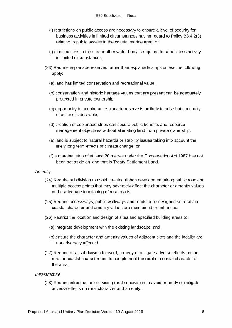
restrictions on public access are necessary to ensure a level of security for (i)business activities in limited circumstances having regard to Policy B8.4.2(3) relating to public access in the coastal marine area; or
direct access to the sea or other water body is required for a business activity (j)in limited circumstances.
Require esplanade reserves rather than esplanade strips unless the following (23)apply:
land has limited conservation and recreational value; (a)
conservation and historic heritage values that are present can be adequately (b)protected in private ownership;
opportunity to acquire an esplanade reserve is unlikely to arise but continuity (c)of access is desirable;
creation of esplanade strips can secure public benefits and resource (d)management objectives without alienating land from private ownership;
land is subject to natural hazards or stability issues taking into account the (e)likely long term effects of climate change; or
a marginal strip of at least 20 metres under the Conservation Act 1987 has not (f)been set aside on land that is Treaty Settlement Land.
Amenity
Require subdivision to avoid creating ribbon development along public roads or (24)multiple access points that may adversely affect the character or amenity values or the adequate functioning of rural roads.
Require accessways, public walkways and roads to be designed so rural and (25)coastal character and amenity values are maintained or enhanced.
Restrict the location and design of sites and specified building areas to: (26)
integrate development with the existing landscape; and (a)
ensure the character and amenity values of adjacent sites and the locality are (b)not adversely affected.
Require rural subdivision to avoid, remedy or mitigate adverse effects on the (27)rural or coastal character and to complement the rural or coastal character of the area.
Infrastructure
Require infrastructure servicing rural subdivision to avoid, remedy or mitigate (28)adverse effects on rural character and amenity.
Proposed Auckland Unitary Plan Decision Version 19 August 2016 6
E39 Subdivision - Rural
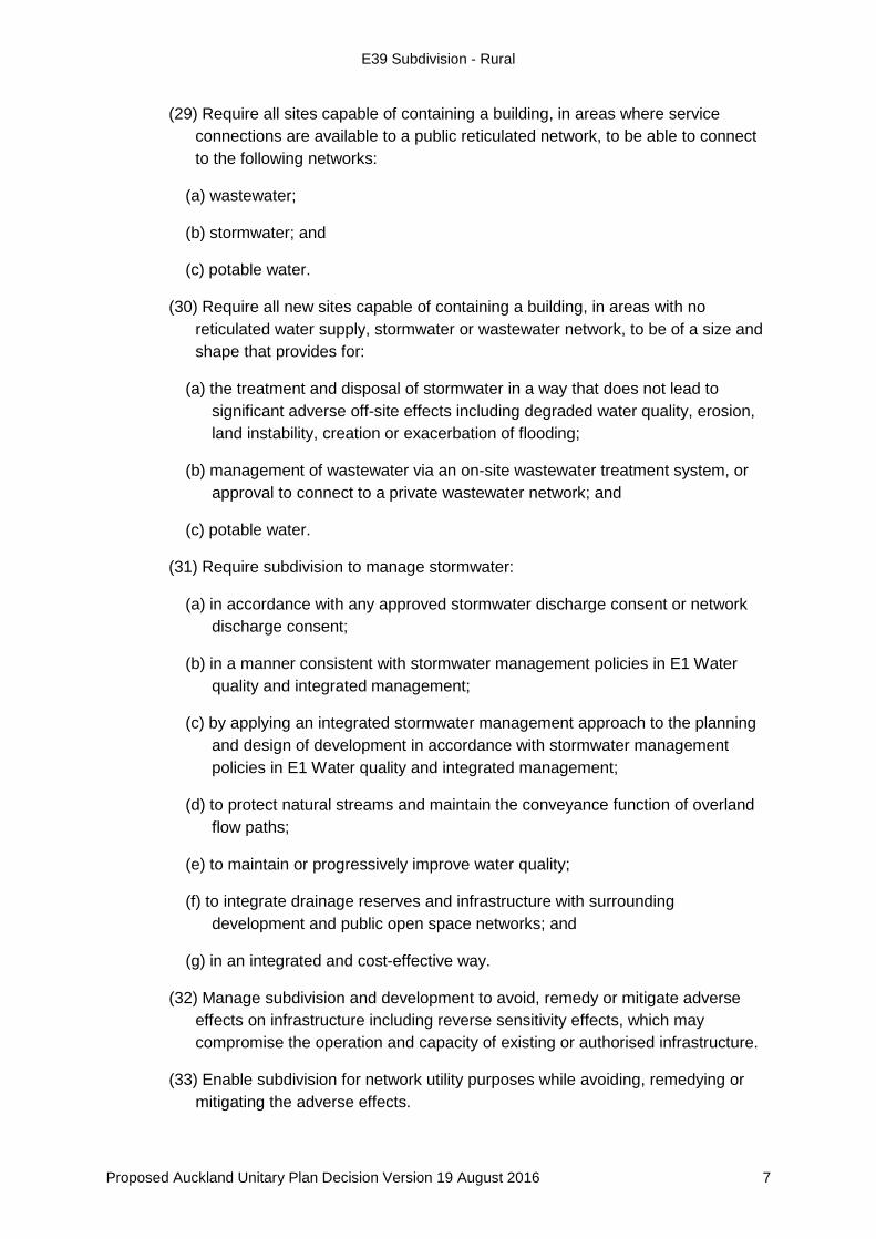
Require all sites capable of containing a building, in areas where service (29)connections are available to a public reticulated network, to be able to connect to the following networks:
wastewater; (a)
stormwater; and (b)
potable water. (c)
Require all new sites capable of containing a building, in areas with no (30)reticulated water supply, stormwater or wastewater network, to be of a size and shape that provides for:
the treatment and disposal of stormwater in a way that does not lead to (a)significant adverse off-site effects including degraded water quality, erosion, land instability, creation or exacerbation of flooding;
management of wastewater via an on-site wastewater treatment system, or (b)approval to connect to a private wastewater network; and
potable water. (c)
Require subdivision to manage stormwater: (31)
in accordance with any approved stormwater discharge consent or network (a)discharge consent;
in a manner consistent with stormwater management policies in E1 Water (b)quality and integrated management;
by applying an integrated stormwater management approach to the planning (c)and design of development in accordance with stormwater management policies in E1 Water quality and integrated management;
to protect natural streams and maintain the conveyance function of overland (d)flow paths;
to maintain or progressively improve water quality; (e)
to integrate drainage reserves and infrastructure with surrounding (f)development and public open space networks; and
in an integrated and cost-effective way. (g)
Manage subdivision and development to avoid, remedy or mitigate adverse (32)effects on infrastructure including reverse sensitivity effects, which may compromise the operation and capacity of existing or authorised infrastructure.
Enable subdivision for network utility purposes while avoiding, remedying or (33)mitigating the adverse effects.
Proposed Auckland Unitary Plan Decision Version 19 August 2016 7

E39 Subdivision - Rural
E39.4. Activity table
Tables E39.4.1 to E39.4.5 specify the activity status of subdividing land pursuant to section 11 of the Resource Management Act 1991.
For subdivision within the National Grid Corridor Overlay, the activity status for subdivision in the rural zones as listed in Tables E39.4.1 to E39.4.5 below will apply unless there are different provisions in D26 National Grid Corridor Overlay in which case the overlay provisions will take precedence.
For all other subdivision refer to E38 Subdivision – Urban.
An activity listed in Table E39.4.1 Subdivision for specified purposes may only comprise a specific element of a subdivision activity. The other elements of a subdivision may also be listed in Tables E39.4.2 Subdivision in rural zones, E39.4.3 Subdivision in Future Urban Zone, E39.4.4 Subdivision in Special Purpose – Quarry Zone and E39.4.5 Subdivsion in Rural - Waitākere Foothills Zone and Rural – Waitākere Ranges Zone.
Where a proposed subdivision activity fits into activities listed in Table E39.4.1 and those listed in Tables E39.4.2, E39.4.3, E39.4.4, or E39.4.5, then the activity status listed for each activity in each table also applies.
Refer to D12 Waitākere Ranges Heritage Area Overlay for areas and sites subject to specific subdivisions provisions in the Waitākere Ranges Heritage Area.
Table E39.4.1 Subdivision for specified purposes
Activity Activity status
(A1) Lease in excess of 35 years of a building or part of a building where a cross-lease, company lease, or unit title subdivision is not involved
P
(A2) Subdivision for a network utility P
(A3) Amendments to cross-lease or unit title, including additions and alterations to buildings, accessory buildings and areas for exclusive use by an owner or owners
C
(A4) Boundary adjustments not exceeding 10 per cent of the original site area and meeting Standard E39.6.3.2
C
(A5) Subdivision establishing an esplanade reserve RD (A6) Subdivision establishing an esplanade strip D (A7) Any reduction or waiver of esplanade reserves or strips D (A8) Subdivision of land within any of the following natural hazard
areas:
• one per cent annual exceedance probability floodplain;
• coastal storm inundation one per cent annual exceedance probability;
• coastal storm inundation one per cent annual exceedance probability plus 1 metre sea level rise;
• land which may be subject to coastal hazards; or
RD
Proposed Auckland Unitary Plan Decision Version 19 August 2016 8
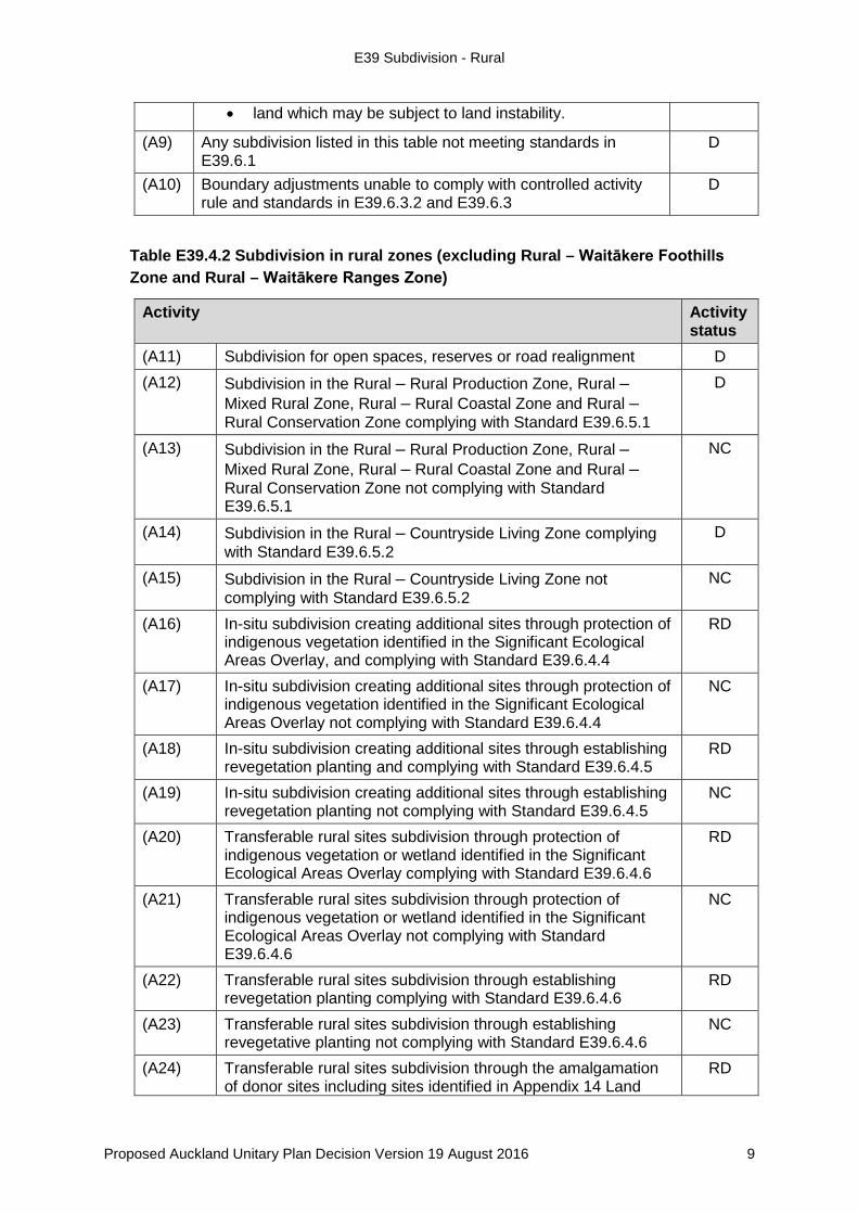
E39 Subdivision - Rural
Table E39.4.2 Subdivision in rural zones (excluding Rural – Waitākere Foothills Zone and Rural – Waitākere Ranges Zone)
• land which may be subject to land instability.
(A9) Any subdivision listed in this table not meeting standards in E39.6.1
D
(A10) Boundary adjustments unable to comply with controlled activity rule and standards in E39.6.3.2 and E39.6.3
D
Activity Activity status
(A11) Subdivision for open spaces, reserves or road realignment D (A12) Subdivision in the Rural – Rural Production Zone, Rural –
Mixed Rural Zone, Rural – Rural Coastal Zone and Rural – Rural Conservation Zone complying with Standard E39.6.5.1
D
(A13) Subdivision in the Rural – Rural Production Zone, Rural – Mixed Rural Zone, Rural – Rural Coastal Zone and Rural – Rural Conservation Zone not complying with Standard E39.6.5.1
NC
(A14) Subdivision in the Rural – Countryside Living Zone complying with Standard E39.6.5.2
D
(A15) Subdivision in the Rural – Countryside Living Zone not complying with Standard E39.6.5.2
NC
(A16) In-situ subdivision creating additional sites through protection of indigenous vegetation identified in the Significant Ecological Areas Overlay, and complying with Standard E39.6.4.4
RD
(A17) In-situ subdivision creating additional sites through protection of indigenous vegetation identified in the Significant Ecological Areas Overlay not complying with Standard E39.6.4.4
NC
(A18) In-situ subdivision creating additional sites through establishing revegetation planting and complying with Standard E39.6.4.5
RD
(A19) In-situ subdivision creating additional sites through establishing revegetation planting not complying with Standard E39.6.4.5
NC
(A20) Transferable rural sites subdivision through protection of indigenous vegetation or wetland identified in the Significant Ecological Areas Overlay complying with Standard E39.6.4.6
RD
(A21) Transferable rural sites subdivision through protection of indigenous vegetation or wetland identified in the Significant Ecological Areas Overlay not complying with Standard E39.6.4.6
NC
(A22) Transferable rural sites subdivision through establishing revegetation planting complying with Standard E39.6.4.6
RD
(A23) Transferable rural sites subdivision through establishing revegetative planting not complying with Standard E39.6.4.6
NC
(A24) Transferable rural sites subdivision through the amalgamation of donor sites including sites identified in Appendix 14 Land
RD
Proposed Auckland Unitary Plan Decision Version 19 August 2016 9
E39 Subdivision - Rural
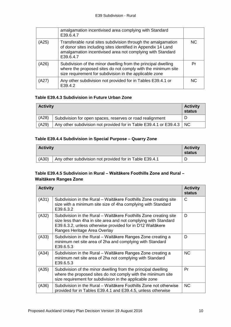
Table E39.4.3 Subdivision in Future Urban Zone
Activity Activity status
(A28) Subdivision for open spaces, reserves or road realignment D (A29) Any other subdivision not provided for in Table E39.4.1 or E39.4.3 NC
Table E39.4.4 Subdivision in Special Purpose – Quarry Zone
Activity Activity status
(A30) Any other subdivision not provided for in Table E39.4.1 D
Table E39.4.5 Subdivision in Rural – Waitākere Foothills Zone and Rural – Waitākere Ranges Zone
Activity Activity status
(A31) Subdivision in the Rural – Waitākere Foothills Zone creating site size with a minimum site size of 4ha complying with Standard E39.6.3.2
C
(A32) Subdivision in the Rural – Waitākere Foothills Zone creating site size less than 4ha in site area and not complying with Standard E39.6.3.2, unless otherwise provided for in D12 Waitākere Ranges Heritage Area Overlay
D
(A33) Subdivision in the Rural – Waitākere Ranges Zone creating a minimum net site area of 2ha and complying with Standard E39.6.5.3
D
(A34) Subdivision in the Rural – Waitākere Ranges Zone creating a minimum net site area of 2ha not complying with Standard E39.6.5.3
NC
(A35) Subdivision of the minor dwelling from the principal dwelling where the proposed sites do not comply with the minimum site size requirement for subdivision in the applicable zone
Pr
(A36) Subdivision in the Rural – Waitākere Foothills Zone not otherwise provided for in Tables E39.4.1 and E39.4.5, unless otherwise
NC
amalgamation incentivised area complying with Standard E39.6.4.7
(A25) Transferable rural sites subdivision through the amalgamation of donor sites including sites identified in Appendix 14 Land amalgamation incentivised area not complying with Standard E39.6.4.7
NC
(A26) Subdivision of the minor dwelling from the principal dwelling where the proposed sites do not comply with the minimum site size requirement for subdivision in the applicable zone
Pr
(A27) Any other subdivision not provided for in Tables E39.4.1 or E39.4.2
NC
Proposed Auckland Unitary Plan Decision Version 19 August 2016 10
E39 Subdivision - Rural
provided for in D12 Waitākere Ranges Heritage Area Overlay (A37) Any other subdivision not otherwise provided for in Tables
E39.4.1 or E39.4.5 D
E39.5. Notification
An application for resource consent for a controlled activity listed in Table E39.4.1 (1)or Table E39.4.5 will be considered without public or limited notification or the need to obtain written approval from affected parties unless the Council decides that special circumstances exist under section 95A(4) of the Resource Management Act 1991.
Any application for resource consent for an activity listed in Tables E39.4.1 to (2)E39.4.5 and which is not listed in E39.5(1) will be subject to the normal tests for notification under the relevant sections of the Resource Management Act 1991.
When deciding who is an affected person in relation to any activity for the (3)purposes of section 95E of the Resource Management Act 1991 the Council will give specific consideration to those persons listed in Rule C1.13(4).
E39.6. Standards
Subdivision listed in Tables E39.4.1 to E39.4.5 must comply with the relevant standards in E39.6.1 General standards, and the relevant standards for permitted, controlled, restricted discretionary and discretionary activities in E39.6.2 to E39.6.5.
General standards E39.6.1.
Specified building area E39.6.1.1.
(1) A specified building area must be clearly identified on every site on a subdivision scheme plan on which a building is to be constructed.
(2) Where the site contains an existing dwelling at the time the subdivision application is made, the specified building area must include:
(a) the location of the existing dwelling;
(b) indicate that the dwelling will be removed from the site; or
(c) the new location of the existing dwelling that will be relocated.
(3) The specified building area must meet all of the following:
(a) include a single area of at least 2,000m2 clear of all of the following:
(i) all yards;
(ii) one per cent annual exceedance probability floodplain areas;
Proposed Auckland Unitary Plan Decision Version 19 August 2016 11
E39 Subdivision - Rural
(iii) land affected by coastal storm inundation one per cent annual exceedance probability;
(iv) land affected by coastal storm inundation one per cent annual exceedance probability plus 1m sea level rise;
(v) land which may be subject to coastal hazards;
(vi) land which may be subject to land instability;
(vii) access to all proposed building platforms or areas; and
(viii) on-site private infrastructure required to service the intended use of the site.
(b) be able to be linked by adequate and appropriate vehicle access to a formed public road;
(c) be identified as the only place within the site where dwellings, any accessory buildings, and related parking and manoeuvring areas can be located; and
(d) be located outside of the Quarry Buffer Area Overlay.
Access and entrance strips E39.6.1.2.
(1) All proposed sites must be provided with legal and physical access to a road, unless they meet one of the following:
(a) are being created for reserves, network utilities or road closure; or
(b) will be amalgamated with another site that already has legal and physical access to a road.
Services E39.6.1.3.
(1) For all proposed sites capable of containing a building, or for cross-lease, unit title, strata title or company lease, each building must be designed and located so that provision is made for all of the following services:
(a) collection, treatment and disposal of stormwater;
(b) collection, treatment and disposal of wastewater;
(c) water supply;
(d) electricity supply; and
(e) telecommunications.
(2) Where no reticulated water supply is available, sufficient water supply and access to water supplies for firefighting purposes in accordance with the
Proposed Auckland Unitary Plan Decision Version 19 August 2016 12
E39 Subdivision - Rural
New Zealand Fire Service Fire Fighting Water Supplies Code of Practice SNZ PAS 4509:2008 must be provided.
Staging E39.6.1.4.
(1) Where a subdivision is to be carried out in stages, the applicant must provide adequate detail of the proposed timetable and sequencing of the staging at the time they apply for the overall subdivision consent. This detail must include all of the following:
(a) the time period over which the development is likely to take place;
(b) the areas of land subject to the proposed stages; and
(c) the balance area of the site remaining after the completion of each stage.
Overland flow paths E39.6.1.5.
(1) All subdivision must be designed to incorporate overland flow paths existing on the site.
(2) Stormwater must exit the site in a location that does not increase the risks of hazards to downstream properties.
Existing vegetation on the site E39.6.1.6.
(1) All subdivision plans, excluding boundary adjustments subdivision plans, must show any of the following features that exist on, or on the boundary of, the land being subdivided:
(a) any areas identified as an Significant Ecological Area in the D9 Significant Ecological Areas Overlay; or
(b) any other areas of indigenous vegetation, wetlands, waterways, streams, rivers and lakes.
Standards – permitted activities E39.6.2.
Subdivision listed as a permitted activity in Table E39.4.1 Subdivision for specified purposes must comply with the relevant standards in E39.6.1 General standards, and E39.6.2 Standards – permited activities.
Lease in excess of 35 years of a building or part of a building E39.6.2.1.where a cross-lease, company lease or unit title subdivision is not involved
(1) The subject building must be lawfully established.
(2) The boundaries of the proposed sites must follow existing or proposed walls, ceilings and floors.
Proposed Auckland Unitary Plan Decision Version 19 August 2016 13
E39 Subdivision - Rural
(3) The scheme plan must show the proposed sites in relation to the exterior of the building and provide upper and lower elevations in terms of a datum to be established.
(4) Each lease area must have either frontage to a legal road or allow for access through common areas to a legal road.
Subdivision for a network utility E39.6.2.2.
(1) The network utility activity must meet one of the following:
(a) be a permitted activity pursuant to E26 Infrastructure; or
(b) have all resource consents or notices of requirements approved.
(2) A covenant or consent notice must be required to state that land that is no longer required for the network utility after it disestablishes, must be amalgamated with the adjoining land.
(3) The balance sites must comply with the relevant overlays, Auckland-wide and zone standards, other than the minimum site size, unless resource consent has been granted for any infringements.
(4) Sites must have access to a legal road through an appropriate legal mechanism.
Standards - controlled activities E39.6.3.
Subdivision listed as a controlled activity in Table E39.4.1 Subdivision for specified purposes and Table E39.4.5 Subdivision in Rural – Waitākere Foothills Zone and Rural – Waitākere Ranges Zone must comply with the relevant standards in E39.6.1 General standards and in E39.6.3 Standards – controlled activities.
Amendments to cross-lease or unit title, including additions and E39.6.3.1.alterations to buildings, accessory buildings and areas for exclusive use by an owner or owners
(1) All buildings must meet one of the following:
(a) have existing use rights;
(b) comply with the relevant overlays, Auckland-wide and zone standards; or
(c) be in accordance with an approved land use resource consent.
(2) All areas to be set aside for the exclusive use of each building or unit must be shown on the survey plan, in addition to any areas to be used for common access or parking or other such purpose.
(3) Subdivision consent affecting a building or any part of a building, any proposed covenant, unit or accessory unit boundary, must not result in
Proposed Auckland Unitary Plan Decision Version 19 August 2016 14

E39 Subdivision - Rural
any infringements of any relevant overlays, Auckland-wide and zone rules.
(4) Parking spaces must not be created as principal units, unless provided for by a resource consent, and only created as accessory units or common areas when associated with an approved use or activity.
(5) All service connections and on-site infrastructure must be located within the boundary of the site they serve or have access provided by an appropriate legal mechanism.
Boundary adjustments that do not exceed 10 per cent of the E39.6.3.2.original site size
(1) All sites prior to the boundary adjustment must be contained within the same zone.
(2) All service connections and on-site infrastructure must be located within the boundary of the site they serve, or have legal rights provided by an appropriate legal mechanism.
(3) All sites must remain compliant with the applicable minimum site area and minimum average site area for the relevant zones.
(4) Boundary adjustments must not result in the creation of additional titles.
(5) If any boundary adjustment under this control creates the potential for additional subdivision or dwellings over and above what was possible for each site prior to the boundary adjustment a legal covenant or consent notice under s. 221 of the RMA is to be registered on the titles prohibiting;
(a) any further subdivision; and/or
(b) new dwellings.
Standards – restricted discretionary activities E39.6.4.
Subdivision listed as a restricted discretionary activity in Table E39.4.1 Subdivision for specified purposes or Table E39.4.2 Subdivision in rural zones must comply with the relevant standards set out in E39.6.1 General standards and E39.6.4 Standards – restricted discretionary activities unless otherwise specified.
Subdivision establishing an esplanade reserve E39.6.4.1.
(1) Any subdivision involving the creation of sites less than 4 hectare which adjoins the line of the mean high water springs, or the bank of a river or stream 3 metres or more in width, or any lake, must provide a minimum 20 metre wide esplanade reserve in accordance with section 230 of the Resource Management Act 1991. This must be shown on the application plan and the subsequent land transfer plan.
Proposed Auckland Unitary Plan Decision Version 19 August 2016 15
E39 Subdivision - Rural
(2) The esplanade reserve must be measured in a landward direction at 90 degrees to the line of mean high water springs, or the bank of a river, stream or the margin of any lake.
(3) Standards E39.6.4.1(1) and (2) do not apply to the subdivision of Treaty Settlement Land where a marginal strip of at least 20 metres has been set aside under the Conservation Act 1987.
Subdivision of a site within the one per cent annual exceedance E39.6.4.2.probability floodplain
(1) Each proposed site within the one per cent floodplain that is to contain a more vulnerable activity must meet one of the following:
(a) contain a specified building area that meets the requirements of Standard E39.6.1 General standards; or
(b) be in accordance with a land use consent that authorises development or building in the floodplain.
Subdivision of land which may be subject to coastal hazards E39.6.4.3.
(1) Each proposed site on land which may be subject to coastal hazards must demonstrate that all of the relevant areas/features in (a) to (c) below are located outside of any land subject to coastal hazards:
(a) a specified building area that meets the requirements of Standard E39.6.1 General standards;
(b) access to all proposed building platforms or areas; and
(c) on-site private infrastructure required to service the intended use of the site.
In-situ subdivision creating additional sites through protection of E39.6.4.4.indigenous vegetation identified in the Significant Ecological Areas Overlay
Refer to Appendix 15 Subdivision information and process for further information in relation to in-situ subdivisions.
(1) The indigenous vegetation to be protected must be identified in the Significant Ecological Areas Overlay.
(2) The maximum number of sites created from the protection of an indigenous vegetation must comply with Table E39.6.4.4.1
Proposed Auckland Unitary Plan Decision Version 19 August 2016 16
E39 Subdivision - Rural
Table E39.6.4.4.1 Maximum number of new rural residential sites to be created from the protection of indigenous vegetation identified in the Significant Ecological Areas Overlay
Areas of indigenous vegetation to be protected
Maximum number of rural residential sites that may be created for Transferable Rural Site Subdivision
Maximum number of rural residential sites that may be created for in-situ subdivision
5ha – 9.9999ha 1 1 10ha – 14.9999ha 2 2 15ha – 20ha 3 3 (maximum) For every 10ha increment of SEA (indigenous vegetation) which is protected beyond the protection of 20ha
No maximum
(3) A 20 metre buffer is to be applied to the perimeter of the indigenous vegetation and included as part of the protected area.
(4) The additional sites must be created on the same site as the indigenous vegetation subject to protection.
Note: Standard E39.6.4.6 provides a separate subdivision option to enable the transfer of additional lots created via Standard E39.6.4.4.
(5) The additional sites must have a minimum site size of 1 hectare and a maximum site size of 2 hectares.
(6) Any indigenous vegetation proposed to be legally protected in accordance with Appendix 15 Subdivision information and process must be identified on the subdivision scheme plan.
(7) Areas of indigenous vegetation to be legally protected as part of the proposed subdivision must not already be subject to legal protection.
(8) Areas of indigenous vegetation to be legally protected as part of the proposed subdivision must not have been used to support another transferable rural site subdivision or subdivision under this Plan or a previous district plan.
(9) The subdivision resource consent must be made subject to a condition requiring the subdivision plan creating the sites to be deposited after, and
Proposed Auckland Unitary Plan Decision Version 19 August 2016 17

E39 Subdivision - Rural
not before, the protective covenant has been registered against the title of the site containing the covenanted indigenous vegetation or wetland.
(10) All applications must include all of the following:
(a) a plan that specifies the protection measures proposed to ensure the indigenous vegetation and buffer area remain protected in perpetuity. Refer to legal protection mechanism to protect indigenous vegetation, wetland or revegetation planting as set out in Appendix 15 Subdivision information and process for further information;
(b) the plans required in E39.6.4.4(10)(a) must be prepared by a suitably qualified and experienced person.
(11) Indigenous vegetation to be protected must be made subject to a legal protection mechanism meeting all of the following:
(a) protection of all the indigenous vegetation and buffer existing on the site at the time the application is made, even if this means protecting vegetation or a wetland larger than the minimum qualifying area; and
(b) consistent with the legal protection mechanism to protect indigenous vegetation, wetland or revegetation planting as set out in Appendix 15 Subdivision information and process.
(12) All applications must include a management plan that includes all of the following matters, which must be implemented prior to the Council issuing a section 224(c) certificate:
(a) the establishment of secure stock exclusion;
(b) the maintenance of the indigenous vegetation must ensure that all invasive plant pests are eradicated
(c) the maintenance of the indigenous vegetation must ensure animal and plant pest control occurs.
In-situ subdivision creating additional sites through establishing E39.6.4.5.indigenous revegetation planting
(1) Any established revegetation planting must meet all of the following:
(a) not be located on land containing elite soil or prime soil;
(b) be located outside any Outstanding Natural Character, High Natural Character or Outstanding Natural Landscape overlays; and
(c) be contiguous with existing indigenous vegetation identified in the Significant Ecological Area Overlay.
Proposed Auckland Unitary Plan Decision Version 19 August 2016 18
E39 Subdivision - Rural
(d) the criteria as set out in Appendix 16 Guideline for native revegetation plantings.
(2) The maximum number of new sites created through establishing revegetation planting must comply with Table E39.6.4.5.1.
Table E39.6.4.5.1 Maximum number of new sites from establishing native revegetation planting (to be added to existing indigenous vegetation identified in the Significant Ecological Area Overlay) subject to protection
Minimum area of established native revegetation planting (to be added to an existing indigenous vegetation identified in the Significant Ecological Area Overlay) subject to protection
Maximum number of new sites for Transferable Rural Site Subdivision
Maximum number of new sites for in-situ subdivision
5ha – 9.9999ha 1 1 10ha – 14.9999ha 2 2 15ha or more 3 (maximum) 3 (maximum)
(3) Any new site must have a minimum site size of 1 hectare and a maximum site size of 2 hectares.
(4) Any established revegetation planting proposed must be legally protected.
(5) Areas subject to revegetation planting must be subject to a legal protection mechanism that:
(a) protects all the existing indigenous vegetation on the site at the time of application as well as the additional area subject to any revegetation planting; and
(b) meets the requirements as set out in Appendix 15 Subdivision information and process.
(6) All applications must include all of the following:
(a) a plan that specifies the protection measures proposed to ensure the indigenous vegetation and buffer area remain protected in perpetuity. Refer to the legal protection mechanism to protect indigenous vegetation, wetland or revegetation planting as set out in Appendix 15 Subdivision information and process for further information;
(b) a planting plan for revegetation planting which outlines the restoration measures proposed to be carried out within or adjacent to the indigenous vegetation proposed to be protected in accordance with Appendix 15 Subdivision information and process and Appendix 16 Guideline for native revegetation plantings ; and
Proposed Auckland Unitary Plan Decision Version 19 August 2016 19
E39 Subdivision - Rural
(c) the plans required in E39.6.4.5(6)(a) and (b) must be prepared by a suitably qualified and experienced person.
(7) All applications must include a management plan that includes all of the following matters, which must be implemented prior to the Council issuing a section 224(c) certificate:
(a) the establishment of secure stock exclusion;
(b) the maintenance of plantings that must occur until the plantings have reached a sufficient maturity to be self-sustaining, and have reached 80 per cent canopy closure. The survival rate must ensure a minimum 90 per cent of the original density and species;
(c) the maintenance of plantings must include the ongoing replacement of plants that do not survive;
(d) the maintenance of plantings must ensure that all invasive plant pests are eradicated from the planting site both at the time of planting and on an on-going basis to ensure adequate growth; and
(e) the maintenance of plantings must ensure animal and plant pest control occurs.
(8) The subdivision resource consent must be made subject to a condition that requires the subdivision plan creating the sites to be deposited after, and not before, the protective covenant has been registered against the title of the site containing the covenanted indigenous vegetation to be protected.
Transferable rural site subdivision through protection of E39.6.4.6.indigenous vegetation or wetland identified in the Significant Ecological Areas Overlay or transferable rural sites subdivision through establishing revegetation planting
Refer to Appendix 15 Subdivision information and process and Appendix 16 Guideline for native revegetation plantings for further information on transferable rural sites subdivisions and revegetation planting.
(1) All transferable rural sites subdivisions applications involving protection of indigenous vegetation must meet all of the standards that are applicable for:
(a) the protection of indigenous vegetation identified in the Significant Ecological Areas Overlay as set out in Standard E39.6.4.4; or
(b) the creation of sites through establishing revegetation planting as set out in Standard E39.6.4.5.
(2) All transferable rural site subdivision applications involving protection of wetlands must meet:
Proposed Auckland Unitary Plan Decision Version 19 August 2016 20
E39 Subdivision - Rural
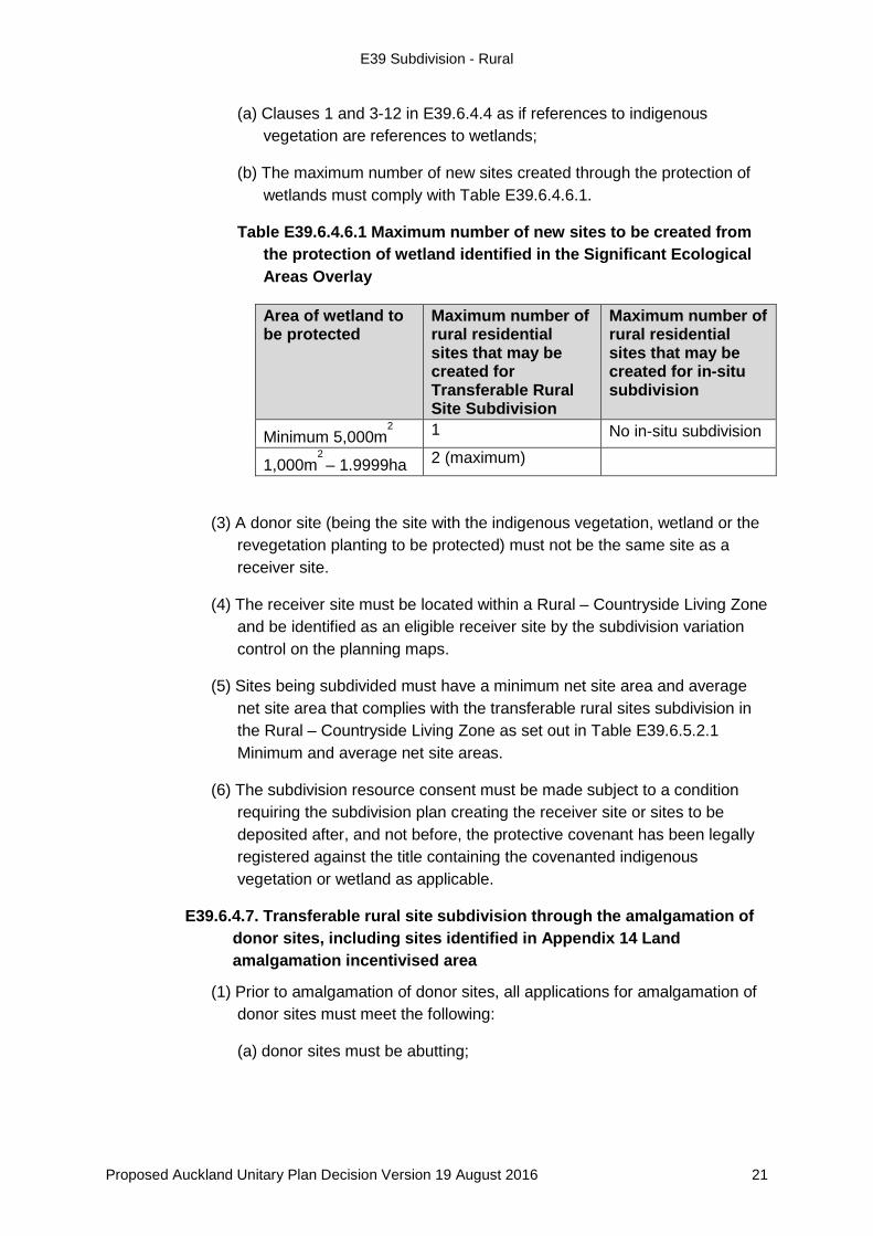
(a) Clauses 1 and 3-12 in E39.6.4.4 as if references to indigenous vegetation are references to wetlands;
(b) The maximum number of new sites created through the protection of wetlands must comply with Table E39.6.4.6.1.
Table E39.6.4.6.1 Maximum number of new sites to be created from the protection of wetland identified in the Significant Ecological Areas Overlay
Area of wetland to be protected
Maximum number of rural residential sites that may be created for Transferable Rural Site Subdivision
Maximum number of rural residential sites that may be created for in-situ subdivision
Minimum 5,000m2 1 No in-situ subdivision
1,000m2 – 1.9999ha 2 (maximum)
(3) A donor site (being the site with the indigenous vegetation, wetland or the revegetation planting to be protected) must not be the same site as a receiver site.
(4) The receiver site must be located within a Rural – Countryside Living Zone and be identified as an eligible receiver site by the subdivision variation control on the planning maps.
(5) Sites being subdivided must have a minimum net site area and average net site area that complies with the transferable rural sites subdivision in the Rural – Countryside Living Zone as set out in Table E39.6.5.2.1 Minimum and average net site areas.
(6) The subdivision resource consent must be made subject to a condition requiring the subdivision plan creating the receiver site or sites to be deposited after, and not before, the protective covenant has been legally registered against the title containing the covenanted indigenous vegetation or wetland as applicable.
Transferable rural site subdivision through the amalgamation of E39.6.4.7.donor sites, including sites identified in Appendix 14 Land amalgamation incentivised area
(1) Prior to amalgamation of donor sites, all applications for amalgamation of donor sites must meet the following:
(a) donor sites must be abutting;
Proposed Auckland Unitary Plan Decision Version 19 August 2016 21

E39 Subdivision - Rural
(b) one of the two donor sites must not contain a dwelling unless the resulting amalgamated site is permitted by this Plan to have more than one dwelling;
(c) donor sites must be zoned either Rural – Rural Production Zone, Rural – Mixed Rural Zone, Rural – Rural Coastal Zone or Rural - Rural Conservation Zone;
(d) the land must contain at least 90 per cent elite soil or prime soil. The applicant must provide a detailed Land Use Capability (LUC) soil assessment confirming that donor sites contain at least 90 per cent elite land or prime land. The assessment must be prepared by a suitably qualified and experienced person;
(e) each site must have a net site area of between 1 and 20 hectares;
(f) sites must have been in existence, or be shown on an approved scheme plan of subdivision; and
(g) sites must not comprise part or all of a closed road, road severance, or designation.
(2) Following amalgamation of donor sites, all donor sites must meet all of the following:
(a) be held in a single certificate of title;
(b) rescinded in such a way that replacement titles cannot be reissued;
(c) made subject to a legal protection mechanism that states all of the following:
(i) the residential development rights attaching to the donor sites have been used to create a transferable rural sites subdivision under the Plan and must not accommodate any further residential development unless it is allowed as a permitted activity subject to the relevant zone rules or by the granting of a resource consent;
(ii) the new site cannot be further subdivided other than by amalgamation with another qualifying site or by boundary adjustment; and
(iii) the new site has no further potential to be used for the purpose of a transferable rural sites subdivision.
(3) Following amalgamation of donor sites, all receiver sites must meet all of the following:
Proposed Auckland Unitary Plan Decision Version 19 August 2016 22

E39 Subdivision - Rural
(a) be subdivided into no more sites than those permitted by Table E39.6.4.7.1 Maximum number of new sites for transfer from the amalgamation of sites;
Table E39.6.4.7.1 Maximum number of new sites for transfer from the amalgamation of sites
Transferable rural sites subdivision by way of amalgamation Criteria Maximum Number of
new sites for transfer Amalgamation of two eligible donor sites as identified in Appendix 14 Land amalgamation incentivised area and complying with Standard E39.6.4.7(1)
Two new sites for every two donor sites amalgamated
Amalgamation of two eligible donor sites outside the land amalgamation incentivised area and complying with Standard E39.6.4.7(1)
One new site for every two donor sites amalgamated
(b) the donor site must not be the same site as a receiver site;
(c) be located within sites zoned as Rural – Countryside Living Zone and be identified as an eligible receiver site by the Subdivision Variation Control on the planning maps;
(d) have a minimum net site area complying with the minimum net site area and average net site area with transferable rural sites subdivision as set out in Table E39.6.5.2.1 Minimum and average net site areas;
(e) be made subject to a condition of subdivision consent that requires the subdivision plan creating the receiver site or sites to be deposited after, and not before, the plan of subdivision for the amalgamation of donor sites has been deposited.
Standards – discretionary activities E39.6.5.
Subdivision listed as a discretionary activity in Table E39.4.2 and Table E39.4.2.5 must comply with the relevant standards in E39.6.1 General standards and E39.6.5 Standards – discretionary activities.
Subdivision in the Rural – Rural Production Zone, Rural – Mixed E39.6.5.1.Rural Zone, Rural – Rural Coastal Zone, and Rural – Rural Conservation Zone
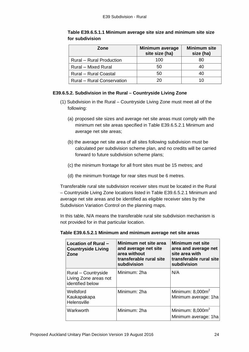
(1) Subdivision in these rural zones must meet the minimum average site size and minimum site size requirement as set out in Table E39.6.5.1.1 Minimum average site size and minimum site size for subdivision.
Proposed Auckland Unitary Plan Decision Version 19 August 2016 23
E39 Subdivision - Rural
Table E39.6.5.1.1 Minimum average site size and minimum site size for subdivision
Zone Minimum average site size (ha)
Minimum site size (ha)
Rural – Rural Production 100 80 Rural – Mixed Rural 50 40 Rural – Rural Coastal 50 40 Rural – Rural Conservation 20 10
Subdivision in the Rural – Countryside Living Zone E39.6.5.2.
(1) Subdivision in the Rural – Countryside Living Zone must meet all of the following:
(a) proposed site sizes and average net site areas must comply with the minimum net site areas specified in Table E39.6.5.2.1 Minimum and average net site areas;
(b) the average net site area of all sites following subdivision must be calculated per subdivision scheme plan, and no credits will be carried forward to future subdivision scheme plans;
(c) the minimum frontage for all front sites must be 15 metres; and
(d) the minimum frontage for rear sites must be 6 metres.
Transferable rural site subdivision receiver sites must be located in the Rural – Countryside Living Zone locations listed in Table E39.6.5.2.1 Minimum and average net site areas and be identified as eligible receiver sites by the Subdivision Variation Control on the planning maps.
In this table, N/A means the transferable rural site subdivision mechanism is not provided for in that particular location.
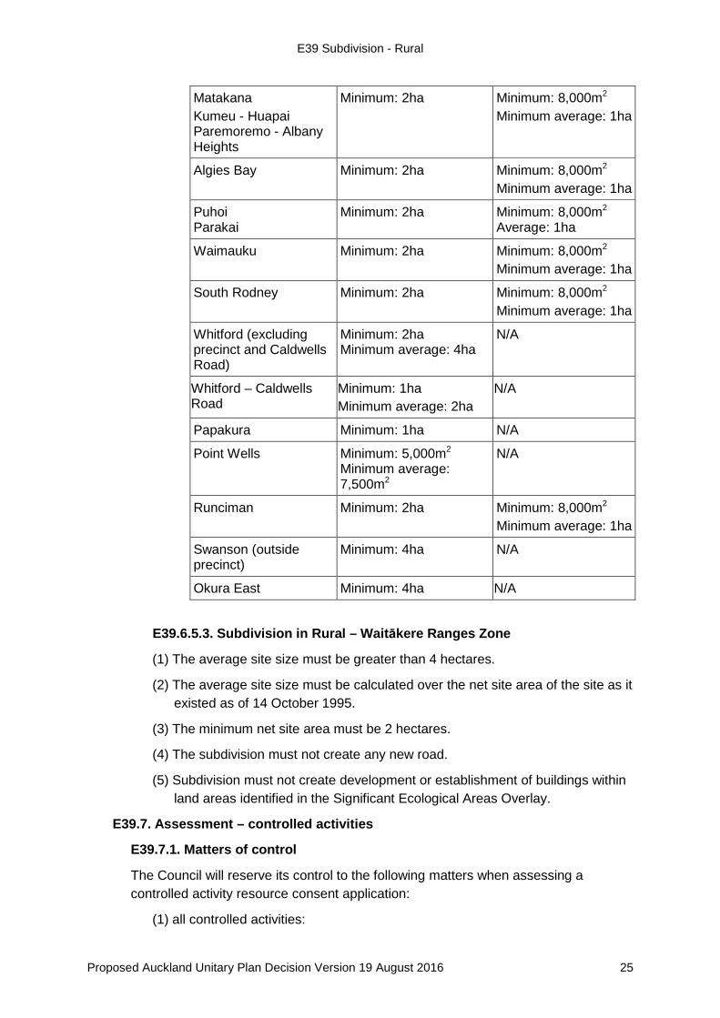
Table E39.6.5.2.1 Minimum and minimum average net site areas
Location of Rural – Countryside Living Zone
Minimum net site area and average net site area without transferable rural site subdivision
Minimum net site area and average net site area with transferable rural site subdivision
Rural – Countryside Living Zone areas not identified below
Minimum: 2ha N/A
Wellsford Kaukapakapa Helensville
Minimum: 2ha Minimum: 8,000m2 Minimum average: 1ha
Warkworth Minimum: 2ha Minimum: 8,000m2 Minimum average: 1ha
Proposed Auckland Unitary Plan Decision Version 19 August 2016 24
E39 Subdivision - Rural
Subdivision in Rural – Waitākere Ranges Zone E39.6.5.3.
(1) The average site size must be greater than 4 hectares.
(2) The average site size must be calculated over the net site area of the site as it existed as of 14 October 1995.
(3) The minimum net site area must be 2 hectares.
(4) The subdivision must not create any new road.
(5) Subdivision must not create development or establishment of buildings within land areas identified in the Significant Ecological Areas Overlay.
E39.7. Assessment – controlled activities
Matters of control E39.7.1.
The Council will reserve its control to the following matters when assessing a controlled activity resource consent application:
(1) all controlled activities:
Matakana Kumeu - Huapai Paremoremo - Albany Heights
Minimum: 2ha Minimum: 8,000m2 Minimum average: 1ha
Algies Bay Minimum: 2ha Minimum: 8,000m2 Minimum average: 1ha
Puhoi Parakai
Minimum: 2ha Minimum: 8,000m2 Average: 1ha
Waimauku Minimum: 2ha Minimum: 8,000m2 Minimum average: 1ha
South Rodney Minimum: 2ha Minimum: 8,000m2 Minimum average: 1ha
Whitford (excluding precinct and Caldwells Road)
Minimum: 2ha Minimum average: 4ha
N/A
Whitford – Caldwells Road
Minimum: 1ha Minimum average: 2ha
N/A
Papakura Minimum: 1ha N/A
Point Wells
Minimum: 5,000m2 Minimum average: 7,500m2
N/A
Runciman Minimum: 2ha Minimum: 8,000m2 Minimum average: 1ha
Swanson (outside precinct)
Minimum: 4ha N/A
Okura East Minimum: 4ha N/A
Proposed Auckland Unitary Plan Decision Version 19 August 2016 25
E39 Subdivision - Rural
(a) compliance with an approved resource consent except for boundary adjustment subdivision;
(b) the effect of the site design, size, shape, gradient and location, including existing buildings, manoeuvring areas and outdoor living spaces;
(c) the effects of infrastructure provision; and
(d) the effects on historic heritage and cultural heritage items.
Assessment criteria E39.7.2.
The Council will consider the relevant assessment criteria for controlled activities from the list below:
(1) all controlled activities:
(a) compliance with an approved resource consent except for boundary adjustment subdivision:
(i) refer to Policy E39.3(6);
(b) the effect of the site design, size, shape, gradient and location, including existing buildings, manoeuvring areas and outdoor living spaces:
(i) the extent to which the design, size, shape, gradient and location of any site including access, existing buildings, manoeuvring areas and outdoor living space affect the safety of pedestrians and cyclists and other users of the space or access;
(ii) whether the sites created are able to accommodate development in accordance with the relevant Auckland-wide and zone rules; and
(iii) refer to Policy E39.3(25), (26) and (27);
(c) the effects of infrastructure provision:
(i) whether provision is made for infrastructure including creation of common areas over parts of the parent site that require access by more than one site within the subdivision; and
(ii) refer to Policy E39.3(28) and (32).
(d) the effects on historic heritage and cultural heritage items;
(i) whether the protection or avoidance of any Scheduled Historic Heritage Place, or Site and Places of Significance to Mana Whenua is ensured; and
(ii) refer to Policy E39.3(4).
(2) Subdivision in the Rural – Waitākere Foothills Zone:
Proposed Auckland Unitary Plan Decision Version 19 August 2016 26
E39 Subdivision - Rural
(a) Policies E39.3(1), (4), (6), (10), (11), (13), (16), (17), (20), (25) and (28) – (33).
E39.8. Assessment – restricted discretionary activities
Matters of discretion E39.8.1.
The Council will restrict its discretion to the following matters when assessing a restricted discretionary resource consent application:
(1) subdivision of a site within the one per cent annual exceedance probability floodplain:
(a) the effects of the hazards on the intended use of the sites created by the subdivision and the vulnerability of these uses to flood hazard events.
(2) subdivision of a site subject to coastal storm inundation one per cent annual exceedance probability or coastal storm inundation one per cent annual exceedance probability plus 1 metre sea level rise:
(a) the effects of the hazards on the intended use of the sites created by the subdivision and the vulnerability of these uses to coastal storm inundation events.
(3) subdivision of a site subject to coastal hazards:
(a) the effects of the hazards on the intended use of the sites created by the subdivision and the vulnerability of these uses to coastal hazards.
(4) subdivision of sites subject to land instability including those areas defined in the Plan as “land which may be subject to land instability”, or other unstable soils as identified through a specific site assessment:
(a) the effects of remediating the land instability hazard and the effect of the hazard on the intended use.
(5) subdivision establishing an esplanade reserve:
(a) the effect of the design, purpose and location of any esplanade reserve established by subdivision in terms of public access, and the conservation of coastal and/or riverbank ecological values, natural values, geological features and landscape features.
(6) in-situ subdivision creating additional sites through protection of indigenous vegetation identified in the Significant Ecological Areas Overlay; in-situ subdivision creating additional sites through establishing revegetation planting:
(a) effects associated with the following matters, having regard to the need to ensure that environmental benefits including the long term protection of Significant Ecological Areas, do not unnecessarily compromise other elements of rural character and amenity:
Proposed Auckland Unitary Plan Decision Version 19 August 2016 27
E39 Subdivision - Rural
(i) the number of sites created, site size, building platforms locations, access;
(ii) the rural character, landscapes and amenity;
(iii) the location of the indigenous vegetation and/or revegetation planting relative to proposed new sites and to existing vegetation;
(iv) the quality of the indigenous vegetation and/or revegetation planting to be protected;
(v) the compliance with Auckland-wide rules;
(vi) any management plans for the ongoing protection and management of indigenous vegetation or revegetation planting;
(vii) the provision of adequate access to existing and new infrastructure and provision of appropriate management of effects of stormwater;
(viii) the legal protection for indigenous vegetation or revegetation planting;
(ix) any reverse sensitivity effects; and
(x) the location of identified building areas platforms relative to areas of significant mineral resources.
(7) transferable rural site subdivision creating additional sites through protection of indigenous vegetation or wetland identified in the Significant Ecological Areas Overlay; transferable rural site subdivision through establishing revegetation planting:
(a) effects associated with the following matters, having regard to the need to ensure that environmental benefits including the long term protection of Significant Ecological Areas, do not unnecessarily compromise other elements of rural character and amenity:
(i) the matters listed in E39.8.1(6)(a)(i) to (x);
(ii) the number and size of new sites created on the receiver sites and compliance with minimum and average net site areas in the Rural – Countryside Living Zone; and
(iii) the timing and co-ordination of the protection of indigenous vegetation, wetland and revegetation planting on donor site relative to the creation of new sites on the receiver site.
(8) transferable rural site subdivision through the amalgamation of donor sites, including those sites identified in Appendix 14 Land amalgamation incentivised area:
(a) effects associated with the below matters, having regard to the need to ensure the long term protection of elite soils and their availability for rural production purposes, without compromising other elements of rural character and amenity, or rural resources:
Proposed Auckland Unitary Plan Decision Version 19 August 2016 28
E39 Subdivision - Rural
(i) the matters listed in E39.8.1(6)(a)(i) to (x);
(ii) the location and the soil qualities of the donor sites;
(iii) the degree to which new sites created from receiver sites comply with the Auckland-wide rules;
(iv) the suitability of the transferred sites for rural residential purposes having regard to the objectives, policies and rules for the Rural – Countryside Living Zone.
Assessment criteria E39.8.2.
The Council will consider the relevant assessment criteria for restricted discretionary activities from the list below:
(1) subdivision of a site within the one per cent annual exceedance probability floodplain and flood prone areas:
(a) the effects of the hazards on the intended use of the sites created by the subdivision and the vulnerability of these uses to flood hazard events:
(i) whether measures are proposed to ensure the long term protection of flood plain conveyance functions;
(ii) whether the location and design of development including building platforms and access ways are located to avoid the hazard;
(iii) the extent to which changes to the landform and the design of mitigation structures/features are necessary for the subdivision; and
(iv) refer to Policy E39.3(2).
(2) subdivision of a site subject to coastal storm inundation one per cent annual exceedance probability and coastal storm inundation one per cent annual exceedance probability plus 1 metre sea level rise:
(a) the effects of the hazards on the intended use of the sites created by the subdivision and the vulnerability of these uses to coastal storm inundation events:
(i) whether the location and design of development including proposed and existing building platforms and access ways include the ability to relocate uses within the proposed site area;
(ii) whether the use of defences to protect the land and any buildings or structures on the land from coastal storm inundation are necessary;
(iii) whether there is any residual risk posed by coastal storm inundation to the site(s) associated with any existing or proposed coastal defences;
(iv) whether there are effects on landscape values resulting from associated built and/or land form modifications required to provide for the intended use of the site; and
(v) Policy E39.3(2).
Proposed Auckland Unitary Plan Decision Version 19 August 2016 29
E39 Subdivision - Rural
(3) subdivision of site subject to coastal hazards:
(a) the effects of the hazards on the intended use of the sites created by the subdivision and the vulnerability of these uses to coastal hazards:
(i) whether public access to the coast is affected;
(ii) the extent to which the installation of hard protection structures to be utilised to protect the site or its uses from coastal erosion hazards over at least a 100 year timeframe are necessary; and
(iii) Policy E39.3(2).
(4) subdivision of sites subject to land instability including those areas defined in the Plan as “land which may be subject to land instability”, or other unstable soils as identified through a specific site assessment:
(a) the effects of remediating the land instability hazard and the effect of the hazard on the intended use:
(i) the extent to which the proposed sites are stable and suitable;
(ii) the extent to which the site instability will affect the intended use, including the provision for onsite infrastructure (where applicable) and accessways; and
(iii) Policy E39.3(2).
(5) subdivision establishing an esplanade reserve:
(a) the effect of the design, purpose and location of any esplanade reserve established by subdivision in terms of public access, and the conservation of coastal and/or riverbank ecological values, natural values, geological features and landscape features:
(i) the extent to which the design purpose and location of the esplanade reserve enables public access and the conservation of coastal and/or riverbank ecological values, natural values, geological features and landscape features; and
(ii) Policies E39.3(1), (21), (22) and (23).
(6) in-situ subdivision creating additional sites through protection of indigenous vegetation identified in the Significant Ecological Areas Overlay; in-situ subdivision creating additional sites through establishing revegetation planting:
(a) Policies E39.3(1), (15), (16), (17), (18), (24) – (27) and (29) to (31).
(7) transferable rural sites subdivision creating additional sites through protection of indigenous vegetation or wetland identified in the Significant Ecological Areas Overlay; transferable rural sites subdivision through establishing revegetation planting:
Proposed Auckland Unitary Plan Decision Version 19 August 2016 30
E39 Subdivision - Rural
(a) Policies E39.3(1), (11), (12), (13), (15), (16), (17), (18), (24) – (27) and (29) to (31).
(8) transferable rural sites subdivision through the amalgamation of donor sites including sites identified in Appendix 14 Land amalgamation incentivised area:
(a) Policies E39.3(1), (3), (9), (11), (12), (13), (15), (16), (17), (18) and (29) to (31).
E39.9. Special information requirements
There are no special information requirements in this section.
Proposed Auckland Unitary Plan Decision Version 19 August 2016 31