I441. Whitford Precinct - Auckland Council
29
I441 Whitford Precinct Auckland Unitary Plan Operative in part 1 I441. Whitford Precinct I441.1. Precinct Description The Whitford Precinct covers approximately 3735ha of rural land that lies entirely within Tūranga, Waikōpua, Te Puru and Beachlands stream catchments, collectively known as the Whitford catchment. The precinct is a rural area located close to the urban areas of Botany, Howick and Flat Bush. The precinct provisions provide for countryside living development, subject to a management framework in order to maintain and enhance landscape character, rural amenity values and the environmental quality of the area. The Whitford Precinct includes two sub-precincts, Whitford Sub-precinct A and Whitford Sub-precinct B, and six mapped indicative constraints areas. Land not located within any of the six constraints areas is generally considered to be the least sensitive of all land within the precinct and the most appropriate location for development. However, as the constraints are indicative, Council will require detailed analysis and design to accompany resource consent applications to subdivide or develop land. An incentive is given to encourage improvements to the natural and physical environment through provisions for additional subdivision for significant enhancement planting. Whitford sub-precinct A Sub-precinct A contains three distinct areas of land. The first lies within the Tūranga Stream catchment. It is characterised as rolling hill country, which generally consists of slopes between 10-20 degrees, and occasional steeper slopes. The second area includes all the land that lies immediately north of the Trig Road ridge and south of Whitford-Maraetai Road. The third area lies in both the Turanga and Waikōpua Stream catchments and is characterised as steep hill country. This area contains some of the steepest land within the Whitford Catchment. The Whitford sub-precinct A contains a significant proportion of slopes steeper than 15 degrees within the precinct. An average site size of 3.5ha is applied to this sub-precinct. Whitford Landfill Sub-precinct A acknowledges the presence of the Whitford Landfill and the need to minimise the potential for reverse sensitivity effects on the landfill activities. The Quarry Buffer Area Overlay, shown on the planning maps, identifies areas sensitive to both the quarry activities and the Whitford Landfill, which are co-located on the site. It is not intended or proposed that the provisions in the Whitford Precinct rules be utilised to relax or lower the level of control on landfill activities that would otherwise apply if the provisions did not exist. Whitford sub-precinct B Sub-precinct B lies within both the Te Puru and the Beachlands south stream catchments. It has a coastal edge and includes specific provisions addressing both the landscape character and environmental considerations. An average site size of 5ha is applied to this sub-precinct.
Transcript of I441. Whitford Precinct - Auckland Council
I441 Whitford Precinct
Auckland Unitary Plan Operative in part 1
I441. Whitford Precinct
I441.1. Precinct Description
The Whitford Precinct covers approximately 3735ha of rural land that lies entirely within
Tūranga, Waikōpua, Te Puru and Beachlands stream catchments, collectively known as
the Whitford catchment. The precinct is a rural area located close to the urban areas of
Botany, Howick and Flat Bush. The precinct provisions provide for countryside living
development, subject to a management framework in order to maintain and enhance
landscape character, rural amenity values and the environmental quality of the area.
The Whitford Precinct includes two sub-precincts, Whitford Sub-precinct A and Whitford
Sub-precinct B, and six mapped indicative constraints areas. Land not located within any
of the six constraints areas is generally considered to be the least sensitive of all land
within the precinct and the most appropriate location for development. However, as the
constraints are indicative, Council will require detailed analysis and design to accompany
resource consent applications to subdivide or develop land.
An incentive is given to encourage improvements to the natural and physical
environment through provisions for additional subdivision for significant enhancement
planting.
Whitford sub-precinct A
Sub-precinct A contains three distinct areas of land. The first lies within the Tūranga
Stream catchment. It is characterised as rolling hill country, which generally consists of
slopes between 10-20 degrees, and occasional steeper slopes. The second area
includes all the land that lies immediately north of the Trig Road ridge and south of
Whitford-Maraetai Road. The third area lies in both the Turanga and Waikōpua Stream
catchments and is characterised as steep hill country. This area contains some of the
steepest land within the Whitford Catchment. The Whitford sub-precinct A contains a
significant proportion of slopes steeper than 15 degrees within the precinct. An
average site size of 3.5ha is applied to this sub-precinct.
Whitford Landfill
Sub-precinct A acknowledges the presence of the Whitford Landfill and the need to
minimise the potential for reverse sensitivity effects on the landfill activities. The Quarry
Buffer Area Overlay, shown on the planning maps, identifies areas sensitive to both the
quarry activities and the Whitford Landfill, which are co-located on the site. It is not
intended or proposed that the provisions in the Whitford Precinct rules be utilised to relax
or lower the level of control on landfill activities that would otherwise apply if the
provisions did not exist.
Whitford sub-precinct B
Sub-precinct B lies within both the Te Puru and the Beachlands south stream
catchments. It has a coastal edge and includes specific provisions addressing both the
landscape character and environmental considerations. An average site size of 5ha is
applied to this sub-precinct.
I441 Whitford Precinct
Auckland Unitary Plan Operative in part 2
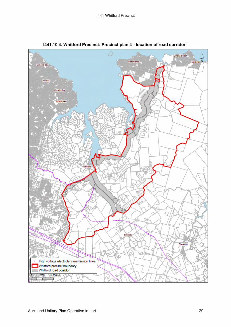
Road corridor indicative constraints area
This constraints area is based on a visibility out to 300m every 50m along arterial
roads within the Whitford precinct, being Whitford Park Road, Sandstone Road and
Whitford-Maraetai Road, shown on Whitford Precinct: Precinct plan 4, so that:
• existing views of the wider countryside are maintained along the roads network
• separation distances between developments are maintained by
dispersing dwellings or clusters of dwellings.
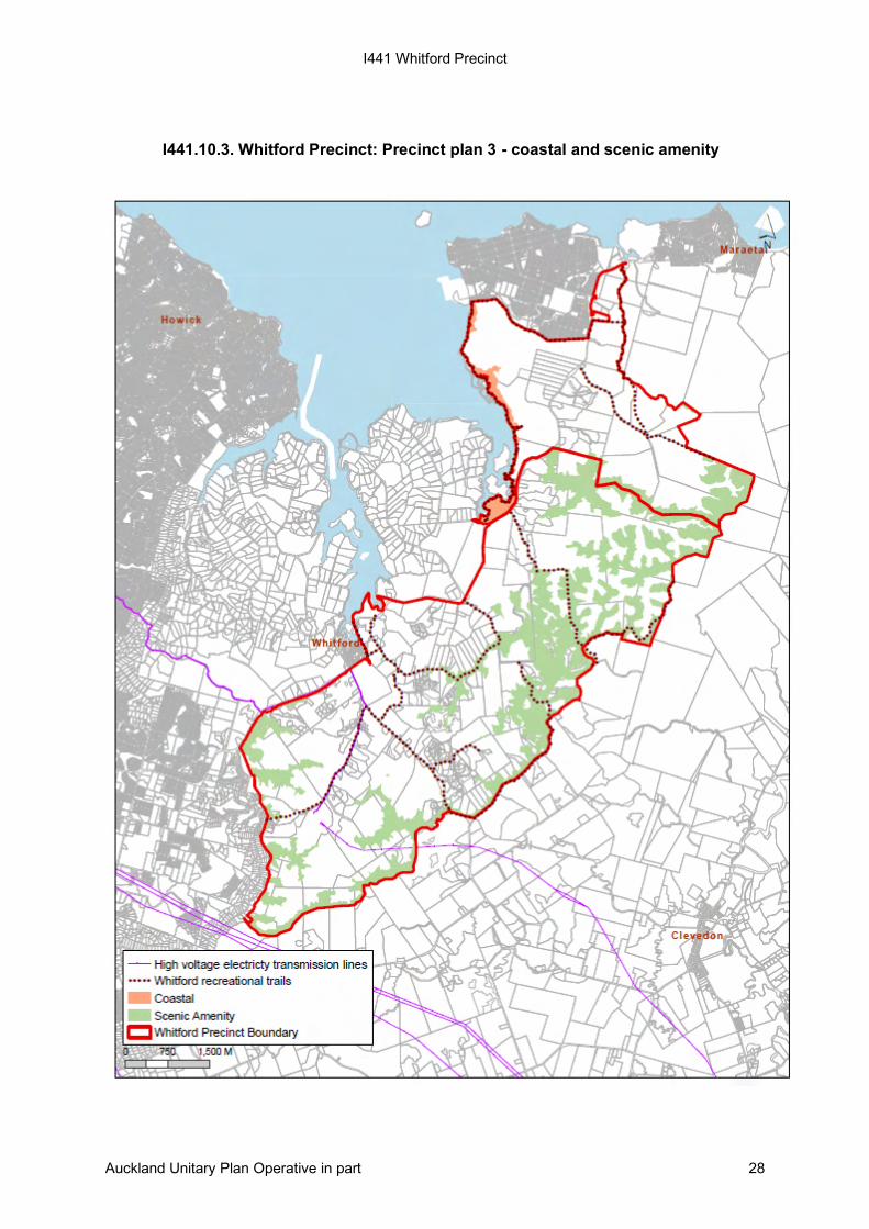
Scenic amenity indicative constraints area
The scenic amenity indicative constraints area applies to all sensitive ridgelines above
the 79.7m(Reduced Level in terms of NZVD2016) contour within the Whitford precinct
that are visible from the main roads, shown on Whitford Precinct: Precinct plan 3 to:
• maintain the existing balance between the built environment and existing natural
areas, including areas of native vegetation, pastoral lands and
production forestry, particularly along the ridgelines that enclose the precinct
• maintain separation by dispersing development.
The hill country and ridgelines surrounding the precinct not only contribute significantly to
landscape character and rural amenity values within the area, but also to the surrounding
suburbs of Howick and Cockle Bay and the wider Whitford area. Limiting the number
of buildings and structures in the skyline ridge and hill country areas is therefore critical
to maintaining rural amenity and the perception that the precinct is rural in character.
Riparian management indicative constraints area
The riparian management indicative constraints area applies, as a minimum, to all land
lying 10m either side of all existing permanent streams within the precinct, shown on
Whitford Precinct: Precinct plan 2 to:
• protect existing landscape features associated with riparian margins
• allow for sediment control between household units and streams
• provide visual screening opportunities between household units
• provide for possible future recreational and ecological corridors.
No development is permitted within the constraints area. The objective is to limit the
amount of development in gully areas and in proximity to streams, and to allow the
setting aside and replanting of these areas with native vegetation. The 20m width of the
constraints area is the minimum requirement only. The actual area of riparian margin that
may be required to be enhanced and/or protected may be greater, depending on the
topography and physical characteristics of the stream. This would be assessed at
resource consent stage.
Coastal indicative constraints area
The coastal edge contributes to the existing character and amenity values of Whitford’s
landscape, refer to Whitford Precinct: Precinct plan 3. Views of the coastal edge,
estuarine areas and the inner Hauraki Gulf are a source of significant amenity to the
area. The coastal indicative constraints area covers the area where land subdivision, use
I441 Whitford Precinct
Auckland Unitary Plan Operative in part 3
and development can influence coastal landscape and amenity within the precinct. The
primary purpose of this constraints area is to protect existing landscape character and
amenity values associated with the coastal edge including beaches, intertidal areas,
estuaries, cliffs, escarpments and coastal slopes.
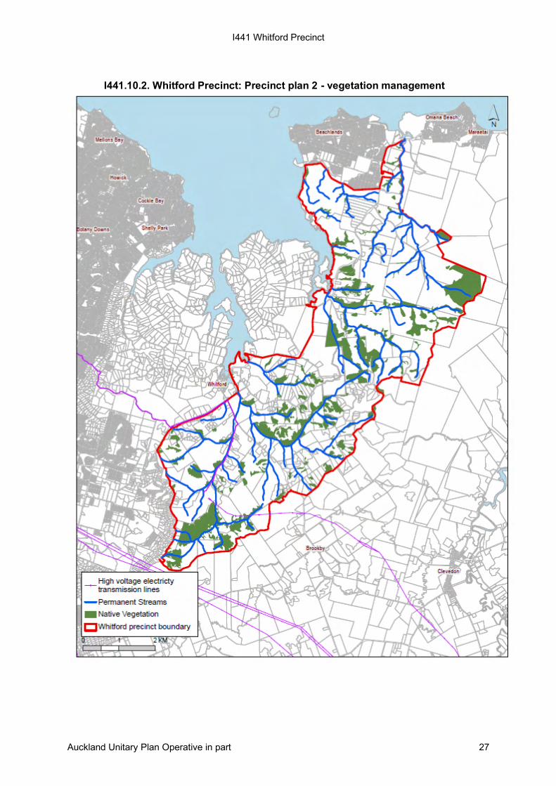
Native vegetation indicative constraints area
The native vegetation indicative constraints area identifies areas of native vegetation for
protection and enhancement, shown on Whitford Precinct: Precinct plan 2 to:
• protect existing native vegetation for future generations
• provide opportunities for increased diversity through permanent legal protection
of existing areas of native vegetation through fencing, weed and pest control
• enhance the landscape to ensure ecological services are maintained during and
after development
• protect the quality and resilience of the resource.
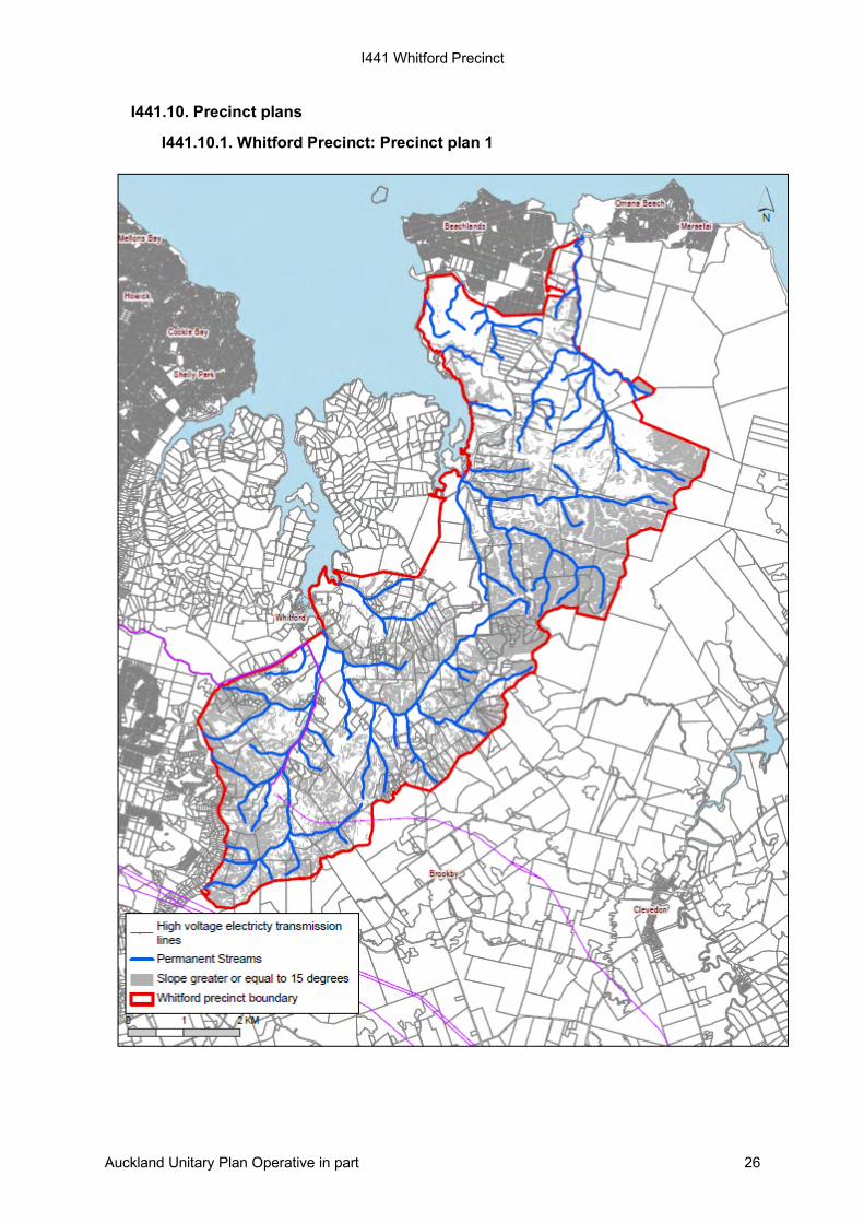
Slopes indicative constraints area
A significant portion of the precinct consists of slopes steeper than 15 degrees, refer to
Whitford Precinct: Precinct plan 1. The northern and eastern parts of the precinct form a
series of prominent hills and valleys. Large tracts of unstable ground are situated in the
southern part of the precinct. This is delineated as the Southern Landslide zone and
covers approximately one third of the precinct. Within this zone there is evidence of
mass land movement and benched topography, typical of deep-seated block sliding.
The location of the slopes steeper than 15 degrees is mapped as a slopes indicative
constraints area to:
• avoid development within these areas unless it can be proven that the building
platform is stable
• encourage stabilisation and landscape and ecological enhancement through
revegetation of steep and erosion-prone slopes.
Sub-precinct A is zoned Rural – Countryside Living Zone and Special Purpose – Quarry
Zone.
Sub-precinct B is zoned Rural – Countryside Living Zone with an area on the eastern
boundary zoned Rural – Mixed Rural Zone.
I441.2. Objectives
(1) Rural countryside living subdivision, use and development of land occurs in a way
which ensures that:
(a) landscape character and rural amenity values are maintained and enhanced;
(b) the operation of rural production activities can continue without being
constrained by the adverse effects of reverse sensitivity;
(c) the natural character and ecological values of native bush and vegetation
areas, the streams and coastal waters are maintained and enhanced;
I441 Whitford Precinct
Auckland Unitary Plan Operative in part 4
(d) areas identified as subject to significant erosion or land instability risk are
avoided.
The overlay, Auckland-wide and underlying zone objectives apply in this precinct in
addition to those specified above.
I441.3. Policies
(1) Identify areas where constraints on development are necessary to prevent them
from being visually prominent or obtrusive when viewed from public places.
(2) Require land subdivision, use, and development to maintain and enhance the
natural character and ecological values of native bush and vegetation areas, the
streams and coastal waters through:
(a) the setting of limits on density, minimum site size, vegetation maintenance
and legal protection of vegetation;
(b) requiring minimum revegetation planting through subdivision standards; and
(c) providing for significant enhancement planting.
(3) Require the retention and enhancement of the natural character and ecological
values of native vegetation, riparian areas and streams within the precinct.
(4) Identify areas subject to significant erosion or land instability risk, and ensure
development is avoided in these areas.
(5) Provide incentives for biodiversity enhancement.
(6) Maintain or enhance water quality in tributaries and the wider Whitford estuary
system by:
(a) minimising land disturbing activities;
(b) protecting and enhancing remnants of native vegetation, riparian vegetation
and wetlands; and
(c) improving biodiversity values through design.
(7) Maintain or enhance water quality in tributaries and the wider Whitford estuary
system by:
(a) minimising land disturbing activities;
(b) protecting and enhancing remnants of native vegetation, riparian vegetation
and wetlands;
(c) improving biodiversity values through design;

I441 Whitford Precinct
Auckland Unitary Plan Operative in part 5
(d) managing stormwater in a way that achieves the collection and management
of rainfall and surface water on site and avoids the discharge of sediment and
other contaminants from entering watercourses; and
(e) managing the quantity of stormwater discharged so as to not increase channel
erosion.
(8) Encourage public open spaces within the Whitford Precinct to:
(a) provide for a range of outdoor recreational activities including passive and
active recreation;
(b) provide for a well-connected, integrated and accessible network of
recreational trails for walking, cycling and horse riding that offer a variety of
different routes, links and circuits;
(c) protect key areas of ecological, heritage and landscape significance;
(d) provide an appropriate amount of space for community buildings or facilities;
and
(e) provide opportunities for visual appreciation of the area.
(9) Encourage dwellings to be clustered and to provide shared community
facilities where it supports the countryside living character of the precinct.
(10) Ensure development is located, designed and managed in such a manner as to
avoid, remedy or mitigate conflicts between differing land uses, including the
Whitford Landfill.
The underlying zone, Auckland-wide and overlay policies apply in this precinct in
addition to those specified above.
I441.4. Activity table
The provisions in any relevant overlays, zone and the Auckland-wide apply in this
precinct unless otherwise specified below.
Table I441.4.1 Activity table specifies the activity status for land use and development
activities pursuant to section 9(3) of the Resource Management Act 1991 and the activity
status for subdivision pursuant to section 11 of the Resource Management Act 1991.
Resource Management (National Environmental Standards for Plantation Forestry)
Regulations 2017
If any activity listed in rules (including standards) I441.4.1 to I441.6.4 is regulated by the
Resource Management (National Environmental Standard for Plantation Forestry)
Regulations 2017 (“NESPF”) then the NESPF applies and prevails.
However, the NESPF allows the plan to include more restrictive rules in relation to one or
more of the following:
• Significant Ecological Areas Overlay;
• Water Supply Management Areas Overlay;
• Outstanding Natural Character Overlay;
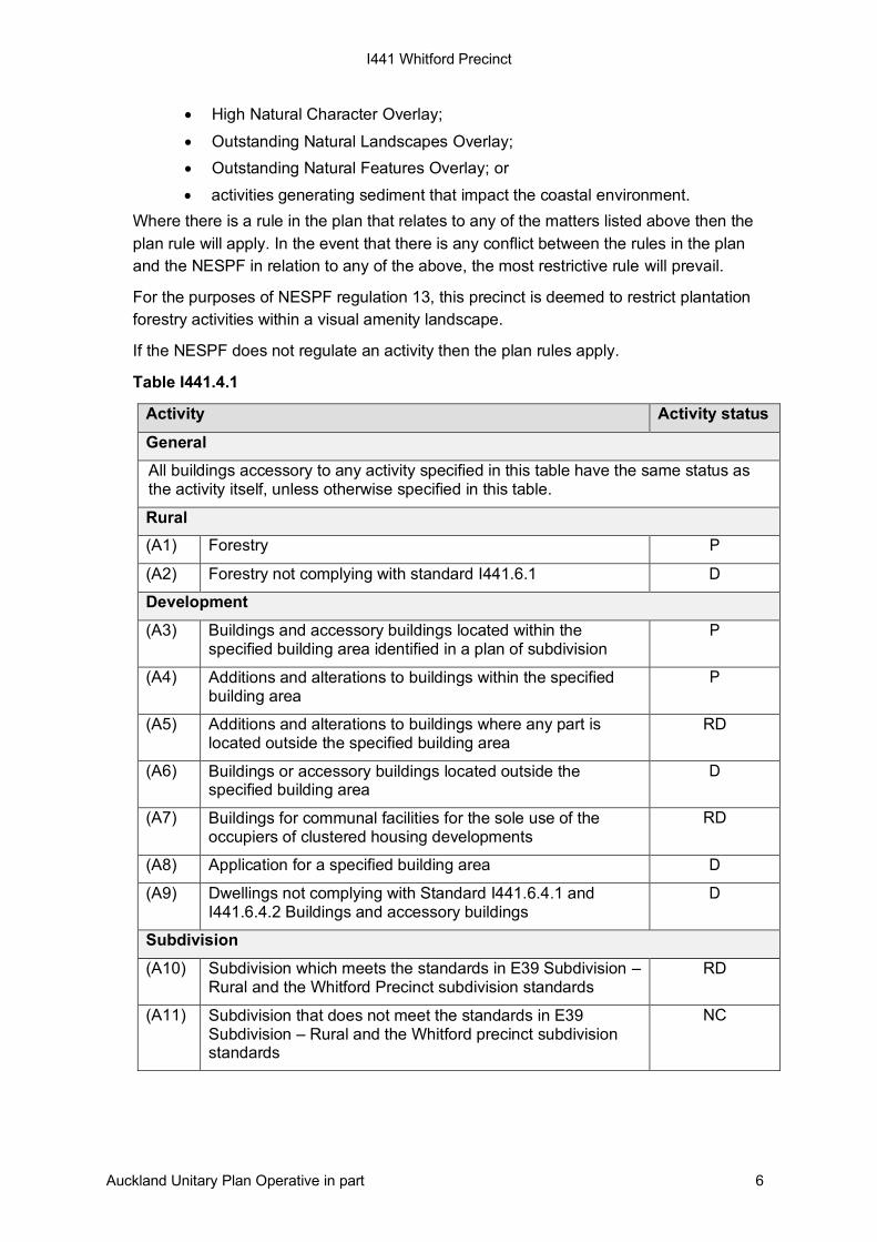
I441 Whitford Precinct
Auckland Unitary Plan Operative in part 6
• High Natural Character Overlay;
• Outstanding Natural Landscapes Overlay;
• Outstanding Natural Features Overlay; or
• activities generating sediment that impact the coastal environment.
Where there is a rule in the plan that relates to any of the matters listed above then the
plan rule will apply. In the event that there is any conflict between the rules in the plan
and the NESPF in relation to any of the above, the most restrictive rule will prevail.
For the purposes of NESPF regulation 13, this precinct is deemed to restrict plantation
forestry activities within a visual amenity landscape.
If the NESPF does not regulate an activity then the plan rules apply.
Table I441.4.1
Activity Activity status
General
All buildings accessory to any activity specified in this table have the same status as the activity itself, unless otherwise specified in this table.
Rural
(A1) Forestry P
(A2) Forestry not complying with standard I441.6.1 D
Development
(A3) Buildings and accessory buildings located within the specified building area identified in a plan of subdivision
P
(A4) Additions and alterations to buildings within the specified building area
P
(A5) Additions and alterations to buildings where any part is located outside the specified building area
RD
(A6) Buildings or accessory buildings located outside the specified building area
D
(A7) Buildings for communal facilities for the sole use of the occupiers of clustered housing developments
RD
(A8) Application for a specified building area D
(A9) Dwellings not complying with Standard I441.6.4.1 and I441.6.4.2 Buildings and accessory buildings
D
Subdivision
(A10) Subdivision which meets the standards in E39 Subdivision – Rural and the Whitford Precinct subdivision standards
RD
(A11) Subdivision that does not meet the standards in E39 Subdivision – Rural and the Whitford precinct subdivision standards
NC
I441 Whitford Precinct
Auckland Unitary Plan Operative in part 7
I441.5. Notification
(1) Any application for resource consent for an activity listed in Table Error!
Reference source not found..1 Activity table above will be subject to the normal
tests for notification under the relevant sections of the Resource Management Act
1991.
(2) When deciding who is an affected person in relation to any activity for the
purposes of section 95E of the Resource Management Act 1991 the Council will
give specific consideration to those persons listed in Rule C1.13(4).
I441.6. Standards
The overlay, zone and Auckland-wide standards apply in this precinct, except for the
following:
• Rural zone rules H19.10.10 Dwellings and Table H19.8.2 do not apply.
All activities listed as permitted and restricted discretionary activities in Table I441.4.1
must comply with the following permitted activity standards.
I441.6.1. Forestry
(1) Maximum planted area within the road corridor, shown on Whitford Precinct:
Precinct plan 4: Whitford road corridor, is 1ha per site.
(2) Maximum planted area outside the road corridor, shown on Whitford Precinct:
Precinct plan 4: Whitford road corridor, is 4ha per site.
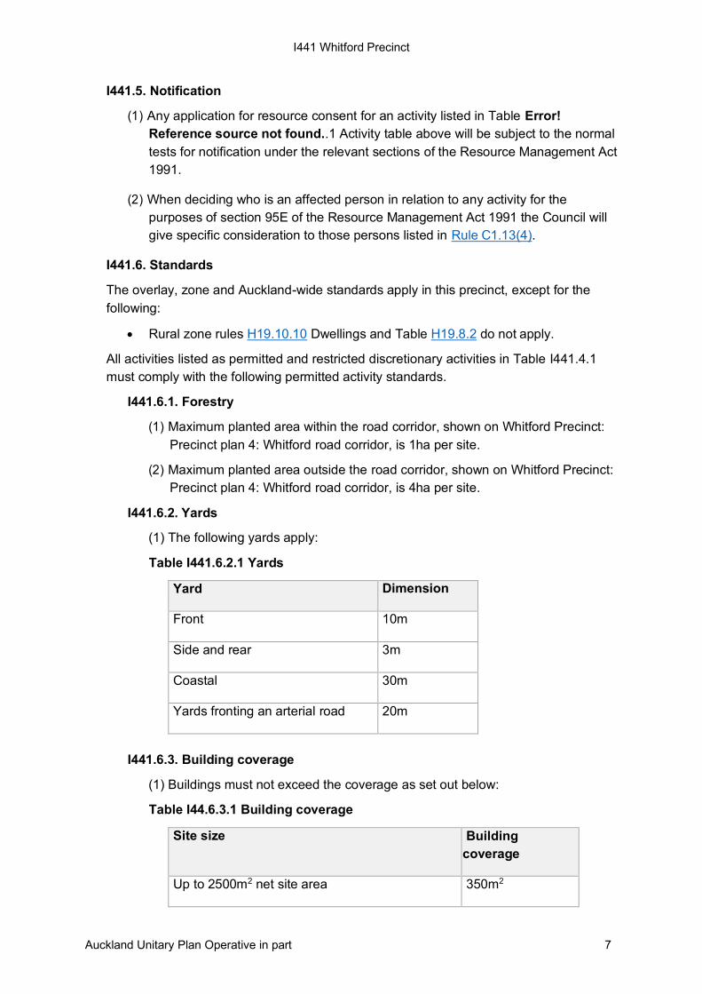
I441.6.2. Yards
(1) The following yards apply:
Table I441.6.2.1 Yards
Yard Dimension
Front 10m
Side and rear 3m
Coastal 30m
Yards fronting an arterial road 20m
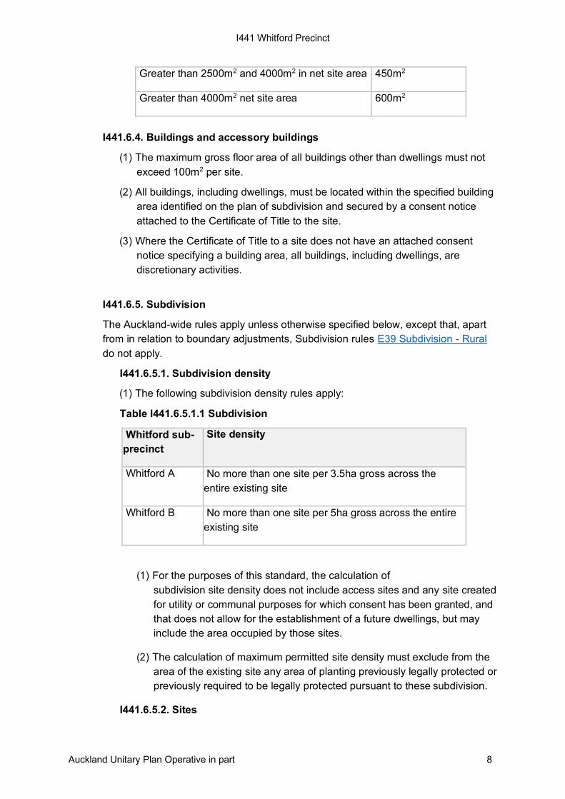
I441.6.3. Building coverage
(1) Buildings must not exceed the coverage as set out below:
Table I44.6.3.1 Building coverage
Site size Building
coverage
Up to 2500m2 net site area 350m2
I441 Whitford Precinct
Auckland Unitary Plan Operative in part 8
Greater than 2500m2 and 4000m2 in net site area 450m2
Greater than 4000m2 net site area 600m2
I441.6.4. Buildings and accessory buildings
(1) The maximum gross floor area of all buildings other than dwellings must not
exceed 100m2 per site.
(2) All buildings, including dwellings, must be located within the specified building
area identified on the plan of subdivision and secured by a consent notice
attached to the Certificate of Title to the site.
(3) Where the Certificate of Title to a site does not have an attached consent
notice specifying a building area, all buildings, including dwellings, are
discretionary activities.
I441.6.5. Subdivision
The Auckland-wide rules apply unless otherwise specified below, except that, apart
from in relation to boundary adjustments, Subdivision rules E39 Subdivision - Rural
do not apply.
I441.6.5.1. Subdivision density
(1) The following subdivision density rules apply:
Table I441.6.5.1.1 Subdivision
Whitford sub-
precinct
Site density
Whitford A No more than one site per 3.5ha gross across the
entire existing site
Whitford B No more than one site per 5ha gross across the entire
existing site
(1) For the purposes of this standard, the calculation of
subdivision site density does not include access sites and any site created
for utility or communal purposes for which consent has been granted, and
that does not allow for the establishment of a future dwellings, but may
include the area occupied by those sites.
(2) The calculation of maximum permitted site density must exclude from the
area of the existing site any area of planting previously legally protected or
previously required to be legally protected pursuant to these subdivision.
I441.6.5.2. Sites
I441 Whitford Precinct
Auckland Unitary Plan Operative in part 9
The existing site:
(1) For the purposes of this standard, existing site means all the land held in a
separate certificate of title dated 8 July 2005. This was the date for public
notification of the Whitford rural plan change.
(2) Subdivision may be carried out in stages by making reference back to the
parent site existing as at 8 July 2005 provided the total number of sites
does not exceed the maximum site density.
(3) Where an application for subdivision consent incorporates two or more
adjoining existing sites, the total area of the land subject to the application
may be treated as one site for the sole purpose of configuring and
designing the subdivision. The number and size of proposed sites in the
application must not exceed the total number and size of sites that would
otherwise be created as a restricted discretionary activity for each of the
individual existing sites.
(4) In respect of any site within a subdivision capable of further subdivision
under these standards, there must be no further subdivision of that site if
it would result in the total permitted density being exceeded with respect
to the existing site. This requirement is to be secured by a suitable legal
instrument which must be registered on certificates of title to ensure
ongoing compliance with this standard.
(5) Where an application for subdivision consent is for an existing site held in
a separate certificate of title on 8 July 2005 and contains land both inside
and outside the Whitford Precinct, the area of land contained within the
precinct must be considered the existing site or parent site under these
standards. Land outside the Whitford Precinct must not be used in the
calculation of the average site size for subdivision.
(6) Where an application for subdivision consent includes proposed sites that
cross the Whitford Sub-precinct A and Sub-precinct B boundaries, no less
than 50% of the net site area of a proposed site shall be located within the
Whitford A sub-precinct to qualify as a site meeting the minimum site area
requirement under these standards.
I441.6.5.3. Specified building area
(1) The subdivision plans must show a minimum 15 metre by 15 metre area
specified building area complying with standards and any site specific
constraints to demonstrate that it can contain a household unit.
(2) Buildings must be limited to the specified building area.
(3) The specified building area and the access to each specified building area
must be proven to be geotechnically stable.
I441 Whitford Precinct
Auckland Unitary Plan Operative in part 10
(4) The specified building area must not be located within a corridor extending
10 metres either side of a perennial stream (as indicated on precinct plan
1 and precinct plan 2), or any ephemeral stream.
(5) Within the Whitford Quarry Buffer, details shall be provided of the outcome
of consultation with representatives of the owners and operators of the
Whitford Quarry and Whitford Landfill concerning the proposed location of
the specified building area.
I441.6.5.4. Riparian management indicative constraints area
(1) Where there is conflict between the location of a permanent stream
mapped on Whitford Precinct: Precinct plans 1 and 2 and the physical
location of the permanent stream on the site, the physical location of the
permanent stream on the site applies.
(2) A minimum 10m strip must be planted in accordance with the precinct
rules and fenced off from each bank of all permanent streams and will
constitute the riparian management indicative constraints area, provided
council may approve an alternative means of excluding livestock. This
constraints area must also include any wetland areas associated with
permanent streams on the site. Where there is no obvious stream bank, a
two-year ARI event water level as determined by a suitably qualified and
experienced person will be used to determine the stream bank.
(3) All buildings and structures excluding fencing must be set back a minimum
of 5m from the constraints area.
(4) Where the planting and revegetation required will be contiguous over
more than three sites, a management structure or ongoing arrangement
must be established to ensure the ongoing integrated management and
maintenance of this planting and revegetation.
(5) Where there is production forestry that was in existence at 8th July 2005
and is located within the riparian management indicative constraints area,
the council may consent to a postponement of the planting required under
this standard. This postponement can be no longer than 12 months after
the clear felling harvest of the trees.
(6) For guidance see the Whitford Precinct guidelines for native revegetation
plantings for the required planting and management measures that relate
to this standard.
I441.6.5.5. Environmental mitigation and enhancement
(1) The permanent protection of all areas of existing native vegetation shown
on Whitford Precinct: Precinct plan 2 must be secured by a suitable legal
instrument which must be registered on certificates of title and binding on
successors in title, and is to provide for the following:
I441 Whitford Precinct
Auckland Unitary Plan Operative in part 11
(a) a requirement not to destroy or damage existing areas of native
vegetation shown on Whitford Precinct: Precinct plan 2, the exact
dimensions to be confirmed at the stage of subdivision
(b) all legally protected areas must be fenced unless the council approves
an alternative fencing layout which effectively excludes
all livestock from such areas.
(2) Where the area of existing native vegetation required to be protected in (1)
above is less than 1ha for each additional site created, additional native
vegetation planting will be required to provide a minimum of 1ha in
Whitford Sub-precinct A and 5000m2 in Whitford Sub-precinct B for each
additional site.
(3) The minimum requirement in (2) above can include:
(a) the planting requirement for the riparian management indicative
constraints area in Standard I441.6.5.34 above; and/or
(b) the planting required for slopes greater than 15 degrees in Standard
I441.6.5.76 below; and/or
(c) areas of native vegetation shown to have been specifically planted for
enhancing or mitigating provided this does not include any area
planted as a condition of any previous resource consent, or through
public funding.
(4) The planting requirement must be located within the Whitford Precinct and
must be confined to areas where planting will provide:
(a) valuable ecological linkages; and/or
(b) significant benefits and improvements to water quality and land
stability within the Whitford Precinct; and/or
(c) enhancement of existing water courses and any wetland areas to
ensure their long term health and viability; and/or
(d) a significant and sustainable forest in its own right.
(5) Where the planting and revegetation required under this standard will be
contiguous over more than three sites, a management structure or other
appropriate ongoing arrangement must be established to ensure ongoing
integrated management and maintenance of this planting and
revegetation.
(6) For guidance the planting plan for this Standard are contained in the
Whitford Precinct guidelines for native revegetation planting.
I441 Whitford Precinct
Auckland Unitary Plan Operative in part 12
(7) Exception. Where production forestry was in existence as at 8 July 2005
and is located within the constraints area or the slopes indicative
constraints area, council may consent to a postponement of the required
planting. This postponement may be no longer than 12 months after the
clear felling harvest of trees within either the riparian constraint area or the
slopes constraints area. A condition of subdivision consent to this effect
will be imposed to ensure continuing compliance by the subdividing owner
and subsequent owners. A consent notice will also be issued under s. 221
of the Resource Management Act 1991 specifying any such condition.
The consent notice will be registered against the Certificates of Title to the
relevant sites and will bind all subsequent owners of the land.
I441.6.5.6. Slopes indicative constraints area
(1) For sites containing slopes steeper than 15 degrees shown on Whitford
Precinct: Precinct plan 1 a report must be prepared by a suitably qualified
and experienced person identifying:
(a) slopes steeper than 21 degrees;
(b) any slopes that exhibit signs of instability or past erosion; and
(c) any slopes subject to erosion in view of their soil and slope
characteristics.
(2) All land identified in Standard I441.6.5.6(1) above must be planted in
accordance with Standard I441.6.5.9 provided the planting will not apply
on slopes steeper than 21 degrees if a report prepared by a suitably
qualified and experienced person confirms there is no need as those
slopes do not exhibit signs of instability or past erosion, or are not subject
to erosion in view of their soil and slope characteristics e.g. rocky cliff,
and:
(a) stock is to be permanently excluded from those slopes; and
(b) the area is to be maintained in accordance with a management plan
that controls weeds and pests.
Note
Where a production forest was in existence on 8 July 2005 and is located within
the constraint area, the council may consent to postponing the required planting
under this standard. This postponement may be no longer than 12 months after
the clear felling harvest of trees within the constraint area at which time the
required planting will be done.
A condition of subdivision consent to this effect will be imposed to ensure
continuing compliance by the subdividing owner and subsequent owners. A
consent notice will also be issued under the Resource Management Act
1991 specifying any such condition. The consent notice will be registered against
I441 Whitford Precinct
Auckland Unitary Plan Operative in part 13
the certificates of title to the relevant sites and will bind all subsequent owners of
the land.
I441.6.5.7. Recreational trails
(1) Where land with recreational trails as shown on Whitford Precinct:
Precinct plan 3 is subdivided or developed, or where the first of any one or
more of the sites legally described as allotments 57, 58 or 59 Parish of
Maraetai is subdivided or developed, then provision for the recreational
trails must be made as follows:
(a) the trail route must be generally in accordance with that indicated on
Whitford Precinct: Precinct plan 3 except that a trail between points A
and B is to be established on land owned by the Council unless an
alternative route is established by agreement between the Council and
the owner(s) of the land through which the alternative route would
pass;
(b) the trail should provide access to scenic, historic and ecological
features in the locality;
(c) the trail should be independent of the road;
(d) where it is necessary for the trail to be provided in conjunction with
a road, the Council may require widened berms and other amenity
features along the trail route;
(e) where it is necessary to cross a major traffic route, Council will
consider the practicality of requiring traffic control devices to help trail
users cross safely;
(f) the trail route should be sited clear of the 1 per cent AEP flood path of
any natural stream system;
(g) where the trail route is provided by means of a pedestrian access way,
the legal width of the access way at any point must be no less than 6m
unless Council believes a reduced width can provide the required level
of access; and
(h) the recreational trail must be vested in Council.
(2) Where a recreational trail is required as a condition of approval for a
resource consent, including subdivision, the following design standards
must apply:
(a) recreational trails independent of roads:
(i) minimum width between boundaries of 5m and minimum metalled
formation width of 3m; and
I441 Whitford Precinct
Auckland Unitary Plan Operative in part 14
(ii) water tables and culverts must be provided when required
for stormwater control.
(b) Recreational trails along road berms:
(i) minimum width of 3m and a minimum metalled width of 2m.
(c) provision must be made in the subdivision plan for any recreational
trail shown on the planning maps that traverses the site to be vested in
Council. The trail must be located at a practicable alignment and
grade.
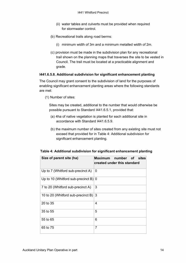
I441.6.5.8. Additional subdivision for significant enhancement planting
The Council may grant consent to the subdivision of land for the purposes of
enabling significant enhancement planting areas where the following standards
are met:
(1) Number of sites:
Sites may be created, additional to the number that would otherwise be
possible pursuant to Standard I441.6.5.1, provided that:
(a) 4ha of native vegetation is planted for each additional site in
accordance with Standard I441.6.5.9.
(b) the maximum number of sites created from any existing site must not
exceed that provided for in Table 4: Additional subdivision for
significant enhancement planting.
Table 4: Additional subdivision for significant enhancement planting
Size of parent site (ha) Maximum number of sites
created under this standard
Up to 7 (Whitford sub-precinct A) 0
Up to 10 (Whitford sub-precinct B) 0
7 to 20 (Whitford sub-precinct A) 3
10 to 20 (Whitford sub-precinct B) 3
20 to 35 4
35 to 55 5
55 to 65 6
65 to 75 7
I441 Whitford Precinct
Auckland Unitary Plan Operative in part 15
(2) Location of significant enhancement planting:
(a) planting must be located within the Whitford Precinct and must be
confined to areas where it will:
(i) provide valuable ecological linkages; or
(ii) provide benefits and improvements to water quality and land
stability; or
(iii) enhance existing water courses, including ephemeral streams, and
any wetland areas to ensure their long-term health and viability; or
(iv) provide a significant and sustainable area of native bush, and may
include:
• the planting requirement for the riparian management indicative
constraint area in Standard I441.6.5.3
• the planting required for slopes greater than 15 degrees in
Standard I441.6.5.6
• any planting provided in Standard I441.6.5.9.
I441.6.5.9. Minimum standards for planting
(1) This rule applies to planting required or proposed pursuant to Standard
I441.6.5.4, Standard I441.6.5.5 and Standard I441.6.5.6.
(2) A re-vegetation plan and programme covering the following matters is
required:
(a) pre-planting site assessment;
(b) planting plan assessment; and
(c) annual monitoring programme.
(3) Planting must be at a minimum density of 1.4m centres - 5100 stems/ha.
A greater density may be required in some situations, for example where
there is a significant weed infestation or the planting is close to streams or
wetlands.
(4) Permanent protection of planting and revegetation areas is to be secured
by a suitable legal instrument which must be registered against the
certificates of title for relevant sites before council issues the s. 224(c)
8 Greater than 75
I441 Whitford Precinct
Auckland Unitary Plan Operative in part 16
certificate under the Resource Management Act 1991, and must include
requirements:
(a) not to destroy or damage protected vegetation;
(b) for protected vegetation to remain undisturbed and weeds and pests to
be adequately controlled; and
(c) for all protected areas to be fenced to prevent undergrazing, unless the
Council approves an alternative method which effectively excludes
all livestock from such areas.
(5) A bond may be required to ensure that any planting is fully established
and sustainable. Any such bond will be registered against the certificates
of title for relevant sites and will bind successors in title.
I441.7. Assessment – controlled activities
There are no controlled activities in this precinct.
I441.8. Assessment – restricted discretionary activities
I441.8.1. Matters of discretion
The council will restrict its discretion to all the following matters when assessing a
restricted discretionary activity resource consent application, in addition to the
matters specified for the relevant restricted discretionary activities in the overlay,
Auckland-wide or zone provisions:
(1) for additions and alterations to buildings where any part is located outside the
specified building form:
(a) the effects on rural character;
(b) the effects on site stability; and
(c) the effects on native vegetation.
(2) for buildings for communal facilities for the sole use of the occupiers of
clustered housing developments:
(a) the effects on rural character and amenity values;
(b) the effects of alternative locations for buildings or structures; and
(c) the effects on native vegetation and archaeological features.
(3) for subdivision which meets the Auckland-wide E39 Subdivision -Rural and
Whitford Precinct subdivision standards:
I441 Whitford Precinct
Auckland Unitary Plan Operative in part 17
(a) the effects on the protection and enhancement of riparian areas and
vegetation;
(b) the effects of the location of building platforms;
(c) the effects on the protection and enhancement of open space;
(d) the effects on the location of internal private ways and rights-of-way;
(e) the effects on the provision of recreational trails;
(f) compatibility of application with the Whitford Precinct design guide;
(g) the effects on the riparian management indicative constraints area;
(h) the effects on the coastal indicative constraint area;
(i) the effects on the road corridor indicative constraints area;
(j) the effects on the slopes indicative constraints area;
(k) the effects on the scenic amenity indicative constraints area;
(l) the effects of re-vegetation planting;
(m) the effects on landscape character and rural amenity values; and
(n) the effects on subdivision for significant enhancement planting.
I441.8.2. Assessment criteria
The council will consider the relevant assessment criteria below for restricted
discretionary activities, in addition to the assessment criteria specified for the relevant
restricted discretionary activities in the overlay, Auckland-wide or zone provisions:
(1) for additions and alterations to buildings where any part is located outside the
specified building form:
(a) the scale and location of the activity should be in keeping with the rural
character of the area:
(i) whether the area onto which the activity is to extend is stable enough
to support the structure; and
(ii) the extent to which the native vegetation shown on Whitford Precinct:
Precinct plan 2 is adversely affected.
(2) for buildings for communal facilities for the sole use of the occupiers of
clustered housing developments.
(a) effects on rural character and amenity values:
I441 Whitford Precinct
Auckland Unitary Plan Operative in part 18
(i) whether the location of the building or structure takes into account the
description, explanation and purpose of any indicative constraints area
it lies within;
(ii) the extent to which the spaciousness of the precinct is maintained
within the site taking into consideration the position of the building or
structure in response to the landform;
(iii) whether the design, orientation, layout and external appearance of the
building or structure blends in with the rural landscape;
(iv) the extent to which the use and activities associated with the building
or structure are compatible with the rural environment and whether the
activity causes conflicts with adjoining land uses;
(v) whether the building or structure complies with the development and
land use controls for the precinct; and
(vi) whether the purpose of the building or structure is accessory to the
clustered housing development it serves.
(b) alternative locations for building and structure:
(i) whether the environmental effects of other alternative locations for the
building or structure are considered and the proposed location provide
the best environmental outcome with respect to its overall design;
(ii) the extent to which the location of the building or structure is in relation
to the clustered housing development it serves; and
(iii) the extent to which the location of the building or structure is within the
clustered housing development it serves.
(c) native vegetation:
(i) whether the building or structure will require the removal of native
vegetation.
(3) for subdivision which meets the Auckland-wide E39 Subdivision -Rural and
Whitford precinct subdivision rules:
(a) protection and enhancement of protected vegetation:
(i) the extent to which any dwelling, accessory building, specified building
area or access driveway is located to minimise adverse effects on any
native vegetation shown on Whitford Precinct: Precinct plan 2; and
(ii) in assessing any plan for any proposed planting:
• the extent to which plants are appropriate to the locality,
accommodating matters such as slope, soil type, exposures to
winds, degree of shading and wetness of the site;
• the extent to which site preparation includes weed/pest removal
and stock proof fencing;
I441 Whitford Precinct
Auckland Unitary Plan Operative in part 19
• the extent to which planting will take account of the seasons and
be of an appropriate size; and
• the extent to which planting and revegetation will protect and
enhance ecological values, natural landscape patterns and values.
(b) location of specified building area:
(i) the extent to which any specified building areas are located so they
minimise adverse effects on rural amenity, stormwater runoff and
sediment loss.
(c) protection and enhancement of open space:
(i) the extent to which a suitable legal mechanism is required to prevent
the future establishment of household units in any area identified as
having particular landscape or rural character value.
(d) location of internal private ways, rights-of-way or public road:
(i) whether these are located at a grade, width and alignment, and with a
finished surface to avoid or mitigate adverse effects on the site’s rural
character.
(e) provision of recreational trails:
(i) the extent to which any trails shown on the subdivision plan generally
accord with those shown on the planning maps. And whether they are
at a practical grade and alignment and link other recreational trails on
adjacent properties that are also generally accord with trails shown on
the planning maps; and
(ii) the extent to which trails volunteered by a landowner or applicant
additional to those shown on the planning maps are shown on a
subdivision plan. And whether any volunteered trails are of a practical
grade and alignment and, where practicable, linked to trails shown on
the planning maps or formed on adjoining properties.
(f) compatibility of application with the Whitford Precinct design guide:
(i) whether the location of any practicable building platforms and the
general layout of the subdivision along with any proposed planting
complies with design guide principles.
(g) riparian management indicative constraints area:
(i) the extent to which the location of the fencing relates to the
topography and the physical characteristics of the natural landform,
including streams, wetlands and slopes;
(ii) the extent to which planting reflects the composition of former natural
vegetation likely to have occupied the site and have regard to natural
processes of succession;
I441 Whitford Precinct
Auckland Unitary Plan Operative in part 20
(iii) the extent to which existing exotics are protected where these are
non-invasive and have positive environmental values, such as
landscape and amenity value; and
(iv) whether protection and planting out of the riparian margins take
account of the ecological health of the stream, and the opportunities to
enhance the ecosystem.
(h) coastal indicative constraints area:
(i) whether the natural character and landscape values of the coastal
environment will be adversely affected;
(ii) the extent to which development will be consistent with the key
national policy documents on the management of the coastal
environment, including the New Zealand Coastal Policy Statement
2010;
(iii) whether buildings are sited and designed so they do not break the
line and form of the landscape with special regard to ridgelines,
headlands, promontories and prominent slopes, and whether their
design uses topography or existing vegetation to screen adverse
visual effects; and
(iv) whether they are located in less prominent locations using a design,
orientation, layout and external appearance to avoid or remedy
adverse effects on the natural character of the coastal environment,
coastal landscapes, amenity values, public access and the potential
for future public access, natural features and ecosystems.
(i) road corridor indicative constraints area:
(i) the extent to which existing topographical features are used to
screen buildings and development within the area shown on precinct
plan 4 from view from any primary roads, and whether buildings and
driveways are visually obtrusive from primary roads unless mitigation
planting is required under rules for riparian management and slopes
indicative constraints areas;
(ii) the extent to which dwellings within the road corridor are screened by
existing topographical features. Where this is not possible such as for
geotechnical reasons, then consideration should be given to
minimising the visual effects by other means. This may include limiting
the height to one storey or using building material and colours
sympathetic to the surroundings. Where possible, buildings are to be
located to take advantage of screening afforded by the required
enhancement planting;
(iii) whether the location of new amenity, mitigation and/or screen planting
restricts views from the road of rural land or the coast, or limit the
ability to retain open space areas within the road corridor and maintain
I441 Whitford Precinct
Auckland Unitary Plan Operative in part 21
views of the landscape beyond, unless mitigation planting is required
under the rules relating to riparian management and slopes indicative
constraints areas;
(iv) the extent to which development within the road corridor leads to an
over concentration of visible development in one vicinity; and
(v) whether lineal or ribbon development is avoided within
the road corridor.
(j) slopes indicative constraints area:
(i) whether buildings are sited to avoid land steeper than 15 degrees and
susceptible to erosion.
(k) scenic amenity indicative constraints area:
(i) whether buildings and driveways are visually obtrusive when viewed
from any public road, reserve, coastal environment or public place. In
prominent locations, whether buildings are avoided or, if the location
is necessary, such as for geotechnical reasons, whether height is
limited to one storey, visible building bulk minimised, and other
techniques such as building materials and colours sympathetic to
surroundings used.
(l) revegetation planting:
(i) whether the location of revegetation planting takes into account its
purpose, including:
• revegetation of slopes steeper than 15 degrees as shown on
Whitford Precinct: Precinct plan 1 which are subject to significant
risk of erosion and instability;
• riparian margin and wetland restoration and coastal margin
restoration;
• extension of existing ecological corridors;
• enhancement of ephemeral streams; and
• enhancement of existing native vegetation.
(ii) whether revegetation or mitigation planting integrates with surrounding
vegetation patterns and natural boundaries i.e. streams, gullies,
ridgelines.
(iii) whether the location of revegetation planting:
• adversely affects the rural character and amenity values of the
precinct; and
• undermine the intent of the various indicative constraints areas
I441 Whitford Precinct
Auckland Unitary Plan Operative in part 22
(iv) whether the location achieves the best environmental outcome for
the site;
(v) whether consideration is given to a better environmental outcome
might be achieved by transferring the planting to a different site within
the precinct;
(vi) the extent to which planting is within 20m either side of the centre
point of a high voltage (110Kv or higher) transmission line, the species
of trees to be planted are to maintain safe clearance distances at a
mature height, in accordance with the Electricity (Hazards from Trees)
Regulations 2003;
(vii) whether replanting prevents vehicular access to existing transmission
lines; and
(viii) whether the revegetation programme/plan for any proposed planting:
• include plants appropriate to the locality, allowing for matters such
as slope, soil type, exposure to winds, degree of shading and
wetness of the site;
• include weed/pest removal and the provision of stock proof fencing
as part of the preparation;
• consider the season of planting;
• ensure the plant size is appropriate to the locality;
• protect and enhance ecological values and natural landscape; and
patterns and values.
(m) effects on rural character and rural amenity values:
(i) the extent to which subdivision design accommodates the purpose(s)
of any constraints areas it lies within open space is maintained, taking
into consideration whether buildings are dispersed or clustered in
response to the landform;
(ii) the extent to which any earthworks integrate with surrounding natural
landforms;
(iii) the extent to which revegetation or mitigation planting integrates with
surrounding vegetation patterns and natural boundaries i.e. streams,
gullies, ridgelines;
(iv) the extent to which any proposed urban elements, such as kerb and
channel, subdivision entrances and entry statements, curtilage,
boundary fences, boundary walls and exterior lighting, are
incompatible with the precinct’s rural character;
(v) the extent to which the appearance of a working rural landscape is
maintained e.g. pasture, vineyards, agriculture;
I441 Whitford Precinct
Auckland Unitary Plan Operative in part 23
(vi) the extent to which the locations of any buildings to be constructed,
proposed planting or earthworks restrict existing views of the open
countryside surrounding properties; and
(vii) the extent to which the environmental effects of alternative locations
for the proposed boundaries of any new sites, the proposed
practicable building platforms or activities on the site have been
considered and whether the proposed location provides the best
environmental outcome with respect to its overall design.
(n) subdivision for significant enhancement planting:
(i) whether there are no adverse effects on the rural character and
amenity values within the precinct;
(ii) whether the proposal achieves good environmental outcomes on the
parent site or an appropriate alternative site;
(iii) whether adequate legal and physical protection provides for the
replanted area, including fencing, weed and animal pest control;
(iv) whether native planting is appropriate for the site e.g. eco-sourcing,
soil type, aspect, wetness; and
(v) whether replanted area is sustainable and becomes an ecosystem in
its own right.
(o) effects on landfill activities
The extent to which subdivision of development is located in the Quarry
Buffer Area surrounding Whitford Quarry and Whitford Landfill, subdivision
or development is located and designed to avoid the potential for adverse
effects (including reverse sensitivity effects) on the existing landfill, including
(in addition to the measures that apply in respect of quarry activities in the
Quarry Buffer Area rules):
(i) whether the location and orientation of a dwelling and outdoor living
areas in the specified building area can ensure occupants are
adequately separated and/or protected from the adverse effects of
landfill activities and heavy haulage routes, including existing and
future odour, noise, dust and vibration;
(ii) whether building design, landform modifications or planting proposals
are able to mitigate existing and future odour, noise and visual effects
of the landfill activity;
(iii) whether sufficient acoustic insulation measures in the design of a
building in the specified building area can ensure an internal noise
environment in habitable rooms that does not exceed LAeqLdn (1hr)
40dBA; and
I441 Whitford Precinct
Auckland Unitary Plan Operative in part 24
(iv) whether buildings or activities in the specified building area would
unduly limit the operation of an existing landfill activity, including its
future operations.
I441.9. Special information requirements
I441.9.1. Removal of native vegetation shown on Whitford Precinct: Precinct
plan 2: Location of permanent streams and native vegetation indicative
constraints areas.
(1) An application to remove native vegetation must have a management plan
that includes:
(a) the nature, extent, ecological and landscape significance of all native
vegetation on the site;
(b) the nature and extent of any proposed alteration to the native vegetation;
(c) the reasons for altering native vegetation;
(d) the nature and extent of any development of the site likely to affect the
area of remaining native vegetation;
(e) details of noxious weed and animal control; and
(f) details in both map and written form, and sufficient information to give a
clear understanding of the plan.
I441 Whitford Precinct
Auckland Unitary Plan Operative in part 25
I441.9.2. Forestry
(1) An application for resource consent for forestry must include a management
plan prepared to council's satisfaction and including the following information:
(a) location and scale of areas proposed for forestry;
(b) an assessment of any archaeological or historic sites within the areas
proposed for forestry;
(c) an assessment of the impact of the proposal on natural habitat values of
the locality and measures to be used to protect those values;
(d) an assessment of the impact of the proposal on any natural heritage
overlay areas and measures to be used to preserve and protect the
quality, character and values of those landscapes;
(e) methods to be used to prevent erosion during forestry work;
(f) the time period over which forestry will take place;
(g) measures to be used to protect water flow and quality of any bodies of
water or wetlands in the vicinity;
(h) methods to be employed to inhibit the spread of fire within and in the
vicinity of the area to be forested;
(i) likely methods to be employed in harvesting operations;
(j) estimated volumes of timber produced and intended methods of transport
of harvested timber from the site;
(k) the likely demands placed on roads and transportation facilities through
the transportation of harvested timber; and
(l) the application must also include a sustainable forest management plan.
I441 Whitford Precinct
Auckland Unitary Plan Operative in part 26
I441.10. Precinct plans
I441.10.1. Whitford Precinct: Precinct plan 1
I441 Whitford Precinct
Auckland Unitary Plan Operative in part 27
I441.10.2. Whitford Precinct: Precinct plan 2 - vegetation management
I441 Whitford Precinct
Auckland Unitary Plan Operative in part 28
I441.10.3. Whitford Precinct: Precinct plan 3 - coastal and scenic amenity
I441 Whitford Precinct
Auckland Unitary Plan Operative in part 29
I441.10.4. Whitford Precinct: Precinct plan 4 - location of road corridor