Draft Environmental Impact Report
120
Prepared for: California Department of Toxic Substances Control 1001 I Street Sacramento, CA 95814 April 2010 SCH #2008051003 Draft Environmental Impact Report for the Topock Compressor Station Groundwater Remediation Project California Department of Toxic Substances Control
Transcript of Draft Environmental Impact Report

Prepared for:
California Department of Toxic Substances Control1001 I Street
Sacramento, CA 95814
April 2010
SCH #2008051003
Draft Environmental Impact Reportfor the
Topock Compressor StationGroundwater Remediation Project
California Department of Toxic Substances Control

Prepared by:
AECOM2022 J Street
Sacramento, CA 95811
April 2010
Prepared for:
California Department of Toxic Substances Control1001 I Street
Sacramento, CA 95814
Contact: Aaron Yue
Project Manager5796 Corporate Avenue
Cypress, CA [email protected]
Draft Environmental Impact Reportfor the
Topock Compressor StationGroundwater Remediation Project
California Department of Toxic Substances Control
SCH #2008051003

Topock Compressor Station Final Remedy DEIR AECOM California Department of Toxic Substances Control i Table of Contents
TABLE OF CONTENTS
Section Page
1 SUMMARY .............................................................................................................................................. 1-1 1.1 Introduction .................................................................................................................................. 1-1 1.2 Summary of the Proposed Project ................................................................................................ 1-1
1.2.1 Project Location .............................................................................................................. 1-1 1.2.2 Project Objectives ........................................................................................................... 1-2 1.2.3 Description of the Proposed Project ................................................................................ 1-2 1.2.4 Decommissioning of the Proposed Project ...................................................................... 1-6
1.3 Summary of Project Alternatives ................................................................................................. 1-7 1.3.1 Alternative B—Monitored Natural Attenuation .............................................................. 1-7 1.3.2 Alternative C—High Volume in Situ Treatment ............................................................. 1-7 1.3.3 Alternative D—Sequential In Situ Treatment ................................................................. 1-8 1.3.4 Alternative F—Pump and Treat ...................................................................................... 1-8 1.3.5 Alternative G—Combined Floodplain in Situ/Pump and Treat ...................................... 1-9 1.3.6 Alternative H—Combined Upland in Situ/Pump and Treat ............................................ 1-9 1.3.7 Alternative I—No Project Alternative/Continued Operation of Interim Measure ........ 1-10
1.4 Summary of Known Controversial Issues .................................................................................. 1-10 1.5 Issues to be Resolved ................................................................................................................. 1-11 1.6 Summary of Impacts and Mitigation .......................................................................................... 1-12 1.7 Summary of Cumulative Impacts ............................................................................................... 1-12 1.8 Summary of the Settlement Agreement Requirements .............................................................. 1-12
1.8.1 Biological Resources ..................................................................................................... 1-13 1.8.2 Cultural Resources ........................................................................................................ 1-13
2 INTRODUCTION ................................................................................................................................... 2-1 2.1 Type, Purpose, and Intended Use of This Environmental Impact Report .................................... 2-1
2.1.1 Combined Program and Project-Level Analysis in this Environmental Impact Report .. 2-1 2.1.2 Contents and Purpose of This Environmental Impact Report ......................................... 2-3
2.2 Background of the Proposed Project ............................................................................................ 2-3 2.2.1 Compressor Station History and Activities ..................................................................... 2-3 2.2.2 Chemical Use and Disposal at the Compressor Station .................................................. 2-4 2.2.3 Groundwater Contamination ........................................................................................... 2-7 2.2.4 Corrective Action History ............................................................................................... 2-8 2.2.5 Ongoing Evaluation of Soils Contamination ................................................................. 2-10
2.3 Agency Roles and Responsibilities ............................................................................................ 2-12 2.3.1 Responsible and Trustee Agencies ................................................................................ 2-13 2.3.2 Federal ........................................................................................................................... 2-14 2.3.3 Arizona Agencies .......................................................................................................... 2-15 2.3.4 Consultation and Coordination ...................................................................................... 2-15
2.4 Remediation and Environmental Review Process ...................................................................... 2-15 2.4.1 Remediation Process ..................................................................................................... 2-15 2.4.2 Environmental Review Process ..................................................................................... 2-16
2.5 Scope of This Environmental Impact Report ............................................................................. 2-18 2.6 DEIR Organization ..................................................................................................................... 2-18 2.7 Terminology Used in This DEIR ............................................................................................... 2-20

AECOM Topock Compressor Station Final Remedy DEIR Table of Contents ii California Department of Toxic Substances Control
TABLE OF CONTENTS
Continued Page
3 PROJECT DESCRIPTION .................................................................................................................... 3-1 3.1 Introduction .................................................................................................................................. 3-1 3.2 Project Location ........................................................................................................................... 3-1 3.3 Project Purpose ............................................................................................................................. 3-2 3.4 Project Objectives ......................................................................................................................... 3-2 3.5 Description of the Proposed Project ............................................................................................. 3-7
3.5.1 Description of Proposed Project Features ..................................................................... 3-12 3.5.2 Description of Construction Activities .......................................................................... 3-19 3.5.3 Operation and Maintenance of the Proposed Project .................................................... 3-24 3.5.4 Decommissioning of the Proposed Project .................................................................... 3-26
4 ENVIRONMENTAL ANALYSIS ......................................................................................................... 4-1 4.1 Aesthetics .................................................................................................................................. 4.1-1
4.1.1 Existing Setting ............................................................................................................ 4.1-1 4.1.2 Regulatory Background .............................................................................................. 4.1-23 4.1.3 Environmental Impacts and Mitigation Measures ...................................................... 4.1-25
4.2 Air Quality ................................................................................................................................. 4.2-1 4.2.1 Existing Setting ............................................................................................................ 4.2-1 4.2.2 Regulatory Background .............................................................................................. 4.2-10 4.2.3 Environmental Impacts and Mitigation Measures ...................................................... 4.2-24
4.3 Biological Resources ................................................................................................................. 4.3-1 4.3.1 Existing Setting ............................................................................................................ 4.3-1 4.3.2 Regulatory Background .............................................................................................. 4.3-19 4.3.3 Environmental Impacts and Mitigation Measures ...................................................... 4.3-23
4.4 Cultural Resources .................................................................................................................... 4.4-1 4.4.1 Existing Setting ............................................................................................................ 4.4-1 4.4.2 Regulatory Setting ...................................................................................................... 4.4-35 4.4.3 Environmental Impacts and Mitigation Measures ...................................................... 4.4-46
4.5 Geology and Soils ..................................................................................................................... 4.5-1 4.5.1 Existing Setting ............................................................................................................ 4.5-1 4.5.2 Regulatory Background .............................................................................................. 4.5-42 4.5.3 Environmental Impacts and Mitigation Measures ...................................................... 4.5-45
4.6 Hazardous Materials .................................................................................................................. 4.6-1 4.6.1 Existing Setting ............................................................................................................ 4.6-1 4.6.2 Regulatory Background ................................................................................................ 4.6-9 4.6.3 Environmental Impacts and Mitigation Measures ...................................................... 4.6-12
4.7 Hydrology and Water Quality ................................................................................................... 4.7-1 4.7.1 Existing Setting ............................................................................................................ 4.7-1 4.7.2 Regulatory Background .............................................................................................. 4.7-38 4.7.3 Environmental Impacts and Mitigation Measures ...................................................... 4.7-45
4.8 Land Use and Planning .............................................................................................................. 4.8-1 4.8.1 Existing Setting ............................................................................................................ 4.8-1 4.8.2 Regulatory Background ................................................................................................ 4.8-5 4.8.3 Environmental Impacts and Mitigation Measures ........................................................ 4.8-9

Topock Compressor Station Final Remedy DEIR AECOM California Department of Toxic Substances Control iii Table of Contents
TABLE OF CONTENTS
Continued Page
4.9 Noise .......................................................................................................................................... 4.9-1 4.9.1 Existing Setting ............................................................................................................ 4.9-1 4.9.2 Regulatory Background ................................................................................................ 4.9-9 4.9.3 Environmental Impacts and Mitigation Measures ...................................................... 4.9-16
4.10 Transportation ......................................................................................................................... 4.10-1
4.10.1 Existing Setting .......................................................................................................... 4.10-1 4.10.2 Regulatory Background .............................................................................................. 4.10-6 4.10.3 Environmental Impacts and Mitigation Measures ...................................................... 4.10-9
4.11 Utilities and Service Systems .................................................................................................. 4.11-1 4.11.1 Existing Setting .......................................................................................................... 4.11-1 4.11.2 Regulatory Background .............................................................................................. 4.11-2 4.11.3 Environmental Impacts and Mitigation Measures ...................................................... 4.11-3
4.12 Water Supply ........................................................................................................................... 4.12-1 4.12.1 Existing Setting .......................................................................................................... 4.12-1 4.12.2 Regulatory Background .............................................................................................. 4.12-4 4.12.3 Environmental Impacts and Mitigation Measures ...................................................... 4.12-6
5 OTHER CEQA SECTIONS ................................................................................................................... 5-1 5.1 Unavoidable Significant Impacts ................................................................................................. 5-1
5.1.1 Cultural Resources .......................................................................................................... 5-1 5.1.2 Noise................................................................................................................................ 5-7
5.2 Significant Irreversible Environmental Changes that would be Caused by the Proposed Project 5-8 5.3 Environmental Effects Found Not To Be Significant .................................................................. 5-9
5.3.1 Agriculture Resources ..................................................................................................... 5-9 5.3.2 Mineral Resources ........................................................................................................... 5-9 5.3.3 Population and Housing ................................................................................................ 5-10 5.3.4 Public Services .............................................................................................................. 5-10 5.3.5 RecreATION ................................................................................................................... 5-11
5.4 Growth Inducement .................................................................................................................... 5-11
6 CUMULATIVE IMPACTS .................................................................................................................... 6-1 6.1 Introduction to the Cumulative Analysis ...................................................................................... 6-1 6.2 Geographic Scope ......................................................................................................................... 6-1 6.3 Related Projects ............................................................................................................................ 6-2
6.3.1 Regional Growth Projections .......................................................................................... 6-2 6.3.2 List of Projects in the Vicinity ........................................................................................ 6-3
6.4 Analysis of Cumulative Impacts ................................................................................................ 6-26 6.4.1 Aesthetics ...................................................................................................................... 6-26 6.4.2 Air Quality ..................................................................................................................... 6-27 6.4.3 Biological Resources ..................................................................................................... 6-30 6.4.4 Cultural Resources ........................................................................................................ 6-31 6.4.5 Geology and Soils ......................................................................................................... 6-33 6.4.6 Hazardous Materials ...................................................................................................... 6-34 6.4.7 Hydrology and Water Quality ....................................................................................... 6-35 6.4.8 Land Use and Planning.................................................................................................. 6-35 6.4.9 Noise.............................................................................................................................. 6-36 6.4.10 Transportation ............................................................................................................... 6-37

AECOM Topock Compressor Station Final Remedy DEIR Table of Contents iv California Department of Toxic Substances Control
TABLE OF CONTENTS
Continued Page
6.4.11 Utilities and Service Systems ........................................................................................ 6-39 6.4.12 Water Supply ................................................................................................................. 6-40
7 ALTERNATIVE BASELINE ANALYSIS PURSUANT TO THE SETTLEMENT AGREEMENT7-1 7.1 Introduction .................................................................................................................................. 7-1 7.2 Biological resources Analysis ...................................................................................................... 7-2
7.2.1 January 2004 Setting ....................................................................................................... 7-2 7.2.2 Impact Analysis ............................................................................................................. 7-23
7.3 Cultural Resources analysis ........................................................................................................ 7-24 7.3.1 January 2004 Setting ..................................................................................................... 7-24 7.3.2 Impact Analysis ............................................................................................................. 7-24
8 ALTERNATIVES TO THE PROPOSED PROJECT ......................................................................... 8-1 8.1 Introduction .................................................................................................................................. 8-1 8.2 Rationale for Selection of Alternatives ........................................................................................ 8-1 8.3 Elements Common to all Active project Alternatives .................................................................. 8-2
8.3.1 Construction Activities .................................................................................................... 8-2 8.3.2 Groundwater Monitoring Network .................................................................................. 8-3 8.3.3 Water Conveyance, Utilities, and Roadways .................................................................. 8-3 8.3.4 Optimization of Alternatives ........................................................................................... 8-4 8.3.5 Decommissioning of Facilities ........................................................................................ 8-4 8.3.6 Institutional Controls ....................................................................................................... 8-4
8.4 Description of Alternatives to the Proposed Project .................................................................... 8-4 8.4.1 Alternative B—Monitored Natural Attenuation .............................................................. 8-5 8.4.2 Alternative C—High Volume in Situ Treatment ............................................................. 8-6 8.4.3 Alternative D—Sequential In Situ Treatment ............................................................... 8-14 8.4.4 Alternative F—Pump and Treat .................................................................................... 8-16 8.4.5 Alternative G—Combined Floodplain in Situ/Pump and Treat .................................... 8-20 8.4.6 Alternative H—Combined Upland in Situ/Pump and Treat .......................................... 8-26 8.4.7 No Project Alternative—Alternative I/Continued Operation of Interim Measure ........ 8-31
8.5 Alternatives Analysis ................................................................................................................. 8-35 8.5.1 Alternative B—Monitored Natural Attenuation ............................................................ 8-35 8.5.2 Alternative C—High Volume in Situ Treatment ........................................................... 8-39 8.5.3 Alternative D—Sequential In Situ Treatment ............................................................... 8-43 8.5.4 Alternative F—Pump and Treat .................................................................................... 8-47 8.5.5 Alternative G—Combined Floodplain in Situ/Pump and Treat .................................... 8-52 8.5.6 Alternative H—Combined Upland in Situ/Pump and Treat .......................................... 8-56 8.5.7 Alternative I—No Project Alternative/Continued Operation of Interim Measure 3 ..... 8-61
8.6 Summary of Alternatives Analysis ............................................................................................. 8-64 8.7 Environmentally Superior Alternative ....................................................................................... 8-64 8.8 Alternatives Considered But Rejected ........................................................................................ 8-69
8.8.1 Screening of Remedial Technologies and Alternatives ................................................. 8-70 8.8.2 Selection of Representative Alternatives....................................................................... 8-70
8.9 Rejection of Final CMS/FS Alternative A—No Action ............................................................. 8-70
9 OTHER INFORMATIONAL ANALYSIS ........................................................................................... 9-1 9.1 Environmental Justice .................................................................................................................. 9-1
9.1.1 Existing Setting ............................................................................................................... 9-1 9.1.2 Regulatory Background ................................................................................................... 9-5

Topock Compressor Station Final Remedy DEIR AECOM California Department of Toxic Substances Control v Table of Contents
TABLE OF CONTENTS
Continued Page
9.1.3 Environmental Justice Effects ......................................................................................... 9-7 9.2 SOCIOECONOMICS ................................................................................................................ 9-11
9.2.1 Existing Setting ............................................................................................................. 9-11 9.2.2 Regulatory Background ................................................................................................. 9-27 9.2.3 Socioeconomic Effects .................................................................................................. 9-28
10 BIBLIOGRAPHY ....................................................................................................................................... 1
11 LIST OF PREPARERS ........................................................................................................................ 11-1 11.1 Department of Toxic Substances Control ................................................................................... 11-1 11.2 AECOM ..................................................................................................................................... 11-1
12 GLOSSARY ........................................................................................................................................... 12-1
Appendices (on CD-see back cover)
CMS Corrective Measure Study NOP Notice of Preparation AQ Air Quality Modeling Results BIO Programmatic Biological Assessment for Pacific Gas and Electric Topock Compressor Station
Remedial and Investigative Actions Prepared for Pacific Gas and Electric Company January 2007 WQ Surface Water Sampling Results NO Noise Modeling Results TR Level of Service Computation Report SA Settlement Agreement

AECOM Topock Compressor Station Final Remedy DEIR Table of Contents vi California Department of Toxic Substances Control
TABLE OF CONTENTS
Exhibits Page
2-1 Developed Land Uses and Existing Infrastructure ............................................................................. 2-5 3-1 Regional Project Location ................................................................................................................... 3-3 3-2 Project Vicinity ................................................................................................................................... 3-4 3-3 Boundaries of Contaminated Groundwater Plume and Land Ownership/Management ..................... 3-5 3-4 Conceptual Layout of Proposed Remediation Facilities ..................................................................... 3-9 3-5 Conceptual Layout of Future Monitoring Wells ............................................................................... 3-11 3-6 Typical Flush Mounted IRZ Well ..................................................................................................... 3-13 3-7 Projected Downstream Flow Lines of the Plume .............................................................................. 3-14 3-8 Typical Groundwater Monitoring Well Vault at the Topock Compressor Station ........................... 3-17 3-9 Example of Solar Panel That May Be Used in the Final Remedy .................................................... 3-19 3-10 Track-Mounted Rotosonic Drill Rig and Support Vehicle Used for Locations with
Difficult Access ............................................................................................................................... 3-21 4.1-1 Regional Context Imagery ............................................................................................................... 4.1-2 4.1-2 Regional Context Imagery ............................................................................................................... 4.1-4 4.1-3 Regional Context Imagery ............................................................................................................... 4.1-5 4.1-4 Site Overview .................................................................................................................................. 4.1-7 4.1-5 Site Overview .................................................................................................................................. 4.1-8 4.1-6 Site Overview .................................................................................................................................. 4.1-9 4.1-7 Key View Map ............................................................................................................................... 4.1-11 4.1-8 Key Views ...................................................................................................................................... 4.1-14 4.1-9 Key Views ...................................................................................................................................... 4.1-16 4.1-10 Key Views ...................................................................................................................................... 4.1-17 4.1-11 Key Views ...................................................................................................................................... 4.1-19 4.1-12 Key Views ...................................................................................................................................... 4.1-20 4.1-13 Key Views ...................................................................................................................................... 4.1-22 4.1-14 Key Views ...................................................................................................................................... 4.1-24 4.1-15 Key View 1, Existing Conditions Photo and Visual Simulation of the Proposed Project ............. 4.1-30 4.1-16 Key View 2, Existing Conditions Photo and Visual Simulation of the Proposed Project ............. 4.1-31 4.1-17 Key View 3, Existing Conditions Photo and Visual Simulation of the Proposed Project ............. 4.1-33 4.1-18 Key View 4, Existing Conditions Photo and Visual Simulation of the Proposed Project ............ 4.1-35 4.1-19 Key View 5, Existing Conditions Photo and Visual Simulation of the Proposed Project ............. 4.1-36 4.1-20 Key View 6, Existing Conditions Photo and Visual Simulation of the Proposed Project ............. 4.1-38 4.1-21 Key View 9, Existing Conditions Photo and Visual Simulation of the Proposed Project ............. 4.1-40 4.1-22 Key View 10, Existing Conditions Photo and Visual Simulation of the Proposed Project ........... 4.1-41 4.1-23 Key View 11, Existing Conditions Photo and Visual Simulation of the Proposed Project .......... 4.1-43 4.1-24 Key View 13, Existing Conditions Photo and Visual Simulation of the Proposed Project ........... 4.1-45 4.2-1 California’s Greenhouse Gas Emissions by Economic Sector (2002-2004 Average) ..................... 4.2-9 4.3-1 Habitat and Wetlands Map ............................................................................................................... 4.3-3 4.3-2 Known Locations of Special-Status Wildlife ................................................................................... 4.3-9 4.4-1 Cultural Resources Survey Area .................................................................................................... 4.4-12 4.4-2 Contacted Tribes ............................................................................................................................ 4.4-26 4.4-3 Aerial Photo of the Topock Maze Locus A with Compressor Station in the Distance .................. 4.4-33

Topock Compressor Station Final Remedy DEIR AECOM California Department of Toxic Substances Control vii Table of Contents
TABLE OF CONTENTS
Continued Page
4.5-1 Topographic Map and Project Area ................................................................................................. 4.5-3 4.5-2 Geologic Map and Project Area ....................................................................................................... 4.5-5 4.5-3 Regional Hydrogeologic Cross Section ........................................................................................... 4.5-7 4.5-4 Site Stratigraphy .............................................................................................................................. 4.5-8 4.5-5 Locations of Major Faults in Southern California ......................................................................... 4.5-15 4.5-6 Solid Waste Management Units (SWMUS), Areas of Concern (AOCS), And Other
Undesignated Areas ....................................................................................................................... 4.5-19 4.5.7 SWMUS Associated With the Former Two-Step Wastewater Treatment System ........................ 4.5-21 4.5-8 Industrial Floor Drain Layout ........................................................................................................ 4.5-39 4.7-1 Regional Surface Features ............................................................................................................... 4.7-3 4.7-2 U.S. Army Corps of Engineers Jurisdictional Waters and Wetlands ............................................... 4.7-9 4.7-3 Surface Water Monitoring Location .............................................................................................. 4.7-11 4.7-4 Groundwater Elevation Map Shallow Zone of Alluvial Aquifer (Water Table), June 2006 ......... 4.7-17 4.7-5 Groundwater Elevation Map Mid-Depth Zone of Alluvial Aquifer, June 2006 ............................ 4.7-19 4.7-6 Groundwater Elevation Map, Deep Zone of Alluvial Aquifer, June 2006 .................................... 4.7-21 4.7-7 Groundwater Elevation Map, Shallow Zone of Alluvial Aquifer (Water Table), December
2006 ............................................................................................................................................... 4.7-23 4.7-8 Groundwater Elevation Map, Mid-Depth Zone for Alluvial Aquifer, December 2006 ................ 4.7-25 4.7-9 Groundwater Elevation Map, Deep Zone of Alluvial Aquifer, December 2006 ........................... 4.7-27 4.7-10 Groundwater Hexavalent Chromium Results, Shallow Wells October 2008 and July 2009 ......... 4.7-31 4.7-11 Groundwater Hexavalent Chromium Results, Mid-Depth Wells October 2008 and July
2009 ............................................................................................................................................... 4.7-33 4.7-12 Groundwater Hexavalent Chromium Results, Deep Wells October 2008 and July 2009 ............. 4.7-35 4.8-1 San Bernardino County Zoning ....................................................................................................... 4.8-2 4.9-1 Common Noise Sources and Levels ................................................................................................ 4.9-2 4.9-2 Noise Measurement Locations ......................................................................................................... 4.9-6 4.10-1 Existing Volumes and Traffic Control ........................................................................................... 4.10-2 4.10-2 Construction Trip Assignment Volumes...................................................................................... 4.10-13 4.10-3 Construction (50%) With O&M Trip Assignment ...................................................................... 4.10-14 4.10-4 O&M with Decommissioning Trip Assignment .......................................................................... 4.10-15 4.10-5 Decommissioning Trip Assignment ............................................................................................ 4.10-16 4.10-6 Existing With Construction Volumes .......................................................................................... 4.10-20 4.10-7 Existing With O&M Construction Volumes ................................................................................ 4.10-21 4.10-8 Existing With O&M and Decommissioning Volumes ................................................................ 4.10-22 4.10-9 Existing With Decommissioning Volumes .................................................................................. 4.10-23 4.12-1 Water Accounting Surface Contours ............................................................................................. 4.12-3 6-1 Approximate Location of Cumulative Projects ................................................................................. 6-8 7-1 Im-3 Site And Surrounding Parcels .................................................................................................... 7-3 8-1 Area of Potential Monitoring Wells (Alternatives B, C, F, G) ........................................................... 8-9 8-2 Conceptual Remedial Approach, Alternative C—High Volume in Situ Treatment ......................... 8-11

AECOM Topock Compressor Station Final Remedy DEIR Table of Contents viii California Department of Toxic Substances Control
TABLE OF CONTENTS
Continued Page
8-3 Area of Potential Monitoring Wells for Alternative D—Sequential In Situ Treatment ................... 8-15 8-4 Conceptual Remedial Approach, Alternative D—Sequential In Situ Treatment .............................. 8-17 8-5 Conceptual Remedial Approach, Alternative F – Pump and Treat ................................................... 8-21 8-6 Conceptual Remedial Approach, Alternative G—Combined Floodplain/In Situ Pump and
Treat .................................................................................................................................................. 8-23 8-7 Area of Potential Monitoring Wells for Alternative H – Combined Floodplain in
Situ/Pump and Treat ......................................................................................................................... 8-27 8-8 Conceptual Remedial Approach, Alternative H—Combined Upland in Situ/Pump and
Treat .................................................................................................................................................. 8-29 8-9 No Project Alternative/Alternative I – Continued Operation of Im-3 .............................................. 8-33 9-1 Socioeconomic Regional Map .......................................................................................................... 9-12 9-2 Household Income, 2000 .................................................................................................................. 9-23
Tables Page
1-1 Summary of Project Features .............................................................................................................. 1-4 1-2 Summary of Impacts and Mitigation ................................................................................................ 1-15 1-2 Summary of Impacts and Mitigation ................................................................................................ 1-29 2-1 Status of SWMUs, AOCs, Units, and Other Undesignated Areas ...................................................... 2-9 3-1 Soil Disturbance in the Project Area ................................................................................................. 3-20 4.1-1 Summary of Key Views of the Project Area .................................................................................. 4.1-13 4.1-2 Summary of Potentially Visible Project Features .......................................................................... 4.1-28 4.1-3 Summary of Key View Analysis ................................................................................................... 4.1-46 4.2-1 Summary of 2008 Estimated Emissions Inventory for Criteria Air Pollutants and
Precursors (San Bernardino County) ............................................................................................... 4.2-5 4.2-2 Summary of Annual Ambient Air Quality Data (2004–2006)—Bullhead City, Arizona ............... 4.2-6 4.2-3 Summary of Modeled Emissions of Criteria Air Pollutants and Precursors Generated By
Existing Site Uses ............................................................................................................................ 4.2-6 4.2-4 Summary of Ambient Air Quality Standards and Attainment Designations ................................. 4.2-11 4.2-5 Summary of Mojave Desert Air Quality Management District Air Quality Plans ........................ 4.2-14 4.2-6 Summary of Modeled Annual Emissions of Criteria Air Pollutants and Precursors
Construction of the Proposed Project ............................................................................................ 4.2-27 4.2-7 Operations-Related Regional Emissions of Criteria Air Pollutants ............................................... 4.2-29 4.3-1 Habitat Types in the Project Area .................................................................................................... 4.3-6 4.3-2 Jurisdictional Wetlands and Waters of the United States in the Project Area ................................. 4.3-7 4.3-3 Special-Status Species Potentially Occurring in the Project Area ................................................. 4.3-10 4.3-4 Summary of Infrastructure Elements ............................................................................................. 4.3-23 4.4-1 Archaeological and Historical Resources within Previous Survey Areas...................................... 4.4-14 4.4-2 Summary of Cultural Resources Concerns Communicated During the NOP Process .................. 4.4-27

Topock Compressor Station Final Remedy DEIR AECOM California Department of Toxic Substances Control ix Table of Contents
TABLE OF CONTENTS
Continued Page
4.5-1 Geologic Formations in the Project Area ......................................................................................... 4.5-9 4.5-2 Descriptions of Soil Mapping Units in the Project Area ................................................................ 4.5-13 4.5-3 Major Regional Active Faults ........................................................................................................ 4.5-14 4.6-1 Summary of COPCS in Groundwater Plume, July 1997 through September 2008 ......................... 4.6-4 4.7-1 Colorado River Surface Water Quality Results ............................................................................... 4.7-6 4.7-2 Unfiltered Surface Water Sample Results, January 27, 2010 ........................................................ 4.7-13 4.7-3 Beneficial Uses Of Nearby Surface Waters ................................................................................... 4.7-13 4.8-1 Consistency with Land Use Plans, Policies, and Regulations .............................................................. 12 4.9-1 Summary of Measured Ambient Noise Survey Levels .................................................................... 4.9-7 4.9-2 Summary of Modeled Existing Traffic Noise Levels ...................................................................... 4.9-8 4.9-3 Summary of Existing Noise Levels from the BNSF Railway .......................................................... 4.9-9 4.9-4 OPR Land Use Noise Compatibility Guidelines ............................................................................ 4.9-10 4.9-5 Noise Standards for Stationary Noise Sources .............................................................................. 4.9-12 4.9-6 Noise Standards for Adjacent Mobile Noise Sources .................................................................... 4.9-13 4.9-7 Land Use Compatibility for Community Noise Environments ...................................................... 4.9-15 4.9-8 Mohave County Industrial Noise Performance Standards ............................................................. 4.9-16 4.9-9 Mohave County Industrial Vibration Standards ............................................................................ 4.9-16 4.9-10 Summary of Predicted Project-Generated Traffic Noise Level Increase (Moabi Road from
Interstate 40 to National Old Trails Road) ..................................................................................... 4.9-19 4.9-11 Representative Vibration Source Levels For Construction Equipment ......................................... 4.9-19 4.9-12 Noise Emission Levels From Construction Equipment ................................................................. 4.9-22 4.10-1 San Bernardino County Standards and Existing Roadway Conditions ......................................... 4.10-4 4.10-2 Los Criteria for Unsignalized Intersections ................................................................................... 4.10-5 4.10-3 Existing (2008) Peak-Hour Level of Service ................................................................................. 4.10-5 4.10-4 Roadway Segment Analysis .......................................................................................................... 4.10-6 4.10-5 Summary of Trip Generation Assumptions for Proposed Remediation Components ................. 4.10-10 4.10-6 Estimate of Daily Trip Generation ............................................................................................... 4.10-11 4.10-7 Estimate of Peak-Hour Trip Generation ...................................................................................... 4.10-11 4.10-8 Existing Plus Project Roadway Segment Analysis ...................................................................... 4.10-17 4.10-9 Existing Plus Project Level of Service ......................................................................................... 4.10-18 4.11-1 Summary of Im-3 Major Solid Waste Streams and Disposal Facilities ......................................... 4.11-3 4.11-2 Landfills in the Vicinity, Permitted Capacity, And Anticipated Facility Lifespan ........................ 4.11-5 4.12-1 Annual Water Use by Phase .......................................................................................................... 4.12-7 6-1 Geographic Scope of Cumulative Impacts .......................................................................................... 6-2 6-2 Regional Growth Projections .............................................................................................................. 6-3 6-3 List of Projects Located At or Within the Vicinity of the Proposed Project ....................................... 6-4 6-4 Summary of Modeled Greenhouse Gas (Co2e) Emissions ............................................................... 6-29 6-5 Cumulative Plus Project—Roadway Segment Analysis ................................................................... 6-38 6-6 Cumulative Plus Project—Level of Service ..................................................................................... 6-38 7-1 Comparison of Impacts and Mitigation Conclusions: 2008 versus 2004 Baseline ............................. 7-5

AECOM Topock Compressor Station Final Remedy DEIR Table of Contents x California Department of Toxic Substances Control
TABLE OF CONTENTS
Continued Page
8-1 Summary of Design and Operation Features For Project Alternatives ............................................... 8-7 8-2 Initial Construction Activities by Alternative ..................................................................................... 8-7 8-3 Summary of Environmental Impacts by Project Alternative ............................................................ 8-65 8-4 Summary of Alternatives Considered But Rejected ......................................................................... 8-71 9-1 Race, Ethnicity, and Proportion of Total Minority for Cities and Counties ....................................... 9-3 9-2 Income and Poverty Status for Cities and Counties ............................................................................ 9-3 9-3 Ethnicity and Proportion of Total Minority Population for Census Block Groups within a
5-Mile Radius ..................................................................................................................................... 9-4 9-4 Income and Poverty Status for Census Block Groups within a 5-Mile Radius .................................. 9-4 9-5 Total Population and Population Growth, 1990 And 2000 ............................................................... 9-15 9-6 Race and Ethnicity, 2000 .................................................................................................................. 9-16 9-7 Sex and Age Distribution, 2000 ........................................................................................................ 9-18 9-8 Households and Average Household Size, 2000 .............................................................................. 9-19 9-9a Labor Force Characteristics, 2000 .................................................................................................... 9-21 9-9b Labor Force Characteristics, 2000 .................................................................................................... 9-22 9-10 Household Income and Median Household Income, 1999 ............................................................... 9-24 9-11 Per Capita Income and Low-Income Residents, 1999 ...................................................................... 9-25 9-12 Annual Output and Employment by Sector for the Five-County Region, 2008 ............................... 9-26 9-13 Construction of Proposed Project, Modeled Annual Output and Employment Impacts .................. 9-31 9-14 Operation and Maintenance of Proposed Project, Modeled Annual Output and
Employment Impacts ........................................................................................................................ 9-33 9-15 Long Term Monitoring Of Proposed Project, Modeled Annual Output And Employment
Impacts .............................................................................................................................................. 9-34 9-16 Decommissioning Of Proposed Project, Modeled Annual Output And Employment
Impacts .............................................................................................................................................. 9-36 9-17 Anticipated Budget (In $ Millions) and Socioeconomics Effects by Alternative Compared
To the Proposed Project .................................................................................................................... 9-37

Topock Compressor Station Final Remedy DEIR AECOM California Department of Toxic Substances Control 1-1 Summary
1 SUMMARY
1.1 INTRODUCTION
This summary provides an overview of the Topock Compressor Station Groundwater Remediation Project (proposed project) and the environmental analyses that are contained within this draft environmental impact report (DEIR). Past activities at the Pacific Gas and Electric Company’s (PG&E’s) Topock Compressor Station (compressor station) have resulted in contamination of groundwater with total chromium [Cr(T)] and hexavalent chromium [Cr(VI)], as well as other contaminants including molybdenum, selenium, and nitrates, which, under certain exposure conditions, are harmful to human health. Corrective actions developed under the Resource Conservation and Recovery Act (RCRA) and the Comprehensive Environmental Response, Compensation, and Liability Act (CERCLA) process, which are designed to evaluate the nature and extent of releases of hazardous substances and then implement appropriate protective measures, are needed to ensure the long-term health of humans and the environment. Thus, the proposed project is to implement a final corrective action remedy to address groundwater contamination in the project area.
The long-term cleanup options for contamination in groundwater at the compressor station have been evaluated and are summarized in the Final Groundwater Corrective Measures Study/Feasibility Study Report for Solid Waste Management Unit (SWMU) 1/Area of Concern (AOC) 1 and AOC 10, PG&E Topock Compressor Station, Needles, California (Final CMS/FS), which was completed in December 2009 (CH2M Hill 2009, included in Appendix CMS of this EIR). The Final CMS/FS was developed under the RCRA and CERCLA process and involved extensive evaluation and comment by stakeholders, agencies, tribal governments, and the public. The Final CMS/FS identifies and evaluates remedial alternatives and provides the basis for selecting a recommended alternative to address the defined objectives for the remedial action. As the lead agency under the RCRA, the California Department of Toxic Substances Control (DTSC) has reviewed the alternatives considered in the Final CMS/FS and has determined that Alternative E—In Situ with Freshwater Flushing is the remedy that best achieves the project goals within a reasonable time frame and is therefore carried forward in the statement of basis issued under the RCRA. Alternative E—In Situ with Freshwater Flushing is also set out for analysis as the proposed project in this EIR.
1.2 SUMMARY OF THE PROPOSED PROJECT
DTSC is the lead agency for the preparation of this EIR, which addresses the potential environmental effects of actions associated with cleanup of groundwater contamination at the compressor station. Groundwater near the compressor station has been contaminated by chemicals associated with historical releases in areas known as Bat Cave Wash and East Ravine. The main contaminant of concern in groundwater is Cr(VI), which was used in the past as an additive to the cooling water at the compressor station, and is harmful to human health and ecological receptors in the environment. Other chemicals present in the groundwater include Cr(T), molybdenum, selenium, and nitrates. Although currently not being used as a drinking water source, the affected groundwater has the potential to come into contact with drinking water wells and the Colorado River. Cleanup of the contaminated groundwater plume is being designed to protect all identified potential receptors and maintain groundwater as a resource.
1.2.1 PROJECT LOCATION
The compressor station is located in eastern San Bernardino County, California in the Mojave Desert, approximately 12 miles southeast of the City of Needles, California, and 1 mile southeast of the Moabi Regional Park in California (see Exhibit 3-1 in Chapter 3 of this document). The compressor station is one-half mile west of the community of Topock, Arizona, which is situated directly across the Colorado River from the compressor station, and is 5 miles south of Golden Shores, Arizona. The compressor station is approximately 1,500 feet west of the Colorado River (California shoreline) and less than 1 mile south of Interstate 40 (I-40). It is located on 66.8 acres of land owned by PG&E. The groundwater plume subject to planned remediation efforts extends from the

AECOM Topock Compressor Station Final Remedy DEIR Summary 1-2 California Department of Toxic Substances Control
compressor station to the north, as depicted in Exhibit 3-2. This exhibit also shows the area within which remediation activities are expected to occur. This “project area” encompasses the area where potential environmental impacts associated with the proposed project are mostly likely to occur, although some impacts, such as air quality or transportation, could have effects outside of this area as described in the resource areas. The total project area in which potential remediation and monitoring facilities could be located is approximately 779.2 acres.
1.2.2 PROJECT OBJECTIVES
The objectives of the proposed project are defined based on the conclusions of the Ground Water Human Health and Ecological Risk Assessment (GWRA) and applicable or relevant and appropriate requirements (ARARs) identification, which were developed in the Final CMS/FS (PG&E 2009). The Remedial Action Objectives (RAOs) for the project are intended to provide a general description of the cleanup objectives and to provide the basis for the development of site-specific remediation goals. In accordance with CERCLA guidance, RAOs specify the contaminant(s) of concern, the exposure routes and receptors, and an acceptable contaminant concentration for each exposure pathway (EPA 1988a and 1988b, cited in CH2M Hill 2009: 3-7, which is included in Appendix CMS of this EIR). Protective measures can be achieved by limiting or eliminating the exposure pathway, reducing or eliminating chemical concentrations, or both. Similarly, RCRA corrective action guidance describes goals for final cleanup both in terms of protecting human health and the environment as well as performance standards that must also include controlling future sources of releases (EPA 2004). Further, California State Water Board Resolution 92-49 requires the selection of a remedial alternative that would achieve compliance with RAOs within a reasonable timeframe.
The primary objective of the proposed project is to clean up the groundwater contamination related to the historical release of chemicals into Bat Cave Wash and the East Ravine near the compressor station in a manner consistent with all applicable regulatory requirements, and within a reasonable period of time when compared with other viable alternatives. These objectives establish specific cleanup goals for Cr(VI) and Cr(T), and address the other identified chemicals of potential concern (COPCs) (molybdenum, selenium, and nitrates) through monitoring and institutional controls. The RAOs for groundwater and project objectives are to:
► prevent ingestion of groundwater as a potable water source having Cr(VI) in excess of the regional background concentration of 32 micrograms per liter (µg/l),
► prevent or minimize migration of Cr(T) and Cr(VI) in groundwater to ensure concentrations in surface waters do not exceed water quality standards that support the designated beneficial uses of the Colorado River [11 µg/l Cr(VI)],
► reduce the mass of Cr(T) and Cr(VI) in groundwater at the project area to comply with ARARs, which would be achieved through the cleanup goal of 32 µg/l of Cr(VI), and
► ensure that the geographic location of the target remediation area does not permanently expand following completion of the remedial action.
1.2.3 DESCRIPTION OF THE PROPOSED PROJECT
The proposed project involves flushing the contaminated groundwater plume through an in situ reactive zone (IRZ) of extraction and injections wells and installing extraction wells near the Colorado River to hydraulically control the plume, accelerate cleanup of the groundwater within the floodplain, and flush the groundwater with elevated Cr(VI) through the IRZ. The proposed project consists of five main elements: (1) an IRZ zone along a portion of National Trails Highway, (2) extraction wells near the Colorado River that would pump approximately 640 gallons per minute (gpm) of contaminated groundwater that would be amended with organic carbon before reinjection in the western end of the plume, (3) approximately 500 gpm of freshwater that would be injected west of the plume to accelerate groundwater flow, (4) institutional controls on groundwater use, and (5) monitoring.

Topock Compressor Station Final Remedy DEIR AECOM California Department of Toxic Substances Control 1-3 Summary
The project description is divided into sequential phases of project implementation: construction, operations and maintenance, long-term monitoring, and decommissioning. It is estimated that the duration of these three project phases is 3 years, 29 years (could be up to 110 years), 10 years, and 2 years, respectively. Table 1-1 presents a summary of project features.
The ultimate number and specific locations of the elements that make up the proposed project (e.g., remediation wells, monitoring wells, pipelines, freshwater intake locations, and associated infrastructure) have not been determined at this time because the locations are dependent on the final remediation system design. The actual number, location, and configuration of the extraction, treatment, and injection systems and/or changes to the type, method, and configuration of the treatment delivery systems may occur to enhance performance of the remedy to attain the cleanup goals and to respond to site conditions and performance issues. Locations of remedial structures would be determined through communication and discussions with the landowners and/or other entities with rights-of-way. Remedial structure locations also would be determined in consideration of treatment efficiency, accessibility for construction and operation and maintenance, topography, sensitive cultural and biological resources, and existing infrastructure. For these reasons, the environmental analysis of the proposed project is based on the maximum area that is expected to be affected by the construction, operation, maintenance, and decommissioning of the proposed project.
1.2.3.1 REMEDIATION FACILITIES
The proposed project would involve the in situ treatment of contaminated groundwater. In situ treatment of groundwater refers to the reduction in mass, toxicity, mobility, volume, and/or concentration of chemicals of concern in groundwater, such as Cr(VI), using treatment technologies that treat groundwater in place, as opposed to pumping and circulating water through a separate treatment plant. In situ treatment would be performed by manipulating the subsurface environment by placing a degradable chemical compound (termed a “reductant”) to create reducing conditions to convert Cr(VI) in groundwater to the relatively insoluble trivalent chromium [Cr(III)]. The reduced chromium would precipitate or become adsorbed onto aquifer solids.
The in situ treatment system would include installing remediation wells that would generally consist of extraction and injection wells and an IRZ that would comprise both. The remediation would include a maximum of 110 new remediation wells, and wells could be replaced throughout the operation and maintenance phase, if necessary.
The IRZ portion of the proposed project would create a treatment zone where groundwater would be extracted and injected, and would therefore include both injection and extraction wells. The IRZ would be constructed using a series of wells that could be used either as injection or extraction wells to circulate groundwater and distribute the reductant. The water with the reductant would be injected under pressure into the aquifer using a network of wells to form the treatment zone. The IRZ is expected to be located along a portion of National Trails Highway. IRZ well vaults would be approximately 6 feet long by 8 feet wide. Well vault would extend approximately 8 feet below the surface, and would be constructed flush with the ground surface to the extent feasible.
It is anticipated that approximately 50% of remediation wells would be located in what is known as the floodplain area (along the Colorado River, or eastern part of the project area), with the remaining wells located within the upland areas (western part of project area), and bedrock areas (southern part of project area). Extraction wells would likely be located near the Colorado River to provide hydraulic control to prevent contaminated groundwater from reaching the river. Extraction near the river would also help to draw carbon-amended water a portion of the way across the floodplain to treat the existing Cr(VI) in the alluvial zone of the floodplain aquifer east of National Trails Highway. The extracted water would be amended with carbon substrate or other reductants and reinjected in the western portion of the plume, where it would help induce a hydraulic gradient to accelerate the movement of the groundwater through the IRZ, where it would be treated. To further accelerate the movement of the contaminated groundwater toward reducing zones and to enhance the distribution of the reductants, additional injection wells would likely be constructed in areas to the west and north of the plume and within the southern part of the plume.

AECOM Topock Compressor Station Final Remedy DEIR Summary 1-4 California Department of Toxic Substances Control
Table 1-1 Summary of Project Features
Structure Type Quantity Size Location1
Extraction Wells
Up to 1102
6 feet long by 8 feet wide by 8 feet deep
Likely near the Colorado River and the compressor station
Injection Wells West and north of plume, and near the compressor station
In Situ Reactive Zone Wells
6 feet long by 8 feet wide by 5 feet deep Likely between the National
Trails Hwy and Colorado River6 feet long by 8 feet wide by 8 feet deep
Reductant Storage Facilities
Aboveground tanks
Total tank storage capacity of up to 100,000 gallons;
number of tanks to be determined during design
phase
35,000 sq. ft. maximum footprint3
25,000 gallon capacity/tank 12 feet wide, 24 feet long,
and up to 15 feet tall
Within defined project area, likely near injection wells, at the compressor station, at MW-20 bench, or at the IM-3 Facility
Freshwater Supply Wells OR
Freshwater Intake Structure and Treatment System
Undetermined number of wells, 6 feet long by 8 feet
wide by 8 feet deep
OR
1 intake structure
Typical freshwater well sizeOR
40,000 sq. ft. maximum footprint to include
10,000 sq. ft. maximum building size/25 feet tall
Wells would either be in Arizona or California
but within defined project area
OR On Colorado River
Monitoring Wells Up to 60, not including
replacement wells
4 sq. ft. flush-mounted concrete pad with manhole-type cover or aboveground completion consisting of steel protective casing 4
In and around the perimeter of the plume
Water Conveyance (pipelines)
Up to 50,000 linear feet Trenches up to 5 feet wide,
3 to 4 feet deep
Above and belowground Exact locations TBD (intent to locate main
infrastructure corridors with existing utility corridors)
Utilities (electrical and conduit cable)
Up to 50,000 linear feet
Roadways5 Up to 6,000 linear feet Roadway size/width
dependant on location and not available
Within the defined project area
Note: sq. ft. = square feet; TBD = to be determined. 1 Refer to Project Description Exhibit 3-4 for conceptual facilities locations
2 Includes all remediation wells – extraction, injection (including freshwater injection) and IRZ wells, but does not include replacement wells 3 This total maximum area may consist of facilities (tanks, control buildings and associated equipment) at multiple locations. Reductant
storage/delivery area(s) would have lighting for safety and security purposes. 4 Refer to Project Description Exhibit 3-7 5 Roads would be either paved with asphalt or gravel, or left unpaved depending on location and use. All new roads would be removed
following determination that the remedial or monitoring structure is no longer needed. As such, no permanent roads are proposed.
Other Ancillary Structures – protective bollards around, for example, structures, electrical boxes, and solar panels. These structures would
be located throughout the defined project area.
Source: Data compiled by AECOM in 2010

Topock Compressor Station Final Remedy DEIR AECOM California Department of Toxic Substances Control 1-5 Summary
The reductant for the in situ portion of the proposed project would be stored in aboveground tanks. The maximum footprint of the area in which the tanks, control buildings, and associated equipment would be located is estimated to be a maximum of 35,000 square feet, which may consist of facilities at multiple locations within the defined project area [e.g., at the compressor station, the IM-3 Facility, or near the monitoring well 20 bench (MW-20 bench) area].
1.2.3.2 FRESHWATER FLUSHING
Freshwater flushing involves using injection wells to introduce clean water to the aquifer. These injection wells may be located beyond the margin of the plume and would contribute to flushing groundwater through the IRZ. The injection of freshwater at an assumed rate of approximately 500 gpm would induce a hydraulic gradient to accelerate the movement of the site groundwater through the IRZ, where it would be treated. In addition to the 500 gpm of freshwater, 640 gpm of treated groundwater extracted from the plume would be reinjected. This combined freshwater and treated groundwater injection would also serve to constrain westward movement of the carbon amended water from the IRZ and flush much of this water eastward toward the IRZ and extraction wells.
Freshwater injection would involve piping water in from an off-site source. Freshwater for the flushing portion of the proposed project would come from PG&E’s existing Lower Colorado Water Supply Subcontract entitlements and would be pumped either from new or existing Arizona wells, from new wells in California north of the compressor station, or from a new surface water intake at or near the Colorado River. Freshwater would be transported by pipeline to injection wells located north, west, and/or south of the plume. The source of freshwater may change during the operation and maintenance phase of the remedy; not all freshwater supply structures (wells, intakes, pipelines) would need to be constructed at the outset of the remedy, but could be constructed as needed during the operation and maintenance phase. To accommodate the flow volume that would be required for remediation, new pipelines would likely need to be constructed connecting the water supply with the injection wells.
Depending on the source of water used for flushing, minor pH adjustment might be required to make the water chemically compatible with the aquifer where it would be injected and to prevent scaling in the injection wells. If needed, this pH adjustment would require a small system with equipment such as a chemical storage tank(s), secondary containment, a feed pump, and a security enclosure such as a building or fence. If surface water from the Colorado River is used, a surface water intake would typically consist of belowground perforated or solid pipes or rectangular channels extending into the river, or an alternative approach is to install pumps below the river surface with riser pipes extending to a concrete and steel platform. If surface water from the Colorado River is the source of water for flushing, filtration may be needed to remove sediment and bacteria (for injection well maintenance). Water treatment facilities that would be needed for this purpose would likely be housed in one or two buildings. Freshwater treatment systems, such as tanks and buildings, would be a maximum of 10,000 square feet and 25 feet tall, with an overall footprint of up to 40,000 square feet.
1.2.3.3 MONITORING WELLS
Groundwater monitoring wells would be installed as part of the proposed project to evaluate site conditions and contaminant levels and to assess the performance of the remediation system over time. Monitoring wells would be strategically placed to assess contaminant levels of groundwater and progress of in situ treatment and freshwater flushing. Monitoring would include the collection, management, and reporting of groundwater quality, surface water quality, and operational data from the remedial system. In addition to using existing and future wells, monitoring would continue to include periodic sampling and analysis of surface water or pore water in the Colorado River. Monitoring would be required during the operation and maintenance phase and for an estimated 10 years following completion of the remedy.
A maximum of 60 new monitoring wells are anticipated as part of the proposed project. In addition, monitoring wells could be replaced throughout the operation and monitoring phase, as necessary. Monitoring wells are

AECOM Topock Compressor Station Final Remedy DEIR Summary 1-6 California Department of Toxic Substances Control
typically between 4 and 8 inches in diameter and are finished at the ground surface with a concrete pad (typically 4 square feet) and include a manhole-type cover provide access to the well. Where a ground surface completion is not feasible, monitoring wells may be installed with aboveground completion with steel protective casing. Monitoring wells would be situated in areas that provide relevant data on groundwater hydraulics and chemistry. In the interior of the plume, monitoring wells would provide data on the operation of the in situ remediation systems. These wells would monitor the changes in water levels and water quality in the active part of the remediation system. Around the perimeter of the plume, monitoring wells are usually installed for compliance monitoring or as “sentry” wells just outside of the contaminated area. Monitoring wells would be sited with consideration of available access, existing infrastructures including transportation and pipeline corridors, sensitive areas, and property owners.
1.2.3.4 WATER CONVEYANCE, UTILITIES, AND ROADWAYS
The proposed project would require pipelines to transfer freshwater, treated water, and reductant-amended water throughout the project area. It would also require other utility connections such as electrical power, signal communications, and natural gas. An estimated maximum of 50,000 linear feet of pipeline may be required to serve the proposed project. Electric conduit and cable would be installed to supply communication and power to pumps and instrumentation and would typically be installed underground in the same location as piping. As with pipelines, an estimated maximum of 50,000 linear feet of electrical and signal communications is expected to be required for project implementation. Wireless transmitters and receivers, like cellular or radio devices, may be used to communicate to remote areas that have little power demand, thereby reducing the amount of trenching required to install communications-related equipment. Small solar panels may be installed to provide supplemental power, or as a primary power source for a lower power demand, such as for instrumentation and communication systems.
A road network for accessing the existing network of monitoring wells runs throughout the project area. This road network would be used where feasible for construction and operation of the proposed project; however, additional roads would be required. A maximum of 6,000 linear feet of new roads could be needed throughout the project area, for both construction and long-term operation and maintenance of the proposed project. An access road would be required to provide service to each well. Following determination that the remedial or monitoring structure is no longer needed, the road would be closed and restored to pre-project conditions. As such, no permanent roads are proposed under any of the alternatives.
1.2.3.5 INSTITUTIONAL CONTROLS
Institutional controls are non-engineering mechanisms, such as legal or contractual restrictions on property use, which are used to help minimize the potential for human exposure to contamination and/or protect the integrity of a remedy. Institutional controls work by limiting land or resource use and/or by providing information that helps modify or guide human behavior at a site. Some common examples of institutional controls include zoning restrictions, building or excavation permits, prohibitions on well drilling, and easements and covenants. Institutional controls are determined based on the specific conditions at a site and may be temporary or permanent. Institutional controls would likely consist of restrictions against development of the groundwater as a potable water supply during the cleanup period and restrictions against removal of or damage to remedial structures (e.g., wells, pipelines, tanks) during the cleanup period. Maintaining institutional controls would not require any physical disturbance in the project area.
1.2.4 DECOMMISSIONING OF THE PROPOSED PROJECT
Following completion of the remedial action, when it is determined through monitoring that cleanup of contaminated groundwater plume to background levels or 32 µg/l of Cr(VI), and/or following the determination that the remedial structures are no longer needed, the remedial facilities (e.g., in situ reductant storage and delivery systems, foundation material, process controls/instrumentation systems, and the Interim Measure 3

Topock Compressor Station Final Remedy DEIR AECOM California Department of Toxic Substances Control 1-7 Summary
Groundwater Extraction and Treatment Facility [IM-3 Facility]) would be decommissioned. After deconstruction and decommissioning of the facilities, the areas would be restored using decompaction and grading techniques designed to decrease erosion and accelerate revegetation of native species. The decommissioning of monitoring wells would occur approximately 10 years after the decommissioning of remediation wells. It is estimated that the length of time required to decommission all elements of the proposed project would be up to 2 years in total.
1.3 SUMMARY OF PROJECT ALTERNATIVES
The Final CMS/FS presents the identification and evaluation of various remedial alternatives to address the remedial action goals for groundwater contamination associated with the historic discharges to Bat Cave Wash (SWMU 1/AOC 1) and within AOC 10 (East Ravine) at the compressor station. The Final CMS/FS examined a total of nine remedy alternatives (Alternatives A through I). As described above, the proposed project is based largely on what is defined as Alternative E—In Situ Treatment with Freshwater Flushing. The following provides a summary of each of the alternatives that are considered in this EIR. For a full discussion of the alternatives and an evaluation of their potential environmental effects, refer to Chapter 8, “Alternatives to the Proposed Project.”
1.3.1 ALTERNATIVE B—MONITORED NATURAL ATTENUATION
Under Alternative B, no active treatment to reduce Cr(VI) concentrations in groundwater would occur. This alternative would rely only on the naturally reducing conditions to remove Cr(VI) from groundwater in the project area’s shallow floodplain. These reducing conditions are derived from naturally occurring organic carbon in the fluvial deposits associated with the Colorado River. Wherever the natural reducing capacity of the fluvial material is present, Cr(VI) is converted to its stable and less toxic form of Cr(III), which is essentially immobile. The reducing conditions in the fluvial sediments provide a natural geochemical zone that limits or prevents the movement of Cr(VI) through the fluvial sediments adjacent to and beneath the Colorado River. Under Alternative B, up to 60 additional monitoring wells could be installed, not including replacement wells. No remediation wells or associated facilities (i.e., pipelines, roads, and utility connections) are proposed. While it is likely that Alternative B would have the least amount of initial ground disturbing activity because of the absence of remediation facilities, Alternative B has the longest estimated time to clean up (from 220 to 2,200 years) and resulting ground disturbance from replacement of monitoring wells over this cleanup period.
1.3.2 ALTERNATIVE C—HIGH VOLUME IN SITU TREATMENT
Alternative C would involve active in situ groundwater treatment by distributing an organic carbon substrate across the entire plume through high-volume pumping by of wells installed primarily in previously disturbed areas. Under Alternative C up to 310 new wells could be installed, of which 240 would be remediation wells (including extraction, injection, and IRZ wells) and 70 would be monitoring wells. Of the 240 remediation wells, an estimated 50% would be upland remediation wells, 40% would be floodplain remediation wells, and 10% would be bedrock remediation wells (PG&E 2010, PG&E 2009:Table D-19B). This alternative would have the largest amount of remediation wells and infrastructure, and therefore the largest amount of associated ground disturbance.
Alternative C would locate injection wells within the center of the plume and extraction wells at the plume margin. An organic carbon substrate would be injected to create geochemically reduced conditions and convert the harmful and soluble Cr(VI) to the insoluble form of chromium, Cr(III). Since the reduced chromium would be deposited in the soil formation instead of dissolved in groundwater, Cr(VI) would be removed from groundwater. Under Alternative C, groundwater would be extracted along National Trails Highway and along the western margin of the plume, amended with a carbon substrate, and injected into the injection wells within the center of the plume. The extraction/injection well lines would form a recirculation system to induce a hydraulic gradient to distribute the carbon substrate throughout the plume. The implementation of this alternative would consist of two phases: floodplain cleanup and interior plume cleanup. Estimated time to clean up under Alternative C is from 10 to 60 years.

AECOM Topock Compressor Station Final Remedy DEIR Summary 1-8 California Department of Toxic Substances Control
1.3.3 ALTERNATIVE D—SEQUENTIAL IN SITU TREATMENT
Under Alternative D, treatment of Cr(VI) would occur by injecting an organic carbon substrate throughout the plume to create geochemically reduced conditions to convert Cr(VI) to insoluble Cr(III). Since the reduced chromium would be deposited in the soil formation instead of groundwater, Cr(VI) would be removed from groundwater in a manner similar to Alternative C. Approximately 10 treatment zones consisting of lines of injection and extraction wells would be constructed and operated in phases to distribute an organic carbon substrate over the entire plume. Wells would be switched from extraction to injection as the implementation progress through different phases of treatment. Lines of wells would be constructed with piping and power to allow each line to be operated in either an injection or extraction mode. Water would be pumped from one line of wells and injected into the adjacent line of wells. Carbon substrate would be added to extracted water prior to injection. The carbon would be distributed throughout the aquifer in the area between the active injection and extraction well lines. Under Alternative D, up to 280 new wells could be installed, of which 200 would be remediation wells (including extraction, injection, and IRZ wells) and 80 would be monitoring wells. Of the 200 remediation wells, an estimated 70% would be upland remediation wells, 10% would be floodplain remediation wells, and 20% would be bedrock remediation wells (PG&E 2010, PG&E 2009:Table D-19B).
The floodplain would be treated in the initial phase by pumping from wells near the Colorado River and injecting into wells near National Trails Highway. Once carbon distribution is complete and Cr(VI) is below cleanup goals in the floodplain, the line of wells along National Trails Highway would be converted to extraction wells and injection would be moved to the adjacent line of wells west of National Trails Highway. This “leapfrog” pattern of moving the injection and extraction after each segment of the plume was treated would be repeated throughout all the lines of wells until the entire plume had been treated. Estimated time to clean up under Alternative D is from 10 to 20 years.
1.3.4 ALTERNATIVE F—PUMP AND TREAT
Alternative F would involve pumping groundwater, ex situ treatment in an aboveground treatment plant to remove chromium from the groundwater, and reinjection of the treated water back to the aquifer (known as pump and treat). The pump and treat process would include chemical reduction by addition of ferrous iron; oxidation, pH adjustment, and settling in a clarifier; and final filtration for a process that is essentially similar to the ex situ treatment processes at the current IM-3 Facility, with the exception that it would not include reverse osmosis, as it is assumed salinity removal would not be needed.
Alternative F would include a 1,280 gpm treatment plant to remove Cr(VI) from groundwater prior to injection into injection wells. The treatment plant would be considerably larger than the existing IM-3 Facility. For the purposes of this analysis, it is assumed the treatment plant would be 90,000 square feet and 45 feet high. An additional 100,000 square feet would be needed to accommodate parking and storage for equipment and materials. Location of the treatment plant would most likely be within the lower yard of the compressor station; however an alternate location could be the site of the current IM-3 treatment plant. The current IM-3 would be decommissioned and demolished under this alternative. In addition to the treatment plant, up to 120 new wells could be installed, of which 70 would be remediation wells (including extraction, injection and IRZ wells) and 50 would be monitoring wells. Of the 70 remediation wells, an estimated 60 %would be upland remediation wells and 40 % would be bedrock remediation wells. No floodplain remediation wells are proposed under this alternative (PG&E 2010, PG&E 2009:Table D-19B). Extraction wells would be placed in the plume and East Ravine area to extract groundwater. Extracted groundwater would be transported via piping to the treatment plant for treatment. Treated groundwater would be delivered to injection wells at approximately three locations to the west of the plume and three locations in the southern portion of the plume near the mountain front. Chromium removed from the groundwater via ex situ treatment would be collected in the sludge from the clarifier and filtration systems and would be transported off-site by truck to an appropriately licensed disposal facility. Estimated time to cleanup under Alternative F is from 15 to 150 years.

Topock Compressor Station Final Remedy DEIR AECOM California Department of Toxic Substances Control 1-9 Summary
1.3.5 ALTERNATIVE G—COMBINED FLOODPLAIN IN SITU/PUMP AND TREAT
Alternative G would combine floodplain cleanup by in situ treatment with treatment of the upland portion of the plume by extraction and reinjection with ex situ treatment. The floodplain cleanup would involve construction of IRZ lines at National Trails Highway and between National Trails Highway and the Colorado River, as described in the initial phase of Alternative C. Chromium in the upland portions of the project area would be addressed by pumping groundwater, ex situ treatment to remove chromium from the groundwater, and reinjection of the treated water back to the aquifer.
Concurrent with the floodplain cleanup, treatment of the plume in the upland portions of the site would be by an ex situ process similar to the treatment processes at the current IM-3 treatment plant: chemical reduction by addition of ferrous iron; oxidation, pH adjustment, and settling in a clarifier; and final filtration. Alternative G would include a treatment plant of the same dimensions and at the same potential locations as defined under Alternative F. In addition, up to 200 new wells could be installed, of which 140 would be remediation wells (including extraction, injection and IRZ wells) and 60 would be monitoring wells. Of the 140 remediation wells, an estimated 30 %would be upland remediation wells, 50 % would be floodplain remediation wells, and 20 % would be bedrock remediation wells (PG&E 2010, PG&E 2009:Table D-19B). Extraction wells would be placed in the central portions of the plume and the East Ravine area to extract groundwater. Extracted groundwater would be transported via piping to a treatment plant for treatment and treated groundwater would be piped to injection wells. The assumed combined flow rate is approximately 1,230 gpm. Treated groundwater would be delivered to injection wells at approximately three locations to the west and north of the plume and three locations in the southern portion of the plume near the mountain front. Chromium removed from the groundwater via ex situ treatment would be collected in the sludge from the clarifier and filtration systems and would be transported off-site by truck to an appropriately licensed disposal facility. Estimated time to cleanup under Alternative G is from 10 to 90 years.
1.3.6 ALTERNATIVE H—COMBINED UPLAND IN SITU/PUMP AND TREAT
Alternative H would combine in situ treatment in the upland portions of the plume with pump-and-treat technology in the floodplain. While both Alternative G and Alternative H include a combination of in situ treatment and pump and treat, this alternative differs from Alternative G by relying on in situ to be the dominant feature of the cleanup rather than pump and treat. The upland in situ cleanup would involve construction of several IRZ lines across the length and width of the plume. Organic carbon would be injected in the IRZ lines to treat the existing Cr(VI) in the alluvial zone of the aquifer. IRZ lines would be constructed by recirculating between adjacent wells within each line or by use of vertical circulation wells.
The ex situ process would be similar to the treatment processes at the existing IM-3 Facility: chemical reduction by addition of ferrous iron; oxidation, pH adjustment, and settling in a clarifier; and final filtration. Following ex situ treatment, treated groundwater would be transported via pipeline to injection wells. Treated groundwater would be reinjected into injection wells at approximately four locations within and outside the plume boundary. Chromium removed from the groundwater via ex situ treatment would be collected in the sludge from the clarifier and filtration systems and would be transported off-site by truck to an appropriately licensed disposal facility. While Alternative H would include a treatment plant, it would be considerably smaller than that proposed for Alternatives F and G. The treatment plant under Alternative H would be a 200–300 gpm facility with a 120,000 square foot overall facility footprint, including the 55,000 square foot treatment facility. As with the other alternatives, the current IM-3 would be decommissioned and demolished.
In addition, up to 210 new wells could be installed under Alternative H, of which 140 would be remediation wells (including extraction, injection and IRZ wells) and 70 would be monitoring wells. Of the 140 remediation wells, an estimated 70 % would be upland remediation wells, 20% would be floodplain remediation wells, and 10% would be bedrock remediation wells (PG&E 2010, PG&E 2009:Table D-19B).

AECOM Topock Compressor Station Final Remedy DEIR Summary 1-10 California Department of Toxic Substances Control
Under Alternative H, approximately one-half the extracted groundwater would be transported to the ex situ treatment process described above. The remaining approximately one-half of the extracted water being transported to the western edge of the plume, amended with carbon, and reinjected at approximately four locations near the western edge of the plume. The primary purpose of this reinjection is to increase the flushing efficiency by providing additional “push” to move the plume through the IRZ lines. Sufficient carbon would be added to this water to reduce the Cr(VI) in the injected water, thereby providing treatment of this water concurrent with reinjection. The flows would be balanced so that the treated water injection provides containment of all the flow lines emanating from the amended water injection wells, thus limiting the spread of the amended water and forcing it to flow back through the IRZ lines toward the extraction wells. Estimated time to cleanup under Alternative H is from 10 to 70 years.
1.3.7 ALTERNATIVE I—NO PROJECT ALTERNATIVE/CONTINUED OPERATION OF
INTERIM MEASURE
As described in the Final CMS/FS, Alternative I would involve continued operation of the IM-3 Facility as the final remedial action at the site. The IM-3 system would operate with the existing equipment with existing procedures using the existing process at the existing flow rate until cleanup goals are attained. As a continuation of existing operations with no new remediation facilities, this alternative is considered as the No Project Alternative in this EIR.
1.4 SUMMARY OF KNOWN CONTROVERSIAL ISSUES
CEQA Guidelines require that the summary of an EIR include a synopsis of known issues of controversy that have been raised by agencies and the public (CEQA Guidelines, Section 15123). A notice of preparation (NOP) for the project was released on May 2, 2008 (Appendix NOP). The NOP and the scoping process are described in Chapter 2 of this EIR. Agency and public scoping meetings were held from May 27 to June 5, 2008, to receive oral comments on the scope and content of the EIR. The following is a summary of the most controversial issues that were received during the NOP comment period:
► Issue: Concerns regarding contamination in the project area and the types, duration, and effectiveness of cleanup methods being considered (i.e., whether the cleanup methods would be effective; how much time would be required to clean up the contamination; whether residual contamination would remain after cleanup activities are completed).
• Where Addressed in EIR: The extent of groundwater contamination is described in detail in Sections 4.5, “Geology and Soils,” 4.6, “Hazardous Materials,” and 4.7, “Hydrology and Water Quality.” The effectiveness of the remedy that has been selected as the proposed project that is analyzed in this EIR is described in detail in the Final CMS/FS that was prepared to evaluate the remedial alternatives and their effectiveness under RCRA and CERCLA. Chapter 8, “Alternatives to the Proposed Project,” provides a summary of the elements of each of the alternatives as compared with the proposed project. The duration of the cleanup process is described in Chapter 3, “Project Description.” The analysis of the indirect impacts related to hazardous materials associated with implementation of the proposed project is discussed in Section 4.7, “Hydrology and Water Quality.”
► Issue: Potential impact to the environment of the investigation and cleanup process, particularly the impact to Native American cultural and archaeological resources in the immediate vicinity of the compressor station.
• Where Addressed in EIR: The purpose of this EIR is to evaluate the potential environmental effects associated with implementation of the proposed project (the remediation efforts) to all environmental resources that could be affected. It considers the potential environmental impacts associated with construction, operation and maintenance, and decommissioning of the proposed project. In particular, this document includes Section 4.4, “Cultural Resources,” which focuses on the evaluation of potential effects

Topock Compressor Station Final Remedy DEIR AECOM California Department of Toxic Substances Control 1-11 Summary
to Native American cultural and archaeological resources. Table 4.4-2 includes a summary of specific comments that were received regarding cultural resource concerns. In addition, Chapter 8 provides a discussion of the potential impacts to cultural resources associated with each of the alternatives.
► Issue: Potential impact to human health from exposure to contaminants of concern in the project area, as a result of exposure either to contaminated surface water (i.e., the Colorado River) and/or contaminated ground water (via drinking water wells).
• Where Addressed in the EIR: The extent of groundwater contamination is described in detail in Sections 4.5, “Geology and Soils,” 4.6, “Hazardous Materials,” and 4.7, “Hydrology and Water Quality.” The effectiveness of the ongoing interim measure implemented at the compressor station and that of the proposed remedy that has been selected as the proposed project that is analyzed in this EIR are described in detail in the Final CMS/FS that was prepared to evaluate the remedial alternatives and their effectiveness.
► Issue: Range of environmental issues that should be addressed in the EIR (i.e., whether all of the appropriate cleanup methods will be properly/fully addressed in the EIR, as opposed to limiting the analysis of technologies to those that are less expensive or shorter in duration).
• Where Addressed in the EIR: The purpose of this EIR is to evaluate the potential environmental effects associated with implementation of the proposed project as defined in the statement of basis to all environmental resources that could be affected. Section 1.6 provides a list of those issue areas that are analyzed in this EIR and Chapter 5.3 provides rationale for those few areas that were not evaluated in detail. It considers the potential environmental impacts associated with construction, operation, and decommissioning of the proposed project, and also provides a comparative analysis of the alternatives to the proposed project. The process of identifying remedial technologies is not the focus of this document. Detail regarding the available technologies and effectiveness of each is presented in the Final CMS/FS.
1.5 ISSUES TO BE RESOLVED
DTSC has prepared this EIR and corresponding statement of basis using the review of available technical information regarding potential alternatives to the remediation of the contaminated groundwater plume. As required by CEQA, DTSC must evaluate the material in this EIR, including the identified mitigation measures and potentially feasible alternatives, before deciding whether to approve the project or an alternative to the project. Aside from those basic decisions, at this time, there are no issues to be resolved regarding the selection of alternatives or regarding implementation of the proposed project.
DTSC acknowledges that the proposed project area is located within the Topock Cultural Area, which is considered a historical resource as defined at Section 15064.5 of the CEQA Guidelines. The nature of this resource, and the expressed interests and concerns of the Fort Mojave Indian Tribe and certain other Yuman-speaking peoples indicate that the remediation activities required under RCRA and CERCLA would create further impacts on this resource that cannot be mitigated to a less-than-significant level.
Investigation regarding the extent of soil contamination associated with current and historical operation at the compressor station is ongoing. Soil investigations that will determine the extent of contamination are likely to be completed in 2013. Following the completion of these investigations, remedial alternatives designed specifically for soil contamination will be prepared through a separate process and additional environmental review will be required. As explained elsewhere in Section 2.2.5, “Ongoing Evaluation of Soils Contamination,” DTSC had initially planned for the soils remediation project to be considered simultaneously with the proposed groundwater remediation project evaluated in this EIR. The development of the two projects, however, could not be maintained on the same timeline because of technical and legal constraints on the development of data to support the need for and the design of soil remediation. DTSC determined that substantial delays in approving a groundwater

AECOM Topock Compressor Station Final Remedy DEIR Summary 1-12 California Department of Toxic Substances Control
remediation project simply for administrative convenience of parallel evaluation was not justified and the two projects are now being evaluated on separate timelines.
The remedial alternatives evaluated for groundwater are anticipated to be different from the alternatives to be evaluated for soil. The RFI/RI Volume 3 and associated risk assessment will complete the evaluation of soils, and will provide conclusions about remedial objectives, if any, associated with any potential soil contamination that might migrate to groundwater. While this evaluation is not complete, it is not anticipated that this evaluation will redefine the objectives of the groundwater remedy. Thus, this DEIR does not consider future soil remediation activities as part of the proposed project; however, for the purposes of full disclosure soil remediation activities are considered a reasonably foreseeable future project and considered as part of the cumulative impacts analysis in Chapter 6 of this DEIR.
1.6 SUMMARY OF IMPACTS AND MITIGATION
Information in Table 1-2, “Summary of Impacts and Mitigation,” has been organized to correspond with the environmental issues discussed in Chapter 4, “Approach to the Environmental Analysis.”
1.7 SUMMARY OF CUMULATIVE IMPACTS
The extent of the geographic area that may be affected by implementation of the proposed project varies depending on the resource under consideration. As discussed in Chapter 6, “Cumulative Impacts,” of this document, in addition to the proposed project, 22 other projects have been completed, are under construction, or are proposed for future development in the vicinity of the project. In addition, activities located in the project area related to the future investigation of soil contamination and remediation is considered in this chapter.
1.8 SUMMARY OF THE SETTLEMENT AGREEMENT REQUIREMENTS
Chapter 7 provides the analysis required by the stipulation and settlement agreement entered into on December 18, 2006, in Fort Mojave Indian Tribe v. Department of Toxic Substances Control et al. (Superior Court of the State of California, Sacramento County [Case No. 05CS00437]), referred to in this chapter as the “Settlement Agreement.” Among other things, the Settlement Agreement requires that, if the proposed final remedy involves locating or retaining any equipment or installation on the IM-3 site, DTSC, in exercising its discretion regarding any such equipment or installation, is to evaluate significant environmental effects on cultural and biological resources on the site based on the environmental setting (e.g., conditions) at the site as of January 2004 (before development of the IM-3 Facility). Chapter 7 specifically considers the potentially significant environmental impacts on biological and cultural resources of locating or retaining any equipment or installation on the IM-3 site as part of the potential final remedies, consistent with the Settlement Agreement.
The project area for remediation facilities, monitoring wells, and infrastructure associated with the proposed project does include the location of the IM-3 site. The project facilities that could occur within the IM-3 site are limited to freshwater injection wells, injection wells for carbon-amended water, monitoring wells, and associated utility and pipeline trenches. In addition, as part of the proposed project, IM-3 would be decommissioned. More detail on the physical attributes of these facilities and the proposed construction and decommissioning activities is provided in Chapter 3.
Based on a review of the Settlement Agreement, relevant case law, and relevant sections of the CEQA statute and CEQA Guidelines, DTSC determined that the requirements of the Settlement Agreement should be addressed in a stand-alone chapter of the EIR (Chapter 7). This approach allows the environmental analysis provided in Chapter 4 to establish a consistent approach to the baseline generally required by CEQA, with Chapter 7 providing the additional information stipulated in the Settlement Agreement.

Topock Compressor Station Final Remedy DEIR AECOM California Department of Toxic Substances Control 1-13 Summary
The analysis contained in Chapter 7 is at an equal level of detail when compared to the biology and cultural resource impact analyses contained in Chapter 4. The following is a summary of the conclusions of the analysis contained in Chapter 7.
1.8.1 BIOLOGICAL RESOURCES
Biological resource impacts and mitigation measures would remain unchanged when comparing the environmental analysis using a 2004 baseline (as reflected in Chapter 7) and a 2008 baseline (as reflected in Chapter 4). The extent of (e.g., acreage) of potential impacts on waters of the United States, wetlands, riparian habitats, and aquatic species and habitat would not differ because the construction of the IM-3 Facility did not affect these habitats. With regards to potential impacts to avian species, impacts and recommended mitigation measures would not differ between the 2004 and 2008 baseline. Under both, impacts on special-status bird species (e.g., crissal thrasher [Toxostoma crissale]) could occur. These potential impacts would not differ when comparing an analysis using a 2004 baseline to an analysis using the baseline at the time the NOP was issued (May 2008) because the construction of the IM-3 Facility did not affect these habitats. It should be noted that habitat for several of the bird species addressed in Chapter 4 are not present on the IM-3 site (i.e., southwestern willow flycatcher [Empidonax traillii extimus], and Yuma clapper rail [Rallus longirostris yumanensis]).
With regard to upland habitats and species, impacts on creosote scrub habitat could occur as a result of the installation of new wells and associated infrastructure, as well as the decommissioning of IM-3 (when considering the 2004 baseline, which assumes that the existing IM-3 is not present). Significant impacts to terrestrial species would not occur because of the minimal acreage affected in the upland habitat and its marginal quality. As with consideration under the May 2008 baseline, impacts on desert tortoise could occur because there is some evidence of historical use, although the quality of the present creosote scrub habitat is poor, typically lacking of annual vegetation for forage and burrows for shelter (CH2M Hill 2007a:5-11 through 5-12, included in Appendix BIO of this EIR). Decommissioning of the IM-3 Facility and loss of marginal desert tortoise habitat could occur but these impacts would be relatively minor (although the number of acres would be greater when considering a 2004 baseline as compared to a May 2008 baseline).
1.8.2 CULTURAL RESOURCES
With a January 2004 baseline, impacts and recommended mitigation measures would be very similar to those identified using the 2008 baseline. Sixty-four of the 155 archaeological resources (sites and isolated finds) identified in Section 4.4, “Cultural Resources,” are within the boundaries of the IM-3 site. The potential would remain for loss or damage of known cultural resources sites associated with construction and operations/maintenance activities. In addition, undiscovered cultural resources or Native American burials could be discovered. These resources would have the potential to be affected by any proposed project facilities within the IM-3 site, regardless of the date of the baseline.
Impacts to the historical resources, unique archaeological resources, paleontological resources, Native American burials, and the Topock Cultural Area, as well as the recommended mitigation measures for those impacts, would remain relatively unchanged. The impacts and mitigation measures (CUL-1a, CUL-1b, CUL-1c, CUL-2, and CUL-4) regarding potential loss or damage to historical resources and/or burials would remain applicable. In January 2004, a protective cap was placed on a portion of site CA-SBR-2910H as a mitigation measure for the IM-3 Facility to protect the site from project-related truck traffic. Presuming that the cap did not exist, additional measures would need to be implemented to protect site CA-SBR-2910H. These measures would involve either implementing mitigation similar to the cap, or rerouting site access and other project facilities to avoid sites that are eligible for the California Register of Historical Resources.
The effects of decommissioning under either baseline scenario would be similar to those of construction activities, with a potential for the loss or damage of known cultural resources sites near decommissioning activities. Information gathered as part of this EIR through the Native American Communication Plan and other sources

AECOM Topock Compressor Station Final Remedy DEIR Summary 1-14 California Department of Toxic Substances Control
suggests that some tribal stakeholders would consider the decommissioning activities associated with the proposed project would create a temporary, adverse change to the Topock Cultural Area, but that ultimate removal of all proposed project facilities would serve to largely restore the sanctity of the area.

AECOM Topock Compressor Station Final Remedy DEIR Summary 1-15 California Department of Toxic Substances Control
Tab
le 1
-2
Su
mm
ary
of
Imp
acts
an
d M
itig
atio
n
Impa
cts
Sign
ifica
nce
Bef
ore
Miti
gatio
n M
itiga
tion
Mea
sure
s Si
gnifi
canc
e A
fter M
itiga
tion
4.1
Aes
thet
ics
Con
stru
ctio
n an
d de
com
mis
sion
ing
activ
ities
are
dyn
amic
an
d w
ould
hav
e a
lim
ited
eff
ect o
n ex
isti
ng f
orm
, lin
es o
f si
ght,
and
text
ural
pat
tern
. Con
stru
ctio
n an
d de
com
mis
sion
ing
activ
ities
wou
ld b
e sp
read
thro
ugho
ut
the
larg
e pr
ojec
t are
a an
d vi
ews
of c
onst
ruct
ion
activ
ity
wou
ld b
e of
sho
rt d
urat
ion.
Fro
m k
ey v
iew
s 1,
2, 4
, 5, 9
, 11
and
13 o
f th
e pr
ojec
t are
a, th
e ov
eral
l deg
ree
of c
ontr
ast
does
not
mee
t the
thre
shol
d of
sig
nifi
canc
e fo
r vi
sual
qu
ality
and
cha
ract
er im
pact
s
Les
s th
an
Sig
nifi
cant
N
o m
itig
atio
n is
req
uire
d.
Les
s th
an
Sig
nifi
cant
Fro
m k
ey v
iew
s 4,
6, a
nd 1
0, th
e ov
eral
l deg
ree
of c
ontr
ast
does
not
mee
t the
thre
shol
d of
sig
nifi
canc
e.
Les
s th
an
Sig
nifi
cant
N
o m
itig
atio
n is
req
uire
d.
Les
s th
an
Sig
nifi
cant
Imp
act
AE
S-1
: V
iew
s fr
om T
opoc
k M
aze
Loc
us B
to
war
d th
e fl
oodp
lain
, Col
orad
o R
iver
and
“N
eedl
es”
rock
fo
rmat
ion,
a S
ceni
c V
ista
(re
pres
ente
d by
key
vie
w 5
) co
uld
be a
dver
sely
aff
ecte
d by
the
prop
osed
pro
ject
th
roug
h re
mov
al o
f fl
oodp
lain
veg
etat
ion,
intr
oduc
tion
of
reag
ent s
tora
ge ta
nks
and
cont
rol b
uild
ing,
gra
ding
op
erat
ions
, and
ove
rall
alte
ratio
n of
the
fore
grou
nd
elem
ents
of
a sc
enic
vis
ta.
Pot
entia
lly
Sig
nifi
cant
M
itig
atio
n M
easu
re A
ES
-1:
The
pro
pose
d pr
ojec
t sha
ll be
de
sign
ed a
nd im
plem
ente
d to
adh
ere
to th
e de
sign
cri
teri
a pr
esen
ted
belo
w.
►
Exi
stin
g m
atur
e pl
ant s
peci
men
s sh
all b
e pr
otec
ted
in p
lace
du
ring
con
stru
ctio
n, o
pera
tion,
and
dec
omm
issi
onin
g ph
ases
. T
he id
entif
icat
ion
of p
lant
spe
cim
ens
that
are
det
erm
ined
to
be m
atur
e an
d re
tain
ed s
hall
occu
r as
par
t of
the
desi
gn p
hase
an
d m
appe
d/id
entif
ied
by a
qua
lifie
d pl
ant e
colo
gist
or
biol
ogis
t and
inte
grat
ed in
to th
e fi
nal d
esig
n an
d pr
ojec
t im
plem
enta
tion.
►
Rev
eget
atio
n of
dis
turb
ed a
reas
with
in th
e ri
pari
an v
eget
atio
n al
ong
the
Col
orad
o R
iver
sha
ll oc
cur
conc
urre
ntly
with
co
nstr
uctio
n op
erat
ions
. Pla
ns a
nd s
peci
fica
tion
s fo
r re
vege
tatio
n sh
all b
e de
velo
ped
by a
qua
lifie
d pl
ant e
colo
gist
or
bio
logi
st b
efor
e an
y ri
pari
an v
eget
atio
n is
dis
turb
ed. T
he
reve
geta
tion
plan
sha
ll in
clud
e sp
ecif
icat
ion
of m
aint
enan
ce
and
mon
itori
ng r
equi
rem
ents
, whi
ch s
hall
be im
plem
ente
d fo
r a
peri
od o
f 5
year
s af
ter
proj
ect c
onst
ruct
ion
or a
fter
the
vege
tati
on h
as s
ucce
ssfu
lly
esta
blis
hed,
as
dete
rmin
ed b
y a
qual
ifie
d pl
ant e
colo
gist
or
biol
ogis
t.
Les
s th
an
Sig
nifi
cant

Tab
le 1
-2
Su
mm
ary
of
Imp
acts
an
d M
itig
atio
n
Impa
cts
Sign
ifica
nce
Bef
ore
Miti
gatio
n M
itiga
tion
Mea
sure
s Si
gnifi
canc
e A
fter M
itiga
tion
►
Pla
nt m
ater
ial s
hall
be c
onsi
sten
t with
sur
roun
ding
nat
ive
vege
tatio
n.
►
The
col
or o
f th
e w
ells
, pip
elin
es, r
eage
nt s
tora
ge ta
nks,
co
ntro
l str
uctu
res,
and
uti
liti
es s
hall
con
sist
of
mut
ed, e
arth
-to
ne c
olor
s th
at a
re c
onsi
sten
t with
the
surr
ound
ing
natu
ral
colo
r pa
lette
. Mat
te f
inis
hes
shal
l be
used
to p
reve
nt
refl
ecti
vity
alo
ng th
e vi
ew c
orri
dor.
Int
egra
l col
or c
oncr
ete
shou
ld b
e us
ed in
pla
ce o
f st
anda
rd g
ray
conc
rete
.
►
The
fin
al r
eveg
etat
ion
plan
s an
d sp
ecif
icat
ions
sha
ll be
re
view
ed a
nd a
ppro
ved
by a
n ar
chit
ect,
land
scap
e ar
chit
ect,
or
allie
d de
sign
pro
fess
iona
l lic
ense
d in
the
Sta
te o
f C
alif
orni
a to
en
sure
that
the
desi
gn o
bjec
tive
s an
d cr
iter
ia a
re b
eing
met
. P
lant
ing
asso
ciat
ed w
ith
biol
ogic
al m
itig
atio
n m
ay c
ontr
ibut
e to
, but
may
not
ful
ly s
atis
fy, v
isua
l mit
igat
ion.
Fro
m k
ey v
iew
s 1,
2, 1
0, a
nd 1
3, th
e ov
eral
l deg
ree
of
cont
rast
doe
s no
t mee
t the
thre
shol
d of
sig
nifi
canc
e.
Les
s th
an
Sig
nifi
cant
N
o m
itig
atio
n is
req
uire
d.
Les
s th
an
Sig
nifi
cant
Imp
act
AE
S-2
: V
iew
s fr
om th
e C
olor
ado
Riv
er, a
sce
nic
reso
urce
s co
rrid
or (
repr
esen
ted
by k
ey v
iew
11)
cou
ld b
e ad
vers
ely
affe
cted
by
the
prop
osed
pro
ject
thro
ugh
rem
oval
of
floo
dpla
in v
eget
atio
n, g
radi
ng o
pera
tions
, and
ov
eral
l alte
ratio
n of
a s
ceni
c vi
ew c
orri
dor.
Pot
entia
lly
Sig
nifi
cant
M
itig
atio
n M
easu
re A
ES
-2:
The
pro
pose
d pr
ojec
t sha
ll be
de
sign
ed a
nd im
plem
ente
d to
adh
ere
to th
e de
sign
cri
teri
a pr
esen
ted
belo
w.
►
A m
inim
um s
etba
ck r
equi
rem
ent o
f 20
fee
t fro
m th
e w
ater
(o
rdin
ary
high
wat
er m
ark)
sha
ll b
e en
forc
ed, e
xcep
t wit
h re
gard
to a
ny r
equi
red
rive
r in
take
fac
ilitie
s, to
pre
vent
su
bsta
ntia
l veg
etat
ion
rem
oval
alo
ng th
e ri
verb
ank.
►
Exi
stin
g m
atur
e pl
ant s
peci
men
s sh
all b
e pr
otec
ted
in p
lace
du
ring
con
stru
ctio
n, o
pera
tion,
and
dec
omm
issi
onin
g ph
ases
. T
he id
entif
icat
ion
of p
lant
spe
cim
ens
that
are
det
erm
ined
to
be m
atur
e an
d re
tain
ed s
hall
occu
r as
par
t of
the
desi
gn p
hase
an
d m
appe
d/id
entif
ied
by a
qua
lifie
d pl
ant e
colo
gist
or
biol
ogis
t and
inte
grat
ed in
to th
e fi
nal d
esig
n an
d pr
ojec
t im
plem
enta
tion.
Les
s th
an
Sig
nifi
cant

AECOM Topock Compressor Station Final Remedy DEIR Summary 1-17 California Department of Toxic Substances Control
Tab
le 1
-2
Su
mm
ary
of
Imp
acts
an
d M
itig
atio
n
Impa
cts
Sign
ifica
nce
Bef
ore
Miti
gatio
n M
itiga
tion
Mea
sure
s Si
gnifi
canc
e A
fter M
itiga
tion
►
Rev
eget
atio
n of
dis
turb
ed a
reas
with
in th
e ri
pari
an v
eget
atio
n al
ong
the
Col
orad
o R
iver
sha
ll oc
cur
conc
urre
ntly
with
co
nstr
uctio
n op
erat
ions
. Pla
ns a
nd s
peci
fica
tion
s fo
r re
vege
tatio
n sh
all b
e de
velo
ped
by a
qua
lifie
d pl
ant e
colo
gist
or
bio
logi
st b
efor
e an
y ri
pari
an v
eget
atio
n is
dis
turb
ed. T
he
reve
geta
tion
plan
sha
ll in
clud
e sp
ecif
icat
ion
of m
aint
enan
ce
and
mon
itori
ng r
equi
rem
ents
, whi
ch s
hall
be im
plem
ente
d fo
r a
peri
od o
f 5
year
s af
ter
proj
ect c
onst
ruct
ion
or a
fter
the
vege
tati
on h
as s
ucce
ssfu
lly
esta
blis
hed,
as
dete
rmin
ed b
y a
qual
ifie
d pl
ant e
colo
gist
or
biol
ogis
t.
►
Pla
nt m
ater
ial s
hall
be c
onsi
sten
t with
sur
roun
ding
nat
ive
vege
tatio
n.
►
The
col
or o
f th
e w
ells
, pip
elin
es, a
nd u
tiliti
es s
hall
cons
ist o
f m
uted
, ear
th-t
one
colo
rs th
at a
re c
onsi
sten
t with
the
surr
ound
ing
natu
ral c
olor
pal
ette
. Mat
te f
inis
hes
shal
l be
used
to
pre
vent
ref
lect
ivity
alo
ng th
e vi
ew c
orri
dor.
Int
egra
l col
or
conc
rete
sho
uld
be u
sed
in p
lace
of
stan
dard
gra
y co
ncre
te.
►
The
fin
al r
eveg
etat
ion
plan
s an
d sp
ecif
icat
ions
sha
ll be
re
view
ed a
nd a
ppro
ved
by a
n ar
chit
ect,
land
scap
e ar
chit
ect,
or
allie
d de
sign
pro
fess
iona
l lic
ense
d in
the
Sta
te o
f C
alif
orni
a to
en
sure
that
the
desi
gn o
bjec
tive
s an
d cr
iter
ia a
re b
eing
met
. P
lant
ing
asso
ciat
ed w
ith
biol
ogic
al m
itig
atio
n m
ay c
ontr
ibut
e to
, but
may
not
ful
ly s
atis
fy, v
isua
l mit
igat
ion.
Fro
m k
ey v
iew
s 1,
2, 4
, 5, 9
, and
13
of th
e pr
ojec
t are
a, th
e ov
eral
l deg
ree
of c
ontr
ast d
oes
not m
eet t
he th
resh
old
of
sign
ific
ance
for
vis
ual q
uali
ty a
nd c
hara
cter
impa
cts.
Les
s th
an
Sig
nifi
cant
N
o m
itig
atio
n is
req
uire
d.
Les
s th
an
Sig
nifi
cant
Imp
act
AE
S-3
: T
he v
isua
l qua
lity
and
char
acte
r al
ong
the
Col
orad
o R
iver
cou
ld b
e al
tere
d th
roug
h th
e re
mov
al o
f fl
oodp
lain
veg
etat
ion
and
grad
ing
oper
atio
ns (
key
view
11
).
Pot
entia
lly
Sig
nifi
cant
M
itig
atio
n M
easu
re A
ES
-3:
Miti
gatio
n M
easu
re A
ES
-1 s
hall
be im
plem
ente
d. I
mpl
emen
tati
on o
f M
itiga
tion
Mea
sure
s A
ES
-1
wou
ld r
educ
e th
e ov
eral
l cha
nge
to th
e vi
sual
cha
ract
er o
f th
e vi
ew
corr
idor
alo
ng th
e C
olor
ado
Riv
er. A
lthou
gh th
e pr
opos
ed p
roje
ct
wou
ld s
till b
e vi
sibl
e, in
corp
orat
ing
a fa
cilit
ies
desi
gn th
at is
ae
sthe
tical
ly s
ensi
tive
and
pres
ervi
ng th
e ve
geta
tion
wou
ld b
lend
Les
s th
an
Sig
nifi
cant

Tab
le 1
-2
Su
mm
ary
of
Imp
acts
an
d M
itig
atio
n
Impa
cts
Sign
ifica
nce
Bef
ore
Miti
gatio
n M
itiga
tion
Mea
sure
s Si
gnifi
canc
e A
fter M
itiga
tion
the
prop
osed
pro
ject
into
thei
r vi
sual
set
ting
with
in th
e fl
oodp
lain
an
d w
ould
red
uce
the
over
all c
ontr
ast o
f th
e pr
opos
ed p
roje
ct
Vie
ws
of li
ghtin
g an
d ni
ghtti
me
cons
truc
tion
activ
ity
wou
ld b
e of
sho
rt d
urat
ion
and
wou
ld n
ot in
clud
e fe
atur
es
that
wou
ld c
reat
e gl
are.
Les
s th
an
Sig
nifi
cant
N
o m
itig
atio
n is
req
uire
d.
Les
s th
an
Sig
nifi
cant
4.2
Air
Qua
lity
Imp
act
AIR
-1:
Con
stru
ctio
n of
the
prop
osed
pro
ject
w
ould
res
ult i
n em
issi
ons
that
do
not e
xcee
d M
DA
QM
D’s
th
resh
olds
for
RO
G, N
OX ,
and
PM
2.5,
but
that
do
exce
ed
MD
AQ
MD
’s th
resh
old
of s
igni
fica
nce
for
PM
10 (
82
lb/d
ay).
Sig
nifi
cant
M
itig
atio
n M
easu
re A
IR-1
: P
G&
E s
hall
impl
emen
t the
fu
gitiv
e du
st c
ontr
ol m
easu
res
belo
w f
or a
ny c
onst
ruct
ion
and/
or
dem
oliti
on a
ctiv
ities
:
►
Use
per
iodi
c w
ater
ing
for
shor
t-te
rm s
tabi
liza
tion
of
dist
urbe
d su
rfac
e ar
ea to
min
imiz
e vi
sibl
e fu
giti
ve d
ust e
mis
sion
s du
ring
dus
t epi
sode
s. U
se o
f a
wat
er tr
uck
to m
aint
ain
moi
st
dist
urbe
d su
rfac
es a
nd a
ctiv
ely
spre
ad w
ater
dur
ing
visi
ble
dust
ing
epis
odes
sha
ll be
con
side
red
suff
icie
nt;
►
Cov
er lo
aded
hau
l veh
icle
s w
hile
ope
ratin
g on
pub
licly
m
aint
aine
d pa
ved
surf
aces
;
►
Sta
biliz
e (u
sing
soi
l bin
ders
or
esta
blis
h ve
geta
tive
cove
r)
grad
ed s
ite
surf
aces
upo
n co
mpl
etio
n of
gra
ding
whe
n su
bseq
uent
dev
elop
men
t is
dela
yed
or e
xpec
ted
to b
e de
laye
d m
ore
than
30
days
, exc
ept w
hen
such
del
ay is
cau
sed
by
prec
ipit
atio
n th
at d
ampe
ns th
e di
stur
bed
surf
ace
suff
icie
ntly
to
elim
inat
e vi
sibl
e fu
gitiv
e du
st e
mis
sion
s;
►
Cle
anup
pro
ject
-rel
ated
trac
k ou
t or
spill
s on
pub
licly
m
aint
aine
d pa
ved
surf
aces
wit
hin
twen
ty-f
our
hour
s; a
nd
►
Cur
tail
none
ssen
tial e
arth
-mov
ing
activ
ity u
nder
hig
h w
ind
cond
ition
s (g
reat
er th
an 2
5 m
iles
per
hou
r) o
r de
velo
p a
plan
to
con
trol
dus
t dur
ing
high
win
d co
nditi
ons.
For
pur
pose
s of
th
is r
ule,
a r
educ
tion
in e
arth
-mov
ing
activ
ity w
hen
visi
ble
Les
s th
an
Sig
nifi
cant

AECOM Topock Compressor Station Final Remedy DEIR Summary 1-19 California Department of Toxic Substances Control
Tab
le 1
-2
Su
mm
ary
of
Imp
acts
an
d M
itig
atio
n
Impa
cts
Sign
ifica
nce
Bef
ore
Miti
gatio
n M
itiga
tion
Mea
sure
s Si
gnifi
canc
e A
fter M
itiga
tion
dust
ing
occu
rs f
rom
moi
st a
nd d
ry s
urfa
ces
due
to w
ind
eros
ion
shal
l be
cons
ider
ed s
uffi
cien
t to
mai
ntai
n co
mpl
ianc
e.
To
rece
ive
a pe
rmit
, sta
tiona
ry s
ourc
es m
ust m
eet
appl
icab
le s
tand
ards
. Mob
ile s
ourc
es w
ould
be
wel
l bel
ow
appl
icab
le s
tand
ards
. The
refo
re, m
obile
and
sta
tiona
ry
oper
atio
n-re
late
d ac
tiviti
es w
ould
not
res
ult i
n pr
ojec
t-ge
nera
ted
emis
sion
s of
cri
teri
a po
lluta
nts
and
ozon
e pr
ecur
sors
that
exc
eed
the
appl
icab
le th
resh
olds
.
Les
s th
an
Sig
nifi
cant
N
o m
itig
atio
n is
req
uire
d.
Les
s th
an
Sig
nifi
cant
At t
his
tim
e no
am
bien
t CO
mon
itor
ing
data
is a
vail
able
fo
r th
e pr
ojec
t are
a, h
owev
er it
is e
xpec
ted
that
the
1-ho
ur
ppm
of
CO
in th
e pr
ojec
t are
a w
ould
be
less
than
3 p
pm/1
-hr
, bas
ed o
n ty
pica
l con
cent
ratio
ns in
out
lyin
g ar
eas
(SM
AQ
MD
200
4). T
he a
ntic
ipat
ed 1
-hou
r an
d 8-
hour
CO
co
ncen
trat
ions
wou
ld b
e le
ss th
an C
AA
QS
and
NA
AQ
S.
Les
s th
an
Sig
nifi
cant
N
o m
itig
atio
n is
req
uire
d.
Les
s th
an
Sig
nifi
cant
The
pro
ject
con
stru
ctio
n pe
riod
of
appr
oxim
atel
y 3
year
s w
ould
be
muc
h le
ss th
an th
e 70
-yea
r pe
riod
use
d fo
r ri
sk
dete
rmin
atio
n, a
nd th
e eq
uipm
ent w
ould
be
loca
ted
at
dist
ance
s gr
eate
r th
an 1
,000
fee
t fro
m th
e se
nsiti
ve
rece
ptor
s as
rec
omm
ende
d by
MD
AQ
MD
for
sig
nifi
canc
e de
term
inat
ion.
Thi
s w
ould
be
less
than
sig
nifi
cant
. Dur
ing
the
perm
ittin
g pr
oces
s M
DA
QM
D w
ould
ana
lyze
suc
h so
urce
s (e
.g.,
by p
repa
ring
a h
ealt
h ri
sk a
sses
smen
t) b
ased
on
thei
r po
tent
ial t
o em
it T
AC
s. I
f it
is d
eter
min
ed th
at th
e so
urce
s w
ould
em
it T
AC
s in
exc
ess
of M
DA
QM
D’s
ap
plic
able
sig
nifi
canc
e th
resh
old,
MA
CT
or
T-B
AC
T
wou
ld b
e im
plem
ente
d in
ord
er to
red
uce
emis
sion
s. I
f th
e im
plem
enta
tion
of M
AC
T o
r T
-BA
CT
wou
ld n
ot r
educ
e th
e ri
sk b
elow
the
appl
icab
le th
resh
old,
the
MD
AQ
MD
w
ould
den
y th
e op
erat
ing
perm
it.
Les
s th
an
Sig
nifi
cant
N
o m
itig
atio
n is
req
uire
d.
Les
s th
an
Sig
nifi
cant
The
pro
pose
d pr
ojec
t wou
ld n
ot in
trod
uce
new
, per
man
ent
odor
-gen
erat
ing
faci
litie
s cl
ose
to e
xist
ing
or p
lann
ed
sens
itiv
e re
cept
ors.
Sho
rt-t
erm
odo
rs s
ourc
es w
ould
be
inte
rmit
tent
and
wou
ld d
issi
pate
rap
idly
fro
m th
e so
urce
.
Les
s th
an
Sig
nifi
cant
N
o m
itig
atio
n is
req
uire
d.
Les
s th
an
Sig
nifi
cant

Tab
le 1
-2
Su
mm
ary
of
Imp
acts
an
d M
itig
atio
n
Impa
cts
Sign
ifica
nce
Bef
ore
Miti
gatio
n M
itiga
tion
Mea
sure
s Si
gnifi
canc
e A
fter M
itiga
tion
4.3
Bio
logi
cal R
esou
rces
Imp
act
BIO
-1:
Impl
emen
tati
on o
f th
e pr
opos
ed p
roje
ct
coul
d re
sult
in f
ill o
f w
etla
nds
and
othe
r w
ater
s of
the
Uni
ted
Sta
tes
unde
r U
SA
CE
and
DF
G ju
risd
ictio
n, a
s w
ell
as p
oten
tial d
istu
rban
ce o
r re
mov
al o
f ri
pari
an v
eget
atio
n al
ong
the
Col
orad
o R
iver
.
Pot
entia
lly
Sig
nifi
cant
M
itig
atio
n M
easu
re B
IO-1
: A
reas
of
sens
itiv
e ha
bita
t in
the
proj
ect a
rea
have
bee
n id
enti
fied
dur
ing
proj
ect s
urve
ys. T
hese
ar
eas
incl
ude
floo
dpla
in a
nd r
ipar
ian
area
s, w
etla
nds,
and
wat
ers
of th
e U
nite
d S
tate
s. H
abita
ts d
esig
nate
d by
DF
G a
s se
nsiti
ve,
incl
udin
g de
sert
was
hes
and
dese
rt r
ipar
ian,
are
als
o in
clud
ed. T
o th
e ex
tent
fea
sibl
e, e
lem
ents
of
the
proj
ect s
hall
be d
esig
ned
to
avoi
d di
rect
eff
ects
on
thes
e se
nsiti
ve a
reas
. Dur
ing
the
desi
gn
proc
ess
and
befo
re g
roun
d di
stur
bing
act
iviti
es, a
qua
lifie
d bi
olog
ist s
hall
coor
dina
te w
ith P
G&
E to
ens
ure
that
the
foot
prin
ts
of c
onst
ruct
ion
zone
s, d
rill
pad
s, s
tagi
ng a
reas
, and
acc
ess
rout
es
are
desi
gned
to a
void
dis
turb
ance
of
sens
itiv
e ha
bita
ts to
the
exte
nt
feas
ible
. DT
SC
sha
ll be
res
pons
ible
for
enf
orci
ng c
ompl
ianc
e w
ith
desi
gn a
nd a
ll pr
econ
stru
ctio
n m
easu
res.
If d
urin
g th
e de
sign
pro
cess
it is
sho
wn
that
com
plet
e av
oida
nce
of
habi
tats
und
er U
SA
CE
juri
sdic
tion
is n
ot f
easi
ble,
the
Sec
tion
404
perm
ittin
g pr
oces
s sh
all b
e co
mpl
eted
, or
the
subs
tant
ive
equi
vale
nt p
er C
ER
CL
A S
ectio
n 12
1(e)
(1).
In
eith
er e
vent
, the
ac
reag
e of
aff
ecte
d ju
risd
icti
onal
hab
itat s
hall
be r
epla
ced
and/
or
reha
bilit
ated
to e
nsur
e “n
o-ne
t-lo
ss.”
Bef
ore
any
grou
nd-d
istu
rbin
g pr
ojec
t act
iviti
es b
egin
in a
reas
that
co
ntai
n po
tent
ially
juri
sdic
tiona
l wet
land
s, th
e w
etla
nd d
elin
eatio
n fi
ndin
gs s
hall
be d
ocum
ente
d in
a d
etai
led
repo
rt a
nd s
ubm
itte
d to
U
SA
CE
for
ver
ific
atio
n as
par
t of
the
form
al S
ectio
n 40
4 w
etla
nd
delin
eatio
n pr
oces
s an
d to
DT
SC
. For
all
juri
sdic
tiona
l are
as th
at
cann
ot b
e av
oide
d as
des
crib
ed a
bove
, aut
hori
zatio
n fo
r fi
ll of
w
etla
nds
and
alte
ratio
n of
wat
ers
of th
e U
nite
d S
tate
s sh
all b
e se
cure
d fr
om U
SAC
E th
roug
h th
e S
ectio
n 40
4 pe
rmit
ting
proc
ess
befo
re p
roje
ct im
plem
enta
tion.
Hab
itat r
esto
ratio
n, r
ehab
ilita
tion,
an
d/or
rep
lace
men
t sha
ll be
at a
loca
tion
and
by f
easi
ble
met
hods
ag
reea
ble
to U
SA
CE
and
con
sist
ent w
ith a
pplic
able
cou
nty
and
agen
cy p
olic
ies
and
code
s. M
inim
izat
ion
and
com
pens
atio
n m
easu
res
adop
ted
thro
ugh
any
appl
icab
le p
erm
ittin
g pr
oces
ses
shal
l be
impl
emen
ted.
Les
s th
an
Sig
nifi
cant

AECOM Topock Compressor Station Final Remedy DEIR Summary 1-21 California Department of Toxic Substances Control
Tab
le 1
-2
Su
mm
ary
of
Imp
acts
an
d M
itig
atio
n
Impa
cts
Sign
ifica
nce
Bef
ore
Miti
gatio
n M
itiga
tion
Mea
sure
s Si
gnifi
canc
e A
fter M
itiga
tion
Alt
erna
tely
, if
US
AC
E d
ecli
nes
to a
sser
t jur
isdi
ctio
n be
caus
e it
dete
rmin
es th
at C
ER
CL
A S
ecti
on 1
21(e
)(1)
app
lies
, the
su
bsta
ntiv
e eq
uiva
lent
of
the
Sec
tion
404
perm
ittin
g pr
oces
s sh
all
be c
ompl
ied
with
by
ensu
ring
that
the
acre
age
of ju
risd
ictio
nal
wet
land
aff
ecte
d is
be
repl
aced
on
a “n
o-ne
t-lo
ss”
basi
s in
ac
cord
ance
wit
h th
e su
bsta
ntiv
e pr
ovis
ions
of
US
AC
E r
egul
atio
ns.
Hab
itat
res
tora
tion
, reh
abil
itat
ion,
and
/or
repl
acem
ent s
hall
be
at a
lo
catio
n an
d by
fea
sibl
e m
etho
ds c
onsi
sten
t with
USA
CE
m
etho
ds, a
nd c
onsi
sten
t with
the
purp
ose
and
inte
nt o
f ap
plic
able
co
unty
and
age
ncy
polic
ies
and
code
s. M
inim
izat
ion
and
com
pens
atio
n m
easu
res
adop
ted
thro
ugh
any
appl
icab
le p
erm
ittin
g pr
oces
ses
shal
l be
impl
emen
ted.
In
any
even
t, a
repo
rt s
hall
be
subm
itted
to D
TS
C to
doc
umen
t com
plia
nce
with
thes
e m
anda
tes.
If d
urin
g th
e de
sign
pro
cess
it is
sho
wn
that
com
plet
e av
oida
nce
of
habi
tats
und
er D
FG ju
risd
ictio
n (s
uch
as c
hang
es to
the
natu
ral
flow
and
/or
bed
and
bank
of
a w
ater
way
) is
infe
asib
le, a
Sec
tion
1602
str
eam
bed
alte
ratio
n ag
reem
ent s
hall
be o
btai
ned
from
DF
G
and
affe
cted
hab
itat
s sh
all b
e re
plac
ed a
nd/o
r re
habi
lita
ted.
If
com
plet
e av
oida
nce
of id
entif
ied
ripa
rian
hab
itat i
s no
t fea
sibl
e,
the
acre
age
of r
ipar
ian
habi
tat t
hat w
ould
be
rem
oved
sha
ll be
re
plac
ed o
r re
habi
litat
ed o
n a
no-n
et-l
oss
basi
s in
acc
orda
nce
with
D
FG
reg
ulat
ions
and
, if
appl
icab
le, a
s sp
ecif
ied
in th
e st
ream
bed
alte
ratio
n ag
reem
ent,
if n
eede
d. H
abita
t res
tora
tion,
reh
abili
tatio
n,
and/
or r
epla
cem
ent s
hall
be
at a
loca
tion
and
by
met
hods
agr
eeab
le
to D
FG
and
con
sist
ent w
ith th
e pu
rpos
e an
d in
tent
of
appl
icab
le
coun
ty p
olic
ies
and
code
s, a
s w
ell a
s th
ose
polic
ies
outli
ned
unde
r th
e re
spec
tive
fede
ral a
genc
y gu
idan
ce d
ocum
ents
. Min
imiz
atio
n an
d co
mpe
nsat
ion
mea
sure
s ad
opte
d th
roug
h th
e pe
rmitt
ing
proc
ess
shal
l als
o be
impl
emen
ted.
Res
tora
tion
of a
ny d
istu
rbed
ar
eas
shal
l inc
lude
mea
sure
s to
ach
ieve
“no
-net
-los
s” o
f ha
bita
t fu
nctio
ns a
nd v
alue
s ex
istin
g be
fore
pro
ject
impl
emen
tatio
n.
The
se m
easu
res
shal
l be
achi
eved
by
deve
lopi
ng a
nd
impl
emen
ting
a ha
bita
t res
tora
tion
plan
sub
mit
ted
to D
FG, B
LM
, an
d U
SF
WS
that
is a
gree
able
to th
ese
agen
cies
, or,
alt
erna
tely
, th
roug
h th
e im
plem
enta
tion
of a
hab
itat r
esto
ratio
n pl
an c
onsi
sten
t w
ith th
e su
bsta
ntiv
e po
licie
s of
DFG
, BL
M, a
nd U
SFW
S. T
he
plan
sha
ll in
clud
e a
reve
geta
tion
seed
mix
or
plan
tings
des
ign,
a
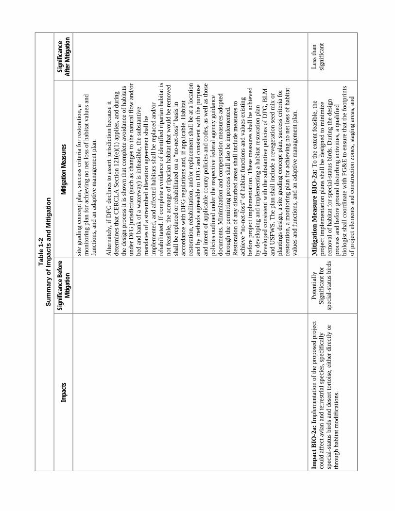
Tab
le 1
-2
Su
mm
ary
of
Imp
acts
an
d M
itig
atio
n
Impa
cts
Sign
ifica
nce
Bef
ore
Miti
gatio
n M
itiga
tion
Mea
sure
s Si
gnifi
canc
e A
fter M
itiga
tion
site
gra
ding
con
cept
pla
n, s
ucce
ss c
rite
ria
for
rest
orat
ion,
a
mon
itori
ng p
lan
for
achi
evin
g no
net
loss
of
habi
tat v
alue
s an
d fu
nctio
ns, a
nd a
n ad
aptiv
e m
anag
emen
t pla
n.
Alt
erna
tely
, if
DF
G d
ecli
nes
to a
sser
t jur
isdi
ctio
n be
caus
e it
dete
rmin
es th
at C
ER
CL
A S
ecti
on 1
21(e
)(1)
app
lies,
and
dur
ing
the
desi
gn p
roce
ss it
is s
how
n th
at c
ompl
ete
avoi
danc
e of
hab
itats
un
der
DF
G ju
risd
ictio
n (s
uch
as c
hang
es to
the
natu
ral f
low
and
/or
bed
and
bank
of
a w
ater
way
) is
infe
asib
le, t
he s
ubst
anti
ve
man
date
s of
a s
trea
mbe
d al
tera
tion
agre
emen
t sha
ll be
im
plem
ente
d, a
nd a
ffec
ted
habi
tats
sha
ll b
e re
plac
ed a
nd/o
r re
habi
litat
ed. I
f co
mpl
ete
avoi
danc
e of
iden
tifie
d ri
pari
an h
abita
t is
not f
easi
ble,
the
acre
age
of r
ipar
ian
habi
tat t
hat w
ould
be
rem
oved
sh
all b
e re
plac
ed o
r re
habi
litat
ed o
n a
“no-
net-
loss
” ba
sis
in
acco
rdan
ce w
ith
DF
G r
egul
atio
ns a
nd, i
f ap
plic
able
. Hab
itat
re
stor
atio
n, r
ehab
ilit
atio
n, a
nd/o
r re
plac
emen
t sha
ll b
e at
a lo
cati
on
and
by m
etho
ds a
gree
able
to D
FG
and
con
sist
ent w
ith
the
purp
ose
and
inte
nt o
f ap
plic
able
cou
nty
polic
ies
and
code
s, a
s w
ell a
s th
ose
polic
ies
outli
ned
unde
r th
e re
spec
tive
fede
ral a
genc
y gu
idan
ce
docu
men
ts. M
inim
izat
ion
and
com
pens
atio
n m
easu
res
adop
ted
thro
ugh
the
perm
ittin
g pr
oces
s sh
all a
lso
be im
plem
ente
d.
Res
tora
tion
of
any
dist
urbe
d ar
eas
shal
l inc
lude
mea
sure
s to
ac
hiev
e “n
o-ne
t-lo
ss”
of h
abita
t fun
ctio
ns a
nd v
alue
s ex
istin
g be
fore
pro
ject
impl
emen
tatio
n. T
hese
mea
sure
s sh
all b
e ac
hiev
ed
by d
evel
opin
g an
d im
plem
enti
ng a
hab
itat r
esto
ratio
n pl
an
deve
lope
d co
nsis
tent
with
the
subs
tant
ive
polic
ies
of D
FG
, BL
M
and
US
FWS
. The
pla
n sh
all i
nclu
de a
rev
eget
atio
n se
ed m
ix o
r pl
anti
ngs
desi
gn, a
sit
e gr
adin
g co
ncep
t pla
n, s
ucce
ss c
rite
ria
for
rest
orat
ion,
a m
onito
ring
pla
n fo
r ac
hiev
ing
no n
et lo
ss o
f ha
bita
t va
lues
and
fun
ctio
ns, a
nd a
n ad
aptiv
e m
anag
emen
t pla
n.
Imp
act
BIO
-2a:
Im
plem
enta
tion
of th
e pr
opos
ed p
roje
ct
coul
d af
fect
avi
an a
nd te
rres
tria
l spe
cies
, spe
cifi
call
y sp
ecia
l-st
atus
bir
ds a
nd d
eser
t tor
tois
e, e
ither
dir
ectly
or
thro
ugh
habi
tat m
odif
icat
ions
.
Pot
entia
lly
Sig
nifi
cant
for
sp
ecia
l-st
atus
bir
ds
Mit
igat
ion
Mea
sure
BIO
-2a:
To
the
exte
nt f
easi
ble,
the
proj
ect i
mpl
emen
tatio
n pl
ans
shal
l be
desi
gned
to m
inim
ize
rem
oval
of
habi
tat f
or s
peci
al-s
tatu
s bi
rds.
Dur
ing
the
desi
gn
proc
ess
and
befo
re g
roun
d di
stur
bing
act
iviti
es, a
qua
lifie
d bi
olog
ist s
hall
coor
dina
te w
ith P
G&
E to
ens
ure
that
the
foot
prin
ts
of p
roje
ct e
lem
ents
and
con
stru
ctio
n zo
nes,
sta
ging
are
as, a
nd
Les
s th
an
sign
ific
ant

AECOM Topock Compressor Station Final Remedy DEIR Summary 1-23 California Department of Toxic Substances Control
Tab
le 1
-2
Su
mm
ary
of
Imp
acts
an
d M
itig
atio
n
Impa
cts
Sign
ifica
nce
Bef
ore
Miti
gatio
n M
itiga
tion
Mea
sure
s Si
gnifi
canc
e A
fter M
itiga
tion
acce
ss r
oute
s ar
e de
sign
ed to
avo
id d
irec
t or
indi
rect
eff
ects
on
habi
tat a
nd n
estin
g ha
bita
t for
oth
er s
peci
al-s
tatu
s sp
ecie
s, to
the
exte
nt f
easi
ble.
DT
SC
sha
ll g
uara
ntee
com
plia
nce
wit
h al
l pr
econ
stru
ctio
n an
d co
nstr
uctio
n ph
ase
avoi
danc
e m
easu
res
iden
tifie
d du
ring
this
pro
cess
and
incl
uded
in a
ny d
esig
n pl
ans.
V
eget
atio
n re
mov
al a
nd o
ther
act
iviti
es s
hall
be ti
med
to a
void
the
nest
ing
seas
on f
or s
peci
al-s
tatu
s bi
rd s
peci
es th
at m
ay b
e pr
esen
t. T
he n
estin
g cy
cle
for
mos
t bir
ds in
this
reg
ion
span
s M
arch
15
thro
ugh
Sep
tem
ber
30.
Prec
onst
ruct
ion
Mea
sure
s
Pre
cons
truc
tion
bree
ding
sea
son
surv
eys
shal
l be
cond
ucte
d du
ring
th
e ge
nera
l nes
ting
peri
od, w
hich
enc
ompa
sses
the
peri
od f
rom
M
arch
15
thro
ugh
Sep
tem
ber
30, i
f th
e fi
nal d
esig
n of
the
proj
ect
coul
d re
sult
in d
istu
rban
ce o
r lo
ss o
f ac
tive
nest
s of
spe
cial
-sta
tus
bird
spe
cies
. If
vege
tatio
n re
mov
al o
r ot
her
dist
urba
nce
rela
ted
to
proj
ect i
mpl
emen
tatio
n is
req
uire
d du
ring
the
nest
ing
seas
on,
focu
sed
surv
eys
for
acti
ve n
ests
of
spec
ial-
stat
us b
irds
sha
ll b
e co
nduc
ted
befo
re s
uch
activ
ities
beg
in. A
qua
lifie
d bi
olog
ist s
hall
cond
uct p
reco
nstr
uctio
n su
rvey
s to
iden
tify
activ
e ne
sts
that
cou
ld
be a
ffec
ted.
The
app
ropr
iate
are
a to
be
surv
eyed
and
the
timin
g of
th
e su
rvey
may
var
y de
pend
ing
on th
e ac
tivit
y an
d sp
ecie
s th
at
coul
d be
aff
ecte
d. F
or th
e Y
uma
clap
per
rail,
the
prec
onst
ruct
ion
surv
eys
shal
l spe
cifi
cally
iden
tify
habi
tat w
ithin
300
fee
t of
cons
truc
tion
are
as, i
n ac
cord
ance
wit
h su
bsta
ntiv
e po
lici
es o
f U
SFW
S.
Con
stru
ctio
n M
easu
res
Bef
ore
the
initi
atio
n of
pro
ject
ele
men
ts th
at c
ould
res
ult i
n di
stur
banc
e of
act
ive
nest
s or
nes
ting
pair
s of
oth
er s
peci
al-s
tatu
s bi
rds,
a q
ualif
ied
biol
ogis
t sha
ll be
con
sulte
d to
iden
tify
appr
opri
ate
mea
sure
s to
min
imiz
e ad
vers
e im
pact
s du
ring
the
cons
truc
tion
pha
se o
f th
e pr
ojec
t. If
dee
med
app
ropr
iate
for
the
fina
l pro
ject
des
ign
beca
use
of th
e po
tent
ial f
or im
pact
s,
min
imiz
atio
n m
easu
res
will
incl
ude
focu
sing
con
stru
ctio
n ac
tiviti
es th
at m
ust b
e co
nduc
ted
duri
ng th
e ne
stin
g se
ason
to le
ss-
sens
itive
per
iods
in th
e ne
stin
g cy
cle,
impl
emen
ting
buff
ers

Tab
le 1
-2
Su
mm
ary
of
Imp
acts
an
d M
itig
atio
n
Impa
cts
Sign
ifica
nce
Bef
ore
Miti
gatio
n M
itiga
tion
Mea
sure
s Si
gnifi
canc
e A
fter M
itiga
tion
arou
nd a
ctiv
e ne
sts
of s
peci
al-s
tatu
s bi
rds
to th
e ex
tent
pra
ctic
al
and
feas
ible
to li
mit
visu
al a
nd n
oise
dis
turb
ance
, con
duct
ing
wor
ker
awar
enes
s tr
aini
ng, a
nd c
ondu
ctin
g bi
olog
ical
mon
itori
ng
(inc
ludi
ng n
oise
mon
itori
ng to
det
erm
ine
if c
onst
ruct
ion
nois
e at
th
e ed
ge o
f su
itabl
e ne
stin
g ha
bita
t is
elev
ated
abo
ve 6
0 dB
A L
eq
or a
mbi
ent l
evel
s).
An
avoi
danc
e an
d m
inim
izat
ion
plan
for
spe
cial
sta
tus
bird
sp
ecie
s, a
s de
fine
d in
Tab
le 4
.3-3
and
thos
e sp
ecie
s pr
otec
ted
unde
r th
e fe
dera
l Mig
rato
ry B
ird
Tre
aty
Act
, inc
ludi
ng th
e Y
uma
clap
per
rail,
sha
ll be
dev
elop
ed a
nd im
plem
ente
d in
con
sulta
tion
with
US
FWS,
and
agr
eed
upon
by
DT
SC
. Avo
idan
ce a
nd im
pact
m
inim
izat
ion
mea
sure
s, s
uch
as p
rohi
bitin
g co
nstr
uctio
n ne
ar o
r in
se
nsiti
ve b
ird
habi
tat,
lim
itin
g co
nstr
uctio
n du
ring
bre
edin
g se
ason
s, a
nd r
equi
ring
an
on-s
ite b
iolo
gica
l mon
itor,
sha
ll be
in
clud
ed in
the
desi
gn p
lan
and
impl
emen
ted
to th
e ex
tent
ne
cess
ary
to a
void
sig
nifi
cant
impa
cts
on s
ensi
tive
bird
spe
cies
.
Imp
act
BIO
-2b
: Im
plem
enta
tion
of th
e pr
opos
ed p
roje
ct
coul
d af
fect
avi
an a
nd te
rres
tria
l spe
cies
, inc
ludi
ng th
e de
sert
tort
oise
, eith
er d
irec
tly o
r th
roug
h ha
bita
t m
odif
icat
ions
.
Pot
entia
lly
Sig
nifi
cant
for
de
sert
tort
oise
Mit
igat
ion
Mea
sure
BIO
-2b
:
Prec
onst
ruct
ion
Mea
sure
s
In a
reas
whe
re im
pact
s to
pot
entia
l des
ert t
orto
ise
habi
tat a
re
unav
oida
ble,
mea
sure
s ou
tline
d in
the
Pro
gram
mat
ic B
iolo
gica
l A
gree
men
t (P
BA
) an
d in
the
US
FW
S le
tter
conc
urri
ng w
ith th
e P
BA
, sha
ll be
impl
emen
ted,
as
desc
ribe
d be
low
. To
the
exte
nt
feas
ible
, pro
ject
con
stru
ctio
n sh
all b
e de
sign
ed to
min
imiz
e re
mov
al o
f ha
bita
t for
the
dese
rt to
rtoi
se. B
efor
e an
y gr
ound
-di
stur
bing
pro
ject
act
iviti
es b
egin
, a U
SF
WS
-aut
hori
zed
dese
rt
tort
oise
bio
logi
st s
hall
iden
tify
pote
ntia
l des
ert t
orto
ise
habi
tat i
n ar
eas
that
cou
ld b
e af
fect
ed b
y th
e fi
nal p
roje
ct d
esig
n. T
hrou
gh
coor
dina
tion
with
the
auth
oriz
ed b
iolo
gist
, PG
&E
sha
ll en
sure
that
th
e fo
otpr
ints
of
proj
ect e
lem
ents
and
con
stru
ctio
n zo
nes,
sta
ging
ar
eas,
and
acc
ess
rout
es a
re d
esig
ned
to a
void
dir
ect o
r in
dire
ct
effe
cts
on p
oten
tial d
eser
t tor
tois
e ha
bita
t to
the
exte
nt f
easi
ble.
T
hese
mea
sure
s in
clud
e th
e pr
esen
ce o
f a
US
FW
S-a
utho
rize
d de
sert
tort
oise
bio
logi
st o
n-si
te w
ho w
ill e
xam
ine
wor
k ar
eas
and
vehi
cles
for
the
pres
ence
of
dese
rt to
rtoi
ses,
and
who
will
con
duct
pr
econ
stru
ctio
n de
sert
tort
oise
sur
veys
in a
reas
whe
re u
navo
idab
le
Les
s th
an
Sig
nifi
cant

AECOM Topock Compressor Station Final Remedy DEIR Summary 1-25 California Department of Toxic Substances Control
Tab
le 1
-2
Su
mm
ary
of
Imp
acts
an
d M
itig
atio
n
Impa
cts
Sign
ifica
nce
Bef
ore
Miti
gatio
n M
itiga
tion
Mea
sure
s Si
gnifi
canc
e A
fter M
itiga
tion
impa
cts
to to
rtoi
se h
abita
t wou
ld o
ccur
. If
feas
ible
, the
pr
econ
stru
ctio
n de
sert
tort
oise
sur
veys
wou
ld c
oinc
ide
with
one
of
the
two
peak
per
iods
of
dese
rt to
rtoi
se a
ctiv
ity
(i.e
., if
fea
sibl
e, th
e su
rvey
s sh
ould
be
cond
ucte
d in
eith
er th
e pe
riod
fro
m A
pril
thro
ugh
May
, or
from
Sep
tem
ber
thro
ugh
Oct
ober
). T
he
prec
onst
ruct
ion
surv
eys
shal
l be
in f
ull a
ccor
danc
e w
ith
the
subs
tant
ive
requ
irem
ents
of
US
FW
S p
roto
cols
.
Con
stru
ctio
n M
easu
res
Bef
ore
the
initi
atio
n of
pro
ject
ele
men
ts th
at c
ould
res
ult i
n di
stur
banc
e of
des
ert t
orto
ises
or
dese
rt to
rtoi
se h
abita
t, a
US
FWS
-au
thor
ized
des
ert t
orto
ise
biol
ogis
t sha
ll be
con
sulte
d to
iden
tify
appr
opri
ate
mea
sure
s to
min
imiz
e ad
vers
e im
pact
s. M
inim
izat
ion
mea
sure
s ar
e lik
ely
to in
clud
e m
icro
-siti
ng s
truc
ture
s, p
ipel
ines
, an
d ac
cess
roa
ds in
pre
viou
sly
dist
urbe
d ar
eas
or in
are
as w
ith
spar
se s
crub
veg
etat
ion,
con
duct
ing
wor
ker
awar
enes
s tr
aini
ng,
and
cond
uctin
g bi
olog
ical
mon
itori
ng.
Imp
act
BIO
-2c:
Im
plem
enta
tion
of
the
prop
osed
pro
ject
co
uld
affe
ct a
vian
and
terr
estr
ial s
peci
es, s
peci
fica
lly
spec
ial-
stat
us b
irds
and
des
ert t
orto
ise,
eith
er d
irec
tly o
r th
roug
h ha
bita
t mod
ific
atio
ns.
Pot
entia
lly
Sig
nifi
cant
for
D
istu
rban
ce o
f S
peci
al-S
tatu
s S
peci
es a
nd L
oss
of
Hab
itat
Cau
sed
by
Dec
omm
issi
onin
g
Mit
igat
ion
Mea
sure
BIO
-2c:
To
avoi
d im
pact
s on
spe
cial
-st
atus
spe
cies
that
may
occ
ur w
ithi
n th
e pr
ojec
t are
a as
a r
esul
t of
deco
mm
issi
onin
g ac
tiviti
es, a
n av
oida
nce
and
min
imiz
atio
n pl
an
shal
l be
deve
lope
d an
d im
plem
ente
d th
roug
h co
nsul
tatio
n w
ith
DF
G, B
LM
, and
US
FW
S. T
hese
mea
sure
s sh
all b
e ba
sed
on
surv
eys
cond
ucte
d pr
ior
to d
ecom
mis
sion
ing,
and
dur
ing
the
bree
ding
sea
son
(as
prev
ious
ly d
efin
ed in
this
EIR
for
eac
h sp
ecie
s or
sui
te o
f sp
ecie
s). R
esto
ratio
n of
any
dis
turb
ed a
reas
sha
ll in
clud
e m
easu
res
to a
chie
ve n
o ne
t los
s of
hab
itat f
unct
ions
and
va
lues
exi
stin
g be
fore
pro
ject
impl
emen
tati
on. T
hese
mea
sure
s sh
all b
e ac
hiev
ed b
y de
velo
ping
and
impl
emen
ting
a ha
bita
t re
stor
atio
n pl
an s
ubm
itted
to D
FG, B
LM
, and
US
FW
S th
at is
ag
reea
ble
to th
ese
agen
cies
. The
pla
n sh
all i
nclu
de a
rev
eget
atio
n se
ed m
ix o
r pl
antin
gs d
esig
n, a
site
gra
ding
con
cept
pla
n, s
ucce
ss
crite
ria
for
rest
orat
ion,
a m
onito
ring
pla
n fo
r ac
hiev
ing
no n
et lo
ss
of h
abita
t val
ues
and
func
tions
, and
an
adap
tive
man
agem
ent p
lan.
Les
s th
an
Sig
nifi
cant

Tab
le 1
-2
Su
mm
ary
of
Imp
acts
an
d M
itig
atio
n
Impa
cts
Sign
ifica
nce
Bef
ore
Miti
gatio
n M
itiga
tion
Mea
sure
s Si
gnifi
canc
e A
fter M
itiga
tion
Imp
act
BIO
-3:
If s
elec
ted
as p
art o
f th
e fi
nal r
emed
y,
cons
truc
tion
of th
e fr
eshw
ater
inta
ke s
truc
ture
ele
men
t of
the
prop
osed
pro
ject
cou
ld p
reve
nt f
ish
from
acc
essi
ng
spaw
ning
hab
itat o
r in
terf
ere
with
pre
ferr
ed h
abita
t. In
ad
ditio
n, o
pera
tion
of th
e w
ater
inta
ke s
truc
ture
with
in th
e C
olor
ado
Riv
er c
ould
cau
se m
orta
lity
to f
ish,
incl
udin
g sp
ecia
l-st
atus
spe
cies
. Inc
reas
ed s
edim
enta
tion
and
tu
rbid
ity, t
he r
elea
se o
f co
ntam
inan
ts, a
nd s
tand
ing
duri
ng
cons
truc
tion
activ
ities
cou
ld a
lso
adve
rsel
y af
fect
fis
h ha
bita
t and
mov
emen
t in
the
Col
orad
o R
iver
.
Pot
entia
lly
Sig
nifi
cant
M
itig
atio
n M
easu
re B
IO-3
a: H
ydro
logy
& W
ater
Qua
lity
M
itiga
tion
Mea
sure
HY
DR
O-1
sha
ll be
impl
emen
ted
in o
rder
to
redu
ce w
ater
qua
lity
impa
cts
rela
ted
to e
rosi
on a
nd p
ollu
tant
ru
noff
thro
ugh
impl
emen
tatio
n of
BM
Ps.
In
addi
tion,
inst
allin
g th
e co
ffer
dam
and
dew
ater
ing
a po
rtio
n of
the
prop
osed
inta
ke
stru
ctur
e si
te d
urin
g fi
sh s
cree
n co
nstr
uctio
n m
ay r
esul
t in
fish
st
rand
ing.
PG
&E
and
its
cont
ract
or s
hall
coor
dina
te w
ith a
qu
alif
ied
fish
erie
s bi
olog
ist t
o de
velo
p an
d im
plem
ent a
fis
h re
scue
pla
n. T
he f
ish
resc
ue e
ffor
t wou
ld b
e im
plem
ente
d du
ring
th
e de
wat
erin
g of
the
area
beh
ind
the
coff
erda
m a
nd w
ould
in
volv
e ca
ptur
ing
thos
e fi
sh a
nd r
etur
ning
them
to s
uita
ble
habi
tat
wit
hin
the
rive
r.
The
fis
h re
scue
pla
n sh
all i
dent
ify
and
desc
ribe
the
follo
win
g it
ems:
col
lect
ion
perm
its
need
ed, f
ish
capt
ure
zone
s, s
taff
ing,
st
agin
g ar
eas,
fis
h co
llec
tion
and
tran
spor
t met
hods
, spe
cies
pr
iori
tizat
ion,
res
ourc
e ag
ency
con
tact
s, f
ish
hand
ling
prot
ocol
s,
fish
rel
ocat
ion
zone
s, s
ite
layo
ut a
nd p
rogr
essi
on o
f de
wat
erin
g an
d fi
sh r
escu
e, a
nd r
ecor
ds a
nd d
ata.
To
ensu
re c
ompl
ianc
e, a
fi
sher
ies
biol
ogis
t sha
ll b
e pr
esen
t on-
site
dur
ing
init
ial p
umpi
ng
(dew
ater
ing)
act
ivit
ies
and
to o
vers
ee th
e fi
sh r
escu
e op
erat
ion.
Mit
igat
ion
Mea
sure
BIO
-3b
: T
o re
stor
e, r
epla
ce, o
r re
habi
lita
te h
abit
at im
pact
ed b
y th
e in
take
str
uctu
re, P
G&
E s
hall
im
plem
ent t
he m
easu
res
desc
ribe
d be
low
. Unl
ess
as p
rovi
ded
belo
w, P
G&
E s
hall
conf
er w
ith D
FG
reg
ardi
ng p
oten
tial
dist
urba
nce
to f
ish
habi
tat a
nd s
hall
obta
in a
str
eam
bed
alte
ratio
n ag
reem
ent,
purs
uant
to S
ecti
on 1
602
of th
e C
alif
orni
a F
ish
and
Gam
e C
ode,
for
con
stru
ctio
n w
ork
asso
ciat
ed w
ith in
take
str
uctu
re
cons
truc
tion;
PG
&E
sha
ll al
so c
onfe
r w
ith D
FG
pur
suan
t to
the
CE
SA
reg
ardi
ng p
oten
tial i
mpa
cts
rela
ted
to th
e lo
ss o
f ha
bita
t or
othe
r op
erat
iona
l im
pact
s on
sta
te-l
iste
d fi
sh s
peci
es, r
espe
ctiv
ely.
P
G&
E s
hall
com
ply
wit
h al
l req
uire
men
ts o
f th
e st
ream
bed
alte
ratio
n ag
reem
ent a
nd a
ny C
ES
A p
erm
its
to p
rote
ct f
ish
or f
ish
habi
tat o
r to
res
tore
, rep
lace
, or
reha
bili
tate
any
impo
rtan
t hab
itat
on
a “
no-n
et-l
oss”
bas
is.
Alt
erna
tive
ly, i
f D
FG
dec
lines
to a
sser
t jur
isdi
ctio
n be
caus
e it
dete
rmin
es th
at C
ER
CL
A S
ecti
on 1
21(e
)(1)
app
lies
, the
pro
ject
Les
s th
an
Sig
nifi
cant

AECOM Topock Compressor Station Final Remedy DEIR Summary 1-27 California Department of Toxic Substances Control
Tab
le 1
-2
Su
mm
ary
of
Imp
acts
an
d M
itig
atio
n
Impa
cts
Sign
ifica
nce
Bef
ore
Miti
gatio
n M
itiga
tion
Mea
sure
s Si
gnifi
canc
e A
fter M
itiga
tion
prop
onen
t sha
ll co
nsul
t with
DF
G r
egar
ding
pot
entia
l dis
turb
ance
to
fis
h ha
bita
t and
sha
ll m
eet t
he s
ubst
antiv
e po
licie
s of
a
stre
ambe
d al
tera
tion
agr
eem
ent a
nd o
f th
e C
ES
A f
or c
onst
ruct
ion
wor
k as
soci
ated
wit
h in
take
str
uctu
re c
onst
ruct
ion
and
oper
atio
ns.
PG
&E
sha
ll co
mpl
y w
ith a
ll su
bsta
ntiv
e re
quir
emen
ts o
f th
e st
ream
bed
alte
rati
on a
gree
men
t and
CE
SA to
pro
tect
fis
h an
d fi
sh
habi
tat o
r to
res
tore
, rep
lace
, or
reha
bili
tate
any
impo
rtan
t hab
itat
on
a “
no-n
et-l
oss”
bas
is a
nd to
ope
rate
the
faci
lity
in a
ccor
danc
e w
ith C
ES
A to
ens
ure
no n
et lo
ss o
f ha
bita
t fun
ctio
n.
Add
ition
ally
, PG
&E
sha
ll co
nsul
t with
US
AC
E r
egar
ding
the
need
to
obt
ain
perm
its
unde
r se
ctio
n 40
4 of
the
CW
A a
nd s
ectio
n 10
of
the
Riv
ers
and
Har
bors
Act
. In
conj
unct
ion
with
thes
e pe
rmit
ting
acti
viti
es, t
he U
SA
CE
mus
t ini
tiat
e co
nsul
tati
on w
ith
US
FW
S
unde
r S
ectio
n 7
of th
e F
eder
al E
SA
reg
ardi
ng p
oten
tial i
mpa
cts
of
the
prop
osed
pro
ject
on
fede
rally
list
ed f
ish
spec
ies
due
to th
e lo
ss
of h
abita
t on
fede
rally
list
ed f
ish
spec
ies.
PG
&E
sha
ll im
plem
ent
any
addi
tiona
l mea
sure
s de
velo
ped
thro
ugh
the
ES
A S
ectio
n 7
proc
esse
s, o
r its
equ
ival
ent,
to e
nsur
e “n
o-ne
t-lo
ss”
of h
abita
t fu
nctio
n.
Alte
rnat
ivel
y, if
US
AC
E a
nd/o
r U
SF
WS
dec
line
to a
sser
t ju
risd
icti
on b
ecau
se it
det
erm
ines
that
CE
RC
LA
Sec
tion
121
(e)(
1)
appl
ies,
PG
&E
sha
ll co
nfer
with
US
FW
S r
egar
ding
pot
entia
l di
stur
banc
e to
fed
eral
ly li
sted
fis
h sp
ecie
s an
d fe
dera
lly li
sted
fis
h sp
ecie
s ha
bita
t and
sha
ll m
eet t
he s
ubst
antiv
e m
anda
tes
unde
r S
ecti
on 7
of
the
Fed
eral
ES
A r
egar
ding
pot
enti
al im
pact
s to
fis
h or
to
hab
itat o
f fe
dera
lly li
sted
fis
h sp
ecie
s. P
G&
E s
hall
impl
emen
t an
y ad
ditio
nal m
easu
res
deve
lope
d th
roug
h th
at p
roce
sses
, in
clud
ing
com
plia
nce
with
the
subs
tant
ive
requ
irem
ents
of
all o
f w
hat w
ould
be
perm
it co
nditi
ons
if n
ot e
xem
pt p
ursu
ant t
o C
ER
CL
A, a
nd to
ens
ure
“no-
net-
loss
” of
hab
itat f
unct
ion.
Bec
ause
the
type
and
ext
ent o
f ha
bita
t pot
entia
lly
affe
cted
is
unkn
own,
PG
&E
sha
ll ha
ve a
n in
stre
am h
abita
t typ
ing
surv
ey
cond
ucte
d in
the
area
pot
enti
ally
aff
ecte
d by
the
inta
ke
cons
truc
tion.
Fur
ther
, coo
pera
tion
with
US
FWS
and
oth
er
fish
erie
s bi
olog
ists
sha
ll d
eter
min
e su
itab
le a
nd a
ccep
tabl
e

Tab
le 1
-2
Su
mm
ary
of
Imp
acts
an
d M
itig
atio
n
Impa
cts
Sign
ifica
nce
Bef
ore
Miti
gatio
n M
itiga
tion
Mea
sure
s Si
gnifi
canc
e A
fter M
itiga
tion
loca
tion(
s) f
or th
e in
take
str
uctu
re(s
) to
avo
id th
e sp
awni
ng h
abita
t of
spe
cial
-sta
tus
fish
spe
cies
. PG
&E
sha
ll av
oid
habi
tat
mod
ific
atio
ns, e
spec
ially
to h
abita
t tha
t is
pref
erre
d by
nat
ive
fish
es f
or s
paw
ning
or
rear
ing
incl
udin
g si
de c
hann
els,
cob
ble
or
grav
el b
ars,
and
sha
llow
bac
kwat
ers.
If
thes
e ha
bita
t typ
es c
anno
t be
avo
ided
, any
dis
turb
ed h
abit
at w
ill b
e re
stor
ed o
r re
plac
ed to
ac
hiev
e “n
o-ne
t-lo
ss”
of h
abita
t typ
es a
nd v
alue
s as
des
crib
ed
abov
e.
Mit
igat
ion
Mea
sure
BIO
-3c:
Bot
h sc
reen
ed a
nd u
nscr
eene
d di
vers
ions
can
ent
rain
larv
al li
fe s
tage
s of
fis
h. F
or e
xam
ple,
ad
vers
e ef
fect
s to
ear
ly li
fe s
tage
s of
fis
h co
uld
occu
r if
div
ersi
ons
coin
cide
with
pla
nkto
nic
larv
al li
fe s
tage
s th
at o
ccur
dur
ing
sum
mer
mon
ths,
a p
erio
d of
hig
h en
trai
nmen
t vul
nera
bili
ty. P
rior
to
ope
ratio
n of
the
inta
ke s
truc
ture
, PG
&E
sha
ll co
nsul
t with
U
SF
WS
and
DF
G to
det
erm
ine
the
mos
t vul
nera
ble
tim
e of
the
year
for
ent
rain
men
t or
impi
ngem
ent o
f ra
zorb
ack
suck
er a
nd
bony
tail
chub
egg
s or
larv
ae.
PG
&E
sha
ll in
stal
l a s
tate
-of-
the-
art p
ositi
ve-b
arri
er f
ish
scre
en
that
wou
ld m
inim
ize
fish
ent
rain
men
t and
impi
ngem
ent a
t the
in
take
str
uctu
re. T
he f
ish
scre
en s
hall
be d
esig
ned
in a
ccor
danc
e w
ith D
FG
and
the
Nat
iona
l Mar
ine
Fis
heri
es S
ervi
ce c
rite
ria,
wit
h sp
ecif
ic c
onsi
dera
tion
giv
en to
min
imiz
ing
harm
to f
ish
eggs
and
ot
her
earl
y li
fe s
tage
s.
To
ensu
re th
at th
e fi
sh s
cree
n op
erat
es a
s in
tend
ed a
nd r
educ
e th
e ri
sk o
f im
pact
s, lo
ng-t
erm
mon
itor
ing
of th
e op
erat
ions
and
m
aint
enan
ce o
f th
e po
sitiv
e-ba
rrie
r sc
reen
sha
ll be
con
duct
ed.
Mon
itori
ng a
t the
ons
et o
f di
vers
ions
thro
ugh
the
inta
ke s
hall
incl
ude
appr
oach
vel
ocit
y m
easu
rem
ents
imm
edia
tely
aft
er th
e po
siti
ve-b
arri
er s
cree
n op
erat
ions
beg
in, w
ith
fine
-tun
ing
of
velo
city
con
trol
baf
fles
or
othe
r m
odif
icat
ions
as
nece
ssar
y, to
ac
hiev
e un
ifor
m v
eloc
ities
in c
onfo
rman
ce w
ith th
e sc
reen
cri
teri
a es
tabl
ishe
d by
reg
ulat
ory
agen
cies
.

AECOM Topock Compressor Station Final Remedy DEIR Summary 1-29 California Department of Toxic Substances Control
Tab
le 1
-2
Su
mm
ary
of
Imp
acts
an
d M
itig
atio
n
Impa
cts
Sign
ifica
nce
Bef
ore
Miti
gatio
n M
itiga
tion
Mea
sure
s Si
gnifi
canc
e A
fter M
itiga
tion
Impl
emen
tati
on o
f th
e pr
opos
ed p
roje
ct w
ould
not
hav
e su
bsta
ntia
l adv
erse
eff
ects
on
the
viab
ility
of
popu
latio
ns
of s
peci
es c
over
ed in
the
LC
R M
SC
P, t
he e
ffec
tive
ness
of
the
LC
R M
SC
P’s
con
serv
atio
n st
rate
gy, a
nd a
ttain
men
t of
the
goal
s an
d ob
ject
ives
of
the
LC
R M
SC
P. A
dditi
onal
ly,
the
proj
ect w
ould
not
con
flic
t with
res
ourc
e m
anag
emen
t go
als
of U
SFW
S, B
LM
or
DO
I.
Les
s th
an
Sig
nifi
cant
N
o m
itig
atio
n is
req
uire
d.
Les
s th
an
Sig
nifi
cant
Impl
emen
tati
on o
f th
e pr
opos
ed p
roje
ct w
ould
not
su
bsta
ntia
lly in
terf
ere
with
the
mov
emen
t of
any
nativ
e re
side
nt o
r m
igra
tory
fis
h or
wild
life
spec
ies,
or
wit
h es
tabl
ishe
d na
tive
resi
dent
or
mig
rato
ry w
ildlif
e co
rrid
ors,
or
impe
de th
e us
e of
nat
ive
wild
life
nurs
ery
site
s.
Les
s th
an
Sig
nifi
cant
N
o m
itig
atio
n is
req
uire
d L
ess
than
S
igni
fica
nt
4.4
Cu
ltu
ral R
esou
rces
Impa
ct C
UL
-1:
Cau
se S
ubst
antia
l Adv
erse
Cha
nge
in th
e S
igni
fica
nce
of a
His
tori
cal R
esou
rce
as D
efin
ed in
CE
QA
G
uide
lines
Sec
tion
1506
4.5.
Con
stru
ctio
n, o
pera
tion
and
mai
nten
ance
, and
dec
omm
issi
onin
g ac
tiviti
es o
f th
e pr
opos
ed p
roje
ct c
ould
res
ult i
n su
bsta
ntia
l adv
erse
ch
ange
s to
his
tori
cal r
esou
rces
in th
e pr
ojec
t are
a,
incl
udin
g th
e (1
) T
opoc
k C
ultu
ral A
rea,
(2)
oth
er h
isto
rica
l re
sour
ces
list
ed in
Tab
le 4
.4-3
, (3)
his
tori
cal r
esou
rces
that
ha
ve y
et to
be
iden
tifie
d in
uns
urve
yed
area
s, a
nd (
4)
hist
oric
al r
esou
rces
that
cou
ld b
e id
entif
ied
duri
ng
cons
truc
tion.
Im
pact
s co
uld
occu
r th
roug
h gr
ound
di
stur
banc
e an
d ot
her
proj
ect-
rela
ted
activ
ities
or
thro
ugh
the
intr
oduc
tion
of o
ut-o
f ch
arac
ter
visu
al o
r au
dito
ry
intr
usio
ns to
his
tori
cal r
esou
rces
that
gai
n th
eir
sign
ific
ance
in p
art b
ecau
se h
isto
rica
l ass
ocia
tions
or
aest
hetic
val
ues.
Thi
s im
pact
wou
ld b
e po
tent
ially
si
gnif
ican
t.
Sig
nifi
cant
and
U
navo
idab
le f
or
CU
L-1
a an
d
Pot
entia
lly
Sig
nifi
cant
for
CU
L-1
b an
d C
UL
-1c
Mit
igat
ion
Mea
sure
CU
L-1
a:
►
Dur
ing
sele
ctio
n of
the
fina
l des
ign
and
loca
tion
for
phys
ical
im
prov
emen
ts, P
G&
E s
hall
utili
ze p
revi
ousl
y di
stur
bed
area
s fo
r th
e pl
acem
ent o
f ne
w p
hysi
cal i
mpr
ovem
ents
to th
e ex
tent
fe
asib
le, a
nd s
hall
use
prev
ious
ly e
xist
ing
phys
ical
im
prov
emen
ts, s
uch
as w
ells
and
oth
er f
acili
ties,
whe
re
appr
opri
ate.
►
PG
&E
sha
ll al
so c
onsi
der
the
loca
tion
of L
oci A
, B a
nd C
of
the
Top
ock
Maz
e du
ring
the
desi
gn o
f th
e ph
ysic
al
impr
ovem
ents
nec
essa
ry f
or th
e pr
opos
ed p
roje
ct a
nd a
void
di
rect
impa
cts
to th
e T
opoc
k M
aze
to th
e fu
llest
ext
ent
feas
ible
.
►
Upo
n se
lect
ion
of th
e fi
nal d
esig
n an
d lo
catio
n fo
r ph
ysic
al
impr
ovem
ents
, PG
&E
sha
ll co
nsul
t with
Nat
ive
Am
eric
an
Tri
bes
that
att
ach
cult
ural
sig
nifi
canc
e to
the
Top
ock
Maz
e an
d th
e T
opoc
k C
ultu
ral A
rea
and
deve
lop
a pl
an to
ens
ure
trib
al a
cces
s to
and
use
of
the
proj
ect a
rea
for
reli
giou
s,
spir
itual
or
cultu
ral p
urpo
ses,
to th
e ex
tent
PG
&E
has
the
auth
orit
y to
gra
nt s
uch
acce
ss, c
onsi
sten
t wit
h ex
isti
ng la
ws,
Pot
entia
lly
Sig
nifi
cant
and
U
navo
idab
le

Tab
le 1
-2
Su
mm
ary
of
Imp
acts
an
d M
itig
atio
n
Impa
cts
Sign
ifica
nce
Bef
ore
Miti
gatio
n M
itiga
tion
Mea
sure
s Si
gnifi
canc
e A
fter M
itiga
tion
regu
latio
ns a
nd a
gree
men
ts g
over
ning
pro
pert
y w
ithin
the
proj
ect a
rea.
The
pla
n m
ay s
peci
fy th
at s
uch
acce
ss m
ay n
ot
inte
rfer
e w
ith th
e pr
ojec
t or
crea
te h
ealt
h an
d sa
fety
con
cern
s.
Due
to h
ealth
and
saf
ety
conc
erns
, PG
&E
may
exc
lude
the
T
opoc
k C
ompr
esso
r S
tatio
n an
d re
late
d fa
cilit
ies
from
the
area
for
whi
ch tr
ibal
acc
ess
and
use
may
be
prov
ided
.
►
Thi
s m
itig
atio
n m
easu
re s
hall
be im
plem
ente
d in
a m
anne
r th
at is
con
sist
ent w
ith m
itig
atio
n re
quir
ed th
roug
h th
e fe
dera
l C
ompr
ehen
sive
Env
iron
men
tal R
espo
nse,
Com
pens
atio
n, a
nd
Lia
bili
ty A
ct (
CE
RC
LA
) pr
oces
s.
►
Miti
gatio
n m
easu
res
AE
S-1
, AE
S-2
, and
NO
ISE
-3 a
re a
lso
appl
icab
le to
the
Top
ock
Cul
tura
l Are
a. M
itiga
tion
mea
sure
s A
ES
-1 a
nd A
ES
-2 w
ould
red
uce
impa
cts
rela
ted
to a
esth
etic
qu
aliti
es o
f th
e pr
ojec
t are
a, in
clud
ing
thos
e vi
ews
from
the
Top
ock
Maz
e L
ocus
B. M
itig
atio
n m
easu
re N
OIS
E-3
wou
ld
serv
e to
red
uce
nois
e im
pact
s th
at c
ould
be
expe
rien
ced
with
in th
e T
opoc
k C
ultu
ral A
rea
and
notif
y tr
ibal
mem
bers
of
proj
ect a
ctiv
ity th
at w
ould
gen
erat
e ne
w n
oise
.
Mit
igat
ion
Mea
sure
CU
L-1
b a
nd
CU
L-1
c: T
he f
ollo
win
g ac
tions
will
red
uce
the
pote
ntia
l for
impa
cts
to id
entif
ied
hist
oric
al r
esou
rces
(ot
her
than
the
Top
ock
Cul
tura
l Are
a,
whi
ch is
sep
arat
ely
addr
esse
d in
CU
L-1
a) w
ithin
the
proj
ect
area
. To
the
exte
nt f
easi
ble,
thes
e ac
tion
s sh
all b
e im
plem
ente
d in
a m
anne
r th
at is
con
sist
ent w
ith m
itig
atio
n re
quir
ed th
roug
h th
e fe
dera
l CE
RC
LA
pro
cess
.
►
PG
&E
sha
ll co
nsid
er th
e lo
catio
ns o
f th
e id
entif
ied
hist
oric
re
sour
ces
desc
ribe
d ab
ove
duri
ng th
e de
sign
of
the
phys
ical
im
prov
emen
ts n
eces
sary
for
the
prop
osed
pro
ject
and
avo
id
impa
cts
to h
isto
rica
l and
arc
haeo
logi
cal r
esou
rces
to th
e ex
tent
fea
sibl
e. D
TS
C s
hall
rev
iew
the
plan
s fo
r th
e fi
nal
desi
gn o
f th
e pr
ojec
t and
com
pare
suc
h pl
ans
to th
e lo
cati
on
of id
entif
ied
reso
urce
s to
ass
ist i
n an
d en
forc
e th
e av
oida
nce

AECOM Topock Compressor Station Final Remedy DEIR Summary 1-31 California Department of Toxic Substances Control
Tab
le 1
-2
Su
mm
ary
of
Imp
acts
an
d M
itig
atio
n
Impa
cts
Sign
ifica
nce
Bef
ore
Miti
gatio
n M
itiga
tion
Mea
sure
s Si
gnifi
canc
e A
fter M
itiga
tion
of id
entif
ied
reso
urce
s to
the
exte
nt f
easi
ble.
►
Upo
n se
lect
ion
of th
e fi
nal d
esig
n an
d lo
catio
n fo
r ph
ysic
al
impr
ovem
ents
, PG
&E
sha
ll re
tain
a q
ualif
ied
cultu
ral
reso
urce
s co
nsul
tant
to p
repa
re a
cul
tura
l res
ourc
es s
tudy
th
at a
sses
ses
the
pote
ntia
l for
the
cons
truc
tion,
ope
ratio
ns, o
r de
com
mis
sion
ing
of p
ropo
sed
impr
ovem
ents
to r
esul
t in
sign
ific
ant i
mpa
cts
on id
entif
ied
hist
oric
al r
esou
rces
de
scri
bed
in I
mpa
ct C
UL
-1b
and
CU
L-1
c. T
his
will
incl
ude
cult
ural
res
ourc
es s
urve
y an
d ev
alua
tion
of
unsu
rvey
ed a
reas
th
at c
ould
be
affe
cted
by
cons
truc
tion
as d
eter
min
ed b
y D
TS
C in
con
sulta
tion
with
PG
&E
and
BL
M. “
Sig
nifi
cant
im
pact
s” a
s us
ed h
ere
mea
ns th
e po
tent
ial f
or c
onst
ruct
ion
to
dem
olis
h or
mat
eria
lly a
lter
in a
n ad
vers
e m
anne
r th
ose
phys
ical
cha
ract
eris
tics
of
a re
sour
ce th
at c
onve
y it
s hi
stor
ical
sig
nifi
canc
e an
d th
at ju
stif
y its
incl
usio
n in
, or
elig
ibil
ity
for,
incl
usio
n in
the
CR
HR
. DT
SC
sha
ll r
evie
w
this
stu
dy.
►
If th
e st
udy
dete
rmin
es th
at th
e co
nstr
uctio
n of
phy
sica
l im
prov
emen
ts w
ould
res
ult i
n si
gnif
ican
t im
pact
s on
id
enti
fied
his
tori
cal r
esou
rces
des
crib
ed in
Im
pact
CU
L-1
b an
d C
UL
-1c,
and
avo
idan
ce o
f th
e re
sour
ce is
not
fea
sibl
e,
PG
&E
sha
ll p
repa
re a
nd D
TS
C s
hall
rev
iew
a tr
eatm
ent p
lan
that
iden
tifie
s m
easu
res
to r
educ
e th
ese
impa
cts.
The
tr
eatm
ent p
lan
shal
l ide
ntif
y w
hich
cri
teri
a fo
r lis
ting
on th
e C
RH
R c
ontr
ibut
e to
the
affe
cted
res
ourc
e’s
sign
ific
ance
and
w
hich
asp
ects
of
sign
ific
ance
wou
ld b
e m
ater
ially
alte
red
by
cons
truc
tion,
ope
ratio
ns, o
r de
com
mis
sion
ing.
How
ever
, if
avoi
danc
e is
not
fea
sibl
e, th
e P
lan
shal
l pro
vide
for
re
ason
able
eff
orts
to b
e m
ade
to p
erm
it th
e re
sour
ce to
be
pres
erve
d in
pla
ce o
r le
ft in
an
undi
stur
bed
stat
e. M
etho
ds o
f ac
com
plis
hing
this
may
incl
ude
capp
ing
or c
over
ing
the
reso
urce
wit
h a
laye
r of
soi
l. T
o th
e ex
tent
that
res
ourc
e ca
nnot
fea
sibl
y be
pre
serv
ed in
pla
ce o
r no
t lef
t in
an
undi
stur
bed
stat
e, e
xcav
atio
n as
mit
igat
ion
shal
l be
rest
rict
ed
to th
ose
part
s of
res
ourc
e th
at w
ould
be
dam
aged
or
dest
roye
d by
the
proj
ect.
Exc
avat
ion
as m
itiga
tion
shal
l not

Tab
le 1
-2
Su
mm
ary
of
Imp
acts
an
d M
itig
atio
n
Impa
cts
Sign
ifica
nce
Bef
ore
Miti
gatio
n M
itiga
tion
Mea
sure
s Si
gnifi
canc
e A
fter M
itiga
tion
be r
equi
red
for
a un
ique
arc
haeo
logi
cal r
esou
rce
if th
e tr
eatm
ent p
lan
dete
rmin
es th
at te
stin
g or
stu
dies
alr
eady
co
mpl
eted
hav
e ad
equa
tely
rec
over
ed th
e sc
ient
ific
ally
co
nseq
uent
ial i
nfor
mat
ion
from
and
abo
ut th
e re
sour
ce. T
he
plan
sha
ll re
quir
e co
mm
unic
atio
n an
d co
nsul
tatio
n w
ith
Nat
ive
Am
eric
an tr
ibes
that
att
ach
cultu
ral s
igni
fica
nce
to
the
Top
ock
Maz
e an
d th
e T
opoc
k C
ultu
ral A
rea
wit
h re
gard
to
thei
r pe
rspe
ctiv
es a
nd w
ishe
s fo
r th
e tr
eatm
ent o
f th
e re
sour
ces.
►
PG
&E
sha
ll re
tain
a q
ualif
ied
cultu
ral r
esou
rces
con
sulta
nt
to o
bser
ve g
roun
d-di
stur
bing
act
iviti
es a
nd s
hall
invi
te th
e pa
rtic
ipat
ion
of N
ativ
e A
mer
ican
trib
al m
onit
ors
duri
ng
thos
e ac
tiviti
es, i
nclu
ding
rep
airs
nec
essa
ry d
urin
g op
erat
ions
and
dec
omm
issi
onin
g ac
tiviti
es, t
o en
sure
that
id
entif
ied
hist
oric
al r
esou
rces
are
avo
ided
, to
the
exte
nt
feas
ible
, dur
ing
actu
al c
onst
ruct
ion.
The
cul
tura
l res
ourc
es
cons
ulta
nt s
hall
prov
ide
trai
ning
to c
onst
ruct
ion
pers
onne
l on
the
loca
tions
of
iden
tifie
d re
sour
ces,
val
ues
asso
ciat
ed
with
the
iden
tifie
d re
sour
ces,
res
pons
ibili
ty f
or r
epor
ting
susp
ecte
d hi
stor
ic r
esou
rces
, and
pro
cedu
res
for
susp
ensi
on
of w
ork
in th
e im
med
iate
vic
inity
of
the
disc
over
y, a
nd s
hall
use
excl
usio
nary
fen
cing
, fla
ggin
g, o
r ot
her
appr
opri
ate
phys
ical
bar
rier
s to
mar
k th
e bo
unda
ries
of
iden
tifi
ed
reso
urce
s. T
he c
ultu
ral r
esou
rces
con
sulta
nt s
hall
invi
te
Nat
ive
Am
eric
an tr
ibes
to p
arti
cipa
te in
this
trai
ning
.
►
PG
&E
sha
ll re
tain
a q
ualif
ied
cultu
ral r
esou
rces
con
sulta
nt
and
shal
l inv
ite N
ativ
e A
mer
ican
trib
al m
onito
rs to
con
duct
ye
arly
insp
ectio
ns (
or le
ss f
requ
ently
if a
gree
d up
on)
iden
tifi
ed h
isto
rica
l res
ourc
es a
nd u
niqu
e ar
chae
olog
ical
re
sour
ces
to d
eter
min
e if
they
hav
e be
en im
pact
ed b
y on
goin
g op
erat
ions
act
ivity
rel
ativ
e to
thei
r co
nditi
on p
rior
to
the
proj
ect.
If d
eter
iora
tion
caus
ed b
y on
goin
g op
erat
ions
is
det
ecte
d, P
G&
E s
hall
dev
elop
and
impl
emen
t a tr
eatm
ent
plan
to r
educ
e or
avo
id f
urth
er d
egra
datio
n.

AECOM Topock Compressor Station Final Remedy DEIR Summary 1-33 California Department of Toxic Substances Control
Tab
le 1
-2
Su
mm
ary
of
Imp
acts
an
d M
itig
atio
n
Impa
cts
Sign
ifica
nce
Bef
ore
Miti
gatio
n M
itiga
tion
Mea
sure
s Si
gnifi
canc
e A
fter M
itiga
tion
Impa
ct C
UL
-2:
Cau
se a
Sub
stan
tial A
dver
se C
hang
e in
th
e S
igni
fica
nce
of a
Uni
que
Arc
haeo
logi
cal R
esou
rce.
M
any
of th
e cu
ltura
l res
ourc
es li
sted
in T
able
4.4
-3 m
ay
mee
t the
CE
QA
cri
teri
a fo
r a
uniq
ue a
rcha
eolo
gica
l re
sour
ce. C
onst
ruct
ion,
ope
ratio
n an
d m
aint
enan
ce, a
nd
deco
mm
issi
onin
g ac
tiviti
es o
f th
e pr
opos
ed p
roje
ct c
ould
re
sult
in s
ubst
antia
l adv
erse
cha
nges
to o
ne o
r m
ore
uniq
ue
arch
aeol
ogic
al r
esou
rce
in th
e pr
ojec
t are
a th
roug
h gr
ound
di
stur
banc
e an
d ot
her
proj
ect-
rela
ted
acti
viti
es. T
his
impa
ct
wou
ld b
e po
tent
ially
sig
nifi
cant
.
Pot
entia
lly
Sig
nifi
cant
M
itig
atio
n M
easu
re C
UL
-2:
Cul
tura
l res
ourc
es th
at q
ualif
y as
un
ique
arc
haeo
logi
cal s
ites
in th
e pr
ojec
t are
a w
ould
pro
babl
y al
so
mee
t one
or
mor
e of
the
crit
eria
for
his
tori
cal r
esou
rces
and
wou
ld
be s
ubje
ct to
Miti
gatio
n M
easu
res
CU
L-1
b an
d C
UL
-1c.
The
fo
llow
ing
acti
ons
wil
l fur
ther
red
uce
the
pote
ntia
l for
impa
cts
on
uniq
ue a
rcha
eolo
gica
l res
ourc
es. T
o th
e ex
tent
fea
sibl
e, th
ese
actio
ns s
hall
be im
plem
ente
d in
a m
anne
r th
at is
con
sist
ent w
ith
mit
igat
ion
requ
ired
thro
ugh
the
fede
ral C
ER
CL
A p
roce
ss.
►
PG
&E
sha
ll co
nsid
er th
e lo
catio
ns o
f th
e un
ique
ar
cheo
logi
cal r
esou
rces
des
crib
ed a
bove
dur
ing
the
desi
gn o
f th
e ph
ysic
al im
prov
emen
ts n
eces
sary
for
the
prop
osed
pr
ojec
t and
avo
id im
pact
s to
thos
e re
sour
ces
to th
e ex
tent
fe
asib
le. D
TS
C s
hall
revi
ew th
e pl
ans
for
the
fina
l des
ign
of
the
proj
ect a
nd c
ompa
re s
uch
plan
s to
the
loca
tion
of th
e re
sour
ces
to a
ssis
t in
and
enfo
rce
the
avoi
danc
e of
iden
tifie
d re
sour
ces
to th
e ex
tent
fea
sibl
e.
►
Upo
n se
lect
ion
of th
e fi
nal d
esig
n an
d lo
catio
n fo
r ph
ysic
al
impr
ovem
ents
, PG
&E
sha
ll re
tain
a q
ualif
ied
cultu
ral
reso
urce
s co
nsul
tant
to p
repa
re a
cul
tura
l res
ourc
es s
tudy
th
at a
sses
ses
the
pote
ntia
l for
the
cons
truc
tion,
ope
ratio
ns, o
r de
com
mis
sion
ing
of p
ropo
sed
impr
ovem
ents
to r
esul
t in
sign
ific
ant i
mpa
cts
on u
niqu
e ar
cheo
logi
cal r
esou
rces
. “S
igni
fica
nt im
pact
s” a
s us
ed h
ere
mea
ns th
e po
tent
ial f
or
cons
truc
tion
to d
emol
ish
or m
ater
iall
y al
ter
in a
n ad
vers
e m
anne
r th
ose
phys
ical
cha
ract
eris
tics
of
a re
sour
ce th
at
conv
ey it
s hi
stor
ical
sig
nifi
canc
e an
d th
at ju
stif
y its
in
clus
ion
in, o
r el
igib
ility
for
, inc
lusi
on in
the
CR
HR
. DT
SC
sh
all r
evie
w th
is s
tudy
to e
nsur
e av
oida
nce
has
been
im
plem
ente
d to
the
exte
nt f
easi
ble.
►
If th
e st
udy
dete
rmin
es th
at th
e co
nstr
uctio
n of
phy
sica
l im
prov
emen
ts w
ould
res
ult i
n si
gnif
ican
t im
pact
s on
uni
que
arch
eolo
gica
l res
ourc
es, a
nd a
void
ance
of
the
reso
urce
is n
ot
feas
ible
, PG
&E
sha
ll p
repa
re a
nd D
TS
C s
hall
rev
iew
a
trea
tmen
t pla
n th
at id
enti
fies
mea
sure
s to
red
uce
thes
e
Pot
entia
lly
Sig
nifi
cant

Tab
le 1
-2
Su
mm
ary
of
Imp
acts
an
d M
itig
atio
n
Impa
cts
Sign
ifica
nce
Bef
ore
Miti
gatio
n M
itiga
tion
Mea
sure
s Si
gnifi
canc
e A
fter M
itiga
tion
impa
cts.
The
trea
tmen
t pla
n sh
all i
dent
ify
whi
ch c
rite
ria
for
list
ing
on th
e C
RH
R c
ontr
ibut
e to
the
affe
cted
res
ourc
e’s
sign
ific
ance
and
whi
ch a
spec
ts o
f si
gnif
ican
ce w
ould
be
mat
eria
lly
alte
red
by c
onst
ruct
ion,
ope
ratio
ns, o
r de
com
mis
sion
ing.
How
ever
, if
avoi
danc
e is
not
fea
sibl
e, th
e P
lan
shal
l pro
vide
for
rea
sona
ble
effo
rts
to b
e m
ade
to
perm
it th
e re
sour
ce to
be
pres
erve
d in
pla
ce o
r le
ft in
an
undi
stur
bed
stat
e. M
etho
ds o
f ac
com
plis
hing
this
may
in
clud
e ca
ppin
g or
cov
erin
g th
e re
sour
ce w
ith
a la
yer
of s
oil.
To
the
exte
nt th
at r
esou
rce
cann
ot f
easi
bly
be p
rese
rved
in
plac
e or
not
left
in a
n un
dist
urbe
d st
ate,
exc
avat
ion
as
mit
igat
ion
shal
l be
rest
rict
ed to
thos
e pa
rts
of r
esou
rce
that
w
ould
be
dam
aged
or
dest
roye
d by
the
proj
ect.
Exc
avat
ion
as m
itig
atio
n sh
all n
ot b
e re
quir
ed f
or a
uni
que
arch
aeol
ogic
al r
esou
rce
if th
e tr
eatm
ent p
lan
dete
rmin
es th
at
test
ing
or s
tudi
es a
lrea
dy c
ompl
eted
hav
e ad
equa
tely
re
cove
red
the
scie
ntif
ical
ly c
onse
quen
tial i
nfor
mat
ion
from
an
d ab
out t
he r
esou
rce.
The
pla
n sh
all r
equi
re
com
mun
icat
ion
wit
h N
ativ
e A
mer
ican
trib
es th
at a
ttac
h cu
ltura
l sig
nifi
canc
e to
the
Top
ock
Cul
tura
l Are
a w
ith
rega
rd to
thei
r pe
rspe
ctiv
es a
nd w
ishe
s fo
r th
e tr
eatm
ent o
f th
e re
sour
ces.
►
PG
&E
sha
ll re
tain
a q
ualif
ied
cultu
ral r
esou
rces
con
sulta
nt
and
shal
l inv
ite th
e pa
rtic
ipat
ion
of N
ativ
e A
mer
ican
trib
al
mon
itors
to o
bser
ve g
roun
d-di
stur
bing
act
iviti
es a
nd s
hall
invi
te th
e pa
rtic
ipat
ion
of N
ativ
e A
mer
ican
trib
al m
onit
ors,
du
ring
thos
e ac
tiviti
es, i
nclu
ding
rep
airs
nec
essa
ry d
urin
g op
erat
ions
and
dec
omm
issi
onin
g ac
tiviti
es, t
o en
sure
that
id
entif
ied
uniq
ue a
rche
olog
ical
res
ourc
es a
re a
void
ed, t
o th
e ex
tent
fea
sibl
e, d
urin
g ac
tual
con
stru
ctio
n. T
he c
ultu
ral
reso
urce
s co
nsul
tant
sha
ll pr
ovid
e tr
aini
ng to
bri
ef
cons
truc
tion
per
sonn
el o
n th
e lo
cati
ons
of id
enti
fied
re
sour
ces,
val
ues
asso
ciat
ed w
ith th
e id
entif
ied
reso
urce
s,
resp
onsi
bilit
y fo
r re
port
ing
susp
ecte
d un
ique
arc
heol
ogic
al
reso
urce
s, a
nd p
roce
dure
s fo
r su
spen
sion
of
wor
k in
the
imm
edia
te v
icin
ity o
f th
e di
scov
ery,
and
sha
ll us
e ex
clus
iona
ry f
enci
ng, f
lagg
ing,
or
othe
r ap
prop
riat
e ph
ysic
al

AECOM Topock Compressor Station Final Remedy DEIR Summary 1-35 California Department of Toxic Substances Control
Tab
le 1
-2
Su
mm
ary
of
Imp
acts
an
d M
itig
atio
n
Impa
cts
Sign
ifica
nce
Bef
ore
Miti
gatio
n M
itiga
tion
Mea
sure
s Si
gnifi
canc
e A
fter M
itiga
tion
barr
iers
to m
ark
the
boun
dari
es o
f id
entif
ied
reso
urce
s. T
he
cult
ural
res
ourc
es c
onsu
ltan
t sha
ll in
vite
Nat
ive
Am
eric
an
trib
es to
par
tici
pate
in th
is tr
aini
ng.
►
PG
&E
sha
ll re
tain
a q
ualif
ied
cultu
ral r
esou
rces
con
sulta
nt
and
shal
l inv
ite
Nat
ive
Am
eric
an tr
ibal
mon
itor
s to
pe
riod
ical
ly c
ondu
ct y
earl
y in
spec
tion
s (o
r le
ss f
requ
entl
y if
ag
reed
upo
n) id
entif
ied
uniq
ue a
rche
olog
ical
res
ourc
es to
de
term
ine
if th
ey h
ave
been
impa
cted
by
ongo
ing
oper
atio
ns
acti
vity
rel
ativ
e to
thei
r co
nditi
on p
rior
to th
e pr
ojec
t. If
de
teri
orat
ion
caus
ed b
y on
goin
g op
erat
ions
is d
etec
ted,
P
G&
E s
hall
deve
lop
and
impl
emen
t a tr
eatm
ent p
lan
to
redu
ce o
r av
oid
furt
her
degr
adat
ion.
Impa
ct C
UL
-3:
Dir
ectl
y or
Ind
irec
tly
Des
troy
a U
niqu
e P
aleo
ntol
ogic
al R
esou
rce
or S
ite o
r U
niqu
e G
eolo
gic
Fea
ture
. The
con
stru
ctio
n of
wel
ls (
extr
actio
n, in
ject
ion,
an
d IR
Z c
onst
ruct
ion)
, wat
er c
onve
yanc
e pi
peli
nes
and
othe
r ut
ilit
y pa
thw
ays,
red
ucta
nt s
tora
ge f
acili
ties
, and
the
grad
ing
of a
cces
s ro
ads
thro
ugho
ut th
e pr
ojec
t are
a m
ay
affe
ct p
aleo
ntol
ogic
al r
esou
rces
thro
ugh
grou
nd
dist
urba
nce
activ
ities
. Thi
s im
pact
wou
ld b
e po
tent
ially
si
gnif
ican
t.
Pot
entia
lly
Sig
nifi
cant
M
itig
atio
n M
easu
re C
UL
-3:
A p
aleo
ntol
ogic
al in
vest
igat
ion
incl
udin
g a
deta
iled
surv
ey o
f th
e pr
ojec
t are
a by
a q
uali
fied
pa
leon
tolo
gist
, sha
ll be
con
duct
ed to
ref
ine
the
pote
ntia
l im
pact
s to
un
ique
pal
eont
olog
ical
res
ourc
es w
ithin
the
proj
ect a
rea
and
dete
rmin
e w
heth
er p
reco
nstr
uctio
n re
cove
ry o
f se
nsiti
ve r
esou
rces
an
d/or
con
stru
ctio
n m
onito
ring
wou
ld b
e w
arra
nted
. If
cons
truc
tion
mon
itori
ng is
det
erm
ined
to b
e w
arra
nted
, gro
und-
alte
ring
act
ivity
wou
ld b
e m
onito
red
by a
qua
lifie
d pa
leon
tolo
gist
to
ass
ess,
doc
umen
t, an
d re
cove
r un
ique
fos
sils
. Mon
itori
ng s
hall
incl
ude
the
insp
ecti
on o
f ex
pose
d su
rfac
es a
nd m
icro
scop
ic
exam
inat
ion
of m
atri
x in
pot
entia
l fos
sil b
eari
ng f
orm
atio
ns. I
n th
e ev
ent m
icro
foss
ils
are
disc
over
ed, t
he m
onito
r sh
all c
olle
ct m
atri
x fo
r pr
oces
sing
. In
the
even
t pal
eont
olog
ical
res
ourc
es a
re
enco
unte
red
duri
ng e
arth
mov
ing
activ
ities
, rec
over
ed s
peci
men
s sh
all b
e pr
epar
ed b
y th
e pa
leon
tolo
gist
to a
poi
nt o
f id
entif
icat
ion
and
perm
anen
t pre
serv
atio
n. T
he m
onito
r sh
all b
e em
pow
ered
to
halt
cons
truc
tion
activ
ity in
the
imm
edia
te v
icin
ity o
f th
e en
coun
tere
d pa
leon
tolo
gica
l res
ourc
es f
or a
suf
fici
ent i
nter
val t
o al
low
rec
over
y of
sig
nifi
cant
une
arth
ed f
ossi
l rem
ains
. P
aleo
ntol
ogic
al r
esou
rces
of
scie
ntif
ic v
alue
sha
ll be
iden
tifie
d an
d cu
rate
d in
to a
n es
tabl
ishe
d, a
ccre
dite
d, p
rofe
ssio
nal m
useu
m
repo
sito
ry in
the
regi
on w
ith p
erm
anen
t ret
riev
able
pal
eont
olog
ical
st
orag
e. T
o th
e ex
tent
fea
sibl
e, th
is m
itiga
tion
mea
sure
sha
ll be
Les
s th
an
Sig
nifi
cant

Tab
le 1
-2
Su
mm
ary
of
Imp
acts
an
d M
itig
atio
n
Impa
cts
Sign
ifica
nce
Bef
ore
Miti
gatio
n M
itiga
tion
Mea
sure
s Si
gnifi
canc
e A
fter M
itiga
tion
impl
emen
ted
in a
man
ner
that
is c
onsi
sten
t with
mit
igat
ion
requ
ired
thro
ugh
the
fede
ral C
ER
CL
A p
roce
ss.
Impa
ct C
UL
-4:
Dis
turb
ance
of
Hum
an R
emai
ns,
Incl
udin
g T
hose
Int
erre
d O
utsi
de o
f F
orm
al C
emet
erie
s.
Gro
und-
dist
urbi
ng a
ctiv
ities
req
uire
d fo
r al
l pro
ject
pha
ses
may
dis
turb
as-
yet u
ndis
cove
red
hum
an r
emai
ns, i
nclu
ding
N
ativ
e A
mer
ican
bur
ial r
emai
ns (
i.e.,
hum
an r
emai
ns a
nd
grav
e go
ods)
. Thi
s im
pact
wou
ld b
e po
tent
ially
sig
nifi
cant
.
Pot
entia
lly
Sig
nifi
cant
M
itig
atio
n M
easu
re C
UL
-4:
Gro
und
dist
urba
nce
activ
ities
m
ay d
istu
rb a
s-ye
t und
isco
vere
d hu
man
rem
ains
or
Nat
ive
Am
eric
an b
uria
ls a
nd a
ssoc
iate
d gr
ave
good
s. P
G&
E s
hall
reta
in a
qu
alif
ied
cultu
ral r
esou
rces
con
sulta
nt a
nd in
vite
des
igna
ted
Nat
ive
Am
eric
an tr
ibal
mon
itor(
s) to
trai
n co
nstr
uctio
n pe
rson
nel
in th
e id
entif
icat
ion
of h
uman
rem
ains
so
that
they
may
aid
in th
e id
entif
icat
ion
of s
uch
reso
urce
s. I
n th
e un
like
ly e
vent
hum
an
rem
ains
are
unc
over
ed o
ver
the
cour
se o
f pr
ojec
t con
stru
ctio
n,
oper
atio
n an
d m
aint
enan
ce, a
nd/o
r de
com
mis
sion
ing
activ
ities
, the
fo
llow
ing
proc
edur
es s
hall
be f
ollo
wed
to e
nsur
e co
mpl
ianc
e w
ith
all a
pplic
able
sta
te a
nd f
eder
al la
ws:
►
The
con
stru
ctio
n co
ntra
ctor
sha
ll im
med
iate
ly s
uspe
nd w
ork
with
in th
e vi
cini
ty o
f th
e di
scov
ery
and
dete
rmin
e if
the
rem
ains
dis
cove
red
are
hum
an o
r no
nhum
an. T
his
dete
rmin
atio
n sh
all b
e m
ade
by a
qua
lifie
d ar
chae
olog
ist
with
ski
ll in
the
iden
tific
atio
n of
hum
an o
steo
logi
cal (
bone
) re
mai
ns.
►
The
cul
tura
l res
ourc
es m
onito
r or
con
stru
ctio
n co
ntra
ct s
hall
prot
ect d
isco
vere
d hu
man
rem
ains
and
/or
buri
al g
oods
re
mai
ning
in th
e gr
ound
fro
m a
dditi
onal
dis
turb
ance
.
►
The
arc
haeo
logi
st o
r co
nstr
ucti
on c
ontr
acto
r sh
all c
onta
ct
the
San
Ber
nard
ino
Cou
nty
Cor
oner
and
PG
&E
pro
ject
pe
rson
nel i
mm
edia
tely
. In
Ari
zona
, the
arc
haeo
logi
st a
nd
cons
truc
tion
con
trac
tor
wil
l fol
low
Ari
zona
law
s an
d im
plem
entin
g re
gula
tions
. Hum
an r
emai
ns f
ound
on
fede
ral
land
wou
ld r
equi
re th
e no
tific
atio
n of
the
BL
M H
avas
u C
ity
fiel
d of
fice
and
com
plia
nce
with
app
lica
ble
fede
ral l
aws
and
regu
lati
ons,
incl
udin
g th
e N
ativ
e A
mer
ican
Gra
ves
Pro
tect
ion
and
Rep
atri
atio
n A
ct.
►
The
San
Ber
nard
ino
Cou
nty
Cor
oner
will
mak
e de
term
ine
if
the
rem
ains
are
of
rece
nt o
rigi
n an
d if
a in
vest
igat
ion
of th
e
Sig
nifi
cant
and
U
navo
idab
le

AECOM Topock Compressor Station Final Remedy DEIR Summary 1-37 California Department of Toxic Substances Control
Tab
le 1
-2
Su
mm
ary
of
Imp
acts
an
d M
itig
atio
n
Impa
cts
Sign
ifica
nce
Bef
ore
Miti
gatio
n M
itiga
tion
Mea
sure
s Si
gnifi
canc
e A
fter M
itiga
tion
caus
e of
dea
th is
req
uire
d (C
alif
orni
a H
ealth
and
Saf
ety
Cod
e S
ectio
n 70
50.5
). I
f th
e co
rone
r de
term
ines
that
the
hum
an r
emai
ns a
re n
ot N
ativ
e A
mer
ican
and
not
evi
denc
e of
a
crim
e, p
roje
ct p
erso
nnel
sha
ll co
ordi
nate
with
a q
ualif
ied
arch
aeol
ogis
t(s)
to d
evel
op a
n ap
prop
riat
e tr
eatm
ent p
lan.
T
his
may
incl
ude
cont
actin
g th
e ne
xt-o
f-ki
n to
sol
icit
inpu
t on
sub
sequ
ent d
ispo
sitio
n of
the
rem
ains
. If
ther
e is
no
next
-of
-kin
, or
reco
mm
enda
tions
by
the
next
-of-
kin
are
cons
ider
ed u
nacc
epta
ble
by th
e la
ndow
ner,
the
land
owne
r w
ill r
eint
er th
e re
mai
ns w
ith a
ppro
pria
te d
igni
ty in
a lo
catio
n ou
tsid
e th
e pr
ojec
t are
a an
d w
here
they
wou
ld b
e un
likel
y to
be
dis
turb
ed in
the
futu
re.
►
In th
e ev
ent t
hat t
he S
an B
erna
rdin
o C
ount
y C
oron
er
dete
rmin
es th
at th
e hu
man
rem
ains
are
Nat
ive
Am
eric
an a
nd
not e
vide
nce
of a
cri
me,
pro
ject
per
sonn
el s
hall
cont
act t
he
NA
HC
so
that
a m
ost l
ikel
y de
scen
dent
(M
LD
) ca
n be
id
entif
ied
as r
equi
red
unde
r C
alif
orni
a Pu
blic
Res
ourc
es
Cod
e S
ectio
n 50
97.9
8.
►
The
ML
Ds
shal
l ins
pect
the
area
in w
hich
the
hum
an
rem
ains
wer
e fo
und
and
prov
ide
trea
tmen
t rec
omm
enda
tions
to
the
land
owne
r an
d pr
ojec
t per
sonn
el in
acc
orda
nce
with
th
e pr
ovis
ions
of
Cal
ifor
nia
Publ
ic R
esou
rces
Cod
e S
ectio
n 50
97.9
8. T
he tr
eatm
ent m
ay in
clud
e re
buri
al, s
cien
tific
re
mov
al o
f th
e di
scov
ered
hum
an r
emai
ns a
nd
relin
quis
hmen
t to
the
ML
D, n
onde
stru
ctiv
e an
alys
is o
f hu
man
rem
ains
and
/or
othe
r cu
ltur
ally
app
ropr
iate
trea
tmen
t. If
the
ML
D s
o re
ques
ts, t
he la
ndow
ner
wou
ld r
eint
er th
e re
mai
ns w
ith th
e ap
prop
riat
e di
gnity
in a
loca
tion
outs
ide
the
area
of
dist
urba
nce
in a
loca
tion
unlik
ely
to b
e di
stur
bed
in
the
futu
re.
►
To
the
exte
nt f
easi
ble,
this
mit
igat
ion
mea
sure
sha
ll be
im
plem
ente
d in
a m
anne
r th
at is
con
sist
ent w
ith m
itig
atio
n re
quir
ed th
roug
h th
e fe
dera
l CE
RC
LA
pro
cess
.
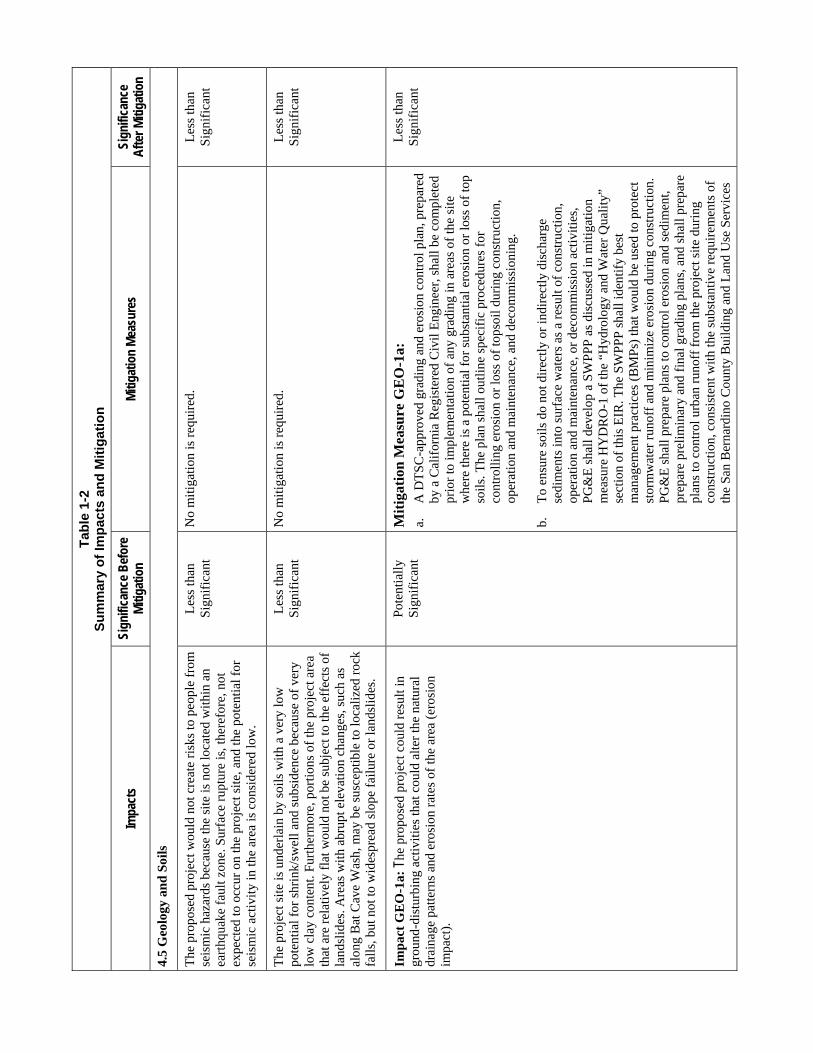
Tab
le 1
-2
Su
mm
ary
of
Imp
acts
an
d M
itig
atio
n
Impa
cts
Sign
ifica
nce
Bef
ore
Miti
gatio
n M
itiga
tion
Mea
sure
s Si
gnifi
canc
e A
fter M
itiga
tion
4.5
Geo
logy
an
d S
oils
The
pro
pose
d pr
ojec
t wou
ld n
ot c
reat
e ri
sks
to p
eopl
e fr
om
seis
mic
haz
ards
bec
ause
the
site
is n
ot lo
cate
d w
ithi
n an
ea
rthq
uake
fau
lt zo
ne. S
urfa
ce r
uptu
re is
, the
refo
re, n
ot
expe
cted
to o
ccur
on
the
proj
ect s
ite, a
nd th
e po
tent
ial f
or
seis
mic
act
ivit
y in
the
area
is c
onsi
dere
d lo
w.
Les
s th
an
Sig
nifi
cant
N
o m
itig
atio
n is
req
uire
d.
Les
s th
an
Sig
nifi
cant
The
pro
ject
sit
e is
und
erla
in b
y so
ils
wit
h a
very
low
po
tent
ial f
or s
hrin
k/sw
ell a
nd s
ubsi
denc
e be
caus
e of
ver
y lo
w c
lay
cont
ent.
Furt
herm
ore,
por
tion
s of
the
proj
ect a
rea
that
are
rel
ativ
ely
flat
wou
ld n
ot b
e su
bjec
t to
the
effe
cts
of
land
slid
es. A
reas
with
abr
upt e
leva
tion
chan
ges,
suc
h as
al
ong
Bat
Cav
e W
ash,
may
be
susc
eptib
le to
loca
lized
roc
k fa
lls,
but
not
to w
ides
prea
d sl
ope
fail
ure
or la
ndsl
ides
.
Les
s th
an
Sig
nifi
cant
N
o m
itig
atio
n is
req
uire
d.
Les
s th
an
Sig
nifi
cant
Imp
act
GE
O-1
a: T
he p
ropo
sed
proj
ect c
ould
res
ult i
n gr
ound
-dis
turb
ing
activ
ities
that
cou
ld a
lter
the
natu
ral
drai
nage
pat
tern
s an
d er
osio
n ra
tes
of th
e ar
ea (
eros
ion
impa
ct).
Pot
entia
lly
Sig
nifi
cant
M
itig
atio
n M
easu
re G
EO
-1a:
a.
A
DT
SC
-app
rove
d gr
adin
g an
d er
osio
n co
ntro
l pla
n, p
repa
red
by a
Cal
ifor
nia
Reg
iste
red
Civ
il E
ngin
eer,
sha
ll be
com
plet
ed
prio
r to
impl
emen
tatio
n of
any
gra
ding
in a
reas
of
the
site
w
here
ther
e is
a p
oten
tial f
or s
ubst
antia
l ero
sion
or
loss
of
top
soils
. The
pla
n sh
all o
utlin
e sp
ecif
ic p
roce
dure
s fo
r co
ntro
lling
ero
sion
or
loss
of
tops
oil d
urin
g co
nstr
uctio
n,
oper
atio
n an
d m
aint
enan
ce, a
nd d
ecom
mis
sion
ing.
b.
To
ensu
re s
oils
do
not d
irec
tly o
r in
dire
ctly
dis
char
ge
sedi
men
ts in
to s
urfa
ce w
ater
s as
a r
esul
t of
cons
truc
tion
, op
erat
ion
and
mai
nten
ance
, or
deco
mm
issi
on a
ctiv
ities
, P
G&
E s
hall
deve
lop
a S
WP
PP
as
disc
usse
d in
mit
igat
ion
mea
sure
HY
DR
O-1
of
the
“Hyd
rolo
gy a
nd W
ater
Qua
lity”
se
ctio
n of
this
EIR
. The
SW
PP
P s
hall
iden
tify
best
m
anag
emen
t pra
ctic
es (
BM
Ps)
that
wou
ld b
e us
ed to
pro
tect
st
orm
wat
er r
unof
f an
d m
inim
ize
eros
ion
duri
ng c
onst
ruct
ion.
P
G&
E s
hall
prep
are
plan
s to
con
trol
ero
sion
and
sed
imen
t, pr
epar
e pr
elim
inar
y an
d fi
nal g
radi
ng p
lans
, and
sha
ll pr
epar
e pl
ans
to c
ontr
ol u
rban
run
off
from
the
proj
ect s
ite d
urin
g co
nstr
uctio
n, c
onsi
sten
t with
the
subs
tant
ive
requ
irem
ents
of
the
San
Ber
nard
ino
Cou
nty
Bui
ldin
g an
d L
and
Use
Ser
vice
s
Les
s th
an
Sig
nifi
cant

AECOM Topock Compressor Station Final Remedy DEIR Summary 1-39 California Department of Toxic Substances Control
Tab
le 1
-2
Su
mm
ary
of
Imp
acts
an
d M
itig
atio
n
Impa
cts
Sign
ifica
nce
Bef
ore
Miti
gatio
n M
itiga
tion
Mea
sure
s Si
gnifi
canc
e A
fter M
itiga
tion
Dep
artm
ent f
or e
rosi
on c
ontr
ol.
c.
Dur
ing
road
pre
para
tion
activ
ities
, loo
se s
edim
ent s
hall
be
unif
orm
ly c
ompa
cted
con
sist
ent w
ith th
e su
bsta
ntiv
e S
an
Ber
nard
ino
Cou
nty
Bui
ldin
g an
d L
and
Use
Ser
vice
s D
epar
tmen
t req
uire
men
ts to
aid
in r
educ
ing
win
d er
osio
n.
Ong
oing
roa
d m
aint
enan
ce in
clud
ing
visu
al in
spec
tion
to
iden
tify
area
s of
ero
sion
and
per
form
ing
loca
lized
roa
d re
pair
an
d re
grad
ing,
inst
alla
tion
and
mai
nten
ance
of
eros
ion
cont
rol
feat
ures
suc
h as
ber
ms,
sil
t fen
ces,
or
stra
w w
attl
es, a
nd
grad
ing
for
road
sm
ooth
ness
sha
ll be
per
form
ed a
s ne
eded
to
redu
ce p
oten
tial f
or e
rosi
on.
d.
Reg
ardi
ng th
e po
tent
ial f
or c
onta
min
ated
soi
ls to
be
erod
ed
and
cont
ribu
te c
onta
min
atio
n in
to r
ecei
ving
wat
ers,
M
itiga
tion
Mea
sure
s G
EO
-2 a
nd H
AZ
-2 s
hall
be
impl
emen
ted.
Miti
gatio
n M
easu
re G
EO
-2 p
rovi
des
the
prov
isio
ns f
or m
itig
atin
g er
osio
n th
roug
h B
MP
s w
hich
sha
ll be
impl
emen
ted.
Miti
gatio
n M
easu
re H
AZ
-2 p
rovi
des
the
prov
isio
ns f
or s
afe
wor
k pr
actic
es a
nd h
andl
ing
of
cont
amin
ated
soi
ls a
s in
vest
igat
ion
deri
ved
was
tes.
Imp
act
GE
O-1
b:
The
prop
osed
pro
ject
cou
ld r
esul
t in
grou
nd-d
istu
rbin
g ac
tiviti
es th
at c
ould
alte
r th
e na
tura
l dr
aina
ge p
atte
rns
and
eros
ion
rate
s of
the
area
(dr
aina
ge
patte
rns
impa
ct).
Pot
entia
lly
Sig
nifi
cant
M
itig
atio
n M
easu
re G
EO
-1b
:
a.
BM
Ps
shal
l be
impl
emen
ted
duri
ng c
onst
ruct
ion,
ope
ratio
n an
d m
aint
enan
ce, a
nd d
ecom
mis
sion
ing
activ
ities
to m
inim
ize
impa
cts
on th
e af
fect
ed a
reas
. Suc
h B
MP
s co
uld
incl
ude,
but
w
ould
not
be
limite
d to
, the
fol
low
ing:
uni
form
com
pact
ion
of
road
way
s cr
eate
d fo
r ac
cess
ing
the
proj
ect a
rea
as p
er S
an
Ber
nard
ino
Cou
nty
Bui
ldin
g an
d L
and
Use
Ser
vice
s D
epar
tmen
t req
uire
men
ts, r
etur
ning
are
as a
dver
sely
aff
ecte
d by
dif
fere
ntia
l com
pact
ion
to p
reex
istin
g co
nditi
ons
whe
n th
ese
area
s ar
e no
long
er n
eede
d, a
nd c
ontin
uing
mai
nten
ance
of
acc
ess
road
s, w
ellh
ead
area
s, a
nd th
e tr
eatm
ent f
acil
ity
area
s.
b.
Wor
k ar
ea fo
otpr
ints
sha
ll be
min
imiz
ed to
the
grea
test
ext
ent
Les
s th
an
Sig
nifi
cant

Tab
le 1
-2
Su
mm
ary
of
Imp
acts
an
d M
itig
atio
n
Impa
cts
Sign
ifica
nce
Bef
ore
Miti
gatio
n M
itiga
tion
Mea
sure
s Si
gnifi
canc
e A
fter M
itiga
tion
feas
ible
to li
mit
the
area
s ex
pose
d to
dif
fere
ntia
l com
pact
ion.
W
here
pos
sibl
e, e
xist
ing
unpa
ved
acce
ss ro
ads
and
stag
ing/
wor
king
are
as s
hall
be re
used
and
mai
ntai
ned
for
diff
eren
t sta
ges
of th
e co
nstr
uctio
n. N
ew g
rade
d ar
eas
for s
tagi
ng
or fo
r acc
ess
road
s sh
all b
e co
mpa
cted
to a
uni
form
spe
cifi
catio
n,
typi
cally
on
the
orde
r of 9
0 to
95%
com
pact
ion
and
cons
iste
nt
with
sub
stan
tive
San
Ber
nard
ino
Cou
nty
Bui
ldin
g an
d L
and
Use
Ser
vice
s D
epar
tmen
t req
uire
men
ts to
redu
ce d
iffe
rent
ial
com
pact
ion
and
subs
eque
nt e
rosi
on o
f site
soi
ls.
c.
Aft
er th
e co
mpl
etio
n of
the
oper
atio
n an
d m
aint
enan
ce p
hase
, the
di
stur
bed
area
s w
hich
resu
lt in
incr
ease
d po
tent
ial f
or c
ompa
ctio
n sh
all b
e re
turn
ed to
thei
r res
pect
ive
pree
xist
ing
cond
ition
by
regr
adin
g co
nsis
tent
with
the
prec
onst
ruct
ion
slop
es a
s do
cum
ente
d th
roug
h su
rvey
s th
at m
ay in
clud
e to
pogr
aphi
c su
rvey
s or
pho
to s
urve
ys. T
he a
reas
will
be
retu
rned
to th
e su
rrou
ndin
g na
tura
l sur
face
topo
grap
hy a
nd c
ompa
cted
co
nsis
tent
with
una
ltere
d ar
eas
near
the
acce
ss ro
ads
or s
tagi
ng
area
s in
que
stio
n. T
he h
abita
t res
tora
tion
plan
out
lined
in
miti
gatio
n m
easu
re B
IO-1
sha
ll in
clud
e re
stor
atio
n of
nat
ive
vege
tatio
n or
oth
er e
rosi
on c
ontr
ol m
easu
res
whe
re re
vege
tatio
n w
ould
be
infe
asib
le o
r ina
dequ
ate,
for p
urpo
ses
of s
oil
stab
iliza
tion
and
eros
ion
cont
rol o
f the
pro
ject
are
a.
4.6
Haz
ardo
us M
ater
ials
Imp
act
HA
Z-1
: O
pera
tion
and
mai
nten
ance
of
the
prop
osed
pro
ject
cou
ld r
esul
t in
the
pote
ntia
l rel
ease
of
chem
ical
s du
ring
use
or
deli
very
of
chem
ical
s as
a r
esul
t of
com
pone
nt f
ailu
re (
e.g.
, val
ve, f
lang
e, o
r pi
pe),
tank
fa
ilure
, or
hum
an e
rror
(e.
g., t
ank
over
filli
ng).
Pot
entia
lly
Sig
nifi
cant
M
itig
atio
n M
easu
re H
AZ
-1a:
a.
PG
&E
sha
ll st
ore,
han
dle,
and
tran
spor
t haz
ardo
us m
ater
ial i
n co
mpl
ianc
e w
ith a
pplic
able
loca
l, st
ate,
and
fed
eral
law
s.
b. A
ll ch
emic
al s
tora
ge a
nd lo
adin
g ar
eas
shal
l be
equi
pped
with
pr
oper
con
tain
men
t and
spi
ll re
spon
se e
quip
men
t. B
MP
s to
be
impl
emen
ted
may
incl
ude,
but
are
not
lim
ited
to, u
se o
f se
cond
ary
cont
ainm
ent i
n m
ixin
g an
d st
orag
e ar
eas;
ava
ilabi
lity
of s
pill
kits
and
spi
ll co
ntai
nmen
t boo
ms,
and
app
ropr
iate
st
orag
e co
ntai
ners
for
con
tain
men
t of
the
mat
eria
ls g
ener
ated
Les
s th
an
Sig
nifi
cant

AECOM Topock Compressor Station Final Remedy DEIR Summary 1-41 California Department of Toxic Substances Control
Tab
le 1
-2
Su
mm
ary
of
Imp
acts
an
d M
itig
atio
n
Impa
cts
Sign
ifica
nce
Bef
ore
Miti
gatio
n M
itiga
tion
Mea
sure
s Si
gnifi
canc
e A
fter M
itiga
tion
duri
ng th
e sp
ill r
espo
nse.
c. A
pro
ject
-spe
cifi
c H
MB
P, c
hem
ical
sta
ndar
d op
erat
ing
proc
edur
e (S
OP
) pr
otoc
ols
and
cont
inge
ncy
plan
s sh
all b
e de
velo
ped
to e
nsur
e th
at p
rope
r re
spon
se p
roce
dure
s w
ould
be
impl
emen
ted
in th
e ev
ent o
f sp
ills
or r
elea
ses.
Spe
cifi
cally
, the
H
MB
P an
d SO
Ps s
hall
desc
ribe
the
proc
edur
es f
or p
rope
rly
stor
ing
and
hand
ling
fuel
on-
site
, the
req
uire
d eq
uipm
ent a
nd
proc
edur
es f
or s
pill
cont
ainm
ent,
requ
ired
per
sona
l pro
tect
ive
equi
pmen
t (P
PE),
and
the
mea
sure
s to
be
used
to r
educ
e th
e lik
elih
ood
of r
elea
ses
or s
pills
dur
ing
fuel
ing
or v
ehic
le
mai
nten
ance
act
iviti
es. B
MP
s to
be
impl
emen
ted
may
incl
ude,
bu
t are
not
lim
ited
to, u
se o
f se
cond
ary
cont
ainm
ent i
n m
ixin
g an
d st
orag
e ar
eas;
ava
ilabi
lity
of s
pill
kits
and
spi
ll co
ntai
nmen
t bo
oms,
and
app
ropr
iate
sto
rage
con
tain
ers
for
cont
ainm
ent o
f th
e m
ater
ials
gen
erat
ed d
urin
g th
e sp
ill r
espo
nse.
The
fie
ld
man
ager
in c
harg
e of
ope
ratio
ns a
nd m
aint
enan
ce a
ctiv
ities
sh
all b
e re
spon
sibl
e fo
r en
suri
ng th
at th
ese
proc
edur
es a
re
foll
owed
at a
ll ti
mes
.
Mit
igat
ion
Mea
sure
HA
Z-1
b:
a.
Fue
ling
area
s an
d m
aint
enan
ce a
reas
wou
ld b
e su
pplie
d w
ith
prop
er s
econ
dary
con
tain
men
t and
spi
ll re
spon
se e
quip
men
t.
b.
PG
&E
sha
ll de
velo
p fu
elin
g SO
P p
roto
cols
and
a c
ontin
genc
y pl
an th
at w
ould
be
impl
emen
ted
at a
ll fu
elin
g ar
eas
on s
ite.
The
SO
Ps
shal
l des
crib
e th
e pr
oced
ures
for
pro
perl
y st
orin
g an
d ha
ndlin
g fu
el o
n-si
te, t
he r
equi
red
equi
pmen
t and
pr
oced
ures
for
spi
ll co
ntai
nmen
t, re
quir
ed P
PE
, and
the
mea
sure
s to
be
used
to r
educ
e th
e li
keli
hood
of
rele
ases
or
spill
s du
ring
fue
ling
or v
ehic
le m
aint
enan
ce a
ctiv
ities
. P
oten
tial
mea
sure
s in
clud
e bu
t are
not
lim
ited
to, f
uel s
tora
ge
in b
erm
ed a
reas
, per
form
ing
vehi
cle
mai
nten
ance
in p
aved
an
d be
rmed
are
as, a
nd a
vaila
bilit
y of
spi
ll ki
ts f
or
cont
ainm
ent a
nd c
lean
up o
f pe
trol
eum
rel
ease
s. T
he f
ield
m
anag
er in
cha
rge
of c
onst
ruct
ion
and
deco
mm
issi
onin
g ac
tiviti
es s
hall
be r
espo
nsib
le f
or e
nsur
ing
that
thes
e

Tab
le 1
-2
Su
mm
ary
of
Imp
acts
an
d M
itig
atio
n
Impa
cts
Sign
ifica
nce
Bef
ore
Miti
gatio
n M
itiga
tion
Mea
sure
s Si
gnifi
canc
e A
fter M
itiga
tion
proc
edur
es a
re f
ollo
wed
at a
ll ti
mes
.
c.
PG
&E
sha
ll co
mpl
y w
ith lo
cal,
stat
e, a
nd f
eder
al r
egul
atio
ns
rela
ted
to th
e bu
lk s
tora
ge a
nd m
anag
emen
t of
fuel
s.
Imp
act
HA
Z-2
: C
onst
ruct
ion,
ope
ratio
n an
d m
aint
enan
ce,
and
deco
mm
issi
onin
g ac
tiviti
es a
ssoc
iate
d w
ith th
e pr
opos
ed p
roje
ct c
ould
res
ult i
n th
e ge
nera
tion
of d
ust a
nd
the
expo
sure
of
cons
truc
tion
wor
kers
to a
irbo
rne
cont
amin
ants
[e.
g., C
r(V
I), t
otal
pet
role
um h
ydro
carb
ons,
vo
latil
e or
gani
c ca
rbon
s, s
emiv
olat
ile o
rgan
ic c
arbo
ns]
dete
rmin
ed to
be
in th
e so
il o
f th
e pr
ojec
t site
or
that
fu
rthe
r in
vest
igat
ion
may
det
erm
ine
to b
e in
the
soil
Pot
entia
lly
Sig
nifi
cant
M
itig
atio
n M
easu
re H
AZ
-2:
Bef
ore
init
iati
ng g
roun
d-di
stur
bing
ope
ratio
ns, a
hea
lth a
nd s
afet
y pl
an s
hall
be d
evel
oped
an
d im
plem
ente
d by
qua
lifie
d en
viro
nmen
tal p
rofe
ssio
nals
to
ensu
re h
ealth
and
saf
ety
prec
autio
ns a
re b
eing
met
. It i
s no
t po
ssib
le to
pre
pare
the
heal
th a
nd s
afet
y pl
an a
t thi
s st
age
of th
e pl
anni
ng p
roce
ss b
ecau
se f
inal
con
stru
ctio
n pl
ans
and
othe
r de
sign
do
cum
ents
hav
e no
t bee
n fi
naliz
ed in
suf
fici
ent d
etai
l. H
owev
er, a
t a
min
imum
, the
hea
lth
and
safe
ty p
lan
shal
l inc
lude
pro
cedu
res
to
mit
igat
e po
tent
ial h
azar
ds, a
nd s
uch
proc
edur
es s
hall
incl
ude
the
use
of P
PE, m
easu
res
that
pro
vide
pro
tect
ion
from
phy
sica
l ha
zard
s, m
easu
res
that
pro
vide
pro
tect
ion
from
che
mic
al h
azar
ds
that
may
be
pres
ent a
t the
site
, dec
onta
min
atio
n pr
oced
ures
, and
w
orke
r an
d he
alth
and
saf
ety
mon
itor
ing
crite
ria
to b
e im
plem
ente
d du
ring
con
stru
ctio
n. T
he w
orke
r he
alth
and
saf
ety
plan
sha
ll in
clud
e pr
otec
tive
mea
sure
s an
d P
PE
that
are
spe
cifi
c to
th
e co
nditi
ons
of c
once
rn a
nd m
eet t
he r
equi
rem
ents
of
the
U.S
. O
ccup
atio
nal S
afet
y an
d H
ealt
h A
dmin
istr
atio
n’s
(OS
HA
’s)
cons
truc
tion
saf
ety
requ
irem
ents
and
Haz
ardo
us W
aste
Ope
rati
ons
and
Em
erge
ncy
Res
pons
e S
tand
ard
(29
CF
R 1
910.
120)
. In
acco
rdan
ce w
ith
OS
HA
req
uire
men
ts, a
ppro
pria
te tr
aini
ng a
nd
reco
rdke
epin
g sh
all a
lso
be a
par
t of
the
heal
th a
nd s
afet
y pr
ogra
m. T
he w
orke
r he
alth
and
saf
ety
plan
sha
ll b
e ce
rtif
ied
by a
C
erti
fied
Ind
ustr
ial H
ygie
nist
in a
ccor
danc
e w
ith
OS
HA
re
gula
tion
s. T
he w
orke
r he
alth
and
saf
ety
plan
sha
ll be
exp
lain
ed
to th
e co
nstr
uctio
n w
orke
rs a
nd a
ll w
orke
rs s
hall
be r
equi
red
to
sign
the
plan
, whi
ch w
ill b
e ke
pt o
n th
e co
nstr
uctio
n si
te a
t all
tim
es.
Wor
ker
safe
ty tr
aini
ng s
hall
occu
r pr
ior
to in
itiat
ion
of g
roun
d di
stur
bing
act
ivit
ies.
Tra
inin
g sh
all i
nclu
de th
e re
view
of
all h
ealt
h an
d sa
fety
mea
sure
s an
d pr
oced
ures
. All
wor
kers
and
eng
inee
ring
in
spec
tors
at t
he s
ite s
hall
prov
ide
wri
tten
ackn
owle
dgem
ent t
hat
the
soils
man
agem
ent p
lan
(dis
cuss
ed b
elow
), w
orke
r he
alth
and
Les
s th
an
Sig
nifi
cant

AECOM Topock Compressor Station Final Remedy DEIR Summary 1-43 California Department of Toxic Substances Control
Tab
le 1
-2
Su
mm
ary
of
Imp
acts
an
d M
itig
atio
n
Impa
cts
Sign
ifica
nce
Bef
ore
Miti
gatio
n M
itiga
tion
Mea
sure
s Si
gnifi
canc
e A
fter M
itiga
tion
safe
ty p
lan,
and
com
mun
ity h
ealth
and
saf
ety
plan
wer
e re
view
ed
and
trai
ning
was
rec
eive
d pr
ior
to c
omm
ence
men
t of
cons
truc
tion
ac
tivi
ties
.
The
fol
low
ing
are
spec
ific
ele
men
ts a
nd d
irec
tive
s th
at s
hall
be
incl
uded
in th
e he
alth
and
saf
ety
plan
and
impl
emen
ted
by P
G&
E
duri
ng c
onst
ruct
ion,
ope
ratio
n an
d m
aint
enan
ce, a
nd
deco
mm
issi
onin
g of
this
pro
ject
:
a.
Veh
icle
s tr
avel
ing
on u
npav
ed r
oadw
ays
or s
urfa
ces
wou
ld b
e di
rect
ed to
avo
id tr
avel
ing
in a
reas
whe
re c
onta
min
ated
soi
ls
are
know
n to
be
pres
ent;
veh
icle
spe
eds
shal
l be
cont
rolle
d (e
.g.,
lim
ited
to 1
5 m
ph o
r sl
ower
) to
lim
it ge
nera
tion
of d
ust;
mea
sure
s, s
uch
as w
etti
ng o
f su
rfac
es, w
ill b
e em
ploy
ed to
pr
even
t dus
t gen
erat
ion
by v
ehic
ular
traf
fic
or o
ther
dus
t-ge
nera
ting
wor
k ac
tiviti
es.
b.
Pre
mob
iliza
tion
plan
ning
sha
ll oc
cur
duri
ng w
hich
the
likel
ihoo
d of
enc
ount
erin
g co
ntam
inat
ed s
oils
sha
ll be
re
view
ed a
long
wit
h th
e H
MB
P, s
ite-
spec
ific
hea
lth
and
safe
ty p
lan,
and
SO
Ps
so th
at th
e pr
oced
ures
are
fol
low
ed a
nd
the
cont
inge
ncie
s fo
r ha
ndlin
g co
ntam
inat
ed s
oils
are
in-p
lace
pr
ior
to im
plem
entin
g th
e fi
eld
oper
atio
ns.
c.
Sho
uld
evid
ence
of
cont
amin
ated
soi
l be
iden
tifie
d du
ring
gr
ound
dis
turb
ing
activ
ities
(e.
g., n
oxio
us o
dors
, dis
colo
red
soil
), w
ork
in th
is a
rea
will
imm
edia
tely
cea
se u
ntil
soil
sam
ples
can
be
coll
ecte
d an
d an
alyz
ed f
or th
e pr
esen
ce o
f co
ntam
inan
ts b
y th
e si
te s
uper
viso
r or
the
site
saf
ety
offi
cer.
C
onta
min
ated
soi
l sha
ll be
man
aged
and
dis
pose
d of
in
acco
rdan
ce w
ith
a pr
ojec
t-sp
ecif
ic h
ealt
h an
d sa
fety
pla
n an
d so
il m
anag
emen
t pla
n. T
he h
ealth
and
saf
ety
plan
and
soi
l m
anag
emen
t pla
n sh
all b
e ap
prov
ed b
y D
TSC
bef
ore
begi
nnin
g an
y gr
ound
dis
turb
ing
activ
ities
. Whi
le th
e pr
ojec
t is
exe
mpt
fro
m th
e re
quir
emen
ts o
f th
e S
an B
erna
rdin
o C
ount
y D
ivis
ion
of E
nvir
onm
enta
l Hea
lth, t
he h
ealth
and
sa
fety
pla
n an
d so
il m
anag
emen
t pla
n sh
all b
e pr
epar
ed in

Tab
le 1
-2
Su
mm
ary
of
Imp
acts
an
d M
itig
atio
n
Impa
cts
Sign
ifica
nce
Bef
ore
Miti
gatio
n M
itiga
tion
Mea
sure
s Si
gnifi
canc
e A
fter M
itiga
tion
gene
ral a
ccor
danc
e w
ith th
e su
bsta
ntiv
e re
quir
emen
ts o
f th
is
agen
cy.
d.
In
the
even
t tha
t dri
lling
site
s m
ust b
e lo
cate
d w
ithin
are
as o
f su
spec
ted
soil
con
tam
inat
ion,
the
appr
opri
ate
PP
E s
hall
be
wor
n by
all
pers
onne
l wor
king
in th
ese
area
s an
d m
etho
ds
spec
ifie
d in
the
heal
th a
nd s
afet
y pl
an u
sed
to c
ontr
ol th
e ge
nera
tion
of d
ust.
Whe
n w
orki
ng in
thes
e ar
eas,
per
sonn
el
shal
l be
requ
ired
to f
ollo
w a
ll gu
idan
ce p
rese
nted
in th
e si
te-
spec
ific
hea
lth
and
safe
ty p
lan
and
soil
man
agem
ent p
lan.
The
si
te-s
peci
fic
heal
th a
nd s
afet
y pl
an s
hall
incl
ude
prov
isio
ns f
or
site
con
trol
suc
h as
, but
not
lim
ited
to, d
elin
eatio
n of
the
excl
usio
n, c
onta
min
ant r
educ
tion
and
supp
ort z
ones
for
eac
h w
ork
area
, dec
onta
min
atio
n pr
oced
ures
, and
pro
cedu
res
for
the
hand
ling
of c
onta
min
ated
soi
ls a
nd o
ther
inve
stig
atio
n de
rive
d w
aste
s. S
oil t
hat i
s ex
cava
ted
shal
l be
load
ed d
irec
tly
into
con
tain
ers
such
as
roll-
off
bins
; dus
t sup
pres
sion
met
hods
sh
all b
e us
ed p
rior
to a
nd d
urin
g lo
adin
g of
soi
ls in
to th
e bi
ns.
Sus
pect
ed c
onta
min
ated
soi
ls s
hall
be
segr
egat
ed f
rom
su
spec
ted
unco
ntam
inat
ed s
oils
.
e.
Per
sonn
el w
orki
ng a
t the
sit
e sh
all b
e tr
aine
d in
Haz
ardo
us
Was
te O
pera
tion
s.
f.
All
soil
exca
vate
d an
d pl
aced
in r
oll-
off
bins
or
truc
ks f
or
tran
spor
tatio
n of
f-si
te s
hall
be c
over
ed w
ith
a ta
rp o
r ri
gid
clos
ure
befo
re tr
ansp
ortin
g, a
nd p
erso
nnel
wor
king
in th
e ar
ea
shal
l be
posi
tione
d up
win
d of
the
load
ing
loca
tion.
4.7
Hyd
rolo
gy a
nd W
ater
Qua
lity
Impa
ct H
YD
RO
-1:
Con
stru
ctio
n, o
pera
tion
and
mai
nten
ance
, and
dec
omm
issi
onin
g ac
tiviti
es a
ssoc
iate
d w
ith
the
prop
osed
pro
ject
cou
ld r
esul
t in
(i)
the
exce
edan
ce
of w
ater
qua
lity
stan
dard
s as
a r
esul
t of
incr
ease
d ru
noff
fr
om im
perv
ious
sur
face
s an
d (i
i) e
xcee
danc
e of
wat
er
qual
ity s
tand
ards
due
to p
oten
tial e
xpos
ure
of r
unof
f to
Pot
entia
lly
Sig
nifi
cant
M
itig
atio
n M
easu
re H
YD
RO
-1:
The
pro
ject
sha
ll im
plem
ent
BM
Ps to
mee
t the
sub
stan
tive
crite
ria
of a
ll ap
plic
able
fede
ral,
stat
e,
and
loca
l per
mit
and
regu
lato
ry re
quir
emen
ts, e
ven
if a
per
mit
is n
ot
requ
ired
pur
suan
t to
CE
RC
LA
, for
pur
pose
s of
ens
urin
g th
e pr
otec
tion
of re
ceiv
ing
wat
er q
ualit
y. A
s su
ch, a
BM
P pl
an s
hall
be
prep
ared
and
impl
emen
ted
for t
he p
roje
ct p
rior
to c
onst
ruct
ion
and
Les
s th
an
Sig
nifi
cant

AECOM Topock Compressor Station Final Remedy DEIR Summary 1-45 California Department of Toxic Substances Control
Tab
le 1
-2
Su
mm
ary
of
Imp
acts
an
d M
itig
atio
n
Impa
cts
Sign
ifica
nce
Bef
ore
Miti
gatio
n M
itiga
tion
Mea
sure
s Si
gnifi
canc
e A
fter M
itiga
tion
sign
ific
ant m
ater
ials
sto
red,
han
dled
, and
tran
spor
ted
at th
e si
te. T
his
wou
ld b
e a
pot
enti
ally
sig
nif
ican
t im
pact
. de
com
mis
sion
ing
phas
e ac
tiviti
es.
Impa
cts
on w
ater
qua
lity
from
pol
luta
nts,
incl
udin
g so
ils fr
om
eros
ion,
sha
ll be
con
trol
led
thro
ugh
use
of th
e fo
llow
ing
type
s of
B
MPs
, whi
ch s
hall
be in
corp
orat
ed in
to th
e ap
prop
riat
e pr
ojec
t-sp
ecif
ic B
MP
plan
. BM
P de
sign
atio
ns a
re b
ased
on
thos
e us
ed b
y th
e C
alifo
rnia
Dep
artm
ent o
f Tra
nspo
rtat
ion
Stor
m W
ater
Qua
lity
Han
dboo
ks, C
onst
ruct
ion
Site
BM
Ps
Man
ual (
Cal
tran
s 20
00) a
nd th
e C
alifo
rnia
Sto
rmw
ater
Qua
lity
Ass
ocia
tion
Con
stru
ctio
n B
MP
H
andb
ook
(Cal
ifor
nia
Stor
mw
ater
Qua
lity
Ass
ocia
tion
2004
):
►
Sche
dulin
g (S
S-1)
: Pro
per s
ched
ulin
g as
sist
s in
iden
tifyi
ng w
ays
to m
inim
ize
dist
urbe
d ar
eas,
whi
ch a
llow
s fo
r a re
duct
ion
in th
e ac
tive
proj
ect a
rea
requ
irin
g pr
otec
tion
and
also
min
imiz
es th
e le
ngth
of t
ime
dist
urbe
d so
ils a
re e
xpos
ed to
ero
sive
pro
cess
es.
►
Pres
erva
tion
of E
xist
ing
Veg
etat
ion
(SS-
2): P
rese
rvin
g ex
istin
g ve
geta
tion
to th
e m
axim
um e
xten
t pra
ctic
able
faci
litat
es
prot
ectio
n of
sur
face
s fr
om e
rosi
on a
nd c
an a
lso
help
to c
ontr
ol
sedi
men
ts. S
ensi
tive
area
s sh
ould
als
o be
cle
arly
iden
tifie
d an
d pr
otec
ted.
►
Hyd
raul
ic M
ulch
(SS-
3), S
traw
Mul
ch (S
S-6)
, and
Woo
d M
ulch
ing
(SS-
8): U
sing
var
ious
mul
ches
is a
met
hod
for
tem
pora
rily
sta
biliz
ing
soil
and
can
be u
sed
on s
urfa
ces
with
littl
e or
no
slop
e.
►
Geo
text
iles,
Pla
stic
Cov
ers,
and
Ero
sion
Con
trol
Bla
nket
s/M
ats
(SS-
7): T
hese
ero
sion
con
trol
met
hods
can
be
used
on
flat
or,
usua
lly, s
lope
d su
rfac
es, c
hann
els,
and
sto
ckpi
les.
►
Stab
ilize
d C
onst
ruct
ion
Ent
ranc
e/E
xit (
TC
-1):
A g
rave
led
area
or
pad
loca
ted
at p
oint
s w
here
veh
icle
s en
ter a
nd le
ave
a co
nstr
uctio
n si
te c
an b
e bu
ilt. T
his
BM
P pr
ovid
es a
buf
fer a
rea
whe
re v
ehic
les
can
drop
thei
r mud
and
sed
imen
t to
avoi
d tr
ansp
ortin
g it
onto
pub
lic ro
ads,
to c
ontr
ol e
rosi
on fr
om s
urfa
ce
runo
ff, a
nd to
hel
p co
ntro
l dus
t.

Tab
le 1
-2
Su
mm
ary
of
Imp
acts
an
d M
itig
atio
n
Impa
cts
Sign
ifica
nce
Bef
ore
Miti
gatio
n M
itiga
tion
Mea
sure
s Si
gnifi
canc
e A
fter M
itiga
tion
►
Run
off C
ontr
ol M
easu
res
(SS-
9, S
S-10
, and
SC
-10)
: The
se
incl
ude
grad
ed s
urfa
ces
to re
dire
ct s
heet
flow
, div
ersi
on d
ikes
or
berm
s th
at fo
rce
shee
t flo
w a
roun
d a
prot
ecte
d ar
ea, a
nd
stor
mw
ater
con
veya
nces
(sw
ales
, cha
nnel
s, g
utte
rs, d
rain
s,
sew
ers)
that
inte
rcep
t, co
llect
, and
redi
rect
runo
ff. D
iver
sion
s ca
n be
eith
er te
mpo
rary
or p
erm
anen
t. T
empo
rary
div
ersi
ons
incl
ude
exca
vatio
n of
a c
hann
el a
long
with
pla
cem
ent o
f the
spo
il in
a
dike
on
the
dow
ngra
dien
t sid
e of
the
chan
nel,
and
plac
emen
t of
grav
el in
a ri
dge
belo
w a
n ex
cava
ted
swal
e. P
erm
anen
t di
vers
ions
are
use
d to
div
ide
a si
te in
to s
peci
fic
drai
nage
are
as,
shou
ld b
e si
zed
to c
aptu
re a
nd c
arry
a s
peci
fic
mag
nitu
de o
f st
orm
eve
nt, a
nd s
houl
d be
con
stru
cted
of m
ore
perm
anen
t m
ater
ials
. A w
ater
bar
is a
spe
cifi
c ki
nd o
f run
off d
iver
sion
that
is
cons
truc
ted
diag
onal
ly a
t int
erva
ls a
cros
s a
linea
r slo
ping
sur
face
su
ch a
s a
road
or r
ight
-of-
way
that
is s
ubje
ct to
ero
sion
. Wat
er
bars
are
mea
nt to
inte
rrup
t acc
umul
atio
n of
ero
sive
vol
umes
of
wat
er th
roug
h th
eir p
erio
dic
plac
emen
t dow
n th
e sl
ope,
and
di
vert
the
resu
lting
seg
men
ts o
f flo
w in
to a
djac
ent u
ndis
turb
ed
area
s fo
r dis
sipa
tion.
►
Silt
Fenc
e (S
C-1
): A
tem
pora
ry s
edim
ent b
arri
er c
onsi
stin
g of
fa
bric
is d
esig
ned
to re
tain
sed
imen
t fro
m s
mal
l dis
turb
ed a
reas
by
redu
cing
the
velo
city
of s
heet
flow
s.
►
Gra
vel B
ag B
erm
(SC
-6) a
nd S
and/
Gra
vel B
ag B
arri
er (S
C-8
): A
te
mpo
rary
sed
imen
t bar
rier
con
sist
ing
of g
rave
l-fi
lled
fabr
ic b
ags
is d
esig
ned
to re
tain
sed
imen
t fro
m s
mal
l dis
turb
ed a
reas
by
redu
cing
the
velo
city
of s
heet
flow
s.
►
Des
iltin
g B
asin
(SC
-2) a
nd S
edim
ent T
rap
(SC
-3):
Con
stru
ctin
g te
mpo
rary
det
entio
n st
ruct
ures
faci
litat
es th
e re
mov
al o
f sed
imen
t fr
om w
ater
s. T
he d
evic
es p
rovi
de ti
me
for s
edim
ent p
artic
les
to
settl
e ou
t of t
he w
ater
bef
ore
runo
ff is
dis
char
ged.
Seco
ndar
y co
ncer
ns in
clud
e po
tent
ial p
ollu
tant
s fr
om in
appr
opri
ate
mat
eria
l sto
rage
and
han
dlin
g pr
oced
ures
and
non
stor
mw
ater
di
scha
rges
. The
se w
ill b
e ad
dres
sed
thro
ugh
the
follo
win
g ty
pes
of
BM
Ps, w
hich
sha
ll be
inco
rpor
ated
into
the
stor
mw
ater
BM
P pl
an:

AECOM Topock Compressor Station Final Remedy DEIR Summary 1-47 California Department of Toxic Substances Control
Tab
le 1
-2
Su
mm
ary
of
Imp
acts
an
d M
itig
atio
n
Impa
cts
Sign
ifica
nce
Bef
ore
Miti
gatio
n M
itiga
tion
Mea
sure
s Si
gnifi
canc
e A
fter M
itiga
tion
►
Mat
eria
l Del
iver
y an
d St
orag
e (W
M-1
): P
rovi
de c
over
ed s
tora
ge
for m
ater
ials
, esp
ecia
lly to
xic
or h
azar
dous
mat
eria
ls, t
o pr
even
t ex
posu
re to
sto
rmw
ater
. Sto
re a
nd tr
ansf
er to
xic
or h
azar
dous
m
ater
ials
on
impe
rvio
us s
urfa
ces
that
will
pro
vide
sec
onda
ry
cont
ainm
ent f
or s
pills
. Par
k ve
hicl
es a
nd e
quip
men
t use
d fo
r m
ater
ial d
eliv
ery
and
stor
age,
as
wel
l as
cont
ract
or v
ehic
les,
in
desi
gnat
ed a
reas
.
►
Spill
Pre
vent
ion
and
Con
trol
(WM
-4):
Ens
ure
that
spi
lls a
nd
rele
ases
of m
ater
ials
are
cle
aned
up
imm
edia
tely
and
thor
ough
ly.
Ens
ure
that
app
ropr
iate
spi
ll re
spon
se e
quip
men
t, pr
efer
ably
spi
ll ki
ts p
relo
aded
with
abs
orbe
nts
in a
n ov
erpa
ck d
rum
, is
prov
ided
at
con
veni
ent l
ocat
ions
thro
ugho
ut th
e si
te. S
pent
abs
orbe
nt
mat
eria
l mus
t be
man
aged
and
dis
pose
d of
in a
ccor
danc
e w
ith
appl
icab
le re
gula
tions
. In
part
icul
ar, a
bsor
bent
s us
ed to
cle
an u
p sp
ills
of h
azar
dous
mat
eria
ls o
r was
te m
ust b
e m
anag
ed a
s ha
zard
ous
was
te u
nles
s ch
arac
teri
zed
as n
onha
zard
ous.
►
Solid
Was
te M
anag
emen
t (W
M-5
): P
rovi
de a
suf
fici
ent n
umbe
r of
con
veni
ently
loca
ted
tras
h an
d sc
rap
rece
ptac
les
to p
rom
ote
prop
er d
ispo
sal o
f sol
id w
aste
s. E
nsur
e th
at th
e re
cept
acle
s ar
e pr
ovid
ed w
ith li
ds o
r cov
ers
to p
reve
nt w
indb
low
n lit
ter.
►
Haz
ardo
us W
aste
Man
agem
ent (
WM
-6):
Pro
vide
a s
uffi
cien
t nu
mbe
r of p
rope
r rec
epta
cles
to p
rom
ote
prop
er d
ispo
sal o
f ha
zard
ous
was
tes.
►
Con
cret
e W
aste
Man
agem
ent (
WM
-8):
Dis
pose
of e
xces
s co
ncre
te in
spe
cifi
c co
ncre
te w
asho
ut fa
cilit
ies.
►
Sani
tary
/Sep
tic W
aste
Man
agem
ent (
WM
-9):
Loc
ate
sani
tary
an
d se
ptic
was
te fa
cilit
ies
away
from
dra
inag
e co
urse
s an
d tr
affi
c ar
eas.
Mai
ntai
n th
e fa
cilit
ies
regu
larl
y.
►
Veh
icle
and
Equ
ipm
ent C
lean
ing
(NS-
8): C
lean
veh
icle
s an
d

Tab
le 1
-2
Su
mm
ary
of
Imp
acts
an
d M
itig
atio
n
Impa
cts
Sign
ifica
nce
Bef
ore
Miti
gatio
n M
itiga
tion
Mea
sure
s Si
gnifi
canc
e A
fter M
itiga
tion
equi
pmen
t tha
t reg
ular
ly e
nter
and
leav
e th
e co
nstr
uctio
n si
te.
►
Veh
icle
and
Equ
ipm
ent F
uelin
g (N
S-9)
: Fue
l veh
icle
s an
d eq
uipm
ent o
ff-s
ite w
hene
ver p
ossi
ble.
If o
ff-s
ite fu
elin
g is
not
pr
actic
al, e
stab
lish
a de
sign
ated
on-
site
fuel
ing
area
with
pro
per
cont
ainm
ent a
nd s
pill
clea
nup
mat
eria
ls.
►
Veh
icle
and
Equ
ipm
ent M
aint
enan
ce (N
S-10
): U
se o
ff-s
ite
mai
nten
ance
faci
litie
s w
hene
ver p
ossi
ble.
Any
on-
site
m
aint
enan
ce a
reas
mus
t be
prot
ecte
d fr
om s
torm
wat
er ru
noff
and
on
-site
floo
ding
.
In a
dditi
on to
BM
Ps
impl
emen
ted
to a
void
or
redu
ce im
pact
s fr
om
the
cons
truc
tion
and
deco
mm
issi
onin
g ph
ases
, BM
Ps
shal
l als
o be
im
plem
ente
d to
avo
id o
r re
duce
impa
cts
from
the
oper
atio
ns a
nd
mai
nten
ance
pha
ses.
To
addr
ess
pote
ntia
l vio
latio
n of
wat
er
qual
ity s
tand
ards
cau
sed
by in
suff
icie
nt tr
eatm
ent,
syst
em f
ailu
re
at c
once
ntra
tions
in e
xces
s of
wat
er q
ualit
y st
anda
rds,
pro
per
desi
gn s
hall
incl
ude
cont
inge
ncy
mea
sure
s su
ch a
s sa
fegu
ards
to
shut
dow
n th
e ex
trac
tion
wel
ls in
cas
e of
pip
elin
e fa
ilure
or
mal
func
tion.
In
addi
tion,
ope
ratio
n of
the
prop
osed
pro
ject
will
be
gove
rned
by
and
follo
w a
n op
erat
ions
and
mai
nten
ance
pla
n.
PG
&E
will
com
ply
with
all
appl
icab
le w
ater
qua
lity
stan
dard
s an
d an
y S
WR
CB
or
RW
QC
B r
esol
utio
ns id
enti
fied
as
AR
AR
, as
wel
l as
a c
orre
ctiv
e ac
tion
mon
itor
ing
prog
ram
. Und
er th
e co
rrec
tive
ac
tion
mon
itor
ing
prog
ram
, dat
a w
ill b
e co
llec
ted
to m
easu
re
perf
orm
ance
of
the
rem
edy,
com
plia
nce
with
sta
ndar
ds, a
nd
prog
ress
of
the
rem
edia
l act
ion
as a
par
t of
the
proj
ect d
escr
iptio
n.
In a
dditi
on, t
he p
roje
ct w
ill b
e op
erat
ed to
con
tinua
lly a
sses
s pe
rfor
man
ce is
sues
and
to m
odif
y th
e ty
pe, m
etho
d, a
nd
conf
igur
atio
n of
the
trea
tmen
t del
iver
y sy
stem
s to
enh
ance
pe
rfor
man
ce o
f th
e re
med
y to
att
ain
the
clea
nup
goal
s an
d to
re
spon
d to
site
con
ditio
ns a
nd p
erfo
rman
ce is
sues
as
desc
ribe
d in
th
e pr
ojec
t des
crip
tion.
A S
WP
PP
will
als
o be
pre
pare
d fo
r th
e pr
opos
ed p
roje
ct, w
hich

AECOM Topock Compressor Station Final Remedy DEIR Summary 1-49 California Department of Toxic Substances Control
Tab
le 1
-2
Su
mm
ary
of
Imp
acts
an
d M
itig
atio
n
Impa
cts
Sign
ifica
nce
Bef
ore
Miti
gatio
n M
itiga
tion
Mea
sure
s Si
gnifi
canc
e A
fter M
itiga
tion
wil
l con
tain
BM
Ps
rela
ted
to in
dust
rial
act
ivit
ies
(ind
ustr
ial
SWPP
P).
The
BM
Ps
are
desi
gned
to r
educ
e po
lluta
nts
in
disc
harg
es th
at m
ay a
ffec
t rec
eivi
ng w
ater
qua
lity
dur
ing
oper
atio
ns a
nd m
aint
enan
ce o
f th
e pr
opos
ed p
roje
ct. A
s no
ted
abov
e, B
MP
desi
gnat
ions
are
bas
ed o
n th
ose
used
by
the
Cal
iforn
ia
Stor
mw
ater
Qua
lity
Ass
ocia
tion
Con
stru
ctio
n B
MP
Han
dboo
k (C
alif
orni
a St
orm
wat
er Q
ualit
y A
ssoc
iatio
n 20
04).
The
SW
PPP
will
in
corp
orat
e B
MP
s su
ch a
s th
e fo
llow
ing:
►
Goo
d H
ouse
keep
ing:
Mai
ntai
n fa
cilit
y in
a c
lean
man
ner
and
trai
n fa
cilit
y pe
rson
nel t
o co
ntri
bute
to a
saf
e, c
lean
, and
or
derl
y en
viro
nmen
t by
prop
erly
dis
posi
ng o
f tr
ash
in
desi
gnat
ed c
onta
iner
s, s
tori
ng m
ater
ials
in a
ppro
pria
te
loca
tion
s, a
nd k
eepi
ng e
quip
men
t cle
an a
nd in
goo
d w
orki
ng
cond
ition
.
►
Pre
vent
ativ
e M
aint
enan
ce: P
reve
nt o
r m
inim
ize
rele
ase
of
pollu
tant
s. D
evel
op S
tand
ard
Ope
ratin
g Pr
oced
ures
for
op
erat
ion
and
mai
nten
ance
of
faci
lity
com
pone
nts
and
trai
n em
ploy
ees
to f
ollo
w th
e pr
oced
ures
.
►
Non
-Sto
rmw
ater
Dis
char
ges
(SC
-10)
: Ens
ure
that
use
d oi
l, us
ed a
ntif
reez
e, a
nd h
azar
dous
che
mic
al r
ecyc
ling
pro
gram
s ar
e be
ing
impl
emen
ted.
Con
duct
reg
ular
insp
ectio
ns o
f hi
gh
prio
rity
are
as.
►
Spi
ll P
reve
ntio
n, C
ontr
ol, a
nd C
lean
up (
SC
-11)
: Sto
re
mat
eria
ls p
rope
rly
to p
reve
nt s
pills
fro
m e
nter
ing
the
stor
m
drai
n sy
stem
or
surf
ace
wat
ers.
Ens
ure
that
spi
ll c
lean
up
mat
eria
ls a
re lo
cate
d on
-sit
e an
d ar
e ea
sily
acc
essi
ble.
Cle
an
up le
aks
and
spill
s im
med
iate
ly u
sing
pro
per
abso
rben
t m
ater
ials
. Abs
orbe
nts
used
to c
lean
up
haza
rdou
s m
ater
ials
mus
t be
dis
pose
d of
as
haza
rdou
s w
aste
. Edu
cate
em
ploy
ees
abou
t sp
ill p
reve
ntio
n an
d cl
eanu
p.
►
Veh
icle
and
Equ
ipm
ent F
uelin
g (S
C-2
0): M
aint
ain
clea
n fu
el-
disp
ensi
ng a
reas
usi
ng d
ry c
lean
up m
etho
ds, s
uch
as s
wee
ping
or
usi
ng r
ags
and
abso
rben
ts f
or le
aks
and
spill
s. C
over
the

Tab
le 1
-2
Su
mm
ary
of
Imp
acts
an
d M
itig
atio
n
Impa
cts
Sign
ifica
nce
Bef
ore
Miti
gatio
n M
itiga
tion
Mea
sure
s Si
gnifi
canc
e A
fter M
itiga
tion
fuel
ing
area
to p
reve
nt c
onta
ct w
ith
stor
mw
ater
. Tra
in
pers
onne
l in
pollu
tion
prev
entio
n, f
ocus
ing
on c
onta
inm
ent o
f sp
ills
and
leak
s.
►
Out
door
Loa
ding
/Unl
oadi
ng (
SC-3
0): L
oad
and
unlo
ad
chem
ical
s du
ring
dry
wea
ther
, if
poss
ible
, and
load
and
un
load
in d
esig
nate
d ar
eas.
Che
ck e
quip
men
t reg
ular
ly f
or
leak
s.
►
Out
door
Liq
uid
Con
tain
er S
tora
ge (
SC
-31)
: Cov
er th
e st
orag
e ar
ea w
ith a
roo
f an
d pr
ovid
e se
cond
ary
cont
ainm
ent.
Insp
ect
stor
age
area
s re
gula
rly
for
leak
s or
spi
lls.
►
Out
door
Equ
ipm
ent O
pera
tions
(S
C-3
2): P
erfo
rm a
ctiv
ities
du
ring
dry
wea
ther
, cov
er th
e w
ork
area
with
a r
oof,
and
use
se
cond
ary
cont
ainm
ent.
Tra
in e
mpl
oyee
s in
pro
per
tech
niqu
es
for
spill
con
tain
men
t and
cle
anup
.
►
Was
te H
andl
ing
and
Dis
posa
l (S
C-3
4): C
over
sto
rage
co
ntai
ners
with
leak
-pro
of li
ds, c
heck
for
leak
s w
eekl
y, a
nd
clea
n st
orag
e ar
eas
regu
larl
y. E
nsur
e th
at w
aste
s ar
e di
spos
ed
of p
rope
rly.
►
Tan
k D
esig
n Sy
stem
: Ens
ure
that
tank
sys
tem
s ha
ve s
uffi
cien
t st
reng
th to
avo
id c
olla
pse,
rup
ture
, or
fail
ure
and
that
they
are
pr
otec
ted
agai
nst p
hysi
cal d
amag
e an
d ex
cess
ive
stre
ss.
Pro
vide
ade
quat
e se
cond
ary
cont
ainm
ent.
In c
onfo
rman
ce w
ith th
e su
bsta
ntiv
e re
quir
emen
ts o
f G
ener
al
Indu
stri
al P
erm
it (
Ord
er N
o. 9
7-03
-DW
Q),
a m
onit
orin
g an
d re
port
ing
prog
ram
will
be
impl
emen
ted
to a
sses
s th
e ef
fect
iven
ess
of B
MP
s an
d to
mod
ify
BM
Ps a
nd r
evis
e th
e SW
PP
P, if
ne
cess
ary,
to c
ontin
ue to
red
uce
pollu
tant
s an
d im
pact
s on
re
ceiv
ing
wat
ers.
The
mon
itor
ing
prog
ram
sha
ll in
clud
e th
e fo
llow
ing
min
imum
ele
men
ts:
►
sam
plin
g an
d an
alys
is o
f th
e fi
rst s
torm
wat
er e
vent
of
the
wet
se
ason
(O
ctob
er 1
thro
ugh
May
30)
,

AECOM Topock Compressor Station Final Remedy DEIR Summary 1-51 California Department of Toxic Substances Control
Tab
le 1
-2
Su
mm
ary
of
Imp
acts
an
d M
itig
atio
n
Impa
cts
Sign
ifica
nce
Bef
ore
Miti
gatio
n M
itiga
tion
Mea
sure
s Si
gnifi
canc
e A
fter M
itiga
tion
►
sam
plin
g an
d an
alys
is o
f a
seco
nd s
torm
wat
er e
vent
dur
ing
the
wet
sea
son,
►
qu
arte
rly
visu
al o
bser
vatio
ns,
►
mon
thly
vis
ual o
bser
vatio
ns o
f st
orm
-eve
nt d
isch
arge
s du
ring
th
e w
et s
easo
n, a
nd
►
annu
al e
valu
atio
n fo
r si
te c
ompl
ianc
e.
Res
ults
of
this
mon
itori
ng s
hall
be r
epor
ted
annu
ally
to D
TS
C.
The
ann
ual r
epor
t sha
ll al
so r
epor
t non
com
plia
nce,
if a
pplic
able
, w
ith e
ither
the
SW
PP
P o
r su
bsta
ntiv
e ge
nera
l per
mit
requ
irem
ents
an
d sh
all i
nclu
de a
pla
n to
pre
vent
rec
urre
nce
of th
e no
ncom
plia
nce.
The
impl
emen
tatio
n of
sto
rmw
ater
pla
ns s
hall
incl
ude
an
educ
atio
n co
mpo
nent
to tr
ain
wor
kers
on
wat
er q
ualit
y co
ncer
ns
and
prop
er B
MP
impl
emen
tati
on, m
aint
enan
ce, a
nd r
epai
r, in
ad
ditio
n to
sto
rmw
ater
man
agem
ent p
rogr
am tr
aini
ng o
n th
e co
nstr
uctio
n B
MP
pla
n an
d in
dust
rial
SW
PP
P.
Impa
ct H
YD
RO
-2:
The
pro
pose
d pr
ojec
t wou
ld r
equi
re
the
cons
truc
tion
of
impe
rvio
us s
urfa
ces
that
cou
ld r
esul
t in
incr
ease
d fl
ows
from
indi
vidu
al p
roje
ct s
ites
with
in th
e pr
ojec
t are
a th
at c
ould
res
ult i
n an
incr
ease
of
eros
ion
and
silta
tion
on th
e pr
ojec
t site
and
off
-site
.
Pot
entia
lly
Sig
nifi
cant
M
itig
atio
n M
easu
re H
YD
RO
-2:
Impl
emen
t Miti
gati
on
Mea
sure
HY
DR
O-1
. Im
plem
enta
tion
of a
ppro
pria
te B
MP
s de
fine
d in
Miti
gatio
n M
easu
re H
YD
RO
-1 w
ould
min
imiz
e im
pact
s on
w
ater
qua
lity
by
cont
roll
ing
eros
ion
and
silt
atio
n.
Les
s th
an
Sig
nifi
cant
Impa
ct H
YD
RO
-3:
The
pro
pose
d pr
ojec
t doe
s no
t inc
lude
di
scha
rge
to a
n ex
istin
g or
pla
nned
sto
rmw
ater
dra
inag
e sy
stem
. The
pro
ject
doe
s ha
ve th
e po
tent
ial t
o co
ntri
bute
su
bsta
ntia
l add
ition
al s
ourc
es o
f po
llute
d ru
noff
if
mat
eria
ls a
nd o
pera
tions
are
not
pro
perl
y ha
ndle
d.
Pot
entia
lly
Sig
nifi
cant
M
itig
atio
n M
easu
re H
YD
RO
-3:
Impl
emen
t Miti
gati
on
Mea
sure
HY
DR
O-1
. Miti
gatio
n M
easu
re H
YD
RO
-1 s
hall
be
impl
emen
ted.
Im
plem
enta
tion
of a
ppro
pria
te B
MP
s de
fine
d in
M
itiga
tion
Mea
sure
HY
DR
O-1
wou
ld m
inim
ize
impa
cts
on w
ater
qu
ality
by
cont
rolli
ng p
oten
tial p
ollu
tant
s, in
clud
ing
sedi
men
t, an
d ru
noff
dis
char
ges
from
the
proj
ect a
rea.
Les
s th
an
Sig
nifi
cant
4.8
Lan
d U
se a
nd
Pla
nn
ing
The
pro
pose
d pr
ojec
t wou
ld n
ot p
hysi
cally
div
ide
resi
dent
ial c
omm
uniti
es in
the
proj
ect a
rea.
Pip
elin
es
asso
ciat
ed w
ith
the
prop
osed
pro
ject
wou
ld b
e lo
cate
d un
derg
roun
d or
alo
ng e
xist
ing
pipe
lines
.
Les
s th
an
Sig
nifi
cant
N
o m
itig
atio
n is
req
uire
d.
Les
s th
an
Sig
nifi
cant

Tab
le 1
-2
Su
mm
ary
of
Imp
acts
an
d M
itig
atio
n
Impa
cts
Sign
ifica
nce
Bef
ore
Miti
gatio
n M
itiga
tion
Mea
sure
s Si
gnifi
canc
e A
fter M
itiga
tion
As
sum
mar
ized
in T
able
4.8
-1, t
he p
ropo
sed
proj
ect w
ould
be
con
sist
ent w
ith r
elev
ant l
and
use
regu
latio
ns a
nd w
ould
no
t res
ult i
n si
gnif
ican
t con
flic
ts w
ith la
nd u
se p
lans
, po
licie
s, o
r re
gula
tions
ado
pted
for
the
purp
ose
of a
void
ing
or m
itig
atin
g an
env
iron
men
tal e
ffec
t. A
lthou
gh s
ome
feat
ures
of
the
proj
ect m
ay b
e pe
rcei
ved
as c
onfl
ictin
g w
ith
the
over
all p
urpo
se o
f th
e C
ount
y’s
Ope
n S
pace
and
R
esou
rce
Con
serv
atio
n la
nd u
se d
esig
natio
ns, t
he p
ropo
sed
proj
ect i
s co
nstr
ucti
on o
f ne
cess
ary
faci
liti
es f
or p
urpo
ses
of r
emed
iatio
n, a
nd w
ould
be
deco
mm
issi
oned
fol
low
ing
proj
ect c
ompl
etio
n. N
o ch
ange
s to
des
igna
ted
land
use
s or
zo
ning
des
igna
tions
are
req
uire
d fo
r pr
ojec
t app
rova
l.
Les
s th
an
Sig
nifi
cant
N
o m
itig
atio
n is
req
uire
d.
Les
s th
an
Sig
nifi
cant
4.9
Noi
se
Ope
ratio
n of
the
prop
osed
pro
ject
wou
ld n
ot r
esul
t in
any
nont
rans
port
atio
n no
ise
sour
ces
(i.e
., w
ater
filt
ratio
n fa
cili
ties
) th
at w
ould
gen
erat
e no
ise
leve
ls th
at w
ould
re
sult
in a
not
icea
ble,
per
man
ent i
ncre
ase
in a
mbi
ent n
oise
le
vels
at n
earb
y se
nsiti
ve r
ecep
tors
.
Les
s th
an
Sig
nifi
cant
N
o m
itig
atio
n is
req
uire
d.
Les
s th
an
Sig
nifi
cant
The
pro
pose
d pr
ojec
t wou
ld n
ot r
esul
t in
a su
bsta
ntia
l pe
rman
ent i
ncre
ase
in a
mbi
ent n
oise
leve
ls r
elat
ive
to
exis
ting
sen
siti
ve r
ecep
tors
in th
e pr
ojec
t are
a ab
ove
leve
ls
exis
ting
with
out t
he p
roje
ct o
r ex
pose
per
sons
to o
r ge
nera
te n
oise
leve
ls in
exc
ess
of a
pplic
able
sta
ndar
ds.
Les
s th
an
Sig
nifi
cant
N
o m
itig
atio
n is
req
uire
d.
Les
s th
an
Sig
nifi
cant
Imp
act
NO
ISE
-1:
Impl
emen
tatio
n of
the
prop
osed
pro
ject
w
ould
res
ult i
n th
e ex
posu
re o
f se
nsiti
ve r
ecep
tors
to
grou
ndbo
rne
nois
e an
d vi
brat
ion
leve
ls th
at e
xcee
d th
e ap
plic
able
sta
ndar
ds o
f th
e S
an B
erna
rdin
o C
ount
y D
evel
opm
ent C
ode
(83.
01.0
90)
and
the
Moh
ave
Cou
nty
Zon
ing
Ord
inan
ce (
Tab
le 4
.9-9
). T
hese
gro
undb
orne
noi
se
and
vibr
atio
n le
vels
cou
ld r
esul
t in
anno
yanc
e or
ar
chit
ectu
ral/
stru
ctur
al d
amag
e.
Pot
entia
lly
Sig
nifi
cant
M
itig
atio
n M
easu
re N
OIS
E-1
: ►
C
onst
ruct
new
wel
ls a
min
imum
of
45 f
eet f
rom
vib
ratio
n-se
nsit
ive
rece
ptor
s. A
void
con
stru
ctin
g w
ells
wit
hin
30 f
eet o
f vi
brat
ion-
sens
itive
land
use
s lo
cate
d in
Cal
ifor
nia
and
275
feet
of
vibr
atio
n-se
nsiti
ve la
nd u
ses
loca
ted
in A
rizo
na;
►
A d
istu
rban
ce c
oord
inat
or w
ill b
e de
sign
ated
by
the
proj
ect
appl
ican
t, w
hich
will
pos
t con
tact
info
rmat
ion
in a
co
nspi
cuou
s lo
cati
on n
ear
the
entr
ance
so
that
it is
cle
arly
vi
sibl
e to
nea
rby
rece
iver
s m
ost l
ikel
y to
be
dist
urbe
d. T
he
coor
dina
tor
will
man
age
com
plai
nts
resu
lting
fro
m th
e co
nstr
uctio
n vi
brat
ion.
Reo
ccur
ring
dis
turb
ance
s w
ill b
e
Les
s th
an
Sig
nifi
cant

AECOM Topock Compressor Station Final Remedy DEIR Summary 1-53 California Department of Toxic Substances Control
Tab
le 1
-2
Su
mm
ary
of
Imp
acts
an
d M
itig
atio
n
Impa
cts
Sign
ifica
nce
Bef
ore
Miti
gatio
n M
itiga
tion
Mea
sure
s Si
gnifi
canc
e A
fter M
itiga
tion
eval
uate
d by
a q
ualif
ied
acou
stic
al c
onsu
ltant
ret
aine
d by
the
proj
ect a
ppli
cant
to e
nsur
e co
mpl
ianc
e w
ith
appl
icab
le
stan
dard
s. T
he d
istu
rban
ce c
oord
inat
or w
ill c
onta
ct n
earb
y vi
brat
ion-
sens
itiv
e re
cept
ors,
adv
isin
g th
em o
f th
e co
nstr
uctio
n sc
hedu
le.
Imp
act
NO
ISE
-2:
Impl
emen
tatio
n of
the
prop
osed
pro
ject
w
ould
res
ult i
n in
term
itte
nt c
onst
ruct
ion
activ
ities
as
soci
ated
wit
h th
e in
stal
lati
on o
f ne
w w
ells
, roa
dway
s,
wat
er c
onve
yanc
e, u
tiliti
es, r
oadw
ays,
wat
er f
iltra
tion
faci
litie
s, o
pera
tions
, and
mai
nten
ance
. The
se c
onst
ruct
ion
acti
viti
es c
ould
pot
enti
ally
exp
ose
sens
itiv
e re
cept
ors
to
nois
e le
vels
in e
xces
s of
the
appl
icab
le n
oise
sta
ndar
ds
and/
or r
esul
t in
a su
bsta
ntia
l inc
reas
e in
am
bien
t noi
se
leve
ls.
Pot
entia
lly
Sig
nifi
cant
M
itig
atio
n M
easu
re N
OIS
E-2
: ►
C
onst
ruct
ion
equi
pmen
t sha
ll be
pro
perl
y m
aint
aine
d pe
r m
anuf
actu
rer
spec
ific
atio
ns a
nd f
itted
with
the
best
ava
ilabl
e no
ise
supp
ress
ion
devi
ces
(e.g
., m
uffl
ers,
sile
ncer
s, w
raps
).
All
impa
ct to
ols
shal
l be
shro
uded
or
shie
lded
, and
all
inta
ke
and
exha
ust p
orts
on
pow
er e
quip
men
t sha
ll be
muf
fled
or
shie
lded
.
►
Con
stru
ctio
n eq
uipm
ent s
hall
not i
dle
for
exte
nded
per
iods
of
tim
e (m
ore
than
15
min
utes
) w
hen
not b
eing
util
ized
dur
ing
cons
truc
tion
activ
ities
.
►
Con
stru
ctio
n ac
tiviti
es s
hall
incl
ude
the
use
of b
erm
s,
stoc
kpil
es, d
umps
ters
, and
or
bins
to s
hiel
d th
e ne
ares
t noi
se-
sens
itiv
e re
cept
or a
djac
ent t
o co
nstr
ucti
on a
ctiv
itie
s to
wit
hin
acce
ptab
le n
ontr
ansp
orta
tion
noi
se le
vel s
tand
ards
. Whe
n co
nstr
uctio
n ac
tiviti
es a
re c
ondu
cted
with
in th
e di
stan
ces
outli
ned
abov
e (i
.e.,
1,85
0 fe
et a
nd 5
,830
fee
t fro
m C
alif
orni
a re
cept
ors
and
330
feet
and
735
fee
t fro
m A
rizo
na r
ecep
tors
fo
r da
ytim
e an
d ni
ghtt
ime
nois
e, r
espe
ctiv
ely)
rel
ativ
e to
no
ise-
sens
itive
use
s in
the
proj
ect a
rea,
noi
se m
easu
rem
ents
sh
all b
e co
nduc
ted
by a
qua
lifie
d ac
oust
ical
con
sult
ant a
t the
ne
ares
t noi
se-s
ensi
tive
land
use
rel
ativ
e to
the
cons
truc
tion
activ
ities
with
a s
ound
leve
l met
er th
at m
eets
the
stan
dard
s of
th
e A
mer
ican
Nat
iona
l Sta
ndar
ds I
nstit
ute
(AN
SI
Sec
tion
S14
19
79, T
ype
1 of
Typ
e 2)
to e
nsur
e th
at c
onst
ruct
ion
nois
e as
soci
ated
with
the
proj
ect c
ompo
nent
com
plie
s w
ith
appl
icab
le d
aytim
e an
d ni
ghtti
me
nois
e st
anda
rds.
If
nois
e le
vels
are
sti
ll d
eter
min
ed to
exc
eed
nois
e st
anda
rds,
te
mpo
rary
bar
rier
s sh
all b
e er
ecte
d as
clo
se to
the
cons
truc
tion
activ
ities
as
feas
ible
, bre
akin
g th
e lin
e of
sig
ht b
etw
een
the
sour
ce a
nd r
ecep
tor
whe
re n
oise
leve
ls e
xcee
d ap
plic
able
Les
s th
an
Sig
nifi
cant

Tab
le 1
-2
Su
mm
ary
of
Imp
acts
an
d M
itig
atio
n
Impa
cts
Sign
ifica
nce
Bef
ore
Miti
gatio
n M
itiga
tion
Mea
sure
s Si
gnifi
canc
e A
fter M
itiga
tion
stan
dard
s. A
ll ac
oust
ical
bar
rier
s sh
all b
e co
nstr
ucte
d w
ith
mat
eria
l hav
ing
a m
inim
um s
urfa
ce w
eigh
t of
2 po
unds
per
sq
uare
foo
t or
grea
ter
and
a de
mon
stra
ted
Sou
nd
Tra
nsm
issi
on C
lass
(S
TC
) ra
ting
of 2
5 or
gre
ater
as
defi
ned
by th
e A
mer
ican
Soc
iety
for
Tes
ting
and
Mat
eria
ls’
Tes
t M
etho
d E
90. P
lace
men
t, or
ient
atio
n, s
ize,
and
den
sity
of
acou
stic
al b
arri
ers
shal
l be
spec
ifie
d by
a q
ualif
ied
acou
stic
al
cons
ulta
nt.
►
A d
istu
rban
ce c
oord
inat
or w
ill b
e de
sign
ated
by
the
proj
ect
appl
ican
t, w
hich
will
pos
t con
tact
info
rmat
ion
in a
co
nspi
cuou
s lo
cati
on n
ear
cons
truc
tion
are
as s
o th
at it
is
clea
rly
visi
ble
to n
earb
y re
ceiv
ers
mos
t lik
ely
to b
e di
stur
bed.
In
add
itio
n, m
aili
ng o
f th
e sa
me
info
rmat
ion
wil
l be
sent
to
near
by r
ecep
tors
and
all
trib
es. T
he c
oord
inat
or w
ill m
anag
e co
mpl
aint
s re
sulti
ng f
rom
the
cons
truc
tion
nois
e. R
eocc
urri
ng
dist
urba
nces
will
be
eval
uate
d by
a q
ualif
ied
acou
stic
al
cons
ulta
nt r
etai
ned
by th
e pr
ojec
t app
lican
t to
ensu
re
com
plia
nce
with
app
licab
le s
tand
ards
. The
dis
turb
ance
co
ordi
nato
r w
ill c
onta
ct n
earb
y no
ise-
sens
itiv
e re
cept
ors,
ad
visi
ng th
em o
f th
e co
nstr
uctio
n sc
hedu
le.
Imp
act
NO
ISE
-3:
Impl
emen
tatio
n of
the
prop
osed
pro
ject
co
uld
resu
lt in
fut
ure
nois
e (c
onst
ruct
ion,
ope
ratio
ns a
nd
mai
nten
ance
, and
dec
omm
issi
onin
g ac
tiviti
es)
that
cou
ld
resu
lt in
con
flic
ts w
ith la
nd u
se c
ompa
tibili
ty th
at e
xcee
d th
e C
ount
y’s
stan
dard
s fo
r P
lace
s of
Wor
ship
or
conf
lict
wit
h N
ativ
e A
mer
ican
val
ues
asso
ciat
ed w
ith th
e T
opoc
k C
ultu
ral A
rea
Pot
entia
lly
Sig
nifi
cant
M
itig
atio
n M
easu
re N
OIS
E-3
: P
rovi
ded
that
the
prop
osed
pro
ject
wou
ld b
e re
quir
ed to
ach
ieve
th
e no
rmal
ly a
ccep
tabl
e ex
teri
or n
oise
leve
l sta
ndar
d fo
r pl
aces
of
wor
ship
, the
fol
low
ing
miti
gati
on m
easu
re s
hall
be in
corp
orat
ed in
th
e pr
ojec
t des
ign:
►
Impl
emen
t all
of th
e m
itiga
tion
mea
sure
s ou
tline
d fo
r Im
pact
N
OIS
E-1
and
Im
pact
NO
ISE
-2;
►
Upo
n co
mpl
etio
n of
det
aile
d pr
ojec
t des
ign,
the
dete
rmin
atio
n of
rem
edia
tion
activ
ities
and
the
sche
dule
est
ablis
hed
to
achi
eve
thes
e ac
tiviti
es s
hall
be c
omm
unic
ated
to N
ativ
e A
mer
ican
trib
es. P
G&
E s
hall
mai
ntai
n a
liai
son
wit
h re
ques
ting
Tri
bes
to a
lert
them
to p
roje
ct a
ctiv
ities
that
wou
ld
gene
rate
new
noi
se in
the
Top
ock
Cul
tura
l Are
a on
at l
east
an
Pot
entia
lly
Sig
nifi
cant
and
U
navo
idab
le

AECOM Topock Compressor Station Final Remedy DEIR Summary 1-55 California Department of Toxic Substances Control
Tab
le 1
-2
Su
mm
ary
of
Imp
acts
an
d M
itig
atio
n
Impa
cts
Sign
ifica
nce
Bef
ore
Miti
gatio
n M
itiga
tion
Mea
sure
s Si
gnifi
canc
e A
fter M
itiga
tion
annu
al b
asis
.
4.10
Tra
nsp
orta
tion
The
pro
pose
d pr
ojec
t wou
ld g
ener
ate
addi
tiona
l tra
ffic
du
ring
con
stru
ctio
n, o
pera
tion
and
mai
nten
ance
, and
de
com
mis
sion
ing
of th
e pr
opos
ed p
roje
ct, h
owev
er, i
t w
ould
not
deg
rade
LO
S o
f ro
adw
ay s
egm
ents
. Bec
ause
the
stud
y fa
cili
ties
all
cur
rent
ly o
pera
te a
t an
acce
ptab
le le
vel
and
the
prop
osed
pro
ject
wou
ld n
ot a
dd tr
affi
c to
a
road
way
seg
men
t tha
t is
oper
atin
g at
una
ccep
tabl
e le
vels
, th
is im
pact
wou
ld b
e le
ss th
an s
igni
fica
nt.
Les
s th
an
Sig
nifi
cant
N
o m
itig
atio
n is
req
uire
d.
Les
s th
an
Sig
nifi
cant
The
exi
stin
g cr
oss-
sect
ion
of P
ark
Moa
bi R
oad
does
not
m
eet c
urre
nt c
ount
y ro
adw
ay s
tand
ards
; how
ever
, the
pr
opos
ed p
roje
ct w
ould
not
aff
ect t
he o
vera
ll sa
fety
of
this
ro
ad o
r in
crea
se th
e po
tent
ial f
or tr
ansp
orta
tion-
rela
ted
haza
rds.
Les
s th
an
Sig
nifi
cant
N
o m
itig
atio
n is
req
uire
d.L
ess
than
S
igni
fica
nt
The
pro
pose
d pr
ojec
t wou
ld n
ot c
onfl
ict w
ith a
ny a
dopt
ed
polic
ies,
pla
ns, o
r pr
ogra
ms
supp
ortin
g al
tern
ativ
e tr
ansp
orta
tion
in th
e st
udy
area
Les
s th
an
Sig
nifi
cant
N
o m
itig
atio
n is
req
uire
d.
Les
s th
an
Sig
nifi
cant
4.11
Uti
litie
s an
d S
ervi
ce S
yste
ms
The
pro
pose
d pr
ojec
t wou
ld n
ot g
ener
ate
subs
tant
ial
amou
nts
of d
omes
tic w
aste
wat
er.
Les
s th
an
Sig
nifi
cant
N
o m
itig
atio
n is
req
uire
d.
Les
s th
an
Sig
nifi
cant
The
pro
pose
d pr
ojec
t wou
ld g
ener
ate
inci
dent
al
nonh
azar
dous
was
te a
nd h
azar
dous
was
te d
urin
g co
nstr
uctio
n, o
pera
tion,
and
dec
omm
issi
onin
g of
the
prop
osed
pro
ject
. Sou
rces
of
was
te d
urin
g co
nstr
uctio
n in
clud
e co
nstr
uctio
n de
bris
(em
pty
cem
ent a
nd s
and
bags
, pa
llets
and
scr
ap m
ater
ial,
empt
y dr
ink
and
food
co
ntai
ners
, and
pla
stic
she
etin
g). S
ourc
es o
f w
aste
an
ticip
ated
dur
ing
oper
atio
ns c
ould
incl
ude
soil
cutti
ngs,
dr
illin
g m
ud a
nd r
inse
wat
er, a
s w
ell a
s in
cide
ntal
co
nstr
uctio
n de
bris
ass
ocia
ted
with
rep
airs
or
rout
ine
mai
nten
ance
and
tras
h ge
nera
ted
by c
onst
ruct
ion
pers
onne
l
Les
s th
an
Sig
nifi
cant
N
o m
itig
atio
n is
req
uire
d.
Les
s th
an
Sig
nifi
cant

Tab
le 1
-2
Su
mm
ary
of
Imp
acts
an
d M
itig
atio
n
Impa
cts
Sign
ifica
nce
Bef
ore
Miti
gatio
n M
itiga
tion
Mea
sure
s Si
gnifi
canc
e A
fter M
itiga
tion
such
as
food
and
dri
nk c
onta
iner
s. D
ecom
mis
sion
ing
of th
e pr
opos
ed p
roje
ct, i
nclu
ding
IM
-3, w
ould
gen
erat
e a
vari
ety
of c
onst
ruct
ion
debr
is, i
nclu
ding
con
cret
e, m
etal
she
etin
g,
and
pipe
.
UT
IL-1
: O
pera
tion
of th
e pr
opos
ed p
roje
ct w
ould
req
uire
up
to 1
.6 m
illio
n ad
ditio
nal k
ilow
att-
hour
s of
ele
ctri
city
an
nual
ly. T
his
elec
tric
ity w
ould
eith
er b
e ge
nera
ted
on-s
ite
or w
ould
be
prov
ided
by
the
elec
tric
al s
uppl
y an
d de
liver
y sy
stem
for
the
Cit
y of
Nee
dles
.
Pot
entia
lly
sign
ific
ant
Mit
igat
ion
Mea
sure
UT
IL-1
: T
he p
ropo
sed
proj
ect w
ould
re
quir
e ad
ditio
nal e
lect
rica
l pow
er. I
f it
is d
eter
min
ed th
at th
e pr
opos
ed p
roje
ct w
ould
req
uire
add
ition
al o
ff-s
ite e
lect
rica
l su
pply
, the
pro
ject
app
lican
t sha
ll co
ordi
nate
with
the
City
of
Nee
dles
to p
rovi
de f
or th
e co
ntin
ued
mai
nten
ance
, dev
elop
men
t, or
exp
ansi
on o
f el
ectr
ic s
yste
ms
to th
e pr
ojec
t site
nec
essa
ry to
ac
com
mod
ate
the
proj
ect d
eman
d, w
hich
is e
stim
ated
at 1
.6
mil
lion
kilo
wat
t-ho
urs
of e
lect
rici
ty a
nnua
lly f
or th
e pr
opos
ed
proj
ect,
in c
ombi
natio
n w
ith th
e 1.
8 m
illio
n ki
low
atts
use
d to
po
wer
the
IM-3
Fac
ility
, for
a to
tal o
f ap
prox
imat
ely
3.4
mill
ion
kilo
wat
ts o
f el
ectr
icit
y an
nual
ly u
ntil
IM
-3 is
dec
omm
issi
oned
or
sign
ific
antly
red
uced
. If
it is
fea
sibl
e to
red
uce
relia
nce
on I
M-3
an
d th
ereb
y re
duce
its
asso
ciat
ed e
nerg
y de
man
ds, w
hile
pha
sing
im
plem
enta
tion
of th
e fi
nal r
emed
y, th
e ad
ditio
nal e
nerg
y de
man
ds o
f th
e pr
ojec
t cou
ld p
ossi
bly
be m
et th
roug
h on
-site
ge
nera
tion.
Les
s th
an
Sig
nifi
cant
4.12
Wat
er S
upp
ly
No
cons
umpt
ive
use
wou
ld b
e as
soci
ated
with
the
in s
itu
trea
tmen
t and
fre
shw
ater
flu
shin
g el
emen
ts b
ecau
se a
ll
extr
acte
d w
ater
wou
ld c
ome
from
the
Col
orad
o R
iver
B
asin
and
wou
ld b
e re
turn
ed to
the
Col
orad
o R
iver
Bas
in
via
rein
ject
ion
wel
ls w
ithi
n th
e C
olor
ado
Riv
er a
ccou
ntin
g su
rfac
e. D
rink
ing
wat
er f
or u
se b
y co
nstr
uctio
n pe
rson
nel
wou
ld b
e tr
ucke
d fr
om o
ff-s
ite. O
ther
con
stru
ctio
n an
d op
erat
ion
and
mai
nten
ance
act
iviti
es w
ould
req
uire
a s
mal
l am
ount
of
wat
er th
at w
ould
be
serv
ed b
y P
G&
E’s
exi
stin
g L
CW
SP
ent
itlem
ent.
PG
&E
’s e
xist
ing
LC
WS
P e
ntitl
emen
t is
suf
fici
ent t
o se
rve
the
proj
ect n
eeds
dur
ing
cons
truc
tion,
op
erat
ion
and
mai
nten
ance
, and
dec
omm
issi
onin
g.
Les
s th
an
Sig
nifi
cant
N
o m
itig
atio
n is
req
uire
d.
Les
s th
an
Sig
nifi
cant

AECOM Topock Compressor Station Final Remedy DEIR Summary 1-57 California Department of Toxic Substances Control
Tab
le 1
-2
Su
mm
ary
of
Imp
acts
an
d M
itig
atio
n
Impa
cts
Sign
ifica
nce
Bef
ore
Miti
gatio
n M
itiga
tion
Mea
sure
s Si
gnifi
canc
e A
fter M
itiga
tion
Imp
act
WA
TE
R-1
: W
hile
, fro
m a
wat
er s
uppl
y pe
rspe
ctiv
e, th
e co
nsum
ptiv
e us
e as
soci
ated
wit
h th
e pr
ojec
t is
very
sm
all,
loca
lized
eff
ects
on
the
grou
ndw
ater
ta
ble
near
the
fres
hwat
er e
xtra
ctio
n w
ells
are
pos
sibl
e.
Dep
endi
ng o
n w
here
the
extr
actio
n w
ells
are
site
d, e
xist
ing
near
by s
uppl
y w
ells
cou
ld b
e ad
vers
ely
affe
cted
.
Pot
entia
lly
sign
ific
ant
Mit
igat
ion
Mea
sure
WA
TE
R-1
: T
o m
itig
ate
pote
ntia
lly
sign
ific
ant e
ffec
ts o
n lo
cal g
roun
dwat
er le
vels
ass
ocia
ted
wit
h th
e fr
eshw
ater
ext
ract
ion
wel
ls, i
n th
e ev
ent t
hat f
resh
wat
er is
to b
e su
ppli
ed f
rom
wel
ls r
athe
r th
an f
rom
a s
urfa
ce in
take
, a h
ydro
logi
c an
alys
is s
hall
be c
ondu
cted
dur
ing
the
desi
gn p
hase
of
the
proj
ect
to e
valu
ate
the
prop
osed
pum
ping
rat
es f
or e
xtra
ctio
n, th
e po
tent
ial
cone
of
depr
essi
on, a
nd th
e ex
trac
tion
effe
ct o
n an
y ex
istin
g w
ells
in
pro
xim
ity.
Pro
xim
ity
shal
l be
defi
ned
by th
e co
ne o
f de
pres
sion
bo
unda
ry o
f an
y w
ell t
o be
use
d in
the
extr
actio
n pr
oces
s.
Ext
ract
ion
wel
l loc
atio
n an
d/or
ext
ract
ion
rate
s sh
all b
e ad
just
ed
duri
ng p
roje
ct d
esig
n ba
sed
on th
is a
naly
sis
to e
nsur
e th
at
extr
actio
n do
es n
ot s
ubst
antia
lly a
dver
sely
aff
ect t
he p
rodu
ctio
n ra
tes
of e
xist
ing
near
by w
ells
(e.
g., a
dver
sely
aff
ect w
ell
prod
uctio
n su
ch th
at e
xist
ing
land
use
s w
ould
not
be
supp
orte
d). I
t sh
all b
e de
mon
stra
ted
usin
g co
mpu
ter
sim
ulat
ions
or
othe
r ap
prop
riat
e hy
drol
ogic
ana
lysi
s th
at p
rodu
ctio
n ra
tes
of n
earb
y w
ells
will
not
be
subs
tant
ially
aff
ecte
d be
fore
the
inst
alla
tion
of
any
new
fre
shw
ater
ext
ract
ion
wel
ls.
Les
s th
an
Sig
nifi
cant
Dat
a co
mpi
led
by A
EC
OM
in 2
010.

AECOM Topock Compressor Station Final Remedy DEIR Summary 1-58 California Department of Toxic Substances Control
This page is left intentionally blank.

Topock Compressor Station Final Remedy DEIR AECOM California Department of Toxic Substances Control 2-1 Introduction
2 INTRODUCTION
This draft environmental impact report (DEIR) has been prepared by the California Department of Toxic Substances Control (DTSC), the lead agency under the California Environmental Quality Act (CEQA) (Public Resources Code, Section 21000 et seq.; California Code of Regulations Title 14 Section 15000 et seq. [CEQA Guidelines]), to evaluate the potentially significant environmental effects associated with the cleanup and remediation of contaminated groundwater at the Pacific Gas and Electric (PG&E) Topock Compressor Station (compressor station). Under CEQA, DTSC must identify and consider the potentially significant environmental effects of the actions proposed before making a final decision to approve the proposed project. This DEIR will be used in the planning and decision-making process by the lead agency (DTSC) and any responsible or trustee agencies.
This introductory chapter provides an overview of the environmental review process required under CEQA; background information related to the proposed project; agency roles and responsibilities; and the organization and terminology used in this DEIR. A detailed description of the proposed project that is the subject of this DEIR can be found in Chapter 3.
2.1 TYPE, PURPOSE, AND INTENDED USE OF THIS ENVIRONMENTAL IMPACT REPORT
Remediation of contaminated groundwater at the compressor station is being conducted under the Resource Conservation and Recovery Act (RCRA) and the Comprehensive Environmental Response, Compensation and Liability Act of 1980 (CERCLA). Both RCRA and CERCLA are federal laws. RCRA provides a framework for the U.S. Environmental Protection Agency (EPA) to remediate hazardous waste sites in the U.S. This authority under RCRA, however, can be delegated to states. In California, DTSC implements RCRA under such delegated authority from the federal EPA through state law. The selection and approval of a final corrective action to remediate the contaminated groundwater at the compressor station is a discretionary action that will be made by DTSC. Activities associated with the corrective action may result in direct or indirect change in the physical environment. Therefore, this project is subject to environmental analysis under CEQA. Thus, pursuant to CEQA Guidelines Section 15367, DTSC is the CEQA lead agency for the proposed project under RCRA. Technically speaking, the proposed project being evaluated under CEQA is a “corrective action,” which, generally, refers to the investigation and cleanup process at a hazardous waste site under RCRA. It should be noted as well that DTSC also has an ongoing Corrective Action Consent Agreement (CACA) with PG&E, which also describes DTSC’s authority over the proposed project.
This DEIR was prepared by independent consultants to DTSC for purposes of assessing the potential environmental impacts that may arise in connection with actions being related to approval and implementation of the proposed project by California public agencies, as required under CEQA. The DEIR is intended to address the potentially significant adverse effects of the project on the physical environment, including infrastructure development to the extent such effects are reasonably foreseeable at this time.
2.1.1 COMBINED PROGRAM AND PROJECT-LEVEL ANALYSIS IN THIS
ENVIRONMENTAL IMPACT REPORT
An EIR is an informational document that is intended to inform regulatory agency decision makers and the public of the environmental effects of a project (in this instance, the selection of the cleanup remedy for contaminated groundwater at the compressor station) and any potential measures to mitigate, reduce, or avoid significant impacts. It also discusses alternatives to the proposed project that could accomplish the primary objectives of the project while substantially reducing or avoiding significant environmental impacts.

AECOM Topock Compressor Station Final Remedy DEIR Introduction 2-2 California Department of Toxic Substances Control
CEQA authorizes lead agencies to prepare a program-level or “first-tier” analysis for some approval of a series of actions that are related geographically or as part of a suite of activities (14 California Code of Regulations Section 15168). By contrast a project-level EIR reviews specific plans for a discretionary action that may result in significant environmental effects (14 California Code of Regulations Section 15162).
This EIR provides a project-level analysis for the conceptual technical methods selected for the final remedy that would remediate contaminated groundwater at the compressor station. The proposed final remedy was described in the Final CMS/FS for Solid Waste Management Unit 1 (SWMU 1)/Area of Concern 1 (AOC 1) and AOC 10 (Final CMS/FS) as Alternative E—In Situ with Freshwater Flushing. After a remedy concept is selected and approved, a Corrective Measures Implementation Workplan, followed by design plans for facility siting and operation and maintenance activities, will be prepared. This EIR also provides a program-level analysis of the construction of physical facilities that would be necessary to implement the proposed project (Alternative E from the Final CMS/FS), which have not yet been developed to specific plans and designs. Those specific plans and designs cannot feasibly be developed until a final remedy is selected.
The CEQA Guidelines (set forth in Title 14 of the California Code of Regulations) define a project EIR as “focusing primarily on the changes in the environment that would result from project development.” As stated in Section 15161 of the CEQA Guidelines, a project specific EIR is required to “examine all phases of the project including planning, construction, and operation.” A project-specific analysis has been prepared only for the selection of the final remedy to the extent that the Final CMS/FS presents the information regarding the technical combination of in situ treatment with freshwater flushing, as the general method of remediation. A copy of the Final CMS/FS can be found at DTSC’s project website (http://www.dtsc-topock.com/). While the Final CMS/FS explains the types of facilities that would be required and are included in the proposed project, it does not identify the exact location or quantity of these facilities. Instead, a project area boundary is provided, anywhere within which the identified project facilities could be located. The exact location of project facilities would not be determined until the future design phase of the project, which is planned to occur after the approval of the project concept. Where the potential for project impacts is not tied to the exact location of project facilities (such as wells or utilities) or where variability in the final designs or locations of these facilities would not change the outcome of the impact analysis, a “project-level” analysis can be and has been prepared in the environmental assessments in Chapter 4.
As defined by the CEQA Guidelines Section 15168, a program EIR is an EIR which may be prepared on a series of actions that can be characterized as one large project and are related either:
1. Geographically;
2. As logical parts in the chain of contemplated actions;
3. In connection with rules, regulations, plans, or other general criteria to govern the conduct of a continuing program; or
4. As individual activities carried out under the same authorizing statutory or regulatory authority and having generally similar environmental effects which can be mitigated in several different ways.
A Program EIR is a type of EIR that allows a public agency to consider broad policy alternatives and program-wide mitigation measures at the early stages of planning. The final proposed remedy and related infrastructure needed to complete cleanup are geographically related because these activities occur in the same footprint Thus the combined program and project elements are appropriately analyzed at a program and project level of detail. Although no specific site locations for facilities are proposed at this time, the ultimate development of those facilities is recognized as the logical progression for cleanup if the proposed final remedy, as described below, is approved. This EIR therefore includes a dual-level analysis in order to ensure that the effects of developing the final remedy, and implementation of the final remedy, is not segmented, while recognizing that the components are at different stages of planning.

Topock Compressor Station Final Remedy DEIR AECOM California Department of Toxic Substances Control 2-3 Introduction
2.1.1.1 FUTURE REVIEW OF PROJECT-LEVEL DESIGNS
When PG&E reduces the proposed final remedy to specific designs associated with a discrete footprint within the project area, DTSC shall review these plans which would include the Corrective Measures Implementation Workplan and subsequent design. DTSC shall determine if the impacts associated with the project-level designs are generally consistent with the significance conclusions of this EIR, after implementation of mitigation. On this basis, DTSC shall determine whether the specific design for the final remedy is within the scope of the program EIR, pursuant to the provisions of Section 15168 of the CEQA Guidelines.
In some cases, site-specific mitigation planning may be necessary when project designs are available. This EIR evaluates these potential consequences to the extent possible and provides program-level mitigation measures and performance criteria to guide mitigation planning; however, site-specific impact or mitigation analyses have not been achievable at this juncture in project development.
2.1.2 CONTENTS AND PURPOSE OF THIS ENVIRONMENTAL IMPACT REPORT
In accordance with Section 15125 of the CEQA Guidelines, the EIR must include a description of the physical environmental conditions in the vicinity of the project as they exist at the time of the notice of preparation (NOP), or, if no NOP is published, at the time the environmental analysis begins. This environmental setting will normally constitute the baseline physical conditions by which a lead agency determines whether an impact is significant. The environmental analyses contained in Chapter 4 of this DEIR uses the NOP as the baseline for the description of the physical conditions that might be affected by the proposed remedial options. However, based on a 2005 Stipulation and Settlement Agreement between DTSC and the Fort Mojave Indian Tribe regarding an interim remediation system that was constructed at the compressor station in 2004, the EIR must also evaluate potential impacts (on biological and cultural resources solely) using a baseline date of January 2004, the date after which construction of the interim remediation system was initiated. Therefore, this DEIR considers two separate baselines in analysis of potential impacts for biological and cultural resources. The analyses conducted using the January 2004 baseline date are contained in Chapter 7 of this DEIR.
This document has been prepared in sufficient detail to support a decision for approval or rejection of the proposed project. DTSC intends that this EIR be used by other local, regional, and state agencies in the approval process of related permits associated with cleanup efforts within the project area. These agencies are identified in Section 2.5 of this chapter. To the extent that the CEQA streamlining processes described above are available to such agencies, they may choose to rely on them as well.
The purpose of an EIR is not to recommend approval or denial of a proposed project. Rather, an EIR is required to identify the significant adverse environmental effects of a proposed project to the physical environment, and to further identify measures that avoid or mitigate those impacts to the extent feasible. If environmental impacts are identified as significant and unavoidable in the sense that no feasible mitigation measures or alternatives have been identified, DTSC may still approve the project after adopting all feasible mitigation measures and alternatives if, through the adoption of CEQA findings and statement of overriding considerations, it finds that social, economic, legal, technological, or other benefits outweigh these impacts.
2.2 BACKGROUND OF THE PROPOSED PROJECT
2.2.1 COMPRESSOR STATION HISTORY AND ACTIVITIES
The compressor station is owned and operated by PG&E. It began operating in 1951 and is still active today. From 1951 to 1964, the compressor station was located on a 65-acre property that PG&E leased from the U.S. Bureau of Land Management (BLM). In 1964, BLM transferred the property to the State of California and in 1965 PG&E purchased the property from the state. The compressor station is used to compress and cool natural gas for transport through PG&E pipelines to customers in central and northern California. Pipeline pressure must

AECOM Topock Compressor Station Final Remedy DEIR Introduction 2-4 California Department of Toxic Substances Control
be increased at regular distances along the pipeline to effectively transport natural gas through the pipelines. As the pressure is increased, the temperature of the gas also increases. Cooling towers located at the compressor station use water to lower the temperature of the gas before reintroducing the gas to the PG&E pipeline system.
The main structures at the facility include the cooling towers (Towers A and B), compressor building, and generator building (Exhibit 2-1). Adjacent to the main buildings are various auxiliary structures including an office, a warehouse, a vehicle garage, maintenance buildings, equipment and chemical storage buildings, and a water softening building. Aboveground tanks used for storage of water, water treatment chemicals, new and waste oil, gasoline and diesel fuel, and wastewater also are located at the facility. Exhibit 2-1 identifies existing infrastructure at the compressor station and vicinity.
When originally constructed, the facility was equipped with six compressors and could process 400 million standard cubic feet per day (scfd) of natural gas. As demand increased, PG&E added new compressors and upgraded existing compressors to increase the volume of gas that the compressor station could process. Most of the upgrades were completed by the mid-1950s. Following the upgrades, the facility is currently capable of processing 1.1 billion scfd of natural gas.
Currently, the compressor station processes between 300 million and 1.1 billion scfd of natural gas, depending on demand. The compressor station operates and is staffed 24 hours per day, 7 days a week. Operations at the compressor station have been relatively unchanged since it opened in 1951. The operations at the compressor station consist of: (1) conditioning the cooling water; (2) compressing the natural gas, (3) cooling the gas and compressor lubricating oil, (4) treating the wastewater that is generated during the cooling process, (5) maintaining the facility and equipment, and (6) miscellaneous operations.
2.2.2 CHEMICAL USE AND DISPOSAL AT THE COMPRESSOR STATION
From 1951 through 1985, PG&E added chromium to the water circulating in the cooling towers to inhibit corrosion, minimize scale, and control biological growth that affected the mechanical equipment. Chromium is a chemical found in air, soil, water, and food. There are two common forms of chromium: trivalent chromium [Cr(III)], which is considered an important mineral needed in small amounts for healthy human growth, and hexavalent chromium [Cr(VI)], which is considered harmful to human health at elevated concentrations, because it is carcinogenic if inhaled. While Cr(III) is the less toxic form of chromium for humans, it can have adverse impacts to the environment (e.g., plants, animals).
From 1951 to 1964, untreated wastewater (also known as “blowdown”) containing Cr(VI) was discharged directly to Bat Cave Wash, a natural wash located adjacent to the western boundary of the compressor station. During this period of uncontrolled wastewater discharge, an area of groundwater contaminated with Cr(VI), known as a plume, was formed. Beginning in 1964, PG&E began to treat the wastewater to convert Cr(VI) to Cr(III). Cr(III) is essentially insoluble and tends to bind to soil, so is not as easily transported to groundwater. PG&E also constructed a percolation bed in the wash by creating soil berms that impounded the discharged wastewater and allowed it to percolate into the ground and/or evaporate. In 1969, PG&E began treating the wastewater using a two-step process that converted Cr(VI) to Cr(III) and then removed the Cr(III).
Beginning in May 1970, wastewater discharges to Bat Cave Wash ceased, and treated wastewater was discharged to an injection well located on PG&E property, known as PGE-8. The well facilitated the injection of the treated wastewater into the subsurface at depths in excess of 405 feet below ground surface. In 1973, PG&E discontinued use of injection well PGE-8, and wastewater was discharged exclusively to a set of four, single-lined evaporation ponds located about 1,600 feet west of the compressor station.

Topock Compressor Station Final Remedy DEIR AECOM California Department of Toxic Substances Control 2-5 Introduction
Source: CH2MHill 2010, data adapted by AECOM 2010
Developed Land Uses and Existing Infrastructure Exhibit 2-1


AECOM Topock Compressor Station Final Remedy DEIR Introduction 2-7 California Department of Toxic Substances Control
PG&E replaced the Cr(VI)-based cooling water treatment products with nonhazardous phosphate-based products in 1985, at which time PG&E discontinued operation of the wastewater treatment system. Use of the four, single-lined evaporation ponds continued from 1985 to 1989. In 1989, the single-lined ponds were replaced with four new, Class II (double-lined) ponds. The wastewater treatment system and the single-lined ponds were physically removed and closed between 1988 and 1993. The four, Class II double-lined ponds are used currently. The disposal of wastewater from ongoing operations at the compressor station is regulated by the State of California’s Colorado River Basin Regional Water Quality Control Board (RWQCB), a department under California’s Environmental Protection Agency.
2.2.3 GROUNDWATER CONTAMINATION
RCRA corrective action activities at the compressor station were initiated in 1987 with the completion of a RCRA facility assessment (RFA) conducted by the U.S. EPA. The RFA identified areas of possible contamination through records review, data evaluation, interviews, and visual site inspection. The investigation activities conducted at the compressor station are summarized in the RCRA Facility Investigation and the CERCLA Remedial Investigation (RFI/RI) report. This document has been divided into three volumes. Volume 1 contains the site background and history of the compressor station. Volumes 2 and 3 contain information regarding the nature and extent of hazardous waste and constituent releases in groundwater and soil, respectively1.
Based on the findings contained in the RFI/RI report, the principal contaminant in groundwater in the project area is Cr(VI). The majority of the Cr(VI) present in groundwater at the compressor station is believed to have been released during the 13-year period (1951–1964) when untreated wastewater was discharged to Bat Cave Wash. From the discharge locations in Bat Cave Wash, the cooling tower “blowdown” water infiltrated into the coarse sand and gravel of the wash bed and percolated downward approximately 75 feet through the unsaturated zone to reach groundwater.
In addition to Cr(VI), elevated concentrations of molybdenum, nitrate, and selenium have been detected within the boundaries of the contaminated groundwater plume. These contaminants are likely released through activities associated with facility operations including compression of natural gas, cooling of the compressed natural gas and compressor lubricating oil, water conditioning, wastewater treatment, and facility and equipment maintenance. However, due to the relatively limited sampling data and lower risks as compared with Cr(VI) at this site, these contaminants would be further addressed through monitoring and institutional controls during implementation of the remedy. Furthermore, it is anticipated that molybdenum, selenium and nitrate would be cleaned up with any of the remedial alternatives proposed by PG&E.
The Cr(VI) groundwater plume has been defined as chromium-bearing groundwater exceeding a regional background (or naturally occurring) value of 32 micrograms per liter (µg/l), or 32 parts per billion (ppb). Based on testing data to date, the majority of the Cr(VI) plume resides predominantly in the more permeable alluvial/fluvial deposits, with the southernmost portion extending into an area of less permeable bedrock known as the East Ravine. The contaminated groundwater plume underlies an area of approximately 175 acres and extends approximately 2,800 feet down-gradient of the former cooling water disposal area in Bat Cave Wash toward the Colorado River, which is adjacent to and east of the contaminated groundwater plume. The thickness of the plume varies from approximately 50 to over 150 feet. Extensive monitoring efforts indicate that the contaminated alluvial groundwater plume has not reached the surface waters of the Colorado River. Based on the results of well installations in the alluvial aquifer on the California and Arizona shores of the Colorado River, the chromium plume has not been detected in Arizona or under the Colorado River just south of I-40 (CH2M Hill 2008:3-2; CH2M Hill 2009; Figure 2-12, included in Appendix CMS of this EIR). The extent of the bedrock plume near the Colorado River is less certain. Cr(VI) concentrations range from less than 0.2 µg/l to 15,700 µg/l
1 The revised final version of Volume 1 was issued on August 10, 2007. The final version of Volume 2 was issued on February 11, 2009. Volume 3 currently is being completed and is anticipated to be issued in 2011.

AECOM Topock Compressor Station Final Remedy DEIR Introduction 2-8 California Department of Toxic Substances Control
within the plume boundaries, with the highest concentrations observed in the area of the MW-20 and MW-24 benches (CH2M Hill 2008:Table 2-4).
A primary route of contaminant migration in the project area is through groundwater transport, given the proximity to the Colorado River. The groundwater gradient in the project area is slight, on the order of 0.0005 vertical feet per horizontal foot, and the hydraulic conductivity of the aquifer along the axis of the plume is moderate, averaging about 30 feet per day. Groundwater is therefore expected to move relatively slowly. The direction of groundwater flow from the source area in Bat Cave Wash generally is toward the north or northeast.
2.2.4 CORRECTIVE ACTION HISTORY
RCRA corrective action at the compressor station was initiated in 1987. Investigation and remedial activities have been ongoing since contamination was discovered at the compressor station in 1995. These activities include:
► groundwater and river water sampling and monitoring; ► extraction, treatment, and reinjection of groundwater; ► other environmental investigation activities; and ► evaluation of long-term cleanup technologies.
Groundwater and river water sampling, or monitoring, began in 1998 as part of initial site investigation activities, and a regular monitoring program is established at the compressor station. Monitoring activities include groundwater sampling from over 100 wells and river water sampling from 18 locations both along the shoreline and from the Colorado River channel (see Chapter 6, “Cumulative Impacts,” regarding past groundwater remediation activities on-site and their corresponding level of CEQA documentation).
A total of 14 solid waste management units (SWMUs), 20 areas of concern (AOCs), and two other undesignated areas have been identified at the compressor station. The SWMUs, AOCs, and other undesignated areas have been identified at different times during the history of the RCRA corrective action process, and therefore, the status of the various sites differs. The status of sites ranges from those where no investigation has yet been performed to sites where remediation and closure have already been completed. For the purpose of developing appropriate conclusions and recommendations, the sites have been divided into three groups, identified below, according to their status within the site investigation, remediation, and closure process:
► SWMUs and AOCs for which the site investigation and closure process is complete, ► previously closed SWMUs and AOCs for which further investigation has been requested, and ► SWMUs, AOCs, and other undesignated areas to be carried forward in the RFI/RI.
Table 2-1 provides a summary of the names, locations, and status of the SWMUs, AOCs, units, and undesignated areas.
2.2.4.1 INTERIM MEASURES
As part of the corrective action process, in 2004, DTSC determined that immediate action was necessary at the compressor station, as a precautionary measure, to ensure that chromium-contaminated groundwater does not reach the Colorado River. Interim Measures (IM) were instituted to protect the Colorado River. IMs are cleanup actions that are taken to protect public health and the environment while long-term solutions are being developed and evaluated. There have been three separate but related IMs at the compressor station since 2004 in response to the need to control the groundwater plume. IM-1, IM-2, and most recently IM-3, are collectively referred to as the IM. The IM currently consists of three steps: (1) groundwater extraction from the areas of groundwater containing Cr(VI) for hydraulic control in the Colorado River floodplain, (2) treatment of extracted groundwater in a groundwater treatment plant, and (3) reinjection of the treated groundwater back into the subsurface through injection wells. This treated groundwater meets the standards set by DTSC and the RWQCB.

AECOM Topock Compressor Station Final Remedy DEIR Introduction 2-9 California Department of Toxic Substances Control
Table 2-1 Status of SWMUs, AOCs, Units, and Other Undesignated Areas
SWMU/AOC/Unit Number Description SWMUs and AOCs for Which Site Investigation and Closure Process is Complete
SWMU 2 Inactive Injection Well PGE-8 (for soil only) SWMU 3 PG&E Abandoned Well #6 SWMU 4 PG&E Abandoned Well #7 SWMU 7 Precipitation Tank SWMU 10 Old Evaporation Ponds AOC 2 Area Around Inactive Injection Well PGE-8 AOC 3 Area Around PG&E Inactive Wells #6 and #7 (PGE-06 and PGE-07) Unit 4.6 Waste Oil Storage Tank
Previously Closed SWMUs and AOCs for Which Additional Investigation Has Been Requested
SWMU 5 Sludge Drying Beds SWMU 6 Chromate Reduction Tank SWMU 8 Process Pump Tank SWMU 9 Transfer Sump Unit 4.3 Oil/Water Holding Tank Unit 4.4 Oil/Water Separator Unit 4.5 Portable Waste Oil Storage Tank AOC 18 Former Two-Step Wastewater Treatment System Piping Undesignated Area Former 300B Pipeline Liquids Tank
SWMUs, AOCs and Other Undesignated Areas to be Carried Forward in RFI/RI
SWMU 1 Former Percolation Bed1
SWMU 2 Inactive Injection Well PGE-8 (for groundwater only) AOC 1 Area Around Former Percolation Bed1
AOC 4 Debris Ravine AOC 5 Cooling Tower A AOC 6 Cooling Tower B AOC 7 Hazardous Materials Storage Area AOC 8 Paint Locker AOC 9 Southeast Fence Line (outside visitor parking area) AOC 10 East Ravine1
AOC 11 Topographic Low Areas AOC 12 Fill Area AOC 13 Unpaved Areas within Compressor Station AOC 14 Railroad Debris Site AOC 15 Auxiliary Jacket Water Cooling Pumps AOC 16 Sandblast Shelter AOC 17 Onsite Septic System AOC 19 Former Cooling Chemical Mixing Shed AOC 20 Industrial Floor Drains Undesignated Area Potential Pipe Disposal Area
Note: 1 Contaminated groundwater plume resulting from the release from SWMU 1, AOC 1, and AOC 10 are the subject of the final remedy for
which this DEIR is prepared.
Source: Data compiled by AECOM in 2010

AECOM Topock Compressor Station Final Remedy DEIR Introduction 2-10 California Department of Toxic Substances Control
Notices of exemption were prepared pursuant to CEQA for IM-2 (February 2004) and IM-3 (June 2004), which are available for review on the project website at http://www.dtsc-topock.com/. It was determined that the notice of exemption was the appropriate level of CEQA review for IM-2 and IM-3 because the project activities were necessary to prevent or mitigate an emergency situation wherein the waters of the Colorado River may be impacted with a hazardous constituent, chromium, and immediate action was necessary to contain and reverse the flow of groundwater toward the Colorado River.
2.2.5 ONGOING EVALUATION OF SOILS CONTAMINATION
In addition to groundwater contamination, investigation activities conducted to date within the project area indicate that contaminants have been released to soils through past management practices such as those associated with hazardous materials handling/disposal, waste discharges, spills, and leaks of cooling water and other fluids at the compressor station. Investigation and cleanup of contaminated soils associated with the long-term operation of the compressor station is being conducted under both RCRA and CERCLA. The characterization of soil contamination on and around the compressor station is preliminary and is based on information collected during the RFI/RI data collection process. The nature and extent of hazardous waste and constituent releases in soil in detail, is in the process of development and is expected to be completed in 2013.
To date, the following chemicals have been detected in several soil samples at elevated concentrations: various metals (including chromium and hexavalent chromium), dioxins/furans, polycyclic aromatic hydrocarbons (PAHs), polychlorinated biphenyls (PCBs), and total petroleum hydrocarbons (TPH). Semi-volatile organic compounds have also been detected, but at lesser frequencies. Many of the highest contaminant concentrations are associated with waste materials within the Debris Ravine area (also known as AOC 4), which is located at the southern end of the compressor station on lands managed by DOI. To address the potential for imminent impacts to the downriver Havasu Wildlife Refuge property, DOI has directed PG&E to remediate portions of the Debris Ravine on an expedited schedule under a time-critical removal action pursuant to DOI’s CERCLA authority. Additional soil samples will be collected at various SWMUs, AOCs, and undesignated areas to complete Volume 3 of the RFI/RI. Following completion of the soils investigation, risk assessments will be performed to estimate potential exposure levels, evaluate potential adverse effects of exposures, and estimate potential adverse human health and/or environmental effects based on carcinogenic, noncarcinogenic, and environmental risks. These assessments will determine whether contaminants are present at concentrations that pose unacceptable risk to human health and/or the environment. If it is determined that the presence of these contaminants represents an unacceptable risk, these investigations and assessments will form a basis for determining the geographic locations where risks must be controlled or eliminated through cleanup and/or removal.
DTSC originally planned to combine in a single remedy decision the groundwater and soil investigation and remediation, and to conduct both soil and groundwater evaluation and remediation simultaneously. By June 2007, it became apparent to DTSC that legal and technical impediments would delay the soils investigations and the subsequent development of a proposed remedy for any soil contamination. For instance, DTSC learned that certain aspects of the soils remediation project would require compliance with section 106 of the National Historic Preservation Act (NHPA), which is often a time-consuming process. Thus, at that time, DTSC decided that a single remedy decision for the two projects would not be feasible. Nevertheless, DTSC remained hopeful that it would be able to gather sufficient soil information to provide a program-level evaluation of the potential soil remediation along with the groundwater final remedy in a single environmental document under CEQA. For this reason, the May 2, 2008 release of the NOP referenced a single “final remedy” to address both soil and groundwater contamination at the station. However, delays in the soil investigations have continued in the time since DTSC issued the NOP and the lack of a full soil characterization has prevented the preparation of an evaluation of feasible remedies to address the soil contamination. DTSC anticipates that it will be able to begin evaluating a soils remedy in 2014. Because the extent of the soils contamination is not fully known and because feasible remedies have not been identified, inclusion of soils remediation in this EIR would involve a high degree of speculation. Such speculation is neither required under CEQA nor helpful in decision making.

AECOM Topock Compressor Station Final Remedy DEIR Introduction 2-11 California Department of Toxic Substances Control
Since the issuance of the NOP, DTSC has publically discussed its efforts to keep the soils and groundwater remediation projects on parallel tracks, and its subsequent decision to separate the analyses of the groundwater remedy from the soils remedy. This information, for instance, was evident in the published project schedules. The decision to select two formally separate remedies for groundwater and soil is reflected in the June 2007 project schedule and was presented at the Topock Consultative Work Group meeting held on June 20, 2007. At that time, DTSC still hoped that the projects would remain on relatively parallel tracks and could be evaluated in a single programmatic EIR. By the summer of 2008, however, the focus to select a final remedy for the restoration of the groundwater resource and protection of the Colorado River was intensified while the schedule for investigation of the soil contamination fell further behind.
In sum, at this time, due to limited soil contamination data, it is impossible to determine the extent of soil contamination at or surrounding the site, and thus even a preliminary determination of potential remediation needs are still undetermined. Therefore, this EIR could not feasibly analyze both the groundwater and soils remediation projects as envisioned during the release of the NOP in May 2008.
DTSC could delay moving forward with the groundwater remediation project, so that the groundwater and soils remediation projects could be analyzed in a single EIR. DTSC has determined, however, that it is not in the public interest to delay the groundwater remediation project until the soils remediation project is developed. The groundwater and soil remediation activities currently are on different schedules and tracks and will be evaluated in separate environmental documents. It is important to note that while it might have been more efficient administratively to pursue the two projects in tandem because of their geographic proximity and because of the commonality of stakeholders, these two projects are not dependent on one another for completion. The soils remediation project is not an expansion of the groundwater remediation project and will not change the nature or scope of the groundwater project. In fact, the two projects involve different contaminants and distinct environmental risks; while Cr(IV) may be present in the soil as well as the groundwater, elevated concentrations of dioxins/furans, polycyclic aromatic hydrocarbons (PAHs), polychlorinated biphenyls (PCBs), and total petroleum hydrocarbons (TPH), as well as some semi-volatile organic compounds, have also been detected in the soils. Because of the nature of the contamination and contaminated substrate, the two projects would necessarily employ different remediation technologies on different schedules for different durations. Potential soil contamination cleanup activities in the future may prove to be a key component of the overall cleanup efforts at the compressor station, but would represent a separate project from the groundwater remediation project and would have independent utility. If further soils investigations indicate that soils remediation is suggested, future environmental review would be required before initiating any remediation of contaminated soils.
The remedial alternatives evaluated for groundwater are anticipated to be different from the alternatives to be evaluated for soil. The RFI/RI Volume 3 and associated risk assessment will complete the evaluation of soils, and will provide conclusions about remedial objectives, if any, associated with any potential soil contamination that might migrate to groundwater. While this evaluation is not complete, it is not anticipated that this evaluation will redefine the objectives of the groundwater remedy. Thus, this DEIR does not consider future soil remediation activities as part of the proposed project; however, for the purposes of full disclosure soil remediation activities are considered a reasonably foreseeable future project and considered as part of the cumulative impacts analysis in Chapter 6 of this DEIR.
Such division of remedial activities at the Topock site is common at remediation sites. Much emphasis has been placed in recent years on reforming EPA policies for remediation sites to phase site remediation programs to focus resources on the areas or pathways of highest concern (e.g., Corrective Action Advance Notice of Proposed Rulemaking, EPA Results-based Approaches and Tailored Oversight Guidance document (EPA 530-R-03- 012 September 2003).

AECOM Topock Compressor Station Final Remedy DEIR Introduction 2-12 California Department of Toxic Substances Control
This approach is supported by the following legal precedence and directives:
► A “project” under CEQA is defined as the whole of an action which has the potential for resulting in either a direct physical change in the environment or a reasonably foreseeable indirect physical change in the environment (Public Resources Code Section 21065). In this case, the “whole of the action” does not include soils cleanup activities.
► Currently, meaningful information is not available regarding the soil cleanup activities (No Oil, Inc. v. City of Los Angeles [1987] 196 Cal. App. 3d 223), and CEQA does not mandate that agencies engage “rank speculation as to possible future environmental consequences” of actions that may or may not occur in the future (Laurel Heights Improvement Assn. v. Regents of University of California [1988] 47 Cal.3d 376, 395 ).
► Information about the soils contamination and the associated cleanup is not necessary to make an environmentally informed decision whether to proceed with the groundwater contamination cleanup (No Oil, Inc. v. City of Los Angeles [1987] 196 Cal. App. 3d 223).
► The soils project is not a reasonably foreseeable consequence of the groundwater project, nor would the soils project change the scope or nature of the initial project (Laurel Heights Improvement Assn. v. Regents of the University of California [1988] 47 Cal.3d 376.) Rather the soils and groundwater projects, while geographically proximal, are separate distinct actions, and DTSC’s decisions on the groundwater project will not affect its decisions on the soils project, and vice versa. Thus, the soils cleanup appears independent of, and not a contemplated future part of the groundwater cleanup efforts (Christward Ministry v. County of San Diego [1993] 13 Cal. App. 4th 31; Del Mar Terrace Conservancy, Inc. v. City Council [1992] 10 Cal.App.4th 712).
► CEQA Guidelines section 15165 provides that, “[w]here one project is one of several similar projects of a public agency, but is not deemed a part of a larger undertaking or a larger project, the agency may prepare one EIR for all projects, or one for each project, but shall in either case comment upon the cumulative effect.”
► The EIR does consider the potential for the soils and groundwater remediation projects to result in cumulative impacts, the potential for such cumulative impacts is disclosed, and appropriate mitigation measures are identified.
2.3 AGENCY ROLES AND RESPONSIBILITIES
The CEQA Guidelines identify the lead agency as the public agency with the principal responsibility for carrying out or approving a project (14 California Code of Regulations Section 15367). DTSC is the CEQA lead agency for the proposed project because DTSC has the primary approval authority for the project. In addition to approving the final remedy, DTSC would approve the subsequent Corrective Measures Implementation Workplan, preliminary design, intermediate design (if needed), and final remedial design.
A number of other agencies in addition to DTSC will serve as Responsible and Trustee Agencies, pursuant to CEQA Guidelines Section 15381 and Section 15386, respectively. This DEIR provides environmental information to these and other public agencies, which may be required to grant approvals or otherwise coordinate with DTSC, PG&E, or other agencies as part of project implementation. For the purposes of CEQA, the term “responsible agency” includes all state and local public agencies other than the lead agency that have discretionary approval power over the project (14 California Code of Regulations Section 15381). “Trustee agencies” are state agencies that have jurisdiction by law over natural resources affected by the project and held in trust for the people of the state, such as the California Department of Fish and Game and the State Lands Commission (CEQA Guidelines Section 15386). Future discretionary approvals may include issuance of a permit, if not otherwise exempt as explained below, or other required action. Responsible agencies may consider and use the analysis provided in this DEIR to satisfy their responsibilities under CEQA, as they deem appropriate. Federal

AECOM Topock Compressor Station Final Remedy DEIR Introduction 2-13 California Department of Toxic Substances Control
agencies may review the DEIR and submit comments and/or use the information in this DEIR as part of their own approval processes.
As noted above, CERCLA includes an exemption for removal or remedial actions conducted entirely on-site, and where such remedial action is selected and carried out in compliance with Section 121. Specifically, CERCLA Section 121(e)(1) provides that: “No Federal, State, or local permit shall be required for the portion of any removal or remedial action conducted entirely on-site, where such remedial action is selected and carried out in compliance with this section.” (See 42 U.S.C. Section 9621 [e][1], also referred to as Section 121[e][1]). The Code of Federal Regulations provide that: “[t]he term on-site means the areal extent of contamination and all suitable areas in very close proximity to the contamination necessary for implementation of the response action.” (40 CFR Sections 300 and 400[e][1]). Substantive elements or conditions that would be required by a particular permit, however, must still be attained after conferring with the applicable agency, consistent with the requirements of CERCLA. The general intent behind the above provisions is that CERCLA actions should not be delayed by time-consuming and duplicative administrative requirements such as permitting, although remedial remedies should achieve the substantive standards of otherwise applicable laws.
The on-site portions of remedial actions taken under CERCLA authority must meet the substantive provisions of promulgated requirements that are applicable or relevant and appropriate to the actions (ARARs), which were determined by DOI, BLM, USFWS, and Bureau of Reclamation (DOI 2009). ARARs must be attained by the remedial action pursuant to Section 121(d) of CERCLA, which assures protection of human health and the environment, and requires attainment of “legally applicable or relevant and appropriate standard(s), requirement(s), criteria, or limitation(s).” There are four basic criteria that define ARARs: (1) substantive rather than administrative, (2) applicable or relevant and appropriate, (3) promulgated state requirements which are more stringent than comparable federal standards, and (4) categorized as Chemical-specific, Location-specific, or Action-specific. ARARs were considered in the preparation of the Final CMS/FS, and are included as Appendix B to that document. Criteria, guidance, advisories, and proposed standards that are not legally binding are not ARARs, but may be considered and used as appropriate to ensure the protectiveness of the remedy. These are referred to as “To Be Considered” criteria (TBCs). DOI, as the lead agency for remedial actions taken under CERCLA authority, has established a list of ARARs and TBCs for the site, which is presented in the Final CMS/FS (CH2M Hill 2009:3-3 through 3-6 and Appendix B, included in Appendix CMS of this EIR).
In accordance with the Topock Administrative Consent Agreement, the various response and corrective actions required to clean up groundwater contamination within the project area are exempt from obtaining permits pursuant to CERCLA Section 121(e)(1). If the exemption is found not to apply for any particular proposed action or approval not sufficiently related to clean up of the site, a permit may be required. Because it is unclear what specific future actions may be requested by PG&E in the future, DTSC is unable to conclude with absolute certainty that the CERCLA exemption will be found to apply to all future actions that may arise. As discussed throughout this EIR, therefore, some of the following agencies may need to issue permits or approvals relating to the following activities if not otherwise deemed exempt under CERCLA.
2.3.1 RESPONSIBLE AND TRUSTEE AGENCIES
Responsible and trustee agencies may include, but are not limited to the following State, regional, and local agencies:
► The State of California Colorado River Basin RWQCB for Clean Water Act (CWA) may be asked to issue a Section 401 water quality certification, in support of any CWA Section 404 permit obtained from the USACE (see below). Pursuant to Section 401 of the Clean Water Act, every applicant for a USACE 404 permit must obtain state certification that the proposed activity will not violate state or federal water quality standards. Additionally, the project may obtain coverage under the General Construction Activity Stormwater National Pollutant Discharge Elimination System (NPDES) permit (33 U.S. Code Section 1341). The NPDES General Construction Permit is issued by the State Water Resources Control Board. In order to obtain coverage under

AECOM Topock Compressor Station Final Remedy DEIR Introduction 2-14 California Department of Toxic Substances Control
this permit, a Notice of Intent and Storm Water Pollution Prevention Plan (SWPPP) must be submitted to the RWQCB.
► The California State Lands Commission may act as a responsible agency for issuance of rights-of-way or leases for project activities that would occur on land owned or managed by the California State Lands Commission.
► In addition to their role in approving investigations on lands held by the state, the California State Lands Commission is a responsible agency regarding state-owned “sovereign” lands such as the beds of navigable waters.
► The California Department of Fish and Game may be asked to issue permits pursuant to the California Endangered Species Act (California Fish and Game Code Section 20810 for listed species status and for streambed alteration agreements (California Fish and Game Code Section 1600 et seq.) for alteration of the bed or banks of surface waters. The California Department of Fish and Game is also a trustee agency responsible for protecting fish and wildlife resources in the state.
► The California Department of Transportation may be asked to issue rights-of-way or leases for project activities that would occur on land owned or managed by California Department of Transportation (Caltrans).
► The Mojave Desert Air Quality Management District may be consulted regarding air quality and emissions and may be asked for certain permit approvals.
► The State Historic Preservation Officer may be asked for review of projects within the State of California for purposes of protecting historic and archeological resources pursuant to the Public Resources Code, Sections 5020 et seq. and Section 21083.2 et seq.
► The Metropolitan Water District of Southern California (MWD) may be asked for rights-of-way or leases related to construction and operation of any portion of the project that would occur on MWD land.
► The San Bernardino County Division of Environmental Health may be asked to approve permits for well installation and potentially for on-site treatment of hexavalent chromium in groundwater and Health and Safety Plans and Soil Management Plans related to investigation and cleanup activities at the site.
► The San Bernardino County Fire Department may be asked to approve permits for tank installations associated with the investigation and cleanup of the project area.
2.3.2 FEDERAL
The following federal agencies may review the DEIR and submit comments and/or use the information in this DEIR at their own discretion and in their own approval of any federal action not otherwise exempt as part of the remediation:
► EPA is the federal agency that enforces the federal RCRA (42 U.S. Code Section 6901 et seq.) and that is responsible for oversight related to the investigation and corrective action activities being conducted at the site by DTSC under their delegated authority to implement RCRA within California.
► The U.S. Army Corps of Engineers may be asked to issue a Section 404 permit pursuant to the CWA (33 U.S. Code Section 1344) for project-related discharges of dredged fill into waters of the United States. The proposed project may impact jurisdictional waters regulated by USACE. Section 404 of the Clean Water Act typically requires USACE approval prior to the discharge of dredged or fill material into “waters of the U. S.” In general, work in rivers, streams, certain ephemeral washes, or wetlands require an USACE 404 permit. USACE may also be asked to issue a permit under Section 10 of the Rivers and Harbors Appropriations Act

AECOM Topock Compressor Station Final Remedy DEIR Introduction 2-15 California Department of Toxic Substances Control
of 1899. Section 10 requires permits for all structures, such as riprap, and activities, such as dredging, in navigable waters of the United States.
► The U.S. Bureau of Reclamation has oversight authority for constructions, operations and maintenance of the Lower Colorado Water Supply Project, from which PG&E derives water rights.
► The U.S. Fish and Wildlife Service (USFWS) may be asked to issue incidental take authorization for species listed as threatened or endangered under Section 7 of the federal Endangered Species Act (16 U.S. Code Section 1535[a][2]);
► The BLM and USFWS may be asked to issue rights-of-way or leases for project activities that would occur on lands managed or owned by these agencies.
► The BLM, USFWS, and the U.S. Bureau of Reclamation, as land managing agencies with authority over lands on which project activities would occur, would also be responsible for compliance with Executive Order 13007. This order requires federal agencies, to the extent practicable and permitted by law, and not clearly inconsistent with essential agency functions, to accommodate access to and ceremonial use of Native American sacred sites by Native American religious practitioners and avoid adversely affecting the physical integrity of such sacred sites. Where appropriate, agencies shall maintain the confidentiality of sacred sites.
2.3.3 ARIZONA AGENCIES
The project may require rights-of-way or leases from the Arizona State Land Department or Arizona Department of Transportation for project activities that would occur on lands under the department’s jurisdiction. If freshwater wells in Arizona are needed for the project, coordination or approval from Mohave County may be required with regard to the construction of those wells and any support facilities.
2.3.4 CONSULTATION AND COORDINATION
Notice, outreach, and consultation were conducted with trustee and responsible agencies, federal agencies, tribal representatives, and members of the public and relevant communities during the CEQA scoping process. The results of the scoping process, including received comments, are summarized in the Scoping Report for the Draft Environmental Impact Report, Pacific Gas and Electric Company, Topock Compressor Station, Environmental Investigation and Cleanup Project, which is incorporated by reference as provided for in the CEQA Guidelines (California Code of Regulations Section 15150). The report is available for inspection at the offices of DTSC (5796 Corporate Avenue Cypress, California 90630). Consultation and coordination with federal, state, and local agencies that would issue permits, approvals, or access to the project site are ongoing.
2.4 REMEDIATION AND ENVIRONMENTAL REVIEW PROCESS
2.4.1 REMEDIATION PROCESS
As described above, corrective action activities under RCRA at the compressor station were initiated in 1987 with the completion of an RFA conducted by the EPA. Below is an overview of the main steps that are required during the corrective action process:
► Preliminary review of pertinent existing information is executed.
► A visual site inspection verifies preliminary information about the site and includes a developed sampling strategy, if needed.
► A sampling visit gathers limited field data.

AECOM Topock Compressor Station Final Remedy DEIR Introduction 2-16 California Department of Toxic Substances Control
► RCRA facility assessments are the first step in the corrective action process. It is a detailed, preliminary site assessment to determine whether or not potential substances or other constituents of concern exist in soils or groundwater at or near a facility, which may be required to undergo some form of corrective action under RCRA. The RFA for the compressor station was submitted to the DTSC in August 1987.
► RCRA facility investigation/remedial investigations occur in the corrective action process following the RFA. It is an in-depth study designed to gather data needed to determine the nature and extent of contamination at the site. PG&E has completed two volumes of the RFI/RI report and has conducted additional studies to help evaluate cleanup options and technologies. Volume 3, addressing soil characterization and remaining areas of concern, is anticipated to be completed in late 2012 or early 2013.
► Human and ecological risk assessments are qualitative and quantitative evaluations of the risk posed to human health and/or the environment by the actual or potential presence and/or use of specific pollutants.
► Corrective measures study/feasibility studies (CMS/FSs) develop and evaluate alternatives that can be used to address contamination. The Final CMS/FS for Solid Waste Management Unit 1 (SWMU 1)/Area of Concern 1 (AOC 1) and AOC 10 (Final CMS/FS) was submitted to DTSC in December 2009 and is the basis for development of the remedial alternatives evaluated in this DEIR.
► A statement of basis is a type of document that describes the basis for DTSC’s proposed final remedy and cleanup standards and is considered within this DEIR.
► CEQA is a state law that requires the lead agency, in this case DTSC, to analyze and disclose to the public all potential environmental impacts that could result from the agency-approved cleanup activities at the compressor station. This DEIR is intended to meet CEQA requirements for this project.
► Corrective Measures Implementation is implementation of the selected remedy.
► Corrective action certification is given when DTSC deems the action complete.
2.4.2 ENVIRONMENTAL REVIEW PROCESS
As required by CEQA Guidelines Section 15375, a notice of preparation (NOP) is a brief notice sent by the lead agency to notify the responsible agencies, trustee agencies, the Office of Planning and Research, and involved federal agencies that the lead agency plans to prepare an EIR for the project. The purpose of the notice is to solicit guidance from those agencies as to the scope and content of the environmental information to be included in the EIR and to solicit recommendations and develop information regarding the scope, focus, and content of the EIR. An NOP was prepared for the proposed project and is included as Appendix A. The NOP identified the project location, described the need for and objectives of the project, and identified the probable environmental effects of the project. The NOP was circulated to responsible and trustee agencies, federal agencies, and interested members of the public. The NOP public comment period began on May 2, 2008, and concluded on July 1, 2008.
Concurrent with the issuance of the NOP, public meetings were held during the 30-day public comment period. The meetings were open to the agencies mentioned above and to any interested organizations and individuals, including Native American tribes that have expressed interest in the potential effects of proposed remediation activities on cultural resources located near the compressor station. Several Native American tribes were invited to attend the scoping meetings. The tribes were contacted based on an inquiry that was forwarded to the Native American Heritage Commission (NAHC) requesting a list of Native American tribal representatives that may have knowledge of cultural resources in the project area. The NAHC provided a list of 10 tribal representatives that may have knowledge of cultural resources in the project area. The list of tribal representatives to be contacted was then expanded to 13 based an understanding of the region and past tribal interest that had been expressed in other activities that have taken place at the compressor station.

AECOM Topock Compressor Station Final Remedy DEIR Introduction 2-17 California Department of Toxic Substances Control
The Native American tribal governments that have been contacted regarding the proposed project include the Fort Mojave Indian Tribe, Colorado River Indian Tribes, Chemehuevi Indian Tribe, Cocopah Indian Tribe, Fort Yuma-Quechan Indian Tribe, Havasupai Indian Tribe, Hualapai Indian Tribe, Morongo Band of Mission Indians, San Manuel Band of Mission Indians, Serrano Nation of Indians Torres-Martinez Desert Cahuilla Indian Tribe, Twenty-Nine Palms Indian Tribe, and the Yavapai-Prescott Tribe. Subsequent to the NOP scoping meetings, an extensive communication program was conducted with involved tribes that included formal meetings with tribal councils, informal meetings and field visits with cultural resource personnel and tribal elders, and solicitation of written comments. Information obtained through the scoping meetings and the subsequent communication program has been incorporated into this DEIR.
Public and agency review of the project will be further facilitated by DTSC through distribution of this DEIR for a 45-day public review period. The public review period will extend from June 4 to July 19, 2010. This EIR, as well as appendices and all supporting materials and references, can be found at the project website (www.dtsc-topock.com and www.dtsc.ca.gov) and the following locations:
Needles Library 1111 Bailey Avenue Needles, CA 92363
Colorado River Indian Tribes Public Library Second Avenue and Mojave Road Parker, AZ 85344
Chemehuevi Indian Reservation Environmental Protection Office 2000 Chemehuevi Trail Havasu Lake, CA 92363
Parker Public Library 1001 Navajo Avenue Parker, AZ 85344
Golden Shores/Topock Library Station 13136 South Golden Shores Parkway Topock, AZ 86436
Lake Havasu City Library 1770 McCulloch Boulevard Lake Havasu City, AZ 86403
California Department of Toxic Substances Control 5796 Corporate Avenue Cypress, CA 90630
Four public meetings will be held at the locations and times identified below to present the contents of this DEIR and to receive written and oral comments. Public meetings will include a 2-hour open house, where the public is invited to review technical information that is presented in the DEIR, and a 1-hour public hearing that will give the public opportunity to provide oral public comments to the lead agency. Following the close of the DEIR public review period, DTSC will prepare and publish a second document that contains responses to all comments received on the DEIR. The DEIR, comments, and responses together constitute the final EIR, which will be used by DTSC for consideration during decision making for the project.
Parker, Arizona: Parker Community/Senior Center 1115 12th Street Parker, Arizona 85344 Tuesday, June 22, 2010 Open House—5:00 p.m. to 6:30 p.m. Public Hearing—6:30 p.m. to 8:00 p.m.
Topock, Arizona: Topock Elementary School Auditorium 5083 East Tule Drive Topock, AZ 86436 Wednesday, June 30, 2010 Open House—5:00 p.m. to 6:30 p.m. Public Hearing—6:30 p.m. to 8:00 p.m.

AECOM Topock Compressor Station Final Remedy DEIR Introduction 2-18 California Department of Toxic Substances Control
Lake Havasu City, Arizona: Lake Havasu City Aquatic Center 100 Park Avenue Lake Havasu City, AZ 86403 Wednesday, June 23, 2010 Open House—5:30 p.m. to 7:00 p.m. Public Hearing—7:00p.m. to 8:30 p.m.
Needles, California Needles High School 1600 Washington Street Needles, CA 92363 Tuesday, June 29, 2010 Open House—5:00 p.m. to 6:30 p.m. Public Hearing—6:30 p.m. to 8:00 p.m.
Please submit your written comments on the DEIR, with the subject line “Topock DEIR Comments,” postmarked or dated (for e-mails) no later than July 19, 2010, to:
Aaron Yue Project Manager California Department of Toxic Substances Control 5796 Corporate Avenue Cypress, CA 90630 [email protected] Phone: 714-484-5439 Fax No.: 714-484-5411
2.5 SCOPE OF THIS ENVIRONMENTAL IMPACT REPORT
The scope of the analysis contained within this DEIR is focused on the environmental resource areas that could be affected by construction or operation of the proposed project. The DEIR therefore addresses the following environmental issues:
► aesthetics ► air quality ► biological resources ► cultural resources ► geology and soils ► hazardous materials
► hydrology and water quality ► land use and planning ► noise ► transportation ► utilities and service systems ► water supply
It was determined that several issue areas would not be affected by implementation of the proposed project based on a review of the NOP, public comments received on the NOP, comments from the public scoping meetings, and review of existing information. These issue areas include agricultural resources, mineral resources, population and housing, public services, and recreation. Section 5.3 of this DEIR provides a summary of those issue areas for which a detailed analysis is not included and the basis for those determinations.
2.6 DEIR ORGANIZATION
This DEIR is organized into chapters, as identified and briefly described below. Chapters are further divided into sections (e.g., Section 4.2, “Air Quality”).
Chapter 1, “Summary”: This chapter presents a summary of the proposed project activities and the potential environmental impacts. It describes mitigation measures that would be implemented and level of significance after mitigation (as fully described in Chapter 4). It also provides a summary of alternatives to the proposed project, a summary of known controversial issues, and issues to be resolved.

AECOM Topock Compressor Station Final Remedy DEIR Introduction 2-19 California Department of Toxic Substances Control
Chapter 2, “Introduction”: This chapter presents a discussion of the purpose and use of this DEIR; the history and activities that have occurred at the compressor station; the contamination identified in the vicinity of the compressor station to date; the environmental review and CEQA process; and the organization of this DEIR.
Chapter 3, “Project Description”: This chapter provides a detailed description of the proposed project, including the construction, operation, and decommissioning phases. It defines the project need and objectives, describes all the features of the proposed project, and provides a summary of the alternatives to the proposed project.
Chapter 4, “Environmental Analysis”: For each environmental issue listed above in Section 2.5, this chapter describes the existing environmental and regulatory setting, evaluates the potential environmental impacts associated with the proposed project, identifies mitigation for significant impacts, and discusses the level of significance after implementation of those mitigation measures.
Chapter 5, “Other CEQA Sections”: This chapter identifies those areas where environmental impacts are considered significant and unavoidable. It also summarizes those areas where no environmental effects are anticipated and no further analysis is necessary. The growth inducing effects of the proposed project are also considered in this chapter.
Chapter 6, “Cumulative Impacts”: This chapter identifies other past, present, and reasonably foreseeable actions at and in the vicinity of the compressor station. It evaluates the cumulative impacts associated with implementation of the proposed project in combination with the other identified projects. Where necessary, it identified additional mitigation measures in order to reduce or avoid significant cumulative impacts.
Chapter 7, “Alternative Baseline Analysis Pursuant to the Settlement Agreement”: This chapter addresses the applicable requirements of a stipulation and settlement agreement concerning the IM-3 site (Case No. 05CS00437 of the Superior Court of the State of California, Sacramento County). Specifically, this chapter provides an overview of the settlement agreement and evaluates the potential for environmental effects to cultural and biological resources on the IM-3 site based on the environmental setting as of January 2004, in accordance with the settlement agreement.
Chapter 8, “Alternatives to the Proposed Project”: This chapter provides additional meaningful information regarding project alternatives to be considered by decision makers in compliance with Section 15126.6 of the CEQA Guidelines. This alternatives analysis evaluates a range of potential alternatives that may reduce environmental impacts associated with implementation of the proposed project. In addition, this chapter summarizes the alternatives that were rejected from further consideration because they did not meet project goals and objectives, or were determined to be impractical or infeasible.
Chapter 9, “Other Informational Analyses”: This chapter includes additional analyses that may be helpful to decision makers, but are not required by CEQA. Specifically, the issues of environmental justice and socioeconomics are included in this chapter. These analyses were determined to be beneficial in aiding the federal decision making, but are not germane to the CEQA analysis. Effects analyzed under CEQA must be related to a physical change on the environment (CEQA Guidelines, Section 15358[b]) and economic and social effects are not considered environmental effects under CEQA unless tied to a reasonably foreseeable indirect effect to the physical environment. (CEQA Guidelines, Section 15131).
Chapter 10, “Bibliography”: This chapter sets forth a comprehensive listing of all sources of information used in the preparation of DEIR. This includes organizations and persons that were contacted during the preparation of this DEIR.
Chapter 11, “List of Preparers”: This chapter identifies the lead agency personnel and consultants involved with preparation of this DEIR.

AECOM Topock Compressor Station Final Remedy DEIR Introduction 2-20 California Department of Toxic Substances Control
Chapter 12, “Glossary”: This chapter provides a glossary of key terms and definitions that are used throughout the DEIR.
Appendices: This DEIR includes several appendices that provide either background information or additional technical support for the analysis.
2.7 TERMINOLOGY USED IN THIS DEIR
This DEIR includes the following CEQA terminology to denote the significance of environmental impacts of the proposed project:
► Less-than-significant impact: A less-than-significant impact does not result in a substantial adverse change in the environment. Impacts at this level do not require mitigation measures.
► Significant impact: CEQA Section 21068 defines a significant impact as “a substantial, or potentially substantial, adverse change in the environment.” The environmental checklist included as Appendix G of the CEQA Guidelines provides additional guidance for determining which impacts would be regarded as significant. This DEIR uses the CEQA definition of “significant impact.” Mitigation measures or alternatives to the project must be identified in an attempt to reduce the magnitude of significant impacts to less-than-significant levels.
► Potentially significant impact: A potentially significant impact is one that, if it were to occur, would be considered a significant impact as described above; however, the likelihood of the impact’s occurrence is uncertain. For example, although the EIR may provide evidence that buried archaeological resources could be found in a particular location, the actual discovery cannot be determined until the time of project construction. For CEQA purposes, a potentially significant impact is treated (e.g., mitigated) as if it were a significant impact. Mitigation measures or alternatives to the project must be identified in an attempt to reduce the magnitude of potentially significant impacts to less-than-significant levels.
► Significant and unavoidable impact: A significant and unavoidable impact is a substantial adverse effect on the environment that cannot be mitigated to a less-than-significant level. A project with significant and unavoidable impacts could still proceed, but DTSC would be required to prepare a statement of overriding considerations, pursuant to CEQA Guidelines Section 15093, explaining why DTSC would proceed with the project in spite of the potential for significant environmental impacts.
► Threshold of significance: A threshold of significance is a criterion established by the lead agency to identify at what level an impact would be considered significant. A criterion is defined by a lead agency based on examples found in CEQA or the CEQA Guidelines, scientific and factual data relative to the lead agency jurisdiction, views of the public in affected areas, the policy/regulatory environment of affected jurisdictions, and other factors.

Topock Compressor Station Final Remedy DEIR AECOM California Department of Toxic Substances Control 3-1 Project Description
3 PROJECT DESCRIPTION
3.1 INTRODUCTION
As required by the CEQA Guidelines, this chapter provides a description of the proposed project (including its location), and a statement of the objectives sought by the proposed project (CEQA Guidelines Section 15124). The statement of objectives includes the underlying purpose of the project and assisted DTSC in developing the reasonable range of alternatives, as evaluated in Chapter 8, “Alternatives to the Proposed Project,” of this DEIR. This chapter also includes a general description of the project’s technical, economic, and environmental characteristics and describes the intended uses of the DEIR (CEQA Guidelines Section 15124.)
The proposed project is to implement a final corrective action remedy to address groundwater contamination at the proposed project area. DTSC’s approval of this project is subject to California Health and Safety Code (CHSC) Sections 25187 and 25200.10, which implement the federally delegated authority under RCRA. CHSC Section 25187 authorizes DTSC to order action necessary to correct violations and to assess a penalty when DTSC determines that any person has violated specified provisions of the CHSC or any permit, rule, regulation, standard, or requirement issued pursuant to the CHSC. DTSC may require corrective action(s) when there is a release (as defined in Chapter 6.5 of the CHSC) of hazardous waste or constituents into the environment from a hazardous waste facility. If corrective action is not taken within the specified time frame or if DTSC determines that immediate corrective action is necessary to prevent an imminent substantial danger to the public health and the environment, DTSC may contract to perform the corrective action, at the expense of the violating facility. Section 25200.10 specifically addresses the corrective action of a permitted hazardous waste facility. The section states that the permit shall require corrective action for all releases of hazardous waste or constituents from a solid waste or hazardous waste management unit at a facility engaged in hazardous waste management. The section further states that any corrective action be taken beyond the facility boundary where necessary to protect human health and safety or the environment, unless the facility operator is unable to obtain the necessary permission for completing the corrective action.
The specific activities that would be authorized by DTSC, if approved, are those identified as Alternative E— In Situ Treatment with Freshwater Flushing in the document titled Final CMS/FS for Solid Waste Management Unit 1 (SWMU 1)/Area of Concern 1 (AOC 1) and AOC 10 (Final CMS/FS) (CH2M Hill 2009, included in Appendix CMS of this EIR). Alternative E is the “project” for purposes of this EIR and is described and analyzed herein.
As described in Chapter 2, “Introduction,” groundwater in the vicinity of the compressor station has been contaminated by historical releases of chemicals of potential concern (COPCs), including Cr(VI), total chromium [Cr(T)], molybdenum, selenium, and nitrate. Cr(VI) was used as a corrosion inhibitor at the compressor station between 1951 and 1985. DTSC concluded that these chemicals are harmful to human health. For instance, Cr(VI) is considered carcinogenic through inhalation and ingestion. The groundwater beneath and around the compressor station has been adversely affected as a result of the historical releases. Currently, the groundwater basin beneath the project area is designated for beneficial uses including, but not limited to, industrial uses and drinking water. The affected groundwater containing Cr(VI) also has the potential of reaching the Colorado River if not abated. This chapter describes the proposed project, or “final remedy,” associated with the cleanup of the groundwater contamination. It describes the location of the proposed project, defines the project objectives, and the purpose and need for the proposed project. Chapter 8 provides an overview of potential alternatives to the proposed project.
3.2 PROJECT LOCATION
The proposed project is situated in the vicinity of the compressor station, located in the Mojave Desert approximately 12 miles southeast of the City of Needles, California, and 1 mile southeast of the Moabi Regional

AECOM Topock Compressor Station Final Remedy DEIR Project Description 3-2 California Department of Toxic Substances Control
Park in California (Exhibits 3-1 and 3-2). The compressor station is approximately one-half mile west of the community of Topock, Arizona, which is situated directly across the Colorado River and is 5 miles south of Golden Shores, Arizona. The compressor station is approximately 1,500 feet west of the Colorado River and less than 1 mile south of Interstate 40 (I-40). The compressor station is within a 66.8-acre parcel of land owned by the Pacific Gas and Electric Company (PG&E). The area of the compressor station that is developed is fenced and encompasses approximately 15 acres. As shown in Exhibit 3-2, the area within which corrective action activities would occur (the “project area”) includes 40.3 acres of the 66.8-acre PG&E-owned parcel as well the immediate surrounding area that could be affected by construction, operation, and/or decommissioning activities associated with the proposed project. This project area encompasses 779.2 acres. The lands adjoining the PG&E parcel are owned and/or managed by a number of government agencies and private entities, including the Havasu National Wildlife Refuge, which is managed by the U.S. Fish and Wildlife Service; lands managed by the U.S. Department of Interior, Bureau of Land Management; U.S. Bureau of Reclamation managed by the U.S. Bureau of Land Management; the Burlington Northern Santa Fe Railway (BNSF); California Department of Transportation–leased land; lands owned by the Fort Mojave Indian Tribe; and privately owned lands. Exhibit 3-3 depicts the division of land ownership within the project area and the horizontal limits of the contaminated groundwater plume.
3.3 PROJECT PURPOSE
Past activities at the compressor station have resulted in contamination of groundwater with Cr(VI), Cr(T), molybdenum, selenium, and nitrates, which have the potential to affect human health and the environment. Protection of California’s groundwater resources, including the Colorado River, which is adjacent to the contaminated groundwater plume, is one of DTSC’s highest priorities. DTSC has directed PG&E to take actions, which include operation of the existing IM-3 Facility, to control the groundwater gradient in the floodplain area of the site from the compressor station to protect the Colorado River (see Section 2.2.5). This measure has proved successful to date in preventing contaminated groundwater from reaching the Colorado River. However, further actions under the Comprehensive Environmental Response, Compensation, and Liability Act (CERCLA) and the Resource Conservation and Recovery Act (RCRA) corrective action process, which is a process designed to evaluate the nature and extent of releases of hazardous substances and implement appropriate protective measures, are needed to ensure the long- term effectiveness and protection of human health and the environment. Thus further cleanup actions are needed to treat the contaminated groundwater plume.
The long-term cleanup options are summarized in the Final CMS/FS (CH2M Hill 2009, included in Appendix CMS of this EIR). The Final CMS/FS was evaluated by stakeholders, agencies, and tribal governments interested in the site. The CMS/FS identifies the cleanup objectives, evaluates remedial alternatives, and provides the basis for selecting a recommended alternative to address the defined objectives for the remedial action. As the lead agency under the RCRA, DTSC reviewed the alternatives considered in the Final CMS/FS and agrees with PG&E’s recommendation in the Final CMS/FS that Alternative E—In Situ Treatment with Freshwater Flushing provides the best balance within the regulatory selection criteria framework identified in the Final CMS/FS and the potential site impacts identified within this EIR. The Alternative E—In Situ Treatment with Freshwater Flushing remedy is, therefore, carried forward in the statement of basis under the RCRA corrective action process and for analysis as the proposed project in this EIR.
3.4 PROJECT OBJECTIVES
The objectives of this project are defined based on the conclusions of the Ground Water Human Health and Ecological Risk Assessment and identification of applicable or relevant and appropriate requirements (ARARs). The remedial action objectives (RAOs) for the project are intended to provide a general description of the cleanup objectives and to provide the basis for the development of site-specific remediation goals. In accordance with CERCLA guidance, RAOs specify the COPCs, the exposure routes and receptors, and an acceptable contaminant concentration for each exposure pathway (EPA 1988a and 1988b, cited in CH2M Hill 2009:3-7, included in Appendix CMS of this EIR). Protectiveness can be achieved by limiting or eliminating the exposure pathway,

Topock Compressor Station Final Remedy DEIR AECOM California Department of Toxic Substances Control 3-3 Project Description
Source: Adapted by AECOM in 2009
Regional Project Location Exhibit 3-1

AECOM Topock Compressor Station Final Remedy DEIR Project Description 3-4 California Department of Toxic Substances Control
Source: PG&E 2010
Project Vicinity Exhibit 3-2

Topock Compressor Station Final Remedy DEIR AECOM California Department of Toxic Substances Control 3-5 Project Description
Source: CH2M Hill 2009, adapted by AECOM in 2010
Boundaries of Contaminated Groundwater Plume and Land Ownership/Management Exhibit 3-3


Topock Compressor Station Final Remedy DEIR AECOM California Department of Toxic Substances Control 3-7 Project Description
reducing or eliminating chemical concentrations, or both. Guidance from the RCRA corrective action describes goals for final cleanup both in terms of protecting human health and the environment as well as performance standards that must also include controlling future sources of releases (EPA 2004, cited in CH2M Hill 2009:3-7, included in Appendix CMS of this EIR). Further, California State Water Board Resolution 92-49 requires the selection of a remedial alternative that would achieve compliance with RAOs within a reasonable timeframe.
The primary objective of the proposed project is to clean up the groundwater contamination related to the historical release of chemicals into Bat Cave Wash and the East Ravine near the compressor station in a manner that would be consistent with all applicable regulatory requirements and to do so within a reasonable period of time when compared between viable alternatives. These objectives establish specific cleanup goals for Cr(VI) and Cr(T), and address the other identified COPCs (molybdenum, selenium, and nitrates) through monitoring and institutional controls. The proposed project RAOs for groundwater are to:
► prevent ingestion of groundwater as a potable water source having Cr(VI) in excess of the regional background concentration of 32 micrograms per liter (µg/l) Cr(VI);
► prevent or minimize migration of Cr(T) and Cr(VI) in groundwater to ensure concentrations in surface waters do not exceed water quality standards that support the designated beneficial uses of the Colorado River [11 µg/l CR(VI)];
► reduce the mass of Cr(T) and Cr(VI) in groundwater at the project area to comply with ARARs,1 which would be achieved through the cleanup goal of 32 µg/l of Cr(VI); and
► ensure that the geographic location of the target remediation area (contaminated groundwater plume) does not permanently expand following completion of the remedial action.
3.5 DESCRIPTION OF THE PROPOSED PROJECT
This section describes the proposed project, or the final remedy, that would be implemented at the compressor station in order to meet the objectives stated above. This project description is consistent with the description contained in the statement of basis and is based largely on information contained within the Final CMS/FS (CH2M Hill 2009, included in Appendix CMS of this EIR). The Final CMS/FS examined nine remedy alternatives. This project description is based on what is identified in the Final CMS/FS as Alternative E—In Situ Treatment with Freshwater Flushing.
Specifically, the proposed project involves flushing the contaminated groundwater plume through an in situ reactive zone (IRZ) and installing extraction wells near the Colorado River to hydraulically control the plume, accelerate cleanup of the groundwater within the floodplain, and flush the groundwater with elevated Cr(VI) through the IRZ. The proposed project consists of five main elements: (1) an IRZ zone along a portion of National Trails Highway, (2) extraction wells near the Colorado River that would pump approximately 640 gallons per minute (gpm) of contaminated groundwater that would be amended with organic carbon before reinjection in the western end of the plume, (3) approximately 500 gpm of freshwater that would be injected west of the plume to accelerate groundwater flow, (4) institutional controls on groundwater use, and (5) monitoring. The project description is divided into sequential phases of project implementation: construction, operations and maintenance, long-term monitoring, and decommissioning. It is estimated that the duration of these phases is 3 years, 29 years (could be up to 110 years), 10 years, and 2 years, respectively.
1 CERCLA Section 121 requires cleanups to meet “ARARs”: any “legally applicable or relevant and appropriate standard,
requirement, criteria or limitation” that has been promulgated under federal or state environmental laws. The ARARs include such things as the federal and state “Safe Drinking Water Act” and the Solid Waste Control Act’s land disposal restrictions.

AECOM Topock Compressor Station Final Remedy DEIR Project Description 3-8 California Department of Toxic Substances Control
Because DTSC recognizes that the variable nature of the geologic materials beneath the site may result in some localized areas being resistant to in situ treatment and freshwater flushing, DTSC’s preferred alternative includes monitored natural attenuation as a long-term component to address residual Cr(VI) that may remain in portions of the aquifer formation after a majority has been treated by in situ treatment with freshwater flushing monitored natural attenuation relies on the naturally occurring degradation and dilution properties of the groundwater system to change Cr(VI) to Cr(III). Furthermore, because of the heterogeneity of the bedrock, the design of the hydraulic system to control plume migration toward the Colorado River in an area known as the East Ravine may include a series of extraction wells along a portion of the National Trails Highway or within the areas in the East Ravine (see Section 5.3.1 of the Final CMS/FS, which is included as Appendix CMS of this EIR).
Exhibit 3-4 identifies the project area in which all remediation facilities could be located, which includes potential future facilities required for project implementation and where, generally, they are proposed to be sited. Exhibit 3-5 identifies the project area where future monitoring wells could be located. While the remediation and monitoring project boundaries almost entirely overlap, there are some areas where monitoring wells could be located where remediation facilities would not be necessary (such as on the eastern bank of the Colorado River in Arizona) and vice versa. All construction and operation activities would occur primarily within the tan areas identified in these exhibits. These areas would include all remediation and monitoring wells and all necessary infrastructure to support implementation of the proposed project. These areas would also include all areas needed for construction activity and access, such as staging areas. Localized freshwater intake facilities and associated pipelines could be located within the tan, green or purple areas identified in Exhibit 3-4. As displayed in the exhibits, the majority of the facilities are located outside of PG&E-owned property. The ultimate locations, siting, and conditions would be coordinated with the individual landowners and would occur during the subsequent detailed design, construction, and implementation phases.
The ultimate number and specific locations of the elements that make up the proposed project (e.g., remediation wells, monitoring wells, pipelines, freshwater intake locations, and associated infrastructure) have not been determined at this time and are dependent on the final remediation system design and changes to the design during construction and implementation. The actual number, location, and configuration of the extraction, treatment, and injection systems and/or changes to the type, method, and configuration of the treatment delivery systems may occur to enhance performance of the remedy to attain the cleanup goals and to respond to site conditions and performance issues. During the project design phase (which would occur subsequent to this EIR and the statement of basis), locations of remedial structures would also be determined through communication and discussions with the landowners and/or other entities with rights-of-way. Remedial structure locations also would be determined in consideration of treatment efficiency, accessibility for construction and operation and maintenance, topography, sensitive cultural and biological resources, and existing infrastructure. The estimated maximum number of new wells that would be installed in the project area considered within this EIR is 170, which includes both remediation and monitoring, but does not include replacement wells that may be necessary during the operation and maintenance phase.
Exhibit 3-4 portrays a conceptual idea of what the distribution of remedy facilities could look like in the project area, including conceptual locations of wells and pipelines. This exhibit is provided for illustrative purposes only, and a greater number of facilities, as described below, could be implemented. Specific elements associated with the proposed project could be located anywhere within the area of potential facility locations. An estimated 60 of the 170 new wells would be monitoring wells (not including replacement wells), and those could be located anywhere within the boundary shown on Exhibit 3-5. Following final design, an assessment of potential environmental impacts would be reviewed to ensure that the impacts would be consistent with the analysis presented in this EIR, or if additional analysis is required.

Topock Compressor Station Final Remedy DEIR AECOM California Department of Toxic Substances Control 3-9 Project Description
Source: Compiled by AECOM in 2010, CH2M Hill 2010
Conceptual Layout of Proposed Remediation Facilities Exhibit 3-4


Topock Compressor Station Final Remedy DEIR AECOM California Department of Toxic Substances Control 3-11 Project Description
Source: CH2MHill 2009
Conceptual Layout of Future Monitoring Wells Exhibit 3-5

AECOM Topock Compressor Station Final Remedy DEIR Project Description 3-12 California Department of Toxic Substances Control
3.5.1 DESCRIPTION OF PROPOSED PROJECT FEATURES
3.5.1.1 REMEDIATION FACILITIES
The proposed project would involve the in situ treatment of contaminated groundwater. In situ treatment of groundwater refers to the reduction in mass, toxicity, mobility, volume, and/or concentration of COPCs, such as Cr(VI), using treatment technologies that treat groundwater in place, as opposed to pumping and circulating water through a separate treatment plant. In situ treatment would be performed by manipulating the subsurface environment by placing a degradable chemical compound (termed a “reductant”) to create reducing conditions to convert Cr(VI) in groundwater to the relatively insoluble trivalent chromium [Cr(III)]. The reduced chromium would precipitate or become adsorbed onto aquifer solids. In situ treatment would occur by injecting a reductant solution below the ground surface. Reductants used could be organic carbon substrates (such as ethanol) that promote biochemical processes that reduce Cr(VI) to Cr(III), inorganic reagents such as calcium polysulfide that react directly to reduce Cr(VI), or commercially available compounds designed for in situ remediation. Reductants are typically mixed on-site with a water source, such as extracted contaminated groundwater, prior to injection.
The in situ treatment would include installing remediation wells that would generally consist of extraction and injection wells and an IRZ that would comprise both. The anticipated cleanup action would include a maximum of 110 remediation wells, as well as the replacement of wells that may be necessary during the operation and maintenance phase. The actual number, location, and configuration of the extraction, treatment, and injection systems and/or changes to the type, method, and configuration of the treatment delivery systems may occur over time to enhance performance of the remedy to attain the cleanup goals and to respond to site conditions and performance issues. It is anticipated that approximately 50% of remediation wells would be located in what is known as the floodplain area (along the Colorado River, or eastern part of the project area), with the remaining wells located within the upland areas (western part of project area), and bedrock areas (southern part of project area). A brief description of the types of remediation wells is provided below.
IRZ Wells
The IRZ portion of the proposed project would create a treatment zone where groundwater would be extracted and injected, and would therefore include both injection and extraction wells. The IRZ would be constructed using a series of wells that could be used either as injection or extraction wells to circulate groundwater and distribute the reductant. The water with the reductant would be injected under pressure into the aquifer using a network of wells to form the treatment zone. The IRZ is expected to be located along a portion of National Trails Highway, as conceptually illustrated in Exhibit 3-4.
The IRZ portion of the proposed project would include new wells that could be located in the floodplain, alluvium, or bedrock portions of the plume, and is expected to be located along a portion of National Trails Highway. IRZ well vaults (the above ground area that would be disturbed and visible) would be approximately 6 feet long by 8 feet wide. Well vaults would extend approximately 8 feet below the surface. The vaults would likely be constructed flush with the ground surface to the extent feasible (Exhibit 3-6). For those that are not flush with the ground, steel posts (bollards) may be installed around the wells for protection (e.g., from vehicle traffic). Wells could range from 4-inch diameter polyvinyl chloride (PVC) and stainless steel to 12-inch diameter stainless steel. There are numerous potential arrangements of wells and injection schemes that could be used in the in situ portion of the proposed project, and the proposed project could include direct injection schemes and/or recirculation well systems. Not all new wells would need to be constructed at the outset of the remedy, but could be constructed as needed during the operation and maintenance period to optimize the cleanup process.

Topock Compressor Station Final Remedy DEIR AECOM California Department of Toxic Substances Control 3-13 Project Description
Source: Photo taken by PG&E in 2010
Typical Flush Mounted IRZ Well Exhibit 3-6
Extraction and Injection Wells
Extraction wells would likely be located near the Colorado River to provide hydraulic control to prevent contaminated water from reaching the river. Extraction near the river would also help to draw carbon-amended water a portion of the way across the floodplain to treat the existing Cr(VI) in the alluvial zone of the floodplain aquifer east of National Trails Highway. Additional extraction wells would also likely be located in an area known as the East Ravine, which is in the southeast portion of the project area. Exhibit 3-7 shows the projected downstream flow lines associated with the proposed project. The extracted water would be amended with carbon substrate or other reductants and reinjected in the western portion of the plume where it would help induce a hydraulic gradient to accelerate the movement of the groundwater through the IRZ, where it would be treated. To further accelerate the movement of the contaminated groundwater toward reducing zones and to enhance the distribution of the reductants, additional injection wells would likely be constructed in areas to the west and north of the plume. The injection of freshwater to further accelerate the remediation process is expected to occur within the southern part of the plume for freshwater injection, as described in more detail below.
The assumed flow rate of groundwater extracted from the extraction wells, amended with carbon substrate and reinjected, is approximately 640 gpm. The primary purpose of adding carbon to the injected water would be to create treatment zones near each injection well where any Cr(VI) in the injected water would be reduced. Typical well vaults for injection/extraction wells could be as large as 6 feet long by 8 feet wide by 8 feet deep. The range

AECOM Topock Compressor Station Final Remedy DEIR Project Description 3-14 California Department of Toxic Substances Control
Source: CH2M Hill 2009
Projected Downstream Flow Lines of the Plume Exhibit 3-7

Topock Compressor Station Final Remedy DEIR AECOM California Department of Toxic Substances Control 3-15 Project Description
of well size would be between 4 and 12 inches in diameter. As discussed for IRZ wells, not all new extraction and injection wells would need to be constructed at the outset of the remedy, but could be constructed as needed during the operation and maintenance period to optimize the cleanup process.
Reductant Storage and Associated Facilities
Up to 240,000 gallons per year of reductant chemicals would be used for the remediation. The reductant for the in situ portion of the proposed project would be stored in aboveground tanks, which would be located within the defined project area shown in Exhibit 3-4, ideally near the injection wells for efficient management of the material. Other likely locations for reductant storage facilities are at the compressor station, existing monitoring well 20 bench (MW-20 bench), which is adjacent to the east side of National Trails Highway in the project area (see Exhibit 1-1), or near the existing IM-3 Facility. The maximum footprint of the area in which the tanks, control buildings, and associated equipment would be located is estimated to be a maximum of 35,000 square feet, which may consist of facilities at multiple locations. Tanks and equipment may be located within a permanent enclosed structure. Alternatively, final design of the project may be based on a mobile delivery system involving a central reductant storage area with one or more concrete or steel tanks built in the project area, ideally at the compressor station within the existing fence line. The tanks would be sized for the demand and are expected to have a storage capacity of up to 100,000 gallons. If multiple tanks are necessary, each tank would be approximately 12 feet wide, 24 feet long, and up to 15 feet tall, with a capacity of 24,000 gallons. The storage or delivery areas would have fencing and lighting for safety and security purposes.
3.5.1.2 FRESHWATER FLUSHING
Freshwater flushing involves using injection wells to introduce clean water to the aquifer. These injection wells may be located beyond the margin of the plume (but within the defined project area shown in Exhibit 3-4) and would contribute to flushing groundwater through the IRZ. These injection wells may be located in bedrock or along the leading edges of the plume to control movement of groundwater. The injection of freshwater at an assumed rated of approximately 500 gpm would induce a hydraulic gradient to accelerate the movement of the contaminated groundwater through the IRZ, where it would be treated. In addition to the 500 gpm of freshwater, 640 gpm of treated groundwater extracted from the plume would be reinjected. This combined freshwater and treated groundwater injection would also serve to constrain westward movement of the carbon amended water from the IRZ and flush much of this water eastward toward the extraction wells.
Freshwater injection would involve piping water in from an off-site source. Currently, the compressor station receives freshwater from two wells located on the Arizona side of the Colorado River through a Lower Colorado Water Supply Project subcontract with the City of Needles. The water is pumped across the Colorado River through piping mounted on a bridge and then through an aboveground pipeline to two aboveground water tanks located south of the compressor station, where it is stored for use in the operation of the compressor station on an as-needed basis. Freshwater for the flushing portion of the proposed project would come from PG&E’s existing Lower Colorado Water Supply Subcontract entitlements and would be pumped either from new or existing Arizona wells, from new wells in California north of the compressor station, or from a new surface water intake at or near the Colorado River (as shown in Exhibit 3-4). Freshwater would be transported by pipeline to injection wells located north, west, and/or south of the plume. Any water pipelines that may be needed to deliver water from freshwater wells and which may extend through or adjacent to the communities of Moabi Regional Park and Topock would be built underground and primarily within existing utility corridors or roadways. The source of freshwater may change during the operation and maintenance period of the remedy; not all freshwater supply structures (wells, intakes, pipelines) would need to be constructed at the outset of the remedy, but could be constructed as needed during the operation and maintenance period. To accommodate the flow volume that would be required for remediation, new pipelines would likely need to be constructed connecting the water supply with the injection wells.
All off-site freshwater delivered to the site may need to be adjusted to match the water quality at the injection point to prevent water fouling. This could require minor pH adjustments to make the water chemically compatible

AECOM Topock Compressor Station Final Remedy DEIR Project Description 3-16 California Department of Toxic Substances Control
with the aquifer where it would be injected and to prevent scaling in the injection wells. If needed, this pH adjustment would require a small system with equipment such as a chemical storage tank(s), secondary containment, a feed pump, and a security enclosure such as a building or fence. If surface water from the Colorado River is used, a surface water intake would typically consist of belowground perforated or solid pipes or rectangular channels extending into the river, or an alternative approach is to install pumps below the river surface with riser pipes extending to a concrete and steel platform. If surface water from the Colorado River is the source of water for flushing, filtration may be needed to remove sediment and bacteria (for injection well maintenance). Water treatment facilities that would be needed for this purpose would likely be housed in one or two buildings that would be most likely located on the lower plateau of the compressor station, but could be located anywhere within the defined project area. Freshwater treatment systems, such as tanks and buildings, would be a maximum of 10,000 square feet and 25 feet tall, with an overall footprint of up to 40,000 square feet.
The factors influencing the number and location of injection wells for efficient flushing using freshwater depend on remedial system flow rates and aquifer capacity. Injection wells would typically be located outside the plume boundaries in an upgradient direction. In order to deliver the freshwater to the injection wells, a piping system would also be required. This piping system could either be above- or belowground, and its ultimate location would depend on the final design, landownership, environmental conditions, safety, and feasibility. A conceptual route for piping associated with freshwater flushing is shown in Exhibit 3-4.
3.5.1.3 MONITORING WELLS
Approximately 100 monitoring wells currently exist near the compressor station. These wells were used to collect groundwater samples during completion of the RCRA facility investigation/remedial investigation, and are also used for performance monitoring of the IM. Additional groundwater monitoring wells may be installed as part of the proposed project to further evaluate site conditions, monitor contaminant levels, and to assess the performance of the remediation system. Additional monitoring wells would be strategically placed to assess contaminant levels of groundwater and progress of in situ treatment and freshwater flushing. Monitoring would include the collection, management, and reporting of groundwater quality, surface water quality, and operational data from the remedial system. In addition to using existing and future wells, monitoring would continue to include periodic sampling and analysis of surface water or pore water in the Colorado River. Monitoring would be required during the operation and maintenance phase and for an estimated 10 years following completion of the remedy.
A maximum of 60 new additional monitoring wells are anticipated as part of the proposed project, and these wells could be located anywhere in the boundary shown on Exhibit 3-5. In addition, monitoring wells could be replaced throughout the operation and monitoring phase, as necessary. Monitoring wells are typically between 4 and 8 inches in diameter and are completed at the ground surface with a concrete pad (typically 4 square feet) and include a manhole-type cover to the well (Exhibit 3-8). Where a ground surface completion is not feasible, monitoring wells may be installed with aboveground completion with steel protective casing. Monitoring wells would be situated in areas that provide relevant data on groundwater hydraulics and chemistry. In the interior of the plume, monitoring wells would provide data on the operation of the in situ remediation systems. These wells would monitor the changes in water levels and water quality in the active part of the remediation system. Around the perimeter of the plume, monitoring wells are usually installed for compliance monitoring or as “sentry” wells just outside of the contaminated area. Monitoring wells would be sited with consideration of available access, existing infrastructures including transportation and pipeline corridors, sensitive areas, and property owners.
Monitoring of the groundwater wells in the project area is anticipated to occur on a quarterly or more frequent basis initially and would likely be reduced to a semiannual or less frequent basis in later stages of remediation. The specific number and location of additional monitoring wells would depend on the location of remedial facilities and the rate of progress to attain remedial action goals. Not all new monitoring wells would need to be constructed at the outset of the remedy, but could be constructed as needed during the operational life of the proposed project. As the remediation progresses and the plume changes in size and shape, monitoring wells may

Topock Compressor Station Final Remedy DEIR AECOM California Department of Toxic Substances Control 3-17 Project Description
need to be decommissioned or additional monitoring wells may need to be installed in order to provide adequate data for control and optimization of the remedy.
Source: Photograph taken by AECOM in 2008
Typical Groundwater Monitoring Well Vault at the Topock Compressor Station Exhibit 3-8
3.5.1.4 WATER CONVEYANCE, UTILITIES, AND ROADWAYS
The proposed project would require pipelines to transfer freshwater, treated water, and reductant-amended water throughout the treatment area. It would also require other utility connections such as electrical power, signal communications, and natural gas. Where underground pipelines or utilities are determined most appropriate, trenches would be excavated to depths of 3 to 4 feet, buried, and covered to match the surrounding area, whether it is soil or pavement.
Locations of utilities and water conveyance structures would depend on the ultimate placement of monitoring and treatment facilities. A conceptual footprint of water conveyance systems and utilities for illustrative purposes is shown in Exhibit 3-4. Main infrastructure corridors would be sited coincident with existing utility and transportation corridors where possible; north-south main alignments are expected to utilize existing crossings of the freeway and railroad (e.g., at National Trails Highway, through the Bat Cave Wash culvert), and east-west main connections are expected to follow alignments of existing roads (I-40, railroad, Historic Route 66, gas pipeline maintenance roads) to the extent feasible. Other pipelines would be constructed between the main corridors and the well locations. Final locations of pipelines would be determined based on communication and discussion with landowners and/or other entities with rights-of-way. Final locations would also be determined in consideration of well locations, topography, sensitive cultural and biological resources, landownership, and existing infrastructure.

AECOM Topock Compressor Station Final Remedy DEIR Project Description 3-18 California Department of Toxic Substances Control
Depending on required service life, security and access, landowner requirements, type of pipeline, and environmental constraints (such as the subsurface geologic features or cultural resources), pipelines could be installed aboveground or belowground. The diameter of pipelines would vary from 1 to 14 inches, depending on the specific utility and required flow rate. Trenching would vary according to the size of pipeline and electrical conduit needed, as follows: 1.5-foot-wide trench for 1- to 4-inch piping, 3-foot-wide trench for 6- to 12-inch piping, and 5-foot-wide trench for 12- to 14-inch piping. Pipe access points and air-release valves may be constructed inside underground or aboveground concrete vaults that may be surrounded by protective bollards. An estimated maximum of 50,000 linear feet of pipeline may be required to serve the proposed project. Electric utility access vaults (with protective bollards) or power poles would likely be placed at selected points along the pipelines.
Electric conduit and cable would be installed to supply communication and power to pumps and instrumentation and would typically be installed underground in the same location as piping. Wherever feasible, trenches would be dug to place utility connections underground, which would reduce wear from weather and vandalism. As with pipelines, a maximum of 50,000 linear feet of electrical and signal communications is expected to be required for project implementation. Wireless transmitters and receivers, like cellular or radio devices, may be used to communicate to remote areas that have little power demand, thereby reducing the amount of trenching required to install communications-related equipment. Small solar panels may be installed to provide supplemental power, or as a primary power source for a lower power demand, such as for instrumentation and communication systems (Exhibit 3-9). Using solar panels would minimize the need for conduit and pipeline to serve the electrical demands of smaller ancillary facilities.
A road network for accessing the existing network of monitoring wells runs throughout the project area. This road network would be used where feasible for construction and operation of the proposed project; however, additional roads would be required. A maximum of 6,000 linear feet of new roads could be needed throughout the project area, for both construction and long-term operation and maintenance of the proposed project. An access road would be required to provide service to each well. At some wells, a vehicle turnaround would be required. For wells where a turnaround is needed, the final disturbed area at each wellhead would be approximately 3,000 square feet. For wells located along an access road where no turnaround is needed, the disturbed area would be approximately 1,000 square feet. Access roads would be graded to create a smooth surface and proper drainage and would be routed with topographical and built structures and would consider sensitive natural resources. The roads would be maintained throughout the operation and maintenance period of the proposed project. Depending on their location, condition, frequency of use, and purpose, roads may be paved with asphalt, covered in gravel, or left unpaved. Following determination that the remedial or monitoring structure is no longer needed, the road would be closed and restored to preproject conditions.
3.5.1.5 INSTITUTIONAL CONTROLS
Institutional controls are non-engineering mechanisms, such as legal or contractual restrictions on property use, which are used to help minimize the potential for human exposure to contamination and/or protect the integrity of a remedy. Institutional controls would be authorized by PG&E and can be imposed by agencies (such as DTSC). Institutional controls work by limiting land or resource use and/or by providing information that helps modify or guide human behavior at a site. Some common examples of institutional controls include zoning restrictions, building or excavation permits, prohibitions on well drilling, and easements and covenants. Institutional controls are determined based on the specific conditions at a site and may be temporary or permanent. Institutional controls would likely consist of restrictions against development of the groundwater as a potable water supply during the cleanup period and restrictions against removal of or damage to remedial structures (e.g., wells, pipelines, tanks) during the cleanup period. Maintaining institutional controls would not require any physical disturbance in the project area.

Topock Compressor Station Final Remedy DEIR AECOM California Department of Toxic Substances Control 3-19 Project Description
Source: Photograph taken by AECOM in 2008
Example of Solar Panel That May Be Used in the Final Remedy Exhibit 3-9
3.5.2 DESCRIPTION OF CONSTRUCTION ACTIVITIES
3.5.2.1 GENERAL OVERVIEW OF CONSTRUCTION ACTIVITIES
Construction of the proposed project would occur during an estimated 4 years: 3 years for constructing the remediation facilities at the onset of the proposed project and 1 year for decommissioning of the existing IM-3 Facility after final remedy is considered operating properly and successfully. The length of time required for construction is dependent on a number of factors, including the number of wells, pipelines, and other infrastructure, the geologic conditions encountered during well installation, the time required for regulatory and landowner approvals, and the availability of construction labor and materials at the time of construction. Construction would be limited to daylight hours to minimize the need for lighting and to conserve energy to the extent practical; however, some nighttime construction efforts may be required. For example, nighttime construction activity could be required for the continuous drilling of large-diameter wells. Staging areas would be located to the extent feasible in areas that are already developed or disturbed, such as within the fenced and developed areas at the compressor station. However, staging could also be located elsewhere within the project area identified on Exhibit 3-4.

AECOM Topock Compressor Station Final Remedy DEIR Project Description 3-20 California Department of Toxic Substances Control
In general, construction activities would include the mobilization of equipment, supplies, and workers to and from the project area. Construction workers would be present on-site each day throughout the duration of construction. Heavy equipment would likely include drill rigs to install remediation wells, trucks and excavators or backhoes to lay the pipeline network, and cranes to place control sheds and reductant storage tanks. Trucks would be necessary for making deliveries and hauling waste from the site. Table 3-1 shows the total amounts of cubic yards of soil that is expected to be disturbed during construction.
Table 3-1 Soil Disturbance in the Project Area
Location within the Project Area Volume of Soil Disturbance (cubic yards)
Floodplain 3,400
Bat Cave Wash 1,400
Roadways 4,600
Undisturbed areas 2,100
IRZ reagent storage tank 1,000
Well installation 900
TOTAL 13,400
Note: IRZ = in situ reactive zone.
Source: Data provided by Pacific Gas and Electric Company in 2010
Drinking water to be used by personnel during construction would consist of bottled water purchased by contractors from off-site sources. Water for other uses during construction activity (e.g. for dust suppression) would be trucked within the project area from the existing water tanks at the compressor station to other locations in the project area. The maximum amount of water used during construction would be 9.2 acre feet. Tanks, bins, or tanker trucks would likely be used to contain excess water and drill cuttings (e.g., the fragments of rock and soil that are removed to create the borehole) at the drill site and at designated staging areas. Staging areas would most typically be located in areas that are already developed or disturbed, such as within the fenced and developed areas at the compressor station. However, staging could also be located anywhere within the project area identified on Exhibit 3-4. Construction practices will be designed to limit dust, noise, and nighttime light generation where feasible. During the detailed design process, specifications to conserve energy, minimize carbon footprint, utilize alternative fuels and energy sources, minimize waste, and use recycled or sustainably produced materials will be identified. Details regarding the construction activities for the main elements of the project are provided below.
3.5.2.2 CONSTRUCTION OF WELLS
Remediation and monitoring wells could be installed either using conventional truck-mounted drilling equipment or all-terrain capable equipment. Exhibit 3-10 shows a typical drill rig for the installation of a monitoring well. The sonic drilling method has proven to be effective for monitoring wells and could be used for smaller-diameter extraction and injection wells. Wells that would be located within the bedrock area may involve diamond coring or air rotary drilling methods in conjunction with sonic or rotary methods for setting surface casing. For wells greater than 4 inches in diameter, mud rotary drilling methods would likely be used. Large diameters are needed for large capacity wells, both to increase the yield of the well and to accommodate the larger pumps needed to lift higher volumes of water from the well. Sonic drilling methods would be used for construction of 4-inch-diameter or smaller diameter wells to the depths necessary to reach bedrock at much of the project area. Tanks, bins, or tanker trucks would likely be used to contain excess water and drill cuttings at the drill site and at designated staging areas.

Topock Compressor Station Final Remedy DEIR AECOM California Department of Toxic Substances Control 3-21 Project Description
Source: Photograph taken by AECOM in 2008
Track-Mounted Rotosonic Drill Rig and Support Vehicle Used for Locations with Difficult Access Exhibit 3-10
Based on the activities that have occurred to date in the project area during installation of similar wells, the length of time required to construct the injection and extraction wells would be approximately 1 day to 5 weeks per well, depending on the diameter and depth of the well. Small diameter, shallow monitoring wells may be constructed in 1 or 2 days. Large-diameter extraction or injection wells to depths of up to 500 feet may require several weeks to construct and develop. The area surrounding each borehole that may be disturbed, including temporary equipment lay down areas, during drilling is estimated to be up to one-half acre. There are some situations where a particular borehole could require grading up to the one-half acre; however, grading is not typically required for existing wells. The boreholes would typically be drilled out to a maximum diameter of approximately 24 inches and to a maximum depth of 500 feet below ground surface (thus requiring the same drilling equipment during installation

AECOM Topock Compressor Station Final Remedy DEIR Project Description 3-22 California Department of Toxic Substances Control
activities). If drilling occurs at night, generators and temporary light plants may be employed to provide safe working conditions. Continuous drilling, including nighttime drilling, may be necessary for construction of large diameter wells drilled using mud rotary methods. Drilling operations for a larger extraction or injection well could require up to several continuous weeks of work to complete.
To support the drilling rig, a support truck, a forklift, and one or more pickup trucks may be used to transport personnel, equipment, and materials from staging areas to the drill site. The forklift would also be used to transport cuttings and excess core generated from drilling the soil borings to lined, steel roll-off soil bins that would be temporarily staged. The number and size of staging areas and number of tanks and roll off bins would vary depending on how many wells are installed, the size of the wells, the drilling method used, and how quickly construction is required to proceed. Up to four 20,000 gallon tanks and four to six roll-off bins might be required for large-diameter deep wells.
Standard practices, such as use of plastic sheeting over the ground surface, would be employed in the drilling and staging areas as necessary to keep the drilling materials and equipment clean and to minimize contact of the drilling materials and equipment with the ground surface. Materials to be temporarily stored at the well sites may include drilling equipment and well construction materials (e.g., casing, sand, bentonite, and grout). Additional supplies and equipment not in use would be stored at the compressor station, near the core storage area, or within the already developed or disturbed areas within the project area. Drilling and well installation activities would conform to state and local regulations.
Several types of waste materials would be generated during the drilling, development, and sampling of the wells. Investigation-derived waste materials that would likely be generated include groundwater, drill cuttings, and incidental trash. Water generated during drilling, development, and testing activities would be stored temporarily in bins or portable storage tanks with maximum capacities of 20,000 gallons. These tanks would be located temporarily near the drilling sites. Secondary containment would be setup at the drilling area for the portable storage tanks or bins. After characterization, water generated from the well installation activities would likely be processed on-site at the IM-3 treatment facility and reinjected into the aquifer or transported off-site for processing to an appropriate waste receiving facility. Based on disposal activities conducted to date at the compressor station, the off-site facility likely would be in the Phoenix or Los Angeles areas. Drill cuttings from well installation would typically be contained in lined roll-off bins at the well sites or in an investigation-derived waste staging area during the drilling and sampling activities. After sampling and characterization, bins with contaminated soils would be removed from the investigation-derived waste staging area using heavy trucks and transported for disposal in a permitted off-site hazardous waste disposal facility (e.g., CWM Kettleman Hills Landfill located outside of Kettleman City, in Kings County, California or a similar facility such as Clean Harbors Buttonwillow Landfill in Buttonwillow, California). Any unregulated drill cuttings (i.e., cuttings that would not be considered hazardous, pose a significant risk to ecological or human receptors, or require disposal at a hazardous waste facility) would likely be stockpiled at the compressor station (within the fenced boundary) or at the treatment plant for later reuse on-site, if suitable. It is estimated that the soil investigation-derived waste bins temporarily staged at a drill site would not remain in excess of 45 days.
Nonhazardous incidental wastes from installation of wells, such as trash (e.g., gloves, disposable clothing, food waste) and any cleared vegetation, (estimated to be approximately 5 cubic yards per day) would typically be collected at the end of each drilling shift and either hauled off the drill site at the end of the day or placed in dumpsters or roll-off bins that would be hauled off-site periodically by truck to an appropriately permitted municipal solid waste or recycling facility located within approximately 200 miles of the site.
Well installation would also include pump testing that involves longer-term pumping of the well to measure aquifer properties and well capacity. Water generated from the testing would be temporarily stored and appropriately managed, either on-site or off-site, as noted above.

Topock Compressor Station Final Remedy DEIR AECOM California Department of Toxic Substances Control 3-23 Project Description
3.5.2.3 CONSTRUCTION OF WATER CONVEYANCE, UTILITIES, AND ROADWAYS
Utilities and water conveyance pipelines would likely be constructed using standard construction methods and may need to be constructed beneath or around existing structures such as I-40, railroad tracks, and/or existing pipelines. For pipelines that would cross I-40 or railroad tracks at grade, trenchless construction techniques would likely be used. A typical method is to dig a pit to a depth matching the pipeline design depth. A drilling machine equipped with an auger is placed in the pit. The drilling auger can be directed as required to avoid obstructions. The auger is used to drill a hole horizontally across the crossing area. A steel casing pipe is then installed in the hole created by the auger to keep it open. After the hole is completed, the utility piping is installed in the casing. Next the drilling machine is removed and the pit is backfilled following completion of the crossing. The size of the drilling pit depends on the size of the casing installed but could be up to 50 feet long by 20 feet wide. This is a maximum estimate that would be for activities such as bore and jack operations to extend pipelines under roadways. Soil excavated during the trenching process would be placed adjacent to the trench and would occupy an area approximately 10 feet wide on either side of the trench. The areas necessary for trenching and stockpiling are within the footprint boundaries shown on Exhibit 3-4. For digging and backfilling conventional trenches, typical equipment would include backhoes and excavators. Trucks would be used for hauling fill and pipe bedding materials.
Depending on the location of extraction, treatment, and injection facilities, additional access routes could be constructed, or existing roads improved to support the level of activities proposed. The length of new or improved roads is estimated to be up to 6,000 linear feet. Locations of new or improved roads would be within the boundaries of the facility locations shown in Exhibit 3-4, and would be designed to minimize grading and disturbance of sensitive resources and existing structures and to maximize the use of existing roads. Typical road design and construction involves topographic surveying, grading, installing surface drainage systems (culverts, gutters, and riprap for slope protection), and constructing retaining walls.
Existing infrastructure within the project area includes natural gas pipelines, equipment, and pipeline bridges; the BNSF railroad tracks; I-40; overhead and underground telecommunications and power cables; and San Bernardino County roads. In addition, groundwater wells and interim measure structures associated with the remedial activities exist in the area. Appropriate measures would be taken during construction to protect the existing infrastructure. For example, it may be necessary to place a temporary earthen berm or other protective structure over buried natural gas pipelines to allow the safe passage of heavy vehicles across them. Other measures to protect existing infrastructure may be required by future easement agreements for construction with the BNSF, California Department of Transportation, San Bernardino County, and pipeline and utility companies.
3.5.2.4 CONSTRUCTION OF REDUCTANT STORAGE AND ASSOCIATED FACILITIES
Construction of facilities required for reductant storage and delivery would likely require the following elements, depending on the carbon substrate selected for the remedy. Typical construction equipment described above would be used for these facilities as well. These facilities, as well as all construction staging areas, would be located within the project area shown in Exhibit 3-4.
► Dual containment.
► Mojave Desert Air Quality Management District-compliant venting and recovery system (if storing a volatile carbon substrate).
► Dual containment conveyance lines if product is greater than 1% solution strength.
► Electric system to power pumps.
► Mechanical pumps.

AECOM Topock Compressor Station Final Remedy DEIR Project Description 3-24 California Department of Toxic Substances Control
► Valves and control/metering devices.
► Instrumentation and controls.
► Civil engineering structures such as foundations, concrete pads, and earthen berms.
► Field trailer and on-site laboratory.
3.5.2.5 CONSTRUCTION OF THE FRESHWATER FLUSHING ELEMENT
Freshwater could be obtained and delivered for the proposed project from wells in Arizona (similar to existing wells that are used to deliver water to the compressor station), wells in California, or surface water from the Colorado River. If a well is determined the most appropriate method for obtaining freshwater for flushing, wells would be drilled in the typical method for drilling wells as described above.
Should a river intake approach be used, the intake would consist typically of belowground perforated or solid pipes (or rectangular channels) extending into the river. The pipes may be fitted with one or more fixed or moving screens to prevent large objects (e.g., refuse) or fish from entering the intake. The intake pipes lead to pumps that push the water to the desired location. The intake pipes are often installed by excavating soil to the desired depth. Reinforced concrete is often used to support the pipes. Because the intake pipes are usually installed below the water table, dewatering is necessary to allow for safe construction. Dewatering can be accomplished by pumping or installing sheet piles or cofferdams. Cofferdams are made of wooden, steel, or concrete sheets that act as temporary barriers to water flow or are installed in submerged areas and allow construction to occur under drier conditions.
An alternative approach is to install pumps below the river surface with riser pipes extending to a concrete and steel platform. The pumps would be fitted with trash and fish screens. The pump motors, air compressors, monitoring and control equipment, equipment hoists, and an operator’s structure would be installed on the platform. The platform would be supported by pylons or piers drilled into bedrock beneath the river bottom or mounted on the existing pipe bridge structure. The area of the platform would be from 2,000 to 10,000 square feet, and could be accessed by boat or by vehicles.
As described above, pipelines that would deliver the freshwater could be installed above or belowground depending on the required service life, security and access needs, ground disturbance considerations, and type of pipeline. The diameter of pipelines is estimated to vary between 1 inch and 2 feet. Air release valves would typically be constructed inside underground concrete vaults surrounded by protective bollards. If water is supplied from wells in Arizona, it is likely that piping would run adjacent to existing water pipes that deliver water to the compressor station. These pipes run along the existing bridge over the Colorado River.
Utilities and pipelines might need to cross the Colorado River if the freshwater intake wells are located near the Moabi County Park or in Arizona. In this case, the directional drilling techniques or trenchless construction techniques described above may be employed and/or upgrades to existing pipeline bridges may be necessary.
3.5.3 OPERATION AND MAINTENANCE OF THE PROPOSED PROJECT
Operation and maintenance of the proposed project would occur during the entire period in which cleanup activities would be ongoing and until the cleanup goals defined in the objectives have been met. The cleanup goal has been defined as the regional background level of 32 µg/l of Cr(VI). Depending on the performance of the proposed project, the operation and maintenance phase for the proposed project is estimated to take up to 110 years; however, detailed modeling and analysis contained within the Final CMS/FS shows that a more likely time frame is approximately 29 years (CH2M Hill 2009, included in Appendix CMS of this EIR). In addition, after cleanup goals are attained, an additional 10 years of monitoring would occur. Any specific issues with the remedy

Topock Compressor Station Final Remedy DEIR AECOM California Department of Toxic Substances Control 3-25 Project Description
noted during the operation and maintenance phase would be documented by PG&E in a periodic operation and maintenance report to be submitted to DTSC. If reporting identifies parameters that differ significantly from the approved operation and/or design of the "remediation system" as outlined in the operation and maintenance plan or the remedial design, PG&E shall notify DTSC and shall discuss any proposed changes to the operation or design with DTSC. Based on DTSC review, if the changes are necessary and beyond the scope of an administrative change (e.g. changing the monitoring date from one month to another, or reducing flow rate with no design modifications), then DTSC would evaluate the change for CEQA significance. DTSC would then either agree with the change through a finding of CEQA compliance or propose a change through EIR addendum. DTSC may also elect to reject the proposed change and require PG&E to continue operation and maintenance as specified in the operation and maintenance plan and design until the 5-year review for comprehensive remedy evaluation.
Operation and maintenance of the proposed project would require one operator on-site for 5 days per week and one operator on-site for 3 days per week, annually throughout the life of the project (up to 110 years, more likely 29). Operation would also include three site managers 5 days per week, and seven workers on-site for 4 weeks per year for sampling and maintaining the monitoring well network. Additional trips that would be required throughout the duration of operation and maintenance include the following:
► 100 vehicles per year for regular maintenance, ► up to 10 additional vehicles per year for nonroutine maintenance, ► 1 pump rig for 1 to 4 months per year for well maintenance, ► 10 delivery trucks or sampling vehicles per monitoring event, and ► 3 passenger vehicles (15 trips per week) for site management.
Key operation and maintenance activities for the proposed project would primarily include periodic well maintenance, refinement of the injection/recirculation systems, management of the reductants, equipment maintenance and inspections, performance testing, periodic water supply quality testing, and periodic replacement of wells and other structures that become clogged or damaged. Injection wells typically involve more maintenance than extraction or monitoring wells. The maintenance activities typically involve use of pump service trucks to lift pipes and pumps out of the wells and lower cleaning tools into the wells. Tanker trucks and/or temporary storage tanks are needed to contain the water generated during well maintenance. In some cases, acid or other chemicals may be placed in the well to assist in removing mineral scale or biological growth. The frequency of maintenance activities may be as often as every few months at injection wells and as infrequent as every decade at extraction wells.
Optimization of the proposed project would occur throughout the design, construction, and operational phases of implementation. Changes to the number, location, and configuration of the extraction, treatment, and injection systems, and/or changes to the type, method, and configuration of the treatment delivery systems, as approved by appropriate agencies, may occur to enhance performance of the remedy to attain the cleanup goals, and to respond to site conditions and performance issues.
Controls and support facilities would be maintained throughout the operation and maintenance period. Activities may include repairs and equipment upgrades. The existing field trailer may be replaced by a larger on-site trailer to accommodate additional office space, bathrooms, and an on-site laboratory.
During implementation of the proposed project, existing and new monitoring wells would be periodically sampled to collect data to evaluate the performance of the action to obtain the remedial goals. Sampling frequency could vary between wells and over different stages of the operations and maintenance period. Sampling could be as frequent as daily for some wells over certain periods, or as infrequently as every 10 years for some wells over certain periods.

AECOM Topock Compressor Station Final Remedy DEIR Project Description 3-26 California Department of Toxic Substances Control
Well sampling typically involves purging a volume of water from the well, measurement of field parameters (such as pH or temperature), collecting a representative sample, and management of the purge water. The monitoring events would involve sampling with dedicated or portable pumps, tubing, and portable generators. The purge water from the wells would be transferred to purge tanks that may contain up to 1,000 gallons. Depending on the quantity and quality of purge water and available on-site facilities, purge water could be managed on-site or transported off-site to an appropriate processing facility in accordance with waste management standards and requirements. The sampling equipment and purge tanks would be transported to and from the monitoring wells by pickup trucks or in trailers towed by pickup trucks or all terrain vehicles. Support pickup trucks or SUVs may transport samples or additional equipment to the monitoring wells. Energy for pumps used during purging would typically be supplied by portable generators. Groundwater monitoring events may last up to a couple of weeks. Collected samples are usually sent to an off-site commercial laboratory for analysis, and several trips may be involved per monitoring event. Other operation and maintenance for monitoring wells may include periodic repair and replacement of pumps and/or periodic repair and replacement of water level or other field data collection devices installed within the wells. Radio or wireless communication devices, which may include solar panels for supplying power, may be installed on or near the wells to allow the remote collection of water level or water quality data and minimize the number of trips needed to each well.
The reductant for the treatment system would be delivered to the site by truck. The frequency of reductant delivery would vary based on system performance and configuration, but the frequency of deliveries during the operation and maintenance period is estimated to be 40 tanker trucks per year. The reductant would be stored in aboveground tanks prior to use in accordance with environmental and safety protocols. The reductant dosing rate would be adjusted to optimize the potential reductive capacity of the aquifer. The groundwater would be amended with reductant at a facility within the defined area of potential facility locations, and then distributed in a main header pipe (likely along National Trails Highway). Piping or hoses would carry reductant solution from the header pipeline across the floodplain to each injection well. Reductant delivery would likely be by trucks, which would transfer the reductant at full strength into the storage tanks on-site via hoses. If a mobile reductant delivery system is employed, it would involve delivery via tanker trucks, each containing up to 5,000 gallons of full-strength reductant. The reductant would then likely be added to the main conveyance lines or directly to the wellheads through dedicated pipelines, at a solution strength that could vary from less than 10% by volume to 100% by volume. The amended groundwater would likely contain less than 1% by volume of the reductant.
Roadways and utilities associated with implementation of the proposed project would be maintained throughout the life of the project. This would involve maintaining road quality, vegetation maintenance, pipeline checks, and other utility testing. An estimated 1.6 million kilowatt-hours per year of energy would be consumed to pump the freshwater through the remediation system, and 1.2 billion gallons per year of groundwater would be pumped and reinjected throughout the life of the project.
3.5.4 DECOMMISSIONING OF THE PROPOSED PROJECT
Following completion of the remedial action, when it is determined through monitoring cleanup of contaminated groundwater plume to background levels or 32 µg/l of Cr(VI), and/or following the determination that the remedial structures are no longer needed, the remedial facilities (e.g., in situ reductant storage and delivery systems, foundation material, process controls/instrumentation systems) would be decommissioned. After deconstruction and decommissioning of the facilities, the areas would be restored using decompaction and grading techniques designed to decrease erosion and accelerate revegetation of native species or as directed. The decommissioning of monitoring wells would occur approximately 10 years after the decommissioning of remediation wells. It is estimated that the length of time required to decommission all elements of the proposed project would a maximum of two years in total. One or more staging areas would likely be required for storage of materials and equipment. Staging areas would likely be located at or near the compressor station (within the fenced boundary) or other suitable locations that have already been developed or disturbed (within the project area shown on Exhibit 3-4). Standard practices such as the use of plastic sheeting laid on the ground surface, would be

Topock Compressor Station Final Remedy DEIR AECOM California Department of Toxic Substances Control 3-27 Project Description
employed to keep the drilling materials and equipment clean and to minimize contact of the drilling materials and equipment with the ground surface.
Decommissioning of the proposed project would generate solid waste, including incidental trash. Incidental trash typically includes empty cement and sand bags, pallets, empty drink and food containers, plastic sheeting and other disposables associated with construction work. Incidental trash would typically be collected at the end of each shift and either hauled off at the end of the day or placed in dumpsters or roll-off bins that would be hauled off-site periodically by truck to an appropriate disposal or recycling facility. Decontamination wash water generated during the decommissioning operation would be characterized and appropriately managed in conformance with applicable regulations, off-site or on-site.
3.5.4.1 DECOMMISSIONING OF WELLS
Standard well decommissioning procedures required by San Bernardino County and the California Water Resources Department would be followed for the decommissioning of all wells (including remediation and monitoring). This would typically include perforating the well casing and filling the well with cement grout. Typically, the top 5 feet of casing (including the concrete vault, any above-grade monument or concrete pad and protective bollards) is removed during decommissioning, usually by excavating an area large enough and deep enough to allow workers to enter the excavation. The soil excavated from the hole would typically be placed back in the hole as backfill; imported fill or other appropriate material would be added to the excavation to reach existing grade. The maximum area around a well that may be disturbed for excavation and restoration activities is estimated to be approximately 50 feet in diameter.
Typical equipment that may be used for decommissioning injection and extraction wells includes backhoes, dump trucks, front loaders, cement trucks or trailers, and/or pump service trucks. The length of time required to decommission the injection and extraction wells is anticipated to be between 1 day and 2 weeks per well depending on the location, depth, and size of the well. Some vegetation clearance may be necessary to accommodate equipment for the decommissioning activities.
IDW materials that would be generated during well decommissioning may include incidental trash, the 5-foot-long sections of steel casing that would be cut off the top of the well, and some amount of groundwater mixed with cement residue. Incidental trash typically includes empty cement and sand bags, pallets, empty drink and food containers, plastic sheeting, and other disposables associated with construction work. Incidental trash would typically be collected at the end of each shift and either hauled off at the end of the day or placed in dumpsters or roll-off bins that would be hauled off-site periodically by truck to an appropriate disposal or recycling facility. Piping and instruments in the well vault would be decontaminated as appropriate and disposed of as nonhazardous waste along with the additional incidental waste, or sold to a salvage company. Decontamination water or groundwater generated during the decommissioning operation would likely be processed on-site at the groundwater treatment facility and reinjected into the aquifer or transported off-site for processing to an appropriate waste receiving facility. The off-site facility likely would be in the Phoenix or Los Angeles areas, based on the disposal activities conducted to date at the Station. The concrete vault would be either removed intact or broken into pieces for subsequent disposal. The amount of investigation-derived waste materials that may be generated per well range from 5 to 20 cubic yards of solid waste and up to 2,000 gallons of water.
3.5.4.2 REDUCTANT STORAGE
Decommissioning reductant storage facilities would include removing above grade treatment facilities from the site. Removed materials would be reused, transported to an off-site disposal facility, or sold as scrap material. Equipment would be decontaminated as appropriate, such as by power washing. Decontamination wash water would be treated on-site or disposed off-site as appropriate, in conformance with applicable regulations. Regrading by placement of imported fill or other appropriate materials would typically be completed if foundation materials for the treatment facilities are removed during decommissioning.

AECOM Topock Compressor Station Final Remedy DEIR Project Description 3-28 California Department of Toxic Substances Control
3.5.4.3 DECOMMISSIONING OF THE FRESHWATER FLUSHING
While most facilities would be expected to be decommissioned following the completion of the remedial action, it is possible that water supply wells or the surface water intake structure may not be decommissioned and that it could be transferred to another use.
3.5.4.4 WATER CONVEYANCE, UTILITIES, AND ROADWAYS
Pipelines would be decontaminated as appropriate. Aboveground piping would be removed and either reused or disposed off-site as scrap material. Subsurface pipelines would likely be abandoned in place following decontamination. Decontamination wash water would be treated on-site or disposed off-site as described above. Electrical utilities would be disconnected from their service points and underground conduit would be left in place. Electrical or piping vaults would be excavated and removed, with the piping or conduit left in place. The excavation would be backfilled. Aboveground conduit would be removed with the piping. Electrical cable would be disposed of or sold for salvage value. Waste materials described above would be disposed of at a permitted off-site disposal facility located within approximately 200 miles of the site.
As wells and other infrastructure are removed and it is determined that access roads are no longer necessary, roads would be decommissioned from further use. They efforts involved in decommissioning would be dependent on the type of road (could be paved with asphalt, covered in gravel, or left unpaved) and the location of road (such as in previously disturbed areas or areas that were in a more natural state prior to the proposed project). Areas that are decommissioned from further use as roads would be restored back to preproject conditions. After deconstruction and decommissioning of the facilities, the areas would be restored using decompaction and grading techniques designed to decrease erosion and accelerate revegetation of native species or as directed.
3.5.4.5 DECOMMISSIONING OF IM-3
IM-3 facilities include extraction wells, injection wells, pipelines, an aboveground treatment plant and brine storage and loading facilities. IM-3 facilities that are not incorporated into the final remedial action are expected to be decommissioned following the determination that the facilities are not needed to meet remedial goals. Methodologies for decommissioning are described below.
The two interim measure injection wells (IW-02 and IW-03) and four extraction wells (PE-1, TW-2D, TW-2S, and TW-3D) would be decommissioned using similar practices as described for well decommissioning as described above. Pipelines would be decontaminated as appropriate. Aboveground piping from the treatment plant to the injection well field would be removed and either reused or disposed off-site as scrap material. Subsurface pipelines from the extraction wells to the treatment plant would likely be abandoned in place following decontamination. Decontamination wash water would be treated on-site or disposed off-site as appropriate. Electrical utilities would be disconnected from their service points and underground conduit left in place. Aboveground conduit would be removed with the piping. Electrical cable would be disposed of or sold for salvage value.
Decommissioning of the existing IM-3 Facility and brine storage and loading facilities would include removing the exterior structure, interior treatment equipment, and associated tanks and facilities from the site. Related process piping, conduit, incandescent lights, electrical trays, concrete, road surfacing, and sunshade metal cladding would be removed and either reused or transported to a local nonhazardous waste landfill. Other components such as the control trailer, sunshade steel supports, tanks, pumps, polymer system, microfilter system, reverse osmosis system, mixers, control panels, switchgears, panels, and generators are expected to be removed and either sold for salvage value or stored at the compressor station as shelf spares.
Similar to well decommissioning, the decommissioning of the treatment plant would generate solid and liquid waste. Waste streams would be identified and evaluated prior to decommissioning. This effort would involve

Topock Compressor Station Final Remedy DEIR AECOM California Department of Toxic Substances Control 3-29 Project Description
reviewing equipment use and spills or leaks to identify potential waste disposal or salvage options. If foundation material beneath the treatment plant is to be removed, imported fill or other appropriate materials would likely be spread over the area after removal of the foundation. Sampling of the foundation to assess whether contamination is present would typically be by wipe or core sampling if determined to be necessary. If the concrete foundation is found to be contaminated, it would be managed and disposed in accordance with regulations at locations for hazardous waste previously identified. Equipment such as process pipe and tanks would be decontaminated as appropriate, such as by power washing. Decontamination wash water would be treated on-site or disposed off-site as appropriate. The volume of wash water to be disposed depends on the volume of water generated and the availability of on-site use or disposal. Treatment can be accomplished with portable equipment (e.g., filters, pumps, tanks). If limited on-site use is available, off-site disposal or treatment options would need to be employed.
Solid waste generated would consist of incidental trash, such as empty cement and sand bags, pallets, empty drink and food containers, plastic sheeting and other disposables associated with construction work. Incidental trash would typically be collected at the end of each shift and either hauled off at the end of the day or placed in dumpsters or roll-off bins that would be hauled off-site periodically by truck to an appropriate disposal or recycling facility. The amount of materials that may be generated during the treatment plant decommissioning is estimated to be up to 5,000 cubic yards of solid waste and up to 2,000,000 gallons of water.
Typical equipment that may be used for decommissioning of the treatment plant may includes cranes, forklifts, standard and high reach demolition equipment, cutting equipment (e.g., torches, reciprocating saws), jackhammers, backhoes, graders, excavators, bulldozers, water trucks, and dump trucks. The area of disturbance for the treatment plant decommissioning is estimated to be between 1 and 3 acres. The length of time required to decommission the existing IM-3 Facility is estimated to be up to 1 year.

AECOM Topock Compressor Station Final Remedy DEIR Project Description 3-30 California Department of Toxic Substances Control
This page is left intentionally blank.