Draft Environmental Impact Report/ Environmental ... · draft environmental impact...
147
District 7 • 120 South Spring Street • Los Angeles, California Draft Environmental Impact Report/ Environmental Assessment State Route 138 Widening Project From Avenue T to State Route 18 Junction Through the Communities of Littlerock, Pearblossom, Llano and the City of Palmdale SCH Number: 1998091007
-
Upload
hoangtuong -
Category
Documents
-
view
223 -
download
0
Transcript of Draft Environmental Impact Report/ Environmental ... · draft environmental impact...

District 7 • 120 South Spring Street • Los Angeles, California
DraftEnvironmental Impact Report/
Environmental Assessment
State Route 138 Widening ProjectFrom Avenue T to State Route 18
Junction Throughthe Communities of Littlerock,
Pearblossom, Llano and the City ofPalmdale
SCH Number: 1998091007

DRAFT ENVIRONMENTAL IMPACT REPORT/ENVIRONMENTAL ASSESSMENTSTATE ROUTE 138 WIDENING FROM AVENUE T TO ROUTE 18
September 2000 i
Table of Contents
S.0 Summary .............................................................................................................................................................. 1S.1 Purpose and Need for the Project ................................................................................................................ 1S.2 Alternatives under Consideration................................................................................................................ 1S.3 Other Actions in the Same Area .................................................................................................................. 3S.4 Environmental Consequences and Recommended Mitigation Measures ............................................ 3
1.0 Purpose and Need............................................................................................................................................. 111.1 Purpose of the Project.................................................................................................................................. 111.2 Need for the Project ..................................................................................................................................... 111.2.1 Capacity Issues ........................................................................................................................................ 111.2.2 Safety Problems ....................................................................................................................................... 161.2.3 Operational Deficiencies ........................................................................................................................ 191.2.4 Structural Deficiencies............................................................................................................................ 191.3 Summary ........................................................................................................................................................ 20
2.0 Alternatives including the Proposed Project................................................................................................ 212.1 Alternative 1: Widening along existing facility...................................................................................... 212.1.2 Design Variation A: South of Llano del Rio hotel............................................................................ 262.1.3 Design Variation B (Preferred Alternative): South of Llano del Rio Hotel and North of U.S.
Post Office ................................................................................................................................................ 262.1.4 Design Variation C: South of Llano del Rio Hotel............................................................................ 262.1.5 Design Variation D: Avenue V, Fort Tejon and Avenue V-8......................................................... 262.1.6 Design Variation E: Avenue V.............................................................................................................. 272.1.7 Attainment of Project Goals .................................................................................................................. 272.2 Other Alternatives Considered................................................................................................................... 282.2.1 Alternative 2: Building of Freeway...................................................................................................... 282.2.2 Alternative 3: Transportation System Management (TSM)............................................................ 282.2.3 Alternative 4: Widening along the existing highway through Pearblossom................................. 282.2.4 Alternative 5: No Action........................................................................................................................ 282.3 Current Status of the Project ...................................................................................................................... 292.4 Status of Other Projects or Proposals In The Area................................................................................. 29
3.0 Affected Environment...................................................................................................................................... 323.1 Topography ................................................................................................................................................... 323.2 Geology and Soils ........................................................................................................................................ 323.2.1 Faults ......................................................................................................................................................... 323.2.2 Mining ....................................................................................................................................................... 323.3 Water Resources .......................................................................................................................................... 333.3.1 Hydrology................................................................................................................................................. 333.3.2 Water Quality........................................................................................................................................... 333.3.3 Flood Hazards .......................................................................................................................................... 333.3.4 Climate ...................................................................................................................................................... 343.4 Biological Resources................................................................................................................................... 343.4.1 Vegetation................................................................................................................................................. 343.4.2 Wildlife...................................................................................................................................................... 383.4.3 Wildlife Corridors ................................................................................................................................... 383.4.4 Wetlands ................................................................................................................................................... 393.5 Air Quality Characteristics ......................................................................................................................... 393.6 Hazardous Waste ......................................................................................................................................... 463.6.1 Storage Tanks........................................................................................................................................... 463.7 Land Use Setting .......................................................................................................................................... 473.7.1 Housing..................................................................................................................................................... 473.7.2 Commercial............................................................................................................................................... 483.7.3 Industrial.................................................................................................................................................... 483.7.4 Farm Land................................................................................................................................................. 483.8 Socioeconomic Characteristics .................................................................................................................. 483.8.1 Economics................................................................................................................................................. 48

DRAFT ENVIRONMENTAL IMPACT REPORT/ENVIRONMENTAL ASSESSMENTSTATE ROUTE 138 WIDENING FROM AVENUE T TO ROUTE 18
September 2000 ii
3.8.2 Population................................................................................................................................................. 523.9 Public Services & Facilities........................................................................................................................ 533.9.1 Schools ...................................................................................................................................................... 543.10 Transportation............................................................................................................................................... 543.11 Historic & Cultural Resources.................................................................................................................. 543.12 Noise Analysis ............................................................................................................................................. 553.13 Parks and Bicycle Facilities........................................................................................................................ 573.13.1 Park............................................................................................................................................................. 573.13.2 Equestrian Trails ....................................................................................................................................... 573.13.3 Bicycle Lanes ........................................................................................................................................... 573.14 Scenic Resources ......................................................................................................................................... 57
4.0 Environmental Evaluation............................................................................................................................... 594.1 CEQA Environmental Checklist ............................................................................................................... 604.2 Discussion of Environmental Consequences .......................................................................................... 624.3 Geology, Topography, Seismic (Environmental Checklist Questions 1,2,4).................................... 634.3.1 Soil Erosion (5) ........................................................................................................................................ 634.4 Hazardous Waste (9).................................................................................................................................... 634.5 Floodplain (11).............................................................................................................................................. 654.5.1 Water Quality (10, 12,14,15)................................................................................................................. 654.6 Air Quality (19)............................................................................................................................................ 664.7 Noise (20, 21)................................................................................................................................................ 674.8 Wildlife (23,29,56)...................................................................................................................................... 684.8.1 Vegetation (14,24,27).............................................................................................................................. 704.8.2 Wildlife Movement/Habitat Fragmentation (30,31).......................................................................... 724.8.3 Wetlands (14)........................................................................................................................................... 764.9 Growth Inducing (35) .................................................................................................................................. 784.10 Lifestyles, Neighborhood Stability (36) ................................................................................................... 794.11 Elderly or Specific Interest Groups, Housing and Employment (39).................................................. 794.12 Housing and Employment (40,41)........................................................................................................... 794.13 Minority (37)................................................................................................................................................. 824.14 Property Values, Local Tax Base (41)...................................................................................................... 834.15 Community Facilities (42).......................................................................................................................... 834.16 Public Utilities and Services (43) .............................................................................................................. 854.17 Traffic and Circulation (44, 45,50)............................................................................................................ 864.18 Cultural/Historic Resources (51) ............................................................................................................... 874.19 Cumulative Effects (58).............................................................................................................................. 894.20 Farmland (26)................................................................................................................................................ 914.21 Visual Impacts (53)...................................................................................................................................... 924.22 Construction Impacts (54)........................................................................................................................... 94
5.0 Section 4(f) Evaluation.................................................................................................................................... 965.1 Section 4(f) .................................................................................................................................................... 975.2 Proposed Action........................................................................................................................................... 975.3 Description of Section 4(f) Properties Directly Used............................................................................ 975.3.1 Historic Resources .................................................................................................................................. 975.4 Impacts on the Section 4(f) Property ......................................................................................................1015.4.1 No Build Alternative.............................................................................................................................1015.4.2 Design Variation A................................................................................................................................1015.4.3 Design Variation B (Preferred)...........................................................................................................1025.4.4 Design Variation C................................................................................................................................1035.5 Avoidance Alternatives .............................................................................................................................1035.5.1 No Build Alternative.............................................................................................................................1035.5.2 Avoidance Alternative..........................................................................................................................1045.6 Measures to Minimize Harm....................................................................................................................1045.6.1 Mitigation Measures for Llano Colony Site......................................................................................1045.7 Other Properties Evaluated Relative to the Requirements of Section 4(f) .......................................1055.8 Section 6(f) ..................................................................................................................................................105

DRAFT ENVIRONMENTAL IMPACT REPORT/ENVIRONMENTAL ASSESSMENTSTATE ROUTE 138 WIDENING FROM AVENUE T TO ROUTE 18
September 2000 iii
5.9 Coordination................................................................................................................................................1076.0 Consultation and Coordination ....................................................................................................................108
6.1 Early Scoping Process...............................................................................................................................1086.2 Consultation................................................................................................................................................1086.3 Community and Agency Meetings .........................................................................................................1096.4 Circulation of Draft Environmental Document.....................................................................................109
7.0 List of Preparers..............................................................................................................................................110
List of Tables
TABLE 1 IMPROVEMENTS PROJECT AND ENVIRONMENTAL EVALUATION SUMMARY OF EFFECTS............... 4TABLE 2 LEVEL OF SERVICE CRITERIA................................................................................................................. 14TABLE 3 LEVEL OF SERVICE (LOS) ANALYSIS FOR BUILD/NO BUILD ALTERNATIVE ................................. 14TABLE 4 1998 TRAFFIC VOLUMES ........................................................................................................................ 15TABLE 5 FUTURE (2024) TRAFFIC VOLUMES ...................................................................................................... 16TABLE 6 ACCIDENT HISTORY ................................................................................................................................ 18TABLE 7 ACCIDENT SUMMARY.............................................................................................................................. 18TABLE 8 ACCIDENT COMPARISON TO THE STATEWIDE AVERAGE ................................................................... 18TABLE 9 STATE TRANSPORTATION IMPLEMENTATION PLAN............................................................................ 29TABLE 10 PLANTS OBSERVED IN THE PROJECT VICINITY.................................................................................... 36TABLE 11 HIGHEST 4 DAILY MAXIMUM HOURLY OZONE MEASUREMENTS.................................................... 40TABLE 12 HIGHEST 4 DAILY MAXIMUM 8-HOUR CARBON MONOXIDE AVERAGES....................................... 43TABLE 13 HIGHEST 4 DAILY PM10 MEASUREMENTS AND ANNUAL PM10 STATISTICS................................... 43TABLE 14 HIGHEST 4 DAILY NITROGEN DIOXIDE MEASUREMENTS AND ANNUAL NITROGEN DIOXIDE .... 46TABLE 15 HOUSING UNITS FOR 1990...................................................................................................................... 47TABLE 16 MEDIAN FAMILY INCOME BY COMMUNITY COMPARED TO LOS ANGELES COUNTY..................... 49TABLE 17 LABOR-MARKET INDUSTRY................................................................................................................... 49TABLE 18 REGIONAL DEMOGRAPHICS.................................................................................................................... 52TABLE 19 ANTELOPE VALLEY REGION POPULATION TRENDS BY CITY AND AREA ........................................ 52TABLE 20 EDUCATION DEMOGRAPHICS................................................................................................................. 53TABLE 21 ETHNIC POPULATION IN ANTELOPE VALLEY COMMUNITIES............................................................ 53TABLE 22 ETHNIC POPULATION OF ALPINE ELEMENTARY SCHOOL 1998-1999 SCHOOL YEAR ................... 54TABLE 23 NOISE CRITERIA ....................................................................................................................................... 56TABLE 24 EXISTING NOISE LEVELS IN PROJECT AREA ........................................................................................ 56TABLE 25 CO CONCENTRATION RESULTS COMPARED TO BUILD AND NO BUILD ALTERNATIVE................. 67TABLE 26 SENSITIVE FLORA IN PROJECT AREA .................................................................................................... 70TABLE 27 BEST CASE SCENARIO FOR RIGHT-OF-WAY ACQUISITION FOR THE COMMUNITIES OF PALMDALE,
LITTLEROCK, PEARBLOSSOM AND LLANO........................................................................................... 81TABLE 28 WORST CASE SCENARIO FOR RIGHT-OF-WAY ACQUISITION FOR THE COMMUNITIES OF
PALMDALE, LITTLEROCK, PEARBLOSSOM AND LLANO..................................................................... 81TABLE 29 SITES OF UTILITY RELOCATION IN PROJECT AREA............................................................................. 86
List of Figures
FIGURE 1 REGIONAL MAP........................................................................................................................................ 12FIGURE 2 LOCATION MAP ........................................................................................................................................ 13FIGURE 3 TYPICAL LEVEL OF SERVICE FOR EXISTING ROADWAYS................................................................... 15FIGURE 4 TYPICAL CROSS-SECTION FOR DEVELOPED AREA ............................................................................. 23FIGURE 5 TYPICAL CROSS SECTION FOR UNDEVELOPED AREA......................................................................... 24FIGURE 6 DESIGN VARIATIONS A, B, AND C...................................................................................................... 25FIGURE 7 STATE AND NATIONAL AREA OZONE ATTAINMENT/NONATTAINMENT AREAS............................ 42FIGURE 8 STATE AND NATIONAL AREA CARBON MONOXIDE ATTAINMENT /NONATTAINMENT AREAS.... 44FIGURE 9 STATE AND NATIONAL AREA PM10 ATTAINMENT/NONATTAINMENT AREAS............................... 45FIGURE 10 IMPORTANT FARMLAND IN THE VICINITY OF THE PROPOSED PROJECT ........................................... 50FIGURE 11 PRIME FARMLAND AFFECTED BY THE PROPOSED PROJECT ............................................................. 51
DRAFT ENVIRONMENTAL IMPACT REPORT/ENVIRONMENTAL ASSESSMENTSTATE ROUTE 138 WIDENING FROM AVENUE T TO ROUTE 18
September 2000 iv
FIGURE 12 LOCATION OF EQUESTRIAN TRAILS IN PROJECT AREA ................................................................ 58FIGURE 13 WESTBOUND STATE ROUTE 138 NEAR 87TH STREET -LITTLE ROCK EXISTING CONDITION ..... 92FIGURE 14 WESTBOUND STATE ROUTE 138 NEAR 87TH STREET -LITTLE ROCK PROPOSED CONDITIONS.. 93FIGURE 15 EASTBOUND STATE ROUTE 138 NEAR 175TH STREET –LLANO ..................................................... 93FIGURE 16A VIEW OF LLANO DEL RIO HOTEL ON NORTHSIDE OF STATE ROUTE 138.................................. 98FIGURE 16B VIEW OF CORE AREA OF LLANO COLONY SOUTH SIDE OF STATE ROUTE 138 ........................ 99FIGURE 16C LLANO HOTEL (APPROX. 46 M (150 FT) FROM THE HIGHWAY)................................................. 99FIGURE 17 ROOT CROP STORAGE STRUCTURE (APPROX. 411 M (1340 FT) FROM HIGHWAY)...................100FIGURE 18 MASONRY SILO, SMALLER BARN (APPROX. 716 M (2350 FT) FROM HIGHWAY).....................100FIGURE 19 BOUNDARIES OF THE LLANO DEL RIO COLONY ( BLACK DOTS).................................................106
Appendices
Appendix A Letter of Concurrence from State Historic Preservation OfficerAppendix B Noise Receptor Location Aerial MapsAppendix C Scoping NoticeAppendix D Scoping CommentsAppendix E Mailing ListAppendix F Title VI Policy StatementAppendix G FootprintAppendix H Farmland Conversion Impact Rating (Form AD-1006)Appendix I List of Acronyms
DRAFT ENVIRONMENTAL IMPACT REPORT/ENVIRONMENTAL ASSESSMENTSTATE ROUTE 138 WIDENING FROM AVENUE T TO ROUTE 18
September 2000 11
1.0 Purpose and Need
1.1 Purpose of the Project
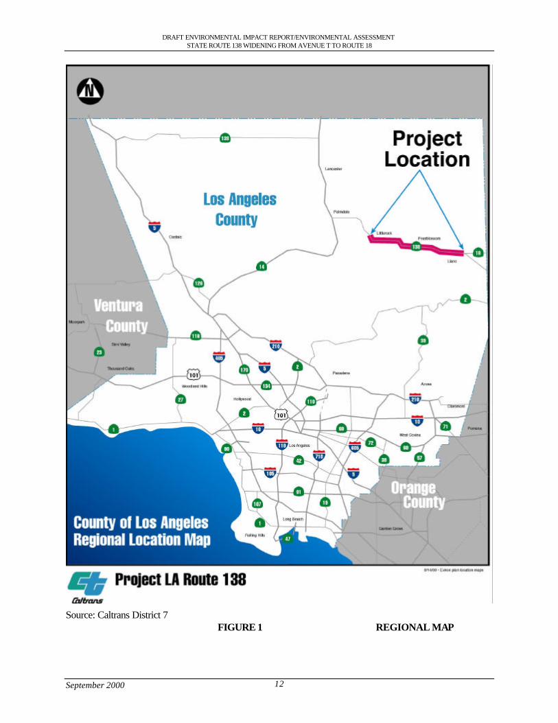
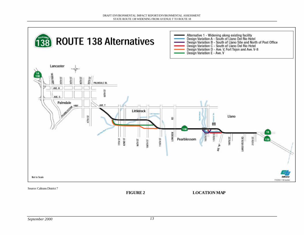
State Route 138 is regarded as an urban Principal Arterial (for the High Desert Corridor connection)between State Route 14 (Antelope Valley Freeway, PM 43.42, KP 69.88) in Palmdale and thePearblossom Highway at Avenue T, (PM 51.41, KP 82.7). From Avenue T to the junction with StateRoute 18 (PM 69.4, KP 111.69) State Route 138 is a 2 lane undivided rural arterial highway with theexception in the areas between 60th and 75th Streets and between 106th and 116th Street East where itbecomes a 4 lane highway for a short distance. State Route 138 does not have current standarddrainage facilities. See Figures 1 and 2. The proposed project is intended to achieve the followinggoals:
• Improve safety.• Facilitate the efficient flow of goods and services through this area.• Conform to state, regional, and local plans and policies.This section describes the existing operational deficiencies, projected travel demands in the StateRoute 138 corridor area, and other considerations that have created the need for the proposed project.
1.2 Need for the Project
The existing section of State Route 138 between Avenue T (PM 51.4, KP 82.7) and the junction ofState Route 138/18 (PM 69.4, KP 111.69) consists of two12-foot (3.6 m) mixed flow lanes, one ineach direction, with a broken center line in some areas to allow vehicles to pass slow moving traffic.The paved right shoulder is 5 ft (1.5 m) to 8 ft (2.4 m) wide. Beyond the shoulder, swales have beengraded to provide drainage along the highway. Vertical grades through the entire route are less than 3percent except between Big Rock Wash (PM 63.0, KP 101.37) and the junction of State Route 138/18(PM 69.4, KP 111.69) where swales are less than 3 percent to allow floodwater to cross the roadway.There are a several pockets for left turns. The California Aqueduct crosses State Route 138 at twolocations, under the California Aqueduct Bridge (Br# 53-2098) (PM 56.17, KP 90.3), andunderground at approximately 116th Street (PM 58.8, KP 94.51).
1.2.1 Capacity Issues
Economic and population growth in the Antelope Valley has rapidly accelerated in the past decade.Southern California Association of Governments (SCAG) predicts high growth rates (approximately5% per year) for the Palmdale area with the presumption that aerospace industry activity will increase.There has been extensive growth in population, housing, and employment.
State Route 138 carries heavy vehicle traffic including a substantial percentage of trucks. This route isbeing used increasingly as a by-pass for recreation vehicles and heavy trucks, coming from the northand going to Las Vegas, Barstow, Victorville, San Bernardino County, and Riverside County, to avoidthe congestion of the Los Angeles metropolitan area.
DRAFT ENVIRONMENTAL IMPACT REPORT/ENVIRONMENTAL ASSESSMENTSTATE ROUTE 138 WIDENING FROM AVENUE T TO ROUTE 18
September 2000 12
Source: Caltrans District 7FIGURE 1 REGIONAL MAP
DRAFT ENVIRONMENTAL IMPACT REPORT/ENVIRONMENTAL ASSESSMENTSTATE ROUTE 138 WIDENING FROM AVENUE T TO ROUTE 18
September 2000 13
Source: Caltrans District 7FIGURE 2 LOCATION MAP
DRAFT ENVIRONMENTAL IMPACT REPORT/ENVIRONMENTAL ASSESSMENTSTATE ROUTE 138 WIDENING FROM AVENUE T TO ROUTE 18
September 2000 14
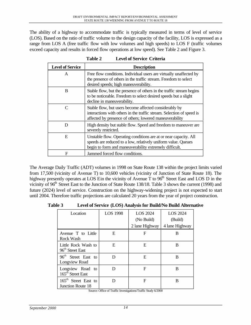
The ability of a highway to accommodate traffic is typically measured in terms of level of service(LOS). Based on the ratio of traffic volume to the design capacity of the facility, LOS is expressed as arange from LOS A (free traffic flow with low volumes and high speeds) to LOS F (traffic volumesexceed capacity and results in forced flow operations at low speed). See Table 2 and Figure 3.
Table 2 Level of Service Criteria
Level of Service DescriptionA Free flow conditions. Individual users are virtually unaffected by
the presence of others in the traffic stream. Freedom to selectdesired speeds; high maneuverability.
B Stable flow, but the presence of others in the traffic stream beginsto be noticeable. Freedom to select desired speeds but a slightdecline in maneuverability.
C Stable flow, but users become affected considerably byinteractions with others in the traffic stream. Selection of speed isaffected by presence of others; lowered maneuverability
D High density but stable flow. Speed and freedom to maneuver areseverely restricted.
E Unstable flow. Operating conditions are at or near capacity. Allspeeds are reduced to a low, relatively uniform value. Queuesbegin to form and maneuverability extremely difficult.
F Jammed forced flow conditions.
The Average Daily Traffic (ADT) volumes in 1998 on State Route 138 within the project limits variedfrom 17,500 (vicinity of Avenue T) to 10,600 vehicles (vicinity of Junction of State Route 18). Thehighway presently operates at LOS E in the vicinity of Avenue T to 96th Street East and LOS D in thevicinity of 96th Street East to the Junction of State Route 138/18. Table 3 shows the current (1998) andfuture (2024) level of service. Construction on the highway-widening project is not expected to startuntil 2004. Therefore traffic projections are calculated 20 years from the year of project construction.
Table 3 Level of Service (LOS) Analysis for Build/No Build Alternative
Location LOS 1998 LOS 2024(No Build)
2 lane Highway
LOS 2024(Build)
4 lane Highway
Avenue T to LittleRock Wash
E F B
Little Rock Wash to96th Street East
E E B
96th Street East toLongview Road
D E B
Longview Road to165th Street East
D F B
165th Street East toJunction Route 18
D F B
Source: Office of Traffic Investigations/Traffic Study 6/2000
DRAFT ENVIRONMENTAL IMPACT REPORT/ENVIRONMENTAL ASSESSMENTSTATE ROUTE 138 WIDENING FROM AVENUE T TO ROUTE 18
September 2000 15
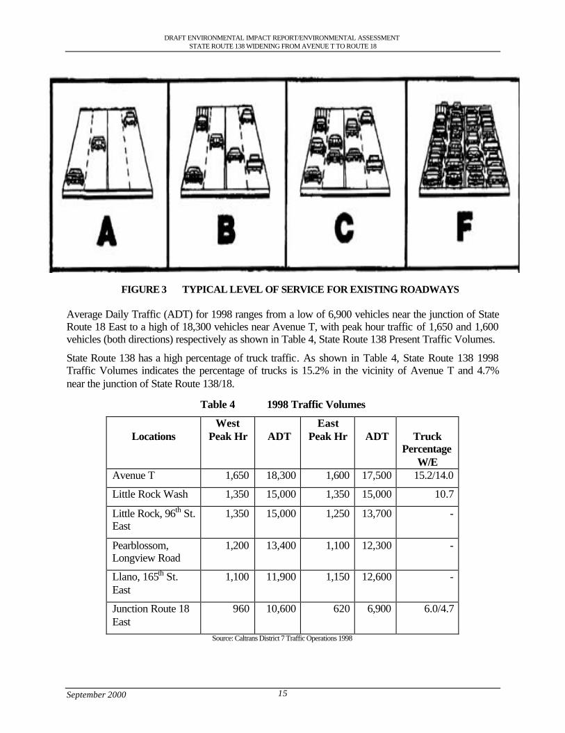
FIGURE 3 TYPICAL LEVEL OF SERVICE FOR EXISTING ROADWAYS
Average Daily Traffic (ADT) for 1998 ranges from a low of 6,900 vehicles near the junction of StateRoute 18 East to a high of 18,300 vehicles near Avenue T, with peak hour traffic of 1,650 and 1,600vehicles (both directions) respectively as shown in Table 4, State Route 138 Present Traffic Volumes.
State Route 138 has a high percentage of truck traffic. As shown in Table 4, State Route 138 1998Traffic Volumes indicates the percentage of trucks is 15.2% in the vicinity of Avenue T and 4.7%near the junction of State Route 138/18.
Table 4 1998 Traffic Volumes
LocationsWest
Peak Hr ADTEast
Peak Hr ADT TruckPercentage
W/EAvenue T 1,650 18,300 1,600 17,500 15.2/14.0
Little Rock Wash 1,350 15,000 1,350 15,000 10.7
Little Rock, 96th St.East
1,350 15,000 1,250 13,700 -
Pearblossom,Longview Road
1,200 13,400 1,100 12,300 -
Llano, 165th St.East
1,100 11,900 1,150 12,600 -
Junction Route 18East
960 10,600 620 6,900 6.0/4.7
Source: Caltrans District 7 Traffic Operations 1998
DRAFT ENVIRONMENTAL IMPACT REPORT/ENVIRONMENTAL ASSESSMENTSTATE ROUTE 138 WIDENING FROM AVENUE T TO ROUTE 18
September 2000 16
The Los Angeles Regional Transportation Study (LARTS) traffic projections for the year 2024(Table 5) range from a maximum of 33,800 ADT between Largo Vista Road and State Route 18/138junction to a low of 15,700 ADT from Little Rock Wash to 90th St East. The area between LargoVista Road and State Route 18/138 Junction has a peak AM traffic projection of 2,700 vehicles and apeak PM traffic of 2,850 vehicles. The ideal capacity for smooth flow of traffic for a 2-laneconventional highway is approximately 1,200 vehicles per hour per lane. This data shows that StateRoute 138 should be upgraded to a 4-lane conventional highway so that Level of Service (LOS) C canbe achieved as illustrated by Table 3 Level of Service (LOS) Analysis for Build/No Build Alternative.
The existing Level of Service (LOS) for State Route 138 between Avenue T and the junction of StateRoute 138/18 is D/E. It is expected that by adding 2 lanes to make it a 4-lane conventional highway,the LOS will be maintained at LOS B, which would consist of a stable flow of traffic through 2024.
Table 5 Future (2024) Traffic Volumes
Location East ADT West ADT
AM PM AM PMAvenue T to Little Rock Wash 1,725 1,625 24,900 1,500 2,000 25,600Little Rock Wash to 90th StEast
1,200 1,325 15,700 1,150 1,400 16,700
90th St East to 106th St East 1,175 1,250 16,800 1,125 1,325 16,500106th St East to 136th St East 1,400 1,325 18,900 1,250 1,625 19,800136th St East to 165th St East 1,650 1,675 22,900 1,575 1,950 23,900165th St East to Largo Vista Rd 2,200 1,950 27,800 1,850 2,245 29,000Largo Vista Rd to the StateRoute 18/138 Junction
2,700 2,375 33,800 2,150 2,850 34,000
Source: Caltrans District 7 Traffic Projections
1.2.2 Safety Problems
This existing stretch of State Route 138 has one lane in each direction with passing lanes in only twoareas (between 60th and 75th Streets and between 106th and 116th Street East).
Analysis from the Caltrans’ Traffic Accident Surveillance and Analysis System (TASAS) for theperiod from April 1, 1994 to March 31, 1999 indicated the actual accident rate is .81/million vehiclemiles traveled (mvm) within the project limits, which is lower than the statewide average of 1.02/mvm. However, the actual fatality rate is 0.049/mvm, which is higher than the statewide average of0.038/mvm. A more detailed analysis of the accident summary reveals that there were 25 fatalities and354 injured within this same period within the project limits (Avenue T to the Junction State Route138/18).
State Route 138 has been identified as having a high number of cross-centerline accidents. TheCaltrans 2-3 lane cross-centerline accident monitoring program has identified a pattern of cross-centerline accidents between 96th Street East to approximately the junction of State Route 138/18. Forthe 5-year analysis period of 1994-1998 there were 10 fatal cross-centerline accidents between 96th
Street East and the Junction of the 138/18.
DRAFT ENVIRONMENTAL IMPACT REPORT/ENVIRONMENTAL ASSESSMENTSTATE ROUTE 138 WIDENING FROM AVENUE T TO ROUTE 18
September 2000 17
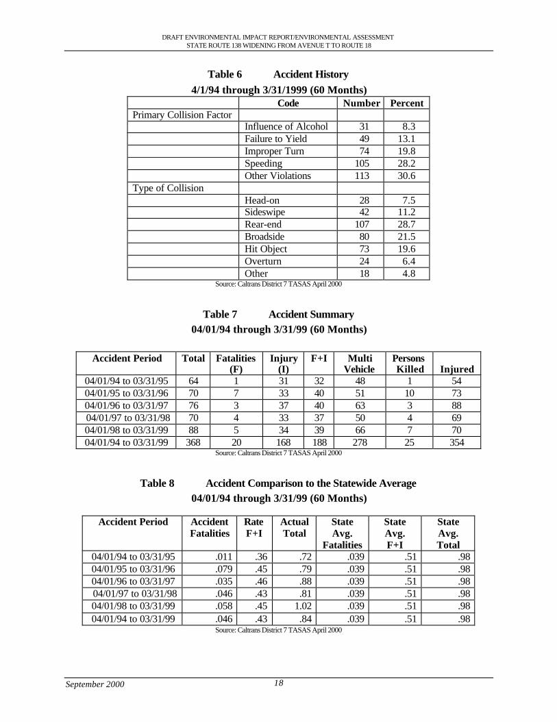
The high truck volumes along with their slower speeds create a queue along the 2-lane section becauseof insufficient passing opportunities. The majority of the accidents indicate that the types of collisionwere broadside (21.5%), rear end (28.7%), and hit object (19.6%). See Table 6 for detailedexaminations of accidents.
In response to community concern over accident history Caltrans District 7 (which consists of LosAngeles and Ventura County) in association with other agencies formed a Highway 138 SafetyCorridor Task Force. See section 2.7.
DRAFT ENVIRONMENTAL IMPACT REPORT/ENVIRONMENTAL ASSESSMENTSTATE ROUTE 138 WIDENING FROM AVENUE T TO ROUTE 18
September 2000 18
Table 6 Accident History4/1/94 through 3/31/1999 (60 Months)
Code Number PercentPrimary Collision Factor
Influence of Alcohol 31 8.3Failure to Yield 49 13.1Improper Turn 74 19.8Speeding 105 28.2Other Violations 113 30.6
Type of CollisionHead-on 28 7.5Sideswipe 42 11.2Rear-end 107 28.7Broadside 80 21.5Hit Object 73 19.6Overturn 24 6.4Other 18 4.8
Source: Caltrans District 7 TASAS April 2000
Table 7 Accident Summary04/01/94 through 3/31/99 (60 Months)
Accident Period Total Fatalities(F)
Injury(I)
F+I MultiVehicle
PersonsKilled Injured
04/01/94 to 03/31/95 64 1 31 32 48 1 5404/01/95 to 03/31/96 70 7 33 40 51 10 7304/01/96 to 03/31/97 76 3 37 40 63 3 88 04/01/97 to 03/31/98 70 4 33 37 50 4 6904/01/98 to 03/31/99 88 5 34 39 66 7 7004/01/94 to 03/31/99 368 20 168 188 278 25 354
Source: Caltrans District 7 TASAS April 2000
Table 8 Accident Comparison to the Statewide Average04/01/94 through 3/31/99 (60 Months)
Accident Period AccidentFatalities
RateF+I
ActualTotal
StateAvg.
Fatalities
StateAvg.F+I
StateAvg.Total
04/01/94 to 03/31/95 .011 .36 .72 .039 .51 .9804/01/95 to 03/31/96 .079 .45 .79 .039 .51 .9804/01/96 to 03/31/97 .035 .46 .88 .039 .51 .98 04/01/97 to 03/31/98 .046 .43 .81 .039 .51 .9804/01/98 to 03/31/99 .058 .45 1.02 .039 .51 .9804/01/94 to 03/31/99 .046 .43 .84 .039 .51 .98
Source: Caltrans District 7 TASAS April 2000
DRAFT ENVIRONMENTAL IMPACT REPORT/ENVIRONMENTAL ASSESSMENTSTATE ROUTE 138 WIDENING FROM AVENUE T TO ROUTE 18
September 2000 19
1.2.3 Operational Deficiencies
The existing pavement profile east of the community of Pearblossom is a rolling profile withdrastically deep depressions originally designed to accommodate the passage of flash drainage flows.These depressions in the pavement have the effect of diminishing the stopping and passing sightdistance available to the user. It should be noted that the sight distance is one of the 13 mandatorycontrolling design criteria elements required in the design of a highway facility.
The accidents associated with wet pavement conditions are relatively high, about 9 percent of the totalaccidents can be attributed to wet conditions. If drainage conditions remain the same and drainage isallowed to flow over the roadway, it can be expected that these types of accidents will increase asresult of the additional traffic lanes, increase traffic volumes, and higher speeds.
The present condition of the shoulders consists of the earth berms along side the roadway in thedriver’s recovery area this reduces the recovery areas for errant drivers and poses a potential safetyhazard. Also the existing facility has curves in the project areas that are not up to the latest designstandards at the following locations:
• 72nd Street East• 116th Street• 175th Street East• Avenue W• State Route 138/18 JunctionAn Engineering and Traffic survey was completed in 1997 in which speed measurements wereobtained. The observed critical speeds were generally around 65 to 70 miles per hour (mph) outsidedeveloped areas, with 45 to 60 mph speeds in the community of Littlerock and 50-55 mph speeds inthe community of Pearblossom. These curves do not provide adequate stopping sight distance for thespeeds that motorists drive. The State Route 138/18 junction is on a curve, which has a left turn pocketonto State Route 18. The inadequate space for vehicles making a left hand turn on to State Route 18from State Route 138 has the potential to create a queuing effect on the highway that backs up thetraffic and poses the potential for rear end collisions.
1.2.4 Structural Deficiencies
Big Rock Wash Bridge (Bridge #53-313 and Bridge #53-314)
The existing bridges do not have sufficient waterway to convey a 100-year storm. Also, the existingbridge is not wide enough to carry the four lanes that are proposed for State Route 138. Big RockWash Bridge is in an area that has a rolling profile and has a restricted sight distance.
The Big Rock Wash Bridges are concrete bridges that were constructed in 1948 using the supportsfrom earlier timber bridges. Bridge #53-313 is a two span continuous slab bridge that is 40 ft (12.2 m)long and bridge #53-314 is a three span continuous slab bridge that is 60 ft (18.2 m) long. Each bridgeis presently 32.8 ft (10.0 m) wide. The new bridge would replace the two older bridges with onecontinuous bridge spanning Big Rock Wash.
The Q100 flow (100 year flood) for the Big Rock Wash Bridge was calculated by Caltrans District 7Hydraulics to be 566 cubic meters per second (cms) (20,000 cubic feet per second (cfs)). Based onthese flows the bridges will be overtopped by a 100-year storm event. The channels and bridgescurrently have sufficient capacity for a 20-year flood. If the channels were allowed to aggrade to theirnatural state the bridge would only be able to handle a 10-year flood.
DRAFT ENVIRONMENTAL IMPACT REPORT/ENVIRONMENTAL ASSESSMENTSTATE ROUTE 138 WIDENING FROM AVENUE T TO ROUTE 18
September 2000 20
California Aqueduct (Bridge No. 53-2098)
It is proposed to widen both sides of the California Aqueduct Bridge at 96th Street East toaccommodate four lanes and keep within the same alignment to bring the bridge up to currentstandards and to accommodate equestrian users.
Little Rock Wash Bridge (Bridge No. 53-0303R and Bridge No. 53-0303L)
Little Rock Wash Bridge consists of two bridges (53-0303R and 53-0303L). The westbound bridge(53-0303L) would be replaced. As a result the eastbound bridge (53-0303R) would be widened to thenorth to accommodate the 4-lane highway and bring the bridge up to current standard.
1.3 Summary
The proposed improvements of State Route 138 were planned to correct existing operationaldeficiencies, accommodate projected travel demands in the State Route 138 corridor area and achieveplanning consistency. A transportation project is needed in this area to improve the safetycharacteristics, which would reduce the number of accidents. Adding an additional lane in bothdirections would allow traffic to flow at an acceptable Level of Service. Also the project wouldeliminate the need for fast moving vehicles to crossover the median to pass slow moving trafficthereby reducing the number of cross-centerline accidents. Due to the predicted increase in travelvolumes, the existing facility will not be able to accommodate the future projected volumesadequately. In summary improvements to the existing State Route 138 facility are needed for thefollowing reasons:
• Improve safety.• Facilitate the efficient flow of goods and services through this area.• Conform to state, regional, and local plans and policies.• Vehicle miles of delay will continue to increase and vehicle hours of travel will increase
from current conditions.• Congestion on arterial roadways intersecting to State Route 138 will increase substantially
from the 1999 conditions.• Accident rates will continue to increase due to operational deficiencies.• Regional emissions will increase due to the increase of vehicle hours of travel.

District 7 • 120 South Spring Street • Los Angeles, California
DraftEnvironmental Impact Report/
Environmental Assessment
State Route 138 Widening ProjectFrom Avenue T to State Route 18
Junction Throughthe Communities of Littlerock,
Pearblossom, Llano and the City ofPalmdale
SCH Number: 1998091007

DRAFT ENVIRONMENTAL IMPACT REPORT/ENVIRONMENTAL ASSESSMENTSTATE ROUTE 138 WIDENING FROM AVENUE T TO ROUTE 18
September 2000 i
Table of Contents
S.0 Summary .............................................................................................................................................................. 1S.1 Purpose and Need for the Project ................................................................................................................ 1S.2 Alternatives under Consideration................................................................................................................ 1S.3 Other Actions in the Same Area .................................................................................................................. 3S.4 Environmental Consequences and Recommended Mitigation Measures ............................................ 3
1.0 Purpose and Need............................................................................................................................................. 111.1 Purpose of the Project.................................................................................................................................. 111.2 Need for the Project ..................................................................................................................................... 111.2.1 Capacity Issues ........................................................................................................................................ 111.2.2 Safety Problems ....................................................................................................................................... 161.2.3 Operational Deficiencies ........................................................................................................................ 191.2.4 Structural Deficiencies............................................................................................................................ 191.3 Summary ........................................................................................................................................................ 20
2.0 Alternatives including the Proposed Project................................................................................................ 212.1 Alternative 1: Widening along existing facility...................................................................................... 212.1.2 Design Variation A: South of Llano del Rio hotel............................................................................ 262.1.3 Design Variation B (Preferred Alternative): South of Llano del Rio Hotel and North of U.S.
Post Office ................................................................................................................................................ 262.1.4 Design Variation C: South of Llano del Rio Hotel............................................................................ 262.1.5 Design Variation D: Avenue V, Fort Tejon and Avenue V-8......................................................... 262.1.6 Design Variation E: Avenue V.............................................................................................................. 272.1.7 Attainment of Project Goals .................................................................................................................. 272.2 Other Alternatives Considered................................................................................................................... 282.2.1 Alternative 2: Building of Freeway...................................................................................................... 282.2.2 Alternative 3: Transportation System Management (TSM)............................................................ 282.2.3 Alternative 4: Widening along the existing highway through Pearblossom................................. 282.2.4 Alternative 5: No Action........................................................................................................................ 282.3 Current Status of the Project ...................................................................................................................... 292.4 Status of Other Projects or Proposals In The Area................................................................................. 29
3.0 Affected Environment...................................................................................................................................... 323.1 Topography ................................................................................................................................................... 323.2 Geology and Soils ........................................................................................................................................ 323.2.1 Faults ......................................................................................................................................................... 323.2.2 Mining ....................................................................................................................................................... 323.3 Water Resources .......................................................................................................................................... 333.3.1 Hydrology................................................................................................................................................. 333.3.2 Water Quality........................................................................................................................................... 333.3.3 Flood Hazards .......................................................................................................................................... 333.3.4 Climate ...................................................................................................................................................... 343.4 Biological Resources................................................................................................................................... 343.4.1 Vegetation................................................................................................................................................. 343.4.2 Wildlife...................................................................................................................................................... 383.4.3 Wildlife Corridors ................................................................................................................................... 383.4.4 Wetlands ................................................................................................................................................... 393.5 Air Quality Characteristics ......................................................................................................................... 393.6 Hazardous Waste ......................................................................................................................................... 463.6.1 Storage Tanks........................................................................................................................................... 463.7 Land Use Setting .......................................................................................................................................... 473.7.1 Housing..................................................................................................................................................... 473.7.2 Commercial............................................................................................................................................... 483.7.3 Industrial.................................................................................................................................................... 483.7.4 Farm Land................................................................................................................................................. 483.8 Socioeconomic Characteristics .................................................................................................................. 483.8.1 Economics................................................................................................................................................. 48

DRAFT ENVIRONMENTAL IMPACT REPORT/ENVIRONMENTAL ASSESSMENTSTATE ROUTE 138 WIDENING FROM AVENUE T TO ROUTE 18
September 2000 ii
3.8.2 Population................................................................................................................................................. 523.9 Public Services & Facilities........................................................................................................................ 533.9.1 Schools ...................................................................................................................................................... 543.10 Transportation............................................................................................................................................... 543.11 Historic & Cultural Resources.................................................................................................................. 543.12 Noise Analysis ............................................................................................................................................. 553.13 Parks and Bicycle Facilities........................................................................................................................ 573.13.1 Park............................................................................................................................................................. 573.13.2 Equestrian Trails ....................................................................................................................................... 573.13.3 Bicycle Lanes ........................................................................................................................................... 573.14 Scenic Resources ......................................................................................................................................... 57
4.0 Environmental Evaluation............................................................................................................................... 594.1 CEQA Environmental Checklist ............................................................................................................... 604.2 Discussion of Environmental Consequences .......................................................................................... 624.3 Geology, Topography, Seismic (Environmental Checklist Questions 1,2,4).................................... 634.3.1 Soil Erosion (5) ........................................................................................................................................ 634.4 Hazardous Waste (9).................................................................................................................................... 634.5 Floodplain (11).............................................................................................................................................. 654.5.1 Water Quality (10, 12,14,15)................................................................................................................. 654.6 Air Quality (19)............................................................................................................................................ 664.7 Noise (20, 21)................................................................................................................................................ 674.8 Wildlife (23,29,56)...................................................................................................................................... 684.8.1 Vegetation (14,24,27).............................................................................................................................. 704.8.2 Wildlife Movement/Habitat Fragmentation (30,31).......................................................................... 724.8.3 Wetlands (14)........................................................................................................................................... 764.9 Growth Inducing (35) .................................................................................................................................. 784.10 Lifestyles, Neighborhood Stability (36) ................................................................................................... 794.11 Elderly or Specific Interest Groups, Housing and Employment (39).................................................. 794.12 Housing and Employment (40,41)........................................................................................................... 794.13 Minority (37)................................................................................................................................................. 824.14 Property Values, Local Tax Base (41)...................................................................................................... 834.15 Community Facilities (42).......................................................................................................................... 834.16 Public Utilities and Services (43) .............................................................................................................. 854.17 Traffic and Circulation (44, 45,50)............................................................................................................ 864.18 Cultural/Historic Resources (51) ............................................................................................................... 874.19 Cumulative Effects (58).............................................................................................................................. 894.20 Farmland (26)................................................................................................................................................ 914.21 Visual Impacts (53)...................................................................................................................................... 924.22 Construction Impacts (54)........................................................................................................................... 94
5.0 Section 4(f) Evaluation.................................................................................................................................... 965.1 Section 4(f) .................................................................................................................................................... 975.2 Proposed Action........................................................................................................................................... 975.3 Description of Section 4(f) Properties Directly Used............................................................................ 975.3.1 Historic Resources .................................................................................................................................. 975.4 Impacts on the Section 4(f) Property ......................................................................................................1015.4.1 No Build Alternative.............................................................................................................................1015.4.2 Design Variation A................................................................................................................................1015.4.3 Design Variation B (Preferred)...........................................................................................................1025.4.4 Design Variation C................................................................................................................................1035.5 Avoidance Alternatives .............................................................................................................................1035.5.1 No Build Alternative.............................................................................................................................1035.5.2 Avoidance Alternative..........................................................................................................................1045.6 Measures to Minimize Harm....................................................................................................................1045.6.1 Mitigation Measures for Llano Colony Site......................................................................................1045.7 Other Properties Evaluated Relative to the Requirements of Section 4(f) .......................................1055.8 Section 6(f) ..................................................................................................................................................105

DRAFT ENVIRONMENTAL IMPACT REPORT/ENVIRONMENTAL ASSESSMENTSTATE ROUTE 138 WIDENING FROM AVENUE T TO ROUTE 18
September 2000 iii
5.9 Coordination................................................................................................................................................1076.0 Consultation and Coordination ....................................................................................................................108
6.1 Early Scoping Process...............................................................................................................................1086.2 Consultation................................................................................................................................................1086.3 Community and Agency Meetings .........................................................................................................1096.4 Circulation of Draft Environmental Document.....................................................................................109
7.0 List of Preparers..............................................................................................................................................110
List of Tables
TABLE 1 IMPROVEMENTS PROJECT AND ENVIRONMENTAL EVALUATION SUMMARY OF EFFECTS............... 4TABLE 2 LEVEL OF SERVICE CRITERIA................................................................................................................. 14TABLE 3 LEVEL OF SERVICE (LOS) ANALYSIS FOR BUILD/NO BUILD ALTERNATIVE ................................. 14TABLE 4 1998 TRAFFIC VOLUMES ........................................................................................................................ 15TABLE 5 FUTURE (2024) TRAFFIC VOLUMES ...................................................................................................... 16TABLE 6 ACCIDENT HISTORY ................................................................................................................................ 18TABLE 7 ACCIDENT SUMMARY.............................................................................................................................. 18TABLE 8 ACCIDENT COMPARISON TO THE STATEWIDE AVERAGE ................................................................... 18TABLE 9 STATE TRANSPORTATION IMPLEMENTATION PLAN............................................................................ 29TABLE 10 PLANTS OBSERVED IN THE PROJECT VICINITY.................................................................................... 36TABLE 11 HIGHEST 4 DAILY MAXIMUM HOURLY OZONE MEASUREMENTS.................................................... 40TABLE 12 HIGHEST 4 DAILY MAXIMUM 8-HOUR CARBON MONOXIDE AVERAGES....................................... 43TABLE 13 HIGHEST 4 DAILY PM10 MEASUREMENTS AND ANNUAL PM10 STATISTICS................................... 43TABLE 14 HIGHEST 4 DAILY NITROGEN DIOXIDE MEASUREMENTS AND ANNUAL NITROGEN DIOXIDE .... 46TABLE 15 HOUSING UNITS FOR 1990...................................................................................................................... 47TABLE 16 MEDIAN FAMILY INCOME BY COMMUNITY COMPARED TO LOS ANGELES COUNTY..................... 49TABLE 17 LABOR-MARKET INDUSTRY................................................................................................................... 49TABLE 18 REGIONAL DEMOGRAPHICS.................................................................................................................... 52TABLE 19 ANTELOPE VALLEY REGION POPULATION TRENDS BY CITY AND AREA ........................................ 52TABLE 20 EDUCATION DEMOGRAPHICS................................................................................................................. 53TABLE 21 ETHNIC POPULATION IN ANTELOPE VALLEY COMMUNITIES............................................................ 53TABLE 22 ETHNIC POPULATION OF ALPINE ELEMENTARY SCHOOL 1998-1999 SCHOOL YEAR ................... 54TABLE 23 NOISE CRITERIA ....................................................................................................................................... 56TABLE 24 EXISTING NOISE LEVELS IN PROJECT AREA ........................................................................................ 56TABLE 25 CO CONCENTRATION RESULTS COMPARED TO BUILD AND NO BUILD ALTERNATIVE................. 67TABLE 26 SENSITIVE FLORA IN PROJECT AREA .................................................................................................... 70TABLE 27 BEST CASE SCENARIO FOR RIGHT-OF-WAY ACQUISITION FOR THE COMMUNITIES OF PALMDALE,
LITTLEROCK, PEARBLOSSOM AND LLANO........................................................................................... 81TABLE 28 WORST CASE SCENARIO FOR RIGHT-OF-WAY ACQUISITION FOR THE COMMUNITIES OF
PALMDALE, LITTLEROCK, PEARBLOSSOM AND LLANO..................................................................... 81TABLE 29 SITES OF UTILITY RELOCATION IN PROJECT AREA............................................................................. 86
List of Figures
FIGURE 1 REGIONAL MAP........................................................................................................................................ 12FIGURE 2 LOCATION MAP ........................................................................................................................................ 13FIGURE 3 TYPICAL LEVEL OF SERVICE FOR EXISTING ROADWAYS................................................................... 15FIGURE 4 TYPICAL CROSS-SECTION FOR DEVELOPED AREA ............................................................................. 23FIGURE 5 TYPICAL CROSS SECTION FOR UNDEVELOPED AREA......................................................................... 24FIGURE 6 DESIGN VARIATIONS A, B, AND C...................................................................................................... 25FIGURE 7 STATE AND NATIONAL AREA OZONE ATTAINMENT/NONATTAINMENT AREAS............................ 42FIGURE 8 STATE AND NATIONAL AREA CARBON MONOXIDE ATTAINMENT /NONATTAINMENT AREAS.... 44FIGURE 9 STATE AND NATIONAL AREA PM10 ATTAINMENT/NONATTAINMENT AREAS............................... 45FIGURE 10 IMPORTANT FARMLAND IN THE VICINITY OF THE PROPOSED PROJECT ........................................... 50FIGURE 11 PRIME FARMLAND AFFECTED BY THE PROPOSED PROJECT ............................................................. 51

DRAFT ENVIRONMENTAL IMPACT REPORT/ENVIRONMENTAL ASSESSMENTSTATE ROUTE 138 WIDENING FROM AVENUE T TO ROUTE 18
September 2000 iv
FIGURE 12 LOCATION OF EQUESTRIAN TRAILS IN PROJECT AREA ................................................................ 58FIGURE 13 WESTBOUND STATE ROUTE 138 NEAR 87TH STREET -LITTLE ROCK EXISTING CONDITION ..... 92FIGURE 14 WESTBOUND STATE ROUTE 138 NEAR 87TH STREET -LITTLE ROCK PROPOSED CONDITIONS.. 93FIGURE 15 EASTBOUND STATE ROUTE 138 NEAR 175TH STREET –LLANO ..................................................... 93FIGURE 16A VIEW OF LLANO DEL RIO HOTEL ON NORTHSIDE OF STATE ROUTE 138.................................. 98FIGURE 16B VIEW OF CORE AREA OF LLANO COLONY SOUTH SIDE OF STATE ROUTE 138 ........................ 99FIGURE 16C LLANO HOTEL (APPROX. 46 M (150 FT) FROM THE HIGHWAY)................................................. 99FIGURE 17 ROOT CROP STORAGE STRUCTURE (APPROX. 411 M (1340 FT) FROM HIGHWAY)...................100FIGURE 18 MASONRY SILO, SMALLER BARN (APPROX. 716 M (2350 FT) FROM HIGHWAY).....................100FIGURE 19 BOUNDARIES OF THE LLANO DEL RIO COLONY ( BLACK DOTS).................................................106
Appendices
Appendix A Letter of Concurrence from State Historic Preservation OfficerAppendix B Noise Receptor Location Aerial MapsAppendix C Scoping NoticeAppendix D Scoping CommentsAppendix E Mailing ListAppendix F Title VI Policy StatementAppendix G FootprintAppendix H Farmland Conversion Impact Rating (Form AD-1006)Appendix I List of Acronyms
DRAFT ENVIRONMENTAL IMPACT REPORT/ENVIRONMENTAL ASSESSMENTSTATE ROUTE 138 WIDENING FROM AVENUE T TO ROUTE 18
September 2000 21
2.0 Alternatives including the Proposed Project
This section describes the alternative analysis by which the Preferred Alternative was identified. Alsoit describes how this process complies with the applicable requirements of the Intermodal SurfaceTransportation Efficiency Act (ISTEA) of 1991. Alternatives that were considered at various times arealso described, along with the reasons why they were rejected. Related Transportation improvements,project phasing, and funding issues are also discussed.
The formulation of alternatives for analysis in this Environmental Impact Report/EnvironmentalAssessment (EIR/EA) involved the review of prior studies and additional analysis. This analysisidentified transportation system deficiencies, developed and screened a broad range of alternatives,and performed a detailed evaluation of those alternatives deemed most responsive to safety, travel andcommunity concerns and demands. Alternatives were evaluated for their ability to attain project goalsand objectives and as the alternative analysis process merged with the environmental process, thesafety and transportation needs for the State Route 138 corridor were evaluated with consideration ofenvironmental needs.
2.1 Alternative 1: Widening along existing facility
This alternative involves highway widening on State Route 138 between Avenue T to the west and theLos Angeles/San Bernardino County Line to the east. This alternative involves the addition of onelane in each direction, upgrading the existing facility to a standard 4 lane conventional highway with a16 ft (4.8 m) median for turns. The existing alignment and profile would be maintained except in thecommunity of Pearblossom where the alignment would shift to the north by approximately 12 ft (3.66m) from 121st St. East to Longview Road and then return to the existing roadway. The vertical profilewould change from the Pearblossom to the junction with State Route 18 to improve stopping sightdistance and accommodate drainage culverts. This alternative would include two 12 ft (3.6 m) lanes,one in each direction, standard 8 ft (2.4 m) shoulders and a 16 ft (4.8 m) median for turns. Right-of-way width of 200 ft (60 m) would accommodate drainage culverts in undeveloped areas and curbs andgutters in developed areas. Present right-of-way varies from a minimum of 50 ft (15.24 m) to amaximum of 100 ft (30.48 m). See Figures 4 and 5.
Other proposed features for the highway widening are described below.
Curve Corrections - The widening will include curve corrections in the immediate vicinity of thefollowing locations:
• 72nd Street East• 116th Street• 175th Street East• Avenue W• State Route 18 Junction.
Junction Modification – The project would modify the State Route 138/State Route 18 Junction byproviding a direct connector from the eastbound 138 to the eastbound 18.
Bridge Widening – Two bridges, California Aqueduct (BR 53-2098), and Big Rock Wash (BR 53-313 and BR 53-314), will be widened. The widening of these bridges will accommodate drainage
DRAFT ENVIRONMENTAL IMPACT REPORT/ENVIRONMENTAL ASSESSMENTSTATE ROUTE 138 WIDENING FROM AVENUE T TO ROUTE 18
September 2000 22
culverts and facilitate functional wildlife corridors. Little Rock Creek Bridge will have the existingmedian closed.
Elevation of Profile- the widening of the State Route 138 would include raised profiles along thehighway to accommodate drainage requirements and eliminate the rolling profile from Pearblossom toState Route 18 thereby improving the stopping sight distance and reducing the number of fatal cross-median accidents.
It is Caltrans Policy to upgrade highways to the current highway standards in order to improve safetyand efficiency in transportation. Consideration during the design process was given to the occurrencesof flash floods between Big Rock Wash and Junction State Route 138/State Route18. The highwayalong this area is subjected to flood waters washing over the highway. To meet the drainagerequirements for this area a design was developed that would raise the profile of the existing highway.Caltrans policy states that the design of highway drainage structures and other features must considerthe probability of flooding and provide protection which is commensurate with the importance of thehighway, the potential for property damage and traffic safety. Drainage design seeks to prevent theretention of water on the highway and provide for removal of water from the roadway.
Standard highway dimensions for the State Route 138 widening project can be classified into thefollowing categories:
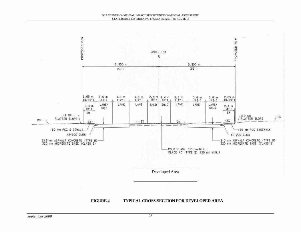
Developed Areas: The existing width of both east and westbound lanes within urbanized areas isapproximately 30 ft (9.14 m) from the highway centerline. Both directions of the highway, within thelimits of the proposed project, will be widened to include an additional 20 ft (6.10 m). After projectconstruction, each direction of State Route 138 will have a total width of 52 ft (15.85 m) from thehighway centerline. These dimensions are illustrated by Figure 4, Typical Cross Section forDeveloped Areas.
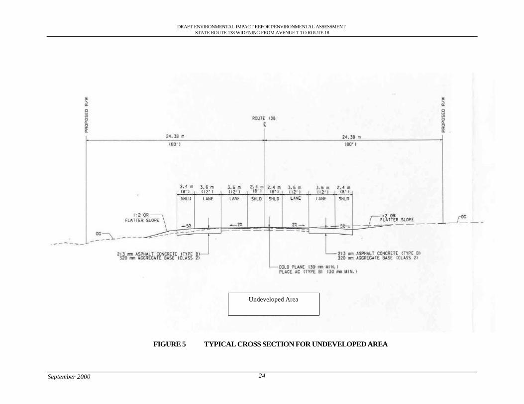
Undeveloped Areas: The existing width of both east and westbound lanes within undeveloped areas isapproximately 30 ft (9.14 m) from the highway centerline. Both directions of the highway, within thelimits of the proposed project, will be widened to include an additional 50 ft (15.24 m). After projectconstruction the width of the highway will have a total width of 80 ft (24.38 m) from the highwaycenterline in order to accommodate drainage easements along the highway. However, it should benoted that the 52 ft (15.85 m) will apply only to areas of the roadway which require additional fill(imported and local borrow) during project construction. These dimensions are illustrated by Figure 5,Typical Cross Section Undeveloped Areas.
These measurements are the standard dimensions anticipated for the State Route 138 wideningproject; however, slight variations to this standard may occur. It should also be noted that thesedimensions include both paved areas resulting from project implementation along with any additionalright-of-way which may extend beyond paved areas after project implementation.
The following alternatives are based on the existing highway structure and proposed changes inalternative 1, but with specific design variations along certain portions of the State Route 138. SeeFigure 6 Design Alternatives State Route 138.
The implementation of this design variation would:
• Have a direct impact on the Llano del Rio Hotel Site
DRAFT ENVIRONMENTAL IMPACT REPORT/ENVIRONMENTAL ASSESSMENTSTATE ROUTE 138 WIDENING FROM AVENUE T TO ROUTE 18
September 2000 23
Developed Area
FIGURE 4 TYPICAL CROSS-SECTION FOR DEVELOPED AREA
DRAFT ENVIRONMENTAL IMPACT REPORT/ENVIRONMENTAL ASSESSMENTSTATE ROUTE 138 WIDENING FROM AVENUE T TO ROUTE 18
September 2000 24
Undeveloped Area
FIGURE 5 TYPICAL CROSS SECTION FOR UNDEVELOPED AREA
DRAFT ENVIRONMENTAL IMPACT REPORT/ENVIRONMENTAL ASSESSMENTSTATE ROUTE 138 WIDENING FROM AVENUE T TO ROUTE 18
September 2000 25
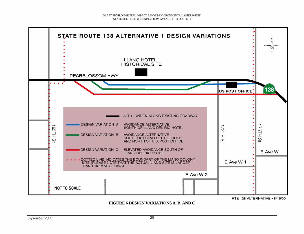
FIGURE 6 DESIGN VARIATIONS A, B, AND C
DRAFT ENVIRONMENTAL IMPACT REPORT/ENVIRONMENTAL ASSESSMENTSTATE ROUTE 138 WIDENING FROM AVENUE T TO ROUTE 18
September 2000 26
2.1.2 Design Variation A: South of Llano del Rio hotel
This design variation involves all of the features of Alternative 1; however, near the community ofLlano a new alignment would be constructed to the south to avoid impacts to the Llano del Rio site.The new alignment will shift to the south by approximately 20 ft (6 m) just east of 165th Street Eastand will continue east until it rejoins the existing highway west of 175th Street.
The implementation of this design variation would:
• Create a barrier for the animals that migrate across the highway• Relocate State Route 138 from its historic setting within the Llano del Rio Cooperative
Colony Site• Keep the existing rolling profile that limits sight distance• Allow floodwaters to cross over the highway between Big Rock Wash and Junction State
Route 138/State Route 18 causing unsafe conditions for motorists
2.1.3 Design Variation B (Preferred Alternative): South of Llano del Rio Hotel and Northof U.S. Post Office
This design variation involves all the features of Alternative 1; however near the Llano del Rio hotelwidening of the existing roadway will occur 82 ft (25 m) to the south and as the route approaches theU.S. Post office located in Llano it will shift north to the existing roadway to avoid it and the profilewill be raised approximately 5 ft (1.52m) to accommodate the arch type pipe drainage culverts for thisvariation before and after the Llano hotel site.
The implementation of this design variation would:
• Create a barrier for the animals that migrate across the highway• Relocate State Route 138 from its historic setting within the Llano del Rio Cooperative
Colony Site
2.1.4 Design Variation C: South of Llano del Rio Hotel
This design variation involves all the features of Alternative 1; however this variation proposes torealign the highway approximately 394 ft (120 meters) to the south in order to raise the roadwayprofile approximately 15 ft (4.6 meters) to accommodate 8 foot (2.4 m) x 8 foot (2.4 m) drainageculverts for this variation and avoid the hotel.
The implementation of this design variation would:
• Adversely affect the existing flora and fauna by creating a new alignment.• Create a barrier for the animals that migrate across the highway.• Visually impair the view of the Llano site• Relocate State Route 138 from its historic setting within the Llano del Rio Cooperative
Colony Site
2.1.5 Design Variation D: Avenue V, Fort Tejon and Avenue V-8
This variation involves all of the features of Alternative 1; however, near the community of Littlerocka new alignment will be constructed to the south of the existing alignment. At 70th Street East, this
DRAFT ENVIRONMENTAL IMPACT REPORT/ENVIRONMENTAL ASSESSMENTSTATE ROUTE 138 WIDENING FROM AVENUE T TO ROUTE 18
September 2000 27
alignment will veer south towards Avenue V and then continue along Avenue V to 82nd Street. At 82nd
Street, the alignment will veer further to the south to continue along Fort Tejon Road and will thentraverse further east along Avenue V-8 until it rejoins the existing highway at the intersection of 116th
Street East and State Route138 (PM 58.67, KP 94.52).
The implementation of this design variation would:
• Adversely impact relatively undisturbed native vegetation.• Reduce and fragment habitat.• Create barriers to wildlife movement throughout the area impacted.• Disrupt the economic life of the three rural communities (Littlerock, Pearblossom, and
Llano) by diverting traffic from the businesses along the existing highway.• Require substantial new right-of-way• Substantial number of displacements
2.1.6 Design Variation E: Avenue V
This alternative involves all of the features of Alternative 1; however, near the community ofLittlerock a new alignment will be constructed to the south of the existing alignment. At 70th StreetEast, this alignment will veer south towards Avenue V and then continue along Avenue V until itrejoins the existing highway at the intersection of Avenue V and State Route 138 (PM 57.94, KP93.34).
This alternative is similar to Littlerock Avoidance Alternative D mentioned above and will have thesame impacts to relatively undisturbed native vegetation due to constructing a new facility away fromthe existing roadway.
2.1.7 Attainment of Project Goals
Alternative 1 design variation B attains the project goals and objectives as described below.
Goal: Improve safety
This alternative would meet the project goal for improving safety. The addition of another lane in eachdirection of traffic flow would improve the level of service for the highway by decreasing congestionand eliminate the need for vehicles to cross over the median to pass thereby reducing the number ofcross-median accidents. The elevation of the profile would eliminate the rolling profile, eliminatefloodwater from crossing the roadway and improve the sight distance. Curve corrections would bringthe existing conditions up to the latest standard design.
Goal: Facilitate the efficient flow of goods and services through this area
This alternative would satisfy the goal of facilitating the efficient movement of goods and servicesthrough the area. This alternative would provide an improved route between Eastern Los AngelesCounty and Western San Bernardino County and Southern Kern County. This alternative wouldcomplete the planned integrated regional transportation network between San Bernardino County andthe Eastern Los Angeles County.
Goal: Conform to state, regional, and local plans and policies
This alternative would comply with state, regional, and local plans and policies. The alternative isconsistent with the assumptions for the State Transportation Improvement Plan and with the RegionalTransportation Improvement Plan by meeting the approved facility location and type which would be
DRAFT ENVIRONMENTAL IMPACT REPORT/ENVIRONMENTAL ASSESSMENTSTATE ROUTE 138 WIDENING FROM AVENUE T TO ROUTE 18
September 2000 28
a 4-lane facility. This alternative would conform to the Air Quality Management Plan (AQMP) byreducing emissions in the South Coast Air Basin by providing components of the AQMP in the StateRoute 138 corridor.
2.2 Other Alternatives Considered
2.2.1 Alternative 2: Building of Freeway
This alternative consisted of developing a freeway in the State Route 138 corridor. In the ProjectStudy Report that was completed in 1992 it was one of the alternatives considered. It stated that thecontinuing intense development in the Antelope Valley would require development of a freeway bythe year 2010.
This alternative was withdrawn from consideration at this time as it would not address the safety andoperational problems of the existing highway and funding is not available. It is also currentlyinconsistent with the assumptions for the State Transportation Improvement Plan and with theRegional Transportation Improvement Plan.
2.2.2 Alternative 3: Transportation System Management (TSM)
At this time the project area does not meet the criteria for a Transportation System Managementprogram. The project area is located in a unincorporated/rural area of Los Angeles County with thepopulation below the 200,000 level that would make it eligible.
A TSM program would not satisfy the purpose and need of this project to improve safety, facilitate themovement of people and goods and comply with local, regional and state plans and policies.Therefore this alternative was eliminated from further consideration.
2.2.3 Alternative 4: Widening along the existing highway through Pearblossom
This alternative proposed to widen both sides of the highway through the community of Pearblossom.During preliminary design and environmental studies it was found that there is a significantconcentration of commercial, residential property and an U.S. post office on the south side of thehighway. This alternative would have substantial impacts to the community of Pearblossom byeliminating the center of the town.
2.2.4 Alternative 5: No Action
This alternative retains the existing roadway conditions. It has the following drawbacks:
• It is not consistent with the long-term objective of reducing congestion and improving theoverall operation and safety for State Route 138.
• It would not provide sufficient capacity for projected 2024 traffic volumes.• It would not improve safety conditions or reduce the number of accidents and fatalities.• It would not facilitate the efficient movement of goods and services through the area.• It would not complete the planned integrated regional transportation network between San
Bernardino County and the Eastern Los Angeles County.• It would be inconsistent with the 1990 STIP that allotted funds for Passing Lanes, Widen
Bridge, and Channelization.• It would not conform to the Air Quality Management Plan (AQMP)
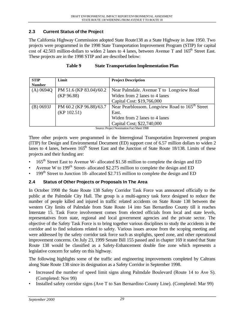
DRAFT ENVIRONMENTAL IMPACT REPORT/ENVIRONMENTAL ASSESSMENTSTATE ROUTE 138 WIDENING FROM AVENUE T TO ROUTE 18
September 2000 29
2.3 Current Status of the Project
The California Highway Commission adopted State Route138 as a State Highway in June 1950. Twoprojects were programmed in the 1998 State Transportation Improvement Program (STIP) for capitalcost of 42.503 million-dollars to widen 2 lanes to 4 lanes, between Avenue T and 165th Street East.These projects are in the 1998 STIP and are described below:
Table 9 State Transportation Implementation Plan
STIPNumber
Limit Project Description
(A) 0694Q PM 51.6 (KP 83.04)/60.2(KP 96.88)
Near Palmdale. Avenue T to Longview RoadWiden from 2 lanes to 4 lanesCapital Cost: $19,766,000
(B) 0693J PM 60.2 (KP 96.88)/63.7(KP 102.51)
Near Pearblossom. Longview Road to 165th StreetEast.Widen from 2 lanes to 4 lanesCapital Cost; $22,740,000
Source: Project Nomination Fact Sheet 1998
Three other projects were programmed in the Interregional Transportation Improvement program(ITIP) for Design and Environmental Document (ED) support cost of 6.57 million dollars to widen 2lanes to 4 lanes, between 165th Street East and the Junction of State Route 18/138. Limits of theseprojects and their funding are:
• 165th Street East to Avenue W- allocated $1.58 million to complete the design and ED• Avenue W to 199th Street- allocated $2.275 million to complete the design and ED• 199th Street to Junction 18- allocated $2.715 million to complete the design and ED
2.4 Status of Other Projects or Proposals In The Area
In October 1998 the State Route 138 Safety Corridor Task Force was announced officially to thepublic at the Palmdale City Hall. The group is a multi-agency task force designed to reduce thenumber of people killed and injured in traffic related accidents on State Route 138 between thewestern City limits of Palmdale from State Route 14 into San Bernardino County till it reachesInterstate 15. Task Force involvement comes from elected officials from local and state levels,representatives from state, regional and local government agencies and the private sector. Theobjective of the Safety Task Force is to bring together various disciplines to study the accidents in thecorridor and to find solutions related to safety. Various issues arouse from the scoping meeting andwere addressed by the safety corridor task force such as stoplights, speed zone, and other operationalimprovement concerns. On July 23, 1999 Senate Bill 155 passed and in chapter 169 it stated that StateRoute 138 would be classified as a Safety-Enhancement double fine zone which represents alegislative concern for safety on this highway.
The following highlights some of the traffic and engineering improvements completed by Caltransalong State Route 138 since its designation as a Safety Corridor in September 1998.
• Increased the number of speed limit signs along Palmdale Boulevard (Route 14 to Ave S).(Completed: Nov 99)
• Installed safety corridor signs (Ave T to San Bernardino County Line). (Completed: Mar 99)
DRAFT ENVIRONMENTAL IMPACT REPORT/ENVIRONMENTAL ASSESSMENTSTATE ROUTE 138 WIDENING FROM AVENUE T TO ROUTE 18
September 2000 30
• Installed additional speed limit signs in Littlerock. (Completed: Nov 98)• Refurbished faded pavement markings and limit lines on cross streets within communities of
Littlerock and Pearblossom. (Completed: Dec 98)• Installed oversize Stop Signs (48 in, 1.22 m) on the 96th St East and 165th St East
intersections. (Completed: Nov 98)• Replaced faded school area speed zone signs in Littlerock. (Completed: Sep 98)• Installed No Stopping Anytime sign in front of elementary school in Littlerock. (Completed:
Oct 99)• Installed reduced speed zone ahead sign east of Littlerock. (Completed: Jun 99)• Removed passing zone on bridge west of 96th St East. (Completed: May 99)• Relocated obscured stop sign at 106th St East. (Completed: Dec 98)• Replaced faded side road warning sign west of Longview Rd. (Completed: Sep 98)• Installed signing and striping for aerial speed zone enforcement between Pearblossom and
Llano). (Completed: Dec 98)• Installed larger Narrow Bridge signs (48 in., 1.22 m) for approaches to bridge at Big Rock
Wash. (Completed: Dec 98)• Replaced faded crossroad warning signs for 165th St East. (Completed: Sep 98)• Restriped edgeline for eastbound approach to 165th St East. (Completed: Nov 98)• Removed excessive sand accumulated on roadway at vicinity of 165th St East. (Completed:
Mar 99)• Restriped faded centerline and replaced missing pavement markers between 165th St East and
the junction with Route 18. (Completed: May 99)• Replaced faded stop sign at 175th St East. (Completed: Dec 98)• Removed all 55-mph advisory speed signs on all curve-warning signs between Avenue T and
the San Bernardino County Line. (Completed: Feb 99)• Installed curve warning chevrons for westbound approach to Avenue W. (Completed: Nov
98)• Relocated westbound curve warning sign at Avenue W. (Completed: May 99)• Extend double yellow centerline striping east of Avenue W. (Completed: May 99)• Removed 9 passing zones between the junction with Route 18 and the San Bernardino
County Line. (Completed: Mar 99)• Installed double fine zone signs between Avenue T and the San Bernardino County Line.
(Completed: Dec 99)• Minor project to construct a soft median barrier (median rumble strips, pavement markers,
and centerline striping changes) from approximately one mile west of Big Rock Wash to1500’ east of Ave W. (Completed: April 2000)
The following lists some of Caltrans proposed Interim Projects:• Initiate a project to install left turn pockets at 96th Street East. (Construction will start in Fall
of 2000)• Initiate a project to raise the profile of the roadway approaching the Big Rock Wash Twin
Bridges. (Construction will start in Fall of 2000)• Initiate a project to install left turn pocket at 175th Street East. (Construction will start in Fall
of 2000)
DRAFT ENVIRONMENTAL IMPACT REPORT/ENVIRONMENTAL ASSESSMENTSTATE ROUTE 138 WIDENING FROM AVENUE T TO ROUTE 18
September 2000 31
• Initiate a project to install standard right turn pocket at 165th Street East. (Construction willstart in Fall of 2000)
• Install new detector loops at Division St. (Permit in review)• Resurface pavement at 106th St East / Hampel Ave (Permit in review)• Planned development at SE corner of Avenue S impacting State Route 138 from Avenue S to
Fort Tejon Road. (IGR/CEQA review in progress)• Unresolved parking issues along State Route 138 within the Communities of Littlerock and
Pearblossom. (Under investigation)• Local advertising signs creating a potential conflict with regulatory signs on State Route 138
within the Community of Littlerock. (Under investigation)• Update existing Daytime Headlight Zone
California Highway Patrol (CHP)• Increased the number of CHP Officers on patrol (with grant through end of 2000)• Implemented Aircraft Enforcement• Increased Radar Units• Implemented Community Awareness Programs
As a member of the “Highway 138 Safety Task Force Committee” which consists of the CaliforniaHighway Patrol, County of Los Angeles, Local cities and private citizens, Caltrans continues to seekways to make the highway safer and better.
Caltrans District 8 (San Bernardino and Riverside Counties) have begun work on the environmentaldocument that would increase the number of lanes from 2 lanes to 4 lanes with a median fromInterstate 15 in San Bernardino County to the Junction of 138/18 in Los Angeles County.

District 7 • 120 South Spring Street • Los Angeles, California
DraftEnvironmental Impact Report/
Environmental Assessment
State Route 138 Widening ProjectFrom Avenue T to State Route 18
Junction Throughthe Communities of Littlerock,
Pearblossom, Llano and the City ofPalmdale
SCH Number: 1998091007

DRAFT ENVIRONMENTAL IMPACT REPORT/ENVIRONMENTAL ASSESSMENTSTATE ROUTE 138 WIDENING FROM AVENUE T TO ROUTE 18
September 2000 i
Table of Contents
S.0 Summary .............................................................................................................................................................. 1S.1 Purpose and Need for the Project ................................................................................................................ 1S.2 Alternatives under Consideration................................................................................................................ 1S.3 Other Actions in the Same Area .................................................................................................................. 3S.4 Environmental Consequences and Recommended Mitigation Measures ............................................ 3
1.0 Purpose and Need............................................................................................................................................. 111.1 Purpose of the Project.................................................................................................................................. 111.2 Need for the Project ..................................................................................................................................... 111.2.1 Capacity Issues ........................................................................................................................................ 111.2.2 Safety Problems ....................................................................................................................................... 161.2.3 Operational Deficiencies ........................................................................................................................ 191.2.4 Structural Deficiencies............................................................................................................................ 191.3 Summary ........................................................................................................................................................ 20
2.0 Alternatives including the Proposed Project................................................................................................ 212.1 Alternative 1: Widening along existing facility...................................................................................... 212.1.2 Design Variation A: South of Llano del Rio hotel............................................................................ 262.1.3 Design Variation B (Preferred Alternative): South of Llano del Rio Hotel and North of U.S.
Post Office ................................................................................................................................................ 262.1.4 Design Variation C: South of Llano del Rio Hotel............................................................................ 262.1.5 Design Variation D: Avenue V, Fort Tejon and Avenue V-8......................................................... 262.1.6 Design Variation E: Avenue V.............................................................................................................. 272.1.7 Attainment of Project Goals .................................................................................................................. 272.2 Other Alternatives Considered................................................................................................................... 282.2.1 Alternative 2: Building of Freeway...................................................................................................... 282.2.2 Alternative 3: Transportation System Management (TSM)............................................................ 282.2.3 Alternative 4: Widening along the existing highway through Pearblossom................................. 282.2.4 Alternative 5: No Action........................................................................................................................ 282.3 Current Status of the Project ...................................................................................................................... 292.4 Status of Other Projects or Proposals In The Area................................................................................. 29
3.0 Affected Environment...................................................................................................................................... 323.1 Topography ................................................................................................................................................... 323.2 Geology and Soils ........................................................................................................................................ 323.2.1 Faults ......................................................................................................................................................... 323.2.2 Mining ....................................................................................................................................................... 323.3 Water Resources .......................................................................................................................................... 333.3.1 Hydrology................................................................................................................................................. 333.3.2 Water Quality........................................................................................................................................... 333.3.3 Flood Hazards .......................................................................................................................................... 333.3.4 Climate ...................................................................................................................................................... 343.4 Biological Resources................................................................................................................................... 343.4.1 Vegetation................................................................................................................................................. 343.4.2 Wildlife...................................................................................................................................................... 383.4.3 Wildlife Corridors ................................................................................................................................... 383.4.4 Wetlands ................................................................................................................................................... 393.5 Air Quality Characteristics ......................................................................................................................... 393.6 Hazardous Waste ......................................................................................................................................... 463.6.1 Storage Tanks........................................................................................................................................... 463.7 Land Use Setting .......................................................................................................................................... 473.7.1 Housing..................................................................................................................................................... 473.7.2 Commercial............................................................................................................................................... 483.7.3 Industrial.................................................................................................................................................... 483.7.4 Farm Land................................................................................................................................................. 483.8 Socioeconomic Characteristics .................................................................................................................. 483.8.1 Economics................................................................................................................................................. 48
DRAFT ENVIRONMENTAL IMPACT REPORT/ENVIRONMENTAL ASSESSMENTSTATE ROUTE 138 WIDENING FROM AVENUE T TO ROUTE 18
September 2000 ii
3.8.2 Population................................................................................................................................................. 523.9 Public Services & Facilities........................................................................................................................ 533.9.1 Schools ...................................................................................................................................................... 543.10 Transportation............................................................................................................................................... 543.11 Historic & Cultural Resources.................................................................................................................. 543.12 Noise Analysis ............................................................................................................................................. 553.13 Parks and Bicycle Facilities........................................................................................................................ 573.13.1 Park............................................................................................................................................................. 573.13.2 Equestrian Trails ....................................................................................................................................... 573.13.3 Bicycle Lanes ........................................................................................................................................... 573.14 Scenic Resources ......................................................................................................................................... 57
4.0 Environmental Evaluation............................................................................................................................... 594.1 CEQA Environmental Checklist ............................................................................................................... 604.2 Discussion of Environmental Consequences .......................................................................................... 624.3 Geology, Topography, Seismic (Environmental Checklist Questions 1,2,4).................................... 634.3.1 Soil Erosion (5) ........................................................................................................................................ 634.4 Hazardous Waste (9).................................................................................................................................... 634.5 Floodplain (11).............................................................................................................................................. 654.5.1 Water Quality (10, 12,14,15)................................................................................................................. 654.6 Air Quality (19)............................................................................................................................................ 664.7 Noise (20, 21)................................................................................................................................................ 674.8 Wildlife (23,29,56)...................................................................................................................................... 684.8.1 Vegetation (14,24,27).............................................................................................................................. 704.8.2 Wildlife Movement/Habitat Fragmentation (30,31).......................................................................... 724.8.3 Wetlands (14)........................................................................................................................................... 764.9 Growth Inducing (35) .................................................................................................................................. 784.10 Lifestyles, Neighborhood Stability (36) ................................................................................................... 794.11 Elderly or Specific Interest Groups, Housing and Employment (39).................................................. 794.12 Housing and Employment (40,41)........................................................................................................... 794.13 Minority (37)................................................................................................................................................. 824.14 Property Values, Local Tax Base (41)...................................................................................................... 834.15 Community Facilities (42).......................................................................................................................... 834.16 Public Utilities and Services (43) .............................................................................................................. 854.17 Traffic and Circulation (44, 45,50)............................................................................................................ 864.18 Cultural/Historic Resources (51) ............................................................................................................... 874.19 Cumulative Effects (58).............................................................................................................................. 894.20 Farmland (26)................................................................................................................................................ 914.21 Visual Impacts (53)...................................................................................................................................... 924.22 Construction Impacts (54)........................................................................................................................... 94
5.0 Section 4(f) Evaluation.................................................................................................................................... 965.1 Section 4(f) .................................................................................................................................................... 975.2 Proposed Action........................................................................................................................................... 975.3 Description of Section 4(f) Properties Directly Used............................................................................ 975.3.1 Historic Resources .................................................................................................................................. 975.4 Impacts on the Section 4(f) Property ......................................................................................................1015.4.1 No Build Alternative.............................................................................................................................1015.4.2 Design Variation A................................................................................................................................1015.4.3 Design Variation B (Preferred)...........................................................................................................1025.4.4 Design Variation C................................................................................................................................1035.5 Avoidance Alternatives .............................................................................................................................1035.5.1 No Build Alternative.............................................................................................................................1035.5.2 Avoidance Alternative..........................................................................................................................1045.6 Measures to Minimize Harm....................................................................................................................1045.6.1 Mitigation Measures for Llano Colony Site......................................................................................1045.7 Other Properties Evaluated Relative to the Requirements of Section 4(f) .......................................1055.8 Section 6(f) ..................................................................................................................................................105

DRAFT ENVIRONMENTAL IMPACT REPORT/ENVIRONMENTAL ASSESSMENTSTATE ROUTE 138 WIDENING FROM AVENUE T TO ROUTE 18
September 2000 iii
5.9 Coordination................................................................................................................................................1076.0 Consultation and Coordination ....................................................................................................................108
6.1 Early Scoping Process...............................................................................................................................1086.2 Consultation................................................................................................................................................1086.3 Community and Agency Meetings .........................................................................................................1096.4 Circulation of Draft Environmental Document.....................................................................................109
7.0 List of Preparers..............................................................................................................................................110
List of Tables
TABLE 1 IMPROVEMENTS PROJECT AND ENVIRONMENTAL EVALUATION SUMMARY OF EFFECTS............... 4TABLE 2 LEVEL OF SERVICE CRITERIA................................................................................................................. 14TABLE 3 LEVEL OF SERVICE (LOS) ANALYSIS FOR BUILD/NO BUILD ALTERNATIVE ................................. 14TABLE 4 1998 TRAFFIC VOLUMES ........................................................................................................................ 15TABLE 5 FUTURE (2024) TRAFFIC VOLUMES ...................................................................................................... 16TABLE 6 ACCIDENT HISTORY ................................................................................................................................ 18TABLE 7 ACCIDENT SUMMARY.............................................................................................................................. 18TABLE 8 ACCIDENT COMPARISON TO THE STATEWIDE AVERAGE ................................................................... 18TABLE 9 STATE TRANSPORTATION IMPLEMENTATION PLAN............................................................................ 29TABLE 10 PLANTS OBSERVED IN THE PROJECT VICINITY.................................................................................... 36TABLE 11 HIGHEST 4 DAILY MAXIMUM HOURLY OZONE MEASUREMENTS.................................................... 40TABLE 12 HIGHEST 4 DAILY MAXIMUM 8-HOUR CARBON MONOXIDE AVERAGES....................................... 43TABLE 13 HIGHEST 4 DAILY PM10 MEASUREMENTS AND ANNUAL PM10 STATISTICS................................... 43TABLE 14 HIGHEST 4 DAILY NITROGEN DIOXIDE MEASUREMENTS AND ANNUAL NITROGEN DIOXIDE .... 46TABLE 15 HOUSING UNITS FOR 1990...................................................................................................................... 47TABLE 16 MEDIAN FAMILY INCOME BY COMMUNITY COMPARED TO LOS ANGELES COUNTY..................... 49TABLE 17 LABOR-MARKET INDUSTRY................................................................................................................... 49TABLE 18 REGIONAL DEMOGRAPHICS.................................................................................................................... 52TABLE 19 ANTELOPE VALLEY REGION POPULATION TRENDS BY CITY AND AREA ........................................ 52TABLE 20 EDUCATION DEMOGRAPHICS................................................................................................................. 53TABLE 21 ETHNIC POPULATION IN ANTELOPE VALLEY COMMUNITIES............................................................ 53TABLE 22 ETHNIC POPULATION OF ALPINE ELEMENTARY SCHOOL 1998-1999 SCHOOL YEAR ................... 54TABLE 23 NOISE CRITERIA ....................................................................................................................................... 56TABLE 24 EXISTING NOISE LEVELS IN PROJECT AREA ........................................................................................ 56TABLE 25 CO CONCENTRATION RESULTS COMPARED TO BUILD AND NO BUILD ALTERNATIVE................. 67TABLE 26 SENSITIVE FLORA IN PROJECT AREA .................................................................................................... 70TABLE 27 BEST CASE SCENARIO FOR RIGHT-OF-WAY ACQUISITION FOR THE COMMUNITIES OF PALMDALE,
LITTLEROCK, PEARBLOSSOM AND LLANO........................................................................................... 81TABLE 28 WORST CASE SCENARIO FOR RIGHT-OF-WAY ACQUISITION FOR THE COMMUNITIES OF
PALMDALE, LITTLEROCK, PEARBLOSSOM AND LLANO..................................................................... 81TABLE 29 SITES OF UTILITY RELOCATION IN PROJECT AREA............................................................................. 86
List of Figures
FIGURE 1 REGIONAL MAP........................................................................................................................................ 12FIGURE 2 LOCATION MAP ........................................................................................................................................ 13FIGURE 3 TYPICAL LEVEL OF SERVICE FOR EXISTING ROADWAYS................................................................... 15FIGURE 4 TYPICAL CROSS-SECTION FOR DEVELOPED AREA ............................................................................. 23FIGURE 5 TYPICAL CROSS SECTION FOR UNDEVELOPED AREA......................................................................... 24FIGURE 6 DESIGN VARIATIONS A, B, AND C...................................................................................................... 25FIGURE 7 STATE AND NATIONAL AREA OZONE ATTAINMENT/NONATTAINMENT AREAS............................ 42FIGURE 8 STATE AND NATIONAL AREA CARBON MONOXIDE ATTAINMENT /NONATTAINMENT AREAS.... 44FIGURE 9 STATE AND NATIONAL AREA PM10 ATTAINMENT/NONATTAINMENT AREAS............................... 45FIGURE 10 IMPORTANT FARMLAND IN THE VICINITY OF THE PROPOSED PROJECT ........................................... 50FIGURE 11 PRIME FARMLAND AFFECTED BY THE PROPOSED PROJECT ............................................................. 51

DRAFT ENVIRONMENTAL IMPACT REPORT/ENVIRONMENTAL ASSESSMENTSTATE ROUTE 138 WIDENING FROM AVENUE T TO ROUTE 18
September 2000 iv
FIGURE 12 LOCATION OF EQUESTRIAN TRAILS IN PROJECT AREA ................................................................ 58FIGURE 13 WESTBOUND STATE ROUTE 138 NEAR 87TH STREET -LITTLE ROCK EXISTING CONDITION ..... 92FIGURE 14 WESTBOUND STATE ROUTE 138 NEAR 87TH STREET -LITTLE ROCK PROPOSED CONDITIONS.. 93FIGURE 15 EASTBOUND STATE ROUTE 138 NEAR 175TH STREET –LLANO ..................................................... 93FIGURE 16A VIEW OF LLANO DEL RIO HOTEL ON NORTHSIDE OF STATE ROUTE 138.................................. 98FIGURE 16B VIEW OF CORE AREA OF LLANO COLONY SOUTH SIDE OF STATE ROUTE 138 ........................ 99FIGURE 16C LLANO HOTEL (APPROX. 46 M (150 FT) FROM THE HIGHWAY)................................................. 99FIGURE 17 ROOT CROP STORAGE STRUCTURE (APPROX. 411 M (1340 FT) FROM HIGHWAY)...................100FIGURE 18 MASONRY SILO, SMALLER BARN (APPROX. 716 M (2350 FT) FROM HIGHWAY).....................100FIGURE 19 BOUNDARIES OF THE LLANO DEL RIO COLONY ( BLACK DOTS).................................................106
Appendices
Appendix A Letter of Concurrence from State Historic Preservation OfficerAppendix B Noise Receptor Location Aerial MapsAppendix C Scoping NoticeAppendix D Scoping CommentsAppendix E Mailing ListAppendix F Title VI Policy StatementAppendix G FootprintAppendix H Farmland Conversion Impact Rating (Form AD-1006)Appendix I List of Acronyms
DRAFT ENVIRONMENTAL IMPACT REPORT/ENVIRONMENTAL ASSESSMENTSTATE ROUTE 138 WIDENING FROM AVENUE T TO ROUTE 18
September 2000 32
3.0 Affected Environment
3.1 Topography
The proposed project will occur in the Southern California northeastern portion of the Mojave Desertregion in the Antelope Valley. The area ranges in altitude from 2450 ft (742 m) to 3200 ft (975 m)with the surrounding mountain rising up to 4000 ft (1211 m). The San Gabriel Mountains binds theregion to the north and the Sierra Pelona Mountains on the Southwest. The topography varies fromflat with occasional drainage’s and sand dunes on the valley floor to steep foothill mountain areas onthe south. The San Andreas Fault transverses the project limits parallel and just north of themountains. The area surrounding State Route 138 is a flat terrain.
3.2 Geology and Soils
The project site is located northerly of the San Bernardino Mountains. The geologic profile situatedbeneath State Route 138 is composed of three types of strata. The surface stratum being alluvium andolder alluvium, underlying the alluvium are the Punchbowl Formation of Cajon Valley, and thebasement rock formation being metamorphic rock of gneiss, which locally contains undeformed toslightly deformed plutonic rocks. In Palmdale consolidated rocks make up the mountains and rockybuttes while alluvial soils are found on streambeds and the valley floor. Pelona schist underlies mostof the mountainous portions of Palmdale. Situated beneath the alluvial soil lies the same hard rocksfound in the mountain areas.
Older alluvium deposits consist of sand, gravel silt, and boulders characterized by their ability to storeand yield water. Younger alluvium deposits make up the alluvial fans found at the base of the SanGabriel Mountains.
3.2.1 Faults
The project site is situated in an active seismic region that is located less than 3 miles (3.82 km)northerly of the San Andreas Fault Zone. The San Andreas Fault is the boundary where the NorthAmerican plate and the Pacific plate meet. The source of seismic activity is related to the tectonicactivity of the right lateral movement of the Pacific Plate relative to the North American Plate.Relative movement along these plates boundaries is what causes earthquakes in this area. The SanAndreas Fault extends over 600 miles (965.4 km) from the Salton Sea, northwest toward the PacificOcean at Point Arena. The San Andreas Fault system has several fault traces branch off the primaryfault.
Active branches of the San Andreas Fault system in the Palmdale area are the Cemetery Fault, theNadeau Fault, and the Littlerock Fault. Any movement from the San Andreas Fault may activate oneor all of the subsidiary faults.
3.2.2 Mining
One of the predominant uses of land in the City of Palmdale and surrounding areas involves mining,which consists of sand and gravel operations. There are six mining operations located along the LittleRock Wash on the eastern edge of the City. In addition, there are six concrete batching operations,
DRAFT ENVIRONMENTAL IMPACT REPORT/ENVIRONMENTAL ASSESSMENTSTATE ROUTE 138 WIDENING FROM AVENUE T TO ROUTE 18
September 2000 33
three asphalt batching operations and one concrete pipe manufacturer located within the Little RockWash area.
3.3 Water Resources
3.3.1 Hydrology
The largest waterways within the project area include Little Rock Wash, Big Rock Wash and theCalifornia Aqueduct which run generally north and northeast across the project lands toward theRosamond and Rogers dry lakes. Thunderstorms are common, but washes are dry during much of theyear. The California Aqueduct is channelized and flows year round. The Antelope Valley is a naturalinland basin within the southwestern Mojave Desert. The groundwater system consists of an upperand lower aquifer covering 900 square miles (1448 km) separated vertically by silt and clay depositsfrom when an inland lake covered the valley that is also called a lacustrine deposit. The uplifting ofthe San Gabriel and the Sierra Pelona Mountain Ranges, the Tehachapi Mountains, and the SoledaMountain upland created the aquifers in the Antelope Valley. The upper aquifer overlies the lacustrinedeposits and supplies all water pumped from wells in the Antelope Valley. The lower aquiferunderlies these deposits. Water moves downward from the upper aquifer to the lower aquifer on thewestern and southern limits of the lacustrine deposits.
Although a constant water flow within the California Aqueduct is maintained year-round, littleriparian vegetation was noted in close proximity to the concrete lined channel. Little riparianvegetation was also noted at the Big Rock Wash Bridge area as well. In contrast, the Little Rock Washarea contains an extensive, diverse, dense riparian habitat.
Big Rock Wash is an intermittent stream that flows between the Angeles National Forest and theAntelope Valley. Near Highway 138, the wash is mostly unvegetated, except for limited alluvial scrubvegetation. Big Rock contains two channels separated by a 200-foot (61.38 m) island. Leveesconstructed from alluvial material line the wash immediately upstream and downstream of thebridges.
3.3.2 Water Quality
The chemical quality of the groundwater in the Antelope Valley Basin is generally satisfactory fordomestic use and irrigation, as well as for most commercial and industrial uses. The levels of totaldissolved solids generally range from 200 to 800 parts per million with concentrations of up to 2,600parts per million near Rosamond and Rogers Playa. Although present quality is satisfactory, there is aslow trend toward reduced groundwater quality, due to increased urban run-off, septic tank failures inthe San Gabriel watershed, declining water tables, and an extensive perched water condition in theLancaster sub-unit of the Antelope Valley Basin. (This sub-unit presently supplies the majority of thepumped water supply in the Basin). Particular water quality problems exist in the Littlerock area. Pastnitrate readings in Littlerock Creek Irrigation District (LCID) wells have indicated that such levelswill exceed State standards.
3.3.3 Flood Hazards
In the vicinity of State Route 138 there are two floodplain areas, which are of concern. The areas arelocated at Littlerock Creek Bridge #52-303 (PM 53.57), Big Rock Wash Bridge #53-313 (PM 63.00,KP 101.38) and Big Rock Wash Bridge #53-314 (PM 63.04, KP 101.45).
DRAFT ENVIRONMENTAL IMPACT REPORT/ENVIRONMENTAL ASSESSMENTSTATE ROUTE 138 WIDENING FROM AVENUE T TO ROUTE 18
September 2000 34
Large areas of the Antelope Valley are subject to flooding due to weather conditions in the SanGabriel and Sierra Pelona Mountains. In the winter season the rainfall is concentrated and encouragesrun-off from exposed, highly fractured rocks. The topography of this area results in high velocityerosive flows due to steep canyon slopes and channel gradients which concentrate the rain fall. Theflows quickly satisfy soil moisture deficiencies and then spread across alluvial deposits in newchannels and/or sheet flow. Flooding in the Antelope Valley is further produced by impervious silt,clay and fine sand located on the desert floor.
Urban development reduces the total ground absorption area by creating impermeable surfaces suchas pavement and streets. Storm runoff, increased by the presence of impermeable surfaces, flows fromdeveloped areas, contributing to street flooding. The amount and frequency of rain is variable, andalthough floodwaters may be diverted, the lack of a completed regional drainage system will continueto result in local flooding problems. Rainfall in the area is often in the form of thunderstorms and otherfast moving, relatively intense storms, which may cause flash floods. There is a tendency for flashfloods in the project area. It is difficult to forecast the force and strength of flash floods and the amountof rain they will produce, so there may be occasional occurrences of floodwater washing over theroadway. Runoff may be anticipated from storm water.
3.3.4 Climate
The climate of the Antelope Valley is dominated by the region’s Pacific high-pressure system, whichcontributes to the area’s hot, dry summers and relatively mild winters. The climate is characterized byits wide fluctuation in temperature between day and night. Temperatures in the area average a low of71 F and a high of 95 F in summer months. During the winter the average low is 36 F and the averagehigh is 58 F. The average annual precipitation is 8 inches in the antelope valley. The climate ischaracterized by spring being typically mild with cool nights and a tapering of rain showers; thesummer months being typically dry, warm-hot, and often breezy; fall being mild, windy and dry withmild days and cool nights; and winter being cold, breezy and moist to wet.
3.4 Biological Resources
3.4.1 Vegetation
In the Antelope Valley there are Four (4) major zones that have distinct vegetative associations. Thevalley floor zone, the bajadas and plains, the floodplains and drainage courses, and the uppermountain slope zone. The valley floor extends to about 2,400 feet (731.5 m) and is a zone consistingof alkaline playa lakebeds, with compact clay soils and very little vegetation other than saltbushes(Atriplex spp.) and other salt tolerant species. The bajadas and plains are gently sloping alluvial fansextending from the nearby mountain ranges (below 4,000 feet, 1219.2 m) to the floor of the basin.Species associated with these well drained areas include creosote bush (Larrea tridentata),cheesebush (Hymenoclea salsola), burrobrush (Franseria dumosa), and Mormon tea (Ephedratorreyana). Cacti species (Opuntia and Cereus spp.) are more common in the drier valley areas andthe most conspicuous tree of the bajadas is the Joshua Tree.
The types of vegetation found in the floodplains and concrete lined channels, which would beconsistent with the Big Rock and Little Rock creeks, are clumps of desert willow or catalpa (Chilopsislinearis) and acacia (Acacia spp.) Other species found in this area include: bittterbrush (Parishiaglabulosa), rabbitbrush (Chrysothammus spp.) , and goldenbush (Happlopappus copperii).
DRAFT ENVIRONMENTAL IMPACT REPORT/ENVIRONMENTAL ASSESSMENTSTATE ROUTE 138 WIDENING FROM AVENUE T TO ROUTE 18
September 2000 35
The vegetation in the higher valley areas consists of clumps of scrub juniper or California Junipers(Juniperus califonica) present in the Joshua tree woodland areas in the upper elevations. Thevegetation in the project area can be classified into five (5) plant communities; the Mojave CreosoteBush Scrub, Mojave Mixed Woody Scrub, Joshua Tree Woodland, Mojave Wash Scrub and Ruderalplant communities.
The following is a description of natural communities and associated plant species observed within thevicinity of the proposed project.
Mojave Creosote Bush Scrub: This plant community is dominant on well-drained secondarysoils in relatively flat areas of the western Mojave Desert. Although this plant community israrely adjacent to developed areas, it is found in the project vicinity. Of the most commonspecies of this plant community, creosote, with sub-dominant species that included lycium(Lycium spp.), brittle bush (Encelia farinosa), and Mormon tea are present in the vicinity of theproposed project.
Mojave Mixed Woody Scrub: The Mojave Mixed Woody Scrub occurs in areas which arecharacterized by steep overly-drained soils with extremely low water holding capacity. Thesesites are scattered throughout the project area. Of the most common species of this plantcommunity, rabbitbrush (Chrysothamnus nauseosus), saltbush (Atriplex spp.), phacelia (Phaceliaspp.), and Joshua tree (Yucca brevifolia) are present in the vicinity of the proposed project.
Joshua Tree Woodland: Joshua Tree Woodland communities are characterized by higherdensities of Joshua Trees and are generally found between higher elevation Juniper Woodlandcommunities and lower elevation Mojave Creosote Bush Scrub Communities. Joshua TreeWoodland communities are interspersed throughout the project area. The most common speciesof this plant community found in this area are Lycium, cactus (Opuntia spp.) and Californiajunipers (Juniperus californica).
Mojave Wash Scrub: This type of community is found in the sandy desert washes of the bajadas.Of the most common species of the Mojave Wash Scrub community, saltbush (Atriplex sp.), andrabbitbrush (Chrysothamnus nauseosus) are present in the vicinity of the proposed project.
Ruderal: Ruderal plant communities are characterized by extremely weedy and substantially degradedhabitats that are unable too effectively retard soil erosion and runoff. Ruderal plant communities arepresent within the project area in sections disturbed by agricultural activities and other developments.Of the most common species of this plant community, several different species of mustards, nonnativegrasses and forbs are present in the vicinity of the proposed project, which are considered invasivespecies.
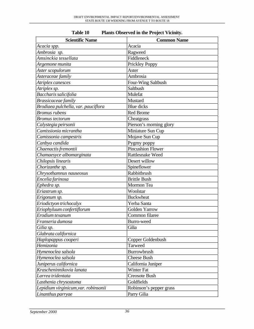
DRAFT ENVIRONMENTAL IMPACT REPORT/ENVIRONMENTAL ASSESSMENTSTATE ROUTE 138 WIDENING FROM AVENUE T TO ROUTE 18
September 2000 36
Table 10 Plants Observed in the Project Vicinity.
Scientific Name Common NameAcacia spp. AcaciaAmbrosia sp. RagweedAmsinckia tessellata FiddleneckArgemone munita Prickley PoppyAster scopulorum AsterAsteraceae family AmbrosiaAtriplex canesces Four-Wing SaltbushAtriplex sp. SaltbushBaccharis salicifolia MulefatBrassicaceae family MustardBrodiaea pulchella, var. pauciflora Blue dicksBromus rubens Red BromeBromus tectorum CheatgrassCalystegia peirsonii Pierson’s morning gloryCamissionia micrantha Miniature Sun CupCamissonia campestris Mojave Sun CupCanbya candida Pygmy poppyChaenactis fremontii Pincushion FlowerChamaesyce albomarginata Rattlesnake WeedChilopsis linearis Desert willowChorizanthe sp. SpineflowerChrysothamnus nauseosus RabbitbrushEncelia farinosa Brittle BushEphedra sp. Mormon TeaEriastrum sp. WoolstarErigonum sp. BuckwheatEriodictyon trichocalyx Yerba SantaEriophyluum confertiflorum Golden YarrowErodium texanum Common filareeFranseria dumosa Burro-weedGilia sp. GiliaGlabrata californicaHaplopappus cooperi Copper GoldenbushHemizonia TarweedHymenoclea salsola BurrowbrushHymenoclea salsola Cheese BushJuniperus californica California JuniperKrascheninnikovia lanata Winter FatLarrea tridentata Creosote BushLasthenia chrysostoma GoldfieldsLepidium virginicum,var. robinsonii Robinson’s pepper grassLinanthus parryae Parry Gilia
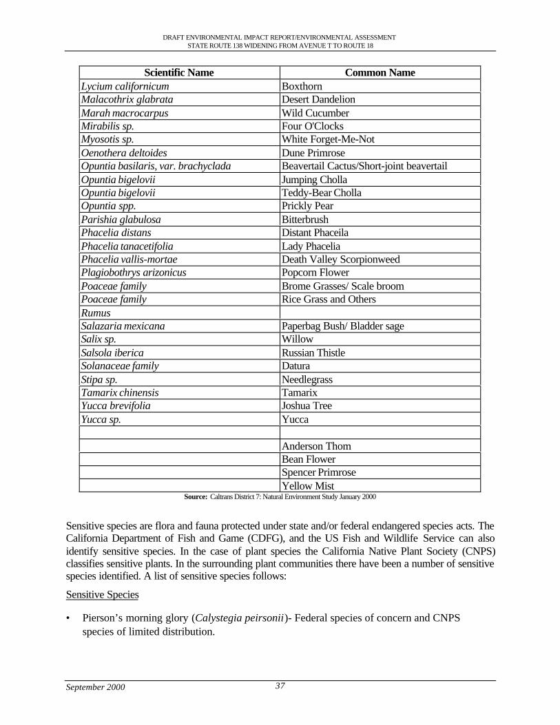
DRAFT ENVIRONMENTAL IMPACT REPORT/ENVIRONMENTAL ASSESSMENTSTATE ROUTE 138 WIDENING FROM AVENUE T TO ROUTE 18
September 2000 37
Scientific Name Common NameLycium californicum BoxthornMalacothrix glabrata Desert DandelionMarah macrocarpus Wild CucumberMirabilis sp. Four O'ClocksMyosotis sp. White Forget-Me-NotOenothera deltoides Dune PrimroseOpuntia basilaris, var. brachyclada Beavertail Cactus/Short-joint beavertailOpuntia bigelovii Jumping ChollaOpuntia bigelovii Teddy-Bear ChollaOpuntia spp. Prickly PearParishia glabulosa BitterbrushPhacelia distans Distant PhaceilaPhacelia tanacetifolia Lady PhaceliaPhacelia vallis-mortae Death Valley ScorpionweedPlagiobothrys arizonicus Popcorn FlowerPoaceae family Brome Grasses/ Scale broomPoaceae family Rice Grass and OthersRumusSalazaria mexicana Paperbag Bush/ Bladder sageSalix sp. WillowSalsola iberica Russian ThistleSolanaceae family DaturaStipa sp. NeedlegrassTamarix chinensis TamarixYucca brevifolia Joshua TreeYucca sp. Yucca
Anderson ThomBean FlowerSpencer PrimroseYellow Mist
Source: Caltrans District 7: Natural Environment Study January 2000
Sensitive species are flora and fauna protected under state and/or federal endangered species acts. TheCalifornia Department of Fish and Game (CDFG), and the US Fish and Wildlife Service can alsoidentify sensitive species. In the case of plant species the California Native Plant Society (CNPS)classifies sensitive plants. In the surrounding plant communities there have been a number of sensitivespecies identified. A list of sensitive species follows:
Sensitive Species
• Pierson’s morning glory (Calystegia peirsonii)- Federal species of concern and CNPSspecies of limited distribution.
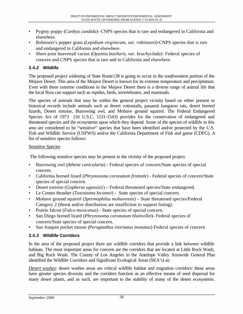
DRAFT ENVIRONMENTAL IMPACT REPORT/ENVIRONMENTAL ASSESSMENTSTATE ROUTE 138 WIDENING FROM AVENUE T TO ROUTE 18
September 2000 38
• Pygmy poppy (Canbya candida)- CNPS species that is rare and endangered in California andelsewhere.
• Robinson’s pepper grass (Lepidium virginicum, var. robinsonii)-CNPS species that is rareand endangered in California and elsewhere.
• Short-joint beavertail cactus (Opuntia basilaris, var. brachyclada)- Federal species ofconcern and CNPS species that is rare and in California and elsewhere.
3.4.2 Wildlife
The proposed project widening of State Route138 is going to occur in the southwestern portion of theMojave Desert. This area of the Mojave Desert is known for its extreme temperature and precipitation.Even with these extreme conditions in the Mojave Desert there is a diverse range of animal life thatthe local flora can support such as reptiles, birds, invertebrates, and mammals.
The species of animals that may be within the general project vicinity based on either present orhistorical records include animals such as desert cottontails, panamit kangaroo rats, desert hornedlizards, Desert tortoise, Burrowing owl, and Mohave ground squirrel. The Federal EndangeredSpecies Act of 1973 (16 U.S.C. 1531-1543) provides for the conservation of endangered andthreatened species and the ecosystems upon which they depend. Some of the species of wildlife in thisarea are considered to be “sensitive” species that have been identified and/or protected by the U.S.Fish and Wildlife Service (USFWS) and/or the California Department of Fish and game (CDFG). Alist of sensitive species follows:
Sensitive Species
The following sensitive species may be present in the vicinity of the proposed project.
• Burrowing owl (Athene cunicularia) - Federal species of concern/State species of specialconcern.
• California horned lizard (Phrynosoma coronatum frontale) - Federal species of concern/Statespecies of special concern.
• Desert tortoise (Gopherus agassizii) – Federal threatened species/State endangered.• Le Contes thrasher (Toxostoma lecontei) - State species of special concern.• Mohave ground squirrel (Spermophilus mohavensis) – State threatened species/Federal
Category 2 (threat and/or distribution are insufficient to support listing).• Prairie falcon (Falco mexicanus) - State species of special concern.• San Diego horned lizard (Phrynosoma coronatum blainvillei)- Federal species of
concern/State species of special concern.• San Joaquin pocket mouse (Perognathus inornatus inonatus)-Federal species of concern
3.4.3 Wildlife Corridors
In the area of the proposed project there are wildlife corridors that provide a link between wildlifehabitats. The most important areas for concern are the corridors that are located at Little Rock Wash,and Big Rock Wash. The County of Los Angeles in the Antelope Valley Areawide General Planidentified the Wildlife Corridors and Significant Ecological Areas (SEA’s) as:
Desert washes: desert washes areas are critical wildlife habitat and migration corridors: these areashave greater species diversity and the corridors function as an effective means of seed dispersal formany desert plants, and as such, are important to the stability of many of the desert ecosystems.
DRAFT ENVIRONMENTAL IMPACT REPORT/ENVIRONMENTAL ASSESSMENTSTATE ROUTE 138 WIDENING FROM AVENUE T TO ROUTE 18
September 2000 39
According to the 1986 General Plan, Little Rock Wash is the largest and least disturbed habitat of thistype in Los Angeles County.
Desert-Montane Transect : The Desert-Montane transect is located within the project area along theeastern edge of Los Angeles County. This is an important transitional area between the Mojave Desertand the northern slopes of the San Gabriel Mountains. The mix of desert and Montane habitats makethis area one of the most diverse in the county, as well as one of the largest undisturbed areas outsideof the Angeles National Forest.
Desert Buttes: Although these buttes are north of the State Route 138 corridor, it is possible thatwildlife may migrate through the State Route 138 study area to/from the buttes, e.g., Little Rock Washand Big Rock Wash represent major wildlife corridors in this area. The Buttes are characterized ashaving substantially more biotic diversity relative to the surrounding areas and are ecologicallyvaluable habitats to many desert-dwelling species. Most butte areas are potential habitat for theMohave ground squirrel (Spermophilus mohavensis), a species protected by the state.
3.4.4 Wetlands
A wetland delineation and assessment for the areas adjacent to the current alignment of State Route138 in Los Angles County were prepared for this project. Previous surveys within the project areawere conducted by windshield surveys and walking where the larger drainages crossed under StateRoute 138. This background knowledge was used to determine which drainage’s needed furtherstudy. A Federal wetland is defined by meeting three criteria (hydrology, hydric soils, andhydrophytic vegetation) set by the U.S. Army Corps of Engineers and Environmental ProtectionAgency. A State wetland is defined by meeting one of the three criteria. The majority of the culvertsin the project area do not meet the three criteria. Many of the culverts may meet one of the threecriteria, typically the hydrology criteria, which would classify them as a state wetland, but would notbe classified as a Federal wetland.
Within the proposed project area along State Route 138, three locations were chosen for furtherinvestigation to determine if the three criteria for a federal wetland were present. These sites werechosen because the conditions indicate the possibility of meeting the three criteria mentioned. Thethree locations of the wetland delineation’s included were State Route 138 crosses Little Rock Wash,Big Rock Wash, and near the State Route 138 and State Route 18 junction.
3.5 Air Quality Characteristics
The Antelope Valley lies within the Southeast Desert Air Basin (SEDAB). The Colorado River bindsthe air basin to the east, the crest of the San Bernardino, San Gabriel, and San Jacinto Mountains to thesouth and west, and the northern Kern County boundary to the north.
In the Antelope Valley the SEDAB air mass interacts with the air mass from the South Coast AirBasin which contains high levels of emissions and reacted air pollutants that originate from vehicular,commercial and industrial sources in Los Angeles, Orange, Riverside and San Bernardino counties.During the summer the polluted air from the South Coast Air Basin moves north into the AntelopeValley with emissions that exceed the National Ambient Air Quality Standards (NAAQS). Differentphysical factors can affect the air quality on any given day. The physical factors that can affect airquality are topography, wind patterns, average wind speeds and the frequency with which temperatureinversions occur in the affected area.
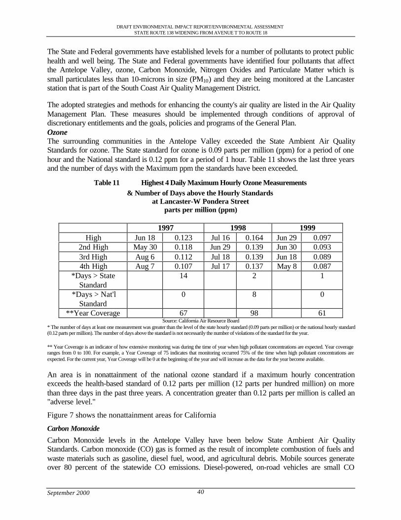
DRAFT ENVIRONMENTAL IMPACT REPORT/ENVIRONMENTAL ASSESSMENTSTATE ROUTE 138 WIDENING FROM AVENUE T TO ROUTE 18
September 2000 40
The State and Federal governments have established levels for a number of pollutants to protect publichealth and well being. The State and Federal governments have identified four pollutants that affectthe Antelope Valley, ozone, Carbon Monoxide, Nitrogen Oxides and Particulate Matter which issmall particulates less than 10-microns in size (PM10) and they are being monitored at the Lancasterstation that is part of the South Coast Air Quality Management District.
The adopted strategies and methods for enhancing the county's air quality are listed in the Air QualityManagement Plan. These measures should be implemented through conditions of approval ofdiscretionary entitlements and the goals, policies and programs of the General Plan.OzoneThe surrounding communities in the Antelope Valley exceeded the State Ambient Air QualityStandards for ozone. The State standard for ozone is 0.09 parts per million (ppm) for a period of onehour and the National standard is 0.12 ppm for a period of 1 hour. Table 11 shows the last three yearsand the number of days with the Maximum ppm the standards have been exceeded.
Table 11 Highest 4 Daily Maximum Hourly Ozone Measurements& Number of Days above the Hourly Standards
at Lancaster-W Pondera Streetparts per million (ppm)
1997 1998 1999High Jun 18 0.123 Jul 16 0.164 Jun 29 0.097
2nd High May 30 0.118 Jun 29 0.139 Jun 30 0.0933rd High Aug 6 0.112 Jul 18 0.139 Jun 18 0.0894th High Aug 7 0.107 Jul 17 0.137 May 8 0.087
*Days > StateStandard
14 2 1
*Days > Nat'lStandard
0 8 0
**Year Coverage 67 98 61Source: California Air Resource Board
* The number of days at least one measurement was greater than the level of the state hourly standard (0.09 parts per million) or the national hourly standard(0.12 parts per million). The number of days above the standard is not necessarily the number of violations of the standard for the year.
** Year Coverage is an indicator of how extensive monitoring was during the time of year when high pollutant concentrations are expected. Year coverageranges from 0 to 100. For example, a Year Coverage of 75 indicates that monitoring occurred 75% of the time when high pollutant concentrations areexpected. For the current year, Year Coverage will be 0 at the beginning of the year and will increase as the data for the year become available.
An area is in nonattainment of the national ozone standard if a maximum hourly concentrationexceeds the health-based standard of 0.12 parts per million (12 parts per hundred million) on morethan three days in the past three years. A concentration greater than 0.12 parts per million is called an"adverse level."
Figure 7 shows the nonattainment areas for California
Carbon Monoxide
Carbon Monoxide levels in the Antelope Valley have been below State Ambient Air QualityStandards. Carbon monoxide (CO) gas is formed as the result of incomplete combustion of fuels andwaste materials such as gasoline, diesel fuel, wood, and agricultural debris. Mobile sources generateover 80 percent of the statewide CO emissions. Diesel-powered, on-road vehicles are small CO
DRAFT ENVIRONMENTAL IMPACT REPORT/ENVIRONMENTAL ASSESSMENTSTATE ROUTE 138 WIDENING FROM AVENUE T TO ROUTE 18
September 2000 41
contributors. Stationary and area-wide sources of CO are the same types of fuel combustion sourcesthat also generate NOx . The stationary source contribution to statewide CO is small, due in part towidespread use of natural gas as a fuel and the presence of combustion controls.
The carbon monoxide levels for the past three years are shown in Table 12. Figure 8 shows that theproject area is in an attainment for Carbon Monoxide.
Particulate Matter
The levels of Particulate Matter (PM10) have also exceeded the State Ambient Air Quality Standards.The major source of Particulate Matter in the Antelope Valley is due to wind blown dust as a majorsource of emission. Table 13 has the last three years levels. Figure 9 shows the Statewide and Nationaldesignation for PM10. The project area is in a state nonattainment area.
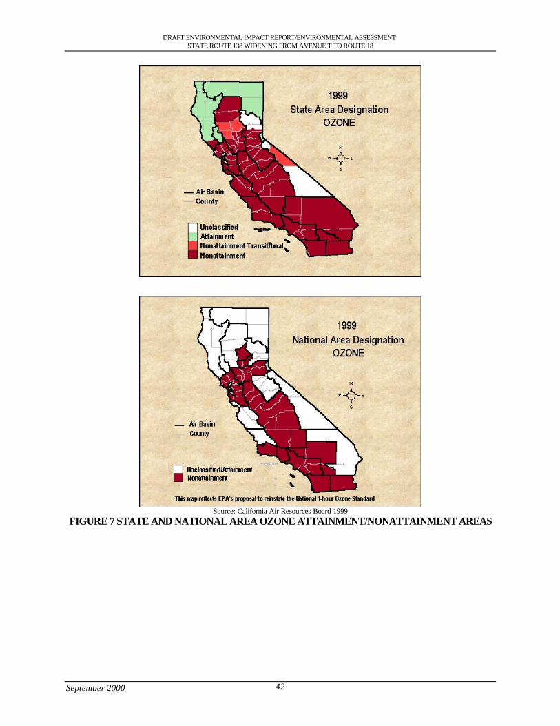
DRAFT ENVIRONMENTAL IMPACT REPORT/ENVIRONMENTAL ASSESSMENTSTATE ROUTE 138 WIDENING FROM AVENUE T TO ROUTE 18
September 2000 42
Source: California Air Resources Board 1999FIGURE 7 STATE AND NATIONAL AREA OZONE ATTAINMENT/NONATTAINMENT AREAS
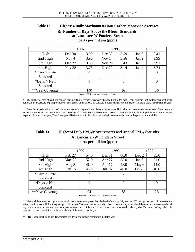
DRAFT ENVIRONMENTAL IMPACT REPORT/ENVIRONMENTAL ASSESSMENTSTATE ROUTE 138 WIDENING FROM AVENUE T TO ROUTE 18
September 2000 43
Table 12 Highest 4 Daily Maximum 8-Hour Carbon Monoxide Averages& Number of Days Above the 8-hour Standards
at Lancaster-W Pondera Streetparts per million (ppm)
1997 1998 1999High Dec 30 3.99 Dec 30 3.59 Jan 6 5.41
2nd High Nov 4 3.96 Nov 14 3.56 Jan 2 3.993rd High Dec 27 3.89 Nov 20 3.43 Jan 5 3.914th High Nov 25 3.75 Dec 29 3.14 Jan 4 3.74
*Days > StateStandard
0 0 0
*Days > Nat'lStandard
0 0 0
**Year Coverage 100 99 36Source: California Air Resource Board
* The number of days at least one non-overlapping 8-hour average was greater than the level of the state 8-hour standard (9.0 parts per million) or thenational 8-hour standard (9 parts per million). The number of days above the standard is not necessarily the number of violations of the standard for the year.
** Year Coverage is an indicator of how extensive monitoring was during the time of year when high pollutant concentrations are expected. Year coverageranges from 0 to 100. For example, a Year Coverage of 75 indicates that monitoring occurred 75% of the time when high pollutant concentrations areexpected. For the current year, Year Coverage will be 0 at the beginning of the year and will increase as the data for the year become available.
Table 13 Highest 4 Daily PM10 Measurements and Annual PM10 StatisticsAt Lancaster-W Pondera Street
parts per million (ppm)
1997 1998 1999High Feb 27 54.0 Dec 31 80.0 Dec 2 85.0
2nd High May 22 52.0 Apr 27 58.0 Jan 6 51.03rd High Aug 8 46.0 Apr 17 48.0 May 6 44.04th High Feb 15 45.0 Jul 16 46.0 Jun 23 40.0
*Days > StateStandard
2 2 1
*Days > Nat'lStandard
0 0 0
**Year Coverage 94 85 26Source: California Air Resource Board
* Measured days are those days that an actual measurement was greater than the level of the state daily standard (50 micrograms per cubic meter) or thenational daily standard (150 micrograms per cubic meter). Measurements are typically collected every six days. Calculated days are the estimated number ofdays that a measurement would have been greater than the level of the standard had measurements been collected every day. The number of days above thestandard is not necessarily the number of violations of the standard for the year.
** The 3-year statistics include data from the listed year and the two years before the listed year.
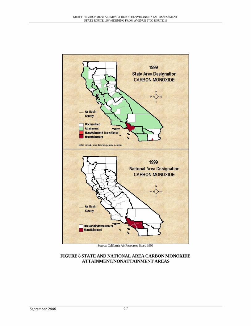
DRAFT ENVIRONMENTAL IMPACT REPORT/ENVIRONMENTAL ASSESSMENTSTATE ROUTE 138 WIDENING FROM AVENUE T TO ROUTE 18
September 2000 44
Source: California Air Resources Board 1999
FIGURE 8 STATE AND NATIONAL AREA CARBON MONOXIDEATTAINMENT/NONATTAINMENT AREAS
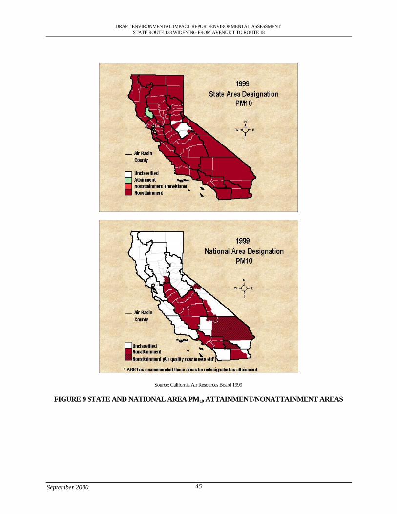
DRAFT ENVIRONMENTAL IMPACT REPORT/ENVIRONMENTAL ASSESSMENTSTATE ROUTE 138 WIDENING FROM AVENUE T TO ROUTE 18
September 2000 45
Source: California Air Resources Board 1999
FIGURE 9 STATE AND NATIONAL AREA PM10 ATTAINMENT/NONATTAINMENT AREAS
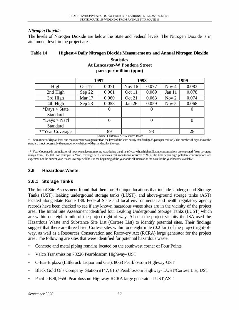
DRAFT ENVIRONMENTAL IMPACT REPORT/ENVIRONMENTAL ASSESSMENTSTATE ROUTE 138 WIDENING FROM AVENUE T TO ROUTE 18
September 2000 46
Nitrogen DioxideThe levels of Nitrogen Dioxide are below the State and Federal levels. The Nitrogen Dioxide is inattainment level in the project area.
Table 14 Highest 4 Daily Nitrogen Dioxide Measurements and Annual Nitrogen DioxideStatistics
At Lancaster-W Pondera Streetparts per million (ppm)
1997 1998 1999High Oct 17 0.071 Nov 16 0.077 Nov 4 0.083
2nd High Sep 22 0.061 Oct 11 0.069 Jan 11 0.0783rd High Mar 17 0.060 Oct 21 0.063 Nov 2 0.0744th High Sep 23 0.058 Jan 26 0.059 Nov 5 0.068
*Days > StateStandard
0 0 0
*Days > Nat'lStandard
0 0 0
**Year Coverage 89 93 28 Source: California Air Resource Board
* The number of days at least one measurement was greater than the level of the state hourly standard (0.25 parts per million). The number of days above thestandard is not necessarily the number of violations of the standard for the year.
** Year Coverage is an indicator of how extensive monitoring was during the time of year when high pollutant concentrations are expected. Year coverageranges from 0 to 100. For example, a Year Coverage of 75 indicates that monitoring occurred 75% of the time when high pollutant concentrations areexpected. For the current year, Year Coverage will be 0 at the beginning of the year and will increase as the data for the year become available.
3.6 Hazardous Waste
3.6.1 Storage Tanks
The Initial Site Assessment found that there are 9 unique locations that include Underground StorageTanks (UST), leaking underground storage tanks (LUST), and above-ground storage tanks (AST)located along State Route 138. Federal State and local environmental and health regulatory agencyrecords have been checked to see if any known hazardous waste sites are in the vicinity of the projectarea. The Initial Site Assessment identified four Leaking Underground Storage Tanks (LUST) whichare within one-eighth mile of the project right of way. Also in the project vicinity the ISA used theHazardous Waste and Substance Site List (Cortese List) to identify potential sites. Their findingssuggest that there are three listed Cortese sites within one-eight mile (0.2 km) of the project right-of-way, as well as a Resources Conservation and Recovery Act (RCRA) large generator for the projectarea. The following are sites that were identified for potential hazardous waste.
• Concrete and metal piping remains located on the southwest corner of Four Points
• Valco Transmission 78226 Pearblossom Highway- UST
• C-Bar-B plaza (Littlerock Liquor and Gas), 8063 Pearblossom Highway-UST
• Black Gold Oils Company Station #147, 8157 Pearblossom Highway- LUST/Cortese List, UST
• Pacific Bell, 9550 Pearblossom Highway-RCRA large generator-LUST,AST
DRAFT ENVIRONMENTAL IMPACT REPORT/ENVIRONMENTAL ASSESSMENTSTATE ROUTE 138 WIDENING FROM AVENUE T TO ROUTE 18
September 2000 47
• Jerry’s Minute Mart, 12515 Pearblossom Highway-LUST/Cortese,UST
• Kwik Tune Lube and Oil , 13100 Pearblossom Highway- UST
• Buchanan Union 76 (Jack’s Gas and Mini Mart), 17326 Pearblossom Highway-UST
• Unidentified residential property at Largo Vista Road- Drums, AST
It has also been found that in four areas between Post Mile 59.8 (96.23 km) to 69.5 (11.84 km) thereare concentrations of lead located 0.5 (0.15 m) to 1.5 feet (0.46 m) below the surface level that are at ahazardous level. It is estimated that approximately 222 cubic yards of soil at the site are impacted withhazardous concentrations of lead and will require special handling.
3.7 Land Use Setting
The communities of Littlerock, Pearblossom, Llano and the City of Palmdale are located in the highdesert region of Los Angeles County approximately 60 (96.56 km) miles from downtown LosAngeles. The City of Palmdale was incorporated August 24, 1962 and the communities of Littlerock,Pearblossom and Llano are unincorporated areas of Los Angeles within the Antelope Valley. Theproject limits encompass an area between the foothills of the San Gabriel and Sierra Pelona Mountainsand the Mojave Desert to the north and east.
The land use along State Route 138 varies as you go through the communities of Littlerock,Pearblossom, Llano and the City of Palmdale. The City of Palmdale has urban residential, non-urbanresidential, commercial, industrial and open space land use. The land use in the Palmdale area hasbeen focused primarily on the aerospace industry. The city’s development pattern has been shaped bythe existing constraints to growth within the city’s own planning area. To the east, Little Rock Washforms a natural boundary between urban residential development in Palmdale and rural residentialuses in the unincorporated community of Littlerock.. Other established rural communities in oradjacent to the project area have also indicated their desire to maintain lower densities and rurallifestyles. Also located on State Route 138 in the vicinity of 72nd Street East and 75th Street East (PM53.95, KP 86.82) and the California Aqueduct and 96th street (PM 56.17, KP 90.39) are agriculturalareas that support crops that are located on Prime Farmland.
3.7.1 Housing
The 1990 census shows the number of housing units in the communities that are in the project area.The City of Palmdale had 24,418 housing units. In January 1995, the California Department ofFinance’s Demographic Research Unit estimated that there were 35,780 housing units in the City ofPalmdale. In five years the increase of housing units was 46.5%. The large percentage increase is dueto an increase in the number of single-family homes.
Table 15 shows the number of Housing Units located in the communities in the project area.Table 15 Housing Units for 1990
Dwelling Units Palmdale Littlerock Pearblossom LlanoTotal Dwelling Units 24,418 422 447 543Single Family Detached 16,293 382 - -Person/Household 3.13 3.27 - -
Source: US Census Bureau 1990
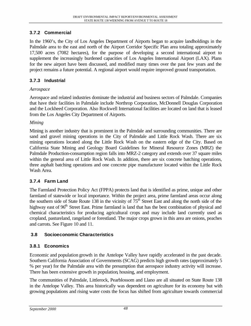
DRAFT ENVIRONMENTAL IMPACT REPORT/ENVIRONMENTAL ASSESSMENTSTATE ROUTE 138 WIDENING FROM AVENUE T TO ROUTE 18
September 2000 48
3.7.2 Commercial
In the 1960’s, the City of Los Angeles Department of Airports began to acquire landholdings in thePalmdale area to the east and north of the Airport Corridor Specific Plan area totaling approximately17,500 acres (7082 hectares), for the purpose of developing a second international airport tosupplement the increasingly burdened capacities of Los Angeles International Airport (LAX). Plansfor the new airport have been discussed, and modified many times over the past few years and theproject remains a future potential. A regional airport would require improved ground transportation.
3.7.3 Industrial
Aerospace
Aerospace and related industries dominate the industrial and business sectors of Palmdale. Companiesthat have their facilities in Palmdale include Northrop Corporation, McDonnell Douglas Corporationand the Lockheed Corporation. Also Rockwell International facilities are located on land that is leasedfrom the Los Angeles City Department of Airports.
Mining
Mining is another industry that is prominent in the Palmdale and surrounding communities. There aresand and gravel mining operations in the City of Palmdale and Little Rock Wash. There are sixmining operations located along the Little Rock Wash on the eastern edge of the City. Based onCalifornia State Mining and Geology Board Guidelines for Mineral Resource Zones (MRZ) thePalmdale Production-consumption region falls into MRZ-2 category and extends over 37 square mileswithin the general area of Little Rock Wash. In addition, there are six concrete batching operations,three asphalt batching operations and one concrete pipe manufacturer located within the Little RockWash Area.
3.7.4 Farm Land
The Farmland Protection Policy Act (FPPA) protects land that is identified as prime, unique and otherfarmland of statewide or local importance. Within the project area, prime farmland areas occur alongthe southern side of State Route 138 in the vicinity of 75th Street East and along the north side of thehighway east of 96th Street East. Prime farmland is land that has the best combination of physical andchemical characteristics for producing agricultural crops and may include land currently used ascropland, pastureland, rangeland or forestland. The major crops grown in this area are onions, peachesand carrots. See Figure 10 and 11.
3.8 Socioeconomic Characteristics
3.8.1 Economics
Economic and population growth in the Antelope Valley have rapidly accelerated in the past decade.Southern California Association of Governments (SCAG) predicts high growth rates (approximately 5% per year) for the Palmdale area with the presumption that aerospace industry activity will increase.There has been extensive growth in population, housing, and employment.
The communities of Palmdale, Littlerock, Pearblossom and Llano are all situated on State Route 138in the Antelope Valley. This area historically was dependent on agriculture for its economy but withgrowing populations and rising water costs the focus has shifted from agriculture towards commercial
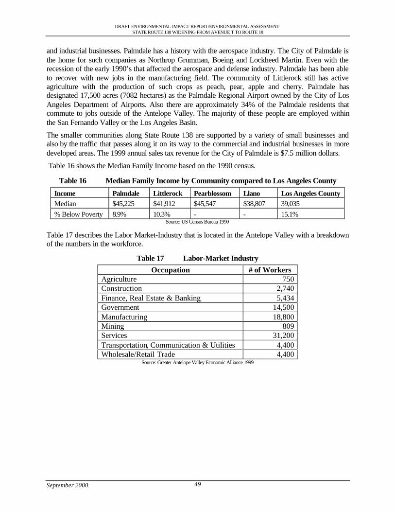
DRAFT ENVIRONMENTAL IMPACT REPORT/ENVIRONMENTAL ASSESSMENTSTATE ROUTE 138 WIDENING FROM AVENUE T TO ROUTE 18
September 2000 49
and industrial businesses. Palmdale has a history with the aerospace industry. The City of Palmdale isthe home for such companies as Northrop Grumman, Boeing and Lockheed Martin. Even with therecession of the early 1990’s that affected the aerospace and defense industry. Palmdale has been ableto recover with new jobs in the manufacturing field. The community of Littlerock still has activeagriculture with the production of such crops as peach, pear, apple and cherry. Palmdale hasdesignated 17,500 acres (7082 hectares) as the Palmdale Regional Airport owned by the City of LosAngeles Department of Airports. Also there are approximately 34% of the Palmdale residents thatcommute to jobs outside of the Antelope Valley. The majority of these people are employed withinthe San Fernando Valley or the Los Angeles Basin.
The smaller communities along State Route 138 are supported by a variety of small businesses andalso by the traffic that passes along it on its way to the commercial and industrial businesses in moredeveloped areas. The 1999 annual sales tax revenue for the City of Palmdale is $7.5 million dollars.
Table 16 shows the Median Family Income based on the 1990 census.
Table 16 Median Family Income by Community compared to Los Angeles County
Income Palmdale Littlerock Pearblossom Llano Los Angeles CountyMedian $45,225 $41,912 $45,547 $38,807 39,035% Below Poverty 8.9% 10.3% - - 15.1%
Source: US Census Bureau 1990
Table 17 describes the Labor Market-Industry that is located in the Antelope Valley with a breakdownof the numbers in the workforce.
Table 17 Labor-Market Industry
Occupation # of WorkersAgriculture 750Construction 2,740Finance, Real Estate & Banking 5,434Government 14,500Manufacturing 18,800Mining 809Services 31,200Transportation, Communication & Utilities 4,400Wholesale/Retail Trade 4,400
Source: Greater Antelope Valley Economic Alliance 1999
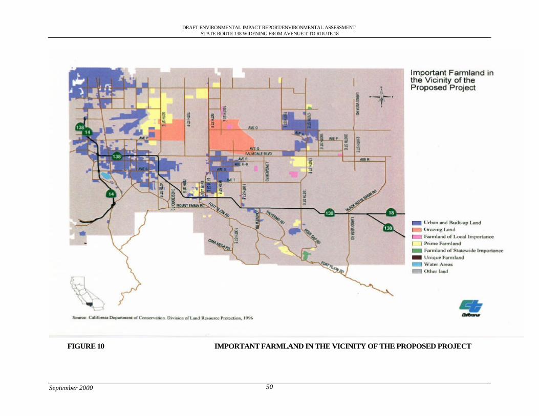
DRAFT ENVIRONMENTAL IMPACT REPORT/ENVIRONMENTAL ASSESSMENTSTATE ROUTE 138 WIDENING FROM AVENUE T TO ROUTE 18
September 2000 50
FIGURE 10 IMPORTANT FARMLAND IN THE VICINITY OF THE PROPOSED PROJECT
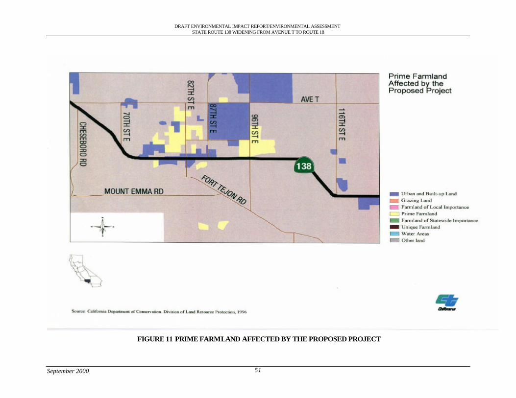
DRAFT ENVIRONMENTAL IMPACT REPORT/ENVIRONMENTAL ASSESSMENTSTATE ROUTE 138 WIDENING FROM AVENUE T TO ROUTE 18
September 2000 51
FIGURE 11 PRIME FARMLAND AFFECTED BY THE PROPOSED PROJECT
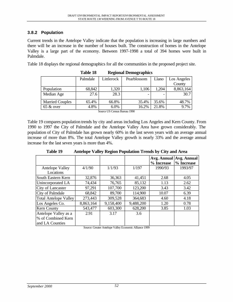
DRAFT ENVIRONMENTAL IMPACT REPORT/ENVIRONMENTAL ASSESSMENTSTATE ROUTE 138 WIDENING FROM AVENUE T TO ROUTE 18
September 2000 52
3.8.2 Population
Current trends in the Antelope Valley indicate that the population is increasing in large numbers andthere will be an increase in the number of houses built. The construction of homes in the AntelopeValley is a large part of the economy. Between 1997-1998 a total of 394 homes were built inPalmdale.
Table 18 displays the regional demographics for all the communities in the proposed project site.
Table 18 Regional DemographicsPalmdale Littlerock Pearblossom Llano Los Angeles
CountyPopulation 68,842 1,320 1,106 1,204 8,863,164Median Age 27.6 28.3 - - 30.7
Married Couples 65.4% 66.8% 35.4% 35.6% 48.7%65 & over 4.8% 6.0% 16.2% 21.8% 9.7%
Source US Census Bureau 1990
Table 19 compares population trends by city and areas including Los Angeles and Kern County. From1990 to 1997 the City of Palmdale and the Antelope Valley Area have grown considerably. Thepopulation of City of Palmdale has grown nearly 60% in the last seven years with an average annualincrease of more than 8%. The total Antelope Valley growth is nearly 33% and the average annualincrease for the last seven years is more than 4%.
Table 19 Antelope Valley Region Population Trends by City and AreaAvg. Annual% Increase
Avg. Annual% Increase
Antelope ValleyLocations
4/1/90 1/1/93 1/197 1990/93 1993/97
South Eastern Kern 32,876 36,363 41,451 2.68 4.05Unincorporated LA 74,434 76,765 85,132 1.13 2.62City of Lancaster 97,291 107,700 123,200 3.43 3.42City of Palmdale 68,842 89,700 114,900 10.07 6.39Total Antelope Valley 273,443 309,528 364,683 4.60 4.18Los Angeles Co. 8,863,164 9,158,400 9,488,200 1.20 0.78Kern County 543,477 603,300 628,200 3.85 1.03Antelope Valley as a% of Combined Kernand LA Counties
2.91 3.17 3.6
Source: Greater Antelope Valley Economic Alliance 1999
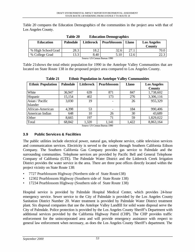
DRAFT ENVIRONMENTAL IMPACT REPORT/ENVIRONMENTAL ASSESSMENTSTATE ROUTE 138 WIDENING FROM AVENUE T TO ROUTE 18
September 2000 53
Table 20 compares the Education Demographics of the communities in the project area with that ofLos Angeles County.
Table 20 Education DemographicsEducation Palmdale Littlerock Pearblossom Llano Los Angeles
County% High School Grad 28.3 18.2 32.6 27.1 70.0% College Grad 13.3 8.40 5.10 12.6 22.3
Source: US Census Bureau 1990
Table 21shows the total ethnic population for 1990 in the Antelope Valley Communities that arelocated on State Route 138 in the proposed project area compared to Los Angeles County.
Table 21 Ethnic Population in Antelope Valley CommunitiesEthnic Population Palmdale Littlerock Pearblossom Llano Los Angeles
CountyWhite 36,947 639 871 847 1,738,602Hispanic 15,154 402 173 276 3,306,116Asian / PacificIslander
3,030 19 - 26 955,329
African-American 4,398 53 - 184 990,406American Indian 648 10 26 30 43,689Other 8,665 197 71 59 1,829,022Total 68,842 1,320 1,141 1,422 8,863,164
Source: US Census Bureau 1990
3.9 Public Services & Facilities
The public utilities include electrical power, natural gas, telephone service, cable television servicesand communication services. Electricity is served to the county through Southern California EdisonCompany. The Southern California Gas Company provides gas service to Palmdale and thesurrounding communities. Telephone services are provided by Pacific Bell and General TelephoneCompany of California (GTE). The Palmdale Water District and the Littlerock Creek IrrigationDistrict provides the water service in the area. There are three post offices directly located within theproject vicinity on State Route 138:
• 7727 Pearblossom Highway (Northern side of State Route138)• 12302 Pearblossom Highway (Southern side of State Route 138)• 17234 Pearblossom Highway (Southern side of State Route 138)
Hospital service is provided by Palmdale Hospital Medical Center, which provides 24-houremergency service. Sewer service to the City of Palmdale is provided by the Los Angeles CountySanitation District Number 20. Water treatment is provided by Palmdale Water District treatmentplant. Six disposal companies that use the Antelope Valley Landfill for solid waste disposal serve theCity of Palmdale. Police protection is provided by the Los Angeles County Sheriff’s Department withadditional services provided by the California Highway Patrol (CHP). The CHP provides trafficenforcement for the unincorporated area and will provide emergency assistance with respect togeneral law enforcement when necessary, as does the Los Angeles County Sheriff’s department. The
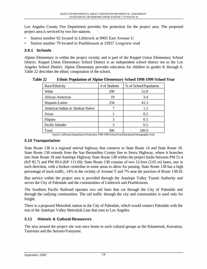
DRAFT ENVIRONMENTAL IMPACT REPORT/ENVIRONMENTAL ASSESSMENTSTATE ROUTE 138 WIDENING FROM AVENUE T TO ROUTE 18
September 2000 54
Los Angeles County Fire Department provides fire protection for the project area. The proposedproject area is serviced by two fire stations.
• Station number 92 located in Littlerock at 8905 East Avenue U• Station number 79 located in Pearblossom at 33957 Longview road
3.9.1 Schools
Alpine Elementary is within the project vicinity and is part of the Keppel Union Elementary SchoolDistrict. Keppel Union Elementary School District is an independent school district not in the LosAngeles School District. Alpine Elementary provides education for children in grades K through 6.Table 22 describes the ethnic composition of the school.
Table 22 Ethnic Population of Alpine Elementary School 1998-1999 School Year
Race/Ethnicity # of Students % of School PopulationWhite 299 52.8African-American 19 3.4Hispanic/Latino 234 41.3American Indian or Alaskan Native 7 1.2Asian 1 0.2Filipino 3 0.5Pacific Islander 3 0.5Total 566 100.0
Source: California Department of Education 1998-1999 School Year/Educational Demographics Unit
3.10 Transportation
State Route 138 is a regional arterial highway that connects to State Route 14 and State Route 18.State Route 138 extends from the San Bernardino County line to Sierra Highway, where it branchesinto State Route 18 and Antelope Highway State Route 138 within the project limits between PM 51.4(KP 82.7) and PM 69.4 (KP 111.69). State Route 138 consists of two 12-foot (3.65 m) lanes, one ineach direction, with a broken centerline in some areas to allow for passing. State Route 138 has a highpercentage of truck traffic, 14% in the vicinity of Avenue T and 7% near the junction of Route 138/18.
Bus service within the project area is provided through the Antelope Valley Transit Authority andserves the City of Palmdale and the communities of Littlerock and Pearblossom.
The Southern Pacific Railroad operates two rail lines that cut through the City of Palmdale andthrough the outlying communities. The rail traffic through the city and communities is used only forfreight.
There is a proposed Metrolink station in the City of Palmdale, which would connect Palmdale with therest of the Antelope Valley Metrolink Line that runs to Los Angeles.
3.11 Historic & Cultural Resources
The area around the project site was once home to such cultural groups as the Kitanemuk, Kawaissu,Tatavium and the Serrano/Vanyume.
DRAFT ENVIRONMENTAL IMPACT REPORT/ENVIRONMENTAL ASSESSMENTSTATE ROUTE 138 WIDENING FROM AVENUE T TO ROUTE 18
September 2000 55
Between the intersection of the Pearblossom Highway, California Aqueduct and the Little Rock Washthere are paleontology records that show there are fossil sites that have vertebrate paleontology. Thesites have produced fossil horse teeth, mammoth tooth fragments, and rabbit, bird, carnivore androdent tooth and bone fragments
Situated on State Route 138 sixty miles north of Los Angeles is the town of Llano where the Llano delRio Cooperative colony was founded on approximately 2100 acres bisected by State Route 138. Thecolony was founded in 1914 by Job Harriman to promote a Socialist Utopian Society and as a “havenfrom capitalism and competition”. The colony started to take shape in May of 1914 when the firstgroup of settlers arrived at the site. The first buildings were constructed of canvas and wood with afew buildings made from rock, adobe and mortar. As time progressed they started to build morecomplicated structures such as a two-story hotel, post office, boot factory and a cannery. Thepopulation of the colony increased gradually to almost a 1,000 people but experienced a decrease inpopulation starting in 1917 due to internal conflicts within the colony and the lack of assistance fromJob Harriman. In 1918 the colony went into receivership and there was a mass exodus to a new site inLouisiana. The State of California recognizes the site of Llano del Rio Cooperative colony as ahistorical landmark number 933. Also the colony is eligible for the National Register of HistoricPlaces. This site is one of the most important non-religious Utopian experiments in western Americanhistory. See Figure 6.
3.12 Noise Analysis
The project area on State Route 138 must meet the noise criteria set forth by the Federal HighwayAdministration (FHWA) which is that noise levels must not exceed 67 decibels (dBA), the maximumallowable exterior noise level or 52 decibels (dBA), the maximum allowable interior noise levels forresidential areas.
The Traffic Noise Analysis Protocol contains Caltrans noise policies, which fulfill the highway noiseanalysis and abatement/mitigation requirements stemming from the following State and Federalenvironmental statutes:
• California Environmental Quality Act (CEQA)• National Environmental Policy Act (NEPA)• Title 23 United States Code of Federal Regulations, Part 772 “Procedures for Abatement of
Highway Traffic Noise and Construction Noise” (23 CFR 772)• Section 216 et seq. of the California Streets and Highways Code.Policies, procedures and practices are provided in the Traffic Noise Analysis Protocol for use byagencies that sponsor new construction or reconstruction of transportation projects. The Traffic NoiseAnalysis Protocol is designed to evaluate the potential traffic and construction generated noiseimpacts, and determines reasonable and feasible noise abatement/mitigation for the project.
A traffic noise impact will also occur when predicted noise levels within the project area approachwithin 1 dBA, or exceed the Noise Abatement Criteria as seen in Table 23. See Appendix B NoiseReceptor Location Aerial Maps.
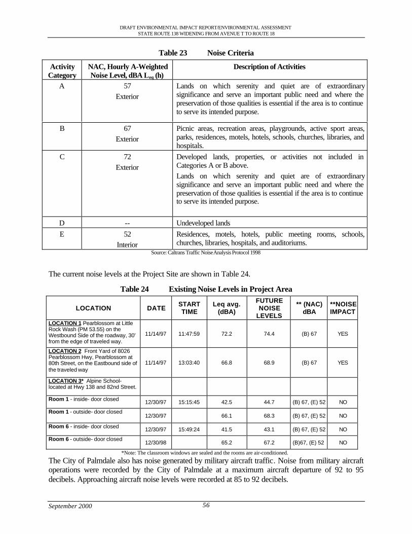
DRAFT ENVIRONMENTAL IMPACT REPORT/ENVIRONMENTAL ASSESSMENTSTATE ROUTE 138 WIDENING FROM AVENUE T TO ROUTE 18
September 2000 56
Table 23 Noise Criteria
ActivityCategory
NAC, Hourly A-WeightedNoise Level, dBA Leq (h)
Description of Activities
A 57Exterior
Lands on which serenity and quiet are of extraordinarysignificance and serve an important public need and where thepreservation of those qualities is essential if the area is to continueto serve its intended purpose.
B 67Exterior
Picnic areas, recreation areas, playgrounds, active sport areas,parks, residences, motels, hotels, schools, churches, libraries, andhospitals.
C 72Exterior
Developed lands, properties, or activities not included inCategories A or B above.Lands on which serenity and quiet are of extraordinarysignificance and serve an important public need and where thepreservation of those qualities is essential if the area is to continueto serve its intended purpose.
D -- Undeveloped landsE 52
InteriorResidences, motels, hotels, public meeting rooms, schools,churches, libraries, hospitals, and auditoriums.
Source: Caltrans Traffic Noise Analysis Protocol 1998
The current noise levels at the Project Site are shown in Table 24.
Table 24 Existing Noise Levels in Project Area
LOCATION DATE STARTTIME
Leq avg.(dBA)
FUTURENOISE
LEVELS
** (NAC)dBA
**NOISEIMPACT
LOCATION 1 Pearblossom at LittleRock Wash (PM 53.55) on theWestbound Side of the roadway, 30'from the edge of traveled way.
11/14/97 11:47:59 72.2 74.4 (B) 67 YES
LOCATION 2 Front Yard of 8026Pearblossom Hwy, Pearblossom at80th Street, on the Eastbound side ofthe traveled way
11/14/97 13:03:40 66.8 68.9 (B) 67 YES
LOCATION 3* Alpine School-located at Hwy 138 and 82nd Street.
Room 1 - inside- door closed 12/30/97 15:15:45 42.5 44.7 (B) 67, (E) 52 NO
Room 1 - outside- door closed12/30/97 66.1 68.3 (B) 67, (E) 52 NO
Room 6 - inside- door closed 12/30/97 15:49:24 41.5 43.1 (B) 67, (E) 52 NO
Room 6 - outside- door closed12/30/98 65.2 67.2 (B)67, (E) 52 NO
*Note: The classroom windows are sealed and the rooms are air-conditioned.
The City of Palmdale also has noise generated by military aircraft traffic. Noise from military aircraftoperations were recorded by the City of Palmdale at a maximum aircraft departure of 92 to 95decibels. Approaching aircraft noise levels were recorded at 85 to 92 decibels.
DRAFT ENVIRONMENTAL IMPACT REPORT/ENVIRONMENTAL ASSESSMENTSTATE ROUTE 138 WIDENING FROM AVENUE T TO ROUTE 18
September 2000 57
3.13 Parks and Bicycle Facilities
3.13.1 Park
At one time there was a 46-acre proposed park located within the Community of Llano and within theboundaries of the 2100-acre Llano del Rio Colony site. The land is to the northwest corner of the StateRoute 138/175th street intersection, which is adjacent to State Route 138 in the project area. TheCounty of Los Angeles Department of Parks and Recreation owns the land and it is zoned for lightagricultural and commercial use and is no longer considered a feasible park site.
3.13.2 Equestrian Trails
Currently equestrian trails have not been formally designed for the project area, but extensive plansexist for many proposed trails. The Los Angeles County Department of Parks and Recreations hasdeveloped a Master Plan that identifies 5 equestrian trail crossings as of 1999. The locations of thesecrossings are along State Route 138 in the proposed project area and are located at:
• Littlerock Wash Bridge – trail crosses under east side of the bridge• 96th St. East - at-grade crossing on the west side• 121st St. East - at-grade crossing on the west side• Big Rock Wash Bridge - trail crosses under west side of the bridge• Largo Vista - at-grade crossing on the east sideAlso the Antelope Valley Trails, Recreation and Environmental Council (AVTREC), which is anadvisory group to the County Master plan has requested two additional at-grade crossings located at:
• 89th St. East• 165th St. EastFigure 12 shows current and proposed equestrian trails in the project area.
3.13.3 Bicycle Lanes
In the proposed project area between Avenue T and State Route 138 there are no bicycle lanes. In theCity of Palmdale General Plan and the Los Angeles County General Plan there are proposed plans thatinclude a bicycle lane which would be in the project area. There are no plans to develop this bicyclelane. Implementation of the bicycle lane would be phased with other development in the specific area.
3.14 Scenic Resources
The scenic resources of the Antelope Valley include open space, landscaped corridors and viewsheds.The Godde Hills Road winds up the Portal Ridge Mountains and overlooks the entire AntelopeValley. The City of Palmdale has designated portions of the Pearblossom Highway as a ScenicHighway. The California Department of Transportation has not recognized State Route 138 as aScenic Highway.
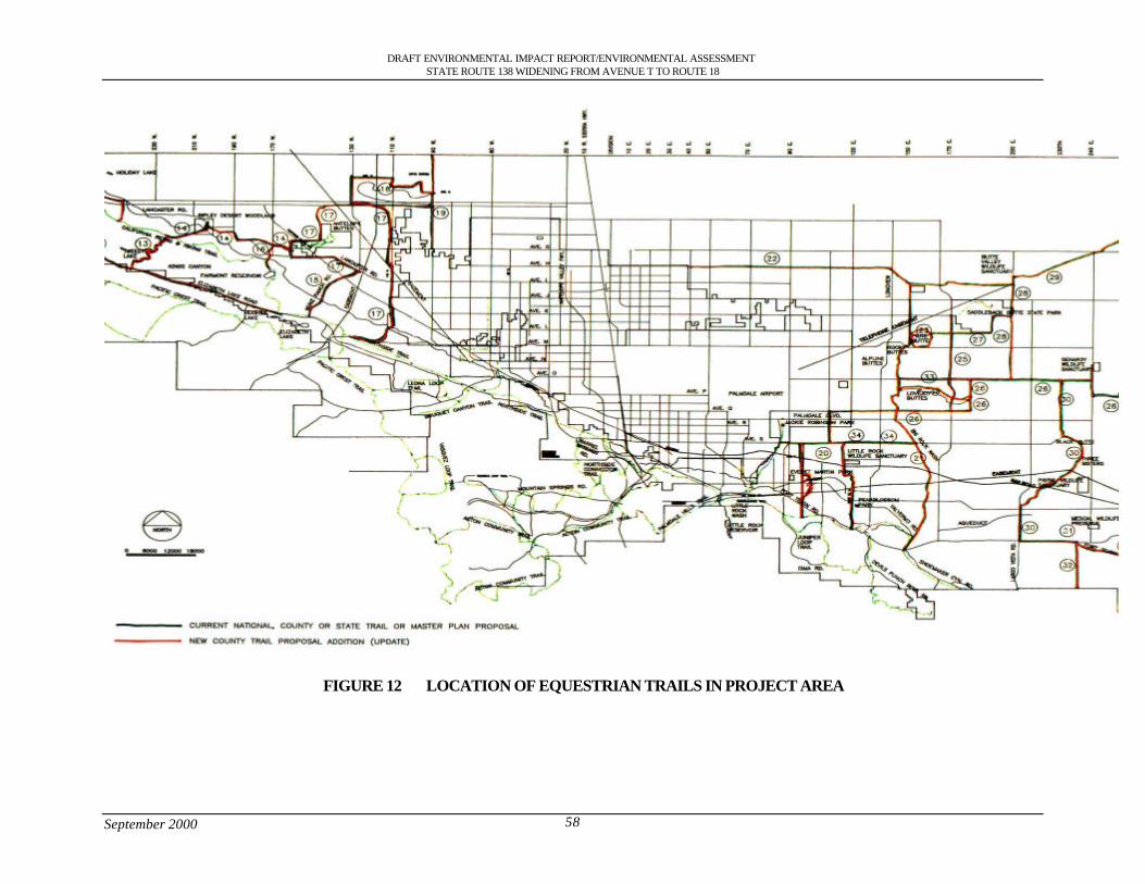
DRAFT ENVIRONMENTAL IMPACT REPORT/ENVIRONMENTAL ASSESSMENTSTATE ROUTE 138 WIDENING FROM AVENUE T TO ROUTE 18
September 2000 58
FIGURE 12 LOCATION OF EQUESTRIAN TRAILS IN PROJECT AREA

District 7 • 120 South Spring Street • Los Angeles, California
DraftEnvironmental Impact Report/
Environmental Assessment
State Route 138 Widening ProjectFrom Avenue T to State Route 18
Junction Throughthe Communities of Littlerock,
Pearblossom, Llano and the City ofPalmdale
SCH Number: 1998091007

DRAFT ENVIRONMENTAL IMPACT REPORT/ENVIRONMENTAL ASSESSMENTSTATE ROUTE 138 WIDENING FROM AVENUE T TO ROUTE 18
September 2000 i
Table of Contents
S.0 Summary .............................................................................................................................................................. 1S.1 Purpose and Need for the Project ................................................................................................................ 1S.2 Alternatives under Consideration................................................................................................................ 1S.3 Other Actions in the Same Area .................................................................................................................. 3S.4 Environmental Consequences and Recommended Mitigation Measures ............................................ 3
1.0 Purpose and Need............................................................................................................................................. 111.1 Purpose of the Project.................................................................................................................................. 111.2 Need for the Project ..................................................................................................................................... 111.2.1 Capacity Issues ........................................................................................................................................ 111.2.2 Safety Problems ....................................................................................................................................... 161.2.3 Operational Deficiencies ........................................................................................................................ 191.2.4 Structural Deficiencies............................................................................................................................ 191.3 Summary ........................................................................................................................................................ 20
2.0 Alternatives including the Proposed Project................................................................................................ 212.1 Alternative 1: Widening along existing facility...................................................................................... 212.1.2 Design Variation A: South of Llano del Rio hotel............................................................................ 262.1.3 Design Variation B (Preferred Alternative): South of Llano del Rio Hotel and North of U.S.
Post Office ................................................................................................................................................ 262.1.4 Design Variation C: South of Llano del Rio Hotel............................................................................ 262.1.5 Design Variation D: Avenue V, Fort Tejon and Avenue V-8......................................................... 262.1.6 Design Variation E: Avenue V.............................................................................................................. 272.1.7 Attainment of Project Goals .................................................................................................................. 272.2 Other Alternatives Considered................................................................................................................... 282.2.1 Alternative 2: Building of Freeway...................................................................................................... 282.2.2 Alternative 3: Transportation System Management (TSM)............................................................ 282.2.3 Alternative 4: Widening along the existing highway through Pearblossom................................. 282.2.4 Alternative 5: No Action........................................................................................................................ 282.3 Current Status of the Project ...................................................................................................................... 292.4 Status of Other Projects or Proposals In The Area................................................................................. 29
3.0 Affected Environment...................................................................................................................................... 323.1 Topography ................................................................................................................................................... 323.2 Geology and Soils ........................................................................................................................................ 323.2.1 Faults ......................................................................................................................................................... 323.2.2 Mining ....................................................................................................................................................... 323.3 Water Resources .......................................................................................................................................... 333.3.1 Hydrology................................................................................................................................................. 333.3.2 Water Quality........................................................................................................................................... 333.3.3 Flood Hazards .......................................................................................................................................... 333.3.4 Climate ...................................................................................................................................................... 343.4 Biological Resources................................................................................................................................... 343.4.1 Vegetation................................................................................................................................................. 343.4.2 Wildlife...................................................................................................................................................... 383.4.3 Wildlife Corridors ................................................................................................................................... 383.4.4 Wetlands ................................................................................................................................................... 393.5 Air Quality Characteristics ......................................................................................................................... 393.6 Hazardous Waste ......................................................................................................................................... 463.6.1 Storage Tanks........................................................................................................................................... 463.7 Land Use Setting .......................................................................................................................................... 473.7.1 Housing..................................................................................................................................................... 473.7.2 Commercial............................................................................................................................................... 483.7.3 Industrial.................................................................................................................................................... 483.7.4 Farm Land................................................................................................................................................. 483.8 Socioeconomic Characteristics .................................................................................................................. 483.8.1 Economics................................................................................................................................................. 48

DRAFT ENVIRONMENTAL IMPACT REPORT/ENVIRONMENTAL ASSESSMENTSTATE ROUTE 138 WIDENING FROM AVENUE T TO ROUTE 18
September 2000 ii
3.8.2 Population................................................................................................................................................. 523.9 Public Services & Facilities........................................................................................................................ 533.9.1 Schools ...................................................................................................................................................... 543.10 Transportation............................................................................................................................................... 543.11 Historic & Cultural Resources.................................................................................................................. 543.12 Noise Analysis ............................................................................................................................................. 553.13 Parks and Bicycle Facilities........................................................................................................................ 573.13.1 Park............................................................................................................................................................. 573.13.2 Equestrian Trails ....................................................................................................................................... 573.13.3 Bicycle Lanes ........................................................................................................................................... 573.14 Scenic Resources ......................................................................................................................................... 57
4.0 Environmental Evaluation............................................................................................................................... 594.1 CEQA Environmental Checklist ............................................................................................................... 604.2 Discussion of Environmental Consequences .......................................................................................... 624.3 Geology, Topography, Seismic (Environmental Checklist Questions 1,2,4).................................... 634.3.1 Soil Erosion (5) ........................................................................................................................................ 634.4 Hazardous Waste (9).................................................................................................................................... 634.5 Floodplain (11).............................................................................................................................................. 654.5.1 Water Quality (10, 12,14,15)................................................................................................................. 654.6 Air Quality (19)............................................................................................................................................ 664.7 Noise (20, 21)................................................................................................................................................ 674.8 Wildlife (23,29,56)...................................................................................................................................... 684.8.1 Vegetation (14,24,27).............................................................................................................................. 704.8.2 Wildlife Movement/Habitat Fragmentation (30,31).......................................................................... 724.8.3 Wetlands (14)........................................................................................................................................... 764.9 Growth Inducing (35) .................................................................................................................................. 784.10 Lifestyles, Neighborhood Stability (36) ................................................................................................... 794.11 Elderly or Specific Interest Groups, Housing and Employment (39).................................................. 794.12 Housing and Employment (40,41)........................................................................................................... 794.13 Minority (37)................................................................................................................................................. 824.14 Property Values, Local Tax Base (41)...................................................................................................... 834.15 Community Facilities (42).......................................................................................................................... 834.16 Public Utilities and Services (43) .............................................................................................................. 854.17 Traffic and Circulation (44, 45,50)............................................................................................................ 864.18 Cultural/Historic Resources (51) ............................................................................................................... 874.19 Cumulative Effects (58).............................................................................................................................. 894.20 Farmland (26)................................................................................................................................................ 914.21 Visual Impacts (53)...................................................................................................................................... 924.22 Construction Impacts (54)........................................................................................................................... 94
5.0 Section 4(f) Evaluation.................................................................................................................................... 965.1 Section 4(f) .................................................................................................................................................... 975.2 Proposed Action........................................................................................................................................... 975.3 Description of Section 4(f) Properties Directly Used............................................................................ 975.3.1 Historic Resources .................................................................................................................................. 975.4 Impacts on the Section 4(f) Property ......................................................................................................1015.4.1 No Build Alternative.............................................................................................................................1015.4.2 Design Variation A................................................................................................................................1015.4.3 Design Variation B (Preferred)...........................................................................................................1025.4.4 Design Variation C................................................................................................................................1035.5 Avoidance Alternatives .............................................................................................................................1035.5.1 No Build Alternative.............................................................................................................................1035.5.2 Avoidance Alternative..........................................................................................................................1045.6 Measures to Minimize Harm....................................................................................................................1045.6.1 Mitigation Measures for Llano Colony Site......................................................................................1045.7 Other Properties Evaluated Relative to the Requirements of Section 4(f) .......................................1055.8 Section 6(f) ..................................................................................................................................................105
DRAFT ENVIRONMENTAL IMPACT REPORT/ENVIRONMENTAL ASSESSMENTSTATE ROUTE 138 WIDENING FROM AVENUE T TO ROUTE 18
September 2000 iii
5.9 Coordination................................................................................................................................................1076.0 Consultation and Coordination ....................................................................................................................108
6.1 Early Scoping Process...............................................................................................................................1086.2 Consultation................................................................................................................................................1086.3 Community and Agency Meetings .........................................................................................................1096.4 Circulation of Draft Environmental Document.....................................................................................109
7.0 List of Preparers..............................................................................................................................................110
List of Tables
TABLE 1 IMPROVEMENTS PROJECT AND ENVIRONMENTAL EVALUATION SUMMARY OF EFFECTS............... 4TABLE 2 LEVEL OF SERVICE CRITERIA................................................................................................................. 14TABLE 3 LEVEL OF SERVICE (LOS) ANALYSIS FOR BUILD/NO BUILD ALTERNATIVE ................................. 14TABLE 4 1998 TRAFFIC VOLUMES ........................................................................................................................ 15TABLE 5 FUTURE (2024) TRAFFIC VOLUMES ...................................................................................................... 16TABLE 6 ACCIDENT HISTORY ................................................................................................................................ 18TABLE 7 ACCIDENT SUMMARY.............................................................................................................................. 18TABLE 8 ACCIDENT COMPARISON TO THE STATEWIDE AVERAGE ................................................................... 18TABLE 9 STATE TRANSPORTATION IMPLEMENTATION PLAN............................................................................ 29TABLE 10 PLANTS OBSERVED IN THE PROJECT VICINITY.................................................................................... 36TABLE 11 HIGHEST 4 DAILY MAXIMUM HOURLY OZONE MEASUREMENTS.................................................... 40TABLE 12 HIGHEST 4 DAILY MAXIMUM 8-HOUR CARBON MONOXIDE AVERAGES....................................... 43TABLE 13 HIGHEST 4 DAILY PM10 MEASUREMENTS AND ANNUAL PM10 STATISTICS................................... 43TABLE 14 HIGHEST 4 DAILY NITROGEN DIOXIDE MEASUREMENTS AND ANNUAL NITROGEN DIOXIDE .... 46TABLE 15 HOUSING UNITS FOR 1990...................................................................................................................... 47TABLE 16 MEDIAN FAMILY INCOME BY COMMUNITY COMPARED TO LOS ANGELES COUNTY..................... 49TABLE 17 LABOR-MARKET INDUSTRY................................................................................................................... 49TABLE 18 REGIONAL DEMOGRAPHICS.................................................................................................................... 52TABLE 19 ANTELOPE VALLEY REGION POPULATION TRENDS BY CITY AND AREA ........................................ 52TABLE 20 EDUCATION DEMOGRAPHICS................................................................................................................. 53TABLE 21 ETHNIC POPULATION IN ANTELOPE VALLEY COMMUNITIES............................................................ 53TABLE 22 ETHNIC POPULATION OF ALPINE ELEMENTARY SCHOOL 1998-1999 SCHOOL YEAR ................... 54TABLE 23 NOISE CRITERIA ....................................................................................................................................... 56TABLE 24 EXISTING NOISE LEVELS IN PROJECT AREA ........................................................................................ 56TABLE 25 CO CONCENTRATION RESULTS COMPARED TO BUILD AND NO BUILD ALTERNATIVE................. 67TABLE 26 SENSITIVE FLORA IN PROJECT AREA .................................................................................................... 70TABLE 27 BEST CASE SCENARIO FOR RIGHT-OF-WAY ACQUISITION FOR THE COMMUNITIES OF PALMDALE,
LITTLEROCK, PEARBLOSSOM AND LLANO........................................................................................... 81TABLE 28 WORST CASE SCENARIO FOR RIGHT-OF-WAY ACQUISITION FOR THE COMMUNITIES OF
PALMDALE, LITTLEROCK, PEARBLOSSOM AND LLANO..................................................................... 81TABLE 29 SITES OF UTILITY RELOCATION IN PROJECT AREA............................................................................. 86
List of Figures
FIGURE 1 REGIONAL MAP........................................................................................................................................ 12FIGURE 2 LOCATION MAP ........................................................................................................................................ 13FIGURE 3 TYPICAL LEVEL OF SERVICE FOR EXISTING ROADWAYS................................................................... 15FIGURE 4 TYPICAL CROSS-SECTION FOR DEVELOPED AREA ............................................................................. 23FIGURE 5 TYPICAL CROSS SECTION FOR UNDEVELOPED AREA......................................................................... 24FIGURE 6 DESIGN VARIATIONS A, B, AND C...................................................................................................... 25FIGURE 7 STATE AND NATIONAL AREA OZONE ATTAINMENT/NONATTAINMENT AREAS............................ 42FIGURE 8 STATE AND NATIONAL AREA CARBON MONOXIDE ATTAINMENT /NONATTAINMENT AREAS.... 44FIGURE 9 STATE AND NATIONAL AREA PM10 ATTAINMENT/NONATTAINMENT AREAS............................... 45FIGURE 10 IMPORTANT FARMLAND IN THE VICINITY OF THE PROPOSED PROJECT ........................................... 50FIGURE 11 PRIME FARMLAND AFFECTED BY THE PROPOSED PROJECT ............................................................. 51

DRAFT ENVIRONMENTAL IMPACT REPORT/ENVIRONMENTAL ASSESSMENTSTATE ROUTE 138 WIDENING FROM AVENUE T TO ROUTE 18
September 2000 iv
FIGURE 12 LOCATION OF EQUESTRIAN TRAILS IN PROJECT AREA ................................................................ 58FIGURE 13 WESTBOUND STATE ROUTE 138 NEAR 87TH STREET -LITTLE ROCK EXISTING CONDITION ..... 92FIGURE 14 WESTBOUND STATE ROUTE 138 NEAR 87TH STREET -LITTLE ROCK PROPOSED CONDITIONS.. 93FIGURE 15 EASTBOUND STATE ROUTE 138 NEAR 175TH STREET –LLANO ..................................................... 93FIGURE 16A VIEW OF LLANO DEL RIO HOTEL ON NORTHSIDE OF STATE ROUTE 138.................................. 98FIGURE 16B VIEW OF CORE AREA OF LLANO COLONY SOUTH SIDE OF STATE ROUTE 138 ........................ 99FIGURE 16C LLANO HOTEL (APPROX. 46 M (150 FT) FROM THE HIGHWAY)................................................. 99FIGURE 17 ROOT CROP STORAGE STRUCTURE (APPROX. 411 M (1340 FT) FROM HIGHWAY)...................100FIGURE 18 MASONRY SILO, SMALLER BARN (APPROX. 716 M (2350 FT) FROM HIGHWAY).....................100FIGURE 19 BOUNDARIES OF THE LLANO DEL RIO COLONY ( BLACK DOTS).................................................106
Appendices
Appendix A Letter of Concurrence from State Historic Preservation OfficerAppendix B Noise Receptor Location Aerial MapsAppendix C Scoping NoticeAppendix D Scoping CommentsAppendix E Mailing ListAppendix F Title VI Policy StatementAppendix G FootprintAppendix H Farmland Conversion Impact Rating (Form AD-1006)Appendix I List of Acronyms
DRAFT ENVIRONMENTAL IMPACT REPORT/ENVIRONMENTAL ASSESSMENTSTATE ROUTE 138 WIDENING FROM AVENUE T TO ROUTE 18
September 2000 59
4.0 Environmental Evaluation
Projects located in California that are undertaken by federal agencies, utilize federal funds, orrequire discretionary approval from federal agencies, are subject to both the NationalEnvironmental Policy Act (NEPA) (42 USC 4321, et seq.) and the California EnvironmentalQuality Act (CEQA) (PRC 2100-21178.1, et seq.). The basic procedural and policy structureof NEPA and CEQA are similar, and the content requirements for documents implementingNEPA and CEQA are also similar. CEQA does require a “finding of significant effects” incertain cases, which are not required by NEPA or the Federal Highway Administration(FHWA) guidance for applying NEPA (FHWA Technical Advisory T6640.8A).
Determining significance on project environmental impacts requires careful evaluation basedon technical data. To assist in making this determination, an environmental checklist wascompleted. See Section 4.1.
Technical studies were conducted to provide background data and to assist in evaluating theenvironmental consequences of the proposed project. The following studies are incorporatedby reference into the document.
• Air Quality Conformity (March 2000)• Physical Environment Report-Noise, Air Quality and Energy (February 1998)• Historical Property Survey Report (February 2000)• Geotechnical Report (July 1999)• Hydraulic/Floodplain Analysis (Location Hydraulic Study August 1998)• Visual Impact Analysis (April 2000)• Traffic Forecast Analysis (May 2000)• Natural Sciences Study Report (January 2000)• Project Scope Summary Report, Big Rock Wash Bridge (August 1997)• City of Palmdale Specific Plan (1993)• Draft Relocation Impact Report (January 2000)• Antelope Valley General Plan (December 1986)• Initial Site Assessment (Professional Service Industries January 1998)• Utility Impact Study (November 1999)• Project Study Report (October 1991)• Traffic Study (June 2000)• Site Investigation Report-Lead Testing (January 1996)• Archaeological and Historical Investigation Report (February 2000)The technical reports are available for review at the following location.
Caltrans, District 7Office of Environmental Planning
120 South Spring StreetLos Angeles, CA 90012
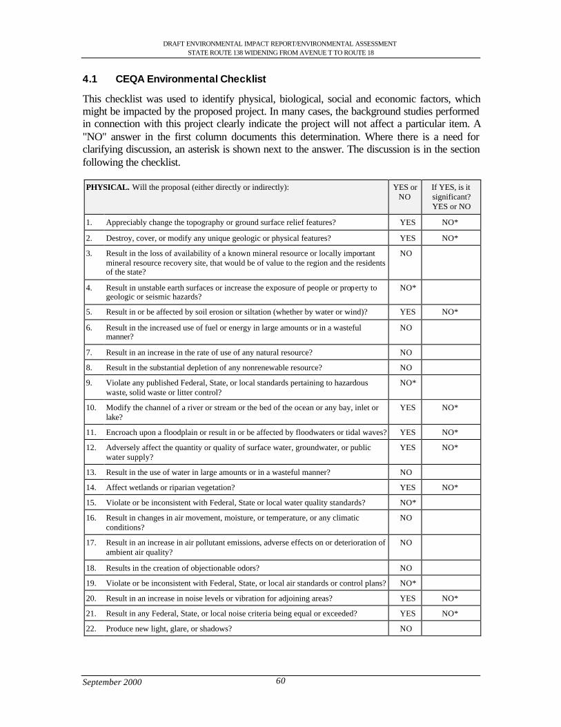
DRAFT ENVIRONMENTAL IMPACT REPORT/ENVIRONMENTAL ASSESSMENTSTATE ROUTE 138 WIDENING FROM AVENUE T TO ROUTE 18
September 2000 60
4.1 CEQA Environmental Checklist
This checklist was used to identify physical, biological, social and economic factors, whichmight be impacted by the proposed project. In many cases, the background studies performedin connection with this project clearly indicate the project will not affect a particular item. A"NO" answer in the first column documents this determination. Where there is a need forclarifying discussion, an asterisk is shown next to the answer. The discussion is in the sectionfollowing the checklist.
PHYSICAL. Will the proposal (either directly or indirectly): YES orNO
If YES, is itsignificant?YES or NO
1. Appreciably change the topography or ground surface relief features? YES NO*
2. Destroy, cover, or modify any unique geologic or physical features? YES NO*
3. Result in the loss of availability of a known mineral resource or locally importantmineral resource recovery site, that would be of value to the region and the residentsof the state?
NO
4. Result in unstable earth surfaces or increase the exposure of people or property togeologic or seismic hazards?
NO*
5. Result in or be affected by soil erosion or siltation (whether by water or wind)? YES NO*
6. Result in the increased use of fuel or energy in large amounts or in a wastefulmanner?
NO
7. Result in an increase in the rate of use of any natural resource? NO
8. Result in the substantial depletion of any nonrenewable resource? NO
9. Violate any published Federal, State, or local standards pertaining to hazardouswaste, solid waste or litter control?
NO*
10. Modify the channel of a river or stream or the bed of the ocean or any bay, inlet orlake?
YES NO*
11. Encroach upon a floodplain or result in or be affected by floodwaters or tidal waves? YES NO*
12. Adversely affect the quantity or quality of surface water, groundwater, or publicwater supply?
YES NO*
13. Result in the use of water in large amounts or in a wasteful manner? NO
14. Affect wetlands or riparian vegetation? YES NO*
15. Violate or be inconsistent with Federal, State or local water quality standards? NO*
16. Result in changes in air movement, moisture, or temperature, or any climaticconditions?
NO
17. Result in an increase in air pollutant emissions, adverse effects on or deterioration ofambient air quality?
NO
18. Results in the creation of objectionable odors? NO
19. Violate or be inconsistent with Federal, State, or local air standards or control plans? NO*
20. Result in an increase in noise levels or vibration for adjoining areas? YES NO*
21. Result in any Federal, State, or local noise criteria being equal or exceeded? YES NO*
22. Produce new light, glare, or shadows? NO
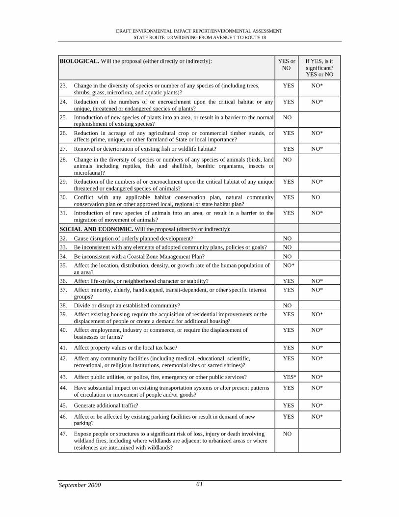
DRAFT ENVIRONMENTAL IMPACT REPORT/ENVIRONMENTAL ASSESSMENTSTATE ROUTE 138 WIDENING FROM AVENUE T TO ROUTE 18
September 2000 61
BIOLOGICAL. Will the proposal (either directly or indirectly): YES orNO
If YES, is itsignificant?YES or NO
23. Change in the diversity of species or number of any species of (including trees,shrubs, grass, microflora, and aquatic plants)?
YES NO*
24. Reduction of the numbers of or encroachment upon the critical habitat or anyunique, threatened or endangered species of plants?
YES NO*
25. Introduction of new species of plants into an area, or result in a barrier to the normalreplenishment of existing species?
NO
26. Reduction in acreage of any agricultural crop or commercial timber stands, oraffects prime, unique, or other farmland of State or local importance?
YES NO*
27. Removal or deterioration of existing fish or wildlife habitat? YES NO*
28. Change in the diversity of species or numbers of any species of animals (birds, landanimals including reptiles, fish and shellfish, benthic organisms, insects ormicrofauna)?
NO
29. Reduction of the numbers of or encroachment upon the critical habitat of any uniquethreatened or endangered species of animals?
YES NO*
30. Conflict with any applicable habitat conservation plan, natural communityconservation plan or other approved local, regional or state habitat plan?
YES NO
31. Introduction of new species of animals into an area, or result in a barrier to themigration of movement of animals?
YES NO*
SOCIAL AND ECONOMIC. Will the proposal (directly or indirectly):
32. Cause disruption of orderly planned development? NO33. Be inconsistent with any elements of adopted community plans, policies or goals? NO
34. Be inconsistent with a Coastal Zone Management Plan? NO35. Affect the location, distribution, density, or growth rate of the human population of
an area?NO*
36. Affect life-styles, or neighborhood character or stability? YES NO*37. Affect minority, elderly, handicapped, transit-dependent, or other specific interest
groups?YES NO*
38. Divide or disrupt an established community? NO39. Affect existing housing, require the acquisition of residential improvements or the
displacement of people or create a demand for additional housing?YES NO*
40. Affect employment, industry or commerce, or require the displacement ofbusinesses or farms?
YES NO*
41. Affect property values or the local tax base? YES NO*
42. Affect any community facilities (including medical, educational, scientific,recreational, or religious institutions, ceremonial sites or sacred shrines)?
YES NO*
43. Affect public utilities, or police, fire, emergency or other public services? YES* NO*
44. Have substantial impact on existing transportation systems or alter present patternsof circulation or movement of people and/or goods?
YES NO*
45. Generate additional traffic? YES NO*
46. Affect or be affected by existing parking facilities or result in demand of newparking?
YES NO*
47. Expose people or structures to a significant risk of loss, injury or death involvingwildland fires, including where wildlands are adjacent to urbanized areas or whereresidences are intermixed with wildlands?
NO
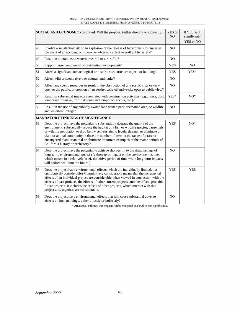
DRAFT ENVIRONMENTAL IMPACT REPORT/ENVIRONMENTAL ASSESSMENTSTATE ROUTE 138 WIDENING FROM AVENUE T TO ROUTE 18
September 2000 62
SOCIAL AND ECONOMIC continued. Will the proposal (either directly or indirectly): YES orNO
If YES, is itsignificant? YES or NO
48. Involve a substantial risk of an explosion or the release of hazardous substances inthe event of an accident or otherwise adversely affect overall public safety?
NO
49. Result in alterations to waterborne, rail or air traffic? NO
50. Support large commercial or residential development? YES NO
51. Affect a significant archaeological or historic site, structure object, or building? YES YES*
52. Affect wild or scenic rivers or natural landmarks? NO
53. Affect any scenic resources or result in the obstruction of any scenic vista or viewopen to the public, or creation of an aesthetically offensive site open to public view?
NO
54. Result in substantial impacts associated with construction activities (e.g., noise, dust,temporary drainage, traffic detours and temporary access, etc.)?
YES* NO*
55. Result in the use of any publicly owned land from a park, recreation area, or wildlifeand waterfowl refuge?
NO
MANDATORY FINDINGS OF SIGNIFICANCE
56. Does the project have the potential to substantially degrade the quality of theenvironment, substantially reduce the habitat of a fish or wildlife species, cause fishor wildlife population to drop below self-sustaining levels, threaten to eliminate aplant or animal community, reduce the number of, restrict the range of a rare orendangered plant or animal or eliminate important examples of the major periods ofCalifornia history or prehistory?
YES NO*
57. Does the project have the potential to achieve short-term, to the disadvantage oflong-term, environmental goals? (A short-term impact on the environment is one,which occurs in a relatively brief, definitive period of time while long-term impactswill endure well into the future.)
NO
58. Does the project have environmental effects, which are individually limited, butcumulatively considerable? Cumulatively considerable means that the incrementaleffects of an individual project are considerable when viewed in connection with theeffects of past projects, the effects of other current projects, and the effects probablefuture projects. It includes the effects of other projects, which interact with thisproject and, together, are considerable.
YES YES
59. Does the project have environmental effects that will cause substantial adverseeffects on human beings, either directly or indirectly?
NO
* An asterisk indicates that impacts can be mitigated to a level of non-significance.
DRAFT ENVIRONMENTAL IMPACT REPORT/ENVIRONMENTAL ASSESSMENTSTATE ROUTE 138 WIDENING FROM AVENUE T TO ROUTE 18
September 2000 63
4.2 Discussion of Environmental Consequences
This section is devoted to explanations of impacts and proposed mitigation measures. Anymitigation measures that are proposed are clearly identified.
4.3 Geology, Topography, Seismic (Environmental Checklist Questions 1,2,4)
In the proposed alternatives there will be some changes in the profile of the existing highway.The preferred alternative will require the profile of the highway to be elevated 5 ft (1.5 m) toaccommodate the drainage culverts required to eliminate the retention of water on theroadway. In the Big Rock Wash the topography will change due to an increase in the profile ofthe bridge in order to accommodate a wildlife corridor and to elevate the roadway frompossible flooding during the storm event.
The Llano del Rio site would have a change in profile as much as 6 ft (1.8 m) in order toaccommodate new culverts in order to diverge water away from the site.
The existing highway and the project site are situated in an active seismic region that islocated less than 3 miles northerly of the San Andreas Fault Zone.
Measures to Minimize Harm
1. Work would be conducted during the dry season, unless an emergency situationarises during the wet season.
2. All bridges and other structures would be designed to resist the maximum credibleearthquake without collapse, structural damage or traffic obstruction.
4.3.1 Soil Erosion (5)
Construction of new bridges in the Little Rock and Big Rock Wash may result in soil erosion.The potential for high winds along the corridor contributes to erosion. The AQMD Rule 403governs soil erosion due to wind across bare or excavated soil during the construction phase ofthe project.
Measures to Minimize Harm
1. An effective dust control plan shall be incorporated as required by the AQMD.2. Erosion control procedures, such as application of stabilizing materials to exposed
soil, shall be used as appropriate during construction. Water may be used as astabilizer: however hydroseeding or planting of vegetation, polymers or otherchemical stabilizers, or straw matting may be used alternatively.
4.4 Hazardous Waste (9)
An Initial Site Assessment was conducted for the State Route 138 widening project. Asbestosand a lead-based paint surveys were not performed in the Initial Site Assessment. Howeverlead-based paint and asbestos containing materials and components may be present in existingbuildings due to the age, which may be impacted by the proposed right-of-way acquisition.Therefore, sampling for lead-based paint and asbestos is recommended. Prior to right-of-wayacquisition and/or any demolition activities, a comprehensive asbestos survey in accordancewith the South Coast Air Quality Management District (SCAQMD) Rule 1403 will be
DRAFT ENVIRONMENTAL IMPACT REPORT/ENVIRONMENTAL ASSESSMENTSTATE ROUTE 138 WIDENING FROM AVENUE T TO ROUTE 18
September 2000 64
conducted. There are above and underground storage tanks just outside the proposed right-of-way.
Between 126 St. East (PM 59.8, KP 96.23) and State Route 18 (PM 69.5, KP 111.84) a SiteInvestigation Report identified two areas where concentrations of lead located 0.5 (0.15 m) to1.5 feet (0.46 m) below the surface level are at a hazardous level. It is estimated thatapproximately 222 cubic yards of soil at the site is impacted with hazardous concentrations oflead and will require special handling. Other areas along the State Route 138 widening projectare below the Caltrans acceptable variance for lead and below the threshold limit for theamount of lead present in the soil. Therefore the sites are no longer considered to have apotential for hazardous waste.
Caltrans applies an Aerial Lead variance that has been approved by the Department of ToxicSubstances Control to project sites when there is a potential for contaminated soil. Thevariance allows Caltrans to reuse soil-containing lead, as long as it is handled properly,replaced along the same section of highway (within the freeway corridor) and covered withclean soil or roadway. The goals of the variance are to 1) make sure that the lead will staywhere it placed and 2) that neither animals nor humans can come into contact with it.
The following properties would require further investigations to ensure there is nocontamination into the right-of-way.
• Concrete and metal piping remains located on the southwest corner of Four Points• Valco Transmission 78226 Pearblossom Highway- UST• C-Bar-B plaza (Littlerock Liquor and Gas), 8063 Pearblossom Highway-UST• Black Gold Oils Company Station #147, 8157 Pearblossom Highway- LUST/Cortese
List, UST• Pacific Bell, 9550 Pearblossom Highway-RCRA large generator-LUST,AST• Jerry’s Minute Mart, 12515 Pearblossom Highway-LUST/Cortese,UST• Kwik Tune Lube and Oil , 13100 Pearblossom Highway- UST• Buchanan Union 76 (Jack’s Gas and Mini Mart), 17326 Pearblossom Highway-UST• Unidentified residential property at Largo Vista Road- Drums, ASTMeasures to Minimize Harm
1. A Preliminary Site Investigation (PSI) would be conducted prior to acquisition.2. A thorough on site visual inspection of property with identification of drums,
containers, vents, soil staining or any other possible point source contaminants.3. Communication with property owners and personnel.4. In the sites of lead contamination it is recommended to excavate intervals of 0.5 to
1.5 feet (0.15 to 0.46 m) of soil using the following process: The interval from 0 to 0.5feet (0 to 0.46 m) below ground surface (bgs) should be excavated and stockpiled asStockpile A. The interval of lead impacted soil, 0.5 to 1.5 feet (0.15 to 0.46 m) bgs,should be excavated and stockpiled as Stockpile B. Soil existing at depths from 1.5 to3.0 feet (0.46 to 0.91 m) bgs should be excavated and stockpiled with Stockpile A.Stockpile B should then be re-used and placed from 2.0 to 3.0 feet (0.6 to 0.91 m) bgs.Stockpile A should then be placed over the lead impacted cover.
5. Notify contractors that there is a detectable concentration of lead present within theon-site soils.
DRAFT ENVIRONMENTAL IMPACT REPORT/ENVIRONMENTAL ASSESSMENTSTATE ROUTE 138 WIDENING FROM AVENUE T TO ROUTE 18
September 2000 65
6. Necessary health and safety precautions should be taken to avoid/minimize potentialexposure to lead in the on-site soil.
7. All properties to be acquired should be clear of Hazardous Waste/Materials prior toacquisition by Caltrans.
4.5 Floodplain (11)
The project area encroaches on floodplains transversely at various locations throughout itslength. The roadway encroaches on all existing conditions and would be continued in alldesign alternatives of the project. In order to alleviate this problem it is proposed to raise andlevel the roadway to the top of the existing high points, and place culverts to allow water topass under the 4-lane highway.
Three areas of concern that were identified by the Location Hydraulic Study are as follows.
• Little Rock Creek Bridge #53-303 PM 53.57• Big Rock Wash Bridge #53-313 PM 63.00• Big Rock Wash Bridge #56-314 PM 63.04Little Rock Creek Bridge #53-303 is in a floodplain and is exposed to flooding. This bridgeis in an alluvial fan formation and the extent of flooding will vary, because of the continualdegradation, aggradation and meandering of the water in the channel and the strength of eachindividual storm. The risk associated with the implementation of any of the projectalternatives is low.
Big Rock Wash Bridges # 53-313 and #53-314 are located in a floodplain and are bothsubjected to flooding. This location is in an alluvial fan formation and the extent and depth offlooding is dependent on the severity of the storm. The risk associated with theimplementation of the proposed project is low.
As discussed in the Location Hydraulic Study the proposed project would not constitute asignificant floodplain encroachment, as required by 23 CFR 650, Subpart A (Executive Order11988 and 23 CFR 650 Subpart A). The proposed project would not support incompatiblefloodplain development. It was also determined that the project would not adversely affect thebase floodplain and would not impact the natural and beneficial floodplain values. The Cityof Palmdale and the communities of Littlerock, Pearblossom, and Llano are all activeparticipants in the National Flood Insurance Program.
4.5.1 Water Quality (10, 12,14,15)
Although present water quality is satisfactory, there is a slow trend toward reducedgroundwater quality, due to increased urban run-off, septic tank failures in the San Gabrielwatershed, declining water tables, and an extensive perched water condition in the Lancastersub-unit of the Antelope Valley Basin (this sub-unit presently supplies the majority of thepumped water supply in the Basin). The proposed project widening of Big Rock Wash Bridgewould occur in Big Rock Wash and since the creek is seasonal there will not be any effects tothe existing water quality. Also all work that will be required would be done during low flowseason.
DRAFT ENVIRONMENTAL IMPACT REPORT/ENVIRONMENTAL ASSESSMENTSTATE ROUTE 138 WIDENING FROM AVENUE T TO ROUTE 18
September 2000 66
Measures to Minimize Harm
1. Earthen or paved interceptors and diversions will be installed at the top of cut or fillslopes where there is a potential for surface runoff on constructed slopes.
2. Excavated materials would not be deposited or stored alongside watercourses wherematerial can be washed away by high water or storm runoff.
3. Drainage would be designed to perpetuate existing flows to the maximum extentfeasible.
4. Water quality control measures would be undertaken during project construction incompliance with Caltrans Standard Specifications Section 7-1.01G – Water PollutionControl Program (WPCP) and/or Storm Water Pollution Prevention Plan (SWPPP)requirements.
5. Caltrans would obtain water quality certification, under Section 401 of the CleanWater Act, from the California Regional Water Quality Control Board.
6. Caltrans would obtain 404 permit from the Army Corps of Engineers.7. The drainage area would be evaluated for the need to acquire a Section 1601
Streambed Alteration Agreement from the California Department of Fish and Game.
4.6 Air Quality (19)
The Quantitative measurement of the Air Quality was done with both microscale andmesoscale analysis. The major sources of air pollutants on State Route 138 are produced bymotor vehicles. The emissions that were analyzed were found to contain carbon monoxide(CO), hydrocarbons (HC), oxides of nitrogen (NOX), oxides of sulfur (SOX) and particulatesthat are all primary pollutant emissions form vehicular traffic.
The Clean Air Act Amendments (CAAA's) of 1990 require that transportation plans,programs and projects which are funded by or approved under Title 23 U.S.C. or FederalTransit Act (FTA) conform with state or federal air quality plans. In order to be found toconform, a project must come from approved transportation plans and programs such as theState Implementation Plan (SIP), the Regional Transportation Plan (RTP) and the RegionalTransportation Improvement program (RTIP). This project is identified in the federallyapproved (July 31,1998) RTIP.
This project is identified in the Department of Transportation (District 7) 1991Route/Transportation Concept Report (RCR/TCR). The project is also listed in the June, 1999Los Angeles County Metropolitan Transportation Authority (LACMTA) TransportationImprovement Program (TIP) Call for Project Listing. The project is consistent with the 1998Regional Transportation Plan (RTP), adopted on April 16,1998 and prepared by the SouthernCalifornia Association of Governments (SCAG).
Regional Level
The project is located in an area that is classified attainment for Carbon Monoxide (CO);therefore it is not subject to localized CO impact review. The Quantitative Analysis for thisproject is provided for the purpose of relating project pollutant concentrations to State andFederal Ambient Air Quality standards shown in the Table 25. Worst case concentrations ofroadside CO were computed using the screening procedure outlined in the Caltrans AirQuality Technical Analysis Notes for the build and no build alternatives.
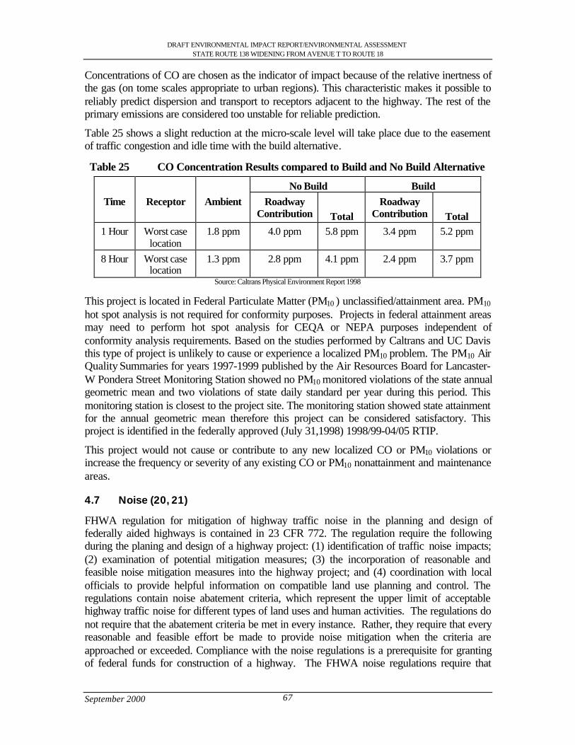
DRAFT ENVIRONMENTAL IMPACT REPORT/ENVIRONMENTAL ASSESSMENTSTATE ROUTE 138 WIDENING FROM AVENUE T TO ROUTE 18
September 2000 67
Concentrations of CO are chosen as the indicator of impact because of the relative inertness ofthe gas (on tome scales appropriate to urban regions). This characteristic makes it possible toreliably predict dispersion and transport to receptors adjacent to the highway. The rest of theprimary emissions are considered too unstable for reliable prediction.
Table 25 shows a slight reduction at the micro-scale level will take place due to the easementof traffic congestion and idle time with the build alternative.
Table 25 CO Concentration Results compared to Build and No Build Alternative
No Build BuildTime Receptor Ambient Roadway
Contribution TotalRoadway
Contribution Total1 Hour Worst case
location1.8 ppm 4.0 ppm 5.8 ppm 3.4 ppm 5.2 ppm
8 Hour Worst caselocation
1.3 ppm 2.8 ppm 4.1 ppm 2.4 ppm 3.7 ppm
Source: Caltrans Physical Environment Report 1998
This project is located in Federal Particulate Matter (PM10 ) unclassified/attainment area. PM10
hot spot analysis is not required for conformity purposes. Projects in federal attainment areasmay need to perform hot spot analysis for CEQA or NEPA purposes independent ofconformity analysis requirements. Based on the studies performed by Caltrans and UC Davisthis type of project is unlikely to cause or experience a localized PM10 problem. The PM10 AirQuality Summaries for years 1997-1999 published by the Air Resources Board for Lancaster-W Pondera Street Monitoring Station showed no PM10 monitored violations of the state annualgeometric mean and two violations of state daily standard per year during this period. Thismonitoring station is closest to the project site. The monitoring station showed state attainmentfor the annual geometric mean therefore this project can be considered satisfactory. Thisproject is identified in the federally approved (July 31,1998) 1998/99-04/05 RTIP.
This project would not cause or contribute to any new localized CO or PM10 violations orincrease the frequency or severity of any existing CO or PM10 nonattainment and maintenanceareas.
4.7 Noise (20, 21)
FHWA regulation for mitigation of highway traffic noise in the planning and design offederally aided highways is contained in 23 CFR 772. The regulation require the followingduring the planing and design of a highway project: (1) identification of traffic noise impacts;(2) examination of potential mitigation measures; (3) the incorporation of reasonable andfeasible noise mitigation measures into the highway project; and (4) coordination with localofficials to provide helpful information on compatible land use planning and control. Theregulations contain noise abatement criteria, which represent the upper limit of acceptablehighway traffic noise for different types of land uses and human activities. The regulations donot require that the abatement criteria be met in every instance. Rather, they require that everyreasonable and feasible effort be made to provide noise mitigation when the criteria areapproached or exceeded. Compliance with the noise regulations is a prerequisite for grantingof federal funds for construction of a highway. The FHWA noise regulations require that
DRAFT ENVIRONMENTAL IMPACT REPORT/ENVIRONMENTAL ASSESSMENTSTATE ROUTE 138 WIDENING FROM AVENUE T TO ROUTE 18
September 2000 68
abatement measure be considered when highway traffic noise impacts are identified and thatabatement measures be implemented when they are determined to be reasonable and feasible.
The majority of the project area is surrounded by open space. Existing noise levels along StateRoute 138, as measured at sensitive receptors within the project limits and taken at times thatwould be representative of the higher traveled periods, qualify for the consideration of noisemitigation per Caltrans’ Design Manual, chapter 1100 and FHWA noise abatementprocedures in the Code of Federal Regulations (23 CFR part 772). Noise levels exceeded the67 dBA recommended by the FHWA as the maximum for residential areas. However, sincethe businesses and residences have driveways and walkways abutting the highway,soundwalls would provide only 2-3 dBA of attenuation due to sound flaking. In addition, sightdistance and sidewalk access requirements per Highway Design Manual 1102.4, Noise Barrierlocation, cannot be satisfied with the placement of soundwalls in any reasonable location. Theconstruction of the soundwalls must prove reasonable and feasible. Therefore, noisemitigation is not considered feasible and not recommended for this project.
Existing and future noise levels indicate the sensitive receptors within the project limitsqualify for consideration of noise mitigation. However, since the residences have drivewaysand walkways abutting the highway, soundwalls would provide only 2-3 dBA of attenuation,due to sound flanking.
Alpine School
An area of particular concern is the Alpine elementary school. The entrance and exit to theschool is via the driveways that connect to State Route 138. A noise impact may also be foundif, as a result of a proposed project, noise levels exceed 52 dBA within the interior of anexisting public or private elementary, or secondary school. An existing nominal height (6 ft.,1.8 m) soundwall provides minimal noise attenuation (1-2 dBA) for the outside area adjacentto room 6. Increasing the height of the soundwall would provide an additional 1-2 dBA ofattenuation. Interior classroom noise levels are currently below 43dBA. All classrooms are air-conditioned much of the year. The projected future interior classroom noise levels with theproject is 47 dBA or less. The future interior noise level will be well below the dBA criteria.Therefore, soundwalls are not recommended as a method of noise attenuation for this project.
4.8 Wildlife (23,29,56)
The proposed widening of State Route 138 from Avenue T to State Route 18 would impactlocal wildlife. Wildlife observed included mammal (primarily rabbits and coyotes), variousbirds (both songbirds and raptors, various reptiles and insects. Wildlife signs observedincluded various size burrows; tracks and scats of reptiles, rodents, and mammals. TheCalifornia Department of Fish and Games Natural Diversity Data Base (NDDB) has indicatedcertain species that have a potential for being present in the project vicinity. The NDDB hasindicated that the project area is in the historic range and habitat for the Mohave groundsquirrel.
Impacts to the biological resources in the vicinity of State Route 138 widening would occuralong the entire route, with particular concentration around the Little Rock Wash and BigRock Wash. The largest waterways include Little Rock and Big Rock Washes and theCalifornia Aqueduct. These two large washes carry the bulk of rainwater runoff along the
DRAFT ENVIRONMENTAL IMPACT REPORT/ENVIRONMENTAL ASSESSMENTSTATE ROUTE 138 WIDENING FROM AVENUE T TO ROUTE 18
September 2000 69
project area and they are critical areas for foraging and travel for local fauna. Impacts includeloss or degradation of plant communities and habitats, noise and air pollution, light and glare,increased runoff and erosion, and “road kills.” There are three main areas of potential impacts:1) State Route 138 widening will create a greater barrier to faunal movement (for food,mating, etc.) and migration; 2) Some of the Joshua Trees adjacent to the roadway will have tobe removed during construction and; 3) The deterioration and intrusion within the washes vis-à-vis grading and increased runoff along the route (especially Little Rock and Big Rockwashes).
The desert tortoise is a listed threatened species by the United States Fish and Wildlife Service(USFWS) and the California Department of Fish and Game (CDFG) have listed the tortoise asendangered. The Bureau of Land management has ranked areas within the historic range intocategories, depending on the existing populations. The State Route 138 highway wideningproject lies south of a Category III area. A Category III area indicates a very low population ofknown tortoises within the area. Surveys conducted during May 1998 (Spring) in the projectarea confirmed that the desert tortoise was not present.
With the implementation of the following measures impacts to the above mentioned resourceswould be mitigated.
Measures to Minimize Harm
1. A focused survey for the burrowing owl species will be conducted. If the species isobserved, construction will be limited to times outside of the breeding season whichbegin late March and nesting pairs usually have only a single brood per breedingseason. The Caltrans District 7 Office of Environmental Planning, Natural SciencesUnit, would conduct these surveys.
2. Pre-construction surveys will be conducted to ensure that desert tortoises have notmigrated into the impacted area. In the project area there is no current HabitatConservation Plan for the Desert tortoise in this area. The Caltrans District 7 Officeof Environmental Planning, Natural Sciences Unit, will conduct these surveys.
3. Caltrans would consider the potential off-site mitigation at either Saddleback ButteState Park or the Antelope Valley Indian Museum for desert tortoise and Mohaveground squirrel habitat. Consideration will be made by the Caltrans District 7 Officeof Environmental Planning, Natural Sciences Unit.
4. Impacts to Desert tortoise may require land banking as mitigation, desert tortoisefencing, and/or construction of wildlife passageways.
5. Because there is significant historic data regarding the presence of the Le Contesthrasher within the project vicinity, further study would be performed during thebreeding season. These surveys will be conducted by the Caltrans District 7 Office ofEnvironmental Planning, Natural Sciences Unit.
6. The historic range and habitat for the Mohave ground squirrel is within the projectvicinity. Because of the number of occurrences of this species listed by the NDDBwithin the project vicinity, further focused surveys and pre-construction surveyswould be conducted in order to ensure that the species has not migrated into theproject vicinity. These surveys will be conducted by the Caltrans District 7 Office ofEnvironmental Planning, Natural Sciences Unit.
7. Impacts to the Mojave ground squirrel may require land banking as mitigation. Landbanking to replace habitat could range from 1:1 to 5:1, e.g., for every acre (hectare)
DRAFT ENVIRONMENTAL IMPACT REPORT/ENVIRONMENTAL ASSESSMENTSTATE ROUTE 138 WIDENING FROM AVENUE T TO ROUTE 18
September 2000 70
of habitat impacted; 1 to 5 acres would need to be purchased for mitigation.Consideration of this action will be made by the Caltrans District 7 Office ofEnvironmental Planning, Natural Sciences Unit.
8. Although the Prairie falcon and the San Diego horned lizard were not observedwithin the project vicinity, pre-construction focus surveys would be performed in theconservation areas within the project vicinity. The Caltrans District 7 Office ofEnvironmental Planning, Natural Sciences Unit, would conduct these surveys.
9. The rodent signs that are present in the project vicinity may be evidence of the morecommon varieties of the pocket mouse such as the California pocket mouse(Chaetodipus californicus) or other rodent species. Pre-construction trapping wouldbe conducted to identify if there are any San Joaquin pocket mouse in the projectarea. The Caltrans District 7 Office of Environmental Planning, Natural SciencesUnit, will conduct this activity.
10. FHWA and Caltrans will consult with the United States Fish and Wildlife Service toensure that any action they authorize is not likely to jeopardize the continuedexistence of any listed species in accordance with Section 7 of the EndangeredSpecies Act.
Comparison of Alternatives
Most of the alternatives are located in areas where a listed species, according to theEndangered Species Act (either Federal or California), has the potential to occur. If a listedspecies may occur within the project area, then Caltrans will be responsible to conduct studiesto determine the species presence or absence as required by the resource agencies. If a listedspecies is found within the Area of Impact, the mitigation cost will increase.
1) Option D and Option E may require a biological monitor on-site, during construction, forparts of these alternatives. The anticipated project duration for each alternative is not yetknown at this time. Therefore, the estimated cost does not include a biological monitor on-site. The cost of a biological monitor could substantially increase the cost estimate forbiological mitigation.
2) The implementation of box culverts within the design of the highways may be considereda measure to minimize harm to the flora and fauna. The location and design of the culvertmay be considered a measure to minimize impacts of the highway.
4.8.1 Vegetation (14,24,27)
The desert ecosystem is very sensitive and even the smallest changes can disrupt it. Theproject area lies in the southwestern portion of the Mojave Desert. The project has severalpotential impacts with emphasis on vegetation. The Natural Environment Study for StateRoute 138 (Pearblossom Highway) From the City of Palmdale to State Route 18 inUnincorporated Los Angeles County suggests that there will be a substantial loss of nativevegetation, such as Mojave Creosote Bush Scrub and Joshua Tree Woodlands and impacts tosensitive flora.
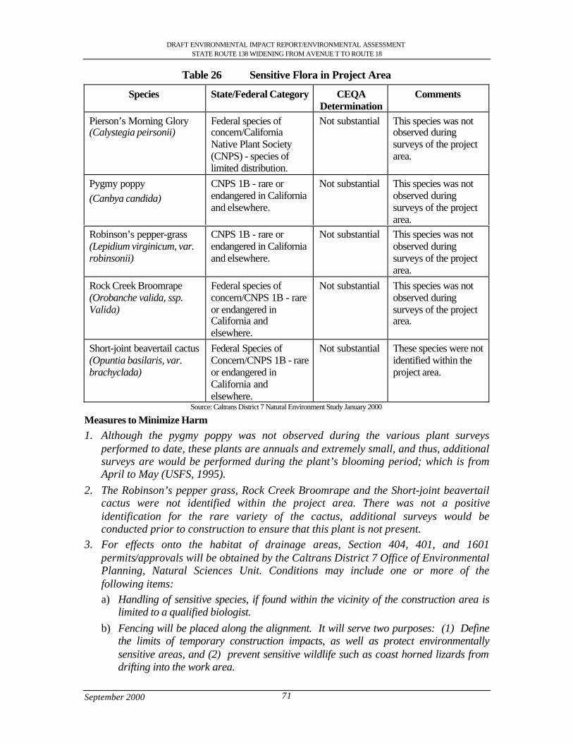
DRAFT ENVIRONMENTAL IMPACT REPORT/ENVIRONMENTAL ASSESSMENTSTATE ROUTE 138 WIDENING FROM AVENUE T TO ROUTE 18
September 2000 71
Table 26 Sensitive Flora in Project Area
Species State/Federal Category CEQADetermination
Comments
Pierson’s Morning Glory(Calystegia peirsonii)
Federal species ofconcern/CaliforniaNative Plant Society(CNPS) - species oflimited distribution.
Not substantial This species was notobserved duringsurveys of the projectarea.
Pygmy poppy(Canbya candida)
CNPS 1B - rare orendangered in Californiaand elsewhere.
Not substantial This species was notobserved duringsurveys of the projectarea.
Robinson’s pepper-grass(Lepidium virginicum, var.robinsonii)
CNPS 1B - rare orendangered in Californiaand elsewhere.
Not substantial This species was notobserved duringsurveys of the projectarea.
Rock Creek Broomrape(Orobanche valida, ssp.Valida)
Federal species ofconcern/CNPS 1B - rareor endangered inCalifornia andelsewhere.
Not substantial This species was notobserved duringsurveys of the projectarea.
Short-joint beavertail cactus(Opuntia basilaris, var.brachyclada)
Federal Species ofConcern/CNPS 1B - rareor endangered inCalifornia andelsewhere.
Not substantial These species were notidentified within theproject area.
Source: Caltrans District 7 Natural Environment Study January 2000
Measures to Minimize Harm1. Although the pygmy poppy was not observed during the various plant surveys
performed to date, these plants are annuals and extremely small, and thus, additionalsurveys are would be performed during the plant’s blooming period; which is fromApril to May (USFS, 1995).
2. The Robinson’s pepper grass, Rock Creek Broomrape and the Short-joint beavertailcactus were not identified within the project area. There was not a positiveidentification for the rare variety of the cactus, additional surveys would beconducted prior to construction to ensure that this plant is not present.
3. For effects onto the habitat of drainage areas, Section 404, 401, and 1601permits/approvals will be obtained by the Caltrans District 7 Office of EnvironmentalPlanning, Natural Sciences Unit. Conditions may include one or more of thefollowing items:a) Handling of sensitive species, if found within the vicinity of the construction area is
limited to a qualified biologist.b) Fencing will be placed along the alignment. It will serve two purposes: (1) Define
the limits of temporary construction impacts, as well as protect environmentallysensitive areas, and (2) prevent sensitive wildlife such as coast horned lizards fromdrifting into the work area.
DRAFT ENVIRONMENTAL IMPACT REPORT/ENVIRONMENTAL ASSESSMENTSTATE ROUTE 138 WIDENING FROM AVENUE T TO ROUTE 18
September 2000 72
c) If unknown sensitive species are encountered after construction has commenced, theproject will be halted until after consultation with the appropriate resource agencies.
d) Any vegetation that is removed will be replaced in accordance with Caltrans policy.A Vegetation Replacement Mitigation Plan will be prepared for onsite mitigation.Caltrans District 7 policy dictates that native flora removed from the site, whetherplanted or natural shall be replaced at a 10:1 ratio. This ratio is generally loweredfor extremely large projects and if larger plants are used in the revegetation plan.
e) Planting should be done between October and March. This is the optimal plantestablishment period for this biotic community.
f) Revegetation should be completed within one year after construction is completed.g) Vegetation monitoring will be conducted for five (5) years to determine success of the
revegetation plan. Caltrans will prepare a mitigation plan that will include restoringthe site, planting, maintenance and monitoring to ensure an appropriate level ofsuccess.
h) The revegetation plan will include the plant palette, quantities and a drawing showingthe plant locations.
4. Revegetation of all areas temporarily impacted during construction activities,particularly drainage areas and other areas with substantial biotic diversity anddensity. Revegetation will be performed both on-site and off-site. Plans for thisactivity will be prepared by the Caltrans District 7 Office of Environmental Planning,Natural Sciences Unit and the Caltrans District 7 Division of LandscapeArchitecture.
5. Off-site acquisition for permanent impacts, particularly for areas with valuablebiological resources, such as drainage areas, will be considered. The amount of landdepends on the quality and quantity of habitat impacted.
6. A Desert Vegetation Preservation Plan must be submitted for the review andapproval of the City of Palmdale. The plan will identify Joshua tree locations withinthe project area and recommend additional management efforts in order to remainconsistent with local ordinances. The plan would be applicable to all Joshua treeswithin the jurisdiction of the City of Palmdale, which includes the sections of theproposed project between Avenue T and Avenue T-8.
7. Invasive species would not be introduced as a result of this project. This would beachieved through some Best Management Practices, including:
a) All equipment cleaning shall be conducted away from areas containing nativeplant assemblages
b) All equipment will be cleaned prior to entering the work area from a distantlocale, in this case outside the Antelope Valley
c) All post-construction landscaping shall use species that, if not native, are notinvasive
d) A post-construction inspection by a landscape Architect and District Biologistwill be conducted to inventory if this goal has been accomplished. If not,eradication methods will be established into any post-construction mitigationplan.
DRAFT ENVIRONMENTAL IMPACT REPORT/ENVIRONMENTAL ASSESSMENTSTATE ROUTE 138 WIDENING FROM AVENUE T TO ROUTE 18
September 2000 73
4.8.2 Wildlife Movement/Habitat Fragmentation (30,31)
Wildlife Corridors
Wildlife corridors function as critical links between wildlife habitats. Many species duringtheir life history require different habitats. Also, they may need to migrate due to seasonalchanges, for breeding purposes, or possibly because of changes in forage conditions. Humanactivities may reduce habitat areas and displace species to other locations, which are often lessdesirable habitats. The Antelope Valley General Plan identifies two areas that are SignificantEcological Areas (see section 3.4). The areas are Little Rock Wash and Big Rock Wash. LittleRock Wash and Big Rock Wash are important, because they provide essential wildlife habitatand migration corridors.
Roads are considered to be a major impediment to wildlife movement due to the hazards thewildlife face trying to cross the roads. Within the State Route 138 study area, there are severalmajor wildlife corridors. Frequently, riparian corridors are used for wildlife movementbetween habitats. Within the State Route 138 study area, the more significant of thesecorridors are Little Rock Creek/Wash, and the Big Rock Creek/Wash. The CaliforniaResources Agency and the Department of Parks and Recreation have determined that thebridges at Little Rock Creek/Wash and Big Rock Creek/Wash are sufficient to maintain afunctioning wildlife corridor for both small and large animals.
Measures to Minimize Harm
1. Prior to construction further studies will be performed to determine the level to whichother washes and drainages may be used by wildlife.
2. Prior to construction the potential impacts of roads on pollinators (e.g. bees andmoths) will be examined. A study will be conducted to determine whether wideningthe road will have a negative impact on the population of pollinators that are neededby the plants in the area.
3. Isolation and fragmentation of natural open space areas should be preventedwherever possible.
4. Natural stream drainages often serve as important movement corridors for wildlife,they should be preserved wherever it is feasible to do so.
Comparison of Alternatives
The magnitude of environmental impacts varies somewhat among alternative alignments forthe State Route 138 corridor. For instance, improving the existing alignment will probablyhave far less impact on wildlife corridors and migration patterns than a new transportationinfrastructure. This is particularly important to consider in areas where sensitive wildlifespecies are likely to be present. Fencing and wildlife passageways may be necessary foralternatives involving new roadway and/or potentially impacting sensitive fauna; with theresultant additional costs for construction of these items and ongoing maintenance.
Biological IssuesListed below are key issues that were considered in evaluating each alternative ’s overallimpact:
• Waterways – Potential degradation of washes and other waterways throughout thearea of impact were evaluated for each alternative. Locations shown as blueline
DRAFT ENVIRONMENTAL IMPACT REPORT/ENVIRONMENTAL ASSESSMENTSTATE ROUTE 138 WIDENING FROM AVENUE T TO ROUTE 18
September 2000 74
streams on USGS maps generally consist of greater biota diversity and have to beevaluated carefully to avoid and minimize impacts. More extensive habitatreplacement and restoration activities will be needed along these washes and otherdrainage areas. The largest of areas are designated as Significant Ecological Areas(SEA's) by the County of Los Angeles and/or designated as Conservation Areas bythe BLM. For example, Little Rock Wash and Big Rock Wash are SEA's and BLMConservation Areas.
• Sensitive species – Impacts to sensitive flora and fauna and the proximity ofalignments to the historic range and habitat for sensitive species were evaluated todetermine which alternative would avoid or minimize impacting existing populationsof these species to the greatest degree.
• Habitat fragmentation and wildlife corridors – habitat fragmentation and loss ordegradation of wildlife corridors were other factors considered to determine relativeimpacts each alternative would have on habitat reduction and wildlife migrationpatterns.
• Native vegetation – substantial loss of native vegetation, such as mojave creosotebush scrub and Joshua tree woodlands is likely to occur with any of the alternativesselected. Native plant diversity, plant sizes, and densities were compared among thealternatives to establish relative impacts to the desert ecosystems. Impacts to joshuatrees and creosote bushes are particularly significant.
• Flora and fauna diversity – Potential reduction in species’ variety and densities withinthe area of impact was also considered among the alternatives. Typically, areas thatbecome highly disturbed by human activities will experience a reduction in wildlifespecies (many animals will shy away from the activity) and non-native plant specieswill begin to out compete native vegetation. Exotic vegetation has become a majorproblem in the southwest, e.g., non-native plants invading Nevada sagebrush rangelands are more easily ignited by strikes of lightening and have caused huge,uncontrolled wildfires (Boxall, October 24, 1999).
Alternative 1 Design variations A: South of Llano del Rio Hotel and B: South of Llano delRio Hotel and North of U.S. Post OfficeImproving the existing State Route 138 between State Route 14 and State Route 18 involveswidening of an existing facility only, and as such, sensitive biological resources are much lesslikely to be impacted than with the other proposed alternative alignments. Habitat along manyareas of State Route 138 has been highly disturbed and degraded by human activities.
Although native vegetation is dominant, a substantial amount of non-native vegetationmay be found along a large percentage of the route. As expected, the amount of disturbedand degraded habitat is most prevalent near the more developed areas.
The eastern portion of this alternative appears to be just below the area identified by theBureau of Land Management (BLM) as Desert Tortoise Management Category III. CategoryIII has very low densities of tortoises and it is unlikely a desert tortoise will be found.However Caltrans would coordinate closely with the USFWS to determine any appropriatemitigation.
DRAFT ENVIRONMENTAL IMPACT REPORT/ENVIRONMENTAL ASSESSMENTSTATE ROUTE 138 WIDENING FROM AVENUE T TO ROUTE 18
September 2000 75
In addition, this alternative crosses Little Rock Wash and Big Rock Wash, consideredSignificant Ecological Areas (SEA's) by Los Angeles and Conservation Areas by the BLM.Activities impacting these locations will require coordination with these agencies, as well asthe resource agencies, for the 404, 401, 1601 permits/approvals.
Design variation C: South of Llano del Rio HotelDesign variation C involves all the features of alternative 1, with the exception of the Llanodel Rio Site. In this area a new alignment will be constructed 393.7 ft (120 m) to the south ofthe Llano del Rio Site with a raised profile of 15 ft (4.6 m). In this area, a portion of thealignment will involve constructing a new facility over relatively undisturbed nativevegetation. This variation would result in habitat fragmentation and create a barrier to wildlifemovement. The distance of the new alignment would be approximately 6300 ft (1900 m).
Design variation D: Avenue V, Fort Tejon and Avenue V-8Design variation D involves all the features of alternative 1, with the exception of theLittlerock area. In this area, a portion of the alignment will involve constructing a new facilityover relatively undisturbed native vegetation. The distance of the new alignment would beapproximately 26,500 ft (8000 m).
New roadway segments not only permanently reduce a less disturbed habitat than wideningactivities, but also fragment the habitat and create barriers to wildlife movement through outthe area impacted. Wildlife corridors and migration patterns will be impacted; the resourceagencies may require fencing and/or wildlife passageways along the new roadway segments.
Design Variation E: Avenue VDesign Variation E involves all the features similar to Alternative 1, with the exception of theLittlerock area. Similar to design variation 4 a portion of the alignment in the Littlerock areawill involve constructing a new facility over relatively undisturbed native vegetation. Thedistance of the new alignment would be approximately 29,000 ft (8900 m).
As already noted new roadway segments not only permanently reduce a less disturbed habitatthan widening activities, but also fragment the habitat and create barriers to wildlife movementthrough out the area impacted. Wildlife corridors and migration patterns will be impacted; theresource agencies may require fencing and/or wildlife passageways along the new roadwaysegments.
Alignment with the Least Biological ImpactAn assessment was made of the above to determine which alternative would have the leastimpact on the natural resources within the Mojave Desert. Clearly, Alternative 1 – Designvariations A and B have the least impacts to natural resources of the five (5) alignments basedon the following general factors:
• Alternative 1 – Design Variations A and B involves the least amount of new facilityconstruction
• This alternative is along an area that is more urbanized, disturbed, than the otheralternatives
DRAFT ENVIRONMENTAL IMPACT REPORT/ENVIRONMENTAL ASSESSMENTSTATE ROUTE 138 WIDENING FROM AVENUE T TO ROUTE 18
September 2000 76
• This alternative is estimated to involve less acres of habitat that will be permanentlyimpacted by the roadway improvements. The exact number of acres will bedetermined during final design.
An evaluation of the key environmental issues is provided below:
• Waterways – The potential increase for an increase in degradation of washes andother waterways throughout the area of impact would be greater for DesignVariations D and E because these alignments would double the number of existingculverts to accommodate washes crossing both State Route 138 and the newalignment within the Littlerock area.
• Sensitive species - Since many areas of State Route 138 are already fairly disturbedand ruderal in nature, impacts to sensitive flora and fauna would generally be lessthan the alternatives involving new roadway segments through the desert ecosystem.
• Habitat fragmentation and wildlife corridors – Clearly, Alternative 1- Designvariations A and B are the only alternatives, which will not dramatically increasehabitat fragmentation and loss or degradation of wildlife corridors.
• Native vegetation - It is more likely that because Design variation C and Designvariation D and E involve new roadway segments that the loss of native vegetationwill be greater with these alignments. Additionally, during surveys, native plantdiversity, plant sizes, and densities were generally greater for Design variation D andE.
• Flora and fauna diversity - Alternative 1 – Design variation A and B already show asubstantially reduced variety and density in species within the area of impact incomparison to the other alternatives. Widening along the existing State Route 138will primarily impact areas already disturbed.
Assuming that all additional pre-construction biological surveys support current data, it islikely that as long as measures to avoid and minimize biological impacts are employed,impacts of constructing Alternative 1- Design variation A and B may be reduced to a level ofinsignificance under CEQA.
4.8.3 Wetlands (14)
The wetland delineation that was completed for the State Route 138 widening projectidentified three locations for potential wetlands. The locations identified are Little Rock Wash,Big Rock Wash, and near the State Route 138 and State Route 18 junction. The wetlanddelineation completed for the State Route 138 widening has identified one area that qualify forboth State and Federal wetlands and two areas that classify only for State wetlands. Potentialimpacts would result from new bridge piers, and increased shading that would be caused bythe new bridges in the project area.
At the time of the field survey, Little Rock Wash consisted of areas that were dry, with theeastward channel having flowing water (25 August 2000). From the past observations itappears that Little Rock Wash has water flowing year round. Although speculative, it may bethat the dam upstream releases small amounts of water year round there-by providing a yearround source of water. The soil was hydric, with riparian vegetation in the area mostly alongthe edges of the current water flow. A profile of the soil at 0-1 inch, according to the Munsellsoil color chart (1994), shows a value of 2.5/1 5BG Gley with greenish black color. As a
DRAFT ENVIRONMENTAL IMPACT REPORT/ENVIRONMENTAL ASSESSMENTSTATE ROUTE 138 WIDENING FROM AVENUE T TO ROUTE 18
September 2000 77
result of the water flowing, it appears hydric soil and hydrophtic vegetation has formed. Thetotal cover of riparian vegetation is approximately 30 % with the dominant vegetationconsisting of mature stands of mulefat and some sycamore trees. The Federal wetlandjurisdiction is delineated to approximately five feet from the water edge. Outside of thestreamflow there is approximately 30 % vegetation cover. The area under Little Rock Bridgedoes meet the three criteria and is considered a Federal and State wetland.
At the junction of Route 138 and 18, Graham Canyon Wash was shown on the U.S.G.S.topography as ephemeral blue line stream. On the south side of State Route 138, which isupstream, a culvert runs underneath Route 138. This culvert has created an area where watercollects, at times, due to insufficient culvert capacity. This has created an area that appears tobe a possible wetland. Within this area the total plant coverage was approximately 95%.Species found included chia (Saliva columbariae), four winged salt bush (Artiplex canescens),and two sub-species of rabbitbush (Chrysothamus nauseosus spp.). In comparison, the uplandsurrounding this area had a plant density/cover of approximatley 70 %. Within the area of thewetland assessment, the soil had no organic matter and no hydric features other than crackingon the surface. A profile description showed at 0-3 inches the value/chroma was 3/2 2.5YRwith dusky red colour. The 3-10 inch profile had a value/chroma of 3/4 2.5YR with a darkreddish brown colour. The vegetation was dominated by non-riparian species. Curly dockwas the only wetland indicator species, which consisted of approximately five percent of thetotal vegetation. The vegetation was dominated by non-riparian species. This area is a Statewetland based on hydrology but is not a Federal wetland.
Big Rock Wash was examined and also underwent wetland delineation. Big Rock Wash is ahighly disturbed area due to maintenance activities. The area surrounding Big Rock Wash haslarge cobbles, with no water flowing during the assessment. The riparian vegetation in BigRock Wash was sparse with a few patches scattered throughout the area. Due to maintenanceactivities no hydric soil or organic matter was present. Fine sand was present on top of thecobble and boulders. Since Big Rock Wash did not meet the soil criteria, it would not beclassified as a Federal Wetland: however it does meet the criteria for a State wetland.
The impacts created from building new bridges in the project area can be mitigated, and themitigation would be established in the permit consultation with the U.S. Army Corps ofEngineers, California Department of Fish and Game, and the State Water Quality ControlBoard. This project would require a 404 permit from the U.S. Army Corps of Engineers, a 401permit from the State Water Quality Control Board and a 1601 Streambed AlterationAgreement from California Department of Fish and Game.
DRAFT ENVIRONMENTAL IMPACT REPORT/ENVIRONMENTAL ASSESSMENTSTATE ROUTE 138 WIDENING FROM AVENUE T TO ROUTE 18
September 2000 78
4.9 Growth Inducing (35)
NEPA regulations 40 CFR Section 1508.8 calls for a discussion of a project’s indirect effects,which “… may include growth inducing effects and other effects related to induced changes inthe pattern of land use, population density and growth rate, and related effects on air and waterand other natural systems, including ecosystems.” The California Environmental Quality Act(CEQA) guidelines (15126[a]) specify that “… significant environmental effects of theproposed project…” would include”…changes induced in population distribution, populationconcentration, the human use of the land (including commercial and residential development),health and safety problems caused by the physical changes, and other aspects of the resourcebase such as water, scenic quality, and public services.”
The Antelope Valley General Plan 1986 lists the following development-related principles:
• All development in the rural communities of Littlerock, Pearblosssom and Llano mustbe of a infill nature.
• Commercial development should coincide with the rural western motif of thecommunities.
The Antelope Valley General Plan recognizes the unincorporated areas of Littlerock,Pearblossom, and Llano as areas of low-density lifestyle that characterizes much of theAntelope Valley. The General Plan promotes the protection of the existing rural communitiesas well as recognizes the urban centers such as Palmdale in the Antelope Valley. These ruralcommunities offer an attractive low-density life style integrated into the natural environmentand with the proposed project it should be maintained at the same level it is currently at.
The City of Palmdale is strategically located with respect to the Antelope Valley, San JoaquinValley, Owens Valley and the San Fernando Valley/Los Angeles Basin. With direct access toState Route 14 (Antelope Valley Freeway) and Highway 138, as well as rail access via theSouthern Pacific Transportation Company, Palmdale is readily accessible to commuters andfuture commercial or industrial users. The City of Los Angeles Department of Airports ownsapproximately 17,500 acres earmarked for a regional airport within the City of Palmdale.Once the regional airport is built there will be a significant increase in population andcommercial properties due to an increase in employment and future needs. Palmdale hasexperienced the highest growth rate of any city in California since 1980 (586%) . Althoughthe rate of growth has diminished from 1989 to the present, indications are strong thatresidential growth will continue, due to relatively low housing prices as compared with therest of Los Angeles County.
The City has been in a development boom with the potential to be an example to the region interms of growth patterns. The likelihood is greatest that future growth in the project areawould occur in conformance with local plans and policies, rather than in new, induced areas asa result of widening State Route 138. The proposed project has been designed to facilitategrowth. Planned growth may also occur due to the improvements to the transportation facility.It should be noted that growth and land use decisions are the responsibility of localjurisdictions and are under their control
In summary, the proposed project has been designed to accommodate but not exceed thetraffic volume capacities anticipated in 2024; the No Action Alternative is expected to operateat unacceptable levels of service. Additionally, the proposed project is consistent with the
DRAFT ENVIRONMENTAL IMPACT REPORT/ENVIRONMENTAL ASSESSMENTSTATE ROUTE 138 WIDENING FROM AVENUE T TO ROUTE 18
September 2000 79
growth and planning goals of the local jurisdictions, and with the “pre-existing” plannedgrowth in the area. Caltrans, the City of Palmdale and Los Angeles County have been in closecoordination for several years identifying the need for the project. Based on this information,and in accordance with NEPA and CEQA, it is concluded that the proposed project facilitatesplanned growth and would not induce growth.
4.10 Lifestyles, Neighborhood Stability (36)
Potentially disruptive effects to existing residential areas near or adjacent to State Route 138would be related to the modification of neighborhood accessibility and circulation, visualeffects, and noise effects.
Residential areas presently exist adjacent to or near the project right of way in all of thecommunities along the corridor. These areas would experience short-term construction relatedimpacts such as increased truck traffic, noise, dust, visual impacts, detours, etc.
The Antelope Valley General Plan recognizes the unincorporated areas of Littlerock,Pearblossom, and Llano as areas of low-density lifestyle that characterize much of theAntelope Valley. The General Plan promotes the protection of the existing rural communitiesas well as recognizes the urban centers such as Palmdale in the Antelope Valley. These ruralcommunities offer an attractive low-density life style integrated into the natural environmentand with the proposed project it should be maintained at the same level at which it currently is.
4.11 Elderly or Specific Interest Groups, Housing and Employment (39)
The only change would be the distance that a disabled or elderly person would have to travelacross State Route 138. Instead of disabled or elderly person crossing a two-lane highway theywould now have to cross a four-lane highway. To assist the elderly and disabled across theroad, a traffic signal will be provided at 82nd Street East. Sidewalks will be provided on bothsides of the highway in the Community of Littlerock. In Pearblossom a sidewalk will beprovided on the south side. Median refuge areas to assist those crossing the highway will beconsidered at various intersections. Locations and sizes will be determined during the designphase of the project.
4.12 Housing and Employment (40,41)
Relocations: Commercial and Residential
Along the proposed project area there will be relocation and acquisition of commercial andresidential property. The majority of parcels to be acquired are partial acquisitions andcommercial properties. The majority of businesses are retail stores or shops that employskilled and non-skilled workers. The relocation of a few businesses will be required and theremaining businesses will require temporary construction easements for the use of theproperty through construction completion. This impact would be minimal and temporary untilconstruction is complete.
All displaced businesses and farms will be subject to the Uniform Relocation Assistance andReal Property Acquisition Policies Act of 1970, as amended in 1987. The Uniform RelocationAssistance Program was developed to help displaced individuals move with as little
DRAFT ENVIRONMENTAL IMPACT REPORT/ENVIRONMENTAL ASSESSMENTSTATE ROUTE 138 WIDENING FROM AVENUE T TO ROUTE 18
September 2000 80
inconvenience and expense as possible, and all benefits and services will be administered tothe general public without regard to race, color, national origin, or sex, in compliance withTitle VI of the 1964 Civil Rights Act (42 USC 200d.et seq.). The Uniform RelocationAssistance program provides that:
Caltrans will provide relocation advisory assistance to any person, business, farm, ornon-profit organization displaced as a result of the department’s acquisition of realproperty for public use. The department will assist displacees in obtaining replacementhousing by providing current and continuing information on the availability and pricesof houses for sale and rental units that are comparable, “decent, safe and sanitary”.Non-residential displacees will receive information on comparable properties for leaseor purchase.
The Business and Farm Relocation Assistance Program provides aid in locating suitablereplacement property, and reimbursement for certain costs involved in relocation. TheRelocation Advisory Assistance Program can provide, when requested, a current list ofproperties offered for sale or rent, suitable for specific relocation needs. The types of paymentsavailable to business, farms and non-profit organizations can be summarized as follows:
• The expenses incurred in moving inventory, machinery, office equipment and similarbusiness related personal property dismantling, disconnecting, crating, packing,loading, insuring, transporting, unloading, unpacking, and reconnecting of personalproperty.
• Payment for “actual direct” losses of personal property that the owner elects not tomove.
• Expenses related to searching for a new business site could be reimbursed up to$1,000 for actual reasonable cost incurred.
• Re-establishment expenses relating to the new business operation.Payment “in lieu” of moving expenses is available to businesses which are expected to suffera substantial loss of existing patronage as a result of the displacement, or if certain otherrequirements such as inability to find a suitable relocation site are met. This payment is anamount equal to the average annual net earnings for the last two taxable years prior torelocation. Such payment may not be less than $1,000 and not more than $20,000.
Following final design, final estimates of land taking would be made and access requirementswould be established. Where possible, land exchanges would be investigated to reduce theeffect of severed parcels.
Table 27 shows the number of single family residential, multi-residential, improvedcommercial and non-profit residential buildings that will be acquired in the best case scenario.
DRAFT ENVIRONMENTAL IMPACT REPORT/ENVIRONMENTAL ASSESSMENTSTATE ROUTE 138 WIDENING FROM AVENUE T TO ROUTE 18
September 2000 81
Table 27 Best Case Scenario for Right-of-Way acquisition for the communities ofPalmdale, Littlerock, Pearblossom and Llano.
Littlerock Pearblossom Llano PalmdaleFull Partial Full Partial Full Partial All Partial
Single FamilyResidence
2 11 0 19 0 4 0
Multi-Residential
1 2 0 5 0 0 0
ImprovedCommercial
3 43 0 27 0 2 0
Non-Profit 2 4 0 2 0 2 0All Partial 2 RL-22, AG-4,
VL-23, PL-2,I-0, U-8, E-1,CL-3
RL-14, VL-31, CL-40, I-1, IL-3,PL-1,MHP-1, AG-13
CL-5, VL-96,IL-2, I-1, RL-5
RL-2, AG-1
Source: Draft Relocation Impact Report 1998
Table 28 Worst Case Scenario for Right-of-Way acquisition for the communities ofPalmdale, Littlerock, Pearblossom and Llano.
LittlerockFull Takes
PearblossomFull Takes
LlanoFull Takes
PalmdaleFull Takes
Single Family Residence 13 4 1 0Mu1ti-Residetial 3 1 0 0Improved Commercial 25 16 1 (I) 0Non-Profit 3 3 1 0
Source: Draft Relocation Impact Report 1998
The following reflects the best and worst case scenarios for right-of-way acquisition from theDraft Relocation Impact Report and are based upon Alternative 1 (widening along the existingalignment).
Littlerock
In Littlerock, 13 residential (best case) parcels will be impacted partially and 3 residentialpartials will be impacted fully and 52 improved commercial and non-residential (best case)parcels will be impacted due to right-of-way requirements. The estimated breakdown ofemployees to be displaced in the community would be: 15 jobs displaced in Littlerock withbest case scenario and 75 jobs displaced with worst case scenario.
Pearblossom
The new alignment of State Route 138 would shift the existing alignment to the north in orderto reduce impact to commercial and residential property. Therefore there will be no relocationimpacts in the community of Pearblossom as seen in Table 27. Prior to the new alignment the
2 RL= Residential Lot; AG= Agricultural; VL= Vacant Lot; PL= Parking Lot; IL= Industrial Lot; U= Utilities; CL= Commercial Lot;E=Easement
DRAFT ENVIRONMENTAL IMPACT REPORT/ENVIRONMENTAL ASSESSMENTSTATE ROUTE 138 WIDENING FROM AVENUE T TO ROUTE 18
September 2000 82
community would have the worst case scenario as seen in Table 28. The number of partialtakes in Pearblossom would be 24 residential properties and 29 commercial and non-profitparcels that would be impacted due to right-of-way requirements.
Llano
Llano will have a minor amount of displacement. Llano will have 4 residential parcelspartially impacted and 5 improved commercial or non-residential parcels partially impacted.The estimated breakdown of employees to be displaced in the community ranges from 0 jobsdisplaced in Llano in best case to 5 jobs in the worst case scenario.
The greatest displacement will rest on the communities of Littlerock and Pearblossom. Llanowill have a minor amount of displacement. For the study area as a whole, approximately 10employees in the best case scenario would be displaced by the proposed project. In the worstcase scenario the acquisition would result in 107 employees would be displaced. The City ofPalmdale would not suffer any employee displacement.
The exact number of parcels that will be in the project right-of-way will be determined in theFinal Relocation Impact Report. As for the number of residential displacees they would beminimal and there would be no difficulty in finding replacement residential property withinthe project area that is affordable and accessible to public services.
Employment
The current commercial property is directed towards the traffic that passes along the existingState Route 138 corridor. The State Route 138 corridor brings business to the neighboringcommunities and continues to provide the economic base for these rural communities.
The number of commercial properties affected by the project right-of-way leads to employeedisplacement. The anticipated job displacement in the project area was measured with theSouthern California Association of Governments (SCAG) Employment Forecasts for LosAngeles County for the year 2000 and 2010 using information from the 1990 US CensusData. According to the projected SCAG Employment Forecasts by Census Tracts there will be3,114 jobs available in these communities for the year 2000 and 5,548 jobs by the year 2010.
It should be understood that when employment displacement would occur initially most, if notall of the displaced employees can be expected to find employment, either in the relocatedbusiness itself or at a similar business in another location. Given the nature of the affectedbusiness, the ability of the marketplace to absorb employees, the relocation efforts of the right-of-way staff, and the support of the affected communities, it is anticipated that the actual lossof jobs would be minimal.
4.13 Minority (37)
This Environmental Impact Report/Environmental Assessment considers not only TheNational Environmental Policy Act (NEPA) requirements, but also those of Title VI (seeAppendix F) of the Civil Rights Act of 1964, as amended, as well as Executive Order 12898.
Title VI requires that no person, because of race, color, religion, national origin, sex, age, orhandicap, be excluded from participation in, denied benefits of, or be subjected todiscrimination by, any federal aid activity. Executive Order 12898 broadens this requirementto mandate that disproportionately high and adverse health or environmental impacts to

DRAFT ENVIRONMENTAL IMPACT REPORT/ENVIRONMENTAL ASSESSMENTSTATE ROUTE 138 WIDENING FROM AVENUE T TO ROUTE 18
September 2000 83
minority and low-income populations be avoided or minimized to the extent possible.Implementation of the State Route 138 improvement project will not result indisproportionately high or adverse impacts on minority or low-income neighborhoods orcommunities. No denial or substantial delay in the receipt of benefits from Caltrans programs,projects, policies, or activities is expected to occur.
The Department of Housing and Community Development (HCD) gives income definitionsfor the housing needs in the area. The two income levels that are of interest are the very lowincome and the low income. The very low income for HCD is 50 % of median income orbelow. In 1995-96, families earning less than $25,650 were classified very low income. Thelow income housing for HCD is between 50% and 80% of median income. For a family offour in 1995-96, low income was $41,050. The City of Palmdale is required by SCAG toprovide sufficient housing for low and very low income. The proposed project will not affectany of the low-income housing. Table 16 shows the median family income.
In the project area all possible care was taken in the selection and processing of the Caltransright-of-way. The project right-of-way took into account minority and low-incomepopulations in order to avoid and minimize harm in the communities of Palmdale, Littlerock,Pearblossom and Llano.
4.14 Property Values, Local Tax Base (41)
The proposed highway-widening project would create local short-term fiscal impacts as aresult of right-of-way acquisition. The proposed build alternatives would have an impact dueto the removal of acquired property from the local tax base. The acquisition of additionalright-of-way and the resultant loss in taxable property, however, would be minimal comparedto the total tax assessment base, since there is adequate space for relocation of displacedbusinesses within the local vicinity.
Positive effects would occur if the inducement of better transportation conditions encouragesbusinesses to relocate into the project study area. Property value in the project area would beexpected to increase as a result of improved access, resulting in higher property tax yield.Business sales and volume in the area would also be expected to improve due to improvedaccess for customers, resulting in higher sales tax yield.
Under the No Action Alternative, there could be some reduction in the tax base if increasedcongestion and poor access discourage consumers from coming to the area.
4.15 Community Facilities (42)
Equestrian Trails
Currently equestrian trails have not been formally designed for the project area, but extensiveplans exist for many proposed trails. The Los Angeles County Department of Parks andRecreations has developed a Master Plan that identifies 5 equestrian trail crossings and 2 moreidentified by Antelope Valley Trails, Recreation and Environmental Council (AVTREC) as of1999. They are Littlerock Wash Bridge, 96th Street East, 121st East, Big Rock Wash Bridgeand Largo Vista road. AVTREC has identified the two crossings at 89th Street East and 165th
Street East.
DRAFT ENVIRONMENTAL IMPACT REPORT/ENVIRONMENTAL ASSESSMENTSTATE ROUTE 138 WIDENING FROM AVENUE T TO ROUTE 18
September 2000 84
The following is a list of measures to ensure the project design does not precludeimplementation of the plans for trails. Antelope Valley Trails, Recreation and EnvironmentalCouncil (AVTREC) is an advisory ground for the County Master Plan.
Measures to Minimize Harm
96th Street Crossing1) Bridge widening; and separate pedestrian/equestrian crossing
121st Street Crossing1) As part of the Caltrans project design features for the highway-widening project the
need for a demand signal will be studied.Big Rock Wash Crossing1) The County is requesting the use of the West Side of this crossing for equestrian trails2) Caltrans will study the possibility of maintaining a 10-foot (3.0 m) clearance at this
bridge and a path width of 8-ft (2.4 m) to allow sufficient clearance and minimizepossibility of rider being trampled if the horse jumps sideways. If sediment reducesclearance, Caltrans will study the possibility of signage on both sides of the trail,which will instruct equestrians to dismount and walk horses
3) With respect to safety & flood control, the county currently does not provide signageto discourage trail use during rains
Littlerock Crossing1) The new bridge at this crossing will have 3% slope. Clearance will range from a 15-
foot (4.6 m) width to 13-foot (4.0 m) width, not accounting for sediment. It was notedby the County that the clearance at this location is sufficient for equestrian trails
2) In the case that the bridge is designed without a 10-foot (3.0 m) clearance, Caltranswill study the possibility of providing signage to instruct equestrians to dismount andwalk horses and provide adequate path width in which to lead horses.
3) With respect to safety & flood control, the county currently does not provide signageto discourage trail use during rains
The design and building of equestrian trails follow certain general standards and they wouldconsist of:
1) Grades shall not exceed 10 percent, except that for distances less than 300 feet (91.4m), 15 percent shall be permitted to avoid switchbacks.
2) Drainage - provide surface drainage by rolling the grade and outsloping the surface,installing water bars (modified water bars or rubber water deflectors), and using metalor wood culverts or open rocks to provide cross drainage.
3) Clearing - trees and shrubs will be cleared to a minimum width of 8 feet (2.4 m), andoverhead clearance shall be 10 feet (3.0 m), minimum, above the trail tread.
4) Trail tread width of 10 feet (3.0 m) is desirable where cut and fill is not required. Aminimum width of 4 feet (1.2 m) is required, with 6 to 8 feet (1.82 m to 2.4 m)around corners and in hazardous areas.
5) Sharp switchbacks should be avoided. In areas where they are unavoidable, the trialshould be structurally reinforced.
DRAFT ENVIRONMENTAL IMPACT REPORT/ENVIRONMENTAL ASSESSMENTSTATE ROUTE 138 WIDENING FROM AVENUE T TO ROUTE 18
September 2000 85
6) Based on the development plan, fencing shall be provided to confine equestrians tothe trail where safety hazards or destruction of adjacent properties or vegetation mayoccur.
7) Surface county road crossings must have painted black and white crosswalk strips andwarning signs to motorists, of the equestrians crossing the road.
8) Equestrian tunnel is to be a minimum of 8 feet wide (inside) and 10 feet (3.0 m) high(head clearance) with a complete drainage system. The ingress and egress ramp to thetunnel must not exceed 15 percent grade. Concrete surface is to be rough broomfinish. The construction will be the box culvert type.
9) All identification and directional signs shall be uniform throughout the project, andprovided for safety and control.
10) All equestrian entrances are to have motorcycle barriers installed.11) Natural character of the site shall not be disrupted.12) All work shall conform to all governing codes and Los Angeles County ordinances
and standard specifications for public works construction.a) Trails shall remain within the park boundary.b) Natural character of the site shall not be disrupted.c) Grades shall not exceed 10 percent; except that for distances less than 300 feet
(91.4 m), 15 percent shall be allowable.d) Trail tread width of 10 feet (3.0 m) is desirable where cut and fill is not
required. Minimum width of four feet is required, with six to eight feet aroundcorners and in hazardous areas.
e) Sharp switchbacks should be avoided. In areas where they are unavoidable,the trail should be structurally reinforced.
f) Barriers, of materials compatible with the site, shall be provided to confineequestrians to the trail where conflict may occur with adjacent properties orwith other uses, and in areas where they may destroy vegetation or elementsdesirable to the site.
g) Signs shall be provided as required for safety and control.
4.16 Public Utilities and Services (43)
A Utility Impact Report has been completed for the State Route 138 widening project. Theaddition of two new lanes and passing lanes will result in the relocation of minimal amount ofutilities in the project area. The affected utilities would be relocated in accordance with Statelaw and regulations and Caltrans’ policies. There would be ongoing coordination betweenCaltrans, FHWA, affected agencies, and utility companies to minimize potential disruption ofutility services.
The project site would affect the U.S. Post Offices that are located in the communities ofPearblossom and Llano. The Post Office that is located in the community of Littlerock wasalready in the process of being relocated prior to the establishment of the project area. In theworst case scenario the Post Offices in the communities of Pearblossom and Llano would berelocated. The areas that are going to be effected are: Avenue T to Longview Road; LongviewRoad to 165th St.; 165th St. to Avenue W; Avenue W to Largo Vista (PM 65.5, KP 105.4 to
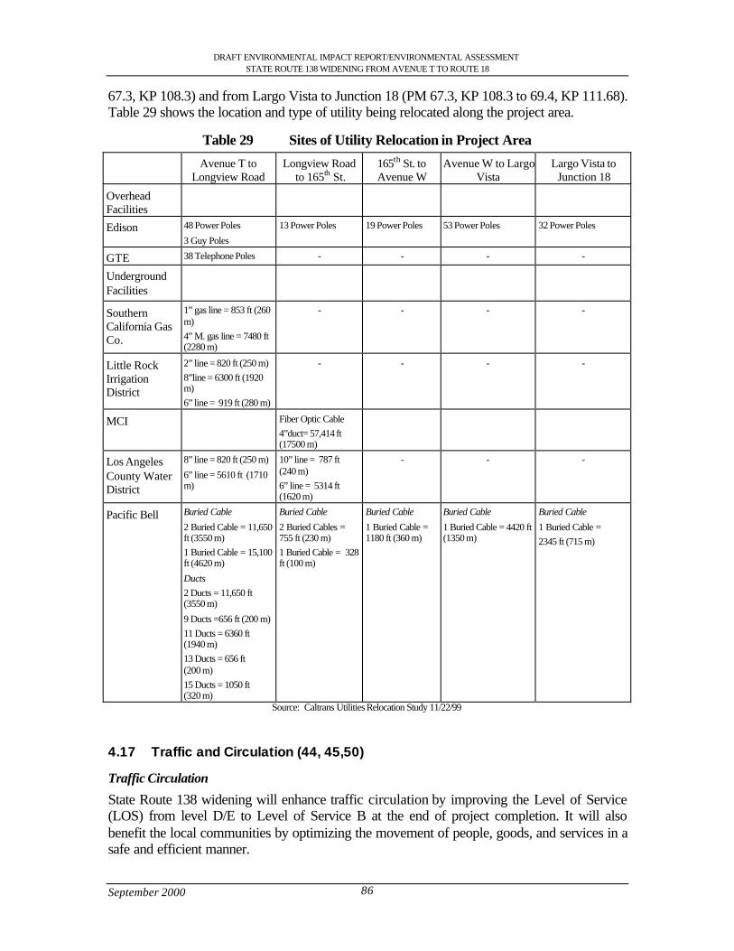
DRAFT ENVIRONMENTAL IMPACT REPORT/ENVIRONMENTAL ASSESSMENTSTATE ROUTE 138 WIDENING FROM AVENUE T TO ROUTE 18
September 2000 86
67.3, KP 108.3) and from Largo Vista to Junction 18 (PM 67.3, KP 108.3 to 69.4, KP 111.68).Table 29 shows the location and type of utility being relocated along the project area.
Table 29 Sites of Utility Relocation in Project Area
Avenue T toLongview Road
Longview Roadto 165th St.
165th St. toAvenue W
Avenue W to LargoVista
Largo Vista toJunction 18
OverheadFacilities
Edison 48 Power Poles
3 Guy Poles
13 Power Poles 19 Power Poles 53 Power Poles 32 Power Poles
GTE 38 Telephone Poles - - - -
UndergroundFacilities
SouthernCalifornia GasCo.
1” gas line = 853 ft (260m)4” M. gas line = 7480 ft(2280 m)
- - - -
Little RockIrrigationDistrict
2” line = 820 ft (250 m)8”line = 6300 ft (1920m)6” line = 919 ft (280 m)
- - - -
MCI Fiber Optic Cable4”duct= 57,414 ft(17500 m)
Los AngelesCounty WaterDistrict
8” line = 820 ft (250 m)
6” line = 5610 ft (1710m)
10” line = 787 ft(240 m)6” line = 5314 ft(1620 m)
- - -
Pacific Bell Buried Cable
2 Buried Cable = 11,650ft (3550 m)1 Buried Cable = 15,100ft (4620 m)
Ducts
2 Ducts = 11,650 ft(3550 m)
9 Ducts =656 ft (200 m)11 Ducts = 6360 ft(1940 m)13 Ducts = 656 ft(200 m)15 Ducts = 1050 ft(320 m)
Buried Cable
2 Buried Cables =755 ft (230 m)1 Buried Cable = 328ft (100 m)
Buried Cable
1 Buried Cable =1180 ft (360 m)
Buried Cable
1 Buried Cable = 4420 ft(1350 m)
Buried Cable
1 Buried Cable =2345 ft (715 m)
Source: Caltrans Utilities Relocation Study 11/22/99
4.17 Traffic and Circulation (44, 45,50)
Traffic Circulation
State Route 138 widening will enhance traffic circulation by improving the Level of Service(LOS) from level D/E to Level of Service B at the end of project completion. It will alsobenefit the local communities by optimizing the movement of people, goods, and services in asafe and efficient manner.
DRAFT ENVIRONMENTAL IMPACT REPORT/ENVIRONMENTAL ASSESSMENTSTATE ROUTE 138 WIDENING FROM AVENUE T TO ROUTE 18
September 2000 87
According to the California State CEQA guidelines, a project will normally have a significanteffect on the environment if it will cause an increase in traffic that is substantial to the existingtraffic load and capacity of the street system.
As compared to year 2024 baseline conditions, this project is expected to shorten work-triptravel times, increase average p.m. peak-hour highway speed, reduce daily hours of delay forall trips, and decrease the percent of all p.m. hours travel that are delayed, thereby improvingregional mobility.
Parking
A parking study was not done at this time for this project, but one will be included in the finalEIR/EA. The Los Angeles County Department of Public Works, Traffic and LightingInvestigations was contacted concerning parking issues in relation to the proposed project.They stated that they would analyze the parking issues on an “as needed” basis or towards thedesign stage of the project. Caltrans has been coordinating with the Keppel Union SchoolDistrict to develop a plan to mitigate impacts to their parking and circulation at AlpineElementary School.
Measures to Minimize Harm1. A Traffic Management Plan (TMP) would be completed for the construction of the
project during the final design preparation. Adequate public notices and postedannouncements will be required to alert motorist about different construction stagesand lane closures. Also posted announcements would be required to alertmotorists/consumers that businesses are still open during construction.
2. Caltrans will continue to work with Los Angeles County Department of Public Workon parking issues.
3. Caltrans will continue to coordinate with Alpine Elementary School
4.18 Cultural/Historic Resources (51)
According to the Historic Property Survey Report, the Area of Potential Effect (APE)contained 124 properties and 5 bridges. The study found that none of the structures appear tomeet the criteria of eligibility for inclusion in the National Register of Historic Places.Likewise, Caltrans has evaluated the properties in accordance with Section 15064.5(a, 2-3) ofthe CEQA guidelines and determined that none of the resources are historical resources andfor the purposes of CEQA. Furthermore, there does not appear to be a National Register-eligible historic district or cultural landscape within the APE.
While no prehistoric archeological sites were identified within the project area, the historicLlano del Rio Cooperative colony would be effected by the project. The remnants of thecolony (which consists of approximately 2100 acres )lie on both sides of State Route 138 withvisible ruins serving as key landmarks to identify the center of the colony. The Llano del RioColony is already recognized as California Historical Landmark No. 933 and, by virtue of thatregistration, is also listed on the California Register of Historical Resources. The colony alsoappears to be eligible for the National Register of Historic Places as a discontiguous historicdistrict. If project plans are changed, additional survey work will be required on any area notpreviously surveyed. If during construction, buried cultural remains are encountered, it isCaltrans policy that all work in that area be stopped until a qualified archeologist can evaluatethe nature and significance of the find.

DRAFT ENVIRONMENTAL IMPACT REPORT/ENVIRONMENTAL ASSESSMENTSTATE ROUTE 138 WIDENING FROM AVENUE T TO ROUTE 18
September 2000 88
Section 106 of the National Historic Preservation Act has established very specific guidancefor finding that a project has an effect on a historic property. Section 106 requires such afinding:
…when the undertaking may alter characteristics of the property that may qualify theproperty for inclusion in the National Register. For the purpose of determining effect,alteration to features of a property’s location, setting, or use may be relevantdepending on a property’s significant characteristics and should be considered… Anundertaking is considered to have an adverse effect when the effect on a historicproperty may diminish the integrity of the property’s location, design, setting,materials, workmanship, feeling, or association. Adverse effects on historic propertiesinclude, but are not limited to:
1) Physical destruction, damage, or alteration of all or part of the property
2) Isolation of the property from or alteration of the character of the property’s settingwhen that character contributes to the property’s qualification for the NationalRegister;
3) Introduction of visual, audible, or atmospheric elements that are out of characterwith the property or alter its setting
4) Neglect of a property resulting in its deterioration of destruction; and
5) Transfer, lease, or sale of the property… (36CFR80).
Under CEQA, a project would have a significant effect on the environment if it would disruptor adversely affect any of the following:
l A historic or prehistoric archeological site
l A property of historic or cultural significance to a community,
l Ethnic or social group
l A paleontological site (except as a part of a scientific study).
All build alternatives would affect the Llano del Rio site. Alternative 1 – Design variation Bwould have the least impact.
Measures to Minimize harm1. Mitigation measures will be identified and considered through the public comment on
this document and in completing consultation with the State Historic PreservationOfficer pursuant to section 106 of the National Historic Preservation Act (36 CFR800).
2. If during project construction additional cultural materials appear, work will stop inthe immediate area. The District 7 Archaeologist will be notified upon such discoveryand appropriate measures will be performed to mitigate the impacts to the resource.Work may only resume with approval from the Caltrans Archaeologist.
3. The site would be designated and managed as an Environmentally Sensitive Area(ESA).
DRAFT ENVIRONMENTAL IMPACT REPORT/ENVIRONMENTAL ASSESSMENTSTATE ROUTE 138 WIDENING FROM AVENUE T TO ROUTE 18
September 2000 89
4. Permanent fencing and vehicular gated will be installed as the first constructionactivity along this section of highway. These fences would extend along the north andsouth right-of-way boundary lines from 165th Street to 175th Street through the formerurban core of the community. Vehicular gates would be placed to allow access toexisting private dirt roads.
4.19 Cumulative Effects (58)
Preparation of this section is in accordance with California Environmental Quality Act(CEQA) and the National Environmental Policy Act (NEPA). The CEQA Guidelines, Section15130, states that "cumulative impacts shall be discussed when they are significant. Thediscussion of cumulative impacts shall reflect the severity of the impacts and their likelihoodof occurrence, but the discussion need not provide as great detail as is provided of the effectsattributable to the project alone." Under 40 CFR 1508.7, cumulative effects “which resultfrom the incremental consequences of an action when added to other past and reasonablyforeseeable future actions” shall be discussed.
The Antelope Valley General Plan and the Los Angeles County Growth Management PlanEIR were reviewed to determine whether the proposed State Route 138 project impacts werealready included in the analysis. If not, the State Route 138 project impacts were then added tothe forecasted impacts to determine the likelihood that cumulative impacts would occur.
Geology and Soils
Seismic hazards are experienced throughout Southern California, including in the project area.With or without the State Route 138 project, people would be exposed to such hazards as faultdisplacement/ground rupture, seismic groundshaking, liquefaction, differential settlement,subsidence, and landslides. The project would not increase or decrease these hazards, norwould it introduce additional population into an area where these hazards exist. Thus, theproject would not contribute to cumulative geology or soils impacts.
Land Use and Socioeconomic
The Antelope Valley General Plan recognizes the unincorporated areas of Littlerock,Pearblossom, and Llano as areas of low-density lifestyle that characterize much of theAntelope Valley. The General Plan promotes the protection of the existing rural communitiesas well as recognizes the urban centers such as Palmdale in the Antelope Valley. The preferredalternative would require acquisition of approximately 3 full takes and 41 partial takes ofresidential property through he communities of Littlerock, Pearblossom and Llano. It wouldalso require 5 full take and 82 partial takes of non-residential property through thecommunities of Littlerock, Pearblossom and Llano. There is adequate replacement housingthe area. Therefore, the project would not contribute to cumulative population or housingimpacts. Most, if not all, of the displaced employees can be expected to find employment,either in the relocated business itself or at a similar business in another location.
The project would provide short-term employment opportunities (construction) and contributeto an overall increased economic activity in the long term by improving accessibility withinand to the project area. Thus, the project’s contribution to cumulative economic impactswould be neutral to beneficial; depending on the ability to relocate displaced businesses in thelocal area.
DRAFT ENVIRONMENTAL IMPACT REPORT/ENVIRONMENTAL ASSESSMENTSTATE ROUTE 138 WIDENING FROM AVENUE T TO ROUTE 18
September 2000 90
Traffic and Transportation
By design, the State Route 138 project would have beneficial traffic and transportationimpacts, and would not contribute to cumulative adverse impacts.
Air Quality
As a result of congestion reduction which would result from the project, the State Route 138improvements would have a beneficial impact on air quality, and would not contribute tocumulative adverse impacts. The proposed project is included in the Regional and FederalTransportation Improvement Plan and is consistent with the Regional Transportation Plan thatfurther the goals of the Clean Air Act.
Noise
The majority of the project area is surrounded by open space. The noise-sensitive land usesthat front State Route 138 are now, and would continue to be, exposed to adverse noiseimpacts. The only feasible form of noise abatement along State Route 138 is soundwalls. Insome locations, however, such walls would block views of highway dependent business andmay not be desirable. Since, the businesses and residences have driveways and walkwaysabutting the highway, soundwalls would provide only 2-3 dBA of attenuation due to soundflaking. In addition, sight distance and sidewalk access requirements per Highway DesignManual section 1102.4, Noise Barrier location, cannot be satisfied with the placement ofsoundwalls in any reasonable location. If mitigation is not fully implemented, noise impactsrelated to State Route 138 improvements would contribute to the existing and growing noiseimpacts.
Biological Resources
Habitat area along many areas of State Route 138 has been highly disturbed and degraded byhuman activities. There are no federal wetland impacts. Impacts to riparian vegetation will betemporary and mitigated based on coordination with the responsible resource agencies. Theproposed project has the potential to impact wildlife corridors. The California ResourcesAgency and the Department of Parks and Recreation have determined that the bridges at LittleRock Creek/Wash and Big Rock Creek/Wash are sufficient to maintain a functioning wildlifecorridor for both small and large animals.
Archaeological/Historical Resources
The Llano del Rio site is within the Area of Potential Effect and is eligible for the NationalRegister of Historic Places. This site will be affected by the proposed project. Mitigation willbe conducted after completing consultation with the State Historic Preservation Officerpursuant to Section 106 or the National Historic Preservation Act (36 CFR 800).
Hydrology
Although present quality is satisfactory, there is a slow trend toward reduced groundwaterquality, due to increased urban run-off, septic tank failures in the San Gabriel watershed,declining water tables, and an extensive perched water condition in the Lancaster sub-unit ofthe Antelope Valley Basin (this sub-unit presently supplies the majority of the pumped watersupply in the Basin). The proposed project widening of Big Rock Wash Bridge would occurin Big Rock Wash and since the creek is seasonal there will not be any effects to the existingwater quality. Also all work that will be required would be done during low flow season.
DRAFT ENVIRONMENTAL IMPACT REPORT/ENVIRONMENTAL ASSESSMENTSTATE ROUTE 138 WIDENING FROM AVENUE T TO ROUTE 18
September 2000 91
Hazardous Materials
The State Route 138 improvements would affect existing hazardous materials within theproject area by disturbing the areas where these materials are found. With implementation ofhazardous materials remediation, impacts related to hazardous materials would be reduced to aless-than-substantial level on an individual and cumulative basis.
Visual Resources
The State Route 138-improvement project would result in very few changes in the aestheticcomposition of the area. Views of the surrounding desert and mountains will not be obscuredas no sound walls are foreseen along the route.
4.20 Farmland (26)
The U.S. Soil Conservation Service within the U.S. Department of Agriculture determined thefarmland in the proposed area of State Route 138 widening which happens to fall under theFederal Farmland Protection Act. Prime farmland is land, which has the best combination ofphysical and chemical characteristics for the production of crops. It has the soil quality,growing season, and moisture supply needed to produce sustained high yields of crops whentreated and managed, including water management according to the current farming methods.
Construction of any of the alternatives would result in conversion of approximately .14 to 1.03acres of prime farmland designated by the United States Department of Agriculture’s NaturalResources Conservation Service (NRCS) depending on the alternative chosen. The farmlandthat would be converted is located between 72nd Street East and 75th Street East (PM 53.95,KP 86.82) and east of the California aqueduct in the proximity of 96th Street East (56.17, KP90.39). According to the Farmland Conversion Impact Rating Form AD-1006 that was doneby the NRCS the total prime farmland in the project area represents 1.9% of total farmableland in Los Angeles County which is 56,883 acres as defined in the Farmland ProtectionPolicy Act (FPPA). The percentage of affected prime farmland that will be converted directlyby the highway widening project is 0.0019% and 0.00026% according to the FarmlandConversion Impact Rating Form AD-1006. Given the extremely small proportion of regionalfarmland to be converted by the project, the proposed project’s impact upon prime farmland isnot substantial based upon the score of 152 given to the farmland based on the criteria set bythe NRCS scoring system (See Appendix H).
The NRCS classified the farmland “prime,” but due to the relative value of the farmlandand the Site Assessment, sites receiving a total score of less than 160 need not be givenfurther consideration for protection and no additional alternatives need to be evaluatedunder 7 CFR 658.4 (c)(2). Therefore, no further coordination with the NRCS will berequired.
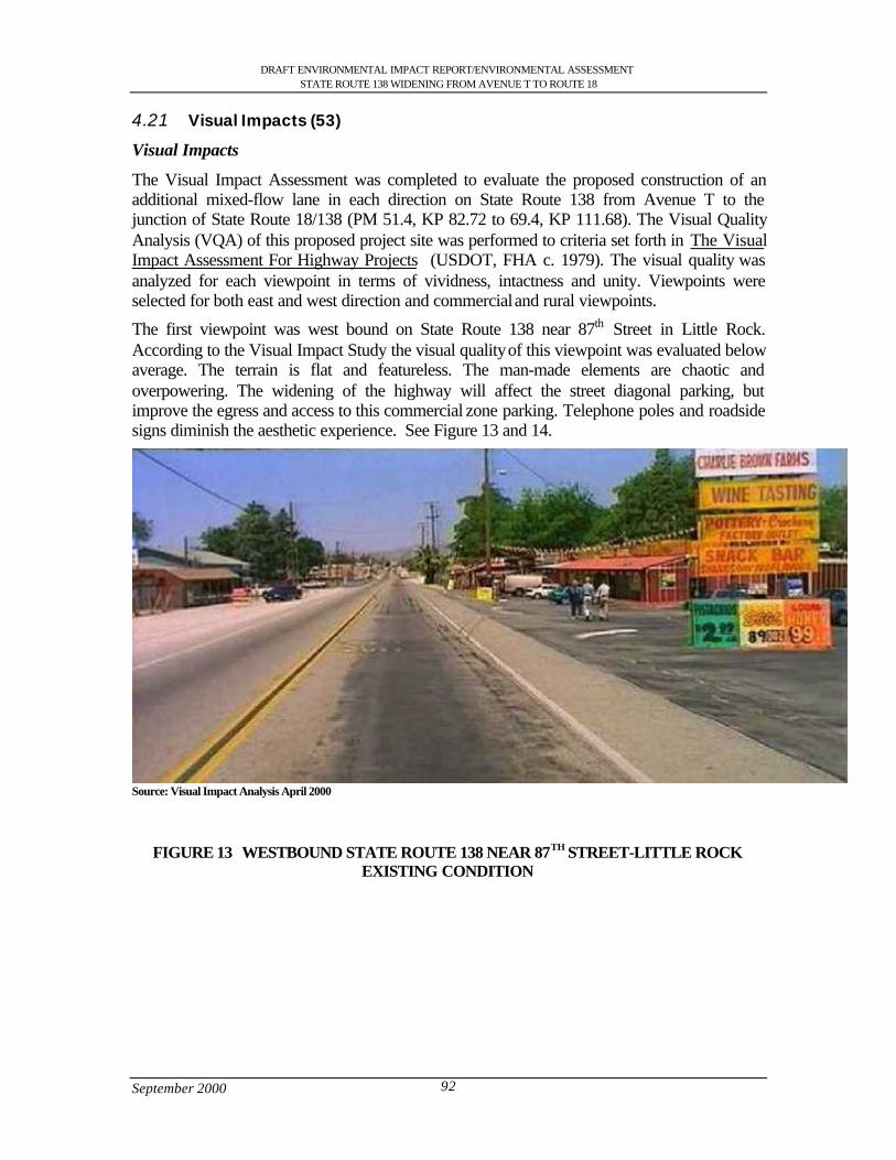
DRAFT ENVIRONMENTAL IMPACT REPORT/ENVIRONMENTAL ASSESSMENTSTATE ROUTE 138 WIDENING FROM AVENUE T TO ROUTE 18
September 2000 92
4.21 Visual Impacts (53)
Visual Impacts
The Visual Impact Assessment was completed to evaluate the proposed construction of anadditional mixed-flow lane in each direction on State Route 138 from Avenue T to thejunction of State Route 18/138 (PM 51.4, KP 82.72 to 69.4, KP 111.68). The Visual QualityAnalysis (VQA) of this proposed project site was performed to criteria set forth in The VisualImpact Assessment For Highway Projects (USDOT, FHA c. 1979). The visual quality wasanalyzed for each viewpoint in terms of vividness, intactness and unity. Viewpoints wereselected for both east and west direction and commercial and rural viewpoints.
The first viewpoint was west bound on State Route 138 near 87th Street in Little Rock.According to the Visual Impact Study the visual quality of this viewpoint was evaluated belowaverage. The terrain is flat and featureless. The man-made elements are chaotic andoverpowering. The widening of the highway will affect the street diagonal parking, butimprove the egress and access to this commercial zone parking. Telephone poles and roadsidesigns diminish the aesthetic experience. See Figure 13 and 14.
Source: Visual Impact Analysis April 2000
FIGURE 13 WESTBOUND STATE ROUTE 138 NEAR 87TH STREET-LITTLE ROCKEXISTING CONDITION
DRAFT ENVIRONMENTAL IMPACT REPORT/ENVIRONMENTAL ASSESSMENTSTATE ROUTE 138 WIDENING FROM AVENUE T TO ROUTE 18
September 2000 93
Source: Visual Impact Analysis April 2000
FIGURE 14 WESTBOUND STATE ROUTE 138 NEAR 87TH STREET-LITTLE ROCKPROPOSED CONDITIONS
The second viewpoint was eastbound on State Route 138 near 175th Street –Llano. The visualquality of this viewpoint was evaluated above average. The terrain is flat and featureless andthe desert vegetation is limited. The dominance of the San Gabriel Mountains is the mostsignificant feature. The addition of one travel lane per direction will have no impact on thevisual quality. See Figure 15
FIGURE 15 EASTBOUND STATE ROUTE 138 NEAR 175TH STREET –LLANO
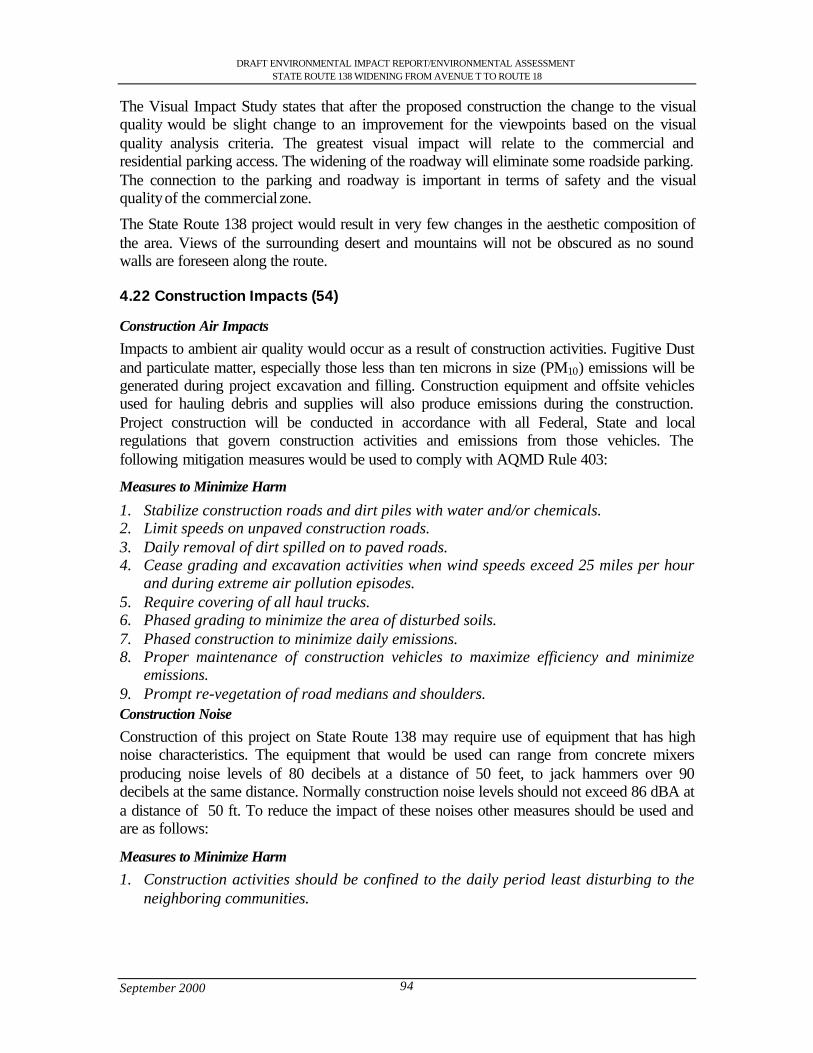
DRAFT ENVIRONMENTAL IMPACT REPORT/ENVIRONMENTAL ASSESSMENTSTATE ROUTE 138 WIDENING FROM AVENUE T TO ROUTE 18
September 2000 94
The Visual Impact Study states that after the proposed construction the change to the visualquality would be slight change to an improvement for the viewpoints based on the visualquality analysis criteria. The greatest visual impact will relate to the commercial andresidential parking access. The widening of the roadway will eliminate some roadside parking.The connection to the parking and roadway is important in terms of safety and the visualquality of the commercial zone.
The State Route 138 project would result in very few changes in the aesthetic composition ofthe area. Views of the surrounding desert and mountains will not be obscured as no soundwalls are foreseen along the route.
4.22 Construction Impacts (54)
Construction Air Impacts
Impacts to ambient air quality would occur as a result of construction activities. Fugitive Dustand particulate matter, especially those less than ten microns in size (PM10) emissions will begenerated during project excavation and filling. Construction equipment and offsite vehiclesused for hauling debris and supplies will also produce emissions during the construction.Project construction will be conducted in accordance with all Federal, State and localregulations that govern construction activities and emissions from those vehicles. Thefollowing mitigation measures would be used to comply with AQMD Rule 403:
Measures to Minimize Harm
1. Stabilize construction roads and dirt piles with water and/or chemicals.2. Limit speeds on unpaved construction roads.3. Daily removal of dirt spilled on to paved roads.4. Cease grading and excavation activities when wind speeds exceed 25 miles per hour
and during extreme air pollution episodes.5. Require covering of all haul trucks.6. Phased grading to minimize the area of disturbed soils.7. Phased construction to minimize daily emissions.8. Proper maintenance of construction vehicles to maximize efficiency and minimize
emissions.9. Prompt re-vegetation of road medians and shoulders.Construction Noise
Construction of this project on State Route 138 may require use of equipment that has highnoise characteristics. The equipment that would be used can range from concrete mixersproducing noise levels of 80 decibels at a distance of 50 feet, to jack hammers over 90decibels at the same distance. Normally construction noise levels should not exceed 86 dBA ata distance of 50 ft. To reduce the impact of these noises other measures should be used andare as follows:
Measures to Minimize Harm
1. Construction activities should be confined to the daily period least disturbing to theneighboring communities.
DRAFT ENVIRONMENTAL IMPACT REPORT/ENVIRONMENTAL ASSESSMENTSTATE ROUTE 138 WIDENING FROM AVENUE T TO ROUTE 18
September 2000 95
2. Where there is close proximity to residential frontage, minimize operations from theCity street side of the project to create the greatest distance between noise sourcesand residents.
3. Arrange the noisiest operations together in the construction program to avoidcontinuing periods of greater annoyance.
4. Require that equipment be installed and maintained with effective muffler exhaustsystems.
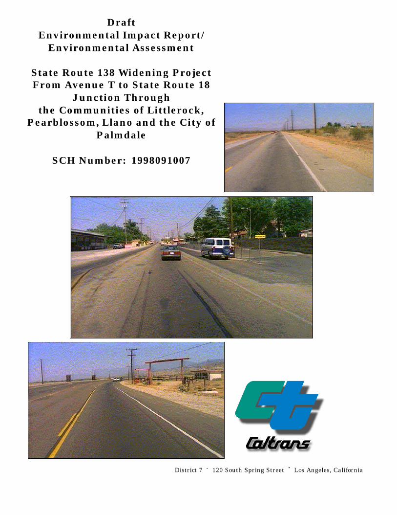
District 7 • 120 South Spring Street • Los Angeles, California
DraftEnvironmental Impact Report/
Environmental Assessment
State Route 138 Widening ProjectFrom Avenue T to State Route 18
Junction Throughthe Communities of Littlerock,
Pearblossom, Llano and the City ofPalmdale
SCH Number: 1998091007

DRAFT ENVIRONMENTAL IMPACT REPORT/ENVIRONMENTAL ASSESSMENTSTATE ROUTE 138 WIDENING FROM AVENUE T TO ROUTE 18
September 2000 i
Table of Contents
S.0 Summary .............................................................................................................................................................. 1S.1 Purpose and Need for the Project ................................................................................................................ 1S.2 Alternatives under Consideration................................................................................................................ 1S.3 Other Actions in the Same Area .................................................................................................................. 3S.4 Environmental Consequences and Recommended Mitigation Measures ............................................ 3
1.0 Purpose and Need............................................................................................................................................. 111.1 Purpose of the Project.................................................................................................................................. 111.2 Need for the Project ..................................................................................................................................... 111.2.1 Capacity Issues ........................................................................................................................................ 111.2.2 Safety Problems ....................................................................................................................................... 161.2.3 Operational Deficiencies ........................................................................................................................ 191.2.4 Structural Deficiencies............................................................................................................................ 191.3 Summary ........................................................................................................................................................ 20
2.0 Alternatives including the Proposed Project................................................................................................ 212.1 Alternative 1: Widening along existing facility...................................................................................... 212.1.2 Design Variation A: South of Llano del Rio hotel............................................................................ 262.1.3 Design Variation B (Preferred Alternative): South of Llano del Rio Hotel and North of U.S.
Post Office ................................................................................................................................................ 262.1.4 Design Variation C: South of Llano del Rio Hotel............................................................................ 262.1.5 Design Variation D: Avenue V, Fort Tejon and Avenue V-8......................................................... 262.1.6 Design Variation E: Avenue V.............................................................................................................. 272.1.7 Attainment of Project Goals .................................................................................................................. 272.2 Other Alternatives Considered................................................................................................................... 282.2.1 Alternative 2: Building of Freeway...................................................................................................... 282.2.2 Alternative 3: Transportation System Management (TSM)............................................................ 282.2.3 Alternative 4: Widening along the existing highway through Pearblossom................................. 282.2.4 Alternative 5: No Action........................................................................................................................ 282.3 Current Status of the Project ...................................................................................................................... 292.4 Status of Other Projects or Proposals In The Area................................................................................. 29
3.0 Affected Environment...................................................................................................................................... 323.1 Topography ................................................................................................................................................... 323.2 Geology and Soils ........................................................................................................................................ 323.2.1 Faults ......................................................................................................................................................... 323.2.2 Mining ....................................................................................................................................................... 323.3 Water Resources .......................................................................................................................................... 333.3.1 Hydrology................................................................................................................................................. 333.3.2 Water Quality........................................................................................................................................... 333.3.3 Flood Hazards .......................................................................................................................................... 333.3.4 Climate ...................................................................................................................................................... 343.4 Biological Resources................................................................................................................................... 343.4.1 Vegetation................................................................................................................................................. 343.4.2 Wildlife...................................................................................................................................................... 383.4.3 Wildlife Corridors ................................................................................................................................... 383.4.4 Wetlands ................................................................................................................................................... 393.5 Air Quality Characteristics ......................................................................................................................... 393.6 Hazardous Waste ......................................................................................................................................... 463.6.1 Storage Tanks........................................................................................................................................... 463.7 Land Use Setting .......................................................................................................................................... 473.7.1 Housing..................................................................................................................................................... 473.7.2 Commercial............................................................................................................................................... 483.7.3 Industrial.................................................................................................................................................... 483.7.4 Farm Land................................................................................................................................................. 483.8 Socioeconomic Characteristics .................................................................................................................. 483.8.1 Economics................................................................................................................................................. 48

DRAFT ENVIRONMENTAL IMPACT REPORT/ENVIRONMENTAL ASSESSMENTSTATE ROUTE 138 WIDENING FROM AVENUE T TO ROUTE 18
September 2000 ii
3.8.2 Population................................................................................................................................................. 523.9 Public Services & Facilities........................................................................................................................ 533.9.1 Schools ...................................................................................................................................................... 543.10 Transportation............................................................................................................................................... 543.11 Historic & Cultural Resources.................................................................................................................. 543.12 Noise Analysis ............................................................................................................................................. 553.13 Parks and Bicycle Facilities........................................................................................................................ 573.13.1 Park............................................................................................................................................................. 573.13.2 Equestrian Trails ....................................................................................................................................... 573.13.3 Bicycle Lanes ........................................................................................................................................... 573.14 Scenic Resources ......................................................................................................................................... 57
4.0 Environmental Evaluation............................................................................................................................... 594.1 CEQA Environmental Checklist ............................................................................................................... 604.2 Discussion of Environmental Consequences .......................................................................................... 624.3 Geology, Topography, Seismic (Environmental Checklist Questions 1,2,4).................................... 634.3.1 Soil Erosion (5) ........................................................................................................................................ 634.4 Hazardous Waste (9).................................................................................................................................... 634.5 Floodplain (11).............................................................................................................................................. 654.5.1 Water Quality (10, 12,14,15)................................................................................................................. 654.6 Air Quality (19)............................................................................................................................................ 664.7 Noise (20, 21)................................................................................................................................................ 674.8 Wildlife (23,29,56)...................................................................................................................................... 684.8.1 Vegetation (14,24,27).............................................................................................................................. 704.8.2 Wildlife Movement/Habitat Fragmentation (30,31).......................................................................... 724.8.3 Wetlands (14)........................................................................................................................................... 764.9 Growth Inducing (35) .................................................................................................................................. 784.10 Lifestyles, Neighborhood Stability (36) ................................................................................................... 794.11 Elderly or Specific Interest Groups, Housing and Employment (39).................................................. 794.12 Housing and Employment (40,41)........................................................................................................... 794.13 Minority (37)................................................................................................................................................. 824.14 Property Values, Local Tax Base (41)...................................................................................................... 834.15 Community Facilities (42).......................................................................................................................... 834.16 Public Utilities and Services (43) .............................................................................................................. 854.17 Traffic and Circulation (44, 45,50)............................................................................................................ 864.18 Cultural/Historic Resources (51) ............................................................................................................... 874.19 Cumulative Effects (58).............................................................................................................................. 894.20 Farmland (26)................................................................................................................................................ 914.21 Visual Impacts (53)...................................................................................................................................... 924.22 Construction Impacts (54)........................................................................................................................... 94
5.0 Section 4(f) Evaluation.................................................................................................................................... 965.1 Section 4(f) .................................................................................................................................................... 975.2 Proposed Action........................................................................................................................................... 975.3 Description of Section 4(f) Properties Directly Used............................................................................ 975.3.1 Historic Resources .................................................................................................................................. 975.4 Impacts on the Section 4(f) Property ......................................................................................................1015.4.1 No Build Alternative.............................................................................................................................1015.4.2 Design Variation A................................................................................................................................1015.4.3 Design Variation B (Preferred)...........................................................................................................1025.4.4 Design Variation C................................................................................................................................1035.5 Avoidance Alternatives .............................................................................................................................1035.5.1 No Build Alternative.............................................................................................................................1035.5.2 Avoidance Alternative..........................................................................................................................1045.6 Measures to Minimize Harm....................................................................................................................1045.6.1 Mitigation Measures for Llano Colony Site......................................................................................1045.7 Other Properties Evaluated Relative to the Requirements of Section 4(f) .......................................1055.8 Section 6(f) ..................................................................................................................................................105

DRAFT ENVIRONMENTAL IMPACT REPORT/ENVIRONMENTAL ASSESSMENTSTATE ROUTE 138 WIDENING FROM AVENUE T TO ROUTE 18
September 2000 iii
5.9 Coordination................................................................................................................................................1076.0 Consultation and Coordination ....................................................................................................................108
6.1 Early Scoping Process...............................................................................................................................1086.2 Consultation................................................................................................................................................1086.3 Community and Agency Meetings .........................................................................................................1096.4 Circulation of Draft Environmental Document.....................................................................................109
7.0 List of Preparers..............................................................................................................................................110
List of Tables
TABLE 1 IMPROVEMENTS PROJECT AND ENVIRONMENTAL EVALUATION SUMMARY OF EFFECTS............... 4TABLE 2 LEVEL OF SERVICE CRITERIA................................................................................................................. 14TABLE 3 LEVEL OF SERVICE (LOS) ANALYSIS FOR BUILD/NO BUILD ALTERNATIVE ................................. 14TABLE 4 1998 TRAFFIC VOLUMES ........................................................................................................................ 15TABLE 5 FUTURE (2024) TRAFFIC VOLUMES ...................................................................................................... 16TABLE 6 ACCIDENT HISTORY ................................................................................................................................ 18TABLE 7 ACCIDENT SUMMARY.............................................................................................................................. 18TABLE 8 ACCIDENT COMPARISON TO THE STATEWIDE AVERAGE ................................................................... 18TABLE 9 STATE TRANSPORTATION IMPLEMENTATION PLAN............................................................................ 29TABLE 10 PLANTS OBSERVED IN THE PROJECT VICINITY.................................................................................... 36TABLE 11 HIGHEST 4 DAILY MAXIMUM HOURLY OZONE MEASUREMENTS.................................................... 40TABLE 12 HIGHEST 4 DAILY MAXIMUM 8-HOUR CARBON MONOXIDE AVERAGES....................................... 43TABLE 13 HIGHEST 4 DAILY PM10 MEASUREMENTS AND ANNUAL PM10 STATISTICS................................... 43TABLE 14 HIGHEST 4 DAILY NITROGEN DIOXIDE MEASUREMENTS AND ANNUAL NITROGEN DIOXIDE .... 46TABLE 15 HOUSING UNITS FOR 1990...................................................................................................................... 47TABLE 16 MEDIAN FAMILY INCOME BY COMMUNITY COMPARED TO LOS ANGELES COUNTY..................... 49TABLE 17 LABOR-MARKET INDUSTRY................................................................................................................... 49TABLE 18 REGIONAL DEMOGRAPHICS.................................................................................................................... 52TABLE 19 ANTELOPE VALLEY REGION POPULATION TRENDS BY CITY AND AREA ........................................ 52TABLE 20 EDUCATION DEMOGRAPHICS................................................................................................................. 53TABLE 21 ETHNIC POPULATION IN ANTELOPE VALLEY COMMUNITIES............................................................ 53TABLE 22 ETHNIC POPULATION OF ALPINE ELEMENTARY SCHOOL 1998-1999 SCHOOL YEAR ................... 54TABLE 23 NOISE CRITERIA ....................................................................................................................................... 56TABLE 24 EXISTING NOISE LEVELS IN PROJECT AREA ........................................................................................ 56TABLE 25 CO CONCENTRATION RESULTS COMPARED TO BUILD AND NO BUILD ALTERNATIVE................. 67TABLE 26 SENSITIVE FLORA IN PROJECT AREA .................................................................................................... 70TABLE 27 BEST CASE SCENARIO FOR RIGHT-OF-WAY ACQUISITION FOR THE COMMUNITIES OF PALMDALE,
LITTLEROCK, PEARBLOSSOM AND LLANO........................................................................................... 81TABLE 28 WORST CASE SCENARIO FOR RIGHT-OF-WAY ACQUISITION FOR THE COMMUNITIES OF
PALMDALE, LITTLEROCK, PEARBLOSSOM AND LLANO..................................................................... 81TABLE 29 SITES OF UTILITY RELOCATION IN PROJECT AREA............................................................................. 86
List of Figures
FIGURE 1 REGIONAL MAP........................................................................................................................................ 12FIGURE 2 LOCATION MAP ........................................................................................................................................ 13FIGURE 3 TYPICAL LEVEL OF SERVICE FOR EXISTING ROADWAYS................................................................... 15FIGURE 4 TYPICAL CROSS-SECTION FOR DEVELOPED AREA ............................................................................. 23FIGURE 5 TYPICAL CROSS SECTION FOR UNDEVELOPED AREA......................................................................... 24FIGURE 6 DESIGN VARIATIONS A, B, AND C...................................................................................................... 25FIGURE 7 STATE AND NATIONAL AREA OZONE ATTAINMENT/NONATTAINMENT AREAS............................ 42FIGURE 8 STATE AND NATIONAL AREA CARBON MONOXIDE ATTAINMENT /NONATTAINMENT AREAS.... 44FIGURE 9 STATE AND NATIONAL AREA PM10 ATTAINMENT/NONATTAINMENT AREAS............................... 45FIGURE 10 IMPORTANT FARMLAND IN THE VICINITY OF THE PROPOSED PROJECT ........................................... 50FIGURE 11 PRIME FARMLAND AFFECTED BY THE PROPOSED PROJECT ............................................................. 51

DRAFT ENVIRONMENTAL IMPACT REPORT/ENVIRONMENTAL ASSESSMENTSTATE ROUTE 138 WIDENING FROM AVENUE T TO ROUTE 18
September 2000 iv
FIGURE 12 LOCATION OF EQUESTRIAN TRAILS IN PROJECT AREA ................................................................ 58FIGURE 13 WESTBOUND STATE ROUTE 138 NEAR 87TH STREET -LITTLE ROCK EXISTING CONDITION ..... 92FIGURE 14 WESTBOUND STATE ROUTE 138 NEAR 87TH STREET -LITTLE ROCK PROPOSED CONDITIONS.. 93FIGURE 15 EASTBOUND STATE ROUTE 138 NEAR 175TH STREET –LLANO ..................................................... 93FIGURE 16A VIEW OF LLANO DEL RIO HOTEL ON NORTHSIDE OF STATE ROUTE 138.................................. 98FIGURE 16B VIEW OF CORE AREA OF LLANO COLONY SOUTH SIDE OF STATE ROUTE 138 ........................ 99FIGURE 16C LLANO HOTEL (APPROX. 46 M (150 FT) FROM THE HIGHWAY)................................................. 99FIGURE 17 ROOT CROP STORAGE STRUCTURE (APPROX. 411 M (1340 FT) FROM HIGHWAY)...................100FIGURE 18 MASONRY SILO, SMALLER BARN (APPROX. 716 M (2350 FT) FROM HIGHWAY).....................100FIGURE 19 BOUNDARIES OF THE LLANO DEL RIO COLONY ( BLACK DOTS).................................................106
Appendices
Appendix A Letter of Concurrence from State Historic Preservation OfficerAppendix B Noise Receptor Location Aerial MapsAppendix C Scoping NoticeAppendix D Scoping CommentsAppendix E Mailing ListAppendix F Title VI Policy StatementAppendix G FootprintAppendix H Farmland Conversion Impact Rating (Form AD-1006)Appendix I List of Acronyms
DRAFT ENVIRONMENTAL IMPACT REPORT/ENVIRONMENTAL ASSESSMENTSTATE ROUTE 138 WIDENING FROM AVENUE T TO ROUTE 18
September 2000 96
5.0 Section 4(f) Evaluation
U.S. Department of Transportation Act Section 4(f) Evaluation
State Route 138 Highway Widening
Project in Los Angeles County, California
State of California Department of Transportation
And
U.S. Department of Transportation
Federal Highway Administration
Pursuant to 42 U.S.C. 4332(2)(c) and 49 U.S.C. 303
September 2000
DRAFT ENVIRONMENTAL IMPACT REPORT/ENVIRONMENTAL ASSESSMENTSTATE ROUTE 138 WIDENING FROM AVENUE T TO ROUTE 18
September 2000 97
5.1 Section 4(f)
Section 4(f) of the Department of Transportation Act of 1966 prohibits the Secretary ofTransportation from approving any program or project which:
…requires the use of any publicly owned land from a public park, recreation area,or wildlife or wildlife and waterfowl refuge of national, state, or local significanceas determined by federal, state, or local officials having jurisdiction thereof, orany land from an historic site of national, state, or local significance as sodetermined by such officials unlessThere is no feasible and prudent alternative to the use of such land, andSuch program includes all possible planning to minimize harm to such park,recreational area, wildlife and waterfowl refuge, or historic site resulting fromsuch use….(Department of Transportation Act of 1983, 49 U.S.C. Section21)
Section 4(f) further requires consultation with the Department of the Interior and, asappropriate other federal agencies, in developing transportation projects and programs, whichuse lands, protected by Section 4(f).
5.2 Proposed Action
The California Department of Transportation (Caltrans) proposes to widen State Route 138from 2 to 4 lanes on the segment of the highway, which goes through the communities ofPearblossom, Littlerock, Llano and the City of Palmdale, all within unincorporated LosAngeles County. The project involves widening along State Route 138 between Avenue T tothe west and the Los Angeles/San Bernardino County line to the east. The preferredalternative involves the addition of one lane in each direction in order to make the existinghighway a standard 4-lane conventional highway (for additional information see Section 1.0 inthe EIR/EA). A more detailed description of the proposed project can be found in Section1(purpose and need) and Section 2 (Alternatives) of this document.
5.3 Description of Section 4(f) Properties Directly Used
5.3.1 Historic Resources
The historic archaeological site resource described below is identified in the Area of PotentialEffect (APE) for the proposed Route 138 widening project.
Llano Del Rio Colony Historic Archaeological SiteThe Llano Del Rio Colony Historic Archaeological site encompasses a 2095 acre area of theAntelope Valley and is bisected by the Pearblossom Highway (State Route 138) as shown onFigure 2 and Figure 9. Figure 3A shows the Llano Hotel in a northerly direction situatedapproximately 46 meters (150 ft) from the highway. Figure 16B is a picture taken in thesoutherly direction facing away from the Llano Hotel into the core area of the colony. Accessto the property is not restricted, but traffic studies done show that the speeds in this area arebetween 65-70 miles per hour. The lack of signs and vehicles traveling at a high rate of speedcombine to prevent the commuter from realizing that there is a California Historical Landmark
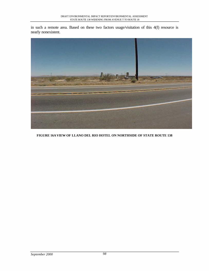
DRAFT ENVIRONMENTAL IMPACT REPORT/ENVIRONMENTAL ASSESSMENTSTATE ROUTE 138 WIDENING FROM AVENUE T TO ROUTE 18
September 2000 98
in such a remote area. Based on these two factors usage/visitation of this 4(f) resource isnearly nonexistent.
FIGURE 16A VIEW OF LLANO DEL RIO HOTEL ON NORTHSIDE OF STATE ROUTE 138
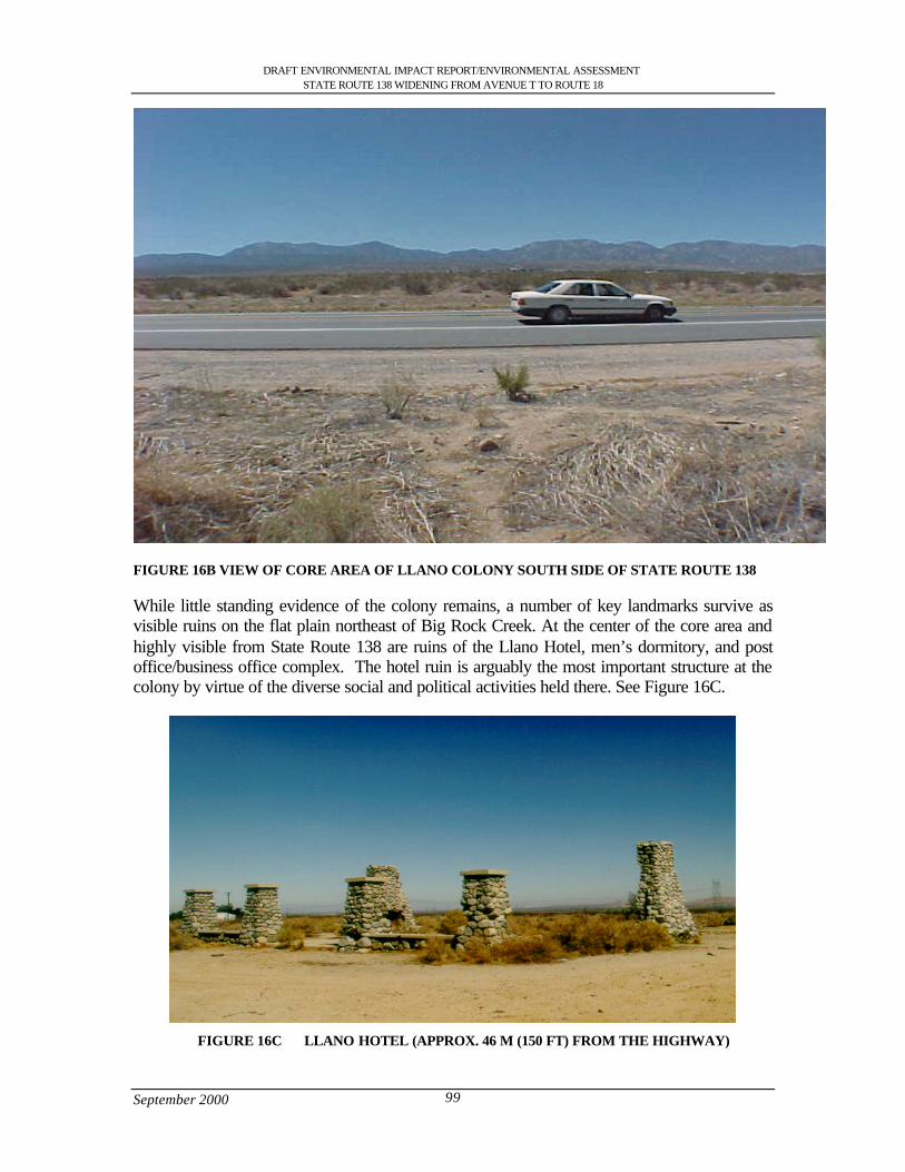
DRAFT ENVIRONMENTAL IMPACT REPORT/ENVIRONMENTAL ASSESSMENTSTATE ROUTE 138 WIDENING FROM AVENUE T TO ROUTE 18
September 2000 99
FIGURE 16B VIEW OF CORE AREA OF LLANO COLONY SOUTH SIDE OF STATE ROUTE 138
While little standing evidence of the colony remains, a number of key landmarks survive asvisible ruins on the flat plain northeast of Big Rock Creek. At the center of the core area andhighly visible from State Route 138 are ruins of the Llano Hotel, men’s dormitory, and postoffice/business office complex. The hotel ruin is arguably the most important structure at thecolony by virtue of the diverse social and political activities held there. See Figure 16C.
FIGURE 16C LLANO HOTEL (APPROX. 46 M (150 FT) FROM THE HIGHWAY)
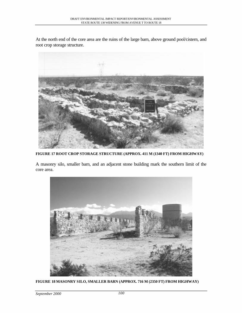
DRAFT ENVIRONMENTAL IMPACT REPORT/ENVIRONMENTAL ASSESSMENTSTATE ROUTE 138 WIDENING FROM AVENUE T TO ROUTE 18
September 2000 100
At the north end of the core area are the ruins of the large barn, above ground pool/cistern, androot crop storage structure.
FIGURE 17 ROOT CROP STORAGE STRUCTURE (APPROX. 411 M (1340 FT) FROM HIGHWAY)
A masonry silo, smaller barn, and an adjacent stone building mark the southern limit of thecore area.
FIGURE 18 MASONRY SILO, SMALLER BARN (APPROX. 716 M (2350 FT) FROM HIGHWAY)
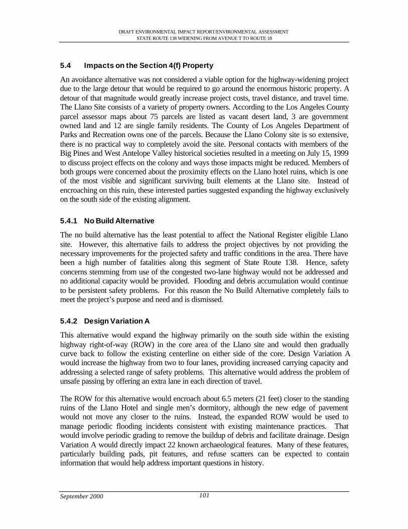
DRAFT ENVIRONMENTAL IMPACT REPORT/ENVIRONMENTAL ASSESSMENTSTATE ROUTE 138 WIDENING FROM AVENUE T TO ROUTE 18
September 2000 101
5.4 Impacts on the Section 4(f) Property
An avoidance alternative was not considered a viable option for the highway-widening projectdue to the large detour that would be required to go around the enormous historic property. Adetour of that magnitude would greatly increase project costs, travel distance, and travel time.The Llano Site consists of a variety of property owners. According to the Los Angeles Countyparcel assessor maps about 75 parcels are listed as vacant desert land, 3 are governmentowned land and 12 are single family residents. The County of Los Angeles Department ofParks and Recreation owns one of the parcels. Because the Llano Colony site is so extensive,there is no practical way to completely avoid the site. Personal contacts with members of theBig Pines and West Antelope Valley historical societies resulted in a meeting on July 15, 1999to discuss project effects on the colony and ways those impacts might be reduced. Members ofboth groups were concerned about the proximity effects on the Llano hotel ruins, which is oneof the most visible and significant surviving built elements at the Llano site. Instead ofencroaching on this ruin, these interested parties suggested expanding the highway exclusivelyon the south side of the existing alignment.
5.4.1 No Build Alternative
The no build alternative has the least potential to affect the National Register eligible Llanosite. However, this alternative fails to address the project objectives by not providing thenecessary improvements for the projected safety and traffic conditions in the area. There havebeen a high number of fatalities along this segment of State Route 138. Hence, safetyconcerns stemming from use of the congested two-lane highway would not be addressed andno additional capacity would be provided. Flooding and debris accumulation would continueto be persistent safety problems. For this reason the No Build Alternative completely fails tomeet the project’s purpose and need and is dismissed.
5.4.2 Design Variation A
This alternative would expand the highway primarily on the south side within the existinghighway right-of-way (ROW) in the core area of the Llano site and would then graduallycurve back to follow the existing centerline on either side of the core. Design Variation Awould increase the highway from two to four lanes, providing increased carrying capacity andaddressing a selected range of safety problems. This alternative would address the problem ofunsafe passing by offering an extra lane in each direction of travel.
The ROW for this alternative would encroach about 6.5 meters (21 feet) closer to the standingruins of the Llano Hotel and single men’s dormitory, although the new edge of pavementwould not move any closer to the ruins. Instead, the expanded ROW would be used tomanage periodic flooding incidents consistent with existing maintenance practices. Thatwould involve periodic grading to remove the buildup of debris and facilitate drainage. DesignVariation A would directly impact 22 known archaeological features. Many of these features,particularly building pads, pit features, and refuse scatters can be expected to containinformation that would help address important questions in history.
DRAFT ENVIRONMENTAL IMPACT REPORT/ENVIRONMENTAL ASSESSMENTSTATE ROUTE 138 WIDENING FROM AVENUE T TO ROUTE 18
September 2000 102
The reasons for dismissing Design Variation A stem from its failure to address severalimportant safety concerns spurring development of this project. While less impacting to theLlano site than either of the viable project alternatives (design variations B and C), thisalternative fails to meet the basic purpose and need of the project because it would not addressseveral important safety issues including the currently inadequate sight distance caused by theundulating profile of the existing at grade facility, periodic flash flooding, and debrisaccumulation.
The existing pavement profile in the vicinity of the Llano colony site is a rolling profile thatfollows the existing grade, with some deep depressions originally designed to accommodatethe passage of flush drainage flows. The dips and deeper depressions along this stretch havethe effect of reducing the stopping and passing sight distance available to the user. Adequatesight distance is one of 13 mandatory controlling design criteria elements required in thedesign of highway facilities. The corrective measure for this condition is to raise the roadwayprofile, as needed, to eliminate the dips and smooth out the profile. Design Variation A failsto correct the vertical alignment deficiencies discussed above.
About 9 percent of the accidents on this stretch of highway are associated with wet pavementconditions. Design Variation A would not improve existing drainage conditions, continuing toallow flood waters, rocks, and other debris to flow over the roadway. Accidents due toflooding events would increase in number and severity if this alternative were selectedbecause drivers would not expect to encounter such conditions on a multilane highway andwould be travelling at greater speeds. For all of the foregoing reasons, Design Variation Adoes not meet the basic objectives of the project and has been dismissed.
5.4.3 Design Variation B (Preferred)
This alternative would expand the alignment to the south to avoid impacts to the Llano del RioHotel ruin and gradually curve back to follow the existing centerline on either side of the corearea. The new alignment would shift to the south by approximately 6 m (19.7 ft) just east of165th Street East and would continue east until it rejoins the existing highway west of 175th
Street. This alternative would be elevated about 1.5 meters (5 feet) in the vicinity of the Llanohotel in order to address drainage requirements for a 25-year flood event. It would also have atotal width of 68-meter (233 feet) to accommodate required fill, and a series of 82 culverts anddrainage channels that will be needed along both sides of the highway.
This alternative meets the project purpose and need, albeit below normal drainage designstandards. This design would directly impact 42 archaeological features. Most of thesefeatures, particularly building pads, pit features, and refuse scatters can be expected to containinformation that would help address important questions in history.
The elevated design would also create indirect effects associated with the introduction of amodest structure in the middle of the site. By truncating the view across this broad, flatcultural landscape, the ability to appreciate the scale and layout of the former settlement wouldbe diminished. The elevated view from the structure would also make the features of thecolony more visible in angled light, possibly causing an increase in looting activities.However, an elevation of the highway profile along the highway would accommodate
DRAFT ENVIRONMENTAL IMPACT REPORT/ENVIRONMENTAL ASSESSMENTSTATE ROUTE 138 WIDENING FROM AVENUE T TO ROUTE 18
September 2000 103
drainage requirements and eliminate the rolling profile thereby improving the stopping sightdistance and reducing the number of fatal cross-median accidents.
Design Variation B appears to be the least damaging choice among the two viable alternativesand is thus considered the preferred alignment. Design Variation A and the No Buildalternative, while they would have fewer or no harmful effects on the Llano site, are not viablebecause they fail to address the fundamental safety and congestion problems promptingdevelopment of this project. Some of the adverse effects of Design Variation B can bereduced in severity through the implementation of mitigation measures summarized Section5.6.2.
5.4.4 Design Variation C
Design Variation C would diverge from the existing alignment at a point just east of 165th
street and then run parallel to it some 120 meters to the south until it rejoins the existingalignment east of 175th street. It would be elevated 4.6 meters (15 feet) to accommodate largeculverts and have an average width of 88.39 meters (290ft). This alternative would achieve amaximum elevation of 15 feet above the existing grade with a slope at a gradient of 1:6 toaddress a 100-year flood event. As a result, it would directly impact more archaeologicalfeatures. A total of 53 features would be wholly or partly destroyed if this alignment ischosen.
In addition, Design Variation C would entail an even more massive and imposing structurethan Design Variation B, causing indirect effects of the same types already discussed.Although Design Variation C is farther from the standing ruins at the center of the formercolony, the massive scale of this elevated structure would be much more intrusive than theother build alternatives. It would also impact more features and may have a greater tendencyto enhance the visibility of the site, potentially resulting in increased looting. These factorssuggest this alignment would have the most potential to harm the significant values of theLlano site.
5.5 Avoidance Alternatives
5.5.1 No Build Alternative
This alternative retains the existing roadway conditions. It was rejected for the followingreasons.
l It is not consistent with the long-term objective of reducing congestion and improving theoverall operation and safety for State Route 138.
l It would not provide sufficient capacity for projected 2024 traffic volumes.
l It would not improve safety conditions or reduce the number of accidents and fatalities.
l It would not facilitate the efficient movement of goods and services through the area.
l It would not complete the planned integrated regional transportation network between SanBernardino County and the Eastern Los Angeles County.
DRAFT ENVIRONMENTAL IMPACT REPORT/ENVIRONMENTAL ASSESSMENTSTATE ROUTE 138 WIDENING FROM AVENUE T TO ROUTE 18
September 2000 104
l It would be inconsistent with the 1990 STIP that allotted funds for Passing Lanes, WidenBridge, and Channelization.
l It would not conform to the Air Quality Management Plan (AQMP)
This alternative would not solve existing transportation safety or maintenance problems.While this project would have no impact on the section 4(f) property, it does not address theproject objectives.
5.5.2 Avoidance Alternative
Llano Colony Site
Because the Llano Colony is so extensive (2095 acres), there is no practical way to completelyavoid the site. Routing the highway around the site would substantially increase project costsand would also increase travel routes and travel time, resulting in concomitant reductions in airquality. Also, the new location would result in substantial adverse social, economic andenvironmental impacts including such impacts as extensive severing of productive farmland,displacement of a substantial number of families or businesses, serious disruptions ofestablished travel patterns, substantial damage to sensitive species habitat. See Figure 19.
5.6 Measures to Minimize Harm
The general approaches that would be used to mitigate adverse effects to the Llano Colony aredescribed in this section. That plan proposes treatment measures designed to address adverseeffects on the full range of the values that qualify the Llano Colony for the National Registerof Historic Places. The values that would be affected include the loss of significant datarelative to Criterion D and diminishment of the integrity of the colony as a cultural landscaperelative to Criterion A. To address the loss of these diverse values, an integrated program ofhistorical and archaeological investigation, interpretation, and public involvement is planned.The goal of this work would be to gain a more complete understanding of the scope, layout,and characteristics of the colony as a whole and to recover important information that wouldbe lost or diminished as a result of project implementation.
5.6.1 Mitigation Measures for Llano Colony Site
To prevent inadvertent damage to the portions of the Llano Colony site that lie outside of theproposed ROW, the site will be designated and managed as an Environmentally SensitiveArea (ESA). Prior to construction, the ESA will be specifically described in the plans,specifications, and estimates prepared to guide the construction effort. Monetary penalties willbe specified for ESA transgressions. Permanent fencing and vehicular gates will be installedas the first construction activity along this section of the highway. These fences will extendalong the north and south ROW boundary lines from 165th Street to 175th Street through theformer urban core of the community. Vehicular gates will be placed to allow access to existingprivate dirt roads. Upon completion of the construction project the local maintenancesupervisor will review the location of the permanent ESA with a Caltrans archaeologist.
Further coordination with SHPO, FHWA and experts in the history of Llano will result in aMemorandum of Agreement that would stipulate a revised treatment plan and any other
DRAFT ENVIRONMENTAL IMPACT REPORT/ENVIRONMENTAL ASSESSMENTSTATE ROUTE 138 WIDENING FROM AVENUE T TO ROUTE 18
September 2000 105
potential measures that would reduce the impact of the highway widening project upon theLlano del Rio Colony site.
The general approaches that would be used to mitigate adverse effects to the Llano Colonysite proposes treatment measures designed to address adverse effects on the full range of thevalues that qualify the Llano Colony for the National Register of Historic Places. The valuesthat would be affected include the loss of significant data relative to Criterion D anddiminishment of the integrity of the colony as a cultural landscape relative to Criterion A. Toaddress the loss of these diverse values, an integrated program of historical and archaeologicalinvestigation, interpretation, and public involvement is planned. The goal of this work wouldbe to gain a more complete understanding of the scope, layout, and characteristics of thecolony as a whole and to recover important information that would be lost or diminished as aresult of project implementation. Caltrans staff will initiate a separate environmentalenhancement and mitigation grant application for within Caltrans Right-of-way at the LlanoHotel Site.
5.7 Other Properties Evaluated Relative to the Requirements of Section 4(f)
The purpose of this discussion is to address section 4(f) requirements relative to other park,recreational facilities, and historical properties within approximately one-half mile (0.8 km) ofthe study area. Due to the remote/rural location of the Llano del Rio Colony site and ShadyBend Park there are no other 4(f) properties within one-half (0.8-km) of any of the projectalternatives.
5.8 Section 6(f)
There has been no use of Land and Water Conservation Funds in the acquisition ordevelopment of Llano Colony.
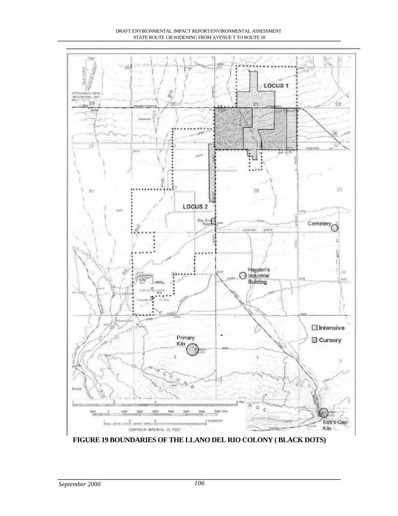
DRAFT ENVIRONMENTAL IMPACT REPORT/ENVIRONMENTAL ASSESSMENTSTATE ROUTE 138 WIDENING FROM AVENUE T TO ROUTE 18
September 2000 106
FIGURE 19 BOUNDARIES OF THE LLANO DEL RIO COLONY ( BLACK DOTS)

DRAFT ENVIRONMENTAL IMPACT REPORT/ENVIRONMENTAL ASSESSMENTSTATE ROUTE 138 WIDENING FROM AVENUE T TO ROUTE 18
September 2000 107
5.9 Coordination
A 30-day scoping period was allocated to ensure that all concerns were presented to thedepartment for consideration and inclusion in the environmental studies. A scoping meetingwas held on August 26, 1998 to address any initial concerns prior to design and developmentof the project. Members of the Big Pines Historical Society expressed concerns about theproject effects on the Llano site. An additional meeting was held with members of the BigPines and West Antelope Valley historical societies on July 15, 1999 to discuss project effectson the colony and ways those impacts might be reduced.
Members of both groups were concerned about proximity effects on the Llano Hotel ruin, oneof the most visible and significant surviving built elements. Instead of encroaching on thisruin, these interested parties suggested expanding the highway exclusively on the south side ofthe existing alignment and installing fencing along the north side of the highway to limitaccess to the ruin. Design Variation A was initially proposed in response to these suggestionsand Design Variations B and C were later developed to move the expanded highway evenfarther away from the hotel.
Caltrans cultural resources experts also had personal and telephone contacts with individualsknowledgeable about the Llano Colony and heard similar concerns from those parties.Personal contacts were made with Felice Abodaca, Ralph Bowman, Jasper Kidd, and othermembers of the Big Pines Historical Society, as well as Milt Stark, Cora and JamesMcCrumb, Jim Pledger, David Earle, and Dana Hicks of the Western Antelope ValleyHistorical Society. Dr. Robert Hine, a historian who has written extensively about westernutopian communities including the Llano cooperative, was also contacted by email andexpressed his wish that the colony be mapped and recorded to ensure project effects areadequately considered.
In a letter sent on April 21, 2000, the Office of Historic Preservation determined that the Llanodel Rio Colony is eligible for the National Register of Historic Properties under Criterion Aand D. There is not sufficient evidence at this time to support the eligibility in the areas ofeconomic practices and social behavior. Significance under Criterion A and D is sufficient toestablish Llano del Rio as a historic property for the purposes of Section 106 consultation.
Public views on the proposed project have also been sought through numerous additionalmeetings, telephone conversations, and email exchanges with interested parties.
General public meetings were held on June 10, September 8, and December 15, 1999 with theHighway 138 Safety Corridor Task Force and another general public meeting took placeMarch 9, 2000 in connection with a Littlerock Town Council Meeting. Those venuesproduced no specific comments about the treatment of the Llano Del Rio Colony site or ShadyBend Park.

District 7 • 120 South Spring Street • Los Angeles, California
DraftEnvironmental Impact Report/
Environmental Assessment
State Route 138 Widening ProjectFrom Avenue T to State Route 18
Junction Throughthe Communities of Littlerock,
Pearblossom, Llano and the City ofPalmdale
SCH Number: 1998091007

DRAFT ENVIRONMENTAL IMPACT REPORT/ENVIRONMENTAL ASSESSMENTSTATE ROUTE 138 WIDENING FROM AVENUE T TO ROUTE 18
September 2000 i
Table of Contents
S.0 Summary .............................................................................................................................................................. 1S.1 Purpose and Need for the Project ................................................................................................................ 1S.2 Alternatives under Consideration................................................................................................................ 1S.3 Other Actions in the Same Area .................................................................................................................. 3S.4 Environmental Consequences and Recommended Mitigation Measures ............................................ 3
1.0 Purpose and Need............................................................................................................................................. 111.1 Purpose of the Project.................................................................................................................................. 111.2 Need for the Project ..................................................................................................................................... 111.2.1 Capacity Issues ........................................................................................................................................ 111.2.2 Safety Problems ....................................................................................................................................... 161.2.3 Operational Deficiencies ........................................................................................................................ 191.2.4 Structural Deficiencies............................................................................................................................ 191.3 Summary ........................................................................................................................................................ 20
2.0 Alternatives including the Proposed Project................................................................................................ 212.1 Alternative 1: Widening along existing facility...................................................................................... 212.1.2 Design Variation A: South of Llano del Rio hotel............................................................................ 262.1.3 Design Variation B (Preferred Alternative): South of Llano del Rio Hotel and North of U.S.
Post Office ................................................................................................................................................ 262.1.4 Design Variation C: South of Llano del Rio Hotel............................................................................ 262.1.5 Design Variation D: Avenue V, Fort Tejon and Avenue V-8......................................................... 262.1.6 Design Variation E: Avenue V.............................................................................................................. 272.1.7 Attainment of Project Goals .................................................................................................................. 272.2 Other Alternatives Considered................................................................................................................... 282.2.1 Alternative 2: Building of Freeway...................................................................................................... 282.2.2 Alternative 3: Transportation System Management (TSM)............................................................ 282.2.3 Alternative 4: Widening along the existing highway through Pearblossom................................. 282.2.4 Alternative 5: No Action........................................................................................................................ 282.3 Current Status of the Project ...................................................................................................................... 292.4 Status of Other Projects or Proposals In The Area................................................................................. 29
3.0 Affected Environment...................................................................................................................................... 323.1 Topography ................................................................................................................................................... 323.2 Geology and Soils ........................................................................................................................................ 323.2.1 Faults ......................................................................................................................................................... 323.2.2 Mining ....................................................................................................................................................... 323.3 Water Resources .......................................................................................................................................... 333.3.1 Hydrology................................................................................................................................................. 333.3.2 Water Quality........................................................................................................................................... 333.3.3 Flood Hazards .......................................................................................................................................... 333.3.4 Climate ...................................................................................................................................................... 343.4 Biological Resources................................................................................................................................... 343.4.1 Vegetation................................................................................................................................................. 343.4.2 Wildlife...................................................................................................................................................... 383.4.3 Wildlife Corridors ................................................................................................................................... 383.4.4 Wetlands ................................................................................................................................................... 393.5 Air Quality Characteristics ......................................................................................................................... 393.6 Hazardous Waste ......................................................................................................................................... 463.6.1 Storage Tanks........................................................................................................................................... 463.7 Land Use Setting .......................................................................................................................................... 473.7.1 Housing..................................................................................................................................................... 473.7.2 Commercial............................................................................................................................................... 483.7.3 Industrial.................................................................................................................................................... 483.7.4 Farm Land................................................................................................................................................. 483.8 Socioeconomic Characteristics .................................................................................................................. 483.8.1 Economics................................................................................................................................................. 48

DRAFT ENVIRONMENTAL IMPACT REPORT/ENVIRONMENTAL ASSESSMENTSTATE ROUTE 138 WIDENING FROM AVENUE T TO ROUTE 18
September 2000 ii
3.8.2 Population................................................................................................................................................. 523.9 Public Services & Facilities........................................................................................................................ 533.9.1 Schools ...................................................................................................................................................... 543.10 Transportation............................................................................................................................................... 543.11 Historic & Cultural Resources.................................................................................................................. 543.12 Noise Analysis ............................................................................................................................................. 553.13 Parks and Bicycle Facilities........................................................................................................................ 573.13.1 Park............................................................................................................................................................. 573.13.2 Equestrian Trails ....................................................................................................................................... 573.13.3 Bicycle Lanes ........................................................................................................................................... 573.14 Scenic Resources ......................................................................................................................................... 57
4.0 Environmental Evaluation............................................................................................................................... 594.1 CEQA Environmental Checklist ............................................................................................................... 604.2 Discussion of Environmental Consequences .......................................................................................... 624.3 Geology, Topography, Seismic (Environmental Checklist Questions 1,2,4).................................... 634.3.1 Soil Erosion (5) ........................................................................................................................................ 634.4 Hazardous Waste (9).................................................................................................................................... 634.5 Floodplain (11).............................................................................................................................................. 654.5.1 Water Quality (10, 12,14,15)................................................................................................................. 654.6 Air Quality (19)............................................................................................................................................ 664.7 Noise (20, 21)................................................................................................................................................ 674.8 Wildlife (23,29,56)...................................................................................................................................... 684.8.1 Vegetation (14,24,27).............................................................................................................................. 704.8.2 Wildlife Movement/Habitat Fragmentation (30,31).......................................................................... 724.8.3 Wetlands (14)........................................................................................................................................... 764.9 Growth Inducing (35) .................................................................................................................................. 784.10 Lifestyles, Neighborhood Stability (36) ................................................................................................... 794.11 Elderly or Specific Interest Groups, Housing and Employment (39).................................................. 794.12 Housing and Employment (40,41)........................................................................................................... 794.13 Minority (37)................................................................................................................................................. 824.14 Property Values, Local Tax Base (41)...................................................................................................... 834.15 Community Facilities (42).......................................................................................................................... 834.16 Public Utilities and Services (43) .............................................................................................................. 854.17 Traffic and Circulation (44, 45,50)............................................................................................................ 864.18 Cultural/Historic Resources (51) ............................................................................................................... 874.19 Cumulative Effects (58).............................................................................................................................. 894.20 Farmland (26)................................................................................................................................................ 914.21 Visual Impacts (53)...................................................................................................................................... 924.22 Construction Impacts (54)........................................................................................................................... 94
5.0 Section 4(f) Evaluation.................................................................................................................................... 965.1 Section 4(f) .................................................................................................................................................... 975.2 Proposed Action........................................................................................................................................... 975.3 Description of Section 4(f) Properties Directly Used............................................................................ 975.3.1 Historic Resources .................................................................................................................................. 975.4 Impacts on the Section 4(f) Property ......................................................................................................1015.4.1 No Build Alternative.............................................................................................................................1015.4.2 Design Variation A................................................................................................................................1015.4.3 Design Variation B (Preferred)...........................................................................................................1025.4.4 Design Variation C................................................................................................................................1035.5 Avoidance Alternatives .............................................................................................................................1035.5.1 No Build Alternative.............................................................................................................................1035.5.2 Avoidance Alternative..........................................................................................................................1045.6 Measures to Minimize Harm....................................................................................................................1045.6.1 Mitigation Measures for Llano Colony Site......................................................................................1045.7 Other Properties Evaluated Relative to the Requirements of Section 4(f) .......................................1055.8 Section 6(f) ..................................................................................................................................................105

DRAFT ENVIRONMENTAL IMPACT REPORT/ENVIRONMENTAL ASSESSMENTSTATE ROUTE 138 WIDENING FROM AVENUE T TO ROUTE 18
September 2000 iii
5.9 Coordination................................................................................................................................................1076.0 Consultation and Coordination ....................................................................................................................108
6.1 Early Scoping Process...............................................................................................................................1086.2 Consultation................................................................................................................................................1086.3 Community and Agency Meetings .........................................................................................................1096.4 Circulation of Draft Environmental Document.....................................................................................109
7.0 List of Preparers..............................................................................................................................................110
List of Tables
TABLE 1 IMPROVEMENTS PROJECT AND ENVIRONMENTAL EVALUATION SUMMARY OF EFFECTS............... 4TABLE 2 LEVEL OF SERVICE CRITERIA................................................................................................................. 14TABLE 3 LEVEL OF SERVICE (LOS) ANALYSIS FOR BUILD/NO BUILD ALTERNATIVE ................................. 14TABLE 4 1998 TRAFFIC VOLUMES ........................................................................................................................ 15TABLE 5 FUTURE (2024) TRAFFIC VOLUMES ...................................................................................................... 16TABLE 6 ACCIDENT HISTORY ................................................................................................................................ 18TABLE 7 ACCIDENT SUMMARY.............................................................................................................................. 18TABLE 8 ACCIDENT COMPARISON TO THE STATEWIDE AVERAGE ................................................................... 18TABLE 9 STATE TRANSPORTATION IMPLEMENTATION PLAN............................................................................ 29TABLE 10 PLANTS OBSERVED IN THE PROJECT VICINITY.................................................................................... 36TABLE 11 HIGHEST 4 DAILY MAXIMUM HOURLY OZONE MEASUREMENTS.................................................... 40TABLE 12 HIGHEST 4 DAILY MAXIMUM 8-HOUR CARBON MONOXIDE AVERAGES....................................... 43TABLE 13 HIGHEST 4 DAILY PM10 MEASUREMENTS AND ANNUAL PM10 STATISTICS................................... 43TABLE 14 HIGHEST 4 DAILY NITROGEN DIOXIDE MEASUREMENTS AND ANNUAL NITROGEN DIOXIDE .... 46TABLE 15 HOUSING UNITS FOR 1990...................................................................................................................... 47TABLE 16 MEDIAN FAMILY INCOME BY COMMUNITY COMPARED TO LOS ANGELES COUNTY..................... 49TABLE 17 LABOR-MARKET INDUSTRY................................................................................................................... 49TABLE 18 REGIONAL DEMOGRAPHICS.................................................................................................................... 52TABLE 19 ANTELOPE VALLEY REGION POPULATION TRENDS BY CITY AND AREA ........................................ 52TABLE 20 EDUCATION DEMOGRAPHICS................................................................................................................. 53TABLE 21 ETHNIC POPULATION IN ANTELOPE VALLEY COMMUNITIES............................................................ 53TABLE 22 ETHNIC POPULATION OF ALPINE ELEMENTARY SCHOOL 1998-1999 SCHOOL YEAR ................... 54TABLE 23 NOISE CRITERIA ....................................................................................................................................... 56TABLE 24 EXISTING NOISE LEVELS IN PROJECT AREA ........................................................................................ 56TABLE 25 CO CONCENTRATION RESULTS COMPARED TO BUILD AND NO BUILD ALTERNATIVE................. 67TABLE 26 SENSITIVE FLORA IN PROJECT AREA .................................................................................................... 70TABLE 27 BEST CASE SCENARIO FOR RIGHT-OF-WAY ACQUISITION FOR THE COMMUNITIES OF PALMDALE,
LITTLEROCK, PEARBLOSSOM AND LLANO........................................................................................... 81TABLE 28 WORST CASE SCENARIO FOR RIGHT-OF-WAY ACQUISITION FOR THE COMMUNITIES OF
PALMDALE, LITTLEROCK, PEARBLOSSOM AND LLANO..................................................................... 81TABLE 29 SITES OF UTILITY RELOCATION IN PROJECT AREA............................................................................. 86
List of Figures
FIGURE 1 REGIONAL MAP........................................................................................................................................ 12FIGURE 2 LOCATION MAP ........................................................................................................................................ 13FIGURE 3 TYPICAL LEVEL OF SERVICE FOR EXISTING ROADWAYS................................................................... 15FIGURE 4 TYPICAL CROSS-SECTION FOR DEVELOPED AREA ............................................................................. 23FIGURE 5 TYPICAL CROSS SECTION FOR UNDEVELOPED AREA......................................................................... 24FIGURE 6 DESIGN VARIATIONS A, B, AND C...................................................................................................... 25FIGURE 7 STATE AND NATIONAL AREA OZONE ATTAINMENT/NONATTAINMENT AREAS............................ 42FIGURE 8 STATE AND NATIONAL AREA CARBON MONOXIDE ATTAINMENT /NONATTAINMENT AREAS.... 44FIGURE 9 STATE AND NATIONAL AREA PM10 ATTAINMENT/NONATTAINMENT AREAS............................... 45FIGURE 10 IMPORTANT FARMLAND IN THE VICINITY OF THE PROPOSED PROJECT ........................................... 50FIGURE 11 PRIME FARMLAND AFFECTED BY THE PROPOSED PROJECT ............................................................. 51

DRAFT ENVIRONMENTAL IMPACT REPORT/ENVIRONMENTAL ASSESSMENTSTATE ROUTE 138 WIDENING FROM AVENUE T TO ROUTE 18
September 2000 iv
FIGURE 12 LOCATION OF EQUESTRIAN TRAILS IN PROJECT AREA ................................................................ 58FIGURE 13 WESTBOUND STATE ROUTE 138 NEAR 87TH STREET -LITTLE ROCK EXISTING CONDITION ..... 92FIGURE 14 WESTBOUND STATE ROUTE 138 NEAR 87TH STREET -LITTLE ROCK PROPOSED CONDITIONS.. 93FIGURE 15 EASTBOUND STATE ROUTE 138 NEAR 175TH STREET –LLANO ..................................................... 93FIGURE 16A VIEW OF LLANO DEL RIO HOTEL ON NORTHSIDE OF STATE ROUTE 138.................................. 98FIGURE 16B VIEW OF CORE AREA OF LLANO COLONY SOUTH SIDE OF STATE ROUTE 138 ........................ 99FIGURE 16C LLANO HOTEL (APPROX. 46 M (150 FT) FROM THE HIGHWAY)................................................. 99FIGURE 17 ROOT CROP STORAGE STRUCTURE (APPROX. 411 M (1340 FT) FROM HIGHWAY)...................100FIGURE 18 MASONRY SILO, SMALLER BARN (APPROX. 716 M (2350 FT) FROM HIGHWAY).....................100FIGURE 19 BOUNDARIES OF THE LLANO DEL RIO COLONY ( BLACK DOTS).................................................106
Appendices
Appendix A Letter of Concurrence from State Historic Preservation OfficerAppendix B Noise Receptor Location Aerial MapsAppendix C Scoping NoticeAppendix D Scoping CommentsAppendix E Mailing ListAppendix F Title VI Policy StatementAppendix G FootprintAppendix H Farmland Conversion Impact Rating (Form AD-1006)Appendix I List of Acronyms
DRAFT ENVIRONMENTAL IMPACT REPORT/ENVIRONMENTAL ASSESSMENTSTATE ROUTE 138 WIDENING FROM AVENUE T TO ROUTE 18
September 2000 108
6.0 Consultation and Coordination
6.1 Early Scoping Process
The CEQA requires a formal scoping process when an Environmental Impact Report isprepared. A 30-day scoping period was allocated to ensure that all concerns were presented tothe department for consideration and inclusion in the environmental studies. At the start of theproject there was a scoping meeting on August 26, 1998 to address any initial concerns priorto design and development of the project from concerned residents and business owners.
Scoping letters were mailed on July 28, 1998 to the appropriate local, state, and federalagencies, elected officials and over 3000 local homeowners and residents notifying them ofthe formal initiation of studies. A Notice of Intent was published in the Federal Register onAugust 27,1998 and the Notice of Preparation was dated August 20, 1998 and sent by certifiedmail to the responsible agencies. The public notices (Appendix C) were published in thefollowing newspapers.
Los Angeles Times-San Fernando Edition on August 12, 1998 and August 19, 1998Antelope Valley Press on August 12, 1998 and August 19, 1998La Voz on August 14, 1998Acton Agua Dulce Weekly on August 17, 1998 and August 24, 1998
The comments of potentially affected agencies, businesses, and the public on pertinent social,economic, and environmental issues were required by September 30, 1998. The majority ofthe comments dealt with safety issues, primarily speeding violations and the difficultyinvolved in making turns or passing safely. There were requests for consideration of trailcrossings for hikers and equestrians. Littlerock residents expressed some opposition to theproject.
6.2 Consultation
Consultation and coordination by Caltrans Districts 7 with the following agencies andjurisdictions has occurred throughout the project.
§ US Fish & Wildlife Service§ Natural Resources Conservation
Service (Lancaster Office)§ California Department of Fish and
Game (CDFG)§ Littlerock Town Council§ City of Lancaster§ Llano Community Association§ City of Palmdale§ Los Angeles County Department of
Parks and Recreation§ California Department of Water
Resources
§ Los Angeles County Department ofPower and Water
§ State Assemblyman George Runner§ CHP Southern Division, Victorville,
Antelope Valley Area, San Bernardino§ Los Angeles County Sheriff’s
Department (Lancaster)§ Keppel Union School District§ Pearblossom Chamber of Commerce§ Littlerock Chamber of Commerce§ Route 138 Safety Task Force
DRAFT ENVIRONMENTAL IMPACT REPORT/ENVIRONMENTAL ASSESSMENTSTATE ROUTE 138 WIDENING FROM AVENUE T TO ROUTE 18
September 2000 109
6.3 Community and Agency Meetings
During project development there have been meetings with various groups to ensure that allpossible concerns have been addressed. As mentioned in Section 2.7 there was a Highway 138Safety Corridor Task Force formed in order to implement changes while design anddevelopment were in the works. The meetings for the Highway 138 Safety Corridor TaskForce were held on:
§ September 25, 1998§ November 19, 1998§ January 28, 1999§ March 11, 1999
§ June 10, 1999§ September 8, 1999§ December 15, 1999§ March 15, 2000
Besides meetings of the 138 corridor task force their was a town council meeting in Littlerockon March 9, 2000 and a Cultural meeting concerning the archaeological site in Llano on July15, 1999. A major concern during project development and design has been the impact ofCaltrans right-of-way on Alpine Elementary school in Littlerock and the impacts on thefaculty and visitor parking and the impact to the bus loading/unloading zone.
The meetings with Keppel Union School District were held on:
§ August 10,1999§ November 5, 1999§ December 3, 1999
§ January 7, 2000§ February 4, 2000
Caltrans has also conducted workshops with the following organizations:§ Pearblossom Chamber of Commerce on June 1,2000§ Littlerock Town Council on June 22,2000§ Littlerock Chamber of Commerce on July 19, 2000
6.4 Circulation of Draft Environmental Document
This document will be circulated to the agencies and individuals shown on the mailing list inAppendix D. Notices of the document’s availability will be sent to all property owners(approximately 2000) in the corridor. Copies of the document will be available at the locallibraries. A Public Hearing will held during the circulation of this Draft Environmental ImpactReport/Environmental Assessment (EIR/EA). Also the Draft Environmental ImpactReport/Environmental Assessment will be available at the following site:
http://www.dot.ca.gov/dist07/route138/index.htm

District 7 • 120 South Spring Street • Los Angeles, California
DraftEnvironmental Impact Report/
Environmental Assessment
State Route 138 Widening ProjectFrom Avenue T to State Route 18
Junction Throughthe Communities of Littlerock,
Pearblossom, Llano and the City ofPalmdale
SCH Number: 1998091007
DRAFT ENVIRONMENTAL IMPACT REPORT/ENVIRONMENTAL ASSESSMENTSTATE ROUTE 138 WIDENING FROM AVENUE T TO ROUTE 18
September 2000 i
Table of Contents
S.0 Summary .............................................................................................................................................................. 1S.1 Purpose and Need for the Project ................................................................................................................ 1S.2 Alternatives under Consideration................................................................................................................ 1S.3 Other Actions in the Same Area .................................................................................................................. 3S.4 Environmental Consequences and Recommended Mitigation Measures ............................................ 3
1.0 Purpose and Need............................................................................................................................................. 111.1 Purpose of the Project.................................................................................................................................. 111.2 Need for the Project ..................................................................................................................................... 111.2.1 Capacity Issues ........................................................................................................................................ 111.2.2 Safety Problems ....................................................................................................................................... 161.2.3 Operational Deficiencies ........................................................................................................................ 191.2.4 Structural Deficiencies............................................................................................................................ 191.3 Summary ........................................................................................................................................................ 20
2.0 Alternatives including the Proposed Project................................................................................................ 212.1 Alternative 1: Widening along existing facility...................................................................................... 212.1.2 Design Variation A: South of Llano del Rio hotel............................................................................ 262.1.3 Design Variation B (Preferred Alternative): South of Llano del Rio Hotel and North of U.S.
Post Office ................................................................................................................................................ 262.1.4 Design Variation C: South of Llano del Rio Hotel............................................................................ 262.1.5 Design Variation D: Avenue V, Fort Tejon and Avenue V-8......................................................... 262.1.6 Design Variation E: Avenue V.............................................................................................................. 272.1.7 Attainment of Project Goals .................................................................................................................. 272.2 Other Alternatives Considered................................................................................................................... 282.2.1 Alternative 2: Building of Freeway...................................................................................................... 282.2.2 Alternative 3: Transportation System Management (TSM)............................................................ 282.2.3 Alternative 4: Widening along the existing highway through Pearblossom................................. 282.2.4 Alternative 5: No Action........................................................................................................................ 282.3 Current Status of the Project ...................................................................................................................... 292.4 Status of Other Projects or Proposals In The Area................................................................................. 29
3.0 Affected Environment...................................................................................................................................... 323.1 Topography ................................................................................................................................................... 323.2 Geology and Soils ........................................................................................................................................ 323.2.1 Faults ......................................................................................................................................................... 323.2.2 Mining ....................................................................................................................................................... 323.3 Water Resources .......................................................................................................................................... 333.3.1 Hydrology................................................................................................................................................. 333.3.2 Water Quality........................................................................................................................................... 333.3.3 Flood Hazards .......................................................................................................................................... 333.3.4 Climate ...................................................................................................................................................... 343.4 Biological Resources................................................................................................................................... 343.4.1 Vegetation................................................................................................................................................. 343.4.2 Wildlife...................................................................................................................................................... 383.4.3 Wildlife Corridors ................................................................................................................................... 383.4.4 Wetlands ................................................................................................................................................... 393.5 Air Quality Characteristics ......................................................................................................................... 393.6 Hazardous Waste ......................................................................................................................................... 463.6.1 Storage Tanks........................................................................................................................................... 463.7 Land Use Setting .......................................................................................................................................... 473.7.1 Housing..................................................................................................................................................... 473.7.2 Commercial............................................................................................................................................... 483.7.3 Industrial.................................................................................................................................................... 483.7.4 Farm Land................................................................................................................................................. 483.8 Socioeconomic Characteristics .................................................................................................................. 483.8.1 Economics................................................................................................................................................. 48

DRAFT ENVIRONMENTAL IMPACT REPORT/ENVIRONMENTAL ASSESSMENTSTATE ROUTE 138 WIDENING FROM AVENUE T TO ROUTE 18
September 2000 ii
3.8.2 Population................................................................................................................................................. 523.9 Public Services & Facilities........................................................................................................................ 533.9.1 Schools ...................................................................................................................................................... 543.10 Transportation............................................................................................................................................... 543.11 Historic & Cultural Resources.................................................................................................................. 543.12 Noise Analysis ............................................................................................................................................. 553.13 Parks and Bicycle Facilities........................................................................................................................ 573.13.1 Park............................................................................................................................................................. 573.13.2 Equestrian Trails ....................................................................................................................................... 573.13.3 Bicycle Lanes ........................................................................................................................................... 573.14 Scenic Resources ......................................................................................................................................... 57
4.0 Environmental Evaluation............................................................................................................................... 594.1 CEQA Environmental Checklist ............................................................................................................... 604.2 Discussion of Environmental Consequences .......................................................................................... 624.3 Geology, Topography, Seismic (Environmental Checklist Questions 1,2,4).................................... 634.3.1 Soil Erosion (5) ........................................................................................................................................ 634.4 Hazardous Waste (9).................................................................................................................................... 634.5 Floodplain (11).............................................................................................................................................. 654.5.1 Water Quality (10, 12,14,15)................................................................................................................. 654.6 Air Quality (19)............................................................................................................................................ 664.7 Noise (20, 21)................................................................................................................................................ 674.8 Wildlife (23,29,56)...................................................................................................................................... 684.8.1 Vegetation (14,24,27).............................................................................................................................. 704.8.2 Wildlife Movement/Habitat Fragmentation (30,31).......................................................................... 724.8.3 Wetlands (14)........................................................................................................................................... 764.9 Growth Inducing (35) .................................................................................................................................. 784.10 Lifestyles, Neighborhood Stability (36) ................................................................................................... 794.11 Elderly or Specific Interest Groups, Housing and Employment (39).................................................. 794.12 Housing and Employment (40,41)........................................................................................................... 794.13 Minority (37)................................................................................................................................................. 824.14 Property Values, Local Tax Base (41)...................................................................................................... 834.15 Community Facilities (42).......................................................................................................................... 834.16 Public Utilities and Services (43) .............................................................................................................. 854.17 Traffic and Circulation (44, 45,50)............................................................................................................ 864.18 Cultural/Historic Resources (51) ............................................................................................................... 874.19 Cumulative Effects (58).............................................................................................................................. 894.20 Farmland (26)................................................................................................................................................ 914.21 Visual Impacts (53)...................................................................................................................................... 924.22 Construction Impacts (54)........................................................................................................................... 94
5.0 Section 4(f) Evaluation.................................................................................................................................... 965.1 Section 4(f) .................................................................................................................................................... 975.2 Proposed Action........................................................................................................................................... 975.3 Description of Section 4(f) Properties Directly Used............................................................................ 975.3.1 Historic Resources .................................................................................................................................. 975.4 Impacts on the Section 4(f) Property ......................................................................................................1015.4.1 No Build Alternative.............................................................................................................................1015.4.2 Design Variation A................................................................................................................................1015.4.3 Design Variation B (Preferred)...........................................................................................................1025.4.4 Design Variation C................................................................................................................................1035.5 Avoidance Alternatives .............................................................................................................................1035.5.1 No Build Alternative.............................................................................................................................1035.5.2 Avoidance Alternative..........................................................................................................................1045.6 Measures to Minimize Harm....................................................................................................................1045.6.1 Mitigation Measures for Llano Colony Site......................................................................................1045.7 Other Properties Evaluated Relative to the Requirements of Section 4(f) .......................................1055.8 Section 6(f) ..................................................................................................................................................105

DRAFT ENVIRONMENTAL IMPACT REPORT/ENVIRONMENTAL ASSESSMENTSTATE ROUTE 138 WIDENING FROM AVENUE T TO ROUTE 18
September 2000 iii
5.9 Coordination................................................................................................................................................1076.0 Consultation and Coordination ....................................................................................................................108
6.1 Early Scoping Process...............................................................................................................................1086.2 Consultation................................................................................................................................................1086.3 Community and Agency Meetings .........................................................................................................1096.4 Circulation of Draft Environmental Document.....................................................................................109
7.0 List of Preparers..............................................................................................................................................110
List of Tables
TABLE 1 IMPROVEMENTS PROJECT AND ENVIRONMENTAL EVALUATION SUMMARY OF EFFECTS............... 4TABLE 2 LEVEL OF SERVICE CRITERIA................................................................................................................. 14TABLE 3 LEVEL OF SERVICE (LOS) ANALYSIS FOR BUILD/NO BUILD ALTERNATIVE ................................. 14TABLE 4 1998 TRAFFIC VOLUMES ........................................................................................................................ 15TABLE 5 FUTURE (2024) TRAFFIC VOLUMES ...................................................................................................... 16TABLE 6 ACCIDENT HISTORY ................................................................................................................................ 18TABLE 7 ACCIDENT SUMMARY.............................................................................................................................. 18TABLE 8 ACCIDENT COMPARISON TO THE STATEWIDE AVERAGE ................................................................... 18TABLE 9 STATE TRANSPORTATION IMPLEMENTATION PLAN............................................................................ 29TABLE 10 PLANTS OBSERVED IN THE PROJECT VICINITY.................................................................................... 36TABLE 11 HIGHEST 4 DAILY MAXIMUM HOURLY OZONE MEASUREMENTS.................................................... 40TABLE 12 HIGHEST 4 DAILY MAXIMUM 8-HOUR CARBON MONOXIDE AVERAGES....................................... 43TABLE 13 HIGHEST 4 DAILY PM10 MEASUREMENTS AND ANNUAL PM10 STATISTICS................................... 43TABLE 14 HIGHEST 4 DAILY NITROGEN DIOXIDE MEASUREMENTS AND ANNUAL NITROGEN DIOXIDE .... 46TABLE 15 HOUSING UNITS FOR 1990...................................................................................................................... 47TABLE 16 MEDIAN FAMILY INCOME BY COMMUNITY COMPARED TO LOS ANGELES COUNTY..................... 49TABLE 17 LABOR-MARKET INDUSTRY................................................................................................................... 49TABLE 18 REGIONAL DEMOGRAPHICS.................................................................................................................... 52TABLE 19 ANTELOPE VALLEY REGION POPULATION TRENDS BY CITY AND AREA ........................................ 52TABLE 20 EDUCATION DEMOGRAPHICS................................................................................................................. 53TABLE 21 ETHNIC POPULATION IN ANTELOPE VALLEY COMMUNITIES............................................................ 53TABLE 22 ETHNIC POPULATION OF ALPINE ELEMENTARY SCHOOL 1998-1999 SCHOOL YEAR ................... 54TABLE 23 NOISE CRITERIA ....................................................................................................................................... 56TABLE 24 EXISTING NOISE LEVELS IN PROJECT AREA ........................................................................................ 56TABLE 25 CO CONCENTRATION RESULTS COMPARED TO BUILD AND NO BUILD ALTERNATIVE................. 67TABLE 26 SENSITIVE FLORA IN PROJECT AREA .................................................................................................... 70TABLE 27 BEST CASE SCENARIO FOR RIGHT-OF-WAY ACQUISITION FOR THE COMMUNITIES OF PALMDALE,
LITTLEROCK, PEARBLOSSOM AND LLANO........................................................................................... 81TABLE 28 WORST CASE SCENARIO FOR RIGHT-OF-WAY ACQUISITION FOR THE COMMUNITIES OF
PALMDALE, LITTLEROCK, PEARBLOSSOM AND LLANO..................................................................... 81TABLE 29 SITES OF UTILITY RELOCATION IN PROJECT AREA............................................................................. 86
List of Figures
FIGURE 1 REGIONAL MAP........................................................................................................................................ 12FIGURE 2 LOCATION MAP ........................................................................................................................................ 13FIGURE 3 TYPICAL LEVEL OF SERVICE FOR EXISTING ROADWAYS................................................................... 15FIGURE 4 TYPICAL CROSS-SECTION FOR DEVELOPED AREA ............................................................................. 23FIGURE 5 TYPICAL CROSS SECTION FOR UNDEVELOPED AREA......................................................................... 24FIGURE 6 DESIGN VARIATIONS A, B, AND C...................................................................................................... 25FIGURE 7 STATE AND NATIONAL AREA OZONE ATTAINMENT/NONATTAINMENT AREAS............................ 42FIGURE 8 STATE AND NATIONAL AREA CARBON MONOXIDE ATTAINMENT /NONATTAINMENT AREAS.... 44FIGURE 9 STATE AND NATIONAL AREA PM10 ATTAINMENT/NONATTAINMENT AREAS............................... 45FIGURE 10 IMPORTANT FARMLAND IN THE VICINITY OF THE PROPOSED PROJECT ........................................... 50FIGURE 11 PRIME FARMLAND AFFECTED BY THE PROPOSED PROJECT ............................................................. 51

DRAFT ENVIRONMENTAL IMPACT REPORT/ENVIRONMENTAL ASSESSMENTSTATE ROUTE 138 WIDENING FROM AVENUE T TO ROUTE 18
September 2000 iv
FIGURE 12 LOCATION OF EQUESTRIAN TRAILS IN PROJECT AREA ................................................................ 58FIGURE 13 WESTBOUND STATE ROUTE 138 NEAR 87TH STREET -LITTLE ROCK EXISTING CONDITION ..... 92FIGURE 14 WESTBOUND STATE ROUTE 138 NEAR 87TH STREET -LITTLE ROCK PROPOSED CONDITIONS.. 93FIGURE 15 EASTBOUND STATE ROUTE 138 NEAR 175TH STREET –LLANO ..................................................... 93FIGURE 16A VIEW OF LLANO DEL RIO HOTEL ON NORTHSIDE OF STATE ROUTE 138.................................. 98FIGURE 16B VIEW OF CORE AREA OF LLANO COLONY SOUTH SIDE OF STATE ROUTE 138 ........................ 99FIGURE 16C LLANO HOTEL (APPROX. 46 M (150 FT) FROM THE HIGHWAY)................................................. 99FIGURE 17 ROOT CROP STORAGE STRUCTURE (APPROX. 411 M (1340 FT) FROM HIGHWAY)...................100FIGURE 18 MASONRY SILO, SMALLER BARN (APPROX. 716 M (2350 FT) FROM HIGHWAY).....................100FIGURE 19 BOUNDARIES OF THE LLANO DEL RIO COLONY ( BLACK DOTS).................................................106
Appendices
Appendix A Letter of Concurrence from State Historic Preservation OfficerAppendix B Noise Receptor Location Aerial MapsAppendix C Scoping NoticeAppendix D Scoping CommentsAppendix E Mailing ListAppendix F Title VI Policy StatementAppendix G FootprintAppendix H Farmland Conversion Impact Rating (Form AD-1006)Appendix I List of Acronyms
DRAFT ENVIRONMENTAL IMPACT REPORT/ENVIRONMENTAL ASSESSMENTSTATE ROUTE 138 WIDENING FROM AVENUE T TO ROUTE 18
September 2000 110
7.0 List of Preparers
EIR/EA prepared by:
Cathy Wright Senior Environmental Planner Document Review/PreparationCarlos J. Montez Environmental Planner Document PreparationChris Benz-Blumberg, Environmental Planner Document Preparation
Contributions By:
Fouad Abdelkerim Senior Transportation Planner Air QualityLeann Williams Senior Transportation Planner Air Quality Conformity StudyClaudia, Harbert Architectural Historian Historical Property Survey ReportThad M. Van Buren Associate Archeologist Archaeological Survey ReportGary Iverson Senior Environmental Planner Archaeological Survey ReportJoseph Millman Associate Landscape Architect Visual Impacts AnalysisGeorge T. Ghebranious Senior Transportation Engineer Hazardous MaterialsLinda Taira Senior Transportation Planner Natural Environment StudyKaren Drewe Natural Science Specialist Natural Environment StudyLorna Foster Assoc. Right of Way Agent Draft Relocation Impact ReportSami Deeb Utilities Engineer Utilities Relocation Study ReportYung Chung Civil Engineer Geotechnical ReportDave Gilstrap Senior Transportation Engineer LARTS/Traffic ProjectionsGuillermo Gutierrez Assoc. Transportation Planner Traffic ProjectionsArt Correa Senior Transportation Engineer DesignAnthony Hughes Civil Engineer DesignEd Shiao Senior Transportation Engineer Traffic Study
Consultants:John Landgard, Geocon, Environmental Geologist Site Investigation Report (Lead
Testing)Phillip RichardsProfessional ServicesIndustries Inc.
Environmental Professional Initial Site Assessment
DRAFT ENVIRONMENTAL IMPACT REPORT/ENVIRONMENTAL ASSESSMENTSTATE ROUTE 138 WIDENING FROM AVENUE T TO ROUTE 18
September 2000 111
Index
Accident, 1, 8, 9, 16, 17, 20, 62Accidents, 1, 16, 17, 19, 20, 22, 27, 28, 29Aesthetics, 10Air Quality, 28, 39, 40, 41, 59, 63, 66, 67, 90,
110Alternative, 2, 3, 21, 22, 27, 28, 63, 67, 70, 73,
74, 75, 76, 89, 91Alternatives, 1, 21, 28, 70, 73, 76, 83Avoidance Alternative, 2, 27Avoidance Alternative E, 70Bicycle Lanes, 57Biological Resources, 34, 90Businesses, 27, 49, 61, 68, 79, 80, 83, 87, 89, 90,
108Circulation, 9, 61, 79, 86, 109Climate, 34Commercial, 28, 33, 39, 47, 48, 49, 61, 62, 78,
79, 80, 81, 82, 92, 94Coordination, 67, 75, 79, 85, 90, 91, 108Costs, 48, 73, 80Cultural Resource, 54Cultural Resources, 54Cumulative Impacts, 89Design Variation, 2, 22, 26, 27, 75Design Variations, 22Detours, 62, 79Dust, 10, 41, 62, 63, 79Employment, 79, 82Endangered Species, 37, 61Environmental Impacts, 1, 59, 73, 82Equestrian Trails, 57, 58, 83Erosion, 10, 35, 60, 63, 69Farmland, 47, 48, 51, 91Faults, 32Floodplain, 33, 59, 65Floodplains, 34, 65Geology, 32, 48, 63, 89Growth, 78, 89Growth Inducing, 78Hazardous Materials, 91, 110Hazardous Waste, 9, 46, 60, 64Historic Resource, iv, 54, 55, 87, 88, 90Historic Resources, 97Housing, 11, 47, 48, 61, 78, 80, 83, 89Hydrology, 33, 90Industrial, 48, 81
Land Use, 47, 89Level of Service, 1, 14, 15, 16, 20, 86Measures to Minimize Harm, 63, 64, 66, 69, 71,
73, 84, 87, 94Mitigation Measures, 63, 67, 94No Action, 3, 28, 78, 83No Build Alternative, 14, 16, 67, 83Noise, 8, 55, 56, 67, 68, 90, 94Noise Impacts, 55, 67, 68, 90Option, 2, 70, 75Options, 27, 76Park, 57, 69Parking, 84Parks, 57, 73, 83, 90, 108Pedestrian, 9, 84Permit, 66Permits, 71, 75Population, 3, 11, 28, 48, 52, 53, 55, 61, 62, 69,
73, 78, 89Populations, 48, 69, 74, 83Potential Impacts, 69, 70, 73Public Services, 53Relocation, 8, 9, 59, 79, 80, 81, 82, 86, 110Responsible Agencies, 108School, 53, 54, 56, 68, 108, 109Schools, 54Shady Bend Park, 57Socioeconomic, 48, 89Soil, 9, 32, 34, 35, 47, 60, 63, 64, 65, 91Soils, 32, 34, 35, 64, 89, 94Topography, 32, 63Traffic, 1, 10, 11, 14, 15, 16, 19, 20, 22, 27, 28,
29, 49, 53, 54, 55, 56, 61, 62, 63, 66, 67, 68,78, 79, 82, 86, 87, 90
Trail, 84, 85Trails, 57, 83, 84, 85Transportation, 1, 3, 21, 27, 28, 29, 49, 54, 57,
66, 78, 83, 90, 97, 110Utilities, 49, 81, 85, 86, 110Vegetation, 27, 33, 34, 35, 60, 63, 70, 72, 74, 75,
76, 85, 90, 93, 94Visual Quality, 92, 93, 94Water Quality, 33, 60, 65, 66, 90Wildlife, 37, 38, 68, 69, 70, 73, 75, 108Wildlife Corridors, 38, 39, 73
Caltrans > District 7 >
IndexThe Project Development ProcessHow Projects get startedWhy build it?Project InitiationProject Development TeamsProgrammingProject Report & Environmental DocumentEnvironmental StudiesProject Approval/Environmental ApprovalFinal Project ApprovalComplete Project Design &Prepare PS&EAcquisition of Rights of WayApprovals, Agreements andPermitsConstruct the Project
Description of ProjectPurposeThe Proposed Widening Project:Alt. No. 1Alt. No. 2Alt. No. 3Alt. No. 4Proposed Project FeaturesStudies are Under Way
Project Fact SheetProject LimitsDesign FeaturesRight of Way FeaturesConstruction FeaturesPublic Information
Caltrans > District 7 >
Improving State Route 138Pearblossom Highway Improvement
THE PROJECT DEVELOPMENT PROCESS
This section has been designed to show you the Caltrans project developmentprocess. To help explain the Project Development Process at Caltrans, portions of theCaltrans publication "How Caltrans Builds Projects" are presented below.
The Caltrans project development process begins with feasibility studies and endswith a completed project. It melds engineering requirements, public involvement andfederal and state approval steps, and is governed by a host of laws and regulationspertaining to programming, environmental effects, right of way acquisition andcontracting for construction. The basic steps are:
Identify Project Need1.
Prepare Initiation Document2.
Form Project Development Team3.
Prepare Project Study Report4.
Secure Project Funding5.
Prepare Draft Project Report6.
Perform Environmental Studies7.
Secure Project Approval8.
Prepare Plans, Specifications, and Estimates9.
Acquire Rights of Way10.
Obtain Approvals, Agreements, and Permits11.
Construct and Complete Construction Project12.
HOW PROJECTS GET STARTED
Caltrans, the local agency or both do considerable planning, before projectdevelopment starts. A need is identified, either as a structural or operating deficiencyof the existing road, or in response to planned land use changes such as a newsubdivision, shopping or industrial center. Identification of such a need may result in aproject as minor as a traffic signal or as major as a freeway.
WHY BUILD IT?
Route 138 Where the Past, Present and Future Meet
http://www.dot.ca.gov/dist07/route138/index.htm (1 of 11) [10/24/2000 5:37:43 PM]
Contacts
Stage ConstructionStage 1Stage 2
Helpful Travel Tips
GlossaryEIREANEPACEQA
Last updated October 24, 2000
Last updated October 24, 2000
A project must satisfy a clearly defined need and purpose. It must meet state,regional and local goals and objectives and, for capacity-increasing projects, airquality goals. System planning is a start in defining a project’s purpose, but theproject’s purpose statement is reexamined constantly. It will drive the projectdevelopment and environmental processes and ultimate approval of the project,and is essential in getting public consent.
PROJECT INITIATION
Generally, the origination of any new project requires a Project Study Report (PSR) forlarger projects, or Scope and Summary Report (PSSR) for smaller ones. A Project StudyReport is a substantial document that contains a report of preliminary engineeringefforts, a detailed alternatives analysis and cost, schedule and scope information. AProject Scope and Summary Report is an abbreviated document that contains a verybrief project description, cost, schedule and scope information, for a project that isexempt from detailed environmental study.
Project development starts when a Caltrans project manager is named and securesan expenditure authorization, then begins a project work plan to cover projectinitiation in detail. He or she determines the disciplines needed to develop the projectand forms the project development team.
PROJECT DEVELOPMENT TEAMS
Project Development Teams employ different disciplines to develop and evaluatealternatives, help project managers direct studies, make recommendations and carryout the project work plan. Members of project teams participate in major meetings,public hearings and community involvement. The teams consist of a wide range ofdisciplines and individuals from both Caltrans and outside agencies and may eveninclude representatives from community groups.
PROGRAMMING
Before formal project studies can commence for State-funded projects, the projectmust be programmed. Projects may be listed in the State Transportation ImprovementProgram or in the State Highway Operation and Protection Plan or various minorprograms approved by the California Transportation Commission.
Senate Bill 45, passed in 1997, placed 75% of State Transportation ImprovementProgram (STIP) funds under the control of California’s regional transportationagencies. Within the regions, cities and counties nominate projects for inclusion inRegional Transportation Improvement Programs (RTIP). Projects compete with oneanother through a process that is established by each region. Caltrans assists theregional agencies, when requested to do so, in the development of regional plans.
Twenty-five percent of STIP funds are nominated by Caltrans through the Interregional
Route 138 Where the Past, Present and Future Meet
http://www.dot.ca.gov/dist07/route138/index.htm (2 of 11) [10/24/2000 5:37:44 PM]
Transportation Improvement Program.
PREPARE PROJECT REPORT & ENVIRONMENTAL DOCUMENT
The basic document that provides information for decisions regarding a project’sultimate scope, schedule and cost is the Project Report. This report, based onpreliminary engineering analysis, contains information about the project’sbackground, need and purpose, alternatives investigated and issues encountered inthe engineering and environmental investigations. Issues encountered may beenvironmental issues, air quality conformity, permits, right of way issues, trafficmanagement plans, and various other engineering issues and funding.
Activities in this phase include preliminary engineering and various studies, includingsurveys and mapping, traffic forecasts and modeling, value analysis, hydraulicstudies, right of way and utilities impacts, railroad issues, materials and geotechnicalinformation, and multi-modal issues. Alternatives that are studied in detail mustcomply with legal and administrative requirements and be technically andeconomically feasible. The environmental document is also prepared at this time.
A Draft Relocation Impact Report is prepared at this time, which details the directand indirect impacts on businesses and residents, both owners and tenants, in theproject area.
ENVIRONMENTAL STUDIES
The environmental document discusses the affected environment and compares andevaluates the possible impacts of each alternative. This document is used by thedecision-makers in deciding which alternative would best satisfy the need andpurpose of the project with the least environmental impacts.
The environmental document must outline the need and purpose and the reasonswhy some alternatives were set aside. All significant adverse effects for eachreasonable alternative must be identified and for each impact, mitigation measuresproposed which would lessen the impacts of the alternative.
Effects that must be considered include those on the natural environment,architectural and cultural issues, social issues and hazardous materials, involving asmany as a dozen separate studies. At this time, Caltrans consults with State andFederal agencies such as the U.S. Fish and Wildlife Service, Army Corps of Engineers,California Dept. of Fish and Game and other agencies, which may have concerns inthe area.
Projects must comply with all applicable environmental laws, including theEndangered Species Fact, Clean Air and Water Acts, Wetlands Executive Order, andthe National Historic Preservation Act and Section 4(f) regarding taking of parklands,historic sites and other sensitive lands. Compliance with these acts and other State
Route 138 Where the Past, Present and Future Meet
http://www.dot.ca.gov/dist07/route138/index.htm (3 of 11) [10/24/2000 5:37:44 PM]
and Federal regulations is usually established in the environmental document afterreview by agencies with responsibilities in those areas.
PROJECT APPROVAL / ENVIRONMENTAL APPROVAL
After the environmental studies for the practicable alternatives are complete, theDraft Project Report is approved and the draft environmental document is circulatedfor comment. A preferred alternative is not usually recommended at this stage;however, if one is presented, the discussion of the preferred alternative documentsfactors considered in its selection.
The project development team communicates regularly and informally with thosewhom the project is likely to affect and secure their consent to projectimplementation. In addition, the project development process requires formal publiccomment for projects with significant effects.
FINAL PROJECT APPROVAL
After the project development team has analyzed the public comments, it selectsthe preferred alternative, completes the final environmental document and attachesit to the Project Report, which should also document selection of the preferredalternative and discuss changes in the project as a result of public comment. IfFederal funding is involved, the project must be approved by the Federal HighwayAdministration and a Record of Decision is published in the Federal Register. A Noticeof Determination is published in the State Clearinghouse Newsletter. If the projectcontains no federal funds, approval of the project is by the California TransportationCommission.
COMPLETE PROJECT DESIGN AND PREPARE PS & E
Preparation of detailed Plans, Specifications and Estimates (PS&E) cannot begin untilcompletion of project report and environmental approvals. In this stage, projectinformation is reviewed and updated, purpose and scope are refined, design surveysand photogrammetric mapping obtained, and reports, including traffic data,hydrology and hydraulic, geotechnical design, pavement design, materials andsoundwall design are completed. Final right of way requirements are determined andsite plans are prepared.
ACQUISITION OF RIGHTS OF WAY
Acquisition of Rights of Way can begin only after completion of the environmentaldocument, although some preliminary work, such as appraisals, can be started.
Relocation Impact studies are required on all projects that displace any person orbusiness. A final relocation impact study will have been completed for the preferredalternative and included in the Final Environmental Document.
Route 138 Where the Past, Present and Future Meet
http://www.dot.ca.gov/dist07/route138/index.htm (4 of 11) [10/24/2000 5:37:44 PM]
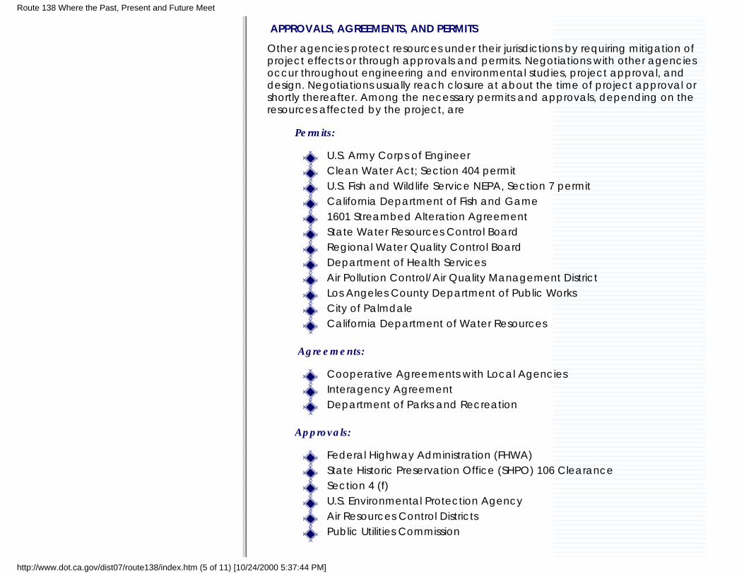
APPROVALS, AGREEMENTS, AND PERMITS
Other agencies protect resources under their jurisdictions by requiring mitigation ofproject effects or through approvals and permits. Negotiations with other agenciesoccur throughout engineering and environmental studies, project approval, anddesign. Negotiations usually reach closure at about the time of project approval orshortly thereafter. Among the necessary permits and approvals, depending on theresources affected by the project, are
Permits:
U.S. Army Corps of EngineerClean Water Act; Section 404 permitU.S. Fish and Wildlife Service NEPA, Section 7 permitCalifornia Department of Fish and Game1601 Streambed Alteration AgreementState Water Resources Control BoardRegional Water Quality Control BoardDepartment of Health ServicesAir Pollution Control/Air Quality Management DistrictLos Angeles County Department of Public WorksCity of PalmdaleCalifornia Department of Water Resources
Agreements:
Cooperative Agreements with Local AgenciesInteragency AgreementDepartment of Parks and Recreation
Approvals:
Federal Highway Administration (FHWA)State Historic Preservation Office (SHPO) 106 ClearanceSection 4 (f)U.S. Environmental Protection AgencyAir Resources Control DistrictsPublic Utilities Commission
Route 138 Where the Past, Present and Future Meet
http://www.dot.ca.gov/dist07/route138/index.htm (5 of 11) [10/24/2000 5:37:44 PM]
CONSTRUCTION OF THE PROJECTOnce the necessary permits and approvals have been obtained and the right of waypurchased, construction can begin. The Plans, Specifications and Estimates are sentout for bid and a contractor is selected.
DESCRIPTION OF PROJECTPURPOSE:Welcome to Caltrans' Route 138 Pearblossom Highway widening project Website. Thepurpose of our website is to keep individuals, public interest groups and governmentalagencies up to date on the status of the proposed Route 138 Project. From ourwebsite you can access information about the alternatives under consideration, beplaced on our mailing list, find answers to frequently asked questions, learn aboutnew project information, and have access to environmental data. You can alsocommunicate with Caltrans staff. You can do all of these things using the links on thewebb site.
THE PROPOSED WIDENING PROJECT:This project proposes to widen State Route 138 between 0.5 mile (0.8 km) east ofAvenue T and the Junction with State Route 18. It consists of four 12-foot (3.6 m) widelanes, 8-foot (2.4 m) wide shoulder on each side of the highway, and 16-foot (4.8 m)wide median for turning lanes.
Due to the high traffic volumes, including truck traffic, state and local governmentsand the general public are concerned about congestion, delay and safety on Route138 through the communities of Littlerock, Pearblossom, and Llano.
Caltrans is currently examining alternatives to address these concerns. Threealternatives, in addition to the No Project Alternative, are being considered and theyare as follows:
Alternative No.1 – along the existing alignment from Avenue T to the Junction withstate Route 18. The alternative also proposes the following:
Realign the five curves at or near 72nd St East; 116th St East; 175th St East;Avenue W; and State Route 18 Junction.
Remove the existing Little Rock Creek Bridge (Bridge No.53-0303R) and
Route 138 Where the Past, Present and Future Meet
http://www.dot.ca.gov/dist07/route138/index.htm (6 of 11) [10/24/2000 5:37:44 PM]
widen the existing Little Rock Creek Bridge (Bridge No.53-0303L) to thenorth side.
Widen the existing Little Rock (California Aqueduct) Bridge on both sides.
Replace the existing Big Rock Wash Bridges (Bridge Nos.53-0313 and53-0314
Shift the highway alignment approximately 12’ (3.6 m) to the north to avoidimpacting the commercial areas on the south side of the highway inPearblossom.
Raise the highway profile to accommodate drainage culverts between 1.2mile (2 km) west of the Big Rock Wash Bridges and the Junction with Route18.
Realign the highway approximately 82’ (25 m) to the south to avoidimpacting the Llano ruins and to accommodate drainage requirements.
Modify Route 138 and Route 18 Junction approximately 0.2 mile (0.3 km)west of its present location and add a connector from eastbound Route138 to eastbound Route 18. The connector consists of one 12-foot (3.6 m)lane and one 8-foot (2.4 m) shoulder on each side of the traveled way.
Alternative No. 2 – same as Alternative No.1, except that near the community ofLittlerock where it is constructed on a new alignment. At this point, the new alignmentwill shift south; then continuing along Avenue V and finally rejoining the highway atthe intersection of Avenue V and Pearblossom Highway.
Alternative No. 3 – same as Alternative No.1, except that near the community ofLittlerock where it constructed on a new alignment. At this point, the new alignmentwill shift south; then continuing along Avenue V, then near 82nd Street East continuesalong Fort Tejon Road and finally rejoining the highway at the intersection of 116th
Street east and Pearblossom Highway.
Alternative No. 4 – "No Project Alternative" Under this alternative, no action would betaken to construct any improvements along this portion of Route 138.
A preferred alternative will not be selected until an environmental document isprepared and approved
PROPOSED PROJECT FEATURES:
The main project features include:Two 12-foot (3.6 m) wide lanes in each direction8-foot (2.4 m) wide shoulders in each direction
Route 138 Where the Past, Present and Future Meet
http://www.dot.ca.gov/dist07/route138/index.htm (7 of 11) [10/24/2000 5:37:44 PM]
16-foot (4.8 m) wide median to be used as a two way left turn laneCurb, gutter, and sidewalk through townTypically, widening will take place on both sides of the highwayThe cross slope for the lane will be at 2%The cross slope for the shoulder will be at 5%The side slope will be 6:1 or flatter
STUDIES ARE UNDER WAY:This site contains the most current information available. It may change as finalenvironmental and engineering studies are completed. As Caltrans staff develops theenvironmental and engineering studies, we will update the site
PROJECT FACT SHEETPROJECT LIMITS:
Pearblosssom Highway (State Route 138) from Avenue "T" to Junction with State Route18.
DESIGN FEATURES:
Two 12-foot wide lanes in each direction8-foot wide shoulders in each direction16-foot wide median to be used as a two way left turn laneCurb, gutter, and sidewalk through townThe alignment is shifted to the north to avoid the businesses and the homes,including the post office near 123rd St. East.
RIGHT OF WAY FEATURES:
Right of Way width ranges from 52 feet (15.85m) to 120 feet (36.58m).Temporary Construction Easements from adjacent properties may be requiredto reconstruct access from proposed highway to the existing driveways.Relocation of businesses, homes, or residents is anticipated.
Route 138 Where the Past, Present and Future Meet
http://www.dot.ca.gov/dist07/route138/index.htm (8 of 11) [10/24/2000 5:37:44 PM]
Utility poles will be relocated behind the sidewalk
CONSTRUCTION FEATURES:
Construction of the project will be completed in two stagesAccess to existing cross streets and businesses and homes will be maintained.Construction staging does not require detours.Fire trucks, ambulances, and police vehicles will have access at all times.
PUBLIC INFORMATIONA Web page for the project is under construction. It will have informationabout schedules, right of way, design issues, local issues, constructioninformation, etc.
Press releases to all local media outlets, including newspapers, local cableaccess stations; local radio stations, etc. will be made available prior toany closures.
Community meetings will be scheduled, as necessary, to maintain thecommunity informed on the status of the project.
The Office of Project Development B personnel will be available to answerany questions members of the community may have and will meet withthem to explain the project upon request.
CONTACTS:Design: Art Correa, P.E Phone# 213-897-0122E Mail: [email protected]
Environmental: Cathy Wright Phone# 213-897-0687E Mail: [email protected]
Route 138 Where the Past, Present and Future Meet
http://www.dot.ca.gov/dist07/route138/index.htm (9 of 11) [10/24/2000 5:37:44 PM]
STAGE CONSTRUCTIONConstruction of the project will be completed in two stages:
Stage 1 – Construct new pavement on the north side of the existinghighway. Maintain eastbound and westbound traffic on the existinghighway.
Stage 2 – After Stage 1 work is completed, move eastbound andwestbound traffic onto the newly paved roadway and construct theremaining pavement on the south side of the highway.
Access to existing cross streets, businesses, and homes will be maintained at all times.
Construction staging does not require detours.
Fire trucks, ambulances, and police vehicles will have access at all times.
Helpful Travel TipsIn addition to staying informed, the following suggestions will help make your drivesafer and easier during the Pearblossom Highway Improvement Project:
Speed up your commute by traveling at non-peak times.
Try to avoid the rush hours of 6 to 9 a.m. and 3 to 7 p.m. by staggering yourwork schedule and combining trips and errands.
Rideshare whenever possible -- especially during peak traffic hours. Also,consolidate trips and use alternative modes of transportation such asMetrolink, carpooling or even your own bicycle.
If your car breaks down during rush hour, use the nearest emergency callbox or look for the Los Angeles County Freeway Service Patrol.
Don't get caught by surprise! Plan your commute using the resources listedand always drive safely through construction zones. Also, watch forconstruction workers and observe posted construction and detour signs.
Don't drink and drive
Route 138 Where the Past, Present and Future Meet
http://www.dot.ca.gov/dist07/route138/index.htm (10 of 11) [10/24/2000 5:37:44 PM]
GLOSSARYEIR: Environmental Impact Report. The environmental document requiredunder California legislation CEQA)
EA: Environmental Assessment. The environmental document requiredunder Federal legislation (NEPA)
CEQA: California Environmental Quality Act (1970)
NEPA: National Environmenrtal Policy Act (1969)
Last updated October 23, 2000
Route 138 Where the Past, Present and Future Meet
http://www.dot.ca.gov/dist07/route138/index.htm (11 of 11) [10/24/2000 5:37:44 PM]