Renato U. Solidum, Jr. DOST-PHIVOLCS My EARTHly Experience as a Leader.
Upload
rehne-gibb-larenaCategory
view
909download
1
DISASTER IMAGINATION:
Key to Building Resilience to
Extreme Natural Events
Understanding Choices Forum
Ramon Aboitiz Foundation Inc.
July 15, 2014
Renato U. Solidum, Jr.
Philippine Institute of Volcanology and Seismology
Department of Science and Technology

The Philippines is prone to many natural hazards
due to its geologic and geographic setting
THE REALITY
Earthquake Tsunami Volcanic eruption
Typhoon Storm surge Flood Landslide

Casualties
Dead 1,067
Injured 2,668
Missing 834
Damaged Houses 216,817
Total Cost of Damages ≈ Php 40B From NDRRMC
DEC 2012 TYPHOON PABLO

European Pressphoto Agency
Tacloban Airport
Impacts (as of 10 Jan 2014, NDRRMC):
• 6190 dead
• 1785 missing
• 28,626 injured
• 16,078,181 persons
affected
• 4,095,280 persons
displaced
• 1,140,332 houses
destroyed
• PhP 36,690,882,497 cost
of direct damage
(infrastructure and
agriculture)
Hazards:
Severe wind:
• 235 kph 10-min sustained wind
• 315 kph 1-min sustained wind
Storm surge: ~ 5 m
NOV 2013 SUPERTYPHOON YOLANDA

M7.8 1990 Luzon Earthquake
M6.9 2012 Negros Or Earthquake
(~90 destructive earthquakes for past 400 years)
EARTHQUAKE ACTIVITY IN THE PHILIPPINES

M7.2 2013 BOHOL EARTHQUAKE
Affected Bohol (Intensity VII-
VIII) and Cebu (Intensity VII)
Casualties:
Dead - 222
Missing - 8
Injured - 976
Houses damaged:
Total - 14,512
Partial - 58,490
Roads, bridges, seaports
damaged

JULY 16, 1990 M7.8 LUZON
EARTHQUAKE
Intensity Description
VIII - Very Destructive
VII - Destructive
VI - Very strong
Affected area: Central and northern Luzon Casualties: Dead – 1,283 Injured – 2,786 Missing – 321 Houses Damaged: Total – 25,305 Partial – 77,249
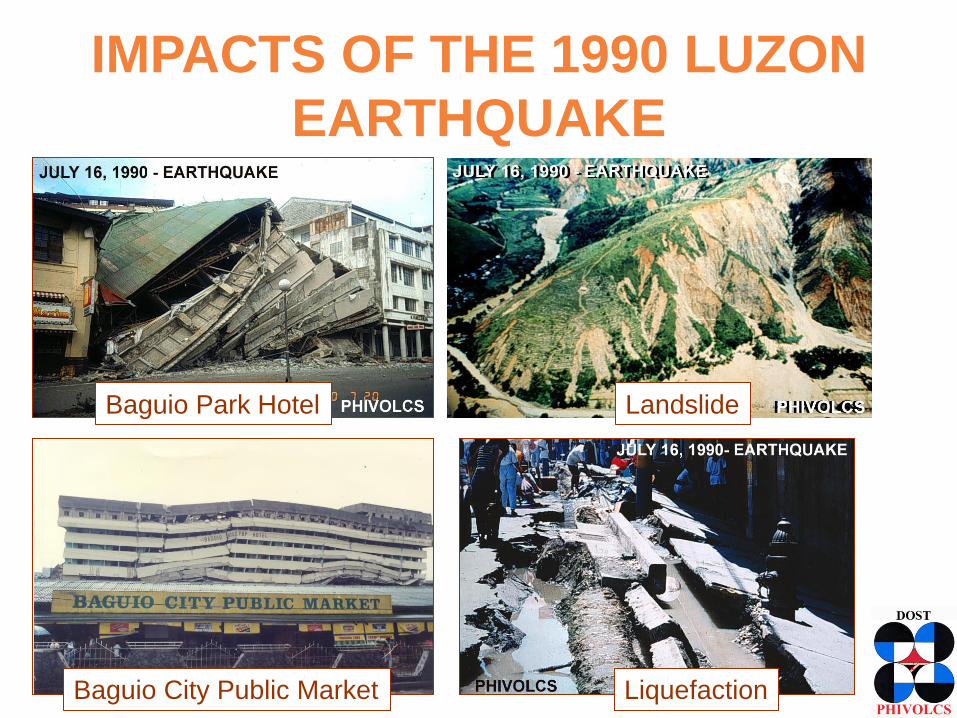
IMPACTS OF THE 1990 LUZON
EARTHQUAKE
Baguio City Public Market
Baguio Park Hotel Landslide
Liquefaction

LESSONS FROM THE 1990 LUZON
EARTHQUAKE
• Public need to respond properly during
earthquakes
• Water, power, transport, communication lines
affected
• need to simulate hazards and effects for
appropriate preparedness and response
• Implementation of building code standards,
proper land use
• Need for many trained search and rescue
groups, medical responders

Can large earthquakes affect
Cebu and vicinity?

1907 to 2014 January (PHIVOLCS Catalogue)
<3 4 5 6 7 8
Magnitude (Ms)
Depth (km)
0 35 70 150 800
SEISMICITY OF CEBU AND VICINITY

1787 M7.4
1892 M5.5
1892 M5.0
1942 M7.3
1922 M6.0
1922 M6.2
1888,1887
1941 M5.8
1955 M6.1
1925 6.8
1936 M6.8
1941 M7.0 d600
1926 M6.2 d520
1948 M8.3
1885 M7.0
1902 1919 M6.4
HISTORICAL EARTHQUAKES (1600-1956)

Cebu City -- earthquake of Intensity VII-VIII.
• The area of destruction comprised the city of Cebu and the small
island of Mactan. Within this area, the shocks damaged old
structures, generally built of coral limestone blocks. Two very old
walls, remnants of ruined buildings, and consequently standing
without any connection to other structures came down by the force
of the shocks; one in the centre of the city and another in the
suburb of St. Nicolas. Tile roofs, very numerous in Cebu, suffered
more severely. Three of them partly slid down, one very steep and
old of the Recoletos Church and Convent and another of a private
house. The roof of the Bishop's Palace partially caved in.
• Cracks in the soil were noticed chiefly in limestone banks on the
seashore of Mactan .
• Some kilometres north of Cebu, fissures were caused in alluvial
soils and on the slopes of hills composed of limestone.
1922 Jan 28 4:41 Cebu Island
EARTHQUAKE ACCOUNTS

How do we reduce the risks from
earthquakes in Cebu and vicinity?

Exposure
(people,
assets,
business in
hazard area)
Hazard
(threat)
DISASTER RISK (potential loss)
REDUCED DISASTER RISK
Hazard Exposure reduced
Vulnerability reduced Vulnerability
(susceptibility to
damaging effects –
physical, social),
coping and adaptive
capacities
• Evacuation
• Land Use Planning
• Relocation
• Education, Awareness
• Preparedness
• Response
• Mitigation
- Engineering
- Non-engineering
- Risk transfer
• Hazard and Risk
Assessment
• Monitoring and
Warning
• Business Continuity
(company, staff and
families)
(Solidum, 2012)
DISASTER RISK REDUCTION

DISASTER IMAGINATION


RECOVERY TIME OBJECTIVE (RTO)
`
Rate
of O
pera
tion
100%
xx%
0%
Recovery Time
Reduced
business
Core
Business
DISASTER
Recovery
Tim
e O
bje
ctiv
e
Core
Busin
ess R
ecovery
Norm
al O
pera
tion
Desired window of time when business or service
would have recovered xx% of normal operation

• HAZARDS AND RISK ASSESSMENT – potentially affected areas, who and what will be affected
• MONITORING - real time instrumentation if possible to detect early; understand the processes
• WARNING AND DISSEMINATION – forecasting and communicating down to local residents the warning and actions to take
• PROPER RESPONSE
- Awareness, education
- Preparedness – evacuation sites and procedures; drills
- Planning for efficient and effective response - - standard operating procedures, - - emergency operation plans
EARLY WARNING, SAVING LIVES

HAZARD AND IMPACT ASSESSMENT
SOFTWARE (REDAS by DOST-PHIVOLCS)
• Hazard assessment
module
- tools for assessing
earthquake hazards;
preparing scenarios
- static maps of various
hazards (geological,
hydro-meteorological)
can be integrated
* being shared with local governments,
national agencies, academic partners

Multi-Hazard Maps In REDAS
Albay Pyroclastic Flow and Lahar
Cavite Ground Shaking
Cavite Tsunami
Cavite Rain-Induced
Landslide
Cavite Flood
Cavite Storm Surge

HAZARD AND IMPACT ASSESSMENT
SOFTWARE (REDAS by DOST-PHIVOLCS)
• Exposure data base
module
- contains database of
elements at risk,
example: location at
attributes of houses,
buildings,
infrastructure,
population
- can be updated by
local government

HAZARD AND IMPACT ASSESSMENT
SOFTWARE (REDAS by DOST-PHIVOLCS)
• Impact
assessment
module
- can estimate
damage to
buildings,
casualty,
economic
loss

A typical classroom scene
Building risk database using GPS
Hands on Training

Hazard Scenario for Cebu
and Vicinity

EARTHQUAKE-RELATED HAZARDS
Tsunami Fire
Ground Shaking Liquefaction
Landslide
Faulting (Ground)
Rupture
Fault

FAULTS
Strike Slip (Horizontal)
Normal
Thrust
• fractures where rock
movement has taken
place and earthquakes
have been produced
• active faults are
those that have
produced earthquakes
historically or has
moved for the last
10,000 years

1990 Luzon
FAULTING OR GROUND RUPTURE

FAULTING OR GROUND RUPTURE
Taiwan Earthquake, 1999

Earthquake Generators in Region VII
• West Panay Fault
(WPF)
• Negros Trench
(NT)
• Faults in Negros
(NF)
• Faults in Cebu (CF)
• Faults in Bohol
(BF) NT
WPF
NF CF
BF

GROUND RUPTURE HAZARD MAP FOR CEBU

AVOIDING EFFECTS GROUND RUPTURE
• Avoid
construction of
structures on
top of an active
fault
• House or
building should
be at least 5
meters away
from the trace
of the fault

GROUND SHAKING

TYPES OF SHAKING
• Up and down;
- first felt by people near the epicenter
- not felt by people far from epicenter
• Sideways;
- felt after up and down by people near
epicenter
- first felt by people far from epicenter

MAGNITUDE
Energy released during
earthquake.
INTENSITY
Effect or felt strength at the surface
STRENGTH OF EARTHQUAKE:
MAGNITUDE VERSUS INTENSITY

Earthquake Intensity Scale
I - Scarcely Perceptible
II - Slightly Felt
III - Weak
IV - Moderately Strong
V - Strong
VI - Very Strong
VII - Destructive
VII - Very Destructive
IX - Devastating
X - Completely Devastating

Scenario: Magnitude 7.5 Earthquake in Cebu
0 1 2 3 4 5 6 7 8
Not felt I II III IV V VI VII VIII (PEIS)
SIMULATED
INTENSITIES
PEIS High VII - VIII (very
destructive) in most areas
of Cebu, Bais and
Dumaguete
PEIS VII (destructive) in
northern tip of Cebu,
northern half and western
areas of Bohol and many
areas of Negros (eastern
and central)
PEIS VI (very strong and
slightly damaging) in
western areas of Negros
and Siquijor Island
PEIS V (strong, able to
cause panic) in Leyte,
Panay, northwest Mindanao

GROUND SHAKING
Intensity VIII (Very Destructive Shaking)
1995 Kobe Earthquake

GROUND SHAKING
Intensity VIII (Very Destructive Shaking)
1995 Kobe Earthquake

RESPONDING TO A STRONG
GROUND SHAKING SCENARIO (1)
(1) INSPECT HOUSES, BUILDINGS,
INFRASTRUCTURES
- How safe is your house?
- Government and private buildings?
- Churches? Mosques? Malls?

HOW SAFE IS MY HOUSE: SELF-
CHECK FOR EARTHQUAKE SAFETY

(3) SIMULATE RESPONSE
• conduct drills
(2) PLAN
• How do you respond during the strong
shaking?
- Where are the safe spots?
- What do you do? Drop, Cover and Hold
• What do you do after? Plan how to respond
RESPONDING TO A STRONG
GROUND SHAKING SCENARIO (2)

• Loose, water-rich sediments behave like
liquid during strong ground shaking.
• Sediments are rearranged into a more
compact state.
LIQUEFACTION

LIQUEFACTION
Subsidence of bridge column Subsidence of building, roads
Dagupan 1990
Fissuring of roads
Mindoro 1994
Dagupan 1990
La Union, 1990
Damage to buried pipes, tanks

Localities prone to liquefaction
a) water-saturated (shallow water table), low-lying
b) Have loose
(unconsolidated), sandy or silty deposits
• river banks, abandoned
rivers, flood plains
• coastlines
• swamps
• reclaimed land
Liquefaction-Prone Areas in Cebu and Vicinity

• Down slope movement of rocks, soil and other debris
commonly triggered by heavy rain and strong earthquakes
Effects:
• - erosion
• - burial
• - blockage
Road destroyed by quake-triggered
landslide China (2008). From Nie, CEA.
LANDSLIDE

Earthquake-triggered Landslide Hazard Map for
Cebu and Vicinity

Sea waves, small to large, resulting from disturbance of
seawater by undersea earthquakes, landslides, and
volcanic eruptions, and meteor impact
March 11,2011 Japan Tsunami From Kyodo News
TSUNAMI


Framework for Reducing Risks
from Strong Earthquakes

EARTHQUAKE RISK REDUCTION
• Develop governance and business system
resistant to earthquake impact
• Improve urban structures
• Enhance current risk and emergency
management
• Enhance community disaster management
capacities
• Formulation of reconstruction system
• Promotion of research and technology
development

PRIORITY STRATEGIC APPROACH TO
CONTEND WITH STRONG EARTHQUAKE (1)
Focus Concept
1 – Strengthen
Legal
Framework and
Institutional
Capacity for
Disaster
Management
• Enhance Legal Basis and
support
• Strengthen Institutional
Capacity for Mitigation,
Preparedness and Response
as well as Inter-Institutional
Coordination

PRIORITY STRATEGIC APPROACH TO
CONTEND WITH STRONG EARTHQUAKE (2)
Focus Concept
2 – Build
Capacity for
Relief and
Recovery
• Enhance Emergency Health
and Medical Response
System
• Establish Emergency
Transportation System
• Secure sea ports, airports
• Secure water source and
supply
• Secure power and
communication systems

PRIORITY STRATEGIC APPROACH TO
CONTEND WITH STRONG EARTHQUAKE (3)
Focus Concept
3 – Strengthen
Community
Preparedness
for Earthquakes
and Tsunamis
• Enhance self-reliance and
mutual help for efficient risk
management capacity
• Inculcate Disaster Mitigation
Culture among populace

PRIORITY STRATEGIC APPROACH TO
CONTEND WITH STRONG EARTHQUAKE (4)
Focus Concept
4 – Reduce
Seismic
Dangers of
Residential
Structures
• Strengthen Buildings,
Structures
• Promote and Institute Fire
Safety
• Promote and support further
researches on seismic
hazards and better building
technology

PRIORITY STRATEGIC APPROACH TO
CONTEND WITH STRONG EARTHQUAKE (5)
Focus Concept
5 – Enhance
City, Provincial,
Regional
System to
Become
Resistant to
Impact of
Earthquakes
• Protect stability of
government function
• Ensure continuity of socio-
economic systems
-> Business or Service
Continuity

• Cebu and vicinity can be affected by various natural
hazards – including earthquakes.
• Earthquakes and tsunamis are sudden onset events,
can cause wide-spread impacts.
• Appropriate preparedness, mitigation and response
activities must be based on appropriate hazard and
impact scenarios.
• Possible hazards and its effects in localities and the
whole region must be imagined to craft and implement
appropriate solutions. • Information, tools are available for communities to be
safer. Let us collectively make our communities safer
and resilient to disasters.
KEY MESSAGES

/PHIVOLCS
@phivolcs.dost
www.phivolcs.dost.gov.ph
Earthquake & Tsunami (24/7):
Tel. Numbers
+632 929-9254
+632 426-1468 loc 124 / 125
Fax number
+632 927-1087
Volcano (24/7):
Tel. Numbers
+632 426-1468 loc 127
Telefax number
+632 927-1095
IEC materials:
+632 426-1468 loc 128
+632 927-4524