Degradation of Mangroves in the Coastal Zones of Ratnagiri ......Degradation of Mangroves in the...
6
International Journal of Scientific & Engineering Research, Volume 6, Issue 11, November-2015 ISSN 2229-5518 IJSER © 2015 http://www.ijser.org Degradation of Mangroves in the Coastal Zones of Ratnagiri, Maharashtra Balu L. Rathod, Jagdish B. Sapkale Abstract— The present investigation is an attempt to make an in depth study of seven sample villages i.e._ Anusure, Purngad, Ganeshgule, Jakemerya, Kolthare, Dhabol, Anjarle in Ratnagiri district of Maharashtra. The data for mangroves was collected from villages and tehsil revenue department. The data collected, was converted into percentage. The primary data was collected through questionnaires on the basis of perceptions of farmers and villagers. Besides this, personal visits were made to selected sample villages and observations are noted for acquiring correct information. Questionnaire has covered various aspects related to mangroves i.e. Function of mangroves, mangroves species, uses of mangroves for livelihood, mangrove protection/ conservation, etc. Index Terms— Mangrove Degradation, Perception of Villagers, Magrove species, Coastal Resource Management. —————————— —————————— 1 INTRODUCTION N the earth’s ecosystems many natural resources are on the way of deterioration. Some are under heavy pres- sures due to increasing Industrial and Urbanization en- croachments. Consequently protection and conservation of resources are the primary need in the present context. In view of this, coastal tract of Maharashtra is more vulnerable to mangrove degradation. Most of the mangroves patches have been degraded as a result of transforming the wetlands into agricultural fields and prawns’ farming. Violations of coastal regulation zone have seen in the coastal areas of Maharashtra. Therefore, mangroves are more prone to degradation in fu- ture. In coastal areas mangroves can be protected by adopting the appropriate managements techniques, so that degradation of mangroves can be minimize. By adopting various manage- ment plans, the people’s perception towards the mangrove ecosystem is to be considered. Permitting the views and per- ceptions of the local people, the basic in-depth knowledge about the mangroves; their species; their problems and many other inter-related processes can be a part of concrete output for the strategic plans. Therefore, present research work has been attempted. Mangrove is a tree or shrub which grows in tidal, chiefly trop- ical, coastal swamps, having numerous tangled roots that grow above ground and form dense thickets [1]. “Mangrove is large tropical evergreen tree/forest, genus Rhizophora that grows on muddy tidal flats and along protected ocean shore- lines. Mangroves produce from their trunks aerial roots that become embedded in the mud and form a tangled network; this serves both as a support for the tree and as a means of aerating the root system. Such roots also form a base for the deposits of silt and other material carried by the tides, and thus land is built up which is gradually invaded by other veg- etation. The mangrove forests also can protect inland coastal- areas as by absorbing the effects of storm and some tsunami waves, but many mangroves have been harvested destructive- ly on a large scale” [2]. Now-a-days the Mangrove ecosystem is affected by climatic factors as well as by human interfer- ences. Directly or indirectly, climatic change influences on mangrove growth. Many studies determined that variations in sea level, storm, cyclones, uneven distribution of rainfall, tem- perature variations are the climatic factor that effects on man- grove. Most of the mangrove covered area is converted into Kharland area [3], [4]. In many other countries the pioneering work on mangroves are appreciable, some studies have at- tempted on the basis of questionnaire survey. In the present research work partial methodology and questionnaire was used that is the adopted questionnaire designed by the Man- grove Management group at VUB and IFP, Wageningen, also used by Hirani and Maniatis in 2005 [5], [6], [7]. The case studies and standard questionnaire designed by them is very useful for the actual present status of the mangroves in any region. On the basis of field visits and observations, differenti- ate investigations revealed that mangrove growth and its area is decreasing due to change in climate and human interven- tions. Global warming is one of the dominant events of cli- mate change which causes sea level rises and tends to reduce the mangrove swamps. The mangrove vegetation also protects the coasts from erosion. In the coastal area of Ratnagiri district (Maharashtra), it has seen that mangrove vegetation protects the agricultural lands/settlements and reduces the risks of catastrophic events (fig 1, 2, 3). In recent years, the study of coastal ecosystem has become very essential that provides information to enable sustainable condition of coastal re- sources [8], [9]. Therefore, the present study aims to assess the status of mangroves in view of coastal resource management at some sites of Ratnagiri coasts. 2 MATERIALS AND METHODS In the coastal area of Maharashtra, it has observed that, the degradation of Mangroves has increased tremendously. In view of this, an attempt has been made to assess the actual status of mangroves in the coastal zones of Ratnagiri district O ———————————————— Balu L. Rathod : Assistant Professor, Department of Geography, Kankavli College, Kankavli, District- Sindhudurg, Maharashtra (Ph.D. Scholar, Department of Geography, Shivaji University, Kolhapur, Maharashtra, In- dia, , e-mail- [email protected] Jagdish B. Sapkale: Assistant Professor, Department of Geography, Shivaji University, Kolhapur, Maharashtra, India. Mobile No. 09850046453 (Ph.D. Guide & Corresponding Author - E-mail: [email protected] 1103 IJSER
Transcript of Degradation of Mangroves in the Coastal Zones of Ratnagiri ......Degradation of Mangroves in the...

International Journal of Scientific & Engineering Research, Volume 6, Issue 11, November-2015ISSN 2229-5518
IJSER © 2015http://www.ijser.org
Degradation of Mangroves in the Coastal Zonesof Ratnagiri, Maharashtra
Balu L. Rathod, Jagdish B. Sapkale
Abstract— The present investigation is an attempt to make an in depth study of seven sample villages i.e._ Anusure, Purngad,Ganeshgule, Jakemerya, Kolthare, Dhabol, Anjarle in Ratnagiri district of Maharashtra. The data for mangroves was collected from villagesand tehsil revenue department. The data collected, was converted into percentage. The primary data was collected through questionnaireson the basis of perceptions of farmers and villagers. Besides this, personal visits were made to selected sample villages and observationsare noted for acquiring correct information. Questionnaire has covered various aspects related to mangroves i.e. Function of mangroves,mangroves species, uses of mangroves for livelihood, mangrove protection/ conservation, etc.
Index Terms— Mangrove Degradation, Perception of Villagers, Magrove species, Coastal Resource Management.
—————————— ——————————
1 INTRODUCTIONN the earth’s ecosystems many natural resources are onthe way of deterioration. Some are under heavy pres-sures due to increasing Industrial and Urbanization en-
croachments. Consequently protection and conservation ofresources are the primary need in the present context. In viewof this, coastal tract of Maharashtra is more vulnerable tomangrove degradation. Most of the mangroves patches havebeen degraded as a result of transforming the wetlands intoagricultural fields and prawns’ farming. Violations of coastalregulation zone have seen in the coastal areas of Maharashtra.Therefore, mangroves are more prone to degradation in fu-ture. In coastal areas mangroves can be protected by adoptingthe appropriate managements techniques, so that degradationof mangroves can be minimize. By adopting various manage-ment plans, the people’s perception towards the mangroveecosystem is to be considered. Permitting the views and per-ceptions of the local people, the basic in-depth knowledgeabout the mangroves; their species; their problems and manyother inter-related processes can be a part of concrete outputfor the strategic plans. Therefore, present research work hasbeen attempted.Mangrove is a tree or shrub which grows in tidal, chiefly trop-ical, coastal swamps, having numerous tangled roots thatgrow above ground and form dense thickets [1]. “Mangrove islarge tropical evergreen tree/forest, genus Rhizophora thatgrows on muddy tidal flats and along protected ocean shore-lines. Mangroves produce from their trunks aerial roots thatbecome embedded in the mud and form a tangled network;this serves both as a support for the tree and as a means ofaerating the root system. Such roots also form a base for thedeposits of silt and other material carried by the tides, andthus land is built up which is gradually invaded by other veg-
etation. The mangrove forests also can protect inland coastal-areas as by absorbing the effects of storm and some tsunamiwaves, but many mangroves have been harvested destructive-ly on a large scale” [2]. Now-a-days the Mangrove ecosystemis affected by climatic factors as well as by human interfer-ences. Directly or indirectly, climatic change influences onmangrove growth. Many studies determined that variations insea level, storm, cyclones, uneven distribution of rainfall, tem-perature variations are the climatic factor that effects on man-grove. Most of the mangrove covered area is converted intoKharland area [3], [4]. In many other countries the pioneeringwork on mangroves are appreciable, some studies have at-tempted on the basis of questionnaire survey. In the presentresearch work partial methodology and questionnaire wasused that is the adopted questionnaire designed by the Man-grove Management group at VUB and IFP, Wageningen, alsoused by Hirani and Maniatis in 2005 [5], [6], [7]. The casestudies and standard questionnaire designed by them is veryuseful for the actual present status of the mangroves in anyregion. On the basis of field visits and observations, differenti-ate investigations revealed that mangrove growth and its areais decreasing due to change in climate and human interven-tions. Global warming is one of the dominant events of cli-mate change which causes sea level rises and tends to reducethe mangrove swamps. The mangrove vegetation also protectsthe coasts from erosion. In the coastal area of Ratnagiri district(Maharashtra), it has seen that mangrove vegetation protectsthe agricultural lands/settlements and reduces the risks ofcatastrophic events (fig 1, 2, 3). In recent years, the study ofcoastal ecosystem has become very essential that providesinformation to enable sustainable condition of coastal re-sources [8], [9]. Therefore, the present study aims to assess thestatus of mangroves in view of coastal resource managementat some sites of Ratnagiri coasts.
2 MATERIALS AND METHODSIn the coastal area of Maharashtra, it has observed that, thedegradation of Mangroves has increased tremendously. Inview of this, an attempt has been made to assess the actualstatus of mangroves in the coastal zones of Ratnagiri district
O
————————————————
Balu L. Rathod : Assistant Professor, Department of Geography, KankavliCollege, Kankavli, District- Sindhudurg, Maharashtra (Ph.D. Scholar,Department of Geography, Shivaji University, Kolhapur, Maharashtra, In-dia, , e-mail- [email protected] B. Sapkale: Assistant Professor, Department of Geography, ShivajiUniversity, Kolhapur, Maharashtra, India. Mobile No. 09850046453(Ph.D. Guide & Corresponding Author - E-mail: [email protected]
1103
IJSER

International Journal of Scientific & Engineering Research Volume 6, Issue 11, November-2015ISSN 2229-5518
IJSER © 2015http://www.ijser.org
(Maharashtra). The Random sampling methods was chosenand considered total 54 respondents from selected seven sam-ple villages. Questionnaire has covered various aspects relatedto mangroves i.e. Function of mangroves, mangroves species,uses of mangroves for livelihood, mangroves and malaria rela-tionship, mangrove and fishing, fuel wood, constructional use,agricultural use, mangrove protection/ conservation, etc. Thedata collected through Primary and Secondary sources havebeen processed and represented by GIS and Remote SensingSoftware.
Figure: 1 Aare village - Mangroves
Figure: 2 Mangroves along Ganpatipule road.
3 DISCUSSIONS AND RESULTSOn the basis of results and analysis for the present status ofmangroves, the table and graphs have prepared. Table no. 1and graph no. 01 to 15 have brief discussed and gives the rela-tionship between man and mangroves in view of ethno eco-
logical context.Graph no. 01 shows the responses for the “term” used for
mangroves by the villagers. Most of the people know man-groves as a wood. The percentage in villages like Anusure,Purngad, Jakemerya, Kolthere and Anjarle is 88.88%, 88.88%,and 92.30%, 100% and 75% respectively. In Ganeshgule andAnjarle villages, respondents distinguish mangrove as an eco-system and its percentage is 28.28% and 16.16%. About 11.11%respondents know mangrove as ‘vegetation’ in the villagesAnusure, Purngad and Anjarle.
Figure: 3 The mangroves of Harnai which is polluted.
Graph 02 shows the functions of mangroves. Most of the peo-ple think that the function of mangroves is wave breaking. InAnusure 50%, in Ganeshgule 33.33%, in Jakemerya33.33%, inKolthere 33.33% and in Anjarle village 28.27% people believethat wave break is the main function of mangrove. In Purngad, Ganeshgule and Anjarle villages, respondentsknow that the function of mangrove is water break and itspercentage is 50%, 33.33% and 42.85%. In Anusure and Purn-gad 50% and 25% respondents reflects that mangrove acts as abarrier. Some people said that the function of mangroves iswind break. Finally, these people have very less knowledgeabout functions of mangroves.
Table No.1 reveals the knowledge of local peoples aboutthe differentiate mangrove species in their localities. Man-groves are known by different local names at different loca-tions. Sonkanjal, Chipi, Kandal, Khajan, Tiwar, Udan,Kharphuti, Marvel, Maradi etc.are the diverse local names ofmangroves. Most of the people in the villages Anusure,Jakemerya and Kolthere villages call mangroves as Kanjal andits percentage in these villages is 43.75%, 33.33%, 30% respec-tively. Mostly , the mangroves species are known as kanjal,tiwar and chipi.
The relationship between mangroves and dengue / malariahas shown in graph no. 03. Most of respondents answered asthere is ‘NO’ relation between mangrove and dengue / malar-ia. In Anusure, Purngad, Jakemerya Kolthere, 100%, people
1104
IJSER

International Journal of Scientific & Engineering Research Volume 6, Issue 11, November-2015ISSN 2229-5518
IJSER © 2015http://www.ijser.org
1105
IJSER
International Journal of Scientific & Engineering Research Volume 6, Issue 11, November-2015ISSN 2229-5518
IJSER © 2015http://www.ijser.org
1106
IJSER

International Journal of Scientific & Engineering Research Volume 6, Issue 11, November-2015ISSN 2229-5518
IJSER © 2015http://www.ijser.org
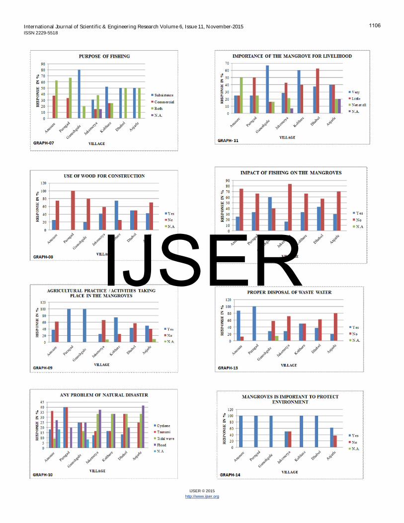
and in Anjarle, 90% people believe that there is no relationshipbetween mangrove and dengue/ malaria. Very few respond-ents think that ‘YES’ mangroves and dengue/ malaria rela-tionship is almost there. Some people did not respond. Thediseases like Dengue and Malaria are caused by mosquitos.These are mosquito borne diseases and due to mangroves themosquitoes have increased. To overcome such disease prob-lem, the people are trying to cut down the mangroves near totheir houses, but they are not admitting for these activities. Most of the people who live near mangroves forest usemangrove as a fuel wood. The perceptions in Anusure are70%, Purngad it is 42.85%, Jakemerya 85.71% and in Anjarle itis 64.28%. The respondents gave preference to the usages ofmangrove as fuel wood, then for fishing and then construction(graph 04). One more important question was asked about the existingstatus of mangroves, whether there is a change in mangrovesforest vegetation, that means whether there is an increase ordecrease in the mangrove growth. Most of the people i.e.66.66% in Anusure and Purngad; 42.85% in Dhabol answeredas ‘YES’, means changes are found in mangrove forest vegeta-tion. In Jakemerya 100% people in Anjarle 80% people an-swered ‘NO’. Some people did not respond as they are fright-ened of the strict rules and regulations about the mangroveprotection (graph 05). Fish, Crab, shrimps etc are available forfishing, it has observed that, fishing is done in creek / riverestuary near the villages (graph 06). Graph no. 07 reveals about the perceptions for question‘what is the purpose of fishing?’ Most of people answeredthat fishing is used for both purposes (subsistence and com-mercial) and its percentage in Anusure, Purngad, Jakemerya,Dhabol and Anjarle is 62.5%, 66.66% 38.46%, 50% and 50%respectively. Some people answered that they are fishing forindividual subsistence and commercial use. Most of the villag-ers are not using wood of the mangroves for the house con-struction (graph 08).
The graph no. 09 displays that how many people thinkthat agricultural practices / activities are taking place in man-groves. Most of the people from Purngad, Ganeshgule, Kol-thare and Anjarle that is 100%, 100%, 75% and 50% respective-ly gave a positive response. But 75% in Anusure, 66.66% in
Jakemerya, 25% in Kolthare and 40% in Dhabol answered as‘NO’. Finally, it is observed that, agricultural practices andactivities are taking places in mangroves. Graph no. 10 exposes that whether there is a problem ofnatural disaster or not, which occurs at the most; and the roleof mangrove to minimize the problem. Cyclone is the domi-nant disaster in the coastal area of Ratnagiri. Tidal wave andflood in Jakemerya, Kolthare and Anjarle villages are the ma-jor problem, mangroves reduces the intensity of these disas-ters. In Anusure, Ganeshgule, Kolthere and Anjarle that is 25%,66.66%, 60% and 40% respectively, the respondents think thatmangroves are very important for their livelihood. In villagesAnusure and Purngad 25% and 50%, respondents consideredthat mangroves are of little importance for livelihood (Graphno. 11). As per the opinion of the people, i.e. 75% in Anusure,66.66% in Purngad, 83.33% in Jakemerya and 70% in Dabholsaid that there is ‘NO’ impact of fishing on mangroves. Somepeople are answered as ‘YES’ i.e. in villages Anusure, Ganesh-gule and Anjarlethe responses are 25%, 60%, and 30% respec-tively (Graph no. 12). Graph no. 13 has given information about the availability ofproper disposal system for waste water in their localities.Some people answered ‘YES’ in villages Anusure, Purngad,Ganeshgule, Kolthare, Dhabol and Anjarle that is 87.5%,100%, 28.5%, 50%, 37.5% and 20% respectively. Graph no. 14 displays the perceptions of villagers towardsthe importance of mangroves for the protection of the envi-ronment. Most of the people answered ‘YES’. in villagesAnusure, Purngad, Ganeshgule, Kolthere and Dhabol that isin all 100%. Only few people answered ‘NO’ in villagesJakemerya and Anjarle that is 50%, and 37.5% respectively. Graph no. 15 indicates that there is a decrease in mangroveforest. Most of people answered ‘yes’ because of consumptionof mangrove by local people, illegal harvesting, legal harvest-ing, water and soil pollution. Overall villagers are opined that,Mangroves forest is decreasing in various ways in the studyregion. It has also observed that mangroves in the study area arecontinuously used for the various purposes, but the local peo-ple are not giving the correct information about the degrada-tional activities of mangroves. Some villagers are afraiding ofthe existing strict rules and regulations that is implemented bythe government. Therefore, in many parts of the coastal tractsof Ratnagiri, mangrove degradation has reduced at some ex-tent.
4 CONCLUSIONThe mangroves of Ratnagiri coasts are very sensible and vul-nerable to the effects of human activities. The use of man-groves for fishing, fuel wood and agricultural practices is theprobable threats to mangrove ecosystem. Therefore, it is nec-essary to formulate strategy for ecological conservation andproper development of these valuable resources. This naturalvegetation minimizes the adverse and severe effects of tsuna-mi, cyclone, tidal waves and floods. As a result of this, these
1107
IJSER

International Journal of Scientific & Engineering Research Volume 6, Issue 11, November-2015ISSN 2229-5518
IJSER © 2015http://www.ijser.org
valuable natural resources directly or indirectly protect theagricultural land and settlements of coastal zone from the nat-ural calamities. Government should motivate the local peopleto protect the mangroves and participate in its conservationprogramme. Awareness programmes should be carried out forthe growth of mangroves.
REFERENCES[1] http://www.oxforddictionaries.com/definition/english/mangrove.[2] Mangrove; The Columbia Encyclopedia, 6th ed.. 2014. Encyclopedia.com. 24
Nov. 2014, http://www.encyclopedia.com.[3] Sapkale, J.B., Rathod, B. L., “Kharlands-An Agrarian Disaster in Coastal Areas
of Southern Ratnagiri, Maharashtra: A Study Using Remote Sensing andGIS”, International Refereed Journal of Engineering and Science (IRJES), 3(6),71-78, 2014.
[4] Mugade, N.R., Sapkale, J.B., (2014), “A Review of Mangrove Conser-vation Studies in Maharashtra, India”, International Journal of Engi-neering and Technical Research (IJETR), 2 (11), 338-341, 2014.
[5] Maniatis, D; (2005), “ Retrospective study of the Mangroves of theTanbi Wetland Complex, The Gambia, M.Sc. Thesis, VUB, 2005.
[6] Hirani, P; (2005), “ Ethnoecological study of the Mangroves of theTanbi Wetland Complex, The Gambia, M.Sc. Thesis, VUB, 2005.
[7] Dahdouh,-Guebas, F., Mathenge, C., Kairo, K.G., Koedam, N., “ Uti-lization of Mangrove Wood Products around Mida Creek (Kenya)amongst Subsistence and Commercial Users. Economic Botany, 54(4),513-527, 2000.
[8] Rathod, B.L, (2015) , “ Coastal Resource Management Using RemoteSensing and GIS Techniques: A Case Study of Ratnagiri District, Ma-harashtra”, (2015), Unpublished Ph.D. Dissertation, 2015.
[9] Rathod, B. L., Sapkale, J.B., “Status of Agriculture in Coastal Villagesof Ratnagiri, Maharashtra”., International Journal of Scientific andEngineering Research, (IJSER), 6(9), 1556-1559, 2015.
1108
IJSER