Dearborn-Ripley Loop 3 - Whitewater Canal Scenic Byway
26
1 Whitewater Canal Scenic Byway The Whitewater Canal Scenic Byway is more than a road, it’s a journey into America’s transportation history with more than mere pictures and stories, but also historical sites galore. The Whitewater River Valley is waiting for you to drive its roads, hike its trails, or paddle its waters while enjoying its beautiful scenery, charming towns, recreational offerings, and so much more. In fact, there’s so much to see and do here that we’re thinking of changing our name to the Whitewater Canal Scenic DOway. The Byway’s Canal Route mirrors the settlement of the Whitewater River Valley beginning on the Ohio River in Lawrenceburg and winding north to Hagerstown. More than a single route, this Byway has a bonus with three additional driving loops to help you discover the richness of the entire valley, not just the historic canal route. This is where Indiana all began with Native American settlements and hunting grounds of the Miami and Shawnee tribes. Their trails up the twin forks of the Whitewater River were followed by pioneers and trailblazers seeking space and prosperity. Many roads and highways still follow these familiar routes. As the Northwest Territory was opened to settlement, farmers were seeking better and faster ways to move their products to markets back east. When the Erie Canal in 1825, “canal fever” gripped the Great Lakes
-
Upload
phillip-anderson -
Category
Documents
-
view
225 -
download
4
description
A turn-by-turn four-color driving guide to the Dearborn-Ripley Loop, designated as the Whitewater Canal Scenic Byway Loop 3, through the picturesque Whitewater River Valley in southeastern Indiana. The route follows the Ohio River then up through the hills and back. The route is filled with history, scenery, and recreation.
Transcript of Dearborn-Ripley Loop 3 - Whitewater Canal Scenic Byway

! 1
Whitewater Canal Scenic Byway
The Whitewater Canal Scenic Byway is more than a road, it’s a journey into America’s transportation history with more than mere pictures and stories, but also historical sites galore. The Whitewater River Valley is waiting for you to drive its roads, hike its trails, or paddle its waters while enjoying its beautiful scenery, charming towns, recreational offerings, and so much more. In fact, there’s so much to see and do here that we’re thinking of changing our name to the Whitewater Canal Scenic DOway. The Byway’s Canal Route mirrors the settlement of the Whitewater River Valley beginning on the Ohio River in Lawrenceburg and winding north to Hagerstown. More than a single route, this Byway has a bonus with three additional driving loops to help you discover the richness of the entire valley, not just the historic canal route.
This is where Indiana all began with Native American settlements and hunting grounds of the Miami and Shawnee tribes. Their trails up the twin forks of the Whitewater River were followed by pioneers and trailblazers seeking space and prosperity. Many roads and highways still follow these familiar routes.
As the Northwest Territory was opened to settlement, farmers were seeking better and faster ways to move their products to markets back east. When the Erie Canal in 1825, “canal fever” gripped the Great Lakes

! 2
region and numerous river communities dreamed of a canal system that would crisscross the heartland. The Whitewater Canal was created to connect the Ohio River to east central Indiana. Initial funding was provided by the Indiana General Assembly as part of the 1836 Mammoth Internal Improvement Act which supported canals, roads and a railroad. The design of the canal called for a 76-mile route starting at Nettle Creek near Hagerstown and following the Whitewater River’s West Fork to Connersville, Brookville, and Harrison, Ohio, and then turning back to Lawrenceburg on the Ohio River. The canal’s design was quite ambitious as it required 56 locks, seven dams, and several aqueducts to accommodate the 491-foot drop or 6.7 feet per mile. In comparison, the Erie Canal’s descent was 1.7 feet per mile while the Wabash and Erie Canal was only 1 foot per mile.
The State of Indiana started construction on the canal at Lawrenceburg in 1836. The first boat arrived in Brookville in 1839. Construction was suspended shortly thereafter due to budget problems and wasn’t resumed until 1842 under the leadership of a new private company–White Water Valley Canal Company. The canal was completed to Laurel in 1843 and boats were arriving in Connersville in 1845. The financially strapped company borrowed money from a Cincinnati financier to complete the canal to Cambridge City in 1846. A private group of investors formed the Hagerstown Canal Company to finish the last eight miles from Cambridge City to Hagerstown in 1847. Upon its completion, the Whitewater Canal cost nearly $1.2 million or $15,000 per mile. Meanwhile, another group of investors built the Cincinnati and Whitewater Canal from Cincinnati to Harrison, Ohio and connected to the Whitewater Canal in 1843.
A major flood in 1847 severely damaged the canal and permanently closed the portion from Cambridge City to Hagerstown and from Harrison to Lawrenceburg. Additional floods in 1848, 1850, and 1852 caused extensive
Tips for Traveling the Byway
LOOK FOR RED – The sites directly on the Byway’s or Loop’s designated routes will be titled in orange. LOOK FOR BLUE – As you travel through a town or city, there will be many sites to see so those off the route will be marked in blue.
LOOK FOR Off-the-Trail – These are significant sites farther away from the Byway and Loops, but might be worth a visit, depending upon your interests. LOOK FOR WEBLINKS - Several sites along the Byway have websites with more information–hours, days of operation or their own brochures. So, click and connect, and plan ahead for your visit.
What to Look for Along the Byway
Transportation History
Lodging
General History
Outdoor Recreation
Food and Wine

! 3
damage that led to the canal’s abandonment in 1856. Seven years later, the Indianapolis and Cincinnati Railroad purchased the canal and laid the rails on the towpath. A stretch of the canal from Milton through Connersville continued to provide hydropower into the mid-20th century.
While the canal era lasted less than 30 years, elements of the canal have been used ever since. And many canal structures still exist throughout the region. Along the Byway, you’ll see lock ruins, get to ride a canal boat through the only covered wooden aqueduct left in the country and visit an operating grist mill in Metamora, a historic canal town which still feels like 1838.
Common lore has it that fathers and sons went to the Civil War on boats and came home on trains. Today, the Whitewater Valley Railroad’s excursion train will take you on a scenic ride from Connersville to Metamora. And, since it’s built right on the canal’s towpath you can see canal ruins only visible from the tracks.
In the northern reaches of the valley you can get an inside look at the region’s rich automotive heritage in Richmond and Connersville, once called “Little Detroit.” Horses and buggies, gave way to farm equipment, automobiles, and busses. See the old cars in local museums, see their manufacturing sites, and the change in the landscape brought on by the roads, bridges, highways, and interstates of the automobile era.
Today, we are a more mobile society with everything and everywhere within reach. It’s interesting that many are seeking ways to get away from it all. If you find enjoyment in the great outdoors, the Byway offers hiking, biking, and paddling trails that help you slow down to relax or play. There’s also great camping, fishing, and horseback riding available. Golfers will find courses for all skill levels. In the winter, there’s skiing and tubing. Off-roaders and racing enthusiasts can get their thrills in the Valley.
The Whitewater Canal Scenic Byway takes some time to explore and you can choose when, where, and how you do it––from a one-day excursion, a long weekend, or an extended adventure––but make sure to do it.

! 4
Experience the Byway The Whitewater Canal Scenic Byway follows the the route of the historic Whitewater Canal up the western portion of the Whitewater River Valley. And while the drive along the primary route takes you on scenic highways and features the area’s rich transportation history, we would be selling you short if we didn’t share the rest of the Valley with you. With the Byway’s four routes, sister byways, and historic corridors you can explore more than 200 sites across 300+ miles. Along with the historic Canal Route, the additional loops will take you through small towns and cities, along the Whitewater’s East Fork and Brookville Lake, along the Old National Road, into the “Village of the Spires,” and even to the real-life home of the movie Hoosiers. There are also Off-the-Trail sites to add interest to your travels.
It wouldn’t be a real road trip without enticing restaurants, interesting landmarks, small towns and fun things to see and do. So, click on the weblinks to get more details about sites, and connect to local tourism bureaus to round out your trip with food and lodging.
Traveling the DOway isn’t about seeing its sites through a windshield. So, stop in our charming cities and towns, take a walking tour and explore the valley on foot and at a slower pace.
This digital driving guide can help you plan the trip you want to take. We’ve provided site descriptions, photographs, and travel-friendly directions to take you through the region. Print the pages you want or download them into your smartphone. Just choose your route, grab your camera, hop in your car, and make a little history of your own. Go on, enjoy the Whitewater Canal Scenic DOway!
The valley offers great bed-and-breakfasts or traditional lodging, inviting restaurants, and an opportunity to experience the rhythm of the Whitewater River. Whether you stay on the Canal Route or venture off onto its three loops, you’ll find that a trip though the valley can truly refresh the soul.
XDO

! 5
Whitewater River Valley Driving Guide Map

! 6
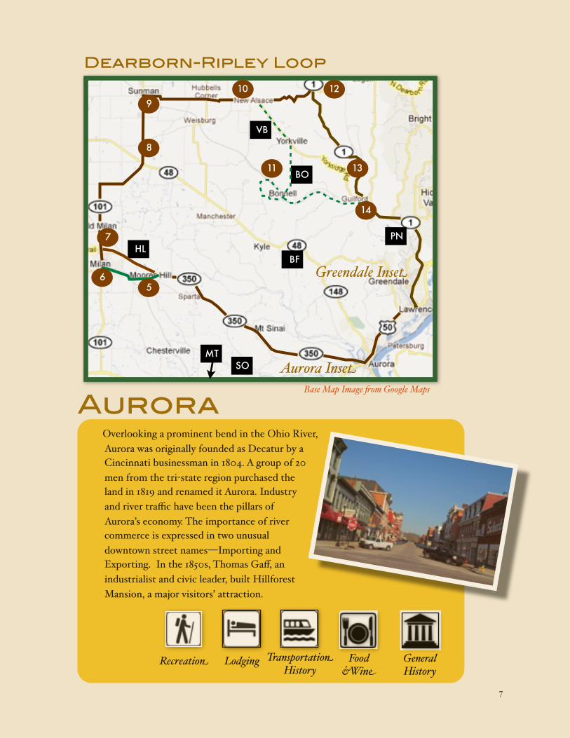
Dearborn-Ripley Loop
Whitewater Canal Scenic Byway Loop 3
Starting in Lawrenceburg, this 47-mile loop shows off many homes built by the Valley’s early industrialists in their desire to work and live near the Ohio River. You’ll see early educational institutions and visit the town whose Indiana story became a national treasure in the movie Hoosiers. The circular trip concludes in
Greendale in the shadows of the world’s largest whiskey distillery and the history of brewing in the Valley.
Dearborn-Ripley Loop
! 7
Overlooking a prominent bend in the Ohio River, Aurora was originally founded as Decatur by a Cincinnati businessman in 1804. A group of 20 men from the tri-state region purchased the land in 1819 and renamed it Aurora. Industry and river traffic have been the pillars of Aurora’s economy. The importance of river commerce is expressed in two unusual downtown street names—Importing and Exporting. In the 1850s, Thomas Gaff, an industrialist and civic leader, built Hillforest Mansion, a major visitors’ attraction.
Aurora
Recreation Lodging Transportation History
Food &Wine
General History
Dearborn-Ripley Loop
Aurora Inset
Greendale InsetBF
MTSO
56
HL7
8
910
VB
11
12
13
14
BO
PN
Base Map Image $om Google Maps

! 8
Directions501 3rd Street
Take US 50 west 3.7m to SR 56/Importing Street and then take first right onto Bridgeway Street. Go two blocks and Post Office is on the corner.
Aurora Post Office Mural The mural, Down to the Ferry, was painted by Henrik Martin Mayer in 1938 as part of the Public Works of Art Project during the Great Depression.
1
Directions215 4th Street
Continue on Bridgeway Street to 4th Street. Turn left and go 3 blocks. Church is on the left.
First Presbyterian ChurchWith a presence in Aurora prior to the 1826 construction of a Seminary (school), leading Presbyterians built the first stage of this church in 1850 and five years later added the the second floor sanctuary, bell tower, and four-faced clock which was the official time-piece of the City of Aurora until 1981. St. Mary’s Catholic Church is across the street.
2
2
3
4
1
N
Aurora
AT
Base Map Image $om Google Maps

! 9
RecreationSouthern trailhead begins 0.8m south of 5th Street on SR 56.
The northern trailhead begins at Manchester Landing Street at US 50 and SR 48.
Aurora-Lawrenceburg Trail
The 3.5 mile trail connects the two cities on the former New York Central railbed. The trail hugs the Ohio River and crosses refurbished bridges and encourages hikers and bikers to enjoy the history in these early Indiana communities. Public access.
Directions213 Fi%h Street
Turn right onto Judiciary Street and go one block to the Mansion.
Hillforest Mansion Local industrialist and steamboat owner Thomas Gaff constructed the home in 1855 and it remained in the family until 1926. The Italianate home is unique in its openness and its steamboat-like turret on the third floor providing a magnificent view of Aurora and the Ohio River. Open to public, admission charged.
3
Did you know?On the bank of the Ohio River in Aurora, opposite the Eagle Hotel, Pinkney James built the steamboat CLINTON 1823-24. The July 4, 1824, launching caused much celebration and firing of cannon. ~Dearborn County Sesquicentennial Committee
VeraestauWhen Jesse Holman combined the Latin words for spring, summer and fall to name his property Veraestau in 1810, he hoped winter would never touch his home. In a way, it never has. Set high above the Ohio River in Aurora, Indiana, the landmark home captures a long sweep of Indiana’s architectural history and exemplifies historic preservation. Today, Veraestau serves as Indiana Landmarks' Southeast Field Office, and is open each weekend April through December for tours and rentals.
Off-the-trailGo one block SE to
Market Street, turn right and continue on Market Street/Dutch Hollow Road 0.7 m. Turn onto Glen Marry Road for 0.5m to Veraestau Lane.
4
AT

! 10
Did you know?In a settlement called Cochran(e), on the western edge of Aurora, stood the early train works of the Ohio and Missisippi Railroad. The railyard
served the trains moving freight and passengers from Cincinnati to St. Louis.
Recreation7096 State Route 48Aurora, IN 47001(812) 926-1807
Learn more...
Busse’s FarmThe farm offers a wide variety of bedding plants for purchase, including 19 different varieties of tomatoes, peppers, zucchini, eggplant and herbs. In the fall, choose from approximately 2,500 pumpkins and 500 gourds, or pick from the farm's vast selection of mums. Open April through November.
Recreation9267 Mt. Tabor Rd.Aurora IN 47001812-926-3732
Mt. Tabor Alpaca FarmThis 89-acre farm located in the rolling hills of Dearborn County is home to a large
herd of alpacas, gentle animals prized for the super-soft fiber. Enjoy a special behind-the-scenes tour of this scenic farm, where you will learn more about these magnificent animals and meet the farm’s other inhabitants, including goats, honeybees and horses. Advance reservations required.
A Bit of History... Wilmington
On September 26, 1836, Wilmington became the seat of justice for Dearborn County, moving from Lawrenceburg. It remained the county seat until April 1, 1844 when it returned to Lawrenceburg.
Salatin’s OrchardStarted in 1984 as a hobby, it has since
grown into a full-time business. Salatin's Orchard grows and sells 24 varieties of apples and produces its own cider. Apples that have fallen on the ground, however, are never used for cider or sold. Instead, the fallen apples are donated to the Red Wolf Sanctuary in Rising Sun to feed the bears that live there.
Recreation10514 Chesterville RdMoores Hill, IN 47032(812) 744-3481
BF
MT
SO

! 11
DirectionsStay on
Main Street, turn right on Adams and then left onto Old SR 350/Carr Street for 2.1m to Milan. Continue west on Carr Street one block to the Milan ’54 Museum.
Milan-– Story behind the movie HoosiersThe story of the “Milan Miracle,” captured in the epic movie Hoosiers, the small town high school’s upset of mighty Muncie Central to win the 1954 Indiana High School Basketball Championship is still celebrated here on the town’s water tower. Visit the Milan ’54 Museum for memorabilia of the team’s historic run. Milan was a railroad town and had a large warehouse complex for the whiskey
distillery in nearby Lawrenceburg. Donations accepted, check for hours.
DirectionsReturn to US 50 at SR 56/SR 350. Head west on SR 350 for 10.7m to Main Street. Turn left and go 1.0m into town and to the landmark.
Carnegie Hall–Moores Hill Moores Hill College, a coeducational institution was founded in 1854. Its first building Moore Hall, (b. 1856) burned down in 1915. Carnegie Hall (b.
1908) remains on the site even though the college relocated in 1917 and became the University of Evansville. Tours by appointment only.
6
Hoosier Links Golf CourseThe decades old golf course nestled in the heart of the farmland of southeast Indiana features 7,404 yards of golf from the longest tees for a par of 72. With four sets of tees the course fits everyone. For those up to a real challenge, try the Black Monster tees.
Recreation 488 N. Country Club DriveMilan, IN 47031-8311(812) 654-2440www.hoosierlinksgolf.com
A bit of history... John Hunt Morgan Heritage TrailThe Byway intersects the John Hunt Morgan Heritage Trail. In 1863, Confederate Brigadier General Morgan led 2,000 troops on an 18-day raid through southern Indiana and Ohio. The band swept through here in July. The raiders crossed the Ohio River south of Corydon, traveled north to Salem, then northeast toward Vernon, south to Dupont, then east and north into Versailles. From there they headed east-northeast toward Milan and Sunman, and then eastward across northern Dearborn County to West Harrison and across the Ohio state line into Harrison, Ohio.
5
HL

! 12
Directions8930 N State Road 101,
SunmanContinue north of Milan 7.2m on on SR 101 to its intersection with Asche Road. The church is on the northwest corner.
DirectionsFrom Milan
proceed north on SR 101. Cross SR 350 and continue 0.9m to Old Milan. The marker is on the right at the intersection of SR 101 and Old Milan Road.
Morgan’s Raid Marker • Old MilanIn 1924, the Ripley County Historical Society placed a series of stone markers along the Raid’s route through the county. Several markers are included in this guide.
Morgan’s Raid • St. Paul’s United Methodist ChurchMorgan’s raiders camped in St. Paul Cemetery, approximately 48 miles from their last camp. Morgan set up his headquarters in the Ferris School House on the southeast corner of the intersection, now a private residence.
7
8
Directions121 South
Meridian Street
Continue north on SR 101 2.2m into the town of Sunman. The marker is just south of Classic Pizza on the right side of the street.
Civil War 83rd Indiana Voluntary Infantry • SunmanA Ripley County historical marker tells of the sacrifices of Sunman’s young men serving in Company G of the 83rd Indiana. The well traveled group fought in several major battles, including General Sherman’s famous “March to the Sea.”
9
Did you know?The town of Sunman was established in
1856, three years after the Big Four Railroad placed a major crossing here. The railroads don’t stop in Sunman anymore and the town focuses on Interstate 74 for economic prosperity.

! 13
Recreation9569 Yorkridge RoadGuilford IN 47022(812) 623-1433
Learn more...
Very Berry Patch (seasonal)The Very Berry Patch offers a variety of items depending on season, including berries, pumpkins, gourds and mums. Business hours at The Very Berry Patch vary according to season, so you may wish to call before visiting.
Directions9798 N. Dearborn Road,
GuilfordFrom downtown Sunman go east 0.8m on Eastern Avenue, jog right at County Line Road then left onto North Dearborn Road. Proceed east for 4.4m to New Alsace.
St. Paul’s Catholic Church • New AlsaceEstablished in 1833 as a parish by the first bishop of Cincinnati, pioneers built a log church on the site of the current rectory. German Catholics built New Alsace around the church as the land resembled their homeland. A school offered classes in the log church in 1834. The present
church was built in 1837 and the school in 1921. Morgan’s Confederate troops raced through here on their eastward flight.
10
Scenic RoadThis winding route travels through the same valley as
the original Indianapolis & Lawrenceburg Railroad. The road weaves under the overhead railroad and historic bridges span streams that criss-cross the route. The Adventure Option route (recommended for SUVs and a*-wheel drive vehicles) is a loop on partially-paved and gravel roads with steep hills. Some creeks will be forded so use extreme caution and avoid fast moving water. It’s a scenic drive, so it’s okay to turn around. Enjoy, but travel at your own risk.
11
St. John the Baptist Catholic ChurchEstablished in 1824, it is the second oldest Roman Catholic Church in Indiana. The original log meeting house was replaced by a framed structure in 1842. The first brick church was built in 1847 and the present building was dedicated October 19, 1879.
12 Off-the-trail25743 State Route 1, DoverContinue east on North Dearborn Road 3.3 miles to SR 1 at Dover. Turn left and go north 0.3m to the church on the left.
VB
Off-the-trailFrom New Alsace, turn right onto Yorkridge Road and go 2.6m to Yorkville. Take a slight right onto Burtzelbach Road. Proceed 2.9m to Bonnell Road.
(Easy Option) Turn left and wind along Bonnell Road 3.7m to Guilford and rejoin the Byway Loop at S.R. 1
(Adventure Option) Turn right onto Bonnell Road 0.7m then turn left onto Konradi Road. Take the rugged 3.5m loop to Bonnell Road and then head east to S.R. 1 at Guilford.

! 14
DirectionsSR 1 & Main Street
Continue on East Fork Road 0.2m and merge onto SR 1 then 1.2m to Guilford. Turn right onto Main Street, then left to the bridge.
Guilford Covered BridgeBuilt in 1879 over Tanners Creek, by Archibald M. Kennedy & Sons of
Rushville, prominent bridge builders. The 103-foot bridge is open to traffic. It was relocated to the park in 1960 and was rehabilitated in 1997. Public access.
14
DirectionsTurn around and go
south on SR 1 for 5.0m to East Fork Road and turn right. Go 0.1m to the church and cemetery on the right.
Stone ChapelErected in 1821, the early Methodist Church served a congregation for more than 125 years. The church building and cemetery are maintained by a local endowment fund.
13
Recreation19074 Perfect LaneLawrenceburg, IN 47025-8266(812) 537-3754www.perfectnorth.com
Perfect North SlopesIf it's winter action you crave, then head for Perfect North Slopes. Here you can ski down family-friendly trails, snowboard on heart pounding double black-diamonds, or slide down a 750-foot tubing run.
Whatever your course of adventure, you can count on one thing at Perfect North Slopes: plenty of snowy fun. With twenty picturesque trails and open slopes, skiers of all abilities will love. For those that love sled riding, go for a slide on the snow tubing hill. With multiple lanes to choose from and a surface lift to get you back to the top, this is the perfect family activity.Recreation
21874 Kuebel Rd.Guilford, IN 47022(812)487-2695www.beiersdorferorchard.com
Beiersdorfer OrchardBeiersdorfer Orchard is a family-owned business operating in Southeastern Indiana. While specializing in apples and apple cider, we have a wide selection of mouth-watering fruits such as peaches, pears, plums, etc. to meet your needs. Open year-round.
PN
BO

! 15
DirectionsContinue 4.9m south on SR 1 to Nowlin Avenue. Turn right and go 1.2m to cemetery.
Greendale CemeterySituated on land given to Col. Zebulon Pike in 1803 for payment of his Revolutionary War service. A memorial at the entrance shares the story. Also, George Dunn, president of Lawrenceburg & Indianapolis RR, is buried here with a carved train as his headstone.
15
DirectionsContinue 0.6m south
on Nowlin Avenue to intersection with Probasco Street. Marker is on SW corner.
Lawrenceburg & Indianapolis RR markerA marker notes the route of the railroad, the state’s first chartered rail company. It was completed in 1853 largely due to efforts of George Dunn. Later that year, the name was changed to the Indianapolis & Cincinnati RR.
16
Greendale was laid out in 1852, but not recorded until 1883. North and west from the city of Lawrenceburg, the town of Greendale lies along an extended gravel ridge. It overlooks the broad valley of the Great Miami and has a fine view of the surrounding hills, the Kentucky hills just across the Ohio, Fort Hill and the range of beautifully rounded elevations on the farther side of the Miami,
reaching to the bold promontory that juts out overlooking the confluence of the Miami and the
Whitewater Rivers.
To the west overlooking the town, standing some three or four hundred feet above it, is the long range of hills that are led up to by the old state road, that has had such history to recount of the early pioneer days when it was a thoroughfare and along which the men and women who peopled the country to the west took their way.
Greendale
Recreation Lodging Transportation History
Food &Wine
General History

! 16
DirectionsContinue east on
Probasco Street 4 blocks to Ridge Avenue on the corner.
Turn south on Ridge Avenue and go 0.2m to Cook House.
Greendale Historic DistrictMany beautiful homes were built along Greendale’s Ridge Avenue by prominent distillers, industrialists, and other
businessmen. One of them, William H. Probasco, president of the People’s National Bank, built this home in 1868. Private residence.
17
____ Dearborn-Ripley Loop (Loop 3)
____ Canal Route
10
Greendale*Note - SR 1 no longer fo*ows Ridge Avenue through Greendale but ends at I-275
N
15
16
17
18
GT
CR
Base Map Image $om Google Maps

! 17
DirectionsContinue south 0.1m on
Ridge Avenue to Distillery entrance.
The “Spirits” of the Whitewater ValleyThe Whitewater valley has a rich heritage in distilling, especially whiskey. With its readily available grain and access to river and canal markets, the businesses sprang forth from immigrants bringing the trade from Europe. At one time, Lawrenceburg was called “Whiskey City USA.”
The first commercial venture, Dunn and Ludlow Distillery, began in Lawrenceburg in 1807, nine years prior to Indiana’s statehood.
John B. Garnier, an immigrant from France, established J. B. Garnier Malt House & Brewery in 1840 and it continued until 1916. In 1896, Garnier's son-in-law, Victor Oberting took over the business. Thomas and James Gaff of Aurora had three different distilling endeavors—T. & J.W. Gaff & Co (1846-?), Aurora Brewing and Malting Company (1871-73), and Crescent Brewing Company (1873–1899). Gaff also got into shipping and moved spirits up and down the Ohio River.
The Squibb family built a distillery called Old Quaker in Lawrenceburg in 1846 and sold under the names Chimney Corner, Old Dearborn, Rock Castle, and Gold Leaf Rye. Just before prohibition ended Schenley bought the plant and several others and rolled them into a new conglomerate. Schenley closed the plant in the 1980s.
During the valley’s settlement many other individuals built distilleries and breweries. There were at least four operations in or near Brookville, six in northern Dearborn County, two in Metamora, one in Oldenburg, and five in Batesville.
18
End of the LoopContinue 0.5m south on Ridge Avenue in Greendale/Main Street in Lawrenceburg to US 50 and the Dearborn-Ripley Loop’s end.
Lawrenceburg DistillersFounded as the Rossville Union Distillery in 1847, purchased in 1933 by Jos. Seagrams & Sons and built into the world’s largest distillery capable of producing 85,000 gallons of alcohol per day. Currently owned by MPG
Ingredients Inc. producing whiskeys, gins, and neutral grain spirits. Not open to the public.

! 18
Food, Wine and Lodging ! ! ! ! ! !! along the Whitewater Canal Scenic BywayHere are just some of the many places to eat in the Whitewater Valley. Find out more options at WhitewaterCanalScenicByway.org. Restaurants are listed here by town in the order the town appears on the
byway and its loops.
Restaurants
There are numerous culinary delights throughout the Valley. From brewpubs to casual dining spots, to chocolatiers. So the choice is yours. Check on the location on your route and visit the appropriate
tourism site for a complete dining guide.
Dearborn County (Indiana)Aurora • Lawrenceburg • Greendale
Hamilton County (Ohio)North Bend • Cleves • Harrison
Franklin County (Indiana)Brookvi*e • Metamora • Laurel
Fayette County (Indiana)Connersvi*e
Wayne County (Indiana)Cambridge City • Hagerstown • Centervi*e • Richmond
Union County (Indiana)Liberty
Butler County (Ohio)Oxford
Ripley County (Indiana)Batesvi*e • Milan • Versai*es • Osgood
J’s Dairy Inn Liberty
GhyslainChocolatier Richmond
Kunkel’s Drive-In Connersville
Great Crescent Brewery Aurora
The Hearthstone Metamora
Wagner’s Village Inn Oldenburg

! 19
Lodging
Bed and Breakfasts
Herman Leive House - Aurora
The Brookville Inn - Brookville
The Metamora Inn - Metamora
Stonebridge Inn and Spa - Batesville
The Hermitage B&B - Brookville
Huntington B&B - Milan
Newman-Vollmar House B&B - Osgood
Victorian Garden B&B Osgood
Schaefer’s B&B - Sunman
Thorpe House Country Inn - Metamora
Lantz House Inn - Centerville
Philip W. Smith B&B - Richmond
Martha E. Parry B&B - Richmond
Girls Night Inn - Richmond
Carriage Lamp B&B - Liberty
Potters Wheel B&B - Richmond
The Doctor’s Inn - West College Corner
Maplevale Farm B&B - Oxford (OH)
White Garden Inn - Oxford (OH)
Hotels and MotelsThere are additional hotels, motels and other lodging options so visit the counties’ tourism websites.
Stonebridge Inn & Spa
Batesville
Metamora Inn Metamora
Brookville Inn Brookville
Philip W. Smith B&B Richmond

! 20
and the US government prevailed resulting in the Treaty of Greenville in 1795 that opened up Ohio and a wedge of southeastern Indiana called The Gore.
From there a few adventuresome souls began blazing trails over land connecting river settlements across Indiana, often following historic Indian routes. Many early Indiana trails began in the Whitewater Valley, including Whetzel’s Trace, Berry Trace, Kibbey’s Road, Quaker Trace and the Brookville-Brownstown Road.
In 1811, construction on the National Road began in Cumberland, Maryland and it was completed to Vandalia, Illinois in 1838. The road reached Indiana in 1827 at Richmond and construction continued westward reaching Terre Haute in 1834. The road spurred rapid emigration to the Midwest and laid the foundation for other road-building efforts.
Farm to Market and Western MigrationFollowing the opening of the Erie Canal, canal fever swept across the nation. In 1836, Indiana’s legislature passed the ambitious Internal Improvement Act calling for the construction of two railroads, three main roads and three canals, including the Whitewater.
The Whitewater Canal’s surveys showed that to accommodate the 491 feet fall over 76-miles would require fifty-six locks, seven dams and
Native American, Trailblazers and PioneersNative Americans living in the Ohio Valley and Great Lakes region traversed its streams by canoe and connected their villages on well-worn paths over land. One in particular followed the Whitewater River up the valley then from the east fork to the west fork at Connersville and then cross country to major settlements in Munseetown (Muncie) or Andersontown (Anderson) both on the White River.
In 1787, the U.S. Congress established the Northwest Territory in the Great Lakes region including Ohio and Indiana. William Henry Harrison, with ties to Indiana and Ohio, was named Territorial Governor, led a successful military campaign which vaulted him to the US presidency. Pioneers
made their way down the Ohio River and then headed into the interior along streams such as the
Whitewater River.
As new settlers flooded into the territory, the Native Americans resisted
! the incursions. Little ! Turtle, the Miami ! Chief and General Anthony Wayne led their sides in battle. After several setbacks, Wayne
Early Trails Canals, Early Roads, and Early Rail
1830s-1860s 1800-1830s
Timeline The Whitewater Valley’s Layers of Transportation

! 21
twelve aqueducts. Canal construction with public financing began in 1836, connecting Lawrenceburg to Brookville. Private funding constructed the canal to Connersville by 1845 and Cambridge City later that same year. Private business interests funded the canal’s extension to Hagerstown by 1847. Extensive flooding in 1847 and again in 1848 led to runaway repair expenses and ultimately the canal’s demise.
Early plans called for it to connect to the White River at Muncie or Anderson, but time and money ran out on Indiana’s canals. In 1865, the president of the Indianapolis and Cincinnati Railroad purchased the White Water Valley Canal Company and soon laid the White Water Railroad on the canal’s towpath. The Canal continued providing hydraulic power to several towns and Connersville continued using it into the early 1950s. In the 1940s, the Whitewater Canal Association was formed to save the canal around
Metamora. In 1945, the state of Indiana created a state memorial which included the restoration
of the Laurel
! !Feeder Dam, and the Grist Mill, Duck Creek Aqueduct and Gordon’s Lock (#24). Many other sites and canal remnants can be found along the Byway.
Rise of Railroads
1830s –present
Also included in the infrastructure plan was the Michigan Road. Created to connect the Ohio River and Lake Michigan, it was the state’s north-south response to the east-west National Road. The road began at Madison and headed northeast to Napoleon and the northwest to Greensburg and Indianapolis. The northern segment required negotiations with the Potawatomi Indians to get access through their lands. The road connected the future state capital city with Logansport, Rochester, Plymouth and South Bend before heading due west to Michigan City. A more direct route was not possible because it impossible to cross the Grand Kankakee Marsh in northwest Indiana.
The Act also called for construction of two railroads one of which–Lawrenceburg and Indianapolis Railroad–became the state’s first chartered railroad. Completed in 1853, the line changed its name to the Indianapolis and Cincinnati Railroad and later became part of the Big Four system.
Creating and Connecting National MarketsIn 1832 the state of Indiana chartered the Lawrenceburg and Indiana Railroad, the state’s first railroad. By the 1850s, rail lines were springing up everywhere. President Lincoln’s inauguration and funeral trains both made stops in the Whitewater Valley and are designated by historical markers along ! the Byway.
From 1860-1900, railroads expanded and consolidated into huge rail networks. Located
between Cincinnati, St. Louis, Indianapolis, and Chicago, the valley was criss-crossed by the Big Four RR, Ohio and Mississippi RR, Nickel Plate, and the Panhandle. Railroads

! 22
continued to dominate transportation until automobiles, trucks and highways pushed them aside. Railroad depots were symbols of a community’s importance. By 1920, over 1,500 depots were spread across Indiana’s landscape. Early depots were functional buildings, while later-
built, larger depots were more deliberately architecturally marvels, such as Richmond’s depot and Union Station
terminals in Indianapolis and Cincinnati.
As rail companies abandoned underperforming lines and consolidated routes, things were bound to change. In 1980, the federal Staggers Act deregulated the railroads and created opportunities for short-line railroads to step in and continue service for key industrial customers off the main lines. Short lines still operate key railroads in the region.
In the mid-1970s, the non-profit Whitewater Valley Railroad was formed and began a excursion train from Connersville to Brookville on the Penn Central line. In 1983, the group purchased 18-miles of track from Connersville to Metamora and now provides regularly scheduled rides from May through October and special events including the official “Polar Express.” In addition to its collection of engines and cars in its museum, the group has also restored the Dearborn Crossing tower and the Rushville Depot in its new park south of Connersville. Step back in time and ride the train along the old Whitewater Canal. All Aboard!
As railroads abandoned tracks, bicycle groups jumped on an opportunity to turn rails-to-trails. One of the earliest effort in Indiana was the Cardinal Greenway, reusing parts of the C&O railway from Richmond to Sweetser.
Pedaling to ProsperityIn the 1880s, well before the advent of automobiles, bicycling turned people’s focus toward independent, long distance travel resulting in a desire for “good roads.” This well-organized movement pushed for public paving of roads connecting cities and towns. The goal was to afford bicyclists the same privileges as those of horse-drawn vehicles. As automobiles moved to the forefront of transportation, business and user groups began promoting the building of the famous Lincoln-Highway (east-west) and Dixie Highway (north-south)
In the Whitewater Valley, there were at least three bicycle companies and one bicycling club. The most famous bicycle was constructed by Charles Teetor of Hagerstown. In 1894, Teetor worked in a bicycle shop in nearby New Castle. At the request of his cousin, Charles Hartley, superintendent of the Chicago and Northwestern Railroad, he built a four-wheeled bicycle that could be used to inspect railroad tracks. Thus, the Railway Cycle Manufacturing Company was born and soon its was shipping inspection cycles all over the world. This was one of many first for the Teetor family. Come to Hagerstown and learn more about the Teetors, Teetor-Hartley Corporation and Perfect Circle Corporation.
Bicycles and the Good Roads Movement
1880s-1920s

! 23
Creating the First Wave of CommutersAt the turn of the 20th century, electric trains , called interurbans, swept across the midwest connecting small towns and big cities alike. By 1914, Indiana’s mass transit system spanned 1,425 miles, second only to Ohio.
Interurbans connected Richmond east and west, and Connersville to Indianapolis. Even small-town Milton was connected to Cambridge City with a smaller passenger car called “The Dinky.”
In the lower part of the Valley, trains connected Lawrenceburg and Harrison to Cincinnati through Valley Junction, a major railroad interchange.
With the advent of the automobile and the freedom to go wherever and whenever, the last interurban in Indiana ceased in 1941. Today’s discussions of light rail have brought the spotlight back to a transportation legacy left behind.
Freedom to MoveAs the industrial revolution hit full stride, companies in Whitewater valley were making horse-drawn buggies and mechanized farm equipment. With the advent of the combustion engine, the move
from horses to automobiles signaled a big change with twelve different cars manufactured in Connersville, fourteen in Richmond, and two in Lawrenceburg. While some cars were well-known, Auburn, Cord, Lexington, McFarlan and Davis, the region was prominent in auto parts making bodies, lamps, radiators, jeeps for the military and even inventing cruise control. The region still plays a major role in the automotive industry and the legacy lives on.
The automobile changed more than the mode of transportation, it changed the American landscape. People began traveling for leisure, giving rise to auto camps, parks, drive-in restaurants, auto dealers, service stations and more.
Connecting, then BypassingFollowing in the footsteps of bicyclists, National Auto Trails began in 1910 as an outgrowth of the Good Roads Movement. Trails were the forerunners of today’s interstate highways connecting cities all across the country. As the Crossroads of America, eleven different trails traveled through Indiana, including the Lincoln Highway, and the Dixie Highway, two of the earliest auto trails. Inconsistencies in building, maintenance, and support led to the creation of the U.S. Highway System in 1926.
Indiana developed its own auto trails with seven trails through the Whitewater Valley with interesting names––Minute Man Highway, National Old Trails
Road, French Lick Route, and the Atlantic-Pacific Highway.
Prior to 1920, Indiana began numbering its main highways, starting with five Main Market Highways in 1917. Many of these roads became
Automobile:Roads and Highways Part 2
1910s-present
Interurbans (electric rail) The Automobile’s New Freedom
1900s-present1898-1941

! 24
U.S. Highways with the arrival of the national system in 1926.
The next big change came after World War II with the introduction of Interstate Highways, championed by President Dwight D. Eisenhower, who crossed the country with the 1919 US Army Convoy on the Lincoln Highway. Interstate highways paralleled U.S. highways and skirted cities and towns––Interstate 70 traced U.S. 40 and I-74 shadowed U.S. 52––shifting commerce and development all across the nation.
Seeking Spaces and PlacesWith the creation of state and national parks to protect natural areas, people began to travel from place to place seeking new experiences. These
parks created trail systems to let visitors explore the wonders of these natural spaces. The first park in
the region, Versailles State Park, began as a federal project during the Great Depression and was built by the Civilian Conservation Corps. The Whitewater Memorial State Park, near Liberty, was established as a living memorial to to the men and
women who served in World War II. In the 1970s, the U.S. Army Corps of Engineers dammed up the East Fork of the Whitewater River as a flood control project resulting in Brookville Lake and its undeveloped shorelines.
Beyond the parks, trails advocates have created other systems in the region––Whitewater Gorge Trail, Richmond; Smalley Lake, Connersville; Whitewater Canal Trail, Metamora/Brookville; and the Aurora-Lawrenceburg Trail. Other nature sites have shorter trails as well.
Cycling groups have been developing trails on abandoned railroads--Cardinal Greenway–– and creating designated bike routes on highways and back roads in the valley, such as the Vatican Ride through Franklin County.
Canoeing, and subsequently kayaking, has been a part of the valley since the Native Americans lived here. Running the river is still a very popular activity on the Whitewater River.
Unofficial driving trails, such as the Vatican Ride (bike trail) and the Chicken Trail, respectively, are the latest addition to the Whitewater Valley’s extensive trail system.
Reconnecting Communities––Creating ExperiencesEstablished by Congress in 1991 to preserve and protect the nation's scenic roads and promote tourism and economic development, the National Scenic
New Trails
1950s-present

! 25
Byway Program recognizes roads for their archeological, cultural, historic, natural, recreational, and/or scenic qualities. The program is administered by the Federal Highway Administration along with state transportation departments. There are five state or national byways in parts of the Whitewater Valley. At a glance...
The Whitewater Canal Scenic Byway with its 78-mile Canal Route and three Byway Loops.
The National Road Scenic Byway which roughly follows U.S. 40 from Maryland to Illinois, entering Indiana at Richmond. It is an All-American Road, the nation’s highest designation.
The Ohio River Scenic Byway is a national scenic byway following the river through Ohio, Indiana and Illinois.
Indiana’s Historic Pathways Scenic Byway is a national scenic byway that traverses southern Indiana following US 50 and US 150 from the Ohio River to historic Vincennes on the Wabash River.
The Presidential Pathways Scenic Byway is a state byway that parallels the Whitewater Canal Scenic Byway in southwestern Ohio and celebrates the the legacy of two U.S. presidents.
The historic Michigan Road, Indiana’s first north-south “highway” from Madison to Michigan City, is initiating byway designation. It travels through Ripley County––part of the Whitewater Canal Scenic Byway Association––and is spotlighted in this guide.
Scenic Byways
1991-present Photograph and History Acknowledgements
Phillip AndersonPaul BaudendistelBig Oaks Wildlife RefugeBrookville InnCardinal GreenwayCoachbuilt.com Connersville Parks and RecreationCope Environmental CenterDearborn County Convention and Visitors BureauLawrenceburg Public Library DistrictDougherty OrchardsEklund’s Crazy AcresErtel Cellars WineryFayette County GovernmentFranklin County Convention, Recreation & Visitors CommissionFranklin County GovernmentGennett MansionGhyslain Chocolate CafeGreat Crescent BreweryJim GreyTown of HagerstownBob HansenHaspin AcresHayes ArboretumHermitage B&B Hillforest MansionHistorical Marker Database (www.hmdb.org)Indiana Audubon SocietyIndiana Department of Natural ResourcesIndiana Historical BureauIndiana LandmarksJ’s Dairy InnKent’s HarborLee LewellenSharon Lutz MacDuffe FamilyPhyllis and Jerry MattheisMetamora InnMilan ’54 MuseumOxbow, Inc.Philip W. Smith B&BPresidential Pathways Scenic BywayJames Resh Richmond/Wayne County Convention and Tourism BureauRipley County GovernmentRipley County Tourism BureauInezeta StiverStonebridge Inn and SpaDan Tate (http://dantate.featuredblog.com/)Wayne County Historical SocietyEmmett Vaughan Wagner’s Village InnWhitewater Canal Byway AssociationWhitewater Valley RailroadRon Yurcak

! 26
ThanksThis guide book was prepared by Phillip Anderson, ReThink! as a consultant to the Whitewater Canal Byway Association. The project was funded by a Historic Preservation Education Grant from Indiana Humanities and Indiana Landmarks.
We would like to thank all those who provided photographs, site entries, and historical information. Also thanks to the community leaders who reviewed the document: Charles Whiting, Dearborn County; Bob Hansen, Fayette County; Candy Yurcak, Paul Baudendistel, Terry Duffy, and Gail Ginther, Franklin County; Duane Nickels, Union County; Mary Walker, Phyllis and Jerry Mattheis, and Bob Hansen, Wayne County; Sharon Lutz, Hamilton County; and Bonita Porter, Butler County.
We hope this guide provided the road map to an exciting adventure for all those who visited the Whitewater Valley. We invite you to come again to experience the changing seasons and the vibrant culture in this beautiful are of southeastern Indiana and southwestern Ohio.
The Whitewater Canal Byway Association is a non-profit organization working in collaboration with all stakeholders to promote the Whitewater region and its history as a unique and valuable asset, the development of which will serve to enhance the economic vitality of the region and the quality of life for current and future generations.
Whitewater Canal Byway AssociationP.O. Box 75
Metamora, IN 47030www.whitewatercanalscenicbyway.org