Cultural Resources Survey for the Big Creek Channel Repair ...
41
Volume 2020 Article 53 1-1-2020 Cultural Resources Survey for the Big Creek Channel Repair Cultural Resources Survey for the Big Creek Channel Repair Project in Fort Bend County, Texas Project in Fort Bend County, Texas Michael Quennoz Follow this and additional works at: https://scholarworks.sfasu.edu/ita Part of the American Material Culture Commons, Archaeological Anthropology Commons, Environmental Studies Commons, Other American Studies Commons, Other Arts and Humanities Commons, Other History of Art, Architecture, and Archaeology Commons, and the United States History Commons Tell us how this article helped you. Cite this Record Cite this Record Quennoz, Michael (2020) "Cultural Resources Survey for the Big Creek Channel Repair Project in Fort Bend County, Texas," Index of Texas Archaeology: Open Access Gray Literature from the Lone Star State: Vol. 2020, Article 53. ISSN: 2475-9333 Available at: https://scholarworks.sfasu.edu/ita/vol2020/iss1/53 This Article is brought to you for free and open access by the Center for Regional Heritage Research at SFA ScholarWorks. It has been accepted for inclusion in Index of Texas Archaeology: Open Access Gray Literature from the Lone Star State by an authorized editor of SFA ScholarWorks. For more information, please contact [email protected].
Transcript of Cultural Resources Survey for the Big Creek Channel Repair ...

Volume 2020 Article 53
1-1-2020
Cultural Resources Survey for the Big Creek Channel Repair Cultural Resources Survey for the Big Creek Channel Repair
Project in Fort Bend County, Texas Project in Fort Bend County, Texas
Michael Quennoz
Follow this and additional works at: https://scholarworks.sfasu.edu/ita
Part of the American Material Culture Commons, Archaeological Anthropology Commons,
Environmental Studies Commons, Other American Studies Commons, Other Arts and Humanities
Commons, Other History of Art, Architecture, and Archaeology Commons, and the United States History
Commons
Tell us how this article helped you.
Cite this Record Cite this Record Quennoz, Michael (2020) "Cultural Resources Survey for the Big Creek Channel Repair Project in Fort Bend County, Texas," Index of Texas Archaeology: Open Access Gray Literature from the Lone Star State: Vol. 2020, Article 53. ISSN: 2475-9333 Available at: https://scholarworks.sfasu.edu/ita/vol2020/iss1/53
This Article is brought to you for free and open access by the Center for Regional Heritage Research at SFA ScholarWorks. It has been accepted for inclusion in Index of Texas Archaeology: Open Access Gray Literature from the Lone Star State by an authorized editor of SFA ScholarWorks. For more information, please contact [email protected].

Cultural Resources Survey for the Big Creek Channel Repair Project in Fort Bend Cultural Resources Survey for the Big Creek Channel Repair Project in Fort Bend County, Texas County, Texas
Creative Commons License Creative Commons License
This work is licensed under a Creative Commons Attribution 4.0 License.
This article is available in Index of Texas Archaeology: Open Access Gray Literature from the Lone Star State: https://scholarworks.sfasu.edu/ita/vol2020/iss1/53
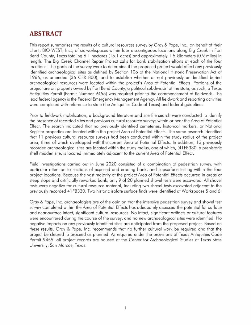
Cultural Resources Survey for the Big Creek Channel
Repair Project in Fort Bend County, Texas
Lead Agency: Federal Emergency Management Agency
Texas Antiquities Act Permit #9455
Prepared for: BIO-WEST, Inc.
1625 Cottonwood School Road Rosenberg, Texas 77471
Prepared by: Gray & Pape, Inc.
110 Avondale Street Houston, Texas 77006
20-72316.001

Project No. 20-72316.001
Cultural Resources Survey for the Big Creek Channel Repair Project in Fort Bend County, Texas
Texas Antiquities Act Permit #9455
Lead Agency: Federal Emergency Management Agency
Prepared for: BIO-WEST, Inc.
1625 Cottonwood School Road Rosenberg, Texas 77471
(832) 990-2940
Prepared by: Michael Quennoz
Gray & Pape, Inc. 110 Avondale Street
Houston, Texas 77006 (713) 541-0473
_________________________________ Tony Scott, M.A.
Senior Principal Investigator August 3, 2020
ABSTRACT
This report summarizes the results of a cultural resources survey by Gray & Pape, Inc., on behalf of their client, BIO-WEST, Inc., of six workspaces within four discontiguous locations along Big Creek in Fort Bend County, Texas totaling 6.1 hectares (15.1 acres) and approximately 1.5 kilometers (0.9 miles) in length. The Big Creek Channel Repair Project calls for bank stabilization efforts at each of the four locations. The goals of the survey were to determine if the proposed project would affect any previously identified archaeological sites as defined by Section 106 of the National Historic Preservation Act of 1966, as amended (36 CFR 800), and to establish whether or not previously unidentified buried archaeological resources were located within the project’s Area of Potential Effects. Portions of the project are on property owned by Fort Bend County, a political subdivision of the state, as such, a Texas Antiquities Permit (Permit Number 9455) was required prior to the commencement of fieldwork. The lead federal agency is the Federal Emergency Management Agency. All fieldwork and reporting activities were completed with reference to state (the Antiquities Code of Texas) and federal guidelines.
Prior to fieldwork mobilization, a background literature and site file search were conducted to identify the presence of recorded sites and previous cultural resource surveys within or near the Area of Potential Effect. The search indicated that no previously identified cemeteries, historical markers, or National Register properties are located within the project Area of Potential Effects. The same research identified that 11 previous cultural resource surveys had been conducted within the study radius of the project area, three of which overlapped with the current Area of Potential Effects. In addition, 13 previously recorded archaeological sites are located within the study radius, one of which, (41FB330) a prehistoric shell midden site, is located immediately adjacent to the current Area of Potential Effect.
Field investigations carried out in June 2020 consisted of a combination of pedestrian survey, with particular attention to sections of exposed and eroding bank, and subsurface testing within the four project locations. Because the vast majority of the project Area of Potential Effects occurred in areas of steep slope and artificially reworked bank, only 9 of 20 planned shovel tests were excavated. All shovel tests were negative for cultural resource material, including two shovel tests excavated adjacent to the previously recorded 41FB330. Two historic isolate surface finds were identified at Workspaces 5 and 6.
Gray & Pape, Inc. archaeologists are of the opinion that the intensive pedestrian survey and shovel test survey completed within the Area of Potential Effects has adequately assessed the potential for surface and near-surface intact, significant cultural resources. No intact, significant artifacts or cultural features were encountered during the course of the survey, and no new archaeological sites were identified. No negative impacts on any previously identified sites are anticipated from the proposed project. Based on these results, Gray & Pape, Inc. recommends that no further cultural work be required and that the project be cleared to proceed as planned. As required under the provisions of Texas Antiquities Code Permit 9455, all project records are housed at the Center for Archaeological Studies at Texas State University, San Marcos, Texas.
i

TABLE OF CONTENTS
ABSTRACT ................................................................................................................................. i
TABLE OF CONTENTS ................................................................................................................ii
LIST OF FIGURES ...................................................................................................................... iii
LIST OF TABLES......................................................................................................................... iii
1.0 INTRODUCTION ................................................................................................................ 1
1.1 Project Overview .............................................................................................................. 1
1.2 Report Organization ......................................................................................................... 1
1.3 Acknowledgements........................................................................................................... 3
2.0 ENVIRONMENTAL CONTEXT ............................................................................................... 4
2.1 Physiography and Geomorphology .................................................................................... 4
2.2 Big Creek ........................................................................................................................ 4
2.3 Soils ................................................................................................................................ 5
2.4 Natural Environment ......................................................................................................... 5
2.5 Land Use ......................................................................................................................... 6
3.0 CULTURAL CONTEXT .......................................................................................................... 7
3.1 Prehistoric Context ............................................................................................................ 7
3.2 Historical Context ........................................................................................................... 10
4.0 FIELD METHODOLOGY .................................................................................................... 13
4.1 Site File and Literature Review.......................................................................................... 13
4.2 Field Methods ................................................................................................................ 13
4.3 Curation........................................................................................................................ 14
5.0 RESULTS OF INVESTIGATIONS .......................................................................................... 15
5.1 Result of Site File and Literature Review ............................................................................. 15
5.2 Results of Field Investigations ........................................................................................... 20
6.0 CONCLUSIONS AND RECOMMENDATIONS ..................................................................... 28
7.0 REFERENCES CITED .......................................................................................................... 29
APPENDIX A: Shovel Test Log
ii

LIST OF FIGURES
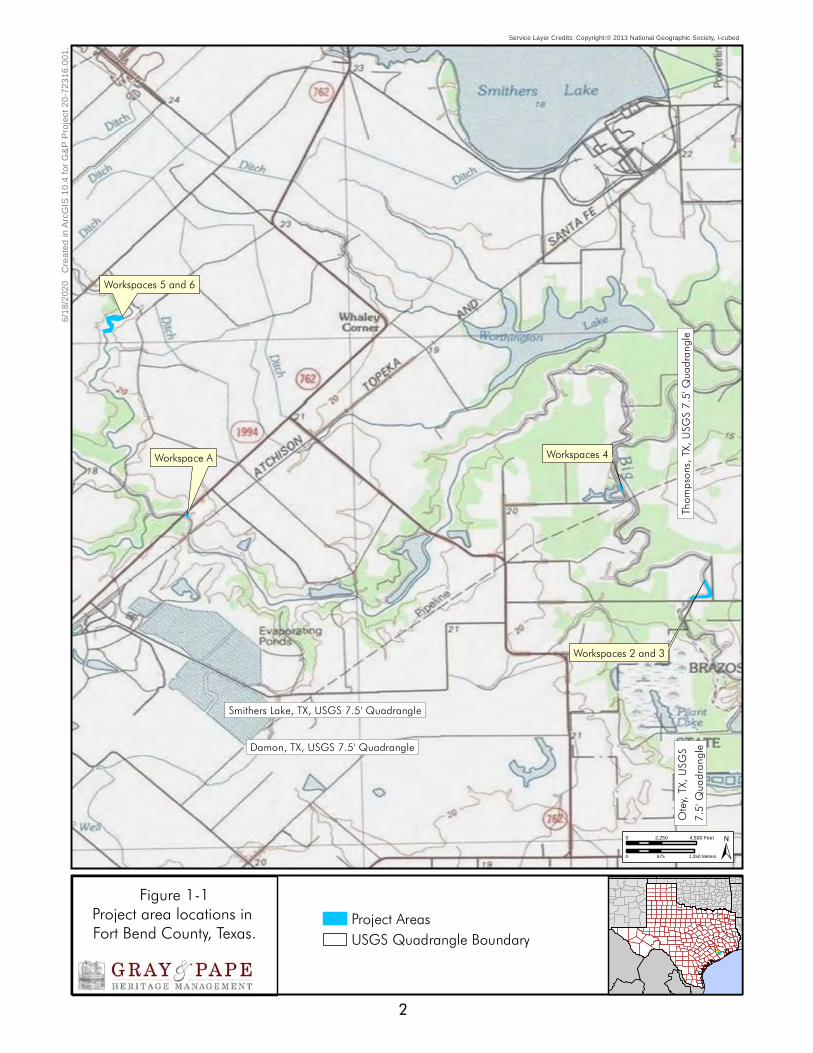
Figure 1-1. Project area locations in Fort Bend County, Texas. ....................................................... 2
Figure 5-4. Survey results within Workspaces 5 and 6 overlaid on an aerial background circa
Figure 5-7. Survey results within Workspaces 2 and 3 overlaid on an aerial background circa
Figure 5-12. Overview of Workspace A APE with large erosional feature showing fill deposits located
Figure 5-1. Research map of Workspaces 5 and 6...................................................................... 16 Figure 5-2. Research map of Workspace A. ............................................................................... 17 Figure 5-3. Research map of Workspaces 2, 3, and 4. ................................................................ 18
12/1/2019. ............................................................................................................................ 21 Figure 5-5. Survey results within Workspace A overlaid on an aerial background circa 3/21/2018. 22 Figure 5-6. Survey results within Workspace 4 overlaid on an aerial background circa 3/21/2018. 23
3/21/2018. ............................................................................................................................ 24 Figure 5-8. Overview of Workspaces 5 and 6 APE. View is to the west. ......................................... 25 Figure 5-9. Shovel Test A3 Profile.............................................................................................. 25 Figure 5-10. Isolate 1 along the erosional surface of the east bank of Big Creek. .......................... 25 Figure 5-11. Isolate 2, eroded brick fragment. ........................................................................... 25
at Workspace A. View is to the north. ......................................................................................... 26 Figure 5-13. Overview of Workspace 4 APE. View is to the north. ................................................ 26 Figure 5-14. Overview of Workspaces 2 and 3 APE. View is to the southwest. ............................... 26 Figure 5-15. Shovel Test A1 Profile............................................................................................ 27 Figure 5-16. Shovel Test A3 Profile............................................................................................ 27
LIST OF TABLES
Table 1-1. Summary of Project Locations ..................................................................................... 1 Table 5-1. Previously Recorded Surveys within 1.6 kilometers of the Proposed Project Areas, Fort Bend
Table 5-2. Previously Recorded Archaeological Sites within 1.6 kilometers of the Proposed Project Areas, County, Texas.......................................................................................................................... 19
Fort Bend County, Texas........................................................................................................... 19
iii

1.0 INTRODUCTION
BIO-WEST, Inc. (BIO-WEST), of Rosenberg, Texas, contracted with Gray & Pape, Inc. (Gray & Pape), of Houston, Texas, to perform an intensive pedestrian cultural resources survey of six workspaces within four discontiguous locations along Big Creek in Fort Bend County, Texas totaling 6.1 hectares (15.1 acres) and approximately 1.5 kilometers (0.9 miles) in length. The Big Creek Channel Repair Project calls for bank stabilization efforts at each of the four locations. The lead federal agency is the Federal Emergency Management Agency (FEMA).
The goals of the survey were to determine if the proposed project would affect any previously identified archaeological sites as defined by Section 106 of the National Historic Preservation Act (NHPA) of 1966, as amended (36 CFR 800), and to establish whether or not previously unidentified buried archaeological resources were located within the project’s Area of Potential Effects (APE). Portions of the APE are on property owned by Fort Bend County, a political subdivision of the state, as such, a Texas Antiquities Permit (Permit Number 9455) was required prior to the commencement of fieldwork. All fieldwork and reporting activities were completed with reference to state (the Antiquities Code of Texas) and federal (NHPA) guidelines.
1.1 Project Overview The APE is located on the Smithers Lake, TX and Thompsons, TX United States Geological Survey (USGS) 7.5-minute topographic quadrangle maps (USGS 1980). Each of the four areas that constitute the project APE is located along Big Creek in Fort Bend County Texas (Figure 1-1, Table 1-1). Current project plans call for maintenance work designed to restore flow and circulations and prevent erosion in each of the four locations. Work will consist of excavation of sedimentation and installation of sheet-piling to restore bank contours. Sheet piling will be
driven approximately 4.57 meters (15 feet) below the natural ground surface and the maintenance corridor will extend approximately 30 to 60 meters (98 to 196 feet) from the bank. The pilings will be driven by means of track hoe equipped with a hydraulic hammer attached to the boom. No bank sculpting or new excavation will be required for the installation of the pilings or equipment access to the workspaces. Because installation of the pilings will require no new excavation and deep impacts will be restricted to the driving of pilings into previously sloped and contoured banks, deep testing was not included as part of the survey design. Workspaces 5 and 6 are located near Boothline Road where construction will take place on both sides of Big Creek. Workspace A located near Whaley Long Point Road includes only the northeastern bank where work will consist of the placement of articulated block to slow erosion. Workspace 4 is located near Rawlings Road and construction will be limited to the southwestern side of the creek. Workspaces 2 and 3 are located near Sawmill Road where work will be conducted on both sides of the creek.
Table 1-1. Summary of Project Locations
Location Length Area
Workspaces 5 and 6 630 meters 3.7 hectares Workspace A 75 meters 0.1 hectares Workspace 4 125 meters 0.3 hectares
Workspaces 2 and 3 650 meters 2.0 hectares
1.2 Report Organization This report is organized into seven numbered chapters and one lettered appendix. Chapter 1.0 provides an overview of the project. Chapter 2.0 presents an overview of the environmental setting and geomorphology. Chapter 3.0 presents a discussion of the cultural context associated with the APE. Chapter 4.0 presents the research design and methods developed for this investigation. The results of this investigation are presented in Chapter 5.0.
1
Service Layer Credits: Copyright:© 2013 National Geographic Society, i-cubed
6/1
8/2
020
Cre
ate
d in
Arc
GIS
10.
4 fo
r G
&P
Pro
ject
20
-72
316
.001
.
Workspaces 5 and 6
Workspace A Workspaces 4
Workspaces 2 and 3
Smithers Lake, TX, USGS 7.5' Quadrangle
Damon, TX, USGS 7.5' Quadrangle
Otey, T
X, USG
S Tho
mpson
s, TX, U
SGS 7
.5' Qu
adrang
le 7.5
' Quad
rangle
0 2,250 4,500 Feet
0 675 1,350 Meters
Figure 1-1 Project area locations inFort Bend County, Texas. Project AreasUSGS Quadrangle Boundary
2

Chapter 6.0 presents the investigation summary and provides recommendations based on the results of the field survey. A list of literary references cited in the body of the report is provided in Chapter 7.0. Appendix A includes a log of all excavated shovel tests.
1.3 Acknowledgements The intensive pedestrian survey was completed by Principal Investigator Tony Scott, M.A. and Archaeologists Michael Quennoz and Amanda Kleopfer, under the supervision of Mr. Scott, on June 3 and 4, 2020. The fieldwork required 48-person hours to complete. Mr. Quennoz and Mr. Scott prepared the report. Mr. Scott produced graphics. Jessica Bludau edited and produced the report.
3

2.0 ENVIRONMENTAL CONTEXT
2.1 Physiography andGeomorphology The Texas Coastal Plain makes up part of the larger Gulf Coastal Plain, a low level to gently sloping region extending from Florida to Mexico. The Texas Coastal Plain reaches as far north as the Ouachita uplift in Oklahoma, and as far west as the Balcones escarpment in central Texas. The basic geomorphological characteristics of the Texas coast and associated inland areas, which includes Fort Bend County, resulted from depositional conditions influenced by the combined action of sea-level changes from glacial advance in the northern portions of the continent, and subsequent downcutting and variations in the sediment load capacity of the region’s rivers. Locally, Fort Bend County is underlain by relatively recent sedimentary rocks and unconsolidated sediments ranging in age from the Miocene to Holocene (Abbott 2001; Van Siclen 1991).
Although older geologic units have been identified in the region (Abbott 2001; Barnes 1982; Van Siclen 1991), units relevant to the study of long-term human occupation in modern-day Fort Bend County include the Beaumont Formation, generally believed to predate human occupation in the region, the so-called “Deweyville Terraces”, stratigraphically positioned between the Beaumont and Recent deposits. Holocene alluvium underlies the project area (Barnes 1982). These deposits are made up of clay, silt, and sand. This includes stream channel, point bar, natural levee, back swamp, and mud-flat deposits (Barnes 1982). Gilgae, a succession of microbasins and microknolls in generally level areas or microvalleys and microridges parallel to the slope, are common microfeatures.
The date of deposition for the Deweyville Terraces is not known. However, Abbott
(2001:16) among others believes the north-south oriented terraces aggraded during the Late Pleistocene from overbank deposition of rivers and streams including the ancient Brazos River prior to the beginning of the Holocene. Abbott suggests that aggradation ended by approximately 20,000 years before present (B.P.) (Abbott 2001:106). However, meanders of rivers including the Brazos cut valleys through these terraces regularly during the Holocene and then abandoned them. This process leaves large, flat, open, and well drained areas favored for campsites. While all depositional facies other than channels have the potential to preserve archaeological sites, behaviorally, human activity favors well-drained, sandy channel-proximal localities over flood basin muds (Abbott 2001:126). Other Recent or Holocene deposits on the Gulf Plain typically result from overbank flooding of extant streams, eolian transport including dune formation, and infilling of marshes.
Within current project work site, Workspaces 5 and 6 are located within an area mapped as being underlain by the Pleistocene-age Beaumont Formation, while the remaining workspace locations are located within areas of Holocene-age alluvium (Barnes 1982).
2.2 Big Creek The headwaters of Big Creek are located south of Rosenberg in central Fort Bend County and from there the stream flows southeasterly for 40 kilometers (25 miles) before joining the Brazos River upstream of Farm to Market 1462. The creek represents an older, more southerly, channel of the Brazos River. Consequently, sloughs and oxbow lakes frame much of the stream’s course as it cuts across the coastal prairie (Norris and Linam 1999).
The course and sedimentation of the Brazos River have a complex history. Channel avulsion is documented to have occurred four times in
4

the Holocene (Waters and Nordt 1995). The first occurred at 8,100 B.P., the second at 2,500 BP, another around 500 B.P., and the last around 300 B.P. The depositional regime changed soon after the first avulsion after 8,500 B.P. and floodplain construction is dominated by vertical accretion until 4,200 B.P. The second period of vertical accretion occurs from 2,500 to 1,250 B.P. Nordt and Waters (1995) postulate two major and three minor periods of soil formation in the floodplain sequence. The two most developed soils formed from 4,200 to 2,500 B.P. and a less well-developed soil formed from around 1,250 to 500 B.P.
2.3 Soils Three soil series are mapped within the APE: Kaman clay, Pledger clay, and Bernard-Edna clay loam (Soil Survey Staff, Natural Resources Conservation Service, United States Department of Agriculture [SSS NRCS USDA] 2020). The Kaman series consists of very deep, somewhat poorly drained and slowly permeable soils derived from Holocene-age alluvium. Kaman soils underlie all of Workspace A and portions of Workspaces 5 and 6. Pledger series soils are very deep, moderately well-drained, and very slowly permeable soils formed in clayey alluvium of Holocene age. Pledger clay is mapped at Workspaces 2, 3, and 4. Both Kaman and Pledger series soils are typical of broad floodplains. The Bernard series soils are very deep, somewhat poorly drained, and derived from clayey fluviomarine deposits of the Beaumont Formation. They are typically associated with flats and meanders located on coastal plains. Edna series soils are very deep and somewhat poorly drained. They are derived from loamy fluviomarine deposits of the Beaumont Formation. In contrast to the Bernard soils with which they are associated, they are typically associated with pimple mounds that dot the coastal plain. Bernard and Edna soils are mapped at Workspaces 5 and 6 (SSS NRCS USDA 2020).
2.4 Natural Environment
Flora and Fauna
Fort Bend County lies at the southwestern boundary of the Austroriparian biotic province as defined by Blair (1950). The project area is located within the Floodplains and Low Terraces sub-region of the Western Gulf Coastal Plain Ecoregion (Griffith et al. 2007). Evidence from pollen analysis in Central Texas suggests that, at least during the Late Pleistocene, the area may have been populated by vegetative species that were tolerant of a cold-weather environment. Climactic flux during the Holocene would eventually result in a gradual trend towards warmer weather, similar to that seen today (Abbott 2001).
Late Pleistocene flora may have included populations of spruce, poplar, maple, and pine (Holloway 1997), in an oak woodland environment that would eventually transition to an oak savanna in the late Holocene (Abbott 2001). Fauna during this time would include currently present species such as white-tailed deer and various smaller game, as well as bison, and, in localized areas, pronghorn sheep, and the American alligator (Abbott 2001).
The modern vegetative community associated with this region consists of a diverse collection of primarily deciduous trees and undergrowth (Abbott 2001). Modern land alteration activities, especially those associated with agriculture, have resulted in the removal of native plant species from the area. Commonly identified trees include water oak, pecan, various elms, cedar, oaks, sweetgum, Chinese tallow, and mulberry. Honeysuckle, dewberry, ragweed, yaupon, and blackberry are common, as are Indiangrass and bluegrasses and various types of briars and vines (Abbott 2001).
The modern faunal community includes mammals such as deer, squirrel, opossum, raccoon, skunk, and various small rodents, numerous bird species, and reptiles including
5

the Texas rat snake, the western cottonmouth, the kingsnake, American alligator, and turtle species. Invasive feral hogs are also common. Black bear and bison were present occasionally in the past (Abbott 2001; Norris and Linam 1999).
Climate
Fort Bend County’s close proximity to the Gulf of Mexico tends to influence the temperature, rainfall, and relative humidity of the region. Winds usually trend from the southeast or east, except during winter months when high-pressure systems can bring in polar air from the north. Average temperatures in the summer can reach well above 30 degrees Celsius (90 degrees Fahrenheit), and are often accompanied by equally high humidity. Although winter temperatures can reach below 0 degrees Celsius (30 degrees Fahrenheit), below freezing temperatures usually occur on only a few days out of every year and are typically restricted to the early morning hours (Mowery et al. 1960).
Rainfall is even throughout the year, with an average monthly distribution ranging from between 43 centimeters (17 inches) to trace amounts; rainfall comes primarily from thunderstorms, which tend to be heavy but of short duration (Mowery et al. 1960).
2.5 Land Use The project areas currently consist of stream bank surrounded by properties currently being used for grazing. In most cases, the bank at each location has been heavily modified by past flood control measures. In addition to widespread sculpting of the streambanks, beginning in the 1950s, the streambed was regularly dredged, and the material deposited along the tops of the adjacent banks (Adam Wright personal communication). In some
cases, these deposits could be as much as 6 meters (20 feet) thick (Walley 1955).
Historical aerial imagery and maps were reviewed at each location (Google, Inc. 2020; Nationwide Environmental Title Research [NETR] 2020). At Workspaces 5 and 6, the stream and its associated banks appear to have remained relatively untouched as late as a 1951 aerial image. However, by 1983 the banks appear cleared of vegetation and sculpted (NETR 2020). Subsequent rounds of clearing and sculpting can be seen in some later aerials, most notably in 2008 when the entire south/east bank was graded to bare earth (Google, Inc. 2020).
At Workspace A, the Whaley Long Point Road bridge is already present on a 1954 aerial image, but otherwise, the stream appears unmodified. Between 2006 and 2008, a natural drainage that flowed into the creek at the south end of the APE was filled and a concrete spillway with buried outflow pipe installed diverting the water further to the south. During the same period, the bridge was widened and replaced (Google, Inc. 2020; NETR 2020).
At Workspace 4, a 1951 aerial image shows that Big Creek formerly followed a bend to the west of the current project area. At some point prior to the 1980s, the stream’s course was straightened, cutting the current channel and the former natural bend became a cattle pond. The current APE is located entirely within this newly cut channel (Google, Inc. 2020; NETR 2020).
At Workspaces 2 and 3, the stream banks have been left relatively unmodified. Though historical aerial imagery shows that sometime between 1951 and 1982 the wooded banks were completely clear cut and remained so until the 1990s (Google, Inc. 2020; NETR 2020).
6

3.0 CULTURAL CONTEXT
3.1 Prehistoric Context Traditionally, Southeast Texas has been viewed as a buffer zone between cultural regions in prehistoric times. Patterson (1995) describes the archaeological record in this area as being an interface between the Southern Plains and the Southeast Woodlands. Along similar lines, both Shafer (1975) and Aten (1984) have categorized the Post-Archaic archaeological record of this region as Woodland. This categorization is not meant to literally invoke the exact cultural patterns and chronology of the Woodlands culture found to the east. Aten (1984:74) summarizes his concept by saying, “it loosely connotes activities by populations on a geographic as well as a cultural periphery of the southeastern Woodlands.”
Dee Ann Story (1990) has suggested that the culture of Southeast Texas is distinctive enough so as to merit a separate designation by the Late Prehistoric. The Mossy Grove cultural tradition is a heuristic concept based on technological similarities shared by groups in this region. The primary marker of this technological tradition is the plain, sandy-paste Goose Creek pottery that is found in this region from the Early Ceramic through Early Historic periods.
Ethnic affiliations for the region are not entirely clear. Aten (1983) has defined the Brazos Delta-West Bay, Galveston Bay, and Sabine Lake archaeological areas and suggests that they may correlate with the Historic territories of the Coco, Akokisa, and Atakapa groups, respectively. Similarly, historic reconstructions of the inland subregion suggest a number of possible group affiliations (Story 1990). The historic economic inland/coastal cycle of the Akokisa, which stretched from Galveston Bay to the San Jacinto River basin, may mean that archaeological materials in the Lake Conroe area are affiliated with this group. Alternately, these remains may be associated with the Bidais
who occupied territory immediately to the north of the Akokisa groups. At this point in time, it is not possible to identify the cultural affiliation of the groups that inhabited the inland subregion. In part, this is a function of the dynamic nature of this region in which a number of cultural traditions met and diffused.
The Southeast Texas region is divided into inland and coastal margin subregions, which have archaeologically distinctive subsistence patterns, settlement patterns, and artifact types. Archaeological and historic evidence suggests that some groups exploited inland resources year-round, while other groups spent parts of the year both inland and on the coast.
Based on aspects of material culture, researchers have identified six archaeological time periods associated with Native Americans in the Southeast Texas region; in general, these include the Paleoindian, Archaic (with Early, Middle, and Late subdivisions), Ceramic, Late Prehistoric, Protohistoric, and Historic Indian. Archaeologists within the region agree on the general framework of cultural time periods while disagreeing on the temporal boundaries of these periods. Patterson’s (1995) chronology, for example, includes Early Paleoindian (10,000-8,000 B.C.), Late Paleoindian (8,000-5,000 B.C.), Early Archaic (5,000-3,000 B.C.), Middle Archaic (3,000-1,500 B.C.), Late Archaic (1,500 B.C.-A.D. 100), Early Ceramic (A.D. 100-A.D. 600), Late Prehistoric (A.D. 600 to 1500), Protohistoric (A.D. 1500 to 1700), and the Historic Indian (A.D. 1700 to 1800) periods. In contrast, Ensor (1995) offers a Southeast Texas chronology that includes Paleoindian (10,000 to 8,000 B.C.), Early Archaic (8,000 to 5,000 B.C.), Middle Archaic (5,000 to 1,000 B.C.), Late Archaic (1000 B.C. to A.D. 400), Early Ceramic (A.D. 400 to 800), and Late Ceramic (A.D. 800 to 1750). Despite these differences, the chronologies developed by researchers are based primarily on changes in projectile point
7

technologies within the region and the introduction of pottery. It is generally recognized that a broad-based hunting and gathering lifestyle was utilized throughout all time periods.
Paleoindian Period
Evidence is sparse for Paleoindian habitation, and much of what is known about the period in the area comes from a compilation of materials gathered from the state of Texas and North America. At the close of the Pleistocene, large game hunters crossed the Bering Strait, and within a few millennia had penetrated into South America (Culberson 1993; Newcomb 1961). The Paleoindian people traveled in small bands (Culberson 1993) and were megafauna hunter-gatherers with the bulk of their meat protein derived from mammoths, mastodons, giant bison, and giant sloths. These groups carried with them an easily recognizable stone tool material culture, though admittedly, little is known about their wooden or bone tools and clothing types. The later Folsom Culture developed a very efficient toolkit that was apparently designed to be portable leading to theories that these people were following buffalo herds across the plains. However, the widespread use of Folsom technology suggests that the technology spread beyond the area for which it was initially designed. Isolated Paleoindian artifacts found across southeastern Texas include Clovis, Angostura, Scottsbluff, Meserve, Plainview, and Golondrina point types (Aten 1983).
The Transitional Archaic period begins about 9,000 years ago and ends around 7,500 years ago (Aten 1983; Story 1990). This stage is also poorly represented in the archaeological work in the area but isolated finds of Bell/Calf Creek, Early-Side Notched, and Early Expanding Stemmed dart points are attributed to this time period.
Archaic Period
With the retreat of the glaciers (the Hypsithermal period), the megafauna upon which the Paleoindian peoples depended gradually
became extinct. This shift in the food supply is seen as the pivotal transition point between the Paleo and Archaic periods (Biesaart et al. 1985; Culberson 1993; Newcomb 1961). Though dates often disagree (ranging from 8,000 B.C. marking the beginning of the Early Archaic [Culberson 1993] to Aten [1984] stating that the transition from Late Archaic to Late Prehistoric-Woodland began around A.D. 100), there are three progressive stages recognizable during the Archaic period: the Early, Middle, and Late.
Much of what is known about the Early Archaic peoples indicates that they were small, isolated bands of hunter-gatherers that remained in relatively restricted regions (Aten 1984). With the loss of the mega-fauna as a food source, the Early Archaic peoples adopted the hunting of smaller game such as bison and deer and increased their reliance on foraging (Culberson 1993). The material record fits the transitional makeup of this period because there was a dramatic shift from the large spear points of the Paleoindian period to a reliance on smaller dart type points. Diagnostic designs for this period are Dalton, San Patrice, Angostura, Golondrina, Merserve, Scottsbluff, Wells, Hoxie, Gower, Uvalde, Martindale, Bell, Andice, Baird, and Taylor (Turner and Hester 1993). These points are much more crudely made than their Paleo precursors but remain designed for use on a spear shaft.
The Middle Archaic period saw the largest growth in technology and in the number of stone tools utilized. Specialized tools appeared for the milling of wild plant foodstuffs (Culberson 1993) along with a large assortment of tools for food preparation and procurement. Gravers, scrapers, axes and choppers, knives, drills, and polished stone tools, also known as ground stone tools, began to appear in large quantities (Newcomb 1961). Diagnostic points such as Gary, Kent, Palmillas, Nolan, Travis, Belvedere, Pedernales, Marshall, Williams, and Lange dominate the spectrum of dart points from the Middle Archaic period (Turner and Hester 1993; see also the Edwards Plateau
8

Aspect [Newcomb 1961]). The advent of the atlatl also seems to be placed within this period (Culberson 1993).
The Late Archaic period saw a dramatic increase in the population densities of Native American groups. Human habitation of areas rich in diverse flora and fauna intensified, as did the variety of materials and artifacts (Culberson 1993; Aten 1984). Late Archaic peoples began relying heavily on foraging tubers, berries, and nuts and hunting small game such as deer, rabbits, and raccoons, as well as fish and shellfish, and birds. Groups became socially more complex than earlier periods and the result was an increasing intercommunication with neighboring groups. Culberson (1993:55) states that a “Lapidary Industry” developed in which stone artifacts were made from exotic materials (jasper, hematite, quartz, shale, slate, etc.) acquired from sources great distances away. These materials were fashioned into an increasingly complex array of household goods such as celts, plummets, banner stones, mortars and pestles, and pendants; also, during this period there is an increase in the occurrence of sandstone bowls (Culberson 1993). Diagnostic points of this period are difficult to distinguish from those of the Middle Archaic. Gary and Kent points remain prevalent in southeast Texas, while other points such as Marcos, Montell, San Gabriel, Mahomet, Fairland, and Castroville also appear at times (Turner and Hester 1993).
The Archaic period in southeast Texas ends with the adoption of ceramic technology at the beginning of the Ceramic period. Patterson (1995) places the beginning of the Early Ceramic period on the Texas coast from 100-600 A.D. Aten (1983) placed the appearance of pottery in the Galveston Bay area approximately 100 A.D. The ceramic chronology of the inland areas parallels that of the coast; however, it does not manifest until several centuries later. The inland areas generally lack the earliest ceramic types present in the coastal region as well as some of the later ceramic types (Aten 1983; Story 1990). As a result of trade networks or
stylistic/manufacturing influences, it appears that ceramic traits moved from the coast to the inland areas and from the east to the west (Aten 1983).
Late Prehistoric
The transitional period between Late Archaic and Woodland-Late Prehistoric is a period marked by an intensification of group dynamics across Texas. The advent of the bow and arrow is believed by most (Aten 1984; Culberson 1993; Newcomb 1961) to be from this period, though some may place it later. Most importantly for archaeological investigations, the first signs of pottery begin to emerge at sites from this period (Aten 1983). Although the amount and variety of pottery intensify during the Late Prehistoric, it is an excellent way of determining the terminus post quem of a site. Fishing, bison hunting, and the collection of wild flora intensify beyond the level of the Late Archaic period during this stage, but there is no sufficient data to demonstrate the initial advent of sedentary agriculture. The diagnostic points of this period are Catahoula, Friley, Alba, and Bonham (Turner and Hester 1993).
The Late Prehistoric (also known as Woodland and Ceramic periods) continues from the end of the Archaic period to the Historic period ushered in by the Spanish Missions and Anglo-American settlers. During this period, there is a shift to the almost total use of arrow points such as Perdiz and, later, Scallorn, and a wide variety of ceramic types. According to Aten (1984), there are nearly 18 different types of pottery from this period currently identified for the east Texas Coast alone based on temper, paste, and design.
Goose Creek and other sandy paste pottery types are often recovered from the Ceramic period and Late Prehistoric sites throughout southeast Texas. Goose Creek appears in Aten’s coastal chronology to greater or lesser extents in nearly every period, particularly Mayes Island, Turtle Bay, Round Lake, and the later Orcoquisac periods. Because of the
9

predominance of sandy paste pottery across the region, Story (1990) has suggested the Mossy Grove Tradition as an encompassing cultural tradition for the area. Other ceramic forms that occur in the region include grog-tempered, stamped, and bone-tempered pottery (Patterson 1996).
Protohistoric Period to the Post-Contact Period
It is during this period, that peoples known today as the Caddo, Attakapans, and Bidai, to name a few, are identifiable both culturally and materially. This is mostly due to the historical sources of the seventeenth through the nineteenth centuries that aid in the reconstruction of the past cultures in the area. In order to better understand the complexity of the region’s cultures, researchers turn to historical sources to get an understanding of the peoples who first occupied southeast Texas. Hernando De Soto encountered the Native Americans of the region during his expedition in 1542 (Hudson 1976); it was the first recorded meeting with the Caddo peoples. The first expeditions by René-Robert Cavelier, Sieur de La Salle in 1687 and the subsequent settlement in the eighteenth century by Europeans continued to document the presence of Native American groups in the area (Aten 1984). French traders and Spanish missionaries encountered the Hasinai, also known as the Neches Angelina, who became allies of the Spanish against the western Apache tribes (Newcomb 1961). The later historical sources identify the Hasinai as one of the two main groups in the area of eastern Texas that fall under the Caddo culture (the primary culture that dominated the Piney Woods area), the other of which is the Kadohadacho (La Vere 1998; Gregory 1986).
The loose cultural group, known as the Attakapans, dominated the majority of the land north of present-day Harris County in what is now Montgomery County. Their language group extended from the Gulf coast to the Trinity and San Jacinto Rivers and they had
much in common with the coastal group known as the Karankawa (Aten 1984). The Attakapans were subdivided into regional groups. The Akokisas dwelled primarily on the shores of the Trinity and San Jacinto rivers. The Patiris group occupied the land north of the San Jacinto valley. The Bidai group dominated the Trinity Valley and to their north was the small group known as the Deadoso. Most of what is known about the Attakapans culture comes from the early accounts of the French explorer DeBellise. They are described as primarily hunter-gatherer groups who relied somewhat on agriculture and fishing (Sjoberg 1951). Both Wharton (1939) and Sowell 1904) relate to interactions between early Anglo-American settlers and Karankawa who sometimes encamped on Big Creek. In the early to mid-1800s, a known Karankawa camp was located along Big Creek, approximately 24 kilometers (15 miles) away from Richmond (Wharton 1939).
In the seventeenth and eighteenth centuries, the Spanish and French used the Native American groups as pawns in the two nations’ quest to settle the area (Newcomb 1961). Most destructive for all native groups in the region was the influx of European diseases. When Anglo-American settlers began moving into the area in mass around the 1850s, disease and warfare had decimated the groups to near extinction.
3.2 Historical Context Fort Bend County was established on December 29, 1837, from parts of Austin, Brazoria, and Harrisburg counties. Richmond, which had been incorporated in May of that same year, was voted the county seat by the citizens of the new county. The area was originally settled in the 1820s as part of the land originally granted to Moses Austin by the Spanish colonial government and then reissued by the Mexican government after the Mexican Revolution (1810-1821). Of the 297 original grants, 53 of them were situated in the future Fort Bend County (Ott 2010).
10

In 1821, the first contingent of Stephen F. Austin’s settlers anchored at the mouth of the Brazos River. A small party from this group continued 145 kilometers (90 miles) up the Brazos to a bend in the river. In November of 1822, a blockhouse was built at this location to protect the settlers from hostile Indians. Other settlers followed and a small community that came to be referred to as Fort Bend grew around the blockhouse. Fort Bend was located on one of the primary fords of the Brazos River and as such played a role in the troop movements during the Texas Revolution. The site was abandoned when Santa Anna’s Mexican Army crossed the river en route to the battle of San Jacinto. When the area was resettled, the new community of Richmond was established (Leffler 2010). Homesteads were also established along the banks of Big Creek to the south, and along Oyster Creek to the east (Wharton 1939).
The early land grants in what became known as the Big Creek Neighborhood were given to land speculators who in most cases had little interest in permanently settling in the area. Men like Joseph H. Polley, who received a land grant along the lower part of Big Creek that stretched to the Brazos, stayed on the property just long enough to cement his claim before moving towards San Antonio. It was not until a second wave of Anglo-American colonizers arrived between 1827 and 1832 that permanent white settlement in the area took hold (Wharton 1939:49-63).
Land grants within the current project areas were issued to Joseph H. Polley in 1824 (Workspaces 2 and 3), David Milburn in 1828 (Workspace 4), W. T. Austin in 1831 (Workspaces 5 and 6), and Charles D. Sayre (Workspace A). Polley, as mentioned previously, lived on his grant only a short while before moving west and pursuing ranching. William. T. Austin, a distant relative of Stephen A., was also rarely on his Big Creek property, though he did maintain a home there near the Brazos called Austin’s Point (Wharton 1939). David H. Milburn, who originally arrived in America in
1823, received a grant in Austin’s colony in 1824. In 1828, Milburn received an additional grant along Big Creek (Wharton 1939). Charles D. Sayre originally came to Texas in 1831. He owned approximately 2,428 hectares (6,000 acres) of land by 1840 and ran a sugar-milling business in the 1850s, becoming one of the top sugar producers in the Brazos area (Roell 2019).
Richmond became a regional trade center in the following decades, with barges and steamboats carrying the cotton, corn, and sugar produced in the region down the Brazos to Galveston (Leffler 2010). In 1853, the Buffalo Bayou, Brazos, and Colorado Railway proved a further boon to business connecting Stafford Point to Harrisburg. African slaves were essential to the plantation economy of region and by the 1850s, outnumbered the white inhabitants of the county. The 1860 census recorded 120 people living in the Big Creek neighborhood (Wharton 1939). By the start of the Civil War, there were approximately 250,000 Africans held in captivity in Texas and the majority of these people were living on plantations in eastern Texas. Because of their economic and social dependency on slave labor, Fort Bend planters strongly supported the secession of the southern states from the United States of America (Ott 2010).
The final quarter of the nineteenth century witnessed a steady increase in the settlement and population of the county. Immigrants from Central Europe, including Czechs, Germans, Austrians, and Bohemians, established prosperous small farms on the lands once held by the large plantations. A number of settlements arose along the rail lines that stretched across the entire county. One such community, Rosenberg, grew at the junction where the Colorado and Santa Fe line crossed the Galveston, Harrisburg, and San Antonio line 5 kilometers (3 miles) west of Richmond. Rosenberg would grow to be the predominant town in the county surpassing Richmond in population in 1920 (Ott 2010).
11

The economy of Fort Bend in the nineteenth century focused on cotton, sugar, corn, and livestock production. In the 1890s, a one-million-dollar sugar refinery was constructed in Sugar Land. The county also contains substantial amounts of oil, gas, and sulfur deposits, which have played a major role in the economic development of the area (Ott 2010).
Fort Bend County’s economic and social identities have revolved around farming and ranching since the earliest settlers arrived. Poor economic and agricultural conditions in the latter part of the nineteenth century resulted in a movement toward farm tenancy. In 1925, 72 percent of farms in the county were operated on
a tenancy basis. During the World War II years, the lure of jobs in urban centers and the military reduced the number and ratio of tenant farmers. More valuable uses of the farmland by home developments, industry, business, and commerce reduced the number of viable commercial farms. Until very recently, the development and transport of oil, gas, and sulfur have been at the heart of commercial ventures and industry in the county. As the City of Houston has expanded westward, a more diverse mix of commerce and industry has taken root. Property-development corporations and two high-technology corporations are the largest contributors to the county’s tax coffers (Ott 2010).
12

4.0 FIELD METHODOLOGY
This cultural resource investigation was designed to identify and assess new and already recorded cultural resources that may be impacted by the proposed project. Desktop assessment and modeling were performed prior to initiating field investigations in order to better understand cultural, environmental, and geological settings. The results of the desktop assessment were then used to develop the field methodology.
4.1 Site File and Literature Review Site file research was initiated by reviewing records maintained by the Texas Archeological Research Laboratory (TARL) in Austin, Texas, and by consulting online research archives maintained by the Texas Historical Commission (THC). Site file research resulted in a listing of all archaeological sites within 1.6 kilometers (1 mile) of the project area and all historic structures eligible for the National Register of Historic Places (NRHP) listing located adjacent to the project APE. Documentary research, including historical maps, USGS topographic maps, historical aerials, and land grants, was conducted in order to provide an understanding of the development and history of the project area, the surrounding area, and southeast Texas in general. This research then was used to prepare an overview history of the area and to provide an understanding of the contextual framework of local prehistory and history.
4.2 Field Methods
Intensive Pedestrian Survey
The project workspace locations are largely located along heavily modified landscapes as a result of past stream channelization efforts; therefore, shovel testing was focused in areas of minimal disturbance, as well as in areas near known archaeological sites. In areas of slope, obvious disturbance, such as along canals and levees or in areas of development, shovel testing was less intensive. Subsurface testing
consisted of the excavation of 30- by 30-centimeter (12- by 12-inch) shovel tests. Vertical control was maintained by excavating each shovel test in 10-centimeter (4-inch) levels. One wall of each shovel test was profiled, and the walls and floor of each shovel test were inspected for color or texture change potentially associated with the presence of cultural features. When possible, soils were screened through 0.64-centimeter (0.25-inch) wire mesh; soils with high clay content were hand sorted in an effort to detect cultural materials in the soil matrix. Descriptions of soil texture and color followed standard terminology and the Munsell (2005) soil color charts. All the field data were recorded on appropriate field forms. All shovel tests were backfilled after excavation and documentation. The excavated shovel tests were placed on field maps and points were taken with Global Positioning System (GPS) if the strength of the signal permitted.
Site Definition
If new or previously identified cultural resources were encountered, systematic steps would be taken to define their extent, limits, and general character within the confines of the APE. Additional delineation shovel tests would be excavated in four radiating directions at an interval of 10 meters (32.8 feet) within the confines of the APE. In general, two sterile shovel tests would be used to define a site’s size and extent. At a minimum, between six and eight delineation shovel tests would be excavated unless surrounding landforms or topography suggested the presence of a natural site boundary.
For each cultural resource identified, including structures or other resources within or immediately adjacent to the APE, photographs would be taken of the general vicinity and of any visible features. A sketch map would be prepared showing site limits, feature locations, permanent landmarks, topographic and
13

vegetation variations, sources of disturbances, and the total number of tests performed within the site. Only diagnostic artifacts recovered from shovel tests would be collected. Locations of all positive tests were recorded with the GPS.
If any architectural resources had been identified, these would have been recorded on corresponding field forms. Details of form, construction, material, style, condition, and alteration would be recorded both on the forms and photographically for each structure. All documentation would be reviewed by a
qualified Architectural Historian who would decide if additional information or a personal field inspection was necessary at the survey level.
4.3 Curation No diagnostic or non-diagnostic artifacts were collected in the course of the current survey. As a project permitted through the THC, however, Gray & Pape submitted project records to the Center for Archaeological Studies at Texas State University in San Marcos, Texas.
14

5.0 RESULTS OF INVESTIGATIONS
5.1 Result of Site File andLiterature Review Site file research resulted in a listing of all archaeological sites and cultural resource surveys within 1.6 kilometers (1 mile) of the project area and all historic structures eligible for the NRHP listing located adjacent to the project APE (Figures 5-1 through 5-3). The search of the Texas Archeological Sites Atlas determined that no previously identified cemeteries, historical markers, or National Register properties are located within or adjacent to the project APE. The same research identified that no previous sites or surveys are located with the 1.6-kilometer (1-mile) study radius of Workspaces 5 and 6 (Figure 5-1). Eleven previous cultural resource surveys had been conducted within the 1.6-kilometer (1-mile) study radius of Workspaces A, 2, 3, and 4, three of these surveys overlap with the current APE (Figures 5-2 and 5-3). Thirteen previously recorded archaeological sites are located within the study radius of Workspace 4, 2, and 3 (Figure 5-3). One site, 41FB330, was identified as being immediately adjacent to Workspaces 2 and 3 (Figure 5-3).
Previously Recorded Surveys
The Texas Archeological Sites Atlas identifies 11 previous cultural resource surveys conducted with 1.6 kilometers (1 mile) of the APE (Table 5-1). Three of these surveys overlap with the current project areas. In 1987, a linear survey sponsored by the United States Army Corps of Engineers investigated a section of Big Creek between Fairchilds Creek and Rabbs Bayou, including the current Workspace A project area. Two large block surveys overlap with Workspaces 2 and 3. However, no additional information is available for these two surveys.
Previously Recorded Archaeological Sites
According to a search of the Texas Archeological Sites Atlas, 13 previously recorded archaeological sites are located within the 1.6-kilometer (1-mile) study radius of the project area (Table 5-2). One site, 41FB330, is located immediately adjacent to Workspaces 2 and 3.
Many of the sites previously excavated along Big Creek within the research study radius were originally excavated in the 1950s and poorly documented. However, it is known that at some of them, such as 41FB13 located 900 meters (3000 feet) upstream of the Workspace 4 APE, contained multiple prehistoric burials dated to the Late Archaic. Several of the burials appeared to be interred with decorated bone and shell grave goods. Likewise, 41FB2, located near the mouth of Big Creek where it joins the Brazos, is believed to have been the location of 75 to 100 burials before being targeted by collectors in the 1950s (Walley 1955; Terneny 2005).
Site 41FB330 is the only site located adjacent to a project area. It was recorded by Atkins in 2011 as a prehistoric shell midden that extended along the east bank of Big Creek north and south of the Sawmill Road bridge. The investigation consisted of a pedestrian walkover and three bank scrapes. The site was estimated to be approximately 500 square meters (5,400 square feet) but was not fully delineated to the south due to right of way restrictions. Artifacts observed in the profile scrapes included bone fragments, a biface, lithic debitage, shell, and charcoal. The deposit was estimated to be greater than 100 centimeters (40 inches) thick and continued beneath the water line at the time of recording (Washington 2011). The site’s eligibility status is currently listed as undetermined.
15

6/1
8/2
020
Cre
ate
d in
Arc
GIS
10.
4 fo
r G
&P
Pro
ject
20
-72
316
.001
Service Layer Credits: Copyright:© 2013 National Geographic Society, i-cubed
Workspaces 5 and 6
0 690 1,380 Feet
Smithers Lake, TX, USGS 7.5' Quadrangle 0 210 420 Meters
Figure 5-1 Project Area Research map of Workspaces 5 and 6. Study Radius (1.6-km/1-mi.)USGS Quadrangle Boundary
16

Service Layer Credits: Copyright:© 2013 National Geographic Society, i-cubed
Workspace A
Corps of Engineers - Galveston District, 5/1/1987
TAS Inc., 11/1/2011
TAS Inc., 11/1/2011
URS Group, 5/1/2012
Smithers Lake, TX, USGS 7.5' Quadrangle
6/1
8/2
020
Cre
ate
d in
Arc
GIS
10.
4 fo
r G
&P
Pro
ject
20
-72
307
.001
Project Areas Study Radius (1.6-km/1-mi.)Previously Recorded Area SurveyUSGS Quadrangle Boundary
Figure 5-2Research map of Workspace A.
0 620 1,240 Feet
0 180 360 Meters
17

Research map of Workspaces 2, 3, and 4.
18
Figure 5-3
REMOVED FROM PUBLIC COPY

Table 5-1. Previously Recorded Surveys within 1.6 kilometers of the Proposed Project Areas, Fort Bend County, Texas.
Project Type TAC Permit #
Investigating Firm/ Agency
Field Work Date
Report Author
Sponsoring Agency
THC Review Date
Archaeological Area Survey N/A
Texas Parks and Wildlife Department
(TPWD) 10/2012 Strutt, Michael TPWD 11/29/2012
Archaeological Area Survey
N/A URS Group 05/2012 Poche, Lauren et
al.
U.S. Department of
Energy 09/14/2012
Archaeological Linear Survey
N/A TAS, Inc. 11/2011 Turner, Billy D. USACE,
Galveston District
04/04/2012
Archaeological Area Survey
5750 SWCA
Environmental Consultants
04/2011 Galindo, Mary
Jo et al. TPWD 08/15/2011
Archaeological Area Survey 5877 Atkins (PBS&J) 03/2011
Sager, Rebecca M., and Darren
Schubert
USACE, Galveston
District 06/07/2011
Archaeological Linear Survey
622 N/A 07/1987 N/A USACE,
Galveston District
N/A
Archaeological Linear Survey
N/A N/A 05/1987 N/A USACE,
Galveston District
N/A
Archaeological Area Survey
N/A N/A 05/1987 N/A USACE,
Galveston District
N/A
Archaeological Area Survey
N/A N/A N/A N/A N/A N/A
Archaeological Area Survey
N/A N/A N/A N/A N/A N/A
Archaeological Linear Survey N/A N/A N/A N/A N/A N/A
Table 5-2. Previously Recorded Archaeological Sites within 1.6 kilometers of the Proposed Project Areas, Fort Bend County, Texas.
Trinomial/ Name
Site type Temporal
Affiliation(s) Recorder(s)
Date(s) of Investigation
NRHP Status/ Recommendations
41FB6/ Tom Hale Site
Campsite, Midden
Archaic Ralph, Ronald W. 01/15/1977 Eligible
41FB7/ Tom Hale Two
Campsite, Midden
Archaic Ralph, Ronald W. 01/15/1977 Eligible
41FB8 Campsite, Midden
Archaic Ralph, Ronald W. 01/15/1977 Eligible
41FB10/ Tom Hale Five
Campsite, Midden
Archaic Ralph, Ronald W. 01/15/1977 Eligible
41FB13/ Albert George
Campsite, Midden, Cemetery
Late Prehistoric, Late Archaic
Walley, Raymond and Dorris L. Olds; Drollinger, Harold
09/19/1969, 05/20/1987 Undetermined
41FB14/ Walley’s #14
Unknown Unknown Walley, Raymond 09/19/1969 Undetermined
41FB15/ Walley’s #5
Unknown Prehistoric Walley, Raymond; Washington, J. P.
09/19/1969, 03/22/2011
Undetermined / No Further Work
Recommended
19

Trinomial/ Name
Site type Temporal
Affiliation(s) Recorder(s)
Date(s) of Investigation
NRHP Status/ Recommendations
41FB16/ Kitchen Site
Campsite, Midden
Archaic Walley, Raymond 09/19/1969 Eligible
41FB17/ Jordaski Site (Hale Ranch)
Campsite, Midden, Burial
Archaic Walley, Raymond; Ralph, Ronald W.
09/19/1969, 01/15/1977
Eligible
41FB327/ Historic Sawmill
Bridge Bridge
Historic (c. 1945)
Washington, J. P. 03/22/2011 Ineligible
41FB328/ Shell Midden 1 Shell Midden Late Prehistoric Washington, J. P. 03/17/2011
Undetermined / No Further Work
Recommended 41FB329/ Shell
Midden 2 Shell Midden Prehistoric Washington, J. P. 03/22/2011 Ineligible
41FB330/ Shell Midden 3*
Shell Midden Prehistoric Washington, J. P. 03/21/2011 Undetermined / NRHP Testing Recommended
5.2 Results of Field Investigations Field investigation consisted of close interval pedestrian surveys of each of the four project locations. A total of 9 shovel tests were excavated, 20 additional planned tests were left unexcavated due to slope and ground disturbance from previous flood control and drainage improvement projects (Figure 5-4, Figure 5-5, Figure 5-6, Figure 5-7). Two historic surface isolates were identified at Workspaces 5 and 6. No subsurface cultural resource finds were identified in the shovel tests or within exposed bank sediments.
Workspaces 5 and 6
The APE for Workspaces 5 and 6 was observed to consist of tall, steeply sloped banks following a S-shaped curve of Big Creek (Figure 5-8). A raised levee runs along the top of the east bank to accommodate a two-track road. This raised bank sits up to 1-meter (3-feet) above the natural land surface level as observed further east of the stream bank. In most places, the bank has been given a smooth contour and
planted with grass. However, in some locations slump erosion has cut away parts of the bank.
A pedestrian survey was conducted along the steeply sloped bank on both the east and west sides of Big Creek. Particular attention was paid to exposed eroded sections of the bank in an attempt to identify potential archaeological deposits eroding out. Isolated cultural finds were identified in two locations during the pedestrian survey of the east bank.
Three shovel tests were excavated at locations where the project APE intersected with level top of the east bank. No shovel tests were attempted on the west bank as the APE was completely confined to steep, artificial slope (Figure 5-4). Soils as seen in Shovel Test A3 showed compact disturbed fill. A 30-centimeter (12-inch) layer of heavily disturbed brown, strong brown, and white (7.5YR4/2, 7.5YR4/4, and 7.5YR8/1) compact clay was underlain by a brown (7.5YR4/2) firm clay to the base of the test at 45 centimeters (18 inches) below the surface (Figure 5-9). All three shovel tests were negative for cultural resources.
20

Service Layer Credits: Source: Esri, DigitalGlobe, GeoEye, Earthstar Geographics, CNES/Airbus DS, USDA, USGS, AeroGRID, IGN, and the GIS User Community
Isolate 1
Isolate 2
A1 A2
A3
Figure 5-4 Survey results within Workspaces 5 and 6 overlaid on an aerialbackground circa 12/1/2019.
0 60 120 Feet
0 20 40 Meters
6/19/2
020
Crea
ted in
ArcG
IS 10
.4 for
G&P
Proj
ect 2
0-723
16.00
1.
Project Area LimitsNegative Shovel Test Unexcavated Shovel Test - Disturbed Surface Find Contours - 1.5m (5ft)
21

Service Layer Credits:
Figure 5-5 Survey results within Workspace A overlaid on an aerialbackground circa 3/21/2018.
0 10 20 Feet
0 4 8 Meters
6/19/2
020
Crea
ted in
ArcG
IS 10
.4 for
G&P
Proj
ect 2
0-723
16.00
1.
Project Area Limits Unexcavated Shovel Test - Slope Contours - 1.5m (5ft)
22

Service Layer Credits:
Figure 5-6 Survey results within Workspace 4 overlaid on an aerialbackground circa 3/21/2018.
0 20 40 Feet
0 6.5 13 Meters
6/19/2
020
Crea
ted in
ArcG
IS 10
.4 for
G&P
Proj
ect 2
0-737
04.00
1.
Project Area Limits Unexcavated Shovel Test - Disturbed Contours - 1.5m (5ft)
23

Survey results within Workspaces 2 and 3 overlaid on an aerial background circa 3/21/2018.
24
Figure 5-7
REMOVED FROM PUBLIC COPY
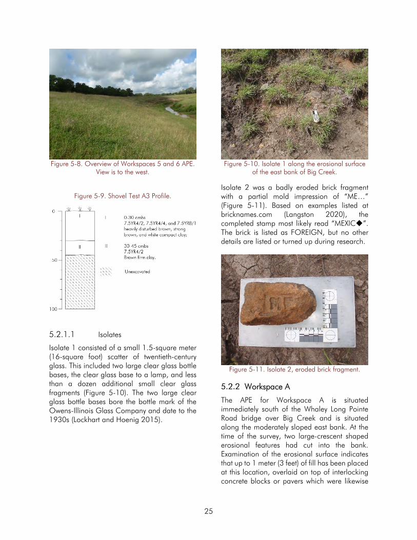
Figure 5-8. Overview of Workspaces 5 and 6 APE. View is to the west.
Figure 5-9. Shovel Test A3 Profile.
5.2.1.1 Isolates
Isolate 1 consisted of a small 1.5-square meter (16-square foot) scatter of twentieth-century glass. This included two large clear glass bottle bases, the clear glass base to a lamp, and less than a dozen additional small clear glass fragments (Figure 5-10). The two large clear glass bottle bases bore the bottle mark of the Owens-Illinois Glass Company and date to the 1930s (Lockhart and Hoenig 2015).
Figure 5-10. Isolate 1 along the erosional surface of the east bank of Big Creek.
Isolate 2 was a badly eroded brick fragment with a partial mold impression of “ME…” (Figure 5-11). Based on examples listed at bricknames.com (Langston 2020), the completed stamp most likely read “MEXIC”. The brick is listed as FOREIGN, but no other details are listed or turned up during research.
Figure 5-11. Isolate 2, eroded brick fragment.
Workspace A
The APE for Workspace A is situated immediately south of the Whaley Long Pointe Road bridge over Big Creek and is situated along the moderately sloped east bank. At the time of the survey, two large-crescent shaped erosional features had cut into the bank. Examination of the erosional surface indicates that up to 1 meter (3 feet) of fill has been placed at this location, overlaid on top of interlocking concrete blocks or pavers which were likewise
25

placed atop geotechnical fabric (Figure 5-12). This is consistent with historical aerial imagery (see Section 2.5) that indicates this area was heavily modified first by new bridge construction and then by the filling of a natural drainage and the installation of a nearby spillway and drainpipe. A close interval pedestrian survey was conducted along the sloped bank. Because of the steeply sloped banks and obvious indications of previous disturbance and fill placement, no shovel tests were excavated at this location (Figure 5-5). No cultural resources were identified during the survey of Workspace A.
Figure 5-12. Overview of Workspace A APE with large erosional feature showing fill deposits located
at Workspace A. View is to the north.
Workspace 4
The APE consists entirely of a steeply sloped artificial bank along the west side of Big Creek (Figure 5-13). This section consists of a modern excavated channel during a previous flood control project. Prior to the survey, emergency repairs were undertaken in Workspace 4 in August 2019. As proposed for the remaining workspaces, these repairs involved a series of stabilization pilings being driven into the bank and slumped material bulldozed back into place (Adam Wright, personal communication 2020). A close interval pedestrian survey was conducted along the sloped bank. Because of the steeply sloped banks, obvious surface disturbance, and knowledge that the APE is located within a modern cut artificial channel
(see Section 2.5), no shovel tests were excavated at this location (Figure 5-6). No cultural resources were identified during the survey of Workspace 4.
Figure 5-13. Overview of Workspace 4 APE. View is to the north.
Workspaces 2 and 3
The APE for Workspaces 2 and 3 is located along the east bank of Big Creek immediately above the Sawmill Road bridge. The area consists of a narrow, less than 5-meter (16-foot) lower bank and a high eroded bluff face up to 10 meters (30 feet) above the stream bed. While the project APE spans approximately 634 meters (2,080 feet) of the creek bank, the proposed fill locations are much smaller as displayed in Figure 5-7) and confined to steeply sloped to the near vertical slope banks (Figure 5-14).
Figure 5-14. Overview of Workspaces 2 and 3 APE. View is to the southwest.
26

The high bank contains several feet of dredge spoil material as observed in comparison with the adjacent landscape and as stated by landowner Mike Donovan (personal communication 2020). A close interval pedestrian survey and visual inspection of exposed sections of the eroded bank identified no cultural resources. A total of six shovel tests were also excavated; two on the lower bank and four on the upper bank (Figure 5-7). Two shovel tests were placed immediately north of where the project APE abuts the previously drawn site boundary for 41FB330, a prehistoric shell midden site (see Section 5.1.2). Shovel Test A1 was located approximately 10 meters (33 feet) north of the recorded site boundary. In profile, the test consisted of a 40-centimeter (16-inch) layer of dark grayish brown (10YR4/2) compact sticky clay. This was underlain by a brown (10YR4/3) sandy clay to a depth of 60 centimeters (24 inches) below the surface. Between 60 and 130 centimeters (24 and 51 inches) was a dark yellowish brown (10YR4/4) sandy deposit with very small to small fragments of shell distributed throughout the deposit. To the base of the shovel test at 140 centimeters (55 inches) below the surface was a very dark grayish brown (10YR3/2) clay (Figure 5-15). No artifacts were located within Shovel Test A1 or A2, which was located 10 meters further to the north.
Four shovel tests were excavated along the upper bank. Here a typical profile can be seen in Shovel Test A3 where a 10-centimeter (inch) layer of strong brown (7.5YR4/6) clay was underlain by a yellowish red (5YR5/6) very compact clay to a depth of 60 centimeters (23.6 inches) below the surface. A dark brown (7.5YR3/3) dense clay with increasing calcium carbonate concretions then continued to the
base of the test at 75 centimeters (inches) below the surface (Figure 5-16).
Figure 5-15. Shovel Test A1 Profile.
Figure 5-16. Shovel Test A3 Profile.
27

6.0 CONCLUSIONS AND RECOMMENDATIONS
This report summarizes the results of a cultural resources survey of six workspaces within four discontiguous locations along Big Creek in Fort Bend County, Texas totaling 6.1 hectares (15.1 acres) and approximately 1.5 kilometers (0.9 miles) in length. The Big Creek Channel Repair Project calls for bank stabilization efforts at each of the four locations. Work was carried out by Gray & Pape on behalf of their client, BIO-WEST. The lead federal agency is FEMA.
The goals of the survey were to determine if the proposed project would affect any previously identified archaeological sites as defined by Section 106 of the NHPA of 1966, as amended (36 CFR 800), and to establish whether or not previously unidentified buried archaeological resources were located within the project’s APE. Portions of the APE are on property owned by Fort Bend County, political subdivisions of the state, as such, a Texas Antiquities Permit (Permit Number 9455) was required prior to the commencement of fieldwork. All fieldwork and reporting activities were completed with reference to state (the Antiquities Code of Texas) and federal (NHPA) guidelines.
Prior to fieldwork mobilization, a background literature and site file search were conducted to identify the presence of recorded sites and previous cultural resource surveys within or near the APE. The search indicated that no previously identified, cemeteries, historical markers, or National Register properties are located within the project APE. The same research identified that 11 previous cultural resource surveys had
been conducted within the study radius of the project area at Workspaces A, 2, 3, and 4, three of which overlapped with the current APE. In addition, 13 previously recorded archaeological sites are located within the study radius, one of which, (41FB330) a prehistoric shell midden site, is located immediately adjacent to the current APE.
Field investigations consisted of a combination of pedestrian survey, with particular attention to sections of exposed and eroding bank, and subsurface testing. Because the vast majority of the project APE occurred in areas of steep slope and artificially reworked bank, only 9 of 20 planned shovel tests were excavated. All shovel tests were negative for cultural resource material. Two historic isolate surface finds were identified at Workspaces 5 and 6.
Gray & Pape archaeologists are of the opinion that the intensive pedestrian survey and shovel test survey completed within the APE has adequately assessed the potential for surface and near surface intact, significant cultural resources.
No intact, significant artifacts or cultural features were encountered during the course of the survey, and no new archaeological sites were identified. No negative impacts on any previously identified sites are anticipated from the proposed project. Based on these results, Gray & Pape recommends that no further cultural work be required and that the project be cleared to proceed as planned.
28

7.0 REFERENCES CITED
Abbott, James T. 2001 Houston Area Geoarcheology; A Framework for Archeological Investigation,
Interpretation, and Cultural Resource Management in the Houston Highway District. Texas Department of Transportation, Environmental Affairs Division.
Aten, Lawrence E. 1983 Indians of the Upper Texas Coast. Academic Press, New York. 1984 Woodland Cultures on the Texas Coast. In Perspective on Gulf Coast History, edited by
Dave D. Davis, pp. 72-93. Ripley P. Bullen Monographs in Anthropology and History, No. 5. Florida State Museum, University Press of Florida, Gainesville.
Barnes, V.E. 1982 Geologic Atlas of Texas, Houston Sheet. Bureau of Economic Geology, University of Texas
at Austin.
Biesaart, Lynne A., Wayne R. Robertson, and Lisa Springs 1985 Prehistoric Archaeological Sites in Texas: A Statistical Overview. Office of the State
Archaeological Report 28. Texas Historical Commission, Austin.
Blair, W.F. 1950 The Biotic Provinces of Texas. Texas Journal of Science. 2:93-117.
Culberson, Linda C. 1993 Arrowheads and Spear Points in the Prehistoric Southeast: A Guide to Understanding
Cultural Artifacts. University Press of Mississippi, Jackson.
Donovan, Mike 2020 Personal Communication, 979-533-3210.
Ensor, H.B. 1995 Archeological Test Excavations at Four Shell Midden Sites in the Wallisville Lake Project
Area, Chambers and Liberty Counties, Texas. Geo-Marine, Plano.
Google, Inc. 2020 Google Earth Aerial Images: (1995, 2004, 2005, 2006, 2008, 2009, 2010, 2011,
2012, 2014, 2015, 2016, 2017, 2018). Accessed May 28, 2020.
Gregory, H.F. 1986 The Southern Caddo: An Anthology. Garland Publishing: New York.
Griffith, Glen, Sandy Bryce, James Omernik, and Anne Rogers 2007 Ecoregions of Texas. Texas Commission on Environmental Quality. Austin.
Holloway, Vance T. 1997 Paleoindian Geoarchaeology of the Southern High Plains. The University of Texas Press,
Austin.
29

Hudson, Charles 1976 The Southeastern Indians. The University of Tennessee Press, Nashville.
La Vere, David 1998 The Caddo Chiefdoms: Caddo Economics and Politics, 700-1835. The University of
Nebraska Press, Lincoln.
Langston, John 2020 “MEXIC (DIAMOND)”. Bricknames.com. bricknames.com/brick/show/509. Accessed June
8, 2020.
Leffler, John 2010 Richmond, TX. Handbook of Texas Online.
https://www.tshaonline.org/handbook/online/articles/RR/hfr4.html. Accessed January 13, 2017.
Lockhart, Bill and Russ Hoenig 2015 The Bewildering Array of Owens-Illinois Glass Co. Logos and Codes.
Sha.org/bottle/pdffiles/OwensIll_BLockhart.pdf. Accessed June 8, 2020.
Mowery, Irvin C., Gordon S. McKee, Francisco Matanzo, and Everett Francis 1960 Soil Survey of Fort Bend County, Texas. United States Department of Agriculture Soil
Conservation Service, Washington D.C.
Munsell Soil Color Chart (Musell) 2005 Revised Edition. Macbeth Division of Kollmorgan Instruments Corporoation.
Nationwide Environmental Title Research, LLC (NETR) Online 2019 Smithers Lake, TX and Thompsons, TX 7.5 Minute Quadrangle Topographic Maps, 1:
24,000 (1954, 1980, 1981, 1992, 2013, 2016). Aerial images (1951, 1982, 1983, 1995, 2004, 2008, 2010, 2012, 2014, 2016). http://www.historicaerials.com. Accessed May 28, 2020.
Newcomb, W.W. Jr. 1961 The Indians of Texas From Prehistoric to Modern Times. The University of Texas Press,
Austin.
Norris, Chad W. and Gordon W. Linam 1999 Ecologically Significant River and Stream Segments – Region H. Texas Parks and Wildlife
Department, Austin.
Ott, Virginia Laird 2010 Fort Bend County. Handbook of Texas Online.
https://tshaonline.org/handbook/online/articles/hcf07. Accessed January 13, 2018.
Patterson, Leland 1995 The Archeology of Southeast Texas. Bulletin of the Texas Archeological Society 66:239-
264. 1996 Southeast Texas Archeology. Report No. 12, Houston Archeological Society
30

Roell, Craig H. 2019 Sayre, Charles D. Handbook of Texas Online.
https://tshaonline.org/handbook/online/articles/fsa43. Accessed June 16, 2020.
Shafer, Harry J. 1975 Comments on the Woodland Cultures of Texas. Bulletin of the Texas Archeological Society,
46:249-254.
Sjoberg, A.A. 1951 The Bidai Indians of Southeastern Texas. Southwestern Journal of Anthropology 7(4).
Soil Survey Staff, Natural Resources Conservation Service, United States Department of Agriculture (SSS NRCS USDA)
2019 Web Soil Survey. Available URL: http://websoilsurvey.nrcs.usda.gov/app/WebSoilSurvey.aspx . Accessed January 15, 2019.
Story, Dee Ann 1990 Cultural History of the Native Americans. In The Archeology and Bioarcheology of the Gulf
Coastal Plain 1: 163-366. 2 vols. Research Series No. 38. Arkansas Archeological Survey, Fayettville.
Terneny, Tiffany Tanya 2005 A Re-Evaluation of Late Prehistoric and Archaic Chronology in the Rio Grand Delta of South
Texas. University of Texas, Austin.
Turner, E.S. and T.R. Hester 1993 A Field Guide to Stone Artifacts of Texas Indians, 2nd Edition. Texas Monthly Field Guide
Series. Gulf Publishing Co., Houston
United States Geological Survey (USGS) 1980 Smithers Lake, Texas Quadrangle (7.5 minute). USGS, Washington D.C. 1980 Thompsons, Texas Quadrangle (7.5 minute). USGS, Washington D.C.
Van Siclen, D.C. 1991 Surficial Geology of the Houston Area: An Offlapping Series of Pleistocene (& Pliocene)
Highest Sea Level Fluviodeltaic Sequences. Transactions of the Gulf Coast Association of Geological Societies, 41:651-666.
Walley, Raymond 1955 A Preliminary Report on the Albert George Site in Fort Bend County. Bulletin of the Texas
Archeological Society. 55: 218-303.
Washington, J.P. 2011 41FB330.
Waters, Michael 1992 Principles of Geoarchaeology: A North American Perspective. The University of Arizona
Press, Tucson.
31
Waters, Michael and Lee Nordt 1995 Late Quaternary Floodplain History of the Brazos River in East-Central Texas. Quaternary
Research 43:311-319.
Wharton, Clarence R. 1939 History of Fort Bend County. Naylor Company, San Antonio.
Wright, Adam 2020 Fort Bend County Drainage District, Personal Communication, 281-342-0141.
32

APPENDIX A:
SHOVEL TEST LOG

ST Segment Survey
Technique Strat I Depth
Strat I Munsell
Strat I Texture Strat II Depth
Strat II Munsell
Strat II Texture
Strat III Depth
Strat III Munsell
Strat III Texture
Strat IV Depth
Strat IV Munsell
Strat IV Texture
A1 5-6 ST-N 10 7.5YR6/6 and 4/1 dense mottled clay 24 75YR42 mottled dense cl,
few sm shell 35
75yr41 mottled
dense cl
A2 5-6 ST-N 10 7.5YR6/6 and 4/1 dense mottled clay 24 75YR42 mottled dense cl,
few sm shell 35
75yr41 mottled
dense cl
A3 5-6 ST-D 30 7.5YR 4/2 mottled
with 7.5YR 4/6 and 7.5YR 8/1
Clay, compact, disturbed
35 7.5YR 5/4 Clay, compact 45 7.5YR 4/2 Clay
A1 2-3 ST-N 40 10YR4/2 Cl 60 10YR4/3 Sa cl 130 10YR4/4 Sa small shell &
charcoal 140 10YR3/2 Cl
A2 2-3 ST-N 25 10YR4/2 cl moist 120 10YR4/3 Sa cl 130 10YR4/4 sa, sacl
A3 2-3 ST-N 10 7.5YR4/6 hard cl, few concretions
60 5YR5/6 dense cl, few concretions
75 7.5YR3/3 dense cl, several
concretions
A4 2-3 ST-N 10 7.5YR4/6 hard cl,
few concretions 50 5YR5/6
dense cl, few concretions
65 7.5YR3/3 dense cl, several
concretions
A5 2-3 ST-N 40 7.5YR4/6, 5YR5/6, 7.5YR3/3
compact dist cl
A6 2-3 ST-N 20 7.5YR4/6,
5YR5/6, 7.5YR3/3 Dist cl 55 7.5YR3/3 Si cl lo