CSU Stanislaus Bicycle Master PlanThe CSU Stanislaus Bicycle Master Plan will have a significant...
70
CSU Stanislaus Bicycle Master Plan Prepared by January 2016
Transcript of CSU Stanislaus Bicycle Master PlanThe CSU Stanislaus Bicycle Master Plan will have a significant...

CSU Stanislaus
BicycleMaster Plan
Prepared by
January 2016

Acknowledgments
This Plan was made possible through the funding of the California State University, Stanislaus (CSU Stanislaus) and was led by the
Facilities Services Department. In addition, many CSU Stanislaus students, faculty, and staff provided critical input on existing
conditions and proposed facilities and programs.
Fehr & Peers prepared the plan for CSU Stanislaus.
Facilities Services Staff
Melody Maffei, Associate Vice President
Julia Reynoso, Director of Facilities Planning & Finance
Fehr & Peers Staff
Carrie Nielson
Ellen Poling
Dana Weissman
Brooke DuBose
Table of Contents
EXECUTIVE SUMMARY ......................................................................................................................................... 1
1. INTRODUCTION ................................................................................................................................... 3
Background .............................................................................................................................................................................. 3
Community Outreach .............................................................................................................................................................. 5
Focus Groups .................................................................................................................................................................... 5
Campus Open Forums ...................................................................................................................................................... 6
2. GOALS & RELATED POLICIES .............................................................................................................. 7
Goals ..........................................................................................................................................................................................7
Related Plans & Policies ...........................................................................................................................................................7
CSU Stanislaus Master Plan ..............................................................................................................................................7
Turlock General Plan and Active Transportation Plan ................................................................................................... 9
StanCOG Non-Motorized Transportation Plan ............................................................................................................ 10
3. EXISTING CONDITIONS ..................................................................................................................... 13
Existing Campus Bikeways and Roadways ........................................................................................................................... 13
Types of Campus Bikeway Facilities ............................................................................................................................... 13
Circulation ........................................................................................................................................................................ 16
Transit .............................................................................................................................................................................. 18
Campus Amenities .................................................................................................................................................................. 21
Bicycle Parking................................................................................................................................................................. 21
Signage and Wayfinding .................................................................................................................................................. 21
Personal Safety ................................................................................................................................................................. 21
Key Issues and Opportunities ............................................................................................................................................... 22
Bicycle Issue Areas ......................................................................................................................................................... 22
Bicycle and Pedestrian Opportunity Areas ................................................................................................................... 23
4. PROPOSED CAMPUS BICYCLE NETWORK ........................................................................................ 25
Bicycle Network Development .............................................................................................................................................. 25
Proposed Campus Bicycle Network ...................................................................................................................................... 25
Proposed Bikeway Projects ................................................................................................................................................... 26
Bicycle Access Points ...................................................................................................................................................... 30
Campus Pathway Improvements ................................................................................................................................... 34
Bicycle Parking................................................................................................................................................................ 38
5. SUPPORT PROGRAMS ........................................................................................................................ 41
Existing Programs .................................................................................................................................................................. 41
Proposed Programs ................................................................................................................................................................ 41
Education ......................................................................................................................................................................... 41
Encouragement ............................................................................................................................................................... 42
Enforcement.................................................................................................................................................................... 42
Collaboration .................................................................................................................................................................. 43
Bicycle Parking................................................................................................................................................................ 43
6. IMPLEMENTATION STRATEGY .......................................................................................................... 45
Cost Estimates ....................................................................................................................................................................... 45
Prioritization .......................................................................................................................................................................... 48
Prioritization Framework ............................................................................................................................................... 48
Prioritized Project List.................................................................................................................................................... 48
Funding Opportunities ........................................................................................................................................................... 51
7. DESIGN GUIDELINES ......................................................................................................................... 53
Bicycle Parking and Support Facilities ................................................................................................................................. 53
Bicycle Fix-It Stations..................................................................................................................................................... 55
Bicycle Facilities .................................................................................................................................................................... 55

Shared-Use Paths............................................................................................................................................................ 55
Bicycle Lanes ................................................................................................................................................................... 56
Bicycle Routes with Sharrows ........................................................................................................................................ 56
Wayfinding .......................................................................................................................................................................57
Crossings .................................................................................................................................................................................57
Crosswalks .......................................................................................................................................................................57
Curb Ramps .................................................................................................................................................................... 58
Crosswalk Signage .......................................................................................................................................................... 58
APPENDIX A Project Prioritization Scoring ........................................................................................................ 59
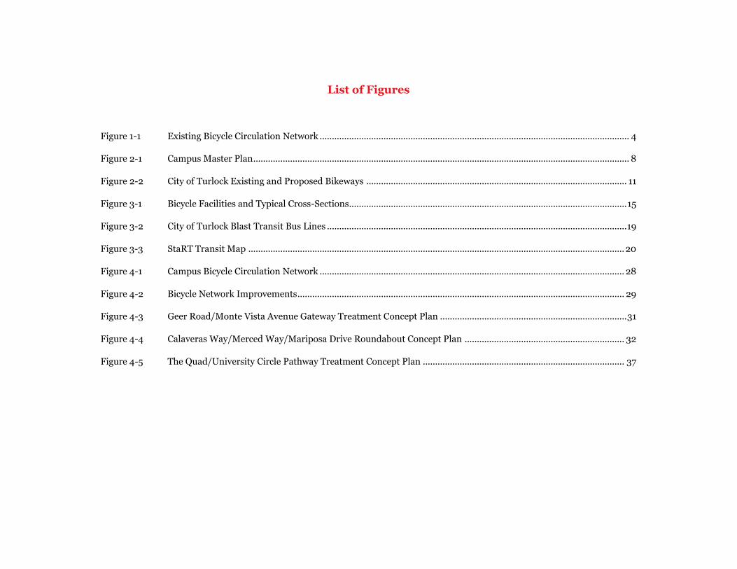
List of Figures
Figure 1-1 Existing Bicycle Circulation Network .............................................................................................................................. 4
Figure 2-1 Campus Master Plan ......................................................................................................................................................... 8
Figure 2-2 City of Turlock Existing and Proposed Bikeways .......................................................................................................... 11
Figure 3-1 Bicycle Facilities and Typical Cross-Sections................................................................................................................. 15
Figure 3-2 City of Turlock Blast Transit Bus Lines .......................................................................................................................... 19
Figure 3-3 StaRT Transit Map ......................................................................................................................................................... 20
Figure 4-1 Campus Bicycle Circulation Network ............................................................................................................................ 28
Figure 4-2 Bicycle Network Improvements ..................................................................................................................................... 29
Figure 4-3 Geer Road/Monte Vista Avenue Gateway Treatment Concept Plan ............................................................................ 31
Figure 4-4 Calaveras Way/Merced Way/Mariposa Drive Roundabout Concept Plan ................................................................. 32
Figure 4-5 The Quad/University Circle Pathway Treatment Concept Plan .................................................................................. 37
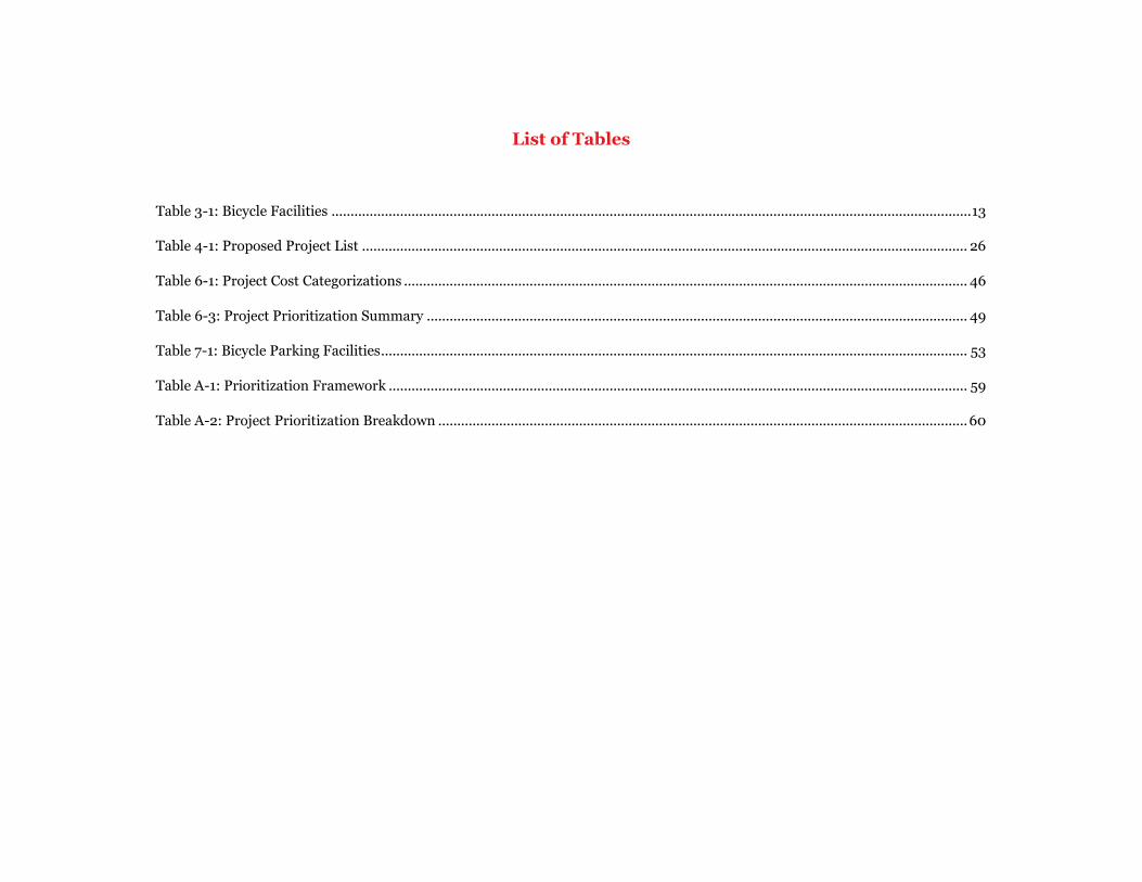
List of Tables
Table 3-1: Bicycle Facilities ........................................................................................................................................................................ 13
Table 4-1: Proposed Project List ............................................................................................................................................................... 26
Table 6-1: Project Cost Categorizations .................................................................................................................................................... 46
Table 6-3: Project Prioritization Summary .............................................................................................................................................. 49
Table 7-1: Bicycle Parking Facilities .......................................................................................................................................................... 53
Table A-1: Prioritization Framework ........................................................................................................................................................ 59
Table A-2: Project Prioritization Breakdown ........................................................................................................................................... 60
Executive Summary
CSU Stanislaus Bicycle Master Plan 1
EXECUTIVE SUMMARY
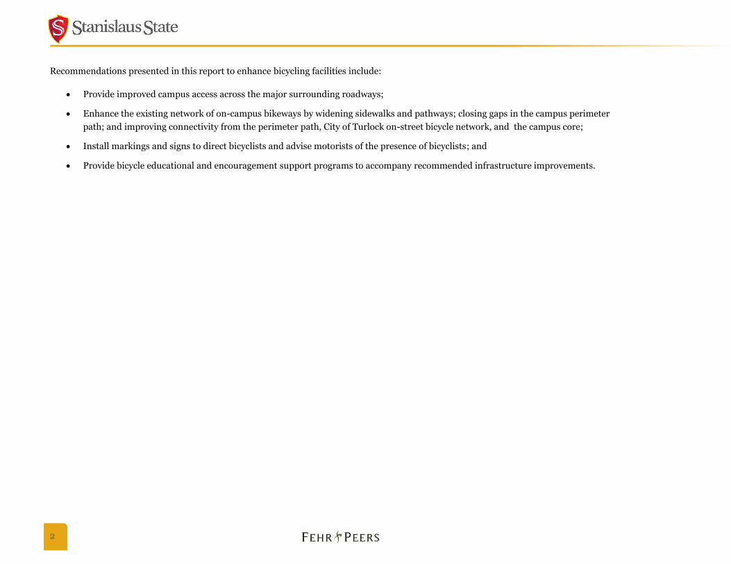
The goal of the California State University, Stanislaus (CSU Stanislaus) Bicycle Master Plan (the Plan) is to develop and implement a bikeway
system that applies the following guiding principles:
Improve safety for bicyclists and pedestrians;
Provide on-campus amenities that provide students, faculty, and staff the opportunity to efficiently travel through campus by bicycle;
Coordinate with the City of Turlock to provide bicycle enhancements to the roadways adjacent to campus;
Accommodate bicyclists through a combination of off-street paths and improved on-street routes;
Provide support facilities such as secure bike parking and wayfinding signage; and
Build on existing education and encouragement efforts by campus groups.
The Plan sets forth a blueprint for a campus bicycle network and support facilities such as bike parking, wayfinding signs, and education and
encouragement programs. This Plan reflects direct outreach and input from the campus community, including students, staff, and faculty.
The Plan includes:
An evaluation of existing conditions;
A prioritized list of recommended bicycle improvements for both on- and off-street facilities;
Recommended support programs and policies; and
Design guidelines for bicycle facilities.
CSU Stanislaus currently enjoys an internal pathway system that connects the campus buildings in the east-west direction but need additional
north-south pathways. The mild year-round climate and beautifully landscaped grounds of CSU Stanislaus add to its desirability as a great place
to bike. Some students, faculty and staff currently bicycle to and from campus, as well as within the campus. In addition, the surrounding City
of Turlock has a progressive plan to construct new bikeways around the CSU Stanislaus campus.
2
Recommendations presented in this report to enhance bicycling facilities include:
Provide improved campus access across the major surrounding roadways;
Enhance the existing network of on-campus bikeways by widening sidewalks and pathways; closing gaps in the campus perimeter
path; and improving connectivity from the perimeter path, City of Turlock on-street bicycle network, and the campus core;
Install markings and signs to direct bicyclists and advise motorists of the presence of bicyclists; and
Provide bicycle educational and encouragement support programs to accompany recommended infrastructure improvements.
Introduction 1
CSU Stanislaus Bicycle Master Plan 3
1. INTRODUCTION
California State University, Stanislaus (CSU Stanislaus) is well suited for bicycling and walking. The relatively flat landscape and compact size
make it ideal for bicycling and walking around the campus. Expanding campus bicycle facilities is an important component for sustainable
growth.
CSU Stanislaus staff, faculty, and students have indicated the need to enhance bicycling opportunities on campus; the core of this evaluation is
focused on producing recommendations to meet their needs.
Background
CSU Stanislaus is situated on 228 acres in the City of Turlock, Stanislaus County. In 2014 there were 9,045 registered students attending CSU
Stanislaus, with 528 faculty members and over 492 staff members. The mid-size campus’s countryside atmosphere blends with Turlock’s small-
town community. The University strives to encourage the community to actively participate in learning-centered activities on campus.
CSU Stanislaus is located less than two miles north of Downtown Turlock. The campus is bounded by West Christoffersen Parkway to the north,
Monte Vista Avenue / University Way to the south, Geer Road to the east, and Crowell Road to the west. The campus can be accessed regionally
by State Route 99, approximately 1.5 miles to the west. Approximately 84% of students attending CSU Stanislaus are from our six-county service
region - Stanislaus, San Joaquin, Merced, Mariposa, Calaveras and Tuolumne, with 48% of students from within Stanislaus County. The primary
mode of transportation to and from the campus is by automobile, although bicycling and walking continue to grow in popularity due to their
health benefits, recreational values and are the only mode of transportation for some students.
CSU Stanislaus opened at its current location in 1965 with two buildings; since then, the campus has significantly expanded its academic
buildings and student facilities. Figure 1-1 Existing Bicycle Circulation Network shows the existing pedestrian paths and bikeways, on a
site plan that includes existing buildings. As the University continues to develop its campus, completing a safe and convenient bicycle network
will be critical to reducing the number of vehicle trips and encouraging healthy and convenient modes of travel on campus.
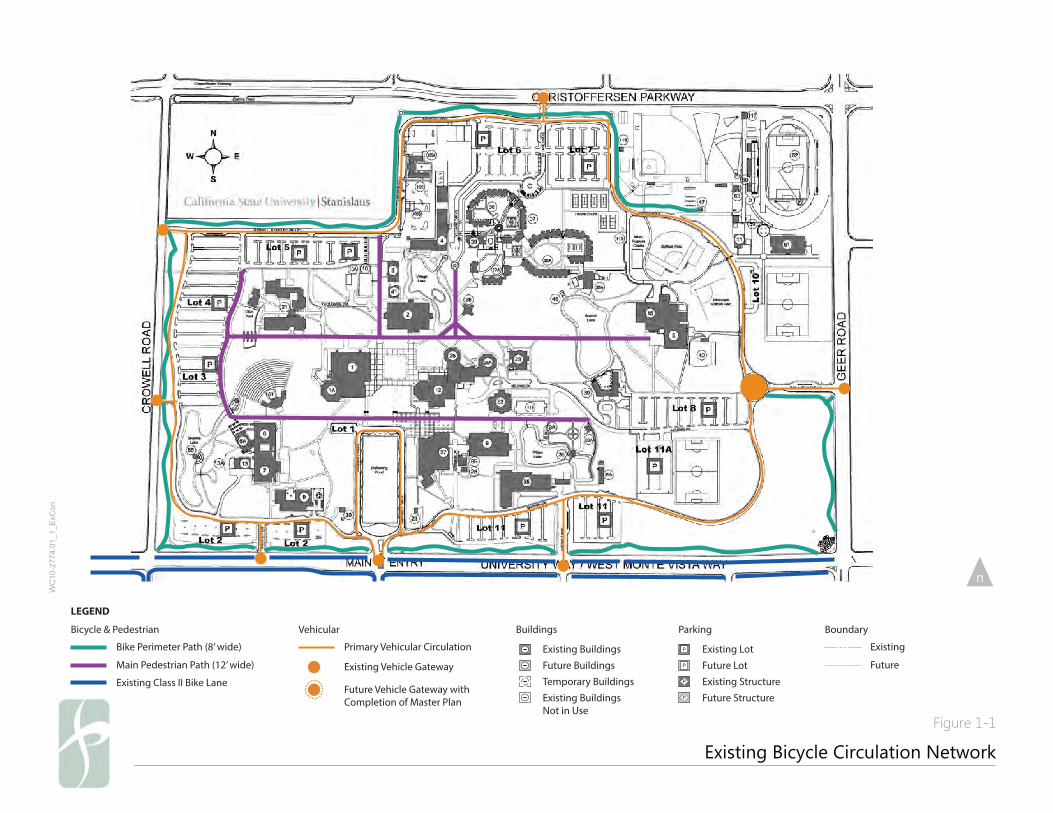
Existing Bicycle Circulation Network
Figure 1-1
WC
10-2
774.
01_1
_ExC
on
LEGEND
Buildings
Existing Buildings
Future Buildings
Temporary Buildings
Existing BuildingsNot in Use
Parking
Existing Lot
Future Lot
Existing Structure
Future Structure
Boundary
Existing
Future
Vehicular
Primary Vehicular Circulation
Future Vehicle Gateway withCompletion of Master Plan
Existing Vehicle Gateway
Bicycle & Pedestrian
Bike Perimeter Path (8’ wide)
Main Pedestrian Path (12’ wide)
Existing Class II Bike Lane
CSU Stanislaus Bicycle Master Plan 5
Community Outreach
Through this planning process, the University convened four focus groups to target four key campus groups:
1. Students
2. Faculty
3. Staff
4. GIS Students
These four groups consisted of bicyclists, non-bicyclists, student researchers in bicycle planning, and campus staff involved in maintenance and
enforcement activities.
In addition to the focus group outreach, a campus workshop was held in November 2014, at which students, faculty, and staff had an opportunity
to comment on the draft Plan document and proposed projects and programs. The individual outreach events are summarized in the chapters
below.
Focus Groups
In May 2014, four focus group meetings were held to understand key bicycle issues and opportunities on and adjacent to campus from the
perspective of students, faculty and staff. Four key themes were identified through the focus group discussions:
Enhanced bicycle parking and support facilities: Need for secure, long-term parking with bicycle maintenance stations, as well
as increased education on available support facilities like showers and lockers.
Improved connectivity between City of Turlock roadways and CSU Stanislaus campus: Need for improved connections
between campus bicycle facilities and City of Turlock facilities, including reduced spacing between and better design of crossings of
perimeter roadways.
Increased bicycle/pedestrian wayfinding: Need for increased legibility of primary campus bicycle routes and pedestrian priority
areas.
Enhanced visibility of education and encouragement programs: Need for enhanced awareness of and inclusion in existing
education and encouragement programs for entire campus community (i.e., students, faculty, staff, and visitors).
Student and GIS Student Group
Focus group participants included the GIS student group. This organization had previously studied bicycling on campus through a survey of the
campus community’s preferred bicycle routes to and through campus. They found that the majority of their 600 respondents live within two
6
miles of campus and still drive. The GIS student group concluded that some of these car trips could be shifted to bicycling if the connection
between campus and city streets were improved.
Faculty Group
Most of the faculty participants in the focus groups were daily bicycle commuters. Several were occasional bicycle commuters or potentially
interested bicycle commuters who desired additional information and/or infrastructure enhancements around campus. Overall, the faculty
participants supported bicycle improvements and favored increasing bicycling on campus.
Staff Group
Staff participants in the focus groups highlighted the challenges of accessing campus from the surrounding residential neighborhoods. Many
used sidewalks instead of the roadway on the high speed arterials immediately surrounding campus. Some took longer, more circuitous routes
to campus on lower-volume and lower-speed roadways in order to avoid these arterials altogether.
Campus Open Forums
In November 2014, the draft Plan was presented to the campus community at two Open Forums on campus. The Open Forum was attended by
students and faculty in addition to City of Turlock staff. Each Open Forum included a presentation of existing issues and opportunities for biking
on the campus, the proposed campus bicycle circulation network, and three priority projects. Following the presentation, attendees were invited
to ask any questions they may have, and then participants circulated through open-house style stations that presented the campus bicycle
network, project list, and concepts for the priority projects. Students, staff, and faculty provided both general and site-specific comments to
draft Plan and priority projects.
Goals & Related Policies 2
CSU Stanislaus Bicycle Master Plan 7
2. GOALS & RELATED POLICIES
Goals
The creation of the CSU Stanislaus Bicycle Master Plan is driven by a number of important goals for improving the campus bicycle network. The
following five key goals will be achieved through the implementation of the programs and projects contained in this Plan:
1. Establishing safe and convenient bicycle connections from the City’s bicycle network and the perimeter bicycle path to the center of
campus.
2. Balancing the needs of pedestrians and bicyclists along campus pathways and key activity areas.
3. Creating safe and accessible bicycle crossings at roadways and parking lots.
4. Improving and increasing the existing bicycle parking on campus.
5. Completing the periphery bicycle loop path.
Related Plans & Policies
The CSU Stanislaus Bicycle Master Plan will have a significant positive impact on bicycling on campus and between the campus and adjacent
neighborhoods. However, this document is not the only effort aimed at improving conditions for bicyclists in the area, nor is the University the
only entity working toward such a goal. This Plan will build on and coordinate with the plans, projects and policies of the CSU Stanislaus Master
Plan, as well as other agencies’ plans, as described below.
CSU Stanislaus Master Plan
The purpose of the CSU Stanislaus Campus Physical Master Plan is to provide the University with a vision to develop the campus and reach its
ultimate goals as described in the 1968 Physical Master Plan. The 2009 updated Physical Master Plan evolves the original by incorporating new
technological advances unanticipated in the original plan. The University seeks to incorporate needed changes while maintaining the positive
campus character of an attractive, welcoming environment that supports the delivery of quality higher education.
Planned improvements, according to the Campus Master Plan Update, include developing multi-story student housing facilities and multi-level
parking structures. Figure 2-1 Campus Master Plan illustrates planned future building projects on the CSU Stanislaus campus. As part of
the development process, nighttime lighting will be installed on all pathways for safety and security. Future improvements to the bicycle and
pedestrian network include additional signage on main pathways to direct students to the right facilities, and
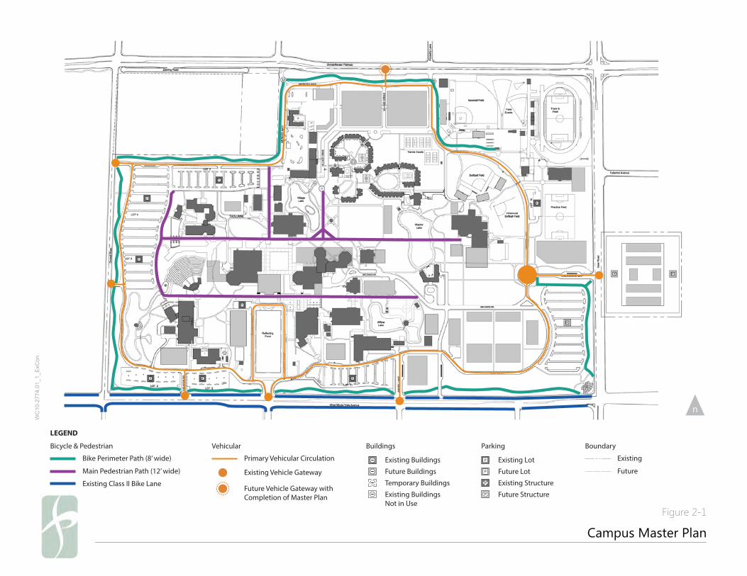
Campus Master Plan
Figure 2-1
WC
10-2
774.
01_1
_ExC
on
LEGEND
Buildings
Existing Buildings
Future Buildings
Temporary Buildings
Existing BuildingsNot in Use
Parking
Existing Lot
Future Lot
Existing Structure
Future Structure
Boundary
Existing
Future
Vehicular
Primary Vehicular Circulation
Future Vehicle Gateway withCompletion of Master Plan
Existing Vehicle Gateway
Bicycle & Pedestrian
Bike Perimeter Path (8’ wide)
Main Pedestrian Path (12’ wide)
Existing Class II Bike Lane
CSU Stanislaus Bicycle Master Plan 9
installing more bicycle racks and related facilities throughout the campus to promote alternate means of reaching destinations and circulating
on campus.
Turlock General Plan and Active Transportation Plan
The Turlock General Plan encourage walking and bicycling. Turlock’s flat topography and mild rainfall are ideal for commuting and
recreational bicycle riding and walking. The plan recognizes three classes of bikeways used throughout the city.
Bike Path (Class I Bikeway). Provides a completely separated right-of-way designated for the exclusive use of bicycles and
pedestrians with cross flows by motorists minimized.
Bike Lane (Class II Bikeway). Provides a restricted right-of-way designated for the exclusive or semi-exclusive use of bicycles with
through-travel by motor vehicles or pedestrians prohibited, but with vehicle parking and crossflows by pedestrians and motorists
permitted.
Bike Route (Class III Bikeway). Provides right-of-way designated by signs or permanent markings and shared with pedestrians and
motorists.
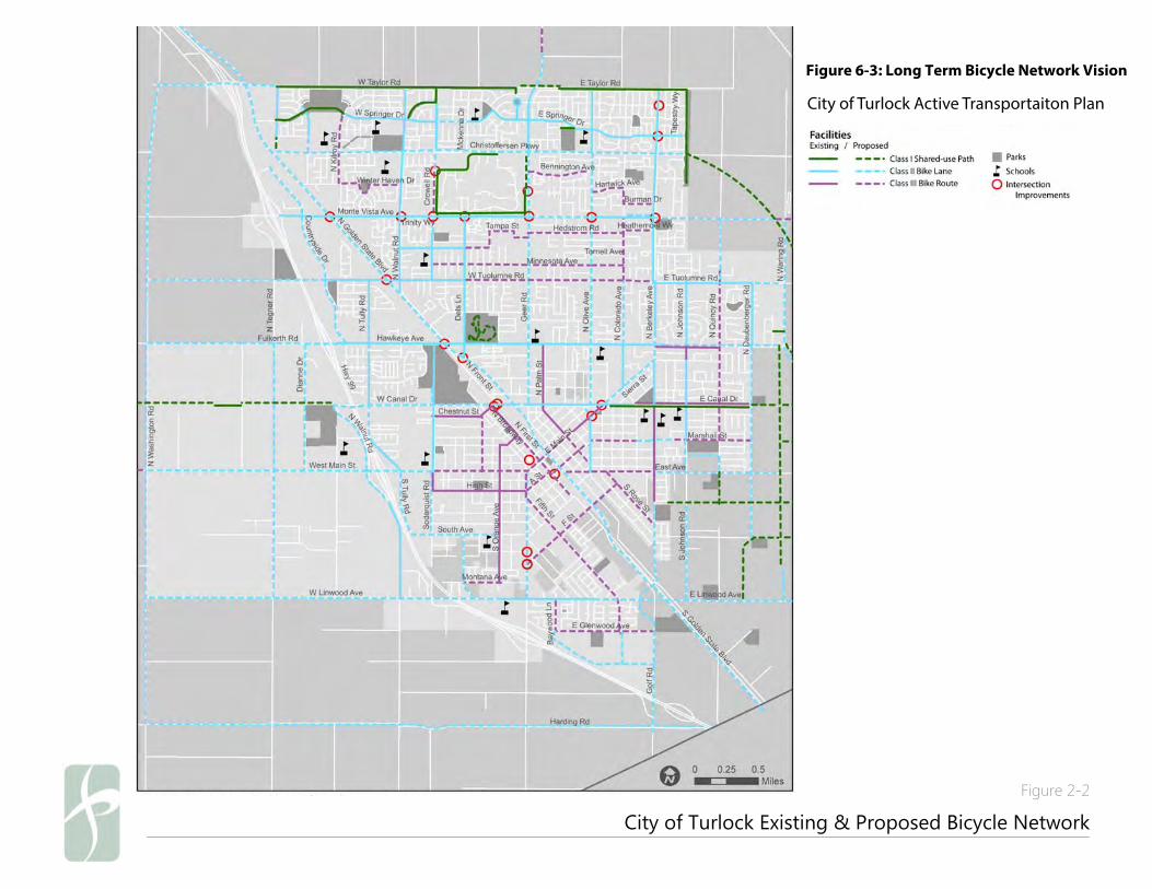
In 2015, the City adopted its first Active Transportation Plan. Figure 2-2 City of Turlock Existing and Proposed Bikeways shows the
long-term vision for bikeways and trails for the City of Turlock. Existing or proposed bikeways located adjacent to or near the campus include:
Monte Vista Avenue/University Way*
Dels Lane*
Crowell Road*
West Christoffersen Parkway*
Walnut Road
Fosberg Road
Minnesota Avenue
Ferreira Ranch Drive
Fosberg Road
Olive Avenue
Minnesota Avenue
Streets followed by an asterisk (*) signify bikeways that provide access to the University.
10
StanCOG Non-Motorized Transportation Plan
The Stanislaus Council of Governments Non-Motorized Transportation Plan (StanCOG NMTP) reviews the bicycle facilities within the
county, which includes the City of Turlock. The StanCOG NMTP’s purpose is to increase bicycle and pedestrian access and increase bicycle and
pedestrian activity. Figure 2-2 City of Turlock Existing and Proposed Bikeways illustrates the StanCOG NMTP with existing bikeways
and proposed routes for the City of Turlock. The existing routes in the StanCOG NMTP are identical to the City of Turlock’s General Plan.
City of Turlock Existing & Proposed Bicycle Network
Figure 2-2
Infrastructure Recommendations
58 | Alta Planning + Design
Figure 6-3: Long Term Bicycle Network Vision
Infrastructure Recommendations
58 | Alta Planning + Design
Figure 6-3: Long Term Bicycle Network Vision
Infrastructure Recommendations
58 | Alta Planning + Design
Figure 6-3: Long Term Bicycle Network Vision
City of Turlock Active Transportaiton Plan

12
This page left intentionally blank

Existing Conditions 3
CSU Stanislaus Bicycle Master Plan 13
3. EXISTING CONDITIONS
The CSU Stanislaus Bicycle Master Plan sets forth a blueprint for completing a system of bikeways and support facilities on the CSU Stanislaus
campus. It builds upon the existing system of pathways throughout the campus, focusing on connections from the perimeter to the center of
campus and a series of north-south and east-west routes. This chapter focuses on an evaluation of the existing transportation conditions on- and
off-campus.
Existing Campus Bikeways and Roadways
Types of Campus Bikeway Facilities
Bikeway planning and design in California typically relies on the guidelines and design standards established by Caltrans as documented in
“Chapter 1000: Bikeway Planning and Design” of the Highway Design Manual (5th Edition, California Department of Transportation, January
2001). Chapter 1000 follows standards developed by the American Association of State Highway and Transportation Officials (AASHTO) and
the Federal Highway Administration (FHWA), and identifies specific design standards for various conditions and bikeway-to-roadway
relationships. Caltrans standards provide for three distinct types of bicycle facilities, as generally described in Table 3-1 Bicycle Facilities
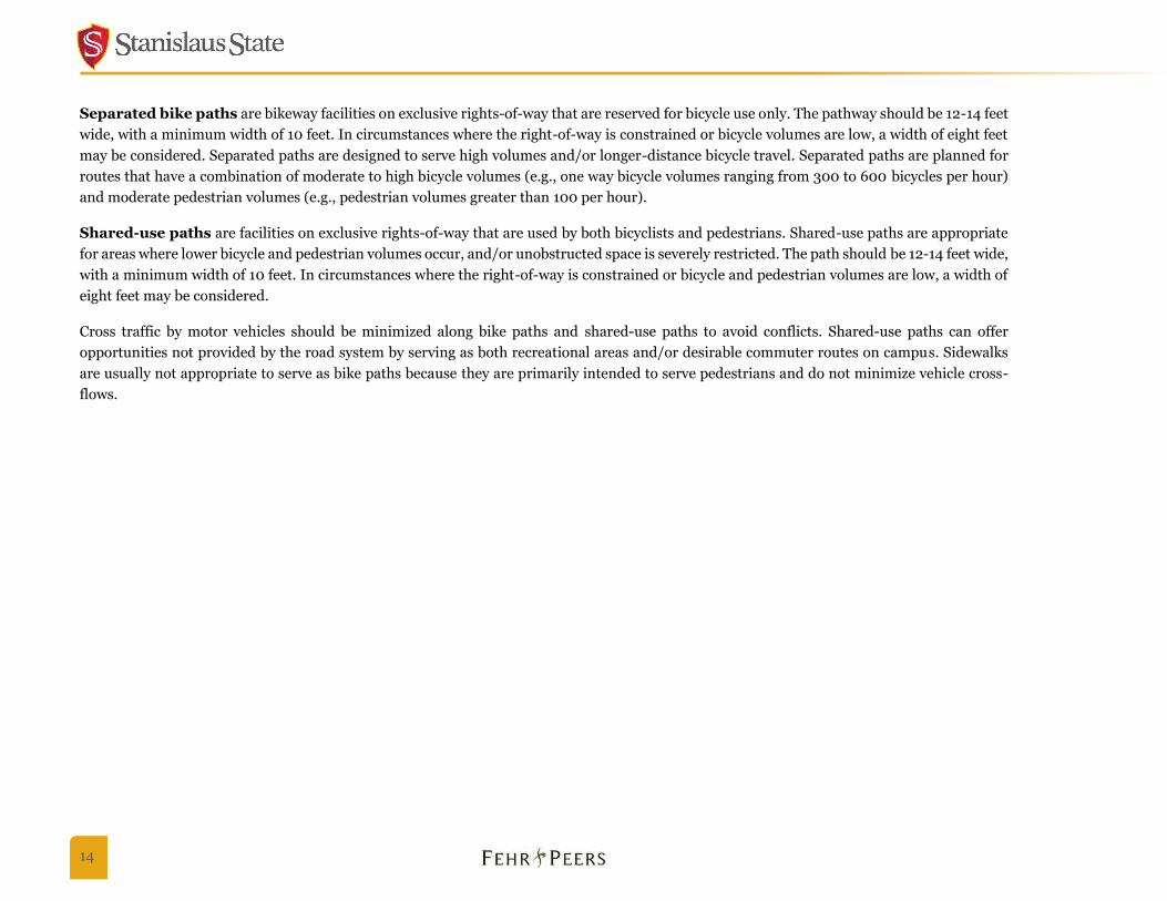
below and illustrated in Figure 3-1 Bicycle Facilities and Typical Cross-Sections.
Table 3-1: Bicycle Facilities
Class I: Bike Path/Shared-Use Path
These facilities provide a completely separate right-of-way and are designated for the exclusive use of bicycles and pedestrians with vehicles cross-flow minimized.
Class II: Bike Lane
Bike lanes provide a restricted right-of-way and are designated for the use of bicycles with a striped lane on a street or highway. Bicycle lanes are generally five feet wide. Vehicle parking and vehicle/pedestrian cross-flow are permitted.
Class III: Bike Route
Bike routes provide a right-of-way designated by signs or pavement markings for shared use with pedestrians or motor vehicles. While a basic Class III route may simply have signs and markings, a Bicycle Boulevard is a special type of shared route that optimizes bicycle travel. Bike boulevards can have a variety of traffic calming elements to improve safety and comfort for bicyclists.
Class I paths are the predominant facility for the existing and proposed CSU Stanislaus campus bikeway network, and they can either be shared
or separated from pedestrians.
14
Separated bike paths are bikeway facilities on exclusive rights-of-way that are reserved for bicycle use only. The pathway should be 12-14 feet
wide, with a minimum width of 10 feet. In circumstances where the right-of-way is constrained or bicycle volumes are low, a width of eight feet
may be considered. Separated paths are designed to serve high volumes and/or longer-distance bicycle travel. Separated paths are planned for
routes that have a combination of moderate to high bicycle volumes (e.g., one way bicycle volumes ranging from 300 to 600 bicycles per hour)
and moderate pedestrian volumes (e.g., pedestrian volumes greater than 100 per hour).
Shared-use paths are facilities on exclusive rights-of-way that are used by both bicyclists and pedestrians. Shared-use paths are appropriate
for areas where lower bicycle and pedestrian volumes occur, and/or unobstructed space is severely restricted. The path should be 12-14 feet wide,
with a minimum width of 10 feet. In circumstances where the right-of-way is constrained or bicycle and pedestrian volumes are low, a width of
eight feet may be considered.
Cross traffic by motor vehicles should be minimized along bike paths and shared-use paths to avoid conflicts. Shared-use paths can offer
opportunities not provided by the road system by serving as both recreational areas and/or desirable commuter routes on campus. Sidewalks
are usually not appropriate to serve as bike paths because they are primarily intended to serve pedestrians and do not minimize vehicle cross-
flows.
Bicycle Facilities and Typical Cross-SectionsFigure 3-1
CLASS III BIKEWAY (Bike Route)
BIKE ROUTE SIGN
BIKE ROUTE
CLASS II BIKEWAY (Bike Lane)
6” SOLID WHITE STRIPE
Provides a striped lane for one-way bike travel on a street or highway.
BIKE LANE
CLASS I BIKEWAY (Shared-Use Path)Provides a completely separated right-of-way for the exclusive use of bicycles
and pedestrians with crossflow minimized.
Bike/Pedestrian Shared PathLandscape Area Landscape Area
EXISTING CAMPUSCONFIGURATION
CLASS I BIKEWAY (Separated Path)Provides a completely separated right-of-way for the exclusive use of bicycles
and pedestrians with crossflow minimized.
Bike PathSidewalk SidewalkLandscape Area/Fencing
Landscape Area/Fencing

16
Circulation
Adjacent Roadways
The CSU Stanislaus campus is bounded by the following streets:
Monte Vista Avenue is a four-lane arterial that runs east-west along the south
side of campus. It provides access to the main campus entrance. Bike lanes are
striped from North Golden State Boulevard to Geer Road. Wide intersections
and high vehicle volumes and speeds affect bicycle access and safety.
Crowell Road is a two-lane collector that runs north-south along the west side of
the campus. It provides access to Parking Lots 3, 4 and 5 (via Ansel Adams
Boulevard). There are no existing bike facilities on Crowell Road.
West Christoffersen Parkway is a four-lane arterial that runs east-west along the
north side of campus. A new north entrance from the parkway to campus is
complete. High vehicle speeds and a lack of signalized crossings create a
challenging environment for both bicyclists and pedestrians. West Christofferson
Parkway has room for bike lanes that the City of Turlock plans to paint.
Geer Road is a four-lane arterial with center-turn lanes that runs north-south along the east side of campus. Geer Road provides access
to the east entrance of campus via Calaveras Way. The City of Turlock has plans for on-street bicycle facilities on Geer Road.
CSU Stanislaus Bicycle Master Plan 17
Internal Campus Roadways
The CSU Stanislaus campus is designed to limit vehicle access to the periphery, with
a perimeter road that circles the core campus. Melones Drive provides vehicle access
to the University Union and Cafeteria, and it is primarily used by delivery vehicles. A
series of surface parking lots are located around the campus, connecting to an internal
pedestrian pathway system.
Bicycle Network
The CSU Stanislaus campus core was designed primarily for pedestrian access, though
the campus is ideal for bicycling, and many areas are easily accessible by bicycle. An
eight-foot bicycle path skirts the outer perimeter of the campus. Bicycle access
between the perimeter path and center of campus is limited in several locations. To
access the center of campus, bicyclists must travel through parking lots and across the
perimeter road, where there are few dedicated bicycle facilities and multiple conflict points with vehicles.
Bicycles are currently allowed on all pedestrian pathways. The existing primary pedestrian pathways identified in the Campus Master Plan are
12 feet wide, and in some locations even wider, which can comfortably accommodate both bicyclists and pedestrians on the shared path. Two
exceptions are the pathway connection on the south side of the center quad and access to the south side of the library, which are only accessible
by stairs or a narrow pathway with tight angles. Both the current and projected levels of pedestrian and bicycle activity are moderate and do not
present any notable conflicts. The center quad has the highest amount of pedestrian activity.
The secondary pedestrian pathways that connect key walking and bicycling routes to campus buildings are typically narrower, with most ranging
between five to eight feet wide. While eight feet may be adequate in certain circumstances, the recommended minimum width for a shared-use
path is 10 feet.
18
Transit
Both Stanislaus Regional Transit and the City of Turlock provide transit service to the CSU Stanislaus campus. The Bus Line Service of Turlock
(BLAST) serves campus with the B and C bus routes. Service hours for BLAST are 6:40 am to 5:30 pm Monday through Friday, and 9:25 am to
4 pm on Saturdays. There is no service on Sundays or holidays. Bike racks with capacity for two bikes are provided on BLAST buses. Figure 3-
2 City of Turlock Blast Transit Bus Lines shows the BLAST Bus Route map.
Stanislaus Regional Transit (StaRT) provides public transit to the CSU Stanislaus campus via the Route 10 Express, Route 15, and Route 45 East.
StaRT buses provide bike racks with capacity for two bikes. The campus bus stop is located at Dels Lane and Monte Vista Avenue, which connects
directly to the perimeter bicycle path. Figure 3-3 StaRT Transit Map shows the current StaRT system map.
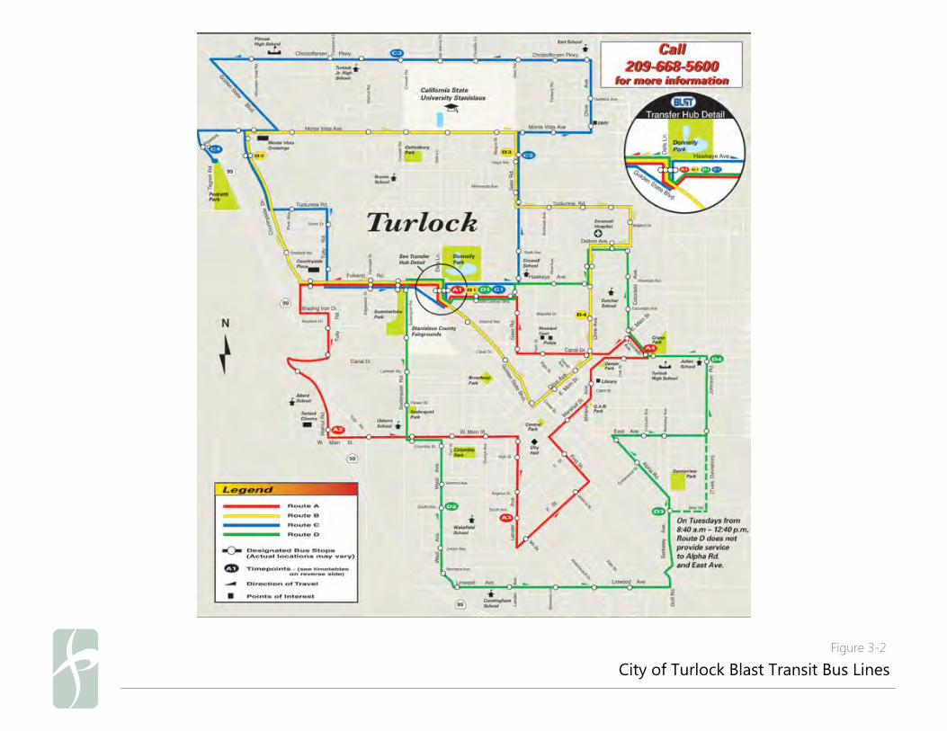
City of Turlock Blast Transit Bus LinesFigure 3-2
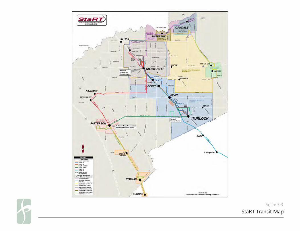
StaRT Transit MapFigure 3-3
CSU Stanislaus Bicycle Master Plan 21
Campus Amenities
Bicycle Parking
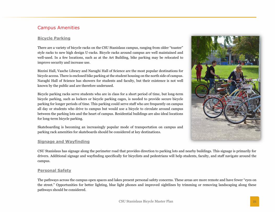
There are a variety of bicycle racks on the CSU Stanislaus campus, ranging from older “toaster”
style racks to new high design U-racks. Bicycle racks around campus are well maintained and
well-used. In a few locations, such as at the Art Building, bike parking may be relocated to
improve security and increase use.
Bizzini Hall, Vasche Library and Naraghi Hall of Science are the most popular destinations for
bicycle access. There is enclosed bike parking at the student housing on the north side of campus.
Naraghi Hall of Science has showers for students and faculty, but their existence is not well
known by the public and are therefore underused.
Bicycle parking racks serve students who are in class for a short period of time, but long-term
bicycle parking, such as lockers or bicycle parking cages, is needed to provide secure bicycle
parking for longer periods of time. This parking could serve staff who are frequently on campus
all day or students who drive to campus but would use a bicycle to circulate around campus
between the parking lots and the heart of campus. Residential buildings are also ideal locations
for long-term bicycle parking.
Skateboarding is becoming an increasingly popular mode of transportation on campus and
parking rack amenities for skateboards should be considered at key destinations.
Signage and Wayfinding
CSU Stanislaus has signage along the perimeter road that provides direction to parking lots and nearby buildings. This signage is primarily for
drivers. Additional signage and wayfinding specifically for bicyclists and pedestrians will help students, faculty, and staff navigate around the
campus.
Personal Safety
The pathways across the campus open spaces and lakes present personal safety concerns. These areas are more remote and have fewer “eyes on
the street.” Opportunities for better lighting, blue light phones and improved sightlines by trimming or removing landscaping along these
pathways should be considered.
22
Enhanced lighting along these corridors would improve safety, as well as the comfort of cyclists and pedestrians when traveling at night.
Key Issues and Opportunities
The key issues related to bicycling on campus set the groundwork for the CSU Stanislaus Bicycle Master Plan recommendations. This chapter
discusses those issues and the opportunities that they present.
Bicycle Issue Areas
University staff, faculty, students, focus groups, and detailed field review helped identify the bicycle issue areas adjacent to and on campus.
“Issue areas” are places that are troublesome for bicycle mobility.
Boundary Roadways
The campus is bordered by major arterial roadways. The roadways are all at least four lanes wide with relatively high speeds of travel. These
roadways are likely perceived as obstacles to novice bicyclists and present barriers even to experienced bicyclists traveling to and from the
campus. Only one of the large boundary roadways (Monte Vista Avenue) currently has on-street bicycle facilities, and roadway crossings are
spaced a large distance apart from one another.
Bicycle Access Points
There are multiple opportunities to establish safer and more convenient bicycle connections from the periphery to the center of campus and to
improve bicycle access from the surrounding street network. To access campus, bicyclists cross the boundary roadways and perimeter path, as
well as surface parking lots in some locations. Consideration should be given to create safe and visible bicycle crossings that provide a clear
understanding of the right-of-way at each location.
Campus Network Connectivity
CSU Stanislaus campus currently has a few high-quality shared-use paths that function well for internal east-west bicycle circulation. However,
north-south connections between these paths are poor, and campus paths often do not directly connect to the city roadway network.
Elevation Change
There are significant elevation changes in the southern portion of campus. The current lack of north-south bicycle paths in this area makes direct
bicycle access difficult, and bicyclists must use a circuitous route to travel among southern campus buildings and the Quad.
CSU Stanislaus Bicycle Master Plan 23
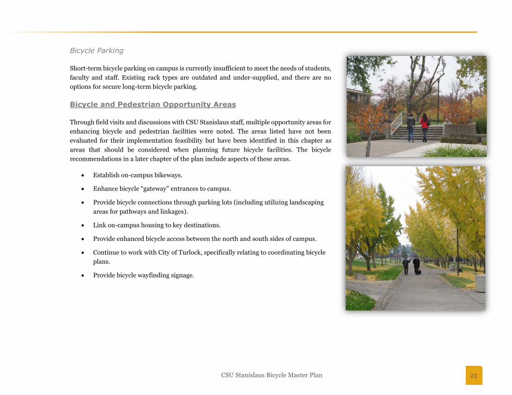
Bicycle Parking
Short-term bicycle parking on campus is currently insufficient to meet the needs of students,
faculty and staff. Existing rack types are outdated and under-supplied, and there are no
options for secure long-term bicycle parking.
Bicycle and Pedestrian Opportunity Areas
Through field visits and discussions with CSU Stanislaus staff, multiple opportunity areas for
enhancing bicycle and pedestrian facilities were noted. The areas listed have not been
evaluated for their implementation feasibility but have been identified in this chapter as
areas that should be considered when planning future bicycle facilities. The bicycle
recommendations in a later chapter of the plan include aspects of these areas.
Establish on-campus bikeways.
Enhance bicycle “gateway” entrances to campus.
Provide bicycle connections through parking lots (including utilizing landscaping
areas for pathways and linkages).
Link on-campus housing to key destinations.
Provide enhanced bicycle access between the north and south sides of campus.
Continue to work with City of Turlock, specifically relating to coordinating bicycle
plans.
Provide bicycle wayfinding signage.

24
The CSU Stanislaus campus has a well-designed network of pedestrian pathways, many
of which are wide enough to accommodate bicyclists as well. The core pedestrian
circulation network set forth in the Campus Master Plan will also serve as the backbone
to the CSU Stanislaus Bicycle Master Plan campus bikeway network. Those pathways are
12 feet wide and will be able to accommodate bicyclists and pedestrians as the campus
and student body continues to grow.
There are opportunities to improve secondary pathways that provide connections
between buildings. Most of these paths are between five and eight feet wide and are too
narrow for bicycles. In addition, some paths meander or have angled turns that are
difficult to navigate by bicycle. A number of campus paths could be upgraded to
accommodate bicyclists. New pathway opportunities, especially north-south routes,
should also be considered.
Proposed Campus Bicycle Network 4
CSU Stanislaus Bicycle Master Plan 25
4. PROPOSED CAMPUS BICYCLE NETWORK
This chapter presents recommendations for new and enhanced bicycle facilities on the CSU Stanislaus campus. The main goals of the
recommendations are to enhance bicycle connectivity and improve bicyclist safety.
Bicycle Network Development
The recommended bicycle network was developed based on field visits, meetings with staff, focus groups with staff, faculty and students, City of
Turlock staff, and review of related plans. Data collection included multiple field visits during different times of the day and different times of
the year to better understand bicycling activity on campus and on the surrounding roadways. Campus visits occurred by foot, by bicycle, and by
car to understand the viewpoint of each user.
CSU Stanislaus Facilities Services key staff helped to guide the development of recommendations. The committee reviewed existing conditions,
issue areas, and potential recommendations.
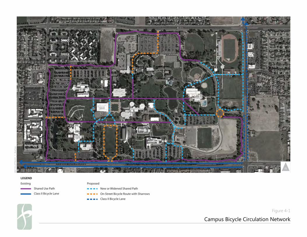
Proposed Campus Bicycle Network
The bicycle circulation network is intended to enhance campus-wide bicycle and pedestrian accessibility, designed to provide bicyclists seamless
access from City streets to the campus as well as to improve connections within the CSU Stanislaus campus. The goal is to organize users and
create a well-connected, intuitive system that is inviting for bicyclists.
There are four key issues that the proposed network seeks to address:
o Closing gaps in the existing path network
o Improving north-south connectivity across campus
o Providing gateway and connections from the City bicycle network to campus
o Connecting the campus perimeter path to the campus core, via on-street routes in parking lots and off-street paths
Figure 4-1 Campus Bicycle Circulation Network presents the proposed bicycle network. Each project in the network is prioritized based
on key criteria including safety, demand, and feasibility, as described in Chapter 6 Implementation Strategy. As new campus buildings are
constructed, new bicycle connections to those locations should be prioritized.
26
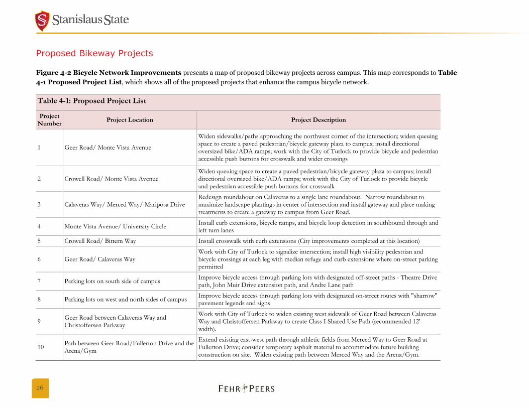
Proposed Bikeway Projects
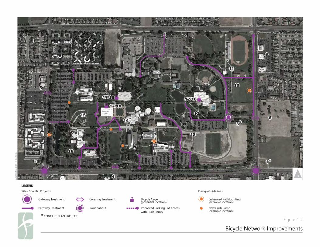
Figure 4-2 Bicycle Network Improvements presents a map of proposed bikeway projects across campus. This map corresponds to Table
4-1 Proposed Project List, which shows all of the proposed projects that enhance the campus bicycle network.
Table 4-1: Proposed Project List
Project Number
Project Location Project Description
1 Geer Road/ Monte Vista Avenue
Widen sidewalks/paths approaching the northwest corner of the intersection; widen queuing space to create a paved pedestrian/bicycle gateway plaza to campus; install directional oversized bike/ADA ramps; work with the City of Turlock to provide bicycle and pedestrian accessible push buttons for crosswalk and wider crossings
2 Crowell Road/ Monte Vista Avenue Widen queuing space to create a paved pedestrian/bicycle gateway plaza to campus; install directional oversized bike/ADA ramps; work with the City of Turlock to provide bicycle and pedestrian accessible push buttons for crosswalk
3 Calaveras Way/ Merced Way/ Mariposa Drive Redesign roundabout on Calaveras to a single lane roundabout. Narrow roundabout to maximize landscape plantings in center of intersection and install gateway and place making treatments to create a gateway to campus from Geer Road.
4 Monte Vista Avenue/ University Circle Install curb extensions, bicycle ramps, and bicycle loop detection in southbound through and left turn lanes
5 Crowell Road/ Bittern Way Install crosswalk with curb extensions (City improvements completed at this location)
6 Geer Road/ Calaveras Way Work with City of Turlock to signalize intersection; install high visibility pedestrian and bicycle crossings at each leg with median refuge and curb extensions where on-street parking permitted
7 Parking lots on south side of campus Improve bicycle access through parking lots with designated off-street paths - Theatre Drive path, John Muir Drive extension path, and Andre Lane path
8 Parking lots on west and north sides of campus Improve bicycle access through parking lots with designated on-street routes with "sharrow" pavement legends and signs
9 Geer Road between Calaveras Way and Christoffersen Parkway
Work with City of Turlock to widen existing west sidewalk of Geer Road between Calaveras Way and Christoffersen Parkway to create Class I Shared Use Path (recommended 12' width).
10 Path between Geer Road/Fullerton Drive and the Arena/Gym
Extend existing east-west path through athletic fields from Merced Way to Geer Road at Fullerton Drive; consider temporary asphalt material to accommodate future building construction on site. Widen existing path between Merced Way and the Arena/Gym.

CSU Stanislaus Bicycle Master Plan 27
Table 4-1: Proposed Project List
Project Number
Project Location Project Description
11 Merced Way between Calaveras Way and Perimeter Path
Widen east sidewalk to 12' along Merced Way between Calaveras Way and Perimeter Path to close gap in the campus Perimeter Path
12 Lot 8 Sidewalk (north side) and Connection to Warrior Lake Widening
Widen the existing path/sidewalk to 12' path between Calaveras roundabout and Warrior Lake
13 Path through Melones Drive and Mariposa Drive east of Willow Lake
Improve north-south path connection between perimeter bike path on southern edge of campus and central campus east-west path; path to pass east of lot 11, east of Willow Lake across Mariposa Drive and Melones Drive, and east of Health Center
14 Path between the Quad and University Circle Provide bicycle connection between the Quad and University Circle around flagpole
15 Path along west edge of Library to Theatre/Drama
Provide bicycle connection between campus east-west paths and Theatre/Drama buildings; path to pass west of Library
16 Path between Art and Theatre/ Drama buildings Provide bicycle ramp adjacent to existing ADA switch-back path and stairs between Art and Theater/Drama buildings
17 Multiple Locations on campus Install bicycle cage at high use location(s), such as Bizzini Hall, Vasche Library, Fitzpatrick Arena/Gym; Warrior Card access and enhanced security
18 Multiple locations on campus Install bicycle fix-it station and bicycle equipment vending machine near or in proposed bicycle cages
NARAGHI HALL
SCIENCE 1
MUSIC
ART
THEATRE/DRAMA
UNIVERSITY UNION
ARENA/GYM
FIELDHOUSE
DININGHALL
VASCHELIBRARY
DEMERGASSO-BAVAHALL
BIZZINI HALL
STUDENT HOUSING
NARAGHI HALL
SCIENCE 1
MUSIC
ART
THEATRE/DRAMA
UNIVERSITY UNION
ARENA/GYM
FIELDHOUSE
DININGHALL
VASCHELIBRARY
DEMERGASSO-BAVAHALL
BIZZINI HALL
STUDENT HOUSING
Campus Bicycle Circulation Network
Figure 4-1
WC
10-2
774.
01_1
_ExC
on
LEGEND
ProposedExisting
Shared Use Path
Class II Bicycle Lane
Class II Bicycle Lane
New or Widened Shared Path
On-Street Bicycle Route with Sharrows
NARAGHI HALL
SCIENCE 1
MUSIC
ART
THEATRE/DRAMA
UNIVERSITY UNION
ARENA/GYM
FIELDHOUSE
DININGHALL
VASCHELIBRARY
DEMERGASSO-BAVAHALL
BIZZINI HALL
STUDENT HOUSING
NARAGHI HALL
SCIENCE 1
MUSIC
ART
THEATRE/DRAMA
UNIVERSITY UNION
ARENA/GYM
FIELDHOUSE
DININGHALL
VASCHELIBRARY
DEMERGASSO-BAVAHALL
BIZZINI HALL
STUDENT HOUSING
Bicycle Network Improvements
WC
10-2
774.
01_1
_ExC
on
22
44
11
66
99
1111
33
55
17/1817/1817/1817/1817/1817/18
1212
1010
1313
1616
88
77
15151414
**
****
LEGEND
Site - Speci�c Projects
Gateway Treatment
Pathway Treatment
Crossing Treatment
Roundabout
Bicycle Cage(potential location)
Design Guidelines
Enhanced Path Lighting(example location)
Improved Parking Lot Accesswith Curb Ramp
New Curb Ramp(example location)
**CONCEPT PLAN PROJECTFigure 4-2

30
Bicycle Access Points
One of the primary goals of the CSU Stanislaus Bicycle Master Plan is to establish safe and convenient bicycle connections from the periphery to
the center of campus. There are multiple opportunities to improve bicycle connections to the surrounding City on-street bicycle network as well
as to the campus perimeter path.
Gateway Treatments (Projects 1, 2, 3)
At the two major southern gateways to campus - Geer Road/Monte Vista Avenue (northwest corner of intersection) and Crowell Road/Monte
Vista Avenue (northeast corner of intersection), gateway treatments improve bicycle and pedestrian comfort and safety by expanding and
enhancing waiting areas and crossings. Additionally, a re-design of the East Campus gateway roundabout would improve bicyclist safety and
comfort through the intersection.
Recommendations:
Geer Road/Monte Vista Avenue (Project 1) and Crowell Road/Monte Vista Avenue (Project 2)
Widen bicycle and pedestrian queuing space on the campus side of the two corners to create paved pedestrian and bicycle gateway plazas,
and install directional oversized ADA curb ramps that are wide enough to allow two-way bicycle and pedestrian traffic. Widen campus
sidewalks and paths approaching gateways. Work with City of Turlock to provide bicycle and pedestrian accessible push buttons for
crossings and to stripe wider crosswalks. These gateway treatments will require coordination with the City of Turlock to secure the
necessary permitting for construction at the intersection. Figure 4-3 Geer Road/Monte Vista Avenue Gateway Treatment
Concept Plan presents a concept plan of the recommended gateway treatments.
Calaveras Way/Merced Way/Mariposa Drive (Project 3)
Convert the existing oversized roundabout to a true single-lane roundabout to clarify expectations for all modes and to improve bicycle
and pedestrian safety through the intersection. Marked crosswalks with refuges are proposed in addition to curb extensions to reduce
pedestrian crossing distances. Figure 4-4 Calaveras Way Roundabout Concept Plan presents a conceptual design for the
proposed roundabout treatment. This project serves an important gateway function for the east side of campus, and the narrowing of
the roundabout presents an opportunity for new landscaping, campus signs, and other aesthetic and placemaking treatments.
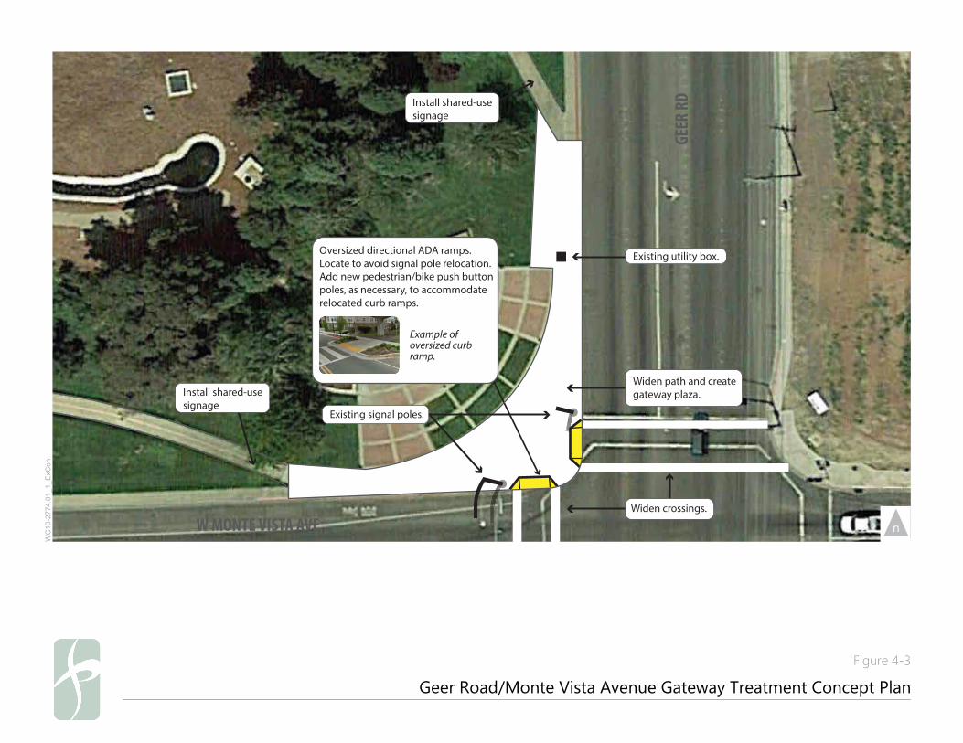
Oversized directional ADA ramps. Locate to avoid signal pole relocation. Add new pedestrian/bike push button poles, as necessary, to accommodate relocated curb ramps.
Example of oversized curbramp.
Widen crossings.
Widen path and create gateway plaza.
Existing signal poles.
Install shared-usesignage
Install shared-usesignage
Existing utility box.
GEER
RD
W MONTE VISTA AVE
Geer Road/Monte Vista Avenue Gateway Treatment Concept Plan
Figure 4-3
WC
10-2
774.
01_1
_ExC
on
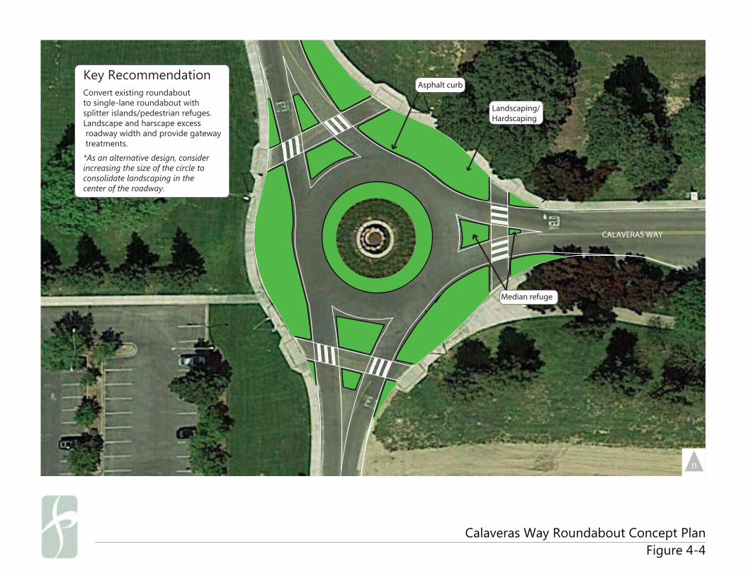
Asphalt curb
Landscaping/Hardscaping
Convert existing roundaboutto single-lane roundabout withsplitter islands/pedestrian refuges.Landscape and harscape excess roadway width and provide gateway treatments.
*As an alternative design, considerincreasing the size of the circle to consolidate landscaping in the center of the roadway.
Key Recommendation
Median refuge
CALAVERAS WAY
Calaveras Way Roundabout Concept PlanFigure 4-4

CSU Stanislaus Bicycle Master Plan 33
Crossing Treatments (Projects 4-6)
Crossing treatments enhance the connection between campus paths and the City of Turlock street network by facilitating bicycle and
pedestrian movement across busy arterials on the perimeter of campus.
Recommendations:
Monte Vista Avenue/University Circle (Project 4)
Install curb extensions and wide bicycle ramps on the northeast and northwest corners of the intersection. Install bicycle loop detection
in the southbound through and left-turn lanes to improve bicycle crossings.
Crowell Road/Bittern Way (Project 5)
Pedestrian crosswalk improvements were completed at this location by the City of Turlock.
Geer Road/Calaveras Way (Project 6)
Work with the City of Turlock to install a full traffic signal to enhance campus access for all modes on the east side of campus. Mark all
crosswalks and install curb extensions (where parking is allowed) and median refuges to reduce crossing distances for pedestrians.
Improved Parking Lot Access (Project 7 and 8)
Parking lot connections enhance access to the on-campus bicycle network from local city streets and the campus perimeter path by constructing
shared-use path spurs and striping bicycle routes through parking lots with sharrow pavement legends to connect with core campus path
network. All of these connections should include wayfinding signs to guide bicyclists to key campus destinations and signs. (See Chapter 7
Design Guidelines for more information on sharrow placement and design.) Bicycle curb ramps further facilitate bicycle movement between
parking lots routes and campus paths.
Wide shared-use paths between the campus perimeter path and the campus core network of paths should be constructed where space allows,
either by widening sidewalks or constructing new paths. Where space is constrained, on-street bicycle routes with sharrows on designated
parking lot aisles may be considered.
34
Recommendations:
Designate an on-street east-west route along the southern edge of Parking Lot 3 on the west side of campus to provide enhanced bicycle
access from Crowell Road to the campus core. Stripe with sharrows and designate as a route to campus through bicycle wayfinding to
key destinations.
Designate an on-street north-south route through Parking Lot 4 in the northwest corner of campus at Demergasso-Bava Hall to provide
enhanced bicycle access from the perimeter path and Ansel Adams Boulevard. Stripe with sharrows and designate as a route to campus
through bicycle wayfinding to key destinations.
Designate an on-street north-south route between Parking Lots 6 & 7 and along the western edge of the student housing area to provide
on-campus residents with enhanced bicycle access from West Christoffersen Parkway and Merced Way. Stripe with sharrows and
designate as a route to campus through bicycle wayfinding to key destinations.
Widen the existing sidewalk on the east side of Theatre Drive to connect the Monte Vista Avenue/University Way bicycle lanes and
campus perimeter path with the Arts & Theatre buildings.
Widen the sidewalk extending south from John Muir Drive through Parking Lot 11 to provide a shared-use path connection between the
campus perimeter path and the Mary Stuart Rogers and Science I buildings.
Widen the sidewalk on the east side of Andre Lane to provide a shared-use path connection to Naraghi Hall from the campus perimeter
path and the Monte Vista Avenue/University Way bicycle lanes. Construct wide bicycle ramps and connection to the path system on the
north side of Mariposa Drive.
Construct a shared-use path on the east side of Lot 11 to connect north to the green house and Melones Drive. Install path crossings and
wide bike ramps in support of the path. (See also Project 14 in next section.)
Optional: Install green colored pavement behind sharrows through on-street parking lot routes to signify bicycle right-of-way to parking
lot users.
Campus Pathway Improvements
Another primary goal of the CSU Stanislaus Bicycle Master Plan is to improve on-campus bicycle circulation by enhancing the quality of the
connectivity among campus pathways. There are multiple opportunities to improve bicycle circulation on the campus pathway network.
Gap Closures and Connectivity Improvements (Projects 9-16)
Given the limited north-south routes through campus and the gap in the campus perimeter path, this group of projects enhances connectivity
with new path connections and a gap closure project to create a continuous campus perimeter path. Facilities should be enhanced to
accommodate bicyclist riding in these areas.
CSU Stanislaus Bicycle Master Plan 35
Recommendations:
Geer Road between Calaveras Way and West Christoffersen Parkway (Project 9)
Work with the City of Turlock to widen the existing west sidewalk to create a Class I shared-use path (recommended 12 feet wide). Install
bicycle curbs ramps at the path intersections with West Christoffersen Parkway and Calaveras Way.
This path widening would be incorporated into the City of Turlock’s plans for new bicycle facilities on Geer Road between Monte
Vista Avenue and Taylor Road. The City plans to add bicycle lanes to the roadway, with the exception of the southbound portion
between West Christoffersen Parkway and Calaveras Way. The exception is due to the campus community’s high utilization of
parking on the west side of Geer Road, which results in insufficient width for an on-street bicycle lane. The widened shared-use
path would serve bicyclists and pedestrians for this stretch of Geer Road and transition to bicycle lanes south of Merced Way.
Bicycle lanes are proposed on northbound Geer Road.
East-west path between Merced Way and Fullerton Drive at athletic fields (Project 10)
Formalize the existing shared-use path through the athletic fields from Merced Way to Geer Road at Fullerton Drive to provide a
convenient link to athletic facilities from campus perimeter. Install a bicycle curb ramp at the path intersection with Geer Road.
Consider temporary asphalt material to accommodate future building construction on the site.
Merced Way between Calaveras Way and Perimeter Path (Project 11)
Widen the existing east sidewalk to 12 feet to close the gap in the campus perimeter path. Install bicycle curb ramps at the path
intersections with Parking Lot 5 and Calaveras Way.
North side of Parking Lot 8 sidewalk (Project 12)
Construct new bicycle pathway on the north side of Parking Lot 8 of 12 feet to create a path between the Calaveras roundabout and
Warrior Lake. Install bicycle curb ramps at the path intersection with Calaveras Way and the parking lot on Melones Drive.
North-south path through Melones Drive and Mariposa Drive east of Willow Lake (Project 13)
Improve the north-south path connection between the perimeter bike path on the southern edge of campus and the central campus east-
west path. The path would pass east of Parking Lot 11, east of Willow Lake across Mariposa Drive and Melones Drive, and east of Health
Center. Install a bicycle curb ramp at the path intersection with Monte Vista Avenue; install bicycle curb ramps and markings for a
bicycle crossing at the path intersections with Mariposa Drive and Melones Drive.
Path between the Quad and University Circle (Project 14)
36
Construct a new path between the Quad and University Circle around the flagpole to enhance the north-south bicycle connection. Install
bicycle curb ramps at the path intersections with University Circle and its parking lot. See Figure 4-5 The Quad/University Circle
Pathway Treatment Concept Plan for a concept plan of the recommended Quad-University Circle pathway treatment.
Path along west edge of Library to Theatre/Drama (Project 15)
Construct a new path between the campus east-west paths and the Theatre/Drama buildings, passing west of the Library, to enhance
the north-south bicycle connection.
Path between Art and Theatre/Drama buildings (Project 16)
Provide a bicycle ramp near the stairs between the Art and Theater/Drama buildings to accommodate bicyclists while maintaining an
ADA path of travel.
Alternatively, install stair channels along the stairs between the buildings to accommodate bicycles and provide additional
bicycle parking at the base of the stairs and hills where demand exists.
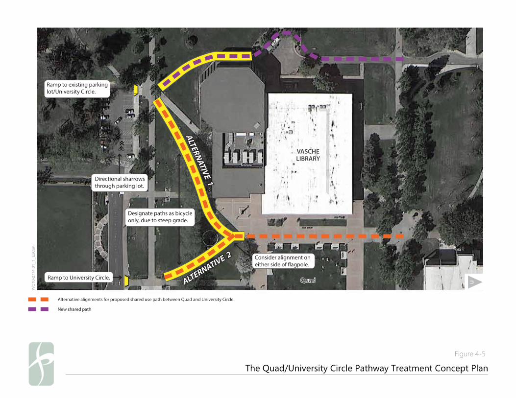
The Quad/University Circle Pathway Treatment Concept Plan
Figure 4-5
WC
10-2
774.
01_1
_ExC
on
ALTERNATIVE 1
ALTERNATIVE 1
ALTERNATIVE 2
ALTERNATIVE 2
Directional sharrows through parking lot.
Ramp to existing parking lot/University Circle.
Ramp to University Circle.
UNIVERSITY CIRCLE Consider alignment on either side of �agpole.
Designate paths as bicycle only, due to steep grade.
Alternative alignments for proposed shared use path between Quad and University Circle
New shared path
VASCHELIBRARYVASCHELIBRARY
QuadQuad
38
Quad Treatment
As the nexus of campus academic buildings and the walking and biking circulation networks, the Quad is a high-demand area of campus. The
Quad currently has very wide pathways and also provides a critical north-south and east-west link in the campus bicycle network. Given its
importance to the network, maintaining bicycle access through the Quad is recommended. However, special events frequently occur in the Quad
and may require that bicyclists be prohibited from riding through the Quad for short periods of time. On such special event days, cyclists should
be required to dismount rather than mix with pedestrians. Temporary “Bicyclist Dismount Zone” signs would be located on the fringe of the
Quad and would signal to bicyclists the end of the bike facility. The temporary signs should direct bicyclists to the proposed nearby bicycle cages
and short-term bicycle parking on the edge of the Quad to ensure that cyclists have a secure and visible place to store their bikes.
Recommendations:
Maintain pedestrian-only facilities within the Quad only on special event days.
Provide bicycle parking on perimeter of Quad to accommodate special event day bicycle prohibition.
Enhanced Path Lighting and Path User Definition
Pathway lighting should be pedestrian-scale and provide sufficient visibility for users at night. Pathways should be striped and signed to clearly
indicate user right-of-way and direction, creating clear expectations between bicyclists and pedestrians.
Recommendations:
Install pedestrian-scale lighting on campus perimeter path and other on-campus pathways.
Install signs and stencils to indicate bicycle and pedestrian rights-of-way on campus pathways.
Bicycle Parking
Bicycle parking racks serve students who are in class for a short period of time. Long-term bicycle parking, such as bicycle parking cages, is
needed to provide secure bicycle parking for longer periods of time. This parking should also serve faculty and staff who are frequently on
campus all day or students who drive to campus but would use a bicycle to circulate around campus between the parking lots and the heart of
campus.
CSU Stanislaus Bicycle Master Plan 39
Bicycle Cages and Fix-It Stations (Project 18)
Recommendations:
Install bicycle cages
Install a bicycle cage at high use location(s), such as Bizzini Hall, Vasche Library, and Fitzpatrick Arena/Gym to serve long-term bicycle
parking needs. Equip cages with Warrior Card access and enhanced security. Bizzini Hall location is recommended as a pilot project.
The Vasche Library and Fitzpatrick Arena/Gym locations could be installed as a second phase of the bicycle parking project.
Install bicycle fix-it station
Install a bicycle fix-it station and/or bicycle equipment vending machine near or in proposed bicycle cages to facilitate basic self-service
bicycle maintenance.
40
This page left intentionally blank
Support Programs 5
CSU Stanislaus Bicycle Master Plan 41
5. SUPPORT PROGRAMS
Support programs that complement and enhance bicycle infrastructure improvements are critical elements for a complete and balanced
approach to improving bicycling at CSU Stanislaus. CSU Stanislaus should build on current education, encouragement, enforcement, and
collaboration efforts related to bicycling on campus.
Existing Programs
Bicycle network support programs are currently limited to education and encouragement events at the beginning of the school year, when
University Police host bicycle lock giveaways and the Student Recreation Complex offers a Bicycling 101 introductory course. However, these
efforts are largely marketed towards students; there is currently limited education and encouragement outreach directed towards the rest of the
CSU Stanislaus campus community, specifically faculty and staff.
Additionally, students recently organized the Bicycle Advocacy Group, newly formed at the time of publication of this plan, and have designed a
bicycling brochure consisting of safety tips and maintenance information.
Three campus buildings, including Naraghi Hall of Science, Mary Stuart Rogers and the Physical Education Facility, provide bicycle support
facilities, consisting of showers and/or locker facilities. These are not well publicized and may not be open for general use. There are short-term
bicycle parking racks located around campus, but these are often overcrowded, lack sufficient security, and are poorly designed to support two
points of connection with the parked bicycle.
Proposed Programs
Depending on staff availability and resources, CSU Stanislaus should consider augmenting existing efforts with the support programs detailed
below.
Education
Distribute a map with recommended bicycle routes to campus and the locations of lockers, showers and bicycle parking around
campus to all campus students, faculty and staff. (Distinguish between short-term and long-term parking facilities.)
Work with the student advocacy group to produce and distribute the bicycle safety brochure and other bicycle information materials in
new student orientation packets, including a guide to proper bike locking.
Include bicycle information, maps, and brochures on the CSU website.
42
Engage faculty and staff to participate in and promote Bike to Work Day activities.
Increase visibility of existing education programs (e.g., Bicycling 101 course) and extend offerings to entire campus community,
including faculty and staff.
Encouragement
Partner with a local bike shop for student discounts and bike repair classes.
Provide bike light, bike lock and helmet discounts and giveaways.
Organize bicycle-oriented social events, such as bike mechanic happy hours.
Develop financial incentives for bicycling to campus, such as a commuter benefits bonus.
Build a general marketing campaign directed towards students, faculty and staff to share available resources and promote bicycling.
Establish a bicycle ambassador program to distribute information and guidance. Work with existing organizations, like the Bicycle
Advocacy Group or University Student Union, to serve as a liaison to the campus community.
Establish a bicycle buddy system to pair new riders with experienced riders.
Sponsor a campus Bike Share program. The program would be intended to provide short-term bicycle rentals on campus and would be
aimed towards students, faculty, staff, and visitors who do not own bicycles or choose not to bring a bicycle to campus.
Enforcement
Work with campus security staff to provide support on enforcement.
Require bicycle registration to help identify stolen bicycles.
Utilize public safety officers to monitor bicycle/pedestrian conflicts on shared facilities, and issue citations for unsafe bicycling.
Provide bicycle safety education classes, and require attendance for bicyclists issued a citation.
Consider a bicycle dismount zone in the center quad during special events.

CSU Stanislaus Bicycle Master Plan 43
Collaboration
Collaborate with City of Turlock staff to ensure that regional bicycle and pedestrian facility improvements are coordinated with on-
campus facilities.
Bicycle Parking
Bicycle racks around the CSU Stanislaus campus are well maintained and well-used; however, CSU Stanislaus should consider the following
bicycle parking opportunities:
Select a preferred design standard for bicycle racks.
Develop a program to inventory existing bike parking, upgrade old racks to the preferred design standard, and create a maintenance
program for new racks.
Monitor bicycle rack use and identify opportunities to increase bike parking at popular destinations.
Identify candidate locations for lockers or enclosed facilities and build new parking structures.

44
This page left intentionally blank
Implementation Strategy 6
CSU Stanislaus Bicycle Master Plan 45
6. IMPLEMENTATION STRATEGY
This chapter presents information on the priority and cost for the recommended improvements. The intent of this chapter is to assist CSU
Stanislaus with programming and constructing the projects.
The proposed bikeway system, when fully implemented, will provide a comprehensive system for the campus. However, due to resource
constraints, the proposed segments need to be prioritized for implementation. The prioritization provided in this chapter is meant to serve as a
guide for implementation, but it should not be a limiting factor if opportunities arise to implement low- or medium-priority projects sooner.
CSU Stanislaus should pursue opportunities to implement projects through routine resurfacing or redevelopment projects as they appear,
regardless of a project’s place in the prioritized list.
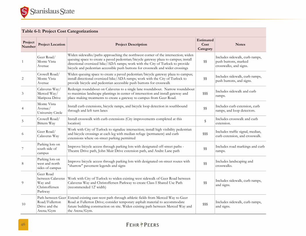
Cost Estimates
Table 6-1 Project Cost Categorizations presents cost categorization estimates for the proposed projects. Notes are provided to add detail
to the cost estimates. Overall, implementation of the projects recommended in the CSU Stanislaus Bicycle Master Plan would cost approximately
$4 million.
The cost estimates assume soft costs, contingency, and design as follows:
15% markup for traffic control, construction management, and mobilization
25% markup for contingency
15% markup for design and environmental
46
Table 6-1: Project Cost Categorizations
Project Number
Project Location Project Description Estimated
Cost Category
Notes
1 Geer Road/ Monte Vista Avenue
Widen sidewalks/paths approaching the northwest corner of the intersection; widen queuing space to create a paved pedestrian/bicycle gateway plaza to campus; install directional oversized bike/ADA ramps; work with the City of Turlock to provide bicycle and pedestrian accessible push buttons for crosswalk and wider crossings
$$ Includes sidewalk, curb ramps, push buttons, marked crosswalks, and signs.
2 Crowell Road/ Monte Vista Avenue
Widen queuing space to create a paved pedestrian/bicycle gateway plaza to campus; install directional oversized bike/ADA ramps; work with the City of Turlock to provide bicycle and pedestrian accessible push buttons for crosswalk
$$ Includes sidewalk, curb ramps, push buttons, and signs.
3 Calaveras Way/ Merced Way/ Mariposa Drive
Redesign roundabout on Calaveras to a single lane roundabout. Narrow roundabout to maximize landscape plantings in center of intersection and install gateway and place making treatments to create a gateway to campus from Geer Road.
$$$ Includes sidewalk and curb ramps.
4 Monte Vista Avenue/ University Circle
Install curb extensions, bicycle ramps, and bicycle loop detection in southbound through and left turn lanes
$$ Includes curb extension, curb ramps, and loop detectors.
5 Crowell Road/ Bittern Way
Install crosswalk with curb extensions (City improvements completed at this location)
$ Includes crosswalk and curb extension.
6 Geer Road/ Calaveras Way
Work with City of Turlock to signalize intersection; install high visibility pedestrian and bicycle crossings at each leg with median refuge (permanent) and curb extensions where on-street parking permitted
$$$ Includes traffic signal, median, curb extension, and crosswalk.
7 Parking lots on south side of campus
Improve bicycle access through parking lots with designated off-street paths - Theatre Drive path, John Muir Drive extension path, and Andre Lane path
$$ Includes road markings and curb ramps.
8 Parking lots on west and north sides of campus
Improve bicycle access through parking lots with designated on-street routes with "sharrow" pavement legends and signs
$$ Includes landscaping and crosswalks.
9
Geer Road between Calaveras Way and Christoffersen Parkway
Work with City of Turlock to widen existing west sidewalk of Geer Road between Calaveras Way and Christoffersen Parkway to create Class I Shared Use Path (recommended 12' width)
$$ Includes sidewalk, curb ramps, and signs.
10
Path between Geer Road/Fullerton Drive and the Arena/Gym
Extend existing east-west path through athletic fields from Merced Way to Geer Road at Fullerton Drive; consider temporary asphalt material to accommodate future building construction on site. Widen existing path between Merced Way and the Arena/Gym.
$$$ Includes sidewalk, curb ramps, and signs.
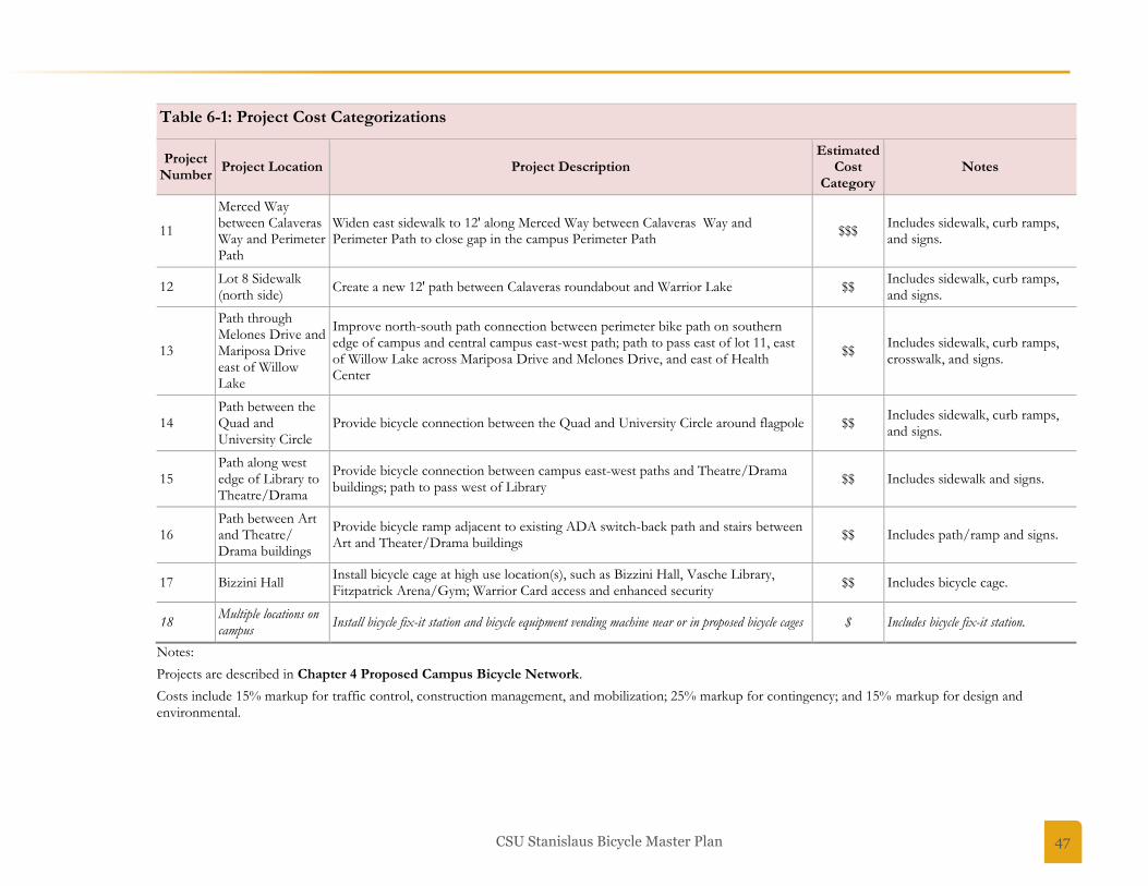
CSU Stanislaus Bicycle Master Plan 47
Table 6-1: Project Cost Categorizations
Project Number
Project Location Project Description Estimated
Cost Category
Notes
11
Merced Way between Calaveras Way and Perimeter Path
Widen east sidewalk to 12' along Merced Way between Calaveras Way and Perimeter Path to close gap in the campus Perimeter Path
$$$ Includes sidewalk, curb ramps, and signs.
12 Lot 8 Sidewalk (north side)
Create a new 12' path between Calaveras roundabout and Warrior Lake $$ Includes sidewalk, curb ramps, and signs.
13
Path through Melones Drive and Mariposa Drive east of Willow Lake
Improve north-south path connection between perimeter bike path on southern edge of campus and central campus east-west path; path to pass east of lot 11, east of Willow Lake across Mariposa Drive and Melones Drive, and east of Health Center
$$ Includes sidewalk, curb ramps, crosswalk, and signs.
14 Path between the Quad and University Circle
Provide bicycle connection between the Quad and University Circle around flagpole $$ Includes sidewalk, curb ramps, and signs.
15 Path along west edge of Library to Theatre/Drama
Provide bicycle connection between campus east-west paths and Theatre/Drama buildings; path to pass west of Library
$$ Includes sidewalk and signs.
16 Path between Art and Theatre/ Drama buildings
Provide bicycle ramp adjacent to existing ADA switch-back path and stairs between Art and Theater/Drama buildings
$$ Includes path/ramp and signs.
17 Bizzini Hall Install bicycle cage at high use location(s), such as Bizzini Hall, Vasche Library, Fitzpatrick Arena/Gym; Warrior Card access and enhanced security
$$ Includes bicycle cage.
18 Multiple locations on campus
Install bicycle fix-it station and bicycle equipment vending machine near or in proposed bicycle cages $ Includes bicycle fix-it station.
Notes:
Projects are described in Chapter 4 Proposed Campus Bicycle Network.
Costs include 15% markup for traffic control, construction management, and mobilization; 25% markup for contingency; and 15% markup for design and environmental.
48
Prioritization
Prioritization Framework
Project prioritization was based on the following five prioritization criteria, which are further defined in Table 6-2 Prioritization
Framework.
Safety/Comfort
Demand
Feasibility
Cost
Barriers
Projects were assigned scores for each criterion, and criteria scores were aggregated to create an overall prioritization score. Appendix A
Project Prioritization Scoring presents the detailed criteria and weighting in addition to numeric scores for each project.
Prioritized Project List
Results from the prioritization process are summarized in Table 6-3 Project Prioritization Summary. Projects were ranked either “high”,
“medium”, or “low” priority. Three of the highest priority projects were selected in consultation with CSU Stanislaus staff for further concept
development. These conceptual plans are presented in Chapter 4 Proposed Campus Bicycle Network.
Detailed scoring for each project is presented in the appendix to this plan. Based on the prioritization framework, CSU Stanislaus should
prioritize site improvements on identified north-south path connections (i.e., along the west edge of the Library, between the Quad and
University Circle, and along Geer Road), as well as at the campus entrance at Geer Road and Calaveras Way through a redesigned roundabout
and improved Geer Road crossings. Results also indicate that the installation of bicycle cages at strategic locations on campus, the extension of
the path between Merced Way and Geer Road at Fullerton Drive, gateway treatments at Geer Road/Monte Vista Avenue and Crowell
Road/Monte Vista Avenue, and on-street parking lot access routes would be important bicycle projects to pursue.
All recommendations are intended to enhance the bicycling experience on campus, and many are related. Opportunities to couple multiple
recommendations will provide a greater benefit to bicyclists.
Several recommendations will require significant preparation, including coordination with other agencies, grant applications, and additional
analysis and design.
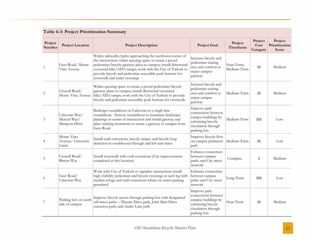
CSU Stanislaus Bicycle Master Plan 49
Table 6-3: Project Prioritization Summary
Project Number
Project Location Project Description Project Goal Project
Timeframe
Project Cost
Category
Project Prioritization
Score
1 Geer Road/ Monte Vista Avenue
Widen sidewalks/paths approaching the northwest corner of the intersection; widen queuing space to create a paved pedestrian/bicycle gateway plaza to campus; install directional oversized bike/ADA ramps; work with the City of Turlock to provide bicycle and pedestrian accessible push buttons for crosswalk and wider crossings
Increase bicycle and pedestrian waiting area and comfort at major campus gateway
Near-Term; Medium-Term
$$ Medium
2 Crowell Road/ Monte Vista Avenue
Widen queuing space to create a paved pedestrian/bicycle gateway plaza to campus; install directional oversized bike/ADA ramps; work with the City of Turlock to provide bicycle and pedestrian accessible push buttons for crosswalk
Increase bicycle and pedestrian waiting area and comfort at major campus gateway
Medium-Term $$ Medium
3 Calaveras Way/ Merced Way/ Mariposa Drive
Redesign roundabout on Calaveras to a single lane roundabout. Narrow roundabout to maximize landscape plantings in center of intersection and install gateway and place making treatments to create a gateway to campus from Geer Road.
Improve path connections between campus buildings by enhancing bicycle circulation through parking lots
Medium-Term $$$ Low
4 Monte Vista Avenue/ University Circle
Install curb extensions, bicycle ramps, and bicycle loop detection in southbound through and left turn lanes
Improve bicycle flow on campus perimeter path
Medium-Term $$ Low
5 Crowell Road/ Bittern Way
Install crosswalk with curb extensions (City improvements completed at this location)
Enhance connection between campus paths and City street network
Complete $ Medium
6 Geer Road/ Calaveras Way
Work with City of Turlock to signalize intersection; install high visibility pedestrian and bicycle crossings at each leg with median refuge and curb extensions where on-street parking permitted
Enhance connection between campus paths and City street network
Long-Term $$$ Low
7 Parking lots on south side of campus
Improve bicycle access through parking lots with designated off-street paths – Theatre Drive path, John Muir Drive extension path, and Andre Lane path
Improve path connections between campus buildings by enhancing bicycle circulation through parking lots
Near-Term $$ Medium
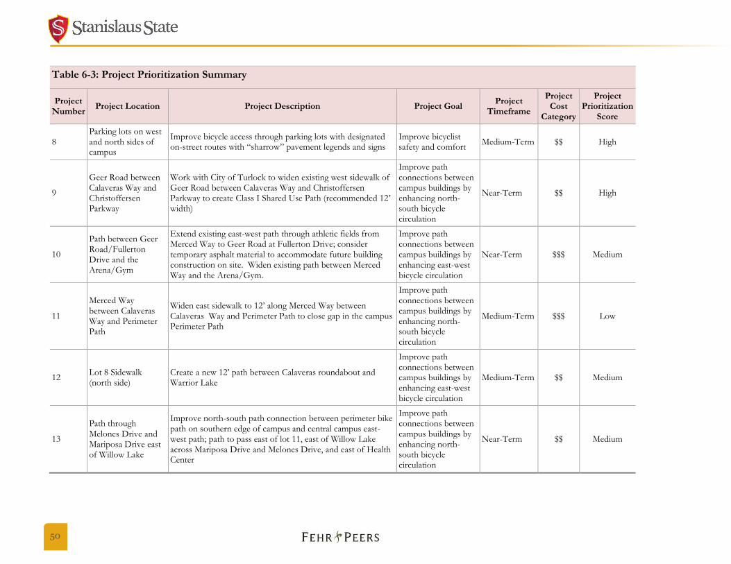
50
Table 6-3: Project Prioritization Summary
Project Number
Project Location Project Description Project Goal Project
Timeframe
Project Cost
Category
Project Prioritization
Score
8 Parking lots on west and north sides of campus
Improve bicycle access through parking lots with designated on-street routes with “sharrow” pavement legends and signs
Improve bicyclist safety and comfort
Medium-Term $$ High
9
Geer Road between Calaveras Way and Christoffersen Parkway
Work with City of Turlock to widen existing west sidewalk of Geer Road between Calaveras Way and Christoffersen Parkway to create Class I Shared Use Path (recommended 12’ width)
Improve path connections between campus buildings by enhancing north-south bicycle circulation
Near-Term $$ High
10
Path between Geer Road/Fullerton Drive and the Arena/Gym
Extend existing east-west path through athletic fields from Merced Way to Geer Road at Fullerton Drive; consider temporary asphalt material to accommodate future building construction on site. Widen existing path between Merced Way and the Arena/Gym.
Improve path connections between campus buildings by enhancing east-west bicycle circulation
Near-Term $$$ Medium
11
Merced Way between Calaveras Way and Perimeter Path
Widen east sidewalk to 12’ along Merced Way between Calaveras Way and Perimeter Path to close gap in the campus Perimeter Path
Improve path connections between campus buildings by enhancing north-south bicycle circulation
Medium-Term $$$ Low
12 Lot 8 Sidewalk (north side)
Create a new 12’ path between Calaveras roundabout and Warrior Lake
Improve path connections between campus buildings by enhancing east-west bicycle circulation
Medium-Term $$ Medium
13
Path through Melones Drive and Mariposa Drive east of Willow Lake
Improve north-south path connection between perimeter bike path on southern edge of campus and central campus east-west path; path to pass east of lot 11, east of Willow Lake across Mariposa Drive and Melones Drive, and east of Health Center
Improve path connections between campus buildings by enhancing north-south bicycle circulation
Near-Term $$ Medium

CSU Stanislaus Bicycle Master Plan 51
Table 6-3: Project Prioritization Summary
Project Number
Project Location Project Description Project Goal Project
Timeframe
Project Cost
Category
Project Prioritization
Score
14 Path between the Quad and University Circle
Provide bicycle connection between the Quad and University Circle around flagpole
Improve path connections between campus buildings by enhancing north-south bicycle circulation
Near-Term $$ High
15 Path along west edge of Library to Theatre/Drama
Provide bicycle connection between campus east-west paths and Theatre/Drama buildings; path to pass west of Library
Improve path connections between campus buildings by enhancing north-south bicycle circulation
Near-Term $$ High
16 Path between Art and Theatre/ Drama buildings
Provide bicycle ramp adjacent to existing ADA switch-back path and stairs between Art and Theater/Drama buildings
Improve path connections between campus buildings by enhancing north-south bicycle circulation
Complete $$ Medium
17 Bizzini Hall Install bicycle cage at high use location(s), such as Bizzini Hall, Vasche Library, Fitzpatrick Arena/Gym; Warrior Card access and enhanced security
Improve convenience and security of bicycle parking
Near-Term, Medium-Term
$$ Medium
18 Multiple locations on campus
Install bicycle fix-it station and bicycle equipment vending machine near or in proposed bicycle cages
Improve bicyclist convenience and comfort
Near-Term $ Medium
Funding Opportunities
There are a number of funding opportunities that CSU Stanislaus could pursue to help fund the projects proposed in the CSU Stanislaus Bicycle
Master Plan.
Continue use of University parking fines and forfeitures with generated revenue dedicated to bicycle plan improvements.
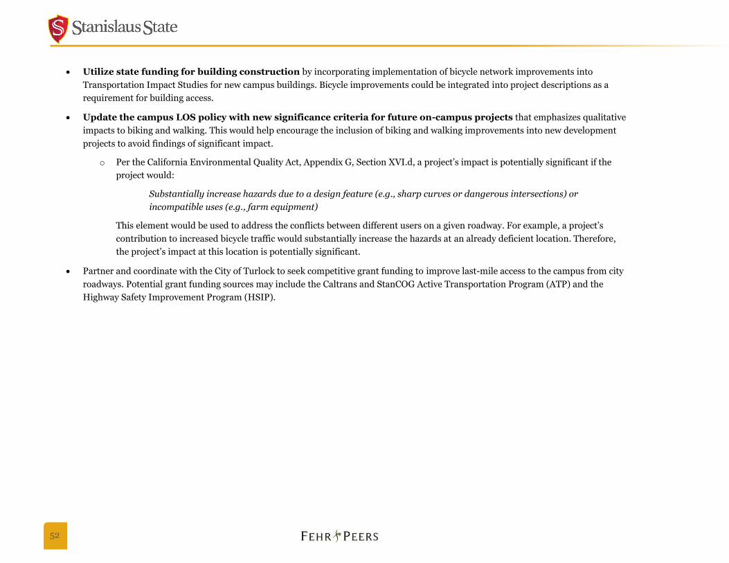
52
Utilize state funding for building construction by incorporating implementation of bicycle network improvements into
Transportation Impact Studies for new campus buildings. Bicycle improvements could be integrated into project descriptions as a
requirement for building access.
Update the campus LOS policy with new significance criteria for future on-campus projects that emphasizes qualitative
impacts to biking and walking. This would help encourage the inclusion of biking and walking improvements into new development
projects to avoid findings of significant impact.
o Per the California Environmental Quality Act, Appendix G, Section XVI.d, a project’s impact is potentially significant if the
project would:
Substantially increase hazards due to a design feature (e.g., sharp curves or dangerous intersections) or
incompatible uses (e.g., farm equipment)
This element would be used to address the conflicts between different users on a given roadway. For example, a project’s
contribution to increased bicycle traffic would substantially increase the hazards at an already deficient location. Therefore,
the project’s impact at this location is potentially significant.
Partner and coordinate with the City of Turlock to seek competitive grant funding to improve last-mile access to the campus from city
roadways. Potential grant funding sources may include the Caltrans and StanCOG Active Transportation Program (ATP) and the
Highway Safety Improvement Program (HSIP).
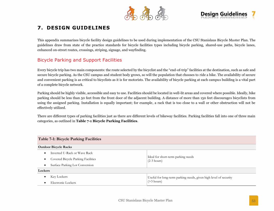
Design Guidelines 7
CSU Stanislaus Bicycle Master Plan 53
7. DESIGN GUIDELINES
This appendix summarizes bicycle facility design guidelines to be used during implementation of the CSU Stanislaus Bicycle Master Plan. The
guidelines draw from state of the practice standards for bicycle facilities types including bicycle parking, shared-use paths, bicycle lanes,
enhanced on-street routes, crossings, striping, signage, and wayfinding.
Bicycle Parking and Support Facilities
Every bicycle trip has two main components: the route selected by the bicyclist and the “end-of-trip” facilities at the destination, such as safe and
secure bicycle parking. As the CSU campus and student body grows, so will the population that chooses to ride a bike. The availability of secure
and convenient parking is as critical to bicyclists as it is for motorists. The availability of bicycle parking at each campus building is a vital part
of a complete bicycle network.
Parking should be highly visible, accessible and easy to use. Facilities should be located in well-lit areas and covered where possible. Ideally, bike
parking should be less than 50 feet from the front door of the adjacent building. A distance of more than 150 feet discourages bicyclists from
using the assigned parking. Installation is equally important; for example, a rack that is too close to a wall or other obstruction will not be
effectively utilized.
There are different types of parking facilities just as there are different levels of bikeway facilities. Parking facilities fall into one of three main
categories, as outlined in Table 7-1 Bicycle Parking Facilities.
Table 7-1: Bicycle Parking Facilities
Outdoor Bicycle Racks
Inverted U-Rack or Wave Rack Ideal for short-term parking needs (2-3 hours)
Covered Bicycle Parking Facilities
Surface Parking Lot Conversion
Lockers
Key Lockers Useful for long-term parking needs, given high level of security (>3 hours) Electronic Lockers
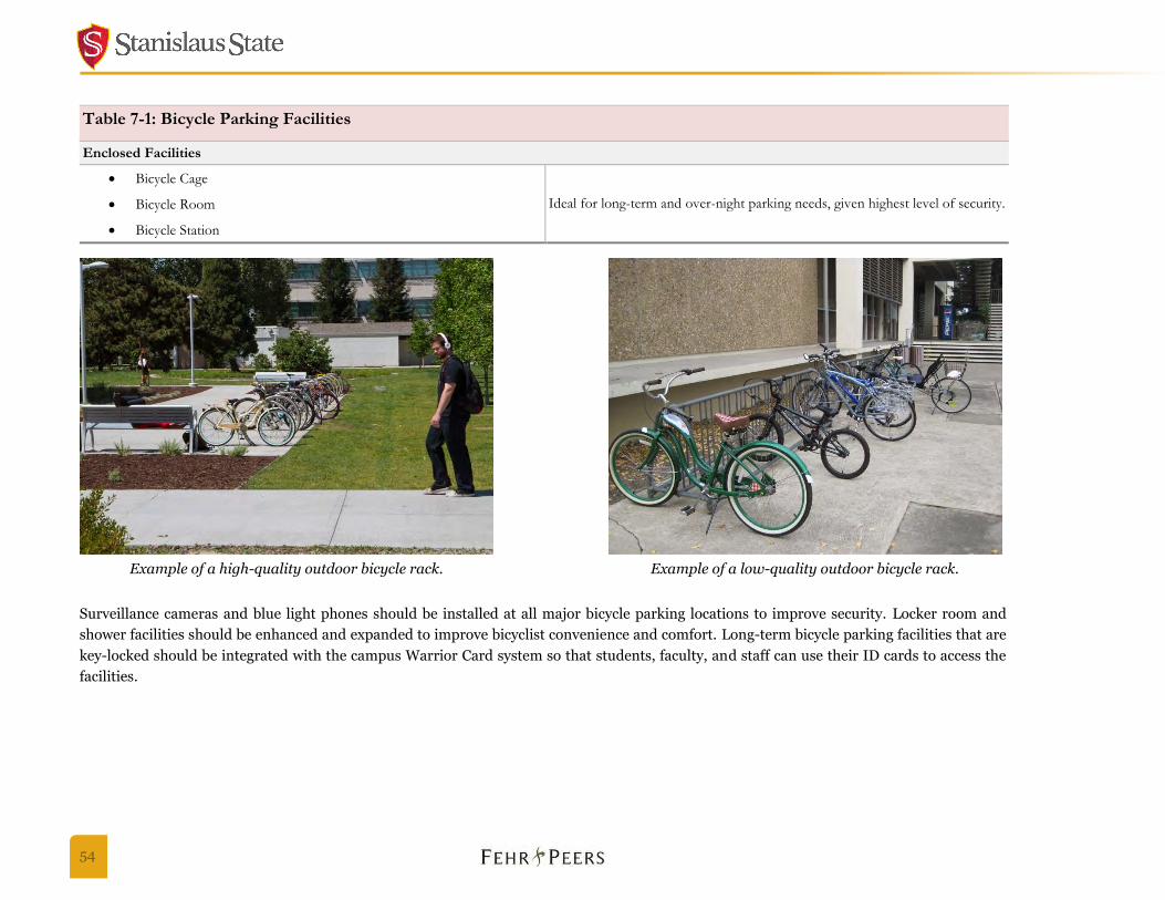
54
Table 7-1: Bicycle Parking Facilities
Enclosed Facilities
Bicycle Cage
Ideal for long-term and over-night parking needs, given highest level of security. Bicycle Room
Bicycle Station
Surveillance cameras and blue light phones should be installed at all major bicycle parking locations to improve security. Locker room and
shower facilities should be enhanced and expanded to improve bicyclist convenience and comfort. Long-term bicycle parking facilities that are
key-locked should be integrated with the campus Warrior Card system so that students, faculty, and staff can use their ID cards to access the
facilities.
Example of a high-quality outdoor bicycle rack. Example of a low-quality outdoor bicycle rack.
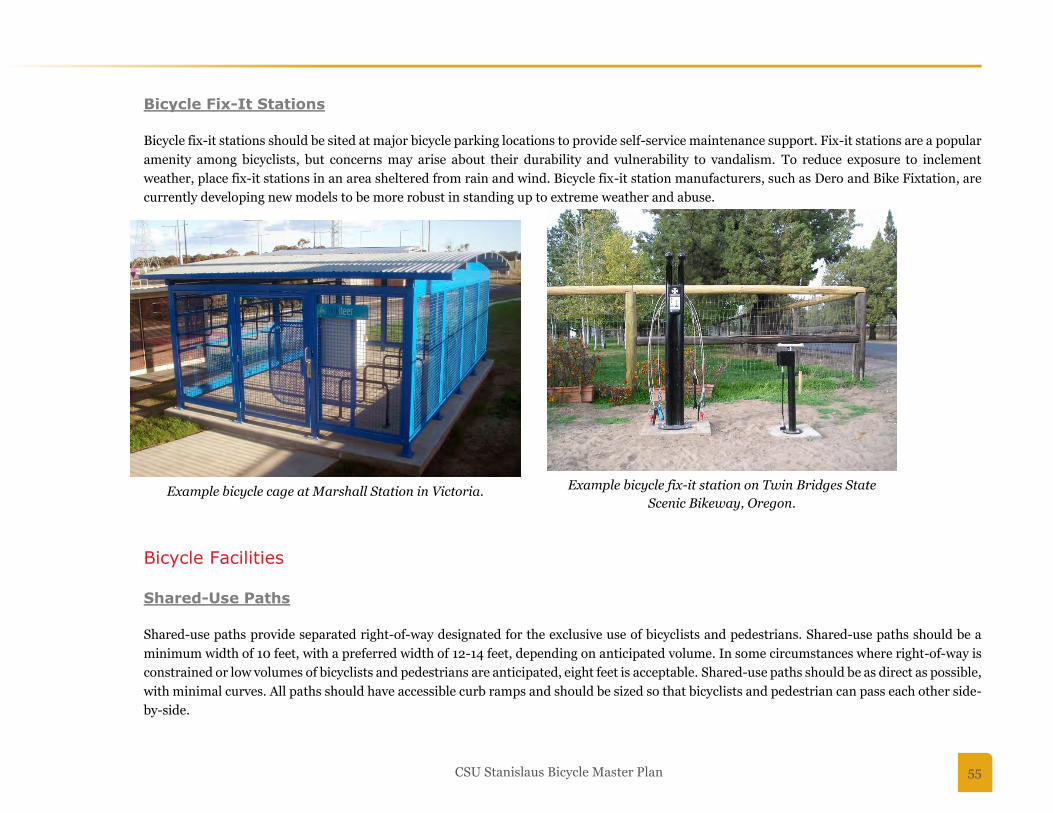
CSU Stanislaus Bicycle Master Plan 55
Bicycle Fix-It Stations
Bicycle fix-it stations should be sited at major bicycle parking locations to provide self-service maintenance support. Fix-it stations are a popular
amenity among bicyclists, but concerns may arise about their durability and vulnerability to vandalism. To reduce exposure to inclement
weather, place fix-it stations in an area sheltered from rain and wind. Bicycle fix-it station manufacturers, such as Dero and Bike Fixtation, are
currently developing new models to be more robust in standing up to extreme weather and abuse.
Bicycle Facilities
Shared-Use Paths
Shared-use paths provide separated right-of-way designated for the exclusive use of bicyclists and pedestrians. Shared-use paths should be a
minimum width of 10 feet, with a preferred width of 12-14 feet, depending on anticipated volume. In some circumstances where right-of-way is
constrained or low volumes of bicyclists and pedestrians are anticipated, eight feet is acceptable. Shared-use paths should be as direct as possible,
with minimal curves. All paths should have accessible curb ramps and should be sized so that bicyclists and pedestrian can pass each other side-
by-side.
Example bicycle cage at Marshall Station in Victoria. Example bicycle fix-it station on Twin Bridges State
Scenic Bikeway, Oregon.

56
Striping and signage indicating user right-of-way and direction may be added to paths to further clarify expectations between bicyclists and
pedestrians. It is suggested that this be used as an “enhancement” to existing paths where bicyclist and pedestrian conflicts are reported. Path
lighting should be pedestrian-scale and provide sufficient visibility for users at night.
On CSU Stanislaus campus, shared-use paths are generally preferred to maximize bicycle and pedestrian connectivity. Existing narrow paths
should be widened to 12 feet, where feasible, and plans for new paths should include a width of no less than 10 feet. Where available width is
insufficient for a shared-use path, on-street bicycle routes may be considered. For example, on-street facilities would be recommended through
the parking lots on the west side of campus, since there is no available space for a quality off-street path. Shared-use paths also limit the need
for ongoing enforcement efforts by campus police and keeps the campus active transportation network flexible and accessible to all users.
Where on-campus shared-use paths intersect parking lot aisles that access the campus core or cross driveways, large curb ramps should be
provided for bicyclists to connect to other campus roadways and paths. All shared-use paths should have safe and visible crossings at roadways
and through parking lots. Good lighting, blue light phones and other safety amenities should also be installed.
Bicycle Lanes
Bicycle lanes provide a restricted right-of-way designated for the use of bicycles on roadways with through motor vehicles traffic. Bicycle lanes
should have a six-foot preferred width, with a minimum of five feet. If sufficient space is available, buffered bicycle lanes should be installed to
increase the separation between bicyclists in the bicycle lane and motor vehicle traffic in the adjacent lanes.
The City of Turlock currently has plans to install new bicycle lanes on Geer Road between
Monte Vista Avenue and Taylor Road.
Bicycle Routes with Sharrows
Sharrows (or “shared lane markings”) are a way to designated shared space between autos and
bicyclists. Sharrows also have a wayfinding feature to guide bicyclists along preferred bicycle
routes on campus roadways. Sharrows are typically centered on the width of a travel lane to
indicate that bicyclists may use the full lane.
The sharrow treatment should be considered to designate bicycle routes through parking lots to
connect the campus core with the campus perimeter path and other key routes. Example of a Sharrow.
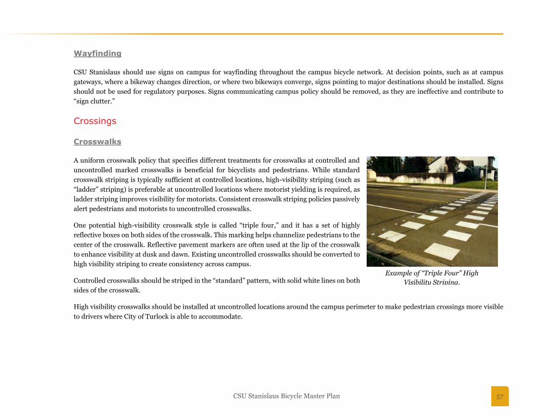
CSU Stanislaus Bicycle Master Plan 57
Wayfinding
CSU Stanislaus should use signs on campus for wayfinding throughout the campus bicycle network. At decision points, such as at campus
gateways, where a bikeway changes direction, or where two bikeways converge, signs pointing to major destinations should be installed. Signs
should not be used for regulatory purposes. Signs communicating campus policy should be removed, as they are ineffective and contribute to
“sign clutter.”
Crossings
Crosswalks
A uniform crosswalk policy that specifies different treatments for crosswalks at controlled and
uncontrolled marked crosswalks is beneficial for bicyclists and pedestrians. While standard
crosswalk striping is typically sufficient at controlled locations, high-visibility striping (such as
“ladder” striping) is preferable at uncontrolled locations where motorist yielding is required, as
ladder striping improves visibility for motorists. Consistent crosswalk striping policies passively
alert pedestrians and motorists to uncontrolled crosswalks.
One potential high-visibility crosswalk style is called “triple four,” and it has a set of highly
reflective boxes on both sides of the crosswalk. This marking helps channelize pedestrians to the
center of the crosswalk. Reflective pavement markers are often used at the lip of the crosswalk
to enhance visibility at dusk and dawn. Existing uncontrolled crosswalks should be converted to
high visibility striping to create consistency across campus.
Controlled crosswalks should be striped in the “standard” pattern, with solid white lines on both
sides of the crosswalk.
High visibility crosswalks should be installed at uncontrolled locations around the campus perimeter to make pedestrian crossings more visible
to drivers where City of Turlock is able to accommodate.
Example of “Triple Four” High
Visibility Striping.
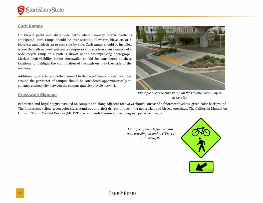
58
Curb Ramps
On bicycle paths and shared-use paths where two-way bicycle traffic is
anticipated, curb ramps should be over-sized to allow two bicyclists or a
bicyclists and pedestrian to pass side-by-side. Curb ramps should be installed
where the path network intersects campus or City roadways. An example of a
wide bicycle ramp on a path is shown in the accompanying photograph.
Marked high-visibility ladder crosswalks should be considered at these
locations to highlight the continuation of the path on the other side of the
roadway.
Additionally, bicycle ramps that connect to the bicycle lanes on city roadways
around the perimeter of campus should be considered opportunistically to
enhance connectivity between the campus and city bicycle network.
Crosswalk Signage
Pedestrian and bicycle signs installed on campus and along adjacent roadways should consist of a fluorescent yellow-green color background.
The fluorescent yellow-green color signs stand out and alert drivers to upcoming pedestrian and bicycle crossings. The California Manual on
Uniform Traffic Control Devices (MUTCD) recommends fluorescent yellow-green pedestrian signs.
Example oversize curb ramp on the Ohlone Greenway in
El Cerrito.
Example of bicycle/pedestrian
trail crossing assembly (W11-15
with W16-7P).
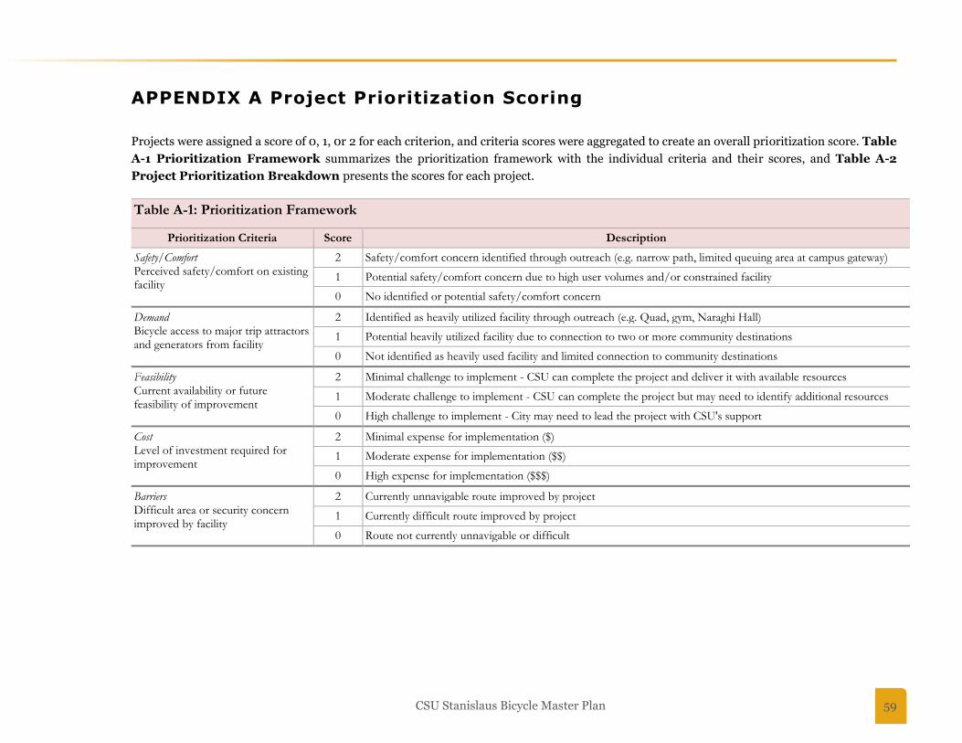
CSU Stanislaus Bicycle Master Plan 59
APPENDIX A Project Prioritization Scoring
Projects were assigned a score of 0, 1, 0r 2 for each criterion, and criteria scores were aggregated to create an overall prioritization score. Table
A-1 Prioritization Framework summarizes the prioritization framework with the individual criteria and their scores, and Table A-2
Project Prioritization Breakdown presents the scores for each project.
Table A-1: Prioritization Framework
Prioritization Criteria Score Description
Safety/Comfort Perceived safety/comfort on existing facility
2 Safety/comfort concern identified through outreach (e.g. narrow path, limited queuing area at campus gateway)
1 Potential safety/comfort concern due to high user volumes and/or constrained facility
0 No identified or potential safety/comfort concern
Demand Bicycle access to major trip attractors and generators from facility
2 Identified as heavily utilized facility through outreach (e.g. Quad, gym, Naraghi Hall)
1 Potential heavily utilized facility due to connection to two or more community destinations
0 Not identified as heavily used facility and limited connection to community destinations
Feasibility Current availability or future feasibility of improvement
2 Minimal challenge to implement - CSU can complete the project and deliver it with available resources
1 Moderate challenge to implement - CSU can complete the project but may need to identify additional resources
0 High challenge to implement - City may need to lead the project with CSU's support
Cost Level of investment required for improvement
2 Minimal expense for implementation ($)
1 Moderate expense for implementation ($$)
0 High expense for implementation ($$$)
Barriers Difficult area or security concern improved by facility
2 Currently unnavigable route improved by project
1 Currently difficult route improved by project
0 Route not currently unnavigable or difficult

60
Table A-2: Project Prioritization Breakdown
Project Number
Project Location Project Description
Prioritization Criteria
Safety/Comfort
Demand Feasibility Cost Barriers Project
Prioritization Score
1 Geer Road/ Monte Vista Avenue
Widen sidewalks/paths approaching the northwest corner of the intersection; widen queuing space to create a paved pedestrian/bicycle gateway plaza to campus; install directional oversized bike/ADA ramps; work with the City of Turlock to provide bicycle and pedestrian accessible push buttons for crosswalk and wider crossings
2 2 1 1 1 7
2 Crowell Road/ Monte Vista Avenue
Widen queuing space to create a paved pedestrian/bicycle gateway plaza to campus; install directional oversized bike/ADA ramps; work with the City of Turlock to provide bicycle and pedestrian accessible push buttons for crosswalk
2 2 1 1 1 7
3 Calaveras Way/ Merced Way/ Mariposa Drive
Redesign roundabout on Calaveras to a single lane roundabout. Narrow roundabout to maximize landscape plantings in center of intersection and install gateway and place making treatments to create a gateway to campus from Geer Road.
2 1 1 0 1 5
4 Monte Vista Avenue/ University Circle
Install curb extensions, bicycle ramps, and bicycle loop detection in southbound through and left turn lanes
0 1 2 1 1 5
5 Crowell Road/ Bittern Way
Install crosswalk with curb extensions (City improvements completed at this location)
1 1 0 2 2 6
6 Geer Road/ Calaveras Way
Work with City of Turlock to signalize intersection; install high visibility pedestrian and bicycle crossings at each leg with median refuge and curb extensions where on-street parking permitted
2 2 0 0 1 5
7 Parking lots on south side of campus
Improve bicycle access through parking lots with designated off-street paths - Theatre Drive path, John Muir Drive extension path, and Andre Lane path
2 1 2 1 1 7

CSU Stanislaus Bicycle Master Plan 61
Table A-2: Project Prioritization Breakdown
Project Number
Project Location Project Description
Prioritization Criteria
Safety/Comfort
Demand Feasibility Cost Barriers Project
Prioritization Score
8 Parking lots on west and north sides of campus
Improve bicycle access through parking lots with designated on-street routes with "sharrow" pavement legends and signs
2 2 2 1 1 8
9
Geer Road between Calaveras Way and Christoffersen Parkway
Work with City of Turlock to widen existing west sidewalk of Geer Road between Calaveras Way and Christoffersen Parkway to create Class I Shared Use Path (recommended 12' width)
2 2 2 1 1 8
10
Path between Geer Road/Fullerton Drive and the Arena/Gym
Extend existing east-west path through athletic fields from Merced Way to Geer Road at Fullerton Drive; consider temporary asphalt material to accommodate future building construction on site. Widen existing path between Merced Way and the Arena/Gym.
1 1 2 2 1 7
11
Merced Way between Calaveras Way and Perimeter Path
Widen east sidewalk to 12' along Merced Way between Calaveras Way and Perimeter Path to close gap in the campus Perimeter Path
1 1 2 0 1 5
12 Lot 8 Sidewalk (north side)
Create a new 12' path between Calaveras roundabout and Warrior Lake
1 1 2 1 1 6
13
Path through Melones Drive and Mariposa Drive east of Willow Lake
Improve north-south path connection between perimeter bike path on southern edge of campus and central campus east-west path; path to pass east of lot 11, east of Willow Lake across Mariposa Drive and Melones Drive, and east of Health Center
1 1 2 1 1 6
14 Path between the Quad and University Circle
Provide bicycle connection between the Quad and University Circle around flagpole
2 2 1 1 2 8
15 Path along west edge of Library to Theatre/Drama
Provide bicycle connection between campus east-west paths and Theatre/Drama buildings; path to pass west of Library
2 2 2 1 2 9

62
Table A-2: Project Prioritization Breakdown
Project Number
Project Location Project Description
Prioritization Criteria
Safety/Comfort
Demand Feasibility Cost Barriers Project
Prioritization Score
16 Path between Art and Theatre/ Drama buildings
Provide bicycle ramp adjacent to existing ADA switch-back path and stairs between Art and Theater/Drama buildings
1 1 1 1 2 6
17 Bizzini Hall Install bicycle cage at high use location(s), such as Bizzini Hall, Vasche Library, Fitzpatrick Arena/Gym; Warrior Card access and enhanced security
0 2 2 1 2 7
18 Multiple locations on campus
Install bicycle fix-it station and bicycle equipment vending machine near or in proposed bicycle cages
0 2 2 2 0 6