Crescent Mountain Fire - Wa
16
Crescent Mountain Fire Geology-Debris Flows October 2018 Page 1 Crescent Mountain Fire Twisp River Debris Flow Evaluation Washington Geological Survey Okanogan-Wenatchee Ranger District, Washington Image: Evidence of past debris flows on the Scaffold Camp Creek fan: Imbricated boulders up to 8 feet in diameter 285 feet south of West Buttermilk Creek Road.
Transcript of Crescent Mountain Fire - Wa

Crescent Mountain Fire Geology-Debris Flows
October 2018 Page 1
Crescent Mountain Fire Twisp River Debris Flow Evaluation
Washington Geological Survey
Okanogan-Wenatchee Ranger District, Washington
Image: Evidence of past debris flows on the Scaffold Camp Creek fan: Imbricated boulders up to 8 feet in diameter 285 feet south of West Buttermilk Creek Road.

Crescent Mountain Fire Geology-Debris Flows
October 2018 Page 2
Contents Introduction .................................................................................................................................................. 3
Background ................................................................................................................................................... 3
Hillslope Processes .................................................................................................................................... 3
Debris flows and flash floods ................................................................................................................ 4
Debris flow and flooding hazards ......................................................................................................... 5
Fans ....................................................................................................................................................... 5
Methods ........................................................................................................................................................ 6
Observations and Interpretations ................................................................................................................. 6
Twisp River Valley ..................................................................................................................................... 6
Fans along the Twisp River .................................................................................................................... 6
War Creek ............................................................................................................................................. 6
Eagle Creek ............................................................................................................................................ 7
Two unnamed drainages between Eagle and Scaffold Camp Creeks ................................................... 7
Scaffold Camp Creek ............................................................................................................................. 7
Recommendations ........................................................................................................................................ 9
Limitations .................................................................................................................................................... 9
References: ................................................................................................................................................. 10
Resources: ................................................................................................................................................... 10
Figures ......................................................................................................................................................... 11
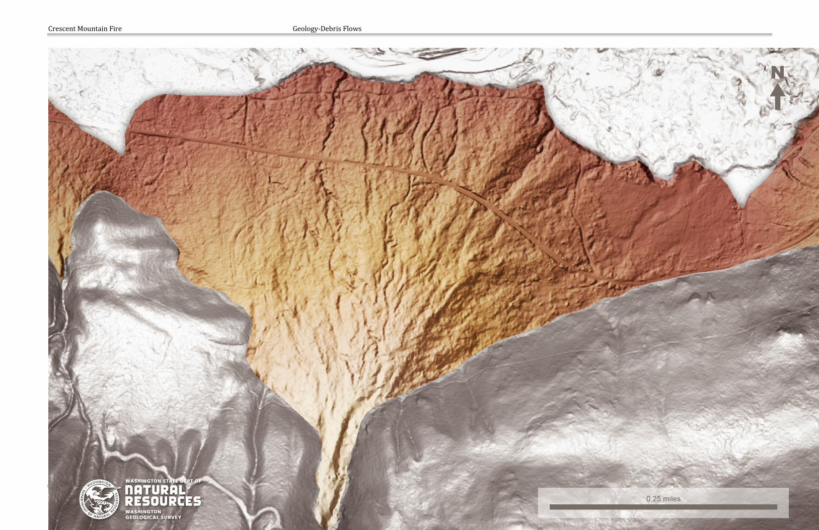
Appendix A. Maps ....................................................................................................................................... 14

Crescent Mountain Fire Geology-Debris Flows
October 2018 Page 3
Introduction This report is a rapid geologic assessment evaluating hazards from post-wildfire debris flows from the Crescent Mountain Fire, along West Buttermilk Creek Road with focus on Scaffold Camp Creek. Hazards assessed are debris flows and flooding that may adversely impact public safety and (or) infrastructure.
Wildfire can significantly change the hydrologic response of a watershed to the extent that even modest rainstorms can produce dangerous flash flooding and (or) debris flows. Areas downstream of slopes burned by wildfire were assessed for historic evidence of debris flow impacts using field reconnaissance, GIS interpretation of LIDAR. Field observations evaluated the characteristics of surficial deposits where creeks on the south side the Twisp River enter the main river valley. This is a qualitative assessment based on our professional judgement and experience and was performed in cooperation with the emergency response efforts of the U.S. Forest Service (USFS) Burned Area Emergency Response (BAER) team. The assessment is for areas adjacent to lands managed by the USFS and outside of the jurisdiction of the federal agency.
Summarized in the report are geologic observations, interpretations, and recommendations. The focus of this assessment is to the wildfire’s effect across all ownerships and to identify downstream areas susceptible to impacts from a post-wildfire debris flows.
Background The Crescent Mountain fire was ignited by lightning on July 29, 2018, in the Okanogan-Wenatchee National Forest (OWNF) and located approximately 10 miles west of Twisp, WA. As of October 4, 2018, the fire was 52,609 acres in size and 86 percent contained.
The U.S. Geological Survey (USGS) produced a Post-Fire Debris-Flow Hazards Assessment from the calibrated Soil Burn Severity map produced by the Burned Area Emergency Response (BAER) team. The debris flow hazard assessment suggested that Scaffold Camp Creek is at an elevated risk for debris flows along with other fans with basins in the burned area and along the south side of the Twisp River. On October 2nd USFS staff requested a consultation with a landslide hazards geologist from the Washington Geological Survey to evaluate the debris flow potential to impact a home on the Scaffold Camp Creek alluvial fan.
This report we relied heavily on the BAER Specialist Hydrology and Soil Resource reports for basin burn severity and basin area calculations, and the USGS Post-Fire Debris-Flow Hazards Assessment.
Hillslope Processes Soils impacted by fire, especially those on steep slopes and in areas of high burn severity, are prone to surface erosion by water and wind when bare of a protective vegetative cover. Hydrophobic (water repellant) soil conditions from fire can increase water runoff potential by repelling water from infiltrating into the subsurface, thus intensify the amount and rate of runoff produced during a storm event. When effective ground cover has been denuded after intense fire, soils are exposed to erosive forces such as raindrop impact, runoff can become rapid and erosion accelerated, and overland flow can result in rills and gullies that signify an accelerated rate of surface erosion. The steepest slopes are most prone, particularly where soils are shallow, are somewhat hydrophobic, or where there is a restrictive subsurface layer such as bedrock. Soils that have developed in volcanic ash and glacial till are easily detachable, having low cohesion and structure, and relatively low amounts of organics and moderately thin topsoil horizons.
Crescent Mountain Fire Geology-Debris Flows
October 2018 Page 4
On the steepest of slopes, the risk of debris flows can be high when runoff is channelized. Shallow soils on steep slopes in first- and second-order (Strahler stream order) headwater drainages are most prone to debris flows. The probability of debris flows is typically relative to hillslope gradient, channel convergence, available fine sediments, severity of hydrophobic soil conditions, the removal of a protective canopy and diminished root strength by fire, and the occurrence of a notable storm or precipitation event(s). Weather events that generate heavy precipitation and runoff in the area typically are associated with seasonal convective thunderstorms. Culmination of debris flows are usually associated with steep drainages and channels where sediment is routed downslope. If a debris flow does initiate, it can transform back to a flash flood due to a number of physical variables including decreasing channel gradient, a widening channel, and (or) entraining additional water. These variables effectively decrease the amount of sediment within the moving mass and change the physical attributes of the debris flow.
Debris flows and flash floods Debris flows have a specific, geologic definition that is often misused by media, the public, and scientists. Most observed “debris flows” are actually debris (sediment)-laden flash floods or “hyperconcentrated flows.” In the following sections, we attempt to explain the differences between a debris flow and a sediment-laden flash flood. It is important to distinguish between these events because debris flows can be much more hazardous than floods.
Flash floods, especially those that originate from recently burned areas, are often described as “debris flows” due to the appearance of sediment-laden water transporting woody and vegetative debris, trash, and carrying gravel, cobbles, and occasionally boulders. Though “debris flow” may be an observer’s description of the event, a true debris flow has specific properties, behaviors, and characteristics that significantly differentiate them from flash floods. What are often described as a “debris flow” are actually a sediment-rich flash flood called a hyperconcentrated flow (HCF). A HCF is the transition between a flash flood and debris flow. One way geologists differentiate the three is by the percent of sediment (by volume) carried by the flowing water: a flood contains less than 5 percent sediment by volume, a HCF is around 5 to 60 percent sediment by volume, and a debris flow exceeds 50 percent sediment by volume.
Debris flows are often described as appearing similar to flowing, wet concrete and travel quickly in steep, convergent channels. Debris flow speed may exceed that of the water flowing in the same channel. A moving debris flow can be very loud because they can buoy cobbles, boulders, and debris to the front and sides of the moving debris flow. The sound is often described as similar to that of a freight train and may cause the ground to vibrate. In the post-fire situation, a debris flow may start as a flash flood that entrains (picks up) sufficient sediment to transform into a HCF and, if conditions are suitable, (typically very steep and convergent slopes with significant, unconsolidated sediments) can transform into a debris flow.
Evidence of debris flow deposits tend to be distinct and include channel-adjacent levees of gravel, cobbles, and boulders; channel-adjacent trees display upslope damage such as scarring to bark from rock or debris impact; mud and gravel may be splashed onto trees and other channel adjacent objects; and (or) debris flow deposits that display coarse gravel, cobbles, and boulders “suspended” in fine-grained sediments (sand and finer).
The USGS provided models of post-fire debris-flow likelihood, volume, and hazard for the fire and this data can be downloaded or viewed on the USGS website Emergency Assessment of Post-Fire Debris-

Crescent Mountain Fire Geology-Debris Flows
October 2018 Page 5
Flow Hazards1. The modeling calculates debris flow hazards with a range of precipitation storm scenarios and we opted to analyze the 15 minute, 24 millimeters (0.94 inches) storm intensity, the same storm event that the USGS displays on their webpage. The outputs of this tool is the Debris-Flow Combined Hazard model.
Debris flow and flooding hazards Because of the ability of a debris flow to buoy cobbles, boulders, and woody debris to the front of the moving mass, debris flows are extremely dangerous to public safety and infrastructure. The hazard is typically limited to first and second order channels, so exposure by the public may be limited in wilderness areas and forestlands.
The hazard of HCF and flash floods should not be discounted because they are not debris flows. Both flash floods and HCF can mobilize large volumes of woody debris and HCF can transport large volumes of coarse sediment. Both flash floods and HCF can inundate areas not typically wetted by regular flows, so channel-adjacent roads, trails, building, and other infrastructure can still be damaged by impact from debris, sedimentation, water erosion, and (or) water inundation.
Fans Fans are low-gradient, cone-shaped deposits built by deposition of sediment and debris that accumulate immediately below a significant change in channel gradient and (or) valley confinement, such as a canyon or steep channel that drains from mountainous terrain, and emerges onto a low gradient area such as a floodplain. Sediment on the fan is deposited by streams, floods, HCF, and (or) debris flows and are typically sourced from a single channel. Over time, the stream will migrate across the fan surface to occupy many areas. The migrating stream commonly form distributary channels that branch across the surface and do not rejoin as water flows down the fan. On varying time scales, the channel(s) will change location on the fan, seeking a lower elevation away from where it has most recently been depositing sediment. Due to the low gradient of fans, the capacity of the channel to move sediment is reduced and channels will fill with sediment, forcing the channel to change direction. In extreme events these changes in channel can occur quickly, during a single storm. Over time, this gradual accumulation of sediment and channel migration builds and maintains the characteristic shape of a fan or cone.
Fans are attractive locations to build cabins and homes due to the slight elevation above river floodplains and (or) the occasion to have a view of the floodplain (Figure 1). However, fans are there because they are active depositional areas that accumulate sediment over time. The sediment can be deposited both slowly, such as during a spring melt when high streamflow during spring runoff transports and deposits fine sediment on the fan or quickly, when a flash flood, HCF, or debris flow transports sediment and debris to the fan. As stated previously, both flash floods and HCF can inundate areas not typically wetted by regular streamflow, so channel-adjacent roads, trails, building, and other infrastructure can still be damaged by impact from debris, sedimentation, water erosion, and (or) water inundation. In addition, a debris flow can be very destructive due to the ability of a debris flow to buoy cobbles, boulders, and woody debris at the front of the moving mass. Debris flows are extremely dangerous to public safety and infrastructure.
1 https://landslides.usgs.gov/hazards/postfire_debrisflow/index.php
Crescent Mountain Fire Geology-Debris Flows
October 2018 Page 6
Methods Assessment of past evidence of debris flows and the potential impacts from debris flows at locations intersecting infrastructure and public safety were reliant upon observations in the field, LIDAR (where available) interpretation, Burned Area Reflectance Classification (BARC) mapping, and orthoimagery. A rapid field assessment was performed by the author on October 4, 2018 and focused on fans along West Buttermilk Creek Road between Buttermilk Creek and Eagle Creek. Field assessments focused on three concerns: homes built on Scaffold Camp Creek fan, fans where a channelized debris flows may intersect public roads. Our field observations are compared to the USGS Emergency Assessment of Post-Fire Debris-Flow Hazards mapping to further assess where debris flows may be a concern. Though in some areas we briefly discuss flooding and soils, a detailed description of wildfire effects on soils and hydrology can be found in the related narratives in the final BAER report.
Observations and Interpretations This section includes field observations and interpretations augmented by remote sensing. Remote sensing is performed in a GIS and include 1 foot lidar digital elevation model, historic orthoimagery, and geologic mapping. We also compare our field observations to the outputs of the USGS Debris-Flow Combined Hazard model.
Twisp River Valley
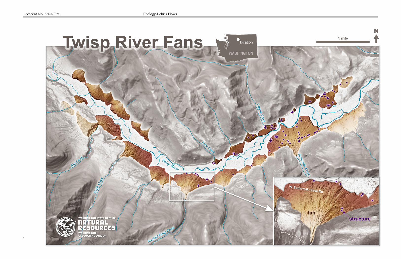
Fans along the Twisp River Appendix A depicts fan mapping along the Twisp River between War Creek and Buttermilk Creek and includes structures (homes, cabins, barns, outbuildings, etc.). Fan mapping was performed in a geographic information system (GIS) using 1-foot grid LIDAR digital elevation data and structures were identified using 1-foot orthoimagery from 2017. The mapping shows fans where tributary drainages enter the Twisp River valley. Fans on the south side of the Twisp River clearly show more recent activity based on distributed channel networks and irregular topography. The irregular topography corresponds to field observed channels and levees of boulders, evidence of past debris flow and flooding events on the fans. Fans on the north side of the Twist River appear largely smooth and channels are absent.
War Creek War Creek enters the Twisp River on the west end of the map in Appendix A. The War Creek watershed is approximately 15,517 acres and flows onto a 71 acre fan. 3450 feet of the West Buttermilk Creek Road is built on the fan and a bridge crosses the Twisp River on the north end of the fan. No structures appear to exist on the fan. The road is approximately 600 feet downstream from where the creek emerges from the confined channel above the highest point of the fan (the apex). Approximately 62 percent of the watershed was impacted by the fire. Portions of the basin are rated high in the USGS Debris-Flow Combined Hazard model. Because portions of the channel on the fan are confined, debris flows and floods may be conveyed to the road.
The debris fan at War Creek shows numerous channels on the eastern edge of the fan, suggesting debris flow activity may have occurred here in the past.

Crescent Mountain Fire Geology-Debris Flows
October 2018 Page 7
In 2011, a landslide and subsequent debris flow occurred about 2500 feet west of the War Creek fan. The event did not occur in the main stem of War Creek but in an isolated inner gorge above the river valley at approximately 4200 feet in elevation. The landslide likely initiated in glacial deposits that veneer the bedrock in this portion of the valley. Interpretation of 2013 orthoimagery suggests the subsequent debris flow likely mostly deposited on the glacial bench, above the valley floor (Fig. 2).
Eagle Creek Approximately 40 percent of the Eagle Creek basin was burned with only 12 percent being moderate and high burn severity. West Buttermilk Creek Road is approximately 1,300 feet from the apex of the fan. There are no known structures on the fan. From West Buttermilk Creek Road, we observed boulders up to 4 feet diameter with average boulders being 1 to 2 feet diameter. The distributed channel network across Eagle Creek fan and the size of the boulders suggests that debris flow activity is possible and may have occurred in the past. The USGS Debris-Flow Combined Hazard outputs primarily modeled low to moderate hazards for Eagle Creek, with a few high hazard ratings primarily restricted to Oval Creek, the eastern tributary of Eagle Creek.
Unnamed drainages between Eagle and Scaffold Camp Creeks The USGS Debris-Flow Combined Hazard model identified two unnamed drainages between Eagle and Scaffold Camp Creeks as high hazard for debris flows. Both of these drainages have fans where the creeks emerges from the narrow canyons above. However, for the most part, these fans lack distributary channel networks. The western fan has a 24 inch culvert where the road passes over a small dry channel. Boulders up to 4.5 feet diameter were observed at the surface. The road is approximately 1,000 feet from the apex of the fans.
Lidar interpretation of both fans reveal straight channels with relatively flat areas at the downslope end of the channel. The western fan also has abundant grades that crisscross the fan. We speculate that these channels may have been modified to attempt to confine the creek in a defined channel. These fans don’t appear as active as the Scaffold Camp Creek, but based on the boulders observed at the surface and the USGS Debris-Flow Combined Hazard modeling, these two drainages present a hazard to West Buttermilk Creek Road.
Scaffold Camp Creek The Scaffold Camp Creek fan has approximately 7 structures and 3,100 feet of West Buttermilk Creek Road on it. The road is located approximately 1,550 feet from the apex of the fan. The watershed is approximately 2,877 acres and flows onto an approximately 107 acre fan. About 96 percent of the watershed was impacted by the fire, with 77 percent being moderate and high soil burn severity. The channel was flowing water at the time of our field visit. The USGS Debris-Flow Combined Hazard modeling for Scaffold Camp Creek is “high” for a peak 15-minute rainfall intensity of 24 mm/hr (0.94 inches/hour).
We visited with a resident of 211 West Buttermilk Creek Road, John Alexius. Mr. Alexius provided background and gave a tour of the area. He lives in the home closest to the fan apex, approximately
Crescent Mountain Fire Geology-Debris Flows
October 2018 Page 8
1400 feet from the fan apex. His home is at an elevation of 2,388 feet and is in a relatively low area of the eastern flank of the fan.
Above the fan apex, Scaffold Camp Creek is confined in a steep canyon with a channel gradient of 11 to 15 degrees based on lidar. The slope of the upper fan is typically between 10 to 20 degrees. The creek becomes unconfined at the fan apex, at 2640 feet in elevation and flows to the north toward the Twisp River at over 100 gallons per minute (visual estimate 10/4/2018). Twisp River is at approximately 2335 feet elevation, approximately 335 feet of relief on the body of the fan. The relief of the total watershed is approximately 5200 feet.
During the site visit of the fan, we observed multiple dry channels typically 10 to 12 feet wide and 4 to 5 feet deep. We also observed lobes and levees of boulders and cobbles oriented north south. These lobes show various ages of activity based on the varying thickness of soil formation on the deposits. Some deposits appear to have occurred in the past 20 to 30 years based on trees that have cobble deposits piled up against them (Fig. 3). The photo on the front of this report shows smaller boulders stacked up between two large boulders. The largest is approximately 8 feet in the longest axis. These boulders are approximately 1275 feet from the apex of the fan, about 285 feet from the road, and 550 feet west of the home at 211 West Buttermilk Creek Rd. Boulders were also noted 200 feet west of the home. These boulder and cobble deposits are interpreted as evidence for debris flows and flood events on the fan.
Currently the active channel of Scaffold Camp Creek descends the fan from the apex to the north, roughly along the center axis of the fan. Approximately 500 feet from the mouth of the canyon, an irrigation diversion channels water to the northeast and passes east of Mr. Alexius’ home in a low area along the east flank of the fan. Flow is estimated during the field visit at approximately 50 gallons per minute in the irrigation ditch. The remainder of the creek continues north, crossing West Buttermilk Creek Road in a 5 foot culvert approximately 1600 feet from the mouth of canyon.
There is a boulder levee that is in-between the main creek channel and this low area. It is approximately 3 to 8 feet tall and made of boulders too large to move by hand. We did not observe the location where the irrigation ditch crosses the boulder levee.
After the site visit, two additional structures were reported to be on the fan, on the north end and near Twisp River. The structure are included in the map of Scaffold Camp Creek fan. They are approximately 2,000 to 2,200 feet from the apex of the fan, in an area that appears to have a network of dry channels and is slightly elevated compared to distal east and west edges of the fan. These channels and slight elevation suggest that flooding and sedimentation has occurred on this portion of the fan in the past.
Given the distance from the apex of the fan and the mostly intact forest on the fan body, a debris-flow hazard is low for the two structures. However, flooding and debris may be an issue, as well as safe evacuation routes if debris flows or flooding events impact the fan. It is more likely that flooding events might impact these structures by taking advantage of existing channel network from the apex of the fan. That said, large debris flow events may be possible that could impact this distal area of the fan.

Crescent Mountain Fire Geology-Debris Flows
October 2018 Page 9
Recommendations Large debris flows and floods have occurred on the fans on the south side of the Twisp River where creeks drain the basins to the south. Due to the burn severity of the Crescent Mountain Fire, some of these creeks are at an elevated likelihood of debris flows and flooding that would impact these fans during heavy precipitation events in the coming few years. Residents living on the fans and traveling on West Buttermilk Creek Road should be aware of the threat these events pose.
The road may be impacted by flooding and debris where flood waters cross the road. These hazards are possible anywhere the road crosses a fan, and are more likely where channels currently exist along the fans. Many of these channel networks can be observed in lidar data. The culverts at these locations are unlikely to pass the quantity of water and debris that a significant event could produce. The worst flooding and debris would be expected along the current channels, and new channels could form or abandoned channels could be reoccupied.
Residents on the fans should consider flood insurance coverage if possible, consult the Post Wildfire Flash Flood and Debris Flow guide, and prepare for potential flooding and debris flows. Anyone who lives on these fans should be notified of the risk to personal safety and develop emergency evacuation plans noting locations of high ground outside of the flood and debris flow hazard areas. It should be noted that flooding and debris flows hazards on fans can occur at any time, not just after a wildfire.
All parties should work together to minimize flood damage to homes and roads, and identify evacuation routes and areas that may be impacted during flooding events. Mitigation measures to protect homes from flood damage may be helpful in reducing damage to structures on the fans. Protecting homes from the impacts of large debris flows should be explored but may need additional design resources and consultation with engineers that is outside the scope of this evaluation. See discussions on design and implementation in Prochaska and others (2008) and VanDine (1996).
Limitations This report was written in support of emergency operations of the Burned Area Emergency Response (BAER) assessment to quickly assess and identify geological hazards associated with the Crescent Mountain Fire. It is intended to help the USFS, Okanogan County, conservation districts, and others focus efforts and make decisions regarding post-wildfire geological hazards. Limited fieldwork was accomplished to assess hazards presented by landslides, and not all areas or hazards were evaluated, and we did not assess flooding issues. Hydrological professionals with the USFS provided that analysis and their report should be consulted. We encourage the USFS, Okanogan County, landowners and others to consult qualified professionals for site specific analysis of geological hazards and flood risk due to the wildfires.
We did not visit the two structures on the north end of the Scaffold Camp Creek fan (234 West Buttermilk Creek Road) and thus cannot be confident that debris flows haven’t impacted this site. We are basing our assessment on remote imagery.

Crescent Mountain Fire Geology-Debris Flows
October 2018 Page 10
We did not evaluate debris flow hazards to other fans in the area, due to time constraints and the specific request to assess fans where cabins exist. There are other fans further west that may become active based on the modeled flow increases and debris flow modeling. Consult the BAER team findings and the USGS debris-flow modeling for information regarding these basins and fans.
We presented limited results of the USGS Emergency Assessment of Post-Fire Debris-Flow Hazards modeling, choosing to present the 24mm (0.94in) in 15-minute storm intensity as the USGS provides on their website. There is additional modeling of higher and lower storm intensities that can be accessed at: ftp://ftpext.usgs.gov/pub/cr/co/golden/Staley/cug2018/
References: Oregon Department of Forestry, 2003, Determination of Rapidly Moving Landslide Impact Rating: Forest Practices Technical Note No. 6, Version 1, 12p. Accessed online at: https://www.oregon.gov/ODF/Documents/WorkingForests/LandslideImpactRatingTechNote6.pdf
Prochaska, A. B.; Santi, P. M.; Higgins, J. D.; 2008, Debris Basin and Deflection Berm Design for Fire-Related Debris-Flow Mitigation, Environmental & Engineering Geoscience, v. XIV, no. 4, p. 297-313. Accessed online at: http://inside.mines.edu/~psanti/paper_pdfs/Prochaska%20basin%20and%20berm%20design.pdf
VanDine, D.F., 1996, Debris Flow Control Structures for Forest Engineering, Res. Br., B.C. Ministry of Forests., Victoria, B.C., Work Paper, 08-1996. Accessed online at: [https://www.for.gov.bc.ca/hfd/pubs/Docs/Wp/WP22.pdf]
Resources: Here are a few resources about debris flows and flooding preparedness and debris flow engineering:
• https://pubs.usgs.gov/fs/fs-176-97/fs-176-97.pdf
• https://www.wrh.noaa.gov/lox/hydrology/files/DebrisFlowSurvivalGuide.pdf
• https://www.lacounty.gov/wp-content/uploads/2016/12/LANDSLIDE_MUDSLIDE_Safety_phbs_2012.pdf

Crescent Mountain Fire Geology-Debris Flows
October 2018 Page 11
Trevor Contreras Licensed Engineering Geologist #2687 Washington Geological Survey Washington State Dept. of Natural Resources Olympia, WA Office: 360-902-1553 Cell: 360-810-0005 Email: [email protected]
With alluvial fan and structure mapping by Kara Jacobacci (G.I.T.) and cartography by Dan Coe. Review by Stephen Slaughter L.E.G.
Figures
Figure 1. Homes and road in debris flow-prone locations on fans. Oregon Dept. of Forestry (2003).

Crescent Mountain Fire Geology-Debris Flows
October 2018 Page 12
Figure 2. 2011 Debris flow scar west of War Creek where the FR4430 and FR100 meet. Imagery is from 2013.

Crescent Mountain Fire Geology-Debris Flows
October 2018 Page 13
Figure 3. Cobbles piled up against Douglas fir trees on the west side of Scaffold Camp Creek, suggest recent activity in the past 20 to 30 years. Notice thin soil development on cobbles. Blue pick is just over two feet in length.

Crescent Mountain Fire Geology-Debris Flows
October 2018 Page 14
Appendix A. Maps
Crescent Mountain Fire Geology-Debris Flows
October 2018 Page 15
Crescent Mountain Fire Geology-Debris Flows
October 2018 Page 16