Conflicts over Water in the Upper Klamath Basin and the
18
Journal of Agricultural and Resource Economics 29(2): 167-1 84 Copyright 2004 Western Agricultural Economics Association Conflicts over Water in the Upper Klamath Basin and the Potential Role for Market-Based Allocations William K. Jaeger The curtailment of irrigation on the Klamath Reclamation Project in 2001 is estimated to have cost farmers more than $35 million. This study examines how alternative water allocations among irrigators in the Upper Klamath Basin could have lowered those costs. Per acre marginal water values vary by a factor of 20 due primarily to variations in soil productivity, with the highest productivity lands concentrated in the federal Project. A linear programming model estimates costs for alternative allocations. Findings indicate that compared to the 2001 allocation, costs could be reduced by 75% with a market-based approach. Key words: endangered species, instream flow, irrigation, Klamath Basin, linear programming model, voluntary water transfer, water market, water supply reduction Introduction On April 6,2001, the U.S. Department of the Interiois Bureau of Reclamation (hereafter referred to as the Bureau) released the 2001 Klamath Project Operations Plan that severely limited irrigation water deliveries to Project irrigators. The Plan was based on '?biological opinions"mandated under the Endangered Species Act which required main- taining higher levels of Upper Klamath Lake to protect the Lost River sucker and the shortnose sucker, as well as increased streamflow into the Klamath River to protect endangered Coho salmon. Because 2001 was a critically dry year, the operation plan adopted by the Bureau allowed no water to be released from the Klamath River for irrigation on Project lands. This shut-off of irrigation in the Klamath Project led to protests and demonstrations by farmers and others, attracted national media attention, and resulted in calls for repeal of the Endangered Species Act. Taking account of some of the private and public responses to the initial irrigation curtailment, ex post cost estimates put losses of farm income between $27 and $46 million, government transfers in the form of emergency payments at $36 million, and other government outlays at $10 million [Oregon State University and University of California (OSUJUC), 20021. In the following year, there was a die-off of thousands of salmon in the Lower Klamath River, an event blamed on excessive diversions of Klamath River waters for agriculture accordingto the California Department of Fish and Game (U.S. House of Representatives, William K Jaeger is associate professor, Department of Agricultural and Resource Economics, Oregon State University, Corvallis. Comments and suggestions from Bruce Weber, Bill Braunworth, Emery Castle, Ron Hathaway, Rodney Todd, Bill Boggess, and Rich Adams at various stages of this analysis are gratefully acknowledged. They are not, of course, responsible for any of the analysis or interpretations presented. Review coordinated by Paul M. Jakus.
Transcript of Conflicts over Water in the Upper Klamath Basin and the

Journal of Agricultural and Resource Economics 29(2): 167-1 84 Copyright 2004 Western Agricultural Economics Association
Conflicts over Water in the Upper Klamath Basin and the Potential
Role for Market-Based Allocations
William K. Jaeger
The curtailment of irrigation on the Klamath Reclamation Project in 2001 is estimated to have cost farmers more than $35 million. This study examines how alternative water allocations among irrigators in the Upper Klamath Basin could have lowered those costs. Per acre marginal water values vary by a factor of 20 due primarily to variations in soil productivity, with the highest productivity lands concentrated in the federal Project. A linear programming model estimates costs for alternative allocations. Findings indicate that compared to the 2001 allocation, costs could be reduced by 75% with a market-based approach.
Key words: endangered species, instream flow, irrigation, Klamath Basin, linear programming model, voluntary water transfer, water market, water supply reduction
Introduction
On April 6,2001, the U.S. Department of the Interiois Bureau of Reclamation (hereafter referred to as the Bureau) released the 2001 Klamath Project Operations Plan that severely limited irrigation water deliveries to Project irrigators. The Plan was based on '?biological opinions" mandated under the Endangered Species Act which required main- taining higher levels of Upper Klamath Lake to protect the Lost River sucker and the shortnose sucker, as well as increased streamflow into the Klamath River to protect endangered Coho salmon. Because 2001 was a critically dry year, the operation plan adopted by the Bureau allowed no water to be released from the Klamath River for irrigation on Project lands.
This shut-off of irrigation in the Klamath Project led to protests and demonstrations by farmers and others, attracted national media attention, and resulted in calls for repeal of the Endangered Species Act. Taking account of some of the private and public responses to the initial irrigation curtailment, ex post cost estimates put losses of farm income between $27 and $46 million, government transfers in the form of emergency payments at $36 million, and other government outlays at $10 million [Oregon State University and University of California (OSUJUC), 20021.
In the following year, there was a die-off of thousands of salmon in the Lower Klamath River, an event blamed on excessive diversions of Klamath River waters for agriculture according to the California Department of Fish and Game (U.S. House of Representatives,
William K Jaeger is associate professor, Department of Agricultural and Resource Economics, Oregon State University, Corvallis. Comments and suggestions from Bruce Weber, Bill Braunworth, Emery Castle, Ron Hathaway, Rodney Todd, Bill Boggess, and Rich Adams a t various stages of this analysis are gratefully acknowledged. They are not, of course, responsible for any of the analysis or interpretations presented.
Review coordinated by Paul M. Jakus.

168 August 2004 Journal of Agricultural and Resource Economics
2003), but the cause of the die-off has been disputed elsewhere. Controversy continues regarding the science and biological opinions involving the endangered fish species, as do the legal and political conflicts among irrigators, tribes, environmental groups, and commercial fishing interests.
Prior Research
The efficiency advantages of market-based water allocations have been noted by econo- mists for decades (e.g., Burness and Quirk, 1979; Howe, Schurmeier, and Shaw, 1986; see also Easter, Rosegrant, and Dinar, 1998). In the case of water controlled by the Bureau of Reclamation, institutional constraints on allocative efficiency have been documented, and ways to achieve Pareto improvements in western water allocation have been identified (Moore and Negri, 1992; Burke, 1999).
The cost of improving aquatic habitats by reducing agricultural diversions of surface water may depend importantly on how the supply reductions are allocated among irrigators and on the extent of water trading, as shown by Sunding et al. (2002) in an analysis of irrigation reductions in California's central valley. Their study evaluates cost differences among alternative approaches to water supply reductions in terms of the heterogeneity of agricultural production in the region, the types of responses to water shortages (changes in crops, irrigation technologies, use of groundwater), and institu- tional barriers to trade. Based on their findings, the volume of water supply reduction is not the most important factor affecting the social cost of aquatic habitat protection. Rather, the impact depends most critically on how water supply reductions are distri- buted. Results indicate that impacts can be mitigated by 40% to 80% under efficient water allocation compared to uniform proportional reductions in all regions.
These findings call to mind the theory of the second best (Lipsey and Lancaster, 1956), which tells us that the correction of a single market distortion without simultaneously correcting other sources of market failure can lead to costly, Pareto-inferior resource allocations. The potential welfare implications of the theory of the second best for irri- gated agriculture and environmental effects in the West have been evaluated quantita- tively (Weinberg and Kling, 1996). In order to augment stream flow for protection of fish habitat, water markets have been shown to be cost-effective policies in some areas (Willis and Whittlesey, 1998), and contingent water markets have been evaluated as a potentially low-cost way to protect endangered species during low flow periods (Willis et al., 1998).
Clearly, there are institutional obstacles facing water markets in the West-including state water laws that do not recognize streamflow as a beneficial use, third-party impacts, and restrictions on transfers between federal and state jurisdictions. However, these have been judged to be surmountable for improving instream flows for fish (see Huffaker, Whittlesey, and Wandschneider, 1993). The present analysis assesses how the cost of protecting fish habitat may be affected by the allocation of water among irrigated areas in the context of the Upper Klamath Basin.
Study Area and Context
The Upper Klamath Basin watershed straddles the OregonlCalifornia border and is fed by snowmelt and precipitation on the east side of the Cascade Range. The Klamath River

Jaeger Klamath Water Conflicts and a Role for Markets 169
Link River Da
Oregon-California Border .......................
Irrigated Areas
Figure 1. Key features and irrigated areas in the Upper Klamath Basin and River system
and its upper tributaries flow generally southward from south-central Oregon into California and then west to the Pacific Ocean. The "Upper Klamath Basin" refers to those portions of the drainage above Iron Gate Dam in Siskiyou County, California, and including the Klamath Project. The Upper Basin is sparsely populated, with Klamath Falls (population 20,000:1 being the only urban center. The regional economy of the Upper Klamath Basin generated about $4 billion in output and $2.3 billion in income in 1998, and provided just over 60,000 jobs. Agricultural production and processing generate about 13% of the jobs in the region, with the Klamath Project accounting for nearly half the value of agricultural production. Non-irrigated agriculture is dominated by livestock production [see OSUIUC (2002) for additional background and detail].
The U.S. Reclamation Service began operating the Klamath Irrigation Project in 1905. Situated in three counties on the OregonICalifornia border (Klamath County, OR, Modoc County, CA, and Siskiyou County, CA) the Project currently delivers water to about 200,000 acres in both states (see figure 1). The Project's main water source is Upper Klamath Lake; additional water comes from the Lost River system, including its two reservoirs. At the lower end of the Project sit the Tule Lake National Wildlife Refuge and the Lower Klamath National Wildlife Refuge, which are major stopping points on the Pacific Flyway. The refuges host the largest concentration of migratory waterfowl in North America. The marshes of the refuges and Lower Klamath Lake are fed by the Lost River and return flows from irrigated lands.

170 August2004 Journal of Agricultural and Resource Economics
Upper Klamath Lake is a large, shallow lake fed by several rivers and springs. The lake level is controlled at its southern outlet by the Link River Dam which feeds both the Klamath River and the Project. The Lost River sucker and short-nosed sucker live in Upper Klamath Lake and its tributaries. The two species were listed as endangered under the Endangered Species Act (ESA) in 1988.
Below Upper Klamath Lake, flows in the Klamath River are affected by irrigation diversions and by several small hydropower dams. Coho salmon that use the Klamath River to spawn are in decline and have been listed as threatened species by the National Oceanic and Atmospheric Administration (NOAA) Fisheries under the ESA in 1997 (National Marine Fisheries Service, 2001).
Under the ESA, all federal agencies are required to ensure their actions are not likely to jeopardize threatened or endangered species. The Bureau was thus required to consult with the U.S. Fish and Wildlife Service (responsible for listing the two species of suckers), and NOAA Fisheries (responsible for listing Coho salmon) regarding the possible effects of its operating plan on these species. In early 2001, surveys of snow pack indicated the lowest expected inflow on record into Upper Klamath Lake. Consultation between the Bureau and the other agencies led to a determination that the combined effect of low water supply, minimum lake levels to protect suckers, and minimum Klamath River flows below Iron Gate Dam flows to protect Coho salmon, prevented the diversion of water from Upper Klamath Lake for Project irrigation or for the two national wildlife refuges.
The Project area affected by the 2001 shut-off represents less than half of the total irrigated acreage in the Upper Klamath Basin, yet includes most of the relatively high- productivity farmlands. Non-Project irrigated lands were unaffected because of the high legal barrier to imposing ESA-related restrictions on individual irrigators. Transfers of water between non-Project and Project areas were not possible in 2001 (or since) due to the incomplete, but ongoing, water rights adjudication process.
Although there was little scope for alternative water allocations during 2001, future shortages and conflicts are expected. Consequently, it is an important question whether the costs of protecting endangered fish species could have been achieved at a lower cost had water been allocated differently, or had water markets enabled water to be moved from relatively low value uses to higher value uses. Prior to 2001, the economic cost of limiting irrigation diversions within the Klamath Project had been evaluated (Adams and Cho, 1998; Burke, 1999). To complement that work, we are interested in assessing how alternative, cost-minimizing allocations of irrigation water might affect the cost of shortages such as the event in 2001, and especially how the inclusion of off-Project irriga- tion affects our results. To do this, we construct a linear programming model for irrigated agriculture in the Upper Klamath Basin to compare the costs of the 2001 plan with costs for alternative scenarios.
Data
Data on irrigated acreages in the region, including location, soil class, cropping pattern, and land prices, have been compiled by the Klamath County Assessor (2001a, b). Addi- tional data have been assembled from the county assessors in Modoc and Siskiyou counties in California, and from the Bureau of Reclamation in Klamath Falls. Crop enterprise budgets for the major crops and data on crop production, prices, and yields are from Oregon State University's Extension Service (1994-2002).
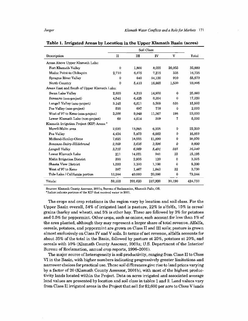
Jaeger Klamath Water Conflicts and a Role for Markets 17 1
Table 1. Irrigated Areas by Location in the Upper Klamath Basin (acres)
Soil Class
Description I1 I11 lV V Total
Areas Above Upper Klamath Lake:
Fort Klamath Valley 0 1,800 8,025 26,055 35,880
Modoc Point to Chiloquin 2,710 6,475 7,215 335 16,735
Sprague River Valley 0 640 54,120 910 55,670
North Country 0 5,410 16,865 1,530 23,805
Areas East and South of Upper Klamath Lake:
Swan Lake Valley 2,620 8,310 14,930 0 25,860
Bonanza (non-project) 4,541 6,425 6,354 0 17,320
Langell Valley (non-project) 3,145 6,611 5,209 535 15,500
Poe Valley (non-project) 525 697 778 0 2,000
West of 97 to Keno (non-project) 2,388 9,048 11,367 198 23,000
Lower Klamath Lake (non-project) 69 4,614 309 7 5,000
Klamath Irrigation Project (KIP) Areas: " Merril-Malin area 2,030 13,965 6,205 0 22,200
Poe Valley 4,424 5,873 6,562 0 16,859
Midland-Henley-Olene 7,625 18,555 11,890 0 38,070
Bonanza-Dairy-Hildebrand 2,569 3,635 3,596 0 9,800
Langell Valley 3,315 6,969 5,491 565 16,340
Lower Klamath Lake 211 14,021 941 23 15,195
Malin Irrigation District 300 2,905 120 0 3,325
Shasta View District 1,000 3,100 1,100 0 5,200
West of 97 to Keno 387 1,467 1,843 32 3,730
Tule Lake 1 California portion 13,244 40,000 20,000 0 73,244
Totals: 59,103 201,620 217,920 30,190 424,733
Sources: Klamath County Assessor, 2001a; Bureau of Reclamation, Klamath Falls, OR. "Italics indicate portions of the KIP that received water in 2001.
The crops and crop rotations in the region vary by location and soil class. For the Upper Basin overall, 54% of irrigated land is pasture, 22% is alfalfa, 15% is cereal grains (barley and wheat), and 5% is other hay. These are followed by 3% for potatoes and 0.5% for peppermint. Other crops, such as onions, each account for less than 1% of the area planted, although they may represent a larger share of total revenue. Alfalfa, cereals, potatoes, and peppermint are grown on Class I1 and I11 soils; pasture is grown almost exclusively on Class IV and V soils. In terms of net revenue, alfalfa accounts for about 35% of the total in the Basin, followed by pasture at 25%, potatoes a t 20%, and cereals with 10% (Klamath County Assessor, 2001a; U.S. Department of the Interior1 Bureau of Reclamation, annual crop reports, 1996-2001).
The major source of heterogeneity is soil productivity, ranging from Class I1 to Class VI in the Basin, with higher numbers indicating progressively greater limitations and narrower choices for practical use. These soil differences give rise to land prices varying by a factor of 20 (Klamath County Assessor, 2001b), with most of the highest produc- tivity lands located within the Project. Data on acres irrigated and associated average land values are presented by location and soil class in tables 1 and 2. Land values vary from Class I1 irrigated areas in the Project that sell for $2,600 per acre to Class V lands

172 August 2004 Journal ofAgricultura1 and Resource Economics
Table 2. Average Market Values for Irrigated Land in the Upper Klamath Basin by Location and Soil Class ($/acre)
Soil Class
Non-irrigated Description I1 I11 IV V VI
Areas Above Upper Klamath Lake:
Fort Klamath Valleya -
Modoc Point to Chiloquin 1,700
Sprague River Valley - North Country -
Areas East and South of Upper Klamath Lake:
Swan Lake Valley 2,100
Bonanza (non-project) 2,100
Langell Valley (non-project) 2,100
Poe Valley (non-project) 2,600
West of 97 to Keno (non-project) 1,700
Lower Klamath Lake (non-project) 2,600
Klarnath Irrigation Project (KIP) Areas:
Merril-Malin area 2,600
Poe Valley 2,600
Midland-Henley-Olene 2,600
Bonanza-Dairy-Hildebrand 2,100
Langell Valley 2,100
Lower Klamath Lake 2,600
Malin Irrigation District 2,600
Shasta View District 2,600
West of 97 to Keno 1,700
Tule Lake / California portion 2,600
Sources: Klamath County Assessor, 2001b; Bureau of Reclamation, Klamath Falls, OR. "Values reflect agricultural use. Recreational demand has raised land values in this area. bItalics indicate portions of the IUP that received water in 2001.
selling for between $250 and $600 per acre.' The combined data reported in tables 1 and 2 show the total value of irrigated land in the Basin is $534 million. Assuming these land prices reflect the capitalized value of income generated from agriculture net of all input costs, and using a discount rate of 6%, these figures suggest an annual net revenue from these lands (excluding the returns to farm labor) of roughly $32 million.
The Model
From these data on soil class, cropping pattern, land prices, and fured costs, we are able to estimate net returns for each acre normally irrigated in the Upper Klamath Basin, and to infer the marginal value of water in both the short run and long run.
The data on average land values are based on market information during a number of years prior to the events of 2001, and thus do not reflect changes due to the 2001 irrigation curtailment (Klamath County Tax Assessor, personal communi- cation, February 2002).

Klamath Water Conflicts and a Role for Markets 173
Long-Run Marginal Values of Water
Our estimates of the long-run value of irrigation water are based on the difference be- tween the value of irrigated land and the value of similar non-irrigated land as reported in table 2. The difference between these two prices is expected to reflect the addition to the net present value of the land due to the water rights, based on the notion of Ricardian rents in a competitive land market (Ricardo, 1912). As observed from table 2, the difference between the per acre market value of Class I1 irrigated and Class VI non-irrigated lands in much of the Project is $2,300 (i.e., $2,600 - $300). The difference between irrigated Class I11 soils and non-irrigated Class VI soils ranges from $1,000 to $1,500 per acre. For Class IV soils, the difference is $700 per acre; for Class V soils, the difference ranges from $0 to $200. Even ignoring the very low estimates of $0 and $50 per acre, these data indicate the value of applied water varies by a factor of 23 between the most productive lands ($2,300 per acre) and least productive lands ($100 per acre). On average, the data suggest irrigation water adds about $1,000 per acre to the value of land.
Assuming a 6% discount rate, these prices imply annual values of applied water per acre ranging from an average of $9 for Class V soils to an average of $121 for Class I1 soils (table 3). The lowest value is $0 for Class V soils in the Lower Klamath Lake area; the highest value is $144 for Class I1 soils in the Malin and Shasta View irrigation districts.
Our linear programming model represents all acres from table 1 with long-run marginal values as reported in table 3. For validation, the figures in table 3 are compared to econometric estimates for similar soil classes in Malheur County, Oregon (Faux and Perry, 1999). The Malheur County values are nearly identical to the soil class averages in table 3 for Class I11 and IV soils. Table 3 averages are higher for Class I1 and lower for Class V compared to those for Malheur County. For class IV and V soils, evidence from actual purchases of water rights by the Oregon Water Trust suggest values of $9 per acre-foot of consumptive use, which translates to about $22 per acre (Jaeger and Mikesell, 2002).
Short-Run Marginal Values of Water
Short-run losses from curtailed water deliveries are expected to exceed the long-run values of water due to the short-run fxed costs incurred by farmers whether they irrigate or not. Relevant fxed costs in this context may include insurance, equipment and machinery, and property taxes. These costs vary by crop. For example, losses are assumed to be higher for perennial crops which must be reestablished if plants die from lack of irrigation. We therefore estimate short-run losses from irrigation curtailment as the sum of (a) expected annual profits or net returns (as defined above), and (b ) fixed costs (see analytical expressions in the next section for details). Fixed costs are based on crop enterprise budgets (OSU Extension Service) for each crop and crop rotation associated with each combination of location and soil class in the Upper Basin. Table 4 summarizes these estimates which range from $25 to $312 per acre per year across locations and soil classes.
To validate these estimates, these values are compared to market data involving short- run or temporary water transactions. First, the rental market for irrigated lands in the
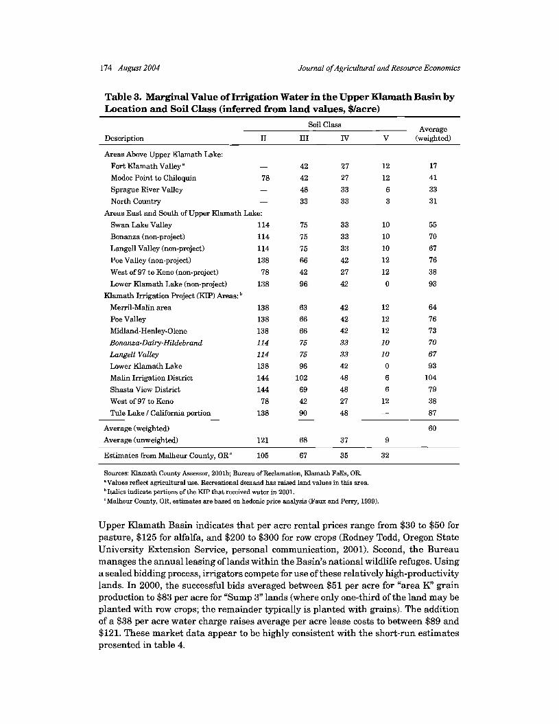
174 August 2004 Journal of Agricultural and Resource Economics
Table 3. Marginal Value of Irrigation Water in the Upper Klamath Basin by Location and Soil Class (inferred from land values, $/acre)
Soil Class Average Description I1 I11 IV V (weighted)
Areas Above Upper Klamath Lake:
Fort Klamath Valley" - 42 27 12 17
Modoc Point to Chiloquin 78 42 27 12 41
Sprague River Valley - 48 33 6 33
North Country - 33 33 3 3 1
Areas East and South of Upper Klamath Lake:
Swan Lake Valley 114 75 33 10 55
Bonanza (non-project) 114 75 33 10 70
Langell Valley (non-project) 114 75 33 10 67
Poe Valley (non-project) 138 66 42 12 76
West of 97 to Keno (non-project) 78 42 27 12 38
Lower Klamath Lake (non-project) 138 96 42 0 93
Klamath Imgation Project (KIP) Areas:
Meml-Malin area 138 63 42 12 64
Poe Valley 138 66 42 12 76
Midland-Henley-Olene 138 66 42 12 73
Bonanza-Dairy-Nildebrand 114 75 33 10 70
Langell Valley 114 75 33 10 67
Lower Klamath Lake 138 96 42 0 93
Malin Imgation District 144 102 48 6 104
Shasta View District 144 69 48 6 79
West of 97 to Keno 78 42 27 12 38
Tule Lake I California portion 138 90 48 - 87
Average (weighted)
Average (unweighted)
Estimates from Malheur County, ORc 105 67 35 32
Sources: Klamath County Assessor, 2001b; Bureau of Reclamation, Klamath Falls, OR. "Values reflect agricultural use. Recreational demand has raised land values in this area. Italics indicate portions of the KIP that received water in 2001.
'Malheur County, OR, estimates are based on hedonic price analysis (Faux and Perry, 1999).
Upper Klamath Basin indicates that per acre rental prices range from $30 to $50 for pasture, $125 for alfalfa, and $200 to $300 for row crops (Rodney Todd, Oregon State University Extension Service, personal communication, 2001). Second, the Bureau manages the annual leasing of lands within the Basin's national wildlife refuges. Using a sealed bidding process, irrigators compete for use of these relatively high-productivity lands. In 2000, the successful bids averaged between $51 per acre for "area Ky' grain production to $83 per acre for "Sump 3" lands (where only one-third of the land may be planted with row crops; the remainder typically is planted with grains). The addition of a $38 per acre water charge raises average per acre lease costs to between $89 and $121. These market data appear to be highly consistent with the short-run estimates presented in table 4.

Jaeger Klamath Water Conflicts and a Role for Markets 175
Table 4. Estimated Losses per Acre from Irrigation Curtailment in the Upper Klamath Basin ($lacrelyear)
Soil Class Average
Description I1 I11 IV V (weighted)
Areas Above Upper Klamath Lake:
Fort Klamath Valley - 67 52 37 42
Modoc Point to Chiloquin 232 182 52 37 131
Sprague River Valley - 210 58 31 59
North Country - 58 58 28 56
Areas East and South of Upper Klamath Lake:
Swan Lake Valley 236 162 58 35 110
Bonanza (non-project) 309 260 58 35 199
Langell Valley (non-project) 242 106 58 35 115
Poe Valley (non-project) 297 158 67 37 159
West of 97 to Keno (non-project) 206 134 52 37 100
Lower Klamath Lake (non-project) 307 159 67 25 155
Klamath Imgation Project (KIP) Areas: " Merril-Malin area 312 232 67 37 193
Poe Valley 297 158 67 37 159
Midland-Henley-Olene 297 247 67 37 201
Bonanza-Dairy-Hildebrand 309 260 58 35 199
Langell Valley 242 106 58 35 115
Lower Klamath Lake 307 159 67 25 155
Malin Imgation District 295 243 73 31 242
Shasta View District 299 217 211 31 232
West of 97 to Keno 206 134 52 37 100
Tule Lake / California portion 259 211 73 25 182
Average 274 173 69 33 145
"Italics indicate portions of the KIP that received water in 2001.
Hydrology
The hydrology of the Upper Klamath Basin is dominated by the inflows to and outflows from Upper Klamath Lake. The inflows include the Sprague and Williamson Rivers (46%), and the Wood River (15%), as well as several large springs (17%) (OSUKJC, 2002, chapter 2). Waters from the Gerber R e s e ~ o i r and Clear Lake flow into the Lost River Basin, which also serves the Klamath Project but does not feed directly into the Klamath River (see figure 1). This secondary basin accounts for less than 20% of annual flows.
Both the level of Upper Klamath Lake and outflows to the Klamath River and the Project are controlled a t the Link River Dam by the Bureau. Water released into the Project, or entering the Project through the Lost River, is managed by a number of irrigation districts. Post-irrigation return flows drain into Project canals and tend to be reused multiple times by other irrigators within the Project, with residual flows entering the national wildlife refuges and Lower Klamath Lake at the southern end of the Project where they sustain important wetlands and ponds for migratory birds. Given the reuse

176 August 2004 Journal of Agricultural and Resource Economics
of these return flows within the Project, aggregate irrigation efficiency for the Project overall has been estimated to exceed 95% (Burke, 1999).
Potential transfers of water between certain portions of the irrigated areas in the Basin face limitations. For example, direct transfers of water from the upper portions of the Lost River system to areas above Upper Klamath Lake would not be possible because they are independent basins and conveyance would be too costly. However, with the great majority of water originating above Upper Klamath Lake, entering the lake, and available for use in the Project, water transfers between most irrigated areas in the Upper Klamath Basin would be feasible without significant conveyance obstacles, third- party effects, or leakages.
At a farm level, interdependencies among irrigators for flows from individual canals and shared infrastructure and maintenance costs can create pecuniary and non- pecuniary externalities which require attention (Bromley, 2000). Irrigation districts are frequently charged with managing complications of this kind. In areas outside the Project, hydrological third-party effects may arise if there were water transfers from lower diversions to diversions higher up in the watershed (whereby intermediate diversions are impeded by insufficient flow^).^ Given existing differences in soil class and land values, however, we expect mutually beneficial transfers of water to shift diversions from upper to lower points within the watershed, which makes third-party impediments unlikely. In the model below, return flows and changes in diversions with water transfers are assumed to remain within the system for use as lake level, stream- flow, downstream irrigation diversion, or flows to wildlife refuges. Model results requir- ing infeasible transfers of water are excluded.
Institutions and Infrastructure
Currently, the institutions and infrastructure necessary for water markets or water banks to function effectively are incomplete and unavailable. Water rights in the Basin have not yet been fully adjudicated, although the ongoing process of adjudicating water rights is nearing completion. In addition, water gauges and meters are not currently used in the region, making precise water monitoring and measurement impossible. Water allocation is further complicated by the three jurisdictions of the state of Oregon, the state of California, and federal authority for the Project. Tribal senior rights to streamflows sufficient to support traditional hunting and fishing are also a central consideration in the adjudication process as well as the political dimensions of conflicts over water in the region (OSUNC, 2002, chapter 3). Oregon law allows water rights transfers from agricultural diversions to other diversion points or to instream flow, both temporarily and permanently. Indeed, about 250 applications for transfers are processed annually by the Oregon Water Resources Department (OWRD, 2003), which must certify that no adverse third-party effects will be created.
2Non-hydrological third-party effects (interdependencies and sharedcosts) are unlikely to be significant outside the Project because irrigators are much more independent. Most of these irrigators draw water directly from one of the rivers in the Basin, directly from Upper Klamath Lake, or groundwater from wells, so that shared infrastructure is much less common.
Klamath Water Conflicts and a Role for Markets 177
Scenarios
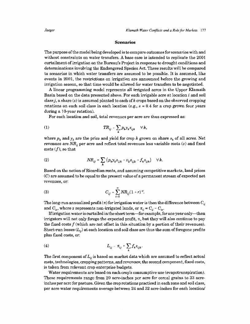
The purpose of the model being developed is to compare outcomes for scenarios with and without constraints on water transfers. A base case is intended to replicate the 2001 curtailment of irrigation on the Bureau's Project in response to drought conditions and determinations involving the Endangered Species Act. These results will be compared to scenarios in which water transfers are assumed to be possible. It is assumed, like events in 2001, the restrictions on irrigation are announced before the growing and irrigation season, so that time would be allowed for water transfers to be negotiated.
A linear programming model represents all irrigated acres in the Upper Klamath Basin based on the data presented above. For each irrigable acre at location i and soil class j, a share (s) is assumed planted to each of k crops based on the observed cropping rotations on each soil class in each location' (e.g., s = 0.4 for a crop grown four years during a 10-year rotation).
For each location and soil, total revenues per acre are thus expressed as:
where p, and y, are the price and yield for crop k grown on share s, of all acres. Net revenues are NRG per acre and reflect total revenues less variable costs (v) and fixed costs (f ), so that
Based on the notion of Ricardian rents, and assuming competitive markets, land prices (C) are assumed to be equal to the present value of a permanent stream of expected net revenues, or:
The long-run annualized profit (x) for irrigation water is then the difference between CG and C,, where z represents non-irrigated lands, or xG = CG - CL.
If irrigation water is curtailed in the short term-for example, for one year only-then irrigators will not only forego the expected profit, x, but they will also continue to pay the fixed costs f (which are not offset in this situation by a portion of their revenues). Short-run losses (Lij) at each location and soil class are thus the sum of foregone profits plus fixed costs, or:
The first component of Lij is based on market data which are assumed to reflect actual costs, technologies, cropping patterns, and revenues; the second component, fixed costs, is taken from relevant crop enterprise budgets.
Water requirements are based on each crop's consumptive use (evapotranspiration). These requirements range from 20 acre-inches per acre for cereal grains to 33 acre- inches per acre for pasture. Given the crop rotations practiced in each zone and soil class, per acre water requirements average between 24 and 32 acre-inches for each location1

178 August ZOO4 Journal of Agricultural and Resource Economics
soil combination. Of course, applied water on a given field will be 50% to 100% higher than these figures given irrigation efficiencies of 50% to 75%. Within the Project, how- ever, return flows reenter canals and are reused, possibly several times, by irrigators in the lower portions of the Project. As a result of this repeated reuse, the overall irriga- tion efficiency for the Project is about 95% (Burke, 1999).
Throughout the Upper Basin, return flows not reused by irrigators will augment the aquatic habitats in Upper Klamath Lake, the Klamath River, or one of two national wildlife refuges. Water requirements for each location, Wij, are based on the crop-specific water requirements w,, and the predominant crop rotation:
Irrigation is potentially limited by a region-wide constraint on acreage irrigated (A), or water applied (W), or by Project-level constraints on acreage irrigated (A,), for loca- tions l , 2, ..., n within the Project. Locations outside the Project (n + l , n +2, ..., m) are not constrained independent of the overall limit.
Net revenue is maximized across all irrigable acres subject to constraints on irrigated acres or their consumptive use of water. The overall linear maximization model can therefore be represented as:
Max C Z N R , ~ , i=1 j=2
s.t.: a, s A,,
The Bureau plan implemented in 2001 is equivalent to the model above,3 with A, = 0 and where
m 5
We are interested in estimating the impact of this scenario #1 on net revenue and short- run losses, and in comparing this scenario with alternative #2, where the same overall limitation on acres irrigated (A from scenario #1) is imposed, such that
Aversion of this model was constructed to allow for partial, or deficit, irrigation on a given area of land, but these options did not enter into the optimal solutions for any of the scenarios considered and were therefore dropped from the model as it is presented here.

Jaeger Klamath Water Conflicts and a Role for Markets 179
(but with no limit on Ap), and alternative #3 in which a limitation is placed on consump- tive use of water equal to the total amount of water used in scenario #1, i.e.,
This last option is included for two reasons. First, we want to be certain a reallocation of irrigation based on idling of a given number of acres does not violate the limits being placed on the consumptive use of water. Second, to the extent that water transfers become widely used in the future, the installation of gauges and meters is likely to allow more precise, and hence more efficient, allocation of water among alternative uses. The results for scenario #3 provide some evidence of the potential additional efficiency gains from water-based transfers as opposed to land-based transfer^.^
Results
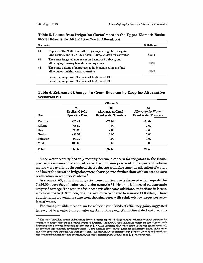
Our scenarios are compared to a typical year in which all irrigable acres receive full water supplies, and none of the aggregate land or water constraints are binding. This allows for 424,733 irrigated acres, consumptive use of 739,000 acre-feet of water, and total net revenues from irrigation of $25 mi l l i~n .~ Gross crop revenue is $154 million. In scenario #1, intended to replicate the 2001 operation plan of the Bureau, none of the 177,823 Klamath Project acres shown in table 1 receive water.6 All other areas receive full water allotments. The model estimates short-run losses of $33 million for this scenario compared to a typical year with no irrigation restrictions. Model results showing losses from irrigation curtailment under the three alternative scenarios are presented in table 5.
In scenario #2, the model minimizes losses by irrigating the same number of acres as in scenario #1, but with no restriction on the location of the non-irrigated lands. This scenario generates losses of $9.6 million rather than the $33.4 under scenario #1, a reduction of 71% (table 5). This result suggests that, rather than curtailing irrigation on Project lands, losses are minimized by curtailing irrigation on Class IV and V lands outside the Project. Indeed, as shown in table 6, non-Project reductions in pasture and hay account for essentially all of the irrigation curtailments under scenario #2: no other crops are reduced by even 1%. By contrast, under scenario #1, pasture and hay acreages are reduced the least, whereas acreages of higher value crops in the Project are reduced the most.
'The important difference between these two approaches is evident in the efforts by the Bureau of Reclamation in Klamath Falls to arrange for contracts in early 2004 to purchase water from Project irrigators in anticipation of likely ESA-related obligations to maintain prescribed lake levels and streamflows during the summer months. The Bureau's proposed payments to farmers for idling an acre of land vary based on the soil type and crop to reflect differences in the amount of "saved watern from a given parcel of land.
5The difference between this $25 million estimate of net revenuefiom irrigation and the previously mentioned $32 million in annual net revenue for these lands is due to the value of non-irrigated lands. In the absence of irrigation, these lands could be used for dryland pasture which, based on the value of non-irrigated grazing land in these locations, could generate about $7 million in net revenue.
Some areas in the KRP were allowed to irrigate in 2001, including those lands irrigated directly from the Lost fiver and Upper Klamath Lake. As a result, we include only 178,000 acres in the Project subject to curtailment, whereas the entire pro- ject includes about 200,000 acres.
180 August 2004 Journal of Agricultural and Resource Economics
Table 5. Losses from Irrigation Curtailment in the Upper Klamath Basin: Model Results for Alternative Water Allocations
Scenario $ Millions
#1 Replica of the 2001 Klamath Project operating plan: irrigated land restrictions of 177,823 acres; 7,496,004 acre-feet of water -$33.4
#2 The same irrigated acreage as in Scenario #1 above, but allowing optimizing transfers among acres
#3 The same volume of water use as in Scenario #1 above, but allowing optimizing water transfers
Percent change from Scenario #1 to #2 = -71% Percent change from Scenario #1 to #3 = -75%
Table 6. Estimated Changes in Gross Revenue by Crop for Alternative Scenarios (%)
SCENARIO
#1 #2 #3 Replica of 2001 Allowance for Land- Allowance for Water-
Crop Operating Plan Based Water Transfers Based Water Transfers
Pasture -25.41 -71.84 -63.69
Alfalfa -68.57 0.00 0.00
Hay -28.93 -7.69 -7.69 Grains -88.59 0.00 0.00 Potatoes -94.37 0.00 0.00 Mint - 100.00 0.00 0.00
Total -55.56 -27.59 -24.50
Since water scarcity has only recently become a concern for irrigators in the Basin, precise measurement of applied water has not been practiced. If gauges and volume meters were available throughout the Basin, one could fine tune the allocation of water, and lower the cost of an irrigation water shortage even further than with an acre-to-acre reallocation in scenario #2 above.'
In scenario #3, a limit on irrigation consumptive use is imposed which equals the 7,496,004 acre-feet of water used under scenario #l. No limit is imposed on aggregate irrigated acreage. The results of this scenario offer some additional reductions in losses, which decline to $8.3 million, or a 75% reduction compared to scenario #1 (table 5). These additional improvements come from choosing acres with relatively low losses per acre- foot of water.
The most plausible mechanism for achieving the kinds of efficiency gains suggested here would be a water bank or water market. In the event of an ESA-related and drought-
' The cost of installing gauges and metering devices does not appear to be high relative to the net revenues generated by irrigation on most of these lands. For flood irrigation diversions, the installation offlumes and meters can cost $2,500 a t each diversion point. For piped diversions, the cost may be $1,000. An inventory of diversion points in the area counts about 300, but there are approximately 850 irrigated farms. If two metering devices are required for each irrigated farm, and if about half of the diversions are piped, the average cost of installation would be approximately $6 per acre. Given an additional 10% cost for annual maintenance and depreciation, the cost of metering would be less than $1 per acre per year.

Jaeger Klamath Water Conflicts and a Role for Markets 18 1
induced restriction on Project irrigation, Project farmers lease water from farmers outside the Project (under the scrutiny of federal and state officials). The model results suggest voluntary transfers of this type could reduce the costs of drought and fish species protection by 75%. Stated otherwise, three-quarters of the costs of the ESA- and drought-induced restrictions on irrigation in 2001 can be attributed to market failure; one-quarter of the costs can be attributed to the ESA and drought. Although the potential for efficiency gains from market-based allocation ofwater has been the subject of economic studies for a long time, few such studies have explored how transfers among irrigators could mitigate the costs of overall restrictions on irrigation diversions.
These results may overstate the efficiency gains from reallocations via water banks or markets to the extent that transaction costs, loss of return flows, or other sources of leakage limit the gains as characterized in our model. However, there are other omissions in the model which may have led us to understate the potential gains. For example, for each combination of location and soil class, losses are assumed to be equal for all acres. Clearly, net returns and potential losses will vary across individual acres due to within-class differences in soil productivity, and in a given year they will vary based on the particular crop within a rotation being grown and current prices for that crop. Fixed costs may also vary depending, for example, on the age and possible alter- native uses of machinery and equipment.
Obstacles to Water Transfers
The incomplete water rights adjudication in the Upper Klamath Basin currently limits the potential for the kinds of water transfers that would capture the gains suggested above. Additional obstacles may include third-party effects and jurisdictional constraints on water transfers between state and federal entities. Under Oregon law, third-party effects caused by water transfers from one diversion point to another are currently eval- uated by the Oregon Water Resources Department prior to authorizing either temporary or permanent water transfers. Transfers that threaten the availability of water for an intermediate right-holder are not allowed.
The scenario results reported above suggest potential for water moving from upstream diversions (above Upper Klamath Lake) to downstream diversions in the Project. Such transfers are not likely to impose third-party effects since they imply more water spends more time in-stream as it passes beyond the higher diversion point on its way to lower diversion points. For similar reasons, we expect such transfers to be beneficial to fish since the higher value lands are in the lower portions of the Upper Basin. Consequently, more water, and perhaps higher quality water, is likely to be left in-stream between the tributaries above Upper Klamath Lake, as well as in the lake itself.
Jurisdictional relationships between the states and federal control over the Reclama- tion Project are complex, and may complicate the future functioning of water markets. Oregon has jurisdiction over state water rights and can approve water transfers to instream uses or, in principle, to the Project. The legal ability of the Bureau to transfer water from the Project to non-Project users is less clear, but transfers of water in this direction are also less likely (Reed Marbut, Oregon Water Resources Department, personal communication, February 2003).
Another potential obstacle to water transfers involves potential conflicts among irrigators whose decisions about water transfer can impose added costs on one another

182 August 2004 Journal ofAgricultura1 and Resource Economics
or onto the surrounding community. Water transfers present an opportunity for some irrigators to shift costs onto other irrigators within an irrigation system, including system maintenance and operating costs of canals (Bromley, 2000). These non-hydrological third- party effects have frequently been mentioned as concerns by farmers in the Klamath Project, which is made up of numerous irrigation districts entrusted to oversee not only the allocation of water but also the maintenance of canals and other infrastructure, and the collection of fees for those services. Given the scale economies involved in maintenance of canals and other aspects of these allocation systems, if system fees are based on the amount of water delivered, then the sale of an individual's water right will impose higher costs on other farmers who continue to irrigate. Due to these interdependencies and the need to coordinate, a water bank with rules for participation, pricing, and markup to cover costs and to compensate the area of origin may be viewed more positively by irrigators than a completely decentralized water market. A water bank of this kind could be operated by irrigation districts or by the Bureau for the entire Project.
Our scenario results suggest, however, that water transfers between irrigators are likely to keep more irrigation water in the Project. Transfers from irrigators to instream flows may involve transfers away from Project irrigators, but non-Project irrigators are much more likely to be the source of leases or purchases by environmental groups to protect stream flows.
In the case of permanent or frequent reallocations of water from agriculture, concerns are often voiced that these changes may lead to contractions in the scale of the agricul- tural economy below a "threshold level," which will then render those activities nonviable (e.g., adequate supply to support a local potato processing plant). Although it would be difficult to determine whether the current economy is operating near such thresholds, the modeling results presented above show that if temporary or permanent reductions in irrigation are undertaken in a way that minimizes losses, the impact on the economy may be quite small. For example, the model suggests a 20% reduction in irrigation con- sumptive use would reduce both gross revenues and employment in irrigated agriculture by only about 10% if those reallocations were initiated to minimize costs.
Concluding Comments
Given the high value of agriculture within the Klamath Irrigation Project, and the presence of large areas of significantly lower value agriculture in other parts of Klamath County, a cost-minimizing approach to reducing irrigated acreage in the Upper Klamath Basin should involve fully irrigating the high-value Project lands while curtailing irrigation in other, relatively less productive parts of the region. Had functioning water markets or a water bank been in place in 2001, this analysis indicates losses could have been reduced by an estimated $25 million, or about 75%. The current lack of adjudicated water rights and the absence of water-metering devices continue to be obstacles to allo- cating water in a way that would reduce uncertainty, promote efficiency, and lower the costs of events like the curtailment in 2001. The costs to agriculture water shortages can be minimized with flexible mechanisms allowing scarce irrigation water to be transferred among growers so that it finds its way to the highest value uses through voluntary exchange. Based on the results presented here, the high cost of restrictions on irrigation in 2001 were due more to the way in which the curtailment was implemented than to the volume of the reduction.

Jaeger Klamath Water Conflicts and a Role for Markets 183
Whatever the future outcomes of tribal water rights claims, or future ESArulings and biological opinions, if water rights can be transferred within the Upper Klamath Basin, it appears possible that irrigators with the most to lose from water supply reductions could be assured of receiving water with the greatest certainty. Moreover, irrigators with junior water rights may be able to develop contingency arrangements to reduce their short-run losses by planting crops more tolerant of deficit irrigation, diversifying their farm activities, and purchasing crop insurance.
Changes in the economics and demographics of western states have coincided with increased pressures to protect instream natural resources. In most regions, this has led to pressures to reduce agricultural diversions for irrigation. When conflicts of this kind result in policies that do not consider allocative efficiency, the costs to farmers and to society generally can be magnified. Future droughts and conflicts over water in the Upper Klamath Basin can be reduced if investments are made now in the physical and institutional infrastructure necessary to make water markets or water banks an option for potential buyers or sellers of water.
[Received October 2003;$nal revision received April 2004.1
References
Adams, R. M., and S. H. Cho. "Agriculture and Endangered Species: An Analysis of Trade-offs in the Klamath Basin, Oregon. Water Resour. Res. 34,10(1998):2741-2749.
Bromley, D. W. "Property Regimes and Pricing Regimes in Water Resource Management." In The Political Economy of Water Pricing Reforms, ed., A. Dinar, pp. 29-48. New York: Oxford University Press, 2000.
Burke, S. M. "Measuring the On-Farm Response of Changing Water Allocation Supply and Methods: The Case of the Klamath Basin." Unpub. Ph.D. diss., Dept. of Agr. and Resour. Econ., Oregon State University, Cowallis, 1999.
Burness, H. S., and J. P. Quirk. "Appropriative Water Rights and the Efficient Allocation of Resources." Amer. Econ. Rev. 69(1979):25-37.
Easter, K. W., M. W. Rosegrant, and A. Dinar, eds. Markets for Water: Potential and Performance. Boston/Dordrecht/London: Kluwer Academic Press, 1998.
Faux, J., and G. M. Perry. "Estimating Irrigation Water Value Using Hedonic Price Analysis: A Case Study in Malheur County, Oregon." Land Econ. 75(1999):440-452.
Howe, C. W., D. R. Schurmeier, and W. D. Shaw. "Innovative Approaches to Water Allocation: The Potential for Water Markets." Water Resour. Res. 22(1986):439-444.
Huffaker, R., N. K. Whittlesey, and P. R. Wandschneider. "Institutional Feasibility of Contingent Water Marketing to Increase Migratory Flows for Salmon on the Upper Snake River." Natural Resour. J. 33(1993):671-696.
Jaeger, W. K, and R. Mikesell. "Increasing Streamflow to Sustain Salmon and Other Native Fish in the Pacific Northwest." Contemporary Econ. Policy 20,4(2002):366-380.
Klamath County Assessor. Klamath County Assessor's Certified Farm Use Study, 2001 -2002. Klamath Falls, OR, 2001a.
. "Summary Tables of Market Values for Irrigation Lands by Soil Class and Location." Processed. Klamath Falls, OR, 2001b.
Lipsey, R. G., and K. Lancaster. "The General Theory of Second-Best." Rev. Econ. Stud. 24(1956):11-32. Moore, M. R., and D. H. Negri. "A Multicrop Production Model of Irrigated Agriculture, Applied to Water
Allocation Policy of the Bureau of Reclamation." J. Agr. and Resour. Econ. 17,1(July 1992):29-43. National Marine Fisheries Service. "Biological Opinion: Ongoing Klamath Project Operations (South-
west Region)." NMFS, Long Beach, CA, 6 April 2001.

184 August 2004 Journal of Agricultural and Resource Economics
Oregon State University Extension Service. "Agricultural Enterprise Budgets." Online. Available a t http://osu.orst.edu/DeptJEconInfo/ent~budgetf. Various years, 1994-2002. [Accessed April 15,2004.1
Oregon State University and University of California. Water Allocation in the Klamath Reclamation Project, 2001: An Assessment of Natural Resource, Economic, Social, and Institutional Issues with a Focus on the Upper Hamath Basin. Oregon State University Extension Service, Cornallis, 2002. Online. Available a t http://eesc.oregonstate.edulklamath.
Oregon Water Resources Department. "Programs: Water Rights Transfers." OWRD, Salem, OR, 2003. Online. Available a t http://www.wrd.state.or.us/programdsupply/transfers.shtd. [Accessed June 2003.1
Ricardo, D. Principles of Political Economy, Vol. I. New York: E. P. Dutton & Co., 1912. Sunding, D., D. Zilberman, R. Howitt, A. Dinar, and N. MacDougall. "Measuring the Costs of Reallo-
cating Water from Agriculture: A Multi-Model Approach." Natural Resour. Modeling 15,2(2002): 201-225.
U.S. Department of the Interior, Bureau of Reclamation. 2001 Klamath Project Operations Plan. Washington, DC, 6 April 2001.
. "Annual Crop Reports." Washington, DC. Various years, 1996-200 1. U.S. House of Representatives. "California State Biologists Report Proves Low Flows Caused Klamath
Fish Kills." Press release, Washington, DC, 3 January 2003. Weinberg, M., and C. L. Kling. "Uncoordinated Agricultural and Environmental Policy Making: An
Application to Irrigated Agriculture in the West." Amer. J. Agr. Econ. 78(1996):65-78. Willis, D. B., J. Caldas, M. Frasier, N. K. Whittlesey, and J. R. Hamilton. "The Effects of Water Rights
and Irrigation Technology on Streamflow Augmentation Cost in the Snake River Basin." J. Agr. and Resour. Econ. 23,1(1998):225-243.
Willis, D. B., and N. K. Whittlesey. 'Water Management Policies for Streamflow Augmentation in an Irrigated River Basin." J. Agr. and Resour. Econ. 23,1(1998):170-190.