COMPILED COMMUNITY COMMENTS ON WORKING DRAFT … · Ver. 2 creates conflicts that modern bicycle...
80
Ver. 2 COMPILED COMMUNITY COMMENTS ON WORKING DRAFT & REVISED BEAUREGARD SMALL AREA PLAN 4-2-2012 Ver. #2 Commenter: Mark Benedict Date: April 2, 2012 Beauregard Corridor revised SAP I am the Vice President of Parkside at Alexandria Condominiums and have been a member of the Beauregard Corridor SAP Stakeholders Group since its inception. I am writing in support of the revised SAP for the Beauregard corridor - the boundaries of that SAP come right up against the northern property line of Parkside. I believe the revised SAP provides a reasoned plan for much needed growth and improvements within the SAP. Upgraded office space, better emergency services, preservation of green space, affordable housing, upgraded retail, and pedestrian friendly areas are all addressed by the revised SAP and the revised SAP is consistent will larger plans for new development in the West End of Alexandria. I hope the Planning commission will take favorable action to support the proposed SAP as revised. Please call my DC office at 202 205- 7913 if you have any questions. Thank you. Commenter: Walter Alesevich Date: March 29, 2012 Support of Beauregard Corridor SAP As President of Parkside of Alexandria, A Condominium, within the boundaries of this SAP, the community wholeheartedly endorses the Beauregard Corridor SAP. Commenter: Jonathan Krall Date: March 29, 2012 I am writing about transportation aspects of the Beauregard Small Area Plan. As Chair of the Alexandria Bicycle and Pedestrian Advisory Committee, I appreciate that a bicycle network is included in the Plan and that new connectivity to nearby neighborhoods and trail networks is added. However, as I review the Plan with my friends and neighbors in the West End, I am concerned about the conflicts between bicycle riders and walkers. Illustrations of the Plan show a town center with numerous citizens walking between housing, shops, offices and transit stops. This is a great illustration of the transit-focused development that has been successful in communities across the USA. The difficulty here is that, along Beauregard Street, the wide sidewalks shown in these illustrations are designated "multi-user paths." That is, they will double as a bicycle lanes, directing bicycle riders to ride through the expected crowds of shoppers and commuters. This is not ideal and is contrary to other similar developments. The Rosslyn-Balston corridor, for example, includes bike lanes throughout. In fact, this design
-
Upload
nguyenminh -
Category
Documents
-
view
213 -
download
0
Transcript of COMPILED COMMUNITY COMMENTS ON WORKING DRAFT … · Ver. 2 creates conflicts that modern bicycle...
Ver. 2
COMPILED COMMUNITY COMMENTS ON
WORKING DRAFT & REVISED BEAUREGARD SMALL AREA PLAN
4-2-2012
Ver. #2
Commenter: Mark Benedict
Date: April 2, 2012
Beauregard Corridor revised SAP
I am the Vice President of Parkside at Alexandria Condominiums and have been a member of the
Beauregard Corridor SAP Stakeholders Group since its inception. I am writing in support of the
revised SAP for the Beauregard corridor - the boundaries of that SAP come right up against the
northern property line of Parkside. I believe the revised SAP provides a reasoned plan for much
needed growth and improvements within the SAP. Upgraded office space, better emergency
services, preservation of green space, affordable housing, upgraded retail, and pedestrian friendly
areas are all addressed by the revised SAP and the revised SAP is consistent will larger plans for
new development in the West End of Alexandria. I hope the Planning commission will take
favorable action to support the proposed SAP as revised. Please call my DC office at 202 205-
7913 if you have any questions. Thank you.
Commenter: Walter Alesevich
Date: March 29, 2012
Support of Beauregard Corridor SAP
As President of Parkside of Alexandria, A Condominium, within the boundaries of this SAP, the
community wholeheartedly endorses the Beauregard Corridor SAP.
Commenter: Jonathan Krall
Date: March 29, 2012
I am writing about transportation aspects of the Beauregard Small Area Plan. As Chair of the
Alexandria Bicycle and Pedestrian Advisory Committee, I appreciate that a bicycle
network is included in the Plan and that new connectivity to nearby neighborhoods and trail
networks is added. However, as I review the Plan with my friends and neighbors in the West
End, I am concerned about the conflicts between bicycle riders and walkers.
Illustrations of the Plan show a town center with numerous citizens walking between housing,
shops, offices and transit stops. This is a great illustration of the transit-focused development that
has been successful in communities across the USA. The difficulty here is that, along Beauregard
Street, the wide sidewalks shown in these illustrations are designated "multi-user paths." That is,
they will double as a bicycle lanes, directing bicycle riders to ride through the expected crowds
of shoppers and commuters. This is not ideal and is contrary to other similar developments. The
Rosslyn-Balston corridor, for example, includes bike lanes throughout. In fact, this design
Ver. 2
creates conflicts that modern bicycle riders are instructed to avoid. Such instruction is promoted
by Alexandria's Local Motion program.
While adding wide sidewalks would make to today's Beauregard Street much safer for bicycling,
this approach makes little sense for the transit-centered Beauregard Street of the future. A
modern approach would separate the cyclists from both pedestrians and motorized traffic. A
good example can be seen on 15th Street in Washington, DC, where the two-way bicycle lane is
separated from the main traffic lanes by plastic bollards and from the sidewalk by a curb. The
plan already allocates the necessary room--it specifies a ten foot setback between the sidewalk
and the buildings. That space would be better allocated to a bike lane.
The Beauregard Small Area Plan, which looks to be successful in many respects, simply does not
account for the ongoing and expected increase in bicycling in Alexandria. This increase is being
driven by improved utility bicycles for commuting and shopping (we expect another record-
setting crowd on Bike To Work Day this year), by public promotion of health and fitness, by
high gas prices, by the renewed joy of riding on our increasingly modern bike lanes and paths,
and by the increasing scope of the Capital Bikeshare transit system, which moves about 5000
people per day--about half of the DASH number. As an advocate for bicycling, I am aware of the
popularity of Capital Bikeshare and receive inquiries almost daily. The most common question?
"When will it come to my neighborhood?" My point is that we need to design for the future.
Like most Alexandria residents, I am aware that our roads are already congested with
automobiles and that our economic future and quality of life require effective and accessible
mass transit. I agree with many others that simply allowing by-right development to add
residents without providing non-automotive options to those new residents will make congestion
much worse than it is now. As Alexandria shifts its transportation focus from moving
automobiles to moving people, I am glad that our leaders and planners are asking us to
modernize. I support this vision and ask that we take the proper next step by modernizing our
approach to bicycling facilities.
Sincerely,
Jonathan Krall
Chair, Alexandria Bicycle and Pedestrian Advisory Committee
REVISED BEAUREGARD SMALL AREA PLAN RELEASED – MARCH 27, 2012
Commenter: Dave Cavanaugh
Date: March 19, 2012
To: The Alexandria Park and Recreation Commission
Subject: Alexandria Park and Recreation Commission Public Hearing on Beauregard Small Area
Plan Open Space and Recreational Components March 22, 2012

Ver. 2
I appreciate the opportunity to comment on the park and recreation issues related to the
Beauregard Small Area Plan Working Draft dated January 23, 2012. I am concerned with the
potential impact of the large scale redevelopment proposal. It is my hope the Alexandria Park
and Recreation Commission would defer action approving the working draft and instead request
additional clarifications and changes to the current working draft.
The proposed Beauregard Small Area Plan Working Draft, unless modified, will dramatically
change the character of the area within the plan boundaries. The Working Draft envisions a more
densely populated, urban, mixed use, transit oriented community. The proposed redevelopment
includes a new framework of streets, bus rapid transit in both dedicated and mixed lanes, a new
intersection (ellipse) at Seminary and Beauregard, hotels, new retail, and a 24% increase
(2,384,285 square feet) in currently allowed zoning. The current area includes 5,500 apartment
units of which 2,519 will be torn down. The proposed plan will add 3,894 units to the remaining
units (2981) bringing the total number of units to approximately 6,500 units. Over the
development period apartments will be vacated and residents displaced.
I offer the following comments for your consideration in advising the City Manager, Mayor and
City Council.
1. The developers (JBG Properties, Home Properties, and Southern Towers) in the plan area
provide a variety of on-site recreational amenities for apartment residents. As an example, JBG
Properties has two swimming pools, a club house with exercise equipment, three tennis courts, a
volley ball court and a tot lot. The current Beauregard Small Area Plan working draft that would
more than double the allowable square footage does not include any provision for similar
recreational amenities, placing more pressure on existing recreational facilities at the Ramsey
Elementary School, the recreation center, Chambliss Park and John Adams. A rewrite of the
working draft should include replacement of on-site amenities for prospective residents.
2. The Developer Contribution includes $8,150,500 for a new artificial turf athletic field near the
Ramsey Elementary School. It is my understanding approximately $1.0-1.5 million would be for
the proposed athletic field and the remainder to be used at John Adams and Hammond Schools. I
suggest the Alexandria Park and Recreation Commission request additional information
regarding the proposed use of the funds for recreation purposes to better understand the scale of
park and recreational services needed to accommodate the increased densities.
3. The 55 acre Dora Kelley Nature Park is an outstanding environmentally sensitive area. Plans
for an athletic field could increase human activity near the park boundaries, damaging plants,
trees and wildlife habitat and increase the erosion on the side slopes into the nature park. I
recommend the proposal for any athletic field be thoroughly and independently evaluated before
City officials endorse an athletic field in a small area plan.
4. The proposal for a multi-purpose athletic field at Ramsey Elementary School does not provide
convenient off street parking. The field is intended to be used by local leagues, community
Ver. 2
groups, and families as well as tournament play. The parking behind the school is heavily used
for school events and does not provide sufficient parking for after school athletic events. In
addition the parking lot is not in close proximity to the proposed athletic field.
Also, the on-street parking is close to the proposed fire station and an ―optional‖ retail area
proposed in the plan. This would add to traffic congestion and make it even more difficult to find
parking for athletic events.
The availability of parking is essential for parents, children and spectators to athletic events. A
more comprehensive study is necessary before automatically accepting developer contributions
for an athletic field in the Beauregard Small Area Plan Working Draft. Any plans for a proposed
multipurpose athletic field must consider the potential volume of use, the impact on the Dora
Kelley Nature Park and the added traffic congestion in the after school hours.
5. JBG Properties has agreed to provide 7.2 acres of land as an addition to Dora Kelley Nature
Park. The additional land would benefit the park, remove current apartment buildings from
intrusion into the wooded area and provide a buffer from proposed buildings. I support the added
acreage, but not at the cost of providing increased density that would reduce the existing tree
canopy.
6. The Beauregard Small Area Plan Working Draft references 45 acres of new open space. The
working draft does not provide sufficient information regarding the dispersal and location of
park, recreation and publically accessible open space. Park, recreation, and publicly accessible
open space is inadequate in the Duke Realty, Home Properties and Hekemian-Foster Fairbanks
Properties. The Alexandria Park and Recreation Commission should request additional
provisions be provided for attractive open areas and the additional acreage be identified in the
revised draft.
7. The Working Draft includes ―greenway‖ in the most unlikely places; the proposed ellipse. The
ellipse would create a traffic circle. East and west bound traffic on Seminary Road crossing
Beauregard Street would go through the middle of the traffic circle and cross signalized
intersections for north and south bound traffic on Beauregard. Traffic signals would also control
traffic within the circle. Drivers on Seminary Road west wanting to go to North Beauregard
Street would make right turns into a signalized circular maze and merge into an exit lane on the
other side of the ellipse. The ―greenway‖ in the proposed ellipse will not be ―green‖ and should
not be counted as a greenway or open space for purposes of providing additional zoning densities
or concessions for developers.
8. The public open spaces are not incorporated into attractive pedestrian walkways connecting
major destinations within the plan area (see page 65). A goal of the plan is to foster a healthy and
active lifestyle for residents and employees in the plan area. One of the ways of doing that is
providing attractive public spaces, paths, sidewalks, bike paths connecting people to the
transportation hubs at Southern Towers and Mark Center Station and to retail and employment
centers in the plan area. The Park and Recreation Commission should request the working draft
Ver. 2
be revised to include open space, parks and greenways as part of an integrated pedestrian
network.
9. The working draft recognizes the redevelopment will result in the potential loss of a
significant amount of tree canopy. To mitigate the loss it recommends the percent of canopy
coverage be met through a combination of on-site and/or off-site improvements. The loss of tree
canopy in any of the proposed neighborhoods is a permanent loss and is not replaced with
additional tree canopy elsewhere. This is especially important in redeveloping the former Hamlet
Apartment complex owned by JBG Properties. To protect the distinctive natural character of the
Hamlet Apartment area and the nearby parks and nature areas, the Park and Recreation
Commission should reaffirm request the revised draft Beauregard Small Area Plan support
maintaining the current percentage of tree cover.
10. The working draft extends Sanger Avenue past Ramsey School along the property boundary
of the 7.2 acres of land to be dedicated to the City as an addition to Dora Kelley Nature Park.
The extension of Sanger Avenue and the 7.2 acres would provide a buffer between the street and
Dora Kelley Nature Park. To discourage traffic into an environmentally sensitive area, the Park
and Recreation Commission should recommend the revised plan allow on street parking and be
narrowed to slow traffic. To further reduce the amount of traffic, the street should be designed as
a one-way street.
11. The working draft creates a new street paralleling Beauregard Street from Mark Center
Drive. The new street would connect to the new town center area on North Beauregard. The
street would increase car and pedestrian traffic adjacent to John Adams Elementary School
potentially creating a safety hazard for children crossing streets to attend the school or participate
in recreation programs. The new street would also impact access to the school and the tot lot on
the south side of the school would likely have to be moved. To ensure the safety of the children
attending the school and using the recreation facilities at John Adams and to avoid any
unexpected costs the revised plan should provide an evaluation of the likely impacts of the new
street.
12. The proposed redevelopment of the JBG Properties will result in the demolition of all of the
apartments with the possible exception of 49 units at Linwood. This would result in a significant
in the tree canopy and potentially increase storm water run-off impacting Holmes Run and the
Dora Kelley Nature Park. The working draft mentions the loss in tree canopy but provides very
little assurance that the increased water flows will be adequately controlled. The Park and
Recreation Commission should insist the revised draft will contain information on mitigation of
storm water run-off and how it will be controlled to protect the Winkler Preserve (private
property), the Dora Kelley Nature Preserve and the Holmes Run drainage.
13. The developers have tentatively agreed to provide $3,000,000 for landscaping and
streetscape, primarily for Beauregard Street and $8,150,000 for an athletic field and
enhancements. The Park and Recreation Commission should not just accept these amounts as

Ver. 2
being sufficient to mitigate the impacts of the proposed development by JBG Properties. There
should be an accounting to ensure the funds promised will cover the additional costs of
accommodating a large increase in population and ensure the City has not traded away amenities
e.g., tree canopy, that make the Beauregard/Sanger Avenue area beautiful and distinctive.
I recommend the Park and Recreation Commission defer action on the working draft and
recommend provisions that will protect the Dora Kelley Nature Preserve, the Holmes Run
drainage, and ensure the tentatively promised funds for parks and recreation fully mitigate the
impacts of redevelopment.
Thank you
Commenter: Dave Cavanaugh
Date: March 5, 2012
The Traffic Ellipse
Does the proposed $30 million traffic ellipse improve traffic flow and pedestrian crossing at
Seminary Road and North Beauregard? Should other safer, less costly options be explored?
City Transportation and Environmental Services staff members have touted the ―ellipse‖ as being
necessary to improve traffic conditions for employees working at the new BRAC office towers.
City officials also argue the ―ellipse‖ would improve opportunities for better urban design and
provide a more attractive gateway for the proposed town center development on Beauregard
Street.
The ―ellipse‖ revives the concept of a round-about or traffic circle. However there are significant
differences. Traffic on Seminary Road would go through the middle of the traffic circle and
traffic signals would be installed at intersections within the circle. Drivers using North
Beauregard Street would make right turns into a signalized circular maze and merge into an exit
lane.
The ellipse was proposed prior to VDOT the HOV ramp at I-395 and Seminary Road. If
approved the ramp will provide bus and HOV-3 drivers more direct access to and from the
BRAC site. This would significantly reduce the distance and numbers of vehicles projected to
use the triple left turn lanes on Seminary Road to access Mark Center Avenue off of Beauregard
Street.
The idea behind the proposed ellipse is that it would replace the recently constructed triple left at
Seminary Road and North Beauregard. It would reduce left turns requiring drivers to turn right
off of Seminary to go either north or south on Beauregard Street. Given the potential volume of
traffic, design speeds, site distances and maneuvering, safety could be an issue. The design does
nothing to alleviate current traffic congestion and queuing during the afternoon rush hour
associated with I-395 on and off ramps and the traffic lights at Mark Center Drive.
The proposed ellipse creates a real barrier to pedestrian and bicyclist and will impact local bus
Ver. 2
service, including plans for the Bus Rapid Transit route through Southern Towers. Pedestrian
crossings at Seminary and Beauregard are currently bad and the ellipse would make it even
worse. An argument can be made that if we are trying to create a transit oriented, walk-able
community, with enhanced transit and local retail the ellipse is the wrong way to go.
The ellipse is a $30 million engineering experiment. Although the cost of the ellipse would be
borne by the developers, it is likely the cost would be offset by additional concessions allowing
more development granted by the City through its zoning process.
If the HOV ramp is approved, the City should reevaluate the need for the ellipse. As an option
the City should consider eliminating the third left lane since the proposed HOV ramp would
alleviate much of the traffic at the Seminary and Beauregard intersection destined for the BRAC
Mark Center site.
I suggest the City staff evaluate the option of eliminating the third left turn lane and returning the
intersection to a more conventional intersection. Improved signalization, restriping would be less
expensive and more importantly, it would provide opportunities for more direct, safer pedestrian
crossing at this important intersection.
Commenter: Annabelle Fischer
Date: February 18, 2012
1. Plan Preparation: P&Z and city staff continue to state that BCSG compiled a series of
individual "recommendations" for this plan. Not so. The citizens group submitted
comments/suggestions and not RECOMMENDATIONS that were submitted to P&Z. Eliminate
word "recommendations that you use throughout this draft working plan. These are not the
recommendations - page "vii" which city staff has incorporated in your plan and as you have
given "symbols/labels" that you have designated throughout each chapter, the majority of these
"labels" are either "modified" by city staff along with "New" recommendations proposed by
staff. This certainly gives the appearance that this is the city staff's plan along with the
recommendations of the developers. Unfortunately for all of us who spent time on this "draft
plan".
2. Page 6 - Need for Plan. You site 4 reasons for the need for this plan at this time, but leave out
the most important reason for now pushing the Beauregard SAP now - BRAC-133 and the fact
that the city wil NOT BE GETTING ANY TAX REVENUE FROM DOD, so it now needs to be
made up by this increased density development & rezoning.
3. Vison/Guiding Elements Section, Page 8. Your statements/assumptions regarding plan
implementation along with comments about what strengths plan builds on (figure 10). Question
all of your statements re: loss of affordable housing, no real transportation plan, integration of
transit, land use and urban design along with topography. The boundaries that have now been
changed to include going over the Seminary over-pass present major problems for all of these
statements and the fact that the city has bought into the Ellipse/traffic circle when the majority of
residents/civic assoc./homeowner assoc. in the affected area oppose the Ellipse. What deals has
Ver. 2
P&Z, TES, mayor/council and City Manager made with JBG to get the ellipse and how much
money will it take to remove the 3 left hand turn lanes from Seminary to Beauregard along with
the 4 lanes on Beauregard heading into the Mark Center or going straight down Beauregard? Fire
station at Sanger/Beauregard. I do not support this and we need to wait and see how the new fire
station on Eisenhower West will reduce the need for response from Fire Station 206 on Seminary
across from Hammond School. I suspect when the new fire station opens on Eisenhower West,
there will be a reduced need for engine company 206 to answer calls on the West
side/condo/canyon neighborhood. Neither Arlington nor Fairfax are working with Alexandria
with regard to transportation improvements and there is no money for a street car here and at
Columbia Pike. And we are not going to get a metro stop at Beauregard/Seminary.
4. Page 10(A). How do you plan to integrate transit, land use and urban design? this area cannot
acommodate bikes, unless there is a separate bike path, not on our streets or sidewalks. There are
already transit stops located at Southern Towers and now a transit hub at Mark Center, which
works well for transit users. Why are you continuing to want a connection to the
Pentagon/Shirlington. It already exists via buses. Also understand that P&Z want to create "new
streets" within the development plan, but you have not made the case for these new streets.
Southern Towers wants to extend a street to Shirley Gardens neighborhood which would mean
crossing through the median stripon Beauregard from So. Towers to the Heikiman development,
taking away the trees from the median strip and suspect a major traffic mess for residents
needing to make a left turn from Beauregard into So. Towers or the Hermitage apts.
5. Housing. JBG has now stated they will transfer Hillwood garden apts. to the city at no cost by
2018, which would only provide 703 market rate rental units. What deal has JBG made with the
City, P&Z, Housing Dept., TES, City Manager Young/Jinks and mayor/council in order for this
transfer to occur. JBG is a business and they are not going to transfer any property for free. So
what is the deal? Increased density/rezoning. There will be no more affordable rentals for those
of us who currently live here should this development move forward without major
modifications as the primary development for Beauregard is for town homes, some rentals as
very high prices, etc. Those individuals/families who have an income of $80,000+ dollars p/year
should not expect Alexandria taxpayers to assist with their rents. They can afford to rent and pay
for themselves.
6. Urban Design Section - Page 17+. Throughout this entire section city staff continues to refer to
the Ellipse as a foregone conclusion a the Seminary/Beauregard intersection. These are city
owned streets. With regard to Beauregard there is absolutely no discussion about Beauregard
Street North/South and the impact of traffic from Rt. 7 down to Alexandria. Why not? The
"urban landscape" will impact the trees along the entire street and the Planning Commission and
City council's vote to adopt "Corridor C" was certainly not carefully thought out and was what
the city wanted and not the residents within the area.
As I have read through this entire document, rather than citing all of the pages, but especially
looking at the Appendix Section, the majority of changes have been "modified" by city staff
along with many "new" changes to the plan by staff and developers. Where is the infrastructure
money coming from to pay for this plan? Where are the "existing conditions" discussion that we
Ver. 2
have asked for? The city is banking on Alexandria taxpayers to front $60 million dollars before
developer contributions have been decided and after the residential/commercial developments
have been put in place. What plans and when will JBG begin to redevelop the Shops at Mark
Center, which I certainly agree needs improvement. The other 4 developers want to incorporate
"boutique" hotels, major residential developments, etc. I agree we do need some redevelopment
in this area. However, the plan has now changed so much thanks to P&Z, other city agencies
along with the mayor/council/city manager's office, that it really has gotten out of control. We
are still waiting for landmark Mall to get going and that appears won't happen for several years
due to the current economic conditions and banks not loaning money. This draft plan by the City
staff has glossed over the open space issues and not provided any standards nor criteria.
Maintaining surface parking in many of the developments that can handle surface parking and
don't need to spend so much money for underground parking because P&Z staff want it is not
acceptable in this part of Alex., i.e. West End and needs further review and elimination for some
of the projects. Since the Landmark Mall/Landmark Van Dorn plan was adopted by Council
several years ago, nothing has happened due to what I believe are related to the current economic
situation. We citizens who live within the Beauregard SAP need to go back and review and
restructure this plan. For myself and suspect for others within the area, we do want some
improvements, but not along the massive scale the city has now presented to us with with
"DRAFT RECOMMENDATION PLAN". This plan is not ready for prime time, we need to slow
it down a bit and allow the other plans being developed in Alexandria to get going. The world
won't come to an end if the Beauregard SAP is put on the middle burner. Lets do a good plan
rather than one that looks like a "stepford wives" community. We can all agree to disagree, but I
suspect many of us, myself included want to see a better plan and want our voices heard as this
development moves ahead rather than the mayor/council/city manager telling us what kind of
area/neighborhood they want us to live in.
Commenter: Allison Silberberg
Date: February 16, 2012
As Alexandria's Economic Opportunities Commission (EOC), we are the voice of the least
fortunate and most vulnerable citizens of Alexandria, and it is our mission to advocate for their
best interests. It is our duty to inform City Council about the legitimate concerns faced by
residents of the Beauregard Street corridor in the face of the area's impending redevelopment.
These citizens are valuable members of our community who deserve the City's recognition and
support.
We respectfully urge members of City Council to govern in a manner that serves these citizens in
a meaningful way by not only listening to their concerns about being displaced by the
redevelopment project but also by being proactive in negotiating specific terms to help prevent
the significant and permanent loss of affordable housing units in the west end of the City.
Specifically, we recommend the City negotiate a redevelopment plan that includes the creation of
Ver. 2
housing units at 30% AMI or below and incorporates such units into the proposed fire station
slotted to be built in this area.
Additionally, in order to assist those citizens who will be displaced from their homes as a result
of the redevelopment, the EOC encourages City Council to adopt measures to efficiently notify
affected individuals and families, and communicate the transition process to Department of
Community and Human Services' staff in order that programs to mitigate the impact can be
utilized or developed.
Commenter: Diane Costello
Date: February 16, 2012
GENERAL COMMENTS:
The first community meeting was held 29 October 2009. The SAP border had been drawn and
there was a 7-slide staff presentation. One slide titled Corridor Issues - Other Infrastructure
listed:
. Sewer Capacity: trunk, plant and nitrogen removal
. Dam Safety
. Fire and Emergency Services
. Schools
. Open Space and recreation
. Affordable Housing
Two years later and the emphasis has certainly shifted - sewer system is discussed on two pages
(p106-7), there is no mention of Lake Barcroft Dam, never mind any related safety issues, the
section on schools amounts to a paragraph on p103 (because it is now anticipated that no new
schools will be necessary), fire and EMS is discussed although there is no mention of
corresponding need for expanded ER and/or hospital capacity with increased population, open
space and recreation are discussed, and the priority/importance of affordable housing in the
current plan is debatable.
1) What has changed in the intervening two years to account for this shift?
2) Although it is consistent with the 2009 boundary, why is the Winkler Preserve shown
within the Plan border when it is privately owned?
Much has been made of the "bucket list" or the "stuff" coming from the developers and in the
Draft the term "public improvements" is often used (items such as the fire house, the Ellipse,
etc). I'd like to point out that these are not gifts being given by a charitable organization. These
are business decisions. The new development will have to compete, in a projected crowded
market, for buyers - whether the purchase is a new home, a rental contract, retail or office space.
And this West End project will always come up short with respect to transportation and access as
it will not be near a Metrorail station. And that shortcoming, more than likely, will only grow in
importance in the future as the region becomes more congested. Throw in gridlocked streets, a
paucity of recreation facilities for the children, and slow to respond emergency services - why
Ver. 2
would anyone want to move to this redeveloped area to live or to own a business when they have
a choice? In my mind these items represent the developers' provisions to attract their future
customers.
Much has also been made of the collective nature of dealing with JBG, Southern Towers, Home
Properties, Hekemian-Foster Fairbanks, and Duke rather than taking each developer and their
section of the plan area individually. This does have benefits with respect to cohesion of the
final project, timing etc. But again, what is being overlooked is the enormous advantage this has
bestowed on one of the developers - namely, Duke Realty. After the BRAC 133/ Mark Center
fiasco, what possible standing does Duke Realty have with the West End, not to mention the
City, to demand anything? Duke Realty sold 16 acres to DoD for $105 million (taxpayers' $$)
and somewhere in the deal the 6.5 acres that was to remain open space in return for development,
got "lost". DoD is compensating the City with a $1.5 million payment (taxpayers' money, which
means in a sense we've paid Duke Realty twice for the same land).
1) Please explain to me the justification for granting Duke Realty additional density? They
had a beautiful business park which could have been developed in a sensitive manner. Instead,
they showed no regard for the surrounding community, nor their neighbors (e.g., IDA), nor their
own tenants (e.g., CNA - which is pursuing a lawsuit against Duke). Why is such behavior
entitled to be rewarded?
Several times it states in the draft - "A strength of Alexandria is the unique character and
individuality of its many great neighborhoods. The Plan reflects a commitment to this City
tradition."
If the Plan really achieved that goal, so many of us would not be struggling to see our West End
in this Draft
As a native NYer and someone who has driven up and down the mid-Atlantic region for 30 years
on a regular basis, I am extremely skeptical that the density that has been proposed can be
handled with the suggested transportation plan. Not without a rail system.
1) What examples of suburban/urban areas of corresponding density (both in the immediate
area and that would equate what we experience here in the DC vicinity) can you provide which
manage their population without traffic congestion in the absence of rail?
Should the City grant the increased density and rezoning, thereby increasing the value of the
developers' holdings, what guarantee is there that the developers won't turn around and sell?
Is the SAP negotiated with current property owners binding on subsequent ones?
This was raised at the recent Federation meeting but I think it deserves more public discussion -
what is the impact of the DSUP/ SUP process on SAPs?
SPECIFIC COMMENTS
Ver. 2
How fast is BRT?
In other words, when compared to the current express buses (take 7X as an example), how much
sooner will the BRT vehicle arrive at the Pentagon?
Does this justify the expense?
Please note - the Seminary Rd/ Mark Center Dr intersection noted in Draft figures (27a) as part
of the BRT route - was determined by VDOT in their recent EA for the I-395 HOV Ramp to be
at a LoS F in 2035.
With all the retail, restaurants, hotels proposed - where are the needed employees supposed to be
living? It is noted in the text that the shortage in affordable housing is anticipated to include
adjoining jurisdictions. Will this pool of workers need to commute from areas like Manassas and
Woodbridge? How is this consistent with the live-work scenario that is repeatedly mentioned as
a guiding principle of the Plan?
There is mention of Independent Design to be utilized in a portion of the housing units. What
percentage?
I would note that townhomes, because of the numerous levels, are notoriously unfriendly to the
physically impaired.
As someone familiar with wheelchair use, I would ask you to go beyond the standard ADA
requirements in public areas for restroom facilities and parking spaces. The bathrooms are often
adequate for someone with a cane or walker, but not a wheelchair. And certainly not a
wheelchair + a second person providing assistance. Parking for those who use a "ramp-van"
with side discharge is also extremely difficult as the handicap spaces are not generally wide
enough.
Provide playground equipment and surfaces that can be enjoyed by disabled children.
This has been requested before - please provide more detailed schematics of the Ellipse and
justification for the statement "improves the projected traffic."
I live in Lincolnia Hills but the "d" in Beauregard Manor is plastered over my little box of a
house. Please take the time to get the existing neighborhoods correct.
The realignment of Sanger Ave needs to be explained much earlier in the document to avoid
confusion with the figures/maps earlier in the text. I thought Ramsay School had been moved.
I raised this at a previous meeting - if existing buses are to continue to run down Beauregard
(e.g., 7X) in addition to the BRT (which doesn't start on Beauregard until Sanger), you will need
pull-offs for the vehicles to discharge/load their passengers. Otherwise you have effectively one
lane for through traffic in each direction.

Ver. 2
Many of the figures need to have better keys - e.g., fig3.
Some are purely wishful thinking - e.g., fig5
How have the land use patterns of the last 20 years changed in the area (assertion p5 - Need for
the Plan)?
Are utility lines to be buried underground? I never see any in the schematics.
Who is responsible for deciding the "optional retail"?
"The Plan recommends a balance of residential and office uses to enable:.24/7 activity.."
So this BSAP is really a mini-Manhattan on stimulants?
As someone not accustomed to reading this type of document, my overall impression was that of
a PR/ marketing brochure. Much jargon, convoluted language, and repetition of themes were
noted.
Examples -
"Each neighborhood park is intended to have a distinct character and programmatic function." In
real life - what does that mean?
"The Plan recommends a canopy coverage requirement of 40% for each neighborhood, which
can be met through a combination of on-site and/or off-site improvements."
Does "off-site" mean a tree planted on Eisenhower Ave counts towards the canopy of the BSAP?
What does "socially. sustainable for the City" mean (p2)?
"Services necessary to create a more self-sufficient community" (p10) - unless people are
growing their own food, making their own furniture and the like, that's a bit of a stretch don't you
think?
"The Plan recommends using contemporary building design elements to implement the "garden
city" vision of the Plan" (p27) What?
"The plan also recommends future Urban Design Standards and Guidelines to ensure high
quality buildings." Who sets/determines such standards and guidelines?
SUGGESTION -
With all the computer graphics that are currently available, is it possible that a video could be
done demonstrating a person walking the various streets and settings within the BSAP? The idea
would be for the viewer to get a sense of building heights and the proximity of structures. It is
very difficult to get a sense of that from reading a description. My concern stems from my
experience of going to the IDA building after BRAC 133 was built and walking in the Winkler
Preserve post-construction. It was shocking - the claustrophobic feeling at the IDA entrance was
in sharp contrast to what I had always felt before - a wonderful green expanse. And the looming
BRAC buildings impose such visual pollution on the Preserve, that it is much harder to achieve
the sense of escape that once greeted you there.
Thank you for the opportunity to provide feedback.
Ver. 2
Commenter: Shirley Downs
Date: February 14, 2012
1) Green Space Between Buildings and 395 on Either Side of Sanger.
In Figure 21 page 28 the townhouses and multifamily buildings on either side of Sanger appear
to be right up against the state right of way for 395. So that the only trees sheltering these
buildings are on state right of way land. Given the fact that in the area on the Van Dorn side
VDOT has proposed to tear down all the trees and put up a sound wall local residents are very
concerned that this could also happen on the other side of 395. This is highly probable because
the state has already discussed widening 395 over Sanger and at some future date the under-pass
could be widened.
For this reason we would like to see additional dedicated green space on the Small Area Plan
itself which could accommodate the planting of a tree screen between the state land and the
buildings. This may necessitate adjustments to move all of the buildings to the west on the Plan
but it is essential that there is a permanent screen of trees between 395 and any and all residences
in the Beauregard Small Area Plan. This is necessary to preserve what has been most
appreciated about the old garden apartments that is the numerous trees. It is the lack of trees
next to BRAC on 395 that residents find so offensive and ugly.
How wide is the state right-of way between the 395 roadbed and the proposed
JBG Buildings?
How wide is the land where the JBG buildings are and the edge of the
Beauregard Small Area Plan?
2) Affordable Housing Formulas
The West End has always had an excellent mix of homes and rental units. They include large,
medium and small single-family homes, townhouses, garden apartments, apartment buildings
and condos. The neighborhood is exceptionally diverse in terms of income, race, age, ethnicity,
and family size. We feel that is something we wish to preserve. For that reason a higher priority
should be placed on affordable housing at all price points, we need housing for young people
starting careers, blue-collar workers, older retired persons and service employees as well as
higher income professionals. But we want this housing to be scattered throughout the Small
Area Plan.
On page 77 the table of 2015 income limits on affordable housing suggests that the needs of the
lowest income group, those making say $25,000 are not going to be addressed. The definition of
those to be served needs to be more flexible so that people at lower income levels are also
included and we are still able to secure the goal of 20% affordable housing.
Ver. 2
3) Parking for Residents of Affordable Units.
On page 82 and in other places in the draft plan it is suggested that lowering parking
requirements is a way to provide more affordable housing. The experience of local residents is
that low-income residents often need MORE parking spaces rather than a diminution of parking
spaces because there are multiple family members working.
Residents of affordable units should have the same parking rights as other residents.
For the sake of good relations between neighbors, there should be adequate parking for both
residents and their guests.
4) Affordable Housing within the Beauregard Plan Area
In the Housing Recommendations section, page 87, 5.2 states that ―Affordable homeownership
will not be subsidized through the Beauregard public amenities fund and /or through Beauregard
developer voluntary affordable housing contributions. These sources will be dedicated to
produce and or preserve affordable and workforce rental housing….‖
It then goes on to state in Section 5.3, page 87 that ―Preserving or securing affordable and
workforce housing in areas immediately outside of the Plan area should be considered as an
alternative strategy to exceed the targeted number established to achieve even more deeply
subsidize units (i.e., reach lower ratings of affordability than 55% or 60% of AMI) and/or as a
means to obtain particular unit types or sizes not available within the Plan area when
redeveloped.‖
First it should be pointed out that local residents who have encouraged having affordable and
workforce housing within the Plan Area have always meant just that.
The Plan Area itself should have the affordable housing within it. That means
in the same buildings and the same complexes.
Further we expect that the money provided by the developers to be used to
subsidize the affordable housing within the Plan Area! It may be that additional
money will be necessary to fund the affordable and workforce housing but
additional funding is intended to augment whatever the developers provide.
Further providing a minimum of 20% affordable and work force housing
should be part of the price of developers getting the further density they desire.
This should not be optional or voluntary but should be the price for the density
that they are seeking.
Ver. 2
Pages 85 and 86 in the draft plan suggest that Willow Run and Southern Towers could be
dedicated to affordable and workforce housing. The local community wants such housing
available but would be completely opposed to either of these complexes being completely
dedicated affordable units. Rather we believe both of these complexes should have affordable
units scattered within them. That way the higher rents can offset some of the costs of
subsidizing other units.
There should be a mix of apartment sizes and price points. The goal should be to have people of
all incomes living together within each complex and throughout the whole Beauregard Small
Area Plan and the City of Alexandria. This is what we currently have here in the West End and
it is worth preserving.
We also note that Willow Run is outside of the Beauregard Small Area Plan
and has no place in this discussion or in this draft plan. Any discussion of
using Willow Run as a substitute location for providing affordable and
workplace housing for the Beauregard Small Area Plan is inappropriate.
Our goal in this Plan is to improve and insure the availability of affordable, and
workforce housing within the Plan Area being discussed.
5) Affordable Tax Credits
It should be noted that most workforce and affordable units in the country have been built using
the Low Income Housing Tax Credits (LIHTC). Indeed about 90% of all such housing is built
with these credits. These credits are attractive as they provide a dollar for dollar tax credit. They
therefore provide a dollar for dollar reduction in a taxpayer‘s federal income tax. So in effect
these units are subsidized via our federal tax code. Under the program the owner will provide an
application to the state authority, which will consider the application competitively. To secure
these tax credits applicants must comply with either of the following conditions or sets-aides:
At least 20% or more of the residential units in the development are both rent
restricted and are occupied by individuals whose incomes are 50% or less of the
area median gross income.
At least 40% or more of the residential units in the development are both rent
restricted and occupied by individuals who have an income of 60% or less of the
area median gross income.
The low income tenants can be charged no more than 30% of the maximum eligible income,
which is 60% of the area median income as determined by HUD. There are no restrictions on
the rent that can be charged to the tenants who are not low income.
Ver. 2
Clearly this tax credit program provides adequate subsidy and incentive for the developers who
are building or renovating existing units. In the case of developers who are building offices such
as Duke they can increase the amount of their contribution to the City‘s affordable housing fund
as the price of being able to build an additional office and a hotel and to finally compensate the
City for the killing they made on the BRAC building. Indeed if Duke Realty does not comply
then they should be removed from the developer group entirely and fend for themselves when
they are ready to apply for development changes at the end of the 10 year lease cycle of their
office buildings.
6) Car Sharing
Local residents share the City‘s interest in lowering the number of cars in our neighborhoods and
suggest that in addition to having car sharing stations at newly developed properties that they
encourage existing rental and condo properties to establish car sharing programs for their
residents. We understand that a certain level of density may be required for such a program to be
attractive to the car sharing companies but it is highly probable that such a program would be
successful at many current properties.
7) Creating an Urban Walkable Environment
The whole goal of smart growth policies is to insure that residents have a chance to live and
work in an area where they do not have to get into a car to shop, enjoy a walk, run errands, or
enjoy a meal. And being able to walk to work would be the biggest bonus.
Virtually any and all articles and planning documents on successful urban walkable
environments stress that they need to have slow traffic and narrower streets. For this reason it is
recommended that the parking lanes on Beauregard be eliminated and parking be placed on the
streets in non-rush hours and evenings. This will not only help the residents and retail facilities it
will match the criteria for successful new urban environments. Having parking on the streets
helps pedestrians. This works well in Old Town and Shirlington. If we are to have an urban
environment here in the West End why isn‘t that model appropriate?
What speed limits do City Transportation Staff envision posting on Beauregard
and Van Dorn?
What is the estimated speed of the traffic with 2 lanes of dedicated transit, 4 lanes
of traffic, and 2 lanes of parking as envisioned by the plan both in rush hour and
non-rush hour?
What is the estimated speed of traffic envisioned both in rush hour and non-rush
hour if the 2 side lanes of parking are removed and on–street parking is allowed
Ver. 2
during non-rush hour and evenings as is allowed in Old Town? Are these speeds
comparable with the speeds in Old Town?
8) Marketing the Plan Area
What steps do the City and the developers plan to take to market the availability of these
proposed homes and rental units to current and potential employees in the area? If we seriously
want to reduce the number of cars on our streets we need to try to entice current and potential
employees to work in the area they live in. We need to really make this a walkable urban
neighborhood where you don‘t have to get into a car to achieve what you want.
9) Place Making
According to the Urban Land Institute the goal of mixed-use building is ―place making‖. That is
you create environments that are alive and lively. Some of this can be done with retail and
restaurants and parks but most successful efforts also have other components such as a library, a
theatre, or some other facility that acts a heart of the ―place.‖ For the level of density envisioned
the City should consider this area for a similar place-making magnet. Are there cultural facilities
that are seeking a new home here in Alexandria? If we are going to have good mass transit what
about making it a place where people can go and enjoy themselves? The addition of the library
and the Signature Theatre has certainly helped to define Shirlington and Eastern Market certainly
has created a heart for Capitol Hill in the District. What might help to contribute to the heart of
this West End development here on Beauregard?
10) Location of Other Amenities
Where is the Community Garden proposed to be?
If there are objections to the location of the Recreational Field what other
locations can be considered?
What is the cost of grading the current site of the recreational field to provide
better drainage? If another site is available that doesn‘t involve such costs would
such cost savings help to allow it being constructed earlier?
Where is the dog park proposed to be located?
11) The Ellipse
It is clear that the ellipse is a high priority for the City but the developers do not all seem to feel
the same way. If the citizens and developers are not wedded to the ellipse why can‘t the City
wait to build the Ellipse at a later point in time? Residents would rather have any
12) Parking
In earlier comments I asked a number of questions about existing parking spaces and policies.
To date I have not received any information relating to the questions posed. We need to know
the number of current rental units, the number of tenants, and the number of parking spaces they
have and the proposed number of rental units, tenants, and parking spaces they will have. These
are critical questions and to date there have been no answers.
Ver. 2
13) The Ratio of Office Spaces to Residential Units
On pages 38 and 39 under land use the draft plan discusses the fact that the Beauregard area,
because of BRAC already has a very high ratio of office spaces to residential units. This raises
the question. Why are we then planning to build additional office space in the JBG upper town
center, at Southern Towers, the Duke office area, and in the Hekemian development on
Seminary? Our neighborhood is primarily a residential community why has the City chosen to
make this community increasingly dominated by office towers
Commenter: Don Buch
Date: February 14, 2012
While 161 pages generate innumerable questions and issues I will use this space to address what
I believe are some ―big picture‖ matters and wanted to first see what issues arose last night.
1. We need to figure out/agree a way to work through the draft plan in some detail. From what
I‘ve seen and heard there are innumerable issues that are not addressed in the comments
posted on the City website. Perhaps you have received more in direct emails? Whatever the
case, we need to recognize and work through them now rather than have the Plan come up
for votes and have people raising all manner of issues they feel have been inadequately
addressed. That said, at this point we ought to be thankful people did not go page-by-page,
recording their each and every comment.
2. ―Affordable housing‖ is clearly sill an open issue. Despite the efforts of many, I believe that
the vast majority of people in the community still don‘t understand how it all works and what
the ramifications of different decisions are or could be. I would like to see a ―table‖ of the
mix of housing units in the Plan area today and what that mix is planned to be 5 years from
now, 10, 15, 20, 25, 30 years from now. Given the turnover rates, how many of today‘s
residents will likely be in the same communities in the same 5 year timeframes (assuming the
only change was escalations in the ―market rate‖ rents). It appears we also need to have a
discussion about what ―obligations‖ the community has to ensure ―affordable‖ housing for
people who do not live in Alexandria today but might wish to at some future time.
3. To date our primary focus has been on ―bricks and mortar‖ and green space. I would ask the
planners to help us understand what we/they can do, in a building sense, to stimulate
interaction between people. For example, how do we build a town center that actually
encourages people to congregate there and interact with their neighbors? How do we make it
a meeting place, a place for cultural events? I‘m thinking of, say, a mini Washington Square
Park in New York City (delusions of grandeur?) At this point, what can the design do to help
make this happen; or what do we need to be careful not to do as it could preclude it
happening?
4. We need to be sensitive to restrictions on what retail merchants can and can‘t do, such as
make use of the ―public‖ sidewalk. I‘ve also heard comment that, in some areas, farmers
Ver. 2
markets are not allowed because the supermarket in the neighborhood got a prohibition on
―competition‖.
5. Is there a way to integrate the various neighborhoods so that they feel like parts of a whole?
To some extent can they have a common theme? Maybe it is expressed through public
artworks? Presumably major streets have a consistency but it would be nice if they had some
characteristic unique to the area – not just ―could be most any streets in most any town‖.
6. Speaking of public art – it does not appear to have gotten much recognition in the Plan.
Again, I think this is one very significant way that character and uniqueness is established.
7. Can we do something to ensure ―standards‖ are agreed, set and maintained across the area?
Can we force the establishment and continuance of a ―property owners‘ consortium‖ to
ensure some continuity across the area? The first item that comes to mind is ―green space‖
standards and maintenance. Along similar lines, there needs to be an organization that
ensures ―community activities‖ actually take place and, in many instances, are appropriately
funded. Who oversees the public gardening venture?
8. I feel that there is extensive ―planning speak‖ throughout the document and there is a lot of
room left for misinterpretation, if not misunderstanding and that can come back to haunt us
all down the road. We need a lot of much clearer definitions. We also need to be clear about
the enforceability of terms like ―desired‖ and the extent to which that does or does not mean
―required‖.
Lots of detail to get to.
Commenter: Seminary Hill Association
Date: February 14, 2012
COMMENTARY OF THE SEMINARY HILL ASSOCIATION, INC., ON THE DRAFT
BEAUREGARD CORRIDOR SMALL AREA PLAN
The Seminary Hill Association, Inc., (SHA) finds that the draft Beauregard Corridor Small Area
Plan (Plan) is severely flawed and needs a thorough restructuring. It should not be considered by
the Planning Commission or the City Council until this restructuring has been accomplished to
the satisfaction of stakeholders, including the residents of Seminary Hill.
SHA‘s chief concerns are that:
1. The Plan potentially would displace 10,000 residents without any provision for affordable
housing until after 2020.
2. The City would invest $60 million of taxpayer funds in the project—up front, before
Ver. 2
developer contributions—with much of the money to be used for infrastructure that residents
oppose, like the ellipse.
3. The densities proposed are the functional equivalent of five more BRACs.
4. The Plan, without justification, contravenes the current West Alexandria Small Area Plan that
calls for modest growth in the area and for the protection of adjoining neighborhoods.
The SHA Board of Directors adopted these comments on February 9, 2012.
Commenter: John Broughton - President, Brookville-Seminary Valley Civic Association
Date: February 13, 2012
(I have emailed this, separately, as a document; I'm posting it here to make the comments more
public - JB)
Comments on the Beauregard Small Area Plan draft of January 2012
The Brookville-Seminary Valley Civic Association (BSVCA) is a non-profit organization that
represents 662 households, primary detached homes, within the City of Alexandria, Virginia.
These households are in the geographical area roughly bounded by Seminary Road, I-395,
Holmes Run, and North Jordan Street
BSVCA believes that there is no objective rationale for including the area east of I-395 in the
Beauregard SAP; this should be removed from the plan.
At a meeting on Thursday, February 9, Faroll Hamer, the City's Director of Planning and Zoning,
said that including the Seminary Towers/Seminary Hill Apartments area in the Beauregard SAP
was a discretionary matter. Since it is, the following are reasons why this area should be removed
from the plan:
(1) There is no clear synergy between the proposed developments on the west side of I-395 and
those on the east side. For example, the east side area is unconnected to the transit corridor on the
west side, and is only marginally ―within a 5-10 minute walk from the transit stops‖ (see Figure
22). In fact, none of the stated benefits on page 10 of the Working Draft (reduced car trips,
Ver. 2
mixed use, interconnected open space, pedestrian-friendly streets, services for self-sufficient
communities, etc.) are realized, to any greater extent than now exists, by what is proposed for the
east side of I-395.
(2) The inclusion of the area where Seminary Towers and Seminary Hill Apartments now are,
within the Beauregard SAP, means that the existing east side community is unable to negotiate
separately for mitigation of negative aspects of the increased density. If there were significant
benefits proposed, this would not be an issue. But in fact there are no benefits to the existing east
side community from allowing the developer, Home Properties, to get increased density (1.6
million square feet allowed, rather than current zoning of 1.0 million, and current build of 0.9
million). [Figures are from slide 4 of the November 21, 2011 City presentation.]
[Note: The plan seems to show a number of benefits. One is the ―greenway‖ that appears to link
to the Hammond School open space area, and new sidewalks. In fact, the greenway, if one
continues along its main axis, leads to a parking lot that the SAP fails to show. A second (figure
41) are new sidewalks along what is now labeled on some maps as Library Lane (south of
Seminary Road), and will be renamed Kenmore Avenue and realigned with the street that goes to
Van Dorn Street. But these two things are benefits primarily for the residents of Seminary
Towers and Seminary Hill Apartments, not for the larger community. A third (figure 41) is the
claim that the plan increases the ―accessibility of the adjoining open space‖, when in fact the
space is not open to the public, and therefore any improved access facilitates trespassing.]
(3) The proposed SAP does in fact have significant costs to those just outside of the Seminary
Overlook ―neighborhood‖. These include:
-- Increased problems with storm water and sewer capacity issues in the Brookville-Seminary
Valley area and the condominiums along Van Dorn Street, with the SAP providing no mitigation
for the worsening of these problems. (As the draft plan states, on p. 106, the area suffers from
inflow and infiltration of sewer lines, though it is incorrect – at least with regards to the area
between Seminary Overlook and Holmes Run, that there is an ―on-going extensive rehabilitation
program‖; in fact, there is no work going on at all in this specific area, nor has there been work in
recent years.)
-- Increased traffic along Van Dorn Street and Seminary Road, among other local roads, due to
the increased number of residential units to be built.
-- Potential negative visual impacts from higher buildings.
In summary, the ―Seminary Overlook Neighborhood‖ is simply one developer who wants more,
taller apartment units, and is asking the City to create a plan that authorizes this, without
providing any offsetting benefits to surrounding neighborhoods. It may well be that City Council
would approve such increased density without requiring anything more of the developer than is
required by this plan. But the current plan offers no such opportunity for such a discussion.
At an absolute minimum, the Planning and Zoning Department should change the maps through
the plan that currently show parking surrounding Hammond Middle School as being green space.
Ver. 2
Figure 23 is the only one that correctly shows where non-permeable surfaces actually exist
within such ―open space‖. Every other figure and illustration within the draft SAP is simply
wrong. Figure 41 is egregiously wrong.
Commenter: John Broughton
Date: February 13, 2012
The plan is silent as to who will get priority for subsidized housing. Does that mean that
displaced tenants will have no special rights in terms of priority for these subsidized, committed
affordable housing units? (The plan should be explicit regarding this, so that there are no
surprises when these units start to be filled.)
Commenter: Carol James
Date: February 13, 2012
I appreciate the opportunity for input on the Beauregard Small Area Plan and the endeavors of all
stakeholders in this project.
I wish to associate myself with the comments of Dave Cavanaugh, and most especially with his
concerns about fire/EMT service. Public safety is Job One of the City and should never be
contingent upon others' agreements to fund it.
My additional concerns beyond those he has articulated are:
1. Financial assumptions need to model best, worst, and likely-case scenarios. For example, there
are no assurances that Ft. Belvoir will not pursue further encroachment into the plan area,
removing property from tax roles and adding a further burden on City and State services. In fact,
it would seem that a negative number for removal of tax revenue by BRAC-133 and its free
parking facility would be a more accurate accounting of the development costs in this locale.
Another BRAC round is now foreseen, despite City planning staff's previous assumption that
such an initiative is likely. A comparison of expansion activities by Ft. Belvoir at its
Charlottesville annex is worthy of review and extrapolation.
Current plans to avoid taking on debt financing for this project are laudable and, to my mind, a
prerequsite assumption for any plan approval.
Affordable housing is a widespread concern. Maintaining workforce housing is an important
objective - and must be accomplished as a scatter-site, integrated initiative rather than as a
segregated site or sites. Government-sanctioned segregation based on economic determinants is
Ver. 2
as perverse in its implications for building functioning communities as other classifications of
persons - all persons must be included by and desirable to the whole.
Parking as currently planned is inadequate. Parking for workforce vehicles such as panel trucks
and pickups must be provided.
As new utility services, such as FIOS, are installed, such services also must be made available in
surrounding neighborhoods.
In addition to upgrading fire/EMT services in the corridor, City administrative services also need
to be located here - perhaps above the fire station.
Corridor C and the ellipse are counterproductive to the walkable urban community envisioned by
this plan and should be abandoned in favor of improved performance of Seminary Road and I-
395.
Commenter: Tenant and Workers Association
Date: February 13, 2012
There are three major concerns with this plan that must be addressed in order to prevent ―an
affordable housing crisis in the City of Alexandria.‖
The plan calls for a study of the Area Median Incomes (AMI‘s) just before demolition in order to
allocate a relocation package for families whose salaries are between 55-80 AMI.
A study should not come weeks before demolition. An AMI study is needed immediately to
continue responsible dialogue and negotiation with developers on what the affordable housing
subsidies and proffers should be be in the development area. How can we responsibly discuss
how much affordable housing will be set aside if we don‘t know how many families exist at what
income levels and how big the families are?
The second concern ties directly into the first. The vast majority of residents in the Beauregard
planning area are in the 30-50 AMI range. So why are the city and developers setting aside
affordable housing for people in the 55-80 AMI range? The AMI range for the affordable
housing should reflect the reality on the ground, otherwise it looks like a deliberate attempt to
remove the current tenants. An immediate study on who lives in this area is needed to
responsibly address this concern.
The third issue has to do with the number of affordable housing units to be set aside. Currently
the number 703 is being offered however, this number is consistently being compared to the
number of units in existence. Let‘s be consistent and compare apples to apples. The number of
new units to be created in the plan is 6470. The number of new affordable housing units to be
created in the new plan is 647 (10% of what will be created). The number of affordable housing
Ver. 2
units to be preserved is 56. In total, only 10.8% of the future units will be affordable housing
units. This is not enough when this area houses upwards of 2800 units of market rate affordable
housing (as per City 2011 information) and is 44.4% of the entire city stock of market rate
affordable housing.
In one massive development, a town will be created inside of a city, complete with its own town
center. The cost and irreparable harm to the city for this development cannot be measured in
millions of dollars. The least the city can do is act responsibly moving forward.
1. Accurate information is needed on who lives in the affected areas to continue discussion on
the plan.
2. More affordable housing units are needed to try and retain as many residents to be affected as
possible.
3. There must be greater subsidies set aside in order for families to continue living in the area
(which will be justified by the study that needs to happen immediately) – in other words, the
affordable housing should be for families in the 30-50 AMI range.
Commenter: Judy Cooper
Date: February 13, 2012
Beauregard Small Area Plan NOTE:
1) It is William RamsAy School.
2) If many of the pictures of buildings, people, green areas, etc., which serve no purpose, were
eliminated, then the charts and maps could be located on the same page, or next page, as they
relate to the text. This is a waste of space and could have reduced the Draft by 30 pages. What a
waste of paper.
Questions, Comments, and Remarks: (References to the page number in the DRAFT.)
*p. v, While many individuals were welcomed to attend these meetings, many attended only
a few or one meeting. Thus, their knowledge of the process only involved a minor segment of
issues.
*p.vii, The BCSG individual recommendations, Appendix A, which forms the basis for this plan,
is a compilation of individual ideas. There was no group consensus nor vote allowed on any parts
of this plan/process and little discussion of major ideas.
*p. 2 The proposed Plan accommodates the existing and proposed zoning in a manner
compatible with the adjacent neighborhoods while creating a transit oriented, mixed use series of
neighborhoods that are reflective of the City‘s goal for a more sustainable approach to growth.
Where is the compatibility with the current neighborhoods?
*p. 4, figure 7: Note that the plan boundaries do not include the area on the NW corner of Sanger
and Beauregard.
*p. 5, The perspective of the plan (figure 9) does not indicate amenities that are listed.
*p. 6, If the plan recommends 2,400,000 sq. ft. of additional development , then open space
should be identified.
Who decides what is "compatible?"
Ver. 2
*p. 11, Retail is to be accessible in each neighborhood. Does this mean that each neighborhood
has to have retail?
E. Provide Interconnected Open Space Network:
The Plan proposes that public open spaces be centrally located within each neighborhood. In
addition, the Plan proposes a new greenway adjacent to the existing Winkler Botanical Preserve
(Figure 11). The Plan also expands the Dora Kelley Nature Park (Figure 42). The proposed new
open spaces, parks, and greenways will constitute approximately 45 acres. In addition to the
parks and greenways, ground level open space and roof-top open space will be provided within
each neighborhood
Are the buildings constructed to support roof-top open space? Will this happen near the Town
Center?
*p. 16, figure 13, Residents were not asked if they wanted a transit stop on N. Van Dorn near
Sanger/Richenbacher. We don't. 2

Ver. 2
*p.21, If the street character is to allow gathering, walking, and biking, then how would this
work with the Beauregard multi- lanes and transit planned for this corridor? Since Beauregard is
planned for a 30 ft. streetscape, double rows of trees, and setbacks, it seems as if a large amount
of footage (and trees) would be lost on the western side of Beauregard.
*p. 22, Who's going to cross Beauregard or Seminary to use the ellipse as a place to bike ride or
walk?
The plan looks rather complete but don't you still have to find areas for alleys later? Why not
now? Won't this eat up a lot of green space?
*p. 24, Someone needs to rethink the A, B, and C streets.
*p. 26, Midblock connections merely divide the "green space" into smaller segments, which
appear to be regular, flat land that has to be mowed.
*p. 31, Urban Design Recommendations contain 20 New recommendations by the staff and 19
are BCSG recommendations with staff modifications. This represents a lot of staff changes!
*p. 36, Transit stops are at Southern Towers and Mark Center but the ellipse is not used? Odd. A
transit stop is near the proposed fire station and school - one block away. Some of the highest
density is planned for that location on Beauregard. This too much and dangerous.
Too much density with retail on the "New" Sanger at Beauregard near the fire station and
Ramsay School. Why do we need four hotels? This increases traffic and what are they visiting?
*p. 38, Existing and Planned Office Development (chart): Between Landmark/Van Dorn and
Mark Center, there will be approximately 8 million sq. ft. of office space, which is greater than
any other area in Alexandria. The planned hotel space will be 768,100 sq. ft. , which is greater
than any area except for hotels in Eisenhower East (780,000). Too much density.
*P.39,
The Plan recommends a balance of residential and office uses to enable:
• A mixed-use community;
• 24/7 activity; and
• A jobs/housing balance.
With 24/7 activity, will we have police on duty 24/7 in that area? Who wants 24/7 activity?
*p. 53, figure 41. The figure is 10 pages past the discussion on p. 53. See Note 2. Open space is
the area between buildings in Seminary Towers. This isn't my concept of real open space.
*p. 54 Where are the multi-purpose fields? Holmes Run already exists; it is not being added to
this plan. Where will they put the dog parks besides in the Greenway, where some play spaces
are to be located? 3
Ver. 2
*p. 64, The Ramsay field is located outside of the Beauregard SAP and near Dora Kelly Park. I
believe that it belongs to the City and thus should not be designated as a new recreation area in
this DRAFT. There is little, if any, available street parking for anyone who would be interested
in using this proposed area.
*p. 84, It seems as if the housing density is developed to support Corridor C. If an expectation is
to encourage worker to reside in this area, does that mean we want BRAC workers to move here?
Would the possibility of potential ownership from JBG to the City of two Hillwood buildings be
in opposition of the City's long standing effort to split up affordable units throughout areas of the
City?
Part VIII - highly questionable.
*p. 88, Section 5.4 is questionable. Section 5.5 - No.
*p. 92, Section 4: Grading "minimized" - seems strange since that area is very hilly and some
land drops off suddenly.
*p. 93, Section 2: There is a great concern about stream restoration by the City. Habitats could be
ruined and wildlife displaced in this process.
*p. 97, Section 6.3: Need more information.
*p. 102, Fire Station #211 -- WHERE did the City plan to locate this station, which most have
agreed is sorely needed, prior to the developer's "contribution" offer? The placement at Sanger
and Beauregard is an extremely poor location because (1) it is on two major roads; (2) there will
be exiting/entering onto these roads during any time period; (3) it is too close to RamsAy School;
(4) it is too close to the tennis courts and park; and (5) some community members will have to
travel by car to use the meeting room (more traffic). Most of the major fire problems are within
the area of Station #208.
*p. 105, It is interesting that there are no new cultural facilities but lots of office and retail space.
*p. 106, With the current sewer service, BRAC is using Arlington's Water Pollution Control
Plant. Sewage and water are critical issues and a solution must be developed now and not in 20 -
30 years.
The above remarks, about randomly chosen parts of this Draft, are important items. These and
other issues need to have better explanations, be revised, or be deleted. In summary, the plan
needs revision due to too much taxpayer cost, too much growth and development, and affordable
housing concerns, if I were really convinced that someone would read this, then I would consider
responding to more items!
Commenter: Allen Lomax
Date: February 13, 2012
Overall, I think the draft Plan is a good start. My specific comments regarding the Plan are as
follows:
A. Transportation and Parking (1) The Plan shows and extension of Mark Center Drive into the Southern Towers property with
a left hand turn onto a new roadway between the Berkeley Building and the Monticello Building.
However, I don't understand from the Plan where the road comes out on Beauregard. Does it cut
through the Hermitage Hill Apartment Complex?
(2) The Plan shows at least 4 new office/retail buildings in front of and on two sides of the

Ver. 2
Berkeley Building at Southern Towers. These buildings appear to consume current residents'
parking. It appears, for example, that over 200 resident parking spaces will be consumed by the
buildings just in front of the Berkeley Building. What happens to the residents' parking?
(3) I am not convinced that the proposed ellipse will eliminate potential traffic issues not does
the Plan yet specifically show what land will be used. For example, will the Cleaners at the
corner of Seminary and Beauregard be eliminated? Is this part if the land for the ellipse? More
specific land overlays are needed for better clarity of what land will be consumed for the ellipse.
B. Housing (1) How was the goal of 28% of the existing units for committed affordable and workforce
housing decided on? Why is it not higher?
(2) The Plan supports committed affordable and workforce housing at 55-60% AMI. However, a
draft goal of the City's Housing Master Plan (goal 2) focuses on focusing a priority on housing
units priced to support households at 50% of AMI and below. Why does the Beauregard Plan not
align with this draft goal?
(3) The City's draft Housing Master Plan also focuses on providing a variety of affordable and
accessible housing units including households earning 30% of AMI and below (goal 5, objective
5.1). Why is the Beauregard Plan silent on trying to address this important population of
residents?
(4) I would like to see a broader variety of housing for families at various AMIs, those at 30%
AMI, 35-50% AMI, 55-80% AMI.
(5) The two existing multifamily buildings at Hillwood would be a good choice, since ownership
will be transferred to the City or its designee, for housing for families at 30% AMI of below. I
would like this option to be considered within the Plan.
(6) Another option I would like the City to consider is to alter the design of the new fire station
to include some housing incorporated within the building such as at Potomac Yard. This would
offer additional housing for families earning 50% AMI and below.
(7) On page 82 of the Plan it states that the Tenant Assistance Plan will be reviewed by
Housing's Landlord Tenant Relations Board. This Tenant Assistance Plan will have impacts on
more than just housing issues. Thus, I recommend that this Plan be reviewed by not only
Housing's Landlord Tenant Relations Board but also by the Affordable Housing Advisory
Committee, the Economic Opportunities Commission, and the Social Services Advisory Board.
Involvement by the last two Commissions in this process is essential since a variety of human
service programs will be impacted by the Plan as well as providing help for ensuring the
successful implementation of the Tenant Assistance Plan.
(8) On page 86 of the Plan, it discusses an Affordable and Workforce Housing Plan. While it
may be implied, I think the document should state that the draft Affordable and Workforce
Housing Plan will be made available for public comment and appropriate changes before its
adoption.
C. General (1) Since the offices at the Mark Center office complex, 1900 and 2000 N. Beauregard, will be
replaced, what are the plans for re-locating JobLink, the Center for Alexandria's Child, and
ACPS central offices? I think the Beauregard Plan should include some discussion regarding this
issue since especially JobLink and the Center for Alexandria's Child provides vital services to
Ver. 2
the public.
(2) The Plan does not show VDOT's proposed pedestrian bridge between Southern Towers and
the Mark Center property over Seminary Road. I think this should be included in the Plan for a
more complete picture of all the proposals within the Plan.
Commenter: Owen Curtis
Date: February 13, 2012
We offer the following thoughts on this draft document, which is being reviewed by a joint work
session of the Council and Planning Commission this evening:
1. We are in agreement that it makes sense to develop a plan for the coming redevelopment of
the land formerly owned by the Winkler family. Many of the urban design aspects of this plan
are in keeping with the improving standards of the profession, and are sensitive to the quality of
life of the development‘s future residents and employees.
2. On the contrary, this plan is grossly insensitive to the quality of life of the thousands who will
be displaced, and of the existing long-term residents of adjacent residential neighborhoods.
3. While the listing of names and the description of the process in the document suggests that
this is a community-based planning document, nothing could be further from the truth. This
document reflects first and foremost the desires of the major land owners and developers,
secondly the ideas of the City staff, thirdly the dreams of the homeowners of the Foster-
Fairbanks area who have sold out to Hekemian and plan on leaving (and thus have no real
interest in the future quality of the community), and lastly of the chair of the BCSG – not a
resident of the area – who ran the meetings in a manner which brooked no opposition to her ideas
for the plan. This plan does not reflect the views, interests, and vision of the vast majority of
the citizens of the City west of I-395.
4. Any plan that is so developed should first be oriented to
a. Being respectful to the adjoining residential neighborhoods, who have long voiced the view
that the neighborhoods need to be protected from the creeping densification of adjoining
development, with its many adverse impacts on quality of life.
b. Developing a transportation and land use balance, such that the multimodal transportation
system is expanded and improved to handle what exists today and what is already approved.
5. No plan should be approved that creates any additional traffic in the area unless and until the
current traffic issues are resolved, and the traffic issues to be created by already approved
development are resolved.
Ver. 2
6. The transportation aspects of this plan are not credible, nor is the Traffic Impact Analysis
report (draft dated 11/11/11). The principal concerns we have with the transportation analyses
include:
a. The reliance on the regional model for the bulk of the analysis. The regional model was
chosen because it diverts traffic away from areas where new development (and new trips) are
proposed. That is a false approach to analysis, and not in keeping with the City‘s adopted
guidelines for traffic impact studies, nor in keeping with national standards for such studies.
b. The reliance on traffic counts which were taken at intersections where operations are
constrained. When the traffic conditions are as congested as they are today in the peak along
Seminary and Beauregard, it is unprofessional to count the cars getting through the intersection;
one must account in the real demand values the number of cars which tried but could NOT get
through the intersection due to the downstream blockages.
c. The reliance on a poorly defined BRT system with no defined northern end and a very
limited service area from which to attract riders as the magical solution which will induce
significant numbers of future employees to take transit to the study are job sites. This system is
flawed, its costs are grossly underestimated, and it is not being developed as part of a balanced,
multimodal system. This plan dreamily relies on transit as the solution to traffic issues in this
area, with no real regard to how the majority of residents and employees will truly need to get
about in cars on roads. AND, it further fails to understand the impact on transit ridership that
poor roadway levels of service imply.
d. The acceptance of levels of service of E and F at many of the major intersections along
Seminary and Beauregard. These are NOT the standards of acceptable level of service today nor
in 2035. Such levels of service, for several hours in the AM and an hour or two more in the PM,
greatly degrade the quality of life of the residents of the west end, and threaten our emergency
service response time.
e. The reliance on the ‗ellipse‖ – an odd-shaped traffic circle which is claimed to solve all the
problems in the area. A traffic circle is probably the last idea one would try if they were
seriously going to address traffic issues. The profession around the country has been working for
years to eliminate traffic circles (not roundabouts, those are a different thing, but the volumes
here are far too great for a roundabout). Take a look at the District, with its infamous traffic
circles, and you get some idea of how the ellipse may work. And those in the District mostly
have at least one of the major roads in a tunnel under the circle (e.g.,DuPont Circle),and they
STILL don‘t work.
7. A better transportation approach to this plan would recognize that the chief issues stem from
the close proximity of multiple intersections within the functional area of the Seminary Road / I-
395 interchange. From Library Lane to at least Beauregard, the congestion stems from the
Ver. 2
conflict between the traffic to/from Shirley Highway and the turns into/out of Library Lane,
Kenmore Avenue, Southern Towers/Mark Center Drive, and N. Beauregard Street. This plan
does NOTHING to address those conflicts, and even makes them worse by loading up more
traffic within the same constrained distances, by connecting Kenmore to Library Lane, by a new
connector from Southern Towers to the Hekemian property (too close to the
Seminary/Beauregard intersection), and by placement of buildings at Seminary and Beauregard
so close to the intersection that future real solutions will be precluded (think about Summit
Center on King Street, and how its placement has kept the City and VDOT from the ability to
widen King Street where it is desperately needed).
8. The plan places roads and buildings too close to adjacent single-family neighborhoods which
somehow were left out of the plan. At the original meeting with staff at the start of this process
several years ago, the community spoke up loud and strong that the staff had artificially drawn
the boundaries of the study area too narrowly. The staff turned a deaf ear, and the result will be
an abuse of the quiet enjoyment of our homes if anything like this plan is enacted. Specifically,
we object to the following:
a. A roadway along Dora Kelly Nature Park. More so than the Winkler Preserve, the Dora
Kelly Park is the home to wildlife of all sorts, and a true refuge for residents and visitors. There
is NO need for the plan to abuse the park by placing a roadway along it, even with the proposed
buffer that is shown. Rather, residential and commercial buildings can have their rear yards face
the park, just as the (former) Hamlet apartments have compatibly been adjacent since the 1960s.
b. A roadway – the major new roadway in the plan – adjacent to the playground of John Adams
School and the residences of Seminary West, Seminary Heights, and Seminary Park. For 40+
years, there has been a parking lot – low volume, limited hours of activity – adjacent to these
sensitive land uses. This plan can do better, and rearrange the building placement and the road
so that we get rear yards of the buildings and not moving traffic next to our children and our
homes.
c. Building heights in the area currently occupied by 1500 – 2000 North Beauregard today are
mostly three story (one is 5 or 6 stories). The plan calls for 6 – 8 stories adjacent to Seminary
West, Seminary Heights, and Seminary Park. In the current small area plan for this area, heights
were limited as a transition from the very tall structures of the (now Duke) CDD and the 2 – 3
story townhomes and single story detached homes. This plan is too impactful on the views from
and to these residences. They will block the sunlight and be an eyesore, with the potential to
adversely affect property values.
Our recommendation to the Planning Commission and the Council is that the City take more
time to resolve the great concerns of the citizens (voters and taxpayers). There has been an
unfortunate rush to get this ready when there is no need for anything but long-term, intelligent
Ver. 2
deliberation that truly hears all views and reaches a compromise solution. There are some good
ideas in this draft document, but they are outweighed by the lack of reality to the core aspects of
the plan. This document fails to envision true long-term improvement to any aspect of the City
except for the bottom-line of the wealthy landowners. We already have nearly as much approved
development in this area as there is development today. Your leadership is needed to take on the
monumental task of getting the City ready for that development increase when the market
permits, so that our quality of life is not any more degraded than it has been with the recent
BRAC disaster. You have approved already more density that the transportation system can
handle, and this plan does not provide a way out of that. Tackle the existing mess first and the
mess which the approved development will bring, and then we can address the ideas in this plan.
Commenter: Kelley Merill
Date: February 13, 2012
February 13, 2012
City of Alexandria
Planning and Zoning
301 King Street, Room 2100
Alexandria, VA 22314
Re: Beauregard Small Area Plan – Affordable Housing
Current tenants, many of them long-time residents of Alexandria, will be inarguably displaced,
casualties of the proposals indicated in the draft of the Beauregard Small Area Plan (―Working
Draft 1-23-12‖), particularly those regarding affordable housing.
• Recent meetings, articles and Beauregard Small Area Plan (―the Plan‖) itself cite the
preservation of 28% affordable housing and gaining over 700 units when in fact thousands of
residents will lose housing before the first affordable housing unit is even available in the year
2020. When the last of the 703 units is finally completed, the actual amount of affordable
housing attained is only 10.8% and will not remain so permanently.
• The Plan does not serve its current residents. The draft Plan proposes to serve those with
income ranges from 55% to 80% of the Area Median Income (AMI), which translates to serving
those with incomes from $58,355 to $84,880. Current tenants make from about $30K – $50K
annually. This means that not one single family residing in the area of development will be
served by this plan.
• It is irresponsible to discuss affordable housing without taking into account the current
residents‘ salaries and family sizes. Therefore, tenants/residents have requested that the City of
Alexandria do surveys specific to the area of development in order to obtain such data.
Ver. 2
On behalf of the thousands of tenants who will be affected by the Beauregard Small Area Plan,
and especially by those who are proud to raise their families here in the currently diverse West
End of the City of Alexandria, thank you for the opportunity to comment and be an active voice
in the planning of our community.
Tenants particularly look forward to attending and being an integral part of the Town Hall
meeting of the Affordable Housing Advisory Committee to be held on Thursday, February 23,
2012 at the William Ramsay Recreation Center from 7:00 PM – 8:00 PM. Residents are
especially appreciative that this meeting is to take place in the heart of the neighborhood.
Commenter: Pete Benavage
Date: February 13, 2012
Page Number Paragraph Comment
54 2, last sentence ―…be needed…‖ should read are needed
77 1, 1st sentence ―ARHA‖ spell out acronym when used the
first time
84 2, last sentence ―incent‖ ? -- no such word
85 3, last sentence close parenthesis omitted
90 Last, 1st sentence ―LEED-ND‖ spell out acronym when used
the first time
91 III. How? What criteria/standard?
91 IV. ―Permeable paving…‖ such as? Give an
Example
92 I., 1. Does this include demo/salvage of existing
homes?
92 I.,2. Doesn‘t shipping in cause major emissions
and traffic issues? This seems to merely
push some pollution elsewhere, and increase
traffic emissions here.
92 I.,4. How is this in keeping with below grade
parking?
92 I.,6. This conflicts with sub-paragraph 2.
Ver. 2
93 I.,8. How would any of these hold up in another
mega snow?
93 II.,4. What about purification of the pond
(considering what will drain into it)?
94 II.,7. a) ―50-80%...‖ that is an awfully wide range
b) cost of these grey-water plumbing
arrangements? Is this practical? Examples are
needed.
c) How will the laundry facilities be policed
to ensure tenants use only ―politically
correct‖ detergents? How will the cistern usage be
enforced? What will be the enforcement costs to
the City?
94 III.,11. Are heat pumps truly practical from an
engineering standpoint in our climate?
95 C. Where are the tax incentives to do so? Are
these planned? How would they be
structured?
100 A. ―EMS‖ and ―CIP‖: spell out the first time
Used
100 Last Paragraph Include time to on site and traffic – most
important!
102 Last Paragraph Proposed site is the only corner of that inter-
section out of the flood plain should the Barcroft
Dam break. This is important, as otherwise
currently owned City land could be used. This
entire section needs great emphasis, as it is
critical. Also, homeowners‘ fire insurance rates are
higher currently due to distance to Fire Station
across from Hammond.
104 D. This smacks of pure boiler plate. Why not
emphasize a sub-station (at new Firehouse?),
and possibly bicycle patrols in
neighborhood, including bike paths, and
walks that kids take to school? This would enhance
the commendable Community Policing initiatives.
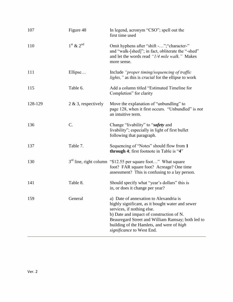
Ver. 2
107 Figure 48 In legend, acronym ―CSO‖; spell out the
first time used
110 1st & 2
nd Omit hyphens after ―shift -…‖;―character-‖
and ―walk-[shed]‖; in fact, obliterate the ―-shed‖
and let the words read “1/4 mile walk.” Makes
more sense.
111 Ellipse… Include “proper timing/sequencing of traffic
lights,” as this is crucial for the ellipse to work
115 Table 6. Add a column titled ―Estimated Timeline for
Completion‖ for clarity
128-129 2 & 3, respectively Move the explanation of ―unbundling‖ to
page 128, when it first occurs. ―Unbundled‖ is not
an intuitive term.
136 C. Change ―livability‖ to ―safety and
livability‖; especially in light of first bullet
following that paragraph.
137 Table 7. Sequencing of ―Notes‖ should flow from 1
through 4; first footnote in Table is ―4‖
130 3rd
line, right column ―$12.55 per square foot…‖ What square
foot? FAR square foot? Acreage? One time
assessment? This is confusing to a lay person.
141 Table 8. Should specify what ―year‘s dollars‖ this is
in, or does it change per year?
159 General a) Date of annexation to Alexandria is
highly significant, as it bought water and sewer
services, if nothing else.
b) Date and impact of construction of N.
Beauregard Street and William Ramsay; both led to
building of the Hamlets, and were of high
significance to West End.
Ver. 2
Commenter: Dave Cavanaugh
Date: February 12, 2012
I appreciate the opportunity to comment.
General Comments:
I appreciate the efforts made by City staff to prepare a Working Draft within a very short of
period of time. However the Beauregard Corridor Small Area Plan Working Draft (Working
Draft) is unsatisfactory, promotional, and incorporates little analysis to support recommendations
and guidelines to implement a small area plan. It should be completely rewritten.
A draft Beauregard Small Area Plan (BSAP)) should better explain the purpose, need and the
underlying planning concepts that are relevant to redeveloping the plan area. Stating the current
plan is outdated or surrounding land uses have changed is not enough to build public support for
a massive transformation of the plan area to a much larger, upscale, urban development. This is
absolutely essential if the City staff is to be successful in building public support for dramatic
changes in the proposed plan area.
The Working Draft should focus on using public space to create a multi-model network
connecting people to the transit stations at Mark Center Station and Southern Towers as well as
the retail stores, cafes and coffee shops. Providing convenient options to move from one place to
another will reduce the dependency on cars and local traffic congestion. The small area plan
should ensure that streets, sidewalks, shared spaces redesigned to operate together for all users
Residents living at Seminary Park should be able to safely cross Seminary Road to a bus stop or
using internal sidewalks and public space be able to walk, ride or bike through the proposed
Hekemian development to Southern Towers. The public spaces used to get from one place to
another should be safe, attractive and interesting-not parking lots or garages. Once on the
Southern Towers property, pedestrians should be able to make their way to the proposed retail
areas and proposed BRT station at Southern Towers and the Mark Center Station. Passengers
arriving at Southern Towers from the District of Columbia, Skyline, Bailey's Crossroads should
be able to walk to the Mark Center Station to catch the bus to Woodbridge or connect to a
carpool.
The Beauregard Corridor Small Area Plan Working Draft includes several ideas not fully
supported by members of the community. In a rush to complete the small area plan process, City
officials and developers have not adequately addressed some of the major concerns expressed by
residents. The mishandling of Corridor "C", the push for a Bus Rapid Transit system, the
unexplained rationale for an ellipse all perplex residents. Part of the problem is unfamiliarity
with the City's planning process, the concepts embedded in new urbanism and a perceived threat
to the character of the community. A draft BSAP should be partly based on efforts to reconcile
the outstanding issues and improving the environment for public involvement.
Ver. 2
The Beauregard Corridor Open House held on Saturday February 11 provided an opportunity to
understand concepts being incorporated into the planning process and be able to envision what is
being proposed. It was relaxing, informative and a variety of residents that do not normally
show up at meetings attended the open house. Although the developers have been persistent in
advocating a need for increased density to make their projects work financially, they have
demonstrated a wiliness to work with the community.
Specific Comments:
The primary purpose of preparing a Beauregard Corridor Plan is to outline goals, objectives, and
provide specific recommendations on land use, zoning, transportation and urban design. City
officials, developers and the community are and should be involved in that process.
Redevelopment in the proposed plan area includes 395.25 acres, an estimated 5,500 housing
units-mostly rental, of which about 3,000 (?) would be directly impacted.
Major property owners involved in the planning process include JBG Properties (129.64 acres),
Southern Towers (40.81 acres, Home Properties (22.31 acres), Duke Realty 19.18 acres and
Hekemian and Private (8.18 acres), Shirley Gardens-Fairbanks/Foster) and WRIT (1.94 acres).
The property owners are seeking additional development rights in addition to what is allowed
under existing zoning with a DSUP.
1. Prepare a draft Beauregard Small Area Plan (BSAP) without referencing earlier
individual comments and suggestions of members of the Beauregard Corridor Stakeholders
Group. Most of the individual comments were modified by staff and are virtually
indistinguishable from the original comment. We had an opportunity to engage in an informal
process and now it is for the City to draft a more comprehensive small area plan for public
comment.
2. The primary focus of the Working Draft is on the JBG Property. This focus obscures the
details necessary to evaluate guidelines and recommendations for the other properties being
considered for redevelopment. The Working Draft should have specific goals, objectives and
recommendations that generally apply to the all properties including a major commitment to
improve interconnectedness within the plan area and ensuring families displaced are provided
relocation and financial assistance. The draft BSAP should include a more current description of
the other proposed redevelopment projects and how they are integrated into the plan area.
3. "The Existing Land Use Approvals-A Starting Point" infers the City has is unable to
place conditions on design, open space, phasing or affordable housing. Although there are no
standards, the City is not powerless in placing conditions on development through the
Developmental Special Use Permit (DSUP) process. This item should be clarified to more
accurately describe the City's authority under the DSUP process.
4. The working draft should incorporate information on the existing conditions within the
plan area, population, transit use, parks, schools, current landlord provided amenities, and natural
environment, especially in the Lower Hill Zone on the JBG Properties. An analysis of the
Ver. 2
current conditions will confirm the current plan area is a vibrant, diverse, mixed use community,
adjacent to parks and schools and is a transit oriented community.
5. This is a functioning community. However, a more transit oriented community, an
attractive network of local streets, sidewalks and public and private spaces, increasing local retail
and commercial services, would rejuvenate and enhance the long term economic sustainability of
an attractive area.
6. The stated need for a new plan is really insufficient and misleading (p.5).
The need is not based on updating an old plan, changes in surrounding land uses (with the
exception of BRAC, no land uses have changed), a desire to create developmental standards and
phasing (?), or a need to provide dedicated affordable housing (not an issue until redevelopment
proposed).
The Working Draft should provide better written justification for embarking on a major
redevelopment of an area built during the 1960s and 70s. The draft BSAP should evaluate
conditions in the existing community and develop recommendations and guidelines for a semi-
urban development that retains and builds on the character of the community. This would make
the planned development in the plan area more distinctive, differentiate it from other similar
projects and reinforce the sense of place the original Mark Winkler plan created.
7. The proposed plan for the JBG properties envisions transforming a park-like suburban
apartment complex into a large scale, urban mixed use development with tree wells, retaining
walls, fountains paved community areas and parking garages. This is a dramatic change in the
character of the area and is not compatible with the scale of the Greenway and Garden Districts
outlined in the Working Draft.
The Working Draft should be revised to ensure the JBG property on Beauregard and Sanger is
designed as a semi-urban development. The scale, building mass, streets and setbacks should be
incorporated into the wooded landscape and not overpower the park like, natural setting.
Development should ensure at least 40 percent tree canopy coverage in the lower (Garden and
Greenway) sections of the proposed plan.
The proposed building heights of 45-70 feet for the Garden District and Greenway are too high.
The draft BSAP should use environmentally responsible methods for mitigating surface water
run-off, the loss of trees, and appropriately scaled buildings for a hillside exposure that overlooks
a Dora Kelley Nature Park.
8. Many of the photos showing urban streets similar to areas on Connecticut and
Massachusetts Avenue in Washington, D.C. This is not what many of us in the community
envision. The Working Draft should incorporate photos of other nearby Town Center, mixed
use, life style, communities more indicative of a semi-urban plan.
Ver. 2
9. The Working Draft introduces a variety of unexplained concepts or terms. These
concepts include "garden city", "shared parking", "Urban Design Standards and Guidelines",
"Contemporary Style", "Signature Building" "a 10' sidewalk trail" and "required retail and
optional retail". These terms and others should be defined and references provided to "Urban
Design Standards and Guideline". This would help citizens evaluate the criteria for
recommended guidelines and in many cases help build support for recommendations and
guidelines in the Working Draft.
10. The building setback for new buildings on Beauregard should be at least 30 feet from the
curb, excluding "bulb-outs". The Urban Design Recommendations (3.3 on page 31) provides
exclusion for retail area "to enable a double row of street trees and 10ft. sidewalk trail".
11. The building heights proposed in the Working Draft for signature buildings in the town
center area or hotels framing the proposed ellipse are too massive, overpower adjacent
development, would add to traffic congestion and potentially reduce the walkability of the
nearby areas. The building heights for townhouses, mid-rise multi-family, office, hotel, and
signature buildings should be addressed in a more comprehensive manner in a draft BSAP.
12. The proposed ellipse has been promoted as a more elegant design for accommodating
traffic through the Beauregard/Seminary Road intersection. Schematic drawings depict an
intersection squeezed into an area where there will be transit, pedestrian and bicycle entrances,
exits and crossings.
There have been no on the ground preliminary design plans that show the right-of-way a
configuration that will be functional. The ultimate reconfiguration of the intersection must
consider safe, efficient car, transit, pedestrian and bicycle crossing and circulation through the
intersection. Because of the potential impacts on Seminary Heights (corner Beauregard and
Seminary Road) and on planning the proposed Hekemian project, more information is needed to
evaluate the design and function of the ellipse. A preliminary design plan to scale is necessary
before including the ellipse as a reasonable option into the Working Draft. The first question to
be asked is "what are the overall objectives we trying to accomplish?"
13. The proposed parking ratios may be too low. BRT and local buses cannot substitute for
the convenience of living near a metro station. This area is and will be a semi-urban area and
time, instant mobility will continue to be part of our way of life. The primary advantage for
living in the Beauregard Corridor is the quick, efficient bus service to the Pentagon Metro
Station and that is not likely to change.
Hopefully the Working Draft will not discourage local Alexandrian's from outside the plan area
using cars to shop and patronize restaurants by making access and parking too restrictive. I
suggest reevaluating the parking ratios and selecting ratios that are more indicative of an area in
transition to a semi-urban development.
Ver. 2
14. Open space is often described as a community gathering place. Open space can have
many meanings and serve different purposes. It is important that the spaces are functional, serve
a useful purpose and not be contrived to satisfy perceived planning requirements.
In many town center developments the town center is used to attract non-residents to the adjacent
restaurants and shops, e.g., Shirlington, Pentagon Row.
15. The JBG Properties proposed development overlooks public parks, Chambliss, Dora
Kelley Nature Park and playgrounds and tennis courts near William Ramsay Elementary School.
The Working Draft should include a separate section on existing parks and recreational facilities
and provide recommendations and guidelines to address potential impacts of the proposed small
area plan on existing public resources.
16. The existing apartment development provides a club house, tennis courts, two swimming
pools, a volley ball court and a toddler area. This is in addition to the tennis courts and play field
at Ramsay School and the playground at John Adams. The Working Draft does not include any
plans for replacing these facilities, placing more demand on public parks and resources. The
Working Draft should ensure adequate on site recreation facilities are available to replace or
enhance what is currently available.
17. The location of the fire station and whether the City should rely on a developer to pay
and build it as a condition of getting approvals for increased densities raises ethical questions.
There is also an issue of whether the City is appropriately allocating financial resources through
an off budget process that distorts the planning process. This is an outstanding issue that should
be discussed as part of draft BSAP. The fire station should be in a location that can serve the
needs of the City of Alexandria, but also help meet our obligation under mutual service
agreements with other jurisdictions.
18. The Working Draft does outline a plan for tenant assistance to be reviewed by the
Housing Landlord Tenant Relations Board. The draft BSAP should require a tenant plan be
approved prior to City approval for the project.
19. The implementation Plan should include the amount of City, State and Federal funding
necessary to start planning, design and construction of an enhanced BRT system that may be
superfluous to the transportation needs of the plan area. The primary destination for residents
living in the area is to the Pentagon Metro station. Residents also rely on local service to nearby
shopping and employment locations. There is no real demand for residents in the plan area to go
to Van Dorn Metro Station that would justify an upfront expenditure for a BRT system. The
primary focus should be on improving the existing network of streets, sidewalks, shared space
that will increase transit use in the corridor from 34% to 60 or 70%.
20. The Working Draft assumes a high capacity transit service being built between the
Pentagon and Van Dorn Metro Station. It assumes a dedicated transit "guideway" along most of
the running way and mixed use in the more congested areas in the plan area. The City has
already allocated funding in its 10-Year Transportation Improvement Program toward the design

Ver. 2
and construction of the Transitway-a project that is still conceptual, with no connections to
adjacent jurisdictions, no defined terminus, and inadequate funding for anything at that scale.
Until the origin and destination of the proposed BRT is established and an integrated
transportation, transit, pedestrian framework is established for the plan area, the Working Draft
should refer to the BRT as being conceptual.
21. The working draft proposes a new street adjacent to the Seminary Heights and Seminary
Park residential communities connecting to Mark Center Drive. Although this would help
disperse traffic, it would become a street that would by-pass Beauregard and be in the backyard
of the townhouses. This is likely a major concern of residents and efforts to resolve the potential
conflict should be part of drafting a BSAP.
22. Historical Context: It is important the historical context be accurate. The Terrett family
was very large and members of the family owned lands into the 1950s. The Working Draft
should identify the Terrett family that owned "Oakland". Ownership of the "Oakland" residence
may not even be relevant.
The "West End" referenced on page 157 is not the same as the West End referenced in the
Working Draft. The original west-end was just outside the boundaries of the District of
Columbia, near present day Carlyle which up until 1847 included Alexandria. Check with Amy
Bertsch on Lance Mallemo's staff.
If there are any questions regarding the above comments, please contact me.
Commenter: Ben Wales
Date: February 10, 2012
It was good to see you both at the recent community meeting to unveil the working draft of the
Beauregard Small Area Plan. As I mentioned, we had submitted some proposed language that
would allow for the future redevelopment of the Hermitage property within the 1.25 FAR
currently approved.
In follow-up to that language, please find the attached. As you will see, we have suggested
changes to certain pages of the draft plan to provide for the possible redevelopment of the
Hermitage. We believe this is consistent with the conversation we had with Jeff during a meeting
at the end of last year.
Should you have any questions, please do not hesitate to contact me.
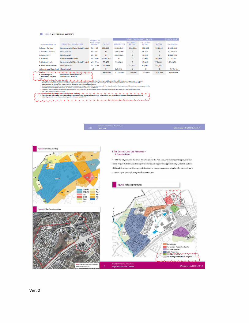
Ver. 2
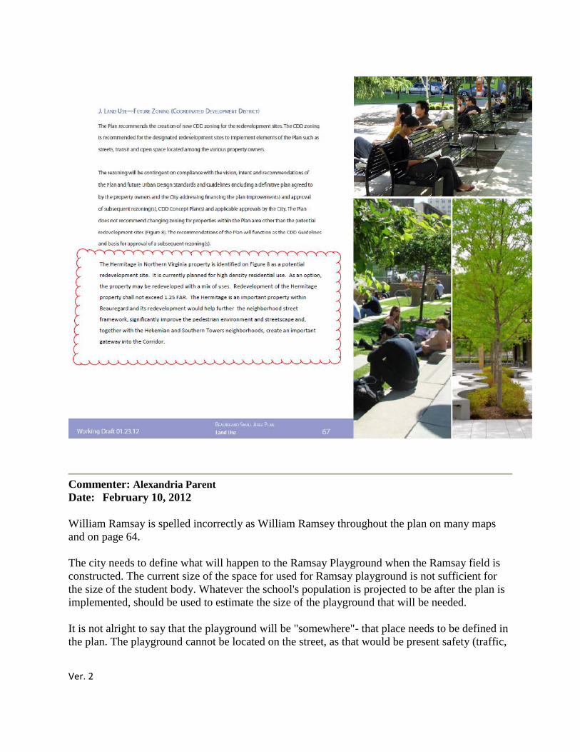
Ver. 2
Commenter: Alexandria Parent
Date: February 10, 2012
William Ramsay is spelled incorrectly as William Ramsey throughout the plan on many maps
and on page 64.
The city needs to define what will happen to the Ramsay Playground when the Ramsay field is
constructed. The current size of the space for used for Ramsay playground is not sufficient for
the size of the student body. Whatever the school's population is projected to be after the plan is
implemented, should be used to estimate the size of the playground that will be needed.
It is not alright to say that the playground will be "somewhere"- that place needs to be defined in
the plan. The playground cannot be located on the street, as that would be present safety (traffic,
Ver. 2
noise, stranger danger) hazards to the children. Perhaps the area behind the field closest to the
nature center would work -- it just cannot be directly on the street. Our children deserve better.
Commenter: Beauregard Homeowner
Date: February 9, 2012
This development is long overdue. Although affordable housing is important, so is expanding the
city's tax base in order to be able to provide improved services.
Commenter: Jim Lowenstern
Date: February 10, 2012
I live in the Larchmont Apartments which is slightly north of the coming
construction, ( displacement ). Using market rates for affordable housing, the people who will
have to leave (buildings being razed for new construction) rarely can afford the "new" affordable
units. The City (of Alexandria) had partnered with construction activity (near the berg, trader
Joes) where expensive or market bearing units partnered with (HUD?) under market value units
exist side by side. Building units that are inexpensive will make them more inexpensive to rent
or lease.
I believe (the state of ) Virginia is a right to build, so a lot of these buildings that
will be razed ( destroyed) are still capable of housing people, All lot of people will be displaced
and this will be a very challenging factor for their lives, Profit and business needs a balance with
ethics and people's needs.
Commenter: Nancy Jennings
Date: February 10, 2012
Attached and below are comments of the Seminary Hill Association, Inc., on the draft
Beauregard Corridor Small Area Plan. Please post them to the City‘s website.
COMMENTARY OF THE SEMINARY HILL ASSOCIATION, INC., ON THE DRAFT
BEAUREGARD CORRIDOR SMALL AREA PLAN
The Seminary Hill Association, Inc., (SHA) finds that the draft Beauregard Corridor Small Area
Plan (Plan) is severely flawed and needs a thorough restructuring. It should not be considered by
the Planning Commission or the City Council until this restructuring has been accomplished to
the satisfaction of stakeholders, including the residents of Seminary Hill.
SHA‘s chief concerns are that:
1. The Plan potentially would displace 10,000 residents without any provision for affordable
housing until after 2020.
Ver. 2
2. The City would invest $60 million of taxpayer funds in the project—up front, before
developer contributions—with much of the money to be used for infrastructure that
residents oppose, like the ellipse.
3. The densities proposed are the functional equivalent of five more BRACs.
4. The Plan, without justification, contravenes the current West Alexandria Small Area Plan
that calls for modest growth in the area and for the protection of adjoining
neighborhoods.
The SHA Board of Directors adopted these comments on February 9, 2012.
Commenter: Mark Benedict
Date: February 8, 2012
Parkside comments to VDOT and Alex. Council on Transport. Improvements & the
Beauregard SAP
The following comments are submitted by the Parkside at Alexandria Condominium Board
and Association (378 units – circa 1000 residents) Parkside is located directly across I-395
from the Mark Center BRAC-133 site. Parkside is located along Van Dorn intra Sanger &
Seminary and will be directly impacted by the I-395 HOV ramp to Seminary and by
proposed noise abatement walls. Parkside is located immediately adjacent to the
Beauregard SAP boundary and will inevitably be directly impacted by the proposed
Beauregard Corridor SAP.
Parkside at Alexandria Condominiums is a charter member of the BRAC-133 Advisory
Group, a charter member of the Beauregard Corridor Stakeholders working group, and is
a member of the Federation of Civic Associations. Parkside has been actively and
continuously involved in all of these efforts either since the summer of 2007 or from their
respective inceptions.
Parkside is not opposed to well thought out development in the Alexandria West End or the
Beauregard corridor. However, Parkside feels resources should be spent in the way best suited
to benefit the largest number of Alexandrians, not just BRAC-133 employees. Parkside feels
that adverse impacts on the environment should be strictly limited and minimized to the greatest
extent possible. Parkside opposes the proposed HOV ramp off I-395N to the top level of the old
and in need of replacement Seminary Road interchange. Seminary strongly disagrees with the
conclusions drawn in the VDOT EA of the Seminary Road ramp. Parkside opposes the shifting
of I-395 North further to the east. Parkside does not believe the FHWA right of way reaches all
the way up to Van Dorn. Parkside strongly opposes the proposed noise abatement walls along
Van Dorn.
Ver. 2
Parkside is not opposed to well designed development in the Beauregard corridor PROVIDED
the environment is adequately protected. Parkside strongly encourages more mid-to high end
retail development in the Beauregard corridor small area – especially more restaurants and retail
which would benefit residents within the confines of the SAP. Parkside strongly encourages
redevelopment of the Kenmore Plaza shopping center as part of the Beauregard SAP.
There is no need to build a ramp at Seminary (which will become outdated by the time it is
completed and would cause unnecessary delays during construction). The amount allocated for
the ramp should be invested in mass transit improvements, which would, hopefully, reduce the
vehicular traffic.
1. the city should preserve the trees adjacent to Van Dorn Street as they create a natural
abatement wall (This looks better than a man-made wall; keeping the trees separating Van Dorn
Street from 395 is good for the environment; the trees and foliage naturally insulate the sound
from traffic on 395 and are good for the community adjacent to 395).
2. There is no need to build an I-395 ramp to Seminary Road.
i. The Mark Center building is now open and occupied. The tenants at the building are able to
park fine and building the ramp will only create huge traffic problems in the area to benefit only
about 3000 parking spaces (and again, the occupants in the Mark Center are fine without the
ramp now). Therefore, it seems unnecessary to build the ramp and it will likely create traffic
congestion for years on 395 while the ramp is being built (again, just for the benefit of some of
the 3000 cars that park at the Mark Center). Also, the plan will likely create permanent traffic
congestion on the HOV lane at Mark Center (much like there is currently at the exit to the
Pentagon in the mornings after 7am), and it will likely cause more problems than it's worth.
ii. Rather than using the $80 million allocated for building the ramp, if possible, it might be
better to use the money to widen 395 where it bottlenecks at the little River Turnpike exit (as it
decreases there from four to three lanes which causes delays during rush hour everyday,
including for cars exiting from the Mark Center. Widening 395 Southbound lanes to four or five
lanes would solve a lot of the traffic congestion that motorists on 395 face in the evening
commute, including the 3000 cars that park at the Mark Center. Shifting of all the northbound
lanes of I-395 further to the east makes no sense, is cost prohibitive, and will create incredible
traffic disruptions for extended periods of time.
3. Construction of noise abatement wall along Van Dorn is NOT required nor is it desirable.
The proposed wall will be ineffective, cost prohibitive, addresses increased noise NOT proven to
exist, will destroy existing berm and trees, will not decrease noise from I-395 or the ramp –
which is taller than the proposed wall, will have immediate adverse impacts on Parkside units‘
property values, will create traffic and safety hazards along Van Dorn, and will require obtaining
ROW from the City of Alexandria since the FHWA ROW for I-395 does NOT extend all the
Ver. 2
way up to the western edge of Van Dorn. A majority of Owners at Parkside at Alexandria will
oppose construction of the proposed ―Wall 1‖ thereby rendering further discussion moot.
Proposed noise abatement walls are not justified nor required and there is no money to pay for
them. The obvious and severe adverse impacts of these walls would far outweigh any minimal
benefit – just a couple of db in noise level reduction – they would, at most provide.
With regard to agenda Item #5, the Beauregard Small Area Plan, Parkside’s concern is
with the funding for the Corridor C project.
The National Capital Regional Planning Board has a summary of the project, here:
http://www.mwcog.org/clrp/projects/new/proposed_2012.asp (item 2) The cost is estimated to
be $100 million. Does that projected cost include widening the Sanger Avenue underpass, or the
Van Dorn Street overpass over Duke Street, or the Van Dorn overpass over the railroad tracks
just south of Pickett Street, to add dedicated bus lanes?
How definitive is that cost estimate - is it based on at least preliminary engineering studies? If so,
will these be made public in some form (even a summary) at some point? If not, when will an
estimate based on at least preliminary engineering studies be completed and available?
What are the projected costs for land acquisition (right of way) for the BRT lanes, between the
Van Dorn Metro Station and Sanger Avenue? There is NO accurate data on this – Parkside
requests same.
If the costs of building Corridor C exceed the projected $100 million, is the expectation that the
City will fund the cost overruns, or will there be fewer miles of dedicated BRT lanes, or is there
some other plan to deal with this possibility?
With regard to agenda item #6, the BRAC update, my concerns include the following:
The briefing documents state that "An average of 1,450 vehicles are entering the parking garages
[daily]". Is there any information as to where these vehicles originate from? (Ideally, by zip
code.) I ask because the benefits of the proposed VDOT HOV ramp depend, of course, on how
many vehicles are likely to actually use the ramp.
The Transportation Commission had not conducted a hearing and that they were being asked to
endorse recommendations had been made by the Beauregard Corridor Stakeholder Group.
Making it more interesting was the Chairman of the Transportation Commission remarked that
"The Transportation Commission was only given responsibility by Council to implement the
Transportation Master Plan. He added that "Road improvements that are part of the Beauregard
Small Area Plan remain in the purview of the Planning Commission. Parkside at
Alexandria feels the Transportation Commission should be involved in all transportation issues,
regardless of whether they are part of the small area process.
Ver. 2
The primary reason for concern is the position of the Transportation Commission limits public
involvement in transportation matters affecting the Beauregard-Seminary Road area. The
Commission was not receptive to holding a public hearing and instead merely urged citizens to
send their comments to the Commission. Parkside at Alexandria believes this MUST change.
The Commission and City officials appear to believe theirs is a limited role in evaluating
transportation changes being proposed as part of the Beauregard Small Area Plan. The
Commission has a role to ensure the public has an opportunity to comment.
If necessary, the City Council should help clarify the Transportation Commission's
mission statement.
Currently, their mission is the following: "The Alexandria Transportation Commission is
established to advocate and promote development of balanced transportation systems for the City
of Alexandria, through oversight of the implementation of the Transportation Charter of the
City's Master Plan." I believe there is ample discretion for the Commission to be more proactive.
Parkside at Alexandria respectfully suggests that they should be an independent body that
encourages public involvement on major issues.
Parkside at Alexandria strongly urges the Transportation Commission to hold a public
hearing regarding proposed transportation changes being considered as part of the
Beauregard Small Area Plan.
Parkside at Alexandria suggests City staff not refer to "recommendations" made by the
Beauregard Corridor Stakeholders Group. They are individual comments forwarded to
City staff through the stakeholders group.
City officials argue the reversible HOV ramp, and Seminary Road at Beauregard ellipse ―the
football‖ are part of a package to improve traffic congestion at I-395 and at Beauregard.
Parkside at Alexandria believes members of the Commission are also receptive to this position.
Parkside at Alexandria strongly objects to the appearance that they have made some
assumptions and see the public commenting process as a ―necessary nuisance.‖ This is NOT in
the best interests of the citizens of the Alexandria West End.
Discussion regarding the "auxiliary" lanes. Parkside believes the environmental process will
start sometime in 2013. More clarification is required on these auxiliary lanes before anything
else is done.
There is a joint Planning Commission/City Council work session scheduled for February 13,
2012. The staff is seeking input from the Transportation Commission to be forwarded at that
work session. Parkside at Alexandria‘s Board and Association suggests and respectfully requests
dissemination of discussion or positions by the Transportation Commission for that joint session
in advance.
Ver. 2
Parkside asks: Is the creation of a regional transit hub, rather than BRAC 133, the rationale for
the proposed HOV ramp? Is there is a site plan for the hub, about which you suggest various
jurisdictions apparently have corresponded? If so, Please provide a link.
Parkside notes that the transportation hub has not been mentioned at BRAC AG or BSAP
meetings. [See Dave Cavanaugh's letter at http://www.alexandrianews.org/2012/02/a-regional-
transportation-hub-at-mark-center/ ]
Is the creation of such a hub also the rationale for BRT? Is the hub the reason BRT will not be
using the proposed $30 million ellipse? Are the hub and the BRT, then, connected to the
rationale for Corridor C (which seems counterintuitive to the developers' intent for a
walkable/bikeable Beauregard community not to mention the fact that its feasibility from Sanger
to Landmark along Van Dorn has not been studied)?
Parkside questions the assertion that an integrated redesign for the I-395 interchange is needed.
Is there such a plan? A plan for a plan? Just a chance convergence?
Parkside strongly argues that it would be hard to justify an $80 million expenditure (for the
proposed I-395 ramp to the Seminary interchange top level) for BRAC employees only. It is
likely there will be sufficient demand to make Mark Center Station a major regional transit hub.
Further, the Seminary Road interchange is very old and in serious need of repairs. Spending
$80 million on a new ramp connecting to an already dilapidated Seminary Road interchange
makes NO sense and the idea should be abandoned and the $80 million be redirected to
transportation projects which will serve a much larger population.
Parkside asserts that it is all the other employees in this area -- the rest of Mark Center, Skyline,
Park Center, and even ALX INOVA Hospital -- who will now have the opportunity to share the
ride and save time on buses will not benefit from the proposed ramp. The transit systems down
the corridor have made it clear -- they will provide express bus service to this area whether the
ramp is built or not. And those buses will be readily used.
Thank you for your serious consideration of these comments for inclusion in the public record.
Parkside does not know how the WHS is managing their spaces in the new garages, but if it is
done like the Pentagon, then, other than the highest ranking folks (this used to be one stars and
higher, it may be colonels/captains and higher now), the only ones who get priority for parking
are carpools and vanpools. The notion that SOVs will backfill for each carpool that is created
doesn't hold water in Parkside‘s opinion.
The second most efficient highway mover of people (carrying people/hour) in the US are the
HOV lanes on Shirley Highway -- the first being the bus-only lanes of the Lincoln Tunnel in
NJ/NYC. The Shirley Highway HOV lanes carry more people in the peak hours than do the
Ver. 2
regular lanes. Since they opened in 1969, they only provided HOV access to the regional core --
the Pentagon, Crystal City, and DC, later Pentagon City. But none of the other No VA
employment destinations were accessible.
The planning for the HOT lanes project, motivated by the private sector to make money,
recognized that many people stuck using the general purpose lanes would use the HOT lanes if
they connected to other NoVA destinations. And, while that project is apparently dead, the
validity of that idea -- that if the HOV lanes connected to other employment destinations, then
buses, vanpools, and carpools could use the ramp, and ridership on these efficient modes would
go up, and SOV use would go down. Parkside agrees with that position.
Parkside believes the rationale remains that there are now perhaps 30,000 employees within a
mile of the Seminary Road interchange who have no incentive to take the bus up Shirley
Highway, nor carpool. And of course, not all of them come up Shirley Highway anyhow, but
more come that way than on any other route, and HOV facilities have strong draw, meaning they
could attract folks who drive singly on other routes to avoid the I-395 delays in the regular lanes.
So the ramp provides the opportunity to give these HOV users an advantage in exchange for
them doing something good for society.
Regarding the transit center at the BRAC site: That is the new 5 or 6 bay facility built by the
army on the N side of their N garage along Mark Center Drive. Parkside strongly feels it is not
clear how all the bus routes which pass through there also will serve the historically high transit
generation coming from Southern Towers. Parkside hopes that as routes are adjusted, that the
residents of our West End area headed into the core are not sacrificed by being hit with more
stops and longer trip times. But that has nothing to do with the ramp which serves travel to/from
the other direction.
Regarding the BRT and the new lanes proposed for the "Beauregard Corridor". Parkside
feels strongly that the whole idea to me is a waste of money which will not relieve our
congestion issues nor provide reasonable options for neither our residents nor the employees who
will come to work in our back yard. It is inflexible and does not serve a known pattern of
commuting or travel. The entire SAP area would be better off with a focus on bus service by
DASH and Metrobus, and of course, the new services from/to points south which will
materialize once the ramp is open. The BRT is dreams by folks have wide-eyed thoughts that the
latest in transit modes will save us all from the auto. What we need in this region, and the West
End in particular, is a balanced, connected, multi-modal system of Metrorail, bus, HOV, and,
yes, safe and efficient roads for autos. Parkside respectfully suggests that we should stop
permitting more development than the transportation network we are willing to build can serve.
Parkside is not aware of any plans for an integrated solution to the interchange and its
neighboring intersections. That is the idea for which I am trying to encourage the City and
Ver. 2
VDOT to seriously address. Instead, the City is off on the pursuit of an ellipse because
some developer thought it would make a great entrance feature to their proposed new
development. An ellipse will only further exacerbate the problems of the functional area of the
Seminary Road interchange. And it is NOT part of an integrated approach to congestion and
safety relief in that area.
Commenter: Lyn Bostain
Date: February 7, 2012
These comments are based on first look at the entire plan; some may have already been raised
(but I don‘t see that they were noted or they need more scrutiny and community input, in my
opinion). I appreciate the opportunity to comment on them, and I hope the City listens to its
citizens who actually live in the jurisdictional area of the Beauregard Small Area Plan.
Regional and Local Context
Pg. 5: C. There‘s mention of “adjoining jurisdictions” in Arlington and Fairfax Counties.
Columbia Pike‘s changes will most likely be much less than was originally introduced, so this
should draw attention to the much talked-about joining up of traffic solutions on Columbia Pike
with the much talked-about Beauregard Street ―improvements.‖ I‘ve pointed out many times that
so-called improvements aren‘t necessarily improvements at all, but should be called ―changes‖.
Not as rosy, but more accurate. Also, where is mention of the Pentagon route here since most of
what‘s occurring on Beauregard is due to the BRAC construction?
Vision and Guiding Elements
Pg. 6: #3. #4 states ―To provide dedicated affordable and workforce housing.‖ Current plan
doesn‘t do this. In the following paragraph, …‖The Plan also recommends the developers
contribute $147.5 million to fund public improvements…‖ Recommends should be changed to
demands (or something stronger than recommends)
Pg. 6: D. Integrating Urban Ecology – Sustainability. This needs a LOT of work and the Dora
Kelley Nature Park (name implies that this park is more than a City park—it‘s a Nature Park and
Wildlife Sanctuary; very different from a ―city park‖) needs to be brought into the equation. This
Nature Park and Sanctuary needs to be protected from all current and future development. It‘s
protected in perpetuity.
Pg. 10: A., 1st bullet. ‖minimize the number of car trips‖. This is exactly why we don‘t need a
road next to the Dora Kelley Nature Park. See above.
Pg. 11: C. ―The Plan recommends a significant level of replacement of affordable and
workforce housing…‖ What‘s being recommended in the Plan isn‘t significant at all! It‘s less
than what‘s there now!

Ver. 2
Pg. 11: E. ―The Plan also expands the Dora Kelley Nature Park. The proposed new open spaces,
parks, and greenways will constitute approximately 45 acres. Where is this 45 acre area? My
understanding is that the current Dora Kelley Nature Park is 50 acres. I‘m not seeing the
additional 45 acres.
Urban Design-Plan Framework
Pg. 21: 5 types of streets. The ellipse is included in this plan although the proposed funding
won‘t cover the entire cost of this design. There‘s also no mention here of the proposed VDOT
ramp. Where does that figure in? This section is very misleading.
Pg. 22: Ellipse. See above Shouldn‘t be included at this time.
Pg. 23: Dotted area adjacent to Dora Kelley Nature Park. There should be no road next to a
Nature Park!
Pg. 23-24 maps. We‘ve requested numerous times that Rayburn Avenue not be extended to
Sanger. To date, there has been no design to show that it wouldn‘t attract much more traffic than
it now has. Rayburn Avenue residents do not want this street extended.
Pg. 29: J. Vistas. If vistas are to be included for all people, the area fronting Dora Kelley Nature
Park should have no road next to the Nature Park.
Pg. 32: 3.19. Much more discussion is needed about North Beauregard Street and transit lanes.
Pg. 32: 3.21 and 3.22. More emphasis: NO road facing toward Dora Kelley Nature Park
Land Use
Pg. 44: Concentration of Retail. The proposed retail looks much larger than what has been
presented to date.
Pg. 44: Building Types-Heights. Office building heights range from 90 to 110 ft (isn‘t this 9-11
stories? Not what page 47 says) Existing buildings: ―The existing high-rise residential buildings
range from 120 ft to 170 ft. I think this is 12-17 stories high. Where are the existing buildings
that are that tall on the map on pg. 47?
Pg. 53: I. Open Space: Emphasis needs to be on the fact that Dora Kelley is a Nature Park and
Sanctuary; NOT an ordinary City Park.
Pg. 68: Table 4. Are the figures shown here, especially for hotel and optional retail the same
numbers that were given the BCSG originally? These seem higher.
Pg. 70: Building Height – Types: What does the 2nd
sentence mean—―…maximum heights the
future zoning will establish minimum heights for each neighborhood.‖ What is meant by a
―minimum height?‖
Ver. 2
Pg. 72: 4.35. #4.35, ―The greenway, Dora Kelley extension (?) and the park within the Upland
Park neighborhood will be dedicated to the City. The remainder of the open spaces will provide a
perpetual public access easement and will be privately maintained.‖ The 2nd
sentence is
disturbing. Needs explanation, and the whole proposition needs extensive public discussion.
Housing
Pg. 76: There are many aspects of the plan on this page that need a lot of public discussion and
study. For example, why are there only 700 replacement affordable and workforce housing
units? The paragraph, ―The City defines housing as affordable if the cost of the housing and its
related expenses….‖ also needs a great deal of study and public discussion.
Pg. 77: Paragraph beginning, ―The Plan does not currently contain any publicly-assisted
affordable, non-profit owned, Resolution 830 or ARHA owned public housing units. In addition,
there is currently not a single dedicated affordable housing unit in the Plan area.‖ This needs a
great deal of study and scrutiny. The City is developing more and more upscale areas with
proposed hotels and restaurants. Where does the City believe the workers in these establishments
who are not generally seen by the public (i.e., housekeeping staff, busboys, cleaning staff, etc.)
are going to come from? They certainly won‘t take 2 or more buses to come to work in a
congested area if they‘re able to find work closer to where they live.
Pg. 77: Paragraph B. The current affordable and workforce housing units section needs much
more scrutiny.
Pg. 79: D. Ensuring Economic Sustainability. This paragraph says what the City needs to do, and
the final sentence is most important! Without committed affordable housing, Alexandria may
(change to ―will‖ lose talented human capital and its associated consumer spending to other
jurisdictions. This important point needs illumination!
Pg. 80: Phase I – Tenant Assistance. The point is made that funding for affordable and
workforce housing ―does not become available until approximately after 2020.‖ My question is,
what happens between now and 2020?
Pg. 84: 2nd
paragraph. The paragraph beginning ―JBG has offered and the City has
conceptually agreed to….transfer ownership of two existing multifamily buildings in the
Hillwood community to the City….sometime in about 2010. The timing of the transfer depends
on current financing restrictions. These 56 units, …‖ As I understand it, there are only 700
affordable units to replace what‘s being lost, and this transfer adds only 56 additional units.
That‘s not enough.
Urban Ecology Sustainability
Pg. 93: Stream restoration. I‘m not clear about the location of ―Turkey Run‖, but if it‘s the
stream running south from the Chambliss entrance to the Dora Kelley Nature Park/Wildlife
Sanctuary, there‘s been considerable damage already done by the City. Riprap was installed at
the beginning of that stream, killing at least 3 mature trees, one a beautiful healthy Oak.
Everything that has been done subsequent to that has resulted in dumping of huge quantities of
Ver. 2
rock or dirt at the base of trees which has killed an additional 5 or 6 well-established trees. Large
machinery is brought into the Nature Park which leaves huge tire tracks that are left and then fill
with water and mud. This results in large amounts of silt in the waterway. What‘s been done so
far in the Dora Kelley Nature Park‘s streams is disgraceful.
Pg. 96: 6.1 h. ―Install LED of comparable efficiency lighting that will also be dark skies
compliant.‖ I don‘t believe that what the Winklers installed throughout the complex meets this
requirement. The lights that are there now are blindingly-bright. Certainly not ―dark skies
compliant.‖
Pg. 97: Aspirational goals. We need discussion about what (b), (d) are. The (g) point is good!
Community Facilities and Infrastructure
Pg. 103: B. Childcare. If there‘s increased need for childcare to ―serve residents and employees
of the existing and proposed development‖, it doesn‘t make sense that there will be no need for
new schools in Alexandria? Where will these children go to school?
Pg. 106: F. Sewer. 3rd
paragraph—there is a letter attached dealing with the Holmes Run
problem. This paragraph states that ―the City has an on-going extensive rehabilitation program in
this Holmes Run Sewer Shed…‖ The residents of this area aren‘t seeing this!
Transportation
Pg. 110: 2nd
paragraph. ―The topography, I-395, existing roadways, developed parcels, and
existing parks limits some opportunities for additional east-west streets. .‖ The Dora Kelley
Nature Park/Wildlife Sanctuary should not have roads next to it simply because of what it is.
Pg. 111: Ellipse at Seminary Road/Beauregard Street. VDOT has told the City and citizens
repeatedly that VDOT is not allowed to include the ellipse in its Ramp Plan because it‘s a
―proposed‖ ellipse. If VDOT can‘t include it in their plans, why does the City do it? There is no
guarantee for the ellipse funding.
Pg. 111: Parallel Road to Beauregard Street. Any parallel streets to Beauregard should be on
JBG‘s property, NOT Rayburn Avenue. Those of us who bought homes on Rayburn Avenue
most likely were attracted by the quiet neighborhood. Extending Rayburn Avenue to Sanger will
give more and more access to traffic trying to avoid Beauregard. Even if there is an additional
Sanger Avenue built in the future, the overflow traffic should be directed to a road through
JBG‘s property, not on Rayburn Avenue.
Pg. 113: New High Occupancy Vehicle(HOV) Ramp. See comments under Pg. 111, Ellipse.
Why is the City including a HOV Ramp when it‘s not even approved? ―The traffic analysis
assumes the proposed new HOV ramp…‖
Pg. 117: Last sentence. ―This is largely due to the construction of the Ellipse.‖ My point is that
there are a lot of assumptions built on the ellipse which isn‘t funded yet!
Ver. 2
Pg. 118: transportation improvements, including the ellipse. See all above comments, Pg
111-117.
Implementation
Pg. 138: A thirty-year buildout is probably realistic since funding clearly will depend on the
market. Deputy City Manager Mark Jinks commented at one BCSG meeting that ―in 2020, 85%
of present buildings will still be there.‖ I think citizens and public officials need to watch this
carefully. Earmarking funds is a good, but tricky endeavor, it seems to me.
Appendix
Pg. 144: 1.b. (4) The public asked for committed affordable housing units; the City needs to pay
attention to that request.
Pg. 144: 2.a.(1) The ―existing homes‖ referred to certainly include the Westridge Townhouses
which have been in existence since the 1960‘s. Since these homes will be profoundly affected
by any sort of development, homeowners need to have regular and consistent updates with ample
time for comments. It is hoped that both the City and JBG will heed comments.
Pg. 146: (2) (d) There should an absolute minimum of tree wells. Tree wells can‘t sustain full
sized or mature trees; the wells are decorative and, in my opinion, are designed to fulfill
developer‘s tastes, not the integrity of the neighborhood or the life of the trees themselves. Any
loss of trees, which should be minimal--especially when trees are mature and would be
extremely difficult to replace--should be replaced with more than saplings. They should also be
native species and chosen for their ability to provide shade. There are trees on the JBG property
which Winkler left standing for several reasons; one is the shade provided by the trees, and
another is their age. Some are older than 50 years and are very valuable to the environment.
These should be protected—not encased in concrete or have ―decorative‖ rocks piled around
them.
Pg. 146: E. (6) Option 1 is the plan I support. Developers already have entirely too much voice
in Alexandria; they certainly outweigh ordinary citizens.
Pg. 147: 4.a. (5) Option 2 is the plan I support. Tree canopy over Beauregard is essential. The
last sentence, ―To the extent possible, existing healthy mature trees should be preserved and new
trees should be as mature as possible when planted.‖ should be the mantra of any and all
development in the West End.
Pg. 148: (5) c. Option 2 is the plan I support. We shouldn‘t establish a new CDD zoning but
should preserve existing zoning for land owned by JBG, Duke Realty, Home Properties, and
Southern Towers.
Ver. 2
Pg. 148: d. (16) Options 1 and 2 Eliminate ―cinemas‖ from the Plan. There is not enough space
for all that developers are dreaming of! However, Option 2 is the plan I support. There definitely
should NOT be large format destination retail stores in the Beauregard Plan.
Pg. 150: (20) There is another plot of land in back of Hammond Middle School that is
considerable larger than the athletic field which is proposed for Sanger and Beauregard. The City
should look into that space (google map attached) I believe the land is owned either by the
school or the City. Either should be willing to develop the space into an athletic field. The space
at Sanger and Beauregard would encroach on the Dora Kelley Nature Park (which was
designated a ―nature‖ park in 1976 and set aside only for its natural preservation, in perpetuity.
Extending the land at Sanger and Beauregard up against the Dora Kelley Nature Park (and
wildlife sanctuary)would endanger the wildlife and also the encroach on the floodplain area
(RPA) resulting in serious destruction to the nature park. This is outrageous! Trails in the Dora
Kelley Nature Park would be jeopardized by this encroachment as well. The state of Virginia‘s
Birding and Wildlife Trail Guide, published by the Virginia Department of Game and Inland
Fisheries, on page 11 states, ―Dora Kelley Park is an excellent example of conscientious urban
planning and conservation efforts. Surrounded by urban sprawl, this woodland gem should be a
prime birding spot any time of the year…..A beautifully maintained self-guided interpretive trail
traverses the deciduous woodland habitat, which is primarily composed of spectacular red, white,
black and chestnut oaks and American beech in the uplands.‖ Development of a field which
would definitely encroach on this ―woodland gem‖ should be taken off the books completely! I
would strongly suggest looking into other areas for an athletic field.
Pg. 151: (25) What is stated in this ―incorporated‖ statement is yet another reason NOT to put a
road adjacent to the Dora Kelley Nature Park (and Wildlife Sanctuary). ―..walking rather than
driving.‖
Pg. 151: h. (9) Option 2 is the plan I support.
Commenter: Jack Sullivan
Date: February 9, 2012
QUESTIONS ON THE BEAUREGARD PLAN
1. Why does the working draft make no mention of the number of people who will be displaced
by the development plan?
2. The plan indicates that the funding for affordable housing will be available only AFTER
2020. By that time thousands of people will have been displaced. How can that be justified?
3. Two buildings will be allowed to go to 13 stories. My recollection is that the earlier
developer plans were only to 10 stories. Why is the City Staff granting additional height?
Ver. 2
4. The City plans to put $60 million of taxpayer money up front to in part to build a $29 million
ellipse that the neighors object to and for other elements that make the development possible.
What guarantees do we have that reimbursement will come?
5. If the City had put similar money into the Landmark/Van Dorn redevelopment we would still
be waiting for the first dollar to be repaid. In the light of experience how can the use of taxpayer
funds thus be justified?
6. Why is there a need for a CDD when the Plan itself encompasses the area? A CDD for the
entire area would deny citizens and neighbors the right to contest individual re-zonings when
they come up. This is against the spirit of the City‘s zoning laws and makes a mockery of them.
7. There is an existing CDD that encompasses both the JBG and Duke properties. This CDD is
supposed to be valid for 20 years from the time of its last amendment which was in 2005. How
does the new plan affect them?
Thank you for your attention to these inquiries. Jack Sullivan, 4300 Ivanhoe Place, Alexandria
22304 (703) 370-3039.
Commenter: Kathryn Habib
Date: February 9, 2012
Dear Ms. Rodriguez,
We are homeowners in Alexandria and are writing to express our concern that the Beauregard
Small Area Plan will ensure only 703 units of affordable housing, compared to the over 2,500
units that exist now. Especially during these days when the economy is down, we need to
provide more affordable housing for residents.
We would like to voice our supports for efforts to modify the new plan to do this.
Commenter: Alexandria Homeowner
Date: February 4, 2012
The first thing the city needs to do is to force Mark Center to abolish those rat-infested outdoor
trash dumps in the old "Hamlets" apartments. Second, I see nothing but massive transportation
trouble for people adjacent to this area. It's nice to preach a car-free area, but let's face it,
nobody's going to take the bus to bring 12 bags of groceries home. Third, the Winkler nature
preserve has already been degraded by massive construction. What's left must be preserved.
Ver. 2
Commenter: Rfradkin
Date: February 4, 2012
The plan does not address the economic and social impact of the proposed changes.
Currently, Southern Towers and the apartments of Mark Center properties provides affordable
housing for low to moderate middle class families, including many immigrants. They will be
completely displaced by this plan as they will be unable to afford the new Shirlington/Ballston
style developments.
The plan does not address the increased property values for homeowners at nearby communities.
This will have the likely effect of making current housing stock unaffordable to current residents,
especially retirees, and put it out of the reach of many middle class families.
The City should look at the impact of similar development in Arlington and other locales, to see
what actually happens to displaced families and ask some hard questions - where will they go?
what kind of city will we end up with? Are we valuing tax revenue over residents?
The plans traffic analysis fails to accurately predict and analyze the influx of car traffic due to
BRAC and other businesses. It rests on an unrealistic assumption that funding will be provided
for public transit, that workers will use public transit, bike to work and/or live within walking
distance of their places of employment.
In short, I envision, should this plan be adopted, a West End full of young upper middle class
professionals, with no children, sitting in their hybrids in gridlock traffic.
Commenter: Chris
Date: February 1, 2012
Are the 10' Multi-Use trails being specified for Beauregard, Sanger, and Seminary in addition to
a sidewalk or are they basically just 10' wide sidewalks?
Commenter: Michele Krocker
Date: February 1, 2012
Affordable Housing: While 703 is 28% of the current number of market affordable units, when
Beauregard is built out with approx.. 6500 units that number will be just under 11% of the total
units developed. That is a more accurate representation of the number of dedicated affordable
units planned. Additionally, a majority of the current residents make less than 55% AMI, (more
detailed analysis should be done to qualify this) so what strategies are being considered to create
more housing opportunities for households in those lower income categories who will want to
remain there?
Ver. 2
Commenter: Scott Littlefield
Date: January 30, 2012
The plan shows proposed building heights, but doesn't show the building heights that are allowed
under the current zoning. To evaluate the pros and cons of the plan, it would helpful to know
what is possible or likely to happen under the existing zoning. Recommend annotating Figure 30
on pg 47 with the currently allowed heights.
Commenter: Eileen Kirwan
Date: January 30, 2012
Thank you for the opportunity to provide comments on the draft Beauregard Small Area Plan. I
agree with Mr. Tedesco's June 2010 comment and didn't see anything in the draft Plan that
addresses it. I've listed my own comments below with the corresponding pages:
Page 30: Public Art or Public Eyesore? Sometimes it's hard to tell the difference. Whatever
artwork is used should be something that is not period-specific (i.e., quickly dated) and that
won't become a rusting hulk a few years after being erected.
Page 49: The Plan must be corrected to include Lincolnia Hills as an existing Alexandria City
community that is adjacent to the Plan Area. It's disappointing that the only place Lincolnia Hills
is mentioned is at the end of the Plan in the Area History.
Page 49: How will security be maintained for underground parking? Unless residents/shoppers
are assured that it's safe to park in these lots, they won't patronize the businesses/shops.
Page 51: Do not exacerbate Lincolnia Hills' existing apartment overflow parking problems (just
drive up N. Morgan Street after 9:00 PM) by underestimating the number of parking spaces
required. We don't want our neighborhood to become an overflow parking lot for Beauregard
Corridor residents.
Pages 53 & 104: In view of the increased population density, the City should establish a Police
substation within the development to include bicycle policemen to patrol the bike/jogging paths
and green areas within each section of the development. The increased number of buildings and
additional secondary & tertiary street intersections will make effective police patrols in patrol
cars much more difficult.
Page 77: Although it is technically correct that there is no subsidized housing within the Plan
area, there are several developments on the fringes. Some that readily come to mind are at corner
of N. Armistead and Beauregard Streets, at the top of Sanger Street just above Ramsey ES, and
at the corner of Van Dorn Street and Braddock Road. The narrative in the report makes it sound
as though there is no subsidized housing in the area. This is incorrect.
Page 110: Is the goal to establish the Beauregard Corridor Community (within the boundaries) as
a totally self-sufficient community? If not, the developers need to make it easy for residents of
Ver. 2
adjacent communities to get there by car. Using Lincolnia Hills as an example, it will simply be
too much trouble to coordinate between Metrobus and the rapid transit buses to shop in the Town
Center and other retail locations. This would be true of any residents (both Alexandria City, as
well as nearby Fairfax County) in areas outside the Plan boundaries, but within close proximity
of the planned community. If you make it too hard for us to support you, we'll take our business
to shops that provide ready access and parking.
Commenter: Jack Sullivan
Date: January 30, 2012
COMMENTARY ON THE BEAUREGARD SMALL AREA PLAN
The Beauregard Plan before us is the ruin of the West End.
It involves an area that not blighted, not crime ridden, a multi-cultural community where people
get along. The Plan would tear much of it down, ultimately displacing potentially more than 10
thousand residents.
And it replaces this community with a highly dense development of condos and townhouses and
shops for the well-to-do. In effect it rips the heart and soul out of the West End.
The Landmark/Van Dorn plan, which was adopted, did not displace a single resident.
The people of the West End when given a chance to vote in the stakeholders group several
months ago, OVERWHELMING, 48 to 22 --rejected the basis of this plan.
I have called for a subsequent vote or votes of the group of the stakeholders on this draft and Ms.
Fossum, the putative chair, has denied us that right calling voting ―useless.‖
The Plan destroys the largest amount of affordable housing in the City. It would displace
thousands before a single dollar is spent on maintaining affordable housing in the plan area. The
first date given for affordable housing is ―After 2020‖ --and no guarantees then.
Moreover, the City would invest $60 million of taxpayer --our -- money up front for things --
like the traffic ellipse -- that citizens have heartily objected to. Again with no guarantee of ever
getting public money returned.
The City Planning staff should look to our people first, then the cement.
I urge everyone in the City who cares about the character of Alexandria to reject this Beauregard
Plan as deeply and utterly flawed.
Ver. 2
Written Public Comments (and responses) to the Alexandria Transportation Commission
February 1, 2012 Meeting
Comment from: Jack Sullivan
Comment received: January 31, 2012
STATEMENT TO MEMBERS OF THE TRANSPORTATION COMMISSION ON THE
BEAUREGARD CORRIDOR PLAN
Mr. Chairman, Members of the Commission:
I will be brief. The Beauregard Plan before you is the ruin of the West End.
It takes an area that not blighted, not crime ridden, a multi-cultural community where people get
along and the Plan would tear much of it down, ultimately displacing potentially more than 10
thousand people.
The Plan destroys the largest amount of affordable housing in the City. Note that the
Landmark/Van Dorn plan, on which I participated, did not displace a single resident.
The plan replaces this community with a highly dense development of condos and townhouses
and shops for the well-to-do. In effect it rips the heart and soul out of the West End. And
replaces it with the functional equivalent of 5 more BRACs.
The people of the West End when given a chance to vote in the stakeholders group,
OVERWHELMING,-- 48 to 22 -- have rejected the densities of this plan.
I have called for a subsequent vote or votes of the group of the stakeholders on this draft and Ms.
Fossum, the putative chair, has denied us that right calling a vote ―useless.‖
I chose Alexandria as a city to live in because it is truly a city. The plan would displace
thousands before a single dollar would be spent on maintaining affordable housing in the area.
The date given for affordable housing is ―After 2020‖ --and no guarantees then.
Moreover, the City would invest $60 million of taxpayer money up front for construction of
things like a traffic ellipse that citizens have heartily objected to. There is no guarantee of ever
getting public money returned within a reasonable period of time.
Look to our people first, then the cement. I urge each of you to reject this Beauregard Plan as
deeply and utterly flawed.
Thank you for your time and attention.
Respectfully submitted, Jack Sullivan, January 31, 2011
Ver. 2
Response from: City of Alexandria, Dept. of Transportation & Environmental Services
Thank you for your comments. Your comments are noted.
Comment from: John Broughton
Comment received: February 1, 2012
Thank you for the informative responses, and for volunteering your time in what may often seem
thankless work. Below are some written comments (questions, actually). I realize that these
should be directed to staff, who are then to relay them to you, but given the lateness of the hour, I
hope that some redundancy is not a problem.
-- John Broughton
President, Brookville-Seminary Road Civic Association
********************
With regard to agenda Item #5, the Beauregard Small Area Plan, my concern is with the funding
for the Corridor C project.
* The National Capital Regional Planning Board has a summary of the project, here:
http://www.mwcog.org/clrp/projects/new/proposed_2012.asp (item 2) The cost is estimated to be
$100 million. Does that projected cost include widening the Sanger Avenue underpass, or the
Van Dorn Street overpass over Duke Street, or the Van Dorn overpass over the railroad tracks
just south of Pickett Street, to add dedicated bus lanes?
* How definitive is that cost estimate - is it based on at least preliminary engineering studies? If
so, will these be made public in some form (even a summary) at some point? If not, when will a
estimate based on at least preliminary engineering studies be completed and available?
* What are the projected costs for land acquisition (right of way) for the BRT lanes, between the
Van Dorn Metro Station and Sanger Avenue?
* If the costs of building Corridor C exceed the projected $100 million, is the expectation that the
City will fund the cost overruns, or will there be fewer miles of dedicated BRT lanes, or is there
some other plan to deal with this possibility?
With regard to agenda item #6, the BRAC update, my concerns include the following:
* The briefing documents state that "An average of 1,450 vehicles are entering the parking
garages [daily]". Is there any information as to where these vehicles originate from? (Ideally, by
zip code.) I ask because the benefits of the proposed VDOT HOV ramp depend, of course, on
how many vehicles are likely to actually use the ramp.
Response from: City of Alexandria, Dept. of Transportation & Environmental Services
Ver. 2
The estimated cost for the Corridor C (Beauregard/Van Dorn) transitway identified in the
Constrained Long Range Plan does not include any widening of the Sanger Avenue underpass,
nor the Van Dorn Street overpass over Duke Street. Those improvements, while helpful to transit
operations, are proposed as longer term improvements that would need additional funding. In the
meantime, the preliminary concept includes the provision of Transit Signal Priority (TSP), and
queue jumps to help improve transit speed and reliability. Along Van Dorn Street, most of the
transitway will operate in dedicated lanes, however, there are portions of Van Dorn Street where
the runningway is proposed to operate in shared lanes. The costs developed to date are planning
level and are not based on preliminary engineering. The costs are in the process of being further
refined as the project progresses into the Alternatives Analysis / Environmental Assessment.
Only planning level costs associated with the projected right of way between the Van Dorn
Metrorail station and Sanger Avenue have been developed. These costs are in the process of
being refined. The City has included approximately $20 million in its 10-year Capital
Improvement Program, and it is expected that additional funding will come from developer
contributions, and federal grants. The Corridor C Transitway is considered a high priority
project. If additional funding is required, the City may decide to delay other capital projects to
fund the transitway, or to phase various sections of the transitway as funding becomes available.
All of the presentations that have been provided to the High Capacity Transit Corridor Work
Group, including the planning level cost estimates, can be found at
www.alexandriava.gov/highcapacitytransit
Comment from: Don Buch
Comment received: February 1, 2012
Reject VDOT’s Environmental Assessment for I-395 HOV Ramp at Seminary Road Until
Shortcomings Are Addressed
Published by EA Ear on Jan 20, 2012
Background (Preamble):
Given the shortcomings of the Virginia Department of Transportation‘s ―Environmental
Assessment for the Proposed I-395 HOV Ramp at Seminary Road‖ dated December 20, 2011,
this petition is intended to clearly set forth the primary concerns and expectations of members of
the Alexandria community with respect to that Environmental Assessment.
Petition Text:
Petition Asserting That There Are Very Significant Shortcomings in VDOT‘s
―Environmental Assessment for the Proposed I-395 HOV Ramp at Seminary Road‖
Dated December 20, 2011
and that The Environmental Assessment Should Be Rejected as Inadequate
Until Those Shortcomings are Fully Addressed
Ver. 2
1. WHEREAS, on December 21, 2011, the Virginia Department of Transportation (―VDOT‖)
approved for public availability its ―Environmental Assessment for the Proposed I-395 HOV
Ramp at Seminary Road‖; and
2. WHEREAS there are numerous relevant matters which do not appear to have received
thorough consideration; and
3. WHEREAS, in supporting their original request for a Categorical Exclusion (―CE‖), VDOT
repeatedly stated that a comprehensive Environmental Assessment (―EA‖) would delay the
project by 12-14 months; yet the EA now provided took roughly one third of the time that a
comprehensive one was to take; and
4. WHEREAS primary justifications for the proposed ramp are stated to be (a) the ―high volume
of (BRAC-133) employee travel (on I-395) originating from the south‖ and (b) that ―up to forty
percent of employees would utilize I-395 as the primary access road to the site from points
south‖, neither assertion is supported by factual data; and
5. WHEREAS the EA takes no account of existing I-395 traffic which will be drawn to the
Seminary Road exit when it becomes the first and only available HOV exit from I-395 between
Franconia/Springfield Parkway and the Pentagon; and
6. WHEREAS the ―study area‖ fails to take into consideration the impact that the proposed ramp
will have on nearby intersections, many of which VDOT has previously documented as about to
have (if not already having) failing levels of service (―LOS‖) even before the addition of yet
more vehicles drawn by the proposed ramp; and
7. WHEREAS it appears illogical that the northbound I-395 ramp to Seminary Road operated at
a LOS D in 2009 but in the ―No Build‖ option is projected to improve to LOS B by 2015 and
remain at LOS B for 20 years beyond that; and
8. WHEREAS, apart from ―relieving congestion‖ on the (two) I-395 on and off ramps, the only
stated purpose (and implied purview) of the EA was to ―address the need for adequate transit
vehicle and High Occupancy Vehicle access to the Mark Center‖ which is, in fact, but one of
innumerable, significant current and future traffic generators in the area; and
9. WHEREAS, despite the foregoing, the EA later states that ―without improved access to Mark
Center…the surrounding freeway network will not be able to handle this additional traffic…‖
offering false hope when VDOT‘s own EA for the HOT lanes concluded ―the level of service
will deteriorate to ‗F‘ throughout most of the (I-395) corridor‖; and
10. WHEREAS, despite VDOT asserting that it is the BRAC-133 facility that precipitates the
need for the ramp, representatives of the Department of Defense have stated they do not view
BRAC-133 as having precipitated any need for the ramp and are thus not prepared to contribute
to its funding – logic which VDOT does not appear to challenge; and
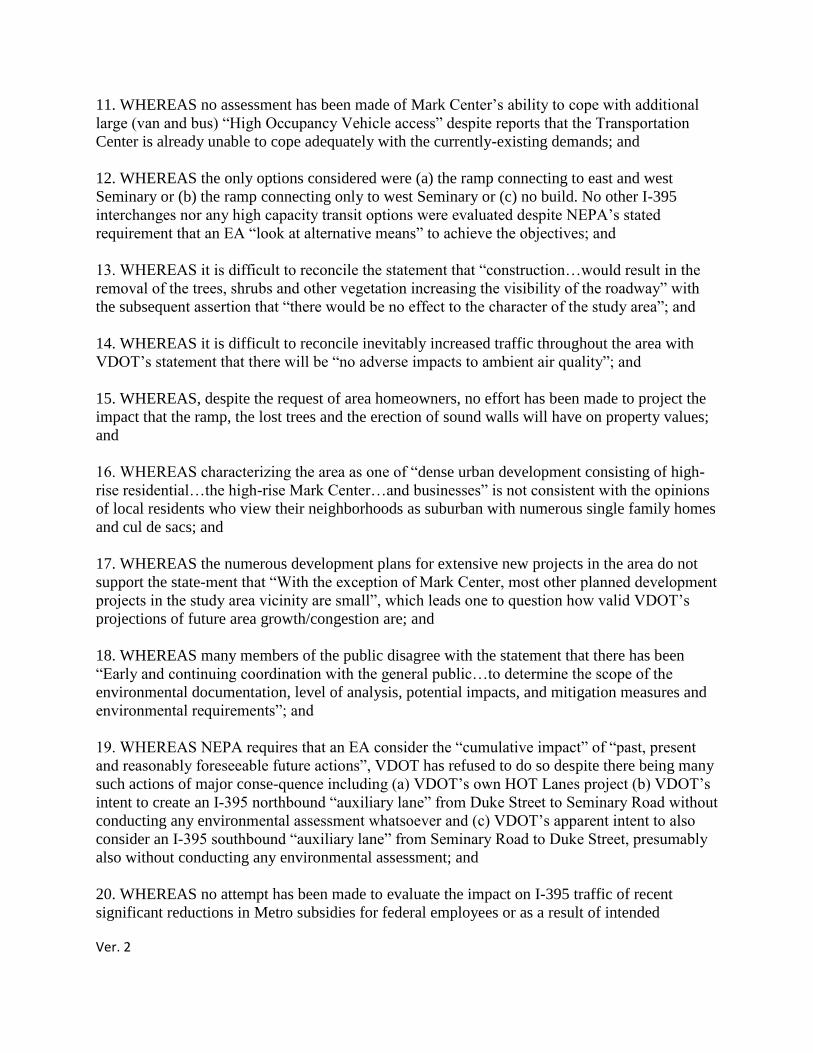
Ver. 2
11. WHEREAS no assessment has been made of Mark Center‘s ability to cope with additional
large (van and bus) ―High Occupancy Vehicle access‖ despite reports that the Transportation
Center is already unable to cope adequately with the currently-existing demands; and
12. WHEREAS the only options considered were (a) the ramp connecting to east and west
Seminary or (b) the ramp connecting only to west Seminary or (c) no build. No other I-395
interchanges nor any high capacity transit options were evaluated despite NEPA‘s stated
requirement that an EA ―look at alternative means‖ to achieve the objectives; and
13. WHEREAS it is difficult to reconcile the statement that ―construction…would result in the
removal of the trees, shrubs and other vegetation increasing the visibility of the roadway‖ with
the subsequent assertion that ―there would be no effect to the character of the study area‖; and
14. WHEREAS it is difficult to reconcile inevitably increased traffic throughout the area with
VDOT‘s statement that there will be ―no adverse impacts to ambient air quality‖; and
15. WHEREAS, despite the request of area homeowners, no effort has been made to project the
impact that the ramp, the lost trees and the erection of sound walls will have on property values;
and
16. WHEREAS characterizing the area as one of ―dense urban development consisting of high-
rise residential…the high-rise Mark Center…and businesses‖ is not consistent with the opinions
of local residents who view their neighborhoods as suburban with numerous single family homes
and cul de sacs; and
17. WHEREAS the numerous development plans for extensive new projects in the area do not
support the state-ment that ―With the exception of Mark Center, most other planned development
projects in the study area vicinity are small‖, which leads one to question how valid VDOT‘s
projections of future area growth/congestion are; and
18. WHEREAS many members of the public disagree with the statement that there has been
―Early and continuing coordination with the general public…to determine the scope of the
environmental documentation, level of analysis, potential impacts, and mitigation measures and
environmental requirements‖; and
19. WHEREAS NEPA requires that an EA consider the ―cumulative impact‖ of ―past, present
and reasonably foreseeable future actions‖, VDOT has refused to do so despite there being many
such actions of major conse-quence including (a) VDOT‘s own HOT Lanes project (b) VDOT‘s
intent to create an I-395 northbound ―auxiliary lane‖ from Duke Street to Seminary Road without
conducting any environmental assessment whatsoever and (c) VDOT‘s apparent intent to also
consider an I-395 southbound ―auxiliary lane‖ from Seminary Road to Duke Street, presumably
also without conducting any environmental assessment; and
20. WHEREAS no attempt has been made to evaluate the impact on I-395 traffic of recent
significant reductions in Metro subsidies for federal employees or as a result of intended

Ver. 2
significant increases in Metro fares; and
21. WHEREAS, several years ago, the City Council of Alexandria passed a resolution requesting
VDOT to ―eliminate from further consideration…a High Occupancy Vehicle ramp at Seminary
Road‖, based upon staff‘s review that ―indicate(d) the primary destinations of HOV traffic
(which would use) HOV ramps at Seminary Road (would be) Crystal City, the Pentagon and
Potomac Yard…conveying substantial cut through traffic…filter(ing) through the local street
network‖; and
22. WHEREAS VDOT and our Commonwealth seemingly continue to place their focus on
building ever more roads in our region while (a) the vast preponderance of information which the
public sees and hears stresses that high capacity transit is the only viable ―solution‖ to our traffic
congestion and (b) the Governor states that we need a broader vision for transit and promotes his
―Super NOVA‖ transit study; and
23. WHEREAS the community was advised to submit concerns, questions and suggestions it had
about this project to VDOT by September 12, 2011, but to date has received no response; and
24. WHEREAS the Mayor of the City of Alexandria, on behalf of its impacted residents,
requested that VDOT‘s public hearing be conducted in an open discussion forum/format, but
VDOT declined to do so;
NOW THEREFORE BE IT RESOLVED THAT:
(a) The December 21, 2011 Virginia Department of Transportation ―Environmental Assessment
for the Proposed I-395 HOV Ramp at Seminary Road‖ be rejected as incomplete based upon its
failure to address the numerous issues enumerated above; and
(b) VDOT be requested/directed to address the above shortcomings and resubmit the revised
Environmental Assessment for reconsideration by the affected public and the Federal Highway
Administration; and furthermore
(c) Should the numerous deficiencies of the Environmental Assessment not be thoroughly
addressed and satisfactorily resolved, then the Federal Highway Administration should NOT
issue any Finding of No Significant Impact but rather insist that either
a. an Environmental Impact Statement be prepared for this project or
b. the ―no build‖ option be the one chosen.
Total Signatures 150 (Signature comments can be viewed in the Appendix of this document)
# Title Name Town/City S/C/P Region Comment Date
150 N/G Christina Lytle alexandria va USA View Jan 31, 2012
149 Mr Robert Bossa Alexandria VA USA N/G Jan 31, 2012
148 N/G Anonymous Alexandria VA N/G N/G Jan 31, 2012
147 Mrs Bette Jo Sullivan Alexandria VA USA N/G Jan 30, 2012
Ver. 2
146 Mr William J
Sullivan Alexandria VA USA N/G Jan 30, 2012
145 Mr. John Richards Alexandria VA USA N/G Jan 30, 2012
144 Ms. Kathryn Tatko Alexandria VA USA N/G Jan 30, 2012
143 N/G Gladys Pettiford Alexandria VA N/G N/G Jan 30, 2012
142 Ms. Nancy Cox Alexandria VA USA N/G Jan 30, 2012
141 Mr Wafa Nasr Alexandria Va N/G View Jan 29, 2012
140 Mr Peter Carson Alexandria Virginia N/G N/G Jan 29, 2012
139 MR DOYLE
HENDERSON CHESAPEAKE VIRGINIA USA N/G Jan 29, 2012
138 Ms Mairym Ramos Alexandria VA USA N/G Jan 28, 2012
137 Mr Thomas
Holcombe Alexandria VA USA N/G Jan 28, 2012
136 N/G Faith Holcombe Alexandria VA USA View Jan 28, 2012
135 Mr Francis Hall Alexandria VA N/G View Jan 28, 2012
134 Mrs. Andrea Lacey Alexandria Virginia USA N/G Jan 27, 2012
133 N/G Roger Brunstrum Alexandria VA USA N/G Jan 27, 2012
132 N/G Marianne Coates alexandria virginia USA N/G Jan 27, 2012
131 N/G Anonymous Alexandria VA N/G N/G Jan 27, 2012
130 N/G Jean MacHarg Alexandria Va N/G N/G Jan 27, 2012
129 Mr. Anonymous Alexandria VA N/G N/G Jan 27, 2012
128 N/G Anonymous Alexandria va USA View Jan 27, 2012
127 mr charles horner Alexandria va N/G N/G Jan 27, 2012
126 N/G Richard Frank Alexandria VA USA View Jan 27, 2012
125 N/G Mary K Horner alexandria va USA N/G Jan 27, 2012
124 N/G Charles Evans Alexandria VA N/G N/G Jan 27, 2012
123 N/G Kellie Souza Alexandria VA USA N/G Jan 27, 2012
122 N/G Cynthia Evans Alexandria VA N/G View Jan 27, 2012
121 N/G Ingeborg
Prichard Alexandria Virginia N/G N/G Jan 27, 2012
120 Ms Anna Magulas Alexandria VA USA N/G Jan 26, 2012
119 Mr. Matthew
Anderson Alexandria VA USA View Jan 26, 2012
118 mr J mARX ALEXANDRIA VA USA View Jan 26, 2012
117 Mrs. Ann Henshaw Alexandria VA USA View Jan 26, 2012
116 Mrs Radhika Yadav Alexandria VA N/G N/G Jan 26, 2012
115 Mr. Gopal Yadav Alexandria VA N/G N/G Jan 26, 2012

Ver. 2
114 Mr. Bruce McCarthy Alexandria VA USA N/G Jan 26, 2012
113 Ms Carter Flemming Alexandria Virginia USA N/G Jan 26, 2012
112 Ms Susan Clark-
Sestak Alexandria VA USA N/G Jan 26, 2012
111 N/G Joanne Lepanto Alexandria VA N/G N/G Jan 26, 2012
110 Mr. Sam Ulm Alexandria VA N/G N/G Jan 26, 2012
109 Mr. Gerrish Flynn Alexandria Virginia N/G View Jan 26, 2012
108 N/G Mary Zoeter Alexandria Virginia USA N/G Jan 26, 2012
107 N/G Carol Flint Alexandria Va N/G N/G Jan 26, 2012
106 N/G Mary Newhouse Alexandria VA USA N/G Jan 26, 2012
105 Dr. John Veldhuis Alexandria Virginia USA View Jan 26, 2012
104 Mr. Morgan Henry Alexandria Virginia USA N/G Jan 25, 2012
103 Mr Jonathan Viney Alexandria Va USA N/G Jan 25, 2012
102 Mr. Mark Ganter ALEXANDRIA Virginia USA N/G Jan 25, 2012
101 N/G Jane Abel Alexandria Va. N/G N/G Jan 25, 2012
100 N/G Martin Abel Alexanadria Va. N/G N/G Jan 25, 2012
99 N/G dana purdy alexandria Virginia USA View Jan 25, 2012
98 N/G Sally Brice Alexandria VA N/G N/G Jan 25, 2012
97 Dr. JEFFREY
CLARKE Alexandria Virginia N/G N/G Jan 25, 2012
96 N/G Laura Olesen Alexandria VA N/G N/G Jan 25, 2012
95 N/G Joan Dreyer Alexandria Virginia USA View Jan 25, 2012
94 Mrs. Laura Marin Alexandria VA USA N/G Jan 25, 2012
93 N/G Anonymous Alexandria Virginia N/G View Jan 25, 2012
92 Mr. Charles Sumpter Alexandria Virginia N/G View Jan 25, 2012
91 N/G Portia Joyner Alexandria Virginia USA N/G Jan 25, 2012
90 Dr. Frances Greene Alexandria Virginia USA N/G Jan 25, 2012
89 N/G Anonymous Alexandria Alexandria,
VA N/G N/G Jan 25, 2012
88 Ms Cheryl Avila Alexandria VA USA N/G Jan 25, 2012
87 N/G Alex Sinaiko Alexandria VA N/G N/G Jan 25, 2012
86 Mr. Martin Menez Alexandria VA USA N/G Jan 25, 2012
85 N/G Anonymous Alexandria VA USA N/G Jan 25, 2012
84 N/G Elizabeth Boehlert Alexandria Virginia N/G N/G Jan 25, 2012
83 N/G Jason Boehlert Alexandria VA N/G N/G Jan 25, 2012
82 Mr Robert Schnurr Alexandria VA USA View Jan 25, 2012
Ver. 2
81 N/G Anonymous Alexandria VA USA N/G Jan 25, 2012
80 N/G Julie Edelson Alexandria Virginia USA View Jan 25, 2012
79 Ms. Rita Sanderson Alexandria VA N/G N/G Jan 25, 2012
78 Mr. Jamie Test Alexandria VA N/G N/G Jan 25, 2012
77 N/G Laura Gann Alexandria VA USA N/G Jan 25, 2012
76 N/G Jayne Schwetje Alexandria Virginia N/G N/G Jan 25, 2012
75 Dr. William Rougle Alexandria VA USA View Jan 24, 2012
74 N/G Jeffrey Marin Alexandria VA USA N/G Jan 24, 2012
73 Ms. Kyle Dunbar Alexandria va N/G N/G Jan 24, 2012
72 mr Anonymous alexandria va USA N/G Jan 24, 2012
71 N/G Judy Cooper Alexandria Va N/G N/G Jan 24, 2012
70 Ms Karen Kearney Alexandria VA N/G N/G Jan 24, 2012
69 Mr. Anonymous Alexandria Virginia USA View Jan 24, 2012
68 N/G Alesia Frerichs Alexandria VA N/G N/G Jan 24, 2012
67 Mr. Richard Somers Alexandria Virginia N/G N/G Jan 24, 2012
66 N/G Anonymous Alexandria VA USA N/G Jan 24, 2012
65 N/G Rick Tedesco Alexandria Virginia USA N/G Jan 24, 2012
64 Mr Arin Franz Alexandria VA N/G N/G Jan 24, 2012
63 Ms Anonymous Alexandria Va N/G View Jan 24, 2012
62 Mrs. Elizabeth P. Mercer Alexandria VA N/G N/G Jan 24, 2012
61 Colonel
(ret) James D. Mercer Alexandria VA N/G N/G Jan 24, 2012
60 N/G Charlotte M. Ross Alexandria VA N/G N/G Jan 24, 2012
59 Ms. Nancy Veldhuis Alexandria Virginia USA View Jan 24, 2012
58 Mr. Robert Mackay Alexandria VA N/G N/G Jan 24, 2012
57 Mrs Francine Mackay Alexandria VA N/G N/G Jan 24, 2012
56 Mr Richard Hobson Alexandria Virginia N/G N/G Jan 24, 2012
55 Mr. Michael Berens Alexandria VA USA N/G Jan 24, 2012
54 Mrs Nora Omijie Alexandria VA USA N/G Jan 24, 2012
53 Mr. Don Buch Alexandria VA USA View Jan 24, 2012
52 N/G Barbara Gilbert-
Chen Alexandria VA N/G N/G Jan 24, 2012
51 N/G Abbie Freeman Alexandria VA USA N/G Jan 24, 2012
50 Ms Lois Vinci Alexandria VA USA N/G Jan 24, 2012
49 Mrs Lisa Johnson Alexandria VA USA N/G Jan 24, 2012
48 Ms. Darcy Franz Alexandria VA N/G N/G Jan 24, 2012
Ver. 2
47 N/G Betty A. Kozak Alexandria VA USA N/G Jan 24, 2012
46 N/G Marianne Murphy Alexandria VA N/G N/G Jan 24, 2012
45 Ms Barbara Durham Alexandria VA USA N/G Jan 24, 2012
44 Ms Dorothy Lynn
Newbill Alexandria VA USA N/G Jan 24, 2012
43 N/G helen davis alexandria va USA N/G Jan 24, 2012
42 Mrs. Eileen Kirwan Alexandria VA USA N/G Jan 24, 2012
41 Mr Anonymous Alexandria VA USA N/G Jan 24, 2012
40 Mrs Deborah Elnahas Alexandria, VA N/G N/G Jan 24, 2012
39 Mrs. Vivian Smith Alexandria VA N/G N/G Jan 24, 2012
38 N/G Norman Henderson Alexandria Virginia N/G N/G Jan 24, 2012
37 N/G John Broughton ALEXANDRIA VA USA N/G Jan 23, 2012
36 Mr Charles M (Charlie)
Howe Alexandria VA USA N/G Jan 23, 2012
35 Mrs Beatrice Marx Alexandria VA USA N/G Jan 23, 2012
34 Mr Charles Viney Alexandria VA USA N/G Jan 23, 2012
33 Mrs Barbara Viney Alexandria VA USA N/G Jan 23, 2012
32 N/G Karen Auth Alexandria Virginia USA View Jan 23, 2012
31 N/G Anonymous Alexandria VA USA N/G Jan 23, 2012
30 Dr Richard Chapman Alexandria VA USA N/G Jan 23, 2012
29 Mrs Ellen Walker Alexandria VA N/G N/G Jan 23, 2012
28 N/G Elizabeth Blackwell Alexandria Va USA View Jan 23, 2012
27 Ms Cornithia Harris Alexandria Virginia USA N/G Jan 23, 2012
26 N/G Jane Hipp Alexamdria VA USA N/G Jan 23, 2012
25 N/G Lori Lataillade Alexandria VA N/G N/G Jan 23, 2012
24 N/G Anonymous Alexandria Va N/G N/G Jan 23, 2012
23 N/G Michael moss Alexandria va USA N/G Jan 23, 2012
22 Ms. Anonymous Alexandria Va USA View Jan 23, 2012
21 mr john sinclair alexandria va N/G N/G Jan 23, 2012
20 N/G Anonymous Alexandria Virginia USA N/G Jan 23, 2012
19 N/G Linda Tokarz Alexandria VA USA N/G Jan 23, 2012
18 Ms. Anonymous Alexandria VA USA N/G Jan 23, 2012
17 N/G Harriett McCune Alexandria VA USA View Jan 23, 2012
16 Mr James Norman Alexandria VA USA View Jan 23, 2012
15 N/G michael bluestein alexandria va USA N/G Jan 23, 2012
14 N/G juliet bluestein alexandria va USA N/G Jan 23, 2012
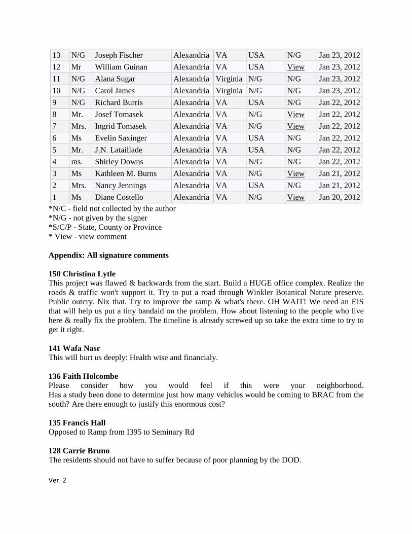
Ver. 2
13 N/G Joseph Fischer Alexandria VA USA N/G Jan 23, 2012
12 Mr William Guinan Alexandria VA USA View Jan 23, 2012
11 N/G Alana Sugar Alexandria Virginia N/G N/G Jan 23, 2012
10 N/G Carol James Alexandria Virginia N/G N/G Jan 23, 2012
9 N/G Richard Burris Alexandria VA USA N/G Jan 22, 2012
8 Mr. Josef Tomasek Alexandria VA N/G View Jan 22, 2012
7 Mrs. Ingrid Tomasek Alexandria VA N/G View Jan 22, 2012
6 Ms Evelin Saxinger Alexandria VA USA N/G Jan 22, 2012
5 Mr. J.N. Lataillade Alexandria VA USA N/G Jan 22, 2012
4 ms. Shirley Downs Alexandria VA N/G N/G Jan 22, 2012
3 Ms Kathleen M. Burns Alexandria VA N/G View Jan 21, 2012
2 Mrs. Nancy Jennings Alexandria VA USA N/G Jan 21, 2012
1 Ms Diane Costello Alexandria VA N/G View Jan 20, 2012
*N/C - field not collected by the author
*N/G - not given by the signer
*S/C/P - State, County or Province
* View - view comment
Appendix: All signature comments
150 Christina Lytle
This project was flawed & backwards from the start. Build a HUGE office complex. Realize the
roads & traffic won't support it. Try to put a road through Winkler Botanical Nature preserve.
Public outcry. Nix that. Try to improve the ramp & what's there. OH WAIT! We need an EIS
that will help us put a tiny bandaid on the problem. How about listening to the people who live
here & really fix the problem. The timeline is already screwed up so take the extra time to try to
get it right.
141 Wafa Nasr
This will hurt us deeply: Health wise and financialy.
136 Faith Holcombe
Please consider how you would feel if this were your neighborhood.
Has a study been done to determine just how many vehicles would be coming to BRAC from the
south? Are there enough to justify this enormous cost?
135 Francis Hall
Opposed to Ramp from I395 to Seminary Rd
128 Carrie Bruno
The residents should not have to suffer because of poor planning by the DOD.

Ver. 2
126 Richard Frank
The expenditure of $80 M is not supported by the thru-put. Spend the money on lengthening the
Duke Street Bridge to support both the south bound exit lane and the a new thru lane to clear up
the existing bottle neck.
122 Cynthia Evans
The current attempts to address traffic around BRAC have not been well thought out and the
need for local traffic to switch lanes repeatedly is dangerous. Any further action must only be
taken after much more consideration & with the intent of putting those of us who live in
Alexandria City first . We drive these roads daily and continue to try to enjoy our city which is
becoming less green and more urban (not in a good way) every day-Alexandria is becoming a
place we don't recognize or like.
119 Matthew Anderson
Redevelop Landmark Mall and generate revenue for Alexandria. Build a flyover to Mark Center
or a shuttle service to and from Landmark. Seminary Road interchange was horrendous--now it
is a travesty and Alexandria police are idling in cruisers every day.
118 J mARX
THIS WILL MAKE THIS END OF THE CITY VIRTUALLY LOCKED UP WITH TRAFFIC.
ALON SITH THE IS THE APPROVED DEVELOPMENT OF THE PICKETT STREET
DEVELOPMENT OF TOWN HOUSES.
117 Ann Henshaw
The assessment is flawed and the ramp is NOT the answer to the increasing traffic congestion.
109 Gerrish Flynn
Please don't BRAC-133 us yet again!! Don't further ruin west Alexandria!! Protect our
neighborhood!!
105 John Veldhuis
There are several shortcomings with the proposed plan that need to be addressed before any
further PR sessions are held.
99 Dana purdy
I live next to N. Van Dorn St-across from I-395 seminary rd ramp and are very concerned about
the proposed ramp site/noise/destruction of trees
95 Joan Dreyer
Consider using unused parking at Landmark Shopping center as satellite spaces for the BRAC.
Include Landmark as one of the shuttle stops.
93 Jeanette S. Robertson
Will decrease good air quality. Need to look to future for more public transportation.
92 Charles Sumpter
Ver. 2
We can all agree that traffic and congestion are a major issue with respect to seminary road.
Having lived right off seminary at one point in time, I know how difficult the morning peak is,
but as well as the PM peak. The PM peak needs just as much consideration and more work needs
to be done to strike just the right balance.
82 Robert Schnurr
This document is incomplete and certainly needs proper public opinion research surveys of
employers, drivers and impacted neighbors. For exampe, no concern has been shown for the
regional hospital's access issues and numerous patients served by surrounding medical service
providers. BRAC will be full of life threatening collateral damage. Good job Donny Rumsfeld.
80 Julie Edelson
The draft VDOT Environmental Assessment and expected format of the public informational
meeting this evening fail to thoroughly review the communities concerns. I find the scope of this
project lacking, which may truly underestimate the overall impacts to our neighborhoods and the
regional transit system. Although a possible benefit, the I-395 HOV Ramp Environmental
Assessment needs more depth to allow effective and thoughtful pre-planning.
75 William Rougle
Poor design and lack of consideration for those living in the impacted area must be addressed
before moving forward with any plans to build any type of ramp in this area.
69 Randall Gafner
I sign this petition to protest the troubling series of mistakes made through the years regarding
the siting of the BRAC project. BRAC is important just not sited at Mark Center. Elected
officials and area residents alike have historically opposed this development when revealed. All
of these current proposals for changes to Seminary Road should have been considered years ago
in preliminary planning. Now the region suffers at every attempt to correct a mistake that should
never have happened.
63 Erin Joy
This proposed ramp will result in a negative impact to my way of life, health, safety, local
school, and to my principal assess. Our local community will see increased traffic, pollution,
drop in real estate value, and our quality of life. Our local taxes will also be affected by increase
need for road repair on our city streets. We are already seeing the negative impact from the poor
decision and planning behind the building of the BRAC building please don't make another
mistake.
59 Nancy Veldhuis
Words are inadequate to describe the frustration resulting from City, State, & Federal officials
seeming inability/ unwillingness to look beyond their own self-interests to solve the problems
that the increased traffic as the result of BRAC 133 has caused & will cause on our neigborhood
streets & the quality of life of those of us who live, pay considerable taxes & conduct business in
this area. Face the real situation with vision & careful planning rather than leave us with the
messy aftermath
53 Don Buch
Are the citizens/taxpayers/voters not entitled to a more thorough EA and answers to their many
questions? I sincerely hope our City government will consider the views of the impacted
Ver. 2
residents and get us answers before they contemplate whether or not to support the ramp, based
upon such limited information.
32 Karen Auth
Along with the 24 points brought up, I am also concerned about the wildlife living on that stretch
of land, specifically a family of deer.
28 Elizabeth Blackwell
Neither the civilian, nor the military authorities, pushing through development, BRAC or
otherwise, have not conducted due diligence or provided accurate impact analysis on further
development related to the ramp. This ramp not address additional traffic issue, but only add to
the misery of communters and the neighborhood alike. Mandatory, free, dedicated shuttle buses
are option that must be explored and may actually help ease traffic.
22 Wilhelmina Dixon
More study needed!
17 Harriett McCune
Please reject the VDOT environmental assessment for the ramp at Seminary Road until the
shortcomings are addressed.
16 James Norman
One more time, the professionals do not listen to those affected. We are a city of smart people
who could contribute measurably to a solution. Why do you not listen?
12 William Guinan
Change this road construction plan. It will devalue the real estate adversely effected by the
construction. If you don't stop the construction then pay the land owners for the lost value of
their land.
8 Josef Tomasek
Leave it as it is. We don't need a wall. Save the trees!!!!!!!
7 Ingrid Tomasek
We are facing 395 and Van Dorn. At least we have a few trees to look out on! Save the trees!!!
3 Kathleen M. Burns
We heard the VDOT presentation on Jan. 18. This will do very little in evening traffic to mitigate
the problems and the 30 ft sound walls will make our neighborhood look like an urban ghetto.
There are better ways to spend $80 million.
1 Diane Costello
The City of Alexandria should be signing this as well....or are they going to short change the
West End again, by not addressing a deeply flawed EA? We do not need a repeat of the BRAC
133 mess. This is a perfect illustration of the precarious road you go down when a poor decision
is made at the outset.
Ver. 2
Response from: City of Alexandria, Dept. of Transportation & Environmental Services
Thank you for your comments. Since this project is being led by the Virginia Department of
Transportation (VDOT), the City has forwarded your comments/petition to VDOT to ensure that
they are taken into consideration.
Comment from: Dave Cavanaugh
Comment received: February 6, 2012
Kevin Posey
Chair Alexandria Transportation Commission
Subject: Beauregard Small Area Plan-Commission Oversight
I attended the Alexandria Transportation Commission Meeting on February 1, 2011. The
agenda for the meeting included the Agenda Item #5, Beauregard Small Area Plan. The City
staff's recommendation was: "That the Transportation Commission receive the Draft Beauregard
Small Area Plan recommendations, and provide input to the Planning Commission and City
Council for their consideration‖ The joint session is scheduled for February 13, 2012.
Although the agenda item was not discussed by the Commission, you urged members in the
audience to provide comments regarding Agenda Item #5--Beauregard Small Area Plan.
I would like the following comments be considered by the Alexandria Transportation
Commission and be prominently posted on the City's website.
The Commission should reevaluate its mission in light of your statement "The
Transportation Commission was only given responsibility by Council to implement
the Transportation Master Plan". Discussion: The City website states: "The Alexandria Transportation Commission is
established to advocate and promote development of balanced transportation systems for
the City of Alexandria, through oversight of the implementation of the Transportation
Chapter of the City‘s adopted Master Plan.
I suggest given the City Council has provided the Commission ample authority to
evaluate transportation systems and provide oversight to changes that impact motor
vehicle, transit, bicycle and pedestrian movement on public streets. However, if further
clarification is necessary, the Commission should provide a written request to the City
Manager for further clarification. This is important to the community to ensure
transportation improvements are functional and integrated as the city transitions to a more
urban environment.
The Commission should publicly clarify their mission or charter and acknowledge
any limitations regarding their oversight of transportation systems.
Ver. 2
Discussion: The clarification should be prominently displayed on the Alexandria
Transportation website.
The Commission should conduct public meetings and hearings on major
transportation issues and proposed changes to ensure an understanding of impacts
on local businesses and neighborhood. Discussion: It is essential the City rely on a independent commission to solicit public
input on major transportation projects like the proposed "ellipse" as well as provide
oversight to ensure Transportation Management Plans are being implemented, and that
the impacts on transit and SOV traffic resulting from the proposed I-395 reversible ramp
at Seminary Road are being mitigated.
The BRAC Transportation Center will become a major regional hub for commuters
working not only at BRAC but also at nearby employment centers in Arlington,
Alexandria and Fairfax County. The increase in commuter service at BRAC will
potentially impact local transit and land uses being considered in the Beauregard Small
Area Plan.
The reference in the Recommendation section to a "Draft Beauregard Small Area
Plan recommendations" is misleading. Discussion: The Beauregard Corridor Stakeholders Group compiled and discussed a
variety of guidelines for a proposed Beauregard Small Area Plan. There was no formal
agreement or consensus on specific guidelines. It was agreed by the group leadership
that all individual comments from members in the informal group would be forwarded to
the City Planning staff for their consideration in drafting the small area plan. In the
future any reference to the Beauregard Corridor Stakeholders Group should refer to
individual citizen proposed guidelines.
I would like to add members of the Planning Commission do not represent the diverse
views of residents impacted by Corridor ―C‖ or the proposed ellipse at Seminary Road
and Beauregard.
Sincerely,
Dave Cavanaugh
Response from: City of Alexandria, Dept. of Transportation & Environmental Services
Thank you for your comments. All of your comments are noted, and will be posted on the
Transportation Commission webpage (www.alexandriava.gov/transportationcommission). While
the key role of the Transportation Commission is to implement the Transportation Master Plan,
the Commission also provides advice to the Council for their consideration in adoption or
approval of other projects, such as the Beauregard Small Area Plan. Public hearings are held
occasionally to solicit public input on projects. The Beauregard Small Area Plan has been
brought to the Transportation Commission for their review, either as a staff report, or
presentation several times in 2010 and 2011. At the February 1, 2012 Transportation
Commission received a staff report on the Beauregard Small Area Plan, and the Commissioners
have reviewed the plan. At the February 1, 2012, there were no comments made by the

Ver. 2
Transportation Commission. It has not yet been determined if the Beauregard Small Area Plan
will be brought back to the Transportation Commission prior to Council review.
Staff will take into consideration your comment regarding the clarification of the Transportation
Commission role on the Commission webpage.
Comment from: Pete Benavage
Comment received: February 9, 2012
As residents of the Fairbanks/Foster sector of the subject SAP, whose properties are most
directly affected by the proposed ellipse, we strongly support that ellipse, and regard with dismay
the comments of those more distant from the project who are attempting to use transportation
issues as a means of halting growth in this part of the West End. After more than 14 traffic
studies, funded at considerable cost, we believe that the experts have clearly demonstrated the
efficacy of the traffic ellipse in ameliorating current and future traffic issues at the Seminary-
Beauregard intersection. This issue has been thouroughly discussed publically, and studied from
every angle, as Mr. Cavanaugh well knows. A vocal minority is attempting to use the
Transportation Commission to serve that minority's no growth ends, and this is unacceptable
in our considered opinion. -- The Shirley Gardens Committee
Response from: City of Alexandria, Dept. of Transportation & Environmental Services
Thank you for your comments. Your comments are noted.
Comment from: Christine Brown
Comment received: February 9, 2012
As a property owner in the Shirley Gardens subdivision (Fairbanks and Foster Avenues), I
strongly urge the Transportation Committee to move forward with the traffic ellipse for the
Beauregard and Seminary Road intersection. Extensive studies prove that this plan will offer the
most effective and efficient means of moving traffic through the area.
Christine S. Brown
Response from: City of Alexandria, Dept. of Transportation & Environmental Services
Thank you for your comments. Your comments are noted.
Comment from: Jim Brown
Comment received: February 9, 2012
Steve Sindiong:
Ver. 2
As a resident of the Fairbanks/Foster sector of the subject SAP, for which I have live in this
sector for over sixty-two (62) years and also I‘ am directly affected by the ellipse, I strongly
support the ellipse and hurt by the comments made by those who are distant away from this
project and by those who continue to have their heads in the sand. The use of a transportation
issues to stop any growth on the West End by a minority‘s group is troublesome. The City of
Alexandria, State of Virginia and Federal government have study this issue fourteen (14) times.
The waste of spending more money on this issue and doing more studies is a waste of more
time. How many more studies and more money wasted on these studies do we need. Do we
need fifty (50) more studies and more money wasted until the minority‘s get their way.. You
could have built the ellipse with all the money spent on these studies. The experts in the field
from the City of Alexandria, State of Virginia and Federal Government have clearly study this
issue and are expert in this field. This issue has been discuss with the citizens of Alexandria for
over a year. Do we not trust those who‘s daily job is working on traffic issues? After all they
(people who get a salary for studying these traffic issues) are expert in this field. To those
minority groups who continue to want to use the Transportation Commission as a way to stop
growth what will happen when BRAC-133 build is completely full with government employees.
And these government employees cannot get to work because the intersection between Seminary
Road and Beauregard street is but a traffic log jam. Remember these government employee‘s are
coming from the west of Alexandria, south of Alexandria, north of Alexandria, east of
Alexandria and they will all meet at the Seminary Road/Beauregard Street road way. Built the
ellipse as soon as possible this will help solve the traffic that we for see is coming soon with the
full employment of the BRAC-133 building.
Jim Brown
Member of Shirley Gardens Committee)
Resident of West End of Alexandria for over sixty-two (62) years
Response from: City of Alexandria, Dept. of Transportation & Environmental Services
Thank you for your comments. Your comments are noted.
Comment from: Priscilla Rasmussen
Comment received: February 9, 2012
Dear Mr. Sindiong,
As a property owner in the Shirley Gardens subdivision (Fairbanks and Foster Avenues), I
strongly urge the Transportation Committee to move forward with the ellipse plan for the
Beauregard St.and Seminary Road intersection. The extensive studies prove this plan will offer
the most effective and efficient means of moving the traffic through the area.
Priscilla Rasmussen

Ver. 2
co-owner
5115 Fairbanks Avenue
Alexandria, VA
Response from: City of Alexandria, Dept. of Transportation & Environmental Services
Thank you for your comments. Your comments are noted.
Comment from: Nancy Shanks
Comment received: February 12, 2012
As a long time resident of Fairbanks Ave, I am very resentful on how some folks that do not
even live in the affected area say that the ellipse is not necessary. Have they been asleep at all
these meetings where traffic officials have spent countless hours studying it? What a slap in the
face to us and to the city to say no one knows what they are talking about! The brac building is
here to stay no matter what so they may as well suck it up and accept it. I do not have the luxury
of a traffic light getting in and out of my street and the people in the town houses on Seminary
make illegal left turns (there are time restrictions) all the time. No one even stops for school
buses anymore. If the Nimby's spent one day trying to do this maybe they will open their closed
narrow minds and actually think before they speak.
Sincerely
Nancy Shanks
Response from: City of Alexandria, Dept. of Transportation & Environmental Services
Thank you for your comments. Your comments are noted.
WORKING DRAFT OF BEAUREGARD SMALL AREA PLAN –
RELEASED JANUARY 23, 2012