Four forest restoration initiative (4fri) annual evaluation 2012

Community Forest Walks
Project Evaluation
Commissioned by Environment Tasmania, July 2016
By Martin Hawes

3 Community Forest Walks Project Evaluation:

By Martin HawesWalking Track Design and Management
This project is supported by Environment Tasmania through funding received from the Australian Government.
Community Forest Walks
Project Evaluation

2 Community Forest Walks Project Evaluation:

Photo: Martin Hawes. This photo can be downloaded for free from the Environment Tasmania website.
Contents
1 Background and Summary 4
2 Higgs Track 6
3 Warners Track 13
4 Blue Tier Giant Walk 20
5 Arm River Track 27
6 Halls Falls Track 34
7 Lake Skinner Track 41
8 Twisted Sister Track 48
9 Junee Cave Track 55
Halls Falls

4 Community Forest Walks Project Evaluation: Background and Summary
1 Background and Summary
The works were undertaken during the period mid-2014 to mid-2016. All of the targeted tracks are in areas that were included in reserves as part of the 2012 Tasmanian Forests Agreement. Six are in recent (2013) extensions to the Tasmanian Wilderness World Heritage Area, and two are in areas in the Blue Tier region designated as Future Potential Production Forest.
The information in this report is based on a series of fieldtrips that the author undertook during the period May-July 2016. Material in the sections ‘Stakeholder feedback’ is based on phone interviews that the author conducted with stakeholders during the same period. Two stakeholders were interviewed for each track.
The overall finding of this evaluation is that the project has been an unqualified success. All of the proposed works have been satisfactorily completed, and the recreational values and environmental sustainability of each of the eight tracks have been substantially improved as a result.
This report was commissioned by Environment Tasmania in order to independently evaluate the outcomes of the Tasmanian Community Forest Walks Project, which was supported by Environment Tasmania through funding from the Australian Government.
The project involved upgrading eight walking tracks in newly reserved forested areas around Tasmania. The report describes the works that have been completed on these tracks, assesses the project’s environmental, recreational and social benefits, and highlights some of the natural, cultural and recreational attractions that the upgraded tracks allow visitors to access.
A key objective of the project was to connect local communities and visitors with Tasmania’s unique wild places, particularly its native forests. By involving community members and stakeholders in the project planning and in the track-construction works, the project sought to encourage these groups to participate in the management and preservation of the outstanding natural environments that lie just a few kilometres from their doorsteps.
A defining characteristic of the completed works is the widespread use of natural construction materials, particularly local rock. This gives the tracks a natural and rustic appearance and allow them to blend in with and complement the natural environment. Most of the timber used has been sourced locally, often from fallen or dead standing celery top pine (which is durable in wet environments).
Good track siting is clearly evident where tracks have been realigned or extended. Thanks to the extensive use of rock, gravel and benching, infrastructure on the new and upgraded sections of track is likely to be low-maintenance and highly durable.
The feedback from stakeholders has been overwhelmingly positive. Stakeholders who participated as volunteers in the works project reported that it was an enjoyable and rewarding experience. Many expressed particular appreciation for the opportunity to work with track maestro John ‘Snapper’ Hughes and other highly experienced trackworkers.
All stakeholders agreed that the track upgrades had substantially improved the walking experience, although some noted that work was needed on other parts of the tracks to get them to a uniformly satisfactory standard.

Community Forest Walks Project Evaluation: Background and Summary 5
Opinions varied on the role of volunteers in maintaining Tasmania’s walking track network. While most stakeholders agreed that volunteers had a valuable role to play, some felt that their role was limited and that government had a responsibility to fund the bulk of ongoing track maintenance.
The overriding message of the stakeholder feedback was that many Tasmanians feel passionate about the state’s natural environment and about the walking tracks that allow people to access it and enjoy it. Some of the stakeholders interviewed had taken part in protracted battles to protect the areas that are now in reserves; indeed, some had helped construct the original tracks to help publicise the values of these areas. Others were members of communities that had cultural ties to the walking tracks that dated back several generations.
The Community Forest Walks Project has played a valuable role in fostering community involvement in the planning, maintenance and ongoing appreciation of Tasmania’s wild areas and the walking tracks that access them. In doing so, it has helped to ensure that this priceless resource will be enjoyed by generations to come.
The overall finding of this
evaluation is that the project has
been an unqualified success.
All of the proposed works have
been satisfactorily completed,
and the recreational values and
environmental sustainability of
each of the eight tracks have been
substantially improved as a result.
This project would not have been possible without
significant support provided by staff within Parks and Wildlife
Service, Tasmania.
All walks photos in this report are by Martin Hawes.

6 Community Forest Walks Project Evaluation: Higgs Track
2 Higgs Track
CONTEXT
Track location
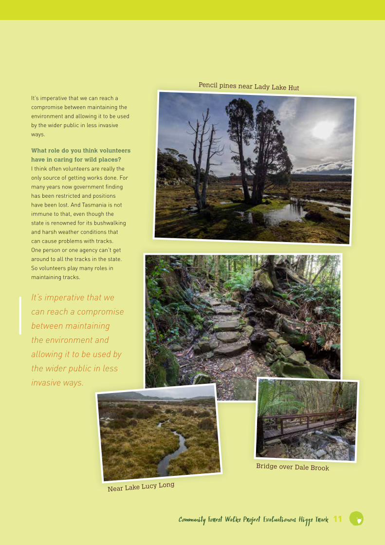
• Higgs Track climbs from Dale Brook Road, an offshoot of Westrope Road, to the vicinity of Lady Lake on the Great Western Tiers.
Recreational significance
The track:
• Provides access to Dale Brook, which is a short-walk destination in its own right.
• Traverses attractive wet forest and subalpine rainforest.
• Provides access to the Lady Lake Hut and the vicinity of Lady Lake.
• Continues as a rough track to Lake
Lucy Long, Lake Nameless and Ironstone Hut.
• Is used by bushwalkers and anglers.
• Allows access to the Central Plateau Conservation Area for walkers with companion dogs, subject to permit. (Note: This could change under the new TWWHA Management Plan, currently in preparation.)
• Is occasionally used to access a multi-day walk from the Higgs Track trailhead to the Walls of Jerusalem.
Other significance
• Higgs track was first cut in the late 1870s to allow farmers to drive cattle and sheep to and from alpine grazing land.
• The track provides access to the recently rebuilt Lady Lake hut, the original of which burnt down in 1961 having been built as an access for anglers in 1911; and to Ironstone Hut at Lake Nameless, which was originally built in 1918 and rebuilt in the 1990s.
Planned track upgrade
The project brief prescribed the following works:
• Upgrade the walking track to minimise erosion and repair sections of track damaged by erosion.
• Specific works to include local realignment, installation of stone waterbars at minor creek crossings, and stone pitching on a 60 metre deeply eroded section.

Community Forest Walks Project Evaluation: Higgs Track 7
Track classification prior to upgrade
• Rated by PWS as Class 4.
Planned track classification
• Class 3 for upgraded sections.
Works completion date
• August 2014
EVALUATION OF COMPLETED WORKS
Date of inspection
• 19 June 2016.
Location, extent and nature
• The 300m section between the trailhead and the Dale Brook footbridge has been surfaced with gravel and has rock edging in places.
• A rock retaining wall and gravel surface have been installed on the track immediately past the footbridge.
• Rock waterbars and drains have been installed at several small creek crossings, preventing the water from flowing down the track. Some rock steps and walling have also been installed at these locations.
• A 90m section has been intensively stabilised with a combination of stone pitching and rock steps. Dry stone walling has also been installed along much of this section.
Recreational and environmental benefits
• The works have effectively stabilised the affected sections, which were the most actively eroding sections of the track.
• The dry stone walling looks attractive and is a feature of the track in its own right.
• The works have improved user amenity by preventing these sections from turning into creeks after heavy rain, as was formerly the case.
Suitability and efficiency
• The completed works blend in well with the surrounding environment and complement the historic character of the track.
• The dry stone walls are likely to look ‘historic’ within a few years once moss and lichen become established on the stone.
• The dry stone infrastructure (particularly the retaining walls) is likely to be extremely durable and will require little maintenance.
Influence on overall track condition
• The works have significantly improved the stability and recreational amenity of the track.
Descriptive track classification
• Class 4. In many respects the track conforms to Class 3 standards, but the extended steep sections warrant a lower classification.
Recommended improvements – walking track
• Further surface hardening is required in places, particularly above the 800m contour.
• The section between the edge of the escarpment and Lady Lake Hut should be realigned onto the more stable ground on the south side of the moorland and hardened as necessary.
• The section immediately past the Dale Brook footbridge requires minor surface repair to replace material lost during the June 2016 flood.
Recommended improvements – road access
• None required.
Suggested location for ‘Significance to stakeholders’ sign
• At the trailhead.
INFORMATION FOR WALKERS
How to access the trailhead
• Access Westrope Road from Mole Creek or Chudleigh via Caveside, from Needles via Dairy Plains Road, or from Deloraine via Highland Lakes Road, Meander Road and Cheshunt Road.
• Follow Westrope Road for approximately 4 km, then follow the signs to Higgs Track.
• The trailhead car park is approximately 400m from Westrope Road.

8 Community Forest Walks Project Evaluation: Higgs Track
Walk length
• Dale Brook return: 600m / 30 minutes.
• Lady Lake Hut return: 4.5 km / 4-5 hours.
Walk difficulty
• The track surface is mostly fairly even but it is rocky and broken in places on the upper part of the ascent.
• Much of the track is steep and the track climbs 530m in a little over 2 km.
Track guide
• The track is easy to follow from the trailhead to the edge of the plateau.
• Just beyond the edge of the plateau the track emerges onto an open moorland. Lady Lake Hut is approximately 200m away and is clearly visible in fine weather. However the track is poorly defined across the moorland, so navigation could be tricky on this section if visibility is poor.
• On return from the hut, the start of the descent is marked by a cairn on the rocky rise on the eastern edge of the moorland.
• The track to Lake Nameless can be picked up on the slope south of Lady Lake Hut.
• The track to Lake Nameless is of a lower standard (Class 5-6). It is mostly marked but the markings are discontinuous and the track is poorly defined in places. Navigation can be difficult especially in snow or poor visibility.
• Lady Lake can be accessed by following the moorland for approximately 200m northwest from the hut.
Richea scoparia
View of Mother
Cummings Peak
Stone walling

Community Forest Walks Project Evaluationon: Higgs Track 9
STAKEHOLDER FEEDBACK
Kristina Nicklasonthere. A lot of people go up there for a day walk. And also the track itself: some of the work that’s been done there in the last three years is quite outstanding. There’s some really beautiful stonework that’s been done. And also on the way up you see some of the historical work that was done on the track.
What for you is the single most
important thing about this track?
The fact that it provides access to the plateau.
How successful was the project in
terms of improving this track?
It very much improved it. The area about halfway up that had the major work done on it was very eroded and it was like a river every time it rained, whereas now it seems very stable in spite of some heavy rains. And it’s also been beautifully done.
What were the highlights of the
project?
It was nice working together with a few local people, and also having some expertise. So we learned a few things about how to manage the track, especially how to keep water off it, how to work with stone. Just getting up there and doing something!
Were there any downsides or
things that could have been done
better?
I think basically that more work needs to be done. We did what we could in three sessions but there’s still a lot of work that could be done on that track.
Do you think this track could be
better managed, and if so how?
The main thing that a lot of us around here who go up there regularly are concerned about is the top of the track, where it goes across a very wet area of sphagnum bog on the edge of the escarpment to the hut. If it’s covered in snow you can’t see where there’s lots of channels going through and eroding the vegetation there.
What can be done to ensure this
track is adequately cared for into
the future?
We think that area requires some significant work, some boardwalk. We have actually engaged a consultant to give us a plan on what could be done. So we’ve got a plan, it’s just a matter of finding the money.
How important do you think
walking tracks are for fostering
our connection with nature?
Very important. Most people require a track, and it’s much safer to have a track than to go off-track to connect with nature. And it’s better that the tracks are reasonably well looked after because otherwise they deteriorate.
What role do you think volunteers
have in caring for wild places?
I think it’s probably essential given what I gather to be the funding situation. And there are a lot of tracks around that haven’t received any grant money or had any projects on them, that have probably been managed by volunteers in a bit of an ad hoc way over a long time. So it would be good to support volunteers with training and materials to continue to do necessary work.
What is your connection with this
track?
I live right near it, so it’s part of my backyard and something that I’ve enjoyed and walked on for a long time. I was also involved in the trackwork on Higgs Track as a volunteer through Environment Tasmania; I think we had three sessions and I worked on all of those.
How would you describe this
track to someone who intended to
walk it for the first time?
The Higgs Track would be the easiest track to access from Westrope Road or Western Creek because it’s had a lot of work done on it in the last two to three years. It’s well signposted, it has good access and it’s well marked. There’s a short, fairly flat walk into the Dale Brook and a bridge over that. After that it climbs fairly steadily for about two hours for an average person. It’s a pretty steady climb and gets steeper and quite rocky up near the top. Down the bottom you see mainly sassafras and myrtle rainforest and ferns, and as you get up further it dries out and you get waratah and hakea and things like that, and when you get up the top you have a view across a marshy area on the plateau to the Lady Lake Hut.
What do you think are the most
outstanding aspects of this track?
One of the things is that change of vegetation on the way up, which is really beautiful. And the Dale Brook area itself is a lovely place; some people just go that far for a picnic. The other thing is the access to the plateau and the hut and the lake up
. . . it would be good to support volunteers with training and materials to continue to do necessary work.

10 Community Forest Walks Project Evaluation: Higgs Track
STAKEHOLDER FEEDBACK
Volker MischkerWhat for you is the single most
important thing about this track?
I guess that it’s there and that it’s getting looked after by NGOs or volunteer groups or other agencies.
How successful was the project in
terms of improving this track?
I think it’s excellent. At the end of the day it’s not a pavement, it’s not a path around a café strip. It’s a bush area and I think people expect that and appreciate that. And therefore – I can only give my point of view – the people I associate with greatly benefit and appreciate any work that gets done to improve sections such as overhanging branches, prune things correctly, and improve any wet and boggy areas.
What were the highlights of the
project?
Just the people you meet. And you do give a little bit back. It’s not much to ask to go and spend a day. I would have been happy to spend more days and I’d be happy to go back. I do quite a bit of volunteering when I can fit it in. You always pick up a few skills and you meet good people. Also, coming from a conservation background I have an affinity for working in a park context, so for me it’s quite appealing.
Were there any downsides or
things that could have been done
better?
No, no downside at all; only that there could always be more.
Do you think this track could be
better managed, and if so how?
You could always argue ‘if there was more funding, if it came under the jurisdiction of this or that organisation’ – there’s always potentially a ‘yes’ for every track. But in reality it’s a bush track and it’s one of many. If interest groups are targeted as they were in this case, bushwalking clubs of friends-of groups or resident groups or whatever it might be, I guess that presents the best opportunity: to ‘adopt’ a track. And then hopefully, with the right state or federal government projects, for someone to facilitate two or three activities per year.
What can be done to ensure this
track is adequately cared for into
the future?
Leading on from the previous answer: targeting those user groups and making it attractive for other individuals who do have an interest. Sometimes you might only get six people attending, other times you might get 26. It’s a matter of having the opportunity, and that often is associated with funding. It’s a matter of it getting a guernsey in amongst the many other worthwhile projects around the state.
How important do you think
walking tracks are for fostering
our connection with nature?
I think they’re absolutely vital. There is always an impact on the environment, whatever user group you might be. But it’s a matter of – this is where track maintenance comes in – of minimising that impact, of allowing access for a whole host of user groups.
What is your connection with this
track?
Basically as a user with the Launceston Bushwalking Club, and I was involved in one of the two Environment Tasmania working bees.
How would you describe this
track to someone who intended to
walk it for the first time?
It’s an interesting track. By bushwalking standards I don’t think it’s difficult, it’s relatively straightforward and easy to follow. There are some really good improved sections; by Tasmanian standards it’s a fair to quite good track in that regard. A person walking that track certainly needs to be prepared for a range of weather conditions; the track has the potential to be muddy and slippery in places; and there are drop-offs in places. But you don’t need more than medium fitness levels, and providing you’ve got a bit of experience and general awareness, you will be fine.
What do you think are the most
outstanding aspects of this track?
Firstly that the track actually exists; and that improvements have been made in some of the wet and boggy and tricky areas, both from an environmental and from a user point of view. I think that’s excellent. There are some magnificent views, and it’s one of those tracks that has quite a magnificent destination [i.e. the plateau in the vicinity of Lady Lake Hut]. Depending on what a person’s interests are it has many interests along the way – if you’re interested in photography, if you’re looking for sightseeing, or for ultimately getting up onto the plateau.
Community Forest Walks Project Evaluationon: Higgs Track 11
It’s imperative that we can reach a compromise between maintaining the environment and allowing it to be used by the wider public in less invasive ways.
What role do you think volunteers
have in caring for wild places?
I think often volunteers are really the only source of getting works done. For many years now government finding has been restricted and positions have been lost. And Tasmania is not immune to that, even though the state is renowned for its bushwalking and harsh weather conditions that can cause problems with tracks. One person or one agency can’t get around to all the tracks in the state. So volunteers play many roles in maintaining tracks.
It’s imperative that we can reach a compromise between maintaining the environment and allowing it to be used by the wider public in less invasive ways.
Pencil pines near Lady Lake Hut
Near Lake Lucy Long
Bridge over Dale Brook

12 Community Forest Walks Project Evaluation: Higgs Track
Trackwork snapshots
Trackies Andrew, Pete, Beth, and Ursula in August 2014
Bridge over Dale Brook

Community Forest Walks Project Evaluation: Warners Track 13
3 Warners Track
CONTEXT
Track location
• Warners Track accesses the Adams Peak–Pine Lake area of the Great Western Tiers from Wiiteena Road south of Jackeys Marsh.
Recreational significance
The track:
• Traverses scenic forest ranging from regrowth wet forest to alpine rainforest.
• Provides opportunities for a day-return walk from Wiiteena Road or a through-walk to Highland Lakes Road via the Pine Lake area.
• Is popular among the local community and used by at least one local tourism enterprise.
Other significance
• Warners Track was built in the mid 1890s and was originally the only stock route linking Deloraine and Bothwell.
• The track provided access for droving sheep and cattle to and from grazing country on the Central Plateau.
• The track includes sections of impressive historic dry stone walling.
Planned track upgrade
The project brief prescribed the following works:
• Clearing vegetation and fallen timber from the track.
• Local repair to stone work and drainage.
• Construction of waterbars.
• Installation of a vehicle barrier near the trailhead.
• Works to be undertaken below the 800m contour.
Track classification prior to upgrade
• Class 5.
Planned track classification
• Class 3 for upgraded sections.
14 Community Forest Walks Project Evaluation: Warners Track
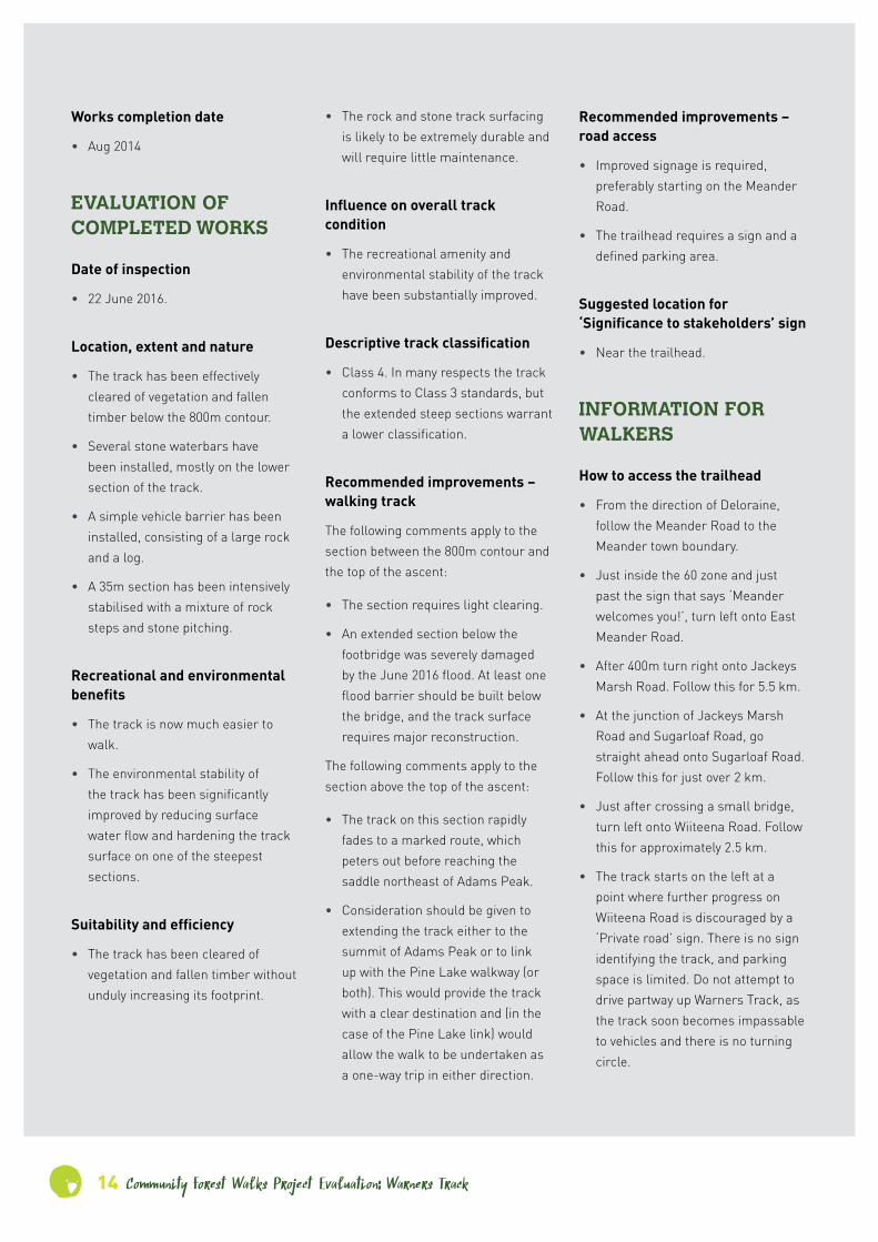
Works completion date
• Aug 2014
EVALUATION OF COMPLETED WORKS
Date of inspection
• 22 June 2016.
Location, extent and nature
• The track has been effectively cleared of vegetation and fallen timber below the 800m contour.
• Several stone waterbars have been installed, mostly on the lower section of the track.
• A simple vehicle barrier has been installed, consisting of a large rock and a log.
• A 35m section has been intensively stabilised with a mixture of rock steps and stone pitching.
Recreational and environmental benefits
• The track is now much easier to walk.
• The environmental stability of the track has been significantly improved by reducing surface water flow and hardening the track surface on one of the steepest sections.
Suitability and efficiency
• The track has been cleared of vegetation and fallen timber without unduly increasing its footprint.
• The rock and stone track surfacing is likely to be extremely durable and will require little maintenance.
Influence on overall track condition
• The recreational amenity and environmental stability of the track have been substantially improved.
Descriptive track classification
• Class 4. In many respects the track conforms to Class 3 standards, but the extended steep sections warrant a lower classification.
Recommended improvements – walking track
The following comments apply to the section between the 800m contour and the top of the ascent:
• The section requires light clearing.
• An extended section below the footbridge was severely damaged by the June 2016 flood. At least one flood barrier should be built below the bridge, and the track surface requires major reconstruction.
The following comments apply to the section above the top of the ascent:
• The track on this section rapidly fades to a marked route, which peters out before reaching the saddle northeast of Adams Peak.
• Consideration should be given to extending the track either to the summit of Adams Peak or to link up with the Pine Lake walkway (or both). This would provide the track with a clear destination and (in the case of the Pine Lake link) would allow the walk to be undertaken as a one-way trip in either direction.
Recommended improvements – road access
• Improved signage is required, preferably starting on the Meander Road.
• The trailhead requires a sign and a defined parking area.
Suggested location for ‘Significance to stakeholders’ sign
• Near the trailhead.
INFORMATION FOR WALKERS
How to access the trailhead
• From the direction of Deloraine, follow the Meander Road to the Meander town boundary.
• Just inside the 60 zone and just past the sign that says ‘Meander welcomes you!’, turn left onto East Meander Road.
• After 400m turn right onto Jackeys Marsh Road. Follow this for 5.5 km.
• At the junction of Jackeys Marsh Road and Sugarloaf Road, go straight ahead onto Sugarloaf Road. Follow this for just over 2 km.
• Just after crossing a small bridge, turn left onto Wiiteena Road. Follow this for approximately 2.5 km.
• The track starts on the left at a point where further progress on Wiiteena Road is discouraged by a ‘Private road’ sign. There is no sign identifying the track, and parking space is limited. Do not attempt to drive partway up Warners Track, as the track soon becomes impassable to vehicles and there is no turning circle.
Community Forest Walks Project Evaluationon: Warners Track 15
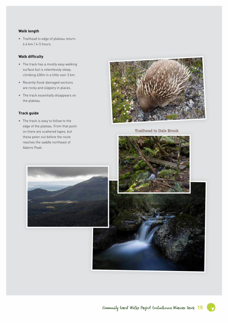
Walk length
• Trailhead to edge of plateau return: 6.4 km / 4-5 hours.
Walk difficulty
• The track has a mostly easy walking surface but is relentlessly steep, climbing 630m in a little over 3 km.
• Recently flood-damaged sections are rocky and slippery in places.
• The track essentially disappears on the plateau.
Track guide
• The track is easy to follow to the edge of the plateau. From that point on there are scattered tapes, but these peter out before the route reaches the saddle northeast of Adams Peak.
Trailhead to Dale Brook

16 Community Forest Walks Project Evaluation: Warners Track
STAKEHOLDER FEEDBACK
Sean CadmanWhat were the highlights of the
project?
I think the stone pitching work on the steep section; it’s very good. And also the stone drains that they put in at the bottom.
Were there any downsides or
things that could have been done
better?
The top of the track still needs work – there are erosion issues.
Do you think this track could be
better managed, and if so how?
The single biggest issue is the refusal by Parks to promote it. They won’t sign it or direct people to the track. There’s a huge increase in visitation onto the Tiers and it’s a no-brainer of a promotional opportunity. And people who walk up to the top of the track are going to want to get up to the top of Adams Peak. They put $50,000 worth of bridges in to nowhere! It’s an obvious thing to join it [Warners Track] up to the Pine Lake walkway and then actively promote it, so people can walk the track down from the top or up from the bottom. People could then do there-and-back or a car-shuffle circuit.
You can link the tracks by running around to the north of Adams Peak. You don’t have to run it down through the swamps and the pencil pines. That’s the old route anyway and there’s an old bombardier track there. Warners Track is a lovely track: the alpine area is stunning. The alpine vegetation there is in extraordinarily good condition.
What can be done to ensure this
track is adequately cared for into
the future?
I think we need to get a Wildcare group going. And then the big thing is signage. I’ve got ideas in terms of interpretive opportunities, which is what we’ve done at the base of Quamby [Bluff]. We take a high-level interpretive walk, and I’ve put posts with numbers on them which link to track notes. Warners Track is perfect for that sort of thing because there’s a great interpretive opportunity there. It’s one of the few places where the old settlers and the new settlers have a shared view that it’s a beautiful track and worth maintaining.
How important do you think
walking tracks are for fostering
our connection with nature?
Huge. On a scale of one to five it’s five. That’s the difference between our generation and a couple of generations below us, because the young generation don’t go walking. You’ve got to get people off their iPhone and iPad long enough to have a real experience rather than a vicarious one.
What role do you think volunteers
have in caring for wild places?
I think it’s really important but there’s an issue of capacity. People need to know what they’re doing; they need to be trained. Providing it’s attached to training and supervision I think it’s great.
What is your connection with this
track?
My wife Rosemary and I run Forest Walks Lodge at Jackeys Marsh. We promote the track to our guests and I lead parties up the track fairly regularly.
How would you describe this
track to someone who intended to
walk it for the first time?
The track itself is well made but there are some very steep sections. It’s definitely aerobic!
What do you think are the most
outstanding aspects of this track?
In terms of the cultural features there are beautiful sections of original drystone walling. The original pencil pine bridges were amazing but the replacements that the locals did are also pretty nice. Then there’s the gradation from tall wet forest up through alpine rainforest and onto the alpine vegetation. It’s a great altitudinal sequence.
What for you is the single most
important thing about this track?
It’s the relatively easy access. It’s easy to get to and it’s easy to walk. In terms of our business that’s the main thing.
How successful was the project in
terms of improving this track?
Very good, particularly on one of the steepest pitches where they did a lovely job of stone pitching. The work was done sensitively, it’s nice looking trackwork. We’ve had guests comment on it as well.
There’s a huge increase in visitation onto the Tiers and it’s a no-brainer of a promotional opportunity.
Darryl PeacockHow successful was the project in
terms of improving this track?
It made certain sections of it a lot easier, where they put some steps in. It made more of a difference going down that coming up, because you need to keep control of yourself on a steep descent. So it made the track much safer coming down.
What were the highlights of the
project?
We were never contacted about the working bees. If we had been I would have gone, but we didn’t know it was in progress.
Were there any downsides or
things that could have been done
better?
Not really. I walked the track about five years ago and found that the track had improved considerably since then. A lot of fallen trees that had been blocking sections had been cut and cleared.
Do you think this track could be
better managed, and if so how?
There should be a sign at the base of the track, letting people know where the start of the track is. And possibly a hint as to the elevation the track climbs to, the fact that it goes virtually up to Pine Lake. If more people used it you’d get more feedback [on the track condition]. I think a lot of people have trouble finding it. If it was better signposted I think it would have much higher use. That would benefit the track a lot I would think; the more people who use it the better.
What can be done to ensure this
track is adequately cared for into
the future?
I would suppose some sort of observation of the track on maybe a yearly basis, and some sort of ongoing maintenance. I doing think much maintenance will be required; basically only after heavy weather when there would be trees down. But it’s only the lower slopes that are going to suffer from wind damage. It probably doesn’t need maintenance every year; I’d say on a three-year cycle. If you’ve got people going up and down, they’d be able to observe it and report to someone if there was a problem with the track. I’d say a routine maintenance every three years, somebody to check that the bridges were fine and whatever.
How important do you think
walking tracks are for fostering
our connection with nature?
Extremely important, especially here in Tasmania which is quite diverse from the mainland. We used to live in Townsville, so when we came to Tasmania the flora and fauna down here are quite different. The vegetation and the habitat vary dramatically, and tracks are important for allowing people to see that. And the views that you get from these tracks as well.
What role do you think volunteers
have in caring for wild places?
I think eyes on the ground at a regular interval is one of the main things. And a lot of these volunteers live close by, so it’s not like there’s large travel times required. They can help out at short notice, and have a lot of their own equipment handy.
What is your connection with this
track?
We live adjacent to the start of the track and I walk up there every year or so.
How would you describe this
track to someone who intended to
walk it for the first time?
Not too difficult as long as you’re reasonably fit. Coming down’s quite easy, going up you have to have a few breaks. I took a 75-year-old up there. You’d want to be reasonably fit, average or a bit above.
What do you think are the most
outstanding aspects of this track?
The views, coming halfway up. If you go up in autumn, one of the best things I saw was about 30 or 40 different varieties of fungus growing, which was quite stunning. The fact that it follows the river course: it’s quite picturesque and you can go down to the river at different spots. The historical thing with the ramps that were constructed there, a fair way up the hill. The bridges. The view from the top. Access to Pine Lake from the top. And the variety of vegetation as you go from the lowland area up through the mid-level vegetation to the top where you get those ghostly gums, and then onto the alpine areas.
What for you is the single most
important thing about this track?
I think it’s historical value. The fact that it’s been there a certain length of time, and the early history of its use.
The vegetation and the habitat vary dramatically, and tracks are important for allowing people to see that.
Community Forest Walks Project Evaluationon: Warners Track 17

18 Community Forest Walks Project Evaluation: Warners Track
Ice on Pine Lake
Coral fungus
Pink mountain berry

Community Forest Walks Project Evaluationon: Warners Track 19
Trackwork snapshots

20 Community Forest Walks Project Evaluation: Big Tree/ Giant Walk
4 Big Tree/ Giant Walk
CONTEXT
Track location
• The track is located on the northeast slope of Lehners Ridge in the Blue Tier region, approximately 3 km southwest of Lotta and 25 km northwest of St Helens.
Recreational significance
The track:
• Traverses scenic wet forest including spectacular stands of tree ferns.
• Provides access to several giant eucalypts.
• Provides opportunities for easy walks of approximately 30-60 minute duration.
Other significance
• The development and maintenance of the track have been strongly supported by the Friends of the Blue Tier, a group of local residents who have campaigned to protect the Blue Tier region.
Planned track upgrade
The project brief prescribed the following works:
• Substantially realign the pre-existing loop track and upgrade it to Class 2/3 standard.
• Clear the entire track (apart from closed sections) of windfalls and encroaching vegetation.
• Partially realign the upper section from the trailhead to the water race and surface it with gravel to a width of 1200 mm. Install rock edging or a downslope rock retaining wall as required.
• Clear the section that follows the water race. (No other work was required on this section.)

Community Forest Walks Project Evaluation: Big Tree/ Giant Walk 21
• Survey, clear and bench a section of new track roughly parallel to and downslope of the water race, with a downslope rock retaining wall as required.
• Clear the sidetrack to the Big Tree.
• Install directional and interpretative signs and track markers.
Track classification prior to upgrade
• Not recorded, but probably Class 3-4.
Planned track classification
• Car park to water race: Class 2-3.
• Section along water race: Class 2-3.
• Remaining sections: Class 3.
Works completion date
• Nov 2014.
EVALUATION OF COMPLETED WORKS
Date of inspection
• 18 May 2016
Location, extent and nature
• The works listed in the previous section have all been completed.
• Length of new track: 1.0 km
• Length of existing track cleared: 1.4 km.
• The upper section from the trailhead to the water race (600m approximately) has been extensively benched and surfaced with imported gravel.
• Most of the new track has been benched.
• Numerous sections of benched track have been stabilised with downslope rock retaining walls.
• Some gravel track on level ground has been edged on both sides with rock.
• An attractive rock arch has been constructed at the point where the track crosses the water race.
• Redundant track sections have been effectively closed off and obscured from view.
Recreational and environmental benefits
• The track is now environmentally stable under current and likely future usage levels.
• The walk can be completed by visitors of average fitness.
• The track has been aligned so as to limit gradients (which are mostly less than 1 in 8) and to allow the entire walk to be constructed without steps.
Suitability and efficiency
• New sections of track have been aligned to optimise environmental stability and user enjoyment.
• The completed works blend in well with the surrounding environment.
• The rock infrastructure (edging and retaining walls) has already gathered moss and looks ‘historic’.
• The rock infrastructure is likely to be extremely durable and will require little maintenance unless damaged by major tree falls.
• Benching is relatively low-cost and in this environment will be durable with light ongoing maintenance.
• Much of the circuit has been left with a natural surface, which is likely to remain stable unless usage levels increase dramatically.
• Track construction costs have been minimised by avoiding the need for steps, which are costly compared to level or ramped track.
Influence on overall track condition
• The track is stable, conforms to the projected track classifications and offers a rewarding recreational experience.
Descriptive track classification
• See ‘Planned track classification’.
• Short sections of the track from the car park to the water race have gradients up to 10°. This is strictly steeper than the Class 2 specifications although it conforms to the PWS ‘W2’ standard.
View from inside the Big Tree
Friends of the Blue Tier sandstone slab
22 Community Forest Walks Project Evaluation: Big Tree/ Giant Walk
Recommended improvements – walking track
• Ongoing maintenance will be required to keep the track clear of windfalls. Some recent (post works) debris had fallen on the track at the time of inspection.
• Periodic maintenance may be required to reduce the amount of organic litter (bark, tree fern fronds etc.) on the track surface. Excessive litter build-up could make the walking surface slippery in places or could effectively bury the track.
• Some additional rock edging or downslope rock retaining walls may be required. (The outer edge of the track is getting worn away in places.)
• The interpretative signs may soon need maintenance or replacing as they appear to be getting damaged by specks of mould.
• The impact of trampling around the base of the tall eucalypts should be monitored, and elevated walkways should be installed if necessary.
Recommended improvements – road access
• A toilet is desirable at the trailhead car park, given its distance from the nearest available public toilets.
• The existing access road (unofficially called Lehners Ridge Road) is narrow, with limited opportunities for passing other vehicles. Access could be improved by widening the road.
• Sealing Lottah Road and the start of Lehners Ridge Road would make access more inviting particularly for visitors in rental cars.
Suggested location for ‘Significance to stakeholders’ sign
• Close to the rock-walled entrance portal at the trailhead. Note: Information about the significance of the track to stakeholders is already included on existing signs, so it is not necessary to duplicate this.
INFORMATION FOR WALKERS
How to access the trailhead
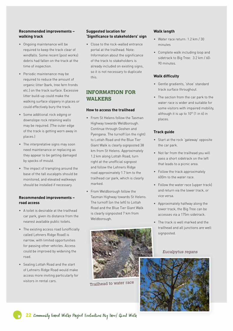
• From St Helens follow the Tasman Highway towards Weldborough. Continue through Goshen and Pyengana. The turnoff (on the right) to Lottah Road and the Blue Tier Giant Walk is clearly signposted 38 km from St Helens. Approximately 1.2 km along Lottah Road, turn right at the unofficial signpost and follow the Lehners Ridge road approximately 1.7 km to the trailhead car park, which is clearly marked.
• From Weldborough follow the Tasman Highway towards St Helens. The turnoff (on the left) to Lottah Road and the Blue Tier Giant Walk is clearly signposted 7 km from Weldborough.
Walk length
• Water race return: 1.2 km / 30 minutes
• Complete walk including loop and sidetrack to Big Tree: 3.2 km / 60-90 minutes.
Walk difficulty
• Gentle gradients, ‘shoe’ standard track surface throughout.
• The section from the car park to the water race is wider and suitable for some visitors with impaired mobility, although it is up to 10° (1 in 6) in places.
Track guide
• Start at the rock ‘gateway’ opposite the car park.
• Not far from the trailhead you will pass a short sidetrack on the left that leads to a picnic area.
• Follow the track approximately 600m to the water race.
• Follow the water race (upper track) and return via the lower track, or vice versa.
• Approximately halfway along the lower track, the Big Tree can be accesses via a 175m sidetrack.
• The track is well marked and the trailhead and all junctions are well signposted.
Eucalpytus regans
Trailhead to water race

Community Forest Walks Project Evaluationon: Big Tree/ Giant Walk 23
STAKEHOLDER FEEDBACK
Beris HansberryWhat were the highlights of the
project?
The involvement of the community and the fact that it was actually happening. We found it difficult to believe that it was actually happening and being done at such a high quality.
Were there any downsides or
things that could have been done
better?
No. We get extreme weather events here; we’ve just had one but the track is okay.
Do you think this track could be
better managed, and if so how?
Well it’s not really being managed at all because there’s only two Parks people for thousands of hectares. So we manage the track and maintain it. But we also get help from the Green Army through the North East Bioregional Network. If there’s stuff there that’s too big for us women, who are all over 50 and up to nearly 70, we ask the Green Army now and they come and saw things up. And they love it. It’s a good experience for those guys to get up from the coast doing weeding, and into magical bush with four-metre-high tree ferns and all that. The track is really good; I don’t think we’ve ever heard a complaint.
What can be done to ensure this
track is adequately cared for into
the future?
It just needs maintenance, and that would have to be local people. Maintenance is the big thing.
How important do you think
walking tracks are for fostering
our connection with nature?
Hugely important. We’ve had people we know to be logging, clearfelling rednecks who go in there and they come out and say, ‘Aw gee, that was bloody beautiful!’. And local people love it.
What role do you think volunteers
have in caring for wild places?
I think they have a huge role because if they’re caring for wild places they’re learning about what’s in wild places and what’s in the ground and what’s in the air. They get a much greater awareness of it and then they get the idea of ‘Right, now I know what people were talking about; we need to maintain this and keep these areas as much as possible’. And that includes appreciating the intrinsic, non-human values of what’s there. You don’t need anything extra, no things to put your face in for a photo, no stalls; it’s just the magic of real nature. That’s how we feel and that’s why we spent nearly 20 years working the protect this place.
What is your connection with this
track?
I was part of a group of people who started fighting to protect this area over 16 years ago. We fought Forestry on the grounds of catchment protection etc., and we kept them at bay until the Forests Agreement. It’s now a well-known walking track under the control of Parks, and we do the maintenance on the track.
How would you describe this
track to someone who intended to
walk it for the first time?
I’d call the Big Tree Track [i.e. Giant Walk] very high quality.
What do you think are the most
outstanding aspects of this track?
Mostly a feeling of awe and also a feeling of tranquillity. It’s quite amazing, a different world really.
What for you is the single most
important thing about this track?
For us the track finally meant that the area was never going to be logged.
How successful was the project in
terms of improving this track?
It was unbelievable. The track that we put in originally went more or less straight down and it was quite steep in places. The new track that John [Hughes] put in follows the contour of the land. We got a wheelchair halfway down with a 14 stone [89 kg] man in it. It’s a million times better than what we had. It’s the highest standard track I’ve seen actually.
. . . if they’re caring for wild places they’re learning about what’s in wild places and what’s in the ground and what’s in the air.
Sassafras trunk

24 Community Forest Walks Project Evaluation: Big Tree/ Giant Walk
STAKEHOLDER FEEDBACK
Lesley NicklasonWhat for you is the single most
important thing about this track?
We’re still hoping that it’s saved that valley. [Liberal MHA for Lyons] Eric Hutchinson opened the track, and when I asked him, ‘Does that mean that this is now not a logging coupe?’ he said, ‘Not necessarily.’ If it hadn’t been for the moratorium through the Forests Agreement, it would be gone. They’d taped the coupe next to it and they’d built the road. It was absolutely critical timing that that happened.
How successful was the project in
terms of improving this track?
A hundred per cent. We never intended to build ‘the’ track, we just wanted to be able to show people the valley.
What were the highlights of the
project?
Having the track approved. And the outstanding work by that group of people. In April-May in terrible conditions they camped in there and they built that in no time at all; I think it was eight weeks from go to whoa. We didn’t have to wade through any paperwork at all. It was all fantastically organised, and it was completed.
Were there any downsides or
things that could have been done
better?
No. Well, we put the picnic table in but that wasn’t really part of the track building. And the little stools were carved by an amazing woman while it was hailing; she’s a doctor and does all sorts of other amazing things, but she can also carve little stools with a chainsaw in the worst weather imaginable.
Do you think this track could be
better managed, and if so how?
I don’t think it could be any better managed. There’s a group of us middle-aged women and we are absolutely committed to maintaining it, and we go out there after every weather event and clear off stuff. Last week there were a few treefalls from a big wind and we hijacked a Green Army project for a day, and they came along cheerfully and helped clear the track. So while we’re still able it’s managed by the community. The only downside is that they were so reluctant to put in signs so people can actually find it. We put that sign at the top of the Weldborough Pass, and then someone flogged the sign where you turn down, so we’ve replaced that. It’s a pretty ugly one but we’ve got a much better one happening.
What can be done to ensure this
track is adequately cared for into
the future?
If we can keep doing what we do, doing most of it ourselves and having someone else available when there’s a big weather event, that’s all it needs.
What is your connection
with this track?
We found the [Big] tree in 2002 and put a rough track in because it was a logging coupe that was scheduled to be clearfelled. We took people there over all those years, kept on campaigning for it, and through all that effort that track was picked to be properly upgraded a couple of years ago.
How would you describe this
track to someone who intended to
walk it for the first time?
It’s very well made. It does descend into a valley but it’s not terribly steep. The feedback from most people in our [visitors’] book is people say it’s the best track they’ve ever been on.
What do you think are the most
outstanding aspects of this track?
The little arch bridge! It’s sensational! It’s a lot better than the rough few boards we had across the water race. The stonework is just outstanding. We’re completely blown away by the signage along the track because it actually tells the community story rather than any other story. That was pretty spectacular.
And while the track’s beautiful, the area is part of the Groom River Valley, the headwater of the Groom River that’s protected by that track. That was always our main thing, to save the catchment of the Groom River which was the last intact catchment of the whole George River system.
We’re completely blown away by the signage along the track because it actually tells the community story rather than any other story.
Community Forest Walks Project Evaluationon: Big Tree/ Giant Walk 25
How important do you think
walking tracks are for fostering
our connection with nature?
Extremely important. I’ve taken people in there that have changed their whole mind, how they look at things. It’s a fantastic way to show people what you’re talking about especially with that track. When we said the Big Tree was a feature people scoffed at it a bit, but when they went there they couldn’t believe it. I think it’s critical. We’ve delivered lots of educational sessions on the track while taking people on the walk. It’s the best way to explain your position on the logging of it and the need to protect it.
What role do you think volunteers
have in caring for wild places?
What we do as volunteers: we take care of the track, we promote it, we do weeding if necessary, we pick up all the rubbish and we’re lobbying to get a toilet. That’s our latest campaign. So volunteers play a huge role.
This hand-built track weaves unobtrusively through the landscape to a junction that divides into the Giant Tree path, and a longer return-circuit.
In addition to its stunning valley and fern-forest views, the loop track passes a number of striking tall trees, such as the ‘Cradle Tree’. It also crosses a restored bridge over an agricultural water race.
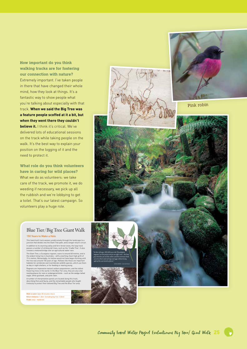
The Giant Tree, a Eucalyptus regnans, soars to around 60 metres, and is the widest living tree in Australia – with a startling chest-high girth of 19.4 metres. Remarkably, its hollow would not have begun forming until the tree was around 150 years of age. Hollows like these are important habitats for vertebrate and invertebrate wildlife species, which use them as day or night shelters, or for feeding or rearing young.
Regnans are impressive natural carbon sequesterers, and the tallest flowering trees in the world. In the Blue Tier area, they are also vital nesting places for rare or endangered birds – such as the wedge-tailed eagle, white goshawk, and pink robin.
A number of interpretation panels are located along this track, describing flora and fauna, and the remarkable people who fought tirelessly to protect their beloved Big Tree and the Blue Tier area.
Blue Tier/Big Tree Giant Walk150 Years to Make a Hole
Walk to water race: 30 minutes return
Return distance: 1.2km (including big tree: 3.2km)
Grade: easy – moderate
“In their old ages, 300-600 years old, [eucalyptus regnans] are the perfect site for an eagle’s nest – the bare, grey branches jut out like antlers and the enormous birds can sit on their stash of twigs and eggs without losing sight of the vast stretch of forest.”
aNNa KrieN – into the Woods
Pink robin
26 Community Forest Walks Project Evaluation: Big Tree/ Giant Walk
Trackwork snapshots

Community Forest Walks Project Evaluation: Arm River Track 27
5 Arm River Track
CONTEXT
Track location
• The track accesses the central Overland Track from forestry roads in the western Mersey Valley.
Recreational significance
The track:
• Is the Overland Track’s primary side-access track.
• Provides the easiest and fastest access to the Pelion Range and its surrounding country. (The Forth Valley Track is of comparable length, but it is less well maintained and its trailhead is accessible only via 12 km of ORV-standard vehicular track.)
• Provides access to Mt Pillinger and Lake Price, which are attractive as day-trip destinations. (Note: Access to Mt Pillinger is via a Class 6 sidetrack.)
• Is a potential component of a loop walk via Lake Ayr, the Reedy Lake Track and the Lees Paddocks Track.
• Provides access to the southern region of February Plains.
• Provides a potential exit route for Overland Track walkers who are unable to complete the walk south or north from the Pelion area.
• Traverses attractive dry-eucalypt forest and woodland, grading to wet forest on some sections.
• Provides access to and close views of the Arm River, an extended section of which comprises a sequence of small falls and cascades.
Other significance
• The track provides access to the location and remnants of historic trappers’ huts in the Wurragarra Creek area.
Planned track upgrade
The project brief prescribed the following works:
• Upgrade the walking track to minimise erosion and repair sections of track damaged by erosion.

28 Community Forest Walks Project Evaluation: Arm River Track
• Reduce track gradient to improve walker comfort and discourage use of the unofficial track to Arm River via Maggs Spur 17-2.
• Specifically, the brief prescribed the survey and construction of a number of switchbacks that would reduce the grade as well as taking the track closer to the creek (Arm River) in places.
• The track was to be stabilised with dry stone walling as necessary.
• The track width was to be less than 800 mm.
Track classification prior to upgrade
• Class 3.
Planned track classification
• Class 3
Works completion date
• March 2015
EVALUATION OF COMPLETED WORKS
Date of inspection
• 31 May 2016 - 2 June 2016
Location, extent and nature
• The track realignment and upgrade have been completed as planned.
• The main section of realigned track on the ascent is approximately 260m long.
• This section comprises benched switchbacks with gradients mostly less than 10° (1 in 6) but up to 20° (1 in 3) in places.
• Extensive sections of the new benching have been stabilised with dry stone walling on the downhill side. In a few places dry stone walling has also been used to stabilise the bank above the track.
• Isolated rock steps have been installed.
• All or most of the original track on this section has been replaced
• Redundant track sections have been closed and covered with organic material.
• Isolated sections of rock stepping stones and turnpiking with rock edging have been installed on the level traverse between the trailhead and the base of the ascent.
Recreational and environmental benefits
• The installation of switchbacks has substantially improved the walking experience, replacing the original ascent which was relentlessly and excessively steep.
• The track has been aligned so as to ‘weave’ through the landscape, giving the sense that one is engaging with the natural environment instead of just ploughing through it.
• The track construction has a rustic and ‘natural’ appearance, allowing the track to blend in aesthetically with the surrounding environment.
• The reduction of track grades and the realignment of the track away from the fall line will reduce trampling abrasion and largely eliminate water flow along the track, thereby substantially reduce the rate of track erosion.
• The track realignment brings walkers close to the creek (the Arm River) in several locations, allowing them to see the creek and the adjacent gully.
Suitability and efficiency
• The completed works blend in well with the surrounding environment.
• The dry stone infrastructure (particularly the retaining walls) is likely to be extremely durable and will require little maintenance.
• Benching, although moderately expensive in steep and rocky terrain, will be extremely durable with light ongoing maintenance.
• The track has been left unsurfaced, which is appropriate given the high proportion of rock and stones in the soil.
• The switchbacks have been sited and designed so as to minimise the likelihood that walkers will cut corners. (At the time of inspection there was no evidence that walkers had done so.)
• The length and orientation of the switchbacks was to a large extent constrained by the ruggedness of the terrain and by features such as rock outcrops and large trees.
Influence on overall track condition
• The works have dramatically improved the enjoyment of walking the track and have largely eliminated the risk of track erosion on the upgraded sections.
Descriptive track classification
• Class 3.

Community Forest Walks Project Evaluationon: Arm River Track 29
Recommended improvements – walking track
• The log crossing near the base of the ascent should be supplied with a Type C handrail as recommended in the engineering assessment.
• Some additional drainage is required on the level traverse between the trailhead and the base of the main ascent, mainly to reduce water flow over the track.
• At present the unofficial track from Maggs Spur 17-2 offers the most direct access route to Mt Pillinger. To further discourage its use it would be advisable to (a) reopen, re-cut and lightly upgrade the sidetrack (currently Class 6) along the upper part of the Arm valley to the base of Mt Pillinger, (b) signpost the start of this sidetrack and (c) close the Maggs Spur road.
Recommended improvements – road access
• Clearer signage is required at the junction of the Maggs and Arm Roads. The present signs do not make it clear that the Arm Road is impassable, and confuse matters by referring to the Arm River Track as the ‘East Pelion Track’.
• Access roads should be kept clear of obstructions and in a condition suitable for 2WD access. At the time of inspection Maggs Road (which is now the only access route to the Arm River Track) was partially blocked by a tree fall.
Suggested location for ‘Significance to stakeholders’ sign
• Either just past the washdown station or just before the first section of new work – i.e. the stepping stones a few hundred metres from the trailhead.
INFORMATION FOR WALKERS
How to access the trailhead
• The Arm Road no longer provides access to the Arm River Track, as the bridge over the Arm River is unusable and the road has been blocked off. Access is via Maggs Road only, which accesses the southern end of Arm Road.
• Access the Mersey Forest Road via Mole Creek, Moina or Gowrie Park.
• Shortly after the road surface changes to gravel, turn right at the signposts to Maggs Road and the Arm River Track.
• After driving along Maggs Road for approximately three and a half kilometres, veer left and stay on Maggs Road at its junction with the Arm Road.
• Follow Maggs Road for approximately 13 km until you come to a point where the road had been blocked off by an earth barrier.
• Turn left immediately before the barrier (technically you are now on Arm Road) and drive approximately 800m to the trailhead car park.
Note: As of mid-July 2016 the upper Mersey Forest Road and the Arm River Track are inaccessible due to damage caused by the June 2016 floods.
Walk length
• Lake Price return: 5.5 km / 2½ hours
• Mt Pillinger return: 9 km / 6-7 hours
• New Pelion Hut return: 22 km / 2 days
Walk difficulty
• Consistent with Class 3 classification.
• The climb to the plateau involves a 200m altitude gain, now less daunting thanks to the recent realignment and upgrade.
• Mostly ‘dry boot’ standard as far as Lake Price, but with some shallow mud and water.
• The creek near the trailhead may require wading and could be difficult to cross after substantial rain.
Track guide
The following guidelines apply only to the section between the trailhead and Lake Price.
• The track is easy to follow under normal conditions but could be obscure on the plateau if covered by snow.
• The options for camping are limited in the vicinity of the track. There is an informal campsite at Lake Price, but this is poorly drained and its use would contribute to environmental damage to the lakeshore vegetation. The best emergency shelter can be found in the rainforest that the track traverses immediately northwest of Lake Price.
• The track to Mt Pillinger branches south at approximately the 940m contour. As of June 2016 this track was unmarked and fairly overgrown, but could be followed with careful observation. The section on the ascent of Mt Pillinger is better defined and clearer of vegetation.

30 Community Forest Walks Project Evaluation: Arm River Track
STAKEHOLDER FEEDBACK
Nick ClarkWhat is your connection with
this track?
Currently I’m a guide on the Overland Track. We do four-day itineraries from Waldheim to Arm River, bringing groups out by the Arm River Track. For the last few years all of my trips on the Arm River Track have been as a guide, but I’ve walked it a few times personally as well – the first time maybe twelve years ago.
How would you describe this track
to someone who intended to walk it
for the first time?
Beautiful. If you’re planning to do the Overland it’s a really nice addition to that. You get some really interesting landscapes that you don’t see from the Overland Track. In terms of quality it’s a similar standard as the Overland, so when we have guests that’s usually how we’d explain it to them. We used to caution guests about the big descent at the end, but with the trackwork that’s been done that’s definitely less of an issue than it has been in the past.
What do you think are the most
outstanding aspects of this track?
On a clear day the view up through Mt Pillinger and up the upper Mersey to Cathedral [Mountain] is gorgeous. It’s really beautiful country. And some of the tarns and pencil pine areas are really lovely.
What for you is the single most
important thing about this track?
The obvious benefit of it is having that access, a day’s or half-day’s walk, straight into the middle of the park. The options that that opens up are fantastic, whether you’re a recreational walker or a commercial group.
Probably the single biggest thing is being able to do Mt Ossa as a long weekend.
How successful was the project in
terms of improving this track?
I think it’s immeasurably better.
Were there any downsides or things
that could have been done better?
From what I’ve seen of the outcome, no.
Do you think this track could be
better managed, and if so how?
The track itself, no. Given that in many ways it’s a secondary track to the Overland, I think it’s very well managed. It’s better managed have I would have expected. The only thing is, the vehicle access to the bottom end isn’t great; especially for us as a commercial company that’s probably the biggest issue that we have. There have been issues with bridges before the current situation*. The current [pre-flood] access is across Maggs Mountain, which isn’t a very good road. Getting in there now can be quite confusing with all the forestry tracks going everywhere. The road condition is an issue, and road signage as well. The quality of the track feels like it should be getting quite a lot of usage, whereas the quality of the road access doesn’t match that. [*At the time of the interview the Arm River Track trailhead was inaccessible by vehicle due to flood damage.]
What can be done to ensure this
track is adequately cared for into
the future?
Having it under the same kind of management regime at the Overland would probably help: treating it as part of that network rather than as a standalone feature, and giving it the attention that it
would deserve as part of that. As for the access, maybe having the road in the Arm River Valley managed as an access route.
How important do you think
walking tracks are for fostering
our connection with nature?
Massively important. Having the ability to get guests away from the roadways and away from their cars, beyond the five-minute walks that you can do; being able to get visitors to the state and locals into remote parts of Tasmania, which I guess is what’s really special about Tasmania – I think that’s incredibly important if you want to have that kind of awareness of these places, which is what you need to make people want to protect them. So in terms of conservation I think they’re hugely important, and in terms of people getting into wilderness they’re vital.
What role do you think volunteers
have in caring for wild places?
I think a really big role. This might be more relevant to some of the other tracks in the Community Forest Walks Project. Organisations like Parks are never going to have enough money or resources to look after everything in a place like Tasmania, so having really strong community groups that want to look after their local tracks: I think being able to develop that and maintain that is probably the best way to have a comprehensive track system that can be used by everyone. If we were completely reliant on Parks or other professional agencies I think the track system would be nowhere near what it could be.
Organisations like Parks are never going to have enough money or resources . . . so having really strong community groups that want to look after their local tracks . . . is probably the best way.

Community Forest Walks Project Evaluationon: Arm River Track 31
STAKEHOLDER FEEDBACK
Paul BanksWhat is your connection with
this track?
I work for a guided-tour company that uses the Arm River Track to restock our cache of supplies at Pelion. I have used the Arm River track a lot, though getting less each year.
How successful was the project in
terms of improving this track?
The new track is good. It should take pressure of other tracks in the area. There’s a few rest spots/seats on the climb for the old timers, and I like where it was planned to meet the creek for the thirsty. I think the trackies did a good job. Natural timbers are a waste of time but it’s great to see funding for stonework.
Were there any downsides or
things that could have been done
better?
I am concerned that upgrades at the more accessible end of tracks could compromise the conservation of more fragile areas deeper into the park. These reserves are protected. Even if interest tripled I don’t see it having a great effect on voting patterns or mandates. I can only see the promotion of increasing overuse and by people who really should know better. Also, I can’t separate the upgrade of a bit of track, in a relatively stable area, from the loss of the lower half of the ring road circuit/access [resulting from the closure of the Arm River Road]. This forces traffic to elevations encountering snow, along an avenue of wattle that seem to blow down at the hint of a storm.
Do you think this track could be
better managed, and if so how?
I’m sure you recognise the value of leaving work on the road/access end of tracks till last, in these areas. I’d hope such concerns are at least considered in conjunction with Parks and Wildlife. I’d hope that the broader context is carefully considered before giving wholehearted support to any track works. Track upgrades are going to be popular (especially among bushwalkers) but they always have wider implications further in to parks. I wonder if the best long term environmental outcome wouldn’t be better served by encouraging the use of these fringe areas themselves, rather than just easy access to walking and to places infinitely more fragile.
How important do you think
walking tracks are for fostering
our connection with nature?
At the end of the day, I feel uneasy with anyone encroaching further into our wilds – individuals, corporations, NGO’s, anyone. The projects can sound perfectly envisaged, planned and executed, motivations can be borne from love for the bush no doubt…yet something is still ‘wrong’, these places don’t get any more perfected by us.
The new track is good. It should take pressure of other tracks in the area.

32 Community Forest Walks Project Evaluation: Arm River Track
Lake Price
Sphagnum moss
Pencil pine north of Wurragarra Creek
Barn Bluff and Cradle
from Mt Pillinger

Community Forest Walks Project Evaluationon: Arm River Track 33
Trackwork snapshots

34 Community Forest Walks Project Evaluation: Halls Falls Track
6 Halls Falls Track
CONTEXT
Track location
• Halls Falls are on the Groom River south of Blue Tier, approximately 20 km northwest of St Helens.
• The track connects the Halls Falls Track car park on Anchor Road to a viewing platform above Halls Falls; to a point by the river at the base of the falls; to rock pools above the falls; and to a historic weir.
• A 650m track duplicates the main track from the trailhead, providing a loop option back to the car park.
Recreational significance
The track:
• Provides opportunities for short (1-2 hour) walks of low to moderate difficulty.
• Traverses attractive wet forest.
• Provides access to Halls Falls and other scenic features on the Groom River.
Other significance
• The track provides access to historic features including evidence of past logging and a late-19th-century weir upstream of Halls Falls.
Groom River from lookout
Community Forest Walks Project Evaluation: Halls Falls Track 35
Planned track upgrade
The project brief prescribed the following works:
• Clear all sections of the track of encroaching vegetation and windfalls.
• Replace a short section of rotting duckboard over the small creek between the car park and the lookout with rock paving and stepping stones.
• Improve the section between the small creek and the viewing platform by recutting benching, constructing a rock lower retaining wall, and installing some rock steps.
• Replace the tree fern steps on the lower part of the section between the viewing platform and the base of the falls with rock steps.
• Re-bench the section from the viewing platform to the weir as necessary.
Track classification prior to upgrade
• Car park to viewing platform (including loop): Class 3.
• Viewing platform to base of falls: Class 4.
• Viewing platform to rock pools & weir: Class 3.
Planned track classification
• Retain existing classifications.
Works completion date
• Sep 2015
EVALUATION OF COMPLETED WORKS
Date of inspection
• 17 May 2016
Location, extent and nature
• The entire track has been cleared (total length 1.8 km).
• The creek crossing has been hardened with rock paving and stepping stones.
• Much of the section between the small creek and the viewing platform (total length approximately 130m) has been stabilised with benching and a rock lower retaining wall. Some rock steps have also been installed.
• A continuous flight of rock steps (horizontal length approximately 20m) has been installed on the lower part of the zigzag descent to the base of Halls Falls.
• The section between the viewing platform and the weir is now adequately benched.
Recreational and environmental benefits
• The track has been made more accessible to walkers and more pleasant to walk on.
• The track is now environmentally stable. Minimal erosion is likely in the foreseeable future providing the track is adequately maintained.
• The creek crossing is stable and can be crossed with dry footwear in normal conditions.
Suitability and efficiency
• The completed works complement the pre-existing track infrastructure and blend in with the surrounding environment.
• The rock infrastructure (steps, paving, stepping stones and retaining walls) is likely to be extremely durable and will require little maintenance.
• Benching is relatively low-cost, and in this environment it will be durable with light ongoing maintenance.
Influence on overall track condition
• The entire track is now stable and the walking difficulty is commensurate with the track classifications.
Descriptive track classification
• As per ‘Track classification prior to upgrade’.
• Short sections of the track from the car park to the viewing platform have gradients up to 20°. This is steep by Class 3 standards is but acceptable under the track classification.

36 Community Forest Walks Project Evaluation: Halls Falls Track
Recommended improvements – walking track
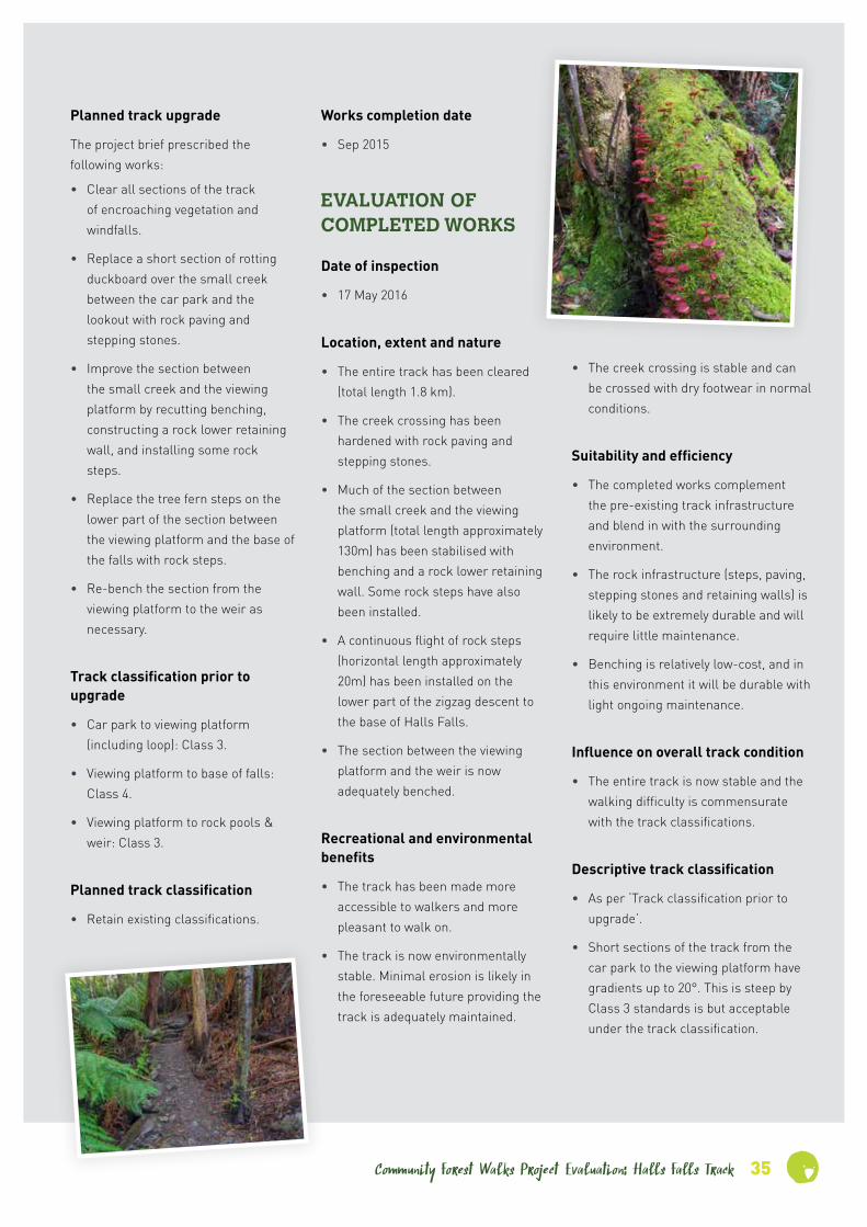
• Ongoing maintenance is required to keep the track clear of windfalls. Some recent (post works) debris required clearing at the time of inspection.
• Minor maintenance is required to repair or replace some timber risers (which predate the recent works).
• A few steps are required on the sidetrack that descends to the rock pools.
• Directional signs are required at the sidetrack to the rock pools and at the weir (where an unsigned track continues up the valley).
• An interpretative sign would be useful to explain the significance of the tram wheels near the trailhead.
• The bench on the viewing platform is rotten and needs replacing.
• The option should be considered of constructing an additional sidetrack accessing the cascades between the viewing platform and the rock pools.
• The directional signpost beside the interpretation booth at the trailhead should be relocated closer to the trackside.
Recommended improvements – road access
• Sealing Anchor Road would make access more inviting particularly for visitors in rental cars.
• A roadside sign is required to direct visitors off Anchor Road into the trailhead car park.
• A toilet is desirable at the trailhead car park, given its distance from the nearest available public toilets.
Suggested location for ‘Significance to stakeholders’ sign
• Either in the interpretation booth or beside the track immediately past the booth.
INFORMATION FOR WALKERS
How to access the trailhead
• From St Helens follow the Tasman Highway towards Weldborough. Continue through Goshen and past both turnoffs to Goulds Country and Blue Tier. The turnoff (on the right) to the Halls Falls Track is clearly signposted 24 km from St Helens. Follow Anchor Road for approximately 1 km. The trailhead car park is on the right hand side.
• From Weldborough follow the Tasman Highway towards St Helens and continue through Pyengana. The turnoff (on the left) to the Halls Falls Track is clearly signposted 21 km from Weldborough.
Walk length
• Falls lookout return: 1.5 km / 30 minutes.
• Weir return: 2 km / 45 minutes
Walk difficulty
• Trailhead to lookout: Easy but with short moderately steep sections.
• Lookout to base of falls: Steep with numerous steps.
• Lookout to weir: Easy but the track is fairly narrow in places.
• Steep descent on sidetrack to rock pools.
Track guide notes
• Start at the interpretation booth (i.e. the small roofed structure) near the eastern edge of the car park.
• Follow the track approximately 750m to the junction at the viewing platform.
• The track on the right descends steeply via a couple of switchbacks to the base of the falls.
• The track on the left leads upstream to the historic weir, with a short sidetrack to rock pools downstream of the weir.
• On the way back from the viewing platform, a 650m interpretative trail provides an alternative return route to the car park. Turn left at the ‘Loop walk’ signpost.

Community Forest Walks Project Evaluationon: Halls Falls Track 37
STAKEHOLDER FEEDBACK
Kym MatthewsWere there any downsides or
things that could have been done
better?
No, I’m thrilled by the improvement to it. They’ve done just enough. I don’t like this large-scale manicuring of bush systems and I thought it was very tastefully done and very timely.
Do you think this track could be
better managed, and if so how?
It needs to have regular maintenance because that’s why it got into such a state. Because we work in a public facility under Council auspices, and because we’ve got the visitor information centre here in the same building, we must be mindful of the condition of tracks when we suggest places to visit. That’s why it was crucial to get some works done in the area. There’s a similar situation with the track to the historic Anchor Stampers: we can’t advise people to go there because of the degraded condition of the track, and if we haven’t got approval from State authorities like Parks and Wildlife to send people there then our hands are tied. There are many beautiful walks in this area; we just have to be able to promote them.
What can be done to ensure this
track is adequately cared for into
the future?
Regular maintenance. The Green Army’s input has been most welcome and they’ve done a fantastic job on the Halls Falls and Giant Walks. We need to engage in more facilitative processes between groups that are more than willing to help. It’s our history and it’s important to us.
How important do you think
walking tracks are for fostering
our connection with nature?
Hugely important. The trouble is that most people don’t have a connection; they are removed from their food source and from the natural world because they get bogged down with the minutiae of life.
What role do you think volunteers
have in caring for wild places?
I think volunteers are under-utilised. It’s great to go the places where volunteers are active and know that they’re in good hands. The trouble with the Northeast is that it tends to be overlooked by the rest of the state with these projects.
What is your connection with
this track?
I am curator of the St Helens History Room. We were involved with a number of other community groups with consolidating the Halls Falls Track, doing work on it and promoting it.
How would you describe this
track to someone who intended to
walk it for the first time?
I would probably advise them that it is off-road, there are no facilities apart from a lovely parking spot, and that it can be a challenging walk.
What do you think are the most
outstanding aspects of this track?
The beauty, although it’s not in a pristine state. The track’s not manicured like the Wineglass Bay Lookout Track for instance, so it’s in a ‘raw’ state. And the track has heritage value because of the historic tin mining and sawmilling in the area.
What for you is the single most
important thing about this track?
That you can gain access to the water systems, such as the [historic] weir.
How successful was the project in
terms of improving this track?
Very successful. I’ve walked it before and after the improvements, and it’s been very successful in terms of the ease of access, removing the obstacles and making it a much safer and much more inviting place to walk.
What were the highlights of
the project?
That is was actually done! I wasn’t involved with the works on this track, although I was involved with the works on the Giant Walk. We volunteered our time there for a whole day.
Kangaroo fern
Weir from rockpools

38 Community Forest Walks Project Evaluation: Halls Falls Track
STAKEHOLDER FEEDBACK
Dan DonaldsonHow successful was the project in
terms of improving this track?
Very successful. It was getting pretty bad. I didn’t see it before the work but you could see where people had been making their own tracks, and all that seems to have stopped. It’s only been a year but it’s held up really well, all the work that was done there by Snapper [John Hughes] and his crew last year. He’s a master. Once they’ve done their work it looks like it’s been there ten years; you can’t really tell what’s fresh and what’s not.
What were the highlights of the
project?
For us, working with Snapper and his crew was the highlight. We do mainly a lot of weeding, chopping down pine trees and killing Spanish heath and so forth. So it was good to be able to go and do something practical and build something. And the Green Army team got on really well with Snapper and his crew; they were really professional and eager to teach as well as just have the labour. I think they [the Green Army team] picked up a lot of good skills. It probably was the most popular activity that they did last project.
Were there any downsides or
things that could have been done
better?
No. Not that I can think of. Everyone on the team wanted to come back, so they obviously enjoyed it.
Do you think this track could be
better managed, and if so how?
Halls Falls is actually quite well managed. As long as people keep maintaining it I think it’ll last a long
time. There probably could be a bit more publicity about it; I know a lot of people haven’t heard of either of those walks [i.e. Halls Falls and the Giant Walk]. And the feedback you get from people, they say it’s better than Cradle Mountain.
What can be done to ensure this
track is adequately cared for into
the future?
Without Snapper it’d be difficult! Funding for Parks and Wildlife would be the main thing; that’s what it always comes back to.
How important do you think
walking tracks are for fostering
our connection with nature?
Tracks like Halls Falls certainly raises awareness of what’s out there. If it weren’t for the tracks no one would see it except for Forestry blokes. A lot of the places here don’t seem that special to locals if you don’t know how rare they are. We get to go out with groups like Friends of the Blue Tier, who can give us a wider perspective on things. I’ve certainly noticed a change in a lot of the Green Army volunteers.
What role do you think volunteers
have in caring for wild places?
Very important. You’re always going to need experts onsite, but to be able to take ten people out just for manual labour is pretty crucial. And volunteer groups like the Friends of the Blue Tier are obviously crucial drivers in the tracks being there and maintained. I think they do 95 per cent of the work in terms of keeping the track clear after storms.
What is your connection with this
track?
I’ve supervised Green Army participants for two projects in the last year which included track maintenance activity at Halls Falls and the Big Tree Walk. In September 2015 participants worked under the supervision of John Hughes and his team for track construction and maintenance activities, organised by Environment Tasmania. This year we’ve visited both sites for some clearing of fallen trees etc., with the Friends of the Blue Tier volunteers group. Any time we can go up and help the Blue Tier people we will; as long as there’s a Green Army project we’ll keep going back.
How would you describe this
track to someone who intended to
walk it for the first time?
There’s a fairly good track to the lookout, but if you want to go all the way down to the falls it’s pretty rocky and steep. That’s the way Parks & Wildlife want it. It was going to cost five million dollars or something to make it a different grade, so they’ve left it difficult.
What do you think are the most
outstanding aspects of this track?
The quality of the trackwork is quite outstanding. And it’s a lovely spot, it really is. Obviously the oldgrowth trees, and the manferns. People tend to rave about them, they haven’t seen them quite like that before.
What for you is the single most
important thing about this track?
To raise awareness and try and stop any timber harvesting in that area.
[groups like the Friends of the Blue Tier] do 95 per cent of the work in terms of keeping the track clear after storms.

Community Forest Walks Project Evaluationon: Halls Falls Track 39
Halls Falls
Groom River, between rock pools and Halls Falls

40 Community Forest Walks Project Evaluation: Halls Falls Track
Trackwork snapshots
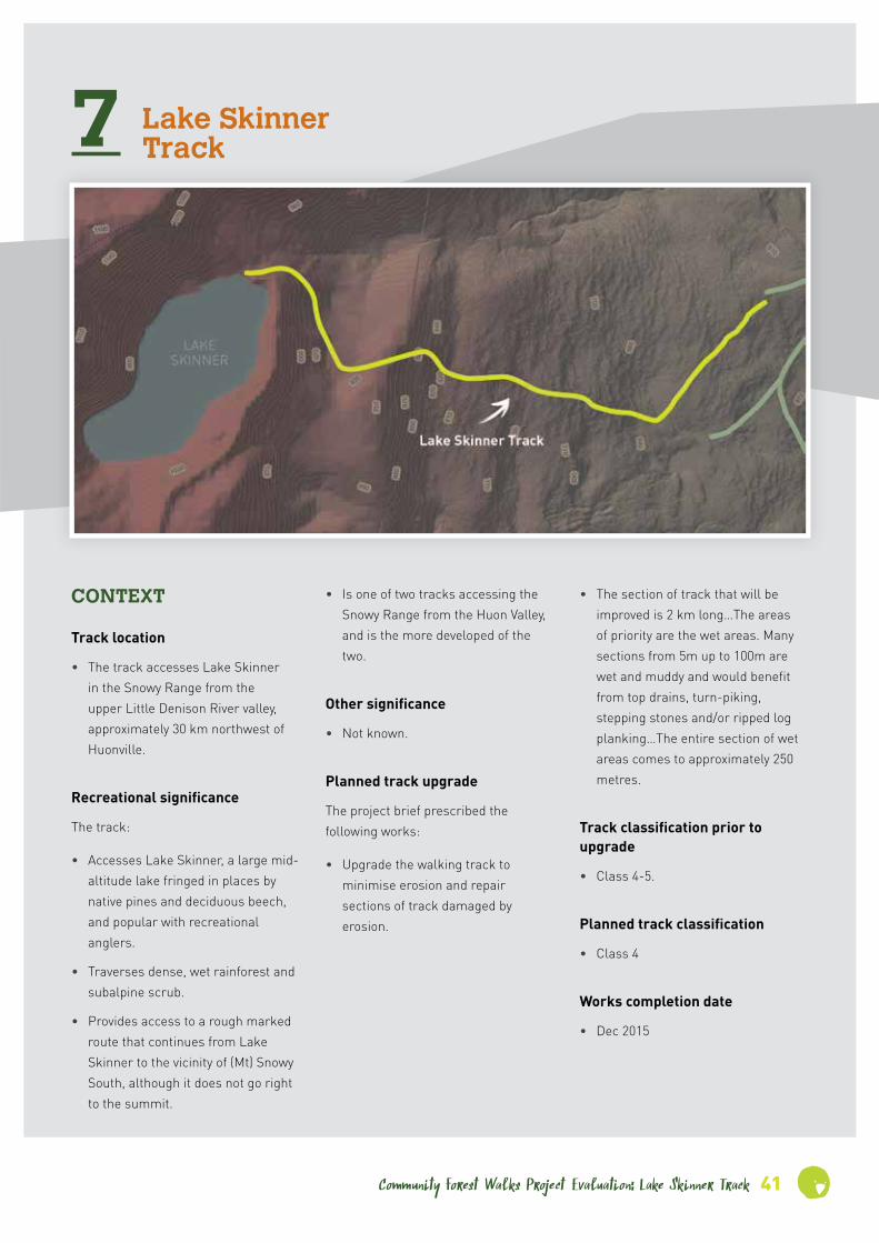
Community Forest Walks Project Evaluation: Lake Skinner Track 41
7 Lake Skinner Track
• Is one of two tracks accessing the Snowy Range from the Huon Valley, and is the more developed of the two.
Other significance
• Not known.
Planned track upgrade
The project brief prescribed the following works:
• Upgrade the walking track to minimise erosion and repair sections of track damaged by erosion.
• The section of track that will be improved is 2 km long…The areas of priority are the wet areas. Many sections from 5m up to 100m are wet and muddy and would benefit from top drains, turn-piking, stepping stones and/or ripped log planking…The entire section of wet areas comes to approximately 250 metres.
Track classification prior to upgrade
• Class 4-5.
Planned track classification
• Class 4
Works completion date
• Dec 2015
CONTEXT
Track location
• The track accesses Lake Skinner in the Snowy Range from the upper Little Denison River valley, approximately 30 km northwest of Huonville.
Recreational significance
The track:
• Accesses Lake Skinner, a large mid-altitude lake fringed in places by native pines and deciduous beech, and popular with recreational anglers.
• Traverses dense, wet rainforest and subalpine scrub.
• Provides access to a rough marked route that continues from Lake Skinner to the vicinity of (Mt) Snowy South, although it does not go right to the summit.

42 Community Forest Walks Project Evaluation: Lake Skinner Track
EVALUATION OF COMPLETED WORKS
Date of inspection
• 7 July 2016
Location, extent and nature
• Most of the upgrade works are located in an 800m section that extends south-westwards along the slope from the trailhead to the point where the track starts to climb, together with the lower 100m of the climb.
• All the major wet areas in this 900m section have been hardened, mostly with either timber duckboard or sawn-log planking derived from local timber (presumably mostly dead celery top pine).
• All timber walking surfaces have been covered with chicken-wire to reduce the slip risk.
• The first 100m approximately of the track has been hardened with gravel edged with rock. The track is effectively turnpiked on this section.
• Some top-drains and cross-drains have been installed.
• A few short sections of sawn-log planking have been installed in wet hollows further up the track.
Recreational and environmental benefits
• The works have dramatically improved the first kilometre of the track by hardening all the major wet and muddy hollows, including some sections where walkers were obliged to wade shin-deep.
• The improvement is mainly to the walking experience, as damage due to mud churning and track widening was limited by the dense, woody vegetation. However, at a local level the reduction in trampling should allow recovery of natural soil profiles and vegetation.
Suitability and efficiency
• The use of local materials and the adoption of a ‘minimalist’ approach, particularly the use of narrow planking, has improved the walking experience with minimal input of materials and labour.
• The upgraded track has an ‘organic’, low-key appearance that is appropriate for the track classification and blends in well with the natural environment.
• The use of local timber has saved on the cost of materials.
Influence on overall track condition
• The works have stabilised the track and dramatically improved the walking experience on the first 900m of the track.
Descriptive track classification
• Class 4
Recommended improvements – walking track
• There is substantial scope for further works of a similar nature further up the track, which includes extensive wet sections.
• Upper sections of the track also need scrub-cutting.
Recommended improvements – road access
• No improvements required. The access is via many kilometres of unsealed forestry roads, but the route is 2WD accessible and well signed.
Suggested location for ‘Significance to stakeholders’ sign
• At the trailhead.
INFORMATION FOR WALKERS
How to access the trailhead
• First drive to Judbury. The route from the Huon Highway via Ranelagh is slightly shorter but much of it is unsealed, whereas the route via Glen Huon is on a sealed, high-grade road.
• At the main intersection in Judbury take the Lonnavale Road upriver, following the signpost to Lonnavale, Russell River and Denison River.
• At the junction just after crossing the Russell River, keep going straight ahead on Denison Road.
• 12 km from Judbury, turn right to stay on Denison Road. There is a sign at this junction to the Lake Skinner Track.
• 17 km from Judbury turn right onto McDougall’s Road following the signs to the Lake Skinner Track and McDougall’s Road.
• Follow McDougall’s Road for 7 km, ignoring numerous spur roads.
• 24 km from Judbury turn right following the signs to Russell Road and the Lake Skinner Track.

Community Forest Walks Project Evaluationon: Lake Skinner Track 43
• After approximately 100m turn left, again following the sign to the Lake Skinner Track.
• Follow the road for approximately 400m to the road terminus and the trailhead.
• On the return drive, immediately after the junction of McDougall’s Road with Denison Road, take the right fork to stay on Denison Road. (The left fork takes you onto Link Road. This links to Lonnavale Road, but it is a longer route back.)
Walk length
• Lake Skinner return: 6.5 km / 4-5 hours.
• Snowy South return: 11 km / 7-9 hours.
Walk difficulty
• Challenging. The track is easy to follow but the surface is very uneven with numerous exposed roots and wet hollows.
• The upper section of the track is somewhat overgrown, making for uncomfortable walking when the scrub is wet.
Track guide
• The track is easy to follow with no sidetracks.
• There are a few potential campsites in the vicinity of the outlet creek, but they are all pretty rough.
• The rough track continuing to Snowy South starts on the north side of the outlet creek, which can be crossed fairly easily except after heavy rain.
Brockenspectre at Lake Skinner
Outlet creek at Lake Skinner

44 Community Forest Walks Project Evaluation: Lake Skinner Track
STAKEHOLDER FEEDBACK
Libby GrahamWhat for you is the single most
important thing about this track?
The reason I like trackwork is that it’s protecting the environment. You get people tramping on those muddy sections and it degrades so quickly. And you tend to lose that really fine vegetation, those little mosses and fungi and all those kinds of things. That’s really why I like the track: it’s gets people up out of that. It’s the minutiae that I love: that’s what I go there to photograph, not so much the big stuff but it’s those tiny things that you miss if you blink. And the track helps to preserve those things.
How successful was the project in
terms of improving this track?
We were only there for a day but it was a long day and there was a lot of work done. Everyone was there for the same reason, they all pitched in and it got done quite quickly. There were two Parks guys there and it seemed quite well organised. When you have volunteers you can get the situation where no one wants to take charge and people end up doing nothing; but the group worked quite well, jobs were allocated and it got done in a fairly quick and seamless manner.
What were the highlights of the
project?
I find satisfaction in a job well done, so at the end of a hard day’s work it was good to see that we’d made a difference. We’d put up I think maybe seven planks, the wire was put down and you could see what we’d done. I was tired and weary and I had a nice warm glow from making a contribution.
Were there any downsides or
things that could have been done
better?
My only gripe is that it was a one-off and I haven’t heard anything since. If they were more regular I’d love it, but I haven’t heard anything. There’s no information. I would work on any of the tracks if they had some sort of a register of all the trackwork that was going on. I don’t even know how to find that information. I would do something every other weekend if I could. I only heard about the Lake Skinner work from someone who knew someone; it’s a bit random. I get the Wildcare newsletter but that’s only once every three months.
Do you think this track could be
better managed, and if so how?
The only issue I had was with the signage on the access roads. They go through logging areas and there’s no signs. If we want to promote these areas and encourage people to walk there we need to improve the access. It’s a really beautiful walk and it’s not that far to get to.
What can be done to ensure this
track is adequately cared for into
the future?
Regular working bees, not just a one-off. I’m more than happy to come and do it for nothing, just to keep it tidy and make sure the track’s not degraded. That’s the point of volunteering. But it needs someone to organise that and make sure people are informed and there’s regular communication. It just needs regular upkeep.
What is your connection with this
track?
I moved to Tasmania a bit over three years ago. I enjoy hiking and camping and I go out in the wilderness quite a bit. I utilise it a lot, I felt that I was taking a bit and I wanted to give a bit back and try and protect the areas that I walk in. The working bee came up as an option. I live at South Arm so it’s a bit of a hike from here, but I love the area, I’ve walked the Hartz [Mountains] quite a bit and it was close to that, and it was something I really enjoy and wanted to do.
How would you describe this
track to someone who intended to
walk it for the first time?
It’s a little hard to find. If I hadn’t had very specific directions to get there I’m not sure I would have found it. There are lots of turns and it’s not very well signposted. Once you get there the track is quite easy to follow. I think it’s a lovely track. You’ve got that really nice mix, and that’s one of the things I love about Tasmania, you get that mix as you go from low up to high, you get the difference in the forest from dry sclerophyll to the wet forest to the alpine.
What do you think are the most
outstanding aspects of this track?
The myrtle and the rainforest. It’s beautiful! And when you get up to the alpine areas you’re on top of the world and you can see to the end of the earth when it’s a clear day. It’s a stunning part of the world.
It’s the minutiae that I love . . . those tiny things that you miss if you blink.

How important do you think
walking tracks are for fostering
our connection with nature?
Oh my God, I don’t think you can put a price on it! For me if I don’t get out there on a regular basis I don’t cope very well. It’s so therapeutic to be out there because there’s no communication, no emails, no phones. It’s an experience you don’t get anywhere else and I think it’s incredibly important.
What role do you think volunteers
have in caring for wild places?
I think they’re going to be increasingly important as government funding gets more and more scarce. I know there’s lots of people like me. I find those places amazing. You go out there to…I mean I have an incredibly stressful job and I go out there to repair myself for want of a better word. And you want to make sure that they stay that way, that they do continue to help people to appreciate them and take time out. That’s people power I guess, and if there are enough people interested it’ll make sure it gets done. I’m a believer in putting your money where your mouth is, that one person can make a difference, and if enough people think that it will get done.
David PriceWhat do you think are the most
outstanding aspects of this track?
Obvious the lake’s pretty cool, and I really go for the mossy forest.
What for you is the single most
important thing about this track?
One thing about it is there’s not much else around that particular area as far as tracks are concerned, unless you go further down [south] to Hartz and Adamsons and those peaks down there. On the Hobart side of that there’s very little. It’s probably the closest track to Hobart that really gets you into the feel of the Southwest. When you get up onto the top of the ridge around Lake Skinner, into glaciated country, you get a little bit of a taste of what the Southwest is like.
How successful was the project in
terms of improving this track?
We’ve improved a section of the track but I reckon you could do a whole heap more work on it. I was talking to the ranger a month or two ago and he said there’s been a storm and it had broken some of the boardwalk that we’d made, a tree fell over. It’s a long trail and it takes time lugging things up and down. So it’s definitely an ongoing thing.
What were the highlights of the
project?
Definitely the highlight was working with people like Snapper, who’s a bit of a track building guru. And the other people who came too were lovely, including Ben Storer the Ranger. It was a very positive day of doing something constructive.
What is your connection with
this track?
I went out there and walked it. I try to get out and see all these lovely bits of Tasmania that are there, and I’m very conscious that unless you make a concerted effort your weekends just drift by. And then there was like a Bushcare group that was doing some maintenance on the track, so I volunteered and got involved with that. There were I think three working bees on the track, and I was on two of them.
How would you describe this
track to someone who intended to
walk it for the first time?
It’s not like a boardwalked track that’s super easy, but it’s not particularly demanding. I seem to remember it look a good part of the day to get up to Lake Skinner and back, and you can go beyond Lake Skinner up on top of the range. It’s very wet forest: you’ve got celery top and sassafras, and the first stages of the track before it starts to climb can be a bit swampy. It’s a pretty wet, mossy track, and then you get up onto the top, and I seem to remember there’s even a bit of fagus [i.e. deciduous beech, Nothofagus gunnii] up there.
Nevada Peak and distant Mt Field
STAKEHOLDER FEEDBACK
Community Forest Walks Project Evaluationon: Lake Skinner Track 45
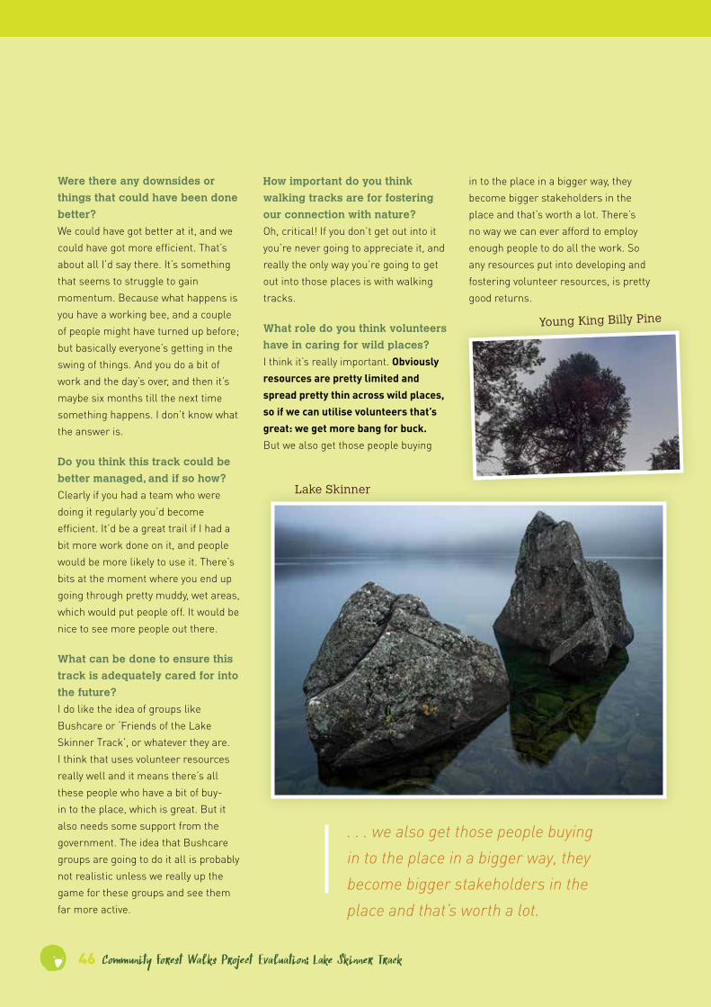
46 Community Forest Walks Project Evaluation: Lake Skinner Track
Were there any downsides or
things that could have been done
better?
We could have got better at it, and we could have got more efficient. That’s about all I’d say there. It’s something that seems to struggle to gain momentum. Because what happens is you have a working bee, and a couple of people might have turned up before; but basically everyone’s getting in the swing of things. And you do a bit of work and the day’s over, and then it’s maybe six months till the next time something happens. I don’t know what the answer is.
Do you think this track could be
better managed, and if so how?
Clearly if you had a team who were doing it regularly you’d become efficient. It’d be a great trail if I had a bit more work done on it, and people would be more likely to use it. There’s bits at the moment where you end up going through pretty muddy, wet areas, which would put people off. It would be nice to see more people out there.
What can be done to ensure this
track is adequately cared for into
the future?
I do like the idea of groups like Bushcare or ‘Friends of the Lake Skinner Track’, or whatever they are. I think that uses volunteer resources really well and it means there’s all these people who have a bit of buy-in to the place, which is great. But it also needs some support from the government. The idea that Bushcare groups are going to do it all is probably not realistic unless we really up the game for these groups and see them far more active.
How important do you think
walking tracks are for fostering
our connection with nature?
Oh, critical! If you don’t get out into it you’re never going to appreciate it, and really the only way you’re going to get out into those places is with walking tracks.
What role do you think volunteers
have in caring for wild places?
I think it’s really important. Obviously resources are pretty limited and spread pretty thin across wild places, so if we can utilise volunteers that’s great: we get more bang for buck. But we also get those people buying
. . . we also get those people buying in to the place in a bigger way, they become bigger stakeholders in the place and that’s worth a lot.
in to the place in a bigger way, they become bigger stakeholders in the place and that’s worth a lot. There’s no way we can ever afford to employ enough people to do all the work. So any resources put into developing and fostering volunteer resources, is pretty good returns.
Lake Skinner
Young King Billy Pine

Community Forest Walks Project Evaluationon: Lake Skinner Track 47
Young King Billy Pine
Volunteer Working Bee
Trackwork snapshots

48 Community Forest Walks Project Evaluation: Twisted Sister Track
8 Twisted Sister Track
Other significance
• The track features the location and artefacts of a historic forest blockade, which played a significant role in the area’s eventual inclusion in the Tasmanian Wilderness World Heritage Area.
Planned track upgrade
The project brief prescribed the following works:
• Upgrade section of Timbs Track to turnoff to Twisted Sister.
• Construct new track from Timbs Track via Twisted Sister to Florentine logging road.
• Formalise section of track along logging road, including using stone and gravel to cross two ditches.
• Install directional signage.
• Install raised gravel and stone walkway around Twisted Sister tree to prevent damage to tree roots.
• All Camp Florentine infrastructure to be left in situ, except for walking track infrastructure.
• Remove unsafe bridge over ditch near Gordon River Road – replace with benched track.
Track classification prior to upgrade
• Timbs Track – Class 5.
• Link tracks – Roughly taped but not yet cut or constructed.
Planned track classification
• Class 3.
Works completion date
• December 2015.
CONTEXT
Track location
• The track is located on the northwest side of the Gordon River Road in the upper Florentine Valley, 21 km from Maydena.
Recreational significance
The track:
• Traverses attractive rainforest and tall-eucalypt forest with rainforest understory.
• Provides close access to several giant eucalypts, including the eponymous Twisted Sister.
• Is one of only three relatively high-grade short-walk opportunities on the Gordon River and Scotts Peak Roads. (The other two are the Creepy Crawly Nature Trail and the first section of the Port Davey Track.)

Community Forest Walks Project Evaluation: Twisted Sister Track 49
EVALUATION OF COMPLETED WORKS
Date of inspection
• 5 July 2016.
Location, extent and nature
• The two link tracks have been cut and some track marker posts have been installed.
• The two link tracks and the section of Timbs Track between these links have been hardened.
• Tracks have been hardened using a variety of techniques, namely light benching with gravel surfacing, raised gravel with rock edging, and sawn celery top logs. The celery top pine was retrieved from a forestry burn pile in a nearby logging coupe, which is now in the World Heritage Area. Sawn logs have been surfaced with chicken wire to reduce the slip risk.
• Dry stone walling has been installed in places.
• A stone/gravel ramp has been constructed over the log that straddles the forestry road and was a focus of the blockade.
• The makeshift bridge over the ditch across the logging road near the Gordon River Road has been removed, and the ditch has been bypassed with a benched ramp.
• A two-sided interpretative sign has been installed near the Timbs Track trailhead.
• A rock/gravel ramp has been constructed around the Twisted Sister tree, and a celery top pine bench has been constructed and installed beside the tree.
Recreational and environmental benefits
• The loop track is environmentally stable and provides the opportunity for an enjoyable and educational short walk.
• The track widens the scope for short walks on the Gordon River and Scotts Peak Roads.
Suitability and efficiency
• The gravel and rock track constructions will be highly durable and will require little maintenance.
• The celery top pine constructions are likely to be highly durable.
• The use of celery top pine provides a practical and aesthetic use for a resource that would otherwise have gone to waste.
Influence on overall track condition
• The track is now clearly defined, stable and of ‘dry shoe’ standard.
Descriptive track classification
• Class 3.
Recommended improvements – walking track
• The track needs better directional signage particularly at the trailhead.
• It is unclear whether the walk starts at the former logging road or at the Timbs Track trailhead. The section of the Timbs Track between the trailhead and the junction with the first link has not been upgraded, and the existing track infrastructure on this section (which includes crudely made duckboard) is dilapidated and unsafe. The
alignment of tracks at the link track junction suggests that walkers are expected to start and complete the circuit at the former logging road. However, the major interpretative sign has been installed near the Timbs Track trailhead, not on the logging road.
• It is undesirable and potentially confusing for walkers for the Timbs Track and the Twisted Sister walk to have separate trailheads. A decision needs to be made regarding which trailhead is suitable for both tracks. If the Timbs Track trailhead is chosen, the section of Timbs Track between the trailhead and the first link needs to be upgraded. (This includes additional clearance of vegetation.) If the former logging road is selected, the interpretative sign should be relocated to the Twisted Sister circuit close to the logging road trailhead.
• Walkers who start at the Timbs Track trailhead may think the trailhead warning sign applies to the Twisted Sister walk, whereas it actually applies to the Timbs Track / Rasselas Valley walk. The sign should be moved to a location on the Timbs Track beyond the Twisted Sister circuit.
• Lengths of discarded timber walkway beside the track near the Timbs Track trailhead should be removed.
Recommended improvements – road access
• Once the trailhead has been decided, the car parking area should be better defined and formed.

50 Community Forest Walks Project Evaluation: Twisted Sister Track
Suggested location for ‘Significance to stakeholders’ sign
• Near the trailhead, once this has been decided.
INFORMATION FOR WALKERS
How to access the trailhead
• From Maydena, follow the Gordon River Road over Humboldt Divide and down into the Florentine Valley.
• After reaching the valley floor the road runs fairly straight for two long sections, hemmed in by forest and tall scrub.
• The trailhead is on the right hand side in the second of these straights, approximately 21 km from Maydena.
• Note: The location of the trailhead can be specified more precisely once the Timbs Track / Twister Sister trailheads have been rationalised – see ‘Recommended improvements – walking track’.
Walk length
• 860m / 15 minutes.
Walk difficulty
• ‘Dry shoe’ standard.
• No steps.
• Close to Class 2 standard, but the walking surface is very narrow in places.
Track guide
• From the car parking area beside the Gordon River Road, follow the logging road for a few dozen metres to a deep trench that crosses the road. The track bypasses this trench on the right-hand side.
• Immediately past this trench, turn right and follow the track into the forest.
• After approximately 120m, turn left at the junction with Timbs Track.
• Follow Timbs Track for approximately 100m, then turn left onto the second link track.
• Follow the second link track for approximately 250m to the junction with the short sidetrack to Twisted Sister.
• After returning from Twisted Sister, continue a short distance along the link track to the former logging road.
• Turn left and follow the logging road back to the trailhead.
• Note: These notes will need to be modified if the Twister Sister trailhead is relocated to the Timbs Track trailhead.

Community Forest Walks Project Evaluationon: Twisted Sister Track 51
STAKEHOLDER FEEDBACK
Elizabeth PereyWhat for you is the single most
important thing about this track?
Compared with the tracks that were there, you never quite knew whether you were going to fall through it or not! The current one is aesthetically pleasing and very stable.
How successful was the project in
terms of improving this track?
(Answered by previous response.)
What were the highlights of the
project?
I wasn’t involved in the program of works but I’ve seen photos of the works in progress. The whole structure is very impressive; the workmanship is great.
Were there any downsides or
things that could have been done
better?
No, it was terrific. It was such an improvement on what had been before, and making a feature of the Twisted Sister in the best possible way.
Do you think this track could be
better managed, and if so how?
The old tracks were managed by the protesters, and Parks did some work on them. But they weren’t very stable. The track work that’s been done is very stable and is likely to last for a long time.
What can be done to ensure this
track is adequately cared for into
the future?
Money. The tracks are well made and should be pretty lasting. They’ve used celery top pine, which is very long lasting.
How important do you think
walking tracks are for fostering
our connection with nature?
Very important, especially ones that are organic like this one. You don’t feel that you’re on a highway, you feel you’re part of nature but you’re on a safe, dry, stable track.
What role do you think volunteers
have in caring for wild places?
I think ideally the government should place far more value on these places, and organisations like Parks should be the prime carers. I don’t think it should be volunteers at all. It’s only volunteers because it has to be. I think it should be funded, and one would hope that the government would value these places.
What is your connection with this
track?
We’re the Florentine Protection Society. I’ve been out there, I’m familiar with it and I’m impressed with the new track.
How would you describe this
track to someone who intended to
walk it for the first time?
Beautiful. Sturdy. I’m 76 and I felt totally secure on it. That was a big thing for me. Aesthetically lovely, I just think it’s great the way they’ve done it.
What do you think are the most
outstanding aspects of this track?
It’s a very nice experience. The thing about the Florentine is that you have a temperate rainforest beside a highway. It’s accessible to the public, which is fantastic and very rare I think. The track is very organic-looking. And I like the fact that they’ve used celery top pine that had left been left to rot [in the nearby logging coupe]. It’s been put to good use.
I also very much like the German guy’s sculpture. We went out there to decide where it should be placed. I was nervous because I feel that man-made sculptures in nature often come off very kitsch and second best, but the way he’s done it is great. It’s two seats together and they’re near the road.
I went there at fungi time and it was just mind-blowing. I took a German friend from Sydney, a doctor who’s very into eucalypts, and she was blown away. We both were.
The whole thing is very impressive – top marks!
The thing about the Florentine is that you have a temperate rainforest beside a highway.
Ramp built to go over prior
blockade log
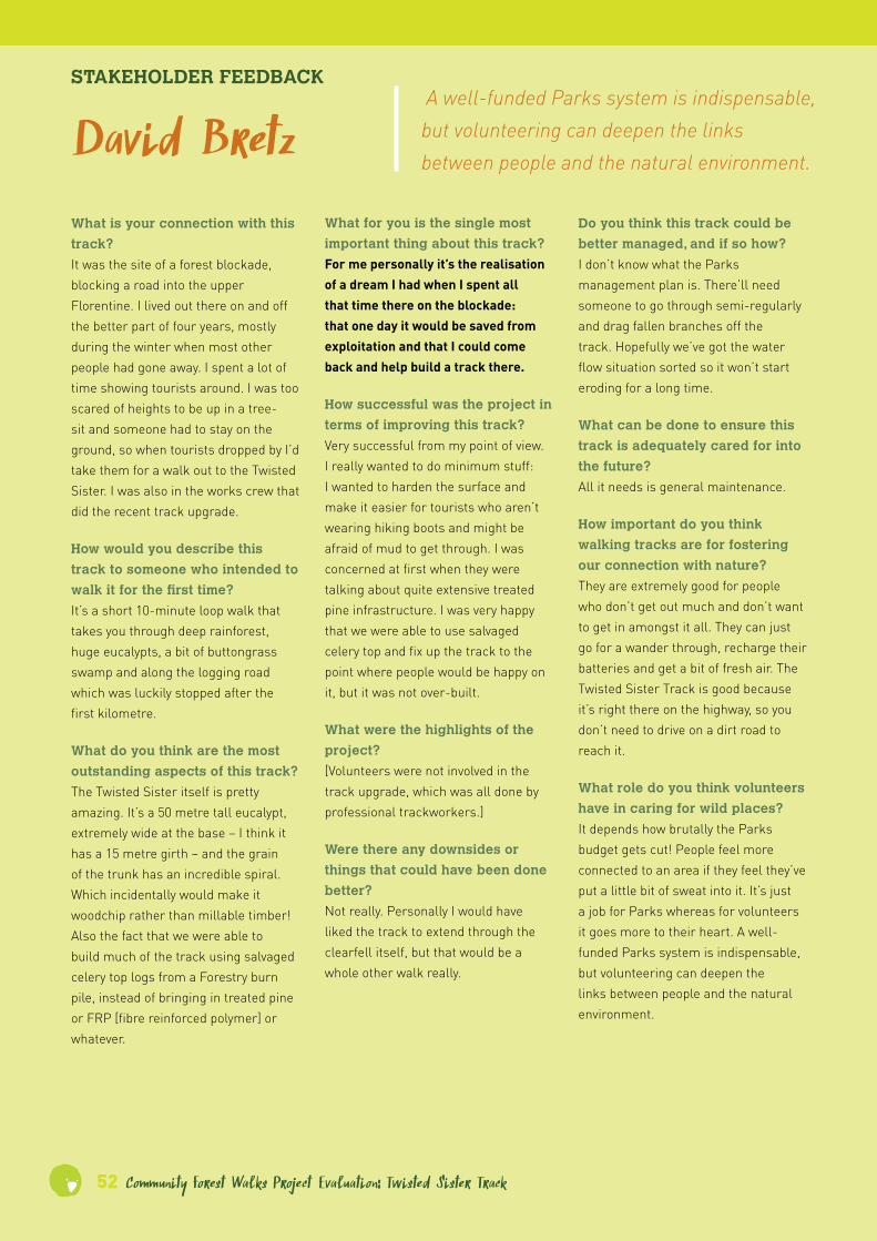
52 Community Forest Walks Project Evaluation: Twisted Sister Track
STAKEHOLDER FEEDBACK
David BretzWhat for you is the single most
important thing about this track?
For me personally it’s the realisation of a dream I had when I spent all that time there on the blockade: that one day it would be saved from exploitation and that I could come back and help build a track there.
How successful was the project in
terms of improving this track?
Very successful from my point of view. I really wanted to do minimum stuff: I wanted to harden the surface and make it easier for tourists who aren’t wearing hiking boots and might be afraid of mud to get through. I was concerned at first when they were talking about quite extensive treated pine infrastructure. I was very happy that we were able to use salvaged celery top and fix up the track to the point where people would be happy on it, but it was not over-built.
What were the highlights of the
project?
[Volunteers were not involved in the track upgrade, which was all done by professional trackworkers.]
Were there any downsides or
things that could have been done
better?
Not really. Personally I would have liked the track to extend through the clearfell itself, but that would be a whole other walk really.
Do you think this track could be
better managed, and if so how?
I don’t know what the Parks management plan is. There’ll need someone to go through semi-regularly and drag fallen branches off the track. Hopefully we’ve got the water flow situation sorted so it won’t start eroding for a long time.
What can be done to ensure this
track is adequately cared for into
the future?
All it needs is general maintenance.
How important do you think
walking tracks are for fostering
our connection with nature?
They are extremely good for people who don’t get out much and don’t want to get in amongst it all. They can just go for a wander through, recharge their batteries and get a bit of fresh air. The Twisted Sister Track is good because it’s right there on the highway, so you don’t need to drive on a dirt road to reach it.
What role do you think volunteers
have in caring for wild places?
It depends how brutally the Parks budget gets cut! People feel more connected to an area if they feel they’ve put a little bit of sweat into it. It’s just a job for Parks whereas for volunteers it goes more to their heart. A well-funded Parks system is indispensable, but volunteering can deepen the links between people and the natural environment.
What is your connection with this
track?
It was the site of a forest blockade, blocking a road into the upper Florentine. I lived out there on and off the better part of four years, mostly during the winter when most other people had gone away. I spent a lot of time showing tourists around. I was too scared of heights to be up in a tree-sit and someone had to stay on the ground, so when tourists dropped by I’d take them for a walk out to the Twisted Sister. I was also in the works crew that did the recent track upgrade.
How would you describe this
track to someone who intended to
walk it for the first time?
It’s a short 10-minute loop walk that takes you through deep rainforest, huge eucalypts, a bit of buttongrass swamp and along the logging road which was luckily stopped after the first kilometre.
What do you think are the most
outstanding aspects of this track?
The Twisted Sister itself is pretty amazing. It’s a 50 metre tall eucalypt, extremely wide at the base – I think it has a 15 metre girth – and the grain of the trunk has an incredible spiral. Which incidentally would make it woodchip rather than millable timber! Also the fact that we were able to build much of the track using salvaged celery top logs from a Forestry burn pile, instead of bringing in treated pine or FRP [fibre reinforced polymer] or whatever.
A well-funded Parks system is indispensable, but volunteering can deepen the links between people and the natural environment.

Community Forest Walks Project Evaluation: Twisted Sister Track 53
The winged benches at the head of the Twisted Sister Track were designed and fabricated by artist Gerhard Mausz. Their design was inspired by the forest’s abundant bird life, and the campaign that defended the riches surrounding them: the wings serve as a fitting metaphor for protection. The winged benches were supported through funding from the Australian Government’s Community Heritage and Icons Grants program.
Twisted Sister

54 Community Forest Walks Project Evaluation: Twisted Sister Track
Trackwork snapshots
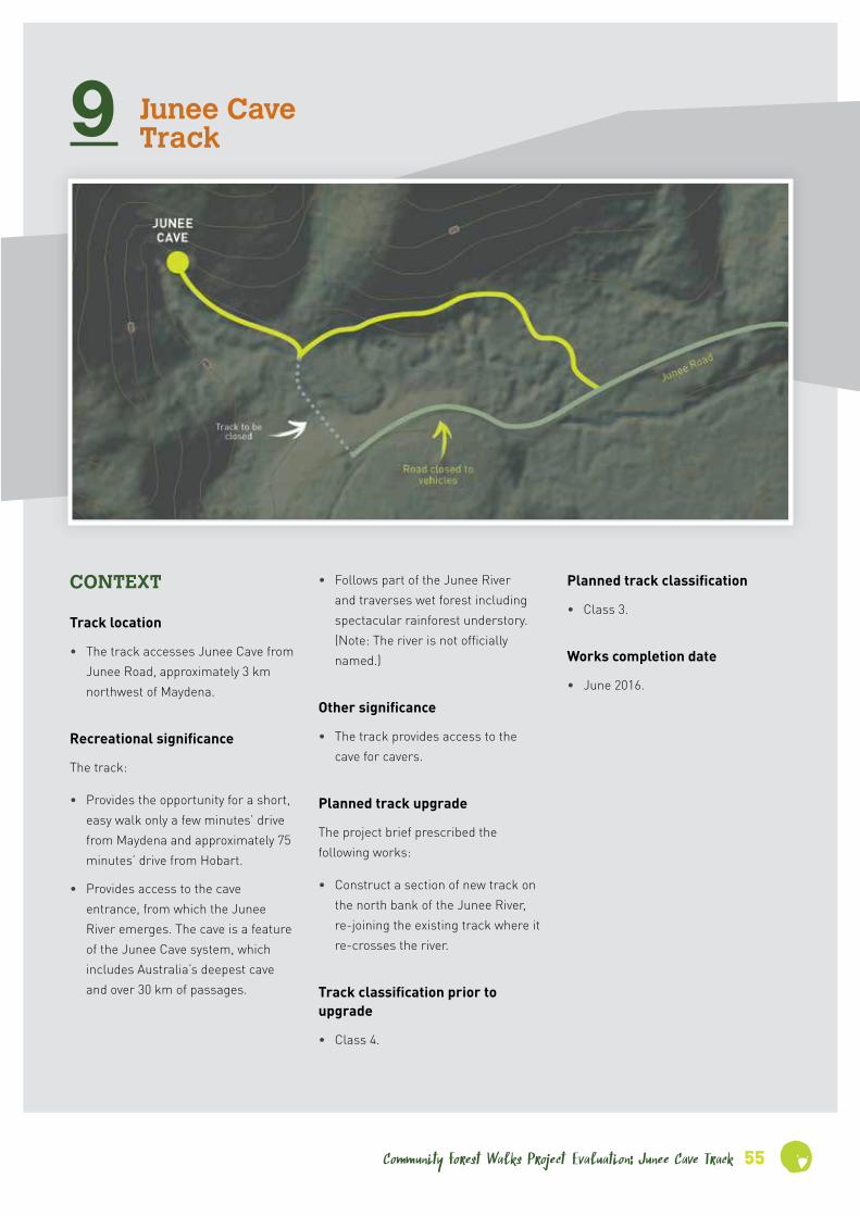
Community Forest Walks Project Evaluation: Junee Cave Track 55
9 Junee Cave Track
• Follows part of the Junee River and traverses wet forest including spectacular rainforest understory. (Note: The river is not officially named.)
Other significance
• The track provides access to the cave for cavers.
Planned track upgrade
The project brief prescribed the following works:
• Construct a section of new track on the north bank of the Junee River, re-joining the existing track where it re-crosses the river.
Track classification prior to upgrade
• Class 4.
Planned track classification
• Class 3.
Works completion date
• June 2016.
CONTEXT
Track location
• The track accesses Junee Cave from Junee Road, approximately 3 km northwest of Maydena.
Recreational significance
The track:
• Provides the opportunity for a short, easy walk only a few minutes’ drive from Maydena and approximately 75 minutes’ drive from Hobart.
• Provides access to the cave entrance, from which the Junee River emerges. The cave is a feature of the Junee Cave system, which includes Australia’s deepest cave and over 30 km of passages.

56 Community Forest Walks Project Evaluation: Junee Cave Track
EVALUATION OF COMPLETED WORKS
Dates of inspection
• 22 May 2016 (works in progress); 7 July 2016 (works completed)
Location, extent and nature
• The new track section has been surveyed, cut and constructed.
• Most of the new section has been benched, and much of the benching has a lower rock retaining wall.
• The entire length of the new section (excluding bridges) has been surfaced with hard-packed gravel.
• On flat ground the gravel track has been edged with rock.
• Several small bridges have been installed, comprising sawn celery top planks with chicken-wire nonslip surfacing.
• The track has been ramped with dry stone walling and gravel surfacing to traverse several small outcrops without the need for steps.
Recreational and environmental benefits
• The new alignment of the track avoids the double crossing of Junee River. Hence it avoids the need to replace the vehicular bridge on Junee Road and the pedestrian bridge on the original track, both of which had been assessed as structurally unsound.
• The new alignment traverses attractive rainforest, in contrast to the replaced section which traversed more open woodland including an opening that had evidently been cleared at one time.
• The new alignment allows walkers to access the cave without having to walk 250m along Junee Road from the vehicular bridge (which has been closed to vehicles) to the original trailhead. Apart from being unattractive in recreational terms, the walk along the road posed a potential risk to pedestrians.
• The realigned track is located on well-drained, stable ground, well above the potential flood level of the river.
Suitability and efficiency
• Construction of the new track section avoids two unnecessary river crossings and the cost of replacing two bridges.
• The new section has been well aligned with low gradients and no steps.
• Benching is relatively low-cost and in this environment will be durable with light ongoing maintenance.
• The rock infrastructure is likely to be extremely durable and will require little maintenance unless damaged by major tree falls.
• The gravel track surfacing will require only occasional maintenance and will rarely be damaged by falling timber.
• The completed works including the small timber bridges blend in well with the surrounding environment.
• The celery top timber used in the bridges was destined to be wasted in a forestry burn pile and is likely to be durable.
Influence on overall track condition
• The track is stable, pleasant to walk along and conforms to the projected track classification.
• By traversing rainforest understory the new alignment enhances the sense that one is entering wild country, even though it is actually a regrowth forest.
Descriptive track classification
• Class 3.
• Short sections of the track near the cave entrance (which were not affected by the recent upgrade) have an effective fall height exceeding 1.5m but no safety rail, contravening the recommended standards for a Class 3 track.
Recommended improvements – walking track
• The trailhead requires a sign indicating that the track leads to Junee Cave.
• The recent works realigned only part of the track. As a result, the modified track drops onto the river flat before climbing again slightly along the river bank to the cave entrance. It would be preferable to avoid the drop and the river flat by realigning part of the remaining track onto sloping ground to the north.
• It may be advisable to install additional safety rails on the approach to the cave. A risk assessment should be conducted on this section.

Community Forest Walks Project Evaluation: Junee Cave Track 57
• The existing interpretation materials are in a degraded condition and the information provided could be improved. Arguably it would make sense for information about the Junee/Florentine cave system to be presented at the cave entrance rather than back down the track.
Recommended improvements – road access
• The car park needs better drainage, and the parking area needs to me more clearly distinguished from the vehicle turning area.
• Widening Junee Road would make access safer and allow easier passing, particularly for larger vehicles.
• Sealing Junee Road would make access more inviting particularly for visitors in rental cars.
• Ideally the trailhead car park should have a toilet. However, this is probably inessential given that the trailhead is only a few minutes’ drive from Maydena.
Suggested location for ‘Significance to stakeholders’ sign
• Either at the trailhead or in the opening where the track drops down to the river flat.
INFORMATION FOR WALKERS
How to access the trailhead
• In Maydena, turn off the Gordon River Road onto Junee Road opposite the Maydena general store. A signpost at the junction points to ‘Junee Cave State Reserve’.
• The trailhead is approximately 3.4 km along Junee Road, on the right hand side.
Walk length
• Return walk to cave: 960m / 20-30 minutes.
Walk difficulty
• Gentle gradients, ‘shoe’ standard track surface throughout.
• Young children should be supervised in the vicinity of the river.
Track guide
• The track is easy to follow and has no junctions.
Junee Cave

58 Community Forest Walks Project Evaluation: Junee Cave Track
STAKEHOLDER FEEDBACK
Brendan MoodieHow successful was the project in
terms of improving this track?
Excellent. Fantastic. The track itself is now a feature, whereas the old track was just an access. Part of the idea of doing it was also to reduce the infrastructure management on our part. We bypassed two bridges. One of them was about to collapse, and any bridges like that are really high maintenance. Now that we’ve bypassed them, eventually they’ll come out.
What were the highlights of the
project?
[Not relevant because volunteers were not involved in the track upgrade.]
Were there any downsides or
things that could have been done
better?
I don’t think so. We would like to have taken it all the way in to the cave, and that may still happen down the track. We’ve got to replace the platform at the end – we’re currently looking at designs for that. The funding didn’t go all that way, and it was only supposed to cover the new country that’s come across to us. But apart from that it went really well.
Do you think this track could be
better managed, and if so how?
It’s one of the tracks that we do get out to fairly regularly. We also have plans to do some work around the entry point of it. And the way we’ve worked with Christo and the guys out there [who did the track upgrade], hopefully it’ll be a low maintenance track.
What can be done to ensure this
track is adequately cared for into
the future?
We’ve already spoken to the Friends of Mt Field volunteer group, and they’re certainly keen to have that as one of their sites that they can duck out to, because it’s all attached to Mt Field now. They’re keen for us to let them know if there’s any works out there that they can do.
How important do you think
walking tracks are for fostering
our connection with nature?
Very important and growing. It’s obviously important to get people into some of these areas to give them an appreciation of what’s out there. And one of the things that we’ve been working with, especially in the Southwest: people go on drives right out to the Southwest but there weren’t any short tracks around. And Junee’s certainly one of the walks I’ve been speaking with the council a fair bit about, with that in mind, getting people out of their cars. A lot of people now want to do a short walk, not a long one, not spending hours on end out there. So Junee’s one of the walks we’ve focussed on, and the other one of course is Twisted Sister.
What role do you think volunteers
have in caring for wild places?
A huge amount. We’ve got a lot of experience with the Friends of Mt Field group here. They’ve basically almost adopted most of the tracks up on the mountain here at Mt Field. They’re out once a month, they’ve got a group of anywhere up to twelve people come out. We work really closely with them. Without them up
What is your connection with this
track?
I’m Ranger in Charge at Mt Field National Park. So I’m basically the track manager.
How would you describe this
track to someone who intended to
walk it for the first time?
Reasonably short, but it runs alongside the river and shows you a bit remnant almost-rainforest on the way in to the cave system. A fairly easy walk to tackle.
What do you think are the most
outstanding aspects of this track?
Obviously the cave system. But with the new reroute of the track, the walk in has become almost as much part of the destination as the cave itself. In the past the way in was through old pine forest which has been recently clearfelled, and it was a pretty ordinary looking track in. The feedback that we’re already getting is that it’s a vast improvement. People are enjoying the walk and the views down across the river all the way in. And the endpoint’s a bonus.
What for you is the single most
important thing about this track?
Given the location, it offers people heading to the Southwest another short walk that they can do. And it’s the only spot where we’ve got easy public access to one of the 2000 cave entrances. It’s a little known fact about Mt Field that it’s totally covered with caves on that western side.
. . . the walk in has become almost as much part of the destination as the cave itself.

on the mountain we wouldn’t get around to those tracks. Our guys have had to pull back to the high visitation areas. This year we’ve had 189,000 people through Mt Field. Given the staffing numbers that we’ve got, the budgets and that sort of thing, we’ve got to concentrate on the high volume areas. The volunteers can deal with the more remote tracks up on the mountain. So they’re playing a critical role up there at the moment. We have a yearly works plan that we work out with them, so they’re not out there just doing whatever they feel like. It’s pretty directed work. And they can also access funding that we can’t. So they’re critical here. We spend a lot of time working with them; we wouldn’t do that if it wasn’t worthwhile.
Junee Creek
Community Forest Walks Project Evaluationon: Junee Cave Track 59

60 Community Forest Walks Project Evaluation: Junee Cave Track
STAKEHOLDER FEEDBACK
Greg PowerHow successful was the project in
terms of improving this track?
Hugely successful. It takes you through more of that dense rainforest than the previous track, the track itself is pretty, and you’ve got the timber sections that go over the water runoff areas. They certainly did the job the other day, keeping your feet dry. And it’s certainly nice now that you don’t have to walk past the clearfell, which you did on the old track. It’s very picturesque now.
What were the highlights of the
project?
[Not relevant – the upgrade was undertaken by contractors.]
Were there any downsides or
things that could have been done
better?
No, I can’t think of any. It was very well done. I really was quite impressed with the level of detail and just how neat it was.
Do you think this track could be
better managed, and if so how?
I understand resources are pretty slim, so I’m not sure how much attention will be given to it, based on the fact it’s only quite new. If there are trees go over the track for example, I’m not sure how quickly there’ll be attended to. It’s a bit early days yet to know how much resources will be given to it.
There’s just not the manpower for the Mt Field office to be going after every track, the new sites that [Ranger in Charge] Brendan [Moodey]’s been given. I’m concerned that it won’t have the resources to maintain it at that level. It’s a pity if Parks have to rely on grants or bits and pieces of funding to do the job that they have to do. This
is essential work for them and if that sort of funding didn’t come through I imagine the track would deteriorate more and more. Before the new World Heritage listings came about the Mt field office was already depleted in staff, and it appears that not much has changed since they got all that new land to manage.
What can be done to ensure this
track is adequately cared for into
the future?
I just have to say increased field officers. That’s really what the Southwest is screaming out for. There’s only a couple of blokes on the ground really, and you get a windy day and trees blow over all over the place, and it takes quite a long time to rectify. The priority is probably Russell Falls Track, and from then on I’m not sure where the priorities lie.
How important do you think
walking tracks are for fostering
our connection with nature?
Absolutely essential. I don’t know how there could be any other opinion. Unless people visit these places and get in amongst it, they won’t have the passion and the support for these places. Visitation builds conservation.
What role do you think volunteers
have in caring for wild places?
You can only use volunteers so much. I know that volunteers around Mt Field are going above and beyond what is expected elsewhere in Tasmania, and they’ve helped out with trackwork. I have the feeling volunteers are usually more for tree planting, rejuvenating forestry coupes and whatnot.
What is your connection with this
track?
Living nearby at Mt Field, it’s just a short hop down the road to Maydena and I’ve walked that track a fair few times in the past. I’m a photographer by trade, and although I haven’t done much photography on that track it’s certainly one that I’ll photograph in future. We run the café at Mt Field and also run the petrol station and café at Maydena. People come into the café and are interested in what they can do around the area, and that’s one of the things I recommend, to head down the Junee Road and have a look at the cave.
How would you describe this
track to someone who intended to
walk it for the first time?
It’s an easy walk and it’s a neat and tidy track. It’s a 10 minute walk each way. The other day I literally ran the track to check out the cave after the heavy rain.
What do you think are the most
outstanding aspects of this track?
There’s good examples of rainforest in there with the manferns, and there’s the nice clear creek water. If I’m talking to someone about it I mention how the water enters at Growling Swallet and pops out there at Junee Cave. It goes through the filtration process, and it’s so crystal clear you can spot some fish in there.
What for you is the single most
important thing about this track?
It has an air of remoteness about it, but the main thing is it’s a nice easy walk to the cave opening. There’s not too many tracks around that area where you can just pop in and see a cave like that. The cave is the drawcard.
Unless people visit these places . . . they won’t have the passion and the support for these places.
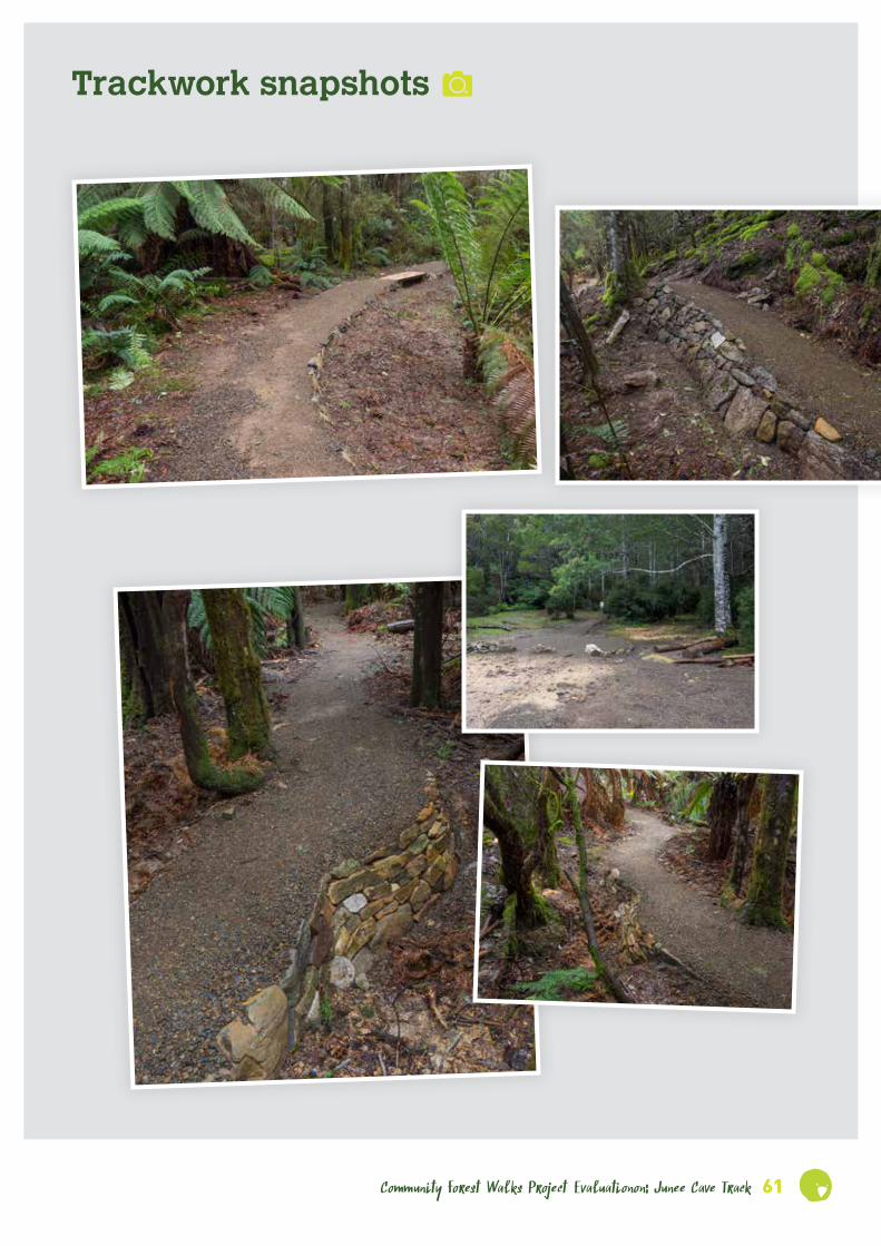
Community Forest Walks Project Evaluationon: Junee Cave Track 61
Trackwork snapshots

62 Community Forest Walks Project Evaluation: Junee Cave Track
Upgrading Junee Caves Track June 2016
Before After

Community Forest Walks Project Evaluation: Junee Cave Track 63
Before After

64 Community Forest Walks Project Evaluation: Junee Cave Track
In the news . . .
frie
nds of the blue tier
This project is supported by Environment Tasmania, through funding from the Australian Government.
Environment Tasmania and Friends of the
Blue Tier have pleasure in inviting you to the:
by the Mr Eric Hutchinson, Federal Member for Lyons,
at 2pm on Sunday 7 December, 2014. Afterwards join us
to walk the track and for an afternoon tea celebration.
Find out why this new 2.4km walking track to the Big
Tree and other spectacular forest giants in the Blue Tier
is destined to be one of Tasmania’s greatest short walks.
RSVP by 4 December to Environment Tasmania on
6224 6319 or email [email protected].
Blue Tier Giant Walk Official Opening
LIVING LANDSCAPES SYMPOSIUM
S A V E T H E D A T E : 1 4 O C T O B E R 2 0 1 6
engaging communities. showcasing restoration.
enhancing nature.

Community Forest Walks Project Evaluation: Junee Cave Track 65
For footage, photos, screen savers, maps and walk guides related to these tracks please go to
www.et.org.au

Proud member
Environment Tasmania PO Box 1073 Hobart TAS 7001
(03) 6281 5100
1st Floor 100 Elizabeth St Hobart TAS 7000
www.et.org.au
This project was supported by Environment Tasmania through
funding received from the Australian Government.