COMMITTEE OF THE WHOLE AGENDA
48
COUNCIL COMMITTEE OF THE WHOLE AGENDA DECEMBER 12, 2017 - 6:00 P.M. CITY HALL COUNCIL CHAMBERS 15 LOOCKERMAN PLAZA, DOVER, DELAWARE PUBLIC COMMENTS ARE WELCOMED ON ANY ITEM AND WILL BE PERMITTED AT APPROPRIATE TIMES. WHEN POSSIBLE, PLEASE NOTIFY THE CITY CLERK (736-7008 OR E-MAIL AT CITYCLERK@DOVER.DE.US) SHOULD YOU WISH TO BE RECOGNIZED. LEGISLATIVE, FINANCE, AND ADMINISTRATION COMMITTEE AGENDA ADDITIONS/DELETIONS 1. PROPOSED FOOD TRUCK PILOT PROGRAM (STAFF RECOMMENDS APPROVAL OF A 30 BUSINESS DAY FOOD TRUCK PILOT PROGRAM) 2. PROPOSED ORDINANCE #2017-16 - AMENDING APPENDIX B - ZONING, ARTICLE 3 - DISTRICT REGULATIONS, SECTION 28 - TRADITIONAL NEIGHBORHOOD DESIGN ZONE (TND), SUBSECTION 28.52 - NEIGHBORHOOD COMMERCIAL DISTRICT (FUEL PUMPS) 3. RECOMMENDED PROCEDURE FOR REQUESTING A LEGAL OPINION (STAFF RECOMMENDS ADOPTION OF THE PROCEDURE) 4. RECOMMENDED PROCEDURE FOR REQUESTING AN EXCUSED ABSENCE (STAFF RECOMMENDS ADOPTION OF THE PROCEDURE) 5. ADJOURNMENT OF LEGISLATIVE, FINANCE, AND ADMINISTRATION COMMITTEE MEETING PARKS, RECREATION, AND COMMUNITY ENHANCEMENT COMMITTEE AGENDA ADDITIONS/DELETIONS 1. COMMUNITY DEVELOPMENT BLOCK GRANT (CDBG) PROGRAM ADMINISTRATION FUNDING FOR ASSESSMENT OF FAIR HOUSING (AFH) PLAN (STAFF RECOMMENDS APPROVAL OF FUNDING SET-ASIDE FOR AFH) 2. COMMUNITY DEVELOPMENT BLOCK GRANT (CDBG) PROGRAM SEMI-ANNUAL REPORT (COMMITTEE ACTION NOT REQUIRED) 3. REVIEW OF ACTIVE RECREATION AREA PLAN (REQUEST FOR CASH-IN-LIEU) - MULTIPLEX AT 299 COLLEGE ROAD (PLANNING REFERENCE: S-17-28) (STAFF RECOMMENDS ACCEPTANCE OF THE $4,000 CASH-IN-LIEU OF RECREATION AREA CONSTRUCTION DONATION, AS THE AMOUNT COMPLIES WITH THE REQUIREMENTS OF THE ZONING ORDINANCE)
Transcript of COMMITTEE OF THE WHOLE AGENDA

COUNCIL COMMITTEE OF THE WHOLE
AGENDA
DECEMBER 12, 2017 - 6:00 P.M.
CITY HALL COUNCIL CHAMBERS
15 LOOCKERMAN PLAZA, DOVER, DELAWARE
PUBLIC COMMENTS ARE WELCOMED ON ANY ITEM AND WILL BE PERMITTED AT APPROPRIATE TIMES. WHEN
POSSIBLE, PLEASE NOTIFY THE CITY CLERK (736-7008 OR E-MAIL AT [email protected]) SHOULD
YOU WISH TO BE RECOGNIZED.
LEGISLATIVE, FINANCE, AND ADMINISTRATION COMMITTEE
AGENDA ADDITIONS/DELETIONS
1. PROPOSED FOOD TRUCK PILOT PROGRAM
(STAFF RECOMMENDS APPROVAL OF A 30 BUSINESS DAY FOOD TRUCK PILOT PROGRAM)
2. PROPOSED ORDINANCE #2017-16 - AMENDING APPENDIX B - ZONING, ARTICLE 3 - DISTRICT
REGULATIONS, SECTION 28 - TRADITIONAL NEIGHBORHOOD DESIGN ZONE (TND),SUBSECTION 28.52 - NEIGHBORHOOD COMMERCIAL DISTRICT (FUEL PUMPS)
3. RECOMMENDED PROCEDURE FOR REQUESTING A LEGAL OPINION
(STAFF RECOMMENDS ADOPTION OF THE PROCEDURE)
4. RECOMMENDED PROCEDURE FOR REQUESTING AN EXCUSED ABSENCE
(STAFF RECOMMENDS ADOPTION OF THE PROCEDURE)
5. ADJOURNMENT OF LEGISLATIVE, FINANCE, AND ADMINISTRATION COMMITTEE MEETING
PARKS, RECREATION, AND COMMUNITY ENHANCEMENT COMMITTEE
AGENDA ADDITIONS/DELETIONS
1. COMMUNITY DEVELOPMENT BLOCK GRANT (CDBG) PROGRAM ADMINISTRATION FUNDING FOR
ASSESSMENT OF FAIR HOUSING (AFH) PLAN
(STAFF RECOMMENDS APPROVAL OF FUNDING SET-ASIDE FOR AFH)
2. COMMUNITY DEVELOPMENT BLOCK GRANT (CDBG) PROGRAM SEMI-ANNUAL REPORT
(COMMITTEE ACTION NOT REQUIRED)
3. REVIEW OF ACTIVE RECREATION AREA PLAN (REQUEST FOR CASH-IN-LIEU) - MULTIPLEX AT 299COLLEGE ROAD (PLANNING REFERENCE: S-17-28)
(STAFF RECOMMENDS ACCEPTANCE OF THE $4,000 CASH-IN-LIEU OF RECREATION AREA
CONSTRUCTION DONATION, AS THE AMOUNT COMPLIES WITH THE REQUIREMENTS OF THE ZONING
ORDINANCE)

COUNCIL COMMITTEE OF THE WHOLE AGENDA - DECEMBER 12, 2017 Page 2
PARKS, RECREATION, AND COMMUNITY ENHANCEMENT COMMITTEE (CONTINUED)
4. PROPOSED LAND SWAP - CITY OF DOVER AND CAPITAL BAPTIST CHURCH/MAYFAIR PARK -APPLICATION FOR APPROVAL FROM NATIONAL PARKS SERVICE
(DURING THEIR REGULAR MEETING OF JANUARY 9, 2017 COUNCIL APPROVED THE COMMITTEE’S
RECOMMENDATION TO MOVE AHEAD WITH THE PROCESS USING OPTION 1, THAT STAFF COME BACK TO
THE COMMITTEE WITH DETAILS AT A LATER MEETING, AND THAT ANY EXPENSES SHALL BE INCURRED
BY THE CHURCH)
5. STATUS REPORT - REQUEST FOR DOG PARK AND PASSIVE PLAYGROUND - ACORN FARMS
(COMMITTEE REFERRED THIS ITEM TO STAFF DURING THEIR MEETING OF SEPTEMBER 12, 2017)
6. DISCUSSION OF THE DEFINITION AND PERMISSIBILITY OF ROOMING HOUSES/BOARDING HOUSES
IN THE ZONING ORDINANCE
7. DISCUSSION OF THE AVAILABILITY OF STORAGE LOCKERS FOR HOMELESS INDIVIDUALS
8. ADJOURNMENT OF PARKS, RECREATION, AND COMMUNITY ENHANCEMENT COMMITTEE MEETING
ADJOURNMENT OF THE COUNCIL COMMITTEE OF THE WHOLE MEETING
/TMS:\AGENDAS-MINUTES-PACKETS-PRESENTATIONS-ATT&EXH\COMMITTEE-AGENDAS\2017\12-12-2017 CCW AGENDA.WPD
THE AGENDA ITEMS AS LISTED MAY NOT BE CONSIDERED IN SEQUENCE. PURSUANT TO 29 DEL. C. §10004(E)(2), THISAGENDA IS SUBJECT TO CHANGE TO INCLUDE THE ADDITION OR THE DELETION OF ITEMS, INCLUDING EXECUTIVESESSIONS, WHICH ARISE AT THE TIME OF THE MEETING.

ACTION FORM
PROCEEDING: Council Committee of the Whole / Legislative, Finance and Administration Committee
DEPARTMENT OF ORIGIN: City Manager’s Office DATE SUBMITTED: 12-6-2017
PREPARED BY: Kirby A. Hudson, Assistant City Manager
SUBJECT: Proposed Food Truck Pilot Program
REFERENCE: None
APPROVALS: City Council
REVIEWED BY: Donna Mitchell, Acting City Manager
EXHIBITS: N/A
EXPENDITURE REQUIRED: N/A AMOUNT BUDGETED: N/A
FUNDING SOURCE (Dept./Page in CIP & Budget): N/A
TIME TIMETABLE: Pilot Program to become effective upon City Council’s Approval
RECOMMENDED ACTION: Staff recommends approval of a 30 business day Food Truck Pilot Program
BACKGROUND AND ANALYSIS
The City Manager’s Office seeks the support of Council to establish a 30 business day Pilot Mobile Food Truck
Program for the City of Dover. After the 30 business day Pilot trial, if the Food Truck Program is successful,
the objective would be to make this program permanent.
By way of background, over the past two years, the City of Dover has seen the development of food truck
services operating out of various locations on Route 13 and during special events within the downtown central
business district. Currently, there is no City Code or operational oversight allowing a permanent framework by
which food trucks can park on City streets and sell to Dover’s population. Consequently, food trucks are not
permitted to operate on the public right-of-way on a regular basis. Given the large density of employees and
citizens visiting City Hall, the Dover Public Library, the Post Office, and the various State Office buildings in
the general area of Loockerman Street, these food truck vendors would like to be able to gain access to these
potential customers.
The Pilot Mobile Food Truck Program will commence on Monday January 15, 2018 and end on Friday
February 23, 2018. The plan is to have (10) ten food trucks located on Loockerman Street, fronting the Dover
Public Library and City Hall area. The City will allow food trucks to provide temporary Food Truck Service
Monday through Friday, between the hours of 8:00 AM and 3:00 PM. These food vendors will provide food
service from pre-designated parking spaces only. The City of Dover Police Department will ensure that signage
and cones will be installed on a daily basis, as to inform drivers and the general public of this reserved parking
spot location(s).
This pilot program will hopefully give rise to a future comprehensive Mobile Food Truck Program which
addresses the issues of safety, fees, revenue impact, program management & oversight, licensing, site locations
and enforcement.
NOTE: The Mobile Food Truck Program is the culmination of research and conversations centered upon the
current “Best Practices” of the City of Wilmington, with the sole goal of creating a positive Mobile Food Truck
Program in the City of Dover.

CITY OF DOVER ORDINANCE #2017-16
BE IT ORDAINED BY THE MAYOR AND COUNCIL OF THE CITY OF DOVER, IN 1 COUNCIL MET: 2 3 That Appendix B - Zoning, Article 3 - District Regulations, Section 28 - Traditional Neighborhood 4 Design Zone (TND), Subsection 28.52 – Neighborhood Commercial District, of the Dover Code, be 5 amended by inserting the text indicated in bold, blue font and deleting the text indicated in red strikeout 6 as follows: 7 8
28.52 Neighborhood commercial district: Additional uses permitted in this district include the following 9 subject to the requirements set forth in subsection 28.7: 10
28.521 Convenience retail stores such as, but not limited to, drug stores, grocery stores, 11 restaurants, variety stores, or combinations thereof. Fuel pumps accessory to a convenience 12 retail store may be permitted as a conditional use, upon the approval of the Planning 13 Commission in accordance with the procedures and subject to the general conditions set 14 forth in article 10, section 1. Drive through drug stores shall be allowed if they are of superior 15 design and screening consistent with the intent of the TND zone. There shall be no drive-through 16 restaurants. 17
28.522 Personal service stores such as, but not limited to, barber shops, beauty parlors, and 18 laundry/dry cleaning establishments. 19
28.523 Service establishments furnishing services other than of a personal nature, but excluding 20 gasoline filling stations and motor vehicle storage, repair, or service. 21
28.524 Business, professional, and government offices, banks, philanthropic or not-for-profit 22 offices, and financial institutions. Drive through banks shall be allowed if they are of superior design 23 and screening consistent with the intent of the TND zone. 24
28.525 Any of these uses mixed with residential uses in the same building. 25
26 ADOPTED: * 27 S:\ORDINANCES\2017\DRAFT\ORDINANCE #2017-16 APPDX B, ART 3, SEC 28 (TND), SEC 28.52 - NEIGHBORHOOD COMMERCIAL DIST\ORDINANCE #2017-16 APPDX B, ART 3.doc 28 29 30 SYNOPSIS 31 This Ordinance would allow the Planning Commission to approve a convenience retail store with fuel 32 pumps as a conditional use in the Traditional Neighborhood Design (TND) Zone. 33 34
(SPONSORS: COLE, LINDELL, AND POLCE) 35 36 37 Actions History 38 12/12/2017 - Scheduled for Introduction - Council Committee of the Whole/Legislative, Finance, 39
and Administration Committee 40

ACTION FORM
MEETING DATE: 12/12/17
DATE SUBMITTED: 12/05/2017
PROCEEDING: Council Committee of the Whole/Legislative, Finance, and Administration Committee
DEPARTMENT OF ORIGIN: City Council
PREPARED BY: Traci A. McDowell, City Clerk
SUBJECT: Recommended Procedure for Requesting a Legal Opinion
RELATED PROJECT: N/A
APPROVALS: City Council
EXPENDITURE REQUIRED: $ N/A AMOUNT BUDGETED: $ N/AFUNDING SOURCE (Dept./Page in CIP & Budget): N/A
TIMETABLE: Consideration by Council Committee of the Whole/Legislative, Finance, and AdministrationCommittee on December 12, 2017 / Council’s consideration of Committee’s recommendation on January 8, 2018
RECOMMENDED ACTION: Staff recommends adoption of the Procedure for Requesting a Legal Opinion
BACKGROUND AND ANALYSISDuring their Regular Meeting of November 13, 2017 members of City Council approved the Council Committeeof the Whole/Legislative, Finance, and Administration Committee’s recommendation that the City Clerk's Officedevelop a recommended procedure for requesting legal opinions. The proposed procedure is as follows:
REQUESTS FOR LEGAL OPINIONS
PURPOSE1. To establish a uniform procedure for requests for legal opinions.2. To ensure mandatory permanent retention of all legal opinions.3. To manage legal expenses.4. To avoid duplication of requests for legal opinions.5. To maintain an accurate tracking system for legal opinions.
DEFINITIONSCouncil Appointees - Shall mean those employees that directly report to the Mayor and City Council, as follows:City Manager, Chief of Police, City Assessor, Controller/Treasurer, City Planner, and City Clerk. It is noted thatany request for a legal opinion by an employee of the City Manager would be submitted to the City Manager forprocessing.
Legal Advice - Shall mean the guidance given by lawyers to their clients. The term “guidance” is important to thisdefinition. It points to the key difference between a legal opinion and legal advice—i.e., that a legal opinion is anattorney’s analysis based on past or present facts, while legal advice is an attorney’s counsel and guidance as to whatfuture actions the client should take (Black’s Law Dictionary).

Recommended Procedure for Requesting Legal Opinions Page 2
DEFINITIONS (CONTINUED)Legal Opinion - Shall mean a written document (formal or informal) in which an attorney provides his or herunderstanding of the law as applied to assumed facts (Black’s Law Dictionary).
City Solicitor - Shall mean either the City Solicitor or the Deputy City Solicitor.
CONFIDENTIALITY OF LEGAL ADVICE AND OPINIONSAny communication between the City Solicitor and representatives of the City is considered confidential, as it isprotected under attorney-client privilege.
STATEMENT OF PROCEDURE
Members of City CouncilShould a member of Council wish to obtain either legal advice or a legal opinion, and that member has the supportof two (2) other members of Council (Rule of 3), the written request will be forwarded to the Council President. The Council President will refer the question to the City Clerk to determine if there is a legal opinion orcorrespondence on file that may address the concern being brought forward. If there are records on file pertainingto the question, they will be distributed to the Mayor and all members of Council. If there are no records on filepertaining to the question, the City Clerk will refer the question to the City Solicitor. The City Solicitor will providethe legal advice or legal opinion to the City Clerk and it will be distributed to the Mayor and all members of Council.
Council Appointees
Legal AdviceShould a Council appointee require legal advice on a pending issue or project, they will refer the question to the CityClerk to determine if there is a legal opinion or correspondence on file that may address their concerns. If there areno records on file pertaining to the question, the Council appointee will work directly with the City Solicitor toaddress their concerns. The Council appointee will provide any resulting written legal advice or opinion to the CityClerk for reference and permanent retention.
Legal OpinionsShould a Council appointee wish to obtain a legal opinion, they will refer the question to the City Clerk to determineif there is a legal opinion on file that may address their concerns. If there are no records on file pertaining to thequestion, the Council appointee will refer the question to the City Solicitor. The City Solicitor will provide the legalopinion to the Council appointee and copy the City Clerk for permanent retention.
Department Heads Reporting to the City Manager
Legal AdviceShould a City Manager Department Head require legal advice on a pending issue or project, they will refer thequestion to the City Manager. If it is determined that legal advice is necessary, the City Manager will forward thequestion to the City Clerk to determine if there is an opinion or correspondence on file that may address theirconcerns. If there are no records on file pertaining to the question, the City Manager will either work directly withthe City Solicitor to address their concerns or authorize the Department Head to work with the City Solicitordirectly. The City Manager will provide any resulting written legal advice or opinion to the City Clerk for referenceand permanent retention.

Recommended Procedure for Requesting Legal Opinions Page 3
Department Heads Reporting to the City Manager (Continued)
Legal OpinionsShould a City Manager Department Head wish to obtain a legal opinion, they will refer the question to the CityManager. The City Manager will forward the question to the City Clerk to determine if there is a legal opinion onfile that may address their concerns. If there are no records on file pertaining to the question, the City Manager willeither work directly with the City Solicitor to address their concerns or authorize the Department Head to work withthe City Solicitor directly. The City Solicitor will provide the legal opinion to the City Manager and copy the CityClerk for permanent retention.
/tmS:\CAFS\12-12-2017 LF&A - REQUESTING A LEGAL OPINION.wpd
Actions History12/12/2017 - Scheduled for Introduction - Council Committee of the Whole/Legislative, Finance, and Administration Committee

ACTION FORM
MEETING DATE: 12/12/17
DATE SUBMITTED: 12/05/2017
PROCEEDING: Council Committee of the Whole/Legislative, Finance, and Administration Committee
DEPARTMENT OF ORIGIN: City Council
PREPARED BY: Traci A. McDowell, City Clerk
SUBJECT: Recommended Procedure for Requesting an Excused Absence
RELATED PROJECT: N/A
APPROVALS: City Council
EXPENDITURE REQUIRED: $ N/A AMOUNT BUDGETED: $ N/AFUNDING SOURCE (Dept./Page in CIP & Budget): N/A
TIMETABLE: Consideration by Council Committee of the Whole/Legislative, Finance, and AdministrationCommittee on December 12, 2017 / Council’s consideration of Committee’s recommendation on January 8, 2018
RECOMMENDED ACTION: Staff recommends adoption of the Procedure for Requesting an Excused Absence
BACKGROUND AND ANALYSISIn accordance with Section 13 - Vacancies; forfeiture of office; filling of vacancies, of the City of Dover Charter,“A council member shall forfeit that office if the council member (4) Fails to attend three consecutive regularmeetings of the council without being excused by the council.”
During their Regular Meeting of November 13, 2017 members of City Council approved the Council Committeeof the Whole/Legislative, Finance, and Administration Committee’s recommendation that the City Clerk's Officedevelop a procedure for Council members to request being excused for absences, with the level of specificity to bedetermined by the person requesting it, and that members' requests be placed on the consent agenda for the nextmeeting so that an action of Council grants the excuse. The proposed procedure is as follows:
PROCEDURE FOR REQUESTING AN EXCUSED ABSENCE
PURPOSETo establish a uniform procedure for excusing Council members’ absences.
STATEMENT OF PROCEDURE
Requesting an Excused Absence Prior to the MeetingThe Council member shall e-mail the Council President and the City Clerk prior to the meeting indicating the reasonfor his or her inability to attend the meeting. If the Council member is unable to access their e-mail, a text messageto the Council President and the City Clerk will be considered acceptable notification. Absent the ability to e-mailand text message, the member shall call the Council President to advise them of the absence. The Council Presidentwill notify the City Clerk’s Office for purposes of securing a quorum.

Recommended Procedure for Requesting an Excused Absence Page 2
Requesting an Excused Absence Subsequent to the Missed MeetingA council member requesting an excused absence subsequent to the missed meeting must submit the request andreason for the absence in writing to the Council President and the City Clerk within seven (7) days after the meetingfrom which the Council member desires an excused absence.
Excused AbsencesFor purposes of this procedure, an absence will be considered excused without further action by City Council if dueto the following causes:
1. The illness or injury of the council member or their family member; 2. A family emergency; 3. The death of a family member; 4. An employment-related commitment; 5. A commitment for city business; 6. Service related deployment; and 7. Vacation.
Absences Requiring Council ActionIf a member has failed to request an excused absence, either prior to or within seven (7) days after the missedmeeting, or if the reason for the absence is not listed above, the absence shall be placed on the consent agenda forthe next regular Council meeting and Council members shall vote to determine whether the absence is excused orunexcused. In the event a Council member fails to attend three (3) consecutive regular meetings without beingexcused by the Council, the Council, in accordance with Section 13 of the Charter, shall declare the seat forfeitedand vacant at the next regular meeting.
/tmS:\CAFS\12-12-2017 LF&A - REQUESTING AN EXCUSED ABSENCE.wpd
Actions History12/12/2017 - Scheduled for Introduction - Council Committee of the Whole/Legislative, Finance, and Administration Committee

ACTION FORM
PROCEEDING: Parks, Recreation and Community Enhancement Committee
DEPARTMENT OF ORIGIN: Planning DATE SUBMITTED: 12/12/17
PREPARED BY: Tracey Harvey, Planner/CDBG Administrator
SUBJECT: CDBG Program Administration funding set-aside for Assessment of Fair Housing Plan
RELATED PROJECT: The 2020-2024 Assessment of Fair Housing (AFH)
EXHIBITS: None
APPROVALS: Council Committee of the Whole and City Council
EXPENDITURE REQUIRED: $5,000 AMOUNT BUDGETED: $5,000
FUNDING SOURCE (Dept./Page in CIP & Budget): CDBG Program Income and Program Administration
TIME TIMETABLE: After approval is received from Council, the City will enter in a Memorandum of
Understanding (MOU) with Delaware State Housing Authority, New Castle County, City of Wilmington,
Dover Housing Authority and Newark Housing Authority
RECOMMENDED ACTION: Approval of funding set-aside for AFH
BACKGROUND AND ANALYSIS
In accordance with the applicable statues and the regulations governing the Consolidated Plan regulations, the
City is required to affirmatively further fair housing and required to submit an Assessment of Fair Housing
under the requirements of 24 CFR § 5.150 through 5.180. HUD has adopted an assessment tool that encourages
jurisdictions and public housing authorities to collaborate regionally and enables collaborators to select a lead
entity and submit the AFH according to the entity’s schedule. 24CFR § 5.156(b) (2).
The AFH is due to be submitted to HUD on or before October 5, 2019. Delaware State Housing Authority
(DSHA) has agreed to be the lead entity of the Consortium. Once the MOU has been executed by all parties, a
Request for Proposals to obtain a consultant to develop a regional AFH and develop a coordinated regional
response to affirmatively further fair housing in each individual jurisdiction and across the region will be
implemented.
The estimated cost of the AFH is approximately $150,000. DSHA has requested the City to provide financial
support in the amount of $5,000 since the City is a small entitlement community. The funds for this project will
come from CDBG program income received in October 2017 for $4,000 from the sales proceeds of a property
that received settlement assistance from the First-time Homebuyers Program, and $1,000 will come from the
remaining balance of the FY16 Program Administration line item of $13,861.00. No funds will be needed from
the FY17 Program Administration line item.

CDBG Semi-Annual Report
June-November 2017
CDBG Semi-Annual Review
- The City was awarded $230,289 in program funds for fiscal year 2017.
- FY17 Action Plan approved by HUD
- The City is in compliance with the statutes and overall management and capacity to administer
CDBG funds from HUD’s Annual Performance Assessment.
- The City is in compliance of the 1.5 timeliness standard for expenditure of funds within the
program year.
- Sub-recipient contracts were executed in October, and all projects are underway.
CDBG FY17 Projects
Homeownership Assistance Program
CDBG funds will be used to provide homeownership assistance to first-time homebuyers who
purchase affordable housing in the City of Dover. Two (2) families are currently under contract
to purchase homes and two (2) families have purchased new construction properties in the City;
one in the Village of Westover and the other property is one of the newly constructed
townhomes by the Mautiste Investment Group located in the Downtown Development District
area.
Dover Interfaith Mission for Housing
CDBG funds will be used to provide operations cost for the shelter. This project is underway.
Connections Community Support Program
CDBG funds will be used to provide rapid re-housing/rental assistance services for homeless
households within the City. This project is underway.
Milford Housing Homeowner Rehabilitation/Emergency Home Repair Programs
CDBG funds will be used to rehabilitate existing owner occupied housing in the City that is in
violation of the City’s Housing Code and complete emergency home repairs to eliminate
housing conditions that threaten the health and safety of low income homeowners. This project
is underway,
Habitat for Humanity
CDBG funds will be used to complete exterior renovations to existing owner-occupied homes in
the Restoring Central Dover Revitalization area. This project is underway.
NSP Program
The City has provided approximately $59,000 in NSP grant funds to Diamond State Community
Land Trust to assist in acquiring a vacant or foreclosed property in the City of Dover. This
property has been fully renovated and will be sold to a low to moderate income family. This
property is a townhouse located in the Village of Westover.

The Honorable Robin R. Christiansen Mayor of Dover 15 E. Loockerman Street PO Box 475 Dover, DE 19903
Dear Mayor Christiansen:
U.S. Department of Housing and Urban Development
Philadelphia Office The Wanamaker Building 100 Penn Square East Philadelphia, Pennsylvania 19107 -3380
RE: Annual Community Assessment City of Dover July 1, 2016 through June 30, 2017
The provisions of the Housing and Community Development Act of 1974, as amended, and the National Affordable Housing Act of 1990, require the annual submission of performance reports by grant recipients receiving federal assistance through programs covered under these Acts. Additionally, these Acts require that a determination be made by the Secretary of the U.S. Department of Housing and Urban Development that the grant recipient is in compliance with the statutes and has the continuing capacity to implement and administer the programs for which assistance is received.
The Consolidated Plan regulations at 24 CFR 91.525 require the Department to evaluate and report to the public on a community's overall progress in the management of its program funds, compliance with the Consolidated Plan, the accuracy of performance reports, and the extent to which progress has been achieved toward the statutory goals identified in Section 91.1. This letter serves to apprise you of our assessment of the City of Dover's overall progress.
In making our evaluation, we relied primarily upon the city's submission of the Consolidated Annual Performance and Evaluation Report (CAPER) for Fiscal Year 2016. This report summarized accomplishments made with funds provided from the Community Development Block Grant (CDBG) program. This letter is a summary of our review of Dover's overall performance.
Under the update to the Part 91 Consolidated Planning regulations, effective March 13, 2006, all Annual Action Plans and CAPERs are required to include performance measures as part of their annual reporting. The Office of Management and Budget has deemed this information necessary to validate the continued funding of HUD programs. The city provided performance measures as required by this guidance.
www.hud.gov espanol.hud.gov

The Honorable Robin R. Christiansen Mayor of Dover
Re: Annual Community Assessment Pro gram Year 2016
Page 2
The HUD timeliness requirement is that a community may have no more than 1.5 times its most recent annual grant remaining in the line of credit 60 days prior to the end of its program year. When the 60-day timeliness test was conducted on May 2nct, 2017, it was calculated that Dover had a balance in its line of credit of 1.18 times its annual grant, which is in compliance with the 1.5 timeliness standard. Please note that this did not include any program income that the city may have in its accounts. Thus, this figure may actually be higher. Beginning in 2017, HUD will measure grantee compliance with the CDBG timeliness standard using the adjusted for program income ratio.
During the 2016 program year, the city reports that it expended 100 percent of its CDBG funds for activities benefiting low- and moderate-income persons, which meets the primary objective of the Housing and Community Development Act of 1974. In addition, the city spent 10.97 percent of its funds on public service activities, which is below the 15 percent regulatory cap. Dover also obligated 14.32 percent of its funds to planning and administration, which is below the 20 percent regulatory cap.
Dover received a CDBG grant of $227,955 for Program Year 2016. The city expended $196,990 of CDBG funds during the 2016 Program Year. Resources were devoted to activities in geographic areas consisting primarily of low- and moderate-income residents throughout the city. The types of activities undertaken with these funds include homeownership assistance, housing rehabilitation, emergency home repair projects, and activities that benefited homeless persons.
In Program Year 2016, the majority of CDBG funds were spent on housing activities. These activities were designed to provide decent affordable housing to low- and moderateincome households. A total of $69,102 was used to provide four (4) low-income first-time homebuyers assistance with purchasing affordable housing in the city. Additionally, six (6) owner-occupied housing units were repaired through the homeowner rehabilitation and emergency home repair programs. Two (2) units were completed through the homeowner rehabilitation program using $57,806 of CDBG funds, and four (4) units were completed through the emergency home repair program using $10,056 of CDBG funding.
Additionally, the city funded homeless activities with CDBG grant funds. These activities included providing operating support to a homeless shelter. A total of $22,000 was spent on operating costs. As a result, 242 individuals were provided emergency shelter in Program Year 2016. Additionally, one (1) person that was at-risk of becoming homeless received rental assistance to acquire permanent supportive housing.
In addition to providing information on the types of activities funded, the city included in its CAPER its role in affirmatively furthering fair housing and identifying impediments to fair housing. The city collaborated with Delaware State Housing Authority, New Castle County and the City of Wilmington to complete an Analysis of Impediments to Fair Housing Choice (Al) in

The Honorable Robin R. Christiansen Mayor of Dover
Re: Annual Community Assessment Program Year 2016
Page 3
August 2011. The AI identifies ten ( 10) impediments to fair housing choice and recommends strategies for the city to undertake to affirmatively further fair housing.
The identified impediments include the need to provide language accommodations to the city's diverse population; assist minority households in becoming homeowners; create housing that is affordable to low- and moderate-income households; meet the need for accessible housing; improve fair housing reporting; improve policy documents; recognize the city's responsibilities to affirmatively further fair housing; ensure that the city's zoning ordinances do not limit fair housing choice for certain families and persons living in group homes; ensure that members of protected classes are represented on city boards and commissions dealing with housing issues; and ensure that minority applicants do not continue to be disproportionately affected by mortgage loan denials and high-cost lending.
The city reported on the progress it has made toward overcoming each of the identified impediments in FY 2016, including: providing language services as needed; strengthening partnerships with local lenders that offer homebuyer education and other incentives to purchase a home in the city; promoting land use policies that enable an increase in the supply of affordable rental housing in areas with adequate infrastructure; encouraging landlords to attend fair housing training; giving first consideration to new rental and for-sale housing development in nonimpacted areas when considering uses for federal and state funding; conducting outreach to members of protected classes to fulfill roles on housing-related boards and commissions; and engaging a HUD-certified housing counseling agency to provide one-on-one financial coaching and credit repair services to city residents. We commend you for these efforts. Please note that the Office of Fair Housing and Equal Opportunity is available to provide technical assistance regarding affirmatively furthering fair housing upon your request.
HUD congratulates Dover on its many accomplishments during the program year. Based on our review we have concluded that the city has the capacity to carry out its programs and has met its reporting requirements.
We ask that you review our assessment of your performance and provide any comments that you may have within 35 days of the date of this letter. Upon receipt, we will evaluate your comments and make any revisions that are deemed appropriate. If you do not have any comments, we request that you formally notify us of that fact within the 35-day timeframe. Where no conunents are received within the designated timeframe, our initial letter will serve as our final assessment of the city's performance for this program year. To facilitate and expedite citizen access to our performance letter, we request that you inform the general public and interested citizens' organizations and non-profit entities of its availability. If, for any reason, the city chooses not to do so, please be advised that our office is obligated to make the letter available to the public. We appreciate your cooperation in this matter.

. ' The Honorable Robin R. Christiansen
Mayor of Dover Re: Annual Community Assessment
Pro gram Year 2016 ·page 4
We look forward to continuing to work with you and members of your staff to accomplish departmental goals and mutual objectives to develop viable urban communities. We would also be pleased to provide you with any information on resources that may be available to your community. If you need assistance, or if you have any questions concerning the content of this letter, please contact Mr. Nadab 0. Bynum, Community Planning and Development Director, at (215) 861-7652, or Miss Crystal I. Edwards, Senior Community Development Representative at (215) 861-7657, or by email, at [email protected]"OV. Our telephone text (TTY) number for the hearing impaired is (800) 877-8339.
cc: I Ms. Tracey Harvey, Planner/CDBG Administrator

Parks, Recreation, and Community Enhancement 12/12/2017
2017 Grant Projects Project Details Total Grant Funds Expended Unencumbered Balance
Homeownership Assistance Program
Funds will be utilized for
settlement assistance for
properties purchased in
the City
$70,000 $30,000 $40,000
Connections
Funds will be utilized for
rapid re-housing/rental
assistance for homeless
persons
$3,000 $0 $3,000
Dover Interfaith Mission for Housing
Funds will be utilized for
utility and maintenance
cost for the shelter.
$24,000 $0 $24,000
Milford Housing Development Corp Funds will be utilized for
emergency home repairs. $40,000 $0 $40,000
Milford Housing Development Corp
Funds will be utilized for
rehabbing owner occupied
homes.
$25,289 $0 $25,289
Habitat for Humanity
Funds will be utilized to
rehab the exterior of
owner occupied homes in
the RCD area.
$21,245 $0 $21,245
Total $183,534 $30,000 $153,534
Status of FY-17 Program Funds Spent - Fiscal Year 7/1/17- 6/30/18

City of Dover
P. O. Box 475 Dover, DE 19903
Community Excellence Through Quality Service
DATA SHEET FOR RECREATION PLAN REVIEW
Approval of Cash Donation
PARKS, RECREATION AND COMMUNITY ENHANCEMENT COMMITTEE
MEETING OF December 12, 2017
Plan Title: Multiplex at 299 College Road, S-17-28
Plan Type: Active Recreation Area – Approval of Cash Donation
(Cash-in-lieu of Recreation Area Construction)
Associated with Site Plan S-17-28
Property Location: Northwest side of College Road and adjacent to Conwell Street
Property Address: 299 College Road, Dover
Owner/Applicants: Stephen E. Lumor (Enyam, LLC)
Tax Parcel: ED-05-067.00-02-26.00-000
Present Zoning: RM-2 (Medium Density Residence Zone)
Site Area: 18,244 SF+/- (0.42 acres +/-)
Proposed Use: Multiplex - 3 dwelling units
Proposed Cash-in-lieu Donation: $4,000
Project Summary:
This project proposes construction of a two-story multiplex building consisting of three (3) units
of approximately 2,210 SF each, along with associated site improvements including parking and
landscaping. The units are located in one building and are intended as student rental housing.
The project takes access from College Road and is adjacent to an unimproved right-of-way
known as Conwell Street.
Active Recreation Area Plan Summary:
Due to the property size and unit density, this project qualifies for Active Recreation Area
exemption for small developments under Zoning Ordinance, Article 5 §10.511. The project has
less than five acres of land and proposes less than ten dwelling units. It is therefore exempt from
the active recreation land dedication requirements set forth under Zoning Ordinance, Article 5
§10.1 and §10.2. The applicant was not required to provide a plan sheet showing land area on the
site to be used for recreational purposes.
However, under §10.511 the developer is still required to make a full cash donation in lieu of a
dedication of land. Zoning Ordinance, Article 5 §10.52 specifies that “this cash donation shall be
equivalent to ten percent of the appraised value of gross land area.” §10.52 also specifies criteria

S-17-28 Multiplex at 299 College Road: Active Recreation Area – Approval of Cash Donation
Report to Parks, Recreation & Community Enhancement Committee –December 12, 2017
Page 2 of 3
the appraisal must meet for it to be a valid basis of calculation. The applicant submitted an
appraisal meeting the criteria to Planning Staff, who reviewed the appraisal to determine the
required cash-in-lieu amount.
The Parks, Recreation and Community Enhancement Committee will review the cash-in-lieu
amount for the College Road Multiplex at their meeting on December 12, 2017.
The Site Development Plan for the College Road Multiplex was conditionally approved by the
Planning Commission following a public hearing on November 20, 2017. As part of the
approval, the Planning Commission indicated that approval was conditional on a cash-in-lieu (of
recreation area) payment being made, with the amount of payment to be accepted at a future
meeting of the Planning Commission.
CODE SUMMARY AND ANALYSIS:
Article 5, §10 of the Zoning Ordinance addresses Open Space, Recreation and Other Public
Facilities. This includes §10.5 where exemptions for small developments are outlined with
reference to the process and calculation of the amount for cash-in-lieu of recreation area
construction. §10.7 further specifies that City Council, through the Parks, Recreation and
Community Enhancement Committee, must approve the cash donation amount prior to final
acceptance by the Planning Commission.
Regarding the calculation of the amount of the cash donation, the Zoning Ordinance in §10.52
specifies that the “cash donation shall be equivalent to ten percent of the appraised value of gross
land area” and that this value shall be “based on the appraisal prepared for the developer to
secure construction financing.”
An appraisal performed by Masten Realty LLC, dated November 22, 2017, was submitted to the
Planning Office. This appraisal identifies the value of the gross land area as $40,000. Based on
this amount §10.52 the required amount of cash donation would therefore by $4,000. See
calculation below:
2017 Appraisal of Land Value: $40,000
Cash-in-Lieu Amount = $40,000 x 10% = $4000
CODE CITATIONS:
Dover Code of Ordinances, Appendix B – Zoning, Article 5 – Supplementary Regulations,
Section 10 – Open Space, Recreation and Other Public Facilities (select excerpts).
Article 5 Section 10
10.1 Recreation Areas.
10.17 Cash in lieu of recreation area construction.
10.171 Determination of suitability for cash donation. If the commission determines that the construction of recreation is not practical due to close proximity to existing available recreation facilities or infeasible due to natural characteristics of the land or will not benefit the residents of the development, the commission shall require a full or partial cash in lieu of areas of donation to be made by the developer in lieu of a full or partial dedication of land.
10.172 Separate recreation account. The cash donation shall be deposited in a separate account to be used for parks, playgrounds or recreational purposes.

S-17-28 Multiplex at 299 College Road: Active Recreation Area – Approval of Cash Donation
Report to Parks, Recreation & Community Enhancement Committee –December 12, 2017
Page 3 of 3
10.173 Amount of cash donation. The cash donation shall be equivalent to the appraised value of land area required in section 10.16. The land area value shall be based on the appraisal prepared for the developer to secure construction financing. This submitted appraisal shall be a copy of the original supplied to the lending institution, with that institution identified, and shall conform in all ways to the Uniform Standards of Professional Appraisal practice and be performed by an appropriately qualified certified appraiser. If an appraisal prepared for construction financing is not available, then the developer shall have an appraisal done in accordance with the procedures set forth in [sub]section 10.174.
10.174 Appeal of appraised value. If the city does not accept the land value established by the appraisal detailed in [sub]section 10.173, the city may, at the developer's expense, require another appraisal be performed. This appraisal will be let on a bid basis between at least three appropriately qualified, certified appraisers selected by the city. The appraiser(s) who prepared the original appraisal in [sub]section 10.173 cannot be a party to this appeal appraisal.
10.175 Payment of cash donation. One hundred percent cash donation provided under this section shall be collected prior to issuing the first building permit for the development.
10.5 Exemption to recreation area and open space dedication.
10.51 Exemptions for small developments. 10.511 Residential developments with less than five acres of land and less than ten dwelling units. These developments shall be exempt from the land requirements set forth in [sub]sections 10.1 and 10.2, but shall require a full cash donation to be made by the developer in lieu of a dedication of land.
10.52 Amount of cash donation. This cash donation shall be equivalent to ten percent of the appraised value of gross land area. The land area value shall be based on the appraisal prepared for the developer to secure construction financing. This submitted appraisal shall be a copy of the original supplied to the lending institution, with that institution identified, and shall conform in all ways to the Uniform Standard of Professional Appraisal practice and be performed by an appropriately qualified certified appraiser. If an appraisal prepared for construction financing is not available, then the developer shall have an appraisal done in accordance with the procedures set forth in [sub]section 10.174.
10.7 Council approval. Prior to acceptance by the planning commission, all areas planned for public dedication, or cash donations provided under this section must be submitted to, and approved by the parks, recreation, and community enhancement committee of the City of Dover, and shall be subject to final review and approval by [the] city council.
STAFF RECOMMENDATION
Staff recommends acceptance of the $4000 cash-in-lieu of recreation area construction donation,
as the amount complies with the requirements of the Zoning Ordinance.

ACTION FORM
PROCEEDING: City Council
DEPARTMENT OF ORIGIN: Planning & Inspections DATE SUBMITTED: 12-1-17
PREPARED BY: Dave Hugg, Interim Director of Planning and Community Development
SUBJECT: Proposed Land Swap-City of Dover and Capital Baptist Church/Mayfair Park-Application for Approval from National Parks Service
REFERENCE: Parks, Recreation, and Community Enhancement Committee Meeting of December 13, 2017 and City Council Meeting of January 9, 2017.
RELATED PROJECT: NI A
APPROVALS: N/ A
EXHIBITS: Letter, Memo/Maps, and Minutes of January 9, 2017 City Council Meeting
EXPENDITURE REQUIRED: AMOUNT BUDGETED: FUNDING SOURCE (Dept./Page in CIP & Budget):
TIMETABLE: As soon as possible.
RECOMMENDED ACTION:
BACKGROUND AND ANALYSIS
During their regular meeting of January 9, 2017 Council approved the Committee's recommendation to move ahead
with the process to implement Option 1, that staff come back to the Committee with details at a later meeting, and that
any expenses shall be incurred by the church. Because Federal funds were used to acquire the property, approval from
the National Park Service is required. DNREC/Division of Parks and Recreation will file the application on behalf of the
City. Federal regulations require that the applicant (City of Dover) provide an opportunity for public comment prior to
submission of the application to the National Park Service (NPS). No action is required other than providing for public
comment. The actual land swamp and an associated matter relating to reconstruction of the playground will be brought
back to Council for final approval once the NPS approval is received.

August 17, 2017
Dear Mr. Ehemann:
Capitol Baptist Church would like to request the consideration of a 1: 1 land swap between the City of Dover's Mayfair Park property and the church's New Burton Road property. ,This request is based on the following reasons:
1. Capitol Baptist Church owns two parcels ofland which are separated by a portion of the Mayfair Park property. The church building has been located at 401 Kesselring Avenue since the 1960's, and we purchased the second parcel ofland on New Burton Road in the 1990's. A land swap would connect these two parcels together, giving us access to that property from our current property and also giving us one continuous property.
2. One of the long-standing problems that we have had at our church facility is limited parking. Our current facility has fewer than 80 parking spaces. Each week, the attendance in our Sunday morning church services averages between 300 and 350 people. On special days, we have had well over 400 in attendance. Our parking lot is unable to service the vehicles. Therefore, many people are parking their cars on the residential streets around our church (Kesselring Avenue, Alder Road, and Harnan Drive), in our fire lanes (although we ask them not to), in grass areas, and in the few handicapped parking spaces, causing our elderly and handicapped attendees with handicapped parking permits to either park elsewhere or not attend the service. This also causes young families and new visitors to our church to have to walk more than a block from where they park to the church. Years ago, we added an additional service on Sunday mornings at 8 :30 a.rn. to try to alleviate the parking problem, and we asked as many people as could to attend that service. Although that has helped a little, it has in no way solved the problem.
3. Both the design of Mayfair Park and the location of the playground equipment have created some long-standing problems for both our church and the residents adjacent to our property on Alder Road. The entrances to Mayfair Park are located on Alder Road and Blue Beach Drive. For the residents that live across the street from the church in Clearfield Apartments, it is much easier for them to cut across our parking lot and climb the fence to access the park. Over the years, this foot traffic has caused many problems. Our church vehicles have been vandalized, our storage
401 KESSELRING AVE., DOVER, DE 19904 I 302.734.2410 CAPITOL BAPTIST SCHOOL I WWW.CBCOFDOVER.COM I WI HW-FM 96.1

buildings have been vandalized, and the fence between our property and the park has been tom open, bent, and damaged to the point where it had to be replaced. The adjacent property owners have experienced some of the same types of problems. The last time the fence was replaced, our church financially joined with the city to install a six-foot fence instead of the existing four-foot fence, in hopes that this would lessen the problems. The problems are still occurring. Also, one section of the fence that is repeatedly climbed is connected to the fence that surrounds the electric company's substation. This is no doubt a safety concern.
4. The L-shape of the park makes it hard for law enforcement officials and the community to monitor the activity that takes place in the park. There is a portion of the park that is tucked behind our church building, which shields it from view. There has been much stir in the community on social media and through emails over the unwanted and illegal activities in the park (drinking, drug use, loitering after hours, etc.). It created such a stir that the City of Dover removed the basketball hoops as a temporary solution. A land swap would reshape the park and make it easier for the community and law enforcement officials to monitor park activity.
For some time, we have been discussing the land swap with the City of Dover. Dover's City Council suggested that we present four options to them at a City Council Meeting. Out of the four options presented, both the City Council and the church agreed on Option 1 because it causes the least amount of change to the adjacent resident's current situation, gives the park a shape that would increase its use options, and connects the church's two properties.
With these factors in mind, it would seem that a land swap would be a good long-term solution that would be in the best interests of all.
Thank you for your consideration.
z p~f!:-Capitol Baptist Church 401 Kesselring A venue Dover, DE 19904
401 KESSELRING AVE., DOVER, DE 19904 302. 734.2410 CAPITOL BAPTIST SCHOOL I WWW.CBCOFDOVER.COM I WlHW-FM 96.1

Memorandum Office of the City Manager PO Box475 Dover, DE 19903 Phone: (302) 736-7005 FAX: (302) 736-7002 E-mail: [email protected]
To:
From:
Date:
Subject:
Parks, Recreation, and Community Enhancement Committee
Scott D. Koenig, P,Ejt, ICMA-CM City Manager -1"'.v December 6, 2ql.6
Proposed Land Swap - Capitol Baptist Church I Mayfair Park
THE DOVER CITY CO UNI CL AUTHORIZED THE CITY MANAGER AND OTHER CITY STAFF TO NEGOTIATE A PROPOSED LAND SW AP WHICH IS MUTUALLY BENEFICIAL TO THE PROPERTY OWNERS AND THE CITY OF DOVER, INCLUDING ANY NECESSARY RESEARCH AND LEGAL EXPENSES NECESSARY TO DETERMINE THE TERMS AND CONDITIONS OF A POTENTIAL LAND SWAP THAT INVOLVES THE PUBLIC OPEN SPACE KNOWN AS MAYFAIR PARK WITH FOUR (4) CAVEATS, AS FOLLOWS: I) THAT STAFF WOULD COME BACK AND PRESENT AT LEAST THREE {3) ALTERNATIVES ON THE PROPOSED LAND SWAP THAT INCLUDE MAPS AND DRAWINGS; 2) THAT THERE WOULD BE COMMENTARY FROM THE PARKS AND RECREATION DEPARTMENT ON WHAT THE POTENTIAL EFFECT WOULD BE ON THE FUTURE USES OF THE PARK FOR THE LAND SW AP; 3) THAT IT WOULD INCLUDE AN ESTIMATE OF COSTS, AND A PROPOSED COST SHARING ARRANGEMENT WITH THE CHURCH WOULD BE IDENTCFIED, AND 4) THAT STAFF WAS NOT AUTHORIZED TO EXPEND ANY FUNDS AT TIDS POINT WITHOUT FURTHER APPROVAL)
August 31. 2016 Update: Mrs. Ann Marie Townshend, Director of Planning & Community Development, and I met with representatives of the Capitol Baptist Church on Thursday, August 25, 2015 to discuss the above topic. Representatives of the church presented three (3) hand drawn concepts of potential revisions to property lines to satisfy the City Council's request. City staff has sent these drawings to our GIS staff for digital plotting so they can be further evaluated as viable options. No further action has occurred at this time; therefore, no formal discussion on the topic is necessary. This memorandum is for information only.
December 6, 2016 Update:
Mrs. Ann Marie Townshend, AICP, Director of Planning & Community Development, and I met with representatives of Capital Baptist Church on Monday, November 7, 2016 and discuss the attached four (4) options for the proposed land swap. After discussing each option, the consensus was that Option #1 represented the best overall option to pursue. Staff recommends these options be discussed with the Committee and the next steps outlined. Mrs. Townshend has also contacted DNREC regarding the prior use of LWCF and DLWCTF but has not received a response as of this writing.
sdk/SDK Attachments - 10 pages of support documents including map options cc: Ann Marie Townshend, AICP, Director of Planning & Community Development

Mayfair Park Potential Land Swap: Option 1
Date Printed: August 31 , 2016
0 I
File: m:\gis_data\projects\tech_mxds \planning_maps\mayfair_park_land_swap \option_1
Department: Public Works GIS City of Dover, Delaware
75 150 I
N
A
300 Feet I
Legend
Dover Parcels
Lands to be Exchanged Option 1

Mayfair Park Potential Land Swap: Option. 2
0
Date Printed : August 31 , 2016 File: m:\gis_datalprojects\tech_mxds
\planning_maps\mayfair_park_land_swap \option_2
Department: Public Works GIS City of Dover, Delaware
75 150 I
N
A
300 Feet I
Legend Dover Parcels
Lands to be Exchanged Opllon 2

Mayfair Park Potential Land Swap: Option 3
Date Printed: August 31, 2016
0 I
File: m:\gis_datalprojectsltech_mxds \planning_mapslmayfair_park_land_swap \option_3
Department Public Works GIS City of Dover, Delaware
75 150 I
N
A
300 Feet I
Legend
Dover Parcels
Lands to be Exchanged C]option3

' .. \ •• ' . ' . !' ,, Ii :~ t e .' : , ·"CJ'··
, ;.,.,,.,.-;
Mayfair Park Potential Land Swap: Option 4
Date Printed: August 31, 2016
0 I
File: m:lgis_datalprojectsltech_mxds lplanning_mapslmayfair_park_/and_swap \opt/on_ 1
Department: Public Works GIS City of Dover, De/aware
75 150 I
N
A
300 Feet I
Legend
Dover Parcels
Lands to be Exchanged Option
CITY COUNCIL MEETING OF JANUARY 9, 2017 PAGE 10
Mr. Sudler moved for acceptance of the Council Committee of the Whole/Parks Recreation and Community Enhancement Committee Report. The motion was seconded by Mr. Anderson and unanimously carried.
Proposed Land Swap - Capitol Baptist Church/Mayfair Park During their Regular meeting of August 22, 2016, Council approved the Council Committee of the Whole/Parks, Recreation, and Community Enhancement Committee's recommendation for approval of staff's recommendation to authorize the City Manager and other City staff to negotiate a proposed land swap which is mutually beneficial to the property owners and the City of Dover, including any necessary research and legal expenses necessary to determine the terms and conditions of a potential land swap that involves the public open space known as Mayfair Park with four (4) caveats, as follows: 1) that staff would come back and present at least three (3) alternatives on the proposed land swap that include maps and drawings; 2) that there would be commentary from the Parks and Recreation Department on what the potential effect would be on the future uses of the park for the land swap; 3) that it would include an estimate of costs, and a proposed cost sharing arrangement with the church would be identified, and 4) that staff was not authorized to expend any funds at this point without further approval.
Mr. Scott Koenig, City Manager, informed members that concerns about the uses of the Mayfair Park began approximately a year ago. He advised that basketball nets and goals were removed from the park by staff because the neighborhood felt they detracted from the neighborhood. Mr. Koenig reminded members that various discussions had been held with the Capitol Baptist Church regarding a potential land swap. Referring to the four (4) caveats that Council had established regarding this matter, Mr. Koenig stated that no money had been spent. He advised members that, based on previous discussions, the City's Geographical fuformation Systems (GIS) Department was able to develop maps by moving property lines reflecting four ( 4) potential land swap options. He indicated that a meeting was held with Capitol Baptist Church and Pastor Terri Moore on Monday, November 7, 2016, and the potential impact of each option was discussed. Referring to the map entitled "Mayfair Park- Potential Land Swap: Option 1 ", Mr. Koenig stated that staff and the church felt that this option would have the least impact on new property owners. He reviewed the map, noting that two (2) residences currently front on Alder Road and back up to the park, and the park extends to the Capitol Baptist Church parking lot. Mr. Koenig stated that, according to this option, there would be a land swap of approximately 0.66 acres. He explained that the polygon outlined in red, located next to the church parking lot, would be transferred to Capitol Baptist Church and the rectangular section outlined in red to the north would be transferred to the City of Dover. Mr. Koenig stated advised members that this option would impact the property owner at 156 Blue Beach Drive.
Mr. Koenig explained that each of the other options would affect more landowners. Referring to the map entitled "Mayfair Park - Potential Land Swap: Option 2", he advised that Option 2 would take the City park away from the residents that front on

CITY COUNCIL MEETING OF JANUARY 9, 2017 PAGE 11
Alder Road and impact two (2) additional residences on Blue Beach Drive. Mr. Koenig referred to the map entitled "Mayfair Park- Potential Land Swap: Option 3", explaining that, similarly to Option 2, Option 3 would give up some frontage property on Alder Road, noting that one (1) of those residences would no longer abut the City park but two (2) property owners on Blue Beach Drive would be impacted. Referring to the map entitled "Mayfair Park - Potential Land Swap: Option 4", he stated that under Option 4, the property owners on Alder Road would no longer abut the City park; however, five (5) properties along Blue Beach Drive would be affected. Mr. Koenig noted that this would also create an odd-shaped piece of land for the City.
Based on the conversation with the church during the meeting on November 7, 2016, Mr. Koenig indicated that both staff and the church representatives felt that Option 1 would be the best option to put before the Committee to receive comments. He stated that, since that meeting, Mrs. Ann Marie Townshend, Director of Planning and Community Development, had emailed the City's contact at the Department of Natural Resources and Environment Control (DNREC) regarding the park. Mr. Koenig reminded members that State and federal money had been used at some point to improve the park, and concurrence from the State was needed to modify the boundary of the park. He advised that staff had not yet received any feedback at this point from DNREC; therefore, this part of the equation had not been resolved.
Mr. Koenig stated that the purpose of this evening's meeting was to get feedback on the options and take public comment. He advised that some of the options had been shared with Mr. Hare, and Mr. Koenig stated that he believed that Mr. Hare had shared them with people in the neighborhood. Mr. Koenig also noted that Pastor Moore had indicated that the church had talked to people in the neighborhood. Mr. Koenig stated that costs related to the land transfer had not yet been discussed because staff was unsure ifthe City would be moving forward to the next step.
Staff recommended Option 1 if the City is going to pursue a potential land swap.
Responding to Mr. Neil regarding the types of costs that would be involved, Mr. Koenig explained that there would be legal costs for the preparation and recording of the deed for the property for the land swap. He also noted that there were currently park improvements on the piece of land adjacent to the church property, and there was a question about whether those park improvements would need to be moved. Mr. Koenig advised that the City does not want to bear the cost to move those park improvements, but explained that there may be some other mechanism to transfer the value to the church. He noted that these types of discussions had not yet been held. Mr. Koenig reiterated that there would be real costs associated with the preparation of deeds and things like that, which Council had indicated staff should not pursue at the City's expense.
Referring to the map entitled "Mayfair Park - Potential Land Swap: Option 1," Mr. Hosfelt asked what land the City currently owned. In response, Mr. Koenig

CITY COUNCIL MEETING OF JANUARY 9, 2017 PAGE 12
stated that the City owns several pieces of property in this area and identified them on the map.
Mr. Slavin referred to the map entitled "Mayfair Park- Potential Land Swap: Option l" and asked who owned the small grassed area behind the church, noting that it did not appear in either of the polygons depicted. Responding, Mr. Koenig indicated that this small grassed area belonged to the church. Mr. Slavin asked if that area was a small in-holding of the church that was surrounded by park land and Mr. Koenig stated that it was, explaining that the church has an odd-shaped property. Mr. Slavin asked if all the properties on Blue Beach Drive were abutted by church property, and Mr. Koenig stated that they currently were.
In response to Mr. Slavin, Mrs. Townshend stated that the vacant church property is zoned R-10, One-Family Residence Zone. She noted that this zoning would allow for 10,000 s.f. lots, which would be approximately four (4) lots per acre. Mrs. Townshend advised that this was approximately nine (9) acres, which would theoretically allow for 36 lots if roads, etc., could be put in.
Mr. Sudler asked what the second option would be if Option 1 was not obtainable. Responding, Mr. Koenig advised that this had not been discussed; however, he would not recommend Option 4 because it would create an odd-shaped piece of land. He stated that Option 3 would probably be the next most attractive option because it would result in land that is closer to a square.
Mr. Slavin stated his understanding that this was proposed to be a fee-simple swap and the City would be the outright owner of the land that it would receive. Responding, Mr. Koenig stated that this was what had been discussed.
Mr. Slavin stated that there would be some low costs and it would just be a swap. He asked if, rather than having the City own fee-simple land, discussions had taken place about conservation easements on a bigger amount of property that would be declared unbuildable land, with underlying ownership by the church. Mr. Slavin explained that his thought was that the land would then be conserved, and the City could design it to be behind all of the houses on Blue Beach Drive to provide a buffer that could never be developed behind those houses. Responding, Mr. Koenig advised that staff had not discussed that option. Mr. Slavin noted that this would give the church, and perhaps the City, the option to use it as open space. He stated that, at the very least, it would give the residents comfort knowing that the property right behind them may not end up being housing in the future.
Mrs. Janice Sibbald, 144 Blue Beach Drive, stated that she had spoken during the August 9, 2016 Council Committee of the Whole/Parks, Recreation, and Community Enhancement Committee meeting when this was discussed and recalled that an easement was granted or offered to the church. She stated that this was not being mentioned now, and there was only talk of a land swap. Responding, Mrs . Townshend stated that she thought there had been some discussion about

CITY COUNCIL MEETING OF JANUARY 9, 2017 PAGE 13
potential easements; however, the motion made by members did not address easements but a land swap, the effect it would have on recreation, and no expenditure of funds.
Mr. Sudler asked how an easement would impact staffs recommendation in regard to this matter. In response, Mrs. Townshend stated that it would depend on what that easement entails. She indicated that if the City proceeded with an easement instead of a land swap, it could affect the grant covenants because the land that is put under an easement would no longer be accessible for public recreation. Mrs. Townshend explained that, for instance, if a parking lot or drive aisle is placed on the land, it could end up complicating things with DNREC.
Mrs. Sibbald expressed her understanding from the August 9, 2016 meeting that the easement would be for two-way traffic to go back and forth from the property where the church is located to the vacant property that the church owns. She stated that traffic would cross the park, but the church would not own that land. Responding, Mr. Koenig stated that Mrs. Sibbald was correct. He recalled that there had been discussions as long as two (2) years ago when the church had indicated that they would potentially like to obtain an easement from the City of Dover to drive through the parking lot adjacent to the substation through a drive aisle to access the nine (9) acres ofland, where they would potentially build some kind of building and a parking lot that would be associated with the church. He advised that the problem was that the area where the easement would most likely go was where the playground was currently located, which would potentially create a conflict with the playground. Mr. Koenig stated that, during the discussion at the Committee meetings, everybody felt that it may be a cleaner transaction if there was a swap of land that would better define the City's park, potentially give the City a better shape ofland, and at the same time potentially transfer land to the church so they could proceed with future development that would enhance the community. He stated that there were discussions about this early on. Mr. Koenig advised that Mrs. Townshend was correct that if an easement was granted, there would be no exchange of land, and the easement would reduce the area of the park that the City could utilize for community purposes. He advised that granting an easement could have a negative effect on how the transaction is viewed from the State, as far as maintaining parkland, etc. Mr. Koenig indicated that the discussion had gravitated to a land swap, whereby the City would indicate to the State that the City would give up 0.66 acres of the park but replace it with another 0.66 acres, and the shape of the park would then be more appropriate for modem application and recreation.
Mr. Sudler asked if staff had looked at the impact of providing an easement from the Delaware Department of Transportation (DelDOT) or the entity that would approve this from the State. Responding, Mr. Koenig stated that if the City provided an easement, the only review required to his knowledge would be internal review of the drive aisle across City property. He explained that the development of the nine (9) acres, whether with a parking lot or a building, would most likely require Planning Commission review because of the land disturbance area. Mr. Koenig indicated that

CITY COUNCIL MEETING OF JANUARY 9, 2017 PAGE 14
staff had not reviewed any associated costs. He stated that, in their discussion with church representatives, staff had stated that if the City granted an easement, the costs to prepare the easement document and to build the drive aisle, etc., would be the church's costs. Mr. Koenig advised that this would become somewhat ofa problem if the church were to improve the City's property. Although this sounded like a good idea on the surface, he explained that there would be issues of maintenance in perpetuity, and if someone was hurt on the property, there would be a question of who owns the property.
Mr. Koenig stated that if the City were to do a transaction, in his opinion a land swap would be a cleaner transaction. He indicated that there was discussion about the location of the playground equipment that is now near the church's area, the composition of the children in the area, and what it is that they want. Mr. Koenig advised that he did not know whether the playground should be moved, if there is even a need for this type of playground equipment in a revised park, or if, in the transaction, the City should decide to leave the equipment and plan for something new. He explained that this discussion had not yet been held.
Mrs. Sibbald, referring to the map entitled "Mayfair Park - Potential Land Swap: Option 1," stated that she was confused by the way the lines were drawn, explaining that she did not know why a yellow line was running through the park and a jagged line going up, as ifthere was an entrance to the park outlined in yellow. She advised that there was an entrance to the park next to the two (2) houses at the bottom that were adjacent to the church. In response, Mr. Koenig stated that he did not believe the lines were meant to indicate entrances but parcels, noting that the park currently exists on two (2) different parcels. Mrs. Sibbald stated that the park was one (1) whole, big piece. Responding, Mr. Koenig explained that legally there were two (2) parcels. Mrs. Sibbald stated that they could not be subdivided or held for anything else and asked for explanation. In response, Mrs. Townshend advised that the park is made up of two (2) parcels ofland, one (1) on the comer outlined in yellow, and one (1) just north of it that extends to the playground. She explained that these two (2) separate parcels were part of the park, noting that this did not mean that it would be developed but that the two (2) parcels had never been combined into one (1). Mrs. Sibbald stated that the existing land use had always been a park and this would not change, and Mrs. Townshend indicated that this was correct. She stated that it appeared that at some point the land was divided into two (2) parcels, or possibly the northern parcel was added later, noting that it would be necessary to look at the history to make a determination. Mrs. Townshend reiterated that it was all one (1) park with two (2) different parcels.
Mr. Anderson asked if the Parks and Recreation Department had determined what type of use would best fit this particular park through discussions or a needs assessment. Responding, Mrs. Townshend indicated that staff had planned to hold a park planning workshop at the park during the summer; however, they decided to wait and see what happened with the land swap and then work with the neighbors to develop a park plan. She stated that it was clear that the City had not made any

CITY COUNCIL MEETING OF JANUARY 9, 2017 PAGE 15
upgrades to the park, other than the playground equipment that was installed in 2005. Mrs. Townshend indicated that there was asphalt from the basketball courts, some goal posts, and a backstop, so people could use the park for pick-up activities; however, there was no manicured ballfield. She stated that the question was if the needs in that specific area had evolved. Mrs. Townshend explained that once the park boundary is determined, staff wants to have a neighborhood park planning meeting to find out specifically what activity people would like to see at the park.
Mr. Anderson stated that it was an interesting conundrum that one (1) department wanted to know what was needed to effect the change and the other department wanted to know what the change would be to know the needs, and he asked how this would work out. In response, Mrs. Townshend stated that the park is a very odd shape, with a lot of property extending beyond the church that is shielded from public view, which had been part of the problem with the basketball court. Mrs. Townshend indicated that, regardless of what improvements are ultimately put in the park, reshaping the park could be a benefit to the community and could accommodate whatever types of amenities would be wanted in the park.
Mr. Anderson asked what the total acreage of the park was projected to be. Responding, Mr. Koenig stated that it would not change from its current size. Mrs. Townshend explained that the acreage would stay the same, since one (1) area would be changed for another. She estimated the total acreage at just under three (3) acres, noting that any amount that goes to the church would have an equal swap.
Mrs. Sibbald stated that, during the August 9, 2016 meeting, she provided photographs of signs on the church property that state no trespassing. She indicated that it was discussed that the City had found that the parking lot had been paved so that people would be able to access the park through the church property, and this was part of$1,500 that was paid to pave the church's parking lot. Mrs. Sibbald noted that the signs were still there and nothing had been done about it. She stated that there was talk about access to the park; however, there is no access as long as the church has signs up that state that people cannot walk or go through. Mrs. Sibbald indicated that the agreement stated that people could park in the church parking lot when they wanted to use the park; however, they had never been allowed to do so by the church. She stated that this had been presented in public at the meeting that she attended.
Mr. Koenig advised that Pastor Moore had indicated that, while this agreement was reflected in the minutes, he was unsure that it actually happened. Mr. Koenig explained that staff had not told the church to take the signs down because they wanted to have the discussion about the land swap. He explained that Pastor Moore had indicated that one (1) of the reasons for the signs being up was because the church had problems with residents at the apartment complexes using the church parking lot as overflow, or parking there for days and taking up the off-street parking. Mr. Koenig stated that he would defer to Pastor Moore, but Mr. Koenig believed that related conversations indicated that the church's position was not that they did not

CITY COUNCIL MEETING OF JANUARY 9, 2017 PAGE 16
want people in the neighborhood coming to stay at the park for a few minutes with their kids, but they were having difficulty with people at the apartment complexes leaving cars and other items in their parking lot for many hours.
Mr. Caldwell recalled that during the August 9, 2016 meeting, there was discussion about illegal activities taking place in the park and questioned if this was still a concern. In response, Mr. Koenig stated his recollection that residents along Alder Road were concerned about activity in the park, specifically kids doing things related to the basketball courts and vandalism. He advised that he was unsure about what illegal activity was occurring; however, when there are isolated areas, a number of different things can happen. Mr. Koenig stated that he would defer to Pastor Moore to provide a first-hand perspective regarding the activity that was occurring.
Mrs. Sibbald informed members that the basketball hoops were removed, the light had been turned off, and there had not been illegal activity going on there anymore. She advised that she had seen young children, probably around the ages of 10 to 12, playing soccer on the basketball court, which is still paved. Mrs. Sibbald indicated that there had not been any problems since the basketball hoops were taken down and this was not a valid complaint anymore. She stated that the discussion had been that if an easement was given to the church to cross over to their own property, the church would have to pay for moving the equipment. Mrs. Sibbald explained that if it was being stated that the City needed to do a land swap now because of illegal activity, there was no such activity.
Pastor Terri Moore, Capitol Baptist Church, advised that the reason that the no trespassing signs are at that location is because there are no entrances to the park there, noting that a fence runs all the way across and there is no way to get in. Referring to the map entitled "Mayfair Park - Potential Land Swap: Option l," he indicated the location of the fence and the entrances to the park. Pastor Moore advised that the problem was that a lot of people from Clearfield Apartments would flood through the properties of the church and the two (2) adjacent houses on Alder Road to get to the basketball courts. He stated that these people had destroyed the fence many times and the church repaired it, noting that the church went in with the City to redo the fence several years ago and paid to make it higher, hoping that the individuals would use the entrance. Pastor Moore explained that this had not stopped these individuals, who had ripped open the fence and kicked the gate in, noting that much of this was because of the design of the property.
Pastor Moore stated that the church wants to work with, attract, and minister to the community and it would be odd to say that they would not allow people to do things. He explained that the no trespassing signs are there because the fence had been tom down, noting that the whole thing was tom down where the house is located next to the church. Pastor Moore advised that their gate had been kicked in and they had repaired the fence over and over again. He stated that the City had a problem with the activity, noting that the problem was twofold, the items in the park and also the
CITY COUNCIL MEETING OF JANUARY 9~ 2017 PAGE 17
shape of the park, explaining that its location was attracting the group to come through the way they were.
Pastor Moore explained that the land swap would be good for everyone and would help the church with their parking. He noted that a redesign would solve the problems of trespassing through everybody's property, since the individuals accessing the park would go a different way, which would curb the activity. Pastor Moore indicated that there had never been any longstanding agreement with the City about letting people park at the church, stating that people had parked there and the church understood this. Pastor Moore advised that the fence was the problem, since one cannot get to the park where the fence is located.
Pastor Moore provided a copy of a statement that Mrs. Sunny Schmidt, 375 Alder Road, asked him to submit on her behalf. He stated that Mrs. Schmidt resides two (2) houses over from the church, had wanted to be present, and was in favor of the land swap.
Mr. Neil asked if Pastor Moore believed that Option 1 was the strongest option for the church. Responding, Pastor Moore stated that he thought it was best for the community. He indicated that his first thought would be to go straight up to make the park square; however, the church wanted the situation to be good for the community as well and to be good neighbors. Pastor Moore stated that the church felt that the best way would interfere the least with anyone, and Option 1 would not affect anyone that was not already affected. Referring to the map entitled "Mayfair Park - Potential Land Swap: Option 1," he explained that the park was already along the side and part of the back of the property belonging to the house at 156 Blue Beach Drive, and Option 1 would increase that. Pastor Moore noted that the two (2) houses on Alder Road already had the park behind them, so they would not be affected. He stated that there would certainly be other designs that would benefit the church; however, the church wanted everyone to be happy and felt that working together would solve the problems of the park and the activity there, as well as the church's parking problem. Pastor Moore advised that Option 1 would help the church and the City, noting that the church currently has two (2) services on Sunday and people have to park on the street. He indicated that proceeding with this approach would remove parking on the street during service times and allow the church to increase their parking lot, noting that they must see what the agreement and design would be before moving forward.
Ms. Sandy Kinkus, 365 Fiddler's Green, asked Pastor Moore when parking is an issue, other than Sunday. Responding, Pastor Moore advised that they have a lot of things going on, including Sunday services, Wednesday services, and special meetings throughout the week. Ms. Kinkus asked if the church definitely wanted to use this property as a parking lot. Responding, Pastor Moore indicated that the church did not know exactly what they would be doing yet or the design and noted that the church owns other land there as well.

CITY COUNCIL MEETING OF JANUARY 9, 2017 PAGE 18
Ms. Kink.us stated her understanding that the City could not make plans until there is a land swap and asked if it had been established that a land swap would be legal. In response, Mrs. Townshend advised that, because of the grant covenants, the land cannot be removed from outdoor recreation and would have to be replaced with an equivalent. She stated the need to go through DNREC to determine if any of the proposed alternatives would be considered an equivalent. Mrs. Townshend indicated that, in preliminary discussions when this issue first came up, DNREC had stated that a land swap would be less rigorous than reducing the size of the park and trying to replace it elsewhere.
Mr. Sudler expressed his understanding that the land swap could be considered equivalent, but had not been deemed as equivalent. In response, Mr. Slavin stated that he was dealing with a similar issue in Delaware City in his State job, and that a swap must be the same amount acre for acre, and also the same quality ofland. He advised that land could not be taken out of active recreation and open space and swapped for an identical amount of land that is wetlands and inaccessible, and Mrs. Townshend concurred. In regard to the City's current discussion, Mr. Slavin indicated that the land parcels are adjacent to each other which is the easiest type of swap that can be done under these covenants. Mrs. Townshend indicated that she did not see any issues that would prevent a swap from going forward; however, she advised that the City needed to be sure to follow the process through the State.
Ms. Kink.us stated her understanding that the City would not incur any expense; however, she noted that cost-sharing had been mentioned and asked what this meant. Responding, Mr. Koenig explained that cost-sharing had been part of the overall motion that was made during the August 9, 2016 meeting and approved by Council on August 22, 2016; however, there was no commitment of funds on behalf of the City. He advised that this would be the next step in the process, noting that the City was not even close to being done. Mr. Koenig stated that the question about costsharing would be whether there is a benefit to the City in sharing the cost of a fence or something else in the future, noting that this had not yet been discussed. He explained that staff was trying to react to the different concerns of residents who abut the existing park and the facilities that had been constructed in that park that they were not happy with, as well as the church entity that had expressed interest in a potential land swap. Mr. Koenig indicated that staff was trying to present alternatives to the Council and Committee that may add value to the overall community. He stated that the City may end up not selecting any of the options and leaving everything as is, or choosing one of the options to move forward with and evaluate further. Mr. Koenig reiterated that there was clear direction from Council that they did not want staff to spend any money up to this point, and staff had not done so.
Ms. Kink.us stated that the City wants to develop the park but cannot until the land swap issue is settled, because it is not known which parcel of land will be swapped. She indicated that her first impression was that Pastor Moore wanted the piece of property for a parking lot; however, she now understood that the church did not know what they wanted to do with the property. Ms. Kink.us stated that if the church

CITY COUNCIL MEETING OF JANUARY 9, 2017 PAGE 19
wanted the piece of property, there had to be a plan in mind which she thought needed to be made clear before doing the swap. She noted that there may be zoning, conservation, and water runoff issues. Ms. Kinkus suggested that if the City and church were going to move forward, there should be a committee made up of the residents in the area and Pastor Moore to be clear about what the church would do with the piece ofland. She advised that, as far as the park is concerned, she has some ideas that she would like to present at a later date, noting that this all seemed very foggy to her at this point.
Mr. Sudler asked Pastor Moore if, after hearing some of the concerns, he was willing to sit down with residents and come up with a clear plan of action in regard to the property. Responding, Pastor Moore stated that he would be happy to discuss it; however, he explained that the truth was that the church already owns nine (9) acres there and would or would not develop it regardless. Pastor Moore noted that just a little strip ofland was being discussed and they were open to any type of discussions with the community. He indicated that it seemed that Ms. Kinkus was trying to put the cart before the horse, noting that the church knew some of the things that were possibilities; however, it would depend on what happens with the land. Pastor Moore explained that the church did not have a grand plan awaiting and noted that they are a non-profit organization and do not have millions of dollars in the bank, and anything they would do would take years. He advised that if the church develops the land, they would come to the Council Chambers again, and the City could decide whether or not they want something there. Pastor Moore stated that these subjects should be addressed at that time, rather than before dealing with the land swap, noting that the church does not know what could be done without the swap happening first.
Mr. Hare asked why Pastor Moore wanted the land. In response, Pastor Moore advised that the church has two (2) pieces of property that are not connected. Mr. Hare asked if the piece of land could be cut down and if the tip of it, one-third or perhaps 0.22 acres, could be swapped with the City for 0.22 acres. He explained that the church would then have the land in the comer where the playground equipment is located and would have full access to their other land. Responding, Pastor Moore indicated that this would limit options for the park, stating that there is a small strip there to do what the City wants to do. Mr. Hare advised that it would not limit the park any more than it is now. Pastor Moore expressed his understanding that this was why the City was trying to change the situation. Mr. Hare advised that the City was not trying to change it, but the church was proposing that the City change it. Pastor Moore stated his understanding that this was a mutual problem that the City and the church were trying to solve together. He noted that the church was landlocked, and this would help them; however, there were also a lot of problems with the park that had prompted these meetings. Pastor Moore stated that what was in the park and its design were problems, and moving and redesigning it would help the problems of the park and the church at the same time, and this was why he felt this would be a good solution for everyone and was the way to go.

CITY COUNCIL MEETING OF JANUARY 9, 2017 PAGE20
Mr. Hare indicated that the problems with basketball had been alleviated since late April or early May when the equipment was taken down, noting that he and Mr. Slavin had been over there. Responding, Pastor Moore stated that people were still climbing the fence to get to the park. Mr. Hare noted that the basketball hoops where there were drug dealers had been cleared.
Mr. Simon Lowe, 140 Blue Beach Drive, stated that of the proposals he had seen, he liked Option 1, which would have the least impact. He noted that his wife concurred with this but was unable to be present. Mr. Lowe advised that he liked this option because it was the church's property and they could build whatever the City authorized, and it would also impact the least amount of property owners. Mr. Lowe stated that Option 1 would not impact his property, which was the fifth property. In regard to the park, he stated that he had more issues with kids and parents playing in the street than playing in the park. Mr. Lowe advised members that he would like to hear what the plan is for the park. He stated that the biggest problem is kids playing at the intersection and people zooming down Blue Beach Drive, noting that the stop signs serve no purpose other than places for the kids to play.
Ms. Susan Murphy, 116 Blue Beach Drive, stated that she was in favor of the land swap and agreed that Option 1 seemed best. She stated that she had been a resident on Blue Beach Drive for 14 years and had never cared for the way that the park is. Ms. Murphy noted that there is a playground right next to an electrical substation and although it was fenced in, it was not welcoming to the community. She stated that she felt it would benefit the community much more to have the land swap, a much more defined square shape, and a more community-friendly setting.
Ms. Sibbald stated that she wanted to make a comment that she had made in August. She explained that there are two (2) entrances through the gate and through the fence on the church property to the park, noting that the church had been using that park for a playground since they put their school in. Ms. Sibbald stated that the church was allowed to have a church and a school because of the park, since they did not have any room for a playground and they were using the park for a playground. She indicated that the church uses two (2) entrances and exits to go back and forth with the children into the park and she did not know why it was just stated that there were no entrances there. Ms. Sibbald stated that this entrance was what the public was using when they would walk through the church property. Responding, Pastor Moore advised that this was not a public entrance, and when the church went in with the City to rebuild the fence and paid for the second half, they also paid to put the gate in because they do use it as a park, noting that it is a park to be used. He stated that this was not a public entrance and there was only one ( 1) gate there for the kids from the church to go in. At the request of Mr. Sudler, Pastor Moore referred to the map entitled "Mayfair Park - Potential Land Swap: Option l ,'' and identified the gate, noting that there was six-foot fencing that dropped to four (4) feet.
Ms. Elaine Kesselring, 1315 New Burton Road, stated that she was in favor of Option 1. She noted that everyone had said that she does not live on that street;
CITY COUNCIL MEETING OF JANUARY 9, 2017 PAGE21
however, she can see everything that is happening, the park, and the property because it is wide open. Ms. Kesselring indicated that the field was the only thing between her and the church. She stated that she did not think that she would like to have the church landlocked, although she believed that it currently was. Ms. Kesselring explained that the church does not have access to their property for a parking lot, or if they want to build, etc. She stated that the only way to preclude anything happening in your backyard is to own the property.
Mr. Sam Knickerbocker, 943 Buck Drive, stated that he was in favor of the land swap and Option 1, which he thought benefitted both the church and the community for the park. He indicated that he has three (3) kids and thought it was an interesting area of the park. Mr. Knickerbocker noted that the church had been in Dover for 50 years and 40 years in that location. He stated that he is an attender of the church and several hundreds of people also attend. Mr. Knickerbocker advised that being in a landlocked position is detrimental not only to the church, but also to the community, because of all that takes place on the streets when there are events and activities. He noted that he knew there were a lot of legal issues and things that would have to be dealt with, as far as whether there would be a land swap or something else that would take place. Mr. Knickerbocker indicated that the most important question was whether this answer would help the community and also the church, and he stated that he thought it would benefit everyone.
Noting that this had nothing to do with the park, Mr. Neil stated that he was the producer of the 300th anniversary show honoring the City of Dover on May 7, 2017 and extended a personal invitation to Pastor Moore to have a group participate and perform on stage at this event. He asked Pastor Moore to contact him.
Mr. Neil stated that he was unsure if members were ready at this point to take any specific action, noting that if they indicate that they will move ahead with Option 1, there is still a lot of work to do. He stated that other agencies must be contacted to find out what must happen and details must be worked out, such as the costs and how it would move forward. Mr. Neil suggested making a motion to continue on the basis of Option 1 being favored, but to come back with a further report on the details of how the City would be able to do this.
Mr. Neil moved to recommend moving ahead with the process using Option 1 and coming back with a report at a later meeting, seconded by Mr. Anderson.
Mr. Hare suggested an addition to the motion, stating that he did not want the impression out there that members were the ones who wanted this, noting that this was not something the City was actively wanting to get done. He stated that he did not think that any City expense should be involved and any expenses should be incurred by the church, noting that it would be a bigger benefit for the church than for the City.

CITY COUNCIL MEETING OF JANUARY 9, 2017 PAGE22
Responding to Mr. Sudler, Mr. Neil stated that he was receptive to a friendly amendment to the motion. Mr. Anderson stated that, as the seconder, he would agree to the motion since it is all part of the negotiation and he thought it was a good starting point.
Mr. Sudler requested the City Clerk to restate the motion and the friendly amendment to the motion for the record. Responding, Mrs. Traci McDowell, City Clerk, advised that the motion was to recommend moving ahead with the process using Option 1, that staff come back to the Committee with details at a later meeting, and that any expenses shall be incurred by the church.
Mr. Slavin noted that none of this would signify Council's approval for any action at this time, but would simply move the process further along. He supported, promoted, and encouraged the church and the neighbors to communicate the best they can on this issue. Mr. Slavin stated that he thought that members were missing a level of understanding and what the benefits would be to the church and the community, noting that in some ways he thought that it was a win-win for the community and the church.
Mr. Sudler echoed Mr. Slavin's comments, stating that the community and the church had a lot of questions and they should talk and try to work out a clear understanding of what would take place. He suggested that they may agree or agree to disagree. Mr. Sudler stated that members were trying to make sure that all City constituents are served and that there is a clear understanding.
Mr. Anderson stated that members had heard from five ( 5) people, an overwhelming number, who were in favor of Option 1 for various reasons. He asked what the essence was of the letter from Mrs. Schmidt and ifit supported a particular option or the concept in general. As requested by Mr. Sudler, Mrs. McDowell read the correspondence from Mrs. Sunny 0. Schmidt, dated December 13, 2016, into the record.
The Committee recommended moving ahead with the process using Option 1, that staff come back to the Committee with details at a later meeting, and that any expenses shall be incurred by the church.
By consent agenda, Mr. Hare moved for approval of the Committee's recommendation, seconded by Mr. Neil and carried by a unanimous roll call vote (Mr. Hosfelt absent).
Mr. Sudler moved for acceptance of the Council Committee of the Whole Report, seconded by Mr. Anderson and unanimously carried.

PLANNING & INSPECTIONS DEPARTMENT
CITY OF DOVER
TO: Council President Slavin, Councilman Sudler and Councilman Anderson (makers of the original motion), all other members of Council, Donna Mitchell
DATE: November 16, 2017
SUBJ: DOG PARK REQUEST-ACORN FARMS
This is a summary of my assessment of this request from Council. Per the motion at the September 12 Parks Committee it is to come back for committee review.
Background :
• City owned parcel of 1.2412 acres, zoned ROS,
• Parcel number EDOS-068.19-02-86.00
• Wedge shaped with access from Acacia Place
• City maintains (cuts grass only)
• No improvements on any portions of the open space
• Not a named park in our park system
• Posted "no smoking" (doubt it is enforced)
• Rest of open space falls under the HOA which I understand is primarily inactive.
• Development is built out - duplex units (84)
• Established as part of 1992 approval of development
• Council voted May 11, 1992 to accept land plus $7600 for balance of public open space
• Note on plan - developer to establish HOA for care of common open space
• Note on plan - portion dedicated as public open space to be developed and maintained by City
Questions:
• Who would develop park (minimal estimated cost ($25-$35,000, considerably higher with benches, water fountain, shelter or other amenities)?
• Who would maintain and enforce park rules (clean up dog wastes, mow grass, fix holes)?
• What improvements are needed (fencing, water, dog waste bags, trash cans, benches, etc.)?
• Will there be issues with property owners who back up to the park (14 are directly affected)?
• What kinds of issues might be encountered (smells, noise, dog/owner fights, vandalism)?
• Would police or animal control be expected to secure the area on a regular basis?
Other Jurisdictions:
• Elsmere, Middletown, Kent County, Little Creek, Milford, and Lewes have designated dog parks (Lewes is private, others are municipal)
• Do they have posted/enforced restrictions and regulations?

• What are their operating costs?
• What improvements were made and at what cost?
• Who else is considering a park?
• Interest/support groups (Friends, BringFido.com, pet supply companies)?
Survey Data (email survey of Delaware municipalities done by City Manager's Association:
• Only two responses to inquiry {Milford and Elsmere - both are municipal parks) - only 20 towns responded to the DCMA survey
• Of the two that responded, one park is 2 Acres {Milford), the other is% of an acre (Elsmere)
• Estimated development costs (Milford) were $150,000 including fencing, sod, irrigation, concrete and benches
• Maintenance costs annually are $10,000 and $4500 respectively, primarily grass cutting, weed whacking, fertilizer, irrigation - part of overall parks budge; both are municipally maintained
• One town facility is divided by fencing for large and smaller dogs; critical issue when one side has to be closed for maintenance (Milford)
• Rules (Milford) include owner/handler clean-up, owner/handler must remain with dog, only two dogs per adult, no children under 6, no dogs in heat, no puppies under 4 months old, no aggressive dogs, no smoking or food, etc. Other jurisdictions have similar restrictions in place.
• Middletown did not respond but has a designated dog park area within Price Park, general park rules plus lease requirements and clean-up of dog droppings apply.
Considerations:
• Nearby houses (14 dwellings abut the city-owned property) are present along both long dimensions of the park, increasing the likelihood of nuisance odors, noise, loss of privacy, exposure to aggressive dogs, etc. Another 10+ units are located on Lexington Place directly east of this park area, separated by a vegetated hedge, and might be impacted by the proximity of the dog park.
• The open space averages about 100 feet wide behind most of the dwellings.
• There are no amenities at Acorn Farms other than a grassy field. Most municipal dog parks have fencing, shade or shelter, drinking water and often benches. Some also provide irrigation and grass maintenance beyond simply cutting.
• These improvements are not budgeted in Dover for such purposes at any of our parks.
• City maintenance is currently limited to grass cutting of the public open space in Acorn Farms.
• Enforcement of rules (which would have to be promulgated and adopted) could be an issue for Dover Police (control of aggressive dogs, conflicts between dog owners and/or residents, unleashed dogs, waste clean-up) as these would be added burdens for the department.
City Regulations:
• Leased dogs or dogs under the control of the owner and obedient to their commands are allowed in city parks (with some restrictions such as on softball fields). See Sec 74-31 of the Code.

• Section 18 of the Code covers any number of animal related issues including animal cruelty,
animal wastes, noisy animals, abandonment, enforcement, etc. Dover PD responds to issues.
Dog parks are not specifically mentioned.
Recommendations:
• A quick literature review presents a mixed conclusion with major concerns involving how well
the park is managed, dog owner responsibility for control of their animals, safety and
maintenance. Fights between dogs and owners is a concern as well. Segregation of large and
small or older dogs is strongly recommended. There is general acceptance that providing room
for dogs to get healthy exercise is a plus.
• Because of its size, shape, proximity to nearby residences, and potential improvement and
ongoing maintenance costs, a dog park at Acorn Farms is not recommended.
• As with all other parks, leased or controlled dogs are allowed in Acorn park, but usage should be
on an informal basis, subject to all park regulations.
• Although adding some modest cost, dog waste bags could be provided at this location for the
use and convenience of the residents.
A dog park, appropriately designed and with appropriate requirements could be an asset to the city's
park system. Possible locations might include Dover Park, Williams Park, Schutte Park or Silver Lake Park
where there are large open spaces that would be better suited to the use. These locations have not
been further assessed nor have possible costs been determined at this time.
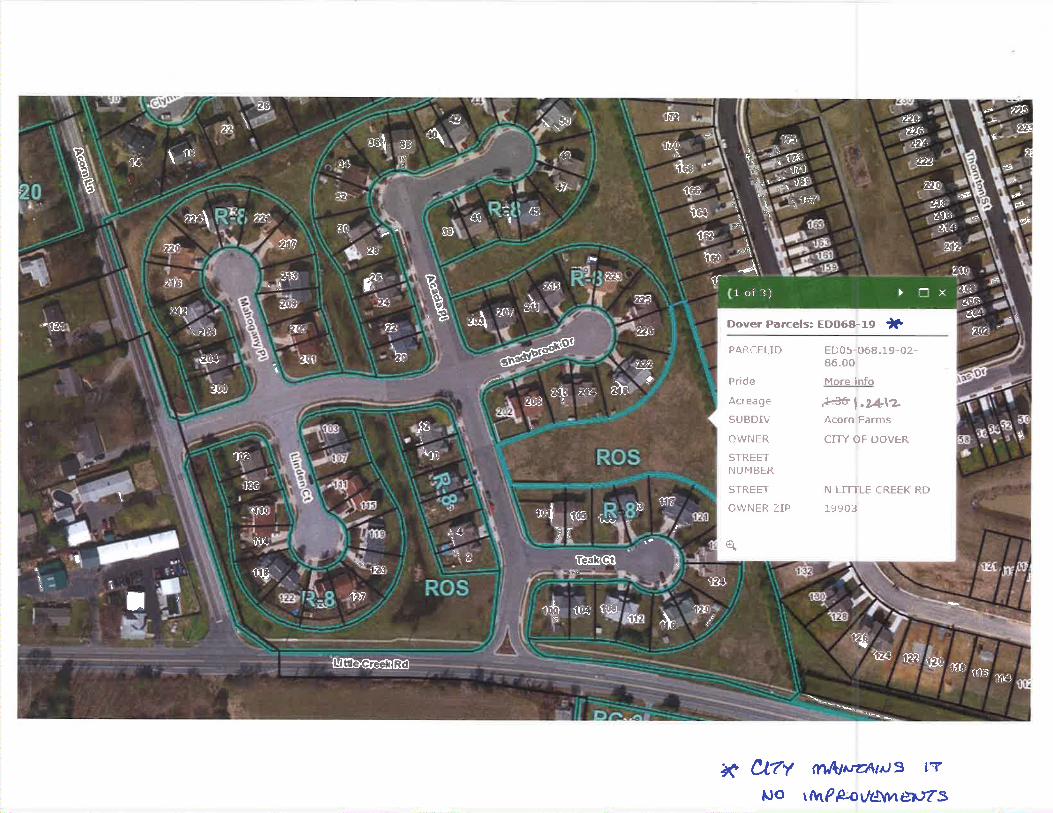
PAR.CEUD EDOS-068.19-02-86.00
Pride More info
Acreage ~ t.2.4-\'2. SUB DIV Acorn Farms
OWNER CITY OF DOVER
STREET NUMBER
STREET N LITTLE CREEK RD
OWNER ZIP 19903
~ Ci7Y <Y\A-J1Jz:·A11J 9 l 'T
tJO \ tvtP fJ;.-0 \ILSWl etJr S

Acom fo.rms C R.-rt) "'- ])ev~ed.- a~ ,t'eritlenW Ql~w De-V· 1'1'1:i. Ac.a.cic:£-Pltu-e.. £"J:y-t$-0~'6'.ll:f-02-K~.oo-ooa Sf3-'f2.-0'>f ;oeJtcolel fuJolt'<-OfotS~ Ros 1, 2l11 '2,JU.-
+ t9tu-kJ~ Fee-(faa)
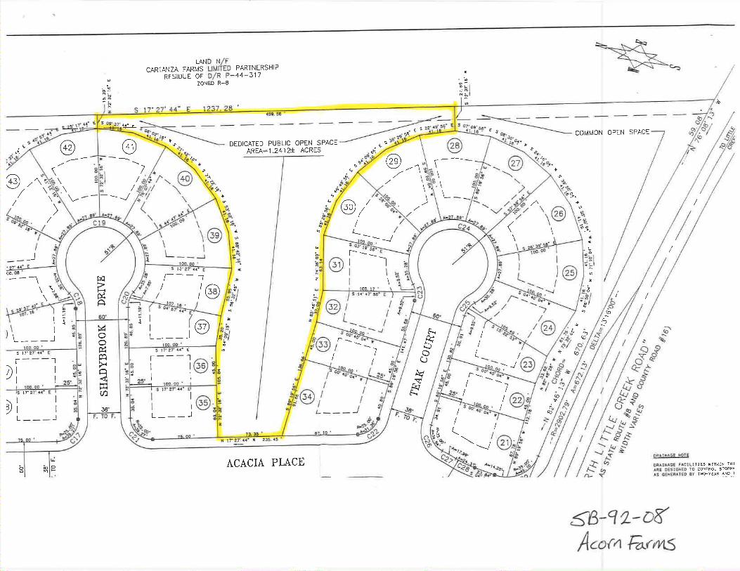
I ~ 60'
) \ I " :::.:-: " l ___ _J :~ 0
lDD. ca ' ~ 0 s1rz1· 1 .. ·e ~ r - - - 1 i:i::i
v' I ., ... ~ 0
!1"1!2 0 I < I 25' ~
OG. ICID ' ::r: S 17" 2-7' 4"4'" E [/J I
~ I 36' L _ _ _ _J F. TO F.
::; t~
~
"'g
'"''" ~ .. ~ ~ " ~
l(j
LAND N/F CARTANZA FARMS LIMITED PARTNERSHIP
RESIDUE OF 0/R P-44-317 ZONED R-6
S 1 7" 2 7' 44 " E 237 28 '
~
1P'O 00 I
S t?•t.7' u· E
r---1 -I 1@ :s -I I ~ ~
25' \DO, 00 • 2 S u~ Z7' --H •
I I "' I 1@ -. ~ L ___ _J g ~
7l.3~.
>I tT 27°· H• -£ ZJ5, 45. '
ACACIA PLACE O~A UUC!'ii MOTE
CRA!HA.i:l: F&CJUTIES WITH!N THl
.11'.~ OES\Gh*'EO ro CON TROL STORM ..
AS GE~EAAl£0 S'!' T'rrlO-YEAR ~~D .~
:5"f3-Cf 1-oC' Acor11 furlYl.S

I I
APPROVED:
PLANNING COMMISSION CHAIRMAN DATE
PLANNING COMMISSION MEMBER DA.TE
CITY CLERK DA1E
1.
2.
3.
4. 5. 6. 7. B .
9 .
OWNER OF AECORO:
EQUITABLE OWNER :
SOURCE OF TITLE:
ZONE PRESENT USE: PROPOSED USE: NUMBER OF LOTS : AREAS:
""g ' \.i1L11LQ_ ra: • ~•-RD 3 Box 3H Dover, DE 19901
K/ C Partners 600 Bay Road Dover, DE 19901
A Portion Of Deed Record Dated Feb. 9, 1988 A-8 Vac~nt, Cultivated Cluster Residential 84 Individual Lots;Ouplex
P-·44-317
Owel 1 ing Units
AVERAGE LOT AREA = 5 ,Z 13 Soua re Fee t
MlNT~U~ LOT AREA = ~. soo SQua re fee t MAX I MUM LOT AREA = 7 , 458 SQue"re Fee L
TOTAL AREA Of LOTS = 10 .0528 +/ - Acres
DEDICATED RIGHT OF WAY = 3 . 8769 +/- Acres
Of>EN SPACE : 6 . 070• +/- Ac res
TOTAL S I TE AREA = io .0001 +/- Acres
STREETS : Z, U• ~/- LI near Feet
Street.5 Shell Be Construot.ed In ·Accordance With The City Of Dover
Standarda And S1><1cifica ti ons. stree ts To Be Dedicated To!he City Of
Dover Str e e.t s Con5truc.te d WHhin The Limit s o·r The Right-Of-Wa y
Oed fc ated Ta The Publ 1c Use Shown On Tl>is P] an Ar• Ta Be
Mointaine d Sy The City Of Oo~ar Following Completi on By The Dsvol ope r
To The sat i ,.fec t on .Of The City. The Ci ty As sumes r<o Maintenance
Aespons ibil it.ies Within The O" dicated Ri ght-Of -Way Until Th e Str...,ta
Ha ve Been Acce pted By The Cjty . 10 . WATE R SUPPLY: CiLy Of Dover
11. SA.NITA.RY SEWER : City Of Dove r
12. ~ater Supp ly And S•nita ry Sewer Des i gn And Cons t ruction Shel l Be
.ln Acc orda.r,ce With The City Of Oover S:c.anda. r d.s And !? PGC ff i c a tions .
13 . F IRE ~ Y ORA.HT (Hinfmum Si ze 8")
u . DATUM: H.G. S. ( Net ior.el Ge ode tic survey). 1929 .
Bench Mark Na•~ " DEDOT J". El eva t i on 24 ,1 82 , loc~ted At Tho Northe~st Co nier
Of The I nte rsect on Of Sta t e Route 8 And
Acorn Lene. , Bning A 81'"'as s Otak ln
Concrete.
20 . EROSION CONTROL:
21. DEBRIS BURIAL:
22 . AREA OF DISTURBANCE: 23. HONUHENT:
urvuµ "' In Accordance With Delaware Eroaion And
Sediment Control Handbook, 1989.
The Burial Of Construction Debrie 1• Prohibited On Thia Sf ta. 20.00 +/- Acree
48 : Ex1ot!n9 II= PropoHd
24. With Th• E~c•Dtton Lot Lin• • Tr•v•l'"'• i~g Th~ough Pa~~Y Wall •. A 7.5
Foot WiO• E•••..,..nt On Each S i d• Ot Each S id• And Rear Lo t Lin• Shown On
Thf a P J an And On Each Sid• Of Ea cn S i a1 An d Ae•r Lo~ Li ne Su bc1quently
E•~•bl1•h•d ~ith in The Area Sho~n On Sa i d P lan J • ~ereby Ded icated To
B• Ava i lab l e For An y Ut ili ty U•1 1 Provide d TMat Whe r • An y Lot l ine l•
E11 mi n•t•a. Tn e E•·••ment Al on g Sa.id Lot Lin• Sha l l Se E• t fn vu,•h•d
£.ccepL Al To Ut111tle,.a Thi n E.K ~ •t. in'll! In S•1d E•••mant. SI• Ho t.• 25.
1.1,l; 4l"a"_, , .,....._~ . A c;. ~ _ . .,_ .. VT, ... ,.,,_. &.&1~-~T ~ µ~~-"'(" ~·tG~ • t.. -.C.
-n..r. e- ~~ L-•u• o~ ~ACAJ ~T'.
?5. A 15 Foot W1d• Utility Eaeem1nt On Eich Re•r lot Line Along
Project Boundar;e• Abutting Undeveloped Lend• la Hereby D•dicet•d To Be
Av& i \ a bl• For Any Utility Ue•. At Such Tfm• That Said Landa Are
O•ve top•d, The Eaaement Shall 9• Reduced To 7.5 Feet Wide In Accordance
With Note 2 ...
26. COMMON OP EN" SPACE: In Acco r dance Wi th Arti<: h S . Sec t i on
10 , Ci tY Of Dover Zon l n~ Coda. rt !s The . I n tent ion Of The
Deve l ooer To Prov i de Fo r The Esta.bl ! s nmant Of A Non-Prof i t
Homeowne r s• ASs0c 1s t ion For The Care. Oeve loomant , And
Maintenence Of Common Ooen Soece And I t s Ac ourten·a nt. Storm
Dra i nage An d Recr eat i ona l Fac ili t i es . A Port. i o n of The Oo•n
Spac e . A5 Noted , ts Dedi cate d By Th i s Plat As Pub li c Ooan Soac e
To 8& De velooed And Ma i nta i ned By Th e Ci t y Of Dover .
27. Deed Restrictions As Aoplv To Lots Shown On This Plan Are
Recorded In The Office Of Kent Countv Recorder Of Deeds In Deed
Record Book ..E_ Volume ..:?:!_Page lfil.
28 . This P1at Plan Was Recorded Jn The Off;ce Of The Recorder Of Deed•
In And For Kent County And State Of Delaware In Plat Book _ At
Page_.
,__r -::~ =--=-sJf> -Cf 2 ~D'F ........ ,, I
l..Jc::rTe;:. \,._, t:.. c.co~"ClnNeT- v.· .,..,_ ~ C.1'T-,· c:=o "'" -.;;,,..,s-c,.. Zc.n..J. ,__.c., lZEr, ...,i... ... --•o;>• , , ·-- •'- • A F ""'' '"" <--r'?u•• L ~J !'-?"'dV •~~? ,v .-... • .,.....,~(_<.) oe ~-<.'""' "'-.: .. ,. • c 0 r n a I.,, 11 ~ P.c.\'Ct.-~l""-'.e.., "'1'fA.G"e-c;..
- ,....._. .. • ...-,. s
::;:, "" ... "'"'" '"" • . .... '°" ,., ,J;,., ~:: '. · ~~,o d't EXTINGUISHING AND DELETING A 15-FOOT WI DE WATER LINE E.ASFMENr - -->" REVISED~
BETWEEN LOTS 8 AND 9 . ANO EXTENDING A 20- FOOT WIDE W TED, ! itl':. Y,/-z.e_,1'0<;-oo;··::.._ ___ _ _ _ _ _ ~«_-----'"-----------
EASEMENT TO ABUT. WITH VARYING WIDTH . THE RoAR LINES q~ .. LOTS_?-, / "/7 -AND 8. EASEMENTS AS SPECIFIED IN NOTE #24 ARE NOT ~Ff EC.TEP.~~f~ I RE PLAN THI S REVI S ION . t2E.V1~1ou ~<=-Ju i.._. Z"r, l~Z. A~E~ ~,.., ..., ,..,~ ~,..;:: • - }(/ . ._ _
THI S PLAN SUPERSEDES THE RECORD PLAN OF ACORN FAR"JS ASI REOOR:> Eb 7 /-. !/"'~
IN KENT COUNTY PLOT BOOK 30 . PAGE 17. -- --/ .&.:-;, ' ~;,.....· =---------------------· _ ~~ESIDF.NTIAL CLUSTER DEVELOPMENT
-I ~ T!1E CITY OF DOVER, EAST DOVER HUNDREll,
KENT COUNIY AND STATE OF DELAWARE
T.M.# ED-05-68.00-01-07.00 (BEING A PORTION or)
REVISIO~~S GERALD A. DONOVAN ASSOC., INC. 1
1-----~-------------------1 -4-V'I SOUTH GOVERNORS AVENUE. DOVER DELAWARE 19901 1 7
DATE DESCRIPTION n:u::?HONE 302-674-2903 L._lr
1-----+---=----------------1--------~~~--~--~~~~~~-/~
4/14/92 REVISED TEAK COURT AND PP.OVIC'lC:D PUBLIC OP" rJ PROFESSIONAL I.AND SURVf:..l'ORS
SPACE PER PARKS AND REe.. -----~-----------------!
4/ 14/ 92 MISCELLANEOUS Rt.VISIONS t/RA.WI l BY: '"'J7.y'5/ GAD/RPS DATE: 4/06/ !:12
1-.:..........,.:...-0-~~------------------~--------....;._-----+------'--'-------· -
1-c.-=--/,,..e._,/,.,"',_z._+-,,._.,._~_ ... _..,~w~.,..,~,,..~·-·--b::-..... '.:'""".,-4~.....,...~-=-----"-~-·--"'-'":-... -o-·-- -- .,._ --i C~ECKED BY: ~t..r.:>/tz.-= <:- SHEET
.r. / 1 .. / q'L .e t..1 .-...-... • ~S:C- T' ..,.._.., / "WCIA'l"e- PCl "fO...~ •°"""·· ·r OF Z
'<": '.":.:- : '.'"'"" ~~~~: ·= '::':',;~!. . . $C./\L['. AS SHOWN I DWG: 9138REC1 I CL: 91- .',R-00

15
Members of the committee expressed concern with the acceptance of cash in lieu of parkland, but was assured by staff that the parkland was adequate to meet the needs of the development.
Mr. Salters informed the committee that the City already has a development known as "Westwood Place" and suggested that the name of the subdivision be changed to avoid confusion.
Mr. Daisey moved to recommend that Council accept from the Westwood Development a combination ofland donation in the amount of 1.45+/- acres (which equals 50% of the development's required land area donation) and $39,785 (which equals the value of the remaining 50% of the land requirement) to meet the 10% land donation requirement under Article VI, Section F-2 of the Subdivision Regulations. The motion was seconded by Mr. Pitts and carried by a unanimous roll call vote.
Open Space Requirement - Acorn arms The Planning Commission recommended that Council accept from the Acorn Farms development a combination of a land donation in the amount of 1.24 acres (which equals 62% of the development's required land area donation) and a cash donation in the amount of $9,600 (which equals the value of the remaining 48% of the land donation) to meet the 10% land donation requirement under Article VI, Section F-2 of the Subdivision Regulations. The City Assessor has determined that the value of the land is $200,000. The subdivision consists of 20+/- acres, located at the northeasterly corner of the intersection of Acorn Lane and North Little Creek Road.
The subdivision is being developed under the Cluster option which allows duplexes on smaller lots, but a larger open space requirement (25% of land area dedicated to open space).
Members of the committee questioned ifthe proposed open space was adequate and was assured by staff that it was adequate to meet the needs of the development.
The committee recommended that Council accept from the Acorn Farms development a combination of a land donation in the amount of 1.24 acres (which equals 62% of the development's required land area donation) and cash donation in the amount of $9,600 (which equals the value of the remaining 48% of the land donation) to meet the 10% land donation requirement under Article VI, Section F-2 of the Subdivision Regulations. The motion was seconded by Mr. Daisey and carried with Mr. Lambert voting no.
It was later determined that calculations for the cash donation of the open space requirement were incorrect and should be a cash donation in the amount of $7,600 (which equals the value of the remaining 38% of the land donation).
Mr. Daisey moved that Council accept from the Acorn Farms development a combination of a land donation in the amount of 1.24 acres (which equals 62% of the development's required land area donation) and cash donation in the amount of$7,600 (which equals the value of the remaining 38% of the land donation) to meet the 10% land donation requirement under Article VI, Section F-2 of the Subdivision Regulations. The motion was seconded by Mr. Pitts and carried by a roll call vote of five (5) yes, four (4) no (Mr. Lambert, Mr. Salters, Mr. Christiansen and Mr. Hare).
Mr. Lambert explained his opposition to the motion, stating that much of the traffic problems on Whiteoak Road are a result of the growth that has been allowed to take place on the east side of Dover. In many cases the original plan has been altered to higher density plans which effect utilities, streets, traffic, etc.
Mr. Daisey moved for acceptance of the Parks and Recreation Committee Report, seconded by Mr. Pitts and unanimously carried.
UTILITY COMMITTEE REPORT