
CloudCompare - Cloud Storage & Compute · 2015-04-10 · Change detection on 3D geometric data ......
52
-
Upload
nguyenmien -
Category
Documents
-
view
219 -
download
0
Transcript of CloudCompare - Cloud Storage & Compute · 2015-04-10 · Change detection on 3D geometric data ......
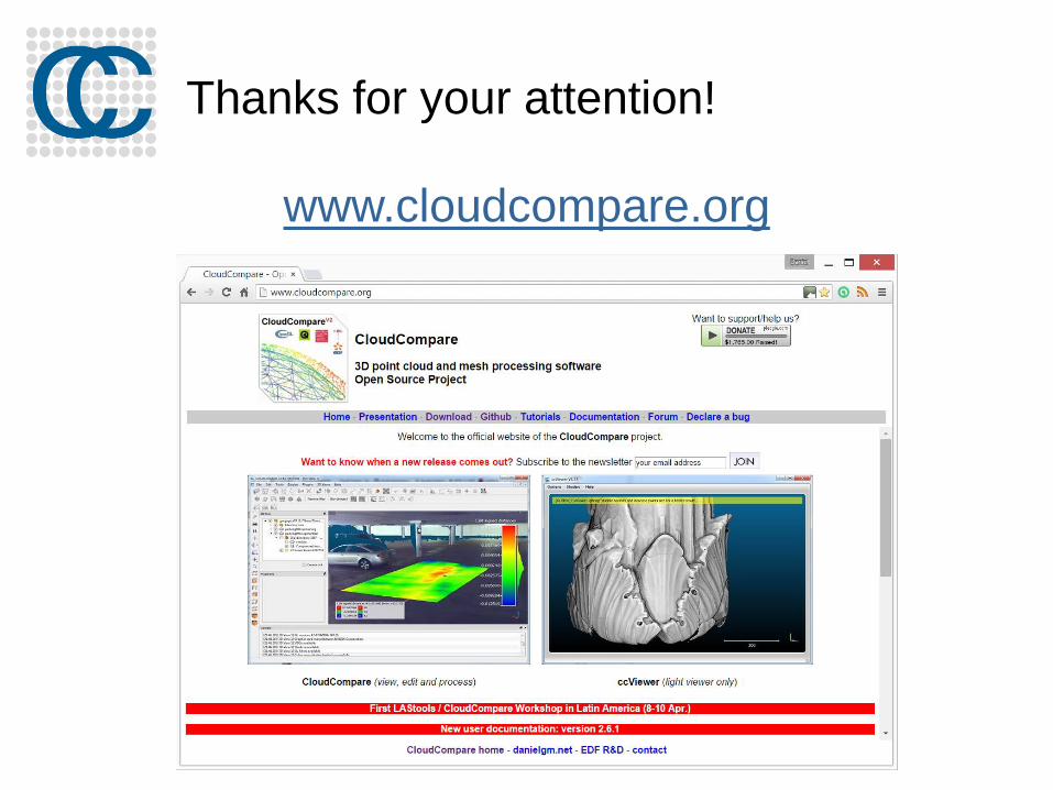
Workshop
Interactive!
Copy the sample files from the USB thumb drive:
You can install CloudCompare 2.6.1 with the Windows or
Mac OS X 10.9+ installers (“binaries”). Otherwise go to:
www.cloudcompare.org

Outline
About the project
Generalities
Level 1: GUI, display, manual editing, etc.
Advanced stuff
Level 2: registration, distances, scalar fields, etc.
And everything else…

2003: PhD for EDF R&D
EDF
main French power utility
Over 150 000 employees worldwide
2 000 @ R&D (< 2%)
200 know about CloudCompare (< 0.2%)
Sales >75 Bn € (90 Bn $)
Over 200 dams
58 nuclear reactors (19 plants)
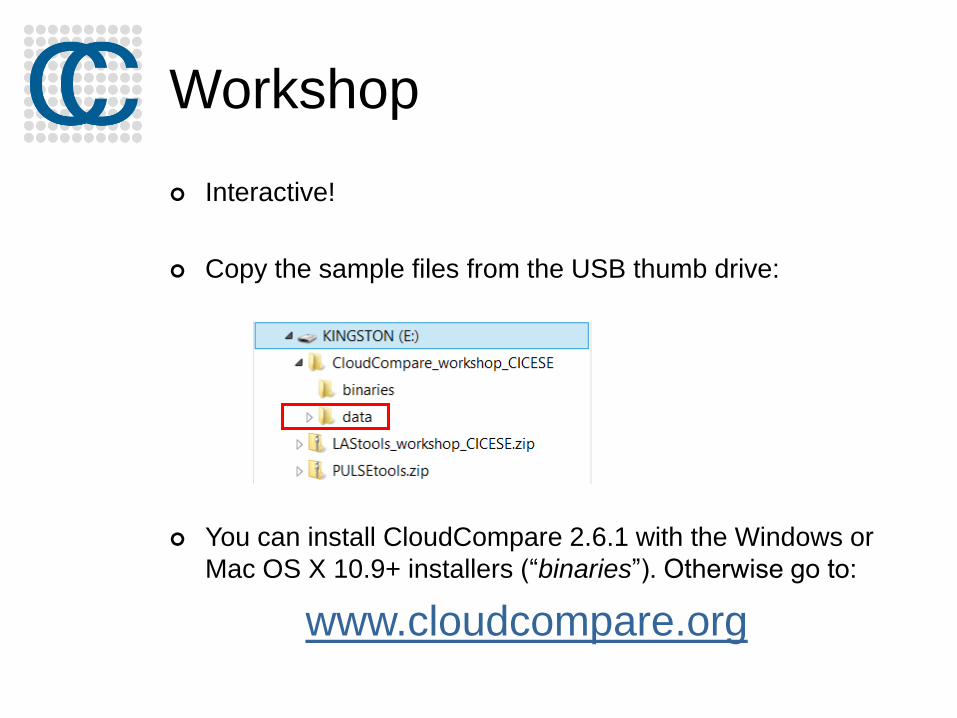
EDF and Laser Scanning
EDF = former owner of Mensi (now Trimble Laser Scanning)
Main scanning activity: as-built documentation
Scanning a single nuclear reactor building
2002: 3 days, 50 M. points
2014: 1.5 days, 50 Bn points (+ high res. photos)
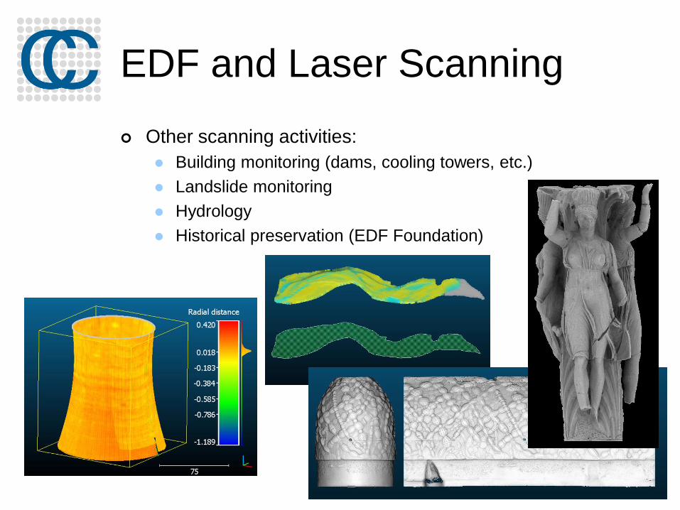
EDF and Laser Scanning
Other scanning activities:
Building monitoring (dams, cooling towers, etc.)
Landslide monitoring
Hydrology
Historical preservation (EDF Foundation)

PhD
Change detection on 3D geometric data Application to Emergency Mapping
Inspired by 9/11 post-attacks recovery efforts(see “Mapping Ground Zero” by J. Kern, Optech, Nov. 2001)
TLS was used for: visualization, optimal crane placement, measurements,
monitoring the subsidence of the wreckage pile, slurry wall monitoring, etc.

CloudCompare V1
2004-2006
Initial goals: to compare freshly (and big) acquired point clouds to quickly assess for changes
either between a cloud and a mesh/CAD
or directly between two clouds ( the high density of
TLS clouds is the key)

CloudCompare V2
2007: “Industrialization” of CloudCompare
… for internal use only!
Rationale:
idle reactor = 6 M€ / day
acquired data can be checked on-site less missing or
erroneous data no need to come back later
checking the work of sub-contractors in charge of modeling
became fast and accurate
the algorithms are also used for clash detection during
virtual simulation of tricky maintenance operations highly
reduces the risk of issues or bad surprises during the actual
maintenance operation
Moreover EDF is not a software company

The open-source path
2009/2010: CloudCompare V2.1
Already a multi-purpose point cloud
editing and processing software
2014: CloudCompare V2.6
Works on:
Windows (XP / 7 / 8)
Mac OS (thanks to Andy Maloney)
Linux (thanks to Romain Janvier)
Supports 3D mice (Windows only)

Open-source!
Quickly evolving
Goes where the users want…
… goes there faster if the users are able to actively participate!
Remains under strict supervision of the administrator ;-)
Independent on any manufacturer
Meant to survive: backed by strong companies and
institutions (EDF, BRGM, CNRS, etc.)

Open-source!
Free…
…but someone has to “pay” ;)
either by working on the project
or by paying someone to do so
plugins are not necessarily public or free
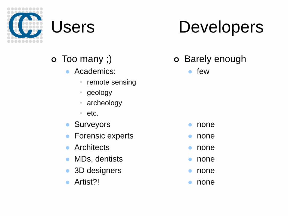
Users Developers
Too many ;)
Academics:
• remote sensing
• geology
• archeology
• etc.
Surveyors
Forensic experts
Architects
MDs, dentists
3D designers
Artist?!
Barely enough
few
none
none
none
none
none
none

Development cycle
Specscore
algorithm
“packaging”
(GUI, details, etc.)tests
A simple
message on
the forum
The fun partThe less fun
part
Developer’s
hell
User’s hell ;)
stability
time1st release
user feedback!

Worldwide users
> 1300 subscribers to the news letter

Generalities

User interface overview
3D view(s)DB view
Selected
entity
properties
Console
Menus + main toolbars
View
toolbar

Input/Output
Mainly point clouds (ASC/PTS, LAS/LAZ, E57, PTX,
FLS/FWS, DP, etc.) and triangular meshes (PLY, OBJ,
STL, OFF, FBX)
Dedicated format: “BIN” (for projects)
Other formats: calibrated photos (Bundler .OUT), CAD (Autocad
DXF drawings, Aveva .PDMS scripts), GIS shapefiles
To come:
RIEGL files
more manufacturer formats?

Clouds display
Blank cloud
RGB
Normals (slow )
EDL (fast )

PCV
Global illumination / ambient occlusion

Scalar fields
One value per point
The value can be anything (distance, intensity, density,
roughness, confidence, curvature, temperature, time,
etc.)
Values can be (dynamically) color-coded

Scalar fields
Values can be
mixed (+,-,/,x)
transformed (cos, log, etc.)
filtered (spatial smoothing, spatial gradient, etc.)
imported or exported as a coordinate dimension
merged with colors
Statistics can be computed
Clouds can be processed based on those values
Segmentation (Filter by value)
Subsampling
Values can be exported to a CSV file
( Excel, Matlab, etc.)

Color scales
Color Scale Editor : edit and create color scales
Color scales can now be imported/exported as XML files
When saving a « BIN » file, custom scales are automatically
exported (and will be automatically imported when opening the
file on another PC)

Manual editing
Manual transformation
Manual segmentation
Cross Section
Color / Normal editing
Sub-sampling tool
Scaling
Cloning / Merging

Advanced

Registration
Point-pair based alignment
Automatic registration (ICP)
+ semi-automatic ball detection

RegistrationSome considerations
What if my entities have some “structural differences”?
Small local differences: ICP: ‘Enable farthest points removal’ checkbox
Different scales: Point-pairs based alignment: uncheck the ‘Fixed
scale’ checkbox
ICP: check the ‘Free scale parameters’ checkbox
Major differences: Prefer the “point-pairs based alignment” tool!

RegistrationSome (more) considerations
What if one of the entity is a mesh?
Almost the same workflow
Sometimes you may have to sample points on the mesh first (Edit > Mesh >
Sample points)
then apply the resulting transformation on the original mesh (Edit > Apply Transformation)
For the ICP process (fine registration) the mesh should always be the ‘reference’ generally less holes and/or noise

Distances computation

Distances computation
Distances are computed between each point of a ‘compared’ cloud and its nearest point or triangle in a ‘reference’ entity
Process is not symmetrical
compared reference

Distances computation
Two (or three) cases
1. Comparison of two clouds
2. Comparison of a cloud and a mesh
3. Comparison of two meshes: the only way to do this in CloudCompare is to sample points on the ‘compared’ mesh back to case 2
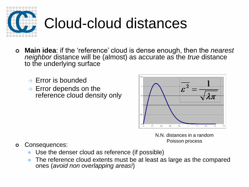
Cloud-cloud distances
Main idea: if the ‘reference’ cloud is dense enough, then the nearest neighbor distance will be (almost) as accurate as the true distance to the underlying surface
Error is bounded
Error depends on thereference cloud density only
Consequences:
Use the denser cloud as reference (if possible)
The reference cloud extents must be at least as large as the compared ones (avoid non overlapping areas!)
N.N. distances in a random
Poisson process

Poor or irregular density?Local meshing strategy
measured distance
real distanceLocal modeling: 2 to 5
times slower

Cloud-cloud distances
Select both entities
Tools > Distances > Cloud/Cloud dist.

Robust C2C distances with
M3C2
Lague, D., Brodu, N. and Leroux, J., Accurate 3D comparison of complex topography with
terrestrial laser scanner : application to the Rangitikei canyon (N-Z), 2013, ISPRS journal of
Photogrammmetry and Remote Sensing

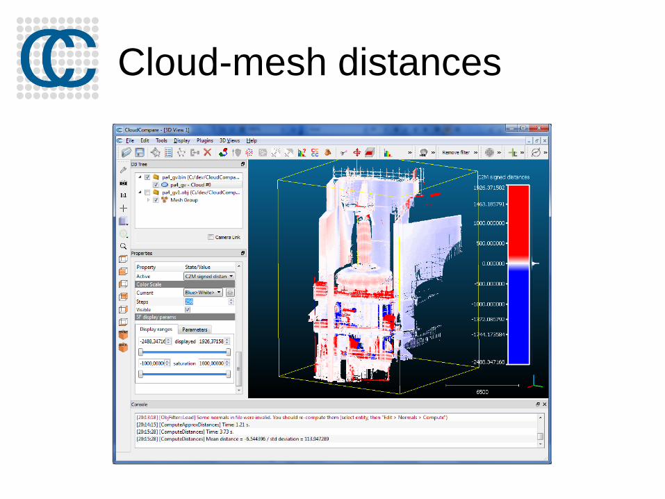
Cloud-mesh distances
Tools > Distances > Cloud/Mesh dist.
In this mode, the distance is computed between each point of the ‘compared’ cloud and its nearest triangle in the ‘reference’ mesh
If the mesh quality is good, this is generally faster and more accurate… but getting a clean mesh can be hard!
Regarding the output, the only difference with the cloud/cloud case is that the distances are signed (we use the triangle normal)
Cloud-mesh distances

Classification with CANUPO
Brodu, N. and Lague, D., 3D Terrestrial LiDAR data classification of complex natural scenes
using a multi-scale dimensionality criterion : applications in geomorphology, ISPRS journal of
Photogrammmetry and Remote Sensing, 2012

Cleaning
Various methods to remove isolated parts, outliers, non-overlapping areas, etc. :
Manual editing
Remove isolated parts with the “Label Connected Components” tool
Remove isolated points / noise with: Tools > Clean > Noise filter
Other option: scalar-field based segmentation

Contour/profile extraction
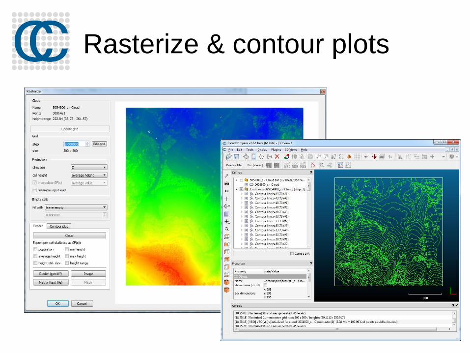
Rasterize & contour plots

Other

Working with SfM data
Support for Bundler files
Handling of calibrated pictures and
camera sensors

Sensors
TLS (“GBL”) Sensors
Camera sensors

Meshing
Meshing tool (to cope with holes mainly)
Delaunay 2D for ‘2D½’ clouds
Or the qPoissonRecon plugin for closed shapes
Warning: CloudCompare is not a ‘meshing’ tool
(remember that the initial aim was to avoid meshes ;-)
It only provides simple approaches for convenience
Consider using “true” meshing tools
(Meshlab, VR mesh, Geomagic, etc.)
If you need accurate meshes

Presenting & sharing results
Analysis
Histogram
Local Statistical Testing tool
Export to Matlab®/Excel®/etc. (ASCII ~ CSV format)
Display
create labels, save viewports, etc.
Save the whole project in a “BIN” file
Share
ccViewer (lightweight, for load & display only)
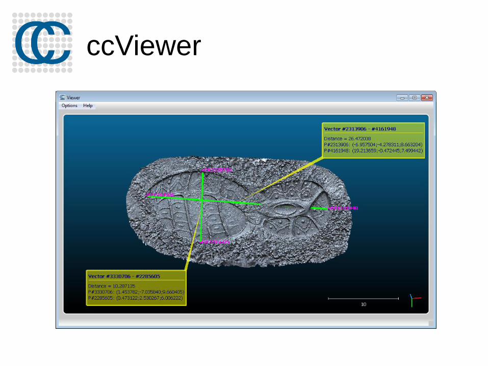
ccViewer

Misc.
Plane and sphere fitting
Unroll feature (on a cylinder or a cone)
Plugins
Command line mode
Wiki (http://www.cloudcompare.org/doc/wiki)

Next

In preparation
Near future:
Oculus Rift plugin
Animation
Volume calculation
TODO list:
https://github.com/cloudcompare/trunk/blob/master/qCC/TODO.txt

Next workshops
2nd international conference of the IAFSM (San
Diego, Nov. 2015)
ISPRS International Conference (Prague, Jul.
2016)