CITY OF GREATER SHEPPARTON HERITAGE STUDY STAGE...
161
CITY OF GREATER SHEPPARTON HERITAGE STUDY STAGE II HERITAGE PLACE DATASHEETS The Echoes (HO11) VOLUME 3 DATASHEETS A-Mooroopna
Transcript of CITY OF GREATER SHEPPARTON HERITAGE STUDY STAGE...
C I T Y O F G R E A T E R S H E P P A R T O N
H E R I T A G E S T U D Y S T A G E I I
H E R I T A G E P L A C E D A T A S H E E T S
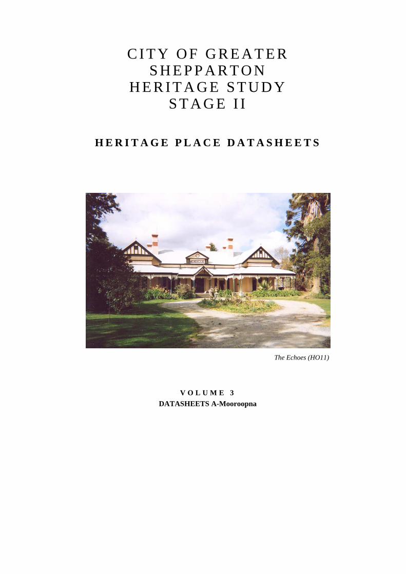
The Echoes (HO11)
V O L U M E 3 DATASHEETS A-Mooroopna


C I T Y O F G R E A T E R S H E P P A R T O N H E R I T A G E
S T U D Y S T A G E 1 1
H E R I T A G E P L A C E D A T A S H E E T S
V O L U M E 3 DATASHEETS A-Mooroopna
Allom Lovell & Associates Conservation Architects 35 Little Bourke Street
Melbourne 3000
February 2004

This report is Volume 3 of a six-volume set, comprising:
Volume 1 Introduction and Recommendations
Volume 2 Environmental History
Volume 3 Heritage Place Datasheets: A-Mooroopna
Volume 4 Heritage Place Datasheets: Murchison –Z
Volume 5 Heritage Overlay Precincts
Volume 6 Heritage Place Datasheets: Log Structures and Scotch Kiln

City of Greater Shepparton Heritage Study Stage Two
Allom Lovell & Associates 5
DATASHEETS A-MOOROOPNA

City of Greater Shepparton Heritage Study Stage II
6 Allom Lovell & Associates

City of Greater Shepparton Heritage Study Stage Two
Allom Lovell & Associates 7
Current Name Holy Trinity Anglican Church Reference No. 01 (HO1)
Former Name Grade B
Address Lenne Road, Ardmona Construction Date 1914-15
Map Reference 471.722 Shepparton Ownership Anglican Church
Survey Date August 2002
Intactness Condition Good Fair Poor Good Fair Poor
Heritage Listings
Exi
stin
g
Rec
omm
ende
d
VHR
RNE
Planning Scheme
National Trust (Vic)

City of Greater Shepparton Heritage Study Stage Two
8 Allom Lovell & Associates
History Prior to 1914, the Anglican congregation at Ardmona had gathered in the local public hall for services. Half an acre of orchard land was donated by a local farmer, Mr Hornidge, as the site for a new church. The foundation stone for the Holy Trinity Anglican Church was laid on 9 December 1914 by Bishop J D Langley. Designed by architect, Mr Richardson, the builder was M A Miles of Tatura. Brick paving was laid around the outside of the church after its completion by Reverend J A Rowell and members of the congregation.
Description Holy Trinity Anglican Church, Lenne Road, Ardmona, is a small red face brick building comprising porch, nave, sanctuary and vestry with parapeted gabled roofs clad with corrugated galvanised steel. The parapets are finished with rendered copings and cross finials and the main gable end contains a small oculus window. The central projecting porch contains a pair of pointed arch side entrances with V-jointed board timber doors and a single lancet opening in the end wall. The buttressed side elevations contain regular fenestration with the exception of the north side which also contains a pair of timber doors. The sanctuary window comprises a group of 3 lancet openings. All windows contain timber-framed fixed sash windows with diapered leadlight glazing.
The area surrounding the church is paved with red bricks (1915) and includes numerous mature Canary Island date palms (Phoenix canariensis) and Pepper trees (Schinus molle).
Thematic Context
Thematic Environmental History
10.0 Worshipping
Australian Heritage Commission
8.6 Worshipping
9.7 Mourning the dead
Significance
Holy Trinity Anglican Church, Ardmona, is of local historical, social and aesthetic significance. Constructed in 1914, the church has served as a place of worship for the district’s Anglicans for almost 90 years. Aesthetically, it is a substantially intact example of a simple rural brick church, of which there are numerous examples in the municipality.
References
W H Bossence, Tatura and the Shire of Rodney, pp 48-50.
Recommendations
• Retain original unpainted finish to brickwork and otherwise investigate original external paint colours when due for a repaint
• Repair damaged brickwork and repoint
• Retain brick paving and landscape setting including mature specimen trees
• It is desirable, from a heritage perspective, that the building retain its public/community function
• Should toilets be required they should be sited at the rear and not visible from the road.
Identified By
SOMA Design Partnership, June 2001.

City of Greater Shepparton Heritage Study Stage Two
Allom Lovell & Associates 9
Current Name Residence Reference No. 02 (HO2)
Former Name Scots Presbyterian Church Grade B
Address 100 Lenne Road, Ardmona Construction Date 1930
Map Reference 473.722 Shepparton Ownership Private
Survey Date August 2002
Intactness Condition Good Fair Poor Good Fair Poor
Heritage Listings
Exi
stin
g
Rec
omm
ende
d
VHR
RNE
Planning Scheme
National Trust (Vic)

City of Greater Shepparton Heritage Study Stage Two
10 Allom Lovell & Associates
History
For many years local Presbyterians, as well as Church of England worshippers, used the Ardmona Fruit Growers Hall for worship. In 1930 work commenced on the new Scots Church in Lenne Road. Constructed of concrete, it was built at a cost of £1, 121. It was opened on 16 May that year by Mr John Allan, MLA. In the early years the church was a hive of activity, and was the focus of such groups as the church choir, Ladies’ Guild and League of Worship. The number of parishioners began to decline after World War Two and it became difficult to keep the church viable. Services ceased in 1985, and the church was converted to a private residence.
Description
The former Scots Church, Lenne Road, Ardmona is a rendered concrete building on a T-shaped plan comprising a porch, nave, sanctuary and vestry. Each section has a gabled roof clad with corrugated galvanised steel and gable end finished with strapped cement sheet and timber fretwork. The central projecting porch contains a pair of timber doors and a pointed arch timber-framed double-hung sash window to each side. The buttressed side walls contain regular timber-framed double-hung sash windows with leadlight glazing. A recent timber-framed gabled canopy has been added to the west porch. The side and rear boundaries are defined by a recent steel fence and the landscaped surrounds include mature Canary Island date palms (Phoenix canariensis). The rear yard contains a recent prefabricated steel shed.
Thematic Context
Thematic Environmental History
10.0 Worshipping
Australian Heritage Commission
8.6 Worshipping
9.7 Mourning the dead
Significance
The former Scots Church, Lenne Road, Ardmona is of local historic, social and aesthetic significance. Constructed in 1930, the church served as a place of worship for the district’s Presbyterians for 55 years, although it no longer serves this purpose. Aesthetically, it is a reasonably intact and interesting example of a rural church constructed of concrete, of which there are no other known examples in the municipality.
References
W H Bossence, Tatura and the Shire of Rodney.
The Historical Society of Mooroopna Inc, Mooroopna to 1988, pp. 59-60.
Recommendations
• Investigate original external paint colours when due for a repaint
• Preferably remove later timber-framed addition to west porch
• Retain mature specimen trees
• Any additional external structures should be located at the rear of the building and be visible from the road.
Identified By
SOMA Design Partnership, June 2001.

City of Greater Shepparton Heritage Study Stage Two
Allom Lovell & Associates 11
Current Name Pine Trees Reference No. 03 (HO3)
Former Name Grade B
Address 15 Lenne Road, Ardmona Construction Date c.1892
Map Reference 484.719 Shepparton Ownership
Survey Date August 2002
Intactness Condition Good Fair Poor Good Fair Poor
Heritage Listings
Exi
stin
g
Rec
omm
ende
d
VHR
RNE
Planning Scheme
National Trust (Vic)
Curtilage A nominal curtilage should be maintained to preserve the setting of the trees, nominally the dimension of the canopy overhang plus 10 metres.

12 Allom Lovell & Associates
History
Spurred on by a book published in England by the Chaffey brothers, who had established irrigation in the Mildura area, two families emigrated from England to Victoria. Settling first in Mildura, H E Pickworth and the Turnbull brothers were disappointed by the early plantings of vines, as well as the difficulty of transportation from Mildura, and soon moved to the Goulburn Valley. The Pickworth and Turnbull families settled at Ardmona in 1892 and immediately bought 57 acres of land from George Pagan, one of the original settlers. The pair of Norfolk Island pines (Araucaria heterophylla) were probably planted soon after their arrival in Ardmona. Anecdotal evidence suggests that the trees were originally planted to divide the land between the two families, and a laneway still exists between the pines.
Description Pair of mature Norfolk Island pines (Araucaria Heterophylla) flanking a dirt driveway off Lenne Road, Ardmona.
Thematic Context
Thematic Environmental History
4.2 Selectors and Closer Settlement
Australian Heritage Commission
2.5 Promoting settlement on the land through selection
Significance
The pair of mature Norfolk Island pines (Araucaria Heterophylla), Lenne Road, Ardmona, are of local historical and aesthetic significance. Of approximately 100 years old, they provide a distinctive landmark of the township of Ardmona, which is otherwise hidden by the surrounding orchards. The trees mark the boundaries of the land selected by two families of English immigrants who chose the Ardmona area to grow fruit.
References
W H Bossence. Tatura And the Shire of Rodney, p. 53
Recommendations
• The trees should be assessed on a 1 to 2 year basis by a qualified arborist
• Should they require removal when they become senescent, they should be replaced with a similar species.
Identified By
SOMA Design Partnership, June 2001.

City of Greater Shepparton Heritage Study Stage Two
Allom Lovell & Associates 13
Current Name House Reference No. 04 (HO4)
Former Name Grade B
Address 610 Simson Road, Ardmona Construction Date c.1910
Map Reference 456.691 Shepparton Ownership
Survey Date August 2002
Intactness Condition Good Fair Poor Good Fair Poor
Heritage Listings
Exi
stin
g
Rec
omm
ende
d
VHR
RNE
Planning Scheme
National Trust (Vic)

14 Allom Lovell & Associates
History
The house, originally built in Nixon Street, Shepparton, was transported to Ardmona in c.1975 by Ken Ratcliffe.
The land on which this house now stands was originally Allotment 72b, in the Parish of Toolamba, (1946). The 238 acres of Crown land was first owned by Thomas Alexander, a farmer of Toolamba, in 1882. Its rateable value was £42 by 1886. This residence is located on the original, though somewhat reduced block of land.
Description The residence at 610 Simson Road, Ardmona, is a single-storey Edwardian weatherboard villa with a complex gambrel and gable roof clad with corrugated galvanised steel which is punctuated by a red brick chimney with corbelled top. The distinctive flying gable ends are finished with carved bargeboards and pressed metal cladding. The house is angled 45 degrees to the road and the broad asymmetrical façade contains a central splayed bay window flanked by two entrances each containing half-glazed panelled doors, sidelights and fanlights with leadlight glazing. The facade is screened by a return verandah with timber posts and fretwork and a timber floor and rendered splayed entry steps. Each projecting bay contains a bay window with timber-framed double-hung sash windows screened by a timber-framed awning.
The property is unfenced to the road frontage and contains a later steel-framed carport and swimming pool enclosure.
Thematic Context
Thematic Environmental History
15.2 Small Townships and Localities
Australian Heritage Commission
4.5 Making settlements to serve rural Australia
Significance
The residence at 610 Simson Road, Ardmona, is of local historic and aesthetic significance. While the house has been transported to the site from Shepparton in recent years, its original construction c. 1910 provides evidence of the residential expansion in the region during the first quarter of the twentieth century. Aesthetically, it is a good and intact example of an Edwardian villa. The significance does not extend to its present location.
References
Parish Plan, Toolamba Sheet 2, T201 (12), 1946.
Cr. Bruce McNeill, pers comm.
Recommendations
• The modern carport can be retained, altered or demolished as required
• Investigate original external paint colours.
Identified By
SOMA Design Partnership, June 2001.

City of Greater Shepparton Heritage Study Stage Two
Allom Lovell & Associates 15
Current Name Ardmona Primary School Reference No. 05 (HO5)
Former Name Ardmona State School No. 1563 Grade B
Address 580 Turnbull Road, Ardmona Construction Date Pre-1909, 1912, 1930
Map Reference 485.717 Shepparton Ownership Dept. of Education
Survey Date August 2002
Intactness Condition Good Fair Poor Good Fair Poor
Heritage Listings
Exi
stin
g
Rec
omm
ende
d
VHR
RNE
Planning Scheme
National Trust (Vic)
Curtilage

16 Allom Lovell & Associates
History
The first school in Ardmona opened in September 1875 and was originally known as the Mooroopna District School. It was a simple timber building with a shingle roof, which was replaced by a more substantial schoolroom in 1885. The grounds were also fenced and an underground tank installed. In 1890 the school’s name was changed to Ardmona State School to reflect the fact that it was built on the Ardmona Estate. An additional classroom and a teacher’s residence were added in 1911-12. The use of the school as a practising and observation (teacher training) school, also famous for its agricultural plots, helped to secure the improvements.
Gardens formed an impressive feature of the school in the early years and in 1914 a windmill was erected to pump irrigation water into the site. The school became famous for its agricultural plots. Further additions and modifications were carried out in 1921. Pines and other now mature trees were planted in the school grounds in 1928. In 1930 memorial gates were erected by pupils in memory of the school’s long standing Head Teacher, W T Lees. Ardmona’s World War One Memorial was also constructed within the school grounds. Various other works have been undertaken at the school, including renovations to the teacher’s residence in 1933, and additions to the classrooms in 1948.
Description The Ardmona Primary School schoolroom is a single-storey weatherboard building with a hipped roof clad with corrugated galvanised steel. The double-fronted façade contains banks of timber-framed multi-paned double-hung sash windows with hopper sash highlights and a recessed entrance with pair of half-glazed timber doors. The façade is partially obscured by a later steel-framed flat-roofed shelter shed. To the north is a later addition also containing a recessed entrance and windows to match the original. Two small weatherboard outbuildings have gambrel roofs clad with corrugated galvanised steel. The landscape contains mature pines and palms including mature Norfolk Island Pines (Araucaria heterophylia) and Canary Island date palms (Phoenix canariensis). Central to the front garden is a World War I memorial consisting of granite obelisk and plinth. The frontage is fenced with a low Cyclone wire fence containing wrought iron memorial gates. Rendered masonry piers bear marble plaques with the inscription ‘IN MEMORY OF THE LATE W T LEES, HEADMASTER 1909-23’ and ‘ERECTED AUGUST 1930’.
Thematic Context
Thematic Environmental History
9.1 Primary and Secondary Education
Australian Heritage Commission
6.5 Educating people in remote places
8.8 Remembering the fallen
Significance
The Ardmona Primary School schoolhouse, landscape and memorials are of local historical, social and aesthetic significance. Opened in 1875, the school is associated with an early phase of development in Ardmona, being constructed on part of the original Ardmona Estate. The construction of a new schoolroom and residence in 1911, emphasises its importance as a practising and observation school, famous for its agricultural plots, buoyed by the development of irrigation in the surrounding area. Aesthetically, the school is distinguished by its mature garden surrounds.
References
W H Bossence, Tatura and the Shire of Rodney, p. 55.
Allom Lovell & Associates 17
Education Department of Victoria. Vision & Realisation Volume 3, pp. 775-776.
Recommendations
• Repair roofing
• Investigate original external paint colours
• Relocation of the later shelter shed to the rear of the building should be considered.
Identified By
SOMA Design Partnership, June 2001.

18 Allom Lovell & Associates

City of Greater Shepparton Heritage Study Stage Two
Allom Lovell & Associates 19
Current Name Residence Reference No. 06 (HO6)
Former Name St Patrick’s Roman Catholic Church Grade B
Address Brewer Road, Byrneside Construction Date 1897
Map Reference 361.678 Shepparton Ownership Private
Survey Date August 2002
Intactness Condition Good Fair Poor Good Fair Poor
Heritage Listings
Exi
stin
g
Rec
omm
ende
d
VHR
RNE
Planning Scheme
National Trust (Vic) File only

20 Allom Lovell & Associates
History
The first St Patrick’s Church at Byrneside was erected in c.1878 on land leased, then donated by local farmer Jeremiah Breen. Originally located at Graytown, this building was moved to Byrneside and modified by contractor Thomas Hill of Nagambie. In its first 10 years it had various names including the Tatura Church, the Toolamba North Church, the Junction Church (Baldwinsville), before becoming the Byrneside Church when Baldwinsville was renamed Byrneside. On 30 November 1897, a foundation stone was laid for the existing St Patrick’s church by the Very Reverend T J O’Connell, which replaced the earlier building. The building functioned both as a church and school before finally closing in 1986. It is now in private hands.
Description The former St Patrick’s Roman Catholic Church, Brewer Road, Byrneside, is a face red brick building consisting of porch, nave, sanctuary and vestry with parapeted gabled roof clad with corrugated galvanised steel. The parapets are finished with rendered copings and cross finials, detail which is reflected in the rendered window dressings, plinth, bandings, voussoirs, sills and drip moulds. The main gable contains a group of 3 lancet openings containing coloured glazing. The projecting porch contains a central entrance with pointed arch and original V-jointed board timber doors. Both the porch door and lancet windows have tuck-pointed bichrome brick dressings. The side elevations are buttressed and contain regular and repetitive fenestration with pointed arch timber-framed fixed sash windows with coloured glazing.
The remains of two small brick WC blocks exist at the rear of the property and a recent prefabricated steel shed has been erected to the east of the building. The front boundary has a Cyclone wire fence.
Thematic Context
Thematic Environmental History
10.0 Worshipping
Australian Heritage Commission
8.6 Worshipping
9.7 Mourning the dead
Significance
The former St Patrick’s Roman Catholic Church is of local historical, social and aesthetic significance. Constructed in 1897, and the only surviving church building in Byrneside, the church served as a focus for Catholic worship and community activity for 89 years until its closure in 1986. Aesthetically, it is a largely intact and representative example of a rural church, of which there are a number of surviving examples within the community.
References
A History of the Sacred Heart Parish of Tatura 1889-1989, p. 40.
W H Bossence, Tatura and the Shire of Rodney, pp. 60-61.
R Burtonclay, Solving the Mystery, Tatura, Toolamba North Junction Church [Baldwinsville], Byrneside, p. 3.
Allom Lovell & Associates 21
Recommendations
• While a shed has been recently constructed, it is desirable that no other additional structures be constructed within the curtilage which are visible from the street.
• Retain original unpainted finish to brickwork and otherwise investigate original external paint colours.
Identified By
SOMA Design Partnership, June 2001.

22 Allom Lovell & Associates
City of Greater Shepparton Heritage Study Stage Two
Allom Lovell & Associates 23
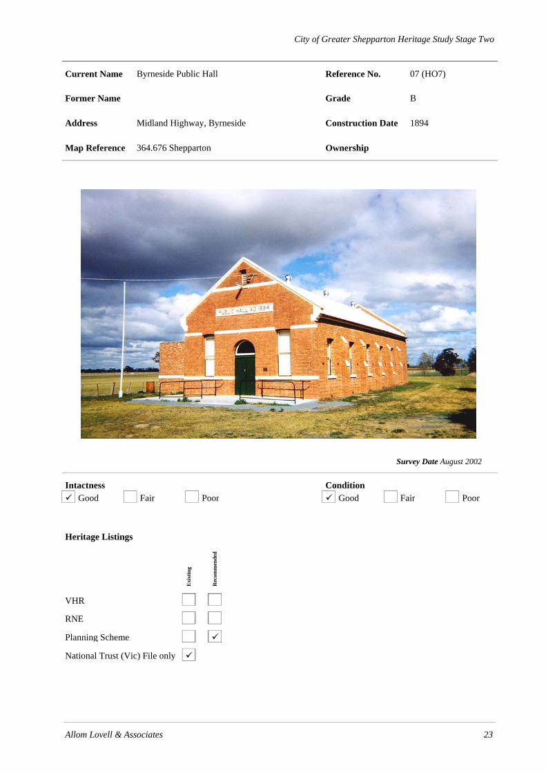
Current Name Byrneside Public Hall Reference No. 07 (HO7)
Former Name Grade B
Address Midland Highway, Byrneside Construction Date 1894
Map Reference 364.676 Shepparton Ownership
Survey Date August 2002
Intactness Condition Good Fair Poor Good Fair Poor
Heritage Listings
Exi
stin
g
Rec
omm
ende
d
VHR
RNE
Planning Scheme
National Trust (Vic) File only

24 Allom Lovell & Associates
History
The foundation stone for the Byrneside Public Hall was laid in 1894 by Elizabeth Morrisey. The building was completed at a cost of £640 and was opened with a special three-day bazaar in May 1894. In 1918 its original proprietors suggested to the local public that they intended to dispose of the building, causing the local community to rally together and form a committee in order to purchase the building. On 14 March 1919, the Free Press reported that the hall had been purchased by the local residents for the sum of £200. Initial trustees were W Sheales, Christopher Ford and P Keady. Electricity was connected in 1940 and the lights were turned on by the Honourable John McEwen. Renovations were undertaken in 1947, and more recently.
Description The Byrneside Public Hall, Midland Highway, Byrneside is a single-storey double-fronted red face brick hall building consisting of hall and later kitchen and amenities wing to the east, with parapeted gable roof clad in corrugated galvanised steel to the original hall and skillion roof to the addition. The façade contains a central semi-circular arched entrance with pair of V-jointed board timber doors, flanked by a pair of timber-framed double-hung sash windows with segmental arched heads with brick voussoirs. All other windows are similar. The buttressed side walls contain regular fenestration. The parapet coping, sills and plinth are rendered and a recent concrete ramp with steel pipe handrail provides access to the main entrance.
Thematic Context
Thematic Environmental History
11.0 Recreation and Leisure
15.2 Small Townships and Localities
Australian Heritage Commission
4.5 Making towns to serve rural Australia
8.1 Organising recreation
Significance
The Byrneside Public Hall is of local historic, social and aesthetic significance. Constructed in 1894, the hall was the first building of a public nature to be constructed in the area and, as such, has served as a focus of community activity for over 100 years. Aesthetically, it is a substantially intact example of a simple rural brick hall, of which there are a number of other examples in the municipality.
References
W H Bossence, Tatura and the Shire of Rodney, p. 60.
Recommendations
• Repair damaged brickwork to west elevation
• Retain original unpainted finish to brickwork and otherwise investigate original external paint colours
Identified By
SOMA Design Partnership, June 2001.

City of Greater Shepparton Heritage Study Stage Two
Allom Lovell & Associates 25
Current Name Uniting Church Reference No.
Former Name Grade
Address Cnr Bridge & Coles Roads, Caniambo Construction Date
Map Reference Ownership
DEMOLISHED
Survey Date August 2002
Intactness Condition Good Fair Poor Good Fair Poor
Heritage Listings
Exi
stin
g
Rec
omm
ende
d
VHR
RNE
Planning Scheme
National Trust (Vic)
Curtilage

26 Allom Lovell & Associates
History
The Uniting Church building was relocated to Violet Town in 2001.
Description
Thematic Context
Thematic Environmental History
Australian Heritage Commission
Significance
References
Recommendations
Identified By
SOMA Design Partnership Pty Ltd, June 2001.

City of Greater Shepparton Heritage Study Stage Two
Allom Lovell & Associates 27
Current Name Former Bank Building Reference No. 08 (HO8)
Former Name National Bank of Australasia Grade B
Address Cashel Bank Road, Cashel Construction Date c.1877
Map Reference 835.764 Dookie Ownership
Survey Date August 2002
Intactness Condition Good Fair Poor Good Fair Poor
Heritage Listings
Exi
stin
g
Rec
omm
ende
d
VHR
RNE
Planning Scheme
National Trust (Vic)

28 Allom Lovell & Associates
History
The National Bank of Australasia first opened a branch in Dookie South on 18 September, 1873. On 6 August 1877, tenders were called by notable Melbourne architects Terry & Oakden for the erection of a new bank; it probably related to this structure. Over the following years, the bank opened sub-branches in Shepparton and Yarrawonga. Dookie South was renamed Cashell in 1876. The Cashel Bank ceased operation during the 1890s, the building serving as the bank manager’s residence until 1902, then later as the Methodist manse. By the late 1980s it had been restored, and continues to be used as a private residence.
Description The former Bank Building at Cashel Bank Road, Cashel, is a single storey rendered brick building comprising the original bank and attached residential wing to the rear, with hipped roofs clad in corrugated galvanised steel. The former bank has a symmetrical double-fronted façade containing a four-panelled timber door with a round arched fanlight above a timber transom, flanked on either side by a round arched timber-framed double-hung sash window. The façade is embellished with a moulded string course and moulded archivolts to the door and window openings. Above the door, the words NATIONAL BANK OF AUSTRALASIA in red paint are discernible under the white paint finish. The render finish to external walls has been painted and was presumably originally unpainted. The residential rear wing comprises three distinct sections, set on progressively lower levels due to the downward sloping ground. A rear verandah was erected in the 1980s.
Thematic Context
Thematic Environmental History
15.2 Small Townships and Localities
Australian Heritage Commission
3.18 Financing Australia
4.5 Making towns to serve rural Australia
Significance
The former Cashel Bank is of local historic and aesthetic significance. It remains as one of the few surviving structures marking the location of the Cashel township. Aesthetically, it is a fine and intact example of a Victorian commercial building and a good example of a rural bank by notable bank designers, Terry & Oakden. Interestingly, it is one of five rural banks designed in 1877 for the Bank of Australasia by the firm.
References
Dookie, The Years to 1988, pp. 124-25.
Miles Lewis, Australian Architectural Index.
Recommendations
• Investigate original external paint colours
• Future additions and structures should be confined to the rear so as not to be visible from the street
Identified By
SOMA Design Partnership, June 2001.
City of Greater Shepparton Heritage Study Stage Two
Allom Lovell & Associates 29
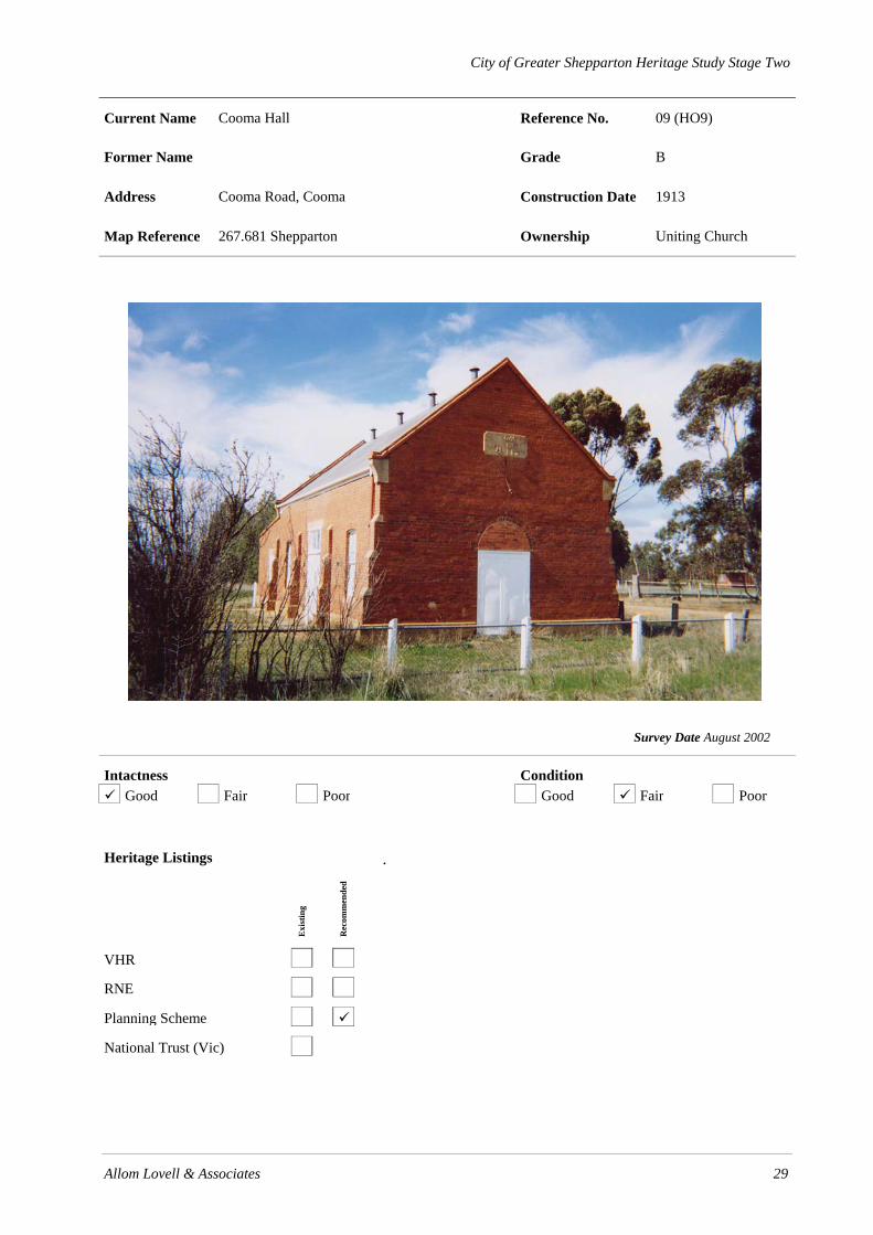
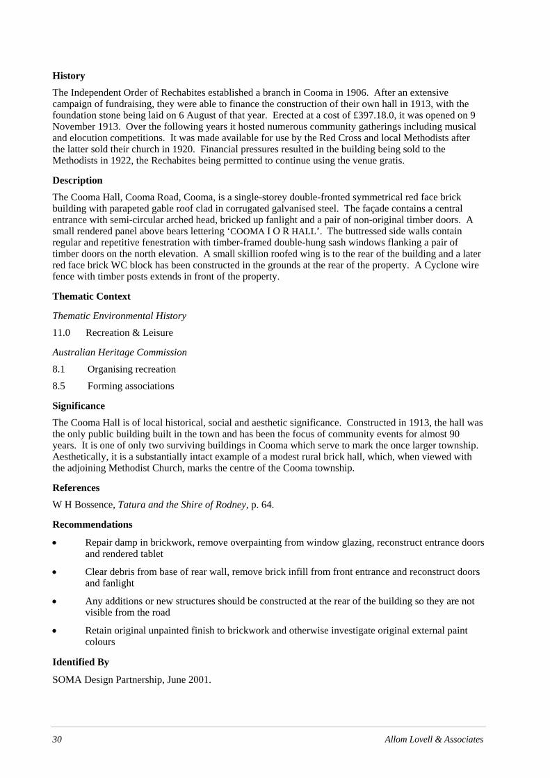
Current Name Cooma Hall Reference No. 09 (HO9)
Former Name Grade B
Address Cooma Road, Cooma Construction Date 1913
Map Reference 267.681 Shepparton Ownership Uniting Church
Survey Date August 2002
Intactness Condition Good Fair Poor Good Fair Poor
Heritage Listings
Exi
stin
g
Rec
omm
ende
d
VHR
RNE
Planning Scheme
National Trust (Vic)
.
30 Allom Lovell & Associates
History
The Independent Order of Rechabites established a branch in Cooma in 1906. After an extensive campaign of fundraising, they were able to finance the construction of their own hall in 1913, with the foundation stone being laid on 6 August of that year. Erected at a cost of £397.18.0, it was opened on 9 November 1913. Over the following years it hosted numerous community gatherings including musical and elocution competitions. It was made available for use by the Red Cross and local Methodists after the latter sold their church in 1920. Financial pressures resulted in the building being sold to the Methodists in 1922, the Rechabites being permitted to continue using the venue gratis.
Description
The Cooma Hall, Cooma Road, Cooma, is a single-storey double-fronted symmetrical red face brick building with parapeted gable roof clad in corrugated galvanised steel. The façade contains a central entrance with semi-circular arched head, bricked up fanlight and a pair of non-original timber doors. A small rendered panel above bears lettering ‘COOMA I O R HALL’. The buttressed side walls contain regular and repetitive fenestration with timber-framed double-hung sash windows flanking a pair of timber doors on the north elevation. A small skillion roofed wing is to the rear of the building and a later red face brick WC block has been constructed in the grounds at the rear of the property. A Cyclone wire fence with timber posts extends in front of the property.
Thematic Context
Thematic Environmental History
11.0 Recreation & Leisure
Australian Heritage Commission
8.1 Organising recreation
8.5 Forming associations
Significance
The Cooma Hall is of local historical, social and aesthetic significance. Constructed in 1913, the hall was the only public building built in the town and has been the focus of community events for almost 90 years. It is one of only two surviving buildings in Cooma which serve to mark the once larger township. Aesthetically, it is a substantially intact example of a modest rural brick hall, which, when viewed with the adjoining Methodist Church, marks the centre of the Cooma township.
References
W H Bossence, Tatura and the Shire of Rodney, p. 64.
Recommendations
• Repair damp in brickwork, remove overpainting from window glazing, reconstruct entrance doors and rendered tablet
• Clear debris from base of rear wall, remove brick infill from front entrance and reconstruct doors and fanlight
• Any additions or new structures should be constructed at the rear of the building so they are not visible from the road
• Retain original unpainted finish to brickwork and otherwise investigate original external paint colours
Identified By
SOMA Design Partnership, June 2001.

City of Greater Shepparton Heritage Study Stage Two
Allom Lovell & Associates 31
Current Name Methodist Memorial Church Reference No. 10 (HO10)
Former Name Grade B
Address Cooma Road, Cooma Construction Date 1926
Map Reference 267.681 Shepparton Ownership Uniting Church
Survey Date August 2002
Intactness Condition Good Fair Poor Good Fair Poor
Heritage Listings
Exi
stin
g
Rec
omm
ende
d
VHR
RNE
Planning Scheme
National Trust (Vic)

32 Allom Lovell & Associates
History
The first Methodist church in Cooma was a simple log and mud building erected in 1876. It was replaced by a new wooden church constructed on the site of the present church in 1885. This building was sold in 1920 and the church purchased the adjacent Independent Order of Rechabites (IOR) Hall in 1922 to use for services for the next few years as fundraising efforts were stepped up for a new, more substantial church building to honour the local men who died during World War 1. The foundation stone for the new memorial church was laid on 24 March 1926 by Mrs C J Poole, with the completed building opened in a special ceremony on 12 September 1926.
Description
The Methodist Memorial Church, Cooma Road, Cooma, is a red face brick church with Art Nouveau detailing which comprises a nave, projecting central porch at the front and sanctuary and vestry at the rear. The nave and vestry have gabled roofs clad with concrete roof tiles and the flying gable ends are half timbered with roughcast infill and carved timber brackets. The projecting front porch has a rendered crenellated parapet and contains a pair of pointed arch side entrances with V-jointed board timber doors with tapestry brick spandrels and a single pointed arch leadlight-glazed window. The buttressed side walls contain regular and repetitive paired openings with rendered bar tracery and diaper leadlight-glazed windows. The sanctuary is in the form of a faceted bay centred at the rear of the church and has a concrete tiled hipped roof. To the south of the sanctuary is a small vestry which is offset from the nave, providing an additional entrance to the building. The gabled roof is similarly detailed to the nave roof. There is a timber post and Cyclone wire fence along the Cooma Road boundary with wrought iron gate and brick piers which appear to be contemporary with the building.
Thematic Context
Thematic Environmental History
10.0 Worshipping
Australian Heritage Commission
8.6 Worshipping
9.7 Mourning the dead
Significance
The Methodist Memorial Church, Cooma is of local historical, social and aesthetic significance. Constructed in 1926 as a memorial to the district’s men who died during World War I, the church has served not only as a place of worship for the district’s Methodists for almost 90 years, but as a War memorial for families of all denominations. It is a rare surviving marker of the former town of Cooma, now only a locality. Aesthetically, it is a substantially intact example of a rural brick church, of which there are numerous examples in the municipality. Its eclectic Arts and Crafts Gothic Survival design, however, distinguishes it from others.
References
W H Bossence, Tatura and the Shire of Rodney, p. 64.
Recommendations
• Retain original unpainted finish to face brickwork and investigate original external paint colours
• Any additions or new structures should be constructed at the rear of the building so they are not visible from the road
Identified By
SOMA Design Partnership, June 2001.

City of Greater Shepparton Heritage Study Stage Two
Allom Lovell & Associates 33
Current Name ‘The Echoes’ Bed & Breakfast Reference No. 11 (HO11)
Former Name ‘St Heubert’s’ Grade B
Address 245 Kyabram-Cooma Road, Cooma Construction Date 1860s, 1870s, 1903
Map Reference 267.757 Shepparton Ownership
‘The Echoes’ homestead (1903) 1860s log hut (front) and 1870s cottage (rear)
Survey Date August 2002
Intactness Condition Good Fair Poor Good Fair Poor
Heritage Listings
Exi
stin
g
Rec
omm
ende
d
VHR
RNE
Planning Scheme
National Trust (Vic)

34 Allom Lovell & Associates
History
The 320-acre block on which the homestead, ‘The Echoes’, was constructed, formed part of the original 1500 acre estate, ‘St Heubert’s’, on which the former township of Henley was established. In 1959, 532 acres of the original ‘St Heubert’s’ was selected by the then Department of Agriculture to establish the Kyabram Irrigation Research Farm.
‘The Echoes’ was constructed in 1903 by Samuel Hunt. An original slab hut, built c.1860, and numerous outbuildings of various dates, remain on the property. The house is believed to be the work of prominent local architect, J A K Clarke, who designed numerous Shepparton buildings including ‘Fairley Downs’, ‘Ambermere’, ‘Ivanhoe’ and the former Shepparton Post Office. The house remained in the family when Samuel Hunt died – it passed to his son William and then to William’s son, Oriel who died in the 1950s. From that time, ‘The Echoes’ has subsequently been owned by Miss Goldsworthy, Jack Portsch, Laurie Foley, Victor Kuhle and is currently operated as a bed & breakfast by Tony Gibson.
Description ‘The Echoes’, 245 Cooma Road, Cooma, is a large Edwardian single-storey, double-fronted homestead of red face brick construction (overpainted) with hipped and gabled roof clad with corrugated galvanised steel. The roof features numerous prominent red brick chimneys with roughcast rendered mouldings, and the gable ends are half-timbered and infilled with roughcast. A wide ogee profile verandah supported by cast iron columns with cast iron valance and corner brackets encircles the entire house.
The symmetrical façade is divided into three bays. The centre bay is recessed and includes a central entrance surmounted by a rendered gablet, bearing the wording ‘THE ECHOES’, which is also reflected in a pediment in the verandah roof over bluestone entrance steps. A 4-panel timber door is surrounded by leadlight glazed side and highlights and is flanked by two groups of three full-height timber-framed, double-hung sash windows. The centre bay of the façade is flanked by two projecting bays, each containing a square bay window with group of three full-height timber-framed double-hung sash windows. The side elevations both contain a single entry with 4-panel timber door flanked by paired and individual timber-framed double-hung sash windows. The rear elevation is more utilitarian in nature.
Outbuildings include a c.1860s two-roomed log hut with gabled roof, presumably originally bark or shingle, clad in corrugated galvanised steel. A small number of slabs have been replaced with weatherboards, the western elevation has been opened up to provide vehicular access to the building and the remains of a fireplace are located in the southern wall. Adjacent to the hut is a c.1870s single-storey double-fronted weatherboard servant’s cottage with gabled roof clad in corrugated galvanised steel and red face brick chimney. Directly behind the main house is a c. 1870s kitchen wing (which originally served the first house constructed on the site of the present house). The adjoining properties also contain outbuildings which were originally part of ‘St Heubert’s’, including shearing shed, barn, dairy, butchery and machinery shed. The grounds contain numerous mature trees including two impressive Bunya Bunya pine (Araucaria bidwillii) and a small ornamental lake, which was formed when clay was excavated to make bricks for the main house.
Thematic Context
Thematic Environmental History
4.1 Squatters
4.2 Selectors and Closer Settlement
7.0 Developing Primary Industries
Australian Heritage Commission
2.5 Promoting settlement

Allom Lovell & Associates 35
3.4 Developing primary production
Significance
The Echoes, Cooma Road, Cooma, is of local historical and aesthetic significance. Despite its reduced size, the property and collection of outbuildings, some of which date from the earliest European settlement of the area, demonstrate distinct phases and patterns of settlement. Aesthetically, the substantial main house is a fine example of Edwardian homestead design, and is associated with one of the district’s most eminent architects, J A K Clarke. Its setting in mature gardens also adds to its aesthetic value.
References
W H Bossence, Tatura and the Shire of Rodney, p. 74.
Mr Dan Gibson, pers. comm.
Recommendations
• Consideration should be given to removing paint from brickwork
• Retain original unpainted finish to brickwork and otherwise investigate original external paint colours
• Any additions or new structures should be constructed at the rear of the house so they are not visible from the front circular driveway area.
Identified By
SOMA Design Partnership, June 2001.

36 Allom Lovell & Associates
City of Greater Shepparton Heritage Study Stage Two
Allom Lovell & Associates 37
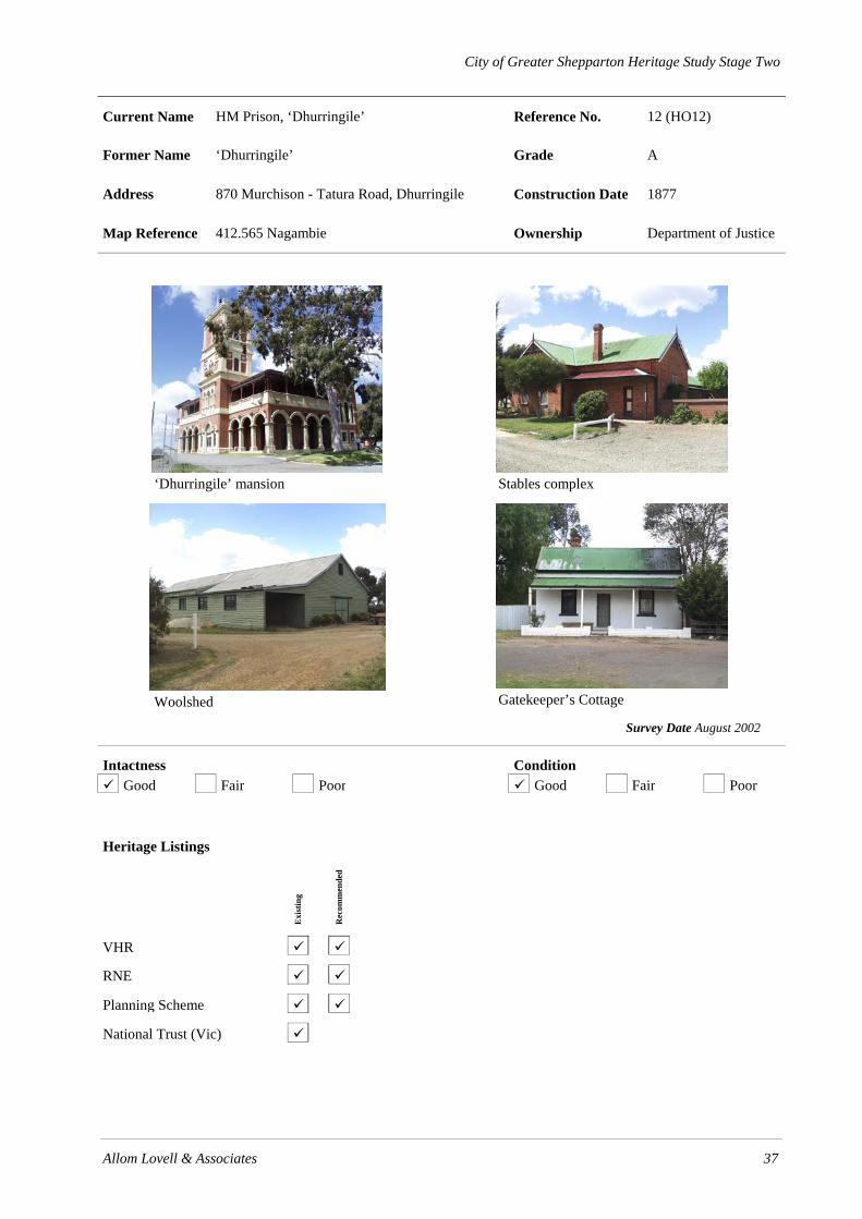
Current Name HM Prison, ‘Dhurringile’ Reference No. 12 (HO12)
Former Name ‘Dhurringile’ Grade A
Address 870 Murchison - Tatura Road, Dhurringile Construction Date 1877
Map Reference 412.565 Nagambie Ownership Department of Justice
‘Dhurringile’ mansion
Stables complex
Woolshed
Gatekeeper’s Cottage
Survey Date August 2002
Intactness Condition Good Fair Poor Good Fair Poor
Heritage Listings
Exi
stin
g
Rec
omm
ende
d
VHR
RNE
Planning Scheme
National Trust (Vic)

38 Allom Lovell & Associates
History
The Winter family came to the Western Goulburn Valley during the 1850s, and within ten years controlled a huge area of land in the region, through the acquisition of pre-emptive rights and direct purchase. As their estates matured, John Winter and his sons, William and James, built massive homesteads, ‘Nooroolim’, ‘Stanhope’ and ‘Dhurringile’ respectively.
‘Dhurringile’ was completed in 1877 for James Winter at a cost of £30,000. Tenders were called by architects Lloyd Taylor and Wyatt on 10 March 1876, with construction supervised by the clerk of works, H M Thompson. Italian craftsmen are thought to have been involved in the work. The completed mansion was the largest element of a complex which also included a manager’s residence, extensive stable block, gatekeeper’s cottage and a woolshed. The manager’s residence and stables both faced onto a small courtyard, and may have been built several years before the mansion. There was originally a gasometer (now demolished) at the rear of the property to supply the mansion with gas.
The Winter family sold the property in 1907, with gradual subdivision occurring as it passed through a succession of owners including Everard Browne, Mr V A Zed, Henry Hardy, Vincent Hart and then the Chambers family. In 1938 Jack Lowry purchased the gatekeeper’s cottage, stables and shearing shed with several acres of land.
During World War Two the mansion was converted into an internment camp for enemy aliens. From 20 October 1939 until early 1940 it was occupied by Germans who had been resident in Melbourne at the outbreak of war and between 1941 and 1945 it accommodated German officers who had been captured overseas. Jack Lowry operated the farm throughout the war. Various huts and other outbuildings constructed on the site were removed after the camp closed on 25 July 1945.
From 1950 until 1964 the estate was operated by the Presbyterian Church as The Dhurringile Rural Training Farm for Migrant Boys, which trained young orphaned British immigrants in farming methods. In 1965 it was taken over by the Victorian Government and converted into the H M Dhurringile Rehabilitation Centre, which operated the farm as a rehabilitation facility for alcoholic prisoners. In 1975 the government purchased Jack Lowry’s land holdings and reincorporated them back into the property.
Description
Residence
Dhurringile, HM Prison, Dhurringile, is a double-storey red face brick mansion in the Victorian Italianate style with hipped roof clad in corrugated galvanised steel. The roofline contains red brick chimneys with rendered moulded caps and the bracketed eaves are lined with timber. The asymmetrical façade is divided by projecting and recessed bays including a prominent four-storey tower. The tower is symmetrical in composition and features rendered mouldings, string courses, pilasters and a balustraded parapet. It contains varying compositions of round and pointed arched fenestration at each level with rendered dressings and timber-framed double-hung sash windows. Projecting bays on both principal elevations contain arcaded pilaster mouldings with round arched openings at ground floor level and a group of 3 segmented arch openings and consoled wrought iron balconette at first floor level. All window openings contain timber-framed double-hung sash windows; the tower windows feature hand painted leadlight glazing. The recessed façade is screened by a double height return verandah which consists of a red face brick arcade with rendered piers and archivolts at ground floor level, rendered masonry balustrade and cast iron posts and lacework frieze and brackets at first floor level. Fenestration consists of multi-paned timber-framed French windows at ground floor level and timber-framed double-hung sash windows at first floor.
To the rear of the main house is an extensive attached single-storey service wing and to the east is a c.1930s gabled single-storey wing with later additions. The front garden contains an asphalted circular driveway, a cast iron lamp standard, concrete fountain, timber flagpole and mature eucalypt of considerable age. Numerous recent portable buildings surround the rear of the building.
Allom Lovell & Associates 39
Stables
The single-storey red face brick stables block is a symmetrical composition of wings arranged in a U-shaped plan around a central yard, which is enclosed on the fourth side by a brick fence. Each wing has a gabled roof clad with corrugated galvanised steel, red brick chimneys, timber finials and fretwork. The central wing contains a carriage-entrance surmounted by a segmented arch and gablet. Each side wing terminates at the front with a small double-fronted residential block which is screened by a timber skillion-roofed verandah. Within the central courtyard, the north wing is also screened by a full-length verandah and contains regular fenestration of single timber-framed double-hung sash windows and panelled timber doors. The south wing opens onto the courtyard with double timber doors with segmented arch heads.
Woolshed
The single-storey bush pole-framed weatherboard woolshed has a gabled roof clad with corrugated galvanised steel. The end elevation contains a pair of timber ledged and braced doors, surmounted by a small louvered opening in the gable end. Each side elevation contains regular high level timber-framed multi-paned fixed sash windows. To the west of the main entrance the building is extended by an additional bay which is accessed on both sides by a large opening.
Gatekeeper’s Cottage
The cottage is a single-storey double-fronted brick (overpainted) building with transverse gabled roof and timber-framed skillion verandah clad with corrugated galvanised steel. The façade contains a central entrance with panelled timber door flanked by a pair of timber-framed double-hung sash windows. A low brick wall has been added to the front of the verandah.
Thematic Context
Thematic Environmental History
4.1 Squatters
13.2 Dhurringile
Australian Heritage Commission
2.4 Migrating
3.5 Developing Primary Production
7.6 Administering Australia
Significance
Dhurringile, Murchison - Tatura Road, Dhurringile, is of historic and aesthetic significance at a state level. Constructed in 1877 for James Winter, member of one of the largest landholding and influential families in the region, the mansion demonstrates the massive wealth of the early Victorian “squattocracy”. The extensive complex of farm and outbuildings illustrate the complete day-to-day workings of a large nineteenth century pastoral holding. The property is of added significance because of its use during World War 2 for German officer internment. It is also of interest as Dhurringile Rural Training Farm for Migrant Boys and H M Dhurringile Rehabilitation Centre. Aesthetically, Dhurringile is a fine and intact example of a Victorian mansion homestead, featuring fine joinery, marble, decoration and imported glass.
In addition, the scale of the residence, the largest in the municipality and one of the largest in rural Victoria, sited prominently in an elevated location, creates an impressive local landmark. The aesthetic qualities are further enhanced by the various approaches to the residence lined with mature avenues of elms and oaks.

40 Allom Lovell & Associates
The extensive stable block is a finely executed complex, reminiscent of English traditions, and the only known example of its scale and type in the region. The woolshed is a large and intact example, typical of others throughout the municipality. While aesthetically unremarkable, the gatekeeper’s cottage is one of few known surviving residences which were constructed to serve this purpose, the other being at Day’s Mill, Murchison.
References
W H Bossence, Tatura, and the Shire of Rodney.
Frances O’Neill & Delia Taylor, H M Rehabilitation Centre Dhurringale: A Conservation Analysis, pp. 10-26.
Recommendations
• Retain original unpainted finish to face brickwork
• Continue current program of restoration and works
• Investigate original paint colours of all significant buildings
• The mature specimen and avenue trees should be inspected regularly on a 1-2 year basis by a suitably qualified arborist.
Identified By
SOMA Design Partnership, June 2001.

City of Greater Shepparton Heritage Study Stage Two
Allom Lovell & Associates 41
Current Name St Luke’s Anglican Church and Church Hall Reference No. 13 (HO13)
Former Name Grade B
Address Cnr Baldock & Dookie Streets, Dookie Construction Date Church c.1892 Hall 1928
Map Reference Ownership
St Luke’s Anglican Church
Church Hall
Survey Date August 2002
Intactness Condition Good Fair Poor Good Fair Poor
Heritage Listings
Exi
stin
g
Rec
omm
ende
d
VHR
RNE
Planning Scheme
National Trust (Vic)

42 Allom Lovell & Associates
History St Luke’s Anglican Church was constructed in c.1892 by local builders Alexander and Torgrimson, who also provided the furniture. Dedication of the new church was performed by the Bishop of Wangaratta on Friday 31 July 1903. A rectory was built to the east of the church in 1895. This was sold in 1976 and relocated to Tocumwal Road, near Devenish for use as a private residence. In 1928 the St Luke’s Anglican Church Hall was erected for use as a Sunday school. It also served as a venue for boy scout meetings after the Rector Reverend Ball established a scouting troop in the area. The original Church bell cracked after being rung too hard in celebration of the end of World War Two. Although repaired, it is now disused.
Description St Luke’s Anglican Church is a single storey red brick building comprising a nave, projecting wing to the east elevation and a later timber-framed entry porch to the west elevation. The nave and east wing each have a parapeted gable roof clad in corrugated galvanised steel and finished with rendered dressings, copings and crosses. The gable end to the east wing contains a tripartite pointed arch window. Side walls are buttressed and contain regular fenestration of lancet arched windows with rendered and quoined surrounds. Abutting the south side of the church is a single-storey skillion roofed cream brick addition. The adjacent church hall is a single-storey timber-framed building with a gabled roof clad in corrugated galvanised steel. It comprises a rectangular plan hall with a gabled roof entry porch to the front and a skillion roof wing to the rear. The front gable ends to the hall and entry porch have strapped fibro cement sheet lining and simple timber finials. The hall has recently been re-clad in Hardiplank weatherboards.
Thematic Context
Thematic Environmental History
10.0 Worshipping 11.0 Recreation & Leisure
Australian Heritage Commission
8.1 Organising recreation 8.6 Worshipping 9.7 Mourning the dead
Significance St Luke’s Anglican Church, Dookie, is of local aesthetic, historical and social significance. Constructed in c.1892, the church has served as a focus for Anglican worship and community activity for over a hundred years. Aesthetically it is a representative example of a modest rural Gothic-Revival Church, of which there are a numerous extant examples in the municipality.
References
Dookie, the Years to 1988, pp. 59-60.
Recommendations • The addition to the south side of the church may be retained, modified or removed. • Investigate cracks to brickwork and repair as necessary under instruction from a conservation
practitioner • Re-clad church hall in timber weatherboards of the correct (original) profile • Undertake basic maintenance to the fence. • Retain original unpainted finish to brickwork and otherwise investigate original external paint
colours Identified By
SOMA Design Partnership, June 2001.

City of Greater Shepparton Heritage Study Stage Two
Allom Lovell & Associates 43
Current Name Main Building (Administration Block, Patrick Ryan Hall, Dormitories A, B, C)
Reference No. 14 (HO14)
Former Name Grade B
Address Dookie Agricultural College, Dookie – Nailing Road, Dookie
Construction Date 1960-62
Map Reference Ownership
Administration Block
Patrick Ryan Hall
Dormitories
Dormitories
Survey Date August 2002
Intactness Condition Good Fair Poor Good Fair Poor
Heritage Listings
Exi
stin
g
Rec
omm
ende
d
VHR
RNE
Planning Scheme
National Trust (Vic) File only
NB: The complete heritage overlay for Dookie Agricultural College also includes the following buildings: Library; Dormitories; Gavin Gibson Memorial Laboratory; and, Winery Building

44 Allom Lovell & Associates
History In 1875, as a result of the efforts of the Secretary of Agriculture, Alexander Robert Wallis, an area of Crown Land in the Parish of Dookie was reserved for an experimental farm. This became known as the Cashel Experimental Farm and originally consisted of 1,938 hectares. Dookie Agricultural College commenced its operation on 4 October 1886, under the auspices of the Council of Agricultural Education, following the implementation of the Agricultural Education Act, 1884. The College offered a two year course for students over the age of 14 years who had completed a satisfactory State School education. The two year course continued from 1886 to 1910.
Following an increase in applications to attend Dookie College in the immediate post-Second World War years, a building program for the college was approved in 1957. This involved the demolition of a number of existing buildings, including the old 1886 administration block; the construction of a new main complex and the renovation of various existing structures. The design of the new buildings was undertaken by Public Work Department (PWD) architects P Brand and J T Adams in 1958. Tenders were called in July of that year.
Work commenced on 28 January, 1960 with the main building being officially opened on 22 March 1962. This work was completed at a total cost of £621,000. The builders were A V Jennings. The new main building contained 184 single study bedrooms, bathrooms, games and study areas, classrooms, a billiard room and a library. Renovation works in other buildings continued into 1963.
Description The main section of Dookie Agricultural College is a complex of modern buildings of steel and masonry construction comprising an administration block, assembly hall and dormitories.
The administration block is a modern single storey building on a long rectangular plan form aligned on a north-south axis. The front (east) and rear (west) elevations are of non-load bearing aluminium framed fibro-cement panels with aluminium-framed windows. End walls are exposed aggregate concrete panels. Projecting from centre of the façade, to the front of the main entry, is a verandah with a cantilevered concrete deck and concrete stairs leading up from the ground level. The adjustable aluminium, louvred sun-shades fitted to the façade either side of the verandah are a later addition. Extending across the full width of the rear elevation is a covered walkway. The front verandah and the rear covered walkway have a shallow pitched skillion roof with V-jointed timber board soffit lining and tubular steel posts and balustrades.
The Patrick Ryan Hall, located to the west of the administration block, is a large double-height hall of masonry and steel construction with a shallow pitched steel deck roof. Walls are of exposed aggregate concrete panels supported on concrete columns, behind which there is a recessed cream brick wall. Side elevations contain large, multi-paned fixed-sash aluminium-framed windows.
Dormitories A, B & C is a substantial three-storey, cream-brick building with a shallow pitch steel-deck roof. The building comprises an east-west wing on a long rectangular plan and two shorter wings running north-south and enclosing a grassed courtyard. The building has regular fenestration of aluminium-framed windows and curtain walling to the end walls of aluminium framed windows with fibro-cement sheet spandrel panels.
Thematic Context
Thematic Environmental History
9.2 Dookie Agricultural College
Australian Heritage Commission
6.3 Training people for workplace skills
6.4 Building a system of higher education

Allom Lovell & Associates 45
Significance
The Main Building at Dookie Agricultural College is of regional historical and social significance. Erected in 1960 it demonstrates the major post-war development of the campus. Aesthetically it is an unremarkable example of post-War modern architecture.
References
Roger Aldridge, Dookie College: The First 100 Years.
Andrew Ward, VCAH Dookie Conservation Study
Recommendations
• Retain original unpainted finish to brickwork and otherwise investigate original external paint colours
Identified By
SOMA Design Partnership, June 2001.

46 Allom Lovell & Associates

City of Greater Shepparton Heritage Study Stage Two
Allom Lovell & Associates 47
Current Name Library Building Reference No. 15 (H014)
Former Name Swinburne Hall (Dining Hall) Grade B
Address Dookie Agricultural College, Dookie – Nalinga Road, Dookie
Construction Date 1907-08
Map Reference Ownership
Survey Date August 2002
Intactness Condition Good Fair Poor Good Fair Poor
Heritage Listings
Exi
stin
g
Rec
omm
ende
d
VHR
RNE
Planning Scheme
National Trust (Vic) File only
NB: The complete heritage overplay for Dookie Agricultural College also includes the following buildings: Main Building: College Dormitories; Gavin Gibson Memorial Laboratory, Winery Building

48 Allom Lovell & Associates
History
The Library building was constructed in 1907-08 as part of an expansion of the Dookie College campus facilities, instigated by George Swinburne, Minister of Agriculture, in 1905. Originally a dining room, it also contained bread, dairy, pastry and vegetable rooms as well as a cellar. It is believed to have been designed by George de Lacy Evans, architect and building instructor at Dookie College. The contractor was G Matthews and the cost of the completed work was £2,850. Serving as a venue for important college functions, it remained in use as the dining hall until September 1969, when Gilbert Chandler Hall, the present dining facility, was opened. The kitchen, servery and stores were subsequently demolished. New additions were constructed during the 1980s and the building has been adapted for use as the library.
Description The Library at Dookie College is a single-storey Federation Free Style building with tuck-pointed red-brick walls and a hipped and gabled roof clad in corrugated galvanised steel. The roof has carved timber eaves brackets and is penetrated by both cylindrical metal ventilators and gablet ventilators. The entry porch, located at the south-east corner, has a bracketed, half-timbered gable and a round arched opening. The porch has non-original quarry tile flooring and non-original timber doors. Side walls contain regular, repetitive fenestration of timber framed-casement windows set between brick pilasters. At ¾ height is a moulded string course above which the wall is finished in roughcast render finish. The north elevation has a bracketed half-timbered gable end and is dominated by a corbelled brick chimney. Windows to the end walls are timber-framed casements with coloured leadlight glazing. Abutting the west elevation of the building is recent a modern face red-brick addition. The building is linked to the main building to the south by means of a steel framed covered walkway.
Thematic Context
Thematic Environmental History
9.2.1 Dookie Agricultural College
Australian Heritage Commission
6.3 Training people for workplace skills
6.4 Building a system of higher education
Significance
The Library at Dookie Agricultural College is of regional historic and social significance and local aesthetic significance. Erected 1907-it demonstrates the major expansion of campus facilities undertaken at that time. Aesthetically it is a fine, albeit altered, example of a Federation Free Style institutional building.
References
Andrew Ward. VCAH Dookie College Conservation Study 1996.
Recommendations
• Retain original unpainted finish to brickwork and otherwise investigate original external paint colours
• Preferably remove covered walkway where it abuts the south elevation.
Identified By
SOMA Design Partnership, June 2001.

City of Greater Shepparton Heritage Study Stage Two
Allom Lovell & Associates 49
Current Name College Dormitories D, E, F Reference No. 16 (HO14)
Former Name Grade B
Address Dookie Agricultural College, Dookie – Nalinga Road, Dookie
Construction Date 1907, 1962-63
Map Reference Ownership
Survey Date August 2002
Intactness Condition Good Fair Poor Good Fair Poor
Heritage Listings
Exi
stin
g
Rec
omm
ende
d
VHR
RNE
Planning Scheme
National Trust (Vic) File only
NB: The complete heritage overplay for Dookie Agricultural College also includes the following buildings: Main Building; Library; Gavin Gibson Memorial Laboratory, and, Winery Building

50 Allom Lovell & Associates
History
The dormitories were constructed in 1907 as part of a program of expansion of the College. This was initiated by the government to accommodate one hundred students, and to introduce a degree course in agriculture at Melbourne University in association with Dookie College. The dormitories were built by contractor E Carter for £185 and are possibly the work of George de Lacy Evans, architect and college building instructor. In 1962-3, the dormitories were refurbished and ablution blocks constructed.
Description Dormitories D, E and F at Dookie Agricultural College comprise a series of three identical single-storey weatherboard buildings of utilitarian design. Each has a gabled roof with corrugated galvanised steel cladding and bracketed gable ends. The symmetrical facades contain a central entry porch with steel-framed landing and a shallow-pitched awning supported on timber brackets. The side elevations contain pairs of timber-framed, double-hung sash windows. The two weatherboard ablution blocks located between the dormitories were constructed in 1962-1963. The group also includes a gymnasium building of similar design.
Thematic Context
Thematic Environmental History
9.2.1 Dookie Agricultural College
Australian Heritage Commission
6.3 Training people for workplace skills
6.4 Building a system of higher education
Significance
Dormitories D, E and F at Dookie Agricultural College are of local historic and aesthetic significance. Erected 1907-it demonstrates the major expansion of campus facilities undertaken at that time. Aesthetically the buildings are individually undistinguished but collectively they form a group which makes an important contribution to the historic fabric of the college.
References
Andrew Ward. VCAH Dookie College Conservation Study 1996.
Recommendations
• Investigate original external paint schemes.
Identified By
SOMA Design Partnership, June 2001.
City of Greater Shepparton Heritage Study Stage Two
Allom Lovell & Associates 51
Current Name Gavin Gibson Memorial Laboratory/Student Lounge, S.R.C Office & Student Welfare
Reference No. 16 (HO14)
Former Name Biology Laboratory, Lecture Room, Museum & Library
Grade B
Address Dookie Agricultural College, Dookie – Nalinga Road, Dookie
Construction Date 1938
Map Reference Ownership
Survey Date August 2002
Intactness Condition Good Fair Poor Good Fair Poor
Heritage Listings
Exi
stin
g
Rec
omm
ende
d
VHR
RNE
Planning Scheme
National Trust (Vic) File only
NB: The complete heritage overplay for Dookie Agricultural College also includes the following buildings: Main Building; Library; Dormitories; and, Winery Building

52 Allom Lovell & Associates
History
In 1934, repeated requests from science master W J Webb, highlighted the need for improved laboratory facilities at the college. Lack of funding prevented the project from going ahead until Mrs Gavin Gibson of Dookie donated £1,500. The government matched the donated amount and plans were drawn up in February 1938 by the Public Works Department, under the direction of chief architect Percy Everett. The building as constructed housed a laboratory with adjoining prep room, storeroom, lecture theatre, museum, office and library. It was officially opened in October 1938.
Description The Gavin Gibson Memorial Laboratory is a single-storey red brick Moderne style building with a corrugated galvanised steel skillion roof, concealed by a brick parapet with concrete coping. It has an asymmetrical façade, composed of cubic forms with a projecting semi-circular bay. The bay features a strip window of timber-framed top-hung casements with glazed black and orange tile mullions and a projecting concrete hood. The timber-framed skillion roofed entry porch, located near the west end of the façade, is a later addition. The words GAVIN GIBSON MEMORIAL LABORATORY 1938 in wrought iron letters are affixed to the wall, adjacent to the entry porch. Above the entry porch is a flagpole fixed to the parapet by three horizontal metal hoops.
Thematic Context
Thematic Environmental History
9.2.1 Dookie Agricultural College
Australian Heritage Commission
6.3 Training people for workplace skills
6.4 Building a system of higher education
Significance
The Gavin Gibson Memorial Laboratory at Dookie College is of local historical and aesthetic significance. Erected in 1938, it demonstrates the increasing importance of scientific studies in the college curriculum during that period. Aesthetically it is a fine example of a substantially intact Moderne style building and typical of the work of Percy Everett, long serving and prolific PWD chief architect.
References
Andrew Ward. VCAH Dookie College Conservation Study 1996.
Recommendations
• Replace aluminium framed window to rear elevation with timber framed window to match original
• Retain original unpainted finish to face brickwork
• Repaint external joinery in original colours and remove paint finishes from glazing
• Preferably remove canvas awnings.
Identified By
SOMA Design Partnership

City of Greater Shepparton Heritage Study Stage Two
Allom Lovell & Associates 53
Current Name Winery Building Reference No. 18(HO14)
Former Name Experimental Building (1916-1931) Grade B
Address Dookie Agricultural College, Dookie – Nalinga Road, Dookie
Construction Date 1896
Map Reference Ownership
Survey Date August 2002
Intactness Condition Good Fair Poor Good Fair Poor
Heritage Listings
Exi
stin
g
Rec
omm
ende
d
VHR
RNE
Planning Scheme
National Trust (Vic) File only
NB: The complete heritage overlay for Dookie Agricultural College also includes the following buildings: Main Building; Library; Dormitories; and, Gavin Gibson Memorial Laboratory

City of Greater Shepparton Heritage Study Stage Two
54 Allom Lovell & Associates
History The winery building was constructed in 1896 by local Dookie contractors Alexander and Torgrimson under direction of Giovanni Federli, the college viticulturalist. Winemaking had emerged as a major industry in the1880s and the Dookie region boasted a number of wineries.
The wine cellar was described in 1903 as a ‘fine brick structure, nearly 150 feet long divided into two parts, a fermenting house and cellar proper. The former is replete with cement fermenting vats, wine presses, overhead tramway from the vats to the presses, one of which is a hydraulic press of the newest type’. By 1904 the building was surrounded by a landscaped garden featuring a summerhouse and bird cage.
In 1916, the winery was closed as a result of the combined effects of phylloxera and an over-supplied market. The building was used by Hugh Pye, principal of Dookie from 1894 and State Cerealist from 1916. Pye set up his office and continued his research work until his retirement in 1931. During Pye’s period of occupancy the winery building was known as the ‘Experimental Buildings’.
Description The winery building at Dookie Agricultural College is a substantial red brick building on a long rectangular plan. It has a gabled roof clad in corrugated galvanised steel (over-painted red) with prominent timber bargeboards, turned timber finials and gablet roof vents. The symmetrical east gable end contains a large double-leaf timber door flanked on either side by a timber-framed, double-hung sash window. The west gable end is also symmetrical and contains a double-leaf timber-framed door flanked on either side by a louvred, timber-framed window. Projecting from the south elevation are two double-height gabled bays with face brick and weatherboard cladding. The east gable bay has been reconstructed. The east and west elevations are approached via gravel access roads excavated into the hillside.
Thematic Context
Thematic Environmental
8.0 Developing Secondary Industries
9.2.1 Dookie Agricultural College
Australian Heritage Commission
6.3 Training people for workplace skills
6.4 Building a system of higher education
Significance
The Winery Building at Dookie College is of local historical and aesthetic significance. Erected in 1896, it demonstrates the importance of winemaking industry in the early development of the district. Aesthetically it has interest as a substantially intact utilitarian building of the period and is rare as a purpose built structure for the study of viticulture.
References
Andrew Ward. VCAH Dookie College Conservation Study 1996.
Recommendations
• Retain original unpainted finish to brickwork and otherwise investigate original external paint colours
Identified By
SOMA Design Partnership, June 2001.

City of Greater Shepparton Heritage Study Stage Two
Allom Lovell & Associates 55
Current Name The Chateau Reference No. 19 (HO15)
Former Name Grade B
Address Hoopers Road, Dookie Construction Date 1886
Map Reference 812.811 Dookie Ownership
Survey Date August 2002
Intactness Condition Good Fair Poor Good Fair Poor
Heritage Listings
Exi
stin
g
Rec
omm
ende
d
VHR
RNE
Planning Scheme
National Trust (Vic)
Curtilage

56 Allom Lovell & Associates
History
‘The Chateau’ was constructed in 1886 for John Curtain, MLA for North Melbourne in 1871-1877, and was built by local builders Alexander and Torgrimson. It incorporated special features in response to hot climatic conditions including verandahs along all four sides, and a connection taking water pumped from a well to a spray on the roof. The tower access gained from timber staircase was reportedly used by Curtain to watch over his employees in the vineyards below. At the rear of the building there was a courtyard with kitchen, pantry, bathroom, servants quarters and stables. The house was furnished with fine furniture including carpets from Brussels, fine oil paintings, stained glass, and cut glass door knobs.
Curtain had purchased the Dookie Vinyard Company in 1885, subsequently undertaking an expansion of the vineyard by purchasing adjacent land and replanting most of the vines. At its peak of production the estate comprised over 2,000 acres (810 hectares), and for a number of years during the 1890s it laid claim to being the largest vineyard in Australia. The vineyard itself became known as ‘the Chateau’, after the house which was commonly referred to as ‘the Chateau’ by locals. In c.1887 a large three-storey wine cellar with a five storey tower was built. The tower housed a steam-operated lift, used to transport the grapes and wine between the different floors. To finance his expansion of the vineyard Curtain borrowed from the Bank of Victoria and the depression of the 1890s left him heavily in debt. He was unable to repay the loan and the estate was subsequently taken over by the Bank of Victoria in late 1892 or early 1893. It then became the residence of the successive winery managers, Francois de Castella and W C Bayliss until the vineyard’s closure in 1909. It has remained a family residence since that time.
Description ‘The Chateau’ is a double-storey Italianate residence with ruled ashlar rendered brick walls. It has a hipped slate roof with bracketed eaves and three rendered and capped chimneys. The symmetrical front elevation contains a central panelled timber door with sidelights and a fanlight, flanked on either side by a tripartite timber-framed double-hung sash window. Above the door and ground floor windows to the front only is a continuous stucco articulated drip mould. On the first floor directly above the main entry is a small timber framed double-hung sash window, possibly replacing an original doorway onto the verandah. Flanking the steps to the front entry are two tall rendered piers surmounted by decorative urns. Along the full width of the rear elevation is a single storey later addition with a central skillion roofed verandah, detailed to match the existing building. The building was originally encircled by a double height verandah with cast iron lace balustrade and frieze. A square plan tower which surmounted the roof has also been removed. Two single-storey brick outbuildings, presumably original, are located to the rear of the building. The outbuildings are rectangular in plan and have parapeted masonry walls with a ruled ashlar render finish and skillion roofs.
Thematic Context
Thematic Environmental History
7.0 Developing Primary Industries
Australian Heritage Commission
3.5 Developing primary production
Significance
‘The Chateau’, Hoopers Road, Dookie is of local historical and aesthetic significance. Erected in 1886 for prominent local identity and politician, John Curtain, it demonstrates the importance of the winemaking industry in the early development of the district. Aesthetically, it is a fine example, albeit altered, of an Italianate homestead, and in that respect is rare in the municipality.

Allom Lovell & Associates 57
References
Dookie Centenary Committee, Dookie The Years to 1988
Recommendations
• Continue ongoing conservation works including reconstruction of the verandah and tower (the later if feasible)
• Investigate original external paint colours
Identified By
SOMA Design Partnership, June 2001.

58 Allom Lovell & Associates

City of Greater Shepparton Heritage Study Stage Two
Allom Lovell & Associates 59
Current Name Former Shop Reference No. 20 (HO16)
Former Name Butchers Shop Grade B
Address Mary Street (cnr. Curtain Street), Dookie Construction Date 1903
Map Reference Ownership
Survey Date August 2002
Intactness Condition Good Fair Poor Good Fair Poor
Heritage Listings
Exi
stin
g
Rec
omm
ende
d
VHR
RNE
Planning Scheme
National Trust (Vic)
Curtilage

City of Greater Shepparton Heritage Study Stage Two
60 Allom Lovell & Associates
History
The business was established in 1897 and it originally operated as a butcher’s shop. It is assumed that this is also the date of construction. Edward Tacey is believed to have been the original builder and owner. Further occupants were as follows: Chas Roach, Fulton and Jackson, George Plummer, Roy Plummer, Wally Dunlop, Norm Wright, Heather Whitehead, and a hairdresser.
Description The former butcher’s shop, Mary Street, on the corner of Curtain Street, Dookie, is a single storey brick building with a parapeted gabled and hipped roof clad in corrugated galvanised steel. The parapet is of face brick (over-painted) with a segmented arched pediment and moulded cornice. The pediment is set between scrolled consoles and surmounted by an acroterion motif and bears the words ESTABLISHED 1897 in raised, pressed cement lettering. Across the front of the building there is a non-original skillion roofed verandah supported on steel posts. The shop entry is splayed and set to one side and is flanked by a large multi-paned, fixed-sash timber-frame shop window. The entire shop front appears to have been reconstructed c.1920s and has been partially re-clad in glazed tiles.
Thematic Context
Thematic Environmental History
15.2 Smaller Townships and Localities
Australian Heritage Commission
3.12 Feeding people
3.19 Marketing and retailing
Significance
The former butcher’s shop, Mary Street, on the corner of Curtain Street, Dookie, is of local historical significance. Erected in 1903, and one of the few remaining Victorian shop buildings in Mary Street, it demonstrates the early development of the town.
References
Dookie Centenary Committee, Dookie The Years to 1988
Mrs Margaret Feldtmann, pers. comm.
Recommendations
• Reconstruct verandah to original or appropriate detail.
• Investigate original external paint colours.
Identified By
SOMA Design Partnership, June 2001.

City of Greater Shepparton Heritage Study Stage Two
Allom Lovell & Associates 61
Current Name Gladstone Hotel Reference No. 21 (HO17)
Former Name Grade B
Address 44 Mary Street (cnr. Gladstone Street), Dookie Construction Date 1887-1888
Map Reference 822.788 Dookie Ownership
Survey Date August 2002
Intactness Condition Good Fair Poor Good Fair Poor
Heritage Listings
Exi
stin
g
Rec
omm
ende
d
VHR
RNE
Planning Scheme
National Trust (Vic)
Curtilage

62 Allom Lovell & Associates
History
Construction of the Gladstone Hotel began in 1887; Alexander and Torgrimson were the builders. The building was only partially completed when it was offered for sale in November of the same year. By early 1888 the hotel is believed to have been open for business. In the 1900s, major alterations and additions were undertaken. A new kitchen, dining room and balcony were added and the verandah to the Gladstone Street façade was removed.
The hotel has a long succession of proprietors. Through the late nineteenth century, they included John Curtain, James McGrotty and Mrs M Fay. During the early decades of the twentieth century Walter Compton, Ambrose A Dunn, Elias Suding, Fred George, Patrick William Ryan and Francis Lalor were licensees.
Description The Gladstone Hotel, 44 Mary Street, Dookie, is a two-storey rendered brick Victorian corner hotel with a hipped roof with corrugated galvanised steel cladding and paired eaves brackets. The Mary Street frontage is screened by a wide return verandah supported on cast iron columns with a cast iron lace balustrade. Walls have regular fenestration of timber-framed, double-hung sash windows with projecting sills. The splayed corner is fitted with a non-original flush panel timber door. Abutting the north of the hotel is a double storey brick (over-painted) later addition with a skillion roof. At the east end of the Mary Street façade is a single storey modern brick addition.
Thematic Context
Thematic Environmental History
11.1 Eating, Drinking and More: the role of the country ‘pub’
Australian Heritage Commission
3.22 Lodging people
4.5 Making settlements to serve rural Australia
8.4 Eating and drinking
Significance
The Gladstone Hotel, 44 Mary Street, Dookie, is of local historical, aesthetic and social significance. The building has functioned as a hotel for over 100 years and remains an important focus for local social activity and recreation. Aesthetically it is a largely intact and representative example of a rural Victorian corner hotel, which makes an important contribution to the streetscape.
References
Dookie Centenary Committee, Dookie The Years to 1988
Recommendations • Replace missing/deteriorated verandah elements. • Reconstruct the presumably four-panel timber door to splayed corner • Refrain from parking under the verandah to avoid potential collision with the posts • Restrict the amount of external illuminated signage to the existing number of two signs and
preferably reduce to a single sign • The modern single-storey addition to Mary Street may be retained, modified or removed.
Identified By
SOMA Design Partnership, June 2001.
City of Greater Shepparton Heritage Study Stage Two
Allom Lovell & Associates 63
Current Name St Mary’s Roman Catholic Church Reference No. 22 (HO18)
Former Name Grade B
Address Saddleback Road, Dookie Construction D ate 1898
Map Reference 823.798 Dookie Ownership Roman Catholic Trust Corporation
Survey Date August 2002
Intactness Condition Good Fair Poor Good Fair Poor
Heritage Listings
Exi
stin
g
Rec
omm
ende
d
VHR
RNE
Planning Scheme
National Trust (Vic)
Curtilage
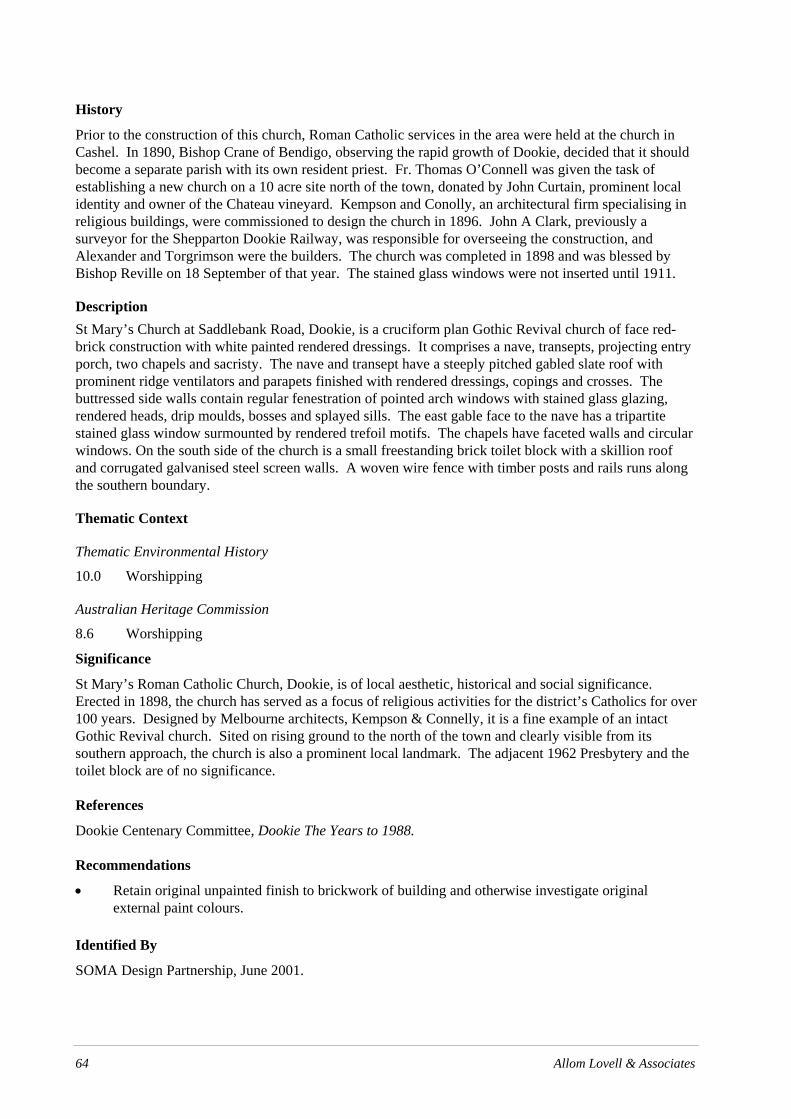
64 Allom Lovell & Associates
History
Prior to the construction of this church, Roman Catholic services in the area were held at the church in Cashel. In 1890, Bishop Crane of Bendigo, observing the rapid growth of Dookie, decided that it should become a separate parish with its own resident priest. Fr. Thomas O’Connell was given the task of establishing a new church on a 10 acre site north of the town, donated by John Curtain, prominent local identity and owner of the Chateau vineyard. Kempson and Conolly, an architectural firm specialising in religious buildings, were commissioned to design the church in 1896. John A Clark, previously a surveyor for the Shepparton Dookie Railway, was responsible for overseeing the construction, and Alexander and Torgrimson were the builders. The church was completed in 1898 and was blessed by Bishop Reville on 18 September of that year. The stained glass windows were not inserted until 1911.
Description St Mary’s Church at Saddlebank Road, Dookie, is a cruciform plan Gothic Revival church of face red-brick construction with white painted rendered dressings. It comprises a nave, transepts, projecting entry porch, two chapels and sacristy. The nave and transept have a steeply pitched gabled slate roof with prominent ridge ventilators and parapets finished with rendered dressings, copings and crosses. The buttressed side walls contain regular fenestration of pointed arch windows with stained glass glazing, rendered heads, drip moulds, bosses and splayed sills. The east gable face to the nave has a tripartite stained glass window surmounted by rendered trefoil motifs. The chapels have faceted walls and circular windows. On the south side of the church is a small freestanding brick toilet block with a skillion roof and corrugated galvanised steel screen walls. A woven wire fence with timber posts and rails runs along the southern boundary.
Thematic Context
Thematic Environmental History
10.0 Worshipping
Australian Heritage Commission
8.6 Worshipping
Significance
St Mary’s Roman Catholic Church, Dookie, is of local aesthetic, historical and social significance. Erected in 1898, the church has served as a focus of religious activities for the district’s Catholics for over 100 years. Designed by Melbourne architects, Kempson & Connelly, it is a fine example of an intact Gothic Revival church. Sited on rising ground to the north of the town and clearly visible from its southern approach, the church is also a prominent local landmark. The adjacent 1962 Presbytery and the toilet block are of no significance.
References
Dookie Centenary Committee, Dookie The Years to 1988.
Recommendations
• Retain original unpainted finish to brickwork of building and otherwise investigate original external paint colours.
Identified By
SOMA Design Partnership, June 2001.

City of Greater Shepparton Heritage Study Stage Two
Allom Lovell & Associates 65
Current Name Former Church Reference No. 23 (HO19)
Former Name Springvale – Girgarre East Presbyterian Church Grade B
Address Cnr. Springvale & Harston Roads, Girgarre Construction Date 1882
Map Reference 309.623 Shepparton Ownership Presbyterian Church
Survey Date August 2002
Intactness Condition Good Fair Poor Good Fair Poor
Heritage Listings
Exi
stin
g
Rec
omm
ende
d
VHR
RNE
Planning Scheme
National Trust (Vic)
Curtilage

66 Allom Lovell & Associates
History The first church in the locality was erected in 1874, on a corner of the ‘Springvale’ property; it was originally a non-denominational church funded by public subscription. Prominent local farmer, George Collie, purchased ‘Springvale’ in 1881 and the building continued to be used by all denominations. Collie donated the building and an acre of land in 1891 to the Springvale Presbyterian Church, Girgarre East, otherwise known as the Harston Presbyterian Church. The original church was replaced with a new church in 1901 at a cost of £381, and new pews were also purchased around this time. The Right Reverend J C Johnstone dedicated the building on 24 March 1902. During the 1950s a number of memorial stained glass windows were installed. A rear porch, toilet block and a freestanding brick Sunday School classroom (1962) were later added. The church was closed in 2003 and its sale is currently proposed. Four memorial windows from the church were removed and installed in an addition to St Andrew’s Presbyterian Church, Tatura.
Description The former Springvale–Girgarre East Presbyterian Church, Girgarre, is small red face red brick church comprising nave, projecting front entry porch and vestry to the rear. The nave and porch have parapeted gabled roofs clad in corrugated galvanised steel with steel ridge ventilators and parapets with rendered copings and cross finials. The main gable end features a pair of lancet openings. The porch contains a central pair of non-original entrance doors, around which the brickwork is tuckpointed, and a single lancet opening in each side containing diapered leadlight. All walls are buttressed and feature prominent horizontal bandings and regular fenestration of lancet timber-framed leadlight windows. Bandings, dressings, hood mouldings and copings have a rendered (overpainted) finish. The church has been altered by the construction of a steel framed porch at the rear, a freestanding c.1960s brick Sunday School building and later brick toilet block. The property is fenced along the road by an early post and wire fence with a section of early timber pickets flanking a non-original gate.
Thematic Context
Thematic Environmental History
10.0 Worshipping
Australian Heritage Commission
8.6 Worshipping
9.7 Mourning the dead
Significance The former Springvale–Girgarre East Presbyterian Church, Girgarre, is of local historic and aesthetic significance. The present building, constructed in1901, was a centre for Presbyterian worship and activity for over 100 years up until its recent closure. Aesthetically, the church is a good and intact example of a rural brick church, of which there are many examples in the municipality.
References W H Bossence, Tatura and the Shire of Rodney, pp. 70-72.
Recommendations • Reconstruct entrance doors, remove window security screens and clean rust from sills • Retain original unpainted finish to face brickwork and otherwise investigate original paint colours
elsewhere • The later rear porch, WC block and Sunday School classroom can be retained or demolished as
required.

Allom Lovell & Associates 67 Report Name
Identified By
SOMA Design Partnership, June 2001.

68 Allom Lovell & Associates

City of Greater Shepparton Heritage Study Stage Two
Allom Lovell & Associates 69
Current Name Memorial Hall Reference No. 24 (HO20)
Former Name Grade B
Address Harston Road, Harston Construction Date 1947
Map Reference 337.621 Shepparton Ownership City of Greater Shepparton
Survey Date August 2002
Intactness Condition Good Fair Poor Good Fair Poor
Heritage Listings
Exi
stin
g
Rec
omm
ende
d
VHR
RNE
Planning Scheme
National Trust (Vic)
Curtilage
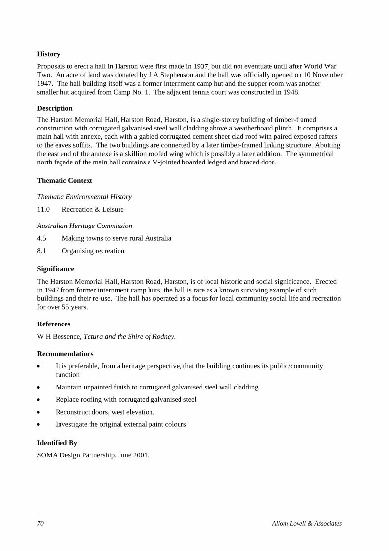
70 Allom Lovell & Associates
History
Proposals to erect a hall in Harston were first made in 1937, but did not eventuate until after World War Two. An acre of land was donated by J A Stephenson and the hall was officially opened on 10 November 1947. The hall building itself was a former internment camp hut and the supper room was another smaller hut acquired from Camp No. 1. The adjacent tennis court was constructed in 1948.
Description The Harston Memorial Hall, Harston Road, Harston, is a single-storey building of timber-framed construction with corrugated galvanised steel wall cladding above a weatherboard plinth. It comprises a main hall with annexe, each with a gabled corrugated cement sheet clad roof with paired exposed rafters to the eaves soffits. The two buildings are connected by a later timber-framed linking structure. Abutting the east end of the annexe is a skillion roofed wing which is possibly a later addition. The symmetrical north façade of the main hall contains a V-jointed boarded ledged and braced door.
Thematic Context
Thematic Environmental History
11.0 Recreation & Leisure
Australian Heritage Commission
4.5 Making towns to serve rural Australia
8.1 Organising recreation
Significance
The Harston Memorial Hall, Harston Road, Harston, is of local historic and social significance. Erected in 1947 from former internment camp huts, the hall is rare as a known surviving example of such buildings and their re-use. The hall has operated as a focus for local community social life and recreation for over 55 years.
References
W H Bossence, Tatura and the Shire of Rodney.
Recommendations
• It is preferable, from a heritage perspective, that the building continues its public/community function
• Maintain unpainted finish to corrugated galvanised steel wall cladding
• Replace roofing with corrugated galvanised steel
• Reconstruct doors, west elevation.
• Investigate the original external paint colours
Identified By
SOMA Design Partnership, June 2001.

City of Greater Shepparton Heritage Study Stage Two
Allom Lovell & Associates 71
Current Name St Mary’s Anglican Church Reference No. 25 (HO21)
Former Name Grade B
Address 7-9 Lincoln Street, Katandra West Construction Date c.1895
Map Reference Ownership Anglican Church
Survey Date August 2002
Intactness Condition Good Fair Poor Good Fair Poor
Heritage Listings
Exi
stin
g
Rec
omm
ende
d
VHR
RNE
Planning Scheme
National Trust (Vic)
Curtilage
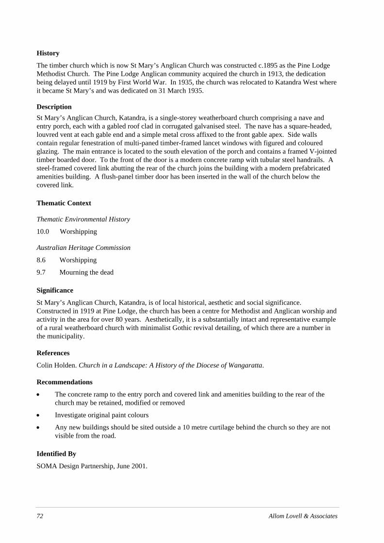
72 Allom Lovell & Associates
History
The timber church which is now St Mary’s Anglican Church was constructed c.1895 as the Pine Lodge Methodist Church. The Pine Lodge Anglican community acquired the church in 1913, the dedication being delayed until 1919 by First World War. In 1935, the church was relocated to Katandra West where it became St Mary’s and was dedicated on 31 March 1935.
Description St Mary’s Anglican Church, Katandra, is a single-storey weatherboard church comprising a nave and entry porch, each with a gabled roof clad in corrugated galvanised steel. The nave has a square-headed, louvred vent at each gable end and a simple metal cross affixed to the front gable apex. Side walls contain regular fenestration of multi-paned timber-framed lancet windows with figured and coloured glazing. The main entrance is located to the south elevation of the porch and contains a framed V-jointed timber boarded door. To the front of the door is a modern concrete ramp with tubular steel handrails. A steel-framed covered link abutting the rear of the church joins the building with a modern prefabricated amenities building. A flush-panel timber door has been inserted in the wall of the church below the covered link.
Thematic Context
Thematic Environmental History
10.0 Worshipping
Australian Heritage Commission
8.6 Worshipping
9.7 Mourning the dead
Significance
St Mary’s Anglican Church, Katandra, is of local historical, aesthetic and social significance. Constructed in 1919 at Pine Lodge, the church has been a centre for Methodist and Anglican worship and activity in the area for over 80 years. Aesthetically, it is a substantially intact and representative example of a rural weatherboard church with minimalist Gothic revival detailing, of which there are a number in the municipality.
References
Colin Holden. Church in a Landscape: A History of the Diocese of Wangaratta.
Recommendations
• The concrete ramp to the entry porch and covered link and amenities building to the rear of the church may be retained, modified or removed
• Investigate original paint colours
• Any new buildings should be sited outside a 10 metre curtilage behind the church so they are not visible from the road.
Identified By
SOMA Design Partnership, June 2001.

City of Greater Shepparton Heritage Study Stage Two
Allom Lovell & Associates 73
Current Name Calder Woodburn Memorial Reference No. 26 (HO22)
Former Name Grade A
Address Goulburn Valley Highway, Kialla Construction Date 1945-1949
Map Reference Ownership
Survey Date August 2002
Intactness Condition Good Fair Poor Good Fair Poor
Heritage Listings
Exi
stin
g
Rec
omm
ende
d
VHR
RNE
Planning Scheme
National Trust (Vic)
Curtilage

74 Allom Lovell & Associates
History
The Calder Woodburn Memorial Avenue was proposed in late 1943 by local farmer J L F (Fen) Woodburn after the death of his son Calder off the coast of France in April 1942. Planting began in the second half of 1945. The original plan was to establish the avenue in two rows along 9.5 km of the Goulburn Valley Highway, and by August 1947 this had been accomplished with 1,406 trees planted. In 1948 the avenue was extended by a further 638 trees, so that it stretched as far as the Murchison-Violet Town Road. Woodburn is believed to have personally planted every tree. Upon its completion, he proposed that the avenue became a memorial for all local servicemen who perished in World War Two, thus transforming what had begun as a memorial to his own private loss to one representing that of the wider community. A black granite memorial was erected at a point near the Woodburn property in 1995, commemorating the history of the avenue and all local servicemen who participated in World War Two. Major restoration work was undertaken on the avenue at this time.
Description The Calder Woodburn Memorial is an avenue of 2,441 eucalypts, planted in four rows over a total length of 19.7 kilometres along the Goulburn Valley Highway. Approximately one third of the trees are Eucalyptus camaldulenisis, the other two-thirds comprising roughly equal numbers of Eucalyptus cladocalyx, Eucalyptus microcarpa, Eucalyptus melliodora, Eucalyptus maculata, Eucalyptus polyanthemos and Eucalyptus sideroxylon. There are some Eucalyptus leucoxylon, Eucalyptus citriodora as well as twenty-two unidentified species. Most of the original trees remain, with 300-400 replacement trees having being planted in 1995-1996. Memorial plaques bearing the names of fallen World War II servicemen are attached to 110 of the trees. A black granite memorial was erected near the south end of the avenue in 1995.
Thematic Context
Thematic Environmental History
14.3 Tributes to the War Dead
Australian Heritage Commission
8.8 Remembering the fallen
8.9 Commemorating significant events and people
9.7 Mourning the dead
Significance
The Calder Woodburn Memorial, Goulburn Valley Highway, Kialla is of state historic, social and aesthetic significance. Planted as a living memorial to individual, Calder Woodburn, the Memorial not only commemorates the loss of one life, but all local service men that were killed during the Second World War. The Memorial is the grandest and largest commemorative planting in Victoria, distinguished by its use of only Eucalypt species and as the vision of only one man. The Memorial is socially significant because of the value held by the community of it as a war memorial. Aesthetically, the Memorial is a prominent landscape planting of over 2,400 trees over 24 kilometres, forming an outstanding designed landscape. Its use of native planting is also rare, other avenues typically containing cypress, oak or elm species.
References
Victorian Heritage Register
Register of the National Estate

Allom Lovell & Associates 75
A Correy, ‘Remembrance Driveway: A Living Memorial’, in Historic Environment, Vol. 12, 1996.
Recommendations
• The trees should be assessed by a suitably qualified arborist on a one to two year basis
• Any replanting should ensure that only the existing Eucalyptus species are replanted
Identified By
SOMA Design Partnership, June 2001.

76 Allom Lovell & Associates

City of Greater Shepparton Heritage Study Stage Two
Allom Lovell & Associates 77
Current Name Uniting Church & Hall Reference No. 27 (HO23)
Former Name Grade B
Address Goulburn Valley Highway, Kialla Construction Date 1898, 1953.
Map Reference 554.603 Shepparton Ownership Uniting Church of Australia
Survey Date August 2002
Intactness Condition Good Fair Poor Good Fair Poor
Heritage Listings
Exi
stin
g
Rec
omm
ende
d
VHR
RNE
Planning Scheme
National Trust (Vic)
Curtilage

78 Allom Lovell & Associates
History
The first regular Presbyterian services in the area are thought to have been held by Reverend Thomson of Mooroopna. From about 1883 they were held by at the Kialla West State School, before being transferred to Kialla West Public Hall after 1889. The existing church was constructed in 1898 and was dedicated by the Victorian Moderator Reverend Steele. A vestry was added in 1923. An adjacent Sunday School was constructed in 1954 and dedicated on 8 October that year. The building became the Kialla West Uniting Church after the formation of the Uniting Church in 1977.
Description
The Uniting Church at Kialla is a modest, single storey weatherboard clad building. It comprises a projecting entry porch, nave and vestry, each with a gabled roof clad in corrugated galvanised steel. The nave roof contains gablet vents and there are turned timber finials to the front gable apexes. The side walls of the nave contain regular timber-framed six-pane, fixed-sash windows surmounted by a lancet hopper. The entry porch has a timber-framed, lancet window to its front and lancet, double leaf doors to each side with panels of diagonal V-jointed boards.
The adjacent Church Hall is a simple weatherboard hall with a gabled roof clad in corrugated galvanised steel. The side walls each contain two timber-framed windows with louvred glazing while the front elevation contains a timber-framed door. Pepper trees (Schinus molle) grow along the boundaries and a prefabricated aluminium toilet is located at the north west corner of the yard.
Thematic Context
Thematic Environmental History
10.0 Worshipping
Australian Heritage Commission
8.6 Worshipping
9.7 Mourning the dead
Significance
The Uniting Church, Kialla, is of local historical, social and aesthetic significance. Constructed in 1898, the church and hall have been a centre for Presbyterian/Uniting Church worship and activity for over 100 years. Aesthetically the church is a substantially intact and representative example of a rural weatherboard church with Gothic Revival detailing, of which there are a number of examples in the municipality. While the hall is an aesthetically undistinguished utilitarian structure, it makes a contribution to the church reserve. The aesthetic qualities of the place are further enhanced by the pepper trees which provide an attractive setting for the church buildings. The prefabricated aluminium toilet is of no significance.
References
Kialla West Uniting Church Centenary, 1884 - March 11th 1984.
Recommendations
• Reconstruct deteriorated timber thresholds
• Investigate original paint colours
• Any additional buildings should be sited outside a nominal 10 metre curtilage and set behind the existing so that their impact on the street presentation of the original building is minimised.
Identified By
SOMA Design Partnership, June 2001.

City of Greater Shepparton Heritage Study Stage Two
Allom Lovell & Associates 79
Current Name Campbell’s Soup Tower Reference No. 28 (HO24)
Former Name Grade B
Address Lemnos North Road, Lemnos Construction Date c. 1962
Map Reference 617.750 Shepparton Ownership Campbell’s Soups P/L
Survey Date August 2002
Intactness Condition Good Fair Poor Good Fair Poor
Heritage Listings
Exi
stin
g
Rec
omm
ende
d
VHR
RNE
Planning Scheme
National Trust (Vic)
Curtilage Ensure that no multi-storey buildings or structures are constructed within a nominal curtilage of 2 metres around the soup tower in order to preserve its landmark qualities.

City of Greater Shepparton Heritage Study Stage Two
80 Allom Lovell & Associates
History
In the post-Second World War decades, the trend towards the development of secondary processing industries accelerated in Victoria. Campbell’s Soups began operations in Australia in 1960, following their acquisition of the food division of Kai-Ora Industries. After considering a number of alternate sites in the Shepparton region, the company purchased 137 acres at Lemnos. They quickly began construction of a large food processing plant, including the distinctive water tower. The company commenced operations at the site (known as ‘The Fields’) in November 1961.
Description The Campbell’s Soup Tower, at the Campbell’s Soup Factory, Lemnos, is a modern steel-framed tower with four cross-braced legs rising up from a square base and supporting a cylindrical steel water tank painted to resemble the iconographic red and white Campbell’s soup cans. Below the base of the tank the tower is encircled by a steel-framed walkway.
Thematic Context
Thematic Environmental History
8.0 Developing Secondary Industries
Australian Heritage Commission
3.12 Feeding people
3.13 Developing an Australian manufacturing capacity
Significance
The Campbell’s Soup Tower is of local historical and aesthetic significance. Associated with Campbell’s soups, an almost universally recognised trademark, it demonstrates the post-War development of secondary industries in the region. Due to the flat nature of the surrounding terrain, the tower is also a prominent landmark in the landscape.
References
Shepparton Shire Reflections
Recommendations
• Retain the distinctive Campbell’s Soup can iconography, including traditional colours, wording and type.
Identified By
SOMA Design Partnership, June 2001

City of Greater Shepparton Heritage Study Stage Two
Allom Lovell & Associates 73
Current Name House Reference No. 29 (HO25)
Former Name Grade B
Address 76 Morrisey Street (Merrigum – Ardmona Road), Merrigum
Construction Date c.1900
Map Reference Ownership
Survey Date August 2002
Intactness Condition Good Fair Poor Good Fair Poor
Heritage Listings
Exi
stin
g
Rec
omm
ende
d
VHR
RNE
Planning Scheme
National Trust (Vic)
Curtilage

City of Greater Shepparton Heritage Study Stage Two
74 Allom Lovell & Associates
History
To date, no information has been sourced which reveals the names of the original or early owners of this property or when the house was constructed. Stylistically it appears to date from c. 1905.
Description The house at 76 Morrisey Street, Merrigum is a single-storey, double-fronted Edwardian villa of red face brick construction. The hipped roof is clad with corrugated galvanised steel, finished with non-original quad profile gutters and features a pair of prominent corbelled brick chimneys. The bullnose verandah features turned timber posts and carved brackets and has a non-original concrete floor. It appears to have been substantially reconstructed.
The symmetrical façade contains a central entry with 4-panel timber door and non-original security screen, flanked by a pair of tripartite timber-framed double-hung sash windows.
The front boundary fence is constructed of prefabricated steel mesh panels.
Thematic Context
Thematic Environmental History
15.2 Small Townships and Localities
Australian Heritage Commission
8.12 Living in and around Australian homes
Significance
The house at 76 Morrisey Street is of local aesthetic significance. Aesthetically, it is a good and intact example of a modest late Victorian/early Edwardian brick villa which makes an important contribution to the historic streetscape.
References
-
Recommendations
• Retain original unpainted finish to brickwork and otherwise investigate original external paint colours.
• Replace front fence with more appropriate design, e.g. timber pickets.
Identified By
SOMA Design Partnership, June 2001.

City of Greater Shepparton Heritage Study Stage Two
Allom Lovell & Associates 75
Current Name St Sebastian’s Roman Catholic Church Reference No. 30 (HO26)
Former Name Grade B
Address 78 Morrisey Street (Merrigum – Ardmona Road), Merrigum
Construction Date 1902
Map Reference Ownership Roman Catholic Church
Survey Date August 2002
Intactness Condition Good Fair Poor Good Fair Poor
Heritage Listings
Exi
stin
g
Rec
omm
ende
d
VHR
RNE
Planning Scheme
National Trust (Vic)
Curtilage

City of Greater Shepparton Heritage Study Stage Two
76 Allom Lovell & Associates
History
This Catholic Church was a gift of the first hotel-keeper in Merrigum, Mr John Sebastian Smith, who left land and £3,400 in his will to fund the construction of a Roman Catholic chapel for the local community. A notice announcing the acceptance of tenders for ‘a Roman Catholic brick church at Merrigum’ by prolific Melbourne architect, Augustus Andrew Fritsch, appeared on 30 August 1902 in the Building, Engineering and Mining Journal. The foundation stone was laid by Bishop Reville on 5 November 1902. The newly completed building was opened on 22 February 1903 by Father Mulqueen of Echuca parish. Mulqueen became the first priest to serve at the church. The contractor for the works was Messrs McBride and Nichols of Echuca. The stained glass was designed by Messrs Yencken and Co. of Melbourne, with a memorial window specially dedicated to the church’s benefactor. Contract for church £852.
Description The church at 78 Morrisey Street, Merrigum, is Gothic Revival in style. Of red face brick construction with rendered (overpainted) dressings and mouldings it consists of a porch, nave, sanctuary and vestries. The steep parapeted gable roof is clad with corrugated galvanised steel and contains steel ridge ventilators. The gable end contains three lancet windows above a small projecting porch which has a similarly detailed parapet and gabled roof; both are finished with rendered dressings, copings and crosses. The projecting gable ends to the vestries are half-timbered with roughcast rendered infill and the red brick chimney has a rendered cap. The buttressed side walls contain regular fenestration of pointed arch steel-framed fixed sash windows with simple leadlight glazing. The porch contains pointed arch windows and is entered via a timber door. A non-original steel-framed verandah screens the external entrance to the east vestry. The timber and Cyclone wire fence is a later addition. Two pairs of semi-mature Cypress trees flank a concrete path.
Thematic Context
Thematic Environmental History
10.0 Worshipping
Australian Heritage Commission
8.6 Worshipping
Significance The church at 78 Morrisey Street, Merrigum, is of local historical and aesthetic significance. Constructed in 1902 it has served as a centre for Roman Catholic worship and community activity for 100 years. Aesthetically, the building is a fine and substantially intact example of a rural brick church, of which there are many throughout the municipality. It is, however, distinguished by its association with prolific Melbourne-based ecclesiastical architect, Augustus Andrew Fritsch, and is probably one of his earliest works.
References Stan Arnel. Out Where the Dead Men Lie, pp 97-98.
Michael Endicott. Kyabram Catholic Heritage, pp 23-24.
W H Bossence. Tatura and the Shire of Rodney, p. 83.
Miles Lewis. Australian Architectural Index.
Recommendations • Retain original unpainted finish to brickwork of building and otherwise investigate original
external paint colours.

City of Greater Shepparton Heritage Study Stage Two
Allom Lovell & Associates 77
• Repair damaged render and brickwork
• Remove verandah over vestry entry
• Lower concrete path around building
Identified By SOMA Design Partnership, June 2001

City of Greater Shepparton Heritage Study Stage Two
78 Allom Lovell & Associates
.

City of Greater Shepparton Heritage Study Stage Two
Allom Lovell & Associates 79
Current Name War Memorial Reference No. 31 (HO27)
Former Name Grade B
Address Morrisey Street (Merrigum – Ardmona Road), Merrigum
Construction Date 1921
Map Reference Ownership
Survey Date August 2002
Intactness Condition Good Fair Poor Good Fair Poor
Heritage Listings
Exi
stin
g
Rec
omm
ende
d
VHR
RNE
Planning Scheme
National Trust (Vic)
Curtilage Maintain existing extent of clear open space surrounding memorial including flagpole and trees.

80 Allom Lovell & Associates
History
This memorial was erected to commemorate the ten local men who died during World War 1. First erected on a site in the south-east corner of the Recreation Reserve, it was officially unveiled on 29 May 1921. In 1965 it was removed to its present place in the Merrigum Hall Reserve.
Description The war memorial, Morrisey Street, Merrigum, is a Harcourt granite obelisk on rock face granite plinth and sawn bluestone block base. The obelisk features discreet fluted detail and bronze plaques listing, the fallen from the War, are fixed to two sides of the memorial. The site also includes an associated timber flagpole and two (possibly) memorial trees.
Thematic Context
Thematic Environmental History
14.3 Tributes to the War Dead
Australian Heritage Commission
8.8 Remembering the fallen
8.9 Commemorating significant events and people
Significance
The war memorial, Morrisey Street, Merrigum, is of local historical and social significance as a memorial to those killed in the First World War.
References
W H Bossence, Tatura and the Shire of Rodney, p. 80.
Recommendations
• Retain and conserve
Identified By
SOMA Design Partnership, June 2001.
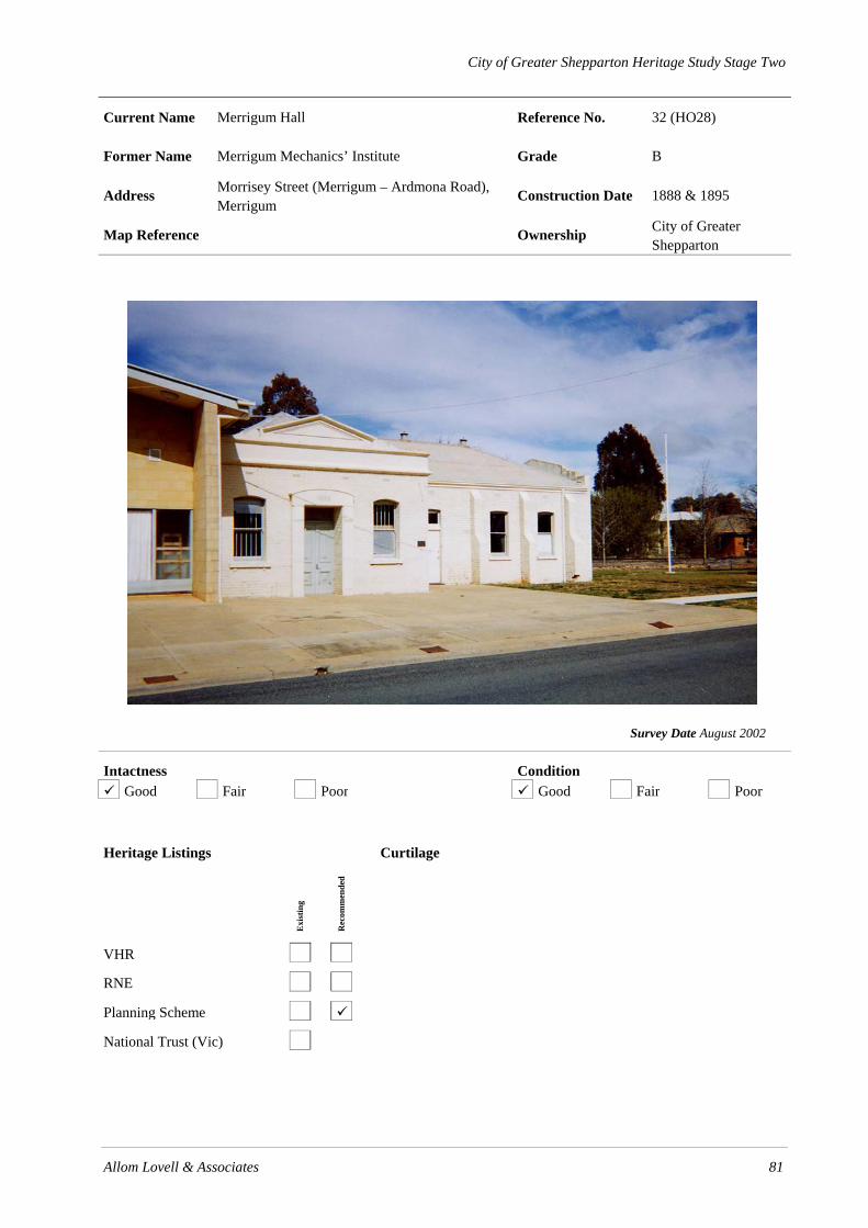
City of Greater Shepparton Heritage Study Stage Two
Allom Lovell & Associates 81
Current Name Merrigum Hall Reference No. 32 (HO28)
Former Name Merrigum Mechanics’ Institute Grade B
Address Morrisey Street (Merrigum – Ardmona Road), Merrigum
Construction Date 1888 & 1895
Map Reference Ownership City of Greater Shepparton
Survey Date August 2002
Intactness Condition Good Fair Poor Good Fair Poor
Heritage Listings
Exi
stin
g
Rec
omm
ende
d
VHR
RNE
Planning Scheme
National Trust (Vic)
Curtilage

City of Greater Shepparton Heritage Study Stage Two
82 Allom Lovell & Associates
History
In 1888 land was donated by Messrs W S Pearce and Cathcart for the erection of a Mechanics’ Institute in Merrigum. A contract was let to Bishop & Co., Kyabram, in the same year, following public subscription. William Bray, an early president of the local Progress Association, was the first president of the Institute, with J S Smith as secretary. It was decided to enlarge the building in 1894, and the renovated building was officially opened with a formal banquet and ball on 13 March 1895. Plans for a memorial in the form of a ‘Victory Hall’ commenced at a public meeting in 1944. The new Memorial Hall in honour of Merrigum’s World War Two fallen was not added to the complex until 1959, when it was opened by the Right Hon John McEwan on 30 March 1959.
Description The Merrigum Hall in Morrisey Street, Merrigum, is a single-storey hall building of brick (overpainted) construction consisting of two distinct yet interconnected wings and later additions at the rear. The hipped roof is clad with corrugated galvanised steel. The original building addresses the street with a symmetrical double-fronted façade with parapet which features pediment, scrolled consoles and dentilated entablature. The central entrance is surrounded by an aedicule which is supported by bold fluted pilasters and contains a pair of timber-framed 2-panelled doors with highlight. The door is flanked by a pair of timber-framed double-hung sash windows with segmented arch heads. The later wing is perpendicular in plan to the original and addresses the reserve. The double-fronted main elevation also features a distinctive parapeted form and contains a central entrance flanked by a pair of window openings, all of which have semi-circular arched heads. The non-original pair of doors are lined with V-jointed timber boards and the windows have timber-framed double-hung sashes. The buttressed side walls contain regular fenestration which matches the façade. Later additions consist of early brick and timber-framed construction to the south and a c. 1960s hall of rendered masonry construction to the east.
Thematic Context Thematic Environmental History
16.1 Mechanics’ Institutes
Australian Heritage Commission
8.1 Organising recreation
8.5 Forming associations
Significance The Merrigum Hall is of local historical, social and aesthetic significance. Constructed in 1889, the hall has served as a focus for local community social activity for over 110 years. Aesthetically, it is a good and substantially intact example of a rural Victorian-era mechanics institute, of which there are few in the municipality.
References Pam Baragwanath, If These Walls Could Speak, pp. 200-02.
W H Bossence, Tatura and the Shire of Rodney, p. 79.
Recommendations • Remove textured paint from brickwork and render by non-abrasive method
• Reconstruct entrance door in 1895 wing
• Investigate original external paint colours
Identified By SOMA Design Partnership, June 2001.

City of Greater Shepparton Heritage Study Stage Two
Allom Lovell & Associates 83
Current Name House Reference No. 37 (HO29)
Former Name ‘The Coffee Palace’ Grade B
Address 88 (90-92?) Waverley Avenue (Byrneside – Kyabram Road), Merrigum
Construction Date 1893
Map Reference Ownership
Survey Date August 2002
Intactness Condition Good Fair Poor Good Fair Poor
Heritage Listings
Exi
stin
g
Rec
omm
ende
d
VHR
RNE
Planning Scheme
National Trust (Vic)
Curtilage

City of Greater Shepparton Heritage Study Stage Two
84 Allom Lovell & Associates
History
This residence was erected for the carpenter, Mr David Aubrey, in 1893. The house was constructed using clay from the site, which subsequently created a hole in the ground for a cellar. The land and house were valued at only £5 in 1893. It is interesting to note that the rateable value changed little up until the early years of the twentieth century – it had risen only to £15 by 1895 and remained rated at that value until 1908. The house remained within the Aubrey family, and in 1898 Mary Aubrey is listed as the owner and occupier.
By 1908 the Aubrey family had moved on, and the building possibly became a ‘Coffee Palace’, run and owned by George Webb, a baker of Merrigum. Situated next to Hanley’s Railway Hotel, local speculation suggests the residence may have been used as a hotel or boarding house at some stage which would account for the name ‘Coffee Palace’, which in the late nineteenth century, also referred to hotels. The original building was made up of four rooms downstairs and six upstairs. The building also served as the local post office in 1906.
Description The residence at 88 Waverley Avenue, Merrigum, is a double-storey ruled ashlar finished rendered masonry building with hipped roof clad in corrugated galvanised steel, with a skillion-roofed weatherboard addition to the south and later fibro-cement sheet addition to the rear. The symmetrical double-fronted façade contains a central entrance with non-original 3-panelled timber door with highlight flanked by a pair of window openings at the ground floor and three window openings at first floor level. All of which contain timber-framed double-hung sash windows with segmented arch heads. The side elevations contain irregular fenestration and some of the original windows have been replaced with aluminium-framed sliding sash windows. The weatherboard addition contains a single entrance with 4-panelled timber door flanked by a timber-framed double-hung sash window. The rear yard contains an early timber-framed corrugated galvanised steel shed with gabled roof. To the south of the house is a later painted concrete block building with aluminium-framed shopfront windows and timber-framed pergola. The front fence is a recent lapped treated pine construction.
Thematic Context
Thematic Environmental History
15.2 Small Townships and Localities
Australian Heritage Commission
3.22 Lodging people
4.5 Making settlements to serve rural Australia
8.4 Eating and drinking
Significance
The residence at 88 Waverley Avenue, Merrigum, is of local historical and aesthetic significance. Erected in 1893, it demonstrates the growth of the township following the establishment of the railway in 1886. The possible use of the building as a coffee palace is also of interest.
References
W H Bossence, Tatura and the Shire of Rodney, p. 77, p. 86.
Mr M Potts, pers. comm.
Shire of Rodney Ratebooks, 1892-1908.

City of Greater Shepparton Heritage Study Stage Two
Allom Lovell & Associates 85
Recommendations
• Carry out general conservation of the building
• Remove pergola from south side
• Reconstruct front door
• Reconstruct front fence with appropriate design
• Investigate original external paint colours
• Reconstruct verandah to original or appropriate detail
Identified By
SOMA Design Partnership, June 2001

City of Greater Shepparton Heritage Study Stage Two
86 Allom Lovell & Associates
.

City of Greater Shepparton Heritage Study Stage Two
Allom Lovell & Associates 87
Current Name Railway Hotel Reference No. 38 (HO30)
Former Name Grade C
Address 94 Waverley Avenue (Byrneside – Kyabram Road), Merrigum
Construction Date c.1886
Map Reference Ownership
Survey Date August 2002
Intactness Condition Good Fair Poor Good Fair Poor
Heritage Listings
Exi
stin
g
Rec
omm
ende
d
VHR
RNE
Planning Scheme
National Trust (Vic)
Curtilage

City of Greater Shepparton Heritage Study Stage Two
88 Allom Lovell & Associates
History
The railway reached Merrigum in 1886 and one of the nearby landholders, Mr John Sebastian Smith, purchased an adjoining site where he erected a brick hotel. Smith had also left a sum of money for the construction of the Roman Catholic Church behind the hotel in Morrissey Street. In 1906, a local farmer, T E Byrne of Byrneside, bought the Railway Hotel property from Mrs Hanley for £3,500. Byrne in turn sold it to Mr J Quirk three years later.
During the c.1970s a brick addition was constructed along the east side of the original building.
Description The Railway Hotel, 94 Waverley Avenue, Merrigum is a single-storey corner face brick (overpainted) hotel with early weatherboard addition to the west and hipped roof clad in corrugated galvanised steel. The weatherboard section has bracketed eaves and a corbelled brick chimney. The entire original east elevation is concealed by a c. 1970s brick façade of one room deep with flat roof and steel fascia.
The visible north elevation to the side street contains a single entrance with non-original glazed timber door flanked by a pair of timber-framed double-hung sash windows. A second entrance further west with non-original glazed door divides the brick building from the weatherboard addition. The addition contains 3 timber-framed double-hung sash windows with moulded timber architraves.
Thematic Context
Thematic Environmental History
11.1 Eating, Drinking and More: the role of the country ‘pub’
Australian Heritage Commission
3.2.1 Lodging people
4.5 Making towns to serve rural Australia
8.4 Eating and drinking
Significance
The Railway Hotel, Merrigum, is of local historical and social significance. Constructed in 1886, the hotel has served as the township’s only hotel for almost 120 years and demonstrates the opportunities which developed in line with the construction of the railway through the district in 1886. The 1970s additions are intrusive and of no cultural significance.
References
W H Bossence, Tatura and the Shire of Rodney, p. 77.
Recommendations
• Preferably demolish c. 1970s brick additions and reinstate original façade.
• Investigate original external paint colours.
Identified By
SOMA Design Partnership, June 2001.
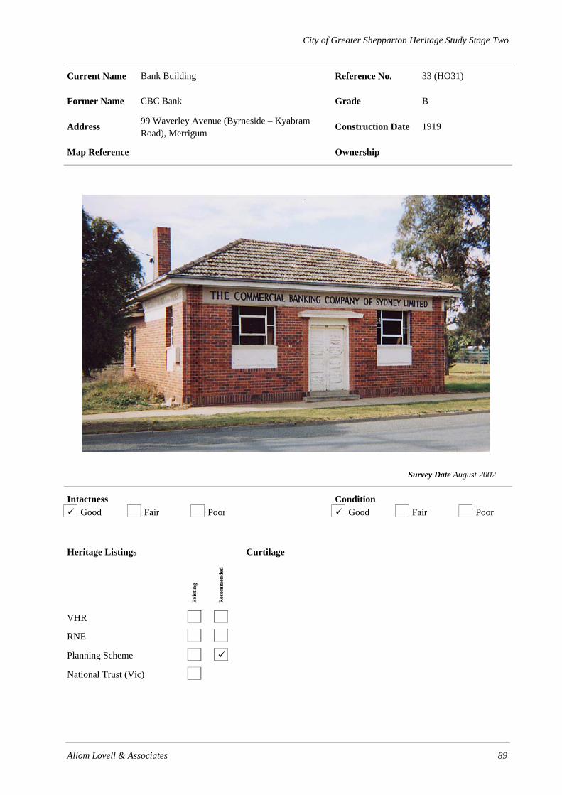
City of Greater Shepparton Heritage Study Stage Two
Allom Lovell & Associates 89
Current Name Bank Building Reference No. 33 (HO31)
Former Name CBC Bank Grade B
Address 99 Waverley Avenue (Byrneside – Kyabram Road), Merrigum
Construction Date 1919
Map Reference Ownership
Survey Date August 2002
Intactness Condition Good Fair Poor Good Fair Poor
Heritage Listings
Exi
stin
g
Rec
omm
ende
d
VHR
RNE
Planning Scheme
National Trust (Vic)
Curtilage

City of Greater Shepparton Heritage Study Stage Two
90 Allom Lovell & Associates
History The Merrigum Progress Association was successful in securing a banking agency for the town in 1902, through the Bank of Victoria. A permanent agency of the Kyabram Bank of Victoria was established in Merrigum in 1914, and Mr R Swale was appointed as agent. The agency became a branch when a new bank building was constructed to house the business in 1919. Rate books list the building in 1920 as valued at £50, with Francis James Parkinson the bank manager. By 1953 it was valued at only £42. The building became a branch of the Commercial Banking Company of Sydney, after the Bank of Victoria was taken over.
Description The former CBC branch, 99 Waverley Avenue, Merrigum, is a single-storey clinker brick inter-War commercial building with hipped roof clad in Marseilles pattern terracotta tiles and with boxed eaves and simple unadorned brick chimney. The building comprises the main banking chamber with offices and ancillary rooms to the rear and is constructed to the footpath with gardens at the sides and rear. Each corner of the building is defined by vertical bands of dog-toothed brickwork, three bricks wide and the plinth is defined by a soldier course. The rear and side elevations contain timber-framed double-hung sash windows and timber panelled doors. The symmetrical façade features a central entrance with pair of 4-panelled timber doors surrounded by rendered hood moulding and column motif to the reveal. It is flanked by a pair of steel-framed fixed and pivot sash windows (glass removed) which have rendered recessed panels below and surmounted by a rendered band at eaves line bearing the signage ‘COMMERCIAL BANKING COMPANY OF SYDNEY LIMITED’.
Thematic Context
Thematic Environmental History 15.2 Small towns and localities
Australian Heritage Commission 3.18 Financing Australia 4.5 Making towns to serve rural Australia
Significance The former CBC branch, Merrigum is of local historical and aesthetic significance. Erected in 1919, it demonstrates the growth of the district as after World War One due to the availability of irrigation water and the Soldier Settlement scheme. Aesthetically the building is a typical example of a modest inter-War commercial building.
References
W H Bossence, Tatura and the Shire of Rodney, p. 79.
Shire of Rodney Ratebooks, 1920-1953.
Recommendations • Reinstate missing glazing • Repair entrance doors • Remove ivy from brickwork • Retain original unpainted finish to brickwork and otherwise investigate original external paint
colours
Identified By
SOMA Design Partnership, June 2001.

City of Greater Shepparton Heritage Study Stage Two
Allom Lovell & Associates 91
Current Name Merrigum District Historical Society Museum Reference No. 34 (HO32)
Former Name Rodney Store & Residence Grade B
Address Waverley Avenue (Byrneside – Kyabram Road), Merrigum
Construction Date 1905
Map Reference Ownership City of Greater Shepparton
Survey Date August 2002
Intactness Condition Good Fair Poor Good Fair Poor
Heritage Listings
Exi
stin
g
Rec
omm
ende
d
VHR
RNE
Planning Scheme
National Trust (Vic) File only
Curtilage A nominal curtilage should include the allotments on which the store and adjoining cottage is constructed, but need not include the paddocks at the rear containing the machinery.

City of Greater Shepparton Heritage Study Stage Two
92 Allom Lovell & Associates
History There was surge of commercial development in the centre of Merrigum in the first few decades of the twentieth century, with various new businesses opening to serve local residents and farmers. The first general store in the town had been opened by Mr F Williams in 1886 and the Rodney Store opened in 1905. It was built by Arthur Edgar Castles for the then Shire President and local farmer and fruit grower, Mr John Lilford. It was subsequently acquired by Messrs Salmon & Judd. James Percy Judd operated the store for around 60 years, and it remained in the Judd family until 1976, when it was acquired by the Farmer family. In 1989 the house and former Rodney Store and residence were acquired by the Shepparton Council who leased it and one room of the house to the Merrigum Historical Society.
Description The former Rodney Store, Waverley Avenue, Merrigum, comprises an Edwardian single-storey tuck-pointed red face brick shop and attached residence. The shop has a distinctive parapeted gabled roof clad with corrugated galvanised steel and reconstructed bullnosed verandah supported by timber posts. The parapet features a prominent pediment and rendered copings, fielded panels, fluted pilasters and signage, ‘1905’ and ‘RODNEY STORE’ in pressed cement. The double-fronted timber-framed shopfront contains a recessed splayed entrance with pair of half-glazed panelled timber doors.
The cottage has a hipped roof clad in corrugated galvanised steel with a pair of corbelled brick chimneys and a bullnosed verandah supported by timber posts with cast iron valance and corner brackets. The symmetrical double-fronted façade contains a central entrance with 4 panelled timber door and later screen door, flanked by a pair of timber-framed double-hung sash windows. The cottage has a non-original timber picket fence to Waverley Avenue and a pair of mature Cotton palms (Washingtonia filifera) and numerous small outbuildings in the rear garden.
Thematic Context
Thematic Environmental History 9.2 Small towns of the shire
Australian Heritage Commission 3.18 Marketing and retailing
Significance The former Rodney Store and residence is of local historic and aesthetic significance. Constructed in 1905 it operated as a general store for more than eighty years and demonstrates the influx of small businesses to the town in the first two decades of the twentieth century. Aesthetically, the store and residence are good and substantially intact examples of a rural Edwardian shop and residence, of which there are few surviving examples in the municipality. Together they make a strong contribution to the historic streetscape, demonstrating the once prosperous nature of the town’s retail sector.
References W H Bossence, Tatura and the Shire of Rodney.
National Trust file.
Mrs F Halliday, Merrigum Historical Society, pers. comm.
Recommendations • Repair cracking over cottage entrance door. • Retain original unpainted finish to brickwork and otherwise investigate original external paint
colours
Identified By
SOMA Design Partnership, June 2001.

City of Greater Shepparton Heritage Study Stage Two
Allom Lovell & Associates 93
Current Name St Matthew’s Anglican Church Reference No. 35 (HO33)
Former Name Grade B
Address Waverley Avenue (Byrneside – Kyabram Road), Merrigum
Construction Date 1898
Map Reference Ownership Anglican Church
Survey Date August 2002
Intactness Condition Good Fair Poor Good Fair Poor
Heritage Listings
Exi
stin
g
Rec
omm
ende
d
VHR
RNE
Planning Scheme
National Trust (Vic)
Curtilage

94 Allom Lovell & Associates
History
St Matthews Anglican Church was originally built in the former village of Henley (north-west of Merrigum) as a Roman Catholic Church. The church was reputedly relocated to its present site in 1898 by the Hunt brothers, sons of early settler, Samuel Hunt of ‘St Heuberts’. A tender notice by architects Inskip and Butler, dated 29 January 1898, for the erection of a brick church at Merrigum, probably relates to the reconstruction works. A new hall (demolished) and a bell (originally from St Stephen’s Church, Barry’s Reef), were dedicated in 1936. B C Miller contractor. Officially opened St Mathews Day 28 September 1898.
Description St Matthew’s Anglican Church, Waverley Avenue, Merrigum, is a Gothic Early English tuck-pointed red face brick building comprising nave with projecting porch, sanctuary and vestry, all of which have simple gabled roofs. The nave and porch roofs are clad in corrugated galvanised steel and the sanctuary and vestry in corrugated fibro-cement. The central, open porch contains a pair of side entrances with pointed arch heads which lead to the main entrance containing a pointed arch and beaded timber doors. The interior of the porch is rendered. Above the porch is a group of three lancet openings which appear to have been bricked in and rendered. The buttressed side walls contain regular and repetitive fenestration with timber-framed fixed sash lancet windows with leadlight glazing. In addition, the south elevation contains a single door opening with non-original timber door. To the south-west of the church is a steel-framed bell tower and a later brick toilet block is located to the rear.
Thematic Context
Thematic Environmental History
10.0 Worshipping
Australian Heritage Commission
8.6 Worshipping
Significance
St Matthew’s Anglican Church, Merrigum is of local historic and aesthetic significance. Originally constructed in nearby Henley in 1884 and relocated to Merrigum in 1898, the church is the oldest surviving building in the town. As such, the church has been the focus of Anglican worship in the area and a centre for community activity for over 100 years. Aesthetically, it is a substantially intact example of an simple rural church, of which there are a number of surviving examples in the municipality.
References
W H Bossence, Tatura and the Shire of Rodney.
Miles Lewis. Australian Architectural Index.
Recommendations
• Repair damaged tuck-pointing, porch ceiling.
• Preferably replace screens on windows with more sympathetic protection.
• Retain original unpainted finish to brickwork of building and otherwise investigate original external paint colours.
Identified By
SOMA Design Partnership, June 2001.

City of Greater Shepparton Heritage Study Stage Two
Allom Lovell & Associates 95
Current Name Merrigum Uniting Church Reference No. 36 (HO34)
Former Name Methodist Church Grade B
Address 137 Waverley Avenue (Byrneside – Kyabram Road), Merrigum
Construction Date 1908
Map Reference Ownership Uniting Church
Survey Date August 2002
Intactness Condition Good Fair Poor Good Fair Poor
Heritage Listings
Exi
stin
g
Rec
omm
ende
d
VHR
RNE
Planning Scheme
National Trust (Vic)
Curtilage
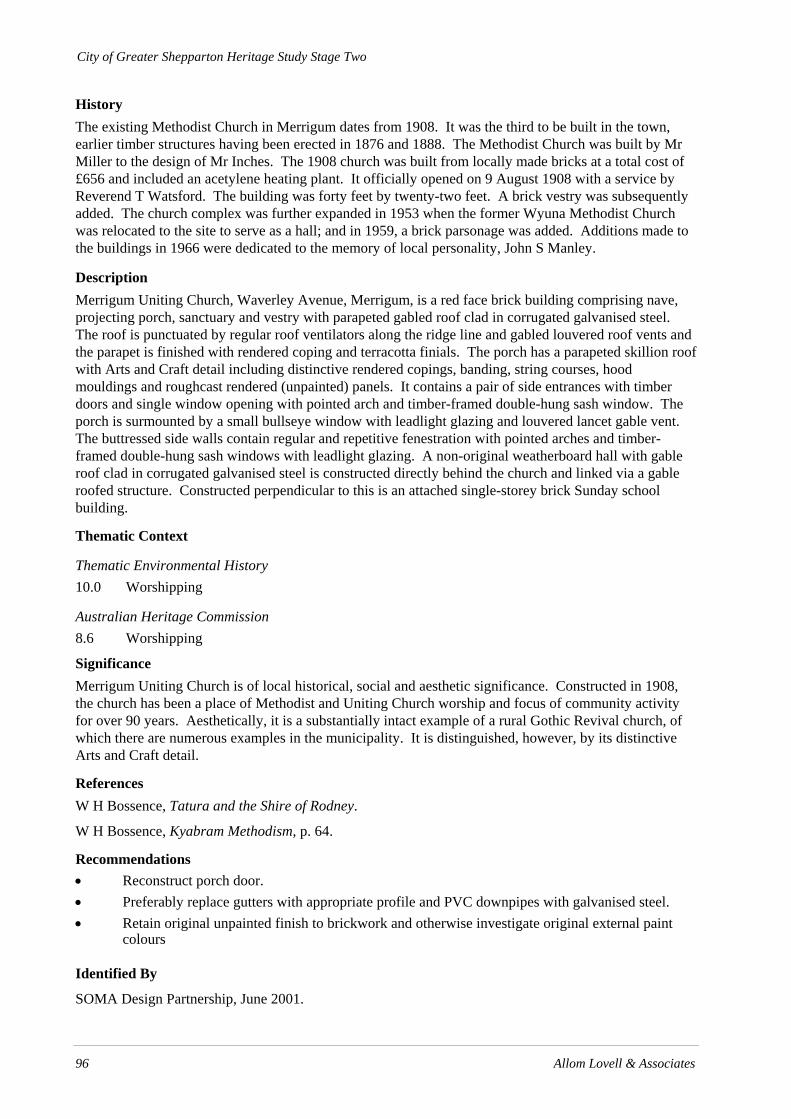
City of Greater Shepparton Heritage Study Stage Two
96 Allom Lovell & Associates
History The existing Methodist Church in Merrigum dates from 1908. It was the third to be built in the town, earlier timber structures having been erected in 1876 and 1888. The Methodist Church was built by Mr Miller to the design of Mr Inches. The 1908 church was built from locally made bricks at a total cost of £656 and included an acetylene heating plant. It officially opened on 9 August 1908 with a service by Reverend T Watsford. The building was forty feet by twenty-two feet. A brick vestry was subsequently added. The church complex was further expanded in 1953 when the former Wyuna Methodist Church was relocated to the site to serve as a hall; and in 1959, a brick parsonage was added. Additions made to the buildings in 1966 were dedicated to the memory of local personality, John S Manley.
Description Merrigum Uniting Church, Waverley Avenue, Merrigum, is a red face brick building comprising nave, projecting porch, sanctuary and vestry with parapeted gabled roof clad in corrugated galvanised steel. The roof is punctuated by regular roof ventilators along the ridge line and gabled louvered roof vents and the parapet is finished with rendered coping and terracotta finials. The porch has a parapeted skillion roof with Arts and Craft detail including distinctive rendered copings, banding, string courses, hood mouldings and roughcast rendered (unpainted) panels. It contains a pair of side entrances with timber doors and single window opening with pointed arch and timber-framed double-hung sash window. The porch is surmounted by a small bullseye window with leadlight glazing and louvered lancet gable vent. The buttressed side walls contain regular and repetitive fenestration with pointed arches and timber-framed double-hung sash windows with leadlight glazing. A non-original weatherboard hall with gable roof clad in corrugated galvanised steel is constructed directly behind the church and linked via a gable roofed structure. Constructed perpendicular to this is an attached single-storey brick Sunday school building.
Thematic Context
Thematic Environmental History 10.0 Worshipping
Australian Heritage Commission 8.6 Worshipping
Significance Merrigum Uniting Church is of local historical, social and aesthetic significance. Constructed in 1908, the church has been a place of Methodist and Uniting Church worship and focus of community activity for over 90 years. Aesthetically, it is a substantially intact example of a rural Gothic Revival church, of which there are numerous examples in the municipality. It is distinguished, however, by its distinctive Arts and Craft detail.
References W H Bossence, Tatura and the Shire of Rodney.
W H Bossence, Kyabram Methodism, p. 64.
Recommendations • Reconstruct porch door. • Preferably replace gutters with appropriate profile and PVC downpipes with galvanised steel. • Retain original unpainted finish to brickwork and otherwise investigate original external paint
colours
Identified By
SOMA Design Partnership, June 2001.

City of Greater Shepparton Heritage Study Stage Two
Allom Lovell & Associates 97
Current Name Former Church Reference No. 39 (HO35)
Former Name St Patrick’s Roman Catholic Church Grade B
Address Goulburn Valley Highway, Moorilim Construction Date 1888
Map Reference 479.466 Nagambie Ownership
Survey Date August 2002
Intactness Condition Good Fair Poor Good Fair Poor
Heritage Listings
Exi
stin
g
Rec
omm
ende
d
VHR
RNE
Planning Scheme
National Trust (Vic)
Curtilage

98 Allom Lovell & Associates
History
A timber church and school existed on this site in 1872; the land had been donated by the local farmer, Michael Kearney. The existing St Patrick’s Roman Catholic Church was erected in 1888, with the foundation stone laid by Dr Reville, Co-adjudicator and Bishop of Sandhurst, on 19 April 1888. The builder was a Mr McKenzie. The original church was reportedly relocated to the rear of the site at this time for use by the school, which continued to operate until 1903. The original church, however, was later sold and moved from the site in 1928. The current building on the site, St Patrick’s Roman Catholic Church, ceased to be an active place of worship by the late 1990s and the building was sold in September 1998.
Description The Former Church, Goulburn Valley Highway, Moorilim, is a face red brick building comprising an entry porch, nave, sanctuary and vestry, each with a parapeted gabled slate roof. The nave roof has gablet vents and parapets with rendered copings and crosses. The main gable end contains three narrow louvered vents. The side elevations are buttressed and contain regular fenestration of lancet windows with rendered quoining. On the east elevation of both the porch and nave there are shallow arched doorways fitted with a non-original flush panel timber doors.
Thematic Context
Thematic Environmental History
10.0 Worshipping
Australian Heritage Commission
8.6 Worshipping
Significance
The Former Catholic Church, Goulburn Valley Highway, Moorilim, is of local historic and aesthetic significance. Constructed in 1888, the church was a centre for Catholic worship and activity for the local community for over 100 years. Aesthetically, the church is an intact and good example of a modest brick rural church in the Gothic Revival style, of which there are numerous examples throughout the municipality.
References
Bert Kearney, pers comm.
St Patricks Centenary: A History of Moorlim, (cited by Marjorie Quirk, pers comm.)
Recommendations
• Reconstruct doors to original detail.
• Retain original unpainted finish to brickwork and otherwise investigate original external paint colours
Identified By
SOMA Design Partnership, June 2001.

City of Greater Shepparton Heritage Study Stage Two
Allom Lovell & Associates 99
Current Name St Andrew’s Uniting Church and Hall Reference No. 40 (HO36)
Former Name Grade B
Address Alexandra Street, Mooroopna Construction Date 1882, 1935, 1952 Hall 1928
Map Reference Ownership Uniting Church
Survey Date August 2002
Intactness Condition Good Fair Poor Good Fair Poor
Heritage Listings
Exi
stin
g
Rec
omm
ende
d
VHR
RNE
Planning Scheme
National Trust (Vic)
Curtilage

City of Greater Shepparton Heritage Study Stage Two
100 Allom Lovell & Associates
History
Presbyterian services in Mooroopna commenced in the newly opened primary school in 1876. St Andrew’s Church was then built for the local Presbyterian congregation in 1882, including an adjacent manse. The manse was relocated in 1919 to the corner of Park and O’Brien Streets, following extensive damage from the 1916 flood. A Sunday School hall was erected adjacent to the church in 1928 at a cost of £1516.2.0. Renovations were carried out to the church and hall in 1935, and the McLennan Memorial Porch was added to the front of the church in 1952. Since 1977 the church has served the local Uniting Church congregation. More recent alterations have included the construction of additions at the rear and the interconnection of the church and hall.
Description St Andrew’s Uniting Church, Alexandra Street, Mooroopna, is a small tuck-pointed red face brick building consisting of a nave with later porch and vestry. The parapeted gabled nave and skillion vestry roofs are clad with corrugated galvanised steel and the gabled porch roof is clad with concrete tiles. The main gable contains a group of three lancet openings with rendered drip moulds which are flanked by pinnacles featuring rendered mouldings and recessed panels. The porch contains a side entrance with double-leaf timber doors and single pointed arch opening and the buttressed side walls contain regular pointed arch fenestration. All window openings contain timber-framed fixed sash windows with leadlight glazing. The adjacent church hall is a single-storey double-fronted red face brick building consisting of hall and rear kitchen wing on a T-shaped plan, linked to the church via a later flat roofed addition. The hipped roof is clad with corrugated galvanised steel and finished with timber lined boxed eaves. The symmetrical parapeted façade contains a central pair of glazed timber doors, flanked by a pair of steel-framed fixed sash windows which are surmounted by a rendered pediment with consoled cornice and pilaster motif. The buttressed side elevation contains regular steel-framed multi-paned fixed sash windows.
Thematic Context
Thematic Environmental History 10.0 Worshipping
Australian Heritage Commission 8.6 Worshipping
Significance St Andrew’s Uniting Church, Alexandra Street, Mooroopna, is of local historic and aesthetic significance. Constructed in 1882, the church has served as a focus for Presbyterian / Uniting Church worship and community activity for 120 years. Aesthetically, the building is a good and largely intact example of a Gothic Revival church, albeit altered by the construction of later additions. The church hall is also a good example of an inter-War brick hall of which there are numerous examples throughout the municipality.
References The Historical Society of Mooroopna Inc, Mooroopna to 1988, p. 59.
Donald McLennan, History of Mooroopna, Ardmona and District.
Recommendations • Repair damaged brickwork. • Retain original unpainted finish to brickwork of building and otherwise investigate original
external paint colours.
Identified By SOMA Design Partnership, June 2001.
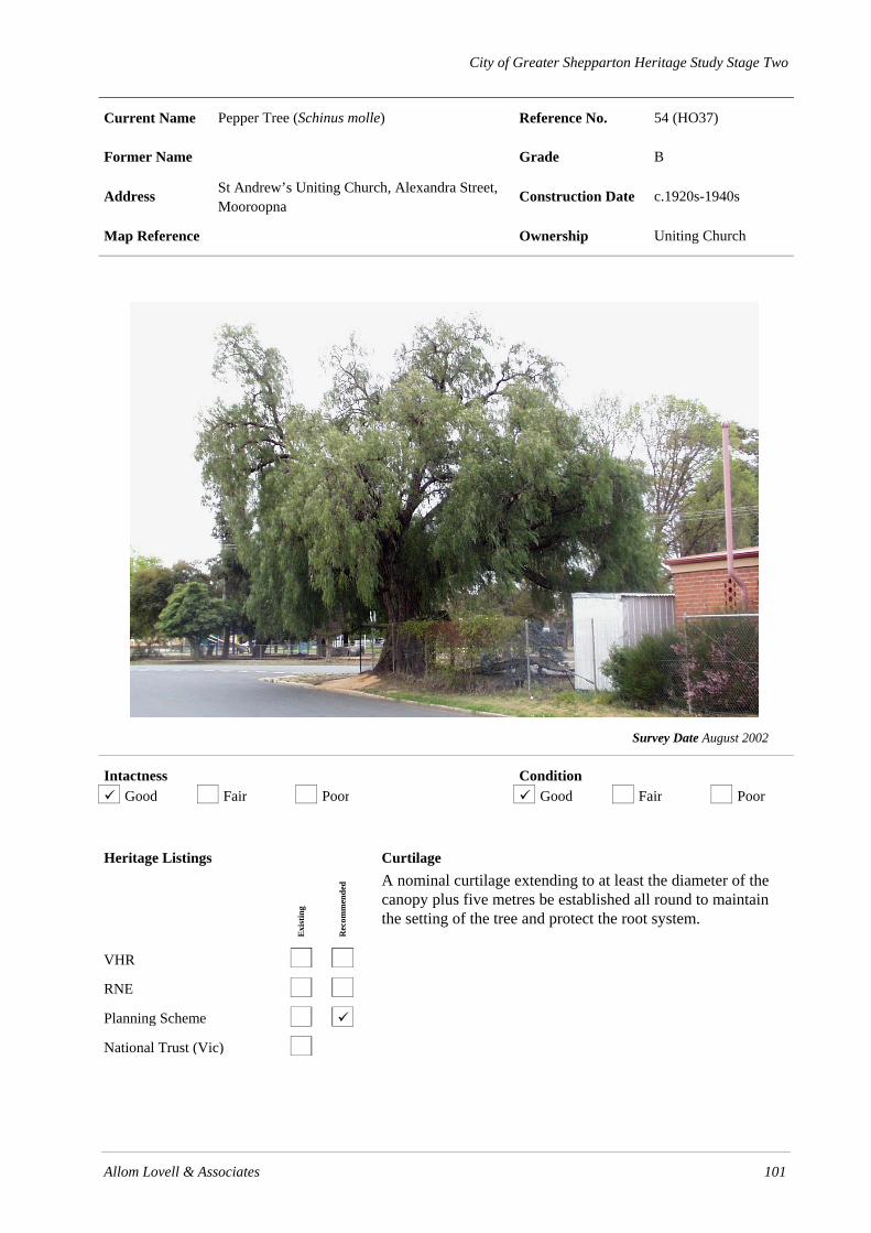
City of Greater Shepparton Heritage Study Stage Two
Allom Lovell & Associates 101
Current Name Pepper Tree (Schinus molle) Reference No. 54 (HO37)
Former Name Grade B
Address St Andrew’s Uniting Church, Alexandra Street, Mooroopna
Construction Date c.1920s-1940s
Map Reference Ownership Uniting Church
Survey Date August 2002
Intactness Condition Good Fair Poor Good Fair Poor
Heritage Listings
Exi
stin
g
Rec
omm
ende
d
VHR
RNE
Planning Scheme
National Trust (Vic)
Curtilage A nominal curtilage extending to at least the diameter of the canopy plus five metres be established all round to maintain the setting of the tree and protect the root system.

102 Allom Lovell & Associates
History
The Pepper tree (Schinus molle) is native to South America, and was introduced for cultivation in Victoria in 1873 by St. Kilda nurseryman George Brunning. The specimen at St Andrew’s Uniting Church, Mooroopna is estimated to be 60 - 80 years old.
Description The single specimen Pepper tree (Schinus molle) on the corner of Mill and O’Brien Streets, Mooroopna is located behind St Andrew’s Uniting Church. It is approximately 12 metres tall with a trunk of approximately 1.5 metres in diameter.
Thematic Context
Thematic Environmental History
-
Australian Heritage Commission
1.4 Appreciating the natural wonders of Australia
Significance
The Pepper tree on the corner of Mill and O’Brien Streets, Mooroopna is of some scientific (botanical) and aesthetic interest. It is a moderately sized example of the species and forms a prominent marker in the streetscape.
References
Margaret Brookes and Richard Barley. Plants Listed in Nursery Catalogues of Victoria 1855-1889. p. 283.
John Patrick, pers comm.
Recommendations
• The tree should be assessed on a 1 to 2 year basis by a qualified arborist.
Identified By
SOMA Design Partnership, June 2001.

City of Greater Shepparton Heritage Study Stage Two
Allom Lovell & Associates 103
Current Name Mooroopna North State Primary School Reference No. 41 (HO38)
Former Name Mooroopna North State School No. 1612 Grade B
Address Ardmona Road, Mooroopna Construction Date c. 1901
Map Reference Ownership Ministry of Education
Survey Date August 2002
Intactness Condition Good Fair Poor Good Fair Poor
Heritage Listings
Exi
stin
g
Rec
omm
ende
d
VHR
RNE
Planning Scheme
National Trust (Vic)
Curtilage

104 Allom Lovell & Associates
History
A schoolhouse was constructed by local selectors on Crown Allotment 67A in 1875, and James Hunter opened the school on 12 July of that year. The original schoolhouse was subsequently enlarged and a four-roomed residence constructed in 1877, as enrolments had risen from 44 to 55. This building serviced the school until the turn of the century when a new schoolhouse was constructed adjacent to the old building which was then sold for removal. In August 1937, three acres (1.21 hectares) of land adjacent to the school was granted for the purpose of establishing an endowment plantation. This was later cleared in 1975.
Description The Mooroopna North Primary School comprises a single-storey weatherboard building on a rectangular plan with steeply pitched gable roof clad in corrugated galvanised steel. The roofline contains a prominent brick (overpainted) chimney with corbelled cap and the bracketed gable ends contain louvered vents and timber finials. Below the main gable is a small timber-framed four-light window with corrugated galvanised steel awning. A small gabled porch, with side entrance and single timber-framed double-hung sash window projects from the asymmetrical façade and is flanked by a pair of timber-framed, double-hung sash windows. The front and side elevations are screened by a skillion-roofed verandah supported by stop-chamfered timber posts with curved brackets. The roof has recently been re-clad and contains skylights and there are some sheets of corrugated fibreglass to the verandah roof. The verandah along the west elevation has a recent timber deck. A recent prefabricated shed with a steel-framed verandah abuts the west elevation of the school building. Adjacent to the school building is a recently constructed and similarly detailed weatherboard toilet block. The school grounds also contain modern portable classrooms and sheds of no significance and the road frontage is fenced with a concrete post and wire fence.
Thematic Context
Thematic Environmental History
9.1 Primary and Secondary Education
Australian Heritage Commission
6.2 Establishing schools
6.5 Educating people in remote places
Significance The Mooroopna North Primary School, Ardmona Road, Mooroopna North is of local historic and aesthetic significance. Associated with the earliest development of the area, the site has contained a schoolhouse for over 125 years. The present building demonstrates the demands on the school due to the growth in population around the turn of the century. Aesthetically, it is a largely intact and picturesque example of an Edwardian weatherboard schoolhouse, of which there are few known examples in the municipality.
References The Historical Society of Mooroopna Inc. Mooroopna to 1988.
Recommendations
• The later structures on the site can be retained, altered or demolished as required. • Preferably site new buildings behind or away from the school building so as not to intrude on the
view of the building from the street.
Identified By
SOMA Design Partnership, June 2001.

City of Greater Shepparton Heritage Study Stage Two
Allom Lovell & Associates 105
Current Name SPC Ardmona Canteen Reference No. 42 (HO39)
Former Name Former Mooroopna Post Office Grade B
Address Camp Street (cnr. Young Street), Mooroopna Construction Date 1921
Map Reference Ownership SPC Ardmona
Survey Date August 2002
Intactness Condition Good Fair Poor Good Fair Poor
Heritage Listings
Exi
stin
g
Rec
omm
ende
d
VHR
RNE
Planning Scheme
National Trust (Vic)
Curtilage

City of Greater Shepparton Heritage Study Stage Two
106 Allom Lovell & Associates
History
The land for the former Mooroopna Post Office was acquired in 1918, after erosion of the river bank due to the 1916 flooding made it necessary to relocate the previous post office building and its services. The new post office and residence were opened in 1921, and Mr L A D O’Connor was the first postmaster. The building also housed the manually operated telephone exchange until the automatic exchange was constructed in Echuca Road in 1973. The building now accommodates a canteen servicing the employees of the adjoining SPC Ardmona factory.
Description The former Mooroopna Post Office, Camp Street, Mooroopna, is a single-storey red face brick inter-War building with hipped roof clad with Marseilles pattern terracotta tiles and timber batten lined boxed eaves. The symmetrical façade addresses the corner with a splayed entrance porch with flat roof which contains a wide central opening with a stripped Classical rendered surround, beyond which is a pair of half-glazed timber doors and non-original panel of glass bricks. Both principal facades contain a group of three timber-framed double-hung sash windows flanked by rusticated brick quoined pilasters.
Thematic Context
Thematic Environmental History
15.1 Medium-sized Towns
16.0 Public Buildings
17.1 Floods
Australian Heritage Commission
3.6 Establishing lines and networks of communication
4.3 Developing institutions
Significance
The former Mooroopna Post Office, Camp Street, Mooroopna, is of local historical significance. Erected in 1921, the building demonstrates the ongoing provision of essential services to the town. The relocation of the postal service to the Camp Street site is also evidence of the impact of local flooding in the municipality in 1916. Aesthetically, it is a modest, yet good, example of an inter-War public building, with interesting stripped Classical detail.
References
The Historical Society of Mooroopna Inc. Mooroopna to 1988, p. 153.
Recommendations
• Retain original unpainted finish to brickwork of building and otherwise investigate original external paint colours.
Identified By
SOMA Design Partnership, June 2001.
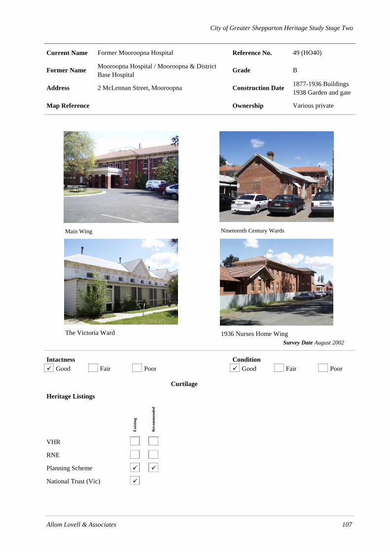
City of Greater Shepparton Heritage Study Stage Two
Allom Lovell & Associates 107
Current Name Former Mooroopna Hospital Reference No. 49 (HO40)
Former Name Mooroopna Hospital / Mooroopna & District Base Hospital
Grade B
Address 2 McLennan Street, Mooroopna Construction Date 1877-1936 Buildings 1938 Garden and gate
Map Reference Ownership Various private
Main Wing
Nineteenth Century Wards
The Victoria Ward
1936 Nurses Home Wing
Survey Date August 2002
Intactness Condition Good Fair Poor Good Fair Poor
Heritage Listings
Exi
stin
g
Rec
omm
ende
d
VHR
RNE
Planning Scheme
National Trust (Vic)
Curtilage

City of Greater Shepparton Heritage Study Stage Two
108 Allom Lovell & Associates
History
The land on which the hospital stands was donated by local businessman, William S Archer; fundraising began, and construction of the hospital commenced in 1876. In 1880, additions made to the main building comprised a board room, waiting room and additional ward, as well as a wash house and underground tank. In June 1882 a new isolation ward was constructed and alterations and additions were made to the existing buildings, and in 1883 an additional 3¼ acres of land was purchased from Archer. In August 1884 a brick laundry was erected and in 1885 a new ward was constructed and improvements to the existing were completed. In August of the same year a refractory ward and ambulance shed were built which were followed in May 1886 by an operating room and dispensary. In July 1887 a contagious ward was constructed.
The next phase of building did not occur until 1893, when the No. 2 Male Ward was built to the design of notable Melbourne architects, Beswicke & Coote; this was followed in 1901 by the Victoria Ward for women. In 1906 a new laundry was opened and in July 1912 the west wing of the nurses’ home was opened; it was later extended in 1925. In response to the prevalence of diphtheria in 1916, an infectious ward was desperately needed. It was constructed adjacent to McLennan Street by J & J E Kittle but was later relocated to the rear of the site. Ancillary works continued throughout the 1920s, following establishment of a “Peace Appeal” and included extensions to the nurses’ home and kitchen, underground drainage and sanitary works, maids’ home, covered ways, Sternberg Ward verandahs, a steam and hot water reticulation system, telephone system, boilers and general alterations.
In 1921 the committee engaged Melbourne architects, Henderson, Alsop and Martin to prepare plans for a master plan; as a result, the infectious ward was relocated and in 1924 work commenced on additions to the nurses’ home, a children’s ward, resident doctors’ quarters, maternity ward, administrative building and sewerage system over the period 1924-1929. Around this time the mortuary and attached chapel were constructed.
In 1934 the largest hospital building program commenced, under the direction of prominent Melbourne architects, A & K Henderson, at which time a number of the smaller older buildings were removed to make way for the current main hospital building. Concurrent alterations were also made to the infectious diseases block. The landscaped front garden was planted and memorial gates were constructed in 1938, however the centrepiece, a large tree in front of the main entrance, was struck by lightening and died in the late 1950s. It was replaced with the present Pin Oak (Quercus pilustrus), planted by Shepparton Parks and Gardens curator, Harry Tonkin. Construction of the present central laundry commenced in 1962.
Description
Nineteenth Century Wards
The earliest remaining hospital buildings on the site are the former wards which comprise 2 single-storey red face brick buildings on a rectangular plan, sited parallel to each other. The northern building has a gable roof clad in corrugated galvanised steel with circular louvered gable vents, corbelled brick chimney and skillion roofed verandah along the southern elevation. The north elevation has a canted bay with timber-framed double-hung sash windows with segmented arched heads and irregular fenestration elsewhere. Alterations to the building include non-original openings in the northern elevation and a bricked-in window in the east elevation. The southern building has a hipped roof clad in corrugated galvanised steel with skillion verandahs supported by timber posts to both long elevations. Both elevations contain regular fenestration with timber-framed double-hung sash windows and panelled timber doors. Both buildings contain Tobin tubes (ventilation vents).
The Victoria Ward
The Victoria Ward (1901) is an Edwardian single-storey face brick (over-painted) hospital wing with hipped and gabled roof clad with corrugated galvanised steel and bracketed eaves. The original entrance

City of Greater Shepparton Heritage Study Stage Two
Allom Lovell & Associates 109
is surmounted by a pair of gablets with half-timbered pressed metal gable ends. The symmetrical façade is screened by a timber skillion roofed verandah (now infilled with aluminium-framed windows) and contains regular segmented arched openings containing 4-panelled timber doors and timber-framed casement sash windows. Above the verandah level each ward is ventilated by small segmented arch openings containing non-original louvered windows.
Former Residence (?)
The building comprises a single-storey rendered brick building on an L-shaped plan with gabled roof clad in corrugated galvanised steel. Each gable end contains a small louvred vent and the façade is largely obscured by a red brick addition in place of the original verandah. Openings appear to have been largely altered and a steel framed awning has been fixed above the non-original main entrance.
1912 Nurse’ Home wing
The Nurses’ Home wing (1912) consists of a central double-storey wing of red face brick construction to the ground floor and weatherboard to the attic level with hipped roof clad in Marseilles pattern terracotta tile. The roofline includes prominent chimneys with roughcast rendered caps and dormer windows. The symmetrical façade features three canted bay windows with timber-framed double-hung sash windows with leadlight glazing and a recessed entrance with half-glazed timber door at ground floor level and timber-framed double-hung sash windows at attic level. The central wing is flanked by a pair of single-storey red face brick wings, forming a U-shaped plan. The west elevation of the western wing is screened by a wide belcast roofed verandah supported on brick piers with paired timber posts and arched timber valance. Single half-glazed timber doors flanked by timber-framed double-hung sash windows, provide direct access to the wards. The east wing verandah is more utilitarian in nature. The gabled south elevation of each wing features a canted bay which is roofed with timber shingles and incorporates a chimney breast flanked by narrow timber-framed double-hung sash windows. The weatherboard gable ends contain a pair of louvered vents.
Boiler House
The Boiler House (1928-29) comprises a single-storey red face brick building on a rectangular plan with parapeted gable roof clad in corrugated galvanised steel. The gable end is finished with rendered copings and contains a circular louvered vent. The symmetrical double-fronted façade is divided into three bays by a central breakfront, which contains a pair of openings with non-original steel roller shutters with steel-framed multi-paned pivot sash fanlights. The flanking bays contain single steel-framed multi-paned fixed windows. Both side elevations have been altered by the construction of later corrugated galvanised steel and brick annexes. The original brick chimney has been demolished and the rear of the building has been incorporated into the 1960s laundry building.
1936 Nurses Home Wing
The Nurses Home (1936) is a large double-storey red face wing on an L-shaped plan which matches the main wing in style, construction and detail. The main entrance is via a central pair of multi-paned timber doors with rendered hood moulding which are surrounded by timber-framed double-hung multi-paned sash windows. The side and rear elevations are more utilitarian in nature and include regular and repetitive fenestration at ground and first floor levels with timber-framed double-hung sash windows.
Main Wing
The main wing (1936) fronting McLennan Street is a double-storey red face brick institutional building in the inter-War Stripped Classical style with hipped roof clad with Marseilles pattern terracotta tiles. The boxed bracketed eaves are lined with timber and the roofline is broken by a widow’s walk with wrought iron balustrade. The symmetrical break-fronted façade features rusticated brick quoins and a central projecting bay, in front of which is a single-storey porte-cochère supported by brick piers with rendered parapet and capitals and roof-top balcony with a wrought iron balustrade. Three pairs of timber-framed

City of Greater Shepparton Heritage Study Stage Two
110 Allom Lovell & Associates
French doors access the balcony and are flanked by timber-framed double-hung multi-paned sash windows. The recessed entrance contains a pair of glazed timber-framed doors flanked by a narrow pair of timber-framed double-hung sash windows. The remaining fenestration is regular and repetitive with largely intact timber-framed double-hung multi-paned sash windows.
Mortuary & Chapel
The former mortuary (1929) comprises a single-storey double-fronted red face brick building with hipped and gabled roof clad with terracotta tiles. The Georgian Revival façade is break-fronted with a central projecting entrance containing a pair of four-panel timber doors with arched fanlight above. Flanking bays contain pairs of timber-framed double-hung multi-paned sash windows. Rendered dressings define the openings and eaves line. A second projecting bay at the north end of the façade contains a wide opening with non-original steel roller shutter surmounted by a small timber-framed multi-paned highlight. The south elevation is partially screened by a wide bellcast verandah supported on brick piers. Recent steel-framed canopies have been erected over each entrance.
Memorial Gates & Landscape
The McLennan Street entrance to the hospital is via a pair of low wrought iron gates (1938) which are flanked by a low red face brick and wrought iron fence and are marked by a white marble plaque bearing the inscription, ‘MEMORIAL GATES 1938, ERECTED BY C W NORTON IN MEMORY OF HIS FATHER AND MOTHER, EARLY PIONEERS’. The landscape is designed around a circular driveway in front of the main entrance which contains a mature Pin Oak (Quercus pilustrus).
Thematic Context
Thematic Environmental History
15.1 Medium-sized Towns
Australian Heritage Commission
3.25 Treating what ails Australians
4.3 Developing urban institutions
Significance
The Mooroopna Hospital is of regional historic and aesthetic significance. First established on the site in 1876, the complex grew rapidly to become one of the largest country hospitals in the state by the 1920s. It remained the Goulburn Valley’s main hospital until its closure in 1974 and was one of the town’s major sources of employment. Aesthetically, the complex is architecturally distinguished by the consistent use of red brick, creating a landmark complex in the main street. In addition the association with notable architects, Beswicke & Coote and also Henderson, Alsop and Martin is significant. The main entry wing by Melbourne architects, Henderson, Alsop and Martin, is an individually notable institutional building in the inter-War Stripped Classical style.
References
J M (Bunty) Corbet. The Growth of a Caring Community.
Donald McLennan. History of Mooroopna, Ardmona & District.
Geoffrey Nice. Hospitals are People.
Geoffrey Nice. Not Bricks and Mortar and Paint – But People.

City of Greater Shepparton Heritage Study Stage Two
Allom Lovell & Associates 111
Recommendations
• Remove verandah to Victoria Ward
• Retain original unpainted finish to brickwork and otherwise investigate original external paint colours
Identified By
SOMA Design Partnership, June 2001.

City of Greater Shepparton Heritage Study Stage Two
112 Allom Lovell & Associates

City of Greater Shepparton Heritage Study Stage Two
Allom Lovell & Associates 113
Current Name Former Athenaeum Hall Reference No. 49 (HO41)
Former Name Mooroopna Masonic Hall / Elsie Jones School of Nursing
Grade B
Address 2 McLennan Street, Mooroopna Construction Date 1875, 1960s
Map Reference Ownership
Survey Date August 2002
Intactness Condition Good Fair Poor Good Fair Poor
Heritage Listings
Exi
stin
g
Rec
omm
ende
d
VHR
RNE
Planning Scheme
National Trust (Vic)
Curtilage
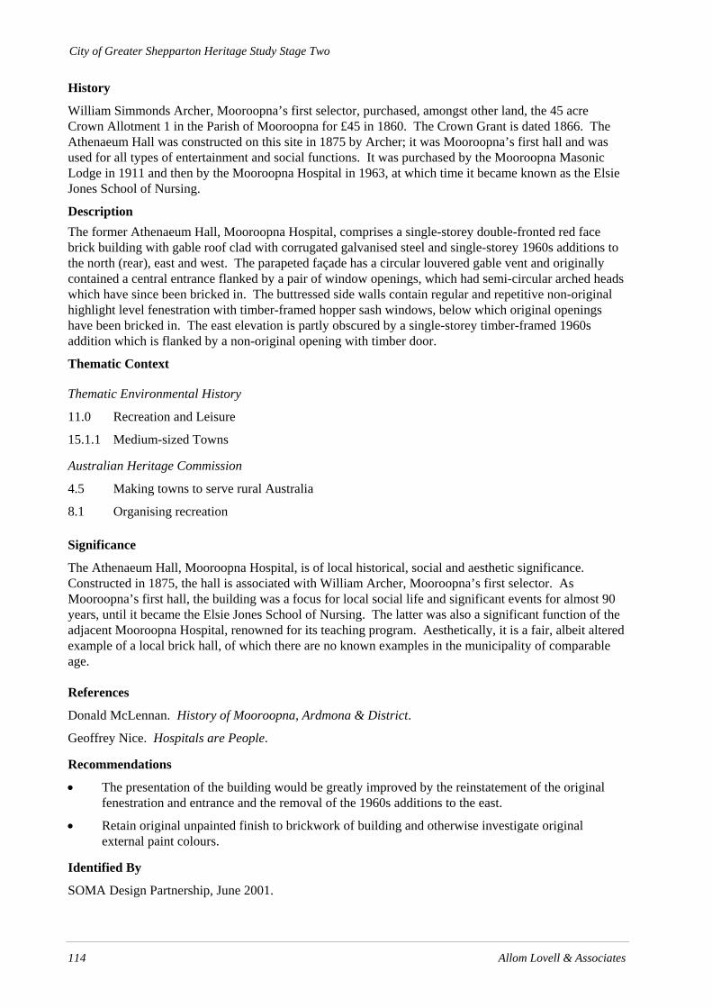
City of Greater Shepparton Heritage Study Stage Two
114 Allom Lovell & Associates
History
William Simmonds Archer, Mooroopna’s first selector, purchased, amongst other land, the 45 acre Crown Allotment 1 in the Parish of Mooroopna for £45 in 1860. The Crown Grant is dated 1866. The Athenaeum Hall was constructed on this site in 1875 by Archer; it was Mooroopna’s first hall and was used for all types of entertainment and social functions. It was purchased by the Mooroopna Masonic Lodge in 1911 and then by the Mooroopna Hospital in 1963, at which time it became known as the Elsie Jones School of Nursing.
Description The former Athenaeum Hall, Mooroopna Hospital, comprises a single-storey double-fronted red face brick building with gable roof clad with corrugated galvanised steel and single-storey 1960s additions to the north (rear), east and west. The parapeted façade has a circular louvered gable vent and originally contained a central entrance flanked by a pair of window openings, which had semi-circular arched heads which have since been bricked in. The buttressed side walls contain regular and repetitive non-original highlight level fenestration with timber-framed hopper sash windows, below which original openings have been bricked in. The east elevation is partly obscured by a single-storey timber-framed 1960s addition which is flanked by a non-original opening with timber door.
Thematic Context
Thematic Environmental History
11.0 Recreation and Leisure
15.1.1 Medium-sized Towns
Australian Heritage Commission
4.5 Making towns to serve rural Australia
8.1 Organising recreation
Significance
The Athenaeum Hall, Mooroopna Hospital, is of local historical, social and aesthetic significance. Constructed in 1875, the hall is associated with William Archer, Mooroopna’s first selector. As Mooroopna’s first hall, the building was a focus for local social life and significant events for almost 90 years, until it became the Elsie Jones School of Nursing. The latter was also a significant function of the adjacent Mooroopna Hospital, renowned for its teaching program. Aesthetically, it is a fair, albeit altered example of a local brick hall, of which there are no known examples in the municipality of comparable age.
References
Donald McLennan. History of Mooroopna, Ardmona & District.
Geoffrey Nice. Hospitals are People.
Recommendations
• The presentation of the building would be greatly improved by the reinstatement of the original fenestration and entrance and the removal of the 1960s additions to the east.
• Retain original unpainted finish to brickwork of building and otherwise investigate original external paint colours.
Identified By
SOMA Design Partnership, June 2001.

City of Greater Shepparton Heritage Study Stage Two
Allom Lovell & Associates 115
Current Name Mooroopna War Memorials Reference No. 52 (HO42)
Former Name Grade B
Address McLennan Street, Mooroopna Construction Date 1901 and 1928
Map Reference Ownership
Mooroopna War Memorial
Mooroopna Boer War Memorial
Survey Date August 2002
Intactness Condition Good Fair Poor Good Fair Poor
Heritage Listings
Exi
stin
g
Rec
omm
ende
d
VHR
RNE
Planning Scheme
National Trust (Vic)
Curtilage Maintain a nominal curtilage of 15 metres around each memorial structure, preferably to the extent of the garden reserve.

City of Greater Shepparton Heritage Study Stage Two
116 Allom Lovell & Associates
History
Mooroopna’s Boer War Memorial commemorates Mooroopna’s first casualty, Private George Stratton, who died at Wilmansrust, South Africa, on 12 June 1901. The memorial was erected by public subscription. The Mooroopna community also contributed £1,100 to erect a memorial to those locals who served in World War One. This included 145 men and 21 nurses, all of whom trained at the Mooroopna Hospital. This Mooroopna War Memorial was dedicated on 25 April 1928.
Description The Mooroopna Boer War Memorial consists of a white marble colonette and base on a rock-faced bluestone plinth and concrete footing. The marble base bears a carved inscription in memory of Private George Stratton.
The Mooroopna War Memorial, McLennan Street, Mooroopna, is a Classical rotunda of reinforced concrete construction. A domed roof with octagonal plan is supported by plain Ionic columns on square bases. The octagonal frieze contains moulded panels with the pressed cement lettering ‘FRANCE’, ‘BELGIUM’, ‘PALESTINE’ and ‘GALLIPOLI’ alternating with blank panels, all of which are moulded The structure is raised on an octagonal concrete base which is stepped on all sides. A marble-faced cenotaph, bearing the names of those who served, is located in the centre of the rotunda on a bluestone (overpainted) plinth. The plinth is surrounded on three sides by a non-original galvanised steel rack for floral wreaths.
Thematic Context
Thematic Environmental History
14.0 Commemorating the Dead – Cemeteries and Memorials
Australian Heritage Commission
8.8 Remembering the fallen
8.9 Commemorating significant events and people
Significance
The Boer War Memorial and Mooroopna War Memorial are of local historic and aesthetic significance. Erected in 1901 and 1928 respectively, the memorials are an important focus for the collective remembrance of the fallen, and the local people who served in the conflicts. Aesthetically, the rotunda is a distinctive landmark in the park landscape at the gateway to the township, and is a good example of an inter-War rotunda in the Classical style, of which there are no other known examples in the municipality.
References
Donald McLennan. The History of Mooroopna, Ardmona & District.
The Historical Society of Mooroopna Inc, Mooroopna to 1988.
Recommendations • Clean and repaint painted finishes • Remove paint from bluestone base by non-abrasive method • The memorials should remain unobstructed by other structures or plantings in an open park setting.
Identified By
SOMA Design Partnership, June 2001.

City of Greater Shepparton Heritage Study Stage Two
Allom Lovell & Associates 117
Current Name Mooroopna Chiropractic Centre Reference No. 45 (HO43)
Former Name Mooroopna Post Office Grade B
Address 33 McLennan Street, Mooroopna Construction Date 1884
Map Reference Ownership
Survey Date August 2002
Intactness Condition Good Fair Poor Good Fair Poor
Heritage Listings
Exi
stin
g
Rec
omm
ende
d
VHR
RNE
Planning Scheme
National Trust (Vic)
Curtilage

City of Greater Shepparton Heritage Study Stage Two
118 Allom Lovell & Associates
History
Mooroopna’s first post office operated from 1873 in the private home of selector, William Archer at 19 McLennan Street. Two years later it moved to Egbert Florence’s ‘Medical Hall’. The mail began to arrive by train in 1881 and at this time the post office received official status and was relocated to the new McLennan Street premises. Four years later the substantial brick building was built at 33 McLennan Street to the design of the Public Works Department. The post office operated from this site until 1921, when the rear of the site was undermined by the 1916 floods. The service was then relocated to a new post office in Camp Street.
Description The former Mooroopna Post Office, McLennan Street, Mooroopna, is a single-storey tuck-pointed bichrome face brick building with brick quoining and a hipped roof clad in slate, penetrated by prominent chimneys with rendered banding and caps. The symmetrical façade features a central projecting entrance porch with gabled roof supported by brick piers, beyond which is a 4-panelled timber door and single timber-framed double-hung sash window. The gable vent contains a clock face, below which is a recent signage panel. The porch is flanked by two timber-framed double-hung sash windows with rendered sills and keystones. The west elevation, visible from O’Brien Street, is screened by a wide skillion roofed carport supported on timber posts and contains timber-framed double-hung sash windows. The property is defined by a recent woven wire and timber post and rail fence.
Thematic Context
Thematic Environmental History
16.0 Public Buildings
Australian Heritage Commission
4.3 Developing urban institutions
4.4 Establishing lines and networks of communication
Significance
The former Mooroopna Post Office, McLennan Street, Mooroopna, is of local historical and aesthetic significance. Constructed in 1884, it demonstrates a period of expansion and prosperity in the town, in line with the arrival of the railway. Its change in use following the 1916 floods, is also evidence of the impact of local flooding in shaping the towns of the municipality. Aesthetically, it is a fine and substantially intact example of a Victorian post office and attached residence, of which there are no other surviving examples in the municipality. The building makes a strong contribution to the historic streetscape.
References
Donald McLennan. The History of Mooroopna, Ardmona & District.
The Historical Society of Mooroopna Inc, Mooroopna to 1988, p. 152.
Recommendations
• Retain original unpainted finish to brickwork of building and otherwise investigate original external paint colours.
Identified By
SOMA Design Partnership, June 2001.

City of Greater Shepparton Heritage Study Stage Two
Allom Lovell & Associates 119
Current Name Mooroopna & M G O’Brien Halls Reference No. 47 (HO44)
Former Name Mooroopna Mechanics’ Institute Grade B
Address 39-41 McLennan Street (cnr. Archer Street, Mooroopna
Construction Date 1933 & 1955
Map Reference Ownership Mooroopna RSL
M G O’Brien Hall Mooroopna Hall
Survey Date August 2002
Intactness Condition Good Fair Poor Good Fair Poor
Heritage Listings
Exi
stin
g
Rec
omm
ende
d
VHR
RNE
Planning Scheme
National Trust (Vic)
Curtilage

120 Allom Lovell & Associates
History
The first Mooroopna Mechanics’ Institute was built of timber and erected on the river bank, behind the present Hall, in about 1875. It was moved to the present site in 1906, at which time a small timber hall was purchased from C Norton and erected alongside it. In 1932 it was decided to rebuild the hall, which could not accommodate the requirements of a town, enlarged by the establishment of the cannery in 1925. Plans were drawn up by Melbourne architects Twentyman & Askew for a concrete building, which was completed in January 1933 at a cost of £1,300. The adjoining hall was rebuilt in 1953 and renamed the M G O’Brien Hall in 1959, in memory of local businessman Martin O’Brien. The hall was fully renovated in 1974 following flooding in the same year.
Description The 1932 hall building is a single-storey double-fronted reinforced concrete building with parapeted gabled roof clad with corrugated galvanised steel punctuated by steel ventilators. The symmetrical façade features a stepped parapet with louvered vent, moulded copings and Stripped Classical pilasters and entablature. A central pair of timber doors is flanked by two steel-framed fixed sash multi-paned windows with rendered dressings. An earlier entrance canopy has been removed and the entrance is surmounted by raised lettering ‘MOOROOPNA HALL’. The side elevation is divided by pilasters and contains highlight level steel-framed fixed multi-paned windows and non-original timber two-leaf doors.
The adjoining M G O’Brien Hall is a smaller single-storey double-fronted rendered masonry building with parapeted gambrel roof clad with corrugated galvanised steel. The symmetrical façade contains a central recessed entrance with glazed timber doors flanked by two small steel-framed fixed sash windows. The building has been linked to the earlier hall by a covered link which is accessed via a full width opening with wrought iron gates.
Thematic Context
Thematic Environmental History 16.1 Mechanics’ Institutes
Australian Heritage Commission 8.2 Organising recreation
8.5 Forming associations
Significance The Mooroopna and M G O’Brien Halls are of local historic and social significance, with the Mooroopna Hall also being of aesthetic (architectural) significance. Replacing the original Mechanics Institute on the same site in 1933 and 1955 respectively, the halls have provided a continuing focus for community and social life for almost 70 and 50 years. Aesthetically, the Mooroopna Hall is of additional significance for its association with prominent Melbourne architects, Twentyman & Askew, and for its construction in off-form concrete, a relatively unusual construction material in the municipality.
References Donald McLennan. The History of Mooroopna, Ardmona & District.
The Historical Society of Mooroopna Inc, Mooroopna to 1988, pp. 249-50.
Recommendations • Reconstruct entrance awning to match historic photographs.
• Investigate original external paint colours
Identified By SOMA Design Partnership, June 2001.

City of Greater Shepparton Heritage Study Stage Two
Allom Lovell & Associates 121
Current Name Royal Mail Hotel Reference No. 43 (HO45)
Former Name Grade B
Address 47-51 McLennan Street, Mooroopna Construction Date 1877
Map Reference Ownership
Survey Date August 2002
Intactness Condition Good Fair Poor Good Fair Poor
Heritage Listings
Exi
stin
g
Rec
omm
ende
d
VHR
RNE
Planning Scheme
National Trust (Vic)
Curtilage

City of Greater Shepparton Heritage Study Stage Two
122 Allom Lovell & Associates
History
The Royal Mail Hotel was constructed in 1877 by John Hardy, an enterprising local citizen who also established the Coach and Horses Hotel and the store opposite the hotel. Hardy also operated the punt and was connected with a number of early public movements to benefit the early township. He died in 1879 and the hotel was later run by Mr Lean (1885), Tom Lovelock, Mrs Smith, Mrs Elder (1894), Mrs J Randall (1895) and Angus Miller (1897). Ratebooks indicate that by 1900 the hotel was valued at £90 and was owned by the Shepparton brewers Bryant & Shiel, who also owned other hotels in the district, including the Hotel Australia and Terminus Hotel (both in Shepparton). Over the following years publicans included Ernest Burch and Harry James Jennings. By the 1920s ownership had been transferred to publican J McKay, and the building’s value had increased to £200. Modern brick additions have been erected on both sides of the building along the street.
Description
The Royal Mail Hotel, 47 McLennan Street, Mooroopna, is a double-storey red face brick building with hipped roof clad with corrugated galvanised steel. A later single-storey addition is constructed along the eastern side. The formerly symmetrical façade (presumably originally screened by a verandah) contains a single panelled timber door with highlight flanked by a pair of timber-framed double-hung sash windows (altered) at ground floor level. Further west is a non-original vehicular entrance with segmented arch and steel gates. At first floor level are timber-framed double-hung sash windows, one of which has been altered to form a doorway onto a non-original balconnette and an earlier doorway has been bricked in to create a window. The side elevation has been altered by the addition of an aluminium fascia and a pair of vehicular openings which are screened by steel roller shutters. To the west of the building a non-original high red face brick garden wall screens a yard.
Thematic Context
Thematic Environmental History
11.1 Eating, Drinking and More: the role of the country ‘pub’
Australian Heritage Commission
8.4 Eating and drinking
Significance
The Royal Mail Hotel, Mooroopna, is of local historical significance. Of over 20 hotels operating in the town in 1876, the Royal Mail, albeit altered, is the most intact example of only three remaining from the nineteenth century. It demonstrates the earliest phase of commercial development in the township in the 1870s. Aesthetically, it is distinguished by its recognisable nineteenth century form which makes a strong contribution to the historic streetscape. More intact examples can, however, be found in Shepparton and Murchison.
References
Donald McLennan. The History of Mooroopna, p. 51
The Historical Society of Mooroopna Inc, Mooroopna to 1988, p. 111;
Shire of Rodney Ratebooks
Recommendations
• Retain original unpainted finish to brickwork and otherwise investigate original external paint colours
• The presentation of the building would be greatly improved if the original form of openings were reconstructed, where altered, and the non-original balcony was removed.

City of Greater Shepparton Heritage Study Stage Two
Allom Lovell & Associates 123
• Ensure that any future works are sympathetic and do not further diminish significant fabric.
• Consider full reconstruction of verandah to original or appropriate detail
Identified By
SOMA Design Partnership, June 2001

City of Greater Shepparton Heritage Study Stage Two
124 Allom Lovell & Associates
.

City of Greater Shepparton Heritage Study Stage Two
Allom Lovell & Associates 125
Current Name Ridley Agriproducts Reference No. 51 (HO46)
Former Name McLennan & Co. / KMM Pty. Ltd. / Barastock Stockfeeds Pty. Ltd.
Grade B
Address 53 McLennan Street, Mooroopna Construction Date Mill 1904 Silos 1944
Map Reference Ownership
Survey Date August 2002
Intactness Condition Good Fair Poor Good Fair Poor
Heritage Listings
Exi
stin
g
Rec
omm
ende
d
VHR
RNE
Planning Scheme
National Trust (Vic)
Curtilage

City of Greater Shepparton Heritage Study Stage Two
126 Allom Lovell & Associates
History
The successful farming of wheat in the district and the lack of rail transport to other mills necessitated the establishment of a local flour mill. Established in 1872 by prominent local citizen, Elias Ralph, the flour mill has the distinction of being the longest operating secondary industry in Mooroopna. Ralph constructed a brick building in 1872-73 on the site of the present silos. In 1881 the mill was leased to William Frederick Ford, and in 1886 D M McLennan Snr., Robert McBride and H M Sutherland purchased the mill from Ralph for £1,500. Within a few years, McLennan had bought out his partners’ interests and the business became a family affair involving sons, David M Junior, William and Rueben McLennan. The mill was converted from a stone grinder to a roller mill in 1889, one of the first mills to adopt the new technology in the Goulburn Valley, and business boomed as high quality flour was produced.
A new mill, which remains today, was constructed alongside the original building in 1904. A private railway siding within the property was established in 1920 and the company prospered throughout the 1920s and ‘30s. In 1944 a landmark concrete silo with a capacity of 90,000 bushels was constructed for £11,000 and was added to later with another eight bins. Between the end of the war and the mid-1960s the mill saw its busiest period, with a stock-feed plant established in 1956. By the 1970s, however a decline in flour trade had resulted and the mill was closed in 1973. Ownership of the mill then changed several times, and passed variously to Barrett Burston, Henry Jones IXL Ltd., Elders IXL Ltd., Barastock Stockfeeds Pty Ltd and Ridley Agriproducts.
Description The Mooroopna Mill, McLennan Street, consists of a number of buildings and structures of various dates. The earliest is a four level red face brick mill building with transverse parapeted gabled roof clad with corrugated galvanised steel. The essentially symmetrical façade contains regular and repetitive fenestration at each level with segmented arch timber-framed double-hung sash windows and timber doors. The openings to the sub-ground level have been sheeted over with steel plate. Adjoining this is a large single-storey red face brick building with gambrel and saw tooth roof clad with corrugated galvanised steel. The broad façade contains a wide central opening flanked by a pair of segmented arch timber-framed double-hung sash windows and two non-original openings with steel-framed fixed windows.
To the east of the mill are two reinforced concrete silos, connected by a timber-framed, corrugated galvanised steel clad link. One silo is rectangular in plan with timber-framed, corrugated galvanised steel clad rooftop structures and the other consists of four cylindrical silos with recent steel-framed hipped roof. Other buildings on the site are of no historical significance.
Thematic Context
Thematic Environmental History
7.1 Wheat and Flour Mills
Australian Heritage Commission
3.11 Feeding people
9.1 Large towns of the Shire
Significance
The Mooroopna Mill, McLennan Street, is of regional historic and aesthetic significance. Operating from the same site for over 120 years, the mill has been the longest operating secondary industry in the town, providing employment for generations of the local community. It demonstrates the need for local milling in response to the early success of wheat farming in the district, and the continuing success of

City of Greater Shepparton Heritage Study Stage Two
Allom Lovell & Associates 127
manufacturing stock feed. It is also associated with the prominent pioneering McLennan family. Aesthetically, the silos and distinctive mill buildings form impressive local landmarks and make a strong contribution to the historic streetscape.
References
Myrtle Ford. Flour Mills and Millers of the Goulburn Valley.
The Historical Society of Mooroopna Inc, Mooroopna to 1988, p. 86, 98-100.
Recommendations
• Maintain original unpainted face brick finish to mill buildings and natural concrete finish to silos.
• Reconstruct original openings in façade of western building.
Identified By
SOMA Design Partnership, June 2001

City of Greater Shepparton Heritage Study Stage Two
128 Allom Lovell & Associates
.
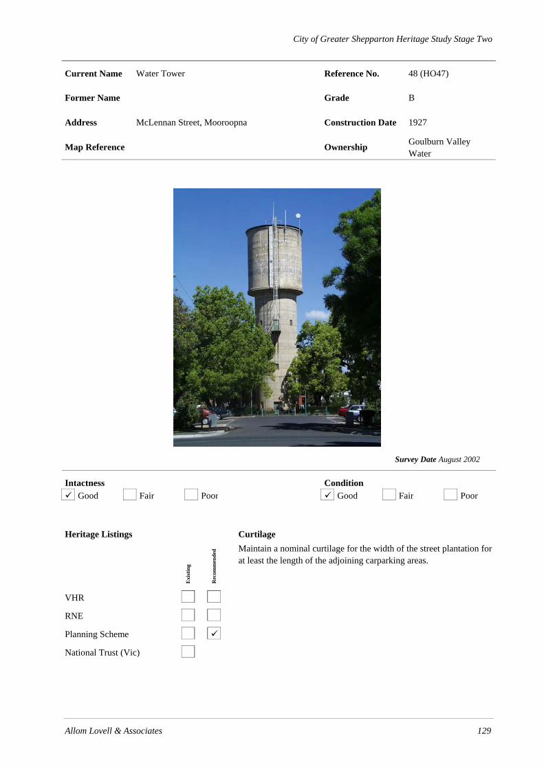
City of Greater Shepparton Heritage Study Stage Two
Allom Lovell & Associates 129
Current Name Water Tower Reference No. 48 (HO47)
Former Name Grade B
Address McLennan Street, Mooroopna Construction Date 1927
Map Reference Ownership Goulburn Valley Water
Survey Date August 2002
Intactness Condition Good Fair Poor Good Fair Poor
Heritage Listings
Exi
stin
g
Rec
omm
ende
d
VHR
RNE
Planning Scheme
National Trust (Vic)
Curtilage Maintain a nominal curtilage for the width of the street plantation for at least the length of the adjoining carparking areas.

130 Allom Lovell & Associates
History
Mooroopna was the first township in the Goulburn Valley to be supplied with reticulated water in 1876. At this time it was provided by a private company which pumped the water from the river to a storage tank on top of the O’Farrell’s brewery. In 1880 the same company constructed a 10,000 gallon tank on a timber stand adjacent to the river bank. The Mooroopna Waterworks Trust was constituted on 12 October 1885 and constructed their first water tank and tower of brick, which is still standing at the corner of McLennan and O’Brien Streets, that same year.
The Water Act 1905 constituted the State Rivers and Water Supply Commission which became the principal water supply authority in rural areas. Demand for water continued to grow with the three major industries operating in town including the Ardmona cannery, McLennan’s flour mill and the Mooroopna Base Hospital, and the present tank was erected in 1927 at a cost of £3,727.
Description The Mooroopna Water Tower consists of a cylindrical reinforced concrete 100,000 gallon (454,609 litre) tank and tower located in the centre of the McLennan Street plantation. The tower contains three bands of timber-framed multi-paned fixed sash windows and those at the lowest level have been filled in with steel plate. A single non-original steel door provides access to the structure and an external steel ladder provides access to the roof.
Thematic Context
Thematic Environmental History
5.3 Reticulated water in the townships
Australian Heritage Commission
4.2 Supplying urban services (power, transport, fire prevention, roads, water, lights & sewerage)
Significance
The Mooroopna Water Tower is of local historic and aesthetic significance. Constructed in 1927, the tower is predated by other examples in the municipality, however, it is demonstrative of the rapid growth of the township during the 1920s and ‘30s and the demand for water associated with the establishment of the cannery and continuing growth of the mill and hospital. Aesthetically, the tower has been a prominent landmark in the streetscape for over 70 years.
References
The Historical Society of Mooroopna Inc, Mooroopna to 1988.
Recommendations
• Retain the original unpainted finish to concrete.
Identified By
SOMA Design Partnership, June 2001.
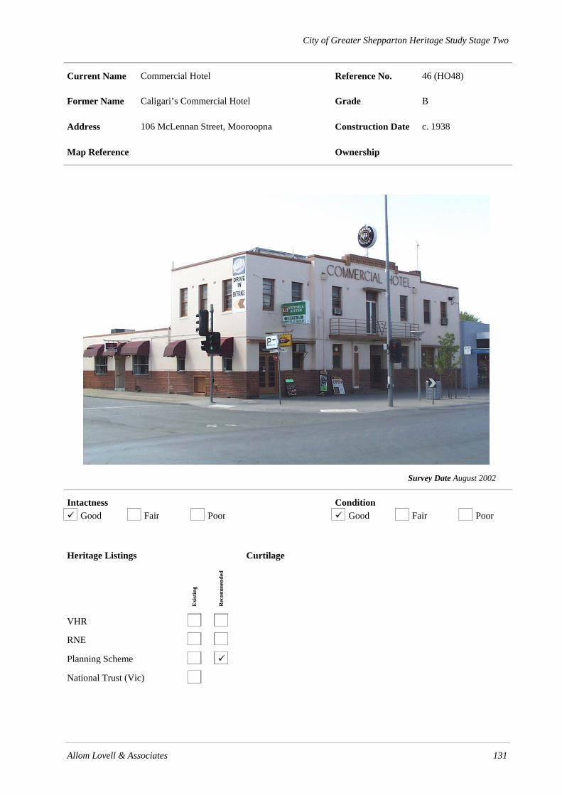
City of Greater Shepparton Heritage Study Stage Two
Allom Lovell & Associates 131
Current Name Commercial Hotel Reference No. 46 (HO48)
Former Name Caligari’s Commercial Hotel Grade B
Address 106 McLennan Street, Mooroopna Construction Date c. 1938
Map Reference Ownership
Survey Date August 2002
Intactness Condition Good Fair Poor Good Fair Poor
Heritage Listings
Exi
stin
g
Rec
omm
ende
d
VHR
RNE
Planning Scheme
National Trust (Vic)
Curtilage
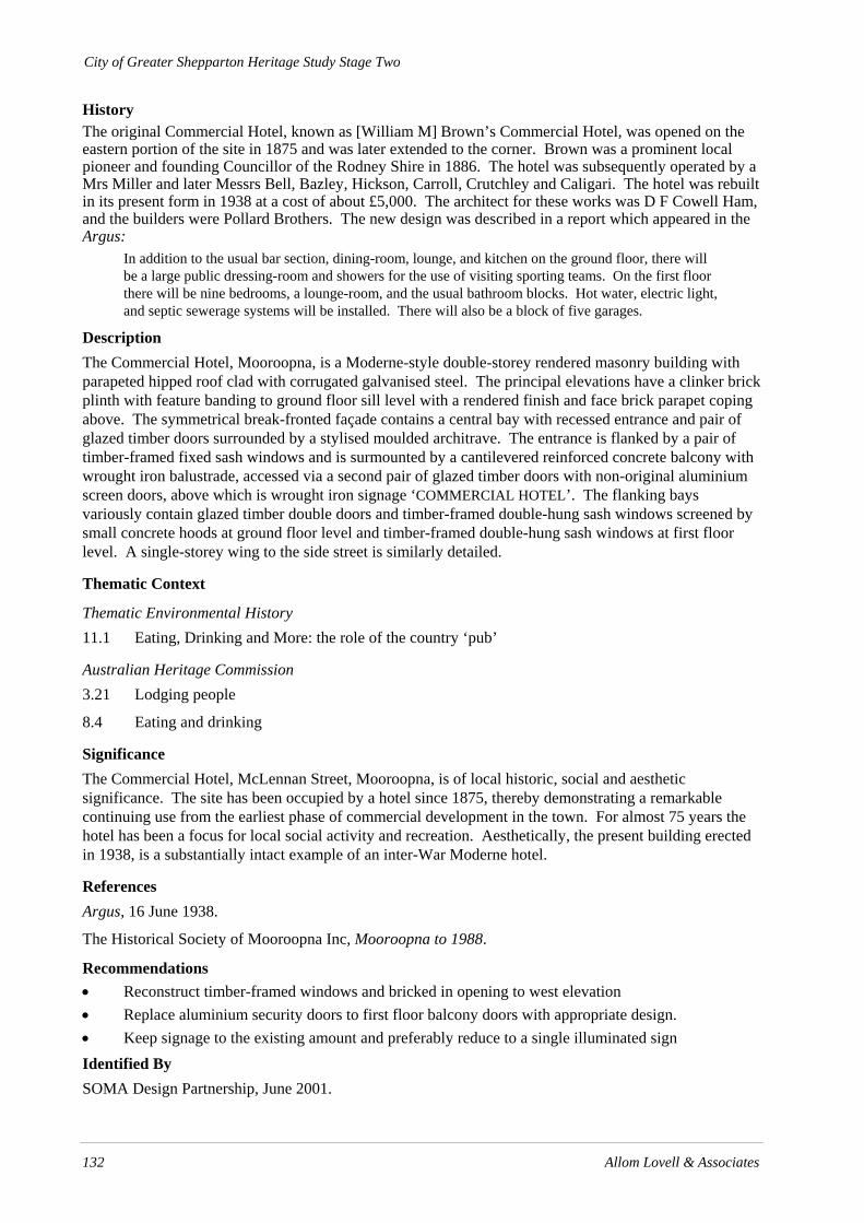
City of Greater Shepparton Heritage Study Stage Two
132 Allom Lovell & Associates
History The original Commercial Hotel, known as [William M] Brown’s Commercial Hotel, was opened on the eastern portion of the site in 1875 and was later extended to the corner. Brown was a prominent local pioneer and founding Councillor of the Rodney Shire in 1886. The hotel was subsequently operated by a Mrs Miller and later Messrs Bell, Bazley, Hickson, Carroll, Crutchley and Caligari. The hotel was rebuilt in its present form in 1938 at a cost of about £5,000. The architect for these works was D F Cowell Ham, and the builders were Pollard Brothers. The new design was described in a report which appeared in the Argus:
In addition to the usual bar section, dining-room, lounge, and kitchen on the ground floor, there will be a large public dressing-room and showers for the use of visiting sporting teams. On the first floor there will be nine bedrooms, a lounge-room, and the usual bathroom blocks. Hot water, electric light, and septic sewerage systems will be installed. There will also be a block of five garages.
Description The Commercial Hotel, Mooroopna, is a Moderne-style double-storey rendered masonry building with parapeted hipped roof clad with corrugated galvanised steel. The principal elevations have a clinker brick plinth with feature banding to ground floor sill level with a rendered finish and face brick parapet coping above. The symmetrical break-fronted façade contains a central bay with recessed entrance and pair of glazed timber doors surrounded by a stylised moulded architrave. The entrance is flanked by a pair of timber-framed fixed sash windows and is surmounted by a cantilevered reinforced concrete balcony with wrought iron balustrade, accessed via a second pair of glazed timber doors with non-original aluminium screen doors, above which is wrought iron signage ‘COMMERCIAL HOTEL’. The flanking bays variously contain glazed timber double doors and timber-framed double-hung sash windows screened by small concrete hoods at ground floor level and timber-framed double-hung sash windows at first floor level. A single-storey wing to the side street is similarly detailed.
Thematic Context
Thematic Environmental History 11.1 Eating, Drinking and More: the role of the country ‘pub’
Australian Heritage Commission 3.21 Lodging people
8.4 Eating and drinking
Significance The Commercial Hotel, McLennan Street, Mooroopna, is of local historic, social and aesthetic significance. The site has been occupied by a hotel since 1875, thereby demonstrating a remarkable continuing use from the earliest phase of commercial development in the town. For almost 75 years the hotel has been a focus for local social activity and recreation. Aesthetically, the present building erected in 1938, is a substantially intact example of an inter-War Moderne hotel.
References Argus, 16 June 1938.
The Historical Society of Mooroopna Inc, Mooroopna to 1988.
Recommendations • Reconstruct timber-framed windows and bricked in opening to west elevation • Replace aluminium security doors to first floor balcony doors with appropriate design. • Keep signage to the existing amount and preferably reduce to a single illuminated sign Identified By SOMA Design Partnership, June 2001.

City of Greater Shepparton Heritage Study Stage Two
Allom Lovell & Associates 133
Current Name Westpac Bank Reference No. 44 (HO49)
Former Name Commercial Bank Grade B
Address 108 McLennan Street, Mooroopna Construction Date 1891-92
Map Reference Ownership Bank of Melbourne
Survey Date August 2002
Intactness Condition Good Fair Poor Good Fair Poor
Heritage Listings
Exi
stin
g
Rec
omm
ende
d
VHR
RNE
Planning Scheme
National Trust (Vic)
Curtilage
City of Greater Shepparton Heritage Study Stage Two
134 Allom Lovell & Associates
History The Commercial Bank purchased the present site, which originally contained Phillip’s butcher’s shop, for £300 in 1891. Architects Lloyd Tayler and Fitts called for tenders for the building on 14 November 1891. The completed bank cost £2,678, and was occupied in 1892. It was described at the time as a two storey banking chamber with six rooms, kitchen, etc., stables and orchard. Some remodelling occurred in 1966-67, although the works appear to have been relatively minor with only the removal of decorative elements from the façade. Other internal changes were made in 1976. The bank building was extensively restored internally and externally in 1985.
Description The former Westpac Bank, Mooroopna, comprises a double-storey rendered masonry banking chamber in the Victorian Italianate style and single-storey rear wing with parapeted hipped roof clad with corrugated galvanised steel. The façade has a rusticated finish at ground floor level and ruled ashlar finish above. The symmetrical façade is divided vertically into three bays by rusticated pilasters and paired half-fluted Ionic pilasters with vermiculated pedestals at first floor level. Horizontally it is delineated by moulded string cornices and friezes featuring tryglyphs, swags and dentils. The central bay has a round-arched entrance with moulded archivolt and mask, bluestone steps, glazed fanlight and non-original pair of glazed timber doors surmounted by a moulded segmental pediment, flanked by two timber-framed fixed sash windows at ground level and a central pediment at first floor level. Windows at the ground floor level have straight heads and are recessed into the rustication while those at the upper level have round arched heads with moulded architraves and keystones. The side elevation is a similarly detailed composition of two bays centred around a wide chimney.
Thematic Context
Thematic Environmental History
15.1.1 Mooroopna
Australian Heritage Commission
3.18 Financing Australia
4.5 Making towns to serve rural Australia
Significance The former Westpac Bank, Mooroopna, is of local historical and aesthetic significance. Constructed in 1891, the building is demonstrative of the growth of the of surrounding district during the late nineteenth century. The association with notable architect Lloyd Tayler is also of significance. Aesthetically, it is a fine and substantially intact example of a Victorian bank branch, of which there are few known remaining examples in the municipality and makes a strong contribution to the historic streetscape.
References Donald McLennan. History of Mooroopna, Ardmona and District.
Miles Lewis. Australian Architectural Index.
Recommendations • Reconstruct wall where former night safe has been removed and remove adjacent light • Repair wall where signage has been removed. • Investigate original external paint colours and reinstate or otherwise repaint in an appropriate
scheme of a plain render colour and a darker joinery colour.
Identified By SOMA Design Partnership, June 2001.

City of Greater Shepparton Heritage Study Stage Two
Allom Lovell & Associates 135
Current Name Post Office Agency Reference No. 50 (HO50)
Former Name West End Bakery / Excelsior Bakery Grade B
Address 132 McLennan Street, Mooroopna Construction Date c. 1880
Map Reference Ownership
Survey Date August 2002
Intactness Condition Good Fair Poor Good Fair Poor
Heritage Listings
Exi
stin
g
Rec
omm
ende
d
VHR
RNE
Planning Scheme
National Trust (Vic)
Curtilage

City of Greater Shepparton Heritage Study Stage Two
136 Allom Lovell & Associates
History
The first record of a building constructed on the eastern corner of McLennan and Northgate Streets occurs in 1880, when a general store was opened by John Hardy. The store was purchased by Hugh McCann in 1882. By 1886 its rateable value was noted as £65. In 1887, Segrave and Tinsell built the West End Bakery on the adjoining block, which was later operated by Henry Segrave. W M Reid, then Joe Hodgson are also listed as bakery owners. Mr E M Little purchased the property in the 1930s, and using both blocks, expanded the bakery and constructed a home. The Little family continued living in McLennan Street until the 1940s. The property was then purchased by Mr Dohfler who owned it until 1951; it was later owned by the Hodgson brothers until 1965. The building is currently used as the Mooroopna Post Office Agency.
Description The former Excelsior Bakery, 132 McLennan Street, Mooroopna, comprises a single-storey brick (overpainted) Victorian shop with a parapeted longitudinal hipped roof clad with corrugated galvanised steel, behind which is a collection of single-storey brick additions. The symmetrical façade contains a non-original double-fronted aluminium-framed shopfront and modern cantilevered awning, surmounted by a rendered stepped parapet featuring raised rendered lettering, ‘C M LITTLE & SONS. EXCELSIOR BAKERY’, and pressed cement orbs. The side elevation is more utilitarian with a pair of timber-framed double-hung sash windows, row of smaller highlight level openings with timber-framed fixed sash windows and non-original timber doors and steel roller shutters.
Thematic Context
Thematic Environmental History 15.1.1 Mooroopna
Australian Heritage Commission 3.11 Feeding people
3.18 Marketing and retailing
Significance
The former Excelsior Bakery, 132 McLennan Street, Mooroopna, is of local historic and aesthetic significance. Constructed in 1880 and further developed during the 1880s, it demonstrates an early phase of commercial development in the township, following subdivision of William Archer’s selection and arrival of the railways. Aesthetically, it is one of few surviving Victorian shops in Mooroopna, albeit altered, and makes a contribution to the historic streetscape.
References
Donald McLennan. History of Mooroopna, Ardmona and District.
The Historical Society of Mooroopna Inc, Mooroopna to 1988.
Recommendations
• The removal of the non-original shopfront and modern cantilevered awning and reconstruction of the original form of shopfront and verandah would greatly enhance the appearance and interpretation of the shop
• Original external paint colours could be investigated with a view to their reinstatement.
Identified By
SOMA Design Partnership, June 2001.

City of Greater Shepparton Heritage Study Stage Two
Allom Lovell & Associates 137
Current Name Grandstand Reference No. 53 (HO51)
Former Name Grade B
Address Mooroopna Recreation Reserve, Midland Highway, Mooroopna
Construction Date c. 1880-1900
Map Reference Ownership Mooroopna Recreation Reserve
Survey Date August 2002
Intactness Condition Good Fair Poor Good Fair Poor
Heritage Listings
Exi
stin
g
Rec
omm
ende
d
VHR
RNE
Planning Scheme
National Trust (Vic)
Curtilage Maintain a nominal curtilage of 5 metres surrounding the building in order to preserve its setting and relationship with the sporting field.

138 Allom Lovell & Associates
History
Mooroopna’s first officially gazetted racing and recreational area, established in 1880, comprised 165 acres located north of the Mooroopna Cemetery on the Meaklim family property, however it soon became apparent that the land was too far from town. The 81 acres on which the recreation reserve is now located was purchased in 1901 for £1134 from Mrs F J Young. The grandstand was relocated from the old reserve and the area was developed to accommodate a number of sports, including horse racing, football, cricket and bowls.
In 1970, following 20 years of political lobbying, the newly formed Mooroopna Recreation Reserve Committee, together with the Shire of Rodney, commenced a major redevelopment of the site. At this time the grandstand was relocated from the former racecourse to its present position.
Description The grandstand, adjacent to the main oval, Mooroopna Recreation Reserve, is a small timber-framed structure with hipped corrugated galvanised steel roof (recently re-clad) on a rectangular plan. The structure comprises large undressed hardwood posts with cross bracing on both long elevations, which support the timber-framed roof structure. The rear timber-framed wall and raking side walls are clad with corrugated galvanised steel and a wide opening in the rear wall with Cyclone wire gates provides access to the underside of the structure for storage. Stepped platforms clad with timber boards provide seating and a modern set of steel-framed steps provides access at the front.
Thematic Context
Thematic Environmental History
11.2 Casual and Competitive Sport
Australian Heritage Commission
8.1 Organising recreation
Significance
The grandstand, Mooroopna Recreation Reserve, is of local historical and some aesthetic significance. Constructed between 1880 and 1900, the grandstand demonstrates the early use of the recreation reserve. Its retention and relocation to the main oval illustrates the importance of amateur sport at a local level to the social life of Mooroopna. Aesthetically, it is a modest, yet picturesque, example of a late Victorian grandstand, of which there are no other known surviving examples in the municipality.
References
The Historical Society of Mooroopna Inc, Mooroopna to 1988, p. 190.
Donald McLennan, History of Mooroopna, p. 84.
Recommendations
• Retain and conserve
• The grandstand could be relocated to another position around the oval if required.
Identified By
SOMA Design Partnership, June 2001.

City of Greater Shepparton Heritage Study Stage Two
Allom Lovell & Associates 139
Current Name Mooroopna Primary School Reference No. 55 (HO53)
Former Name Mooroopna State School No. 1432 Grade B
Address Park Street, Mooroopna Construction Date 1877, 1929
Map Reference Ownership Ministry of Education
Survey Date August 2002
Intactness Condition Good Fair Poor Good Fair Poor
Heritage Listings
Exi
stin
g
Rec
omm
ende
d
VHR
RNE
Planning Scheme
National Trust (Vic)
Curtilage

140 Allom Lovell & Associates
History
In 1868, three years prior to the Education Act 1872-73 only seven common and three private schools existed in the whole Goulburn region. Only one of these, a Presbyterian school at Murchison, was located within the boundaries of the present City of Greater Shepparton. Land selection, railways, irrigation, and later closer settlement caused a great land rush which coincided with the Act and by 1883, 128 new State schools had opened in the region.
The first formal education in Mooroopna was given by William Crimp, a selector, in 1873 in his hut, located a few kilometres west of the present school. In 1874 two acres (0.81 hectares) of land were given by W S Archer, where a small timber building was erected. Within two years, however, it proved unsatisfactory and a three classroom brick building with slate roof was constructed by John Mills. Mooroopna State School No 1432 opened in 1877. An additional classroom, office and lobby were added in 1929, and in 1947 a timber building was relocated to the site from Wyuna South. The school underwent further enlargement throughout from the 1950s to the 1990s.
Description The 1877 wing is a single-storey bichrome brick building with a jerkinhead roof clad in slate. The distinctive roofline maintains a slate roofed bellcote and steel ridge ventilators. The jerkinhead gable ends have moulded timber bargeboards and boarded eaves, below which are three timber-framed windows. Elsewhere, there are regular groups and single window openings with segmental arched heads variously containing later brick infill or timber-framed double-hung sash windows. The original skillion-roofed verandah remains on three sides of the building however the timber posts have generally been replaced with steel. To the east, a second wing comprises a single-storey red face brick building with a gable roof clad in slate. The roofline is penetrated by tall red brick chimneys and steel ridge ventilators. The end elevations contain quadripartite bays of timber-framed double-hung multi-paned sash windows with rendered sills and rectangular fanlights. Elsewhere, there are single window openings with timber-framed double-hung sash windows. The west elevation is screened by a skillion-roofed verandah which has been infilled with glazing. The 1929 addition is constructed at the north-east corner of the main building and continues the general construction of the original building.
The school grounds contain various other timber-framed and brick buildings of no significance and the property is fenced by a Cyclone wire fence with recent metal palisade fence flanking the main entrance. The grounds contain a number of mature Pepper trees (Schinus molle).
Thematic Context
Thematic Environmental History
9.1 Primary and Secondary Education
Australian Heritage Commission
6.2 Establishing schools
6.5 Educating people in remote places
Significance
The 1877 wing of the Mooroopna State School is of local historical and aesthetic significance. Erected shortly after the establishment of the school, it demonstrates the rapid development of educational facilities in the region following the Education Act 1872-73, and mirroring the increase in the town’s population. Aesthetically, it is a largely intact early example of a nineteenth century schoolhouse in the so called ‘Horsham’ type, characterised by its distinctive roofline.

Allom Lovell & Associates 141
The adjoining 1929 wing is of some historical and aesthetic significance. It provides evidence of the ongoing development of the school in the twentieth century. Aesthetically, the school is a representative example of its type, and contrasts markedly with the more ubiquitous weatherboard schoolrooms of comparable date throughout the municipality.
References
Education Department of Victoria, Vision and Realisation. pp. 753-771.
L Burchell. Victorian Schools.
The Historical Society of Mooroopna Inc, Mooroopna to 1988.
Recommendations
• Retain original unpainted finish to brickwork of building and otherwise investigate original external paint colours.
• It is desirable that bricked in window openings be opened up and timber verandah posts be reconstructed.
• Preferably site any new structures in a manner which does not encroach on the setting of the heritage buildings and which does not compromise their view from the street
Identified By
SOMA Design Partnership, June 2001

142 Allom Lovell & Associates
.
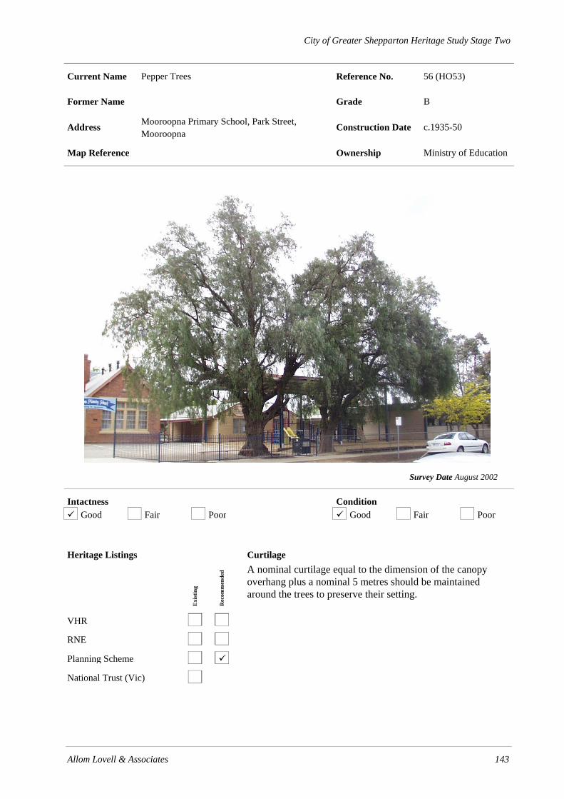
City of Greater Shepparton Heritage Study Stage Two
Allom Lovell & Associates 143
Current Name Pepper Trees Reference No. 56 (HO53)
Former Name Grade B
Address Mooroopna Primary School, Park Street, Mooroopna
Construction Date c.1935-50
Map Reference Ownership Ministry of Education
Survey Date August 2002
Intactness Condition Good Fair Poor Good Fair Poor
Heritage Listings
Exi
stin
g
Rec
omm
ende
d
VHR
RNE
Planning Scheme
National Trust (Vic)
Curtilage A nominal curtilage equal to the dimension of the canopy overhang plus a nominal 5 metres should be maintained around the trees to preserve their setting.

144 Allom Lovell & Associates
History
The Pepper tree (Schinus molle) is native to South America, and was introduced for cultivation in Victoria in 1873 by St. Kilda nurseryman George Brunning. The specimens at the front of Mooroopna Primary School, Park Street, Mooroopna are estimated to be between 50-65 years old, with the tree at the rear approximately 80 years old.
Description The pair of Pepper trees (Schinus molle) flanking the Mooroopna Primary School gate are approximately 15 metres tall with a trunk of approximately 1.5 metres in diameter. A tree at the rear of the school has a trunk of approximately 3 metres diameter and has been considerably pruned.
Thematic Context
Thematic Environmental History
NA
Australian Heritage Commission
1.4 Appreciating the natural wonders of Australia
Significance
The three Pepper trees (Schinus molle), Mooroopna Primary School, are of some scientific (botanical) and aesthetic interest. They are a moderately sized example of their species and form a prominent marker of the school entrance in the streetscape. One at the rear appears to be of a great age.
References
Margaret Brookes and Richard Barley. Plants Listed in Nursery Catalogues in Victoria 1855-1889. p. 283.
John Patrick, pers comm.
Recommendations
• The tree should be assessed on a 1 to 2 year basis by a qualified arborist.
Identified By
SOMA Design Partnership, June 2001.

City of Greater Shepparton Heritage Study Stage Two
Allom Lovell & Associates 145
Current Name Mooroopna Railway Station Reference No. 57 (HO54)
Former Name Grade B
Address Young Street, Mooroopna Construction Date c.1910s
Map Reference Ownership
Survey Date August 2002
Intactness Condition Good Fair Poor Good Fair Poor
Heritage Listings
Exi
stin
g
Rec
omm
ende
d
VHR
RNE
Planning Scheme
National Trust (Vic)
Curtilage
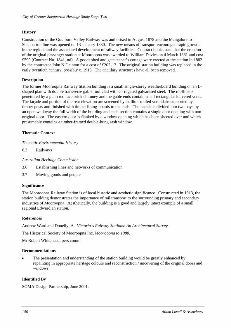
City of Greater Shepparton Heritage Study Stage Two
146 Allom Lovell & Associates
History
Construction of the Goulburn Valley Railway was authorised in August 1878 and the Mangalore to Shepparton line was opened on 13 January 1880. The new means of transport encouraged rapid growth in the region, and the associated development of railway facilities. Contract books state that the erection of the original passenger station at Mooroopna was awarded to William Davies on 4 March 1881 and cost £599 (Contract No. 1841, nd). A goods shed and gatekeeper’s cottage were erected at the station in 1882 by the contractor John N Dainton for a cost of £202-17. The original station building was replaced in the early twentieth century, possibly c. 1913. The ancillary structures have all been removed.
Description The former Mooroopna Railway Station building is a small single-storey weatherboard building on an L-shaped plan with double transverse gable roof clad with corrugated galvanised steel. The roofline is penetrated by a plain red face brick chimney and the gable ends contain small rectangular louvered vents. The façade and portion of the rear elevation are screened by skillion-roofed verandahs supported by timber posts and finished with timber lining-boards to the ends. The façade is divided into two bays by an open walkway the full width of the building and each section contains a single door opening with non-original door. The eastern door is flanked by a window opening which has been sheeted over and which presumably contains a timber-framed double-hung sash window.
Thematic Context
Thematic Environmental History
6.3 Railways
Australian Heritage Commission
3.6 Establishing lines and networks of communication
3.7 Moving goods and people
Significance
The Mooroopna Railway Station is of local historic and aesthetic significance. Constructed in 1913, the station building demonstrates the importance of rail transport to the surrounding primary and secondary industries of Mooroopna. Aesthetically, the building is a good and largely intact example of a small regional Edwardian station.
References
Andrew Ward and Donelly, A. Victoria’s Railway Stations: An Architectural Survey.
The Historical Society of Mooroopna Inc, Mooroopna to 1988.
Mr Robert Whitehead, pers comm.
Recommendations
• The presentation and understanding of the station building would be greatly enhanced by repainting in appropriate heritage colours and reconstruction / uncovering of the original doors and windows.
Identified By
SOMA Design Partnership, June 2001.

City of Greater Shepparton Heritage Study Stage Two
Allom Lovell & Associates 147
Current Name Residence Reference No. (HO148)
Former Name Grade B
Address 2 Archer Street, Mooroopna Construction Date Early 20th century
Map Reference Ownership
2 Archer Street
2 Archer Street
Survey Date August 2002
Intactness Condition Good Fair Poor Good Fair Poor
Heritage Listings
Exi
stin
g
Rec
omm
ende
d
VHR
RNE
Planning Scheme
National Trust (Vic)
Curtilage The existing house block.

City of Greater Shepparton Heritage Study Stage Two
148 Allom Lovell & Associates
History
The Ridley Agri Products factory was a former flour mill – McLennan & Co Pty Ltd. Much of the original factory building is extant and there is some photographic evidence to support this. Anecdotal evidence indicates that the house at 2 Archer Street was constructed for the manager (or similar) of the flour mill. It appears that the house was constructed prior to c.1916 and this could possibly correspond with physical changes at the mill – as suggested by surviving photographic evidence.
The McLennan flour mill and the Jas Minifie & Co Mill merged in 1969 with Kimptons to form Kimpton Minifie McLennan Ltd and this became a public company in 1973. The merger was described as ' a useful rationalization in the face of the dwindling flour market and the tough competition for trade in the stockfeed industry.'1 McLennans stock feed operation 'Acme Feeds' was small but had competitive significance because of its proximity to Barastoc's Echuca plant.
Since the merger flour milling has ceased and stockfeed manufacture has taken precedence.
Description No. 2 Archer Street, Mooroopna is a single storey red brick house which is typical of the Edwardian, or Federation, style. It is T-shaped in plan with a projecting gable wing and a skillion roofed, timber-framed verandah in the recess on the front and the back. The front gable is infilled with stucco, contains an oculus vent and is covered by a timber screen fixed between decorative bargeboards with shaped ends. Beneath the screen is a double casement with coloured glass highlights beneath brick header course voussoirs. The rear gable is similar above a pair of timber-framed double hung sash windows, with coloured glass highlights, below header course voussoirs which is typical for the period. A third similar gable in located on a side elevation. The front verandah has been enclosed with a timber screen lined with shadecloth. The verandah is timber-framed with a timber floor and a galvanized corrugated steel bullnose profile roof. The wall facing the verandah contains a single timber-framed double-hung sash window. The rear verandah is s timber-framed skillion with a galvanized corrugated steel. The wall behind contains a small window. The main roof is galvanized corrugated steel and is penetrated by three chimneys with rendered, moulded and corbelled caps.
Internally the building contains timber fretwork screens; decorative timber mantels; pressed metal ceilings and timber skirtings and architraves.
The physical condition of 2 Archer Street is generally good. The most major defect is the failure of the damp proof course (dpc). It appears that the dpc was bituminous based and as is commonly found after 100 years or so the bitumen has failed. However, the brickwork is still in relatively good condition despite various inappropriate repairs which have been undertaken over the last few years. The mortar is showing the most signs of distress. It is a relatively straightforward procedure to introduce a new dpc (chemical injections) and this should prevent any further decay. Once the source of damp has been addressed the mortar can be re-pointed.
Thematic Context
Thematic History
7.0 Developing Primary Industries – Grazing and Agriculture
7.1 Wheat and flour mills
Australian Heritage Commission
Developing local, regional and national economies.
1 W Lewis Jones, Where have all the flour mills gone?, p 112

City of Greater Shepparton Heritage Study Stage Two
Allom Lovell & Associates 149
Significance
No. 2 Archer Street Mooroopna is of local aesthetic and historical significance. It is notable in the area as a good example of a substantial Edwardian residence which is demonstrative of the development of Mooroopna up until the early decades of the twentieth century. Historically it is demonstrative of the approach by business management of the day and the necessity to provide housing for employees, similarly to many banks, mining and other commercial activities and towns in accord with the enterprise hierarchy. It is also of historical significance because of its association with early flour milling activities of the area which still continue today.
References
W Lewis Jones. Where have all the Flour Mills Gone? Recommendations
Recommended that remedial maintenance is undertaken and that an effective damp proof course is reinstated.
Identified By
City of Greater Shepparton

City of Greater Shepparton Heritage Study Stage Two
150 Allom Lovell & Associates
Current Name 22 McLennan Street, Mooroopna Reference No. (HO149)
Former Name Grade B
Address 22 McLennan Street, Mooroopna Construction Date C1870
Map Reference Ownership Private
Front facade
Rear of building showing demolished areas
Survey Date August 2002
Intactness Condition Good Fair x Poor Good Fair x Poor
Heritage Listings
Exi
stin
g
Rec
omm
ende
d
VHR
RNE
Planning Scheme
National Trust (Vic)
Curtilage The front boundary (property line) and nominally 5 metres all round on the same title.

City of Greater Shepparton Heritage Study Stage Two
Allom Lovell & Associates 151
History
It appears that 22 McLennan Street Mooroopna was constructed by the Kittle Bros., Carpenters and Builders- (Thomas John, Charles and John Kittle). The Kittle Bros. are reported to have worked on many of the early buildings in Shepparton, Tallygaroopna and Ardmona. It is highly likely that the premises was constructed by them.
William Kittle (1865 – 1942) another brother was manager of the Mooroopna Flour Mill for 11 years and was a commissioner of the Water Trust. He was also associated with the Methodist church and various other community groups. It is during his period as Manager of the Flour Mill that he is thought to have lived at 22 McLennan Street Mooroopna. There is a surviving photograph of his wife (Amelia) and two daughters (Ivy and May) standing at their front door.
Description 22 McLennan Street, Mooroopna is a single storey commercial building constructed from three layers of brickwork, a construction technique which was not uncommon in the 19th century. Stylistically the building suggests a construction date of mid 1860s-70s. The façade is clearly differentiated into two sections. One has a single doorway and single double hung sash window. The other has a central doorway, with glazed highlight, flanked on one side by a pair of timber-framed sash windows and on the other by a single window. All openings have stilted arch heads. The external finish is painted face brick with rendered detailing. The roof is concealed behind a parapet. The presumed original verandah is lacking.
22 McLennan Street appears to be one of the earliest surviving buildings in Mooroopna. Physical evidence that supports this can be found with:
• the nature of the bricks which are hand pressed and irregularly fired; • the mortar which has very little if any lime. The only evidence of cement is where the building
has been patched.
Brickwork layer: 200/300 mm thick. The composition of this layer appears to be primarily clay loam with some hair – possibly horse hair. There does not seem to be any lime in the mixture. The use of a clay/loam slurry with the addition of organic material such as hair was a relatively common finish during the earlier periods of settlement particularly where lime was not readily available.
Brickwork layer 2: Thin layer of hard plaster finish. This layer was possibly a later layer or a coating placed over the clay/loam wall finish.
Surviving fragments of wallpaper support a construction date ranging from the 1860s – 1870s. Subsequent layers vary but the patterns are indicative of the late 1860s – 1890s. The internal finishes to the structural brickwork indicate that at least some sections of the building are relatively early and possibly relate to the location of the building at a crossing point of the Goulburn River. Internal footings suggest a later, but still early addition, at one end. Its construction possibly relates to the gold rush or even earlier pastoral settlement of the region.
The building has been partially demolished, however much of the original building fabric survives.
Thematic Context
Thematic History
15.1.1 Medium Size Towns – Mooroopna.

City of Greater Shepparton Heritage Study Stage Two
152 Allom Lovell & Associates
Australian Heritage Commission
Significance
22 McLennan St Mooroopna is of local historical, aesthetic and scientific (building technology) significance. The building is associated with the Kittle Bros, a locally prominent firm of carpenters and builders and was most likely erected by them. Constructed c. 1860s-70s it is locally significant as an early, possibly the earliest, remaining building in Mooroopna and the region. Aesthetically it is a good example of a small business premises simply styled. It is of scientific (building technology) significance being a good example of building construction and decorative techniques of the mid-nineteenth century.
References
Mooroopna Historical Society.
Recommendations
It is recommended that the owners be consulted with view to retaining the remainder of the building and reconstruction the demolished sections.
Identified By
Greater City of Shepparton.
City of Greater Shepparton Heritage Study Stage Two
Allom Lovell & Associates 153