City of Bellingham Survey Information Report of …...City of Bellingham Survey Information Report...
788
City of Bellingham Survey Information Report of Survey Mark NAVD 88 Bench Mark Data The City of Bellingham has compiled this information for its own use and is not responsible for any use of this information by others. The information found herein is provided simply as a courtesy to the public and is not intended for any third party use in any official, professional or other authoritative capacity. Persons using this information do so at their own risk and by such use agree to defend, indemnify and hold harmless the City of Bellingham as to any claims, damages, liability, losses or suits arising out of such use. The NAVD 88 Bench Mark Data report is a comprehensive list that includes all of the bench marks established by the 2008-2009 Vertical Datum Modernization Project as well as bench marks that were added with capital improvement project surveys. The report also includes data reported by other agencies such as WSDOT or NGS. Additional areas of the network will be developed as funding becomes available or as we survey for capital projects. Please note that some of these monuments may have been raised since the reported data was collected.
Transcript of City of Bellingham Survey Information Report of …...City of Bellingham Survey Information Report...

City of Bellingham Survey Information
Report of Survey Mark
NAVD 88 Bench Mark Data
The City of Bellingham has compiled this information for its own use and is not
responsible for any use of this information by others. The information found
herein is provided simply as a courtesy to the public and is not intended for
any third party use in any official, professional or other authoritative capacity.
Persons using this information do so at their own risk and by such use agree
to defend, indemnify and hold harmless the City of Bellingham as to any
claims, damages, liability, losses or suits arising out of such use.
The NAVD 88 Bench Mark Data report is a comprehensive list that includes
all of the bench marks established by the 2008-2009 Vertical Datum
Modernization Project as well as bench marks that were added with capital
improvement project surveys. The report also includes data reported by other
agencies such as WSDOT or NGS.
Additional areas of the network will be developed as funding becomes
available or as we survey for capital projects.
Please note that some of these monuments may have been raised since the
reported data was collected.

City of Bellingham Survey Information
Report of Survey Mark
NAVD 88 Bench Mark Data
SURVEY CONTROL DATA
34Monument ID: Other Reference ID:
SITE_DESC MEADOR & 1/4 COR.
SECTION QUARTER CORNERCorner Type: 1/4 CORNER
SECTION 29/30 T38N
R3E
Corner Description:
BRASS MONMonument Type:
RAISED FOR LINCOLN ST PROJECT 1991. VISITED FOR NAD 83/98
CONTROL NETWORK 2006. MAY BE DISTURBED BY TRAIL
PROJECT ES-0413
Remarks:
69.6510
0.0000
FEETNorthing:
Easting:
Latitude:
Longitude:
Units:
Ortho Elev:
Ellipse:
Geoid:
Scale Factor:
Convergence:
Combined Grid Factor:
WA North 4601Coordinate Zone:
Horizontal Method:
Horizontal Datum: NAVD 88Vertical Datum:
DifferentialVertical Method:
Horizontal Accuracy 0.0300Vertical Accuracy:
WILSON ENGINEERING LLC.Vertical Calc By:Horizontal Calc By:
ES-0425Project No.:
C-BDS ¼ COR N.S/WALK MEADOR 150' EAST OF
JAMES
Point Description:
BENCHMARK NAVD 88Coordinate Source:
FB918-7 pg. 11Comments:
Horizontal Calc Date: 02/12/2009Vertical Calc Date:
643,806.1200
1,246,975.4020 69.6500
FEETNorthing:
Easting:
Latitude:
Longitude:
Units:
Ortho Elev:
Ellipse:
Geoid:
Scale Factor:
Convergence:
Combined Grid Factor:
WA North 4601Coordinate Zone:
Conventional SurveyHorizontal Method:
NAD 83/98Horizontal Datum: NAVD 88Vertical Datum:
DifferentialVertical Method:
0.0200Horizontal Accuracy 0.0300Vertical Accuracy:
LARRY STEELE & ASSOCIATESVertical Calc By:LARRY STEELE & ASSOCIATESHorizontal Calc By:
EU-0163Project No.:
C-BDSPoint Description:
NAD 83/98 PROJECT POINTSCoordinate Source:
FB 992-1Comments:
07/01/2014Horizontal Calc Date: 07/01/2014Vertical Calc Date:
201/13/2016Mon# 34
The City of Bellingham has compiled this information for its own use and is not responsible for the use by others. Persons using this information do
so at their own risk and agree to defend, indemnify and hold harmless the City of Bellingham as to any claims or suits arising out of such

City of Bellingham Survey Information
Report of Survey Mark
NAVD 88 Bench Mark Data
SURVEY CONTROL DATA
48Monument ID: Other Reference ID:
SITE_DESC COWGILL AV & 6 TH ST
RIGHT-OF-WAY INTERSECTIONCorner Type: Corner Description:
BRASS MONMonument Type:
REPLACED BY LSA FOR 2005 OVERLAY PROJECT. VISITED FOR
NAD 83/98 CONTROL NETWORK SURVEY 2006.
Remarks:
62.1520
0.0000
FEETNorthing:
Easting:
Latitude:
Longitude:
Units:
Ortho Elev:
Ellipse:
Geoid:
Scale Factor:
Convergence:
Combined Grid Factor:
WA North 4601Coordinate Zone:
Horizontal Method:
Horizontal Datum: NAVD 88Vertical Datum:
DifferentialVertical Method:
Horizontal Accuracy 0.0200Vertical Accuracy:
LARRY STEELE & ASSOCIATESVertical Calc By:Horizontal Calc By:
ES-0425Project No.:
BRASS MON AT COWGILL & 6THPoint Description:
BENCHMARK NAVD 88Coordinate Source:
FB 918-11Comments:
Horizontal Calc Date: 02/17/2009Vertical Calc Date:
101/13/2016Mon# 48
The City of Bellingham has compiled this information for its own use and is not responsible for the use by others. Persons using this information do
so at their own risk and agree to defend, indemnify and hold harmless the City of Bellingham as to any claims or suits arising out of such

City of Bellingham Survey Information
Report of Survey Mark
NAVD 88 Bench Mark Data
SURVEY CONTROL DATA
68Monument ID: Other Reference ID:
SITE_DESC WILSON AV & 15TH ST
RIGHT-OF-WAY INTERSECTIONCorner Type: Corner Description:
BRASS MONMonument Type:
RAISED 12-93, REPLACED BY LSA FOR 2005 OVERLAY PROJECT.
VISITED FOR NAD 83/98 CONTROL NETWORK SURVEY 2006.
Remarks:
102.9940
0.0000
FEETNorthing:
Easting:
Latitude:
Longitude:
Units:
Ortho Elev:
Ellipse:
Geoid:
Scale Factor:
Convergence:
Combined Grid Factor:
WA North 4601Coordinate Zone:
Horizontal Method:
Horizontal Datum: NAVD 88Vertical Datum:
DifferentialVertical Method:
Horizontal Accuracy 0.0200Vertical Accuracy:
LARRY STEELE & ASSOCIATESVertical Calc By:Horizontal Calc By:
ES-0425Project No.:
BRASS MON AT WILSON & 15THPoint Description:
BENCHMARK NAVD 88Coordinate Source:
FB 918-11Comments:
Horizontal Calc Date: 02/17/2009Vertical Calc Date:
101/13/2016Mon# 68
The City of Bellingham has compiled this information for its own use and is not responsible for the use by others. Persons using this information do
so at their own risk and agree to defend, indemnify and hold harmless the City of Bellingham as to any claims or suits arising out of such

City of Bellingham Survey Information
Report of Survey Mark
NAVD 88 Bench Mark Data
SURVEY CONTROL DATA
102Monument ID: Other Reference ID:
SITE_DESC 13TH ST & LARRABEE AV
RIGHT-OF-WAY INTERSECTIONCorner Type: Corner Description:
BRASS MONMonument Type:
MON RAISED FOR 1995 OVERLAYRemarks:
631,249.4563
1,237,837.3520 114.5500
FEETNorthing:
Easting:
Latitude:
Longitude:
Units:
Ortho Elev:
Ellipse:
Geoid:
Scale Factor:
Convergence:
Combined Grid Factor:
WA North 4601Coordinate Zone:
Conventional SurveyHorizontal Method:
NAD 83/98Horizontal Datum: NAVD 88Vertical Datum:
DifferentialVertical Method:
0.0200Horizontal Accuracy 0.0200Vertical Accuracy:
LARRY STEELE & ASSOCIATESVertical Calc By:LARRY STEELE & ASSOCIATESHorizontal Calc By:
EU-0151Project No.:
C-BDS PROJECT PNT 758Point Description:
NAD 83/98 PROJECT POINTSCoordinate Source:
FB 927Comments:
07/13/2009Horizontal Calc Date: 07/13/2009Vertical Calc Date:
101/13/2016Mon# 102
The City of Bellingham has compiled this information for its own use and is not responsible for the use by others. Persons using this information do
so at their own risk and agree to defend, indemnify and hold harmless the City of Bellingham as to any claims or suits arising out of such
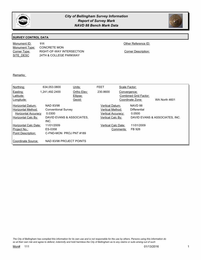
City of Bellingham Survey Information
Report of Survey Mark
NAVD 88 Bench Mark Data
SURVEY CONTROL DATA
111Monument ID: Other Reference ID:
SITE_DESC 24TH & COLLEGE PARKWAY
RIGHT-OF-WAY INTERSECTIONCorner Type: Corner Description:
CONCRETE MONMonument Type:
Remarks:
634,053.0800
1,241,492.2400 230.8600
FEETNorthing:
Easting:
Latitude:
Longitude:
Units:
Ortho Elev:
Ellipse:
Geoid:
Scale Factor:
Convergence:
Combined Grid Factor:
WA North 4601Coordinate Zone:
Conventional SurveyHorizontal Method:
NAD 83/98Horizontal Datum: NAVD 88Vertical Datum:
DifferentialVertical Method:
0.0300Horizontal Accuracy 0.0500Vertical Accuracy:
DAVID EVANS & ASSOCIATES, INC.Vertical Calc By:DAVID EVANS & ASSOCIATES,
INC.
Horizontal Calc By:
ES-0358Project No.:
C-FND-MON PROJ PNT #189Point Description:
NAD 83/98 PROJECT POINTSCoordinate Source:
FB 926Comments:
11/01/2009Horizontal Calc Date: 11/01/2009Vertical Calc Date:
101/13/2016Mon# 111
The City of Bellingham has compiled this information for its own use and is not responsible for the use by others. Persons using this information do
so at their own risk and agree to defend, indemnify and hold harmless the City of Bellingham as to any claims or suits arising out of such

City of Bellingham Survey Information
Report of Survey Mark
NAVD 88 Bench Mark Data
SURVEY CONTROL DATA
118Monument ID: Other Reference ID:
SITE_DESC HIGHLAND DR & PT N/O FERRY ST.
RIGHT-OF-WAY PTCorner Type: Corner Description:
BRASS MONMonument Type:
RAISED 11-93
HOUSE # 444
Remarks:
635,344.9700
1,239,523.7570 410.4900
FEETNorthing:
Easting:
Latitude:
Longitude:
Units:
Ortho Elev:
Ellipse:
Geoid:
Scale Factor:
Convergence:
Combined Grid Factor:
WA North 4601Coordinate Zone:
Conventional SurveyHorizontal Method:
NAD 83/98Horizontal Datum: NAVD 88Vertical Datum:
DifferentialVertical Method:
0.0200Horizontal Accuracy 0.0300Vertical Accuracy:
LARRY STEELE & ASSOCIATESVertical Calc By:LARRY STEELE & ASSOCIATESHorizontal Calc By:
EU-0156Project No.:
BPFPoint Description:
NAD 83/98 PROJECT POINTSCoordinate Source:
FB 940-1 PROJECT POINT #504Comments:
08/09/2011Horizontal Calc Date: 08/09/2011Vertical Calc Date:
101/13/2016Mon# 118
The City of Bellingham has compiled this information for its own use and is not responsible for the use by others. Persons using this information do
so at their own risk and agree to defend, indemnify and hold harmless the City of Bellingham as to any claims or suits arising out of such

City of Bellingham Survey Information
Report of Survey Mark
NAVD 88 Bench Mark Data
SURVEY CONTROL DATA
119Monument ID: Other Reference ID:
SITE_DESC ADAMS AV & HIGHLAND DR
RIGHT-OF-WAY INTERSECTIONCorner Type: Corner Description:
BRASS MONMonument Type:
VISITED FOR NAD 83/98 CONTROL NETWORK SURVEY.Remarks:
634,865.2160
1,239,513.4150 412.5500
FEETNorthing:
Easting:
Latitude:
Longitude:
Units:
Ortho Elev:
Ellipse:
Geoid:
Scale Factor:
Convergence:
Combined Grid Factor:
WA North 4601Coordinate Zone:
Conventional SurveyHorizontal Method:
NAD 83/98Horizontal Datum: NAVD 88Vertical Datum:
DifferentialVertical Method:
0.0200Horizontal Accuracy 0.0300Vertical Accuracy:
LARRY STEELE & ASSOCIATESVertical Calc By:LARRY STEELE & ASSOCIATESHorizontal Calc By:
EU-0156Project No.:
BPFPoint Description:
NAD 83/98 PROJECT POINTSCoordinate Source:
FB-940-1 PROJECT POINT #505Comments:
08/09/2011Horizontal Calc Date: 08/09/2011Vertical Calc Date:
101/13/2016Mon# 119
The City of Bellingham has compiled this information for its own use and is not responsible for the use by others. Persons using this information do
so at their own risk and agree to defend, indemnify and hold harmless the City of Bellingham as to any claims or suits arising out of such

City of Bellingham Survey Information
Report of Survey Mark
NAVD 88 Bench Mark Data
SURVEY CONTROL DATA
122Monument ID: Other Reference ID:
SITE_DESC EASTON & D.L.C. MON E/O HIGHLAND DR.
DONATION LAND CLAIMCorner Type: Corner Description:
BRASS MONMonument Type:
Remarks:
634,481.8670
1,239,642.8250 395.0600
FEETNorthing:
Easting:
Latitude:
Longitude:
Units:
Ortho Elev:
Ellipse:
Geoid:
Scale Factor:
Convergence:
Combined Grid Factor:
WA North 4601Coordinate Zone:
Conventional SurveyHorizontal Method:
NAD 83/98Horizontal Datum: NAVD 88Vertical Datum:
DifferentialVertical Method:
0.0200Horizontal Accuracy 0.0300Vertical Accuracy:
LARRY STEELE & ASSOCIATESVertical Calc By:LARRY STEELE & ASSOCIATESHorizontal Calc By:
EU-0156Project No.:
BPFPoint Description:
NAD 83/98 PROJECT POINTSCoordinate Source:
FB 940-1 PROJECT POINT #535Comments:
08/09/2011Horizontal Calc Date: 08/09/2011Vertical Calc Date:
101/13/2016Mon# 122
The City of Bellingham has compiled this information for its own use and is not responsible for the use by others. Persons using this information do
so at their own risk and agree to defend, indemnify and hold harmless the City of Bellingham as to any claims or suits arising out of such

City of Bellingham Survey Information
Report of Survey Mark
NAVD 88 Bench Mark Data
SURVEY CONTROL DATA
123Monument ID: Other Reference ID:
SITE_DESC EASTON AV & RIDGEWAY DR
RIGHT-OF-WAY INTERSECTIONCorner Type: Corner Description:
BRASS MONMonument Type:
Remarks:
634,478.4340
1,239,803.8990 382.3300
FEETNorthing:
Easting:
Latitude:
Longitude:
Units:
Ortho Elev:
Ellipse:
Geoid:
Scale Factor:
Convergence:
Combined Grid Factor:
WA North 4601Coordinate Zone:
Conventional SurveyHorizontal Method:
NAD 83/98Horizontal Datum: NAVD 88Vertical Datum:
DifferentialVertical Method:
0.0200Horizontal Accuracy 0.0300Vertical Accuracy:
LARRY STEELE & ASSOCIATESVertical Calc By:LARRY STEELE & ASSOCIATESHorizontal Calc By:
EU-0156Project No.:
BPFPoint Description:
NAD 83/98 PROJECT POINTSCoordinate Source:
FB 940-1 PROJECT POINT #511Comments:
08/09/2011Horizontal Calc Date: 08/09/2011Vertical Calc Date:
101/13/2016Mon# 123
The City of Bellingham has compiled this information for its own use and is not responsible for the use by others. Persons using this information do
so at their own risk and agree to defend, indemnify and hold harmless the City of Bellingham as to any claims or suits arising out of such

City of Bellingham Survey Information
Report of Survey Mark
NAVD 88 Bench Mark Data
SURVEY CONTROL DATA
126Monument ID: Other Reference ID:
SITE_DESC 20TH ST & P.I. N/O EASTON AV
RIGHT-OF-WAY PICorner Type: Corner Description:
BRASS MONMonument Type:
RAISED 11-93, MON RAISED FOR 1997 OVERLAYRemarks:
634,606.8820
1,240,154.9210 360.3800
FEETNorthing:
Easting:
Latitude:
Longitude:
Units:
Ortho Elev:
Ellipse:
Geoid:
Scale Factor:
Convergence:
Combined Grid Factor:
WA North 4601Coordinate Zone:
Conventional SurveyHorizontal Method:
NAD 83/98Horizontal Datum: NAVD 88Vertical Datum:
DifferentialVertical Method:
0.0200Horizontal Accuracy 0.0300Vertical Accuracy:
LARRY STEELE & ASSOCIATESVertical Calc By:LARRY STEELE & ASSOCIATESHorizontal Calc By:
EU-0156Project No.:
BPFPoint Description:
NAD 83/98 PROJECT POINTSCoordinate Source:
FB-940-1 PROJECT POINT#532Comments:
08/09/2011Horizontal Calc Date: 08/09/2011Vertical Calc Date:
101/13/2016Mon# 126
The City of Bellingham has compiled this information for its own use and is not responsible for the use by others. Persons using this information do
so at their own risk and agree to defend, indemnify and hold harmless the City of Bellingham as to any claims or suits arising out of such

City of Bellingham Survey Information
Report of Survey Mark
NAVD 88 Bench Mark Data
SURVEY CONTROL DATA
128Monument ID: Other Reference ID:
SITE_DESC RIDGEWAY & P.I. N/O ADAMS
RIGHT-OF-WAY PICorner Type: Corner Description:
BRASS MONMonument Type:
RAISED 1-94Remarks:
635,042.5600
1,239,823.8010 425.5200
FEETNorthing:
Easting:
Latitude:
Longitude:
Units:
Ortho Elev:
Ellipse:
Geoid:
Scale Factor:
Convergence:
Combined Grid Factor:
WA North 4601Coordinate Zone:
Conventional SurveyHorizontal Method:
NAD 83/98Horizontal Datum: NAVD 88Vertical Datum:
DifferentialVertical Method:
0.0200Horizontal Accuracy 0.0300Vertical Accuracy:
LARRY STEELE & ASSOCIATESVertical Calc By:LARRY STEELE & ASSOCIATESHorizontal Calc By:
EU-0156Project No.:
BPFPoint Description:
NAD 83/98 PROJECT POINTSCoordinate Source:
FB 940-1 PROJECT POINT #515Comments:
08/09/2011Horizontal Calc Date: 08/09/2011Vertical Calc Date:
101/13/2016Mon# 128
The City of Bellingham has compiled this information for its own use and is not responsible for the use by others. Persons using this information do
so at their own risk and agree to defend, indemnify and hold harmless the City of Bellingham as to any claims or suits arising out of such

City of Bellingham Survey Information
Report of Survey Mark
NAVD 88 Bench Mark Data
SURVEY CONTROL DATA
139Monument ID: Other Reference ID:
SITE_DESC CHERRYWOOD & ALDERWOOD
RIGHT-OF-WAY INTERSECTIONCorner Type: Corner Description:
BRASS MONMonument Type:
ELEVATION NOT VALID AS OF 6/22/11. VISITED FOR NAD 83/98
CONTROL NETWORK 2006.
Remarks:
653,337.6653
1,236,344.2873 129.3600
FEETNorthing:
Easting:
Latitude:
Longitude:
Units:
Ortho Elev:
Ellipse:
Geoid:
Scale Factor:
Convergence:
Combined Grid Factor:
WA North 4601Coordinate Zone:
Conventional SurveyHorizontal Method:
NAD 83/98Horizontal Datum: NAVD 88Vertical Datum:
DifferentialVertical Method:
0.0100Horizontal Accuracy 0.0100Vertical Accuracy:
PACIFIC SURVEY & ENGINEERING,
INC.
Vertical Calc By:PACIFIC SURVEY &
ENGINEERING, INC.
Horizontal Calc By:
EU-0150Project No.:
BRASS DISK PROJ PNT 91 AT STA 71+18.65Point Description:
NAD 83/98 PROJECT POINTSCoordinate Source:
ELEVATION NO LONGER VALID. FB
920-2
Comments:
08/10/2009Horizontal Calc Date: 08/10/2009Vertical Calc Date:
101/13/2016Mon# 139
The City of Bellingham has compiled this information for its own use and is not responsible for the use by others. Persons using this information do
so at their own risk and agree to defend, indemnify and hold harmless the City of Bellingham as to any claims or suits arising out of such
City of Bellingham Survey Information
Report of Survey Mark
NAVD 88 Bench Mark Data
SURVEY CONTROL DATA
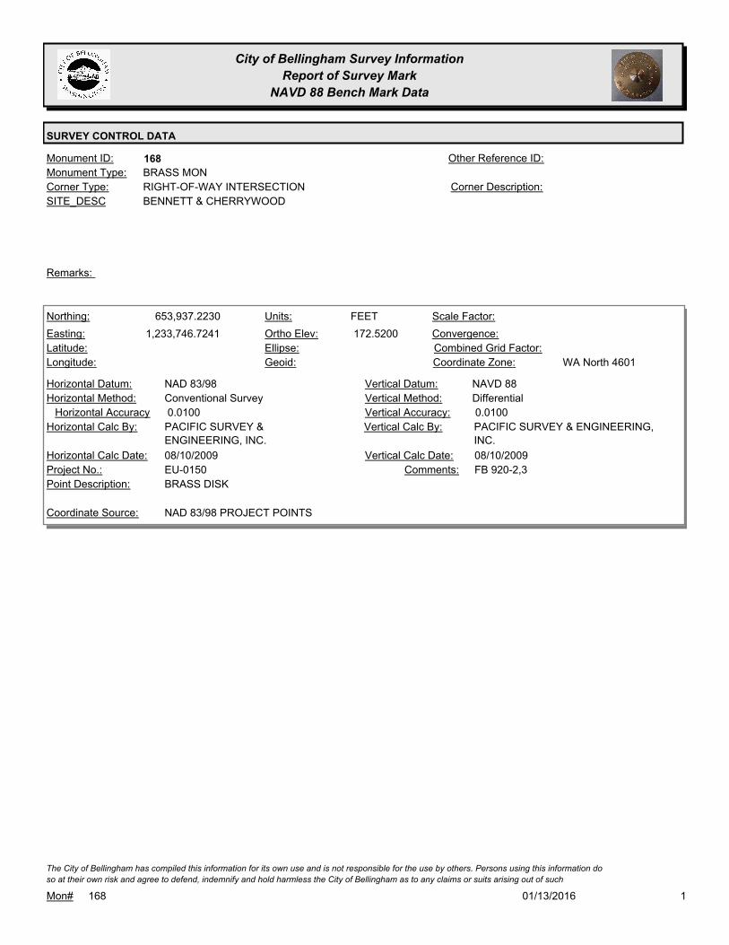
168Monument ID: Other Reference ID:
SITE_DESC BENNETT & CHERRYWOOD
RIGHT-OF-WAY INTERSECTIONCorner Type: Corner Description:
BRASS MONMonument Type:
Remarks:
653,937.2230
1,233,746.7241 172.5200
FEETNorthing:
Easting:
Latitude:
Longitude:
Units:
Ortho Elev:
Ellipse:
Geoid:
Scale Factor:
Convergence:
Combined Grid Factor:
WA North 4601Coordinate Zone:
Conventional SurveyHorizontal Method:
NAD 83/98Horizontal Datum: NAVD 88Vertical Datum:
DifferentialVertical Method:
0.0100Horizontal Accuracy 0.0100Vertical Accuracy:
PACIFIC SURVEY & ENGINEERING,
INC.
Vertical Calc By:PACIFIC SURVEY &
ENGINEERING, INC.
Horizontal Calc By:
EU-0150Project No.:
BRASS DISKPoint Description:
NAD 83/98 PROJECT POINTSCoordinate Source:
FB 920-2,3Comments:
08/10/2009Horizontal Calc Date: 08/10/2009Vertical Calc Date:
101/13/2016Mon# 168
The City of Bellingham has compiled this information for its own use and is not responsible for the use by others. Persons using this information do
so at their own risk and agree to defend, indemnify and hold harmless the City of Bellingham as to any claims or suits arising out of such

City of Bellingham Survey Information
Report of Survey Mark
NAVD 88 Bench Mark Data
SURVEY CONTROL DATA
172Monument ID: Other Reference ID:
SITE_DESC ALDERWOOD & BENNETT
RIGHT-OF-WAY INTERSECTIONCorner Type: Corner Description:
BRASS MONMonument Type:
VISITED FOR NAD 83/98 CONTROL NETWORK 2005.Remarks:
653,277.7222
1,233,726.2443 157.5000
FEETNorthing:
Easting:
Latitude:
Longitude:
Units:
Ortho Elev:
Ellipse:
Geoid:
Scale Factor:
Convergence:
Combined Grid Factor:
WA North 4601Coordinate Zone:
Conventional SurveyHorizontal Method:
NAD 83/98Horizontal Datum: NAVD 88Vertical Datum:
DifferentialVertical Method:
0.0100Horizontal Accuracy 0.0100Vertical Accuracy:
PACIFIC SURVEY & ENGINEERING,
INC.
Vertical Calc By:PACIFIC SURVEY &
ENGINEERING, INC.
Horizontal Calc By:
EU-0150Project No.:
BRASS DISK PROJ PNT 51 AT STA 44+85.66Point Description:
NAD 83/98 PROJECT POINTSCoordinate Source:
FB 920-2Comments:
08/10/2009Horizontal Calc Date: 08/10/2009Vertical Calc Date:
101/13/2016Mon# 172
The City of Bellingham has compiled this information for its own use and is not responsible for the use by others. Persons using this information do
so at their own risk and agree to defend, indemnify and hold harmless the City of Bellingham as to any claims or suits arising out of such

City of Bellingham Survey Information
Report of Survey Mark
NAVD 88 Bench Mark Data
SURVEY CONTROL DATA
204Monument ID: Other Reference ID:
SITE_DESC SUPERIOR & N. LINE TEXAS
RIGHT-OF-WAY INTERSECTIONCorner Type: Corner Description:
BRASS MONMonument Type:
Remarks:
646,734.2540
1,252,608.9190 124.5100
FEETNorthing:
Easting:
Latitude:
Longitude:
Units:
Ortho Elev:
Ellipse:
Geoid:
Scale Factor:
Convergence:
Combined Grid Factor:
WA North 4601Coordinate Zone:
Conventional SurveyHorizontal Method:
NAD 83/98Horizontal Datum: NAVD 88Vertical Datum:
DifferentialVertical Method:
0.0200Horizontal Accuracy 0.0300Vertical Accuracy:
LARRY STEELE & ASSOCIATESVertical Calc By:LARRY STEELE & ASSOCIATESHorizontal Calc By:
ES-0445Project No.:
C-BDSPoint Description:
NAD 83/98 PROJECT POINTSCoordinate Source:
FB 950-1 PROJECT POINT #104Comments:
08/22/2011Horizontal Calc Date: 08/22/2011Vertical Calc Date:
101/13/2016Mon# 204
The City of Bellingham has compiled this information for its own use and is not responsible for the use by others. Persons using this information do
so at their own risk and agree to defend, indemnify and hold harmless the City of Bellingham as to any claims or suits arising out of such

City of Bellingham Survey Information
Report of Survey Mark
NAVD 88 Bench Mark Data
SURVEY CONTROL DATA
223Monument ID: Other Reference ID:
SITE_DESC VINING & PLAT. BOUND. MON. S/O
VIEWRIDGE
PLAT LINECorner Type: Corner Description:
BRASS MONMonument Type:
VISITED FOR NAD 83/98 CONTROL NETWORK SURVEY 2006.Remarks:
326.2800
0.0000
FEETNorthing:
Easting:
Latitude:
Longitude:
Units:
Ortho Elev:
Ellipse:
Geoid:
Scale Factor:
Convergence:
Combined Grid Factor:
WA North 4601Coordinate Zone:
Horizontal Method:
Horizontal Datum: NAVD 88Vertical Datum:
DifferentialVertical Method:
Horizontal Accuracy 0.0300Vertical Accuracy:
WILSON ENGINEERING LLC.Vertical Calc By:Horizontal Calc By:
ES-0425Project No.:
C-BDS CL VINING @ RES. #2200 & #2204Point Description:
BENCHMARK NAVD 88Coordinate Source:
FB918-8 pg. 53Comments:
Horizontal Calc Date: 02/12/2009Vertical Calc Date:
101/13/2016Mon# 223
The City of Bellingham has compiled this information for its own use and is not responsible for the use by others. Persons using this information do
so at their own risk and agree to defend, indemnify and hold harmless the City of Bellingham as to any claims or suits arising out of such

City of Bellingham Survey Information
Report of Survey Mark
NAVD 88 Bench Mark Data
SURVEY CONTROL DATA
242Monument ID: Other Reference ID:
SITE_DESC FRASER & ELECTRIC
RIGHT-OF-WAY INTERSECTIONCorner Type: Corner Description:
BRASS MONMonument Type:
VISITED FOR NAD 83/98 CONTROL NETWORK SURVEY 2006.Remarks:
350.8350
0.0000
FEETNorthing:
Easting:
Latitude:
Longitude:
Units:
Ortho Elev:
Ellipse:
Geoid:
Scale Factor:
Convergence:
Combined Grid Factor:
WA North 4601Coordinate Zone:
Horizontal Method:
Horizontal Datum: NAVD 88Vertical Datum:
DifferentialVertical Method:
Horizontal Accuracy 0.0300Vertical Accuracy:
WILSON ENGINEERING LLC.Vertical Calc By:Horizontal Calc By:
ES-0425Project No.:
C-BDS INT FRASER & ELECTRIC (OFFSET)Point Description:
BENCHMARK NAVD 88Coordinate Source:
FB918-8 pg. 23Comments:
Horizontal Calc Date: 02/12/2009Vertical Calc Date:
101/13/2016Mon# 242
The City of Bellingham has compiled this information for its own use and is not responsible for the use by others. Persons using this information do
so at their own risk and agree to defend, indemnify and hold harmless the City of Bellingham as to any claims or suits arising out of such

City of Bellingham Survey Information
Report of Survey Mark
NAVD 88 Bench Mark Data
SURVEY CONTROL DATA
245Monument ID: Other Reference ID:
SITE_DESC OHIO & ELECTRIC
RIGHT-OF-WAY INTERSECTIONCorner Type: Corner Description:
BRASS MONMonument Type:
VISITED FOR NAD 83/98 CONTROL NETWORK SURVEY 2006.Remarks:
345.6840
0.0000
FEETNorthing:
Easting:
Latitude:
Longitude:
Units:
Ortho Elev:
Ellipse:
Geoid:
Scale Factor:
Convergence:
Combined Grid Factor:
WA North 4601Coordinate Zone:
Horizontal Method:
Horizontal Datum: NAVD 88Vertical Datum:
DifferentialVertical Method:
Horizontal Accuracy 0.0300Vertical Accuracy:
WILSON ENGINEERING LLC.Vertical Calc By:Horizontal Calc By:
ES-0425Project No.:
C-BDS INT OHIO & ELECTRIC (OFFSET)Point Description:
BENCHMARK NAVD 88Coordinate Source:
FB918-8 pg. 24Comments:
Horizontal Calc Date: 02/12/2009Vertical Calc Date:
101/13/2016Mon# 245
The City of Bellingham has compiled this information for its own use and is not responsible for the use by others. Persons using this information do
so at their own risk and agree to defend, indemnify and hold harmless the City of Bellingham as to any claims or suits arising out of such

City of Bellingham Survey Information
Report of Survey Mark
NAVD 88 Bench Mark Data
SURVEY CONTROL DATA
260Monument ID: Other Reference ID:
SITE_DESC MCLEOD RD & PRIMROSE LN
SECTION CENTERCorner Type: CENTER SECTION 18
T38N R3E
Corner Description:
CONCRETE MONMonument Type:
VISITED FOR NAD 83/98 CONTROL NETWORK 2005. USED FOR
DATUM MODERNIZATION TO NAVD88. FOUND 6 FT NORTH OF
NORTH EP.
Remarks:
134.2410
0.0000
FEETNorthing:
Easting:
Latitude:
Longitude:
Units:
Ortho Elev:
Ellipse:
Geoid:
Scale Factor:
Convergence:
Combined Grid Factor:
WA North 4601Coordinate Zone:
Horizontal Method:
Horizontal Datum: NAVD 88Vertical Datum:
DifferentialVertical Method:
Horizontal Accuracy 0.0200Vertical Accuracy:
PACIFIC SURVEY & ENGINEERING,
INC.
Vertical Calc By:Horizontal Calc By:
ES-0425Project No.:
BRASS PIN IN CONC N. OF INT. PRIMROSE LN AND
E. MCLEOD RD
Point Description:
BENCHMARK NAVD 88Coordinate Source:
FB 918Comments:
Horizontal Calc Date: 12/09/2008Vertical Calc Date:
101/13/2016Mon# 260
The City of Bellingham has compiled this information for its own use and is not responsible for the use by others. Persons using this information do
so at their own risk and agree to defend, indemnify and hold harmless the City of Bellingham as to any claims or suits arising out of such
City of Bellingham Survey Information
Report of Survey Mark
NAVD 88 Bench Mark Data
SURVEY CONTROL DATA
271Monument ID: Other Reference ID:
SITE_DESC N STATE ST & E CHESTNUT ST
RIGHT-OF-WAY INTERSECTIONCorner Type: Corner Description:
BRASS MONMonument Type:
Remarks:
641,665.3912
1,243,480.7003
48 44 50.60717
-122 28 42.98313
89.9550
0.0000
FEETNorthing:
Easting:
Latitude:
Longitude:
Units:
Ortho Elev:
Ellipse:
Geoid:
1.0000000000Scale Factor:
- 1 13 30Convergence:
Combined Grid Factor:
WA North 4601Coordinate Zone:
Conventional SurveyHorizontal Method:
NAD 83/98Horizontal Datum: NAVD 88Vertical Datum:
DifferentialVertical Method:
0.0700Horizontal Accuracy 0.0200Vertical Accuracy:
PACIFIC SURVEY & ENGINEERING,
INC.
Vertical Calc By:PACIFIC SURVEY &
ENGINEERING, INC.
Horizontal Calc By:
Project No.:
C-BDSPoint Description:
NAD 83/98 NETWORK(DENSIFICATION PROJECT)Coordinate Source:
ELEVATION NO LONGER VALID.
FB880-2 WATERFRONT CONTROL
SURVEY AF2080302393
Comments:
01/23/2008Horizontal Calc Date: 01/23/2008Vertical Calc Date:
101/13/2016Mon# 271
The City of Bellingham has compiled this information for its own use and is not responsible for the use by others. Persons using this information do
so at their own risk and agree to defend, indemnify and hold harmless the City of Bellingham as to any claims or suits arising out of such
City of Bellingham Survey Information
Report of Survey Mark
NAVD 88 Bench Mark Data
SURVEY CONTROL DATA
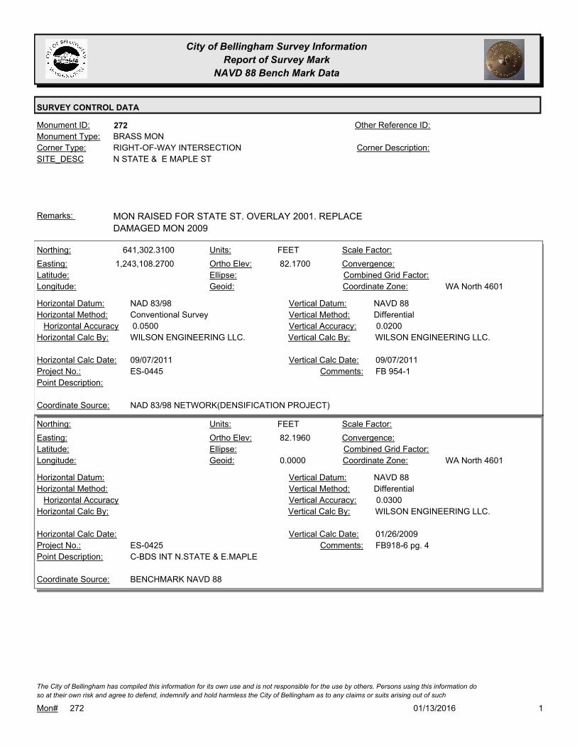
272Monument ID: Other Reference ID:
SITE_DESC N STATE & E MAPLE ST
RIGHT-OF-WAY INTERSECTIONCorner Type: Corner Description:
BRASS MONMonument Type:
MON RAISED FOR STATE ST. OVERLAY 2001. REPLACE
DAMAGED MON 2009
Remarks:
641,302.3100
1,243,108.2700 82.1700
FEETNorthing:
Easting:
Latitude:
Longitude:
Units:
Ortho Elev:
Ellipse:
Geoid:
Scale Factor:
Convergence:
Combined Grid Factor:
WA North 4601Coordinate Zone:
Conventional SurveyHorizontal Method:
NAD 83/98Horizontal Datum: NAVD 88Vertical Datum:
DifferentialVertical Method:
0.0500Horizontal Accuracy 0.0200Vertical Accuracy:
WILSON ENGINEERING LLC.Vertical Calc By:WILSON ENGINEERING LLC.Horizontal Calc By:
ES-0445Project No.:
Point Description:
NAD 83/98 NETWORK(DENSIFICATION PROJECT)Coordinate Source:
FB 954-1Comments:
09/07/2011Horizontal Calc Date: 09/07/2011Vertical Calc Date:
82.1960
0.0000
FEETNorthing:
Easting:
Latitude:
Longitude:
Units:
Ortho Elev:
Ellipse:
Geoid:
Scale Factor:
Convergence:
Combined Grid Factor:
WA North 4601Coordinate Zone:
Horizontal Method:
Horizontal Datum: NAVD 88Vertical Datum:
DifferentialVertical Method:
Horizontal Accuracy 0.0300Vertical Accuracy:
WILSON ENGINEERING LLC.Vertical Calc By:Horizontal Calc By:
ES-0425Project No.:
C-BDS INT N.STATE & E.MAPLEPoint Description:
BENCHMARK NAVD 88Coordinate Source:
FB918-6 pg. 4Comments:
Horizontal Calc Date: 01/26/2009Vertical Calc Date:
101/13/2016Mon# 272
The City of Bellingham has compiled this information for its own use and is not responsible for the use by others. Persons using this information do
so at their own risk and agree to defend, indemnify and hold harmless the City of Bellingham as to any claims or suits arising out of such

City of Bellingham Survey Information
Report of Survey Mark
NAVD 88 Bench Mark Data
SURVEY CONTROL DATA
302Monument ID: Other Reference ID:
SITE_DESC OLD LAKEWAY & NEWTON
RIGHT-OF-WAY INTERSECTIONCorner Type: Corner Description:
BRASS MONMonument Type:
RAISED 1-94. VISITED FOR NAD 83/98 CONTROL NETWORK
SURVEY 2006
Remarks:
281.4320
0.0000
FEETNorthing:
Easting:
Latitude:
Longitude:
Units:
Ortho Elev:
Ellipse:
Geoid:
Scale Factor:
Convergence:
Combined Grid Factor:
WA North 4601Coordinate Zone:
Horizontal Method:
Horizontal Datum: NAVD 88Vertical Datum:
DifferentialVertical Method:
Horizontal Accuracy 0.0300Vertical Accuracy:
WILSON ENGINEERING LLC.Vertical Calc By:Horizontal Calc By:
ES-0425Project No.:
C-BDS INT NEWTON & OLD LAKEWAYPoint Description:
BENCHMARK NAVD 88Coordinate Source:
FB918-8 pg. 6Comments:
Horizontal Calc Date: 02/12/2009Vertical Calc Date:
101/13/2016Mon# 302
The City of Bellingham has compiled this information for its own use and is not responsible for the use by others. Persons using this information do
so at their own risk and agree to defend, indemnify and hold harmless the City of Bellingham as to any claims or suits arising out of such

City of Bellingham Survey Information
Report of Survey Mark
NAVD 88 Bench Mark Data
SURVEY CONTROL DATA
313Monument ID: Other Reference ID:
SITE_DESC CEDARWOOD & FIRWOOD
RIGHT-OF-WAY INTERSECTIONCorner Type: Corner Description:
BRASS MONMonument Type:
RESET 6-05. VISITED FOR NAD 83/98 CONTROL NETWORK
SURVEY 2006. USED FOR DATUM MODERNIZATION TO NAVD88
Remarks:
79.6050
0.0000
FEETNorthing:
Easting:
Latitude:
Longitude:
Units:
Ortho Elev:
Ellipse:
Geoid:
Scale Factor:
Convergence:
Combined Grid Factor:
WA North 4601Coordinate Zone:
Horizontal Method:
Horizontal Datum: NAVD 88Vertical Datum:
DifferentialVertical Method:
Horizontal Accuracy 0.0200Vertical Accuracy:
PACIFIC SURVEY & ENGINEERING,
INC.
Vertical Calc By:Horizontal Calc By:
ES-0425Project No.:
BRASS MON AT INT. FIRWOOD AVE &
CEDARWOOD AVE
Point Description:
BENCHMARK NAVD 88Coordinate Source:
FB 918Comments:
Horizontal Calc Date: 12/12/2008Vertical Calc Date:
101/13/2016Mon# 313
The City of Bellingham has compiled this information for its own use and is not responsible for the use by others. Persons using this information do
so at their own risk and agree to defend, indemnify and hold harmless the City of Bellingham as to any claims or suits arising out of such

City of Bellingham Survey Information
Report of Survey Mark
NAVD 88 Bench Mark Data
SURVEY CONTROL DATA
315Monument ID: Other Reference ID:
SITE_DESC RAILROAD AV & E MAPLE ST
RIGHT-OF-WAY INTERSECTIONCorner Type: Corner Description:
BRASS MONMonument Type:
Remarks:
641,552.9500
1,242,863.9200 62.2700
FEETNorthing:
Easting:
Latitude:
Longitude:
Units:
Ortho Elev:
Ellipse:
Geoid:
Scale Factor:
Convergence:
Combined Grid Factor:
WA North 4601Coordinate Zone:
Conventional SurveyHorizontal Method:
NAD 83/98Horizontal Datum: NAVD 88Vertical Datum:
DifferentialVertical Method:
0.0500Horizontal Accuracy 0.0200Vertical Accuracy:
WILSON ENGINEERING LLC.Vertical Calc By:WILSON ENGINEERING LLC.Horizontal Calc By:
ES-0445Project No.:
Point Description:
NAD 83/98 PROJECT POINTSCoordinate Source:
FB 954-1Comments:
09/07/2011Horizontal Calc Date: 09/07/2011Vertical Calc Date:
101/13/2016Mon# 315
The City of Bellingham has compiled this information for its own use and is not responsible for the use by others. Persons using this information do
so at their own risk and agree to defend, indemnify and hold harmless the City of Bellingham as to any claims or suits arising out of such

City of Bellingham Survey Information
Report of Survey Mark
NAVD 88 Bench Mark Data
SURVEY CONTROL DATA
318Monument ID: Other Reference ID:
SITE_DESC INDIAN & LAUREL
RIGHT-OF-WAY INTERSECTIONCorner Type: Corner Description:
BRASS MONMonument Type:
Remarks:
639,936.9123
1,243,712.9564 206.2500
FEETNorthing:
Easting:
Latitude:
Longitude:
Units:
Ortho Elev:
Ellipse:
Geoid:
Scale Factor:
Convergence:
Combined Grid Factor:
WA North 4601Coordinate Zone:
GPS + ConventionalHorizontal Method:
NAD 83/98Horizontal Datum: NAVD 88Vertical Datum:
DifferentialVertical Method:
0.0500Horizontal Accuracy 0.0200Vertical Accuracy:
WILSON ENGINEERING LLC.Vertical Calc By:WILSON ENGINEERING LLC.Horizontal Calc By:
ES-0448Project No.:
Z BSM COB 318Point Description:
NAD 83/98 PROJECT POINTSCoordinate Source:
FB 965-1,2. PROJECT POINT 127.Comments:
03/27/2012Horizontal Calc Date: 03/27/2012Vertical Calc Date:
101/13/2016Mon# 318
The City of Bellingham has compiled this information for its own use and is not responsible for the use by others. Persons using this information do
so at their own risk and agree to defend, indemnify and hold harmless the City of Bellingham as to any claims or suits arising out of such
City of Bellingham Survey Information
Report of Survey Mark
NAVD 88 Bench Mark Data
SURVEY CONTROL DATA
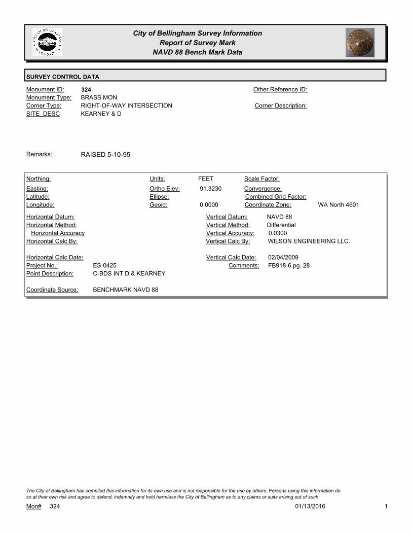
324Monument ID: Other Reference ID:
SITE_DESC KEARNEY & D
RIGHT-OF-WAY INTERSECTIONCorner Type: Corner Description:
BRASS MONMonument Type:
RAISED 5-10-95Remarks:
91.3230
0.0000
FEETNorthing:
Easting:
Latitude:
Longitude:
Units:
Ortho Elev:
Ellipse:
Geoid:
Scale Factor:
Convergence:
Combined Grid Factor:
WA North 4601Coordinate Zone:
Horizontal Method:
Horizontal Datum: NAVD 88Vertical Datum:
DifferentialVertical Method:
Horizontal Accuracy 0.0300Vertical Accuracy:
WILSON ENGINEERING LLC.Vertical Calc By:Horizontal Calc By:
ES-0425Project No.:
C-BDS INT D & KEARNEYPoint Description:
BENCHMARK NAVD 88Coordinate Source:
FB918-6 pg. 28Comments:
Horizontal Calc Date: 02/04/2009Vertical Calc Date:
101/13/2016Mon# 324
The City of Bellingham has compiled this information for its own use and is not responsible for the use by others. Persons using this information do
so at their own risk and agree to defend, indemnify and hold harmless the City of Bellingham as to any claims or suits arising out of such

City of Bellingham Survey Information
Report of Survey Mark
NAVD 88 Bench Mark Data
SURVEY CONTROL DATA
326Monument ID: Other Reference ID:
SITE_DESC OHIO & HUMBOLT
RIGHT-OF-WAY INTERSECTIONCorner Type: Corner Description:
BRASS MONMonument Type:
RESET 4/05Remarks:
644,432.8118
1,246,141.1255 67.4900
FEETNorthing:
Easting:
Latitude:
Longitude:
Units:
Ortho Elev:
Ellipse:
Geoid:
Scale Factor:
Convergence:
Combined Grid Factor:
WA North 4601Coordinate Zone:
Conventional SurveyHorizontal Method:
NAD 83/98Horizontal Datum: NAVD 88Vertical Datum:
DifferentialVertical Method:
0.0540Horizontal Accuracy 0.0200Vertical Accuracy:
CONSTRUCTION SURVEYORS N W
INC.
Vertical Calc By:CONSTRUCTION SURVEYORS N
W INC.
Horizontal Calc By:
EW-0186Project No.:
C-BDSPoint Description:
NAD 83/98 PROJECT POINTSCoordinate Source:
FB 952-1,2Comments:
09/26/2011Horizontal Calc Date: 09/26/2011Vertical Calc Date:
101/13/2016Mon# 326
The City of Bellingham has compiled this information for its own use and is not responsible for the use by others. Persons using this information do
so at their own risk and agree to defend, indemnify and hold harmless the City of Bellingham as to any claims or suits arising out of such

City of Bellingham Survey Information
Report of Survey Mark
NAVD 88 Bench Mark Data
SURVEY CONTROL DATA
332Monument ID: Other Reference ID:
SITE_DESC CONNECTICUT & RUSSELL
RIGHT-OF-WAY INTERSECTIONCorner Type: Corner Description:
BRASS MONMonument Type:
RAISED 5-10-95Remarks:
648,345.9413
1,242,646.7507 91.5100
FEETNorthing:
Easting:
Latitude:
Longitude:
Units:
Ortho Elev:
Ellipse:
Geoid:
Scale Factor:
Convergence:
Combined Grid Factor:
WA North 4601Coordinate Zone:
Conventional SurveyHorizontal Method:
NAD 83/98Horizontal Datum: NAVD 88Vertical Datum:
DifferentialVertical Method:
0.0330Horizontal Accuracy 0.0100Vertical Accuracy:
CONSTRUCTION SURVEYORS N W
INC.
Vertical Calc By:CONSTRUCTION SURVEYORS N
W INC.
Horizontal Calc By:
EU-0156Project No.:
C-BDSPoint Description:
NAD 83/98 PROJECT POINTSCoordinate Source:
FB 964-1Comments:
04/09/2012Horizontal Calc Date: 04/09/2012Vertical Calc Date:
101/13/2016Mon# 332
The City of Bellingham has compiled this information for its own use and is not responsible for the use by others. Persons using this information do
so at their own risk and agree to defend, indemnify and hold harmless the City of Bellingham as to any claims or suits arising out of such

City of Bellingham Survey Information
Report of Survey Mark
NAVD 88 Bench Mark Data
SURVEY CONTROL DATA
338Monument ID: Other Reference ID:
SITE_DESC 11TH ST & KNOX AVE
RIGHT-OF-WAY INTERSECTIONCorner Type: Corner Description:
BRASS MONMonument Type:
RAISED 3-94. VISITED FOR NAD 83/98 CONTROL NETWORK
SURVEY 2006.
Remarks:
77.0030
0.0000
FEETNorthing:
Easting:
Latitude:
Longitude:
Units:
Ortho Elev:
Ellipse:
Geoid:
Scale Factor:
Convergence:
Combined Grid Factor:
WA North 4601Coordinate Zone:
Horizontal Method:
Horizontal Datum: NAVD 88Vertical Datum:
DifferentialVertical Method:
Horizontal Accuracy 0.0200Vertical Accuracy:
LARRY STEELE & ASSOCIATESVertical Calc By:Horizontal Calc By:
ES-0425Project No.:
BRASS MON AT KNOX & 11THPoint Description:
BENCHMARK NAVD 88Coordinate Source:
FB 918-11Comments:
Horizontal Calc Date: 02/17/2009Vertical Calc Date:
101/13/2016Mon# 338
The City of Bellingham has compiled this information for its own use and is not responsible for the use by others. Persons using this information do
so at their own risk and agree to defend, indemnify and hold harmless the City of Bellingham as to any claims or suits arising out of such

City of Bellingham Survey Information
Report of Survey Mark
NAVD 88 Bench Mark Data
SURVEY CONTROL DATA
348Monument ID: Other Reference ID:
SITE_DESC VALENCIA TO THE SOUTH AND FRASER TO
THE EAST
RIGHT-OF-WAY INTERSECTIONCorner Type: Corner Description:
BRASS MONMonument Type:
RAISED 1-94, VISITED FOR NAD 83/98 CONTROL NETWORK
SURVEY 2006.
Remarks:
94.6600
0.0000
FEETNorthing:
Easting:
Latitude:
Longitude:
Units:
Ortho Elev:
Ellipse:
Geoid:
Scale Factor:
Convergence:
Combined Grid Factor:
WA North 4601Coordinate Zone:
Horizontal Method:
Horizontal Datum: NAVD 88Vertical Datum:
DifferentialVertical Method:
Horizontal Accuracy 0.0300Vertical Accuracy:
WILSON ENGINEERING LLC.Vertical Calc By:Horizontal Calc By:
ES-0425Project No.:
C-BDS INT FRASER & VALENCIA (NE OF 2 MONS.)Point Description:
BENCHMARK NAVD 88Coordinate Source:
FB918-7 pg. 25Comments:
Horizontal Calc Date: 02/12/2009Vertical Calc Date:
101/13/2016Mon# 348
The City of Bellingham has compiled this information for its own use and is not responsible for the use by others. Persons using this information do
so at their own risk and agree to defend, indemnify and hold harmless the City of Bellingham as to any claims or suits arising out of such

City of Bellingham Survey Information
Report of Survey Mark
NAVD 88 Bench Mark Data
SURVEY CONTROL DATA
349Monument ID: Other Reference ID:
SITE_DESC ALABAMA & DEAN
RIGHT-OF-WAY INTERSECTIONCorner Type: Corner Description:
BRASS MONMonument Type:
BP SET FOR 1993 OVERLAY, FOUND 12-20-94.Remarks:
647,342.8702
1,244,803.5740 123.5500
FEETNorthing:
Easting:
Latitude:
Longitude:
Units:
Ortho Elev:
Ellipse:
Geoid:
Scale Factor:
Convergence:
Combined Grid Factor:
WA North 4601Coordinate Zone:
Conventional SurveyHorizontal Method:
NAD 83/98Horizontal Datum: NAVD 88Vertical Datum:
DifferentialVertical Method:
0.0200Horizontal Accuracy 0.0100Vertical Accuracy:
CHRISTIE & CHRISTIE LAND
SURVEYING INC.
Vertical Calc By:CHRISTIE & CHRISTIE LAND
SURVEYING INC.
Horizontal Calc By:
EU-0154Project No.:
C-BDSPoint Description:
NAD 83/98 PROJECT POINTSCoordinate Source:
FB 957-1,2Comments:
02/27/2012Horizontal Calc Date: 02/27/2012Vertical Calc Date:
101/13/2016Mon# 349
The City of Bellingham has compiled this information for its own use and is not responsible for the use by others. Persons using this information do
so at their own risk and agree to defend, indemnify and hold harmless the City of Bellingham as to any claims or suits arising out of such

City of Bellingham Survey Information
Report of Survey Mark
NAVD 88 Bench Mark Data
SURVEY CONTROL DATA
350Monument ID: Other Reference ID:
SITE_DESC ALABAMA & ELLIS
RIGHT-OF-WAY INTERSECTIONCorner Type: Corner Description:
BRASS MONMonument Type:
BP SET FOR 1993 OVERLAYRemarks:
647,335.3894
1,245,153.6147 126.9600
FEETNorthing:
Easting:
Latitude:
Longitude:
Units:
Ortho Elev:
Ellipse:
Geoid:
Scale Factor:
Convergence:
Combined Grid Factor:
WA North 4601Coordinate Zone:
Conventional SurveyHorizontal Method:
NAD 83/98Horizontal Datum: NAVD 88Vertical Datum:
DifferentialVertical Method:
0.0200Horizontal Accuracy 0.0100Vertical Accuracy:
CHRISTIE & CHRISTIE LAND
SURVEYING INC.
Vertical Calc By:CHRISTIE & CHRISTIE LAND
SURVEYING INC.
Horizontal Calc By:
EU-0154Project No.:
C-BDSPoint Description:
NAD 83/98 PROJECT POINTSCoordinate Source:
FB 957-1,2Comments:
02/27/2012Horizontal Calc Date: 02/27/2012Vertical Calc Date:
101/13/2016Mon# 350
The City of Bellingham has compiled this information for its own use and is not responsible for the use by others. Persons using this information do
so at their own risk and agree to defend, indemnify and hold harmless the City of Bellingham as to any claims or suits arising out of such

City of Bellingham Survey Information
Report of Survey Mark
NAVD 88 Bench Mark Data
SURVEY CONTROL DATA
351Monument ID: Other Reference ID:
SITE_DESC ALABAMA & FRANKLIN
RIGHT-OF-WAY INTERSECTIONCorner Type: Corner Description:
BRASS MONMonument Type:
BP SET FOR 1993 OVERLAYRemarks:
647,327.6125
1,245,503.6018 122.1500
FEETNorthing:
Easting:
Latitude:
Longitude:
Units:
Ortho Elev:
Ellipse:
Geoid:
Scale Factor:
Convergence:
Combined Grid Factor:
WA North 4601Coordinate Zone:
Conventional SurveyHorizontal Method:
NAD 83/98Horizontal Datum: NAVD 88Vertical Datum:
DifferentialVertical Method:
0.0200Horizontal Accuracy 0.0100Vertical Accuracy:
CHRISTIE & CHRISTIE LAND
SURVEYING INC.
Vertical Calc By:CHRISTIE & CHRISTIE LAND
SURVEYING INC.
Horizontal Calc By:
EU-0154Project No.:
Point Description:
NAD 83/98 PROJECT POINTSCoordinate Source:
FB 957-1,2Comments:
02/27/2012Horizontal Calc Date: 02/27/2012Vertical Calc Date:
101/13/2016Mon# 351
The City of Bellingham has compiled this information for its own use and is not responsible for the use by others. Persons using this information do
so at their own risk and agree to defend, indemnify and hold harmless the City of Bellingham as to any claims or suits arising out of such

City of Bellingham Survey Information
Report of Survey Mark
NAVD 88 Bench Mark Data
SURVEY CONTROL DATA
352Monument ID: Other Reference ID:
SITE_DESC ALABAMA & GRANT
RIGHT-OF-WAY INTERSECTIONCorner Type: Corner Description:
BRASS MONMonument Type:
BP SET FOR 1993 OVERLAYRemarks:
647,320.1025
1,245,853.4176 115.2900
FEETNorthing:
Easting:
Latitude:
Longitude:
Units:
Ortho Elev:
Ellipse:
Geoid:
Scale Factor:
Convergence:
Combined Grid Factor:
WA North 4601Coordinate Zone:
Conventional SurveyHorizontal Method:
NAD 83/98Horizontal Datum: NAVD 88Vertical Datum:
DifferentialVertical Method:
0.0200Horizontal Accuracy 0.0100Vertical Accuracy:
CHRISTIE & CHRISTIE LAND
SURVEYING INC.
Vertical Calc By:CHRISTIE & CHRISTIE LAND
SURVEYING INC.
Horizontal Calc By:
EU-0154Project No.:
C-BDSPoint Description:
NAD 83/98 PROJECT POINTSCoordinate Source:
FB 957-1,2Comments:
02/27/2012Horizontal Calc Date: 02/27/2012Vertical Calc Date:
101/13/2016Mon# 352
The City of Bellingham has compiled this information for its own use and is not responsible for the use by others. Persons using this information do
so at their own risk and agree to defend, indemnify and hold harmless the City of Bellingham as to any claims or suits arising out of such

City of Bellingham Survey Information
Report of Survey Mark
NAVD 88 Bench Mark Data
SURVEY CONTROL DATA
354Monument ID: Other Reference ID:
SITE_DESC DONOVAN & 4TH
RIGHT-OF-WAY INTERSECTIONCorner Type: Corner Description:
BRASS MONMonument Type:
ALSO SEE MON ID#2000 AT SECTION LINE TO NORTHRemarks:
630,989.9000
1,235,300.8000 54.4100
FEETNorthing:
Easting:
Latitude:
Longitude:
Units:
Ortho Elev:
Ellipse:
Geoid:
Scale Factor:
Convergence:
Combined Grid Factor:
WA North 4601Coordinate Zone:
Conventional SurveyHorizontal Method:
NAD 83/98Horizontal Datum: NAVD 88Vertical Datum:
DifferentialVertical Method:
Horizontal Accuracy Vertical Accuracy:
WILSON ENGINEERING LLC.Vertical Calc By:WILSON ENGINEERING LLC.Horizontal Calc By:
Project No.:
BRASS SURFACE MONPoint Description:
NAD 83/98 PROJECT POINTSCoordinate Source:
POST POINT RS-4712Comments:
08/10/2009Horizontal Calc Date: 08/10/2009Vertical Calc Date:
101/13/2016Mon# 354
The City of Bellingham has compiled this information for its own use and is not responsible for the use by others. Persons using this information do
so at their own risk and agree to defend, indemnify and hold harmless the City of Bellingham as to any claims or suits arising out of such

City of Bellingham Survey Information
Report of Survey Mark
NAVD 88 Bench Mark Data
SURVEY CONTROL DATA
358Monument ID: Other Reference ID:
SITE_DESC ALABAMA & IRON
RIGHT-OF-WAY INTERSECTIONCorner Type: Corner Description:
BRASS MONMonument Type:
BP SET FOR 1993 OVERLAYRemarks:
112.0460
0.0000
FEETNorthing:
Easting:
Latitude:
Longitude:
Units:
Ortho Elev:
Ellipse:
Geoid:
Scale Factor:
Convergence:
Combined Grid Factor:
WA North 4601Coordinate Zone:
Horizontal Method:
Horizontal Datum: NAVD 88Vertical Datum:
DifferentialVertical Method:
Horizontal Accuracy 0.0300Vertical Accuracy:
WILSON ENGINEERING LLC.Vertical Calc By:Horizontal Calc By:
ES-0425Project No.:
C-BDS INT ALABAMA & IRONPoint Description:
BENCHMARK NAVD 88Coordinate Source:
FB918-6 pg. 43Comments:
Horizontal Calc Date: 02/12/2009Vertical Calc Date:
101/13/2016Mon# 358
The City of Bellingham has compiled this information for its own use and is not responsible for the use by others. Persons using this information do
so at their own risk and agree to defend, indemnify and hold harmless the City of Bellingham as to any claims or suits arising out of such

City of Bellingham Survey Information
Report of Survey Mark
NAVD 88 Bench Mark Data
SURVEY CONTROL DATA
369Monument ID: Other Reference ID:
SITE_DESC ALABAMA & VERONA
RIGHT-OF-WAY INTERSECTIONCorner Type: Corner Description:
BRASS MONMonument Type:
BP SET FOR 1993 OVERLAYRemarks:
647,209.6846
1,250,975.6150 106.4800
FEETNorthing:
Easting:
Latitude:
Longitude:
Units:
Ortho Elev:
Ellipse:
Geoid:
Scale Factor:
Convergence:
Combined Grid Factor:
WA North 4601Coordinate Zone:
Conventional SurveyHorizontal Method:
NAD 83/98Horizontal Datum: NAVD 88Vertical Datum:
DifferentialVertical Method:
0.0100Horizontal Accuracy 0.0100Vertical Accuracy:
PACIFIC SURVEY & ENGINEERING,
INC.
Vertical Calc By:PACIFIC SURVEY &
ENGINEERING, INC.
Horizontal Calc By:
EU-0151Project No.:
C-MONPoint Description:
NAD 83/98 PROJECT POINTSCoordinate Source:
FB 932-3 PROJECT POINT #443Comments:
11/10/2010Horizontal Calc Date: 11/10/2010Vertical Calc Date:
101/13/2016Mon# 369
The City of Bellingham has compiled this information for its own use and is not responsible for the use by others. Persons using this information do
so at their own risk and agree to defend, indemnify and hold harmless the City of Bellingham as to any claims or suits arising out of such

City of Bellingham Survey Information
Report of Survey Mark
NAVD 88 Bench Mark Data
SURVEY CONTROL DATA
371Monument ID: Other Reference ID:
SITE_DESC ALABAMA & SUPERIOR
RIGHT-OF-WAY INTERSECTIONCorner Type: Corner Description:
BRASS MONMonument Type:
BP SET FOR 1993 OVERLAYRemarks:
647,174.0800
1,252,617.6480 127.6300
FEETNorthing:
Easting:
Latitude:
Longitude:
Units:
Ortho Elev:
Ellipse:
Geoid:
Scale Factor:
Convergence:
Combined Grid Factor:
WA North 4601Coordinate Zone:
Conventional SurveyHorizontal Method:
Horizontal Datum: NAVD 88Vertical Datum:
DifferentialVertical Method:
0.0200Horizontal Accuracy 0.0300Vertical Accuracy:
LARRY STEELE & ASSOCIATESVertical Calc By:LARRY STEELE & ASSOCIATESHorizontal Calc By:
ES-0445Project No.:
C-BDSPoint Description:
NAD 83/98 PROJECT POINTSCoordinate Source:
FB 950-1 PROJECT POINT #110Comments:
08/22/2011Horizontal Calc Date: 08/22/2011Vertical Calc Date:
101/13/2016Mon# 371
The City of Bellingham has compiled this information for its own use and is not responsible for the use by others. Persons using this information do
so at their own risk and agree to defend, indemnify and hold harmless the City of Bellingham as to any claims or suits arising out of such

City of Bellingham Survey Information
Report of Survey Mark
NAVD 88 Bench Mark Data
SURVEY CONTROL DATA
372Monument ID: Other Reference ID:
SITE_DESC ALABAMA & XENIA
RIGHT-OF-WAY INTERSECTIONCorner Type: Corner Description:
BRASS MONMonument Type:
BP SET FOR 1993 OVERLAYRemarks:
647,188.2810
1,251,957.5140 119.8300
FEETNorthing:
Easting:
Latitude:
Longitude:
Units:
Ortho Elev:
Ellipse:
Geoid:
Scale Factor:
Convergence:
Combined Grid Factor:
WA North 4601Coordinate Zone:
Conventional SurveyHorizontal Method:
NAD 83/98Horizontal Datum: NAVD 88Vertical Datum:
DifferentialVertical Method:
0.0200Horizontal Accuracy 0.0300Vertical Accuracy:
LARRY STEELE & ASSOCIATESVertical Calc By:LARRY STEELE & ASSOCIATESHorizontal Calc By:
ES-0445Project No.:
C-BDSPoint Description:
NAD 83/98 PROJECT POINTSCoordinate Source:
FB 950-1 PROJECT POINT #113Comments:
08/22/2011Horizontal Calc Date: 08/22/2011Vertical Calc Date:
101/13/2016Mon# 372
The City of Bellingham has compiled this information for its own use and is not responsible for the use by others. Persons using this information do
so at their own risk and agree to defend, indemnify and hold harmless the City of Bellingham as to any claims or suits arising out of such

City of Bellingham Survey Information
Report of Survey Mark
NAVD 88 Bench Mark Data
SURVEY CONTROL DATA
373Monument ID: Other Reference ID:
SITE_DESC ALABAMA & W. LINE YEW
RIGHT-OF-WAY INTERSECTIONCorner Type: Corner Description:
BRASS MONMonument Type:
BP SET FOR 1993 OVERLAYRemarks:
647,181.8530
1,252,257.6880 121.3300
FEETNorthing:
Easting:
Latitude:
Longitude:
Units:
Ortho Elev:
Ellipse:
Geoid:
Scale Factor:
Convergence:
Combined Grid Factor:
WA North 4601Coordinate Zone:
Conventional SurveyHorizontal Method:
NAD 83/98Horizontal Datum: NAVD 88Vertical Datum:
DifferentialVertical Method:
0.0200Horizontal Accuracy 0.0300Vertical Accuracy:
LARRY STEELE & ASSOCIATESVertical Calc By:LARRY STEELE & ASSOCIATESHorizontal Calc By:
ES-0445Project No.:
C-BDSPoint Description:
NAD 83/98 PROJECT POINTSCoordinate Source:
FB 950-1 PROJECT POINT #112Comments:
08/22/2011Horizontal Calc Date: 08/22/2011Vertical Calc Date:
101/13/2016Mon# 373
The City of Bellingham has compiled this information for its own use and is not responsible for the use by others. Persons using this information do
so at their own risk and agree to defend, indemnify and hold harmless the City of Bellingham as to any claims or suits arising out of such

City of Bellingham Survey Information
Report of Survey Mark
NAVD 88 Bench Mark Data
SURVEY CONTROL DATA
401Monument ID: Other Reference ID:
SITE_DESC VALLETTE & JEFFERSON
RIGHT-OF-WAY INTERSECTIONCorner Type: Corner Description:
BRASS MONMonument Type:
Remarks:
647,433.2520
1,242,347.9752 87.3200
FEETNorthing:
Easting:
Latitude:
Longitude:
Units:
Ortho Elev:
Ellipse:
Geoid:
Scale Factor:
Convergence:
Combined Grid Factor:
WA North 4601Coordinate Zone:
Conventional SurveyHorizontal Method:
NAD 83/98Horizontal Datum: NAVD 88Vertical Datum:
DifferentialVertical Method:
0.0330Horizontal Accuracy 0.0100Vertical Accuracy:
CONSTRUCTION SURVEYORS N W
INC.
Vertical Calc By:CONSTRUCTION SURVEYORS N
W INC.
Horizontal Calc By:
EU-0156Project No.:
C-BDSPoint Description:
NAD 83/98 PROJECT POINTSCoordinate Source:
FB 964-1Comments:
04/09/2012Horizontal Calc Date: 04/09/2012Vertical Calc Date:
101/13/2016Mon# 401
The City of Bellingham has compiled this information for its own use and is not responsible for the use by others. Persons using this information do
so at their own risk and agree to defend, indemnify and hold harmless the City of Bellingham as to any claims or suits arising out of such

City of Bellingham Survey Information
Report of Survey Mark
NAVD 88 Bench Mark Data
SURVEY CONTROL DATA
402Monument ID: Other Reference ID:
SITE_DESC MARYLAND & RUSSELL
RIGHT-OF-WAY INTERSECTIONCorner Type: Corner Description:
BRASS MONMonument Type:
BP SET FOR 1993 OVERLAYRemarks:
648,805.8963
1,242,658.1026 95.1000
FEETNorthing:
Easting:
Latitude:
Longitude:
Units:
Ortho Elev:
Ellipse:
Geoid:
Scale Factor:
Convergence:
Combined Grid Factor:
WA North 4601Coordinate Zone:
Conventional SurveyHorizontal Method:
NAD 83/98Horizontal Datum: NAVD 88Vertical Datum:
DifferentialVertical Method:
0.0330Horizontal Accuracy 0.0100Vertical Accuracy:
CONSTRUCTION SURVEYORS N W
INC.
Vertical Calc By:CONSTRUCTION SURVEYORS N
W INC.
Horizontal Calc By:
EU-0156Project No.:
C-BDSPoint Description:
NAD 83/98 PROJECT POINTSCoordinate Source:
FB 964-1Comments:
04/09/2012Horizontal Calc Date: 04/09/2012Vertical Calc Date:
101/13/2016Mon# 402
The City of Bellingham has compiled this information for its own use and is not responsible for the use by others. Persons using this information do
so at their own risk and agree to defend, indemnify and hold harmless the City of Bellingham as to any claims or suits arising out of such

City of Bellingham Survey Information
Report of Survey Mark
NAVD 88 Bench Mark Data
SURVEY CONTROL DATA
418Monument ID: Other Reference ID:
SITE_DESC CENTRAL & GRAND
RIGHT-OF-WAY INTERSECTIONCorner Type: Corner Description:
BRASS MONMonument Type:
MONUMENT RAISED IN 2010. ELEVATION BEFORE THIS DATE NO
LONGER VALID
Remarks:
65.7300
0.0000
FEETNorthing:
Easting:
Latitude:
Longitude:
Units:
Ortho Elev:
Ellipse:
Geoid:
Scale Factor:
Convergence:
Combined Grid Factor:
WA North 4601Coordinate Zone:
Horizontal Method:
Horizontal Datum: NAVD 88Vertical Datum:
DifferentialVertical Method:
Horizontal Accuracy 0.0300Vertical Accuracy:
WILSON ENGINEERING LLC.Vertical Calc By:Horizontal Calc By:
ES-0425Project No.:
C-BDS INT GRAND & CENTRALPoint Description:
BENCHMARK NAVD 88Coordinate Source:
ELEVATION NO LONGER VALID.
FB918-6 PG. 6
Comments:
Horizontal Calc Date: 01/26/2009Vertical Calc Date:
101/13/2016Mon# 418
The City of Bellingham has compiled this information for its own use and is not responsible for the use by others. Persons using this information do
so at their own risk and agree to defend, indemnify and hold harmless the City of Bellingham as to any claims or suits arising out of such

City of Bellingham Survey Information
Report of Survey Mark
NAVD 88 Bench Mark Data
SURVEY CONTROL DATA
444Monument ID: Other Reference ID:
SITE_DESC ERIE & MOSSOP
RIGHT-OF-WAY INTERSECTIONCorner Type: Corner Description:
BRASS MONMonument Type:
MON SET FOR STORM JOB 1991Remarks:
249.1410
0.0000
FEETNorthing:
Easting:
Latitude:
Longitude:
Units:
Ortho Elev:
Ellipse:
Geoid:
Scale Factor:
Convergence:
Combined Grid Factor:
WA North 4601Coordinate Zone:
Horizontal Method:
Horizontal Datum: NAVD 88Vertical Datum:
DifferentialVertical Method:
Horizontal Accuracy 0.0300Vertical Accuracy:
WILSON ENGINEERING LLC.Vertical Calc By:Horizontal Calc By:
ES-0425Project No.:
C-BDS INT ERIE & MOSSOPPoint Description:
BENCHMARK NAVD 88Coordinate Source:
FB918-8 pg. 40Comments:
Horizontal Calc Date: 02/12/2009Vertical Calc Date:
101/13/2016Mon# 444
The City of Bellingham has compiled this information for its own use and is not responsible for the use by others. Persons using this information do
so at their own risk and agree to defend, indemnify and hold harmless the City of Bellingham as to any claims or suits arising out of such

City of Bellingham Survey Information
Report of Survey Mark
NAVD 88 Bench Mark Data
SURVEY CONTROL DATA
457Monument ID: Other Reference ID:
SITE_DESC HIGHLAND DR & HILLCREST WY
RIGHT-OF-WAY INTERSECTIONCorner Type: Corner Description:
BRASS MONMonument Type:
GPS POINT "HIGHLAND & HILLCREST" DEA 1996. VISITED FOR
NAD 83/98 CONTROL NETWORK SURVEY 2006.
Remarks:
636,029.9980
1,239,907.3910 439.3100
FEETNorthing:
Easting:
Latitude:
Longitude:
Units:
Ortho Elev:
Ellipse:
Geoid:
Scale Factor:
Convergence:
Combined Grid Factor:
WA North 4601Coordinate Zone:
Conventional SurveyHorizontal Method:
NAD 83/98Horizontal Datum: NAVD 88Vertical Datum:
DifferentialVertical Method:
0.0200Horizontal Accuracy 0.0300Vertical Accuracy:
LARRY STEELE & ASSOCIATESVertical Calc By:LARRY STEELE & ASSOCIATESHorizontal Calc By:
EU-0156Project No.:
BPFPoint Description:
NAD 83/98 PROJECT POINTSCoordinate Source:
FB 940-1 PROJECT POINT #502Comments:
08/09/2011Horizontal Calc Date: 08/09/2011Vertical Calc Date:
101/13/2016Mon# 457
The City of Bellingham has compiled this information for its own use and is not responsible for the use by others. Persons using this information do
so at their own risk and agree to defend, indemnify and hold harmless the City of Bellingham as to any claims or suits arising out of such

City of Bellingham Survey Information
Report of Survey Mark
NAVD 88 Bench Mark Data
SURVEY CONTROL DATA
464Monument ID: Other Reference ID:
SITE_DESC 40TH & DONOVAN
SECTION CORNERCorner Type: CORNER SECTIONS
5/6/7/8 T37N R3E
Corner Description:
CONCRETE MONMonument Type:
Remarks:
610.9080
FEETNorthing:
Easting:
Latitude:
Longitude:
Units:
Ortho Elev:
Ellipse:
Geoid:
Scale Factor:
Convergence:
Combined Grid Factor:
Coordinate Zone:
Horizontal Method:
Horizontal Datum: NAVD 88Vertical Datum:
DifferentialVertical Method:
Horizontal Accuracy 0.0300Vertical Accuracy:
WILSON ENGINEERING LLC.Vertical Calc By:Horizontal Calc By:
Project No.:
Point Description:
BENCHMARK NAVD 88Coordinate Source:
FB 960-3Comments:
Horizontal Calc Date: 01/18/2012Vertical Calc Date:
101/13/2016Mon# 464
The City of Bellingham has compiled this information for its own use and is not responsible for the use by others. Persons using this information do
so at their own risk and agree to defend, indemnify and hold harmless the City of Bellingham as to any claims or suits arising out of such

City of Bellingham Survey Information
Report of Survey Mark
NAVD 88 Bench Mark Data
SURVEY CONTROL DATA
467Monument ID: Other Reference ID:
SITE_DESC NEQUALICUM & LAFAYETTE
RIGHT-OF-WAY INTERSECTIONCorner Type: Corner Description:
ALUMINUM CAPMonument Type:
MON SET 12-19-94, BPRemarks:
70.7790
0.0000
FEETNorthing:
Easting:
Latitude:
Longitude:
Units:
Ortho Elev:
Ellipse:
Geoid:
Scale Factor:
Convergence:
Combined Grid Factor:
WA North 4601Coordinate Zone:
Horizontal Method:
Horizontal Datum: NAVD 88Vertical Datum:
DifferentialVertical Method:
Horizontal Accuracy 0.0200Vertical Accuracy:
PACIFIC SURVEY & ENGINEERING,
INC.
Vertical Calc By:Horizontal Calc By:
ES-0425Project No.:
BRASS MON AT INT. NEQUALICUM AVE &
LAFAYETTE ST.
Point Description:
BENCHMARK NAVD 88Coordinate Source:
FB 918Comments:
Horizontal Calc Date: 12/12/2008Vertical Calc Date:
101/13/2016Mon# 467
The City of Bellingham has compiled this information for its own use and is not responsible for the use by others. Persons using this information do
so at their own risk and agree to defend, indemnify and hold harmless the City of Bellingham as to any claims or suits arising out of such

City of Bellingham Survey Information
Report of Survey Mark
NAVD 88 Bench Mark Data
SURVEY CONTROL DATA
468Monument ID: Other Reference ID:
SITE_DESC LAYAFETTE & CONNECTICUT
RIGHT-OF-WAY INTERSECTIONCorner Type: Corner Description:
BRASS MONMonument Type:
VISITED FOR NAD 83/98 CONTROL NETWORK SURVEY 2006.Remarks:
74.4510
0.0000
FEETNorthing:
Easting:
Latitude:
Longitude:
Units:
Ortho Elev:
Ellipse:
Geoid:
Scale Factor:
Convergence:
Combined Grid Factor:
WA North 4601Coordinate Zone:
Horizontal Method:
Horizontal Datum: NAVD 88Vertical Datum:
DifferentialVertical Method:
Horizontal Accuracy 0.0200Vertical Accuracy:
PACIFIC SURVEY & ENGINEERING,
INC.
Vertical Calc By:Horizontal Calc By:
ES-0425Project No.:
BRASS MON AT INT. LAFAYETTE ST & W.
CONNECTICUT ST.
Point Description:
BENCHMARK NAVD 88Coordinate Source:
FB 918Comments:
Horizontal Calc Date: 12/12/2008Vertical Calc Date:
101/13/2016Mon# 468
The City of Bellingham has compiled this information for its own use and is not responsible for the use by others. Persons using this information do
so at their own risk and agree to defend, indemnify and hold harmless the City of Bellingham as to any claims or suits arising out of such

City of Bellingham Survey Information
Report of Survey Mark
NAVD 88 Bench Mark Data
SURVEY CONTROL DATA
475Monument ID: Other Reference ID:
SITE_DESC 24TH & N OF E COLLEGE WAY AT WWU
TOWNSHIP CORNERCorner Type: CORNER T37/38N
R2/3E - CORNER
SECTIONS 31/6/1/36
Corner Description:
BRASS MONMonument Type:
AT WWU ACADEMIC CENTERRemarks:
308.6350
0.0000
FEETNorthing:
Easting:
Latitude:
Longitude:
Units:
Ortho Elev:
Ellipse:
Geoid:
Scale Factor:
Convergence:
Combined Grid Factor:
WA North 4601Coordinate Zone:
Horizontal Method:
Horizontal Datum: NAVD 88Vertical Datum:
DifferentialVertical Method:
Horizontal Accuracy 0.0200Vertical Accuracy:
LARRY STEELE & ASSOCIATESVertical Calc By:Horizontal Calc By:
ES-0425Project No.:
BRASS MON IN CONCRETE, NORTH OF E
COLLEGE WAY AT WWU
Point Description:
BENCHMARK NAVD 88Coordinate Source:
FB 918-11Comments:
Horizontal Calc Date: 02/17/2009Vertical Calc Date:
101/13/2016Mon# 475
The City of Bellingham has compiled this information for its own use and is not responsible for the use by others. Persons using this information do
so at their own risk and agree to defend, indemnify and hold harmless the City of Bellingham as to any claims or suits arising out of such

City of Bellingham Survey Information
Report of Survey Mark
NAVD 88 Bench Mark Data
SURVEY CONTROL DATA
476Monument ID: Other Reference ID:
SITE_DESC 32ND ST & DONOVAN AV
SECTION QUARTER CORNERCorner Type: 1/4 CORNER
SECTION 6/7 T37N
R3E
Corner Description:
BRASS MONMonument Type:
MON RAISED FOR 1996 OVERLAY, MON RAISED FOR 2002
OVERLAY. VISITED FOR NAD 83/98 CONTROL NETWORK SURVEY
2006.
Remarks:
170.2300
0.0000
FEETNorthing:
Easting:
Latitude:
Longitude:
Units:
Ortho Elev:
Ellipse:
Geoid:
Scale Factor:
Convergence:
Combined Grid Factor:
WA North 4601Coordinate Zone:
Horizontal Method:
Horizontal Datum: NAVD 88Vertical Datum:
DifferentialVertical Method:
Horizontal Accuracy 0.0200Vertical Accuracy:
LARRY STEELE & ASSOCIATESVertical Calc By:Horizontal Calc By:
ES-0425Project No.:
BRASS MON AT 32ND & DONOVANPoint Description:
BENCHMARK NAVD 88Coordinate Source:
FB 918-11Comments:
Horizontal Calc Date: 02/17/2009Vertical Calc Date:
101/13/2016Mon# 476
The City of Bellingham has compiled this information for its own use and is not responsible for the use by others. Persons using this information do
so at their own risk and agree to defend, indemnify and hold harmless the City of Bellingham as to any claims or suits arising out of such
City of Bellingham Survey Information
Report of Survey Mark
NAVD 88 Bench Mark Data
SURVEY CONTROL DATA
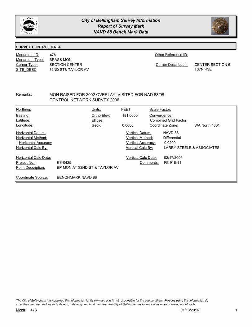
478Monument ID: Other Reference ID:
SITE_DESC 32ND ST& TAYLOR AV
SECTION CENTERCorner Type: CENTER SECTION 6
T37N R3E
Corner Description:
BRASS MONMonument Type:
MON RAISED FOR 2002 OVERLAY. VISITED FOR NAD 83/98
CONTROL NETWORK SURVEY 2006.
Remarks:
181.0000
0.0000
FEETNorthing:
Easting:
Latitude:
Longitude:
Units:
Ortho Elev:
Ellipse:
Geoid:
Scale Factor:
Convergence:
Combined Grid Factor:
WA North 4601Coordinate Zone:
Horizontal Method:
Horizontal Datum: NAVD 88Vertical Datum:
DifferentialVertical Method:
Horizontal Accuracy 0.0200Vertical Accuracy:
LARRY STEELE & ASSOCIATESVertical Calc By:Horizontal Calc By:
ES-0425Project No.:
BP MON AT 32ND ST & TAYLOR AVPoint Description:
BENCHMARK NAVD 88Coordinate Source:
FB 918-11Comments:
Horizontal Calc Date: 02/17/2009Vertical Calc Date:
101/13/2016Mon# 478
The City of Bellingham has compiled this information for its own use and is not responsible for the use by others. Persons using this information do
so at their own risk and agree to defend, indemnify and hold harmless the City of Bellingham as to any claims or suits arising out of such

City of Bellingham Survey Information
Report of Survey Mark
NAVD 88 Bench Mark Data
SURVEY CONTROL DATA
486Monument ID: Other Reference ID:
SITE_DESC YEW & LOPEZ
SECTION QUARTER CORNERCorner Type: 1/4 CORNER
SECTION 32/33 T38N
R3E
Corner Description:
BRASS MONMonument Type:
VISITED FOR NAD 83/98 CONTROL NETWORK SURVEY 2006.Remarks:
404.4800
FEETNorthing:
Easting:
Latitude:
Longitude:
Units:
Ortho Elev:
Ellipse:
Geoid:
Scale Factor:
Convergence:
Combined Grid Factor:
Coordinate Zone:
Horizontal Method:
Horizontal Datum: NAVD 88Vertical Datum:
DifferentialVertical Method:
Horizontal Accuracy 0.0200Vertical Accuracy:
CONSTRUCTION SURVEYORS N W
INC.
Vertical Calc By:Horizontal Calc By:
Project No.:
Point Description:
BENCHMARK NAVD 88Coordinate Source:
FB 960-2Comments:
Horizontal Calc Date: 05/01/2012Vertical Calc Date:
101/13/2016Mon# 486
The City of Bellingham has compiled this information for its own use and is not responsible for the use by others. Persons using this information do
so at their own risk and agree to defend, indemnify and hold harmless the City of Bellingham as to any claims or suits arising out of such

City of Bellingham Survey Information
Report of Survey Mark
NAVD 88 Bench Mark Data
SURVEY CONTROL DATA
505Monument ID: Other Reference ID:
SITE_DESC ALABAMA & VIEWRIDGE
RIGHT-OF-WAY INTERSECTIONCorner Type: Corner Description:
BRASS MONMonument Type:
BP SET FOR ST739 ,1991Remarks:
360.5080
0.0000
FEETNorthing:
Easting:
Latitude:
Longitude:
Units:
Ortho Elev:
Ellipse:
Geoid:
Scale Factor:
Convergence:
Combined Grid Factor:
WA North 4601Coordinate Zone:
Horizontal Method:
Horizontal Datum: NAVD 88Vertical Datum:
DifferentialVertical Method:
Horizontal Accuracy 0.0300Vertical Accuracy:
WILSON ENGINEERING LLC.Vertical Calc By:Horizontal Calc By:
ES-0425Project No.:
C-BDS INT VIEWRIDGE & ALABAMAPoint Description:
BENCHMARK NAVD 88Coordinate Source:
FB918-8 pg. 32Comments:
Horizontal Calc Date: 02/12/2009Vertical Calc Date:
101/13/2016Mon# 505
The City of Bellingham has compiled this information for its own use and is not responsible for the use by others. Persons using this information do
so at their own risk and agree to defend, indemnify and hold harmless the City of Bellingham as to any claims or suits arising out of such

City of Bellingham Survey Information
Report of Survey Mark
NAVD 88 Bench Mark Data
SURVEY CONTROL DATA
506Monument ID: Other Reference ID:
SITE_DESC ALABAMA & VINING
RIGHT-OF-WAY INTERSECTIONCorner Type: Corner Description:
BRASS MONMonument Type:
BP SET FOR ST739 ,1991Remarks:
312.5770
0.0000
FEETNorthing:
Easting:
Latitude:
Longitude:
Units:
Ortho Elev:
Ellipse:
Geoid:
Scale Factor:
Convergence:
Combined Grid Factor:
WA North 4601Coordinate Zone:
Horizontal Method:
Horizontal Datum: NAVD 88Vertical Datum:
DifferentialVertical Method:
Horizontal Accuracy 0.0300Vertical Accuracy:
WILSON ENGINEERING LLC.Vertical Calc By:Horizontal Calc By:
ES-0425Project No.:
C-BDS INT ALABAMA & VININGPoint Description:
BENCHMARK NAVD 88Coordinate Source:
FB918-8 pg. 33Comments:
Horizontal Calc Date: 02/12/2009Vertical Calc Date:
101/13/2016Mon# 506
The City of Bellingham has compiled this information for its own use and is not responsible for the use by others. Persons using this information do
so at their own risk and agree to defend, indemnify and hold harmless the City of Bellingham as to any claims or suits arising out of such

City of Bellingham Survey Information
Report of Survey Mark
NAVD 88 Bench Mark Data
SURVEY CONTROL DATA
508Monument ID: Other Reference ID:
SITE_DESC ALABAMA & ERIE
RIGHT-OF-WAY INTERSECTIONCorner Type: Corner Description:
BRASS MONMonument Type:
BP SET FOR ST739 ,1991Remarks:
234.8380
0.0000
FEETNorthing:
Easting:
Latitude:
Longitude:
Units:
Ortho Elev:
Ellipse:
Geoid:
Scale Factor:
Convergence:
Combined Grid Factor:
WA North 4601Coordinate Zone:
Horizontal Method:
Horizontal Datum: NAVD 88Vertical Datum:
DifferentialVertical Method:
Horizontal Accuracy 0.0300Vertical Accuracy:
WILSON ENGINEERING LLC.Vertical Calc By:Horizontal Calc By:
ES-0425Project No.:
C-BDS INT ALABAMA & ERIEPoint Description:
BENCHMARK NAVD 88Coordinate Source:
FB918-8 pg. 35Comments:
Horizontal Calc Date: 02/12/2009Vertical Calc Date:
101/13/2016Mon# 508
The City of Bellingham has compiled this information for its own use and is not responsible for the use by others. Persons using this information do
so at their own risk and agree to defend, indemnify and hold harmless the City of Bellingham as to any claims or suits arising out of such

City of Bellingham Survey Information
Report of Survey Mark
NAVD 88 Bench Mark Data
SURVEY CONTROL DATA
510Monument ID: Other Reference ID:
SITE_DESC LAURELWOOD & ALDERWOOD
RIGHT-OF-WAY INTERSECTIONCorner Type: Corner Description:
BRASS MONMonument Type:
Remarks:
653,259.9424
1,234,655.7759 157.4200
FEETNorthing:
Easting:
Latitude:
Longitude:
Units:
Ortho Elev:
Ellipse:
Geoid:
Scale Factor:
Convergence:
Combined Grid Factor:
WA North 4601Coordinate Zone:
Conventional SurveyHorizontal Method:
NAD 83/98Horizontal Datum: NAVD 88Vertical Datum:
DifferentialVertical Method:
0.0100Horizontal Accuracy 0.0100Vertical Accuracy:
PACIFIC SURVEY & ENGINEERING,
INC.
Vertical Calc By:PACIFIC SURVEY &
ENGINEERING, INC.
Horizontal Calc By:
EU-0150Project No.:
BRASS DISK PROJ PNT 61 AT STA 54+15.36Point Description:
NAD 83/98 PROJECT POINTSCoordinate Source:
FB 920-2Comments:
08/10/2009Horizontal Calc Date: 08/10/2009Vertical Calc Date:
101/13/2016Mon# 510
The City of Bellingham has compiled this information for its own use and is not responsible for the use by others. Persons using this information do
so at their own risk and agree to defend, indemnify and hold harmless the City of Bellingham as to any claims or suits arising out of such

City of Bellingham Survey Information
Report of Survey Mark
NAVD 88 Bench Mark Data
SURVEY CONTROL DATA
511Monument ID: Other Reference ID:
SITE_DESC C & ASTOR
RIGHT-OF-WAY INTERSECTIONCorner Type: Corner Description:
BRASS MONMonument Type:
MON RAISED FOR 1995 OVERLAY. VISITED FOR NAD 83/98
CONTROL NETWORK SURVEY 2006
Remarks:
644,207.5836
1,242,092.2884
48 45 15.39229
-122 29 04.50816
17.9470
0.0000
FEETNorthing:
Easting:
Latitude:
Longitude:
Units:
Ortho Elev:
Ellipse:
Geoid:
1.0000000000Scale Factor:
- 1 13 46Convergence:
Combined Grid Factor:
WA North 4601Coordinate Zone:
Conventional SurveyHorizontal Method:
NAD 83/98Horizontal Datum: NAVD 88Vertical Datum:
DifferentialVertical Method:
0.0700Horizontal Accuracy 0.0200Vertical Accuracy:
PACIFIC SURVEY & ENGINEERING,
INC.
Vertical Calc By:PACIFIC SURVEY &
ENGINEERING, INC.
Horizontal Calc By:
Project No.:
C-BDSPoint Description:
NAD 83/98 NETWORK(DENSIFICATION PROJECT)Coordinate Source:
FB880-2 WATERFRONT CONTROL
SURVEY AF2080302393
Comments:
01/23/2008Horizontal Calc Date: 01/23/2008Vertical Calc Date:
101/13/2016Mon# 511
The City of Bellingham has compiled this information for its own use and is not responsible for the use by others. Persons using this information do
so at their own risk and agree to defend, indemnify and hold harmless the City of Bellingham as to any claims or suits arising out of such

City of Bellingham Survey Information
Report of Survey Mark
NAVD 88 Bench Mark Data
SURVEY CONTROL DATA
524Monument ID: Other Reference ID:
SITE_DESC PINEWOOD & BIRCHWOOD
RIGHT-OF-WAY INTERSECTIONCorner Type: Corner Description:
BRASS MONMonument Type:
Remarks:
81.4340
0.0000
FEETNorthing:
Easting:
Latitude:
Longitude:
Units:
Ortho Elev:
Ellipse:
Geoid:
Scale Factor:
Convergence:
Combined Grid Factor:
WA North 4601Coordinate Zone:
Horizontal Method:
Horizontal Datum: NAVD 88Vertical Datum:
DifferentialVertical Method:
Horizontal Accuracy 0.0200Vertical Accuracy:
PACIFIC SURVEY & ENGINEERING,
INC.
Vertical Calc By:Horizontal Calc By:
ES-0425Project No.:
BRASS MON AT INT. PINEWOOD AVE AND
BIRCHWOOD AVE
Point Description:
BENCHMARK NAVD 88Coordinate Source:
FB 918Comments:
Horizontal Calc Date: 01/06/2009Vertical Calc Date:
101/13/2016Mon# 524
The City of Bellingham has compiled this information for its own use and is not responsible for the use by others. Persons using this information do
so at their own risk and agree to defend, indemnify and hold harmless the City of Bellingham as to any claims or suits arising out of such
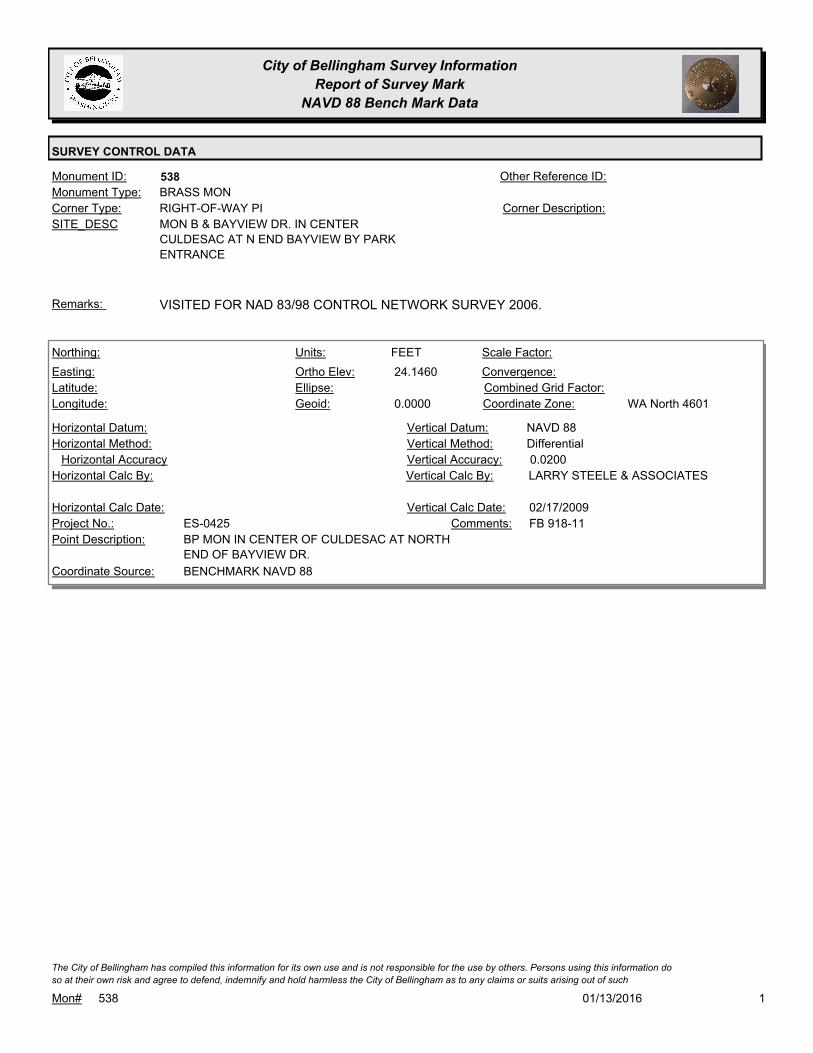
City of Bellingham Survey Information
Report of Survey Mark
NAVD 88 Bench Mark Data
SURVEY CONTROL DATA
538Monument ID: Other Reference ID:
SITE_DESC MON B & BAYVIEW DR. IN CENTER
CULDESAC AT N END BAYVIEW BY PARK
ENTRANCE
RIGHT-OF-WAY PICorner Type: Corner Description:
BRASS MONMonument Type:
VISITED FOR NAD 83/98 CONTROL NETWORK SURVEY 2006.Remarks:
24.1460
0.0000
FEETNorthing:
Easting:
Latitude:
Longitude:
Units:
Ortho Elev:
Ellipse:
Geoid:
Scale Factor:
Convergence:
Combined Grid Factor:
WA North 4601Coordinate Zone:
Horizontal Method:
Horizontal Datum: NAVD 88Vertical Datum:
DifferentialVertical Method:
Horizontal Accuracy 0.0200Vertical Accuracy:
LARRY STEELE & ASSOCIATESVertical Calc By:Horizontal Calc By:
ES-0425Project No.:
BP MON IN CENTER OF CULDESAC AT NORTH
END OF BAYVIEW DR.
Point Description:
BENCHMARK NAVD 88Coordinate Source:
FB 918-11Comments:
Horizontal Calc Date: 02/17/2009Vertical Calc Date:
101/13/2016Mon# 538
The City of Bellingham has compiled this information for its own use and is not responsible for the use by others. Persons using this information do
so at their own risk and agree to defend, indemnify and hold harmless the City of Bellingham as to any claims or suits arising out of such

City of Bellingham Survey Information
Report of Survey Mark
NAVD 88 Bench Mark Data
SURVEY CONTROL DATA
549Monument ID: Other Reference ID:
SITE_DESC BROADWAY & RUSSELL
RIGHT-OF-WAY INTERSECTIONCorner Type: Corner Description:
BRASS MONMonument Type:
Remarks:
647,617.5388
1,242,628.8587 90.8200
FEETNorthing:
Easting:
Latitude:
Longitude:
Units:
Ortho Elev:
Ellipse:
Geoid:
Scale Factor:
Convergence:
Combined Grid Factor:
WA North 4601Coordinate Zone:
Conventional SurveyHorizontal Method:
NAD 83/98Horizontal Datum: NAVD 88Vertical Datum:
DifferentialVertical Method:
0.0330Horizontal Accuracy 0.0100Vertical Accuracy:
CONSTRUCTION SURVEYORS N W
INC.
Vertical Calc By:CONSTRUCTION SURVEYORS N
W INC.
Horizontal Calc By:
EU-0156Project No.:
C-BDSPoint Description:
NAD 83/98 PROJECT POINTSCoordinate Source:
FB 964-1Comments:
04/09/2012Horizontal Calc Date: 04/09/2012Vertical Calc Date:
101/13/2016Mon# 549
The City of Bellingham has compiled this information for its own use and is not responsible for the use by others. Persons using this information do
so at their own risk and agree to defend, indemnify and hold harmless the City of Bellingham as to any claims or suits arising out of such
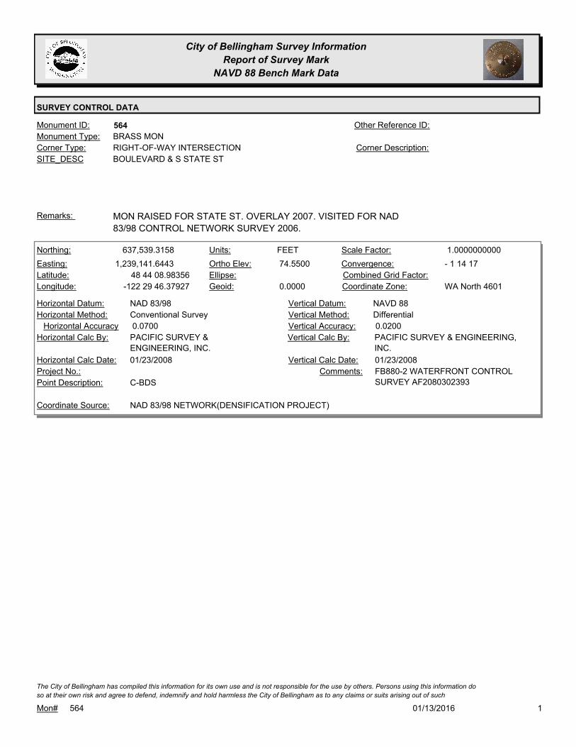
City of Bellingham Survey Information
Report of Survey Mark
NAVD 88 Bench Mark Data
SURVEY CONTROL DATA
564Monument ID: Other Reference ID:
SITE_DESC BOULEVARD & S STATE ST
RIGHT-OF-WAY INTERSECTIONCorner Type: Corner Description:
BRASS MONMonument Type:
MON RAISED FOR STATE ST. OVERLAY 2007. VISITED FOR NAD
83/98 CONTROL NETWORK SURVEY 2006.
Remarks:
637,539.3158
1,239,141.6443
48 44 08.98356
-122 29 46.37927
74.5500
0.0000
FEETNorthing:
Easting:
Latitude:
Longitude:
Units:
Ortho Elev:
Ellipse:
Geoid:
1.0000000000Scale Factor:
- 1 14 17Convergence:
Combined Grid Factor:
WA North 4601Coordinate Zone:
Conventional SurveyHorizontal Method:
NAD 83/98Horizontal Datum: NAVD 88Vertical Datum:
DifferentialVertical Method:
0.0700Horizontal Accuracy 0.0200Vertical Accuracy:
PACIFIC SURVEY & ENGINEERING,
INC.
Vertical Calc By:PACIFIC SURVEY &
ENGINEERING, INC.
Horizontal Calc By:
Project No.:
C-BDSPoint Description:
NAD 83/98 NETWORK(DENSIFICATION PROJECT)Coordinate Source:
FB880-2 WATERFRONT CONTROL
SURVEY AF2080302393
Comments:
01/23/2008Horizontal Calc Date: 01/23/2008Vertical Calc Date:
101/13/2016Mon# 564
The City of Bellingham has compiled this information for its own use and is not responsible for the use by others. Persons using this information do
so at their own risk and agree to defend, indemnify and hold harmless the City of Bellingham as to any claims or suits arising out of such
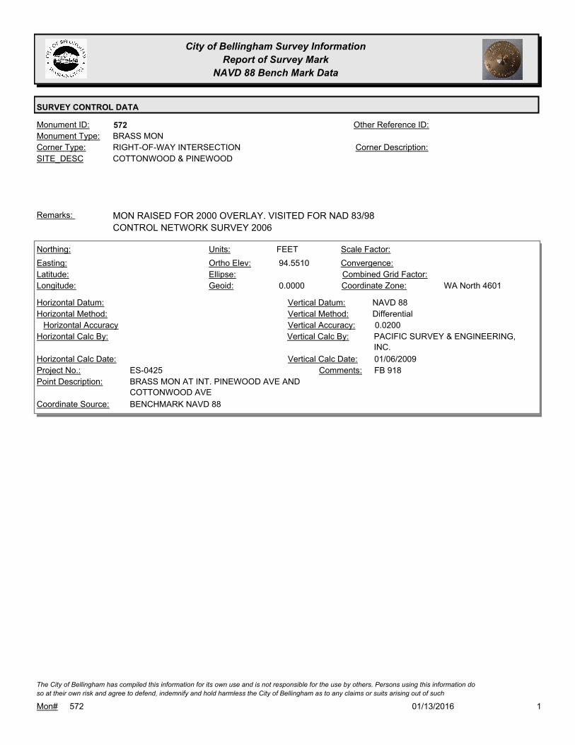
City of Bellingham Survey Information
Report of Survey Mark
NAVD 88 Bench Mark Data
SURVEY CONTROL DATA
572Monument ID: Other Reference ID:
SITE_DESC COTTONWOOD & PINEWOOD
RIGHT-OF-WAY INTERSECTIONCorner Type: Corner Description:
BRASS MONMonument Type:
MON RAISED FOR 2000 OVERLAY. VISITED FOR NAD 83/98
CONTROL NETWORK SURVEY 2006
Remarks:
94.5510
0.0000
FEETNorthing:
Easting:
Latitude:
Longitude:
Units:
Ortho Elev:
Ellipse:
Geoid:
Scale Factor:
Convergence:
Combined Grid Factor:
WA North 4601Coordinate Zone:
Horizontal Method:
Horizontal Datum: NAVD 88Vertical Datum:
DifferentialVertical Method:
Horizontal Accuracy 0.0200Vertical Accuracy:
PACIFIC SURVEY & ENGINEERING,
INC.
Vertical Calc By:Horizontal Calc By:
ES-0425Project No.:
BRASS MON AT INT. PINEWOOD AVE AND
COTTONWOOD AVE
Point Description:
BENCHMARK NAVD 88Coordinate Source:
FB 918Comments:
Horizontal Calc Date: 01/06/2009Vertical Calc Date:
101/13/2016Mon# 572
The City of Bellingham has compiled this information for its own use and is not responsible for the use by others. Persons using this information do
so at their own risk and agree to defend, indemnify and hold harmless the City of Bellingham as to any claims or suits arising out of such

City of Bellingham Survey Information
Report of Survey Mark
NAVD 88 Bench Mark Data
SURVEY CONTROL DATA
575Monument ID: Other Reference ID:
SITE_DESC CAROLINA & ELLIS
RIGHT-OF-WAY INTERSECTIONCorner Type: Corner Description:
CASED MONMonument Type:
Remarks:
646,375.4036
1,245,132.7259 95.1800
FEETNorthing:
Easting:
Latitude:
Longitude:
Units:
Ortho Elev:
Ellipse:
Geoid:
Scale Factor:
Convergence:
Combined Grid Factor:
WA North 4601Coordinate Zone:
Conventional SurveyHorizontal Method:
NAD 83/98Horizontal Datum: NAVD 88Vertical Datum:
DifferentialVertical Method:
0.0200Horizontal Accuracy 0.0100Vertical Accuracy:
CHRISTIE & CHRISTIE LAND
SURVEYING INC.
Vertical Calc By:CHRISTIE & CHRISTIE LAND
SURVEYING INC.
Horizontal Calc By:
EU-0154Project No.:
C-BDSPoint Description:
NAD 83/98 PROJECT POINTSCoordinate Source:
FB 957-1,2Comments:
02/27/2012Horizontal Calc Date: 02/27/2012Vertical Calc Date:
646,375.4432
1,245,132.8161 95.1700
FEETNorthing:
Easting:
Latitude:
Longitude:
Units:
Ortho Elev:
Ellipse:
Geoid:
Scale Factor:
Convergence:
Combined Grid Factor:
WA North 4601Coordinate Zone:
Conventional SurveyHorizontal Method:
NAD 83/98Horizontal Datum: NAVD 88Vertical Datum:
DifferentialVertical Method:
0.0200Horizontal Accuracy 0.0100Vertical Accuracy:
CHRISTIE & CHRISTIE LAND
SURVEYING INC.
Vertical Calc By:CHRISTIE & CHRISTIE LAND
SURVEYING INC.
Horizontal Calc By:
EU-0154Project No.:
Point Description:
NAD 83/98 PROJECT POINTSCoordinate Source:
FB 957-1Comments:
09/14/2011Horizontal Calc Date: 09/14/2011Vertical Calc Date:
101/13/2016Mon# 575
The City of Bellingham has compiled this information for its own use and is not responsible for the use by others. Persons using this information do
so at their own risk and agree to defend, indemnify and hold harmless the City of Bellingham as to any claims or suits arising out of such

City of Bellingham Survey Information
Report of Survey Mark
NAVD 88 Bench Mark Data
SURVEY CONTROL DATA
576Monument ID: Other Reference ID:
SITE_DESC CAROLINA & FRANKLIN
RIGHT-OF-WAY INTERSECTIONCorner Type: Corner Description:
BRASS MONMonument Type:
Remarks:
646,367.8421
1,245,482.6493 92.3400
FEETNorthing:
Easting:
Latitude:
Longitude:
Units:
Ortho Elev:
Ellipse:
Geoid:
Scale Factor:
Convergence:
Combined Grid Factor:
WA North 4601Coordinate Zone:
Conventional SurveyHorizontal Method:
NAD 83/98Horizontal Datum: NAVD 88Vertical Datum:
DifferentialVertical Method:
0.0200Horizontal Accuracy 0.0100Vertical Accuracy:
CHRISTIE & CHRISTIE LAND
SURVEYING INC.
Vertical Calc By:CHRISTIE & CHRISTIE LAND
SURVEYING INC.
Horizontal Calc By:
EU-0154Project No.:
C-BDSPoint Description:
NAD 83/98 PROJECT POINTSCoordinate Source:
FB 957-1,2Comments:
02/27/2012Horizontal Calc Date: 02/27/2012Vertical Calc Date:
101/13/2016Mon# 576
The City of Bellingham has compiled this information for its own use and is not responsible for the use by others. Persons using this information do
so at their own risk and agree to defend, indemnify and hold harmless the City of Bellingham as to any claims or suits arising out of such

City of Bellingham Survey Information
Report of Survey Mark
NAVD 88 Bench Mark Data
SURVEY CONTROL DATA
577Monument ID: Other Reference ID:
SITE_DESC CAROLINA & GRANT
RIGHT-OF-WAY INTERSECTIONCorner Type: Corner Description:
BRASS MONMonument Type:
Remarks:
646,360.2757
1,245,832.7179 87.9000
FEETNorthing:
Easting:
Latitude:
Longitude:
Units:
Ortho Elev:
Ellipse:
Geoid:
Scale Factor:
Convergence:
Combined Grid Factor:
WA North 4601Coordinate Zone:
Conventional SurveyHorizontal Method:
NAD 83/98Horizontal Datum: NAVD 88Vertical Datum:
DifferentialVertical Method:
0.0200Horizontal Accuracy 0.0100Vertical Accuracy:
CHRISTIE & CHRISTIE LAND
SURVEYING INC.
Vertical Calc By:CHRISTIE & CHRISTIE LAND
SURVEYING INC.
Horizontal Calc By:
EU-0154Project No.:
C-BDSPoint Description:
NAD 83/98 PROJECT POINTSCoordinate Source:
FB 957-1,2Comments:
02/27/2012Horizontal Calc Date: 02/27/2012Vertical Calc Date:
101/13/2016Mon# 577
The City of Bellingham has compiled this information for its own use and is not responsible for the use by others. Persons using this information do
so at their own risk and agree to defend, indemnify and hold harmless the City of Bellingham as to any claims or suits arising out of such

City of Bellingham Survey Information
Report of Survey Mark
NAVD 88 Bench Mark Data
SURVEY CONTROL DATA
581Monument ID: Other Reference ID:
SITE_DESC CAROLINA & IRON
RIGHT-OF-WAY INTERSECTIONCorner Type: Corner Description:
BRASS MONMonument Type:
Remarks:
646,345.1862
1,246,532.5809 85.5400
FEETNorthing:
Easting:
Latitude:
Longitude:
Units:
Ortho Elev:
Ellipse:
Geoid:
Scale Factor:
Convergence:
Combined Grid Factor:
WA North 4601Coordinate Zone:
Conventional SurveyHorizontal Method:
NAD 83/98Horizontal Datum: NAVD 88Vertical Datum:
DifferentialVertical Method:
0.0540Horizontal Accuracy 0.0200Vertical Accuracy:
CONSTRUCTION SURVEYORS N W
INC.
Vertical Calc By:CONSTRUCTION SURVEYORS N
W INC.
Horizontal Calc By:
EW-0186Project No.:
C-BDSPoint Description:
NAD 83/98 PROJECT POINTSCoordinate Source:
FB 952-1,2Comments:
09/26/2011Horizontal Calc Date: 09/26/2011Vertical Calc Date:
101/13/2016Mon# 581
The City of Bellingham has compiled this information for its own use and is not responsible for the use by others. Persons using this information do
so at their own risk and agree to defend, indemnify and hold harmless the City of Bellingham as to any claims or suits arising out of such

City of Bellingham Survey Information
Report of Survey Mark
NAVD 88 Bench Mark Data
SURVEY CONTROL DATA
588Monument ID: Other Reference ID:
SITE_DESC CORNWALL AV & E PINE ST
RIGHT-OF-WAY INTERSECTIONCorner Type: Corner Description:
BRASS MONMonument Type:
VISITED FOR NAD 83/98 CONTROL NETWORK SURVEY 2006Remarks:
639,988.1596
1,240,757.7416
48 44 33.48509
-122 29 23.06336
13.3470
0.0000
FEETNorthing:
Easting:
Latitude:
Longitude:
Units:
Ortho Elev:
Ellipse:
Geoid:
1.0000000000Scale Factor:
- 1 14 00Convergence:
Combined Grid Factor:
WA North 4601Coordinate Zone:
Conventional SurveyHorizontal Method:
NAD 83/98Horizontal Datum: NAVD 88Vertical Datum:
DifferentialVertical Method:
0.0700Horizontal Accuracy 0.0200Vertical Accuracy:
PACIFIC SURVEY & ENGINEERING,
INC.
Vertical Calc By:PACIFIC SURVEY &
ENGINEERING, INC.
Horizontal Calc By:
Project No.:
C-BDSPoint Description:
NAD 83/98 NETWORK(DENSIFICATION PROJECT)Coordinate Source:
FB880-2 WATERFRONT CONTROL
SURVEY AF2080302393
Comments:
01/23/2008Horizontal Calc Date: 01/23/2008Vertical Calc Date:
101/13/2016Mon# 588
The City of Bellingham has compiled this information for its own use and is not responsible for the use by others. Persons using this information do
so at their own risk and agree to defend, indemnify and hold harmless the City of Bellingham as to any claims or suits arising out of such

City of Bellingham Survey Information
Report of Survey Mark
NAVD 88 Bench Mark Data
SURVEY CONTROL DATA
592Monument ID: Other Reference ID:
SITE_DESC CORNWALL AV & E LAUREL ST
RIGHT-OF-WAY INTERSECTIONCorner Type: Corner Description:
BRASS MONMonument Type:
USED FOR WATERFRONT SURVEY CONTROL NETWORKRemarks:
641,439.9108
1,242,247.1066
48 44 48.12221
-122 29 01.31274
20.9240
0.0000
FEETNorthing:
Easting:
Latitude:
Longitude:
Units:
Ortho Elev:
Ellipse:
Geoid:
1.0000000000Scale Factor:
- 1 13 44Convergence:
Combined Grid Factor:
WA North 4601Coordinate Zone:
Conventional SurveyHorizontal Method:
NAD 83/98Horizontal Datum: NAVD 88Vertical Datum:
DifferentialVertical Method:
0.0700Horizontal Accuracy 0.0200Vertical Accuracy:
PACIFIC SURVEY & ENGINEERING,
INC.
Vertical Calc By:PACIFIC SURVEY &
ENGINEERING, INC.
Horizontal Calc By:
Project No.:
C-BDSPoint Description:
NAD 83/98 NETWORK(DENSIFICATION PROJECT)Coordinate Source:
FB880-2 WATERFRONT CONTROL
SURVEY AF2080302393
Comments:
01/23/2008Horizontal Calc Date: 01/23/2008Vertical Calc Date:
101/13/2016Mon# 592
The City of Bellingham has compiled this information for its own use and is not responsible for the use by others. Persons using this information do
so at their own risk and agree to defend, indemnify and hold harmless the City of Bellingham as to any claims or suits arising out of such

City of Bellingham Survey Information
Report of Survey Mark
NAVD 88 Bench Mark Data
SURVEY CONTROL DATA
593Monument ID: Other Reference ID:
SITE_DESC CORNWALL AVE & E MAPLE ST
RIGHT-OF-WAY INTERSECTIONCorner Type: Corner Description:
BRASS MONMonument Type:
RAISED 8-20-99, VISITED FOR NAD 83/98 CONTROL NETWORK
SURVEY 2006
Remarks:
641,803.6200
1,242,619.5400 39.3000
FEETNorthing:
Easting:
Latitude:
Longitude:
Units:
Ortho Elev:
Ellipse:
Geoid:
Scale Factor:
Convergence:
Combined Grid Factor:
WA North 4601Coordinate Zone:
Conventional SurveyHorizontal Method:
NAD 83/98Horizontal Datum: NAVD 88Vertical Datum:
DifferentialVertical Method:
0.0500Horizontal Accuracy 0.0200Vertical Accuracy:
WILSON ENGINEERING LLC.Vertical Calc By:WILSON ENGINEERING LLC.Horizontal Calc By:
ES-0445Project No.:
Point Description:
NAD 83/98 PROJECT POINTSCoordinate Source:
FB 954-1Comments:
09/07/2011Horizontal Calc Date: 09/07/2011Vertical Calc Date:
641,803.6004
1,242,619.5688
48 44 51.78876
-122 28 55.87298
39.2960
0.0000
FEETNorthing:
Easting:
Latitude:
Longitude:
Units:
Ortho Elev:
Ellipse:
Geoid:
1.0000000000Scale Factor:
- 1 13 40Convergence:
Combined Grid Factor:
WA North 4601Coordinate Zone:
Conventional SurveyHorizontal Method:
NAD 83/98Horizontal Datum: NAVD 88Vertical Datum:
DifferentialVertical Method:
0.0700Horizontal Accuracy 0.0200Vertical Accuracy:
PACIFIC SURVEY & ENGINEERING,
INC.
Vertical Calc By:PACIFIC SURVEY &
ENGINEERING, INC.
Horizontal Calc By:
Project No.:
C-BDSPoint Description:
NAD 83/98 NETWORK(DENSIFICATION PROJECT)Coordinate Source:
FB880-2 WATERFRONT CONTROL
SURVEY AF2080302393
Comments:
01/23/2008Horizontal Calc Date: 01/23/2008Vertical Calc Date:
101/13/2016Mon# 593
The City of Bellingham has compiled this information for its own use and is not responsible for the use by others. Persons using this information do
so at their own risk and agree to defend, indemnify and hold harmless the City of Bellingham as to any claims or suits arising out of such

City of Bellingham Survey Information
Report of Survey Mark
NAVD 88 Bench Mark Data
SURVEY CONTROL DATA
597Monument ID: Other Reference ID:
SITE_DESC CORNWALL & CHAMPION
RIGHT-OF-WAY INTERSECTIONCorner Type: Corner Description:
BRASS MONMonument Type:
RAISED 2008Remarks:
70.1620
0.0000
FEETNorthing:
Easting:
Latitude:
Longitude:
Units:
Ortho Elev:
Ellipse:
Geoid:
Scale Factor:
Convergence:
Combined Grid Factor:
WA North 4601Coordinate Zone:
Horizontal Method:
Horizontal Datum: NAVD 88Vertical Datum:
DifferentialVertical Method:
Horizontal Accuracy 0.0300Vertical Accuracy:
WILSON ENGINEERING LLC.Vertical Calc By:Horizontal Calc By:
ES-0425Project No.:
C-BDS INT CHAMPION & CORNWALLPoint Description:
BENCHMARK NAVD 88Coordinate Source:
FB918-6 pg. 25Comments:
Horizontal Calc Date: 02/04/2009Vertical Calc Date:
101/13/2016Mon# 597
The City of Bellingham has compiled this information for its own use and is not responsible for the use by others. Persons using this information do
so at their own risk and agree to defend, indemnify and hold harmless the City of Bellingham as to any claims or suits arising out of such

City of Bellingham Survey Information
Report of Survey Mark
NAVD 88 Bench Mark Data
SURVEY CONTROL DATA
601Monument ID: Other Reference ID:
SITE_DESC CORNWALL & VIRGINIA
RIGHT-OF-WAY INTERSECTIONCorner Type: Corner Description:
BRASS MONMonument Type:
RAISED 2008Remarks:
81.4950
0.0000
FEETNorthing:
Easting:
Latitude:
Longitude:
Units:
Ortho Elev:
Ellipse:
Geoid:
Scale Factor:
Convergence:
Combined Grid Factor:
WA North 4601Coordinate Zone:
Horizontal Method:
Horizontal Datum: NAVD 88Vertical Datum:
DifferentialVertical Method:
Horizontal Accuracy 0.0300Vertical Accuracy:
WILSON ENGINEERING LLC.Vertical Calc By:Horizontal Calc By:
ES-0425Project No.:
C-BDS INT CORNWALL & VIRGINIAPoint Description:
BENCHMARK NAVD 88Coordinate Source:
FB918-6 pg. 29Comments:
Horizontal Calc Date: 02/04/2009Vertical Calc Date:
101/13/2016Mon# 601
The City of Bellingham has compiled this information for its own use and is not responsible for the use by others. Persons using this information do
so at their own risk and agree to defend, indemnify and hold harmless the City of Bellingham as to any claims or suits arising out of such

City of Bellingham Survey Information
Report of Survey Mark
NAVD 88 Bench Mark Data
SURVEY CONTROL DATA
603Monument ID: Other Reference ID:
SITE_DESC CORNWALL & D
RIGHT-OF-WAY INTERSECTIONCorner Type: Corner Description:
BRASS MONMonument Type:
RAISED 2008Remarks:
111.2910
0.0000
FEETNorthing:
Easting:
Latitude:
Longitude:
Units:
Ortho Elev:
Ellipse:
Geoid:
Scale Factor:
Convergence:
Combined Grid Factor:
WA North 4601Coordinate Zone:
Horizontal Method:
Horizontal Datum: NAVD 88Vertical Datum:
DifferentialVertical Method:
Horizontal Accuracy 0.0300Vertical Accuracy:
WILSON ENGINEERING LLC.Vertical Calc By:Horizontal Calc By:
ES-0425Project No.:
C-BDS INT D & CORNWALLPoint Description:
BENCHMARK NAVD 88Coordinate Source:
FB918-6 pg. 40Comments:
Horizontal Calc Date: 02/12/2009Vertical Calc Date:
101/13/2016Mon# 603
The City of Bellingham has compiled this information for its own use and is not responsible for the use by others. Persons using this information do
so at their own risk and agree to defend, indemnify and hold harmless the City of Bellingham as to any claims or suits arising out of such
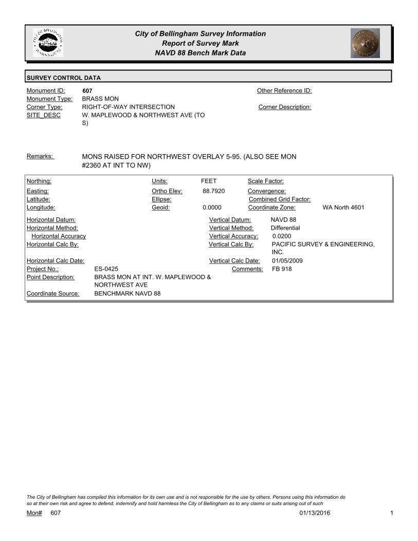
City of Bellingham Survey Information
Report of Survey Mark
NAVD 88 Bench Mark Data
SURVEY CONTROL DATA
607Monument ID: Other Reference ID:
SITE_DESC W. MAPLEWOOD & NORTHWEST AVE (TO
S)
RIGHT-OF-WAY INTERSECTIONCorner Type: Corner Description:
BRASS MONMonument Type:
MONS RAISED FOR NORTHWEST OVERLAY 5-95. (ALSO SEE MON
#2360 AT INT TO NW)
Remarks:
88.7920
0.0000
FEETNorthing:
Easting:
Latitude:
Longitude:
Units:
Ortho Elev:
Ellipse:
Geoid:
Scale Factor:
Convergence:
Combined Grid Factor:
WA North 4601Coordinate Zone:
Horizontal Method:
Horizontal Datum: NAVD 88Vertical Datum:
DifferentialVertical Method:
Horizontal Accuracy 0.0200Vertical Accuracy:
PACIFIC SURVEY & ENGINEERING,
INC.
Vertical Calc By:Horizontal Calc By:
ES-0425Project No.:
BRASS MON AT INT. W. MAPLEWOOD &
NORTHWEST AVE
Point Description:
BENCHMARK NAVD 88Coordinate Source:
FB 918Comments:
Horizontal Calc Date: 01/05/2009Vertical Calc Date:
101/13/2016Mon# 607
The City of Bellingham has compiled this information for its own use and is not responsible for the use by others. Persons using this information do
so at their own risk and agree to defend, indemnify and hold harmless the City of Bellingham as to any claims or suits arising out of such

City of Bellingham Survey Information
Report of Survey Mark
NAVD 88 Bench Mark Data
SURVEY CONTROL DATA
615Monument ID: Other Reference ID:
SITE_DESC CORNWALL & NORTH
RIGHT-OF-WAY INTERSECTIONCorner Type: Corner Description:
BRASS MONMonument Type:
VISITED FOR NAD 83/98 CONTROL NETWORK SURVEY 2006.
RAISED 2008
Remarks:
125.9770
0.0000
FEETNorthing:
Easting:
Latitude:
Longitude:
Units:
Ortho Elev:
Ellipse:
Geoid:
Scale Factor:
Convergence:
Combined Grid Factor:
WA North 4601Coordinate Zone:
Horizontal Method:
Horizontal Datum: NAVD 88Vertical Datum:
DifferentialVertical Method:
Horizontal Accuracy 0.0200Vertical Accuracy:
PACIFIC SURVEY & ENGINEERING,
INC.
Vertical Calc By:Horizontal Calc By:
ES-0425Project No.:
BRASS MON AT INT. E. NORTH ST & CORNWALL
AVE
Point Description:
BENCHMARK NAVD 88Coordinate Source:
FB 918Comments:
Horizontal Calc Date: 12/08/2008Vertical Calc Date:
101/13/2016Mon# 615
The City of Bellingham has compiled this information for its own use and is not responsible for the use by others. Persons using this information do
so at their own risk and agree to defend, indemnify and hold harmless the City of Bellingham as to any claims or suits arising out of such

City of Bellingham Survey Information
Report of Survey Mark
NAVD 88 Bench Mark Data
SURVEY CONTROL DATA
627Monument ID: Other Reference ID:
SITE_DESC CHAMPION & GRAND
RIGHT-OF-WAY INTERSECTIONCorner Type: Corner Description:
BRASS MONMonument Type:
MON ESTABLISHED BY INTERSECTION 1981, RAISED 2008Remarks:
70.1450
0.0000
FEETNorthing:
Easting:
Latitude:
Longitude:
Units:
Ortho Elev:
Ellipse:
Geoid:
Scale Factor:
Convergence:
Combined Grid Factor:
WA North 4601Coordinate Zone:
Horizontal Method:
Horizontal Datum: NAVD 88Vertical Datum:
DifferentialVertical Method:
Horizontal Accuracy 0.0300Vertical Accuracy:
WILSON ENGINEERING LLC.Vertical Calc By:Horizontal Calc By:
ES-0425Project No.:
C-BDS INT CHAMPION & GRANDPoint Description:
BENCHMARK NAVD 88Coordinate Source:
FB918-6 pg. 6Comments:
Horizontal Calc Date: 01/26/2009Vertical Calc Date:
101/13/2016Mon# 627
The City of Bellingham has compiled this information for its own use and is not responsible for the use by others. Persons using this information do
so at their own risk and agree to defend, indemnify and hold harmless the City of Bellingham as to any claims or suits arising out of such

City of Bellingham Survey Information
Report of Survey Mark
NAVD 88 Bench Mark Data
SURVEY CONTROL DATA
639Monument ID: Other Reference ID:
SITE_DESC CHAMPION & RAILROAD
RIGHT-OF-WAY INTERSECTIONCorner Type: Corner Description:
BRASS MONMonument Type:
Remarks:
68.8330
0.0000
FEETNorthing:
Easting:
Latitude:
Longitude:
Units:
Ortho Elev:
Ellipse:
Geoid:
Scale Factor:
Convergence:
Combined Grid Factor:
WA North 4601Coordinate Zone:
Horizontal Method:
Horizontal Datum: NAVD 88Vertical Datum:
DifferentialVertical Method:
Horizontal Accuracy 0.0300Vertical Accuracy:
WILSON ENGINEERING LLC.Vertical Calc By:Horizontal Calc By:
ES-0425Project No.:
C-BDS INT RAILROAD & CHAMPIONPoint Description:
BENCHMARK NAVD 88Coordinate Source:
FB918-6 pg. 24Comments:
Horizontal Calc Date: 02/04/2009Vertical Calc Date:
101/13/2016Mon# 639
The City of Bellingham has compiled this information for its own use and is not responsible for the use by others. Persons using this information do
so at their own risk and agree to defend, indemnify and hold harmless the City of Bellingham as to any claims or suits arising out of such
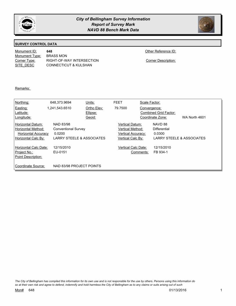
City of Bellingham Survey Information
Report of Survey Mark
NAVD 88 Bench Mark Data
SURVEY CONTROL DATA
648Monument ID: Other Reference ID:
SITE_DESC CONNECTICUT & KULSHAN
RIGHT-OF-WAY INTERSECTIONCorner Type: Corner Description:
BRASS MONMonument Type:
Remarks:
648,373.9694
1,241,543.6510 79.7500
FEETNorthing:
Easting:
Latitude:
Longitude:
Units:
Ortho Elev:
Ellipse:
Geoid:
Scale Factor:
Convergence:
Combined Grid Factor:
WA North 4601Coordinate Zone:
Conventional SurveyHorizontal Method:
NAD 83/98Horizontal Datum: NAVD 88Vertical Datum:
DifferentialVertical Method:
0.0200Horizontal Accuracy 0.0300Vertical Accuracy:
LARRY STEELE & ASSOCIATESVertical Calc By:LARRY STEELE & ASSOCIATESHorizontal Calc By:
EU-0151Project No.:
Point Description:
NAD 83/98 PROJECT POINTSCoordinate Source:
FB 934-1Comments:
12/15/2010Horizontal Calc Date: 12/15/2010Vertical Calc Date:
101/13/2016Mon# 648
The City of Bellingham has compiled this information for its own use and is not responsible for the use by others. Persons using this information do
so at their own risk and agree to defend, indemnify and hold harmless the City of Bellingham as to any claims or suits arising out of such

City of Bellingham Survey Information
Report of Survey Mark
NAVD 88 Bench Mark Data
SURVEY CONTROL DATA
649Monument ID: Other Reference ID:
SITE_DESC CONNECTICUT & ELM
RIGHT-OF-WAY INTERSECTIONCorner Type: Corner Description:
BRASS MONMonument Type:
Remarks:
648,380.8864
1,241,267.8835 81.5200
FEETNorthing:
Easting:
Latitude:
Longitude:
Units:
Ortho Elev:
Ellipse:
Geoid:
Scale Factor:
Convergence:
Combined Grid Factor:
WA North 4601Coordinate Zone:
Conventional SurveyHorizontal Method:
NAD 83/98Horizontal Datum: NAVD 88Vertical Datum:
DifferentialVertical Method:
0.0200Horizontal Accuracy 0.0300Vertical Accuracy:
LARRY STEELE & ASSOCIATESVertical Calc By:LARRY STEELE & ASSOCIATESHorizontal Calc By:
EU-0151Project No.:
Point Description:
NAD 83/98 PROJECT POINTSCoordinate Source:
FB 934-1 PROJECT POINT 6005Comments:
12/15/2010Horizontal Calc Date: 12/15/2010Vertical Calc Date:
101/13/2016Mon# 649
The City of Bellingham has compiled this information for its own use and is not responsible for the use by others. Persons using this information do
so at their own risk and agree to defend, indemnify and hold harmless the City of Bellingham as to any claims or suits arising out of such
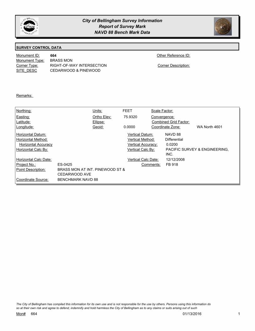
City of Bellingham Survey Information
Report of Survey Mark
NAVD 88 Bench Mark Data
SURVEY CONTROL DATA
664Monument ID: Other Reference ID:
SITE_DESC CEDARWOOD & PINEWOOD
RIGHT-OF-WAY INTERSECTIONCorner Type: Corner Description:
BRASS MONMonument Type:
Remarks:
75.9320
0.0000
FEETNorthing:
Easting:
Latitude:
Longitude:
Units:
Ortho Elev:
Ellipse:
Geoid:
Scale Factor:
Convergence:
Combined Grid Factor:
WA North 4601Coordinate Zone:
Horizontal Method:
Horizontal Datum: NAVD 88Vertical Datum:
DifferentialVertical Method:
Horizontal Accuracy 0.0200Vertical Accuracy:
PACIFIC SURVEY & ENGINEERING,
INC.
Vertical Calc By:Horizontal Calc By:
ES-0425Project No.:
BRASS MON AT INT. PINEWOOD ST &
CEDARWOOD AVE
Point Description:
BENCHMARK NAVD 88Coordinate Source:
FB 918Comments:
Horizontal Calc Date: 12/12/2008Vertical Calc Date:
101/13/2016Mon# 664
The City of Bellingham has compiled this information for its own use and is not responsible for the use by others. Persons using this information do
so at their own risk and agree to defend, indemnify and hold harmless the City of Bellingham as to any claims or suits arising out of such

City of Bellingham Survey Information
Report of Survey Mark
NAVD 88 Bench Mark Data
SURVEY CONTROL DATA
673Monument ID: Other Reference ID:
SITE_DESC CORNWALL & MON SOUTH OF NORTH
SECTION SIXTEENTH CORNERCorner Type: Corner Description:
BRASS MONMonument Type:
RAISED 2008Remarks:
125.9650
0.0000
FEETNorthing:
Easting:
Latitude:
Longitude:
Units:
Ortho Elev:
Ellipse:
Geoid:
Scale Factor:
Convergence:
Combined Grid Factor:
WA North 4601Coordinate Zone:
Horizontal Method:
Horizontal Datum: NAVD 88Vertical Datum:
DifferentialVertical Method:
Horizontal Accuracy 0.0200Vertical Accuracy:
PACIFIC SURVEY & ENGINEERING,
INC.
Vertical Calc By:Horizontal Calc By:
ES-0425Project No.:
BRASS MON (DONATION LAND CLAIM) AT INT. E.
NORTH ST & CORNWALL AVE
Point Description:
BENCHMARK NAVD 88Coordinate Source:
FB 918Comments:
Horizontal Calc Date: 12/08/2008Vertical Calc Date:
101/13/2016Mon# 673
The City of Bellingham has compiled this information for its own use and is not responsible for the use by others. Persons using this information do
so at their own risk and agree to defend, indemnify and hold harmless the City of Bellingham as to any claims or suits arising out of such

City of Bellingham Survey Information
Report of Survey Mark
NAVD 88 Bench Mark Data
SURVEY CONTROL DATA
674Monument ID: Other Reference ID:
SITE_DESC COMMERCIAL & FLORA
RIGHT-OF-WAY INTERSECTIONCorner Type: Corner Description:
BRASS MONMonument Type:
Remarks:
71.8650
0.0000
FEETNorthing:
Easting:
Latitude:
Longitude:
Units:
Ortho Elev:
Ellipse:
Geoid:
Scale Factor:
Convergence:
Combined Grid Factor:
WA North 4601Coordinate Zone:
Horizontal Method:
Horizontal Datum: NAVD 88Vertical Datum:
DifferentialVertical Method:
Horizontal Accuracy 0.0300Vertical Accuracy:
WILSON ENGINEERING LLC.Vertical Calc By:Horizontal Calc By:
ES-0425Project No.:
C-BDS INT COMMERCIAL & FLORAPoint Description:
BENCHMARK NAVD 88Coordinate Source:
FB918-6 pg. 25Comments:
Horizontal Calc Date: 02/04/2009Vertical Calc Date:
101/13/2016Mon# 674
The City of Bellingham has compiled this information for its own use and is not responsible for the use by others. Persons using this information do
so at their own risk and agree to defend, indemnify and hold harmless the City of Bellingham as to any claims or suits arising out of such

City of Bellingham Survey Information
Report of Survey Mark
NAVD 88 Bench Mark Data
SURVEY CONTROL DATA
688Monument ID: Other Reference ID:
SITE_DESC HILLCREST WY & ELLWOOD AV
RIGHT-OF-WAY INTERSECTIONCorner Type: Corner Description:
BRASS MONMonument Type:
RAISED 1-94Remarks:
635,796.4510
1,239,975.3040 447.4400
FEETNorthing:
Easting:
Latitude:
Longitude:
Units:
Ortho Elev:
Ellipse:
Geoid:
Scale Factor:
Convergence:
Combined Grid Factor:
WA North 4601Coordinate Zone:
Conventional SurveyHorizontal Method:
NAD 83/98Horizontal Datum: NAVD 88Vertical Datum:
DifferentialVertical Method:
0.0200Horizontal Accuracy 0.0300Vertical Accuracy:
LARRY STEELE & ASSOCIATESVertical Calc By:LARRY STEELE & ASSOCIATESHorizontal Calc By:
EU-0156Project No.:
BPFPoint Description:
NAD 83/98 PROJECT POINTSCoordinate Source:
FB 940-1 PROJECT POINT #527Comments:
08/09/2011Horizontal Calc Date: 08/09/2011Vertical Calc Date:
101/13/2016Mon# 688
The City of Bellingham has compiled this information for its own use and is not responsible for the use by others. Persons using this information do
so at their own risk and agree to defend, indemnify and hold harmless the City of Bellingham as to any claims or suits arising out of such

City of Bellingham Survey Information
Report of Survey Mark
NAVD 88 Bench Mark Data
SURVEY CONTROL DATA
690Monument ID: Other Reference ID:
SITE_DESC DEAN & NORTH
RIGHT-OF-WAY INTERSECTIONCorner Type: Corner Description:
BRASS MONMonument Type:
Remarks:
647,812.4043
1,244,813.8495 130.9700
FEETNorthing:
Easting:
Latitude:
Longitude:
Units:
Ortho Elev:
Ellipse:
Geoid:
Scale Factor:
Convergence:
Combined Grid Factor:
WA North 4601Coordinate Zone:
Conventional SurveyHorizontal Method:
NAD 83/98Horizontal Datum: NAVD 88Vertical Datum:
DifferentialVertical Method:
0.0200Horizontal Accuracy 0.0100Vertical Accuracy:
CHRISTIE & CHRISTIE LAND
SURVEYING INC.
Vertical Calc By:CHRISTIE & CHRISTIE LAND
SURVEYING INC.
Horizontal Calc By:
EU-0154Project No.:
C-BDSPoint Description:
NAD 83/98 PROJECT POINTSCoordinate Source:
FB 957-1,2Comments:
02/27/2012Horizontal Calc Date: 02/27/2012Vertical Calc Date:
101/13/2016Mon# 690
The City of Bellingham has compiled this information for its own use and is not responsible for the use by others. Persons using this information do
so at their own risk and agree to defend, indemnify and hold harmless the City of Bellingham as to any claims or suits arising out of such
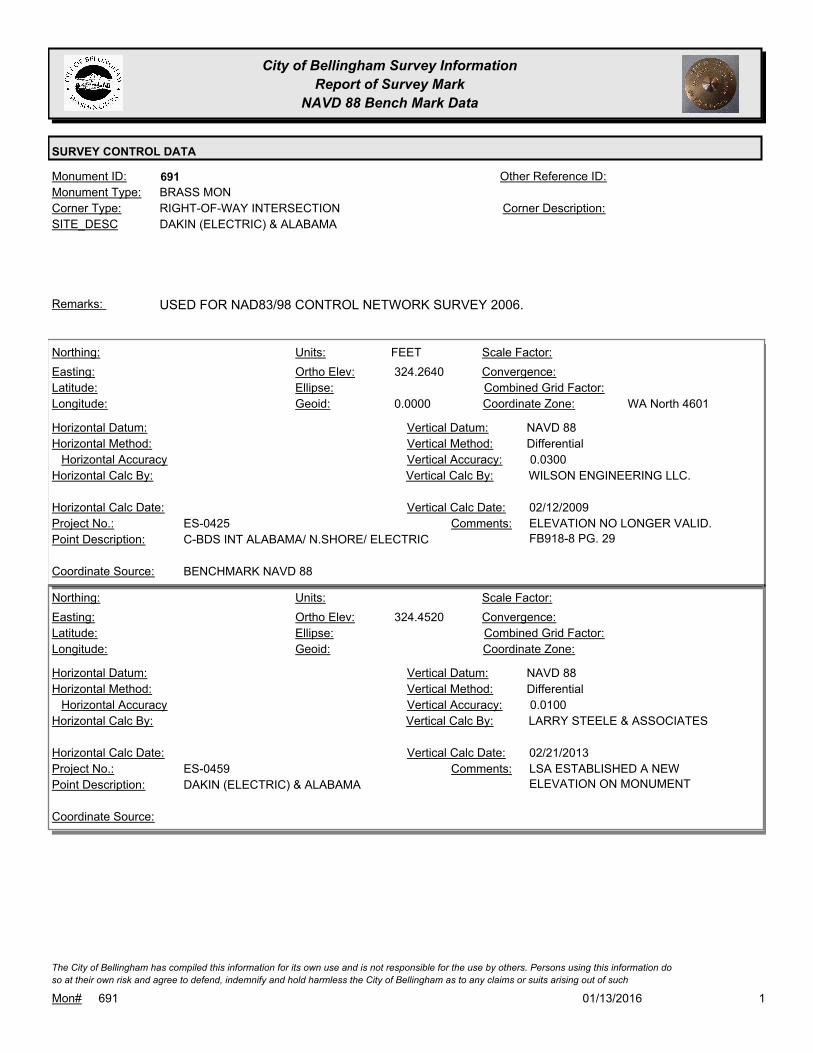
City of Bellingham Survey Information
Report of Survey Mark
NAVD 88 Bench Mark Data
SURVEY CONTROL DATA
691Monument ID: Other Reference ID:
SITE_DESC DAKIN (ELECTRIC) & ALABAMA
RIGHT-OF-WAY INTERSECTIONCorner Type: Corner Description:
BRASS MONMonument Type:
USED FOR NAD83/98 CONTROL NETWORK SURVEY 2006.Remarks:
324.2640
0.0000
FEETNorthing:
Easting:
Latitude:
Longitude:
Units:
Ortho Elev:
Ellipse:
Geoid:
Scale Factor:
Convergence:
Combined Grid Factor:
WA North 4601Coordinate Zone:
Horizontal Method:
Horizontal Datum: NAVD 88Vertical Datum:
DifferentialVertical Method:
Horizontal Accuracy 0.0300Vertical Accuracy:
WILSON ENGINEERING LLC.Vertical Calc By:Horizontal Calc By:
ES-0425Project No.:
C-BDS INT ALABAMA/ N.SHORE/ ELECTRICPoint Description:
BENCHMARK NAVD 88Coordinate Source:
ELEVATION NO LONGER VALID.
FB918-8 PG. 29
Comments:
Horizontal Calc Date: 02/12/2009Vertical Calc Date:
324.4520
Northing:
Easting:
Latitude:
Longitude:
Units:
Ortho Elev:
Ellipse:
Geoid:
Scale Factor:
Convergence:
Combined Grid Factor:
Coordinate Zone:
Horizontal Method:
Horizontal Datum: NAVD 88Vertical Datum:
DifferentialVertical Method:
Horizontal Accuracy 0.0100Vertical Accuracy:
LARRY STEELE & ASSOCIATESVertical Calc By:Horizontal Calc By:
ES-0459Project No.:
DAKIN (ELECTRIC) & ALABAMAPoint Description:
Coordinate Source:
LSA ESTABLISHED A NEW
ELEVATION ON MONUMENT
Comments:
Horizontal Calc Date: 02/21/2013Vertical Calc Date:
101/13/2016Mon# 691
The City of Bellingham has compiled this information for its own use and is not responsible for the use by others. Persons using this information do
so at their own risk and agree to defend, indemnify and hold harmless the City of Bellingham as to any claims or suits arising out of such

City of Bellingham Survey Information
Report of Survey Mark
NAVD 88 Bench Mark Data
SURVEY CONTROL DATA
693Monument ID: Other Reference ID:
SITE_DESC DEAN & TEXAS
RIGHT-OF-WAY INTERSECTIONCorner Type: Corner Description:
BRASS MONMonument Type:
Remarks:
115.7600
FEETNorthing:
Easting:
Latitude:
Longitude:
Units:
Ortho Elev:
Ellipse:
Geoid:
Scale Factor:
Convergence:
Combined Grid Factor:
Coordinate Zone:
Horizontal Method:
Horizontal Datum: NAVD 88Vertical Datum:
DifferentialVertical Method:
Horizontal Accuracy 0.0100Vertical Accuracy:
CHRISTIE & CHRISTIE LAND
SURVEYING INC.
Vertical Calc By:Horizontal Calc By:
EU-0154Project No.:
Point Description:
BENCHMARK NAVD 88Coordinate Source:
FB 957-1Comments:
Horizontal Calc Date: 09/14/2011Vertical Calc Date:
646,862.9663
1,244,793.2393 115.7900
FEETNorthing:
Easting:
Latitude:
Longitude:
Units:
Ortho Elev:
Ellipse:
Geoid:
Scale Factor:
Convergence:
Combined Grid Factor:
WA North 4601Coordinate Zone:
Conventional SurveyHorizontal Method:
NAD 83/98Horizontal Datum: NAVD 88Vertical Datum:
DifferentialVertical Method:
0.0200Horizontal Accuracy 0.0100Vertical Accuracy:
CHRISTIE & CHRISTIE LAND
SURVEYING INC.
Vertical Calc By:CHRISTIE & CHRISTIE LAND
SURVEYING INC.
Horizontal Calc By:
EU-0154Project No.:
C-BDSPoint Description:
NAD 83/98 PROJECT POINTSCoordinate Source:
FB 957-1,2Comments:
02/27/2012Horizontal Calc Date: 02/27/2012Vertical Calc Date:
101/13/2016Mon# 693
The City of Bellingham has compiled this information for its own use and is not responsible for the use by others. Persons using this information do
so at their own risk and agree to defend, indemnify and hold harmless the City of Bellingham as to any claims or suits arising out of such

City of Bellingham Survey Information
Report of Survey Mark
NAVD 88 Bench Mark Data
SURVEY CONTROL DATA
701Monument ID: Other Reference ID:
SITE_DESC ELDRIDGE & UTTER
RIGHT-OF-WAY INTERSECTIONCorner Type: Corner Description:
BRASS MONMonument Type:
Remarks:
65.6110
0.0000
FEETNorthing:
Easting:
Latitude:
Longitude:
Units:
Ortho Elev:
Ellipse:
Geoid:
Scale Factor:
Convergence:
Combined Grid Factor:
WA North 4601Coordinate Zone:
Horizontal Method:
Horizontal Datum: NAVD 88Vertical Datum:
DifferentialVertical Method:
Horizontal Accuracy 0.0200Vertical Accuracy:
PACIFIC SURVEY & ENGINEERING,
INC.
Vertical Calc By:Horizontal Calc By:
ES-0425Project No.:
BRASS MON AT INT. UTTER ST & ELDRIDGE AVEPoint Description:
BENCHMARK NAVD 88Coordinate Source:
FB 918Comments:
Horizontal Calc Date: 12/11/2008Vertical Calc Date:
101/13/2016Mon# 701
The City of Bellingham has compiled this information for its own use and is not responsible for the use by others. Persons using this information do
so at their own risk and agree to defend, indemnify and hold harmless the City of Bellingham as to any claims or suits arising out of such

City of Bellingham Survey Information
Report of Survey Mark
NAVD 88 Bench Mark Data
SURVEY CONTROL DATA
702Monument ID: Other Reference ID:
SITE_DESC ELDRIDGE & WILLIAMS
RIGHT-OF-WAY INTERSECTIONCorner Type: Corner Description:
BRASS MONMonument Type:
VISITED FOR NAD 83/98 CONTROL NETWORK SURVEY 2006.Remarks:
67.0450
0.0000
FEETNorthing:
Easting:
Latitude:
Longitude:
Units:
Ortho Elev:
Ellipse:
Geoid:
Scale Factor:
Convergence:
Combined Grid Factor:
WA North 4601Coordinate Zone:
Horizontal Method:
Horizontal Datum: NAVD 88Vertical Datum:
DifferentialVertical Method:
Horizontal Accuracy 0.0200Vertical Accuracy:
PACIFIC SURVEY & ENGINEERING,
INC.
Vertical Calc By:Horizontal Calc By:
ES-0425Project No.:
BRASS MON AT INT. WILLIAMS ST & ELDRIDGE
AVE
Point Description:
BENCHMARK NAVD 88Coordinate Source:
FB 918Comments:
Horizontal Calc Date: 12/11/2008Vertical Calc Date:
101/13/2016Mon# 702
The City of Bellingham has compiled this information for its own use and is not responsible for the use by others. Persons using this information do
so at their own risk and agree to defend, indemnify and hold harmless the City of Bellingham as to any claims or suits arising out of such
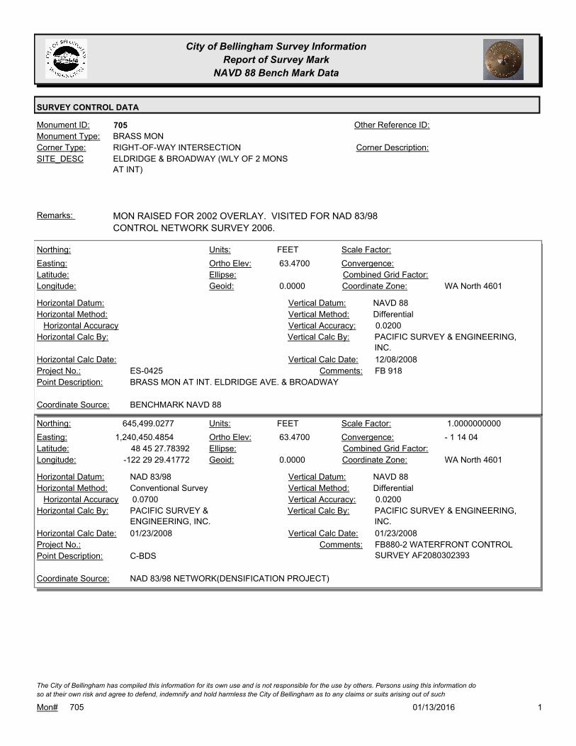
City of Bellingham Survey Information
Report of Survey Mark
NAVD 88 Bench Mark Data
SURVEY CONTROL DATA
705Monument ID: Other Reference ID:
SITE_DESC ELDRIDGE & BROADWAY (WLY OF 2 MONS
AT INT)
RIGHT-OF-WAY INTERSECTIONCorner Type: Corner Description:
BRASS MONMonument Type:
MON RAISED FOR 2002 OVERLAY. VISITED FOR NAD 83/98
CONTROL NETWORK SURVEY 2006.
Remarks:
63.4700
0.0000
FEETNorthing:
Easting:
Latitude:
Longitude:
Units:
Ortho Elev:
Ellipse:
Geoid:
Scale Factor:
Convergence:
Combined Grid Factor:
WA North 4601Coordinate Zone:
Horizontal Method:
Horizontal Datum: NAVD 88Vertical Datum:
DifferentialVertical Method:
Horizontal Accuracy 0.0200Vertical Accuracy:
PACIFIC SURVEY & ENGINEERING,
INC.
Vertical Calc By:Horizontal Calc By:
ES-0425Project No.:
BRASS MON AT INT. ELDRIDGE AVE. & BROADWAYPoint Description:
BENCHMARK NAVD 88Coordinate Source:
FB 918Comments:
Horizontal Calc Date: 12/08/2008Vertical Calc Date:
645,499.0277
1,240,450.4854
48 45 27.78392
-122 29 29.41772
63.4700
0.0000
FEETNorthing:
Easting:
Latitude:
Longitude:
Units:
Ortho Elev:
Ellipse:
Geoid:
1.0000000000Scale Factor:
- 1 14 04Convergence:
Combined Grid Factor:
WA North 4601Coordinate Zone:
Conventional SurveyHorizontal Method:
NAD 83/98Horizontal Datum: NAVD 88Vertical Datum:
DifferentialVertical Method:
0.0700Horizontal Accuracy 0.0200Vertical Accuracy:
PACIFIC SURVEY & ENGINEERING,
INC.
Vertical Calc By:PACIFIC SURVEY &
ENGINEERING, INC.
Horizontal Calc By:
Project No.:
C-BDSPoint Description:
NAD 83/98 NETWORK(DENSIFICATION PROJECT)Coordinate Source:
FB880-2 WATERFRONT CONTROL
SURVEY AF2080302393
Comments:
01/23/2008Horizontal Calc Date: 01/23/2008Vertical Calc Date:
101/13/2016Mon# 705
The City of Bellingham has compiled this information for its own use and is not responsible for the use by others. Persons using this information do
so at their own risk and agree to defend, indemnify and hold harmless the City of Bellingham as to any claims or suits arising out of such

City of Bellingham Survey Information
Report of Survey Mark
NAVD 88 Bench Mark Data
SURVEY CONTROL DATA
707Monument ID: Other Reference ID:
SITE_DESC ELDRIDGE & HENRY
RIGHT-OF-WAY INTERSECTIONCorner Type: Corner Description:
BRASS MONMonument Type:
Remarks:
70.5130
0.0000
FEETNorthing:
Easting:
Latitude:
Longitude:
Units:
Ortho Elev:
Ellipse:
Geoid:
Scale Factor:
Convergence:
Combined Grid Factor:
WA North 4601Coordinate Zone:
Horizontal Method:
Horizontal Datum: NAVD 88Vertical Datum:
DifferentialVertical Method:
Horizontal Accuracy 0.0200Vertical Accuracy:
PACIFIC SURVEY & ENGINEERING,
INC.
Vertical Calc By:Horizontal Calc By:
ES-0425Project No.:
BRASS MON AT INT. HENRY ST & ELDRIDGE AVEPoint Description:
BENCHMARK NAVD 88Coordinate Source:
FB 918Comments:
Horizontal Calc Date: 12/11/2008Vertical Calc Date:
101/13/2016Mon# 707
The City of Bellingham has compiled this information for its own use and is not responsible for the use by others. Persons using this information do
so at their own risk and agree to defend, indemnify and hold harmless the City of Bellingham as to any claims or suits arising out of such

City of Bellingham Survey Information
Report of Survey Mark
NAVD 88 Bench Mark Data
SURVEY CONTROL DATA
709Monument ID: Other Reference ID:
SITE_DESC ELDRIDGE & JAEGER
RIGHT-OF-WAY INTERSECTIONCorner Type: Corner Description:
BRASS MONMonument Type:
Remarks:
69.4830
0.0000
FEETNorthing:
Easting:
Latitude:
Longitude:
Units:
Ortho Elev:
Ellipse:
Geoid:
Scale Factor:
Convergence:
Combined Grid Factor:
WA North 4601Coordinate Zone:
Horizontal Method:
Horizontal Datum: NAVD 88Vertical Datum:
DifferentialVertical Method:
Horizontal Accuracy 0.0200Vertical Accuracy:
PACIFIC SURVEY & ENGINEERING,
INC.
Vertical Calc By:Horizontal Calc By:
ES-0425Project No.:
BRASS MON AT INT. JEAGER ST & ELDRIDGE AVEPoint Description:
BENCHMARK NAVD 88Coordinate Source:
FB 918Comments:
Horizontal Calc Date: 12/11/2008Vertical Calc Date:
101/13/2016Mon# 709
The City of Bellingham has compiled this information for its own use and is not responsible for the use by others. Persons using this information do
so at their own risk and agree to defend, indemnify and hold harmless the City of Bellingham as to any claims or suits arising out of such

City of Bellingham Survey Information
Report of Survey Mark
NAVD 88 Bench Mark Data
SURVEY CONTROL DATA
711Monument ID: Other Reference ID:
SITE_DESC ELDRIDGE & CHERRY
RIGHT-OF-WAY INTERSECTIONCorner Type: Corner Description:
BRASS MONMonument Type:
VISITED FOR NAD 83/98 CONTROL NETWORK SURVEY 2006.Remarks:
67.8790
0.0000
FEETNorthing:
Easting:
Latitude:
Longitude:
Units:
Ortho Elev:
Ellipse:
Geoid:
Scale Factor:
Convergence:
Combined Grid Factor:
WA North 4601Coordinate Zone:
Horizontal Method:
Horizontal Datum: NAVD 88Vertical Datum:
DifferentialVertical Method:
Horizontal Accuracy 0.0200Vertical Accuracy:
PACIFIC SURVEY & ENGINEERING,
INC.
Vertical Calc By:Horizontal Calc By:
ES-0425Project No.:
BRASS MON AT INT. CHERRY ST & ELDRIDGE AVEPoint Description:
BENCHMARK NAVD 88Coordinate Source:
FB 918Comments:
Horizontal Calc Date: 12/11/2008Vertical Calc Date:
101/13/2016Mon# 711
The City of Bellingham has compiled this information for its own use and is not responsible for the use by others. Persons using this information do
so at their own risk and agree to defend, indemnify and hold harmless the City of Bellingham as to any claims or suits arising out of such

City of Bellingham Survey Information
Report of Survey Mark
NAVD 88 Bench Mark Data
SURVEY CONTROL DATA
716Monument ID: Other Reference ID:
SITE_DESC ELDRIDGE & LAFAYETTE ON E. ROW
RIGHT-OF-WAY BOUNDARYCorner Type: Corner Description:
BRASS MONMonument Type:
Remarks:
68.1750
0.0000
FEETNorthing:
Easting:
Latitude:
Longitude:
Units:
Ortho Elev:
Ellipse:
Geoid:
Scale Factor:
Convergence:
Combined Grid Factor:
WA North 4601Coordinate Zone:
Horizontal Method:
Horizontal Datum: NAVD 88Vertical Datum:
DifferentialVertical Method:
Horizontal Accuracy 0.0200Vertical Accuracy:
PACIFIC SURVEY & ENGINEERING,
INC.
Vertical Calc By:Horizontal Calc By:
ES-0425Project No.:
BRASS MON 25' SE OF INT. LAFAYETTE AVE &
ELDRIDGE AVE
Point Description:
BENCHMARK NAVD 88Coordinate Source:
FB 918Comments:
Horizontal Calc Date: 12/11/2008Vertical Calc Date:
101/13/2016Mon# 716
The City of Bellingham has compiled this information for its own use and is not responsible for the use by others. Persons using this information do
so at their own risk and agree to defend, indemnify and hold harmless the City of Bellingham as to any claims or suits arising out of such

City of Bellingham Survey Information
Report of Survey Mark
NAVD 88 Bench Mark Data
SURVEY CONTROL DATA
717Monument ID: Other Reference ID:
SITE_DESC ELDRIDGE & MADRONA ON W. ROW
RIGHT-OF-WAY BOUNDARYCorner Type: Corner Description:
BRASS MONMonument Type:
Remarks:
69.0220
0.0000
FEETNorthing:
Easting:
Latitude:
Longitude:
Units:
Ortho Elev:
Ellipse:
Geoid:
Scale Factor:
Convergence:
Combined Grid Factor:
WA North 4601Coordinate Zone:
Horizontal Method:
Horizontal Datum: NAVD 88Vertical Datum:
DifferentialVertical Method:
Horizontal Accuracy 0.0200Vertical Accuracy:
PACIFIC SURVEY & ENGINEERING,
INC.
Vertical Calc By:Horizontal Calc By:
ES-0425Project No.:
BRASS MON 18' SE INT. MADRONA ST & ELDRIDGE
AVE
Point Description:
BENCHMARK NAVD 88Coordinate Source:
FB 918Comments:
Horizontal Calc Date: 12/11/2008Vertical Calc Date:
101/13/2016Mon# 717
The City of Bellingham has compiled this information for its own use and is not responsible for the use by others. Persons using this information do
so at their own risk and agree to defend, indemnify and hold harmless the City of Bellingham as to any claims or suits arising out of such

City of Bellingham Survey Information
Report of Survey Mark
NAVD 88 Bench Mark Data
SURVEY CONTROL DATA
718Monument ID: Other Reference ID:
SITE_DESC ELDRIDGE & NEQUALICUM
RIGHT-OF-WAY INTERSECTIONCorner Type: Corner Description:
BRASS MONMonument Type:
Remarks:
66.8190
0.0000
FEETNorthing:
Easting:
Latitude:
Longitude:
Units:
Ortho Elev:
Ellipse:
Geoid:
Scale Factor:
Convergence:
Combined Grid Factor:
WA North 4601Coordinate Zone:
Horizontal Method:
Horizontal Datum: NAVD 88Vertical Datum:
DifferentialVertical Method:
Horizontal Accuracy 0.0200Vertical Accuracy:
PACIFIC SURVEY & ENGINEERING,
INC.
Vertical Calc By:Horizontal Calc By:
ES-0425Project No.:
BRASS MON AT INT. OF NEQUALICUM AVE &
ELDRIDGE AVE
Point Description:
BENCHMARK NAVD 88Coordinate Source:
FB 918Comments:
Horizontal Calc Date: 12/12/2008Vertical Calc Date:
101/13/2016Mon# 718
The City of Bellingham has compiled this information for its own use and is not responsible for the use by others. Persons using this information do
so at their own risk and agree to defend, indemnify and hold harmless the City of Bellingham as to any claims or suits arising out of such
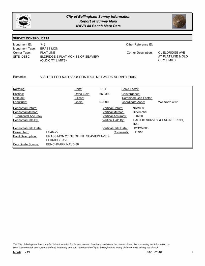
City of Bellingham Survey Information
Report of Survey Mark
NAVD 88 Bench Mark Data
SURVEY CONTROL DATA
719Monument ID: Other Reference ID:
SITE_DESC ELDRIDGE & PLAT MON SE OF SEAVIEW
(OLD CITY LIMITS)
PLAT LINECorner Type: CL ELDRIDGE AVE
AT PLAT LINE & OLD
CITY LIMITS
Corner Description:
BRASS MONMonument Type:
VISITED FOR NAD 83/98 CONTROL NETWORK SURVEY 2006.Remarks:
66.0390
0.0000
FEETNorthing:
Easting:
Latitude:
Longitude:
Units:
Ortho Elev:
Ellipse:
Geoid:
Scale Factor:
Convergence:
Combined Grid Factor:
WA North 4601Coordinate Zone:
Horizontal Method:
Horizontal Datum: NAVD 88Vertical Datum:
DifferentialVertical Method:
Horizontal Accuracy 0.0200Vertical Accuracy:
PACIFIC SURVEY & ENGINEERING,
INC.
Vertical Calc By:Horizontal Calc By:
ES-0425Project No.:
BRASS MON 20' SE OF INT. SEAVIEW AVE &
ELDRIDGE AVE
Point Description:
BENCHMARK NAVD 88Coordinate Source:
FB 918Comments:
Horizontal Calc Date: 12/12/2008Vertical Calc Date:
101/13/2016Mon# 719
The City of Bellingham has compiled this information for its own use and is not responsible for the use by others. Persons using this information do
so at their own risk and agree to defend, indemnify and hold harmless the City of Bellingham as to any claims or suits arising out of such

City of Bellingham Survey Information
Report of Survey Mark
NAVD 88 Bench Mark Data
SURVEY CONTROL DATA
723Monument ID: Other Reference ID:
SITE_DESC ELLIS & SQUALICUM
RIGHT-OF-WAY INTERSECTIONCorner Type: Corner Description:
BRASS MONMonument Type:
VISITED FOR NAD 83/98 CONTROL NETWORK SURVEY 2006.Remarks:
154.3980
0.0000
FEETNorthing:
Easting:
Latitude:
Longitude:
Units:
Ortho Elev:
Ellipse:
Geoid:
Scale Factor:
Convergence:
Combined Grid Factor:
WA North 4601Coordinate Zone:
Horizontal Method:
Horizontal Datum: NAVD 88Vertical Datum:
DifferentialVertical Method:
Horizontal Accuracy 0.0200Vertical Accuracy:
PACIFIC SURVEY & ENGINEERING,
INC.
Vertical Calc By:Horizontal Calc By:
ES-0425Project No.:
BRASS MON AT INT. SQUALICUM PKWY & ELLIS STPoint Description:
BENCHMARK NAVD 88Coordinate Source:
FB 918Comments:
Horizontal Calc Date: 12/31/2008Vertical Calc Date:
101/13/2016Mon# 723
The City of Bellingham has compiled this information for its own use and is not responsible for the use by others. Persons using this information do
so at their own risk and agree to defend, indemnify and hold harmless the City of Bellingham as to any claims or suits arising out of such

City of Bellingham Survey Information
Report of Survey Mark
NAVD 88 Bench Mark Data
SURVEY CONTROL DATA
724Monument ID: Other Reference ID:
SITE_DESC ELLIS & PLYMOUTH
RIGHT-OF-WAY INTERSECTIONCorner Type: Corner Description:
BRASS MONMonument Type:
Remarks:
650,224.3326
1,245,216.2520 157.2200
FEETNorthing:
Easting:
Latitude:
Longitude:
Units:
Ortho Elev:
Ellipse:
Geoid:
Scale Factor:
Convergence:
Combined Grid Factor:
WA North 4601Coordinate Zone:
Conventional SurveyHorizontal Method:
NAD 83/98Horizontal Datum: NAVD 88Vertical Datum:
DifferentialVertical Method:
0.0400Horizontal Accuracy 0.0200Vertical Accuracy:
CONSTRUCTION SURVEYORS N W
INC.
Vertical Calc By:CONSTRUCTION SURVEYORS N
W INC.
Horizontal Calc By:
EU-0156Project No.:
Point Description:
NAD 83/98 PROJECT POINTSCoordinate Source:
ELEVATION NO LONGER VALID. FB
944-3
Comments:
11/14/2011Horizontal Calc Date: 11/14/2011Vertical Calc Date:
101/13/2016Mon# 724
The City of Bellingham has compiled this information for its own use and is not responsible for the use by others. Persons using this information do
so at their own risk and agree to defend, indemnify and hold harmless the City of Bellingham as to any claims or suits arising out of such

City of Bellingham Survey Information
Report of Survey Mark
NAVD 88 Bench Mark Data
SURVEY CONTROL DATA
726Monument ID: Other Reference ID:
SITE_DESC ELLIS & ILLINOIS
RIGHT-OF-WAY INTERSECTIONCorner Type: Corner Description:
BRASS MONMonument Type:
VISITED FOR NAD 83/98 CONTROL NETWORK SURVEY 2006.Remarks:
649,184.7827
1,245,194.2140 148.8100
FEETNorthing:
Easting:
Latitude:
Longitude:
Units:
Ortho Elev:
Ellipse:
Geoid:
Scale Factor:
Convergence:
Combined Grid Factor:
WA North 4601Coordinate Zone:
Conventional SurveyHorizontal Method:
NAD 83/98Horizontal Datum: NAVD 88Vertical Datum:
DifferentialVertical Method:
0.0200Horizontal Accuracy 0.0100Vertical Accuracy:
CHRISTIE & CHRISTIE LAND
SURVEYING INC.
Vertical Calc By:CHRISTIE & CHRISTIE LAND
SURVEYING INC.
Horizontal Calc By:
EU-0154Project No.:
Point Description:
NAD 83/98 PROJECT POINTSCoordinate Source:
FB 957-1Comments:
02/27/2012Horizontal Calc Date: 02/27/2012Vertical Calc Date:
148.7820
0.0000
FEETNorthing:
Easting:
Latitude:
Longitude:
Units:
Ortho Elev:
Ellipse:
Geoid:
Scale Factor:
Convergence:
Combined Grid Factor:
WA North 4601Coordinate Zone:
Horizontal Method:
Horizontal Datum: NAVD 88Vertical Datum:
DifferentialVertical Method:
Horizontal Accuracy 0.0200Vertical Accuracy:
PACIFIC SURVEY & ENGINEERING,
INC.
Vertical Calc By:Horizontal Calc By:
ES-0425Project No.:
BRASS MON AT INT. ILLINOIS ST & ELLIS STPoint Description:
BENCHMARK NAVD 88Coordinate Source:
FB 918Comments:
Horizontal Calc Date: 12/09/2008Vertical Calc Date:
101/13/2016Mon# 726
The City of Bellingham has compiled this information for its own use and is not responsible for the use by others. Persons using this information do
so at their own risk and agree to defend, indemnify and hold harmless the City of Bellingham as to any claims or suits arising out of such

City of Bellingham Survey Information
Report of Survey Mark
NAVD 88 Bench Mark Data
SURVEY CONTROL DATA
727Monument ID: Other Reference ID:
SITE_DESC ELLIS & MARYLAND
RIGHT-OF-WAY INTERSECTIONCorner Type: Corner Description:
CONCRETE MONMonument Type:
Remarks:
648,724.8157
1,245,183.4826 143.5100
FEETNorthing:
Easting:
Latitude:
Longitude:
Units:
Ortho Elev:
Ellipse:
Geoid:
Scale Factor:
Convergence:
Combined Grid Factor:
WA North 4601Coordinate Zone:
Conventional SurveyHorizontal Method:
NAD 83/98Horizontal Datum: NAVD 88Vertical Datum:
DifferentialVertical Method:
0.0200Horizontal Accuracy 0.0100Vertical Accuracy:
CHRISTIE & CHRISTIE LAND
SURVEYING INC.
Vertical Calc By:CHRISTIE & CHRISTIE LAND
SURVEYING INC.
Horizontal Calc By:
EU-0154Project No.:
C-BDSPoint Description:
NAD 83/98 PROJECT POINTSCoordinate Source:
FB 957-1,2Comments:
Horizontal Calc Date: 02/27/2012Vertical Calc Date:
101/13/2016Mon# 727
The City of Bellingham has compiled this information for its own use and is not responsible for the use by others. Persons using this information do
so at their own risk and agree to defend, indemnify and hold harmless the City of Bellingham as to any claims or suits arising out of such

City of Bellingham Survey Information
Report of Survey Mark
NAVD 88 Bench Mark Data
SURVEY CONTROL DATA
729Monument ID: Other Reference ID:
SITE_DESC ELLIS & CONNECTICUT
RIGHT-OF-WAY INTERSECTIONCorner Type: Corner Description:
CONCRETE MONMonument Type:
Remarks:
648,264.8994
1,245,173.9001 141.2500
FEETNorthing:
Easting:
Latitude:
Longitude:
Units:
Ortho Elev:
Ellipse:
Geoid:
Scale Factor:
Convergence:
Combined Grid Factor:
WA North 4601Coordinate Zone:
Conventional SurveyHorizontal Method:
NAD 83/98Horizontal Datum: NAVD 88Vertical Datum:
DifferentialVertical Method:
0.0200Horizontal Accuracy 0.0100Vertical Accuracy:
CHRISTIE & CHRISTIE LAND
SURVEYING INC.
Vertical Calc By:CHRISTIE & CHRISTIE LAND
SURVEYING INC.
Horizontal Calc By:
EU-0154Project No.:
C-BDSPoint Description:
NAD 83/98 PROJECT POINTSCoordinate Source:
FB 957-1,2Comments:
02/27/2012Horizontal Calc Date: 02/27/2012Vertical Calc Date:
101/13/2016Mon# 729
The City of Bellingham has compiled this information for its own use and is not responsible for the use by others. Persons using this information do
so at their own risk and agree to defend, indemnify and hold harmless the City of Bellingham as to any claims or suits arising out of such
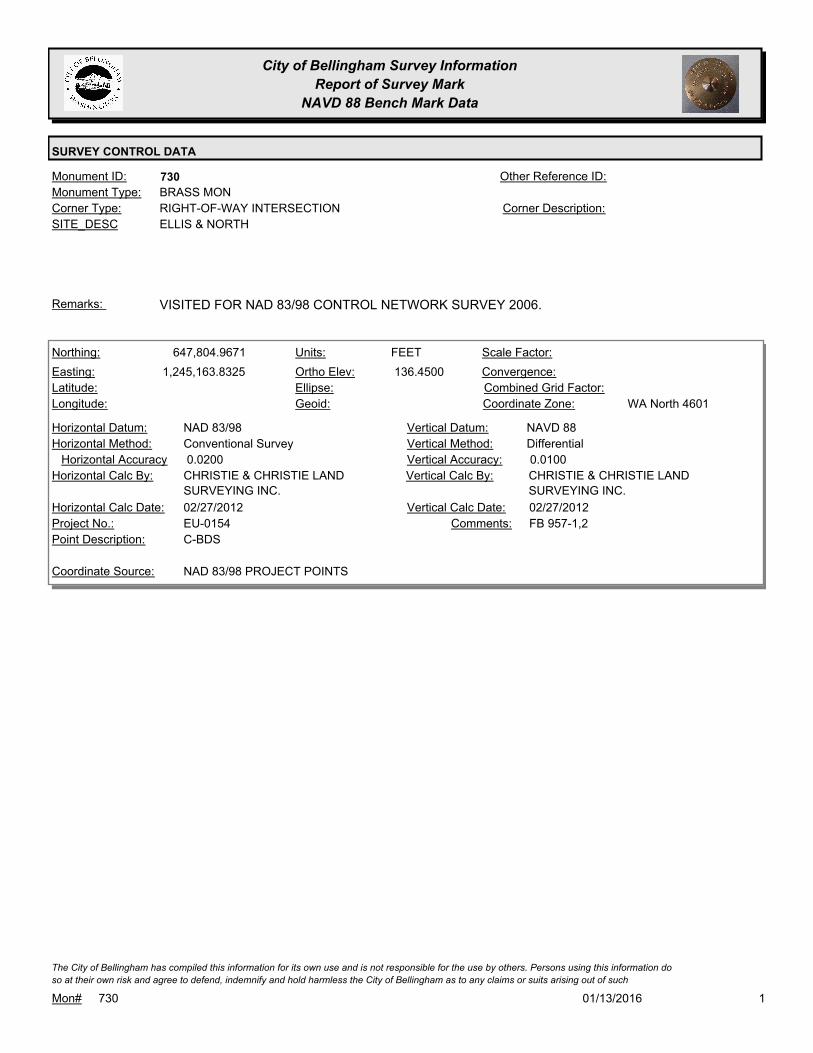
City of Bellingham Survey Information
Report of Survey Mark
NAVD 88 Bench Mark Data
SURVEY CONTROL DATA
730Monument ID: Other Reference ID:
SITE_DESC ELLIS & NORTH
RIGHT-OF-WAY INTERSECTIONCorner Type: Corner Description:
BRASS MONMonument Type:
VISITED FOR NAD 83/98 CONTROL NETWORK SURVEY 2006.Remarks:
647,804.9671
1,245,163.8325 136.4500
FEETNorthing:
Easting:
Latitude:
Longitude:
Units:
Ortho Elev:
Ellipse:
Geoid:
Scale Factor:
Convergence:
Combined Grid Factor:
WA North 4601Coordinate Zone:
Conventional SurveyHorizontal Method:
NAD 83/98Horizontal Datum: NAVD 88Vertical Datum:
DifferentialVertical Method:
0.0200Horizontal Accuracy 0.0100Vertical Accuracy:
CHRISTIE & CHRISTIE LAND
SURVEYING INC.
Vertical Calc By:CHRISTIE & CHRISTIE LAND
SURVEYING INC.
Horizontal Calc By:
EU-0154Project No.:
C-BDSPoint Description:
NAD 83/98 PROJECT POINTSCoordinate Source:
FB 957-1,2Comments:
02/27/2012Horizontal Calc Date: 02/27/2012Vertical Calc Date:
101/13/2016Mon# 730
The City of Bellingham has compiled this information for its own use and is not responsible for the use by others. Persons using this information do
so at their own risk and agree to defend, indemnify and hold harmless the City of Bellingham as to any claims or suits arising out of such

City of Bellingham Survey Information
Report of Survey Mark
NAVD 88 Bench Mark Data
SURVEY CONTROL DATA
731Monument ID: Other Reference ID:
SITE_DESC ELLIS & HIGH
RIGHT-OF-WAY INTERSECTIONCorner Type: Corner Description:
CASED MONMonument Type:
Remarks:
95.0520
0.0000
FEETNorthing:
Easting:
Latitude:
Longitude:
Units:
Ortho Elev:
Ellipse:
Geoid:
Scale Factor:
Convergence:
Combined Grid Factor:
WA North 4601Coordinate Zone:
Horizontal Method:
Horizontal Datum: NAVD 88Vertical Datum:
DifferentialVertical Method:
Horizontal Accuracy 0.0300Vertical Accuracy:
WILSON ENGINEERING LLC.Vertical Calc By:Horizontal Calc By:
ES-0425Project No.:
C-BDS INT ELLIS & HIGHPoint Description:
BENCHMARK NAVD 88Coordinate Source:
FB918-6 pg. 18Comments:
Horizontal Calc Date: 02/04/2009Vertical Calc Date:
101/13/2016Mon# 731
The City of Bellingham has compiled this information for its own use and is not responsible for the use by others. Persons using this information do
so at their own risk and agree to defend, indemnify and hold harmless the City of Bellingham as to any claims or suits arising out of such

City of Bellingham Survey Information
Report of Survey Mark
NAVD 88 Bench Mark Data
SURVEY CONTROL DATA
732Monument ID: Other Reference ID:
SITE_DESC ELLIS & INDIAN
RIGHT-OF-WAY INTERSECTIONCorner Type: Corner Description:
BRASS MONMonument Type:
RAISED 2007Remarks:
641,318.4348
1,245,129.8591 133.8200
FEETNorthing:
Easting:
Latitude:
Longitude:
Units:
Ortho Elev:
Ellipse:
Geoid:
Scale Factor:
Convergence:
Combined Grid Factor:
WA North 4601Coordinate Zone:
Conventional SurveyHorizontal Method:
NAD 83/98Horizontal Datum: NAVD 88Vertical Datum:
DifferentialVertical Method:
0.0200Horizontal Accuracy 0.0100Vertical Accuracy:
CHRISTIE & CHRISTIE LAND
SURVEYING INC.
Vertical Calc By:CHRISTIE & CHRISTIE LAND
SURVEYING INC.
Horizontal Calc By:
EU-0156Project No.:
C-BDSPoint Description:
NAD 83/98 PROJECT POINTSCoordinate Source:
FB 962-1. PROJECT POINT AComments:
04/12/2012Horizontal Calc Date: 04/12/2012Vertical Calc Date:
101/13/2016Mon# 732
The City of Bellingham has compiled this information for its own use and is not responsible for the use by others. Persons using this information do
so at their own risk and agree to defend, indemnify and hold harmless the City of Bellingham as to any claims or suits arising out of such

City of Bellingham Survey Information
Report of Survey Mark
NAVD 88 Bench Mark Data
SURVEY CONTROL DATA
744Monument ID: Other Reference ID:
SITE_DESC ELLIS & KENTUCKY
RIGHT-OF-WAY INTERSECTIONCorner Type: Corner Description:
BRASS MONMonument Type:
Remarks:
645,415.4919
1,245,112.0125 76.6600
FEETNorthing:
Easting:
Latitude:
Longitude:
Units:
Ortho Elev:
Ellipse:
Geoid:
Scale Factor:
Convergence:
Combined Grid Factor:
Coordinate Zone:
Conventional SurveyHorizontal Method:
NAD 83/98Horizontal Datum: NAVD 88Vertical Datum:
DifferentialVertical Method:
0.0200Horizontal Accuracy 0.0100Vertical Accuracy:
CHRISTIE & CHRISTIE LAND
SURVEYING INC.
Vertical Calc By:CHRISTIE & CHRISTIE LAND
SURVEYING INC.
Horizontal Calc By:
EU-0154Project No.:
C-BDSPoint Description:
NAD 83/98 PROJECT POINTSCoordinate Source:
FB 957-1,2Comments:
02/27/2012Horizontal Calc Date: 02/27/2012Vertical Calc Date:
101/13/2016Mon# 744
The City of Bellingham has compiled this information for its own use and is not responsible for the use by others. Persons using this information do
so at their own risk and agree to defend, indemnify and hold harmless the City of Bellingham as to any claims or suits arising out of such

City of Bellingham Survey Information
Report of Survey Mark
NAVD 88 Bench Mark Data
SURVEY CONTROL DATA
745Monument ID: Other Reference ID:
SITE_DESC ELLIS & VIRGINIA
RIGHT-OF-WAY INTERSECTIONCorner Type: Corner Description:
BRASS MONMonument Type:
VISITED FOR NAD 83/98 CONTROL NETWORK SURVEY 2006.Remarks:
85.9210
0.0000
FEETNorthing:
Easting:
Latitude:
Longitude:
Units:
Ortho Elev:
Ellipse:
Geoid:
Scale Factor:
Convergence:
Combined Grid Factor:
WA North 4601Coordinate Zone:
Horizontal Method:
Horizontal Datum: NAVD 88Vertical Datum:
DifferentialVertical Method:
Horizontal Accuracy 0.0300Vertical Accuracy:
WILSON ENGINEERING LLC.Vertical Calc By:Horizontal Calc By:
ES-0425Project No.:
C-BDS INT VIRGINIA & ELLISPoint Description:
BENCHMARK NAVD 88Coordinate Source:
FB918-6 pg. 36Comments:
Horizontal Calc Date: 02/04/2009Vertical Calc Date:
645,895.4703
1,245,122.4217 85.9200
FEETNorthing:
Easting:
Latitude:
Longitude:
Units:
Ortho Elev:
Ellipse:
Geoid:
Scale Factor:
Convergence:
Combined Grid Factor:
WA North 4601Coordinate Zone:
Conventional SurveyHorizontal Method:
NAD 83/98Horizontal Datum: NAVD 88Vertical Datum:
DifferentialVertical Method:
0.0200Horizontal Accuracy 0.0100Vertical Accuracy:
CHRISTIE & CHRISTIE LAND
SURVEYING INC.
Vertical Calc By:CHRISTIE & CHRISTIE LAND
SURVEYING INC.
Horizontal Calc By:
EU-0154Project No.:
C-BDSPoint Description:
NAD 83/98 PROJECT POINTSCoordinate Source:
FB 957-1,2Comments:
02/27/2012Horizontal Calc Date: 02/27/2012Vertical Calc Date:
101/13/2016Mon# 745
The City of Bellingham has compiled this information for its own use and is not responsible for the use by others. Persons using this information do
so at their own risk and agree to defend, indemnify and hold harmless the City of Bellingham as to any claims or suits arising out of such

City of Bellingham Survey Information
Report of Survey Mark
NAVD 88 Bench Mark Data
SURVEY CONTROL DATA
759Monument ID: Other Reference ID:
SITE_DESC FRANKLIN & NORTH
RIGHT-OF-WAY INTERSECTIONCorner Type: Corner Description:
BRASS MONMonument Type:
Remarks:
647,797.0350
1,245,513.9279 132.9900
FEETNorthing:
Easting:
Latitude:
Longitude:
Units:
Ortho Elev:
Ellipse:
Geoid:
Scale Factor:
Convergence:
Combined Grid Factor:
WA North 4601Coordinate Zone:
Conventional SurveyHorizontal Method:
NAD 83/98Horizontal Datum: NAVD 88Vertical Datum:
DifferentialVertical Method:
0.0200Horizontal Accuracy 0.0100Vertical Accuracy:
CHRISTIE & CHRISTIE LAND
SURVEYING INC.
Vertical Calc By:CHRISTIE & CHRISTIE LAND
SURVEYING INC.
Horizontal Calc By:
EU-0154Project No.:
C-BDSPoint Description:
NAD 83/98 PROJECT POINTSCoordinate Source:
FB 957-1,2Comments:
02/27/2012Horizontal Calc Date: 02/27/2012Vertical Calc Date:
101/13/2016Mon# 759
The City of Bellingham has compiled this information for its own use and is not responsible for the use by others. Persons using this information do
so at their own risk and agree to defend, indemnify and hold harmless the City of Bellingham as to any claims or suits arising out of such

City of Bellingham Survey Information
Report of Survey Mark
NAVD 88 Bench Mark Data
SURVEY CONTROL DATA
760Monument ID: Other Reference ID:
SITE_DESC FRANKLIN & CONNECTICUT
RIGHT-OF-WAY INTERSECTIONCorner Type: Corner Description:
BRASS MONMonument Type:
Remarks:
648,257.3299
1,245,523.6624 144.4700
FEETNorthing:
Easting:
Latitude:
Longitude:
Units:
Ortho Elev:
Ellipse:
Geoid:
Scale Factor:
Convergence:
Combined Grid Factor:
WA North 4601Coordinate Zone:
Conventional SurveyHorizontal Method:
NAD 83/98Horizontal Datum: NAVD 88Vertical Datum:
DifferentialVertical Method:
0.0200Horizontal Accuracy 0.0100Vertical Accuracy:
CHRISTIE & CHRISTIE LAND
SURVEYING INC.
Vertical Calc By:CHRISTIE & CHRISTIE LAND
SURVEYING INC.
Horizontal Calc By:
EU-0154Project No.:
C-BDSPoint Description:
NAD 83/98 PROJECT POINTSCoordinate Source:
FB 957-1,2Comments:
02/27/2012Horizontal Calc Date: 02/27/2012Vertical Calc Date:
101/13/2016Mon# 760
The City of Bellingham has compiled this information for its own use and is not responsible for the use by others. Persons using this information do
so at their own risk and agree to defend, indemnify and hold harmless the City of Bellingham as to any claims or suits arising out of such

City of Bellingham Survey Information
Report of Survey Mark
NAVD 88 Bench Mark Data
SURVEY CONTROL DATA
761Monument ID: Other Reference ID:
SITE_DESC FRANKLIN & MARYLAND
RIGHT-OF-WAY INTERSECTIONCorner Type: Corner Description:
BRASS MONMonument Type:
Remarks:
648,717.2017
1,245,533.8265 147.6900
FEETNorthing:
Easting:
Latitude:
Longitude:
Units:
Ortho Elev:
Ellipse:
Geoid:
Scale Factor:
Convergence:
Combined Grid Factor:
WA North 4601Coordinate Zone:
Conventional SurveyHorizontal Method:
NAD 83/98Horizontal Datum: NAVD 88Vertical Datum:
DifferentialVertical Method:
0.0200Horizontal Accuracy 0.0100Vertical Accuracy:
CHRISTIE & CHRISTIE LAND
SURVEYING INC.
Vertical Calc By:CHRISTIE & CHRISTIE LAND
SURVEYING INC.
Horizontal Calc By:
EU-0154Project No.:
C-BDSPoint Description:
NAD 83/98 PROJECT POINTSCoordinate Source:
FB 957-1,2Comments:
02/27/2012Horizontal Calc Date: 02/27/2012Vertical Calc Date:
101/13/2016Mon# 761
The City of Bellingham has compiled this information for its own use and is not responsible for the use by others. Persons using this information do
so at their own risk and agree to defend, indemnify and hold harmless the City of Bellingham as to any claims or suits arising out of such

City of Bellingham Survey Information
Report of Survey Mark
NAVD 88 Bench Mark Data
SURVEY CONTROL DATA
762Monument ID: Other Reference ID:
SITE_DESC FRANKLIN & ILLINOIS
RIGHT-OF-WAY INTERSECTIONCorner Type: Corner Description:
BRASS MONMonument Type:
Remarks:
649,177.1289
1,245,544.0473 152.3900
FEETNorthing:
Easting:
Latitude:
Longitude:
Units:
Ortho Elev:
Ellipse:
Geoid:
Scale Factor:
Convergence:
Combined Grid Factor:
WA North 4601Coordinate Zone:
Conventional SurveyHorizontal Method:
NAD 83/98Horizontal Datum: NAVD 88Vertical Datum:
DifferentialVertical Method:
0.0200Horizontal Accuracy 0.0100Vertical Accuracy:
CHRISTIE & CHRISTIE LAND
SURVEYING INC.
Vertical Calc By:CHRISTIE & CHRISTIE LAND
SURVEYING INC.
Horizontal Calc By:
EU-0154Project No.:
C-BDSPoint Description:
NAD 83/98 PROJECT POINTSCoordinate Source:
FB 957-1Comments:
02/27/2012Horizontal Calc Date: 02/27/2012Vertical Calc Date:
101/13/2016Mon# 762
The City of Bellingham has compiled this information for its own use and is not responsible for the use by others. Persons using this information do
so at their own risk and agree to defend, indemnify and hold harmless the City of Bellingham as to any claims or suits arising out of such

City of Bellingham Survey Information
Report of Survey Mark
NAVD 88 Bench Mark Data
SURVEY CONTROL DATA
763Monument ID: Other Reference ID:
SITE_DESC FRANKLIN & TEXAS
RIGHT-OF-WAY INTERSECTIONCorner Type: Corner Description:
BRASS MONMonument Type:
Remarks:
646,847.8124
1,245,493.1221 102.4300
FEETNorthing:
Easting:
Latitude:
Longitude:
Units:
Ortho Elev:
Ellipse:
Geoid:
Scale Factor:
Convergence:
Combined Grid Factor:
WA North 4601Coordinate Zone:
Conventional SurveyHorizontal Method:
NAD 83/98Horizontal Datum: NAVD 88Vertical Datum:
DifferentialVertical Method:
0.0200Horizontal Accuracy 0.0100Vertical Accuracy:
CHRISTIE & CHRISTIE LAND
SURVEYING INC.
Vertical Calc By:CHRISTIE & CHRISTIE LAND
SURVEYING INC.
Horizontal Calc By:
EU-0154Project No.:
Point Description:
NAD 83/98 PROJECT POINTSCoordinate Source:
FB 957-1,2. PUNCHED BRASS
STUB.
Comments:
02/27/2012Horizontal Calc Date: 02/27/2012Vertical Calc Date:
101/13/2016Mon# 763
The City of Bellingham has compiled this information for its own use and is not responsible for the use by others. Persons using this information do
so at their own risk and agree to defend, indemnify and hold harmless the City of Bellingham as to any claims or suits arising out of such

City of Bellingham Survey Information
Report of Survey Mark
NAVD 88 Bench Mark Data
SURVEY CONTROL DATA
764Monument ID: Other Reference ID:
SITE_DESC FRANKLIN & VIRGINIA
RIGHT-OF-WAY INTERSECTIONCorner Type: Corner Description:
BRASS MONMonument Type:
Remarks:
645,887.8513
1,245,472.4607 83.0300
FEETNorthing:
Easting:
Latitude:
Longitude:
Units:
Ortho Elev:
Ellipse:
Geoid:
Scale Factor:
Convergence:
Combined Grid Factor:
WA North 4601Coordinate Zone:
Conventional SurveyHorizontal Method:
NAD 83/98Horizontal Datum: NAVD 88Vertical Datum:
DifferentialVertical Method:
0.0200Horizontal Accuracy 0.0100Vertical Accuracy:
CHRISTIE & CHRISTIE LAND
SURVEYING INC.
Vertical Calc By:CHRISTIE & CHRISTIE LAND
SURVEYING INC.
Horizontal Calc By:
EU-0154Project No.:
C-BDSPoint Description:
NAD 83/98 PROJECT POINTSCoordinate Source:
FB 957-1,2. PUNCHED SHANK.Comments:
02/27/2012Horizontal Calc Date: 02/27/2012Vertical Calc Date:
83.0320
0.0000
FEETNorthing:
Easting:
Latitude:
Longitude:
Units:
Ortho Elev:
Ellipse:
Geoid:
Scale Factor:
Convergence:
Combined Grid Factor:
WA North 4601Coordinate Zone:
Horizontal Method:
Horizontal Datum: NAVD 88Vertical Datum:
DifferentialVertical Method:
Horizontal Accuracy 0.0300Vertical Accuracy:
WILSON ENGINEERING LLC.Vertical Calc By:Horizontal Calc By:
ES-0425Project No.:
C-BDS INT VIRGINIA & FRANKLINPoint Description:
BENCHMARK NAVD 88Coordinate Source:
FB918-6 pg. 36Comments:
Horizontal Calc Date: 02/04/2009Vertical Calc Date:
101/13/2016Mon# 764
The City of Bellingham has compiled this information for its own use and is not responsible for the use by others. Persons using this information do
so at their own risk and agree to defend, indemnify and hold harmless the City of Bellingham as to any claims or suits arising out of such

City of Bellingham Survey Information
Report of Survey Mark
NAVD 88 Bench Mark Data
SURVEY CONTROL DATA
765Monument ID: Other Reference ID:
SITE_DESC FRANKLIN & KENTUCKY
RIGHT-OF-WAY INTERSECTIONCorner Type: Corner Description:
BRASS MONMonument Type:
Remarks:
645,407.9191
1,245,461.9845 74.1200
FEETNorthing:
Easting:
Latitude:
Longitude:
Units:
Ortho Elev:
Ellipse:
Geoid:
Scale Factor:
Convergence:
Combined Grid Factor:
WA North 4601Coordinate Zone:
Conventional SurveyHorizontal Method:
NAD 83/98Horizontal Datum: NAVD 88Vertical Datum:
DifferentialVertical Method:
0.0200Horizontal Accuracy 0.0100Vertical Accuracy:
CHRISTIE & CHRISTIE LAND
SURVEYING INC.
Vertical Calc By:CHRISTIE & CHRISTIE LAND
SURVEYING INC.
Horizontal Calc By:
EU-0154Project No.:
C-BDSPoint Description:
NAD 83/98 PROJECT POINTSCoordinate Source:
FB 957-1,2Comments:
02/27/2012Horizontal Calc Date: 02/27/2012Vertical Calc Date:
101/13/2016Mon# 765
The City of Bellingham has compiled this information for its own use and is not responsible for the use by others. Persons using this information do
so at their own risk and agree to defend, indemnify and hold harmless the City of Bellingham as to any claims or suits arising out of such

City of Bellingham Survey Information
Report of Survey Mark
NAVD 88 Bench Mark Data
SURVEY CONTROL DATA
769Monument ID: Other Reference ID:
SITE_DESC FRASER & MOORE
RIGHT-OF-WAY INTERSECTIONCorner Type: Corner Description:
BRASS MONMonument Type:
RAISED 12/7/06Remarks:
70.3470
0.0000
FEETNorthing:
Easting:
Latitude:
Longitude:
Units:
Ortho Elev:
Ellipse:
Geoid:
Scale Factor:
Convergence:
Combined Grid Factor:
WA North 4601Coordinate Zone:
Horizontal Method:
Horizontal Datum: NAVD 88Vertical Datum:
DifferentialVertical Method:
Horizontal Accuracy 0.0300Vertical Accuracy:
WILSON ENGINEERING LLC.Vertical Calc By:Horizontal Calc By:
ES-0425Project No.:
C-BDS INT MOORE & FRASERPoint Description:
BENCHMARK NAVD 88Coordinate Source:
FB918-7 pg. 21Comments:
Horizontal Calc Date: 02/12/2009Vertical Calc Date:
101/13/2016Mon# 769
The City of Bellingham has compiled this information for its own use and is not responsible for the use by others. Persons using this information do
so at their own risk and agree to defend, indemnify and hold harmless the City of Bellingham as to any claims or suits arising out of such

City of Bellingham Survey Information
Report of Survey Mark
NAVD 88 Bench Mark Data
SURVEY CONTROL DATA
774Monument ID: Other Reference ID:
SITE_DESC GRANT & ILLINOIS
RIGHT-OF-WAY INTERSECTIONCorner Type: Corner Description:
BRASS MONMonument Type:
Remarks:
649,169.6890
1,245,893.7547 156.4400
FEETNorthing:
Easting:
Latitude:
Longitude:
Units:
Ortho Elev:
Ellipse:
Geoid:
Scale Factor:
Convergence:
Combined Grid Factor:
WA North 4601Coordinate Zone:
Conventional SurveyHorizontal Method:
NAD 83/98Horizontal Datum: NAVD 88Vertical Datum:
DifferentialVertical Method:
0.0200Horizontal Accuracy 0.0100Vertical Accuracy:
CHRISTIE & CHRISTIE LAND
SURVEYING INC.
Vertical Calc By:CHRISTIE & CHRISTIE LAND
SURVEYING INC.
Horizontal Calc By:
EU-0154Project No.:
C-BDSPoint Description:
NAD 83/98 PROJECT POINTSCoordinate Source:
FB 957-1,2Comments:
02/27/2012Horizontal Calc Date: 02/27/2012Vertical Calc Date:
101/13/2016Mon# 774
The City of Bellingham has compiled this information for its own use and is not responsible for the use by others. Persons using this information do
so at their own risk and agree to defend, indemnify and hold harmless the City of Bellingham as to any claims or suits arising out of such

City of Bellingham Survey Information
Report of Survey Mark
NAVD 88 Bench Mark Data
SURVEY CONTROL DATA
775Monument ID: Other Reference ID:
SITE_DESC GRANT & MARYLAND
RIGHT-OF-WAY INTERSECTIONCorner Type: Corner Description:
BRASS MONMonument Type:
MON KNOCKED OUT 11-25-98, RESTORED 6-05Remarks:
648,709.6605
1,245,883.7001 150.3000
FEETNorthing:
Easting:
Latitude:
Longitude:
Units:
Ortho Elev:
Ellipse:
Geoid:
Scale Factor:
Convergence:
Combined Grid Factor:
WA North 4601Coordinate Zone:
Conventional SurveyHorizontal Method:
NAD 83/98Horizontal Datum: NAVD 88Vertical Datum:
DifferentialVertical Method:
0.0200Horizontal Accuracy 0.0100Vertical Accuracy:
CHRISTIE & CHRISTIE LAND
SURVEYING INC.
Vertical Calc By:CHRISTIE & CHRISTIE LAND
SURVEYING INC.
Horizontal Calc By:
EU-0154Project No.:
C-BDSPoint Description:
NAD 83/98 PROJECT POINTSCoordinate Source:
FB 957-1,2Comments:
02/27/2012Horizontal Calc Date: 02/27/2012Vertical Calc Date:
101/13/2016Mon# 775
The City of Bellingham has compiled this information for its own use and is not responsible for the use by others. Persons using this information do
so at their own risk and agree to defend, indemnify and hold harmless the City of Bellingham as to any claims or suits arising out of such

City of Bellingham Survey Information
Report of Survey Mark
NAVD 88 Bench Mark Data
SURVEY CONTROL DATA
776Monument ID: Other Reference ID:
SITE_DESC GRANT & CONNECTICUT
RIGHT-OF-WAY INTERSECTIONCorner Type: Corner Description:
BRASS MONMonument Type:
Remarks:
648,249.7709
1,245,873.6262 144.5000
FEETNorthing:
Easting:
Latitude:
Longitude:
Units:
Ortho Elev:
Ellipse:
Geoid:
Scale Factor:
Convergence:
Combined Grid Factor:
WA North 4601Coordinate Zone:
Conventional SurveyHorizontal Method:
NAD 83/98Horizontal Datum: NAVD 88Vertical Datum:
DifferentialVertical Method:
0.0200Horizontal Accuracy 0.0100Vertical Accuracy:
CHRISTIE & CHRISTIE LAND
SURVEYING INC.
Vertical Calc By:CHRISTIE & CHRISTIE LAND
SURVEYING INC.
Horizontal Calc By:
EU-0154Project No.:
C-BDSPoint Description:
NAD 83/98 PROJECT POINTSCoordinate Source:
FB 957-1,2Comments:
02/27/2012Horizontal Calc Date: 02/27/2012Vertical Calc Date:
101/13/2016Mon# 776
The City of Bellingham has compiled this information for its own use and is not responsible for the use by others. Persons using this information do
so at their own risk and agree to defend, indemnify and hold harmless the City of Bellingham as to any claims or suits arising out of such

City of Bellingham Survey Information
Report of Survey Mark
NAVD 88 Bench Mark Data
SURVEY CONTROL DATA
777Monument ID: Other Reference ID:
SITE_DESC GRANT & NORTH
RIGHT-OF-WAY INTERSECTIONCorner Type: Corner Description:
BRASS MONMonument Type:
Remarks:
647,789.9609
1,245,863.6098 129.9100
FEETNorthing:
Easting:
Latitude:
Longitude:
Units:
Ortho Elev:
Ellipse:
Geoid:
Scale Factor:
Convergence:
Combined Grid Factor:
WA North 4601Coordinate Zone:
Conventional SurveyHorizontal Method:
NAD 83/98Horizontal Datum: NAVD 88Vertical Datum:
DifferentialVertical Method:
0.0200Horizontal Accuracy 0.0100Vertical Accuracy:
CHRISTIE & CHRISTIE LAND
SURVEYING INC.
Vertical Calc By:CHRISTIE & CHRISTIE LAND
SURVEYING INC.
Horizontal Calc By:
EU-0154Project No.:
C-BDSPoint Description:
NAD 83/98 PROJECT POINTSCoordinate Source:
FB 957-1,2Comments:
02/27/2012Horizontal Calc Date: 02/27/2012Vertical Calc Date:
101/13/2016Mon# 777
The City of Bellingham has compiled this information for its own use and is not responsible for the use by others. Persons using this information do
so at their own risk and agree to defend, indemnify and hold harmless the City of Bellingham as to any claims or suits arising out of such

City of Bellingham Survey Information
Report of Survey Mark
NAVD 88 Bench Mark Data
SURVEY CONTROL DATA
779Monument ID: Other Reference ID:
SITE_DESC GRANT & KENTUCKY
RIGHT-OF-WAY INTERSECTIONCorner Type: Corner Description:
BRASS MONMonument Type:
Remarks:
645,400.2067
1,245,812.1299 75.7600
FEETNorthing:
Easting:
Latitude:
Longitude:
Units:
Ortho Elev:
Ellipse:
Geoid:
Scale Factor:
Convergence:
Combined Grid Factor:
WA North 4601Coordinate Zone:
Conventional SurveyHorizontal Method:
NAD 83/98Horizontal Datum: NAVD 88Vertical Datum:
DifferentialVertical Method:
0.0200Horizontal Accuracy 0.0100Vertical Accuracy:
CHRISTIE & CHRISTIE LAND
SURVEYING INC.
Vertical Calc By:CHRISTIE & CHRISTIE LAND
SURVEYING INC.
Horizontal Calc By:
EU-0154Project No.:
C-BDSPoint Description:
NAD 83/98 PROJECT POINTSCoordinate Source:
FB 957-1,2Comments:
02/27/2012Horizontal Calc Date: 02/27/2012Vertical Calc Date:
101/13/2016Mon# 779
The City of Bellingham has compiled this information for its own use and is not responsible for the use by others. Persons using this information do
so at their own risk and agree to defend, indemnify and hold harmless the City of Bellingham as to any claims or suits arising out of such

City of Bellingham Survey Information
Report of Survey Mark
NAVD 88 Bench Mark Data
SURVEY CONTROL DATA
780Monument ID: Other Reference ID:
SITE_DESC GRANT & VIRGINIA
RIGHT-OF-WAY INTERSECTIONCorner Type: Corner Description:
BRASS MONMonument Type:
MON RAISED FOR 2000 OVERLAY.Remarks:
81.6630
0.0000
FEETNorthing:
Easting:
Latitude:
Longitude:
Units:
Ortho Elev:
Ellipse:
Geoid:
Scale Factor:
Convergence:
Combined Grid Factor:
WA North 4601Coordinate Zone:
Horizontal Method:
Horizontal Datum: NAVD 88Vertical Datum:
DifferentialVertical Method:
Horizontal Accuracy 0.0300Vertical Accuracy:
WILSON ENGINEERING LLC.Vertical Calc By:Horizontal Calc By:
ES-0425Project No.:
C-BDS INT VIRGINIA & GRANTPoint Description:
BENCHMARK NAVD 88Coordinate Source:
FB918-6 pg. 37Comments:
Horizontal Calc Date: 02/04/2009Vertical Calc Date:
645,880.2784
1,245,822.8322 81.6600
FEETNorthing:
Easting:
Latitude:
Longitude:
Units:
Ortho Elev:
Ellipse:
Geoid:
Scale Factor:
Convergence:
Combined Grid Factor:
WA North 4601Coordinate Zone:
Conventional SurveyHorizontal Method:
NAD 83/98Horizontal Datum: NAVD 88Vertical Datum:
DifferentialVertical Method:
0.0200Horizontal Accuracy 0.0100Vertical Accuracy:
CHRISTIE & CHRISTIE LAND
SURVEYING INC.
Vertical Calc By:CHRISTIE & CHRISTIE LAND
SURVEYING INC.
Horizontal Calc By:
EU-0154Project No.:
C-BDSPoint Description:
NAD 83/98 PROJECT POINTSCoordinate Source:
FB 957-1,2Comments:
02/27/2012Horizontal Calc Date: 02/27/2012Vertical Calc Date:
101/13/2016Mon# 780
The City of Bellingham has compiled this information for its own use and is not responsible for the use by others. Persons using this information do
so at their own risk and agree to defend, indemnify and hold harmless the City of Bellingham as to any claims or suits arising out of such

City of Bellingham Survey Information
Report of Survey Mark
NAVD 88 Bench Mark Data
SURVEY CONTROL DATA
781Monument ID: Other Reference ID:
SITE_DESC GRANT & TEXAS
RIGHT-OF-WAY INTERSECTIONCorner Type: Corner Description:
BRASS MONMonument Type:
Remarks:
646,840.2237
1,245,843.0449 102.1300
FEETNorthing:
Easting:
Latitude:
Longitude:
Units:
Ortho Elev:
Ellipse:
Geoid:
Scale Factor:
Convergence:
Combined Grid Factor:
WA North 4601Coordinate Zone:
Conventional SurveyHorizontal Method:
NAD 83/98Horizontal Datum: NAVD 88Vertical Datum:
DifferentialVertical Method:
0.0200Horizontal Accuracy 0.0100Vertical Accuracy:
CHRISTIE & CHRISTIE LAND
SURVEYING INC.
Vertical Calc By:CHRISTIE & CHRISTIE LAND
SURVEYING INC.
Horizontal Calc By:
EU-0154Project No.:
C-BDSPoint Description:
NAD 83/98 PROJECT POINTSCoordinate Source:
FB 957-1,2Comments:
02/27/2012Horizontal Calc Date: 02/27/2012Vertical Calc Date:
101/13/2016Mon# 781
The City of Bellingham has compiled this information for its own use and is not responsible for the use by others. Persons using this information do
so at their own risk and agree to defend, indemnify and hold harmless the City of Bellingham as to any claims or suits arising out of such

City of Bellingham Survey Information
Report of Survey Mark
NAVD 88 Bench Mark Data
SURVEY CONTROL DATA
786Monument ID: Other Reference ID:
SITE_DESC GIRARD & D
RIGHT-OF-WAY INTERSECTIONCorner Type: Corner Description:
BRASS MONMonument Type:
MON RAISED FOR 2002 OVERLAYRemarks:
70.2970
0.0000
FEETNorthing:
Easting:
Latitude:
Longitude:
Units:
Ortho Elev:
Ellipse:
Geoid:
Scale Factor:
Convergence:
Combined Grid Factor:
WA North 4601Coordinate Zone:
Horizontal Method:
Horizontal Datum: NAVD 88Vertical Datum:
DifferentialVertical Method:
Horizontal Accuracy 0.0300Vertical Accuracy:
WILSON ENGINEERING LLC.Vertical Calc By:Horizontal Calc By:
ES-0425Project No.:
C-BDS INT D & GIRARDPoint Description:
BENCHMARK NAVD 88Coordinate Source:
FB918-6 pg. 27Comments:
Horizontal Calc Date: 02/04/2009Vertical Calc Date:
101/13/2016Mon# 786
The City of Bellingham has compiled this information for its own use and is not responsible for the use by others. Persons using this information do
so at their own risk and agree to defend, indemnify and hold harmless the City of Bellingham as to any claims or suits arising out of such

City of Bellingham Survey Information
Report of Survey Mark
NAVD 88 Bench Mark Data
SURVEY CONTROL DATA
787Monument ID: Other Reference ID:
SITE_DESC GIRARD & C
RIGHT-OF-WAY INTERSECTIONCorner Type: Corner Description:
BRASS MONMonument Type:
MON RAISED FOR 2000 OVERLAY, MON RAISED FOR 2002
OVERLAY
Remarks:
71.3260
0.0000
FEETNorthing:
Easting:
Latitude:
Longitude:
Units:
Ortho Elev:
Ellipse:
Geoid:
Scale Factor:
Convergence:
Combined Grid Factor:
WA North 4601Coordinate Zone:
Horizontal Method:
Horizontal Datum: NAVD 88Vertical Datum:
DifferentialVertical Method:
Horizontal Accuracy 0.0300Vertical Accuracy:
WILSON ENGINEERING LLC.Vertical Calc By:Horizontal Calc By:
ES-0425Project No.:
C-BDS INT C & GIRARDPoint Description:
BENCHMARK NAVD 88Coordinate Source:
FB918-6 pg. 27Comments:
Horizontal Calc Date: 02/04/2009Vertical Calc Date:
101/13/2016Mon# 787
The City of Bellingham has compiled this information for its own use and is not responsible for the use by others. Persons using this information do
so at their own risk and agree to defend, indemnify and hold harmless the City of Bellingham as to any claims or suits arising out of such

City of Bellingham Survey Information
Report of Survey Mark
NAVD 88 Bench Mark Data
SURVEY CONTROL DATA
790Monument ID: Other Reference ID:
SITE_DESC GRAND & FLORA
RIGHT-OF-WAY INTERSECTIONCorner Type: Corner Description:
PVC RING OVER MONUMENTMonument Type:
Remarks:
68.1840
0.0000
FEETNorthing:
Easting:
Latitude:
Longitude:
Units:
Ortho Elev:
Ellipse:
Geoid:
Scale Factor:
Convergence:
Combined Grid Factor:
WA North 4601Coordinate Zone:
Horizontal Method:
Horizontal Datum: NAVD 88Vertical Datum:
DifferentialVertical Method:
Horizontal Accuracy 0.0300Vertical Accuracy:
WILSON ENGINEERING LLC.Vertical Calc By:Horizontal Calc By:
ES-0425Project No.:
C-BDS INT GRAND & FLORAPoint Description:
BENCHMARK NAVD 88Coordinate Source:
FB918-6 PG. 6Comments:
Horizontal Calc Date: 01/26/2009Vertical Calc Date:
101/13/2016Mon# 790
The City of Bellingham has compiled this information for its own use and is not responsible for the use by others. Persons using this information do
so at their own risk and agree to defend, indemnify and hold harmless the City of Bellingham as to any claims or suits arising out of such

City of Bellingham Survey Information
Report of Survey Mark
NAVD 88 Bench Mark Data
SURVEY CONTROL DATA
797Monument ID: Other Reference ID:
SITE_DESC HARRIS & 4TH
RIGHT-OF-WAY INTERSECTIONCorner Type: Corner Description:
BRASS MONMonument Type:
VISITED FOR NAD 83/98 CONTROL NETWORK SURVEY 2006.Remarks:
12.5210
0.0000
FEETNorthing:
Easting:
Latitude:
Longitude:
Units:
Ortho Elev:
Ellipse:
Geoid:
Scale Factor:
Convergence:
Combined Grid Factor:
WA North 4601Coordinate Zone:
Horizontal Method:
Horizontal Datum: NAVD 88Vertical Datum:
DifferentialVertical Method:
Horizontal Accuracy 0.0200Vertical Accuracy:
LARRY STEELE & ASSOCIATESVertical Calc By:Horizontal Calc By:
ES-0425Project No.:
BRASS MON AT 4TH & HARRISPoint Description:
BENCHMARK NAVD 88Coordinate Source:
FB 918-11Comments:
Horizontal Calc Date: 02/17/2009Vertical Calc Date:
101/13/2016Mon# 797
The City of Bellingham has compiled this information for its own use and is not responsible for the use by others. Persons using this information do
so at their own risk and agree to defend, indemnify and hold harmless the City of Bellingham as to any claims or suits arising out of such

City of Bellingham Survey Information
Report of Survey Mark
NAVD 88 Bench Mark Data
SURVEY CONTROL DATA
805Monument ID: Other Reference ID:
SITE_DESC HOLLY & I
RIGHT-OF-WAY INTERSECTIONCorner Type: Corner Description:
BRASS MONMonument Type:
MON RAISED FOR 2000 OVERLAYRemarks:
645,123.7604
1,240,838.7532
48 45 24.16446
-122 29 23.50414
58.3510
0.0000
FEETNorthing:
Easting:
Latitude:
Longitude:
Units:
Ortho Elev:
Ellipse:
Geoid:
1.0000000000Scale Factor:
- 1 13 59Convergence:
Combined Grid Factor:
WA North 4601Coordinate Zone:
Conventional SurveyHorizontal Method:
NAD 83/98Horizontal Datum: NAVD 88Vertical Datum:
DifferentialVertical Method:
0.0700Horizontal Accuracy 0.0200Vertical Accuracy:
PACIFIC SURVEY & ENGINEERING,
INC.
Vertical Calc By:PACIFIC SURVEY &
ENGINEERING, INC.
Horizontal Calc By:
Project No.:
C-BDSPoint Description:
NAD 83/98 NETWORK(DENSIFICATION PROJECT)Coordinate Source:
FB880-2 WATERFRONT CONTROL
SURVEY AF2080302393
Comments:
01/23/2008Horizontal Calc Date: 01/23/2008Vertical Calc Date:
101/13/2016Mon# 805
The City of Bellingham has compiled this information for its own use and is not responsible for the use by others. Persons using this information do
so at their own risk and agree to defend, indemnify and hold harmless the City of Bellingham as to any claims or suits arising out of such

City of Bellingham Survey Information
Report of Survey Mark
NAVD 88 Bench Mark Data
SURVEY CONTROL DATA
808Monument ID: Other Reference ID:
SITE_DESC HOLLY & F
RIGHT-OF-WAY INTERSECTIONCorner Type: Corner Description:
BRASS MONMonument Type:
MON WILL BE RAISED FOR SEWER REPLACEMENT IN 7/08Remarks:
644,564.3698
1,241,382.6561
48 45 18.76157
-122 29 15.20973
24.8930
0.0000
FEETNorthing:
Easting:
Latitude:
Longitude:
Units:
Ortho Elev:
Ellipse:
Geoid:
1.0000000000Scale Factor:
- 1 13 54Convergence:
Combined Grid Factor:
WA North 4601Coordinate Zone:
Conventional SurveyHorizontal Method:
NAD 83/98Horizontal Datum: NAVD 88Vertical Datum:
DifferentialVertical Method:
0.0700Horizontal Accuracy 0.0200Vertical Accuracy:
PACIFIC SURVEY & ENGINEERING,
INC.
Vertical Calc By:PACIFIC SURVEY &
ENGINEERING, INC.
Horizontal Calc By:
Project No.:
C-BDSPoint Description:
NAD 83/98 NETWORK(DENSIFICATION PROJECT)Coordinate Source:
FB880-2 WATERFRONT CONTROL
SURVEY AF2080302393. NOTE:
RAISED SUMMER 2008 FOR
Comments:
01/23/2008Horizontal Calc Date: 01/23/2008Vertical Calc Date:
101/13/2016Mon# 808
The City of Bellingham has compiled this information for its own use and is not responsible for the use by others. Persons using this information do
so at their own risk and agree to defend, indemnify and hold harmless the City of Bellingham as to any claims or suits arising out of such

City of Bellingham Survey Information
Report of Survey Mark
NAVD 88 Bench Mark Data
SURVEY CONTROL DATA
833Monument ID: Other Reference ID:
SITE_DESC HUMBOLDT & ILLINOIS
RIGHT-OF-WAY INTERSECTIONCorner Type: Corner Description:
BRASS MONMonument Type:
VISITED FOR NAD 83/98 CONTROL NETWORK SURVEY 2006.Remarks:
161.7830
0.0000
FEETNorthing:
Easting:
Latitude:
Longitude:
Units:
Ortho Elev:
Ellipse:
Geoid:
Scale Factor:
Convergence:
Combined Grid Factor:
WA North 4601Coordinate Zone:
Horizontal Method:
Horizontal Datum: NAVD 88Vertical Datum:
DifferentialVertical Method:
Horizontal Accuracy 0.0200Vertical Accuracy:
PACIFIC SURVEY & ENGINEERING,
INC.
Vertical Calc By:Horizontal Calc By:
ES-0425Project No.:
BRASS MON AT INT. ILLINOIS ST & HUMBOLT STPoint Description:
BENCHMARK NAVD 88Coordinate Source:
FB 918Comments:
Horizontal Calc Date: 12/09/2008Vertical Calc Date:
101/13/2016Mon# 833
The City of Bellingham has compiled this information for its own use and is not responsible for the use by others. Persons using this information do
so at their own risk and agree to defend, indemnify and hold harmless the City of Bellingham as to any claims or suits arising out of such

City of Bellingham Survey Information
Report of Survey Mark
NAVD 88 Bench Mark Data
SURVEY CONTROL DATA
835Monument ID: Other Reference ID:
SITE_DESC HURON & IOWA DR
RIGHT-OF-WAY INTERSECTIONCorner Type: Corner Description:
BRASS MONMonument Type:
Remarks:
250.2980
0.0000
FEETNorthing:
Easting:
Latitude:
Longitude:
Units:
Ortho Elev:
Ellipse:
Geoid:
Scale Factor:
Convergence:
Combined Grid Factor:
WA North 4601Coordinate Zone:
Horizontal Method:
Horizontal Datum: NAVD 88Vertical Datum:
DifferentialVertical Method:
Horizontal Accuracy 0.0300Vertical Accuracy:
WILSON ENGINEERING LLC.Vertical Calc By:Horizontal Calc By:
ES-0425Project No.:
C-BDS INT IOWA DRIVE & HURONPoint Description:
BENCHMARK NAVD 88Coordinate Source:
FB918-8 pg. 42Comments:
Horizontal Calc Date: 02/12/2009Vertical Calc Date:
101/13/2016Mon# 835
The City of Bellingham has compiled this information for its own use and is not responsible for the use by others. Persons using this information do
so at their own risk and agree to defend, indemnify and hold harmless the City of Bellingham as to any claims or suits arising out of such

City of Bellingham Survey Information
Report of Survey Mark
NAVD 88 Bench Mark Data
SURVEY CONTROL DATA
859Monument ID: Other Reference ID:
SITE_DESC ILLINOIS & ELM
RIGHT-OF-WAY INTERSECTIONCorner Type: Corner Description:
CASED MONMonument Type:
Remarks:
649,301.0311
1,241,290.8632 82.3400
FEETNorthing:
Easting:
Latitude:
Longitude:
Units:
Ortho Elev:
Ellipse:
Geoid:
Scale Factor:
Convergence:
Combined Grid Factor:
WA North 4601Coordinate Zone:
Conventional SurveyHorizontal Method:
NAD 83/98Horizontal Datum: NAVD 88Vertical Datum:
DifferentialVertical Method:
0.0200Horizontal Accuracy 0.0300Vertical Accuracy:
LARRY STEELE & ASSOCIATESVertical Calc By:LARRY STEELE & ASSOCIATESHorizontal Calc By:
EU-0151Project No.:
C-MON FND W/PINPoint Description:
NAD 83/98 PROJECT POINTSCoordinate Source:
FB 934-1 PROJECT PT. #6014Comments:
12/15/2010Horizontal Calc Date: 12/15/2010Vertical Calc Date:
101/13/2016Mon# 859
The City of Bellingham has compiled this information for its own use and is not responsible for the use by others. Persons using this information do
so at their own risk and agree to defend, indemnify and hold harmless the City of Bellingham as to any claims or suits arising out of such

City of Bellingham Survey Information
Report of Survey Mark
NAVD 88 Bench Mark Data
SURVEY CONTROL DATA
861Monument ID: Other Reference ID:
SITE_DESC BROADWAY & KULSHAN
RIGHT-OF-WAY INTERSECTIONCorner Type: Corner Description:
BRASS MONMonument Type:
MON RAISED FOR 2002 OVERLAY. VISITED FOR NAD 83/98
CONTROL NETWORK SURVEY 2006 2006.
Remarks:
74.9490
0.0000
FEETNorthing:
Easting:
Latitude:
Longitude:
Units:
Ortho Elev:
Ellipse:
Geoid:
Scale Factor:
Convergence:
Combined Grid Factor:
WA North 4601Coordinate Zone:
Horizontal Method:
Horizontal Datum: NAVD 88Vertical Datum:
DifferentialVertical Method:
Horizontal Accuracy 0.0200Vertical Accuracy:
PACIFIC SURVEY & ENGINEERING,
INC.
Vertical Calc By:Horizontal Calc By:
ES-0425Project No.:
BRASS MON AT INT. KULSHAN ST & BROADAWAYPoint Description:
BENCHMARK NAVD 88Coordinate Source:
FB 918Comments:
Horizontal Calc Date: 12/08/2008Vertical Calc Date:
101/13/2016Mon# 861
The City of Bellingham has compiled this information for its own use and is not responsible for the use by others. Persons using this information do
so at their own risk and agree to defend, indemnify and hold harmless the City of Bellingham as to any claims or suits arising out of such
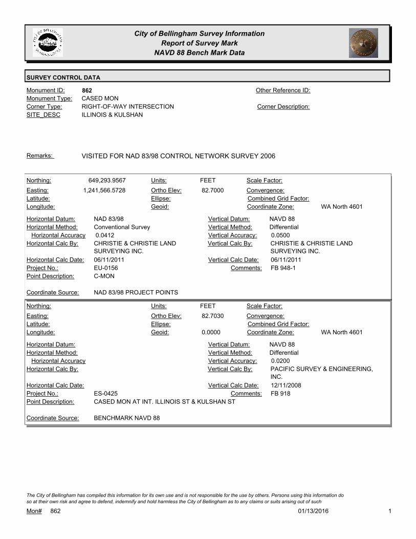
City of Bellingham Survey Information
Report of Survey Mark
NAVD 88 Bench Mark Data
SURVEY CONTROL DATA
862Monument ID: Other Reference ID:
SITE_DESC ILLINOIS & KULSHAN
RIGHT-OF-WAY INTERSECTIONCorner Type: Corner Description:
CASED MONMonument Type:
VISITED FOR NAD 83/98 CONTROL NETWORK SURVEY 2006Remarks:
649,293.9567
1,241,566.5728 82.7000
FEETNorthing:
Easting:
Latitude:
Longitude:
Units:
Ortho Elev:
Ellipse:
Geoid:
Scale Factor:
Convergence:
Combined Grid Factor:
WA North 4601Coordinate Zone:
Conventional SurveyHorizontal Method:
NAD 83/98Horizontal Datum: NAVD 88Vertical Datum:
DifferentialVertical Method:
0.0412Horizontal Accuracy 0.0500Vertical Accuracy:
CHRISTIE & CHRISTIE LAND
SURVEYING INC.
Vertical Calc By:CHRISTIE & CHRISTIE LAND
SURVEYING INC.
Horizontal Calc By:
EU-0156Project No.:
C-MONPoint Description:
NAD 83/98 PROJECT POINTSCoordinate Source:
FB 948-1Comments:
06/11/2011Horizontal Calc Date: 06/11/2011Vertical Calc Date:
82.7030
0.0000
FEETNorthing:
Easting:
Latitude:
Longitude:
Units:
Ortho Elev:
Ellipse:
Geoid:
Scale Factor:
Convergence:
Combined Grid Factor:
WA North 4601Coordinate Zone:
Horizontal Method:
Horizontal Datum: NAVD 88Vertical Datum:
DifferentialVertical Method:
Horizontal Accuracy 0.0200Vertical Accuracy:
PACIFIC SURVEY & ENGINEERING,
INC.
Vertical Calc By:Horizontal Calc By:
ES-0425Project No.:
CASED MON AT INT. ILLINOIS ST & KULSHAN STPoint Description:
BENCHMARK NAVD 88Coordinate Source:
FB 918Comments:
Horizontal Calc Date: 12/11/2008Vertical Calc Date:
101/13/2016Mon# 862
The City of Bellingham has compiled this information for its own use and is not responsible for the use by others. Persons using this information do
so at their own risk and agree to defend, indemnify and hold harmless the City of Bellingham as to any claims or suits arising out of such

City of Bellingham Survey Information
Report of Survey Mark
NAVD 88 Bench Mark Data
SURVEY CONTROL DATA
871Monument ID: Other Reference ID:
SITE_DESC ILLINOIS & WILLIAMS
RIGHT-OF-WAY INTERSECTIONCorner Type: Corner Description:
CASED MONMonument Type:
VISITED FOR NAD 83/98 CONTROL NETWORK SURVEY 2006.Remarks:
78.0890
0.0000
FEETNorthing:
Easting:
Latitude:
Longitude:
Units:
Ortho Elev:
Ellipse:
Geoid:
Scale Factor:
Convergence:
Combined Grid Factor:
WA North 4601Coordinate Zone:
Horizontal Method:
Horizontal Datum: NAVD 88Vertical Datum:
DifferentialVertical Method:
Horizontal Accuracy 0.0200Vertical Accuracy:
PACIFIC SURVEY & ENGINEERING,
INC.
Vertical Calc By:Horizontal Calc By:
ES-0425Project No.:
CASED MON (BRASS BRAD) AT INT W. ILLINOIS ST
& WILLIAMS ST
Point Description:
BENCHMARK NAVD 88Coordinate Source:
FB 918Comments:
Horizontal Calc Date: 01/06/2009Vertical Calc Date:
101/13/2016Mon# 871
The City of Bellingham has compiled this information for its own use and is not responsible for the use by others. Persons using this information do
so at their own risk and agree to defend, indemnify and hold harmless the City of Bellingham as to any claims or suits arising out of such

City of Bellingham Survey Information
Report of Survey Mark
NAVD 88 Bench Mark Data
SURVEY CONTROL DATA
872Monument ID: Other Reference ID:
SITE_DESC ILLINOIS & VICTOR PI
RIGHT-OF-WAY PICorner Type: Corner Description:
CASED MONMonument Type:
Remarks:
76.8220
0.0000
FEETNorthing:
Easting:
Latitude:
Longitude:
Units:
Ortho Elev:
Ellipse:
Geoid:
Scale Factor:
Convergence:
Combined Grid Factor:
WA North 4601Coordinate Zone:
Horizontal Method:
Horizontal Datum: NAVD 88Vertical Datum:
DifferentialVertical Method:
Horizontal Accuracy 0.0200Vertical Accuracy:
PACIFIC SURVEY & ENGINEERING,
INC.
Vertical Calc By:Horizontal Calc By:
ES-0425Project No.:
CASED MON (TOP OF NAIL) AT INT. ILLINOIS ST &
VICTOR ST
Point Description:
BENCHMARK NAVD 88Coordinate Source:
FB 918Comments:
Horizontal Calc Date: 12/31/2008Vertical Calc Date:
101/13/2016Mon# 872
The City of Bellingham has compiled this information for its own use and is not responsible for the use by others. Persons using this information do
so at their own risk and agree to defend, indemnify and hold harmless the City of Bellingham as to any claims or suits arising out of such

City of Bellingham Survey Information
Report of Survey Mark
NAVD 88 Bench Mark Data
SURVEY CONTROL DATA
876Monument ID: Other Reference ID:
SITE_DESC INDIANA & VALLETTE
RIGHT-OF-WAY INTERSECTIONCorner Type: Corner Description:
BRASS MONMonument Type:
RAISED 1999Remarks:
648,727.8649
1,242,556.7013 86.6400
FEETNorthing:
Easting:
Latitude:
Longitude:
Units:
Ortho Elev:
Ellipse:
Geoid:
Scale Factor:
Convergence:
Combined Grid Factor:
WA North 4601Coordinate Zone:
Conventional SurveyHorizontal Method:
NAD 83/98Horizontal Datum: NAVD 88Vertical Datum:
DifferentialVertical Method:
0.0400Horizontal Accuracy 0.0200Vertical Accuracy:
CONSTRUCTION SURVEYORS N W
INC.
Vertical Calc By:CONSTRUCTION SURVEYORS N
W INC.
Horizontal Calc By:
EU-0156Project No.:
Point Description:
NAD 83/98 PROJECT POINTSCoordinate Source:
FB 944-1Comments:
11/10/2011Horizontal Calc Date: 11/10/2011Vertical Calc Date:
101/13/2016Mon# 876
The City of Bellingham has compiled this information for its own use and is not responsible for the use by others. Persons using this information do
so at their own risk and agree to defend, indemnify and hold harmless the City of Bellingham as to any claims or suits arising out of such

City of Bellingham Survey Information
Report of Survey Mark
NAVD 88 Bench Mark Data
SURVEY CONTROL DATA
877Monument ID: Other Reference ID:
SITE_DESC INDIANA & MERIDIAN
RIGHT-OF-WAY INTERSECTIONCorner Type: Corner Description:
BRASS MONMonument Type:
Remarks:
86.1470
0.0000
FEETNorthing:
Easting:
Latitude:
Longitude:
Units:
Ortho Elev:
Ellipse:
Geoid:
Scale Factor:
Convergence:
Combined Grid Factor:
WA North 4601Coordinate Zone:
Horizontal Method:
Horizontal Datum: NAVD 88Vertical Datum:
DifferentialVertical Method:
Horizontal Accuracy 0.0200Vertical Accuracy:
PACIFIC SURVEY & ENGINEERING,
INC.
Vertical Calc By:Horizontal Calc By:
ES-0425Project No.:
BRASS MON AT INT. W. INDIANA ST & MERIDIAN
ST
Point Description:
BENCHMARK NAVD 88Coordinate Source:
FB 918Comments:
Horizontal Calc Date: 12/10/2008Vertical Calc Date:
101/13/2016Mon# 877
The City of Bellingham has compiled this information for its own use and is not responsible for the use by others. Persons using this information do
so at their own risk and agree to defend, indemnify and hold harmless the City of Bellingham as to any claims or suits arising out of such

City of Bellingham Survey Information
Report of Survey Mark
NAVD 88 Bench Mark Data
SURVEY CONTROL DATA
879Monument ID: Other Reference ID:
SITE_DESC IRON & ILLINOIS
RIGHT-OF-WAY INTERSECTIONCorner Type: Corner Description:
BRASS MONMonument Type:
Remarks:
649,154.8538
1,246,593.5201 164.4300
FEETNorthing:
Easting:
Latitude:
Longitude:
Units:
Ortho Elev:
Ellipse:
Geoid:
Scale Factor:
Convergence:
Combined Grid Factor:
WA North 4601Coordinate Zone:
Conventional SurveyHorizontal Method:
NAD 83/98Horizontal Datum: NAVD 88Vertical Datum:
DifferentialVertical Method:
0.0400Horizontal Accuracy 0.0200Vertical Accuracy:
CONSTRUCTION SURVEYORS N W
INC.
Vertical Calc By:CONSTRUCTION SURVEYORS N
W INC.
Horizontal Calc By:
EU-0156Project No.:
Point Description:
NAD 83/98 PROJECT POINTSCoordinate Source:
FB 944-3Comments:
11/14/2011Horizontal Calc Date: 11/14/2011Vertical Calc Date:
101/13/2016Mon# 879
The City of Bellingham has compiled this information for its own use and is not responsible for the use by others. Persons using this information do
so at their own risk and agree to defend, indemnify and hold harmless the City of Bellingham as to any claims or suits arising out of such

City of Bellingham Survey Information
Report of Survey Mark
NAVD 88 Bench Mark Data
SURVEY CONTROL DATA
885Monument ID: Other Reference ID:
SITE_DESC IRON & VIRGINIA
RIGHT-OF-WAY INTERSECTIONCorner Type: Corner Description:
BRASS MONMonument Type:
MON RAISED FOR 2000 OVERLAYRemarks:
77.0240
0.0000
FEETNorthing:
Easting:
Latitude:
Longitude:
Units:
Ortho Elev:
Ellipse:
Geoid:
Scale Factor:
Convergence:
Combined Grid Factor:
WA North 4601Coordinate Zone:
Horizontal Method:
Horizontal Datum: NAVD 88Vertical Datum:
DifferentialVertical Method:
Horizontal Accuracy 0.0300Vertical Accuracy:
WILSON ENGINEERING LLC.Vertical Calc By:Horizontal Calc By:
ES-0425Project No.:
C-BDS INT VIRGINIA & IRONPoint Description:
BENCHMARK NAVD 88Coordinate Source:
FB918-6 pg. 37Comments:
Horizontal Calc Date: 02/04/2009Vertical Calc Date:
101/13/2016Mon# 885
The City of Bellingham has compiled this information for its own use and is not responsible for the use by others. Persons using this information do
so at their own risk and agree to defend, indemnify and hold harmless the City of Bellingham as to any claims or suits arising out of such

City of Bellingham Survey Information
Report of Survey Mark
NAVD 88 Bench Mark Data
SURVEY CONTROL DATA
889Monument ID: Other Reference ID:
SITE_DESC IOWA & NEVADA
RIGHT-OF-WAY INTERSECTIONCorner Type: Corner Description:
BRASS MONMonument Type:
Remarks:
58.5930
0.0000
FEETNorthing:
Easting:
Latitude:
Longitude:
Units:
Ortho Elev:
Ellipse:
Geoid:
Scale Factor:
Convergence:
Combined Grid Factor:
WA North 4601Coordinate Zone:
Horizontal Method:
Horizontal Datum: NAVD 88Vertical Datum:
DifferentialVertical Method:
Horizontal Accuracy 0.0300Vertical Accuracy:
WILSON ENGINEERING LLC.Vertical Calc By:Horizontal Calc By:
ES-0425Project No.:
C-BDS INT IOWA & NEVADAPoint Description:
BENCHMARK NAVD 88Coordinate Source:
FB918-7 pg. 3Comments:
Horizontal Calc Date: 02/12/2009Vertical Calc Date:
101/13/2016Mon# 889
The City of Bellingham has compiled this information for its own use and is not responsible for the use by others. Persons using this information do
so at their own risk and agree to defend, indemnify and hold harmless the City of Bellingham as to any claims or suits arising out of such

City of Bellingham Survey Information
Report of Survey Mark
NAVD 88 Bench Mark Data
SURVEY CONTROL DATA
890Monument ID: Other Reference ID:
SITE_DESC IOWA & VALENCIA
RIGHT-OF-WAY INTERSECTIONCorner Type: Corner Description:
BRASS MONMonument Type:
Remarks:
78.5140
0.0000
FEETNorthing:
Easting:
Latitude:
Longitude:
Units:
Ortho Elev:
Ellipse:
Geoid:
Scale Factor:
Convergence:
Combined Grid Factor:
WA North 4601Coordinate Zone:
Horizontal Method:
Horizontal Datum: NAVD 88Vertical Datum:
DifferentialVertical Method:
Horizontal Accuracy 0.0300Vertical Accuracy:
WILSON ENGINEERING LLC.Vertical Calc By:Horizontal Calc By:
ES-0425Project No.:
C-BDS INT IOWA & VALENCIAPoint Description:
BENCHMARK NAVD 88Coordinate Source:
FB918-7 pg. 32Comments:
Horizontal Calc Date: 02/12/2009Vertical Calc Date:
101/13/2016Mon# 890
The City of Bellingham has compiled this information for its own use and is not responsible for the use by others. Persons using this information do
so at their own risk and agree to defend, indemnify and hold harmless the City of Bellingham as to any claims or suits arising out of such

City of Bellingham Survey Information
Report of Survey Mark
NAVD 88 Bench Mark Data
SURVEY CONTROL DATA
892Monument ID: Other Reference ID:
SITE_DESC IOWA & TOLEDO
RIGHT-OF-WAY INTERSECTIONCorner Type: Corner Description:
BRASS MONMonument Type:
RAISED FOR 2003 OVERLAYRemarks:
64.7430
0.0000
FEETNorthing:
Easting:
Latitude:
Longitude:
Units:
Ortho Elev:
Ellipse:
Geoid:
Scale Factor:
Convergence:
Combined Grid Factor:
WA North 4601Coordinate Zone:
Horizontal Method:
Horizontal Datum: NAVD 88Vertical Datum:
DifferentialVertical Method:
Horizontal Accuracy 0.0300Vertical Accuracy:
WILSON ENGINEERING LLC.Vertical Calc By:Horizontal Calc By:
ES-0425Project No.:
C-BDS INT IOWA & TOLEDOPoint Description:
BENCHMARK NAVD 88Coordinate Source:
FB918-7 pg. 33Comments:
Horizontal Calc Date: 02/12/2009Vertical Calc Date:
101/13/2016Mon# 892
The City of Bellingham has compiled this information for its own use and is not responsible for the use by others. Persons using this information do
so at their own risk and agree to defend, indemnify and hold harmless the City of Bellingham as to any claims or suits arising out of such

City of Bellingham Survey Information
Report of Survey Mark
NAVD 88 Bench Mark Data
SURVEY CONTROL DATA
893Monument ID: Other Reference ID:
SITE_DESC IOWA & RACINE
RIGHT-OF-WAY INTERSECTIONCorner Type: Corner Description:
BRASS MONMonument Type:
VISITED FOR NAD 83/98 CONTROL NETWORK SURVEY 2006.Remarks:
61.7580
0.0000
FEETNorthing:
Easting:
Latitude:
Longitude:
Units:
Ortho Elev:
Ellipse:
Geoid:
Scale Factor:
Convergence:
Combined Grid Factor:
WA North 4601Coordinate Zone:
Horizontal Method:
Horizontal Datum: NAVD 88Vertical Datum:
DifferentialVertical Method:
Horizontal Accuracy 0.0300Vertical Accuracy:
WILSON ENGINEERING LLC.Vertical Calc By:Horizontal Calc By:
ES-0425Project No.:
C-BDS INT IOWA & RACINEPoint Description:
BENCHMARK NAVD 88Coordinate Source:
FB918-7 pg. 33Comments:
Horizontal Calc Date: 02/12/2009Vertical Calc Date:
101/13/2016Mon# 893
The City of Bellingham has compiled this information for its own use and is not responsible for the use by others. Persons using this information do
so at their own risk and agree to defend, indemnify and hold harmless the City of Bellingham as to any claims or suits arising out of such

City of Bellingham Survey Information
Report of Survey Mark
NAVD 88 Bench Mark Data
SURVEY CONTROL DATA
902Monument ID: Other Reference ID:
SITE_DESC IRVING & D
RIGHT-OF-WAY INTERSECTIONCorner Type: Corner Description:
BRASS MONMonument Type:
Remarks:
76.5730
0.0000
FEETNorthing:
Easting:
Latitude:
Longitude:
Units:
Ortho Elev:
Ellipse:
Geoid:
Scale Factor:
Convergence:
Combined Grid Factor:
WA North 4601Coordinate Zone:
Horizontal Method:
Horizontal Datum: NAVD 88Vertical Datum:
DifferentialVertical Method:
Horizontal Accuracy 0.0300Vertical Accuracy:
WILSON ENGINEERING LLC.Vertical Calc By:Horizontal Calc By:
ES-0425Project No.:
C-BDS INT D & IRVINGPoint Description:
BENCHMARK NAVD 88Coordinate Source:
FB918-6 pg. 27Comments:
Horizontal Calc Date: 02/04/2009Vertical Calc Date:
101/13/2016Mon# 902
The City of Bellingham has compiled this information for its own use and is not responsible for the use by others. Persons using this information do
so at their own risk and agree to defend, indemnify and hold harmless the City of Bellingham as to any claims or suits arising out of such

City of Bellingham Survey Information
Report of Survey Mark
NAVD 88 Bench Mark Data
SURVEY CONTROL DATA
935Monument ID: Other Reference ID:
SITE_DESC JAMES & VIRGINIA
RIGHT-OF-WAY INTERSECTIONCorner Type: Corner Description:
BRASS MONMonument Type:
Remarks:
75.9440
0.0000
FEETNorthing:
Easting:
Latitude:
Longitude:
Units:
Ortho Elev:
Ellipse:
Geoid:
Scale Factor:
Convergence:
Combined Grid Factor:
WA North 4601Coordinate Zone:
Horizontal Method:
Horizontal Datum: NAVD 88Vertical Datum:
DifferentialVertical Method:
Horizontal Accuracy 0.0300Vertical Accuracy:
WILSON ENGINEERING LLC.Vertical Calc By:Horizontal Calc By:
ES-0425Project No.:
C-BDS INT VIRGINIA & JAMESPoint Description:
BENCHMARK NAVD 88Coordinate Source:
FB918-6 pg. 37Comments:
Horizontal Calc Date: 02/04/2009Vertical Calc Date:
101/13/2016Mon# 935
The City of Bellingham has compiled this information for its own use and is not responsible for the use by others. Persons using this information do
so at their own risk and agree to defend, indemnify and hold harmless the City of Bellingham as to any claims or suits arising out of such

City of Bellingham Survey Information
Report of Survey Mark
NAVD 88 Bench Mark Data
SURVEY CONTROL DATA
954Monument ID: Other Reference ID:
SITE_DESC KULSHAN & NORTH
RIGHT-OF-WAY INTERSECTIONCorner Type: Corner Description:
CASED MONMonument Type:
VISITED FOR NAD 83/98 CONTROL NETWORK SURVEY 2006.Remarks:
78.4240
0.0000
FEETNorthing:
Easting:
Latitude:
Longitude:
Units:
Ortho Elev:
Ellipse:
Geoid:
Scale Factor:
Convergence:
Combined Grid Factor:
WA North 4601Coordinate Zone:
Horizontal Method:
Horizontal Datum: NAVD 88Vertical Datum:
DifferentialVertical Method:
Horizontal Accuracy 0.0200Vertical Accuracy:
PACIFIC SURVEY & ENGINEERING,
INC.
Vertical Calc By:Horizontal Calc By:
ES-0425Project No.:
CASED MON (TOP OF NAIL)AT INT. W. NORTH ST &
KULSHAN ST
Point Description:
BENCHMARK NAVD 88Coordinate Source:
FB 918Comments:
Horizontal Calc Date: 01/06/2009Vertical Calc Date:
101/13/2016Mon# 954
The City of Bellingham has compiled this information for its own use and is not responsible for the use by others. Persons using this information do
so at their own risk and agree to defend, indemnify and hold harmless the City of Bellingham as to any claims or suits arising out of such

City of Bellingham Survey Information
Report of Survey Mark
NAVD 88 Bench Mark Data
SURVEY CONTROL DATA
956Monument ID: Other Reference ID:
SITE_DESC KING & ILLINOIS
RIGHT-OF-WAY INTERSECTIONCorner Type: Corner Description:
BRASS MONMonument Type:
MON DAMAGED 7-13-05. VISITED FOR NAD 83/98 CONTROL
NETWORK SURVEY 2006.
Remarks:
169.5190
0.0000
FEETNorthing:
Easting:
Latitude:
Longitude:
Units:
Ortho Elev:
Ellipse:
Geoid:
Scale Factor:
Convergence:
Combined Grid Factor:
WA North 4601Coordinate Zone:
Horizontal Method:
Horizontal Datum: NAVD 88Vertical Datum:
DifferentialVertical Method:
Horizontal Accuracy 0.0200Vertical Accuracy:
PACIFIC SURVEY & ENGINEERING,
INC.
Vertical Calc By:Horizontal Calc By:
ES-0425Project No.:
BRASS MON AT INT. ILLINOIS ST & KING STPoint Description:
BENCHMARK NAVD 88Coordinate Source:
FB 918Comments:
Horizontal Calc Date: 12/09/2008Vertical Calc Date:
101/13/2016Mon# 956
The City of Bellingham has compiled this information for its own use and is not responsible for the use by others. Persons using this information do
so at their own risk and agree to defend, indemnify and hold harmless the City of Bellingham as to any claims or suits arising out of such

City of Bellingham Survey Information
Report of Survey Mark
NAVD 88 Bench Mark Data
SURVEY CONTROL DATA
967Monument ID: Other Reference ID:
SITE_DESC LINCOLN & MAPLE
RIGHT-OF-WAY INTERSECTIONCorner Type: Corner Description:
BRASS MONMonument Type:
VISITED FOR NAD 83/98 CONTROL NETWORK SURVEY 2006.Remarks:
637,748.6960
1,246,571.6320 170.8600
FEETNorthing:
Easting:
Latitude:
Longitude:
Units:
Ortho Elev:
Ellipse:
Geoid:
Scale Factor:
Convergence:
Combined Grid Factor:
WA North 4601Coordinate Zone:
Conventional SurveyHorizontal Method:
NAD 83/98Horizontal Datum: NAVD 88Vertical Datum:
DifferentialVertical Method:
0.0200Horizontal Accuracy 0.0300Vertical Accuracy:
LARRY STEELE & ASSOCIATESVertical Calc By:LARRY STEELE & ASSOCIATESHorizontal Calc By:
ES-0504Project No.:
Point Description:
NAD 83/98 PROJECT POINTSCoordinate Source:
Comments:
02/04/2015Horizontal Calc Date: 02/04/2015Vertical Calc Date:
170.8460
0.0000
FEETNorthing:
Easting:
Latitude:
Longitude:
Units:
Ortho Elev:
Ellipse:
Geoid:
Scale Factor:
Convergence:
Combined Grid Factor:
WA North 4601Coordinate Zone:
Horizontal Method:
Horizontal Datum: NAVD 88Vertical Datum:
DifferentialVertical Method:
Horizontal Accuracy 0.0200Vertical Accuracy:
LARRY STEELE & ASSOCIATESVertical Calc By:Horizontal Calc By:
ES-0425Project No.:
BRASS MON AT LINCOLN & MAPLEPoint Description:
BENCHMARK NAVD 88Coordinate Source:
FB 918-11Comments:
Horizontal Calc Date: 02/17/2009Vertical Calc Date:
101/13/2016Mon# 967
The City of Bellingham has compiled this information for its own use and is not responsible for the use by others. Persons using this information do
so at their own risk and agree to defend, indemnify and hold harmless the City of Bellingham as to any claims or suits arising out of such
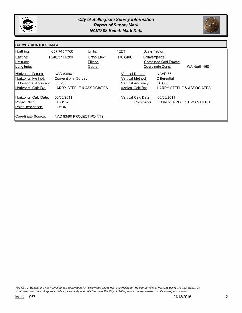
City of Bellingham Survey Information
Report of Survey Mark
NAVD 88 Bench Mark Data
SURVEY CONTROL DATA
637,748.7700
1,246,571.6280 170.8400
FEETNorthing:
Easting:
Latitude:
Longitude:
Units:
Ortho Elev:
Ellipse:
Geoid:
Scale Factor:
Convergence:
Combined Grid Factor:
WA North 4601Coordinate Zone:
Conventional SurveyHorizontal Method:
NAD 83/98Horizontal Datum: NAVD 88Vertical Datum:
DifferentialVertical Method:
0.0200Horizontal Accuracy 0.0300Vertical Accuracy:
LARRY STEELE & ASSOCIATESVertical Calc By:LARRY STEELE & ASSOCIATESHorizontal Calc By:
EU-0159Project No.:
C-MONPoint Description:
NAD 83/98 PROJECT POINTSCoordinate Source:
FB 947-1 PROJECT POINT #101Comments:
06/30/2011Horizontal Calc Date: 06/30/2011Vertical Calc Date:
201/13/2016Mon# 967
The City of Bellingham has compiled this information for its own use and is not responsible for the use by others. Persons using this information do
so at their own risk and agree to defend, indemnify and hold harmless the City of Bellingham as to any claims or suits arising out of such

City of Bellingham Survey Information
Report of Survey Mark
NAVD 88 Bench Mark Data
SURVEY CONTROL DATA
968Monument ID: Other Reference ID:
SITE_DESC LINCOLN & GLADSTONE
RIGHT-OF-WAY INTERSECTIONCorner Type: Corner Description:
BRASS MONMonument Type:
NOTE: MON WILL BE DESTROYED AND RAISED BY
CONSTRUCTION IN 2009. ELEVATION AS OF THIS DATE NO
LONGER VALID.
Remarks:
93.5280
0.0000
FEETNorthing:
Easting:
Latitude:
Longitude:
Units:
Ortho Elev:
Ellipse:
Geoid:
Scale Factor:
Convergence:
Combined Grid Factor:
WA North 4601Coordinate Zone:
Horizontal Method:
Horizontal Datum: NAVD 88Vertical Datum:
DifferentialVertical Method:
Horizontal Accuracy 0.0300Vertical Accuracy:
WILSON ENGINEERING LLC.Vertical Calc By:Horizontal Calc By:
ES-0425Project No.:
C-BDS INT LINCOLN & GLADSTONE. ELEVATION
NO LONGER VALID
Point Description:
BENCHMARK NAVD 88Coordinate Source:
FB918-7 PG. 13. NOTE: MON WILL
BE DESTROYED AND RAISED BY
CONSTRUCTION IN 2009.
Comments:
Horizontal Calc Date: 02/12/2009Vertical Calc Date:
101/13/2016Mon# 968
The City of Bellingham has compiled this information for its own use and is not responsible for the use by others. Persons using this information do
so at their own risk and agree to defend, indemnify and hold harmless the City of Bellingham as to any claims or suits arising out of such
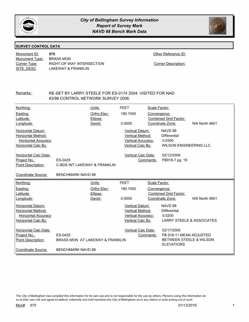
City of Bellingham Survey Information
Report of Survey Mark
NAVD 88 Bench Mark Data
SURVEY CONTROL DATA
975Monument ID: Other Reference ID:
SITE_DESC LAKEWAY & FRANKLIN
RIGHT-OF-WAY INTERSECTIONCorner Type: Corner Description:
BRASS MONMonument Type:
RE-SET BY LARRY STEELE FOR ES-0174 2004. VISITED FOR NAD
83/98 CONTROL NETWORK SURVEY 2006.
Remarks:
180.7450
0.0000
FEETNorthing:
Easting:
Latitude:
Longitude:
Units:
Ortho Elev:
Ellipse:
Geoid:
Scale Factor:
Convergence:
Combined Grid Factor:
WA North 4601Coordinate Zone:
Horizontal Method:
Horizontal Datum: NAVD 88Vertical Datum:
DifferentialVertical Method:
Horizontal Accuracy 0.0300Vertical Accuracy:
WILSON ENGINEERING LLC.Vertical Calc By:Horizontal Calc By:
ES-0425Project No.:
C-BDS INT LAKEWAY & FRANKLINPoint Description:
BENCHMARK NAVD 88Coordinate Source:
FB918-7 pg. 19Comments:
Horizontal Calc Date: 02/12/2009Vertical Calc Date:
180.7450
0.0000
FEETNorthing:
Easting:
Latitude:
Longitude:
Units:
Ortho Elev:
Ellipse:
Geoid:
Scale Factor:
Convergence:
Combined Grid Factor:
WA North 4601Coordinate Zone:
Horizontal Method:
Horizontal Datum: NAVD 88Vertical Datum:
DifferentialVertical Method:
Horizontal Accuracy 0.0200Vertical Accuracy:
LARRY STEELE & ASSOCIATESVertical Calc By:Horizontal Calc By:
ES-0425Project No.:
BRASS MON AT LAKEWAY & FRANKLINPoint Description:
BENCHMARK NAVD 88Coordinate Source:
FB 918-11 MEAN ADJUSTED
BETWEEN STEELE & WILSON
ELEVATIONS
Comments:
Horizontal Calc Date: 02/17/2009Vertical Calc Date:
101/13/2016Mon# 975
The City of Bellingham has compiled this information for its own use and is not responsible for the use by others. Persons using this information do
so at their own risk and agree to defend, indemnify and hold harmless the City of Bellingham as to any claims or suits arising out of such

City of Bellingham Survey Information
Report of Survey Mark
NAVD 88 Bench Mark Data
SURVEY CONTROL DATA
995Monument ID: Other Reference ID:
SITE_DESC LAKEWAY & PACIFIC
RIGHT-OF-WAY INTERSECTIONCorner Type: Corner Description:
BRASS MONMonument Type:
MON RE-SET BY LARRY STEELE FOR ES-0174 2004Remarks:
187.3990
0.0000
FEETNorthing:
Easting:
Latitude:
Longitude:
Units:
Ortho Elev:
Ellipse:
Geoid:
Scale Factor:
Convergence:
Combined Grid Factor:
WA North 4601Coordinate Zone:
Horizontal Method:
Horizontal Datum: NAVD 88Vertical Datum:
DifferentialVertical Method:
Horizontal Accuracy 0.0300Vertical Accuracy:
WILSON ENGINEERING LLC.Vertical Calc By:Horizontal Calc By:
ES-0425Project No.:
C-BDS INT PACIFIC & LAKEWAYPoint Description:
BENCHMARK NAVD 88Coordinate Source:
FB918-7 pg. 42Comments:
Horizontal Calc Date: 02/12/2009Vertical Calc Date:
101/13/2016Mon# 995
The City of Bellingham has compiled this information for its own use and is not responsible for the use by others. Persons using this information do
so at their own risk and agree to defend, indemnify and hold harmless the City of Bellingham as to any claims or suits arising out of such
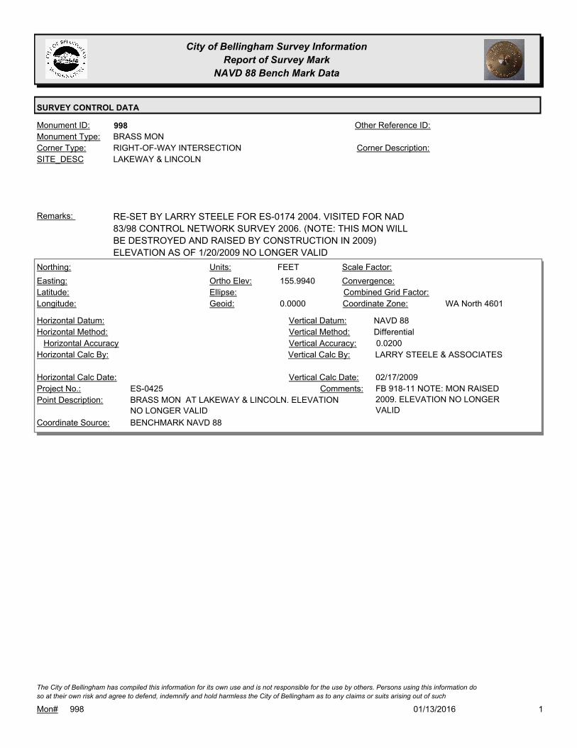
City of Bellingham Survey Information
Report of Survey Mark
NAVD 88 Bench Mark Data
SURVEY CONTROL DATA
998Monument ID: Other Reference ID:
SITE_DESC LAKEWAY & LINCOLN
RIGHT-OF-WAY INTERSECTIONCorner Type: Corner Description:
BRASS MONMonument Type:
RE-SET BY LARRY STEELE FOR ES-0174 2004. VISITED FOR NAD
83/98 CONTROL NETWORK SURVEY 2006. (NOTE: THIS MON WILL
BE DESTROYED AND RAISED BY CONSTRUCTION IN 2009)
ELEVATION AS OF 1/20/2009 NO LONGER VALID
Remarks:
155.9940
0.0000
FEETNorthing:
Easting:
Latitude:
Longitude:
Units:
Ortho Elev:
Ellipse:
Geoid:
Scale Factor:
Convergence:
Combined Grid Factor:
WA North 4601Coordinate Zone:
Horizontal Method:
Horizontal Datum: NAVD 88Vertical Datum:
DifferentialVertical Method:
Horizontal Accuracy 0.0200Vertical Accuracy:
LARRY STEELE & ASSOCIATESVertical Calc By:Horizontal Calc By:
ES-0425Project No.:
BRASS MON AT LAKEWAY & LINCOLN. ELEVATION
NO LONGER VALID
Point Description:
BENCHMARK NAVD 88Coordinate Source:
FB 918-11 NOTE: MON RAISED
2009. ELEVATION NO LONGER
VALID
Comments:
Horizontal Calc Date: 02/17/2009Vertical Calc Date:
101/13/2016Mon# 998
The City of Bellingham has compiled this information for its own use and is not responsible for the use by others. Persons using this information do
so at their own risk and agree to defend, indemnify and hold harmless the City of Bellingham as to any claims or suits arising out of such

City of Bellingham Survey Information
Report of Survey Mark
NAVD 88 Bench Mark Data
SURVEY CONTROL DATA
1003Monument ID: Other Reference ID:
SITE_DESC LYNN & TULIP
RIGHT-OF-WAY INTERSECTIONCorner Type: Corner Description:
BRASS MONMonument Type:
Remarks:
81.8670
0.0000
FEETNorthing:
Easting:
Latitude:
Longitude:
Units:
Ortho Elev:
Ellipse:
Geoid:
Scale Factor:
Convergence:
Combined Grid Factor:
WA North 4601Coordinate Zone:
Horizontal Method:
Horizontal Datum: NAVD 88Vertical Datum:
DifferentialVertical Method:
Horizontal Accuracy 0.0200Vertical Accuracy:
PACIFIC SURVEY & ENGINEERING,
INC.
Vertical Calc By:Horizontal Calc By:
ES-0425Project No.:
BRASS MON AT INT LYNN ST & TULIP STPoint Description:
BENCHMARK NAVD 88Coordinate Source:
FB 918Comments:
Horizontal Calc Date: 12/31/2008Vertical Calc Date:
101/13/2016Mon# 1003
The City of Bellingham has compiled this information for its own use and is not responsible for the use by others. Persons using this information do
so at their own risk and agree to defend, indemnify and hold harmless the City of Bellingham as to any claims or suits arising out of such

City of Bellingham Survey Information
Report of Survey Mark
NAVD 88 Bench Mark Data
SURVEY CONTROL DATA
1006Monument ID: Other Reference ID:
SITE_DESC LYNN & PT W/O NORTHWEST
RIGHT-OF-WAY PTCorner Type: Corner Description:
BRASS MONMonument Type:
RAISED 2-14-96, RAISED FOR 1997 OVERLAYRemarks:
83.2650
0.0000
FEETNorthing:
Easting:
Latitude:
Longitude:
Units:
Ortho Elev:
Ellipse:
Geoid:
Scale Factor:
Convergence:
Combined Grid Factor:
WA North 4601Coordinate Zone:
Horizontal Method:
Horizontal Datum: NAVD 88Vertical Datum:
DifferentialVertical Method:
Horizontal Accuracy 0.0200Vertical Accuracy:
PACIFIC SURVEY & ENGINEERING,
INC.
Vertical Calc By:Horizontal Calc By:
ES-0425Project No.:
BRASS MON 70 FEET WEST OF INTERSECTION
NORTHWEST AVE AND LYNN ST
Point Description:
BENCHMARK NAVD 88Coordinate Source:
FB 918Comments:
Horizontal Calc Date: 12/29/2008Vertical Calc Date:
101/13/2016Mon# 1006
The City of Bellingham has compiled this information for its own use and is not responsible for the use by others. Persons using this information do
so at their own risk and agree to defend, indemnify and hold harmless the City of Bellingham as to any claims or suits arising out of such

City of Bellingham Survey Information
Report of Survey Mark
NAVD 88 Bench Mark Data
SURVEY CONTROL DATA
1021Monument ID: Other Reference ID:
SITE_DESC INDIANA & PEABBODY
RIGHT-OF-WAY INTERSECTIONCorner Type: Corner Description:
BRASS MONMonument Type:
Remarks:
649,739.0873
1,242,127.9094 88.0500
FEETNorthing:
Easting:
Latitude:
Longitude:
Units:
Ortho Elev:
Ellipse:
Geoid:
Scale Factor:
Convergence:
Combined Grid Factor:
WA North 4601Coordinate Zone:
Conventional SurveyHorizontal Method:
NAD 83/98Horizontal Datum: NAVD 88Vertical Datum:
DifferentialVertical Method:
0.0400Horizontal Accuracy 0.0200Vertical Accuracy:
CONSTRUCTION SURVEYORS N W
INC.
Vertical Calc By:CONSTRUCTION SURVEYORS N
W INC.
Horizontal Calc By:
EU-0156Project No.:
Point Description:
NAD 83/98 PROJECT POINTSCoordinate Source:
Comments:
04/18/2011Horizontal Calc Date: 11/10/2011Vertical Calc Date:
101/13/2016Mon# 1021
The City of Bellingham has compiled this information for its own use and is not responsible for the use by others. Persons using this information do
so at their own risk and agree to defend, indemnify and hold harmless the City of Bellingham as to any claims or suits arising out of such
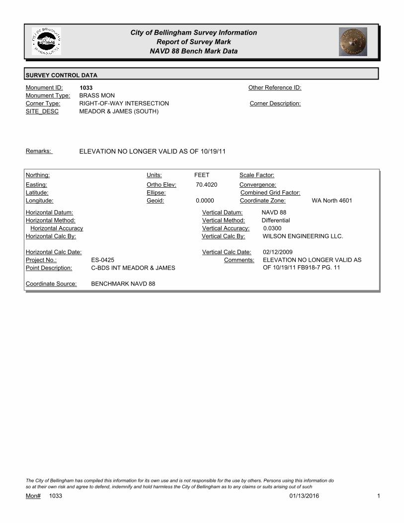
City of Bellingham Survey Information
Report of Survey Mark
NAVD 88 Bench Mark Data
SURVEY CONTROL DATA
1033Monument ID: Other Reference ID:
SITE_DESC MEADOR & JAMES (SOUTH)
RIGHT-OF-WAY INTERSECTIONCorner Type: Corner Description:
BRASS MONMonument Type:
ELEVATION NO LONGER VALID AS OF 10/19/11Remarks:
70.4020
0.0000
FEETNorthing:
Easting:
Latitude:
Longitude:
Units:
Ortho Elev:
Ellipse:
Geoid:
Scale Factor:
Convergence:
Combined Grid Factor:
WA North 4601Coordinate Zone:
Horizontal Method:
Horizontal Datum: NAVD 88Vertical Datum:
DifferentialVertical Method:
Horizontal Accuracy 0.0300Vertical Accuracy:
WILSON ENGINEERING LLC.Vertical Calc By:Horizontal Calc By:
ES-0425Project No.:
C-BDS INT MEADOR & JAMESPoint Description:
BENCHMARK NAVD 88Coordinate Source:
ELEVATION NO LONGER VALID AS
OF 10/19/11 FB918-7 PG. 11
Comments:
Horizontal Calc Date: 02/12/2009Vertical Calc Date:
101/13/2016Mon# 1033
The City of Bellingham has compiled this information for its own use and is not responsible for the use by others. Persons using this information do
so at their own risk and agree to defend, indemnify and hold harmless the City of Bellingham as to any claims or suits arising out of such

City of Bellingham Survey Information
Report of Survey Mark
NAVD 88 Bench Mark Data
SURVEY CONTROL DATA
1041Monument ID: Other Reference ID:
SITE_DESC MCLEOD & NORTHWEST
RIGHT-OF-WAY INTERSECTIONCorner Type: Corner Description:
CONCRETE MONMonument Type:
VISITED FOR NAD 83/98 CONTROL NETWORK 2005. WILL BE
IMPACTED BY PROJECT ES-0360
Remarks:
131.5500
0.0000
FEETNorthing:
Easting:
Latitude:
Longitude:
Units:
Ortho Elev:
Ellipse:
Geoid:
Scale Factor:
Convergence:
Combined Grid Factor:
WA North 4601Coordinate Zone:
Horizontal Method:
Horizontal Datum: NAVD 88Vertical Datum:
DifferentialVertical Method:
Horizontal Accuracy 0.0200Vertical Accuracy:
PACIFIC SURVEY & ENGINEERING,
INC.
Vertical Calc By:Horizontal Calc By:
ES-0425Project No.:
BRASS MON AT INT. MCLEOD RD & NORTHWEST
AVE
Point Description:
BENCHMARK NAVD 88Coordinate Source:
FB 918Comments:
Horizontal Calc Date: 12/29/2008Vertical Calc Date:
101/13/2016Mon# 1041
The City of Bellingham has compiled this information for its own use and is not responsible for the use by others. Persons using this information do
so at their own risk and agree to defend, indemnify and hold harmless the City of Bellingham as to any claims or suits arising out of such

City of Bellingham Survey Information
Report of Survey Mark
NAVD 88 Bench Mark Data
SURVEY CONTROL DATA
1042Monument ID: Other Reference ID:
SITE_DESC MCLEOD & CENTER OF SECTION.
LOCATED NEAR RES #2706
SECTION CENTERCorner Type: CENTER SECTION 13
T38N R2E
Corner Description:
BRASS MONMonument Type:
VISITED FOR NAD 83/98 CONTROL NETWORK 2005.Remarks:
131.3020
0.0000
FEETNorthing:
Easting:
Latitude:
Longitude:
Units:
Ortho Elev:
Ellipse:
Geoid:
Scale Factor:
Convergence:
Combined Grid Factor:
WA North 4601Coordinate Zone:
Horizontal Method:
Horizontal Datum: NAVD 88Vertical Datum:
DifferentialVertical Method:
Horizontal Accuracy 0.0200Vertical Accuracy:
PACIFIC SURVEY & ENGINEERING,
INC.
Vertical Calc By:Horizontal Calc By:
ES-0425Project No.:
BRASS MON (SEC CNR) IN W-BOUND LANE
MCLEOD RD, OPP. RES #2708
Point Description:
BENCHMARK NAVD 88Coordinate Source:
FB 918Comments:
Horizontal Calc Date: 12/10/2008Vertical Calc Date:
101/13/2016Mon# 1042
The City of Bellingham has compiled this information for its own use and is not responsible for the use by others. Persons using this information do
so at their own risk and agree to defend, indemnify and hold harmless the City of Bellingham as to any claims or suits arising out of such

City of Bellingham Survey Information
Report of Survey Mark
NAVD 88 Bench Mark Data
SURVEY CONTROL DATA
1045Monument ID: Other Reference ID:
SITE_DESC MERIDIAN & OREGON
RIGHT-OF-WAY INTERSECTIONCorner Type: Corner Description:
BRASS MONMonument Type:
MON SET FOR MERIDIAN OVERLAY 10-19-94Remarks:
87.8360
0.0000
FEETNorthing:
Easting:
Latitude:
Longitude:
Units:
Ortho Elev:
Ellipse:
Geoid:
Scale Factor:
Convergence:
Combined Grid Factor:
WA North 4601Coordinate Zone:
Horizontal Method:
Horizontal Datum: NAVD 88Vertical Datum:
DifferentialVertical Method:
Horizontal Accuracy 0.0200Vertical Accuracy:
PACIFIC SURVEY & ENGINEERING,
INC.
Vertical Calc By:Horizontal Calc By:
ES-0425Project No.:
BRASS MON AT INT. W. OREGON ST & MERIDIAN
ST
Point Description:
BENCHMARK NAVD 88Coordinate Source:
FB 918Comments:
Horizontal Calc Date: 12/10/2008Vertical Calc Date:
101/13/2016Mon# 1045
The City of Bellingham has compiled this information for its own use and is not responsible for the use by others. Persons using this information do
so at their own risk and agree to defend, indemnify and hold harmless the City of Bellingham as to any claims or suits arising out of such
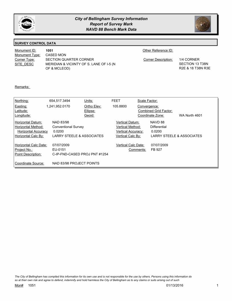
City of Bellingham Survey Information
Report of Survey Mark
NAVD 88 Bench Mark Data
SURVEY CONTROL DATA
1051Monument ID: Other Reference ID:
SITE_DESC MERIDIAN & VICIINTY OF S. LANE OF I-5 (N
OF & MCLEOD)
SECTION QUARTER CORNERCorner Type: 1/4 CORNER
SECTION 13 T38N
R2E & 18 T38N R3E
Corner Description:
CASED MONMonument Type:
Remarks:
654,517.3494
1,241,952.0170 105.8800
FEETNorthing:
Easting:
Latitude:
Longitude:
Units:
Ortho Elev:
Ellipse:
Geoid:
Scale Factor:
Convergence:
Combined Grid Factor:
WA North 4601Coordinate Zone:
Conventional SurveyHorizontal Method:
NAD 83/98Horizontal Datum: NAVD 88Vertical Datum:
DifferentialVertical Method:
0.0200Horizontal Accuracy 0.0200Vertical Accuracy:
LARRY STEELE & ASSOCIATESVertical Calc By:LARRY STEELE & ASSOCIATESHorizontal Calc By:
EU-0151Project No.:
C-IP-FND-CASED PROJ PNT #1254Point Description:
NAD 83/98 PROJECT POINTSCoordinate Source:
FB 927Comments:
07/07/2009Horizontal Calc Date: 07/07/2009Vertical Calc Date:
101/13/2016Mon# 1051
The City of Bellingham has compiled this information for its own use and is not responsible for the use by others. Persons using this information do
so at their own risk and agree to defend, indemnify and hold harmless the City of Bellingham as to any claims or suits arising out of such

City of Bellingham Survey Information
Report of Survey Mark
NAVD 88 Bench Mark Data
SURVEY CONTROL DATA
1059Monument ID: Other Reference ID:
SITE_DESC MARYLAND & VALLETTE
RIGHT-OF-WAY INTERSECTIONCorner Type: Corner Description:
BRASS MONMonument Type:
Remarks:
648,812.6008
1,242,382.1567 85.3000
FEETNorthing:
Easting:
Latitude:
Longitude:
Units:
Ortho Elev:
Ellipse:
Geoid:
Scale Factor:
Convergence:
Combined Grid Factor:
WA North 4601Coordinate Zone:
Conventional SurveyHorizontal Method:
NAD 83/98Horizontal Datum: NAVD 88Vertical Datum:
DifferentialVertical Method:
0.0330Horizontal Accuracy 0.0100Vertical Accuracy:
CONSTRUCTION SURVEYORS N W
INC.
Vertical Calc By:CONSTRUCTION SURVEYORS N
W INC.
Horizontal Calc By:
EU-0156Project No.:
C-BDSPoint Description:
NAD 83/98 PROJECT POINTSCoordinate Source:
FB 964-1Comments:
04/09/2012Horizontal Calc Date: 04/09/2012Vertical Calc Date:
101/13/2016Mon# 1059
The City of Bellingham has compiled this information for its own use and is not responsible for the use by others. Persons using this information do
so at their own risk and agree to defend, indemnify and hold harmless the City of Bellingham as to any claims or suits arising out of such

City of Bellingham Survey Information
Report of Survey Mark
NAVD 88 Bench Mark Data
SURVEY CONTROL DATA
1060Monument ID: Other Reference ID:
SITE_DESC MARYLAND & PEABODY
RIGHT-OF-WAY INTERSECTIONCorner Type: Corner Description:
BRASS MONMonument Type:
Remarks:
82.5000
FEETNorthing:
Easting:
Latitude:
Longitude:
Units:
Ortho Elev:
Ellipse:
Geoid:
Scale Factor:
Convergence:
Combined Grid Factor:
Coordinate Zone:
Horizontal Method:
Horizontal Datum: NAVD 88Vertical Datum:
DifferentialVertical Method:
Horizontal Accuracy 0.0100Vertical Accuracy:
CONSTRUCTION SURVEYORS N W
INC.
Vertical Calc By:Horizontal Calc By:
EU-0156Project No.:
Point Description:
BENCHMARK NAVD 88Coordinate Source:
FB 964-1Comments:
Horizontal Calc Date: 04/09/2012Vertical Calc Date:
101/13/2016Mon# 1060
The City of Bellingham has compiled this information for its own use and is not responsible for the use by others. Persons using this information do
so at their own risk and agree to defend, indemnify and hold harmless the City of Bellingham as to any claims or suits arising out of such

City of Bellingham Survey Information
Report of Survey Mark
NAVD 88 Bench Mark Data
SURVEY CONTROL DATA
1061Monument ID: Other Reference ID:
SITE_DESC MARYLAND & KULSHAN
RIGHT-OF-WAY INTERSECTIONCorner Type: Corner Description:
CASED MONMonument Type:
Remarks:
648,833.7909
1,241,555.0605 80.9600
FEETNorthing:
Easting:
Latitude:
Longitude:
Units:
Ortho Elev:
Ellipse:
Geoid:
Scale Factor:
Convergence:
Combined Grid Factor:
WA North 4601Coordinate Zone:
Conventional SurveyHorizontal Method:
NAD 83/98Horizontal Datum: NAVD 88Vertical Datum:
DifferentialVertical Method:
0.0200Horizontal Accuracy 0.0300Vertical Accuracy:
LARRY STEELE & ASSOCIATESVertical Calc By:LARRY STEELE & ASSOCIATESHorizontal Calc By:
EU-0151Project No.:
C-MON FND W/PINPoint Description:
NAD 83/98 PROJECT POINTSCoordinate Source:
FB 934-1 PROJECT PT. #6011Comments:
12/15/2010Horizontal Calc Date: 12/15/2010Vertical Calc Date:
101/13/2016Mon# 1061
The City of Bellingham has compiled this information for its own use and is not responsible for the use by others. Persons using this information do
so at their own risk and agree to defend, indemnify and hold harmless the City of Bellingham as to any claims or suits arising out of such

City of Bellingham Survey Information
Report of Survey Mark
NAVD 88 Bench Mark Data
SURVEY CONTROL DATA
1062Monument ID: Other Reference ID:
SITE_DESC MARYLAND & ELM
RIGHT-OF-WAY INTERSECTIONCorner Type: Corner Description:
CASED MONMonument Type:
Remarks:
648,841.2959
1,241,279.1656 81.8800
FEETNorthing:
Easting:
Latitude:
Longitude:
Units:
Ortho Elev:
Ellipse:
Geoid:
Scale Factor:
Convergence:
Combined Grid Factor:
WA North 4601Coordinate Zone:
Conventional SurveyHorizontal Method:
NAD 83/98Horizontal Datum: NAVD 88Vertical Datum:
DifferentialVertical Method:
0.0200Horizontal Accuracy 0.0300Vertical Accuracy:
LARRY STEELE & ASSOCIATESVertical Calc By:LARRY STEELE & ASSOCIATESHorizontal Calc By:
Project No.:
C-MON FND W/PINPoint Description:
NAD 83/98 PROJECT POINTSCoordinate Source:
FB 134-1 PROJECT PT. #6010Comments:
12/15/2010Horizontal Calc Date: 12/15/2010Vertical Calc Date:
101/13/2016Mon# 1062
The City of Bellingham has compiled this information for its own use and is not responsible for the use by others. Persons using this information do
so at their own risk and agree to defend, indemnify and hold harmless the City of Bellingham as to any claims or suits arising out of such
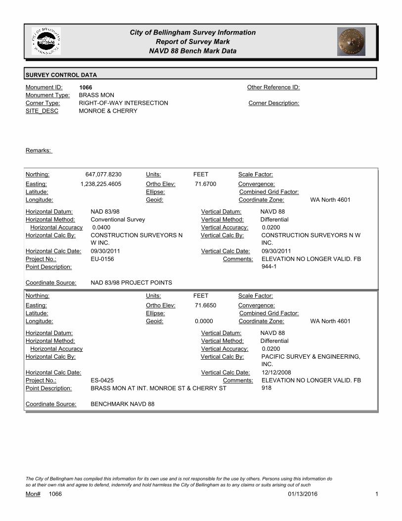
City of Bellingham Survey Information
Report of Survey Mark
NAVD 88 Bench Mark Data
SURVEY CONTROL DATA
1066Monument ID: Other Reference ID:
SITE_DESC MONROE & CHERRY
RIGHT-OF-WAY INTERSECTIONCorner Type: Corner Description:
BRASS MONMonument Type:
Remarks:
647,077.8230
1,238,225.4605 71.6700
FEETNorthing:
Easting:
Latitude:
Longitude:
Units:
Ortho Elev:
Ellipse:
Geoid:
Scale Factor:
Convergence:
Combined Grid Factor:
WA North 4601Coordinate Zone:
Conventional SurveyHorizontal Method:
NAD 83/98Horizontal Datum: NAVD 88Vertical Datum:
DifferentialVertical Method:
0.0400Horizontal Accuracy 0.0200Vertical Accuracy:
CONSTRUCTION SURVEYORS N W
INC.
Vertical Calc By:CONSTRUCTION SURVEYORS N
W INC.
Horizontal Calc By:
EU-0156Project No.:
Point Description:
NAD 83/98 PROJECT POINTSCoordinate Source:
ELEVATION NO LONGER VALID. FB
944-1
Comments:
09/30/2011Horizontal Calc Date: 09/30/2011Vertical Calc Date:
71.6650
0.0000
FEETNorthing:
Easting:
Latitude:
Longitude:
Units:
Ortho Elev:
Ellipse:
Geoid:
Scale Factor:
Convergence:
Combined Grid Factor:
WA North 4601Coordinate Zone:
Horizontal Method:
Horizontal Datum: NAVD 88Vertical Datum:
DifferentialVertical Method:
Horizontal Accuracy 0.0200Vertical Accuracy:
PACIFIC SURVEY & ENGINEERING,
INC.
Vertical Calc By:Horizontal Calc By:
ES-0425Project No.:
BRASS MON AT INT. MONROE ST & CHERRY STPoint Description:
BENCHMARK NAVD 88Coordinate Source:
ELEVATION NO LONGER VALID. FB
918
Comments:
Horizontal Calc Date: 12/12/2008Vertical Calc Date:
101/13/2016Mon# 1066
The City of Bellingham has compiled this information for its own use and is not responsible for the use by others. Persons using this information do
so at their own risk and agree to defend, indemnify and hold harmless the City of Bellingham as to any claims or suits arising out of such

City of Bellingham Survey Information
Report of Survey Mark
NAVD 88 Bench Mark Data
SURVEY CONTROL DATA
1088Monument ID: Other Reference ID:
SITE_DESC MADRONA & MARYLAND
RIGHT-OF-WAY INTERSECTIONCorner Type: Corner Description:
BRASS MONMonument Type:
Remarks:
72.4430
0.0000
FEETNorthing:
Easting:
Latitude:
Longitude:
Units:
Ortho Elev:
Ellipse:
Geoid:
Scale Factor:
Convergence:
Combined Grid Factor:
WA North 4601Coordinate Zone:
Horizontal Method:
Horizontal Datum: NAVD 88Vertical Datum:
DifferentialVertical Method:
Horizontal Accuracy 0.0200Vertical Accuracy:
PACIFIC SURVEY & ENGINEERING,
INC.
Vertical Calc By:Horizontal Calc By:
ES-0425Project No.:
BRASS MON AT INT. W. MARYLAND ST &
MADRONA ST.
Point Description:
BENCHMARK NAVD 88Coordinate Source:
FB 918Comments:
Horizontal Calc Date: 01/05/2009Vertical Calc Date:
101/13/2016Mon# 1088
The City of Bellingham has compiled this information for its own use and is not responsible for the use by others. Persons using this information do
so at their own risk and agree to defend, indemnify and hold harmless the City of Bellingham as to any claims or suits arising out of such
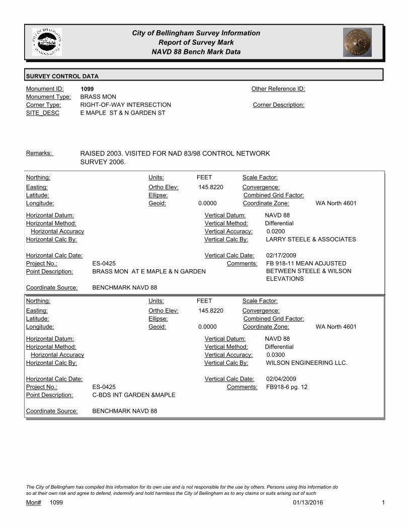
City of Bellingham Survey Information
Report of Survey Mark
NAVD 88 Bench Mark Data
SURVEY CONTROL DATA
1099Monument ID: Other Reference ID:
SITE_DESC E MAPLE ST & N GARDEN ST
RIGHT-OF-WAY INTERSECTIONCorner Type: Corner Description:
BRASS MONMonument Type:
RAISED 2003. VISITED FOR NAD 83/98 CONTROL NETWORK
SURVEY 2006.
Remarks:
145.8220
0.0000
FEETNorthing:
Easting:
Latitude:
Longitude:
Units:
Ortho Elev:
Ellipse:
Geoid:
Scale Factor:
Convergence:
Combined Grid Factor:
WA North 4601Coordinate Zone:
Horizontal Method:
Horizontal Datum: NAVD 88Vertical Datum:
DifferentialVertical Method:
Horizontal Accuracy 0.0200Vertical Accuracy:
LARRY STEELE & ASSOCIATESVertical Calc By:Horizontal Calc By:
ES-0425Project No.:
BRASS MON AT E MAPLE & N GARDENPoint Description:
BENCHMARK NAVD 88Coordinate Source:
FB 918-11 MEAN ADJUSTED
BETWEEN STEELE & WILSON
ELEVATIONS
Comments:
Horizontal Calc Date: 02/17/2009Vertical Calc Date:
145.8220
0.0000
FEETNorthing:
Easting:
Latitude:
Longitude:
Units:
Ortho Elev:
Ellipse:
Geoid:
Scale Factor:
Convergence:
Combined Grid Factor:
WA North 4601Coordinate Zone:
Horizontal Method:
Horizontal Datum: NAVD 88Vertical Datum:
DifferentialVertical Method:
Horizontal Accuracy 0.0300Vertical Accuracy:
WILSON ENGINEERING LLC.Vertical Calc By:Horizontal Calc By:
ES-0425Project No.:
C-BDS INT GARDEN &MAPLEPoint Description:
BENCHMARK NAVD 88Coordinate Source:
FB918-6 pg. 12Comments:
Horizontal Calc Date: 02/04/2009Vertical Calc Date:
101/13/2016Mon# 1099
The City of Bellingham has compiled this information for its own use and is not responsible for the use by others. Persons using this information do
so at their own risk and agree to defend, indemnify and hold harmless the City of Bellingham as to any claims or suits arising out of such

City of Bellingham Survey Information
Report of Survey Mark
NAVD 88 Bench Mark Data
SURVEY CONTROL DATA
1138Monument ID: Other Reference ID:
SITE_DESC NORTH & CHERRY
RIGHT-OF-WAY INTERSECTIONCorner Type: Corner Description:
CASED MONMonument Type:
VISITED FOR NAD 83/98 CONTROL NETWORK SURVEY 2006.Remarks:
71.5290
0.0000
FEETNorthing:
Easting:
Latitude:
Longitude:
Units:
Ortho Elev:
Ellipse:
Geoid:
Scale Factor:
Convergence:
Combined Grid Factor:
WA North 4601Coordinate Zone:
Horizontal Method:
Horizontal Datum: NAVD 88Vertical Datum:
DifferentialVertical Method:
Horizontal Accuracy 0.0200Vertical Accuracy:
PACIFIC SURVEY & ENGINEERING,
INC.
Vertical Calc By:Horizontal Calc By:
ES-0425Project No.:
CASED MON (TOP OF BRASS BRAD) AT INT. W.
NORTH ST & CHERRY ST
Point Description:
BENCHMARK NAVD 88Coordinate Source:
FB 918Comments:
Horizontal Calc Date: 01/05/2009Vertical Calc Date:
101/13/2016Mon# 1138
The City of Bellingham has compiled this information for its own use and is not responsible for the use by others. Persons using this information do
so at their own risk and agree to defend, indemnify and hold harmless the City of Bellingham as to any claims or suits arising out of such

City of Bellingham Survey Information
Report of Survey Mark
NAVD 88 Bench Mark Data
SURVEY CONTROL DATA
1140Monument ID: Other Reference ID:
SITE_DESC NORTH & JAEGER
RIGHT-OF-WAY INTERSECTIONCorner Type: Corner Description:
CASED MONMonument Type:
Remarks:
74.7360
0.0000
FEETNorthing:
Easting:
Latitude:
Longitude:
Units:
Ortho Elev:
Ellipse:
Geoid:
Scale Factor:
Convergence:
Combined Grid Factor:
WA North 4601Coordinate Zone:
Horizontal Method:
Horizontal Datum: NAVD 88Vertical Datum:
DifferentialVertical Method:
Horizontal Accuracy 0.0200Vertical Accuracy:
PACIFIC SURVEY & ENGINEERING,
INC.
Vertical Calc By:Horizontal Calc By:
ES-0425Project No.:
CASED MON (TOP OF BRASS BRAD) AT INT. W.
NORTH ST & JEAGER ST
Point Description:
BENCHMARK NAVD 88Coordinate Source:
FB 918Comments:
Horizontal Calc Date: 01/05/2009Vertical Calc Date:
101/13/2016Mon# 1140
The City of Bellingham has compiled this information for its own use and is not responsible for the use by others. Persons using this information do
so at their own risk and agree to defend, indemnify and hold harmless the City of Bellingham as to any claims or suits arising out of such

City of Bellingham Survey Information
Report of Survey Mark
NAVD 88 Bench Mark Data
SURVEY CONTROL DATA
1141Monument ID: Other Reference ID:
SITE_DESC NORTH & LYNN
RIGHT-OF-WAY INTERSECTIONCorner Type: Corner Description:
BRASS MONMonument Type:
MON RAISED 7-98Remarks:
76.3610
0.0000
FEETNorthing:
Easting:
Latitude:
Longitude:
Units:
Ortho Elev:
Ellipse:
Geoid:
Scale Factor:
Convergence:
Combined Grid Factor:
WA North 4601Coordinate Zone:
Horizontal Method:
Horizontal Datum: NAVD 88Vertical Datum:
DifferentialVertical Method:
Horizontal Accuracy 0.0200Vertical Accuracy:
PACIFIC SURVEY & ENGINEERING,
INC.
Vertical Calc By:Horizontal Calc By:
ES-0425Project No.:
BRASS MON AT INT. W. NORTH ST & LYNN STPoint Description:
BENCHMARK NAVD 88Coordinate Source:
FB 918Comments:
Horizontal Calc Date: 01/06/2009Vertical Calc Date:
101/13/2016Mon# 1141
The City of Bellingham has compiled this information for its own use and is not responsible for the use by others. Persons using this information do
so at their own risk and agree to defend, indemnify and hold harmless the City of Bellingham as to any claims or suits arising out of such

City of Bellingham Survey Information
Report of Survey Mark
NAVD 88 Bench Mark Data
SURVEY CONTROL DATA
1143Monument ID: Other Reference ID:
SITE_DESC NORTH & WALNUT
RIGHT-OF-WAY INTERSECTIONCorner Type: Corner Description:
BRASS MONMonument Type:
Remarks:
77.3490
0.0000
FEETNorthing:
Easting:
Latitude:
Longitude:
Units:
Ortho Elev:
Ellipse:
Geoid:
Scale Factor:
Convergence:
Combined Grid Factor:
WA North 4601Coordinate Zone:
Horizontal Method:
Horizontal Datum: NAVD 88Vertical Datum:
DifferentialVertical Method:
Horizontal Accuracy 0.0200Vertical Accuracy:
PACIFIC SURVEY & ENGINEERING,
INC.
Vertical Calc By:Horizontal Calc By:
ES-0425Project No.:
CASED MON (BRASS DISC) AT INT. W. NORTH ST &
WALNUT ST
Point Description:
BENCHMARK NAVD 88Coordinate Source:
FB 918Comments:
Horizontal Calc Date: 01/05/2009Vertical Calc Date:
647,942.9932
1,240,428.2819 77.5500
FEETNorthing:
Easting:
Latitude:
Longitude:
Units:
Ortho Elev:
Ellipse:
Geoid:
Scale Factor:
Convergence:
Combined Grid Factor:
WA North 4601Coordinate Zone:
Conventional SurveyHorizontal Method:
NAD 83/98Horizontal Datum: NAVD 88Vertical Datum:
DifferentialVertical Method:
0.0100Horizontal Accuracy 0.0100Vertical Accuracy:
FERGUSON LAND SURVEYINGVertical Calc By:FERGUSON LAND SURVEYINGHorizontal Calc By:
EU-0163Project No.:
Point Description:
NAD 83/98 PROJECT POINTSCoordinate Source:
FB 990-4Comments:
12/18/2014Horizontal Calc Date: 12/18/2014Vertical Calc Date:
101/13/2016Mon# 1143
The City of Bellingham has compiled this information for its own use and is not responsible for the use by others. Persons using this information do
so at their own risk and agree to defend, indemnify and hold harmless the City of Bellingham as to any claims or suits arising out of such

City of Bellingham Survey Information
Report of Survey Mark
NAVD 88 Bench Mark Data
SURVEY CONTROL DATA
1144Monument ID: Other Reference ID:
SITE_DESC NORTH & HENRY
RIGHT-OF-WAY INTERSECTIONCorner Type: Corner Description:
BRASS MONMonument Type:
MON RAISED 7-98Remarks:
78.2110
0.0000
FEETNorthing:
Easting:
Latitude:
Longitude:
Units:
Ortho Elev:
Ellipse:
Geoid:
Scale Factor:
Convergence:
Combined Grid Factor:
WA North 4601Coordinate Zone:
Horizontal Method:
Horizontal Datum: NAVD 88Vertical Datum:
DifferentialVertical Method:
Horizontal Accuracy 0.0200Vertical Accuracy:
PACIFIC SURVEY & ENGINEERING,
INC.
Vertical Calc By:Horizontal Calc By:
ES-0425Project No.:
BRASS MON AT INT. W. NORTH ST & HENRY STPoint Description:
BENCHMARK NAVD 88Coordinate Source:
FB 918Comments:
Horizontal Calc Date: 01/05/2009Vertical Calc Date:
101/13/2016Mon# 1144
The City of Bellingham has compiled this information for its own use and is not responsible for the use by others. Persons using this information do
so at their own risk and agree to defend, indemnify and hold harmless the City of Bellingham as to any claims or suits arising out of such

City of Bellingham Survey Information
Report of Survey Mark
NAVD 88 Bench Mark Data
SURVEY CONTROL DATA
1145Monument ID: Other Reference ID:
SITE_DESC NORTH & WILLIAMS
RIGHT-OF-WAY INTERSECTIONCorner Type: Corner Description:
BRASS MONMonument Type:
VISITED FOR NAD 83/98 CONTROL NETWORK SURVEY 2006.Remarks:
75.8640
0.0000
FEETNorthing:
Easting:
Latitude:
Longitude:
Units:
Ortho Elev:
Ellipse:
Geoid:
Scale Factor:
Convergence:
Combined Grid Factor:
WA North 4601Coordinate Zone:
Horizontal Method:
Horizontal Datum: NAVD 88Vertical Datum:
DifferentialVertical Method:
Horizontal Accuracy 0.0200Vertical Accuracy:
PACIFIC SURVEY & ENGINEERING,
INC.
Vertical Calc By:Horizontal Calc By:
ES-0425Project No.:
BRASS MON AT INT. W. NORTH ST & WILLIAMS STPoint Description:
BENCHMARK NAVD 88Coordinate Source:
FB 918Comments:
Horizontal Calc Date: 01/06/2009Vertical Calc Date:
101/13/2016Mon# 1145
The City of Bellingham has compiled this information for its own use and is not responsible for the use by others. Persons using this information do
so at their own risk and agree to defend, indemnify and hold harmless the City of Bellingham as to any claims or suits arising out of such

City of Bellingham Survey Information
Report of Survey Mark
NAVD 88 Bench Mark Data
SURVEY CONTROL DATA
1146Monument ID: Other Reference ID:
SITE_DESC NORTH & UTTER
RIGHT-OF-WAY INTERSECTIONCorner Type: Corner Description:
CASED MONMonument Type:
Remarks:
75.6720
0.0000
FEETNorthing:
Easting:
Latitude:
Longitude:
Units:
Ortho Elev:
Ellipse:
Geoid:
Scale Factor:
Convergence:
Combined Grid Factor:
WA North 4601Coordinate Zone:
Horizontal Method:
Horizontal Datum: NAVD 88Vertical Datum:
DifferentialVertical Method:
Horizontal Accuracy 0.0200Vertical Accuracy:
PACIFIC SURVEY & ENGINEERING,
INC.
Vertical Calc By:Horizontal Calc By:
ES-0425Project No.:
CASED MON (BRASS BRAD) AT INT W. NORTH ST
& UTTER ST
Point Description:
BENCHMARK NAVD 88Coordinate Source:
FB 918Comments:
Horizontal Calc Date: 01/06/2009Vertical Calc Date:
101/13/2016Mon# 1146
The City of Bellingham has compiled this information for its own use and is not responsible for the use by others. Persons using this information do
so at their own risk and agree to defend, indemnify and hold harmless the City of Bellingham as to any claims or suits arising out of such

City of Bellingham Survey Information
Report of Survey Mark
NAVD 88 Bench Mark Data
SURVEY CONTROL DATA
1148Monument ID: Other Reference ID:
SITE_DESC NORTH & ELIZABETH
RIGHT-OF-WAY INTERSECTIONCorner Type: Corner Description:
CASED MONMonument Type:
Remarks:
79.2660
0.0000
FEETNorthing:
Easting:
Latitude:
Longitude:
Units:
Ortho Elev:
Ellipse:
Geoid:
Scale Factor:
Convergence:
Combined Grid Factor:
WA North 4601Coordinate Zone:
Horizontal Method:
Horizontal Datum: NAVD 88Vertical Datum:
DifferentialVertical Method:
Horizontal Accuracy 0.0200Vertical Accuracy:
PACIFIC SURVEY & ENGINEERING,
INC.
Vertical Calc By:Horizontal Calc By:
ES-0425Project No.:
CASED MON (BRASS BRAD) AT INT. W. NORTH ST
& ELIZABETH ST
Point Description:
BENCHMARK NAVD 88Coordinate Source:
FB 918Comments:
Horizontal Calc Date: 12/31/2008Vertical Calc Date:
101/13/2016Mon# 1148
The City of Bellingham has compiled this information for its own use and is not responsible for the use by others. Persons using this information do
so at their own risk and agree to defend, indemnify and hold harmless the City of Bellingham as to any claims or suits arising out of such
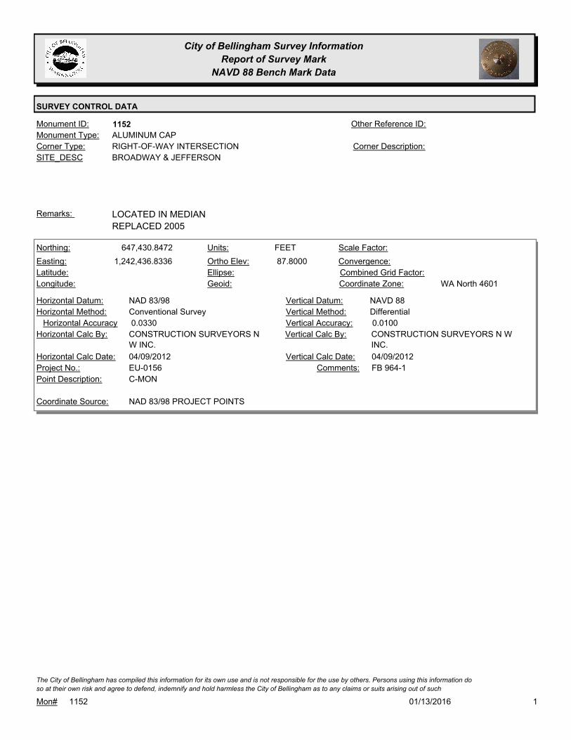
City of Bellingham Survey Information
Report of Survey Mark
NAVD 88 Bench Mark Data
SURVEY CONTROL DATA
1152Monument ID: Other Reference ID:
SITE_DESC BROADWAY & JEFFERSON
RIGHT-OF-WAY INTERSECTIONCorner Type: Corner Description:
ALUMINUM CAPMonument Type:
LOCATED IN MEDIAN
REPLACED 2005
Remarks:
647,430.8472
1,242,436.8336 87.8000
FEETNorthing:
Easting:
Latitude:
Longitude:
Units:
Ortho Elev:
Ellipse:
Geoid:
Scale Factor:
Convergence:
Combined Grid Factor:
WA North 4601Coordinate Zone:
Conventional SurveyHorizontal Method:
NAD 83/98Horizontal Datum: NAVD 88Vertical Datum:
DifferentialVertical Method:
0.0330Horizontal Accuracy 0.0100Vertical Accuracy:
CONSTRUCTION SURVEYORS N W
INC.
Vertical Calc By:CONSTRUCTION SURVEYORS N
W INC.
Horizontal Calc By:
EU-0156Project No.:
C-MONPoint Description:
NAD 83/98 PROJECT POINTSCoordinate Source:
FB 964-1Comments:
04/09/2012Horizontal Calc Date: 04/09/2012Vertical Calc Date:
101/13/2016Mon# 1152
The City of Bellingham has compiled this information for its own use and is not responsible for the use by others. Persons using this information do
so at their own risk and agree to defend, indemnify and hold harmless the City of Bellingham as to any claims or suits arising out of such

City of Bellingham Survey Information
Report of Survey Mark
NAVD 88 Bench Mark Data
SURVEY CONTROL DATA
1155Monument ID: Other Reference ID:
SITE_DESC NORTHWEST & LYNN
RIGHT-OF-WAY INTERSECTIONCorner Type: Corner Description:
BRASS MONMonument Type:
MON RAISED FOR NORTHWEST OVERLAY 9-95. VISITED FOR
NAD 83/98 CONTROL NETWORK SURVEY 2006.
Remarks:
83.5260
0.0000
FEETNorthing:
Easting:
Latitude:
Longitude:
Units:
Ortho Elev:
Ellipse:
Geoid:
Scale Factor:
Convergence:
Combined Grid Factor:
WA North 4601Coordinate Zone:
Horizontal Method:
Horizontal Datum: NAVD 88Vertical Datum:
DifferentialVertical Method:
Horizontal Accuracy 0.0200Vertical Accuracy:
PACIFIC SURVEY & ENGINEERING,
INC.
Vertical Calc By:Horizontal Calc By:
ES-0425Project No.:
BRASS MON AT INT. LYNN ST & NORTHWEST AVE.Point Description:
BENCHMARK NAVD 88Coordinate Source:
FB 918Comments:
Horizontal Calc Date: 12/10/2008Vertical Calc Date:
101/13/2016Mon# 1155
The City of Bellingham has compiled this information for its own use and is not responsible for the use by others. Persons using this information do
so at their own risk and agree to defend, indemnify and hold harmless the City of Bellingham as to any claims or suits arising out of such

City of Bellingham Survey Information
Report of Survey Mark
NAVD 88 Bench Mark Data
SURVEY CONTROL DATA
1161Monument ID: Other Reference ID:
SITE_DESC MERIDIAN & MONROE
RIGHT-OF-WAY INTERSECTIONCorner Type: Corner Description:
BRASS MONMonument Type:
MON SET FOR MERIDIAN OVERLAY 10-19-94 RESET 6-05Remarks:
76.7830
0.0000
FEETNorthing:
Easting:
Latitude:
Longitude:
Units:
Ortho Elev:
Ellipse:
Geoid:
Scale Factor:
Convergence:
Combined Grid Factor:
WA North 4601Coordinate Zone:
Horizontal Method:
Horizontal Datum: NAVD 88Vertical Datum:
DifferentialVertical Method:
Horizontal Accuracy 0.0200Vertical Accuracy:
PACIFIC SURVEY & ENGINEERING,
INC.
Vertical Calc By:Horizontal Calc By:
ES-0425Project No.:
BRASS MON AT INT. MONROE ST & MERIDIAN STPoint Description:
BENCHMARK NAVD 88Coordinate Source:
ELEVATION NO LONGER VALID. FB
918
Comments:
Horizontal Calc Date: 12/11/2008Vertical Calc Date:
101/13/2016Mon# 1161
The City of Bellingham has compiled this information for its own use and is not responsible for the use by others. Persons using this information do
so at their own risk and agree to defend, indemnify and hold harmless the City of Bellingham as to any claims or suits arising out of such

City of Bellingham Survey Information
Report of Survey Mark
NAVD 88 Bench Mark Data
SURVEY CONTROL DATA
1162Monument ID: Other Reference ID:
SITE_DESC MERIDIAN & JEFFERSON
RIGHT-OF-WAY INTERSECTIONCorner Type: Corner Description:
BRASS MONMonument Type:
MON SET FOR MERIDIAN OVERLAY 10-19-94,Remarks:
78.2760
0.0000
FEETNorthing:
Easting:
Latitude:
Longitude:
Units:
Ortho Elev:
Ellipse:
Geoid:
Scale Factor:
Convergence:
Combined Grid Factor:
WA North 4601Coordinate Zone:
Horizontal Method:
Horizontal Datum: NAVD 88Vertical Datum:
DifferentialVertical Method:
Horizontal Accuracy 0.0200Vertical Accuracy:
PACIFIC SURVEY & ENGINEERING,
INC.
Vertical Calc By:Horizontal Calc By:
ES-0425Project No.:
BRASS MON AT INT. JEFFERSON ST & MERIDIAN
ST
Point Description:
BENCHMARK NAVD 88Coordinate Source:
FB 918Comments:
Horizontal Calc Date: 12/11/2008Vertical Calc Date:
101/13/2016Mon# 1162
The City of Bellingham has compiled this information for its own use and is not responsible for the use by others. Persons using this information do
so at their own risk and agree to defend, indemnify and hold harmless the City of Bellingham as to any claims or suits arising out of such

City of Bellingham Survey Information
Report of Survey Mark
NAVD 88 Bench Mark Data
SURVEY CONTROL DATA
1163Monument ID: Other Reference ID:
SITE_DESC MERIDIAN & CONNECTICUT
RIGHT-OF-WAY INTERSECTIONCorner Type: Corner Description:
BRASS MONMonument Type:
MON SET FOR MERIDIAN OVERLAY 10-19-94Remarks:
81.4880
0.0000
FEETNorthing:
Easting:
Latitude:
Longitude:
Units:
Ortho Elev:
Ellipse:
Geoid:
Scale Factor:
Convergence:
Combined Grid Factor:
WA North 4601Coordinate Zone:
Horizontal Method:
Horizontal Datum: NAVD 88Vertical Datum:
DifferentialVertical Method:
Horizontal Accuracy 0.0200Vertical Accuracy:
PACIFIC SURVEY & ENGINEERING,
INC.
Vertical Calc By:Horizontal Calc By:
ES-0425Project No.:
BRASS MON AT INT. CONNECTICUT ST &
MERIDIAN ST
Point Description:
BENCHMARK NAVD 88Coordinate Source:
FB 918Comments:
Horizontal Calc Date: 12/11/2008Vertical Calc Date:
101/13/2016Mon# 1163
The City of Bellingham has compiled this information for its own use and is not responsible for the use by others. Persons using this information do
so at their own risk and agree to defend, indemnify and hold harmless the City of Bellingham as to any claims or suits arising out of such

City of Bellingham Survey Information
Report of Survey Mark
NAVD 88 Bench Mark Data
SURVEY CONTROL DATA
1164Monument ID: Other Reference ID:
SITE_DESC MERIDIAN & MARYLAND
RIGHT-OF-WAY INTERSECTIONCorner Type: Corner Description:
BRASS MONMonument Type:
MON SET FOR MERIDIAN OVERLAY 10-19-94Remarks:
82.9460
0.0000
FEETNorthing:
Easting:
Latitude:
Longitude:
Units:
Ortho Elev:
Ellipse:
Geoid:
Scale Factor:
Convergence:
Combined Grid Factor:
WA North 4601Coordinate Zone:
Horizontal Method:
Horizontal Datum: NAVD 88Vertical Datum:
DifferentialVertical Method:
Horizontal Accuracy 0.0200Vertical Accuracy:
PACIFIC SURVEY & ENGINEERING,
INC.
Vertical Calc By:Horizontal Calc By:
ES-0425Project No.:
BRASS MON AT INT. MARYLAND ST & MERIDIAN STPoint Description:
BENCHMARK NAVD 88Coordinate Source:
FB 918Comments:
Horizontal Calc Date: 01/02/2009Vertical Calc Date:
101/13/2016Mon# 1164
The City of Bellingham has compiled this information for its own use and is not responsible for the use by others. Persons using this information do
so at their own risk and agree to defend, indemnify and hold harmless the City of Bellingham as to any claims or suits arising out of such

City of Bellingham Survey Information
Report of Survey Mark
NAVD 88 Bench Mark Data
SURVEY CONTROL DATA
1167Monument ID: Other Reference ID:
SITE_DESC BROADWAY & GROVE
RIGHT-OF-WAY INTERSECTIONCorner Type: Corner Description:
BRASS MONMonument Type:
VISITED FOR NAD 83/98 CONTROL NETWORK SURVEY 2006.Remarks:
95.3870
0.0000
FEETNorthing:
Easting:
Latitude:
Longitude:
Units:
Ortho Elev:
Ellipse:
Geoid:
Scale Factor:
Convergence:
Combined Grid Factor:
WA North 4601Coordinate Zone:
Horizontal Method:
Horizontal Datum: NAVD 88Vertical Datum:
DifferentialVertical Method:
Horizontal Accuracy 0.0200Vertical Accuracy:
PACIFIC SURVEY & ENGINEERING,
INC.
Vertical Calc By:Horizontal Calc By:
ES-0425Project No.:
BRASS MON AT INT. W. NORTH ST & BROADWAYPoint Description:
BENCHMARK NAVD 88Coordinate Source:
FB 918Comments:
Horizontal Calc Date: 12/31/2008Vertical Calc Date:
101/13/2016Mon# 1167
The City of Bellingham has compiled this information for its own use and is not responsible for the use by others. Persons using this information do
so at their own risk and agree to defend, indemnify and hold harmless the City of Bellingham as to any claims or suits arising out of such

City of Bellingham Survey Information
Report of Survey Mark
NAVD 88 Bench Mark Data
SURVEY CONTROL DATA
1169Monument ID: Other Reference ID:
SITE_DESC MERIDIAN & VICTOR
RIGHT-OF-WAY INTERSECTIONCorner Type: Corner Description:
BRASS MONMonument Type:
Remarks:
92.9340
0.0000
FEETNorthing:
Easting:
Latitude:
Longitude:
Units:
Ortho Elev:
Ellipse:
Geoid:
Scale Factor:
Convergence:
Combined Grid Factor:
WA North 4601Coordinate Zone:
Horizontal Method:
Horizontal Datum: NAVD 88Vertical Datum:
DifferentialVertical Method:
Horizontal Accuracy 0.0200Vertical Accuracy:
PACIFIC SURVEY & ENGINEERING,
INC.
Vertical Calc By:Horizontal Calc By:
ES-0425Project No.:
BRASS MON AT INT. E. VICTOR ST & MERIDIAN STPoint Description:
BENCHMARK NAVD 88Coordinate Source:
FB 918Comments:
Horizontal Calc Date: 12/11/2008Vertical Calc Date:
101/13/2016Mon# 1169
The City of Bellingham has compiled this information for its own use and is not responsible for the use by others. Persons using this information do
so at their own risk and agree to defend, indemnify and hold harmless the City of Bellingham as to any claims or suits arising out of such

City of Bellingham Survey Information
Report of Survey Mark
NAVD 88 Bench Mark Data
SURVEY CONTROL DATA
1177Monument ID: Other Reference ID:
SITE_DESC ORCHARD & ORCHARD PL.
RIGHT-OF-WAY INTERSECTIONCorner Type: Corner Description:
BRASS MONMonument Type:
VISITED FOR NAD 83/98 CONTROL NETWORK SURVEY 2006.Remarks:
96.6650
0.0000
FEETNorthing:
Easting:
Latitude:
Longitude:
Units:
Ortho Elev:
Ellipse:
Geoid:
Scale Factor:
Convergence:
Combined Grid Factor:
WA North 4601Coordinate Zone:
Horizontal Method:
Horizontal Datum: NAVD 88Vertical Datum:
DifferentialVertical Method:
Horizontal Accuracy 0.0200Vertical Accuracy:
PACIFIC SURVEY & ENGINEERING,
INC.
Vertical Calc By:Horizontal Calc By:
ES-0425Project No.:
BRASS MON AT INT. W. ORCHARD DR & ORCHARD
PL
Point Description:
BENCHMARK NAVD 88Coordinate Source:
FB 918Comments:
Horizontal Calc Date: 12/31/2008Vertical Calc Date:
101/13/2016Mon# 1177
The City of Bellingham has compiled this information for its own use and is not responsible for the use by others. Persons using this information do
so at their own risk and agree to defend, indemnify and hold harmless the City of Bellingham as to any claims or suits arising out of such
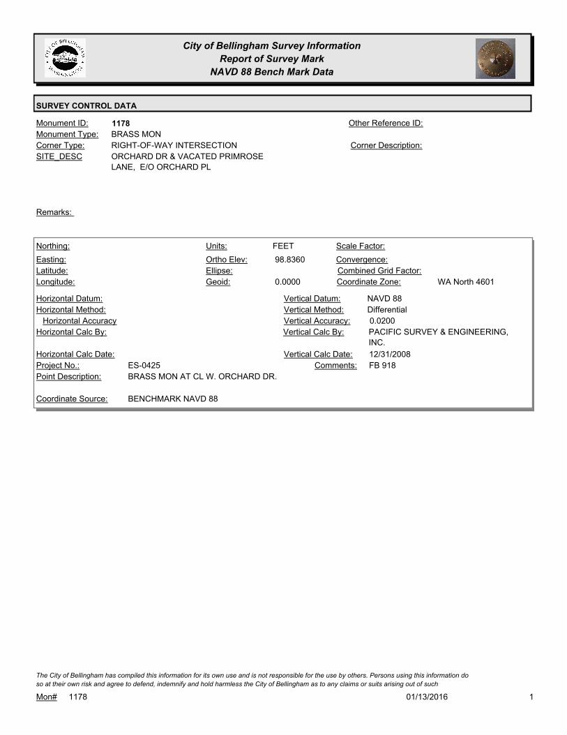
City of Bellingham Survey Information
Report of Survey Mark
NAVD 88 Bench Mark Data
SURVEY CONTROL DATA
1178Monument ID: Other Reference ID:
SITE_DESC ORCHARD DR & VACATED PRIMROSE
LANE, E/O ORCHARD PL
RIGHT-OF-WAY INTERSECTIONCorner Type: Corner Description:
BRASS MONMonument Type:
Remarks:
98.8360
0.0000
FEETNorthing:
Easting:
Latitude:
Longitude:
Units:
Ortho Elev:
Ellipse:
Geoid:
Scale Factor:
Convergence:
Combined Grid Factor:
WA North 4601Coordinate Zone:
Horizontal Method:
Horizontal Datum: NAVD 88Vertical Datum:
DifferentialVertical Method:
Horizontal Accuracy 0.0200Vertical Accuracy:
PACIFIC SURVEY & ENGINEERING,
INC.
Vertical Calc By:Horizontal Calc By:
ES-0425Project No.:
BRASS MON AT CL W. ORCHARD DR.Point Description:
BENCHMARK NAVD 88Coordinate Source:
FB 918Comments:
Horizontal Calc Date: 12/31/2008Vertical Calc Date:
101/13/2016Mon# 1178
The City of Bellingham has compiled this information for its own use and is not responsible for the use by others. Persons using this information do
so at their own risk and agree to defend, indemnify and hold harmless the City of Bellingham as to any claims or suits arising out of such
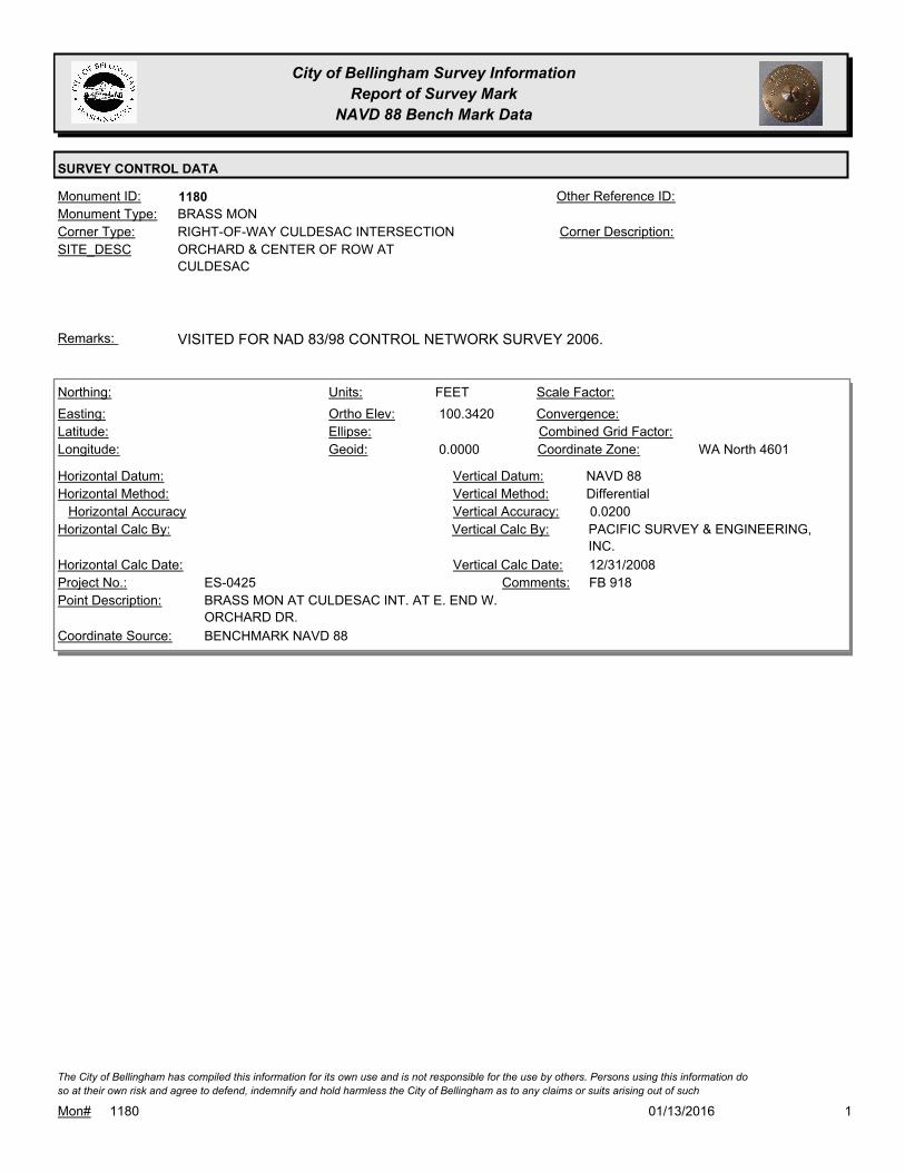
City of Bellingham Survey Information
Report of Survey Mark
NAVD 88 Bench Mark Data
SURVEY CONTROL DATA
1180Monument ID: Other Reference ID:
SITE_DESC ORCHARD & CENTER OF ROW AT
CULDESAC
RIGHT-OF-WAY CULDESAC INTERSECTIONCorner Type: Corner Description:
BRASS MONMonument Type:
VISITED FOR NAD 83/98 CONTROL NETWORK SURVEY 2006.Remarks:
100.3420
0.0000
FEETNorthing:
Easting:
Latitude:
Longitude:
Units:
Ortho Elev:
Ellipse:
Geoid:
Scale Factor:
Convergence:
Combined Grid Factor:
WA North 4601Coordinate Zone:
Horizontal Method:
Horizontal Datum: NAVD 88Vertical Datum:
DifferentialVertical Method:
Horizontal Accuracy 0.0200Vertical Accuracy:
PACIFIC SURVEY & ENGINEERING,
INC.
Vertical Calc By:Horizontal Calc By:
ES-0425Project No.:
BRASS MON AT CULDESAC INT. AT E. END W.
ORCHARD DR.
Point Description:
BENCHMARK NAVD 88Coordinate Source:
FB 918Comments:
Horizontal Calc Date: 12/31/2008Vertical Calc Date:
101/13/2016Mon# 1180
The City of Bellingham has compiled this information for its own use and is not responsible for the use by others. Persons using this information do
so at their own risk and agree to defend, indemnify and hold harmless the City of Bellingham as to any claims or suits arising out of such

City of Bellingham Survey Information
Report of Survey Mark
NAVD 88 Bench Mark Data
SURVEY CONTROL DATA
1181Monument ID: Other Reference ID:
SITE_DESC ORCHARD & CENTER OF CULDESAC
RIGHT-OF-WAY CULDESAC CENTERCorner Type: Corner Description:
BRASS MONMonument Type:
APPROX 20 FT S OF CL MONRemarks:
100.3530
0.0000
FEETNorthing:
Easting:
Latitude:
Longitude:
Units:
Ortho Elev:
Ellipse:
Geoid:
Scale Factor:
Convergence:
Combined Grid Factor:
WA North 4601Coordinate Zone:
Horizontal Method:
Horizontal Datum: NAVD 88Vertical Datum:
DifferentialVertical Method:
Horizontal Accuracy 0.0200Vertical Accuracy:
PACIFIC SURVEY & ENGINEERING,
INC.
Vertical Calc By:Horizontal Calc By:
ES-0425Project No.:
BRASS MON AT CULDESAC CENTER AT E. END W.
ORCHARD DR.
Point Description:
BENCHMARK NAVD 88Coordinate Source:
FB 918Comments:
Horizontal Calc Date: 12/12/2008Vertical Calc Date:
101/13/2016Mon# 1181
The City of Bellingham has compiled this information for its own use and is not responsible for the use by others. Persons using this information do
so at their own risk and agree to defend, indemnify and hold harmless the City of Bellingham as to any claims or suits arising out of such

City of Bellingham Survey Information
Report of Survey Mark
NAVD 88 Bench Mark Data
SURVEY CONTROL DATA
1183Monument ID: Other Reference ID:
SITE_DESC ORLEANS & INDIANA
RIGHT-OF-WAY INTERSECTIONCorner Type: Corner Description:
BRASS MONMonument Type:
MON RAISED FOR 2002 OVERLAYRemarks:
187.5960
FEETNorthing:
Easting:
Latitude:
Longitude:
Units:
Ortho Elev:
Ellipse:
Geoid:
Scale Factor:
Convergence:
Combined Grid Factor:
Coordinate Zone:
Horizontal Method:
Horizontal Datum: NAVD 88Vertical Datum:
DifferentialVertical Method:
Horizontal Accuracy 0.0200Vertical Accuracy:
CONSTRUCTION SURVEYORS N W
INC.
Vertical Calc By:Horizontal Calc By:
Project No.:
Point Description:
BENCHMARK NAVD 88Coordinate Source:
MON VISITED FOR BENCHMARK
DENSIFICATION 2011.
Comments:
Horizontal Calc Date: 05/01/2012Vertical Calc Date:
101/13/2016Mon# 1183
The City of Bellingham has compiled this information for its own use and is not responsible for the use by others. Persons using this information do
so at their own risk and agree to defend, indemnify and hold harmless the City of Bellingham as to any claims or suits arising out of such

City of Bellingham Survey Information
Report of Survey Mark
NAVD 88 Bench Mark Data
SURVEY CONTROL DATA
1184Monument ID: Other Reference ID:
SITE_DESC ORLEANS & ILLINOIS
RIGHT-OF-WAY INTERSECTIONCorner Type: Corner Description:
BRASS MONMonument Type:
MON RAISED FOR 2002 OVERLAYRemarks:
180.0470
FEETNorthing:
Easting:
Latitude:
Longitude:
Units:
Ortho Elev:
Ellipse:
Geoid:
Scale Factor:
Convergence:
Combined Grid Factor:
Coordinate Zone:
Horizontal Method:
Horizontal Datum: NAVD 88Vertical Datum:
DifferentialVertical Method:
Horizontal Accuracy 0.0200Vertical Accuracy:
CONSTRUCTION SURVEYORS N W
INC.
Vertical Calc By:Horizontal Calc By:
Project No.:
Point Description:
BENCHMARK NAVD 88Coordinate Source:
MON VISITED FOR BENCHMARK
DENSIFICATION 2011.
Comments:
Horizontal Calc Date: 05/01/2012Vertical Calc Date:
101/13/2016Mon# 1184
The City of Bellingham has compiled this information for its own use and is not responsible for the use by others. Persons using this information do
so at their own risk and agree to defend, indemnify and hold harmless the City of Bellingham as to any claims or suits arising out of such

City of Bellingham Survey Information
Report of Survey Mark
NAVD 88 Bench Mark Data
SURVEY CONTROL DATA
1185Monument ID: Other Reference ID:
SITE_DESC ORLEANS & MARYLAND
RIGHT-OF-WAY INTERSECTIONCorner Type: Corner Description:
BRASS MONMonument Type:
MON RAISED FOR 2002 OVERLAYRemarks:
648,649.4616
1,248,683.2700 165.9100
FEETNorthing:
Easting:
Latitude:
Longitude:
Units:
Ortho Elev:
Ellipse:
Geoid:
Scale Factor:
Convergence:
Combined Grid Factor:
WA North 4601Coordinate Zone:
Conventional SurveyHorizontal Method:
NAD 83/98Horizontal Datum: NAVD 88Vertical Datum:
DifferentialVertical Method:
0.0100Horizontal Accuracy 0.0100Vertical Accuracy:
PACIFIC SURVEY & ENGINEERING,
INC.
Vertical Calc By:PACIFIC SURVEY &
ENGINEERING, INC.
Horizontal Calc By:
EU-0151Project No.:
BRASS DISCPoint Description:
NAD 83/98 PROJECT POINTSCoordinate Source:
FB 932-1 PROJECT POINT #317Comments:
11/10/2010Horizontal Calc Date: 11/22/2011Vertical Calc Date:
101/13/2016Mon# 1185
The City of Bellingham has compiled this information for its own use and is not responsible for the use by others. Persons using this information do
so at their own risk and agree to defend, indemnify and hold harmless the City of Bellingham as to any claims or suits arising out of such

City of Bellingham Survey Information
Report of Survey Mark
NAVD 88 Bench Mark Data
SURVEY CONTROL DATA
1187Monument ID: Other Reference ID:
SITE_DESC ORLEANS & NORTH
RIGHT-OF-WAY INTERSECTIONCorner Type: Corner Description:
BRASS MONMonument Type:
MON RAISED FOR 2002 OVERLAYRemarks:
127.2580
FEETNorthing:
Easting:
Latitude:
Longitude:
Units:
Ortho Elev:
Ellipse:
Geoid:
Scale Factor:
Convergence:
Combined Grid Factor:
Coordinate Zone:
Horizontal Method:
Horizontal Datum: NAVD 88Vertical Datum:
DifferentialVertical Method:
Horizontal Accuracy 0.0200Vertical Accuracy:
CONSTRUCTION SURVEYORS N W
INC.
Vertical Calc By:Horizontal Calc By:
Project No.:
Point Description:
BENCHMARK NAVD 88Coordinate Source:
MON VISITED FOR BENCHMARK
DENSIFICATION 2011.
Comments:
Horizontal Calc Date: 05/01/2012Vertical Calc Date:
647,729.8625
1,248,663.2298 127.2400
FEETNorthing:
Easting:
Latitude:
Longitude:
Units:
Ortho Elev:
Ellipse:
Geoid:
Scale Factor:
Convergence:
Combined Grid Factor:
WA North 4601Coordinate Zone:
Conventional SurveyHorizontal Method:
NAD 83/98Horizontal Datum: NAVD 88Vertical Datum:
DifferentialVertical Method:
0.0100Horizontal Accuracy 0.0100Vertical Accuracy:
PACIFIC SURVEY & ENGINEERING,
INC.
Vertical Calc By:PACIFIC SURVEY &
ENGINEERING, INC.
Horizontal Calc By:
EU-0151Project No.:
BRASS DISCPoint Description:
NAD 83/98 PROJECT POINTSCoordinate Source:
FB 932-1 PROJECT POINT #304Comments:
11/10/2010Horizontal Calc Date: 11/22/2011Vertical Calc Date:
101/13/2016Mon# 1187
The City of Bellingham has compiled this information for its own use and is not responsible for the use by others. Persons using this information do
so at their own risk and agree to defend, indemnify and hold harmless the City of Bellingham as to any claims or suits arising out of such

City of Bellingham Survey Information
Report of Survey Mark
NAVD 88 Bench Mark Data
SURVEY CONTROL DATA
1195Monument ID: Other Reference ID:
SITE_DESC TEXAS & ONTARIO (TO SOUTH)
RIGHT-OF-WAY INTERSECTIONCorner Type: Corner Description:
BRASS MONMonument Type:
2 MONS FOUND EAST & WEST ALSO SEE #5438Remarks:
646,679.9870
1,253,265.6332 139.6700
FEETNorthing:
Easting:
Latitude:
Longitude:
Units:
Ortho Elev:
Ellipse:
Geoid:
Scale Factor:
Convergence:
Combined Grid Factor:
WA North 4601Coordinate Zone:
Conventional SurveyHorizontal Method:
NAD 83/98Horizontal Datum: NAVD 88Vertical Datum:
DifferentialVertical Method:
0.0100Horizontal Accuracy 0.0100Vertical Accuracy:
PACIFIC SURVEY & ENGINEERING,
INC.
Vertical Calc By:PACIFIC SURVEY &
ENGINEERING, INC.
Horizontal Calc By:
EU-0156Project No.:
Point Description:
NAD 83/98 PROJECT POINTSCoordinate Source:
FB 946-1 PROJECT POINT #103Comments:
05/23/2011Horizontal Calc Date: 05/23/2011Vertical Calc Date:
101/13/2016Mon# 1195
The City of Bellingham has compiled this information for its own use and is not responsible for the use by others. Persons using this information do
so at their own risk and agree to defend, indemnify and hold harmless the City of Bellingham as to any claims or suits arising out of such

City of Bellingham Survey Information
Report of Survey Mark
NAVD 88 Bench Mark Data
SURVEY CONTROL DATA
1198Monument ID: Other Reference ID:
SITE_DESC N GARDEN ST & E LAUREL ST
RIGHT-OF-WAY INTERSECTIONCorner Type: Corner Description:
BRASS MONMonument Type:
Remarks:
138.9160
0.0000
FEETNorthing:
Easting:
Latitude:
Longitude:
Units:
Ortho Elev:
Ellipse:
Geoid:
Scale Factor:
Convergence:
Combined Grid Factor:
WA North 4601Coordinate Zone:
Horizontal Method:
Horizontal Datum: NAVD 88Vertical Datum:
DifferentialVertical Method:
Horizontal Accuracy 0.0200Vertical Accuracy:
LARRY STEELE & ASSOCIATESVertical Calc By:Horizontal Calc By:
ES-0425Project No.:
BRASS MON AT GARDEN & LAURELPoint Description:
BENCHMARK NAVD 88Coordinate Source:
FB 918-11Comments:
Horizontal Calc Date: 02/17/2009Vertical Calc Date:
101/13/2016Mon# 1198
The City of Bellingham has compiled this information for its own use and is not responsible for the use by others. Persons using this information do
so at their own risk and agree to defend, indemnify and hold harmless the City of Bellingham as to any claims or suits arising out of such

City of Bellingham Survey Information
Report of Survey Mark
NAVD 88 Bench Mark Data
SURVEY CONTROL DATA
1208Monument ID: Other Reference ID:
SITE_DESC PATTON & ILLINOIS
RIGHT-OF-WAY INTERSECTIONCorner Type: Corner Description:
BRASS MONMonument Type:
VISITED FOR NAD 83/98 CONTROL NETWORK SURVEY 2006.Remarks:
70.3940
0.0000
FEETNorthing:
Easting:
Latitude:
Longitude:
Units:
Ortho Elev:
Ellipse:
Geoid:
Scale Factor:
Convergence:
Combined Grid Factor:
WA North 4601Coordinate Zone:
Horizontal Method:
Horizontal Datum: NAVD 88Vertical Datum:
DifferentialVertical Method:
Horizontal Accuracy 0.0200Vertical Accuracy:
PACIFIC SURVEY & ENGINEERING,
INC.
Vertical Calc By:Horizontal Calc By:
ES-0425Project No.:
BRASS MON AT INT. W. ILLINOIS ST & PATTON ST.Point Description:
BENCHMARK NAVD 88Coordinate Source:
FB 918Comments:
Horizontal Calc Date: 12/12/2008Vertical Calc Date:
101/13/2016Mon# 1208
The City of Bellingham has compiled this information for its own use and is not responsible for the use by others. Persons using this information do
so at their own risk and agree to defend, indemnify and hold harmless the City of Bellingham as to any claims or suits arising out of such

City of Bellingham Survey Information
Report of Survey Mark
NAVD 88 Bench Mark Data
SURVEY CONTROL DATA
1209Monument ID: Other Reference ID:
SITE_DESC PATTON & MARYLAND
RIGHT-OF-WAY INTERSECTIONCorner Type: Corner Description:
BRASS MONMonument Type:
Remarks:
71.2240
0.0000
FEETNorthing:
Easting:
Latitude:
Longitude:
Units:
Ortho Elev:
Ellipse:
Geoid:
Scale Factor:
Convergence:
Combined Grid Factor:
WA North 4601Coordinate Zone:
Horizontal Method:
Horizontal Datum: NAVD 88Vertical Datum:
DifferentialVertical Method:
Horizontal Accuracy 0.0200Vertical Accuracy:
PACIFIC SURVEY & ENGINEERING,
INC.
Vertical Calc By:Horizontal Calc By:
ES-0425Project No.:
BRASS MON AT INT. W. MARYLAND ST & PATTON
ST.
Point Description:
BENCHMARK NAVD 88Coordinate Source:
FB 918Comments:
Horizontal Calc Date: 12/12/2008Vertical Calc Date:
101/13/2016Mon# 1209
The City of Bellingham has compiled this information for its own use and is not responsible for the use by others. Persons using this information do
so at their own risk and agree to defend, indemnify and hold harmless the City of Bellingham as to any claims or suits arising out of such

City of Bellingham Survey Information
Report of Survey Mark
NAVD 88 Bench Mark Data
SURVEY CONTROL DATA
1211Monument ID: Other Reference ID:
SITE_DESC PATTON & NEQUALICUM
RIGHT-OF-WAY INTERSECTIONCorner Type: Corner Description:
BRASS MONMonument Type:
VISITED FOR NAD 83/98 CONTROL NETWORK SURVEY 2006.Remarks:
71.2070
0.0000
FEETNorthing:
Easting:
Latitude:
Longitude:
Units:
Ortho Elev:
Ellipse:
Geoid:
Scale Factor:
Convergence:
Combined Grid Factor:
WA North 4601Coordinate Zone:
Horizontal Method:
Horizontal Datum: NAVD 88Vertical Datum:
DifferentialVertical Method:
Horizontal Accuracy 0.0200Vertical Accuracy:
PACIFIC SURVEY & ENGINEERING,
INC.
Vertical Calc By:Horizontal Calc By:
ES-0425Project No.:
BRASS MON AT INT. NEQUALICUM AVE & PATTON
ST.
Point Description:
BENCHMARK NAVD 88Coordinate Source:
FB 918Comments:
Horizontal Calc Date: 12/31/2008Vertical Calc Date:
101/13/2016Mon# 1211
The City of Bellingham has compiled this information for its own use and is not responsible for the use by others. Persons using this information do
so at their own risk and agree to defend, indemnify and hold harmless the City of Bellingham as to any claims or suits arising out of such
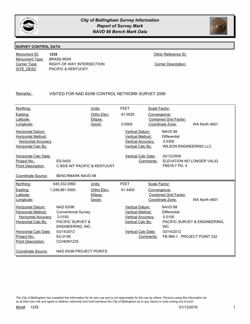
City of Bellingham Survey Information
Report of Survey Mark
NAVD 88 Bench Mark Data
SURVEY CONTROL DATA
1235Monument ID: Other Reference ID:
SITE_DESC PACIFIC & KENTUCKY
RIGHT-OF-WAY INTERSECTIONCorner Type: Corner Description:
BRASS MONMonument Type:
VISITED FOR NAD 83/98 CONTROL NETWORK SURVEY 2006Remarks:
61.0520
0.0000
FEETNorthing:
Easting:
Latitude:
Longitude:
Units:
Ortho Elev:
Ellipse:
Geoid:
Scale Factor:
Convergence:
Combined Grid Factor:
WA North 4601Coordinate Zone:
Horizontal Method:
Horizontal Datum: NAVD 88Vertical Datum:
DifferentialVertical Method:
Horizontal Accuracy 0.0300Vertical Accuracy:
WILSON ENGINEERING LLC.Vertical Calc By:Horizontal Calc By:
ES-0425Project No.:
C-BDS INT PACIFIC & KENTUCKYPoint Description:
BENCHMARK NAVD 88Coordinate Source:
ELEVATION NO LONGER VALID.
FB918-7 PG. 4
Comments:
Horizontal Calc Date: 02/12/2009Vertical Calc Date:
645,332.0990
1,248,961.5000 61.4400
FEETNorthing:
Easting:
Latitude:
Longitude:
Units:
Ortho Elev:
Ellipse:
Geoid:
Scale Factor:
Convergence:
Combined Grid Factor:
WA North 4601Coordinate Zone:
Conventional SurveyHorizontal Method:
NAD 83/98Horizontal Datum: NAVD 88Vertical Datum:
DifferentialVertical Method:
0.0100Horizontal Accuracy 0.0100Vertical Accuracy:
PACIFIC SURVEY & ENGINEERING,
INC.
Vertical Calc By:PACIFIC SURVEY &
ENGINEERING, INC.
Horizontal Calc By:
EU-0156Project No.:
CCHKIN1235Point Description:
NAD 83/98 PROJECT POINTSCoordinate Source:
FB 966-1. PROJECT POINT 232Comments:
03/14/2012Horizontal Calc Date: 03/14/2012Vertical Calc Date:
101/13/2016Mon# 1235
The City of Bellingham has compiled this information for its own use and is not responsible for the use by others. Persons using this information do
so at their own risk and agree to defend, indemnify and hold harmless the City of Bellingham as to any claims or suits arising out of such

City of Bellingham Survey Information
Report of Survey Mark
NAVD 88 Bench Mark Data
SURVEY CONTROL DATA
1236Monument ID: Other Reference ID:
SITE_DESC PACIFIC & VIRGINIA
RIGHT-OF-WAY INTERSECTIONCorner Type: Corner Description:
BRASS MONMonument Type:
Remarks:
645,812.2902
1,248,971.9347 69.5800
FEETNorthing:
Easting:
Latitude:
Longitude:
Units:
Ortho Elev:
Ellipse:
Geoid:
Scale Factor:
Convergence:
Combined Grid Factor:
WA North 4601Coordinate Zone:
Conventional SurveyHorizontal Method:
NAD 83/98Horizontal Datum: NAVD 88Vertical Datum:
DifferentialVertical Method:
0.0100Horizontal Accuracy 0.0100Vertical Accuracy:
PACIFIC SURVEY & ENGINEERING,
INC.
Vertical Calc By:PACIFIC SURVEY &
ENGINEERING, INC.
Horizontal Calc By:
EU-0156Project No.:
C-MONPoint Description:
NAD 83/98 PROJECT POINTSCoordinate Source:
FB 966-1. PROJECT POINT #170Comments:
03/14/2012Horizontal Calc Date: 03/14/2012Vertical Calc Date:
101/13/2016Mon# 1236
The City of Bellingham has compiled this information for its own use and is not responsible for the use by others. Persons using this information do
so at their own risk and agree to defend, indemnify and hold harmless the City of Bellingham as to any claims or suits arising out of such
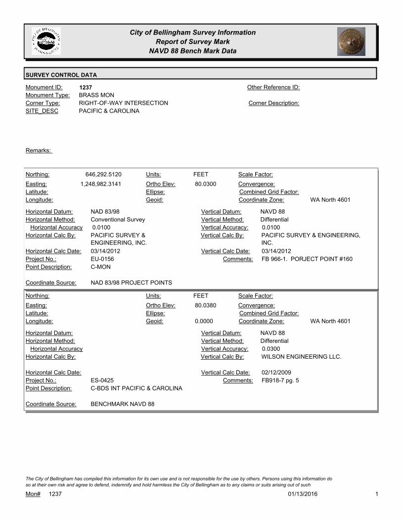
City of Bellingham Survey Information
Report of Survey Mark
NAVD 88 Bench Mark Data
SURVEY CONTROL DATA
1237Monument ID: Other Reference ID:
SITE_DESC PACIFIC & CAROLINA
RIGHT-OF-WAY INTERSECTIONCorner Type: Corner Description:
BRASS MONMonument Type:
Remarks:
646,292.5120
1,248,982.3141 80.0300
FEETNorthing:
Easting:
Latitude:
Longitude:
Units:
Ortho Elev:
Ellipse:
Geoid:
Scale Factor:
Convergence:
Combined Grid Factor:
WA North 4601Coordinate Zone:
Conventional SurveyHorizontal Method:
NAD 83/98Horizontal Datum: NAVD 88Vertical Datum:
DifferentialVertical Method:
0.0100Horizontal Accuracy 0.0100Vertical Accuracy:
PACIFIC SURVEY & ENGINEERING,
INC.
Vertical Calc By:PACIFIC SURVEY &
ENGINEERING, INC.
Horizontal Calc By:
EU-0156Project No.:
C-MONPoint Description:
NAD 83/98 PROJECT POINTSCoordinate Source:
FB 966-1. PORJECT POINT #160Comments:
03/14/2012Horizontal Calc Date: 03/14/2012Vertical Calc Date:
80.0380
0.0000
FEETNorthing:
Easting:
Latitude:
Longitude:
Units:
Ortho Elev:
Ellipse:
Geoid:
Scale Factor:
Convergence:
Combined Grid Factor:
WA North 4601Coordinate Zone:
Horizontal Method:
Horizontal Datum: NAVD 88Vertical Datum:
DifferentialVertical Method:
Horizontal Accuracy 0.0300Vertical Accuracy:
WILSON ENGINEERING LLC.Vertical Calc By:Horizontal Calc By:
ES-0425Project No.:
C-BDS INT PACIFIC & CAROLINAPoint Description:
BENCHMARK NAVD 88Coordinate Source:
FB918-7 pg. 5Comments:
Horizontal Calc Date: 02/12/2009Vertical Calc Date:
101/13/2016Mon# 1237
The City of Bellingham has compiled this information for its own use and is not responsible for the use by others. Persons using this information do
so at their own risk and agree to defend, indemnify and hold harmless the City of Bellingham as to any claims or suits arising out of such

City of Bellingham Survey Information
Report of Survey Mark
NAVD 88 Bench Mark Data
SURVEY CONTROL DATA
1238Monument ID: Other Reference ID:
SITE_DESC PACIFIC & TEXAS
RIGHT-OF-WAY INTERSECTIONCorner Type: Corner Description:
BRASS MONMonument Type:
VISITED FOR NAD 83/98 CONTROL NETWORK SURVEY 2006.Remarks:
92.5300
0.0000
FEETNorthing:
Easting:
Latitude:
Longitude:
Units:
Ortho Elev:
Ellipse:
Geoid:
Scale Factor:
Convergence:
Combined Grid Factor:
WA North 4601Coordinate Zone:
Horizontal Method:
Horizontal Datum: NAVD 88Vertical Datum:
DifferentialVertical Method:
Horizontal Accuracy 0.0300Vertical Accuracy:
WILSON ENGINEERING LLC.Vertical Calc By:Horizontal Calc By:
ES-0425Project No.:
C-BDS NAD83/98 MON INT PACIFIC & TEXASPoint Description:
BENCHMARK NAVD 88Coordinate Source:
FB918-7 pg. 5Comments:
Horizontal Calc Date: 02/12/2009Vertical Calc Date:
101/13/2016Mon# 1238
The City of Bellingham has compiled this information for its own use and is not responsible for the use by others. Persons using this information do
so at their own risk and agree to defend, indemnify and hold harmless the City of Bellingham as to any claims or suits arising out of such

City of Bellingham Survey Information
Report of Survey Mark
NAVD 88 Bench Mark Data
SURVEY CONTROL DATA
1246Monument ID: Other Reference ID:
SITE_DESC RUSSELL & NORTH
RIGHT-OF-WAY INTERSECTIONCorner Type: Corner Description:
CASED MONMonument Type:
Remarks:
647,886.2269
1,242,635.3780 91.7600
FEETNorthing:
Easting:
Latitude:
Longitude:
Units:
Ortho Elev:
Ellipse:
Geoid:
Scale Factor:
Convergence:
Combined Grid Factor:
WA North 4601Coordinate Zone:
Conventional SurveyHorizontal Method:
NAD 83/98Horizontal Datum: NAVD 88Vertical Datum:
DifferentialVertical Method:
0.0330Horizontal Accuracy 0.0100Vertical Accuracy:
CONSTRUCTION SURVEYORS N W
INC.
Vertical Calc By:CONSTRUCTION SURVEYORS N
W INC.
Horizontal Calc By:
EU-0156Project No.:
C-MONPoint Description:
NAD 83/98 PROJECT POINTSCoordinate Source:
FB 964-1. TOP OF PIN INSIDE
CASE
Comments:
04/09/2012Horizontal Calc Date: 04/09/2012Vertical Calc Date:
101/13/2016Mon# 1246
The City of Bellingham has compiled this information for its own use and is not responsible for the use by others. Persons using this information do
so at their own risk and agree to defend, indemnify and hold harmless the City of Bellingham as to any claims or suits arising out of such

City of Bellingham Survey Information
Report of Survey Mark
NAVD 88 Bench Mark Data
SURVEY CONTROL DATA
1248Monument ID: Other Reference ID:
SITE_DESC ROEDER & BELLWETHER (THOMAS
GLENN)
RIGHT-OF-WAY INTERSECTIONCorner Type: Corner Description:
BRASS MONMonument Type:
VISITED FOR NAD 83/98 CONTROL NETWORK SURVEY 2006.Remarks:
645,307.2348
1,240,123.2210
48 45 25.82231
-122 29 34.23885
17.3360
0.0000
FEETNorthing:
Easting:
Latitude:
Longitude:
Units:
Ortho Elev:
Ellipse:
Geoid:
1.0000000000Scale Factor:
- 1 14 08Convergence:
Combined Grid Factor:
WA North 4601Coordinate Zone:
Conventional SurveyHorizontal Method:
NAD 83/98Horizontal Datum: NAVD 88Vertical Datum:
DifferentialVertical Method:
0.0700Horizontal Accuracy 0.0200Vertical Accuracy:
PACIFIC SURVEY & ENGINEERING,
INC.
Vertical Calc By:PACIFIC SURVEY &
ENGINEERING, INC.
Horizontal Calc By:
Project No.:
C-BDSPoint Description:
NAD 83/98 NETWORK(DENSIFICATION PROJECT)Coordinate Source:
FB880-2 WATERFRONT CONTROL
SURVEY AF2080302393
Comments:
01/23/2008Horizontal Calc Date: 01/23/2008Vertical Calc Date:
101/13/2016Mon# 1248
The City of Bellingham has compiled this information for its own use and is not responsible for the use by others. Persons using this information do
so at their own risk and agree to defend, indemnify and hold harmless the City of Bellingham as to any claims or suits arising out of such

City of Bellingham Survey Information
Report of Survey Mark
NAVD 88 Bench Mark Data
SURVEY CONTROL DATA
1287Monument ID: Other Reference ID:
SITE_DESC SAMISH WAY & PASCO ST
RIGHT-OF-WAY INTERSECTIONCorner Type: Corner Description:
BRASS MONMonument Type:
Remarks:
638,278.1320
1,245,520.4070 210.9200
FEETNorthing:
Easting:
Latitude:
Longitude:
Units:
Ortho Elev:
Ellipse:
Geoid:
Scale Factor:
Convergence:
Combined Grid Factor:
WA North 4601Coordinate Zone:
Conventional SurveyHorizontal Method:
NAD 1983Horizontal Datum: NAVD 88Vertical Datum:
DifferentialVertical Method:
0.0200Horizontal Accuracy 0.0300Vertical Accuracy:
LARRY STEELE & ASSOCIATESVertical Calc By:LARRY STEELE & ASSOCIATESHorizontal Calc By:
EU-0159Project No.:
C-BDSPoint Description:
NAD 83/98 PROJECT POINTSCoordinate Source:
FB 947-1 PROJECT POINT #116Comments:
06/30/2011Horizontal Calc Date: 06/30/2011Vertical Calc Date:
101/13/2016Mon# 1287
The City of Bellingham has compiled this information for its own use and is not responsible for the use by others. Persons using this information do
so at their own risk and agree to defend, indemnify and hold harmless the City of Bellingham as to any claims or suits arising out of such

City of Bellingham Survey Information
Report of Survey Mark
NAVD 88 Bench Mark Data
SURVEY CONTROL DATA
1288Monument ID: Other Reference ID:
SITE_DESC ST.PAUL & NORTH
RIGHT-OF-WAY INTERSECTIONCorner Type: Corner Description:
BRASS MONMonument Type:
Remarks:
647,699.8594
1,250,063.1120 129.0200
FEETNorthing:
Easting:
Latitude:
Longitude:
Units:
Ortho Elev:
Ellipse:
Geoid:
Scale Factor:
Convergence:
Combined Grid Factor:
WA North 4601Coordinate Zone:
Conventional SurveyHorizontal Method:
NAD 83/98Horizontal Datum: NAVD 88Vertical Datum:
DifferentialVertical Method:
0.0100Horizontal Accuracy 0.0100Vertical Accuracy:
PACIFIC SURVEY & ENGINEERING,
INC.
Vertical Calc By:PACIFIC SURVEY &
ENGINEERING, INC.
Horizontal Calc By:
EU-0156Project No.:
C-MONPoint Description:
NAD 83/98 PROJECT POINTSCoordinate Source:
FB 966-1. PROJECT POINT 330Comments:
03/14/2012Horizontal Calc Date: 03/14/2012Vertical Calc Date:
101/13/2016Mon# 1288
The City of Bellingham has compiled this information for its own use and is not responsible for the use by others. Persons using this information do
so at their own risk and agree to defend, indemnify and hold harmless the City of Bellingham as to any claims or suits arising out of such

City of Bellingham Survey Information
Report of Survey Mark
NAVD 88 Bench Mark Data
SURVEY CONTROL DATA
1308Monument ID: Other Reference ID:
SITE_DESC SQUALICUM & PT E/O ELLIS AT LEVIN LN
RIGHT-OF-WAY PTCorner Type: Corner Description:
BRASS MONMonument Type:
RAISED 8-20-99Remarks:
153.6490
0.0000
FEETNorthing:
Easting:
Latitude:
Longitude:
Units:
Ortho Elev:
Ellipse:
Geoid:
Scale Factor:
Convergence:
Combined Grid Factor:
WA North 4601Coordinate Zone:
Horizontal Method:
Horizontal Datum: NAVD 88Vertical Datum:
DifferentialVertical Method:
Horizontal Accuracy 0.0200Vertical Accuracy:
PACIFIC SURVEY & ENGINEERING,
INC.
Vertical Calc By:Horizontal Calc By:
ES-0425Project No.:
BRASS MON (PT) AT CL SQUALICUM PKWY NEAR
INT. W/ LEVIN LN
Point Description:
BENCHMARK NAVD 88Coordinate Source:
FB 918Comments:
Horizontal Calc Date: 01/02/2009Vertical Calc Date:
101/13/2016Mon# 1308
The City of Bellingham has compiled this information for its own use and is not responsible for the use by others. Persons using this information do
so at their own risk and agree to defend, indemnify and hold harmless the City of Bellingham as to any claims or suits arising out of such

City of Bellingham Survey Information
Report of Survey Mark
NAVD 88 Bench Mark Data
SURVEY CONTROL DATA
1317Monument ID: Other Reference ID:
SITE_DESC ST. CLAIR & TEXAS
RIGHT-OF-WAY INTERSECTIONCorner Type: Corner Description:
BRASS MONMonument Type:
Remarks:
646,672.7654
1,253,598.1548 163.4800
Northing:
Easting:
Latitude:
Longitude:
Units:
Ortho Elev:
Ellipse:
Geoid:
Scale Factor:
Convergence:
Combined Grid Factor:
WA North 4601Coordinate Zone:
Conventional SurveyHorizontal Method:
NAD 83/98Horizontal Datum: NAVD 88Vertical Datum:
DifferentialVertical Method:
0.0100Horizontal Accuracy 0.0100Vertical Accuracy:
PACIFIC SURVEY & ENGINEERING,
INC.
Vertical Calc By:PACIFIC SURVEY &
ENGINEERING, INC.
Horizontal Calc By:
EU-0156Project No.:
Point Description:
NAD 83/98 PROJECT POINTSCoordinate Source:
FB 946-1 PROJECT POINT #100Comments:
05/23/2011Horizontal Calc Date: 05/23/2011Vertical Calc Date:
101/13/2016Mon# 1317
The City of Bellingham has compiled this information for its own use and is not responsible for the use by others. Persons using this information do
so at their own risk and agree to defend, indemnify and hold harmless the City of Bellingham as to any claims or suits arising out of such

City of Bellingham Survey Information
Report of Survey Mark
NAVD 88 Bench Mark Data
SURVEY CONTROL DATA
1323Monument ID: Other Reference ID:
SITE_DESC ST. CLAIR & KENTUCKY
RIGHT-OF-WAY INTERSECTIONCorner Type: Corner Description:
BRASS MONMonument Type:
VISITED FOR NAD 83/98 CONTROL NETWORK SURVEY 2006.Remarks:
220.7250
0.0000
FEETNorthing:
Easting:
Latitude:
Longitude:
Units:
Ortho Elev:
Ellipse:
Geoid:
Scale Factor:
Convergence:
Combined Grid Factor:
WA North 4601Coordinate Zone:
Horizontal Method:
Horizontal Datum: NAVD 88Vertical Datum:
DifferentialVertical Method:
Horizontal Accuracy 0.0300Vertical Accuracy:
WILSON ENGINEERING LLC.Vertical Calc By:Horizontal Calc By:
ES-0425Project No.:
C-BDS INT ST.CLAIR & KENTUCKYPoint Description:
BENCHMARK NAVD 88Coordinate Source:
FB918-8 pg. 43Comments:
Horizontal Calc Date: 02/12/2009Vertical Calc Date:
101/13/2016Mon# 1323
The City of Bellingham has compiled this information for its own use and is not responsible for the use by others. Persons using this information do
so at their own risk and agree to defend, indemnify and hold harmless the City of Bellingham as to any claims or suits arising out of such

City of Bellingham Survey Information
Report of Survey Mark
NAVD 88 Bench Mark Data
SURVEY CONTROL DATA
1332Monument ID: Other Reference ID:
SITE_DESC BELLWETHER THOMAS GLENN & PT
RIGHT-OF-WAY PTCorner Type: Corner Description:
BRASS MONMonument Type:
Remarks:
644,822.5058
1,239,900.4258
48 45 20.99311
-122 29 37.40689
18.0900
0.0000
FEETNorthing:
Easting:
Latitude:
Longitude:
Units:
Ortho Elev:
Ellipse:
Geoid:
1.0000000000Scale Factor:
- 1 14 10Convergence:
Combined Grid Factor:
WA North 4601Coordinate Zone:
Conventional SurveyHorizontal Method:
NAD 83/98Horizontal Datum: NAVD 88Vertical Datum:
DifferentialVertical Method:
0.0700Horizontal Accuracy 0.0200Vertical Accuracy:
PACIFIC SURVEY & ENGINEERING,
INC.
Vertical Calc By:PACIFIC SURVEY &
ENGINEERING, INC.
Horizontal Calc By:
Project No.:
C-BDSPoint Description:
NAD 83/98 NETWORK(DENSIFICATION PROJECT)Coordinate Source:
FB880-2 WATERFRONT CONTROL
SURVEY AF2080302393
Comments:
01/23/2008Horizontal Calc Date: 01/23/2008Vertical Calc Date:
101/13/2016Mon# 1332
The City of Bellingham has compiled this information for its own use and is not responsible for the use by others. Persons using this information do
so at their own risk and agree to defend, indemnify and hold harmless the City of Bellingham as to any claims or suits arising out of such

City of Bellingham Survey Information
Report of Survey Mark
NAVD 88 Bench Mark Data
SURVEY CONTROL DATA
1338Monument ID: Other Reference ID:
SITE_DESC MORRIS & I
RIGHT-OF-WAY INTERSECTIONCorner Type: Corner Description:
BRASS MONMonument Type:
VISITED FOR NAD 83/98 CONTROL NETWORK SURVEY 2006.Remarks:
108.4920
0.0000
FEETNorthing:
Easting:
Latitude:
Longitude:
Units:
Ortho Elev:
Ellipse:
Geoid:
Scale Factor:
Convergence:
Combined Grid Factor:
WA North 4601Coordinate Zone:
Horizontal Method:
Horizontal Datum: NAVD 88Vertical Datum:
DifferentialVertical Method:
Horizontal Accuracy 0.0200Vertical Accuracy:
PACIFIC SURVEY & ENGINEERING,
INC.
Vertical Calc By:Horizontal Calc By:
ES-0425Project No.:
BRASS MON AT INT. MORRIS ST & "I" STPoint Description:
BENCHMARK NAVD 88Coordinate Source:
FB 918Comments:
Horizontal Calc Date: 01/05/2009Vertical Calc Date:
101/13/2016Mon# 1338
The City of Bellingham has compiled this information for its own use and is not responsible for the use by others. Persons using this information do
so at their own risk and agree to defend, indemnify and hold harmless the City of Bellingham as to any claims or suits arising out of such

City of Bellingham Survey Information
Report of Survey Mark
NAVD 88 Bench Mark Data
SURVEY CONTROL DATA
1354Monument ID: Other Reference ID:
SITE_DESC 32ND ST & ADAMS AVE TO W
RIGHT-OF-WAY INTERSECTIONCorner Type: Corner Description:
BRASS MONMonument Type:
MON RAISED FOR 2002 OVERLAY. VISITED FOR NAD 83/98
CONTROL NETWORK SURVEY 2006.
Remarks:
194.3200
0.0000
FEETNorthing:
Easting:
Latitude:
Longitude:
Units:
Ortho Elev:
Ellipse:
Geoid:
Scale Factor:
Convergence:
Combined Grid Factor:
WA North 4601Coordinate Zone:
Horizontal Method:
Horizontal Datum: NAVD 88Vertical Datum:
DifferentialVertical Method:
Horizontal Accuracy 0.0200Vertical Accuracy:
LARRY STEELE & ASSOCIATESVertical Calc By:Horizontal Calc By:
ES-0425Project No.:
BRASS MON AT 32ND & ADAMSPoint Description:
BENCHMARK NAVD 88Coordinate Source:
FB 918-11Comments:
Horizontal Calc Date: 02/17/2009Vertical Calc Date:
101/13/2016Mon# 1354
The City of Bellingham has compiled this information for its own use and is not responsible for the use by others. Persons using this information do
so at their own risk and agree to defend, indemnify and hold harmless the City of Bellingham as to any claims or suits arising out of such

City of Bellingham Survey Information
Report of Survey Mark
NAVD 88 Bench Mark Data
SURVEY CONTROL DATA
1360Monument ID: Other Reference ID:
SITE_DESC VALLETTE & CONNECTICUT
RIGHT-OF-WAY INTERSECTIONCorner Type: Corner Description:
BRASS MONMonument Type:
Remarks:
648,352.9080
1,242,370.7755 86.8700
FEETNorthing:
Easting:
Latitude:
Longitude:
Units:
Ortho Elev:
Ellipse:
Geoid:
Scale Factor:
Convergence:
Combined Grid Factor:
WA North 4601Coordinate Zone:
Conventional SurveyHorizontal Method:
NAD 83/98Horizontal Datum: NAVD 88Vertical Datum:
DifferentialVertical Method:
0.0330Horizontal Accuracy 0.0100Vertical Accuracy:
CONSTRUCTION SURVEYORS N W
INC.
Vertical Calc By:CONSTRUCTION SURVEYORS N
W INC.
Horizontal Calc By:
EU-0156Project No.:
C-BDSPoint Description:
NAD 83/98 PROJECT POINTSCoordinate Source:
FB 964-1Comments:
04/09/2012Horizontal Calc Date: 04/09/2012Vertical Calc Date:
101/13/2016Mon# 1360
The City of Bellingham has compiled this information for its own use and is not responsible for the use by others. Persons using this information do
so at their own risk and agree to defend, indemnify and hold harmless the City of Bellingham as to any claims or suits arising out of such

City of Bellingham Survey Information
Report of Survey Mark
NAVD 88 Bench Mark Data
SURVEY CONTROL DATA
1361Monument ID: Other Reference ID:
SITE_DESC VALLETTE & NORTH
RIGHT-OF-WAY INTERSECTIONCorner Type: Corner Description:
CASED MONMonument Type:
Remarks:
647,893.1457
1,242,359.3748 84.7500
FEETNorthing:
Easting:
Latitude:
Longitude:
Units:
Ortho Elev:
Ellipse:
Geoid:
Scale Factor:
Convergence:
Combined Grid Factor:
WA North 4601Coordinate Zone:
Conventional SurveyHorizontal Method:
NAD 83/98Horizontal Datum: NAVD 88Vertical Datum:
DifferentialVertical Method:
0.0330Horizontal Accuracy 0.0100Vertical Accuracy:
CONSTRUCTION SURVEYORS N W
INC.
Vertical Calc By:CONSTRUCTION SURVEYORS N
W INC.
Horizontal Calc By:
EU-0156Project No.:
C-MONPoint Description:
NAD 83/98 PROJECT POINTSCoordinate Source:
FB 964-1. TOP OF PIN INSIDE
CASE
Comments:
04/09/2012Horizontal Calc Date: 04/09/2012Vertical Calc Date:
101/13/2016Mon# 1361
The City of Bellingham has compiled this information for its own use and is not responsible for the use by others. Persons using this information do
so at their own risk and agree to defend, indemnify and hold harmless the City of Bellingham as to any claims or suits arising out of such

City of Bellingham Survey Information
Report of Survey Mark
NAVD 88 Bench Mark Data
SURVEY CONTROL DATA
1363Monument ID: Other Reference ID:
SITE_DESC VERONA & TEXAS
RIGHT-OF-WAY INTERSECTIONCorner Type: Corner Description:
BRASS MONMonument Type:
Remarks:
646,729.9475
1,250,965.6605 94.7700
FEETNorthing:
Easting:
Latitude:
Longitude:
Units:
Ortho Elev:
Ellipse:
Geoid:
Scale Factor:
Convergence:
Combined Grid Factor:
WA North 4601Coordinate Zone:
Conventional SurveyHorizontal Method:
NAD 83/98Horizontal Datum: NAVD 88Vertical Datum:
DifferentialVertical Method:
0.0100Horizontal Accuracy 0.0100Vertical Accuracy:
PACIFIC SURVEY & ENGINEERING,
INC.
Vertical Calc By:PACIFIC SURVEY &
ENGINEERING, INC.
Horizontal Calc By:
EU-0151Project No.:
C-MONPoint Description:
NAD 83/98 PROJECT POINTSCoordinate Source:
FB 932-3 PROJECT POINT #431Comments:
11/10/2010Horizontal Calc Date: 11/10/2010Vertical Calc Date:
101/13/2016Mon# 1363
The City of Bellingham has compiled this information for its own use and is not responsible for the use by others. Persons using this information do
so at their own risk and agree to defend, indemnify and hold harmless the City of Bellingham as to any claims or suits arising out of such
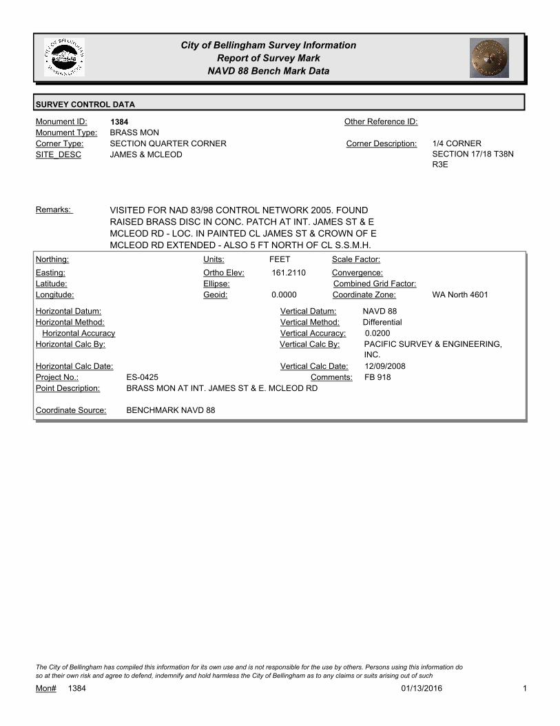
City of Bellingham Survey Information
Report of Survey Mark
NAVD 88 Bench Mark Data
SURVEY CONTROL DATA
1384Monument ID: Other Reference ID:
SITE_DESC JAMES & MCLEOD
SECTION QUARTER CORNERCorner Type: 1/4 CORNER
SECTION 17/18 T38N
R3E
Corner Description:
BRASS MONMonument Type:
VISITED FOR NAD 83/98 CONTROL NETWORK 2005. FOUND
RAISED BRASS DISC IN CONC. PATCH AT INT. JAMES ST & E
MCLEOD RD - LOC. IN PAINTED CL JAMES ST & CROWN OF E
MCLEOD RD EXTENDED - ALSO 5 FT NORTH OF CL S.S.M.H.
Remarks:
161.2110
0.0000
FEETNorthing:
Easting:
Latitude:
Longitude:
Units:
Ortho Elev:
Ellipse:
Geoid:
Scale Factor:
Convergence:
Combined Grid Factor:
WA North 4601Coordinate Zone:
Horizontal Method:
Horizontal Datum: NAVD 88Vertical Datum:
DifferentialVertical Method:
Horizontal Accuracy 0.0200Vertical Accuracy:
PACIFIC SURVEY & ENGINEERING,
INC.
Vertical Calc By:Horizontal Calc By:
ES-0425Project No.:
BRASS MON AT INT. JAMES ST & E. MCLEOD RDPoint Description:
BENCHMARK NAVD 88Coordinate Source:
FB 918Comments:
Horizontal Calc Date: 12/09/2008Vertical Calc Date:
101/13/2016Mon# 1384
The City of Bellingham has compiled this information for its own use and is not responsible for the use by others. Persons using this information do
so at their own risk and agree to defend, indemnify and hold harmless the City of Bellingham as to any claims or suits arising out of such

City of Bellingham Survey Information
Report of Survey Mark
NAVD 88 Bench Mark Data
SURVEY CONTROL DATA
1402Monument ID: Other Reference ID:
SITE_DESC WOBURN & TEXAS
RIGHT-OF-WAY INTERSECTIONCorner Type: Corner Description:
BRASS MONMonument Type:
VISITED FOR NAD 83/98 CONTROL NETWORK SURVEY 2006.Remarks:
104.3390
0.0000
FEETNorthing:
Easting:
Latitude:
Longitude:
Units:
Ortho Elev:
Ellipse:
Geoid:
Scale Factor:
Convergence:
Combined Grid Factor:
WA North 4601Coordinate Zone:
Horizontal Method:
Horizontal Datum: NAVD 88Vertical Datum:
DifferentialVertical Method:
Horizontal Accuracy 0.0300Vertical Accuracy:
WILSON ENGINEERING LLC.Vertical Calc By:Horizontal Calc By:
ES-0425Project No.:
C-BDS NAD83/98 MON INT TEXAS & WOBURNPoint Description:
BENCHMARK NAVD 88Coordinate Source:
ELEVATION NO LONGER VALID.
FB918-8 PG. 64
Comments:
Horizontal Calc Date: 02/12/2009Vertical Calc Date:
101/13/2016Mon# 1402
The City of Bellingham has compiled this information for its own use and is not responsible for the use by others. Persons using this information do
so at their own risk and agree to defend, indemnify and hold harmless the City of Bellingham as to any claims or suits arising out of such

City of Bellingham Survey Information
Report of Survey Mark
NAVD 88 Bench Mark Data
SURVEY CONTROL DATA
1408Monument ID: Other Reference ID:
SITE_DESC WASHINGTON & ELIZABETH
RIGHT-OF-WAY INTERSECTIONCorner Type: Corner Description:
CASED MONMonument Type:
COVER FOR CASED MON MISSING 8-12-05Remarks:
74.9620
0.0000
FEETNorthing:
Easting:
Latitude:
Longitude:
Units:
Ortho Elev:
Ellipse:
Geoid:
Scale Factor:
Convergence:
Combined Grid Factor:
WA North 4601Coordinate Zone:
Horizontal Method:
Horizontal Datum: NAVD 88Vertical Datum:
DifferentialVertical Method:
Horizontal Accuracy 0.0200Vertical Accuracy:
PACIFIC SURVEY & ENGINEERING,
INC.
Vertical Calc By:Horizontal Calc By:
ES-0425Project No.:
CASED MON (TOP OF NAIL) AT INT. WASHINGTON
ST & ELIZABETH ST
Point Description:
BENCHMARK NAVD 88Coordinate Source:
FB 918Comments:
Horizontal Calc Date: 01/05/2009Vertical Calc Date:
101/13/2016Mon# 1408
The City of Bellingham has compiled this information for its own use and is not responsible for the use by others. Persons using this information do
so at their own risk and agree to defend, indemnify and hold harmless the City of Bellingham as to any claims or suits arising out of such

City of Bellingham Survey Information
Report of Survey Mark
NAVD 88 Bench Mark Data
SURVEY CONTROL DATA
1411Monument ID: Other Reference ID:
SITE_DESC WASHINGTON & UTTER
RIGHT-OF-WAY INTERSECTIONCorner Type: Corner Description:
BRASS MONMonument Type:
Remarks:
73.5800
0.0000
FEETNorthing:
Easting:
Latitude:
Longitude:
Units:
Ortho Elev:
Ellipse:
Geoid:
Scale Factor:
Convergence:
Combined Grid Factor:
WA North 4601Coordinate Zone:
Horizontal Method:
Horizontal Datum: NAVD 88Vertical Datum:
DifferentialVertical Method:
Horizontal Accuracy 0.0200Vertical Accuracy:
PACIFIC SURVEY & ENGINEERING,
INC.
Vertical Calc By:Horizontal Calc By:
ES-0425Project No.:
BRASS MON AT INT. WASHINGTON ST & UTTER STPoint Description:
BENCHMARK NAVD 88Coordinate Source:
FB 918Comments:
Horizontal Calc Date: 01/05/2009Vertical Calc Date:
101/13/2016Mon# 1411
The City of Bellingham has compiled this information for its own use and is not responsible for the use by others. Persons using this information do
so at their own risk and agree to defend, indemnify and hold harmless the City of Bellingham as to any claims or suits arising out of such

City of Bellingham Survey Information
Report of Survey Mark
NAVD 88 Bench Mark Data
SURVEY CONTROL DATA
1412Monument ID: Other Reference ID:
SITE_DESC WASHINGTON & WILLIAMS
RIGHT-OF-WAY INTERSECTIONCorner Type: Corner Description:
BRASS MONMonument Type:
Remarks:
73.3260
0.0000
FEETNorthing:
Easting:
Latitude:
Longitude:
Units:
Ortho Elev:
Ellipse:
Geoid:
Scale Factor:
Convergence:
Combined Grid Factor:
WA North 4601Coordinate Zone:
Horizontal Method:
Horizontal Datum: NAVD 88Vertical Datum:
DifferentialVertical Method:
Horizontal Accuracy 0.0200Vertical Accuracy:
PACIFIC SURVEY & ENGINEERING,
INC.
Vertical Calc By:Horizontal Calc By:
ES-0425Project No.:
BRASS MON AT INT. WASHINGTON ST & WILLIAMS
ST
Point Description:
BENCHMARK NAVD 88Coordinate Source:
FB 918Comments:
Horizontal Calc Date: 12/09/2008Vertical Calc Date:
101/13/2016Mon# 1412
The City of Bellingham has compiled this information for its own use and is not responsible for the use by others. Persons using this information do
so at their own risk and agree to defend, indemnify and hold harmless the City of Bellingham as to any claims or suits arising out of such

City of Bellingham Survey Information
Report of Survey Mark
NAVD 88 Bench Mark Data
SURVEY CONTROL DATA
1421Monument ID: Other Reference ID:
SITE_DESC XENIA & TEXAS
RIGHT-OF-WAY INTERSECTIONCorner Type: Corner Description:
BRASS MONMonument Type:
Remarks:
646,708.6880
1,251,947.4080 112.3700
FEETNorthing:
Easting:
Latitude:
Longitude:
Units:
Ortho Elev:
Ellipse:
Geoid:
Scale Factor:
Convergence:
Combined Grid Factor:
WA North 4601Coordinate Zone:
Conventional SurveyHorizontal Method:
NAD 83/98Horizontal Datum: NAVD 88Vertical Datum:
DifferentialVertical Method:
0.0200Horizontal Accuracy 0.0300Vertical Accuracy:
LARRY STEELE & ASSOCIATESVertical Calc By:LARRY STEELE & ASSOCIATESHorizontal Calc By:
ES-0445Project No.:
C-BDSPoint Description:
NAD 83/98 PROJECT POINTSCoordinate Source:
FB 950-1 PROJECT POINT #105Comments:
08/22/2011Horizontal Calc Date: 08/22/2011Vertical Calc Date:
112.3690
0.0000
FEETNorthing:
Easting:
Latitude:
Longitude:
Units:
Ortho Elev:
Ellipse:
Geoid:
Scale Factor:
Convergence:
Combined Grid Factor:
WA North 4601Coordinate Zone:
Horizontal Method:
Horizontal Datum: NAVD 88Vertical Datum:
DifferentialVertical Method:
Horizontal Accuracy 0.0300Vertical Accuracy:
WILSON ENGINEERING LLC.Vertical Calc By:Horizontal Calc By:
ES-0425Project No.:
C-BDS INT TEXAS & XENIAPoint Description:
BENCHMARK NAVD 88Coordinate Source:
FB918-8 pg. 64Comments:
Horizontal Calc Date: 02/12/2009Vertical Calc Date:
101/13/2016Mon# 1421
The City of Bellingham has compiled this information for its own use and is not responsible for the use by others. Persons using this information do
so at their own risk and agree to defend, indemnify and hold harmless the City of Bellingham as to any claims or suits arising out of such

City of Bellingham Survey Information
Report of Survey Mark
NAVD 88 Bench Mark Data
SURVEY CONTROL DATA
1432Monument ID: Other Reference ID:
SITE_DESC YEW & TEXAS
RIGHT-OF-WAY INTERSECTIONCorner Type: Corner Description:
BRASS MONMonument Type:
RAISED 7-98Remarks:
646,701.4940
1,252,276.9940 119.7900
FEETNorthing:
Easting:
Latitude:
Longitude:
Units:
Ortho Elev:
Ellipse:
Geoid:
Scale Factor:
Convergence:
Combined Grid Factor:
WA North 4601Coordinate Zone:
Conventional SurveyHorizontal Method:
NAD 83/98Horizontal Datum: NAVD 88Vertical Datum:
DifferentialVertical Method:
0.0200Horizontal Accuracy 0.0300Vertical Accuracy:
LARRY STEELE & ASSOCIATESVertical Calc By:LARRY STEELE & ASSOCIATESHorizontal Calc By:
ES-0445Project No.:
C-BDSPoint Description:
NAD 83/98 PROJECT POINTSCoordinate Source:
FB 950-1 PROJECT POINT #106Comments:
08/22/2011Horizontal Calc Date: 08/22/2011Vertical Calc Date:
101/13/2016Mon# 1432
The City of Bellingham has compiled this information for its own use and is not responsible for the use by others. Persons using this information do
so at their own risk and agree to defend, indemnify and hold harmless the City of Bellingham as to any claims or suits arising out of such
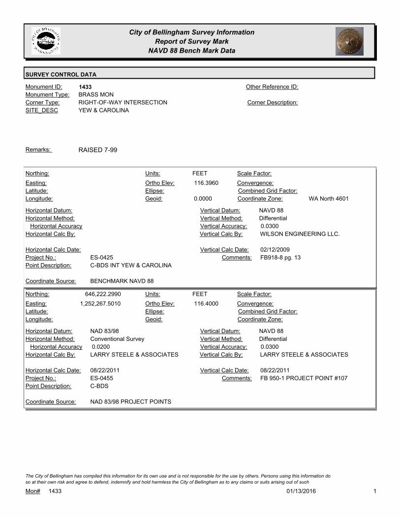
City of Bellingham Survey Information
Report of Survey Mark
NAVD 88 Bench Mark Data
SURVEY CONTROL DATA
1433Monument ID: Other Reference ID:
SITE_DESC YEW & CAROLINA
RIGHT-OF-WAY INTERSECTIONCorner Type: Corner Description:
BRASS MONMonument Type:
RAISED 7-99Remarks:
116.3960
0.0000
FEETNorthing:
Easting:
Latitude:
Longitude:
Units:
Ortho Elev:
Ellipse:
Geoid:
Scale Factor:
Convergence:
Combined Grid Factor:
WA North 4601Coordinate Zone:
Horizontal Method:
Horizontal Datum: NAVD 88Vertical Datum:
DifferentialVertical Method:
Horizontal Accuracy 0.0300Vertical Accuracy:
WILSON ENGINEERING LLC.Vertical Calc By:Horizontal Calc By:
ES-0425Project No.:
C-BDS INT YEW & CAROLINAPoint Description:
BENCHMARK NAVD 88Coordinate Source:
FB918-8 pg. 13Comments:
Horizontal Calc Date: 02/12/2009Vertical Calc Date:
646,222.2990
1,252,267.5010 116.4000
FEETNorthing:
Easting:
Latitude:
Longitude:
Units:
Ortho Elev:
Ellipse:
Geoid:
Scale Factor:
Convergence:
Combined Grid Factor:
Coordinate Zone:
Conventional SurveyHorizontal Method:
NAD 83/98Horizontal Datum: NAVD 88Vertical Datum:
DifferentialVertical Method:
0.0200Horizontal Accuracy 0.0300Vertical Accuracy:
LARRY STEELE & ASSOCIATESVertical Calc By:LARRY STEELE & ASSOCIATESHorizontal Calc By:
ES-0455Project No.:
C-BDSPoint Description:
NAD 83/98 PROJECT POINTSCoordinate Source:
FB 950-1 PROJECT POINT #107Comments:
08/22/2011Horizontal Calc Date: 08/22/2011Vertical Calc Date:
101/13/2016Mon# 1433
The City of Bellingham has compiled this information for its own use and is not responsible for the use by others. Persons using this information do
so at their own risk and agree to defend, indemnify and hold harmless the City of Bellingham as to any claims or suits arising out of such

City of Bellingham Survey Information
Report of Survey Mark
NAVD 88 Bench Mark Data
SURVEY CONTROL DATA
1462Monument ID: Other Reference ID:
SITE_DESC CORNWALL & NEW
RIGHT-OF-WAY INTERSECTIONCorner Type: Corner Description:
BRASS MONMonument Type:
RAISED 2008Remarks:
645,004.0097
1,244,402.9305 69.8800
FEETNorthing:
Easting:
Latitude:
Longitude:
Units:
Ortho Elev:
Ellipse:
Geoid:
Scale Factor:
Convergence:
Combined Grid Factor:
WA North 4601Coordinate Zone:
Conventional SurveyHorizontal Method:
NAD 83/98Horizontal Datum: NAVD 88Vertical Datum:
DifferentialVertical Method:
1.0000Horizontal Accuracy 0.0100Vertical Accuracy:
LAND DEVELOPMENT ENGINEERNG
& SURVEY INC
Vertical Calc By:LAND DEVELOPMENT
ENGINEERNG & SURVEY INC
Horizontal Calc By:
ES-0512Project No.:
Point Description:
NAD 83/98 PROJECT POINTSCoordinate Source:
FB 1013-1Comments:
06/01/2015Horizontal Calc Date: 06/01/2015Vertical Calc Date:
69.8820
0.0000
FEETNorthing:
Easting:
Latitude:
Longitude:
Units:
Ortho Elev:
Ellipse:
Geoid:
Scale Factor:
Convergence:
Combined Grid Factor:
WA North 4601Coordinate Zone:
Horizontal Method:
Horizontal Datum: NAVD 88Vertical Datum:
DifferentialVertical Method:
Horizontal Accuracy 0.0300Vertical Accuracy:
WILSON ENGINEERING LLC.Vertical Calc By:Horizontal Calc By:
ES-0425Project No.:
C-BDS INT CORNWALL & NEW (NOT IRVING)Point Description:
BENCHMARK NAVD 88Coordinate Source:
FB918-6 pg. 30Comments:
Horizontal Calc Date: 02/04/2009Vertical Calc Date:
101/13/2016Mon# 1462
The City of Bellingham has compiled this information for its own use and is not responsible for the use by others. Persons using this information do
so at their own risk and agree to defend, indemnify and hold harmless the City of Bellingham as to any claims or suits arising out of such
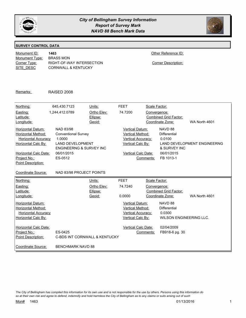
City of Bellingham Survey Information
Report of Survey Mark
NAVD 88 Bench Mark Data
SURVEY CONTROL DATA
1463Monument ID: Other Reference ID:
SITE_DESC CORNWALL & KENTUCKY
RIGHT-OF-WAY INTERSECTIONCorner Type: Corner Description:
BRASS MONMonument Type:
RAISED 2008Remarks:
645,430.7123
1,244,412.0789 74.7200
FEETNorthing:
Easting:
Latitude:
Longitude:
Units:
Ortho Elev:
Ellipse:
Geoid:
Scale Factor:
Convergence:
Combined Grid Factor:
WA North 4601Coordinate Zone:
Conventional SurveyHorizontal Method:
NAD 83/98Horizontal Datum: NAVD 88Vertical Datum:
DifferentialVertical Method:
1.0000Horizontal Accuracy 0.0100Vertical Accuracy:
LAND DEVELOPMENT ENGINEERNG
& SURVEY INC
Vertical Calc By:LAND DEVELOPMENT
ENGINEERNG & SURVEY INC
Horizontal Calc By:
ES-0512Project No.:
Point Description:
NAD 83/98 PROJECT POINTSCoordinate Source:
FB 1013-1Comments:
06/01/2015Horizontal Calc Date: 06/01/2015Vertical Calc Date:
74.7240
0.0000
FEETNorthing:
Easting:
Latitude:
Longitude:
Units:
Ortho Elev:
Ellipse:
Geoid:
Scale Factor:
Convergence:
Combined Grid Factor:
WA North 4601Coordinate Zone:
Horizontal Method:
Horizontal Datum: NAVD 88Vertical Datum:
DifferentialVertical Method:
Horizontal Accuracy 0.0300Vertical Accuracy:
WILSON ENGINEERING LLC.Vertical Calc By:Horizontal Calc By:
ES-0425Project No.:
C-BDS INT CORNWALL & KENTUCKYPoint Description:
BENCHMARK NAVD 88Coordinate Source:
FB918-6 pg. 30Comments:
Horizontal Calc Date: 02/04/2009Vertical Calc Date:
101/13/2016Mon# 1463
The City of Bellingham has compiled this information for its own use and is not responsible for the use by others. Persons using this information do
so at their own risk and agree to defend, indemnify and hold harmless the City of Bellingham as to any claims or suits arising out of such

City of Bellingham Survey Information
Report of Survey Mark
NAVD 88 Bench Mark Data
SURVEY CONTROL DATA
1496Monument ID: Other Reference ID:
SITE_DESC E MAPLE ST & INDIAN ST
RIGHT-OF-WAY INTERSECTIONCorner Type: Corner Description:
BRASS MONMonument Type:
Remarks:
185.7760
0.0000
FEETNorthing:
Easting:
Latitude:
Longitude:
Units:
Ortho Elev:
Ellipse:
Geoid:
Scale Factor:
Convergence:
Combined Grid Factor:
WA North 4601Coordinate Zone:
Horizontal Method:
Horizontal Datum: NAVD 88Vertical Datum:
DifferentialVertical Method:
Horizontal Accuracy 0.0300Vertical Accuracy:
WILSON ENGINEERING LLC.Vertical Calc By:Horizontal Calc By:
ES-0425Project No.:
C-BDS INT MAPLE & INDIANPoint Description:
BENCHMARK NAVD 88Coordinate Source:
ELEVATION NO LONGER VALID.
FB918-6 PG. 14
Comments:
Horizontal Calc Date: 02/04/2009Vertical Calc Date:
101/13/2016Mon# 1496
The City of Bellingham has compiled this information for its own use and is not responsible for the use by others. Persons using this information do
so at their own risk and agree to defend, indemnify and hold harmless the City of Bellingham as to any claims or suits arising out of such

City of Bellingham Survey Information
Report of Survey Mark
NAVD 88 Bench Mark Data
SURVEY CONTROL DATA
1518Monument ID: Other Reference ID:
SITE_DESC HARRIS AV & 14TH ST
RIGHT-OF-WAY INTERSECTIONCorner Type: Corner Description:
BRASS MONMonument Type:
VISITED FOR NAD 83/98 CONTROL NETWORK SURVEY 2006.Remarks:
119.1200
0.0000
FEETNorthing:
Easting:
Latitude:
Longitude:
Units:
Ortho Elev:
Ellipse:
Geoid:
Scale Factor:
Convergence:
Combined Grid Factor:
WA North 4601Coordinate Zone:
Horizontal Method:
Horizontal Datum: NAVD 88Vertical Datum:
DifferentialVertical Method:
Horizontal Accuracy 0.0200Vertical Accuracy:
LARRY STEELE & ASSOCIATESVertical Calc By:Horizontal Calc By:
ES-0425Project No.:
BRASS MON AT HARRIS & 14THPoint Description:
BENCHMARK NAVD 88Coordinate Source:
FB 918-11Comments:
Horizontal Calc Date: 02/17/2009Vertical Calc Date:
101/13/2016Mon# 1518
The City of Bellingham has compiled this information for its own use and is not responsible for the use by others. Persons using this information do
so at their own risk and agree to defend, indemnify and hold harmless the City of Bellingham as to any claims or suits arising out of such

City of Bellingham Survey Information
Report of Survey Mark
NAVD 88 Bench Mark Data
SURVEY CONTROL DATA
1525Monument ID: Other Reference ID:
SITE_DESC ELLIS & POTTER
RIGHT-OF-WAY INTERSECTIONCorner Type: Corner Description:
BRASS MONMonument Type:
Remarks:
129.0020
0.0000
FEETNorthing:
Easting:
Latitude:
Longitude:
Units:
Ortho Elev:
Ellipse:
Geoid:
Scale Factor:
Convergence:
Combined Grid Factor:
WA North 4601Coordinate Zone:
Horizontal Method:
Horizontal Datum: NAVD 88Vertical Datum:
DifferentialVertical Method:
Horizontal Accuracy 0.0300Vertical Accuracy:
WILSON ENGINEERING LLC.Vertical Calc By:Horizontal Calc By:
ES-0425Project No.:
C-BDS INT ELLIS & POTTERPoint Description:
BENCHMARK NAVD 88Coordinate Source:
FB918-6 pg. 17Comments:
Horizontal Calc Date: 02/04/2009Vertical Calc Date:
101/13/2016Mon# 1525
The City of Bellingham has compiled this information for its own use and is not responsible for the use by others. Persons using this information do
so at their own risk and agree to defend, indemnify and hold harmless the City of Bellingham as to any claims or suits arising out of such

City of Bellingham Survey Information
Report of Survey Mark
NAVD 88 Bench Mark Data
SURVEY CONTROL DATA
1549Monument ID: Other Reference ID:
SITE_DESC 10TH ST & BENNETT AV
RIGHT-OF-WAY INTERSECTIONCorner Type: Corner Description:
BRASS MONMonument Type:
RAISED 2-14-96, MON RAISED FOR 1997 OVERLAY. VISITED FOR
NAD 83/98 CONTROL NETWORK SURVEY 2006.
Remarks:
49.7910
0.0000
FEETNorthing:
Easting:
Latitude:
Longitude:
Units:
Ortho Elev:
Ellipse:
Geoid:
Scale Factor:
Convergence:
Combined Grid Factor:
WA North 4601Coordinate Zone:
Horizontal Method:
Horizontal Datum: NAVD 88Vertical Datum:
DifferentialVertical Method:
Horizontal Accuracy 0.0200Vertical Accuracy:
LARRY STEELE & ASSOCIATESVertical Calc By:Horizontal Calc By:
ES-0425Project No.:
BRASS MON AT BENNETT & 10THPoint Description:
BENCHMARK NAVD 88Coordinate Source:
FB 918-11Comments:
Horizontal Calc Date: 02/17/2009Vertical Calc Date:
101/13/2016Mon# 1549
The City of Bellingham has compiled this information for its own use and is not responsible for the use by others. Persons using this information do
so at their own risk and agree to defend, indemnify and hold harmless the City of Bellingham as to any claims or suits arising out of such

City of Bellingham Survey Information
Report of Survey Mark
NAVD 88 Bench Mark Data
SURVEY CONTROL DATA
1556Monument ID: Other Reference ID:
SITE_DESC SAMISH WAY & BILL MCDONALD
PKWY/BYRON
RIGHT-OF-WAY INTERSECTIONCorner Type: Corner Description:
CASED MONMonument Type:
Remarks:
636,604.8820
1,245,481.7660 196.7400
FEETNorthing:
Easting:
Latitude:
Longitude:
Units:
Ortho Elev:
Ellipse:
Geoid:
Scale Factor:
Convergence:
Combined Grid Factor:
WA North 4601Coordinate Zone:
Conventional SurveyHorizontal Method:
NAD 83/98Horizontal Datum: NAVD 88Vertical Datum:
DifferentialVertical Method:
0.0100Horizontal Accuracy 0.0200Vertical Accuracy:
FERGUSON LAND SURVEYINGVertical Calc By:FERGUSON LAND SURVEYINGHorizontal Calc By:
EU-0163Project No.:
C-BDS CASEDPoint Description:
NAD 83/98 PROJECT POINTSCoordinate Source:
FB 990-5Comments:
07/31/2014Horizontal Calc Date: 07/31/2014Vertical Calc Date:
636,604.8800
1,245,481.7620 196.7900
FEETNorthing:
Easting:
Latitude:
Longitude:
Units:
Ortho Elev:
Ellipse:
Geoid:
Scale Factor:
Convergence:
Combined Grid Factor:
WA North 4601Coordinate Zone:
Conventional SurveyHorizontal Method:
NAD 83/98Horizontal Datum: NAVD 88Vertical Datum:
DifferentialVertical Method:
0.0200Horizontal Accuracy 0.0300Vertical Accuracy:
LARRY STEELE & ASSOCIATESVertical Calc By:LARRY STEELE & ASSOCIATESHorizontal Calc By:
EU-0159Project No.:
C-MONPoint Description:
NAD 83/98 PROJECT POINTSCoordinate Source:
FB 947-1 PROJECT POINT #108Comments:
06/30/2011Horizontal Calc Date: 06/30/2011Vertical Calc Date:
101/13/2016Mon# 1556
The City of Bellingham has compiled this information for its own use and is not responsible for the use by others. Persons using this information do
so at their own risk and agree to defend, indemnify and hold harmless the City of Bellingham as to any claims or suits arising out of such

City of Bellingham Survey Information
Report of Survey Mark
NAVD 88 Bench Mark Data
SURVEY CONTROL DATA
1557Monument ID: Other Reference ID:
SITE_DESC BOULEVARD & PINE
RIGHT-OF-WAY INTERSECTIONCorner Type: Corner Description:
BRASS MONMonument Type:
MON RAISED FOR STATE ST. OVERLAY 2001.Remarks:
639,705.2669
1,241,033.1150 87.2100
FEETNorthing:
Easting:
Latitude:
Longitude:
Units:
Ortho Elev:
Ellipse:
Geoid:
Scale Factor:
Convergence:
Combined Grid Factor:
WA North 4601Coordinate Zone:
Conventional SurveyHorizontal Method:
NAD 83/98Horizontal Datum: NAVD 88Vertical Datum:
DifferentialVertical Method:
0.0200Horizontal Accuracy 0.0200Vertical Accuracy:
LARRY STEELE & ASSOCIATESVertical Calc By:LARRY STEELE & ASSOCIATESHorizontal Calc By:
EU-0151Project No.:
C-BDS-BPF AT PINE PROJ PNT #599Point Description:
NAD 83/98 PROJECT POINTSCoordinate Source:
FB 927Comments:
07/10/2009Horizontal Calc Date: 07/10/2009Vertical Calc Date:
101/13/2016Mon# 1557
The City of Bellingham has compiled this information for its own use and is not responsible for the use by others. Persons using this information do
so at their own risk and agree to defend, indemnify and hold harmless the City of Bellingham as to any claims or suits arising out of such
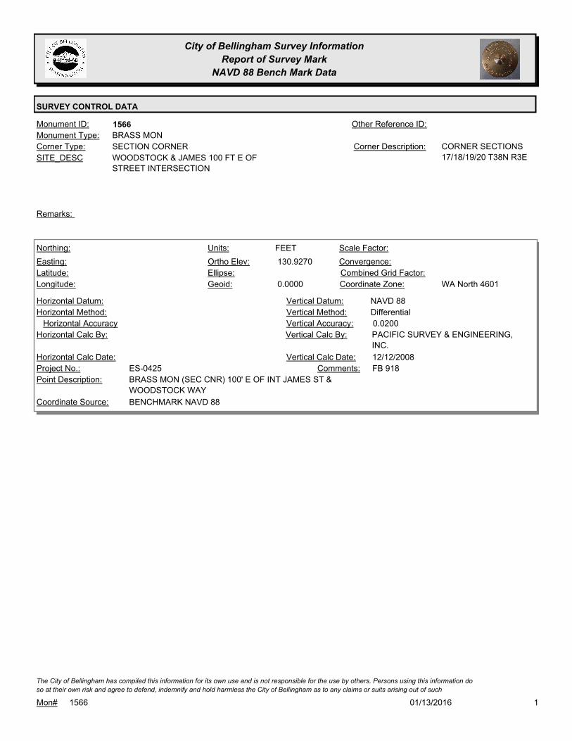
City of Bellingham Survey Information
Report of Survey Mark
NAVD 88 Bench Mark Data
SURVEY CONTROL DATA
1566Monument ID: Other Reference ID:
SITE_DESC WOODSTOCK & JAMES 100 FT E OF
STREET INTERSECTION
SECTION CORNERCorner Type: CORNER SECTIONS
17/18/19/20 T38N R3E
Corner Description:
BRASS MONMonument Type:
Remarks:
130.9270
0.0000
FEETNorthing:
Easting:
Latitude:
Longitude:
Units:
Ortho Elev:
Ellipse:
Geoid:
Scale Factor:
Convergence:
Combined Grid Factor:
WA North 4601Coordinate Zone:
Horizontal Method:
Horizontal Datum: NAVD 88Vertical Datum:
DifferentialVertical Method:
Horizontal Accuracy 0.0200Vertical Accuracy:
PACIFIC SURVEY & ENGINEERING,
INC.
Vertical Calc By:Horizontal Calc By:
ES-0425Project No.:
BRASS MON (SEC CNR) 100' E OF INT JAMES ST &
WOODSTOCK WAY
Point Description:
BENCHMARK NAVD 88Coordinate Source:
FB 918Comments:
Horizontal Calc Date: 12/12/2008Vertical Calc Date:
101/13/2016Mon# 1566
The City of Bellingham has compiled this information for its own use and is not responsible for the use by others. Persons using this information do
so at their own risk and agree to defend, indemnify and hold harmless the City of Bellingham as to any claims or suits arising out of such

City of Bellingham Survey Information
Report of Survey Mark
NAVD 88 Bench Mark Data
SURVEY CONTROL DATA
1586Monument ID: Other Reference ID:
SITE_DESC BOULEVARD & CEDAR
RIGHT-OF-WAY INTERSECTIONCorner Type: Corner Description:
BRASS MONMonument Type:
MON RAISED FOR STATE ST. OVERLAY 2001Remarks:
639,342.4913
1,240,660.4180 76.9600
FEETNorthing:
Easting:
Latitude:
Longitude:
Units:
Ortho Elev:
Ellipse:
Geoid:
Scale Factor:
Convergence:
Combined Grid Factor:
WA North 4601Coordinate Zone:
Conventional SurveyHorizontal Method:
NAD 83/98Horizontal Datum: NAVD 88Vertical Datum:
DifferentialVertical Method:
0.0200Horizontal Accuracy 0.0200Vertical Accuracy:
LARRY STEELE & ASSOCIATESVertical Calc By:LARRY STEELE & ASSOCIATESHorizontal Calc By:
EU-0151Project No.:
C-BDS-BPF AT CEDAR PROJ PNT #598Point Description:
NAD 83/98 PROJECT POINTSCoordinate Source:
FB 927Comments:
07/10/2009Horizontal Calc Date: 07/10/2009Vertical Calc Date:
101/13/2016Mon# 1586
The City of Bellingham has compiled this information for its own use and is not responsible for the use by others. Persons using this information do
so at their own risk and agree to defend, indemnify and hold harmless the City of Bellingham as to any claims or suits arising out of such

City of Bellingham Survey Information
Report of Survey Mark
NAVD 88 Bench Mark Data
SURVEY CONTROL DATA
1628Monument ID: Other Reference ID:
SITE_DESC PC ON HIGHLAND S/O WEST COLLEGE
WAY.
RIGHT-OF-WAY PTCorner Type: Corner Description:
BRASS MONMonument Type:
Remarks:
636,688.3483
1,240,410.8697 434.0200
FEETNorthing:
Easting:
Latitude:
Longitude:
Units:
Ortho Elev:
Ellipse:
Geoid:
Scale Factor:
Convergence:
Combined Grid Factor:
WA North 4601Coordinate Zone:
Conventional SurveyHorizontal Method:
NAD 83/98Horizontal Datum: NAVD 88Vertical Datum:
DifferentialVertical Method:
0.0200Horizontal Accuracy 0.0300Vertical Accuracy:
LARRY STEELE & ASSOCIATESVertical Calc By:LARRY STEELE & ASSOCIATESHorizontal Calc By:
EU-0156Project No.:
BPFPoint Description:
NAD 83/98 PROJECT POINTSCoordinate Source:
ELEVATION NO LONGER VALID. FB
940-1 PROJECT POINT #501
Comments:
08/09/2011Horizontal Calc Date: 08/09/2011Vertical Calc Date:
101/13/2016Mon# 1628
The City of Bellingham has compiled this information for its own use and is not responsible for the use by others. Persons using this information do
so at their own risk and agree to defend, indemnify and hold harmless the City of Bellingham as to any claims or suits arising out of such

City of Bellingham Survey Information
Report of Survey Mark
NAVD 88 Bench Mark Data
SURVEY CONTROL DATA
1630Monument ID: Other Reference ID:
SITE_DESC VIRGINIA & HUMBOLT
RIGHT-OF-WAY INTERSECTIONCorner Type: Corner Description:
BRASS MONMonument Type:
MON RAISED FOR 2000 OVERLAY. VISITED FOR NAD 83/98
CONTROL NETWORK SURVEY 2006.
Remarks:
645,872.6279
1,246,172.0891 78.8600
FEETNorthing:
Easting:
Latitude:
Longitude:
Units:
Ortho Elev:
Ellipse:
Geoid:
Scale Factor:
Convergence:
Combined Grid Factor:
WA North 4601Coordinate Zone:
Conventional SurveyHorizontal Method:
NAD 83/98Horizontal Datum: NAVD 88Vertical Datum:
DifferentialVertical Method:
0.0540Horizontal Accuracy 0.0200Vertical Accuracy:
CONSTRUCTION SURVEYORS N W
INC.
Vertical Calc By:CONSTRUCTION SURVEYORS N
W INC.
Horizontal Calc By:
EW-0186Project No.:
C-BDSPoint Description:
NAD 83/98 PROJECT POINTSCoordinate Source:
FB 953-1,2Comments:
09/26/2011Horizontal Calc Date: 09/26/2011Vertical Calc Date:
78.8470
0.0000
FEETNorthing:
Easting:
Latitude:
Longitude:
Units:
Ortho Elev:
Ellipse:
Geoid:
Scale Factor:
Convergence:
Combined Grid Factor:
WA North 4601Coordinate Zone:
Horizontal Method:
Horizontal Datum: NAVD 88Vertical Datum:
DifferentialVertical Method:
Horizontal Accuracy 0.0300Vertical Accuracy:
WILSON ENGINEERING LLC.Vertical Calc By:Horizontal Calc By:
ES-0425Project No.:
C-BDS INT VIRGINIA & HUMBOLTPoint Description:
BENCHMARK NAVD 88Coordinate Source:
FB918-6 pg. 37Comments:
Horizontal Calc Date: 02/04/2009Vertical Calc Date:
101/13/2016Mon# 1630
The City of Bellingham has compiled this information for its own use and is not responsible for the use by others. Persons using this information do
so at their own risk and agree to defend, indemnify and hold harmless the City of Bellingham as to any claims or suits arising out of such

City of Bellingham Survey Information
Report of Survey Mark
NAVD 88 Bench Mark Data
SURVEY CONTROL DATA
1662Monument ID: Other Reference ID:
SITE_DESC E CHESTNUT ST& KEY ST
RIGHT-OF-WAY INTERSECTIONCorner Type: Corner Description:
BRASS MONMonument Type:
Remarks:
188.3400
FEETNorthing:
Easting:
Latitude:
Longitude:
Units:
Ortho Elev:
Ellipse:
Geoid:
Scale Factor:
Convergence:
Combined Grid Factor:
Coordinate Zone:
Horizontal Method:
Horizontal Datum: NAVD 88Vertical Datum:
DifferentialVertical Method:
Horizontal Accuracy 0.0800Vertical Accuracy:
CONSTRUCTION SURVEYORS N W
INC.
Vertical Calc By:Horizontal Calc By:
EW-0186Project No.:
Point Description:
BENCHMARK NAVD 88Coordinate Source:
ELEVATION NO LONGER VALID. FB
937
Comments:
Horizontal Calc Date: 03/15/2011Vertical Calc Date:
101/13/2016Mon# 1662
The City of Bellingham has compiled this information for its own use and is not responsible for the use by others. Persons using this information do
so at their own risk and agree to defend, indemnify and hold harmless the City of Bellingham as to any claims or suits arising out of such

City of Bellingham Survey Information
Report of Survey Mark
NAVD 88 Bench Mark Data
SURVEY CONTROL DATA
1680Monument ID: Other Reference ID:
SITE_DESC 40TH & FIELDING
RIGHT-OF-WAY INTERSECTIONCorner Type: Corner Description:
BRASS MONMonument Type:
MON SET FOR PROJECT 5-01. VISITED FOR NAD 83/98 CONTROL
NETWORK SURVEY 2006.
Remarks:
344.1860
FEETNorthing:
Easting:
Latitude:
Longitude:
Units:
Ortho Elev:
Ellipse:
Geoid:
Scale Factor:
Convergence:
Combined Grid Factor:
Coordinate Zone:
Horizontal Method:
Horizontal Datum: NAVD 88Vertical Datum:
DifferentialVertical Method:
Horizontal Accuracy 0.0300Vertical Accuracy:
WILSON ENGINEERING LLC.Vertical Calc By:Horizontal Calc By:
Project No.:
Point Description:
BENCHMARK NAVD 88Coordinate Source:
FB 960-3Comments:
Horizontal Calc Date: 01/18/2012Vertical Calc Date:
101/13/2016Mon# 1680
The City of Bellingham has compiled this information for its own use and is not responsible for the use by others. Persons using this information do
so at their own risk and agree to defend, indemnify and hold harmless the City of Bellingham as to any claims or suits arising out of such

City of Bellingham Survey Information
Report of Survey Mark
NAVD 88 Bench Mark Data
SURVEY CONTROL DATA
1686Monument ID: Other Reference ID:
SITE_DESC IOWA & HUMBOLT
RIGHT-OF-WAY INTERSECTIONCorner Type: Corner Description:
BRASS MONMonument Type:
VISITED FOR NAD 83/98 CONTROL NETWORK SURVEY 2006.Remarks:
644,912.7905
1,246,151.5314 68.3900
FEETNorthing:
Easting:
Latitude:
Longitude:
Units:
Ortho Elev:
Ellipse:
Geoid:
Scale Factor:
Convergence:
Combined Grid Factor:
WA North 4601Coordinate Zone:
Conventional SurveyHorizontal Method:
NAD 83/98Horizontal Datum: NAVD 88Vertical Datum:
DifferentialVertical Method:
0.0540Horizontal Accuracy 0.0200Vertical Accuracy:
CONSTRUCTION SURVEYORS N W
INC.
Vertical Calc By:CONSTRUCTION SURVEYORS N
W INC.
Horizontal Calc By:
EW-0186Project No.:
C-BDSPoint Description:
NAD 83/98 PROJECT POINTSCoordinate Source:
FB 952-1,2Comments:
09/26/2011Horizontal Calc Date: 09/26/2011Vertical Calc Date:
101/13/2016Mon# 1686
The City of Bellingham has compiled this information for its own use and is not responsible for the use by others. Persons using this information do
so at their own risk and agree to defend, indemnify and hold harmless the City of Bellingham as to any claims or suits arising out of such
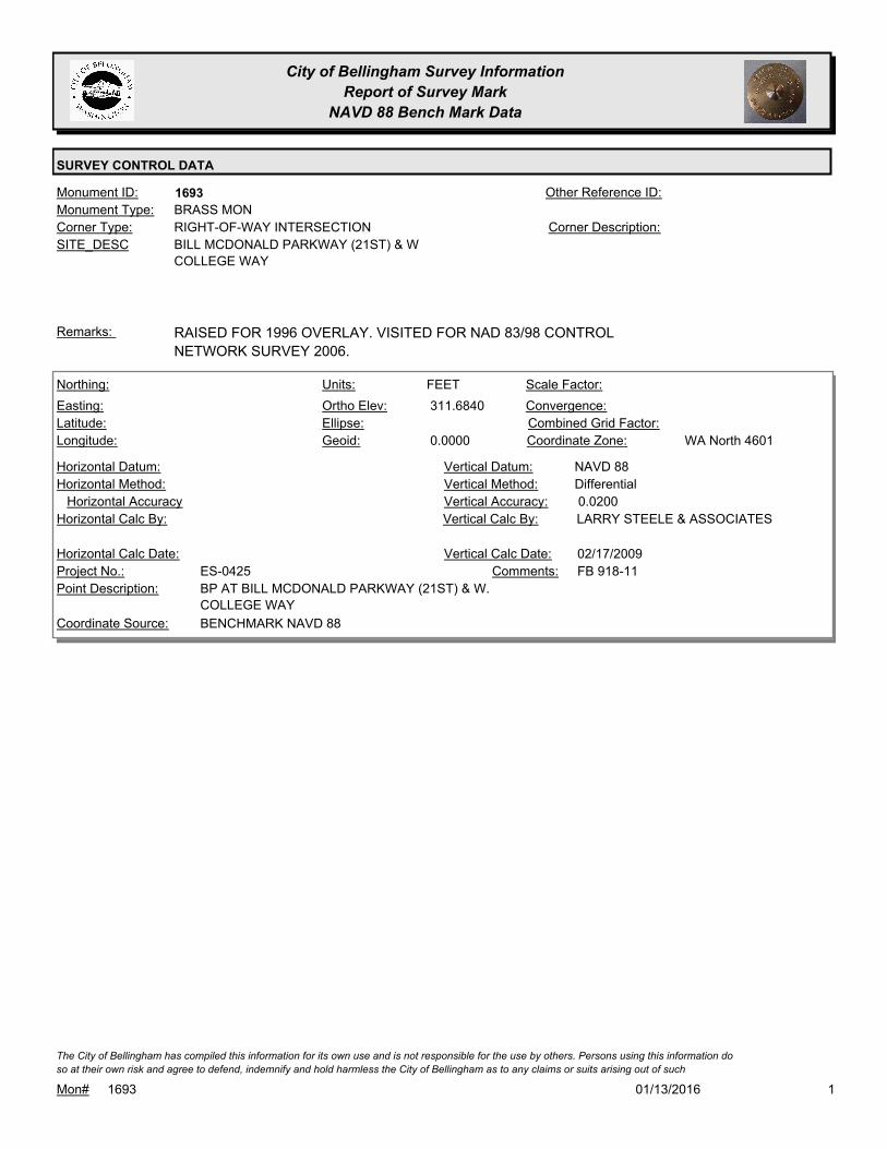
City of Bellingham Survey Information
Report of Survey Mark
NAVD 88 Bench Mark Data
SURVEY CONTROL DATA
1693Monument ID: Other Reference ID:
SITE_DESC BILL MCDONALD PARKWAY (21ST) & W
COLLEGE WAY
RIGHT-OF-WAY INTERSECTIONCorner Type: Corner Description:
BRASS MONMonument Type:
RAISED FOR 1996 OVERLAY. VISITED FOR NAD 83/98 CONTROL
NETWORK SURVEY 2006.
Remarks:
311.6840
0.0000
FEETNorthing:
Easting:
Latitude:
Longitude:
Units:
Ortho Elev:
Ellipse:
Geoid:
Scale Factor:
Convergence:
Combined Grid Factor:
WA North 4601Coordinate Zone:
Horizontal Method:
Horizontal Datum: NAVD 88Vertical Datum:
DifferentialVertical Method:
Horizontal Accuracy 0.0200Vertical Accuracy:
LARRY STEELE & ASSOCIATESVertical Calc By:Horizontal Calc By:
ES-0425Project No.:
BP AT BILL MCDONALD PARKWAY (21ST) & W.
COLLEGE WAY
Point Description:
BENCHMARK NAVD 88Coordinate Source:
FB 918-11Comments:
Horizontal Calc Date: 02/17/2009Vertical Calc Date:
101/13/2016Mon# 1693
The City of Bellingham has compiled this information for its own use and is not responsible for the use by others. Persons using this information do
so at their own risk and agree to defend, indemnify and hold harmless the City of Bellingham as to any claims or suits arising out of such

City of Bellingham Survey Information
Report of Survey Mark
NAVD 88 Bench Mark Data
SURVEY CONTROL DATA
1700Monument ID: Other Reference ID:
SITE_DESC HUMBOLT & KENTUCKY
RIGHT-OF-WAY INTERSECTIONCorner Type: Corner Description:
BRASS MONMonument Type:
Remarks:
645,392.5720
1,246,161.8073 76.0800
FEETNorthing:
Easting:
Latitude:
Longitude:
Units:
Ortho Elev:
Ellipse:
Geoid:
Scale Factor:
Convergence:
Combined Grid Factor:
WA North 4601Coordinate Zone:
Conventional SurveyHorizontal Method:
NAD 83/98Horizontal Datum: NAVD 88Vertical Datum:
DifferentialVertical Method:
0.0540Horizontal Accuracy 0.0200Vertical Accuracy:
CONSTRUCTION SURVEYORS N W
INC.
Vertical Calc By:CONSTRUCTION SURVEYORS N
W INC.
Horizontal Calc By:
Project No.:
C-BDSPoint Description:
NAD 83/98 PROJECT POINTSCoordinate Source:
FB 952-1,2Comments:
09/26/2011Horizontal Calc Date: 09/26/2011Vertical Calc Date:
101/13/2016Mon# 1700
The City of Bellingham has compiled this information for its own use and is not responsible for the use by others. Persons using this information do
so at their own risk and agree to defend, indemnify and hold harmless the City of Bellingham as to any claims or suits arising out of such

City of Bellingham Survey Information
Report of Survey Mark
NAVD 88 Bench Mark Data
SURVEY CONTROL DATA
1738Monument ID: Other Reference ID:
SITE_DESC HIGHLAND DR & PATTLE ST
RIGHT-OF-WAY INTERSECTIONCorner Type: Corner Description:
BRASS MONMonument Type:
Remarks:
635,812.7050
1,239,715.9560 424.0400
FEETNorthing:
Easting:
Latitude:
Longitude:
Units:
Ortho Elev:
Ellipse:
Geoid:
Scale Factor:
Convergence:
Combined Grid Factor:
WA North 4601Coordinate Zone:
Conventional SurveyHorizontal Method:
NAD 83/98Horizontal Datum: NAVD 88Vertical Datum:
DifferentialVertical Method:
0.0200Horizontal Accuracy 0.0300Vertical Accuracy:
LARRY STEELE & ASSOCIATESVertical Calc By:LARRY STEELE & ASSOCIATESHorizontal Calc By:
EU-0156Project No.:
BPFPoint Description:
NAD 83/98 PROJECT POINTSCoordinate Source:
ELEVATION NO LONGER VALID. FB
940-1 PROJECT POINT #526
Comments:
08/09/2011Horizontal Calc Date: 08/09/2011Vertical Calc Date:
101/13/2016Mon# 1738
The City of Bellingham has compiled this information for its own use and is not responsible for the use by others. Persons using this information do
so at their own risk and agree to defend, indemnify and hold harmless the City of Bellingham as to any claims or suits arising out of such
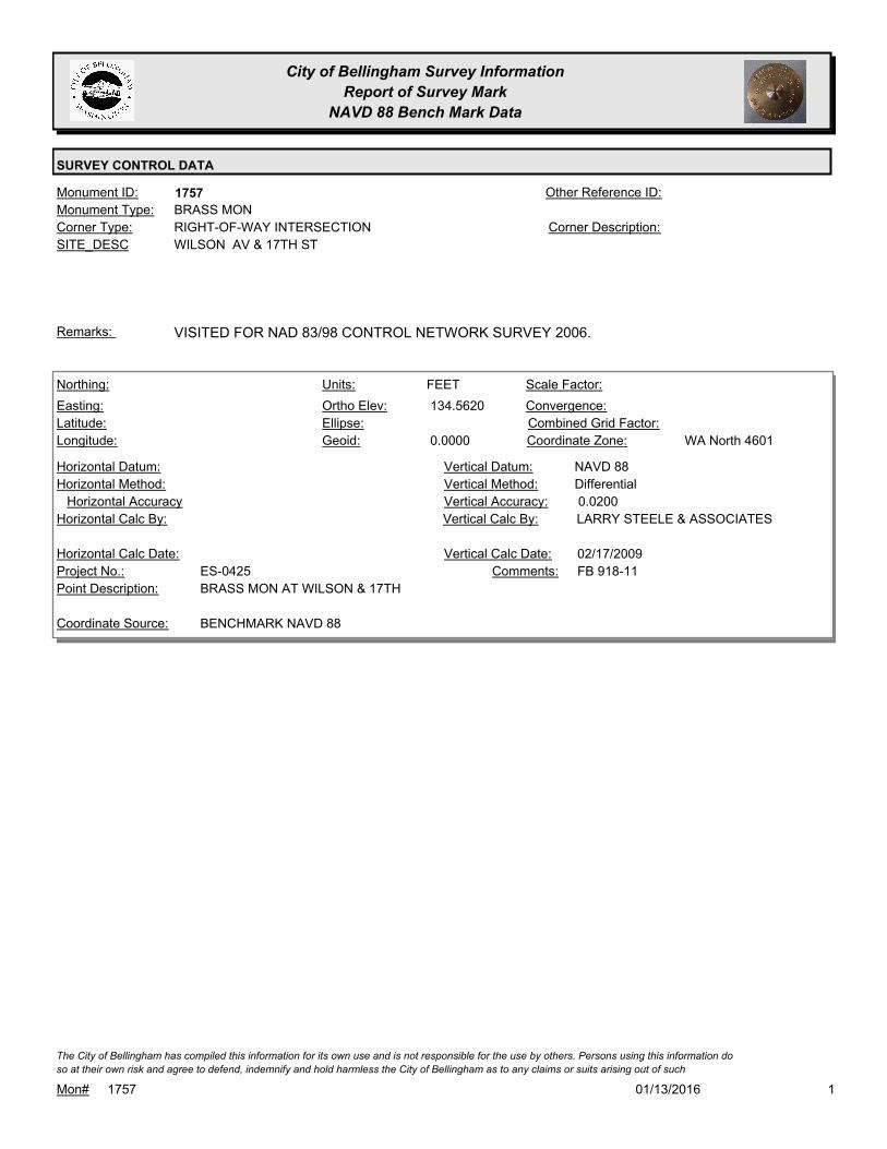
City of Bellingham Survey Information
Report of Survey Mark
NAVD 88 Bench Mark Data
SURVEY CONTROL DATA
1757Monument ID: Other Reference ID:
SITE_DESC WILSON AV & 17TH ST
RIGHT-OF-WAY INTERSECTIONCorner Type: Corner Description:
BRASS MONMonument Type:
VISITED FOR NAD 83/98 CONTROL NETWORK SURVEY 2006.Remarks:
134.5620
0.0000
FEETNorthing:
Easting:
Latitude:
Longitude:
Units:
Ortho Elev:
Ellipse:
Geoid:
Scale Factor:
Convergence:
Combined Grid Factor:
WA North 4601Coordinate Zone:
Horizontal Method:
Horizontal Datum: NAVD 88Vertical Datum:
DifferentialVertical Method:
Horizontal Accuracy 0.0200Vertical Accuracy:
LARRY STEELE & ASSOCIATESVertical Calc By:Horizontal Calc By:
ES-0425Project No.:
BRASS MON AT WILSON & 17THPoint Description:
BENCHMARK NAVD 88Coordinate Source:
FB 918-11Comments:
Horizontal Calc Date: 02/17/2009Vertical Calc Date:
101/13/2016Mon# 1757
The City of Bellingham has compiled this information for its own use and is not responsible for the use by others. Persons using this information do
so at their own risk and agree to defend, indemnify and hold harmless the City of Bellingham as to any claims or suits arising out of such
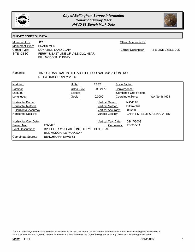
City of Bellingham Survey Information
Report of Survey Mark
NAVD 88 Bench Mark Data
SURVEY CONTROL DATA
1761Monument ID: Other Reference ID:
SITE_DESC FERRY & EAST LINE OF LYLE DLC, NEAR
BILL MCDONALD PKWY
DONATION LAND CLAIMCorner Type: AT E LINE LYSLE DLCCorner Description:
BRASS MONMonument Type:
1973 CADASTRAL POINT. VISITED FOR NAD 83/98 CONTROL
NETWORK SURVEY 2006.
Remarks:
298.2470
0.0000
FEETNorthing:
Easting:
Latitude:
Longitude:
Units:
Ortho Elev:
Ellipse:
Geoid:
Scale Factor:
Convergence:
Combined Grid Factor:
WA North 4601Coordinate Zone:
Horizontal Method:
Horizontal Datum: NAVD 88Vertical Datum:
DifferentialVertical Method:
Horizontal Accuracy 0.0200Vertical Accuracy:
LARRY STEELE & ASSOCIATESVertical Calc By:Horizontal Calc By:
ES-0425Project No.:
BP AT FERRY & EAST LINE OF LYLE DLC, NEAR
BILL MCDONALD PARKWAY
Point Description:
BENCHMARK NAVD 88Coordinate Source:
FB 918-11Comments:
Horizontal Calc Date: 02/17/2009Vertical Calc Date:
101/13/2016Mon# 1761
The City of Bellingham has compiled this information for its own use and is not responsible for the use by others. Persons using this information do
so at their own risk and agree to defend, indemnify and hold harmless the City of Bellingham as to any claims or suits arising out of such

City of Bellingham Survey Information
Report of Survey Mark
NAVD 88 Bench Mark Data
SURVEY CONTROL DATA
1791Monument ID: Other Reference ID:
SITE_DESC PUGET (TO THE NORTH) & S. LINE OF
JONES DLC- EAST MON
DONATION LAND CLAIMCorner Type: Corner Description:
BRASS MONMonument Type:
2 MONS. SEE #5404 TO EASTRemarks:
398.7350
Northing:
Easting:
Latitude:
Longitude:
Units:
Ortho Elev:
Ellipse:
Geoid:
Scale Factor:
Convergence:
Combined Grid Factor:
Coordinate Zone:
Horizontal Method:
Horizontal Datum: NAVD 88Vertical Datum:
DifferentialVertical Method:
Horizontal Accuracy 0.0200Vertical Accuracy:
CONSTRUCTION SURVEYORS N W
INC.
Vertical Calc By:Horizontal Calc By:
Project No.:
Point Description:
BENCHMARK NAVD 88Coordinate Source:
FB 960-2Comments:
Horizontal Calc Date: 05/01/2012Vertical Calc Date:
101/13/2016Mon# 1791
The City of Bellingham has compiled this information for its own use and is not responsible for the use by others. Persons using this information do
so at their own risk and agree to defend, indemnify and hold harmless the City of Bellingham as to any claims or suits arising out of such

City of Bellingham Survey Information
Report of Survey Mark
NAVD 88 Bench Mark Data
SURVEY CONTROL DATA
1792Monument ID: Other Reference ID:
SITE_DESC PUGET & PI N/O CONSOLIDATION
RIGHT-OF-WAY PICorner Type: Corner Description:
BRASS MONMonument Type:
Remarks:
423.9280
FEETNorthing:
Easting:
Latitude:
Longitude:
Units:
Ortho Elev:
Ellipse:
Geoid:
Scale Factor:
Convergence:
Combined Grid Factor:
Coordinate Zone:
Horizontal Method:
Horizontal Datum: NAVD 88Vertical Datum:
DifferentialVertical Method:
Horizontal Accuracy 0.0200Vertical Accuracy:
CONSTRUCTION SURVEYORS N W
INC.
Vertical Calc By:Horizontal Calc By:
Project No.:
Point Description:
BENCHMARK NAVD 88Coordinate Source:
FB 960-2Comments:
Horizontal Calc Date: 05/01/2012Vertical Calc Date:
101/13/2016Mon# 1792
The City of Bellingham has compiled this information for its own use and is not responsible for the use by others. Persons using this information do
so at their own risk and agree to defend, indemnify and hold harmless the City of Bellingham as to any claims or suits arising out of such

City of Bellingham Survey Information
Report of Survey Mark
NAVD 88 Bench Mark Data
SURVEY CONTROL DATA
1846Monument ID: Other Reference ID:
SITE_DESC 40TH & NEAR TAYLOR
SECTION QUARTER CORNERCorner Type: 1/4 CORNER
SECTION 5/6 T37N
R3E
Corner Description:
BRASS MONMonument Type:
1973 CADASTRAL POINT. VISITED FOR NAD 83/98 CONTROL
NETWORK SURVEY 2006.
Remarks:
479.3700
FEETNorthing:
Easting:
Latitude:
Longitude:
Units:
Ortho Elev:
Ellipse:
Geoid:
Scale Factor:
Convergence:
Combined Grid Factor:
Coordinate Zone:
Horizontal Method:
Horizontal Datum: NAVD 88Vertical Datum:
DifferentialVertical Method:
Horizontal Accuracy 0.0300Vertical Accuracy:
WILSON ENGINEERING LLC.Vertical Calc By:Horizontal Calc By:
Project No.:
Point Description:
BENCHMARK NAVD 88Coordinate Source:
FB 960-3Comments:
Horizontal Calc Date: 01/18/2012Vertical Calc Date:
101/13/2016Mon# 1846
The City of Bellingham has compiled this information for its own use and is not responsible for the use by others. Persons using this information do
so at their own risk and agree to defend, indemnify and hold harmless the City of Bellingham as to any claims or suits arising out of such
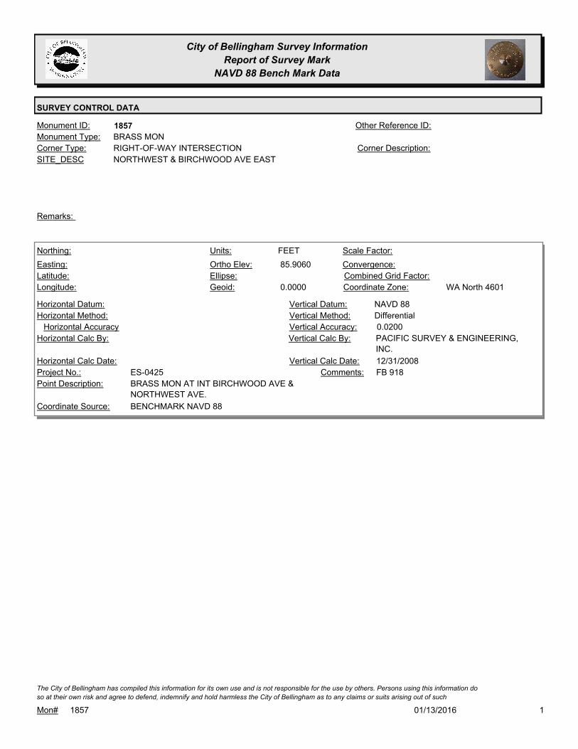
City of Bellingham Survey Information
Report of Survey Mark
NAVD 88 Bench Mark Data
SURVEY CONTROL DATA
1857Monument ID: Other Reference ID:
SITE_DESC NORTHWEST & BIRCHWOOD AVE EAST
RIGHT-OF-WAY INTERSECTIONCorner Type: Corner Description:
BRASS MONMonument Type:
Remarks:
85.9060
0.0000
FEETNorthing:
Easting:
Latitude:
Longitude:
Units:
Ortho Elev:
Ellipse:
Geoid:
Scale Factor:
Convergence:
Combined Grid Factor:
WA North 4601Coordinate Zone:
Horizontal Method:
Horizontal Datum: NAVD 88Vertical Datum:
DifferentialVertical Method:
Horizontal Accuracy 0.0200Vertical Accuracy:
PACIFIC SURVEY & ENGINEERING,
INC.
Vertical Calc By:Horizontal Calc By:
ES-0425Project No.:
BRASS MON AT INT BIRCHWOOD AVE &
NORTHWEST AVE.
Point Description:
BENCHMARK NAVD 88Coordinate Source:
FB 918Comments:
Horizontal Calc Date: 12/31/2008Vertical Calc Date:
101/13/2016Mon# 1857
The City of Bellingham has compiled this information for its own use and is not responsible for the use by others. Persons using this information do
so at their own risk and agree to defend, indemnify and hold harmless the City of Bellingham as to any claims or suits arising out of such
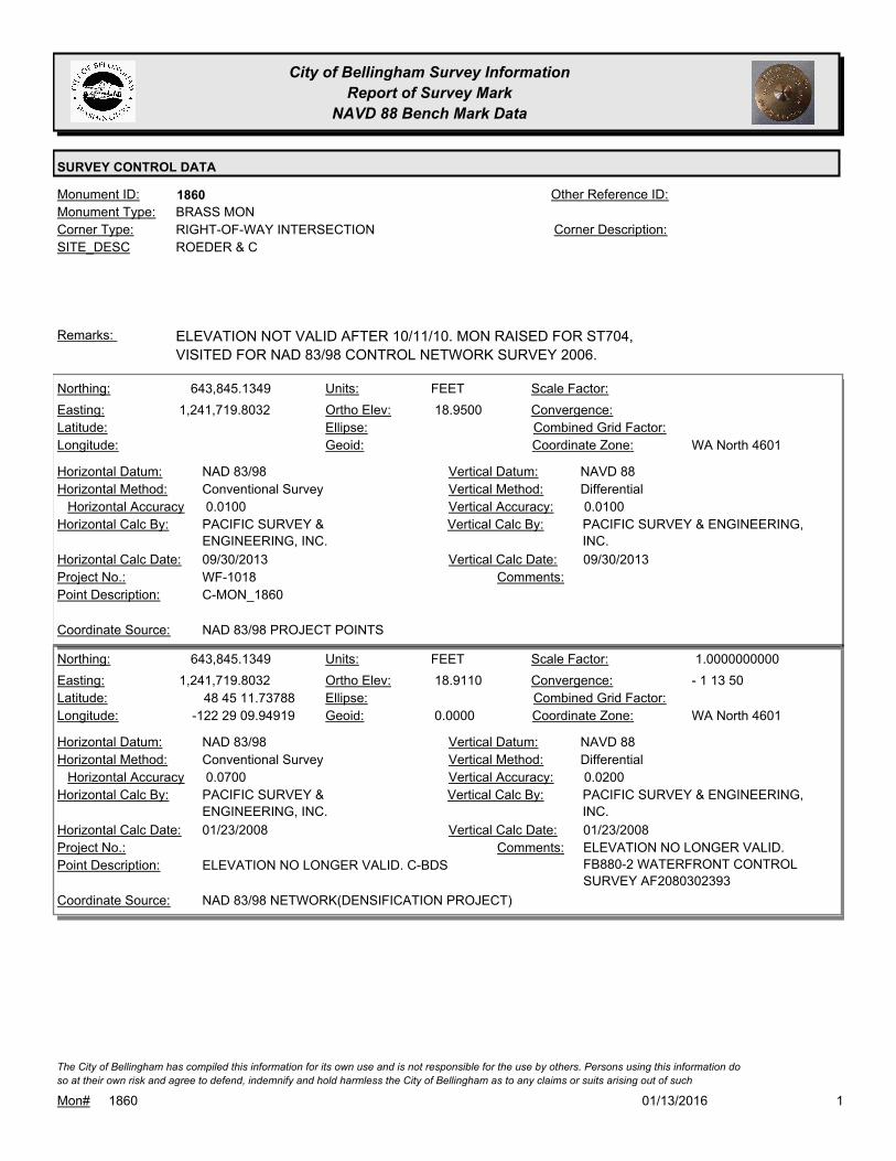
City of Bellingham Survey Information
Report of Survey Mark
NAVD 88 Bench Mark Data
SURVEY CONTROL DATA
1860Monument ID: Other Reference ID:
SITE_DESC ROEDER & C
RIGHT-OF-WAY INTERSECTIONCorner Type: Corner Description:
BRASS MONMonument Type:
ELEVATION NOT VALID AFTER 10/11/10. MON RAISED FOR ST704,
VISITED FOR NAD 83/98 CONTROL NETWORK SURVEY 2006.
Remarks:
643,845.1349
1,241,719.8032 18.9500
FEETNorthing:
Easting:
Latitude:
Longitude:
Units:
Ortho Elev:
Ellipse:
Geoid:
Scale Factor:
Convergence:
Combined Grid Factor:
WA North 4601Coordinate Zone:
Conventional SurveyHorizontal Method:
NAD 83/98Horizontal Datum: NAVD 88Vertical Datum:
DifferentialVertical Method:
0.0100Horizontal Accuracy 0.0100Vertical Accuracy:
PACIFIC SURVEY & ENGINEERING,
INC.
Vertical Calc By:PACIFIC SURVEY &
ENGINEERING, INC.
Horizontal Calc By:
WF-1018Project No.:
C-MON_1860Point Description:
NAD 83/98 PROJECT POINTSCoordinate Source:
Comments:
09/30/2013Horizontal Calc Date: 09/30/2013Vertical Calc Date:
643,845.1349
1,241,719.8032
48 45 11.73788
-122 29 09.94919
18.9110
0.0000
FEETNorthing:
Easting:
Latitude:
Longitude:
Units:
Ortho Elev:
Ellipse:
Geoid:
1.0000000000Scale Factor:
- 1 13 50Convergence:
Combined Grid Factor:
WA North 4601Coordinate Zone:
Conventional SurveyHorizontal Method:
NAD 83/98Horizontal Datum: NAVD 88Vertical Datum:
DifferentialVertical Method:
0.0700Horizontal Accuracy 0.0200Vertical Accuracy:
PACIFIC SURVEY & ENGINEERING,
INC.
Vertical Calc By:PACIFIC SURVEY &
ENGINEERING, INC.
Horizontal Calc By:
Project No.:
ELEVATION NO LONGER VALID. C-BDSPoint Description:
NAD 83/98 NETWORK(DENSIFICATION PROJECT)Coordinate Source:
ELEVATION NO LONGER VALID.
FB880-2 WATERFRONT CONTROL
SURVEY AF2080302393
Comments:
01/23/2008Horizontal Calc Date: 01/23/2008Vertical Calc Date:
101/13/2016Mon# 1860
The City of Bellingham has compiled this information for its own use and is not responsible for the use by others. Persons using this information do
so at their own risk and agree to defend, indemnify and hold harmless the City of Bellingham as to any claims or suits arising out of such
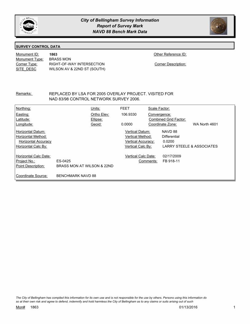
City of Bellingham Survey Information
Report of Survey Mark
NAVD 88 Bench Mark Data
SURVEY CONTROL DATA
1863Monument ID: Other Reference ID:
SITE_DESC WILSON AV & 22ND ST (SOUTH)
RIGHT-OF-WAY INTERSECTIONCorner Type: Corner Description:
BRASS MONMonument Type:
REPLACED BY LSA FOR 2005 OVERLAY PROJECT. VISITED FOR
NAD 83/98 CONTROL NETWORK SURVEY 2006.
Remarks:
106.9330
0.0000
FEETNorthing:
Easting:
Latitude:
Longitude:
Units:
Ortho Elev:
Ellipse:
Geoid:
Scale Factor:
Convergence:
Combined Grid Factor:
WA North 4601Coordinate Zone:
Horizontal Method:
Horizontal Datum: NAVD 88Vertical Datum:
DifferentialVertical Method:
Horizontal Accuracy 0.0200Vertical Accuracy:
LARRY STEELE & ASSOCIATESVertical Calc By:Horizontal Calc By:
ES-0425Project No.:
BRASS MON AT WILSON & 22NDPoint Description:
BENCHMARK NAVD 88Coordinate Source:
FB 918-11Comments:
Horizontal Calc Date: 02/17/2009Vertical Calc Date:
101/13/2016Mon# 1863
The City of Bellingham has compiled this information for its own use and is not responsible for the use by others. Persons using this information do
so at their own risk and agree to defend, indemnify and hold harmless the City of Bellingham as to any claims or suits arising out of such

City of Bellingham Survey Information
Report of Survey Mark
NAVD 88 Bench Mark Data
SURVEY CONTROL DATA
1882Monument ID: Other Reference ID:
SITE_DESC CEDARWOOD & PC S OF BIRCHWOOD
RIGHT-OF-WAY PCCorner Type: Corner Description:
BRASS MONMonument Type:
OPPOSITE HOUSE #2520Remarks:
83.8570
0.0000
FEETNorthing:
Easting:
Latitude:
Longitude:
Units:
Ortho Elev:
Ellipse:
Geoid:
Scale Factor:
Convergence:
Combined Grid Factor:
WA North 4601Coordinate Zone:
Horizontal Method:
Horizontal Datum: NAVD 88Vertical Datum:
DifferentialVertical Method:
Horizontal Accuracy 0.0200Vertical Accuracy:
PACIFIC SURVEY & ENGINEERING,
INC.
Vertical Calc By:Horizontal Calc By:
ES-0425Project No.:
BRASS MON IN NE-BOUND LANE CEDARWOOD
AVE NEAR HOUSE #2520
Point Description:
BENCHMARK NAVD 88Coordinate Source:
FB 918Comments:
Horizontal Calc Date: 12/12/2008Vertical Calc Date:
101/13/2016Mon# 1882
The City of Bellingham has compiled this information for its own use and is not responsible for the use by others. Persons using this information do
so at their own risk and agree to defend, indemnify and hold harmless the City of Bellingham as to any claims or suits arising out of such
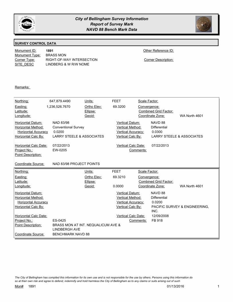
City of Bellingham Survey Information
Report of Survey Mark
NAVD 88 Bench Mark Data
SURVEY CONTROL DATA
1891Monument ID: Other Reference ID:
SITE_DESC LINDBERG & W R/W NOME
RIGHT-OF-WAY INTERSECTIONCorner Type: Corner Description:
BRASS MONMonument Type:
Remarks:
647,879.4490
1,236,526.7670 69.3200
FEETNorthing:
Easting:
Latitude:
Longitude:
Units:
Ortho Elev:
Ellipse:
Geoid:
Scale Factor:
Convergence:
Combined Grid Factor:
WA North 4601Coordinate Zone:
Conventional SurveyHorizontal Method:
NAD 83/98Horizontal Datum: NAVD 88Vertical Datum:
DifferentialVertical Method:
0.0200Horizontal Accuracy 0.0300Vertical Accuracy:
LARRY STEELE & ASSOCIATESVertical Calc By:LARRY STEELE & ASSOCIATESHorizontal Calc By:
EW-0205Project No.:
Point Description:
NAD 83/98 PROJECT POINTSCoordinate Source:
Comments:
07/22/2013Horizontal Calc Date: 07/22/2013Vertical Calc Date:
69.3210
0.0000
FEETNorthing:
Easting:
Latitude:
Longitude:
Units:
Ortho Elev:
Ellipse:
Geoid:
Scale Factor:
Convergence:
Combined Grid Factor:
WA North 4601Coordinate Zone:
Horizontal Method:
Horizontal Datum: NAVD 88Vertical Datum:
DifferentialVertical Method:
Horizontal Accuracy 0.0200Vertical Accuracy:
PACIFIC SURVEY & ENGINEERING,
INC.
Vertical Calc By:Horizontal Calc By:
ES-0425Project No.:
BRASS MON AT INT. NEQUALICUM AVE &
LINDBERGH AVE
Point Description:
BENCHMARK NAVD 88Coordinate Source:
FB 918Comments:
Horizontal Calc Date: 12/09/2008Vertical Calc Date:
101/13/2016Mon# 1891
The City of Bellingham has compiled this information for its own use and is not responsible for the use by others. Persons using this information do
so at their own risk and agree to defend, indemnify and hold harmless the City of Bellingham as to any claims or suits arising out of such

City of Bellingham Survey Information
Report of Survey Mark
NAVD 88 Bench Mark Data
SURVEY CONTROL DATA
1906Monument ID: Other Reference ID:
SITE_DESC WOBURN & PI ON WOBURN N/O 1/4 SEC.
LINE
RIGHT-OF-WAY PICorner Type: Corner Description:
BRASS MONMonument Type:
Remarks:
99.8920
0.0000
FEETNorthing:
Easting:
Latitude:
Longitude:
Units:
Ortho Elev:
Ellipse:
Geoid:
Scale Factor:
Convergence:
Combined Grid Factor:
WA North 4601Coordinate Zone:
Horizontal Method:
Horizontal Datum: NAVD 88Vertical Datum:
DifferentialVertical Method:
Horizontal Accuracy 0.0300Vertical Accuracy:
WILSON ENGINEERING LLC.Vertical Calc By:Horizontal Calc By:
ES-0425Project No.:
C-BDS CL WOBURN @ RES.#1803Point Description:
BENCHMARK NAVD 88Coordinate Source:
ELEVATION NO LONGER VALID.
FB918-7 PG. 29
Comments:
Horizontal Calc Date: 02/12/2009Vertical Calc Date:
101/13/2016Mon# 1906
The City of Bellingham has compiled this information for its own use and is not responsible for the use by others. Persons using this information do
so at their own risk and agree to defend, indemnify and hold harmless the City of Bellingham as to any claims or suits arising out of such

City of Bellingham Survey Information
Report of Survey Mark
NAVD 88 Bench Mark Data
SURVEY CONTROL DATA
1908Monument ID: Other Reference ID:
SITE_DESC 40TH & LARRABEE
RIGHT-OF-WAY INTERSECTIONCorner Type: Corner Description:
BRASS MONMonument Type:
Remarks:
606.5930
FEETNorthing:
Easting:
Latitude:
Longitude:
Units:
Ortho Elev:
Ellipse:
Geoid:
Scale Factor:
Convergence:
Combined Grid Factor:
Coordinate Zone:
Horizontal Method:
Horizontal Datum: NAVD 88Vertical Datum:
DifferentialVertical Method:
Horizontal Accuracy 0.0300Vertical Accuracy:
WILSON ENGINEERING LLC.Vertical Calc By:Horizontal Calc By:
Project No.:
Point Description:
BENCHMARK NAVD 88Coordinate Source:
FB 960-3Comments:
Horizontal Calc Date: 01/18/2012Vertical Calc Date:
101/13/2016Mon# 1908
The City of Bellingham has compiled this information for its own use and is not responsible for the use by others. Persons using this information do
so at their own risk and agree to defend, indemnify and hold harmless the City of Bellingham as to any claims or suits arising out of such

City of Bellingham Survey Information
Report of Survey Mark
NAVD 88 Bench Mark Data
SURVEY CONTROL DATA
1925Monument ID: Other Reference ID:
SITE_DESC IVY ST & N STATE ST
RIGHT-OF-WAY INTERSECTIONCorner Type: Corner Description:
BRASS MONMonument Type:
MON SET 1994, MON RAISED FOR STATE ST. OVERLAY 2001.
VISITED FOR NAD 83/98 CONTROL NETWORK SURVEY 2006.
Remarks:
71.9660
0.0000
FEETNorthing:
Easting:
Latitude:
Longitude:
Units:
Ortho Elev:
Ellipse:
Geoid:
Scale Factor:
Convergence:
Combined Grid Factor:
WA North 4601Coordinate Zone:
Horizontal Method:
Horizontal Datum: NAVD 88Vertical Datum:
DifferentialVertical Method:
Horizontal Accuracy 0.0300Vertical Accuracy:
WILSON ENGINEERING LLC.Vertical Calc By:Horizontal Calc By:
ES-0425Project No.:
C-BDS INT N.STATE & IVYPoint Description:
BENCHMARK NAVD 88Coordinate Source:
ELEVATION NO LONGER VALID.
FB918-6 PG. 2
Comments:
Horizontal Calc Date: 01/26/2009Vertical Calc Date:
640,212.8550
1,241,990.7457
48 44 35.96314
-122 29 04.74405
71.9530
0.0000
FEETNorthing:
Easting:
Latitude:
Longitude:
Units:
Ortho Elev:
Ellipse:
Geoid:
1.0000000000Scale Factor:
- 1 13 46Convergence:
Combined Grid Factor:
WA North 4601Coordinate Zone:
Conventional SurveyHorizontal Method:
NAD 83/98Horizontal Datum: NAVD 88Vertical Datum:
DifferentialVertical Method:
0.0700Horizontal Accuracy 0.0200Vertical Accuracy:
PACIFIC SURVEY & ENGINEERING,
INC.
Vertical Calc By:PACIFIC SURVEY &
ENGINEERING, INC.
Horizontal Calc By:
Project No.:
C-BDSPoint Description:
NAD 83/98 NETWORK(DENSIFICATION PROJECT)Coordinate Source:
ELEVATION NO LONGER VALID.
FB880-2 WATERFRONT CONTROL
SURVEY AF2080302393
Comments:
01/23/2008Horizontal Calc Date: 01/23/2008Vertical Calc Date:
101/13/2016Mon# 1925
The City of Bellingham has compiled this information for its own use and is not responsible for the use by others. Persons using this information do
so at their own risk and agree to defend, indemnify and hold harmless the City of Bellingham as to any claims or suits arising out of such

City of Bellingham Survey Information
Report of Survey Mark
NAVD 88 Bench Mark Data
SURVEY CONTROL DATA
1934Monument ID: Other Reference ID:
SITE_DESC HIGHLAND DR & EASTON AV
RIGHT-OF-WAY INTERSECTIONCorner Type: Corner Description:
BRASS MONMonument Type:
Remarks:
634,484.7550
1,239,505.6640 392.1900
FEETNorthing:
Easting:
Latitude:
Longitude:
Units:
Ortho Elev:
Ellipse:
Geoid:
Scale Factor:
Convergence:
Combined Grid Factor:
WA North 4601Coordinate Zone:
Conventional SurveyHorizontal Method:
NAD 83/98Horizontal Datum: NAVD 88Vertical Datum:
DifferentialVertical Method:
0.0200Horizontal Accuracy 0.0300Vertical Accuracy:
LARRY STEELE & ASSOCIATESVertical Calc By:LARRY STEELE & ASSOCIATESHorizontal Calc By:
EU-0156Project No.:
BPFPoint Description:
NAD 83/98 PROJECT POINTSCoordinate Source:
ELEVATION NO LONGER VALID. FB
940-1 PROJECT POINT #510
Comments:
08/09/2011Horizontal Calc Date: 08/09/2011Vertical Calc Date:
101/13/2016Mon# 1934
The City of Bellingham has compiled this information for its own use and is not responsible for the use by others. Persons using this information do
so at their own risk and agree to defend, indemnify and hold harmless the City of Bellingham as to any claims or suits arising out of such

City of Bellingham Survey Information
Report of Survey Mark
NAVD 88 Bench Mark Data
SURVEY CONTROL DATA
1935Monument ID: Other Reference ID:
SITE_DESC HIGHLAND DR & FERRY AV
RIGHT-OF-WAY INTERSECTIONCorner Type: Corner Description:
BRASS MONMonument Type:
HOUSE # 445 &# 505Remarks:
635,245.2660
1,239,521.5240 410.9700
FEETNorthing:
Easting:
Latitude:
Longitude:
Units:
Ortho Elev:
Ellipse:
Geoid:
Scale Factor:
Convergence:
Combined Grid Factor:
WA North 4601Coordinate Zone:
Conventional SurveyHorizontal Method:
NAD 83/98Horizontal Datum: NAVD 88Vertical Datum:
DifferentialVertical Method:
0.0200Horizontal Accuracy 0.0300Vertical Accuracy:
LARRY STEELE & ASSOCIATESVertical Calc By:LARRY STEELE & ASSOCIATESHorizontal Calc By:
EU-0156Project No.:
BPFPoint Description:
NAD 83/98 PROJECT POINTSCoordinate Source:
ELEVATION NO LONGEER VALID.
FB 940-1 PROJECT POINT #525
Comments:
08/09/2011Horizontal Calc Date: 08/09/2011Vertical Calc Date:
101/13/2016Mon# 1935
The City of Bellingham has compiled this information for its own use and is not responsible for the use by others. Persons using this information do
so at their own risk and agree to defend, indemnify and hold harmless the City of Bellingham as to any claims or suits arising out of such

City of Bellingham Survey Information
Report of Survey Mark
NAVD 88 Bench Mark Data
SURVEY CONTROL DATA
1941Monument ID: Other Reference ID:
SITE_DESC 11TH ST & LARRABEE AV
RIGHT-OF-WAY INTERSECTIONCorner Type: Corner Description:
BRASS MONMonument Type:
VISITED FOR NAD 83/98 CONTROL NETWORK SURVEY 2006.Remarks:
81.4580
0.0000
FEETNorthing:
Easting:
Latitude:
Longitude:
Units:
Ortho Elev:
Ellipse:
Geoid:
Scale Factor:
Convergence:
Combined Grid Factor:
WA North 4601Coordinate Zone:
Horizontal Method:
Horizontal Datum: NAVD 88Vertical Datum:
DifferentialVertical Method:
Horizontal Accuracy 0.0200Vertical Accuracy:
LARRY STEELE & ASSOCIATESVertical Calc By:Horizontal Calc By:
ES-0425Project No.:
BRASS MON AT LARRABEE & 11THPoint Description:
BENCHMARK NAVD 88Coordinate Source:
FB 918-11Comments:
Horizontal Calc Date: 02/17/2009Vertical Calc Date:
101/13/2016Mon# 1941
The City of Bellingham has compiled this information for its own use and is not responsible for the use by others. Persons using this information do
so at their own risk and agree to defend, indemnify and hold harmless the City of Bellingham as to any claims or suits arising out of such

City of Bellingham Survey Information
Report of Survey Mark
NAVD 88 Bench Mark Data
SURVEY CONTROL DATA
1943Monument ID: Other Reference ID:
SITE_DESC HARRIS AVE & 9TH ST
RIGHT-OF-WAY INTERSECTIONCorner Type: Corner Description:
BRASS MONMonument Type:
VISITED FOR NAD 83/98 CONTROL NETWORK SURVEY 2006.Remarks:
27.6050
0.0000
FEETNorthing:
Easting:
Latitude:
Longitude:
Units:
Ortho Elev:
Ellipse:
Geoid:
Scale Factor:
Convergence:
Combined Grid Factor:
WA North 4601Coordinate Zone:
Horizontal Method:
Horizontal Datum: NAVD 88Vertical Datum:
DifferentialVertical Method:
Horizontal Accuracy 0.0200Vertical Accuracy:
LARRY STEELE & ASSOCIATESVertical Calc By:Horizontal Calc By:
ES-0425Project No.:
BRASS MON AT HARRIS & 9THPoint Description:
BENCHMARK NAVD 88Coordinate Source:
FB 918-11Comments:
Horizontal Calc Date: 02/17/2009Vertical Calc Date:
101/13/2016Mon# 1943
The City of Bellingham has compiled this information for its own use and is not responsible for the use by others. Persons using this information do
so at their own risk and agree to defend, indemnify and hold harmless the City of Bellingham as to any claims or suits arising out of such

City of Bellingham Survey Information
Report of Survey Mark
NAVD 88 Bench Mark Data
SURVEY CONTROL DATA
1957Monument ID: Other Reference ID:
SITE_DESC WILSON AVE & 20TH ST
RIGHT-OF-WAY INTERSECTIONCorner Type: Corner Description:
BRASS MONMonument Type:
VISITED FOR NAD 83/98 CONTROL NETWORK SURVEY 2006.Remarks:
108.1080
0.0000
FEETNorthing:
Easting:
Latitude:
Longitude:
Units:
Ortho Elev:
Ellipse:
Geoid:
Scale Factor:
Convergence:
Combined Grid Factor:
WA North 4601Coordinate Zone:
Horizontal Method:
Horizontal Datum: NAVD 88Vertical Datum:
DifferentialVertical Method:
Horizontal Accuracy 0.0200Vertical Accuracy:
LARRY STEELE & ASSOCIATESVertical Calc By:Horizontal Calc By:
ES-0425Project No.:
BRASS MON AT WILSON & 20THPoint Description:
BENCHMARK NAVD 88Coordinate Source:
FB 918-11Comments:
Horizontal Calc Date: 02/17/2009Vertical Calc Date:
101/13/2016Mon# 1957
The City of Bellingham has compiled this information for its own use and is not responsible for the use by others. Persons using this information do
so at their own risk and agree to defend, indemnify and hold harmless the City of Bellingham as to any claims or suits arising out of such

City of Bellingham Survey Information
Report of Survey Mark
NAVD 88 Bench Mark Data
SURVEY CONTROL DATA
1962Monument ID: Other Reference ID:
SITE_DESC 32ND & FIELDING
RIGHT-OF-WAY INTERSECTIONCorner Type: Corner Description:
BRASS MONMonument Type:
VISITED FOR NAD 83/98 CONTROL NETWORK SURVEY 2006.Remarks:
198.6440
0.0000
FEETNorthing:
Easting:
Latitude:
Longitude:
Units:
Ortho Elev:
Ellipse:
Geoid:
Scale Factor:
Convergence:
Combined Grid Factor:
WA North 4601Coordinate Zone:
Horizontal Method:
Horizontal Datum: NAVD 88Vertical Datum:
DifferentialVertical Method:
Horizontal Accuracy 0.0200Vertical Accuracy:
LARRY STEELE & ASSOCIATESVertical Calc By:Horizontal Calc By:
ES-0425Project No.:
BRASS MON AT FIELDING & 32NDPoint Description:
BENCHMARK NAVD 88Coordinate Source:
FB 918-11Comments:
Horizontal Calc Date: 02/17/2009Vertical Calc Date:
101/13/2016Mon# 1962
The City of Bellingham has compiled this information for its own use and is not responsible for the use by others. Persons using this information do
so at their own risk and agree to defend, indemnify and hold harmless the City of Bellingham as to any claims or suits arising out of such

City of Bellingham Survey Information
Report of Survey Mark
NAVD 88 Bench Mark Data
SURVEY CONTROL DATA
1963Monument ID: Other Reference ID:
SITE_DESC 32ND ST& MILL AVE
HOUSE # 1129
RIGHT-OF-WAY INTERSECTIONCorner Type: Corner Description:
BRASS MONMonument Type:
MON RAISED FOR 2002 OVERLAY. VISITED FOR NAD 83/98
CONTROL NETWORK SURVEY 2006.
Remarks:
187.9430
0.0000
FEETNorthing:
Easting:
Latitude:
Longitude:
Units:
Ortho Elev:
Ellipse:
Geoid:
Scale Factor:
Convergence:
Combined Grid Factor:
WA North 4601Coordinate Zone:
Horizontal Method:
Horizontal Datum: NAVD 88Vertical Datum:
DifferentialVertical Method:
Horizontal Accuracy 0.0200Vertical Accuracy:
LARRY STEELE & ASSOCIATESVertical Calc By:Horizontal Calc By:
ES-0425Project No.:
BRASS MON AT MILL AND 32NDPoint Description:
BENCHMARK NAVD 88Coordinate Source:
FB 918-11Comments:
Horizontal Calc Date: 02/17/2009Vertical Calc Date:
101/13/2016Mon# 1963
The City of Bellingham has compiled this information for its own use and is not responsible for the use by others. Persons using this information do
so at their own risk and agree to defend, indemnify and hold harmless the City of Bellingham as to any claims or suits arising out of such

City of Bellingham Survey Information
Report of Survey Mark
NAVD 88 Bench Mark Data
SURVEY CONTROL DATA
1999Monument ID: Other Reference ID:
SITE_DESC WILSON & 4TH
RIGHT-OF-WAY INTERSECTIONCorner Type: Corner Description:
BRASS MONMonument Type:
Remarks:
630,684.8900
1,235,294.4000 66.0300
FEETNorthing:
Easting:
Latitude:
Longitude:
Units:
Ortho Elev:
Ellipse:
Geoid:
Scale Factor:
Convergence:
Combined Grid Factor:
WA North 4601Coordinate Zone:
Conventional SurveyHorizontal Method:
NAD 83/98Horizontal Datum: NAVD 88Vertical Datum:
DifferentialVertical Method:
Horizontal Accuracy Vertical Accuracy:
WILSON ENGINEERING LLC.Vertical Calc By:WILSON ENGINEERING LLC.Horizontal Calc By:
Project No.:
BRASS SURFACE MONPoint Description:
NAD 83/98 PROJECT POINTSCoordinate Source:
POST POINT RS-4712Comments:
08/10/2009Horizontal Calc Date: 08/10/2009Vertical Calc Date:
101/13/2016Mon# 1999
The City of Bellingham has compiled this information for its own use and is not responsible for the use by others. Persons using this information do
so at their own risk and agree to defend, indemnify and hold harmless the City of Bellingham as to any claims or suits arising out of such

City of Bellingham Survey Information
Report of Survey Mark
NAVD 88 Bench Mark Data
SURVEY CONTROL DATA
2006Monument ID: Other Reference ID:
SITE_DESC COWGILL & 4TH
RIGHT-OF-WAY INTERSECTIONCorner Type: Corner Description:
BRASS MONMonument Type:
REPLACED BY LSA FOR 2005 OVERLAY PROJECT.Remarks:
630,379.8500
1,235,287.9800 78.8700
FEETNorthing:
Easting:
Latitude:
Longitude:
Units:
Ortho Elev:
Ellipse:
Geoid:
Scale Factor:
Convergence:
Combined Grid Factor:
WA North 4601Coordinate Zone:
Conventional SurveyHorizontal Method:
NAD 83/98Horizontal Datum: NAVD 88Vertical Datum:
DifferentialVertical Method:
Horizontal Accuracy Vertical Accuracy:
WILSON ENGINEERING LLC.Vertical Calc By:WILSON ENGINEERING LLC.Horizontal Calc By:
Project No.:
BRASS SURFACE MONPoint Description:
NAD 83/98 PROJECT POINTSCoordinate Source:
POST POINT RS-4712Comments:
08/10/2009Horizontal Calc Date: 08/10/2009Vertical Calc Date:
101/13/2016Mon# 2006
The City of Bellingham has compiled this information for its own use and is not responsible for the use by others. Persons using this information do
so at their own risk and agree to defend, indemnify and hold harmless the City of Bellingham as to any claims or suits arising out of such
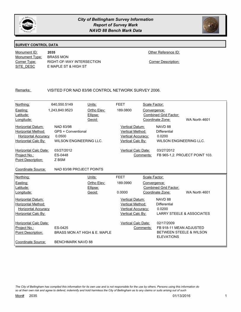
City of Bellingham Survey Information
Report of Survey Mark
NAVD 88 Bench Mark Data
SURVEY CONTROL DATA
2035Monument ID: Other Reference ID:
SITE_DESC E MAPLE ST & HIGH ST
RIGHT-OF-WAY INTERSECTIONCorner Type: Corner Description:
BRASS MONMonument Type:
VISITED FOR NAD 83/98 CONTROL NETWORK SURVEY 2006.Remarks:
640,550.5149
1,243,840.9523 189.0800
FEETNorthing:
Easting:
Latitude:
Longitude:
Units:
Ortho Elev:
Ellipse:
Geoid:
Scale Factor:
Convergence:
Combined Grid Factor:
WA North 4601Coordinate Zone:
GPS + ConventionalHorizontal Method:
NAD 83/98Horizontal Datum: NAVD 88Vertical Datum:
DifferentialVertical Method:
0.0500Horizontal Accuracy 0.0200Vertical Accuracy:
WILSON ENGINEERING LLC.Vertical Calc By:WILSON ENGINEERING LLC.Horizontal Calc By:
ES-0448Project No.:
Z BSMPoint Description:
NAD 83/98 PROJECT POINTSCoordinate Source:
FB 965-1,2. PROJECT POINT 103.Comments:
03/27/2012Horizontal Calc Date: 03/27/2012Vertical Calc Date:
189.0990
0.0000
FEETNorthing:
Easting:
Latitude:
Longitude:
Units:
Ortho Elev:
Ellipse:
Geoid:
Scale Factor:
Convergence:
Combined Grid Factor:
WA North 4601Coordinate Zone:
Horizontal Method:
Horizontal Datum: NAVD 88Vertical Datum:
DifferentialVertical Method:
Horizontal Accuracy 0.0200Vertical Accuracy:
LARRY STEELE & ASSOCIATESVertical Calc By:Horizontal Calc By:
ES-0425Project No.:
BRASS MON AT HIGH & E. MAPLEPoint Description:
BENCHMARK NAVD 88Coordinate Source:
FB 918-11 MEAN ADJUSTED
BETWEEN STEELE & WILSON
ELEVATIONS
Comments:
Horizontal Calc Date: 02/17/2009Vertical Calc Date:
101/13/2016Mon# 2035
The City of Bellingham has compiled this information for its own use and is not responsible for the use by others. Persons using this information do
so at their own risk and agree to defend, indemnify and hold harmless the City of Bellingham as to any claims or suits arising out of such
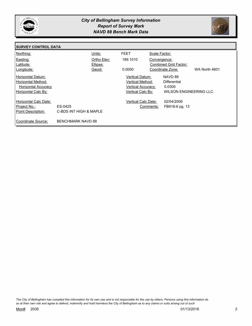
City of Bellingham Survey Information
Report of Survey Mark
NAVD 88 Bench Mark Data
SURVEY CONTROL DATA
189.1010
0.0000
FEETNorthing:
Easting:
Latitude:
Longitude:
Units:
Ortho Elev:
Ellipse:
Geoid:
Scale Factor:
Convergence:
Combined Grid Factor:
WA North 4601Coordinate Zone:
Horizontal Method:
Horizontal Datum: NAVD 88Vertical Datum:
DifferentialVertical Method:
Horizontal Accuracy 0.0300Vertical Accuracy:
WILSON ENGINEERING LLC.Vertical Calc By:Horizontal Calc By:
ES-0425Project No.:
C-BDS INT HIGH & MAPLEPoint Description:
BENCHMARK NAVD 88Coordinate Source:
FB918-6 pg. 13Comments:
Horizontal Calc Date: 02/04/2009Vertical Calc Date:
201/13/2016Mon# 2035
The City of Bellingham has compiled this information for its own use and is not responsible for the use by others. Persons using this information do
so at their own risk and agree to defend, indemnify and hold harmless the City of Bellingham as to any claims or suits arising out of such
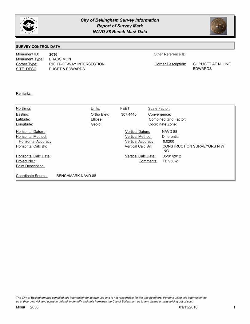
City of Bellingham Survey Information
Report of Survey Mark
NAVD 88 Bench Mark Data
SURVEY CONTROL DATA
2036Monument ID: Other Reference ID:
SITE_DESC PUGET & EDWARDS
RIGHT-OF-WAY INTERSECTIONCorner Type: CL PUGET AT N. LINE
EDWARDS
Corner Description:
BRASS MONMonument Type:
Remarks:
307.4440
FEETNorthing:
Easting:
Latitude:
Longitude:
Units:
Ortho Elev:
Ellipse:
Geoid:
Scale Factor:
Convergence:
Combined Grid Factor:
Coordinate Zone:
Horizontal Method:
Horizontal Datum: NAVD 88Vertical Datum:
DifferentialVertical Method:
Horizontal Accuracy 0.0200Vertical Accuracy:
CONSTRUCTION SURVEYORS N W
INC.
Vertical Calc By:Horizontal Calc By:
Project No.:
Point Description:
BENCHMARK NAVD 88Coordinate Source:
FB 960-2Comments:
Horizontal Calc Date: 05/01/2012Vertical Calc Date:
101/13/2016Mon# 2036
The City of Bellingham has compiled this information for its own use and is not responsible for the use by others. Persons using this information do
so at their own risk and agree to defend, indemnify and hold harmless the City of Bellingham as to any claims or suits arising out of such

City of Bellingham Survey Information
Report of Survey Mark
NAVD 88 Bench Mark Data
SURVEY CONTROL DATA
2037Monument ID: Other Reference ID:
SITE_DESC PUGET & LOPEZ
RIGHT-OF-WAY INTERSECTIONCorner Type: Corner Description:
BRASS MONMonument Type:
Remarks:
379.3650
FEETNorthing:
Easting:
Latitude:
Longitude:
Units:
Ortho Elev:
Ellipse:
Geoid:
Scale Factor:
Convergence:
Combined Grid Factor:
Coordinate Zone:
Horizontal Method:
Horizontal Datum: NAVD 88Vertical Datum:
DifferentialVertical Method:
Horizontal Accuracy 0.0200Vertical Accuracy:
CONSTRUCTION SURVEYORS N W
INC.
Vertical Calc By:Horizontal Calc By:
Project No.:
Point Description:
BENCHMARK NAVD 88Coordinate Source:
FB 960-2Comments:
Horizontal Calc Date: 05/01/2012Vertical Calc Date:
101/13/2016Mon# 2037
The City of Bellingham has compiled this information for its own use and is not responsible for the use by others. Persons using this information do
so at their own risk and agree to defend, indemnify and hold harmless the City of Bellingham as to any claims or suits arising out of such

City of Bellingham Survey Information
Report of Survey Mark
NAVD 88 Bench Mark Data
SURVEY CONTROL DATA
2071Monument ID: Other Reference ID:
SITE_DESC E LAUREL ST & N STATE ST
RIGHT-OF-WAY INTERSECTIONCorner Type: Corner Description:
BRASS MONMonument Type:
MON RAISED FOR STATE ST. OVERLAY 2001.Remarks:
75.3660
0.0000
FEETNorthing:
Easting:
Latitude:
Longitude:
Units:
Ortho Elev:
Ellipse:
Geoid:
Scale Factor:
Convergence:
Combined Grid Factor:
WA North 4601Coordinate Zone:
Horizontal Method:
Horizontal Datum: NAVD 88Vertical Datum:
DifferentialVertical Method:
Horizontal Accuracy 0.0200Vertical Accuracy:
LARRY STEELE & ASSOCIATESVertical Calc By:Horizontal Calc By:
ES-0425Project No.:
BRASS MON AT E. LAUREL & N. STATEPoint Description:
BENCHMARK NAVD 88Coordinate Source:
FB 918-11Comments:
Horizontal Calc Date: 02/17/2009Vertical Calc Date:
75.3650
0.0000
FEETNorthing:
Easting:
Latitude:
Longitude:
Units:
Ortho Elev:
Ellipse:
Geoid:
Scale Factor:
Convergence:
Combined Grid Factor:
WA North 4601Coordinate Zone:
Horizontal Method:
Horizontal Datum: NAVD 88Vertical Datum:
DifferentialVertical Method:
Horizontal Accuracy 0.0300Vertical Accuracy:
WILSON ENGINEERING LLC.Vertical Calc By:Horizontal Calc By:
ES-0425Project No.:
C-BDS INT N.STATE & LAURELPoint Description:
BENCHMARK NAVD 88Coordinate Source:
FB918-6 pg. 2Comments:
Horizontal Calc Date: 01/26/2009Vertical Calc Date:
101/13/2016Mon# 2071
The City of Bellingham has compiled this information for its own use and is not responsible for the use by others. Persons using this information do
so at their own risk and agree to defend, indemnify and hold harmless the City of Bellingham as to any claims or suits arising out of such
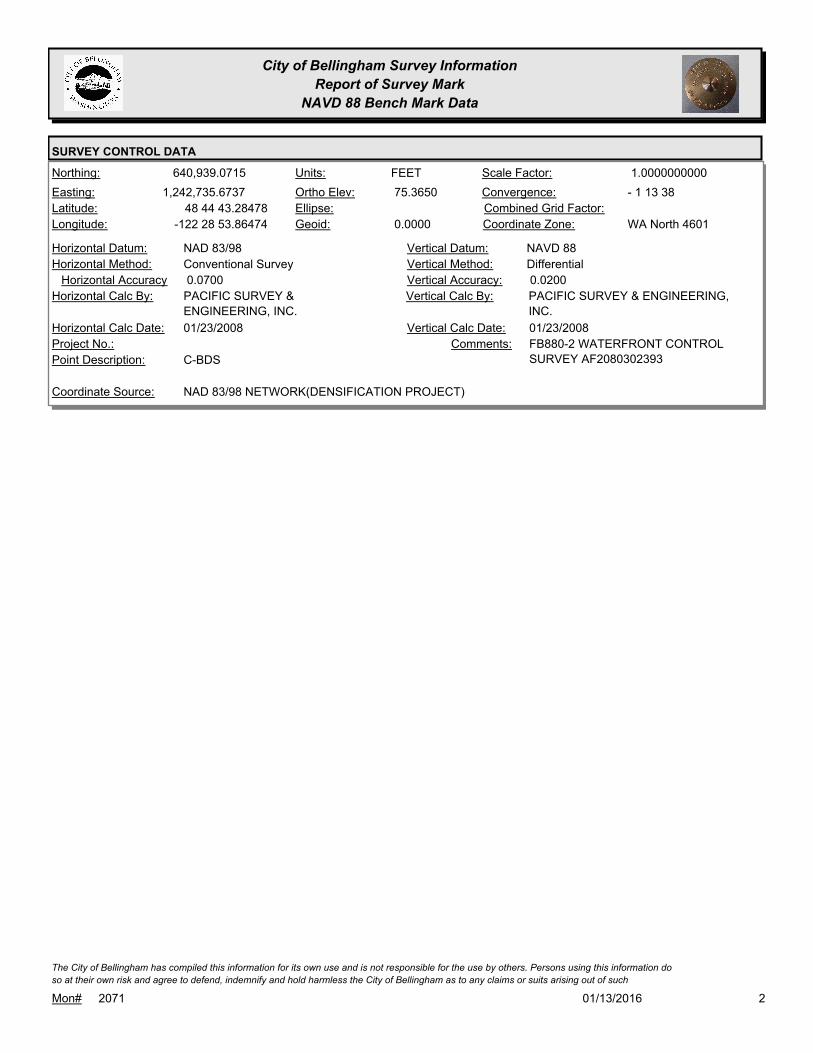
City of Bellingham Survey Information
Report of Survey Mark
NAVD 88 Bench Mark Data
SURVEY CONTROL DATA
640,939.0715
1,242,735.6737
48 44 43.28478
-122 28 53.86474
75.3650
0.0000
FEETNorthing:
Easting:
Latitude:
Longitude:
Units:
Ortho Elev:
Ellipse:
Geoid:
1.0000000000Scale Factor:
- 1 13 38Convergence:
Combined Grid Factor:
WA North 4601Coordinate Zone:
Conventional SurveyHorizontal Method:
NAD 83/98Horizontal Datum: NAVD 88Vertical Datum:
DifferentialVertical Method:
0.0700Horizontal Accuracy 0.0200Vertical Accuracy:
PACIFIC SURVEY & ENGINEERING,
INC.
Vertical Calc By:PACIFIC SURVEY &
ENGINEERING, INC.
Horizontal Calc By:
Project No.:
C-BDSPoint Description:
NAD 83/98 NETWORK(DENSIFICATION PROJECT)Coordinate Source:
FB880-2 WATERFRONT CONTROL
SURVEY AF2080302393
Comments:
01/23/2008Horizontal Calc Date: 01/23/2008Vertical Calc Date:
201/13/2016Mon# 2071
The City of Bellingham has compiled this information for its own use and is not responsible for the use by others. Persons using this information do
so at their own risk and agree to defend, indemnify and hold harmless the City of Bellingham as to any claims or suits arising out of such

City of Bellingham Survey Information
Report of Survey Mark
NAVD 88 Bench Mark Data
SURVEY CONTROL DATA
2078Monument ID: Other Reference ID:
SITE_DESC ERIE & NIAGARA
RIGHT-OF-WAY INTERSECTIONCorner Type: Corner Description:
BRASS MONMonument Type:
MON SET FOR 1994 OVERLAYRemarks:
268.8170
0.0000
FEETNorthing:
Easting:
Latitude:
Longitude:
Units:
Ortho Elev:
Ellipse:
Geoid:
Scale Factor:
Convergence:
Combined Grid Factor:
WA North 4601Coordinate Zone:
Horizontal Method:
Horizontal Datum: NAVD 88Vertical Datum:
DifferentialVertical Method:
Horizontal Accuracy 0.0300Vertical Accuracy:
WILSON ENGINEERING LLC.Vertical Calc By:Horizontal Calc By:
ES-0425Project No.:
C-BDS INT ERIE & IOWA DRIVEPoint Description:
BENCHMARK NAVD 88Coordinate Source:
FB918-8 pg. 41Comments:
Horizontal Calc Date: 02/12/2009Vertical Calc Date:
101/13/2016Mon# 2078
The City of Bellingham has compiled this information for its own use and is not responsible for the use by others. Persons using this information do
so at their own risk and agree to defend, indemnify and hold harmless the City of Bellingham as to any claims or suits arising out of such

City of Bellingham Survey Information
Report of Survey Mark
NAVD 88 Bench Mark Data
SURVEY CONTROL DATA
2100Monument ID: Other Reference ID:
SITE_DESC C & MAPLE
RIGHT-OF-WAY INTERSECTIONCorner Type: Corner Description:
BRASS MONMonument Type:
VISITED FOR NAD 83/98 CONTROL NETWORK SURVEY 2006.Remarks:
643,300.5262
1,241,160.3128
48 45 06.24674
-122 29 18.12140
13.7570
0.0000
FEETNorthing:
Easting:
Latitude:
Longitude:
Units:
Ortho Elev:
Ellipse:
Geoid:
1.0000000000Scale Factor:
- 1 13 56Convergence:
Combined Grid Factor:
WA North 4601Coordinate Zone:
Conventional SurveyHorizontal Method:
NAD 83/98Horizontal Datum: NAVD 88Vertical Datum:
DifferentialVertical Method:
0.0700Horizontal Accuracy 0.0200Vertical Accuracy:
PACIFIC SURVEY & ENGINEERING,
INC.
Vertical Calc By:PACIFIC SURVEY &
ENGINEERING, INC.
Horizontal Calc By:
Project No.:
C-BDSPoint Description:
NAD 83/98 NETWORK(DENSIFICATION PROJECT)Coordinate Source:
FB880-2 WATERFRONT CONTROL
SURVEY AF2080302393
Comments:
01/23/2008Horizontal Calc Date: 01/23/2008Vertical Calc Date:
101/13/2016Mon# 2100
The City of Bellingham has compiled this information for its own use and is not responsible for the use by others. Persons using this information do
so at their own risk and agree to defend, indemnify and hold harmless the City of Bellingham as to any claims or suits arising out of such

City of Bellingham Survey Information
Report of Survey Mark
NAVD 88 Bench Mark Data
SURVEY CONTROL DATA
2103Monument ID: Other Reference ID:
SITE_DESC 13TH ST & MCKENZIE AV
RIGHT-OF-WAY INTERSECTIONCorner Type: Corner Description:
BRASS MONMonument Type:
Remarks:
631,549.4417
1,237,843.6530 110.4100
FEETNorthing:
Easting:
Latitude:
Longitude:
Units:
Ortho Elev:
Ellipse:
Geoid:
Scale Factor:
Convergence:
Combined Grid Factor:
WA North 4601Coordinate Zone:
Conventional SurveyHorizontal Method:
NAD 83/98Horizontal Datum: NAVD 88Vertical Datum:
DifferentialVertical Method:
0.0200Horizontal Accuracy 0.0200Vertical Accuracy:
LARRY STEELE & ASSOCIATESVertical Calc By:LARRY STEELE & ASSOCIATESHorizontal Calc By:
EU-0151Project No.:
C-BDS PROJECT PNT 760Point Description:
NAD 83/98 PROJECT POINTSCoordinate Source:
FB 927Comments:
07/13/2009Horizontal Calc Date: 07/13/2009Vertical Calc Date:
101/13/2016Mon# 2103
The City of Bellingham has compiled this information for its own use and is not responsible for the use by others. Persons using this information do
so at their own risk and agree to defend, indemnify and hold harmless the City of Bellingham as to any claims or suits arising out of such

City of Bellingham Survey Information
Report of Survey Mark
NAVD 88 Bench Mark Data
SURVEY CONTROL DATA
2115Monument ID: Other Reference ID:
SITE_DESC SAMISH WAY & ABBOTT ST AT S LINE
JONES DLC
RIGHT-OF-WAY INTERSECTIONCorner Type: Corner Description:
BRASS MONMonument Type:
Remarks:
638,218.8030
1,245,519.0540 211.7700
FEETNorthing:
Easting:
Latitude:
Longitude:
Units:
Ortho Elev:
Ellipse:
Geoid:
Scale Factor:
Convergence:
Combined Grid Factor:
WA North 4601Coordinate Zone:
Conventional SurveyHorizontal Method:
NAD 83/98Horizontal Datum: NAVD 88Vertical Datum:
DifferentialVertical Method:
0.0200Horizontal Accuracy 0.0300Vertical Accuracy:
LARRY STEELE & ASSOCIATESVertical Calc By:LARRY STEELE & ASSOCIATESHorizontal Calc By:
EU-0159Project No.:
C-BDSPoint Description:
NAD 83/98 PROJECT POINTSCoordinate Source:
FB 947-1 PROJECT POINT #117Comments:
06/30/2011Horizontal Calc Date: 06/30/2011Vertical Calc Date:
638,218.8040
1,245,519.0540 211.7600
FEETNorthing:
Easting:
Latitude:
Longitude:
Units:
Ortho Elev:
Ellipse:
Geoid:
Scale Factor:
Convergence:
Combined Grid Factor:
WA North 4601Coordinate Zone:
Conventional SurveyHorizontal Method:
NAD 83/98Horizontal Datum: NAVD 88Vertical Datum:
DifferentialVertical Method:
0.0100Horizontal Accuracy 0.0100Vertical Accuracy:
CONSTRUCTION SURVEYORS N W
INC.
Vertical Calc By:CONSTRUCTION SURVEYORS N
W INC.
Horizontal Calc By:
ES-0449Project No.:
C-BDSPoint Description:
NAD 83/98 PROJECT POINTSCoordinate Source:
FB 963-1Comments:
04/12/2012Horizontal Calc Date: 04/12/2012Vertical Calc Date:
101/13/2016Mon# 2115
The City of Bellingham has compiled this information for its own use and is not responsible for the use by others. Persons using this information do
so at their own risk and agree to defend, indemnify and hold harmless the City of Bellingham as to any claims or suits arising out of such
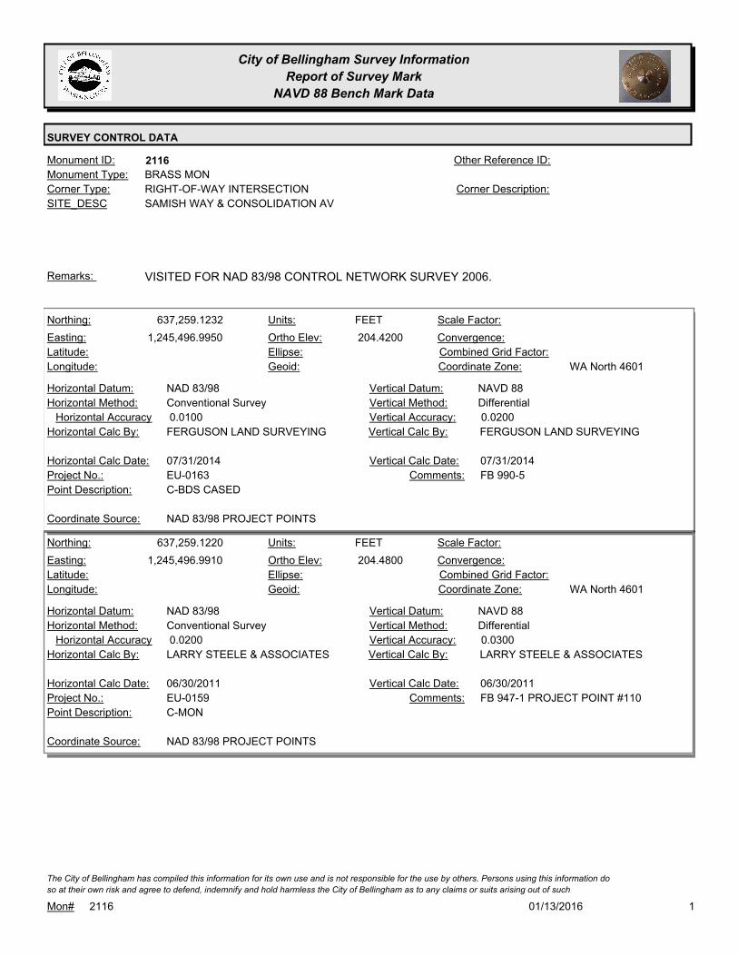
City of Bellingham Survey Information
Report of Survey Mark
NAVD 88 Bench Mark Data
SURVEY CONTROL DATA
2116Monument ID: Other Reference ID:
SITE_DESC SAMISH WAY & CONSOLIDATION AV
RIGHT-OF-WAY INTERSECTIONCorner Type: Corner Description:
BRASS MONMonument Type:
VISITED FOR NAD 83/98 CONTROL NETWORK SURVEY 2006.Remarks:
637,259.1232
1,245,496.9950 204.4200
FEETNorthing:
Easting:
Latitude:
Longitude:
Units:
Ortho Elev:
Ellipse:
Geoid:
Scale Factor:
Convergence:
Combined Grid Factor:
WA North 4601Coordinate Zone:
Conventional SurveyHorizontal Method:
NAD 83/98Horizontal Datum: NAVD 88Vertical Datum:
DifferentialVertical Method:
0.0100Horizontal Accuracy 0.0200Vertical Accuracy:
FERGUSON LAND SURVEYINGVertical Calc By:FERGUSON LAND SURVEYINGHorizontal Calc By:
EU-0163Project No.:
C-BDS CASEDPoint Description:
NAD 83/98 PROJECT POINTSCoordinate Source:
FB 990-5Comments:
07/31/2014Horizontal Calc Date: 07/31/2014Vertical Calc Date:
637,259.1220
1,245,496.9910 204.4800
FEETNorthing:
Easting:
Latitude:
Longitude:
Units:
Ortho Elev:
Ellipse:
Geoid:
Scale Factor:
Convergence:
Combined Grid Factor:
WA North 4601Coordinate Zone:
Conventional SurveyHorizontal Method:
NAD 83/98Horizontal Datum: NAVD 88Vertical Datum:
DifferentialVertical Method:
0.0200Horizontal Accuracy 0.0300Vertical Accuracy:
LARRY STEELE & ASSOCIATESVertical Calc By:LARRY STEELE & ASSOCIATESHorizontal Calc By:
EU-0159Project No.:
C-MONPoint Description:
NAD 83/98 PROJECT POINTSCoordinate Source:
FB 947-1 PROJECT POINT #110Comments:
06/30/2011Horizontal Calc Date: 06/30/2011Vertical Calc Date:
101/13/2016Mon# 2116
The City of Bellingham has compiled this information for its own use and is not responsible for the use by others. Persons using this information do
so at their own risk and agree to defend, indemnify and hold harmless the City of Bellingham as to any claims or suits arising out of such

City of Bellingham Survey Information
Report of Survey Mark
NAVD 88 Bench Mark Data
SURVEY CONTROL DATA
2163Monument ID: Other Reference ID:
SITE_DESC BILL MCDONALD & PT E/O 25TH
RIGHT-OF-WAY PTCorner Type: Corner Description:
BRASS MONMonument Type:
MON RAISED 9-95Remarks:
634,244.1800
1,242,075.8700 272.3300
FEETNorthing:
Easting:
Latitude:
Longitude:
Units:
Ortho Elev:
Ellipse:
Geoid:
Scale Factor:
Convergence:
Combined Grid Factor:
WA North 4601Coordinate Zone:
Conventional SurveyHorizontal Method:
NAD 83/98Horizontal Datum: NAVD 88Vertical Datum:
DifferentialVertical Method:
0.0300Horizontal Accuracy 0.0500Vertical Accuracy:
DAVID EVANS & ASSOCIATES, INC.Vertical Calc By:DAVID EVANS & ASSOCIATES,
INC.
Horizontal Calc By:
ES-0358Project No.:
C-MON PROJ PNT #305Point Description:
NAD 83/98 PROJECT POINTSCoordinate Source:
FB 926Comments:
11/01/2009Horizontal Calc Date: 11/01/2009Vertical Calc Date:
101/13/2016Mon# 2163
The City of Bellingham has compiled this information for its own use and is not responsible for the use by others. Persons using this information do
so at their own risk and agree to defend, indemnify and hold harmless the City of Bellingham as to any claims or suits arising out of such

City of Bellingham Survey Information
Report of Survey Mark
NAVD 88 Bench Mark Data
SURVEY CONTROL DATA
2229Monument ID: Other Reference ID:
SITE_DESC 18TH & MILL
RIGHT-OF-WAY INTERSECTIONCorner Type: Corner Description:
BRASS MONMonument Type:
VISITED FOR NAD 83/98 CONTROL NETWORK SURVEY 2006.Remarks:
168.1020
0.0000
FEETNorthing:
Easting:
Latitude:
Longitude:
Units:
Ortho Elev:
Ellipse:
Geoid:
Scale Factor:
Convergence:
Combined Grid Factor:
WA North 4601Coordinate Zone:
Horizontal Method:
Horizontal Datum: NAVD 88Vertical Datum:
DifferentialVertical Method:
Horizontal Accuracy 0.0200Vertical Accuracy:
LARRY STEELE & ASSOCIATESVertical Calc By:Horizontal Calc By:
ES-0425Project No.:
BRASS MON AT 18TH & MILLPoint Description:
BENCHMARK NAVD 88Coordinate Source:
FB 918-11Comments:
Horizontal Calc Date: 02/17/2009Vertical Calc Date:
101/13/2016Mon# 2229
The City of Bellingham has compiled this information for its own use and is not responsible for the use by others. Persons using this information do
so at their own risk and agree to defend, indemnify and hold harmless the City of Bellingham as to any claims or suits arising out of such

City of Bellingham Survey Information
Report of Survey Mark
NAVD 88 Bench Mark Data
SURVEY CONTROL DATA
2230Monument ID: Other Reference ID:
SITE_DESC 19TH ST & MILL AV
RIGHT-OF-WAY INTERSECTIONCorner Type: Corner Description:
BRASS MONMonument Type:
Remarks:
632,078.8669
1,239,785.3510 171.8800
FEETNorthing:
Easting:
Latitude:
Longitude:
Units:
Ortho Elev:
Ellipse:
Geoid:
Scale Factor:
Convergence:
Combined Grid Factor:
WA North 4601Coordinate Zone:
Conventional SurveyHorizontal Method:
NAD 83/98Horizontal Datum: NAVD 88Vertical Datum:
DifferentialVertical Method:
0.0200Horizontal Accuracy 0.0200Vertical Accuracy:
LARRY STEELE & ASSOCIATESVertical Calc By:LARRY STEELE & ASSOCIATESHorizontal Calc By:
EU-0151Project No.:
C-BDS PROJECT PNT 1259Point Description:
NAD 83/98 PROJECT POINTSCoordinate Source:
FB 927Comments:
07/15/2009Horizontal Calc Date: 07/15/2009Vertical Calc Date:
101/13/2016Mon# 2230
The City of Bellingham has compiled this information for its own use and is not responsible for the use by others. Persons using this information do
so at their own risk and agree to defend, indemnify and hold harmless the City of Bellingham as to any claims or suits arising out of such

City of Bellingham Survey Information
Report of Survey Mark
NAVD 88 Bench Mark Data
SURVEY CONTROL DATA
2268Monument ID: Other Reference ID:
SITE_DESC 35TH ST & BYRON AVE
RIGHT-OF-WAY INTERSECTIONCorner Type: Corner Description:
BRASS MONMonument Type:
RESET 6-05. VISITED FOR NAD 83/98 CONTROL NETWORK
SURVEY 2006.
Remarks:
200.8350
0.0000
FEETNorthing:
Easting:
Latitude:
Longitude:
Units:
Ortho Elev:
Ellipse:
Geoid:
Scale Factor:
Convergence:
Combined Grid Factor:
WA North 4601Coordinate Zone:
Horizontal Method:
Horizontal Datum: NAVD 88Vertical Datum:
DifferentialVertical Method:
Horizontal Accuracy 0.0200Vertical Accuracy:
LARRY STEELE & ASSOCIATESVertical Calc By:Horizontal Calc By:
ES-0425Project No.:
BRASS MON AT 35TH & BYRONPoint Description:
BENCHMARK NAVD 88Coordinate Source:
FB 918-11Comments:
Horizontal Calc Date: 02/17/2009Vertical Calc Date:
101/13/2016Mon# 2268
The City of Bellingham has compiled this information for its own use and is not responsible for the use by others. Persons using this information do
so at their own risk and agree to defend, indemnify and hold harmless the City of Bellingham as to any claims or suits arising out of such

City of Bellingham Survey Information
Report of Survey Mark
NAVD 88 Bench Mark Data
SURVEY CONTROL DATA
2271Monument ID: Other Reference ID:
SITE_DESC TELEGRAPH & MCLEOD
RIGHT-OF-WAY INTERSECTIONCorner Type: Corner Description:
CASED MONMonument Type:
USED FOR NAD83/98 CONTROL NETWORKRemarks:
117.1160
0.0000
FEETNorthing:
Easting:
Latitude:
Longitude:
Units:
Ortho Elev:
Ellipse:
Geoid:
Scale Factor:
Convergence:
Combined Grid Factor:
WA North 4601Coordinate Zone:
Horizontal Method:
Horizontal Datum: NAVD 88Vertical Datum:
DifferentialVertical Method:
Horizontal Accuracy 0.0200Vertical Accuracy:
PACIFIC SURVEY & ENGINEERING,
INC.
Vertical Calc By:Horizontal Calc By:
ES-0425Project No.:
BRASS MON AT INT. E. MCLEOD RD & TELEGRAPH
RD
Point Description:
BENCHMARK NAVD 88Coordinate Source:
FB 918Comments:
Horizontal Calc Date: 01/05/2009Vertical Calc Date:
101/13/2016Mon# 2271
The City of Bellingham has compiled this information for its own use and is not responsible for the use by others. Persons using this information do
so at their own risk and agree to defend, indemnify and hold harmless the City of Bellingham as to any claims or suits arising out of such

City of Bellingham Survey Information
Report of Survey Mark
NAVD 88 Bench Mark Data
SURVEY CONTROL DATA
2274Monument ID: Other Reference ID:
SITE_DESC MAPLEWOOD & ALDERWOOD (E)
RIGHT-OF-WAY INTERSECTIONCorner Type: Corner Description:
BRASS MONMonument Type:
RESET 6/05Remarks:
106.6580
0.0000
FEETNorthing:
Easting:
Latitude:
Longitude:
Units:
Ortho Elev:
Ellipse:
Geoid:
Scale Factor:
Convergence:
Combined Grid Factor:
WA North 4601Coordinate Zone:
Horizontal Method:
Horizontal Datum: NAVD 88Vertical Datum:
DifferentialVertical Method:
Horizontal Accuracy 0.0200Vertical Accuracy:
PACIFIC SURVEY & ENGINEERING,
INC.
Vertical Calc By:Horizontal Calc By:
ES-0425Project No.:
BRASS MON AT INT. MAPLEWOOD AVE &
ALDERWOOD AVE
Point Description:
BENCHMARK NAVD 88Coordinate Source:
FB 918Comments:
Horizontal Calc Date: 12/29/2008Vertical Calc Date:
101/13/2016Mon# 2274
The City of Bellingham has compiled this information for its own use and is not responsible for the use by others. Persons using this information do
so at their own risk and agree to defend, indemnify and hold harmless the City of Bellingham as to any claims or suits arising out of such

City of Bellingham Survey Information
Report of Survey Mark
NAVD 88 Bench Mark Data
SURVEY CONTROL DATA
2291Monument ID: Other Reference ID:
SITE_DESC 21ST & TAYLOR
RIGHT-OF-WAY INTERSECTIONCorner Type: Corner Description:
BRASS MONMonument Type:
REPLACED BY LSA FOR 2005 OVERLAY PROJECT. VISITED FOR
NAD 83/98 CONTROL NETWORK SURVEY 2006.
Remarks:
254.7880
0.0000
FEETNorthing:
Easting:
Latitude:
Longitude:
Units:
Ortho Elev:
Ellipse:
Geoid:
Scale Factor:
Convergence:
Combined Grid Factor:
WA North 4601Coordinate Zone:
Horizontal Method:
Horizontal Datum: NAVD 88Vertical Datum:
DifferentialVertical Method:
Horizontal Accuracy 0.0200Vertical Accuracy:
LARRY STEELE & ASSOCIATESVertical Calc By:Horizontal Calc By:
ES-0425Project No.:
BRASS MON AT 21ST & TAYLORPoint Description:
BENCHMARK NAVD 88Coordinate Source:
FB 918-11Comments:
Horizontal Calc Date: 02/17/2009Vertical Calc Date:
101/13/2016Mon# 2291
The City of Bellingham has compiled this information for its own use and is not responsible for the use by others. Persons using this information do
so at their own risk and agree to defend, indemnify and hold harmless the City of Bellingham as to any claims or suits arising out of such
City of Bellingham Survey Information
Report of Survey Mark
NAVD 88 Bench Mark Data
SURVEY CONTROL DATA
2311Monument ID: Other Reference ID:
SITE_DESC YEW & N OF CAROLINA
SECTION CORNERCorner Type: CORNER SECTIONS
20/21/28/29 T38N R3E
Corner Description:
BRASS MONMonument Type:
Remarks:
646,304.7440
1,252,269.0420 117.6700
FEETNorthing:
Easting:
Latitude:
Longitude:
Units:
Ortho Elev:
Ellipse:
Geoid:
Scale Factor:
Convergence:
Combined Grid Factor:
WA North 4601Coordinate Zone:
Conventional SurveyHorizontal Method:
NAD 83/98Horizontal Datum: NAVD 88Vertical Datum:
DifferentialVertical Method:
0.0200Horizontal Accuracy 0.0300Vertical Accuracy:
LARRY STEELE & ASSOCIATESVertical Calc By:LARRY STEELE & ASSOCIATESHorizontal Calc By:
ES-0445Project No.:
C-BDSPoint Description:
NAD 83/98 PROJECT POINTSCoordinate Source:
FB 950-1 PROJECT POINT 108Comments:
08/22/2011Horizontal Calc Date: 08/22/2011Vertical Calc Date:
101/13/2016Mon# 2311
The City of Bellingham has compiled this information for its own use and is not responsible for the use by others. Persons using this information do
so at their own risk and agree to defend, indemnify and hold harmless the City of Bellingham as to any claims or suits arising out of such

City of Bellingham Survey Information
Report of Survey Mark
NAVD 88 Bench Mark Data
SURVEY CONTROL DATA
2325Monument ID: Other Reference ID:
SITE_DESC MCLEOD & HOME RD
WEST 1/4 13-38-2
SECTION QUARTER CORNERCorner Type: 1/4 CORNER
SECTION 13/14 T38N
T2E
Corner Description:
BRASS MONMonument Type:
VISITED FOR NAD 83/98 CONTROL NETWORK 2005. BRASS CAP
BEHIND SIDEWALK AT NE CORNER INT
Remarks:
144.5940
0.0000
FEETNorthing:
Easting:
Latitude:
Longitude:
Units:
Ortho Elev:
Ellipse:
Geoid:
Scale Factor:
Convergence:
Combined Grid Factor:
WA North 4601Coordinate Zone:
Horizontal Method:
Horizontal Datum: NAVD 88Vertical Datum:
DifferentialVertical Method:
Horizontal Accuracy 0.0200Vertical Accuracy:
PACIFIC SURVEY & ENGINEERING,
INC.
Vertical Calc By:Horizontal Calc By:
ES-0425Project No.:
BRASS MON (1/4 SEC CNR) IN CONC AT NE
QUADR. MCLEOD RD & HOME RD
Point Description:
BENCHMARK NAVD 88Coordinate Source:
FB 918Comments:
Horizontal Calc Date: 12/09/2008Vertical Calc Date:
101/13/2016Mon# 2325
The City of Bellingham has compiled this information for its own use and is not responsible for the use by others. Persons using this information do
so at their own risk and agree to defend, indemnify and hold harmless the City of Bellingham as to any claims or suits arising out of such

City of Bellingham Survey Information
Report of Survey Mark
NAVD 88 Bench Mark Data
SURVEY CONTROL DATA
2334Monument ID: Other Reference ID:
SITE_DESC ORCHARD & JAMES
RIGHT-OF-WAY INTERSECTIONCorner Type: Corner Description:
BRASS MONMonument Type:
Remarks:
117.1700
0.0000
FEETNorthing:
Easting:
Latitude:
Longitude:
Units:
Ortho Elev:
Ellipse:
Geoid:
Scale Factor:
Convergence:
Combined Grid Factor:
WA North 4601Coordinate Zone:
Horizontal Method:
Horizontal Datum: NAVD 88Vertical Datum:
DifferentialVertical Method:
Horizontal Accuracy 0.0200Vertical Accuracy:
PACIFIC SURVEY & ENGINEERING,
INC.
Vertical Calc By:Horizontal Calc By:
ES-0425Project No.:
BRASS MON AT INT. JAMES ST & E. ORCHARD DRVPoint Description:
BENCHMARK NAVD 88Coordinate Source:
ELEVATION NO LONGER VALID. FB
918
Comments:
Horizontal Calc Date: 12/31/2008Vertical Calc Date:
101/13/2016Mon# 2334
The City of Bellingham has compiled this information for its own use and is not responsible for the use by others. Persons using this information do
so at their own risk and agree to defend, indemnify and hold harmless the City of Bellingham as to any claims or suits arising out of such

City of Bellingham Survey Information
Report of Survey Mark
NAVD 88 Bench Mark Data
SURVEY CONTROL DATA
2361Monument ID: Other Reference ID:
SITE_DESC RHODODENDRON & VINING
RIGHT-OF-WAY INTERSECTIONCorner Type: Corner Description:
BRASS MONMonument Type:
Remarks:
350.8550
0.0000
FEETNorthing:
Easting:
Latitude:
Longitude:
Units:
Ortho Elev:
Ellipse:
Geoid:
Scale Factor:
Convergence:
Combined Grid Factor:
WA North 4601Coordinate Zone:
Horizontal Method:
Horizontal Datum: NAVD 88Vertical Datum:
DifferentialVertical Method:
Horizontal Accuracy 0.0300Vertical Accuracy:
WILSON ENGINEERING LLC.Vertical Calc By:Horizontal Calc By:
ES-0425Project No.:
C-BDS INT VINING & RHODODENDRON WAYPoint Description:
BENCHMARK NAVD 88Coordinate Source:
FB918-8 pg. 52Comments:
Horizontal Calc Date: 02/12/2009Vertical Calc Date:
101/13/2016Mon# 2361
The City of Bellingham has compiled this information for its own use and is not responsible for the use by others. Persons using this information do
so at their own risk and agree to defend, indemnify and hold harmless the City of Bellingham as to any claims or suits arising out of such

City of Bellingham Survey Information
Report of Survey Mark
NAVD 88 Bench Mark Data
SURVEY CONTROL DATA
2438Monument ID: Other Reference ID:
SITE_DESC 12TH ST & FILLMORE AVE
RIGHT-OF-WAY INTERSECTIONCorner Type: Corner Description:
BRASS MONMonument Type:
VISITED FOR NAD 83/98 CONTROL NETWORK SURVEY 2006.Remarks:
111.3950
0.0000
FEETNorthing:
Easting:
Latitude:
Longitude:
Units:
Ortho Elev:
Ellipse:
Geoid:
Scale Factor:
Convergence:
Combined Grid Factor:
WA North 4601Coordinate Zone:
Horizontal Method:
Horizontal Datum: NAVD 88Vertical Datum:
DifferentialVertical Method:
Horizontal Accuracy 0.0200Vertical Accuracy:
LARRY STEELE & ASSOCIATESVertical Calc By:Horizontal Calc By:
ES-0425Project No.:
BRASS MON AT 12TH & FILLMOREPoint Description:
BENCHMARK NAVD 88Coordinate Source:
FB 918-11Comments:
Horizontal Calc Date: 02/17/2009Vertical Calc Date:
101/13/2016Mon# 2438
The City of Bellingham has compiled this information for its own use and is not responsible for the use by others. Persons using this information do
so at their own risk and agree to defend, indemnify and hold harmless the City of Bellingham as to any claims or suits arising out of such

City of Bellingham Survey Information
Report of Survey Mark
NAVD 88 Bench Mark Data
SURVEY CONTROL DATA
2450Monument ID: Other Reference ID:
SITE_DESC BAKERVIEW & HOME
RIGHT-OF-WAY INTERSECTIONCorner Type: Corner Description:
BRASS MONMonument Type:
Remarks:
197.3500
FEETNorthing:
Easting:
Latitude:
Longitude:
Units:
Ortho Elev:
Ellipse:
Geoid:
Scale Factor:
Convergence:
Combined Grid Factor:
Coordinate Zone:
Horizontal Method:
Horizontal Datum: NAVD 88Vertical Datum:
DifferentialVertical Method:
Horizontal Accuracy 0.0200Vertical Accuracy:
LARRY STEELE & ASSOCIATESVertical Calc By:Horizontal Calc By:
Project No.:
Point Description:
BENCHMARK NAVD 88Coordinate Source:
FB 960-1Comments:
Horizontal Calc Date: 03/23/2012Vertical Calc Date:
101/13/2016Mon# 2450
The City of Bellingham has compiled this information for its own use and is not responsible for the use by others. Persons using this information do
so at their own risk and agree to defend, indemnify and hold harmless the City of Bellingham as to any claims or suits arising out of such

City of Bellingham Survey Information
Report of Survey Mark
NAVD 88 Bench Mark Data
SURVEY CONTROL DATA
2486Monument ID: Other Reference ID:
SITE_DESC MCKENZIE & 4TH
RIGHT-OF-WAY INTERSECTIONCorner Type: Corner Description:
BRASS MONMonument Type:
RAISED 8-20-99Remarks:
631,602.4950
1,235,313.6000 20.3300
FEETNorthing:
Easting:
Latitude:
Longitude:
Units:
Ortho Elev:
Ellipse:
Geoid:
Scale Factor:
Convergence:
Combined Grid Factor:
WA North 4601Coordinate Zone:
Conventional SurveyHorizontal Method:
NAD 83/98Horizontal Datum: NAVD 88Vertical Datum:
DifferentialVertical Method:
0.0200Horizontal Accuracy 0.0200Vertical Accuracy:
LARRY STEELE & ASSOCIATESVertical Calc By:LARRY STEELE & ASSOCIATESHorizontal Calc By:
ET-0029Project No.:
C-BDS-4TH & MCKENZIE - COB #2486Point Description:
NAD 83/98 PROJECT POINTSCoordinate Source:
FB 1016-1Comments:
06/23/2015Horizontal Calc Date: 06/23/2015Vertical Calc Date:
631,602.4900
1,235,313.5800 20.2800
FEETNorthing:
Easting:
Latitude:
Longitude:
Units:
Ortho Elev:
Ellipse:
Geoid:
Scale Factor:
Convergence:
Combined Grid Factor:
WA North 4601Coordinate Zone:
Conventional SurveyHorizontal Method:
NAD 83/98Horizontal Datum: NAVD 88Vertical Datum:
DifferentialVertical Method:
Horizontal Accuracy Vertical Accuracy:
WILSON ENGINEERING LLC.Vertical Calc By:WILSON ENGINEERING LLC.Horizontal Calc By:
Project No.:
BSMPoint Description:
NAD 83/98 PROJECT POINTSCoordinate Source:
RS-4712Comments:
08/10/2009Horizontal Calc Date: 08/10/2009Vertical Calc Date:
101/13/2016Mon# 2486
The City of Bellingham has compiled this information for its own use and is not responsible for the use by others. Persons using this information do
so at their own risk and agree to defend, indemnify and hold harmless the City of Bellingham as to any claims or suits arising out of such

City of Bellingham Survey Information
Report of Survey Mark
NAVD 88 Bench Mark Data
SURVEY CONTROL DATA
2491Monument ID: Other Reference ID:
SITE_DESC BARKLEY & PACIFIC
RIGHT-OF-WAY INTERSECTIONCorner Type: Corner Description:
ALUMINUM CAPMonument Type:
Remarks:
193.0680
FEETNorthing:
Easting:
Latitude:
Longitude:
Units:
Ortho Elev:
Ellipse:
Geoid:
Scale Factor:
Convergence:
Combined Grid Factor:
Coordinate Zone:
Horizontal Method:
Horizontal Datum: NAVD 88Vertical Datum:
DifferentialVertical Method:
Horizontal Accuracy 0.0200Vertical Accuracy:
CONSTRUCTION SURVEYORS N W
INC.
Vertical Calc By:Horizontal Calc By:
Project No.:
Point Description:
BENCHMARK NAVD 88Coordinate Source:
MON VISITED FOR BENCHMARK
DENSIFICATION 2011.
Comments:
Horizontal Calc Date: 05/01/2012Vertical Calc Date:
101/13/2016Mon# 2491
The City of Bellingham has compiled this information for its own use and is not responsible for the use by others. Persons using this information do
so at their own risk and agree to defend, indemnify and hold harmless the City of Bellingham as to any claims or suits arising out of such

City of Bellingham Survey Information
Report of Survey Mark
NAVD 88 Bench Mark Data
SURVEY CONTROL DATA
2525Monument ID: Other Reference ID:
SITE_DESC 40TH & ELWOOD
RIGHT-OF-WAY INTERSECTIONCorner Type: Corner Description:
CASED MONMonument Type:
Remarks:
329.6490
FEETNorthing:
Easting:
Latitude:
Longitude:
Units:
Ortho Elev:
Ellipse:
Geoid:
Scale Factor:
Convergence:
Combined Grid Factor:
Coordinate Zone:
Horizontal Method:
Horizontal Datum: NAVD 88Vertical Datum:
DifferentialVertical Method:
Horizontal Accuracy 0.0300Vertical Accuracy:
WILSON ENGINEERING LLC.Vertical Calc By:Horizontal Calc By:
Project No.:
Point Description:
BENCHMARK NAVD 88Coordinate Source:
FB 960-3Comments:
Horizontal Calc Date: 02/06/2012Vertical Calc Date:
101/13/2016Mon# 2525
The City of Bellingham has compiled this information for its own use and is not responsible for the use by others. Persons using this information do
so at their own risk and agree to defend, indemnify and hold harmless the City of Bellingham as to any claims or suits arising out of such

City of Bellingham Survey Information
Report of Survey Mark
NAVD 88 Bench Mark Data
SURVEY CONTROL DATA
2545Monument ID: Other Reference ID:
SITE_DESC N STATE ST & BERRY ST
RIGHT-OF-WAY INTERSECTIONCorner Type: Corner Description:
BRASS MONMonument Type:
ELEVATION AS OF 2/7/2011 NOT VALIDRemarks:
72.8700
0.0000
FEETNorthing:
Easting:
Latitude:
Longitude:
Units:
Ortho Elev:
Ellipse:
Geoid:
Scale Factor:
Convergence:
Combined Grid Factor:
WA North 4601Coordinate Zone:
Horizontal Method:
Horizontal Datum: NAVD 88Vertical Datum:
DifferentialVertical Method:
Horizontal Accuracy 0.0300Vertical Accuracy:
WILSON ENGINEERING LLC.Vertical Calc By:Horizontal Calc By:
ES-0425Project No.:
C-BDS INT N.STATE & BERRYPoint Description:
BENCHMARK NAVD 88Coordinate Source:
ELEVATION NO LONGER VALID.
FB918-6 PG. 2
Comments:
Horizontal Calc Date: 01/26/2009Vertical Calc Date:
101/13/2016Mon# 2545
The City of Bellingham has compiled this information for its own use and is not responsible for the use by others. Persons using this information do
so at their own risk and agree to defend, indemnify and hold harmless the City of Bellingham as to any claims or suits arising out of such

City of Bellingham Survey Information
Report of Survey Mark
NAVD 88 Bench Mark Data
SURVEY CONTROL DATA
2588Monument ID: Other Reference ID:
SITE_DESC BARKLEY & RACINE
RIGHT-OF-WAY INTERSECTIONCorner Type: Corner Description:
ALUMINUM CAPMonument Type:
Remarks:
201.4190
FEETNorthing:
Easting:
Latitude:
Longitude:
Units:
Ortho Elev:
Ellipse:
Geoid:
Scale Factor:
Convergence:
Combined Grid Factor:
Coordinate Zone:
Horizontal Method:
Horizontal Datum: NAVD 88Vertical Datum:
DifferentialVertical Method:
Horizontal Accuracy 0.0200Vertical Accuracy:
CONSTRUCTION SURVEYORS N W
INC.
Vertical Calc By:Horizontal Calc By:
Project No.:
Point Description:
BENCHMARK NAVD 88Coordinate Source:
MON VISITED FOR BENCHMARK
DENSIFICATION 2011.
Comments:
Horizontal Calc Date: 05/01/2012Vertical Calc Date:
101/13/2016Mon# 2588
The City of Bellingham has compiled this information for its own use and is not responsible for the use by others. Persons using this information do
so at their own risk and agree to defend, indemnify and hold harmless the City of Bellingham as to any claims or suits arising out of such
City of Bellingham Survey Information
Report of Survey Mark
NAVD 88 Bench Mark Data
SURVEY CONTROL DATA
2608Monument ID: Other Reference ID:
SITE_DESC BARKLEY BLVD & BARKLEY MEADOWS
CIRCLE (INT)
RIGHT-OF-WAY INTERSECTIONCorner Type: Corner Description:
BRASS MONMonument Type:
Remarks:
196.7340
FEETNorthing:
Easting:
Latitude:
Longitude:
Units:
Ortho Elev:
Ellipse:
Geoid:
Scale Factor:
Convergence:
Combined Grid Factor:
Coordinate Zone:
Horizontal Method:
Horizontal Datum: NAVD 88Vertical Datum:
DifferentialVertical Method:
Horizontal Accuracy 0.0200Vertical Accuracy:
CONSTRUCTION SURVEYORS N W
INC.
Vertical Calc By:Horizontal Calc By:
Project No.:
Point Description:
BENCHMARK NAVD 88Coordinate Source:
MON VISITED FOR BENCHMARK
DENSIFICATION 2011.
Comments:
Horizontal Calc Date: 05/01/2012Vertical Calc Date:
101/13/2016Mon# 2608
The City of Bellingham has compiled this information for its own use and is not responsible for the use by others. Persons using this information do
so at their own risk and agree to defend, indemnify and hold harmless the City of Bellingham as to any claims or suits arising out of such

City of Bellingham Survey Information
Report of Survey Mark
NAVD 88 Bench Mark Data
SURVEY CONTROL DATA
2751Monument ID: Other Reference ID:
SITE_DESC BIRCHWOOD & SQUALICUM PC#2
RIGHT-OF-WAY PCCorner Type: Corner Description:
BRASS MONMonument Type:
FOR NORTHERLY ACCESS PROJECT ST-553. VISITED FOR NAD
83/98 CONTROL NETWORK SURVEY 2006.
Remarks:
102.3820
0.0000
FEETNorthing:
Easting:
Latitude:
Longitude:
Units:
Ortho Elev:
Ellipse:
Geoid:
Scale Factor:
Convergence:
Combined Grid Factor:
WA North 4601Coordinate Zone:
Horizontal Method:
Horizontal Datum: NAVD 88Vertical Datum:
DifferentialVertical Method:
Horizontal Accuracy 0.0200Vertical Accuracy:
PACIFIC SURVEY & ENGINEERING,
INC.
Vertical Calc By:Horizontal Calc By:
ES-0425Project No.:
BRASS MON (PC) IN CL BIRCHWOOD AVE, W. OF
SQUALICUM PKWY
Point Description:
BENCHMARK NAVD 88Coordinate Source:
FB 918Comments:
Horizontal Calc Date: 12/10/2008Vertical Calc Date:
101/13/2016Mon# 2751
The City of Bellingham has compiled this information for its own use and is not responsible for the use by others. Persons using this information do
so at their own risk and agree to defend, indemnify and hold harmless the City of Bellingham as to any claims or suits arising out of such

City of Bellingham Survey Information
Report of Survey Mark
NAVD 88 Bench Mark Data
SURVEY CONTROL DATA
2765Monument ID: Other Reference ID:
SITE_DESC BIRCHWOOD PT#1 APPROX 150 FT E OF
MERIDIAN AND 75 FT W OF RR TRACKS
RIGHT-OF-WAY PTCorner Type: PC 150 FT +- E OF
MERIDIAN
Corner Description:
BRASS MONMonument Type:
NORTHERLY ACCESS PROJECT ST-553. VISITED FOR NAD 83/98
CONTROL NETWORK SURVEY 2006.
Remarks:
89.8740
0.0000
FEETNorthing:
Easting:
Latitude:
Longitude:
Units:
Ortho Elev:
Ellipse:
Geoid:
Scale Factor:
Convergence:
Combined Grid Factor:
WA North 4601Coordinate Zone:
Horizontal Method:
Horizontal Datum: NAVD 88Vertical Datum:
DifferentialVertical Method:
Horizontal Accuracy 0.0200Vertical Accuracy:
PACIFIC SURVEY & ENGINEERING,
INC.
Vertical Calc By:Horizontal Calc By:
ES-0425Project No.:
BRASS MON 150' E. OF INT. BIRCHWOOD AVE &
MERIDIAN ST
Point Description:
BENCHMARK NAVD 88Coordinate Source:
FB 918Comments:
Horizontal Calc Date: 12/11/2008Vertical Calc Date:
101/13/2016Mon# 2765
The City of Bellingham has compiled this information for its own use and is not responsible for the use by others. Persons using this information do
so at their own risk and agree to defend, indemnify and hold harmless the City of Bellingham as to any claims or suits arising out of such

City of Bellingham Survey Information
Report of Survey Mark
NAVD 88 Bench Mark Data
SURVEY CONTROL DATA
2950Monument ID: Other Reference ID:
SITE_DESC E MAPLE ST & JERSEY ST
RIGHT-OF-WAY INTERSECTIONCorner Type: Corner Description:
CASED MONMonument Type:
Remarks:
640,049.3028
1,244,329.3651 192.2500
FEETNorthing:
Easting:
Latitude:
Longitude:
Units:
Ortho Elev:
Ellipse:
Geoid:
Scale Factor:
Convergence:
Combined Grid Factor:
WA North 4601Coordinate Zone:
GPS + ConventionalHorizontal Method:
NAD 83/98Horizontal Datum: NAVD 88Vertical Datum:
DifferentialVertical Method:
0.0500Horizontal Accuracy 0.0200Vertical Accuracy:
WILSON ENGINEERING LLC.Vertical Calc By:WILSON ENGINEERING LLC.Horizontal Calc By:
ES-0448Project No.:
Z MICPoint Description:
NAD 83/98 PROJECT POINTSCoordinate Source:
FB 965-1,2. PROJECT POINT 104.Comments:
03/27/2012Horizontal Calc Date: 03/27/2012Vertical Calc Date:
192.2710
0.0000
FEETNorthing:
Easting:
Latitude:
Longitude:
Units:
Ortho Elev:
Ellipse:
Geoid:
Scale Factor:
Convergence:
Combined Grid Factor:
WA North 4601Coordinate Zone:
Horizontal Method:
Horizontal Datum: NAVD 88Vertical Datum:
DifferentialVertical Method:
Horizontal Accuracy 0.0300Vertical Accuracy:
WILSON ENGINEERING LLC.Vertical Calc By:Horizontal Calc By:
ES-0425Project No.:
C-MON IN CASE INT MAPLE &JERSEYPoint Description:
BENCHMARK NAVD 88Coordinate Source:
FB918-6 pg. 14Comments:
Horizontal Calc Date: 02/04/2009Vertical Calc Date:
101/13/2016Mon# 2950
The City of Bellingham has compiled this information for its own use and is not responsible for the use by others. Persons using this information do
so at their own risk and agree to defend, indemnify and hold harmless the City of Bellingham as to any claims or suits arising out of such

City of Bellingham Survey Information
Report of Survey Mark
NAVD 88 Bench Mark Data
SURVEY CONTROL DATA
2951Monument ID: Other Reference ID:
SITE_DESC IVY & INDIAN TERRACE
RIGHT-OF-WAY INTERSECTIONCorner Type: Corner Description:
IRON PIPEMonument Type:
Remarks:
639,210.8032
1,242,968.4236 278.2700
FEETNorthing:
Easting:
Latitude:
Longitude:
Units:
Ortho Elev:
Ellipse:
Geoid:
Scale Factor:
Convergence:
Combined Grid Factor:
WA North 4601Coordinate Zone:
GPS + ConventionalHorizontal Method:
NAD 83/98Horizontal Datum: NAVD 88Vertical Datum:
DifferentialVertical Method:
0.0500Horizontal Accuracy 0.0200Vertical Accuracy:
WILSON ENGINEERING LLC.Vertical Calc By:WILSON ENGINEERING LLC.Horizontal Calc By:
ES-0448Project No.:
Z IPPoint Description:
NAD 83/98 PROJECT POINTSCoordinate Source:
FB 965-1,2. PROJECT POINT 203.Comments:
03/27/2012Horizontal Calc Date: 03/27/2012Vertical Calc Date:
101/13/2016Mon# 2951
The City of Bellingham has compiled this information for its own use and is not responsible for the use by others. Persons using this information do
so at their own risk and agree to defend, indemnify and hold harmless the City of Bellingham as to any claims or suits arising out of such

City of Bellingham Survey Information
Report of Survey Mark
NAVD 88 Bench Mark Data
SURVEY CONTROL DATA
2953Monument ID: Other Reference ID:
SITE_DESC ELM & W. OREGON
RIGHT-OF-WAY INTERSECTIONCorner Type: Corner Description:
BRASS MONMonument Type:
Remarks:
650,320.2410
1,241,313.3507 90.2400
FEETNorthing:
Easting:
Latitude:
Longitude:
Units:
Ortho Elev:
Ellipse:
Geoid:
Scale Factor:
Convergence:
Combined Grid Factor:
WA North 4601Coordinate Zone:
Conventional SurveyHorizontal Method:
NAD 83/98Horizontal Datum: NAVD 88Vertical Datum:
DifferentialVertical Method:
0.0412Horizontal Accuracy 0.0500Vertical Accuracy:
CHRISTIE & CHRISTIE LAND
SURVEYING INC.
Vertical Calc By:CHRISTIE & CHRISTIE LAND
SURVEYING INC.
Horizontal Calc By:
EU-0156Project No.:
Point Description:
NAD 83/98 PROJECT POINTSCoordinate Source:
FB 948-1Comments:
10/03/2011Horizontal Calc Date: 10/03/2011Vertical Calc Date:
101/13/2016Mon# 2953
The City of Bellingham has compiled this information for its own use and is not responsible for the use by others. Persons using this information do
so at their own risk and agree to defend, indemnify and hold harmless the City of Bellingham as to any claims or suits arising out of such

City of Bellingham Survey Information
Report of Survey Mark
NAVD 88 Bench Mark Data
SURVEY CONTROL DATA
2954Monument ID: Other Reference ID:
SITE_DESC KULSHAN & W. OREGON
RIGHT-OF-WAY INTERSECTIONCorner Type: Corner Description:
BRASS MONMonument Type:
VISITED FOR NAD 83/98 CONTROL NETWORK SURVEY 2006.Remarks:
650,313.1389
1,241,589.3988 89.4800
FEETNorthing:
Easting:
Latitude:
Longitude:
Units:
Ortho Elev:
Ellipse:
Geoid:
Scale Factor:
Convergence:
Combined Grid Factor:
WA North 4601Coordinate Zone:
Conventional SurveyHorizontal Method:
NAD 83/98Horizontal Datum: NAVD 88Vertical Datum:
DifferentialVertical Method:
0.0412Horizontal Accuracy 0.0500Vertical Accuracy:
CHRISTIE & CHRISTIE LAND
SURVEYING INC.
Vertical Calc By:CHRISTIE & CHRISTIE LAND
SURVEYING INC.
Horizontal Calc By:
EU-0156Project No.:
Point Description:
NAD 83/98 PROJECT POINTSCoordinate Source:
ELEVATION NO LONGER VALID. FB
948-1
Comments:
10/03/2011Horizontal Calc Date: 10/03/2011Vertical Calc Date:
101/13/2016Mon# 2954
The City of Bellingham has compiled this information for its own use and is not responsible for the use by others. Persons using this information do
so at their own risk and agree to defend, indemnify and hold harmless the City of Bellingham as to any claims or suits arising out of such

City of Bellingham Survey Information
Report of Survey Mark
NAVD 88 Bench Mark Data
SURVEY CONTROL DATA
2957Monument ID: Other Reference ID:
SITE_DESC NORTH & MERIDIAN
RIGHT-OF-WAY INTERSECTIONCorner Type: Corner Description:
BRASS MONMonument Type:
Remarks:
79.7330
0.0000
FEETNorthing:
Easting:
Latitude:
Longitude:
Units:
Ortho Elev:
Ellipse:
Geoid:
Scale Factor:
Convergence:
Combined Grid Factor:
WA North 4601Coordinate Zone:
Horizontal Method:
Horizontal Datum: NAVD 88Vertical Datum:
DifferentialVertical Method:
Horizontal Accuracy 0.0200Vertical Accuracy:
PACIFIC SURVEY & ENGINEERING,
INC.
Vertical Calc By:Horizontal Calc By:
ES-0425Project No.:
BRASS MON AT INT. W. NORTH ST & MERIDIAN STPoint Description:
BENCHMARK NAVD 88Coordinate Source:
FB 918Comments:
Horizontal Calc Date: 12/12/2008Vertical Calc Date:
101/13/2016Mon# 2957
The City of Bellingham has compiled this information for its own use and is not responsible for the use by others. Persons using this information do
so at their own risk and agree to defend, indemnify and hold harmless the City of Bellingham as to any claims or suits arising out of such

City of Bellingham Survey Information
Report of Survey Mark
NAVD 88 Bench Mark Data
SURVEY CONTROL DATA
2987Monument ID: Other Reference ID:
SITE_DESC LAFAYETTE & W MARYLAND
RIGHT-OF-WAY INTERSECTIONCorner Type: Corner Description:
BRASS MONMonument Type:
Remarks:
75.2380
0.0000
FEETNorthing:
Easting:
Latitude:
Longitude:
Units:
Ortho Elev:
Ellipse:
Geoid:
Scale Factor:
Convergence:
Combined Grid Factor:
WA North 4601Coordinate Zone:
Horizontal Method:
Horizontal Datum: NAVD 88Vertical Datum:
DifferentialVertical Method:
Horizontal Accuracy 0.0200Vertical Accuracy:
PACIFIC SURVEY & ENGINEERING,
INC.
Vertical Calc By:Horizontal Calc By:
ES-0425Project No.:
BRASS MON AT INT. LAFAYETTE ST & MARYLAND
ST.
Point Description:
BENCHMARK NAVD 88Coordinate Source:
FB 918Comments:
Horizontal Calc Date: 12/31/2008Vertical Calc Date:
101/13/2016Mon# 2987
The City of Bellingham has compiled this information for its own use and is not responsible for the use by others. Persons using this information do
so at their own risk and agree to defend, indemnify and hold harmless the City of Bellingham as to any claims or suits arising out of such

City of Bellingham Survey Information
Report of Survey Mark
NAVD 88 Bench Mark Data
SURVEY CONTROL DATA
3016Monument ID: Other Reference ID:
SITE_DESC SQUALICUM PARKWAY PI E OF
NORTHWEST AVE BRIDGE
RIGHT-OF-WAY PICorner Type: Corner Description:
BRASS MONMonument Type:
VISITED FOR NAD 83/98 CONTROL NETWORK SURVEY 2006.Remarks:
58.5250
0.0000
FEETNorthing:
Easting:
Latitude:
Longitude:
Units:
Ortho Elev:
Ellipse:
Geoid:
Scale Factor:
Convergence:
Combined Grid Factor:
WA North 4601Coordinate Zone:
Horizontal Method:
Horizontal Datum: NAVD 88Vertical Datum:
DifferentialVertical Method:
Horizontal Accuracy 0.0200Vertical Accuracy:
PACIFIC SURVEY & ENGINEERING,
INC.
Vertical Calc By:Horizontal Calc By:
ES-0425Project No.:
BRASS MON AT CL SQUALICUM PKWY, APPROX.
220' E. OF NORTHWEST AVE
Point Description:
BENCHMARK NAVD 88Coordinate Source:
FB 918Comments:
Horizontal Calc Date: 12/09/2008Vertical Calc Date:
101/13/2016Mon# 3016
The City of Bellingham has compiled this information for its own use and is not responsible for the use by others. Persons using this information do
so at their own risk and agree to defend, indemnify and hold harmless the City of Bellingham as to any claims or suits arising out of such

City of Bellingham Survey Information
Report of Survey Mark
NAVD 88 Bench Mark Data
SURVEY CONTROL DATA
3021Monument ID: Other Reference ID:
SITE_DESC E MAPLEWOOD W OF MERIDIAN
RIGHT-OF-WAY PICorner Type: Corner Description:
CASED MONMonument Type:
Remarks:
93.7290
0.0000
FEETNorthing:
Easting:
Latitude:
Longitude:
Units:
Ortho Elev:
Ellipse:
Geoid:
Scale Factor:
Convergence:
Combined Grid Factor:
WA North 4601Coordinate Zone:
Horizontal Method:
Horizontal Datum: NAVD 88Vertical Datum:
DifferentialVertical Method:
Horizontal Accuracy 0.0200Vertical Accuracy:
PACIFIC SURVEY & ENGINEERING,
INC.
Vertical Calc By:Horizontal Calc By:
ES-0425Project No.:
CASED MON AT INT. E. MAPLEWOOD AVE &
MERIDIAN ST
Point Description:
BENCHMARK NAVD 88Coordinate Source:
FB 918Comments:
Horizontal Calc Date: 01/05/2009Vertical Calc Date:
101/13/2016Mon# 3021
The City of Bellingham has compiled this information for its own use and is not responsible for the use by others. Persons using this information do
so at their own risk and agree to defend, indemnify and hold harmless the City of Bellingham as to any claims or suits arising out of such
City of Bellingham Survey Information
Report of Survey Mark
NAVD 88 Bench Mark Data
SURVEY CONTROL DATA
3029Monument ID: DH3747 FIRE 4Other Reference ID:
SITE_DESC MON IN GRASS AREA W/O PARKING LOT
AT COUNTY FIRE STATION 4. E/O
INTERSECTION OF BRITTON LOOP RD.
AND RUSTON WAY.
CADASTRAL SURVEY REFERENCE POINT NGSCorner Type: NGS DH3747 FIRE 4Corner Description:
CASED MONMonument Type:
2004 CADASTRAL POINT SET BY PSE 3-04. "FIRE 4"Remarks:
369.8660
299.9830
-69.8820
FEETNorthing:
Easting:
Latitude:
Longitude:
Units:
Ortho Elev:
Ellipse:
Geoid:
Scale Factor:
Convergence:
Combined Grid Factor:
WA North 4601Coordinate Zone:
Geodetic GPSHorizontal Method:
NAD 83/98Horizontal Datum: NAVD 88Vertical Datum:
DifferentialVertical Method:
0.0000Horizontal Accuracy 0.0500Vertical Accuracy:
PACIFIC SURVEY & ENGINEERING,
INC.
Vertical Calc By:NATIONAL GEODETIC SURVEYHorizontal Calc By:
Project No.:
NGS DH3747 FIRE4Point Description:
BENCHMARK NAVD 88Coordinate Source:
FB 880-1 PG5Comments:
04/22/2004Horizontal Calc Date: 09/25/2007Vertical Calc Date:
101/13/2016Mon# 3029
The City of Bellingham has compiled this information for its own use and is not responsible for the use by others. Persons using this information do
so at their own risk and agree to defend, indemnify and hold harmless the City of Bellingham as to any claims or suits arising out of such

City of Bellingham Survey Information
Report of Survey Mark
NAVD 88 Bench Mark Data
SURVEY CONTROL DATA
3030Monument ID: DH3746 HORTONOther Reference ID:
SITE_DESC MONUMENT IS IN THE GRASS AREA JUST
S/O THE SIDEWALK ON THE SOUTH SIDE
OF HORTON ROAD, E/O CORDATA
CADASTRAL SURVEY REFERENCE POINT NGSCorner Type: NGS PID DH3746
HORTON
Corner Description:
CASED MONMonument Type:
MON SET FOR 2004 CADASTRAL SURVEY
"HORTON"
Remarks:
166.7980
96.5550
-70.3740
FEETNorthing:
Easting:
Latitude:
Longitude:
Units:
Ortho Elev:
Ellipse:
Geoid:
Scale Factor:
Convergence:
Combined Grid Factor:
Coordinate Zone:
Horizontal Method:
Horizontal Datum: NAVD 88Vertical Datum:
DifferentialVertical Method:
Horizontal Accuracy 0.0500Vertical Accuracy:
PACIFIC SURVEY & ENGINEERING,
INC.
Vertical Calc By:Horizontal Calc By:
Project No.:
NGS DH3746 HORTONPoint Description:
BENCHMARK NAVD 88Coordinate Source:
FB 880-1 PG3Comments:
Horizontal Calc Date: 09/26/2007Vertical Calc Date:
101/13/2016Mon# 3030
The City of Bellingham has compiled this information for its own use and is not responsible for the use by others. Persons using this information do
so at their own risk and agree to defend, indemnify and hold harmless the City of Bellingham as to any claims or suits arising out of such
City of Bellingham Survey Information
Report of Survey Mark
NAVD 88 Bench Mark Data
SURVEY CONTROL DATA
3031Monument ID: DH3748 TERMINALOther Reference ID:
SITE_DESC MONUMENT SET IN AIRPORT PARKING LOT
AT THE NORTHERLY END OF PARKING
SECTION G1 BETWEEN THE SECOND AND
THIRD PARKING STALLS AT THE REAR OF
THE STALLS.
CADASTRAL SURVEY REFERENCE POINT NGSCorner Type: NGS "TERMINAL"Corner Description:
CASED MONMonument Type:
MONUMENT SET BY PSE FOR THE 2004 CADASTRAL SURVEY
"TERMINAL"
Remarks:
151.6510
81.0860
-70.7010
FEETNorthing:
Easting:
Latitude:
Longitude:
Units:
Ortho Elev:
Ellipse:
Geoid:
Scale Factor:
Convergence:
Combined Grid Factor:
Coordinate Zone:
Horizontal Method:
Horizontal Datum: NAVD 88Vertical Datum:
DifferentialVertical Method:
Horizontal Accuracy 0.0500Vertical Accuracy:
PACIFIC SURVEY & ENGINEERING,
INC.
Vertical Calc By:Horizontal Calc By:
Project No.:
NGS DH3748 TERMINALPoint Description:
BENCHMARK NAVD 88Coordinate Source:
FB 880-1 PG3Comments:
Horizontal Calc Date: 09/26/2007Vertical Calc Date:
101/13/2016Mon# 3031
The City of Bellingham has compiled this information for its own use and is not responsible for the use by others. Persons using this information do
so at their own risk and agree to defend, indemnify and hold harmless the City of Bellingham as to any claims or suits arising out of such
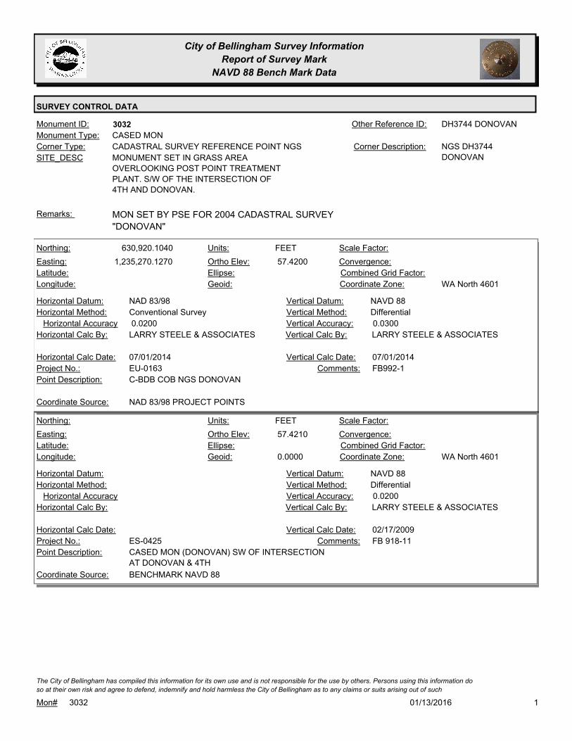
City of Bellingham Survey Information
Report of Survey Mark
NAVD 88 Bench Mark Data
SURVEY CONTROL DATA
3032Monument ID: DH3744 DONOVANOther Reference ID:
SITE_DESC MONUMENT SET IN GRASS AREA
OVERLOOKING POST POINT TREATMENT
PLANT. S/W OF THE INTERSECTION OF
4TH AND DONOVAN.
CADASTRAL SURVEY REFERENCE POINT NGSCorner Type: NGS DH3744
DONOVAN
Corner Description:
CASED MONMonument Type:
MON SET BY PSE FOR 2004 CADASTRAL SURVEY
"DONOVAN"
Remarks:
630,920.1040
1,235,270.1270 57.4200
FEETNorthing:
Easting:
Latitude:
Longitude:
Units:
Ortho Elev:
Ellipse:
Geoid:
Scale Factor:
Convergence:
Combined Grid Factor:
WA North 4601Coordinate Zone:
Conventional SurveyHorizontal Method:
NAD 83/98Horizontal Datum: NAVD 88Vertical Datum:
DifferentialVertical Method:
0.0200Horizontal Accuracy 0.0300Vertical Accuracy:
LARRY STEELE & ASSOCIATESVertical Calc By:LARRY STEELE & ASSOCIATESHorizontal Calc By:
EU-0163Project No.:
C-BDB COB NGS DONOVANPoint Description:
NAD 83/98 PROJECT POINTSCoordinate Source:
FB992-1Comments:
07/01/2014Horizontal Calc Date: 07/01/2014Vertical Calc Date:
57.4210
0.0000
FEETNorthing:
Easting:
Latitude:
Longitude:
Units:
Ortho Elev:
Ellipse:
Geoid:
Scale Factor:
Convergence:
Combined Grid Factor:
WA North 4601Coordinate Zone:
Horizontal Method:
Horizontal Datum: NAVD 88Vertical Datum:
DifferentialVertical Method:
Horizontal Accuracy 0.0200Vertical Accuracy:
LARRY STEELE & ASSOCIATESVertical Calc By:Horizontal Calc By:
ES-0425Project No.:
CASED MON (DONOVAN) SW OF INTERSECTION
AT DONOVAN & 4TH
Point Description:
BENCHMARK NAVD 88Coordinate Source:
FB 918-11Comments:
Horizontal Calc Date: 02/17/2009Vertical Calc Date:
101/13/2016Mon# 3032
The City of Bellingham has compiled this information for its own use and is not responsible for the use by others. Persons using this information do
so at their own risk and agree to defend, indemnify and hold harmless the City of Bellingham as to any claims or suits arising out of such

City of Bellingham Survey Information
Report of Survey Mark
NAVD 88 Bench Mark Data
SURVEY CONTROL DATA
57.3600
-13615.0000
-71.1280
FEETNorthing:
Easting:
Latitude:
Longitude:
Units:
Ortho Elev:
Ellipse:
Geoid:
Scale Factor:
Convergence:
Combined Grid Factor:
Coordinate Zone:
Horizontal Method:
Horizontal Datum: NAVD 88Vertical Datum:
DifferentialVertical Method:
Horizontal Accuracy 0.0500Vertical Accuracy:
PACIFIC SURVEY & ENGINEERING,
INC.
Vertical Calc By:Horizontal Calc By:
Project No.:
NGS DH3744 DONOVANPoint Description:
BENCHMARK NAVD 88Coordinate Source:
FB 880-1 PG13Comments:
Horizontal Calc Date: 04/29/2004Vertical Calc Date:
201/13/2016Mon# 3032
The City of Bellingham has compiled this information for its own use and is not responsible for the use by others. Persons using this information do
so at their own risk and agree to defend, indemnify and hold harmless the City of Bellingham as to any claims or suits arising out of such
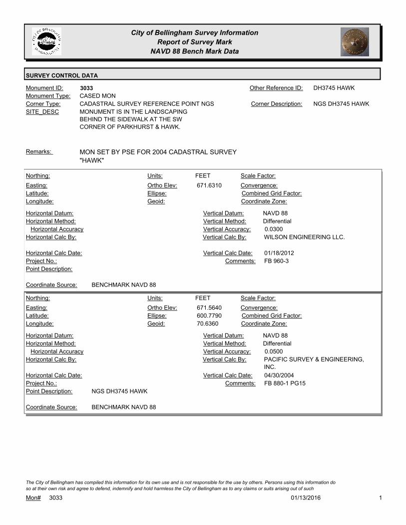
City of Bellingham Survey Information
Report of Survey Mark
NAVD 88 Bench Mark Data
SURVEY CONTROL DATA
3033Monument ID: DH3745 HAWKOther Reference ID:
SITE_DESC MONUMENT IS IN THE LANDSCAPING
BEHIND THE SIDEWALK AT THE SW
CORNER OF PARKHURST & HAWK.
CADASTRAL SURVEY REFERENCE POINT NGSCorner Type: NGS DH3745 HAWKCorner Description:
CASED MONMonument Type:
MON SET BY PSE FOR 2004 CADASTRAL SURVEY
"HAWK"
Remarks:
671.6310
FEETNorthing:
Easting:
Latitude:
Longitude:
Units:
Ortho Elev:
Ellipse:
Geoid:
Scale Factor:
Convergence:
Combined Grid Factor:
Coordinate Zone:
Horizontal Method:
Horizontal Datum: NAVD 88Vertical Datum:
DifferentialVertical Method:
Horizontal Accuracy 0.0300Vertical Accuracy:
WILSON ENGINEERING LLC.Vertical Calc By:Horizontal Calc By:
Project No.:
Point Description:
BENCHMARK NAVD 88Coordinate Source:
FB 960-3Comments:
Horizontal Calc Date: 01/18/2012Vertical Calc Date:
671.5640
600.7790
70.6360
FEETNorthing:
Easting:
Latitude:
Longitude:
Units:
Ortho Elev:
Ellipse:
Geoid:
Scale Factor:
Convergence:
Combined Grid Factor:
Coordinate Zone:
Horizontal Method:
Horizontal Datum: NAVD 88Vertical Datum:
DifferentialVertical Method:
Horizontal Accuracy 0.0500Vertical Accuracy:
PACIFIC SURVEY & ENGINEERING,
INC.
Vertical Calc By:Horizontal Calc By:
Project No.:
NGS DH3745 HAWKPoint Description:
BENCHMARK NAVD 88Coordinate Source:
FB 880-1 PG15Comments:
Horizontal Calc Date: 04/30/2004Vertical Calc Date:
101/13/2016Mon# 3033
The City of Bellingham has compiled this information for its own use and is not responsible for the use by others. Persons using this information do
so at their own risk and agree to defend, indemnify and hold harmless the City of Bellingham as to any claims or suits arising out of such

City of Bellingham Survey Information
Report of Survey Mark
NAVD 88 Bench Mark Data
SURVEY CONTROL DATA
3035Monument ID: DH3749 BLOEDELOther Reference ID:
SITE_DESC MONUMENT SET IN SOCCER/BASEBALL
FIELD IN BLOEDEL DONOVAN PARK 45'
EAST OF TRAIL THAT RUNS ALONG
ELECTRIC AVE.
CADASTRAL SURVEY REFERENCE POINT NGSCorner Type: NGS DH3749
BLOEDEL
Corner Description:
CASED MONMonument Type:
MON SET BY PSE FOR 2004 CADASTRAL
"BLOEDEL"
Remarks:
326.0340
0.0000
FEETNorthing:
Easting:
Latitude:
Longitude:
Units:
Ortho Elev:
Ellipse:
Geoid:
Scale Factor:
Convergence:
Combined Grid Factor:
WA North 4601Coordinate Zone:
Horizontal Method:
Horizontal Datum: NAVD 88Vertical Datum:
DifferentialVertical Method:
Horizontal Accuracy 0.0300Vertical Accuracy:
WILSON ENGINEERING LLC.Vertical Calc By:Horizontal Calc By:
ES-0425Project No.:
C-BDS NAD83/98 HARN BLOEDELPoint Description:
BENCHMARK NAVD 88Coordinate Source:
FB918-8 pg. 27Comments:
Horizontal Calc Date: 02/12/2009Vertical Calc Date:
326.0060
255.8650
-70.1440
FEETNorthing:
Easting:
Latitude:
Longitude:
Units:
Ortho Elev:
Ellipse:
Geoid:
Scale Factor:
Convergence:
Combined Grid Factor:
Coordinate Zone:
Horizontal Method:
Horizontal Datum: NAVD 88Vertical Datum:
DifferentialVertical Method:
Horizontal Accuracy 0.0500Vertical Accuracy:
PACIFIC SURVEY & ENGINEERING,
INC.
Vertical Calc By:Horizontal Calc By:
Project No.:
NGS DH3749 BLOEDELPoint Description:
BENCHMARK NAVD 88Coordinate Source:
FB 880-1 PG9Comments:
Horizontal Calc Date: 09/25/2007Vertical Calc Date:
101/13/2016Mon# 3035
The City of Bellingham has compiled this information for its own use and is not responsible for the use by others. Persons using this information do
so at their own risk and agree to defend, indemnify and hold harmless the City of Bellingham as to any claims or suits arising out of such
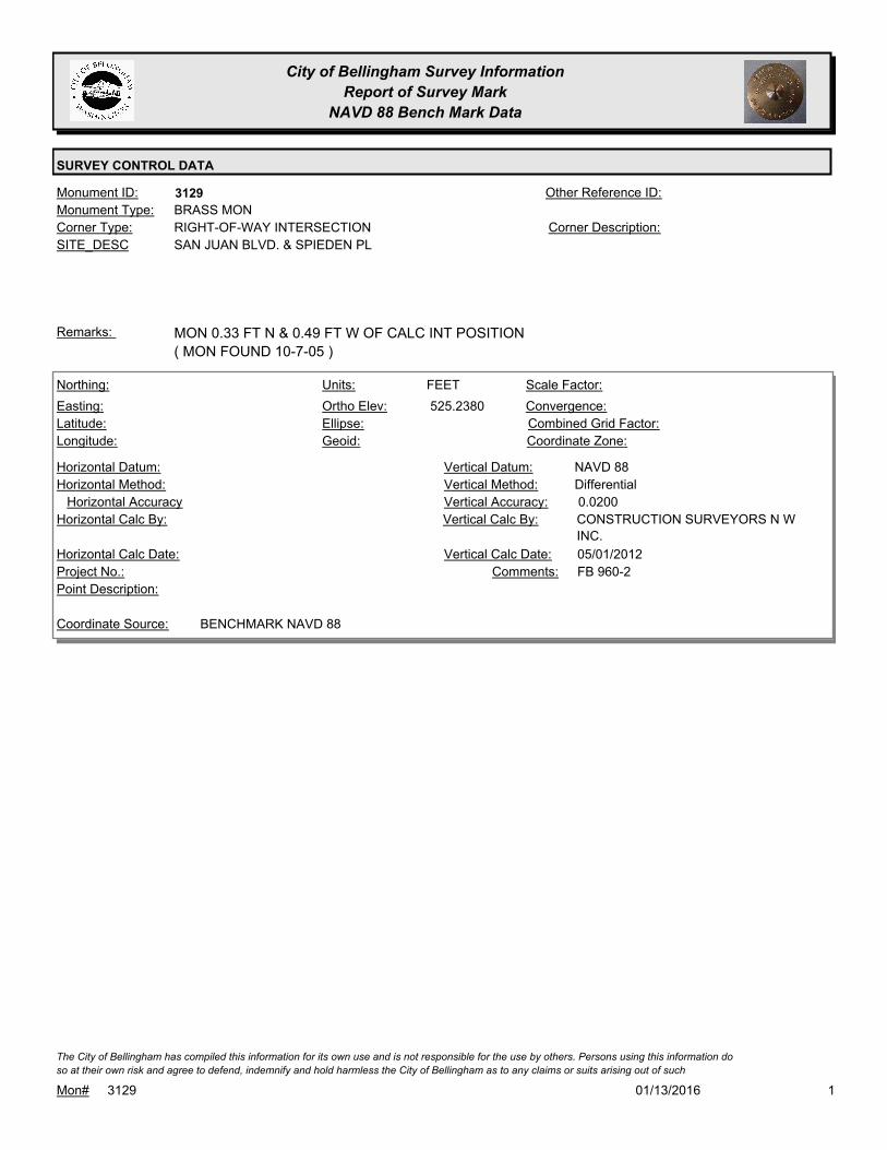
City of Bellingham Survey Information
Report of Survey Mark
NAVD 88 Bench Mark Data
SURVEY CONTROL DATA
3129Monument ID: Other Reference ID:
SITE_DESC SAN JUAN BLVD. & SPIEDEN PL
RIGHT-OF-WAY INTERSECTIONCorner Type: Corner Description:
BRASS MONMonument Type:
MON 0.33 FT N & 0.49 FT W OF CALC INT POSITION
( MON FOUND 10-7-05 )
Remarks:
525.2380
FEETNorthing:
Easting:
Latitude:
Longitude:
Units:
Ortho Elev:
Ellipse:
Geoid:
Scale Factor:
Convergence:
Combined Grid Factor:
Coordinate Zone:
Horizontal Method:
Horizontal Datum: NAVD 88Vertical Datum:
DifferentialVertical Method:
Horizontal Accuracy 0.0200Vertical Accuracy:
CONSTRUCTION SURVEYORS N W
INC.
Vertical Calc By:Horizontal Calc By:
Project No.:
Point Description:
BENCHMARK NAVD 88Coordinate Source:
FB 960-2Comments:
Horizontal Calc Date: 05/01/2012Vertical Calc Date:
101/13/2016Mon# 3129
The City of Bellingham has compiled this information for its own use and is not responsible for the use by others. Persons using this information do
so at their own risk and agree to defend, indemnify and hold harmless the City of Bellingham as to any claims or suits arising out of such
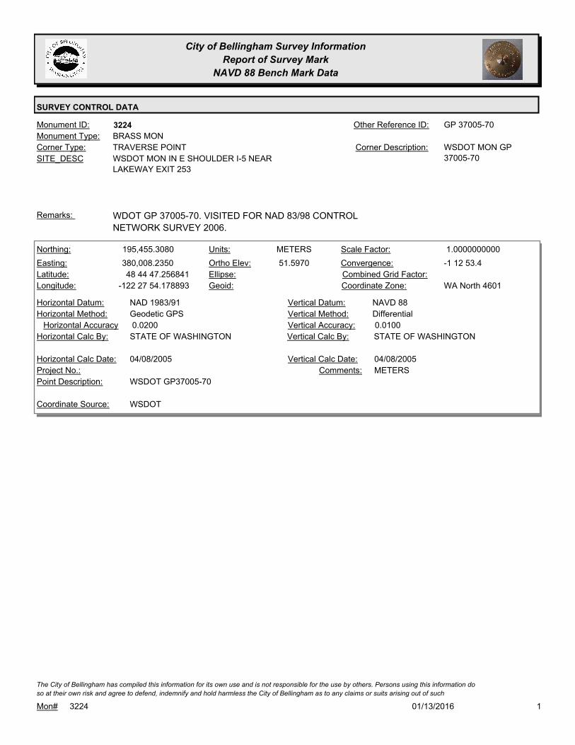
City of Bellingham Survey Information
Report of Survey Mark
NAVD 88 Bench Mark Data
SURVEY CONTROL DATA
3224Monument ID: GP 37005-70Other Reference ID:
SITE_DESC WSDOT MON IN E SHOULDER I-5 NEAR
LAKEWAY EXIT 253
TRAVERSE POINTCorner Type: WSDOT MON GP
37005-70
Corner Description:
BRASS MONMonument Type:
WDOT GP 37005-70. VISITED FOR NAD 83/98 CONTROL
NETWORK SURVEY 2006.
Remarks:
195,455.3080
380,008.2350
48 44 47.256841
-122 27 54.178893
51.5970
METERSNorthing:
Easting:
Latitude:
Longitude:
Units:
Ortho Elev:
Ellipse:
Geoid:
1.0000000000Scale Factor:
-1 12 53.4Convergence:
Combined Grid Factor:
WA North 4601Coordinate Zone:
Geodetic GPSHorizontal Method:
NAD 1983/91Horizontal Datum: NAVD 88Vertical Datum:
DifferentialVertical Method:
0.0200Horizontal Accuracy 0.0100Vertical Accuracy:
STATE OF WASHINGTONVertical Calc By:STATE OF WASHINGTONHorizontal Calc By:
Project No.:
WSDOT GP37005-70Point Description:
WSDOTCoordinate Source:
METERSComments:
04/08/2005Horizontal Calc Date: 04/08/2005Vertical Calc Date:
101/13/2016Mon# 3224
The City of Bellingham has compiled this information for its own use and is not responsible for the use by others. Persons using this information do
so at their own risk and agree to defend, indemnify and hold harmless the City of Bellingham as to any claims or suits arising out of such

City of Bellingham Survey Information
Report of Survey Mark
NAVD 88 Bench Mark Data
SURVEY CONTROL DATA
3237Monument ID: WSDOT GP 37005-87Other Reference ID:
SITE_DESC SUNSET & E OF I-5 OVERPASS IN N
SHOULDER
TRAVERSE POINTCorner Type: WSDOT GP 37005-87.
GPS CONTROL
POINT CITY/WSDOT
BD 180.05
Corner Description:
CASED MONMonument Type:
VISITED FOR NAD 83/98 CONTROL NETWORK SURVEY 2006.Remarks:
198,218.3930
380,223.0350
48 46 16.831973
-122 27 46.530467
54.3590
METERSNorthing:
Easting:
Latitude:
Longitude:
Units:
Ortho Elev:
Ellipse:
Geoid:
1.0000000000Scale Factor:
-1 12 47.8Convergence:
Combined Grid Factor:
WA North 4601Coordinate Zone:
Geodetic GPSHorizontal Method:
NAD 83/07Horizontal Datum: NAVD 88Vertical Datum:
DifferentialVertical Method:
0.0200Horizontal Accuracy 0.0100Vertical Accuracy:
STATE OF WASHINGTONVertical Calc By:STATE OF WASHINGTONHorizontal Calc By:
Project No.:
WSDOT GP37005-87Point Description:
WSDOTCoordinate Source:
METERSComments:
04/29/2008Horizontal Calc Date: 04/29/2008Vertical Calc Date:
178.3430
0.0000
FEETNorthing:
Easting:
Latitude:
Longitude:
Units:
Ortho Elev:
Ellipse:
Geoid:
Scale Factor:
Convergence:
Combined Grid Factor:
WA North 4601Coordinate Zone:
Horizontal Method:
Horizontal Datum: NAVD 88Vertical Datum:
DifferentialVertical Method:
Horizontal Accuracy 0.0200Vertical Accuracy:
PACIFIC SURVEY & ENGINEERING,
INC.
Vertical Calc By:Horizontal Calc By:
ES-0425Project No.:
CASED MON (WSDOT) ON N. SIDE SUNSET DRV /
E. END OF I-5 OVERPASS
Point Description:
BENCHMARK NAVD 88Coordinate Source:
FB 918Comments:
Horizontal Calc Date: 12/10/2008Vertical Calc Date:
101/13/2016Mon# 3237
The City of Bellingham has compiled this information for its own use and is not responsible for the use by others. Persons using this information do
so at their own risk and agree to defend, indemnify and hold harmless the City of Bellingham as to any claims or suits arising out of such
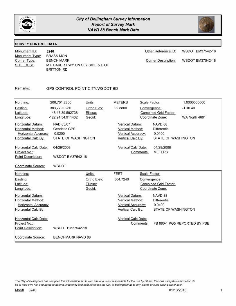
City of Bellingham Survey Information
Report of Survey Mark
NAVD 88 Bench Mark Data
SURVEY CONTROL DATA
3240Monument ID: WSDOT BM37542-18Other Reference ID:
SITE_DESC MT. BAKER HWY ON SLY SIDE & E OF
BRITTON RD
BENCH MARKCorner Type: WSDOT BM37542-18Corner Description:
BRASS MONMonument Type:
GPS CONTROL POINT CITY/WSDOT BDRemarks:
200,701.2800
383,779.0280
48 47 39.592738
-122 24 54.911432
92.8800
METERSNorthing:
Easting:
Latitude:
Longitude:
Units:
Ortho Elev:
Ellipse:
Geoid:
1.0000000000Scale Factor:
-1 10 40Convergence:
Combined Grid Factor:
WA North 4601Coordinate Zone:
Geodetic GPSHorizontal Method:
NAD 83/07Horizontal Datum: NAVD 88Vertical Datum:
DifferentialVertical Method:
0.0200Horizontal Accuracy 0.0100Vertical Accuracy:
STATE OF WASHINGTONVertical Calc By:STATE OF WASHINGTONHorizontal Calc By:
Project No.:
WSDOT BM37542-18Point Description:
WSDOTCoordinate Source:
METERSComments:
04/29/2008Horizontal Calc Date: 04/29/2008Vertical Calc Date:
304.7240
FEETNorthing:
Easting:
Latitude:
Longitude:
Units:
Ortho Elev:
Ellipse:
Geoid:
Scale Factor:
Convergence:
Combined Grid Factor:
Coordinate Zone:
Horizontal Method:
Horizontal Datum: NAVD 88Vertical Datum:
DifferentialVertical Method:
Horizontal Accuracy 0.0400Vertical Accuracy:
STATE OF WASHINGTONVertical Calc By:Horizontal Calc By:
Project No.:
WSDOT BM37542-18Point Description:
BENCHMARK NAVD 88Coordinate Source:
FB 880-1 PG5 REPORTED BY PSEComments:
Horizontal Calc Date: Vertical Calc Date:
101/13/2016Mon# 3240
The City of Bellingham has compiled this information for its own use and is not responsible for the use by others. Persons using this information do
so at their own risk and agree to defend, indemnify and hold harmless the City of Bellingham as to any claims or suits arising out of such

City of Bellingham Survey Information
Report of Survey Mark
NAVD 88 Bench Mark Data
SURVEY CONTROL DATA
3251Monument ID: Other Reference ID:
SITE_DESC VINING P.I.
RIGHT-OF-WAY PICorner Type: Corner Description:
BRASS MONMonument Type:
GPS "PI VINING BP" BY DEA 1996. VISITED FOR NAD 83/98
CONTROL NETWORK SURVEY 2006.
Remarks:
328.0750
0.0000
FEETNorthing:
Easting:
Latitude:
Longitude:
Units:
Ortho Elev:
Ellipse:
Geoid:
Scale Factor:
Convergence:
Combined Grid Factor:
WA North 4601Coordinate Zone:
Horizontal Method:
Horizontal Datum: NAVD 88Vertical Datum:
DifferentialVertical Method:
Horizontal Accuracy 0.0300Vertical Accuracy:
WILSON ENGINEERING LLC.Vertical Calc By:Horizontal Calc By:
ES-0425Project No.:
C-BDS CL VINING S. OF VIEWRIDGE RD.Point Description:
BENCHMARK NAVD 88Coordinate Source:
FB918-8 pg. 54Comments:
Horizontal Calc Date: 02/12/2009Vertical Calc Date:
101/13/2016Mon# 3251
The City of Bellingham has compiled this information for its own use and is not responsible for the use by others. Persons using this information do
so at their own risk and agree to defend, indemnify and hold harmless the City of Bellingham as to any claims or suits arising out of such
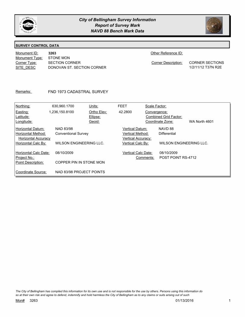
City of Bellingham Survey Information
Report of Survey Mark
NAVD 88 Bench Mark Data
SURVEY CONTROL DATA
3263Monument ID: Other Reference ID:
SITE_DESC DONOVAN ST. SECTION CORNER
SECTION CORNERCorner Type: CORNER SECTIONS
1/2/11/12 T37N R2E
Corner Description:
STONE MONMonument Type:
FND 1973 CADASTRAL SURVEYRemarks:
630,960.1700
1,236,150.8100 42.2800
FEETNorthing:
Easting:
Latitude:
Longitude:
Units:
Ortho Elev:
Ellipse:
Geoid:
Scale Factor:
Convergence:
Combined Grid Factor:
WA North 4601Coordinate Zone:
Conventional SurveyHorizontal Method:
NAD 83/98Horizontal Datum: NAVD 88Vertical Datum:
DifferentialVertical Method:
Horizontal Accuracy Vertical Accuracy:
WILSON ENGINEERING LLC.Vertical Calc By:WILSON ENGINEERING LLC.Horizontal Calc By:
Project No.:
COPPER PIN IN STONE MONPoint Description:
NAD 83/98 PROJECT POINTSCoordinate Source:
POST POINT RS-4712Comments:
08/10/2009Horizontal Calc Date: 08/10/2009Vertical Calc Date:
101/13/2016Mon# 3263
The City of Bellingham has compiled this information for its own use and is not responsible for the use by others. Persons using this information do
so at their own risk and agree to defend, indemnify and hold harmless the City of Bellingham as to any claims or suits arising out of such
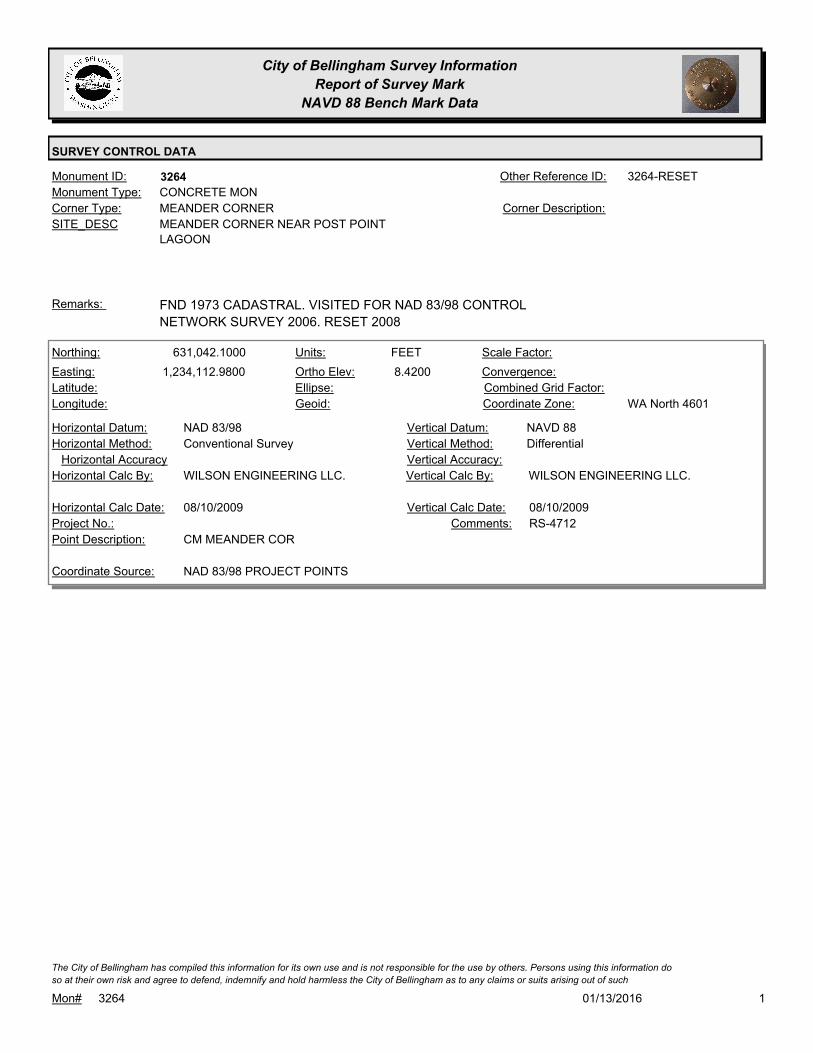
City of Bellingham Survey Information
Report of Survey Mark
NAVD 88 Bench Mark Data
SURVEY CONTROL DATA
3264Monument ID: 3264-RESETOther Reference ID:
SITE_DESC MEANDER CORNER NEAR POST POINT
LAGOON
MEANDER CORNERCorner Type: Corner Description:
CONCRETE MONMonument Type:
FND 1973 CADASTRAL. VISITED FOR NAD 83/98 CONTROL
NETWORK SURVEY 2006. RESET 2008
Remarks:
631,042.1000
1,234,112.9800 8.4200
FEETNorthing:
Easting:
Latitude:
Longitude:
Units:
Ortho Elev:
Ellipse:
Geoid:
Scale Factor:
Convergence:
Combined Grid Factor:
WA North 4601Coordinate Zone:
Conventional SurveyHorizontal Method:
NAD 83/98Horizontal Datum: NAVD 88Vertical Datum:
DifferentialVertical Method:
Horizontal Accuracy Vertical Accuracy:
WILSON ENGINEERING LLC.Vertical Calc By:WILSON ENGINEERING LLC.Horizontal Calc By:
Project No.:
CM MEANDER CORPoint Description:
NAD 83/98 PROJECT POINTSCoordinate Source:
RS-4712Comments:
08/10/2009Horizontal Calc Date: 08/10/2009Vertical Calc Date:
101/13/2016Mon# 3264
The City of Bellingham has compiled this information for its own use and is not responsible for the use by others. Persons using this information do
so at their own risk and agree to defend, indemnify and hold harmless the City of Bellingham as to any claims or suits arising out of such

City of Bellingham Survey Information
Report of Survey Mark
NAVD 88 Bench Mark Data
SURVEY CONTROL DATA
3287Monument ID: Other Reference ID:
SITE_DESC MILL AVE & 16TH ST
RIGHT-OF-WAY INTERSECTIONCorner Type: Corner Description:
BRASS MONMonument Type:
VISITED FOR NAD 83/98 CONTROL NETWORK SURVEY 2006.Remarks:
165.3780
0.0000
FEETNorthing:
Easting:
Latitude:
Longitude:
Units:
Ortho Elev:
Ellipse:
Geoid:
Scale Factor:
Convergence:
Combined Grid Factor:
WA North 4601Coordinate Zone:
Horizontal Method:
Horizontal Datum: NAVD 88Vertical Datum:
DifferentialVertical Method:
Horizontal Accuracy 0.0200Vertical Accuracy:
LARRY STEELE & ASSOCIATESVertical Calc By:Horizontal Calc By:
ES-0425Project No.:
BRASS MON AT MILL & 16THPoint Description:
BENCHMARK NAVD 88Coordinate Source:
FB 918-11Comments:
Horizontal Calc Date: 02/17/2009Vertical Calc Date:
101/13/2016Mon# 3287
The City of Bellingham has compiled this information for its own use and is not responsible for the use by others. Persons using this information do
so at their own risk and agree to defend, indemnify and hold harmless the City of Bellingham as to any claims or suits arising out of such

City of Bellingham Survey Information
Report of Survey Mark
NAVD 88 Bench Mark Data
SURVEY CONTROL DATA
3309Monument ID: Other Reference ID:
SITE_DESC S. STATE & BEECHER
RIGHT-OF-WAY INTERSECTIONCorner Type: Corner Description:
BRASS MONMonument Type:
Remarks:
77.1700
0.0000
FEETNorthing:
Easting:
Latitude:
Longitude:
Units:
Ortho Elev:
Ellipse:
Geoid:
Scale Factor:
Convergence:
Combined Grid Factor:
WA North 4601Coordinate Zone:
Horizontal Method:
Horizontal Datum: NAVD 88Vertical Datum:
DifferentialVertical Method:
Horizontal Accuracy 0.0200Vertical Accuracy:
LARRY STEELE & ASSOCIATESVertical Calc By:Horizontal Calc By:
ES-0425Project No.:
BRASS MON AT STATE & BEECHERPoint Description:
BENCHMARK NAVD 88Coordinate Source:
FB 918-11Comments:
Horizontal Calc Date: 02/17/2009Vertical Calc Date:
101/13/2016Mon# 3309
The City of Bellingham has compiled this information for its own use and is not responsible for the use by others. Persons using this information do
so at their own risk and agree to defend, indemnify and hold harmless the City of Bellingham as to any claims or suits arising out of such

City of Bellingham Survey Information
Report of Survey Mark
NAVD 88 Bench Mark Data
SURVEY CONTROL DATA
3324Monument ID: Other Reference ID:
SITE_DESC S STATE & 14TH
RIGHT-OF-WAY INTERSECTIONCorner Type: Corner Description:
BRASS MONMonument Type:
VISITED FOR NAD 83/98 CONTROL NETWORK SURVEY 2006Remarks:
86.0780
0.0000
FEETNorthing:
Easting:
Latitude:
Longitude:
Units:
Ortho Elev:
Ellipse:
Geoid:
Scale Factor:
Convergence:
Combined Grid Factor:
WA North 4601Coordinate Zone:
Horizontal Method:
Horizontal Datum: NAVD 88Vertical Datum:
DifferentialVertical Method:
Horizontal Accuracy 0.0200Vertical Accuracy:
LARRY STEELE & ASSOCIATESVertical Calc By:Horizontal Calc By:
ES-0425Project No.:
BRASS MON AT STATE & 14THPoint Description:
BENCHMARK NAVD 88Coordinate Source:
FB 918-11Comments:
Horizontal Calc Date: 02/17/2009Vertical Calc Date:
101/13/2016Mon# 3324
The City of Bellingham has compiled this information for its own use and is not responsible for the use by others. Persons using this information do
so at their own risk and agree to defend, indemnify and hold harmless the City of Bellingham as to any claims or suits arising out of such

City of Bellingham Survey Information
Report of Survey Mark
NAVD 88 Bench Mark Data
SURVEY CONTROL DATA
3325Monument ID: Other Reference ID:
SITE_DESC 12TH & S STATE
RIGHT-OF-WAY INTERSECTIONCorner Type: Corner Description:
BRASS MONMonument Type:
Remarks:
69.7520
0.0000
FEETNorthing:
Easting:
Latitude:
Longitude:
Units:
Ortho Elev:
Ellipse:
Geoid:
Scale Factor:
Convergence:
Combined Grid Factor:
WA North 4601Coordinate Zone:
Horizontal Method:
Horizontal Datum: NAVD 88Vertical Datum:
DifferentialVertical Method:
Horizontal Accuracy 0.0200Vertical Accuracy:
LARRY STEELE & ASSOCIATESVertical Calc By:Horizontal Calc By:
ES-0425Project No.:
BRASS MON AT 12TH & STATEPoint Description:
BENCHMARK NAVD 88Coordinate Source:
FB 918-11Comments:
Horizontal Calc Date: 02/17/2009Vertical Calc Date:
101/13/2016Mon# 3325
The City of Bellingham has compiled this information for its own use and is not responsible for the use by others. Persons using this information do
so at their own risk and agree to defend, indemnify and hold harmless the City of Bellingham as to any claims or suits arising out of such

City of Bellingham Survey Information
Report of Survey Mark
NAVD 88 Bench Mark Data
SURVEY CONTROL DATA
3335Monument ID: Other Reference ID:
SITE_DESC CONSOLIDATION & LINCOLN (S)
RIGHT-OF-WAY INTERSECTIONCorner Type: Corner Description:
BRASS MONMonument Type:
Remarks:
637,237.0790
1,246,454.1190 177.7000
FEETNorthing:
Easting:
Latitude:
Longitude:
Units:
Ortho Elev:
Ellipse:
Geoid:
Scale Factor:
Convergence:
Combined Grid Factor:
WA North 4601Coordinate Zone:
Conventional SurveyHorizontal Method:
NAD 83/98Horizontal Datum: NAVD 88Vertical Datum:
DifferentialVertical Method:
0.0200Horizontal Accuracy 0.0300Vertical Accuracy:
LARRY STEELE & ASSOCIATESVertical Calc By:LARRY STEELE & ASSOCIATESHorizontal Calc By:
ES-0504Project No.:
Point Description:
NAD 83/98 PROJECT POINTSCoordinate Source:
Comments:
02/04/2015Horizontal Calc Date: 02/04/2015Vertical Calc Date:
637,237.0950
1,246,454.0890 177.7200
FEETNorthing:
Easting:
Latitude:
Longitude:
Units:
Ortho Elev:
Ellipse:
Geoid:
Scale Factor:
Convergence:
Combined Grid Factor:
WA North 4601Coordinate Zone:
Conventional SurveyHorizontal Method:
NAD 83/98Horizontal Datum: NAVD 88Vertical Datum:
DifferentialVertical Method:
0.0200Horizontal Accuracy 0.0300Vertical Accuracy:
LARRY STEELE & ASSOCIATESVertical Calc By:LARRY STEELE & ASSOCIATESHorizontal Calc By:
EU-0159Project No.:
C-MONPoint Description:
NAD 83/98 PROJECT POINTSCoordinate Source:
FB 947-1 PROJECT POINT #100Comments:
06/30/2011Horizontal Calc Date: 06/30/2011Vertical Calc Date:
101/13/2016Mon# 3335
The City of Bellingham has compiled this information for its own use and is not responsible for the use by others. Persons using this information do
so at their own risk and agree to defend, indemnify and hold harmless the City of Bellingham as to any claims or suits arising out of such
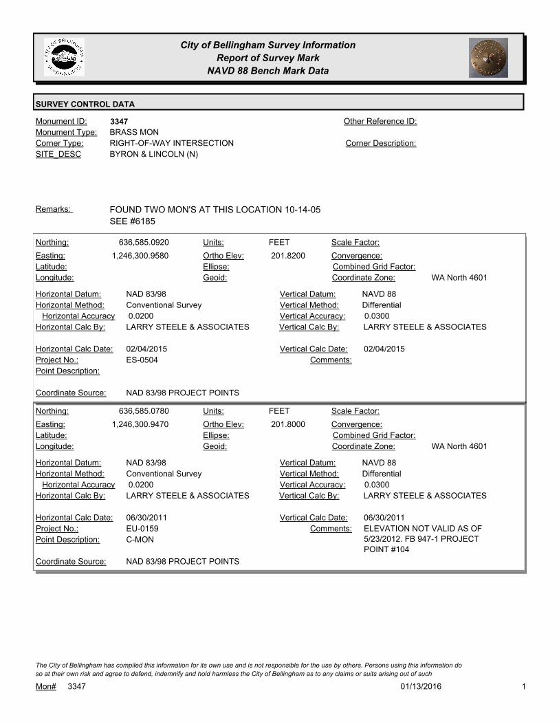
City of Bellingham Survey Information
Report of Survey Mark
NAVD 88 Bench Mark Data
SURVEY CONTROL DATA
3347Monument ID: Other Reference ID:
SITE_DESC BYRON & LINCOLN (N)
RIGHT-OF-WAY INTERSECTIONCorner Type: Corner Description:
BRASS MONMonument Type:
FOUND TWO MON'S AT THIS LOCATION 10-14-05
SEE #6185
Remarks:
636,585.0920
1,246,300.9580 201.8200
FEETNorthing:
Easting:
Latitude:
Longitude:
Units:
Ortho Elev:
Ellipse:
Geoid:
Scale Factor:
Convergence:
Combined Grid Factor:
WA North 4601Coordinate Zone:
Conventional SurveyHorizontal Method:
NAD 83/98Horizontal Datum: NAVD 88Vertical Datum:
DifferentialVertical Method:
0.0200Horizontal Accuracy 0.0300Vertical Accuracy:
LARRY STEELE & ASSOCIATESVertical Calc By:LARRY STEELE & ASSOCIATESHorizontal Calc By:
ES-0504Project No.:
Point Description:
NAD 83/98 PROJECT POINTSCoordinate Source:
Comments:
02/04/2015Horizontal Calc Date: 02/04/2015Vertical Calc Date:
636,585.0780
1,246,300.9470 201.8000
FEETNorthing:
Easting:
Latitude:
Longitude:
Units:
Ortho Elev:
Ellipse:
Geoid:
Scale Factor:
Convergence:
Combined Grid Factor:
WA North 4601Coordinate Zone:
Conventional SurveyHorizontal Method:
NAD 83/98Horizontal Datum: NAVD 88Vertical Datum:
DifferentialVertical Method:
0.0200Horizontal Accuracy 0.0300Vertical Accuracy:
LARRY STEELE & ASSOCIATESVertical Calc By:LARRY STEELE & ASSOCIATESHorizontal Calc By:
EU-0159Project No.:
C-MONPoint Description:
NAD 83/98 PROJECT POINTSCoordinate Source:
ELEVATION NOT VALID AS OF
5/23/2012. FB 947-1 PROJECT
POINT #104
Comments:
06/30/2011Horizontal Calc Date: 06/30/2011Vertical Calc Date:
101/13/2016Mon# 3347
The City of Bellingham has compiled this information for its own use and is not responsible for the use by others. Persons using this information do
so at their own risk and agree to defend, indemnify and hold harmless the City of Bellingham as to any claims or suits arising out of such
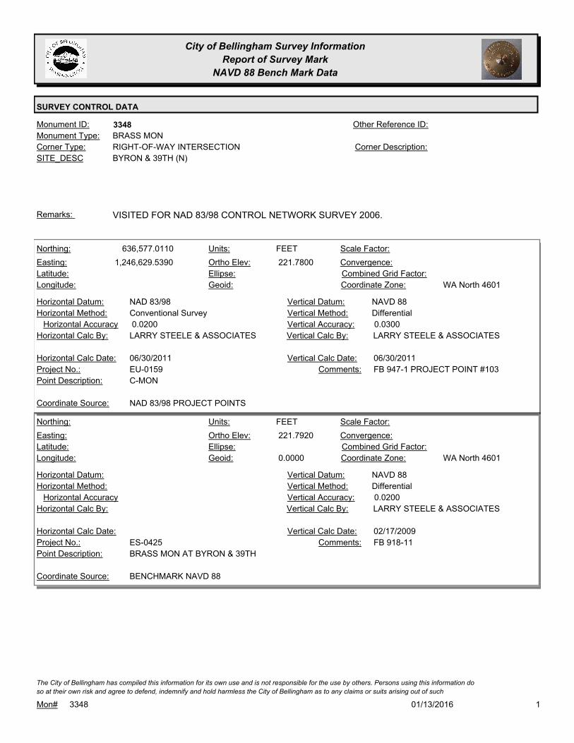
City of Bellingham Survey Information
Report of Survey Mark
NAVD 88 Bench Mark Data
SURVEY CONTROL DATA
3348Monument ID: Other Reference ID:
SITE_DESC BYRON & 39TH (N)
RIGHT-OF-WAY INTERSECTIONCorner Type: Corner Description:
BRASS MONMonument Type:
VISITED FOR NAD 83/98 CONTROL NETWORK SURVEY 2006.Remarks:
636,577.0110
1,246,629.5390 221.7800
FEETNorthing:
Easting:
Latitude:
Longitude:
Units:
Ortho Elev:
Ellipse:
Geoid:
Scale Factor:
Convergence:
Combined Grid Factor:
WA North 4601Coordinate Zone:
Conventional SurveyHorizontal Method:
NAD 83/98Horizontal Datum: NAVD 88Vertical Datum:
DifferentialVertical Method:
0.0200Horizontal Accuracy 0.0300Vertical Accuracy:
LARRY STEELE & ASSOCIATESVertical Calc By:LARRY STEELE & ASSOCIATESHorizontal Calc By:
EU-0159Project No.:
C-MONPoint Description:
NAD 83/98 PROJECT POINTSCoordinate Source:
FB 947-1 PROJECT POINT #103Comments:
06/30/2011Horizontal Calc Date: 06/30/2011Vertical Calc Date:
221.7920
0.0000
FEETNorthing:
Easting:
Latitude:
Longitude:
Units:
Ortho Elev:
Ellipse:
Geoid:
Scale Factor:
Convergence:
Combined Grid Factor:
WA North 4601Coordinate Zone:
Horizontal Method:
Horizontal Datum: NAVD 88Vertical Datum:
DifferentialVertical Method:
Horizontal Accuracy 0.0200Vertical Accuracy:
LARRY STEELE & ASSOCIATESVertical Calc By:Horizontal Calc By:
ES-0425Project No.:
BRASS MON AT BYRON & 39THPoint Description:
BENCHMARK NAVD 88Coordinate Source:
FB 918-11Comments:
Horizontal Calc Date: 02/17/2009Vertical Calc Date:
101/13/2016Mon# 3348
The City of Bellingham has compiled this information for its own use and is not responsible for the use by others. Persons using this information do
so at their own risk and agree to defend, indemnify and hold harmless the City of Bellingham as to any claims or suits arising out of such

City of Bellingham Survey Information
Report of Survey Mark
NAVD 88 Bench Mark Data
SURVEY CONTROL DATA
3354Monument ID: 5002Other Reference ID:
SITE_DESC ELIZA & MATANUSKA NEAR PLAT LINE
RIGHT-OF-WAY POTCorner Type: CL NEAR PLAT LINECorner Description:
BRASS MONMonument Type:
VISITED FOR NAD 83/98 CONTROL NETWORK 2005.Remarks:
656,532.3370
1,239,367.9920 174.5800
Northing:
Easting:
Latitude:
Longitude:
Units:
Ortho Elev:
Ellipse:
Geoid:
Scale Factor:
Convergence:
Combined Grid Factor:
WA North 4601Coordinate Zone:
Conventional SurveyHorizontal Method:
NAD 83/98Horizontal Datum: NAVD 88Vertical Datum:
DifferentialVertical Method:
0.0200Horizontal Accuracy 0.0300Vertical Accuracy:
LARRY STEELE & ASSOCIATESVertical Calc By:LARRY STEELE & ASSOCIATESHorizontal Calc By:
ES-0441Project No.:
Point Description:
NAD 83/98 PROJECT POINTSCoordinate Source:
ELEVATION NO LONGER VALID. FB
942-1 PROJECT POINT #105
Comments:
04/28/2011Horizontal Calc Date: 04/28/2011Vertical Calc Date:
101/13/2016Mon# 3354
The City of Bellingham has compiled this information for its own use and is not responsible for the use by others. Persons using this information do
so at their own risk and agree to defend, indemnify and hold harmless the City of Bellingham as to any claims or suits arising out of such

City of Bellingham Survey Information
Report of Survey Mark
NAVD 88 Bench Mark Data
SURVEY CONTROL DATA
3397Monument ID: Other Reference ID:
SITE_DESC N FOREST S/O E ROSE ST
RIGHT-OF-WAY PTCorner Type: Corner Description:
BRASS MONMonument Type:
ELEVATION NOT VALID AS OF 6/22/11Remarks:
104.4160
0.0000
FEETNorthing:
Easting:
Latitude:
Longitude:
Units:
Ortho Elev:
Ellipse:
Geoid:
Scale Factor:
Convergence:
Combined Grid Factor:
WA North 4601Coordinate Zone:
Horizontal Method:
Horizontal Datum: NAVD 88Vertical Datum:
DifferentialVertical Method:
Horizontal Accuracy 0.0200Vertical Accuracy:
LARRY STEELE & ASSOCIATESVertical Calc By:Horizontal Calc By:
ES-0425Project No.:
BRASS MON AT FOREST, SOUTH OF ROSEPoint Description:
BENCHMARK NAVD 88Coordinate Source:
ELEVATION NO LONGER VALID. FB
918-11
Comments:
Horizontal Calc Date: 02/17/2009Vertical Calc Date:
101/13/2016Mon# 3397
The City of Bellingham has compiled this information for its own use and is not responsible for the use by others. Persons using this information do
so at their own risk and agree to defend, indemnify and hold harmless the City of Bellingham as to any claims or suits arising out of such

City of Bellingham Survey Information
Report of Survey Mark
NAVD 88 Bench Mark Data
SURVEY CONTROL DATA
3398Monument ID: Other Reference ID:
SITE_DESC HIGHLAND DR. BTWN. W COLLEGE WY &
HILLCREST WY
RIGHT-OF-WAY PCCorner Type: Corner Description:
BRASS MONMonument Type:
HOUSE # 301. ELEVATION RUN IN 2003 IS NO LONGER VALID.Remarks:
636,349.4940
1,240,188.9200 448.3900
FEETNorthing:
Easting:
Latitude:
Longitude:
Units:
Ortho Elev:
Ellipse:
Geoid:
Scale Factor:
Convergence:
Combined Grid Factor:
WA North 4601Coordinate Zone:
Conventional SurveyHorizontal Method:
NAD 83/98Horizontal Datum: NAVD 88Vertical Datum:
DifferentialVertical Method:
0.0200Horizontal Accuracy 0.0300Vertical Accuracy:
LARRY STEELE & ASSOCIATESVertical Calc By:LARRY STEELE & ASSOCIATESHorizontal Calc By:
EU-0156Project No.:
BPFPoint Description:
NAD 83/98 PROJECT POINTSCoordinate Source:
FB 940-1 PROJECT POINT 528Comments:
08/09/2011Horizontal Calc Date: 08/09/2011Vertical Calc Date:
101/13/2016Mon# 3398
The City of Bellingham has compiled this information for its own use and is not responsible for the use by others. Persons using this information do
so at their own risk and agree to defend, indemnify and hold harmless the City of Bellingham as to any claims or suits arising out of such

City of Bellingham Survey Information
Report of Survey Mark
NAVD 88 Bench Mark Data
SURVEY CONTROL DATA
3410Monument ID: Other Reference ID:
SITE_DESC 6TH ST & MCKENZIE AV
RIGHT-OF-WAY INTERSECTIONCorner Type: Corner Description:
BRASS MONMonument Type:
Remarks:
631,590.5200
1,235,883.3800 21.8300
FEETNorthing:
Easting:
Latitude:
Longitude:
Units:
Ortho Elev:
Ellipse:
Geoid:
Scale Factor:
Convergence:
Combined Grid Factor:
WA North 4601Coordinate Zone:
Conventional SurveyHorizontal Method:
NAD 83/98Horizontal Datum: NAVD 88Vertical Datum:
DifferentialVertical Method:
Horizontal Accuracy Vertical Accuracy:
WILSON ENGINEERING LLC.Vertical Calc By:WILSON ENGINEERING LLC.Horizontal Calc By:
Project No.:
BRASS SURFACE MONPoint Description:
NAD 83/98 PROJECT POINTSCoordinate Source:
POST POINT RS-4712Comments:
08/10/2009Horizontal Calc Date: 08/10/2009Vertical Calc Date:
101/13/2016Mon# 3410
The City of Bellingham has compiled this information for its own use and is not responsible for the use by others. Persons using this information do
so at their own risk and agree to defend, indemnify and hold harmless the City of Bellingham as to any claims or suits arising out of such
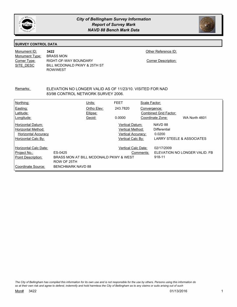
City of Bellingham Survey Information
Report of Survey Mark
NAVD 88 Bench Mark Data
SURVEY CONTROL DATA
3422Monument ID: Other Reference ID:
SITE_DESC BILL MCDONALD PKWY & 25TH ST
ROW/WEST
RIGHT-OF-WAY BOUNDARYCorner Type: Corner Description:
BRASS MONMonument Type:
ELEVATION NO LONGER VALID AS OF 11/23/10. VISITED FOR NAD
83/98 CONTROL NETWORK SURVEY 2006.
Remarks:
243.7820
0.0000
FEETNorthing:
Easting:
Latitude:
Longitude:
Units:
Ortho Elev:
Ellipse:
Geoid:
Scale Factor:
Convergence:
Combined Grid Factor:
WA North 4601Coordinate Zone:
Horizontal Method:
Horizontal Datum: NAVD 88Vertical Datum:
DifferentialVertical Method:
Horizontal Accuracy 0.0200Vertical Accuracy:
LARRY STEELE & ASSOCIATESVertical Calc By:Horizontal Calc By:
ES-0425Project No.:
BRASS MON AT BILL MCDONALD PKWY & WEST
ROW OF 25TH
Point Description:
BENCHMARK NAVD 88Coordinate Source:
ELEVATION NO LONGER VALID. FB
918-11
Comments:
Horizontal Calc Date: 02/17/2009Vertical Calc Date:
101/13/2016Mon# 3422
The City of Bellingham has compiled this information for its own use and is not responsible for the use by others. Persons using this information do
so at their own risk and agree to defend, indemnify and hold harmless the City of Bellingham as to any claims or suits arising out of such

City of Bellingham Survey Information
Report of Survey Mark
NAVD 88 Bench Mark Data
SURVEY CONTROL DATA
3423Monument ID: Other Reference ID:
SITE_DESC 25TH ST & BILL MCDONALD PARKWAY,
JUST W/O 25TH
RIGHT-OF-WAY PTCorner Type: Corner Description:
CASED MONMonument Type:
Remarks:
634,048.9300
1,241,680.1700 243.4000
FEETNorthing:
Easting:
Latitude:
Longitude:
Units:
Ortho Elev:
Ellipse:
Geoid:
Scale Factor:
Convergence:
Combined Grid Factor:
WA North 4601Coordinate Zone:
Conventional SurveyHorizontal Method:
NAD 83/98Horizontal Datum: NAVD 88Vertical Datum:
DifferentialVertical Method:
0.0300Horizontal Accuracy 0.0500Vertical Accuracy:
DAVID EVANS & ASSOCIATES, INC.Vertical Calc By:DAVID EVANS & ASSOCIATES,
INC.
Horizontal Calc By:
ES-0358Project No.:
C-FND-MON PNT#179Point Description:
NAD 83/98 PROJECT POINTSCoordinate Source:
FB 926Comments:
11/01/2009Horizontal Calc Date: 11/01/2009Vertical Calc Date:
101/13/2016Mon# 3423
The City of Bellingham has compiled this information for its own use and is not responsible for the use by others. Persons using this information do
so at their own risk and agree to defend, indemnify and hold harmless the City of Bellingham as to any claims or suits arising out of such

City of Bellingham Survey Information
Report of Survey Mark
NAVD 88 Bench Mark Data
SURVEY CONTROL DATA
3424Monument ID: Other Reference ID:
SITE_DESC 25TH ST & BILL MCDONALD PKWY
ROW/EAST
RIGHT-OF-WAY BOUNDARYCorner Type: Corner Description:
BRASS MONMonument Type:
ELEVATION AS OF 11/23/10 NO LONGER VALID.Remarks:
634,065.3500
1,241,726.4000 247.7300
FEETNorthing:
Easting:
Latitude:
Longitude:
Units:
Ortho Elev:
Ellipse:
Geoid:
Scale Factor:
Convergence:
Combined Grid Factor:
WA North 4601Coordinate Zone:
Conventional SurveyHorizontal Method:
NAD 83/98Horizontal Datum: NAVD 88Vertical Datum:
DifferentialVertical Method:
0.0300Horizontal Accuracy 0.0500Vertical Accuracy:
DAVID EVANS & ASSOCIATES, INC.Vertical Calc By:DAVID EVANS & ASSOCIATES,
INC.
Horizontal Calc By:
ES-0358Project No.:
C-MON-FND PROJ POINT#180Point Description:
NAD 83/98 PROJECT POINTSCoordinate Source:
ELEVATION NO LONGER VALID. FB
926
Comments:
11/01/2009Horizontal Calc Date: 11/01/2009Vertical Calc Date:
101/13/2016Mon# 3424
The City of Bellingham has compiled this information for its own use and is not responsible for the use by others. Persons using this information do
so at their own risk and agree to defend, indemnify and hold harmless the City of Bellingham as to any claims or suits arising out of such
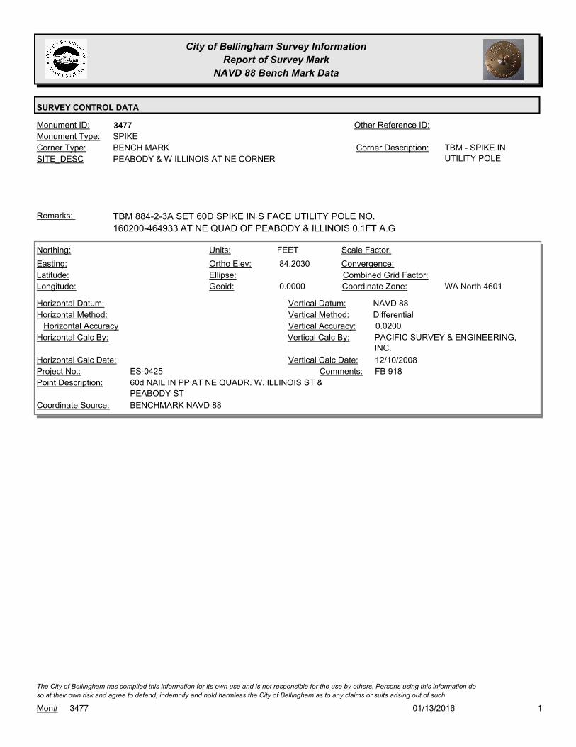
City of Bellingham Survey Information
Report of Survey Mark
NAVD 88 Bench Mark Data
SURVEY CONTROL DATA
3477Monument ID: Other Reference ID:
SITE_DESC PEABODY & W ILLINOIS AT NE CORNER
BENCH MARKCorner Type: TBM - SPIKE IN
UTILITY POLE
Corner Description:
SPIKEMonument Type:
TBM 884-2-3A SET 60D SPIKE IN S FACE UTILITY POLE NO.
160200-464933 AT NE QUAD OF PEABODY & ILLINOIS 0.1FT A.G
Remarks:
84.2030
0.0000
FEETNorthing:
Easting:
Latitude:
Longitude:
Units:
Ortho Elev:
Ellipse:
Geoid:
Scale Factor:
Convergence:
Combined Grid Factor:
WA North 4601Coordinate Zone:
Horizontal Method:
Horizontal Datum: NAVD 88Vertical Datum:
DifferentialVertical Method:
Horizontal Accuracy 0.0200Vertical Accuracy:
PACIFIC SURVEY & ENGINEERING,
INC.
Vertical Calc By:Horizontal Calc By:
ES-0425Project No.:
60d NAIL IN PP AT NE QUADR. W. ILLINOIS ST &
PEABODY ST
Point Description:
BENCHMARK NAVD 88Coordinate Source:
FB 918Comments:
Horizontal Calc Date: 12/10/2008Vertical Calc Date:
101/13/2016Mon# 3477
The City of Bellingham has compiled this information for its own use and is not responsible for the use by others. Persons using this information do
so at their own risk and agree to defend, indemnify and hold harmless the City of Bellingham as to any claims or suits arising out of such

City of Bellingham Survey Information
Report of Survey Mark
NAVD 88 Bench Mark Data
SURVEY CONTROL DATA
3481Monument ID: Other Reference ID:
SITE_DESC MERIDIAN & E VICTOR AT NE CORNER
BENCH MARKCorner Type: TBM - X ON SE BOLT
OF LIGHT POLE
Corner Description:
BOLTMonument Type:
TBM 884-2-5A- SET X ON SE BOLT OF LIGHT POLE AT NE QUAD
MERIDIAN & VICTOR
Remarks:
93.2200
0.0000
FEETNorthing:
Easting:
Latitude:
Longitude:
Units:
Ortho Elev:
Ellipse:
Geoid:
Scale Factor:
Convergence:
Combined Grid Factor:
WA North 4601Coordinate Zone:
Horizontal Method:
Horizontal Datum: NAVD 88Vertical Datum:
DifferentialVertical Method:
Horizontal Accuracy 0.0200Vertical Accuracy:
PACIFIC SURVEY & ENGINEERING,
INC.
Vertical Calc By:Horizontal Calc By:
ES-0425Project No.:
SE BOLT LIGHT BASE AT NE QUADR. E. VICTOR ST
& MERIDIAN ST
Point Description:
BENCHMARK NAVD 88Coordinate Source:
FB 918Comments:
Horizontal Calc Date: 01/05/2009Vertical Calc Date:
101/13/2016Mon# 3481
The City of Bellingham has compiled this information for its own use and is not responsible for the use by others. Persons using this information do
so at their own risk and agree to defend, indemnify and hold harmless the City of Bellingham as to any claims or suits arising out of such

City of Bellingham Survey Information
Report of Survey Mark
NAVD 88 Bench Mark Data
SURVEY CONTROL DATA
3491Monument ID: Other Reference ID:
SITE_DESC BIRCH & LAKEWAY AT NE CORNER
BENCH MARKCorner Type: TBM - X ON SW
CORNER FIRST
STEP RESIDENCE
#1400 BIRCH
Corner Description:
STEPMonument Type:
TBM - SET X ON SW CORNER FIRST STEP OF RESIDENCE #1400
BIRCH ST
Remarks:
355.6600
0.0000
FEETNorthing:
Easting:
Latitude:
Longitude:
Units:
Ortho Elev:
Ellipse:
Geoid:
Scale Factor:
Convergence:
Combined Grid Factor:
WA North 4601Coordinate Zone:
Horizontal Method:
Horizontal Datum: NAVD 88Vertical Datum:
DifferentialVertical Method:
Horizontal Accuracy 0.0300Vertical Accuracy:
WILSON ENGINEERING LLC.Vertical Calc By:Horizontal Calc By:
ES-0425Project No.:
C-BM SW COR CONC. STEP RES. #1400
LAKEWAY/BIRCH
Point Description:
BENCHMARK NAVD 88Coordinate Source:
FB918-8 pg. 22Comments:
Horizontal Calc Date: 02/12/2009Vertical Calc Date:
101/13/2016Mon# 3491
The City of Bellingham has compiled this information for its own use and is not responsible for the use by others. Persons using this information do
so at their own risk and agree to defend, indemnify and hold harmless the City of Bellingham as to any claims or suits arising out of such

City of Bellingham Survey Information
Report of Survey Mark
NAVD 88 Bench Mark Data
SURVEY CONTROL DATA
3493Monument ID: Other Reference ID:
SITE_DESC LAKEWAY DR & RAYMOND ST AT SW
CORNER
BENCH MARKCorner Type: TBM - X ON NW
CORNER FIRST
CONC STEP OF
RESIDENCE #3326
LAKEWAY
Corner Description:
STEPMonument Type:
TBM - SET X ON NW CORNER FIRST CONC STEP OF RESIDENCE
#3326 LAKEWAY DR
Remarks:
344.5430
0.0000
FEETNorthing:
Easting:
Latitude:
Longitude:
Units:
Ortho Elev:
Ellipse:
Geoid:
Scale Factor:
Convergence:
Combined Grid Factor:
WA North 4601Coordinate Zone:
Horizontal Method:
Horizontal Datum: NAVD 88Vertical Datum:
DifferentialVertical Method:
Horizontal Accuracy 0.0300Vertical Accuracy:
WILSON ENGINEERING LLC.Vertical Calc By:Horizontal Calc By:
ES-0425Project No.:
C-BM NW COR CONC. STEP RES. #3326 LAKEWAYPoint Description:
BENCHMARK NAVD 88Coordinate Source:
FB918-8 pg. 21Comments:
Horizontal Calc Date: 02/12/2009Vertical Calc Date:
101/13/2016Mon# 3493
The City of Bellingham has compiled this information for its own use and is not responsible for the use by others. Persons using this information do
so at their own risk and agree to defend, indemnify and hold harmless the City of Bellingham as to any claims or suits arising out of such

City of Bellingham Survey Information
Report of Survey Mark
NAVD 88 Bench Mark Data
SURVEY CONTROL DATA
3494Monument ID: Other Reference ID:
SITE_DESC LAKE WHATCOM CONTROL DAM W OF
ELECTRIC AVE
BENCH MARKCorner Type: BM ON E END OF
DAM
Corner Description:
BRASS MONMonument Type:
BRONZE PLUG ON ELY END OF LAKE WHATCOM CONTROL DAM.Remarks:
645,170.0000
1,257,100.0000
48 45 28
-122 25 21
320.9860
FEETNorthing:
Easting:
Latitude:
Longitude:
Units:
Ortho Elev:
Ellipse:
Geoid:
Scale Factor:
Convergence:
Combined Grid Factor:
WA North 4601Coordinate Zone:
Resource GPSHorizontal Method:
NAD 83/98Horizontal Datum: NAVD 88Vertical Datum:
DifferentialVertical Method:
30.0000Horizontal Accuracy 0.0500Vertical Accuracy:
PACIFIC SURVEY & ENGINEERING,
INC.
Vertical Calc By:PACIFIC SURVEY &
ENGINEERING, INC.
Horizontal Calc By:
Project No.:
BM ON E END OF DAMPoint Description:
BENCHMARK NAVD 88Coordinate Source:
FB 880-1 PG9Comments:
10/10/2007Horizontal Calc Date: 09/25/2007Vertical Calc Date:
321.0150
0.0000
FEETNorthing:
Easting:
Latitude:
Longitude:
Units:
Ortho Elev:
Ellipse:
Geoid:
Scale Factor:
Convergence:
Combined Grid Factor:
WA North 4601Coordinate Zone:
Horizontal Method:
Horizontal Datum: NAVD 88Vertical Datum:
DifferentialVertical Method:
Horizontal Accuracy 0.0300Vertical Accuracy:
WILSON ENGINEERING LLC.Vertical Calc By:Horizontal Calc By:
ES-0425Project No.:
C-BDS LAKE WHATCOM FLOOD CONTROL DAMPoint Description:
BENCHMARK NAVD 88Coordinate Source:
FB918-8 pg. 62Comments:
Horizontal Calc Date: 02/12/2009Vertical Calc Date:
101/13/2016Mon# 3494
The City of Bellingham has compiled this information for its own use and is not responsible for the use by others. Persons using this information do
so at their own risk and agree to defend, indemnify and hold harmless the City of Bellingham as to any claims or suits arising out of such

City of Bellingham Survey Information
Report of Survey Mark
NAVD 88 Bench Mark Data
SURVEY CONTROL DATA
3495Monument ID: Other Reference ID:
SITE_DESC ELECTRIC & IDAHO AT NE CORNER
BENCH MARKCorner Type: TBM - SW CORNER
MIDDLE STEP AT W
END WALK NEAR
HEDGE OF RES
#1726 ELECTRIC
Corner Description:
STEPMonument Type:
TBM - SW CORNER MIDDLE STEP AT W END WALK NEAR HEDGE
OF RES #1726 ELECTRIC
Remarks:
349.5020
0.0000
FEETNorthing:
Easting:
Latitude:
Longitude:
Units:
Ortho Elev:
Ellipse:
Geoid:
Scale Factor:
Convergence:
Combined Grid Factor:
WA North 4601Coordinate Zone:
Horizontal Method:
Horizontal Datum: NAVD 88Vertical Datum:
DifferentialVertical Method:
Horizontal Accuracy 0.0300Vertical Accuracy:
WILSON ENGINEERING LLC.Vertical Calc By:Horizontal Calc By:
ES-0425Project No.:
C-BM SW COR CONC. STEP RES #1726 ELECTRICPoint Description:
BENCHMARK NAVD 88Coordinate Source:
FB918-8 pg. 24Comments:
Horizontal Calc Date: 02/12/2009Vertical Calc Date:
101/13/2016Mon# 3495
The City of Bellingham has compiled this information for its own use and is not responsible for the use by others. Persons using this information do
so at their own risk and agree to defend, indemnify and hold harmless the City of Bellingham as to any claims or suits arising out of such

City of Bellingham Survey Information
Report of Survey Mark
NAVD 88 Bench Mark Data
SURVEY CONTROL DATA
3496Monument ID: Other Reference ID:
SITE_DESC ELECTRIC & OHIO AT NE CORNER
BENCH MARKCorner Type: TBM - SW CORNER
OF CONC PATIO AT
RES #1910 ELECTRIC
AVE
Corner Description:
Monument Type:
TBM - SW CORNER OF CONC PATIO AT RES # 1910 ELECTRIC
AVE
Remarks:
346.3810
0.0000
FEETNorthing:
Easting:
Latitude:
Longitude:
Units:
Ortho Elev:
Ellipse:
Geoid:
Scale Factor:
Convergence:
Combined Grid Factor:
WA North 4601Coordinate Zone:
Horizontal Method:
Horizontal Datum: NAVD 88Vertical Datum:
DifferentialVertical Method:
Horizontal Accuracy 0.0300Vertical Accuracy:
WILSON ENGINEERING LLC.Vertical Calc By:Horizontal Calc By:
ES-0425Project No.:
C-BM SW COR CONC. PATIO RES. #1910 ELECTRICPoint Description:
BENCHMARK NAVD 88Coordinate Source:
FB918-8 pg. 25Comments:
Horizontal Calc Date: 02/12/2009Vertical Calc Date:
101/13/2016Mon# 3496
The City of Bellingham has compiled this information for its own use and is not responsible for the use by others. Persons using this information do
so at their own risk and agree to defend, indemnify and hold harmless the City of Bellingham as to any claims or suits arising out of such

City of Bellingham Survey Information
Report of Survey Mark
NAVD 88 Bench Mark Data
SURVEY CONTROL DATA
3497Monument ID: Other Reference ID:
SITE_DESC ELECTRIC AVE
BENCH MARKCorner Type: TBM - NE CORNER
CONC LANDING AT
BOTTOM OF STAIRS
AT RES #2107
ELECTRIC
Corner Description:
Monument Type:
TBM - NE CORNER CONC LANDING AT BOTTOM OF STAIRS AT
RES #2107 ELECTRIC
Remarks:
328.4010
0.0000
FEETNorthing:
Easting:
Latitude:
Longitude:
Units:
Ortho Elev:
Ellipse:
Geoid:
Scale Factor:
Convergence:
Combined Grid Factor:
WA North 4601Coordinate Zone:
Horizontal Method:
Horizontal Datum: NAVD 88Vertical Datum:
DifferentialVertical Method:
Horizontal Accuracy 0.0300Vertical Accuracy:
WILSON ENGINEERING LLC.Vertical Calc By:Horizontal Calc By:
ES-0425Project No.:
C-BM NE COR CONC. STEP RES. #2107 ELECTRICPoint Description:
BENCHMARK NAVD 88Coordinate Source:
FB918-8 pg. 26Comments:
Horizontal Calc Date: 02/12/2009Vertical Calc Date:
101/13/2016Mon# 3497
The City of Bellingham has compiled this information for its own use and is not responsible for the use by others. Persons using this information do
so at their own risk and agree to defend, indemnify and hold harmless the City of Bellingham as to any claims or suits arising out of such

City of Bellingham Survey Information
Report of Survey Mark
NAVD 88 Bench Mark Data
SURVEY CONTROL DATA
3498Monument ID: Other Reference ID:
SITE_DESC ELECTRIC AVE
BENCH MARKCorner Type: TBM - NE CORNER
OF BOTTOM STEP
AT RES #2323
ELECTRIC AVE
Corner Description:
STEPMonument Type:
TBM - NE CORNER OF BOTTOM STEP AT RES #2323 ELECTRIC
AVE
Remarks:
316.8070
0.0000
FEETNorthing:
Easting:
Latitude:
Longitude:
Units:
Ortho Elev:
Ellipse:
Geoid:
Scale Factor:
Convergence:
Combined Grid Factor:
WA North 4601Coordinate Zone:
Horizontal Method:
Horizontal Datum: NAVD 88Vertical Datum:
DifferentialVertical Method:
Horizontal Accuracy 0.0300Vertical Accuracy:
WILSON ENGINEERING LLC.Vertical Calc By:Horizontal Calc By:
ES-0425Project No.:
C-BM NE COR CONC. STEP RES. #2323 ELECTRICPoint Description:
BENCHMARK NAVD 88Coordinate Source:
FB918-8 pg. 27Comments:
Horizontal Calc Date: 02/12/2009Vertical Calc Date:
101/13/2016Mon# 3498
The City of Bellingham has compiled this information for its own use and is not responsible for the use by others. Persons using this information do
so at their own risk and agree to defend, indemnify and hold harmless the City of Bellingham as to any claims or suits arising out of such

City of Bellingham Survey Information
Report of Survey Mark
NAVD 88 Bench Mark Data
SURVEY CONTROL DATA
3500Monument ID: Other Reference ID:
SITE_DESC HENRY & W NORTH AT NE CORNER
BENCH MARKCorner Type: TBM - RR SPIKE IN W
FACE OF
PP#464802-159920,
NE QUAD HENRY &
W NORTH
Corner Description:
RAILROAD SPIKEMonument Type:
TBM 873-5-17B - RR SPIKE IN W FACE OF PP#464802-159920, NE
QUAD HENRY & W NORTH
Remarks:
78.2910
0.0000
FEETNorthing:
Easting:
Latitude:
Longitude:
Units:
Ortho Elev:
Ellipse:
Geoid:
Scale Factor:
Convergence:
Combined Grid Factor:
WA North 4601Coordinate Zone:
Horizontal Method:
Horizontal Datum: NAVD 88Vertical Datum:
DifferentialVertical Method:
Horizontal Accuracy 0.0200Vertical Accuracy:
PACIFIC SURVEY & ENGINEERING,
INC.
Vertical Calc By:Horizontal Calc By:
ES-0425Project No.:
RR SPIKE IN PP AT NE QUADR. W. NORTH ST &
HENRY ST
Point Description:
BENCHMARK NAVD 88Coordinate Source:
FB 918Comments:
Horizontal Calc Date: 01/05/2009Vertical Calc Date:
101/13/2016Mon# 3500
The City of Bellingham has compiled this information for its own use and is not responsible for the use by others. Persons using this information do
so at their own risk and agree to defend, indemnify and hold harmless the City of Bellingham as to any claims or suits arising out of such

City of Bellingham Survey Information
Report of Survey Mark
NAVD 88 Bench Mark Data
SURVEY CONTROL DATA
3502Monument ID: Other Reference ID:
SITE_DESC WALNUT & WASHINGTON AT NW CORNER
BENCH MARKCorner Type: TBM - RR SPIKE IN
TP
Corner Description:
RAILROAD SPIKEMonument Type:
TBM 873-5-21A - SET RR SPIKE IN E FACE TP#2301, NW QUAD
WALNUT & WASHINGTON
Remarks:
75.2990
0.0000
FEETNorthing:
Easting:
Latitude:
Longitude:
Units:
Ortho Elev:
Ellipse:
Geoid:
Scale Factor:
Convergence:
Combined Grid Factor:
WA North 4601Coordinate Zone:
Horizontal Method:
Horizontal Datum: NAVD 88Vertical Datum:
DifferentialVertical Method:
Horizontal Accuracy 0.0200Vertical Accuracy:
PACIFIC SURVEY & ENGINEERING,
INC.
Vertical Calc By:Horizontal Calc By:
ES-0425Project No.:
RR SPIKE IN PP AT NW QUADR. WASHINGTON ST
& WALNUT ST
Point Description:
BENCHMARK NAVD 88Coordinate Source:
FB 918Comments:
Horizontal Calc Date: 12/08/2008Vertical Calc Date:
101/13/2016Mon# 3502
The City of Bellingham has compiled this information for its own use and is not responsible for the use by others. Persons using this information do
so at their own risk and agree to defend, indemnify and hold harmless the City of Bellingham as to any claims or suits arising out of such
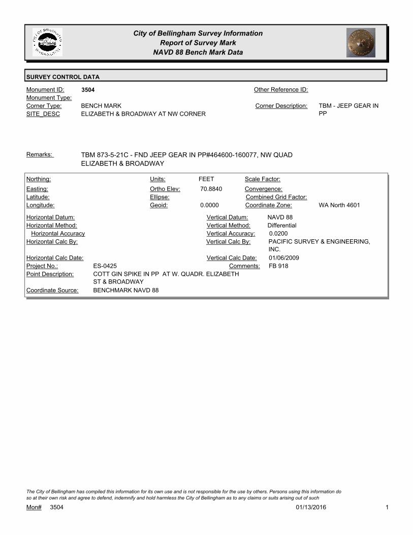
City of Bellingham Survey Information
Report of Survey Mark
NAVD 88 Bench Mark Data
SURVEY CONTROL DATA
3504Monument ID: Other Reference ID:
SITE_DESC ELIZABETH & BROADWAY AT NW CORNER
BENCH MARKCorner Type: TBM - JEEP GEAR IN
PP
Corner Description:
Monument Type:
TBM 873-5-21C - FND JEEP GEAR IN PP#464600-160077, NW QUAD
ELIZABETH & BROADWAY
Remarks:
70.8840
0.0000
FEETNorthing:
Easting:
Latitude:
Longitude:
Units:
Ortho Elev:
Ellipse:
Geoid:
Scale Factor:
Convergence:
Combined Grid Factor:
WA North 4601Coordinate Zone:
Horizontal Method:
Horizontal Datum: NAVD 88Vertical Datum:
DifferentialVertical Method:
Horizontal Accuracy 0.0200Vertical Accuracy:
PACIFIC SURVEY & ENGINEERING,
INC.
Vertical Calc By:Horizontal Calc By:
ES-0425Project No.:
COTT GIN SPIKE IN PP AT W. QUADR. ELIZABETH
ST & BROADWAY
Point Description:
BENCHMARK NAVD 88Coordinate Source:
FB 918Comments:
Horizontal Calc Date: 01/06/2009Vertical Calc Date:
101/13/2016Mon# 3504
The City of Bellingham has compiled this information for its own use and is not responsible for the use by others. Persons using this information do
so at their own risk and agree to defend, indemnify and hold harmless the City of Bellingham as to any claims or suits arising out of such

City of Bellingham Survey Information
Report of Survey Mark
NAVD 88 Bench Mark Data
SURVEY CONTROL DATA
3506Monument ID: Other Reference ID:
SITE_DESC WALNUT & JEFFERSON AT NE CORNER
BENCH MARKCorner Type: TBM - RR SPIKE IN
WOOD LIGHT POLE
Corner Description:
RAILROAD SPIKEMonument Type:
TBM 873-5-25A - SET RR SPIKE IN W FACE WOOD LIGHT POLE,
NE QUAD WALNUT & JEFFERSON
Remarks:
77.6850
0.0000
FEETNorthing:
Easting:
Latitude:
Longitude:
Units:
Ortho Elev:
Ellipse:
Geoid:
Scale Factor:
Convergence:
Combined Grid Factor:
WA North 4601Coordinate Zone:
Horizontal Method:
Horizontal Datum: NAVD 88Vertical Datum:
DifferentialVertical Method:
Horizontal Accuracy 0.0200Vertical Accuracy:
PACIFIC SURVEY & ENGINEERING,
INC.
Vertical Calc By:Horizontal Calc By:
ES-0425Project No.:
RR SPIKE IN PP AT NE QUADR. JEFFERSON ST &
WALNUT ST
Point Description:
BENCHMARK NAVD 88Coordinate Source:
FB 918Comments:
Horizontal Calc Date: 01/06/2009Vertical Calc Date:
101/13/2016Mon# 3506
The City of Bellingham has compiled this information for its own use and is not responsible for the use by others. Persons using this information do
so at their own risk and agree to defend, indemnify and hold harmless the City of Bellingham as to any claims or suits arising out of such

City of Bellingham Survey Information
Report of Survey Mark
NAVD 88 Bench Mark Data
SURVEY CONTROL DATA
3508Monument ID: Other Reference ID:
SITE_DESC WALNUT & W ILLINOIS AT NW CORNER
BENCH MARKCorner Type: TBM - SPIKE IN PPCorner Description:
NAILMonument Type:
TBM 873-5-25C - SET 60D SPIKE IN SE FACE PP#464937-160031,
NW QUAD WALNUT & ILLINOIS
Remarks:
81.8110
0.0000
FEETNorthing:
Easting:
Latitude:
Longitude:
Units:
Ortho Elev:
Ellipse:
Geoid:
Scale Factor:
Convergence:
Combined Grid Factor:
WA North 4601Coordinate Zone:
Horizontal Method:
Horizontal Datum: NAVD 88Vertical Datum:
DifferentialVertical Method:
Horizontal Accuracy 0.0200Vertical Accuracy:
PACIFIC SURVEY & ENGINEERING,
INC.
Vertical Calc By:Horizontal Calc By:
ES-0425Project No.:
60d SPIKE IN PP AT NW QUADR. W. ILLINOIS ST &
WALNUT ST
Point Description:
BENCHMARK NAVD 88Coordinate Source:
FB 918Comments:
Horizontal Calc Date: 12/11/2008Vertical Calc Date:
101/13/2016Mon# 3508
The City of Bellingham has compiled this information for its own use and is not responsible for the use by others. Persons using this information do
so at their own risk and agree to defend, indemnify and hold harmless the City of Bellingham as to any claims or suits arising out of such

City of Bellingham Survey Information
Report of Survey Mark
NAVD 88 Bench Mark Data
SURVEY CONTROL DATA
3510Monument ID: Other Reference ID:
SITE_DESC ELDRIDGE NEAR RES #2817
BENCH MARKCorner Type: TBM - GIN SPIKE SET
IN PP ON S SIDE
ELDRIDGE AVE
BETWEEN RES #
2817 & # 2813
Corner Description:
SPIKEMonument Type:
TBM - GIN SPIKE SET IN PP ON S SIDE ELDRIDGE BETWEEN RES
#2817 & #2813 (STA 15+50)
Remarks:
68.1750
0.0000
FEETNorthing:
Easting:
Latitude:
Longitude:
Units:
Ortho Elev:
Ellipse:
Geoid:
Scale Factor:
Convergence:
Combined Grid Factor:
WA North 4601Coordinate Zone:
Horizontal Method:
Horizontal Datum: NAVD 88Vertical Datum:
DifferentialVertical Method:
Horizontal Accuracy 0.0200Vertical Accuracy:
PACIFIC SURVEY & ENGINEERING,
INC.
Vertical Calc By:Horizontal Calc By:
ES-0425Project No.:
COTT GIN SPIKE IN PP ON SW SIDE ELDRIDGE
AVE
Point Description:
BENCHMARK NAVD 88Coordinate Source:
FB 918Comments:
Horizontal Calc Date: 12/11/2008Vertical Calc Date:
101/13/2016Mon# 3510
The City of Bellingham has compiled this information for its own use and is not responsible for the use by others. Persons using this information do
so at their own risk and agree to defend, indemnify and hold harmless the City of Bellingham as to any claims or suits arising out of such

City of Bellingham Survey Information
Report of Survey Mark
NAVD 88 Bench Mark Data
SURVEY CONTROL DATA
3511Monument ID: Other Reference ID:
SITE_DESC ELDRIDGE & WEST AT NW COR
BENCH MARKCorner Type: TBM - GIN SPIKE FND
IN PP
Corner Description:
SPIKEMonument Type:
TBM - GIN SPIKE FND IN PP AT NW CORNER INT ELDRIDGE &
WEST ST
Remarks:
69.5890
0.0000
FEETNorthing:
Easting:
Latitude:
Longitude:
Units:
Ortho Elev:
Ellipse:
Geoid:
Scale Factor:
Convergence:
Combined Grid Factor:
WA North 4601Coordinate Zone:
Horizontal Method:
Horizontal Datum: NAVD 88Vertical Datum:
DifferentialVertical Method:
Horizontal Accuracy 0.0200Vertical Accuracy:
PACIFIC SURVEY & ENGINEERING,
INC.
Vertical Calc By:Horizontal Calc By:
ES-0425Project No.:
COTT GIN SPIKE IN PP AT N. QUADR. WEST ST &
ELDRIDGE AVE
Point Description:
BENCHMARK NAVD 88Coordinate Source:
FB 918Comments:
Horizontal Calc Date: 12/11/2008Vertical Calc Date:
101/13/2016Mon# 3511
The City of Bellingham has compiled this information for its own use and is not responsible for the use by others. Persons using this information do
so at their own risk and agree to defend, indemnify and hold harmless the City of Bellingham as to any claims or suits arising out of such
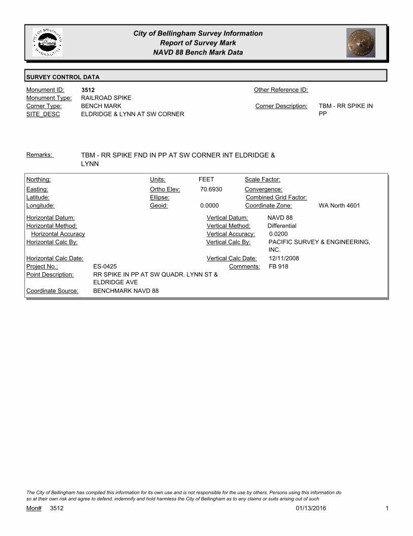
City of Bellingham Survey Information
Report of Survey Mark
NAVD 88 Bench Mark Data
SURVEY CONTROL DATA
3512Monument ID: Other Reference ID:
SITE_DESC ELDRIDGE & LYNN AT SW CORNER
BENCH MARKCorner Type: TBM - RR SPIKE IN
PP
Corner Description:
RAILROAD SPIKEMonument Type:
TBM - RR SPIKE FND IN PP AT SW CORNER INT ELDRIDGE &
LYNN
Remarks:
70.6930
0.0000
FEETNorthing:
Easting:
Latitude:
Longitude:
Units:
Ortho Elev:
Ellipse:
Geoid:
Scale Factor:
Convergence:
Combined Grid Factor:
WA North 4601Coordinate Zone:
Horizontal Method:
Horizontal Datum: NAVD 88Vertical Datum:
DifferentialVertical Method:
Horizontal Accuracy 0.0200Vertical Accuracy:
PACIFIC SURVEY & ENGINEERING,
INC.
Vertical Calc By:Horizontal Calc By:
ES-0425Project No.:
RR SPIKE IN PP AT SW QUADR. LYNN ST &
ELDRIDGE AVE
Point Description:
BENCHMARK NAVD 88Coordinate Source:
FB 918Comments:
Horizontal Calc Date: 12/11/2008Vertical Calc Date:
101/13/2016Mon# 3512
The City of Bellingham has compiled this information for its own use and is not responsible for the use by others. Persons using this information do
so at their own risk and agree to defend, indemnify and hold harmless the City of Bellingham as to any claims or suits arising out of such

City of Bellingham Survey Information
Report of Survey Mark
NAVD 88 Bench Mark Data
SURVEY CONTROL DATA
3513Monument ID: Other Reference ID:
SITE_DESC ELDRIDGE & VICTOR AT SW COR
BENCH MARKCorner Type: TBM - GIN SPIKE IN
PP
Corner Description:
SPIKEMonument Type:
TBM - SET GIN SPIKE IN PP AT SW CORNER INT ELDRIDGE &
VICTOR
Remarks:
68.7090
0.0000
FEETNorthing:
Easting:
Latitude:
Longitude:
Units:
Ortho Elev:
Ellipse:
Geoid:
Scale Factor:
Convergence:
Combined Grid Factor:
WA North 4601Coordinate Zone:
Horizontal Method:
Horizontal Datum: NAVD 88Vertical Datum:
DifferentialVertical Method:
Horizontal Accuracy 0.0200Vertical Accuracy:
PACIFIC SURVEY & ENGINEERING,
INC.
Vertical Calc By:Horizontal Calc By:
ES-0425Project No.:
COTT GIN SPIKE IN PP AT SW QUADR. VICTOR ST
& ELDRIDGE AVE
Point Description:
BENCHMARK NAVD 88Coordinate Source:
FB 918Comments:
Horizontal Calc Date: 12/11/2008Vertical Calc Date:
101/13/2016Mon# 3513
The City of Bellingham has compiled this information for its own use and is not responsible for the use by others. Persons using this information do
so at their own risk and agree to defend, indemnify and hold harmless the City of Bellingham as to any claims or suits arising out of such
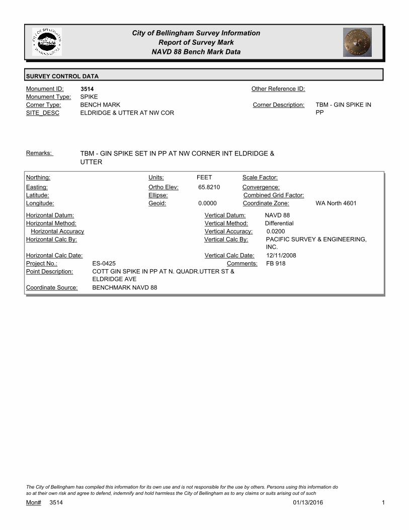
City of Bellingham Survey Information
Report of Survey Mark
NAVD 88 Bench Mark Data
SURVEY CONTROL DATA
3514Monument ID: Other Reference ID:
SITE_DESC ELDRIDGE & UTTER AT NW COR
BENCH MARKCorner Type: TBM - GIN SPIKE IN
PP
Corner Description:
SPIKEMonument Type:
TBM - GIN SPIKE SET IN PP AT NW CORNER INT ELDRIDGE &
UTTER
Remarks:
65.8210
0.0000
FEETNorthing:
Easting:
Latitude:
Longitude:
Units:
Ortho Elev:
Ellipse:
Geoid:
Scale Factor:
Convergence:
Combined Grid Factor:
WA North 4601Coordinate Zone:
Horizontal Method:
Horizontal Datum: NAVD 88Vertical Datum:
DifferentialVertical Method:
Horizontal Accuracy 0.0200Vertical Accuracy:
PACIFIC SURVEY & ENGINEERING,
INC.
Vertical Calc By:Horizontal Calc By:
ES-0425Project No.:
COTT GIN SPIKE IN PP AT N. QUADR.UTTER ST &
ELDRIDGE AVE
Point Description:
BENCHMARK NAVD 88Coordinate Source:
FB 918Comments:
Horizontal Calc Date: 12/11/2008Vertical Calc Date:
101/13/2016Mon# 3514
The City of Bellingham has compiled this information for its own use and is not responsible for the use by others. Persons using this information do
so at their own risk and agree to defend, indemnify and hold harmless the City of Bellingham as to any claims or suits arising out of such

City of Bellingham Survey Information
Report of Survey Mark
NAVD 88 Bench Mark Data
SURVEY CONTROL DATA
3520Monument ID: Other Reference ID:
SITE_DESC LINCOLN ST AT CARL COZIER SCHOOL
BENCH MARKCorner Type: TBM - TOP OF NW
CORNER BOTTOM
STAIR, LINCOLN ST
ENTRANCE TO CARL
COZIER ELEM.
SCHOOL
Corner Description:
STEPMonument Type:
TBM - TOP OF NW CORNER BOTTOM STAIR, LINCOLN ST
ENTRANCE TO CARL COZIER ELEM. SCHOOL
Remarks:
149.2010
0.0000
FEETNorthing:
Easting:
Latitude:
Longitude:
Units:
Ortho Elev:
Ellipse:
Geoid:
Scale Factor:
Convergence:
Combined Grid Factor:
WA North 4601Coordinate Zone:
Horizontal Method:
Horizontal Datum: NAVD 88Vertical Datum:
DifferentialVertical Method:
Horizontal Accuracy 0.0300Vertical Accuracy:
WILSON ENGINEERING LLC.Vertical Calc By:Horizontal Calc By:
ES-0425Project No.:
C-BM NW COR LOWEST CONC STEP CARL COZIER
SCHOOL
Point Description:
BENCHMARK NAVD 88Coordinate Source:
FB918-7 pg. 15Comments:
Horizontal Calc Date: 02/12/2009Vertical Calc Date:
101/13/2016Mon# 3520
The City of Bellingham has compiled this information for its own use and is not responsible for the use by others. Persons using this information do
so at their own risk and agree to defend, indemnify and hold harmless the City of Bellingham as to any claims or suits arising out of such
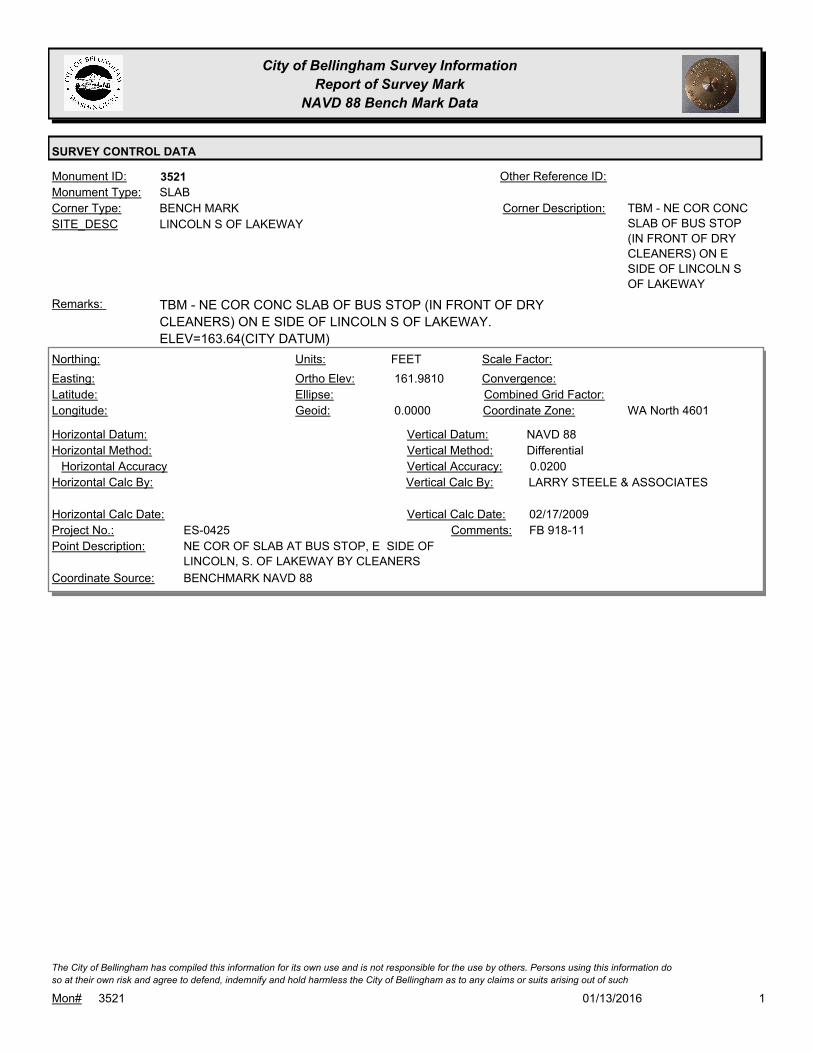
City of Bellingham Survey Information
Report of Survey Mark
NAVD 88 Bench Mark Data
SURVEY CONTROL DATA
3521Monument ID: Other Reference ID:
SITE_DESC LINCOLN S OF LAKEWAY
BENCH MARKCorner Type: TBM - NE COR CONC
SLAB OF BUS STOP
(IN FRONT OF DRY
CLEANERS) ON E
SIDE OF LINCOLN S
OF LAKEWAY
Corner Description:
SLABMonument Type:
TBM - NE COR CONC SLAB OF BUS STOP (IN FRONT OF DRY
CLEANERS) ON E SIDE OF LINCOLN S OF LAKEWAY.
ELEV=163.64(CITY DATUM)
Remarks:
161.9810
0.0000
FEETNorthing:
Easting:
Latitude:
Longitude:
Units:
Ortho Elev:
Ellipse:
Geoid:
Scale Factor:
Convergence:
Combined Grid Factor:
WA North 4601Coordinate Zone:
Horizontal Method:
Horizontal Datum: NAVD 88Vertical Datum:
DifferentialVertical Method:
Horizontal Accuracy 0.0200Vertical Accuracy:
LARRY STEELE & ASSOCIATESVertical Calc By:Horizontal Calc By:
ES-0425Project No.:
NE COR OF SLAB AT BUS STOP, E SIDE OF
LINCOLN, S. OF LAKEWAY BY CLEANERS
Point Description:
BENCHMARK NAVD 88Coordinate Source:
FB 918-11Comments:
Horizontal Calc Date: 02/17/2009Vertical Calc Date:
101/13/2016Mon# 3521
The City of Bellingham has compiled this information for its own use and is not responsible for the use by others. Persons using this information do
so at their own risk and agree to defend, indemnify and hold harmless the City of Bellingham as to any claims or suits arising out of such
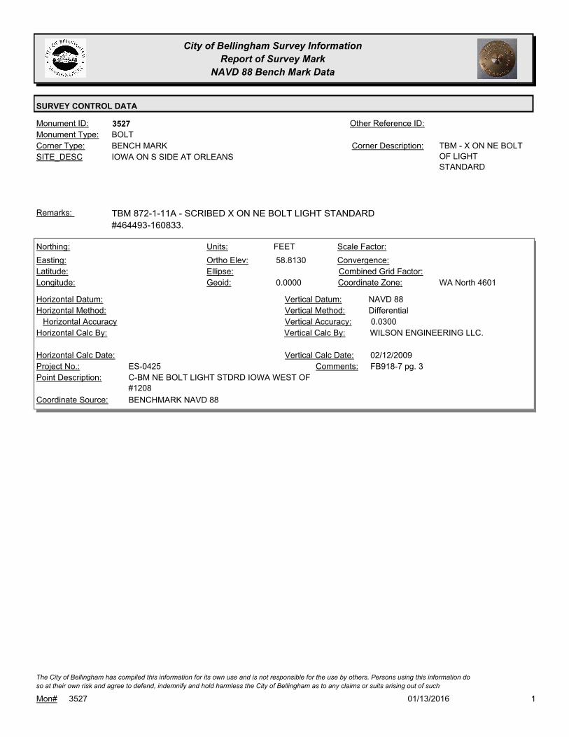
City of Bellingham Survey Information
Report of Survey Mark
NAVD 88 Bench Mark Data
SURVEY CONTROL DATA
3527Monument ID: Other Reference ID:
SITE_DESC IOWA ON S SIDE AT ORLEANS
BENCH MARKCorner Type: TBM - X ON NE BOLT
OF LIGHT
STANDARD
Corner Description:
BOLTMonument Type:
TBM 872-1-11A - SCRIBED X ON NE BOLT LIGHT STANDARD
#464493-160833.
Remarks:
58.8130
0.0000
FEETNorthing:
Easting:
Latitude:
Longitude:
Units:
Ortho Elev:
Ellipse:
Geoid:
Scale Factor:
Convergence:
Combined Grid Factor:
WA North 4601Coordinate Zone:
Horizontal Method:
Horizontal Datum: NAVD 88Vertical Datum:
DifferentialVertical Method:
Horizontal Accuracy 0.0300Vertical Accuracy:
WILSON ENGINEERING LLC.Vertical Calc By:Horizontal Calc By:
ES-0425Project No.:
C-BM NE BOLT LIGHT STDRD IOWA WEST OF
#1208
Point Description:
BENCHMARK NAVD 88Coordinate Source:
FB918-7 pg. 3Comments:
Horizontal Calc Date: 02/12/2009Vertical Calc Date:
101/13/2016Mon# 3527
The City of Bellingham has compiled this information for its own use and is not responsible for the use by others. Persons using this information do
so at their own risk and agree to defend, indemnify and hold harmless the City of Bellingham as to any claims or suits arising out of such
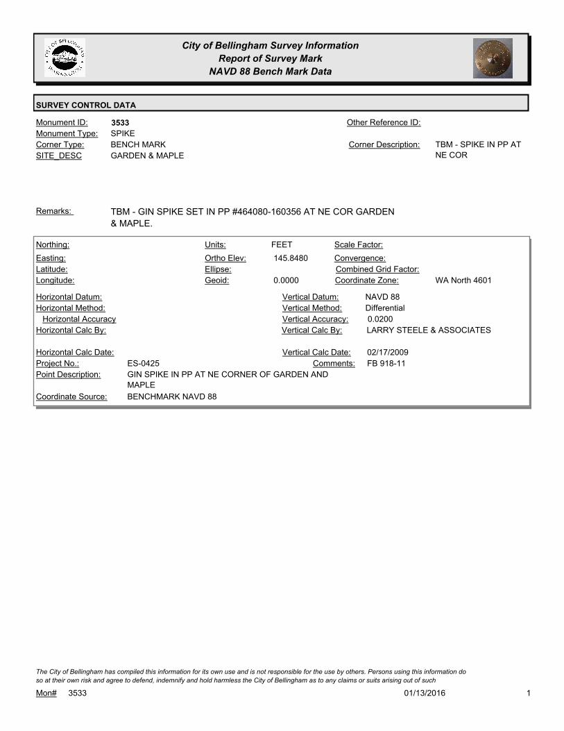
City of Bellingham Survey Information
Report of Survey Mark
NAVD 88 Bench Mark Data
SURVEY CONTROL DATA
3533Monument ID: Other Reference ID:
SITE_DESC GARDEN & MAPLE
BENCH MARKCorner Type: TBM - SPIKE IN PP AT
NE COR
Corner Description:
SPIKEMonument Type:
TBM - GIN SPIKE SET IN PP #464080-160356 AT NE COR GARDEN
& MAPLE.
Remarks:
145.8480
0.0000
FEETNorthing:
Easting:
Latitude:
Longitude:
Units:
Ortho Elev:
Ellipse:
Geoid:
Scale Factor:
Convergence:
Combined Grid Factor:
WA North 4601Coordinate Zone:
Horizontal Method:
Horizontal Datum: NAVD 88Vertical Datum:
DifferentialVertical Method:
Horizontal Accuracy 0.0200Vertical Accuracy:
LARRY STEELE & ASSOCIATESVertical Calc By:Horizontal Calc By:
ES-0425Project No.:
GIN SPIKE IN PP AT NE CORNER OF GARDEN AND
MAPLE
Point Description:
BENCHMARK NAVD 88Coordinate Source:
FB 918-11Comments:
Horizontal Calc Date: 02/17/2009Vertical Calc Date:
101/13/2016Mon# 3533
The City of Bellingham has compiled this information for its own use and is not responsible for the use by others. Persons using this information do
so at their own risk and agree to defend, indemnify and hold harmless the City of Bellingham as to any claims or suits arising out of such
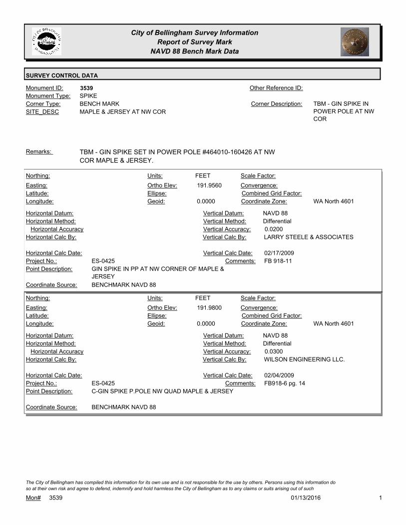
City of Bellingham Survey Information
Report of Survey Mark
NAVD 88 Bench Mark Data
SURVEY CONTROL DATA
3539Monument ID: Other Reference ID:
SITE_DESC MAPLE & JERSEY AT NW COR
BENCH MARKCorner Type: TBM - GIN SPIKE IN
POWER POLE AT NW
COR
Corner Description:
SPIKEMonument Type:
TBM - GIN SPIKE SET IN POWER POLE #464010-160426 AT NW
COR MAPLE & JERSEY.
Remarks:
191.9560
0.0000
FEETNorthing:
Easting:
Latitude:
Longitude:
Units:
Ortho Elev:
Ellipse:
Geoid:
Scale Factor:
Convergence:
Combined Grid Factor:
WA North 4601Coordinate Zone:
Horizontal Method:
Horizontal Datum: NAVD 88Vertical Datum:
DifferentialVertical Method:
Horizontal Accuracy 0.0200Vertical Accuracy:
LARRY STEELE & ASSOCIATESVertical Calc By:Horizontal Calc By:
ES-0425Project No.:
GIN SPIKE IN PP AT NW CORNER OF MAPLE &
JERSEY
Point Description:
BENCHMARK NAVD 88Coordinate Source:
FB 918-11Comments:
Horizontal Calc Date: 02/17/2009Vertical Calc Date:
191.9800
0.0000
FEETNorthing:
Easting:
Latitude:
Longitude:
Units:
Ortho Elev:
Ellipse:
Geoid:
Scale Factor:
Convergence:
Combined Grid Factor:
WA North 4601Coordinate Zone:
Horizontal Method:
Horizontal Datum: NAVD 88Vertical Datum:
DifferentialVertical Method:
Horizontal Accuracy 0.0300Vertical Accuracy:
WILSON ENGINEERING LLC.Vertical Calc By:Horizontal Calc By:
ES-0425Project No.:
C-GIN SPIKE P.POLE NW QUAD MAPLE & JERSEYPoint Description:
BENCHMARK NAVD 88Coordinate Source:
FB918-6 pg. 14Comments:
Horizontal Calc Date: 02/04/2009Vertical Calc Date:
101/13/2016Mon# 3539
The City of Bellingham has compiled this information for its own use and is not responsible for the use by others. Persons using this information do
so at their own risk and agree to defend, indemnify and hold harmless the City of Bellingham as to any claims or suits arising out of such

City of Bellingham Survey Information
Report of Survey Mark
NAVD 88 Bench Mark Data
SURVEY CONTROL DATA
3546Monument ID: Other Reference ID:
SITE_DESC BROADWAY & FARRAGUT AT NE CORNER
BENCH MARKCorner Type: TBM - GIN SPIKE IN
PP AT NE COR
BROADWAY &
FARRAGUT
Corner Description:
SPIKEMonument Type:
TBM- GIN SPIKE SET IN PP# 35292 AT NE COR BROADWAY &
FARRAGUT.
Remarks:
75.6990
0.0000
FEETNorthing:
Easting:
Latitude:
Longitude:
Units:
Ortho Elev:
Ellipse:
Geoid:
Scale Factor:
Convergence:
Combined Grid Factor:
WA North 4601Coordinate Zone:
Horizontal Method:
Horizontal Datum: NAVD 88Vertical Datum:
DifferentialVertical Method:
Horizontal Accuracy 0.0200Vertical Accuracy:
PACIFIC SURVEY & ENGINEERING,
INC.
Vertical Calc By:Horizontal Calc By:
ES-0425Project No.:
COTT GIN SPIKE IN UTIL POLE AT E. QUADR.
FARRAGUT ST & BROADWAY
Point Description:
BENCHMARK NAVD 88Coordinate Source:
FB 918Comments:
Horizontal Calc Date: 12/09/2008Vertical Calc Date:
101/13/2016Mon# 3546
The City of Bellingham has compiled this information for its own use and is not responsible for the use by others. Persons using this information do
so at their own risk and agree to defend, indemnify and hold harmless the City of Bellingham as to any claims or suits arising out of such
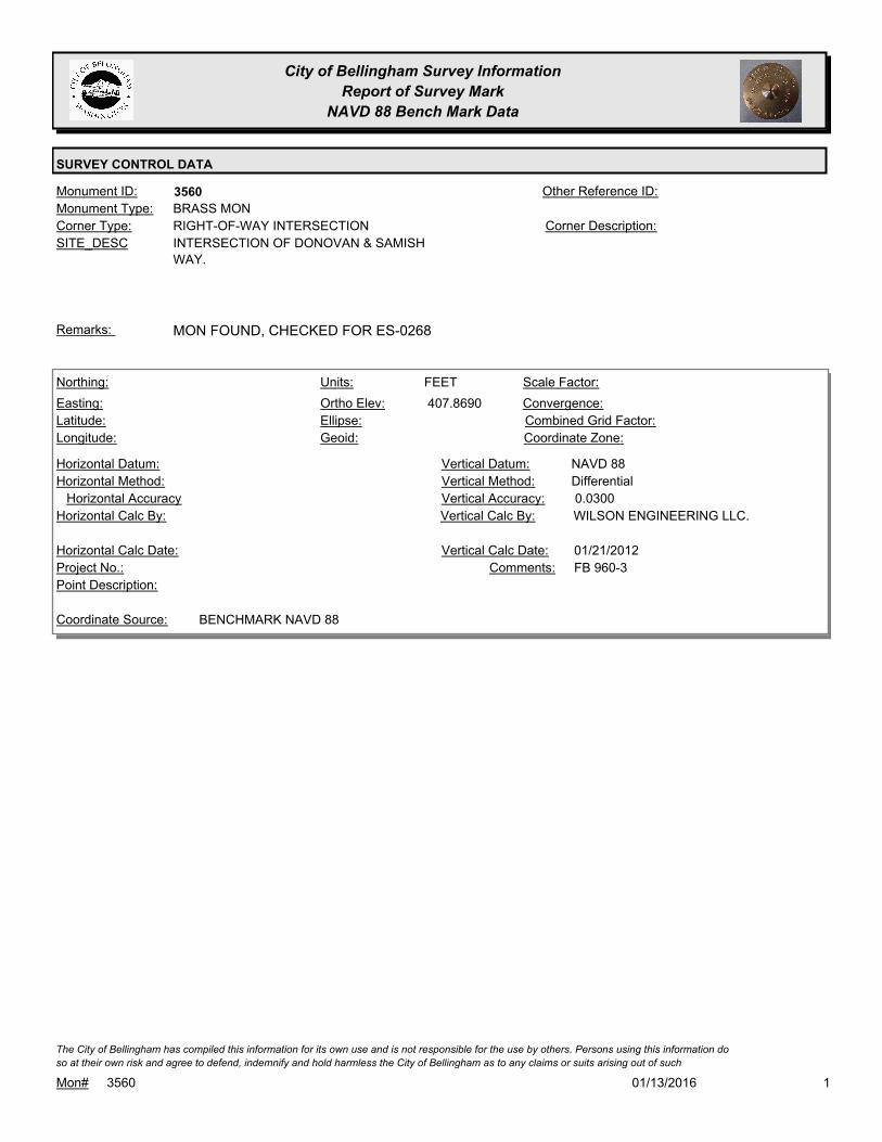
City of Bellingham Survey Information
Report of Survey Mark
NAVD 88 Bench Mark Data
SURVEY CONTROL DATA
3560Monument ID: Other Reference ID:
SITE_DESC INTERSECTION OF DONOVAN & SAMISH
WAY.
RIGHT-OF-WAY INTERSECTIONCorner Type: Corner Description:
BRASS MONMonument Type:
MON FOUND, CHECKED FOR ES-0268Remarks:
407.8690
FEETNorthing:
Easting:
Latitude:
Longitude:
Units:
Ortho Elev:
Ellipse:
Geoid:
Scale Factor:
Convergence:
Combined Grid Factor:
Coordinate Zone:
Horizontal Method:
Horizontal Datum: NAVD 88Vertical Datum:
DifferentialVertical Method:
Horizontal Accuracy 0.0300Vertical Accuracy:
WILSON ENGINEERING LLC.Vertical Calc By:Horizontal Calc By:
Project No.:
Point Description:
BENCHMARK NAVD 88Coordinate Source:
FB 960-3Comments:
Horizontal Calc Date: 01/21/2012Vertical Calc Date:
101/13/2016Mon# 3560
The City of Bellingham has compiled this information for its own use and is not responsible for the use by others. Persons using this information do
so at their own risk and agree to defend, indemnify and hold harmless the City of Bellingham as to any claims or suits arising out of such

City of Bellingham Survey Information
Report of Survey Mark
NAVD 88 Bench Mark Data
SURVEY CONTROL DATA
3562Monument ID: Other Reference ID:
SITE_DESC CORNWALL & FLORA & YORK AT NE
CORNER
BENCH MARKCorner Type: TBM - X ON SW
MOUNTING BOLT OF
SIGNAL STANDARD
AT NE QUAD
CORNWALL & FLORA
& YORK
Corner Description:
BOLTMonument Type:
TBM 870-01-13 - X ON SW MOUNTING BOLT OF SIGNAL
STANDARD AT NE QUAD CORNWALL & FLORA & YORK.
Remarks:
62.1600
FEETNorthing:
Easting:
Latitude:
Longitude:
Units:
Ortho Elev:
Ellipse:
Geoid:
Scale Factor:
Convergence:
Combined Grid Factor:
Coordinate Zone:
Horizontal Method:
Horizontal Datum: NAVD 88Vertical Datum:
DifferentialVertical Method:
Horizontal Accuracy 0.0100Vertical Accuracy:
PACIFIC SURVEY & ENGINEERING,
INC.
Vertical Calc By:Horizontal Calc By:
EW-0142Project No.:
Point Description:
BENCHMARK NAVD 88Coordinate Source:
FB 893-2Comments:
Horizontal Calc Date: 09/05/2006Vertical Calc Date:
101/13/2016Mon# 3562
The City of Bellingham has compiled this information for its own use and is not responsible for the use by others. Persons using this information do
so at their own risk and agree to defend, indemnify and hold harmless the City of Bellingham as to any claims or suits arising out of such

City of Bellingham Survey Information
Report of Survey Mark
NAVD 88 Bench Mark Data
SURVEY CONTROL DATA
3566Monument ID: Other Reference ID:
SITE_DESC KEY & MYRTLE
BENCH MARKCorner Type: TBM - RR SPIKE IN N
FACE OF PP
Corner Description:
POLEMonument Type:
Remarks:
320.7200
FEETNorthing:
Easting:
Latitude:
Longitude:
Units:
Ortho Elev:
Ellipse:
Geoid:
Scale Factor:
Convergence:
Combined Grid Factor:
Coordinate Zone:
Horizontal Method:
Horizontal Datum: NAVD 88Vertical Datum:
DifferentialVertical Method:
Horizontal Accuracy 0.0800Vertical Accuracy:
CONSTRUCTION SURVEYORS N W
INC.
Vertical Calc By:Horizontal Calc By:
EW-0186Project No.:
Point Description:
BENCHMARK NAVD 88Coordinate Source:
FB 937Comments:
Horizontal Calc Date: 03/15/2011Vertical Calc Date:
101/13/2016Mon# 3566
The City of Bellingham has compiled this information for its own use and is not responsible for the use by others. Persons using this information do
so at their own risk and agree to defend, indemnify and hold harmless the City of Bellingham as to any claims or suits arising out of such
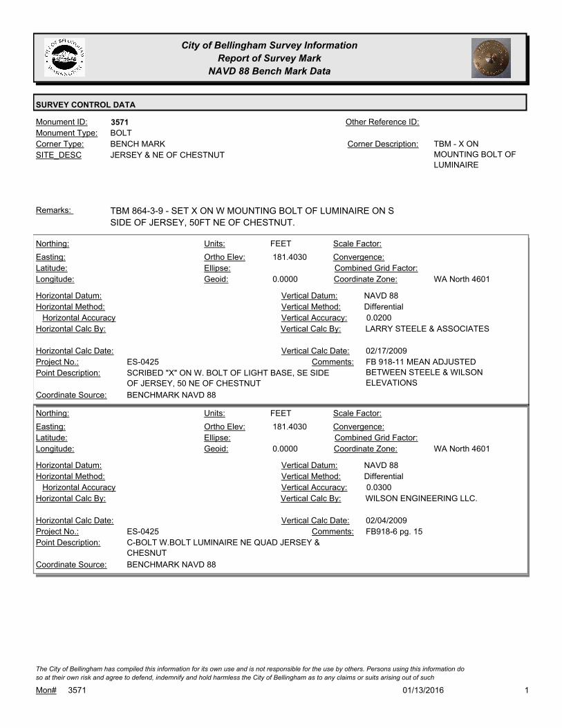
City of Bellingham Survey Information
Report of Survey Mark
NAVD 88 Bench Mark Data
SURVEY CONTROL DATA
3571Monument ID: Other Reference ID:
SITE_DESC JERSEY & NE OF CHESTNUT
BENCH MARKCorner Type: TBM - X ON
MOUNTING BOLT OF
LUMINAIRE
Corner Description:
BOLTMonument Type:
TBM 864-3-9 - SET X ON W MOUNTING BOLT OF LUMINAIRE ON S
SIDE OF JERSEY, 50FT NE OF CHESTNUT.
Remarks:
181.4030
0.0000
FEETNorthing:
Easting:
Latitude:
Longitude:
Units:
Ortho Elev:
Ellipse:
Geoid:
Scale Factor:
Convergence:
Combined Grid Factor:
WA North 4601Coordinate Zone:
Horizontal Method:
Horizontal Datum: NAVD 88Vertical Datum:
DifferentialVertical Method:
Horizontal Accuracy 0.0200Vertical Accuracy:
LARRY STEELE & ASSOCIATESVertical Calc By:Horizontal Calc By:
ES-0425Project No.:
SCRIBED "X" ON W. BOLT OF LIGHT BASE, SE SIDE
OF JERSEY, 50 NE OF CHESTNUT
Point Description:
BENCHMARK NAVD 88Coordinate Source:
FB 918-11 MEAN ADJUSTED
BETWEEN STEELE & WILSON
ELEVATIONS
Comments:
Horizontal Calc Date: 02/17/2009Vertical Calc Date:
181.4030
0.0000
FEETNorthing:
Easting:
Latitude:
Longitude:
Units:
Ortho Elev:
Ellipse:
Geoid:
Scale Factor:
Convergence:
Combined Grid Factor:
WA North 4601Coordinate Zone:
Horizontal Method:
Horizontal Datum: NAVD 88Vertical Datum:
DifferentialVertical Method:
Horizontal Accuracy 0.0300Vertical Accuracy:
WILSON ENGINEERING LLC.Vertical Calc By:Horizontal Calc By:
ES-0425Project No.:
C-BOLT W.BOLT LUMINAIRE NE QUAD JERSEY &
CHESNUT
Point Description:
BENCHMARK NAVD 88Coordinate Source:
FB918-6 pg. 15Comments:
Horizontal Calc Date: 02/04/2009Vertical Calc Date:
101/13/2016Mon# 3571
The City of Bellingham has compiled this information for its own use and is not responsible for the use by others. Persons using this information do
so at their own risk and agree to defend, indemnify and hold harmless the City of Bellingham as to any claims or suits arising out of such

City of Bellingham Survey Information
Report of Survey Mark
NAVD 88 Bench Mark Data
SURVEY CONTROL DATA
3572Monument ID: Other Reference ID:
SITE_DESC OHIO & ELLIS AT NE CORNER
BENCH MARKCorner Type: TBM - RR SPIKE ON S
SIDE OF PP
Corner Description:
RAILROAD SPIKEMonument Type:
TBM 863-2-5 - SET RR SPIKE ON S SIDE OF PP #464452-160492 AT
NE QUAD OHIO & ELLIS.
Remarks:
66.2440
0.0000
FEETNorthing:
Easting:
Latitude:
Longitude:
Units:
Ortho Elev:
Ellipse:
Geoid:
Scale Factor:
Convergence:
Combined Grid Factor:
WA North 4601Coordinate Zone:
Horizontal Method:
Horizontal Datum: NAVD 88Vertical Datum:
DifferentialVertical Method:
Horizontal Accuracy 0.0300Vertical Accuracy:
WILSON ENGINEERING LLC.Vertical Calc By:Horizontal Calc By:
ES-0425Project No.:
C-RRS P.POLE NE.QUAD OHIO & ELLISPoint Description:
BENCHMARK NAVD 88Coordinate Source:
FB918-6 pg. 32Comments:
Horizontal Calc Date: 02/04/2009Vertical Calc Date:
101/13/2016Mon# 3572
The City of Bellingham has compiled this information for its own use and is not responsible for the use by others. Persons using this information do
so at their own risk and agree to defend, indemnify and hold harmless the City of Bellingham as to any claims or suits arising out of such

City of Bellingham Survey Information
Report of Survey Mark
NAVD 88 Bench Mark Data
SURVEY CONTROL DATA
3573Monument ID: Other Reference ID:
SITE_DESC OHIO & HUMBOLDT AT NW CORNER
BENCH MARKCorner Type: TBM - BOX CUT ON
SE CORNER CONC
ELEC PAD
Corner Description:
BOX CUTMonument Type:
TBM 863-2-1 - SET BOX CUT ON SE CORNER OF CONC ELEC PAD
AT NW QUAD OHIO & HUMBOLDT.
Remarks:
68.1960
0.0000
FEETNorthing:
Easting:
Latitude:
Longitude:
Units:
Ortho Elev:
Ellipse:
Geoid:
Scale Factor:
Convergence:
Combined Grid Factor:
WA North 4601Coordinate Zone:
Horizontal Method:
Horizontal Datum: NAVD 88Vertical Datum:
DifferentialVertical Method:
Horizontal Accuracy 0.0300Vertical Accuracy:
WILSON ENGINEERING LLC.Vertical Calc By:Horizontal Calc By:
ES-0425Project No.:
C-SCRX SE COR CONC VLT. NW OHIO & HUMBOLTPoint Description:
BENCHMARK NAVD 88Coordinate Source:
FB918-6 pg. 33Comments:
Horizontal Calc Date: 02/04/2009Vertical Calc Date:
101/13/2016Mon# 3573
The City of Bellingham has compiled this information for its own use and is not responsible for the use by others. Persons using this information do
so at their own risk and agree to defend, indemnify and hold harmless the City of Bellingham as to any claims or suits arising out of such

City of Bellingham Survey Information
Report of Survey Mark
NAVD 88 Bench Mark Data
SURVEY CONTROL DATA
3574Monument ID: Other Reference ID:
SITE_DESC IOWA & JAMES AT NW CORNER
BENCH MARKCorner Type: TBM - X ON NW
MOUNTING BOLT OF
SIGNAL LIGHT
Corner Description:
BPLTMonument Type:
TBM 863-2-7 - SET X ON NW BOLT OF SIGNAL LIGHT AT NW QUAD
OF IOWA & JAMES. ALSO SEE #5889
Remarks:
64.5570
0.0000
FEETNorthing:
Easting:
Latitude:
Longitude:
Units:
Ortho Elev:
Ellipse:
Geoid:
Scale Factor:
Convergence:
Combined Grid Factor:
WA North 4601Coordinate Zone:
Horizontal Method:
Horizontal Datum: NAVD 88Vertical Datum:
DifferentialVertical Method:
Horizontal Accuracy 0.0300Vertical Accuracy:
WILSON ENGINEERING LLC.Vertical Calc By:Horizontal Calc By:
ES-0425Project No.:
C-BOLT LUM NW.QUAD JAMES & IOWAPoint Description:
BENCHMARK NAVD 88Coordinate Source:
FB918-6 pg. 39Comments:
Horizontal Calc Date: 02/04/2009Vertical Calc Date:
101/13/2016Mon# 3574
The City of Bellingham has compiled this information for its own use and is not responsible for the use by others. Persons using this information do
so at their own risk and agree to defend, indemnify and hold harmless the City of Bellingham as to any claims or suits arising out of such

City of Bellingham Survey Information
Report of Survey Mark
NAVD 88 Bench Mark Data
SURVEY CONTROL DATA
3575Monument ID: Other Reference ID:
SITE_DESC IOWA, W OF MOORE
BENCH MARKCorner Type: TBM - X ON NE BOLT
OF LIGHT POLE
Corner Description:
BOLTMonument Type:
TBM 847-6-35 - FND X ON NE BOLT OF LIGHT POLE #41 ON S SIDE
IOWA, 150FT W OF MOORE.
Remarks:
58.5450
0.0000
FEETNorthing:
Easting:
Latitude:
Longitude:
Units:
Ortho Elev:
Ellipse:
Geoid:
Scale Factor:
Convergence:
Combined Grid Factor:
WA North 4601Coordinate Zone:
Horizontal Method:
Horizontal Datum: NAVD 88Vertical Datum:
DifferentialVertical Method:
Horizontal Accuracy 0.0300Vertical Accuracy:
WILSON ENGINEERING LLC.Vertical Calc By:Horizontal Calc By:
ES-0425Project No.:
C-BM NE BOLT LIGHT POLE IOWA WEST OF
MOORE
Point Description:
BENCHMARK NAVD 88Coordinate Source:
FB918-7 pg. 2Comments:
Horizontal Calc Date: 02/12/2009Vertical Calc Date:
101/13/2016Mon# 3575
The City of Bellingham has compiled this information for its own use and is not responsible for the use by others. Persons using this information do
so at their own risk and agree to defend, indemnify and hold harmless the City of Bellingham as to any claims or suits arising out of such

City of Bellingham Survey Information
Report of Survey Mark
NAVD 88 Bench Mark Data
SURVEY CONTROL DATA
3576Monument ID: Other Reference ID:
SITE_DESC MEADOR & I-5
BENCH MARKCorner Type: TBM - X ON SW BOLT
OF LIGHT
STANDARD
Corner Description:
BOLTMonument Type:
TBM 860-2-9 - X ON SW BOLT OF LIGHT STANDARD ON N SIDE
MEADOR, 50FT W OF I-5 SOUTH.
Remarks:
64.8220
0.0000
FEETNorthing:
Easting:
Latitude:
Longitude:
Units:
Ortho Elev:
Ellipse:
Geoid:
Scale Factor:
Convergence:
Combined Grid Factor:
WA North 4601Coordinate Zone:
Horizontal Method:
Horizontal Datum: NAVD 88Vertical Datum:
DifferentialVertical Method:
Horizontal Accuracy 0.0300Vertical Accuracy:
WILSON ENGINEERING LLC.Vertical Calc By:Horizontal Calc By:
ES-0425Project No.:
C-BM SW BOLT LIGHT STDRD MEADOR 50' N. OF
I-5
Point Description:
BENCHMARK NAVD 88Coordinate Source:
FB918-7 pg. 11Comments:
Horizontal Calc Date: 02/12/2009Vertical Calc Date:
101/13/2016Mon# 3576
The City of Bellingham has compiled this information for its own use and is not responsible for the use by others. Persons using this information do
so at their own risk and agree to defend, indemnify and hold harmless the City of Bellingham as to any claims or suits arising out of such

City of Bellingham Survey Information
Report of Survey Mark
NAVD 88 Bench Mark Data
SURVEY CONTROL DATA
3579Monument ID: Other Reference ID:
SITE_DESC ALABAMA & XENIA AT NE CORNER
BENCH MARKCorner Type: TBM - TOP OF BOLT,
S FACE PP
Corner Description:
BOLTMonument Type:
TBM 860-1-9A - TOP OF BOLT, S FACE PP #464727161184 AT NE
QUAD ALABAMA& XENIA.
Remarks:
120.3160
0.0000
FEETNorthing:
Easting:
Latitude:
Longitude:
Units:
Ortho Elev:
Ellipse:
Geoid:
Scale Factor:
Convergence:
Combined Grid Factor:
WA North 4601Coordinate Zone:
Horizontal Method:
Horizontal Datum: NAVD 88Vertical Datum:
DifferentialVertical Method:
Horizontal Accuracy 0.0300Vertical Accuracy:
WILSON ENGINEERING LLC.Vertical Calc By:Horizontal Calc By:
ES-0425Project No.:
C-BM BOLT S.FACE PWR.POLE NE QUAD ALABAMA
& XENIA
Point Description:
BENCHMARK NAVD 88Coordinate Source:
FB918-8 pg. 14Comments:
Horizontal Calc Date: 02/12/2009Vertical Calc Date:
101/13/2016Mon# 3579
The City of Bellingham has compiled this information for its own use and is not responsible for the use by others. Persons using this information do
so at their own risk and agree to defend, indemnify and hold harmless the City of Bellingham as to any claims or suits arising out of such
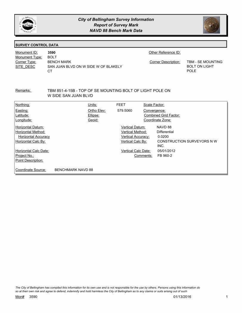
City of Bellingham Survey Information
Report of Survey Mark
NAVD 88 Bench Mark Data
SURVEY CONTROL DATA
3590Monument ID: Other Reference ID:
SITE_DESC SAN JUAN BLVD ON W SIDE W OF BLAKELY
CT
BENCH MARKCorner Type: TBM - SE MOUNTING
BOLT ON LIGHT
POLE
Corner Description:
BOLTMonument Type:
TBM 851-4-15B - TOP OF SE MOUNTING BOLT OF LIGHT POLE ON
W SIDE SAN JUAN BLVD
Remarks:
579.5060
FEETNorthing:
Easting:
Latitude:
Longitude:
Units:
Ortho Elev:
Ellipse:
Geoid:
Scale Factor:
Convergence:
Combined Grid Factor:
Coordinate Zone:
Horizontal Method:
Horizontal Datum: NAVD 88Vertical Datum:
DifferentialVertical Method:
Horizontal Accuracy 0.0200Vertical Accuracy:
CONSTRUCTION SURVEYORS N W
INC.
Vertical Calc By:Horizontal Calc By:
Project No.:
Point Description:
BENCHMARK NAVD 88Coordinate Source:
FB 960-2Comments:
Horizontal Calc Date: 05/01/2012Vertical Calc Date:
101/13/2016Mon# 3590
The City of Bellingham has compiled this information for its own use and is not responsible for the use by others. Persons using this information do
so at their own risk and agree to defend, indemnify and hold harmless the City of Bellingham as to any claims or suits arising out of such

City of Bellingham Survey Information
Report of Survey Mark
NAVD 88 Bench Mark Data
SURVEY CONTROL DATA
3600Monument ID: Other Reference ID:
SITE_DESC ALABAMA & WOBURN AT SW CORNER
BENCH MARKCorner Type: TBM - TOP OF NE
BOLT OF TRAFFIC
SIGNAL POLE AT SW
CORNER ALABAMA &
WOBURN
Corner Description:
BOLTMonument Type:
TBM - TOP OF NE BOLT OF TRAFFIC SIGNAL POLE AT SW
CORNER ALABAMA & WOBURN.
Remarks:
117.7630
0.0000
FEETNorthing:
Easting:
Latitude:
Longitude:
Units:
Ortho Elev:
Ellipse:
Geoid:
Scale Factor:
Convergence:
Combined Grid Factor:
WA North 4601Coordinate Zone:
Horizontal Method:
Horizontal Datum: NAVD 88Vertical Datum:
DifferentialVertical Method:
Horizontal Accuracy 0.0300Vertical Accuracy:
WILSON ENGINEERING LLC.Vertical Calc By:Horizontal Calc By:
ES-0425Project No.:
C-BM NE BOLT SIGNAL STDRD SW QUAD
ALABAMA& WOBURN
Point Description:
BENCHMARK NAVD 88Coordinate Source:
FB918-8 pg. 14Comments:
Horizontal Calc Date: 02/12/2009Vertical Calc Date:
101/13/2016Mon# 3600
The City of Bellingham has compiled this information for its own use and is not responsible for the use by others. Persons using this information do
so at their own risk and agree to defend, indemnify and hold harmless the City of Bellingham as to any claims or suits arising out of such
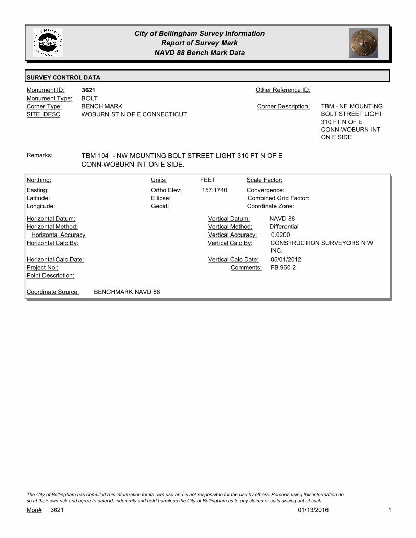
City of Bellingham Survey Information
Report of Survey Mark
NAVD 88 Bench Mark Data
SURVEY CONTROL DATA
3621Monument ID: Other Reference ID:
SITE_DESC WOBURN ST N OF E CONNECTICUT
BENCH MARKCorner Type: TBM - NE MOUNTING
BOLT STREET LIGHT
310 FT N OF E
CONN-WOBURN INT
ON E SIDE
Corner Description:
BOLTMonument Type:
TBM 104 - NW MOUNTING BOLT STREET LIGHT 310 FT N OF E
CONN-WOBURN INT ON E SIDE.
Remarks:
157.1740
FEETNorthing:
Easting:
Latitude:
Longitude:
Units:
Ortho Elev:
Ellipse:
Geoid:
Scale Factor:
Convergence:
Combined Grid Factor:
Coordinate Zone:
Horizontal Method:
Horizontal Datum: NAVD 88Vertical Datum:
DifferentialVertical Method:
Horizontal Accuracy 0.0200Vertical Accuracy:
CONSTRUCTION SURVEYORS N W
INC.
Vertical Calc By:Horizontal Calc By:
Project No.:
Point Description:
BENCHMARK NAVD 88Coordinate Source:
FB 960-2Comments:
Horizontal Calc Date: 05/01/2012Vertical Calc Date:
101/13/2016Mon# 3621
The City of Bellingham has compiled this information for its own use and is not responsible for the use by others. Persons using this information do
so at their own risk and agree to defend, indemnify and hold harmless the City of Bellingham as to any claims or suits arising out of such

City of Bellingham Survey Information
Report of Survey Mark
NAVD 88 Bench Mark Data
SURVEY CONTROL DATA
3622Monument ID: Other Reference ID:
SITE_DESC WOBURN NEAR E ILLINOIS
BENCH MARKCorner Type: TBM - SW CORNER
POWER VAULT E OF
WOBURN AT
WOBURN PUMP
STATION
Corner Description:
VAULTMonument Type:
TBM 105 - SW CORNER POWER VAULT E OF WOBURN AT
WOBURN PUMP STATION.
Remarks:
172.5490
FEETNorthing:
Easting:
Latitude:
Longitude:
Units:
Ortho Elev:
Ellipse:
Geoid:
Scale Factor:
Convergence:
Combined Grid Factor:
Coordinate Zone:
Horizontal Method:
Horizontal Datum: NAVD 88Vertical Datum:
DifferentialVertical Method:
Horizontal Accuracy 0.0200Vertical Accuracy:
CONSTRUCTION SURVEYORS N W
INC.
Vertical Calc By:Horizontal Calc By:
Project No.:
Point Description:
BENCHMARK NAVD 88Coordinate Source:
FB 960-2Comments:
Horizontal Calc Date: 05/01/2012Vertical Calc Date:
101/13/2016Mon# 3622
The City of Bellingham has compiled this information for its own use and is not responsible for the use by others. Persons using this information do
so at their own risk and agree to defend, indemnify and hold harmless the City of Bellingham as to any claims or suits arising out of such

City of Bellingham Survey Information
Report of Survey Mark
NAVD 88 Bench Mark Data
SURVEY CONTROL DATA
3634Monument ID: Other Reference ID:
SITE_DESC BENNETT AVE W/O 21ST ST
RIGHT-OF-WAY PICorner Type: Corner Description:
BRASS MONMonument Type:
REPLACED BY LSA FOR 2005 OVERLAY PROJECT. VISITED FOR
NAD 83/98 CONTROL NETWORK SURVEY 2006.
Remarks:
262.6160
0.0000
FEETNorthing:
Easting:
Latitude:
Longitude:
Units:
Ortho Elev:
Ellipse:
Geoid:
Scale Factor:
Convergence:
Combined Grid Factor:
WA North 4601Coordinate Zone:
Horizontal Method:
Horizontal Datum: NAVD 88Vertical Datum:
DifferentialVertical Method:
Horizontal Accuracy 0.0200Vertical Accuracy:
LARRY STEELE & ASSOCIATESVertical Calc By:Horizontal Calc By:
ES-0425Project No.:
BRASS MON AT BENNETT, WEST OF 21STPoint Description:
BENCHMARK NAVD 88Coordinate Source:
FB 918-11Comments:
Horizontal Calc Date: 02/17/2009Vertical Calc Date:
101/13/2016Mon# 3634
The City of Bellingham has compiled this information for its own use and is not responsible for the use by others. Persons using this information do
so at their own risk and agree to defend, indemnify and hold harmless the City of Bellingham as to any claims or suits arising out of such

City of Bellingham Survey Information
Report of Survey Mark
NAVD 88 Bench Mark Data
SURVEY CONTROL DATA
3668Monument ID: Other Reference ID:
SITE_DESC 4TH & LARRABEE
RIGHT-OF-WAY INTERSECTIONCorner Type: Corner Description:
CONCRETE MONMonument Type:
Remarks:
631,302.4200
1,235,307.3200 35.6400
FEETNorthing:
Easting:
Latitude:
Longitude:
Units:
Ortho Elev:
Ellipse:
Geoid:
Scale Factor:
Convergence:
Combined Grid Factor:
WA North 4601Coordinate Zone:
Conventional SurveyHorizontal Method:
NAD 83/98Horizontal Datum: NAVD 88Vertical Datum:
DifferentialVertical Method:
Horizontal Accuracy Vertical Accuracy:
WILSON ENGINEERING LLC.Vertical Calc By:WILSON ENGINEERING LLC.Horizontal Calc By:
Project No.:
MONPoint Description:
NAD 83/98 PROJECT POINTSCoordinate Source:
RS-4712Comments:
08/10/2009Horizontal Calc Date: 08/10/2009Vertical Calc Date:
101/13/2016Mon# 3668
The City of Bellingham has compiled this information for its own use and is not responsible for the use by others. Persons using this information do
so at their own risk and agree to defend, indemnify and hold harmless the City of Bellingham as to any claims or suits arising out of such

City of Bellingham Survey Information
Report of Survey Mark
NAVD 88 Bench Mark Data
SURVEY CONTROL DATA
3678Monument ID: Other Reference ID:
SITE_DESC CORDATA PKWY & BELLIS FAIR PKWY
RIGHT-OF-WAY INTERSECTIONCorner Type: Corner Description:
BRASS MONMonument Type:
VISITED FOR NAD 83/98 CONTROL NETWORK 2005. RAISED FOR
2006 OVERLAY
Remarks:
656,469.5500
1,240,731.3930 152.8100
Northing:
Easting:
Latitude:
Longitude:
Units:
Ortho Elev:
Ellipse:
Geoid:
Scale Factor:
Convergence:
Combined Grid Factor:
WA North 4601Coordinate Zone:
Conventional SurveyHorizontal Method:
NAD 83/98Horizontal Datum: NAVD 88Vertical Datum:
DifferentialVertical Method:
0.0200Horizontal Accuracy 0.0300Vertical Accuracy:
LARRY STEELE & ASSOCIATESVertical Calc By:LARRY STEELE & ASSOCIATESHorizontal Calc By:
Project No.:
Point Description:
NAD 83/98 PROJECT POINTSCoordinate Source:
FB 942-1 PROJECT POINT #104Comments:
04/28/2011Horizontal Calc Date: 04/28/2011Vertical Calc Date:
101/13/2016Mon# 3678
The City of Bellingham has compiled this information for its own use and is not responsible for the use by others. Persons using this information do
so at their own risk and agree to defend, indemnify and hold harmless the City of Bellingham as to any claims or suits arising out of such

City of Bellingham Survey Information
Report of Survey Mark
NAVD 88 Bench Mark Data
SURVEY CONTROL DATA
3679Monument ID: Other Reference ID:
SITE_DESC BELLIS FAIR PKWY PT W OF CORDATA
RIGHT-OF-WAY PTCorner Type: Corner Description:
BRASS MONMonument Type:
Remarks:
656,487.7690
1,239,846.0600 161.1700
FEETNorthing:
Easting:
Latitude:
Longitude:
Units:
Ortho Elev:
Ellipse:
Geoid:
Scale Factor:
Convergence:
Combined Grid Factor:
WA North 4601Coordinate Zone:
Conventional SurveyHorizontal Method:
NAD 83/98Horizontal Datum: NAVD 88Vertical Datum:
DifferentialVertical Method:
0.0200Horizontal Accuracy 0.0300Vertical Accuracy:
LARRY STEELE & ASSOCIATESVertical Calc By:LARRY STEELE & ASSOCIATESHorizontal Calc By:
ES-0441Project No.:
Point Description:
NAD 83/98 PROJECT POINTSCoordinate Source:
FB 942-1 PROJECT POINT # 103Comments:
04/28/2011Horizontal Calc Date: 04/28/2011Vertical Calc Date:
101/13/2016Mon# 3679
The City of Bellingham has compiled this information for its own use and is not responsible for the use by others. Persons using this information do
so at their own risk and agree to defend, indemnify and hold harmless the City of Bellingham as to any claims or suits arising out of such
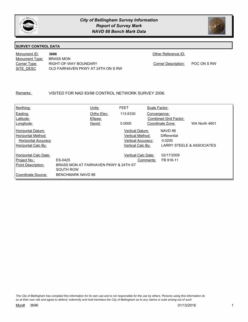
City of Bellingham Survey Information
Report of Survey Mark
NAVD 88 Bench Mark Data
SURVEY CONTROL DATA
3696Monument ID: Other Reference ID:
SITE_DESC OLD FAIRHAVEN PKWY AT 24TH ON S RW
RIGHT-OF-WAY BOUNDARYCorner Type: POC ON S RWCorner Description:
BRASS MONMonument Type:
VISITED FOR NAD 83/98 CONTROL NETWORK SURVEY 2006.Remarks:
113.6330
0.0000
FEETNorthing:
Easting:
Latitude:
Longitude:
Units:
Ortho Elev:
Ellipse:
Geoid:
Scale Factor:
Convergence:
Combined Grid Factor:
WA North 4601Coordinate Zone:
Horizontal Method:
Horizontal Datum: NAVD 88Vertical Datum:
DifferentialVertical Method:
Horizontal Accuracy 0.0200Vertical Accuracy:
LARRY STEELE & ASSOCIATESVertical Calc By:Horizontal Calc By:
ES-0425Project No.:
BRASS MON AT FAIRHAVEN PKWY & 24TH ST
SOUTH ROW
Point Description:
BENCHMARK NAVD 88Coordinate Source:
FB 918-11Comments:
Horizontal Calc Date: 02/17/2009Vertical Calc Date:
101/13/2016Mon# 3696
The City of Bellingham has compiled this information for its own use and is not responsible for the use by others. Persons using this information do
so at their own risk and agree to defend, indemnify and hold harmless the City of Bellingham as to any claims or suits arising out of such
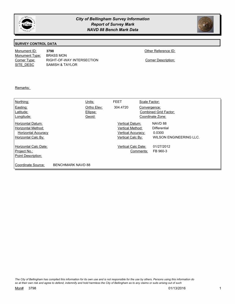
City of Bellingham Survey Information
Report of Survey Mark
NAVD 88 Bench Mark Data
SURVEY CONTROL DATA
3798Monument ID: Other Reference ID:
SITE_DESC SAMISH & TAYLOR
RIGHT-OF-WAY INTERSECTIONCorner Type: Corner Description:
BRASS MONMonument Type:
Remarks:
304.4720
FEETNorthing:
Easting:
Latitude:
Longitude:
Units:
Ortho Elev:
Ellipse:
Geoid:
Scale Factor:
Convergence:
Combined Grid Factor:
Coordinate Zone:
Horizontal Method:
Horizontal Datum: NAVD 88Vertical Datum:
DifferentialVertical Method:
Horizontal Accuracy 0.0300Vertical Accuracy:
WILSON ENGINEERING LLC.Vertical Calc By:Horizontal Calc By:
Project No.:
Point Description:
BENCHMARK NAVD 88Coordinate Source:
FB 960-3Comments:
Horizontal Calc Date: 01/27/2012Vertical Calc Date:
101/13/2016Mon# 3798
The City of Bellingham has compiled this information for its own use and is not responsible for the use by others. Persons using this information do
so at their own risk and agree to defend, indemnify and hold harmless the City of Bellingham as to any claims or suits arising out of such

City of Bellingham Survey Information
Report of Survey Mark
NAVD 88 Bench Mark Data
SURVEY CONTROL DATA
3812Monument ID: Other Reference ID:
SITE_DESC MERIDIAN & MCLEOD IN TRAFFIC ISLAND
CADASTRAL SURVEY REFERENCE POINT 2004Corner Type: REFERENCE
MONUMENT SET BY
WILSON
ENGINEERING FOR
NAD 83/98 CONTROL
NETWORK
Corner Description:
ALUMINUM CAPMonument Type:
FOR NAD 83/98 CONTROL NETWORK 2005. REF. MON. LOCATED
IN TRAFFIC ISLAND AT INT MCLEOD RD & MERIDIAN ST ON EAST
SIDE MERIDIAN ST & SOUTH OF I-5 - LOCATED 6 1/2 FT FROM CL
TRAFFIC SIGNAL STANDARD @ S 30D W & 6 FT @ N 67D W FROM
CL TRAFFIC SIG. VAULT
Remarks:
106.8460
0.0000
FEETNorthing:
Easting:
Latitude:
Longitude:
Units:
Ortho Elev:
Ellipse:
Geoid:
Scale Factor:
Convergence:
Combined Grid Factor:
WA North 4601Coordinate Zone:
Horizontal Method:
Horizontal Datum: NAVD 88Vertical Datum:
DifferentialVertical Method:
Horizontal Accuracy 0.0200Vertical Accuracy:
PACIFIC SURVEY & ENGINEERING,
INC.
Vertical Calc By:Horizontal Calc By:
ES-0425Project No.:
ALUM MON IN CENTER ISLAND AT INT. MERIDIAN
ST / MCLEOD RD / I-5 ON-RAMP
Point Description:
BENCHMARK NAVD 88Coordinate Source:
FB 918Comments:
Horizontal Calc Date: 12/09/2008Vertical Calc Date:
101/13/2016Mon# 3812
The City of Bellingham has compiled this information for its own use and is not responsible for the use by others. Persons using this information do
so at their own risk and agree to defend, indemnify and hold harmless the City of Bellingham as to any claims or suits arising out of such

City of Bellingham Survey Information
Report of Survey Mark
NAVD 88 Bench Mark Data
SURVEY CONTROL DATA
3813Monument ID: Other Reference ID:
SITE_DESC BELLIS FAIR PARKWAY & I-5 NORTHBOUND
OFF RAMP
CADASTRAL SURVEY REFERENCE POINT 2004Corner Type: REFERENCE
MONUMENT SET BY
WILSON
ENGINEERING FOR
NAD 83/98 CONTROL
NETWORK
Corner Description:
ALUMINUM CAPMonument Type:
FOR NAD 83/98 CONTROL NETWORK 2005. REF. MON. LOCATED
@ INTERSECTION BELLIS FAIR MALL PARKWAY & I-5 NORTH
BOUND OFF RAMP - ALSO 2 1/2 FT S.E.ERLY BEHIND CURB ON S
SIDE BELLIS FAIR PKWY & 35 FT S.W.ERLY OF W MOST POST
TRAFFIC LITE
Remarks:
132.7080
FEETNorthing:
Easting:
Latitude:
Longitude:
Units:
Ortho Elev:
Ellipse:
Geoid:
Scale Factor:
Convergence:
Combined Grid Factor:
Coordinate Zone:
Horizontal Method:
Horizontal Datum: NAVD 88Vertical Datum:
DifferentialVertical Method:
Horizontal Accuracy 0.0200Vertical Accuracy:
LARRY STEELE & ASSOCIATESVertical Calc By:Horizontal Calc By:
Project No.:
Point Description:
BENCHMARK NAVD 88Coordinate Source:
FB 960-1Comments:
Horizontal Calc Date: 03/23/2012Vertical Calc Date:
132.7300
0.0000
FEETNorthing:
Easting:
Latitude:
Longitude:
Units:
Ortho Elev:
Ellipse:
Geoid:
Scale Factor:
Convergence:
Combined Grid Factor:
WA North 4601Coordinate Zone:
Horizontal Method:
Horizontal Datum: NAVD 88Vertical Datum:
DifferentialVertical Method:
Horizontal Accuracy 0.0200Vertical Accuracy:
PACIFIC SURVEY & ENGINEERING,
INC.
Vertical Calc By:Horizontal Calc By:
ES-0425Project No.:
ALUM MON IN SW QUADR. BELLIS FAIR MALL
PKWY & I-5 OFF-RAMP
Point Description:
BENCHMARK NAVD 88Coordinate Source:
FB 918Comments:
Horizontal Calc Date: 12/29/2008Vertical Calc Date:
101/13/2016Mon# 3813
The City of Bellingham has compiled this information for its own use and is not responsible for the use by others. Persons using this information do
so at their own risk and agree to defend, indemnify and hold harmless the City of Bellingham as to any claims or suits arising out of such
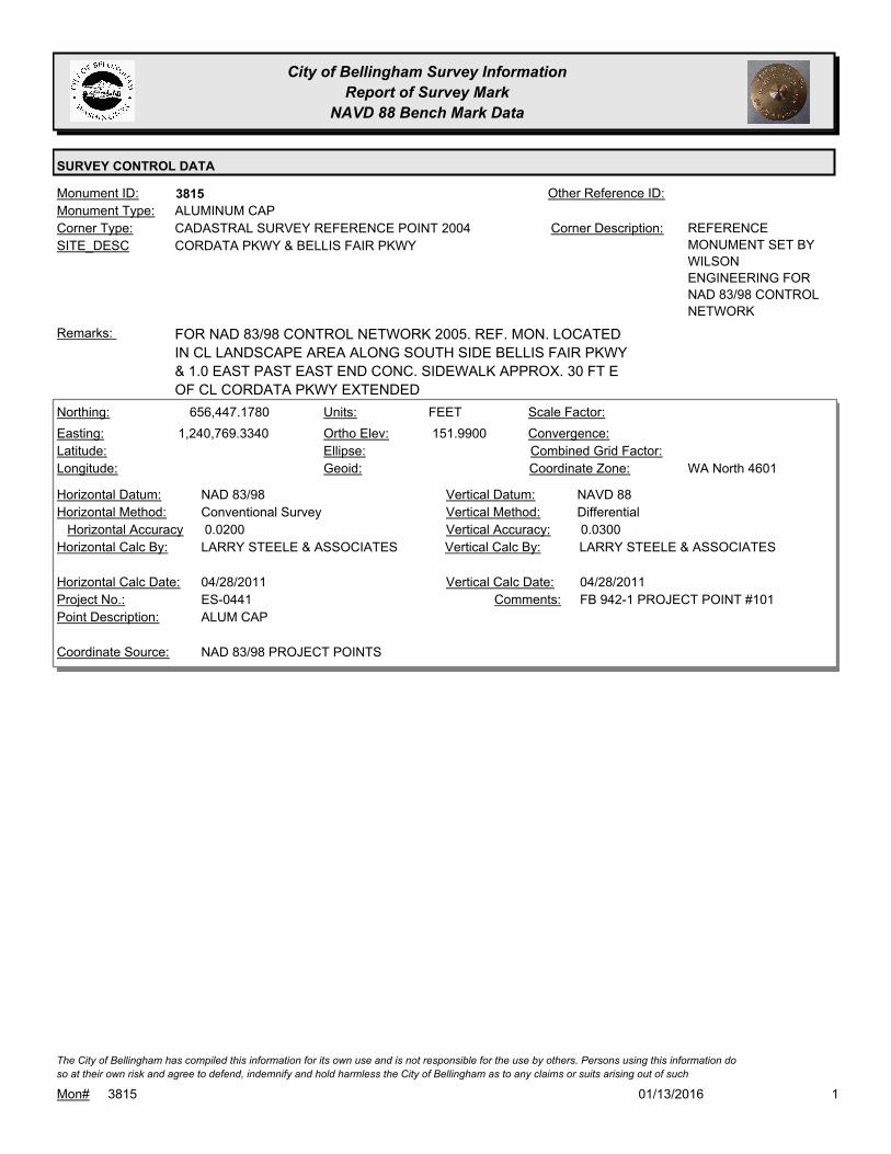
City of Bellingham Survey Information
Report of Survey Mark
NAVD 88 Bench Mark Data
SURVEY CONTROL DATA
3815Monument ID: Other Reference ID:
SITE_DESC CORDATA PKWY & BELLIS FAIR PKWY
CADASTRAL SURVEY REFERENCE POINT 2004Corner Type: REFERENCE
MONUMENT SET BY
WILSON
ENGINEERING FOR
NAD 83/98 CONTROL
NETWORK
Corner Description:
ALUMINUM CAPMonument Type:
FOR NAD 83/98 CONTROL NETWORK 2005. REF. MON. LOCATED
IN CL LANDSCAPE AREA ALONG SOUTH SIDE BELLIS FAIR PKWY
& 1.0 EAST PAST EAST END CONC. SIDEWALK APPROX. 30 FT E
OF CL CORDATA PKWY EXTENDED
Remarks:
656,447.1780
1,240,769.3340 151.9900
FEETNorthing:
Easting:
Latitude:
Longitude:
Units:
Ortho Elev:
Ellipse:
Geoid:
Scale Factor:
Convergence:
Combined Grid Factor:
WA North 4601Coordinate Zone:
Conventional SurveyHorizontal Method:
NAD 83/98Horizontal Datum: NAVD 88Vertical Datum:
DifferentialVertical Method:
0.0200Horizontal Accuracy 0.0300Vertical Accuracy:
LARRY STEELE & ASSOCIATESVertical Calc By:LARRY STEELE & ASSOCIATESHorizontal Calc By:
ES-0441Project No.:
ALUM CAPPoint Description:
NAD 83/98 PROJECT POINTSCoordinate Source:
FB 942-1 PROJECT POINT #101Comments:
04/28/2011Horizontal Calc Date: 04/28/2011Vertical Calc Date:
101/13/2016Mon# 3815
The City of Bellingham has compiled this information for its own use and is not responsible for the use by others. Persons using this information do
so at their own risk and agree to defend, indemnify and hold harmless the City of Bellingham as to any claims or suits arising out of such
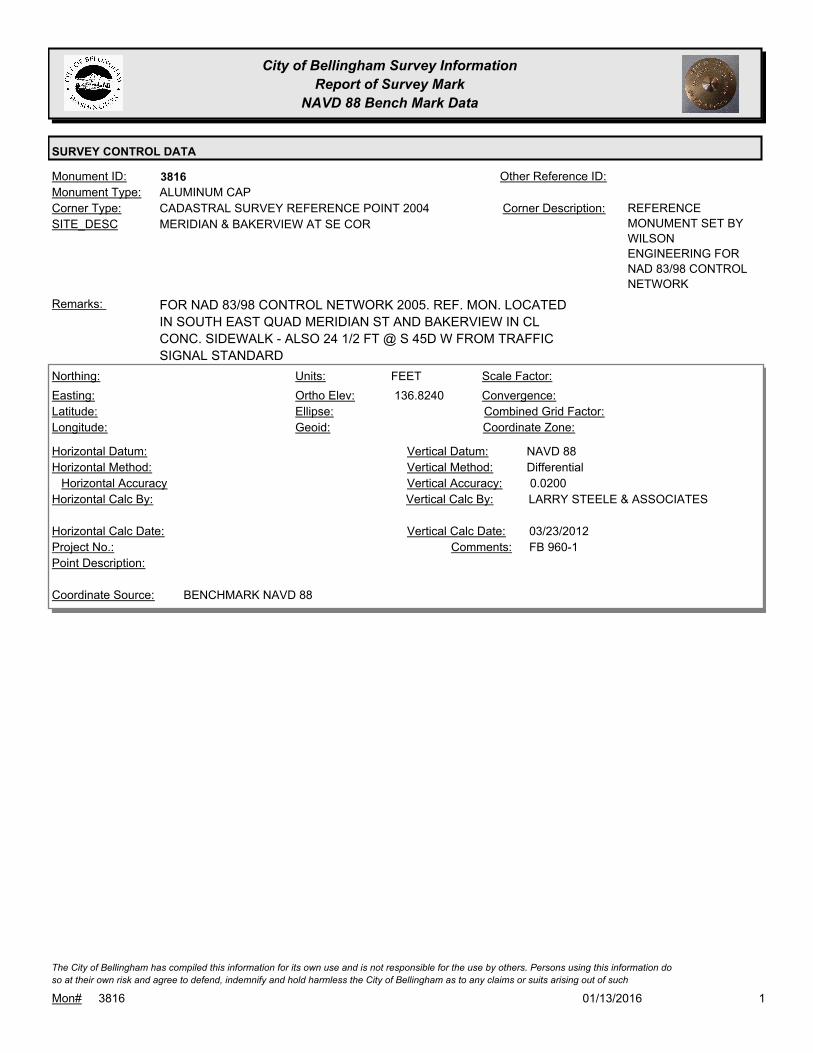
City of Bellingham Survey Information
Report of Survey Mark
NAVD 88 Bench Mark Data
SURVEY CONTROL DATA
3816Monument ID: Other Reference ID:
SITE_DESC MERIDIAN & BAKERVIEW AT SE COR
CADASTRAL SURVEY REFERENCE POINT 2004Corner Type: REFERENCE
MONUMENT SET BY
WILSON
ENGINEERING FOR
NAD 83/98 CONTROL
NETWORK
Corner Description:
ALUMINUM CAPMonument Type:
FOR NAD 83/98 CONTROL NETWORK 2005. REF. MON. LOCATED
IN SOUTH EAST QUAD MERIDIAN ST AND BAKERVIEW IN CL
CONC. SIDEWALK - ALSO 24 1/2 FT @ S 45D W FROM TRAFFIC
SIGNAL STANDARD
Remarks:
136.8240
FEETNorthing:
Easting:
Latitude:
Longitude:
Units:
Ortho Elev:
Ellipse:
Geoid:
Scale Factor:
Convergence:
Combined Grid Factor:
Coordinate Zone:
Horizontal Method:
Horizontal Datum: NAVD 88Vertical Datum:
DifferentialVertical Method:
Horizontal Accuracy 0.0200Vertical Accuracy:
LARRY STEELE & ASSOCIATESVertical Calc By:Horizontal Calc By:
Project No.:
Point Description:
BENCHMARK NAVD 88Coordinate Source:
FB 960-1Comments:
Horizontal Calc Date: 03/23/2012Vertical Calc Date:
101/13/2016Mon# 3816
The City of Bellingham has compiled this information for its own use and is not responsible for the use by others. Persons using this information do
so at their own risk and agree to defend, indemnify and hold harmless the City of Bellingham as to any claims or suits arising out of such
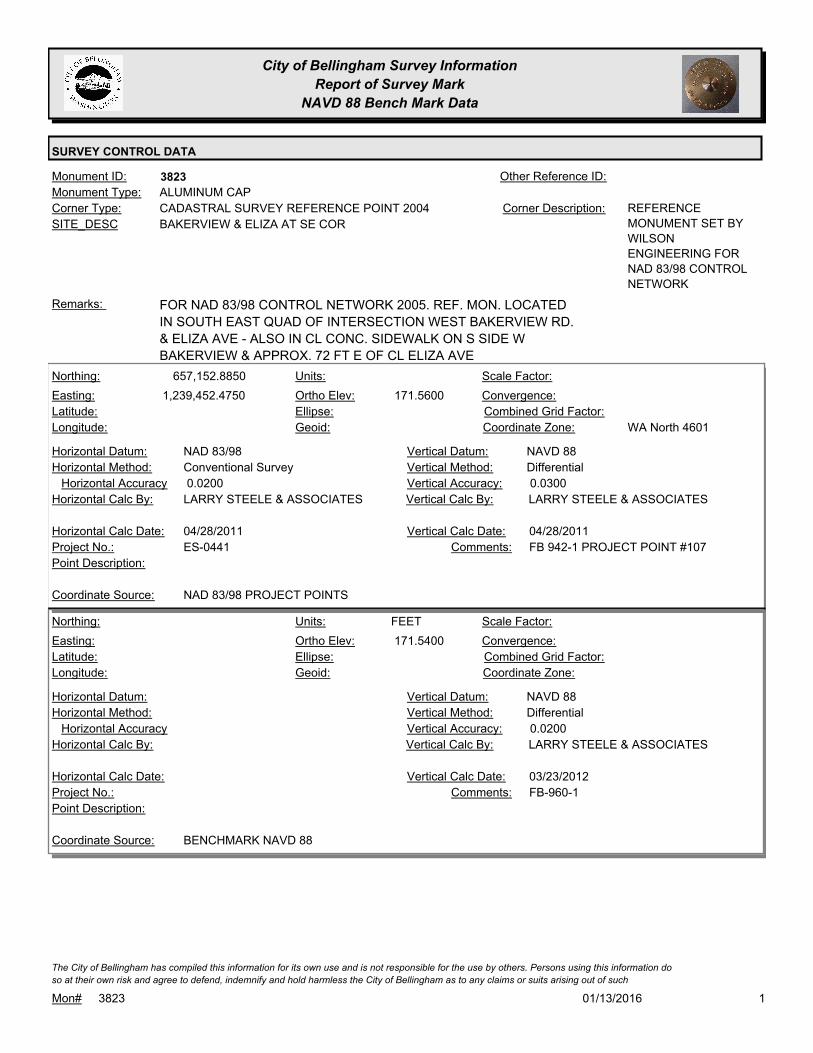
City of Bellingham Survey Information
Report of Survey Mark
NAVD 88 Bench Mark Data
SURVEY CONTROL DATA
3823Monument ID: Other Reference ID:
SITE_DESC BAKERVIEW & ELIZA AT SE COR
CADASTRAL SURVEY REFERENCE POINT 2004Corner Type: REFERENCE
MONUMENT SET BY
WILSON
ENGINEERING FOR
NAD 83/98 CONTROL
NETWORK
Corner Description:
ALUMINUM CAPMonument Type:
FOR NAD 83/98 CONTROL NETWORK 2005. REF. MON. LOCATED
IN SOUTH EAST QUAD OF INTERSECTION WEST BAKERVIEW RD.
& ELIZA AVE - ALSO IN CL CONC. SIDEWALK ON S SIDE W
BAKERVIEW & APPROX. 72 FT E OF CL ELIZA AVE
Remarks:
657,152.8850
1,239,452.4750 171.5600
Northing:
Easting:
Latitude:
Longitude:
Units:
Ortho Elev:
Ellipse:
Geoid:
Scale Factor:
Convergence:
Combined Grid Factor:
WA North 4601Coordinate Zone:
Conventional SurveyHorizontal Method:
NAD 83/98Horizontal Datum: NAVD 88Vertical Datum:
DifferentialVertical Method:
0.0200Horizontal Accuracy 0.0300Vertical Accuracy:
LARRY STEELE & ASSOCIATESVertical Calc By:LARRY STEELE & ASSOCIATESHorizontal Calc By:
ES-0441Project No.:
Point Description:
NAD 83/98 PROJECT POINTSCoordinate Source:
FB 942-1 PROJECT POINT #107Comments:
04/28/2011Horizontal Calc Date: 04/28/2011Vertical Calc Date:
171.5400
FEETNorthing:
Easting:
Latitude:
Longitude:
Units:
Ortho Elev:
Ellipse:
Geoid:
Scale Factor:
Convergence:
Combined Grid Factor:
Coordinate Zone:
Horizontal Method:
Horizontal Datum: NAVD 88Vertical Datum:
DifferentialVertical Method:
Horizontal Accuracy 0.0200Vertical Accuracy:
LARRY STEELE & ASSOCIATESVertical Calc By:Horizontal Calc By:
Project No.:
Point Description:
BENCHMARK NAVD 88Coordinate Source:
FB-960-1Comments:
Horizontal Calc Date: 03/23/2012Vertical Calc Date:
101/13/2016Mon# 3823
The City of Bellingham has compiled this information for its own use and is not responsible for the use by others. Persons using this information do
so at their own risk and agree to defend, indemnify and hold harmless the City of Bellingham as to any claims or suits arising out of such

City of Bellingham Survey Information
Report of Survey Mark
NAVD 88 Bench Mark Data
SURVEY CONTROL DATA
3824Monument ID: Other Reference ID:
SITE_DESC NORTHWEST & SE OF MCLEOD
CADASTRAL SURVEY REFERENCE POINT 2004Corner Type: REFERENCE
MONUMENT SET BY
WILSON
ENGINEERING FOR
NAD 83/98 CONTROL
NETWORK
Corner Description:
ALUMINUM CAPMonument Type:
FOR NAD 83/98 CONTROL NETWORK 2005. REF. MON. LOCATED
APPROX 80' SE OF CL MCLEOD RD AND 1.0 WEST OF BK
SIDEWALK & APPROX 4 FT N OF N EDGE ASPH D/W INTO
NORTHWEST BAPTIST CHURCH - LOCATED @ INTERSECTION
NORTHWEST RD & MCLEOD RD & 60 FT FROM PP TO NNW
Remarks:
129.4260
0.0000
FEETNorthing:
Easting:
Latitude:
Longitude:
Units:
Ortho Elev:
Ellipse:
Geoid:
Scale Factor:
Convergence:
Combined Grid Factor:
WA North 4601Coordinate Zone:
Horizontal Method:
Horizontal Datum: NAVD 88Vertical Datum:
DifferentialVertical Method:
Horizontal Accuracy 0.0200Vertical Accuracy:
PACIFIC SURVEY & ENGINEERING,
INC.
Vertical Calc By:Horizontal Calc By:
ES-0425Project No.:
ALUM. MON ON W. SIDE NORTHWEST AVE,
APPROX 75' S. OF MCLEOD RD
Point Description:
BENCHMARK NAVD 88Coordinate Source:
FB 918Comments:
Horizontal Calc Date: 12/09/2008Vertical Calc Date:
101/13/2016Mon# 3824
The City of Bellingham has compiled this information for its own use and is not responsible for the use by others. Persons using this information do
so at their own risk and agree to defend, indemnify and hold harmless the City of Bellingham as to any claims or suits arising out of such

City of Bellingham Survey Information
Report of Survey Mark
NAVD 88 Bench Mark Data
SURVEY CONTROL DATA
3825Monument ID: Other Reference ID:
SITE_DESC BAKERVIEW & HOME RD AT SW COR
CADASTRAL SURVEY REFERENCE POINT 2004Corner Type: REFERENCE
MONUMENT SET BY
WILSON
ENGINEERING FOR
NAD 83/98 CONTROL
NETWORK
Corner Description:
ALUMINUM CAPMonument Type:
FOR NAD 83/98 CONTROL NETWORK 2005. REF. MON. LOCATED
IN SOUTH WEST QUADRANT OF INTERSECTION WEST
BAKERVIEW RD & NORTHWEST AVE ALSO LOC. 43 FT EAST OF
PP AND 40.5 NORTH OF FIRE HYDT AND 9 FT SOUTH OF BK
CONC SIDEWALK
Remarks:
196.7440
FEETNorthing:
Easting:
Latitude:
Longitude:
Units:
Ortho Elev:
Ellipse:
Geoid:
Scale Factor:
Convergence:
Combined Grid Factor:
Coordinate Zone:
Horizontal Method:
Horizontal Datum: NAVD 88Vertical Datum:
DifferentialVertical Method:
Horizontal Accuracy 0.0200Vertical Accuracy:
LARRY STEELE & ASSOCIATESVertical Calc By:Horizontal Calc By:
Project No.:
Point Description:
BENCHMARK NAVD 88Coordinate Source:
FB 960-1Comments:
Horizontal Calc Date: 03/23/2012Vertical Calc Date:
101/13/2016Mon# 3825
The City of Bellingham has compiled this information for its own use and is not responsible for the use by others. Persons using this information do
so at their own risk and agree to defend, indemnify and hold harmless the City of Bellingham as to any claims or suits arising out of such
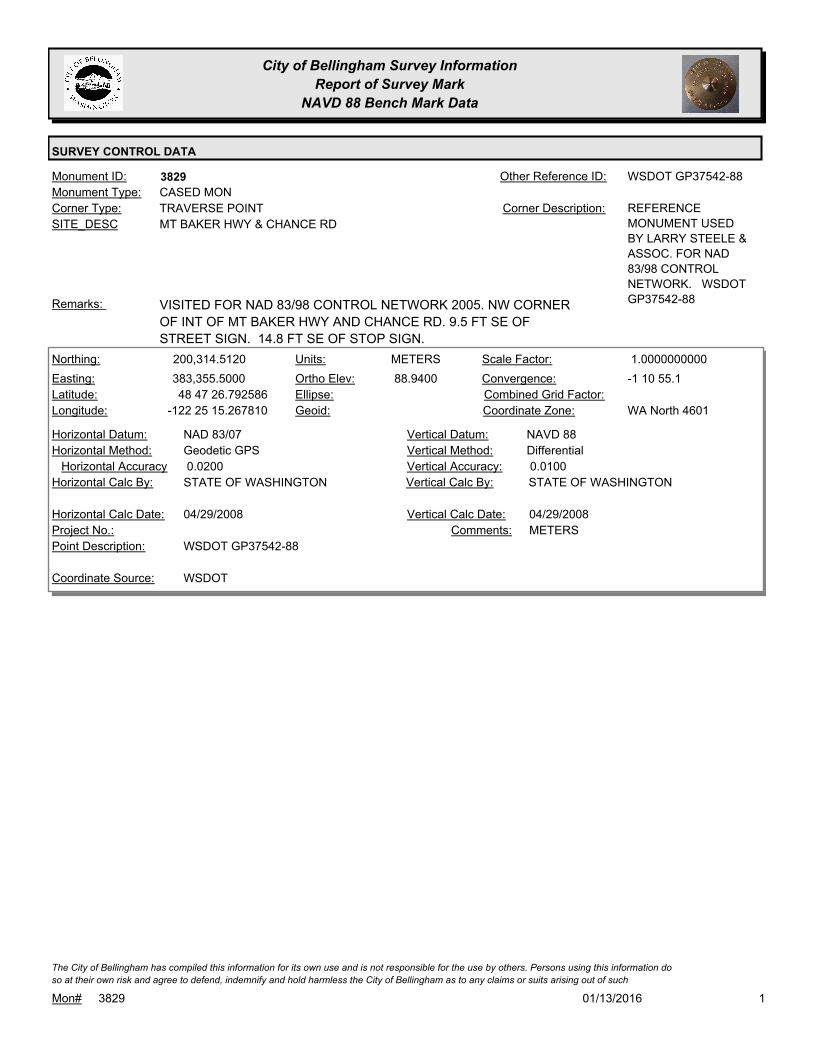
City of Bellingham Survey Information
Report of Survey Mark
NAVD 88 Bench Mark Data
SURVEY CONTROL DATA
3829Monument ID: WSDOT GP37542-88Other Reference ID:
SITE_DESC MT BAKER HWY & CHANCE RD
TRAVERSE POINTCorner Type: REFERENCE
MONUMENT USED
BY LARRY STEELE &
ASSOC. FOR NAD
83/98 CONTROL
NETWORK. WSDOT
GP37542-88
Corner Description:
CASED MONMonument Type:
VISITED FOR NAD 83/98 CONTROL NETWORK 2005. NW CORNER
OF INT OF MT BAKER HWY AND CHANCE RD. 9.5 FT SE OF
STREET SIGN. 14.8 FT SE OF STOP SIGN.
Remarks:
200,314.5120
383,355.5000
48 47 26.792586
-122 25 15.267810
88.9400
METERSNorthing:
Easting:
Latitude:
Longitude:
Units:
Ortho Elev:
Ellipse:
Geoid:
1.0000000000Scale Factor:
-1 10 55.1Convergence:
Combined Grid Factor:
WA North 4601Coordinate Zone:
Geodetic GPSHorizontal Method:
NAD 83/07Horizontal Datum: NAVD 88Vertical Datum:
DifferentialVertical Method:
0.0200Horizontal Accuracy 0.0100Vertical Accuracy:
STATE OF WASHINGTONVertical Calc By:STATE OF WASHINGTONHorizontal Calc By:
Project No.:
WSDOT GP37542-88Point Description:
WSDOTCoordinate Source:
METERSComments:
04/29/2008Horizontal Calc Date: 04/29/2008Vertical Calc Date:
101/13/2016Mon# 3829
The City of Bellingham has compiled this information for its own use and is not responsible for the use by others. Persons using this information do
so at their own risk and agree to defend, indemnify and hold harmless the City of Bellingham as to any claims or suits arising out of such
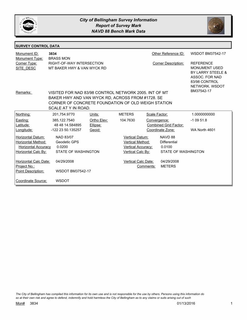
City of Bellingham Survey Information
Report of Survey Mark
NAVD 88 Bench Mark Data
SURVEY CONTROL DATA
3834Monument ID: WSDOT BM37542-17Other Reference ID:
SITE_DESC MT BAKER HWY & VAN WYCK RD
RIGHT-OF-WAY INTERSECTIONCorner Type: REFERENCE
MONUMENT USED
BY LARRY STEELE &
ASSOC. FOR NAD
83/98 CONTROL
NETWORK. WSDOT
BM37542-17
Corner Description:
BRASS MONMonument Type:
VISITED FOR NAD 83/98 CONTROL NETWORK 2005. INT OF MT
BAKER HWY AND VAN WYCK RD, ACROSS FROM #1728. SE
CORNER OF CONCRETE FOUNDATION OF OLD WEIGH STATION
SCALE AT Y IN ROAD.
Remarks:
201,754.9770
385,122.7540
48 48 14.584895
-122 23 50.135257
104.7630
METERSNorthing:
Easting:
Latitude:
Longitude:
Units:
Ortho Elev:
Ellipse:
Geoid:
1.0000000000Scale Factor:
-1 09 51.8Convergence:
Combined Grid Factor:
WA North 4601Coordinate Zone:
Geodetic GPSHorizontal Method:
NAD 83/07Horizontal Datum: NAVD 88Vertical Datum:
DifferentialVertical Method:
0.0200Horizontal Accuracy 0.0100Vertical Accuracy:
STATE OF WASHINGTONVertical Calc By:STATE OF WASHINGTONHorizontal Calc By:
Project No.:
WSDOT BM37542-17Point Description:
WSDOTCoordinate Source:
METERSComments:
04/29/2008Horizontal Calc Date: 04/29/2008Vertical Calc Date:
101/13/2016Mon# 3834
The City of Bellingham has compiled this information for its own use and is not responsible for the use by others. Persons using this information do
so at their own risk and agree to defend, indemnify and hold harmless the City of Bellingham as to any claims or suits arising out of such
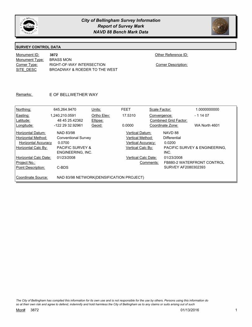
City of Bellingham Survey Information
Report of Survey Mark
NAVD 88 Bench Mark Data
SURVEY CONTROL DATA
3872Monument ID: Other Reference ID:
SITE_DESC BROADWAY & ROEDER TO THE WEST
RIGHT-OF-WAY INTERSECTIONCorner Type: Corner Description:
BRASS MONMonument Type:
E OF BELLWETHER WAYRemarks:
645,264.9470
1,240,210.0591
48 45 25.42362
-122 29 32.92961
17.5310
0.0000
FEETNorthing:
Easting:
Latitude:
Longitude:
Units:
Ortho Elev:
Ellipse:
Geoid:
1.0000000000Scale Factor:
- 1 14 07Convergence:
Combined Grid Factor:
WA North 4601Coordinate Zone:
Conventional SurveyHorizontal Method:
NAD 83/98Horizontal Datum: NAVD 88Vertical Datum:
DifferentialVertical Method:
0.0700Horizontal Accuracy 0.0200Vertical Accuracy:
PACIFIC SURVEY & ENGINEERING,
INC.
Vertical Calc By:PACIFIC SURVEY &
ENGINEERING, INC.
Horizontal Calc By:
Project No.:
C-BDSPoint Description:
NAD 83/98 NETWORK(DENSIFICATION PROJECT)Coordinate Source:
FB880-2 WATERFRONT CONTROL
SURVEY AF2080302393
Comments:
01/23/2008Horizontal Calc Date: 01/23/2008Vertical Calc Date:
101/13/2016Mon# 3872
The City of Bellingham has compiled this information for its own use and is not responsible for the use by others. Persons using this information do
so at their own risk and agree to defend, indemnify and hold harmless the City of Bellingham as to any claims or suits arising out of such

City of Bellingham Survey Information
Report of Survey Mark
NAVD 88 Bench Mark Data
SURVEY CONTROL DATA
3905Monument ID: B.M.37005 2004Other Reference ID:
SITE_DESC S SIDE SLATER RD ON I-5 OVERPASS
CADASTRAL SURVEY REFERENCE POINT 2004Corner Type: WDOT SURVEY
MONUMENT B.M.
37005-47 2004
Corner Description:
BRASS MONMonument Type:
USED FOR NAD 83/98 CONTROL NETWORKRemarks:
203,452.1160
374,072.1760
48 49 01.891979
-122 32 53.405989
31.0800
METERSNorthing:
Easting:
Latitude:
Longitude:
Units:
Ortho Elev:
Ellipse:
Geoid:
1.0000000000Scale Factor:
-1 16 36.2Convergence:
Combined Grid Factor:
WA North 4601Coordinate Zone:
Geodetic GPSHorizontal Method:
NAD 83/07Horizontal Datum: NAVD 88Vertical Datum:
DifferentialVertical Method:
0.0200Horizontal Accuracy 0.0100Vertical Accuracy:
STATE OF WASHINGTONVertical Calc By:STATE OF WASHINGTONHorizontal Calc By:
Project No.:
WSDOT BM37005-47Point Description:
WSDOTCoordinate Source:
METERSComments:
08/19/2008Horizontal Calc Date: 08/19/2008Vertical Calc Date:
101/13/2016Mon# 3905
The City of Bellingham has compiled this information for its own use and is not responsible for the use by others. Persons using this information do
so at their own risk and agree to defend, indemnify and hold harmless the City of Bellingham as to any claims or suits arising out of such

City of Bellingham Survey Information
Report of Survey Mark
NAVD 88 Bench Mark Data
SURVEY CONTROL DATA
3945Monument ID: Other Reference ID:
SITE_DESC KENTUCKY E OF YEW
RIGHT-OF-WAY CULDESAC INTERSECTIONCorner Type: Corner Description:
BRASS MONMonument Type:
ALSO CENTER CULDESAC MON 5FT SOUTH
MON FOUND 9-7-05
Remarks:
166.3160
0.0000
FEETNorthing:
Easting:
Latitude:
Longitude:
Units:
Ortho Elev:
Ellipse:
Geoid:
Scale Factor:
Convergence:
Combined Grid Factor:
WA North 4601Coordinate Zone:
Horizontal Method:
Horizontal Datum: NAVD 88Vertical Datum:
DifferentialVertical Method:
Horizontal Accuracy 0.0300Vertical Accuracy:
WILSON ENGINEERING LLC.Vertical Calc By:Horizontal Calc By:
ES-0425Project No.:
C-BDS KENTUCKY CUL-DE-SAC (NORTH OF TWO
MONS.)
Point Description:
BENCHMARK NAVD 88Coordinate Source:
FB918-8 pg. 45Comments:
Horizontal Calc Date: 02/12/2009Vertical Calc Date:
101/13/2016Mon# 3945
The City of Bellingham has compiled this information for its own use and is not responsible for the use by others. Persons using this information do
so at their own risk and agree to defend, indemnify and hold harmless the City of Bellingham as to any claims or suits arising out of such

City of Bellingham Survey Information
Report of Survey Mark
NAVD 88 Bench Mark Data
SURVEY CONTROL DATA
3947Monument ID: Other Reference ID:
SITE_DESC BIRCH AT E & W BIRCH
RIGHT-OF-WAY INTERSECTIONCorner Type: Corner Description:
BRASS MONMonument Type:
Remarks:
343.1760
0.0000
FEETNorthing:
Easting:
Latitude:
Longitude:
Units:
Ortho Elev:
Ellipse:
Geoid:
Scale Factor:
Convergence:
Combined Grid Factor:
WA North 4601Coordinate Zone:
Horizontal Method:
Horizontal Datum: NAVD 88Vertical Datum:
DifferentialVertical Method:
Horizontal Accuracy 0.0300Vertical Accuracy:
WILSON ENGINEERING LLC.Vertical Calc By:Horizontal Calc By:
ES-0425Project No.:
C-BDS INT BIRCH/E.BIRCH/W.BIRCHPoint Description:
BENCHMARK NAVD 88Coordinate Source:
FB918-8 pg. 48Comments:
Horizontal Calc Date: 02/12/2009Vertical Calc Date:
101/13/2016Mon# 3947
The City of Bellingham has compiled this information for its own use and is not responsible for the use by others. Persons using this information do
so at their own risk and agree to defend, indemnify and hold harmless the City of Bellingham as to any claims or suits arising out of such

City of Bellingham Survey Information
Report of Survey Mark
NAVD 88 Bench Mark Data
SURVEY CONTROL DATA
3954Monument ID: Other Reference ID:
SITE_DESC BIRCH CIRCLE
RIGHT-OF-WAY PCCorner Type: Corner Description:
BRASS MONMonument Type:
Remarks:
339.0440
0.0000
FEETNorthing:
Easting:
Latitude:
Longitude:
Units:
Ortho Elev:
Ellipse:
Geoid:
Scale Factor:
Convergence:
Combined Grid Factor:
WA North 4601Coordinate Zone:
Horizontal Method:
Horizontal Datum: NAVD 88Vertical Datum:
DifferentialVertical Method:
Horizontal Accuracy 0.0300Vertical Accuracy:
WILSON ENGINEERING LLC.Vertical Calc By:Horizontal Calc By:
ES-0425Project No.:
C-BDS PC MON SW OF ROUNDABOUT BIRCH
CIRCLE
Point Description:
BENCHMARK NAVD 88Coordinate Source:
FB918-8 pg. 49Comments:
Horizontal Calc Date: 02/12/2009Vertical Calc Date:
101/13/2016Mon# 3954
The City of Bellingham has compiled this information for its own use and is not responsible for the use by others. Persons using this information do
so at their own risk and agree to defend, indemnify and hold harmless the City of Bellingham as to any claims or suits arising out of such
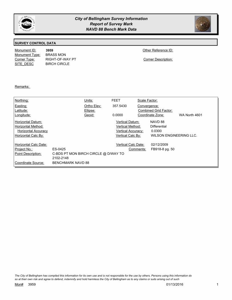
City of Bellingham Survey Information
Report of Survey Mark
NAVD 88 Bench Mark Data
SURVEY CONTROL DATA
3959Monument ID: Other Reference ID:
SITE_DESC BIRCH CIRCLE
RIGHT-OF-WAY PTCorner Type: Corner Description:
BRASS MONMonument Type:
Remarks:
357.5430
0.0000
FEETNorthing:
Easting:
Latitude:
Longitude:
Units:
Ortho Elev:
Ellipse:
Geoid:
Scale Factor:
Convergence:
Combined Grid Factor:
WA North 4601Coordinate Zone:
Horizontal Method:
Horizontal Datum: NAVD 88Vertical Datum:
DifferentialVertical Method:
Horizontal Accuracy 0.0300Vertical Accuracy:
WILSON ENGINEERING LLC.Vertical Calc By:Horizontal Calc By:
ES-0425Project No.:
C-BDS PT MON BIRCH CIRCLE @ D/WAY TO
2102-2148
Point Description:
BENCHMARK NAVD 88Coordinate Source:
FB918-8 pg. 50Comments:
Horizontal Calc Date: 02/12/2009Vertical Calc Date:
101/13/2016Mon# 3959
The City of Bellingham has compiled this information for its own use and is not responsible for the use by others. Persons using this information do
so at their own risk and agree to defend, indemnify and hold harmless the City of Bellingham as to any claims or suits arising out of such

City of Bellingham Survey Information
Report of Survey Mark
NAVD 88 Bench Mark Data
SURVEY CONTROL DATA
4043Monument ID: Other Reference ID:
SITE_DESC FIRST BRASS MON EAST OF RACINE ON
FRASER
RIGHT-OF-WAY PCCorner Type: Corner Description:
BRASS MONMonument Type:
Remarks:
69.7370
0.0000
FEETNorthing:
Easting:
Latitude:
Longitude:
Units:
Ortho Elev:
Ellipse:
Geoid:
Scale Factor:
Convergence:
Combined Grid Factor:
WA North 4601Coordinate Zone:
Horizontal Method:
Horizontal Datum: NAVD 88Vertical Datum:
DifferentialVertical Method:
Horizontal Accuracy 0.0300Vertical Accuracy:
WILSON ENGINEERING LLC.Vertical Calc By:Horizontal Calc By:
ES-0425Project No.:
C-BDS R-of-W PC CL FRASERPoint Description:
BENCHMARK NAVD 88Coordinate Source:
FB918-7 pg. 23Comments:
Horizontal Calc Date: 02/12/2009Vertical Calc Date:
101/13/2016Mon# 4043
The City of Bellingham has compiled this information for its own use and is not responsible for the use by others. Persons using this information do
so at their own risk and agree to defend, indemnify and hold harmless the City of Bellingham as to any claims or suits arising out of such
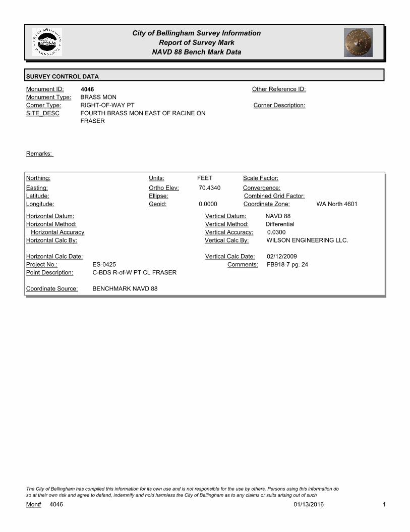
City of Bellingham Survey Information
Report of Survey Mark
NAVD 88 Bench Mark Data
SURVEY CONTROL DATA
4046Monument ID: Other Reference ID:
SITE_DESC FOURTH BRASS MON EAST OF RACINE ON
FRASER
RIGHT-OF-WAY PTCorner Type: Corner Description:
BRASS MONMonument Type:
Remarks:
70.4340
0.0000
FEETNorthing:
Easting:
Latitude:
Longitude:
Units:
Ortho Elev:
Ellipse:
Geoid:
Scale Factor:
Convergence:
Combined Grid Factor:
WA North 4601Coordinate Zone:
Horizontal Method:
Horizontal Datum: NAVD 88Vertical Datum:
DifferentialVertical Method:
Horizontal Accuracy 0.0300Vertical Accuracy:
WILSON ENGINEERING LLC.Vertical Calc By:Horizontal Calc By:
ES-0425Project No.:
C-BDS R-of-W PT CL FRASERPoint Description:
BENCHMARK NAVD 88Coordinate Source:
FB918-7 pg. 24Comments:
Horizontal Calc Date: 02/12/2009Vertical Calc Date:
101/13/2016Mon# 4046
The City of Bellingham has compiled this information for its own use and is not responsible for the use by others. Persons using this information do
so at their own risk and agree to defend, indemnify and hold harmless the City of Bellingham as to any claims or suits arising out of such

City of Bellingham Survey Information
Report of Survey Mark
NAVD 88 Bench Mark Data
SURVEY CONTROL DATA
4049Monument ID: Other Reference ID:
SITE_DESC SEVENTH BRASS MON EAST OF RACINE
ON FRASER
RIGHT-OF-WAY PCCorner Type: Corner Description:
BRASS MONMonument Type:
Remarks:
76.9150
0.0000
FEETNorthing:
Easting:
Latitude:
Longitude:
Units:
Ortho Elev:
Ellipse:
Geoid:
Scale Factor:
Convergence:
Combined Grid Factor:
WA North 4601Coordinate Zone:
Horizontal Method:
Horizontal Datum: NAVD 88Vertical Datum:
DifferentialVertical Method:
Horizontal Accuracy 0.0300Vertical Accuracy:
WILSON ENGINEERING LLC.Vertical Calc By:Horizontal Calc By:
ES-0425Project No.:
C-BDS R-of-W PC CL FRASERPoint Description:
BENCHMARK NAVD 88Coordinate Source:
FB918-7 pg. 24Comments:
Horizontal Calc Date: 02/12/2009Vertical Calc Date:
101/13/2016Mon# 4049
The City of Bellingham has compiled this information for its own use and is not responsible for the use by others. Persons using this information do
so at their own risk and agree to defend, indemnify and hold harmless the City of Bellingham as to any claims or suits arising out of such

City of Bellingham Survey Information
Report of Survey Mark
NAVD 88 Bench Mark Data
SURVEY CONTROL DATA
4077Monument ID: Other Reference ID:
SITE_DESC YEW & E NORTH (TO EAST) ON S ROW
RIGHT-OF-WAY INTERSECTIONCorner Type: Corner Description:
BRASS MONMonument Type:
MON 4077 IS 30.62' TO THE SOUTH OF MON 205.
(MON FOUND 9-7-05)
Remarks:
647,621.4190
1,252,295.0150 132.3700
FEETNorthing:
Easting:
Latitude:
Longitude:
Units:
Ortho Elev:
Ellipse:
Geoid:
Scale Factor:
Convergence:
Combined Grid Factor:
WA North 4601Coordinate Zone:
Conventional SurveyHorizontal Method:
NAD 83/98Horizontal Datum: NAVD 88Vertical Datum:
DifferentialVertical Method:
0.0200Horizontal Accuracy 0.0300Vertical Accuracy:
LARRY STEELE & ASSOCIATESVertical Calc By:LARRY STEELE & ASSOCIATESHorizontal Calc By:
ES-0445Project No.:
C-BDS-LS#41035Point Description:
NAD 83/98 PROJECT POINTSCoordinate Source:
FB 950-1 PROJECT POINT #114Comments:
08/22/2011Horizontal Calc Date: 08/22/2011Vertical Calc Date:
101/13/2016Mon# 4077
The City of Bellingham has compiled this information for its own use and is not responsible for the use by others. Persons using this information do
so at their own risk and agree to defend, indemnify and hold harmless the City of Bellingham as to any claims or suits arising out of such
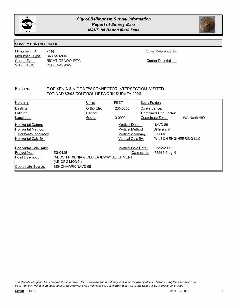
City of Bellingham Survey Information
Report of Survey Mark
NAVD 88 Bench Mark Data
SURVEY CONTROL DATA
4116Monument ID: Other Reference ID:
SITE_DESC OLD LAKEWAY
RIGHT-OF-WAY POCCorner Type: Corner Description:
BRASS MONMonument Type:
E OF XENIA & N OF NEW CONNECTOR INTERSECTION. VISITED
FOR NAD 83/98 CONTROL NETWORK SURVEY 2006.
Remarks:
283.5600
0.0000
FEETNorthing:
Easting:
Latitude:
Longitude:
Units:
Ortho Elev:
Ellipse:
Geoid:
Scale Factor:
Convergence:
Combined Grid Factor:
WA North 4601Coordinate Zone:
Horizontal Method:
Horizontal Datum: NAVD 88Vertical Datum:
DifferentialVertical Method:
Horizontal Accuracy 0.0300Vertical Accuracy:
WILSON ENGINEERING LLC.Vertical Calc By:Horizontal Calc By:
ES-0425Project No.:
C-BDS INT XENIA & OLD LAKEWAY ALIGNMENT
(NE OF 2 MONS.)
Point Description:
BENCHMARK NAVD 88Coordinate Source:
FB918-8 pg. 6Comments:
Horizontal Calc Date: 02/12/2009Vertical Calc Date:
101/13/2016Mon# 4116
The City of Bellingham has compiled this information for its own use and is not responsible for the use by others. Persons using this information do
so at their own risk and agree to defend, indemnify and hold harmless the City of Bellingham as to any claims or suits arising out of such

City of Bellingham Survey Information
Report of Survey Mark
NAVD 88 Bench Mark Data
SURVEY CONTROL DATA
4164Monument ID: Other Reference ID:
SITE_DESC LAKEWAY & CLEARBROOK
RIGHT-OF-WAY INTERSECTIONCorner Type: Corner Description:
BRASS MONMonument Type:
Remarks:
291.3890
0.0000
FEETNorthing:
Easting:
Latitude:
Longitude:
Units:
Ortho Elev:
Ellipse:
Geoid:
Scale Factor:
Convergence:
Combined Grid Factor:
WA North 4601Coordinate Zone:
Horizontal Method:
Horizontal Datum: NAVD 88Vertical Datum:
DifferentialVertical Method:
Horizontal Accuracy 0.0300Vertical Accuracy:
WILSON ENGINEERING LLC.Vertical Calc By:Horizontal Calc By:
ES-0425Project No.:
C-BDS INT LAKEWAY & CLEARBROOK DR.Point Description:
BENCHMARK NAVD 88Coordinate Source:
FB918-8 pg. 19Comments:
Horizontal Calc Date: 02/12/2009Vertical Calc Date:
101/13/2016Mon# 4164
The City of Bellingham has compiled this information for its own use and is not responsible for the use by others. Persons using this information do
so at their own risk and agree to defend, indemnify and hold harmless the City of Bellingham as to any claims or suits arising out of such

City of Bellingham Survey Information
Report of Survey Mark
NAVD 88 Bench Mark Data
SURVEY CONTROL DATA
4243Monument ID: Other Reference ID:
SITE_DESC LAKE CREST DR. PT MON WEST OF PLAT
LINE MON
RIGHT-OF-WAY PTCorner Type: Corner Description:
BRASS MONMonument Type:
25 FT W OF MON #3888Remarks:
357.2810
0.0000
FEETNorthing:
Easting:
Latitude:
Longitude:
Units:
Ortho Elev:
Ellipse:
Geoid:
Scale Factor:
Convergence:
Combined Grid Factor:
WA North 4601Coordinate Zone:
Horizontal Method:
Horizontal Datum: NAVD 88Vertical Datum:
DifferentialVertical Method:
Horizontal Accuracy 0.0300Vertical Accuracy:
WILSON ENGINEERING LLC.Vertical Calc By:Horizontal Calc By:
ES-0425Project No.:
C-BDS PT MON LAKECREST DR. W. OF CL
CUL-DE-SAC (W. OF TWO MONS.)
Point Description:
BENCHMARK NAVD 88Coordinate Source:
FB918-8 pg. 51Comments:
Horizontal Calc Date: 02/12/2009Vertical Calc Date:
101/13/2016Mon# 4243
The City of Bellingham has compiled this information for its own use and is not responsible for the use by others. Persons using this information do
so at their own risk and agree to defend, indemnify and hold harmless the City of Bellingham as to any claims or suits arising out of such
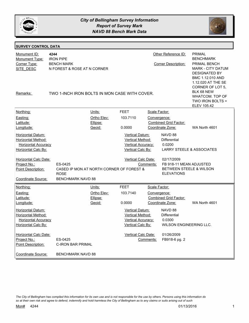
City of Bellingham Survey Information
Report of Survey Mark
NAVD 88 Bench Mark Data
SURVEY CONTROL DATA
4244Monument ID: PRIMAL
BENCHMARK
Other Reference ID:
SITE_DESC N FOREST & ROSE AT N CORNER
BENCH MARKCorner Type: PRIMAL BENCH
MARK - CITY DATUM
DESIGNATED BY
BMC 1.12.010 AND
1.12.020 AT THE SE
CORNER OF LOT 5,
BLK 68 NEW
WHATCOM. TOP OF
TWO IRON BOLTS =
ELEV 105.42
Corner Description:
IRON PIPEMonument Type:
TWO 1-INCH IRON BOLTS IN MON CASE WITH COVER.Remarks:
103.7110
0.0000
FEETNorthing:
Easting:
Latitude:
Longitude:
Units:
Ortho Elev:
Ellipse:
Geoid:
Scale Factor:
Convergence:
Combined Grid Factor:
WA North 4601Coordinate Zone:
Horizontal Method:
Horizontal Datum: NAVD 88Vertical Datum:
DifferentialVertical Method:
Horizontal Accuracy 0.0200Vertical Accuracy:
LARRY STEELE & ASSOCIATESVertical Calc By:Horizontal Calc By:
ES-0425Project No.:
CASED IP MON AT NORTH CORNER OF FOREST &
ROSE
Point Description:
BENCHMARK NAVD 88Coordinate Source:
FB 918-11 MEAN ADJUSTED
BETWEEN STEELE & WILSON
ELEVATIONS
Comments:
Horizontal Calc Date: 02/17/2009Vertical Calc Date:
103.7140
0.0000
FEETNorthing:
Easting:
Latitude:
Longitude:
Units:
Ortho Elev:
Ellipse:
Geoid:
Scale Factor:
Convergence:
Combined Grid Factor:
WA North 4601Coordinate Zone:
Horizontal Method:
Horizontal Datum: NAVD 88Vertical Datum:
DifferentialVertical Method:
Horizontal Accuracy 0.0300Vertical Accuracy:
WILSON ENGINEERING LLC.Vertical Calc By:Horizontal Calc By:
ES-0425Project No.:
C-IRON BAR PRIMALPoint Description:
BENCHMARK NAVD 88Coordinate Source:
FB918-6 pg. 2Comments:
Horizontal Calc Date: 01/26/2009Vertical Calc Date:
101/13/2016Mon# 4244
The City of Bellingham has compiled this information for its own use and is not responsible for the use by others. Persons using this information do
so at their own risk and agree to defend, indemnify and hold harmless the City of Bellingham as to any claims or suits arising out of such

City of Bellingham Survey Information
Report of Survey Mark
NAVD 88 Bench Mark Data
SURVEY CONTROL DATA
103.7050
FEETNorthing:
Easting:
Latitude:
Longitude:
Units:
Ortho Elev:
Ellipse:
Geoid:
Scale Factor:
Convergence:
Combined Grid Factor:
Coordinate Zone:
Horizontal Method:
Horizontal Datum: NAVD 88Vertical Datum:
DifferentialVertical Method:
Horizontal Accuracy 0.0500Vertical Accuracy:
PACIFIC SURVEY & ENGINEERING,
INC.
Vertical Calc By:Horizontal Calc By:
Project No.:
PRIMAL BENCH MARKPoint Description:
BENCHMARK NAVD 88Coordinate Source:
FB 880-1 PG11Comments:
Horizontal Calc Date: 04/28/2004Vertical Calc Date:
201/13/2016Mon# 4244
The City of Bellingham has compiled this information for its own use and is not responsible for the use by others. Persons using this information do
so at their own risk and agree to defend, indemnify and hold harmless the City of Bellingham as to any claims or suits arising out of such

City of Bellingham Survey Information
Report of Survey Mark
NAVD 88 Bench Mark Data
SURVEY CONTROL DATA
4256Monument ID: Other Reference ID:
SITE_DESC YEW & TEXAS AT SE CORNER
BENCH MARKCorner Type: TBM Y-1 - RR SPIKE
1FT UP W FACE OF
PP AT SE QUAD YEW
& TEXAS
Corner Description:
RAILROAD SPIKEMonument Type:
TBM Y-1 - RR SPIKE 1FT UP W FACE OF PP AT SE QUAD YEW &
TEXAS.
Remarks:
120.4710
0.0000
FEETNorthing:
Easting:
Latitude:
Longitude:
Units:
Ortho Elev:
Ellipse:
Geoid:
Scale Factor:
Convergence:
Combined Grid Factor:
WA North 4601Coordinate Zone:
Horizontal Method:
Horizontal Datum: NAVD 88Vertical Datum:
DifferentialVertical Method:
Horizontal Accuracy 0.0300Vertical Accuracy:
WILSON ENGINEERING LLC.Vertical Calc By:Horizontal Calc By:
ES-0425Project No.:
C-BM RRSPK PWR.POLE SE QUAD TEXAS & YEWPoint Description:
BENCHMARK NAVD 88Coordinate Source:
FB918-8 pg. 13Comments:
Horizontal Calc Date: 02/12/2009Vertical Calc Date:
101/13/2016Mon# 4256
The City of Bellingham has compiled this information for its own use and is not responsible for the use by others. Persons using this information do
so at their own risk and agree to defend, indemnify and hold harmless the City of Bellingham as to any claims or suits arising out of such

City of Bellingham Survey Information
Report of Survey Mark
NAVD 88 Bench Mark Data
SURVEY CONTROL DATA
4261Monument ID: Other Reference ID:
SITE_DESC ALABAMA & ONTARIO AT SE CORNER
BENCH MARKCorner Type: TBM O-1 - TOP SW
BOLT AT LIGHT POLE
IN SE QUAD
ALABAMA &
ONTARIO
Corner Description:
BOLTMonument Type:
TBM O-1 - TOP SW BOLT AT LIGHT POLE IN SE QUAD ALABAMA &
ONTARIO.
Remarks:
140.9120
0.0000
FEETNorthing:
Easting:
Latitude:
Longitude:
Units:
Ortho Elev:
Ellipse:
Geoid:
Scale Factor:
Convergence:
Combined Grid Factor:
WA North 4601Coordinate Zone:
Horizontal Method:
Horizontal Datum: NAVD 88Vertical Datum:
DifferentialVertical Method:
Horizontal Accuracy 0.0300Vertical Accuracy:
WILSON ENGINEERING LLC.Vertical Calc By:Horizontal Calc By:
ES-0425Project No.:
C-BM SW BOLT LIGHT STDRD SE.QUAD ONTARIO
& ALABAMA
Point Description:
BENCHMARK NAVD 88Coordinate Source:
FB918-8 pg. 37Comments:
Horizontal Calc Date: 02/12/2009Vertical Calc Date:
101/13/2016Mon# 4261
The City of Bellingham has compiled this information for its own use and is not responsible for the use by others. Persons using this information do
so at their own risk and agree to defend, indemnify and hold harmless the City of Bellingham as to any claims or suits arising out of such
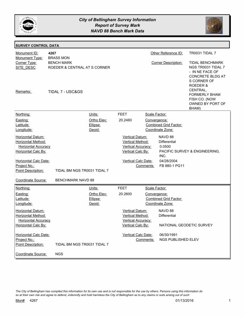
City of Bellingham Survey Information
Report of Survey Mark
NAVD 88 Bench Mark Data
SURVEY CONTROL DATA
4267Monument ID: TR0031 TIDAL 7Other Reference ID:
SITE_DESC ROEDER & CENTRAL AT S CORNER
BENCH MARKCorner Type: TIDAL BENCHMARK
NGS TR0031 TIDAL 7
- IN NE FACE OF
CONCRETE BLDG AT
S CORNER OF
ROEDER &
CENTRAL,
FORMERLY BHAM
FISH CO. (NOW
OWNED BY PORT OF
BHAM)
Corner Description:
BRASS MONMonument Type:
TIDAL 7 - USC&GSRemarks:
20.2460
FEETNorthing:
Easting:
Latitude:
Longitude:
Units:
Ortho Elev:
Ellipse:
Geoid:
Scale Factor:
Convergence:
Combined Grid Factor:
Coordinate Zone:
Horizontal Method:
Horizontal Datum: NAVD 88Vertical Datum:
DifferentialVertical Method:
Horizontal Accuracy 0.0500Vertical Accuracy:
PACIFIC SURVEY & ENGINEERING,
INC.
Vertical Calc By:Horizontal Calc By:
Project No.:
TIDAL BM NGS TR0031 TIDAL 7Point Description:
BENCHMARK NAVD 88Coordinate Source:
FB 880-1 PG11Comments:
Horizontal Calc Date: 04/28/2004Vertical Calc Date:
20.2600
FEETNorthing:
Easting:
Latitude:
Longitude:
Units:
Ortho Elev:
Ellipse:
Geoid:
Scale Factor:
Convergence:
Combined Grid Factor:
Coordinate Zone:
Horizontal Method:
Horizontal Datum: NAVD 88Vertical Datum:
DifferentialVertical Method:
Horizontal Accuracy Vertical Accuracy:
NATIONAL GEODETIC SURVEYVertical Calc By:Horizontal Calc By:
Project No.:
TIDAL BM NGS TR0031 TIDAL 7Point Description:
NGSCoordinate Source:
NGS PUBLISHED ELEVComments:
Horizontal Calc Date: 06/30/1991Vertical Calc Date:
101/13/2016Mon# 4267
The City of Bellingham has compiled this information for its own use and is not responsible for the use by others. Persons using this information do
so at their own risk and agree to defend, indemnify and hold harmless the City of Bellingham as to any claims or suits arising out of such

City of Bellingham Survey Information
Report of Survey Mark
NAVD 88 Bench Mark Data
SURVEY CONTROL DATA
4268Monument ID: Other Reference ID:
SITE_DESC HARRIS AVE W OF 8TH
BENCH MARKCorner Type: BM - BRASS PLUG IN
PARAPET ON BOX
CULVERT OVER
PADDEN CREEK ON
S SIDE HARRIS AVE
Corner Description:
BRASS MONMonument Type:
BM - BP IN PARAPET ON BOX CULVERT OVER PADDEN CREEK
ON S SIDE HARRIS AVE
Remarks:
14.9620
0.0000
FEETNorthing:
Easting:
Latitude:
Longitude:
Units:
Ortho Elev:
Ellipse:
Geoid:
Scale Factor:
Convergence:
Combined Grid Factor:
WA North 4601Coordinate Zone:
Horizontal Method:
Horizontal Datum: NAVD 88Vertical Datum:
DifferentialVertical Method:
Horizontal Accuracy 0.0200Vertical Accuracy:
LARRY STEELE & ASSOCIATESVertical Calc By:Horizontal Calc By:
ES-0425Project No.:
BRASS DOMED MON IN CULVERT HEADWALL AT
HARRIS & 8TH
Point Description:
BENCHMARK NAVD 88Coordinate Source:
FB 918-11Comments:
Horizontal Calc Date: 02/17/2009Vertical Calc Date:
14.8970
FEETNorthing:
Easting:
Latitude:
Longitude:
Units:
Ortho Elev:
Ellipse:
Geoid:
Scale Factor:
Convergence:
Combined Grid Factor:
Coordinate Zone:
Horizontal Method:
Horizontal Datum: NAVD 88Vertical Datum:
DifferentialVertical Method:
Horizontal Accuracy 0.0500Vertical Accuracy:
PACIFIC SURVEY & ENGINEERING,
INC.
Vertical Calc By:Horizontal Calc By:
Project No.:
DOMED BRASS PLUG IN PARAPETPoint Description:
BENCHMARK NAVD 88Coordinate Source:
FB 880-1-13DComments:
Horizontal Calc Date: 04/29/2004Vertical Calc Date:
101/13/2016Mon# 4268
The City of Bellingham has compiled this information for its own use and is not responsible for the use by others. Persons using this information do
so at their own risk and agree to defend, indemnify and hold harmless the City of Bellingham as to any claims or suits arising out of such

City of Bellingham Survey Information
Report of Survey Mark
NAVD 88 Bench Mark Data
SURVEY CONTROL DATA
4269Monument ID: Other Reference ID:
SITE_DESC BRITTON RD S OF LAHTI
BENCH MARKCorner Type: TBM JOHNSON - TOP
OF RR SPIKE IN E
FACE OF PP ON W
SIDE BRITTON S OF
LAHTI
Corner Description:
RAILROAD SPIKEMonument Type:
TBM - TOP OF RR SPIKE IN E FACE OF PP ON W SIDE BRITTON S
OF LAHTI
Remarks:
418.9430
FEETNorthing:
Easting:
Latitude:
Longitude:
Units:
Ortho Elev:
Ellipse:
Geoid:
Scale Factor:
Convergence:
Combined Grid Factor:
Coordinate Zone:
Horizontal Method:
Horizontal Datum: NAVD 88Vertical Datum:
DifferentialVertical Method:
Horizontal Accuracy 0.0500Vertical Accuracy:
PACIFIC SURVEY & ENGINEERING,
INC.
Vertical Calc By:Horizontal Calc By:
Project No.:
BM JOHNSON 880-1-7CPoint Description:
BENCHMARK NAVD 88Coordinate Source:
FB-880-1 PG7Comments:
Horizontal Calc Date: 09/25/2007Vertical Calc Date:
101/13/2016Mon# 4269
The City of Bellingham has compiled this information for its own use and is not responsible for the use by others. Persons using this information do
so at their own risk and agree to defend, indemnify and hold harmless the City of Bellingham as to any claims or suits arising out of such

City of Bellingham Survey Information
Report of Survey Mark
NAVD 88 Bench Mark Data
SURVEY CONTROL DATA
4294Monument ID: Other Reference ID:
SITE_DESC BRITTON RD & BRITTON CT AT NW
CORNER
BENCH MARKCorner Type: TBM 880-1-7B - 60D
SPIKE IN E FACE PP
#3871 AT NWLY
CORNER BRITTON
RD & BRITTON CT,
0.1FT A.G.
Corner Description:
POLEMonument Type:
TBM 880-1-7B AT NWLY CORNERRemarks:
459.3030
FEETNorthing:
Easting:
Latitude:
Longitude:
Units:
Ortho Elev:
Ellipse:
Geoid:
Scale Factor:
Convergence:
Combined Grid Factor:
Coordinate Zone:
Horizontal Method:
Horizontal Datum: NAVD 88Vertical Datum:
DifferentialVertical Method:
Horizontal Accuracy 0.0500Vertical Accuracy:
PACIFIC SURVEY & ENGINEERING,
INC.
Vertical Calc By:Horizontal Calc By:
Project No.:
TBM 880-1-7B - 60D SPIKEPoint Description:
BENCHMARK NAVD 88Coordinate Source:
FB 880-1 PG7Comments:
Horizontal Calc Date: 09/25/2007Vertical Calc Date:
101/13/2016Mon# 4294
The City of Bellingham has compiled this information for its own use and is not responsible for the use by others. Persons using this information do
so at their own risk and agree to defend, indemnify and hold harmless the City of Bellingham as to any claims or suits arising out of such
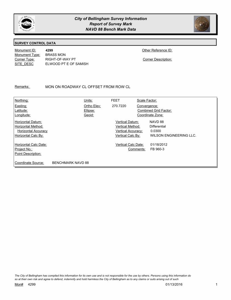
City of Bellingham Survey Information
Report of Survey Mark
NAVD 88 Bench Mark Data
SURVEY CONTROL DATA
4299Monument ID: Other Reference ID:
SITE_DESC ELWOOD PT E OF SAMISH
RIGHT-OF-WAY PTCorner Type: Corner Description:
BRASS MONMonument Type:
MON ON ROADWAY CL OFFSET FROM ROW CLRemarks:
270.7220
FEETNorthing:
Easting:
Latitude:
Longitude:
Units:
Ortho Elev:
Ellipse:
Geoid:
Scale Factor:
Convergence:
Combined Grid Factor:
Coordinate Zone:
Horizontal Method:
Horizontal Datum: NAVD 88Vertical Datum:
DifferentialVertical Method:
Horizontal Accuracy 0.0300Vertical Accuracy:
WILSON ENGINEERING LLC.Vertical Calc By:Horizontal Calc By:
Project No.:
Point Description:
BENCHMARK NAVD 88Coordinate Source:
FB 960-3Comments:
Horizontal Calc Date: 01/18/2012Vertical Calc Date:
101/13/2016Mon# 4299
The City of Bellingham has compiled this information for its own use and is not responsible for the use by others. Persons using this information do
so at their own risk and agree to defend, indemnify and hold harmless the City of Bellingham as to any claims or suits arising out of such
City of Bellingham Survey Information
Report of Survey Mark
NAVD 88 Bench Mark Data
SURVEY CONTROL DATA
4409Monument ID: COB-14Other Reference ID:
SITE_DESC DIVERSION PIPELINE SURVEY CONTROL
POINT COB 14 - PK NAIL IN TOP OF CONC
DECK OF DIVERSION DAM
TRAVERSE POINTCorner Type: DIVERSION PIPELINE
SURVEY CONTROL
POINT COB 14 - PK
NAIL IN TOP OF DAM
WITH LS TAG PSE
32450
Corner Description:
PK NAILMonument Type:
NAVD 88 ELEV= 864.42Remarks:
648,342.3476
1,341,432.1002
48 46 14.594201
-122 4 23.275026
864.4200
0.0000
FEETNorthing:
Easting:
Latitude:
Longitude:
Units:
Ortho Elev:
Ellipse:
Geoid:
Scale Factor:
Convergence:
Combined Grid Factor:
WA North 4601Coordinate Zone:
GPS + ConventionalHorizontal Method:
NAD 1983/91Horizontal Datum: NAVD 88Vertical Datum:
DifferentialVertical Method:
Horizontal Accuracy Vertical Accuracy:
PACIFIC SURVEY & ENGINEERING,
INC.
Vertical Calc By:PACIFIC SURVEY &
ENGINEERING, INC.
Horizontal Calc By:
Project No.:
COB NO. 14, SET PK NAIL IN TOP OF DAM
(PREVIOUS)
Point Description:
NAD 83/91 POINTS (KNOWN SOURCE)Coordinate Source:
Comments:
08/15/2004Horizontal Calc Date: 08/15/2004Vertical Calc Date:
101/13/2016Mon# 4409
The City of Bellingham has compiled this information for its own use and is not responsible for the use by others. Persons using this information do
so at their own risk and agree to defend, indemnify and hold harmless the City of Bellingham as to any claims or suits arising out of such
City of Bellingham Survey Information
Report of Survey Mark
NAVD 88 Bench Mark Data
SURVEY CONTROL DATA
4416Monument ID: Other Reference ID:
SITE_DESC SECTION QC
SECTION QUARTER CORNERCorner Type: 1/4 CORNER
SECTION 26/35 T38N
R5E
Corner Description:
BRASS MONMonument Type:
DIVERSION PIPELINE SURVEY POINT 903. FOUND 3.25 INCH DNR
BRASS CAP MON, 0.3 FT A.G.
Remarks:
639,367.1177
1,328,684.9042
48 44 43.977312
-122 7 31.282322
700.3652
0.0000
FEETNorthing:
Easting:
Latitude:
Longitude:
Units:
Ortho Elev:
Ellipse:
Geoid:
Scale Factor:
Convergence:
Combined Grid Factor:
WA North 4601Coordinate Zone:
GPS + ConventionalHorizontal Method:
NAD 1983/91Horizontal Datum: NAVD 88Vertical Datum:
DifferentialVertical Method:
Horizontal Accuracy Vertical Accuracy:
PACIFIC SURVEY & ENGINEERING,
INC.
Vertical Calc By:PACIFIC SURVEY &
ENGINEERING, INC.
Horizontal Calc By:
Project No.:
FND 3.25" DNR BRASS CAP MON, 0.3' AGPoint Description:
NAD 83/91 POINTS (KNOWN SOURCE)Coordinate Source:
Comments:
08/15/2004Horizontal Calc Date: 08/15/2004Vertical Calc Date:
101/13/2016Mon# 4416
The City of Bellingham has compiled this information for its own use and is not responsible for the use by others. Persons using this information do
so at their own risk and agree to defend, indemnify and hold harmless the City of Bellingham as to any claims or suits arising out of such

City of Bellingham Survey Information
Report of Survey Mark
NAVD 88 Bench Mark Data
SURVEY CONTROL DATA
4436Monument ID: Other Reference ID:
SITE_DESC SECTION 1/16 CORNER
SECTION SIXTEENTH CORNERCorner Type: SE 1/16 COR
SECTION 9 T37N R5E
Corner Description:
STEPMonument Type:
DIVERSION PIPELINE SURVEY POINT 1243Remarks:
625,617.9231
1,318,957.7679
48 42 26.694222
-122 9 52.841576
471.5852
0.0000
FEETNorthing:
Easting:
Latitude:
Longitude:
Units:
Ortho Elev:
Ellipse:
Geoid:
Scale Factor:
Convergence:
Combined Grid Factor:
WA North 4601Coordinate Zone:
GPS + ConventionalHorizontal Method:
NAD 1983/91Horizontal Datum: NAVD 88Vertical Datum:
DifferentialVertical Method:
Horizontal Accuracy Vertical Accuracy:
PACIFIC SURVEY & ENGINEERING,
INC.
Vertical Calc By:PACIFIC SURVEY &
ENGINEERING, INC.
Horizontal Calc By:
Project No.:
FND 3" DNR BRASS CAP ON 3" CONC MON, 0.4' AGPoint Description:
NAD 83/91 POINTS (KNOWN SOURCE)Coordinate Source:
Comments:
08/15/2004Horizontal Calc Date: 08/15/2004Vertical Calc Date:
101/13/2016Mon# 4436
The City of Bellingham has compiled this information for its own use and is not responsible for the use by others. Persons using this information do
so at their own risk and agree to defend, indemnify and hold harmless the City of Bellingham as to any claims or suits arising out of such

City of Bellingham Survey Information
Report of Survey Mark
NAVD 88 Bench Mark Data
SURVEY CONTROL DATA
4454Monument ID: BEL-030Other Reference ID:
SITE_DESC ELLIS & OHIO AT SW CORNER
CADASTRAL SURVEY REFERENCE POINT 2004Corner Type: REFERENCE
MONUMENT FOR
NAD 83/98 CONTROL
NETWORK
Corner Description:
ALUMINUM CAPMonument Type:
MONUMENT DESTROYED 2010
REFERENCE MONUMENT VISITED FOR NAD 83/98 CONTROL
NETWORK SURVEY 2006.
Remarks:
64.8500
0.0000
FEETNorthing:
Easting:
Latitude:
Longitude:
Units:
Ortho Elev:
Ellipse:
Geoid:
Scale Factor:
Convergence:
Combined Grid Factor:
WA North 4601Coordinate Zone:
Horizontal Method:
Horizontal Datum: NAVD 88Vertical Datum:
DifferentialVertical Method:
Horizontal Accuracy 0.0300Vertical Accuracy:
WILSON ENGINEERING LLC.Vertical Calc By:Horizontal Calc By:
ES-0425Project No.:
C-ADS ALUM. DISK BEL030 OHIO & ELLISPoint Description:
BENCHMARK NAVD 88Coordinate Source:
FB918-6 pg. 32Comments:
Horizontal Calc Date: 02/04/2009Vertical Calc Date:
101/13/2016Mon# 4454
The City of Bellingham has compiled this information for its own use and is not responsible for the use by others. Persons using this information do
so at their own risk and agree to defend, indemnify and hold harmless the City of Bellingham as to any claims or suits arising out of such
City of Bellingham Survey Information
Report of Survey Mark
NAVD 88 Bench Mark Data
SURVEY CONTROL DATA
4455Monument ID: BEL-035Other Reference ID:
SITE_DESC LYLE & E ILLINOIS AT SE CORNER
CADASTRAL SURVEY REFERENCE POINT 2004Corner Type: REFERENCE
MONUMENT USED
FOR NAD 83/98
CONTROL NETWORK
Corner Description:
ALUMINUM CAPMonument Type:
REFERENCE MONUMENT VISITED FOR NAD 83/98 CONTROL
NETWORK SURVEY 2006.
Remarks:
147.2980
0.0000
FEETNorthing:
Easting:
Latitude:
Longitude:
Units:
Ortho Elev:
Ellipse:
Geoid:
Scale Factor:
Convergence:
Combined Grid Factor:
WA North 4601Coordinate Zone:
Horizontal Method:
Horizontal Datum: NAVD 88Vertical Datum:
DifferentialVertical Method:
Horizontal Accuracy 0.0200Vertical Accuracy:
PACIFIC SURVEY & ENGINEERING,
INC.
Vertical Calc By:Horizontal Calc By:
ES-0425Project No.:
ALUM CAP IN SIDEWALK AT SE QUADR. ILLINOIS
ST & LYLE ST
Point Description:
BENCHMARK NAVD 88Coordinate Source:
FB 918Comments:
Horizontal Calc Date: 12/09/2008Vertical Calc Date:
101/13/2016Mon# 4455
The City of Bellingham has compiled this information for its own use and is not responsible for the use by others. Persons using this information do
so at their own risk and agree to defend, indemnify and hold harmless the City of Bellingham as to any claims or suits arising out of such

City of Bellingham Survey Information
Report of Survey Mark
NAVD 88 Bench Mark Data
SURVEY CONTROL DATA
4456Monument ID: Other Reference ID:
SITE_DESC W ILLINOIS & SUMMER
RIGHT-OF-WAY INTERSECTIONCorner Type: Corner Description:
BRASS MONMonument Type:
VISITED FOR NAD 83/98 CONTROL NETWORK SURVEY 2006.Remarks:
119.6200
FEETNorthing:
Easting:
Latitude:
Longitude:
Units:
Ortho Elev:
Ellipse:
Geoid:
Scale Factor:
Convergence:
Combined Grid Factor:
Coordinate Zone:
Horizontal Method:
Horizontal Datum: NAVD 88Vertical Datum:
DifferentialVertical Method:
Horizontal Accuracy 0.0200Vertical Accuracy:
CONSTRUCTION SURVEYORS N W
INC.
Vertical Calc By:Horizontal Calc By:
EU-0156Project No.:
Point Description:
BENCHMARK NAVD 88Coordinate Source:
FB 944-2Comments:
Horizontal Calc Date: 11/14/2011Vertical Calc Date:
101/13/2016Mon# 4456
The City of Bellingham has compiled this information for its own use and is not responsible for the use by others. Persons using this information do
so at their own risk and agree to defend, indemnify and hold harmless the City of Bellingham as to any claims or suits arising out of such

City of Bellingham Survey Information
Report of Survey Mark
NAVD 88 Bench Mark Data
SURVEY CONTROL DATA
4457Monument ID: Other Reference ID:
SITE_DESC BELLWETHER WAY AT S END
RIGHT-OF-WAY PICorner Type: Corner Description:
BRASS MONMonument Type:
VISITED FOR NAD 83/98 CONTROL NETWORK SURVEY 2006.Remarks:
644,441.9927
1,239,508.9746
48 45 17.15604
-122 29 43.12457
18.3840
0.0000
FEETNorthing:
Easting:
Latitude:
Longitude:
Units:
Ortho Elev:
Ellipse:
Geoid:
1.0000000000Scale Factor:
- 1 14 15Convergence:
Combined Grid Factor:
WA North 4601Coordinate Zone:
Conventional SurveyHorizontal Method:
NAD 83/98Horizontal Datum: NAVD 88Vertical Datum:
DifferentialVertical Method:
0.0700Horizontal Accuracy 0.0200Vertical Accuracy:
PACIFIC SURVEY & ENGINEERING,
INC.
Vertical Calc By:PACIFIC SURVEY &
ENGINEERING, INC.
Horizontal Calc By:
Project No.:
C-BDSPoint Description:
NAD 83/98 NETWORK(DENSIFICATION PROJECT)Coordinate Source:
FB880-2 WATERFRONT CONTROL
SURVEY AF2080302393
Comments:
01/23/2008Horizontal Calc Date: 01/23/2008Vertical Calc Date:
101/13/2016Mon# 4457
The City of Bellingham has compiled this information for its own use and is not responsible for the use by others. Persons using this information do
so at their own risk and agree to defend, indemnify and hold harmless the City of Bellingham as to any claims or suits arising out of such
City of Bellingham Survey Information
Report of Survey Mark
NAVD 88 Bench Mark Data
SURVEY CONTROL DATA
4458Monument ID: WSDOT BELBAY
2005
Other Reference ID:
SITE_DESC NEAR ZUANICH POINT PARK ON N HARBOR
LOOP
TRAVERSE POINTCorner Type: WSDOT BELBAY
2005 REFERENCE
MONUMENT USED
FOR NAD 83/98
CONTROL NETWORK
Corner Description:
BRASS MONMonument Type:
VISITED FOR NAD 83/98 CONTROL NETWORK SURVEY 2006.Remarks:
196,508.9230
377,456.4920
48 45 19.593376
-122 29 59.736822
4.3790
METERSNorthing:
Easting:
Latitude:
Longitude:
Units:
Ortho Elev:
Ellipse:
Geoid:
1.0000000000Scale Factor:
-1 14 26.9Convergence:
Combined Grid Factor:
WA North 4601Coordinate Zone:
Geodetic GPSHorizontal Method:
NAD 83/07Horizontal Datum: NAVD 88Vertical Datum:
DifferentialVertical Method:
0.0200Horizontal Accuracy 0.0100Vertical Accuracy:
STATE OF WASHINGTONVertical Calc By:STATE OF WASHINGTONHorizontal Calc By:
Project No.:
WSDOT BEL BAYPoint Description:
WSDOTCoordinate Source:
METERSComments:
04/29/2008Horizontal Calc Date: 04/29/2008Vertical Calc Date:
101/13/2016Mon# 4458
The City of Bellingham has compiled this information for its own use and is not responsible for the use by others. Persons using this information do
so at their own risk and agree to defend, indemnify and hold harmless the City of Bellingham as to any claims or suits arising out of such
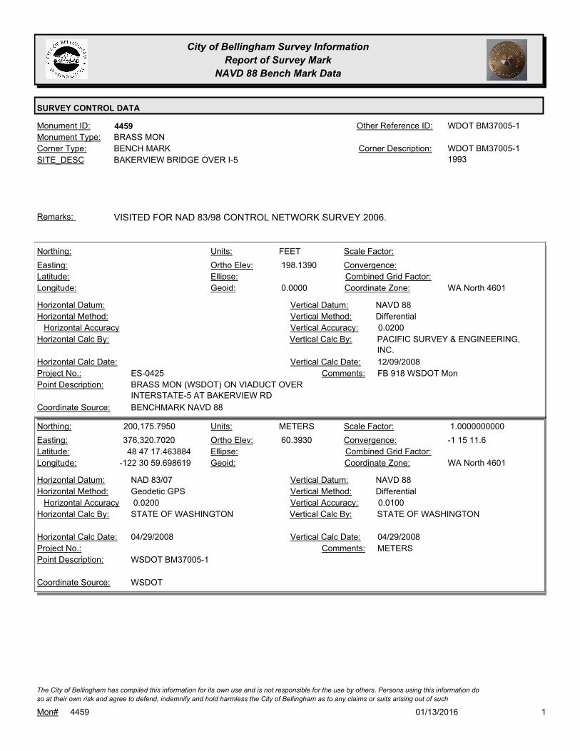
City of Bellingham Survey Information
Report of Survey Mark
NAVD 88 Bench Mark Data
SURVEY CONTROL DATA
4459Monument ID: WDOT BM37005-1Other Reference ID:
SITE_DESC BAKERVIEW BRIDGE OVER I-5
BENCH MARKCorner Type: WDOT BM37005-1
1993
Corner Description:
BRASS MONMonument Type:
VISITED FOR NAD 83/98 CONTROL NETWORK SURVEY 2006.Remarks:
198.1390
0.0000
FEETNorthing:
Easting:
Latitude:
Longitude:
Units:
Ortho Elev:
Ellipse:
Geoid:
Scale Factor:
Convergence:
Combined Grid Factor:
WA North 4601Coordinate Zone:
Horizontal Method:
Horizontal Datum: NAVD 88Vertical Datum:
DifferentialVertical Method:
Horizontal Accuracy 0.0200Vertical Accuracy:
PACIFIC SURVEY & ENGINEERING,
INC.
Vertical Calc By:Horizontal Calc By:
ES-0425Project No.:
BRASS MON (WSDOT) ON VIADUCT OVER
INTERSTATE-5 AT BAKERVIEW RD
Point Description:
BENCHMARK NAVD 88Coordinate Source:
FB 918 WSDOT MonComments:
Horizontal Calc Date: 12/09/2008Vertical Calc Date:
200,175.7950
376,320.7020
48 47 17.463884
-122 30 59.698619
60.3930
METERSNorthing:
Easting:
Latitude:
Longitude:
Units:
Ortho Elev:
Ellipse:
Geoid:
1.0000000000Scale Factor:
-1 15 11.6Convergence:
Combined Grid Factor:
WA North 4601Coordinate Zone:
Geodetic GPSHorizontal Method:
NAD 83/07Horizontal Datum: NAVD 88Vertical Datum:
DifferentialVertical Method:
0.0200Horizontal Accuracy 0.0100Vertical Accuracy:
STATE OF WASHINGTONVertical Calc By:STATE OF WASHINGTONHorizontal Calc By:
Project No.:
WSDOT BM37005-1Point Description:
WSDOTCoordinate Source:
METERSComments:
04/29/2008Horizontal Calc Date: 04/29/2008Vertical Calc Date:
101/13/2016Mon# 4459
The City of Bellingham has compiled this information for its own use and is not responsible for the use by others. Persons using this information do
so at their own risk and agree to defend, indemnify and hold harmless the City of Bellingham as to any claims or suits arising out of such
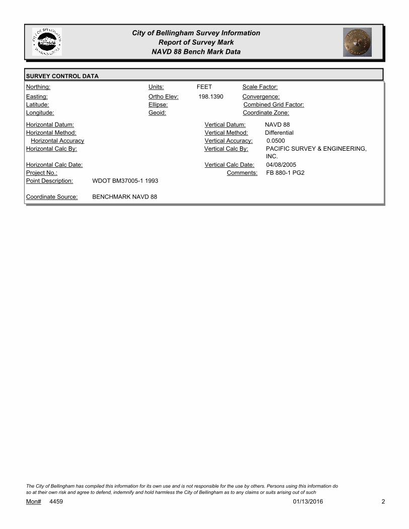
City of Bellingham Survey Information
Report of Survey Mark
NAVD 88 Bench Mark Data
SURVEY CONTROL DATA
198.1390
FEETNorthing:
Easting:
Latitude:
Longitude:
Units:
Ortho Elev:
Ellipse:
Geoid:
Scale Factor:
Convergence:
Combined Grid Factor:
Coordinate Zone:
Horizontal Method:
Horizontal Datum: NAVD 88Vertical Datum:
DifferentialVertical Method:
Horizontal Accuracy 0.0500Vertical Accuracy:
PACIFIC SURVEY & ENGINEERING,
INC.
Vertical Calc By:Horizontal Calc By:
Project No.:
WDOT BM37005-1 1993Point Description:
BENCHMARK NAVD 88Coordinate Source:
FB 880-1 PG2Comments:
Horizontal Calc Date: 04/08/2005Vertical Calc Date:
201/13/2016Mon# 4459
The City of Bellingham has compiled this information for its own use and is not responsible for the use by others. Persons using this information do
so at their own risk and agree to defend, indemnify and hold harmless the City of Bellingham as to any claims or suits arising out of such

City of Bellingham Survey Information
Report of Survey Mark
NAVD 88 Bench Mark Data
SURVEY CONTROL DATA
4460Monument ID: Other Reference ID:
SITE_DESC JAMES ST PT N OF SUNSET
RIGHT-OF-WAY PTCorner Type: Corner Description:
IRON PIPEMonument Type:
VISITED FOR NAD 83/98 CONTROL NETWORK SURVEY 2006.Remarks:
163.7430
0.0000
FEETNorthing:
Easting:
Latitude:
Longitude:
Units:
Ortho Elev:
Ellipse:
Geoid:
Scale Factor:
Convergence:
Combined Grid Factor:
WA North 4601Coordinate Zone:
Horizontal Method:
Horizontal Datum: NAVD 88Vertical Datum:
DifferentialVertical Method:
Horizontal Accuracy 0.0200Vertical Accuracy:
PACIFIC SURVEY & ENGINEERING,
INC.
Vertical Calc By:Horizontal Calc By:
ES-0425Project No.:
IRON PIPE IN CASE AT ROW PT JAMES STPoint Description:
BENCHMARK NAVD 88Coordinate Source:
FB 918Comments:
Horizontal Calc Date: 12/31/2008Vertical Calc Date:
101/13/2016Mon# 4460
The City of Bellingham has compiled this information for its own use and is not responsible for the use by others. Persons using this information do
so at their own risk and agree to defend, indemnify and hold harmless the City of Bellingham as to any claims or suits arising out of such
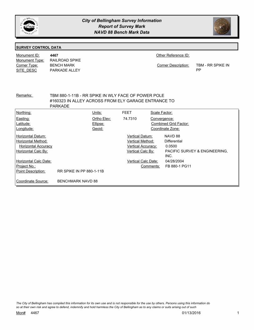
City of Bellingham Survey Information
Report of Survey Mark
NAVD 88 Bench Mark Data
SURVEY CONTROL DATA
4467Monument ID: Other Reference ID:
SITE_DESC PARKADE ALLEY
BENCH MARKCorner Type: TBM - RR SPIKE IN
PP
Corner Description:
RAILROAD SPIKEMonument Type:
TBM 880-1-11B - RR SPIKE IN WLY FACE OF POWER POLE
#160323 IN ALLEY ACROSS FROM ELY GARAGE ENTRANCE TO
PARKADE
Remarks:
74.7310
FEETNorthing:
Easting:
Latitude:
Longitude:
Units:
Ortho Elev:
Ellipse:
Geoid:
Scale Factor:
Convergence:
Combined Grid Factor:
Coordinate Zone:
Horizontal Method:
Horizontal Datum: NAVD 88Vertical Datum:
DifferentialVertical Method:
Horizontal Accuracy 0.0500Vertical Accuracy:
PACIFIC SURVEY & ENGINEERING,
INC.
Vertical Calc By:Horizontal Calc By:
Project No.:
RR SPIKE IN PP 880-1-11BPoint Description:
BENCHMARK NAVD 88Coordinate Source:
FB 880-1 PG11Comments:
Horizontal Calc Date: 04/28/2004Vertical Calc Date:
101/13/2016Mon# 4467
The City of Bellingham has compiled this information for its own use and is not responsible for the use by others. Persons using this information do
so at their own risk and agree to defend, indemnify and hold harmless the City of Bellingham as to any claims or suits arising out of such
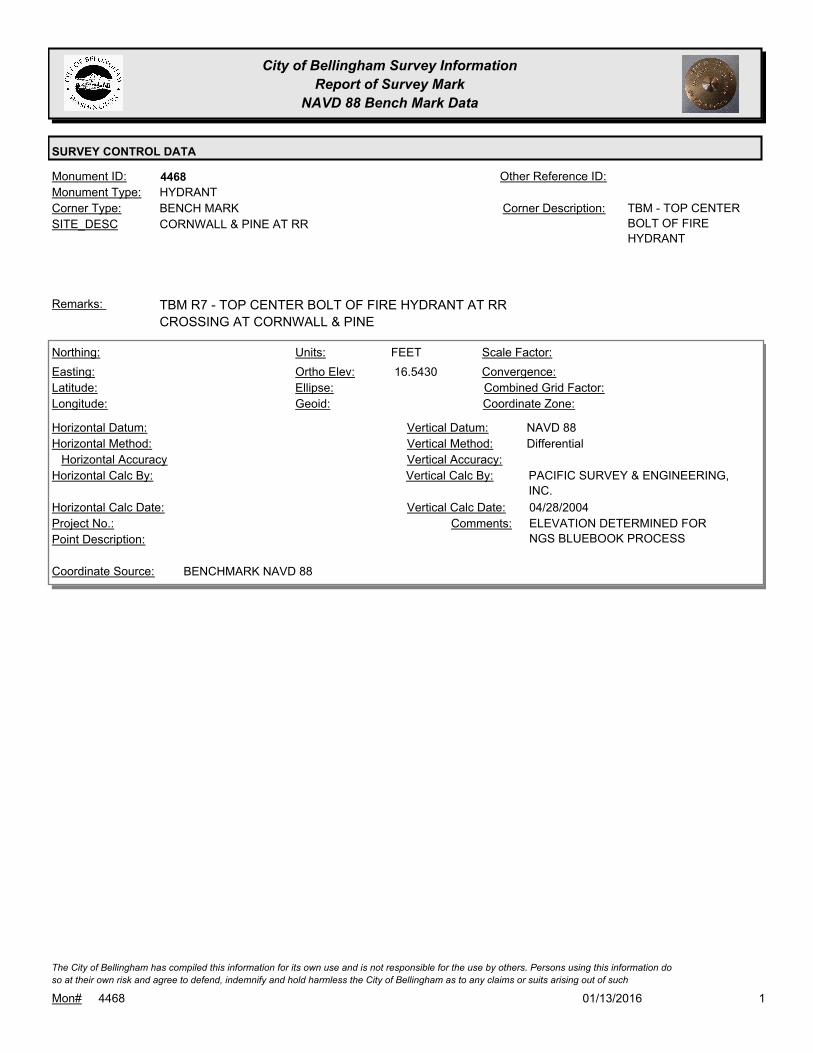
City of Bellingham Survey Information
Report of Survey Mark
NAVD 88 Bench Mark Data
SURVEY CONTROL DATA
4468Monument ID: Other Reference ID:
SITE_DESC CORNWALL & PINE AT RR
BENCH MARKCorner Type: TBM - TOP CENTER
BOLT OF FIRE
HYDRANT
Corner Description:
HYDRANTMonument Type:
TBM R7 - TOP CENTER BOLT OF FIRE HYDRANT AT RR
CROSSING AT CORNWALL & PINE
Remarks:
16.5430
FEETNorthing:
Easting:
Latitude:
Longitude:
Units:
Ortho Elev:
Ellipse:
Geoid:
Scale Factor:
Convergence:
Combined Grid Factor:
Coordinate Zone:
Horizontal Method:
Horizontal Datum: NAVD 88Vertical Datum:
DifferentialVertical Method:
Horizontal Accuracy Vertical Accuracy:
PACIFIC SURVEY & ENGINEERING,
INC.
Vertical Calc By:Horizontal Calc By:
Project No.:
Point Description:
BENCHMARK NAVD 88Coordinate Source:
ELEVATION DETERMINED FOR
NGS BLUEBOOK PROCESS
Comments:
Horizontal Calc Date: 04/28/2004Vertical Calc Date:
101/13/2016Mon# 4468
The City of Bellingham has compiled this information for its own use and is not responsible for the use by others. Persons using this information do
so at their own risk and agree to defend, indemnify and hold harmless the City of Bellingham as to any claims or suits arising out of such
City of Bellingham Survey Information
Report of Survey Mark
NAVD 88 Bench Mark Data
SURVEY CONTROL DATA
4469Monument ID: Other Reference ID:
SITE_DESC 12TH & MCKENZIE AT E SIDE
BENCH MARKCorner Type: TBMCorner Description:
HYDRANTMonument Type:
TBM R-11 - TOP CENTER BOLT OF FIRE HYDRANT ADJACENT TO
RETAINING WALL ON E SIDE 12TH ST AT 50 FT S OF CL
MCKENZIE
Remarks:
97.0180
FEETNorthing:
Easting:
Latitude:
Longitude:
Units:
Ortho Elev:
Ellipse:
Geoid:
Scale Factor:
Convergence:
Combined Grid Factor:
Coordinate Zone:
Horizontal Method:
Horizontal Datum: NAVD 88Vertical Datum:
DifferentialVertical Method:
Horizontal Accuracy Vertical Accuracy:
PACIFIC SURVEY & ENGINEERING,
INC.
Vertical Calc By:Horizontal Calc By:
Project No.:
Point Description:
BENCHMARK NAVD 88Coordinate Source:
ELEVATION DETERMINED FOR
NGS BLUEBOOK PROCESS. FB
880-1
Comments:
Horizontal Calc Date: 04/29/2004Vertical Calc Date:
97.0630
0.0000
FEETNorthing:
Easting:
Latitude:
Longitude:
Units:
Ortho Elev:
Ellipse:
Geoid:
Scale Factor:
Convergence:
Combined Grid Factor:
WA North 4601Coordinate Zone:
Horizontal Method:
Horizontal Datum: NAVD 88Vertical Datum:
DifferentialVertical Method:
Horizontal Accuracy 0.0200Vertical Accuracy:
LARRY STEELE & ASSOCIATESVertical Calc By:Horizontal Calc By:
ES-0425Project No.:
FIRE HYDRANT AT 12TH ST SOUTH OF MCKENZIEPoint Description:
BENCHMARK NAVD 88Coordinate Source:
FB 918-11Comments:
Horizontal Calc Date: 02/17/2009Vertical Calc Date:
101/13/2016Mon# 4469
The City of Bellingham has compiled this information for its own use and is not responsible for the use by others. Persons using this information do
so at their own risk and agree to defend, indemnify and hold harmless the City of Bellingham as to any claims or suits arising out of such
City of Bellingham Survey Information
Report of Survey Mark
NAVD 88 Bench Mark Data
SURVEY CONTROL DATA
4470Monument ID: Other Reference ID:
SITE_DESC OLD FAIRHAVEN PKWY & 30TH AT SE
CORNER
BENCH MARKCorner Type: TBM - FILED X ON SE
BOLT ON SIG POLE
BASE AT SE
CORNER
Corner Description:
BOLTMonument Type:
TBM 880-1-13A FILED X ON SE BOLT ON SIGNAL POLE
FOUNDATION ON SE CORNER OF OLD FAIRHAVEN PKWY & 30TH
Remarks:
139.7810
FEETNorthing:
Easting:
Latitude:
Longitude:
Units:
Ortho Elev:
Ellipse:
Geoid:
Scale Factor:
Convergence:
Combined Grid Factor:
Coordinate Zone:
Horizontal Method:
Horizontal Datum: NAVD 88Vertical Datum:
DifferentialVertical Method:
Horizontal Accuracy 0.0500Vertical Accuracy:
PACIFIC SURVEY & ENGINEERING,
INC.
Vertical Calc By:Horizontal Calc By:
Project No.:
TBM 880-1-13A SCRIBED X ON BOLTPoint Description:
BENCHMARK NAVD 88Coordinate Source:
FB 880-1 PG13Comments:
Horizontal Calc Date: 04/29/2004Vertical Calc Date:
139.8080
0.0000
FEETNorthing:
Easting:
Latitude:
Longitude:
Units:
Ortho Elev:
Ellipse:
Geoid:
Scale Factor:
Convergence:
Combined Grid Factor:
WA North 4601Coordinate Zone:
Horizontal Method:
Horizontal Datum: NAVD 88Vertical Datum:
DifferentialVertical Method:
Horizontal Accuracy 0.0200Vertical Accuracy:
LARRY STEELE & ASSOCIATESVertical Calc By:Horizontal Calc By:
ES-0425Project No.:
SCRIBED "X" BOLT OF SIGNAL POLE AT 30TH &
FAIRHAVEN PKWY
Point Description:
BENCHMARK NAVD 88Coordinate Source:
FB 918-11Comments:
Horizontal Calc Date: 02/17/2009Vertical Calc Date:
101/13/2016Mon# 4470
The City of Bellingham has compiled this information for its own use and is not responsible for the use by others. Persons using this information do
so at their own risk and agree to defend, indemnify and hold harmless the City of Bellingham as to any claims or suits arising out of such
City of Bellingham Survey Information
Report of Survey Mark
NAVD 88 Bench Mark Data
SURVEY CONTROL DATA
4474Monument ID: Other Reference ID:
SITE_DESC SAMISH & 40TH ON N SIDE OF ROAD
BENCH MARKCorner Type: TBM 880-1-15DCorner Description:
BOLTMonument Type:
TBM 880-1-15D - SLY MOST BOLT ON CONCRETE LUMINAIRE
POLE ON N SIDE SAMISH WAY & 40TH
Remarks:
490.5390
FEETNorthing:
Easting:
Latitude:
Longitude:
Units:
Ortho Elev:
Ellipse:
Geoid:
Scale Factor:
Convergence:
Combined Grid Factor:
Coordinate Zone:
Horizontal Method:
Horizontal Datum: NAVD 88Vertical Datum:
DifferentialVertical Method:
Horizontal Accuracy 0.0500Vertical Accuracy:
PACIFIC SURVEY & ENGINEERING,
INC.
Vertical Calc By:Horizontal Calc By:
Project No.:
TBM 880-1-15D SCRIBED XPoint Description:
BENCHMARK NAVD 88Coordinate Source:
DO NOT USE. FB 880-1 PG15.Comments:
Horizontal Calc Date: 04/30/2004Vertical Calc Date:
490.5870
FEETNorthing:
Easting:
Latitude:
Longitude:
Units:
Ortho Elev:
Ellipse:
Geoid:
Scale Factor:
Convergence:
Combined Grid Factor:
Coordinate Zone:
Horizontal Method:
Horizontal Datum: NAVD 88Vertical Datum:
DifferentialVertical Method:
Horizontal Accuracy 0.0300Vertical Accuracy:
WILSON ENGINEERING LLC.Vertical Calc By:Horizontal Calc By:
Project No.:
Point Description:
BENCHMARK NAVD 88Coordinate Source:
FB 960-3Comments:
Horizontal Calc Date: 01/18/2012Vertical Calc Date:
101/13/2016Mon# 4474
The City of Bellingham has compiled this information for its own use and is not responsible for the use by others. Persons using this information do
so at their own risk and agree to defend, indemnify and hold harmless the City of Bellingham as to any claims or suits arising out of such

City of Bellingham Survey Information
Report of Survey Mark
NAVD 88 Bench Mark Data
SURVEY CONTROL DATA
4481Monument ID: Other Reference ID:
SITE_DESC LAKEWAY & ELECTRIC IN SIDEWALK AT NE
QUAD
CADASTRAL SURVEY REFERENCE POINT 2004Corner Type: REFERENCE
MONUMENT SET BY
LARRY STEELE &
ASSOC. FOR NAD
83/98 CONTROL
NETWORK
Corner Description:
ALUMINUM CAPMonument Type:
VISITED FOR NAD 83/98 CONTROL NETWORK SURVEY 2006. IN
SIDEWALK AT NE QUAD INT
Remarks:
342.7180
0.0000
FEETNorthing:
Easting:
Latitude:
Longitude:
Units:
Ortho Elev:
Ellipse:
Geoid:
Scale Factor:
Convergence:
Combined Grid Factor:
WA North 4601Coordinate Zone:
Horizontal Method:
Horizontal Datum: NAVD 88Vertical Datum:
DifferentialVertical Method:
Horizontal Accuracy 0.0300Vertical Accuracy:
WILSON ENGINEERING LLC.Vertical Calc By:Horizontal Calc By:
ES-0425Project No.:
C-ADS NAD83/98 MON ELECTRIC & LAKEWAYPoint Description:
BENCHMARK NAVD 88Coordinate Source:
FB918-8 pg. 21Comments:
Horizontal Calc Date: 02/12/2009Vertical Calc Date:
101/13/2016Mon# 4481
The City of Bellingham has compiled this information for its own use and is not responsible for the use by others. Persons using this information do
so at their own risk and agree to defend, indemnify and hold harmless the City of Bellingham as to any claims or suits arising out of such

City of Bellingham Survey Information
Report of Survey Mark
NAVD 88 Bench Mark Data
SURVEY CONTROL DATA
4482Monument ID: Other Reference ID:
SITE_DESC NEAR OLD WOBURN & YEW IN SIDEWALK
CADASTRAL SURVEY REFERENCE POINT 2004Corner Type: REFERENCE
MONUMENT SET BY
LARRY STEELE &
ASSOC. FOR NAD
83/98 CONTROL
NETWORK
Corner Description:
ALUMINUM CAPMonument Type:
VISITED FOR NAD 83/98 CONTROL NETWORK SURVEY 2006.
USED FOR DATUM MODERNIZATION TO NAVD88
Remarks:
198.8250
0.0000
FEETNorthing:
Easting:
Latitude:
Longitude:
Units:
Ortho Elev:
Ellipse:
Geoid:
Scale Factor:
Convergence:
Combined Grid Factor:
WA North 4601Coordinate Zone:
Horizontal Method:
Horizontal Datum: NAVD 88Vertical Datum:
DifferentialVertical Method:
Horizontal Accuracy 0.0300Vertical Accuracy:
WILSON ENGINEERING LLC.Vertical Calc By:Horizontal Calc By:
ES-0425Project No.:
C-ADS NAD83/98 MON OLD WOBURN &
WOBURN/YEW
Point Description:
BENCHMARK NAVD 88Coordinate Source:
FB918-8 pg. 9Comments:
Horizontal Calc Date: 02/12/2009Vertical Calc Date:
101/13/2016Mon# 4482
The City of Bellingham has compiled this information for its own use and is not responsible for the use by others. Persons using this information do
so at their own risk and agree to defend, indemnify and hold harmless the City of Bellingham as to any claims or suits arising out of such

City of Bellingham Survey Information
Report of Survey Mark
NAVD 88 Bench Mark Data
SURVEY CONTROL DATA
4483Monument ID: Other Reference ID:
SITE_DESC LAKEWAY & PUGET IN SIDEWALK AT NW
CORNER
CADASTRAL SURVEY REFERENCE POINT 2004Corner Type: REFERENCE
MONUMENT SET BY
LARRY STEELE &
ASSOC. FOR NAD
83/98 CONTROL
NETWORK. ALSO
USED FOR DATUM
MODERNIZATION TO
NAVD88
Corner Description:
ALUMINUM CAPMonument Type:
VISITED FOR NAD 83/98 CONTROL NETWORK SURVEY 2006.
ALSO USED FOR DATUM MODERNIZATION TO NAVD88
Remarks:
192.0690
0.0000
FEETNorthing:
Easting:
Latitude:
Longitude:
Units:
Ortho Elev:
Ellipse:
Geoid:
Scale Factor:
Convergence:
Combined Grid Factor:
WA North 4601Coordinate Zone:
Horizontal Method:
Horizontal Datum: NAVD 88Vertical Datum:
DifferentialVertical Method:
Horizontal Accuracy 0.0300Vertical Accuracy:
WILSON ENGINEERING LLC.Vertical Calc By:Horizontal Calc By:
ES-0425Project No.:
C-ADS NAD83/98 MON NW QUAD PUGET &
LAKEWAY
Point Description:
BENCHMARK NAVD 88Coordinate Source:
FB918-7 pg. 42Comments:
Horizontal Calc Date: 02/12/2009Vertical Calc Date:
101/13/2016Mon# 4483
The City of Bellingham has compiled this information for its own use and is not responsible for the use by others. Persons using this information do
so at their own risk and agree to defend, indemnify and hold harmless the City of Bellingham as to any claims or suits arising out of such

City of Bellingham Survey Information
Report of Survey Mark
NAVD 88 Bench Mark Data
SURVEY CONTROL DATA
4487Monument ID: TR0032Other Reference ID:
SITE_DESC PROSPECT & FLORA IN FRONT STEPS OF
OLD CITY HALL - NOW WHATCOM MUSEUM
BENCH MARKCorner Type: TIDAL BM - USGS
BENCHMARK
ESTABLISHED 1917.
PRIMARY TRAVERSE
STA NO 7 67 B.
USC&GS BRASS
PLATE @ THE TOP
OF THE STEPS AT
THE BASE OF THE
COLUMN AT THE
ENTRANCE OF THE
MUSEUM. (OLD CITY
HALL).
Corner Description:
BRASS MONMonument Type:
DISK SET IN TOP OF NE COR OF N CONC BALUSTRADE OF
PROSPECT ST ENTRANCE TO MUSEUM
3 WIRE LEVEL. ELEVATION TAKEN FROM 3 WIRE LEVEL
FIELDBOOK.
Remarks:
72.4200
FEETNorthing:
Easting:
Latitude:
Longitude:
Units:
Ortho Elev:
Ellipse:
Geoid:
Scale Factor:
Convergence:
Combined Grid Factor:
Coordinate Zone:
Horizontal Method:
Horizontal Datum: NAVD 88Vertical Datum:
DifferentialVertical Method:
Horizontal Accuracy Vertical Accuracy:
NATIONAL GEODETIC SURVEYVertical Calc By:Horizontal Calc By:
Project No.:
Point Description:
NGSCoordinate Source:
NGS PUBLISHED ELEVComments:
Horizontal Calc Date: 06/30/1991Vertical Calc Date:
101/13/2016Mon# 4487
The City of Bellingham has compiled this information for its own use and is not responsible for the use by others. Persons using this information do
so at their own risk and agree to defend, indemnify and hold harmless the City of Bellingham as to any claims or suits arising out of such

City of Bellingham Survey Information
Report of Survey Mark
NAVD 88 Bench Mark Data
SURVEY CONTROL DATA
4488Monument ID: NGS PID TR0034,
U454
Other Reference ID:
SITE_DESC CORNWALL AVE CURB ON NW SIDE NEAR
E MAPLE
BENCH MARKCorner Type: TIDAL BM NGS PID
TR0034,
DESIGNATION U454
Corner Description:
BRASS MONMonument Type:
DISK SET IN NW CONC CURB OF CORNWALL AVE OVERPASS
OVER BN RR TRACKS NEAR MAPLE ST
Remarks:
641,770.3187
1,242,564.1736
48 44 51.44872
-122 28 56.68868
39.5670
0.0000
FEETNorthing:
Easting:
Latitude:
Longitude:
Units:
Ortho Elev:
Ellipse:
Geoid:
1.0000000000Scale Factor:
- 1 13 40Convergence:
Combined Grid Factor:
WA North 4601Coordinate Zone:
Conventional SurveyHorizontal Method:
NAD 83/98Horizontal Datum: NAVD 88Vertical Datum:
DifferentialVertical Method:
0.0700Horizontal Accuracy 0.0200Vertical Accuracy:
PACIFIC SURVEY & ENGINEERING,
INC.
Vertical Calc By:PACIFIC SURVEY &
ENGINEERING, INC.
Horizontal Calc By:
Project No.:
C-BDSPoint Description:
NAD 83/98 NETWORK(DENSIFICATION PROJECT)Coordinate Source:
FB880-2 WATERFRONT CONTROL
SURVEY AF2080302393
Comments:
01/23/2008Horizontal Calc Date: 01/23/2008Vertical Calc Date:
39.5670
FEETNorthing:
Easting:
Latitude:
Longitude:
Units:
Ortho Elev:
Ellipse:
Geoid:
Scale Factor:
Convergence:
Combined Grid Factor:
Coordinate Zone:
Horizontal Method:
Horizontal Datum: NAVD 88Vertical Datum:
DifferentialVertical Method:
Horizontal Accuracy Vertical Accuracy:
NATIONAL GEODETIC SURVEYVertical Calc By:Horizontal Calc By:
Project No.:
NGS PID TR0034 U454Point Description:
NGSCoordinate Source:
Comments:
Horizontal Calc Date: 06/01/1991Vertical Calc Date:
101/13/2016Mon# 4488
The City of Bellingham has compiled this information for its own use and is not responsible for the use by others. Persons using this information do
so at their own risk and agree to defend, indemnify and hold harmless the City of Bellingham as to any claims or suits arising out of such

City of Bellingham Survey Information
Report of Survey Mark
NAVD 88 Bench Mark Data
SURVEY CONTROL DATA
4489Monument ID: NGS PID TR0029Other Reference ID:
SITE_DESC C & ROEDER AT BN RR STATION
BENCH MARKCorner Type: TIDAL BM - NGS PID
TR0029, N 6 RESET
1951
Corner Description:
BRASS MONMonument Type:
DISK SET VERTICALLY IN SW FACE OF CONC FOUNDATION OF
BN RR STATION
Remarks:
19.4900
FEETNorthing:
Easting:
Latitude:
Longitude:
Units:
Ortho Elev:
Ellipse:
Geoid:
Scale Factor:
Convergence:
Combined Grid Factor:
Coordinate Zone:
Horizontal Method:
Horizontal Datum: NAVD 88Vertical Datum:
DifferentialVertical Method:
Horizontal Accuracy 0.0500Vertical Accuracy:
PACIFIC SURVEY & ENGINEERING,
INC.
Vertical Calc By:Horizontal Calc By:
Project No.:
TIDAL BM - NGS PID TR0029, N 6 RESET 1951Point Description:
BENCHMARK NAVD 88Coordinate Source:
FB 880-1 PG11Comments:
Horizontal Calc Date: 04/28/2004Vertical Calc Date:
101/13/2016Mon# 4489
The City of Bellingham has compiled this information for its own use and is not responsible for the use by others. Persons using this information do
so at their own risk and agree to defend, indemnify and hold harmless the City of Bellingham as to any claims or suits arising out of such

City of Bellingham Survey Information
Report of Survey Mark
NAVD 88 Bench Mark Data
SURVEY CONTROL DATA
4490Monument ID: Other Reference ID:
SITE_DESC YEW NEAR P.I. S OF HILLSIDE LN BEHIND
CURB ON E SIDE
CADASTRAL SURVEY REFERENCE POINT 2004Corner Type: REFERENCE
MONUMENT SET BY
LARRY STEELE &
ASSOC. FOR NAD
83/98 CONTROL
NETWORK
Corner Description:
ALUMINUM CAPMonument Type:
VISITED FOR NAD 83/98 CONTROL NETWORK SURVEY 2006. SET
IN CONC BEHIND CURB ON E SIDE
Remarks:
146.6310
0.0000
FEETNorthing:
Easting:
Latitude:
Longitude:
Units:
Ortho Elev:
Ellipse:
Geoid:
Scale Factor:
Convergence:
Combined Grid Factor:
WA North 4601Coordinate Zone:
Horizontal Method:
Horizontal Datum: NAVD 88Vertical Datum:
DifferentialVertical Method:
Horizontal Accuracy 0.0300Vertical Accuracy:
WILSON ENGINEERING LLC.Vertical Calc By:Horizontal Calc By:
ES-0425Project No.:
C-ADS NAD83/98 MON YEW S. OF HILLSIDE LN.Point Description:
BENCHMARK NAVD 88Coordinate Source:
FB918-8 pg. 12Comments:
Horizontal Calc Date: 02/12/2009Vertical Calc Date:
101/13/2016Mon# 4490
The City of Bellingham has compiled this information for its own use and is not responsible for the use by others. Persons using this information do
so at their own risk and agree to defend, indemnify and hold harmless the City of Bellingham as to any claims or suits arising out of such

City of Bellingham Survey Information
Report of Survey Mark
NAVD 88 Bench Mark Data
SURVEY CONTROL DATA
4494Monument ID: Other Reference ID:
SITE_DESC COOLIDGE S OF SQUALICUM PKWY
RIGHT-OF-WAY PCCorner Type: Corner Description:
BRASS MONMonument Type:
VISITED FOR NAD 83/98 CONTROL NETWORK SURVEY 2006.Remarks:
140.9580
0.0000
FEETNorthing:
Easting:
Latitude:
Longitude:
Units:
Ortho Elev:
Ellipse:
Geoid:
Scale Factor:
Convergence:
Combined Grid Factor:
WA North 4601Coordinate Zone:
Horizontal Method:
Horizontal Datum: NAVD 88Vertical Datum:
DifferentialVertical Method:
Horizontal Accuracy 0.0200Vertical Accuracy:
PACIFIC SURVEY & ENGINEERING,
INC.
Vertical Calc By:Horizontal Calc By:
ES-0425Project No.:
BRASS MON (PC) IN CL COOLIDGE WAY APPROX.
120' S. OF SQUALICUM PKWY
Point Description:
BENCHMARK NAVD 88Coordinate Source:
FB 918Comments:
Horizontal Calc Date: 12/31/2008Vertical Calc Date:
101/13/2016Mon# 4494
The City of Bellingham has compiled this information for its own use and is not responsible for the use by others. Persons using this information do
so at their own risk and agree to defend, indemnify and hold harmless the City of Bellingham as to any claims or suits arising out of such

City of Bellingham Survey Information
Report of Survey Mark
NAVD 88 Bench Mark Data
SURVEY CONTROL DATA
4495Monument ID: Other Reference ID:
SITE_DESC SQUALICUM PARKWAY 2ND PC E OF ELLIS
RIGHT-OF-WAY PCCorner Type: Corner Description:
BRASS MONMonument Type:
VISITED FOR NAD 83/98 CONTROL NETWORK SURVEY 2006.
LOCATED 0.1 MILE E OF ELLIS
Remarks:
154.3520
0.0000
FEETNorthing:
Easting:
Latitude:
Longitude:
Units:
Ortho Elev:
Ellipse:
Geoid:
Scale Factor:
Convergence:
Combined Grid Factor:
WA North 4601Coordinate Zone:
Horizontal Method:
Horizontal Datum: NAVD 88Vertical Datum:
DifferentialVertical Method:
Horizontal Accuracy 0.0200Vertical Accuracy:
PACIFIC SURVEY & ENGINEERING,
INC.
Vertical Calc By:Horizontal Calc By:
ES-0425Project No.:
BRASS MON (PC) AT CL SQUALICUM PKWY
APPROX. 120' E. OF LEVIN LN
Point Description:
BENCHMARK NAVD 88Coordinate Source:
FB 918Comments:
Horizontal Calc Date: 01/06/2009Vertical Calc Date:
101/13/2016Mon# 4495
The City of Bellingham has compiled this information for its own use and is not responsible for the use by others. Persons using this information do
so at their own risk and agree to defend, indemnify and hold harmless the City of Bellingham as to any claims or suits arising out of such
City of Bellingham Survey Information
Report of Survey Mark
NAVD 88 Bench Mark Data
SURVEY CONTROL DATA
4496Monument ID: Other Reference ID:
SITE_DESC IOWA & WOBURN YEW IN SIDEWALK AT
SW COR
CADASTRAL SURVEY REFERENCE POINT 2004Corner Type: REFERENCE
MONUMENT SET BY
LARRY STEELE &
ASSOC. FOR NAD
83/98 CONTROL
NETWORK
Corner Description:
ALUMINUM CAPMonument Type:
MONUMENT HAS BEEN DESTROYED BY PROJECT ES-0459Remarks:
93.1240
0.0000
FEETNorthing:
Easting:
Latitude:
Longitude:
Units:
Ortho Elev:
Ellipse:
Geoid:
Scale Factor:
Convergence:
Combined Grid Factor:
WA North 4601Coordinate Zone:
Horizontal Method:
Horizontal Datum: NAVD 88Vertical Datum:
DifferentialVertical Method:
Horizontal Accuracy 0.0300Vertical Accuracy:
WILSON ENGINEERING LLC.Vertical Calc By:Horizontal Calc By:
ES-0425Project No.:
C-ADS NAD83/98 MON SW QUAD IOWA & WOBURNPoint Description:
BENCHMARK NAVD 88Coordinate Source:
FB918-7 pg. 31Comments:
Horizontal Calc Date: 02/12/2009Vertical Calc Date:
101/13/2016Mon# 4496
The City of Bellingham has compiled this information for its own use and is not responsible for the use by others. Persons using this information do
so at their own risk and agree to defend, indemnify and hold harmless the City of Bellingham as to any claims or suits arising out of such

City of Bellingham Survey Information
Report of Survey Mark
NAVD 88 Bench Mark Data
SURVEY CONTROL DATA
4535Monument ID: Other Reference ID:
SITE_DESC SECTION 1/16 CORNER
SECTION SIXTEENTH CORNERCorner Type: CS 1/16 COR SEC 9
T37N R5E
Corner Description:
BRASS MONMonument Type:
DIVERSION PIPELINE SURVEY POINT #1263. DNR BRASS CAPRemarks:
625,654.2287
1,317,595.4566
48 42 26.819374
-122 10 13.158495
434.8040
0.0000
FEETNorthing:
Easting:
Latitude:
Longitude:
Units:
Ortho Elev:
Ellipse:
Geoid:
Scale Factor:
Convergence:
Combined Grid Factor:
WA North 4601Coordinate Zone:
GPS + ConventionalHorizontal Method:
NAD 1983/91Horizontal Datum: NAVD 88Vertical Datum:
DifferentialVertical Method:
Horizontal Accuracy Vertical Accuracy:
PACIFIC SURVEY & ENGINEERING,
INC.
Vertical Calc By:PACIFIC SURVEY &
ENGINEERING, INC.
Horizontal Calc By:
Project No.:
FND 2.5" DNR BRASS CAP ON 1.5" IP. 0.7" AGPoint Description:
NAD 83/91 POINTS (KNOWN SOURCE)Coordinate Source:
Comments:
08/15/2004Horizontal Calc Date: 08/15/2004Vertical Calc Date:
101/13/2016Mon# 4535
The City of Bellingham has compiled this information for its own use and is not responsible for the use by others. Persons using this information do
so at their own risk and agree to defend, indemnify and hold harmless the City of Bellingham as to any claims or suits arising out of such

City of Bellingham Survey Information
Report of Survey Mark
NAVD 88 Bench Mark Data
SURVEY CONTROL DATA
4536Monument ID: Other Reference ID:
SITE_DESC SECTION 16 NW CORNER
SECTION CORNERCorner Type: CORNER SECTIONS
8/9/16/17 T37N R5E
Corner Description:
BRASS MONMonument Type:
DIVERSION PIPELINE SURVEY POINT 1311. DNR BRASS CAPRemarks:
624,361.3863
1,314,854.8901
48 42 13.592640
-122 10 53.673448
322.8811
0.0000
FEETNorthing:
Easting:
Latitude:
Longitude:
Units:
Ortho Elev:
Ellipse:
Geoid:
Scale Factor:
Convergence:
Combined Grid Factor:
WA North 4601Coordinate Zone:
GPS + ConventionalHorizontal Method:
NAD 1983/91Horizontal Datum: NAVD 88Vertical Datum:
DifferentialVertical Method:
Horizontal Accuracy Vertical Accuracy:
PACIFIC SURVEY & ENGINEERING,
INC.
Vertical Calc By:PACIFIC SURVEY &
ENGINEERING, INC.
Horizontal Calc By:
Project No.:
FND 3.5" DNR BRASS CAP ON CONC MON, 0.7' AGPoint Description:
NAD 83/91 POINTS (KNOWN SOURCE)Coordinate Source:
Comments:
08/15/2004Horizontal Calc Date: 08/15/2004Vertical Calc Date:
101/13/2016Mon# 4536
The City of Bellingham has compiled this information for its own use and is not responsible for the use by others. Persons using this information do
so at their own risk and agree to defend, indemnify and hold harmless the City of Bellingham as to any claims or suits arising out of such
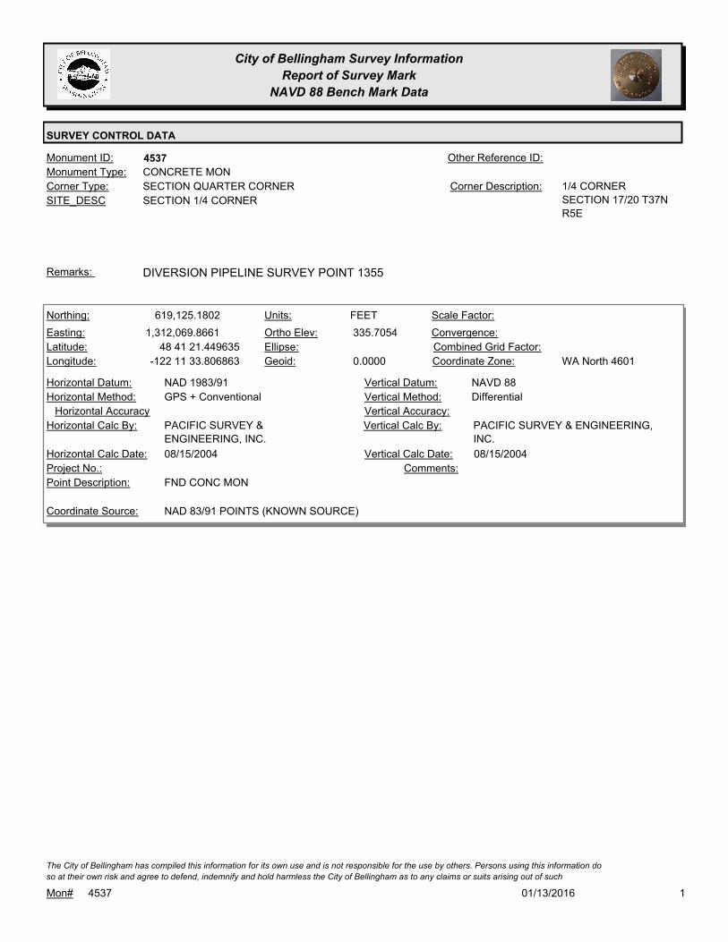
City of Bellingham Survey Information
Report of Survey Mark
NAVD 88 Bench Mark Data
SURVEY CONTROL DATA
4537Monument ID: Other Reference ID:
SITE_DESC SECTION 1/4 CORNER
SECTION QUARTER CORNERCorner Type: 1/4 CORNER
SECTION 17/20 T37N
R5E
Corner Description:
CONCRETE MONMonument Type:
DIVERSION PIPELINE SURVEY POINT 1355Remarks:
619,125.1802
1,312,069.8661
48 41 21.449635
-122 11 33.806863
335.7054
0.0000
FEETNorthing:
Easting:
Latitude:
Longitude:
Units:
Ortho Elev:
Ellipse:
Geoid:
Scale Factor:
Convergence:
Combined Grid Factor:
WA North 4601Coordinate Zone:
GPS + ConventionalHorizontal Method:
NAD 1983/91Horizontal Datum: NAVD 88Vertical Datum:
DifferentialVertical Method:
Horizontal Accuracy Vertical Accuracy:
PACIFIC SURVEY & ENGINEERING,
INC.
Vertical Calc By:PACIFIC SURVEY &
ENGINEERING, INC.
Horizontal Calc By:
Project No.:
FND CONC MONPoint Description:
NAD 83/91 POINTS (KNOWN SOURCE)Coordinate Source:
Comments:
08/15/2004Horizontal Calc Date: 08/15/2004Vertical Calc Date:
101/13/2016Mon# 4537
The City of Bellingham has compiled this information for its own use and is not responsible for the use by others. Persons using this information do
so at their own risk and agree to defend, indemnify and hold harmless the City of Bellingham as to any claims or suits arising out of such
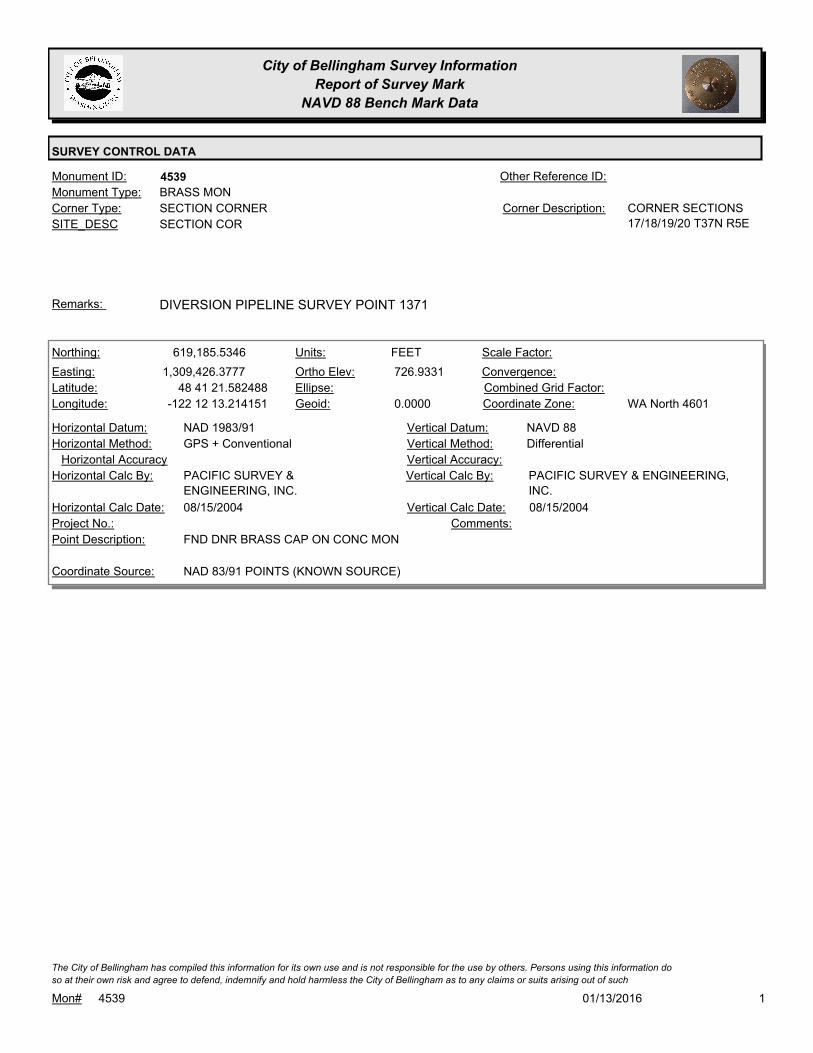
City of Bellingham Survey Information
Report of Survey Mark
NAVD 88 Bench Mark Data
SURVEY CONTROL DATA
4539Monument ID: Other Reference ID:
SITE_DESC SECTION COR
SECTION CORNERCorner Type: CORNER SECTIONS
17/18/19/20 T37N R5E
Corner Description:
BRASS MONMonument Type:
DIVERSION PIPELINE SURVEY POINT 1371Remarks:
619,185.5346
1,309,426.3777
48 41 21.582488
-122 12 13.214151
726.9331
0.0000
FEETNorthing:
Easting:
Latitude:
Longitude:
Units:
Ortho Elev:
Ellipse:
Geoid:
Scale Factor:
Convergence:
Combined Grid Factor:
WA North 4601Coordinate Zone:
GPS + ConventionalHorizontal Method:
NAD 1983/91Horizontal Datum: NAVD 88Vertical Datum:
DifferentialVertical Method:
Horizontal Accuracy Vertical Accuracy:
PACIFIC SURVEY & ENGINEERING,
INC.
Vertical Calc By:PACIFIC SURVEY &
ENGINEERING, INC.
Horizontal Calc By:
Project No.:
FND DNR BRASS CAP ON CONC MONPoint Description:
NAD 83/91 POINTS (KNOWN SOURCE)Coordinate Source:
Comments:
08/15/2004Horizontal Calc Date: 08/15/2004Vertical Calc Date:
101/13/2016Mon# 4539
The City of Bellingham has compiled this information for its own use and is not responsible for the use by others. Persons using this information do
so at their own risk and agree to defend, indemnify and hold harmless the City of Bellingham as to any claims or suits arising out of such

City of Bellingham Survey Information
Report of Survey Mark
NAVD 88 Bench Mark Data
SURVEY CONTROL DATA
4540Monument ID: Other Reference ID:
SITE_DESC SECTION 1/4 COR
SECTION QUARTER CORNERCorner Type: 1/4 CORNER
SECTION 8/17 T37N
R5E
Corner Description:
REBAR AND CAPMonument Type:
DIVERSION PIPELINE SURVEY POINT 1329Remarks:
624,408.7293
1,312,203.9233
48 42 13.599599
-122 11 33.199957
312.2073
0.0000
FEETNorthing:
Easting:
Latitude:
Longitude:
Units:
Ortho Elev:
Ellipse:
Geoid:
Scale Factor:
Convergence:
Combined Grid Factor:
WA North 4601Coordinate Zone:
GPS + ConventionalHorizontal Method:
NAD 1983/91Horizontal Datum: NAVD 88Vertical Datum:
DifferentialVertical Method:
Horizontal Accuracy Vertical Accuracy:
PACIFIC SURVEY & ENGINEERING,
INC.
Vertical Calc By:PACIFIC SURVEY &
ENGINEERING, INC.
Horizontal Calc By:
Project No.:
FND #4 REBAR W/ YPC '11501'Point Description:
NAD 83/91 POINTS (KNOWN SOURCE)Coordinate Source:
Comments:
08/15/2004Horizontal Calc Date: 08/15/2004Vertical Calc Date:
101/13/2016Mon# 4540
The City of Bellingham has compiled this information for its own use and is not responsible for the use by others. Persons using this information do
so at their own risk and agree to defend, indemnify and hold harmless the City of Bellingham as to any claims or suits arising out of such
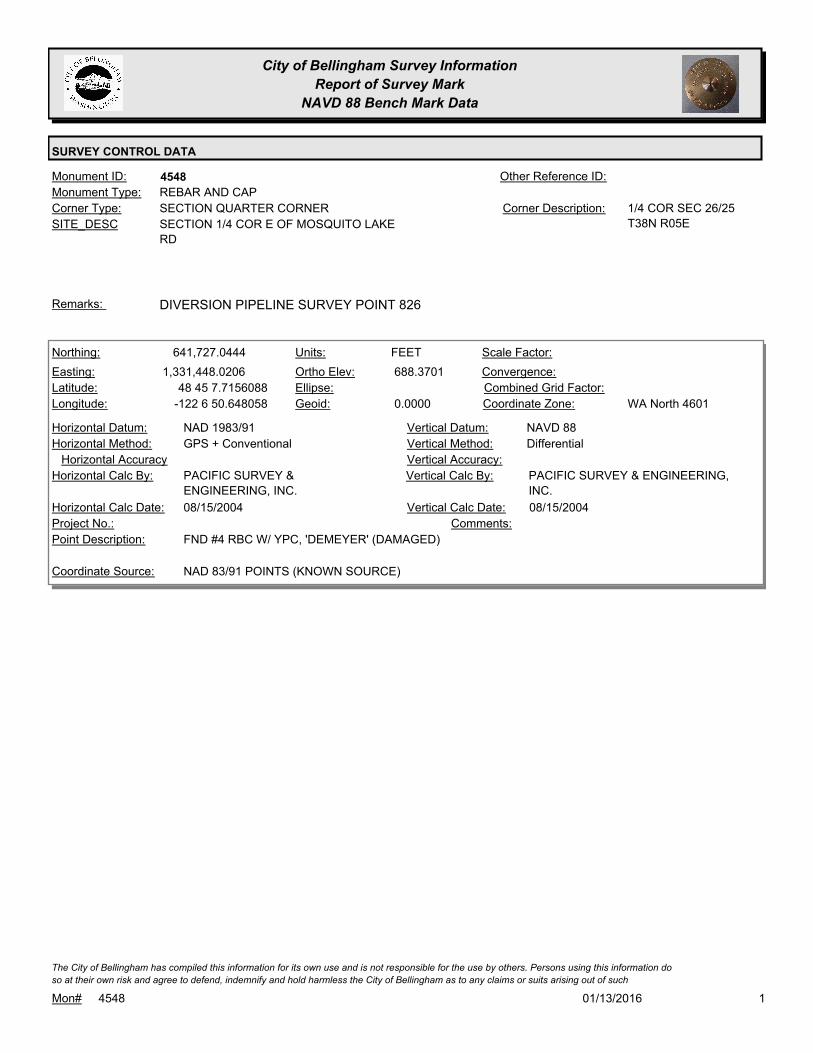
City of Bellingham Survey Information
Report of Survey Mark
NAVD 88 Bench Mark Data
SURVEY CONTROL DATA
4548Monument ID: Other Reference ID:
SITE_DESC SECTION 1/4 COR E OF MOSQUITO LAKE
RD
SECTION QUARTER CORNERCorner Type: 1/4 COR SEC 26/25
T38N R05E
Corner Description:
REBAR AND CAPMonument Type:
DIVERSION PIPELINE SURVEY POINT 826Remarks:
641,727.0444
1,331,448.0206
48 45 7.7156088
-122 6 50.648058
688.3701
0.0000
FEETNorthing:
Easting:
Latitude:
Longitude:
Units:
Ortho Elev:
Ellipse:
Geoid:
Scale Factor:
Convergence:
Combined Grid Factor:
WA North 4601Coordinate Zone:
GPS + ConventionalHorizontal Method:
NAD 1983/91Horizontal Datum: NAVD 88Vertical Datum:
DifferentialVertical Method:
Horizontal Accuracy Vertical Accuracy:
PACIFIC SURVEY & ENGINEERING,
INC.
Vertical Calc By:PACIFIC SURVEY &
ENGINEERING, INC.
Horizontal Calc By:
Project No.:
FND #4 RBC W/ YPC, 'DEMEYER' (DAMAGED)Point Description:
NAD 83/91 POINTS (KNOWN SOURCE)Coordinate Source:
Comments:
08/15/2004Horizontal Calc Date: 08/15/2004Vertical Calc Date:
101/13/2016Mon# 4548
The City of Bellingham has compiled this information for its own use and is not responsible for the use by others. Persons using this information do
so at their own risk and agree to defend, indemnify and hold harmless the City of Bellingham as to any claims or suits arising out of such

City of Bellingham Survey Information
Report of Survey Mark
NAVD 88 Bench Mark Data
SURVEY CONTROL DATA
4567Monument ID: Other Reference ID:
SITE_DESC HAWK WAY & HARRISON
RIGHT-OF-WAY INTERSECTIONCorner Type: INT & PCCorner Description:
BRASS MONMonument Type:
Remarks:
604.3560
FEETNorthing:
Easting:
Latitude:
Longitude:
Units:
Ortho Elev:
Ellipse:
Geoid:
Scale Factor:
Convergence:
Combined Grid Factor:
Coordinate Zone:
Horizontal Method:
Horizontal Datum: NAVD 88Vertical Datum:
DifferentialVertical Method:
Horizontal Accuracy 0.0300Vertical Accuracy:
WILSON ENGINEERING LLC.Vertical Calc By:Horizontal Calc By:
Project No.:
Point Description:
BENCHMARK NAVD 88Coordinate Source:
FB 960-3Comments:
Horizontal Calc Date: 01/18/2012Vertical Calc Date:
101/13/2016Mon# 4567
The City of Bellingham has compiled this information for its own use and is not responsible for the use by others. Persons using this information do
so at their own risk and agree to defend, indemnify and hold harmless the City of Bellingham as to any claims or suits arising out of such

City of Bellingham Survey Information
Report of Survey Mark
NAVD 88 Bench Mark Data
SURVEY CONTROL DATA
4569Monument ID: Other Reference ID:
SITE_DESC HAWK WAY & TEAL CT
RIGHT-OF-WAY INTERSECTIONCorner Type: Corner Description:
BRASS MONMonument Type:
Remarks:
637.7150
FEETNorthing:
Easting:
Latitude:
Longitude:
Units:
Ortho Elev:
Ellipse:
Geoid:
Scale Factor:
Convergence:
Combined Grid Factor:
Coordinate Zone:
Horizontal Method:
Horizontal Datum: NAVD 88Vertical Datum:
DifferentialVertical Method:
Horizontal Accuracy 0.0300Vertical Accuracy:
WILSON ENGINEERING LLC.Vertical Calc By:Horizontal Calc By:
Project No.:
Point Description:
BENCHMARK NAVD 88Coordinate Source:
FB 960-3Comments:
Horizontal Calc Date: 01/18/2012Vertical Calc Date:
101/13/2016Mon# 4569
The City of Bellingham has compiled this information for its own use and is not responsible for the use by others. Persons using this information do
so at their own risk and agree to defend, indemnify and hold harmless the City of Bellingham as to any claims or suits arising out of such

City of Bellingham Survey Information
Report of Survey Mark
NAVD 88 Bench Mark Data
SURVEY CONTROL DATA
4616Monument ID: Other Reference ID:
SITE_DESC SAMISH CREST WAY 2ND PT N OF
PARKHURST
RIGHT-OF-WAY PTCorner Type: Corner Description:
ALUMINUM CAPMonument Type:
Remarks:
704.7190
FEETNorthing:
Easting:
Latitude:
Longitude:
Units:
Ortho Elev:
Ellipse:
Geoid:
Scale Factor:
Convergence:
Combined Grid Factor:
Coordinate Zone:
Horizontal Method:
Horizontal Datum: NAVD 88Vertical Datum:
DifferentialVertical Method:
Horizontal Accuracy 0.0300Vertical Accuracy:
WILSON ENGINEERING LLC.Vertical Calc By:Horizontal Calc By:
Project No.:
Point Description:
BENCHMARK NAVD 88Coordinate Source:
FB 960-3Comments:
Horizontal Calc Date: 01/18/2012Vertical Calc Date:
101/13/2016Mon# 4616
The City of Bellingham has compiled this information for its own use and is not responsible for the use by others. Persons using this information do
so at their own risk and agree to defend, indemnify and hold harmless the City of Bellingham as to any claims or suits arising out of such

City of Bellingham Survey Information
Report of Survey Mark
NAVD 88 Bench Mark Data
SURVEY CONTROL DATA
4631Monument ID: Other Reference ID:
SITE_DESC SAMISH CREST WAY AT PLAT LINE
PLAT LINECorner Type: POCCorner Description:
BRASS MONMonument Type:
Remarks:
699.9940
FEETNorthing:
Easting:
Latitude:
Longitude:
Units:
Ortho Elev:
Ellipse:
Geoid:
Scale Factor:
Convergence:
Combined Grid Factor:
Coordinate Zone:
Horizontal Method:
Horizontal Datum: NAVD 88Vertical Datum:
DifferentialVertical Method:
Horizontal Accuracy 0.0300Vertical Accuracy:
WILSON ENGINEERING LLC.Vertical Calc By:Horizontal Calc By:
Project No.:
Point Description:
BENCHMARK NAVD 88Coordinate Source:
FB 960-3Comments:
Horizontal Calc Date: 01/18/2012Vertical Calc Date:
101/13/2016Mon# 4631
The City of Bellingham has compiled this information for its own use and is not responsible for the use by others. Persons using this information do
so at their own risk and agree to defend, indemnify and hold harmless the City of Bellingham as to any claims or suits arising out of such

City of Bellingham Survey Information
Report of Survey Mark
NAVD 88 Bench Mark Data
SURVEY CONTROL DATA
4676Monument ID: Other Reference ID:
SITE_DESC BRIAR RD N OF BAYSIDE
RIGHT-OF-WAY POTCorner Type: Corner Description:
CASED MONMonument Type:
Remarks:
630,105.6700
1,234,492.5400 90.6900
FEETNorthing:
Easting:
Latitude:
Longitude:
Units:
Ortho Elev:
Ellipse:
Geoid:
Scale Factor:
Convergence:
Combined Grid Factor:
WA North 4601Coordinate Zone:
Conventional SurveyHorizontal Method:
NAD 83/98Horizontal Datum: NAVD 88Vertical Datum:
DifferentialVertical Method:
Horizontal Accuracy Vertical Accuracy:
WILSON ENGINEERING LLC.Vertical Calc By:WILSON ENGINEERING LLC.Horizontal Calc By:
Project No.:
MON IN CASEPoint Description:
NAD 83/98 PROJECT POINTSCoordinate Source:
POST POINT RS-4712Comments:
08/10/2009Horizontal Calc Date: 08/10/2009Vertical Calc Date:
101/13/2016Mon# 4676
The City of Bellingham has compiled this information for its own use and is not responsible for the use by others. Persons using this information do
so at their own risk and agree to defend, indemnify and hold harmless the City of Bellingham as to any claims or suits arising out of such

City of Bellingham Survey Information
Report of Survey Mark
NAVD 88 Bench Mark Data
SURVEY CONTROL DATA
4678Monument ID: Other Reference ID:
SITE_DESC LAGOON DR (COWGILL AVE) NEAR BRIAR
INTERSECTION
RIGHT-OF-WAY PCCorner Type: Corner Description:
CONCRETE MONMonument Type:
Remarks:
630,335.4100
1,234,577.6200 67.4300
FEETNorthing:
Easting:
Latitude:
Longitude:
Units:
Ortho Elev:
Ellipse:
Geoid:
Scale Factor:
Convergence:
Combined Grid Factor:
WA North 4601Coordinate Zone:
Conventional SurveyHorizontal Method:
NAD 83/98Horizontal Datum: NAVD 88Vertical Datum:
DifferentialVertical Method:
Horizontal Accuracy Vertical Accuracy:
WILSON ENGINEERING LLC.Vertical Calc By:WILSON ENGINEERING LLC.Horizontal Calc By:
Project No.:
CONC MONPoint Description:
NAD 83/98 PROJECT POINTSCoordinate Source:
POST POINT RS-4712Comments:
08/10/2009Horizontal Calc Date: 08/10/2009Vertical Calc Date:
101/13/2016Mon# 4678
The City of Bellingham has compiled this information for its own use and is not responsible for the use by others. Persons using this information do
so at their own risk and agree to defend, indemnify and hold harmless the City of Bellingham as to any claims or suits arising out of such

City of Bellingham Survey Information
Report of Survey Mark
NAVD 88 Bench Mark Data
SURVEY CONTROL DATA
4679Monument ID: Other Reference ID:
SITE_DESC LAGOON DR (COWGILL AVE)
RIGHT-OF-WAY PTCorner Type: Corner Description:
CONCRETE MONMonument Type:
Remarks:
630,323.8400
1,234,966.4000 73.6500
FEETNorthing:
Easting:
Latitude:
Longitude:
Units:
Ortho Elev:
Ellipse:
Geoid:
Scale Factor:
Convergence:
Combined Grid Factor:
WA North 4601Coordinate Zone:
Conventional SurveyHorizontal Method:
NAD 83/98Horizontal Datum: NAVD 88Vertical Datum:
DifferentialVertical Method:
Horizontal Accuracy Vertical Accuracy:
WILSON ENGINEERING LLC.Vertical Calc By:WILSON ENGINEERING LLC.Horizontal Calc By:
Project No.:
CONC MONPoint Description:
NAD 83/98 PROJECT POINTSCoordinate Source:
POST POINT RS-4712Comments:
08/10/2009Horizontal Calc Date: 08/10/2009Vertical Calc Date:
101/13/2016Mon# 4679
The City of Bellingham has compiled this information for its own use and is not responsible for the use by others. Persons using this information do
so at their own risk and agree to defend, indemnify and hold harmless the City of Bellingham as to any claims or suits arising out of such

City of Bellingham Survey Information
Report of Survey Mark
NAVD 88 Bench Mark Data
SURVEY CONTROL DATA
4685Monument ID: Other Reference ID:
SITE_DESC RR SPIKE IN PP B-4, CL-T, 4/2 AT THE
SW'LY COR. OF INT. OF STATE & 11TH BY
RIPTIDE.
BENCH MARKCorner Type: Corner Description:
RAILROAD SPIKEMonument Type:
3 WIRE LEVEL. DIFFERENT ELEVATIONS FOUND ON
BENCHMARK. ELEVATION TAKEN FROM BENCHMARK DATABASE.
Remarks:
68.4910
0.0000
FEETNorthing:
Easting:
Latitude:
Longitude:
Units:
Ortho Elev:
Ellipse:
Geoid:
Scale Factor:
Convergence:
Combined Grid Factor:
WA North 4601Coordinate Zone:
Horizontal Method:
Horizontal Datum: NAVD 88Vertical Datum:
DifferentialVertical Method:
Horizontal Accuracy 0.0200Vertical Accuracy:
LARRY STEELE & ASSOCIATESVertical Calc By:Horizontal Calc By:
ES-0425Project No.:
RR SPK IN PP BY RIPTIDE ON 11THPoint Description:
BENCHMARK NAVD 88Coordinate Source:
FB 918-11Comments:
Horizontal Calc Date: 02/17/2009Vertical Calc Date:
101/13/2016Mon# 4685
The City of Bellingham has compiled this information for its own use and is not responsible for the use by others. Persons using this information do
so at their own risk and agree to defend, indemnify and hold harmless the City of Bellingham as to any claims or suits arising out of such
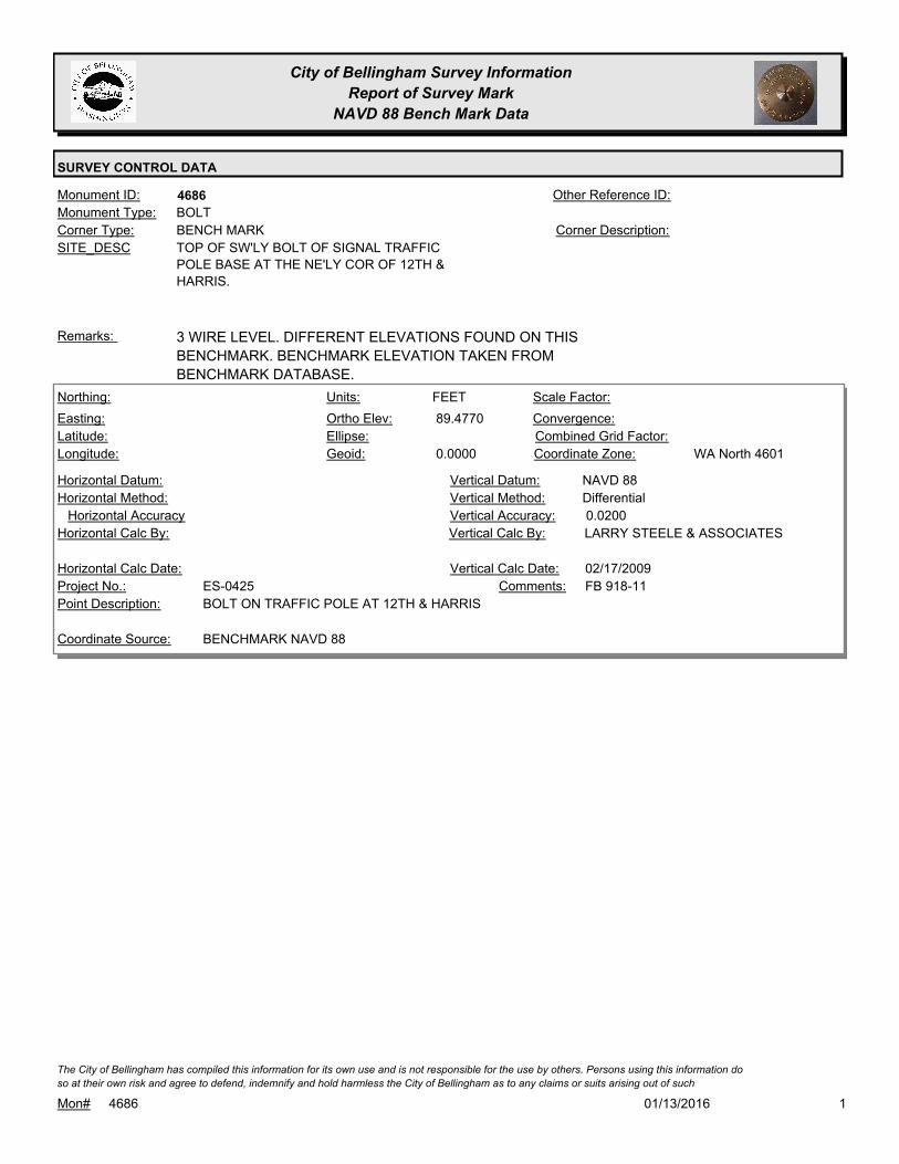
City of Bellingham Survey Information
Report of Survey Mark
NAVD 88 Bench Mark Data
SURVEY CONTROL DATA
4686Monument ID: Other Reference ID:
SITE_DESC TOP OF SW'LY BOLT OF SIGNAL TRAFFIC
POLE BASE AT THE NE'LY COR OF 12TH &
HARRIS.
BENCH MARKCorner Type: Corner Description:
BOLTMonument Type:
3 WIRE LEVEL. DIFFERENT ELEVATIONS FOUND ON THIS
BENCHMARK. BENCHMARK ELEVATION TAKEN FROM
BENCHMARK DATABASE.
Remarks:
89.4770
0.0000
FEETNorthing:
Easting:
Latitude:
Longitude:
Units:
Ortho Elev:
Ellipse:
Geoid:
Scale Factor:
Convergence:
Combined Grid Factor:
WA North 4601Coordinate Zone:
Horizontal Method:
Horizontal Datum: NAVD 88Vertical Datum:
DifferentialVertical Method:
Horizontal Accuracy 0.0200Vertical Accuracy:
LARRY STEELE & ASSOCIATESVertical Calc By:Horizontal Calc By:
ES-0425Project No.:
BOLT ON TRAFFIC POLE AT 12TH & HARRISPoint Description:
BENCHMARK NAVD 88Coordinate Source:
FB 918-11Comments:
Horizontal Calc Date: 02/17/2009Vertical Calc Date:
101/13/2016Mon# 4686
The City of Bellingham has compiled this information for its own use and is not responsible for the use by others. Persons using this information do
so at their own risk and agree to defend, indemnify and hold harmless the City of Bellingham as to any claims or suits arising out of such
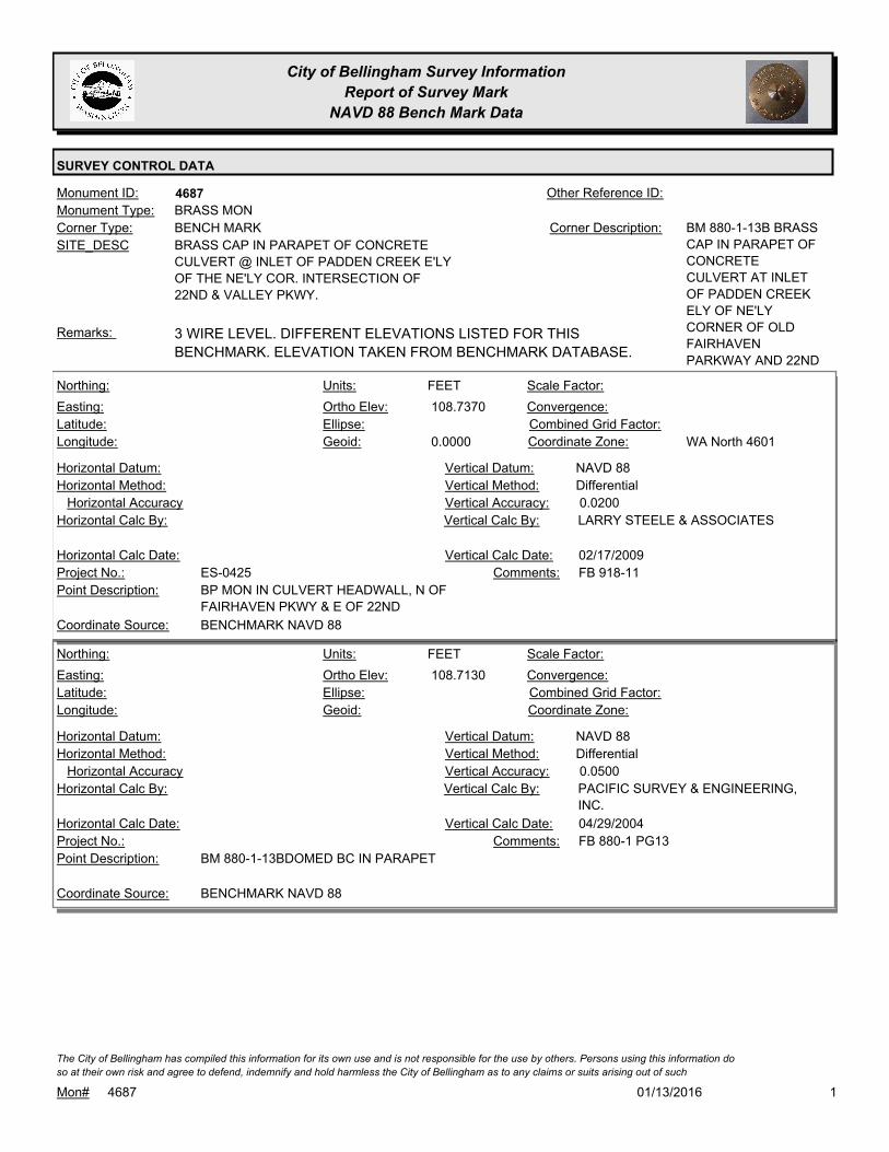
City of Bellingham Survey Information
Report of Survey Mark
NAVD 88 Bench Mark Data
SURVEY CONTROL DATA
4687Monument ID: Other Reference ID:
SITE_DESC BRASS CAP IN PARAPET OF CONCRETE
CULVERT @ INLET OF PADDEN CREEK E'LY
OF THE NE'LY COR. INTERSECTION OF
22ND & VALLEY PKWY.
BENCH MARKCorner Type: BM 880-1-13B BRASS
CAP IN PARAPET OF
CONCRETE
CULVERT AT INLET
OF PADDEN CREEK
ELY OF NE'LY
CORNER OF OLD
FAIRHAVEN
PARKWAY AND 22ND
Corner Description:
BRASS MONMonument Type:
3 WIRE LEVEL. DIFFERENT ELEVATIONS LISTED FOR THIS
BENCHMARK. ELEVATION TAKEN FROM BENCHMARK DATABASE.
Remarks:
108.7370
0.0000
FEETNorthing:
Easting:
Latitude:
Longitude:
Units:
Ortho Elev:
Ellipse:
Geoid:
Scale Factor:
Convergence:
Combined Grid Factor:
WA North 4601Coordinate Zone:
Horizontal Method:
Horizontal Datum: NAVD 88Vertical Datum:
DifferentialVertical Method:
Horizontal Accuracy 0.0200Vertical Accuracy:
LARRY STEELE & ASSOCIATESVertical Calc By:Horizontal Calc By:
ES-0425Project No.:
BP MON IN CULVERT HEADWALL, N OF
FAIRHAVEN PKWY & E OF 22ND
Point Description:
BENCHMARK NAVD 88Coordinate Source:
FB 918-11Comments:
Horizontal Calc Date: 02/17/2009Vertical Calc Date:
108.7130
FEETNorthing:
Easting:
Latitude:
Longitude:
Units:
Ortho Elev:
Ellipse:
Geoid:
Scale Factor:
Convergence:
Combined Grid Factor:
Coordinate Zone:
Horizontal Method:
Horizontal Datum: NAVD 88Vertical Datum:
DifferentialVertical Method:
Horizontal Accuracy 0.0500Vertical Accuracy:
PACIFIC SURVEY & ENGINEERING,
INC.
Vertical Calc By:Horizontal Calc By:
Project No.:
BM 880-1-13BDOMED BC IN PARAPETPoint Description:
BENCHMARK NAVD 88Coordinate Source:
FB 880-1 PG13Comments:
Horizontal Calc Date: 04/29/2004Vertical Calc Date:
101/13/2016Mon# 4687
The City of Bellingham has compiled this information for its own use and is not responsible for the use by others. Persons using this information do
so at their own risk and agree to defend, indemnify and hold harmless the City of Bellingham as to any claims or suits arising out of such

City of Bellingham Survey Information
Report of Survey Mark
NAVD 88 Bench Mark Data
SURVEY CONTROL DATA
4688Monument ID: Other Reference ID:
SITE_DESC BRASS CAP ON THE TOP OF PARAPET
BETWEEN CULVERTS @ OUTLET (PADDEN
CREEK) N.W'LY COR OF 30TH & OLD
FAIRHAVEN PKWY.
BENCH MARKCorner Type: Corner Description:
BRASS MONMonument Type:
BENCHMARK FOUND. 3 WIRE LEVEL. DIFFERENT ELEVATIONS
ON THIS POINT. ELEVATION TAKEN FROM BENCHMARK
DATABASE.
Remarks:
135.0990
0.0000
FEETNorthing:
Easting:
Latitude:
Longitude:
Units:
Ortho Elev:
Ellipse:
Geoid:
Scale Factor:
Convergence:
Combined Grid Factor:
WA North 4601Coordinate Zone:
Horizontal Method:
Horizontal Datum: NAVD 88Vertical Datum:
DifferentialVertical Method:
Horizontal Accuracy 0.0200Vertical Accuracy:
LARRY STEELE & ASSOCIATESVertical Calc By:Horizontal Calc By:
ES-0425Project No.:
BP MON IN CULVERT HEADWALL, NW OF
FAIRHAVEN PKWY & 30TH
Point Description:
BENCHMARK NAVD 88Coordinate Source:
FB 918-11Comments:
Horizontal Calc Date: 02/17/2009Vertical Calc Date:
101/13/2016Mon# 4688
The City of Bellingham has compiled this information for its own use and is not responsible for the use by others. Persons using this information do
so at their own risk and agree to defend, indemnify and hold harmless the City of Bellingham as to any claims or suits arising out of such
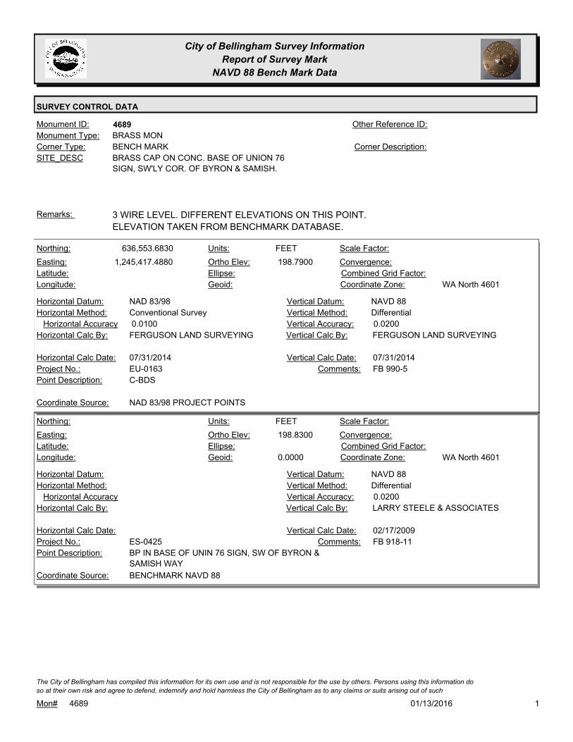
City of Bellingham Survey Information
Report of Survey Mark
NAVD 88 Bench Mark Data
SURVEY CONTROL DATA
4689Monument ID: Other Reference ID:
SITE_DESC BRASS CAP ON CONC. BASE OF UNION 76
SIGN, SW'LY COR. OF BYRON & SAMISH.
BENCH MARKCorner Type: Corner Description:
BRASS MONMonument Type:
3 WIRE LEVEL. DIFFERENT ELEVATIONS ON THIS POINT.
ELEVATION TAKEN FROM BENCHMARK DATABASE.
Remarks:
636,553.6830
1,245,417.4880 198.7900
FEETNorthing:
Easting:
Latitude:
Longitude:
Units:
Ortho Elev:
Ellipse:
Geoid:
Scale Factor:
Convergence:
Combined Grid Factor:
WA North 4601Coordinate Zone:
Conventional SurveyHorizontal Method:
NAD 83/98Horizontal Datum: NAVD 88Vertical Datum:
DifferentialVertical Method:
0.0100Horizontal Accuracy 0.0200Vertical Accuracy:
FERGUSON LAND SURVEYINGVertical Calc By:FERGUSON LAND SURVEYINGHorizontal Calc By:
EU-0163Project No.:
C-BDSPoint Description:
NAD 83/98 PROJECT POINTSCoordinate Source:
FB 990-5Comments:
07/31/2014Horizontal Calc Date: 07/31/2014Vertical Calc Date:
198.8300
0.0000
FEETNorthing:
Easting:
Latitude:
Longitude:
Units:
Ortho Elev:
Ellipse:
Geoid:
Scale Factor:
Convergence:
Combined Grid Factor:
WA North 4601Coordinate Zone:
Horizontal Method:
Horizontal Datum: NAVD 88Vertical Datum:
DifferentialVertical Method:
Horizontal Accuracy 0.0200Vertical Accuracy:
LARRY STEELE & ASSOCIATESVertical Calc By:Horizontal Calc By:
ES-0425Project No.:
BP IN BASE OF UNIN 76 SIGN, SW OF BYRON &
SAMISH WAY
Point Description:
BENCHMARK NAVD 88Coordinate Source:
FB 918-11Comments:
Horizontal Calc Date: 02/17/2009Vertical Calc Date:
101/13/2016Mon# 4689
The City of Bellingham has compiled this information for its own use and is not responsible for the use by others. Persons using this information do
so at their own risk and agree to defend, indemnify and hold harmless the City of Bellingham as to any claims or suits arising out of such

City of Bellingham Survey Information
Report of Survey Mark
NAVD 88 Bench Mark Data
SURVEY CONTROL DATA
4690Monument ID: Other Reference ID:
SITE_DESC BRASS CAP IN SE'LY COR OF CONC. PAD
FOR LAMP BASE AT THE SE COR. OF
FIELDING & SAMISH.
BENCH MARKCorner Type: Corner Description:
BRASS MONMonument Type:
3 WIRE LEVEL. DIFFERENT ELEVATIONS FOUND. USED
ELEVATION FROM BENCHMARK DATABASE AND FROM YELLOW
SHEET.
Remarks:
239.6270
FEETNorthing:
Easting:
Latitude:
Longitude:
Units:
Ortho Elev:
Ellipse:
Geoid:
Scale Factor:
Convergence:
Combined Grid Factor:
Coordinate Zone:
Horizontal Method:
Horizontal Datum: NAVD 88Vertical Datum:
DifferentialVertical Method:
Horizontal Accuracy 0.0300Vertical Accuracy:
WILSON ENGINEERING LLC.Vertical Calc By:Horizontal Calc By:
Project No.:
Point Description:
BENCHMARK NAVD 88Coordinate Source:
FB 960-3Comments:
Horizontal Calc Date: 01/27/2012Vertical Calc Date:
101/13/2016Mon# 4690
The City of Bellingham has compiled this information for its own use and is not responsible for the use by others. Persons using this information do
so at their own risk and agree to defend, indemnify and hold harmless the City of Bellingham as to any claims or suits arising out of such
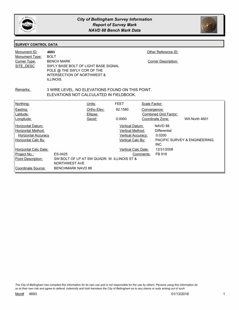
City of Bellingham Survey Information
Report of Survey Mark
NAVD 88 Bench Mark Data
SURVEY CONTROL DATA
4693Monument ID: Other Reference ID:
SITE_DESC SW'LY BASE BOLT OF LIGHT BASE SIGNAL
POLE @ THE SW'LY COR OF THE
INTERSECTION OF NORTHWEST &
ILLINOIS.
BENCH MARKCorner Type: Corner Description:
BOLTMonument Type:
3 WIRE LEVEL. NO ELEVATIONS FOUND ON THIS POINT.
ELEVATIONS NOT CALCULATED IN FIELDBOOK.
Remarks:
82.1580
0.0000
FEETNorthing:
Easting:
Latitude:
Longitude:
Units:
Ortho Elev:
Ellipse:
Geoid:
Scale Factor:
Convergence:
Combined Grid Factor:
WA North 4601Coordinate Zone:
Horizontal Method:
Horizontal Datum: NAVD 88Vertical Datum:
DifferentialVertical Method:
Horizontal Accuracy 0.0200Vertical Accuracy:
PACIFIC SURVEY & ENGINEERING,
INC.
Vertical Calc By:Horizontal Calc By:
ES-0425Project No.:
SW BOLT OF LP AT SW QUADR. W. ILLINOIS ST &
NORTHWEST AVE
Point Description:
BENCHMARK NAVD 88Coordinate Source:
FB 918Comments:
Horizontal Calc Date: 12/31/2008Vertical Calc Date:
101/13/2016Mon# 4693
The City of Bellingham has compiled this information for its own use and is not responsible for the use by others. Persons using this information do
so at their own risk and agree to defend, indemnify and hold harmless the City of Bellingham as to any claims or suits arising out of such

City of Bellingham Survey Information
Report of Survey Mark
NAVD 88 Bench Mark Data
SURVEY CONTROL DATA
4697Monument ID: Other Reference ID:
SITE_DESC BRASS CAP IN CONC. SIDEWALK, SOUTH
SIDE OF LAKEWAY DR. @ I-5 UNDERPASS
BETWEEN NORTH & SOUTH LANES.
BENCH MARKCorner Type: TBM - BRONZE PLUG
IN S SIDEWALK OF
LAKEWAY UNDER I-5
OVERPASS
Corner Description:
BRASS MONMonument Type:
3 WIRE LEVEL BENCHMARK. ELEVATION TAKEN FROM AVERAGE
ON YELLOW SHEETS.
Remarks:
173.4280
0.0000
FEETNorthing:
Easting:
Latitude:
Longitude:
Units:
Ortho Elev:
Ellipse:
Geoid:
Scale Factor:
Convergence:
Combined Grid Factor:
WA North 4601Coordinate Zone:
Horizontal Method:
Horizontal Datum: NAVD 88Vertical Datum:
DifferentialVertical Method:
Horizontal Accuracy 0.0300Vertical Accuracy:
WILSON ENGINEERING LLC.Vertical Calc By:Horizontal Calc By:
ES-0425Project No.:
C-BDS CITY BM S.SIDE LAKEWAY @ I-5Point Description:
BENCHMARK NAVD 88Coordinate Source:
FB918-7 pg. 18Comments:
Horizontal Calc Date: 02/12/2009Vertical Calc Date:
173.4290
0.0000
FEETNorthing:
Easting:
Latitude:
Longitude:
Units:
Ortho Elev:
Ellipse:
Geoid:
Scale Factor:
Convergence:
Combined Grid Factor:
WA North 4601Coordinate Zone:
Horizontal Method:
Horizontal Datum: NAVD 88Vertical Datum:
DifferentialVertical Method:
Horizontal Accuracy 0.0200Vertical Accuracy:
LARRY STEELE & ASSOCIATESVertical Calc By:Horizontal Calc By:
ES-0425Project No.:
BP IN SIDEWALK, SOUTH SIDE OF LAKEWAY,
UNDER I-5 OVERPASS
Point Description:
BENCHMARK NAVD 88Coordinate Source:
FB 918-11 MEAN ADJUSTED
BETWEEN STEELE & WILSON
ELEVATIONS
Comments:
Horizontal Calc Date: 02/17/2009Vertical Calc Date:
101/13/2016Mon# 4697
The City of Bellingham has compiled this information for its own use and is not responsible for the use by others. Persons using this information do
so at their own risk and agree to defend, indemnify and hold harmless the City of Bellingham as to any claims or suits arising out of such
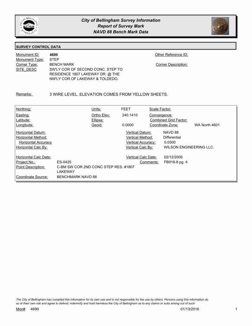
City of Bellingham Survey Information
Report of Survey Mark
NAVD 88 Bench Mark Data
SURVEY CONTROL DATA
4699Monument ID: Other Reference ID:
SITE_DESC SW'LY COR OF SECOND CONC. STEP TO
RESIDENCE 1807 LAKEWAY DR. @ THE
NW'LY COR OF LAKEWAY & TOLDEDO.
BENCH MARKCorner Type: Corner Description:
STEPMonument Type:
3 WIRE LEVEL. ELEVATION COMES FROM YELLOW SHEETS.Remarks:
240.1410
0.0000
FEETNorthing:
Easting:
Latitude:
Longitude:
Units:
Ortho Elev:
Ellipse:
Geoid:
Scale Factor:
Convergence:
Combined Grid Factor:
WA North 4601Coordinate Zone:
Horizontal Method:
Horizontal Datum: NAVD 88Vertical Datum:
DifferentialVertical Method:
Horizontal Accuracy 0.0300Vertical Accuracy:
WILSON ENGINEERING LLC.Vertical Calc By:Horizontal Calc By:
ES-0425Project No.:
C-BM SW COR 2ND CONC STEP RES. #1807
LAKEWAY
Point Description:
BENCHMARK NAVD 88Coordinate Source:
FB918-8 pg. 4Comments:
Horizontal Calc Date: 02/12/2009Vertical Calc Date:
101/13/2016Mon# 4699
The City of Bellingham has compiled this information for its own use and is not responsible for the use by others. Persons using this information do
so at their own risk and agree to defend, indemnify and hold harmless the City of Bellingham as to any claims or suits arising out of such

City of Bellingham Survey Information
Report of Survey Mark
NAVD 88 Bench Mark Data
SURVEY CONTROL DATA
4701Monument ID: Other Reference ID:
SITE_DESC COPPER PIN IN CONC. MON AT THE
INTERSECTION OF KEARNEY & B ST.
BENCH MARKCorner Type: Corner Description:
CONCRETE MONMonument Type:
3 WIRE LEVEL BENCHMARK. ELEVATION TAKEN FROM 3 WIRE
LEVEL FIELD BOOK. IN CONC MON #965
Remarks:
84.3120
0.0000
FEETNorthing:
Easting:
Latitude:
Longitude:
Units:
Ortho Elev:
Ellipse:
Geoid:
Scale Factor:
Convergence:
Combined Grid Factor:
WA North 4601Coordinate Zone:
Horizontal Method:
Horizontal Datum: NAVD 88Vertical Datum:
DifferentialVertical Method:
Horizontal Accuracy 0.0300Vertical Accuracy:
WILSON ENGINEERING LLC.Vertical Calc By:Horizontal Calc By:
ES-0425Project No.:
C-MON CONC. W/PIN B & KEARNEYPoint Description:
BENCHMARK NAVD 88Coordinate Source:
FB918-6 pg. 28Comments:
Horizontal Calc Date: 02/04/2009Vertical Calc Date:
101/13/2016Mon# 4701
The City of Bellingham has compiled this information for its own use and is not responsible for the use by others. Persons using this information do
so at their own risk and agree to defend, indemnify and hold harmless the City of Bellingham as to any claims or suits arising out of such

City of Bellingham Survey Information
Report of Survey Mark
NAVD 88 Bench Mark Data
SURVEY CONTROL DATA
4704Monument ID: Other Reference ID:
SITE_DESC SW COR OF FIRST CONC. STEP @ RES.
1113 ALABAMA ST.
BENCH MARKCorner Type: Corner Description:
STEPMonument Type:
3 WIRE LEVEL. ELEVATION TAKEN FROM 3 WIRE LEVEL FIELD
BOOK.
Remarks:
108.4950
0.0000
FEETNorthing:
Easting:
Latitude:
Longitude:
Units:
Ortho Elev:
Ellipse:
Geoid:
Scale Factor:
Convergence:
Combined Grid Factor:
WA North 4601Coordinate Zone:
Horizontal Method:
Horizontal Datum: NAVD 88Vertical Datum:
DifferentialVertical Method:
Horizontal Accuracy 0.0300Vertical Accuracy:
WILSON ENGINEERING LLC.Vertical Calc By:Horizontal Calc By:
ES-0425Project No.:
C-BM SW COR CONC STEP #1113 ALABAMAPoint Description:
BENCHMARK NAVD 88Coordinate Source:
FB918-7 pg. 7Comments:
Horizontal Calc Date: 02/12/2009Vertical Calc Date:
101/13/2016Mon# 4704
The City of Bellingham has compiled this information for its own use and is not responsible for the use by others. Persons using this information do
so at their own risk and agree to defend, indemnify and hold harmless the City of Bellingham as to any claims or suits arising out of such

City of Bellingham Survey Information
Report of Survey Mark
NAVD 88 Bench Mark Data
SURVEY CONTROL DATA
4705Monument ID: Other Reference ID:
SITE_DESC SW COR. OF FIRST CONC. STEP @ RES
1301 ALABAMA ST.
BENCH MARKCorner Type: Corner Description:
STEPMonument Type:
3 WIRE LEVEL. ELEVATION TAKEN FROM 3 WIRE LEVEL
FIELDBOOK.
Remarks:
112.1320
0.0000
FEETNorthing:
Easting:
Latitude:
Longitude:
Units:
Ortho Elev:
Ellipse:
Geoid:
Scale Factor:
Convergence:
Combined Grid Factor:
WA North 4601Coordinate Zone:
Horizontal Method:
Horizontal Datum: NAVD 88Vertical Datum:
DifferentialVertical Method:
Horizontal Accuracy 0.0300Vertical Accuracy:
WILSON ENGINEERING LLC.Vertical Calc By:Horizontal Calc By:
ES-0425Project No.:
C-BM SW COR CONC STEP #1301 ALABAMAPoint Description:
BENCHMARK NAVD 88Coordinate Source:
FB918-7 pg. 7Comments:
Horizontal Calc Date: 02/12/2009Vertical Calc Date:
101/13/2016Mon# 4705
The City of Bellingham has compiled this information for its own use and is not responsible for the use by others. Persons using this information do
so at their own risk and agree to defend, indemnify and hold harmless the City of Bellingham as to any claims or suits arising out of such

City of Bellingham Survey Information
Report of Survey Mark
NAVD 88 Bench Mark Data
SURVEY CONTROL DATA
4706Monument ID: Other Reference ID:
SITE_DESC NW COR. OF FIRST CONC. STEP. AT
WESTERLY ENTRANCE OF RES. 1500
ALABAMA. SE CORNER ALABAMA &
QUEEN)
BENCH MARKCorner Type: Corner Description:
STEPMonument Type:
3 WIRE LEVEL. ELEVATION TAKEN FROM 3 WIRE LEVEL
FIELDBOOK.
Remarks:
107.6910
0.0000
FEETNorthing:
Easting:
Latitude:
Longitude:
Units:
Ortho Elev:
Ellipse:
Geoid:
Scale Factor:
Convergence:
Combined Grid Factor:
WA North 4601Coordinate Zone:
Horizontal Method:
Horizontal Datum: NAVD 88Vertical Datum:
DifferentialVertical Method:
Horizontal Accuracy 0.0300Vertical Accuracy:
WILSON ENGINEERING LLC.Vertical Calc By:Horizontal Calc By:
ES-0425Project No.:
C-BM NW COR CONC. STEP RES. #1500 ALABAMAPoint Description:
BENCHMARK NAVD 88Coordinate Source:
FB918-8 pg. 16Comments:
Horizontal Calc Date: 02/12/2009Vertical Calc Date:
101/13/2016Mon# 4706
The City of Bellingham has compiled this information for its own use and is not responsible for the use by others. Persons using this information do
so at their own risk and agree to defend, indemnify and hold harmless the City of Bellingham as to any claims or suits arising out of such
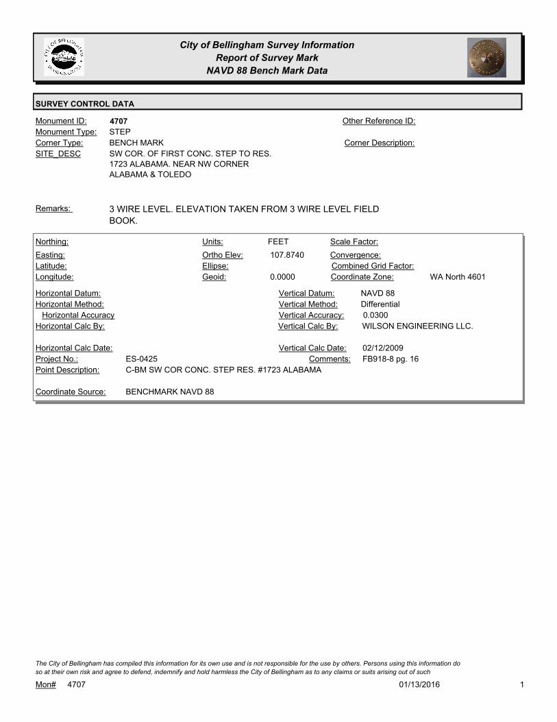
City of Bellingham Survey Information
Report of Survey Mark
NAVD 88 Bench Mark Data
SURVEY CONTROL DATA
4707Monument ID: Other Reference ID:
SITE_DESC SW COR. OF FIRST CONC. STEP TO RES.
1723 ALABAMA. NEAR NW CORNER
ALABAMA & TOLEDO
BENCH MARKCorner Type: Corner Description:
STEPMonument Type:
3 WIRE LEVEL. ELEVATION TAKEN FROM 3 WIRE LEVEL FIELD
BOOK.
Remarks:
107.8740
0.0000
FEETNorthing:
Easting:
Latitude:
Longitude:
Units:
Ortho Elev:
Ellipse:
Geoid:
Scale Factor:
Convergence:
Combined Grid Factor:
WA North 4601Coordinate Zone:
Horizontal Method:
Horizontal Datum: NAVD 88Vertical Datum:
DifferentialVertical Method:
Horizontal Accuracy 0.0300Vertical Accuracy:
WILSON ENGINEERING LLC.Vertical Calc By:Horizontal Calc By:
ES-0425Project No.:
C-BM SW COR CONC. STEP RES. #1723 ALABAMAPoint Description:
BENCHMARK NAVD 88Coordinate Source:
FB918-8 pg. 16Comments:
Horizontal Calc Date: 02/12/2009Vertical Calc Date:
101/13/2016Mon# 4707
The City of Bellingham has compiled this information for its own use and is not responsible for the use by others. Persons using this information do
so at their own risk and agree to defend, indemnify and hold harmless the City of Bellingham as to any claims or suits arising out of such
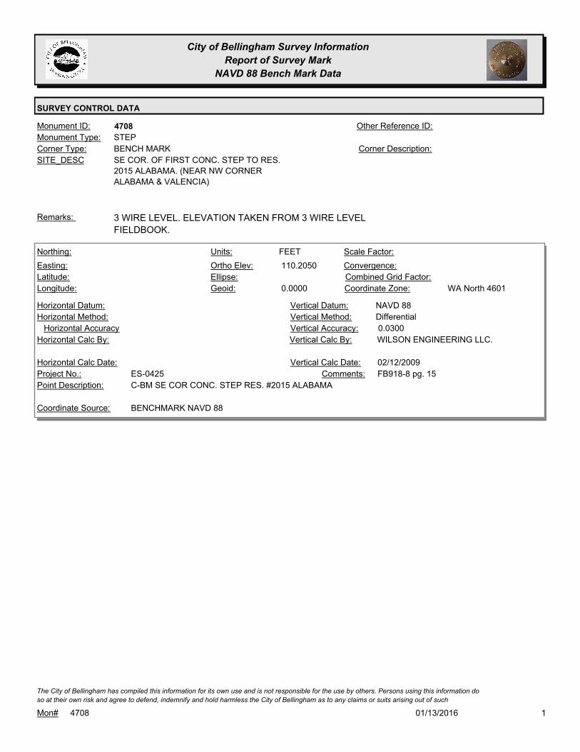
City of Bellingham Survey Information
Report of Survey Mark
NAVD 88 Bench Mark Data
SURVEY CONTROL DATA
4708Monument ID: Other Reference ID:
SITE_DESC SE COR. OF FIRST CONC. STEP TO RES.
2015 ALABAMA. (NEAR NW CORNER
ALABAMA & VALENCIA)
BENCH MARKCorner Type: Corner Description:
STEPMonument Type:
3 WIRE LEVEL. ELEVATION TAKEN FROM 3 WIRE LEVEL
FIELDBOOK.
Remarks:
110.2050
0.0000
FEETNorthing:
Easting:
Latitude:
Longitude:
Units:
Ortho Elev:
Ellipse:
Geoid:
Scale Factor:
Convergence:
Combined Grid Factor:
WA North 4601Coordinate Zone:
Horizontal Method:
Horizontal Datum: NAVD 88Vertical Datum:
DifferentialVertical Method:
Horizontal Accuracy 0.0300Vertical Accuracy:
WILSON ENGINEERING LLC.Vertical Calc By:Horizontal Calc By:
ES-0425Project No.:
C-BM SE COR CONC. STEP RES. #2015 ALABAMAPoint Description:
BENCHMARK NAVD 88Coordinate Source:
FB918-8 pg. 15Comments:
Horizontal Calc Date: 02/12/2009Vertical Calc Date:
101/13/2016Mon# 4708
The City of Bellingham has compiled this information for its own use and is not responsible for the use by others. Persons using this information do
so at their own risk and agree to defend, indemnify and hold harmless the City of Bellingham as to any claims or suits arising out of such

City of Bellingham Survey Information
Report of Survey Mark
NAVD 88 Bench Mark Data
SURVEY CONTROL DATA
4709Monument ID: Other Reference ID:
SITE_DESC SE COR. OF FIRST CONC. STEP TO RES.
2615 ALABAMA.
BENCH MARKCorner Type: Corner Description:
STEPMonument Type:
3 WIRE LEVEL. ELEVATION TAKEN FROM 3 WIRE LEVEL
FIELDBOOK.
Remarks:
138.5640
0.0000
FEETNorthing:
Easting:
Latitude:
Longitude:
Units:
Ortho Elev:
Ellipse:
Geoid:
Scale Factor:
Convergence:
Combined Grid Factor:
WA North 4601Coordinate Zone:
Horizontal Method:
Horizontal Datum: NAVD 88Vertical Datum:
DifferentialVertical Method:
Horizontal Accuracy 0.0300Vertical Accuracy:
WILSON ENGINEERING LLC.Vertical Calc By:Horizontal Calc By:
ES-0425Project No.:
C-BM SE COR CONC. STEP RES. #2615 ALABAMAPoint Description:
BENCHMARK NAVD 88Coordinate Source:
FB918-8 pg. 37Comments:
Horizontal Calc Date: 02/12/2009Vertical Calc Date:
101/13/2016Mon# 4709
The City of Bellingham has compiled this information for its own use and is not responsible for the use by others. Persons using this information do
so at their own risk and agree to defend, indemnify and hold harmless the City of Bellingham as to any claims or suits arising out of such
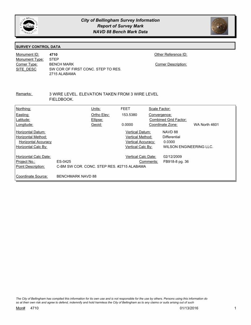
City of Bellingham Survey Information
Report of Survey Mark
NAVD 88 Bench Mark Data
SURVEY CONTROL DATA
4710Monument ID: Other Reference ID:
SITE_DESC SW COR OF FIRST CONC. STEP TO RES.
2715 ALABAMA
BENCH MARKCorner Type: Corner Description:
STEPMonument Type:
3 WIRE LEVEL. ELEVATION TAKEN FROM 3 WIRE LEVEL
FIELDBOOK.
Remarks:
153.5380
0.0000
FEETNorthing:
Easting:
Latitude:
Longitude:
Units:
Ortho Elev:
Ellipse:
Geoid:
Scale Factor:
Convergence:
Combined Grid Factor:
WA North 4601Coordinate Zone:
Horizontal Method:
Horizontal Datum: NAVD 88Vertical Datum:
DifferentialVertical Method:
Horizontal Accuracy 0.0300Vertical Accuracy:
WILSON ENGINEERING LLC.Vertical Calc By:Horizontal Calc By:
ES-0425Project No.:
C-BM SW COR. CONC. STEP RES. #2715 ALABAMAPoint Description:
BENCHMARK NAVD 88Coordinate Source:
FB918-8 pg. 36Comments:
Horizontal Calc Date: 02/12/2009Vertical Calc Date:
101/13/2016Mon# 4710
The City of Bellingham has compiled this information for its own use and is not responsible for the use by others. Persons using this information do
so at their own risk and agree to defend, indemnify and hold harmless the City of Bellingham as to any claims or suits arising out of such

City of Bellingham Survey Information
Report of Survey Mark
NAVD 88 Bench Mark Data
SURVEY CONTROL DATA
4713Monument ID: Other Reference ID:
SITE_DESC BRASS CAP IN NE COR OF CONC. LIGHT
BASE AT THE NORTH COR OF DUPONT & F.
BENCH MARKCorner Type: OLD 3 WIRE BM
USED FOR DATUM
MODERNIZATION TO
NAVD88
Corner Description:
BRASS MONMonument Type:
3 WIRE LEVEL BENCHMARK. ELEVATION TAKEN FROM 3 WIRE
LEVEL FIELDBOOKS.
Remarks:
67.9990
0.0000
FEETNorthing:
Easting:
Latitude:
Longitude:
Units:
Ortho Elev:
Ellipse:
Geoid:
Scale Factor:
Convergence:
Combined Grid Factor:
WA North 4601Coordinate Zone:
Horizontal Method:
Horizontal Datum: NAVD 88Vertical Datum:
DifferentialVertical Method:
Horizontal Accuracy 0.0200Vertical Accuracy:
PACIFIC SURVEY & ENGINEERING,
INC.
Vertical Calc By:Horizontal Calc By:
ES-0425Project No.:
BRASS BM IN N. QUADR. F ST & DUPONT STPoint Description:
BENCHMARK NAVD 88Coordinate Source:
FB 918Comments:
Horizontal Calc Date: 12/08/2008Vertical Calc Date:
101/13/2016Mon# 4713
The City of Bellingham has compiled this information for its own use and is not responsible for the use by others. Persons using this information do
so at their own risk and agree to defend, indemnify and hold harmless the City of Bellingham as to any claims or suits arising out of such
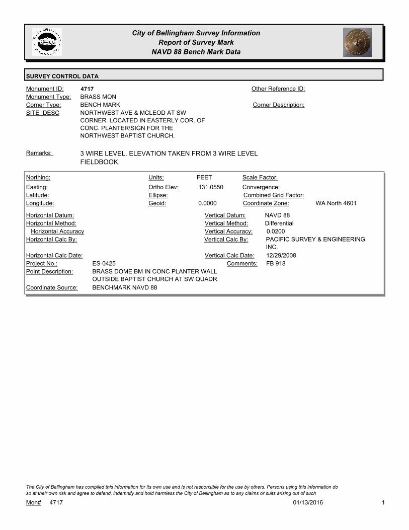
City of Bellingham Survey Information
Report of Survey Mark
NAVD 88 Bench Mark Data
SURVEY CONTROL DATA
4717Monument ID: Other Reference ID:
SITE_DESC NORTHWEST AVE & MCLEOD AT SW
CORNER. LOCATED IN EASTERLY COR. OF
CONC. PLANTER\SIGN FOR THE
NORTHWEST BAPTIST CHURCH.
BENCH MARKCorner Type: Corner Description:
BRASS MONMonument Type:
3 WIRE LEVEL. ELEVATION TAKEN FROM 3 WIRE LEVEL
FIELDBOOK.
Remarks:
131.0550
0.0000
FEETNorthing:
Easting:
Latitude:
Longitude:
Units:
Ortho Elev:
Ellipse:
Geoid:
Scale Factor:
Convergence:
Combined Grid Factor:
WA North 4601Coordinate Zone:
Horizontal Method:
Horizontal Datum: NAVD 88Vertical Datum:
DifferentialVertical Method:
Horizontal Accuracy 0.0200Vertical Accuracy:
PACIFIC SURVEY & ENGINEERING,
INC.
Vertical Calc By:Horizontal Calc By:
ES-0425Project No.:
BRASS DOME BM IN CONC PLANTER WALL
OUTSIDE BAPTIST CHURCH AT SW QUADR.
Point Description:
BENCHMARK NAVD 88Coordinate Source:
FB 918Comments:
Horizontal Calc Date: 12/29/2008Vertical Calc Date:
101/13/2016Mon# 4717
The City of Bellingham has compiled this information for its own use and is not responsible for the use by others. Persons using this information do
so at their own risk and agree to defend, indemnify and hold harmless the City of Bellingham as to any claims or suits arising out of such

City of Bellingham Survey Information
Report of Survey Mark
NAVD 88 Bench Mark Data
SURVEY CONTROL DATA
4718Monument ID: Other Reference ID:
SITE_DESC BRASS CAP IN LARGE GRANITE ROCK 24'
N'LY FROM THE NE'LY COR OF ABBEY IN
BAYVIEW CEMETERY.
BENCH MARKCorner Type: Corner Description:
BRASS MONMonument Type:
BENCHMARK FOUND. ELEVATION TAKEN FROM YELLOW
SHEETS.
Remarks:
283.3310
0.0000
FEETNorthing:
Easting:
Latitude:
Longitude:
Units:
Ortho Elev:
Ellipse:
Geoid:
Scale Factor:
Convergence:
Combined Grid Factor:
WA North 4601Coordinate Zone:
Horizontal Method:
Horizontal Datum: NAVD 88Vertical Datum:
DifferentialVertical Method:
Horizontal Accuracy 0.0300Vertical Accuracy:
WILSON ENGINEERING LLC.Vertical Calc By:Horizontal Calc By:
ES-0425Project No.:
C-BM BRASS DISK IN GRANITE ROCK ABBEY @
BAYVIEW CEMETARY
Point Description:
BENCHMARK NAVD 88Coordinate Source:
FB918-8 pg. 18Comments:
Horizontal Calc Date: 02/12/2009Vertical Calc Date:
101/13/2016Mon# 4718
The City of Bellingham has compiled this information for its own use and is not responsible for the use by others. Persons using this information do
so at their own risk and agree to defend, indemnify and hold harmless the City of Bellingham as to any claims or suits arising out of such

City of Bellingham Survey Information
Report of Survey Mark
NAVD 88 Bench Mark Data
SURVEY CONTROL DATA
4720Monument ID: Other Reference ID:
SITE_DESC NORTHWEST & MCLEOD AT SW CORNER
BENCH MARKCorner Type: TBM- RR SPIKE IN N
FACE U.P.
Corner Description:
RAILROAD SPIKEMonument Type:
ES-0315 TBM A - RR SPIKE IN N FACE U.P. AT SW QUAD INT.Remarks:
129.9930
0.0000
FEETNorthing:
Easting:
Latitude:
Longitude:
Units:
Ortho Elev:
Ellipse:
Geoid:
Scale Factor:
Convergence:
Combined Grid Factor:
WA North 4601Coordinate Zone:
Horizontal Method:
Horizontal Datum: NAVD 88Vertical Datum:
DifferentialVertical Method:
Horizontal Accuracy 0.0200Vertical Accuracy:
PACIFIC SURVEY & ENGINEERING,
INC.
Vertical Calc By:Horizontal Calc By:
ES-0425Project No.:
RR SPK IN PP AT SW QUADR. MCLEOD RD &
NORTHWEST AVE
Point Description:
BENCHMARK NAVD 88Coordinate Source:
FB 918Comments:
Horizontal Calc Date: 12/29/2008Vertical Calc Date:
101/13/2016Mon# 4720
The City of Bellingham has compiled this information for its own use and is not responsible for the use by others. Persons using this information do
so at their own risk and agree to defend, indemnify and hold harmless the City of Bellingham as to any claims or suits arising out of such

City of Bellingham Survey Information
Report of Survey Mark
NAVD 88 Bench Mark Data
SURVEY CONTROL DATA
4757Monument ID: Other Reference ID:
SITE_DESC WILDWOOD DR & 40TH ST
RIGHT-OF-WAY INTERSECTIONCorner Type: Corner Description:
BRASS MONMonument Type:
Remarks:
491.7480
FEETNorthing:
Easting:
Latitude:
Longitude:
Units:
Ortho Elev:
Ellipse:
Geoid:
Scale Factor:
Convergence:
Combined Grid Factor:
Coordinate Zone:
Horizontal Method:
Horizontal Datum: NAVD 88Vertical Datum:
DifferentialVertical Method:
Horizontal Accuracy 0.0300Vertical Accuracy:
WILSON ENGINEERING LLC.Vertical Calc By:Horizontal Calc By:
Project No.:
Point Description:
BENCHMARK NAVD 88Coordinate Source:
FB 960-3Comments:
Horizontal Calc Date: 01/18/2012Vertical Calc Date:
101/13/2016Mon# 4757
The City of Bellingham has compiled this information for its own use and is not responsible for the use by others. Persons using this information do
so at their own risk and agree to defend, indemnify and hold harmless the City of Bellingham as to any claims or suits arising out of such

City of Bellingham Survey Information
Report of Survey Mark
NAVD 88 Bench Mark Data
SURVEY CONTROL DATA
4782Monument ID: Other Reference ID:
SITE_DESC CONSOLIDATION & W PACIFICVIEW DR
RIGHT-OF-WAY INTERSECTIONCorner Type: Corner Description:
BRASS MONMonument Type:
VISITED FOR NAD 83/98 CONTROL NETWORK SURVEY 2006.Remarks:
552.1880
FEETNorthing:
Easting:
Latitude:
Longitude:
Units:
Ortho Elev:
Ellipse:
Geoid:
Scale Factor:
Convergence:
Combined Grid Factor:
Coordinate Zone:
Horizontal Method:
Horizontal Datum: NAVD 88Vertical Datum:
DifferentialVertical Method:
Horizontal Accuracy 0.0200Vertical Accuracy:
CONSTRUCTION SURVEYORS N W
INC.
Vertical Calc By:Horizontal Calc By:
Project No.:
Point Description:
BENCHMARK NAVD 88Coordinate Source:
FB 960-2Comments:
Horizontal Calc Date: 05/01/2012Vertical Calc Date:
101/13/2016Mon# 4782
The City of Bellingham has compiled this information for its own use and is not responsible for the use by others. Persons using this information do
so at their own risk and agree to defend, indemnify and hold harmless the City of Bellingham as to any claims or suits arising out of such

City of Bellingham Survey Information
Report of Survey Mark
NAVD 88 Bench Mark Data
SURVEY CONTROL DATA
4785Monument ID: Other Reference ID:
SITE_DESC E PACIFICVIEW & W PACIFICVIEW
RIGHT-OF-WAY INTERSECTIONCorner Type: Corner Description:
BRASS MONMonument Type:
Remarks:
571.9990
FEETNorthing:
Easting:
Latitude:
Longitude:
Units:
Ortho Elev:
Ellipse:
Geoid:
Scale Factor:
Convergence:
Combined Grid Factor:
Coordinate Zone:
Horizontal Method:
Horizontal Datum: NAVD 88Vertical Datum:
DifferentialVertical Method:
Horizontal Accuracy 0.0200Vertical Accuracy:
CONSTRUCTION SURVEYORS N W
INC.
Vertical Calc By:Horizontal Calc By:
Project No.:
Point Description:
BENCHMARK NAVD 88Coordinate Source:
FB 960-2Comments:
Horizontal Calc Date: 05/01/2012Vertical Calc Date:
101/13/2016Mon# 4785
The City of Bellingham has compiled this information for its own use and is not responsible for the use by others. Persons using this information do
so at their own risk and agree to defend, indemnify and hold harmless the City of Bellingham as to any claims or suits arising out of such
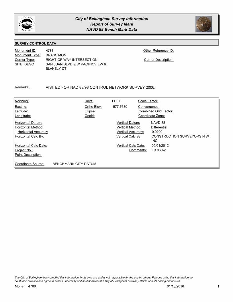
City of Bellingham Survey Information
Report of Survey Mark
NAVD 88 Bench Mark Data
SURVEY CONTROL DATA
4786Monument ID: Other Reference ID:
SITE_DESC SAN JUAN BLVD & W PACIFICVIEW &
BLAKELY CT
RIGHT-OF-WAY INTERSECTIONCorner Type: Corner Description:
BRASS MONMonument Type:
VISITED FOR NAD 83/98 CONTROL NETWORK SURVEY 2006.Remarks:
577.7630
FEETNorthing:
Easting:
Latitude:
Longitude:
Units:
Ortho Elev:
Ellipse:
Geoid:
Scale Factor:
Convergence:
Combined Grid Factor:
Coordinate Zone:
Horizontal Method:
Horizontal Datum: NAVD 88Vertical Datum:
DifferentialVertical Method:
Horizontal Accuracy 0.0200Vertical Accuracy:
CONSTRUCTION SURVEYORS N W
INC.
Vertical Calc By:Horizontal Calc By:
Project No.:
Point Description:
BENCHMARK CITY DATUMCoordinate Source:
FB 960-2Comments:
Horizontal Calc Date: 05/01/2012Vertical Calc Date:
101/13/2016Mon# 4786
The City of Bellingham has compiled this information for its own use and is not responsible for the use by others. Persons using this information do
so at their own risk and agree to defend, indemnify and hold harmless the City of Bellingham as to any claims or suits arising out of such

City of Bellingham Survey Information
Report of Survey Mark
NAVD 88 Bench Mark Data
SURVEY CONTROL DATA
4984Monument ID: Other Reference ID:
SITE_DESC 4TH & TERRACE PL
RIGHT-OF-WAY INTERSECTIONCorner Type: Corner Description:
CASED MONMonument Type:
Remarks:
630,221.9400
1,235,284.7200 96.8700
FEETNorthing:
Easting:
Latitude:
Longitude:
Units:
Ortho Elev:
Ellipse:
Geoid:
Scale Factor:
Convergence:
Combined Grid Factor:
WA North 4601Coordinate Zone:
Conventional SurveyHorizontal Method:
NAD 83/98Horizontal Datum: NAVD 88Vertical Datum:
DifferentialVertical Method:
Horizontal Accuracy Vertical Accuracy:
WILSON ENGINEERING LLC.Vertical Calc By:WILSON ENGINEERING LLC.Horizontal Calc By:
Project No.:
MON IN CASEPoint Description:
NAD 83/98 PROJECT POINTSCoordinate Source:
POST POINT RS-4712Comments:
08/10/2009Horizontal Calc Date: 08/10/2009Vertical Calc Date:
101/13/2016Mon# 4984
The City of Bellingham has compiled this information for its own use and is not responsible for the use by others. Persons using this information do
so at their own risk and agree to defend, indemnify and hold harmless the City of Bellingham as to any claims or suits arising out of such
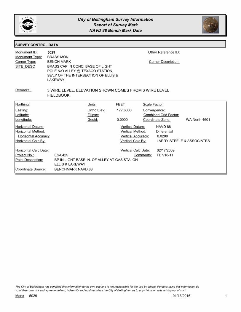
City of Bellingham Survey Information
Report of Survey Mark
NAVD 88 Bench Mark Data
SURVEY CONTROL DATA
5029Monument ID: Other Reference ID:
SITE_DESC BRASS CAP IN CONC. BASE OF LIGHT
POLE N/O ALLEY @ TEXACO STATION,
SE'LY OF THE INTERSECTION OF ELLIS &
LAKEWAY.
BENCH MARKCorner Type: Corner Description:
BRASS MONMonument Type:
3 WIRE LEVEL. ELEVATION SHOWN COMES FROM 3 WIRE LEVEL
FIELDBOOK.
Remarks:
177.6380
0.0000
FEETNorthing:
Easting:
Latitude:
Longitude:
Units:
Ortho Elev:
Ellipse:
Geoid:
Scale Factor:
Convergence:
Combined Grid Factor:
WA North 4601Coordinate Zone:
Horizontal Method:
Horizontal Datum: NAVD 88Vertical Datum:
DifferentialVertical Method:
Horizontal Accuracy 0.0200Vertical Accuracy:
LARRY STEELE & ASSOCIATESVertical Calc By:Horizontal Calc By:
ES-0425Project No.:
BP IN LIGHT BASE, N. OF ALLEY AT GAS STA. ON
ELLIS & LAKEWAY
Point Description:
BENCHMARK NAVD 88Coordinate Source:
FB 918-11Comments:
Horizontal Calc Date: 02/17/2009Vertical Calc Date:
101/13/2016Mon# 5029
The City of Bellingham has compiled this information for its own use and is not responsible for the use by others. Persons using this information do
so at their own risk and agree to defend, indemnify and hold harmless the City of Bellingham as to any claims or suits arising out of such

City of Bellingham Survey Information
Report of Survey Mark
NAVD 88 Bench Mark Data
SURVEY CONTROL DATA
5031Monument ID: Other Reference ID:
SITE_DESC LAKEWAY & NEVADA AT NW CORNER
BENCH MARKCorner Type: SPIKE IN PPCorner Description:
SPIKE & WASHERMonument Type:
TBM - CITY CAD SPIKE IN WASHER IN SIDEWALK W OD PP #1145.Remarks:
162.3010
0.0000
FEETNorthing:
Easting:
Latitude:
Longitude:
Units:
Ortho Elev:
Ellipse:
Geoid:
Scale Factor:
Convergence:
Combined Grid Factor:
WA North 4601Coordinate Zone:
Horizontal Method:
Horizontal Datum: NAVD 88Vertical Datum:
DifferentialVertical Method:
Horizontal Accuracy 0.0300Vertical Accuracy:
WILSON ENGINEERING LLC.Vertical Calc By:Horizontal Calc By:
ES-0425Project No.:
C-NW CITY BM S/WALK N.SIDE LAKEWAYPoint Description:
BENCHMARK NAVD 88Coordinate Source:
FB918-7 pg. 44Comments:
Horizontal Calc Date: 02/12/2009Vertical Calc Date:
101/13/2016Mon# 5031
The City of Bellingham has compiled this information for its own use and is not responsible for the use by others. Persons using this information do
so at their own risk and agree to defend, indemnify and hold harmless the City of Bellingham as to any claims or suits arising out of such

City of Bellingham Survey Information
Report of Survey Mark
NAVD 88 Bench Mark Data
SURVEY CONTROL DATA
5077Monument ID: Other Reference ID:
SITE_DESC SET VERTICALLY IN THE NORTH FACE OF
THE MOST EASTERLY PIER WEST OF THE
RR TRACKS UNDERNEATH OF THE MARINE
DR. OVERPASS. SET ABOUT 3 FEET
HIGHER THAN THE GROUND.
BENCH MARKCorner Type: Corner Description:
BRASS MONMonument Type:
NGS FIRST ORDER, CLASS 1 NAVD 88 BENCHMARK.
(PID=TR0672)
Remarks:
114.6200
FEETNorthing:
Easting:
Latitude:
Longitude:
Units:
Ortho Elev:
Ellipse:
Geoid:
Scale Factor:
Convergence:
Combined Grid Factor:
Coordinate Zone:
Horizontal Method:
Horizontal Datum: NAVD 88Vertical Datum:
DifferentialVertical Method:
Horizontal Accuracy Vertical Accuracy:
NATIONAL GEODETIC SURVEYVertical Calc By:Horizontal Calc By:
Project No.:
BRASS DISK SET IN CONC. PIER BELOW MARINE
DR. OVERPASS.
Point Description:
NGSCoordinate Source:
NGS PUBLISHED ELEVATION.
FIRST ORDER, CLASS 1.
ELEVATION SET AND ADJUSTED
Comments:
Horizontal Calc Date: 06/01/1991Vertical Calc Date:
101/13/2016Mon# 5077
The City of Bellingham has compiled this information for its own use and is not responsible for the use by others. Persons using this information do
so at their own risk and agree to defend, indemnify and hold harmless the City of Bellingham as to any claims or suits arising out of such

City of Bellingham Survey Information
Report of Survey Mark
NAVD 88 Bench Mark Data
SURVEY CONTROL DATA
5078Monument ID: Other Reference ID:
SITE_DESC COTTON GIN SPIKE IN PP 463983/160873 12'
S/O AND 26' W/O INTERSECTION OF
WHATCOM & PUGET.
BENCH MARKCorner Type: Corner Description:
GIN SPIKEMonument Type:
BENCHMARK USED BY CONSTRUCTION SURVEYORS IN 1993.Remarks:
254.7340
Northing:
Easting:
Latitude:
Longitude:
Units:
Ortho Elev:
Ellipse:
Geoid:
Scale Factor:
Convergence:
Combined Grid Factor:
Coordinate Zone:
Horizontal Method:
Horizontal Datum: NAVD 88Vertical Datum:
DifferentialVertical Method:
Horizontal Accuracy 0.0200Vertical Accuracy:
CONSTRUCTION SURVEYORS N W
INC.
Vertical Calc By:Horizontal Calc By:
Project No.:
Point Description:
BENCHMARK NAVD 88Coordinate Source:
FB 960-2Comments:
Horizontal Calc Date: 05/01/2012Vertical Calc Date:
101/13/2016Mon# 5078
The City of Bellingham has compiled this information for its own use and is not responsible for the use by others. Persons using this information do
so at their own risk and agree to defend, indemnify and hold harmless the City of Bellingham as to any claims or suits arising out of such

City of Bellingham Survey Information
Report of Survey Mark
NAVD 88 Bench Mark Data
SURVEY CONTROL DATA
5079Monument ID: Other Reference ID:
SITE_DESC COTTON GIN SPIKE IN PP 18657 @ SE COR
OF PUGET AND EDWARDS.
BENCH MARKCorner Type: Corner Description:
GIN SPIKEMonument Type:
USED BY CONSTRUCTION SURVEYORS IN 1993.Remarks:
314.2590
FEETNorthing:
Easting:
Latitude:
Longitude:
Units:
Ortho Elev:
Ellipse:
Geoid:
Scale Factor:
Convergence:
Combined Grid Factor:
Coordinate Zone:
Horizontal Method:
Horizontal Datum: NAVD 88Vertical Datum:
DifferentialVertical Method:
Horizontal Accuracy 0.0200Vertical Accuracy:
CONSTRUCTION SURVEYORS N W
INC.
Vertical Calc By:Horizontal Calc By:
Project No.:
Point Description:
BENCHMARK NAVD 88Coordinate Source:
FB 960-2Comments:
Horizontal Calc Date: 05/01/2012Vertical Calc Date:
101/13/2016Mon# 5079
The City of Bellingham has compiled this information for its own use and is not responsible for the use by others. Persons using this information do
so at their own risk and agree to defend, indemnify and hold harmless the City of Bellingham as to any claims or suits arising out of such
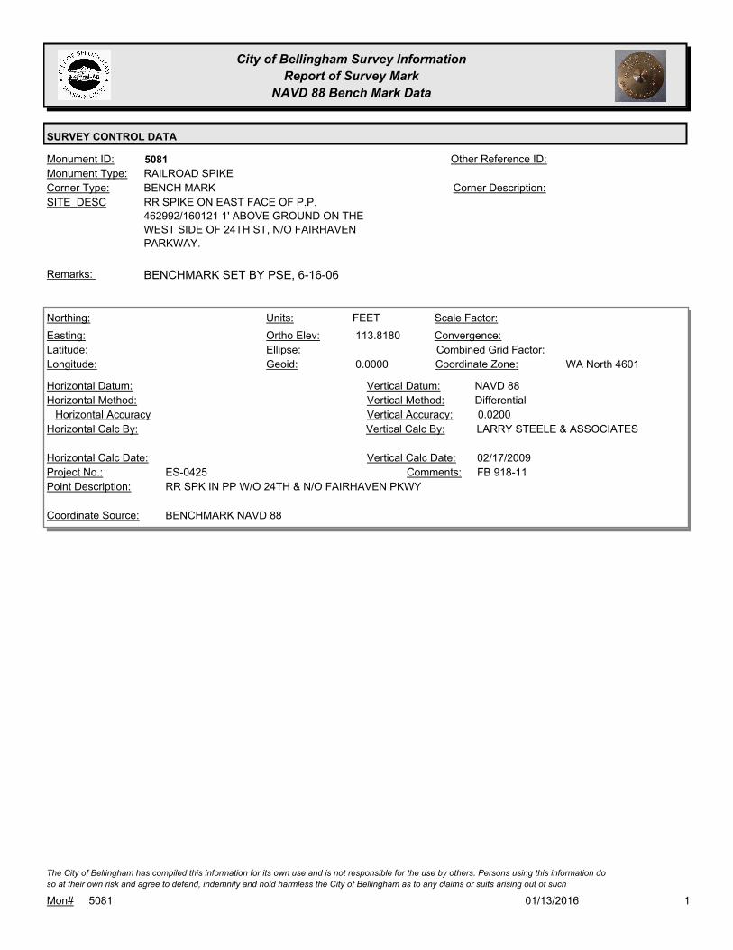
City of Bellingham Survey Information
Report of Survey Mark
NAVD 88 Bench Mark Data
SURVEY CONTROL DATA
5081Monument ID: Other Reference ID:
SITE_DESC RR SPIKE ON EAST FACE OF P.P.
462992/160121 1' ABOVE GROUND ON THE
WEST SIDE OF 24TH ST, N/O FAIRHAVEN
PARKWAY.
BENCH MARKCorner Type: Corner Description:
RAILROAD SPIKEMonument Type:
BENCHMARK SET BY PSE, 6-16-06Remarks:
113.8180
0.0000
FEETNorthing:
Easting:
Latitude:
Longitude:
Units:
Ortho Elev:
Ellipse:
Geoid:
Scale Factor:
Convergence:
Combined Grid Factor:
WA North 4601Coordinate Zone:
Horizontal Method:
Horizontal Datum: NAVD 88Vertical Datum:
DifferentialVertical Method:
Horizontal Accuracy 0.0200Vertical Accuracy:
LARRY STEELE & ASSOCIATESVertical Calc By:Horizontal Calc By:
ES-0425Project No.:
RR SPK IN PP W/O 24TH & N/O FAIRHAVEN PKWYPoint Description:
BENCHMARK NAVD 88Coordinate Source:
FB 918-11Comments:
Horizontal Calc Date: 02/17/2009Vertical Calc Date:
101/13/2016Mon# 5081
The City of Bellingham has compiled this information for its own use and is not responsible for the use by others. Persons using this information do
so at their own risk and agree to defend, indemnify and hold harmless the City of Bellingham as to any claims or suits arising out of such

City of Bellingham Survey Information
Report of Survey Mark
NAVD 88 Bench Mark Data
SURVEY CONTROL DATA
5166Monument ID: Other Reference ID:
SITE_DESC CORNWALL & CHESTNUT AT S QUAD
BENCH MARKCorner Type: TBM - X ON N BOLT
OF SIGNAL LIGHT AT
S QUAD INT
Corner Description:
BOLTMonument Type:
TBM 893-2-40A - X ON N BOLT OF SIGNAL LIGHT AT S QUAD INT.Remarks:
58.1700
FEETNorthing:
Easting:
Latitude:
Longitude:
Units:
Ortho Elev:
Ellipse:
Geoid:
Scale Factor:
Convergence:
Combined Grid Factor:
Coordinate Zone:
Horizontal Method:
Horizontal Datum: NAVD 88Vertical Datum:
DifferentialVertical Method:
Horizontal Accuracy 0.0100Vertical Accuracy:
PACIFIC SURVEY & ENGINEERING,
INC.
Vertical Calc By:Horizontal Calc By:
EW-0142Project No.:
Point Description:
BENCHMARK NAVD 88Coordinate Source:
FB 893-2 PG40Comments:
Horizontal Calc Date: 09/05/2006Vertical Calc Date:
101/13/2016Mon# 5166
The City of Bellingham has compiled this information for its own use and is not responsible for the use by others. Persons using this information do
so at their own risk and agree to defend, indemnify and hold harmless the City of Bellingham as to any claims or suits arising out of such

City of Bellingham Survey Information
Report of Survey Mark
NAVD 88 Bench Mark Data
SURVEY CONTROL DATA
5167Monument ID: Other Reference ID:
SITE_DESC CORNWALL & MAGNOLIA AT N QUAD
BENCH MARKCorner Type: TBM - X ON S BOLT
OF SIGNAL LIGHT AT
N QUAD INT
Corner Description:
BOLTMonument Type:
TBM 893-2-40B - X ON S BOLT OF SIGNAL LIGHT AT N QUAD INT.Remarks:
75.9500
FEETNorthing:
Easting:
Latitude:
Longitude:
Units:
Ortho Elev:
Ellipse:
Geoid:
Scale Factor:
Convergence:
Combined Grid Factor:
Coordinate Zone:
Horizontal Method:
Horizontal Datum: NAVD 88Vertical Datum:
DifferentialVertical Method:
Horizontal Accuracy 0.0100Vertical Accuracy:
PACIFIC SURVEY & ENGINEERING,
INC.
Vertical Calc By:Horizontal Calc By:
EW-0142Project No.:
Point Description:
BENCHMARK NAVD 88Coordinate Source:
FB 893-2Comments:
Horizontal Calc Date: 09/05/2006Vertical Calc Date:
101/13/2016Mon# 5167
The City of Bellingham has compiled this information for its own use and is not responsible for the use by others. Persons using this information do
so at their own risk and agree to defend, indemnify and hold harmless the City of Bellingham as to any claims or suits arising out of such
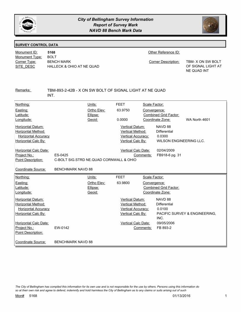
City of Bellingham Survey Information
Report of Survey Mark
NAVD 88 Bench Mark Data
SURVEY CONTROL DATA
5168Monument ID: Other Reference ID:
SITE_DESC HALLECK & OHIO AT NE QUAD
BENCH MARKCorner Type: TBM- X ON SW BOLT
OF SIGNAL LIGHT AT
NE QUAD INT
Corner Description:
BOLTMonument Type:
TBM-893-2-42B - X ON SW BOLT OF SIGNAL LIGHT AT NE QUAD
INT.
Remarks:
63.9750
0.0000
FEETNorthing:
Easting:
Latitude:
Longitude:
Units:
Ortho Elev:
Ellipse:
Geoid:
Scale Factor:
Convergence:
Combined Grid Factor:
WA North 4601Coordinate Zone:
Horizontal Method:
Horizontal Datum: NAVD 88Vertical Datum:
DifferentialVertical Method:
Horizontal Accuracy 0.0300Vertical Accuracy:
WILSON ENGINEERING LLC.Vertical Calc By:Horizontal Calc By:
ES-0425Project No.:
C-BOLT SIG.STRD NE.QUAD CORNWALL & OHIOPoint Description:
BENCHMARK NAVD 88Coordinate Source:
FB918-6 pg. 31Comments:
Horizontal Calc Date: 02/04/2009Vertical Calc Date:
63.9800
FEETNorthing:
Easting:
Latitude:
Longitude:
Units:
Ortho Elev:
Ellipse:
Geoid:
Scale Factor:
Convergence:
Combined Grid Factor:
Coordinate Zone:
Horizontal Method:
Horizontal Datum: NAVD 88Vertical Datum:
DifferentialVertical Method:
Horizontal Accuracy 0.0100Vertical Accuracy:
PACIFIC SURVEY & ENGINEERING,
INC.
Vertical Calc By:Horizontal Calc By:
EW-0142Project No.:
Point Description:
BENCHMARK NAVD 88Coordinate Source:
FB 893-2Comments:
Horizontal Calc Date: 09/05/2006Vertical Calc Date:
101/13/2016Mon# 5168
The City of Bellingham has compiled this information for its own use and is not responsible for the use by others. Persons using this information do
so at their own risk and agree to defend, indemnify and hold harmless the City of Bellingham as to any claims or suits arising out of such
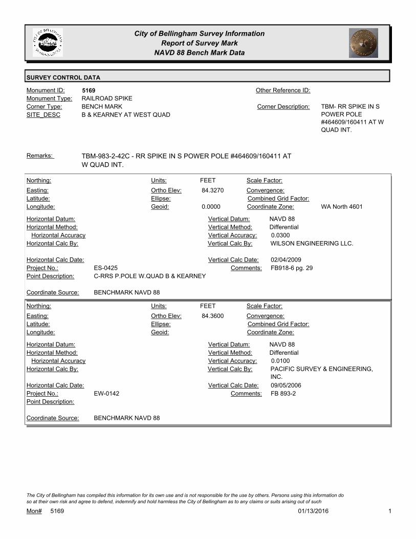
City of Bellingham Survey Information
Report of Survey Mark
NAVD 88 Bench Mark Data
SURVEY CONTROL DATA
5169Monument ID: Other Reference ID:
SITE_DESC B & KEARNEY AT WEST QUAD
BENCH MARKCorner Type: TBM- RR SPIKE IN S
POWER POLE
#464609/160411 AT W
QUAD INT.
Corner Description:
RAILROAD SPIKEMonument Type:
TBM-983-2-42C - RR SPIKE IN S POWER POLE #464609/160411 AT
W QUAD INT.
Remarks:
84.3270
0.0000
FEETNorthing:
Easting:
Latitude:
Longitude:
Units:
Ortho Elev:
Ellipse:
Geoid:
Scale Factor:
Convergence:
Combined Grid Factor:
WA North 4601Coordinate Zone:
Horizontal Method:
Horizontal Datum: NAVD 88Vertical Datum:
DifferentialVertical Method:
Horizontal Accuracy 0.0300Vertical Accuracy:
WILSON ENGINEERING LLC.Vertical Calc By:Horizontal Calc By:
ES-0425Project No.:
C-RRS P.POLE W.QUAD B & KEARNEYPoint Description:
BENCHMARK NAVD 88Coordinate Source:
FB918-6 pg. 29Comments:
Horizontal Calc Date: 02/04/2009Vertical Calc Date:
84.3600
FEETNorthing:
Easting:
Latitude:
Longitude:
Units:
Ortho Elev:
Ellipse:
Geoid:
Scale Factor:
Convergence:
Combined Grid Factor:
Coordinate Zone:
Horizontal Method:
Horizontal Datum: NAVD 88Vertical Datum:
DifferentialVertical Method:
Horizontal Accuracy 0.0100Vertical Accuracy:
PACIFIC SURVEY & ENGINEERING,
INC.
Vertical Calc By:Horizontal Calc By:
EW-0142Project No.:
Point Description:
BENCHMARK NAVD 88Coordinate Source:
FB 893-2Comments:
Horizontal Calc Date: 09/05/2006Vertical Calc Date:
101/13/2016Mon# 5169
The City of Bellingham has compiled this information for its own use and is not responsible for the use by others. Persons using this information do
so at their own risk and agree to defend, indemnify and hold harmless the City of Bellingham as to any claims or suits arising out of such
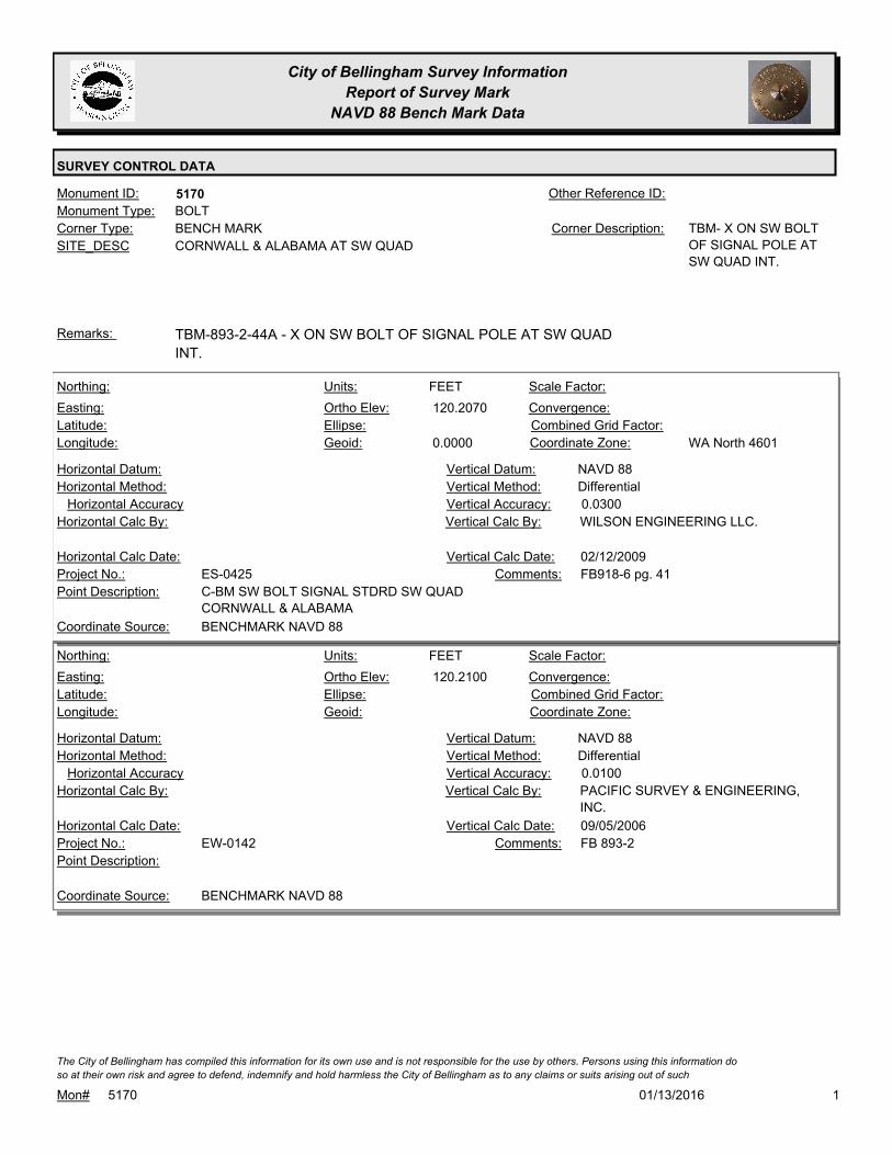
City of Bellingham Survey Information
Report of Survey Mark
NAVD 88 Bench Mark Data
SURVEY CONTROL DATA
5170Monument ID: Other Reference ID:
SITE_DESC CORNWALL & ALABAMA AT SW QUAD
BENCH MARKCorner Type: TBM- X ON SW BOLT
OF SIGNAL POLE AT
SW QUAD INT.
Corner Description:
BOLTMonument Type:
TBM-893-2-44A - X ON SW BOLT OF SIGNAL POLE AT SW QUAD
INT.
Remarks:
120.2070
0.0000
FEETNorthing:
Easting:
Latitude:
Longitude:
Units:
Ortho Elev:
Ellipse:
Geoid:
Scale Factor:
Convergence:
Combined Grid Factor:
WA North 4601Coordinate Zone:
Horizontal Method:
Horizontal Datum: NAVD 88Vertical Datum:
DifferentialVertical Method:
Horizontal Accuracy 0.0300Vertical Accuracy:
WILSON ENGINEERING LLC.Vertical Calc By:Horizontal Calc By:
ES-0425Project No.:
C-BM SW BOLT SIGNAL STDRD SW QUAD
CORNWALL & ALABAMA
Point Description:
BENCHMARK NAVD 88Coordinate Source:
FB918-6 pg. 41Comments:
Horizontal Calc Date: 02/12/2009Vertical Calc Date:
120.2100
FEETNorthing:
Easting:
Latitude:
Longitude:
Units:
Ortho Elev:
Ellipse:
Geoid:
Scale Factor:
Convergence:
Combined Grid Factor:
Coordinate Zone:
Horizontal Method:
Horizontal Datum: NAVD 88Vertical Datum:
DifferentialVertical Method:
Horizontal Accuracy 0.0100Vertical Accuracy:
PACIFIC SURVEY & ENGINEERING,
INC.
Vertical Calc By:Horizontal Calc By:
EW-0142Project No.:
Point Description:
BENCHMARK NAVD 88Coordinate Source:
FB 893-2Comments:
Horizontal Calc Date: 09/05/2006Vertical Calc Date:
101/13/2016Mon# 5170
The City of Bellingham has compiled this information for its own use and is not responsible for the use by others. Persons using this information do
so at their own risk and agree to defend, indemnify and hold harmless the City of Bellingham as to any claims or suits arising out of such
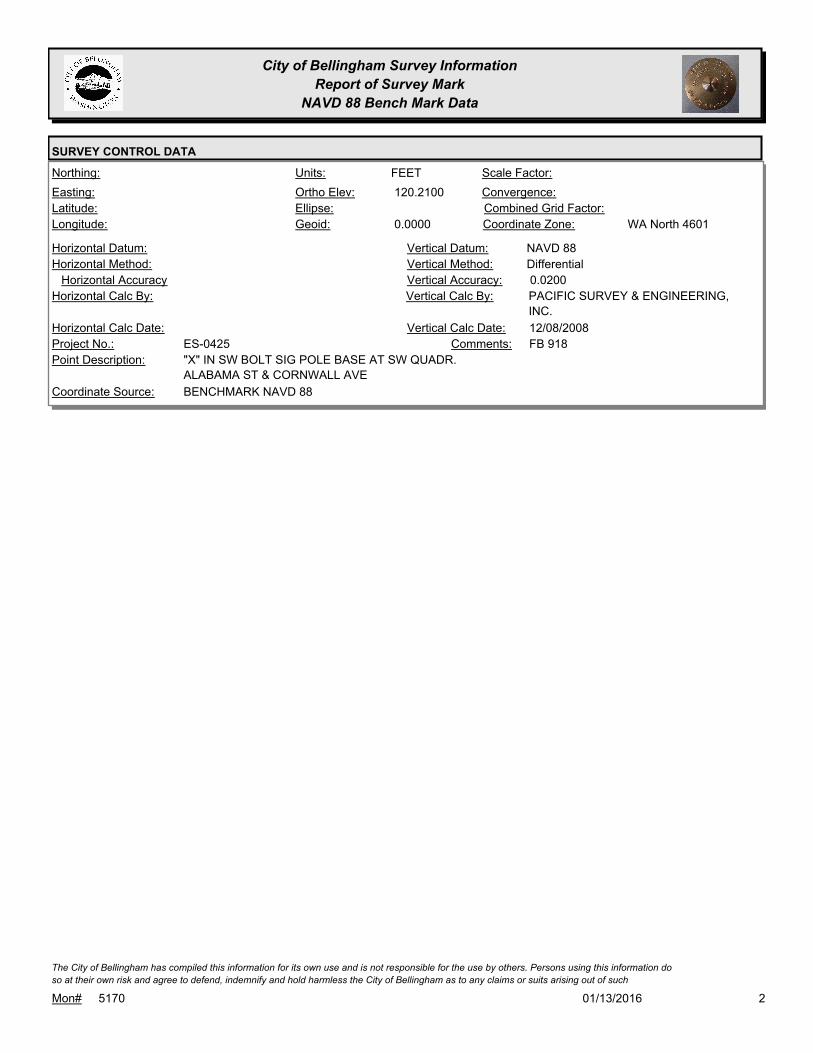
City of Bellingham Survey Information
Report of Survey Mark
NAVD 88 Bench Mark Data
SURVEY CONTROL DATA
120.2100
0.0000
FEETNorthing:
Easting:
Latitude:
Longitude:
Units:
Ortho Elev:
Ellipse:
Geoid:
Scale Factor:
Convergence:
Combined Grid Factor:
WA North 4601Coordinate Zone:
Horizontal Method:
Horizontal Datum: NAVD 88Vertical Datum:
DifferentialVertical Method:
Horizontal Accuracy 0.0200Vertical Accuracy:
PACIFIC SURVEY & ENGINEERING,
INC.
Vertical Calc By:Horizontal Calc By:
ES-0425Project No.:
"X" IN SW BOLT SIG POLE BASE AT SW QUADR.
ALABAMA ST & CORNWALL AVE
Point Description:
BENCHMARK NAVD 88Coordinate Source:
FB 918Comments:
Horizontal Calc Date: 12/08/2008Vertical Calc Date:
201/13/2016Mon# 5170
The City of Bellingham has compiled this information for its own use and is not responsible for the use by others. Persons using this information do
so at their own risk and agree to defend, indemnify and hold harmless the City of Bellingham as to any claims or suits arising out of such
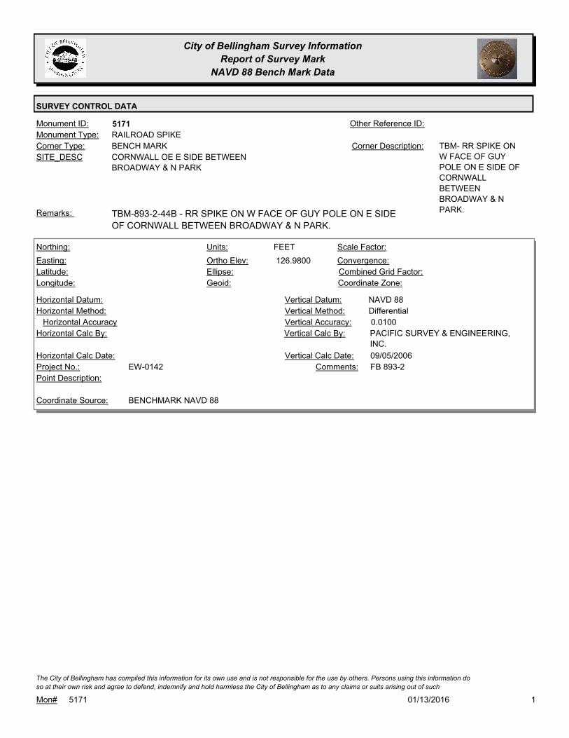
City of Bellingham Survey Information
Report of Survey Mark
NAVD 88 Bench Mark Data
SURVEY CONTROL DATA
5171Monument ID: Other Reference ID:
SITE_DESC CORNWALL OE E SIDE BETWEEN
BROADWAY & N PARK
BENCH MARKCorner Type: TBM- RR SPIKE ON
W FACE OF GUY
POLE ON E SIDE OF
CORNWALL
BETWEEN
BROADWAY & N
PARK.
Corner Description:
RAILROAD SPIKEMonument Type:
TBM-893-2-44B - RR SPIKE ON W FACE OF GUY POLE ON E SIDE
OF CORNWALL BETWEEN BROADWAY & N PARK.
Remarks:
126.9800
FEETNorthing:
Easting:
Latitude:
Longitude:
Units:
Ortho Elev:
Ellipse:
Geoid:
Scale Factor:
Convergence:
Combined Grid Factor:
Coordinate Zone:
Horizontal Method:
Horizontal Datum: NAVD 88Vertical Datum:
DifferentialVertical Method:
Horizontal Accuracy 0.0100Vertical Accuracy:
PACIFIC SURVEY & ENGINEERING,
INC.
Vertical Calc By:Horizontal Calc By:
EW-0142Project No.:
Point Description:
BENCHMARK NAVD 88Coordinate Source:
FB 893-2Comments:
Horizontal Calc Date: 09/05/2006Vertical Calc Date:
101/13/2016Mon# 5171
The City of Bellingham has compiled this information for its own use and is not responsible for the use by others. Persons using this information do
so at their own risk and agree to defend, indemnify and hold harmless the City of Bellingham as to any claims or suits arising out of such
City of Bellingham Survey Information
Report of Survey Mark
NAVD 88 Bench Mark Data
SURVEY CONTROL DATA
5172Monument ID: Other Reference ID:
SITE_DESC CORNWALL & ILLINOIS AT NE QUAD
BENCH MARKCorner Type: TBM- NUT TOP ON W
BOLT OF SIGNAL
POLE AT NE QUAD
INT.
Corner Description:
BOLTMonument Type:
TBM-893-2-44C - NUT TOP ON W BOLT OF SIGNAL POLE AT NE
QUAD INT.
Remarks:
125.6500
FEETNorthing:
Easting:
Latitude:
Longitude:
Units:
Ortho Elev:
Ellipse:
Geoid:
Scale Factor:
Convergence:
Combined Grid Factor:
Coordinate Zone:
Horizontal Method:
Horizontal Datum: NAVD 88Vertical Datum:
DifferentialVertical Method:
Horizontal Accuracy 0.0100Vertical Accuracy:
PACIFIC SURVEY & ENGINEERING,
INC.
Vertical Calc By:Horizontal Calc By:
EW-0142Project No.:
Point Description:
BENCHMARK NAVD 88Coordinate Source:
FB 893-2Comments:
Horizontal Calc Date: 09/05/2006Vertical Calc Date:
125.6500
0.0000
FEETNorthing:
Easting:
Latitude:
Longitude:
Units:
Ortho Elev:
Ellipse:
Geoid:
Scale Factor:
Convergence:
Combined Grid Factor:
WA North 4601Coordinate Zone:
Horizontal Method:
Horizontal Datum: NAVD 88Vertical Datum:
DifferentialVertical Method:
Horizontal Accuracy 0.0200Vertical Accuracy:
PACIFIC SURVEY & ENGINEERING,
INC.
Vertical Calc By:Horizontal Calc By:
ES-0425Project No.:
W. BOLT SIG POLE BASE AT NE QUADR. ILLINOIS
ST & CORNWALL AVE
Point Description:
BENCHMARK NAVD 88Coordinate Source:
FB 918Comments:
Horizontal Calc Date: 12/09/2008Vertical Calc Date:
101/13/2016Mon# 5172
The City of Bellingham has compiled this information for its own use and is not responsible for the use by others. Persons using this information do
so at their own risk and agree to defend, indemnify and hold harmless the City of Bellingham as to any claims or suits arising out of such
City of Bellingham Survey Information
Report of Survey Mark
NAVD 88 Bench Mark Data
SURVEY CONTROL DATA
5173Monument ID: Other Reference ID:
SITE_DESC CHAMPION & N STATE AT W QUAD
BENCH MARKCorner Type: TBM- X ON E BOLT
OF SIGNAL POLE AT
W QUAD OF INT.
Corner Description:
BOLTMonument Type:
TBM-893-2-42A - X ON E BOLT OF SIGNAL POLE AT W QUAD OF
INT.
Remarks:
69.1240
0.0000
FEETNorthing:
Easting:
Latitude:
Longitude:
Units:
Ortho Elev:
Ellipse:
Geoid:
Scale Factor:
Convergence:
Combined Grid Factor:
WA North 4601Coordinate Zone:
Horizontal Method:
Horizontal Datum: NAVD 88Vertical Datum:
DifferentialVertical Method:
Horizontal Accuracy 0.0300Vertical Accuracy:
WILSON ENGINEERING LLC.Vertical Calc By:Horizontal Calc By:
ES-0425Project No.:
C-SRB BOLT SIG.STRD NW STATE & CHAMPIONPoint Description:
BENCHMARK NAVD 88Coordinate Source:
FB918-6 pg. 21Comments:
Horizontal Calc Date: 02/04/2009Vertical Calc Date:
69.1200
FEETNorthing:
Easting:
Latitude:
Longitude:
Units:
Ortho Elev:
Ellipse:
Geoid:
Scale Factor:
Convergence:
Combined Grid Factor:
Coordinate Zone:
Horizontal Method:
Horizontal Datum: NAVD 88Vertical Datum:
DifferentialVertical Method:
Horizontal Accuracy 0.0100Vertical Accuracy:
PACIFIC SURVEY & ENGINEERING,
INC.
Vertical Calc By:Horizontal Calc By:
EW-0142Project No.:
Point Description:
BENCHMARK NAVD 88Coordinate Source:
FB 893-2Comments:
Horizontal Calc Date: 09/05/2006Vertical Calc Date:
101/13/2016Mon# 5173
The City of Bellingham has compiled this information for its own use and is not responsible for the use by others. Persons using this information do
so at their own risk and agree to defend, indemnify and hold harmless the City of Bellingham as to any claims or suits arising out of such
City of Bellingham Survey Information
Report of Survey Mark
NAVD 88 Bench Mark Data
SURVEY CONTROL DATA
5178Monument ID: Other Reference ID:
SITE_DESC MERIDIAN & MARYLAND AT SE QUAD
BENCH MARKCorner Type: TBM - RR SPIKE IN
NW FACE POWER
POLE
#464877/160185 AT
SE QUAD INT
Corner Description:
BRASS MONMonument Type:
TBM-896-1-15 - RR SPIKE IN NW FACE POWER POLE
#464877/160185 AT SE QUAD INT.
Remarks:
82.7360
0.0000
FEETNorthing:
Easting:
Latitude:
Longitude:
Units:
Ortho Elev:
Ellipse:
Geoid:
Scale Factor:
Convergence:
Combined Grid Factor:
WA North 4601Coordinate Zone:
Horizontal Method:
Horizontal Datum: NAVD 88Vertical Datum:
DifferentialVertical Method:
Horizontal Accuracy 0.0200Vertical Accuracy:
PACIFIC SURVEY & ENGINEERING,
INC.
Vertical Calc By:Horizontal Calc By:
ES-0425Project No.:
RR SPIKE IN PP AT SE QUADR MERIDIAN ST &
MARYLAND ST
Point Description:
BENCHMARK NAVD 88Coordinate Source:
FB 918Comments:
Horizontal Calc Date: 12/11/2008Vertical Calc Date:
101/13/2016Mon# 5178
The City of Bellingham has compiled this information for its own use and is not responsible for the use by others. Persons using this information do
so at their own risk and agree to defend, indemnify and hold harmless the City of Bellingham as to any claims or suits arising out of such

City of Bellingham Survey Information
Report of Survey Mark
NAVD 88 Bench Mark Data
SURVEY CONTROL DATA
5179Monument ID: Other Reference ID:
SITE_DESC MERIDIAN & ILLINOIS AT SW QUAD
BENCH MARKCorner Type: TBM- PUNCH ON NE
BOLT OF SIGNAL
STANDARD AT SW
QUAD OF INT
Corner Description:
BOLTMonument Type:
TBM-896-11B - PUNCH ON NE BOLT OF SIGNAL STANDARD AT SW
QUAD OF INT.
Remarks:
84.3060
0.0000
FEETNorthing:
Easting:
Latitude:
Longitude:
Units:
Ortho Elev:
Ellipse:
Geoid:
Scale Factor:
Convergence:
Combined Grid Factor:
WA North 4601Coordinate Zone:
Horizontal Method:
Horizontal Datum: NAVD 88Vertical Datum:
DifferentialVertical Method:
Horizontal Accuracy 0.0200Vertical Accuracy:
PACIFIC SURVEY & ENGINEERING,
INC.
Vertical Calc By:Horizontal Calc By:
ES-0425Project No.:
NE BOLT SIG POLE BASE AT SW QUADR. W.
ILLINOIS ST & MERIDIAN ST
Point Description:
BENCHMARK NAVD 88Coordinate Source:
FB 918Comments:
Horizontal Calc Date: 12/10/2008Vertical Calc Date:
101/13/2016Mon# 5179
The City of Bellingham has compiled this information for its own use and is not responsible for the use by others. Persons using this information do
so at their own risk and agree to defend, indemnify and hold harmless the City of Bellingham as to any claims or suits arising out of such

City of Bellingham Survey Information
Report of Survey Mark
NAVD 88 Bench Mark Data
SURVEY CONTROL DATA
5180Monument ID: Other Reference ID:
SITE_DESC MERIDIAN & INDIANA AT SW QUAD
BENCH MARKCorner Type: TBM- X ON NW BOLT
OF LIGHT POLE AT
SW QUAD INT.
Corner Description:
BOLTMonument Type:
TBM-896-1-12A - X ON NW BOLT OF LIGHT POLE AT SW QUAD
INT.
Remarks:
86.2410
0.0000
FEETNorthing:
Easting:
Latitude:
Longitude:
Units:
Ortho Elev:
Ellipse:
Geoid:
Scale Factor:
Convergence:
Combined Grid Factor:
WA North 4601Coordinate Zone:
Horizontal Method:
Horizontal Datum: NAVD 88Vertical Datum:
DifferentialVertical Method:
Horizontal Accuracy 0.0200Vertical Accuracy:
PACIFIC SURVEY & ENGINEERING,
INC.
Vertical Calc By:Horizontal Calc By:
ES-0425Project No.:
NW BOLT LIGHT BASE AT SW QUADR. W. INDIANA
ST & MERIDIAN ST
Point Description:
BENCHMARK NAVD 88Coordinate Source:
FB 918Comments:
Horizontal Calc Date: 12/10/2008Vertical Calc Date:
101/13/2016Mon# 5180
The City of Bellingham has compiled this information for its own use and is not responsible for the use by others. Persons using this information do
so at their own risk and agree to defend, indemnify and hold harmless the City of Bellingham as to any claims or suits arising out of such

City of Bellingham Survey Information
Report of Survey Mark
NAVD 88 Bench Mark Data
SURVEY CONTROL DATA
5181Monument ID: Other Reference ID:
SITE_DESC ILLINOIS & ELM AT NW QUAD
BENCH MARKCorner Type: TBM- RR SPIKE IN
FACE OF POWER
POLE
#464953/160112 AT
NW QUAD INT.
Corner Description:
RAILROAD SPIKEMonument Type:
TBM-896-1-12B - RR SPIKE IN FACE OF POWER POLE
#464953/160112 AT NW QUAD INT.
Remarks:
83.2160
0.0000
FEETNorthing:
Easting:
Latitude:
Longitude:
Units:
Ortho Elev:
Ellipse:
Geoid:
Scale Factor:
Convergence:
Combined Grid Factor:
WA North 4601Coordinate Zone:
Horizontal Method:
Horizontal Datum: NAVD 88Vertical Datum:
DifferentialVertical Method:
Horizontal Accuracy 0.0200Vertical Accuracy:
PACIFIC SURVEY & ENGINEERING,
INC.
Vertical Calc By:Horizontal Calc By:
ES-0425Project No.:
RR SPIKE IN PP AT NW QUADR. W. ILLINOIS ST &
ELM ST
Point Description:
BENCHMARK NAVD 88Coordinate Source:
FB 918Comments:
Horizontal Calc Date: 01/06/2009Vertical Calc Date:
101/13/2016Mon# 5181
The City of Bellingham has compiled this information for its own use and is not responsible for the use by others. Persons using this information do
so at their own risk and agree to defend, indemnify and hold harmless the City of Bellingham as to any claims or suits arising out of such

City of Bellingham Survey Information
Report of Survey Mark
NAVD 88 Bench Mark Data
SURVEY CONTROL DATA
5182Monument ID: Other Reference ID:
SITE_DESC ILLINOIS & VALLETTE AT NW QUAD
BENCH MARKCorner Type: TBM- RR SPIKE IN S
FACE OF POWER
POLE
#464932/160221 AT
NW QUAD INT.
Corner Description:
RAILROAD SPIKEMonument Type:
TBM-896-1-11A - RR SPIKE IN S FACE OF POWER POLE
#464932/160221 AT NW QUAD INT.
Remarks:
84.6250
0.0000
FEETNorthing:
Easting:
Latitude:
Longitude:
Units:
Ortho Elev:
Ellipse:
Geoid:
Scale Factor:
Convergence:
Combined Grid Factor:
WA North 4601Coordinate Zone:
Horizontal Method:
Horizontal Datum: NAVD 88Vertical Datum:
DifferentialVertical Method:
Horizontal Accuracy 0.0200Vertical Accuracy:
PACIFIC SURVEY & ENGINEERING,
INC.
Vertical Calc By:Horizontal Calc By:
ES-0425Project No.:
RR SPIKE IN PP ON N. SIDE ILLINOIS ST / 50' W. OF
VALLETTE ST
Point Description:
BENCHMARK NAVD 88Coordinate Source:
FB 918Comments:
Horizontal Calc Date: 12/10/2008Vertical Calc Date:
101/13/2016Mon# 5182
The City of Bellingham has compiled this information for its own use and is not responsible for the use by others. Persons using this information do
so at their own risk and agree to defend, indemnify and hold harmless the City of Bellingham as to any claims or suits arising out of such
City of Bellingham Survey Information
Report of Survey Mark
NAVD 88 Bench Mark Data
SURVEY CONTROL DATA
5184Monument ID: Other Reference ID:
SITE_DESC 20TH & JULIA (W)
RIGHT-OF-WAY INTERSECTIONCorner Type: Corner Description:
BRASS MONMonument Type:
VISITED FOR NAD 83/98 CONTROL NETWORK SURVEY 2006.Remarks:
126.2960
0.0000
FEETNorthing:
Easting:
Latitude:
Longitude:
Units:
Ortho Elev:
Ellipse:
Geoid:
Scale Factor:
Convergence:
Combined Grid Factor:
WA North 4601Coordinate Zone:
Horizontal Method:
Horizontal Datum: NAVD 88Vertical Datum:
DifferentialVertical Method:
Horizontal Accuracy 0.0200Vertical Accuracy:
LARRY STEELE & ASSOCIATESVertical Calc By:Horizontal Calc By:
ES-0425Project No.:
BRASS MON AT JULIA & 20THPoint Description:
BENCHMARK NAVD 88Coordinate Source:
FB 918-11Comments:
Horizontal Calc Date: 02/17/2009Vertical Calc Date:
101/13/2016Mon# 5184
The City of Bellingham has compiled this information for its own use and is not responsible for the use by others. Persons using this information do
so at their own risk and agree to defend, indemnify and hold harmless the City of Bellingham as to any claims or suits arising out of such
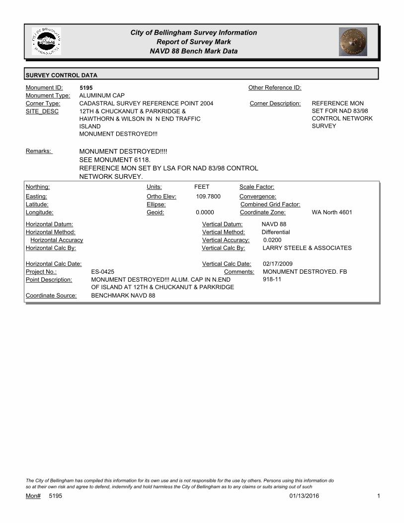
City of Bellingham Survey Information
Report of Survey Mark
NAVD 88 Bench Mark Data
SURVEY CONTROL DATA
5195Monument ID: Other Reference ID:
SITE_DESC 12TH & CHUCKANUT & PARKRIDGE &
HAWTHORN & WILSON IN N END TRAFFIC
ISLAND
MONUMENT DESTROYED!!!
CADASTRAL SURVEY REFERENCE POINT 2004Corner Type: REFERENCE MON
SET FOR NAD 83/98
CONTROL NETWORK
SURVEY
Corner Description:
ALUMINUM CAPMonument Type:
MONUMENT DESTROYED!!!!
SEE MONUMENT 6118.
REFERENCE MON SET BY LSA FOR NAD 83/98 CONTROL
NETWORK SURVEY.
Remarks:
109.7800
0.0000
FEETNorthing:
Easting:
Latitude:
Longitude:
Units:
Ortho Elev:
Ellipse:
Geoid:
Scale Factor:
Convergence:
Combined Grid Factor:
WA North 4601Coordinate Zone:
Horizontal Method:
Horizontal Datum: NAVD 88Vertical Datum:
DifferentialVertical Method:
Horizontal Accuracy 0.0200Vertical Accuracy:
LARRY STEELE & ASSOCIATESVertical Calc By:Horizontal Calc By:
ES-0425Project No.:
MONUMENT DESTROYED!!! ALUM. CAP IN N.END
OF ISLAND AT 12TH & CHUCKANUT & PARKRIDGE
Point Description:
BENCHMARK NAVD 88Coordinate Source:
MONUMENT DESTROYED. FB
918-11
Comments:
Horizontal Calc Date: 02/17/2009Vertical Calc Date:
101/13/2016Mon# 5195
The City of Bellingham has compiled this information for its own use and is not responsible for the use by others. Persons using this information do
so at their own risk and agree to defend, indemnify and hold harmless the City of Bellingham as to any claims or suits arising out of such
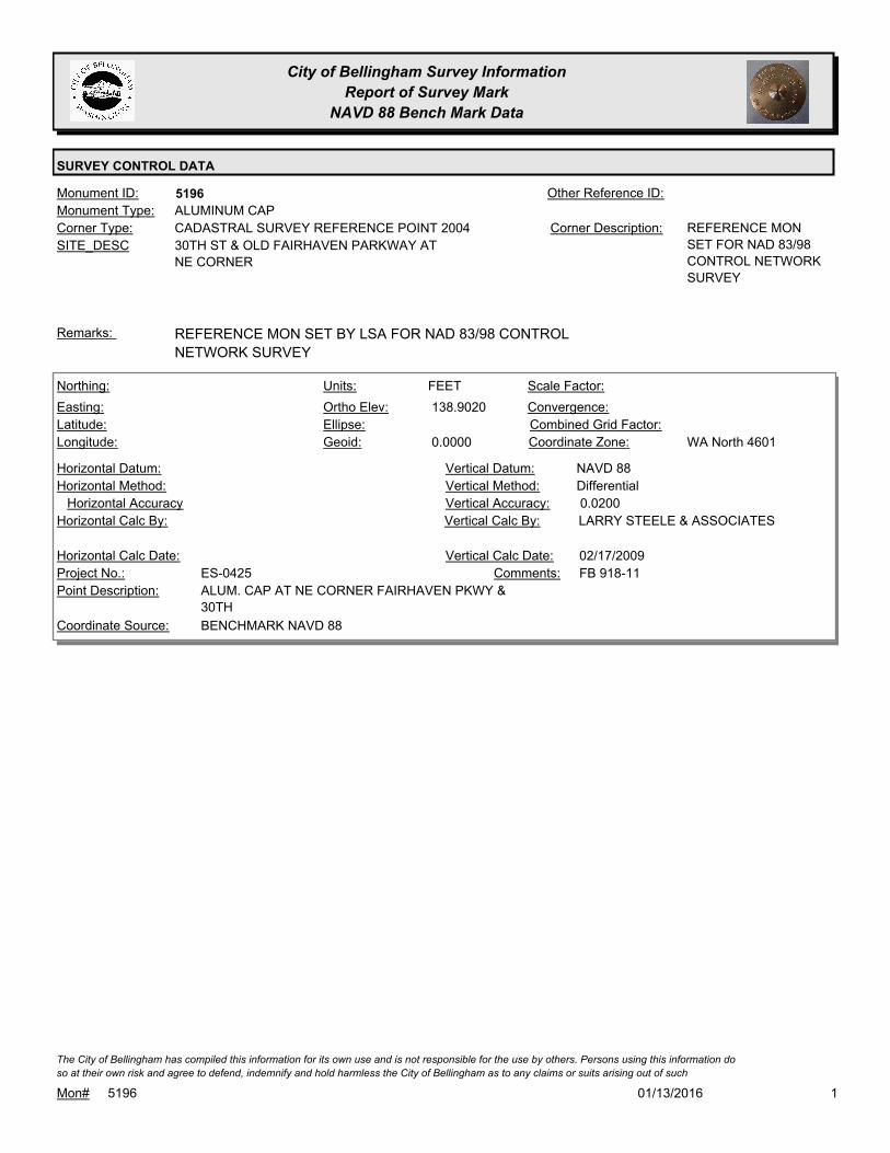
City of Bellingham Survey Information
Report of Survey Mark
NAVD 88 Bench Mark Data
SURVEY CONTROL DATA
5196Monument ID: Other Reference ID:
SITE_DESC 30TH ST & OLD FAIRHAVEN PARKWAY AT
NE CORNER
CADASTRAL SURVEY REFERENCE POINT 2004Corner Type: REFERENCE MON
SET FOR NAD 83/98
CONTROL NETWORK
SURVEY
Corner Description:
ALUMINUM CAPMonument Type:
REFERENCE MON SET BY LSA FOR NAD 83/98 CONTROL
NETWORK SURVEY
Remarks:
138.9020
0.0000
FEETNorthing:
Easting:
Latitude:
Longitude:
Units:
Ortho Elev:
Ellipse:
Geoid:
Scale Factor:
Convergence:
Combined Grid Factor:
WA North 4601Coordinate Zone:
Horizontal Method:
Horizontal Datum: NAVD 88Vertical Datum:
DifferentialVertical Method:
Horizontal Accuracy 0.0200Vertical Accuracy:
LARRY STEELE & ASSOCIATESVertical Calc By:Horizontal Calc By:
ES-0425Project No.:
ALUM. CAP AT NE CORNER FAIRHAVEN PKWY &
30TH
Point Description:
BENCHMARK NAVD 88Coordinate Source:
FB 918-11Comments:
Horizontal Calc Date: 02/17/2009Vertical Calc Date:
101/13/2016Mon# 5196
The City of Bellingham has compiled this information for its own use and is not responsible for the use by others. Persons using this information do
so at their own risk and agree to defend, indemnify and hold harmless the City of Bellingham as to any claims or suits arising out of such
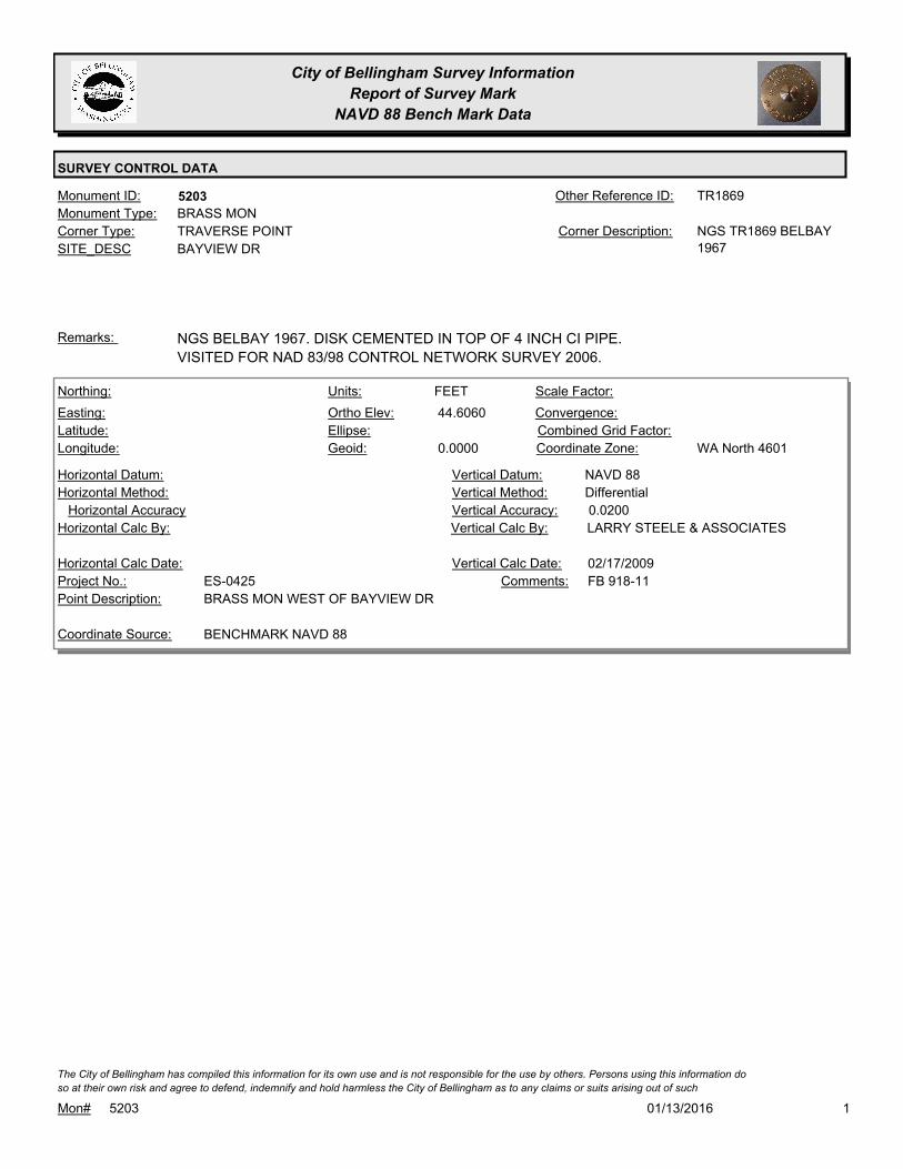
City of Bellingham Survey Information
Report of Survey Mark
NAVD 88 Bench Mark Data
SURVEY CONTROL DATA
5203Monument ID: TR1869Other Reference ID:
SITE_DESC BAYVIEW DR
TRAVERSE POINTCorner Type: NGS TR1869 BELBAY
1967
Corner Description:
BRASS MONMonument Type:
NGS BELBAY 1967. DISK CEMENTED IN TOP OF 4 INCH CI PIPE.
VISITED FOR NAD 83/98 CONTROL NETWORK SURVEY 2006.
Remarks:
44.6060
0.0000
FEETNorthing:
Easting:
Latitude:
Longitude:
Units:
Ortho Elev:
Ellipse:
Geoid:
Scale Factor:
Convergence:
Combined Grid Factor:
WA North 4601Coordinate Zone:
Horizontal Method:
Horizontal Datum: NAVD 88Vertical Datum:
DifferentialVertical Method:
Horizontal Accuracy 0.0200Vertical Accuracy:
LARRY STEELE & ASSOCIATESVertical Calc By:Horizontal Calc By:
ES-0425Project No.:
BRASS MON WEST OF BAYVIEW DRPoint Description:
BENCHMARK NAVD 88Coordinate Source:
FB 918-11Comments:
Horizontal Calc Date: 02/17/2009Vertical Calc Date:
101/13/2016Mon# 5203
The City of Bellingham has compiled this information for its own use and is not responsible for the use by others. Persons using this information do
so at their own risk and agree to defend, indemnify and hold harmless the City of Bellingham as to any claims or suits arising out of such
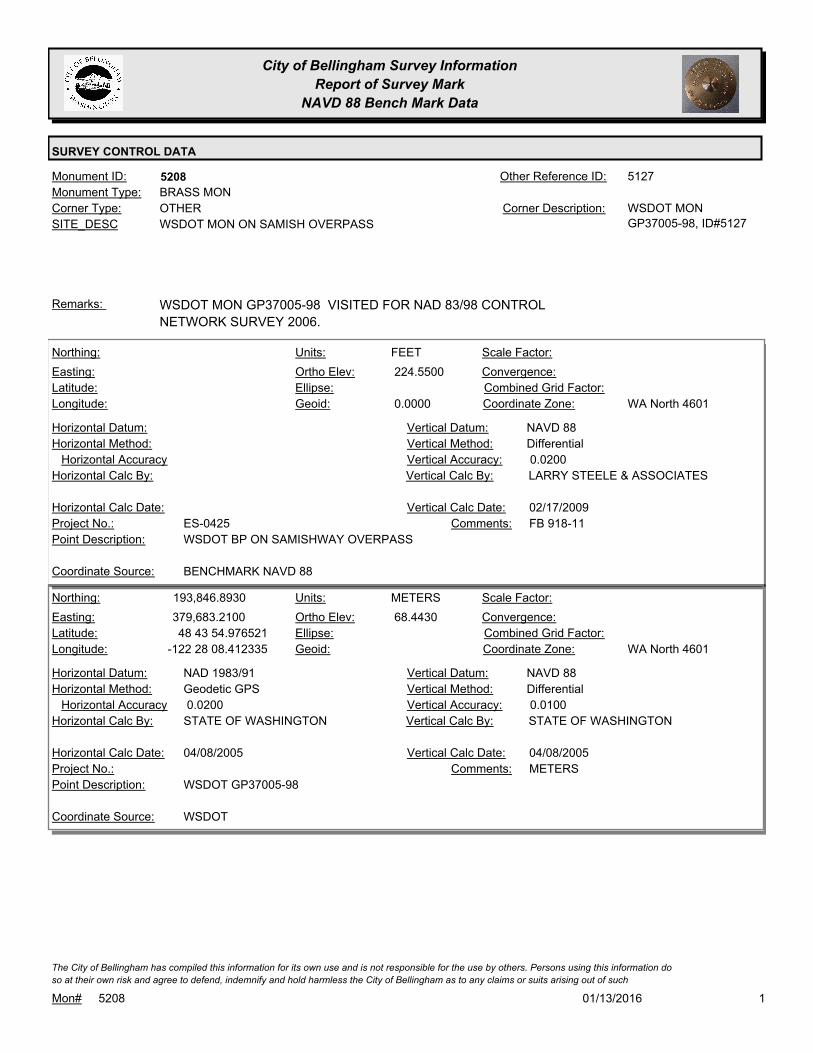
City of Bellingham Survey Information
Report of Survey Mark
NAVD 88 Bench Mark Data
SURVEY CONTROL DATA
5208Monument ID: 5127Other Reference ID:
SITE_DESC WSDOT MON ON SAMISH OVERPASS
OTHERCorner Type: WSDOT MON
GP37005-98, ID#5127
Corner Description:
BRASS MONMonument Type:
WSDOT MON GP37005-98 VISITED FOR NAD 83/98 CONTROL
NETWORK SURVEY 2006.
Remarks:
224.5500
0.0000
FEETNorthing:
Easting:
Latitude:
Longitude:
Units:
Ortho Elev:
Ellipse:
Geoid:
Scale Factor:
Convergence:
Combined Grid Factor:
WA North 4601Coordinate Zone:
Horizontal Method:
Horizontal Datum: NAVD 88Vertical Datum:
DifferentialVertical Method:
Horizontal Accuracy 0.0200Vertical Accuracy:
LARRY STEELE & ASSOCIATESVertical Calc By:Horizontal Calc By:
ES-0425Project No.:
WSDOT BP ON SAMISHWAY OVERPASSPoint Description:
BENCHMARK NAVD 88Coordinate Source:
FB 918-11Comments:
Horizontal Calc Date: 02/17/2009Vertical Calc Date:
193,846.8930
379,683.2100
48 43 54.976521
-122 28 08.412335
68.4430
METERSNorthing:
Easting:
Latitude:
Longitude:
Units:
Ortho Elev:
Ellipse:
Geoid:
Scale Factor:
Convergence:
Combined Grid Factor:
WA North 4601Coordinate Zone:
Geodetic GPSHorizontal Method:
NAD 1983/91Horizontal Datum: NAVD 88Vertical Datum:
DifferentialVertical Method:
0.0200Horizontal Accuracy 0.0100Vertical Accuracy:
STATE OF WASHINGTONVertical Calc By:STATE OF WASHINGTONHorizontal Calc By:
Project No.:
WSDOT GP37005-98Point Description:
WSDOTCoordinate Source:
METERSComments:
04/08/2005Horizontal Calc Date: 04/08/2005Vertical Calc Date:
101/13/2016Mon# 5208
The City of Bellingham has compiled this information for its own use and is not responsible for the use by others. Persons using this information do
so at their own risk and agree to defend, indemnify and hold harmless the City of Bellingham as to any claims or suits arising out of such

City of Bellingham Survey Information
Report of Survey Mark
NAVD 88 Bench Mark Data
SURVEY CONTROL DATA
5209Monument ID: 5128Other Reference ID:
SITE_DESC I-5 SOUTHBOUND ON-RAMP FROM SAMISH
WAY
TRAVERSE POINTCorner Type: WSDOT GP37005-99
ID#5128
Corner Description:
CASED MONMonument Type:
WSDOT GP37005-99 VISITED FOR NAD 83/98 CONTROL
NETWORK SURVEY 2006.
Remarks:
193,391.7990
379,356.7820
48 43 40.022265
-122 28 23.908655
67.3010
METERSNorthing:
Easting:
Latitude:
Longitude:
Units:
Ortho Elev:
Ellipse:
Geoid:
1.0000000000Scale Factor:
-1 13 15.6Convergence:
Combined Grid Factor:
WA North 4601Coordinate Zone:
Geodetic GPSHorizontal Method:
NAD 83/07Horizontal Datum: NAVD 88Vertical Datum:
DifferentialVertical Method:
0.0200Horizontal Accuracy 0.0100Vertical Accuracy:
STATE OF WASHINGTONVertical Calc By:STATE OF WASHINGTONHorizontal Calc By:
Project No.:
WSDOT GP37005-99Point Description:
WSDOTCoordinate Source:
METERSComments:
07/30/2008Horizontal Calc Date: 07/30/2008Vertical Calc Date:
101/13/2016Mon# 5209
The City of Bellingham has compiled this information for its own use and is not responsible for the use by others. Persons using this information do
so at their own risk and agree to defend, indemnify and hold harmless the City of Bellingham as to any claims or suits arising out of such

City of Bellingham Survey Information
Report of Survey Mark
NAVD 88 Bench Mark Data
SURVEY CONTROL DATA
5250Monument ID: Other Reference ID:
SITE_DESC NEAR NORTHSHORE & DAKIN
BENCH MARKCorner Type: TBM - RR SPIKE IN
POWER POLE
Corner Description:
RAILROAD SPIKEMonument Type:
TBM 885-4-13B - RR SPIKE ON W FACE OF PP #464727-161745 ON
E SIDE NORTHSHORE & DAKIN.
Remarks:
329.8080
0.0000
FEETNorthing:
Easting:
Latitude:
Longitude:
Units:
Ortho Elev:
Ellipse:
Geoid:
Scale Factor:
Convergence:
Combined Grid Factor:
WA North 4601Coordinate Zone:
Horizontal Method:
Horizontal Datum: NAVD 88Vertical Datum:
DifferentialVertical Method:
Horizontal Accuracy 0.0300Vertical Accuracy:
WILSON ENGINEERING LLC.Vertical Calc By:Horizontal Calc By:
ES-0425Project No.:
C-BM RRSPK PWR.POLE E.SIDE N.SHORE & DAKINPoint Description:
BENCHMARK NAVD 88Coordinate Source:
FB918-8 pg. 29Comments:
Horizontal Calc Date: 02/12/2009Vertical Calc Date:
101/13/2016Mon# 5250
The City of Bellingham has compiled this information for its own use and is not responsible for the use by others. Persons using this information do
so at their own risk and agree to defend, indemnify and hold harmless the City of Bellingham as to any claims or suits arising out of such
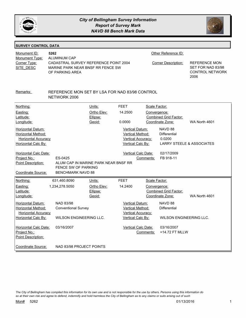
City of Bellingham Survey Information
Report of Survey Mark
NAVD 88 Bench Mark Data
SURVEY CONTROL DATA
5262Monument ID: Other Reference ID:
SITE_DESC MARINE PARK NEAR BNSF RR FENCE SW
OF PARKING AREA
CADASTRAL SURVEY REFERENCE POINT 2004Corner Type: REFERENCE MON
SET FOR NAD 83/98
CONTROL NETWORK
2006
Corner Description:
ALUMINUM CAPMonument Type:
REFERENCE MON SET BY LSA FOR NAD 83/98 CONTROL
NETWORK 2006
Remarks:
14.2500
0.0000
FEETNorthing:
Easting:
Latitude:
Longitude:
Units:
Ortho Elev:
Ellipse:
Geoid:
Scale Factor:
Convergence:
Combined Grid Factor:
WA North 4601Coordinate Zone:
Horizontal Method:
Horizontal Datum: NAVD 88Vertical Datum:
DifferentialVertical Method:
Horizontal Accuracy 0.0200Vertical Accuracy:
LARRY STEELE & ASSOCIATESVertical Calc By:Horizontal Calc By:
ES-0425Project No.:
ALUM CAP IN MARINE PARK NEAR BNSF RR
FENCE SW OF PARKING
Point Description:
BENCHMARK NAVD 88Coordinate Source:
FB 918-11Comments:
Horizontal Calc Date: 02/17/2009Vertical Calc Date:
631,460.8090
1,234,278.5050 14.2400
FEETNorthing:
Easting:
Latitude:
Longitude:
Units:
Ortho Elev:
Ellipse:
Geoid:
Scale Factor:
Convergence:
Combined Grid Factor:
WA North 4601Coordinate Zone:
Conventional SurveyHorizontal Method:
NAD 83/98Horizontal Datum: NAVD 88Vertical Datum:
DifferentialVertical Method:
Horizontal Accuracy Vertical Accuracy:
WILSON ENGINEERING LLC.Vertical Calc By:WILSON ENGINEERING LLC.Horizontal Calc By:
Project No.:
Point Description:
NAD 83/98 PROJECT POINTSCoordinate Source:
=14.72 FT MLLWComments:
03/16/2007Horizontal Calc Date: 03/16/2007Vertical Calc Date:
101/13/2016Mon# 5262
The City of Bellingham has compiled this information for its own use and is not responsible for the use by others. Persons using this information do
so at their own risk and agree to defend, indemnify and hold harmless the City of Bellingham as to any claims or suits arising out of such
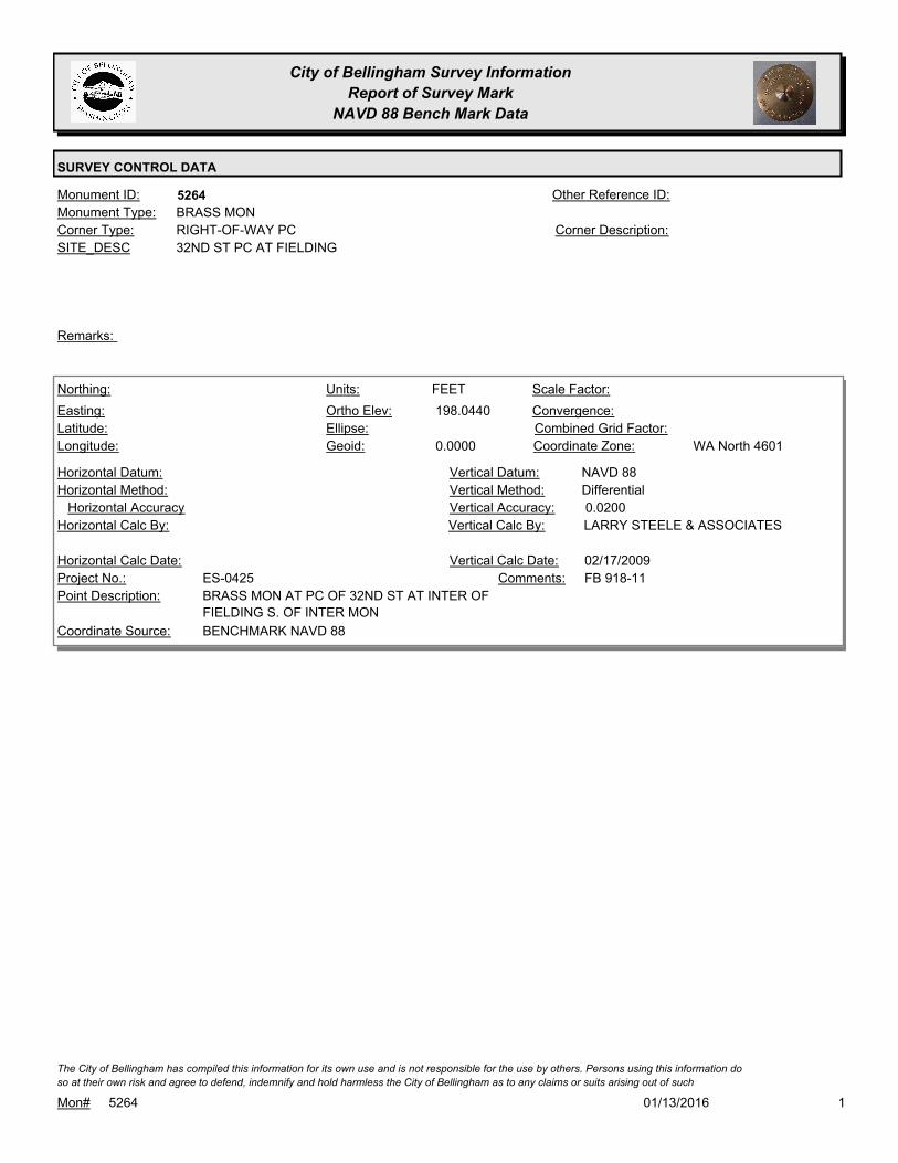
City of Bellingham Survey Information
Report of Survey Mark
NAVD 88 Bench Mark Data
SURVEY CONTROL DATA
5264Monument ID: Other Reference ID:
SITE_DESC 32ND ST PC AT FIELDING
RIGHT-OF-WAY PCCorner Type: Corner Description:
BRASS MONMonument Type:
Remarks:
198.0440
0.0000
FEETNorthing:
Easting:
Latitude:
Longitude:
Units:
Ortho Elev:
Ellipse:
Geoid:
Scale Factor:
Convergence:
Combined Grid Factor:
WA North 4601Coordinate Zone:
Horizontal Method:
Horizontal Datum: NAVD 88Vertical Datum:
DifferentialVertical Method:
Horizontal Accuracy 0.0200Vertical Accuracy:
LARRY STEELE & ASSOCIATESVertical Calc By:Horizontal Calc By:
ES-0425Project No.:
BRASS MON AT PC OF 32ND ST AT INTER OF
FIELDING S. OF INTER MON
Point Description:
BENCHMARK NAVD 88Coordinate Source:
FB 918-11Comments:
Horizontal Calc Date: 02/17/2009Vertical Calc Date:
101/13/2016Mon# 5264
The City of Bellingham has compiled this information for its own use and is not responsible for the use by others. Persons using this information do
so at their own risk and agree to defend, indemnify and hold harmless the City of Bellingham as to any claims or suits arising out of such

City of Bellingham Survey Information
Report of Survey Mark
NAVD 88 Bench Mark Data
SURVEY CONTROL DATA
5270Monument ID: Other Reference ID:
SITE_DESC 23RD & BILL MCDONALD PKWY
RIGHT-OF-WAY INTERSECTIONCorner Type: Corner Description:
BRASS MONMonument Type:
5 FT S OF MON #6097Remarks:
634,060.7000
1,241,146.9600 231.7700
FEETNorthing:
Easting:
Latitude:
Longitude:
Units:
Ortho Elev:
Ellipse:
Geoid:
Scale Factor:
Convergence:
Combined Grid Factor:
WA North 4601Coordinate Zone:
Conventional SurveyHorizontal Method:
NAD 83/98Horizontal Datum: NAVD 88Vertical Datum:
DifferentialVertical Method:
0.0300Horizontal Accuracy 0.0500Vertical Accuracy:
DAVID EVANS & ASSOCIATES, INC.Vertical Calc By:DAVID EVANS & ASSOCIATES,
INC.
Horizontal Calc By:
ES-0358Project No.:
C-FND-BC PROJ PNT #184Point Description:
NAD 83/98 PROJECT POINTSCoordinate Source:
FB 926Comments:
11/01/2009Horizontal Calc Date: 11/01/2009Vertical Calc Date:
101/13/2016Mon# 5270
The City of Bellingham has compiled this information for its own use and is not responsible for the use by others. Persons using this information do
so at their own risk and agree to defend, indemnify and hold harmless the City of Bellingham as to any claims or suits arising out of such

City of Bellingham Survey Information
Report of Survey Mark
NAVD 88 Bench Mark Data
SURVEY CONTROL DATA
5272Monument ID: Other Reference ID:
SITE_DESC S STATE ST P.I. S OF CLAY
RIGHT-OF-WAY PICorner Type: Corner Description:
BRASS MONMonument Type:
VISITED FOR NAD 83/98 CONTROL NETWORK SURVEY 2006.
RAISED FOR OVERLAY IN 2007
Remarks:
81.0540
0.0000
FEETNorthing:
Easting:
Latitude:
Longitude:
Units:
Ortho Elev:
Ellipse:
Geoid:
Scale Factor:
Convergence:
Combined Grid Factor:
WA North 4601Coordinate Zone:
Horizontal Method:
Horizontal Datum: NAVD 88Vertical Datum:
DifferentialVertical Method:
Horizontal Accuracy 0.0200Vertical Accuracy:
LARRY STEELE & ASSOCIATESVertical Calc By:Horizontal Calc By:
ES-0425Project No.:
BRASS MON AT STATE ST PI SOUTH OF CLAYPoint Description:
BENCHMARK NAVD 88Coordinate Source:
FB 918-11Comments:
Horizontal Calc Date: 02/17/2009Vertical Calc Date:
101/13/2016Mon# 5272
The City of Bellingham has compiled this information for its own use and is not responsible for the use by others. Persons using this information do
so at their own risk and agree to defend, indemnify and hold harmless the City of Bellingham as to any claims or suits arising out of such

City of Bellingham Survey Information
Report of Survey Mark
NAVD 88 Bench Mark Data
SURVEY CONTROL DATA
5283Monument ID: Other Reference ID:
SITE_DESC S STATE & DICKENS
RIGHT-OF-WAY INTERSECTIONCorner Type: Corner Description:
BRASS MONMonument Type:
Remarks:
82.5030
0.0000
FEETNorthing:
Easting:
Latitude:
Longitude:
Units:
Ortho Elev:
Ellipse:
Geoid:
Scale Factor:
Convergence:
Combined Grid Factor:
WA North 4601Coordinate Zone:
Horizontal Method:
Horizontal Datum: NAVD 88Vertical Datum:
DifferentialVertical Method:
Horizontal Accuracy 0.0200Vertical Accuracy:
LARRY STEELE & ASSOCIATESVertical Calc By:Horizontal Calc By:
ES-0425Project No.:
BRASS MON AT STATE & DICKENSPoint Description:
BENCHMARK NAVD 88Coordinate Source:
FB 918-11Comments:
Horizontal Calc Date: 02/17/2009Vertical Calc Date:
101/13/2016Mon# 5283
The City of Bellingham has compiled this information for its own use and is not responsible for the use by others. Persons using this information do
so at their own risk and agree to defend, indemnify and hold harmless the City of Bellingham as to any claims or suits arising out of such

City of Bellingham Survey Information
Report of Survey Mark
NAVD 88 Bench Mark Data
SURVEY CONTROL DATA
5284Monument ID: Other Reference ID:
SITE_DESC S STATE & SYCAMORE
RIGHT-OF-WAY INTERSECTIONCorner Type: Corner Description:
BRASS MONMonument Type:
Remarks:
78.4550
0.0000
FEETNorthing:
Easting:
Latitude:
Longitude:
Units:
Ortho Elev:
Ellipse:
Geoid:
Scale Factor:
Convergence:
Combined Grid Factor:
WA North 4601Coordinate Zone:
Horizontal Method:
Horizontal Datum: NAVD 88Vertical Datum:
DifferentialVertical Method:
Horizontal Accuracy 0.0200Vertical Accuracy:
LARRY STEELE & ASSOCIATESVertical Calc By:Horizontal Calc By:
ES-0425Project No.:
BRASS MON AT STATE & SYCAMOREPoint Description:
BENCHMARK NAVD 88Coordinate Source:
FB 918-11Comments:
Horizontal Calc Date: 02/17/2009Vertical Calc Date:
101/13/2016Mon# 5284
The City of Bellingham has compiled this information for its own use and is not responsible for the use by others. Persons using this information do
so at their own risk and agree to defend, indemnify and hold harmless the City of Bellingham as to any claims or suits arising out of such

City of Bellingham Survey Information
Report of Survey Mark
NAVD 88 Bench Mark Data
SURVEY CONTROL DATA
5285Monument ID: Other Reference ID:
SITE_DESC S STATE & CLAY
RIGHT-OF-WAY INTERSECTIONCorner Type: Corner Description:
BRASS MONMonument Type:
Remarks:
79.7290
0.0000
FEETNorthing:
Easting:
Latitude:
Longitude:
Units:
Ortho Elev:
Ellipse:
Geoid:
Scale Factor:
Convergence:
Combined Grid Factor:
WA North 4601Coordinate Zone:
Horizontal Method:
Horizontal Datum: NAVD 88Vertical Datum:
DifferentialVertical Method:
Horizontal Accuracy 0.0200Vertical Accuracy:
LARRY STEELE & ASSOCIATESVertical Calc By:Horizontal Calc By:
ES-0425Project No.:
BRASS MON AT STATE & CLAYPoint Description:
BENCHMARK NAVD 88Coordinate Source:
FB 918-11Comments:
Horizontal Calc Date: 02/17/2009Vertical Calc Date:
101/13/2016Mon# 5285
The City of Bellingham has compiled this information for its own use and is not responsible for the use by others. Persons using this information do
so at their own risk and agree to defend, indemnify and hold harmless the City of Bellingham as to any claims or suits arising out of such
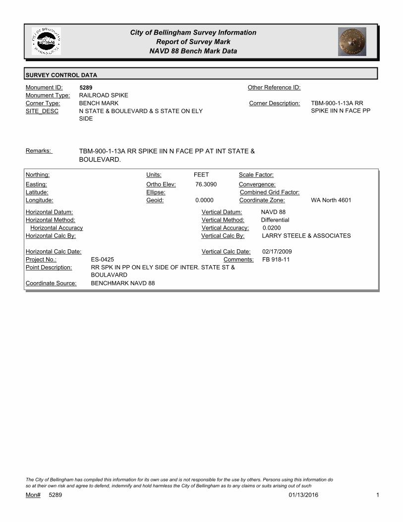
City of Bellingham Survey Information
Report of Survey Mark
NAVD 88 Bench Mark Data
SURVEY CONTROL DATA
5289Monument ID: Other Reference ID:
SITE_DESC N STATE & BOULEVARD & S STATE ON ELY
SIDE
BENCH MARKCorner Type: TBM-900-1-13A RR
SPIKE IIN N FACE PP
Corner Description:
RAILROAD SPIKEMonument Type:
TBM-900-1-13A RR SPIKE IIN N FACE PP AT INT STATE &
BOULEVARD.
Remarks:
76.3090
0.0000
FEETNorthing:
Easting:
Latitude:
Longitude:
Units:
Ortho Elev:
Ellipse:
Geoid:
Scale Factor:
Convergence:
Combined Grid Factor:
WA North 4601Coordinate Zone:
Horizontal Method:
Horizontal Datum: NAVD 88Vertical Datum:
DifferentialVertical Method:
Horizontal Accuracy 0.0200Vertical Accuracy:
LARRY STEELE & ASSOCIATESVertical Calc By:Horizontal Calc By:
ES-0425Project No.:
RR SPK IN PP ON ELY SIDE OF INTER. STATE ST &
BOULAVARD
Point Description:
BENCHMARK NAVD 88Coordinate Source:
FB 918-11Comments:
Horizontal Calc Date: 02/17/2009Vertical Calc Date:
101/13/2016Mon# 5289
The City of Bellingham has compiled this information for its own use and is not responsible for the use by others. Persons using this information do
so at their own risk and agree to defend, indemnify and hold harmless the City of Bellingham as to any claims or suits arising out of such
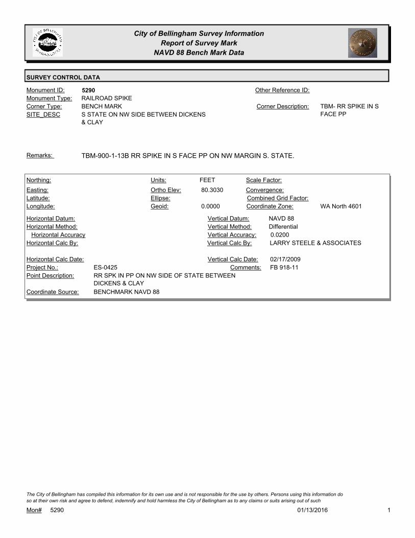
City of Bellingham Survey Information
Report of Survey Mark
NAVD 88 Bench Mark Data
SURVEY CONTROL DATA
5290Monument ID: Other Reference ID:
SITE_DESC S STATE ON NW SIDE BETWEEN DICKENS
& CLAY
BENCH MARKCorner Type: TBM- RR SPIKE IN S
FACE PP
Corner Description:
RAILROAD SPIKEMonument Type:
TBM-900-1-13B RR SPIKE IN S FACE PP ON NW MARGIN S. STATE.Remarks:
80.3030
0.0000
FEETNorthing:
Easting:
Latitude:
Longitude:
Units:
Ortho Elev:
Ellipse:
Geoid:
Scale Factor:
Convergence:
Combined Grid Factor:
WA North 4601Coordinate Zone:
Horizontal Method:
Horizontal Datum: NAVD 88Vertical Datum:
DifferentialVertical Method:
Horizontal Accuracy 0.0200Vertical Accuracy:
LARRY STEELE & ASSOCIATESVertical Calc By:Horizontal Calc By:
ES-0425Project No.:
RR SPK IN PP ON NW SIDE OF STATE BETWEEN
DICKENS & CLAY
Point Description:
BENCHMARK NAVD 88Coordinate Source:
FB 918-11Comments:
Horizontal Calc Date: 02/17/2009Vertical Calc Date:
101/13/2016Mon# 5290
The City of Bellingham has compiled this information for its own use and is not responsible for the use by others. Persons using this information do
so at their own risk and agree to defend, indemnify and hold harmless the City of Bellingham as to any claims or suits arising out of such
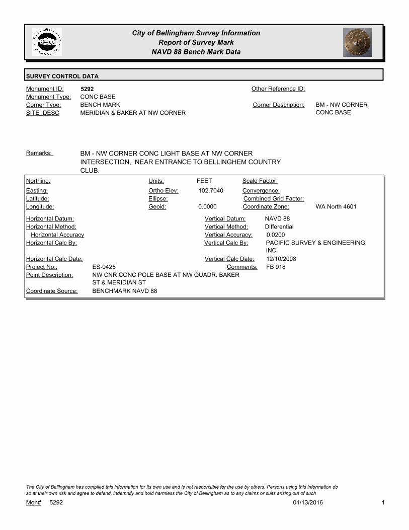
City of Bellingham Survey Information
Report of Survey Mark
NAVD 88 Bench Mark Data
SURVEY CONTROL DATA
5292Monument ID: Other Reference ID:
SITE_DESC MERIDIAN & BAKER AT NW CORNER
BENCH MARKCorner Type: BM - NW CORNER
CONC BASE
Corner Description:
CONC BASEMonument Type:
BM - NW CORNER CONC LIGHT BASE AT NW CORNER
INTERSECTION, NEAR ENTRANCE TO BELLINGHEM COUNTRY
CLUB.
Remarks:
102.7040
0.0000
FEETNorthing:
Easting:
Latitude:
Longitude:
Units:
Ortho Elev:
Ellipse:
Geoid:
Scale Factor:
Convergence:
Combined Grid Factor:
WA North 4601Coordinate Zone:
Horizontal Method:
Horizontal Datum: NAVD 88Vertical Datum:
DifferentialVertical Method:
Horizontal Accuracy 0.0200Vertical Accuracy:
PACIFIC SURVEY & ENGINEERING,
INC.
Vertical Calc By:Horizontal Calc By:
ES-0425Project No.:
NW CNR CONC POLE BASE AT NW QUADR. BAKER
ST & MERIDIAN ST
Point Description:
BENCHMARK NAVD 88Coordinate Source:
FB 918Comments:
Horizontal Calc Date: 12/10/2008Vertical Calc Date:
101/13/2016Mon# 5292
The City of Bellingham has compiled this information for its own use and is not responsible for the use by others. Persons using this information do
so at their own risk and agree to defend, indemnify and hold harmless the City of Bellingham as to any claims or suits arising out of such

City of Bellingham Survey Information
Report of Survey Mark
NAVD 88 Bench Mark Data
SURVEY CONTROL DATA
5294Monument ID: Other Reference ID:
SITE_DESC NE CORNER MERIDIAN & ORCHARD
BENCH MARKCorner Type: BM - SE MOUNTING
BOLT OF LIGHT
STANDARD
Corner Description:
BOLTMonument Type:
BM - SE CORNER BOLT OF LIGHT POLE AT NE COR MERIDIAN &
ORCHARD.
Remarks:
100.7740
0.0000
FEETNorthing:
Easting:
Latitude:
Longitude:
Units:
Ortho Elev:
Ellipse:
Geoid:
Scale Factor:
Convergence:
Combined Grid Factor:
WA North 4601Coordinate Zone:
Horizontal Method:
Horizontal Datum: NAVD 88Vertical Datum:
DifferentialVertical Method:
Horizontal Accuracy 0.0200Vertical Accuracy:
PACIFIC SURVEY & ENGINEERING,
INC.
Vertical Calc By:Horizontal Calc By:
ES-0425Project No.:
SE BOLT LIGHT BASE AT NE QUADR. ORCHARD
DRV & MERIDIAN ST
Point Description:
BENCHMARK NAVD 88Coordinate Source:
FB 918Comments:
Horizontal Calc Date: 12/10/2008Vertical Calc Date:
101/13/2016Mon# 5294
The City of Bellingham has compiled this information for its own use and is not responsible for the use by others. Persons using this information do
so at their own risk and agree to defend, indemnify and hold harmless the City of Bellingham as to any claims or suits arising out of such

City of Bellingham Survey Information
Report of Survey Mark
NAVD 88 Bench Mark Data
SURVEY CONTROL DATA
5303Monument ID: Other Reference ID:
SITE_DESC MONROE & CHERRY AT NW CORNER
BENCH MARKCorner Type: TBMCorner Description:
GIN SPIKEMonument Type:
TBM - COTTON GIN SPIKE IN PP #159807-464713 AT NW CORNER.Remarks:
71.9750
0.0000
FEETNorthing:
Easting:
Latitude:
Longitude:
Units:
Ortho Elev:
Ellipse:
Geoid:
Scale Factor:
Convergence:
Combined Grid Factor:
WA North 4601Coordinate Zone:
Horizontal Method:
Horizontal Datum: NAVD 88Vertical Datum:
DifferentialVertical Method:
Horizontal Accuracy 0.0200Vertical Accuracy:
PACIFIC SURVEY & ENGINEERING,
INC.
Vertical Calc By:Horizontal Calc By:
ES-0425Project No.:
COTT GIN SPIKE IN PP AT NW QUADR. MONROE
ST & CHERRY ST
Point Description:
BENCHMARK NAVD 88Coordinate Source:
FB 918Comments:
Horizontal Calc Date: 01/05/2009Vertical Calc Date:
101/13/2016Mon# 5303
The City of Bellingham has compiled this information for its own use and is not responsible for the use by others. Persons using this information do
so at their own risk and agree to defend, indemnify and hold harmless the City of Bellingham as to any claims or suits arising out of such

City of Bellingham Survey Information
Report of Survey Mark
NAVD 88 Bench Mark Data
SURVEY CONTROL DATA
5309Monument ID: Other Reference ID:
SITE_DESC MONROE & MERIDIAN AT NW CORNER
BENCH MARKCorner Type: TBMCorner Description:
SPIKEMonument Type:
TBM - COTTON GIN SPIKE IN PP #253 AT NW CORNER.Remarks:
76.0560
0.0000
FEETNorthing:
Easting:
Latitude:
Longitude:
Units:
Ortho Elev:
Ellipse:
Geoid:
Scale Factor:
Convergence:
Combined Grid Factor:
WA North 4601Coordinate Zone:
Horizontal Method:
Horizontal Datum: NAVD 88Vertical Datum:
DifferentialVertical Method:
Horizontal Accuracy 0.0200Vertical Accuracy:
PACIFIC SURVEY & ENGINEERING,
INC.
Vertical Calc By:Horizontal Calc By:
ES-0425Project No.:
COTT GIN SPIKE IN PP AT NW QUADR. MONROE
ST & MERIDIAN ST
Point Description:
BENCHMARK NAVD 88Coordinate Source:
FB 918Comments:
Horizontal Calc Date: 12/11/2008Vertical Calc Date:
101/13/2016Mon# 5309
The City of Bellingham has compiled this information for its own use and is not responsible for the use by others. Persons using this information do
so at their own risk and agree to defend, indemnify and hold harmless the City of Bellingham as to any claims or suits arising out of such
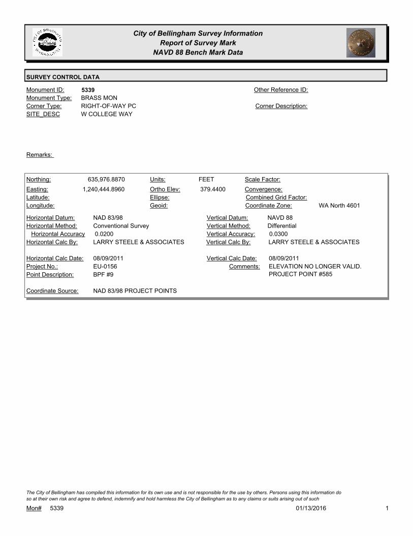
City of Bellingham Survey Information
Report of Survey Mark
NAVD 88 Bench Mark Data
SURVEY CONTROL DATA
5339Monument ID: Other Reference ID:
SITE_DESC W COLLEGE WAY
RIGHT-OF-WAY PCCorner Type: Corner Description:
BRASS MONMonument Type:
Remarks:
635,976.8870
1,240,444.8960 379.4400
FEETNorthing:
Easting:
Latitude:
Longitude:
Units:
Ortho Elev:
Ellipse:
Geoid:
Scale Factor:
Convergence:
Combined Grid Factor:
WA North 4601Coordinate Zone:
Conventional SurveyHorizontal Method:
NAD 83/98Horizontal Datum: NAVD 88Vertical Datum:
DifferentialVertical Method:
0.0200Horizontal Accuracy 0.0300Vertical Accuracy:
LARRY STEELE & ASSOCIATESVertical Calc By:LARRY STEELE & ASSOCIATESHorizontal Calc By:
EU-0156Project No.:
BPF #9Point Description:
NAD 83/98 PROJECT POINTSCoordinate Source:
ELEVATION NO LONGER VALID.
PROJECT POINT #585
Comments:
08/09/2011Horizontal Calc Date: 08/09/2011Vertical Calc Date:
101/13/2016Mon# 5339
The City of Bellingham has compiled this information for its own use and is not responsible for the use by others. Persons using this information do
so at their own risk and agree to defend, indemnify and hold harmless the City of Bellingham as to any claims or suits arising out of such

City of Bellingham Survey Information
Report of Survey Mark
NAVD 88 Bench Mark Data
SURVEY CONTROL DATA
5347Monument ID: Other Reference ID:
SITE_DESC CODY & SAMISH
RIGHT-OF-WAY INTERSECTIONCorner Type: Corner Description:
BRASS MONMonument Type:
Remarks:
462.8630
FEETNorthing:
Easting:
Latitude:
Longitude:
Units:
Ortho Elev:
Ellipse:
Geoid:
Scale Factor:
Convergence:
Combined Grid Factor:
Coordinate Zone:
Horizontal Method:
Horizontal Datum: NAVD 88Vertical Datum:
DifferentialVertical Method:
Horizontal Accuracy 0.0300Vertical Accuracy:
WILSON ENGINEERING LLC.Vertical Calc By:Horizontal Calc By:
Project No.:
Point Description:
BENCHMARK NAVD 88Coordinate Source:
FB 960-3Comments:
Horizontal Calc Date: 01/18/2012Vertical Calc Date:
101/13/2016Mon# 5347
The City of Bellingham has compiled this information for its own use and is not responsible for the use by others. Persons using this information do
so at their own risk and agree to defend, indemnify and hold harmless the City of Bellingham as to any claims or suits arising out of such

City of Bellingham Survey Information
Report of Survey Mark
NAVD 88 Bench Mark Data
SURVEY CONTROL DATA
5349Monument ID: Other Reference ID:
SITE_DESC SAMISH & LARRABEE
RIGHT-OF-WAY INTERSECTIONCorner Type: Corner Description:
BRASS MONMonument Type:
Remarks:
385.1750
FEETNorthing:
Easting:
Latitude:
Longitude:
Units:
Ortho Elev:
Ellipse:
Geoid:
Scale Factor:
Convergence:
Combined Grid Factor:
Coordinate Zone:
Horizontal Method:
Horizontal Datum: NAVD 88Vertical Datum:
DifferentialVertical Method:
Horizontal Accuracy 0.0300Vertical Accuracy:
WILSON ENGINEERING LLC.Vertical Calc By:Horizontal Calc By:
Project No.:
Point Description:
BENCHMARK NAVD 88Coordinate Source:
FB 960-3Comments:
Horizontal Calc Date: 01/24/2012Vertical Calc Date:
101/13/2016Mon# 5349
The City of Bellingham has compiled this information for its own use and is not responsible for the use by others. Persons using this information do
so at their own risk and agree to defend, indemnify and hold harmless the City of Bellingham as to any claims or suits arising out of such

City of Bellingham Survey Information
Report of Survey Mark
NAVD 88 Bench Mark Data
SURVEY CONTROL DATA
5356Monument ID: Other Reference ID:
SITE_DESC W MAPLEWOOD PT N OF COTTONWOOD
RIGHT-OF-WAY PTCorner Type: Corner Description:
BRASS MONMonument Type:
Remarks:
93.9790
0.0000
FEETNorthing:
Easting:
Latitude:
Longitude:
Units:
Ortho Elev:
Ellipse:
Geoid:
Scale Factor:
Convergence:
Combined Grid Factor:
WA North 4601Coordinate Zone:
Horizontal Method:
Horizontal Datum: NAVD 88Vertical Datum:
DifferentialVertical Method:
Horizontal Accuracy 0.0200Vertical Accuracy:
PACIFIC SURVEY & ENGINEERING,
INC.
Vertical Calc By:Horizontal Calc By:
ES-0425Project No.:
BRASS MON (PT) AT CL MAPLEWOOD AVE N. OF
COTTONWOOD AVE
Point Description:
BENCHMARK NAVD 88Coordinate Source:
FB 918Comments:
Horizontal Calc Date: 01/05/2009Vertical Calc Date:
101/13/2016Mon# 5356
The City of Bellingham has compiled this information for its own use and is not responsible for the use by others. Persons using this information do
so at their own risk and agree to defend, indemnify and hold harmless the City of Bellingham as to any claims or suits arising out of such

City of Bellingham Survey Information
Report of Survey Mark
NAVD 88 Bench Mark Data
SURVEY CONTROL DATA
5358Monument ID: Other Reference ID:
SITE_DESC W MAPLEWOOD & BRADLEY LN
RIGHT-OF-WAY INTERSECTIONCorner Type: Corner Description:
BRASS MONMonument Type:
Remarks:
158.6780
0.0000
FEETNorthing:
Easting:
Latitude:
Longitude:
Units:
Ortho Elev:
Ellipse:
Geoid:
Scale Factor:
Convergence:
Combined Grid Factor:
WA North 4601Coordinate Zone:
Horizontal Method:
Horizontal Datum: NAVD 88Vertical Datum:
DifferentialVertical Method:
Horizontal Accuracy 0.0200Vertical Accuracy:
PACIFIC SURVEY & ENGINEERING,
INC.
Vertical Calc By:Horizontal Calc By:
ES-0425Project No.:
BRASS MON AT INT. BRADLEY LANE & W.
MAPLEWOOD AVE
Point Description:
BENCHMARK NAVD 88Coordinate Source:
FB 918Comments:
Horizontal Calc Date: 12/29/2008Vertical Calc Date:
101/13/2016Mon# 5358
The City of Bellingham has compiled this information for its own use and is not responsible for the use by others. Persons using this information do
so at their own risk and agree to defend, indemnify and hold harmless the City of Bellingham as to any claims or suits arising out of such

City of Bellingham Survey Information
Report of Survey Mark
NAVD 88 Bench Mark Data
SURVEY CONTROL DATA
5418Monument ID: BM37539-3Other Reference ID:
SITE_DESC E SIDE OF MERIDIAN SOUTH OF HORTON
NEAR ADDRESS #4564
BENCH MARKCorner Type: WSDOT BM37539-3Corner Description:
BRASS MONMonument Type:
WSDOT BRASS DISK SET INTO A LUMINAIRE BASE AND IS LEVEL
WITH CONCRETE SURFACE.
Remarks:
63.0350
METERSNorthing:
Easting:
Latitude:
Longitude:
Units:
Ortho Elev:
Ellipse:
Geoid:
Scale Factor:
Convergence:
Combined Grid Factor:
Coordinate Zone:
Horizontal Method:
Horizontal Datum: NAVD 88Vertical Datum:
DifferentialVertical Method:
Horizontal Accuracy 0.0100Vertical Accuracy:
STATE OF WASHINGTONVertical Calc By:Horizontal Calc By:
Project No.:
WSDOT BM37539-3Point Description:
WSDOTCoordinate Source:
WSDOT PUBLISHED ELEVATION IN
METERS
Comments:
Horizontal Calc Date: 09/01/2004Vertical Calc Date:
101/13/2016Mon# 5418
The City of Bellingham has compiled this information for its own use and is not responsible for the use by others. Persons using this information do
so at their own risk and agree to defend, indemnify and hold harmless the City of Bellingham as to any claims or suits arising out of such
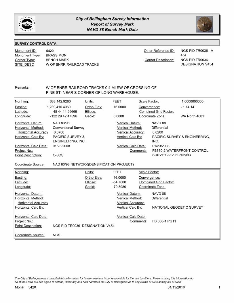
City of Bellingham Survey Information
Report of Survey Mark
NAVD 88 Bench Mark Data
SURVEY CONTROL DATA
5420Monument ID: NGS PID TR0036- V
454
Other Reference ID:
SITE_DESC W OF BNRR RAILROAD TRACKS
BENCH MARKCorner Type: NGS PID TR0036
DESIGNATION V454
Corner Description:
BRASS MONMonument Type:
W OF BNRR RAILROAD TRACKS 0.4 MI SW OF CROSSING OF
PINE ST. NEAR S CORNER OF LONG WAREHOUSE.
Remarks:
638,142.9260
1,239,416.4060
48 44 14.99669
-122 29 42.47596
16.0000
0.0000
FEETNorthing:
Easting:
Latitude:
Longitude:
Units:
Ortho Elev:
Ellipse:
Geoid:
1.0000000000Scale Factor:
- 1 14 14Convergence:
Combined Grid Factor:
WA North 4601Coordinate Zone:
Conventional SurveyHorizontal Method:
NAD 83/98Horizontal Datum: NAVD 88Vertical Datum:
DifferentialVertical Method:
0.0700Horizontal Accuracy 0.0200Vertical Accuracy:
PACIFIC SURVEY & ENGINEERING,
INC.
Vertical Calc By:PACIFIC SURVEY &
ENGINEERING, INC.
Horizontal Calc By:
Project No.:
C-BDSPoint Description:
NAD 83/98 NETWORK(DENSIFICATION PROJECT)Coordinate Source:
FB880-2 WATERFRONT CONTROL
SURVEY AF2080302393
Comments:
01/23/2008Horizontal Calc Date: 01/23/2008Vertical Calc Date:
16.0000
-54.7600
-70.8980
FEETNorthing:
Easting:
Latitude:
Longitude:
Units:
Ortho Elev:
Ellipse:
Geoid:
Scale Factor:
Convergence:
Combined Grid Factor:
Coordinate Zone:
Horizontal Method:
Horizontal Datum: NAVD 88Vertical Datum:
DifferentialVertical Method:
Horizontal Accuracy Vertical Accuracy:
NATIONAL GEODETIC SURVEYVertical Calc By:Horizontal Calc By:
Project No.:
NGS PID TR0036 DESIGNATION V454Point Description:
NGSCoordinate Source:
FB 880-1 PG11Comments:
Horizontal Calc Date: Vertical Calc Date:
101/13/2016Mon# 5420
The City of Bellingham has compiled this information for its own use and is not responsible for the use by others. Persons using this information do
so at their own risk and agree to defend, indemnify and hold harmless the City of Bellingham as to any claims or suits arising out of such
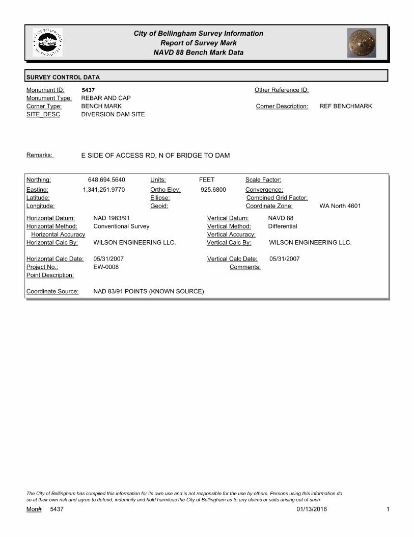
City of Bellingham Survey Information
Report of Survey Mark
NAVD 88 Bench Mark Data
SURVEY CONTROL DATA
5437Monument ID: Other Reference ID:
SITE_DESC DIVERSION DAM SITE
BENCH MARKCorner Type: REF BENCHMARKCorner Description:
REBAR AND CAPMonument Type:
E SIDE OF ACCESS RD, N OF BRIDGE TO DAMRemarks:
648,694.5640
1,341,251.9770 925.6800
FEETNorthing:
Easting:
Latitude:
Longitude:
Units:
Ortho Elev:
Ellipse:
Geoid:
Scale Factor:
Convergence:
Combined Grid Factor:
WA North 4601Coordinate Zone:
Conventional SurveyHorizontal Method:
NAD 1983/91Horizontal Datum: NAVD 88Vertical Datum:
DifferentialVertical Method:
Horizontal Accuracy Vertical Accuracy:
WILSON ENGINEERING LLC.Vertical Calc By:WILSON ENGINEERING LLC.Horizontal Calc By:
EW-0008Project No.:
Point Description:
NAD 83/91 POINTS (KNOWN SOURCE)Coordinate Source:
Comments:
05/31/2007Horizontal Calc Date: 05/31/2007Vertical Calc Date:
101/13/2016Mon# 5437
The City of Bellingham has compiled this information for its own use and is not responsible for the use by others. Persons using this information do
so at their own risk and agree to defend, indemnify and hold harmless the City of Bellingham as to any claims or suits arising out of such

City of Bellingham Survey Information
Report of Survey Mark
NAVD 88 Bench Mark Data
SURVEY CONTROL DATA
5438Monument ID: Other Reference ID:
SITE_DESC TEXAS & ONTARIO (TO NORTH)
RIGHT-OF-WAY INTERSECTIONCorner Type: Corner Description:
BRASS MONMonument Type:
ALSO SEE MON #1195, 2.4 FT TO WESTRemarks:
646,679.9109
1,253,268.0325 139.8600
FEETNorthing:
Easting:
Latitude:
Longitude:
Units:
Ortho Elev:
Ellipse:
Geoid:
Scale Factor:
Convergence:
Combined Grid Factor:
Coordinate Zone:
Conventional SurveyHorizontal Method:
NAD 83/98Horizontal Datum: NAVD 88Vertical Datum:
DifferentialVertical Method:
0.0100Horizontal Accuracy 0.0100Vertical Accuracy:
PACIFIC SURVEY & ENGINEERING,
INC.
Vertical Calc By:PACIFIC SURVEY &
ENGINEERING, INC.
Horizontal Calc By:
EU-0156Project No.:
Point Description:
NAD 83/98 PROJECT POINTSCoordinate Source:
FB 946-1 PROJECT POINT #102Comments:
05/23/2011Horizontal Calc Date: 05/23/2011Vertical Calc Date:
101/13/2016Mon# 5438
The City of Bellingham has compiled this information for its own use and is not responsible for the use by others. Persons using this information do
so at their own risk and agree to defend, indemnify and hold harmless the City of Bellingham as to any claims or suits arising out of such
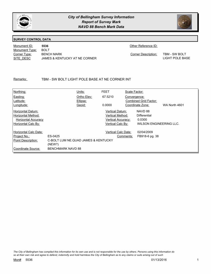
City of Bellingham Survey Information
Report of Survey Mark
NAVD 88 Bench Mark Data
SURVEY CONTROL DATA
5536Monument ID: Other Reference ID:
SITE_DESC JAMES & KENTUCKY AT NE CORNER
BENCH MARKCorner Type: TBM - SW BOLT
LIGHT POLE BASE
Corner Description:
BOLTMonument Type:
TBM - SW BOLT LIGHT POLE BASE AT NE CORNER INTRemarks:
67.5210
0.0000
FEETNorthing:
Easting:
Latitude:
Longitude:
Units:
Ortho Elev:
Ellipse:
Geoid:
Scale Factor:
Convergence:
Combined Grid Factor:
WA North 4601Coordinate Zone:
Horizontal Method:
Horizontal Datum: NAVD 88Vertical Datum:
DifferentialVertical Method:
Horizontal Accuracy 0.0300Vertical Accuracy:
WILSON ENGINEERING LLC.Vertical Calc By:Horizontal Calc By:
ES-0425Project No.:
C-BOLT LUM NE.QUAD JAMES & KENTUCKY
(NEW?)
Point Description:
BENCHMARK NAVD 88Coordinate Source:
FB918-6 pg. 38Comments:
Horizontal Calc Date: 02/04/2009Vertical Calc Date:
101/13/2016Mon# 5536
The City of Bellingham has compiled this information for its own use and is not responsible for the use by others. Persons using this information do
so at their own risk and agree to defend, indemnify and hold harmless the City of Bellingham as to any claims or suits arising out of such
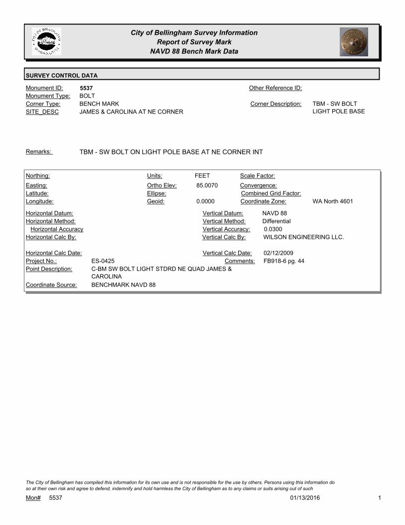
City of Bellingham Survey Information
Report of Survey Mark
NAVD 88 Bench Mark Data
SURVEY CONTROL DATA
5537Monument ID: Other Reference ID:
SITE_DESC JAMES & CAROLINA AT NE CORNER
BENCH MARKCorner Type: TBM - SW BOLT
LIGHT POLE BASE
Corner Description:
BOLTMonument Type:
TBM - SW BOLT ON LIGHT POLE BASE AT NE CORNER INTRemarks:
85.0070
0.0000
FEETNorthing:
Easting:
Latitude:
Longitude:
Units:
Ortho Elev:
Ellipse:
Geoid:
Scale Factor:
Convergence:
Combined Grid Factor:
WA North 4601Coordinate Zone:
Horizontal Method:
Horizontal Datum: NAVD 88Vertical Datum:
DifferentialVertical Method:
Horizontal Accuracy 0.0300Vertical Accuracy:
WILSON ENGINEERING LLC.Vertical Calc By:Horizontal Calc By:
ES-0425Project No.:
C-BM SW BOLT LIGHT STDRD NE QUAD JAMES &
CAROLINA
Point Description:
BENCHMARK NAVD 88Coordinate Source:
FB918-6 pg. 44Comments:
Horizontal Calc Date: 02/12/2009Vertical Calc Date:
101/13/2016Mon# 5537
The City of Bellingham has compiled this information for its own use and is not responsible for the use by others. Persons using this information do
so at their own risk and agree to defend, indemnify and hold harmless the City of Bellingham as to any claims or suits arising out of such

City of Bellingham Survey Information
Report of Survey Mark
NAVD 88 Bench Mark Data
SURVEY CONTROL DATA
5548Monument ID: Other Reference ID:
SITE_DESC N FOREST & E CHESTNUT AT N CORNER
BENCH MARKCorner Type: TBM - 900-3-5A - S
BOLT OF LIGHT
POLE BASE
Corner Description:
BOLTMonument Type:
TBM 900-3-5A - S BOLT OF LIGHT POLE BASE AT N CORNERRemarks:
114.0850
0.0000
FEETNorthing:
Easting:
Latitude:
Longitude:
Units:
Ortho Elev:
Ellipse:
Geoid:
Scale Factor:
Convergence:
Combined Grid Factor:
WA North 4601Coordinate Zone:
Horizontal Method:
Horizontal Datum: NAVD 88Vertical Datum:
DifferentialVertical Method:
Horizontal Accuracy 0.0300Vertical Accuracy:
WILSON ENGINEERING LLC.Vertical Calc By:Horizontal Calc By:
ES-0425Project No.:
C-SRB SIG.STRD N.QUAD FOREST & CHESNUTPoint Description:
BENCHMARK NAVD 88Coordinate Source:
FB918-6 pg. 23Comments:
Horizontal Calc Date: 02/04/2009Vertical Calc Date:
101/13/2016Mon# 5548
The City of Bellingham has compiled this information for its own use and is not responsible for the use by others. Persons using this information do
so at their own risk and agree to defend, indemnify and hold harmless the City of Bellingham as to any claims or suits arising out of such

City of Bellingham Survey Information
Report of Survey Mark
NAVD 88 Bench Mark Data
SURVEY CONTROL DATA
5549Monument ID: Other Reference ID:
SITE_DESC N FOREST & E MAGNOLIA AT S CORNER
BENCH MARKCorner Type: TBM - 900-3-5B - W
BOLT OF LIGHT
POLE BASE
Corner Description:
BOLTMonument Type:
TBM - 900-3-5B - W BOLT OF LIGHT POLE BASE AT S CORNER OF
FOREST & MAGNOLIA.
Remarks:
97.5540
0.0000
FEETNorthing:
Easting:
Latitude:
Longitude:
Units:
Ortho Elev:
Ellipse:
Geoid:
Scale Factor:
Convergence:
Combined Grid Factor:
WA North 4601Coordinate Zone:
Horizontal Method:
Horizontal Datum: NAVD 88Vertical Datum:
DifferentialVertical Method:
Horizontal Accuracy 0.0300Vertical Accuracy:
WILSON ENGINEERING LLC.Vertical Calc By:Horizontal Calc By:
ES-0425Project No.:
C-BOLT LUM. S.QUAD FOREST & MAGNOLIAPoint Description:
BENCHMARK NAVD 88Coordinate Source:
FB918-6 pg. 22Comments:
Horizontal Calc Date: 02/04/2009Vertical Calc Date:
97.5500
FEETNorthing:
Easting:
Latitude:
Longitude:
Units:
Ortho Elev:
Ellipse:
Geoid:
Scale Factor:
Convergence:
Combined Grid Factor:
Coordinate Zone:
Horizontal Method:
Horizontal Datum: NAVD 88Vertical Datum:
DifferentialVertical Method:
Horizontal Accuracy 0.0100Vertical Accuracy:
PACIFIC SURVEY & ENGINEERING,
INC.
Vertical Calc By:Horizontal Calc By:
EU-0163Project No.:
C-MON COBBM#5549Point Description:
BENCHMARK NAVD 88Coordinate Source:
FB995-1Comments:
Horizontal Calc Date: 05/09/2014Vertical Calc Date:
101/13/2016Mon# 5549
The City of Bellingham has compiled this information for its own use and is not responsible for the use by others. Persons using this information do
so at their own risk and agree to defend, indemnify and hold harmless the City of Bellingham as to any claims or suits arising out of such

City of Bellingham Survey Information
Report of Survey Mark
NAVD 88 Bench Mark Data
SURVEY CONTROL DATA
5584Monument ID: Other Reference ID:
SITE_DESC SE OF CORNWALL AVE & N OF OAK ST
PUMP STATION
CADASTRAL SURVEY REFERENCE POINT 2004Corner Type: REFERENCE MON
FOR WATERFRONT
SURVEY CONTROL
NETWORK
Corner Description:
ALUMINUM CAPMonument Type:
SET FOR WATERFRONT SURVEY CONTROL NETWORKRemarks:
640,353.0452
1,241,236.7963
48 44 37.18633
-122 29 16.03491
16.1060
0.0000
FEETNorthing:
Easting:
Latitude:
Longitude:
Units:
Ortho Elev:
Ellipse:
Geoid:
1.0000000000Scale Factor:
- 1 13 54Convergence:
Combined Grid Factor:
WA North 4601Coordinate Zone:
Conventional SurveyHorizontal Method:
NAD 83/98Horizontal Datum: NAVD 88Vertical Datum:
DifferentialVertical Method:
0.0700Horizontal Accuracy 0.0200Vertical Accuracy:
PACIFIC SURVEY & ENGINEERING,
INC.
Vertical Calc By:PACIFIC SURVEY &
ENGINEERING, INC.
Horizontal Calc By:
Project No.:
C-TRVPoint Description:
NAD 83/98 NETWORK(DENSIFICATION PROJECT)Coordinate Source:
FB880-2 WATERFRONT CONTROL
SURVEY AF2080302393
Comments:
01/23/2008Horizontal Calc Date: 01/23/2008Vertical Calc Date:
101/13/2016Mon# 5584
The City of Bellingham has compiled this information for its own use and is not responsible for the use by others. Persons using this information do
so at their own risk and agree to defend, indemnify and hold harmless the City of Bellingham as to any claims or suits arising out of such

City of Bellingham Survey Information
Report of Survey Mark
NAVD 88 Bench Mark Data
SURVEY CONTROL DATA
5585Monument ID: Other Reference ID:
SITE_DESC SE SIDE OF CORNWALL AVE & N OF
MYRTLE
CADASTRAL SURVEY REFERENCE POINT 2004Corner Type: REFERENCE MON
FOR WATERFRONT
SURVEY CONTROL
NETWORK
Corner Description:
ALUMINUM CAPMonument Type:
SET FOR WATERFRONT SURVEY CONTROL NETWORKRemarks:
641,127.3620
1,241,960.1780
48 44 44.97821
-122 29 05.49278
19.2600
0.0000
FEETNorthing:
Easting:
Latitude:
Longitude:
Units:
Ortho Elev:
Ellipse:
Geoid:
1.0000000000Scale Factor:
- 1 13 47Convergence:
Combined Grid Factor:
WA North 4601Coordinate Zone:
Conventional SurveyHorizontal Method:
NAD 83/98Horizontal Datum: NAVD 88Vertical Datum:
DifferentialVertical Method:
0.0700Horizontal Accuracy 0.0200Vertical Accuracy:
PACIFIC SURVEY & ENGINEERING,
INC.
Vertical Calc By:PACIFIC SURVEY &
ENGINEERING, INC.
Horizontal Calc By:
Project No.:
C-TRVPoint Description:
NAD 83/98 NETWORK(DENSIFICATION PROJECT)Coordinate Source:
FB880-2 WATERFRONT CONTROL
SURVEY AF2080302393
Comments:
01/23/2008Horizontal Calc Date: 01/23/2008Vertical Calc Date:
101/13/2016Mon# 5585
The City of Bellingham has compiled this information for its own use and is not responsible for the use by others. Persons using this information do
so at their own risk and agree to defend, indemnify and hold harmless the City of Bellingham as to any claims or suits arising out of such

City of Bellingham Survey Information
Report of Survey Mark
NAVD 88 Bench Mark Data
SURVEY CONTROL DATA
5586Monument ID: Other Reference ID:
SITE_DESC AT E CORNER CORNWALL AVE &
CHESTNUT
CADASTRAL SURVEY REFERENCE POINT 2004Corner Type: REFERENCE
MONUMENT FOR
WATERFRONT
SURVEY CONTROL
NETWORK
Corner Description:
ALUMINUM CAPMonument Type:
SET FOR WATERFRONT SURVEY CONTROL NETWORKRemarks:
642,170.0193
1,243,024.6310
48 44 55.48904
-122 28 49.94756
58.3440
0.0000
FEETNorthing:
Easting:
Latitude:
Longitude:
Units:
Ortho Elev:
Ellipse:
Geoid:
1.0000000000Scale Factor:
- 1 13 35Convergence:
Combined Grid Factor:
WA North 4601Coordinate Zone:
Conventional SurveyHorizontal Method:
NAD 83/98Horizontal Datum: NAVD 88Vertical Datum:
DifferentialVertical Method:
0.0700Horizontal Accuracy 0.0200Vertical Accuracy:
PACIFIC SURVEY & ENGINEERING,
INC.
Vertical Calc By:PACIFIC SURVEY &
ENGINEERING, INC.
Horizontal Calc By:
Project No.:
C-TRVPoint Description:
NAD 83/98 NETWORK(DENSIFICATION PROJECT)Coordinate Source:
FB880-2 WATERFRONT CONTROL
SURVEY AF2080302393
Comments:
01/23/2008Horizontal Calc Date: 01/23/2008Vertical Calc Date:
101/13/2016Mon# 5586
The City of Bellingham has compiled this information for its own use and is not responsible for the use by others. Persons using this information do
so at their own risk and agree to defend, indemnify and hold harmless the City of Bellingham as to any claims or suits arising out of such
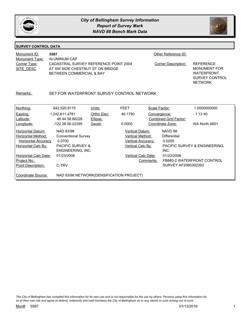
City of Bellingham Survey Information
Report of Survey Mark
NAVD 88 Bench Mark Data
SURVEY CONTROL DATA
5587Monument ID: Other Reference ID:
SITE_DESC AT SW SIDE CHESTNUT ST ON BRIDGE
BETWEEN COMMERCIAL & BAY
CADASTRAL SURVEY REFERENCE POINT 2004Corner Type: REFERENCE
MONUMENT FOR
WATERFRONT
SURVEY CONTROL
NETWORK
Corner Description:
ALUMINUM CAPMonument Type:
SET FOR WATERFRONT SURVEY CONTROL NETWORKRemarks:
642,520.8115
1,242,611.4781
48 44 58.86228
-122 28 56.22295
46.1790
0.0000
FEETNorthing:
Easting:
Latitude:
Longitude:
Units:
Ortho Elev:
Ellipse:
Geoid:
1.0000000000Scale Factor:
- 1 13 40Convergence:
Combined Grid Factor:
WA North 4601Coordinate Zone:
Conventional SurveyHorizontal Method:
NAD 83/98Horizontal Datum: NAVD 88Vertical Datum:
DifferentialVertical Method:
0.0700Horizontal Accuracy 0.0200Vertical Accuracy:
PACIFIC SURVEY & ENGINEERING,
INC.
Vertical Calc By:PACIFIC SURVEY &
ENGINEERING, INC.
Horizontal Calc By:
Project No.:
C-TRVPoint Description:
NAD 83/98 NETWORK(DENSIFICATION PROJECT)Coordinate Source:
FB880-2 WATERFRONT CONTROL
SURVEY AF2080302393
Comments:
01/23/2008Horizontal Calc Date: 01/23/2008Vertical Calc Date:
101/13/2016Mon# 5587
The City of Bellingham has compiled this information for its own use and is not responsible for the use by others. Persons using this information do
so at their own risk and agree to defend, indemnify and hold harmless the City of Bellingham as to any claims or suits arising out of such

City of Bellingham Survey Information
Report of Survey Mark
NAVD 88 Bench Mark Data
SURVEY CONTROL DATA
5588Monument ID: Other Reference ID:
SITE_DESC AT N CORNER OF ROEDER & CENTRAL
CADASTRAL SURVEY REFERENCE POINT 2004Corner Type: REFERENCE MON
FOR WATERFRONT
SURVEY CONTROL
NETWORK
Corner Description:
ALUMINUM CAPMonument Type:
SET FOR WATERFRONT SURVEY CONTROL NETWORKRemarks:
643,391.0183
1,242,172.0242
48 45 07.35383
-122 29 03.05718
18.9690
0.0000
FEETNorthing:
Easting:
Latitude:
Longitude:
Units:
Ortho Elev:
Ellipse:
Geoid:
1.0000000000Scale Factor:
- 1 13 45Convergence:
Combined Grid Factor:
WA North 4601Coordinate Zone:
Conventional SurveyHorizontal Method:
NAD 83/98Horizontal Datum: NAVD 88Vertical Datum:
DifferentialVertical Method:
0.0700Horizontal Accuracy 0.0200Vertical Accuracy:
PACIFIC SURVEY & ENGINEERING,
INC.
Vertical Calc By:PACIFIC SURVEY &
ENGINEERING, INC.
Horizontal Calc By:
Project No.:
C-TRVPoint Description:
NAD 83/98 NETWORK(DENSIFICATION PROJECT)Coordinate Source:
FB880-2 WATERFRONT CONTROL
SURVEY AF2080302393
Comments:
01/23/2008Horizontal Calc Date: 01/23/2008Vertical Calc Date:
101/13/2016Mon# 5588
The City of Bellingham has compiled this information for its own use and is not responsible for the use by others. Persons using this information do
so at their own risk and agree to defend, indemnify and hold harmless the City of Bellingham as to any claims or suits arising out of such

City of Bellingham Survey Information
Report of Survey Mark
NAVD 88 Bench Mark Data
SURVEY CONTROL DATA
5589Monument ID: Other Reference ID:
SITE_DESC W SIDE OF CHESTNUT-ROEDER BRIDGE N
OF BAY ST
CADASTRAL SURVEY REFERENCE POINT 2004Corner Type: REFERENCE MON
FOR WATERFRONT
SURVEY CONTROL
NETWORK
Corner Description:
ALUMINUM CAPMonument Type:
SET FOR WATERFRONT SURVEY CONTROL NETWORKRemarks:
642,946.2913
1,242,415.4654
48 45 03.01815
-122 28 59.28313
34.0640
0.0000
FEETNorthing:
Easting:
Latitude:
Longitude:
Units:
Ortho Elev:
Ellipse:
Geoid:
1.0000000000Scale Factor:
- 1 13 42Convergence:
Combined Grid Factor:
WA North 4601Coordinate Zone:
Conventional SurveyHorizontal Method:
NAD 83/98Horizontal Datum: NAVD 88Vertical Datum:
DifferentialVertical Method:
0.0700Horizontal Accuracy 0.0200Vertical Accuracy:
PACIFIC SURVEY & ENGINEERING,
INC.
Vertical Calc By:PACIFIC SURVEY &
ENGINEERING, INC.
Horizontal Calc By:
Project No.:
C-TRVPoint Description:
NAD 83/98 NETWORK(DENSIFICATION PROJECT)Coordinate Source:
FB880-2 WATERFRONT CONTROL
SURVEY AF2080302393
Comments:
01/23/2008Horizontal Calc Date: 01/23/2008Vertical Calc Date:
101/13/2016Mon# 5589
The City of Bellingham has compiled this information for its own use and is not responsible for the use by others. Persons using this information do
so at their own risk and agree to defend, indemnify and hold harmless the City of Bellingham as to any claims or suits arising out of such

City of Bellingham Survey Information
Report of Survey Mark
NAVD 88 Bench Mark Data
SURVEY CONTROL DATA
5590Monument ID: Other Reference ID:
SITE_DESC ROEDER & C ST AT BN RR STATION S OF
NGS TIDAL BM
CADASTRAL SURVEY REFERENCE POINT 2004Corner Type: REFERENCE MON
FOR WATERFRONT
SURVEY CONTROL
NETWORK
Corner Description:
ALUMINUM CAPMonument Type:
SET FOR WATERFRONT SURVEY CONTROL NETWORKRemarks:
643,964.3850
1,241,657.7638
48 45 12.90112
-122 29 10.91296
18.6930
0.0000
FEETNorthing:
Easting:
Latitude:
Longitude:
Units:
Ortho Elev:
Ellipse:
Geoid:
1.0000000000Scale Factor:
- 1 13 50Convergence:
Combined Grid Factor:
WA North 4601Coordinate Zone:
Conventional SurveyHorizontal Method:
NAD 83/98Horizontal Datum: NAVD 88Vertical Datum:
DifferentialVertical Method:
0.0700Horizontal Accuracy 0.0200Vertical Accuracy:
PACIFIC SURVEY & ENGINEERING,
INC.
Vertical Calc By:PACIFIC SURVEY &
ENGINEERING, INC.
Horizontal Calc By:
Project No.:
C-TRVPoint Description:
NAD 83/98 NETWORK(DENSIFICATION PROJECT)Coordinate Source:
FB880-2 WATERFRONT CONTROL
SURVEY AF2080302393
Comments:
01/23/2008Horizontal Calc Date: 01/23/2008Vertical Calc Date:
101/13/2016Mon# 5590
The City of Bellingham has compiled this information for its own use and is not responsible for the use by others. Persons using this information do
so at their own risk and agree to defend, indemnify and hold harmless the City of Bellingham as to any claims or suits arising out of such

City of Bellingham Survey Information
Report of Survey Mark
NAVD 88 Bench Mark Data
SURVEY CONTROL DATA
5591Monument ID: Other Reference ID:
SITE_DESC AT W CORNER OF ROEDER AVE & F ST
CADASTRAL SURVEY REFERENCE POINT 2004Corner Type: REFERENCE MON
FOR WATERFRONT
SURVEY CONTROL
NETWORK
Corner Description:
ALUMINUM CAPMonument Type:
SET FOR WATERFRONT SURVEY CONTROL NETWORKRemarks:
644,384.5241
1,241,091.5625
48 45 16.92566
-122 29 19.49496
17.9520
0.0000
FEETNorthing:
Easting:
Latitude:
Longitude:
Units:
Ortho Elev:
Ellipse:
Geoid:
1.0000000000Scale Factor:
- 1 13 57Convergence:
Combined Grid Factor:
WA North 4601Coordinate Zone:
Conventional SurveyHorizontal Method:
NAD 83/98Horizontal Datum: NAVD 88Vertical Datum:
DifferentialVertical Method:
0.0700Horizontal Accuracy 0.0200Vertical Accuracy:
PACIFIC SURVEY & ENGINEERING,
INC.
Vertical Calc By:PACIFIC SURVEY &
ENGINEERING, INC.
Horizontal Calc By:
Project No.:
C-TRVPoint Description:
NAD 83/98 NETWORK(DENSIFICATION PROJECT)Coordinate Source:
FB880-2 WATERFRONT CONTROL
SURVEY AF2080302393
Comments:
01/23/2008Horizontal Calc Date: 01/23/2008Vertical Calc Date:
101/13/2016Mon# 5591
The City of Bellingham has compiled this information for its own use and is not responsible for the use by others. Persons using this information do
so at their own risk and agree to defend, indemnify and hold harmless the City of Bellingham as to any claims or suits arising out of such

City of Bellingham Survey Information
Report of Survey Mark
NAVD 88 Bench Mark Data
SURVEY CONTROL DATA
5592Monument ID: Other Reference ID:
SITE_DESC NE SIDE OF ROEDER AVE WLY OF HILTON
AVE
CADASTRAL SURVEY REFERENCE POINT 2004Corner Type: REFERENCE MON
FOR WATERFRONT
SURVEY CONTROL
NETWORK
Corner Description:
ALUMINUM CAPMonument Type:
SET FOR WATERFRONT SURVEY CONTROL NETWORKRemarks:
644,995.4295
1,240,571.9625
48 45 22.84181
-122 29 27.44338
17.7020
0.0000
FEETNorthing:
Easting:
Latitude:
Longitude:
Units:
Ortho Elev:
Ellipse:
Geoid:
1.0000000000Scale Factor:
- 1 14 03Convergence:
Combined Grid Factor:
WA North 4601Coordinate Zone:
Conventional SurveyHorizontal Method:
NAD 83/98Horizontal Datum: NAVD 88Vertical Datum:
DifferentialVertical Method:
0.0700Horizontal Accuracy 0.0200Vertical Accuracy:
PACIFIC SURVEY & ENGINEERING,
INC.
Vertical Calc By:PACIFIC SURVEY &
ENGINEERING, INC.
Horizontal Calc By:
Project No.:
C-TRVPoint Description:
NAD 83/98 NETWORK(DENSIFICATION PROJECT)Coordinate Source:
FB880-2 WATERFRONT CONTROL
SURVEY AF2080302393
Comments:
01/23/2008Horizontal Calc Date: 01/23/2008Vertical Calc Date:
101/13/2016Mon# 5592
The City of Bellingham has compiled this information for its own use and is not responsible for the use by others. Persons using this information do
so at their own risk and agree to defend, indemnify and hold harmless the City of Bellingham as to any claims or suits arising out of such

City of Bellingham Survey Information
Report of Survey Mark
NAVD 88 Bench Mark Data
SURVEY CONTROL DATA
5593Monument ID: Other Reference ID:
SITE_DESC NE SIDE OF HOLLY ST BETWEEN B & C
STREETS
CADASTRAL SURVEY REFERENCE POINT 2004Corner Type: REFERENCE MON
FOR WATERFRONT
SURVEY CONTROL
NETWORK
Corner Description:
ALUMINUM CAPMonument Type:
SET FOR WATERFRONT SURVEY CONTROL NETWORKRemarks:
643,973.7918
1,241,986.9958
48 45 13.06366
-122 29 06.00416
18.7440
0.0000
FEETNorthing:
Easting:
Latitude:
Longitude:
Units:
Ortho Elev:
Ellipse:
Geoid:
1.0000000000Scale Factor:
- 1 13 47Convergence:
Combined Grid Factor:
WA North 4601Coordinate Zone:
Conventional SurveyHorizontal Method:
NAD 83/98Horizontal Datum: NAVD 88Vertical Datum:
DifferentialVertical Method:
0.0700Horizontal Accuracy 0.0200Vertical Accuracy:
PACIFIC SURVEY & ENGINEERING,
INC.
Vertical Calc By:PACIFIC SURVEY &
ENGINEERING, INC.
Horizontal Calc By:
Project No.:
C-TRVPoint Description:
NAD 83/98 NETWORK(DENSIFICATION PROJECT)Coordinate Source:
FB880-2 WATERFRONT CONTROL
SURVEY AF2080302393
Comments:
01/23/2008Horizontal Calc Date: 01/23/2008Vertical Calc Date:
101/13/2016Mon# 5593
The City of Bellingham has compiled this information for its own use and is not responsible for the use by others. Persons using this information do
so at their own risk and agree to defend, indemnify and hold harmless the City of Bellingham as to any claims or suits arising out of such
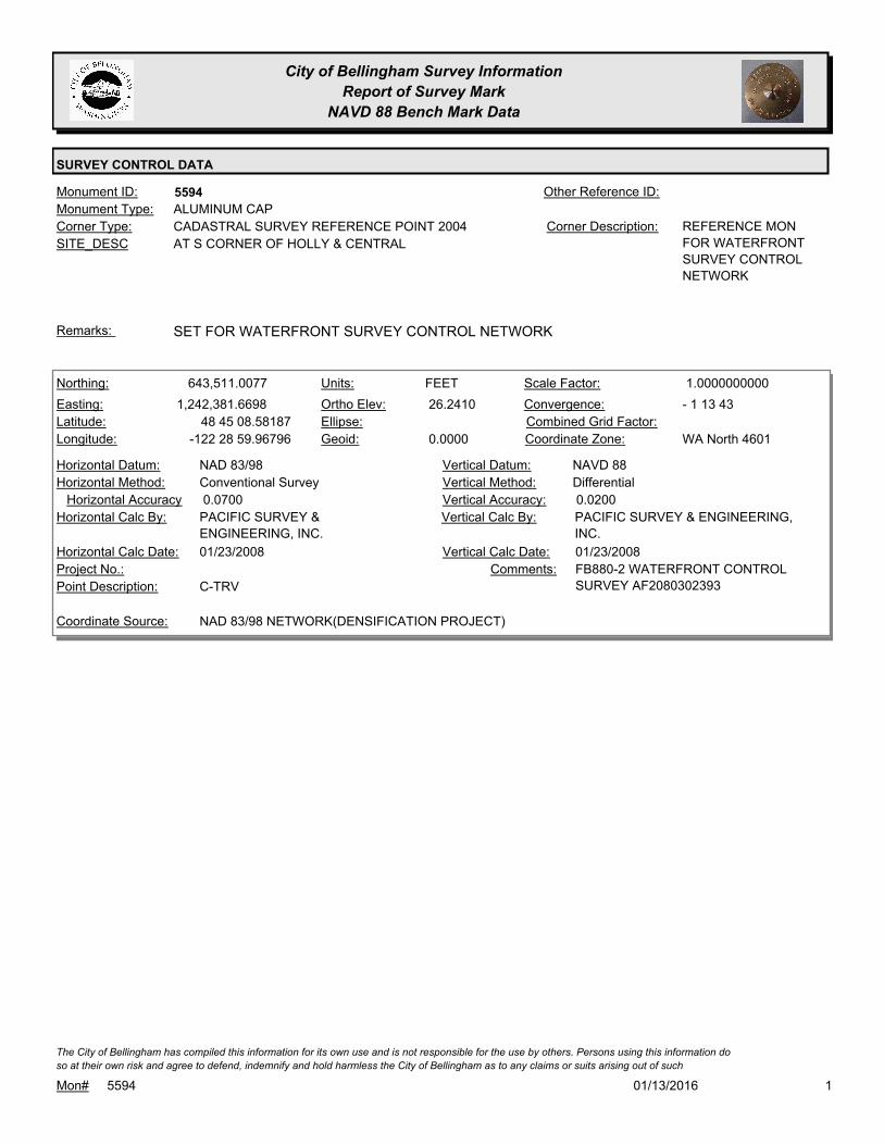
City of Bellingham Survey Information
Report of Survey Mark
NAVD 88 Bench Mark Data
SURVEY CONTROL DATA
5594Monument ID: Other Reference ID:
SITE_DESC AT S CORNER OF HOLLY & CENTRAL
CADASTRAL SURVEY REFERENCE POINT 2004Corner Type: REFERENCE MON
FOR WATERFRONT
SURVEY CONTROL
NETWORK
Corner Description:
ALUMINUM CAPMonument Type:
SET FOR WATERFRONT SURVEY CONTROL NETWORKRemarks:
643,511.0077
1,242,381.6698
48 45 08.58187
-122 28 59.96796
26.2410
0.0000
FEETNorthing:
Easting:
Latitude:
Longitude:
Units:
Ortho Elev:
Ellipse:
Geoid:
1.0000000000Scale Factor:
- 1 13 43Convergence:
Combined Grid Factor:
WA North 4601Coordinate Zone:
Conventional SurveyHorizontal Method:
NAD 83/98Horizontal Datum: NAVD 88Vertical Datum:
DifferentialVertical Method:
0.0700Horizontal Accuracy 0.0200Vertical Accuracy:
PACIFIC SURVEY & ENGINEERING,
INC.
Vertical Calc By:PACIFIC SURVEY &
ENGINEERING, INC.
Horizontal Calc By:
Project No.:
C-TRVPoint Description:
NAD 83/98 NETWORK(DENSIFICATION PROJECT)Coordinate Source:
FB880-2 WATERFRONT CONTROL
SURVEY AF2080302393
Comments:
01/23/2008Horizontal Calc Date: 01/23/2008Vertical Calc Date:
101/13/2016Mon# 5594
The City of Bellingham has compiled this information for its own use and is not responsible for the use by others. Persons using this information do
so at their own risk and agree to defend, indemnify and hold harmless the City of Bellingham as to any claims or suits arising out of such
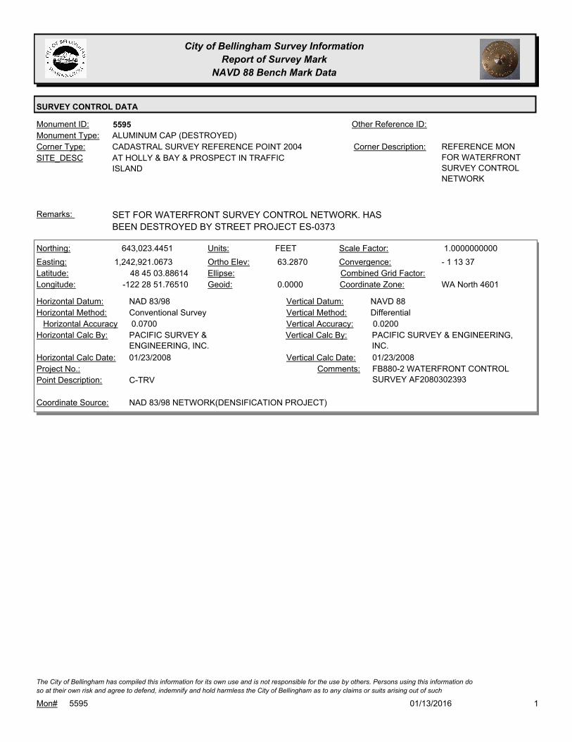
City of Bellingham Survey Information
Report of Survey Mark
NAVD 88 Bench Mark Data
SURVEY CONTROL DATA
5595Monument ID: Other Reference ID:
SITE_DESC AT HOLLY & BAY & PROSPECT IN TRAFFIC
ISLAND
CADASTRAL SURVEY REFERENCE POINT 2004Corner Type: REFERENCE MON
FOR WATERFRONT
SURVEY CONTROL
NETWORK
Corner Description:
ALUMINUM CAP (DESTROYED)Monument Type:
SET FOR WATERFRONT SURVEY CONTROL NETWORK. HAS
BEEN DESTROYED BY STREET PROJECT ES-0373
Remarks:
643,023.4451
1,242,921.0673
48 45 03.88614
-122 28 51.76510
63.2870
0.0000
FEETNorthing:
Easting:
Latitude:
Longitude:
Units:
Ortho Elev:
Ellipse:
Geoid:
1.0000000000Scale Factor:
- 1 13 37Convergence:
Combined Grid Factor:
WA North 4601Coordinate Zone:
Conventional SurveyHorizontal Method:
NAD 83/98Horizontal Datum: NAVD 88Vertical Datum:
DifferentialVertical Method:
0.0700Horizontal Accuracy 0.0200Vertical Accuracy:
PACIFIC SURVEY & ENGINEERING,
INC.
Vertical Calc By:PACIFIC SURVEY &
ENGINEERING, INC.
Horizontal Calc By:
Project No.:
C-TRVPoint Description:
NAD 83/98 NETWORK(DENSIFICATION PROJECT)Coordinate Source:
FB880-2 WATERFRONT CONTROL
SURVEY AF2080302393
Comments:
01/23/2008Horizontal Calc Date: 01/23/2008Vertical Calc Date:
101/13/2016Mon# 5595
The City of Bellingham has compiled this information for its own use and is not responsible for the use by others. Persons using this information do
so at their own risk and agree to defend, indemnify and hold harmless the City of Bellingham as to any claims or suits arising out of such

City of Bellingham Survey Information
Report of Survey Mark
NAVD 88 Bench Mark Data
SURVEY CONTROL DATA
5596Monument ID: Other Reference ID:
SITE_DESC NWLY SIDE BOULEVARD AT OAK ST
(ACROSS FROM 630 BOULEVARD)
CADASTRAL SURVEY REFERENCE POINT 2004Corner Type: REFERENCE MON
FOR WATERFRONT
SURVEY CONTROL
NETWORK
Corner Description:
ALUMINUM CAPMonument Type:
SET FOR WATERFRONT SURVEY CONTROL NETWORKRemarks:
640,054.2043
1,241,394.9987
48 44 34.27184
-122 29 13.57934
79.5870
0.0000
FEETNorthing:
Easting:
Latitude:
Longitude:
Units:
Ortho Elev:
Ellipse:
Geoid:
1.0000000000Scale Factor:
- 1 13 53Convergence:
Combined Grid Factor:
WA North 4601Coordinate Zone:
Conventional SurveyHorizontal Method:
NAD 83/98Horizontal Datum: NAVD 88Vertical Datum:
DifferentialVertical Method:
0.0700Horizontal Accuracy 0.0200Vertical Accuracy:
PACIFIC SURVEY & ENGINEERING,
INC.
Vertical Calc By:PACIFIC SURVEY &
ENGINEERING, INC.
Horizontal Calc By:
Project No.:
C-TRVPoint Description:
NAD 83/98 NETWORK(DENSIFICATION PROJECT)Coordinate Source:
FB880-2 WATERFRONT CONTROL
SURVEY AF2080302393
Comments:
01/23/2008Horizontal Calc Date: 01/23/2008Vertical Calc Date:
101/13/2016Mon# 5596
The City of Bellingham has compiled this information for its own use and is not responsible for the use by others. Persons using this information do
so at their own risk and agree to defend, indemnify and hold harmless the City of Bellingham as to any claims or suits arising out of such
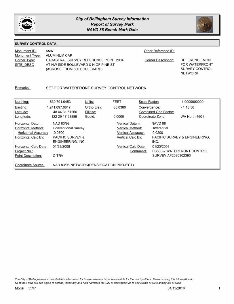
City of Bellingham Survey Information
Report of Survey Mark
NAVD 88 Bench Mark Data
SURVEY CONTROL DATA
5597Monument ID: Other Reference ID:
SITE_DESC AT NW SIDE BOULEVARD & N OF PINE ST
(ACROSS FROM 600 BOULEVARD)
CADASTRAL SURVEY REFERENCE POINT 2004Corner Type: REFERENCE MON
FOR WATERFRONT
SURVEY CONTROL
NETWORK
Corner Description:
ALUMINUM CAPMonument Type:
SET FOR WATERFRONT SURVEY CONTROL NETWORKRemarks:
639,791.0453
1,241,097.0617
48 44 31.61260
-122 29 17.93889
85.0380
0.0000
FEETNorthing:
Easting:
Latitude:
Longitude:
Units:
Ortho Elev:
Ellipse:
Geoid:
1.0000000000Scale Factor:
- 1 13 56Convergence:
Combined Grid Factor:
WA North 4601Coordinate Zone:
Conventional SurveyHorizontal Method:
NAD 83/98Horizontal Datum: NAVD 88Vertical Datum:
DifferentialVertical Method:
0.0700Horizontal Accuracy 0.0200Vertical Accuracy:
PACIFIC SURVEY & ENGINEERING,
INC.
Vertical Calc By:PACIFIC SURVEY &
ENGINEERING, INC.
Horizontal Calc By:
Project No.:
C-TRVPoint Description:
NAD 83/98 NETWORK(DENSIFICATION PROJECT)Coordinate Source:
FB880-2 WATERFRONT CONTROL
SURVEY AF2080302393
Comments:
01/23/2008Horizontal Calc Date: 01/23/2008Vertical Calc Date:
101/13/2016Mon# 5597
The City of Bellingham has compiled this information for its own use and is not responsible for the use by others. Persons using this information do
so at their own risk and agree to defend, indemnify and hold harmless the City of Bellingham as to any claims or suits arising out of such

City of Bellingham Survey Information
Report of Survey Mark
NAVD 88 Bench Mark Data
SURVEY CONTROL DATA
5598Monument ID: Other Reference ID:
SITE_DESC NW SIDE BOULEVARD BETWEEN ALDER &
CEDAR (ACROSS FROM 402 BOULEVARD)
CADASTRAL SURVEY REFERENCE POINT 2004Corner Type: REFERENCE MON
FOR WATERFRONT
SURVEY CONTROL
NETWORK
Corner Description:
ALUMINUM CAPMonument Type:
SET FOR WATERFRONT SURVEY CONTROL NETWORKRemarks:
639,145.7397
1,240,444.6106
48 44 25.10816
-122 29 27.46325
81.7210
0.0000
FEETNorthing:
Easting:
Latitude:
Longitude:
Units:
Ortho Elev:
Ellipse:
Geoid:
1.0000000000Scale Factor:
- 1 14 03Convergence:
Combined Grid Factor:
WA North 4601Coordinate Zone:
Conventional SurveyHorizontal Method:
NAD 83/98Horizontal Datum: NAVD 88Vertical Datum:
DifferentialVertical Method:
0.0700Horizontal Accuracy 0.0200Vertical Accuracy:
PACIFIC SURVEY & ENGINEERING,
INC.
Vertical Calc By:PACIFIC SURVEY &
ENGINEERING, INC.
Horizontal Calc By:
Project No.:
C-TRVPoint Description:
NAD 83/98 NETWORK(DENSIFICATION PROJECT)Coordinate Source:
FB880-2 WATERFRONT CONTROL
SURVEY AF2080302393
Comments:
01/23/2008Horizontal Calc Date: 01/23/2008Vertical Calc Date:
101/13/2016Mon# 5598
The City of Bellingham has compiled this information for its own use and is not responsible for the use by others. Persons using this information do
so at their own risk and agree to defend, indemnify and hold harmless the City of Bellingham as to any claims or suits arising out of such

City of Bellingham Survey Information
Report of Survey Mark
NAVD 88 Bench Mark Data
SURVEY CONTROL DATA
5599Monument ID: Other Reference ID:
SITE_DESC NW SIDE OF BOULEVARD NEAR BEECH ST
CADASTRAL SURVEY REFERENCE POINT 2004Corner Type: REFERENCE MON
FOR WATERFRONT
SURVEY CONTROL
NETWORK
Corner Description:
ALUMINUM CAPMonument Type:
SET FOR WATERFRONT SURVEY CONTROL NETWORKRemarks:
638,577.0652
1,240,040.4946
48 44 19.41230
-122 29 33.30777
96.1240
0.0000
FEETNorthing:
Easting:
Latitude:
Longitude:
Units:
Ortho Elev:
Ellipse:
Geoid:
1.0000000000Scale Factor:
- 1 14 07Convergence:
Combined Grid Factor:
WA North 4601Coordinate Zone:
Conventional SurveyHorizontal Method:
NAD 83/98Horizontal Datum: NAVD 88Vertical Datum:
DifferentialVertical Method:
0.0700Horizontal Accuracy 0.0200Vertical Accuracy:
PACIFIC SURVEY & ENGINEERING,
INC.
Vertical Calc By:PACIFIC SURVEY &
ENGINEERING, INC.
Horizontal Calc By:
Project No.:
C-TRVPoint Description:
NAD 83/98 NETWORK(DENSIFICATION PROJECT)Coordinate Source:
FB880-2 WATERFRONT CONTROL
SURVEY AF2080302393
Comments:
01/23/2008Horizontal Calc Date: 01/23/2008Vertical Calc Date:
101/13/2016Mon# 5599
The City of Bellingham has compiled this information for its own use and is not responsible for the use by others. Persons using this information do
so at their own risk and agree to defend, indemnify and hold harmless the City of Bellingham as to any claims or suits arising out of such

City of Bellingham Survey Information
Report of Survey Mark
NAVD 88 Bench Mark Data
SURVEY CONTROL DATA
5600Monument ID: Other Reference ID:
SITE_DESC NW SIDE OF BOULEVARD N OF PALM ST
(ACROSS FROM 223 N STATE)
CADASTRAL SURVEY REFERENCE POINT 2004Corner Type: REFERENCE MON
FOR WATERFRONT
SURVEY CONTROL
NETWORK
Corner Description:
ALUMINUM CAPMonument Type:
SET FOR WATERFRONT SURVEY CONTROL NETWORK.Remarks:
638,166.5742
1,239,651.8602
48 44 15.28012
-122 29 38.97195
89.1040
0.0000
FEETNorthing:
Easting:
Latitude:
Longitude:
Units:
Ortho Elev:
Ellipse:
Geoid:
1.0000000000Scale Factor:
- 1 14 11Convergence:
Combined Grid Factor:
WA North 4601Coordinate Zone:
Conventional SurveyHorizontal Method:
NAD 83/98Horizontal Datum: NAVD 88Vertical Datum:
DifferentialVertical Method:
0.0700Horizontal Accuracy 0.0200Vertical Accuracy:
PACIFIC SURVEY & ENGINEERING,
INC.
Vertical Calc By:PACIFIC SURVEY &
ENGINEERING, INC.
Horizontal Calc By:
Project No.:
C-TRVPoint Description:
NAD 83/98 NETWORK(DENSIFICATION PROJECT)Coordinate Source:
FB880-2 WATERFRONT CONTROL
SURVEY AF2080302393
Comments:
01/23/2008Horizontal Calc Date: 01/23/2008Vertical Calc Date:
101/13/2016Mon# 5600
The City of Bellingham has compiled this information for its own use and is not responsible for the use by others. Persons using this information do
so at their own risk and agree to defend, indemnify and hold harmless the City of Bellingham as to any claims or suits arising out of such

City of Bellingham Survey Information
Report of Survey Mark
NAVD 88 Bench Mark Data
SURVEY CONTROL DATA
5601Monument ID: Other Reference ID:
SITE_DESC AT E CORNER OF STATE & HOLLY
CADASTRAL SURVEY REFERENCE POINT 2004Corner Type: REFERENCE MON
FOR WATERFRONT
SURVEY CONTROL
NETWORK.
Corner Description:
ALUMINUM CAPMonument Type:
SET FOR WATERFRONT SURVEY CONTROL NETWORK.Remarks:
642,025.6559
1,243,887.9416
48 44 54.24702
-122 28 37.02302
90.6030
0.0000
FEETNorthing:
Easting:
Latitude:
Longitude:
Units:
Ortho Elev:
Ellipse:
Geoid:
1.0000000000Scale Factor:
- 1 13 25Convergence:
Combined Grid Factor:
WA North 4601Coordinate Zone:
Conventional SurveyHorizontal Method:
NAD 83/98Horizontal Datum: NAVD 88Vertical Datum:
DifferentialVertical Method:
0.0700Horizontal Accuracy 0.0200Vertical Accuracy:
PACIFIC SURVEY & ENGINEERING,
INC.
Vertical Calc By:PACIFIC SURVEY &
ENGINEERING, INC.
Horizontal Calc By:
Project No.:
C-TRVPoint Description:
NAD 83/98 NETWORK(DENSIFICATION PROJECT)Coordinate Source:
FB880-2 WATERFRONT CONTROL
SURVEY AF2080302393
Comments:
01/23/2008Horizontal Calc Date: 01/23/2008Vertical Calc Date:
101/13/2016Mon# 5601
The City of Bellingham has compiled this information for its own use and is not responsible for the use by others. Persons using this information do
so at their own risk and agree to defend, indemnify and hold harmless the City of Bellingham as to any claims or suits arising out of such

City of Bellingham Survey Information
Report of Survey Mark
NAVD 88 Bench Mark Data
SURVEY CONTROL DATA
5602Monument ID: Other Reference ID:
SITE_DESC AT S CORNER OF HOLLY & CORNWALL
CADASTRAL SURVEY REFERENCE POINT 2004Corner Type: REFERENCE MON
FOR WATERFRONT
SURVEY CONTROL
NETWORK.
Corner Description:
ALUMINUM CAPMonument Type:
SET FOR WATERFRONT SURVEY CONTROL NETWORK.Remarks:
642,494.2342
1,243,369.1944
48 44 58.76013
-122 28 44.91094
74.1100
0.0000
FEETNorthing:
Easting:
Latitude:
Longitude:
Units:
Ortho Elev:
Ellipse:
Geoid:
1.0000000000Scale Factor:
- 1 13 31Convergence:
Combined Grid Factor:
WA North 4601Coordinate Zone:
Conventional SurveyHorizontal Method:
NAD 83/98Horizontal Datum: NAVD 88Vertical Datum:
DifferentialVertical Method:
0.0700Horizontal Accuracy 0.0200Vertical Accuracy:
PACIFIC SURVEY & ENGINEERING,
INC.
Vertical Calc By:PACIFIC SURVEY &
ENGINEERING, INC.
Horizontal Calc By:
Project No.:
C-TRVPoint Description:
NAD 83/98 NETWORK(DENSIFICATION PROJECT)Coordinate Source:
FB880-2 WATERFRONT CONTROL
SURVEY AF2080302393
Comments:
01/23/2008Horizontal Calc Date: 01/23/2008Vertical Calc Date:
101/13/2016Mon# 5602
The City of Bellingham has compiled this information for its own use and is not responsible for the use by others. Persons using this information do
so at their own risk and agree to defend, indemnify and hold harmless the City of Bellingham as to any claims or suits arising out of such

City of Bellingham Survey Information
Report of Survey Mark
NAVD 88 Bench Mark Data
SURVEY CONTROL DATA
5603Monument ID: Other Reference ID:
SITE_DESC NEW WHATCOM WATERFRONT AT
EXTENSION OF BEAL MEMORIAL WAY
(VACATED OAK & ARMY STREETS)
CADASTRAL SURVEY REFERENCE POINT 2004Corner Type: REFERENCE MON
FOR WATERFRONT
SURVEY CONTROL
NETWORK.
Corner Description:
ALUMINUM CAPMonument Type:
SET FOR WATERFRONT SURVEY CONTROL NETWORK.Remarks:
641,091.5556
1,240,489.9277
48 44 44.31310
-122 29 27.41256
13.8200
0.0000
FEETNorthing:
Easting:
Latitude:
Longitude:
Units:
Ortho Elev:
Ellipse:
Geoid:
1.0000000000Scale Factor:
- 1 14 03Convergence:
Combined Grid Factor:
WA North 4601Coordinate Zone:
Conventional SurveyHorizontal Method:
NAD 83/98Horizontal Datum: NAVD 88Vertical Datum:
DifferentialVertical Method:
0.0700Horizontal Accuracy 0.0200Vertical Accuracy:
PACIFIC SURVEY & ENGINEERING,
INC.
Vertical Calc By:PACIFIC SURVEY &
ENGINEERING, INC.
Horizontal Calc By:
Project No.:
C-TRVPoint Description:
NAD 83/98 NETWORK(DENSIFICATION PROJECT)Coordinate Source:
FB880-2 WATERFRONT CONTROL
SURVEY AF2080302393
Comments:
01/23/2008Horizontal Calc Date: 01/23/2008Vertical Calc Date:
101/13/2016Mon# 5603
The City of Bellingham has compiled this information for its own use and is not responsible for the use by others. Persons using this information do
so at their own risk and agree to defend, indemnify and hold harmless the City of Bellingham as to any claims or suits arising out of such
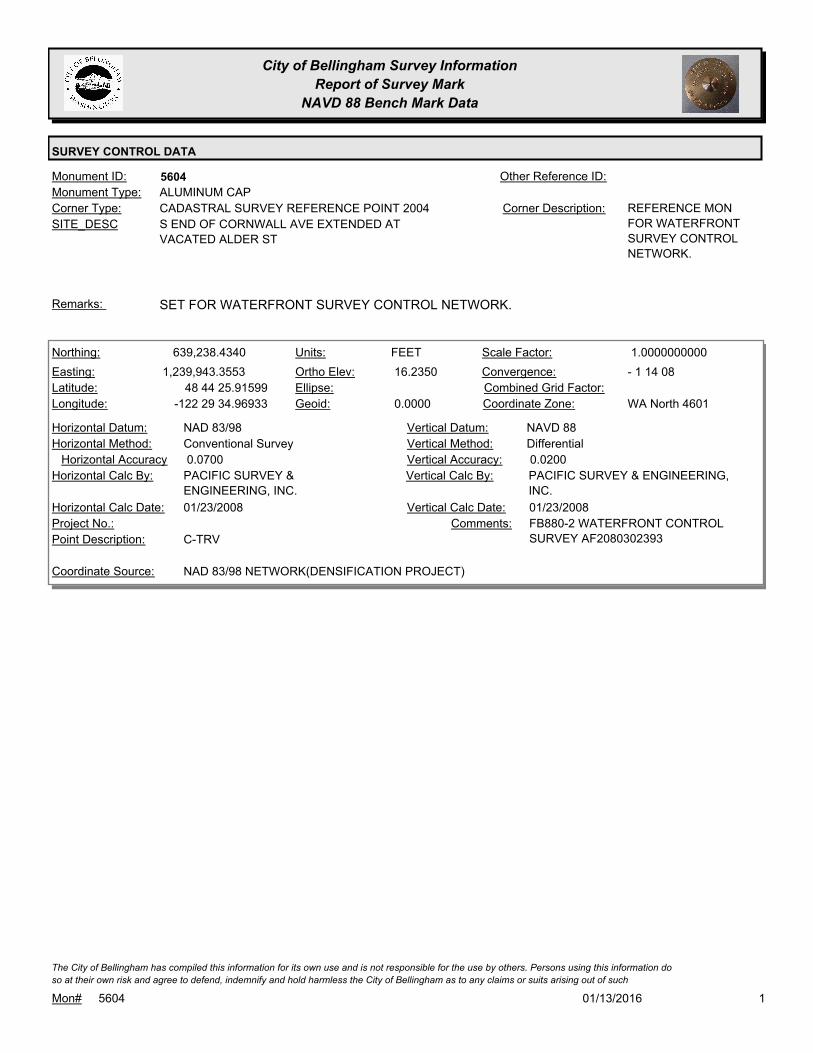
City of Bellingham Survey Information
Report of Survey Mark
NAVD 88 Bench Mark Data
SURVEY CONTROL DATA
5604Monument ID: Other Reference ID:
SITE_DESC S END OF CORNWALL AVE EXTENDED AT
VACATED ALDER ST
CADASTRAL SURVEY REFERENCE POINT 2004Corner Type: REFERENCE MON
FOR WATERFRONT
SURVEY CONTROL
NETWORK.
Corner Description:
ALUMINUM CAPMonument Type:
SET FOR WATERFRONT SURVEY CONTROL NETWORK.Remarks:
639,238.4340
1,239,943.3553
48 44 25.91599
-122 29 34.96933
16.2350
0.0000
FEETNorthing:
Easting:
Latitude:
Longitude:
Units:
Ortho Elev:
Ellipse:
Geoid:
1.0000000000Scale Factor:
- 1 14 08Convergence:
Combined Grid Factor:
WA North 4601Coordinate Zone:
Conventional SurveyHorizontal Method:
NAD 83/98Horizontal Datum: NAVD 88Vertical Datum:
DifferentialVertical Method:
0.0700Horizontal Accuracy 0.0200Vertical Accuracy:
PACIFIC SURVEY & ENGINEERING,
INC.
Vertical Calc By:PACIFIC SURVEY &
ENGINEERING, INC.
Horizontal Calc By:
Project No.:
C-TRVPoint Description:
NAD 83/98 NETWORK(DENSIFICATION PROJECT)Coordinate Source:
FB880-2 WATERFRONT CONTROL
SURVEY AF2080302393
Comments:
01/23/2008Horizontal Calc Date: 01/23/2008Vertical Calc Date:
101/13/2016Mon# 5604
The City of Bellingham has compiled this information for its own use and is not responsible for the use by others. Persons using this information do
so at their own risk and agree to defend, indemnify and hold harmless the City of Bellingham as to any claims or suits arising out of such
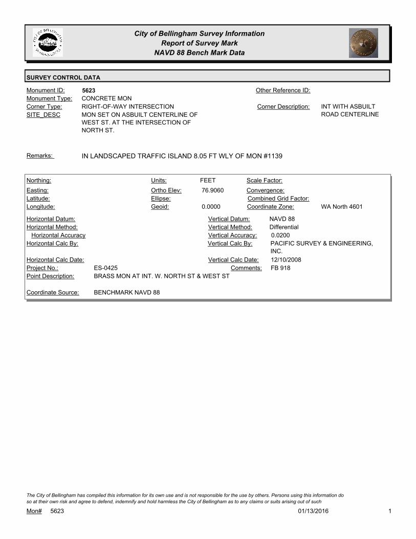
City of Bellingham Survey Information
Report of Survey Mark
NAVD 88 Bench Mark Data
SURVEY CONTROL DATA
5623Monument ID: Other Reference ID:
SITE_DESC MON SET ON ASBUILT CENTERLINE OF
WEST ST. AT THE INTERSECTION OF
NORTH ST.
RIGHT-OF-WAY INTERSECTIONCorner Type: INT WITH ASBUILT
ROAD CENTERLINE
Corner Description:
CONCRETE MONMonument Type:
IN LANDSCAPED TRAFFIC ISLAND 8.05 FT WLY OF MON #1139Remarks:
76.9060
0.0000
FEETNorthing:
Easting:
Latitude:
Longitude:
Units:
Ortho Elev:
Ellipse:
Geoid:
Scale Factor:
Convergence:
Combined Grid Factor:
WA North 4601Coordinate Zone:
Horizontal Method:
Horizontal Datum: NAVD 88Vertical Datum:
DifferentialVertical Method:
Horizontal Accuracy 0.0200Vertical Accuracy:
PACIFIC SURVEY & ENGINEERING,
INC.
Vertical Calc By:Horizontal Calc By:
ES-0425Project No.:
BRASS MON AT INT. W. NORTH ST & WEST STPoint Description:
BENCHMARK NAVD 88Coordinate Source:
FB 918Comments:
Horizontal Calc Date: 12/10/2008Vertical Calc Date:
101/13/2016Mon# 5623
The City of Bellingham has compiled this information for its own use and is not responsible for the use by others. Persons using this information do
so at their own risk and agree to defend, indemnify and hold harmless the City of Bellingham as to any claims or suits arising out of such

City of Bellingham Survey Information
Report of Survey Mark
NAVD 88 Bench Mark Data
SURVEY CONTROL DATA
5714Monument ID: Other Reference ID:
SITE_DESC AT NE CORNER MERIDIAN & OREGON
BENCH MARKCorner Type: TBM - SW
MOUNTING BOLT ON
LIGHT STANDARD
Corner Description:
BOLTMonument Type:
TBM SW MOUNTING BOLT ON LIGHT STANDARD AT NE CORNER
INT MERIDIAN & OREGON
Remarks:
87.9390
0.0000
FEETNorthing:
Easting:
Latitude:
Longitude:
Units:
Ortho Elev:
Ellipse:
Geoid:
Scale Factor:
Convergence:
Combined Grid Factor:
WA North 4601Coordinate Zone:
Horizontal Method:
Horizontal Datum: NAVD 88Vertical Datum:
DifferentialVertical Method:
Horizontal Accuracy 0.0200Vertical Accuracy:
PACIFIC SURVEY & ENGINEERING,
INC.
Vertical Calc By:Horizontal Calc By:
ES-0425Project No.:
SW BOLT LIGHT BASE AT NE QUADR. W. OREGON
ST & MERIDIAN ST
Point Description:
BENCHMARK NAVD 88Coordinate Source:
FB 918Comments:
Horizontal Calc Date: 12/11/2008Vertical Calc Date:
101/13/2016Mon# 5714
The City of Bellingham has compiled this information for its own use and is not responsible for the use by others. Persons using this information do
so at their own risk and agree to defend, indemnify and hold harmless the City of Bellingham as to any claims or suits arising out of such
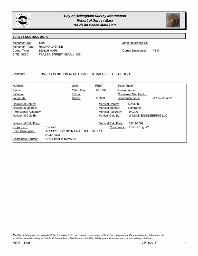
City of Bellingham Survey Information
Report of Survey Mark
NAVD 88 Bench Mark Data
SURVEY CONTROL DATA
5728Monument ID: Other Reference ID:
SITE_DESC FRASER STREET NEAR #1305
BENCH MARKCorner Type: TBMCorner Description:
RAILROAD SPIKEMonument Type:
TBM- RR SPIKE ON NORTH FACE OF BALLFIELD LIGHT # 21.Remarks:
64.1380
0.0000
FEETNorthing:
Easting:
Latitude:
Longitude:
Units:
Ortho Elev:
Ellipse:
Geoid:
Scale Factor:
Convergence:
Combined Grid Factor:
WA North 4601Coordinate Zone:
Horizontal Method:
Horizontal Datum: NAVD 88Vertical Datum:
DifferentialVertical Method:
Horizontal Accuracy 0.0300Vertical Accuracy:
WILSON ENGINEERING LLC.Vertical Calc By:Horizontal Calc By:
ES-0425Project No.:
C-RRSPK CITY BM N.FACE LIGHT STDRD
BALLFIELD
Point Description:
BENCHMARK NAVD 88Coordinate Source:
FB918-7 pg. 22Comments:
Horizontal Calc Date: 02/12/2009Vertical Calc Date:
101/13/2016Mon# 5728
The City of Bellingham has compiled this information for its own use and is not responsible for the use by others. Persons using this information do
so at their own risk and agree to defend, indemnify and hold harmless the City of Bellingham as to any claims or suits arising out of such

City of Bellingham Survey Information
Report of Survey Mark
NAVD 88 Bench Mark Data
SURVEY CONTROL DATA
5730Monument ID: GP 37005-13 AZ MKOther Reference ID:
SITE_DESC I-5 OFFRAMP NORTHBOUND AT MERIDIAN
ST TO BELLIS FAIR SHOPPING CENTER
OTHERCorner Type: NGS GP 37-005-13
1988 PID=TR2568
Corner Description:
BRASS MONMonument Type:
AT NW END OF RAMP BRIDGE OF OFF-RAMP. IN E SHOULDER
200+- FT SE OF TELEGRAPH INT.
Remarks:
199,614.3460
378,419.4890
48 47 00.766147
-122 29 16.30847
41.3860
METERSNorthing:
Easting:
Latitude:
Longitude:
Units:
Ortho Elev:
Ellipse:
Geoid:
1.0000000000Scale Factor:
-1 13 54.6Convergence:
Combined Grid Factor:
WA North 4601Coordinate Zone:
Geodetic GPSHorizontal Method:
NAD 83/07Horizontal Datum: NAVD 88Vertical Datum:
DifferentialVertical Method:
0.0200Horizontal Accuracy 0.0100Vertical Accuracy:
STATE OF WASHINGTONVertical Calc By:STATE OF WASHINGTONHorizontal Calc By:
Project No.:
GP37005-13 AZPoint Description:
WSDOTCoordinate Source:
METERSComments:
04/29/2008Horizontal Calc Date: 04/29/2008Vertical Calc Date:
135.7690
Northing:
Easting:
Latitude:
Longitude:
Units:
Ortho Elev:
Ellipse:
Geoid:
Scale Factor:
Convergence:
Combined Grid Factor:
Coordinate Zone:
Horizontal Method:
Horizontal Datum: NAVD 88Vertical Datum:
DifferentialVertical Method:
Horizontal Accuracy 0.0200Vertical Accuracy:
LARRY STEELE & ASSOCIATESVertical Calc By:Horizontal Calc By:
Project No.:
Point Description:
BENCHMARK NAVD 88Coordinate Source:
FB 960-1Comments:
Horizontal Calc Date: 03/23/2012Vertical Calc Date:
101/13/2016Mon# 5730
The City of Bellingham has compiled this information for its own use and is not responsible for the use by others. Persons using this information do
so at their own risk and agree to defend, indemnify and hold harmless the City of Bellingham as to any claims or suits arising out of such

City of Bellingham Survey Information
Report of Survey Mark
NAVD 88 Bench Mark Data
SURVEY CONTROL DATA
5731Monument ID: Other Reference ID:
SITE_DESC SOUTH STATE AND 14TH
BENCH MARKCorner Type: TBM- GIN SPIKE IN
POWER POLE
#463609-159815
Corner Description:
GIN SPIKEMonument Type:
Remarks:
87.7850
0.0000
FEETNorthing:
Easting:
Latitude:
Longitude:
Units:
Ortho Elev:
Ellipse:
Geoid:
Scale Factor:
Convergence:
Combined Grid Factor:
WA North 4601Coordinate Zone:
Horizontal Method:
Horizontal Datum: NAVD 88Vertical Datum:
DifferentialVertical Method:
Horizontal Accuracy 0.0200Vertical Accuracy:
LARRY STEELE & ASSOCIATESVertical Calc By:Horizontal Calc By:
ES-0425Project No.:
GIN SPK IN PP SE CORNER STATE & 14THPoint Description:
BENCHMARK NAVD 88Coordinate Source:
FB 918-11Comments:
Horizontal Calc Date: 02/17/2009Vertical Calc Date:
101/13/2016Mon# 5731
The City of Bellingham has compiled this information for its own use and is not responsible for the use by others. Persons using this information do
so at their own risk and agree to defend, indemnify and hold harmless the City of Bellingham as to any claims or suits arising out of such

City of Bellingham Survey Information
Report of Survey Mark
NAVD 88 Bench Mark Data
SURVEY CONTROL DATA
5732Monument ID: Other Reference ID:
SITE_DESC SOUTH STATE AND 12TH AT SE CORNER
BENCH MARKCorner Type: TBM- GIN SPIKE IN
POWER POLE
#463517-159738
Corner Description:
GIN SPIKEMonument Type:
Remarks:
71.9620
0.0000
FEETNorthing:
Easting:
Latitude:
Longitude:
Units:
Ortho Elev:
Ellipse:
Geoid:
Scale Factor:
Convergence:
Combined Grid Factor:
WA North 4601Coordinate Zone:
Horizontal Method:
Horizontal Datum: NAVD 88Vertical Datum:
DifferentialVertical Method:
Horizontal Accuracy 0.0200Vertical Accuracy:
LARRY STEELE & ASSOCIATESVertical Calc By:Horizontal Calc By:
ES-0425Project No.:
GIN SPK IN PP SE CORNER STATE & 12THPoint Description:
BENCHMARK NAVD 88Coordinate Source:
FB 918-11Comments:
Horizontal Calc Date: 02/17/2009Vertical Calc Date:
101/13/2016Mon# 5732
The City of Bellingham has compiled this information for its own use and is not responsible for the use by others. Persons using this information do
so at their own risk and agree to defend, indemnify and hold harmless the City of Bellingham as to any claims or suits arising out of such

City of Bellingham Survey Information
Report of Survey Mark
NAVD 88 Bench Mark Data
SURVEY CONTROL DATA
5733Monument ID: Other Reference ID:
SITE_DESC SOUTH STATE AND 13TH AT NE CORNER
BENCH MARKCorner Type: TBM- GIN SPIKE IN
POWER POLE
#463562-159775
Corner Description:
GIN SPIKEMonument Type:
Remarks:
75.7570
0.0000
FEETNorthing:
Easting:
Latitude:
Longitude:
Units:
Ortho Elev:
Ellipse:
Geoid:
Scale Factor:
Convergence:
Combined Grid Factor:
WA North 4601Coordinate Zone:
Horizontal Method:
Horizontal Datum: NAVD 88Vertical Datum:
DifferentialVertical Method:
Horizontal Accuracy 0.0200Vertical Accuracy:
LARRY STEELE & ASSOCIATESVertical Calc By:Horizontal Calc By:
ES-0425Project No.:
GIN SPK IN PP NE CORNER STATE & 13THPoint Description:
BENCHMARK NAVD 88Coordinate Source:
FB 918-11Comments:
Horizontal Calc Date: 02/17/2009Vertical Calc Date:
101/13/2016Mon# 5733
The City of Bellingham has compiled this information for its own use and is not responsible for the use by others. Persons using this information do
so at their own risk and agree to defend, indemnify and hold harmless the City of Bellingham as to any claims or suits arising out of such
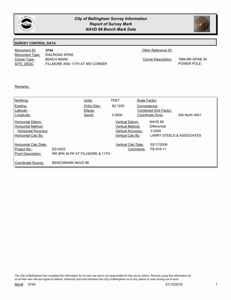
City of Bellingham Survey Information
Report of Survey Mark
NAVD 88 Bench Mark Data
SURVEY CONTROL DATA
5744Monument ID: Other Reference ID:
SITE_DESC FILLMORE AND 11TH AT NW CORNER
BENCH MARKCorner Type: TBM-RR SPIKE IN
POWER POLE.
Corner Description:
RAILROAD SPIKEMonument Type:
Remarks:
82.1220
0.0000
FEETNorthing:
Easting:
Latitude:
Longitude:
Units:
Ortho Elev:
Ellipse:
Geoid:
Scale Factor:
Convergence:
Combined Grid Factor:
WA North 4601Coordinate Zone:
Horizontal Method:
Horizontal Datum: NAVD 88Vertical Datum:
DifferentialVertical Method:
Horizontal Accuracy 0.0200Vertical Accuracy:
LARRY STEELE & ASSOCIATESVertical Calc By:Horizontal Calc By:
ES-0425Project No.:
RR SPK IN PP AT FILLMORE & 11THPoint Description:
BENCHMARK NAVD 88Coordinate Source:
FB 918-11Comments:
Horizontal Calc Date: 02/17/2009Vertical Calc Date:
101/13/2016Mon# 5744
The City of Bellingham has compiled this information for its own use and is not responsible for the use by others. Persons using this information do
so at their own risk and agree to defend, indemnify and hold harmless the City of Bellingham as to any claims or suits arising out of such

City of Bellingham Survey Information
Report of Survey Mark
NAVD 88 Bench Mark Data
SURVEY CONTROL DATA
5748Monument ID: Other Reference ID:
SITE_DESC MERIDIAN AND CONNECTICUT IN S FACE
POWER POLE AT SE CORNER
BENCH MARKCorner Type: TBM-GIN SPIKE IN
POWER POLE
Corner Description:
SPIKEMonument Type:
TBM-GIN SPIKE IN POWER POLE #464834-160184Remarks:
81.6250
0.0000
FEETNorthing:
Easting:
Latitude:
Longitude:
Units:
Ortho Elev:
Ellipse:
Geoid:
Scale Factor:
Convergence:
Combined Grid Factor:
WA North 4601Coordinate Zone:
Horizontal Method:
Horizontal Datum: NAVD 88Vertical Datum:
DifferentialVertical Method:
Horizontal Accuracy 0.0200Vertical Accuracy:
PACIFIC SURVEY & ENGINEERING,
INC.
Vertical Calc By:Horizontal Calc By:
ES-0425Project No.:
COTT GIN SPIKE IN PP AT SE QUADR.
CONNECTICUT ST & MERIDIAN ST
Point Description:
BENCHMARK NAVD 88Coordinate Source:
FB 918Comments:
Horizontal Calc Date: 01/05/2009Vertical Calc Date:
101/13/2016Mon# 5748
The City of Bellingham has compiled this information for its own use and is not responsible for the use by others. Persons using this information do
so at their own risk and agree to defend, indemnify and hold harmless the City of Bellingham as to any claims or suits arising out of such
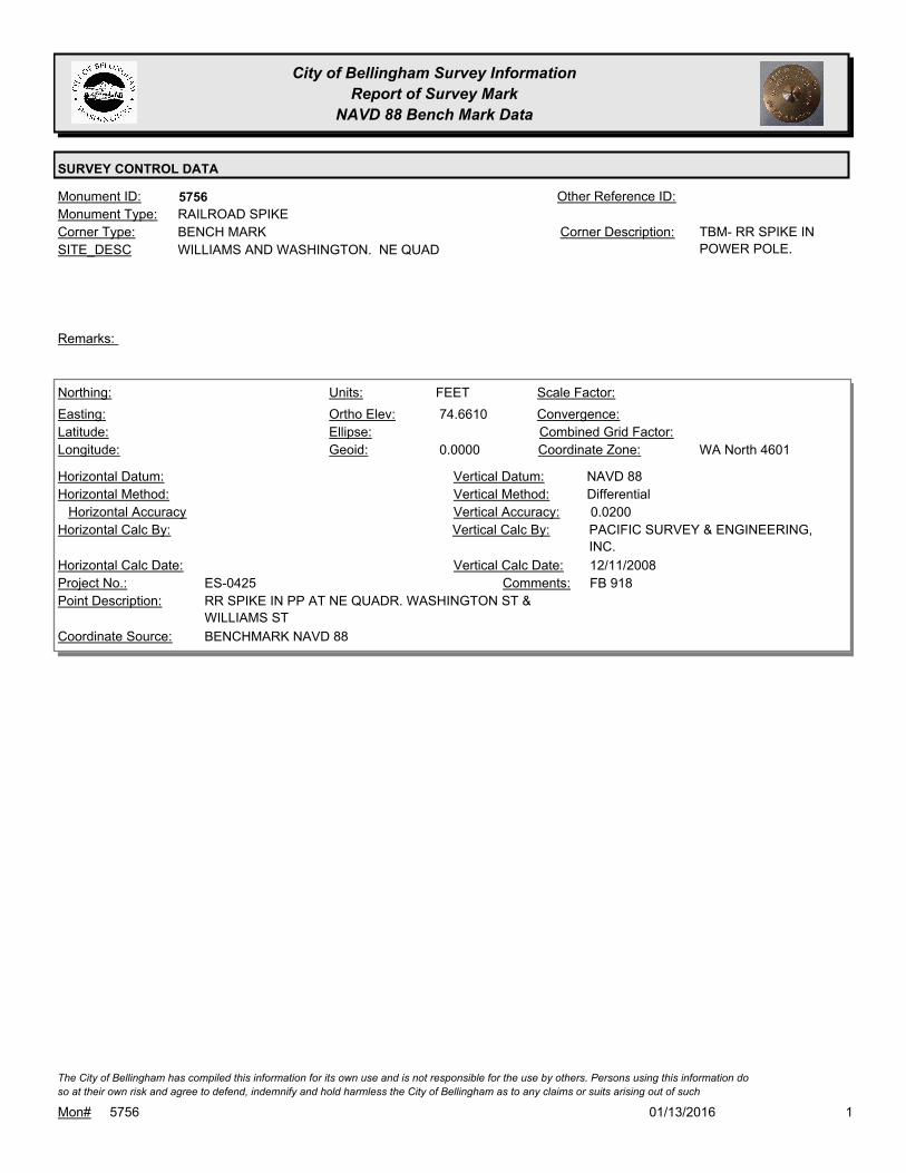
City of Bellingham Survey Information
Report of Survey Mark
NAVD 88 Bench Mark Data
SURVEY CONTROL DATA
5756Monument ID: Other Reference ID:
SITE_DESC WILLIAMS AND WASHINGTON. NE QUAD
BENCH MARKCorner Type: TBM- RR SPIKE IN
POWER POLE.
Corner Description:
RAILROAD SPIKEMonument Type:
Remarks:
74.6610
0.0000
FEETNorthing:
Easting:
Latitude:
Longitude:
Units:
Ortho Elev:
Ellipse:
Geoid:
Scale Factor:
Convergence:
Combined Grid Factor:
WA North 4601Coordinate Zone:
Horizontal Method:
Horizontal Datum: NAVD 88Vertical Datum:
DifferentialVertical Method:
Horizontal Accuracy 0.0200Vertical Accuracy:
PACIFIC SURVEY & ENGINEERING,
INC.
Vertical Calc By:Horizontal Calc By:
ES-0425Project No.:
RR SPIKE IN PP AT NE QUADR. WASHINGTON ST &
WILLIAMS ST
Point Description:
BENCHMARK NAVD 88Coordinate Source:
FB 918Comments:
Horizontal Calc Date: 12/11/2008Vertical Calc Date:
101/13/2016Mon# 5756
The City of Bellingham has compiled this information for its own use and is not responsible for the use by others. Persons using this information do
so at their own risk and agree to defend, indemnify and hold harmless the City of Bellingham as to any claims or suits arising out of such

City of Bellingham Survey Information
Report of Survey Mark
NAVD 88 Bench Mark Data
SURVEY CONTROL DATA
5757Monument ID: Other Reference ID:
SITE_DESC ELDRIDGE AND KEESLING. NW QUAD.
BENCH MARKCorner Type: TBM- RR SPIKE IN
POWER POLE
Corner Description:
RAILROAD SPIKEMonument Type:
Remarks:
66.0990
0.0000
FEETNorthing:
Easting:
Latitude:
Longitude:
Units:
Ortho Elev:
Ellipse:
Geoid:
Scale Factor:
Convergence:
Combined Grid Factor:
WA North 4601Coordinate Zone:
Horizontal Method:
Horizontal Datum: NAVD 88Vertical Datum:
DifferentialVertical Method:
Horizontal Accuracy 0.0200Vertical Accuracy:
PACIFIC SURVEY & ENGINEERING,
INC.
Vertical Calc By:Horizontal Calc By:
ES-0425Project No.:
RR SPIKE IN PP AT N. QUADR. KEESING ST &
ELDRIDGE AVE
Point Description:
BENCHMARK NAVD 88Coordinate Source:
FB 918Comments:
Horizontal Calc Date: 12/12/2008Vertical Calc Date:
101/13/2016Mon# 5757
The City of Bellingham has compiled this information for its own use and is not responsible for the use by others. Persons using this information do
so at their own risk and agree to defend, indemnify and hold harmless the City of Bellingham as to any claims or suits arising out of such

City of Bellingham Survey Information
Report of Survey Mark
NAVD 88 Bench Mark Data
SURVEY CONTROL DATA
5759Monument ID: Other Reference ID:
SITE_DESC HIGHLAND AND PATTLE
BENCH MARKCorner Type: TBM-RR SPIKE IN
POWER POLE
#463596-159959
Corner Description:
RAILROAD SPIKEMonument Type:
Remarks:
426.6500
Northing:
Easting:
Latitude:
Longitude:
Units:
Ortho Elev:
Ellipse:
Geoid:
Scale Factor:
Convergence:
Combined Grid Factor:
Coordinate Zone:
Horizontal Method:
Horizontal Datum: NAVD 88Vertical Datum:
DifferentialVertical Method:
Horizontal Accuracy 0.0300Vertical Accuracy:
LARRY STEELE & ASSOCIATESVertical Calc By:Horizontal Calc By:
EU-0156Project No.:
Point Description:
BENCHMARK NAVD 88Coordinate Source:
FB 940-1Comments:
Horizontal Calc Date: 08/09/2011Vertical Calc Date:
101/13/2016Mon# 5759
The City of Bellingham has compiled this information for its own use and is not responsible for the use by others. Persons using this information do
so at their own risk and agree to defend, indemnify and hold harmless the City of Bellingham as to any claims or suits arising out of such
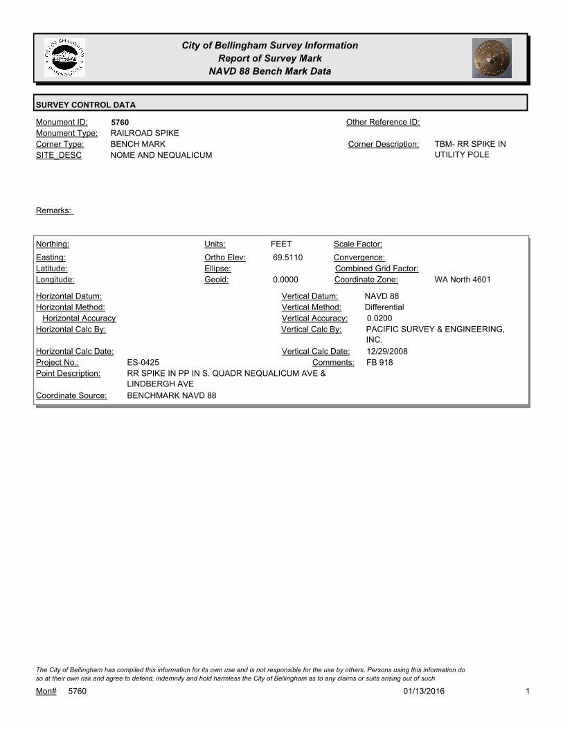
City of Bellingham Survey Information
Report of Survey Mark
NAVD 88 Bench Mark Data
SURVEY CONTROL DATA
5760Monument ID: Other Reference ID:
SITE_DESC NOME AND NEQUALICUM
BENCH MARKCorner Type: TBM- RR SPIKE IN
UTILITY POLE
Corner Description:
RAILROAD SPIKEMonument Type:
Remarks:
69.5110
0.0000
FEETNorthing:
Easting:
Latitude:
Longitude:
Units:
Ortho Elev:
Ellipse:
Geoid:
Scale Factor:
Convergence:
Combined Grid Factor:
WA North 4601Coordinate Zone:
Horizontal Method:
Horizontal Datum: NAVD 88Vertical Datum:
DifferentialVertical Method:
Horizontal Accuracy 0.0200Vertical Accuracy:
PACIFIC SURVEY & ENGINEERING,
INC.
Vertical Calc By:Horizontal Calc By:
ES-0425Project No.:
RR SPIKE IN PP IN S. QUADR NEQUALICUM AVE &
LINDBERGH AVE
Point Description:
BENCHMARK NAVD 88Coordinate Source:
FB 918Comments:
Horizontal Calc Date: 12/29/2008Vertical Calc Date:
101/13/2016Mon# 5760
The City of Bellingham has compiled this information for its own use and is not responsible for the use by others. Persons using this information do
so at their own risk and agree to defend, indemnify and hold harmless the City of Bellingham as to any claims or suits arising out of such
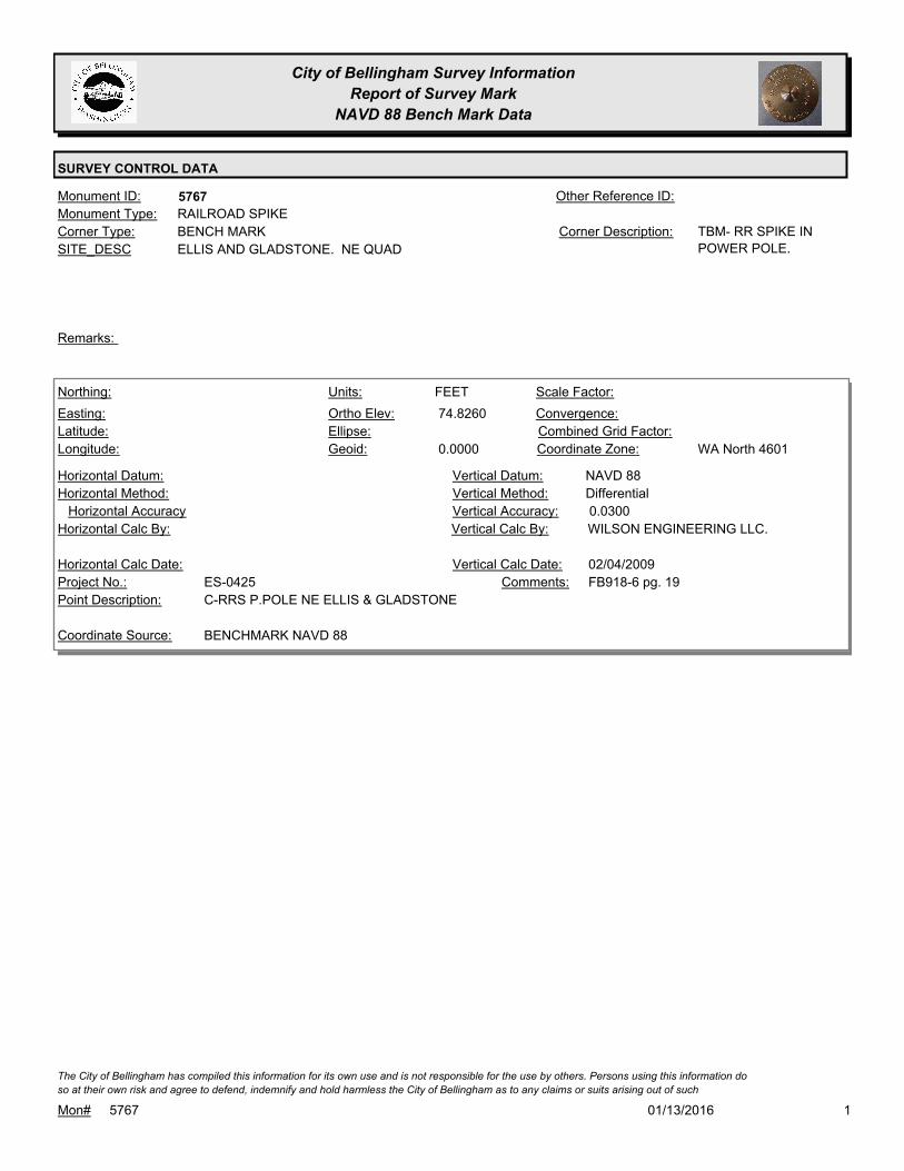
City of Bellingham Survey Information
Report of Survey Mark
NAVD 88 Bench Mark Data
SURVEY CONTROL DATA
5767Monument ID: Other Reference ID:
SITE_DESC ELLIS AND GLADSTONE. NE QUAD
BENCH MARKCorner Type: TBM- RR SPIKE IN
POWER POLE.
Corner Description:
RAILROAD SPIKEMonument Type:
Remarks:
74.8260
0.0000
FEETNorthing:
Easting:
Latitude:
Longitude:
Units:
Ortho Elev:
Ellipse:
Geoid:
Scale Factor:
Convergence:
Combined Grid Factor:
WA North 4601Coordinate Zone:
Horizontal Method:
Horizontal Datum: NAVD 88Vertical Datum:
DifferentialVertical Method:
Horizontal Accuracy 0.0300Vertical Accuracy:
WILSON ENGINEERING LLC.Vertical Calc By:Horizontal Calc By:
ES-0425Project No.:
C-RRS P.POLE NE ELLIS & GLADSTONEPoint Description:
BENCHMARK NAVD 88Coordinate Source:
FB918-6 pg. 19Comments:
Horizontal Calc Date: 02/04/2009Vertical Calc Date:
101/13/2016Mon# 5767
The City of Bellingham has compiled this information for its own use and is not responsible for the use by others. Persons using this information do
so at their own risk and agree to defend, indemnify and hold harmless the City of Bellingham as to any claims or suits arising out of such

City of Bellingham Survey Information
Report of Survey Mark
NAVD 88 Bench Mark Data
SURVEY CONTROL DATA
5788Monument ID: Other Reference ID:
SITE_DESC RUSLEY & MCLEOD AT NE CORNER
BENCH MARKCorner Type: TBMCorner Description:
RAILROAD SPIKEMonument Type:
TBM - RR SPIKE ON SSW FACE UTIL POLE AT NE QUAD RUSLEY
& MCLEOD.
Remarks:
134.9780
0.0000
FEETNorthing:
Easting:
Latitude:
Longitude:
Units:
Ortho Elev:
Ellipse:
Geoid:
Scale Factor:
Convergence:
Combined Grid Factor:
WA North 4601Coordinate Zone:
Horizontal Method:
Horizontal Datum: NAVD 88Vertical Datum:
DifferentialVertical Method:
Horizontal Accuracy 0.0200Vertical Accuracy:
PACIFIC SURVEY & ENGINEERING,
INC.
Vertical Calc By:Horizontal Calc By:
ES-0425Project No.:
RR SPK IN PP AT NE QUADR. MCLEOD RD & W.
RUSLEY DR
Point Description:
BENCHMARK NAVD 88Coordinate Source:
FB 918Comments:
Horizontal Calc Date: 12/08/2008Vertical Calc Date:
101/13/2016Mon# 5788
The City of Bellingham has compiled this information for its own use and is not responsible for the use by others. Persons using this information do
so at their own risk and agree to defend, indemnify and hold harmless the City of Bellingham as to any claims or suits arising out of such

City of Bellingham Survey Information
Report of Survey Mark
NAVD 88 Bench Mark Data
SURVEY CONTROL DATA
5789Monument ID: GP 37005-71Other Reference ID:
SITE_DESC WSDOT MONUMENT AT I-5 & EXIT #254
(STATE/OHIO)
TRAVERSE POINTCorner Type: WSDOT MONUMENT
GP 37005-71
Corner Description:
BRASS MONMonument Type:
IN I-5 ON E SHOULDER AT EXIT 254 (STATE/OHIO)Remarks:
196,375.8240
380,278.6330
48 45 17.235012
-122 27 41.898909
20.7290
METERSNorthing:
Easting:
Latitude:
Longitude:
Units:
Ortho Elev:
Ellipse:
Geoid:
1.0000000000Scale Factor:
-1 12 44.3Convergence:
Combined Grid Factor:
WA North 4601Coordinate Zone:
Geodetic GPSHorizontal Method:
NAD 1983/91Horizontal Datum: NAVD 88Vertical Datum:
DifferentialVertical Method:
0.0200Horizontal Accuracy 0.0100Vertical Accuracy:
STATE OF WASHINGTONVertical Calc By:STATE OF WASHINGTONHorizontal Calc By:
Project No.:
WSDOT GP37005-71Point Description:
WSDOTCoordinate Source:
METERSComments:
04/08/2005Horizontal Calc Date: 04/08/2005Vertical Calc Date:
101/13/2016Mon# 5789
The City of Bellingham has compiled this information for its own use and is not responsible for the use by others. Persons using this information do
so at their own risk and agree to defend, indemnify and hold harmless the City of Bellingham as to any claims or suits arising out of such

City of Bellingham Survey Information
Report of Survey Mark
NAVD 88 Bench Mark Data
SURVEY CONTROL DATA
5793Monument ID: WSDOT IS3728Other Reference ID:
SITE_DESC WSDOT MON ON LINCOLN S OF LAKEWAY
TRAVERSE POINTCorner Type: WSDOT IS3728Corner Description:
ALUMINUM CAPMonument Type:
LOCATED IN THE WEST SHOULDER AREA OF LINCOLN STREET
APPROXIMATELY 20 METERS SOUTH OF THE POINT WHERE THE
STRIPING FOR A BICYCLE LANE BEGINS
Remarks:
161.8590
0.0000
FEETNorthing:
Easting:
Latitude:
Longitude:
Units:
Ortho Elev:
Ellipse:
Geoid:
Scale Factor:
Convergence:
Combined Grid Factor:
WA North 4601Coordinate Zone:
Horizontal Method:
Horizontal Datum: NAVD 88Vertical Datum:
DifferentialVertical Method:
Horizontal Accuracy 0.0200Vertical Accuracy:
LARRY STEELE & ASSOCIATESVertical Calc By:Horizontal Calc By:
ES-0425Project No.:
WSDOT ALUM CAP W. SIDE OF LINCOLN, S. OF
LAKEWAY
Point Description:
BENCHMARK NAVD 88Coordinate Source:
FB 918-11Comments:
Horizontal Calc Date: 02/17/2009Vertical Calc Date:
101/13/2016Mon# 5793
The City of Bellingham has compiled this information for its own use and is not responsible for the use by others. Persons using this information do
so at their own risk and agree to defend, indemnify and hold harmless the City of Bellingham as to any claims or suits arising out of such
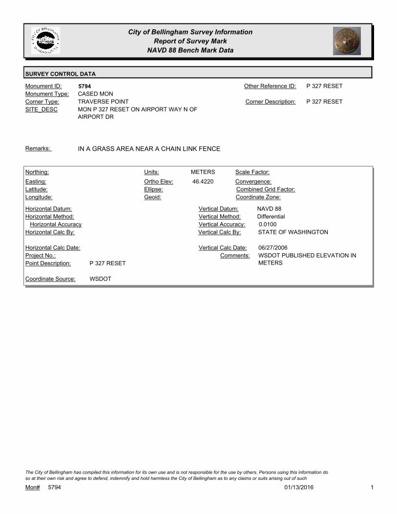
City of Bellingham Survey Information
Report of Survey Mark
NAVD 88 Bench Mark Data
SURVEY CONTROL DATA
5794Monument ID: P 327 RESETOther Reference ID:
SITE_DESC MON P 327 RESET ON AIRPORT WAY N OF
AIRPORT DR
TRAVERSE POINTCorner Type: P 327 RESETCorner Description:
CASED MONMonument Type:
IN A GRASS AREA NEAR A CHAIN LINK FENCERemarks:
46.4220
METERSNorthing:
Easting:
Latitude:
Longitude:
Units:
Ortho Elev:
Ellipse:
Geoid:
Scale Factor:
Convergence:
Combined Grid Factor:
Coordinate Zone:
Horizontal Method:
Horizontal Datum: NAVD 88Vertical Datum:
DifferentialVertical Method:
Horizontal Accuracy 0.0100Vertical Accuracy:
STATE OF WASHINGTONVertical Calc By:Horizontal Calc By:
Project No.:
P 327 RESETPoint Description:
WSDOTCoordinate Source:
WSDOT PUBLISHED ELEVATION IN
METERS
Comments:
Horizontal Calc Date: 06/27/2006Vertical Calc Date:
101/13/2016Mon# 5794
The City of Bellingham has compiled this information for its own use and is not responsible for the use by others. Persons using this information do
so at their own risk and agree to defend, indemnify and hold harmless the City of Bellingham as to any claims or suits arising out of such
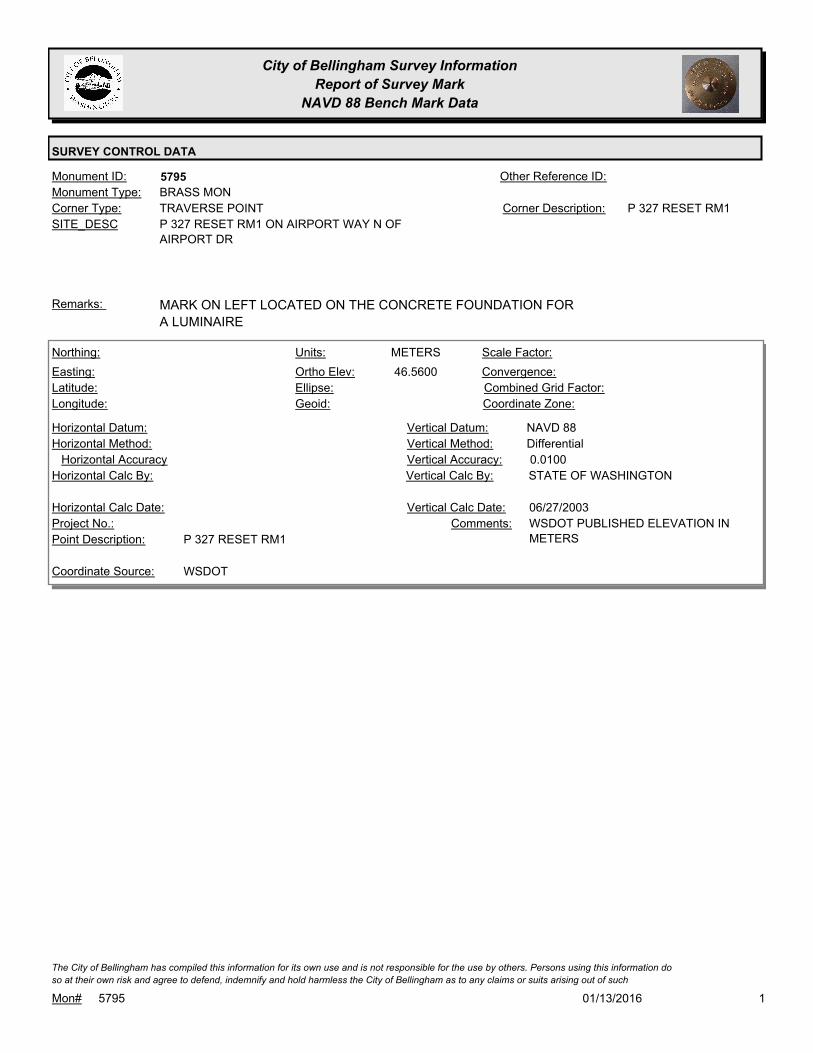
City of Bellingham Survey Information
Report of Survey Mark
NAVD 88 Bench Mark Data
SURVEY CONTROL DATA
5795Monument ID: Other Reference ID:
SITE_DESC P 327 RESET RM1 ON AIRPORT WAY N OF
AIRPORT DR
TRAVERSE POINTCorner Type: P 327 RESET RM1Corner Description:
BRASS MONMonument Type:
MARK ON LEFT LOCATED ON THE CONCRETE FOUNDATION FOR
A LUMINAIRE
Remarks:
46.5600
METERSNorthing:
Easting:
Latitude:
Longitude:
Units:
Ortho Elev:
Ellipse:
Geoid:
Scale Factor:
Convergence:
Combined Grid Factor:
Coordinate Zone:
Horizontal Method:
Horizontal Datum: NAVD 88Vertical Datum:
DifferentialVertical Method:
Horizontal Accuracy 0.0100Vertical Accuracy:
STATE OF WASHINGTONVertical Calc By:Horizontal Calc By:
Project No.:
P 327 RESET RM1Point Description:
WSDOTCoordinate Source:
WSDOT PUBLISHED ELEVATION IN
METERS
Comments:
Horizontal Calc Date: 06/27/2003Vertical Calc Date:
101/13/2016Mon# 5795
The City of Bellingham has compiled this information for its own use and is not responsible for the use by others. Persons using this information do
so at their own risk and agree to defend, indemnify and hold harmless the City of Bellingham as to any claims or suits arising out of such

City of Bellingham Survey Information
Report of Survey Mark
NAVD 88 Bench Mark Data
SURVEY CONTROL DATA
5798Monument ID: WSDOT GP37539-62Other Reference ID:
SITE_DESC WSDOT MON ON W SIDE OF MERIDIAN S
OF TREMONT
TRAVERSE POINTCorner Type: WSDOT GP37539-62Corner Description:
BRASS MONMonument Type:
Remarks:
202,618.9960
378,612.3140
48 48 38.144339
122 29 10.025861
60.3920
METERSNorthing:
Easting:
Latitude:
Longitude:
Units:
Ortho Elev:
Ellipse:
Geoid:
1.0000000000Scale Factor:
-1 13 49.9Convergence:
Combined Grid Factor:
WA North 4601Coordinate Zone:
Geodetic GPSHorizontal Method:
NAD 83/07Horizontal Datum: NAVD 88Vertical Datum:
DifferentialVertical Method:
0.0200Horizontal Accuracy 0.0100Vertical Accuracy:
STATE OF WASHINGTONVertical Calc By:STATE OF WASHINGTONHorizontal Calc By:
Project No.:
GP37539-62Point Description:
WSDOTCoordinate Source:
METERSComments:
04/29/2008Horizontal Calc Date: 04/29/2008Vertical Calc Date:
101/13/2016Mon# 5798
The City of Bellingham has compiled this information for its own use and is not responsible for the use by others. Persons using this information do
so at their own risk and agree to defend, indemnify and hold harmless the City of Bellingham as to any claims or suits arising out of such

City of Bellingham Survey Information
Report of Survey Mark
NAVD 88 Bench Mark Data
SURVEY CONTROL DATA
5799Monument ID: WSDOT GP37539-63Other Reference ID:
SITE_DESC WSDOT MON ON W SIDE MERIDIAN S OF
KELLY RD
TRAVERSE POINTCorner Type: WSDOT GP37539-63Corner Description:
BRASS MONMonument Type:
BRASS DISK SET INTO N SIDE OF A SQUARE FOUNDATION FOR
ABANDONED SCALE
Remarks:
203,263.5580
378,629.6830
48 48 59.017241
-122 29 09.853171
58.5070
METERSNorthing:
Easting:
Latitude:
Longitude:
Units:
Ortho Elev:
Ellipse:
Geoid:
1.0000000000Scale Factor:
-1 13 49.8Convergence:
Combined Grid Factor:
WA North 4601Coordinate Zone:
Geodetic GPSHorizontal Method:
NAD 83/07Horizontal Datum: NAVD 88Vertical Datum:
DifferentialVertical Method:
0.0200Horizontal Accuracy 0.0100Vertical Accuracy:
STATE OF WASHINGTONVertical Calc By:STATE OF WASHINGTONHorizontal Calc By:
Project No.:
WSDOT GP37539-63Point Description:
WSDOTCoordinate Source:
METERSComments:
04/29/2008Horizontal Calc Date: 04/29/2008Vertical Calc Date:
101/13/2016Mon# 5799
The City of Bellingham has compiled this information for its own use and is not responsible for the use by others. Persons using this information do
so at their own risk and agree to defend, indemnify and hold harmless the City of Bellingham as to any claims or suits arising out of such

City of Bellingham Survey Information
Report of Survey Mark
NAVD 88 Bench Mark Data
SURVEY CONTROL DATA
5800Monument ID: WSDOT BM37539-47Other Reference ID:
SITE_DESC WSDOT MON ON E SIDE GUIDE MERIDIAN
S OF SMITH RD
BENCH MARKCorner Type: WSDOT BM37539-47Corner Description:
BRASS MONMonument Type:
WSDOT BRASS DISK SET INTO A ROUND CONCRETE MONUMENT
PROJECTING 10 CM ABOVE GROUND SURFACE.
Remarks:
204,986.2760
378,687.3330
48 49 54.811695
-122 29 08.841029
59.1980
METERSNorthing:
Easting:
Latitude:
Longitude:
Units:
Ortho Elev:
Ellipse:
Geoid:
1.0000000000Scale Factor:
-1 13 49Convergence:
Combined Grid Factor:
WA North 4601Coordinate Zone:
Geodetic GPSHorizontal Method:
NAD 83/07Horizontal Datum: NAVD 88Vertical Datum:
DifferentialVertical Method:
0.0200Horizontal Accuracy 0.0100Vertical Accuracy:
STATE OF WASHINGTONVertical Calc By:STATE OF WASHINGTONHorizontal Calc By:
Project No.:
WSDOT BM37539-4Point Description:
WSDOTCoordinate Source:
METERSComments:
04/29/2008Horizontal Calc Date: 04/29/2008Vertical Calc Date:
101/13/2016Mon# 5800
The City of Bellingham has compiled this information for its own use and is not responsible for the use by others. Persons using this information do
so at their own risk and agree to defend, indemnify and hold harmless the City of Bellingham as to any claims or suits arising out of such
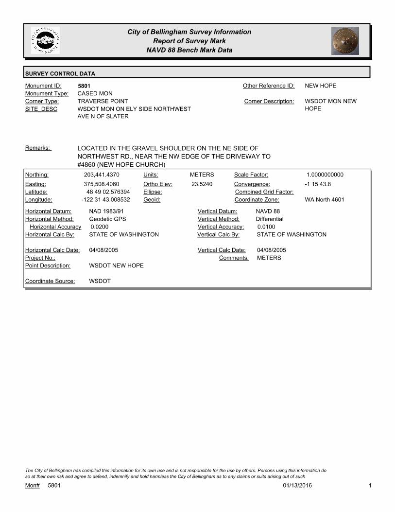
City of Bellingham Survey Information
Report of Survey Mark
NAVD 88 Bench Mark Data
SURVEY CONTROL DATA
5801Monument ID: NEW HOPEOther Reference ID:
SITE_DESC WSDOT MON ON ELY SIDE NORTHWEST
AVE N OF SLATER
TRAVERSE POINTCorner Type: WSDOT MON NEW
HOPE
Corner Description:
CASED MONMonument Type:
LOCATED IN THE GRAVEL SHOULDER ON THE NE SIDE OF
NORTHWEST RD., NEAR THE NW EDGE OF THE DRIVEWAY TO
#4860 (NEW HOPE CHURCH)
Remarks:
203,441.4370
375,508.4060
48 49 02.576394
-122 31 43.008532
23.5240
METERSNorthing:
Easting:
Latitude:
Longitude:
Units:
Ortho Elev:
Ellipse:
Geoid:
1.0000000000Scale Factor:
-1 15 43.8Convergence:
Combined Grid Factor:
WA North 4601Coordinate Zone:
Geodetic GPSHorizontal Method:
NAD 1983/91Horizontal Datum: NAVD 88Vertical Datum:
DifferentialVertical Method:
0.0200Horizontal Accuracy 0.0100Vertical Accuracy:
STATE OF WASHINGTONVertical Calc By:STATE OF WASHINGTONHorizontal Calc By:
Project No.:
WSDOT NEW HOPEPoint Description:
WSDOTCoordinate Source:
METERSComments:
04/08/2005Horizontal Calc Date: 04/08/2005Vertical Calc Date:
101/13/2016Mon# 5801
The City of Bellingham has compiled this information for its own use and is not responsible for the use by others. Persons using this information do
so at their own risk and agree to defend, indemnify and hold harmless the City of Bellingham as to any claims or suits arising out of such
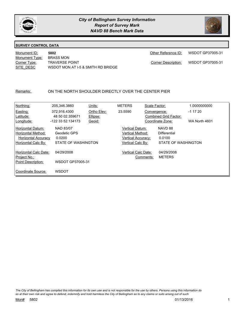
City of Bellingham Survey Information
Report of Survey Mark
NAVD 88 Bench Mark Data
SURVEY CONTROL DATA
5802Monument ID: WSDOT GP37005-31Other Reference ID:
SITE_DESC WSDOT MON AT I-5 & SMITH RD BRIDGE
TRAVERSE POINTCorner Type: WSDOT GP37005-31Corner Description:
BRASS MONMonument Type:
ON THE NORTH SHOULDER DIRECTLY OVER THE CENTER PIERRemarks:
205,346.3860
372,916.4300
48 50 02.359671
-122 33 52.134173
23.5590
METERSNorthing:
Easting:
Latitude:
Longitude:
Units:
Ortho Elev:
Ellipse:
Geoid:
1.0000000000Scale Factor:
-1 17 20Convergence:
Combined Grid Factor:
WA North 4601Coordinate Zone:
Geodetic GPSHorizontal Method:
NAD 83/07Horizontal Datum: NAVD 88Vertical Datum:
DifferentialVertical Method:
0.0200Horizontal Accuracy 0.0100Vertical Accuracy:
STATE OF WASHINGTONVertical Calc By:STATE OF WASHINGTONHorizontal Calc By:
Project No.:
WSDOT GP37005-31Point Description:
WSDOTCoordinate Source:
METERSComments:
04/29/2008Horizontal Calc Date: 04/29/2008Vertical Calc Date:
101/13/2016Mon# 5802
The City of Bellingham has compiled this information for its own use and is not responsible for the use by others. Persons using this information do
so at their own risk and agree to defend, indemnify and hold harmless the City of Bellingham as to any claims or suits arising out of such

City of Bellingham Survey Information
Report of Survey Mark
NAVD 88 Bench Mark Data
SURVEY CONTROL DATA
5803Monument ID: Other Reference ID:
SITE_DESC "F" AND MORRIS AT N CORNER
BENCH MARKCorner Type: TBM - HIT PIN IN
SIDEWALK AT NW
QUAD.
Corner Description:
NAILMonument Type:
SEE FB 897-1 PG 25.Remarks:
117.0570
0.0000
FEETNorthing:
Easting:
Latitude:
Longitude:
Units:
Ortho Elev:
Ellipse:
Geoid:
Scale Factor:
Convergence:
Combined Grid Factor:
WA North 4601Coordinate Zone:
Horizontal Method:
Horizontal Datum: NAVD 88Vertical Datum:
DifferentialVertical Method:
Horizontal Accuracy 0.0200Vertical Accuracy:
PACIFIC SURVEY & ENGINEERING,
INC.
Vertical Calc By:Horizontal Calc By:
ES-0425Project No.:
5/8" PIN (MON TIE) IN SIDEWALK AT N. QUADR. F
ST & MORRIS ST
Point Description:
BENCHMARK NAVD 88Coordinate Source:
FB 918Comments:
Horizontal Calc Date: 12/08/2008Vertical Calc Date:
101/13/2016Mon# 5803
The City of Bellingham has compiled this information for its own use and is not responsible for the use by others. Persons using this information do
so at their own risk and agree to defend, indemnify and hold harmless the City of Bellingham as to any claims or suits arising out of such
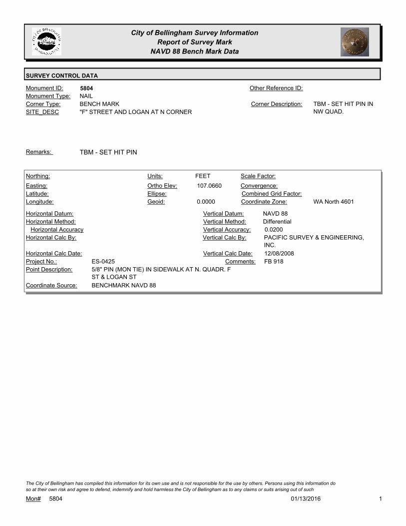
City of Bellingham Survey Information
Report of Survey Mark
NAVD 88 Bench Mark Data
SURVEY CONTROL DATA
5804Monument ID: Other Reference ID:
SITE_DESC "F" STREET AND LOGAN AT N CORNER
BENCH MARKCorner Type: TBM - SET HIT PIN IN
NW QUAD.
Corner Description:
NAILMonument Type:
TBM - SET HIT PINRemarks:
107.0660
0.0000
FEETNorthing:
Easting:
Latitude:
Longitude:
Units:
Ortho Elev:
Ellipse:
Geoid:
Scale Factor:
Convergence:
Combined Grid Factor:
WA North 4601Coordinate Zone:
Horizontal Method:
Horizontal Datum: NAVD 88Vertical Datum:
DifferentialVertical Method:
Horizontal Accuracy 0.0200Vertical Accuracy:
PACIFIC SURVEY & ENGINEERING,
INC.
Vertical Calc By:Horizontal Calc By:
ES-0425Project No.:
5/8" PIN (MON TIE) IN SIDEWALK AT N. QUADR. F
ST & LOGAN ST
Point Description:
BENCHMARK NAVD 88Coordinate Source:
FB 918Comments:
Horizontal Calc Date: 12/08/2008Vertical Calc Date:
101/13/2016Mon# 5804
The City of Bellingham has compiled this information for its own use and is not responsible for the use by others. Persons using this information do
so at their own risk and agree to defend, indemnify and hold harmless the City of Bellingham as to any claims or suits arising out of such

City of Bellingham Survey Information
Report of Survey Mark
NAVD 88 Bench Mark Data
SURVEY CONTROL DATA
5805Monument ID: Other Reference ID:
SITE_DESC "F" STREET AND KEARNEY AT N CORNER
BENCH MARKCorner Type: TBM - HIT PIN IN NW
QUAD.
Corner Description:
NAILMonument Type:
TBM - SET HIT PINRemarks:
100.6460
0.0000
FEETNorthing:
Easting:
Latitude:
Longitude:
Units:
Ortho Elev:
Ellipse:
Geoid:
Scale Factor:
Convergence:
Combined Grid Factor:
WA North 4601Coordinate Zone:
Horizontal Method:
Horizontal Datum: NAVD 88Vertical Datum:
DifferentialVertical Method:
Horizontal Accuracy 0.0200Vertical Accuracy:
PACIFIC SURVEY & ENGINEERING,
INC.
Vertical Calc By:Horizontal Calc By:
ES-0425Project No.:
5/8" PIN (MON TIE) IN SIDEWALK AT N. QUADR. F
ST & KEARNEY ST
Point Description:
BENCHMARK NAVD 88Coordinate Source:
FB 918Comments:
Horizontal Calc Date: 12/08/2008Vertical Calc Date:
101/13/2016Mon# 5805
The City of Bellingham has compiled this information for its own use and is not responsible for the use by others. Persons using this information do
so at their own risk and agree to defend, indemnify and hold harmless the City of Bellingham as to any claims or suits arising out of such

City of Bellingham Survey Information
Report of Survey Mark
NAVD 88 Bench Mark Data
SURVEY CONTROL DATA
5806Monument ID: Other Reference ID:
SITE_DESC "F" STREET AND JENKINS AT N CORNER
BENCH MARKCorner Type: TBM - HIT PIN IN NW
QUAD
Corner Description:
NAILMonument Type:
TBM - SET HIT PINRemarks:
91.2700
0.0000
FEETNorthing:
Easting:
Latitude:
Longitude:
Units:
Ortho Elev:
Ellipse:
Geoid:
Scale Factor:
Convergence:
Combined Grid Factor:
WA North 4601Coordinate Zone:
Horizontal Method:
Horizontal Datum: NAVD 88Vertical Datum:
DifferentialVertical Method:
Horizontal Accuracy 0.0200Vertical Accuracy:
PACIFIC SURVEY & ENGINEERING,
INC.
Vertical Calc By:Horizontal Calc By:
ES-0425Project No.:
5/8" PIN (MON TIE) IN SIDEWALK AT N. QUADR. F
ST & JENKINS ST
Point Description:
BENCHMARK NAVD 88Coordinate Source:
FB 918Comments:
Horizontal Calc Date: 12/08/2008Vertical Calc Date:
101/13/2016Mon# 5806
The City of Bellingham has compiled this information for its own use and is not responsible for the use by others. Persons using this information do
so at their own risk and agree to defend, indemnify and hold harmless the City of Bellingham as to any claims or suits arising out of such

City of Bellingham Survey Information
Report of Survey Mark
NAVD 88 Bench Mark Data
SURVEY CONTROL DATA
5807Monument ID: Other Reference ID:
SITE_DESC "F" STREET AND IRVING AT W CORNER
BENCH MARKCorner Type: TBM - HIT PIN IN SW
QUAD
Corner Description:
NAILMonument Type:
TBM - SET HIT PINRemarks:
77.9680
0.0000
FEETNorthing:
Easting:
Latitude:
Longitude:
Units:
Ortho Elev:
Ellipse:
Geoid:
Scale Factor:
Convergence:
Combined Grid Factor:
WA North 4601Coordinate Zone:
Horizontal Method:
Horizontal Datum: NAVD 88Vertical Datum:
DifferentialVertical Method:
Horizontal Accuracy 0.0200Vertical Accuracy:
PACIFIC SURVEY & ENGINEERING,
INC.
Vertical Calc By:Horizontal Calc By:
ES-0425Project No.:
PK NAIL IN SIDEWALK AT W. QUADR. F ST &
IRVING ST
Point Description:
BENCHMARK NAVD 88Coordinate Source:
FB 918Comments:
Horizontal Calc Date: 12/08/2008Vertical Calc Date:
101/13/2016Mon# 5807
The City of Bellingham has compiled this information for its own use and is not responsible for the use by others. Persons using this information do
so at their own risk and agree to defend, indemnify and hold harmless the City of Bellingham as to any claims or suits arising out of such

City of Bellingham Survey Information
Report of Survey Mark
NAVD 88 Bench Mark Data
SURVEY CONTROL DATA
5808Monument ID: Other Reference ID:
SITE_DESC "F" STREET AND HALLECK AT W CORNER
BENCH MARKCorner Type: TBM - LEAD PLUG IN
SW QUAD
Corner Description:
LEAD PLUG/BRASS BRADMonument Type:
TBM - LEAD PLUGRemarks:
73.3320
0.0000
FEETNorthing:
Easting:
Latitude:
Longitude:
Units:
Ortho Elev:
Ellipse:
Geoid:
Scale Factor:
Convergence:
Combined Grid Factor:
WA North 4601Coordinate Zone:
Horizontal Method:
Horizontal Datum: NAVD 88Vertical Datum:
DifferentialVertical Method:
Horizontal Accuracy 0.0200Vertical Accuracy:
PACIFIC SURVEY & ENGINEERING,
INC.
Vertical Calc By:Horizontal Calc By:
ES-0425Project No.:
LEAD/TACK IN SIDEWALK AT W. QUADR. F ST &
HALLECK ST
Point Description:
BENCHMARK NAVD 88Coordinate Source:
FB 918Comments:
Horizontal Calc Date: 12/08/2008Vertical Calc Date:
101/13/2016Mon# 5808
The City of Bellingham has compiled this information for its own use and is not responsible for the use by others. Persons using this information do
so at their own risk and agree to defend, indemnify and hold harmless the City of Bellingham as to any claims or suits arising out of such

City of Bellingham Survey Information
Report of Survey Mark
NAVD 88 Bench Mark Data
SURVEY CONTROL DATA
5809Monument ID: Other Reference ID:
SITE_DESC "F" STREET AND GIRARD AT N CORNER
BENCH MARKCorner Type: TBM - LEAD PLUG IN
NW QUAD
Corner Description:
LEAD PLUG/BRASS BRADMonument Type:
TBMRemarks:
72.3810
0.0000
FEETNorthing:
Easting:
Latitude:
Longitude:
Units:
Ortho Elev:
Ellipse:
Geoid:
Scale Factor:
Convergence:
Combined Grid Factor:
WA North 4601Coordinate Zone:
Horizontal Method:
Horizontal Datum: NAVD 88Vertical Datum:
DifferentialVertical Method:
Horizontal Accuracy 0.0200Vertical Accuracy:
PACIFIC SURVEY & ENGINEERING,
INC.
Vertical Calc By:Horizontal Calc By:
ES-0425Project No.:
LEAD/TACK IN SIDEWALK AT N. QUADR. F ST &
GIRARD ST
Point Description:
BENCHMARK NAVD 88Coordinate Source:
FB 918Comments:
Horizontal Calc Date: 12/09/2008Vertical Calc Date:
101/13/2016Mon# 5809
The City of Bellingham has compiled this information for its own use and is not responsible for the use by others. Persons using this information do
so at their own risk and agree to defend, indemnify and hold harmless the City of Bellingham as to any claims or suits arising out of such

City of Bellingham Survey Information
Report of Survey Mark
NAVD 88 Bench Mark Data
SURVEY CONTROL DATA
5812Monument ID: WSDOT BM37542-19Other Reference ID:
SITE_DESC WSDOT MON ON MT BAKER HWY & DEWEY
RD
BENCH MARKCorner Type: WSDOT BM37542-19Corner Description:
BRASS MONMonument Type:
RECESSED 7 CM BELOW SHOULDER SURFACERemarks:
199,826.5230
383,022.1840
48 47 10.775847
-122 25 31.100202
90.9470
METERSNorthing:
Easting:
Latitude:
Longitude:
Units:
Ortho Elev:
Ellipse:
Geoid:
1.0000000000Scale Factor:
-1 11 06.9Convergence:
Combined Grid Factor:
WA North 4601Coordinate Zone:
Geodetic GPSHorizontal Method:
NAD 83/07Horizontal Datum: NAVD 88Vertical Datum:
DifferentialVertical Method:
0.0200Horizontal Accuracy 0.0100Vertical Accuracy:
STATE OF WASHINGTONVertical Calc By:STATE OF WASHINGTONHorizontal Calc By:
Project No.:
BM37542-19Point Description:
WSDOTCoordinate Source:
METERSComments:
04/29/2008Horizontal Calc Date: 04/29/2008Vertical Calc Date:
101/13/2016Mon# 5812
The City of Bellingham has compiled this information for its own use and is not responsible for the use by others. Persons using this information do
so at their own risk and agree to defend, indemnify and hold harmless the City of Bellingham as to any claims or suits arising out of such

City of Bellingham Survey Information
Report of Survey Mark
NAVD 88 Bench Mark Data
SURVEY CONTROL DATA
5813Monument ID: WSDOT GP37005-49Other Reference ID:
SITE_DESC WSDOT MON AT OLD SAMISH BRIDGE
OVER I-5
TRAVERSE POINTCorner Type: WSDOT GP37005-49Corner Description:
BRASS MONMonument Type:
IN NW CONC SIDEWALKRemarks:
188,848.9000
384,713.5420
48 41 16.598442
-122 23 57.316275
168.8110
METERSNorthing:
Easting:
Latitude:
Longitude:
Units:
Ortho Elev:
Ellipse:
Geoid:
1.0000000000Scale Factor:
-1 09 57.1Convergence:
Combined Grid Factor:
WA North 4601Coordinate Zone:
Geodetic GPSHorizontal Method:
NAD 83/07Horizontal Datum: NAVD 88Vertical Datum:
DifferentialVertical Method:
0.0200Horizontal Accuracy 0.0100Vertical Accuracy:
STATE OF WASHINGTONVertical Calc By:STATE OF WASHINGTONHorizontal Calc By:
Project No.:
WSDOT GP37005-49Point Description:
WSDOTCoordinate Source:
METERSComments:
07/30/2008Horizontal Calc Date: 07/30/2008Vertical Calc Date:
101/13/2016Mon# 5813
The City of Bellingham has compiled this information for its own use and is not responsible for the use by others. Persons using this information do
so at their own risk and agree to defend, indemnify and hold harmless the City of Bellingham as to any claims or suits arising out of such
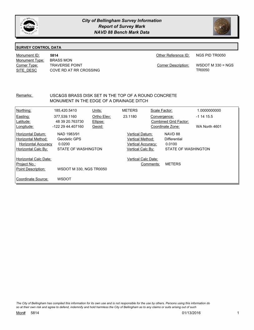
City of Bellingham Survey Information
Report of Survey Mark
NAVD 88 Bench Mark Data
SURVEY CONTROL DATA
5814Monument ID: NGS PID TR0050Other Reference ID:
SITE_DESC COVE RD AT RR CROSSING
TRAVERSE POINTCorner Type: WSDOT M 330 = NGS
TR0050
Corner Description:
BRASS MONMonument Type:
USC&GS BRASS DISK SET IN THE TOP OF A ROUND CONCRETE
MONUMENT IN THE EDGE OF A DRAINAGE DITCH
Remarks:
185,420.5410
377,539.1160
48 39 20.763730
-122 29 44.407160
23.1180
METERSNorthing:
Easting:
Latitude:
Longitude:
Units:
Ortho Elev:
Ellipse:
Geoid:
1.0000000000Scale Factor:
-1 14 15.5Convergence:
Combined Grid Factor:
WA North 4601Coordinate Zone:
Geodetic GPSHorizontal Method:
NAD 1983/91Horizontal Datum: NAVD 88Vertical Datum:
DifferentialVertical Method:
0.0200Horizontal Accuracy 0.0100Vertical Accuracy:
STATE OF WASHINGTONVertical Calc By:STATE OF WASHINGTONHorizontal Calc By:
Project No.:
WSDOT M 330, NGS TR0050Point Description:
WSDOTCoordinate Source:
METERSComments:
Horizontal Calc Date: Vertical Calc Date:
101/13/2016Mon# 5814
The City of Bellingham has compiled this information for its own use and is not responsible for the use by others. Persons using this information do
so at their own risk and agree to defend, indemnify and hold harmless the City of Bellingham as to any claims or suits arising out of such

City of Bellingham Survey Information
Report of Survey Mark
NAVD 88 Bench Mark Data
SURVEY CONTROL DATA
5815Monument ID: WSDOT BLOEDELOther Reference ID:
SITE_DESC WSDOT MONUMENT ON ELECTRIC AVE S
OF ALABAMA
TRAVERSE POINTCorner Type: WSDOT BLOEDELCorner Description:
BRASS MONMonument Type:
IN SIDEWALK NEAR SOUTHWEST CORNER OF BRIDGERemarks:
319.7190
0.0000
FEETNorthing:
Easting:
Latitude:
Longitude:
Units:
Ortho Elev:
Ellipse:
Geoid:
Scale Factor:
Convergence:
Combined Grid Factor:
WA North 4601Coordinate Zone:
Horizontal Method:
Horizontal Datum: NAVD 88Vertical Datum:
DifferentialVertical Method:
Horizontal Accuracy 0.0300Vertical Accuracy:
WILSON ENGINEERING LLC.Vertical Calc By:Horizontal Calc By:
ES-0425Project No.:
C-BDS WSDOT GPS MON BLOEDEL ID#6426Point Description:
BENCHMARK NAVD 88Coordinate Source:
FB918-8 pg. 28Comments:
Horizontal Calc Date: 02/12/2009Vertical Calc Date:
101/13/2016Mon# 5815
The City of Bellingham has compiled this information for its own use and is not responsible for the use by others. Persons using this information do
so at their own risk and agree to defend, indemnify and hold harmless the City of Bellingham as to any claims or suits arising out of such

City of Bellingham Survey Information
Report of Survey Mark
NAVD 88 Bench Mark Data
SURVEY CONTROL DATA
5829Monument ID: Other Reference ID:
SITE_DESC NE CORNER OF SUNSET & ILLINOIS AT
SIGNAL LIGHT POLE BASE
BENCH MARKCorner Type: Corner Description:
BRASS MONMonument Type:
BM SET FOR DATUM MODERNIZATION TO NAVD88Remarks:
649,236.0000
1,244,364.0000 140.7530
0.0000
FEETNorthing:
Easting:
Latitude:
Longitude:
Units:
Ortho Elev:
Ellipse:
Geoid:
Scale Factor:
Convergence:
Combined Grid Factor:
WA North 4601Coordinate Zone:
Resource GPSHorizontal Method:
NAD 83/98Horizontal Datum: NAVD 88Vertical Datum:
DifferentialVertical Method:
3.2800Horizontal Accuracy 0.0200Vertical Accuracy:
PACIFIC SURVEY & ENGINEERING,
INC.
Vertical Calc By:CITY OF BELLINGHAM/SURVEYHorizontal Calc By:
ES-0425Project No.:
C.O.B. BM AT NE QUADR. ILLINOIS ST & SUNSET
DRIVE
Point Description:
BENCHMARK NAVD 88Coordinate Source:
FB 918 NEW BM SET BY CITYComments:
12/05/2008Horizontal Calc Date: 12/09/2008Vertical Calc Date:
101/13/2016Mon# 5829
The City of Bellingham has compiled this information for its own use and is not responsible for the use by others. Persons using this information do
so at their own risk and agree to defend, indemnify and hold harmless the City of Bellingham as to any claims or suits arising out of such

City of Bellingham Survey Information
Report of Survey Mark
NAVD 88 Bench Mark Data
SURVEY CONTROL DATA
5830Monument ID: Other Reference ID:
SITE_DESC SOUTH EAST CORNER OF GRANT AND
ILLINOIS IN SIDEWALK 1 FT S OF N EDGE &
E OF RAMP
BENCH MARKCorner Type: Corner Description:
BRASS MONMonument Type:
BM SET FOR DATUM MODERNIZATION TO NAVD88Remarks:
649,146.0000
1,245,925.0000 155.6810
0.0000
FEETNorthing:
Easting:
Latitude:
Longitude:
Units:
Ortho Elev:
Ellipse:
Geoid:
Scale Factor:
Convergence:
Combined Grid Factor:
WA North 4601Coordinate Zone:
Resource GPSHorizontal Method:
NAD 83/98Horizontal Datum: NAVD 88Vertical Datum:
DifferentialVertical Method:
3.2800Horizontal Accuracy 0.0200Vertical Accuracy:
PACIFIC SURVEY & ENGINEERING,
INC.
Vertical Calc By:CITY OF BELLINGHAM/SURVEYHorizontal Calc By:
ES-0425Project No.:
C.O.B. BM AT SE QUADR. ILLINOIS ST & GRANT STPoint Description:
BENCHMARK NAVD 88Coordinate Source:
FB 918 New BM set by CityComments:
12/05/2008Horizontal Calc Date: 12/09/2008Vertical Calc Date:
101/13/2016Mon# 5830
The City of Bellingham has compiled this information for its own use and is not responsible for the use by others. Persons using this information do
so at their own risk and agree to defend, indemnify and hold harmless the City of Bellingham as to any claims or suits arising out of such

City of Bellingham Survey Information
Report of Survey Mark
NAVD 88 Bench Mark Data
SURVEY CONTROL DATA
5831Monument ID: Other Reference ID:
SITE_DESC TOP OF SANITARY LIFT STATION ON
JAMES STREET, NORTH OF WOODSTOCK
WAY
BENCH MARKCorner Type: Corner Description:
BRASS MONMonument Type:
BM SET FOR DATUM MODERNIZATION TO NAVD88Remarks:
652,002.0000
1,247,171.0000 110.9850
0.0000
FEETNorthing:
Easting:
Latitude:
Longitude:
Units:
Ortho Elev:
Ellipse:
Geoid:
Scale Factor:
Convergence:
Combined Grid Factor:
WA North 4601Coordinate Zone:
Resource GPSHorizontal Method:
NAD 83/98Horizontal Datum: NAVD 88Vertical Datum:
DifferentialVertical Method:
3.2800Horizontal Accuracy 0.0200Vertical Accuracy:
PACIFIC SURVEY & ENGINEERING,
INC.
Vertical Calc By:CITY OF BELLINGHAM/SURVEYHorizontal Calc By:
ES-0425Project No.:
C.O.B. BM IN CONC SURFACE OF SANITARY PUMP
STN, E. SIDE JAMES ST
Point Description:
BENCHMARK NAVD 88Coordinate Source:
FB 918 New BM set by CityComments:
12/05/2008Horizontal Calc Date: 12/09/2008Vertical Calc Date:
101/13/2016Mon# 5831
The City of Bellingham has compiled this information for its own use and is not responsible for the use by others. Persons using this information do
so at their own risk and agree to defend, indemnify and hold harmless the City of Bellingham as to any claims or suits arising out of such

City of Bellingham Survey Information
Report of Survey Mark
NAVD 88 Bench Mark Data
SURVEY CONTROL DATA
5832Monument ID: Other Reference ID:
SITE_DESC AT HIGH POINT OF MCLEOD ROAD (W OF
PRIMROSE LANE) IN N SIDE CURB
BENCH MARKCorner Type: Corner Description:
BRASS MONMonument Type:
BM SET FOR DATUM MODERNIZATION TO NAVD88Remarks:
654,441.0000
1,243,482.0000 135.8770
0.0000
FEETNorthing:
Easting:
Latitude:
Longitude:
Units:
Ortho Elev:
Ellipse:
Geoid:
Scale Factor:
Convergence:
Combined Grid Factor:
WA North 4601Coordinate Zone:
Resource GPSHorizontal Method:
NAD 83/98Horizontal Datum: NAVD 88Vertical Datum:
DifferentialVertical Method:
3.2800Horizontal Accuracy 0.0200Vertical Accuracy:
PACIFIC SURVEY & ENGINEERING,
INC.
Vertical Calc By:CITY OF BELLINGHAM/SURVEYHorizontal Calc By:
ES-0425Project No.:
C.O.B. BM IN CURB ON N. SIDE E. MCLEOD RDPoint Description:
BENCHMARK NAVD 88Coordinate Source:
FB 918 New BM set by CityComments:
12/05/2008Horizontal Calc Date: 12/09/2008Vertical Calc Date:
101/13/2016Mon# 5832
The City of Bellingham has compiled this information for its own use and is not responsible for the use by others. Persons using this information do
so at their own risk and agree to defend, indemnify and hold harmless the City of Bellingham as to any claims or suits arising out of such
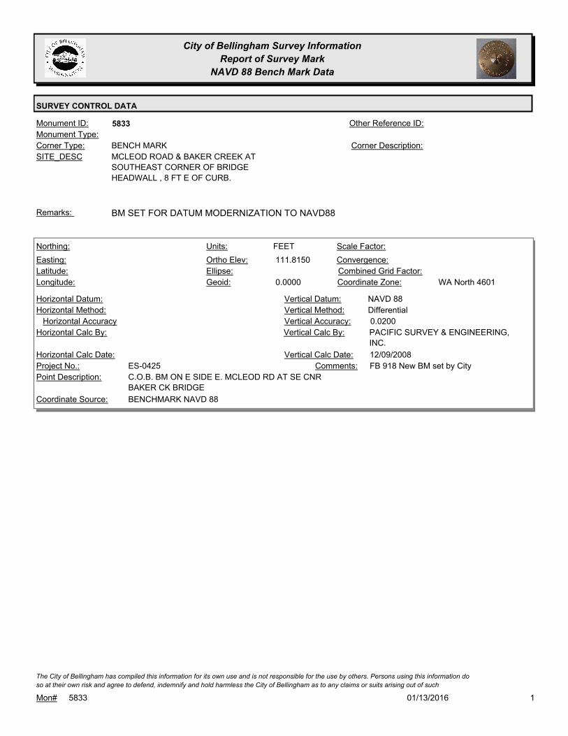
City of Bellingham Survey Information
Report of Survey Mark
NAVD 88 Bench Mark Data
SURVEY CONTROL DATA
5833Monument ID: Other Reference ID:
SITE_DESC MCLEOD ROAD & BAKER CREEK AT
SOUTHEAST CORNER OF BRIDGE
HEADWALL , 8 FT E OF CURB.
BENCH MARKCorner Type: Corner Description:
Monument Type:
BM SET FOR DATUM MODERNIZATION TO NAVD88Remarks:
111.8150
0.0000
FEETNorthing:
Easting:
Latitude:
Longitude:
Units:
Ortho Elev:
Ellipse:
Geoid:
Scale Factor:
Convergence:
Combined Grid Factor:
WA North 4601Coordinate Zone:
Horizontal Method:
Horizontal Datum: NAVD 88Vertical Datum:
DifferentialVertical Method:
Horizontal Accuracy 0.0200Vertical Accuracy:
PACIFIC SURVEY & ENGINEERING,
INC.
Vertical Calc By:Horizontal Calc By:
ES-0425Project No.:
C.O.B. BM ON E SIDE E. MCLEOD RD AT SE CNR
BAKER CK BRIDGE
Point Description:
BENCHMARK NAVD 88Coordinate Source:
FB 918 New BM set by CityComments:
Horizontal Calc Date: 12/09/2008Vertical Calc Date:
101/13/2016Mon# 5833
The City of Bellingham has compiled this information for its own use and is not responsible for the use by others. Persons using this information do
so at their own risk and agree to defend, indemnify and hold harmless the City of Bellingham as to any claims or suits arising out of such

City of Bellingham Survey Information
Report of Survey Mark
NAVD 88 Bench Mark Data
SURVEY CONTROL DATA
5834Monument ID: Other Reference ID:
SITE_DESC IN CONC BASE OF SIGNAL LIGHT POLE AT
NORTHEAST CORNER OF MERIDIAN AND
TELEGRAPH
BENCH MARKCorner Type: Corner Description:
BRASS MONMonument Type:
BM SET FOR DATUM MODERNIZATION TO NAVD88Remarks:
655,235.0000
1,242,005.0000 114.4100
0.0000
FEETNorthing:
Easting:
Latitude:
Longitude:
Units:
Ortho Elev:
Ellipse:
Geoid:
Scale Factor:
Convergence:
Combined Grid Factor:
WA North 4601Coordinate Zone:
Resource GPSHorizontal Method:
NAD 83/98Horizontal Datum: NAVD 88Vertical Datum:
DifferentialVertical Method:
3.2800Horizontal Accuracy 0.0200Vertical Accuracy:
PACIFIC SURVEY & ENGINEERING,
INC.
Vertical Calc By:CITY OF BELLINGHAM/SURVEYHorizontal Calc By:
ES-0425Project No.:
C.O.B. BM AT NE QUADR. TELEGRAPH RD &
MERIDIAN ST
Point Description:
BENCHMARK NAVD 88Coordinate Source:
FB 918 New BM set by CityComments:
12/05/2008Horizontal Calc Date: 12/10/2008Vertical Calc Date:
101/13/2016Mon# 5834
The City of Bellingham has compiled this information for its own use and is not responsible for the use by others. Persons using this information do
so at their own risk and agree to defend, indemnify and hold harmless the City of Bellingham as to any claims or suits arising out of such

City of Bellingham Survey Information
Report of Survey Mark
NAVD 88 Bench Mark Data
SURVEY CONTROL DATA
5835Monument ID: Other Reference ID:
SITE_DESC NORTHEAST CURB AT ORCHARD AND
MERIDIAN
BENCH MARKCorner Type: Corner Description:
BRASS MONMonument Type:
BM SET FOR DATUM MODERNIZATION TO NAVD88Remarks:
653,225.0000
1,241,954.0000 99.7050
0.0000
FEETNorthing:
Easting:
Latitude:
Longitude:
Units:
Ortho Elev:
Ellipse:
Geoid:
Scale Factor:
Convergence:
Combined Grid Factor:
WA North 4601Coordinate Zone:
Resource GPSHorizontal Method:
NAD 83/98Horizontal Datum: NAVD 88Vertical Datum:
DifferentialVertical Method:
3.2800Horizontal Accuracy 0.0200Vertical Accuracy:
PACIFIC SURVEY & ENGINEERING,
INC.
Vertical Calc By:CITY OF BELLINGHAM/SURVEYHorizontal Calc By:
ES-0425Project No.:
C.O.B. BM AT NE QUADR. ORCHARD DRV &
MERIDIAN ST
Point Description:
BENCHMARK NAVD 88Coordinate Source:
FB 918 New BM set by CityComments:
12/05/2008Horizontal Calc Date: 12/31/2008Vertical Calc Date:
101/13/2016Mon# 5835
The City of Bellingham has compiled this information for its own use and is not responsible for the use by others. Persons using this information do
so at their own risk and agree to defend, indemnify and hold harmless the City of Bellingham as to any claims or suits arising out of such
City of Bellingham Survey Information
Report of Survey Mark
NAVD 88 Bench Mark Data
SURVEY CONTROL DATA
5836Monument ID: Other Reference ID:
SITE_DESC W SIDE OF ORCHARD PL ON NW
CONCRETE HEADWALL N OF RAILROAD
TRACKS. 270 FT S OF OCHARD DR.
BENCH MARKCorner Type: Corner Description:
BRASS MONMonument Type:
BM SET FOR DATUM MODERNIZATION TO NAVD88Remarks:
652,882.0000
1,243,238.0000 95.9670
0.0000
FEETNorthing:
Easting:
Latitude:
Longitude:
Units:
Ortho Elev:
Ellipse:
Geoid:
Scale Factor:
Convergence:
Combined Grid Factor:
WA North 4601Coordinate Zone:
Resource GPSHorizontal Method:
NAD 83/98Horizontal Datum: NAVD 88Vertical Datum:
DifferentialVertical Method:
3.2800Horizontal Accuracy 0.0200Vertical Accuracy:
PACIFIC SURVEY & ENGINEERING,
INC.
Vertical Calc By:CITY OF BELLINGHAM/SURVEYHorizontal Calc By:
ES-0425Project No.:
C.O.B. BM ON W.SIDE ORCHARD PL, APPROX. 270'
S. OF W.ORCHARD DR
Point Description:
BENCHMARK NAVD 88Coordinate Source:
FB 918 New BM set by CityComments:
12/05/2008Horizontal Calc Date: 12/10/2008Vertical Calc Date:
101/13/2016Mon# 5836
The City of Bellingham has compiled this information for its own use and is not responsible for the use by others. Persons using this information do
so at their own risk and agree to defend, indemnify and hold harmless the City of Bellingham as to any claims or suits arising out of such

City of Bellingham Survey Information
Report of Survey Mark
NAVD 88 Bench Mark Data
SURVEY CONTROL DATA
5837Monument ID: Other Reference ID:
SITE_DESC MERIDIAN & SQUALICUM CREEK IN THE
NORTHWEST HEADWALL AT SQUALICUM
CREEK
BENCH MARKCorner Type: Corner Description:
BRASS MONMonument Type:
BM SET FOR DATUM MODERNIZATION TO NAVD88Remarks:
652,021.0000
1,241,855.0000 92.3320
0.0000
FEETNorthing:
Easting:
Latitude:
Longitude:
Units:
Ortho Elev:
Ellipse:
Geoid:
Scale Factor:
Convergence:
Combined Grid Factor:
WA North 4601Coordinate Zone:
Resource GPSHorizontal Method:
NAD 83/98Horizontal Datum: NAVD 88Vertical Datum:
DifferentialVertical Method:
3.2800Horizontal Accuracy 0.0200Vertical Accuracy:
PACIFIC SURVEY & ENGINEERING,
INC.
Vertical Calc By:CITY OF BELLINGHAM/SURVEYHorizontal Calc By:
ES-0425Project No.:
C.O.B.BM ON W. SIDE MERIDIAN ST AT NW CNR
SQUALICUM CK BRIDGE
Point Description:
BENCHMARK NAVD 88Coordinate Source:
FB 918 New BM set by CityComments:
12/05/2008Horizontal Calc Date: 12/10/2008Vertical Calc Date:
101/13/2016Mon# 5837
The City of Bellingham has compiled this information for its own use and is not responsible for the use by others. Persons using this information do
so at their own risk and agree to defend, indemnify and hold harmless the City of Bellingham as to any claims or suits arising out of such

City of Bellingham Survey Information
Report of Survey Mark
NAVD 88 Bench Mark Data
SURVEY CONTROL DATA
5838Monument ID: Other Reference ID:
SITE_DESC ILLINOIS AND VALLETTE IN SOUTHEAST
CURB
BENCH MARKCorner Type: Corner Description:
BRASS MONMonument Type:
BM SET FOR DATUM MODERNIZATION TO NAVD88Remarks:
649,249.0000
1,242,420.0000 85.2570
0.0000
FEETNorthing:
Easting:
Latitude:
Longitude:
Units:
Ortho Elev:
Ellipse:
Geoid:
Scale Factor:
Convergence:
Combined Grid Factor:
WA North 4601Coordinate Zone:
Resource GPSHorizontal Method:
NAD 83/98Horizontal Datum: NAVD 88Vertical Datum:
DifferentialVertical Method:
3.2800Horizontal Accuracy 0.0200Vertical Accuracy:
PACIFIC SURVEY & ENGINEERING,
INC.
Vertical Calc By:CITY OF BELLINGHAM/SURVEYHorizontal Calc By:
ES-0425Project No.:
C.O.B. BM IN CURB AT SE QUADR. W. ILLINOIS ST
& VALLETTE ST
Point Description:
BENCHMARK NAVD 88Coordinate Source:
FB 918 New BM set by CityComments:
12/05/2008Horizontal Calc Date: 01/02/2009Vertical Calc Date:
101/13/2016Mon# 5838
The City of Bellingham has compiled this information for its own use and is not responsible for the use by others. Persons using this information do
so at their own risk and agree to defend, indemnify and hold harmless the City of Bellingham as to any claims or suits arising out of such

City of Bellingham Survey Information
Report of Survey Mark
NAVD 88 Bench Mark Data
SURVEY CONTROL DATA
5839Monument ID: Other Reference ID:
SITE_DESC S OF INTERSECTION MORRIS & I STREET
AND WEST NORTH ST IN CURB
BENCH MARKCorner Type: Corner Description:
BRASS MONMonument Type:
BM SET FOR DATUM MODERNIZATION TO NAVD88Remarks:
647,808.0000
1,243,620.0000 108.5770
0.0000
FEETNorthing:
Easting:
Latitude:
Longitude:
Units:
Ortho Elev:
Ellipse:
Geoid:
Scale Factor:
Convergence:
Combined Grid Factor:
WA North 4601Coordinate Zone:
Resource GPSHorizontal Method:
NAD 83/98Horizontal Datum: NAVD 88Vertical Datum:
DifferentialVertical Method:
3.2800Horizontal Accuracy 0.0200Vertical Accuracy:
PACIFIC SURVEY & ENGINEERING,
INC.
Vertical Calc By:CITY OF BELLINGHAM/SURVEYHorizontal Calc By:
ES-0425Project No.:
C.O.B. BM IN CURB S. IF INT. MORRIS ST & "I" STPoint Description:
BENCHMARK NAVD 88Coordinate Source:
FB 918 New BM set by CityComments:
12/05/2008Horizontal Calc Date: 01/02/2009Vertical Calc Date:
101/13/2016Mon# 5839
The City of Bellingham has compiled this information for its own use and is not responsible for the use by others. Persons using this information do
so at their own risk and agree to defend, indemnify and hold harmless the City of Bellingham as to any claims or suits arising out of such

City of Bellingham Survey Information
Report of Survey Mark
NAVD 88 Bench Mark Data
SURVEY CONTROL DATA
5840Monument ID: Other Reference ID:
SITE_DESC ON BROADWAY S OF WEST NORTH
STREET IN CENTER ISLAND CURB
BENCH MARKCorner Type: Corner Description:
BRASS MONMonument Type:
BM SET FOR DATUM MODERNIZATION TO NAVD88Remarks:
647,863.0000
1,242,881.0000 95.5160
0.0000
FEETNorthing:
Easting:
Latitude:
Longitude:
Units:
Ortho Elev:
Ellipse:
Geoid:
Scale Factor:
Convergence:
Combined Grid Factor:
WA North 4601Coordinate Zone:
Resource GPSHorizontal Method:
NAD 83/98Horizontal Datum: NAVD 88Vertical Datum:
DifferentialVertical Method:
3.2800Horizontal Accuracy 0.0200Vertical Accuracy:
PACIFIC SURVEY & ENGINEERING,
INC.
Vertical Calc By:CITY OF BELLINGHAM/SURVEYHorizontal Calc By:
ES-0425Project No.:
C.O.B. BM IN CURB AT N. END OF CENTER ISLAND
AT INT W. NORTH ST & BROADWAY
Point Description:
BENCHMARK NAVD 88Coordinate Source:
FB 918 New BM set by CityComments:
12/05/2008Horizontal Calc Date: 12/11/2008Vertical Calc Date:
101/13/2016Mon# 5840
The City of Bellingham has compiled this information for its own use and is not responsible for the use by others. Persons using this information do
so at their own risk and agree to defend, indemnify and hold harmless the City of Bellingham as to any claims or suits arising out of such

City of Bellingham Survey Information
Report of Survey Mark
NAVD 88 Bench Mark Data
SURVEY CONTROL DATA
5841Monument ID: Other Reference ID:
SITE_DESC MERIDIAN AND WEST NORTH STREET IN
LIGHT POLE BASE AT NORTHEAST
CORNER
BENCH MARKCorner Type: Corner Description:
BRASS MONMonument Type:
BM SET FOR DATUM MODERNIZATION TO NAVD88Remarks:
647,934.0000
1,241,836.0000 79.7040
0.0000
FEETNorthing:
Easting:
Latitude:
Longitude:
Units:
Ortho Elev:
Ellipse:
Geoid:
Scale Factor:
Convergence:
Combined Grid Factor:
WA North 4601Coordinate Zone:
Resource GPSHorizontal Method:
NAD 83/98Horizontal Datum: NAVD 88Vertical Datum:
DifferentialVertical Method:
3.2800Horizontal Accuracy 0.0200Vertical Accuracy:
PACIFIC SURVEY & ENGINEERING,
INC.
Vertical Calc By:CITY OF BELLINGHAM/SURVEYHorizontal Calc By:
ES-0425Project No.:
C.O.B. BM IN SIDEWALK AT NE QUADR. W. NORTH
ST & MERIDIAN ST
Point Description:
BENCHMARK NAVD 88Coordinate Source:
FB 918 New BM set by CityComments:
12/05/2008Horizontal Calc Date: 12/11/2008Vertical Calc Date:
101/13/2016Mon# 5841
The City of Bellingham has compiled this information for its own use and is not responsible for the use by others. Persons using this information do
so at their own risk and agree to defend, indemnify and hold harmless the City of Bellingham as to any claims or suits arising out of such

City of Bellingham Survey Information
Report of Survey Mark
NAVD 88 Bench Mark Data
SURVEY CONTROL DATA
5842Monument ID: Other Reference ID:
SITE_DESC AT BROADWAY AND MERIDIAN AND
GIRARD NEAR EAST SIGNAL LIGHT POLE
BENCH MARKCorner Type: Corner Description:
BRASS MONMonument Type:
BM SET FOR DATUM MODERNIZATION TO NAVD88Remarks:
646,790.0000
1,241,831.0000 76.6560
0.0000
FEETNorthing:
Easting:
Latitude:
Longitude:
Units:
Ortho Elev:
Ellipse:
Geoid:
Scale Factor:
Convergence:
Combined Grid Factor:
WA North 4601Coordinate Zone:
Resource GPSHorizontal Method:
NAD 83/98Horizontal Datum: NAVD 88Vertical Datum:
DifferentialVertical Method:
3.2800Horizontal Accuracy 0.0200Vertical Accuracy:
PACIFIC SURVEY & ENGINEERING,
INC.
Vertical Calc By:CITY OF BELLINGHAM/SURVEYHorizontal Calc By:
ES-0425Project No.:
C.O.B. BM IN SIDEWALK AT SE QUADR. GIRARD ST
& BROADWAY
Point Description:
BENCHMARK NAVD 88Coordinate Source:
FB 918 New BM set by CityComments:
12/05/2008Horizontal Calc Date: 01/06/2009Vertical Calc Date:
101/13/2016Mon# 5842
The City of Bellingham has compiled this information for its own use and is not responsible for the use by others. Persons using this information do
so at their own risk and agree to defend, indemnify and hold harmless the City of Bellingham as to any claims or suits arising out of such

City of Bellingham Survey Information
Report of Survey Mark
NAVD 88 Bench Mark Data
SURVEY CONTROL DATA
5843Monument ID: Other Reference ID:
SITE_DESC ILLINOIS AND WALNUT STREET AT SE
CORNER IN TOP OF CURB
BENCH MARKCorner Type: Corner Description:
BRASS MONMonument Type:
BM SET FOR DATUM MODERNIZATION TO NAVD88Remarks:
649,299.0000
1,240,490.0000 81.2400
0.0000
FEETNorthing:
Easting:
Latitude:
Longitude:
Units:
Ortho Elev:
Ellipse:
Geoid:
Scale Factor:
Convergence:
Combined Grid Factor:
WA North 4601Coordinate Zone:
Resource GPSHorizontal Method:
NAD 83/98Horizontal Datum: NAVD 88Vertical Datum:
DifferentialVertical Method:
3.2800Horizontal Accuracy 0.0200Vertical Accuracy:
PACIFIC SURVEY & ENGINEERING,
INC.
Vertical Calc By:CITY OF BELLINGHAM/SURVEYHorizontal Calc By:
ES-0425Project No.:
C.O.B. BM IN CURB AT SE QUADR W. ILLINOIS ST &
WALNUT ST
Point Description:
BENCHMARK NAVD 88Coordinate Source:
FB 918 New BM set by CityComments:
12/05/2008Horizontal Calc Date: 12/31/2008Vertical Calc Date:
101/13/2016Mon# 5843
The City of Bellingham has compiled this information for its own use and is not responsible for the use by others. Persons using this information do
so at their own risk and agree to defend, indemnify and hold harmless the City of Bellingham as to any claims or suits arising out of such

City of Bellingham Survey Information
Report of Survey Mark
NAVD 88 Bench Mark Data
SURVEY CONTROL DATA
5844Monument ID: Other Reference ID:
SITE_DESC W ILLINOIS STREET AT LYNN ST IN TOP OF
CURB ON WEST SIDE
BENCH MARKCorner Type: Corner Description:
BRASS MONMonument Type:
BM SET FOR DATUM MODERNIZATION TO NAVD88Remarks:
649,351.0000
1,239,325.0000 75.9800
0.0000
FEETNorthing:
Easting:
Latitude:
Longitude:
Units:
Ortho Elev:
Ellipse:
Geoid:
Scale Factor:
Convergence:
Combined Grid Factor:
WA North 4601Coordinate Zone:
Resource GPSHorizontal Method:
NAD 83/98Horizontal Datum: NAVD 88Vertical Datum:
DifferentialVertical Method:
3.2800Horizontal Accuracy 0.0200Vertical Accuracy:
PACIFIC SURVEY & ENGINEERING,
INC.
Vertical Calc By:CITY OF BELLINGHAM/SURVEYHorizontal Calc By:
ES-0425Project No.:
C.O.B. BM IN CURB W. OF INT. ILLINOIS ST & LYNN
ST
Point Description:
BENCHMARK NAVD 88Coordinate Source:
FB 918 New BM set by CityComments:
12/05/2008Horizontal Calc Date: 12/31/2008Vertical Calc Date:
101/13/2016Mon# 5844
The City of Bellingham has compiled this information for its own use and is not responsible for the use by others. Persons using this information do
so at their own risk and agree to defend, indemnify and hold harmless the City of Bellingham as to any claims or suits arising out of such
City of Bellingham Survey Information
Report of Survey Mark
NAVD 88 Bench Mark Data
SURVEY CONTROL DATA
5845Monument ID: Other Reference ID:
SITE_DESC VICTOR AND W NORTH STREET AT NE
CORNER IN TOP OF CURB
BENCH MARKCorner Type: Corner Description:
BRASS MONMonument Type:
BM SET FOR DATUM MODERNIZATION TO NAVD88Remarks:
647,979.0000
1,239,617.0000 77.0520
0.0000
FEETNorthing:
Easting:
Latitude:
Longitude:
Units:
Ortho Elev:
Ellipse:
Geoid:
Scale Factor:
Convergence:
Combined Grid Factor:
WA North 4601Coordinate Zone:
Resource GPSHorizontal Method:
NAD 83/98Horizontal Datum: NAVD 88Vertical Datum:
DifferentialVertical Method:
3.2800Horizontal Accuracy 0.0200Vertical Accuracy:
PACIFIC SURVEY & ENGINEERING,
INC.
Vertical Calc By:CITY OF BELLINGHAM/SURVEYHorizontal Calc By:
ES-0425Project No.:
C.O.B. BM IN CURB AT NE QUADR. W. NORTH ST &
VICTOR ST
Point Description:
BENCHMARK NAVD 88Coordinate Source:
FB 918 New BM set by CityComments:
12/05/2008Horizontal Calc Date: 12/31/2008Vertical Calc Date:
101/13/2016Mon# 5845
The City of Bellingham has compiled this information for its own use and is not responsible for the use by others. Persons using this information do
so at their own risk and agree to defend, indemnify and hold harmless the City of Bellingham as to any claims or suits arising out of such

City of Bellingham Survey Information
Report of Survey Mark
NAVD 88 Bench Mark Data
SURVEY CONTROL DATA
5846Monument ID: Other Reference ID:
SITE_DESC SOUTHWEST CORNER OF VICTOR AND
WASHINGTON IN TOP OF CURB
BENCH MARKCorner Type: Corner Description:
BRASS MONMonument Type:
BM SET FOR DATUM MODERNIZATION TO NAVD88Remarks:
646,569.0000
1,239,549.0000 71.8440
0.0000
FEETNorthing:
Easting:
Latitude:
Longitude:
Units:
Ortho Elev:
Ellipse:
Geoid:
Scale Factor:
Convergence:
Combined Grid Factor:
WA North 4601Coordinate Zone:
Resource GPSHorizontal Method:
NAD 83/98Horizontal Datum: NAVD 88Vertical Datum:
DifferentialVertical Method:
3.2800Horizontal Accuracy 0.0200Vertical Accuracy:
PACIFIC SURVEY & ENGINEERING,
INC.
Vertical Calc By:CITY OF BELLINGHAM/SURVEYHorizontal Calc By:
ES-0425Project No.:
C.O.B. BM IN CURB AT SW QUADR. WASHINGTON
ST & VICTOR ST
Point Description:
BENCHMARK NAVD 88Coordinate Source:
FB 918 New BM set by CityComments:
12/05/2008Horizontal Calc Date: 12/11/2008Vertical Calc Date:
101/13/2016Mon# 5846
The City of Bellingham has compiled this information for its own use and is not responsible for the use by others. Persons using this information do
so at their own risk and agree to defend, indemnify and hold harmless the City of Bellingham as to any claims or suits arising out of such

City of Bellingham Survey Information
Report of Survey Mark
NAVD 88 Bench Mark Data
SURVEY CONTROL DATA
5847Monument ID: Other Reference ID:
SITE_DESC SOUTHEAST CORNER OF WASHINGTON
AND WEST AT TOP OF CURB
BENCH MARKCorner Type: Corner Description:
BRASS MONMonument Type:
BM SET FOR DATUM MODERNIZATION TO NAVD88Remarks:
646,596.0000
1,238,521.0000 69.8660
0.0000
FEETNorthing:
Easting:
Latitude:
Longitude:
Units:
Ortho Elev:
Ellipse:
Geoid:
Scale Factor:
Convergence:
Combined Grid Factor:
WA North 4601Coordinate Zone:
Resource GPSHorizontal Method:
NAD 83/98Horizontal Datum: NAVD 88Vertical Datum:
DifferentialVertical Method:
3.2800Horizontal Accuracy 0.0200Vertical Accuracy:
PACIFIC SURVEY & ENGINEERING,
INC.
Vertical Calc By:CITY OF BELLINGHAM/SURVEYHorizontal Calc By:
ES-0425Project No.:
C.O.B. BM IN CURB AT S. QUADR. WEST ST &
WASHINGTON ST
Point Description:
BENCHMARK NAVD 88Coordinate Source:
FB 918 New BM set by CityComments:
12/05/2008Horizontal Calc Date: 12/11/2008Vertical Calc Date:
101/13/2016Mon# 5847
The City of Bellingham has compiled this information for its own use and is not responsible for the use by others. Persons using this information do
so at their own risk and agree to defend, indemnify and hold harmless the City of Bellingham as to any claims or suits arising out of such

City of Bellingham Survey Information
Report of Survey Mark
NAVD 88 Bench Mark Data
SURVEY CONTROL DATA
5848Monument ID: Other Reference ID:
SITE_DESC ELDRIDGE AVE BRIDGE OVER LITTLE
SQUALICUM CREEK IN TOP OF HEADWALL
AT NW END
BENCH MARKCorner Type: Corner Description:
BRASS MONMonument Type:
BM SET FOR DATUM MODERNIZATION TO NAVD88Remarks:
647,517.0000
1,236,350.0000 67.4190
0.0000
FEETNorthing:
Easting:
Latitude:
Longitude:
Units:
Ortho Elev:
Ellipse:
Geoid:
Scale Factor:
Convergence:
Combined Grid Factor:
WA North 4601Coordinate Zone:
Resource GPSHorizontal Method:
NAD 83/98Horizontal Datum: NAVD 88Vertical Datum:
DifferentialVertical Method:
3.2800Horizontal Accuracy 0.0200Vertical Accuracy:
PACIFIC SURVEY & ENGINEERING,
INC.
Vertical Calc By:CITY OF BELLINGHAM/SURVEYHorizontal Calc By:
ES-0425Project No.:
C.O.B. BM ON W. SIDE AVE / IN W CNR BRIDGE
OVER SQUALICUM PKWY
Point Description:
BENCHMARK NAVD 88Coordinate Source:
FB 918 New BM set by CityComments:
12/05/2008Horizontal Calc Date: 12/12/2008Vertical Calc Date:
101/13/2016Mon# 5848
The City of Bellingham has compiled this information for its own use and is not responsible for the use by others. Persons using this information do
so at their own risk and agree to defend, indemnify and hold harmless the City of Bellingham as to any claims or suits arising out of such

City of Bellingham Survey Information
Report of Survey Mark
NAVD 88 Bench Mark Data
SURVEY CONTROL DATA
5849Monument ID: Other Reference ID:
SITE_DESC PATT0N AND WEST ILLINOIS AT
NORTHEAST CORNER IN LAWN
BENCH MARKCorner Type: Corner Description:
BRASS MONMonument Type:
BM SET FOR DATUM MODERNIZATION TO NAVD88Remarks:
649,489.0000
1,596,770.0000 70.4610
0.0000
FEETNorthing:
Easting:
Latitude:
Longitude:
Units:
Ortho Elev:
Ellipse:
Geoid:
Scale Factor:
Convergence:
Combined Grid Factor:
WA North 4601Coordinate Zone:
Resource GPSHorizontal Method:
NAD 83/98Horizontal Datum: NAVD 88Vertical Datum:
DifferentialVertical Method:
3.2800Horizontal Accuracy 0.0200Vertical Accuracy:
PACIFIC SURVEY & ENGINEERING,
INC.
Vertical Calc By:CITY OF BELLINGHAM/SURVEYHorizontal Calc By:
ES-0425Project No.:
C.O.B. BM IN CONC IN LAWN AT NE QUADR W.
ILLINOIS ST & PATTON ST
Point Description:
BENCHMARK NAVD 88Coordinate Source:
FB 918 New BM set by CityComments:
01/08/2009Horizontal Calc Date: 12/12/2008Vertical Calc Date:
101/13/2016Mon# 5849
The City of Bellingham has compiled this information for its own use and is not responsible for the use by others. Persons using this information do
so at their own risk and agree to defend, indemnify and hold harmless the City of Bellingham as to any claims or suits arising out of such

City of Bellingham Survey Information
Report of Survey Mark
NAVD 88 Bench Mark Data
SURVEY CONTROL DATA
5850Monument ID: Other Reference ID:
SITE_DESC ENTRANCE TO BIRCHWOOD PARK S OF
CEDARWOOD AVE IN CONC PATH
BENCH MARKCorner Type: Corner Description:
BRASS MONMonument Type:
BM SET FOR DATUM MODERNIZATION TO NAVD88Remarks:
650,487.0000
1,238,412.0000 79.4080
0.0000
FEETNorthing:
Easting:
Latitude:
Longitude:
Units:
Ortho Elev:
Ellipse:
Geoid:
Scale Factor:
Convergence:
Combined Grid Factor:
WA North 4601Coordinate Zone:
Resource GPSHorizontal Method:
NAD 83/98Horizontal Datum: NAVD 88Vertical Datum:
DifferentialVertical Method:
3.2800Horizontal Accuracy 0.0200Vertical Accuracy:
PACIFIC SURVEY & ENGINEERING,
INC.
Vertical Calc By:CITY OF BELLINGHAM/SURVEYHorizontal Calc By:
ES-0425Project No.:
C.O.B. BM AT ENTRANCE TO BIRCHWOOD PARK
(S. OF CEDARWOOD AVE)
Point Description:
BENCHMARK NAVD 88Coordinate Source:
FB 918 New BM set by CityComments:
12/05/2008Horizontal Calc Date: 01/06/2009Vertical Calc Date:
101/13/2016Mon# 5850
The City of Bellingham has compiled this information for its own use and is not responsible for the use by others. Persons using this information do
so at their own risk and agree to defend, indemnify and hold harmless the City of Bellingham as to any claims or suits arising out of such

City of Bellingham Survey Information
Report of Survey Mark
NAVD 88 Bench Mark Data
SURVEY CONTROL DATA
5851Monument ID: Other Reference ID:
SITE_DESC PINEWOOD AVE N OF BIRCHWOOD IN SW
CORNER CONCRETE DELIVERY DRIVEWAY
AT BIRCHWOOD ELEMENTARY SCHOOL
BENCH MARKCorner Type: Corner Description:
BRASS MONMonument Type:
BM SET FOR DATUM MODERNIZATION TO NAVD88Remarks:
651,844.0000
1,236,952.0000 82.6500
0.0000
FEETNorthing:
Easting:
Latitude:
Longitude:
Units:
Ortho Elev:
Ellipse:
Geoid:
Scale Factor:
Convergence:
Combined Grid Factor:
WA North 4601Coordinate Zone:
Resource GPSHorizontal Method:
NAD 83/98Horizontal Datum: NAVD 88Vertical Datum:
DifferentialVertical Method:
3.2800Horizontal Accuracy 0.0200Vertical Accuracy:
PACIFIC SURVEY & ENGINEERING,
INC.
Vertical Calc By:CITY OF BELLINGHAM/SURVEYHorizontal Calc By:
ES-0425Project No.:
C.O.B. BM IN CONC PANEL ON E. SIDE PINEWOOD
AVE, AT BIRCHWOOD ELEMENTARY SCHOOL
Point Description:
BENCHMARK NAVD 88Coordinate Source:
FB 918 New BM set by CityComments:
12/05/2008Horizontal Calc Date: 01/05/2009Vertical Calc Date:
101/13/2016Mon# 5851
The City of Bellingham has compiled this information for its own use and is not responsible for the use by others. Persons using this information do
so at their own risk and agree to defend, indemnify and hold harmless the City of Bellingham as to any claims or suits arising out of such
City of Bellingham Survey Information
Report of Survey Mark
NAVD 88 Bench Mark Data
SURVEY CONTROL DATA
5852Monument ID: Other Reference ID:
SITE_DESC TOP OF CURB ON W SIDE OF MAPLEWOOD
AVE, 120 FT S OF ALDERWOOD
BENCH MARKCorner Type: Corner Description:
BRASS MONMonument Type:
BM SET FOR DATUM MODERNIZATION TO NAVD88Remarks:
653,531.0000
1,236,899.0000 104.8570
0.0000
FEETNorthing:
Easting:
Latitude:
Longitude:
Units:
Ortho Elev:
Ellipse:
Geoid:
Scale Factor:
Convergence:
Combined Grid Factor:
WA North 4601Coordinate Zone:
Resource GPSHorizontal Method:
NAD 83/98Horizontal Datum: NAVD 88Vertical Datum:
DifferentialVertical Method:
3.2800Horizontal Accuracy 0.0200Vertical Accuracy:
PACIFIC SURVEY & ENGINEERING,
INC.
Vertical Calc By:CITY OF BELLINGHAM/SURVEYHorizontal Calc By:
ES-0425Project No.:
C.O.B. BM IN CURB ON W. SIDE MAPLEWOOD AVE,
APPROX 120' S. OF ALDERWOOD AVE
Point Description:
BENCHMARK NAVD 88Coordinate Source:
FB 918 New BM set by CityComments:
12/05/2008Horizontal Calc Date: 12/29/2008Vertical Calc Date:
101/13/2016Mon# 5852
The City of Bellingham has compiled this information for its own use and is not responsible for the use by others. Persons using this information do
so at their own risk and agree to defend, indemnify and hold harmless the City of Bellingham as to any claims or suits arising out of such

City of Bellingham Survey Information
Report of Survey Mark
NAVD 88 Bench Mark Data
SURVEY CONTROL DATA
5853Monument ID: Other Reference ID:
SITE_DESC MAPLEWOOD & MCLEOD AT NORTHWEST
CORNER IN BASE OF UTILITY VAULT
BENCH MARKCorner Type: Corner Description:
BRASS MONMonument Type:
BM SET FOR DATUM MODERNIZATION TO NAVD88Remarks:
654,661.0000
1,235,842.0000 144.0690
0.0000
FEETNorthing:
Easting:
Latitude:
Longitude:
Units:
Ortho Elev:
Ellipse:
Geoid:
Scale Factor:
Convergence:
Combined Grid Factor:
WA North 4601Coordinate Zone:
Resource GPSHorizontal Method:
NAD 83/98Horizontal Datum: NAVD 88Vertical Datum:
DifferentialVertical Method:
3.2800Horizontal Accuracy 0.0200Vertical Accuracy:
PACIFIC SURVEY & ENGINEERING,
INC.
Vertical Calc By:CITY OF BELLINGHAM/SURVEYHorizontal Calc By:
ES-0425Project No.:
C.O.B. BM IN BASE OF ELEC. BOX AT NW QUADR
MCLEOD RD & W. MAPLEWOOD AVE
Point Description:
BENCHMARK NAVD 88Coordinate Source:
FB 918 New BM set by CityComments:
12/05/2008Horizontal Calc Date: 12/29/2008Vertical Calc Date:
101/13/2016Mon# 5853
The City of Bellingham has compiled this information for its own use and is not responsible for the use by others. Persons using this information do
so at their own risk and agree to defend, indemnify and hold harmless the City of Bellingham as to any claims or suits arising out of such

City of Bellingham Survey Information
Report of Survey Mark
NAVD 88 Bench Mark Data
SURVEY CONTROL DATA
5854Monument ID: Other Reference ID:
SITE_DESC AT NORTH END OF CURB ON EAST SIDE
OF W MAPLEWOOD AVE, APPROX 200 FT
NORTH OF BRADLEY LANE
BENCH MARKCorner Type: Corner Description:
BRASS MONMonument Type:
BM SET FOR DATUM MODERNIZATION TO NAVD88Remarks:
655,622.0000
1,235,008.0000 166.2800
0.0000
FEETNorthing:
Easting:
Latitude:
Longitude:
Units:
Ortho Elev:
Ellipse:
Geoid:
Scale Factor:
Convergence:
Combined Grid Factor:
WA North 4601Coordinate Zone:
Resource GPSHorizontal Method:
NAD 83/98Horizontal Datum: NAVD 88Vertical Datum:
DifferentialVertical Method:
3.2800Horizontal Accuracy 0.0200Vertical Accuracy:
PACIFIC SURVEY & ENGINEERING,
INC.
Vertical Calc By:CITY OF BELLINGHAM/SURVEYHorizontal Calc By:
ES-0425Project No.:
C.O.B. BM ON E. SIDE W. MAPLEWOOD AVE,
APPROX 200' N. OF BRADLEY LN
Point Description:
BENCHMARK NAVD 88Coordinate Source:
FB 918 New BM set by CityComments:
12/05/2008Horizontal Calc Date: 12/29/2008Vertical Calc Date:
101/13/2016Mon# 5854
The City of Bellingham has compiled this information for its own use and is not responsible for the use by others. Persons using this information do
so at their own risk and agree to defend, indemnify and hold harmless the City of Bellingham as to any claims or suits arising out of such

City of Bellingham Survey Information
Report of Survey Mark
NAVD 88 Bench Mark Data
SURVEY CONTROL DATA
5855Monument ID: Other Reference ID:
SITE_DESC W BAKERVIEW RD AND W MAPLEWOOD
AVE AT SOUTHWEST CORNER IN SIGNAL
LIGHT POLE BASE
BENCH MARKCorner Type: Corner Description:
Monument Type:
BM SET FOR DATUM MODERNIZATION TO NAVD88Remarks:
656,279.0000
1,234,313.0000 181.9880
0.0000
FEETNorthing:
Easting:
Latitude:
Longitude:
Units:
Ortho Elev:
Ellipse:
Geoid:
Scale Factor:
Convergence:
Combined Grid Factor:
WA North 4601Coordinate Zone:
Resource GPSHorizontal Method:
NAD 83/98Horizontal Datum: NAVD 88Vertical Datum:
DifferentialVertical Method:
3.2800Horizontal Accuracy 0.0200Vertical Accuracy:
PACIFIC SURVEY & ENGINEERING,
INC.
Vertical Calc By:CITY OF BELLINGHAM/SURVEYHorizontal Calc By:
ES-0425Project No.:
C.O.B. BM AT SW QUADR. BAKERVIEW RD & W.
MAPLEWOOD AVE.
Point Description:
BENCHMARK NAVD 88Coordinate Source:
FB 918 New BM set by CityComments:
12/05/2008Horizontal Calc Date: 12/29/2008Vertical Calc Date:
101/13/2016Mon# 5855
The City of Bellingham has compiled this information for its own use and is not responsible for the use by others. Persons using this information do
so at their own risk and agree to defend, indemnify and hold harmless the City of Bellingham as to any claims or suits arising out of such

City of Bellingham Survey Information
Report of Survey Mark
NAVD 88 Bench Mark Data
SURVEY CONTROL DATA
5856Monument ID: Other Reference ID:
SITE_DESC AT NORTHEAST CORNER OF MCLEOD RD
AND WEST RUSLEY DR IN NORTHWEST
CORNER OF ELECTRIC VAULT
BENCH MARKCorner Type: Corner Description:
BRASS MONMonument Type:
BM SET FOR DATUM MODERNIZATION TO NAVD88Remarks:
654,616.0000
1,237,429.0000 133.8140
0.0000
FEETNorthing:
Easting:
Latitude:
Longitude:
Units:
Ortho Elev:
Ellipse:
Geoid:
Scale Factor:
Convergence:
Combined Grid Factor:
WA North 4601Coordinate Zone:
Resource GPSHorizontal Method:
NAD 83/98Horizontal Datum: NAVD 88Vertical Datum:
DifferentialVertical Method:
3.2800Horizontal Accuracy 0.0200Vertical Accuracy:
PACIFIC SURVEY & ENGINEERING,
INC.
Vertical Calc By:CITY OF BELLINGHAM/SURVEYHorizontal Calc By:
ES-0425Project No.:
C.O.B. BM IN BASE OF ELEC. BOX AT NE QUADR.
MCLEOD RD & W. RUSLEY DR
Point Description:
BENCHMARK NAVD 88Coordinate Source:
FB 918 New BM set by CityComments:
12/05/2008Horizontal Calc Date: 12/12/2008Vertical Calc Date:
101/13/2016Mon# 5856
The City of Bellingham has compiled this information for its own use and is not responsible for the use by others. Persons using this information do
so at their own risk and agree to defend, indemnify and hold harmless the City of Bellingham as to any claims or suits arising out of such

City of Bellingham Survey Information
Report of Survey Mark
NAVD 88 Bench Mark Data
SURVEY CONTROL DATA
5858Monument ID: Other Reference ID:
SITE_DESC NORTHWEST AVE AND BIRCHWOOD AT
NORTHEAST CORNER OF BRIDGE
SIDEWALK
BENCH MARKCorner Type: Corner Description:
BRASS MONMonument Type:
BM SET FOR DATUM MODERNIZATION TO NAVD88Remarks:
651,393.0000
1,239,593.0000 86.5180
0.0000
FEETNorthing:
Easting:
Latitude:
Longitude:
Units:
Ortho Elev:
Ellipse:
Geoid:
Scale Factor:
Convergence:
Combined Grid Factor:
WA North 4601Coordinate Zone:
Resource GPSHorizontal Method:
NAD 83/98Horizontal Datum: NAVD 88Vertical Datum:
DifferentialVertical Method:
3.2800Horizontal Accuracy 0.0200Vertical Accuracy:
PACIFIC SURVEY & ENGINEERING,
INC.
Vertical Calc By:CITY OF BELLINGHAM/SURVEYHorizontal Calc By:
ES-0425Project No.:
C.O.B. BM IN CURB AT SE QUADR. NORTHWEST
AVE & BIRCHWOOD AVE
Point Description:
BENCHMARK NAVD 88Coordinate Source:
FB 918 New BM set by CityComments:
12/05/2008Horizontal Calc Date: 12/31/2008Vertical Calc Date:
651,393.4314
1,239,592.9549 86.5200
FEETNorthing:
Easting:
Latitude:
Longitude:
Units:
Ortho Elev:
Ellipse:
Geoid:
Scale Factor:
Convergence:
Combined Grid Factor:
WA North 4601Coordinate Zone:
GPS + ConventionalHorizontal Method:
NAD 83/98Horizontal Datum: NAVD 88Vertical Datum:
DifferentialVertical Method:
0.0500Horizontal Accuracy 0.0200Vertical Accuracy:
WILSON ENGINEERING LLC.Vertical Calc By:WILSON ENGINEERING LLC.Horizontal Calc By:
ES-0503Project No.:
C-ASM-COB-5858Point Description:
NAD 83/98 PROJECT POINTSCoordinate Source:
FB 1008-1,2Comments:
12/22/2014Horizontal Calc Date: 12/22/2014Vertical Calc Date:
101/13/2016Mon# 5858
The City of Bellingham has compiled this information for its own use and is not responsible for the use by others. Persons using this information do
so at their own risk and agree to defend, indemnify and hold harmless the City of Bellingham as to any claims or suits arising out of such
City of Bellingham Survey Information
Report of Survey Mark
NAVD 88 Bench Mark Data
SURVEY CONTROL DATA
5859Monument ID: Other Reference ID:
SITE_DESC N SIDE OF BIRCHWOOD AVE AT
SQUALICUM PKWY IN CORNER OF
ELECTRIC VAULT AT UROLOGY OFFICE..
BENCH MARKCorner Type: Corner Description:
BRASS MONMonument Type:
BM SET FOR DATUM MODERNIZATION TO NAVD88Remarks:
652,512.0000
1,244,355.0000 102.1700
0.0000
FEETNorthing:
Easting:
Latitude:
Longitude:
Units:
Ortho Elev:
Ellipse:
Geoid:
Scale Factor:
Convergence:
Combined Grid Factor:
WA North 4601Coordinate Zone:
Resource GPSHorizontal Method:
NAD 83/98Horizontal Datum: NAVD 88Vertical Datum:
DifferentialVertical Method:
3.2800Horizontal Accuracy 0.0200Vertical Accuracy:
PACIFIC SURVEY & ENGINEERING,
INC.
Vertical Calc By:CITY OF BELLINGHAM/SURVEYHorizontal Calc By:
ES-0425Project No.:
C.O.B. BM IN CONC ELEC. VAULT ON N. SIDE
BIRCHWOOD AVE, S. OF #340
Point Description:
BENCHMARK NAVD 88Coordinate Source:
FB 918 New BM set by CityComments:
12/05/2008Horizontal Calc Date: 12/31/2008Vertical Calc Date:
101/13/2016Mon# 5859
The City of Bellingham has compiled this information for its own use and is not responsible for the use by others. Persons using this information do
so at their own risk and agree to defend, indemnify and hold harmless the City of Bellingham as to any claims or suits arising out of such

City of Bellingham Survey Information
Report of Survey Mark
NAVD 88 Bench Mark Data
SURVEY CONTROL DATA
5860Monument ID: Other Reference ID:
SITE_DESC NORTHEAST CORNER OF SQUALICUM
WAY AND WEST HOSPITAL EMERGENCY
ENTRANCE
BENCH MARKCorner Type: Corner Description:
BRASS MONMonument Type:
BM SET FOR DATUM MODERNIZATION TO NAVD88Remarks:
651,487.0000
1,244,340.0000 137.5870
0.0000
FEETNorthing:
Easting:
Latitude:
Longitude:
Units:
Ortho Elev:
Ellipse:
Geoid:
Scale Factor:
Convergence:
Combined Grid Factor:
WA North 4601Coordinate Zone:
Resource GPSHorizontal Method:
NAD 83/98Horizontal Datum: NAVD 88Vertical Datum:
DifferentialVertical Method:
3.2800Horizontal Accuracy 0.0200Vertical Accuracy:
PACIFIC SURVEY & ENGINEERING,
INC.
Vertical Calc By:CITY OF BELLINGHAM/SURVEYHorizontal Calc By:
ES-0425Project No.:
C.O.B. BM IN TOP OF CURB N. OF EMERGENCY
(WEST) ENTRANCE ST JOSEPH'S MEDICAL
Point Description:
BENCHMARK NAVD 88Coordinate Source:
FB 918 New BM set by CityComments:
12/05/2008Horizontal Calc Date: 12/31/2008Vertical Calc Date:
101/13/2016Mon# 5860
The City of Bellingham has compiled this information for its own use and is not responsible for the use by others. Persons using this information do
so at their own risk and agree to defend, indemnify and hold harmless the City of Bellingham as to any claims or suits arising out of such

City of Bellingham Survey Information
Report of Survey Mark
NAVD 88 Bench Mark Data
SURVEY CONTROL DATA
5861Monument ID: Other Reference ID:
SITE_DESC TOP OF ELECTRIC VAULT AT 3130
SQUALICUM PARKWAY (E OF ELLIS)
BENCH MARKCorner Type: Corner Description:
BRASS MONMonument Type:
BM SET FOR DATUM MODERNIZATION TO NAVD88Remarks:
650,621.0000
1,245,963.0000 154.8080
0.0000
FEETNorthing:
Easting:
Latitude:
Longitude:
Units:
Ortho Elev:
Ellipse:
Geoid:
Scale Factor:
Convergence:
Combined Grid Factor:
WA North 4601Coordinate Zone:
Resource GPSHorizontal Method:
NAD 83/98Horizontal Datum: NAVD 88Vertical Datum:
DifferentialVertical Method:
3.2800Horizontal Accuracy 0.0200Vertical Accuracy:
PACIFIC SURVEY & ENGINEERING,
INC.
Vertical Calc By:CITY OF BELLINGHAM/SURVEYHorizontal Calc By:
ES-0425Project No.:
C.O.B. BM IN CONC ELEC VAULT ON S. SIDE
SQUALICUM PKWY, N. OF #3130
Point Description:
BENCHMARK NAVD 88Coordinate Source:
FB 918 New BM set by CityComments:
12/05/2008Horizontal Calc Date: 12/09/2008Vertical Calc Date:
101/13/2016Mon# 5861
The City of Bellingham has compiled this information for its own use and is not responsible for the use by others. Persons using this information do
so at their own risk and agree to defend, indemnify and hold harmless the City of Bellingham as to any claims or suits arising out of such

City of Bellingham Survey Information
Report of Survey Mark
NAVD 88 Bench Mark Data
SURVEY CONTROL DATA
5862Monument ID: Other Reference ID:
SITE_DESC JAMES ST RD AT MCLEOD RD, 15 FEET
EAST OF EAST EDGE OF PAVEMENT & 30
FT N OF MCLEOD
BENCH MARKCorner Type: Corner Description:
BRASS MONMonument Type:
BM SET FOR DATUM MODERNIZATION TO NAVD88Remarks:
654,398.0000
1,607,131.0000 162.2750
0.0000
FEETNorthing:
Easting:
Latitude:
Longitude:
Units:
Ortho Elev:
Ellipse:
Geoid:
Scale Factor:
Convergence:
Combined Grid Factor:
WA North 4601Coordinate Zone:
Resource GPSHorizontal Method:
NAD 83/98Horizontal Datum: NAVD 88Vertical Datum:
DifferentialVertical Method:
3.2800Horizontal Accuracy 0.0200Vertical Accuracy:
PACIFIC SURVEY & ENGINEERING,
INC.
Vertical Calc By:CITY OF BELLINGHAM/SURVEYHorizontal Calc By:
ES-0425Project No.:
C.O.B. BM ON E. SIDE JAMES ST / 30' N. OF E.
MCLEOD RD
Point Description:
BENCHMARK NAVD 88Coordinate Source:
FB 918 New BM set by CityComments:
01/08/2009Horizontal Calc Date: 12/29/2008Vertical Calc Date:
101/13/2016Mon# 5862
The City of Bellingham has compiled this information for its own use and is not responsible for the use by others. Persons using this information do
so at their own risk and agree to defend, indemnify and hold harmless the City of Bellingham as to any claims or suits arising out of such
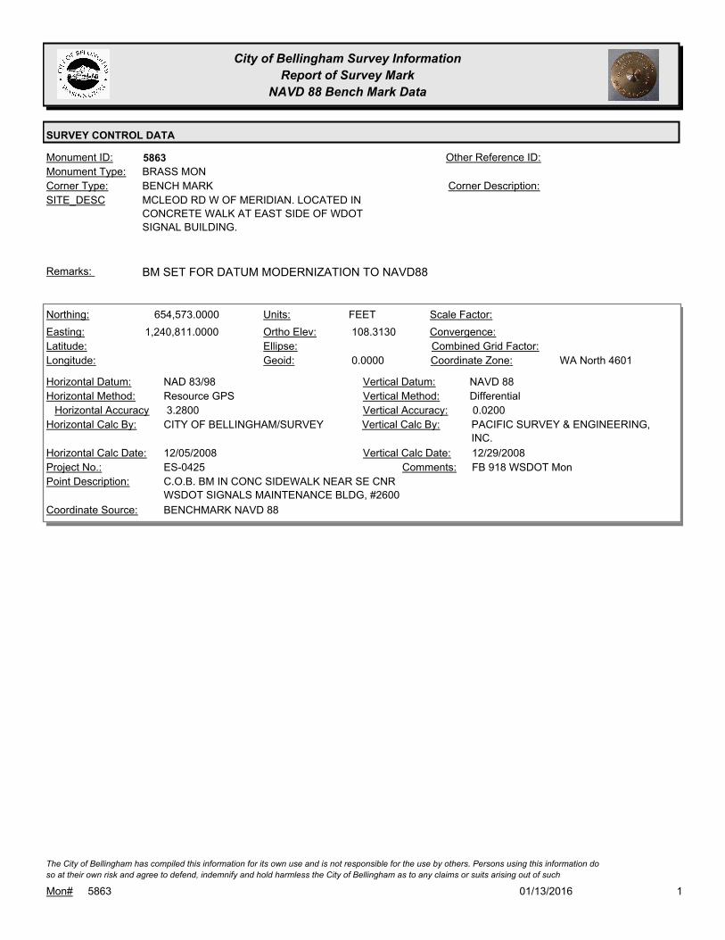
City of Bellingham Survey Information
Report of Survey Mark
NAVD 88 Bench Mark Data
SURVEY CONTROL DATA
5863Monument ID: Other Reference ID:
SITE_DESC MCLEOD RD W OF MERIDIAN. LOCATED IN
CONCRETE WALK AT EAST SIDE OF WDOT
SIGNAL BUILDING.
BENCH MARKCorner Type: Corner Description:
BRASS MONMonument Type:
BM SET FOR DATUM MODERNIZATION TO NAVD88Remarks:
654,573.0000
1,240,811.0000 108.3130
0.0000
FEETNorthing:
Easting:
Latitude:
Longitude:
Units:
Ortho Elev:
Ellipse:
Geoid:
Scale Factor:
Convergence:
Combined Grid Factor:
WA North 4601Coordinate Zone:
Resource GPSHorizontal Method:
NAD 83/98Horizontal Datum: NAVD 88Vertical Datum:
DifferentialVertical Method:
3.2800Horizontal Accuracy 0.0200Vertical Accuracy:
PACIFIC SURVEY & ENGINEERING,
INC.
Vertical Calc By:CITY OF BELLINGHAM/SURVEYHorizontal Calc By:
ES-0425Project No.:
C.O.B. BM IN CONC SIDEWALK NEAR SE CNR
WSDOT SIGNALS MAINTENANCE BLDG, #2600
Point Description:
BENCHMARK NAVD 88Coordinate Source:
FB 918 WSDOT MonComments:
12/05/2008Horizontal Calc Date: 12/29/2008Vertical Calc Date:
101/13/2016Mon# 5863
The City of Bellingham has compiled this information for its own use and is not responsible for the use by others. Persons using this information do
so at their own risk and agree to defend, indemnify and hold harmless the City of Bellingham as to any claims or suits arising out of such
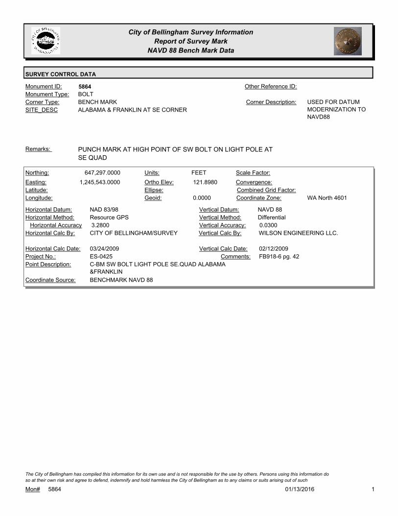
City of Bellingham Survey Information
Report of Survey Mark
NAVD 88 Bench Mark Data
SURVEY CONTROL DATA
5864Monument ID: Other Reference ID:
SITE_DESC ALABAMA & FRANKLIN AT SE CORNER
BENCH MARKCorner Type: USED FOR DATUM
MODERNIZATION TO
NAVD88
Corner Description:
BOLTMonument Type:
PUNCH MARK AT HIGH POINT OF SW BOLT ON LIGHT POLE AT
SE QUAD
Remarks:
647,297.0000
1,245,543.0000 121.8980
0.0000
FEETNorthing:
Easting:
Latitude:
Longitude:
Units:
Ortho Elev:
Ellipse:
Geoid:
Scale Factor:
Convergence:
Combined Grid Factor:
WA North 4601Coordinate Zone:
Resource GPSHorizontal Method:
NAD 83/98Horizontal Datum: NAVD 88Vertical Datum:
DifferentialVertical Method:
3.2800Horizontal Accuracy 0.0300Vertical Accuracy:
WILSON ENGINEERING LLC.Vertical Calc By:CITY OF BELLINGHAM/SURVEYHorizontal Calc By:
ES-0425Project No.:
C-BM SW BOLT LIGHT POLE SE.QUAD ALABAMA
&FRANKLIN
Point Description:
BENCHMARK NAVD 88Coordinate Source:
FB918-6 pg. 42Comments:
03/24/2009Horizontal Calc Date: 02/12/2009Vertical Calc Date:
101/13/2016Mon# 5864
The City of Bellingham has compiled this information for its own use and is not responsible for the use by others. Persons using this information do
so at their own risk and agree to defend, indemnify and hold harmless the City of Bellingham as to any claims or suits arising out of such
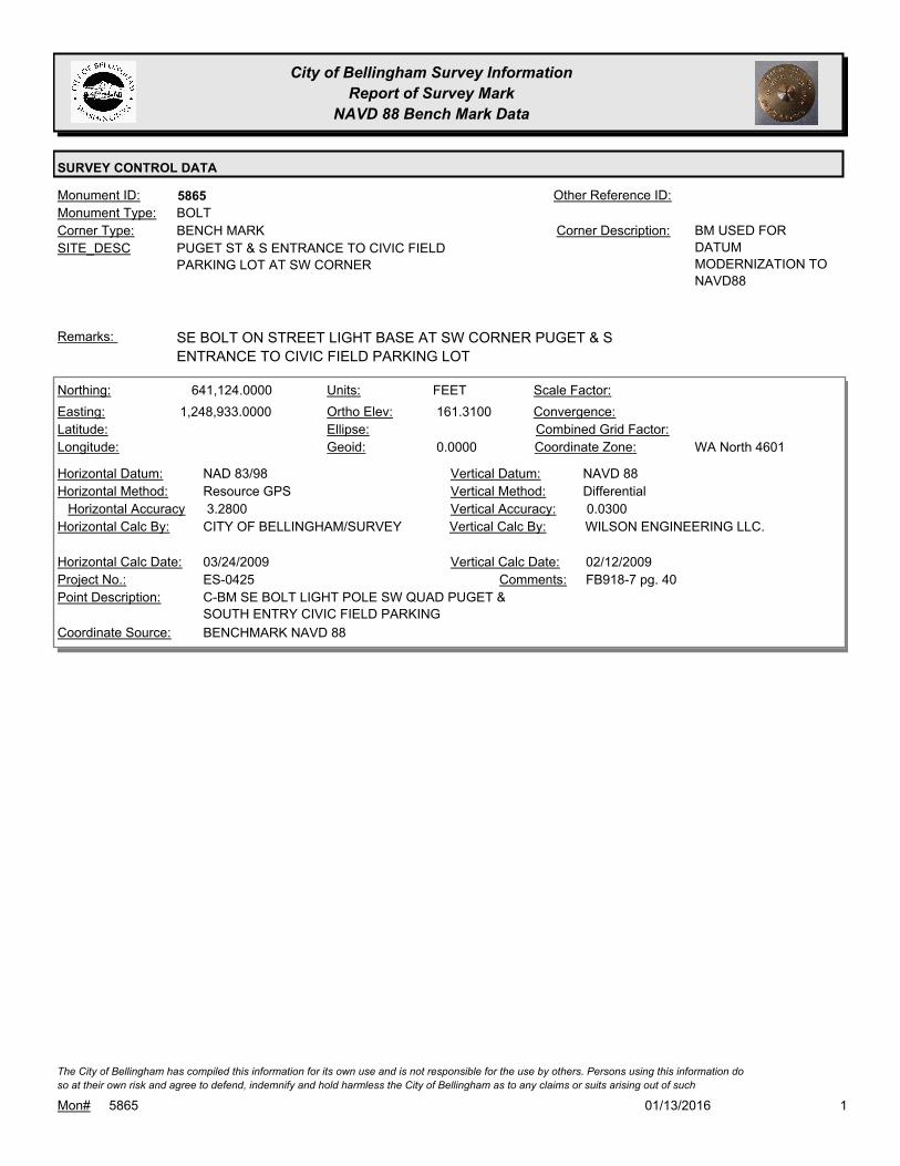
City of Bellingham Survey Information
Report of Survey Mark
NAVD 88 Bench Mark Data
SURVEY CONTROL DATA
5865Monument ID: Other Reference ID:
SITE_DESC PUGET ST & S ENTRANCE TO CIVIC FIELD
PARKING LOT AT SW CORNER
BENCH MARKCorner Type: BM USED FOR
DATUM
MODERNIZATION TO
NAVD88
Corner Description:
BOLTMonument Type:
SE BOLT ON STREET LIGHT BASE AT SW CORNER PUGET & S
ENTRANCE TO CIVIC FIELD PARKING LOT
Remarks:
641,124.0000
1,248,933.0000 161.3100
0.0000
FEETNorthing:
Easting:
Latitude:
Longitude:
Units:
Ortho Elev:
Ellipse:
Geoid:
Scale Factor:
Convergence:
Combined Grid Factor:
WA North 4601Coordinate Zone:
Resource GPSHorizontal Method:
NAD 83/98Horizontal Datum: NAVD 88Vertical Datum:
DifferentialVertical Method:
3.2800Horizontal Accuracy 0.0300Vertical Accuracy:
WILSON ENGINEERING LLC.Vertical Calc By:CITY OF BELLINGHAM/SURVEYHorizontal Calc By:
ES-0425Project No.:
C-BM SE BOLT LIGHT POLE SW QUAD PUGET &
SOUTH ENTRY CIVIC FIELD PARKING
Point Description:
BENCHMARK NAVD 88Coordinate Source:
FB918-7 pg. 40Comments:
03/24/2009Horizontal Calc Date: 02/12/2009Vertical Calc Date:
101/13/2016Mon# 5865
The City of Bellingham has compiled this information for its own use and is not responsible for the use by others. Persons using this information do
so at their own risk and agree to defend, indemnify and hold harmless the City of Bellingham as to any claims or suits arising out of such

City of Bellingham Survey Information
Report of Survey Mark
NAVD 88 Bench Mark Data
SURVEY CONTROL DATA
5866Monument ID: Other Reference ID:
SITE_DESC WOBURN (YEW) ST N OF LAKEWAY ON E
SIDE OPPOSITE YARD WASTE SITE
BENCH MARKCorner Type: BM USED FOR
DATUM
MODERNIZATION TO
NAVD88
Corner Description:
BOLTMonument Type:
NW BOLT LIGHT BASE AT E SIDE WOBURN OPPOSITE YARD
WASTE RECYCLING SITE
Remarks:
641,119.0000
1,252,016.0000 247.8400
0.0000
FEETNorthing:
Easting:
Latitude:
Longitude:
Units:
Ortho Elev:
Ellipse:
Geoid:
Scale Factor:
Convergence:
Combined Grid Factor:
WA North 4601Coordinate Zone:
Resource GPSHorizontal Method:
NAD 83/98Horizontal Datum: NAVD 88Vertical Datum:
DifferentialVertical Method:
3.2800Horizontal Accuracy 0.0300Vertical Accuracy:
WILSON ENGINEERING LLC.Vertical Calc By:CITY OF BELLINGHAM/SURVEYHorizontal Calc By:
ES-0425Project No.:
C-BM NW BOLT LIGHT STDRD E.SIDE WOBURN N.
OF FUNERAL HOME P.LOT
Point Description:
BENCHMARK NAVD 88Coordinate Source:
FB918-8 pg. 7Comments:
03/24/2009Horizontal Calc Date: 02/12/2009Vertical Calc Date:
101/13/2016Mon# 5866
The City of Bellingham has compiled this information for its own use and is not responsible for the use by others. Persons using this information do
so at their own risk and agree to defend, indemnify and hold harmless the City of Bellingham as to any claims or suits arising out of such
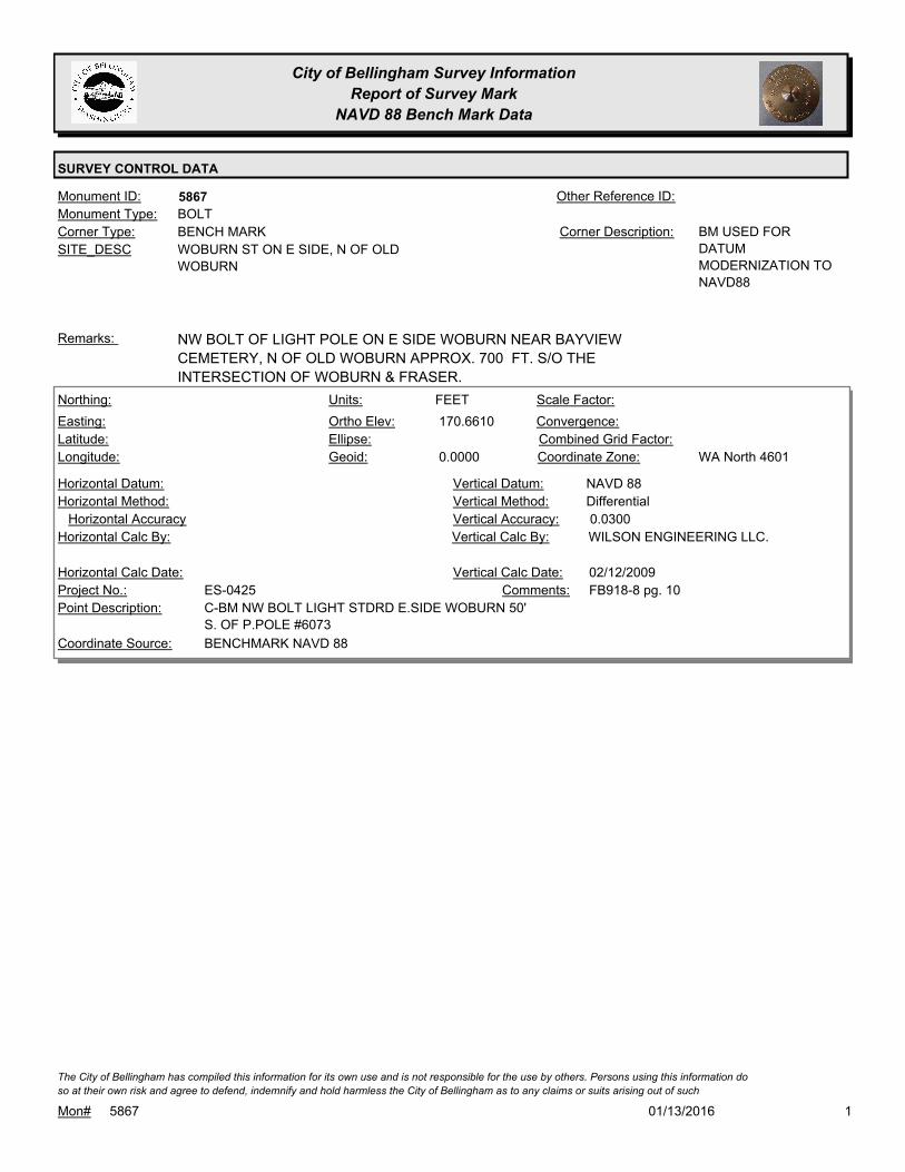
City of Bellingham Survey Information
Report of Survey Mark
NAVD 88 Bench Mark Data
SURVEY CONTROL DATA
5867Monument ID: Other Reference ID:
SITE_DESC WOBURN ST ON E SIDE, N OF OLD
WOBURN
BENCH MARKCorner Type: BM USED FOR
DATUM
MODERNIZATION TO
NAVD88
Corner Description:
BOLTMonument Type:
NW BOLT OF LIGHT POLE ON E SIDE WOBURN NEAR BAYVIEW
CEMETERY, N OF OLD WOBURN APPROX. 700 FT. S/O THE
INTERSECTION OF WOBURN & FRASER.
Remarks:
170.6610
0.0000
FEETNorthing:
Easting:
Latitude:
Longitude:
Units:
Ortho Elev:
Ellipse:
Geoid:
Scale Factor:
Convergence:
Combined Grid Factor:
WA North 4601Coordinate Zone:
Horizontal Method:
Horizontal Datum: NAVD 88Vertical Datum:
DifferentialVertical Method:
Horizontal Accuracy 0.0300Vertical Accuracy:
WILSON ENGINEERING LLC.Vertical Calc By:Horizontal Calc By:
ES-0425Project No.:
C-BM NW BOLT LIGHT STDRD E.SIDE WOBURN 50'
S. OF P.POLE #6073
Point Description:
BENCHMARK NAVD 88Coordinate Source:
FB918-8 pg. 10Comments:
Horizontal Calc Date: 02/12/2009Vertical Calc Date:
101/13/2016Mon# 5867
The City of Bellingham has compiled this information for its own use and is not responsible for the use by others. Persons using this information do
so at their own risk and agree to defend, indemnify and hold harmless the City of Bellingham as to any claims or suits arising out of such
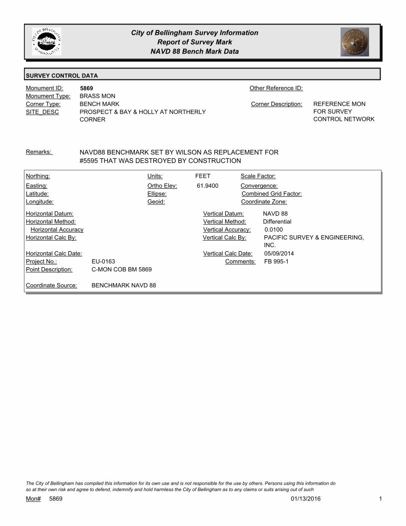
City of Bellingham Survey Information
Report of Survey Mark
NAVD 88 Bench Mark Data
SURVEY CONTROL DATA
5869Monument ID: Other Reference ID:
SITE_DESC PROSPECT & BAY & HOLLY AT NORTHERLY
CORNER
BENCH MARKCorner Type: REFERENCE MON
FOR SURVEY
CONTROL NETWORK
Corner Description:
BRASS MONMonument Type:
NAVD88 BENCHMARK SET BY WILSON AS REPLACEMENT FOR
#5595 THAT WAS DESTROYED BY CONSTRUCTION
Remarks:
61.9400
FEETNorthing:
Easting:
Latitude:
Longitude:
Units:
Ortho Elev:
Ellipse:
Geoid:
Scale Factor:
Convergence:
Combined Grid Factor:
Coordinate Zone:
Horizontal Method:
Horizontal Datum: NAVD 88Vertical Datum:
DifferentialVertical Method:
Horizontal Accuracy 0.0100Vertical Accuracy:
PACIFIC SURVEY & ENGINEERING,
INC.
Vertical Calc By:Horizontal Calc By:
EU-0163Project No.:
C-MON COB BM 5869Point Description:
BENCHMARK NAVD 88Coordinate Source:
FB 995-1Comments:
Horizontal Calc Date: 05/09/2014Vertical Calc Date:
101/13/2016Mon# 5869
The City of Bellingham has compiled this information for its own use and is not responsible for the use by others. Persons using this information do
so at their own risk and agree to defend, indemnify and hold harmless the City of Bellingham as to any claims or suits arising out of such

City of Bellingham Survey Information
Report of Survey Mark
NAVD 88 Bench Mark Data
SURVEY CONTROL DATA
5870Monument ID: Other Reference ID:
SITE_DESC SW CORNER ALABAMA & ELECTRIC &
DAKIN IN SIDEWALK
BENCH MARKCorner Type: Corner Description:
BRASS MONMonument Type:
MONUMENT HAS DESTROYED BY PROJECT ES-0459Remarks:
647,028.0000
1,257,504.0000 324.0750
0.0000
FEETNorthing:
Easting:
Latitude:
Longitude:
Units:
Ortho Elev:
Ellipse:
Geoid:
Scale Factor:
Convergence:
Combined Grid Factor:
WA North 4601Coordinate Zone:
Resource GPSHorizontal Method:
NAD 83/98Horizontal Datum: NAVD 88Vertical Datum:
DifferentialVertical Method:
3.2800Horizontal Accuracy 0.0300Vertical Accuracy:
WILSON ENGINEERING LLC.Vertical Calc By:CITY OF BELLINGHAM/SURVEYHorizontal Calc By:
ES-0425Project No.:
C-BDS 2008 NAVD88 MON SW QUAD
ALABAMA/ELECTRIC/N.SHORE
Point Description:
BENCHMARK NAVD 88Coordinate Source:
FB918-8 pg. 29Comments:
12/05/2008Horizontal Calc Date: 02/12/2009Vertical Calc Date:
101/13/2016Mon# 5870
The City of Bellingham has compiled this information for its own use and is not responsible for the use by others. Persons using this information do
so at their own risk and agree to defend, indemnify and hold harmless the City of Bellingham as to any claims or suits arising out of such

City of Bellingham Survey Information
Report of Survey Mark
NAVD 88 Bench Mark Data
SURVEY CONTROL DATA
5871Monument ID: Other Reference ID:
SITE_DESC NE CORNER ALABAMA & BIRCH IN
SIDEWALK
BENCH MARKCorner Type: Corner Description:
BRASS MONMonument Type:
BM SET FOR DATUM MODERNIZATION TO NAVD88Remarks:
647,117.0000
1,256,284.0000 375.4190
0.0000
FEETNorthing:
Easting:
Latitude:
Longitude:
Units:
Ortho Elev:
Ellipse:
Geoid:
Scale Factor:
Convergence:
Combined Grid Factor:
WA North 4601Coordinate Zone:
Resource GPSHorizontal Method:
NAD 83/98Horizontal Datum: NAVD 88Vertical Datum:
DifferentialVertical Method:
3.2800Horizontal Accuracy 0.0300Vertical Accuracy:
WILSON ENGINEERING LLC.Vertical Calc By:CITY OF BELLINGHAM/SURVEYHorizontal Calc By:
ES-0425Project No.:
C-BDS 2008 NAVD88 MON NE QUAD ALABAMA &
BIRCH
Point Description:
BENCHMARK NAVD 88Coordinate Source:
FB918-8 pg. 31Comments:
12/05/2008Horizontal Calc Date: 02/12/2009Vertical Calc Date:
101/13/2016Mon# 5871
The City of Bellingham has compiled this information for its own use and is not responsible for the use by others. Persons using this information do
so at their own risk and agree to defend, indemnify and hold harmless the City of Bellingham as to any claims or suits arising out of such

City of Bellingham Survey Information
Report of Survey Mark
NAVD 88 Bench Mark Data
SURVEY CONTROL DATA
5872Monument ID: Other Reference ID:
SITE_DESC S SIDE ALABAMA & 115 FT E OF ERIE
TERRACE IN SIDEWALK
BENCH MARKCorner Type: Corner Description:
BRASS MONMonument Type:
BM SET FOR DATUM MODERNIZATION TO NAVD88Remarks:
647,104.0000
1,254,538.0000 266.7120
0.0000
FEETNorthing:
Easting:
Latitude:
Longitude:
Units:
Ortho Elev:
Ellipse:
Geoid:
Scale Factor:
Convergence:
Combined Grid Factor:
WA North 4601Coordinate Zone:
Resource GPSHorizontal Method:
NAD 83/98Horizontal Datum: NAVD 88Vertical Datum:
DifferentialVertical Method:
3.2800Horizontal Accuracy 0.0300Vertical Accuracy:
WILSON ENGINEERING LLC.Vertical Calc By:CITY OF BELLINGHAM/SURVEYHorizontal Calc By:
ES-0425Project No.:
C-BDS 2008 NAVD88 MON ALABAMA 150' E. OF
ERIE TERRACE
Point Description:
BENCHMARK NAVD 88Coordinate Source:
FB918-8 pg. 34Comments:
12/05/2008Horizontal Calc Date: 02/12/2009Vertical Calc Date:
101/13/2016Mon# 5872
The City of Bellingham has compiled this information for its own use and is not responsible for the use by others. Persons using this information do
so at their own risk and agree to defend, indemnify and hold harmless the City of Bellingham as to any claims or suits arising out of such

City of Bellingham Survey Information
Report of Survey Mark
NAVD 88 Bench Mark Data
SURVEY CONTROL DATA
5873Monument ID: Other Reference ID:
SITE_DESC NE CORNER ALABAMA & YEW IN CURB E
OF RAMP
BENCH MARKCorner Type: Corner Description:
BRASS MONMonument Type:
BM SET FOR DATUM MODERNIZATION TO NAVD88Remarks:
647,204.0000
1,252,326.0000 121.9170
0.0000
FEETNorthing:
Easting:
Latitude:
Longitude:
Units:
Ortho Elev:
Ellipse:
Geoid:
Scale Factor:
Convergence:
Combined Grid Factor:
WA North 4601Coordinate Zone:
Resource GPSHorizontal Method:
NAD 83/98Horizontal Datum: NAVD 88Vertical Datum:
DifferentialVertical Method:
3.2800Horizontal Accuracy 0.0300Vertical Accuracy:
WILSON ENGINEERING LLC.Vertical Calc By:CITY OF BELLINGHAM/SURVEYHorizontal Calc By:
ES-0425Project No.:
C-BDS 2008 NAVD88 MON NE QUAD ALABAMA &
YEW
Point Description:
BENCHMARK NAVD 88Coordinate Source:
FB918-8 pg. 14Comments:
12/05/2008Horizontal Calc Date: 02/12/2009Vertical Calc Date:
101/13/2016Mon# 5873
The City of Bellingham has compiled this information for its own use and is not responsible for the use by others. Persons using this information do
so at their own risk and agree to defend, indemnify and hold harmless the City of Bellingham as to any claims or suits arising out of such

City of Bellingham Survey Information
Report of Survey Mark
NAVD 88 Bench Mark Data
SURVEY CONTROL DATA
5874Monument ID: Other Reference ID:
SITE_DESC SE CORNER ALABAMA & PACIFIC IN
SIDEWALK S OF RAMP
BENCH MARKCorner Type: Corner Description:
Monument Type:
BM SET FOR DATUM MODERNIZATION TO NAVD88Remarks:
647,198.0000
1,249,023.0000 108.3010
0.0000
FEETNorthing:
Easting:
Latitude:
Longitude:
Units:
Ortho Elev:
Ellipse:
Geoid:
Scale Factor:
Convergence:
Combined Grid Factor:
WA North 4601Coordinate Zone:
Resource GPSHorizontal Method:
NAD 83/98Horizontal Datum: NAVD 88Vertical Datum:
DifferentialVertical Method:
3.2800Horizontal Accuracy 0.0300Vertical Accuracy:
WILSON ENGINEERING LLC.Vertical Calc By:CITY OF BELLINGHAM/SURVEYHorizontal Calc By:
ES-0425Project No.:
C-BDS 2008 NAVD88 MON SE QUAD PACIFIC &
ALABAMA
Point Description:
BENCHMARK NAVD 88Coordinate Source:
FB918-7 pg. 6Comments:
12/05/2008Horizontal Calc Date: 02/12/2009Vertical Calc Date:
101/13/2016Mon# 5874
The City of Bellingham has compiled this information for its own use and is not responsible for the use by others. Persons using this information do
so at their own risk and agree to defend, indemnify and hold harmless the City of Bellingham as to any claims or suits arising out of such

City of Bellingham Survey Information
Report of Survey Mark
NAVD 88 Bench Mark Data
SURVEY CONTROL DATA
5875Monument ID: Other Reference ID:
SITE_DESC SE CORNER ALABAMA & JAMES IN
SIDEWALK BETWEEN RAMPS
BENCH MARKCorner Type: Corner Description:
BRASS MONMonument Type:
BM SET FOR DATUM MODERNIZATION TO NAVD88Remarks:
647,254.0000
1,246,940.0000 105.6040
0.0000
FEETNorthing:
Easting:
Latitude:
Longitude:
Units:
Ortho Elev:
Ellipse:
Geoid:
Scale Factor:
Convergence:
Combined Grid Factor:
WA North 4601Coordinate Zone:
Resource GPSHorizontal Method:
NAD 83/98Horizontal Datum: NAVD 88Vertical Datum:
DifferentialVertical Method:
3.2800Horizontal Accuracy 0.0300Vertical Accuracy:
WILSON ENGINEERING LLC.Vertical Calc By:CITY OF BELLINGHAM/SURVEYHorizontal Calc By:
ES-0425Project No.:
C-BDS 2008 NAVD88 MON SE QUAD JAMES &
ALABAMA
Point Description:
BENCHMARK NAVD 88Coordinate Source:
FB918-6 pg. 43Comments:
12/05/2008Horizontal Calc Date: 02/12/2009Vertical Calc Date:
101/13/2016Mon# 5875
The City of Bellingham has compiled this information for its own use and is not responsible for the use by others. Persons using this information do
so at their own risk and agree to defend, indemnify and hold harmless the City of Bellingham as to any claims or suits arising out of such

City of Bellingham Survey Information
Report of Survey Mark
NAVD 88 Bench Mark Data
SURVEY CONTROL DATA
5876Monument ID: Other Reference ID:
SITE_DESC SE CORNER ALABAMA & CORNWALL IN
SIDEWALK N OF RAMP
BENCH MARKCorner Type: Corner Description:
BRASS MONMonument Type:
BM SET FOR DATUM MODERNIZATION TO NAVD88Remarks:
647,312.0000
1,244,485.9540 120.0510
0.0000
FEETNorthing:
Easting:
Latitude:
Longitude:
Units:
Ortho Elev:
Ellipse:
Geoid:
Scale Factor:
Convergence:
Combined Grid Factor:
WA North 4601Coordinate Zone:
Resource GPSHorizontal Method:
NAD 83/98Horizontal Datum: NAVD 88Vertical Datum:
DifferentialVertical Method:
3.2800Horizontal Accuracy 0.0300Vertical Accuracy:
WILSON ENGINEERING LLC.Vertical Calc By:CITY OF BELLINGHAM/SURVEYHorizontal Calc By:
ES-0425Project No.:
C-BDS 2008 NAVD88 MON SE QUAD CORNWALL &
ALABAMA
Point Description:
BENCHMARK NAVD 88Coordinate Source:
FB918-6 pg. 41Comments:
12/05/2008Horizontal Calc Date: 02/12/2009Vertical Calc Date:
101/13/2016Mon# 5876
The City of Bellingham has compiled this information for its own use and is not responsible for the use by others. Persons using this information do
so at their own risk and agree to defend, indemnify and hold harmless the City of Bellingham as to any claims or suits arising out of such

City of Bellingham Survey Information
Report of Survey Mark
NAVD 88 Bench Mark Data
SURVEY CONTROL DATA
5877Monument ID: Other Reference ID:
SITE_DESC W SIDE CORNWALL IN SIDEWALK AT S
END BHAM HIGH SCHOOL BLDG
BENCH MARKCorner Type: Corner Description:
BRASS MONMonument Type:
BM SET FOR DATUM MODERNIZATION TO NAVD88Remarks:
644,907.0000
1,244,427.0000 67.9060
0.0000
FEETNorthing:
Easting:
Latitude:
Longitude:
Units:
Ortho Elev:
Ellipse:
Geoid:
Scale Factor:
Convergence:
Combined Grid Factor:
WA North 4601Coordinate Zone:
Resource GPSHorizontal Method:
NAD 83/98Horizontal Datum: NAVD 88Vertical Datum:
DifferentialVertical Method:
3.2800Horizontal Accuracy 0.0300Vertical Accuracy:
WILSON ENGINEERING LLC.Vertical Calc By:CITY OF BELLINGHAM/SURVEYHorizontal Calc By:
ES-0425Project No.:
C-BDS 2008 NAVD88 MON S.SIDE BHS @
CORNWALL
Point Description:
BENCHMARK NAVD 88Coordinate Source:
FB918-6 pg. 30Comments:
12/05/2008Horizontal Calc Date: 02/04/2009Vertical Calc Date:
101/13/2016Mon# 5877
The City of Bellingham has compiled this information for its own use and is not responsible for the use by others. Persons using this information do
so at their own risk and agree to defend, indemnify and hold harmless the City of Bellingham as to any claims or suits arising out of such

City of Bellingham Survey Information
Report of Survey Mark
NAVD 88 Bench Mark Data
SURVEY CONTROL DATA
5878Monument ID: Other Reference ID:
SITE_DESC SE CORNER GIRARD & COMMERCIAL &
YOUNG IN LARGE CONC AREA BEHIND
SIDEWALK
BENCH MARKCorner Type: Corner Description:
BRASS MONMonument Type:
BM SET FOR DATUM MODERNIZATION TO NAVD88Remarks:
644,682.0000
1,243,697.0000 60.9930
0.0000
FEETNorthing:
Easting:
Latitude:
Longitude:
Units:
Ortho Elev:
Ellipse:
Geoid:
Scale Factor:
Convergence:
Combined Grid Factor:
WA North 4601Coordinate Zone:
Resource GPSHorizontal Method:
NAD 83/98Horizontal Datum: NAVD 88Vertical Datum:
DifferentialVertical Method:
3.2800Horizontal Accuracy 0.0300Vertical Accuracy:
WILSON ENGINEERING LLC.Vertical Calc By:CITY OF BELLINGHAM/SURVEYHorizontal Calc By:
ES-0425Project No.:
C-BDS 2008 NAVD88 MON YOUNG & COMMERCIALPoint Description:
BENCHMARK NAVD 88Coordinate Source:
FB918-6 pg. 26Comments:
12/05/2008Horizontal Calc Date: 02/04/2009Vertical Calc Date:
101/13/2016Mon# 5878
The City of Bellingham has compiled this information for its own use and is not responsible for the use by others. Persons using this information do
so at their own risk and agree to defend, indemnify and hold harmless the City of Bellingham as to any claims or suits arising out of such
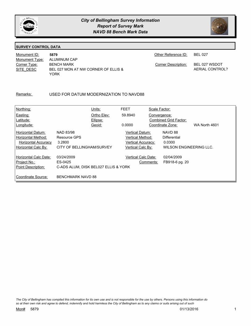
City of Bellingham Survey Information
Report of Survey Mark
NAVD 88 Bench Mark Data
SURVEY CONTROL DATA
5879Monument ID: BEL 027Other Reference ID:
SITE_DESC BEL 027 MON AT NW CORNER OF ELLIS &
YORK
BENCH MARKCorner Type: BEL 027 WSDOT
AERIAL CONTROL?
Corner Description:
ALUMINUM CAPMonument Type:
USED FOR DATUM MODERNIZATION TO NAVD88Remarks:
59.8940
0.0000
FEETNorthing:
Easting:
Latitude:
Longitude:
Units:
Ortho Elev:
Ellipse:
Geoid:
Scale Factor:
Convergence:
Combined Grid Factor:
WA North 4601Coordinate Zone:
Resource GPSHorizontal Method:
NAD 83/98Horizontal Datum: NAVD 88Vertical Datum:
DifferentialVertical Method:
3.2800Horizontal Accuracy 0.0300Vertical Accuracy:
WILSON ENGINEERING LLC.Vertical Calc By:CITY OF BELLINGHAM/SURVEYHorizontal Calc By:
ES-0425Project No.:
C-ADS ALUM, DISK BEL027 ELLIS & YORKPoint Description:
BENCHMARK NAVD 88Coordinate Source:
FB918-6 pg. 20Comments:
03/24/2009Horizontal Calc Date: 02/04/2009Vertical Calc Date:
101/13/2016Mon# 5879
The City of Bellingham has compiled this information for its own use and is not responsible for the use by others. Persons using this information do
so at their own risk and agree to defend, indemnify and hold harmless the City of Bellingham as to any claims or suits arising out of such
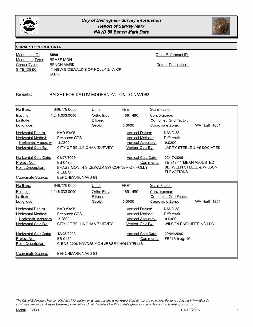
City of Bellingham Survey Information
Report of Survey Mark
NAVD 88 Bench Mark Data
SURVEY CONTROL DATA
5880Monument ID: Other Reference ID:
SITE_DESC IN NEW SIDEWALK S OF HOLLY & W OF
ELLIS
BENCH MARKCorner Type: Corner Description:
BRASS MONMonument Type:
BM SET FOR DATUM MODERNIZATION TO NAVD88Remarks:
640,779.0000
1,245,033.0000 169.1480
0.0000
FEETNorthing:
Easting:
Latitude:
Longitude:
Units:
Ortho Elev:
Ellipse:
Geoid:
Scale Factor:
Convergence:
Combined Grid Factor:
WA North 4601Coordinate Zone:
Resource GPSHorizontal Method:
NAD 83/98Horizontal Datum: NAVD 88Vertical Datum:
DifferentialVertical Method:
3.2800Horizontal Accuracy 0.0200Vertical Accuracy:
LARRY STEELE & ASSOCIATESVertical Calc By:CITY OF BELLINGHAM/SURVEYHorizontal Calc By:
ES-0425Project No.:
BRASS MON IN SIDEWALK SW CORNER OF HOLLY
& ELLIS
Point Description:
BENCHMARK NAVD 88Coordinate Source:
FB 918-11 MEAN ADJUSTED
BETWEEN STEELE & WILSON
ELEVATIONS
Comments:
01/07/2009Horizontal Calc Date: 02/17/2009Vertical Calc Date:
640,779.0000
1,245,033.0000 169.1480
0.0000
FEETNorthing:
Easting:
Latitude:
Longitude:
Units:
Ortho Elev:
Ellipse:
Geoid:
Scale Factor:
Convergence:
Combined Grid Factor:
WA North 4601Coordinate Zone:
Resource GPSHorizontal Method:
NAD 83/98Horizontal Datum: NAVD 88Vertical Datum:
DifferentialVertical Method:
3.2800Horizontal Accuracy 0.0300Vertical Accuracy:
WILSON ENGINEERING LLC.Vertical Calc By:CITY OF BELLINGHAM/SURVEYHorizontal Calc By:
ES-0425Project No.:
C-BDS 2008 NAVD88 MON JERSEY/HOLLY/ELLISPoint Description:
BENCHMARK NAVD 88Coordinate Source:
FB918-6 pg. 16Comments:
12/05/2008Horizontal Calc Date: 02/04/2009Vertical Calc Date:
101/13/2016Mon# 5880
The City of Bellingham has compiled this information for its own use and is not responsible for the use by others. Persons using this information do
so at their own risk and agree to defend, indemnify and hold harmless the City of Bellingham as to any claims or suits arising out of such

City of Bellingham Survey Information
Report of Survey Mark
NAVD 88 Bench Mark Data
SURVEY CONTROL DATA
5881Monument ID: Other Reference ID:
SITE_DESC IN SIDEWALK AT ELY CORNER HOLLY &
FOREST BETWEEN RAMPS (BY AUTO
PARTS STORE)
BENCH MARKCorner Type: Corner Description:
BRASS MONMonument Type:
BM SET FOR DATUM MODERNIZATION TO NAVD88Remarks:
641,774.0000
1,244,131.0000 114.1690
0.0000
FEETNorthing:
Easting:
Latitude:
Longitude:
Units:
Ortho Elev:
Ellipse:
Geoid:
Scale Factor:
Convergence:
Combined Grid Factor:
WA North 4601Coordinate Zone:
Resource GPSHorizontal Method:
NAD 83/98Horizontal Datum: NAVD 88Vertical Datum:
DifferentialVertical Method:
3.2800Horizontal Accuracy 0.0300Vertical Accuracy:
WILSON ENGINEERING LLC.Vertical Calc By:CITY OF BELLINGHAM/SURVEYHorizontal Calc By:
ES-0425Project No.:
C-BDS 2008 NAVD88 MON FOREST & HOLLYPoint Description:
BENCHMARK NAVD 88Coordinate Source:
FB918-6 pg. 22Comments:
03/24/2009Horizontal Calc Date: 02/04/2009Vertical Calc Date:
101/13/2016Mon# 5881
The City of Bellingham has compiled this information for its own use and is not responsible for the use by others. Persons using this information do
so at their own risk and agree to defend, indemnify and hold harmless the City of Bellingham as to any claims or suits arising out of such
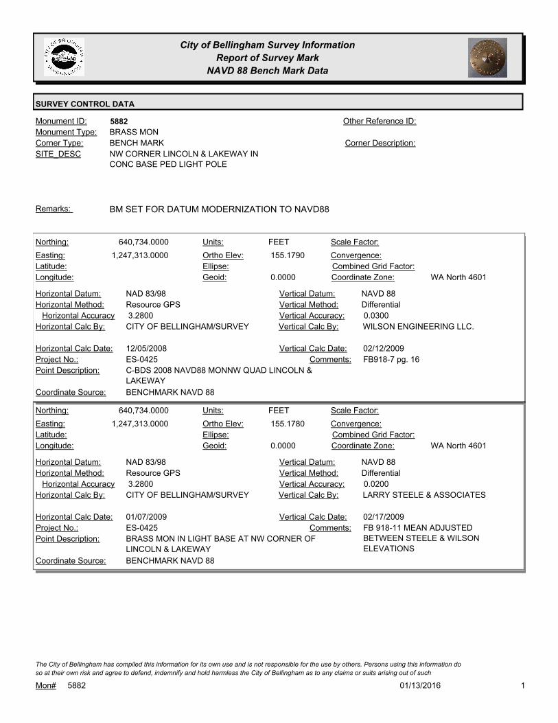
City of Bellingham Survey Information
Report of Survey Mark
NAVD 88 Bench Mark Data
SURVEY CONTROL DATA
5882Monument ID: Other Reference ID:
SITE_DESC NW CORNER LINCOLN & LAKEWAY IN
CONC BASE PED LIGHT POLE
BENCH MARKCorner Type: Corner Description:
BRASS MONMonument Type:
BM SET FOR DATUM MODERNIZATION TO NAVD88Remarks:
640,734.0000
1,247,313.0000 155.1790
0.0000
FEETNorthing:
Easting:
Latitude:
Longitude:
Units:
Ortho Elev:
Ellipse:
Geoid:
Scale Factor:
Convergence:
Combined Grid Factor:
WA North 4601Coordinate Zone:
Resource GPSHorizontal Method:
NAD 83/98Horizontal Datum: NAVD 88Vertical Datum:
DifferentialVertical Method:
3.2800Horizontal Accuracy 0.0300Vertical Accuracy:
WILSON ENGINEERING LLC.Vertical Calc By:CITY OF BELLINGHAM/SURVEYHorizontal Calc By:
ES-0425Project No.:
C-BDS 2008 NAVD88 MONNW QUAD LINCOLN &
LAKEWAY
Point Description:
BENCHMARK NAVD 88Coordinate Source:
FB918-7 pg. 16Comments:
12/05/2008Horizontal Calc Date: 02/12/2009Vertical Calc Date:
640,734.0000
1,247,313.0000 155.1780
0.0000
FEETNorthing:
Easting:
Latitude:
Longitude:
Units:
Ortho Elev:
Ellipse:
Geoid:
Scale Factor:
Convergence:
Combined Grid Factor:
WA North 4601Coordinate Zone:
Resource GPSHorizontal Method:
NAD 83/98Horizontal Datum: NAVD 88Vertical Datum:
DifferentialVertical Method:
3.2800Horizontal Accuracy 0.0200Vertical Accuracy:
LARRY STEELE & ASSOCIATESVertical Calc By:CITY OF BELLINGHAM/SURVEYHorizontal Calc By:
ES-0425Project No.:
BRASS MON IN LIGHT BASE AT NW CORNER OF
LINCOLN & LAKEWAY
Point Description:
BENCHMARK NAVD 88Coordinate Source:
FB 918-11 MEAN ADJUSTED
BETWEEN STEELE & WILSON
ELEVATIONS
Comments:
01/07/2009Horizontal Calc Date: 02/17/2009Vertical Calc Date:
101/13/2016Mon# 5882
The City of Bellingham has compiled this information for its own use and is not responsible for the use by others. Persons using this information do
so at their own risk and agree to defend, indemnify and hold harmless the City of Bellingham as to any claims or suits arising out of such

City of Bellingham Survey Information
Report of Survey Mark
NAVD 88 Bench Mark Data
SURVEY CONTROL DATA
5883Monument ID: Other Reference ID:
SITE_DESC N SIDE FRASER IN NEW CURB APPROX 150
FT E OF LINCOLN
BENCH MARKCorner Type: Corner Description:
BRASS MONMonument Type:
BM SET FOR DATUM MODERNIZATION TO NAVD88Remarks:
643,226.0000
1,247,586.0000 71.3010
0.0000
FEETNorthing:
Easting:
Latitude:
Longitude:
Units:
Ortho Elev:
Ellipse:
Geoid:
Scale Factor:
Convergence:
Combined Grid Factor:
WA North 4601Coordinate Zone:
Resource GPSHorizontal Method:
NAD 83/98Horizontal Datum: NAVD 88Vertical Datum:
DifferentialVertical Method:
3.2800Horizontal Accuracy 0.0300Vertical Accuracy:
WILSON ENGINEERING LLC.Vertical Calc By:CITY OF BELLINGHAM/SURVEYHorizontal Calc By:
ES-0425Project No.:
C-BDS 2008 NAVD88 MON FRASER E. OF LINCOLNPoint Description:
BENCHMARK NAVD 88Coordinate Source:
FB918-7 pg. 12Comments:
12/05/2008Horizontal Calc Date: 02/12/2009Vertical Calc Date:
101/13/2016Mon# 5883
The City of Bellingham has compiled this information for its own use and is not responsible for the use by others. Persons using this information do
so at their own risk and agree to defend, indemnify and hold harmless the City of Bellingham as to any claims or suits arising out of such

City of Bellingham Survey Information
Report of Survey Mark
NAVD 88 Bench Mark Data
SURVEY CONTROL DATA
5884Monument ID: Other Reference ID:
SITE_DESC SW CORNER FRASER & PUGET IN
SIDEWALK W OF RAMP
BENCH MARKCorner Type: Corner Description:
BRASS MONMonument Type:
BM SET FOR DATUM MODERNIZATION TO NAVD88Remarks:
643,124.0000
1,249,192.0000 64.9020
0.0000
FEETNorthing:
Easting:
Latitude:
Longitude:
Units:
Ortho Elev:
Ellipse:
Geoid:
Scale Factor:
Convergence:
Combined Grid Factor:
WA North 4601Coordinate Zone:
Resource GPSHorizontal Method:
NAD 83/98Horizontal Datum: NAVD 88Vertical Datum:
DifferentialVertical Method:
3.2800Horizontal Accuracy 0.0300Vertical Accuracy:
WILSON ENGINEERING LLC.Vertical Calc By:CITY OF BELLINGHAM/SURVEYHorizontal Calc By:
ES-0425Project No.:
C-BDS 2008 NAVD88 MON SW.QUAD PUGET &
FRASER
Point Description:
BENCHMARK NAVD 88Coordinate Source:
FB918-7 pg. 23Comments:
12/05/2008Horizontal Calc Date: 02/12/2009Vertical Calc Date:
101/13/2016Mon# 5884
The City of Bellingham has compiled this information for its own use and is not responsible for the use by others. Persons using this information do
so at their own risk and agree to defend, indemnify and hold harmless the City of Bellingham as to any claims or suits arising out of such

City of Bellingham Survey Information
Report of Survey Mark
NAVD 88 Bench Mark Data
SURVEY CONTROL DATA
5885Monument ID: Other Reference ID:
SITE_DESC NW CORNER PUGET & GLADSTONE IN
SIDEWALK W OF RAMP
BENCH MARKCorner Type: Corner Description:
Monument Type:
BM SET FOR DATUM MODERNIZATION TO NAVD88Remarks:
642,161.0000
1,249,065.0000 117.8450
0.0000
FEETNorthing:
Easting:
Latitude:
Longitude:
Units:
Ortho Elev:
Ellipse:
Geoid:
Scale Factor:
Convergence:
Combined Grid Factor:
WA North 4601Coordinate Zone:
Resource GPSHorizontal Method:
NAD 83/98Horizontal Datum: NAVD 88Vertical Datum:
DifferentialVertical Method:
3.2800Horizontal Accuracy 0.0300Vertical Accuracy:
WILSON ENGINEERING LLC.Vertical Calc By:CITY OF BELLINGHAM/SURVEYHorizontal Calc By:
ES-0425Project No.:
C-BDS 2008 NAVD88 MON NW QUAD PUGET &
GLADSTONE
Point Description:
BENCHMARK NAVD 88Coordinate Source:
FB918-7 pg. 38Comments:
12/05/2008Horizontal Calc Date: 02/12/2009Vertical Calc Date:
101/13/2016Mon# 5885
The City of Bellingham has compiled this information for its own use and is not responsible for the use by others. Persons using this information do
so at their own risk and agree to defend, indemnify and hold harmless the City of Bellingham as to any claims or suits arising out of such

City of Bellingham Survey Information
Report of Survey Mark
NAVD 88 Bench Mark Data
SURVEY CONTROL DATA
5886Monument ID: Other Reference ID:
SITE_DESC AT NE CORNER LAKEWAY & WOBURN ON
NW CORNER OF TRAFFIC LIGHT BASE
BENCH MARKCorner Type: Corner Description:
BRASS MONMonument Type:
BM SET FOR DATUM MODERNIZATION TO NAVD88Remarks:
640,825.0000
1,252,178.0000 281.6320
0.0000
FEETNorthing:
Easting:
Latitude:
Longitude:
Units:
Ortho Elev:
Ellipse:
Geoid:
Scale Factor:
Convergence:
Combined Grid Factor:
WA North 4601Coordinate Zone:
Resource GPSHorizontal Method:
NAD 83/98Horizontal Datum: NAVD 88Vertical Datum:
DifferentialVertical Method:
3.2800Horizontal Accuracy 0.0300Vertical Accuracy:
WILSON ENGINEERING LLC.Vertical Calc By:CITY OF BELLINGHAM/SURVEYHorizontal Calc By:
ES-0425Project No.:
C-BDS 2008 NAVD88 MON NE QUAD LAKEWAY &
YEW
Point Description:
BENCHMARK NAVD 88Coordinate Source:
FB918-8 pg. 6Comments:
12/05/2008Horizontal Calc Date: 02/12/2009Vertical Calc Date:
101/13/2016Mon# 5886
The City of Bellingham has compiled this information for its own use and is not responsible for the use by others. Persons using this information do
so at their own risk and agree to defend, indemnify and hold harmless the City of Bellingham as to any claims or suits arising out of such

City of Bellingham Survey Information
Report of Survey Mark
NAVD 88 Bench Mark Data
SURVEY CONTROL DATA
5887Monument ID: Other Reference ID:
SITE_DESC N SIDE LAKEWAY & W OF KENOYER IN SE
CORNER CONC SLAB FOR ABANDONED
BUS STOP
BENCH MARKCorner Type: Corner Description:
BRASS MONMonument Type:
BM SET FOR DATUM MODERNIZATION TO NAVD88Remarks:
641,490.0000
1,253,976.0000 315.9900
0.0000
FEETNorthing:
Easting:
Latitude:
Longitude:
Units:
Ortho Elev:
Ellipse:
Geoid:
Scale Factor:
Convergence:
Combined Grid Factor:
WA North 4601Coordinate Zone:
Resource GPSHorizontal Method:
NAD 83/98Horizontal Datum: NAVD 88Vertical Datum:
DifferentialVertical Method:
3.2800Horizontal Accuracy 0.0300Vertical Accuracy:
WILSON ENGINEERING LLC.Vertical Calc By:CITY OF BELLINGHAM/SURVEYHorizontal Calc By:
ES-0425Project No.:
C-BDS 2008 NAVD88 MON NW QUAD LAKEWAY &
KENOYER
Point Description:
BENCHMARK NAVD 88Coordinate Source:
FB918-8 pg. 20Comments:
12/05/2008Horizontal Calc Date: 02/12/2009Vertical Calc Date:
101/13/2016Mon# 5887
The City of Bellingham has compiled this information for its own use and is not responsible for the use by others. Persons using this information do
so at their own risk and agree to defend, indemnify and hold harmless the City of Bellingham as to any claims or suits arising out of such

City of Bellingham Survey Information
Report of Survey Mark
NAVD 88 Bench Mark Data
SURVEY CONTROL DATA
5888Monument ID: Other Reference ID:
SITE_DESC SE CORNER ELECTRIC & BIRCH IN
SIDEWALK NE OF RAMP
BENCH MARKCorner Type: Corner Description:
BRASS MONMonument Type:
MONUMENT DESTROYED BY CONSTRUCTION OF ES-0241.Remarks:
642,122.0000
1,256,150.0000 346.7670
0.0000
FEETNorthing:
Easting:
Latitude:
Longitude:
Units:
Ortho Elev:
Ellipse:
Geoid:
Scale Factor:
Convergence:
Combined Grid Factor:
WA North 4601Coordinate Zone:
Resource GPSHorizontal Method:
NAD 83/98Horizontal Datum: NAVD 88Vertical Datum:
DifferentialVertical Method:
3.2800Horizontal Accuracy 0.0300Vertical Accuracy:
WILSON ENGINEERING LLC.Vertical Calc By:CITY OF BELLINGHAM/SURVEYHorizontal Calc By:
ES-0425Project No.:
C-BDS 2008 NAVD88 MON SE QUAD BIRCH &
ELECTRIC
Point Description:
BENCHMARK NAVD 88Coordinate Source:
FB918-8 pg. 22Comments:
12/05/2008Horizontal Calc Date: 02/12/2009Vertical Calc Date:
101/13/2016Mon# 5888
The City of Bellingham has compiled this information for its own use and is not responsible for the use by others. Persons using this information do
so at their own risk and agree to defend, indemnify and hold harmless the City of Bellingham as to any claims or suits arising out of such

City of Bellingham Survey Information
Report of Survey Mark
NAVD 88 Bench Mark Data
SURVEY CONTROL DATA
5889Monument ID: Other Reference ID:
SITE_DESC NW CORNER JAMES & IOWA IN SIDEWALK
W OF SIGNAL POLE
BENCH MARKCorner Type: Corner Description:
BRASS MONMonument Type:
BM SET FOR DATUM MODERNIZATION TO NAVD88Remarks:
644,926.0000
1,246,776.0000 64.3150
0.0000
FEETNorthing:
Easting:
Latitude:
Longitude:
Units:
Ortho Elev:
Ellipse:
Geoid:
Scale Factor:
Convergence:
Combined Grid Factor:
WA North 4601Coordinate Zone:
Resource GPSHorizontal Method:
NAD 83/98Horizontal Datum: NAVD 88Vertical Datum:
DifferentialVertical Method:
3.2800Horizontal Accuracy 0.0300Vertical Accuracy:
WILSON ENGINEERING LLC.Vertical Calc By:CITY OF BELLINGHAM/SURVEYHorizontal Calc By:
ES-0425Project No.:
C-BDS 2008 NAVD88 MON INT JAMES/STATE/IOWAPoint Description:
BENCHMARK NAVD 88Coordinate Source:
FB918-6 pg. 39Comments:
12/05/2008Horizontal Calc Date: 02/04/2009Vertical Calc Date:
101/13/2016Mon# 5889
The City of Bellingham has compiled this information for its own use and is not responsible for the use by others. Persons using this information do
so at their own risk and agree to defend, indemnify and hold harmless the City of Bellingham as to any claims or suits arising out of such

City of Bellingham Survey Information
Report of Survey Mark
NAVD 88 Bench Mark Data
SURVEY CONTROL DATA
5890Monument ID: Other Reference ID:
SITE_DESC SW CORNER IOWA & PACIFIC IN NW
CORNER CONC SIGNAL BASE
BENCH MARKCorner Type: Corner Description:
BRASS MONMonument Type:
BM SET FOR DATUM MODERNIZATION TO NAVD88Remarks:
644,812.0000
1,248,916.0000 59.0950
0.0000
FEETNorthing:
Easting:
Latitude:
Longitude:
Units:
Ortho Elev:
Ellipse:
Geoid:
Scale Factor:
Convergence:
Combined Grid Factor:
WA North 4601Coordinate Zone:
Resource GPSHorizontal Method:
NAD 83/98Horizontal Datum: NAVD 88Vertical Datum:
DifferentialVertical Method:
3.2800Horizontal Accuracy 0.0300Vertical Accuracy:
WILSON ENGINEERING LLC.Vertical Calc By:CITY OF BELLINGHAM/SURVEYHorizontal Calc By:
ES-0425Project No.:
C-BDS 2008 NAVD88 MON SW QUAD IOWA &
PACIFIC
Point Description:
BENCHMARK NAVD 88Coordinate Source:
FB918-7 pg. 3Comments:
12/05/2008Horizontal Calc Date: 02/12/2009Vertical Calc Date:
101/13/2016Mon# 5890
The City of Bellingham has compiled this information for its own use and is not responsible for the use by others. Persons using this information do
so at their own risk and agree to defend, indemnify and hold harmless the City of Bellingham as to any claims or suits arising out of such

City of Bellingham Survey Information
Report of Survey Mark
NAVD 88 Bench Mark Data
SURVEY CONTROL DATA
5891Monument ID: Other Reference ID:
SITE_DESC E SIDE WOBURN IN SIDEWALK ACROSS
FROM FRASER
BENCH MARKCorner Type: Corner Description:
BRASS MONMonument Type:
BM SET FOR DATUM MODERNIZATION TO NAVD88Remarks:
643,033.0000
1,251,585.0000 136.2950
0.0000
FEETNorthing:
Easting:
Latitude:
Longitude:
Units:
Ortho Elev:
Ellipse:
Geoid:
Scale Factor:
Convergence:
Combined Grid Factor:
WA North 4601Coordinate Zone:
Resource GPSHorizontal Method:
NAD 83/98Horizontal Datum: NAVD 88Vertical Datum:
DifferentialVertical Method:
3.2800Horizontal Accuracy 0.0300Vertical Accuracy:
WILSON ENGINEERING LLC.Vertical Calc By:CITY OF BELLINGHAM/SURVEYHorizontal Calc By:
ES-0425Project No.:
C-BDS 2008 NAVD88 MON E.SIDE FRASER &
WOBURN
Point Description:
BENCHMARK NAVD 88Coordinate Source:
FB918-7 pg. 27Comments:
12/05/2008Horizontal Calc Date: 02/12/2009Vertical Calc Date:
101/13/2016Mon# 5891
The City of Bellingham has compiled this information for its own use and is not responsible for the use by others. Persons using this information do
so at their own risk and agree to defend, indemnify and hold harmless the City of Bellingham as to any claims or suits arising out of such

City of Bellingham Survey Information
Report of Survey Mark
NAVD 88 Bench Mark Data
SURVEY CONTROL DATA
5892Monument ID: Other Reference ID:
SITE_DESC ENTRANCE TO WATER TREATMENT PLANT
IN CONC BASE OF TOUCH-KEY SECURITY
BOX
BENCH MARKCorner Type: Corner Description:
BRASS MONMonument Type:
BM SET FOR DATUM MODERNIZATION TO NAVD88Remarks:
642,779.0000
1,254,815.0000 285.5140
0.0000
FEETNorthing:
Easting:
Latitude:
Longitude:
Units:
Ortho Elev:
Ellipse:
Geoid:
Scale Factor:
Convergence:
Combined Grid Factor:
WA North 4601Coordinate Zone:
Resource GPSHorizontal Method:
NAD 83/98Horizontal Datum: NAVD 88Vertical Datum:
DifferentialVertical Method:
3.2800Horizontal Accuracy 0.0300Vertical Accuracy:
WILSON ENGINEERING LLC.Vertical Calc By:CITY OF BELLINGHAM/SURVEYHorizontal Calc By:
ES-0425Project No.:
C-BDS 2008 NAVD88 MON WATER PLANTPoint Description:
BENCHMARK NAVD 88Coordinate Source:
FB918-8 pg. 58Comments:
12/05/2008Horizontal Calc Date: 02/12/2009Vertical Calc Date:
101/13/2016Mon# 5892
The City of Bellingham has compiled this information for its own use and is not responsible for the use by others. Persons using this information do
so at their own risk and agree to defend, indemnify and hold harmless the City of Bellingham as to any claims or suits arising out of such

City of Bellingham Survey Information
Report of Survey Mark
NAVD 88 Bench Mark Data
SURVEY CONTROL DATA
5893Monument ID: Other Reference ID:
SITE_DESC S SIDEWALK ON LAKE CREST DR APPROX
115 FT E OF CRESTLINE DR
BENCH MARKCorner Type: Corner Description:
BRASS MONMonument Type:
BM SET FOR DATUM MODERNIZATION TO NAVD88Remarks:
644,689.0000
1,255,618.0000 362.0740
0.0000
FEETNorthing:
Easting:
Latitude:
Longitude:
Units:
Ortho Elev:
Ellipse:
Geoid:
Scale Factor:
Convergence:
Combined Grid Factor:
WA North 4601Coordinate Zone:
Resource GPSHorizontal Method:
NAD 83/98Horizontal Datum: NAVD 88Vertical Datum:
DifferentialVertical Method:
3.2800Horizontal Accuracy 0.0300Vertical Accuracy:
WILSON ENGINEERING LLC.Vertical Calc By:CITY OF BELLINGHAM/SURVEYHorizontal Calc By:
ES-0425Project No.:
C-BDS 2008 NAVD88 MON LAKECREST DR. @ RES.
#1921
Point Description:
BENCHMARK NAVD 88Coordinate Source:
FB918-8 pg. 52Comments:
12/05/2008Horizontal Calc Date: 02/12/2009Vertical Calc Date:
101/13/2016Mon# 5893
The City of Bellingham has compiled this information for its own use and is not responsible for the use by others. Persons using this information do
so at their own risk and agree to defend, indemnify and hold harmless the City of Bellingham as to any claims or suits arising out of such

City of Bellingham Survey Information
Report of Survey Mark
NAVD 88 Bench Mark Data
SURVEY CONTROL DATA
5894Monument ID: Other Reference ID:
SITE_DESC S SIDE KENTUCKY IN CURB APPROX 125
FT E OF MICHIGAN
BENCH MARKCorner Type: Corner Description:
BRASS MONMonument Type:
BM SET FOR DATUM MODERNIZATION TO NAVD88Remarks:
645,109.0000
1,253,028.0000 191.3240
0.0000
FEETNorthing:
Easting:
Latitude:
Longitude:
Units:
Ortho Elev:
Ellipse:
Geoid:
Scale Factor:
Convergence:
Combined Grid Factor:
WA North 4601Coordinate Zone:
Resource GPSHorizontal Method:
NAD 83/98Horizontal Datum: NAVD 88Vertical Datum:
DifferentialVertical Method:
3.2800Horizontal Accuracy 0.0300Vertical Accuracy:
WILSON ENGINEERING LLC.Vertical Calc By:CITY OF BELLINGHAM/SURVEYHorizontal Calc By:
ES-0425Project No.:
C-BDS 2008 NAVD88 MON KENTUCKY E. of
MICHIGAN
Point Description:
BENCHMARK NAVD 88Coordinate Source:
FB918-8 pg. 44Comments:
12/05/2008Horizontal Calc Date: 02/12/2009Vertical Calc Date:
101/13/2016Mon# 5894
The City of Bellingham has compiled this information for its own use and is not responsible for the use by others. Persons using this information do
so at their own risk and agree to defend, indemnify and hold harmless the City of Bellingham as to any claims or suits arising out of such
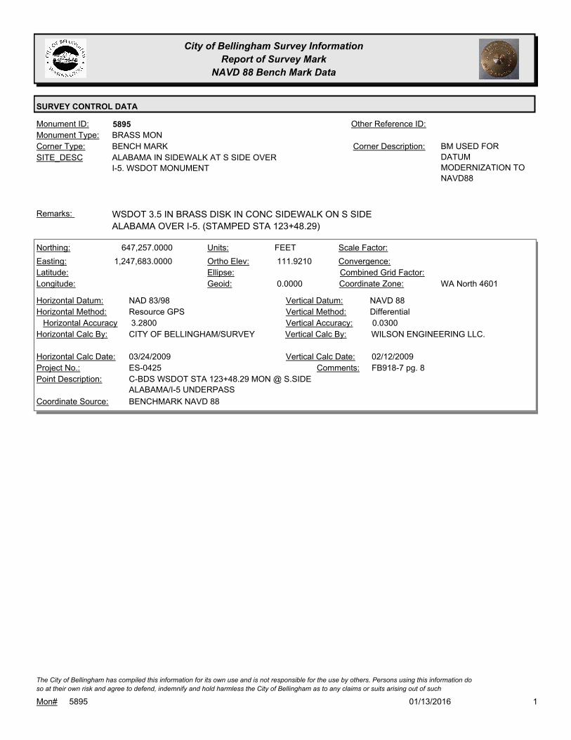
City of Bellingham Survey Information
Report of Survey Mark
NAVD 88 Bench Mark Data
SURVEY CONTROL DATA
5895Monument ID: Other Reference ID:
SITE_DESC ALABAMA IN SIDEWALK AT S SIDE OVER
I-5. WSDOT MONUMENT
BENCH MARKCorner Type: BM USED FOR
DATUM
MODERNIZATION TO
NAVD88
Corner Description:
BRASS MONMonument Type:
WSDOT 3.5 IN BRASS DISK IN CONC SIDEWALK ON S SIDE
ALABAMA OVER I-5. (STAMPED STA 123+48.29)
Remarks:
647,257.0000
1,247,683.0000 111.9210
0.0000
FEETNorthing:
Easting:
Latitude:
Longitude:
Units:
Ortho Elev:
Ellipse:
Geoid:
Scale Factor:
Convergence:
Combined Grid Factor:
WA North 4601Coordinate Zone:
Resource GPSHorizontal Method:
NAD 83/98Horizontal Datum: NAVD 88Vertical Datum:
DifferentialVertical Method:
3.2800Horizontal Accuracy 0.0300Vertical Accuracy:
WILSON ENGINEERING LLC.Vertical Calc By:CITY OF BELLINGHAM/SURVEYHorizontal Calc By:
ES-0425Project No.:
C-BDS WSDOT STA 123+48.29 MON @ S.SIDE
ALABAMA/I-5 UNDERPASS
Point Description:
BENCHMARK NAVD 88Coordinate Source:
FB918-7 pg. 8Comments:
03/24/2009Horizontal Calc Date: 02/12/2009Vertical Calc Date:
101/13/2016Mon# 5895
The City of Bellingham has compiled this information for its own use and is not responsible for the use by others. Persons using this information do
so at their own risk and agree to defend, indemnify and hold harmless the City of Bellingham as to any claims or suits arising out of such

City of Bellingham Survey Information
Report of Survey Mark
NAVD 88 Bench Mark Data
SURVEY CONTROL DATA
5896Monument ID: Other Reference ID:
SITE_DESC MEADOR & STATE AT NE CORNER IN
SIGNAL BASE
BENCH MARKCorner Type: BM USED FOR
DATUM
MODERNIZATION TO
NAVD88
Corner Description:
BOLTMonument Type:
SOUTH-MOST BOLT ON SIGNAL STANDARD AT NE SIDE MEADOR,
NE QUAD INTERSECTION
Remarks:
643,925.0000
1,245,846.0000 63.3960
0.0000
FEETNorthing:
Easting:
Latitude:
Longitude:
Units:
Ortho Elev:
Ellipse:
Geoid:
Scale Factor:
Convergence:
Combined Grid Factor:
WA North 4601Coordinate Zone:
Resource GPSHorizontal Method:
NAD 83/98Horizontal Datum: NAVD 88Vertical Datum:
DifferentialVertical Method:
3.2800Horizontal Accuracy 0.0300Vertical Accuracy:
WILSON ENGINEERING LLC.Vertical Calc By:CITY OF BELLINGHAM/SURVEYHorizontal Calc By:
ES-0425Project No.:
C-BM S BOLT SIGNAL STDRD NE QUAD
MEADOR/KANSAS/STATE
Point Description:
BENCHMARK NAVD 88Coordinate Source:
FB918-6 pg. 34Comments:
03/24/2009Horizontal Calc Date: 02/04/2009Vertical Calc Date:
643,925.0620
1,245,845.5870 63.4000
FEETNorthing:
Easting:
Latitude:
Longitude:
Units:
Ortho Elev:
Ellipse:
Geoid:
Scale Factor:
Convergence:
Combined Grid Factor:
WA North 4601Coordinate Zone:
Conventional SurveyHorizontal Method:
NAD 83/98Horizontal Datum: NAVD 88Vertical Datum:
DifferentialVertical Method:
0.0200Horizontal Accuracy 0.0300Vertical Accuracy:
LARRY STEELE & ASSOCIATESVertical Calc By:LARRY STEELE & ASSOCIATESHorizontal Calc By:
EU-0163Project No.:
C-RRS-S.BOLT-LITE POLEPoint Description:
NAD 83/98 PROJECT POINTSCoordinate Source:
FB 992-1Comments:
07/01/2014Horizontal Calc Date: 07/01/2014Vertical Calc Date:
101/13/2016Mon# 5896
The City of Bellingham has compiled this information for its own use and is not responsible for the use by others. Persons using this information do
so at their own risk and agree to defend, indemnify and hold harmless the City of Bellingham as to any claims or suits arising out of such
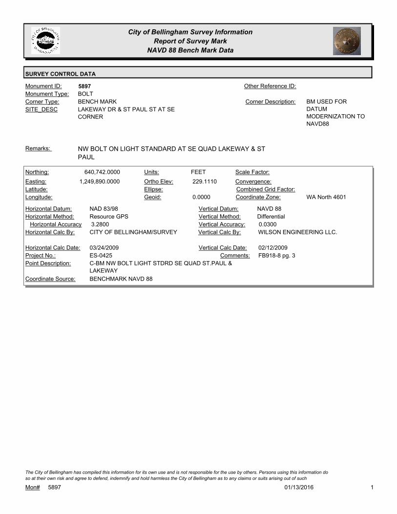
City of Bellingham Survey Information
Report of Survey Mark
NAVD 88 Bench Mark Data
SURVEY CONTROL DATA
5897Monument ID: Other Reference ID:
SITE_DESC LAKEWAY DR & ST PAUL ST AT SE
CORNER
BENCH MARKCorner Type: BM USED FOR
DATUM
MODERNIZATION TO
NAVD88
Corner Description:
BOLTMonument Type:
NW BOLT ON LIGHT STANDARD AT SE QUAD LAKEWAY & ST
PAUL
Remarks:
640,742.0000
1,249,890.0000 229.1110
0.0000
FEETNorthing:
Easting:
Latitude:
Longitude:
Units:
Ortho Elev:
Ellipse:
Geoid:
Scale Factor:
Convergence:
Combined Grid Factor:
WA North 4601Coordinate Zone:
Resource GPSHorizontal Method:
NAD 83/98Horizontal Datum: NAVD 88Vertical Datum:
DifferentialVertical Method:
3.2800Horizontal Accuracy 0.0300Vertical Accuracy:
WILSON ENGINEERING LLC.Vertical Calc By:CITY OF BELLINGHAM/SURVEYHorizontal Calc By:
ES-0425Project No.:
C-BM NW BOLT LIGHT STDRD SE QUAD ST.PAUL &
LAKEWAY
Point Description:
BENCHMARK NAVD 88Coordinate Source:
FB918-8 pg. 3Comments:
03/24/2009Horizontal Calc Date: 02/12/2009Vertical Calc Date:
101/13/2016Mon# 5897
The City of Bellingham has compiled this information for its own use and is not responsible for the use by others. Persons using this information do
so at their own risk and agree to defend, indemnify and hold harmless the City of Bellingham as to any claims or suits arising out of such

City of Bellingham Survey Information
Report of Survey Mark
NAVD 88 Bench Mark Data
SURVEY CONTROL DATA
5898Monument ID: Other Reference ID:
SITE_DESC LAKEWAY DR AT N SIDE BETWEEN
VERONA & OLD LAKEWAY
BENCH MARKCorner Type: BM USED FOR
DATUM
MODERNIZATION TO
NAVD88
Corner Description:
BOLTMonument Type:
SW BOLT OF LIGHT STANDARD AT N SIDE LAKEWAY DR NEAR
VERONA ST
Remarks:
640,820.0000
1,250,820.0000 264.5350
0.0000
FEETNorthing:
Easting:
Latitude:
Longitude:
Units:
Ortho Elev:
Ellipse:
Geoid:
Scale Factor:
Convergence:
Combined Grid Factor:
WA North 4601Coordinate Zone:
Resource GPSHorizontal Method:
NAD 83/98Horizontal Datum: NAVD 88Vertical Datum:
DifferentialVertical Method:
3.2800Horizontal Accuracy 0.0300Vertical Accuracy:
WILSON ENGINEERING LLC.Vertical Calc By:CITY OF BELLINGHAM/SURVEYHorizontal Calc By:
ES-0425Project No.:
C-BM SW BOLT LIGHT STDRD N.SIDE LAKEWAY E.
OF VERONA
Point Description:
BENCHMARK NAVD 88Coordinate Source:
FB918-8 pg. 5Comments:
03/24/2009Horizontal Calc Date: 02/12/2009Vertical Calc Date:
101/13/2016Mon# 5898
The City of Bellingham has compiled this information for its own use and is not responsible for the use by others. Persons using this information do
so at their own risk and agree to defend, indemnify and hold harmless the City of Bellingham as to any claims or suits arising out of such

City of Bellingham Survey Information
Report of Survey Mark
NAVD 88 Bench Mark Data
SURVEY CONTROL DATA
5900Monument ID: Other Reference ID:
SITE_DESC S STATE ST & DICKENS AVE W OF
PAVEMENT BETWEEN HC PARKING STALL
AND LIGHT POLE. ACROSS FROM RES #341
BENCH MARKCorner Type: Corner Description:
BRASS MONMonument Type:
BM SET FOR DATUM MODERNIZATION TO NAVD88Remarks:
636,456.0000
1,238,436.0000 81.0920
0.0000
FEETNorthing:
Easting:
Latitude:
Longitude:
Units:
Ortho Elev:
Ellipse:
Geoid:
Scale Factor:
Convergence:
Combined Grid Factor:
WA North 4601Coordinate Zone:
Resource GPSHorizontal Method:
NAD 83/98Horizontal Datum: NAVD 88Vertical Datum:
DifferentialVertical Method:
3.2800Horizontal Accuracy 0.0200Vertical Accuracy:
LARRY STEELE & ASSOCIATESVertical Calc By:CITY OF BELLINGHAM/SURVEYHorizontal Calc By:
ES-0425Project No.:
BRASS MON IN CONC. BY LIGHT POLE AT STATE &
DICKENS
Point Description:
BENCHMARK NAVD 88Coordinate Source:
FB 918-11Comments:
01/07/2009Horizontal Calc Date: 02/17/2009Vertical Calc Date:
101/13/2016Mon# 5900
The City of Bellingham has compiled this information for its own use and is not responsible for the use by others. Persons using this information do
so at their own risk and agree to defend, indemnify and hold harmless the City of Bellingham as to any claims or suits arising out of such

City of Bellingham Survey Information
Report of Survey Mark
NAVD 88 Bench Mark Data
SURVEY CONTROL DATA
5901Monument ID: Other Reference ID:
SITE_DESC E SIDE S STATE ST N OF 13TH ST AT SW
CORNER CONC PAD OF BUS STOP
BENCH MARKCorner Type: Corner Description:
BRASS MONMonument Type:
BM SET FOR DATUM MODERNIZATION TO NAVD88Remarks:
635,618.0000
1,237,867.0000 75.5900
0.0000
FEETNorthing:
Easting:
Latitude:
Longitude:
Units:
Ortho Elev:
Ellipse:
Geoid:
Scale Factor:
Convergence:
Combined Grid Factor:
WA North 4601Coordinate Zone:
Resource GPSHorizontal Method:
NAD 83/98Horizontal Datum: NAVD 88Vertical Datum:
DifferentialVertical Method:
3.2800Horizontal Accuracy 0.0200Vertical Accuracy:
LARRY STEELE & ASSOCIATESVertical Calc By:CITY OF BELLINGHAM/SURVEYHorizontal Calc By:
ES-0425Project No.:
BRASS MON AT BUS STOP, E SIDE STATE ST, N OF
13TH ST
Point Description:
BENCHMARK NAVD 88Coordinate Source:
FB 918-11Comments:
01/07/2009Horizontal Calc Date: 02/17/2009Vertical Calc Date:
101/13/2016Mon# 5901
The City of Bellingham has compiled this information for its own use and is not responsible for the use by others. Persons using this information do
so at their own risk and agree to defend, indemnify and hold harmless the City of Bellingham as to any claims or suits arising out of such
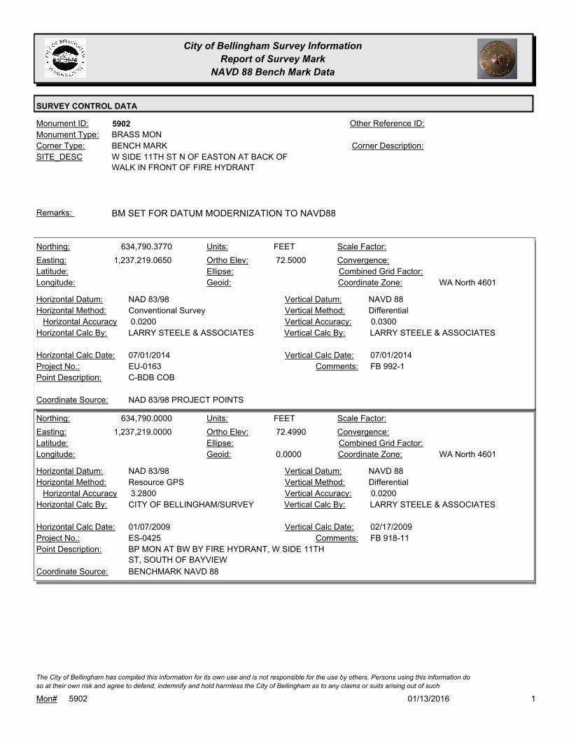
City of Bellingham Survey Information
Report of Survey Mark
NAVD 88 Bench Mark Data
SURVEY CONTROL DATA
5902Monument ID: Other Reference ID:
SITE_DESC W SIDE 11TH ST N OF EASTON AT BACK OF
WALK IN FRONT OF FIRE HYDRANT
BENCH MARKCorner Type: Corner Description:
BRASS MONMonument Type:
BM SET FOR DATUM MODERNIZATION TO NAVD88Remarks:
634,790.3770
1,237,219.0650 72.5000
FEETNorthing:
Easting:
Latitude:
Longitude:
Units:
Ortho Elev:
Ellipse:
Geoid:
Scale Factor:
Convergence:
Combined Grid Factor:
WA North 4601Coordinate Zone:
Conventional SurveyHorizontal Method:
NAD 83/98Horizontal Datum: NAVD 88Vertical Datum:
DifferentialVertical Method:
0.0200Horizontal Accuracy 0.0300Vertical Accuracy:
LARRY STEELE & ASSOCIATESVertical Calc By:LARRY STEELE & ASSOCIATESHorizontal Calc By:
EU-0163Project No.:
C-BDB COBPoint Description:
NAD 83/98 PROJECT POINTSCoordinate Source:
FB 992-1Comments:
07/01/2014Horizontal Calc Date: 07/01/2014Vertical Calc Date:
634,790.0000
1,237,219.0000 72.4990
0.0000
FEETNorthing:
Easting:
Latitude:
Longitude:
Units:
Ortho Elev:
Ellipse:
Geoid:
Scale Factor:
Convergence:
Combined Grid Factor:
WA North 4601Coordinate Zone:
Resource GPSHorizontal Method:
NAD 83/98Horizontal Datum: NAVD 88Vertical Datum:
DifferentialVertical Method:
3.2800Horizontal Accuracy 0.0200Vertical Accuracy:
LARRY STEELE & ASSOCIATESVertical Calc By:CITY OF BELLINGHAM/SURVEYHorizontal Calc By:
ES-0425Project No.:
BP MON AT BW BY FIRE HYDRANT, W SIDE 11TH
ST, SOUTH OF BAYVIEW
Point Description:
BENCHMARK NAVD 88Coordinate Source:
FB 918-11Comments:
01/07/2009Horizontal Calc Date: 02/17/2009Vertical Calc Date:
101/13/2016Mon# 5902
The City of Bellingham has compiled this information for its own use and is not responsible for the use by others. Persons using this information do
so at their own risk and agree to defend, indemnify and hold harmless the City of Bellingham as to any claims or suits arising out of such

City of Bellingham Survey Information
Report of Survey Mark
NAVD 88 Bench Mark Data
SURVEY CONTROL DATA
5903Monument ID: Other Reference ID:
SITE_DESC E SIDE 11TH ST N OF GAMBIER & S OF
DOUGLAS, IN LAWN BETWEEN NO
PARKING SIGN AND EDGE OF PAVEMENT
BENCH MARKCorner Type: Corner Description:
BRASS MONMonument Type:
BM SET FOR DATUM MODERNIZATION TO NAVD88Remarks:
633,112.0000
1,237,315.0000 89.1070
0.0000
FEETNorthing:
Easting:
Latitude:
Longitude:
Units:
Ortho Elev:
Ellipse:
Geoid:
Scale Factor:
Convergence:
Combined Grid Factor:
WA North 4601Coordinate Zone:
Resource GPSHorizontal Method:
NAD 83/98Horizontal Datum: NAVD 88Vertical Datum:
DifferentialVertical Method:
3.2800Horizontal Accuracy 0.0200Vertical Accuracy:
LARRY STEELE & ASSOCIATESVertical Calc By:CITY OF BELLINGHAM/SURVEYHorizontal Calc By:
ES-0425Project No.:
BP IN CONC, BETWEEN EP & SIGN, E SIDE 11TH,
BETWEEN GAMBIER & DOUGLAS
Point Description:
BENCHMARK NAVD 88Coordinate Source:
FB 918-11Comments:
01/07/2009Horizontal Calc Date: 02/17/2009Vertical Calc Date:
101/13/2016Mon# 5903
The City of Bellingham has compiled this information for its own use and is not responsible for the use by others. Persons using this information do
so at their own risk and agree to defend, indemnify and hold harmless the City of Bellingham as to any claims or suits arising out of such

City of Bellingham Survey Information
Report of Survey Mark
NAVD 88 Bench Mark Data
SURVEY CONTROL DATA
5904Monument ID: Other Reference ID:
SITE_DESC NE CORNER 12TH & HARRIS IN SIDEWALK
BULB-OUT 1 FT BACK OF CURB BETWEEN
RAMPS
BENCH MARKCorner Type: Corner Description:
BRASS MONMonument Type:
BM SET FOR DATUM MODERNIZATION TO NAVD88Remarks:
631,870.0000
1,237,595.0000 88.9560
0.0000
FEETNorthing:
Easting:
Latitude:
Longitude:
Units:
Ortho Elev:
Ellipse:
Geoid:
Scale Factor:
Convergence:
Combined Grid Factor:
WA North 4601Coordinate Zone:
Resource GPSHorizontal Method:
NAD 83/98Horizontal Datum: NAVD 88Vertical Datum:
DifferentialVertical Method:
3.2800Horizontal Accuracy 0.0200Vertical Accuracy:
LARRY STEELE & ASSOCIATESVertical Calc By:CITY OF BELLINGHAM/SURVEYHorizontal Calc By:
ES-0425Project No.:
BP AT NE COR. OF 12TH & HARRIS 1' BACK CURB
BETWEEN RAMPS
Point Description:
BENCHMARK NAVD 88Coordinate Source:
FB 918-11Comments:
01/07/2009Horizontal Calc Date: 02/17/2009Vertical Calc Date:
101/13/2016Mon# 5904
The City of Bellingham has compiled this information for its own use and is not responsible for the use by others. Persons using this information do
so at their own risk and agree to defend, indemnify and hold harmless the City of Bellingham as to any claims or suits arising out of such
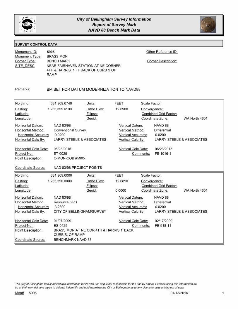
City of Bellingham Survey Information
Report of Survey Mark
NAVD 88 Bench Mark Data
SURVEY CONTROL DATA
5905Monument ID: Other Reference ID:
SITE_DESC NEAR FAIRHAVEN STATION AT NE CORNER
4TH & HARRIS. 1 FT BACK OF CURB S OF
RAMP
BENCH MARKCorner Type: Corner Description:
BRASS MONMonument Type:
BM SET FOR DATUM MODERNIZATION TO NAVD88Remarks:
631,909.0740
1,235,355.6190 12.6900
FEETNorthing:
Easting:
Latitude:
Longitude:
Units:
Ortho Elev:
Ellipse:
Geoid:
Scale Factor:
Convergence:
Combined Grid Factor:
WA North 4601Coordinate Zone:
Conventional SurveyHorizontal Method:
NAD 83/98Horizontal Datum: NAVD 88Vertical Datum:
DifferentialVertical Method:
0.0200Horizontal Accuracy 0.0200Vertical Accuracy:
LARRY STEELE & ASSOCIATESVertical Calc By:LARRY STEELE & ASSOCIATESHorizontal Calc By:
ET-0029Project No.:
C-MON-COB #5905Point Description:
NAD 83/98 PROJECT POINTSCoordinate Source:
FB 1016-1Comments:
06/23/2015Horizontal Calc Date: 06/23/2015Vertical Calc Date:
631,909.0000
1,235,356.0000 12.6890
0.0000
FEETNorthing:
Easting:
Latitude:
Longitude:
Units:
Ortho Elev:
Ellipse:
Geoid:
Scale Factor:
Convergence:
Combined Grid Factor:
WA North 4601Coordinate Zone:
Resource GPSHorizontal Method:
NAD 83/98Horizontal Datum: NAVD 88Vertical Datum:
DifferentialVertical Method:
3.2800Horizontal Accuracy 0.0200Vertical Accuracy:
LARRY STEELE & ASSOCIATESVertical Calc By:CITY OF BELLINGHAM/SURVEYHorizontal Calc By:
ES-0425Project No.:
BRASS MON AT NE COR 4TH & HARRIS 1' BACK
CURB S. OF RAMP
Point Description:
BENCHMARK NAVD 88Coordinate Source:
FB 918-11Comments:
01/07/2009Horizontal Calc Date: 02/17/2009Vertical Calc Date:
101/13/2016Mon# 5905
The City of Bellingham has compiled this information for its own use and is not responsible for the use by others. Persons using this information do
so at their own risk and agree to defend, indemnify and hold harmless the City of Bellingham as to any claims or suits arising out of such

City of Bellingham Survey Information
Report of Survey Mark
NAVD 88 Bench Mark Data
SURVEY CONTROL DATA
5906Monument ID: Other Reference ID:
SITE_DESC AT SW CORNER 6TH & COWGILL. 1 FT N OF
WLY FENCE CORNER IN GRAVEL AREA.
BENCH MARKCorner Type: Corner Description:
BRASS MONMonument Type:
BM SET FOR DATUM MODERNIZATION TO NAVD88Remarks:
630,355.0000
1,235,842.0000 61.8440
0.0000
FEETNorthing:
Easting:
Latitude:
Longitude:
Units:
Ortho Elev:
Ellipse:
Geoid:
Scale Factor:
Convergence:
Combined Grid Factor:
WA North 4601Coordinate Zone:
Resource GPSHorizontal Method:
NAD 83/98Horizontal Datum: NAVD 88Vertical Datum:
DifferentialVertical Method:
3.2800Horizontal Accuracy 0.0200Vertical Accuracy:
LARRY STEELE & ASSOCIATESVertical Calc By:CITY OF BELLINGHAM/SURVEYHorizontal Calc By:
ES-0425Project No.:
BP AT SW COR 6TH & COWGILL 1' NORTH OF WLY
FENCE COR
Point Description:
BENCHMARK NAVD 88Coordinate Source:
FB 918-11Comments:
01/07/2009Horizontal Calc Date: 02/17/2009Vertical Calc Date:
101/13/2016Mon# 5906
The City of Bellingham has compiled this information for its own use and is not responsible for the use by others. Persons using this information do
so at their own risk and agree to defend, indemnify and hold harmless the City of Bellingham as to any claims or suits arising out of such

City of Bellingham Survey Information
Report of Survey Mark
NAVD 88 Bench Mark Data
SURVEY CONTROL DATA
5907Monument ID: Other Reference ID:
SITE_DESC SE CORNER 12TH & OLD FAIRHAVEN
PARKWAY, S OF RAMP, 1 FT FROM FACE
OF WALK
BENCH MARKCorner Type: Corner Description:
BRASS MONMonument Type:
BM SET FOR DATUM MODERNIZATION TO NAVD88Remarks:
630,896.0000
1,237,582.0000 105.7830
0.0000
FEETNorthing:
Easting:
Latitude:
Longitude:
Units:
Ortho Elev:
Ellipse:
Geoid:
Scale Factor:
Convergence:
Combined Grid Factor:
WA North 4601Coordinate Zone:
Resource GPSHorizontal Method:
NAD 83/98Horizontal Datum: NAVD 88Vertical Datum:
DifferentialVertical Method:
3.2800Horizontal Accuracy 0.0200Vertical Accuracy:
LARRY STEELE & ASSOCIATESVertical Calc By:CITY OF BELLINGHAM/SURVEYHorizontal Calc By:
ES-0425Project No.:
BP AT SE COR 12TH & FAIRHAVEN PKWY 1' FACE
WALK S. OF RAMP
Point Description:
BENCHMARK NAVD 88Coordinate Source:
FB 918-11Comments:
01/07/2009Horizontal Calc Date: 02/17/2009Vertical Calc Date:
101/13/2016Mon# 5907
The City of Bellingham has compiled this information for its own use and is not responsible for the use by others. Persons using this information do
so at their own risk and agree to defend, indemnify and hold harmless the City of Bellingham as to any claims or suits arising out of such

City of Bellingham Survey Information
Report of Survey Mark
NAVD 88 Bench Mark Data
SURVEY CONTROL DATA
5908Monument ID: Other Reference ID:
SITE_DESC S OF OLD FAIRHAVEN PARKWAY & E OF
16TH AT NE CORNER CONC PAD FOR BUS
SHELTER
BENCH MARKCorner Type: Corner Description:
BRASS MONMonument Type:
BM SET FOR DATUM MODERNIZATION TO NAVD88Remarks:
630,374.0000
1,238,851.0000 117.3150
0.0000
FEETNorthing:
Easting:
Latitude:
Longitude:
Units:
Ortho Elev:
Ellipse:
Geoid:
Scale Factor:
Convergence:
Combined Grid Factor:
WA North 4601Coordinate Zone:
Resource GPSHorizontal Method:
NAD 83/98Horizontal Datum: NAVD 88Vertical Datum:
DifferentialVertical Method:
3.2800Horizontal Accuracy 0.0200Vertical Accuracy:
LARRY STEELE & ASSOCIATESVertical Calc By:CITY OF BELLINGHAM/SURVEYHorizontal Calc By:
ES-0425Project No.:
BP AT NE COR BUS SHELTER S OF FAIRHAVEN
PKWY E. OF 16TH
Point Description:
BENCHMARK NAVD 88Coordinate Source:
FB 918-11Comments:
01/07/2009Horizontal Calc Date: 02/17/2009Vertical Calc Date:
101/13/2016Mon# 5908
The City of Bellingham has compiled this information for its own use and is not responsible for the use by others. Persons using this information do
so at their own risk and agree to defend, indemnify and hold harmless the City of Bellingham as to any claims or suits arising out of such
City of Bellingham Survey Information
Report of Survey Mark
NAVD 88 Bench Mark Data
SURVEY CONTROL DATA
5909Monument ID: Other Reference ID:
SITE_DESC S SIDE OLD FAIRHAVEN PARKWAY AT E
SIDE WALKWAY TO #2600 (FAIRHAVEN
ESTATES)
BENCH MARKCorner Type: Corner Description:
BRASS MONMonument Type:
BM SET FOR DATUM MODERNIZATION TO NAVD88Remarks:
629,712.0000
1,242,257.0000 122.1020
0.0000
FEETNorthing:
Easting:
Latitude:
Longitude:
Units:
Ortho Elev:
Ellipse:
Geoid:
Scale Factor:
Convergence:
Combined Grid Factor:
WA North 4601Coordinate Zone:
Resource GPSHorizontal Method:
NAD 83/98Horizontal Datum: NAVD 88Vertical Datum:
DifferentialVertical Method:
3.2800Horizontal Accuracy 0.0200Vertical Accuracy:
LARRY STEELE & ASSOCIATESVertical Calc By:CITY OF BELLINGHAM/SURVEYHorizontal Calc By:
ES-0425Project No.:
BP E. SIDE WALKWAY S. SIDE FAIRHAVEN PKWY,
RES # 2600
Point Description:
BENCHMARK NAVD 88Coordinate Source:
FB 918-11Comments:
01/07/2009Horizontal Calc Date: 02/17/2009Vertical Calc Date:
101/13/2016Mon# 5909
The City of Bellingham has compiled this information for its own use and is not responsible for the use by others. Persons using this information do
so at their own risk and agree to defend, indemnify and hold harmless the City of Bellingham as to any claims or suits arising out of such

City of Bellingham Survey Information
Report of Survey Mark
NAVD 88 Bench Mark Data
SURVEY CONTROL DATA
5910Monument ID: Other Reference ID:
SITE_DESC OLD FAIRHAVEN PARKWAY AT OLD 32ND
ST, W OF I-5 ON N SIDE AT BALK OF WALK.
BENCH MARKCorner Type: Corner Description:
BRASS MONMonument Type:
BM SET FOR DATUM MODERNIZATION TO NAVD88Remarks:
629,684.0000
1,243,970.0000 176.8810
0.0000
FEETNorthing:
Easting:
Latitude:
Longitude:
Units:
Ortho Elev:
Ellipse:
Geoid:
Scale Factor:
Convergence:
Combined Grid Factor:
WA North 4601Coordinate Zone:
Resource GPSHorizontal Method:
NAD 83/98Horizontal Datum: NAVD 88Vertical Datum:
DifferentialVertical Method:
3.2800Horizontal Accuracy 0.0200Vertical Accuracy:
LARRY STEELE & ASSOCIATESVertical Calc By:CITY OF BELLINGHAM/SURVEYHorizontal Calc By:
ES-0425Project No.:
BP N. SIDE OF SIDEWALK, INTER FAIRHAVEN
PKWY & 32ND
Point Description:
BENCHMARK NAVD 88Coordinate Source:
FB 918-11Comments:
01/07/2009Horizontal Calc Date: 02/17/2009Vertical Calc Date:
101/13/2016Mon# 5910
The City of Bellingham has compiled this information for its own use and is not responsible for the use by others. Persons using this information do
so at their own risk and agree to defend, indemnify and hold harmless the City of Bellingham as to any claims or suits arising out of such

City of Bellingham Survey Information
Report of Survey Mark
NAVD 88 Bench Mark Data
SURVEY CONTROL DATA
5911Monument ID: Other Reference ID:
SITE_DESC 32ND ST & APPROX 50 FT N OF MCKENZIE
AT W BACK OF WALK
BENCH MARKCorner Type: Corner Description:
BRASS MONMonument Type:
BM SET FOR DATUM MODERNIZATION TO NAVD88Remarks:
631,407.0000
1,244,012.0000 182.6570
0.0000
FEETNorthing:
Easting:
Latitude:
Longitude:
Units:
Ortho Elev:
Ellipse:
Geoid:
Scale Factor:
Convergence:
Combined Grid Factor:
WA North 4601Coordinate Zone:
Resource GPSHorizontal Method:
NAD 83/98Horizontal Datum: NAVD 88Vertical Datum:
DifferentialVertical Method:
3.2800Horizontal Accuracy 0.0200Vertical Accuracy:
LARRY STEELE & ASSOCIATESVertical Calc By:CITY OF BELLINGHAM/SURVEYHorizontal Calc By:
ES-0425Project No.:
BP AT WEST BACKWALK ON 32ND, 50' NORTH OF
MCKENZIE
Point Description:
BENCHMARK NAVD 88Coordinate Source:
FB 918-11Comments:
01/07/2009Horizontal Calc Date: 02/17/2009Vertical Calc Date:
101/13/2016Mon# 5911
The City of Bellingham has compiled this information for its own use and is not responsible for the use by others. Persons using this information do
so at their own risk and agree to defend, indemnify and hold harmless the City of Bellingham as to any claims or suits arising out of such

City of Bellingham Survey Information
Report of Survey Mark
NAVD 88 Bench Mark Data
SURVEY CONTROL DATA
5912Monument ID: Other Reference ID:
SITE_DESC W SIDE OF 32ND ST S OF ADAMS AT SLY
ENTRANCE TO #700, IN BACK OF WALK BY
RAMP
BENCH MARKCorner Type: Corner Description:
BRASS MONMonument Type:
BM SET FOR DATUM MODERNIZATION TO NAVD88Remarks:
634,200.0000
1,244,067.0000 176.4350
0.0000
FEETNorthing:
Easting:
Latitude:
Longitude:
Units:
Ortho Elev:
Ellipse:
Geoid:
Scale Factor:
Convergence:
Combined Grid Factor:
WA North 4601Coordinate Zone:
Resource GPSHorizontal Method:
NAD 83/98Horizontal Datum: NAVD 88Vertical Datum:
DifferentialVertical Method:
3.2800Horizontal Accuracy 0.0200Vertical Accuracy:
LARRY STEELE & ASSOCIATESVertical Calc By:CITY OF BELLINGHAM/SURVEYHorizontal Calc By:
ES-0425Project No.:
BP AT W.BACKWALK AT RAMP ON 32ND ST, S
ENTRANCE TO RES#700
Point Description:
BENCHMARK NAVD 88Coordinate Source:
FB 918-11Comments:
01/07/2009Horizontal Calc Date: 02/17/2009Vertical Calc Date:
101/13/2016Mon# 5912
The City of Bellingham has compiled this information for its own use and is not responsible for the use by others. Persons using this information do
so at their own risk and agree to defend, indemnify and hold harmless the City of Bellingham as to any claims or suits arising out of such

City of Bellingham Survey Information
Report of Survey Mark
NAVD 88 Bench Mark Data
SURVEY CONTROL DATA
5913Monument ID: Other Reference ID:
SITE_DESC S SIDE FIELDING AVE W OF FREEWAY
ON-RAMP AT BACK OF WALK BY FIRE
HYDRANT. E OF BUS SHELTER.
BENCH MARKCorner Type: Corner Description:
BRASS MONMonument Type:
BM SET FOR DATUM MODERNIZATION TO NAVD88Remarks:
635,277.0000
1,244,848.0000 193.1970
0.0000
FEETNorthing:
Easting:
Latitude:
Longitude:
Units:
Ortho Elev:
Ellipse:
Geoid:
Scale Factor:
Convergence:
Combined Grid Factor:
WA North 4601Coordinate Zone:
Resource GPSHorizontal Method:
NAD 83/98Horizontal Datum: NAVD 88Vertical Datum:
DifferentialVertical Method:
3.2800Horizontal Accuracy 0.0200Vertical Accuracy:
LARRY STEELE & ASSOCIATESVertical Calc By:CITY OF BELLINGHAM/SURVEYHorizontal Calc By:
ES-0425Project No.:
BP AT S.SIDE FIELDING AT BACKWALK, W.OF I-5
RAMP, BY FH
Point Description:
BENCHMARK NAVD 88Coordinate Source:
FB 918-11Comments:
01/07/2009Horizontal Calc Date: 02/17/2009Vertical Calc Date:
101/13/2016Mon# 5913
The City of Bellingham has compiled this information for its own use and is not responsible for the use by others. Persons using this information do
so at their own risk and agree to defend, indemnify and hold harmless the City of Bellingham as to any claims or suits arising out of such

City of Bellingham Survey Information
Report of Survey Mark
NAVD 88 Bench Mark Data
SURVEY CONTROL DATA
5914Monument ID: Other Reference ID:
SITE_DESC E SIDE LINCOLN ST N OF BYRON. AT S END
OF WWU BUS STOP IN BACK OF WALK BY
GARBAGE CAN
BENCH MARKCorner Type: Corner Description:
BRASS MONMonument Type:
BM SET FOR DATUM MODERNIZATION TO NAVD88Remarks:
636,874.0000
1,246,407.0000 184.3320
0.0000
FEETNorthing:
Easting:
Latitude:
Longitude:
Units:
Ortho Elev:
Ellipse:
Geoid:
Scale Factor:
Convergence:
Combined Grid Factor:
WA North 4601Coordinate Zone:
Resource GPSHorizontal Method:
NAD 83/98Horizontal Datum: NAVD 88Vertical Datum:
DifferentialVertical Method:
3.2800Horizontal Accuracy 0.0200Vertical Accuracy:
LARRY STEELE & ASSOCIATESVertical Calc By:CITY OF BELLINGHAM/SURVEYHorizontal Calc By:
ES-0425Project No.:
BP AT S END WWU BUS STOP, E. SIDE LINCOLN, N
OF BYRON
Point Description:
BENCHMARK NAVD 88Coordinate Source:
FB 918-11Comments:
01/07/2009Horizontal Calc Date: 02/17/2009Vertical Calc Date:
101/13/2016Mon# 5914
The City of Bellingham has compiled this information for its own use and is not responsible for the use by others. Persons using this information do
so at their own risk and agree to defend, indemnify and hold harmless the City of Bellingham as to any claims or suits arising out of such

City of Bellingham Survey Information
Report of Survey Mark
NAVD 88 Bench Mark Data
SURVEY CONTROL DATA
5915Monument ID: Other Reference ID:
SITE_DESC E SIDE LINCOLN ST N OF SLY ENTRANCE
TO LAKEWAY MOBILE ESTATES. AT BACK
OF WALK IN FRONT OF SIGN.
BENCH MARKCorner Type: Corner Description:
BRASS MONMonument Type:
BM SET FOR DATUM MODERNIZATION TO NAVD88Remarks:
638,485.0000
1,246,784.0000 162.3380
0.0000
FEETNorthing:
Easting:
Latitude:
Longitude:
Units:
Ortho Elev:
Ellipse:
Geoid:
Scale Factor:
Convergence:
Combined Grid Factor:
WA North 4601Coordinate Zone:
Resource GPSHorizontal Method:
NAD 83/98Horizontal Datum: NAVD 88Vertical Datum:
DifferentialVertical Method:
3.2800Horizontal Accuracy 0.0200Vertical Accuracy:
LARRY STEELE & ASSOCIATESVertical Calc By:CITY OF BELLINGHAM/SURVEYHorizontal Calc By:
ES-0425Project No.:
BP AT BW BY SIGN, E SIDE LINCOLN AT SLY DWY
MOBILE ESTATES
Point Description:
BENCHMARK NAVD 88Coordinate Source:
FB 918-11Comments:
01/07/2009Horizontal Calc Date: 02/17/2009Vertical Calc Date:
101/13/2016Mon# 5915
The City of Bellingham has compiled this information for its own use and is not responsible for the use by others. Persons using this information do
so at their own risk and agree to defend, indemnify and hold harmless the City of Bellingham as to any claims or suits arising out of such

City of Bellingham Survey Information
Report of Survey Mark
NAVD 88 Bench Mark Data
SURVEY CONTROL DATA
5916Monument ID: Other Reference ID:
SITE_DESC E SIDE LINCOLN ST AT N ENTRANCE OF
LAKEWAY MOBILE ESTATES. AT SW
CORNER UTILITY VAULT, S OF LAKEWAY
CENTER.
BENCH MARKCorner Type: Corner Description:
BRASS MONMonument Type:
BM SET FOR DATUM MODERNIZATION TO NAVD88Remarks:
640,168.0000
1,247,352.0000 161.4760
0.0000
FEETNorthing:
Easting:
Latitude:
Longitude:
Units:
Ortho Elev:
Ellipse:
Geoid:
Scale Factor:
Convergence:
Combined Grid Factor:
WA North 4601Coordinate Zone:
Resource GPSHorizontal Method:
NAD 83/98Horizontal Datum: NAVD 88Vertical Datum:
DifferentialVertical Method:
3.2800Horizontal Accuracy 0.0200Vertical Accuracy:
LARRY STEELE & ASSOCIATESVertical Calc By:CITY OF BELLINGHAM/SURVEYHorizontal Calc By:
ES-0425Project No.:
BP AT SW COR VAULT, E SIDE LINCOLN AT NORTH
ENTRANCE TO MOBILE ESTATES
Point Description:
BENCHMARK NAVD 88Coordinate Source:
FB 918-11Comments:
01/07/2009Horizontal Calc Date: 02/17/2009Vertical Calc Date:
101/13/2016Mon# 5916
The City of Bellingham has compiled this information for its own use and is not responsible for the use by others. Persons using this information do
so at their own risk and agree to defend, indemnify and hold harmless the City of Bellingham as to any claims or suits arising out of such
City of Bellingham Survey Information
Report of Survey Mark
NAVD 88 Bench Mark Data
SURVEY CONTROL DATA
5919Monument ID: Other Reference ID:
SITE_DESC NE CORNER JERSEY & MAPLE AT
INTERSECTION OF BACK OF WALKS
BENCH MARKCorner Type: Corner Description:
BRASS MONMonument Type:
BM SET FOR DATUM MODERNIZATION TO NAVD88Remarks:
640,039.0000
1,244,369.0000 192.8080
0.0000
FEETNorthing:
Easting:
Latitude:
Longitude:
Units:
Ortho Elev:
Ellipse:
Geoid:
Scale Factor:
Convergence:
Combined Grid Factor:
WA North 4601Coordinate Zone:
Resource GPSHorizontal Method:
NAD 83/98Horizontal Datum: NAVD 88Vertical Datum:
DifferentialVertical Method:
3.2800Horizontal Accuracy 0.0200Vertical Accuracy:
LARRY STEELE & ASSOCIATESVertical Calc By:CITY OF BELLINGHAM/SURVEYHorizontal Calc By:
ES-0425Project No.:
BRASS MON AT BACK WALK, EASTERLY CORNER
JERSEY & MAPLE
Point Description:
BENCHMARK NAVD 88Coordinate Source:
FB 918-11 MEAN ADJUSTED
BETWEEN STEELE & WILSON
ELEVATIONS
Comments:
01/07/2009Horizontal Calc Date: 02/17/2009Vertical Calc Date:
640,039.0000
1,244,369.0000 192.8080
0.0000
FEETNorthing:
Easting:
Latitude:
Longitude:
Units:
Ortho Elev:
Ellipse:
Geoid:
Scale Factor:
Convergence:
Combined Grid Factor:
WA North 4601Coordinate Zone:
Resource GPSHorizontal Method:
NAD 83/98Horizontal Datum: NAVD 88Vertical Datum:
DifferentialVertical Method:
3.2800Horizontal Accuracy 0.0300Vertical Accuracy:
WILSON ENGINEERING LLC.Vertical Calc By:CITY OF BELLINGHAM/SURVEYHorizontal Calc By:
ES-0425Project No.:
C-BDS 2008 NAVD88 MON NW.QUAD JERSEY &
MAPLE
Point Description:
BENCHMARK NAVD 88Coordinate Source:
FB918-8 pg. 61Comments:
01/08/2009Horizontal Calc Date: 02/12/2009Vertical Calc Date:
101/13/2016Mon# 5919
The City of Bellingham has compiled this information for its own use and is not responsible for the use by others. Persons using this information do
so at their own risk and agree to defend, indemnify and hold harmless the City of Bellingham as to any claims or suits arising out of such

City of Bellingham Survey Information
Report of Survey Mark
NAVD 88 Bench Mark Data
SURVEY CONTROL DATA
5920Monument ID: Other Reference ID:
SITE_DESC SW CORNER MAPLE & GARDEN AT
INTERSECTION OF SIDEWALKS IN FRONT
OF CHURCH
BENCH MARKCorner Type: Corner Description:
BRASS MONMonument Type:
BM SET FOR DATUM MODERNIZATION TO NAVD88Remarks:
640,798.0000
1,243,549.0000 145.2320
0.0000
FEETNorthing:
Easting:
Latitude:
Longitude:
Units:
Ortho Elev:
Ellipse:
Geoid:
Scale Factor:
Convergence:
Combined Grid Factor:
WA North 4601Coordinate Zone:
Resource GPSHorizontal Method:
NAD 83/98Horizontal Datum: NAVD 88Vertical Datum:
DifferentialVertical Method:
3.2800Horizontal Accuracy 0.0200Vertical Accuracy:
LARRY STEELE & ASSOCIATESVertical Calc By:CITY OF BELLINGHAM/SURVEYHorizontal Calc By:
ES-0425Project No.:
BRASS MON AT INTER OF SIDEWALK, WESTERLY
CORNER GARDEN & MAPLE
Point Description:
BENCHMARK NAVD 88Coordinate Source:
FB 918-11Comments:
01/07/2009Horizontal Calc Date: 02/17/2009Vertical Calc Date:
101/13/2016Mon# 5920
The City of Bellingham has compiled this information for its own use and is not responsible for the use by others. Persons using this information do
so at their own risk and agree to defend, indemnify and hold harmless the City of Bellingham as to any claims or suits arising out of such

City of Bellingham Survey Information
Report of Survey Mark
NAVD 88 Bench Mark Data
SURVEY CONTROL DATA
5921Monument ID: Other Reference ID:
SITE_DESC S SIDE BILL MCDONALD PARKWAY, E OF
RES #3108. 1 FT N OF BACK OF WALK, 6 FT
N OF TEL RISER
BENCH MARKCorner Type: Corner Description:
BRASS MONMonument Type:
BM SET FOR DATUM MODERNIZATION TO NAVD88Remarks:
635,791.0000
1,243,886.0000 266.4520
0.0000
FEETNorthing:
Easting:
Latitude:
Longitude:
Units:
Ortho Elev:
Ellipse:
Geoid:
Scale Factor:
Convergence:
Combined Grid Factor:
WA North 4601Coordinate Zone:
Resource GPSHorizontal Method:
NAD 83/98Horizontal Datum: NAVD 88Vertical Datum:
DifferentialVertical Method:
3.2800Horizontal Accuracy 0.0200Vertical Accuracy:
LARRY STEELE & ASSOCIATESVertical Calc By:CITY OF BELLINGHAM/SURVEYHorizontal Calc By:
ES-0425Project No.:
BP 1' N. OF BACKWALK, 6' N OF TELERISER S.
SIDE BILL MCDONALD, E. RES #3108
Point Description:
BENCHMARK NAVD 88Coordinate Source:
FB 918-11Comments:
01/07/2009Horizontal Calc Date: 02/17/2009Vertical Calc Date:
101/13/2016Mon# 5921
The City of Bellingham has compiled this information for its own use and is not responsible for the use by others. Persons using this information do
so at their own risk and agree to defend, indemnify and hold harmless the City of Bellingham as to any claims or suits arising out of such

City of Bellingham Survey Information
Report of Survey Mark
NAVD 88 Bench Mark Data
SURVEY CONTROL DATA
5922Monument ID: Other Reference ID:
SITE_DESC BENCHMARK HAS BEEN DESTROYED
DURING CONSTRUCTION OF ES-0358. (SEE
MONUMENT 6119)
SW CORNER BILL MCDONALD PARKWAY &
25TH ST, 0.5 FT FROM BACK OF WALK
BENCH MARKCorner Type: Corner Description:
BRASS MONMonument Type:
BM HAS BEEN DESTROYED BY ES-0358. (SEE MONUMENT 6119)
BM SET FOR DATUM MODERNIZATION TO NAVD88
Remarks:
634,022.0000
1,241,662.0000 243.3960
0.0000
FEETNorthing:
Easting:
Latitude:
Longitude:
Units:
Ortho Elev:
Ellipse:
Geoid:
Scale Factor:
Convergence:
Combined Grid Factor:
WA North 4601Coordinate Zone:
Resource GPSHorizontal Method:
NAD 83/98Horizontal Datum: NAVD 88Vertical Datum:
DifferentialVertical Method:
3.2800Horizontal Accuracy 0.0200Vertical Accuracy:
LARRY STEELE & ASSOCIATESVertical Calc By:CITY OF BELLINGHAM/SURVEYHorizontal Calc By:
ES-0425Project No.:
BRASS MON AT BACKWALK, SW COR BILL
MCDONALD PKWY & 25TH ST
Point Description:
BENCHMARK NAVD 88Coordinate Source:
BENCHMARK DESTROYED BY
ES-0358. FB 918-11
Comments:
01/07/2009Horizontal Calc Date: 02/17/2009Vertical Calc Date:
101/13/2016Mon# 5922
The City of Bellingham has compiled this information for its own use and is not responsible for the use by others. Persons using this information do
so at their own risk and agree to defend, indemnify and hold harmless the City of Bellingham as to any claims or suits arising out of such
City of Bellingham Survey Information
Report of Survey Mark
NAVD 88 Bench Mark Data
SURVEY CONTROL DATA
5923Monument ID: Other Reference ID:
SITE_DESC SW CORNER BILL MCDONALD PARKWAY &
21ST ST, 0.5 FT FROM BACK OF WALK, 18
FT SLY OF SIGNAL POLE.
BENCH MARKCorner Type: Corner Description:
BRASS MONMonument Type:
BM SET FOR DATUM MODERNIZATION TO NAVD88Remarks:
634,150.0000
1,240,511.0000 261.5740
0.0000
FEETNorthing:
Easting:
Latitude:
Longitude:
Units:
Ortho Elev:
Ellipse:
Geoid:
Scale Factor:
Convergence:
Combined Grid Factor:
WA North 4601Coordinate Zone:
Resource GPSHorizontal Method:
NAD 83/98Horizontal Datum: NAVD 88Vertical Datum:
DifferentialVertical Method:
3.2800Horizontal Accuracy 0.0200Vertical Accuracy:
LARRY STEELE & ASSOCIATESVertical Calc By:CITY OF BELLINGHAM/SURVEYHorizontal Calc By:
ES-0425Project No.:
BRASS MON AT BACKWALK, SW COR BILL
MCDONALD & 21ST, 18' SLY SIGNAL POLE
Point Description:
BENCHMARK NAVD 88Coordinate Source:
FB 918-11Comments:
01/07/2009Horizontal Calc Date: 02/17/2009Vertical Calc Date:
101/13/2016Mon# 5923
The City of Bellingham has compiled this information for its own use and is not responsible for the use by others. Persons using this information do
so at their own risk and agree to defend, indemnify and hold harmless the City of Bellingham as to any claims or suits arising out of such

City of Bellingham Survey Information
Report of Survey Mark
NAVD 88 Bench Mark Data
SURVEY CONTROL DATA
5924Monument ID: Other Reference ID:
SITE_DESC E SIDE 21ST ST BETWEEN DOUGLAS &
KNOX NEAR RES #1021. LOCATED 1 FT W
OF BACK OF WALK & 9 FT W OF PP
BENCH MARKCorner Type: Corner Description:
BRASS MONMonument Type:
BM SET FOR DATUM MODERNIZATION TO NAVD88Remarks:
632,872.0000
1,240,482.0000 219.1260
0.0000
FEETNorthing:
Easting:
Latitude:
Longitude:
Units:
Ortho Elev:
Ellipse:
Geoid:
Scale Factor:
Convergence:
Combined Grid Factor:
WA North 4601Coordinate Zone:
Resource GPSHorizontal Method:
NAD 83/98Horizontal Datum: NAVD 88Vertical Datum:
DifferentialVertical Method:
3.2800Horizontal Accuracy 0.0200Vertical Accuracy:
LARRY STEELE & ASSOCIATESVertical Calc By:CITY OF BELLINGHAM/SURVEYHorizontal Calc By:
ES-0425Project No.:
BRASS MON AT BACKWALK, 9'W OF PP, E SIDE
21ST, BETWEEN DOUGLAS & KNOX
Point Description:
BENCHMARK NAVD 88Coordinate Source:
FB 918-11Comments:
01/07/2009Horizontal Calc Date: 02/17/2009Vertical Calc Date:
101/13/2016Mon# 5924
The City of Bellingham has compiled this information for its own use and is not responsible for the use by others. Persons using this information do
so at their own risk and agree to defend, indemnify and hold harmless the City of Bellingham as to any claims or suits arising out of such

City of Bellingham Survey Information
Report of Survey Mark
NAVD 88 Bench Mark Data
SURVEY CONTROL DATA
5925Monument ID: Other Reference ID:
SITE_DESC AT SE CORNER 21ST ST & HARRIS AVE.
LOCATED 1 FT FROM BACK OF WALK IN
FRONT OF PP
BENCH MARKCorner Type: Corner Description:
BRASS MONMonument Type:
BM SET FOR DATUM MODERNIZATION TO NAVD88Remarks:
631,755.0000
1,240,464.0000 140.1110
0.0000
FEETNorthing:
Easting:
Latitude:
Longitude:
Units:
Ortho Elev:
Ellipse:
Geoid:
Scale Factor:
Convergence:
Combined Grid Factor:
WA North 4601Coordinate Zone:
Resource GPSHorizontal Method:
NAD 83/98Horizontal Datum: NAVD 88Vertical Datum:
DifferentialVertical Method:
3.2800Horizontal Accuracy 0.0200Vertical Accuracy:
LARRY STEELE & ASSOCIATESVertical Calc By:CITY OF BELLINGHAM/SURVEYHorizontal Calc By:
ES-0425Project No.:
BRASS MON AT BACKWALK IN FRONT OF PP, SE
COR 21ST & HARRIS
Point Description:
BENCHMARK NAVD 88Coordinate Source:
FB 918-11Comments:
01/07/2009Horizontal Calc Date: 02/17/2009Vertical Calc Date:
101/13/2016Mon# 5925
The City of Bellingham has compiled this information for its own use and is not responsible for the use by others. Persons using this information do
so at their own risk and agree to defend, indemnify and hold harmless the City of Bellingham as to any claims or suits arising out of such

City of Bellingham Survey Information
Report of Survey Mark
NAVD 88 Bench Mark Data
SURVEY CONTROL DATA
5926Monument ID: Other Reference ID:
SITE_DESC SW CORNER 16TH ST & HARRIS AVE.
LOCATED 1 FT FROM BACK OF WALK IN
FRONT OF PP BY FIRE STATION.
BENCH MARKCorner Type: Corner Description:
BRASS MONMonument Type:
BM SET FOR DATUM MODERNIZATION TO NAVD88Remarks:
631,795.0000
1,238,759.0000 136.9340
0.0000
FEETNorthing:
Easting:
Latitude:
Longitude:
Units:
Ortho Elev:
Ellipse:
Geoid:
Scale Factor:
Convergence:
Combined Grid Factor:
WA North 4601Coordinate Zone:
Resource GPSHorizontal Method:
NAD 83/98Horizontal Datum: NAVD 88Vertical Datum:
DifferentialVertical Method:
3.2800Horizontal Accuracy 0.0200Vertical Accuracy:
LARRY STEELE & ASSOCIATESVertical Calc By:CITY OF BELLINGHAM/SURVEYHorizontal Calc By:
ES-0425Project No.:
BP AT BACKWALK IN FRONT OF PP BY FIRE
STATION, SW COR 16TH & HARRIS
Point Description:
BENCHMARK NAVD 88Coordinate Source:
FB 918-11Comments:
01/07/2009Horizontal Calc Date: 02/17/2009Vertical Calc Date:
101/13/2016Mon# 5926
The City of Bellingham has compiled this information for its own use and is not responsible for the use by others. Persons using this information do
so at their own risk and agree to defend, indemnify and hold harmless the City of Bellingham as to any claims or suits arising out of such

City of Bellingham Survey Information
Report of Survey Mark
NAVD 88 Bench Mark Data
SURVEY CONTROL DATA
5927Monument ID: Other Reference ID:
SITE_DESC SE CORNER WEST COLLEGE WAY & BILL
MCDONALD PARKWAY. LOCATED 1.5 FT
BEHIND FACE OF CURB & 5 FT FROM
SIGNAL POLE.
BENCH MARKCorner Type: Corner Description:
BRASS MONMonument Type:
BM SET FOR DATUM MODERNIZATION TO NAVD88Remarks:
635,697.0000
1,240,972.0000 311.8560
0.0000
FEETNorthing:
Easting:
Latitude:
Longitude:
Units:
Ortho Elev:
Ellipse:
Geoid:
Scale Factor:
Convergence:
Combined Grid Factor:
WA North 4601Coordinate Zone:
Resource GPSHorizontal Method:
NAD 83/98Horizontal Datum: NAVD 88Vertical Datum:
DifferentialVertical Method:
3.2800Horizontal Accuracy 0.0200Vertical Accuracy:
LARRY STEELE & ASSOCIATESVertical Calc By:CITY OF BELLINGHAM/SURVEYHorizontal Calc By:
ES-0425Project No.:
BP 1.5' FROM F/C, 5' NW SIGNAL POLE, SE COR
W.COLLEGE WAY MCDONALD PKWY
Point Description:
BENCHMARK NAVD 88Coordinate Source:
FB 918-11Comments:
01/07/2009Horizontal Calc Date: 02/17/2009Vertical Calc Date:
101/13/2016Mon# 5927
The City of Bellingham has compiled this information for its own use and is not responsible for the use by others. Persons using this information do
so at their own risk and agree to defend, indemnify and hold harmless the City of Bellingham as to any claims or suits arising out of such
City of Bellingham Survey Information
Report of Survey Mark
NAVD 88 Bench Mark Data
SURVEY CONTROL DATA
5928Monument ID: Other Reference ID:
SITE_DESC NWLY SIDE HIGH ST IN FRONT OF WWU
BOOKSTORE. LOCATED ON TOP OF
RETAINING WALL AT CORNER BETWEEN
BOOKSTORE & ROADWAY.
BENCH MARKCorner Type: Corner Description:
BRASS MONMonument Type:
BM SET FOR DATUM MODERNIZATION TO NAVD88Remarks:
638,418.0000
1,241,620.0000 315.2550
0.0000
FEETNorthing:
Easting:
Latitude:
Longitude:
Units:
Ortho Elev:
Ellipse:
Geoid:
Scale Factor:
Convergence:
Combined Grid Factor:
WA North 4601Coordinate Zone:
Resource GPSHorizontal Method:
NAD 83/98Horizontal Datum: NAVD 88Vertical Datum:
DifferentialVertical Method:
3.2800Horizontal Accuracy 0.0200Vertical Accuracy:
LARRY STEELE & ASSOCIATESVertical Calc By:CITY OF BELLINGHAM/SURVEYHorizontal Calc By:
ES-0425Project No.:
BP AT TOP COR OF RET. WALL, NWLY SIDE HIGH
ST. IN FRONT OF WWU BOOK STORE
Point Description:
BENCHMARK NAVD 88Coordinate Source:
FB 918-11Comments:
01/07/2009Horizontal Calc Date: 02/17/2009Vertical Calc Date:
101/13/2016Mon# 5928
The City of Bellingham has compiled this information for its own use and is not responsible for the use by others. Persons using this information do
so at their own risk and agree to defend, indemnify and hold harmless the City of Bellingham as to any claims or suits arising out of such

City of Bellingham Survey Information
Report of Survey Mark
NAVD 88 Bench Mark Data
SURVEY CONTROL DATA
5929Monument ID: Other Reference ID:
SITE_DESC NLY SIDE INDIAN ST AT WYE
INTERSECTION WITH HIGH ST. LOCATED
IN SIDEWALK 1 FT FROM FACE OF CURB
BY LIGHT POLE.
BENCH MARKCorner Type: Corner Description:
BRASS MONMonument Type:
BM SET FOR DATUM MODERNIZATION TO NAVD88Remarks:
639,273.0000
1,242,562.0000 268.9910
0.0000
FEETNorthing:
Easting:
Latitude:
Longitude:
Units:
Ortho Elev:
Ellipse:
Geoid:
Scale Factor:
Convergence:
Combined Grid Factor:
WA North 4601Coordinate Zone:
Resource GPSHorizontal Method:
NAD 83/98Horizontal Datum: NAVD 88Vertical Datum:
DifferentialVertical Method:
3.2800Horizontal Accuracy 0.0200Vertical Accuracy:
LARRY STEELE & ASSOCIATESVertical Calc By:CITY OF BELLINGHAM/SURVEYHorizontal Calc By:
ES-0425Project No.:
BP 1' FROM FACE CURB BY LIGHT POLE AT WYE
INTERSECTION OF INDIAN & HIGH ST
Point Description:
BENCHMARK NAVD 88Coordinate Source:
FB 918-11Comments:
01/07/2009Horizontal Calc Date: 02/17/2009Vertical Calc Date:
101/13/2016Mon# 5929
The City of Bellingham has compiled this information for its own use and is not responsible for the use by others. Persons using this information do
so at their own risk and agree to defend, indemnify and hold harmless the City of Bellingham as to any claims or suits arising out of such

City of Bellingham Survey Information
Report of Survey Mark
NAVD 88 Bench Mark Data
SURVEY CONTROL DATA
5930Monument ID: Other Reference ID:
SITE_DESC N CORNER E MYRTLE & INDIAN. LOCATED
2 FT E OF STREET LIGHT IN SIDEWALK.
BENCH MARKCorner Type: Corner Description:
BRASS MONMonument Type:
BM SET FOR DATUM MODERNIZATION TO NAVD88Remarks:
639,608.9611
1,243,343.5411 227.5000
FEETNorthing:
Easting:
Latitude:
Longitude:
Units:
Ortho Elev:
Ellipse:
Geoid:
Scale Factor:
Convergence:
Combined Grid Factor:
WA North 4601Coordinate Zone:
GPS + ConventionalHorizontal Method:
NAD 83/98Horizontal Datum: NAVD 88Vertical Datum:
DifferentialVertical Method:
0.0500Horizontal Accuracy 0.0200Vertical Accuracy:
WILSON ENGINEERING LLC.Vertical Calc By:WILSON ENGINEERING LLC.Horizontal Calc By:
ES-0448Project No.:
Z BSM 5930Point Description:
NAD 83/98 PROJECT POINTSCoordinate Source:
FB 965-1,2. PROJECT POINT 105.Comments:
03/27/2012Horizontal Calc Date: 03/27/2012Vertical Calc Date:
639,609.0000
1,243,344.0000 227.5040
0.0000
FEETNorthing:
Easting:
Latitude:
Longitude:
Units:
Ortho Elev:
Ellipse:
Geoid:
Scale Factor:
Convergence:
Combined Grid Factor:
WA North 4601Coordinate Zone:
Resource GPSHorizontal Method:
NAD 83/98Horizontal Datum: NAVD 88Vertical Datum:
DifferentialVertical Method:
3.2800Horizontal Accuracy 0.0200Vertical Accuracy:
LARRY STEELE & ASSOCIATESVertical Calc By:CITY OF BELLINGHAM/SURVEYHorizontal Calc By:
ES-0425Project No.:
BP AT N.CORNER OF MYRTLE & INDIAN ST, 2' E.
OF LIGHT POLE IN SIDEWALK
Point Description:
BENCHMARK NAVD 88Coordinate Source:
FB 918-11Comments:
01/07/2009Horizontal Calc Date: 02/17/2009Vertical Calc Date:
101/13/2016Mon# 5930
The City of Bellingham has compiled this information for its own use and is not responsible for the use by others. Persons using this information do
so at their own risk and agree to defend, indemnify and hold harmless the City of Bellingham as to any claims or suits arising out of such

City of Bellingham Survey Information
Report of Survey Mark
NAVD 88 Bench Mark Data
SURVEY CONTROL DATA
5931Monument ID: Other Reference ID:
SITE_DESC NLY SIDE BILL MCDONALD PARKWAY AT
FERRY ST. LOCATED IN CONCRETE BASE
OF PEDESTRIAN CROSSWALK SIGNAL
BASE.
BENCH MARKCorner Type: Corner Description:
BRASS MONMonument Type:
MONUMENT DESTROYED 10/23/13. BM SET FOR DATUM
MODERNIZATION TO NAVD88
Remarks:
635,259.0000
1,242,884.0000 303.2930
0.0000
FEETNorthing:
Easting:
Latitude:
Longitude:
Units:
Ortho Elev:
Ellipse:
Geoid:
Scale Factor:
Convergence:
Combined Grid Factor:
WA North 4601Coordinate Zone:
Resource GPSHorizontal Method:
NAD 83/98Horizontal Datum: NAVD 88Vertical Datum:
DifferentialVertical Method:
3.2800Horizontal Accuracy 0.0200Vertical Accuracy:
LARRY STEELE & ASSOCIATESVertical Calc By:CITY OF BELLINGHAM/SURVEYHorizontal Calc By:
ES-0425Project No.:
BP IN PED. SIGNAL BASE, NLY SIDE BILL
MCDONALD PKWY AT FERRY ST.
Point Description:
BENCHMARK NAVD 88Coordinate Source:
FB 918-11Comments:
01/07/2009Horizontal Calc Date: 02/17/2009Vertical Calc Date:
101/13/2016Mon# 5931
The City of Bellingham has compiled this information for its own use and is not responsible for the use by others. Persons using this information do
so at their own risk and agree to defend, indemnify and hold harmless the City of Bellingham as to any claims or suits arising out of such

City of Bellingham Survey Information
Report of Survey Mark
NAVD 88 Bench Mark Data
SURVEY CONTROL DATA
5932Monument ID: Other Reference ID:
SITE_DESC ELY SIDE OF WEST COLLEGE WAY
BETWEEN BILL MCDONALD PARKWAY &
HIGHLAND DR. LOCATED IN CONC BASE
OF LIGHT POLE APPROX 145 FT S OF
GAMMA BLDG 10.
BENCH MARKCorner Type: Corner Description:
BRASS MONMonument Type:
BM SET FOR DATUM MODERNIZATION TO NAVD88Remarks:
636,211.0000
1,240,503.0000 406.2080
0.0000
FEETNorthing:
Easting:
Latitude:
Longitude:
Units:
Ortho Elev:
Ellipse:
Geoid:
Scale Factor:
Convergence:
Combined Grid Factor:
WA North 4601Coordinate Zone:
Resource GPSHorizontal Method:
NAD 83/98Horizontal Datum: NAVD 88Vertical Datum:
DifferentialVertical Method:
3.2800Horizontal Accuracy 0.0200Vertical Accuracy:
LARRY STEELE & ASSOCIATESVertical Calc By:CITY OF BELLINGHAM/SURVEYHorizontal Calc By:
ES-0425Project No.:
BP IN LIGHT BASE, ABOUT 145' S. GAMMA BLDG
10, ELY SIDE W.COLLEGE WAY
Point Description:
BENCHMARK NAVD 88Coordinate Source:
FB 918-11Comments:
01/07/2009Horizontal Calc Date: 02/17/2009Vertical Calc Date:
101/13/2016Mon# 5932
The City of Bellingham has compiled this information for its own use and is not responsible for the use by others. Persons using this information do
so at their own risk and agree to defend, indemnify and hold harmless the City of Bellingham as to any claims or suits arising out of such
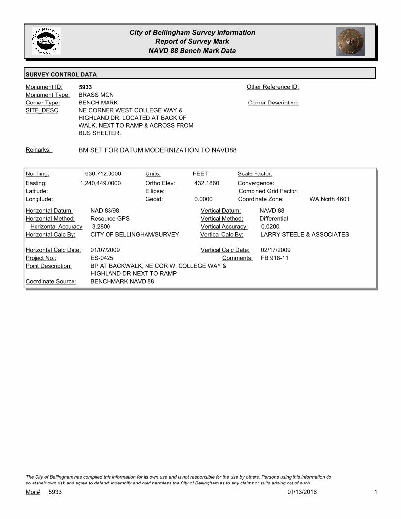
City of Bellingham Survey Information
Report of Survey Mark
NAVD 88 Bench Mark Data
SURVEY CONTROL DATA
5933Monument ID: Other Reference ID:
SITE_DESC NE CORNER WEST COLLEGE WAY &
HIGHLAND DR. LOCATED AT BACK OF
WALK, NEXT TO RAMP & ACROSS FROM
BUS SHELTER.
BENCH MARKCorner Type: Corner Description:
BRASS MONMonument Type:
BM SET FOR DATUM MODERNIZATION TO NAVD88Remarks:
636,712.0000
1,240,449.0000 432.1860
0.0000
FEETNorthing:
Easting:
Latitude:
Longitude:
Units:
Ortho Elev:
Ellipse:
Geoid:
Scale Factor:
Convergence:
Combined Grid Factor:
WA North 4601Coordinate Zone:
Resource GPSHorizontal Method:
NAD 83/98Horizontal Datum: NAVD 88Vertical Datum:
DifferentialVertical Method:
3.2800Horizontal Accuracy 0.0200Vertical Accuracy:
LARRY STEELE & ASSOCIATESVertical Calc By:CITY OF BELLINGHAM/SURVEYHorizontal Calc By:
ES-0425Project No.:
BP AT BACKWALK, NE COR W. COLLEGE WAY &
HIGHLAND DR NEXT TO RAMP
Point Description:
BENCHMARK NAVD 88Coordinate Source:
FB 918-11Comments:
01/07/2009Horizontal Calc Date: 02/17/2009Vertical Calc Date:
101/13/2016Mon# 5933
The City of Bellingham has compiled this information for its own use and is not responsible for the use by others. Persons using this information do
so at their own risk and agree to defend, indemnify and hold harmless the City of Bellingham as to any claims or suits arising out of such

City of Bellingham Survey Information
Report of Survey Mark
NAVD 88 Bench Mark Data
SURVEY CONTROL DATA
5934Monument ID: Other Reference ID:
SITE_DESC HIGH ST & W CAMPUS WAY & HIGHLAND
DR. LOCATED IN NLY TIP OF TRAFFIC
TRIANGLE ISLAND.
BENCH MARKCorner Type: Corner Description:
BRASS MONMonument Type:
BM SET FOR DATUM MODERNIZATION TO NAVD88Remarks:
637,895.0000
1,241,109.0000 337.1630
0.0000
FEETNorthing:
Easting:
Latitude:
Longitude:
Units:
Ortho Elev:
Ellipse:
Geoid:
Scale Factor:
Convergence:
Combined Grid Factor:
WA North 4601Coordinate Zone:
Resource GPSHorizontal Method:
NAD 83/98Horizontal Datum: NAVD 88Vertical Datum:
DifferentialVertical Method:
3.2800Horizontal Accuracy 0.0200Vertical Accuracy:
LARRY STEELE & ASSOCIATESVertical Calc By:CITY OF BELLINGHAM/SURVEYHorizontal Calc By:
ES-0425Project No.:
BP AT NLY TIP OF TRAFFIC ISLAND, INTER OF
HIGH ST, W. CAMPUS WAY & HIGHLAND
Point Description:
BENCHMARK NAVD 88Coordinate Source:
FB 918-11Comments:
01/07/2009Horizontal Calc Date: 02/17/2009Vertical Calc Date:
101/13/2016Mon# 5934
The City of Bellingham has compiled this information for its own use and is not responsible for the use by others. Persons using this information do
so at their own risk and agree to defend, indemnify and hold harmless the City of Bellingham as to any claims or suits arising out of such

City of Bellingham Survey Information
Report of Survey Mark
NAVD 88 Bench Mark Data
SURVEY CONTROL DATA
6028Monument ID: Other Reference ID:
SITE_DESC ALDERWOOD & HOLLYWOOD AT NW
CORNER
BENCH MARKCorner Type: TBM RR SPIKE IN PPCorner Description:
RAILROAD SPIKEMonument Type:
TBM 920-2-33 - RR SPIKE IN E FACE PP#465403-159175 AT NW
QUAD. 0.2 FT A.G.
Remarks:
161.1100
FEETNorthing:
Easting:
Latitude:
Longitude:
Units:
Ortho Elev:
Ellipse:
Geoid:
Scale Factor:
Convergence:
Combined Grid Factor:
Coordinate Zone:
Horizontal Method:
Horizontal Datum: NAVD 88Vertical Datum:
DifferentialVertical Method:
Horizontal Accuracy 0.0100Vertical Accuracy:
PACIFIC SURVEY & ENGINEERING,
INC.
Vertical Calc By:Horizontal Calc By:
EU-0150Project No.:
TBM 920-2-33 RR SPIKE IN PP STA 24+70 35'LPoint Description:
BENCHMARK NAVD 88Coordinate Source:
FB 920-2 PG33Comments:
Horizontal Calc Date: 08/10/2009Vertical Calc Date:
101/13/2016Mon# 6028
The City of Bellingham has compiled this information for its own use and is not responsible for the use by others. Persons using this information do
so at their own risk and agree to defend, indemnify and hold harmless the City of Bellingham as to any claims or suits arising out of such

City of Bellingham Survey Information
Report of Survey Mark
NAVD 88 Bench Mark Data
SURVEY CONTROL DATA
6029Monument ID: Other Reference ID:
SITE_DESC ALDERWOOD AVE W OF WILLOWOOD ON
SLY SIDE
BENCH MARKCorner Type: TBM - RR SPIKE IN
GUY POLE
Corner Description:
RAILROAD SPIKEMonument Type:
TBM 920-2-31 RR SPIKE IN N FACE OF GUY POLE ON S SIDE
ALDERWOOD AVE, N OF RES #3403, 0.2 FT A.G.
Remarks:
157.9900
FEETNorthing:
Easting:
Latitude:
Longitude:
Units:
Ortho Elev:
Ellipse:
Geoid:
Scale Factor:
Convergence:
Combined Grid Factor:
Coordinate Zone:
Horizontal Method:
Horizontal Datum: NAVD 88Vertical Datum:
DifferentialVertical Method:
Horizontal Accuracy 0.0100Vertical Accuracy:
PACIFIC SURVEY & ENGINEERING,
INC.
Vertical Calc By:Horizontal Calc By:
EU-0150Project No.:
TBM 920-2-31 RR SPIKE IN GUY POLE STA 33+54
18'L
Point Description:
BENCHMARK NAVD 88Coordinate Source:
FB 920-2 PG31Comments:
Horizontal Calc Date: 08/10/2009Vertical Calc Date:
101/13/2016Mon# 6029
The City of Bellingham has compiled this information for its own use and is not responsible for the use by others. Persons using this information do
so at their own risk and agree to defend, indemnify and hold harmless the City of Bellingham as to any claims or suits arising out of such

City of Bellingham Survey Information
Report of Survey Mark
NAVD 88 Bench Mark Data
SURVEY CONTROL DATA
6030Monument ID: Other Reference ID:
SITE_DESC CHERRYWOOD & BENNETT AT NE CORNER
BENCH MARKCorner Type: TBM 920-2-33A RR
SPIKE IN PP
Corner Description:
RAILROAD SPIKEMonument Type:
TBM 920-2-33A RR SPIKE IN SW FACE OF PP #465400-159360 IN
NE QUAD CHERRYWOOD & BENNETT, 0.15 A.G.
Remarks:
173.3300
FEETNorthing:
Easting:
Latitude:
Longitude:
Units:
Ortho Elev:
Ellipse:
Geoid:
Scale Factor:
Convergence:
Combined Grid Factor:
Coordinate Zone:
Horizontal Method:
Horizontal Datum: NAVD 88Vertical Datum:
DifferentialVertical Method:
Horizontal Accuracy 0.0100Vertical Accuracy:
PACIFIC SURVEY & ENGINEERING,
INC.
Vertical Calc By:Horizontal Calc By:
EU-0150Project No.:
TBM 920-2-33A RR SPIKE IN PP STA 10+28 29'LPoint Description:
BENCHMARK NAVD 88Coordinate Source:
FB 920-2 PG33Comments:
Horizontal Calc Date: 08/10/2009Vertical Calc Date:
101/13/2016Mon# 6030
The City of Bellingham has compiled this information for its own use and is not responsible for the use by others. Persons using this information do
so at their own risk and agree to defend, indemnify and hold harmless the City of Bellingham as to any claims or suits arising out of such

City of Bellingham Survey Information
Report of Survey Mark
NAVD 88 Bench Mark Data
SURVEY CONTROL DATA
6032Monument ID: Other Reference ID:
SITE_DESC ALDERWOOD AVE ON N SIDE NEAR RES
#3100
BENCH MARKCorner Type: TBM 920-2-34A RR
SPIKE IN PP
Corner Description:
RAILROAD SPIKEMonument Type:
TBM 920-2-34A RR SPIKE IN PP 465331-159527 ON N SIDE
ALDERWOOD AVE 0.2 FT A.G.
Remarks:
159.5200
FEETNorthing:
Easting:
Latitude:
Longitude:
Units:
Ortho Elev:
Ellipse:
Geoid:
Scale Factor:
Convergence:
Combined Grid Factor:
Coordinate Zone:
Horizontal Method:
Horizontal Datum: NAVD 88Vertical Datum:
DifferentialVertical Method:
Horizontal Accuracy 0.0100Vertical Accuracy:
CITY OF BELLINGHAM/SURVEYVertical Calc By:Horizontal Calc By:
EU-0150Project No.:
TBM 920-2-34A RR SPIKE IN PP STA 61+86 17'LPoint Description:
BENCHMARK NAVD 88Coordinate Source:
FB 920-2 PG34Comments:
Horizontal Calc Date: 08/10/2009Vertical Calc Date:
101/13/2016Mon# 6032
The City of Bellingham has compiled this information for its own use and is not responsible for the use by others. Persons using this information do
so at their own risk and agree to defend, indemnify and hold harmless the City of Bellingham as to any claims or suits arising out of such
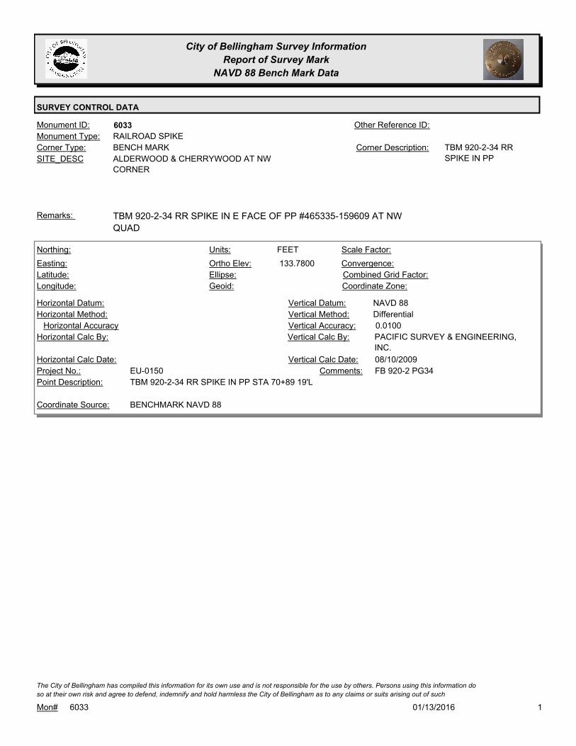
City of Bellingham Survey Information
Report of Survey Mark
NAVD 88 Bench Mark Data
SURVEY CONTROL DATA
6033Monument ID: Other Reference ID:
SITE_DESC ALDERWOOD & CHERRYWOOD AT NW
CORNER
BENCH MARKCorner Type: TBM 920-2-34 RR
SPIKE IN PP
Corner Description:
RAILROAD SPIKEMonument Type:
TBM 920-2-34 RR SPIKE IN E FACE OF PP #465335-159609 AT NW
QUAD
Remarks:
133.7800
FEETNorthing:
Easting:
Latitude:
Longitude:
Units:
Ortho Elev:
Ellipse:
Geoid:
Scale Factor:
Convergence:
Combined Grid Factor:
Coordinate Zone:
Horizontal Method:
Horizontal Datum: NAVD 88Vertical Datum:
DifferentialVertical Method:
Horizontal Accuracy 0.0100Vertical Accuracy:
PACIFIC SURVEY & ENGINEERING,
INC.
Vertical Calc By:Horizontal Calc By:
EU-0150Project No.:
TBM 920-2-34 RR SPIKE IN PP STA 70+89 19'LPoint Description:
BENCHMARK NAVD 88Coordinate Source:
FB 920-2 PG34Comments:
Horizontal Calc Date: 08/10/2009Vertical Calc Date:
101/13/2016Mon# 6033
The City of Bellingham has compiled this information for its own use and is not responsible for the use by others. Persons using this information do
so at their own risk and agree to defend, indemnify and hold harmless the City of Bellingham as to any claims or suits arising out of such
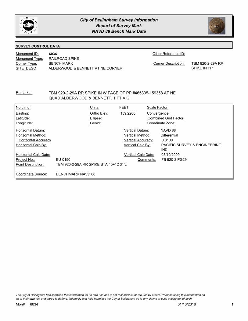
City of Bellingham Survey Information
Report of Survey Mark
NAVD 88 Bench Mark Data
SURVEY CONTROL DATA
6034Monument ID: Other Reference ID:
SITE_DESC ALDERWOOD & BENNETT AT NE CORNER
BENCH MARKCorner Type: TBM 920-2-29A RR
SPIKE IN PP
Corner Description:
RAILROAD SPIKEMonument Type:
TBM 920-2-29A RR SPIKE IN W FACE OF PP #465335-159358 AT NE
QUAD ALDERWOOD & BENNETT. 1 FT A.G.
Remarks:
159.2200
FEETNorthing:
Easting:
Latitude:
Longitude:
Units:
Ortho Elev:
Ellipse:
Geoid:
Scale Factor:
Convergence:
Combined Grid Factor:
Coordinate Zone:
Horizontal Method:
Horizontal Datum: NAVD 88Vertical Datum:
DifferentialVertical Method:
Horizontal Accuracy 0.0100Vertical Accuracy:
PACIFIC SURVEY & ENGINEERING,
INC.
Vertical Calc By:Horizontal Calc By:
EU-0150Project No.:
TBM 920-2-29A RR SPIKE STA 45+12 31'LPoint Description:
BENCHMARK NAVD 88Coordinate Source:
FB 920-2 PG29Comments:
Horizontal Calc Date: 08/10/2009Vertical Calc Date:
101/13/2016Mon# 6034
The City of Bellingham has compiled this information for its own use and is not responsible for the use by others. Persons using this information do
so at their own risk and agree to defend, indemnify and hold harmless the City of Bellingham as to any claims or suits arising out of such
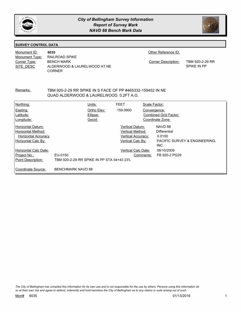
City of Bellingham Survey Information
Report of Survey Mark
NAVD 88 Bench Mark Data
SURVEY CONTROL DATA
6035Monument ID: Other Reference ID:
SITE_DESC ALDERWOOD & LAURELWOOD AT NE
CORNER
BENCH MARKCorner Type: TBM 920-2-29 RR
SPIKE IN PP
Corner Description:
RAILROAD SPIKEMonument Type:
TBM 920-2-29 RR SPIKE IN S FACE OF PP #465332-159452 IN NE
QUAD ALDERWOOD & LAURELWOOD. 0.2FT A.G.
Remarks:
159.0900
FEETNorthing:
Easting:
Latitude:
Longitude:
Units:
Ortho Elev:
Ellipse:
Geoid:
Scale Factor:
Convergence:
Combined Grid Factor:
Coordinate Zone:
Horizontal Method:
Horizontal Datum: NAVD 88Vertical Datum:
DifferentialVertical Method:
Horizontal Accuracy 0.0100Vertical Accuracy:
PACIFIC SURVEY & ENGINEERING,
INC.
Vertical Calc By:Horizontal Calc By:
EU-0150Project No.:
TBM 920-2-29 RR SPIKE IN PP STA 54+43 23'LPoint Description:
BENCHMARK NAVD 88Coordinate Source:
FB 920-2 PG29Comments:
Horizontal Calc Date: 08/10/2009Vertical Calc Date:
101/13/2016Mon# 6035
The City of Bellingham has compiled this information for its own use and is not responsible for the use by others. Persons using this information do
so at their own risk and agree to defend, indemnify and hold harmless the City of Bellingham as to any claims or suits arising out of such

City of Bellingham Survey Information
Report of Survey Mark
NAVD 88 Bench Mark Data
SURVEY CONTROL DATA
6036Monument ID: Other Reference ID:
SITE_DESC ALDERWOOD PT W OF WILLOWOOD
RIGHT-OF-WAY PTCorner Type: Corner Description:
BRASS MONMonument Type:
Remarks:
653,539.0147
1,232,618.5983 158.2400
FEETNorthing:
Easting:
Latitude:
Longitude:
Units:
Ortho Elev:
Ellipse:
Geoid:
Scale Factor:
Convergence:
Combined Grid Factor:
WA North 4601Coordinate Zone:
Conventional SurveyHorizontal Method:
NAD 83/98Horizontal Datum: NAVD 88Vertical Datum:
DifferentialVertical Method:
0.0100Horizontal Accuracy 0.0100Vertical Accuracy:
PACIFIC SURVEY & ENGINEERING,
INC.
Vertical Calc By:PACIFIC SURVEY &
ENGINEERING, INC.
Horizontal Calc By:
EU-0150Project No.:
BRASS DISKPoint Description:
NAD 83/98 PROJECT POINTSCoordinate Source:
FB 920-2 STA 33+25.14Comments:
08/10/2009Horizontal Calc Date: 08/10/2009Vertical Calc Date:
101/13/2016Mon# 6036
The City of Bellingham has compiled this information for its own use and is not responsible for the use by others. Persons using this information do
so at their own risk and agree to defend, indemnify and hold harmless the City of Bellingham as to any claims or suits arising out of such

City of Bellingham Survey Information
Report of Survey Mark
NAVD 88 Bench Mark Data
SURVEY CONTROL DATA
6037Monument ID: Other Reference ID:
SITE_DESC ALDERWOOD & WILLOWOOD
RIGHT-OF-WAY INTERSECTIONCorner Type: Corner Description:
BRASS MONMonument Type:
Remarks:
653,390.5801
1,232,888.2921 156.1400
FEETNorthing:
Easting:
Latitude:
Longitude:
Units:
Ortho Elev:
Ellipse:
Geoid:
Scale Factor:
Convergence:
Combined Grid Factor:
WA North 4601Coordinate Zone:
Conventional SurveyHorizontal Method:
NAD 83/98Horizontal Datum: NAVD 88Vertical Datum:
DifferentialVertical Method:
0.0100Horizontal Accuracy 0.0100Vertical Accuracy:
PACIFIC SURVEY & ENGINEERING,
INC.
Vertical Calc By:PACIFIC SURVEY &
ENGINEERING, INC.
Horizontal Calc By:
EU-0150Project No.:
BRASS DISK PROJ PNT 41Point Description:
NAD 83/98 PROJECT POINTSCoordinate Source:
FB 920-2 STA 36+33.61Comments:
08/10/2009Horizontal Calc Date: 08/10/2009Vertical Calc Date:
101/13/2016Mon# 6037
The City of Bellingham has compiled this information for its own use and is not responsible for the use by others. Persons using this information do
so at their own risk and agree to defend, indemnify and hold harmless the City of Bellingham as to any claims or suits arising out of such
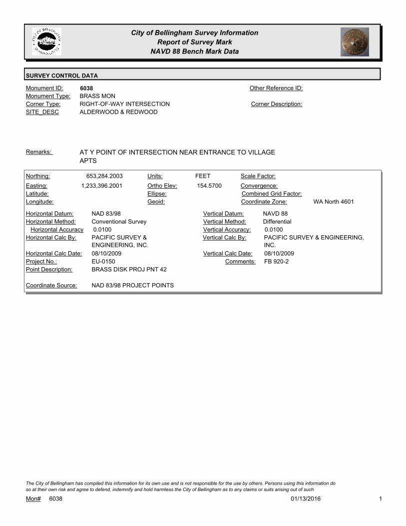
City of Bellingham Survey Information
Report of Survey Mark
NAVD 88 Bench Mark Data
SURVEY CONTROL DATA
6038Monument ID: Other Reference ID:
SITE_DESC ALDERWOOD & REDWOOD
RIGHT-OF-WAY INTERSECTIONCorner Type: Corner Description:
BRASS MONMonument Type:
AT Y POINT OF INTERSECTION NEAR ENTRANCE TO VILLAGE
APTS
Remarks:
653,284.2003
1,233,396.2001 154.5700
FEETNorthing:
Easting:
Latitude:
Longitude:
Units:
Ortho Elev:
Ellipse:
Geoid:
Scale Factor:
Convergence:
Combined Grid Factor:
WA North 4601Coordinate Zone:
Conventional SurveyHorizontal Method:
NAD 83/98Horizontal Datum: NAVD 88Vertical Datum:
DifferentialVertical Method:
0.0100Horizontal Accuracy 0.0100Vertical Accuracy:
PACIFIC SURVEY & ENGINEERING,
INC.
Vertical Calc By:PACIFIC SURVEY &
ENGINEERING, INC.
Horizontal Calc By:
EU-0150Project No.:
BRASS DISK PROJ PNT 42Point Description:
NAD 83/98 PROJECT POINTSCoordinate Source:
FB 920-2Comments:
08/10/2009Horizontal Calc Date: 08/10/2009Vertical Calc Date:
101/13/2016Mon# 6038
The City of Bellingham has compiled this information for its own use and is not responsible for the use by others. Persons using this information do
so at their own risk and agree to defend, indemnify and hold harmless the City of Bellingham as to any claims or suits arising out of such

City of Bellingham Survey Information
Report of Survey Mark
NAVD 88 Bench Mark Data
SURVEY CONTROL DATA
6039Monument ID: Other Reference ID:
SITE_DESC 4TH NEAR S SIDE OF COWGILL
UNKNOWNCorner Type: Corner Description:
CASED MONMonument Type:
Remarks:
630,337.3500
1,235,287.1000 81.5800
FEETNorthing:
Easting:
Latitude:
Longitude:
Units:
Ortho Elev:
Ellipse:
Geoid:
Scale Factor:
Convergence:
Combined Grid Factor:
WA North 4601Coordinate Zone:
Conventional SurveyHorizontal Method:
NAD 83/98Horizontal Datum: NAVD 88Vertical Datum:
DifferentialVertical Method:
Horizontal Accuracy Vertical Accuracy:
WILSON ENGINEERING LLC.Vertical Calc By:WILSON ENGINEERING LLC.Horizontal Calc By:
Project No.:
MON IN CASEPoint Description:
NAD 83/98 PROJECT POINTSCoordinate Source:
POST POINT RS-4712Comments:
08/10/2009Horizontal Calc Date: 08/10/2009Vertical Calc Date:
101/13/2016Mon# 6039
The City of Bellingham has compiled this information for its own use and is not responsible for the use by others. Persons using this information do
so at their own risk and agree to defend, indemnify and hold harmless the City of Bellingham as to any claims or suits arising out of such

City of Bellingham Survey Information
Report of Survey Mark
NAVD 88 Bench Mark Data
SURVEY CONTROL DATA
6040Monument ID: Other Reference ID:
SITE_DESC POST POINT WASTEWATER TREATMENT
PLANT POC ON S BOUNDARY
LOT CORNERCorner Type: Corner Description:
CONCRETE MONMonument Type:
Remarks:
630,715.2800
1,233,853.0700 51.9200
FEETNorthing:
Easting:
Latitude:
Longitude:
Units:
Ortho Elev:
Ellipse:
Geoid:
Scale Factor:
Convergence:
Combined Grid Factor:
WA North 4601Coordinate Zone:
Conventional SurveyHorizontal Method:
NAD 83/98Horizontal Datum: NAVD 88Vertical Datum:
DifferentialVertical Method:
Horizontal Accuracy Vertical Accuracy:
WILSON ENGINEERING LLC.Vertical Calc By:WILSON ENGINEERING LLC.Horizontal Calc By:
Project No.:
CONC MONPoint Description:
NAD 83/98 PROJECT POINTSCoordinate Source:
POST POINT RS-4712Comments:
08/10/2009Horizontal Calc Date: 08/10/2009Vertical Calc Date:
101/13/2016Mon# 6040
The City of Bellingham has compiled this information for its own use and is not responsible for the use by others. Persons using this information do
so at their own risk and agree to defend, indemnify and hold harmless the City of Bellingham as to any claims or suits arising out of such

City of Bellingham Survey Information
Report of Survey Mark
NAVD 88 Bench Mark Data
SURVEY CONTROL DATA
6097Monument ID: Other Reference ID:
SITE_DESC 23RD & BILL MCDONALD PARKWAY N OF
CL MON
UNKNOWNCorner Type: Corner Description:
BRASS MONMonument Type:
5 FT N OF MON #5270Remarks:
634,065.7400
1,241,147.1300 231.9500
FEETNorthing:
Easting:
Latitude:
Longitude:
Units:
Ortho Elev:
Ellipse:
Geoid:
Scale Factor:
Convergence:
Combined Grid Factor:
WA North 4601Coordinate Zone:
Conventional SurveyHorizontal Method:
NAD 83/98Horizontal Datum: NAVD 88Vertical Datum:
DifferentialVertical Method:
0.0300Horizontal Accuracy 0.0500Vertical Accuracy:
DAVID EVANS & ASSOCIATES, INC.Vertical Calc By:DAVID EVANS & ASSOCIATES,
INC.
Horizontal Calc By:
ES-0358Project No.:
C-FND-BC PROJ POINT #183Point Description:
NAD 83/98 PROJECT POINTSCoordinate Source:
FB 926Comments:
11/01/2009Horizontal Calc Date: 11/01/2009Vertical Calc Date:
101/13/2016Mon# 6097
The City of Bellingham has compiled this information for its own use and is not responsible for the use by others. Persons using this information do
so at their own risk and agree to defend, indemnify and hold harmless the City of Bellingham as to any claims or suits arising out of such

City of Bellingham Survey Information
Report of Survey Mark
NAVD 88 Bench Mark Data
SURVEY CONTROL DATA
6098Monument ID: Other Reference ID:
SITE_DESC E LINE 25TH ST & N LINE VACATED
EASTON AT PARK BOUNDARY
RIGHT-OF-WAY BOUNDARYCorner Type: Corner Description:
CASED MONMonument Type:
Remarks:
634,495.4200
1,241,736.1700 282.8700
FEETNorthing:
Easting:
Latitude:
Longitude:
Units:
Ortho Elev:
Ellipse:
Geoid:
Scale Factor:
Convergence:
Combined Grid Factor:
WA North 4601Coordinate Zone:
Conventional SurveyHorizontal Method:
NAD 83/98Horizontal Datum: NAVD 88Vertical Datum:
DifferentialVertical Method:
0.0300Horizontal Accuracy 0.0500Vertical Accuracy:
DAVID EVANS & ASSOCIATES, INC.Vertical Calc By:DAVID EVANS & ASSOCIATES,
INC.
Horizontal Calc By:
ES-0358Project No.:
C-FND-MON PROJ PNT #190Point Description:
NAD 83/98 PROJECT POINTSCoordinate Source:
FB 926Comments:
11/01/2009Horizontal Calc Date: 11/01/2009Vertical Calc Date:
101/13/2016Mon# 6098
The City of Bellingham has compiled this information for its own use and is not responsible for the use by others. Persons using this information do
so at their own risk and agree to defend, indemnify and hold harmless the City of Bellingham as to any claims or suits arising out of such

City of Bellingham Survey Information
Report of Survey Mark
NAVD 88 Bench Mark Data
SURVEY CONTROL DATA
6114Monument ID: Other Reference ID:
SITE_DESC CONSOLIDATION & 38TH
RIGHT-OF-WAY INTERSECTIONCorner Type: Corner Description:
CONCRETE MONMonument Type:
Remarks:
637,240.1400
1,246,319.7250 184.4300
FEETNorthing:
Easting:
Latitude:
Longitude:
Units:
Ortho Elev:
Ellipse:
Geoid:
Scale Factor:
Convergence:
Combined Grid Factor:
WA North 4601Coordinate Zone:
Conventional SurveyHorizontal Method:
NAD 83/98Horizontal Datum: NAVD 88Vertical Datum:
DifferentialVertical Method:
0.0200Horizontal Accuracy 0.0300Vertical Accuracy:
LARRY STEELE & ASSOCIATESVertical Calc By:LARRY STEELE & ASSOCIATESHorizontal Calc By:
EU-0159Project No.:
C-MONPoint Description:
NAD 83/98 PROJECT POINTSCoordinate Source:
FB 947-1. PROJECT POINT #220Comments:
06/30/2011Horizontal Calc Date: 06/30/2011Vertical Calc Date:
101/13/2016Mon# 6114
The City of Bellingham has compiled this information for its own use and is not responsible for the use by others. Persons using this information do
so at their own risk and agree to defend, indemnify and hold harmless the City of Bellingham as to any claims or suits arising out of such
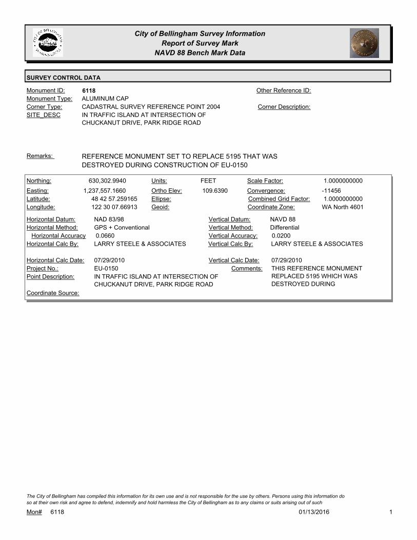
City of Bellingham Survey Information
Report of Survey Mark
NAVD 88 Bench Mark Data
SURVEY CONTROL DATA
6118Monument ID: Other Reference ID:
SITE_DESC IN TRAFFIC ISLAND AT INTERSECTION OF
CHUCKANUT DRIVE, PARK RIDGE ROAD
CADASTRAL SURVEY REFERENCE POINT 2004Corner Type: Corner Description:
ALUMINUM CAPMonument Type:
REFERENCE MONUMENT SET TO REPLACE 5195 THAT WAS
DESTROYED DURING CONSTRUCTION OF EU-0150
Remarks:
630,302.9940
1,237,557.1660
48 42 57.259165
122 30 07.66913
109.6390
FEETNorthing:
Easting:
Latitude:
Longitude:
Units:
Ortho Elev:
Ellipse:
Geoid:
1.0000000000Scale Factor:
-11456Convergence:
1.0000000000Combined Grid Factor:
WA North 4601Coordinate Zone:
GPS + ConventionalHorizontal Method:
NAD 83/98Horizontal Datum: NAVD 88Vertical Datum:
DifferentialVertical Method:
0.0660Horizontal Accuracy 0.0200Vertical Accuracy:
LARRY STEELE & ASSOCIATESVertical Calc By:LARRY STEELE & ASSOCIATESHorizontal Calc By:
EU-0150Project No.:
IN TRAFFIC ISLAND AT INTERSECTION OF
CHUCKANUT DRIVE, PARK RIDGE ROAD
Point Description:
Coordinate Source:
THIS REFERENCE MONUMENT
REPLACED 5195 WHICH WAS
DESTROYED DURING
Comments:
07/29/2010Horizontal Calc Date: 07/29/2010Vertical Calc Date:
101/13/2016Mon# 6118
The City of Bellingham has compiled this information for its own use and is not responsible for the use by others. Persons using this information do
so at their own risk and agree to defend, indemnify and hold harmless the City of Bellingham as to any claims or suits arising out of such

City of Bellingham Survey Information
Report of Survey Mark
NAVD 88 Bench Mark Data
SURVEY CONTROL DATA
6119Monument ID: Other Reference ID:
SITE_DESC BRASS PLUG WITH DIMPLE SET IN CURB
BEHIND CATCH BASIN JUST WEST OF THE
NW QUADRANT OF THE INTERSECTION.
BENCH MARKCorner Type: Corner Description:
BRASS MONMonument Type:
BP WAS SET TO REPLACE MONUMENT 5922 ON THE SW
QUADRANT OF THE INTERSECTIONS WHICH WAS DESTROYED
DURING CONSTRUCTION OF ES-0358.
Remarks:
243.0000
FEETNorthing:
Easting:
Latitude:
Longitude:
Units:
Ortho Elev:
Ellipse:
Geoid:
Scale Factor:
Convergence:
Combined Grid Factor:
Coordinate Zone:
Horizontal Method:
Horizontal Datum: NAVD 88Vertical Datum:
DifferentialVertical Method:
Horizontal Accuracy 0.0100Vertical Accuracy:
PACIFIC SURVEY & ENGINEERING,
INC.
Vertical Calc By:Horizontal Calc By:
ES-0358Project No.:
BRASS MON WITH DIMPLEPoint Description:
BENCHMARK NAVD 88Coordinate Source:
ELEVATION IS 243.00 BUT
APPLICATION TRUNKATES .OO FB
933-1
Comments:
Horizontal Calc Date: 11/04/2010Vertical Calc Date:
101/13/2016Mon# 6119
The City of Bellingham has compiled this information for its own use and is not responsible for the use by others. Persons using this information do
so at their own risk and agree to defend, indemnify and hold harmless the City of Bellingham as to any claims or suits arising out of such
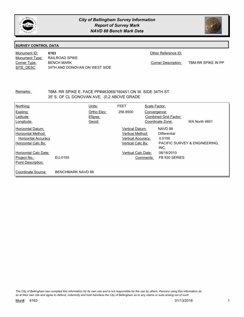
City of Bellingham Survey Information
Report of Survey Mark
NAVD 88 Bench Mark Data
SURVEY CONTROL DATA
6163Monument ID: Other Reference ID:
SITE_DESC 34TH AND DONOVAN ON WEST SIDE
BENCH MARKCorner Type: TBM-RR SPIKE IN PPCorner Description:
RAILROAD SPIKEMonument Type:
TBM- RR SPIKE E. FACE PP#463069/160451 ON W. SIDE 34TH ST.
35' S. OF CL DONOVAN AVE. (0.2 ABOVE GRADE
Remarks:
256.8500
FEETNorthing:
Easting:
Latitude:
Longitude:
Units:
Ortho Elev:
Ellipse:
Geoid:
Scale Factor:
Convergence:
Combined Grid Factor:
WA North 4601Coordinate Zone:
Horizontal Method:
Horizontal Datum: NAVD 88Vertical Datum:
DifferentialVertical Method:
Horizontal Accuracy 0.0100Vertical Accuracy:
PACIFIC SURVEY & ENGINEERING,
INC.
Vertical Calc By:Horizontal Calc By:
EU-0155Project No.:
Point Description:
BENCHMARK NAVD 88Coordinate Source:
FB 930 SERIESComments:
Horizontal Calc Date: 08/16/2010Vertical Calc Date:
101/13/2016Mon# 6163
The City of Bellingham has compiled this information for its own use and is not responsible for the use by others. Persons using this information do
so at their own risk and agree to defend, indemnify and hold harmless the City of Bellingham as to any claims or suits arising out of such

City of Bellingham Survey Information
Report of Survey Mark
NAVD 88 Bench Mark Data
SURVEY CONTROL DATA
6164Monument ID: Other Reference ID:
SITE_DESC WEST SIDE OF 34TH ST. 90' NORTH OF RES
#1306.
BENCH MARKCorner Type: TBM-RR SPIKE IN PPCorner Description:
RAILROAD SPIKEMonument Type:
SET RR SPIKE E FACE PP# 463155/160454Remarks:
250.3000
Northing:
Easting:
Latitude:
Longitude:
Units:
Ortho Elev:
Ellipse:
Geoid:
Scale Factor:
Convergence:
Combined Grid Factor:
Coordinate Zone:
Horizontal Method:
Horizontal Datum: NAVD 88Vertical Datum:
DifferentialVertical Method:
Horizontal Accuracy 0.0100Vertical Accuracy:
PACIFIC SURVEY & ENGINEERING,
INC.
Vertical Calc By:Horizontal Calc By:
EU-0155Project No.:
Point Description:
BENCHMARK NAVD 88Coordinate Source:
FB 930 SERIESComments:
Horizontal Calc Date: 08/16/2010Vertical Calc Date:
101/13/2016Mon# 6164
The City of Bellingham has compiled this information for its own use and is not responsible for the use by others. Persons using this information do
so at their own risk and agree to defend, indemnify and hold harmless the City of Bellingham as to any claims or suits arising out of such

City of Bellingham Survey Information
Report of Survey Mark
NAVD 88 Bench Mark Data
SURVEY CONTROL DATA
6165Monument ID: Other Reference ID:
SITE_DESC WEST SIDE OF 34TH ST. 35' NORTH OF CL
CONC. D-WAY TO RES. #1024.
BENCH MARKCorner Type: TBM-RR SPIKE IN PPCorner Description:
RAILROAD SPIKEMonument Type:
SET RR SPIKE IN PP #463241/160456Remarks:
274.8800
FEETNorthing:
Easting:
Latitude:
Longitude:
Units:
Ortho Elev:
Ellipse:
Geoid:
Scale Factor:
Convergence:
Combined Grid Factor:
Coordinate Zone:
Horizontal Method:
Horizontal Datum: NAVD 88Vertical Datum:
DifferentialVertical Method:
Horizontal Accuracy 0.0100Vertical Accuracy:
PACIFIC SURVEY & ENGINEERING,
INC.
Vertical Calc By:Horizontal Calc By:
EU-0155Project No.:
Point Description:
BENCHMARK NAVD 88Coordinate Source:
FB 930 SERIESComments:
Horizontal Calc Date: 01/12/2012Vertical Calc Date:
101/13/2016Mon# 6165
The City of Bellingham has compiled this information for its own use and is not responsible for the use by others. Persons using this information do
so at their own risk and agree to defend, indemnify and hold harmless the City of Bellingham as to any claims or suits arising out of such

City of Bellingham Survey Information
Report of Survey Mark
NAVD 88 Bench Mark Data
SURVEY CONTROL DATA
6167Monument ID: Other Reference ID:
SITE_DESC ALLEY BETWEEN ELM AND KULSHAN @
CONNECTICUT
BENCH MARKCorner Type: RR SPIKE IN PP
#1208
Corner Description:
RAILROAD SPIKEMonument Type:
TBMRemarks:
84.0000
FEETNorthing:
Easting:
Latitude:
Longitude:
Units:
Ortho Elev:
Ellipse:
Geoid:
Scale Factor:
Convergence:
Combined Grid Factor:
Coordinate Zone:
Horizontal Method:
Horizontal Datum: NAVD 88Vertical Datum:
DifferentialVertical Method:
Horizontal Accuracy 0.0300Vertical Accuracy:
LARRY STEELE & ASSOCIATESVertical Calc By:Horizontal Calc By:
EU-0151Project No.:
RR SPIKEPoint Description:
BENCHMARK NAVD 88Coordinate Source:
Comments:
Horizontal Calc Date: 12/15/2010Vertical Calc Date:
101/13/2016Mon# 6167
The City of Bellingham has compiled this information for its own use and is not responsible for the use by others. Persons using this information do
so at their own risk and agree to defend, indemnify and hold harmless the City of Bellingham as to any claims or suits arising out of such
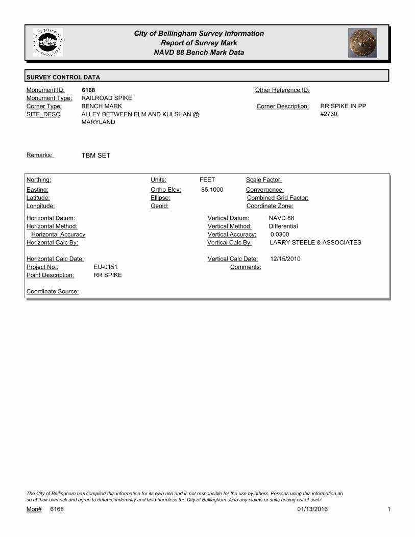
City of Bellingham Survey Information
Report of Survey Mark
NAVD 88 Bench Mark Data
SURVEY CONTROL DATA
6168Monument ID: Other Reference ID:
SITE_DESC ALLEY BETWEEN ELM AND KULSHAN @
MARYLAND
BENCH MARKCorner Type: RR SPIKE IN PP
#2730
Corner Description:
RAILROAD SPIKEMonument Type:
TBM SETRemarks:
85.1000
FEETNorthing:
Easting:
Latitude:
Longitude:
Units:
Ortho Elev:
Ellipse:
Geoid:
Scale Factor:
Convergence:
Combined Grid Factor:
Coordinate Zone:
Horizontal Method:
Horizontal Datum: NAVD 88Vertical Datum:
DifferentialVertical Method:
Horizontal Accuracy 0.0300Vertical Accuracy:
LARRY STEELE & ASSOCIATESVertical Calc By:Horizontal Calc By:
EU-0151Project No.:
RR SPIKEPoint Description:
Coordinate Source:
Comments:
Horizontal Calc Date: 12/15/2010Vertical Calc Date:
101/13/2016Mon# 6168
The City of Bellingham has compiled this information for its own use and is not responsible for the use by others. Persons using this information do
so at their own risk and agree to defend, indemnify and hold harmless the City of Bellingham as to any claims or suits arising out of such

City of Bellingham Survey Information
Report of Survey Mark
NAVD 88 Bench Mark Data
SURVEY CONTROL DATA
6169Monument ID: Other Reference ID:
SITE_DESC ELIZA AVENUE. SW CORNER CONCRETE
WATER VAULT BY RES #4035 APT #101.
BENCH MARKCorner Type: TBMCorner Description:
VAULTMonument Type:
TBM FOR ES-0441Remarks:
175.4000
Northing:
Easting:
Latitude:
Longitude:
Units:
Ortho Elev:
Ellipse:
Geoid:
Scale Factor:
Convergence:
Combined Grid Factor:
Coordinate Zone:
Horizontal Method:
Horizontal Datum: NAVD 88Vertical Datum:
DifferentialVertical Method:
Horizontal Accuracy 0.0300Vertical Accuracy:
LARRY STEELE & ASSOCIATESVertical Calc By:Horizontal Calc By:
Project No.:
CONCRETE WATER VAULTPoint Description:
Coordinate Source:
FB-942-1Comments:
Horizontal Calc Date: 04/27/2011Vertical Calc Date:
101/13/2016Mon# 6169
The City of Bellingham has compiled this information for its own use and is not responsible for the use by others. Persons using this information do
so at their own risk and agree to defend, indemnify and hold harmless the City of Bellingham as to any claims or suits arising out of such

City of Bellingham Survey Information
Report of Survey Mark
NAVD 88 Bench Mark Data
SURVEY CONTROL DATA
6176Monument ID: Other Reference ID:
SITE_DESC FILED 'X' ON E. BOLT OF SIGNAL BASE AT
E. QUADRANT RAILROAD AVE. AND E.
CHESTNUT ST.
BENCH MARKCorner Type: TBM FILED X ON
BOLT
Corner Description:
X ON BOLTMonument Type:
Remarks:
73.6000
FEETNorthing:
Easting:
Latitude:
Longitude:
Units:
Ortho Elev:
Ellipse:
Geoid:
Scale Factor:
Convergence:
Combined Grid Factor:
Coordinate Zone:
Horizontal Method:
Horizontal Datum: NAVD 88Vertical Datum:
DifferentialVertical Method:
Horizontal Accuracy 0.0100Vertical Accuracy:
PACIFIC SURVEY & ENGINEERING,
INC.
Vertical Calc By:Horizontal Calc By:
EU-0151Project No.:
Point Description:
BENCHMARK NAVD 88Coordinate Source:
FB 932-4Comments:
Horizontal Calc Date: 11/10/2010Vertical Calc Date:
101/13/2016Mon# 6176
The City of Bellingham has compiled this information for its own use and is not responsible for the use by others. Persons using this information do
so at their own risk and agree to defend, indemnify and hold harmless the City of Bellingham as to any claims or suits arising out of such

City of Bellingham Survey Information
Report of Survey Mark
NAVD 88 Bench Mark Data
SURVEY CONTROL DATA
6177Monument ID: Other Reference ID:
SITE_DESC SPIKE IN PP IN FRONT OF #404 20TH
STREET
BENCH MARKCorner Type: TBM - RR SPIKECorner Description:
RAILROAD SPIKEMonument Type:
Remarks:
359.1100
Northing:
Easting:
Latitude:
Longitude:
Units:
Ortho Elev:
Ellipse:
Geoid:
Scale Factor:
Convergence:
Combined Grid Factor:
Coordinate Zone:
Horizontal Method:
Horizontal Datum: NAVD 88Vertical Datum:
DifferentialVertical Method:
Horizontal Accuracy 0.0300Vertical Accuracy:
LARRY STEELE & ASSOCIATESVertical Calc By:Horizontal Calc By:
EU-0156Project No.:
Point Description:
BENCHMARK NAVD 88Coordinate Source:
FB 940-1Comments:
Horizontal Calc Date: 02/18/2011Vertical Calc Date:
101/13/2016Mon# 6177
The City of Bellingham has compiled this information for its own use and is not responsible for the use by others. Persons using this information do
so at their own risk and agree to defend, indemnify and hold harmless the City of Bellingham as to any claims or suits arising out of such

City of Bellingham Survey Information
Report of Survey Mark
NAVD 88 Bench Mark Data
SURVEY CONTROL DATA
6178Monument ID: Other Reference ID:
SITE_DESC RR SPIKEIN PP #9502 RIDGEWAY AND
ELWOOD
BENCH MARKCorner Type: TBM-RR SPIKE IN PPCorner Description:
RAILROAD SPIKEMonument Type:
Remarks:
439.4500
Northing:
Easting:
Latitude:
Longitude:
Units:
Ortho Elev:
Ellipse:
Geoid:
Scale Factor:
Convergence:
Combined Grid Factor:
Coordinate Zone:
Horizontal Method:
Horizontal Datum: NAVD 88Vertical Datum:
DifferentialVertical Method:
Horizontal Accuracy 0.0300Vertical Accuracy:
LARRY STEELE & ASSOCIATESVertical Calc By:Horizontal Calc By:
EU-0156Project No.:
Point Description:
BENCHMARK NAVD 88Coordinate Source:
FB 940-1Comments:
Horizontal Calc Date: 02/18/2011Vertical Calc Date:
101/13/2016Mon# 6178
The City of Bellingham has compiled this information for its own use and is not responsible for the use by others. Persons using this information do
so at their own risk and agree to defend, indemnify and hold harmless the City of Bellingham as to any claims or suits arising out of such

City of Bellingham Survey Information
Report of Survey Mark
NAVD 88 Bench Mark Data
SURVEY CONTROL DATA
6179Monument ID: Other Reference ID:
SITE_DESC SE CORNER OF WATER METER AT #510
HIGHLAND DR.
BENCH MARKCorner Type: TBM-SE CORNER
WATER METER
Corner Description:
WATER METERMonument Type:
TBMRemarks:
415.7500
FEETNorthing:
Easting:
Latitude:
Longitude:
Units:
Ortho Elev:
Ellipse:
Geoid:
Scale Factor:
Convergence:
Combined Grid Factor:
Coordinate Zone:
Horizontal Method:
Horizontal Datum: NAVD 88Vertical Datum:
DifferentialVertical Method:
Horizontal Accuracy 0.0300Vertical Accuracy:
LARRY STEELE & ASSOCIATESVertical Calc By:Horizontal Calc By:
EU-0156Project No.:
Point Description:
BENCHMARK NAVD 88Coordinate Source:
FB-940-1Comments:
Horizontal Calc Date: 08/09/2011Vertical Calc Date:
101/13/2016Mon# 6179
The City of Bellingham has compiled this information for its own use and is not responsible for the use by others. Persons using this information do
so at their own risk and agree to defend, indemnify and hold harmless the City of Bellingham as to any claims or suits arising out of such

City of Bellingham Survey Information
Report of Survey Mark
NAVD 88 Bench Mark Data
SURVEY CONTROL DATA
6180Monument ID: Other Reference ID:
SITE_DESC X IN FH BOLT AT NW CORNER OF EASTON
AND RIDGEWAY.
BENCH MARKCorner Type: TBM- X ON FLANGE
BOLT OF FIRE
HYDRANT
Corner Description:
XMonument Type:
Remarks:
385.6200
Northing:
Easting:
Latitude:
Longitude:
Units:
Ortho Elev:
Ellipse:
Geoid:
Scale Factor:
Convergence:
Combined Grid Factor:
Coordinate Zone:
Horizontal Method:
Horizontal Datum: NAVD 88Vertical Datum:
DifferentialVertical Method:
Horizontal Accuracy 0.0300Vertical Accuracy:
LARRY STEELE & ASSOCIATESVertical Calc By:Horizontal Calc By:
EU-0156Project No.:
Point Description:
BENCHMARK NAVD 88Coordinate Source:
FB 940-1Comments:
Horizontal Calc Date: 08/09/2011Vertical Calc Date:
101/13/2016Mon# 6180
The City of Bellingham has compiled this information for its own use and is not responsible for the use by others. Persons using this information do
so at their own risk and agree to defend, indemnify and hold harmless the City of Bellingham as to any claims or suits arising out of such

City of Bellingham Survey Information
Report of Survey Mark
NAVD 88 Bench Mark Data
SURVEY CONTROL DATA
6181Monument ID: Other Reference ID:
SITE_DESC "X " ON NE CORNER CB RIM AT RES. #721
HIGHLAND DR.
BENCH MARKCorner Type: TBM- SCRIBED "X " IN
NE CORNER CB RIM.
Corner Description:
XMonument Type:
Remarks:
377.8900
Northing:
Easting:
Latitude:
Longitude:
Units:
Ortho Elev:
Ellipse:
Geoid:
Scale Factor:
Convergence:
Combined Grid Factor:
Coordinate Zone:
Horizontal Method:
Horizontal Datum: NAVD 88Vertical Datum:
DifferentialVertical Method:
Horizontal Accuracy 0.0300Vertical Accuracy:
LARRY STEELE & ASSOCIATESVertical Calc By:Horizontal Calc By:
EU-0156Project No.:
Point Description:
BENCHMARK NAVD 88Coordinate Source:
FB 940-1Comments:
Horizontal Calc Date: 08/09/2011Vertical Calc Date:
101/13/2016Mon# 6181
The City of Bellingham has compiled this information for its own use and is not responsible for the use by others. Persons using this information do
so at their own risk and agree to defend, indemnify and hold harmless the City of Bellingham as to any claims or suits arising out of such

City of Bellingham Survey Information
Report of Survey Mark
NAVD 88 Bench Mark Data
SURVEY CONTROL DATA
6182Monument ID: Other Reference ID:
SITE_DESC FILED "X" ON SE BOLT OF LIGHT POLE
BASE 150' S/O W. CONNECTICUT ST. ON E
SIDE OF MERIDIAN
BENCH MARKCorner Type: TBM- FILED "X" ON
BOLT
Corner Description:
XMonument Type:
Remarks:
81.3100
FEETNorthing:
Easting:
Latitude:
Longitude:
Units:
Ortho Elev:
Ellipse:
Geoid:
Scale Factor:
Convergence:
Combined Grid Factor:
Coordinate Zone:
Horizontal Method:
Horizontal Datum: NAVD 88Vertical Datum:
DifferentialVertical Method:
Horizontal Accuracy 0.0100Vertical Accuracy:
PACIFIC SURVEY & ENGINEERING,
INC.
Vertical Calc By:Horizontal Calc By:
ES-0445Project No.:
Point Description:
BENCHMARK NAVD 88Coordinate Source:
FB 945-1Comments:
Horizontal Calc Date: 04/27/2011Vertical Calc Date:
101/13/2016Mon# 6182
The City of Bellingham has compiled this information for its own use and is not responsible for the use by others. Persons using this information do
so at their own risk and agree to defend, indemnify and hold harmless the City of Bellingham as to any claims or suits arising out of such
City of Bellingham Survey Information
Report of Survey Mark
NAVD 88 Bench Mark Data
SURVEY CONTROL DATA
6183Monument ID: Other Reference ID:
SITE_DESC FILED "X" ON SW BOLT OF LP BASE SW
QUAD MERIDIAN AND W. CONNECTICUT
BENCH MARKCorner Type: TBM - FILED "X" ON
BOLT
Corner Description:
XMonument Type:
Remarks:
81.8100
FEETNorthing:
Easting:
Latitude:
Longitude:
Units:
Ortho Elev:
Ellipse:
Geoid:
Scale Factor:
Convergence:
Combined Grid Factor:
Coordinate Zone:
Horizontal Method:
Horizontal Datum: NAVD 88Vertical Datum:
DifferentialVertical Method:
Horizontal Accuracy 0.0100Vertical Accuracy:
PACIFIC SURVEY & ENGINEERING,
INC.
Vertical Calc By:Horizontal Calc By:
ES-0445Project No.:
Point Description:
BENCHMARK NAVD 88Coordinate Source:
FB 945-1Comments:
Horizontal Calc Date: 04/27/2011Vertical Calc Date:
101/13/2016Mon# 6183
The City of Bellingham has compiled this information for its own use and is not responsible for the use by others. Persons using this information do
so at their own risk and agree to defend, indemnify and hold harmless the City of Bellingham as to any claims or suits arising out of such

City of Bellingham Survey Information
Report of Survey Mark
NAVD 88 Bench Mark Data
SURVEY CONTROL DATA
6184Monument ID: Other Reference ID:
SITE_DESC FILED "X" ON SW BOLT ON LP BASE 200'
N/O W. CONNECTICUT ON WEST SIDE OF
MERIDIAN
BENCH MARKCorner Type: TBM- FILED "X" ON
LP BOLT
Corner Description:
XMonument Type:
Remarks:
82.5400
FEETNorthing:
Easting:
Latitude:
Longitude:
Units:
Ortho Elev:
Ellipse:
Geoid:
Scale Factor:
Convergence:
Combined Grid Factor:
Coordinate Zone:
Horizontal Method:
Horizontal Datum: NAVD 88Vertical Datum:
DifferentialVertical Method:
Horizontal Accuracy 0.0100Vertical Accuracy:
PACIFIC SURVEY & ENGINEERING,
INC.
Vertical Calc By:Horizontal Calc By:
ES-0445Project No.:
Point Description:
BENCHMARK NAVD 88Coordinate Source:
FB 945-1Comments:
Horizontal Calc Date: 04/27/2011Vertical Calc Date:
101/13/2016Mon# 6184
The City of Bellingham has compiled this information for its own use and is not responsible for the use by others. Persons using this information do
so at their own risk and agree to defend, indemnify and hold harmless the City of Bellingham as to any claims or suits arising out of such

City of Bellingham Survey Information
Report of Survey Mark
NAVD 88 Bench Mark Data
SURVEY CONTROL DATA
6185Monument ID: Other Reference ID:
SITE_DESC LINCOLN AND BYRON TO THE WEST
RIGHT-OF-WAY INTERSECTIONCorner Type: WESTCorner Description:
BRASS MONMonument Type:
SEE #3347Remarks:
636,585.1930
1,246,297.0350 201.9500
FEETNorthing:
Easting:
Latitude:
Longitude:
Units:
Ortho Elev:
Ellipse:
Geoid:
Scale Factor:
Convergence:
Combined Grid Factor:
WA North 4601Coordinate Zone:
Conventional SurveyHorizontal Method:
NAD 83/98Horizontal Datum: NAVD 88Vertical Datum:
DifferentialVertical Method:
0.0200Horizontal Accuracy 0.0300Vertical Accuracy:
LARRY STEELE & ASSOCIATESVertical Calc By:LARRY STEELE & ASSOCIATESHorizontal Calc By:
ES-0504Project No.:
Point Description:
NAD 83/98 PROJECT POINTSCoordinate Source:
Comments:
02/04/2015Horizontal Calc Date: 02/04/2015Vertical Calc Date:
636,585.1800
1,246,297.0250 201.9200
FEETNorthing:
Easting:
Latitude:
Longitude:
Units:
Ortho Elev:
Ellipse:
Geoid:
Scale Factor:
Convergence:
Combined Grid Factor:
WA North 4601Coordinate Zone:
Conventional SurveyHorizontal Method:
NAD 83/98Horizontal Datum: NAVD 88Vertical Datum:
DifferentialVertical Method:
0.0200Horizontal Accuracy 0.0300Vertical Accuracy:
LARRY STEELE & ASSOCIATESVertical Calc By:LARRY STEELE & ASSOCIATESHorizontal Calc By:
EU-0159Project No.:
C-MONPoint Description:
NAD 83/98 PROJECT POINTSCoordinate Source:
ELEVATION NO LONGER VALID AS
OF 5/23/12 FB 947-1 PROJECT
POINT #105
Comments:
06/30/2011Horizontal Calc Date: 06/30/2011Vertical Calc Date:
101/13/2016Mon# 6185
The City of Bellingham has compiled this information for its own use and is not responsible for the use by others. Persons using this information do
so at their own risk and agree to defend, indemnify and hold harmless the City of Bellingham as to any claims or suits arising out of such

City of Bellingham Survey Information
Report of Survey Mark
NAVD 88 Bench Mark Data
SURVEY CONTROL DATA
6186Monument ID: Other Reference ID:
SITE_DESC RR SPIKEIN E. FACE PP #464796/161086 ON
W. SIDE VERONA ST., 0.3' A.G.
BENCH MARKCorner Type: TBM-RR SPIKE IN PPCorner Description:
RAILROAD SPIKEMonument Type:
Remarks:
134.1100
Northing:
Easting:
Latitude:
Longitude:
Units:
Ortho Elev:
Ellipse:
Geoid:
Scale Factor:
Convergence:
Combined Grid Factor:
Coordinate Zone:
Horizontal Method:
Horizontal Datum: NAVD 88Vertical Datum:
DifferentialVertical Method:
Horizontal Accuracy 0.0100Vertical Accuracy:
PACIFIC SURVEY & ENGINEERING,
INC.
Vertical Calc By:Horizontal Calc By:
EU-0151Project No.:
Point Description:
BENCHMARK NAVD 88Coordinate Source:
FB 932-3 PROJECT
POINT932-2-40-A
Comments:
Horizontal Calc Date: 11/10/2010Vertical Calc Date:
101/13/2016Mon# 6186
The City of Bellingham has compiled this information for its own use and is not responsible for the use by others. Persons using this information do
so at their own risk and agree to defend, indemnify and hold harmless the City of Bellingham as to any claims or suits arising out of such

City of Bellingham Survey Information
Report of Survey Mark
NAVD 88 Bench Mark Data
SURVEY CONTROL DATA
6187Monument ID: Other Reference ID:
SITE_DESC FILED 'X' IN TOP OF NE BOLT IN LIGHT
POLE BASE @ NE QUADR. VERONA ST.
AND ALABAMA ST.
BENCH MARKCorner Type: FILED 'X' IN TOP OF
BOLT
Corner Description:
XMonument Type:
TBM SET FOR EU-0151Remarks:
106.8500
FEETNorthing:
Easting:
Latitude:
Longitude:
Units:
Ortho Elev:
Ellipse:
Geoid:
Scale Factor:
Convergence:
Combined Grid Factor:
Coordinate Zone:
Horizontal Method:
Horizontal Datum: NAVD 88Vertical Datum:
DifferentialVertical Method:
Horizontal Accuracy 0.0100Vertical Accuracy:
PACIFIC SURVEY & ENGINEERING,
INC.
Vertical Calc By:Horizontal Calc By:
EU-0151Project No.:
Point Description:
BENCHMARK NAVD 88Coordinate Source:
FB 932-3 PROJECT POINT
932-3-40-B
Comments:
Horizontal Calc Date: 11/10/2010Vertical Calc Date:
101/13/2016Mon# 6187
The City of Bellingham has compiled this information for its own use and is not responsible for the use by others. Persons using this information do
so at their own risk and agree to defend, indemnify and hold harmless the City of Bellingham as to any claims or suits arising out of such

City of Bellingham Survey Information
Report of Survey Mark
NAVD 88 Bench Mark Data
SURVEY CONTROL DATA
6188Monument ID: Other Reference ID:
SITE_DESC RR SPIKE IN NW FACE PP #464682/161085
@ NE QUADR. VERONA AND TEXAS, 0.2'
A.G.
BENCH MARKCorner Type: RR SPIKE IN PPCorner Description:
RAILROAD SPIKEMonument Type:
Remarks:
95.4400
FEETNorthing:
Easting:
Latitude:
Longitude:
Units:
Ortho Elev:
Ellipse:
Geoid:
Scale Factor:
Convergence:
Combined Grid Factor:
Coordinate Zone:
Horizontal Method:
Horizontal Datum: NAVD 88Vertical Datum:
DifferentialVertical Method:
Horizontal Accuracy 0.0100Vertical Accuracy:
PACIFIC SURVEY & ENGINEERING,
INC.
Vertical Calc By:Horizontal Calc By:
EU-0151Project No.:
Point Description:
BENCHMARK NAVD 88Coordinate Source:
FB 932-3 PROJECT POINT
932-3-42-C
Comments:
Horizontal Calc Date: 11/10/2010Vertical Calc Date:
101/13/2016Mon# 6188
The City of Bellingham has compiled this information for its own use and is not responsible for the use by others. Persons using this information do
so at their own risk and agree to defend, indemnify and hold harmless the City of Bellingham as to any claims or suits arising out of such

City of Bellingham Survey Information
Report of Survey Mark
NAVD 88 Bench Mark Data
SURVEY CONTROL DATA
6193Monument ID: Other Reference ID:
SITE_DESC GIN SPIKE IN POWER POLE #463980/160454
AT NE CORNER KEY & E. MAPLE
BENCH MARKCorner Type: GIN SPIKE IN POWER
POLE
Corner Description:
GIN SPIKEMonument Type:
Remarks:
202.5800
FEETNorthing:
Easting:
Latitude:
Longitude:
Units:
Ortho Elev:
Ellipse:
Geoid:
Scale Factor:
Convergence:
Combined Grid Factor:
WA North 4601Coordinate Zone:
Horizontal Method:
Horizontal Datum: NAVD 88Vertical Datum:
DifferentialVertical Method:
Horizontal Accuracy 0.0800Vertical Accuracy:
CONSTRUCTION SURVEYORS N W
INC.
Vertical Calc By:Horizontal Calc By:
EW-0186Project No.:
Point Description:
BENCHMARK NAVD 88Coordinate Source:
FB 937Comments:
Horizontal Calc Date: 03/15/2011Vertical Calc Date:
101/13/2016Mon# 6193
The City of Bellingham has compiled this information for its own use and is not responsible for the use by others. Persons using this information do
so at their own risk and agree to defend, indemnify and hold harmless the City of Bellingham as to any claims or suits arising out of such

City of Bellingham Survey Information
Report of Survey Mark
NAVD 88 Bench Mark Data
SURVEY CONTROL DATA
6194Monument ID: Other Reference ID:
SITE_DESC GIN SPIKE IN POWER POLE #463960/160474
AT NW CORNER LIBERTY AND MAPLE
BENCH MARKCorner Type: GIN SPIKE IN POWER
POLE
Corner Description:
GIN SPIKEMonument Type:
Remarks:
211.8400
FEETNorthing:
Easting:
Latitude:
Longitude:
Units:
Ortho Elev:
Ellipse:
Geoid:
Scale Factor:
Convergence:
Combined Grid Factor:
Coordinate Zone:
Horizontal Method:
Horizontal Datum: NAVD 88Vertical Datum:
DifferentialVertical Method:
Horizontal Accuracy 0.0800Vertical Accuracy:
CONSTRUCTION SURVEYORS N W
INC.
Vertical Calc By:Horizontal Calc By:
EW-0186Project No.:
Point Description:
BENCHMARK NAVD 88Coordinate Source:
Comments:
Horizontal Calc Date: 03/15/2011Vertical Calc Date:
101/13/2016Mon# 6194
The City of Bellingham has compiled this information for its own use and is not responsible for the use by others. Persons using this information do
so at their own risk and agree to defend, indemnify and hold harmless the City of Bellingham as to any claims or suits arising out of such

City of Bellingham Survey Information
Report of Survey Mark
NAVD 88 Bench Mark Data
SURVEY CONTROL DATA
6195Monument ID: Other Reference ID:
SITE_DESC TOP OF GIN SPIKE IN POWER POLE
#463919/160442 AT NE CORNER LIBERTY
AND LAUREL
BENCH MARKCorner Type: TOP OF GIN SPIKE IN
POWER POLE
Corner Description:
GIN SPIKEMonument Type:
Remarks:
250.4600
FEETNorthing:
Easting:
Latitude:
Longitude:
Units:
Ortho Elev:
Ellipse:
Geoid:
Scale Factor:
Convergence:
Combined Grid Factor:
Coordinate Zone:
Horizontal Method:
Horizontal Datum: NAVD 88Vertical Datum:
DifferentialVertical Method:
Horizontal Accuracy 0.0800Vertical Accuracy:
CONSTRUCTION SURVEYORS N W
INC.
Vertical Calc By:Horizontal Calc By:
EW-0186Project No.:
Point Description:
BENCHMARK NAVD 88Coordinate Source:
FB 937Comments:
Horizontal Calc Date: 03/15/2011Vertical Calc Date:
101/13/2016Mon# 6195
The City of Bellingham has compiled this information for its own use and is not responsible for the use by others. Persons using this information do
so at their own risk and agree to defend, indemnify and hold harmless the City of Bellingham as to any claims or suits arising out of such

City of Bellingham Survey Information
Report of Survey Mark
NAVD 88 Bench Mark Data
SURVEY CONTROL DATA
6196Monument ID: Other Reference ID:
SITE_DESC TOP OF GIN SPIKE IN POWER POLE
#4630086/160399 AT SE CORNER LIBERTY
AND MYRTLE
BENCH MARKCorner Type: TOP OF GIN SPIKE IN
POWER POLE
Corner Description:
GIN SPIKEMonument Type:
Remarks:
315.9700
FEETNorthing:
Easting:
Latitude:
Longitude:
Units:
Ortho Elev:
Ellipse:
Geoid:
Scale Factor:
Convergence:
Combined Grid Factor:
Coordinate Zone:
Horizontal Method:
Horizontal Datum: NAVD 88Vertical Datum:
DifferentialVertical Method:
Horizontal Accuracy 0.0800Vertical Accuracy:
CONSTRUCTION SURVEYORS N W
INC.
Vertical Calc By:Horizontal Calc By:
EW-0186Project No.:
Point Description:
BENCHMARK NAVD 88Coordinate Source:
FB 937Comments:
Horizontal Calc Date: 03/15/2011Vertical Calc Date:
101/13/2016Mon# 6196
The City of Bellingham has compiled this information for its own use and is not responsible for the use by others. Persons using this information do
so at their own risk and agree to defend, indemnify and hold harmless the City of Bellingham as to any claims or suits arising out of such

City of Bellingham Survey Information
Report of Survey Mark
NAVD 88 Bench Mark Data
SURVEY CONTROL DATA
6197Monument ID: Other Reference ID:
SITE_DESC TOP OF LARGE PK NAIL IN POWER POLE
#463944/160418 AT NE CORNER OF KEY
AND LAUREL
BENCH MARKCorner Type: TOP OF LARGE PK
NAIL IN POWER
POLE
Corner Description:
PK NAILMonument Type:
Remarks:
247.1500
FEETNorthing:
Easting:
Latitude:
Longitude:
Units:
Ortho Elev:
Ellipse:
Geoid:
Scale Factor:
Convergence:
Combined Grid Factor:
Coordinate Zone:
Horizontal Method:
Horizontal Datum: NAVD 88Vertical Datum:
DifferentialVertical Method:
Horizontal Accuracy 0.0800Vertical Accuracy:
CONSTRUCTION SURVEYORS N W
INC.
Vertical Calc By:Horizontal Calc By:
EW-0186Project No.:
Point Description:
BENCHMARK NAVD 88Coordinate Source:
FB 937Comments:
Horizontal Calc Date: 03/15/2011Vertical Calc Date:
101/13/2016Mon# 6197
The City of Bellingham has compiled this information for its own use and is not responsible for the use by others. Persons using this information do
so at their own risk and agree to defend, indemnify and hold harmless the City of Bellingham as to any claims or suits arising out of such
City of Bellingham Survey Information
Report of Survey Mark
NAVD 88 Bench Mark Data
SURVEY CONTROL DATA
6198Monument ID: Other Reference ID:
SITE_DESC SOUTH OF WEST BAKERVIEW AND WEST
OF CORDATA
BENCH MARKCorner Type: WEST BAKERVIEW
AND CORDATA
Corner Description:
BRASS MONMonument Type:
BP SETRemarks:
153.5880
FEETNorthing:
Easting:
Latitude:
Longitude:
Units:
Ortho Elev:
Ellipse:
Geoid:
Scale Factor:
Convergence:
Combined Grid Factor:
Coordinate Zone:
Horizontal Method:
Horizontal Datum: NAVD 88Vertical Datum:
DifferentialVertical Method:
Horizontal Accuracy 0.0200Vertical Accuracy:
LARRY STEELE & ASSOCIATESVertical Calc By:Horizontal Calc By:
Project No.:
Point Description:
BENCHMARK NAVD 88Coordinate Source:
FB 960-1Comments:
Horizontal Calc Date: 03/23/2012Vertical Calc Date:
101/13/2016Mon# 6198
The City of Bellingham has compiled this information for its own use and is not responsible for the use by others. Persons using this information do
so at their own risk and agree to defend, indemnify and hold harmless the City of Bellingham as to any claims or suits arising out of such

City of Bellingham Survey Information
Report of Survey Mark
NAVD 88 Bench Mark Data
SURVEY CONTROL DATA
6199Monument ID: Other Reference ID:
SITE_DESC WEST BAKERVIEW AND WESTERLY
ENTRANCE TO BELLEAU WOODS
BENCH MARKCorner Type: Corner Description:
BRASS MONMonument Type:
BP SETRemarks:
169.4820
FEETNorthing:
Easting:
Latitude:
Longitude:
Units:
Ortho Elev:
Ellipse:
Geoid:
Scale Factor:
Convergence:
Combined Grid Factor:
Coordinate Zone:
Horizontal Method:
Horizontal Datum: NAVD 88Vertical Datum:
DifferentialVertical Method:
Horizontal Accuracy 0.0200Vertical Accuracy:
LARRY STEELE & ASSOCIATESVertical Calc By:Horizontal Calc By:
Project No.:
Point Description:
BENCHMARK NAVD 88Coordinate Source:
FB 960-1Comments:
Horizontal Calc Date: 03/23/2012Vertical Calc Date:
101/13/2016Mon# 6199
The City of Bellingham has compiled this information for its own use and is not responsible for the use by others. Persons using this information do
so at their own risk and agree to defend, indemnify and hold harmless the City of Bellingham as to any claims or suits arising out of such

City of Bellingham Survey Information
Report of Survey Mark
NAVD 88 Bench Mark Data
SURVEY CONTROL DATA
6200Monument ID: Other Reference ID:
SITE_DESC NORTH SIDE OF BAKERVIEW ROAD E/O
PACIFIC HIGHWAY AND W/O DOVER ST.
BENCH MARKCorner Type: Corner Description:
BRASS MONMonument Type:
Remarks:
191.3500
FEETNorthing:
Easting:
Latitude:
Longitude:
Units:
Ortho Elev:
Ellipse:
Geoid:
Scale Factor:
Convergence:
Combined Grid Factor:
Coordinate Zone:
Horizontal Method:
Horizontal Datum: NAVD 88Vertical Datum:
DifferentialVertical Method:
Horizontal Accuracy 0.0200Vertical Accuracy:
LARRY STEELE & ASSOCIATESVertical Calc By:Horizontal Calc By:
Project No.:
Point Description:
BENCHMARK NAVD 88Coordinate Source:
FB 960-1Comments:
Horizontal Calc Date: 03/23/2012Vertical Calc Date:
101/13/2016Mon# 6200
The City of Bellingham has compiled this information for its own use and is not responsible for the use by others. Persons using this information do
so at their own risk and agree to defend, indemnify and hold harmless the City of Bellingham as to any claims or suits arising out of such
City of Bellingham Survey Information
Report of Survey Mark
NAVD 88 Bench Mark Data
SURVEY CONTROL DATA
6201Monument ID: Other Reference ID:
SITE_DESC BP SET IN SIDEWALK AT THE SW
QUADRANT OF ORLEANS ST. & MARYLAND
ST.
BENCH MARKCorner Type: Corner Description:
BRASS MONMonument Type:
BP SETRemarks:
164.0610
FEETNorthing:
Easting:
Latitude:
Longitude:
Units:
Ortho Elev:
Ellipse:
Geoid:
Scale Factor:
Convergence:
Combined Grid Factor:
Coordinate Zone:
Horizontal Method:
Horizontal Datum: NAVD 88Vertical Datum:
DifferentialVertical Method:
Horizontal Accuracy 0.0200Vertical Accuracy:
CONSTRUCTION SURVEYORS N W
INC.
Vertical Calc By:Horizontal Calc By:
Project No.:
Point Description:
BENCHMARK NAVD 88Coordinate Source:
MON VISITED FOR BENCHMARK
DENSIFICATION 2011.
Comments:
Horizontal Calc Date: 05/01/2012Vertical Calc Date:
101/13/2016Mon# 6201
The City of Bellingham has compiled this information for its own use and is not responsible for the use by others. Persons using this information do
so at their own risk and agree to defend, indemnify and hold harmless the City of Bellingham as to any claims or suits arising out of such

City of Bellingham Survey Information
Report of Survey Mark
NAVD 88 Bench Mark Data
SURVEY CONTROL DATA
6202Monument ID: Other Reference ID:
SITE_DESC BP SET IN SIDEWALK AT THE SE
QUADRANT OF WOBURN ST. & BARKLEY
BLVD.
BENCH MARKCorner Type: Corner Description:
BRASS MONMonument Type:
Remarks:
206.8080
Northing:
Easting:
Latitude:
Longitude:
Units:
Ortho Elev:
Ellipse:
Geoid:
Scale Factor:
Convergence:
Combined Grid Factor:
Coordinate Zone:
Horizontal Method:
Horizontal Datum: NAVD 88Vertical Datum:
DifferentialVertical Method:
Horizontal Accuracy 0.0200Vertical Accuracy:
CONSTRUCTION SURVEYORS N W
INC.
Vertical Calc By:Horizontal Calc By:
Project No.:
Point Description:
BENCHMARK NAVD 88Coordinate Source:
MON VISITED FOR BENCHMARK
DENSIFICATION 2011.
Comments:
Horizontal Calc Date: 05/01/2012Vertical Calc Date:
101/13/2016Mon# 6202
The City of Bellingham has compiled this information for its own use and is not responsible for the use by others. Persons using this information do
so at their own risk and agree to defend, indemnify and hold harmless the City of Bellingham as to any claims or suits arising out of such
City of Bellingham Survey Information
Report of Survey Mark
NAVD 88 Bench Mark Data
SURVEY CONTROL DATA
6203Monument ID: Other Reference ID:
SITE_DESC IN SIDEWALK ON THE NORTH SIDE OF
BARKLEY BLVD W/O ST. PAUL ST. 1.3'
SOUTH OF NORTH EDGE BOW & 1.5' WEST
OF CL POWER VAULT
BENCH MARKCorner Type: Corner Description:
BRASS MONMonument Type:
Remarks:
207.5940
Northing:
Easting:
Latitude:
Longitude:
Units:
Ortho Elev:
Ellipse:
Geoid:
Scale Factor:
Convergence:
Combined Grid Factor:
Coordinate Zone:
Horizontal Method:
Horizontal Datum: NAVD 88Vertical Datum:
DifferentialVertical Method:
Horizontal Accuracy 0.0200Vertical Accuracy:
CONSTRUCTION SURVEYORS N W
INC.
Vertical Calc By:Horizontal Calc By:
Project No.:
Point Description:
BENCHMARK NAVD 88Coordinate Source:
MON VISITED FOR BENCHMARK
DENSIFICATION 2011.
Comments:
Horizontal Calc Date: 05/01/2012Vertical Calc Date:
101/13/2016Mon# 6203
The City of Bellingham has compiled this information for its own use and is not responsible for the use by others. Persons using this information do
so at their own risk and agree to defend, indemnify and hold harmless the City of Bellingham as to any claims or suits arising out of such

City of Bellingham Survey Information
Report of Survey Mark
NAVD 88 Bench Mark Data
SURVEY CONTROL DATA
6204Monument ID: Other Reference ID:
SITE_DESC BP SET IN THE SIDEWALK AT THE NW
QUADRANT OF BARKLEY BLVD. &
ORLEANS ST.
BENCH MARKCorner Type: Corner Description:
BRASS MONMonument Type:
Remarks:
186.5960
FEETNorthing:
Easting:
Latitude:
Longitude:
Units:
Ortho Elev:
Ellipse:
Geoid:
Scale Factor:
Convergence:
Combined Grid Factor:
Coordinate Zone:
Horizontal Method:
Horizontal Datum: NAVD 88Vertical Datum:
DifferentialVertical Method:
Horizontal Accuracy 0.0300Vertical Accuracy:
CONSTRUCTION SURVEYORS N W
INC.
Vertical Calc By:Horizontal Calc By:
Project No.:
Point Description:
BENCHMARK NAVD 88Coordinate Source:
FB 960-2Comments:
Horizontal Calc Date: 05/01/2012Vertical Calc Date:
101/13/2016Mon# 6204
The City of Bellingham has compiled this information for its own use and is not responsible for the use by others. Persons using this information do
so at their own risk and agree to defend, indemnify and hold harmless the City of Bellingham as to any claims or suits arising out of such

City of Bellingham Survey Information
Report of Survey Mark
NAVD 88 Bench Mark Data
SURVEY CONTROL DATA
6205Monument ID: Other Reference ID:
SITE_DESC BP SET IN LIGHTBASE WEST OF THE
INTERSECTION OF 40TH ST., 40TH ST. &
SAMISH CREST DRIVE.
BENCH MARKCorner Type: Corner Description:
BRASS MONMonument Type:
Remarks:
688.0700
FEETNorthing:
Easting:
Latitude:
Longitude:
Units:
Ortho Elev:
Ellipse:
Geoid:
Scale Factor:
Convergence:
Combined Grid Factor:
Coordinate Zone:
Horizontal Method:
Horizontal Datum: NAVD 88Vertical Datum:
DifferentialVertical Method:
Horizontal Accuracy 0.0300Vertical Accuracy:
WILSON ENGINEERING LLC.Vertical Calc By:Horizontal Calc By:
Project No.:
Point Description:
BENCHMARK NAVD 88Coordinate Source:
FB 960-3Comments:
Horizontal Calc Date: 01/18/2012Vertical Calc Date:
101/13/2016Mon# 6205
The City of Bellingham has compiled this information for its own use and is not responsible for the use by others. Persons using this information do
so at their own risk and agree to defend, indemnify and hold harmless the City of Bellingham as to any claims or suits arising out of such

City of Bellingham Survey Information
Report of Survey Mark
NAVD 88 Bench Mark Data
SURVEY CONTROL DATA
6206Monument ID: Other Reference ID:
SITE_DESC BP SET IN SIDEWALK AT THE N/W
QUADRANT OF SAMISH CREST WAY &
PARKHURST DR.
BENCH MARKCorner Type: Corner Description:
BRASS MONMonument Type:
Remarks:
684.7760
FEETNorthing:
Easting:
Latitude:
Longitude:
Units:
Ortho Elev:
Ellipse:
Geoid:
Scale Factor:
Convergence:
Combined Grid Factor:
Coordinate Zone:
Horizontal Method:
Horizontal Datum: NAVD 88Vertical Datum:
DifferentialVertical Method:
Horizontal Accuracy 0.0300Vertical Accuracy:
WILSON ENGINEERING LLC.Vertical Calc By:Horizontal Calc By:
Project No.:
Point Description:
BENCHMARK NAVD 88Coordinate Source:
FB 960-3Comments:
Horizontal Calc Date: 01/18/2012Vertical Calc Date:
101/13/2016Mon# 6206
The City of Bellingham has compiled this information for its own use and is not responsible for the use by others. Persons using this information do
so at their own risk and agree to defend, indemnify and hold harmless the City of Bellingham as to any claims or suits arising out of such

City of Bellingham Survey Information
Report of Survey Mark
NAVD 88 Bench Mark Data
SURVEY CONTROL DATA
6207Monument ID: Other Reference ID:
SITE_DESC BP SET IN SIDEWALK AT THE S/E
QUADRANT OF 40TH & MILL
BENCH MARKCorner Type: Corner Description:
ALUMINUM CAPMonument Type:
Remarks:
549.3020
FEETNorthing:
Easting:
Latitude:
Longitude:
Units:
Ortho Elev:
Ellipse:
Geoid:
Scale Factor:
Convergence:
Combined Grid Factor:
Coordinate Zone:
Horizontal Method:
Horizontal Datum: NAVD 88Vertical Datum:
DifferentialVertical Method:
Horizontal Accuracy 0.0300Vertical Accuracy:
WILSON ENGINEERING LLC.Vertical Calc By:Horizontal Calc By:
Project No.:
Point Description:
BENCHMARK NAVD 88Coordinate Source:
FB 960-3Comments:
Horizontal Calc Date: 01/18/2012Vertical Calc Date:
101/13/2016Mon# 6207
The City of Bellingham has compiled this information for its own use and is not responsible for the use by others. Persons using this information do
so at their own risk and agree to defend, indemnify and hold harmless the City of Bellingham as to any claims or suits arising out of such

City of Bellingham Survey Information
Report of Survey Mark
NAVD 88 Bench Mark Data
SURVEY CONTROL DATA
6208Monument ID: Other Reference ID:
SITE_DESC BP SET IN CONCRETE PATCH ON WEST
SIDE OF SAMISH NEAR ELKS CLUB
BENCH MARKCorner Type: Corner Description:
BRASS MONMonument Type:
Remarks:
267.2980
FEETNorthing:
Easting:
Latitude:
Longitude:
Units:
Ortho Elev:
Ellipse:
Geoid:
Scale Factor:
Convergence:
Combined Grid Factor:
Coordinate Zone:
Horizontal Method:
Horizontal Datum: NAVD 88Vertical Datum:
DifferentialVertical Method:
Horizontal Accuracy 0.0300Vertical Accuracy:
WILSON ENGINEERING LLC.Vertical Calc By:Horizontal Calc By:
Project No.:
Point Description:
BENCHMARK NAVD 88Coordinate Source:
FB 960-3Comments:
Horizontal Calc Date: 01/27/2012Vertical Calc Date:
101/13/2016Mon# 6208
The City of Bellingham has compiled this information for its own use and is not responsible for the use by others. Persons using this information do
so at their own risk and agree to defend, indemnify and hold harmless the City of Bellingham as to any claims or suits arising out of such

City of Bellingham Survey Information
Report of Survey Mark
NAVD 88 Bench Mark Data
SURVEY CONTROL DATA
6209Monument ID: Other Reference ID:
SITE_DESC SET OFF PAVEMENT ON THE EAST SIDE
OF SAMISH SOUTH OF TAYLOR
BENCH MARKCorner Type: Corner Description:
CONCRETE MONMonument Type:
Remarks:
319.6380
FEETNorthing:
Easting:
Latitude:
Longitude:
Units:
Ortho Elev:
Ellipse:
Geoid:
Scale Factor:
Convergence:
Combined Grid Factor:
Coordinate Zone:
Horizontal Method:
Horizontal Datum: NAVD 88Vertical Datum:
DifferentialVertical Method:
Horizontal Accuracy 0.0300Vertical Accuracy:
WILSON ENGINEERING LLC.Vertical Calc By:Horizontal Calc By:
Project No.:
Point Description:
BENCHMARK NAVD 88Coordinate Source:
FB 960-3Comments:
Horizontal Calc Date: 01/26/2012Vertical Calc Date:
101/13/2016Mon# 6209
The City of Bellingham has compiled this information for its own use and is not responsible for the use by others. Persons using this information do
so at their own risk and agree to defend, indemnify and hold harmless the City of Bellingham as to any claims or suits arising out of such

City of Bellingham Survey Information
Report of Survey Mark
NAVD 88 Bench Mark Data
SURVEY CONTROL DATA
6210Monument ID: Other Reference ID:
SITE_DESC MON SET OFF PAVEMENT ON THE EAST
SIDE OF SAMISH NORTH OF MILL
BENCH MARKCorner Type: Corner Description:
CONCRETE MONMonument Type:
Remarks:
368.0890
FEETNorthing:
Easting:
Latitude:
Longitude:
Units:
Ortho Elev:
Ellipse:
Geoid:
Scale Factor:
Convergence:
Combined Grid Factor:
Coordinate Zone:
Horizontal Method:
Horizontal Datum: NAVD 88Vertical Datum:
DifferentialVertical Method:
Horizontal Accuracy 0.0300Vertical Accuracy:
WILSON ENGINEERING LLC.Vertical Calc By:Horizontal Calc By:
Project No.:
Point Description:
BENCHMARK NAVD 88Coordinate Source:
FB 960-3Comments:
Horizontal Calc Date: 01/24/2012Vertical Calc Date:
101/13/2016Mon# 6210
The City of Bellingham has compiled this information for its own use and is not responsible for the use by others. Persons using this information do
so at their own risk and agree to defend, indemnify and hold harmless the City of Bellingham as to any claims or suits arising out of such

City of Bellingham Survey Information
Report of Survey Mark
NAVD 88 Bench Mark Data
SURVEY CONTROL DATA
6211Monument ID: Other Reference ID:
SITE_DESC MON SET OFF PAVEMENT ON THE WEST
SIDE OF SAMISH SOUTH OF DONOVAN
BEHIND BUS STOP
BENCH MARKCorner Type: Corner Description:
CONCRETE MONMonument Type:
Remarks:
410.0940
FEETNorthing:
Easting:
Latitude:
Longitude:
Units:
Ortho Elev:
Ellipse:
Geoid:
Scale Factor:
Convergence:
Combined Grid Factor:
Coordinate Zone:
Horizontal Method:
Horizontal Datum: NAVD 88Vertical Datum:
DifferentialVertical Method:
Horizontal Accuracy 0.0300Vertical Accuracy:
WILSON ENGINEERING LLC.Vertical Calc By:Horizontal Calc By:
Project No.:
Point Description:
BENCHMARK NAVD 88Coordinate Source:
FB 960-3Comments:
Horizontal Calc Date: 01/20/2012Vertical Calc Date:
101/13/2016Mon# 6211
The City of Bellingham has compiled this information for its own use and is not responsible for the use by others. Persons using this information do
so at their own risk and agree to defend, indemnify and hold harmless the City of Bellingham as to any claims or suits arising out of such

City of Bellingham Survey Information
Report of Survey Mark
NAVD 88 Bench Mark Data
SURVEY CONTROL DATA
6212Monument ID: Other Reference ID:
SITE_DESC MON SET OFF PAVEMENT ON THE EAST
SIDE OF SAMISH SOUTH OF LINDSAY
BENCH MARKCorner Type: Corner Description:
CONCRETE MONMonument Type:
Remarks:
6212.0000
FEETNorthing:
Easting:
Latitude:
Longitude:
Units:
Ortho Elev:
Ellipse:
Geoid:
Scale Factor:
Convergence:
Combined Grid Factor:
Coordinate Zone:
Horizontal Method:
Horizontal Datum: NAVD 88Vertical Datum:
DifferentialVertical Method:
Horizontal Accuracy 0.0300Vertical Accuracy:
WILSON ENGINEERING LLC.Vertical Calc By:Horizontal Calc By:
Project No.:
Point Description:
BENCHMARK NAVD 88Coordinate Source:
FB 960-3Comments:
Horizontal Calc Date: 01/20/2012Vertical Calc Date:
101/13/2016Mon# 6212
The City of Bellingham has compiled this information for its own use and is not responsible for the use by others. Persons using this information do
so at their own risk and agree to defend, indemnify and hold harmless the City of Bellingham as to any claims or suits arising out of such
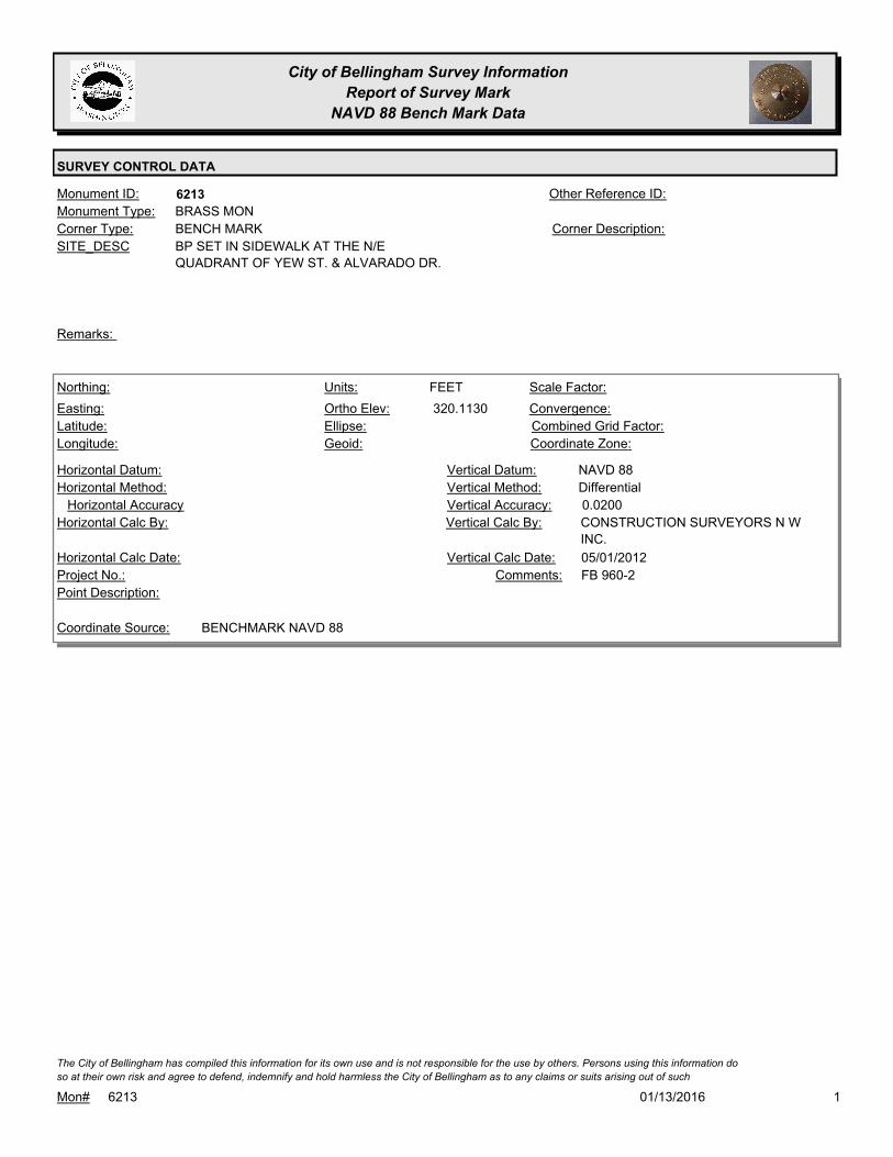
City of Bellingham Survey Information
Report of Survey Mark
NAVD 88 Bench Mark Data
SURVEY CONTROL DATA
6213Monument ID: Other Reference ID:
SITE_DESC BP SET IN SIDEWALK AT THE N/E
QUADRANT OF YEW ST. & ALVARADO DR.
BENCH MARKCorner Type: Corner Description:
BRASS MONMonument Type:
Remarks:
320.1130
FEETNorthing:
Easting:
Latitude:
Longitude:
Units:
Ortho Elev:
Ellipse:
Geoid:
Scale Factor:
Convergence:
Combined Grid Factor:
Coordinate Zone:
Horizontal Method:
Horizontal Datum: NAVD 88Vertical Datum:
DifferentialVertical Method:
Horizontal Accuracy 0.0200Vertical Accuracy:
CONSTRUCTION SURVEYORS N W
INC.
Vertical Calc By:Horizontal Calc By:
Project No.:
Point Description:
BENCHMARK NAVD 88Coordinate Source:
FB 960-2Comments:
Horizontal Calc Date: 05/01/2012Vertical Calc Date:
101/13/2016Mon# 6213
The City of Bellingham has compiled this information for its own use and is not responsible for the use by others. Persons using this information do
so at their own risk and agree to defend, indemnify and hold harmless the City of Bellingham as to any claims or suits arising out of such
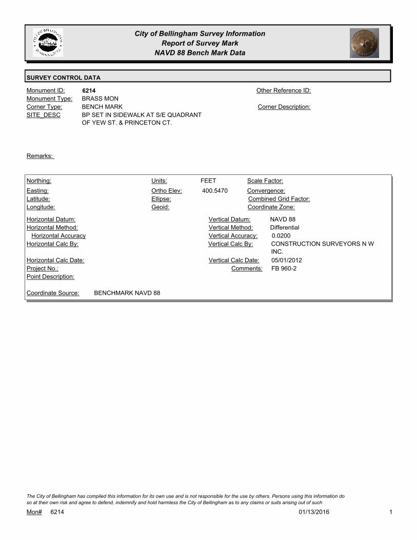
City of Bellingham Survey Information
Report of Survey Mark
NAVD 88 Bench Mark Data
SURVEY CONTROL DATA
6214Monument ID: Other Reference ID:
SITE_DESC BP SET IN SIDEWALK AT S/E QUADRANT
OF YEW ST. & PRINCETON CT.
BENCH MARKCorner Type: Corner Description:
BRASS MONMonument Type:
Remarks:
400.5470
FEETNorthing:
Easting:
Latitude:
Longitude:
Units:
Ortho Elev:
Ellipse:
Geoid:
Scale Factor:
Convergence:
Combined Grid Factor:
Coordinate Zone:
Horizontal Method:
Horizontal Datum: NAVD 88Vertical Datum:
DifferentialVertical Method:
Horizontal Accuracy 0.0200Vertical Accuracy:
CONSTRUCTION SURVEYORS N W
INC.
Vertical Calc By:Horizontal Calc By:
Project No.:
Point Description:
BENCHMARK NAVD 88Coordinate Source:
FB 960-2Comments:
Horizontal Calc Date: 05/01/2012Vertical Calc Date:
101/13/2016Mon# 6214
The City of Bellingham has compiled this information for its own use and is not responsible for the use by others. Persons using this information do
so at their own risk and agree to defend, indemnify and hold harmless the City of Bellingham as to any claims or suits arising out of such

City of Bellingham Survey Information
Report of Survey Mark
NAVD 88 Bench Mark Data
SURVEY CONTROL DATA
6215Monument ID: Other Reference ID:
SITE_DESC BP SET IN SIDEWALK ON EAST SIDE OF
YEW ST. IN FRONT OF RESIDENCE 908
YEW ST.
BENCH MARKCorner Type: Corner Description:
BRASS MONMonument Type:
Remarks:
429.6200
FEETNorthing:
Easting:
Latitude:
Longitude:
Units:
Ortho Elev:
Ellipse:
Geoid:
Scale Factor:
Convergence:
Combined Grid Factor:
Coordinate Zone:
Horizontal Method:
Horizontal Datum: NAVD 88Vertical Datum:
DifferentialVertical Method:
Horizontal Accuracy 0.0200Vertical Accuracy:
CONSTRUCTION SURVEYORS N W
INC.
Vertical Calc By:Horizontal Calc By:
Project No.:
Point Description:
BENCHMARK NAVD 88Coordinate Source:
FB 960-2Comments:
Horizontal Calc Date: 05/01/2012Vertical Calc Date:
101/13/2016Mon# 6215
The City of Bellingham has compiled this information for its own use and is not responsible for the use by others. Persons using this information do
so at their own risk and agree to defend, indemnify and hold harmless the City of Bellingham as to any claims or suits arising out of such

City of Bellingham Survey Information
Report of Survey Mark
NAVD 88 Bench Mark Data
SURVEY CONTROL DATA
6216Monument ID: Other Reference ID:
SITE_DESC BP SET IN SIDEWALK ON EAST SIDE OF
YEW ST. OPPOSITE SAN JUAN BLVD.
BENCH MARKCorner Type: Corner Description:
BRASS MONMonument Type:
Remarks:
509.7850
FEETNorthing:
Easting:
Latitude:
Longitude:
Units:
Ortho Elev:
Ellipse:
Geoid:
Scale Factor:
Convergence:
Combined Grid Factor:
Coordinate Zone:
Horizontal Method:
Horizontal Datum: NAVD 88Vertical Datum:
DifferentialVertical Method:
Horizontal Accuracy 0.0200Vertical Accuracy:
CONSTRUCTION SURVEYORS N W
INC.
Vertical Calc By:Horizontal Calc By:
Project No.:
Point Description:
BENCHMARK NAVD 88Coordinate Source:
FB 960-2Comments:
Horizontal Calc Date: 05/01/2012Vertical Calc Date:
101/13/2016Mon# 6216
The City of Bellingham has compiled this information for its own use and is not responsible for the use by others. Persons using this information do
so at their own risk and agree to defend, indemnify and hold harmless the City of Bellingham as to any claims or suits arising out of such

City of Bellingham Survey Information
Report of Survey Mark
NAVD 88 Bench Mark Data
SURVEY CONTROL DATA
6217Monument ID: Other Reference ID:
SITE_DESC BP SET IN SIDEWALK AT N/W QUADRANT
OF SAN JUAN BLVD. & SPIEDEN PL.
BENCH MARKCorner Type: Corner Description:
BRASS MONMonument Type:
Remarks:
529.1450
FEETNorthing:
Easting:
Latitude:
Longitude:
Units:
Ortho Elev:
Ellipse:
Geoid:
Scale Factor:
Convergence:
Combined Grid Factor:
Coordinate Zone:
Horizontal Method:
Horizontal Datum: NAVD 88Vertical Datum:
DifferentialVertical Method:
Horizontal Accuracy 0.0200Vertical Accuracy:
CONSTRUCTION SURVEYORS N W
INC.
Vertical Calc By:Horizontal Calc By:
Project No.:
Point Description:
BENCHMARK NAVD 88Coordinate Source:
FB 960-2Comments:
Horizontal Calc Date: 05/01/2012Vertical Calc Date:
101/13/2016Mon# 6217
The City of Bellingham has compiled this information for its own use and is not responsible for the use by others. Persons using this information do
so at their own risk and agree to defend, indemnify and hold harmless the City of Bellingham as to any claims or suits arising out of such

City of Bellingham Survey Information
Report of Survey Mark
NAVD 88 Bench Mark Data
SURVEY CONTROL DATA
6218Monument ID: Other Reference ID:
SITE_DESC BP SET IN SIDEWALK AT NORTHERLY
QUARDRANT O F SAN JUAN BLVD. &
PACIFICVIEW DR.
BENCH MARKCorner Type: Corner Description:
BRASS MONMonument Type:
Remarks:
576.9810
FEETNorthing:
Easting:
Latitude:
Longitude:
Units:
Ortho Elev:
Ellipse:
Geoid:
Scale Factor:
Convergence:
Combined Grid Factor:
Coordinate Zone:
Horizontal Method:
Horizontal Datum: NAVD 88Vertical Datum:
DifferentialVertical Method:
Horizontal Accuracy 0.0200Vertical Accuracy:
CONSTRUCTION SURVEYORS N W
INC.
Vertical Calc By:Horizontal Calc By:
Project No.:
Point Description:
BENCHMARK NAVD 88Coordinate Source:
FB 960-2Comments:
Horizontal Calc Date: 05/01/2012Vertical Calc Date:
101/13/2016Mon# 6218
The City of Bellingham has compiled this information for its own use and is not responsible for the use by others. Persons using this information do
so at their own risk and agree to defend, indemnify and hold harmless the City of Bellingham as to any claims or suits arising out of such
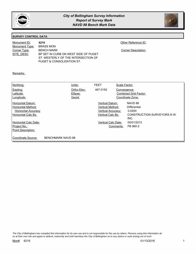
City of Bellingham Survey Information
Report of Survey Mark
NAVD 88 Bench Mark Data
SURVEY CONTROL DATA
6219Monument ID: Other Reference ID:
SITE_DESC BP SET IN CURB ON WEST SIDE OF PUGET
ST. WESTERLY OF THE INTERSECTION OF
PUGET & CONSOLIDATION ST.
BENCH MARKCorner Type: Corner Description:
BRASS MONMonument Type:
Remarks:
467.0150
FEETNorthing:
Easting:
Latitude:
Longitude:
Units:
Ortho Elev:
Ellipse:
Geoid:
Scale Factor:
Convergence:
Combined Grid Factor:
Coordinate Zone:
Horizontal Method:
Horizontal Datum: NAVD 88Vertical Datum:
DifferentialVertical Method:
Horizontal Accuracy 0.0200Vertical Accuracy:
CONSTRUCTION SURVEYORS N W
INC.
Vertical Calc By:Horizontal Calc By:
Project No.:
Point Description:
BENCHMARK NAVD 88Coordinate Source:
FB 960-2Comments:
Horizontal Calc Date: 05/01/2012Vertical Calc Date:
101/13/2016Mon# 6219
The City of Bellingham has compiled this information for its own use and is not responsible for the use by others. Persons using this information do
so at their own risk and agree to defend, indemnify and hold harmless the City of Bellingham as to any claims or suits arising out of such
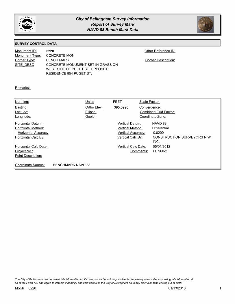
City of Bellingham Survey Information
Report of Survey Mark
NAVD 88 Bench Mark Data
SURVEY CONTROL DATA
6220Monument ID: Other Reference ID:
SITE_DESC CONCRETE MONUMENT SET IN GRASS ON
WEST SIDE OF PUGET ST. OPPOSITE
RESIDENCE 854 PUGET ST.
BENCH MARKCorner Type: Corner Description:
CONCRETE MONMonument Type:
Remarks:
395.0990
FEETNorthing:
Easting:
Latitude:
Longitude:
Units:
Ortho Elev:
Ellipse:
Geoid:
Scale Factor:
Convergence:
Combined Grid Factor:
Coordinate Zone:
Horizontal Method:
Horizontal Datum: NAVD 88Vertical Datum:
DifferentialVertical Method:
Horizontal Accuracy 0.0200Vertical Accuracy:
CONSTRUCTION SURVEYORS N W
INC.
Vertical Calc By:Horizontal Calc By:
Project No.:
Point Description:
BENCHMARK NAVD 88Coordinate Source:
FB 960-2Comments:
Horizontal Calc Date: 05/01/2012Vertical Calc Date:
101/13/2016Mon# 6220
The City of Bellingham has compiled this information for its own use and is not responsible for the use by others. Persons using this information do
so at their own risk and agree to defend, indemnify and hold harmless the City of Bellingham as to any claims or suits arising out of such

City of Bellingham Survey Information
Report of Survey Mark
NAVD 88 Bench Mark Data
SURVEY CONTROL DATA
6221Monument ID: Other Reference ID:
SITE_DESC BP SET IN SIDEWALK AT S/E QUADRANT
OF PUGET ST. & EDWARDS ST.
BENCH MARKCorner Type: Corner Description:
BRASS MONMonument Type:
Remarks:
313.1260
FEETNorthing:
Easting:
Latitude:
Longitude:
Units:
Ortho Elev:
Ellipse:
Geoid:
Scale Factor:
Convergence:
Combined Grid Factor:
Coordinate Zone:
Horizontal Method:
Horizontal Datum: NAVD 88Vertical Datum:
DifferentialVertical Method:
Horizontal Accuracy 0.0200Vertical Accuracy:
CONSTRUCTION SURVEYORS N W
INC.
Vertical Calc By:Horizontal Calc By:
Project No.:
Point Description:
BENCHMARK NAVD 88Coordinate Source:
FB 960-2Comments:
Horizontal Calc Date: 05/01/2012Vertical Calc Date:
101/13/2016Mon# 6221
The City of Bellingham has compiled this information for its own use and is not responsible for the use by others. Persons using this information do
so at their own risk and agree to defend, indemnify and hold harmless the City of Bellingham as to any claims or suits arising out of such

City of Bellingham Survey Information
Report of Survey Mark
NAVD 88 Bench Mark Data
SURVEY CONTROL DATA
6222Monument ID: Other Reference ID:
SITE_DESC GIN SPIKE SET IN POWER POLE
#160201/464979 AT NE CORNER OF
PEAABODY AND INDIANA
BENCH MARKCorner Type: GIN SPIKE IN POWER
POLE
Corner Description:
GINSPIKEMonument Type:
TBM SET FOR EU-0156Remarks:
87.9000
FEETNorthing:
Easting:
Latitude:
Longitude:
Units:
Ortho Elev:
Ellipse:
Geoid:
Scale Factor:
Convergence:
Combined Grid Factor:
Coordinate Zone:
Horizontal Method:
Horizontal Datum: NAVD 88Vertical Datum:
DifferentialVertical Method:
Horizontal Accuracy 0.0200Vertical Accuracy:
CONSTRUCTION SURVEYORS N W
INC.
Vertical Calc By:Horizontal Calc By:
EU-0156Project No.:
Point Description:
BENCHMARK NAVD 88Coordinate Source:
FB 944-1Comments:
Horizontal Calc Date: 11/10/2011Vertical Calc Date:
101/13/2016Mon# 6222
The City of Bellingham has compiled this information for its own use and is not responsible for the use by others. Persons using this information do
so at their own risk and agree to defend, indemnify and hold harmless the City of Bellingham as to any claims or suits arising out of such

City of Bellingham Survey Information
Report of Survey Mark
NAVD 88 Bench Mark Data
SURVEY CONTROL DATA
6223Monument ID: Other Reference ID:
SITE_DESC GIN SPIKE SET IN POWER POLE
#160239/464978 AT NW CORNER OF
VALLETTE AND INDIANA.
BENCH MARKCorner Type: GIN SPIKE IN POWER
POLE
Corner Description:
GIN SPIKEMonument Type:
TBM SET FOR EU-0156Remarks:
86.4400
FEETNorthing:
Easting:
Latitude:
Longitude:
Units:
Ortho Elev:
Ellipse:
Geoid:
Scale Factor:
Convergence:
Combined Grid Factor:
Coordinate Zone:
Horizontal Method:
Horizontal Datum: NAVD 88Vertical Datum:
DifferentialVertical Method:
Horizontal Accuracy 0.0200Vertical Accuracy:
CONSTRUCTION SURVEYORS N W
INC.
Vertical Calc By:Horizontal Calc By:
EU-0156Project No.:
Point Description:
BENCHMARK NAVD 88Coordinate Source:
FB 944-1Comments:
Horizontal Calc Date: 11/10/2011Vertical Calc Date:
101/13/2016Mon# 6223
The City of Bellingham has compiled this information for its own use and is not responsible for the use by others. Persons using this information do
so at their own risk and agree to defend, indemnify and hold harmless the City of Bellingham as to any claims or suits arising out of such
City of Bellingham Survey Information
Report of Survey Mark
NAVD 88 Bench Mark Data
SURVEY CONTROL DATA
6224Monument ID: Other Reference ID:
SITE_DESC BP SET IN SIDEWALK AT THE S/W
QUADRANT OF 40TH & BENNETT
BENCH MARKCorner Type: Corner Description:
BRASS MONMonument Type:
Remarks:
405.5330
FEETNorthing:
Easting:
Latitude:
Longitude:
Units:
Ortho Elev:
Ellipse:
Geoid:
Scale Factor:
Convergence:
Combined Grid Factor:
Coordinate Zone:
Horizontal Method:
Horizontal Datum: NAVD 88Vertical Datum:
DifferentialVertical Method:
Horizontal Accuracy 0.0300Vertical Accuracy:
WILSON ENGINEERING LLC.Vertical Calc By:Horizontal Calc By:
Project No.:
Point Description:
BENCHMARK NAVD 88Coordinate Source:
FB 960-3Comments:
Horizontal Calc Date: 01/18/2012Vertical Calc Date:
101/13/2016Mon# 6224
The City of Bellingham has compiled this information for its own use and is not responsible for the use by others. Persons using this information do
so at their own risk and agree to defend, indemnify and hold harmless the City of Bellingham as to any claims or suits arising out of such
City of Bellingham Survey Information
Report of Survey Mark
NAVD 88 Bench Mark Data
SURVEY CONTROL DATA
6226Monument ID: Other Reference ID:
SITE_DESC RR SPIKE IN PP # 160340/464929 ON NORTH
SIDE ILLINOIS AT SUMMER & ILLINOIS
BENCH MARKCorner Type: TBM RR SPIKE IN
POWER POLE
NORTH SIDE OF
ILLINOIS
Corner Description:
RAILROAD SPIKEMonument Type:
TBM FOUND FOR EU-0156Remarks:
120.5300
FEETNorthing:
Easting:
Latitude:
Longitude:
Units:
Ortho Elev:
Ellipse:
Geoid:
Scale Factor:
Convergence:
Combined Grid Factor:
Coordinate Zone:
Horizontal Method:
Horizontal Datum: NAVD 88Vertical Datum:
DifferentialVertical Method:
Horizontal Accuracy 0.0200Vertical Accuracy:
CONSTRUCTION SURVEYORS N W
INC.
Vertical Calc By:Horizontal Calc By:
EU-0156Project No.:
Point Description:
BENCHMARK NAVD 88Coordinate Source:
FB 944-2Comments:
Horizontal Calc Date: 11/14/2011Vertical Calc Date:
101/13/2016Mon# 6226
The City of Bellingham has compiled this information for its own use and is not responsible for the use by others. Persons using this information do
so at their own risk and agree to defend, indemnify and hold harmless the City of Bellingham as to any claims or suits arising out of such

City of Bellingham Survey Information
Report of Survey Mark
NAVD 88 Bench Mark Data
SURVEY CONTROL DATA
6229Monument ID: Other Reference ID:
SITE_DESC GIN SPIKE IN PP #160489/464929 ON
NORTH SIDE OF PLYMOUTH DRIVE
BETWEEN RES 2977 & 2983
BENCH MARKCorner Type: GIN SPIKE IN PP.Corner Description:
GIN SPIKEMonument Type:
TBM SET FOR EU-0156.Remarks:
157.5300
FEETNorthing:
Easting:
Latitude:
Longitude:
Units:
Ortho Elev:
Ellipse:
Geoid:
Scale Factor:
Convergence:
Combined Grid Factor:
Coordinate Zone:
Horizontal Method:
Horizontal Datum: NAVD 88Vertical Datum:
DifferentialVertical Method:
Horizontal Accuracy 0.0200Vertical Accuracy:
CONSTRUCTION SURVEYORS N W
INC.
Vertical Calc By:Horizontal Calc By:
EU-0156Project No.:
Point Description:
BENCHMARK NAVD 88Coordinate Source:
FB 944-3Comments:
Horizontal Calc Date: 11/14/2011Vertical Calc Date:
101/13/2016Mon# 6229
The City of Bellingham has compiled this information for its own use and is not responsible for the use by others. Persons using this information do
so at their own risk and agree to defend, indemnify and hold harmless the City of Bellingham as to any claims or suits arising out of such

City of Bellingham Survey Information
Report of Survey Mark
NAVD 88 Bench Mark Data
SURVEY CONTROL DATA
6230Monument ID: Other Reference ID:
SITE_DESC SPIKE IN PP #160550/465028 ON THE
NORTH SIDE OF PLYMOUTH DRIVE
BETWEEN RES 3103 & 3105.
BENCH MARKCorner Type: GIN SPIKE IN PPCorner Description:
GIN SPIKEMonument Type:
TBM SET FOR EU-0156.Remarks:
160.6500
FEETNorthing:
Easting:
Latitude:
Longitude:
Units:
Ortho Elev:
Ellipse:
Geoid:
Scale Factor:
Convergence:
Combined Grid Factor:
Coordinate Zone:
Horizontal Method:
Horizontal Datum: NAVD 88Vertical Datum:
DifferentialVertical Method:
Horizontal Accuracy 0.0200Vertical Accuracy:
CONSTRUCTION SURVEYORS N W
INC.
Vertical Calc By:Horizontal Calc By:
EU-0156Project No.:
Point Description:
BENCHMARK NAVD 88Coordinate Source:
FB 944-3Comments:
Horizontal Calc Date: 11/14/2011Vertical Calc Date:
101/13/2016Mon# 6230
The City of Bellingham has compiled this information for its own use and is not responsible for the use by others. Persons using this information do
so at their own risk and agree to defend, indemnify and hold harmless the City of Bellingham as to any claims or suits arising out of such

City of Bellingham Survey Information
Report of Survey Mark
NAVD 88 Bench Mark Data
SURVEY CONTROL DATA
6231Monument ID: Other Reference ID:
SITE_DESC SPIKE IN PP #160643/464924 NW QUAD OF
IRON AND ILLINOIS
BENCH MARKCorner Type: GIN SPIKE IN PPCorner Description:
GIN SPIKEMonument Type:
TBM SET FOR EU-0156.Remarks:
164.5800
FEETNorthing:
Easting:
Latitude:
Longitude:
Units:
Ortho Elev:
Ellipse:
Geoid:
Scale Factor:
Convergence:
Combined Grid Factor:
Coordinate Zone:
Horizontal Method:
Horizontal Datum: NAVD 88Vertical Datum:
DifferentialVertical Method:
Horizontal Accuracy 0.0200Vertical Accuracy:
CONSTRUCTION SURVEYORS N W
INC.
Vertical Calc By:Horizontal Calc By:
EU-0156Project No.:
Point Description:
BENCHMARK NAVD 88Coordinate Source:
FB 944-3Comments:
Horizontal Calc Date: 11/14/2011Vertical Calc Date:
101/13/2016Mon# 6231
The City of Bellingham has compiled this information for its own use and is not responsible for the use by others. Persons using this information do
so at their own risk and agree to defend, indemnify and hold harmless the City of Bellingham as to any claims or suits arising out of such

City of Bellingham Survey Information
Report of Survey Mark
NAVD 88 Bench Mark Data
SURVEY CONTROL DATA
6232Monument ID: Other Reference ID:
SITE_DESC SPIKE IN PP #160661/464923 166' +/- EAST
OF INTERSECTION IRON & ILLINOIS ON
NORTH SIDE OF ILLINOIS.
BENCH MARKCorner Type: GIN SPIKE IN PPCorner Description:
GIN SPIKEMonument Type:
TBM SET FOR EU-0156.Remarks:
166.3700
FEETNorthing:
Easting:
Latitude:
Longitude:
Units:
Ortho Elev:
Ellipse:
Geoid:
Scale Factor:
Convergence:
Combined Grid Factor:
Coordinate Zone:
Horizontal Method:
Horizontal Datum: NAVD 88Vertical Datum:
DifferentialVertical Method:
Horizontal Accuracy 0.0200Vertical Accuracy:
CONSTRUCTION SURVEYORS N W
INC.
Vertical Calc By:Horizontal Calc By:
EU-0156Project No.:
Point Description:
BENCHMARK NAVD 88Coordinate Source:
FB 944-3Comments:
Horizontal Calc Date: 11/14/2011Vertical Calc Date:
101/13/2016Mon# 6232
The City of Bellingham has compiled this information for its own use and is not responsible for the use by others. Persons using this information do
so at their own risk and agree to defend, indemnify and hold harmless the City of Bellingham as to any claims or suits arising out of such

City of Bellingham Survey Information
Report of Survey Mark
NAVD 88 Bench Mark Data
SURVEY CONTROL DATA
6233Monument ID: Other Reference ID:
SITE_DESC SPIKE IN PP PLY12/PLY13 S/O SUBSTATION
ON NORTH SIDE ILLINOIS.
BENCH MARKCorner Type: GIN SPIKE IN PPCorner Description:
GIN SPIKEMonument Type:
TBM SET FOR EU-0156.Remarks:
153.1500
Northing:
Easting:
Latitude:
Longitude:
Units:
Ortho Elev:
Ellipse:
Geoid:
Scale Factor:
Convergence:
Combined Grid Factor:
Coordinate Zone:
Horizontal Method:
Horizontal Datum: NAVD 88Vertical Datum:
DifferentialVertical Method:
Horizontal Accuracy 0.0200Vertical Accuracy:
CONSTRUCTION SURVEYORS N W
INC.
Vertical Calc By:Horizontal Calc By:
EU-0156Project No.:
Point Description:
BENCHMARK NAVD 88Coordinate Source:
FB 944-3Comments:
Horizontal Calc Date: 11/14/2011Vertical Calc Date:
101/13/2016Mon# 6233
The City of Bellingham has compiled this information for its own use and is not responsible for the use by others. Persons using this information do
so at their own risk and agree to defend, indemnify and hold harmless the City of Bellingham as to any claims or suits arising out of such

City of Bellingham Survey Information
Report of Survey Mark
NAVD 88 Bench Mark Data
SURVEY CONTROL DATA
6234Monument ID: Other Reference ID:
SITE_DESC SPIKE IN PP #160466/464926 NEAR SW
CORNER RES #103 ON W ILLINOIS
BENCH MARKCorner Type: GIN SPIKE IN PPCorner Description:
GIN SPIKEMonument Type:
TBM SET FOR EU-0156.Remarks:
147.0800
Northing:
Easting:
Latitude:
Longitude:
Units:
Ortho Elev:
Ellipse:
Geoid:
Scale Factor:
Convergence:
Combined Grid Factor:
Coordinate Zone:
Horizontal Method:
Horizontal Datum: NAVD 88Vertical Datum:
DifferentialVertical Method:
Horizontal Accuracy 0.0200Vertical Accuracy:
CONSTRUCTION SURVEYORS N W
INC.
Vertical Calc By:Horizontal Calc By:
EU-0156Project No.:
Point Description:
BENCHMARK NAVD 88Coordinate Source:
FB 944-3Comments:
Horizontal Calc Date: 11/14/2011Vertical Calc Date:
101/13/2016Mon# 6234
The City of Bellingham has compiled this information for its own use and is not responsible for the use by others. Persons using this information do
so at their own risk and agree to defend, indemnify and hold harmless the City of Bellingham as to any claims or suits arising out of such

City of Bellingham Survey Information
Report of Survey Mark
NAVD 88 Bench Mark Data
SURVEY CONTROL DATA
6235Monument ID: Other Reference ID:
SITE_DESC FILED 'X' ON W. BOLT OF SIGNAL BASE @
THE E. QUADRANT RAILROAD & HOLLY
BENCH MARKCorner Type: FILED 'X' ON SIGNAL
BOLT
Corner Description:
FILED XMonument Type:
TBM SET FOR EW-0186Remarks:
79.9500
FEETNorthing:
Easting:
Latitude:
Longitude:
Units:
Ortho Elev:
Ellipse:
Geoid:
Scale Factor:
Convergence:
Combined Grid Factor:
Coordinate Zone:
Horizontal Method:
Horizontal Datum: NAVD 88Vertical Datum:
DifferentialVertical Method:
Horizontal Accuracy 0.0100Vertical Accuracy:
PACIFIC SURVEY & ENGINEERING,
INC.
Vertical Calc By:Horizontal Calc By:
EW-0186Project No.:
Point Description:
BENCHMARK NAVD 88Coordinate Source:
Comments:
Horizontal Calc Date: Vertical Calc Date:
101/13/2016Mon# 6235
The City of Bellingham has compiled this information for its own use and is not responsible for the use by others. Persons using this information do
so at their own risk and agree to defend, indemnify and hold harmless the City of Bellingham as to any claims or suits arising out of such

City of Bellingham Survey Information
Report of Survey Mark
NAVD 88 Bench Mark Data
SURVEY CONTROL DATA
6236Monument ID: Other Reference ID:
SITE_DESC 60D SPIKE IN SE FACE POWER POLE IN NE
QUAD OF ILLINOIS AND ALLEY EAST OF
NEVADA.
BENCH MARKCorner Type: 60D SPIKE IN
POWER POLE
Corner Description:
60D SPIKEMonument Type:
TBM SET FOR EU-0156Remarks:
179.2900
FEETNorthing:
Easting:
Latitude:
Longitude:
Units:
Ortho Elev:
Ellipse:
Geoid:
Scale Factor:
Convergence:
Combined Grid Factor:
Coordinate Zone:
Horizontal Method:
Horizontal Datum: NAVD 88Vertical Datum:
DifferentialVertical Method:
Horizontal Accuracy 0.0100Vertical Accuracy:
PACIFIC SURVEY & ENGINEERING,
INC.
Vertical Calc By:Horizontal Calc By:
EU-0156Project No.:
Point Description:
BENCHMARK NAVD 88Coordinate Source:
FB 932-1Comments:
Horizontal Calc Date: 11/22/2011Vertical Calc Date:
101/13/2016Mon# 6236
The City of Bellingham has compiled this information for its own use and is not responsible for the use by others. Persons using this information do
so at their own risk and agree to defend, indemnify and hold harmless the City of Bellingham as to any claims or suits arising out of such

City of Bellingham Survey Information
Report of Survey Mark
NAVD 88 Bench Mark Data
SURVEY CONTROL DATA
6237Monument ID: Other Reference ID:
SITE_DESC 60D NAIL SOUTHERLY FACE OF WOOD
UTILITY POLE @ ALLEY ENTRANCE N. SIDE
OF CAROLINA EAST OF NEVADA
BENCH MARKCorner Type: 60D NAIL IN WOOD
UTILITY POLE
Corner Description:
60D NAILMonument Type:
TBM SET FOR EU-0151Remarks:
81.3200
FEETNorthing:
Easting:
Latitude:
Longitude:
Units:
Ortho Elev:
Ellipse:
Geoid:
Scale Factor:
Convergence:
Combined Grid Factor:
Coordinate Zone:
Horizontal Method:
Horizontal Datum: NAVD 88Vertical Datum:
DifferentialVertical Method:
Horizontal Accuracy 0.0100Vertical Accuracy:
PACIFIC SURVEY & ENGINEERING,
INC.
Vertical Calc By:Horizontal Calc By:
EU-0151Project No.:
Point Description:
BENCHMARK NAVD 88Coordinate Source:
FB 932-1,2Comments:
Horizontal Calc Date: 11/22/2011Vertical Calc Date:
101/13/2016Mon# 6237
The City of Bellingham has compiled this information for its own use and is not responsible for the use by others. Persons using this information do
so at their own risk and agree to defend, indemnify and hold harmless the City of Bellingham as to any claims or suits arising out of such

City of Bellingham Survey Information
Report of Survey Mark
NAVD 88 Bench Mark Data
SURVEY CONTROL DATA
6238Monument ID: Other Reference ID:
SITE_DESC RR SPIKE IN WOOD UTILITY POLE
(#464761/160834) W. SIDE ALLEY S/O
NORTH STREET.
BENCH MARKCorner Type: RR SPIKE IN WOOD
UTILITY POLE
Corner Description:
RAILROAD SPIKEMonument Type:
TBM SET FOR EU-0151Remarks:
123.4200
FEETNorthing:
Easting:
Latitude:
Longitude:
Units:
Ortho Elev:
Ellipse:
Geoid:
Scale Factor:
Convergence:
Combined Grid Factor:
Coordinate Zone:
Horizontal Method:
Horizontal Datum: NAVD 88Vertical Datum:
DifferentialVertical Method:
Horizontal Accuracy 0.0100Vertical Accuracy:
PACIFIC SURVEY & ENGINEERING,
INC.
Vertical Calc By:Horizontal Calc By:
EU-0151Project No.:
Point Description:
BENCHMARK NAVD 88Coordinate Source:
Comments:
Horizontal Calc Date: 11/22/2011Vertical Calc Date:
101/13/2016Mon# 6238
The City of Bellingham has compiled this information for its own use and is not responsible for the use by others. Persons using this information do
so at their own risk and agree to defend, indemnify and hold harmless the City of Bellingham as to any claims or suits arising out of such

City of Bellingham Survey Information
Report of Survey Mark
NAVD 88 Bench Mark Data
SURVEY CONTROL DATA
6240Monument ID: Other Reference ID:
SITE_DESC RR SPIKE IN PPP #464917. SW QUAD.
ALLEY E/O ORLEANS & ILLINOIS STREET.
BENCH MARKCorner Type: RR SPIKE IN POWER
POLE
Corner Description:
SCRIBED XMonument Type:
TBM SET FOR EU-0156Remarks:
180.3600
FEETNorthing:
Easting:
Latitude:
Longitude:
Units:
Ortho Elev:
Ellipse:
Geoid:
Scale Factor:
Convergence:
Combined Grid Factor:
Coordinate Zone:
Horizontal Method:
Horizontal Datum: NAVD 88Vertical Datum:
DifferentialVertical Method:
Horizontal Accuracy 0.0100Vertical Accuracy:
PACIFIC SURVEY & ENGINEERING,
INC.
Vertical Calc By:Horizontal Calc By:
EU-0156Project No.:
C-RRS TBM 20APoint Description:
BENCHMARK NAVD 88Coordinate Source:
FB 966-1. PROJECT POINT 20AComments:
Horizontal Calc Date: 03/14/2012Vertical Calc Date:
101/13/2016Mon# 6240
The City of Bellingham has compiled this information for its own use and is not responsible for the use by others. Persons using this information do
so at their own risk and agree to defend, indemnify and hold harmless the City of Bellingham as to any claims or suits arising out of such

City of Bellingham Survey Information
Report of Survey Mark
NAVD 88 Bench Mark Data
SURVEY CONTROL DATA
6241Monument ID: Other Reference ID:
SITE_DESC BOLT IN 4" BOLLARD, SW QUAD ALLEY E/O
ORLEANS & WALKING TRAIL
(CONNECTICUT).
BENCH MARKCorner Type: BOLT IN TOP OF 4"
STEEL BOLLARD
Corner Description:
BOLTMonument Type:
TBM SET FOR EU-0156Remarks:
148.8300
FEETNorthing:
Easting:
Latitude:
Longitude:
Units:
Ortho Elev:
Ellipse:
Geoid:
Scale Factor:
Convergence:
Combined Grid Factor:
Coordinate Zone:
Horizontal Method:
Horizontal Datum: NAVD 88Vertical Datum:
DifferentialVertical Method:
Horizontal Accuracy 0.0100Vertical Accuracy:
PACIFIC SURVEY & ENGINEERING,
INC.
Vertical Calc By:Horizontal Calc By:
EU-0156Project No.:
C-AXL TBM 20B BOLTPoint Description:
BENCHMARK NAVD 88Coordinate Source:
FB 966-1 PROJECT POINT 20BComments:
Horizontal Calc Date: 03/14/2012Vertical Calc Date:
101/13/2016Mon# 6241
The City of Bellingham has compiled this information for its own use and is not responsible for the use by others. Persons using this information do
so at their own risk and agree to defend, indemnify and hold harmless the City of Bellingham as to any claims or suits arising out of such

City of Bellingham Survey Information
Report of Survey Mark
NAVD 88 Bench Mark Data
SURVEY CONTROL DATA
6242Monument ID: Other Reference ID:
SITE_DESC SCRIBED "X" ON SE BOLT L.P. BASE, NW
QUAD ALLEY E/O ORLEANS & ILLINOIS.
BENCH MARKCorner Type: SCRIBED "X " ON
BOLT ON L.P. BASE.
Corner Description:
SCRIBED XMonument Type:
TBM SET FOR EU-0156Remarks:
110.7900
FEETNorthing:
Easting:
Latitude:
Longitude:
Units:
Ortho Elev:
Ellipse:
Geoid:
Scale Factor:
Convergence:
Combined Grid Factor:
Coordinate Zone:
Horizontal Method:
Horizontal Datum: NAVD 88Vertical Datum:
DifferentialVertical Method:
Horizontal Accuracy 0.0100Vertical Accuracy:
PACIFIC SURVEY & ENGINEERING,
INC.
Vertical Calc By:Horizontal Calc By:
EU-0156Project No.:
C-SRB TBM 20CPoint Description:
BENCHMARK NAVD 88Coordinate Source:
FB 966-1. PROJECT POINT 20C.Comments:
Horizontal Calc Date: 03/14/2012Vertical Calc Date:
101/13/2016Mon# 6242
The City of Bellingham has compiled this information for its own use and is not responsible for the use by others. Persons using this information do
so at their own risk and agree to defend, indemnify and hold harmless the City of Bellingham as to any claims or suits arising out of such

City of Bellingham Survey Information
Report of Survey Mark
NAVD 88 Bench Mark Data
SURVEY CONTROL DATA
6243Monument ID: Other Reference ID:
SITE_DESC RR SPIKE IN E FACE OF PP #464637/160865,
NW QUAD ALLEY E/O ORLEANS &
CAROLINA
BENCH MARKCorner Type: RR SPIKE IN POWER
POLE
Corner Description:
RAILROAD SPIKEMonument Type:
TBM SET FOR EU-0156Remarks:
81.4500
FEETNorthing:
Easting:
Latitude:
Longitude:
Units:
Ortho Elev:
Ellipse:
Geoid:
Scale Factor:
Convergence:
Combined Grid Factor:
Coordinate Zone:
Horizontal Method:
Horizontal Datum: NAVD 88Vertical Datum:
DifferentialVertical Method:
Horizontal Accuracy 0.0100Vertical Accuracy:
PACIFIC SURVEY & ENGINEERING,
INC.
Vertical Calc By:Horizontal Calc By:
EU-0156Project No.:
C-RRS TBM 22APoint Description:
BENCHMARK NAVD 88Coordinate Source:
FB 966-1. PROJECT POINT 22AComments:
Horizontal Calc Date: 03/14/2012Vertical Calc Date:
101/13/2016Mon# 6243
The City of Bellingham has compiled this information for its own use and is not responsible for the use by others. Persons using this information do
so at their own risk and agree to defend, indemnify and hold harmless the City of Bellingham as to any claims or suits arising out of such

City of Bellingham Survey Information
Report of Survey Mark
NAVD 88 Bench Mark Data
SURVEY CONTROL DATA
6244Monument ID: Other Reference ID:
SITE_DESC SCRIBED X ON NE BOLT L.P. BASE, SW
QUAD PACIFIC AND VIRGINIA.
BENCH MARKCorner Type: SCRIBED "X" IN L.P.
BASE
Corner Description:
SCRIBED XMonument Type:
TBM SET FOR EU-0156Remarks:
70.9500
FEETNorthing:
Easting:
Latitude:
Longitude:
Units:
Ortho Elev:
Ellipse:
Geoid:
Scale Factor:
Convergence:
Combined Grid Factor:
Coordinate Zone:
Horizontal Method:
Horizontal Datum: NAVD 88Vertical Datum:
DifferentialVertical Method:
Horizontal Accuracy 0.0100Vertical Accuracy:
PACIFIC SURVEY & ENGINEERING,
INC.
Vertical Calc By:Horizontal Calc By:
EU-0156Project No.:
C-SRB TBM 30APoint Description:
BENCHMARK NAVD 88Coordinate Source:
FB 966-1. PROJECT POINT 30AComments:
Horizontal Calc Date: 03/14/2012Vertical Calc Date:
101/13/2016Mon# 6244
The City of Bellingham has compiled this information for its own use and is not responsible for the use by others. Persons using this information do
so at their own risk and agree to defend, indemnify and hold harmless the City of Bellingham as to any claims or suits arising out of such

City of Bellingham Survey Information
Report of Survey Mark
NAVD 88 Bench Mark Data
SURVEY CONTROL DATA
6245Monument ID: Other Reference ID:
SITE_DESC RR SPIKE IN SW FACE PP #464683/161077,
NE QUAD. ALLEY E/O ST. PAUL AND TEXAS.
BENCH MARKCorner Type: RR SPIKE IN FACE
OF WOOD POWER
POLE
Corner Description:
RAILROAD SPIKEMonument Type:
TBM SET FOR EU-0156Remarks:
91.9300
FEETNorthing:
Easting:
Latitude:
Longitude:
Units:
Ortho Elev:
Ellipse:
Geoid:
Scale Factor:
Convergence:
Combined Grid Factor:
Coordinate Zone:
Horizontal Method:
Horizontal Datum: NAVD 88Vertical Datum:
DifferentialVertical Method:
Horizontal Accuracy 0.0100Vertical Accuracy:
PACIFIC SURVEY & ENGINEERING,
INC.
Vertical Calc By:Horizontal Calc By:
EU-0156Project No.:
C-RRS TBM 24APoint Description:
BENCHMARK NAVD 88Coordinate Source:
FB 966-1.Comments:
Horizontal Calc Date: 03/14/2012Vertical Calc Date:
101/13/2016Mon# 6245
The City of Bellingham has compiled this information for its own use and is not responsible for the use by others. Persons using this information do
so at their own risk and agree to defend, indemnify and hold harmless the City of Bellingham as to any claims or suits arising out of such

City of Bellingham Survey Information
Report of Survey Mark
NAVD 88 Bench Mark Data
SURVEY CONTROL DATA
6246Monument ID: Other Reference ID:
SITE_DESC RR SPIKE IN POWER POLE #464772/161010,
N. END ALLEY E/O ST. PAUL.
BENCH MARKCorner Type: RR SPIKE IN POWER
POLE
Corner Description:
RAILROAD SPIKEMonument Type:
TBM SET FOR EU-0156Remarks:
128.0600
FEETNorthing:
Easting:
Latitude:
Longitude:
Units:
Ortho Elev:
Ellipse:
Geoid:
Scale Factor:
Convergence:
Combined Grid Factor:
Coordinate Zone:
Horizontal Method:
Horizontal Datum: NAVD 88Vertical Datum:
DifferentialVertical Method:
Horizontal Accuracy 0.0100Vertical Accuracy:
PACIFIC SURVEY & ENGINEERING,
INC.
Vertical Calc By:Horizontal Calc By:
EU-0156Project No.:
C-RRS TBM 24BPoint Description:
BENCHMARK NAVD 88Coordinate Source:
FB 966-1Comments:
Horizontal Calc Date: 03/14/2012Vertical Calc Date:
101/13/2016Mon# 6246
The City of Bellingham has compiled this information for its own use and is not responsible for the use by others. Persons using this information do
so at their own risk and agree to defend, indemnify and hold harmless the City of Bellingham as to any claims or suits arising out of such

City of Bellingham Survey Information
Report of Survey Mark
NAVD 88 Bench Mark Data
SURVEY CONTROL DATA
6247Monument ID: Other Reference ID:
SITE_DESC RR SPIKE IN PP #464631/160902, SE QUAD
ALLEY EAST OF PACIFIC AND CAROLINA.
BENCH MARKCorner Type: RR SPIKE IN POWER
POLE
Corner Description:
RAILROAD SPIKEMonument Type:
TBM SET FOR EU-0156Remarks:
80.3900
FEETNorthing:
Easting:
Latitude:
Longitude:
Units:
Ortho Elev:
Ellipse:
Geoid:
Scale Factor:
Convergence:
Combined Grid Factor:
Coordinate Zone:
Horizontal Method:
Horizontal Datum: NAVD 88Vertical Datum:
DifferentialVertical Method:
Horizontal Accuracy 0.0100Vertical Accuracy:
PACIFIC SURVEY & ENGINEERING,
INC.
Vertical Calc By:Horizontal Calc By:
EU-0156Project No.:
Point Description:
BENCHMARK NAVD 88Coordinate Source:
FB 966-1. PROJECT POINT 22BComments:
Horizontal Calc Date: 03/14/2012Vertical Calc Date:
101/13/2016Mon# 6247
The City of Bellingham has compiled this information for its own use and is not responsible for the use by others. Persons using this information do
so at their own risk and agree to defend, indemnify and hold harmless the City of Bellingham as to any claims or suits arising out of such

City of Bellingham Survey Information
Report of Survey Mark
NAVD 88 Bench Mark Data
SURVEY CONTROL DATA
6248Monument ID: Other Reference ID:
SITE_DESC SCRIBED BOX IN CONC. POWER VAULT, SE
QUAD ALLEY EAST OF PACIFIC AND
KENTUCKY
BENCH MARKCorner Type: SCRIBED BOX IN
CONCRETE POWER
VAULT.
Corner Description:
SCRIBED BOXMonument Type:
TBM SET FOR EU-0156Remarks:
62.1200
FEETNorthing:
Easting:
Latitude:
Longitude:
Units:
Ortho Elev:
Ellipse:
Geoid:
Scale Factor:
Convergence:
Combined Grid Factor:
Coordinate Zone:
Horizontal Method:
Horizontal Datum: NAVD 88Vertical Datum:
DifferentialVertical Method:
Horizontal Accuracy 0.0100Vertical Accuracy:
PACIFIC SURVEY & ENGINEERING,
INC.
Vertical Calc By:Horizontal Calc By:
EU-0156Project No.:
Point Description:
BENCHMARK NAVD 88Coordinate Source:
FB 966-1. PROJECT POINT 22CComments:
Horizontal Calc Date: 03/14/2012Vertical Calc Date:
101/13/2016Mon# 6248
The City of Bellingham has compiled this information for its own use and is not responsible for the use by others. Persons using this information do
so at their own risk and agree to defend, indemnify and hold harmless the City of Bellingham as to any claims or suits arising out of such

City of Bellingham Survey Information
Report of Survey Mark
NAVD 88 Bench Mark Data
SURVEY CONTROL DATA
6249Monument ID: Other Reference ID:
SITE_DESC GIN SPIKE IN POWER POLE AT
NORTHEAST CORNER OF INTERSECTION
OHIO AND HUMBOLDT.
BENCH MARKCorner Type: TOP OF GIN SPIKE IN
POWER POLE
Corner Description:
GIN SPIKEMonument Type:
BENCHMARK SET FOR EW-0186.Remarks:
67.7300
FEETNorthing:
Easting:
Latitude:
Longitude:
Units:
Ortho Elev:
Ellipse:
Geoid:
Scale Factor:
Convergence:
Combined Grid Factor:
Coordinate Zone:
Horizontal Method:
Horizontal Datum: NAVD 88Vertical Datum:
DifferentialVertical Method:
Horizontal Accuracy 0.0200Vertical Accuracy:
CONSTRUCTION SURVEYORS N W
INC.
Vertical Calc By:Horizontal Calc By:
EW-0186Project No.:
Point Description:
BENCHMARK NAVD 88Coordinate Source:
FB 952-1Comments:
Horizontal Calc Date: 09/26/2011Vertical Calc Date:
101/13/2016Mon# 6249
The City of Bellingham has compiled this information for its own use and is not responsible for the use by others. Persons using this information do
so at their own risk and agree to defend, indemnify and hold harmless the City of Bellingham as to any claims or suits arising out of such

City of Bellingham Survey Information
Report of Survey Mark
NAVD 88 Bench Mark Data
SURVEY CONTROL DATA
6250Monument ID: Other Reference ID:
SITE_DESC GIN SPIKEIN POWER POLE AT
NORTHWEST CORNER INTERSECTION
IOWA AND HUMBOLDT.
BENCH MARKCorner Type: TOP OF GIN SPIKE IN
POWER POLE
Corner Description:
GIN SPIKEMonument Type:
BENCHMARK SET FOR EW-0186.Remarks:
68.7200
FEETNorthing:
Easting:
Latitude:
Longitude:
Units:
Ortho Elev:
Ellipse:
Geoid:
Scale Factor:
Convergence:
Combined Grid Factor:
Coordinate Zone:
Horizontal Method:
Horizontal Datum: NAVD 88Vertical Datum:
DifferentialVertical Method:
Horizontal Accuracy 0.0200Vertical Accuracy:
CONSTRUCTION SURVEYORS N W
INC.
Vertical Calc By:Horizontal Calc By:
EW-0186Project No.:
Point Description:
BENCHMARK NAVD 88Coordinate Source:
FB 952-1Comments:
Horizontal Calc Date: 09/26/2011Vertical Calc Date:
101/13/2016Mon# 6250
The City of Bellingham has compiled this information for its own use and is not responsible for the use by others. Persons using this information do
so at their own risk and agree to defend, indemnify and hold harmless the City of Bellingham as to any claims or suits arising out of such

City of Bellingham Survey Information
Report of Survey Mark
NAVD 88 Bench Mark Data
SURVEY CONTROL DATA
6251Monument ID: Other Reference ID:
SITE_DESC GIN SPIKE IN POWER POLE AT
NORTHWEST CORNER INTERSECTION
KENTUCKY AND HUMBOLDT.
BENCH MARKCorner Type: TOP OF GIN SPIKE IN
POWER POLE
Corner Description:
GIN SPIKEMonument Type:
BENCHMARK SET FOR EW-0186.Remarks:
76.0400
FEETNorthing:
Easting:
Latitude:
Longitude:
Units:
Ortho Elev:
Ellipse:
Geoid:
Scale Factor:
Convergence:
Combined Grid Factor:
Coordinate Zone:
Horizontal Method:
Horizontal Datum: NAVD 88Vertical Datum:
DifferentialVertical Method:
Horizontal Accuracy 0.0200Vertical Accuracy:
CONSTRUCTION SURVEYORS N W
INC.
Vertical Calc By:Horizontal Calc By:
EW-0186Project No.:
Point Description:
BENCHMARK NAVD 88Coordinate Source:
FB 952-1Comments:
Horizontal Calc Date: 09/26/2011Vertical Calc Date:
101/13/2016Mon# 6251
The City of Bellingham has compiled this information for its own use and is not responsible for the use by others. Persons using this information do
so at their own risk and agree to defend, indemnify and hold harmless the City of Bellingham as to any claims or suits arising out of such

City of Bellingham Survey Information
Report of Survey Mark
NAVD 88 Bench Mark Data
SURVEY CONTROL DATA
6253Monument ID: Other Reference ID:
SITE_DESC RR SPIKE IN POWER POLE AT NORTHEAST
CORNER CAROLINA AND HUNBOLDT.
BENCH MARKCorner Type: TOP OF RR SPIKE IN
POWER POLE
Corner Description:
RAILROAD SPIKEMonument Type:
BENCHMARK FOUND FOR EW-0186.Remarks:
90.2000
FEETNorthing:
Easting:
Latitude:
Longitude:
Units:
Ortho Elev:
Ellipse:
Geoid:
Scale Factor:
Convergence:
Combined Grid Factor:
Coordinate Zone:
Horizontal Method:
Horizontal Datum: NAVD 88Vertical Datum:
DifferentialVertical Method:
Horizontal Accuracy 0.0200Vertical Accuracy:
CONSTRUCTION SURVEYORS N W
INC.
Vertical Calc By:Horizontal Calc By:
EW-0186Project No.:
Point Description:
BENCHMARK NAVD 88Coordinate Source:
FB 952-1Comments:
Horizontal Calc Date: 09/26/2011Vertical Calc Date:
101/13/2016Mon# 6253
The City of Bellingham has compiled this information for its own use and is not responsible for the use by others. Persons using this information do
so at their own risk and agree to defend, indemnify and hold harmless the City of Bellingham as to any claims or suits arising out of such

City of Bellingham Survey Information
Report of Survey Mark
NAVD 88 Bench Mark Data
SURVEY CONTROL DATA
6255Monument ID: Other Reference ID:
SITE_DESC GIN SPIKE IN POWER POLE AT
NORTHEAST CORNER INTERSECTION OF
VIRGINIA AND HUMBOLDT.
BENCH MARKCorner Type: TOP OF GIN SPIKE IN
POWER POLE
Corner Description:
GIN SPIKEMonument Type:
BENCHMARK SET FOR EW-0186.Remarks:
79.1700
FEETNorthing:
Easting:
Latitude:
Longitude:
Units:
Ortho Elev:
Ellipse:
Geoid:
Scale Factor:
Convergence:
Combined Grid Factor:
Coordinate Zone:
Horizontal Method:
Horizontal Datum: NAVD 88Vertical Datum:
DifferentialVertical Method:
Horizontal Accuracy 0.0200Vertical Accuracy:
CONSTRUCTION SURVEYORS N W
INC.
Vertical Calc By:Horizontal Calc By:
EW-0186Project No.:
Point Description:
BENCHMARK NAVD 88Coordinate Source:
FB 9562-1Comments:
Horizontal Calc Date: 09/26/2011Vertical Calc Date:
101/13/2016Mon# 6255
The City of Bellingham has compiled this information for its own use and is not responsible for the use by others. Persons using this information do
so at their own risk and agree to defend, indemnify and hold harmless the City of Bellingham as to any claims or suits arising out of such

City of Bellingham Survey Information
Report of Survey Mark
NAVD 88 Bench Mark Data
SURVEY CONTROL DATA
6256Monument ID: Other Reference ID:
SITE_DESC TOP OF NORTHWEST BOLT OF STREET
LIGHT POLE AT SOUTHEAST CORNER OF
ORLEANS & BARKLEY
BENCH MARKCorner Type: Corner Description:
BOLTMonument Type:
VISITED FOR BENCHMARK DENSIFICATION 2011.Remarks:
188.0650
FEETNorthing:
Easting:
Latitude:
Longitude:
Units:
Ortho Elev:
Ellipse:
Geoid:
Scale Factor:
Convergence:
Combined Grid Factor:
Coordinate Zone:
Horizontal Method:
Horizontal Datum: NAVD 88Vertical Datum:
DifferentialVertical Method:
Horizontal Accuracy 0.0200Vertical Accuracy:
CONSTRUCTION SURVEYORS N W
INC.
Vertical Calc By:Horizontal Calc By:
Project No.:
Point Description:
BENCHMARK NAVD 88Coordinate Source:
VISITED FOR BENCHMARK
DENSIFICATION 2011.
Comments:
Horizontal Calc Date: 05/01/2012Vertical Calc Date:
101/13/2016Mon# 6256
The City of Bellingham has compiled this information for its own use and is not responsible for the use by others. Persons using this information do
so at their own risk and agree to defend, indemnify and hold harmless the City of Bellingham as to any claims or suits arising out of such
City of Bellingham Survey Information
Report of Survey Mark
NAVD 88 Bench Mark Data
SURVEY CONTROL DATA
6257Monument ID: Other Reference ID:
SITE_DESC TOP OF NORTHWEST BOLT ON TRAFFIC
SIGNAL LIGHT POLE AT SOUTHEAST
CORNER OF INT. WOBURN AND
SOUTHERN MOST ROAD INTO BARKLEY
BENCH MARKCorner Type: Corner Description:
BOLTMonument Type:
VISITED FOR BENCHMARK DENSIFICATION 2011.Remarks:
189.8960
Northing:
Easting:
Latitude:
Longitude:
Units:
Ortho Elev:
Ellipse:
Geoid:
Scale Factor:
Convergence:
Combined Grid Factor:
Coordinate Zone:
Horizontal Method:
Horizontal Datum: NAVD 88Vertical Datum:
DifferentialVertical Method:
Horizontal Accuracy 0.0200Vertical Accuracy:
CONSTRUCTION SURVEYORS N W
INC.
Vertical Calc By:Horizontal Calc By:
Project No.:
Point Description:
BENCHMARK NAVD 88Coordinate Source:
VISITED FOR BENCHMARK
DENSIFICATION 2011.
Comments:
Horizontal Calc Date: 05/01/2012Vertical Calc Date:
101/13/2016Mon# 6257
The City of Bellingham has compiled this information for its own use and is not responsible for the use by others. Persons using this information do
so at their own risk and agree to defend, indemnify and hold harmless the City of Bellingham as to any claims or suits arising out of such

City of Bellingham Survey Information
Report of Survey Mark
NAVD 88 Bench Mark Data
SURVEY CONTROL DATA
6258Monument ID: Other Reference ID:
SITE_DESC TOP OF NE BOLT OF STREET LIGHT POLE
ON WEST SIDE OF WOBURN IN FRONTOF
#2713 WOBURN
BENCH MARKCorner Type: NORTHEAST BOLT
OF STREET LIGHT
POLE
Corner Description:
BOLTMonument Type:
SET FOR BENCHMARK DENSIFICATION 2011.Remarks:
151.0440
FEETNorthing:
Easting:
Latitude:
Longitude:
Units:
Ortho Elev:
Ellipse:
Geoid:
Scale Factor:
Convergence:
Combined Grid Factor:
Coordinate Zone:
Horizontal Method:
Horizontal Datum: NAVD 88Vertical Datum:
DifferentialVertical Method:
Horizontal Accuracy 0.0200Vertical Accuracy:
CONSTRUCTION SURVEYORS N W
INC.
Vertical Calc By:Horizontal Calc By:
Project No.:
Point Description:
BENCHMARK NAVD 88Coordinate Source:
FB 960-2Comments:
Horizontal Calc Date: 05/01/2012Vertical Calc Date:
101/13/2016Mon# 6258
The City of Bellingham has compiled this information for its own use and is not responsible for the use by others. Persons using this information do
so at their own risk and agree to defend, indemnify and hold harmless the City of Bellingham as to any claims or suits arising out of such

City of Bellingham Survey Information
Report of Survey Mark
NAVD 88 Bench Mark Data
SURVEY CONTROL DATA
6259Monument ID: Other Reference ID:
SITE_DESC TOP OF SOUTHWEST BOLT OF STREET
LIGHT POLE AT NE CORNER WOBURN AND
CONNECTICUT
BENCH MARKCorner Type: TOP OF BOLT OF
STREET LIGHT POLE
Corner Description:
BOLTMonument Type:
Remarks:
144.9410
FEETNorthing:
Easting:
Latitude:
Longitude:
Units:
Ortho Elev:
Ellipse:
Geoid:
Scale Factor:
Convergence:
Combined Grid Factor:
Coordinate Zone:
Horizontal Method:
Horizontal Datum: NAVD 88Vertical Datum:
DifferentialVertical Method:
Horizontal Accuracy 0.0200Vertical Accuracy:
CONSTRUCTION SURVEYORS N W
INC.
Vertical Calc By:Horizontal Calc By:
Project No.:
Point Description:
BENCHMARK NAVD 88Coordinate Source:
FB 960-2Comments:
Horizontal Calc Date: 05/01/2012Vertical Calc Date:
101/13/2016Mon# 6259
The City of Bellingham has compiled this information for its own use and is not responsible for the use by others. Persons using this information do
so at their own risk and agree to defend, indemnify and hold harmless the City of Bellingham as to any claims or suits arising out of such

City of Bellingham Survey Information
Report of Survey Mark
NAVD 88 Bench Mark Data
SURVEY CONTROL DATA
6260Monument ID: Other Reference ID:
SITE_DESC TOP OF SOUTHWEST BOLTOF STREET
LIGHT POLE AT NE CORNER OF WOBURN
AND NORTH
BENCH MARKCorner Type: TOP OF BOLT OF
STREET LIGHT POLE
Corner Description:
BOLTMonument Type:
Remarks:
131.3130
FEETNorthing:
Easting:
Latitude:
Longitude:
Units:
Ortho Elev:
Ellipse:
Geoid:
Scale Factor:
Convergence:
Combined Grid Factor:
Coordinate Zone:
Horizontal Method:
Horizontal Datum: NAVD 88Vertical Datum:
DifferentialVertical Method:
Horizontal Accuracy 0.0200Vertical Accuracy:
CONSTRUCTION SURVEYORS N W
INC.
Vertical Calc By:Horizontal Calc By:
Project No.:
Point Description:
BENCHMARK NAVD 88Coordinate Source:
FB 960-2Comments:
Horizontal Calc Date: 05/01/2012Vertical Calc Date:
101/13/2016Mon# 6260
The City of Bellingham has compiled this information for its own use and is not responsible for the use by others. Persons using this information do
so at their own risk and agree to defend, indemnify and hold harmless the City of Bellingham as to any claims or suits arising out of such

City of Bellingham Survey Information
Report of Survey Mark
NAVD 88 Bench Mark Data
SURVEY CONTROL DATA
6261Monument ID: Other Reference ID:
SITE_DESC TOP OF NW BOLT OF STREET LIGHT AT SE
CORNER OF YEW AND ALVARADO
BENCH MARKCorner Type: TOP OF BOLT OF
STREET LIGHT
Corner Description:
BOLTMonument Type:
TBM SET FOR BENCHMARK DENSIFICATION 2011Remarks:
324.7960
FEETNorthing:
Easting:
Latitude:
Longitude:
Units:
Ortho Elev:
Ellipse:
Geoid:
Scale Factor:
Convergence:
Combined Grid Factor:
Coordinate Zone:
Horizontal Method:
Horizontal Datum: NAVD 88Vertical Datum:
DifferentialVertical Method:
Horizontal Accuracy 0.0200Vertical Accuracy:
CONSTRUCTION SURVEYORS N W
INC.
Vertical Calc By:Horizontal Calc By:
Project No.:
Point Description:
BENCHMARK NAVD 88Coordinate Source:
FB 960-2Comments:
Horizontal Calc Date: 05/01/2012Vertical Calc Date:
101/13/2016Mon# 6261
The City of Bellingham has compiled this information for its own use and is not responsible for the use by others. Persons using this information do
so at their own risk and agree to defend, indemnify and hold harmless the City of Bellingham as to any claims or suits arising out of such

City of Bellingham Survey Information
Report of Survey Mark
NAVD 88 Bench Mark Data
SURVEY CONTROL DATA
6262Monument ID: Other Reference ID:
SITE_DESC TOP OF SE BOLT OF STREET LIGHT ON
WEST SIDE OF YEW IN FRONT OF RES
#1111
BENCH MARKCorner Type: TOP OF BOLT OF
STREET LIGHT
Corner Description:
BOLTMonument Type:
TBM SET FOR BENCHMARK DENSIFICATION 2011Remarks:
380.4600
FEETNorthing:
Easting:
Latitude:
Longitude:
Units:
Ortho Elev:
Ellipse:
Geoid:
Scale Factor:
Convergence:
Combined Grid Factor:
Coordinate Zone:
Horizontal Method:
Horizontal Datum: NAVD 88Vertical Datum:
DifferentialVertical Method:
Horizontal Accuracy 0.0200Vertical Accuracy:
CONSTRUCTION SURVEYORS N W
INC.
Vertical Calc By:Horizontal Calc By:
Project No.:
Point Description:
BENCHMARK NAVD 88Coordinate Source:
FB 960-2Comments:
Horizontal Calc Date: 05/01/2012Vertical Calc Date:
101/13/2016Mon# 6262
The City of Bellingham has compiled this information for its own use and is not responsible for the use by others. Persons using this information do
so at their own risk and agree to defend, indemnify and hold harmless the City of Bellingham as to any claims or suits arising out of such

City of Bellingham Survey Information
Report of Survey Mark
NAVD 88 Bench Mark Data
SURVEY CONTROL DATA
6263Monument ID: Other Reference ID:
SITE_DESC TOP OF SE BOLT ON STREET LIGHT ON
WEST SIDE OF YEW IN FRONT OF RES
#927
BENCH MARKCorner Type: TOP OF BOLT ON
STREET LIGHT
Corner Description:
BOLTMonument Type:
TBM SET FOR BENCHMARK DENSIFICATION 2011Remarks:
416.6900
FEETNorthing:
Easting:
Latitude:
Longitude:
Units:
Ortho Elev:
Ellipse:
Geoid:
Scale Factor:
Convergence:
Combined Grid Factor:
Coordinate Zone:
Horizontal Method:
Horizontal Datum: NAVD 88Vertical Datum:
DifferentialVertical Method:
Horizontal Accuracy 0.0200Vertical Accuracy:
CONSTRUCTION SURVEYORS N W
INC.
Vertical Calc By:Horizontal Calc By:
Project No.:
Point Description:
BENCHMARK NAVD 88Coordinate Source:
FB 960-2Comments:
Horizontal Calc Date: 05/01/2012Vertical Calc Date:
101/13/2016Mon# 6263
The City of Bellingham has compiled this information for its own use and is not responsible for the use by others. Persons using this information do
so at their own risk and agree to defend, indemnify and hold harmless the City of Bellingham as to any claims or suits arising out of such

City of Bellingham Survey Information
Report of Survey Mark
NAVD 88 Bench Mark Data
SURVEY CONTROL DATA
6264Monument ID: Other Reference ID:
SITE_DESC TOP OF SE BOLT ON STREET LIGHT ON
NORTH SIDE OF SAN JUAN ACROSS FROM
REES. #881.
BENCH MARKCorner Type: TOP OF BOLT ON
STREET LIGHT
Corner Description:
BOLTMonument Type:
Remarks:
513.2760
FEETNorthing:
Easting:
Latitude:
Longitude:
Units:
Ortho Elev:
Ellipse:
Geoid:
Scale Factor:
Convergence:
Combined Grid Factor:
Coordinate Zone:
Horizontal Method:
Horizontal Datum: NAVD 88Vertical Datum:
DifferentialVertical Method:
Horizontal Accuracy 0.0200Vertical Accuracy:
CONSTRUCTION SURVEYORS N W
INC.
Vertical Calc By:Horizontal Calc By:
Project No.:
Point Description:
BENCHMARK NAVD 88Coordinate Source:
FB 960-2Comments:
Horizontal Calc Date: 05/01/2012Vertical Calc Date:
101/13/2016Mon# 6264
The City of Bellingham has compiled this information for its own use and is not responsible for the use by others. Persons using this information do
so at their own risk and agree to defend, indemnify and hold harmless the City of Bellingham as to any claims or suits arising out of such

City of Bellingham Survey Information
Report of Survey Mark
NAVD 88 Bench Mark Data
SURVEY CONTROL DATA
6265Monument ID: Other Reference ID:
SITE_DESC TOP OF SW BOLT ON STREET LIGHT WEST
SIDE OF SAN JUAN, 3RD LIGHT POLE WEST
OF INT. SAN JUAN AND SPIEDEN.
BENCH MARKCorner Type: TOP OF BOLT ON
STREET LIGHT
Corner Description:
BOLTMonument Type:
Remarks:
562.6650
FEETNorthing:
Easting:
Latitude:
Longitude:
Units:
Ortho Elev:
Ellipse:
Geoid:
Scale Factor:
Convergence:
Combined Grid Factor:
Coordinate Zone:
Horizontal Method:
Horizontal Datum: NAVD 88Vertical Datum:
DifferentialVertical Method:
Horizontal Accuracy 0.0200Vertical Accuracy:
CONSTRUCTION SURVEYORS N W
INC.
Vertical Calc By:Horizontal Calc By:
Project No.:
Point Description:
BENCHMARK NAVD 88Coordinate Source:
FB 960-2Comments:
Horizontal Calc Date: 05/01/2012Vertical Calc Date:
101/13/2016Mon# 6265
The City of Bellingham has compiled this information for its own use and is not responsible for the use by others. Persons using this information do
so at their own risk and agree to defend, indemnify and hold harmless the City of Bellingham as to any claims or suits arising out of such

City of Bellingham Survey Information
Report of Survey Mark
NAVD 88 Bench Mark Data
SURVEY CONTROL DATA
6266Monument ID: Other Reference ID:
SITE_DESC TOP OF NORTHERLY MOST CORNER OF
POWER VAULT AT SW CORNER OF INT.
CONSOLIDATION & 47TH STREET.
BENCH MARKCorner Type: TOP OF CORNER OF
POWER VAULT
Corner Description:
VAULTMonument Type:
Remarks:
487.2500
FEETNorthing:
Easting:
Latitude:
Longitude:
Units:
Ortho Elev:
Ellipse:
Geoid:
Scale Factor:
Convergence:
Combined Grid Factor:
Coordinate Zone:
Horizontal Method:
Horizontal Datum: NAVD 88Vertical Datum:
DifferentialVertical Method:
Horizontal Accuracy 0.0200Vertical Accuracy:
CONSTRUCTION SURVEYORS N W
INC.
Vertical Calc By:Horizontal Calc By:
Project No.:
Point Description:
BENCHMARK NAVD 88Coordinate Source:
FB 960-2Comments:
Horizontal Calc Date: 05/01/2012Vertical Calc Date:
101/13/2016Mon# 6266
The City of Bellingham has compiled this information for its own use and is not responsible for the use by others. Persons using this information do
so at their own risk and agree to defend, indemnify and hold harmless the City of Bellingham as to any claims or suits arising out of such

City of Bellingham Survey Information
Report of Survey Mark
NAVD 88 Bench Mark Data
SURVEY CONTROL DATA
6267Monument ID: Other Reference ID:
SITE_DESC TOP OF GIN SPIKE SET 0.1' WEST OF
STREET LIGHT POLE LOCATED BETWEEN
RES #'S904 &908
BENCH MARKCorner Type: TOP OF GIN SPIKECorner Description:
GIN SPIKEMonument Type:
Remarks:
405.5600
FEETNorthing:
Easting:
Latitude:
Longitude:
Units:
Ortho Elev:
Ellipse:
Geoid:
Scale Factor:
Convergence:
Combined Grid Factor:
Coordinate Zone:
Horizontal Method:
Horizontal Datum: NAVD 88Vertical Datum:
DifferentialVertical Method:
Horizontal Accuracy 0.0200Vertical Accuracy:
CONSTRUCTION SURVEYORS N W
INC.
Vertical Calc By:Horizontal Calc By:
Project No.:
Point Description:
BENCHMARK NAVD 88Coordinate Source:
FB 960-2Comments:
Horizontal Calc Date: 05/01/2012Vertical Calc Date:
101/13/2016Mon# 6267
The City of Bellingham has compiled this information for its own use and is not responsible for the use by others. Persons using this information do
so at their own risk and agree to defend, indemnify and hold harmless the City of Bellingham as to any claims or suits arising out of such

City of Bellingham Survey Information
Report of Survey Mark
NAVD 88 Bench Mark Data
SURVEY CONTROL DATA
6268Monument ID: Other Reference ID:
SITE_DESC TOP OF NW BOLT ON TRAFFICE SIGNAL
POLE AT SE CORNER OF INT. PUGET &
LAKEWAY.
BENCH MARKCorner Type: TOP OF BOLT ON
TRAFFIC SIGNAL
POLE
Corner Description:
BOLTMonument Type:
Remarks:
194.5730
FEETNorthing:
Easting:
Latitude:
Longitude:
Units:
Ortho Elev:
Ellipse:
Geoid:
Scale Factor:
Convergence:
Combined Grid Factor:
Coordinate Zone:
Horizontal Method:
Horizontal Datum: NAVD 88Vertical Datum:
DifferentialVertical Method:
Horizontal Accuracy 0.0200Vertical Accuracy:
CONSTRUCTION SURVEYORS N W
INC.
Vertical Calc By:Horizontal Calc By:
Project No.:
Point Description:
BENCHMARK NAVD 88Coordinate Source:
FB 960-2Comments:
Horizontal Calc Date: 05/01/2012Vertical Calc Date:
101/13/2016Mon# 6268
The City of Bellingham has compiled this information for its own use and is not responsible for the use by others. Persons using this information do
so at their own risk and agree to defend, indemnify and hold harmless the City of Bellingham as to any claims or suits arising out of such

City of Bellingham Survey Information
Report of Survey Mark
NAVD 88 Bench Mark Data
SURVEY CONTROL DATA
6276Monument ID: Other Reference ID:
SITE_DESC BP SET IN CURB JUST S/O WHEELCHAIR
RAMP AT THE NW CORNER OF ALABAMA &
YEW
BENCH MARKCorner Type: Corner Description:
BRASS MONMonument Type:
Remarks:
121.5080
FEETNorthing:
Easting:
Latitude:
Longitude:
Units:
Ortho Elev:
Ellipse:
Geoid:
Scale Factor:
Convergence:
Combined Grid Factor:
Coordinate Zone:
Horizontal Method:
Horizontal Datum: NAVD 88Vertical Datum:
DifferentialVertical Method:
Horizontal Accuracy 0.0100Vertical Accuracy:
LARRY STEELE & ASSOCIATESVertical Calc By:Horizontal Calc By:
ES-0454Project No.:
BP SET IN CURB JUST S/O WHEELCHAIR RAMP AT
THE NW CORNER OF ALABAMA & YEW
Point Description:
BENCHMARK NAVD 88Coordinate Source:
Comments:
Horizontal Calc Date: 02/21/2013Vertical Calc Date:
101/13/2016Mon# 6276
The City of Bellingham has compiled this information for its own use and is not responsible for the use by others. Persons using this information do
so at their own risk and agree to defend, indemnify and hold harmless the City of Bellingham as to any claims or suits arising out of such
City of Bellingham Survey Information
Report of Survey Mark
NAVD 88 Bench Mark Data
SURVEY CONTROL DATA
6277Monument ID: Other Reference ID:
SITE_DESC BP SET IN SIDEWALK JUST S/O
WHEELCHAIR RAMP AT THE NW CORNER
OF ALABAMA & ELECTRIC
BENCH MARKCorner Type: Corner Description:
BRASS MONMonument Type:
Remarks:
325.1310
FEETNorthing:
Easting:
Latitude:
Longitude:
Units:
Ortho Elev:
Ellipse:
Geoid:
Scale Factor:
Convergence:
Combined Grid Factor:
Coordinate Zone:
Horizontal Method:
Horizontal Datum: NAVD 88Vertical Datum:
DifferentialVertical Method:
Horizontal Accuracy 0.0100Vertical Accuracy:
LARRY STEELE & ASSOCIATESVertical Calc By:Horizontal Calc By:
ES-0459Project No.:
BP SET IN SIDEWALK JUST S/O WHEELCHAIR
RAMP AT THE NW CORNER OF ALABAMA &
Point Description:
Coordinate Source:
Comments:
Horizontal Calc Date: 02/21/2013Vertical Calc Date:
101/13/2016Mon# 6277
The City of Bellingham has compiled this information for its own use and is not responsible for the use by others. Persons using this information do
so at their own risk and agree to defend, indemnify and hold harmless the City of Bellingham as to any claims or suits arising out of such