CIRCULATION AND SCENIC HIGHWAYS ELEMENT200… · 4 Circulation and Scenic Highways Element Policy...
118
Appendix i CIRCULATION AND SCENIC HIGHWAYS ELEMENT Prepared by: Imperial County Planning & Development Services Department 801 Main Street El Centro, CA 92243 in collaboration with the Imperial County Public Works Department 155 South 11 th Street El Centro, CA 92243 WILLIAM S. BRUNET, P.E. Director of Public Works JURG HEUBERGER, AICP Planning & Development Services Director Approved by: Board of Supervisors January 29, 2008
Transcript of CIRCULATION AND SCENIC HIGHWAYS ELEMENT200… · 4 Circulation and Scenic Highways Element Policy...
Appendix i
CIRCULATION AND SCENIC HIGHWAYS ELEMENT
Prepared by: Imperial County Planning & Development Services Department
801 Main Street El Centro, CA 92243
in collaboration with the
Imperial County Public Works Department 155 South 11th Street El Centro, CA 92243
WILLIAM S. BRUNET, P.E. Director of Public Works
JURG HEUBERGER, AICP
Planning & Development Services Director
Approved by: Board of Supervisors
January 29, 2008

Planning & Development Services Dept. (County of Imperial) Circulation/Scenic Highways Element
CIRCULATION AND SCENIC HIGHWAYS ELEMENT
TABLE OF CONTENTS Section Page I. INTRODUCTION 4 A. Preface 4 B. Purpose of the Circulation and Scenic Highways Element 4 C. Other Related Transportation Planning Documents and Programs 5 D. Public Participation/Intergovernmental Coordination 8 E. Roadway Classification System 9 II. EXISTING CONDITIONS AND TRENDS 18 A. Preface 18 B. Existing Conditions 18 C. Future Traffic Volume Forecasts 34 D. Roadway Classification Recommendations 35 E. Financial Recommendations 36 III. GOALS AND OBJECTIVES 46 A. Preface 46 B. Goals and Objectives 46 C. Relationship to Other General Plan Elements 51 IV. IMPLEMENTATION PROGRAMS AND POLICIES 52 A. Preface 52 B. Programs and Policies 52 APPENDICES A. Glossary/Definitions/Abbreviations 66 A1. Intersection Standards 68 A2. Intersection Illustration 69
B. California Scenic Highway Program Question 86 C. Guidelines for the Official Designation of Scenic Highways 90
D. County of Imperial Bicycle Master Plan 115 E. 2002 Imperial County 20 Yr Transportation Plan 116 F. Greater Calexico Area Arterial Needs and Circulation Analysis 117 G. References 118
Planning & Development Services Department (County of Imperial) Circulation and Scenic Highways Element (Revised 3-8-07) (Revised 01-29-08)
3
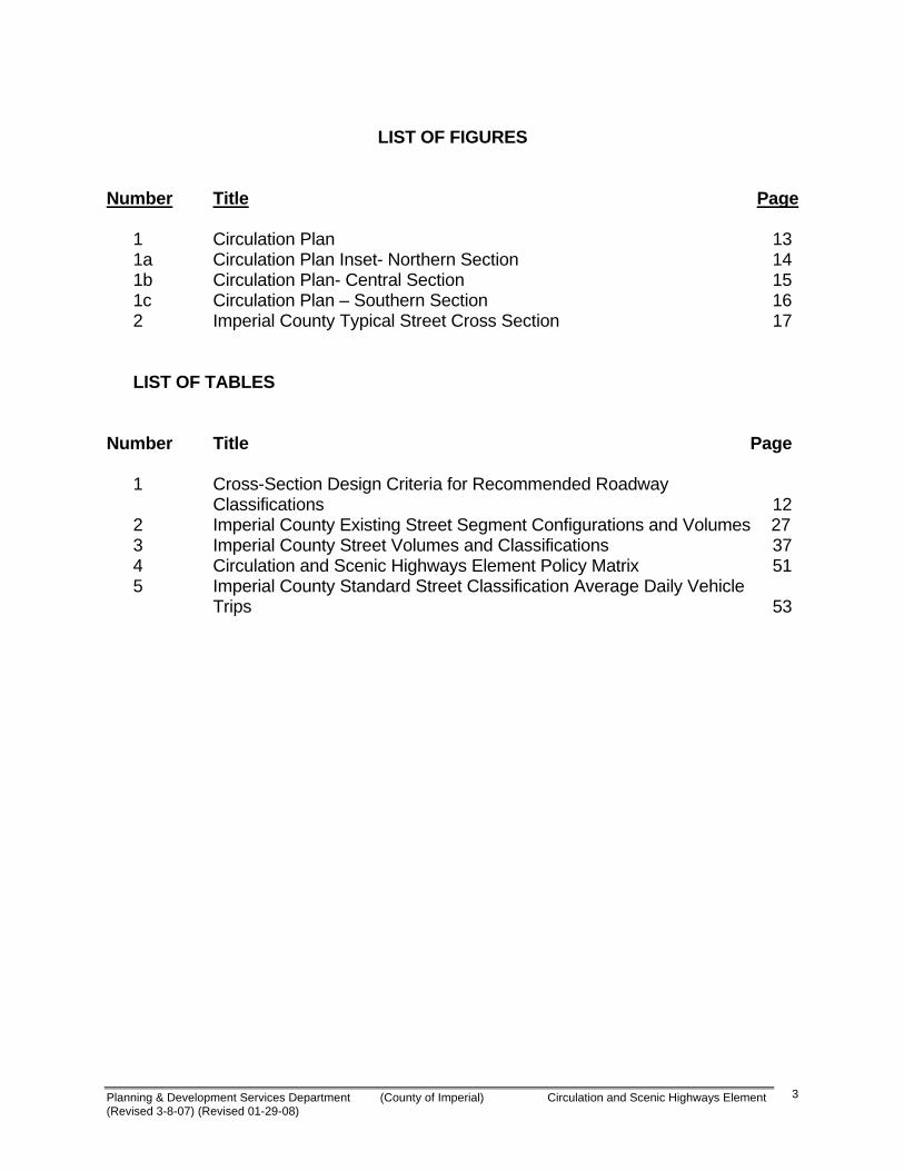
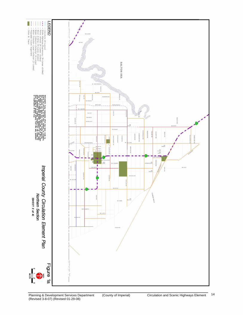
LIST OF FIGURES Number Title Page 1 Circulation Plan 13 1a Circulation Plan Inset- Northern Section 14 1b Circulation Plan- Central Section 15 1c Circulation Plan – Southern Section 16 2 Imperial County Typical Street Cross Section 17 LIST OF TABLES Number Title Page
1 Cross-Section Design Criteria for Recommended Roadway Classifications 12 2 Imperial County Existing Street Segment Configurations and Volumes 27
3 Imperial County Street Volumes and Classifications 37 4 Circulation and Scenic Highways Element Policy Matrix 51 5 Imperial County Standard Street Classification Average Daily Vehicle Trips 53

Planning & Development Services Department (County of Imperial) Circulation and Scenic Highways Element (Revised 3-8-07) (Revised 01-29-08)
4
IMPERIAL COUNTY GENERAL PLAN CIRCULATION AND SCENIC HIGHWAYS ELEMENT
I. INTRODUCTION A. Preface This revision of the Circulation and Scenic Highways Element is prepared in conformance with the General Plan statutes and Guidelines, and in response to new state guidelines and modified population and transportation projections. The County of Imperial is doing so in conjunction with the Southern California Association of Governments (SCAG) Regional Transportation Plan, "Destination 2030," and other related transportation planning documents. The circulation element is a mandatory element of the general plan pursuant to Section 65302(b) of the State Government Code. The inclusion of scenic highways is optional under state law and is being included by the County of Imperial as the initial step in providing a highway system offering unique scenic experiences. Designation of scenic highways provides the policy framework to guide the implementation of a scenic highways program and establishes the basic actions needed to move the program forward. Conscientious implementation of this program including the judicious application of scenic highway standards should lead to the protection of existing scenic resources and the enhancement of those areas in which scenic resources have been lost due to the lack of controls. B. Purpose of the Circulation and Scenic Highways Element The purpose of this element is to provide a comprehensive document which contains the latest information about the transportation needs of the County and the various modes available to meet these needs. It is provided to meet the information needs of local residents, for regional coordination, and pursuant to requirements of law and policies of federal, state, and regional agencies. The circulation system of a community is vital to its prosperity. Its function is to provide for the movement of goods and people, including pedestrians, bicycles, transit, train, air, and automobile traffic flows within and through the community. Efficient traffic circulation is important to economic viability and the creation and preservation of a quality living environment. The Imperial County Circulation and Scenic Highways Element is also intended to provide a plan to accommodate a pattern of concentrated and coordinated growth, providing both, regional and local linkage systems between unique communities, and its neighboring metropolitan regions. The circulation system is also multi-model, meaning that it provides alternatives to the automobile, such as public transit and bicycle facilities so that Imperial County citizens and visitors can access the region by a number of transportation options. Additionally, the purpose of this Element is to provide a means of protecting and enhancing scenic resources within both rural and urban scenic highway corridors.

Planning & Development Services Department (County of Imperial) Circulation and Scenic Highways Element (Revised 3-8-07) (Revised 01-29-08)
5
The State’s 2003 General Plan Guidelines recommend that the circulation policies and plans should:
• Coordinate the transportation and circulation system with planned land uses; • Promote the safe and efficient transport of goods and the safe and effective
movement of all segments of the population; • Make efficient use of existing transportation, transmission, and other infrastructure
facilities, and • Protect environmental quality and promote the wise and equitable use of economic • and natural resources.
The County, through the Department of Public Works (DPW), administers and coordinates the development of local transportation resources, financing and road maintenance in a manner compatible with local land use planning, development patterns and the environment. An important County goal is to provide leadership, staff, and liaison with local and regional permitting and regulatory agencies in order to prepare plans, regulations and standards which can facilitate the transportation network development process. A crucial component of this update was an extensive effort by the County to “coordinate” with each of the cities the “standards” for the road classification and design configurations. It is the intent of this document to guide the future circulation plans for the entire county in a manner that will provide a system of roads and streets that will operate at a level of service “C” (LOS “C”) or better. It is further the intent of this element to standardize road “rights-of-way” dimensions, road alignments, construction design requirements and synchronized control systems between the County and the various cities. Additionally the County and the cities are expected to work closely together to apply not only consistency in design standards but the application of a “fair share” contribution system for all developments. C. Other Related Transportation Planning Documents and Programming Following are several existing planning documents and programs prepared by various agencies that are directly applicable to the aims and objectives of the Circulation Elements: Southern California Association of Governments Plans and Programs SCAG is responsible for the regional planning in Southern California, within the SCAG region of counties. SCAG has prepared long range growth and development plans for the Southern California region since the early 1970’s as part of the ongoing Development Guide Program. This program provides a framework for coordinating local and regional decisions regarding future development and growth. An important component of this process is the preparation of growth forecast policies at intervals ranging from three to

Planning & Development Services Department (County of Imperial) Circulation and Scenic Highways Element (Revised 3-8-07) (Revised 01-29-08)
6
five years. The adopted growth forecast policies become the basis for SCAG’s functional plans (transportation, housing, air and water) for the region. The population totals and growth distribution are used in planning the future capacity of highways and transit systems. The Regional Comprehensive Plan (RCP) recommends ways to redirect the region’s growth in order to minimize congestion and better protect the environment. While SCAG has no authority to mandate implementation of its Regional Comprehensive Plan (RCP), some of the Plan’s principal goals (such as improved jobs/housing balance) are being implemented through county and city general plans. The Regional Transportation Plan (RTP), Destination 2030, is linked to the RCP. Because SCAG has authority over a significant amount of transportation funding, it also has some control over the implementation of transportation-related projects. The Goods Movement Action Plan seeks to optimize the region’s transportation system through increases in economic efficiency, congestion, mitigation, safety and air quality improvements, and enhancements to system security. The Compass Blueprint 2% Strategy provides for studying new directions for growth. Circulation Elements of Other Cities within Imperial County The Circulation Elements of other cities in Imperial County contain information about the transportation needs of each city and the various modes available to meet the identified needs within that city. To ensure that improvements to the overall County circulation system including regional road corridors, public transit corridors and bicycle lanes correspond with new developments and coordinated jurisdictional goals, the Circulation Element addresses the local and regional coordination necessary to have an integrated plan. In particular, this includes standardized road rights of ways, roadway classifications, integrated infrastructure corridors, and the County Bicycle Master Plan, which are significant parts of the Circulation Element. County of Imperial Bicycle Master Plan In 1999, the County of Imperial adopted a Bicycle Master Plan for use as a guideline in planning, developing, designing and constructing future bicycle facilities. This was re-adopted in 2003 and the 2003 plan is incorporated herein as an appendix. As previously mentioned, coordination with Bicycle Master Plans for other cities are being reviewed for compatibility. The County Bicycle Master Plan is periodically updated and approved by the County and Imperial Valley Association of Governments (IVAG). The most current approved Bicycle Master Plan is herein made a part of the Circulation Element as an appendix and said plan may be amended from time to time. The latest adopted version will constitute the appendix.

Planning & Development Services Department (County of Imperial) Circulation and Scenic Highways Element (Revised 3-8-07) (Revised 01-29-08)
7
Imperial County Airport Land Use Compatibility Plan The County of Imperial approved an amended Airport Land Use Compatibility Plan for all Imperial County airports in June of 1996. The plan sets forth the criteria and policies that the Airport Land Use Commission use to assess the compatibility between the primary airports in the County and proposed land use development in the areas surrounding them. Airports affected by this plan located near El Centro are the Imperial County Airport and the Naval Air Facility at El Centro. Additionally, the Plan provides guidance for commission review of new airports and heliports proposed for construction in the County. 2002 Imperial County 20-Year Transportation Plan Update - Highway Element The 2002 Transportation Plan is a 20-year plan that articulates Imperial County’s Transportation challenges. The plan provides the foundation for future transportation funding decisions by establishing a set of transportation priorities for Imperial Valley Roads and Highways. These priorities are intended to meet and respond to the unique transportation characteristics of Imperial Valley’s residents, visitors, economy and businesses. The basis for addressing the region’s particular needs was based on the mission statement; Maintain and improve mobility for people and goods to enhance the quality of life and economic vitality of Imperial County The 2002 20-Year Transportation Plan – Highway Element was adopted by the Imperial Valley Association of Governments on September 25, 2002 and will be incorporated into the SCAG Regional Transportation Plan of 2004. The Executive Summary is included as an appendix. Imperial County 20-Year Transportation Plan - Transit Vision Element An “Imperial County 20-Year Transit Vision Report” was prepared for the IVAG and released in April 2000. The study evaluates existing public transit services in Imperial County and provides long term recommendations. The plan includes specific recommendations based upon census data. The Transit Vision Element is prepared for the member agencies of the Imperial Valley Association of Governments. The Executive Summary is included as an appendix. Imperial County 20-Year Transportation Plan – Non Motorized Transportation Element An “Imperial County 20-Year Non Motorized Transportation Plan” was prepared for the IVAG and released in April 2000. The study evaluates existing facilities for pedestrian and bicycles services in Imperial County and provides long term recommendations. The plan includes specific recommendations based upon census data.
Planning & Development Services Department (County of Imperial) Circulation and Scenic Highways Element (Revised 3-8-07) (Revised 01-29-08)
8
The Non Motorized Transportation Plan is prepared for the member agencies of the Imperial Valley Association of Governments. The Executive Summary is included as an appendix. Imperial Valley Short Range Transit Plan The SRTP, at the time of this update was published in 2003 and is an administrative and management tool. The SRTP is a federally mandated planning document that describes the plans, programs and goals of the transit operator. It has a 10-year planning horizon and is updated biennially. It focuses on the characteristics and capital needs of the existing system, and on committed (funded) expansion plans. The various regional County contracted transit services are listed, as well as, the Cities services. The plan is supported by the County circulation element goals and objectives. The SRTP is prepared for the member agencies of the IVAG. The Executive Summary is included as an appendix. Regional Transportation Plan, “Destination 2030” The RTP is a multi-modal, long-range planning document prepared by the SCAG, in coordination with federal, state, IVAG, and other regional, sub regional and local agencies in southern California. The RTP includes programs and policies for congestion management, transit, bicycles and pedestrians, roadways, and finances. The RTP is prepared every three years and reflects the current future horizon based on a 20-year projection of needs. The RTP’s primary use is as a regional long-range plan for federally funded transportation projects. It also serves as a comprehensive, coordinated transportation plan for all governmental jurisdictions within the region. Each agency responsible for transportation, such as local cities, the County, and Caltrans, has different transportation implementation responsibilities under the RTP. The RTP relies on the plans and policies governing circulation and transportation in each County to identify the region’s future multi-modal transportation system. D. Public Participation/Intergovernmental Coordination The Circulation Element was created in a public forum with input from numerous interest groups, citizens, jurisdictions, and agencies. Extensive efforts were made to involve the public, including:
• Public workshops to receive initial comments and discuss circulation and transportation issues, including local organizations and service groups;
• Coordination with the SCAG;
Planning & Development Services Department (County of Imperial) Circulation and Scenic Highways Element (Revised 3-8-07) (Revised 01-29-08)
9
• Coordination with IVAG;
• Coordination with Caltrans and Local cities; and
• Public Hearings with the County Planning Commission and County Board of
Supervisors. E. Roadway Classification System Functional classification is the process by which roads and highways are grouped into classes or systems according to the type of service they are intended to provide. Basic to this process is the recognition that individual roads do not serve the traveling public independently in any major way. Rather, most travel involves movement through a network of roads. It therefore becomes necessary to determine how this travel can be channelized within the network in a logical, efficient manner. Functional classification defines the nature of this channelization process by defining the part that any particular road should plan on serving the flow of vehicles through a highway network. (Note: Where ROW’s are shown, these are minimum and more ROW may be required as a case by case.) Expressway – the main function of this classification is to provide regional and
intra-county travel services. Features include high design standards with six travel lanes; wide, landscaped medians; highly restricted access; provisions for public transit lanes, including but not limited to, bus lanes, train lanes, or other mass transit type means; and no parking. Minimum right-of-way (ROW) is 210 feet consisting of three travel lanes per direction, a 56-foot median, and shoulders along both sides of the travel way. The ROW width is exclusive of necessary adjacent easements such as for IID facilities as these vary. The minimum intersection spacing is one (1) mile. (NOTE: ROW’s may be greater if the road segment also serves as a corridor for public utilities.)
Prime Arterial — the main function of this classification is to provide regional, sub
regional, and intra-county travel services. Features include high design standards with four to six travel lanes, raised and landscaped medians, highly restricted access, which in most cases will be a one mile (1 mile) minimum, provisions for public transit lanes, including but not limited to bus lanes, train lanes, or other mass transit type means and no parking. The absolute minimum right of way w/o public transit lanes is 136 feet. ROW dimensions are specified in the STANDARDS for specific road segments. Please refer to appropriate standards section. (NOTE: ROW’s may be greater if the road segment also serves as a corridor for public utilities.)

Planning & Development Services Department (County of Imperial) Circulation and Scenic Highways Element (Revised 3-8-07) (Revised 01-29-08)
10
Minor Arterial — these roadways provide intra-county and sub regional service. Access and parking may be allowed, but closely restricted in such a manner as to ensure proper function of this roadway. Typical standards include the provision for four and six travel lanes with raised and landscaped medians for added safety and efficiency by providing protected left turn lanes at selected locations. Some may also contain provisions for public transit lanes or other mass transit type means. Minimum right of way is 102 feet for 4 lanes and 126 for 6 lanes.
Major Collector (Collector) — these roadways are designed for intra-county
travel as a link between the long haul facilities and the collector/local facilities. Although it frequently provides direct access to abutting properties, that is not its primary purpose. Typical design features include provision for four travel lanes without a raised median and some may also contain provisions for public transit lanes or other mass transit type means. Minimum right of way is 84 feet. Parking is generally not permitted.
Minor Local Collector (Local Collector) — this is designed to connect local
streets with the adjacent Collectors or arterial street system. Design standards include provision for two travel lanes and parking, except in specific locations where parking is removed to provide a turn lane at intersections. Local Collector streets frequently provide direct access to abutting properties, although that should be avoided where feasible. Minimum right of way is 70 feet.
Residential Street — this street type also includes residential cul de sac and loop
street and is designed to provide direct access to abutting properties and to give access from neighborhoods to the Local Street and Collector Street system. This classification should be discontinuous in alignment such that through trips are discouraged. Typical design standards include provision for two travel lanes, parking on both sides, and direct driveway access. Minimum right of way is 60 feet.
Additional functional classifications of planned roadways are intended to provide industrial-specific service are as follows:
Major Industrial Collector (Industrial) — the main function of this classification is to provide for efficient movement of goods for regional, subregional, and intra-county travel services. Access and parking may be allowed, but closely restricted in such a manner as to ensure safe and proper function of industrial traffic on this roadway. Typical design standards include provisions for up to four travel lanes and parking on both sides. Minimum right of way is 96 feet. Industrial Local Street — this classification is designed to connect industrial properties and areas with the adjacent Industrial Collector, Residential, Collector or arterial system. Design standards include provisions for two travel lanes, of a minimum of 13 feet width each, and parking. Industrial streets frequently provide direct access to abutting industrial sites and parking of industrial-sized vehicles. Minimum right of way is 64 feet.
Planning & Development Services Department (County of Imperial) Circulation and Scenic Highways Element (Revised 3-8-07) (Revised 01-29-08)
11
A roadway cross-section illustrating the right-of-way, paved width, and other features of the street classification system is shown in Table 1. Figure 2 illustrates the typical cross section for each classification type. In addition, the potential designation of Scenic Highway has been placed on specified roadways in the County and may be added to others in the future. The purpose of this designation is to protect and enhance the County's scenic aesthetic resources which are visible from major County and State routes.
Remainder of Page Blank

Planning & Development Services Department (County of Imperial) Circulation and Scenic Highways Element (Revised 3-8-07) (Revised 01-29-08)
12
TABLE 1 CROSS-SECTION DESIGN CRITERIA FOR RECOMMENDED ROADWAY
CLASSIFICATIONS d
IMPERIAL COUNTY AND CITIES IN IMPERIAL COUNTY
Roadway Classification
Travel Way No. Lanes/Width
ROW Width
Road Surface Width
Parkway Width
Paved Shoulder No./Width
Median Width
Median Shoulder No./Width
Minimum Design Speed (MPH) a
Expressway (6) 6 – 12’ 210’b 154’ 56’ 2 – 10’ 46’ 2 – 8’ 65 Prime Arterial 6 – 12’ 136’ c
6’106’ 30’ 2 – 8’ 18’ None 65
Minor Arterial 4 – 12’ 102’ 82’ 20’ 2 – 8’ 18’ None 55 Major Collector - (Collector) 4 – 12’ 84’ 64’ 20’ 2 – 8’ None None 55
Minor Collector – (Local Collector) 2 – 12’ 70’ 40’ 30’ 2 – 8’ None None 30
Local County – (Residential) 2 – 12’ 60’ 40’ 20’ 2 – 8’ None None 30
Local County (Residential Cul-de-Sac or Loop
2- 12’ 60’ 40’ 20’ 2-8’ None None 30
Major Industrial Collector - (Industrial)
4 – 12’ 96’ 76’ 20’ 2 - 9’ 10’ None 30
Industrial Local 2 – 13’ 64’ 44’ 20’ 2 – 9’ None None 25
Footnote:
a. The minimum design speed shall be used as a guideline only. Final minimum design speeds are subject to the Director of Public Works determination and approval.
b. 164 feet of ROW if transit is planned with roadway (such as on Dogwood Road). Additional ROW needed at intersections and IID facilities not included within 164 feet.
c. 136’ is the minimum, however if transit lanes or ROW is needed for utility corridors or other public facilty structures, the ROW width will be greater as determined by the County.
d. All ROW dimensions are MINIMUM and may be wider as determined on a case by case basis. Please consult with the County.
General Notes:
Additional through lanes, dual turn lanes, or other unusual circumstances may require additional right-of-way, road surface widths, etc. in addition to those shown in Table 1.
Roads in undeveloped, unincorporated portions of the County may require different standards such as unpaved shoulders or no curb, gutter improvements, etc.
Modification to roadway classification and any widths shown are subject to County Road Commissioner determination and approval.
Last Updated: August 24, 2006, Linscott, Law & Greenspan Engineers.

Planning & Development Services Department (County of Imperial) Circulation and Scenic Highways Element (Revised 3-8-07) (Revised 01-29-08)
13
Planning & Development Services Department (County of Imperial) Circulation and Scenic Highways Element (Revised 3-8-07) (Revised 01-29-08)
14

Planning & Development Services Department (County of Imperial) Circulation and Scenic Highways Element (Revised 3-8-07) (Revised 01-29-08)
15

Planning & Development Services Department (County of Imperial) Circulation and Scenic Highways Element (Revised 3-8-07) (Revised 01-29-08)
16

Planning & Development Services Department (County of Imperial) Circulation and Scenic Highways Element (Revised 3-8-07) (Revised 01-29-08)
17
Note #2
R
oads in undeveloped or unincorporated portion of the County
may require different standards such as unpaved shoulders or no curb and gutter im
provements, etc., or as determ
ined by the C
ounty Road C
omm
issioner.
Planning & Development Services Department (County of Imperial) Circulation and Scenic Highways Element (Revised 3-8-07) (Revised 01-29-08)
18
II. EXISTING CONDITIONS AND TRENDS A. Preface Linscott, Law & Greenspan Engineers, Inc. (LL&G) was retained by the County of Imperial to prepare and evaluate the existing circulation conditions and potential transportation impact which may occur as part of the updated traffic forecast conducted by Caltrans (2006). The following information on existing conditions was prepared by LL&G using traffic counts conducted by LL&G and the latest available traffic counts/estimates/forecasts from the County Public Works Department and Caltrans (2006). B. Existing Conditions 1. State Highways Existing regional access to the County of Imperial is provided via Interstate 8, State Route (SR) 111, SR 78, SR 86, SR 98, SR 115, SR 7 and SR 186. The existing conditions of these routes are described below:
Interstate 8 (I-8) is the primary east-west route through Imperial County between San Diego, California and Yuma, Arizona. Providing two travel lanes in each direction, I-8 has complete grade separations at all intersections. In this area, the main functions of I-8 are to serve as an interregional route for people and goods movement, provide connection to other states and provide access to desert recreational activities. The volumes on this facility between Imperial Avenue and Dogwood Road range from 32,000 average daily trips (ADT) to 36,000 ADT. The volumes on this facility east of SR-111 range between 12,200 ADT to 15,700 ADT.
State Route 111 (SR-111) begins at the International Border between Mexico and
the United States traveling north with two travel lanes in each direction, to I-8 with an ADT range from 33,500 to 37,000. Within this section, SR-98 (an east-west route) with heavy truck traffic intersects HWY 111 thru the City of Calexico (see more detail description winder SR 98 designation). Additionally, a document entitled, “Greater Calexico Area Arterial Needs and Circulation Analysis” for Imperial Valley Association of Governments (IVAG) in the County of Imperial was prepared and submitted to IVAG. This document is incorporated herein by reference in Appendix F. North of I-8 to Keystone Road, the ADT ranges from 10,600 to 16,300. Caltrans has begun construction of the Brawley Bypass, which consists of three SR-111 upgrades to a new expressway from I-8 to Keystone Road. Currently, Stage 1 of the Bypass has been completed and opened to the public as a four-lane divided expressway from Keystone Road, north to SR-78. SR-111 is considered to be the “backbone” route of Imperial County as it connects the three largest cities and acts as a major goods movement route, particularly for agricultural products and cross-border goods and services.
Planning & Development Services Department (County of Imperial) Circulation and Scenic Highways Element (Revised 3-8-07) (Revised 01-29-08)
19
State Route 86 (SR-86) is generally a north-south route and begins near the
Townsite of Heber as a two lane conventional highway, and ends at the Riverside County line as a four-lane expressway. In Riverside County, SR-86 extends to Interstate 10. Average existing daily traffic on this route north of the I-8 to Keystone Road can range anywhere from 14,700 to 36,000. Average existing daily traffic on this route north of Keystone Road can range anywhere from 9,400 to 21,400. This 67.8-mile route primarily provides travel for interregional, intra-regional and international trips. SR-86 north of SR-78 is a major goods movement corridor serving the Los Angeles area and other California goods movement centers from the Imperial County region. During the spring, truck traffic transporting agriculture goods constitutes 35 percent of travel on this route. Stage 3 of the Brawley Bypass, a four-lane divided expressway from the SR-111 to the SR-86, is pending funding, however Caltrans is expected to begin construction in early 2007 and complete construction by fall 2009.
State Route 78 (SR-78) is an east-west route and traverses a distance of 81.8
miles through Imperial County with an ADT ranging from 17,000 to 19,500 east of SR-86 and from 1,850 to 3,950 east of SR-111. The route is a two-lane conventional highway throughout its alignment, although some portions have been upgraded to a four-lane expressway and four-lane conventional highway as a result of recent improvement projects. Caltrans is scheduled to begin construction on Stage 2 of the Brawley Bypass, a four-lane divided expressway from the SR-78 to the SR-111, in the summer of 2007. The expected completion date for Stage 2 is fall 2009.
State Route 98 (SR-98) is an east-west route that is entirely contained within
Imperial County. Traversing a distance of 56.9 miles, SR-98 is mostly a two-lane conventional highway route serving interregional, intra-regional and international travel, as well as, providing an alternate route to I-8. However, through the City of Calexico, SR-98 is a four-lane facility with traffic volumes ranging between 17,600 and 26,000. Existing daily traffic on the remaining portions of this route range between 2,200 and 4,550. In order to accommodate an increase of NAFTA, interregional, and local traffic arriving from the Calexico East Federal POE, Caltrans has initiated a Project Report/Environmental Document to widen SR-98 (from SR-111 to SR-7) to four or six lanes. An interchange with grade separation and ramp access is planned at Hwy 111 and Jasper Road. Additionally, future grade separation and/or interchange may be needed at Meadows Road and Bowker Road. The Project Report/Environmental Document study has one alternative considering realignment along Jasper Road east of Bowker Road with a direct connection.
State Route 7 (SR-7) is a four-lane highway with access control, which begins at the Calexico East POE and continues approximately 1.2 miles north to its terminus at I-8. The average daily traffic for this segment of SR-7 averages anywhere between 3,000 and 15,400. When completed, this route serves to

Planning & Development Services Department (County of Imperial) Circulation and Scenic Highways Element (Revised 3-8-07) (Revised 01-29-08)
20
connect the POE to I-8 and provides for the movement of international commercial goods movement, as well as recreational and commuter traffic.
State Route 115 (SR-115) is primarily a northerly route, serving as an alternate to
both SR-86 and SR-111. Traveling for a distance of 33.6 miles, SR-115 is important in facilitating interregional agricultural goods movement and also provides intraregional travel between various cities within Imperial County. For the most part, SR-115 is a two lane conventional highway, although some short segments are four lanes. Existing daily traffic volumes range between 1,000 ADT and 7,600 ADT.
State Route 186 (SR-186) is a short north-south facility connecting I-8 to the
southeastern portion of Imperial County and the Mexican border community of Algodones. SR-186 is classified as a two lane conventional highway with 7,500 ADT. SR-186 accommodates international travel and commercial travel. Currently, this roadway is constructed with one travel lane in each direction.
2. North/South Corridors The following County roadways accommodate most of the north/south traffic movement between local cities and communities: Drew Road (S 29) is a north-south two-lane undivided roadway with a 24-foot
paved width and “soft” shoulders from Evan Hewes Highway south to SR-98. Drew Road provides access to I-8. Bike lanes or bus stops are not provided and the speed limit is posted at 55 mph. A portion of Drew Road from the Townsite of Seeley to Diehl Road is designated as a Class II bike route.
Forrester Road (S 30) is a north-south two-lane undivided roadway with a 30-foot
paved width and “soft” shoulders from Carter Road to McCabe Road. Bike lanes or bus stops are not provided and the speed limit is posted at 55 mph. Curbside parking is prohibited along both sides of the roadway. It should be noted that Forrester Road is planned to be designated as a primary State Route connection in the near future. Forrester Road also provides a diamond-type interchange with I-8 with stop sign controls on both east and westbound off ramps.
Dogwood Road (S 31) is generally a north-south two-lane undivided roadway with
a 24-foot paved width from Malan Road at the southern limit of Brawley south to I-8. Bike lanes or bus stops are not provided and the speed limit is posted at 55 mph. Curbside parking is prohibited along both sides of the roadway. From I-8 to McCabe Road, Dogwood Road varies between a four-lane roadway with a two-way-left-turn-lane and a 75-foot paved width to a two-lane undivided roadway with a 25-foot paved width. Bike lanes or bus stops are not provided and the speed limit is posted at 55 mph. A portion of Dogwood Road from El Centro City Limits to SR-98 is designated as a Class II bike route. Curbside parking is prohibited along both sides of the roadway. From Heber Road to Jasper Road, Dogwood Road is a

Planning & Development Services Department (County of Imperial) Circulation and Scenic Highways Element (Revised 3-8-07) (Revised 01-29-08)
21
two-lane undivided roadway with a 24-foot paved width. It continues as two lanes from SR 86 south to SR 98 and will extend the roadway south connecting at Anza Road which is an east-west arterial that will connect with the U.S. Boarder Station Expansion project at the City of Calexico (see City of Calexico General Plan Update Circulation Element for further details). Bike lanes or bus stops are not provided and the speed limit is posted at 55 mph. Curbside parking is prohibited along both sides of the roadway. Dogwood Road is intended to be upgraded to a six lane road in the future and will also be designed to accommodate a mass transit lane system for either bus, train or other system that would allow commuting in a north-south direction. Such a system on Dogwood Road would serve to physically connect the cities of Calexico, El Centro, Imperial and Brawley as well as the community of Heber in a regionally beneficial and highly effective manner.
Orchard Road (S 32) is a two-lane north-south facility approximately seven miles
east of SR-111. Orchard Road connects to I-8 and provides travel and access through the City of Holtville. At the intersection with I-8, there is a diamond interchange with stop sign controls on the east and westbound off ramps.
Holt Road (S 32) is a north-south two-lane undivided roadway with a 24-foot
paved width from Boyd Road to Norrish Road. Bike lanes or bus stops are not provided and the speed limit is posted at 55 mph. Curbside parking is prohibited along both sides of the roadway.
Hovley Road is a two-lane north-south facility which provides connectivity from the
City of Brawley north to Rutherford Road. Kalin Road is a two-lane north-south facility which connects State Route 86 north
to Sinclair Road. Brandt Road is a two-lane north-south facility which connects State Route 86,
west of the City of Brawley north to Eddins Road. Gentry Road is a two-lane north-south facility which connects Forrester Road,
north of the City of Westmorland north to Eddins Road. A portion of Gentry Road from Sinclair Road to the City of Westmorland is designated a Class II bike route.
Anderholt Road is a two-lane north-south facility which connects Carr Road north
to Hunt Road and to Evan Hewes Highway. This provides a secondary access from the Calexico East Port of Entry northerly.
McConnell Road is a two-lane north-south facility which connects Evan Hewes
Highway north to State Route 78. Austin Road is a north-south two-lane undivided roadway with a 24-foot paved
width and “soft” shoulders from Keystone Road to McCabe Road. Bike lanes or bus stops are not provided and the speed limit is posted at 55 mph. A portion of
Planning & Development Services Department (County of Imperial) Circulation and Scenic Highways Element (Revised 3-8-07) (Revised 01-29-08)
22
Austin Road from Keystone Road to the City of El Centro is designated as a Class II bike route. Curbside parking is prohibited along both sides of the roadway.
La Brucherie Road is a north-south two-lane undivided roadway with a 24-foot
paved width and “soft” shoulders from I-8 to Willoughby Road. Bike lanes or bus stops are not provided and the speed limit is posted at 55 mph. A portion of La Brucherie Road from Kubler Road to the City of El Centro is designated as a Class II bike route. Curbside parking is prohibited along both sides of the roadway. Additional lanes are provided within the City of El Centro. La Brucherie Road continues north to the City of Imperial, connecting to Aten Road.
Clark Road is a north-south two-lane undivided roadway with a 26-foot paved
width from McCabe Road to Willoughby Road. Bike lanes or bus stops are not provided and the speed limit is posted at 50 mph. Curbside parking is prohibited along both sides of the roadway.
Bowker Road is a north-south two-lane undivided roadway with a 24-foot paved
width from Chick Road to Heber Road and a 21-foot paved width from Heber Road to Jasper Road. Bike lanes or bus stops are not provided and the speed limit is posted at 55 mph. Curbside parking is prohibited along both sides of the roadway.
Barbara Worth Road is a north-south two-lane undivided roadway with a 24-foot
paved width from Chick Road to Heber Road and from Heber Road to Jasper Road. Bike lanes or bus stops are not provided and the speed limit is posted at 55 mph. A portion of Barbara Worth Road from Evan Hewes Highway to SR-98 is designated as a Class II bike route. Curbside parking is prohibited along both sides of the roadway.
Bonds Corner Road is a two-lane north-south facility which provides connectivity
from State Route 98, east of the Calexico East Point of Entry north to the City of Holtville.
Kloke Road is a north-south two-lane undivided roadway with a 24-foot paved
width from Cole Road to the All-American Canal. Bike lanes or bus stops are not provided and the speed limit is posted at 55 mph. Curbside parking is prohibited along both sides of the roadway. From the All-American Canal to SR 98, it is a four-lane roadway with a two-way-left-turn-lane and an 80-foot paved width. Bike lanes or bus stops are not provided and the speed limit is posted at 25 mph. Curbside parking is prohibited along both sides of the roadway. The current development proposals that are within the Sphere of Influence (SOI) of the City of Calexico shall conform to the City of Calexico street standard which is a four lane primary road (see City of Calexico General Plan Update Circulation Element for further details).
Planning & Development Services Department (County of Imperial) Circulation and Scenic Highways Element (Revised 3-8-07) (Revised 01-29-08)
23
Best Road is a two-lane north-south facility which provides connectivity from the City of Brawley north to Rutherford Road.
Ogilby Road is a two-lane north-south facility located between El Centro and
Yuma, Arizona which provides connectivity between Interstate 8 and State Route 78.
Pitzer Road is a two-lane north-south facility, which will eventually connect Chick
Road to Fawcett Road. It is currently paved between Chick Road and McCabe Road with an ADT of 1,500, but a portion remains unpaved between McCabe Road and Heber Road. Pitzer Road is a principal route for traffic oriented to/from the Imperial Valley Mall.
3. East/West Corridors The following County roadways accommodate most of the east/west traffic movement between local cities and communities: Evan Hewes Highway/Adams Street/SR-115 (S 80) is an east-west two-lane
undivided roadway with a 24-foot paved width from Austin Road to La Brucherie Road. Bike lanes or bus stops are not provided and the speed limit is posted at 40 mph. Curbside parking is prohibited along both sides of the roadway. From SR 111 to McConnell Road, it is a four-lane divided roadway with a 30-foot curb-to-median width for each direction. Bike lanes or bus stops are not provided and the speed limit is posted at 65 mph. Curbside parking is prohibited along both sides of the roadway. From Barbara Worth Road to SR 115, it is a four-lane divided roadway with a 40-foot curb-to-median width in each direction. Bike lanes or bus stops are not provided and the speed limit is posted at 65 mph. Curbside parking is prohibited along both sides of the roadway. Through the City of El Centro, Evan Hewes Highway connects to Adams Street and is constructed with two travel lanes in each direction. Most portions of this facility are constructed with one travel lane in each direction. West of the City of Holtville, the road corridor becomes SR-115 for approximately one mile.
McCabe Road is an east-west two-lane undivided roadway with a 24-foot paved
width. Bike lanes or bus stops are not provided and the speed limit is posted at 55 mph. A portion of McCabe Road from Brockman Road to La Brucherie Road is designated as a Class II bike route. Curbside parking is prohibited along both sides of the roadway.
Ross Road is an east-west two-lane undivided roadway with a 33-foot paved
width from Silsbee Road to Forrester Road, and a two-lane undivided roadway with a 24-foot paved width from SR 111 to Bowker Road. Bike lanes or bus stops are not provided and the speed limit is posted at 55 mph. A portion of Ross Road from Drew Road to Austin Road is designated as a Class II bike
Planning & Development Services Department (County of Imperial) Circulation and Scenic Highways Element (Revised 3-8-07) (Revised 01-29-08)
24
route. Curbside parking is prohibited along both sides of the roadway connects the communities of Seeley and Holtville traversing through the City of El Centro.
Aten Road is an east-west two-lane undivided roadway with a 27-foot paved
width from Forrester Road to Dogwood Road and a four-lane undivided roadway with a 54-foot paved width from Dogwood Road to SR 111. Bike lanes or bus stops are not provided and the speed limit is posted at 55 mph. A portion of Aten Road from Dogwood Road to SR-111 is designated as a Class I bike route. Curbside parking is prohibited along both sides of the roadway commences west of Forrester Road and terminates at SR-111.
Worthington Road (S 28) commences north of Seeley and terminates just east of
Highline Road north of the City of Holtville. It is a two lane undivided roadway and traverses the northernmost section of the City of Imperial. A portion of Worthington Road from Holt Road to the City of Imperial has a designation as a Class II bike route.
Keystone Road (S 27) is an east-west two-lane undivided roadway with a 24-
foot paved width from Austin Road to McConnell Road. Bike lanes or bus stops are not provided and the speed limit is posted at 55 mph. A portion of Keystone Road from SR-86 to Forrester Road is designated as a Class II bike route. Curbside parking is prohibited along both sides of the roadway.
Harris Road is an east-west two-lane undivided roadway with a 24-foot paved
width from east of Austin Road to SR 111. Harris Road is dirt road from SR 111 to McConnell Road with an observed speed of 25 mph. Harris Road from Austin Road to SR 86 has a speed limit of 55 mph. Bike lanes or bus stops are not provided. Curbside parking is prohibited along both sides of the roadway.
Heber Road is an east-west two-lane undivided roadway with a 24-foot paved
width from SR 111 to Bowker Road. Bike lanes or bus stops are not provided and the speed limit is posted at 55 mph. Curbside parking is prohibited along both sides of the roadway.
Rutherford Road (S 26) provides connection between the City of Westmorland
and north central Imperial County. A portion of Rutherford Road from Best Road to Kalin Road has a designation as a Class II bike route.
County Road (S 24) is located in the Winterhaven and Bard communities on the
far southeastern edge of the County. It follows several roadway alignments (Picacho Road, Ross Road, Collins Road, York Road, and Imperial Dam Road) and traverses in an east/west and north/south manner through the Quechan Indian Reservation.
Winterhaven Drive between I-8 and Picacho Road serves as the connector
between County Route S24 and I-8.

Planning & Development Services Department (County of Imperial) Circulation and Scenic Highways Element (Revised 3-8-07) (Revised 01-29-08)
25
Bannister Road is a two-lane east-west facility which connects State Route 86
east to Brandt Road. Sinclair Road is a two-lane east-west facility which connects Gentry Road to State
Route 111. A portion of Sinclair Road from SR-111 to Gentry Road is designated as a Class II bike route.
Cole Road is an east-west four-lane undivided roadway with a 64-foot paved
width from Andrade Road to Bowker Road. Bike lanes or bus stops are not provided and the speed limit is posted at 35 mph. A suggestion has been made for a portion of Cole Road from Dogwood Road to the City of Calexico to be designated as a Class II bike route. Curbside parking is prohibited along both sides of the roadway.
Jasper Road is an east-west two-lane undivided roadway with a 24-foot paved
width from SR 111 to Anderholt Road. Bike lanes or bus stops are not provided and the speed limit is posted at 55 mph. Curbside parking is prohibited along both sides of the roadway.
Eddins Road is a two-lane east-west facility which connects Gentry Road east to
State Route 115. Shank Road is a two-lane east-west facility which connects State Route 111 in the
City of Brawley east to State Route 115. Carr Road is a two-lane east-west facility which connects Barbara Worth Road
and traffic from the City of Calexico east to State Route 7 and the Calexico East Point of Entry. This roadway will be connected to LaVigne Road which will intersect at E. Rivera Avenue in the City of Calexico. LaVigne is classified as Other Principal Arterial within the City of Calexico Sphere of Influence (SOI). A bridge will be required at the All American Canal (AAC) Crossing.
Anza Road is a two-lane east-west facility which connects Barbara Worth Road
and traffic from State Route7 and the Calexico East Point of Entry west to the City of Calexico. The roadway is classified as a Minor Arterial within the City of Calexico Sphere of Influence (SOI). A bridge widening and/or re-alignment will be required at the All American Canal (AAC) crossing. A portion of Anza Road from Drew Road to the City of Calexico is designated as a Class II bike route.
Correll Road is a two-lane east-west facility which connects SR 111 and
Dogwood Road along the north side of the community of Heber. A significant increase in traffic is expected due to proposed developments in the area.
Chick Road is a four-lane east-west facility which extends from Dogwood Road in El Centro east to Pitzer Road. The previous Chick Road connection to SR 111

Planning & Development Services Department (County of Imperial) Circulation and Scenic Highways Element (Revised 3-8-07) (Revised 01-29-08)
26
was recently closed (2006). No future connection will be allowed. 2005 ADT is 5,700.
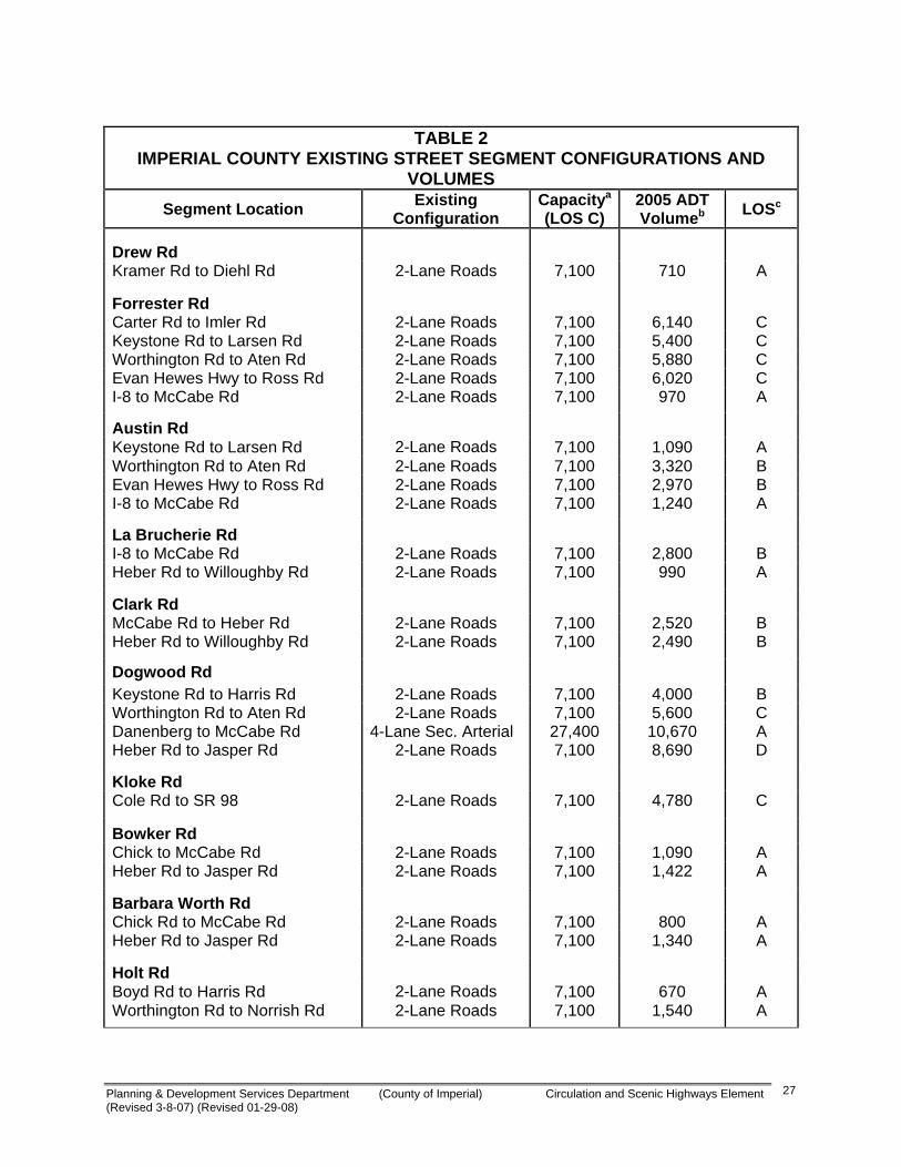
Table 2 presents a summary of the existing street segment configuration, 2005 daily traffic volumes, and level of service.
Remainder of Page Blank
Planning & Development Services Department (County of Imperial) Circulation and Scenic Highways Element (Revised 3-8-07) (Revised 01-29-08)
27
TABLE 2
IMPERIAL COUNTY EXISTING STREET SEGMENT CONFIGURATIONS AND VOLUMES
Segment Location Existing Configuration
Capacitya (LOS C)
2005 ADT Volumeb LOSc
Drew Rd
Kramer Rd to Diehl Rd 2-Lane Roads 7,100 710 A
Forrester Rd Carter Rd to Imler Rd 2-Lane Roads 7,100 6,140 C Keystone Rd to Larsen Rd 2-Lane Roads 7,100 5,400 C Worthington Rd to Aten Rd 2-Lane Roads 7,100 5,880 C Evan Hewes Hwy to Ross Rd 2-Lane Roads 7,100 6,020 C I-8 to McCabe Rd 2-Lane Roads 7,100 970 A
Austin Rd Keystone Rd to Larsen Rd 2-Lane Roads 7,100 1,090 A Worthington Rd to Aten Rd 2-Lane Roads 7,100 3,320 B Evan Hewes Hwy to Ross Rd 2-Lane Roads 7,100 2,970 B I-8 to McCabe Rd 2-Lane Roads 7,100 1,240 A
La Brucherie Rd I-8 to McCabe Rd 2-Lane Roads 7,100 2,800 B Heber Rd to Willoughby Rd 2-Lane Roads 7,100 990 A
Clark Rd McCabe Rd to Heber Rd 2-Lane Roads 7,100 2,520 B Heber Rd to Willoughby Rd 2-Lane Roads 7,100 2,490 B
Dogwood Rd Keystone Rd to Harris Rd 2-Lane Roads 7,100 4,000 B Worthington Rd to Aten Rd 2-Lane Roads 7,100 5,600 C Danenberg to McCabe Rd 4-Lane Sec. Arterial 27,400 10,670 A Heber Rd to Jasper Rd 2-Lane Roads 7,100 8,690 D
Kloke Rd Cole Rd to SR 98 2-Lane Roads 7,100 4,780 C
Bowker Rd Chick to McCabe Rd 2-Lane Roads 7,100 1,090 A Heber Rd to Jasper Rd 2-Lane Roads 7,100 1,422 A
Barbara Worth Rd Chick Rd to McCabe Rd 2-Lane Roads 7,100 800 A Heber Rd to Jasper Rd 2-Lane Roads 7,100 1,340 A
Holt Rd Boyd Rd to Harris Rd 2-Lane Roads 7,100 670 A Worthington Rd to Norrish Rd 2-Lane Roads 7,100 1,540 A

Planning & Development Services Department (County of Imperial) Circulation and Scenic Highways Element (Revised 3-8-07) (Revised 01-29-08)
28
Keystone Rd Austin Rd to SR 86 2-Lane Roads 7,100 1,100 A SR 111 to McConnell Rd 2-Lane Roads 7,100 320 A
Harris Rd West of SR 86 2-Lane Roads 7,100 40 A SR 111 to McConnell Rd 2-Lane Roads 7,100 160 A
Worthington Rd Forrester Rd to Austin Rd 2-Lane Roads 7,100 1,220 A Dogwood Rd to SR 111 2-Lane Roads 7,100 2,920 B Casey Rd to SR 115 2-Lane Roads 7,100 1,110 A
Aten Rd Forrester Rd to Austin Rd 2-Lane Roads 7,100 1,270 A Dogwood Rd to SR 111 2-Lane Roads 7,100 8,360 D
Evan Hewes Hwy Austin Rd to La Brucherie Rd 2-Lane Roads 7,100 5,710 C SR 111 to Mcconnell Rd 2-Lane Roads 7,100 8,790 D Barbara Worth Rd to SR 115 2-Lane Roads 7,100 7,980 D
Ross Rd Silsbee Rd to Forrester Rd 2-Lane Roads 7,100 1,080 A SR 111 to Bowker Rd 2-Lane Roads 7,100 560 A
McCabe Rd Dogwood Rd to SR 111 2-Lane Roads 7,100 200 A SR 111 to Bowker Rd 2-Lane Roads 7,100 130 A
Heber Rd SR 111 to Bowker Rd 2-Lane Roads 7,100 2,040 B
Jasper Rd SR 111 to Meadows Rd 2-Lane Roads 7,100 120 A
Cole Rd Andrade Rd to Bowker Rd 2-Lane Roads 7,100 70 A
Notes: a. Capacity at level C based on the Imperial County Classification Table 5. b. Volume from Caltrans, Imperial County, or Linscott Law & Greenspan, Engineers counts. c. Capacity based on the Imperial County Classification Table 5.

Planning & Development Services Department (County of Imperial) Circulation and Scenic Highways Element (Revised 3-8-07) (Revised 01-29-08)
29
4. Public Transportation Fixed Route Transportation Imperial Valley Transit (IVT) is an inter-city fixed route bus system, subsidized by the IVAG, administered by the County Department of Public Works and operated by a public transit bus service. The service is wheelchair accessible and Americans with Disabilities Act (ADA) compliant. Existing ridership averages approximately 23,000 passengers a month. Service is provided from 6:00 AM until 11:00 PM weekdays, and 6:00 AM to 6:00 PM on Saturdays, within the areas classified as the Primary Zone; a north-south axis throughout Brawley, Imperial Valley College (IVC), Imperial, El Centro, Heber and Calexico, and from 6:00 AM until 6:45 PM in the Secondary Zones; outlying cities and communities of Niland, Calipatria, Westmorland, Seeley and Holtville. The outlying Remote Zone community of Ocotillo is served once a week on Thursdays, by request one day ahead. Remote Zone communities east and west of the Salton Sea, including Desert Shores, Salton City, Salton Sea Beach, and the far eastern portion of the County, including Winterhaven are served once a week, via lifeline. A second transportation service focusing on the south county is Numero Uno, a subsidiary of Laidlaw (owner of Greyhound), provides on the hour, every hour shuttle service between Calexico and El Centro throughout the day and early evening, everyday. A third transportation service focusing on the north county is, Road Runner, operated by a private independent service, provides service from Westmorland to Bombay Beach. The Road Runner connection point is at Westmorland and can be accessed via IVT from the primary and secondary zone communities. ADA Paratransit The Americans with Disabilities Act (ADA) Comparable Complementary Paratransit Service is a federally mandated service requiring equal access to the public fixed route bus system for individuals with disabilities. The service operates wheelchair accessible minibuses as a demand response service in tandem with the fixed route bus system for certified eligible disabled passengers. The service area and hours are the same as the fixed route bus system discussed above. The service is subsidized by IVAG, managed by the County Executive Officer (CEO) and operated by a private non-profit transportation carrier. Med-Express The Med-Express is a non-emergency medical transportation service between communities in Imperial County and the large hospitals and medical facilities in San Diego County. The service is subsidized by IVAG, managed by the County Executive
Planning & Development Services Department (County of Imperial) Circulation and Scenic Highways Element (Revised 3-8-07) (Revised 01-29-08)
30
Officer (CEO) and operated by a private non-profit transportation carrier. Demand response service is provided four days a week, with three pick up locations in Brawley, El Centro and Calexico. Pick up service is available on a limited basis from the home for an additional fare. The service is designed to provide persons with disabilities, low income and transit dependent persons access to medical facilities and services not available within Imperial County, i.e. Children’s Hospital in San Diego. Dial-A-Ride The County contracts for Dial-A-Ride services. The services are provided through a contract with a local provider in the community of the west side of the Salton Sea. These services are also subsidized by IVAG. 5. Scenic Highways Four areas within the County have the potential as state-designated scenic highways. Senate Bill 1467 established the Scenic Highway Program. SB1467 declares: “The development of scenic highways will not only add to the pleasure of the residents of this state, but will also play an important role in encouraging the growth of the recreation and tourist industries upon which the economy of many users of this State depends”. The following routes have been designated or are eligible for state scenic highway designation: Interstate 8 (I-8). The initial segment for future Scenic Highway Designation
status lies between the San Diego County line and its junction with State Route 98. This segment known as Mountain Springs Grade has a long, rapid elevation change, remarkable rock and boulder scenery, and plant life variations.
State Route 78. The portion of SR-78 from the junction with SR-86 to the San
Diego County line is eligible for future Scenic Highway Designation. The area is considered scenic because of its desert characteristics and view of Salton Sea.
State Route 111. SR-111 travels along the northeast shore of the Salton Sea and
is eligible for future Scenic Highway Designation from Bombay Beach to the County line. The drive along this body of water is a study in primitive beauty and an interesting and startling anomaly. The contrast between the flat, wide Salton Sea with its sandy beach and the rugged rise of the Chocolate Mountains has many variations. The panoramic view of the opposite (southwest) shore and its backdrop of mountains is also a sight of pre-historic beauty.
Borrego-Salton Seaway. County Highway S-22 is also known as the Borrego-
Salton Seaway. It begins in Salton City and ends at the community of Borrego Springs in San Diego County. Along its route is Clay Point, located a mile and a half west of SR-86, which is a formation ring above the flat desert shore which shows the bed of pre-Columbian Lake Cahuilla. Three and a half miles farther
Planning & Development Services Department (County of Imperial) Circulation and Scenic Highways Element (Revised 3-8-07) (Revised 01-29-08)
31
west, the Anza Verde Wash parallels the Borrego-Salton Seaway with uniquely scenic desert landforms and vegetation.
SB1467 added Section 260 et seq. to the Streets and Highway Code. In those
statutes the State proclaimed its intent to:
“establish the States responsibility for the protection and enhancement of California natural scenic beauty.”
The legislature further declares the State’s intent to assign responsibility for the
development of scenic highways to local jurisdictions. Please refer to the following Caltrans website for all rules and regulations to the Scenic Highway system and
official designations: http://www.dot.ca.gov/hq/LandArch/scenic_highways/scenic_hwy.htm.
Appendix B (attached) contains “California Scenic Highway Program Frequently Asked Questions”. Appendix C (attached) contains “Guidelines for the Official Designation of Scenic Highways”.
Further, Caltrans has developed an official guide called the "Guidelines for the Official Designation of Scenic Highways" (March 1996) which can be utilized for protecting the County's scenic highways from potential aesthetic impacts from any development projects. This is included as Appendix C. 6. Railroads The Union Pacific Railroad, formerly called the Southern Pacific Railroad main line enters the eastern border near Winterhaven and then bears northwest and leaves the County just east of the Salton Sea. This line serves the Los Angeles area and northward in California and the balance of the U.S. eastward. There is a branch line from this main line at Niland that provides rail service to Calipatria, Brawley, Imperial, El Centro, Calexico, and Mexico. Another branch line of the Union Pacific, the Holton Interurban Railroad, provides service to east El Centro. The San Diego and Arizona Eastern Railroad, also a subsidiary of the Union Pacific Railroad, runs between El Centro and San Diego. It presently provides rail service only between El Centro and the U.S. Gypsum plant in Plaster City. All of the above service is freight only. Passenger rail service is being studied to provide service from Calexico to Los Angeles with terminals in Calexico, El Centro, and Brawley. In September 1991, the County Board of Supervisors endorsed the implementation of the County Intercity Railroad Project by Board Resolution. 7. Airports The primary public use airports in Imperial County are: Imperial County Airport located in the City of Imperial on SR-86; Calexico International Airport located west of Calexico on

Planning & Development Services Department (County of Imperial) Circulation and Scenic Highways Element (Revised 3-8-07) (Revised 01-29-08)
32
Anza Road; Brawley Municipal Airport located at the intersection of Ken Bemis Drive and Jones Road in northeast Brawley; Cliff Hatfield Memorial Airport located on West Main Street in Calipatria; Holtville Airport located seven miles northeast of Holtville on Norrish Road; and the U.S. Naval Air Facility located six miles west of El Centro on Bennett Road. There are several other private airstrips located throughout Imperial County serving principally crop dusting operations. 8. Navigable Waterways Navigable waters as defined in Section 36 of the Harbors and Navigation Code are waters which come under the jurisdiction of the United States Corps of Engineers and any other publicly-owned waters within the State. Public recreational waters in Imperial County are: Salton Sea, Ramer Lake, Finney Lake, Wiest Lake, Imperial Lake, Sunbeam Lake, Drew Lake, Senators Wash, and Squaw Lake. Sixty-one miles of the Colorado River from Imperial Dam upriver to the Riverside County line at Taylor's Ferry are also navigable waters, including the backwaters such as Palo Verde Oxbow Lake, Palo Verde Lagoon, Davis Lake, The Old River Channel, Cibola Lake, Three Finger Lake, Draper Lake, Taylor Lake, Ferguson Lake, Clear Lake, Hidden Lake, Bard Lake, and other related backwaters. 9. Other Local Public Utilities/Facilities About seventy percent of the population is provided potable water for domestic purposes from municipal water districts, which are primarily served by the Imperial Irrigation District (IID). Rural residents obtain potable water from truck delivery companies or from individual wells. IID operates 1700 miles of canals; and the Coachella Irrigation District operates 83 miles of canals that traverse the County. All of the County's cities, and the communities of Seeley, Heber, Niland, Winterhaven, and Salton City, are provided sewer service by municipal districts. The Gateway of the Americas Specific Plan Area, a 1700 acre industrial/commercial development has a County Service Area that provides water and sewer services to the development. Electricity is delivered to the vast majority of Imperial County, and the Coachella Valley portion of Riverside County, by IID, with some existing and proposed transmission owned by San Diego Gas and Electric (SDG&E). Imperial Irrigation District's generating facilities and sources of power are varied as follows: El Centro, 180 megawatts (MW); Brawley, 18 MW; Rockwood, 50 MW; and the Coachella Plant, 80 MW. The County’s geothermal generating facilities and sources of power are located throughout the County and are owned and operated by various entities. Current geothermal power generation is as follows: Salton Sea, 350 MW, East Mesa, 47 MW, and Heber, 90 MW. An upgrade of the El Centro Power Plant was recently proposed by IID to the California Energy Commission and IID is proposing to build a 93 MW natural gas power plant in Niland. Hydroelectric facilities along the All American Canal have a maximum capacity of 45 MW. IID currently serves over 100,000 customers (IID 2006).
Planning & Development Services Department (County of Imperial) Circulation and Scenic Highways Element (Revised 3-8-07) (Revised 01-29-08)
33
Due to the County's seismic conditions, the telephone system is one of the most elaborate communication networks in the country. The equipment and facilities in Imperial County are earthquake resistant up to an 8.0 magnitude. 10. Imperial Valley Telecommunications Authority The Imperial Valley Telecommunications Authority (IVTA) is a collaborative of all Imperial County school districts, city agencies, county agencies, Imperial Community College and San Diego State University-IVC. The IVTA also has an innovative partnership with the Imperial Irrigation District and is officially recognized as a “Public Joint Powers Authority (JPA)”. IVTA is dedicated to provide new technology and a community-wide system access to the Imperial Valley Public agencies, and contribute to the growth and development of the community. IVTA major projects include connecting participating agencies to a state-of-the-industry fiber-optic communications network, providing training and support for the use of computers and advanced technologies in public government and schools, planning for future uses of the high-speed network to improve efficiency and reduce costs of operations and providing government and education access television to our community. 11. Petroleum and Natural Gas Lines Liquid petroleum products are delivered to and are transported through the County via the twenty-inch Santa Fe Pacific Pipe Line. This line is generally located within the Southern Pacific Railroad right-of-way. The right-of-way follows the northwest to southeast trend of Imperial Valley. It passes near the east side of the Salton Sea and serves the storage facility at Niland. The petroleum storage capacity at Niland is 77,500 barrels and at Imperial is 289,000 barrels. Storage tanks, however, are never full at one time but are normally filled fifty percent. Southeast of Ogilby, the line turns east and travels to Yuma. A six-inch branch line distributes gas to the storage facility south of Imperial and a four-inch line serves the Naval Air Facility near Seeley. Natural gas is delivered by the Southern California Gas Company via twin ten-inch lines which generally run south through the County in Range 14 East. These lines serve Niland, Calipatria, Brawley, Imperial, El Centro, Heber, and Calexico; and branch lines serve Holtville, Westmorland, Seeley, NAF, and Plaster City. Rural residents are served by laterals from the branch lines. The lateral lines typically do not exceed a quarter mile in length. The North Baja System is an 80-mile U.S. portion of an overall 220-mile pipeline that primarily serves electric-generation load in the Mexican state of Baja California. The pipeline could be a potential entry of LNG-sourced natural gas into southern California and Arizona from a proposed terminal off the coast of Baja California .

Planning & Development Services Department (County of Imperial) Circulation and Scenic Highways Element (Revised 3-8-07) (Revised 01-29-08)
34
C. Future Traffic Volume Forecast Forecast Model A modification of SCAG’s 2025 Regional Model was used to forecast Year 2025 traffic volumes on the various street segments. Minor modifications were made to both the land use and network data to improve accuracy. The following key roadway network and land use parameters were verified and/or assumed:
The Socio-Economic and Land Use data was reviewed for the 2025 Imperial County Transportation Model (ICTM). The 2025 ICTM contained two different socio-economic and land use data, one is the Calexico General Plan (CalexGP) version and the other is the Imperial Mall (ImpMall4a) version. After a review of the demographic information for both versions and consultation with Caltrans staff, it was determined that the CalexGP model provided the most accurate traffic forecast.
The Calexico General Plan (CalexGP) version of the ICTM was updated based on comments from the City of Calexico and is called the CalexGP+ version. The CalexGP+ version is considered a land use alternative to the CalexGP and ImpMall4a versions of the model.
The transportation network in the 2025 Imperial County Transportation Model was modified to include a link for Kloke Road from SR 98 to Cole Road and minor adjustments to some key connections.
I-8 interchanges are assumed in 2050 at Drew Road, Forrester Road, Austin Road, Imperial Avenue, SR-86, Dogwood Road, SR-111, Bowker Road, and SR-7.
Year 2050 Traffic Volumes Once the land use and network data were modified in the 2025 CalexGP+ Model, Year 2025 ADT volumes were forecasted. The Year 2025 forecasted ADT volumes were reviewed for validity and consistency with existing ADT volumes and the surrounding land use and network data. A review of all 2025 model traffic volumes was conducted and revisions to these forecast volumes were made as deemed appropriate, especially when forecast volumes appeared lower than expected.
Annual growth rates were calculated at the nearby road segments from the existing ADT volumes and Year 2025 ADT volumes. The average annual growth rates were calculated for all the segments in the study area. After a review of the annual growth rates, the following annual growth rates were applied to the segments in the circulation element plan to forecast Year 2050 volumes:
Year 2025 ADT volumes < 20,000 - two percent (2.0%) annual growth was applied to the Year 2025 ADT volumes to determine Year 2050 ADT volumes.

Planning & Development Services Department (County of Imperial) Circulation and Scenic Highways Element (Revised 3-8-07) (Revised 01-29-08)
35
Year 2025 ADT volumes between 20,001 and 27,000 - one percent (1.0%) annual growth was applied to the Year 2025 ADT volumes to estimate Year 2050 ADT volumes. Year 2025 ADT volumes > 27,000 - half percent (0.5%) annual growth was applied to the Year 2025 ADT volumes to determine Year 2050 ADT volumes.
The 2025 CalexGP+ Model did not contain volumes for all of the roadway segments in the Imperial County Circulation Element Plan. For those segments, the Year 2050 segment volumes were calculated by applying a reasonable annual growth rate. The resultant Year 2050 forecast traffic volumes for the roadway segments are summarized in Table 3. As shown in Table 3, all unincorporated area street segments are forecast to operate at LOS C or better on a daily basis. For the purpose of this analysis, LOS C will be targeted as the minimum acceptable level of service. Most roadway segments are forecast to operate at LOS A and B with their proposed Circulation Element classification. Level of service on State Highways, in some cases, deteriorates to LOS D, however the County of Imperial has no jurisdiction over State Highways and planning for these facilities is undertaken by the State of California. County roads that do intersect with State routes should be given special consideration because delays at intersections tend to deteriorate operating conditions along street segments. For the purposes of this analysis, a table (see Table 5, Section IV) to compare daily traffic levels of service has been utilized. This is a broad base approach which is used to size roadways to accommodate long term volumes. D. Roadway Classification Recommendations The circulation plan is developed to create an efficient transportation system on a countywide basis. Roadway classifications will provide for the effective flow of goods and people with minimum delays in a cost effective and well-maintained system. The recommended roadway classifications for the key roadways were determined based on Year 2050 volumes. The goal of the recommended roadway classification is to ensure key roadway segments operate at LOS C or better for the forecasted Year 2050 traffic volumes. The recommended roadway classifications were then reviewed for consistency and countywide infrastructure goals based on the future land use and network data. Table 3 shows the recommended roadway classifications for selected road segments. Dual left–turn lanes and dedicated right-turn lanes should be planned at the intersection of major roadways. Appendix A1 contains guidelines for the provision of left-turn lanes and right-turn lanes at the intersection of various types of roadways. It is recommended that grade-separated railroad crossings be planned at roadways classified as Prime Arterial or Expressway. Appendix A2 contains the typical intersection layouts for the different roadway classifications.

Planning & Development Services Department (County of Imperial) Circulation and Scenic Highways Element (Revised 3-8-07) (Revised 01-29-08)
36
A review of Table 3 shows that some of the classifications are potentially larger than necessary based on the forecasted traffic volumes. However, based on discussions with County staff and the desire to be slightly conservative in terms of setting aside right-of-way, the classifications shown in Table 3 were recommended. E. Financial Recommendations There is no single source nor single method of financing that will achieve the goals and objectives. The County will need to apply consistent efforts to secure the necessary financing.
Remainder of Page Blank

Planning & Development Services Department (County of Imperial) Circulation and Scenic Highways Element (Revised 3-8-07) (Revised 01-29-08)
37
TABLE 3 IMPERIAL COUNTY PROJECTED STREET SEGMENT CONFIGURATIONS AND
VOLUMES
Segment Location 2003 Classification
Year 2002 ADT Volumea
Year 2005 ADT
Volumea
Year 2025 ADT Volumec
25 Year Total
Growth Factord
Year 2050 ADT Volume
Year 2050 Recommended Classification (# of Lanes)
2050 LOSe
Alamo RoadMeloland/SR-115 Major Collector Major Collector (4)Albright RoadSR-111/SR-115 Minor Collector Minor Collector (2)SR-115/Butters Major Collector Major Collector (4)Anderholt RoadEvan Hewes (S-80)/Hunt Minor Collector Minor Collector (2)Hunt/Carr Major Collector Major Collector (4)Andre RoadForrester/End Minor Collector Minor Collector (2)Anza RoadPulliam/Rockwood Local Minor Collector (2)Rockwood/Calexico Prime Arterial Prime Arterial (6-divided)Calexico/Barbara Worth Prime Arterial Prime Arterial (6-divided)Aten RoadEnd/Forrester Minor Collector Minor Collector (2)Forrester/Austin Minor Arterial Minor Arterial (6-divided)East Imperial City Limits/Dogwood Prime Arterial 7,300 8,450 39,000 1.13 44,500 Prime Arterial (6-divided) CDogwood/SR-111 Prime Arterial Prime Arterial (6-divided)Proposed/SR-111/River None Prime Arterial (6-divided)Austin RoadMcCabe/Wahl Local Prime Arterial (6-divided)Proposed Wahl/SR-98 None Prime Arterial (6-divided)Evan Hewes Hwy/McCabe Major Collector Prime Arterial (6-divided)Aten/Evan Hewes Hwy Minor Arterial Prime Arterial (6-divided)Keystone/Aten Major Collector Prime Arterial (6-divided)SR-86/Keystone Minor Collector Prime Arterial (6-divided)Bannister RoadSR-86/Brandt Major Collector Major Collector (4)Barbara Worth RoadZenos/Evan Hewes (S-80) Minor Collector Major Collector (4)Evan Hewes Hwy/Anza Major Collector Major Collector (4)Baughman RoadGarvey/Lack Minor Collector Minor Collector (2)Lack/SR-86 Major Collector Major Collector (4)Bell RoadAlamo/Evan Hewes Hwy Minor Collector Minor Collector (2)Bennett RoadHavens/Ross Minor Collector Minor Collector (2)Best RoadRutherford/Brawley Minor Arterial Minor Arterial (4)Blair RoadPound/Sinclair Minor Collector Minor Collector (2)Peterson/Lindsey Major Collector Major Collector (4)Lindsey/SR-115 Major Collector Major Collector (4)SR-115/Yocum Local Major Collector (4)Blais RoadWieman/Forrester Minor Collector Minor CollectorBoarts Road (S26)Westmorland/Kalin Major Collector Major Collector (4)Boley RoadWestmorland/Huff Minor Collector Minor Collector (2)Bonds Corner RoadHoltville/I-8 Major Collector Major Collector (4)I-8/SR-98 Minor Arterial Minor Arterial (4)Bonesteele RoadKumberg/SR-98 Minor Collector Minor Collector (2)Bornt RoadVerde School/SR-98 Minor Collector Minor Collector (2)Bowker RoadEvan Hewes Hwy/I-8 Major Collector Major Collector (4)I-8/SR-98 Minor Arterial Expressway (6)SR-98/Anza None Minor Arterial (4)

Planning & Development Services Department (County of Imperial) Circulation and Scenic Highways Element (Revised 3-8-07) (Revised 01-29-08)
38
TABLE 3 IMPERIAL COUNTY PROJECTED STREET SEGMENT CONFIGURATIONS AND
VOLUMES (continued)
Segment Location 2003 Classification
Year 2002 ADT Volumea
Year 2005 ADT
Volumea
Year 2025 ADT Volumec
25 Year Total
Growth Factord
Year 2050 ADT Volume
Year 2050 Recommended Classification (# of Lanes)
2050 LOSe
Bowles RoadRiley/Lyerly Minor Collector Minor Collector (2)Boyd RoadWiest/SR-78 Local Minor Collector (2)SR-115/Highline Local Minor Collector (2)Highline/End Minor Collector Minor Collector (2)Brandt RoadSinclair/Lindsey Local Minor Collector (2)Lindsey/Eddins Minor Collector Minor Collector (2)Eddins/Webster Minor Collector Minor Collector (2)Bridenstein RoadProposed SR-78/Hartshorn Minor Collector (2)Hartshorn/Bonds Corner Minor Collector Minor Collector (2)Brockman Road (S30)McCabe/SR-98 Major Collector Major Collector (4)Butters Road (S32)Gonder/SR-78 Prime Arterial Prime Arterial (6) ABowles/Albright Local Major Collector (4)Albright/SR-78 Major Collector Major Collector (4)Cady RoadPellett/SR-86 Major Collector Major Collector (4)Cambell RoadJessup/Derrick Major Collector Major Collector (4)Derrick/Drew Major Collector Major Collector (4)Carey RoadSR-86/Dogwood Minor Collector Minor Collector (2)Carr RoadBarbara Worth/SR-7 Major Collector Minor Arterial (4)Carter RoadKalin/Forrester Minor Collector Major Collector (4)Casey RoadDickerman/SR-78 Minor Collector Minor Collector (2)SR-78/Worthington Minor Collector Major Collector (4)Proposed Worthington/Norrish None Major Collector (4)Chick RoadEl Centro/Pitzer Prime Arterial Prime Arterial (6)Pitzer/Barbara Worth Major Collector Major Collector (4)Clark RoadEl Centro/SR-98 Minor Arterial Minor Arterial (4)North El Centro City Limits/Worthington Major Collector 2,100 2,430 12,550 1.64 21,000 Major Collector (4) BWorthington/Larsen Minor Collector 800 930 6,220 1.64 10,500 Major Collector (4) ACole RoadDogwood/Calexico Prime Arterial Prime Arterial (6-divided)East Calexico City Limits/SR-98 Minor Arterial 9,700 11,230 18,340 1.64 30,500 Prime Arterial (6-divided) BConnelly RoadVencill/Van Der Linden Minor Collector Minor Collector (2)Cooley RoadWorthington/Gillett Minor Collector Minor Collector (2)Corn RoadBowles/Eddins Minor Collector Minor Collector (2)Correll RoadDogwood/SR 111 Minor Arterial Minor Arterial (4)Cross RoadImperial (City)/Villa Minor Collector Minor Collector (2)Davis RoadGillespie/Schrimpf Major Collector Major Collector (4)Proposed Schrimpf/Sinclair Major Collector Major Collector (4)Dearborn RoadHarrigan/Wormwood Minor Collector Minor Collector (2)Derrick RoadEvan Hewes Hwy/Wixom Minor Collector Minor Collector (2)Dickerman RoadSR-115/Butters Minor Collector Minor Collector (2)
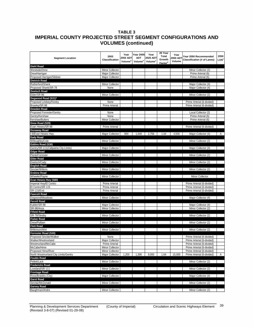
Planning & Development Services Department (County of Imperial) Circulation and Scenic Highways Element (Revised 3-8-07) (Revised 01-29-08)
39
TABLE 3 IMPERIAL COUNTY PROJECTED STREET SEGMENT CONFIGURATIONS AND
VOLUMES (continued)
Segment Location 2003 Classification
Year 2002 ADT Volumea
Year 2005 ADT
Volumea
Year 2025 ADT Volumec
25 Year Total
Growth Factord
Year 2050 ADT Volume
Year 2050 Recommended Classification (# of Lanes)
2050 LOSe
Diehl RoadWestside/Drew Minor Collector Minor Collector (2)Drew/Harrigan Major Collector Prime Arterial (6)Proposed Harrigan/Silsbee Major Collector Prime Arterial (6)Dietrich RoadRutherford/Shank Minor Collector Major Collector (4)Proposed Shank/SR-78 None Major Collector (4)Doetsch RoadElder/SR-86 Minor Collector Minor Collector (2)Dogwood Road (S31)*Proposed Lindsey/Hovley None Prime Arterial (6-divided)Brawley/SR-98 Prime Arterial Prime Arterial (6-divided)Dowden RoadProposed Forrester/Gentry None Local Collector (2)Gentry/Kershaw None Prime Arterial (6)Kershaw/Butters Minor Collector Prime Arterial (6)Drew Road (S29)Evan Hewes/SR-98 Prime Arterial Prime Arterial (6-divided)Dunaway RoadI-8/Evan Hewes Hwy Major Collector 900 1,040 2,756 1.64 4,500 Major Collector (4) AEady RoadWilloughby/Cole Minor Collector Minor Collector (2)Eddins Road (S30)Gentry/SR-111(Calipatria City Limits) Major Collector Major Collector (4)Edgar RoadPierle/Forrester Minor Collector Minor Collector (2)Elder RoadDoetsch/Cady Minor Collector Minor Collector (2)English RoadSinclair/Wilkins Minor Collector Minor Collector (2)Erskine RoadWheeler/Payne Minor Collector Minor CollectorEvan Hewes Hwy (S80)Imperial Hwy/El Centro Prime Arterial Prime Arterial (6-divided)El Centro/SR-115 Prime Arterial Prime Arterial (6-divided)SR-115/End Prime Arterial Prime Arterial (6-divided)Fawcett RoadDogwood/Meadows Minor Collector Major Collector (4)Ferrell RoadKubler/SR-98 Major Collector Major Collector (4)SR-98/Anza Minor Collector Minor Collector (2)Fifield RoadSR-78/Streiby Minor Collector Minor Collector (2)Fisher RoadDrew/Pulliam Minor Collector Minor Collector (2)Flett RoadWilkinson/Wirt Minor Collector Minor Collector (2)Forrester Road (S30)Proposed Sinclair/Walker None Prime Arterial (6-divided)Walker/Westmorland Major Collector Prime Arterial (6-divided)Westmorland/McCabe Prime Arterial Prime Arterial (6-divided)McCabe/Hime Minor Collector Prime Arterial (6-divided)Proposed Hime/River Minor Collector Prime Arterial (6-divided)North Westmorland City Limits/Gentry Major Collector 1,200 1,390 9,000 1.64 15,000 Prime Arterial (6-divided) AFoulds RoadPellett/Lack Minor Collector Minor Collector (2)Fredericks RoadLoveland/SR-111 Minor Collector Minor Collector (2)Frontage RoadRoss/Brawley (City) Major Collector Major Collector (4)Garst RoadSinclair/McDonald Minor Collector Minor Collector (2)Garvey RoadBaughman/Andre Minor Collector Minor Collector (2)
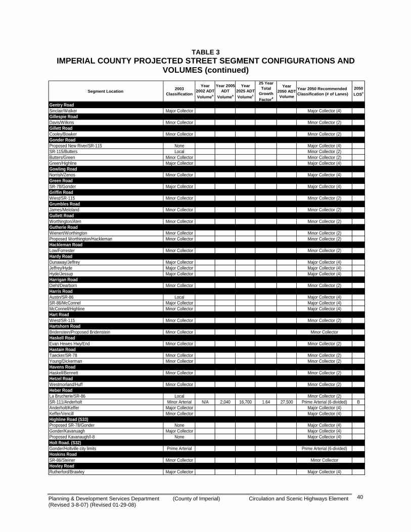
Planning & Development Services Department (County of Imperial) Circulation and Scenic Highways Element (Revised 3-8-07) (Revised 01-29-08)
40
TABLE 3 IMPERIAL COUNTY PROJECTED STREET SEGMENT CONFIGURATIONS AND
VOLUMES (continued)
Segment Location 2003 Classification
Year 2002 ADT Volumea
Year 2005 ADT
Volumea
Year 2025 ADT Volumec
25 Year Total
Growth Factord
Year 2050 ADT Volume
Year 2050 Recommended Classification (# of Lanes)
2050 LOSe
Gentry RoadSinclair/Walker Major Collector Major Collector (4)Gillespie RoadDavis/Wilkins Minor Collector Minor Collector (2)Gillett RoadCooley/Bowker Minor Collector Minor Collector (2)Gonder RoadProposed New River/SR-115 None Major Collector (4)SR-115/Butters Local Minor Collector (2)Butters/Green Minor Collector Minor Collector (2)Green/Highline Major Collector Major Collector (4)Gowling RoadNorrish/Zenos Minor Collector Major Collector (4)Green RoadSR-78/Gonder Major Collector Major Collector (4)Griffin RoadWiest/SR-115 Minor Collector Minor Collector (2)Grumbles RoadJames/Meloland Minor Collector Minor Collector (2)Gullett RoadWorthington/Aten Minor Collector Minor Collector (2)Gutherie RoadWienert/Worthington Minor Collector Minor Collector (2)Proposed Worthington/Hackleman Minor Collector Minor Collector (2)Hackleman RoadLow/Forrester Minor Collector Minor Collector (2)Hardy RoadDunaway/Jeffrey Major Collector Major Collector (4)Jeffrey/Hyde Major Collector Major Collector (4)Hyde/Jessup Major Collector Major Collector (4)Harrigan RoadDiehl/Dearborn Minor Collector Minor Collector (2)Harris RoadAustin/SR-86 Local Major Collector (4)SR-86/McConnel Major Collector Major Collector (4)McConnell/Highline Minor Collector Major Collector (4)Hart RoadWiest/SR-115 Minor Collector Minor Collector (2)Hartshorn RoadBridenstein/Proposed Bridenstein Minor Collector Minor CollectorHaskell RoadEvan Hewes Hwy/End Minor Collector Minor Collector (2)Hastain RoadTaecker/SR-78 Minor Collector Minor Collector (2)Young/Dickerman Minor Collector Minor Collector (2)Havens RoadHaskell/Bennett Minor Collector Minor Collector (2)Hetzel RoadWestmorland/Huff Minor Collector Minor Collector (2)Heber RoadLa Brucherie/SR-86 Local Minor Collector (2)SR-111/Anderholt Minor Arterial N/A 2,040 16,700 1.64 27,500 Prime Arterial (6-divided) BAnderholt/Keffer Major Collector Major Collector (4)Keffer/Vencill Minor Collector Major Collector (4)Highline Road (S33)Proposed SR-78/Gonder None Major Collector (4)Gonder/Kavanuagh Major Collector Major Collector (4)Proposed Kavanaugh/I-8 None Major Collector (4)Holt Road. (S32)Gonder/Holtville city limits Prime Arterial Prime Arterial (6-divided)Hoskins RoadSR-86/Steiner Minor Collector Minor CollectorHovley RoadRutherford/Brawley Major Collector Major Collector (4)
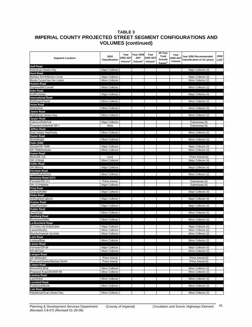
Planning & Development Services Department (County of Imperial) Circulation and Scenic Highways Element (Revised 3-8-07) (Revised 01-29-08)
41
TABLE 3 IMPERIAL COUNTY PROJECTED STREET SEGMENT CONFIGURATIONS AND
VOLUMES (continued)
Segment Location 2003 Classification
Year 2002 ADT Volumea
Year 2005 ADT
Volumea
Year 2025 ADT Volumec
25 Year Total
Growth Factord
Year 2050 ADT Volume
Year 2050 Recommended Classification (# of Lanes)
2050 LOSe
Huff RoadImler/Evan Hewes Hwy Major Collector Major Collector (4)Hunt RoadBarbara Worth/Bonds Corner Major Collector Major Collector (4)Bonds Corner/Van Der Linden Minor Collector Minor Collector (2)Huston RoadDogwood/McConnell Minor Collector Minor Collector (2)Imler RoadHuff/Forrester Major Collector Major Collector (4)International RoadNoffsinger/Pound Minor Collector Minor Collector (2)Irvine RoadShank/End Minor Collector Minor Collector (2)James RoadRalph/Evan Hewes Hwy Minor Collector Minor Collector (2)Jasper RoadCalexico/Anderholt Major Collector Expressway (6)Proposed Anderholt/ SR-7 None Expressway (6)Jeffery RoadEvan Hewes Hwy/Hardy Minor Collector Minor Collector (2)Kaiser RoadWirt/Albright Minor Collector Minor Collector (2)Kalin (S26)Sinclair/SR-78/86 Major Collector Major Collector (4)SR-78/86/Webster Minor Collector Minor Collector (4)Kamm RoadRiver/SR-115 Local Prime Arterial (6)SR-115/Holt Minor Collector Major Collector (4)Keffer RoadSR-98/King Major Collector Major Collector (4)Kershaw RoadYocum/Rutherford Minor Collector Minor Collector (2)Keystone Road (S27)Forrester/SR-111 Prime Arterial Expressway (6)SR-111/Highline Major Collector Expressway (6)King RoadOrchard/Keffer Major Collector Major Collector (4)Kloke RoadWilloughby/Calexico Major Collector Major Collector (4)Kramar RoadDrew/Forrester Major Collector Major Collector (4)Kubler RoadDrew/Clark Minor Collector Minor Collector (2)Kumberg RoadBonesteele/Miller Minor Collector Minor Collector (2)La Brucherie RoadEl Centro city limits/Kubler Major Collector Major Collector (4)Larsen/Murphy Minor Collector Minor Collector (2)Murphy/Imperial city limits Minor Collector Minor Collector (2)Lack RoadLindsey/Blais Minor Collector Minor Collector (2)Larsen RoadForrester/SR-86 Major Collector Major Collector (4)SR-86/Clark Minor Collector Minor Collector (2)Lavigne RoadSR-98/Bowker Prime Arterial Prime Arterial (6)Proposed Bowker/Barbara Worth Prime Arterial Prime Arterial (6)Liebert RoadWixom/Rd 8018 Minor Collector Minor Collector (2)Proposed Road 8018/SR-98 Minor Collector Minor Collector (2)Lindsey RoadLack/Wiest Minor Collector Minor Collector (2)Loveland RoadFredericks/Monte Minor Collector Minor Collector (2)Low RoadHackleman/Evan Hewes Hwy Minor Collector Minor Collector (2)
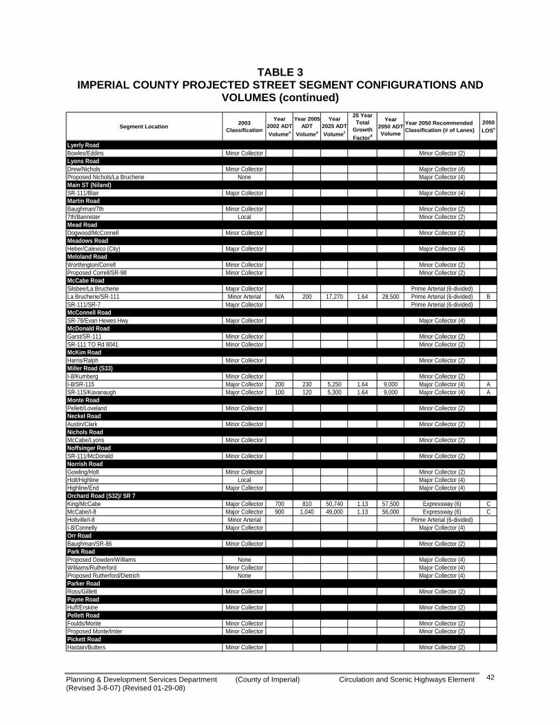
Planning & Development Services Department (County of Imperial) Circulation and Scenic Highways Element (Revised 3-8-07) (Revised 01-29-08)
42
TABLE 3 IMPERIAL COUNTY PROJECTED STREET SEGMENT CONFIGURATIONS AND
VOLUMES (continued)
Segment Location 2003 Classification
Year 2002 ADT Volumea
Year 2005 ADT
Volumea
Year 2025 ADT Volumec
25 Year Total
Growth Factord
Year 2050 ADT Volume
Year 2050 Recommended Classification (# of Lanes)
2050 LOSe
Lyerly RoadBowles/Eddins Minor Collector Minor Collector (2)Lyons RoadDrew/Nichols Minor Collector Major Collector (4)Proposed Nichols/La Brucherie None Major Collector (4)Main ST (Niland)SR-111/Blair Major Collector Major Collector (4)Martin RoadBaughman/7th Minor Collector Minor Collector (2)7th/Bannister Local Minor Collector (2)Mead RoadDogwood/McConnell Minor Collector Minor Collector (2)Meadows RoadHeber/Calexico (City) Major Collector Major Collector (4)Meloland RoadWorthington/Correll Minor Collector Minor Collector (2)Proposed Correll/SR-98 Minor Collector Minor Collector (2)McCabe RoadSilsbee/La Brucherie Major Collector Prime Arterial (6-divided)La Brucherie/SR-111 Minor Arterial N/A 200 17,270 1.64 28,500 Prime Arterial (6-divided) BSR-111/SR-7 Major Collector Prime Arterial (6-divided)McConnell RoadSR-78/Evan Hewes Hwy Major Collector Major Collector (4)McDonald RoadGarst/SR-111 Minor Collector Minor Collector (2)SR-111 TO Rd 8041 Minor Collector Minor Collector (2)McKim RoadHarris/Ralph Minor Collector Minor Collector (2)Miller Road (S33)I-8/Kumberg Minor Collector Minor Collector (2)I-8/SR-115 Major Collector 200 230 5,250 1.64 9,000 Major Collector (4) ASR-115/Kavanaugh Major Collector 100 120 5,300 1.64 9,000 Major Collector (4) AMonte RoadPellett/Loveland Minor Collector Minor Collector (2)Neckel RoadAustin/Clark Minor Collector Minor Collector (2)Nichols RoadMcCabe/Lyons Minor Collector Minor Collector (2)Noffsinger RoadSR-111/McDonald Minor Collector Minor Collector (2)Norrish RoadGowling/Holt Minor Collector Minor Collector (2)Holt/Highline Local Major Collector (4)Highline/End Major Collector Major Collector (4)Orchard Road (S32)/ SR 7King/McCabe Major Collector 700 810 50,740 1.13 57,500 Expressway (6) CMcCabe/I-8 Major Collector 900 1,040 49,000 1.13 56,000 Expressway (6) CHoltville/I-8 Minor Arterial Prime Arterial (6-divided)I-8/Connelly Major Collector Major Collector (4)Orr RoadBaughman/SR-86 Minor Collector Minor Collector (2)Park RoadProposed Dowden/Williams None Major Collector (4)Williams/Rutherford Minor Collector Major Collector (4)Proposed Rutherford/Dietrich None Major Collector (4)Parker RoadRoss/Gilllett Minor Collector Minor Collector (2)Payne RoadHuff/Erskine Minor Collector Minor Collector (2)Pellett RoadFoulds/Monte Minor Collector Minor Collector (2)Proposed Monte/Imler Minor Collector Minor Collector (2)Pickett RoadHastain/Butters Minor Collector Minor Collector (2)
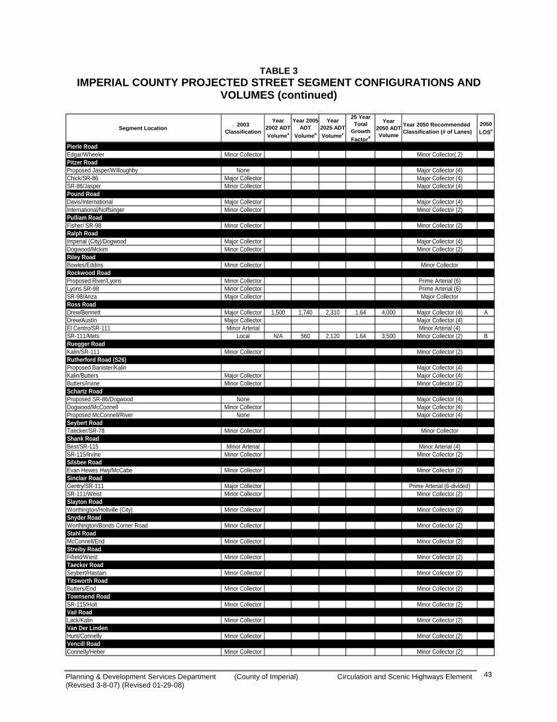
Planning & Development Services Department (County of Imperial) Circulation and Scenic Highways Element (Revised 3-8-07) (Revised 01-29-08)
43
TABLE 3 IMPERIAL COUNTY PROJECTED STREET SEGMENT CONFIGURATIONS AND
VOLUMES (continued)
Segment Location 2003 Classification
Year 2002 ADT Volumea
Year 2005 ADT
Volumea
Year 2025 ADT Volumec
25 Year Total
Growth Factord
Year 2050 ADT Volume
Year 2050 Recommended Classification (# of Lanes)
2050 LOSe
Pierle RoadEdgar/Wheeler Minor Collector Minor Collector( 2)Pitzer RoadProposed Jasper/Willoughby None Major Collector (4)Chick/SR-86 Major Collector Major Collector (4)SR-86/Jasper Minor Collector Major Collector (4)Pound RoadDavis/International Major Collector Major Collector (4)International/Noffsinger Minor Collector Minor Collector (2)Pulliam RoadFisher/ SR-98 Minor Collector Minor Collector (2)Ralph RoadImperial (City)/Dogwood Major Collector Major Collector (4)Dogwood/Mckim Minor Collector Minor Collector (2)Riley RoadBowles/Eddins Minor Collector Minor CollectorRockwood RoadProposed River/Lyons Minor Collector Prime Arterial (6)Lyons SR-98 Minor Collector Prime Arterial (6)SR-98/Anza Major Collector Major CollectorRoss RoadDrew/Bennett Major Collector 1,500 1,740 2,310 1.64 4,000 Major Collector (4) ADrew/Austin Major Collector Major Collector (4)El Centro/SR-111 Minor Arterial Minor Arterial (4)SR-111/Mets Local N/A 560 2,120 1.64 3,500 Minor Collector (2) BRuegger RoadKalin/SR-111 Minor Collector Minor Collector (2)Rutherford Road (S26)Proposed Banister/Kalin Major Collector (4)Kalin/Butters Major Collector Major Collector (4)Butters/Irvine Minor Collector Minor Collector (2)Schartz RoadProposed SR-86/Dogwood None Major Collector (4)Dogwood/McConnell Minor Collector Major Collector (4)Proposed McConnell/River None Major Collector (4)Seybert RoadTaecker/SR-78 Minor Collector Minor CollectorShank RoadBest/SR-115 Minor Arterial Minor Arterial (4)SR-115/Irvine Minor Collector Minor Collector (2)Silsbee RoadEvan Hewes Hwy/McCabe Minor Collector Minor Collector (2)Sinclair RoadGentry/SR-111 Major Collector Prime Arterial (6-divided)SR-111/Weist Minor Collector Minor Collector (2)Slayton RoadWorthington/Holtville (City) Minor Collector Minor Collector (2)Snyder RoadWorthington/Bonds Corner Road Minor Collector Minor Collector (2)Stahl RoadMcConnell/End Minor Collector Minor Collector (2)Streiby RoadFifield/Wiest Minor Collector Minor Collector (2)Taecker RoadSeybert/Hastain Minor Collector Minor Collector (2)Titsworth RoadButters/End Minor Collector Minor Collector (2)Townsend RoadSR-115/Holt Minor Collector Minor Collector (2)Vail RoadLack/Kalin Minor Collector Minor Collector (2)Van Der LindenHunt/Connelly Minor Collector Minor Collector (2)Vencill RoadConnelly/Heber Minor Collector Minor Collector (2)
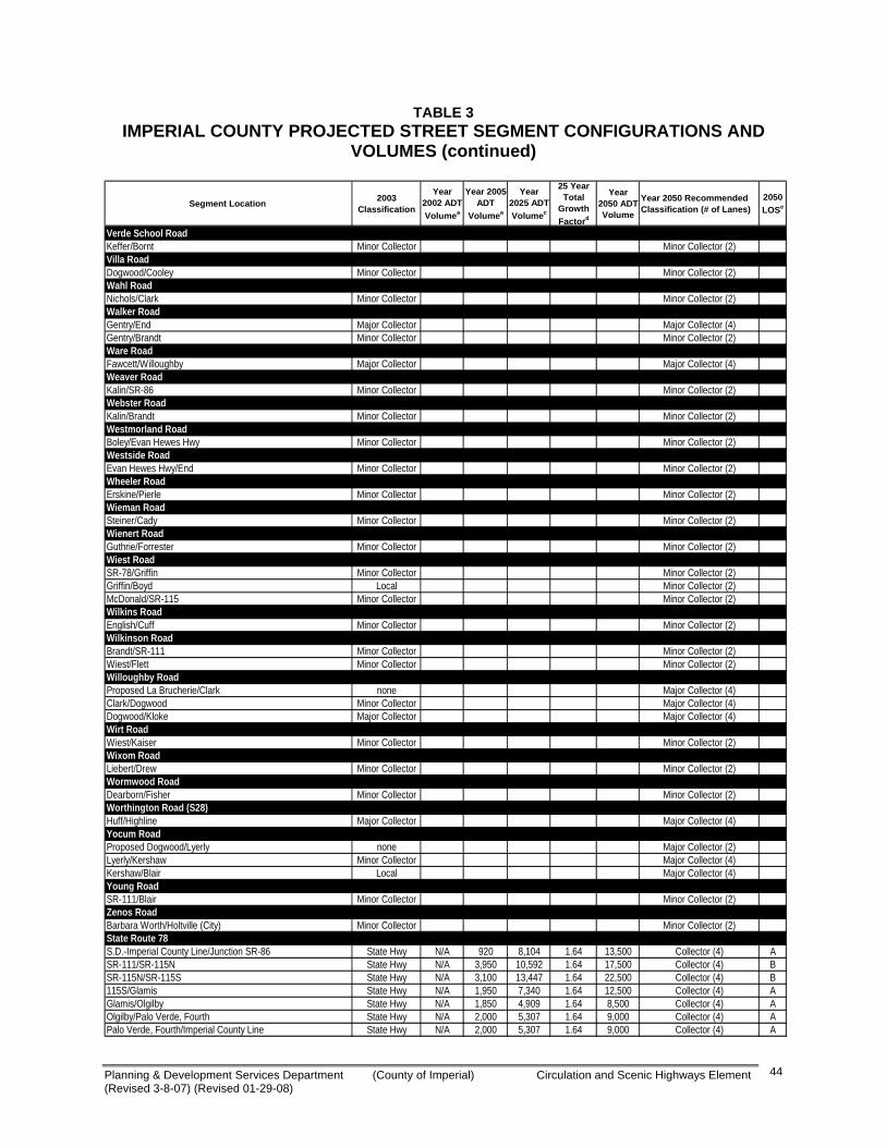
Planning & Development Services Department (County of Imperial) Circulation and Scenic Highways Element (Revised 3-8-07) (Revised 01-29-08)
44
TABLE 3 IMPERIAL COUNTY PROJECTED STREET SEGMENT CONFIGURATIONS AND
VOLUMES (continued)
Segment Location 2003 Classification
Year 2002 ADT Volumea
Year 2005 ADT
Volumea
Year 2025 ADT Volumec
25 Year Total
Growth Factord
Year 2050 ADT Volume
Year 2050 Recommended Classification (# of Lanes)
2050 LOSe
Verde School RoadKeffer/Bornt Minor Collector Minor Collector (2)Villa RoadDogwood/Cooley Minor Collector Minor Collector (2)Wahl RoadNichols/Clark Minor Collector Minor Collector (2)Walker RoadGentry/End Major Collector Major Collector (4)Gentry/Brandt Minor Collector Minor Collector (2)Ware RoadFawcett/Willoughby Major Collector Major Collector (4)Weaver RoadKalin/SR-86 Minor Collector Minor Collector (2)Webster RoadKalin/Brandt Minor Collector Minor Collector (2)Westmorland RoadBoley/Evan Hewes Hwy Minor Collector Minor Collector (2)Westside RoadEvan Hewes Hwy/End Minor Collector Minor Collector (2)Wheeler RoadErskine/Pierle Minor Collector Minor Collector (2)Wieman RoadSteiner/Cady Minor Collector Minor Collector (2)Wienert RoadGuthrie/Forrester Minor Collector Minor Collector (2)Wiest RoadSR-78/Griffin Minor Collector Minor Collector (2)Griffin/Boyd Local Minor Collector (2)McDonald/SR-115 Minor Collector Minor Collector (2)Wilkins RoadEnglish/Cuff Minor Collector Minor Collector (2)Wilkinson RoadBrandt/SR-111 Minor Collector Minor Collector (2)Wiest/Flett Minor Collector Minor Collector (2)Willoughby RoadProposed La Brucherie/Clark none Major Collector (4)Clark/Dogwood Minor Collector Major Collector (4)Dogwood/Kloke Major Collector Major Collector (4)Wirt RoadWiest/Kaiser Minor Collector Minor Collector (2)Wixom RoadLiebert/Drew Minor Collector Minor Collector (2)Wormwood RoadDearborn/Fisher Minor Collector Minor Collector (2)Worthington Road (S28)Huff/Highline Major Collector Major Collector (4)Yocum RoadProposed Dogwood/Lyerly none Major Collector (2)Lyerly/Kershaw Minor Collector Major Collector (4)Kershaw/Blair Local Major Collector (4)Young RoadSR-111/Blair Minor Collector Minor Collector (2)Zenos RoadBarbara Worth/Holtville (City) Minor Collector Minor Collector (2)State Route 78S.D.-Imperial County Line/Junction SR-86 State Hwy N/A 920 8,104 1.64 13,500 Collector (4) ASR-111/SR-115N State Hwy N/A 3,950 10,592 1.64 17,500 Collector (4) BSR-115N/SR-115S State Hwy N/A 3,100 13,447 1.64 22,500 Collector (4) B115S/Glamis State Hwy N/A 1,950 7,340 1.64 12,500 Collector (4) AGlamis/Olgilby State Hwy N/A 1,850 4,909 1.64 8,500 Collector (4) AOlgilby/Palo Verde, Fourth State Hwy N/A 2,000 5,307 1.64 9,000 Collector (4) APalo Verde, Fourth/Imperial County Line State Hwy N/A 2,000 5,307 1.64 9,000 Collector (4) A
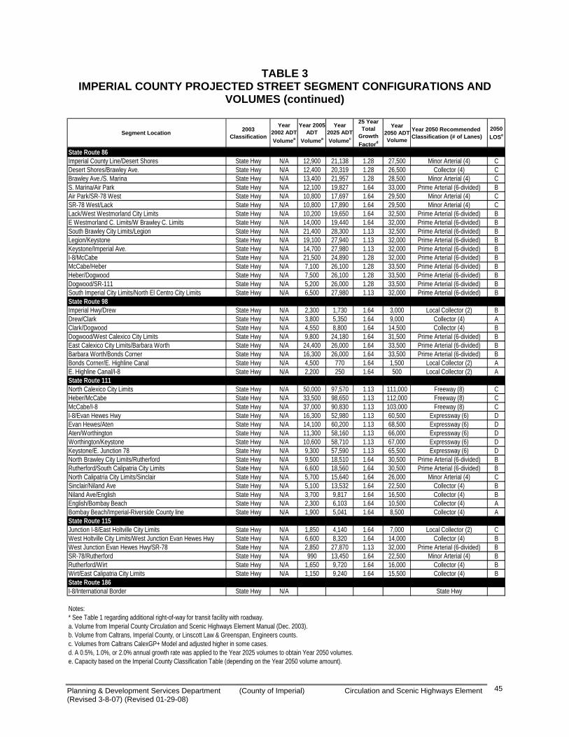
Planning & Development Services Department (County of Imperial) Circulation and Scenic Highways Element (Revised 3-8-07) (Revised 01-29-08)
45
TABLE 3 IMPERIAL COUNTY PROJECTED STREET SEGMENT CONFIGURATIONS AND
VOLUMES (continued)
Segment Location 2003 Classification
Year 2002 ADT Volumea
Year 2005 ADT
Volumea
Year 2025 ADT Volumec
25 Year Total
Growth Factord
Year 2050 ADT Volume
Year 2050 Recommended Classification (# of Lanes)
2050 LOSe
State Route 86Imperial County Line/Desert Shores State Hwy N/A 12,900 21,138 1.28 27,500 Minor Arterial (4) CDesert Shores/Brawley Ave. State Hwy N/A 12,400 20,319 1.28 26,500 Collector (4) CBrawley Ave./S. Marina State Hwy N/A 13,400 21,957 1.28 28,500 Minor Arterial (4) CS. Marina/Air Park State Hwy N/A 12,100 19,827 1.64 33,000 Prime Arterial (6-divided) BAir Park/SR-78 West State Hwy N/A 10,800 17,697 1.64 29,500 Minor Arterial (4) CSR-78 West/Lack State Hwy N/A 10,800 17,890 1.64 29,500 Minor Arterial (4) CLack/West Westmorland City Limits State Hwy N/A 10,200 19,650 1.64 32,500 Prime Arterial (6-divided) BE Westmorland C. Limits/W Brawley C. Limits State Hwy N/A 14,000 19,440 1.64 32,000 Prime Arterial (6-divided) BSouth Brawley City Limits/Legion State Hwy N/A 21,400 28,300 1.13 32,500 Prime Arterial (6-divided) BLegion/Keystone State Hwy N/A 19,100 27,940 1.13 32,000 Prime Arterial (6-divided) BKeystone/Imperial Ave. State Hwy N/A 14,700 27,980 1.13 32,000 Prime Arterial (6-divided) BI-8/McCabe State Hwy N/A 21,500 24,890 1.28 32,000 Prime Arterial (6-divided) BMcCabe/Heber State Hwy N/A 7,100 26,100 1.28 33,500 Prime Arterial (6-divided) BHeber/Dogwood State Hwy N/A 7,500 26,100 1.28 33,500 Prime Arterial (6-divided) BDogwood/SR-111 State Hwy N/A 5,200 26,000 1.28 33,500 Prime Arterial (6-divided) BSouth Imperial City Limits/North El Centro City Limits State Hwy N/A 6,500 27,980 1.13 32,000 Prime Arterial (6-divided) BState Route 98Imperial Hwy/Drew State Hwy N/A 2,300 1,730 1.64 3,000 Local Collector (2) BDrew/Clark State Hwy N/A 3,800 5,350 1.64 9,000 Collector (4) AClark/Dogwood State Hwy N/A 4,550 8,800 1.64 14,500 Collector (4) BDogwood/West Calexico City Limits State Hwy N/A 9,800 24,180 1.64 31,500 Prime Arterial (6-divided) BEast Calexico City Limits/Barbara Worth State Hwy N/A 24,400 26,000 1.64 33,500 Prime Arterial (6-divided) BBarbara Worth/Bonds Corner State Hwy N/A 16,300 26,000 1.64 33,500 Prime Arterial (6-divided) BBonds Corner/E. Highline Canal State Hwy N/A 4,500 770 1.64 1,500 Local Collector (2) AE. Highline Canal/I-8 State Hwy N/A 2,200 250 1.64 500 Local Collector (2) AState Route 111North Calexico City Limits State Hwy N/A 50,000 97,570 1.13 111,000 Freeway (8) CHeber/McCabe State Hwy N/A 33,500 98,650 1.13 112,000 Freeway (8) CMcCabe/I-8 State Hwy N/A 37,000 90,830 1.13 103,000 Freeway (8) CI-8/Evan Hewes Hwy State Hwy N/A 16,300 52,980 1.13 60,500 Expressway (6) DEvan Hewes/Aten State Hwy N/A 14,100 60,200 1.13 68,500 Expressway (6) DAten/Worthington State Hwy N/A 11,300 58,160 1.13 66,000 Expressway (6) DWorthington/Keystone State Hwy N/A 10,600 58,710 1.13 67,000 Expressway (6) DKeystone/E. Junction 78 State Hwy N/A 9,300 57,590 1.13 65,500 Expressway (6) DNorth Brawley City Limits/Rutherford State Hwy N/A 9,500 18,510 1.64 30,500 Prime Arterial (6-divided) BRutherford/South Calipatria City Limits State Hwy N/A 6,600 18,560 1.64 30,500 Prime Arterial (6-divided) BNorth Calipatria City Limits/Sinclair State Hwy N/A 5,700 15,640 1.64 26,000 Minor Arterial (4) CSinclair/Niland Ave State Hwy N/A 5,100 13,532 1.64 22,500 Collector (4) BNiland Ave/English State Hwy N/A 3,700 9,817 1.64 16,500 Collector (4) BEnglish/Bombay Beach State Hwy N/A 2,300 6,103 1.64 10,500 Collector (4) ABombay Beach/Imperial-Riverside County line State Hwy N/A 1,900 5,041 1.64 8,500 Collector (4) AState Route 115Junction I-8/East Holtville City Limits State Hwy N/A 1,850 4,140 1.64 7,000 Local Collector (2) CWest Holtville City Limits/West Junction Evan Hewes Hwy State Hwy N/A 6,600 8,320 1.64 14,000 Collector (4) BWest Junction Evan Hewes Hwy/SR-78 State Hwy N/A 2,850 27,870 1.13 32,000 Prime Arterial (6-divided) BSR-78/Rutherford State Hwy N/A 990 13,450 1.64 22,500 Minor Arterial (4) BRutherford/Wirt State Hwy N/A 1,650 9,720 1.64 16,000 Collector (4) BWirt/East Calipatria City Limits State Hwy N/A 1,150 9,240 1.64 15,500 Collector (4) BState Route 186I-8/International Border State Hwy N/A State Hwy
Notes:* See Table 1 regarding additional right-of-way for transit facility with roadway.a. Volume from Imperial County Circulation and Scenic Highways Element Manual (Dec. 2003).b. Volume from Caltrans, Imperial County, or Linscott Law & Greenspan, Engineers counts.c. Volumes from Caltrans CalexGP+ Model and adjusted higher in some cases.d. A 0.5%, 1.0%, or 2.0% annual growth rate was applied to the Year 2025 volumes to obtain Year 2050 volumes.e. Capacity based on the Imperial County Classification Table (depending on the Year 2050 volume amount).
Planning & Development Services Department (County of Imperial) Circulation and Scenic Highways Element (Revised 3-8-07) (Revised 01-29-08)
46
III. GOALS AND OBJECTIVES A. Preface The following are the Goals and Objectives of the Circulation and Scenic Highways Element along with policies to achieve these specific goals and objectives. The Goals and Objectives, together with the Implementation Programs and Policies in Chapter IV, are the statements that shall provide direction for private development as well as government actions and programs. Imperial County's Goals and Objectives are intended to serve as long-term principles and policy statements representing ideals which have been determined by the citizens as being desirable and deserving of community time and resources to achieve. These Goals and Objectives, therefore, are important guidelines for land use decision making. It is recognized, however, that other social, economic, environmental, and legal considerations are involved in land use decisions and that these Goals and Objectives, and those of the other General Plan Elements, should be used as guidelines but not doctrines. B. Goals and Objectives Safe, Convenient, and Efficient Transportation System Goal 1: The County will provide and require an integrated transportation system for the safe and efficient movement of people and goods within and through the County of Imperial with minimum disruption to the environment. Objective 1.1 Maintain and improve the existing road and highway network,
while providing for future expansion and improvement based on travel demand and the development of alternative travel modes.
Objective 1.2 Require a traffic analysis for any new development which may
have a significant impact on County roads. A traffic analysis may not be necessary in every situation, such as when the size or location of the project will not have a significant impact upon and generate only a small amount of traffic. Also, certain types of projects, due to the trip generation characteristics, may add virtually no traffic during peak periods. These types of projects may be exempt from the traffic analysis requirements. Whether a particular project qualifies for any exemption will be determined by the Department of Public Works Road Commissioner.
Objective 1.3 Ensure safe and coordinated traffic patterns, contiguous growth,
and promote a planned and consistent development around city/township areas. Require that coordination with other jurisdictions, including the cities and CALTRANS results in a coordinated system that is consistent in classification, RoW and improvement standards. When annexations are proposed, projects must provide consistent roadway standards. This is intended to provide

Planning & Development Services Department (County of Imperial) Circulation and Scenic Highways Element (Revised 3-8-07) (Revised 01-29-08)
47
“throughways” that allow for the flow of traffic at LOS “C” or better throughout the system, both in cities as well as the County.
Objective 1.4 In addition to Collector and Arterial roads, maintain and, where
appropriate, extend the existing network of Local Streets which have been historically plotted along section, half-section and tract lines, and which provide alternative local routes to connect with Collector and Arterial streets.
Objective 1.5 Encourage the balance of employment, services, and housing
throughout the County to preclude future traffic congestion. The result of balancing housing and employment demands at a community scale allows residents to live and work in the same area, potentially decreasing demand on inter-regional transportation facilities.
Objective 1.6 Expand and improve needed public utilities relating to
transportation. Objective 1.7 Finance, or seek funding for circulation system maintenance
projects. Objective 1.8 The County's circulation system shall promote efficient intra- and
inter-County travel with minimum disruption to established and planned communities.
Objective 1.9 Identify busy agricultural roads to create special crossings for
farm equipment. Objective 1.10 Maintain and expand public transit services to keep pace with
population and job growth. Objective 1.11 Improve County circulation system roadways in concert with land
development to ensure sufficient levels of service. Objective 1.12 Review new development proposals to ensure that the proposed
development provides adequate parking and would not increase traffic on existing roadways and intersection to a level of service (LOS) worse than “C” without providing appropriate mitigations to existing infrastructure. This can include fair share contributions on the part of developers to mitigate traffic impacts caused by such proposed developments.
Objective 1.13 Work with adjacent jurisdictions and transportation agencies to
identify necessary improvements to the regional roadway system to ensure adequate interregional and intraregional access throughout the County.

Planning & Development Services Department (County of Imperial) Circulation and Scenic Highways Element (Revised 3-8-07) (Revised 01-29-08)
48
Objective 1.14 Coordinate improvement to the County circulation system with other major transportation improvement programs including compliance with air pollution control district regulations and mitigation.
Objective 1.15 Review and update County Road Functional Classifications
periodically in accordance with Federal Highway Administration (FHWA) requirements. Purpose is to ensure current road classifications are accurate and appropriate. Functional Road Classifications within the County are updated by the County Public Works Department routinely and require both County Board and IVAG approvals prior to notifications to Caltrans and FHWA.
Objective 1.16 Design transportation corridors to be co-located/joint use (within
the ROW) with transmission, water and other infrastructure corridors to the extent possible.
Objective 1.17 Assure that road systems are adequate to accommodate
emergency situations and evacuation plans. Multiple Modes of Transportation Goal 2: Consider all modes of transportation including motor vehicle, rail, transit, air transportation, and non-motorized transportation. Objective 2.1 Develop a balanced circulation system which will provide for the
economical, efficient, and safe movement of people and goods within and through the County.
Objective 2.2 Encourage a mix of transportation modes to meet community needs, including access to medical, educational, economic and social service facilities. The local circulation system should include pedestrian, bicycle and transit methods to enable residents to choose alternate modes in lieu of reliance on the automobile.
Objective 2.3 Develop and improve aviation facilities. Objective 2.4 Reduce aviation-related hazards, including hazards to aircraft
and hazards posed by aircraft. Objective 2.5 Ensure consistency of the General Plan with the provisions of the
Airport Land Use Plan.
Objective 2.6 Coordinate and plan for the expansion of the County Airport in Imperial or new location to encourage interregional travel and commerce.
Objective 2.7 Encourage passenger rail or trolley service between El Centro and Mexicali/Calexico and also between Imperial Valley and San Diego.
Planning & Development Services Department (County of Imperial) Circulation and Scenic Highways Element (Revised 3-8-07) (Revised 01-29-08)
49
Objective 2.8 Encourage existing railroad corridor right of ways to be preserved for future transportation needs.
Alternate Modes of Transport Goal 3: Develop alternative transportation strategies designed to reduce traffic volumes and improve traffic flow. This includes providing alternatives to residents such as pedestrian, bicycle and public transit options. Objective 3.1 Develop, promote, and improve transit and para-transit services
and programs for convenient access to major destinations. Objective 3.2 Encourage the improvement and expansion of needed railroads
and bus routes in the County transportation system. Objective 3.3 Coordinate with the Imperial Valley Association of Governments
(IVAG) to ensure that adequate bus service, including a fixed route public transit system, is available for all segments of the community.
Objective 3.4 Provide for the location of necessary transit infrastructure, such
as bus stops, shelters or intermodal use facilities, in major activity centers. Include requiring developments that are identified as significant trip generators to incorporate design of such potential transit infrastructure.
Objective 3.5 Support ridesharing services and other similar alternative modes
of transportation. Objective 3.6 Develop and improve bicycle routes and pedestrian walkways.
Consider the needs of bicyclists in the design, construction, and maintenance of all County roads, with specific attention to those roads established and defined in a network of key bicycling routes in the most current approved Imperial County Bicycle Master Plan.
Objective 3.7 Ensure the safety of the traveling public, including pedestrians
and bicyclists. Objective 3.8 Attempt to reduce motor vehicle air pollution. Require all major
projects to perform an air quality analysis to determine the amount of pollution, as well as the alternative reduction options.
Objective 3.9 Continue to improve the accessibility of public facilities and
commercial centers to improve access and the mobility of the elderly and disabled.
Planning & Development Services Department (County of Imperial) Circulation and Scenic Highways Element (Revised 3-8-07) (Revised 01-29-08)
50
Objective 3.10 Encourage the incorporation of bicycle facilities, such as bike lockers and showers at workplaces, and bicycle racks on buses, to better facilitate bicycle travel.
Objective 3.11 Maintain the pedestrian and bicycle system, including improving
the road surface and sidewalk, to reduce the safety hazard associated with drainage grates, manholes, potholes and uneven surfaces.
Scenic Highways Goal 4: The County shall make every effort to develop a circulation system that highlights and preserves the environmental and scenic amenities of the area. Objective 4.1 Establish various systems of scenic recreational travel utilizing
multiple transportation modes. Objective 4.2 Preserve, enhance, and protect Imperial County's scenic
resources by the removal of illicit billboards from scenic areas and restrictions on new off-site sign construction visible from designated scenic highways.
Objective 4.3 Protect areas of outstanding scenic beauty along any scenic
highways and protect the aesthetics of those areas. Objective 4.4 Acquire scenic easements from private owners when required. Objective 4.5 Develop standards for aesthetically valuable sites. Design review
may be required so that structures, facilities, and activities are properly merged with the surrounding environment.
Regional Transportation System Goal 5: Participate in and assist with coordinating regional efforts which integrate the County Transportation System with the Regional Transportation System. Objective 5.1 The County's Circulation Element shall be designed to provide
the facility and level of access necessary to serve the specific existing and proposed land uses designated in the Land Use Element and to satisfy regional travel needs.
Objective 5.2 The County shall provide and/or requires as appropriate the
necessary facilities to obtain balanced use of all travel modes to address the transportation needs of all ages and to provide mobility for a variety of trip purposes. The County shall generally recognize the following priorities for new transportation facilities: vehicular, freight movement, transit, pedestrian, and bicycle.

Planning & Development Services Department (County of Imperial) Circulation and Scenic Highways Element (Revised 3-8-07) (Revised 01-29-08)
51
Objective 5.3 The County shall cooperate with the adjacent communities and agencies such as the Federal Government, State Department of Transportation (Caltrans District 11), El Centro, Brawley, Calexico, Holtville, Imperial, Westmorland, and Calipatria to provide the maximum compatibility of adopted circulation elements and regional facility plans, provided however that the minimum standards of this element are maintained..
Objective 5.4 The County shall coordinate regularly with Caltrans to obtain
information on trends and plans for roadway changes and improvements which would affect the noise environment.
C. Relationship to Other General Plan Elements The Circulation and Scenic Highways Element Policy Matrix (Table 4) identifies the relationship between the Circulation and Scenic Highways Element Goals and Objectives to other Elements of the Imperial County General Plan. The Issue Area identifies the broader goals of the Element and the "Xs" identify that related objectives are contained in the corresponding Elements.
TABLE 4 CIRCULATION AND SCENIC HIGHWAYS ELEMENT POLICY MATRIX
Issue Area
Land Use
Housing
Noise
Seismic/Public Safety
Agricultural
Open Space Conservation
Geothermal
Water
Safe/Efficient System
X X X X
Scenic Highways
X X
Regional Transport
X X
Remainder of Page Blank

Planning & Development Services Department (County of Imperial) Circulation and Scenic Highways Element (Revised 3-8-07) (Revised 01-29-08)
52
IV. IMPLEMENTATION PROGRAMS AND POLICIES A. Preface Any plan is only as good as the means of implementation. There are various tools and methods to insure that the intent of the Circulation and Scenic Highways Element is followed. These programs are described below. B. Programs and Policies 1. Circulation and Scenic Highways Element The goal of the Circulation and Scenic Highways Element (see Figures 1, 1a-c) is to provide a network of roadways throughout the County, which is the foundation of the transportation system. The street system is used for vehicular, bicycle, transit, pedestrian, and freight movement. Thus, it is essential to define a hierarchical system in which each roadway functions in a manner consistent with its intended use. a. Roadway Classifications The policies contained in this section are intended to encourage design standards which promote efficiency and safety of the circulation system. The Circulation Element roadway classifications are Expressway, Prime Arterial, Minor Arterial, Collector, Local Collector Street, Industrial Collector, Industrial Local Street, and Residential Street as described in Chapter I. A large scale map of these proposed routes is available at the County Planning and Development Services Department and Department of Public Works. Table 5 presents a summary of the estimated level of service for each classification, as well as for residential streets, cul-de-sacs, and loop streets.
Remainder of Page Blank

Planning & Development Services Department (County of Imperial) Circulation and Scenic Highways Element (Revised 3-8-07) (Revised 01-29-08)
53
TABLE 5
IMPERIAL COUNTY STANDARD STREET CLASSIFICATION AVERAGE DAILY VEHICLE TRIPS
Road Level of Service (LOS) Class X-Section A B C D E
Expressway 154/210 30,000 42,000 60,000 70,000 80,000Prime Arterial 106/136 22,200 37,000 44,600 50,000 57,000Minor Arterial 82/102 14,800 24,700 29,600 33,400 37,000Major Collector (Collector)
64/84 13,700 22,800 27,400 30,800 34,200
Minor Collector (Local Collector)
40/70 1,900 4,100 7,100 10,900 16,200
Local County (Residential)
40/60 * * <1,500 * *
Local County (Residential Cul-de-Sac or Loop Street)
40/60 * * <200 * *
Major Industrial Collector – (Industrial)
76/96 5,000 10,000 14,000 17,000 20,000
Industrial Local 44/64 2,500 5,000 7,000 8,500 10,000* Levels of service are not applied to residential streets since their primary purpose is
to serve abutting lots, not carry through traffic. Levels of service normally apply to roads carrying through traffic between major trip generators and attractors.
Table 5 was originally developed for the County of San Diego by the San Diego County Department of Public Works in 1985 and compares ADT to levels of service (LOS) for various roadway classifications. Proposed functional classifications were then inserted into this table and right-of-way widths adjusted to match County of Imperial standards. Transition Areas The Circulation and Scenic Highways Element is the graphical reference guide which shows the present and planned street system, along with the classification of those streets. It is important to note that where there is a change from one classification to another along a certain street, the transition will occur in mid-block areas to preclude non-continuing lanes and intersections. The design criteria (design, speed, curve radii, etc.) for the higher classification shall generally take precedence through the transition area.
Planning & Development Services Department (County of Imperial) Circulation and Scenic Highways Element (Revised 3-8-07) (Revised 01-29-08)
54
The County Director of Public Works shall review these transition areas and provide guidance in achieving this policy. c. New or enlarged Roads: Local Roads The County shall require all new developments to provide for local roads to serve the direct access needs of abutting property. These streets should be designed with a discontinuous pattern to discourage through traffic. They generally should not intersect with arterial street classifications. Typical design features include two travel lanes with parking on both sides of the street. Local roads include loop streets and cul-de-sacs. Regional Roads (Roads beyond the actual development project) The County shall require that all new developments participate in the improvement of regional roads that may be impacted by the proposed development. The extent to which a project impacts regional roads is generally determined by a traffic study. In some cases however the County may have predetermined improvement requirements for certain road segments or road intersections. The new developments will be required to either make certain regional improvements or in the alternative contribute a “fair share” towards the cost of such improvements. d. Level of Service Standards As the County continues to grow, transportation demand management and systems management will be necessary to preserve and increase available roadway “capacity”. Level of Service (LOS) standards are used to assess the performance of a street or highway system and the capacity of a roadway. An important goal when planning the transportation system is to maintain acceptable levels of service along the federal and state highways and the local roadway network. To accomplish this, the California Department of Transportation (Caltrans), Imperial County and local agencies adopt minimum levels of service to determine future infrastructure needs. Imperial County must provide and maintain a highway system with adequate capacity and acceptable levels of service to accommodate projected travel demands associated with the projected population growth within the Land Use Element. This can be accomplished by establishing minimum service levels for the designated street and conventional state highway system. Strategies that result in improvements to the transportation system, coupled with local job creation, will allow County residents to have access to a wide range of job opportunities within reasonable commute times.

Planning & Development Services Department (County of Imperial) Circulation and Scenic Highways Element (Revised 3-8-07) (Revised 01-29-08)
55
The County's goal for an acceptable traffic service standard on an ADT basis and during AM and PM peak periods for all County-Maintained Roads shall be LOS C for all street segment links and intersections. These service values are defined by the 1985 or 2000 edition of the Highway Capacity Manual or any subsequent edition thereof. This policy shall acknowledge that the aforementioned level of service standards may not be obtainable on some existing facilities where abutting development precludes acquisition of additional right-of-way needed for changes in facility classification. In order to achieve the level of service goals in the previous policy, the County shall develop and institute a long-range funding program in which new land development shall bear the major burden of the associated costs and improvement requirements. e. Design Standards The County shall adopt design standards for all streets in accordance with their functional classifications and recognized design guidelines. In developing these standards, the County shall consider the design standards of Caltrans and the American Association of State and Highway Transportation Officials (AASHTO). All streets within the County shall be designed in accordance with the adopted County of Imperial Design Standards. Typical cross sections and design criteria for the various street classifications are shown as an attachment to this document. f. Private Streets The County may permit construction of private streets within individual development projects (gated community). providing the following are addressed:
• They are designed geometrically and structurally to meet County standards.
• Only project occupants are served (gated community).
• Emergency vehicle access requirements are satisfied.
• The streets do not provide a direct through route between public streets.
• The Homeowners Associations and/or property owners provide an acceptable program for financing regular street maintenance.
• If the private street is permitted with a waiver of any of the above standards, any
future requests to make the private street a public street shall require that all adjacent property owners provide and pay for all improvements and right of way required to bring the street to current public street or road standards. This includes road width, right of way widths and structural section. In no circumstance shall the County pay for any costs to upgrade a private street to public street standards if the above-mentioned requirements were waived at the request of the original developer or subdivider.
Planning & Development Services Department (County of Imperial) Circulation and Scenic Highways Element (Revised 3-8-07) (Revised 01-29-08)
56
g. Street Access Guidelines The County shall institute street access guidelines consistent with the street classifications. These shall be applied where feasible to all new developments. The following guidelines shall be used to define appropriate access:
• The County shall prohibit driveway access to Prime Arterials, unless there is no other reasonable means of access.
• Access to Minor Arterials shall not be permitted unless there is no other
reasonable means of access to the public street system. Where access to Minor Arterial or Collectors must be allowed, it shall be limited through the use of medians and/or access controls in order to maintain street capacity.
• Along Minor Arterials, access spacing shall be a standard distance of 1,200 feet or
more. Under special circumstances, this distance may be reduced to a minimum of 600 feet. Along Collectors the corresponding access spacing shall be 600 feet for the standard distance and 300 feet for the minimum distance. The above measurements shall be from the ends of the curb returns.
• All access spacing requirements shall consider the above guidelines. Should more
stringent requirements be imposed by the County Road Commissioner, his decision shall be final.
• No driveway access will be allowed to some roads such as Expressways and
Major Collectors. h. Specific Alignment Plans The County shall adopt specific alignment plans when "stand equal sided" widening is not adequate for future needs, or when special conditions exist which require a detailed implementation plan. When necessary, the specific alignment plan should be prepared prior to the official submittal of the development proposal. The need for such plans will be indicated by the following:
• Variable terrain or other sensitive areas which may preclude straightforward preparation of street improvement plans.
• Alignments which are necessary because of existing street design and/or land use
configurations.
• Development proposals which must deal with extraordinary physical or environmental features.
• Transmission facilities for electric, water, gas and other infrastructure systems.
Planning & Development Services Department (County of Imperial) Circulation and Scenic Highways Element (Revised 3-8-07) (Revised 01-29-08)
57
i. Functional Road Classification Updates The County shall periodically review and update County Road Functional Classifications as necessary to ensure accurate and appropriate classifications are assigned to roads. The County Road Commissioner performs this task. Factors which contribute to necessary modifications include existing and proposed developments, types of development, County and City Land Use (Zoning) and vehicular driving patterns. All changes to the Functional Road Classifications must comply with the requirements described in the “Highway Functional Classifications – Concepts, Criteria and Procedures Manual”, published by the Federal Highway Administration (FHWA). Functional Road Classifications shown in the Circulation Element, although current, are subject to future revisions prepared by the County Public Works Department and approved by the County Board, concurred by IVAG and subsequently provided to Caltrans and FHWA for their review. Since Functional Road Classifications are updated independently of the Circulation Element the latest approved Functional Road classifications are hereby incorporated into the Circulation and Scenic Highway Element by reference. In some cases final approval of functional road classifications may not be in place when a private development project is being initiated or the development itself may require increasing the roads functional classification to address the near term and future traffic impacts. In these cases the higher road functional classification shall govern. Final determination of road functional classification is by the County Road Commissioner. 2. Ordinance Review The County Land Use Ordinance Regulations and the setback portions must be reviewed and made to conform with the needs of this Element. This will insure that future construction will not interfere with present and potential highway needs. In addition, the currently established road right of ways must be analyzed to determine if these are adequate. In those areas where the present right of ways are inadequate, a program for securing such should be commenced. It shall be the policy and direction under this circulation element that the dedication of rights of way and street improvements as a condition of issuance of a building permit and/or land use development application shall be required. All such rights of ways established in the functional road classifications shall be protected and procurement of needed rights of ways and improvements shall be made wherever possible. The County Planning and Development Services Director in conjunction with the County Road Commissioner shall review every building permit and land use development application in regards to obtaining the necessary right of ways and public improvements as a condition of permit issuance. This shall also be performed during the CEQA review of any projects which fall under the CEQA guidelines. All setbacks established by County Ordinance shall be deemed to commence from the edge of ultimate right of ways on any parcel or
Planning & Development Services Department (County of Imperial) Circulation and Scenic Highways Element (Revised 3-8-07) (Revised 01-29-08)
58
property fronting on a public street, right of way, or any other public transit corridor and not from the property line. The County Subdivision, Division 8 of the Title 9 Land Use Ordinance should be enforced in such a manner that street and roads installed shall conform to this element and the appropriate geometric section. If this is appropriately implemented, future widening or roadbed strengthening will not be required later at County expense. 3. Monitoring for Plan Compliance It will be the responsibility of the Department of Public Works (DPW) to maintain surveillance of the Element and the various items that might affect it. Periodic formal reviews should be conducted by the Planning Commission and the Board of Supervisors to keep it current. Generally, such a review should be held at least every five years and more often if needed. In this way, the Element will be kept current and vital, and it will be kept visible to all areas of the public. The Planning and Development Services Department shall be responsible for advising the Department of Public Works of proposed development projects and building permit applications along designated routes. Recommendations for right of way, street improvements, including but not limited to, off-site improvements of road segments, intersection widenings, traffic control devices, street lights, and bike lanes shall be made by DPW. For projects affecting State routes, Caltrans' input shall be sought. 4. Financing Alternatives Revenues for maintenance and construction improvements to the County Road System are mainly derived from the Gas Tax Fund and Local Transportation Authority Sales Tax Funds (Measure D). The Gas Tax Fund is distributed to the County in accordance with formulas enacted by the State Legislative Body. The Local Transportation Authority Sales Tax Fund is a 1/2 percent sales tax specifically targeted for repairs and rehabilitation, safety improvements and construction of needed facilities. It is a Countywide tax, distributed to cities and the County, by a formula based on road mileage and population. Collection of Measure D funds began in 1990 and will terminate in the year 2010. Other revenues are derived from developer impact fees, development mitigation fees, vehicle code fines and miscellaneous fees. Total estimated revenue for Fiscal Year 1991 is 8.3 million dollars. a. Objective
In order to achieve a viable multi-modal transportation system, financing options must be considered. The majority of funds to provide needed capital improvements
Planning & Development Services Department (County of Imperial) Circulation and Scenic Highways Element (Revised 3-8-07) (Revised 01-29-08)
59
as shown on the circulation map must come from the developer impact fees, Federal or State grants, or bond issues if so desired by a vote of the people.
b. Policies
Distribute the costs of transportation improvements equitably among those who will benefit, including current roadway users. Use annexations, development agreements and the CEQA process as tools to ensure that new development pays a fair share of costs to provide local and regional transportation improvements and to mitigate cumulative traffic impacts. Participate in the establishment of regional traffic mitigation fees to be assessed on new development. The fees shall cover a reasonable share of the costs of providing local and sub regional transportation improvements needed for serving new development in the unincorporated area. Seek all available means to finance improvements, including state and federal grants, to ensure that a non-motorized system is implemented, in addition to the current motorized system being adequately maintained. Seek to work cooperatively with the Cities to require that development is their jurisdiction, also to contribute its fair share to County road improvements.
5. Roadway Improvements a. Objective
The ultimate circulation system is not in place at this time, nor is it necessary for it to be fully completed until the County and regional growth warrant it. In general, the road network will be constructed in phases consistent with the needs of the community. This section incorporates policies which will encourage the orderly development and funding of the street system. It is expected that the construction will be funded through a combination of developer contributions and fees, County funds such as gasoline tax, and state and federal subventions.
b. Policies
It shall be the policy and direction under this circulation element that the dedication of rights of way and street improvements as a condition of issuance of a building permit and/or land use development application shall be required. All such rights of ways established in the functional road classifications shall be protected and procurement of needed rights of ways and improvements shall be made wherever possible. The County Planning and Development Services Director in conjunction with the County Road Commissioner shall review every building permit and land
Planning & Development Services Department (County of Imperial) Circulation and Scenic Highways Element (Revised 3-8-07) (Revised 01-29-08)
60
use development application in regards to obtaining the necessary right of ways and public improvements as a condition of permit issuance. This shall also be performed during the CEQA review of any projects which fall under the CEQA Guidelines. All setbacks established by County Ordinance shall be deemed to commence from the edge of ultimate right of ways on any parcel or property fronting on a public street, right of way, or any other public transit corridor and not from the property line. The County shall assure that each addition to the circulation system is a functional link on the total system so that new routes and links are coordinated with existing routes to ensure that each new and existing roadway continues to function as it was intended. The County shall require or provide adequate traffic safety measures on all new and existing roadways. These measures may include, but not be limited to, appropriate levels of maintenance, proper street design, traffic control devices (signs, signals, and striping), street lighting, and coordination with the school districts to provide school crossing signs and protection. The County shall give priority to funding and implementing projects which either complete links on the circulation system, or relieve existing deficiencies. Where feasible, the County shall interconnect traffic signals to form area networks or corridor systems. These systems shall be timed to facilitate the flow of through traffic on the arterial system, thus enhancing the movement of vehicles and goods through the County, while reducing fuel consumption and air pollution. The County shall impose appropriate pro-rated fees for construction of roadway facilities and associated landscaping to ensure that all new development contributes to the completion of the circulation system. In addition to pre-permit collection, such fees may be imposed through creation of assessment districts.
The County shall only approve and build streets as per County of Imperial Design Standards. Likewise, the County shall not allow impacts to other jurisdictions to be unmitigated, nor shall the County allow impacts created by projects within incorporated areas, to be unmitigated in the County. The County shall require additional right-of-way and additional improvements of expressways and major arterials where required for turning movements, bus turnouts, school bus stops or shelters or to provide access to adjacent properties wherever access is not feasible from the lower classification street system. The County shall actively continue all efforts to standardize street design requirements with all Cities.
Planning & Development Services Department (County of Imperial) Circulation and Scenic Highways Element (Revised 3-8-07) (Revised 01-29-08)
61
The County shall:
a. Require development to provide collector and local street improvements according to standards of the County Public Works Department.
b. Require development to dedicate necessary right-of-way when the subdivision or
development of property adjacent or straddling Circulation and Scenic Highway Plan streets is proposed.
c. Require development to provide all necessary grading, installation of curbs,
gutters, sidewalks, and parkway tree planting, unless these improvements are provided through other means.
d. Require development to provide half-width street improvements plus 12-feet
beyond the centerline in accordance with County standards.
e. Require development to provide right of way and improvements for transit infrastructure, including bus turnouts, stops, benches and shelters.
f. Assure that new developments adopted by the Specific Plan process (In
accordance with the General Plan Land Use Element, Section 1-D) have appropriate circulation access. The provision of such access may include the development of new local roads along with intersections or interchanges (that may not be currently listed in the Circulation Element) to the existing local and regional road networks. Areas that may require additional, intersections or interchanges to the road networks when new large scale development occurs include, but not be limited to the County’s outlining communities of Salton Sea/ West Shores, Palo Verde, Ocotillo, and Bard/ Winterhaven.
If the location and traffic generation of a proposed development will result in congestion on major streets or failure to meet LOS C at peak hour periods, or if it creates safety hazards, the proposed development shall be required to make necessary off-site improvements. Such improvements may be eligible for reimbursement from collected impact fees. In some cases, the development may have to wait until financing for required off-site improvements is available. In other cases where development would result in unavoidable impacts, appropriate findings of overriding consideration would be required to allow temporary undesirable levels of service.
6. Transportation Demand Management a. Objective
The transportation system envisioned for the County is a balanced system, incorporating the needs of all groups, as well as making provisions for many
Planning & Development Services Department (County of Imperial) Circulation and Scenic Highways Element (Revised 3-8-07) (Revised 01-29-08)
62
different modes of transportation. To accomplish this, it is necessary to implement policies encouraging a range of transportation opportunities while reducing the dependency upon automobiles.
b. Policies
The County shall encourage the reduction of vehicle miles, reduction of the total number of daily peak hour vehicular trips, and provide better utilization of the circulation system through development and implementation of Transportation Demand Management and Transportation Systems Management programs. These may include implementation of mandatory peak hour trip reduction, requirements for staggered work hours, telecommunications, increased development of employment centers where transit usage is highly viable, encouraging ride sharing in the public and private sector, provision for park and ride facilities adjacent to the regional transportation system, preparation of Traffic Management Plans and provision for transit subsidies. The County in its role as a major employer shall commit to the use of trip reduction and vehicle miles traveled reduction strategies identified by Transportation Demand Management and Transportation Systems Management programs. The County shall consider the use of bicycles electric cars and walking paths during the design and implementation of the street system. The County shall update and maintain a recreational trails bikeway plan to recommend use of bicycle routes. These routes shall connect residential areas with schools, parks, recreation areas, major employment centers, and neighborhood commercial centers. The County shall require pedestrian facilities along all streets, except expressways. The County shall require that adequate off-street parking be provided for all properties. This assumes that on-street parking will not be available on Prime Arterials, Minor Arterials or Collectors since it is necessary in most cases to utilize paved width for vehicular traffic, transit, and bicycle uses. The County shall maintain curb use priorities that consider, in descending order, the needs of through traffic, transit stops, bus turnouts, passenger loading needs, and short and long term parking. The County shall prohibit the use of public streets for freight loading and unloading.
Planning & Development Services Department (County of Imperial) Circulation and Scenic Highways Element (Revised 3-8-07) (Revised 01-29-08)
63
7. Public Transit and Railway Improvements a. Objective
An integral part of the multi-modal system is the provision for public transit and adequate rail service for freight hauling and, when feasible, passenger service. For transit service to be successful, it should be properly planned so as to be accessible to users and operate on a reasonable schedule. The following policies are intended to provide guidance in establishing a transit system and encouraging usage to serve the needs of the County and region.
b. Policies
The County shall cooperate with the SCAG and IVAG and the provider of the Countywide Transit System to attain a balance of transportation opportunities. This shall include the establishment of criteria to implement transit improvements, short and long range transit service plans, corridor improvements, transit centers, and park-and-ride lots. The County shall require developers to construct, where appropriate, transit facilities, including bus pull-outs on arterials and Collectors and bus stop amenities, including lighted shelters, benches, telephones, and route information signs. The County shall work with the Countywide Transit System to establish transit stops adjacent to senior housing facilities, areas with a high concentration of medical facilities, major educational and employment centers, and retail and commercial areas. The County should continue to work with the Countywide Transit System, Caltrans, and appropriate agencies to plan and implement rail service between the international border crossings in Calexico and the Coachella Valley. The County shall encourage use of the existing railway between San Diego and Imperial Counties for potential public transportation as well as cargo hauling. The County shall encourage the use of railroad freight service to minimize long haul truck traffic by providing efficient rail freight loading access facilities. The County shall encourage existing railroad corridor right of ways to be preserved for future transportation needs wherever possible.

Planning & Development Services Department (County of Imperial) Circulation and Scenic Highways Element (Revised 3-8-07) (Revised 01-29-08)
64
8. Non-Motorized Transportation a. Objective
The goal of this program is to enhance environmental and social benefits for the citizens of Imperial County by providing an integrated network system of bicycle and pedestrian facility for the safe and efficient movement in and through the County of Imperial in accordance with the most current approved County of Imperial Bicycle Master Plan. This document is periodically updated and approved by the County and IVAG. The most current approved Master Plan is therefore made a part of the County Circulation Element by reference (Appendix D). The goal of the bicycle facilities program is to provide an integrated bicycle circulation system which includes facilities to promote the environmental and social benefits of commuter and recreational bicycling. The bicycle circulation system and associated bicycle facilities shall provide mobility and safety to all persons and areas within the County of Imperial. The goals of the pedestrian facilities plan are:
Provide for safe pedestrian circulation throughout the County, including sidewalks, pedestrian malls, and hiking trails. Provide properly designed pedestrian facilities for the handicapped and elderly population to ensure their safety and enhanced mobility.
b. Policies
Class II bikeways (on-street bike lanes) shall be planned into appropriate Expressways, Prime Arterials, Minor Arterials, and Collectors in accordance with the most current County of Imperial Bicycle Master Plan.
The County shall cooperate with other governmental agencies to provide connection and continuation of bicycle corridors. The utilization of land shall integrate the bicycle circulation system with auto, pedestrian, and transit systems. The County shall seek funds at the private, local, state, and federal levels for the bicycle circulation system. The County shall encourage the inclusion of green belts and common open space for pedestrian use within residential development areas.
Planning & Development Services Department (County of Imperial) Circulation and Scenic Highways Element (Revised 3-8-07) (Revised 01-29-08)
65
The County shall, in accordance with state and federal law (as applicable), provide access for the disabled and elderly to all public buildings by removal of architectural and access barriers. The County shall require all new development to provide handicap and pedestrian access in compliance with Americans with Disabilities Act (ADA). The County shall require all new development to provide necessary right of way and improvements to accommodate bike lanes in accordance with the most current approved County of Imperial Bicycle Master Plan.
9. Scenic Highway Program/ Landscaping a. Objective
The purpose of this program is to protect and enhance the County's scenic, historic, and recreational resources within a network of scenic highway corridors. This shall also include landscape standards for streets and roads particularly in urban areas.
b. Policies
The County shall consider creation of a Scenic Highway Advisory Committee to: a. Review and recommend amendments to existing ordinances, development
standards, road classifications, and State Scenic Highway Law; b. Initiate corridor studies and recommend additional policies, programs and
specific plans for managing scenic resources; and c. Review and revise Scenic Highway Program. The County shall provide staff assistance to the Scenic Highway Advisory Committee. The County shall emphasize protection of scenic highway resources in all County actions affecting land use. The County shall initiate a study of land use development standards for Scenic Highway Advisory Committee review. The County shall develop standards for road/street landscape requirements.
Remainder of Page Blank

Appendix 66
APPENDIX A GLOSSARY/DEFINITIONS/ABBREVIATIONS Arterial: A major street carrying the traffic of local and collector streets to and from freeways and other major streets, with controlled intersections and generally providing direct access to properties. Collector: A street for traffic moving between arterial and local streets, generally providing direct access to properties. Expressway: A highway with full or partial control of access with some intersections at grade. Freeway: A highway serving high-speed traffic with no crossings interrupting the flow of traffic (i.e., no crossings at grade). Street and Highways Code Section 23.6, in part, states that "Freeway means a highway in respect to which the owners of abutting lands have no right or easement of access to or from their abutting lands or in respect to which such owners have only limited or restricted right or easement of access." Levels-of-Service (LOS): According to the Transportation Research Board's 1985 Highway Capacity Manual Special Report 209, level-of-service is a qualitative measure describing the efficiency of a traffic stream. It also describes the way such conditions are perceived by persons traveling in a traffic stream. Levels-of-service measurements describe variables such as speed and travel time, freedom to maneuver, traffic interruptions, traveler comfort and convenience, and safety. Measurements are graduated ranging from level-of-service A (representing free flow and excellent comfort for motorist, passenger or pedestrian) to level-of-service F (reflecting highly congested traffic conditions where traffic volumes exceed the capacities of streets, sidewalks, etc.). Levels-of-service can be determined for a number of transportation factors including freeways, multi-lane highways, two-lane highways, signalized intersections, intersections that are not signalized, arterials, transit and pedestrian facilities. Local Scenic Highway: A segment of a state or local highway or street that a city or county has designated as "scenic." Official County Scenic Highway: A segment of a county highway the Director of the Department of Transportation (Caltrans) has designated as "scenic." Official State Scenic Highway: A segment of a state highway identified and designated by the Director of the Department of Transportation (Caltrans). Paratransit: Transportation systems, such as dial-a-ride arrangements.

Appendix 67
Recreational Trails: Public areas that include pedestrian trails, bikeways, equestrian trails, boating routes, trails, and areas suitable for use by physically handicapped people, trails and areas for off-highway recreational vehicles, and cross-country skiing trails. Residential Street: A street providing direct access to properties and designed to discourage through-traffic. Includes residential cul de sacs and loop streets. Scenic Highway Corridor: The visible area outside the highway's right-of-way, generally described as "the view from the road." Transit: Urban and suburban rail, bus systems and ferryboats. LIST OF ABBREVIATIONS:
ADT- Average Daily Trips FHWA – Federal Highway Administration IVAG – Imperial Valley Association of Governments IVT – Imperial Valley Transit LOS – Level of Service RCP-Regional Comprehensive Plan ROW- Right of Way RTP- Regional Transportation Plan SCAG – Southern California Association of Governments
Remainder of Page Blank
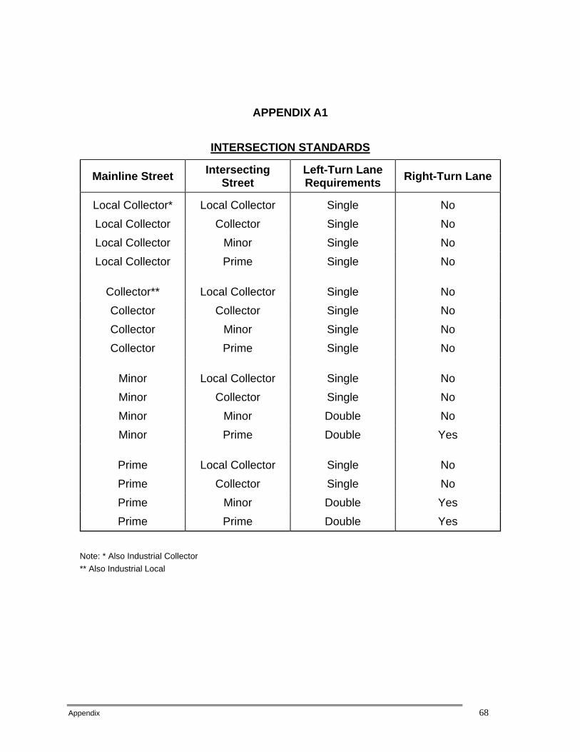
Appendix 68
APPENDIX A1
INTERSECTION STANDARDS
Mainline Street Intersecting Street
Left-Turn Lane Requirements Right-Turn Lane
Local Collector* Local Collector Single No Local Collector Collector Single No Local Collector Minor Single No Local Collector Prime Single No
Collector** Local Collector Single No Collector Collector Single No Collector Minor Single No Collector Prime Single No
Minor Local Collector Single No Minor Collector Single No Minor Minor Double No Minor Prime Double Yes
Prime Local Collector Single No Prime Collector Single No Prime Minor Double Yes Prime Prime Double Yes
Note: * Also Industrial Collector ** Also Industrial Local
Appendix 69
APPENDIX A2
TYPICAL INTERSECTION ILLUSTRATION
[FIGURES TO BE SUBMITTED SEPARATELY BY LL&G ENGINEERS, INC.]
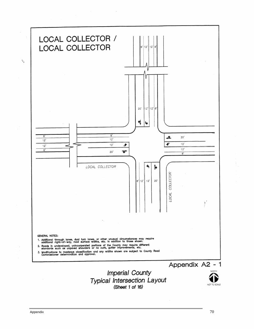
Appendix 70
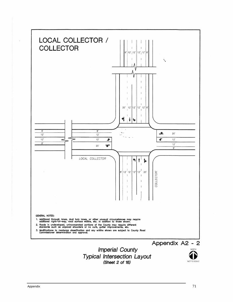
Appendix 71
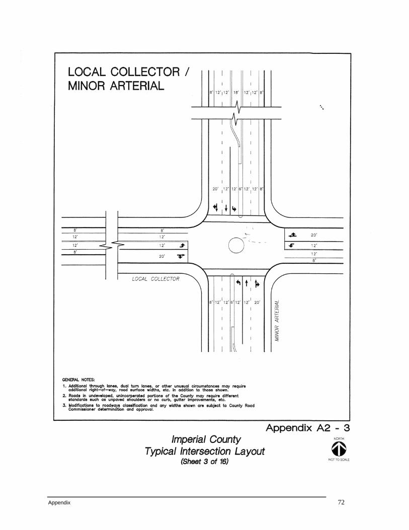
Appendix 72

Appendix 73
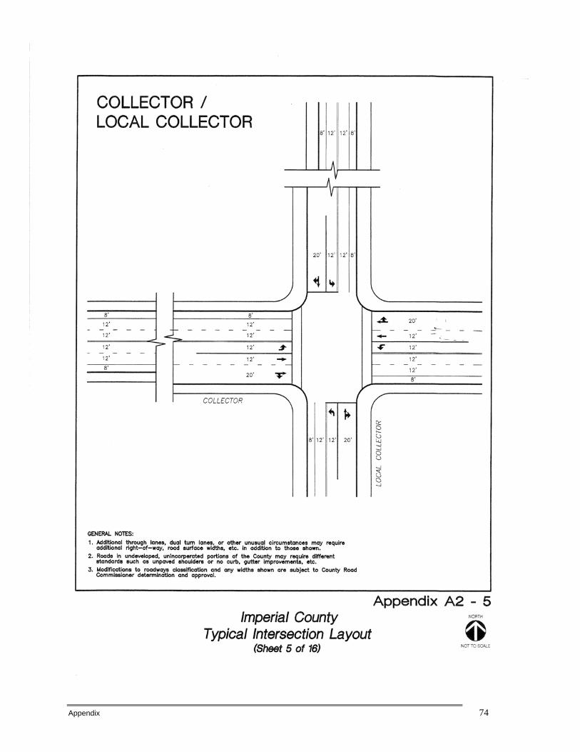
Appendix 74
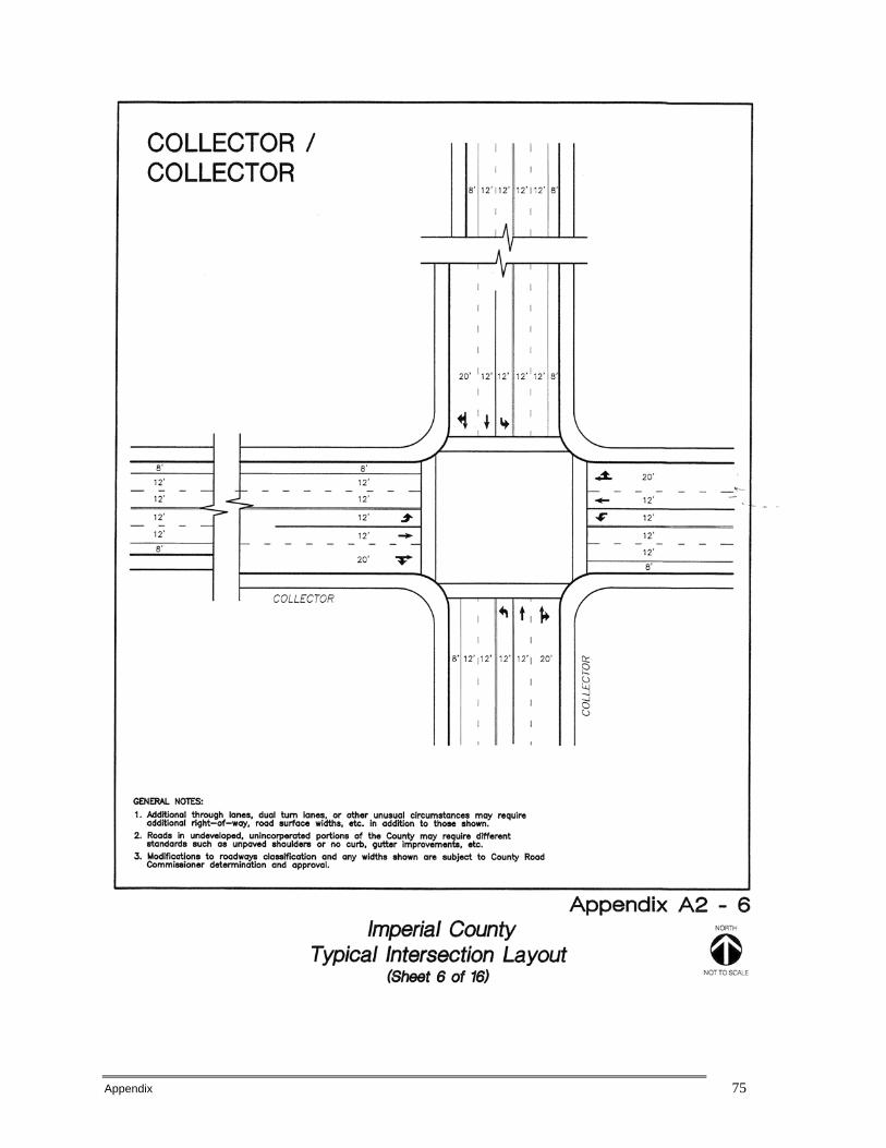
Appendix 75
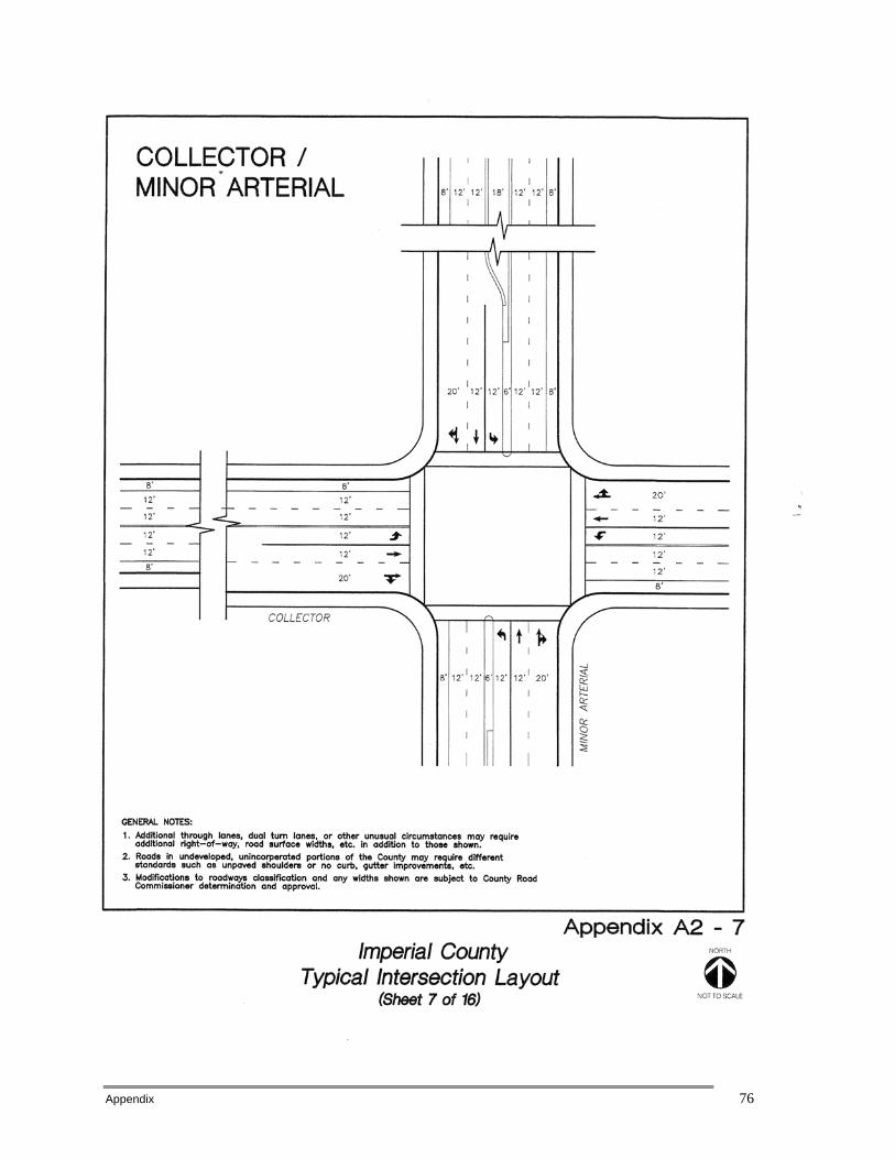
Appendix 76

Appendix 77
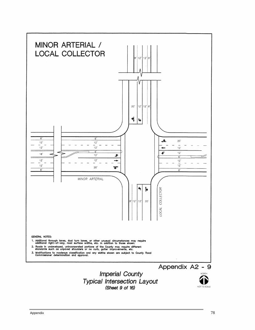
Appendix 78

Appendix 79
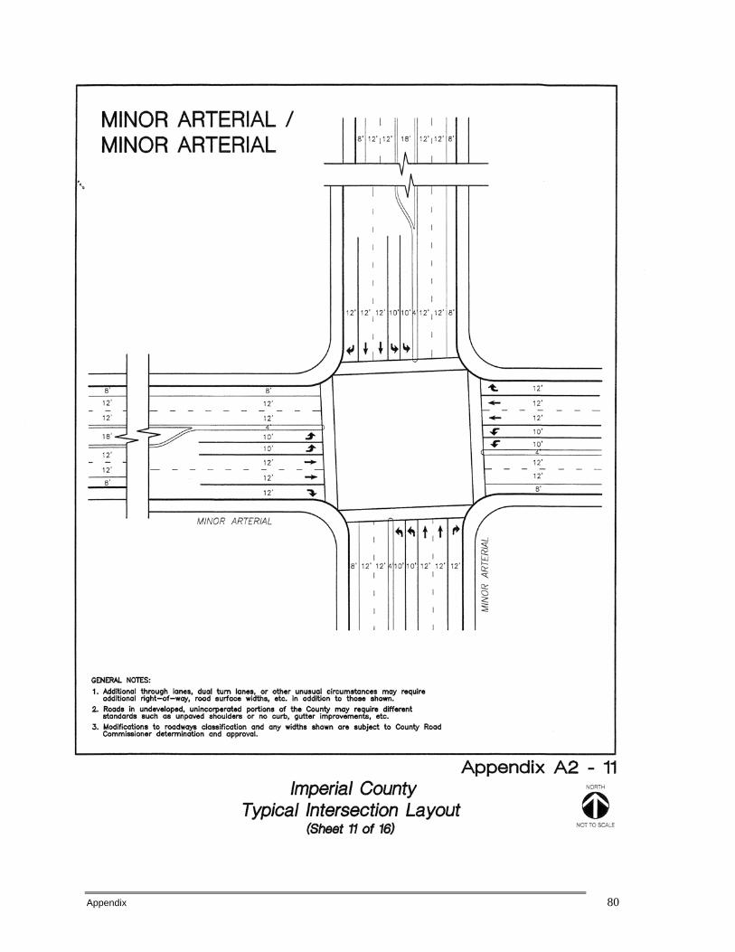
Appendix 80
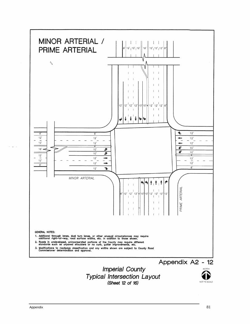
Appendix 81
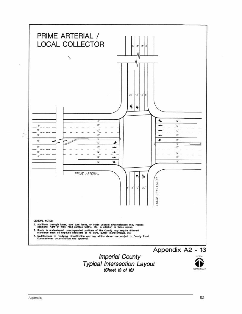
Appendix 82
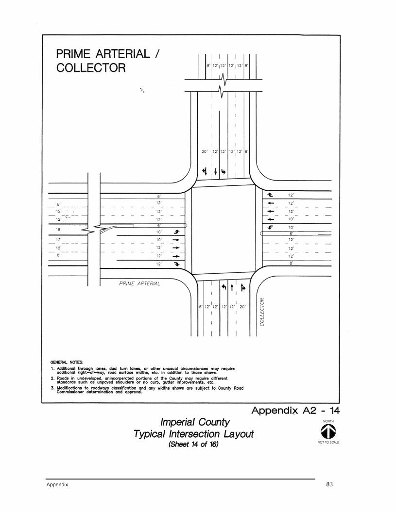
Appendix 83

Appendix 84

Appendix 85
Appendix 86
APPENDIX B
California Scenic Highway Program Frequently Asked
Questions
Appendix 87
• What is the California Scenic Highway Program and when did it start?
Many state highways are located in areas of outstanding natural beauty. California's Scenic Highway Program was created by the Legislature in 1963. Its purpose is to preserve and protect scenic highway corridors from change which would diminish the aesthetic value of lands adjacent to highways. The state laws governing the Scenic Highway Program are found in the Streets and Highways Code, Section 260 et seq.
What elements make a highway "scenic"? A highway may be designated scenic depending upon how much of the natural landscape can be seen by travelers, the scenic quality of the landscape, and the extent to which development intrudes upon the traveler's enjoyment of the view.
What does the "State Scenic Highway System" include? The State Scenic Highway System includes a list of highways that are either eligible for designation as scenic highways or have been so designated. These highways are identified in Section 263 of the Streets and Highways Code. A list of California's scenic highways and map showing their locations may be obtained from Caltrans' Scenic Highway Coordinators.
What is the difference between an "eligible" and an "officially designated" scenic highway? The status of a state scenic highway changes from eligible to officially designated when the local jurisdiction adopts a scenic corridor protection program, applies to the California Department of Transportation for scenic highway approval, and receives notification from Caltrans that the highway has been designated as a Scenic Highway.
What is a scenic corridor protection program? When a city or county nominates an eligible scenic highway for official designation, it must identify and define the scenic corridor of the highway. The agency must also adopt ordinances to preserve the scenic quality of the corridor or document such regulations that already exist in various portions of local codes. These ordinances make up the scenic corridor protection program.
What is included in a scenic corridor protection program? There are minimum requirements for scenic corridor protection: 1. Regulation of land use and density of development; 2. Detailed land and site planning;
3. Control of outdoor advertising (including a ban on billboards);
4. Careful attention to and control of earthmoving and landscaping; and
5. Careful attention to design and appearance of structures and equipment. Citizen participation in developing these requirements is very important if the program is to have popular support.
Appendix 88
How are the boundaries of a scenic corridor determined? A scenic corridor is the land generally adjacent to and visible from the highway. A scenic corridor is identified using a motorist's line of vision. A reasonable boundary is selected when the view extends to the distant horizon. Jurisdictional boundaries of the applicants are also considered.
What steps are necessary to receive official designation? If a route is included on the list of scenic highways eligible for official designation, contact the Caltrans District Scenic Highway Coordinator for a copy of the Guidelines for the Official Designation of Scenic Highways. The city or county with jurisdiction over lands adjacent to the highway must take the following steps: 1. Inspect and evaluate the route to determine if it meets the current scenic highway criteria and
to what extent, if any, development has intruded on the scenic views. 2. Submit a Resolution of Intent Package to the Departmental Transportation Advisory
Committee (DTAC) through the appropriate Caltrans district office. The package should include a Resolution of Intent by the local governing body, maps showing the scenic corridor and existing zoning, a map overlay of development in the corridor, a narrative description of the scenic elements, and a videotape representative of the highway segment. Caltrans District and Headquarters Scenic Highway Coordinators and DTAC evaluate each proposal. If it is determined that the corridor meets the scenic criteria, the applicant proceeds to Step 3. If the route fails this review, it is not advisable to continue seeking official designation.
3. Prepare and adopt a scenic corridor protection program. Caltrans staff and DTAC review the
protection program. If it is determined that the program meets the legislative standards, a recommendation to designate the highway as scenic will be forwarded to the Caltrans Director.
Can highways still be added to the Scenic Highway System?
A city or county may propose adding routes with outstanding scenic elements to the list of eligible state highways. However, state legislation is required. Local governments should consult Caltrans' District Scenic Highway Coordinator before initiating action, to ensure that the route qualifies.
Can county roads become part of the Scenic Highway System?
Yes. Although there is no official list of county highways eligible for scenic designation, county highways that are believed to have outstanding scenic qualities are considered eligible. To receive official designation, the county must follow the same process required for official designation of state scenic highways.
How are officially designated scenic highways identified? Caltrans places the colorful "poppy" sign, logo of the scenic highway program, along the route. Also, the poppy logo identifies scenic highways on travel maps, and maps produced by the State Division of Tourism.
Is there special funding for the Scenic Highway Program? There is no special funding for preparation of scenic highway nominations. Some types of projects on scenic highways may qualify for funding under the Transportation Enhancement Activities (TEA) Program.
Appendix 89
Can scenic highways be widened or otherwise changed? Official scenic highway status places no restrictions for making improvements on scenic highways. However, Caltrans works with appropriate agencies to coordinate transportation proposals and maintenance activities and to ensure the protection of scenic corridors to the maximum extent feasible.
Does official designation preclude development? No, but the corridor protection program seeks to encourage quality development that does not degrade the scenic value of the corridor.
Can official designation be revoked? The most critical element of the scenic highway program is implementation and maintenance of the scenic corridor protection program. Caltrans monitors officially designated scenic highways at least every five years. Designation can be revoked if the local government ceases to enforce its protection program. A city or county may request revocation if it no longer wishes to be part of the program.
What advantages does official designation offer? A scenic highway can create a positive image for a community, preserve and protect environmental assets and encourage tourism.
How can I find out more about the Scenic Highway Program? The Scenic Highway Coordinator at your local Caltrans district office can provide additional information.
Other Information on Scenic Highways
Guidelines for the Official Designation of Scenic Highways -- A process for the designation of official scenic highways whereby cities and/or counties develop and implement scenic protection measures.
What Scenic Highway Designation Can Do -- The benefits of Scenic Highway Designation.
California Scenic Routes -- A list of the officially designated California scenic highways.
California Scenic Highway System -- A list of eligible and officially designated routes.
California Scenic Highway Mapping System -- A description and photo tour of California's scenic routes.
Other Scenic Resources
National Scenic Byways Program -- National Scenic Byways Online provides travelers with current, detailed information about scenic byways throughout the United States. NSBO also gives byway organizations easy access to government and private resources related to scenic byways.
Office of State Landscape Architecture Homepage

Appendix 90
APPENDIX C
Guidelines for the Official Designation of Scenic Highways
(Obtained from Caltrans website)

Appendix 91
SECTION I
INTRODUCTION AND BACKGROUND
Program History In 1963, the State Legislature established the California Scenic Highway Program through Senate Bill 1467 (Farr). The bill declared: "The development of scenic highways will not only add to the pleasure of the residents of this State, but will also play an important role in encouraging the growth of the recreation and tourist industries upon which the economy of many areas of this State depend." Senate Bill 1467 added Sections 260 et seq. to the Streets and Highways Code. In these statutes the State proclaims its intent to: "establish the State's responsibility for the protection and enhancement of California's natural scenic beauty." The legislation further declares the State's intent to assign responsibility for the development of scenic highways to local jurisdictions. These and related codes are located in Appendix A. Provisions for a California Scenic Highway Program were added to the Streets and Highways Code in 1963. Since that time, key features in the Code have remained substantially unchanged.
Highway 1, Monterey County
Program Features The following features characterize the program:

Appendix 92
• A State Scenic Highway System that includes a list of highways eligible to become, or designated as, official scenic highways. Legislative action establishes and amends this list.
• A process for the designation of official scenic highways whereby cities and/or counties (hereafter referred to as local jurisdictions) develop and implement a scenic corridor protection program containing five pertinent, generally accepted land use planning standards.
• A legislatively appointed body, the Departmental Transportation Advisory Committee (DTAC), whose responsibilities include:
o Recommending program criteria; o Reviewing applications and recommending eligible highways for official scenic
highway designation; and o Advising the Director of the California Department of Transportation (Caltrans) to
revoke the official designation of any existing scenic highway which is no longer in compliance with the program.
• A poppy sign as the logo of the California Scenic Highway Program. Caltrans places this on officially designated scenic routes.
• A process for designating county roads as official county scenic highways.
Highway 395, Mono County
Appendix 93
SECTION II
SCENIC HIGHWAY CRITERIA
The goal of the California Scenic Highway Program is to preserve and enhance the natural beauty of California. Therefore, the merits of a nominated highway are evaluated on how much of the natural landscape a passing motorist sees and the extent to which visual intrusions (e.g., buildings, unsightly land uses, noise barriers) impact the "scenic corridor." Visual intrusions are considered in the following manner: • The more pristine and unaffected by intrusions, the more likely the nominated highway
will qualify as scenic. • Where intrusions have occurred, the less the impact on an area's natural beauty, the
more likely the nominated highway will qualify as scenic. • The extent to which intrusions, rather than the natural landscape, dominate views from
the highway determines the significance of their impact on the scenic corridor. State highways nominated for scenic designation must be included on the list of highways eligible for scenic designation in the State Scenic Highway System. These highways are identified in Section 263 of the Streets and Highways Code, located in Appendix A. A process for adding "eligible" highways to the system is described in Section III. Scenic highway nominations will be evaluated using the following qualifications: • The proposed scenic highway is principally within an unspoiled native habitat and
showcases the unique aspects of the landscape. However, the scenic corridor can also showcase agriculture or manmade water features.
• Existing visual intrusions do not significantly impact the scenic corridor. • Strong local support for the proposed scenic highway designation is demonstrated. • The length of the proposed scenic highway is not short or segmented. After it is determined the proposed scenic highway satisfies these qualifications, the local jurisdiction, with support of its citizens, must adopt a program to protect the scenic corridor. The zoning and land use along the highway must meet the State's minimum requirements for scenic highway corridor protection as stated in Section IV. Scenic Corridor: defined as the area of land generally adjacent to and visible from the highway. It is usually limited by topography and/or jurisdictional boundaries.
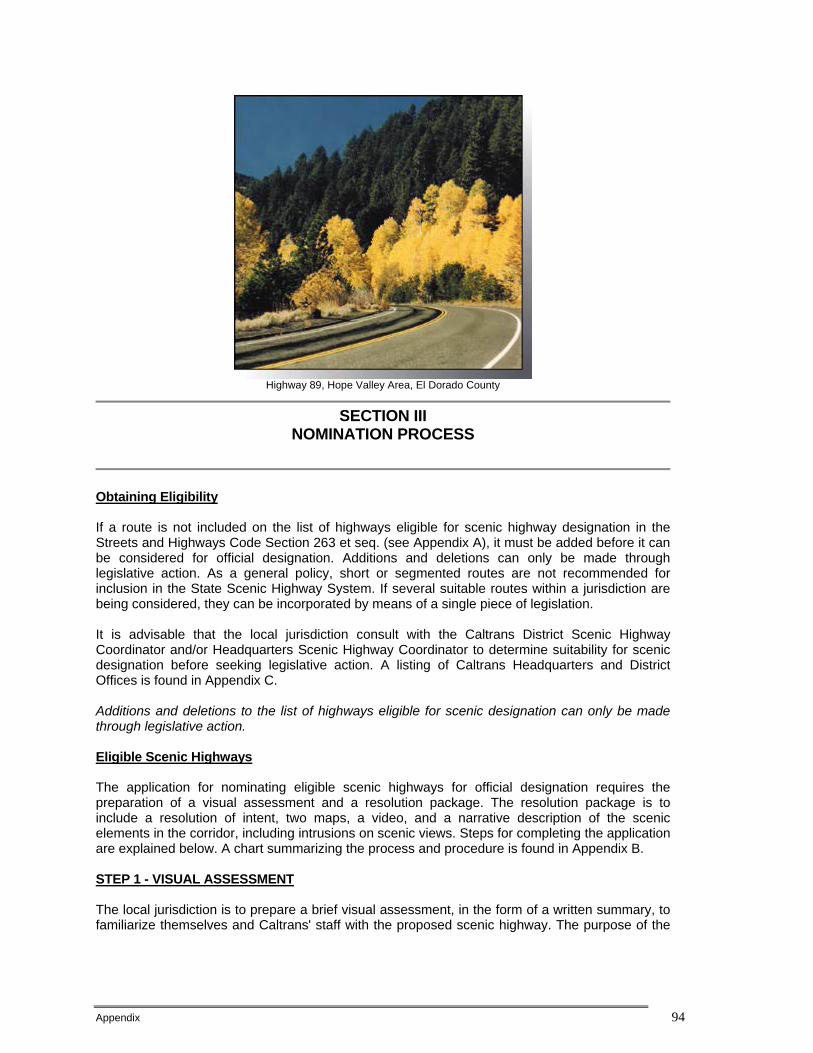
Appendix 94
Highway 89, Hope Valley Area, El Dorado County
SECTION III
NOMINATION PROCESS
Obtaining Eligibility If a route is not included on the list of highways eligible for scenic highway designation in the Streets and Highways Code Section 263 et seq. (see Appendix A), it must be added before it can be considered for official designation. Additions and deletions can only be made through legislative action. As a general policy, short or segmented routes are not recommended for inclusion in the State Scenic Highway System. If several suitable routes within a jurisdiction are being considered, they can be incorporated by means of a single piece of legislation. It is advisable that the local jurisdiction consult with the Caltrans District Scenic Highway Coordinator and/or Headquarters Scenic Highway Coordinator to determine suitability for scenic designation before seeking legislative action. A listing of Caltrans Headquarters and District Offices is found in Appendix C. Additions and deletions to the list of highways eligible for scenic designation can only be made through legislative action. Eligible Scenic Highways The application for nominating eligible scenic highways for official designation requires the preparation of a visual assessment and a resolution package. The resolution package is to include a resolution of intent, two maps, a video, and a narrative description of the scenic elements in the corridor, including intrusions on scenic views. Steps for completing the application are explained below. A chart summarizing the process and procedure is found in Appendix B. STEP 1 - VISUAL ASSESSMENT The local jurisdiction is to prepare a brief visual assessment, in the form of a written summary, to familiarize themselves and Caltrans' staff with the proposed scenic highway. The purpose of the

Appendix 95
visual assessment is to inventory the natural landscape (e.g., landforms, vegetation, water features) and the type and amount of visual intrusions along the proposed scenic highway. Since California contains several diverse landscape regions, the merits of a particular landscape are considered within the context of its own region. However, the highway should go through an area of outstanding scenic quality, containing striking views, flora, geology, and other unique natural attributes. The following three visual concepts are to be addressed in the visual assessment: • Vividness - the extent to which the landscape is memorable. This is associated with the
distinctiveness, diversity and contrast of visual elements. A vivid landscape makes an immediate and lasting impression on the viewer.
• Intactness - the integrity of visual order in the landscape and the extent to which the natural landscape is free from visual intrusions.
Not more than one third of the proposed scenic highway should be impacted by major intrusions.* Examples of visual intrusions are found in Appendix D.
• Unity - the extent to which intrusions are sensitive to and in visual harmony with the natural landscape.
Major intrusions are those that dominate the landscape, degrading or obstructing scenic views STEP 2 - CONSULTATION WITH CALTRANS The local jurisdiction is to discuss and field review the visual assessment with the Caltrans District Scenic Highway Coordinator before proceeding to Step 3. A map showing Caltrans district locations and telephone numbers is found in Appendix C. STEP 3 - SCENIC HIGHWAY RESOLUTION PACKAGE The local jurisdiction for the lands adjacent to the proposed scenic highway must prepare a scenic highway resolution package, consisting of the following:
MINOR intrusions are those that are either complementary to the landscape or are recognized cultural or historical significance. Color these yellow.
MODERATE intrusions are those that are integrated into the landscape and do not degrade or
A. Resolution of Intent - An official Resolution of Intent is to be enacted by the local governing body. This should cite the reason for seeking official scenic designation. It is highly advisable to place the discussion of this resolution on the agenda at a regularly scheduled public meeting to allow public input at the beginning of the project. B.Topographic map and map overlay - A two-part mapping procedure is required to illustrate the visual quality of the proposed scenic highway. A topographic map (USGS or comparable) should show the suggested scenic corridor boundaries and proposed scenic highway limits. The map should show natural features in the landscape (land forms, water, vegetative cover) that make it scenic and include any visual intrusions within the scenic corridor. Also, Caltrans post-mile designations should be shown. The map overlay should be colored where minor, moderate, and major intrusions are shown on the underlying topographic map (see definitions and colors at left). A chart listing examples of intrusions is

Appendix 96
obstruct scenic views. Color these orange.
MAJOR intrusions are those that dominate the landscape, degrading or obstructing scenic views. Color these red.
provided in Appendix D. C. Zoning map - A zoning map delineating the scenic corridor and showing allowable land use. D. Narrative - A narrative description of the elements that make the route scenic. This would include natural features, structures of historical significance and other scenic resources visible from the highway. In addition, the narrative must describe present zoning and future plans for lands in the scenic corridor. It should also describe the type (e.g., buildings, unsightly land uses, noise barriers) and extent of intrusions on scenic views. E. Video - A modest (15 minutes maximum) video cassette tape showing both sides of the corridor, or a representative sample (as attested to by the department) of the characteristics along the corridor, as viewed by the motorist. The video will be used to familiarize DTAC with the proposed scenic highway and for future reference.
STEP 4 - CALTRANS REVIEW OF RESOLUTION PACKAGE Following receipt of the Scenic Highway Resolution Package, the Caltrans District and Headquarters Scenic Highway Coordinators will review the resolution package for completeness and accuracy and evaluate the proposed scenic highway for official designation potential. The evaluation will be based on the qualifications stated in Section II. STEP 5 - DTAC REVIEW OF RESOLUTION PACKAGE The Scenic Highway Resolution Package, as well as recommendations by the District and Headquarters Scenic Highway Coordinators, will be sent to DTAC prior to the meeting at which the project will be discussed. Local jurisdiction applicants will be notified of the meeting and may attend at their discretion. After receiving approval by DTAC, the local jurisdiction can proceed to Section IV. If DTAC determines that the route proposed for designation does not meet the legislative intent of the California Scenic Highway Program, which is to showcase the State's natural scenic beauty, the local jurisdiction should stop here. If DTAC does not approve the proposed route, the local jurisdiction should stop proceedings.
SECTION IV
DESIGNATION PROCESS
STEP 1 - PREPARATION AND ADOPTION OF SCENIC CORRIDOR PROTECTION PROGRAM This step requires the local jurisdiction to develop and adopt protection measures in the form of ordinances to apply to the area of land within the scenic corridor. Such regulations may already exist in various portions of local codes. They should, however, be assembled under an easy to
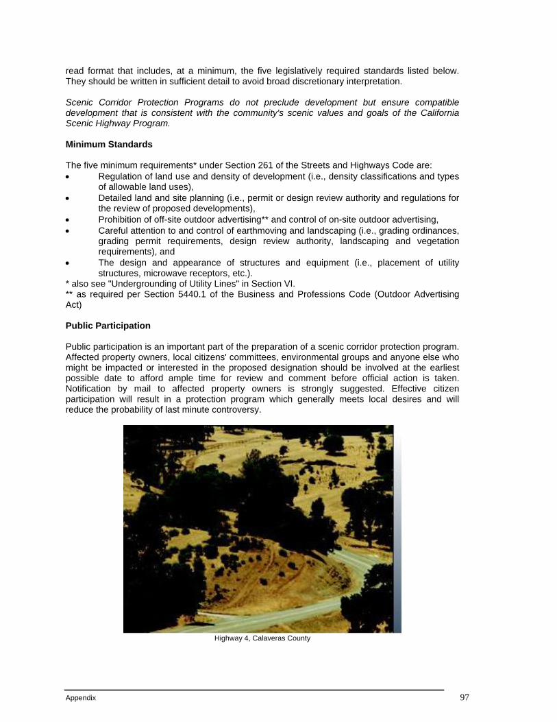
Appendix 97
read format that includes, at a minimum, the five legislatively required standards listed below. They should be written in sufficient detail to avoid broad discretionary interpretation. Scenic Corridor Protection Programs do not preclude development but ensure compatible development that is consistent with the community's scenic values and goals of the California Scenic Highway Program. Minimum Standards The five minimum requirements* under Section 261 of the Streets and Highways Code are: • Regulation of land use and density of development (i.e., density classifications and types
of allowable land uses), • Detailed land and site planning (i.e., permit or design review authority and regulations for
the review of proposed developments), • Prohibition of off-site outdoor advertising** and control of on-site outdoor advertising, • Careful attention to and control of earthmoving and landscaping (i.e., grading ordinances,
grading permit requirements, design review authority, landscaping and vegetation requirements), and
• The design and appearance of structures and equipment (i.e., placement of utility structures, microwave receptors, etc.).
* also see "Undergrounding of Utility Lines" in Section VI. ** as required per Section 5440.1 of the Business and Professions Code (Outdoor Advertising Act) Public Participation Public participation is an important part of the preparation of a scenic corridor protection program. Affected property owners, local citizens' committees, environmental groups and anyone else who might be impacted or interested in the proposed designation should be involved at the earliest possible date to afford ample time for review and comment before official action is taken. Notification by mail to affected property owners is strongly suggested. Effective citizen participation will result in a protection program which generally meets local desires and will reduce the probability of last minute controversy.
Highway 4, Calaveras County
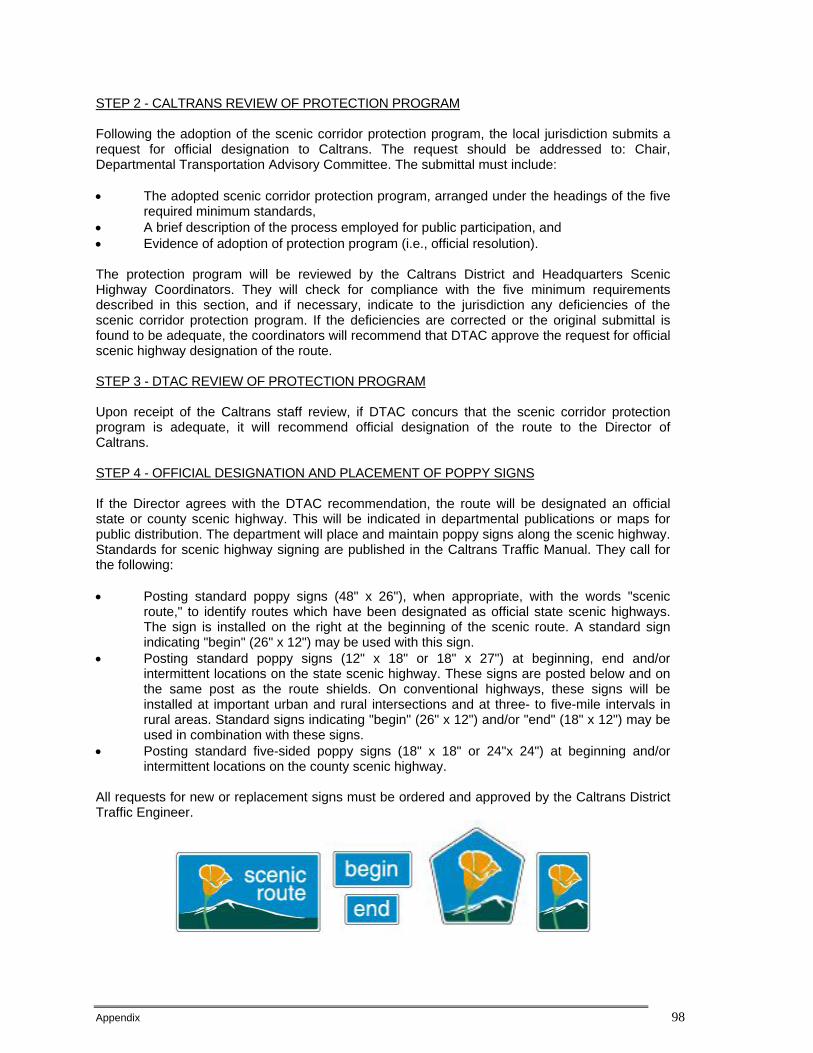
Appendix 98
STEP 2 - CALTRANS REVIEW OF PROTECTION PROGRAM Following the adoption of the scenic corridor protection program, the local jurisdiction submits a request for official designation to Caltrans. The request should be addressed to: Chair, Departmental Transportation Advisory Committee. The submittal must include: • The adopted scenic corridor protection program, arranged under the headings of the five
required minimum standards, • A brief description of the process employed for public participation, and • Evidence of adoption of protection program (i.e., official resolution). The protection program will be reviewed by the Caltrans District and Headquarters Scenic Highway Coordinators. They will check for compliance with the five minimum requirements described in this section, and if necessary, indicate to the jurisdiction any deficiencies of the scenic corridor protection program. If the deficiencies are corrected or the original submittal is found to be adequate, the coordinators will recommend that DTAC approve the request for official scenic highway designation of the route. STEP 3 - DTAC REVIEW OF PROTECTION PROGRAM Upon receipt of the Caltrans staff review, if DTAC concurs that the scenic corridor protection program is adequate, it will recommend official designation of the route to the Director of Caltrans. STEP 4 - OFFICIAL DESIGNATION AND PLACEMENT OF POPPY SIGNS If the Director agrees with the DTAC recommendation, the route will be designated an official state or county scenic highway. This will be indicated in departmental publications or maps for public distribution. The department will place and maintain poppy signs along the scenic highway. Standards for scenic highway signing are published in the Caltrans Traffic Manual. They call for the following: • Posting standard poppy signs (48" x 26"), when appropriate, with the words "scenic
route," to identify routes which have been designated as official state scenic highways. The sign is installed on the right at the beginning of the scenic route. A standard sign indicating "begin" (26" x 12") may be used with this sign.
• Posting standard poppy signs (12" x 18" or 18" x 27") at beginning, end and/or intermittent locations on the state scenic highway. These signs are posted below and on the same post as the route shields. On conventional highways, these signs will be installed at important urban and rural intersections and at three- to five-mile intervals in rural areas. Standard signs indicating "begin" (26" x 12") and/or "end" (18" x 12") may be used in combination with these signs.
• Posting standard five-sided poppy signs (18" x 18" or 24"x 24") at beginning and/or intermittent locations on the county scenic highway.
All requests for new or replacement signs must be ordered and approved by the Caltrans District Traffic Engineer.
Appendix 99
SECTION V
MONITORING PROCESS
The degree to which a scenic corridor protection program is successful depends on enforcement of the protection measures. This requires that the Caltrans district staff remain familiar with the requirements of the protection program and experienced in inspection procedures. To maintain the consistency and integrity of the California Scenic Highway Program, Caltrans, in conjunction with DTAC, will conduct a monitoring program. The appropriate local jurisdiction will be asked to attest to continued enforcement of the approved corridor protection measures once every five years. The District Scenic Highway Coordinator will inspect the scenic highway to confirm compliance. Caltrans, with the advice of DTAC, is authorized by statute to revoke official scenic highway designations if the scenic corridor protection program has ceased to be enforced or if it is determined that the scenic appearance of the corridor has not been protected. Caltrans will extend designation for another five years if the local jurisdiction has reasonably enforced its adopted corridor protection measures. If the local jurisdiction is not in compliance, Caltrans will send notification of the infraction(s). When it is feasible for the local jurisdiction to remedy the infraction(s), a time period of one year (from the date of the notification) will be granted to make corrections. When the infraction(s) cannot be remedied, the scenic highway designation will be revoked. A local jurisdiction may request that Caltrans remove a route from Official Scenic Highway status at any time.
SECTION VI
MISCELLANEOUS
Route Realignments and Relocation When a route is realigned from its original location, scenic designation or eligibility status is not necessarily carried over. The new alignment may be eligible if the original route was either a designated or eligible scenic highway and it essentially covers similar terrain and other natural features. Scenic designation may be transferred if the new alignment remains within the protected scenic corridor. These determinations will be made by the Caltrans District and Headquarters Scenic Highway Coordinators with the advice of DTAC. County Scenic Highways County roads and highways that are scenic may be designated as official county scenic highways. The designation process is initiated in the same manner as for a state scenic highway. When the department, with the advice of DTAC, determines that the county highway meets the minimum standards for official state scenic highways prescribed in this guide, the department may authorize the route to be signed as an official county scenic highway. Undergrounding of Utility Lines Section 320 of the California Public Utilities Code requires that all new or relocated electric and communication distribution facilities within 1,000 feet of an official designated scenic highway and visible from that highway, be buried undergrounded where feasible. Appendix A provides the full

Appendix 100
text of Section 320. Copies of the Public Utilities Commission's Order and Court Decisions Relating to Section 320, which can be obtained from the Caltrans District Scenic Highway Coordinator, provide more detail on utility undergrounding. Effects of Official Designation on Future Highway Construction and Maintenance Activities Highway construction proposed on designated state scenic highways is evaluated in terms of the visual impact to scenic views as part of the environmental process. If major impacts occur, then appropriate mitigation measures shall be proposed. Generally, designating portions of a route as a scenic highway would not substantially alter the type of project proposed nor the environmental clearance process. There are no special restrictions for construction or maintenance activities on scenic highways. However, Caltrans works with appropriate agencies to coordinate transportation proposals and maintenance activities and to ensure the protection of scenic corridors to the maximum extent feasible.
Route 88, Alpine County

Appendix 101
APPENDIX A
STATUTES RELATING TO THE CALIFORNIA STATE SCENIC HIGHWAY PROGRAM
STREETS AND HIGHWAY CODE Division 1, Chapter 2, Article 2.5
260. LEGISLATIVE INTENT It is the intent of the Legislature in designating certain portions of the state highway system as state scenic highways to establish the State's responsibility for the protection and enhancement of California's natural scenic beauty by identifying those portions of the state highway system which, together with the adjacent scenic corridors, require special scenic conservation treatment. It is further declared to be the intent of the Legislature in designating such scenic highways to assign responsibility for the development of such scenic highways and for the establishment and application of specific planning and design standards and procedures appropriate thereto and to indicate, in broad statement terms, the location and extent of routes and areas requiring continuing and careful coordination of planning, design, construction, and regulation of land use and development, by state and local agencies as appropriate, to protect the social and economic values provided by the State's scenic resources. 261. PLANNING AND DESIGN STANDARDS; COMPLETE HIGHWAY The department shall, with the advice of the Departmental Transportation Advisory Committee, establish and apply pertinent planning and design standards for development of official scenic highways. In establishing and applying such standards for, and undertaking the development of official scenic highways, the department shall take into consideration the concept of the "complete highway" which is a highway which incorporates not only safety, utility, and economy, but also beauty. The department shall also take into consideration in establishing such standards that, in a "complete highway," pleasing appearance is a consideration in the planning and design process. In the development of official scenic highways, the department shall give special attention both to the impact of the highway on the landscape and to the highway's visual appearance. The standards for official scenic highways shall also require that local governmental agencies have taken such action as may be necessary to protect the scenic appearance of the scenic corridor, the band of land generally adjacent to the highway right-of-way, including, but not limited to (1) regulation of land use and intensity (density) of development; (2) detailed land and site planning; (3) control of outdoor advertising; (4) careful attention to and control of earthmoving and landscaping; and (5) the design and appearance of structures and equipment. 262. DESIGNATION AS SCENIC HIGHWAYS Whenever the department determines that the corridor protection program for any state highway in the state scenic highway system established by this article has been implemented by local governmental agencies and a plan and program has been developed by the department for bringing the highway up to the standards for official scenic highways established by the department, including the concept of the "complete highway," as described in Section 261, the department shall designate the highway as an official state scenic highway and shall so indicate the highway in any publications of the department or in any maps which are issued by the department to the public.

Appendix 102
The department shall cause appropriate signs to be placed and maintained along the portions of the state scenic highway system which the department has designated as official state scenic highways that indicate that the highways are official state scenic highways. If at any time the department, with the advice of the Departmental Transportation Advisory Committee, determines that the corridor protection program of local governmental agencies, with respect to any highway which has been designated as an official state scenic highway no longer adequately carries out responsibility of the local governmental agencies for the protection of the scenic corridor, it may revoke the designation of the highway as an official state scenic highway and remove the signs which so indicate the highway. 262.1 LOCATION AND CONSTRUCTION OF NEW DISTRICT FACILITY OF LOCAL AGENCY WITHIN SCENIC CORRIDOR; APPROVAL A local agency as defined in subdivision (c) of Section 65402 of the Government Code, shall coordinate its planning with, and obtain the approval from, the appropriate local planning agency on the location and construction of any new district facility that would be within the scenic corridor of any state scenic highway. 263. SCENIC HIGHWAY SYSTEM; ESTABLISHMENT; COMPOSITION The state scenic highway system is hereby established and shall be composed of the highways specified in this article. The highways listed in Sections 263.1 to 263.8, inclusive are either eligible for designation as state scenic highways or have been so designated. 263.1 THE STATE SCENIC HIGHWAY SYSTEM SHALL INCLUDE: Routes 28, 35, 38, 52, 53, 62, 74, 75, 76, 89, 96, 97, 127, 150, 151, 154, 156, 158, 161, 173, 197, 199, 203, 209, 221, 236, 239, 243, 247, 254, and 330 in their entirety. 263.2 ADDITIONAL INCLUSIONS; PORTIONS OF ROUTES 1 TO 4 The state scenic highway system shall also include: • Route 1 from: (a) Route 5 south of San Juan Capistrano to Route 19 near Long Beach,
(b) Route 187 near Santa Monica to Route 101 near El Rio, (c) Route 101 at Las Cruces to Route 246 near Lompoc, (d) Route 227 south of Oceano to Route 101 near Pismo Beach, (e) Route 101 near San Luis Obispo to Route 35 near Daly City, (f) Route 35 in San Francisco to Route 101 near the approach to the Golden Gate Bridge in San Francisco, (g) Route 101 near Marin City to Route 101 near Leggett.
• Route 2 from Route 210 in La Canada Flintridge to Route 138 via Wrightwood. • Route 3 from: (a) Route 36 near Peanut to Route 299 near Douglas City, (b) Route 299
near Weaverville to Montague. • Route 4 from: (a) Route 160 near Antioch to Route 84 near Brentwood, (b) Route 49 near
Angels Camp to Route 89. 263.3 ADDITIONAL INCLUSIONS; PORTIONS OF ROUTES 5, 8 TO 10, 12, 14 TO 18, 20, 24, 25, 27, 29, 30, 33 AND 36 The state scenic highway system shall also include: • Route 5 from: (a) The international boundary near Tijuana to Route 75 near the south
end of San Diego Bay, (b) San Diego opposite Coronado to Route 74 near San Juan Capistrano, (c) Route 210 near Tunnel Station to Route 126 near Castaic, (d) Route 152 west of Los Banos to Route 580 near Vernalis, (e) Route 44 near Redding to the Shasta

Appendix 103
Reservoir, (f) Route 89 near Mt. Shasta to Route 97 near Weed, (g) Route 3 near Yreka to the Oregon state line near Hilts.
• Route 8 from Sunset Cliffs Boulevard in San Diego to Route 98 near Coyote Wells. • Route 9 from: (a) Route 1 near Santa Cruz to Route 2 near Boulder Creek, (b) Route 236
near Boulder Creek to Route 236 near Waterman Gap, (c) Route 236 near Waterman Gap to Route 35, (d) Saratoga to Route 17 near Los Gatos, (e) Blaney Plaza in Saratoga to Route 35.
• Route 10 from Route 38 near Redlands to Route 62 near Whitewater. • Route 12 from Route 101 near Santa Rosa to Route 121 near Sonoma. • Route 14 from Route 58 near Mojave to Route 395 near Little Lake. • Route 15 from: (a) Route 76 near the San Luis Rey River to Route 91 near Corona, (b)
Route 58 near Barstow to Route 127 near Baker. • Route 16 from Route 20 to Capay. • Route 17 from Route 1 near Santa Cruz to Route 9 near Los Gatos. • Route 18 from Route 138 near Mt. Anderson to Route 247 near Lucerne Valley. • Route 20 from: (a) Route 1 near Fort Bragg to Route 101 near Willits, (b) Route 101 near
Calpella to Route 16, (c) Route 49 near Grass Valley to Route 80 near Emigrant Gap. • Route 24 from the Alameda-Contra Costa county line to Route 680 in Walnut Creek. • Route 25 from Route 198 to Route 156 near Hollister. • Route 27 from Route 1 to Mulholland Drive. • Route 29 from: (a) Route 37 near Vallejo to Route 221 near Napa, (b) The vicinity of
Trancas Street in northwest Napa to Route 20 near Upper Lake. • Route 30 from Route 330 near Highland to Route 10 near Redlands. • Route 33 from: (a) Route 101 near Ventura to Route 150, (b) Route 150 to Route 166 in
Cuyama Valley, (c) Route 198 near Coalinga to Route 198 near Oilfields. • Route 36 from: (a) Route 101 near Alton to Route 3 near Peanut, (b) Route 89 near
Morgan Summit to Route 89 near Deer Creek Pass. 263.4 ADDITIONAL INCLUSIONS; PORTIONS OF ROUTES 37, 39 TO 41, 44, 46, 49, 50, 57, 58, 68, 70 AND 71 The state scenic highway system shall also include: • Route 37 from: (a) Route 251 near Nicasio to Route 101 near Novato, (b) Route 101 near
Ignacio to Route 29 near Vallejo. • Route 39 from Route 210 near Azusa to Route 2. • Route 40 from Barstow to Needles. • Route 41 from: (a) Route 1 near Morro Bay to Route 101 near Atascadero, (b) Route 46
near Cholame to Route 33, (c) Route 49 near Oakhurst to Yosemite National Park. • Route 44 from Route 5 near Redding to Route 89 near Old Station. • Route 46 from: (a) Route 1 near Cambria to Route 101 near Paso Robles, (b) Route 101
near Paso Robles to Route 41 near Cholame. • Route 49 from: (a) Route 41 near Oakhurst to Route 120 near Moccasin, (b) Route 120
to Route 20 near Grass Valley, (c) Route 20 near Nevada City to Route 89 near Sattley. • Route 50 from Route 49 near Placerville to the Nevada state line near Lake Tahoe. • Route 57 from Route 90 to Route 60 near Industry. • Route 58 from Route 14 near Mojave to Route 15 near Barstow. • Route 68 from Monterey to Route 101 near Salinas. • Route 70 from Route 149 near Wicks Corner to Route 83 north of Corona. • Route 71 from Route 91 near Corona to Route 83 north of Corona.
Appendix 104
263.5 ADDITIONAL INCLUSIONS; PORTIONS OF ROUTES 78 TO 80, 84, 88, 91, 92 AND 94 The state scenic highway system shall also include: • Route 78 from Route 79 near Santa Ysabel to Route 86 passing near Julian. • Route 79 from: (a) Route 8 near Descanso to Route 78 near Julian, (b) Route 78 near
Santa Ysabel to Route 371 near Aguanga. • Route 80 from: (a) Route 280 near First Street in San Francisco to Route 61 in Oakland,
(b) Route 20 near Emigrant Gap to the Nevada state line near Verdi, Nevada. • Route 84 from Route 238 to Route 680 near Sunol. • Route 88 from Route 49 in Jackson to the Nevada state line via Pine Grove, Silver Lake,
and Kirkwood. • Route 91 from Route 55 near Santa Ana Canyon to Route 15 near Corona. • Route 92 from Route 1 near Half Moon Bay to Route 280 near Crystal Springs Lake. • Route 94 from Route 125 near Spring Valley to Route 8 west of Jacumba. 263.6 ADDITIONAL INCLUSIONS; PORTIONS OF ROUTES 101, 108, 111, 116, 118, 120, 121, 125 AND 126 The state scenic highway system shall also include: • Route 101 from: (a) Route 27 (Topanga Canyon Road) to Route 46 near Paso Robles,
(b) Route 156 near Prunedale northeasterly to Route 156, (c) A point in Marin County opposite San Francisco to Route 1 near Marin City, (d) Route 37 near Ignacio to Route 37 near Novato, (e) Route 20 near Calpella to Route 20 near Willits, (f) Route 1 near Leggett to Route 199 near Crescent City, (g) Route 197 near Fort Dick to the Oregon state line.
• Route 108 from Route 49 near Sonora to Route 395. • Route 111 from: (a) Bombay Beach in Salton Sea State Park to Route 195 near Mecca,
(b) Route 74 near Palm Desert to Route 10 near Whitewater. • Route 116 from Route 101 near Cotati to Route 1 near Jenner. • Route 118 from Route 23 to DeSoto Avenue near Browns Canyon. • Route 120 from: (a) Route 49 near Chinese Camp to Route 49 near Moccasin, (b) The
east boundary of Yosemite National Park to Route 395 near Mono Lake. • Route 121 from: (a) Route 37 near Sears Point to Route 12 near Sonoma, (b) Route 221
near Napa State Hospital to near the vicinity of Trancas Street in northeast Napa. • Route 125 from Route 94 near Spring Valley to Route 8 near La Mesa. • Route 126 from Route 150 near Santa Paula to Route 5 near Castaic. 263.7 ADDITIONAL INCLUSIONS; PORTIONS OF ROUTES 138 TO 140, 142, 146, 152, 160, 163, 166, 174, 178, 180, 190 AND 266 The state scenic highway system shall also include: • Route 138 from Route 2 near Wrightwood to Route 18 near Mt. Anderson. • Route 139 from Route 299 near Canby to the Oregon state line near Hatfield. • Route 140 from Route 49 at Mariposa to Yosemite National Park near El Portal. • Route 142 from the Orange-San Bernardino county line to Peyton Drive. • Route 146 from Pinnacles National Monument to Route 25 in Bear Valley. • Route 152 from: (a) Route 1 to the Santa Clara county line at Hecker Pass, (b) Route 156
near San Felipe to Route 5. • Route 160 from Route 4 near Antioch to Sacramento. • Route 163 from Ash Street in San Diego to Route 8. • Route 166 from Route 101 near Santa Maria to Route 33 in Cuyama Valley. • Route 168 from: (a) Route 65 near Clovis to Huntington Lake, (b) Camp Sabrina to Route
395, (c) Route 395 at Big Pine to Route 266 at Oasis.

Appendix 105
• Route 174 from the Bear River to the Grass Valley city limits. • Route 178 from the east boundary of Death Valley National Monument to Route 127 near
Shoshone. • Route 180 from: (a) Route 65 near Minkler to General Grant Grove section of Kings
Canyon National Park, (b) General Grant Grove section of Kings Canyon National Park to Kings Canyon National Park boundary near Cedar Grove.
• Route 190 from Route 65 near Porterville to Route 127 near Death Valley Junction. • Route 266 from the Nevada state line easterly of Oasis to Route 168 at Oasis. 263.8 ADDITIONAL INCLUSIONS; PORTIONS OF ROUTES 198, 210, 215, 251, 280, 299, 395, 580 AND 680 The state scenic highway system shall also include: • Route 198 from: (a) Route 101 near San Lucas to Route 33 near Coalinga, (b) Route 33
near Oilfields to Route 5, (c) Route 99 near Goshen to the Sequoia National Park line. • Route 210 from Route 5 near Tunnel Station to Route 134. • Route 215 from Route 74 near Romoland to Route 74 near Perris. • Route 251 from Route 37 near Nicassio to Route 1 near Point Reyes Station. • Route 280 from Route 17 in Santa Clara County to Route 80 near First Street in San
Francisco. • Route 299 from: (a) Route 101 near Arcata to Route 96 near Willow Creek, (b) Route 3
near Weaverville to Route 5 near Redding, (c) Route 89 near Burney to Route 139 near Canby.
• Route 395 from Route 14 near Little Lake to Route 89 near Coleville. • Route 580 from Route 5 southwest of Vernalis to Route 80. • Route 680 from the Santa Clara-Alameda county line to Route 24 in Walnut Creek. •
STREETS AND HIGHWAYS CODE Division 1, Chapter 1, Article 3
154. COUNTY SCENIC HIGHWAYS; ENCOURAGEMENT; DESIGNATION; REVOCATION OF DESIGNATION The department shall encourage the construction and development by counties of portions of the county highways as official county scenic highways and may furnish to the counties any information or other assistance which will aid the counties in the construction or development or such scenic highways. Whenever the department with the advice of the Departmental Transportation Advisory Committee, determines that any county highway meets the minimum standards prescribed by the department for official scenic highways, including the concept of the "complete highway," as described in Section 261, it may authorize the county in which the highway is located to designate the highway as an official county scenic highway and the department shall so indicate the highway in publications of the department and in any maps which are prepared by the department for distribution to the public which show the highway. If the department, with the advice of the Departmental Transportation Advisory Committee, determines that any county highway which has been designated as an official county scenic highway no longer meets the minimum standards prescribed by the department for official scenic highways, it may, after notice to the county and a hearing on the matter, if requested by the county, revoke the authority of the county to designate the highway as an official county scenic highway.

Appendix 106
STREETS AND HIGHWAYS CODE Division 3, Chapter 4
2157. DEPARTMENTAL TRANSPORTATION ADVISORY COMMITTEE There is hereby created the Departmental Transportation Advisory Committee. At the 1973-74 Regular Session of the Legislature, and at the commencement of the 1977-78 Regular Session and each four years thereafter, the Speaker of the Assembly and the Rules Committee of the Senate shall jointly appoint a committee of 16 members, to consist of county and city officials, representatives of transportation planning agencies, representatives of air, highway, motoring, and public transportation organizations, and others interested in transportation planning to act in an advisory capacity to the department in the preparation of various transportation reports required by statute, including but not limited to, functional classification and needs studies. The department shall cooperate and confer with the advisory committee so appointed. Each committee so appointed shall remain in existence until such time as a new advisory committee is appointed. Any vacancy on the committee shall be filled by a joint appointment by the Speaker of the Assembly and the Rules Committee of the Senate, and the appointee shall serve until the appointment of a new committee. 2158. TRANSPORTATION ADVISORY COMMITTEE; SUCCESSION TO THE POWERS AND DUTIES OF THE SCENIC HIGHWAY ADVISORY COMMITTEE The Departmental Transportation Advisory Committee shall succeed to and is hereby vested with all of the powers, duties, purposes, responsibilities, and jurisdiction in matters now or hereafter vested by law in the Scenic Highway Advisory Committee, or any officer or employee thereof. Whenever reference is made to the Scenic Highway Advisory Committee, it shall be deemed to be a reference to the Departmental Transportation Advisory Committee. The Department of Transportation shall have possession and control of all records, books, papers, and other property, real, personal and mixed, now or hereafter held for the benefit or use of the Scenic Highway Advisory Committee.
PUBLIC UTILITIES CODE Division 1, Part 1, Chapter 2
320. UNDERGROUNDING OF ELECTRIC AND COMMUNICATION DISTRIBUTION FACILITIES NEAR STATE SCENIC HIGHWAYS The Legislature hereby declares that it is the policy of this State to achieve, whenever feasible and not inconsistent with sound environmental planning, the undergrounding of all future electric and communication distribution facilities which are proposed to be erected in proximity to any highway designated a state scenic highway pursuant to Article 2.5 (commencing with Section 260) of Chapter 2 of Division 1 of the Streets and Highways Code and which would be visible from such scenic highways if erected above ground. The commission shall prepare and adopt by December 31, 1972, a statewide plan and schedule for the undergrounding of all such utility distribution facilities in accordance with the aforesaid policy and the policy and the rules of the commission relating to the undergrounding of facilities. The commission shall coordinate its activities regarding the plan with local governments and planning commissions concerned.
Appendix 107
The commission shall require compliance with the plan upon its adoption. This section shall not apply to facilities necessary to the operation of any railroad.
Remainder of Page Blank
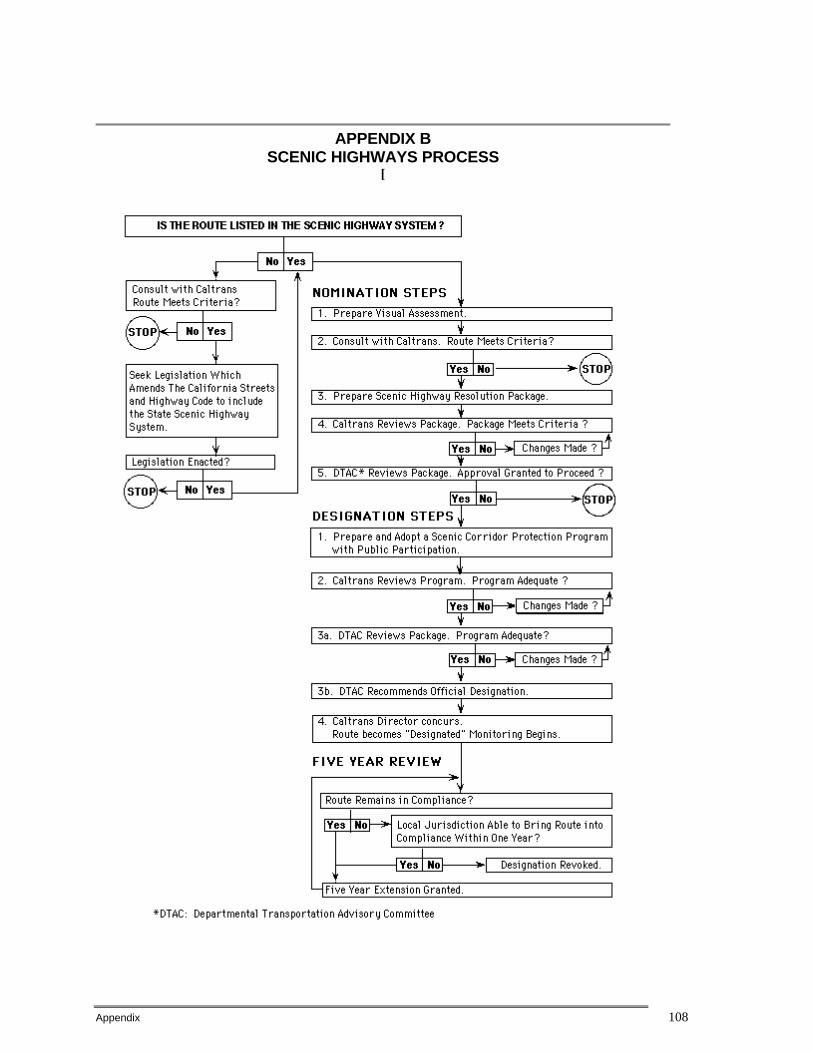
Appendix 108
APPENDIX B SCENIC HIGHWAYS PROCESS
[

Appendix 109
APPENDIX C CALTRANS HEADQUARTERS AND DISTRICT OFFICES

Appendix 110
Below are the street and mailing addresses and phone numbers for the Caltrans District Offices. Contact the District Scenic Highway Coordinator, who is generally in the Landscape Architecture Office. You may also contact the Statewide Scenic Highway Coordinator at Caltrans Headquarters. Caltran Headquarters 1120 N Street, Sacramento CA 95814 (916) 654-5370 District 1 1656 Union Street, Eureka CA 95501 (P.O. Box 3770, 95502) (707) 445-6407 District 2 1657 Riverside Drive, Redding, CA 96001 (P.O. Box 494040, 96049-4040) (530) 225-3372 District 3 703 B Street, Marysville, CA 95901 (P.O. Box 911) (530) 741-4436 District 4 111 Grand Avenue, Oakland, CA 94612 (P.O. Box 23660, 94623-0660) (510) 286-5924 District 5 50 Higuera Street, San Luis Obispo, CA 93401 (805) 549-3083 District 6 1352 West Olive Avenue, Fresno, CA 93728 (P.O. Box 12616, 93778-2616) (559) 230-3135 District 7 120 South Spring Street, Los Angeles, CA 90012-3606 (213) 897-0624 District 8 247 West Third Street, San Bernardino, CA 92402 (P.O. Box 231, 92402) (909) 383-4521 District 9 500 South Main Street, Bishop, CA 93514 (760) 872- 0681 District 10 1976 East Charter Way, Stockton, CA 95205 (P.O. Box 2048, 95201) (209) 948-7190 District 11 2829 Juan Street, San Diego, CA 92110 (P.O. Box 85406, 92186-5406) (619) 688-6719 District 12 2501 Pullman Street, Santa Ana, CA 92705 (714) 724-2449
Appendix 111
APPENDIX D EXAMPLES OF VISUAL INTRUSIONS* ALONG SCENIC CORRIDORS
NOTE: Where more than one example is listed, only one example need be applicable for an intrusion to occur. BUILDINGS: Residential Development, Commercial Development, Industrial Development
• MINOR (yellow)
Widely dispersed buildings. Natural landscape dominates. Wide setbacks and buildings screened from roadway. Exterior colors and materials are compatible with environment. Buildings have cultural or historical significance.
MODERATE (orange) Increased number of buildings, but these are complementary to the landscape. Smaller setbacks and lack of roadway screening. Buildings do not degrade or obstruct scenic view.
• MAJOR (red)
Dense and continuous development. Highly reflective surfaces. Buildings poorly maintained. Visible blight. Development along ridge lines. Buildings degrade or obstruct scenic view.
UNSIGHTLY LAND USES: Dumps, Quarries, Concrete Plants, Tank Farms, Auto Dismantling
• MINOR (yellow)
Screened from view so that facility is not visible from the highway.
MODERATE (orange)
Not screened and visible but programmed/funded for removal and site restoration.
• MAJOR (red)
Not screened and visible by motorists. Will not be removed or modified. Scenic view is degraded.
STRIP MALLS:
MODERATE (orange)
Neat and well landscaped. Single story. Blend with surroundings.
• MAJOR (red)
Appendix 112
Not harmonious with surroundings. Poorly maintained or vacant. Blighted. Development degrades or obstructs scenic view.
PARKING LOTS:
• MINOR (yellow)
Screened from view so that vehicles and pavement are not visible from the highway.
MODERATE (orange)
Neat and well landscaped. Blend with surroundings.
• MAJOR (red)
Not screened or landscaped. Scenic view is degraded.
OFF-SITE ADVERTISING STRUCTURES:
• MAJOR (red)
Billboards degrade or obstruct scenic view.
NOISE BARRIERS:
MODERATE (orange)
Noise barriers are well landscaped and complement the natural landscape. Noise barriers do not degrade or obstruct scenic view.
• MAJOR (red)
Noise barriers obstruct scenic view.
POWER LINES:
• MINOR (yellow)
Not easily visible from road.
MODERATE (orange)
Visible, but compatible with surroundings.
• MAJOR (red)
Poles and lines dominate view. Scenic view is degraded.
AGRICULTURE:
Structures, Equipment, Crops
• MINOR (yellow)

Appendix 113
Blends in and complements scenic view. Indicative of regional culture.
MODERATE (orange)
Not in harmony with surroundings. Competes with natural landscape for visual dominance.
• MAJOR (red)
Incompatible with and dominates natural landscape. Structures, equipment or crops degrade scenic view.
EXOTIC VEGETATION:
• MINOR (yellow)
Used as screening and landscaping. Blends in and complements scenic view.
MODERATE (orange)
Competes with native vegetation for visual dominance.
• MAJOR (red)
Incompatible with and dominates natural landscape. Scenic view is degraded.
CLEARCUTTING:
MODERATE (orange)
Trees bordering highway remain so that clearcutting is not evident.
• MAJOR (red)
Clearcutting or deforestation is evident. Scenic view is degraded. EROSION:
• MINOR (yellow)
Minor Soil Erosion.
MODERATE (orange)
Slopes beginning to erode. Not stabilized.
• MAJOR (red)
Large slope failures and no vegetation. Scenic view is degraded.
GRADING:
• MINOR (yellow)
Grading blends with adjacent landforms and topography.
Appendix 114
MODERATE (orange)
Some changes, but restoration is taking place.
• MAJOR (red)
Extensive cut and fill. Scarred hillsides and landscape. Canyons filled in. Scenic view is degraded.
ROAD DESIGN:
• MINOR (yellow)
Blends in and complements scenic view. Roadway structures are suitable for location and compatible with surroundings.
MODERATE (orange)
Cut and fill is visible, but has vegetative cover.
Last update 9/17/99
Other Information on Scenic Highways:
The California Scenic Highway Program - Frequently asked questions (and answers) about the Scenic Highway Program.
What Scenic Highway Designation Can Do - The benefits of scenic highway
designation.
California Scenic Routes - A list of the officially designated California scenic highways.
California Scenic Highway System - A list of eligible and officially designated
routes.
California Scenic Highway Mapping System - A description and photo tour of California's scenic routes.
Office of State Landscape Architecture Homepage If you have any questions or suggestions, please e-mail dennis [email protected]
Caltrans Homepage

Appendix 115
APPENDIX D
County of Imperial Bicycle Master Plan
Appendix 116
APPENDIX E
2002 Imperial County 20-Year Transportation Plan
Highway Element Executive Summary Transit Vision Element Executive Summary Non Motorized Transportation Element Executive Summary

Appendix 117
APPENDIX F
GREATER CALEXICO AREA ARTERIAL NEEDS AND CIRCULATION ANALYSIS
For the Imperial Valley Association of Governments (IVAG) in the County of Imperial
prepared and submitted to IVAG original date May 9, 2005
with latest revised date June 16, 2005 by Darnell and Associates, Inc.
Appendix 118
APPENDIX G
References
Destination 2030: 2004 Regional Transportation Plan, Southern California Association of Governments (SCAG), http://www.scag.ca.gov/rtp2001/2004draft/FinalPlan.htm, July 25, 2006.
Circulation and Scenic Highways Element, County of Imperial General
Plan, Imperial County, 2003.
Imperial Valley Transit, http://www.ivtransit.com/sub.php?page=iv_transit, August 8, 2006.