
Chapter4 Site Appraisal Pg 19-34.pdf
16
CONTEXT 02 SITE/ CONTEXT APPRAISALS 04
Transcript of Chapter4 Site Appraisal Pg 19-34.pdf
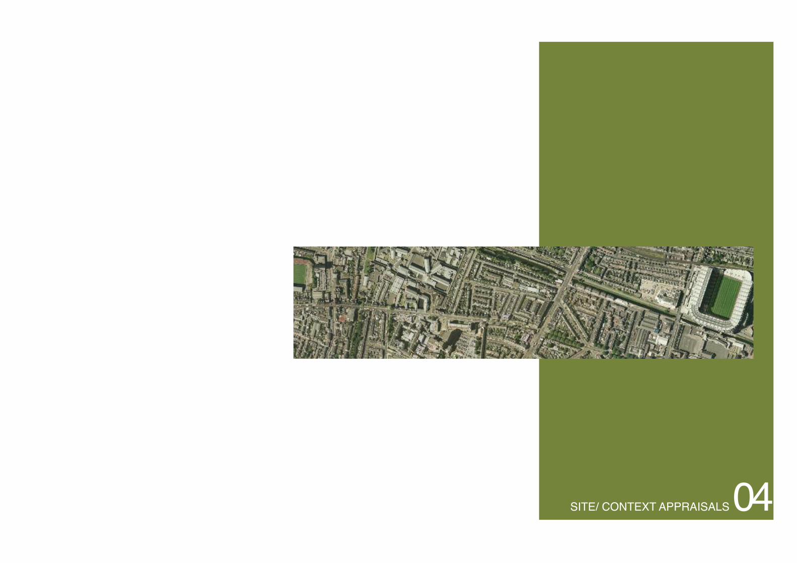
CONTEXT02SITE/ CONTEXT APPRAISALS04

The physical character of the area of Dublin covered by the Phibsborough-MountjoyLocal Area Plan is determined by three main factors: the transport corridors cuttingthrough the area, the pattern and density of housing in the area, and the presence of largeinstitutions and landmark structures.
The area is dissected by two main roads, the North Circular Road running east west andthe Phibsborough Road crossing the North Circular at right angles. This second, andolder, road is named Constitution Hill as it enters the area from the south, then Phibs-borough Road, Prospect Road, and finally Botanic Road as it leaves the area northward.
The pattern made by the various transport corridors crossing the Phibsborough-Moun-tjoy area is an important determinant of physical character: the two parallel railway linesand the Royal anal at the north, and the convergence at the south of the third railwayline, the Phibsborough road, and the disused branch of the Royal Canal.
For the most part, the Phibsborough-Mountjoy area consists of two-storey terracedhousing built near the end of the 19th century or in the early part of the 20th centuryand this defines the low rise character of the area.Dublin is remarkable for having areasof single and two-storey development so close to the city centre.The main exception iswhere three and four storey Georgian city extends into the southeast corner of thearea, at Blessington Street and Eccles Street.The commercial hub of the area at Doyle’scorner is defined by three storey, red-brick terraces.
The area has two large institutions: the Mater Hospital and Mountjoy Prison. Both aresignificant landmarks in the area. Other, less imposing landmarks include St Peter’s andSt Joseph’s churches, the Broadstone, Dalymount Park, a commercial tower at Phibs-borough, mill buildings at the Royal Canal, a chimney in the Smurfit complex and theround tower in Glasnevin Cemetery.
Neither the Broadstone nor the Prison is tall. The churches, the floodlight masts at Da-lymount, the chimney and the round tower are all tall, but slim local landmarks.Only theMater, the Phibsborough tower and the mill buildings have any significant bulk as well asheight. Of these the Mater is by far the most bulky.
STUDY AREA DESCRIPTION
LAPArea,Aerial Context
LAPArea, Existing Context
20 04:01 Context Appraisal
PHIBSBOROUGH/MOUNTJOY LAP
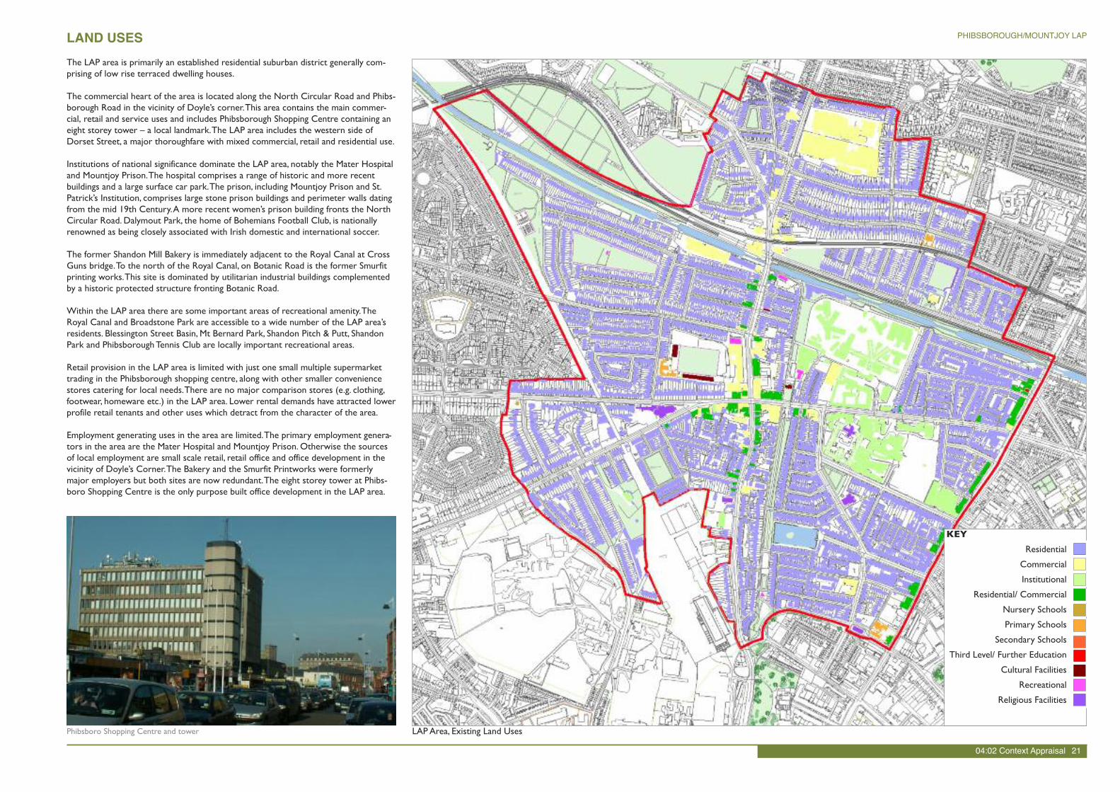
The LAP area is primarily an established residential suburban district generally com-prising of low rise terraced dwelling houses.
The commercial heart of the area is located along the North Circular Road and Phibs-borough Road in the vicinity of Doyle’s corner.This area contains the main commer-cial, retail and service uses and includes Phibsborough Shopping Centre containing aneight storey tower – a local landmark.The LAP area includes the western side ofDorset Street, a major thoroughfare with mixed commercial, retail and residential use.
Institutions of national significance dominate the LAP area, notably the Mater Hospitaland Mountjoy Prison.The hospital comprises a range of historic and more recentbuildings and a large surface car park.The prison, including Mountjoy Prison and St.Patrick’s Institution, comprises large stone prison buildings and perimeter walls datingfrom the mid 19th Century.A more recent women’s prison building fronts the NorthCircular Road. Dalymout Park, the home of Bohemians Football Club, is nationallyrenowned as being closely associated with Irish domestic and international soccer.
The former Shandon Mill Bakery is immediately adjacent to the Royal Canal at CrossGuns bridge.To the north of the Royal Canal, on Botanic Road is the former Smurfitprinting works.This site is dominated by utilitarian industrial buildings complementedby a historic protected structure fronting Botanic Road.
Within the LAP area there are some important areas of recreational amenity.TheRoyal Canal and Broadstone Park are accessible to a wide number of the LAP area’sresidents. Blessington Street Basin, Mt Bernard Park, Shandon Pitch & Putt, ShandonPark and PhibsboroughTennis Club are locally important recreational areas.
Retail provision in the LAP area is limited with just one small multiple supermarkettrading in the Phibsborough shopping centre, along with other smaller conveniencestores catering for local needs.There are no major comparison stores (e.g. clothing,footwear, homeware etc.) in the LAP area. Lower rental demands have attracted lowerprofile retail tenants and other uses which detract from the character of the area.
Employment generating uses in the area are limited.The primary employment genera-tors in the area are the Mater Hospital and Mountjoy Prison. Otherwise the sourcesof local employment are small scale retail, retail office and office development in thevicinity of Doyle’s Corner.The Bakery and the Smurfit Printworks were formerlymajor employers but both sites are now redundant.The eight storey tower at Phibs-boro Shopping Centre is the only purpose built office development in the LAP area.
LAND USES
KEY
Residential
Commercial
Institutional
Residential/ Commercial
Nursery Schools
Primary Schools
Secondary Schools
Third Level/ Further Education
Cultural Facilities
Recreational
Religious Facilities
LAPArea, Existing Land UsesPhibsboro Shopping Centre and tower
04:02 Context Appraisal 21
PHIBSBOROUGH/MOUNTJOY LAP
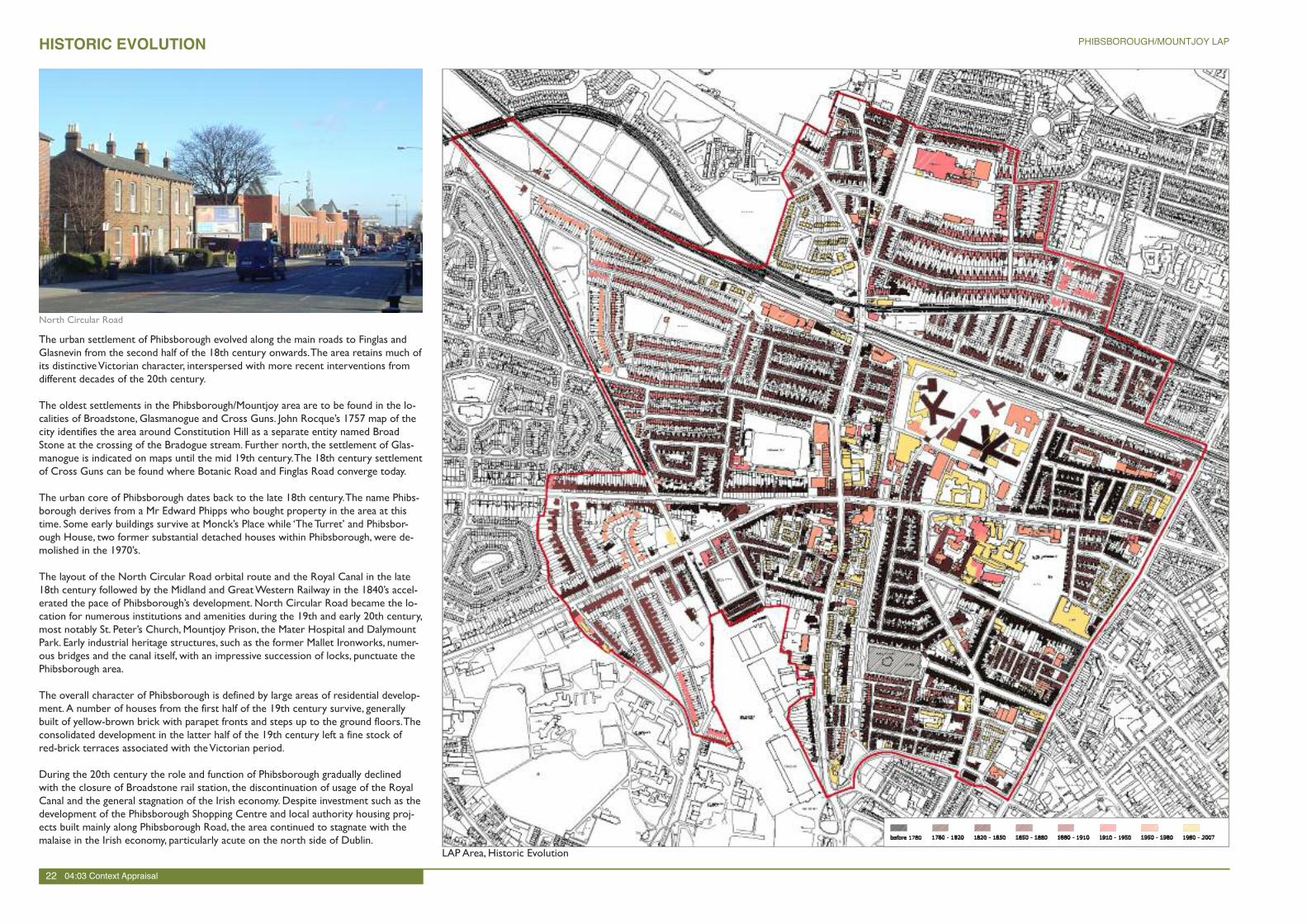
The urban settlement of Phibsborough evolved along the main roads to Finglas andGlasnevin from the second half of the 18th century onwards.The area retains much ofits distinctiveVictorian character, interspersed with more recent interventions fromdifferent decades of the 20th century.
The oldest settlements in the Phibsborough/Mountjoy area are to be found in the lo-calities of Broadstone, Glasmanogue and Cross Guns. John Rocque’s 1757 map of thecity identifies the area around Constitution Hill as a separate entity named BroadStone at the crossing of the Bradogue stream. Further north, the settlement of Glas-manogue is indicated on maps until the mid 19th century.The 18th century settlementof Cross Guns can be found where Botanic Road and Finglas Road converge today.
The urban core of Phibsborough dates back to the late 18th century.The name Phibs-borough derives from a Mr Edward Phipps who bought property in the area at thistime. Some early buildings survive at Monck’s Place while ‘TheTurret’ and Phibsbor-ough House, two former substantial detached houses within Phibsborough, were de-molished in the 1970’s.
The layout of the North Circular Road orbital route and the Royal Canal in the late18th century followed by the Midland and GreatWestern Railway in the 1840’s accel-erated the pace of Phibsborough’s development. North Circular Road became the lo-cation for numerous institutions and amenities during the 19th and early 20th century,most notably St. Peter’s Church, Mountjoy Prison, the Mater Hospital and DalymountPark. Early industrial heritage structures, such as the former Mallet Ironworks, numer-ous bridges and the canal itself, with an impressive succession of locks, punctuate thePhibsborough area.
The overall character of Phibsborough is defined by large areas of residential develop-ment. A number of houses from the first half of the 19th century survive, generallybuilt of yellow-brown brick with parapet fronts and steps up to the ground floors.Theconsolidated development in the latter half of the 19th century left a fine stock ofred-brick terraces associated with theVictorian period.
During the 20th century the role and function of Phibsborough gradually declinedwith the closure of Broadstone rail station, the discontinuation of usage of the RoyalCanal and the general stagnation of the Irish economy. Despite investment such as thedevelopment of the Phibsborough Shopping Centre and local authority housing proj-ects built mainly along Phibsborough Road, the area continued to stagnate with themalaise in the Irish economy, particularly acute on the north side of Dublin.
HISTORIC EVOLUTION
LAPArea, Historic Evolution
North Circular Road
22 04:03 Context Appraisal
PHIBSBOROUGH/MOUNTJOY LAP
ARCHITECTURAL HERITAGE
LAPArea, Existing Protected Structures
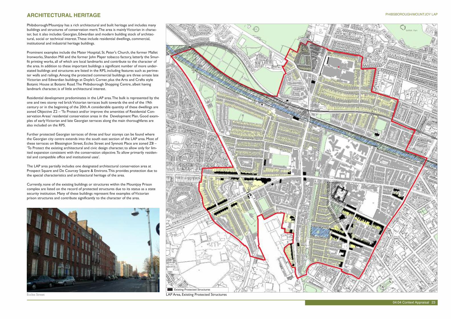
Phibsborough/Mountjoy has a rich architectural and built heritage and includes manybuildings and structures of conservation merit.The area is mainlyVictorian in charac-ter, but it also includes Georgian, Edwardian and modern building stock of architec-tural, social or technical interest.These include residential dwellings, commercial,institutional and industrial heritage buildings.
Prominent examples include the Mater Hospital, St. Peter's Church, the former MalletIronworks, Shandon Mill and the former John Player tobacco factory, latterly the Smur-fit printing works, all of which are local landmarks and contribute to the character ofthe area. In addition to these important buildings a significant number of more under-stated buildings and structures are listed in the RPS, including features such as perime-ter walls and railings.Among the protected commercial buildings are three ornate lateVictorian and Edwardian buildings at Doyle’s Corner, plus the Arts and Crafts styleBotanic House at Botanic Road.The Phibsborough Shopping Centre, albeit havinglandmark character, is of little architectural interest.
Residential development predominates in the LAP area.The bulk is represented by theone and two storey red brickVictorian terraces built towards the end of the 19thcentury or in the beginning of the 20th.A considerable quantity of these dwellings arezoned Objective Z2 – ‘To Protect and/or improve the amenities of Residential Con-servation Areas’ residential conservation areas in the Development Plan. Good exam-ples of earlyVictorian and late Georgian terraces along the main thoroughfares arealso included on the RPS.
Further protected Georgian terraces of three and four storeys can be found wherethe Georgian city centre extends into the south east section of the LAP area. Most ofthese terraces on Blessington Street, Eccles Street and Synnott Place are zoned Z8 –‘To Protect the existing architectural and civic design character, to allow only for lim-ited expansion consistent with the conservation objective.To allow primarily residen-tial and compatible office and institutional uses’.
The LAP area partially includes one designated architectural conservation area atProspect Square and De Courcey Square & Environs.This provides protection due tothe special characteristics and architectural heritage of the area.
Currently, none of the existing buildings or structures within the Mountjoy Prisoncomplex are listed on the record of protected structures due to its status as a statesecurity institution. Many of these buildings represent fine examples ofVictorianprison structures and contribute significantly to the character of the area.
Eccles Street
04:04 Context Appraisal 23
PHIBSBOROUGH/MOUNTJOY LAP
Existing Protected Structures

The Phibsborough/ Mountjoy LAP area includes some unique and attractive recreationspaces which provide important recreational and open green space for local residents.
Both Broadstone Park and Royal CanalWay are linear public parks penetrating the en-tire Phibsborough/Mountjoy area and delivering a high degree of public accessibility.The Blessington Street Basin is a unique public space in Dublin City consisting of awildlife pond, walkways, planting and park facilities. It is a tranquil public park tuckedbehind the narrowVictorian streets in the vicinity of Blessington Street.The Broad-stone Park (Blessington Street Park), which comprises the infilled former Broadstonespur of the Royal Canal, is an open space consisting of an elongated linear park withgreen space and walkways. The space also includes a children’s playground and an allweather pitch.
The Royal CanalWay which includes the canal banks and tow paths traverses the LAParea from east to west.The linear form of the canal facilitates walking, running and cy-cling and passive recreation.The lack of passive overlooking from surrounding residen-tial development leads to a sense of isolation and lack of security along the canal bank.
In addition to these major spaces the LAP area also includes a number of pocketgreen open spaces including Mount Bernard Park, Shandon Pitch & Putt Club, andGreatWestern Square. Mount Bernard Park is the largest single green open space inthe LAP area and is generally perceived by local residents to attract anti-social behav-iour due to the lack of passive supervision and its physical connection to the neg-lected Iaranrod Eireann lands to the north.
In addition to these public recreational spaces the area includes a number of privaterecreational facilities including Charleville Tennis Club, Phibsborough Boxing Club andPhibsborough Snooker Club. Dalymount Park is also a significant local recreational fa-cility although it is generally not publically accessible.
Streets within the LAP area generally provide a low quality urban environment.Through traffic and parking dominate and take precedence over the ‘place’ function ofstreets, i.e roads, access and movement have priority over the needs of pedestriansand cyclists.The LAP area includes a number of strategic pedestrian and cycle routesincluding the Royal CanalWay and Broadstone Park. However, pedestrian facilities aregenerally poor with frequent physical barriers to movement presented by impenetra-ble large urban blocks such as Mountjoy Prison and the Mater Hospital. Dublin CityCouncil have undertaken a large upgrading of the city’s cycle lane network, howeverthe heavy vehicular traffic congestion limits the appeal of cycling.
URBAN STRUCTURE AND PUBLIC REALM
LAPArea, Public Realm and RecreationBroadstone Park (Blessington Street Park)
24 04:05 Context Appraisal
PHIBSBOROUGH/MOUNTJOY LAP
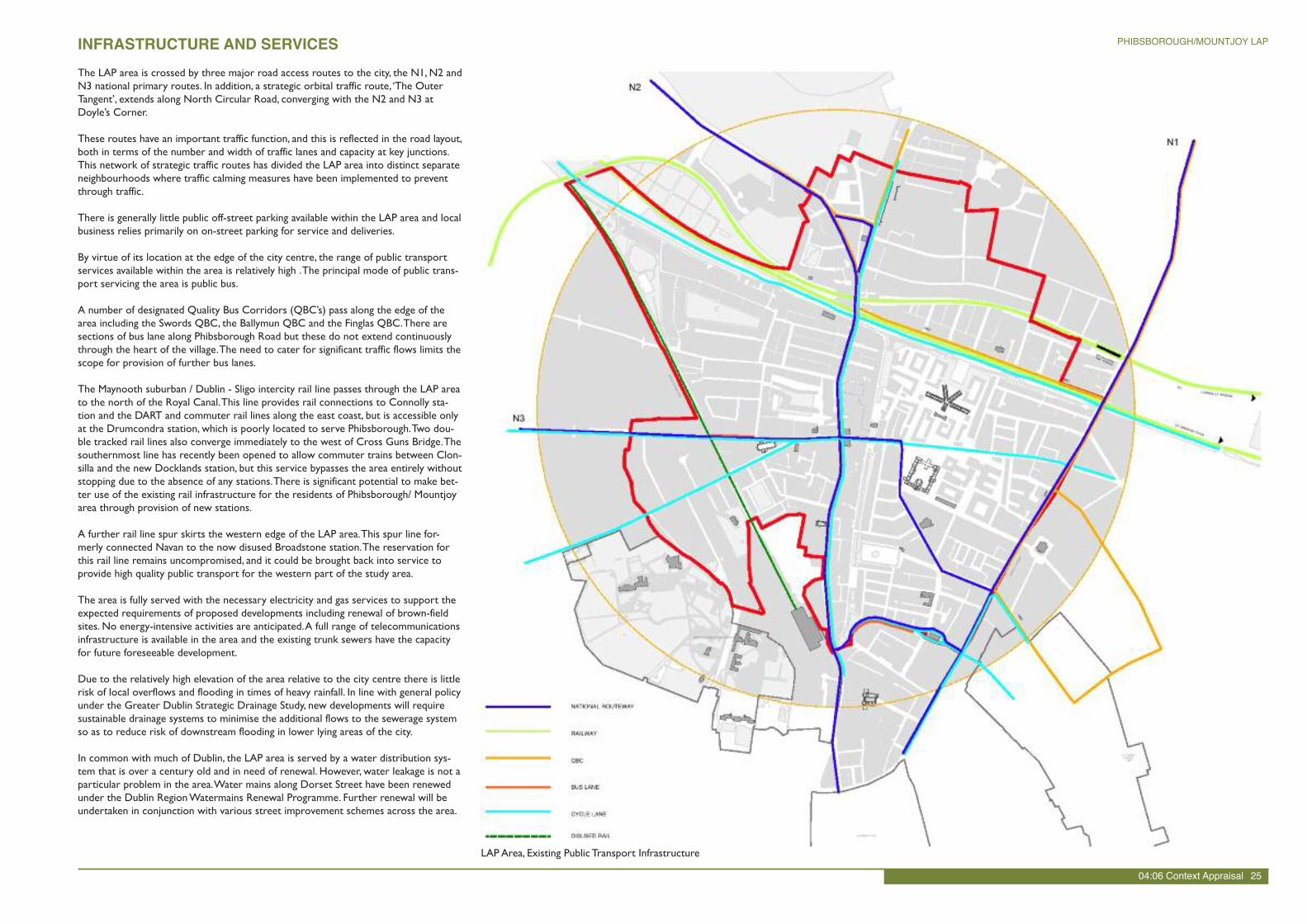
LAPArea, Existing Public Transport Infrastructure
INFRASTRUCTURE AND SERVICESThe LAP area is crossed by three major road access routes to the city, the N1, N2 andN3 national primary routes. In addition, a strategic orbital traffic route,‘The OuterTangent’, extends along North Circular Road, converging with the N2 and N3 atDoyle’s Corner.
These routes have an important traffic function, and this is reflected in the road layout,both in terms of the number and width of traffic lanes and capacity at key junctions.This network of strategic traffic routes has divided the LAP area into distinct separateneighbourhoods where traffic calming measures have been implemented to preventthrough traffic.
There is generally little public off-street parking available within the LAP area and localbusiness relies primarily on on-street parking for service and deliveries.
By virtue of its location at the edge of the city centre, the range of public transportservices available within the area is relatively high .The principal mode of public trans-port servicing the area is public bus.
A number of designated Quality Bus Corridors (QBC’s) pass along the edge of thearea including the Swords QBC, the Ballymun QBC and the Finglas QBC.There aresections of bus lane along Phibsborough Road but these do not extend continuouslythrough the heart of the village.The need to cater for significant traffic flows limits thescope for provision of further bus lanes.
The Maynooth suburban / Dublin - Sligo intercity rail line passes through the LAP areato the north of the Royal Canal.This line provides rail connections to Connolly sta-tion and the DART and commuter rail lines along the east coast, but is accessible onlyat the Drumcondra station, which is poorly located to serve Phibsborough.Two dou-ble tracked rail lines also converge immediately to the west of Cross Guns Bridge.Thesouthernmost line has recently been opened to allow commuter trains between Clon-silla and the new Docklands station, but this service bypasses the area entirely withoutstopping due to the absence of any stations.There is significant potential to make bet-ter use of the existing rail infrastructure for the residents of Phibsborough/ Mountjoyarea through provision of new stations.
A further rail line spur skirts the western edge of the LAP area.This spur line for-merly connected Navan to the now disused Broadstone station.The reservation forthis rail line remains uncompromised, and it could be brought back into service toprovide high quality public transport for the western part of the study area.
The area is fully served with the necessary electricity and gas services to support theexpected requirements of proposed developments including renewal of brown-fieldsites. No energy-intensive activities are anticipated.A full range of telecommunicationsinfrastructure is available in the area and the existing trunk sewers have the capacityfor future foreseeable development.
Due to the relatively high elevation of the area relative to the city centre there is littlerisk of local overflows and flooding in times of heavy rainfall. In line with general policyunder the Greater Dublin Strategic Drainage Study, new developments will requiresustainable drainage systems to minimise the additional flows to the sewerage systemso as to reduce risk of downstream flooding in lower lying areas of the city.
In common with much of Dublin, the LAP area is served by a water distribution sys-tem that is over a century old and in need of renewal. However, water leakage is not aparticular problem in the area.Water mains along Dorset Street have been renewedunder the Dublin RegionWatermains Renewal Programme. Further renewal will beundertaken in conjunction with various street improvement schemes across the area.
04:06 Context Appraisal 25
PHIBSBOROUGH/MOUNTJOY LAP
Population Trends
Regional Population Change 2002 - 2006
Phibsborough/Mountjoy Area & National PopulationChange 2002 - 2006
Source: Central Statistics Office
The national population of Ireland has increased significantly in recent years. Over theperiod between 2002 and 2006 Census the population of Ireland grew by 317,722persons (8.1%), bringing the total national population to 4,234,925.
The Greater Dublin Area (GDA) has experienced a particularly rapid rate of growthand now accounts for approximately 40% of the national population. However, the ma-jority of this growth took place in counties Fingal (22%), Meath (21.4%), Kildare(13.5%) andWicklow (10.2%). In contrast the population of Dublin City grew by just2% over the same period.
The pattern of population growth over the past ten years has favoured the countiessurrounding Dublin due to the extensive areas of greenfield land available for housebuilding. However, this trend has exacerbated car dependency, long distance commut-ing, traffic congestion and undermined the efficient provision of public services includ-ing transport infrastructure.
The Review of Housing Needs in the Greater Dublin Area (March 2007) prepared onbehalf of the Dublin Regional Authority and the Mid-East Regional Authority increasedthe projected housing needs of Dublin city in the period from 2003 to 2010 from39,926 to 43,277 dwelling units. Overall, in the period between 2003 and 2016 a totalof 75,419 additional housing units will be required in the Dublin City Council area.
The outlook in the National Spatial Strategy and the Regional Planning Guidelines isfor further strong population growth with an estimated population in the GDA of1.83 million by the year 2020.
The Phibsborough/Mountjoy LAP area currently comprises an estimated 5,374 perma-nent private households with a resultant population of in the order of 14,800 persons.Over the period 1996 – 2002 the population of the LAP area grew by approximately7.5%. Between 2002 and 2006 the population growth rate fell to just over 4%.Thelower rate of population growth in more recent years can be attributed to the lack ofsuitable infill development land and decreasing average household size.
The LAP area is characterised by a relatively young population with 20% of the popu-lation aged between 15 and 24 years and 41 % aged between 25 and 44 years.Thiscompares to a national average of 15% and 31% respectively. By contrast however, just9.5% of the population in the LAP area is aged less than 15 years old as compared tothe national average of 20%.
This population age profile clearly illustrates that the LAP area is dominated by estab-lished families, young workers and students with a very low proportion of young fami-lies and children.This population profile is consistent with the proximity of the LAParea to Dublin city centre, employment locations and third level institutions.Youngfamilies are generally moving to other outer suburban locations to avail of lowerhouse prices and access to housing suitable for families with children.
The number of people at work within the LAP area is broadly similar to the nationalaverage. However, the proportion of the population unemployed or seeking their firstjob within the LAP area in 2006 was 7.4% which was slightly higher than the nationalaverage of 5%.
A distinctive aspect of the Phibsborough/Mountjoy LAP area is the low level of carownership. 51.6% of households within the LAP area currently have no car.This com-pares with a State average of 20%.The low level of car ownership reflects the innerurban location of Phibsborough/Mountjoy and the existing high quality public trans-port links.
POPULATION/ DEMOGRAPHICS
Population 2002 2006 Increase % Increase
City 495,781 505,739 9,958 2.0
Dun LaoighaireRathdown
191,792 193,688 1,896 1.0
Fingal 196,413 239,813 43,400 22.1
South Dublin 238,835 246,919 8,084 3.4
Total Dublin 1,122,821 1,186,159 63,338 5.6
Kildare 163,944 186,075 22,131 13.5
Meath 134,005 165,621 28,616 21.4
Wicklow 114,676 126,330 11,654 10.2
Total Mid-East 412,625 478,026 62,401 15.8
TOTAL 1,535,446 1,664,18 125,739 8.4
Area Area(% Change)
Ireland Ireland(% Change)
Total Population1986
12,709 - 3,540,643 -
Total population1991
12,357 -2.77% 3,525,719 -0.42%
Total population1996
13,185 6.70% 3,626,087 2.85%
Total population2002
14,171 7.48% 3,917,203 8.03%
Total population2006
14,757 4.14% 4,239,848 8.24%
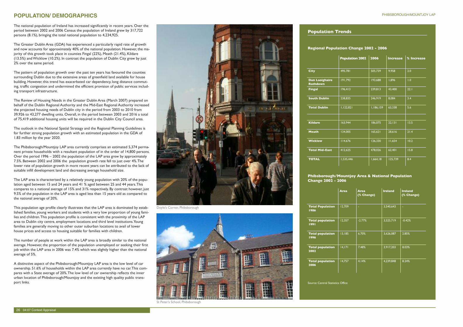
Doyle’s Corner, Phibsborough
26 04:07 Context Appraisal
PHIBSBOROUGH/MOUNTJOY LAP
St Peter’s School, Phibsborough
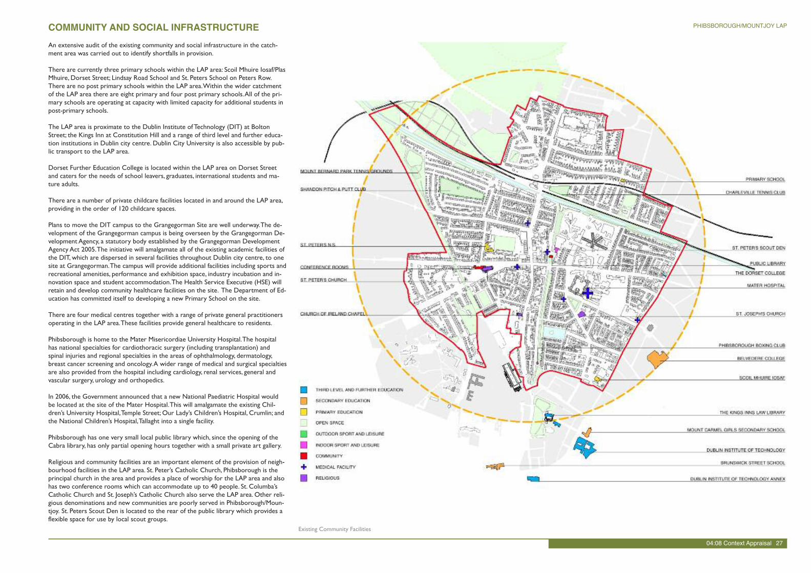
An extensive audit of the existing community and social infrastructure in the catch-ment area was carried out to identify shortfalls in provision.
There are currently three primary schools within the LAP area: Scoil Mhuire Iosaf/PlasMhuire, Dorset Street; Lindsay Road School and St. Peters School on Peters Row.There are no post primary schools within the LAP area.Within the wider catchmentof the LAP area there are eight primary and four post primary schools.All of the pri-mary schools are operating at capacity with limited capacity for additional students inpost-primary schools.
The LAP area is proximate to the Dublin Institute of Technology (DIT) at BoltonStreet; the Kings Inn at Constitution Hill and a range of third level and further educa-tion institutions in Dublin city centre. Dublin City University is also accessible by pub-lic transport to the LAP area.
Dorset Further Education College is located within the LAP area on Dorset Streetand caters for the needs of school leavers, graduates, international students and ma-ture adults.
There are a number of private childcare facilities located in and around the LAP area,providing in the order of 120 childcare spaces.
Plans to move the DIT campus to the Grangegorman Site are well underway.The de-velopment of the Grangegorman campus is being overseen by the Grangegorman De-velopment Agency, a statutory body established by the Grangegorman DevelopmentAgency Act 2005.The initiative will amalgamate all of the existing academic facilities ofthe DIT, which are dispersed in several facilities throughout Dublin city centre, to onesite at Grangegorman.The campus will provide additional facilities including sports andrecreational amenities, performance and exhibition space, industry incubation and in-novation space and student accommodation.The Health Service Executive (HSE) willretain and develop community healthcare facilities on the site. The Department of Ed-ucation has committed itself to developing a new Primary School on the site.
There are four medical centres together with a range of private general practitionersoperating in the LAP area.These facilities provide general healthcare to residents.
Phibsborough is home to the Mater Misericordiae University Hospital.The hospitalhas national specialties for cardiothoracic surgery (including transplantation) andspinal injuries and regional specialties in the areas of ophthalmology, dermatology,breast cancer screening and oncology.A wider range of medical and surgical specialtiesare also provided from the hospital including cardiology, renal services, general andvascular surgery, urology and orthopedics.
In 2006, the Government announced that a new National Paediatric Hospital wouldbe located at the site of the Mater Hospital.This will amalgamate the existing Chil-dren’s University Hospital,Temple Street; Our Lady’s Children’s Hospital, Crumlin; andthe National Children’s Hospital,Tallaght into a single facility.
Phibsborough has one very small local public library which, since the opening of theCabra library, has only partial opening hours together with a small private art gallery.
Religious and community facilities are an important element of the provision of neigh-bourhood facilities in the LAP area. St. Peter’s Catholic Church, Phibsborough is theprincipal church in the area and provides a place of worship for the LAP area and alsohas two conference rooms which can accommodate up to 40 people. St. Columba’sCatholic Church and St. Joseph’s Catholic Church also serve the LAP area. Other reli-gious denominations and new communities are poorly served in Phibsborough/Moun-tjoy. St. Peters Scout Den is located to the rear of the public library which provides aflexible space for use by local scout groups.
COMMUNITY AND SOCIAL INFRASTRUCTURE
Existing Community Facilities
04:08 Context Appraisal 27
PHIBSBOROUGH/MOUNTJOY LAP
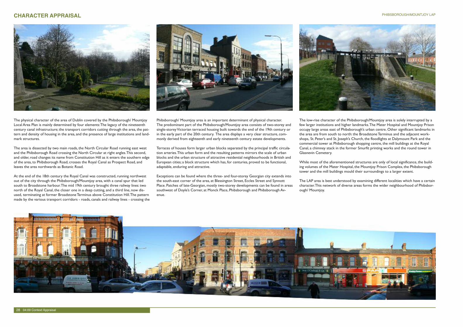
CHARACTER APPRAISAL
The physical character of the area of Dublin covered by the Phibsborough/ MountjoyLocal Area Plan is mainly determined by four elements:The legacy of the nineteenthcentury canal infrastructure; the transport corridors cutting through the area, the pat-tern and density of housing in the area, and the presence of large institutions and land-mark structures.
The area is dissected by two main roads, the North Circular Road running east westand the Phibsborough Road crossing the North Circular at right angles.This second,and older, road changes its name from Constitution Hill as it enters the southern edgeof the area, to Phibsborough Road, crosses the Royal Canal as Prospect Road, andleaves the area northwards as Botanic Road.
At the end of the 18th century the Royal Canal was constructed, running northwestout of the city through the Phibsborough/Mountjoy area, with a canal spur that ledsouth to Broadstone harbour.The mid 19th century brought three railway lines: twonorth of the Royal Canal, the closer one in a deep cutting, and a third line, now dis-used, terminating at former BroadstoneTerminus above Constitution Hill.The patternmade by the various transport corridors - roads, canals and railway lines - crossing the
Phibsborough/ Mountjoy area is an important determinant of physical character.The predominant part of the Phibsborough/Mountjoy area consists of two-storey andsingle-storeyVictorian terraced housing built towards the end of the 19th century orin the early part of the 20th century. The area displays a very clear structure, com-monly derived from eighteenth and early nineteenth century estate developments.
Terraces of houses form larger urban blocks separated by the principal traffic circula-tion arteries.This urban form and the resulting patterns mirrors the scale of urbanblocks and the urban structure of attractive residential neighbourhoods in British andEuropean cities; a block structure which has, for centuries, proved to be functional,adaptable, enduring and attractive.
Exceptions can be found where the three- and four-storey Georgian city extends intothe south-east corner of the area, at Blessington Street, Eccles Street and SynnottPlace. Patches of late-Georgian, mostly two-storey developments can be found in areassouthwest of Doyle’s Corner, at Monck Place, Phibsborough and Phibsborough Av-enue.
The low-rise character of the Phibsborough/Mountjoy area is solely interrupted by afew larger institutions and higher landmarks.The Mater Hospital and Mountjoy Prisonoccupy large areas east of Phibsborough’s urban centre. Other significant landmarks inthe area are from south to north: the BroadstoneTerminus and the adjacent work-shops, St. Peter’s and St. Joseph’s Church, the floodlights at Dalymount Park and thecommercial tower at Phibsborough shopping centre, the mill buildings at the RoyalCanal, a chimney stack in the former Smurfit printing works and the round tower inGlasnevin Cemetery.
While most of the aforementioned structures are only of local significance, the build-ing volumes of the Mater Hospital, the Mountjoy Prison Complex, the Phibsboroughtower and the mill buildings mould their surroundings to a larger extent.
The LAP area is best understood by examining different localities which have a certaincharacter.This network of diverse areas forms the wider neighbourhood of Phibsbor-ough/ Mountjoy.
28 04:09 Context Appraisal
PHIBSBOROUGH/MOUNTJOY LAP
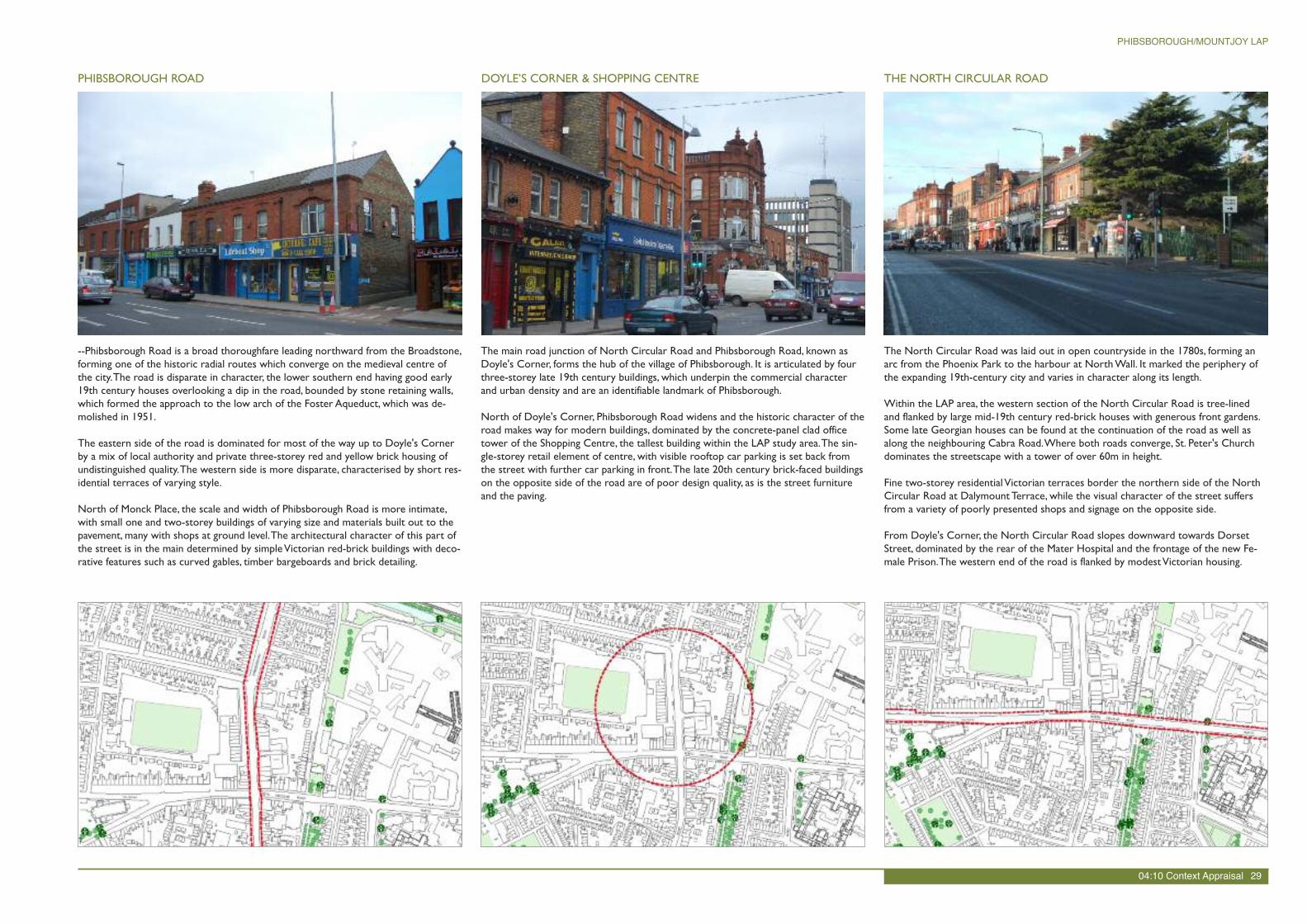
--Phibsborough Road is a broad thoroughfare leading northward from the Broadstone,forming one of the historic radial routes which converge on the medieval centre ofthe city.The road is disparate in character, the lower southern end having good early19th century houses overlooking a dip in the road, bounded by stone retaining walls,which formed the approach to the low arch of the Foster Aqueduct, which was de-molished in 1951.
The eastern side of the road is dominated for most of the way up to Doyle's Cornerby a mix of local authority and private three-storey red and yellow brick housing ofundistinguished quality.The western side is more disparate, characterised by short res-idential terraces of varying style.
North of Monck Place, the scale and width of Phibsborough Road is more intimate,with small one and two-storey buildings of varying size and materials built out to thepavement, many with shops at ground level.The architectural character of this part ofthe street is in the main determined by simpleVictorian red-brick buildings with deco-rative features such as curved gables, timber bargeboards and brick detailing.
The main road junction of North Circular Road and Phibsborough Road, known asDoyle's Corner, forms the hub of the village of Phibsborough. It is articulated by fourthree-storey late 19th century buildings, which underpin the commercial characterand urban density and are an identifiable landmark of Phibsborough.
North of Doyle's Corner, Phibsborough Road widens and the historic character of theroad makes way for modern buildings, dominated by the concrete-panel clad officetower of the Shopping Centre, the tallest building within the LAP study area.The sin-gle-storey retail element of centre, with visible rooftop car parking is set back fromthe street with further car parking in front.The late 20th century brick-faced buildingson the opposite side of the road are of poor design quality, as is the street furnitureand the paving.
PHIBSBOROUGH ROAD DOYLE’S CORNER & SHOPPING CENTRE THE NORTH CIRCULAR ROAD
The North Circular Road was laid out in open countryside in the 1780s, forming anarc from the Phoenix Park to the harbour at NorthWall. It marked the periphery ofthe expanding 19th-century city and varies in character along its length.
Within the LAP area, the western section of the North Circular Road is tree-linedand flanked by large mid-19th century red-brick houses with generous front gardens.Some late Georgian houses can be found at the continuation of the road as well asalong the neighbouring Cabra Road.Where both roads converge, St. Peter's Churchdominates the streetscape with a tower of over 60m in height.
Fine two-storey residentialVictorian terraces border the northern side of the NorthCircular Road at DalymountTerrace, while the visual character of the street suffersfrom a variety of poorly presented shops and signage on the opposite side.
From Doyle's Corner, the North Circular Road slopes downward towards DorsetStreet, dominated by the rear of the Mater Hospital and the frontage of the new Fe-male Prison.The western end of the road is flanked by modestVictorian housing.
04:10 Context Appraisal 29
PHIBSBOROUGH/MOUNTJOY LAP
DALYMOUNT PARK & SURROUNDING STREETS
Although Dalymount Park is an historic site of some social heritage significance, littlebuilt fabric of interest remains.The late 20th century stand building to the south re-tains some elements of the original stand by Archibald Leitch from c.1930.All exits areunpaved and poorly maintained retaining only ruinous fragments of earlier structures.
The area to the north and west of Dalymount is dominated by middle-class houses oftheVictorian era. Red-brick, two-storey terraces dominate the streetscapes, generallywith front gardens and railings. Canopies and canted bay windows are features thatcan be found on buildings along St. Peter's Road and Connaught Road.The plain lateVictorian three-storey tenements at Cabra Park have a distinctive military character.
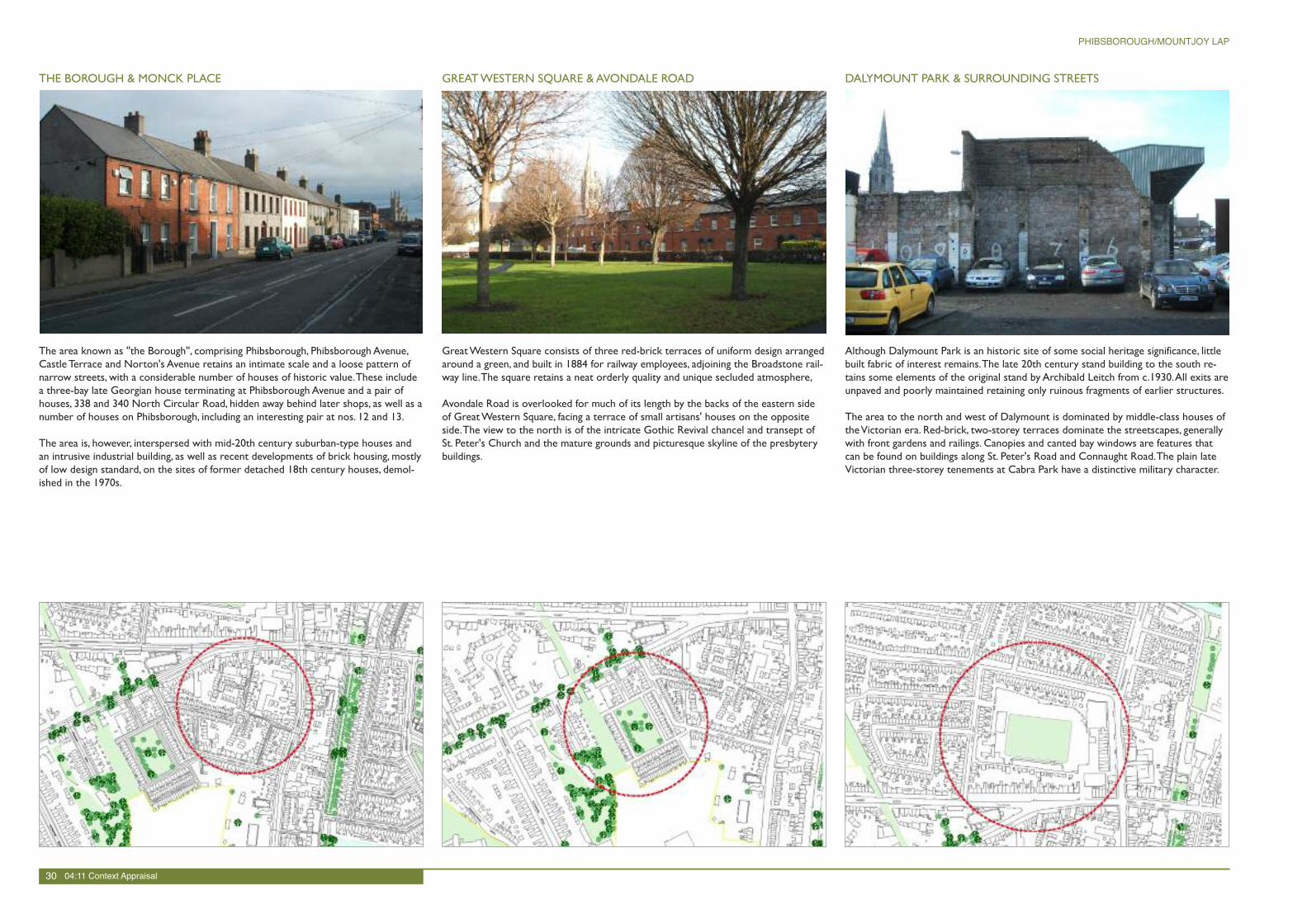
The area known as ''the Borough'', comprising Phibsborough, Phibsborough Avenue,Castle Terrace and Norton's Avenue retains an intimate scale and a loose pattern ofnarrow streets, with a considerable number of houses of historic value.These includea three-bay late Georgian house terminating at Phibsborough Avenue and a pair ofhouses, 338 and 340 North Circular Road, hidden away behind later shops, as well as anumber of houses on Phibsborough, including an interesting pair at nos. 12 and 13.
The area is, however, interspersed with mid-20th century suburban-type houses andan intrusive industrial building, as well as recent developments of brick housing, mostlyof low design standard, on the sites of former detached 18th century houses, demol-ished in the 1970s.
THE BOROUGH & MONCK PLACE GREATWESTERN SQUARE &AVONDALE ROAD
GreatWestern Square consists of three red-brick terraces of uniform design arrangedaround a green, and built in 1884 for railway employees, adjoining the Broadstone rail-way line.The square retains a neat orderly quality and unique secluded atmosphere,
Avondale Road is overlooked for much of its length by the backs of the eastern sideof GreatWestern Square, facing a terrace of small artisans' houses on the oppositeside.The view to the north is of the intricate Gothic Revival chancel and transept ofSt. Peter's Church and the mature grounds and picturesque skyline of the presbyterybuildings.
30 04:11 Context Appraisal
PHIBSBOROUGH/MOUNTJOY LAP
The former John Player tobacco factory, later Smurfit printing works, is situated to theeast of Botanic Road.This large industrial building occupies an expansive site, thefrontage to Botanic Road being a finely-wrought ashlar stone building in neo-Baroquestyle harmonising well with the suburban scale of the area.The building is set back be-hind railings with piers of good architectural detail, but the forecourt which serves asa car park, is very poorly presented and detracts from the character of the building.
The industrial complex behind this shows a more fragmented structure containing in-dustrial halls and extensions that range in their dates of construction from the 1920'sto the 1980's.
Industrial buildings to the southern half of the site have been demolished recently,leaving a huge vacant area which should be carefully redeveloped.
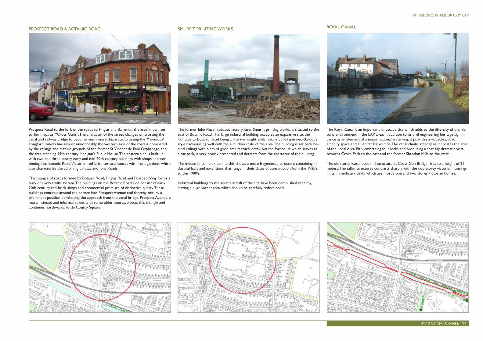
Prospect Road to the fork of the roads to Finglas and Ballymun, the area known onearlier maps as “Cross Guns”.The character of the street changes on crossing thecanal and railway bridge to become much more disparate. Crossing the Maynooth/Longford railway line almost unnoticeably the western side of the road is dominatedby the railings and mature grounds of the former St.Vincent de Paul Orphanage, andthe free standing 19th century Hedigan's Public House.The eastern side is built upwith two and three-storey early and mid 20th century buildings with shops and, con-tinuing into Botanic Road,Victorian red-brick terrace houses with front gardens, whichalso characterise the adjoining Lindsay and Iona Roads.
The triangle of roads formed by Botanic Road, Finglas Road and ProspectWay forms abusy one-way traffic system.The buildings on the Botanic Road side consist of early20th century red-brick shops and commercial premises of distinctive quality.Thesebuildings continue around the corner into Prospect Avenue and thereby occupy aprominent position dominating the approach from the canal bridge. Prospect Avenue, amore intimate and informal street with some older houses, bisects this triangle andcontinues northwards to de Courcy Square.
PROSPECT ROAD & BOTANIC ROAD SMURFIT PRINTINGWORKS ROYAL CANAL
The Royal Canal is an important landscape site which adds to the diversity of the his-toric environment in the LAP area. In addition to its civil engineering heritage signifi-cance as an element of a major national waterway, it provides a valuable publicamenity space and a habitat for wildlife.The canal climbs steadily as it crosses the areaof the Local Area Plan, embracing four locks and producing a spatially dramatic vistatowards Croke Park to the east and the former Shandon Mills to the west.
The six storey warehouse mill structure at Cross Gun Bridge rises to a height of 21meters.The taller structures contrasts sharply with the two storey victorian housingsin its immediate vicinity which are mostly one and two storey victorian homes.
04:12 Context Appraisal 31
PHIBSBOROUGH/MOUNTJOY LAP
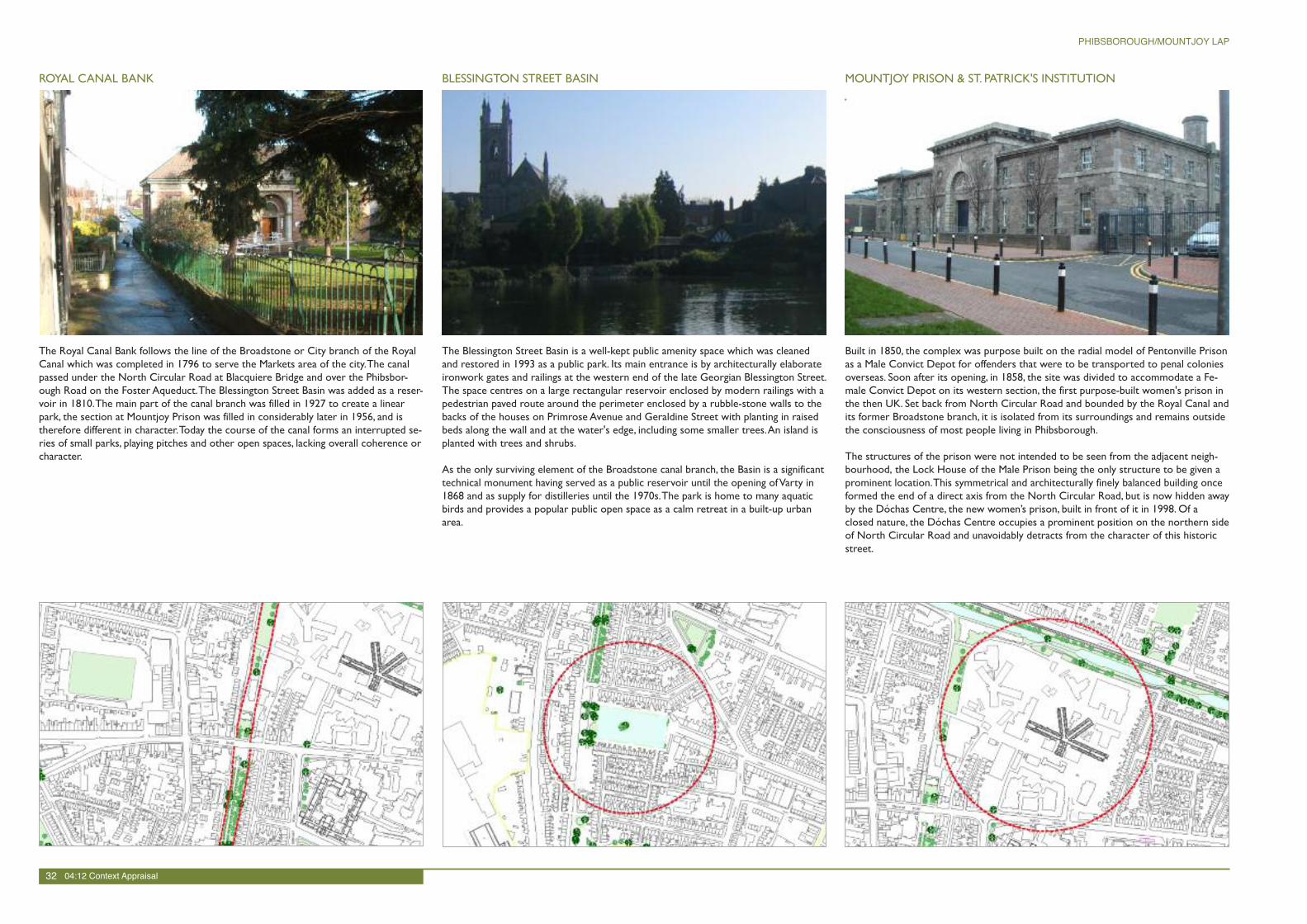
Built in 1850, the complex was purpose built on the radial model of Pentonville Prisonas a Male Convict Depot for offenders that were to be transported to penal coloniesoverseas. Soon after its opening, in 1858, the site was divided to accommodate a Fe-male Convict Depot on its western section, the first purpose-built women's prison inthe then UK. Set back from North Circular Road and bounded by the Royal Canal andits former Broadstone branch, it is isolated from its surroundings and remains outsidethe consciousness of most people living in Phibsborough.
The structures of the prison were not intended to be seen from the adjacent neigh-bourhood, the Lock House of the Male Prison being the only structure to be given aprominent location.This symmetrical and architecturally finely balanced building onceformed the end of a direct axis from the North Circular Road, but is now hidden awayby the Dóchas Centre, the new women’s prison, built in front of it in 1998. Of aclosed nature, the Dóchas Centre occupies a prominent position on the northern sideof North Circular Road and unavoidably detracts from the character of this historicstreet.
MOUNTJOY PRISON & ST. PATRICK'S INSTITUTION
The Royal Canal Bank follows the line of the Broadstone or City branch of the RoyalCanal which was completed in 1796 to serve the Markets area of the city.The canalpassed under the North Circular Road at Blacquiere Bridge and over the Phibsbor-ough Road on the Foster Aqueduct.The Blessington Street Basin was added as a reser-voir in 1810.The main part of the canal branch was filled in 1927 to create a linearpark, the section at Mountjoy Prison was filled in considerably later in 1956, and istherefore different in character.Today the course of the canal forms an interrupted se-ries of small parks, playing pitches and other open spaces, lacking overall coherence orcharacter.
ROYAL CANAL BANK
The Blessington Street Basin is a well-kept public amenity space which was cleanedand restored in 1993 as a public park. Its main entrance is by architecturally elaborateironwork gates and railings at the western end of the late Georgian Blessington Street.The space centres on a large rectangular reservoir enclosed by modern railings with apedestrian paved route around the perimeter enclosed by a rubble-stone walls to thebacks of the houses on Primrose Avenue and Geraldine Street with planting in raisedbeds along the wall and at the water's edge, including some smaller trees.An island isplanted with trees and shrubs.
As the only surviving element of the Broadstone canal branch, the Basin is a significanttechnical monument having served as a public reservoir until the opening ofVarty in1868 and as supply for distilleries until the 1970s.The park is home to many aquaticbirds and provides a popular public open space as a calm retreat in a built-up urbanarea.
BLESSINGTON STREET BASIN
32 04:12 Context Appraisal
PHIBSBOROUGH/MOUNTJOY LAP
The core of the Mater Misericordiae Hospital is still formed by the neo-classical build-ing complex at the western end of Eccles Street, designed by John Burke, with a pedi-mented entrance block and Ionic portico overlooking the public park north of St.Joseph's Church at Berkeley Road.The buildings enclose a quadrangle built in stages,starting with the main range to the south and a section of the adjoining east wing in1855-61, continuing the east wing northwards in 1868-72, and finally completing theoriginally intended u-shaped design by the west wing in 1884-86.
Whilst these earlier structures respond to the scale of the neighbouring residentialbuildings, expansions of the hospital during subsequent decades take the form of fiveand more storeys and leave enormous areas of free space that have radically changedthe streetscape of both Eccles Street and North Circular Road.
THE MATER HOSPITAL COMPLEX
The streets to the east of Mountjoy and the Mater Hospital are red-brick streets ofthe mid-19th century varying from single-storey over-basement with bay windows andsmall front gardens to simpler artisans’ houses built directly onto the street.
The area between the Mater Hospital, Mountjoy and Royal Canal Bank is a distinctivearea developed in the mid-19th century on ground originally intended for the Gar-diner Estate’s grandiose Royal Circus, planned at the end of Eccles Street.Thesestreets consist of modest middle-classVictorian redbrick housing of one and twostoreys, some of split level and many having bay windows.
Berkeley Road and Berkeley Street, a busy artery connecting the city centre to theNorth Circular Road, the eastern side dominated by the French Gothic Revival churchof St. Joseph's, built in 1880-93, and a neat triangular public park laid out in a formalmanner, forming the corner with Eccles Street and complementing the neo-classicalelevation of the Mater Hospital.The park, Mater Hospital and St. Joseph’s Church forma well-presented ensemble of 19th century architecture of high quality.
RESIDENTIALAREAS SURROUNDINGTHE MATER THE GEORGIAN PERIPHERY
Blessington Street is the continuation of North Frederick Street, which leads south-ward via Parnell Square to O'Connell Street and, therefore, has the potential to createa strong link to the city centre.The street is lined with elegant three-storey Georgianhouses of red and brown brick over-basements and is enriched by surviving railings,original windows, doorcases, iron balconettes and entrance steps.
Built from 1772 onwards, Eccles Street was one of Dublin's finest Georgian streetsuntil the destruction of its northern side in the 1980s.The view at the eastern end isterminated by the elegant classical spire of St. George's Church, and the south sidesurvives as a terrace of red-brick Georgian houses of very good quality.
Synnott Place, the continuation of Gardiner Street, retains a fine terrace of Georgianbuildings, which back onto a similar terrace on the North Circular Road, and togetherform a pocket of grand architectural character at the northern extremity of the Geor-gian city.
04:13 Context Appraisal 33
PHIBSBOROUGH/MOUNTJOY LAP
Situated on the crest of a hill, the BroadstoneTerminus was formerly one of the fourmain railway stations in Dublin and is still the most monumental, dominating the junc-tion of Constitution Hill and Phibsborough Road.The building is now in poor condi-tion and is no longer used by the public as intended.The forecourt, now a forlornspace isolated from public use and bounded by ruinous buildings, was used for over acentury as a harbour fed by the canal branch of the Royal Canal.
The area is dominated by heavy traffic, and despite the presence of green spaces tothe east (King's Inns Park and the linear park along the former canal branch) a largepercentage of the open space is taken up by the wide road junctions of DominickStreet Lower,WesternWay, Constitution Hill, and the access road to the Broadstonesite.A terrace of small two-storey 19th century artisans' houses on the eastern sideof the area helps to maintain the historic character of the area.
BROADSTONEAND KINGS INNS
Grassed areas and mature trees flank the front gardens of theVictorian terraces atShandon Park and the mid-20th century housing at Shandon Crescent, significantly en-hancing the appearance of the streetscape.
Secluded from the public domain, a private Pitch and Putt Course is located concealedat the rear of these terraces. Further eastwards, the Phibsborough Road passesthrough the late 19th century development, where some of the houses were adaptedto form shops at ground level.
The area is bounded to the north by the Royal Canal and some fine industrial build-ings from the Shandon Mills still survive in an adapted form.To the east of the areaMount Bernard park is a quiet park, suffering slightly from antisocial behaviour due tothe lack of passive supervision.
SHANDON
ParkMount Bernard
Mount
Bern
ard
SHANDON
PARK
Park
LEINSTERSTREET
SHANDON
GREEN
SH
AN
DO
NCRESCEN
T
SHANDON DRIVE SHA
NDO
NRO
AD
ULSTER
STREET
ULSTER
STREET
SHA
NDO
NRO
AD
STREET
CONNAUGHT
FASSAUGH
FASSAUGHROADROAD
ROADROAD
FAUSSAGH
FAUSSAGH
ROADROAD
ENOY
PRIM
STREET
ST
PA
TRIC
K'S
PLA
CE
WAY
WES
TERN
ConventKings Inns
Tank
HOSPITAL
Bus Depot
ST BRENDAN'S
PLACE
MA
UN
SELL
PLA
NORTH
STREET
ST MARY'S AVENUE NORTH
ST
LA
UREN
CE
PLA
CE
FONTENOY
HallWAY
WESTERN
Car ParkFlatsUnderground
Flats
Inns Registry of DeedsKing's
Tank
Law Library
Hostel
U
Hostels
Hall
Hostel
Tanks
Bus Depot
Tank
S DAN'S AL
Factory
Statue
H
School
(
Convent
Flats
MARNEMARNE
VILLASVILLAS
PLACE
PLACE
PALM
ERST
ON
PALM
ERST
ON
Hill
Fla
tsH
illFla
ts
Const
ituti
on
Const
ituti
on
HIL
LH
ILL
Temple Cottages
Temple Cottages
Temple Buildings
Temple Buildings
UPPER
UPPER
STREET
STREET
PREBEN
DPREBEN
D
STREET
STREET
DOMINICK
DOMINICK
PALMERSTONPL
PALMERSTONPL
MOUNTJO
Y
MOUNTJO
Y
UPPER
UPPER
STREET
STREET
Court CourtDominickDominick
HENRIETTALANE
HENRIETTALANE
STREET
STREET
LONGLONG
ST
MARY'S
TER
RACE
ST
MARY'S
TER
RACE
MOUNTJOY STREETMIDDLE
MOUNTJOY STREETMIDDLE
DOMINICK
DOMINICK
LANELANE
HENRIETTASTREET
CO
NSTIT
UTIO
NH
ILL
Henriett
aHouse
(Fla
ts)
PREBEN
DST
REET
Const
ituti
on
Hill
(Fla
ts)
STREE
T
BOLTONS
LA
NE
BO
LTO
N
PLA
CE
The
Court
HENRIE
TTA
STREET
House
Henriett
aHouse
HENRIETTA
HENRIE
TTA
Bounded by Grangegorman Hospital to the southwest, the line of the former Midlandand GreatWestern Railway to the east and Cabra Road to the north this small neigh-bourhood is strongly residential andVictorian in character.
Substantial early examples can be found along North Circular Road in redbrick two-storey-over-basement terraces, most having landscaped front gardens and cast-ironrailings, the historic setting enhanced by mature trees which line the street. LaterVic-torian developments of smaller scale can be found along Charleville Road, RathdownRoad and Rosemount Road, again with front gardens, railings and mature trees, andhaving canted bay windows typical of this period in Dublin.
UPPER GRANGEGORMAN
DALYMOUNT
GREATWESTERN
VILLAS
AVONDALE
ROAD
GREAT WESTERN
GREAT
WESTERN
AVENUE
SQUARE
C
ST
PETER'S
AVENUE
ROADCABRA
VILLASGREA
T WESTERN
NTHCIRCULAR RD
NTHCIRCULAR RD
PARADE
PARADE
CH
ARLEV
ILLE
CH
ARLEV
ILLE
RO
AD
RO
AD
ROADROADCABRACABRA
ANNAMOEANNAMOE DRIVEDRIVE
DRIVEDRIVE ANNAMOE
ANNAMOE
ANNAMOE
ANNAMOE
Annamoe ParkAnnamoe Park
ANNA
MO
ETERRACE
ANNA
MO
ETERRACE
ROSEM
OUNT
ROSEM
OUNT
CIRCULAR
CIRCULAR
ROADROAD
RATHDOW
NROAD
RATHDOW
NROAD
ROAD
ROAD
RO
AD
RO
AD
CHERRYM
OUNT
PARK
CHERRYM
OUNT
PARK
NORTHNORTH
CHA
RLEV
ILLE
CHA
RLEV
ILLE
CIRCULAR
CIRCULAR
ROADROAD
NORTHNORTH
PARADE
PARADE
ANNAM
OE
ANNAM
OE
SQUARESQUARE
St Elizabeth'sSt Elizabeth'sCourtCourt
GRA
NGEG
ORM
AN
GRA
NGEG
ORM
AN
RA
THDO
WN
RA
THDO
WN
RO
AD
RO
AD
UPPER
UPPER
34 04:14 Context Appraisal
PHIBSBOROUGH/MOUNTJOY LAP