Chapter 5—Land Use, Recreation, and Agricultural Resources
63
PG&E JEFFERSON–MARTIN FINAL PEA E082002004SAC/172750/005.DOC/SFO/022740005 5-1 Chapter 5—Land Use, Recreation, and Agricultural Resources 5.1 Introduction This chapter describes existing land use, recreation, and agricultural resources within the Project Area and analyzes potential impacts to these resources from construction and operation of Project facilities. Approximately 14.7 miles of the proposed route will replace an existing 60 kV transmission line along an existing PG&E utility right-of-way (ROW). The remaining 12 miles will be located underground within the San Francisco Bay Area Rapid Transit (BART) corridor and existing or planned streets. This underground portion of the route will result in temporary construction-related impacts within densely populated urban areas. However, all potential impacts will be minimized or mitigated to a less-than- significant level. The Project is compatible with all applicable land-use and environmental plans and policies adopted by local agencies responsible for land-use planning in the Project Area. The jurisdictions crossed by the Project are shown in Table 5-1 and Figures 5-1 and 5-2, and are described in greater detail in the following subsections. 5.1.1 Methodology Various documents were reviewed to complete the land-use analysis. These included aerial photographs of the Project Area, Thomas Bros. maps, city/county general plans, city/county zoning ordinances/maps, and environmental impact reports for other projects in the area. The San Bruno Mountain Habitat Conservation Plan (HCP), county park plans, and the Peninsula Watershed Management Plan were also reviewed. In addition, on-site surveys were conducted along the transmission-line route and at the substation sites where public access was available. Geographic Information System (GIS) data obtained from ESRI Data 2000 were used to identify schools, hospitals, places of worship, and parks in proximity to the proposed transmission-line route alternatives. Refer to Subsection 5.5 at the end of this chapter for a listing of all of the source documents. 5.2 Existing Conditions The Project is located in the County of San Mateo, including the towns of Hillsborough and Colma, and cities of Brisbane, Daly City, San Bruno, and South San Francisco. Within San Mateo County, the Project crosses through the San Francisco Public Utilities Commission (SFPUC) Peninsula Watershed and two parks—Edgewood County Park at the south end of the Project and San Bruno Mountain State and County Park at the north end. In addition, minor modifications are planned at two existing substations located at a distance from the Project: San Mateo Substation in San Mateo and Monta Vista Substation in Cupertino. The Project crosses through the jurisdictions of various state, county, and city agencies, described below.
Transcript of Chapter 5—Land Use, Recreation, and Agricultural Resources

PG&E JEFFERSON–MARTINFINAL PEA
E082002004SAC/172750/005.DOC/SFO/022740005 5-1
Chapter 5—Land Use, Recreation, andAgricultural Resources
5.1 IntroductionThis chapter describes existing land use, recreation, and agricultural resources within theProject Area and analyzes potential impacts to these resources from construction andoperation of Project facilities. Approximately 14.7 miles of the proposed route will replacean existing 60 kV transmission line along an existing PG&E utility right-of-way (ROW). Theremaining 12 miles will be located underground within the San Francisco Bay Area RapidTransit (BART) corridor and existing or planned streets. This underground portion of theroute will result in temporary construction-related impacts within densely populated urbanareas. However, all potential impacts will be minimized or mitigated to a less-than-significant level. The Project is compatible with all applicable land-use and environmentalplans and policies adopted by local agencies responsible for land-use planning in the ProjectArea. The jurisdictions crossed by the Project are shown in Table 5-1 and Figures 5-1 and5-2, and are described in greater detail in the following subsections.
5.1.1 MethodologyVarious documents were reviewed to complete the land-use analysis. These included aerialphotographs of the Project Area, Thomas Bros. maps, city/county general plans,city/county zoning ordinances/maps, and environmental impact reports for other projectsin the area. The San Bruno Mountain Habitat Conservation Plan (HCP), county park plans,and the Peninsula Watershed Management Plan were also reviewed. In addition, on-sitesurveys were conducted along the transmission-line route and at the substation sites wherepublic access was available. Geographic Information System (GIS) data obtained from ESRIData 2000 were used to identify schools, hospitals, places of worship, and parks inproximity to the proposed transmission-line route alternatives. Refer to Subsection 5.5 at theend of this chapter for a listing of all of the source documents.
5.2 Existing ConditionsThe Project is located in the County of San Mateo, including the towns of Hillsborough andColma, and cities of Brisbane, Daly City, San Bruno, and South San Francisco. Within SanMateo County, the Project crosses through the San Francisco Public Utilities Commission(SFPUC) Peninsula Watershed and two parks—Edgewood County Park at the south end ofthe Project and San Bruno Mountain State and County Park at the north end. In addition,minor modifications are planned at two existing substations located at a distance from theProject: San Mateo Substation in San Mateo and Monta Vista Substation in Cupertino. TheProject crosses through the jurisdictions of various state, county, and city agencies,described below.

CHAPTER 5—LAND USE, RECREATION, AND AGRICULTURAL RESOURCES
PG&E JEFFERSON–MARTINFINAL PEA
5-2 E082002004SAC/172750/005.DOC/SFO/022740005
TABLE 5-1Jurisdictions Crossed
Mileposts Jurisdiction
Segment 1—Jefferson/San Bruno OH/UG
0.0–1.0 San Mateo County (Edgewood Park)
1.0–14.6 SFPUC
6.7–8.8 Adjacent or near to Hillsborough
10.0–10.3 Adjacent to Hillsborough1
10.3–10.5 Adjacent to San Mateo County
10.5–10.7 Adjacent to Burlingame
Segment 2—BART South UG
0.0–1.0 San Bruno
1.0–3.4 South San Francisco
Segment 3—McLellan/Hillside UG
0.0–0.7 South San Francisco/Colma
0.7–2.2 Colma
Segment 4—Hoffman/Orange UG
0.0–0.7 Daly City
Segment 5—Guadalupe Canyon UG
0.0–0.2 Daly City
0.2–2.8 San Mateo County
2.8–4.4 Brisbane1 In vicinity of MP 7.1, the existing transmission line is in one parcel in the town of Hillsborough.OH = overheadUG = underground
5.2.1 Jurisdictions5.2.1.1 California Public Utilities CommissionThe California Public Utilities Commission (CPUC) has primary jurisdiction over the Projectbecause it authorizes the construction, operation, and maintenance of public utility facilities.Although such projects are exempt from local land-use and zoning regulations and permitting,General Order No. 131-D, Section III. C requires “the utility to communicate with, and obtainthe input of, local authorities regarding land-use matters and obtain any non-discretionarylocal permits. ”As part of its environmental-review process, PG&E considered local and stateland-use plans and policies, and local land-use priorities and concerns.

CHAPTER 5—LAND USE, RECREATION, AND AGRICULTURAL RESOURCES
PG&E JEFFERSON–MARTINFINAL PEA
E082002004SAC/172750/005.DOC/SFO/022740005 5-3
5.2.1.2 San Francisco Public Utilities CommissionThe majority of the southern section of the overhead portion of the Project (Segment 1,Milepost [MP] 1.0 through 14.6) passes through the Peninsula Watershed, which is ownedby the SFPUC Water Department. The SFPUC manages the use of Peninsula Watershedlands under the San Francisco City Charter, Section 4.112. The SFPUC adopted thePeninsula Watershed Management Plan in June 2001 to set forth policies related to the area’sland uses and activities.
The Peninsula Watershed lands are encumbered by two easements granted by the City andCounty of San Francisco to the U.S. Department of the Interior in 1969 in exchange forassistance along Interstate 280. These two easements include:
• An approximately 4,000-acre Scenic and Recreation Easement, crossed betweenapproximately MP 1.0-4.9, 7.2-8.4, 8.9-10.0, and 10.8-11.7, granted by the City and Countyof San Francisco to the U.S. Department of Interior (DOI) for the purpose of preserving thePeninsula Watershed lands as open space consistent with certain rights of the City andCounty of San Francisco, PG&E and others, including the rights of the City and County ofSan Francisco to use or permit others to use the Peninsula Watershed lands for utilitypurposes. The Scenic and Recreation Easement also allows for public access forrecreational purposes subject to the rules and regulations of the City and County of SanFrancisco.
• An approximately 19,000-acre Scenic Easement, crossed between approximately MP 11.9and 14.6, granted by the City and County of San Francisco to the DOI with the purpose ofpreserving the Peninsula Watersheds lands as open space consistent with certain rights ofthe City and County of San Francisco, PG&E and others, including the rights of the Cityand County of San Francisco to use or permit others to use the Peninsula Watershed landsfor utility purposes. In contrast to the Scenic and Recreation Easement, the ScenicEasement does not grant public access rights.
The Peninsula Watershed is also designated as a Central California Coastal BiosphereReserve by the United Nations through the U.S. Department of State to protect certaincoastal lands of the Watershed and a San Francisco State Peninsula Fish and Game Refuge.The San Mateo County General Plan Unincorporated County Lands Map identifies thePeninsula Watershed lands as General Open Space. The SFPUC is not required to followDOI planning mandates or procedures and policies applicable to other lands within theGolden Gate National Recreation Area (GGNRA) boundaries.
5.2.1.3 Golden Gate National Recreation AreaThe Peninsula Watershed easements cover most of the SFPUC–owned Peninsula Watershedlands. The Scenic and Recreation Easement covers approximately 4,000 acres of Watershedlands within the vicinity of the Interstate 280 corridor and east of the Crystal Springs andSan Andreas reservoirs, a popular public-recreation area for local residents. The ScenicEasement covers approximately 19,000 acres including the upper portion of the PeninsulaWatershed, the area west of Cañada Road, and the Crystal Springs and San Andreasreservoirs. The City and County of San Francisco granted the easements to the DOI in 1969in exchange for assistance aligning Interstate 280. The Peninsula Watershed easements placecertain restrictive covenants on the uses of the Peninsula Watershed lands. As noted above,

CHAPTER 5—LAND USE, RECREATION, AND AGRICULTURAL RESOURCES
PG&E JEFFERSON–MARTINFINAL PEA
5-4 E082002004SAC/172750/005.DOC/SFO/022740005
the City and County of San Francisco retained rights to use and to permit others to use thePeninsula Watershed lands for utility purposes. Activities unrelated to utility operations,such as non-utility operations resulting in topographic changes, major excavation, and treecutting, as well as erection of structures and buildings that are not utility-related, mayrequire DOI concurrence.
5.2.1.4 San Mateo CountyAs shown in Figures 5-1 and 5-2 and on the San Mateo County General Plan UnincorporatedCounty Lands Map, most of the overhead portion of the proposed route through PeninsulaWatershed lands lies within an unincorporated area of San Mateo County. The portion of theroute that crosses Edgewood County Park and Preserve between MP 0.1 and 0.9 isunincorporated land. Additionally, Segment 5, between MP 0.2 and 2.8 along GuadalupeCanyon Parkway within San Bruno Mountain State and County Park, is unincorporatedSan Mateo County land. The San Mateo County Parks and Recreation Division has primaryoversight of the management of these parks.
5.2.1.5 CitiesThe Proposed Project route also passes through the towns of Hillsborough and Colma andthe cities of Burlingame, San Bruno, South San Francisco, Daly City, and Brisbane. Refer toTable 5-1 and Figures 5-1 and 5-2 for the breakdown of mileposts within each cityjurisdiction.
5.2.2 General Plan Land-Use Designations and Existing Land UseGeneral plan land-use designations1 and existing land uses crossed by and adjacent to theroute are summarized in Table 5-2, shown in Figures 5-1 and 5-2, and detailed in thefollowing subsections.
• Table 5-3 provides definitions for the general plan land-use designations referenced inthe table, figures, and discussion.
• Table 5-4 provides information on how the general plan land-use designations wereconsolidated in Table 5-2 and Figures 5-1 and 5-2.
• Existing and proposed recreational facilities crossed and adjacent to the route aresummarized in Table 5-5 and shown in Figures 5-1 and 5-2. Trails are mapped inRecreational Chapter 8, Visual Resources, Figure 8-1.
• The locations of schools, parks, hospitals, fire and police stations relative to the route areshown in Figure 12-1 in Chapter 12, Population and Housing, Public Services, andUtilities and Service Systems.
5.2.2.1 Jefferson SubstationThe existing Jefferson Substation is located in San Mateo County on land owned by PG&E.The general plan land-use designation for the site is Open Space.
1 General plan land-use designations were consolidated and generalized for all of the jurisdictions crossed. The designationsdo not reflect the actual language from any of the applicable plans. See Table 5-4 for land-use designation conversions. TheExisting Conditions subsection of this Chapter refers to the actual city and county designations throughout the discussion.

CHAPTER 5—LAND USE, RECREATION, AND AGRICULTURAL RESOURCES
PG&E JEFFERSON–MARTINFINAL PEA
E082002004SAC/172750/005.DOC/SFO/022740005 5-5
FIGURE 5-111 X 17 COLOR

CHAPTER 5—LAND USE, RECREATION, AND AGRICULTURAL RESOURCES
PG&E JEFFERSON–MARTINFINAL PEA
5-6 E082002004SAC/172750/005.DOC/SFO/022740005
FIGURE 5-1 (BACK OF PAGE)11 X 17 COLOR
CHAPTER 5—LAND USE, RECREATION, AND AGRICULTURAL RESOURCES
PG&E JEFFERSON–MARTINFINAL PEA
E082002004SAC/172750/005.DOC/SFO/022740005 5-7
FIGURE 5-2

CHAPTER 5—LAND USE, RECREATION, AND AGRICULTURAL RESOURCES
PG&E JEFFERSON–MARTINFINAL PEA
5-8 E082002004SAC/172750/005.DOC/SFO/022740005
FIGURE 5-2 (BACK OF PAGE)

CHAPTER 5—LAND USE, RECREATION, AND AGRICULTURAL RESOURCES
PG&E JEFFERSON–MARTINFINAL PEA
E082002004SAC/172750/005.DOC/SFO/022740005 5-9
FIGURE 5-3 (PAGE 1)

CHAPTER 5—LAND USE, RECREATION, AND AGRICULTURAL RESOURCES
PG&E JEFFERSON–MARTINFINAL PEA
5-10 E082002004SAC/172750/005.DOC/SFO/022740005
FIGURE 5-3 (BACK OF PAGE 1)

CHAPTER 5—LAND USE, RECREATION, AND AGRICULTURAL RESOURCES
PG&E JEFFERSON–MARTINFINAL PEA
E082002004SAC/172750/005.DOC/SFO/022740005 5-11
FIGURE 5-3 (PAGE 2)

CHAPTER 5—LAND USE, RECREATION, AND AGRICULTURAL RESOURCES
PG&E JEFFERSON–MARTINFINAL PEA
5-12 E082002004SAC/172750/005.DOC/SFO/022740005
FIGURE 5-3 (BACK OF PAGE 2)

CHAPTER 5—LAND USE, RECREATION, AND AGRICULTURAL RESOURCES
PG&E JEFFERSON–MARTINFINAL PEA
E082002004SAC/172750/005.DOC/SFO/022740005 5-13
FIGURE 5-3 (PAGE 3)

CHAPTER 5—LAND USE, RECREATION, AND AGRICULTURAL RESOURCES
PG&E JEFFERSON–MARTINFINAL PEA
5-14 E082002004SAC/172750/005.DOC/SFO/022740005
FIGURE 5-3 (BACK OF PAGE 3)

CHAPTER 5—LAND USE, RECREATION, AND AGRICULTURAL RESOURCES
PG&E JEFFERSON–MARTINFINAL PEA
E082002004SAC/172750/005.DOC/SFO/022740005 5-15
FIGURE 5-3 (PAGE 4)

CHAPTER 5—LAND USE, RECREATION, AND AGRICULTURAL RESOURCES
PG&E JEFFERSON–MARTINFINAL PEA
5-16 E082002004SAC/172750/005.DOC/SFO/022740005
FIGURE 5-3 (BACK OF PAGE 4)

CHAPTER 5—LAND USE, RECREATION, AND AGRICULTURAL RESOURCES
PG&E JEFFERSON–MARTINFINAL PEA
E082002004SAC/172750/005.DOC/SFO/022740005 5-17
FIGURE 5-3 (PAGE 5)
CHAPTER 5—LAND USE, RECREATION, AND AGRICULTURAL RESOURCES
PG&E JEFFERSON–MARTINFINAL PEA
5-18 E082002004SAC/172750/005.DOC/SFO/022740005
FIGURE 5-3 (BACK OF PAGE 5)

CHAPTER 5—LAND USE, RECREATION, AND AGRICULTURAL RESOURCES
PG&E JEFFERSON–MARTINFINAL PEA
E082002004SAC/172750/005.DOC/SFO/022740005 5-19
FIGURE 5-3 (PAGE 6)

CHAPTER 5—LAND USE, RECREATION, AND AGRICULTURAL RESOURCES
PG&E JEFFERSON–MARTINFINAL PEA
5-20 E082002004SAC/172750/005.DOC/SFO/022740005
FIGURE 5-3 (BACK OF PAGE 6)

CHAPTER 5—LAND USE, RECREATION, AND AGRICULTURAL RESOURCES
PG&E JEFFERSON–MARTINFINAL PEA
E082002004SAC/172750/005.DOC/SFO/022740005 5-21
FIGURE 5-3 (PAGE 7)

CHAPTER 5—LAND USE, RECREATION, AND AGRICULTURAL RESOURCES
PG&E JEFFERSON–MARTINFINAL PEA
5-22 E082002004SAC/172750/005.DOC/SFO/022740005
FIGURE 5-3 (BACK OF PAGE 7)

CHAPTER 5—LAND USE, RECREATION, AND AGRICULTURAL RESOURCES
PG&E JEFFERSON–MARTINFINAL PEA
E082002004SAC/172750/005.DOC/SFO/022740005 5-23
FIGURE 5-3 (PAGE 8)
CHAPTER 5—LAND USE, RECREATION, AND AGRICULTURAL RESOURCES
PG&E JEFFERSON–MARTINFINAL PEA
5-24 E082002004SAC/172750/005.DOC/SFO/022740005
FIGURE 5-3 (BACK OF PAGE 8)
CHAPTER 5—LAND USE, RECREATION, AND AGRICULTURAL RESOURCES
PG&E JEFFERSON–MARTINFINAL PEA
E082002004SAC/172750/005.DOC/SFO/022740005 5-25
FIGURE 5-3 (PAGE 9)

CHAPTER 5—LAND USE, RECREATION, AND AGRICULTURAL RESOURCES
PG&E JEFFERSON–MARTINFINAL PEA
5-26 E082002004SAC/172750/005.DOC/SFO/022740005
FIGURE 5-3 (BACK OF PAGE 9)

CHAPTER 5—LAND USE, RECREATION, AND AGRICULTURAL RESOURCES
PG&E JEFFERSON–MARTINFINAL PEA
E082002004SAC/172750/005.DOC/SFO/022740005 5-27
FIGURE 5-3 (PAGE 10)

CHAPTER 5—LAND USE, RECREATION, AND AGRICULTURAL RESOURCES
PG&E JEFFERSON–MARTINFINAL PEA
5-28 E082002004SAC/172750/005.DOC/SFO/022740005
FIGURE 5-3 (BACK OF PAGE 10)

CHAPTER 5—LAND USE, RECREATION, AND AGRICULTURAL RESOURCES
PG&E JEFFERSON–MARTINFINAL PEA
E082002004SAC/172750/005.DOC/SFO/022740005 5-29
FIGURE 5-3 (PAGE 11)

CHAPTER 5—LAND USE, RECREATION, AND AGRICULTURAL RESOURCES
PG&E JEFFERSON–MARTINFINAL PEA
5-30 E082002004SAC/172750/005.DOC/SFO/022740005
FIGURE 5-3 (BACK OF PAGE 11)
CHAPTER 5—LAND USE, RECREATION, AND AGRICULTURAL RESOURCES
PG&E JEFFERSON–MARTINFINAL PEA
E082002004SAC/172750/005.DOC/SFO/022740005 5-31
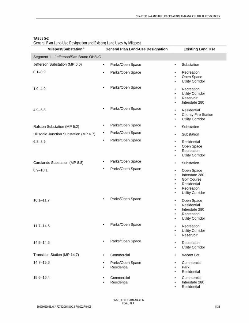
TABLE 5-2General Plan Land-Use Designation and Existing Land Uses by Milepost
Milepost/Substation 1 General Plan Land-Use Designation Existing Land Use
Segment 1—Jefferson/San Bruno OH/UG
Jefferson Substation (MP 0.0) • Parks/Open Space • Substation
0.1–0.9 • Parks/Open Space • Recreation• Open Space• Utility Corridor
1.0–4.9 • Parks/Open Space • Recreation• Utility Corridor• Reservoir• Interstate 280
4.9–6.8 • Parks/Open Space • Residential• County Fire Station• Utility Corridor
Ralston Substation (MP 5.2) • Parks/Open Space • Substation
Hillsdale Junction Substation (MP 6.7) • Parks/Open Space • Substation
6.8–8.9 • Parks/Open Space • Residential• Open Space• Recreation• Utility Corridor
Carolands Substation (MP 8.8) • Parks/Open Space • Substation
8.9–10.1 • Parks/Open Space • Open Space• Interstate 280• Golf Course• Residential• Recreation• Utility Corridor
10.1–11.7 • Parks/Open Space • Open Space• Residential• Interstate 280• Recreation• Utility Corridor
11.7–14.5 • Parks/Open Space • Recreation• Utility Corridor• Reservoir
14.5–14.6 • Parks/Open Space • Recreation• Utility Corridor
Transition Station (MP 14.7) • Commercial • Vacant Lot
14.7–15.6 • Parks/Open Space• Residential
• Commercial• Park• Residential
15.6–16.4 • Commercial• Residential
• Commercial• Interstate 280• Residential
CHAPTER 5—LAND USE, RECREATION, AND AGRICULTURAL RESOURCES
PG&E JEFFERSON–MARTINFINAL PEA
5-32 E082002004SAC/172750/005.DOC/SFO/022740005
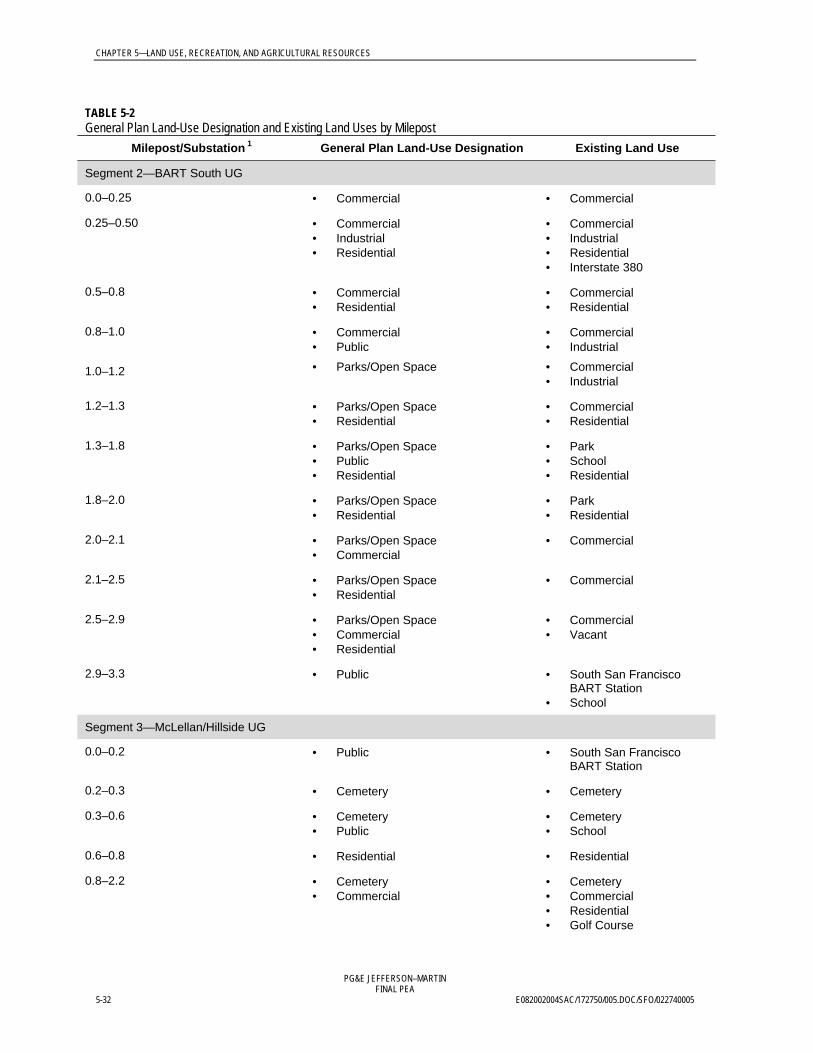
TABLE 5-2General Plan Land-Use Designation and Existing Land Uses by Milepost
Milepost/Substation 1 General Plan Land-Use Designation Existing Land Use
Segment 2—BART South UG
0.0–0.25 • Commercial • Commercial
0.25–0.50 • Commercial• Industrial• Residential
• Commercial• Industrial• Residential• Interstate 380
0.5–0.8 • Commercial• Residential
• Commercial• Residential
0.8–1.0 • Commercial• Public
• Commercial• Industrial
1.0–1.2 • Parks/Open Space • Commercial• Industrial
1.2–1.3 • Parks/Open Space• Residential
• Commercial• Residential
1.3–1.8 • Parks/Open Space• Public• Residential
• Park• School• Residential
1.8–2.0 • Parks/Open Space• Residential
• Park• Residential
2.0–2.1 • Parks/Open Space• Commercial
• Commercial
2.1–2.5 • Parks/Open Space• Residential
• Commercial
2.5–2.9 • Parks/Open Space• Commercial• Residential
• Commercial• Vacant
2.9–3.3 • Public • South San FranciscoBART Station
• School
Segment 3—McLellan/Hillside UG
0.0–0.2 • Public • South San FranciscoBART Station
0.2–0.3 • Cemetery • Cemetery
0.3–0.6 • Cemetery• Public
• Cemetery• School
0.6–0.8 • Residential • Residential
0.8–2.2 • Cemetery• Commercial
• Cemetery• Commercial• Residential• Golf Course

CHAPTER 5—LAND USE, RECREATION, AND AGRICULTURAL RESOURCES
PG&E JEFFERSON–MARTINFINAL PEA
E082002004SAC/172750/005.DOC/SFO/022740005 5-33
TABLE 5-2General Plan Land-Use Designation and Existing Land Uses by Milepost
Milepost/Substation 1 General Plan Land-Use Designation Existing Land Use
Segment 4—Hoffman/Orange UG
0.0–0.5 • Cemetery• Residential
• Cemetery• Residential
0.5–0.7 • Public• Residential
• Schools• Residential
Segment 5—Guadalupe Canyon UG
0–0.2 • Public • Residential
• Substation• Residential
0.2– 2.7 • Parks/Open Space• Public
• Park• School
2.7– 2.8 • Residential • Residential• Open Space
2.8–3.0 • Parks/Open Space • Residential• Open Space
3.0–3.1 • Residential • Open Space
3.1–4.0 • Commercial• Parks/Open Space with Residential
inset
• Commercial• Open Space• Residential
4.0–4.6 • Commercial • Commercial• Vacant
4.6–4.7 • Marsh• Public
• Marsh• Substation
Martin Substation (MP 4.7) • Commercial • Substation1 Mileposts break at land-use designation changes.OH = overhead.UG = underground.

CHAPTER 5—LAND USE, RECREATION, AND AGRICULTURAL RESOURCES
PG&E JEFFERSON–MARTINFINAL PEA
5-34 E082002004SAC/172750/005.DOC/SFO/022740005
TABLE 5-3General Plan Land-Use Designation Definitions 1
Residential This designation includes a full range of housing. Dwelling types mayinclude attached or detached single-family housing, duplexes, townhouses,and condominiums. Single- to multi-story apartment buildings and one- andtwo-story garden apartments are allowed. Residential-related uses, such asschools, churches, childcare centers, and tot lots, may be included.
Commercial This designation includes retail, service-commercial, commercial-recreation,financial, business and personal services, hotels, educational and socialservices, and government offices. Trade and distribution uses may beincluded. Warehouses, distribution facilities, light-industrial, and researchand development uses may be included within some commercial districts.
Industrial This designation includes wholesale outlets, professional and administrativeoffices, and light-manufacturing plants. Manufacturing and processing usesinclude but are not limited to: refining, smelting, fabricating, assembling, andstoring products. This designation also includes industrial lands for a widerange of industrial-processing, general-service, warehousing, storage anddistribution, and service-commercial uses.
Public This designation is intended for any public or institutional use. Thisdesignation includes federal-, state-, or local-government uses that servethe public and applies to city offices, schools, civic buildings, fire and policefacilities, wastewater-treatment plants, libraries, hospitals, and cemeteries.
Parks/Open Space This designation applies to properties that have been purchased, given, oroffered for dedication to a public agency for open-space use or conservationpurposes, and that remain largely unimproved by urban structures. Includedare community parks, neighborhood parks, preserves, and public-ownedpark and recreation facilities (e.g., playgrounds and golf courses).Recreation uses include but are not limited to: stables, riding academies,recreation complexes, public golf courses, and greenways. No significantdevelopment is allowed in these areas.
Cemetery This designation includes public and private cemetery facilities and property.
Agriculture This designation includes uses such as greenhouses, row crops, cutflowers, and livestock grazing. Resource-management and production usesinclude but are not limited to: growing, harvesting, and processing of timberproducts. Most of the land within this designation is used for grazinglivestock or dry-grain farming.
1 General plan land-use designations have been consolidated and generalized for all of the jurisdictions crossed.See Table 5-4 for consolidated general plan land-use designations.
CHAPTER 5—LAND USE, RECREATION, AND AGRICULTURAL RESOURCES
PG&E JEFFERSON–MARTINFINAL PEA
E082002004SAC/172750/005.DOC/SFO/022740005 5-35
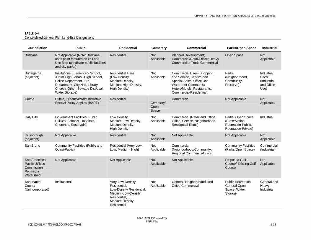
TABLE 5-4Consolidated General Plan Land-Use Designations
Jurisdiction Public Residential Cemetery Commercial Parks/Open Space Industrial
Brisbane Not Applicable (Note: Brisbaneuses point features on its LandUse Map to indicate public facilitiesand city parks)
Residential NotApplicable
Planned Development;Commercial/Retail/Office; HeavyCommercial; Trade Commercial
Open Space NotApplicable
Burlingame(adjacent)
Institutions (Elementary School,Junior High School, High School,Police Department, FireDepartment, City Hall, Library,Church, Other; Sewage Disposal,Water Storage)
Residential Uses(Low Density,Medium Density,Medium-High Density,High Density)
NotApplicable
Commercial Uses (Shoppingand Service, Service andSpecial Sales, Office Use,Waterfront-Commercial,Hotels/Motels, Restaurants,Commercial-Residential)
Parks(Neighborhood,Community,Preserve)
IndustrialUses(Industrialand OfficeUse)
Colma Public, Executive/AdministrativeSpecial Policy Applies (BART)
ResidentialCemetery/OpenSpace
Commercial Not Applicable NotApplicable
Daly City Government Facilities, PublicUtilities, Schools, Hospitals,Churches, Reservoirs
Low Density,Medium-Low Density,Medium Density,High Density
NotApplicable
Commercial (Retail and Office,Office, Service, Neighborhood,Residential-Retail)
Parks, Open Space(Preservation,Recreation-Public,Recreation-Private)
Industrial
Hillsborough(adjacent)
Not Applicable Residential NotApplicable
Not Applicable Not Applicable NotApplicable
San Bruno Community Facilities (Public andQuasi-Public)
Residential (Very Low,Low, Medium, High)
NotApplicable
Commercial(Neighborhood/Community,Regional Community/Office)
Community Facilities(Parks/Open Space)
Commercial(Industrial)
San FranciscoPublic UtilitiesCommission—PeninsulaWatershed
Not Applicable Not Applicable NotApplicable
Not Applicable Proposed GolfCourse/ Existing GolfCourse
NotApplicable
San MateoCounty(Unincorporated)
Institutional Very-Low-DensityResidential,Low-Density Residential,Medium-Low-DensityResidential,Medium-DensityResidential
NotApplicable
General, Neighborhood, andOffice-Commercial
Public Recreation,General OpenSpace, WaterStorage
General andHeavy-Industrial
CHAPTER 5—LAND USE, RECREATION, AND AGRICULTURAL RESOURCES
PG&E JEFFERSON–MARTINFINAL PEA
5-36 E082002004SAC/172750/005.DOC/SFO/022740005
5.2.2.2 Segment 1—Jefferson/San Bruno OH/UGRoute Overview—Segment 1Figure 5-1 and Figures 5-3.1 through 5-3.5 depict the existing land uses for Segment 1. Theconsolidated general plan land-use designations are shown in Figure 5-2. Figure 5-3includes detailed existing land-use figures. The overhead portion of Segment 1 (MP 0.0-14.6)roughly parallels Interstate 280 and State Route 35 (also known as Skyline Boulevard) forapproximately 15 miles along the Peninsula Watershed and turns east for approximatelytwo miles along San Bruno Avenue. The Peninsula Watershed to the west and residentialareas of San Mateo, Hillsborough, Burlingame, Millbrae, and San Bruno to the eastdominate the overhead portion of the segment. San Bruno Avenue (MP 14.6–16.3) is a built-out urban landscape comprised of predominately residential uses, including commercialuses, urban parks, and schools.
Detailed Land Use Description—Segment 1Table 5-2 summarizes the existing land uses by milepost for Segment 1 (MP 0.0–14.6). Thefollowing discussion addresses both existing land uses and General Plan land-usedesignations.
Segment 1, MP 0.0–0.1The Project starts at the existing Jefferson Substation south of Edgewood Country Park andPreserve.
Segment 1, MP 0.1–0.9The area between MP 0.1 and MP 0.9 falls within the western boundary of EdgewoodCounty Park and Preserve; the edge of the Park includes a utility corridor with existing gasand transmission lines close to Interstate 280. This area is designated Open Space andPublic Recreation by the San Mateo County Urban Land Use Map and is used for ecologicalconservation, hiking, and horseback riding. The route then leaves Edgewood County Parkand Preserve, crosses Edgewood Road at MP 0.9, and enters the Peninsula Watershed landswest of Pulgas Ridge Open Space Preserve.
Segment 1, MP 0.9–14.6The route enters Peninsula Watershed lands at MP 0.9. The areas between MP 1.0-4.9,7.2-8.4, 8.9-10.0, and 10.8-11.7 are designated as General Open Space and are covered by theScenic and Recreation Easement according to the San Mateo County Rural Land Use Map.Portions of this area are accessible to the public via multi-use trails or bike routes alongexisting roadways, but the central and southern portions are generally restricted access withthe exception of trails near MP 3.4 (see Figure 8-1). The existing 60 kV transmission linebeing replaced by this Project is located in an existing utility corridor with both existingpower and gas lines. The route is primarily within open space throughout PeninsulaWatershed lands and crosses back and forth over Interstate 280 at MPs 1.4, 4.5, 9.0, 10.0, and10.9. Several substations, a switchyard, and tap connections occur along the corridor(Figure 5-1 and Appendix A).
Between MP 5.1 and MP 5.2, the route passes west of the Hillcrest Juvenile Home and SanMateo County’s Belmont Fire Station. The Ralston Substation is also located at MP 5.2. Theroute continues through land designated as Open Space and adjacent to a residential areabetween MP 5.2 and MP 6.5. The Hillsdale Junction Switchyard is located at MP 6.7, west of
CHAPTER 5—LAND USE, RECREATION, AND AGRICULTURAL RESOURCES
PG&E JEFFERSON–MARTINFINAL PEA
E082002004SAC/172750/005.DOC/SFO/022740005 5-37
the Highlands/Baywood Park residential area. The residential area is within San MateoCounty and designated Residential, according to the San Mateo County Mid-Bayside AreaLand Use Map. From MP 6.8 to MP 8.8, the route remains in designated Open Spacebetween Interstate 280 and residential areas in the Town of Hillsborough. This portion of theroute travels about 200 feet west of approximately 20 homes along Black Mountain Roadbefore crossing over Haynes Road and to the east of Black Mountain Road at MP 8.4. Theroute then continues approximately 200 feet west of 12 more homes and three water tanksover the remaining 0.4 mile before reaching the Carolands Substation at MP 8.8. At thispoint, the route crosses again to the west of Interstate 280 and, at MP 8.9, travels through theCrystal Springs Golf Course along the existing power line corridor (see Subsection 5.2.2.2 forfurther discussion of Crystal Springs Golf Course).
At MP 10.0, the route crosses back to the east of Interstate 280 into a narrow strip ofdesignated Open Space between the highway and a residential area in Burlingame. Thisportion of the route travels about 100 to 200 feet west of approximately 65 homes on SkylineBoulevard for 0.8 mile. The route crosses to the west of Interstate 280 for the last time atMP 10.8.
The route runs along the eastern shore of the San Andreas Dam Reservoir for the remainingdistance within Peninsula Watershed lands. This area is used primarily for recreation andutility purposes. The route leaves the Scenic and Recreation Easement area at MP 11.7 andenters land designated as Open Space, covered by Scenic Easement, which does not providepublic access rights. The route continues along the eastern shore of the San Andreas DamReservoir for the remaining distance on Peninsula Watershed lands, until MP 14.6.
Segment 1, MP 14.6–14.8 At MP 14.6, the route enters the City of San Bruno and crosses to the east of SkylineBoulevard. At this point the route reaches the proposed transition station site on San BrunoAvenue. This area is designated as Commercial and zoned as Neighborhood-Commercialaccording to the City of San Bruno General Plan. The California Department ofTransportation (Caltrans) owns the vacant property. Uses in the area are a gas station and ashopping center to the south of San Bruno Avenue and open space to the north and east.The route is proposed to transition at the Caltrans property from an overhead to anunderground line running east within San Bruno Avenue. The nearest residences to thetransition station are located 900 feet to the north.
Segment 1, MP 14.8–16.3Between MP 14.8 and MP 15.6, the north side of the street is designated as Parks and OpenSpace and the south side as Residential for 0.2 miles, before transitioning to Residential onboth sides of the street. The north side of San Bruno Avenue includes recreational andresidential uses. The south side primarily consists of single-family homes. At MP 15.7, theroute passes under Interstate 280 and enters an area designated as Commercial to the northand Residential to the south. At MP 15.8, the route passes south of the entrance to theBayhill Shopping Center at Cherry Avenue. The primary uses in the area are grocery stores,restaurants, and small commercial shops. A large office building is located east of theshopping center on Cherry Avenue. Between MP 15.8 and MP 16.3, the route passes areasdesignated Commercial to the north of San Bruno Avenue and Residential to the south. Themain uses in this area are small businesses, shopping centers, and single-family homes. At

CHAPTER 5—LAND USE, RECREATION, AND AGRICULTURAL RESOURCES
PG&E JEFFERSON–MARTINFINAL PEA
5-38 E082002004SAC/172750/005.DOC/SFO/022740005
MP 16.3, the route crosses over El Camino Real, also designated as the Anza NationalHistoric Trail, and connects with the BART South Segment.
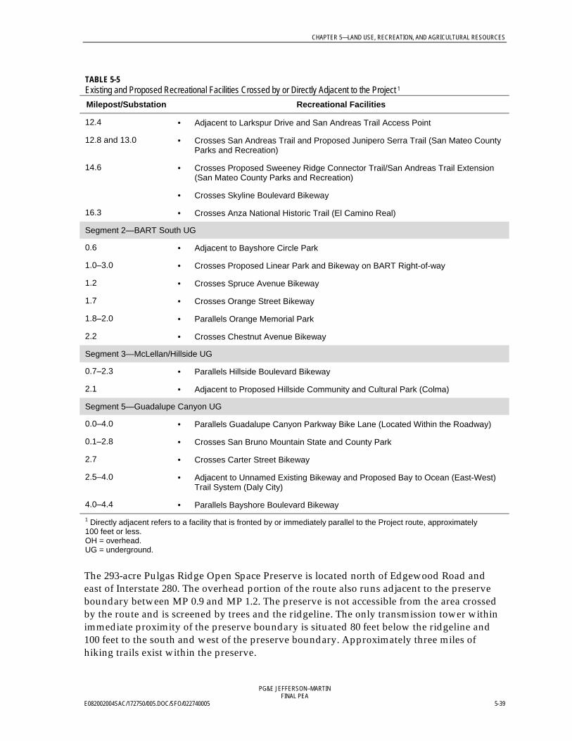
Recreation—Segment 1Table 5-5 summarizes the existing and proposed recreational facilities crossed by or directlyadjacent to the Project. Figure 8-1 in the Visual Resources Chapter shows public access trails.As previously described, the area between MP 0.1 and MP 0.9 of the overhead portion of theroute is within the western boundary of Edgewood County Park and Preserve and adjacentto Interstate 280. The Park encompasses 467 acres of rolling grasslands and forest. Accessiblefrom Interstate 280 and Edgewood Road, the park receives over 50,000 visitors a year(Friends of Edgewood 2002). An extensive trail system for hikers and horseback ridersconnects diverse natural settings, from chaparral to oak woodland to open grassland. Theexisting and proposed towers and overhead line are situated in a utility corridor in the opengrasslands at the western edge of the park close to Interstate 280. The Jefferson Substation,at MP 0.0, lies at the southwestern edge of the park. Between MP 0.1 and MP 0.9, the routecrosses park property, including two trails, as shown in Table 5-5.
TABLE 5-5Existing and Proposed Recreational Facilities Crossed by or Directly Adjacent to the Project 1
Milepost/Substation Recreational Facilities
Segment 1—Jefferson/San Bruno OH/UG
0.1–0.9 • Crosses Edgewood County Park and Preserve
0.2 • Crosses Clarkia Trail (Edgewood County Park and Preserve)
0.6–0.8 • Crosses Serpentine Loop and Edgewood Trails (Edgewood County Park andPreserve)
0.9 • Crosses Edgewood Road Bicycle Lane
1.0 • Proposed East Ridge Trail (San Mateo County Parks and Recreation)
1.0–4.9, 7.2–8.4, 8.9–10.0, 10.8–11.7,
• Crosses Peninsula Watershed
2.3–4.2 • Parallels Cañada Road Bicycle Route
3.1 • Crosses Sheep Camp Trail
4.8 • Crosses Ralston Trail
6.9 • Crosses Proposed San Mateo Creek Trail (San Mateo County Parks andRecreation)
7.0 • Crosses Crystal Springs Trail and Bikeway
8.6 • Crosses Skyline Frontage Bikeway
8.4–8.8 • Parallels Skyline Frontage Bikeway
8.9–10.0 • Crosses Crystal Springs Golf Course
11.2–11.3 • Adjacent to Trousdale Drive Bikeway and Proposed Sawyer Camp Alternate TrailAccess Point (San Mateo County Parks and Recreation)
11.4 and 11.6 • Crosses and parallels Sawyer Camp Trail and Access Point
CHAPTER 5—LAND USE, RECREATION, AND AGRICULTURAL RESOURCES
PG&E JEFFERSON–MARTINFINAL PEA
E082002004SAC/172750/005.DOC/SFO/022740005 5-39
TABLE 5-5Existing and Proposed Recreational Facilities Crossed by or Directly Adjacent to the Project 1
Milepost/Substation Recreational Facilities
12.4 • Adjacent to Larkspur Drive and San Andreas Trail Access Point
12.8 and 13.0 • Crosses San Andreas Trail and Proposed Junipero Serra Trail (San Mateo CountyParks and Recreation)
14.6 • Crosses Proposed Sweeney Ridge Connector Trail/San Andreas Trail Extension(San Mateo County Parks and Recreation)
• Crosses Skyline Boulevard Bikeway
16.3 • Crosses Anza National Historic Trail (El Camino Real)
Segment 2—BART South UG
0.6 • Adjacent to Bayshore Circle Park
1.0–3.0 • Crosses Proposed Linear Park and Bikeway on BART Right-of-way
1.2 • Crosses Spruce Avenue Bikeway
1.7 • Crosses Orange Street Bikeway
1.8–2.0 • Parallels Orange Memorial Park
2.2 • Crosses Chestnut Avenue Bikeway
Segment 3—McLellan/Hillside UG
0.7–2.3 • Parallels Hillside Boulevard Bikeway
2.1 • Adjacent to Proposed Hillside Community and Cultural Park (Colma)
Segment 5—Guadalupe Canyon UG
0.0–4.0 • Parallels Guadalupe Canyon Parkway Bike Lane (Located Within the Roadway)
0.1–2.8 • Crosses San Bruno Mountain State and County Park
2.7 • Crosses Carter Street Bikeway
2.5–4.0 • Adjacent to Unnamed Existing Bikeway and Proposed Bay to Ocean (East-West)Trail System (Daly City)
4.0–4.4 • Parallels Bayshore Boulevard Bikeway1 Directly adjacent refers to a facility that is fronted by or immediately parallel to the Project route, approximately100 feet or less.OH = overhead.UG = underground.
The 293-acre Pulgas Ridge Open Space Preserve is located north of Edgewood Road andeast of Interstate 280. The overhead portion of the route also runs adjacent to the preserveboundary between MP 0.9 and MP 1.2. The preserve is not accessible from the area crossedby the route and is screened by trees and the ridgeline. The only transmission tower withinimmediate proximity of the preserve boundary is situated 80 feet below the ridgeline and100 feet to the south and west of the preserve boundary. Approximately three miles ofhiking trails exist within the preserve.

CHAPTER 5—LAND USE, RECREATION, AND AGRICULTURAL RESOURCES
PG&E JEFFERSON–MARTINFINAL PEA
5-40 E082002004SAC/172750/005.DOC/SFO/022740005
The route crosses Crystal Springs Golf Course between MP 9.1 and MP 9.9. At MP 9.5, theroute passes over the Crystal Springs Golf Course clubhouse parking lot and travels thewestern edge of a fairway for the remaining 0.4 miles.
Between MP 1.0 (the location of the proposed East Ridge Trail) through 4.9, 7.2 to 8.4, 8.9 to10.0, and 10.8 to 11.7, the overhead route crosses an area covered by the Scenic andRecreation Easement bounded by Interstate 280 and the reservoirs in an existing utilitycorridor. According to the Planning Bureau of the SFPUC, this section of PeninsulaWatershed lands is among the state’s most popular recreational areas (Wilson 2002). Asshown in Table 5-4 and Figures 5-1 and 5-2, trails crossed include the Sawyer Camp,Sweeney Ridge (and the proposed Sweeney Ridge Connector), Sheep Camp, San Andreas,Crystal Springs, Ralston, Edgewood, and the proposed San Mateo Creek trails. Hikers,bicyclists, and horseback riders use these trails, with Sawyer Camp Trail alone receiving200,000 visitors per year. At MP 11.6, the route crosses the roadside parking and accesspoint to Sawyer Camp Trail at Hillcrest Boulevard. Between MP 11.4 and MP 11.6, the routecrosses and parallels the Sawyer Camp Trail. The route crosses the San Andreas Trail at MP12.8 and again at MP 13.0.
Between MP 2.3 and MP 4.2, the overhead route roughly parallels Cañada Road at distancesvarying from 200 feet to 0.25 mile. Cañada Road is an existing bicycle route, as designated inthe San Mateo County Trails Plan.
At MP 8.6 and MP 14.7, the overhead route crosses Skyline Frontage Road and SkylineBoulevard, respectively, each of which is an existing bicycle route.
Junipero Serra County Park is located in the peninsula foothills, just east of San AndreasLake and the overhead route, at MP 13.0. The park consists of 108 acres between the cities ofMillbrae and San Bruno. Recreational activities include family and group picnicking,playgrounds, hiking, nature trails, and youth day camping. The proposed Junipero SerraTrail would connect the park with Peninsula Watershed lands at MP 13.0.
At MP 16.3, the underground route crosses El Camino Real, also designated as the AnzaNational Historic Trail, and connects with the BART South segment of the route(Segment 2).
Agricultural Resources—Segment 1The Williamson Act (California Government Code Section 51200 et seq.) is a state law thatestablishes a program to preserve agricultural land. Under this program, the owner of anagricultural parcel may enter into a contract with the county in which the owner agrees tomaintain agricultural operations on the parcel. In exchange, the county assesses theproperty based solely on its agricultural value, lowering the property tax obligation. Thecontracts are valid for a ten-year period, with an automatic renewal unless the owner filesfor non-renewal. There are no Williamson Act parcels along Segment 1.
The California Department of Conservation, Division of Land Resource Protection,designates agriculturally viable lands as Prime, Unique, or Farmland of StatewideImportance. San Mateo County also designates lands that are considered economicallyviable as Agricultural. No farmland that has been designated as Prime, Unique, or Farmlandof Statewide Importance is crossed by or adjacent to the Project ROW. In addition, noagriculturally zoned lands or other agricultural resources are present along Segment 1.

CHAPTER 5—LAND USE, RECREATION, AND AGRICULTURAL RESOURCES
PG&E JEFFERSON–MARTINFINAL PEA
E082002004SAC/172750/005.DOC/SFO/022740005 5-41
5.2.2.3 Segment 2—BART South UGRoute Overview—Segment 2Figure 5-2 and Figures 5-3.5, 5-3.6, and 5-3.7 depict the existing uses of Segment 2. Theapproximately three-mile Segment 2 runs in the BART ROW from San Bruno to South SanFrancisco. The route is dominated by commercial and mixed industrial land uses and runsadjacent to some residential areas (refer to Figure 5-2 for general plan land-usedesignations).
Detailed Land Use Description—Segment 2Table 5-2 summarizes the existing land uses by milepost for Segment 2.
Segment 2, MP 0.0–0.5Between MP 0.0 and MP 0.3, from El Camino Real to Huntington Avenue, the undergroundtransmission line travels down San Bruno Avenue and passes through land designated asCommercial, with businesses on both sides of the street. The line then turns north, where itintersects with Huntington Avenue and enters the BART ROW. Between MP 0.3 and MP 0.5,the underground transmission line passes a residential area to the west, the Caltrain tracks,and a rail yard and commercial area to the east. The line crosses under Interstate 380 at MP0.5.
Segment 2, MP 0.5–1.0From Interstate 380 to MP 0.8, the area west of the line designated as Commercialencompasses Tanforan Park Shopping Center, the new San Bruno BART station, a postoffice, and hotels. An area containing single-family homes designated as Residential liesapproximately 100 feet to the east of the route along Hunnington Avenue. At MP 0.8, theunderground transmission line crosses into South San Francisco, where it runs through anarea designated as Commercial until MP 1.0.
Segment 2, MP 1.0–3.3From MP 1.0 to the South San Francisco BART station at MP 3.0, the transmission line lieswithin a narrow strip of land designated for Park and Recreation. South San Francisco plansto develop this section of the BART ROW into a park, as described in subsection 5.2.3.2.
From MP 1.0 to MP 1.3, the underground portion of the transmission line is adjacent to acommercial and industrial area on both sides of the route near South Maple Avenue, withsome residences approximately 200 feet west of the route, between MP 1.2 and MP 1.3,located on Huntington Avenue between Sneath Lane and South Spruce Avenue. The linethen passes adjacent to an area to the south designated as Residential and occupied byresidences between MP 1.3 and MP 2.0. South San Francisco High School, which fronts ElCamino Real, is adjacent to the route, at MP 1.6. Orange Memorial Park is adjacent to theroute between MP 1.8 and MP 2.0 and is described below under Recreation. A Boys andGirls Club lies just across the BART ROW from Orange Memorial Park on West OrangeAvenue. Multi-family residential buildings are located adjacent to the ROW north of OrangeMemorial Park.
Traveling north, the underground portion of the transmission line runs adjacent to an areadesignated as Commercial, between MP 2.0 and MP 2.1 on the north and south sides ofChestnut Avenue. The commercial area includes a shopping center, construction yard, and acar dealership that uses the BART ROW as a parking lot. Adjacent land uses between MP 2.1
CHAPTER 5—LAND USE, RECREATION, AND AGRICULTURAL RESOURCES
PG&E JEFFERSON–MARTINFINAL PEA
5-42 E082002004SAC/172750/005.DOC/SFO/022740005
and MP 2.5 are designated as Residential, but existing land uses are predominantlycommercial. Land-use designations adjacent to the route between MP 2.5 and MP 2.9 areCommercial and Residential. However, existing uses appear predominantly commercial,with some vacant lots. Within 100 feet of the route on Mission Road at MP 2.9 is a HeadStart child education facility. Segment 2 ends at MP 3.3 near the South San Francisco BARTstation in an area designated as Transportation.
Recreation—Segment 2Previous Table 5-5 summarizes the existing and proposed recreation uses for Segment 2.Three existing parks are located near the BART South Segment in San Bruno. BayshoreCircle Park is located on North Bayshore Circle approximately 400 feet from the route atMP 0.6. This park is one acre in size and contains a basketball court, park benches, and playequipment. The Herman Tot Lot is located a block away (approximately 300 feet) onDiamond Street at MP 0.6. It is 0.25 acre in size and contains play equipment and parkbenches. Several residences are located between the tot lot and the route. Orange MemorialPark, located along the eastern edge of the ROW from MP 1.9 to MP 2.2, encompasses 21acres, with picnic facilities, a pool, tennis courts, soccer fields, baseball diamonds, arecreation building, and a scouting facility. Immediately adjacent to the BART ROW withinthe park is one of the main access roads into the park and a parking lot. A row of eucalyptustrees bounds this side of the park.
Segment 2 crosses several bike routes in South San Francisco, including the Spruce Avenuebikeway at MP 1.2, the Chestnut Avenue bikeway at MP 2.2, and the Orange Street bikewayat MP 1.7.
Agricultural Resources—Segment 2There are no Williamson Act parcels, designated farmland, agriculturally zoned lands, orother agricultural resources along Segment 2.
5.2.2.4 Segment 3—McLellan/Hillside UGRoute Overview—Segment 3Figure 5-2 and Figures 5-3.7 to 5-3.9 depict the existing land uses for Segment 3 by milepost.The McLellan/Hillside Segment runs north from McLellan Drive in South San Francisco toHillside Boulevard in Colma and then continues 1.5 miles to the intersection of SerramonteBoulevard. A public transit station and schools dominate the route for its first 0.5 miles, andcemeteries and residential areas occur along the remainder of the segment.
Detailed Land Use Description—Segment 3Segment 3, MP 0.0–0.8The McLellan/Hillside Segment begins at the South San Francisco BART station in an areadesignated as Transportation.2 The underground portion of the transmission line travelsnortheast for approximately 0.8 miles along the route of the proposed McLellanDrive/Hickey Boulevard Extension, in an area designated as Cemetery/Open Space andadjacent to Holy Cross Cemetery. El Camino High School, which fronts Evergreen Drive, islocated 200 feet southeast of the route from MP 0.3 to MP 0.6. From MP 0.6 to MP 0.8, to the
2 The “Transportation” designation has been included under the “Public” designation in Table 5-2: General Plan Land-UseDesignation and Existing Land Uses by Milepost.
CHAPTER 5—LAND USE, RECREATION, AND AGRICULTURAL RESOURCES
PG&E JEFFERSON–MARTINFINAL PEA
E082002004SAC/172750/005.DOC/SFO/022740005 5-43
southeast of the underground transmission line, in land designated as Residential, lie single-family homes that are accessible from Hillside Boulevard.
Segment 3, MP 0.8–2.5At Hillside Boulevard, the route turns northwest through land designated asCemetery/Open Space from MP 0.8 to MP 2.5, except for a small portion between MP 1.8and MP 1.9 with a Commercial designation. Businesses that support the cemetery industryoccupy some of this area. From MP 0.8 to MP 0.9, the underground transmission line passessouth of an area that the Pacific Nursery uses to grow plants and flowers outdoors. Theroute is within 0.32 mile of the southern edge of Cypress Hills Golf Course at MP 1.7 andMP 1.9. The route also passes the future location of the Hillside Community and CulturalPark (described in the Recreation and Planned and Proposed Development sections) atMP 2.1, northwest of the intersection of Olivet Parkway and Hillside Boulevard. This land isvacant. At MP 2.3, on the west side of the F Street and Hillside Boulevard intersection, asingle-family home occupies a 200-foot long area designated as Residential. TheMcLellan/Hillside route ends at MP 2.5 at the Hoffman Street and Hillside Boulevardintersection.
Recreation—Segment 3The Hillside Boulevard bikeway in Colma, which runs along Hillside Boulevard fromMP 0.7 to MP 2.3, is the only recreation facility along this segment. The 76-acre Cypress HillsGolf Course is accessible from Hillside Boulevard at MP 1.4. The golf course is located0.2 mile north of the route.
Agricultural Resources—Segment 3There are no Williamson Act parcels, designated farmland, or agriculturally zoned landsalong this segment. The land occupied by Pacific Nursery at MP 0.8 is designated asCemetery/Open Space and slated for future cemetery use.
5.2.2.5 Segment 4—Hoffman/Orange UGRoute Overview—Segment 4Figures 5-2 and 5-3.9 depict the existing land uses for Segment 4. This segment travels alongHoffman Street and Orange Street through residential areas of Daly City and passesadjacent to two schools.
Detailed Land Use Description—Segment 4Segment 4, MP 0.0–0.7Beginning at the Hillside Boulevard and Hoffman Street intersection , the route passes betweenColma (on the south) and Daly City (on the north). The area to the south is designated andused as a Cemetery. The area to the north is designated as Residential and contains numeroushigh-density residences. At MP 0.8, the designation to the south changes to Residential for0.1 mile. Multifamily homes and a mobile-home park occupy this and the adjacent area. AtMP 0.4, the route turns north onto Orange Street. Single-family attached homes are on bothsides of Orange Street from MP 0.4 to MP 0.5 in an area designated as Residential. BetweenMP 0.5 and MP 0.7, the route is adjacent to the Susan B. Anthony Elementary School andPollicita Middle School playing fields on the west and PG&E’s Daly City Substation on theeast. The route ends at the Orange Street and Market Street intersection at MP 0.7.
CHAPTER 5—LAND USE, RECREATION, AND AGRICULTURAL RESOURCES
PG&E JEFFERSON–MARTINFINAL PEA
5-44 E082002004SAC/172750/005.DOC/SFO/022740005
Recreation—Segment 4No parks, trails, or bicycle paths exist along or are adjacent to the segment.
Agricultural Resources—Segment 4There are no Williamson Act parcels, designated farmland, agriculturally zoned lands, orother agricultural resources along the segment.
5.2.2.6 Segment 5—Guadalupe Canyon UGRoute Overview—Segment 5Figures 5-2 and 5-3.9 to 5-3.11 depict the existing land uses for Segment 5. The five-mileGuadalupe Canyon Segment crosses residential areas and passes one school in the westernportion of the route. The majority of the route is located on Guadalupe Canyon Parkwaythrough San Bruno Mountain State and County Park.
Detailed Land Use Description—Segment 5Segment 5, MP 0.0–3.1Beginning at MP 0.0, at the intersection of Orange Street and East Market Street, theunderground route travels north of PG&E’s Daly City Substation, which is designated asPublic Utilities. On the west, the segment travels past a designated Residential area withhomes, until MP 0.1. The segment passes John F. Kennedy Elementary School, located onPrice Street off of East Market Street, on the west side of the route between MP 0.2 and MP0.4. This school is located within 100 feet, west and uphill, of where the route would beinstalled.
The segment enters San Bruno Mountain State and County Park at MP 0.2. The San MateoCounty General Plan designates the park, which is used primarily for hiking, as PublicRecreation. At MP 2.7, the segment exits the park and continues between county land on thenorth and Brisbane on the south. The surrounding land is designated and in use as OpenSpace, with two small exceptions in Brisbane, between MP 2.7 and MP 2.8 and MP 3.0 andMP 3.1, with Residential designations. A residential development is under constructionseveral hundred feet north of the segment between MP 3.0 and MP 3.1.
Segment 5, MP 3.1–4.7At MP 3.1, the segment lies entirely within Brisbane. The area on the north side of thesegment is designated as Commercial and contains new office buildings. The area directlyadjacent to the south is designated and in use as Open Space. Within the Open Spacedesignation falls a Residential-designation inset, in which houses are under construction, atMP 3.5, 0.2 mile west of the route. At MP 4.0, the segment turns west on Bayshore Boulevardand continues through an area designated as Commercial. This area contains new officebuildings on the west side of the road and vacant land designated as Commercial on the eastside. At MP 4.6, the segment passes a marsh area, as designated on Brisbane General Planland use maps, on the west for 0.1 miles before passing adjacent to the Martin Substation.The segment ends at MP 4.7, the southern edge of the Martin Substation property.
Recreation—Segment 5Table 5-5 summarizes the existing and planned recreation uses for Segment 5. TheGuadalupe Canyon Segment is located within Guadalupe Canyon Parkway, which passesthrough San Bruno Mountain State and County Park. No trails within the park are crossed

CHAPTER 5—LAND USE, RECREATION, AND AGRICULTURAL RESOURCES
PG&E JEFFERSON–MARTINFINAL PEA
E082002004SAC/172750/005.DOC/SFO/022740005 5-45
by or run adjacent to the route. However, an unnamed existing bikeway runs within theroadway from MP 2.5 to MP 4.0.
The Guadalupe Canyon Parkway bikeway is within the existing roadway and parallel to theProject route from MP 0.0 to MP 4.0, intersecting the Carter Street bikeway at MP 2.7. TheBayshore Boulevard bikeway also follows the route from MP 4.0 to MP 4.4.
Agricultural Resources—Segment 5There are no Williamson Act parcels, designated farmland, agriculturally zoned lands, orother agricultural resources along the Guadalupe Canyon Segment.
5.2.2.7 Martin SubstationThe existing Martin Substation is located in Brisbane and the land-use designation isCommercial/Retail/Office. The nearest residence to the property line of the substation islocated within 150 feet on Geneva Avenue.
5.2.3 Planned and Proposed Development5.2.3.1 Segment 1—Jefferson/San Bruno OH/UGSeveral trails have been proposed along the segment (refer to Table 5-5 for the agenciesproposing each trail). The San Andreas Trail Extension/ Sweeney Ridge Connector Trail isunder construction and scheduled for completion in the fall. The rest of the proposed trailscrossed by this segment (East Ridge Trail, Crystal Springs Trail Alternate, San Mateo CreekTrail, Sawyer Camp Alternate, and the Junipero Serra Trail) lack funding, and constructiondates are unknown.
5.2.3.2 Segment 2—BART South UGThe BART South Segment crosses or is located adjacent to several of the South SanFrancisco’s Capital Improvement Program projects. These include:
• Mission Road Rehabilitation and Transit-Oriented Development Improvements: ThisProject will include the construction of a road from McLellan Drive to the end of the BARTparking lot several hundred feet north of Sequoia Avenue. The BART South Segment willcross this road at MP 2.7. It is currently under construction between 2002 and 2003.
• Linear Park in BART ROW: A two-mile linear park is proposed by the City of South SanFrancisco along the BART ROW between Noor Avenue and the South San FranciscoBART station (between MP 1.0 and MP 3.0). The development will result in approximately30 acres of paved paths, bikeways, and open turf areas and will serve as a greenway to thecity’s center. The city estimates that planning and building the park will take five to eightyears. The BART/SamTrans bikeway, which will be located within the linear park, isscheduled for completion in summer 2004 by the BART and SamTrans Authorities, priorto completion of the City’s linear park.
• Caltrain Grade Separation and New San Bruno Station: San Bruno is consideringconstructing railroad-grade separations to separate the existing Caltrain tracks fromvehicular traffic and pedestrians. The proposal also involves construction of a new stationat the intersection of San Bruno and San Mateo avenues, just east of Segment 2. The

CHAPTER 5—LAND USE, RECREATION, AND AGRICULTURAL RESOURCES
PG&E JEFFERSON–MARTINFINAL PEA
5-46 E082002004SAC/172750/005.DOC/SFO/022740005
grade-separation project, still in the preliminary planning phase, will not be ready forconstruction until late 2004 or early 2005. The construction is expected to last two years.
5.2.3.3 Segment 3—McLellan/Hillside UGThe McLellan/Hillside Segment is located in proximity to the following planned projects.
• McLellan Drive Extension: This Project will extend McLellan Drive from its existingterminus at El Camino Real to Hillside Boulevard. Segment 3 will be under this roadextension between MP 0.0 and MP 0.8. The Project is currently under construction.
• Colma Grove: This 63-unit condominium complex will be located on a 3.5-acre site at1401 Mission Road, across from the South San Francisco BART station. The land is beingdeveloped by Truemark Companies. Construction is expected to begin in September 2002and end by September 2003. Segment 3 will be adjacent to this development at MP 0.0.
• The Hillside Community and Cultural Park: This facility will occupy a 0.5-acre parcel atMP 2.1 on Hillside Boulevard. The park will provide picnic facilities and house thehistorical Colma Train Station, which was displaced by construction of the BARTextension to Colma. Other facilities may include a new building to house the ColmaHistorical Association and a vintage railcar. The park is funded through 2004 andscheduled for completion in summer 2004.
5.2.3.4 Segment 4—Hoffman/Orange UGThe only planned development along the segment is the 18-unit Hoffman Court housing sitelocated on 1.05 acres at 300 Hoffman Street. Construction is expected to begin in summer2002 and end by summer 2003. The route would be adjacent to this development at MP 0.2.
5.2.3.5 Segment 5—Guadalupe Canyon UGThe following developments are planned or proposed along the segment:
• Bay to Ocean (East-West) Trail System—This bikeway is proposed to run withinGuadalupe Canyon Parkway. Because no funding is currently available for the project,the construction schedule is undetermined.
5.2.4 Plans and Policies3
This section describes the goals and policies relating to land use, recreation, and agriculturalresources for the jurisdictions crossed by the Project. Noise or visual policies are addressedin the respective chapters.
5.2.4.1 Segment 1—Jefferson/San Bruno OH/UGEdgewood Park and Natural Preserve Master Plan The entire Edgewood Park and Natural Preserve Master Plan was reviewed for relevantland use, utility, and recreational policies. The plan contains no policies addressing utilitiesor construction, or that are otherwise relevant to the Project.
3 Under the California Constitution and CPUC General Order 131-D, the siting of all electric transmission facilities are withinthe exclusive jurisdiction of the CPUC. Therefore, no local agency has discretionary authority over the Jefferson-MartinProject, and these local requirements are not binding on the CPUC or PG&E. Nonetheless, the policies/designationsdiscussed herein may be relevant to the CPUC’s analysis of potential impacts under CEQA.
CHAPTER 5—LAND USE, RECREATION, AND AGRICULTURAL RESOURCES
PG&E JEFFERSON–MARTINFINAL PEA
E082002004SAC/172750/005.DOC/SFO/022740005 5-47
Peninsula Watershed Management PlanThe entire Peninsula Watershed Management Plan was reviewed for land use, utility, andrecreational policies relevant to the Project. Chapter 4, Goals and Policies, of the Plancontains the following applicable policies:
• Policy WA2: Prohibits the construction of new trails and unsupervised access to existingroads and trails not addressed in this Plan.
• Policy WA6: Restricts new utility lines proposed on the watershed for the transmission ofor communications to existing utility corridors, and requires that new power lines beburied, where feasible. All proposed alignments shall undergo a scenic impact analysis.
• Policy WA22: Proposals for new facilities, structures, roads, trails, projects and leases, orimprovements to existing facilities shall be:
− Limited to essential public services and not attractions unto themselves, butincidental to the primary purposes of the watershed (i.e., water quality protectionand water supply), or to its enjoyment and conservation in its natural condition.
− Designed, sited, constructed, and maintained to blend with the natural landscapeand conform to the goals and policies set forth in this Plan.
− Design and site new facilities, structures, roads, and trails to minimize, whereverpossible, grading and the visibility of cut banks and fill slopes.
• Policy WA24: Requires that all proposed development involving grading of land includethe submittal of a grading plan to SFPUC to retain the existing topography where feasible,minimize grading, minimize the impacts on scenic, ecological, and cultural resources, andminimize off-site soil loss from erosion.
• Policy WA26: All maintenance, operation, and construction activities shall incorporateBest Management Practices (BMPs), as applicable.
• Action “des5” (Phase A, Letter E): Eliminate, wherever possible, the use of unpaintedmetallic surfaces and other sources that may cause increased levels of reflectivity.
San Mateo County General PlanThe General Land Use, Rural Land Use, Parks and Recreation Resources, and County TrailsPolicies elements of the San Mateo County General Plan were reviewed and contain nopolicies applicable to the Project.
San Mateo County Trails PlanThe entire San Mateo County Trails Plan was reviewed for applicable land use, utility, andrecreational policies. The plan contains no policies such as policies addressing utilities orconstruction that are relevant to the Project.
Hillsborough General PlanThe Hillsborough General Plan Land Use and Open Space and Conservation elements werereviewed for relevant policies. The plan contains no policies such as policies addressingutilities or construction that are applicable to the Project.
CHAPTER 5—LAND USE, RECREATION, AND AGRICULTURAL RESOURCES
PG&E JEFFERSON–MARTINFINAL PEA
5-48 E082002004SAC/172750/005.DOC/SFO/022740005
San Bruno General PlanThe Land Use Element of the San Bruno General Plan was reviewed for applicable land use,utility, or recreational policies. No policies such as policies addressing utilities orconstruction that are applicable to the Project are contained within the plan.
5.2.4.2 Segment 2—BART South UGSan Bruno General PlanAs described above, the San Bruno General Plan contains no policies such as policiesaddressing utilities or construction that are applicable to the Project.
South San Francisco General PlanThe Land Use, Parks, and Public Facilities and Services elements of the South San FranciscoGeneral Plan were reviewed for relevant land use, utility, and recreational policies. Thefollowing items from the South San Francisco General Plan apply to the Project:
• Guiding Policies: Parks and Recreation 5.1-G-4: Develop linear parks in conjunction withmajor infrastructure improvements and along existing public utility and transportationROWs.
• Parks, Public Facilities, and Services Policy 5.1-I-6: Work with BART, PG&E, and theSFPUC to lease and develop linear parks on existing public utility and transportationROWs in the city, where appropriate and feasible.
5.2.4.3 Segment 3—McLellan/Hillside UGRefer to the policies listed under South San Francisco General Plan in addition to the planslisted below.
Colma General PlanThe Land Use and Open Space/Conservation elements of the Colma General Plan werereviewed for applicable land use, utility, and recreational policies. The Plan contains thefollowing applicable policy:
• Land Use: 5.02.164.6 Utility Underground: … In areas of existing development, utilitylines should be placed underground in order to give Colma’s streets a neater appearance.
Daly City General PlanNo policies in the Land Use Element of the Daly City General Plan such as policiesaddressing utilities or construction that are applicable to the Project.
5.2.4.4 Segment 4—Hoffman/Orange UG The Colma General Plan contains the following applicable policy:
• Land Use: 5.02.164.6 Utility Underground: … In areas of existing development, utilitylines should be placed underground in order to give Colma’s streets a neater appearance.
Daly City General PlanAs described above, there are no policies such as utility or construction policies addressed inthe Daly City General Plan that apply to the Project.
CHAPTER 5—LAND USE, RECREATION, AND AGRICULTURAL RESOURCES
PG&E JEFFERSON–MARTINFINAL PEA
E082002004SAC/172750/005.DOC/SFO/022740005 5-49
5.2.4.5 Segment 5—Guadalupe Canyon UGSan Bruno Mountain Master PlanThe entire San Bruno Mountain Master Plan was reviewed for land use, utility, andrecreational policies relevant to the Project. The Plan contains no applicable policies.
San Bruno Mountain Habitat Conservation PlanThe entire San Bruno Mountain HCP was reviewed for relevant land use, utility, andrecreational policies. The proposed transmission line is located within the bounds of the HCPfrom the point where it enters San Bruno Mountain State and County Park at MP 0.1 to itsterminus at the PG&E Martin Substation. The HCP divides different geographical areas withinthe HCP bounds into Management Units. The Management Unit that the Project crosses iscalled “PG&E Fee” and includes the open spaces south of Martin Street. This unit also containsthe Martin Substation, but the policies contained in the plan apply only to the open-spaceportions of the Martin Substation parcel. The following objectives and obligations apply to theProject Area:
• HCP Objectives: Specific Conservation Needs: Maintenance activities should be kept toexisting disturbed areas where feasible (i.e., roads and dirt trails). Human or mechanicalencroachment in habitat areas during PG&E utility-maintenance activities should beminimized. If new disturbance is foreseen, PG&E maintenance personnel should consultwith the Habitat Manager to avoid particularly sensitive areas. During emergencysituations (i.e., power failures) this may not be possible. Disturbed areas should berevegetated with Plan-Operator-approved species. PG&E will be advised as to where toobtain the recommended species.
• Operating Program Obligations: PG&E has the following obligations:
− Comply with the mitigation measures set forth for Management Unit 1-11-01.
− Participate in the regulatory provisions of the HCP.
− Obtain approvals of any changes in land use or other uses which would alter thecurrent state of the parcel as required by Chapter Five (F) (4).
− Under non-emergency situations, notify the Plan Operator of all maintenanceactivities which may encroach into the conserved habitat area (routine line patrolswhich will not impact conserved habitat are excluded from this notificationrequirement).
− If unforeseen requirements for adding new gas and electric distribution facilitiesarise, notify the Plan Operator of the proposed activity and give the HabitatManager a detailed drawing of the areas where the activities will take place;Incorporate Plan Operator suggested design changes into the Proposed Project.
• PG&E Fee 2. 1-12-02: This parcel (open space area only) is contained in the transmissionand gas-line corridor which is adjacent to the Rio Verde Heights Area. It contains the openspace portion of PG&E fee south of Martin Street.
− Maintenance activities should be kept to existing disturbed areas where feasible (i.e.roads and dirt trails).
CHAPTER 5—LAND USE, RECREATION, AND AGRICULTURAL RESOURCES
PG&E JEFFERSON–MARTINFINAL PEA
5-50 E082002004SAC/172750/005.DOC/SFO/022740005
− New disturbance to conserved habitat should be minimized.
− PG&E maintenance personnel should consult with the Habitat Manager so that anynew disturbance can avoid particularly sensitive habitat areas. During emergencysituations (i.e., power failures) this may not be possible.
− Disturbed areas should be revegetated with plant species approved by the PlanOperator.
5.2.4.6 Brisbane General PlanNo policies in Land Use, Open Space, Recreation, and Community Service elements of theBrisbane General Plan apply to the Project.
5.3 Potential Impacts5.3.1 Significance CriteriaSignificance criteria for agricultural, land use, and recreational impacts were derived fromAppendix G of the revised CEQA Guidelines. Impacts to agricultural resources, land use, orrecreation would be significant if they resulted in:
• Physical division of an established community
• Substantial conflicts with applicable land-use plans, policies, or regulation of an agencywith jurisdiction over the Project
• Conflicts with an applicable habitat-conservation plan or natural communityconservation plan
• Substantial increase in the use of existing parks or other recreational facilities
• Construction or expansion of recreational facilities that might have an adverse physicaleffect on the environment
• Substantial adverse effect to the use of existing recreational facilities
• Conversion of land designated as prime farmland, unique farmland, or farmland ofstatewide importance to non-agricultural use
• Conflicts with existing zoning for agricultural use or Williamson Act contract
• Changes to the environment resulting in conversion of designated farmland to non-agricultural use
5.3.1.1 Overview of Impact AnalysisBecause the overhead transmission line will replace an existing overhead line located in anexisting utility corridor, and the remainder of the transmission line is proposed as anunderground transmission line located in existing roadways, planned roadways, and theBART ROW, the Project will not result in significant effects to land use, recreation, oragriculture. Existing land uses and temporarily disturbed areas will be restored afterconstruction and, as a result, existing land uses will not be permanently altered. The existing
CHAPTER 5—LAND USE, RECREATION, AND AGRICULTURAL RESOURCES
PG&E JEFFERSON–MARTINFINAL PEA
E082002004SAC/172750/005.DOC/SFO/022740005 5-51
substations will be modified within their existing boundaries, and no land use impactswould therefore result from Project modifications. Temporary adverse impacts will beminimized and mitigated as described below.
Physical Division of an Established CommunityBecause the overhead portion of the transmission line will replace an existing line in anestablished utility corridor, and the underground portion will be entirely locatedunderground in existing or planned roadways or the BART ROW, the Project will notphysically divide an established community.
Conflicts with Plans, Policies, and HCPsConstruction and operation of the Project will not conflict with environmental plans,policies, or regulations adopted by agencies with jurisdiction over local land uses, includingthe San Bruno Mountain HCP. All of the general plan land-use designations crossed (referto Table 5-2) do not restrict utility lines or specify their location. As discussed inSubsection 5.2.4.3, the Colma General Plan encourages the undergrounding of new utilitylines (applicable to Segment 3), but it does not require it. An analysis of consistency witheach jurisdiction’s applicable policies (identified in Subsection 5.2.4.3) follows.
Peninsula Watershed Management PlanThe Project will not involve the construction of new trails: PG&E will establish site controlmeasures on any new temporary access roads; therefore, it will not conflict with Policy WA2of the Peninsula Watershed Management Plan. The overhead portion of the transmissionline will replace an existing transmission line in an existing utility corridor and is thereforeconsistent with Policy WA6. Any access that will be constructed to existing towers will beessential to the maintenance of the utility lines and will be designed and constructedaccording to the requirements of Policy WA22. PG&E will also submit a copy of the dropgrading plans in accordance with policy WA24. BMPs will be prepared in accordance withWA26 as described in Chapter 9, Hydrology and Water Quality. PG&E has adopted severalmitigation measures to reduce levels of reflecting, as described in Chapter 8, VisualResources.
South San Francisco General PlanSouth San Francisco is in the planning stage of developing a linear park along the BARTROW. The underground transmission line will be located within this park and will not posea conflict to park development. The Project is therefore consistent with Parks and RecreationPolicy 5.1-G-4 and Parks, Public Facilities, and Services Policy 5.1-I-6.
Colma General PlanBecause the line will be placed underground within Colma, it will not conflict with LandUse Policy 5.02.164.6.
San Bruno Habitat Conservation PlanThe Project will not result in any disturbance to lands within San Bruno Mountain State andCounty Park because construction will take place entirely within the existing roadway. As aresult, it will be consistent with the HCP Objectives, Operating Program Obligations, andpolicies identified under Plans and Policies above. In addition, PG&E will be applying for aSite Activity Permit.
CHAPTER 5—LAND USE, RECREATION, AND AGRICULTURAL RESOURCES
PG&E JEFFERSON–MARTINFINAL PEA
5-52 E082002004SAC/172750/005.DOC/SFO/022740005
Increased Use of Existing Recreational FacilitiesThe Project does not involve additional housing or population immigration that would placeadditional demands on existing park use. As a result, there will be no significant impact.
Construction or Expansion of Recreational FacilitiesThe Project does not involve the construction or expansion of existing recreational facilities;therefore, there will be no impacts.
Adverse Effect to Existing Recreational UsesAdverse effects to the use of existing recreational facilities are discussed below for eachsegment.
Conversion of Farmland and Conflicts with Agricultural ZoningThe Project will not cross designated Farmland, land under Williamson Act contract, or landzoned for agriculture. As a result, there will be no impacts to sensitive agriculturalresources.
5.3.2 Construction Impacts5.3.2.1 SubstationsAll Project-related construction will occur within the existing boundary and fenceline of thesubstations as described in detail in Chapter 2, subsection 2.3.5. As a result, construction andoperation of the Project at the substations will not impact land use, recreation, oragricultural resources.
5.3.2.2 Segment 1—Jefferson/San Bruno OH/UG Impact 5.1: Land Use—Overhead Segment. Because the Proposed Project is located within anexisting utility corridor and because the proposed temporary construction laydown andstaging areas are located on open-space land or within the existing ROW, the Project willnot significantly affect existing land use. All disturbed areas will be restored topreconstruction conditions. Impacts to land use will be temporary, short-term, and less thansignificant.
Approximately ten proposed tower structures are sited adjacent (within 100 feet) to existinghouses. Tower 7-39 (MP 7.1) in Hillsborough is within the fenceline of a private home. Thistower will be moved outside the residence’s fenceline. Towers 5-29, 5-30, 6-32, 7-44, 8-52,10-63, 10-64, 10-65, and 10-68 (between MP 5.7 and MP 11.0) are located adjacent to homesalong the Jefferson/San Bruno Segment. These residences may be especially susceptible tonoise, dust, and diesel odors generated during construction. Adjacent and nearby residencesmay also experience the following temporary impacts:
• Temporary detours on local roads (refer to Chapter 13, Transportation/Traffic)
• Additional traffic on local roads (refer to Chapter 13, Transportation/Traffic)
• Temporary removal or relocation of existing fences to provide construction access atTower 7-39
• Temporary disturbance to existing residential land uses
CHAPTER 5—LAND USE, RECREATION, AND AGRICULTURAL RESOURCES
PG&E JEFFERSON–MARTINFINAL PEA
E082002004SAC/172750/005.DOC/SFO/022740005 5-53
Construction near any individual residence is estimated to extend for several weeks over aperiod of four to six months in the overhead portion. Noise and dust controls will beimplemented during construction to reduce potential impacts, as described in Chapter 14,Air Quality, and Chapter 15, Noise. Traffic and access restrictions are discussed in Chapter13, Transportation/Traffic. Because construction adjacent to these homes will be temporaryand short term and because PG&E will mitigate impacts with Mitigation Measures 5-1 and5-2, impacts will be less than significant.
Where helicopters are used to construct the overhead portion of the line, a Lift Plan will besubmitted as described in Chapter 11, Hazards and Hazardous Materials.
Helicopters will also generate noise and vibrations that may disturb nearby residents andother land uses. The disturbance at each tower location will be intermittent and short-lived.At each location, the helicopter will drop off a worker(s) and materials, then depart, andreturn later to pick the worker(s) up. Each stop will require the helicopter to hover or landfor only a brief period. While potentially annoying to some individuals, this noise istemporary and will not interfere with the use of affected properties, including recreationaluses. These disturbances are discussed in Chapter 15, Noise, as being less than significant.
Impact 5.2: Land Use Underground Segment. Segment 1 will be constructed undergroundwithin San Bruno Avenue from the transition station to the point where it intersects with theBART ROW. The duct bank will be installed in a trench typically about 2 feet wide and 6 to8 feet deep. Construction activities, as described in Chapter 2, Project Description, willinclude:
• Saw cutting the pavement for the trench and splice vaults
• Excavating a trench for the electrical conduit bank
• Hauling away and disposing of trenched and excavated spoils
• Installing the cable conduit, reinforcement bar, ground wire, and concrete conduitencasement (duct bank)
• Excavating and placing preformed concrete splice vaults
• Backfilling the trench
• Pulling cable into the conduit bank and splicing at several predetermined locations(vaults) along the route
• Terminating cables at Martin Substation
• Horizontal borings under the concrete channels at Twelve Mile Creek and Colma Creek
• Restoring all paved surfaces, restoring landscaping or vegetation as necessary, andcleaning up the job site
Trenching is expected to progress at a rate of about 100 feet a day (see Chapter 2, ProjectDescription). From the time the trench is opened at a given location to the time it is closed atthat same location could take from two to three days. While the trench is opened, portionswill be plated to maintain access (i.e., driveways). Therefore, major construction activities

CHAPTER 5—LAND USE, RECREATION, AND AGRICULTURAL RESOURCES
PG&E JEFFERSON–MARTINFINAL PEA
5-54 E082002004SAC/172750/005.DOC/SFO/022740005
(trenching through backfill and manhole installation) are estimated to take about two weeksin the general vicinity (± 500 feet) of any given location.
Commercial and residential uses located on San Bruno Avenue and adjacent side streets maybe impacted by noise, dust, odors, access restrictions, and increased traffic associated with theactivities listed above. As previously noted, noise and dust will be reduced through measuresdescribed in Chapter 14, Air Quality, and Chapter 15, Noise. Access to all residences andbusinesses will be maintained throughout construction through temporary plating inresidential areas and plating or night construction in commercial areas. Traffic impacts andmitigation measures are addressed in Chapter 13, Transportation/Traffic. PG&E will providewritten notice prior to commencing construction in these areas and provide a public-liaisonrepresentative to address concerns. In addition, impacts will be temporary and short term. Asa result, impacts to land use from underground construction of Segment 1 will be less thansignificant.
Impact 5.3: Adverse Effects to Existing Recreational Uses. The Jefferson/San Bruno Segmentcrosses Edgewood County Park and Preserve and Peninsula Watershed lands, both ofwhich are used for recreation. The public is required to stay on trails when in the park, andtherefore, construction which is occurring off trails will not directly affect recreational use.Construction may also result in brief closures of trails in Edgewood County Park when theskycrane carrying loads or equipment crosses these trails, as described in greater detail inChapter 11, Hazards and Hazardous Materials. These closures will be limited in extent andshort term. As a result, impacts will be less than significant with incorporation of MitigationMeasures 5.2, 5.3, 5.4, 5.5, 5.6, 5.7, and 5.8.
Land-use impacts in the Peninsula Watershed will be related primarily to trail usage.Temporary blockage of trails could occur during Project construction during skycraneactivities or movements of heavy equipment such as cranes or drill rigs across trails. Theaccess points to Sawyer Camp Trail and San Andreas Trail may also be temporarily closedfor this type of activity. Because the Peninsula Watershed is a significant regionalrecreational area, temporary closures may be considered significant and require mitigation.Mitigation Measures 5-3, 5-4, 5-5, and 5-7 will reduce potential impacts to the less-than-significant level.
The existing Cañada Road, Skyline Frontage Road, and Skyline Boulevard bikeways mayrequire temporary closures similar to those described above for trails and withincorporation of mitigation measures 5.3, 5.4, 5.5, and 5.7, these impacts will be less thansignificant. The Anza National Historic Trail (El Camino Real) will not require closure andwill, therefore, not be affected. Because the route is approximately 0.5 miles from theJunipero Serra County Park and adjacent to but not within the Pulgas Ridge Open SpacePreserve, the park and the preserve will not be directly affected by construction.
A portion of the Crystal Springs Golf Course also will be closed for temporarily duringtower replacement and wire-pulling activities. A small portion of the golf course parking lotwill also be closed during this time. PG&E will coordinate with SFPUC and the operators ofthe Crystal Springs Golf Course prior to commencing construction to minimize impacts andcoordinate notification with users as described in Mitigation Measure 5.6. Because thisimpact will be temporary and short term, impacts will be less than significant.

CHAPTER 5—LAND USE, RECREATION, AND AGRICULTURAL RESOURCES
PG&E JEFFERSON–MARTINFINAL PEA
E082002004SAC/172750/005.DOC/SFO/022740005 5-55
Helicopter construction may result in the closure of trails to equestrian use because of thenoise sensitivity of horses and potential safety issues. Helicopter construction will lastseveral weeks and will be temporary and short term. Impacts to trail usage due to helicopterconstruction will be mitigated to the less-than-significant level with the implementation ofMitigation Measure 5.9.
Helicopters will also generate noise and vibrations that may disturb users of trails, nearbyparks, and open space. However, these disturbances will be limited in extent, intermittent,and of short duration. Noise impacts and mitigation measures are further described inChapter 15, Noise.
Impact 5.4: Conflicts with Planned and Proposed Development. The only planneddevelopments in proximity to Segment 1 are trail construction projects. If Projectconstruction coincides with trail construction, or if trails will not be constructed prior to theProject, PG&E will coordinate with the relevant jurisdiction to minimize impacts. Projectoperation will not pose a permanent conflict with any of these trails. As a result, impactswill be less than significant.
5.3.2.3 Transition StationImpact 5.5: Transition Station Site. Construction impacts, including dust, noise, and odors, atthe Transition Station site may affect adjacent land uses, including the adjacent gas stationand shopping centers, and residences located 400 feet away. These impacts are discussed ingreater detail in Chapter 15, Noise, and Chapter 14, Air Quality. With the incorporation ofmitigation measures proposed in those chapters, impacts will be less than significant.
5.3.2.4 Segment 2—BART South UGImpact 5.6: Land Use—BART South Underground Segment. Segment 2 is located entirelyunderground within existing streets and the BART ROW. As previously described underSegment 1—Jefferson/San Bruno, construction of Segment 2 will result in temporarydisturbance to residences and businesses located on and in proximity to San Bruno Avenue.These potential temporary impacts will be mitigated, as discussed in Chapter 14, AirQuality, Chapter 15, Noise, and Chapter 13, Transportation/Traffic, to the less-than-significant level. Impacts to the Boys and Girls Club, a facility that houses indoor activities,and the Head Start child education center will be similar to those described for residencesand are not considered significant after the incorporation of mitigation measures describedin Chapter 14, Air Quality, and Chapter 15, Noise.
South San Francisco High School is located at MP 1.6. Construction activities (trenchingthrough backfill) near the school could take several weeks to complete, as described in thebeginning of this section. Noise may be disruptive to students during school hours. Studentsalso may be exposed to dust during outdoor activities. Mitigation Measure 5.9 will reducethese impacts to the less-than-significant level. Measures listed in Chapter 14, Air Quality,and Chapter 15, Noise also will reduce these impacts below significance levels.
From MP 0.3 to MP 3.3, Segment 2 will be located underground within the BART ROW.Adjacent commercial and residential land uses will experience increased noise and dustduring construction, and these impacts will be mitigated as discussed in Chapter 14, AirQuality and Chapter 15, Noise. To avoid dust nuisances to the car dealership that parks its

CHAPTER 5—LAND USE, RECREATION, AND AGRICULTURAL RESOURCES
PG&E JEFFERSON–MARTINFINAL PEA
5-56 E082002004SAC/172750/005.DOC/SFO/022740005
vehicles at MP 2.0 in the BART ROW, the cars would be moved, based on the leaseagreement between the dealership and BART. The majority of construction activities in thisvicinity are expected to be complete within a few weeks through this area. MitigationMeasure 5.10 will reduce impacts to the less-than-significant level.
Impact 5.7: Adverse Effects to Existing Recreational Uses. Bayshore Circle Park is locatedapproximately 400 feet from the street, and the Herman Tot Lot, across Hunnington Avenuefrom the route, is located approximately 300 feet from the street; neither will be directlyaffected by construction. Impacts could include a temporary, short-term increase inexposure to dust and noise. Construction activities (trenching through backfill) near thepark should last in the order of two weeks. Mitigation measures in Chapter 14, Air Quality,and Chapter 15, Noise, and Mitigation Measure 5.6 will reduce potential impacts to the less-than-significant level.
Construction will occur adjacent to Orange Memorial Park. Park users may be exposed toincreased noise, dust, and odors for a short duration since construction in the vicinity isexpected to last about two weeks. However, because the route is directly adjacent to OrangeMemorial’s parking lot, park users will not be directly adjacent to the construction-relatedactivities, and noise and dust will be reduced by distance. Dust and noise will also bemitigated by measures proposed in Chapter 14, Air Quality, and Chapter 15, Noise. Finally,the park is very large, and users will have ample space to distance themselves from anyconstruction activities. Impacts will be short term, temporary, and less than significant.
Impact 5.8: Conflicts with Planned and Proposed Development. The BART South Segment willcross two roadway extensions that likely will be completed before the Project. These roadswill be temporarily disturbed during construction but fully restored upon Projectcompletion. This should not pose a conflict. As a result, there will be no significant impacts.
As discussed above, the City of South San Francisco linear park (between MP 1.0–3.0) willnot be completed by the time the Project is proposed to begin construction. As a result, theProject will not impact the linear park. The BART /SamTrans bikeway may be completed,according to BART personnel. The bikeway will remain open through construction, withpotential temporary closures for movement of equipment, to be coordinated withappropriate jurisdictions. As a result, there will be no significant impacts. Once operational,the Project will be compatible with the linear park and bikeway because it will beunderground through this area, and this type of park use is compatible with PG&E’s ROWrequirements.
The Caltrain grade separation and new station project likely will occur in the sametimeframe as construction of the Project. PG&E will coordinate with the City and Caltrain toensure this Project is compatible with their plans. As a result, impacts will be less thansignificant.
5.3.2.5 Segment 3—McLellan/Hillside UGImpact 5.9: Land Use—McLellan/Hillside Underground Segment. Segment 3 will be located inthe proposed McLellan Drive Extension. The extension is scheduled to be constructed in2002 and completed by 2003. Because the transmission line ultimately will be located withina roadway, it will not affect the development potential of the land it crosses.
CHAPTER 5—LAND USE, RECREATION, AND AGRICULTURAL RESOURCES
PG&E JEFFERSON–MARTINFINAL PEA
E082002004SAC/172750/005.DOC/SFO/022740005 5-57
El Camino High School is located on the other side of a chain-link fence within a fewhundred feet of the route between MP 0.3 and MP 0.6. The majority of construction activities(trenching through backfill) in this area are expected to extend about two weeks.Construction impacts to the students at the school are similar to those previously describedunder Segment 2, Subsection 5.2.3.4, and Mitigation Measure 5.9 and measures described inChapter 14, Air Quality, and Chapter 15, Noise, will reduce these potentially significantimpacts to the less-than-significant level.
The remaining portion of Segment 3 will be located in an existing road, Hillside Boulevard.Businesses, including cemeteries and funeral-related businesses, and residences will betemporarily affected during construction in Hillside Boulevard by dust, noise, and traffic, asaddressed in those chapters. Land-use effects will be similar to those described for the SanBruno Avenue portion of Segment 1 (Section 5.3.2.2, Underground). As previously noted,these impacts will be less than significant with incorporation of mitigation measures inChapter 14, Air Quality, Chapter 15, Noise, and Chapter 13, Transportation/Traffic.
Impact 5.10: Adverse Effects to Existing Recreational Uses. The only existing recreationalfacility crossed by this segment is the Hillside Boulevard bikeway. The bikeway will remainopen during construction. As discussed in Chapter 13, Transportation/Traffic, a TrafficManagement Plan will be prepared in coordination with the appropriate local jurisdictions.As a result, with incorporation of those mitigation measures there will be no significantimpacts.
Hillside Boulevard also provides access to the Cypress Hills Golf Course, which isapproximately 0.2 miles away. The Project may result in additional traffic on HillsideBoulevard. These impacts are discussed in Chapter 13, Transportation/Traffic. The golfcourse will not be directly affected by Project construction.
Impact 5.11: Conflicts with Planned and Proposed Development. The McLellan DriveExtension should be completed before Project construction begins. Additional traffic andlane closures during construction are addressed in Chapter 13, Transportation/Traffic. Withthe incorporation of mitigation measures proposed in Chapter 13, impacts will be less thansignificant.
The Colma Grove condominium development will be located on the corner of Mission Roadand the future McLellan Drive Extension. Because the transmission line is sited in the futureroadway, it would not conflict with this development, which is scheduled for constructionin September 2003. PG&E will coordinate with the City of South San Francisco through thepublic-information program to minimize land-use effects.
The Hillside Community and Cultural Park will be completed prior to Project constructionand located adjacent to the route at MP 2.1. Impacts to the park will be similar to thosepreviously described under Subsection 5.3.2.4, for Segment 2 at the Bayshore Circle Parkand Orange Memorial Park. The majority of construction activities directly adjacent to thepark are expected occur for about two weeks. With the incorporation of Mitigation Measure5.6, impacts will be less than significant.

CHAPTER 5—LAND USE, RECREATION, AND AGRICULTURAL RESOURCES
PG&E JEFFERSON–MARTINFINAL PEA
5-58 E082002004SAC/172750/005.DOC/SFO/022740005
5.3.2.6 Segment 4—Hoffman/Orange UGImpact 5.12: Land Use—Hoffman/Orange Underground Segment. Land uses in the vicinity ofthis segment are primarily residential. Impacts from construction along Hoffman Street andOrange Street will be similar to those previously described for the underground segments inSections 5.3.2.3 through 5.3.2.5. Construction will be short-term and temporary. With theimplementation of measures previously discussed, impacts will be less than significant.
The play-fields at Susan B. Anthony High School and Pollicita Middle School, locatedadjacent to the route, will be affected by construction, noise, and dust, as previouslydescribed under Segment 1 and Segment 3 in subsections 5.3.2.3 and 5.3.2.5. MitigationMeasure 5.9 and measures described in Chapter 13, Transportation/Traffic, Chapter 14, AirQuality, and Chapter 15, Noise, will reduce these impacts to the less-than-significant level.
Impact 5.13: Adverse Effects to Existing Recreational Uses. Because no parks, trails, or bicyclepaths exist or are proposed along or adjacent to the segment, there will be no impacts.
Impact 5.14: Conflicts with Planned and Proposed Development. The Hoffman Courtdevelopment will be constructed in a vacant lot adjacent to the route. Potential impacts willbe the same as those described for other residences on Hoffman Street in Subsection 5.3.2.6and with incorporation of previously described mitigation measures, will be less thansignificant.
5.3.2.7 Segment 5—Guadalupe Canyon UGImpact 5.15: Land Use—Guadalupe Canyon Underground Segment. Construction of Segment 5will be conducted entirely within existing roads. The John F. Kennedy Elementary School onPrice Street between MP 0.2 and 0.4 may be affected by construction activities as describedunder Segment 2 in Section 5.3.2.4. In addition, access to the school may be affected duringconstruction because it is accessed from East Market Street. Mitigation Measures 5.9 and5.11 and measures proposed in Chapter 13, Transportation/Traffic, Chapter 15, Noise, andChapter 14, Air Quality, will reduce potential impacts to the less-than-significant level.
This segment will also pass adjacent to residences and commercial businesses. Impacts toresidences and businesses will be similar to those previously described for the otherunderground portions. Because impacts will be short-term, temporary, and minimized bythe described mitigation measures, they will be less than significant.
Impact 5.16: Adverse Effects to Existing Recreational Uses. Because Guadalupe CanyonParkway is located within San Bruno Mountain State and County Park, PG&E willcoordinate with County Park and HCP administrators before beginning constructionthrough the park. Because construction will occur in designated roadways, recreational useswill not be impacted, with the exception of potential traffic delays for park users accessingthe trailhead parking lot via Guadalupe Canyon Parkway addressed in Chapter 13,Transportation/Traffic. Because bikeways will remain open during Project construction,there will be no impacts to recreation.
Impact 5.17: Conflicts with Planned and Proposed Development. The Project will not pose aconflict with the planned Bay to Ocean bikeway because the bikeway will remain openduring construction if it has been built by that time.
CHAPTER 5—LAND USE, RECREATION, AND AGRICULTURAL RESOURCES
PG&E JEFFERSON–MARTINFINAL PEA
E082002004SAC/172750/005.DOC/SFO/022740005 5-59
5.3.2.8 Martin SubstationImpact 5.18: Martin Substation Construction Activities. Construction activities at the MartinSubstation will be similar to those that occur during regular maintenance at the facility. Thework likely will generate additional dust and noise; however, the site is located in an areathat is heavily industrialized to the south, east, and west, with residential and commercialuses to the north, across the street on Geneva Avenue. As a result, impacts will be less thansignificant. Impacts to the residences located across the street from the substation will bemitigated to the less-than-significant level with the measures proposed in Chapter 13,Transportation/Traffic, Chapter 15, Noise, and Chapter 14, Air Quality.
5.3.3 Operation Impacts5.3.3.1 SubstationsBecause these substations are in operation, and the additional equipment will be installedwithin the existing property line, there will be no impacts to land use. There are norecreational or agricultural resources adjacent to the substation, so none will be affected.
5.3.3.2 Overhead Transmission LineImpact 5.19: Land Use. After construction, impacts to potential future land use will beminimal. The overhead portion of the transmission line will be located in an existing utilitycorridor and largely within existing PG&E ROW, where development is already restricted.
PG&E is expecting to lengthen four existing unpaved access roads (see Chapter 2, Table 2-7)and reestablish one road to existing and new towers for construction and operational use.These roads will be located within open space lands, in areas not currently accessible to thepublic. Impacts to land use will be less than significant.
Impact 5.20: Recreation. Operation and maintenance activities for the new 230 kV/60 kVtransmission line will be unchanged from those currently undertaken for the double-circuit60 kV transmission line, and therefore, no significant impacts will occur as a result of thisProject.
Operation of the Project will not impact existing or future recreational uses in affected parks andopen-space areas. Segment 1 replaces an existing transmission route in a PG&E transmission-line corridor that does not currently directly affect recreational uses. Existing and proposedrecreational trails that will be paralleled or crossed by the Project will not be impacted, becausethe transmission line will span these areas and no structures will be placed on trails. Althoughthe new towers on the golf course may be sited in different locations than the existing towers,site placement will be designed to prevent interference with the design and layout of the course,and, once constructed, will have no significant change in effect from the existing structures.Potential visual impacts resulting from the transmission line are discussed in Chapter 8, VisualResources. Impacts to recreation from changes in operations due to the change from the existingline to the proposed 230 kV/60 kV transmission line are not significant.
5.3.3.3 Transition StationImpact 5.21: Transition Station. The Transition Station is sited on land designated asCommercial and zoned as Neighborhood Commercial. Caltrans owns the site. The
CHAPTER 5—LAND USE, RECREATION, AND AGRICULTURAL RESOURCES
PG&E JEFFERSON–MARTINFINAL PEA
5-60 E082002004SAC/172750/005.DOC/SFO/022740005
Transition Station will result in development of an 80 x 100 foot test area (0.2 acre) of theexisting approximately six-acre property. As a result, this land will be precluded fromfuture commercial development. However, because the development of this site as atransition station does not conflict with existing plans, zoning, general plan land-usedesignations, or policies, impacts will be less than significant.
5.3.3.4 Underground Transmission LineBecause a portion of the transmission line will be located underground in existingroadways, a planned roadway, and the BART corridor, operation of this part of the line willnot affect land use, recreation, or agricultural resources (there are no agricultural resourcesto be affected).
5.3.3.5 Martin, San Mateo, and Monta Vista SubstationsThe substation modifications will take place within the existing property lines. Because thisland is within the PG&E property line, impacts to land use will be less than significant. Norecreational or agricultural resources will be affected for the same reason and because noneare located adjacent to the sites.
5.4 Mitigation Measures5.4.1 Construction Mitigation MeasuresAs previously noted, the following mitigation measures will reduce impacts associated withconstruction:
Mitigation Measure 5.1. Lift Plan. Should a change in construction temporarily vacate anyresidence, Mitigation Measure 11.7, Helicopter Lift Plan, will be implemented, includingadvance notification and coordination with potentially affected residents.
Mitigation Measure 5.2. Public Information Program. A public-liaison representative willprovide the public with advance notification of construction activities. Concerns related todust, noise, odor, and access restrictions associated with construction activities will beaddressed within this program.
Mitigation Measure 5.3. No construction that affects trail use will be conducted on holidays.
Mitigation Measure 5.4. All construction activities, including temporary trail closures,affecting the parklands and trail systems of the Peninsula Watershed Lands and EdgewoodCounty Park Preserve will be coordinated, respectively, with the SFPUC and San MateoCounty Parks and Recreation Department at least 30 days before construction begins inthese areas.
Mitigation Measure 5.5. Signs directing vehicles to alternative park access and parking will beposted in the event construction temporarily obstructs parking areas near trailheads.
Mitigation Measure 5.6. PG&E will coordinate with city officials with jurisdiction over localparks near the route at least 30 days prior to construction. PG&E will also post signs alertingpark users to construction activities at least a week in advance of construction near parks.
CHAPTER 5—LAND USE, RECREATION, AND AGRICULTURAL RESOURCES
PG&E JEFFERSON–MARTINFINAL PEA
E082002004SAC/172750/005.DOC/SFO/022740005 5-61
Mitigation Measure 5.7. Signs advising recreation users of construction activities anddirecting them to alternative trails or bikeways will be posted on both sides of all trailintersections or as determined through PG&E coordination with the respective jurisdictionalagencies.
Mitigation Measure 5.8. Where helicopters are used for construction, signage advisingequestrians of construction timeframes with helicopter use will be posted at all equestriantrail-access points within the vicinity of the flight paths. These signs will be checked andmaintained daily.
Mitigation Measure 5.9. PG&E will coordinate with nearby schools and provide notificationof construction timing, access issues, and any potential construction-safety issues that mayarise at least 30 days prior to beginning construction.
Mitigation Measure 5.10. PG&E will coordinate with BART and the Chestnut Avenue cardealership to relocate the vehicles parked in the ROW and to minimize impacts to thebusiness during construction.
Mitigation Measure 5.11. PG&E will schedule construction directly in front of school-accesspoints for school holidays, breaks, weekends, or after-school hours. PG&E will informschools of the construction schedule at least 30 days before construction begins. Noconstruction will occur in front of school driveways during school hours.
5.4.2 Operation ImpactsBecause land-use impacts during operations will be less than significant, mitigation measuresare not required.
5.5 ReferencesBlack and Veatch Corporation. 2002. Aerial Photography of San Mateo County. May.
Cabano, Patty. City of South San Francisco, Planning Division. 2002. Personalcommunication with L. Whitman, Essex Environmental, June 25.
City of Brisbane. 1994. City of Brisbane General Plan. June.
City of Burlingame. 1994. City of Burlingame General Plan. June.
City of Burlingame: Parks and Recreation: Parks and Playgrounds: Parks and RecreationFacilities Guide. 2002. Online: http://www.burlingame.org/p_r/parks/P&R_facility_guide.pdfSite visited June 27, 2002.
City of Millbrae. 1998. Millbrae Station Area Specific Plan. November.
City of Millbrae. 1998. City of Millbrae General Plan. November.
City of Millbrae: Parks and Recreation: Park Locations. 2002. Online:http://www.ci.millbrae.ca.us/parksandrec/parklocations.html Site visited June 27, 2002.
City of San Bruno, Recreational Services Department: Recreational Facilities. 2002. Online:http://www.ci.sanbruno.ca.us/Parks/rsw/Rec_facilities.html Site visited June 27, 2002.

CHAPTER 5—LAND USE, RECREATION, AND AGRICULTURAL RESOURCES
PG&E JEFFERSON–MARTINFINAL PEA
5-62 E082002004SAC/172750/005.DOC/SFO/022740005
City of San Bruno. 1984. City of San Bruno General Plan and Environmental Impact Report. June.
City of San Francisco Planning Department. 1999. Peninsula Watershed Management PlanDraft Environmental Impact Report. December.
City and County of San Francisco, San Francisco Planning Department. 2000. Hetch HetchyWater Treatment Project Chloramine Conversion. December.
City of South San Francisco. 2002. City of South San Francisco Five Year Capitol ImprovementProgram. Draft. June.
City of South San Francisco. 1999. South San Francisco General Plan. October.
City of South San Francisco. South San Francisco Parks, Recreation, & Maintenance: Parks,School Sites, and Facilities. 2002. Online: http://www.ci.ssf.ca.us/prm/facilities.htmlSite visited July 2, 2002.
Daly City, Planning Department. 2002. Online: http://www.ci.daly-city.ca.usSite visited June 27, 2002.
Daly City. 1987. Daly City General Plan. Land Use Element. November.
Environmental Systems Research Institute. 2000. Geographic Names Information SystemCultural Points.
Friends of Edgewood. 2002. Online: http://www.friendsofedgewood.org/edgewood.htmSite visited June 20, 2002.
Garrett Hinds. Truemark Companies. 2002. Personal communication with L. Whitman,Essex Environmental, June 18 and July 1.
Geisin, Suzanne. Town of Colma. Planning Department. 2002 Personal communication withL. Whitman, Essex Environmental, July 10.
Geographic Data Technology. 2000. GDT Landmarks.
Horizons Technology, Inc. 1995. U.S. Geological Survey Digital Raster Maps: State ofCalifornia. 1:24,000 scale series.
Hsu, Ping. 2002. Personal communication with L. Whitman, Essex Environmental, July 2.
Lappen, Michael. City of South San Francisco, Planning Division. 2002. Personalcommunication with L. Whitman, Essex Environmental, July 5.
Mapquest: Maps. 2002. Online: http://www.mapquest.com Site visited June–July 2002.
Air Flight Service. 2001. Aerial Photography of San Mateo County 1:3600. July.
San Francisco Public Utilities Commission. 1998. Peninsula Watershed Management Plan.April.
San Mateo County. Environmental Services Agency, Parks & Recreation Division: ParkPlanning. 2002. Online: http://www.eparks.net Site visited June–July 2002.
San Mateo County. 2001a. San Bruno Mountain State and County Park Master Plan. February.
CHAPTER 5—LAND USE, RECREATION, AND AGRICULTURAL RESOURCES
PG&E JEFFERSON–MARTINFINAL PEA
E082002004SAC/172750/005.DOC/SFO/022740005 5-63
San Mateo County. 2001b. San Mateo County Trails Plan. February.
San Mateo County. 1997. Edgewood Park and Natural Preserve Master Plan. May.
San Mateo County. 1986. San Mateo County General Plan. November.
San Mateo County. 1982. San Bruno Mountain Habitat Conservation Plan. November.
San Mateo County Department of Public Works. 2000. Hickey Boulevard Extension Project,Initial Study/Mitigated Negative Declaration and Response to Comments. December.
State of California, Department of Conservation-Division of Land Resource Protection:Farmland Mapping and Monitoring Program. 2002. Online:ftp.consrv.ca.gov/pub/cllrp/fmmp/ Site visited May–June 2002.
Thomas Bros. Maps. 2002. The Thomas Guide San Mateo County.
Thomas Bros. Maps. 1998. The Thomas Guide Metropolitan Bay Area.
Town of Colma. 2002. Town of Colma Capitol Improvement Plan. July.
Town of Colma. 1999. Town of Colma General Plan. June.
Town of Hillsborough. 1994. Town of Hillsborough General Plan. January.
Town of Hillsborough, Planning Department. 2002. Online:http://www.ci.hillsborough.nc.us/ Site visited June 27, 2002.
Town of Woodside. 1988. Town of Woodside General Plan. April.
United States Geological Survey. 1993–1995. Digital Orthophoto Quadrangles. Online:www.bard.wr.usgs.gov Site visited May–June 2002.
Wilson, Joanne. SFPUC. Personal communication with A. Ackerman. July 3.


![[Challenge:Future] Agricultural land deficiency](https://static.fdocuments.net/doc/165x107/54c4b3984a795915788b456c/challengefuture-agricultural-land-deficiency.jpg)