Carleton River Watershed Area Nutrient Sourcing Survey
31
An Assessment of the Sources and Magnitudes of Nutrient Inputs Responsible for Degradation of Water Quality in Seven Lakes Located Within the Carleton River Watershed Area of Digby and Yarmouth Counties, Nova Scotia Prepared for Nova Scotia Environment By M. Brylinsky Acadia Center for Estuarine Research Acadia University Wolfville Nova Scotia January 2012
Transcript of Carleton River Watershed Area Nutrient Sourcing Survey

An Assessment of the Sources and Magnitudes of Nutrient Inputs Responsible for
Degradation of Water Quality in Seven Lakes Located Within the Carleton River
Watershed Area of Digby and Yarmouth Counties, Nova Scotia
Prepared for
Nova Scotia Environment
By
M. Brylinsky
Acadia Center for Estuarine Research
Acadia University
Wolfville Nova Scotia
January 2012

Carleton River Watershed Area Nutrient Sourcing Survey
Page i
SUMMARY
Water quality surveys carried out by Nova Scotia Environment between 2008 and 2010 for a
number of lakes located within the Carleton, Meteghan, and Sissaboo River watersheds have
shown many of the lakes to be seriously degraded as a result of nutrient overenrichment resulting
in the development of extensive algal blooms. In order to better understand the factors
responsible for these conditions, a survey to identify the sources and magnitudes of nutrients
entering those lakes exhibiting the most serious water quality degradation was carried during
June 2011. The lakes surveyed included Nowlans Lake located within the Meteghan watershed,
Provost Lake located within the Sissaboo watershed, and Hourglass, Placides, Parr, Ogden and
Fanning Lakes all of which are located within the Carleton River watershed.
The results indicate that within the Carleton River watershed, the number and magnitude of
nutrient sources is highest within the upper region of the watershed and in close proximity to
areas having high concentrations of mink farms. Although in most instances it was not possible
to identify specific point source inputs, which would have necessitated travel on private lands, a
number of specific areas were noted where high nutrient levels were observed near and
downstream of particular properties or areas. In contrast, the lower regions of the Carleton
watershed, which has little mink farming activity, had no significant nutrient inputs were
identified other than those originating within the upper watershed region.
In the case of Nowlans Lake, the most impacted of all the lakes surveyed, it was possible to
identify a number of point sources, all of which are associated with mink farming activities. In
contrast, Provost Lake, which has a number of mink farms located nearby, had no surface water
inputs and there was little evidence of its water quality being directly impacted by mink farming
activities.
Most of the phosphorus was present in the dissolved inorganic form which is not typically found
in high concentrations in aquatic ecosystems because of its rapid assimilation by aquatic plants.
This suggests that the major source of phosphorus is most likely to be a result of mink farm
operations that utilize superphosphate, a substance used to increase the shelf life of mink feed
and to reduce the occurrence of kidney stones in mink livestock.
Recommendations are made for further studies to be undertaken with a focus on identifying point
sources associated with mink farms located within the region of tributaries having the highest
phosphorus levels. Particular attention should be placed on those mink farms that employ
superphosphate in their operations.

Carleton River Watershed Area Nutrient Sourcing Survey
Page ii
Table of Contents
Page
1. Background ……………………………………………………………….… 1
2. Approach ......................................................................................................... 1
3. Methods ........................................................................................................... 3
4. Results ............................................................................................................. 3
4.1 Carleton River Watershed ........................................................................ 3
4.1.1 The Upper Carleton Watershed Region ........................................... 3
4.1.2 Wentworth River System .................................................................. 8
4.1.3 Upper Carleton River System .......................................................... 10
4.1.4 Parr and Ogden Lake Area ............................................................... 12
4.1.5 Fanning Lake Area ........................................................................... 13
4.1.6 Downstream Trends in the Carleton River System .......................... 14
4.2 Meteghan River Watershed ...................................................................... 16
4.3 Sissaboo River Watershed ........................................................................ 19
4.4 Phosphorus Loadings ............................................................................... 20
5. Discussion ........................................................................................................ 20
6. Recommendations for Future Studies ............................................................. 21
7. References ....................................................................................................... 21
8. Appendix I - Data Summary ............................................................................ 23
Carleton River Watershed Area Nutrient Sourcing Survey
Page iii
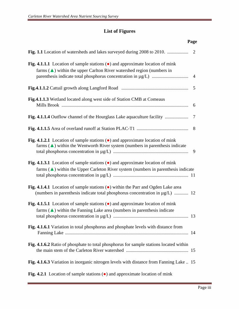
List of Figures
Page
Fig. 1.1 Location of watersheds and lakes surveyed during 2008 to 2010. .................. 2
Fig. 4.1.1.1 Location of sample stations (●) and approximate location of mink
farms (▲) within the upper Carlton River watershed region (numbers in
parenthesis indicate total phosphorus concentration in µg/L) ............................... 4
Fig.4.1.1.2 Cattail growth along Langford Road ......................................................... 5
Fig.4.1.1.3 Wetland located along west side of Station CMB at Comeaus
Mills Brook ............................................................................................................ 6
Fig. 4.1.1.4 Outflow channel of the Hourglass Lake aquaculture facility .................... 7
Fig. 4.1.1.5 Area of overland runoff at Station PLAC-T1 ............................................ 8
Fig. 4.1.2.1 Location of sample stations (●) and approximate location of mink
farms (▲) within the Wentworth River system (numbers in parenthesis indicate
total phosphorus concentration in µg/L) ................................................................ 9
Fig. 4.1.3.1 Location of sample stations (●) and approximate location of mink
farms (▲) within the Upper Carleton River system (numbers in parenthesis indicate
total phosphorus concentration in µg/L) ................................................................ 11
Fig. 4.1.4.1 Location of sample stations (●) within the Parr and Ogden Lake area
(numbers in parenthesis indicate total phosphorus concentration in µg/L) ............ 12
Fig. 4.1.5.1 Location of sample stations (●) and approximate location of mink
farms (▲) within the Fanning Lake area (numbers in parenthesis indicate
total phosphorus concentration in µg/L) ................................................................ 13
Fig. 4.1.6.1 Variation in total phosphorus and phosphate levels with distance from
Fanning Lake ......................................................................................................... 14
Fig. 4.1.6.2 Ratio of phosphate to total phosphorus for sample stations located within
the main stem of the Carleton River watershed ..................................................... 15
Fig. 4.1.6.3 Variation in inorganic nitrogen levels with distance from Fanning Lake .. 15
Fig. 4.2.1 Location of sample stations (●) and approximate location of mink

Carleton River Watershed Area Nutrient Sourcing Survey
Page iv
farms (▲) within the Nowlans Lake watershed (numbers in parenthesis indicate
total phosphorus concentration in µg/L) ................................................................ 16
Fig.4.2.2 Mink farm building located above boggy ravine ........................................... 17
Fig. 4.2.3 Pipe outflow along the lower eastern shoreline of Nowlans Lake ................ 17
Fig. 4.2.4 Area of overland flow along lower eastern shoreline of Nowlans Lake ....... 18
Fig. 4.2.5 Area of overland flow along eastern shoreline of Nowlans Lake ................ 18
Fig. 4.1.3.1 Location of sample stations (●) and approximate location of mink
farms (▲) within the Provost Lake watershed (numbers in parenthesis indicate
total phosphorus concentrations in µg/L) ............................................................... 19

Carleton River Watershed Area Nutrient Sourcing Survey
Page v
List of Tables
Page
Table 4.1.1.1 Summary of sample stations and nutrient levels in the upper Carleton
River watershed ..................................................................................................... 5
Table 4.1.2.1 Summary of sample stations and nutrient levels in the Wentworth River
system .................................................................................................................... 10
Table 4.1.3.1 Summary of sample stations and nutrient levels in the upper Carleton
River system .......................................................................................................... 11
Table 4.1. 4.1 Summary of sample stations and nutrient levels in the Parr and Ogden
Lake area ................................................................................................................ 12
Table 4.1.5.1 Summary of sample stations and nutrient levels in the Fanning Lake
area ........................................................................................................................ 13
Table 4.2.1 Summary of sample stations and nutrient levels in the Nowlans Lake
watershed ............................................................................................................... 16
Table 4.4.1 Summary of total phosphorus loadings ........................................................ 21

Carleton River Watershed Area Nutrient Sourcing Survey
Page 1
An Assessment of the Sources and Magnitudes of Nutrient Inputs Responsible for
Degradation of Water Quality in Seven Lakes Located Within the Carleton River
Watershed Area of Digby and Yarmouth Counties, Nova Scotia
1. Background
Water quality surveys carried out by the Nova Scotia Environment (NSE) between 2008 and
2010 of ten lakes located in the Carleton, Meteghan, and Sissaboo River watersheds have
indicated that water quality is impaired to varying degrees in a number of the lakes surveyed,
primarily as a result of high nutrient inputs resulting in the development of high algal
concentrations (NSE 2009; 2010; Brylinsky 2010). Of the ten lakes surveyed over the three year
period, seven were found to be severely impacted by nutrient over-enrichment in at least one of
the three survey years, two were moderately impacted and only one was found not to be
impacted in any of the three years. Fig. 1.1 is an overview of the watersheds showing the lakes
surveyed.
Those lakes exhibiting the most serious symptoms of nutrient over-enrichment were located
within the upper region of the study area and in close proximity to a high concentration of mink
farming operations, the activities of which are considered to be the most likely major source of
nutrients leading to nutrient over-enrichment of the lakes. As a result, a survey designed to
better elucidate the sources of the nutrient inputs to the lakes was carried out during June of
2011. The survey focused on those lakes known from prior water quality surveys to be the most
severely degraded and included the following seven lakes: Hourglass, Placides, Parr, Ogden,
Fanning, Nowlans and Provost.
2. Approach
The basic approach to identify likely sources of nutrient inputs to each lake was to initially
survey by boat the entire shoreline of each lake to identify all potential water inputs to the lake.
Particular attention was made to identify shoreline areas exhibiting extensive growth of cattails
(Typha sp.) or duckweed (Lemma sp.) as these species of macrophytes only grow well under
conditions of high nutrient concentrations making them excellent indicators of stream inputs or
areas of overland run-off having high nutrient levels.
Once identified, each potential nutrient input to the lake was sampled at the point where it
entered the lake for phosphorus levels using a field kit. If nutrient levels were found to be high
(≥20 µg/L), further sampling was carried out upstream of the input as far as possible by boat or
foot until either the source was identified or it became impracticable to travel further upstream.
Although this approach clearly indicated the general areas where high nutrients inputs occur, in
most cases the exact point source could not be determined because it would have necessitated
travel over private property.

Carleton River Watershed Area Nutrient Sourcing Survey
Page 2
The spatial relationship between mink farming operations and sample stations was determined on
the basis of the civic addresses of mink farms, provided by the Novas Scotia Department of
Agriculture (NSDA), supplemented by Google Earth satellite images and aerial photos of each
lake obtained from the Nova Scotia Geomatics Centre.
Fig. 1.1 Location of watersheds and lakes surveyed during 2008 to 2010.

Carleton River Watershed Area Nutrient Sourcing Survey
Page 3
3. Methods
Phosphate and total phosphorus nutrient concentrations measured in the field were carried out
using a HACH Model DR/2400 field test kit. In addition to nutrient measurements of
phosphorus in the field, additional water samples were collected at those sites suspected of
having high (≥20 µg/L) levels of phosphorus. These samples were sent to the Environmental
Services Laboratory of the QE II Health Science Centre to confirm the high nutrient levels
initially identified using the field kit procedure. In addition to phosphate and total phosphorus,
these samples were also analyzed for inorganic nitrogen.
When possible, estimates of daily nutrient loading based on measurements of nutrient
concentration, current velocity and cross sectional area were also made at each site. Mean
current velocities were determined using a Global Flow model FP101 probe. Cross sectional
areas were determined based on measurements of water depths at half to one meter intervals
across the total width of each site. These measurements were used to construct a diagram of the
cross section of each site which was then used to calculate the cross sectional area using an
image analysis program.
4. Results
Of the seven lake studied, five are located within the Carleton River watershed. These include
Placides, Hourglass, Parr, Ogden and Fanning. The remaining two lakes, Nowlans and Provost,
are located within the Meteghan and Sissaboo watersheds, respectively. A summary of the data
collected is contained in Appendix I.
4.1 Carleton River Watershed
The upper region of the Carleton River watershed contains an extensive system of lakes and
tributaries most of which drain into Placides Lake. The outflow of Placides Lake enters the
Wentworth River system which flows into Wentworth Lake. The Carleton River begins as the
outflow of Wentworth Lake and passes through Parr, Ogden, and Fanning Lakes.
4.1.1 The Upper Carleton Watershed Region
The upper Carleton River watershed region is a hydrologically complex area containing
numerous lakes, streams and wetlands. The lakes and tributaries within this region (Fig.4.1.1.1
and Table 4.1.1.1) were found to have the highest levels of phosphorus within the Carlton
watershed, most of which were well above 100 µg/L and in one case exceeded 3,000 µg/L. It
also has the highest concentration of mink farms as well as a fish aquaculture operation located
along the southwestern shoreline of Hourglass Lake.
The highest total phosphorus level of 3,300 µg/L was measured at Station CMB where Comeaus
Mill Brook crosses under Langford Road between Southville and Riverdale. This site was
characterized by extensive growths of cattails and duckweeds, particularly along the southwesten

Carleton River Watershed Area Nutrient Sourcing Survey
Page 4
side of Langford Road (Fig. 4.1.1.2). Comeaus Mill Brook flows through a wetland area with
extensive growth of cattails (Fig. 4.4.4.3) and then into Bill Lake. The outflow of Bill Lake,
which passes under Hilltown Road (Station PLAC –H4), had a total phosphorus concentration of
540 µg/L. The much lower total phosphorus concentration relative to Station CMB is likely due
to sequestering of phosphorus by the wetland and retention within Bill Lake. The outflow of Bill
Lake in turn flows into Simonds Lake. Its outflow (Station PLAC-H3) had a total phosphorus
level of 400 µg/L.
Fig. 4.1.1.1 Location of sample stations (●) and approximate location of mink farms (▲) within the
upper Carlton River watershed region (numbers in parenthesis indicate total phosphorus concentration in
µg/L).

Carleton River Watershed Area Nutrient Sourcing Survey
Page 5
Table 4.1.1.1 Summary of sample stations and nutrient levels in the upper Carleton River watershed.
Station
Nutrient Concentrations
Site Description PO4
(µg/L) TP
(µg/L) NOx
(mg/L)
CMB 3183 3300 1.28 Comeaus Mill Brook culvert flow @ Langford Rd
HOURL-IN1 <10 12 - Small stream inflow to Hourglass Lake
HOURL-AQOUT 167 240 0.11 Outflow from fish aquaculture operation @ Hourglass Lake
PLAC-H4 481 540 0.40 Outflow from Bill Lake at Hilltown Rd
PLAC-H3 388 400 0.64 Outflow from Simmonds Lake at Hilltown Cross Rd
PLAC-H2 216 230 0.17 Outflow from Hourglass Lake at Hilltown Cross Rd
PLAC-H1 544 580 0.65 Culvert flow at unnamed stream @ Hwy 340
PLAC-T1 698 870 1.25 Overland flow into unnamed stream
PLAC-IN2 575 610 0.67 Unnamed stream flow downstream of overland flow
PLAC-IN1 526 570. 0.69 Inlet flow @ Placides Lake
PLAC-OUT 462 490 0.39 Outflow from Placides Lake
SLS <5 12 <0.01 Channel between Sullivans Lakes
MB-1 38 56 0.08 Mullen Brook outflow from Paul Lake at Hilltown Rd
MB-2 263 280 1.19 Mullen Brook culvert flow @ Hwy 340
Fig.4.1.1.2. Cattail growth along Langford Road.

Carleton River Watershed Area Nutrient Sourcing Survey
Page 6
Fig.4.1.1.3. Wetland located along west side of Station CMB at Comeaus Mills Brook.
Another nutrient source that eventually enters Placides Lake is the outflow from a land-based
smolt aquaculture operation located along the southwestern shoreline of Hourglass Lake (Fig
4.1.1.4). Although a significant outflow could not be measured at the time of the survey, water
lying within the outflow channel had a total phosphorus concentration of 240 µg/L. The outflow
from Hourglass Lake eventually travels into Placides Lake after it passes under Hilltown Cross
Road. The total phosphorus level at this point was 230 µg/L, only slightly lower than the
outflow from the aquaculture site. It is unlikely that this level of phosphorus is due entirely to
the outflow of the aquaculture operation since it would be expected that some of the phosphorus
would be retained within Hourglass Lake. It is more likely that an additional unidentified
nutrient input exists within the area between the outflow of Hourglass Lake and Station PLAC-
H2.

Carleton River Watershed Area Nutrient Sourcing Survey
Page 7
Fig. 4.1.1.4 Outflow channel of the Hourglass Lake aquaculture facility.
The outflow from Simmonds and Hourglass Lake join each other prior to the stream passing
under Hwy 340. At Hwy 340 (Station PLAC-H1) the total phosphorus concentration was 580
µg/L. Below this station total phosphorus levels again increased prior to the stream entering
Placides Lake. This increase was due to an area of overland runoff located on the west side of
the stream (Station PLAC-T1). This was an area of standing water surrounded by anoxic
saturated soils, extensive cattail growth and a strong odour of hydrogen sulphide (Fig. 4.1.1.5).
Total phosphorus concentration in the standing water was 870 µg/L.

Carleton River Watershed Area Nutrient Sourcing Survey
Page 8
Fig. 4.1.1.5 Area of overland runoff at Station PLAC-T1
Beyond this point the total phosphorus concentration fell to 610 and 570 µg/L at Stations PLAC-IN2 and
PLAC-IN1 respectively, the latter being the input to Placides Lake. There are no other inputs to Placadies
Lake. At the output of Placides Lake total phosphorous concentrations fell further to 490 µg//L, a
decrease of about 10 percent.
Also located in this region is Mullen Brook, a small stream that originates at Paul Lake and flows
into Porcupine Lake. This brook was sampled at two sites, one where it crosses under Hilltown
Road and another where it crosses under Hwy 340. Total phosphorus levels were quite low (56
µg/L) at Hilltown Road (Station MB-1), but much higher (280 µg/L) at Hwy 340 (Station MB-
2). There are a number of mink farms located in this area.
4.1.2 Wentworth River System
The Wentworth River system begins at the outflow of Placides Lake and extends downstream
approximately 14 km where it enters Wentworth Lake. Total phosphorus concentrations were
high throughout the River ranging between 320 and 360 µg/L (Fig.4.1.2.1 and Table 4.1.2.1), but
lacked any significant variation within the River as it travels downstream indicating that it is

Carleton River Watershed Area Nutrient Sourcing Survey
Page 9
unlikely to have any major nutrient inputs, and that it has little ability to sequester the high
nutrient load it receives from Placides Lake. Although there are four mink farms located in this
area they do not appear to have a significant impact on nutrient levels within the Wentworth
River system.
In addition to the Wentworth River, Wentworth Lake has a small stream input at its northern end
that originates at Payson Meadow. This brook was sampled at the point where it flows under
Cedarwood Lake Road and was found to have a relatively low (18 µg/L) total phosphorus level.
Fig. 4.1.2.1 Location of sample stations (●) and approximate location of mink farms (▲) within the
Wentworth River system (numbers in parenthesis indicate total phosphorus concentration in µg/L).

Carleton River Watershed Area Nutrient Sourcing Survey
Page 10
Table 4.1.2.1. Summary of sample stations and nutrient levels in the Wentworth river system
Station
Nutrient Concentrations
Site Description PO4
(µg/L) TP
(µg/L) NOx
(mg/L)
WENT-R1 307 330 0.18 Wentworth River above input from Porcupine Lake
WENT-R2 292 320 0.03 Wentworth River @ Patrice Rd
WENT-R3 312 360 0.06 Wentworth River @ Hwy 340
WENT-R4 304 340 0.06 Wentworth River @ inflow to Wentworth Lake
PMB 5 18 0.01 Payson Meadow Brook culvert flow @ Cedarwood Lake Rd
4.1.3 Upper Carleton River System
The Carleton River system begins at the outflow of Privilege Lake, a small lake that receives the
outflow of Wentworth Lake. The total phosphorus concentration at this point (CARLR-1) was
97 µg/L, about four times lower than the total phosphorus concentration at the inlet to
Wentworth Lake. This decrease is most likely a result of phosphorus being retained within
Wentworth Lake, which is one of the largest lakes in the area. From its origin, the Carleton
River travels downstream approximately 11 km where it enters Parr Lake. Unlike the
Wentworth River, there is only a small decrease of about 20 percent in total phosphorus by the
time it enters Parr Lake (Fig. 4.1.3.1 and Table 4.1.3.1). There are no mink farms in this area
and very few tributaries enter this stretch of River.

Carleton River Watershed Area Nutrient Sourcing Survey
Page 11
Fig. 4.1.3.1 Location of sample stations (●) within the Upper Carleton River system
(numbers in parenthesis indicate total phosphorus concentration in µg/L).
Table 4.1.3.1 Summary of sample stations and nutrient levels in the upper Carleton River
system.
Station
Nutrient Concentrations
Site Description PO4
(µg/L) TP
(µg/L) NOx
(mg/L)
CARLR-1 78 97 0.01 Carleton River at Outlet of Wentworth Lake
BLI <10 12 - Inflow to Carleton River form Bear Lake @ Hwy 340
CARLR-3 56 73 0.02 Carleton River above Richfield
CARLR-5 58 77 0.03 Carleton River below Richfield

Carleton River Watershed Area Nutrient Sourcing Survey
Page 12
4.1.4 Parr and Ogden Lake Area
The Carleton River flows into Parr Lake the outlet of which flows through Robichauds Run, a
channel connecting Parr to Ogden Lake Both Parr and Ogden are relatively large lakes. Parr
Lake has three inputs, the Carleton River which flows into Parr Lake at Station PARL-IN1 (Fig.
4.1.4.1), and two small streams, Salmon Lake Brook and Tinkhams Mill Brook, both of which
were found to have very low total phosphorus levels (Table 4.1.4.1). Ogden Lake, which has no
other water inputs other than the input from Parr Lake, exits into the lower Carleton River.
Between the inlet of Parr and the outlet of Ogden Lake, the total phosphorus concentration
decreased about 50 percent, from 67 to 36 µg/L. This decrease is also likely due to the retention
of phosphorus within the lakes, and is indicative of there being no major nutrient inputs to either
lake other than that received from the Carleton River.
Fig. 4.1.4.1 Location of sample stations (●) within the Parr and
Ogden Lake area (numbers in parenthesis indicate total phosphorus
concentrations in µg/L).
Table 4.1.4.1 Summary of sample stations and nutrient levels in the Parr and Ogden Lake area.
Station
Nutrient Concentrations
Site Description PO4
(µg/L) TP
(µg/L) NOx
(mg/L)
PARL-IN1 46 67 0.02 Inflow of Carleton River to Parr Lake
PARL-RR 41 55 0.01 Robichauds Run (channel connecting Parr and Ogden lakes)
OL-OUT 25 36 0.01 Outlet of Ogden Lake to Carleton River
SLB - 7 - Outflow from Salmon Lake Brook
TMB - 5 - Outflow from Tinkhams Mill Brook

Carleton River Watershed Area Nutrient Sourcing Survey
Page 13
4.1.5 Fanning Lake Area
Fanning Lake receives its major input from the Carleton River. Two smaller inputs are the
outflows of Lower Crawleys and Mink Lake, both of which have very low nutrient levels (Fig
4.1.5.1 and Table 4.1.5.1). There are four mink farms located near the lake’s western shoreline,
but these do not appear to be associated with any tributary flows that may enter the lake.
Nutrient levels at the input and output of Fanning Lake are relatively low.
Fig. 4.1.5.1 Location of sample stations (●) and approximate location of mink farms (▲)
within the Fanning Lake area (numbers in parenthesis indicate total phosphorus
concentrations in µg/L).
Table 4.1.5.1 Summary of sample stations and nutrient levels in the Fanning Lake area
Station
Nutrient Concentrations
Site Description PO4
(µg/L) TP
(µg/L) NOx
(mg/L)
FANL-IN-CR 21 32 0.01 Outflow of Carleton River into Fanning Lake
FANL-OUT 24 24 0.01 Outflow of Fanning Lake
LCL - 8 - Inflow of Lower Crawleys Lake into Fanning Lake
ML - 5 - Inflow of Mink Lake into Fanning Lake

Carleton River Watershed Area Nutrient Sourcing Survey
Page 14
4.1.6 Downstream Nutrient Trends in the Carleton River System
From the preceding description of nutrient levels within the Carleton River watershed it is
obvious that there is a dramatic decrease in nutrient levels as the River flows downstream. This
decrease is illustrated in Fig. 4.1.6.1 which shows the gradual decrease in both total phosphorus
and phosphate at sample stations located within the main stem of the River beginning at
Comeaus Mill Brook and ending at the outlet of Fanning Lake. Most of the phosphorus loading
to this system originates within the upper region of the watershed in close proximity to the
greatest concentration of mink farms. Most of the decrease occurs where the River enters and
leaves lakes, the biggest decrease occurring at Wentworth Lake.
Fig. 4.1.6.1 Variation in total phosphorus and phosphate levels with distance from Fanning Lake.
Also of note is that most of the phosphorus is present in the dissolved as opposed to the
particulate form (Fig. 4.1.6.2). This is very unusual since in most natural aquatic ecosystems the
level of phosphate is typically present at levels below the limit of analytical detection as a result
of its rapid utilization by aquatic plants. The only likely source of dissolved phosphorus input to
the Carleton River watershed region is superphosphate1, a widely utilized chemical among mink
farmers that is used to increase the shelf life of mink food as well as reduce the occurrence of
kidney stones in mink livestock (Leoschke 1996).
Also obvious is the gradual decrease in phosphate to total phosphorus ratio as water moves
downstream, a result of waters low in phosphate entering the River in its lower reaches.
1 The chemical name for superphosphate is monocalcium phosphate. Its chemical formula is Ca(H2PO
4)2.

Carleton River Watershed Area Nutrient Sourcing Survey
Page 15
Fig. 4.1.6.2 Ratio of phosphate to total phosphorus for sample stations located within the upper
region and main stem of the Carleton River watershed.
Inorganic nitrogen also shows a decreasing trend in concentration from upstream to downstream
(Fig. 4.1.6.3). The greater levels within the upper region are most likely a result of the runoff of
waste products originating from within mink farms.
Fig. 4.1.6.3 Variation in inorganic nitrogen levels with distance from Fanning Lake.

Carleton River Watershed Area Nutrient Sourcing Survey
Page 16
4.2 Meteghan River Watershed
Nowlans Lake, a small headwater lake, is the only lake located within the Meteghan River
watershed that was evaluated with respect to nutrient inputs. This lake exhibits the most highly
degraded water quality of all the lakes surveyed. In addition to six mink farms, a fish meal
processing plant is also located within its watershed. Although it is a headwater lake with no
well defined stream inputs, flowage from a nearby boggy ravine located along its eastern
shoreline enters the lake after flowing through a culvert located under Hwy 340. The ravine is
saturated with water and has a heavy growth of cattails indicating that it receives an inflow of
high nutrient water. Total phosphorus values measured in this area were among the highest
observed during the survey and ranged between 7,100 and 32,000 µg/L (Fig. 4.2.1 and Table
4.2.1). The nutrients appear to originate from a number of mink farms located just north of and
above the ravine. At Station NOWL-IN5, a small stream located at the head of the ravine, it was
possible to measure a flow rate into the bog of 5,424 L/day and a total phosphorus concentration
of 32,000 µg/l which results in a phosphorus loading of 173.5 kg/day. This stream appeared to
originate from a mink farm building located approximately 150 metres above this outflow
(Fig.4.2.2)
Fig. 4.2.1 Location of sample stations (●) and approximate location of mink farms (▲)
within the Nowlans Lake watershed (numbers in parenthesis indicate total phosphorus
concentration in µg/L).

Carleton River Watershed Area Nutrient Sourcing Survey
Page 17
Table 4.2.1 Summary of sample stations and nutrient levels in Nowlans Lake watershed.
Station
Nutrient Concentrations
Site Description PO4
(µg/L) TP
(µg/L) NOx
(mg/L)
NOWL-IN1 6790 7100 0.58 Standing water along shoreline of Nowlans lake
NOWL-IN2 9200 9500 0.19 Standing water beneath culvert @ Hwy 340
NOWL-IN3 - 18 - Sanding water above east side of ravine
NOWL-IN4 34000 34000 1.37 Standing water within ravine
NOWL-IN5 3100 32000 - Flow from small stream located at top of ravine
NOWL-PO 23 47 3.31 Flow from discharge pipe into Nowlans Lake
Fig. 4.2.2 Mink farm building located above boggy ravine.
There was also an inflow to the lake from a plastic pipe observed at Station NOWL-PO
(Fig.4.2.3). This inflow had a flow rate of 13,248 L/day and a total phosphorus concentration of
0.047 µg/l resulting in a phosphorus loading 0.622 kg/day. The discharge of the pipe appeared to
originate from a mink farm operation located just above the lake’s shoreline.

Carleton River Watershed Area Nutrient Sourcing Survey
Page 18
Fig. 4.2.3 Pipe outflow along the lower eastern shoreline of Nowlans
Lake.
Also observed were two areas along the lake’s shoreline that appear to be sites where overland
flow periodically enters the lake, although at the time of the survey no flow was observed. In
both cases extensive cattail growth was observed along the lake’s shoreline. One was located
along the lower western shoreline just north of where the pipe outflow was located and just
below a mink farm building (Fig. 4.2.4). The other was located along the upper eastern shoreline
just southwest of the fish meal processing plant (Fig. 4.2.5).
Fig. 4.2.4 Area of overland flow along lower eastern shoreline of Nowlans Lake

Carleton River Watershed Area Nutrient Sourcing Survey
Page 19
Fig. 4.2.5 Area of overland flow along upper eastern shoreline of Nowlans Lake
4.3 Sissaboo River Watershed
Provost Lake, a small headwater lake, was the only lake surveyed within the Sissaboo River
watershed. Its water quality is the least impacted of all the lakes surveyed. It has no significant
surface water inputs and is most likely spring fed. The total phosphorus concentration at the
lake’s output was relatively low (Fig. 4.3.1). The only potential nutrient sources to the lake
observed during the shoreline survey were a number of cottage properties having extensive lawn
areas and the droppings of large numbers of roosting seagulls on the lake’s water surface and
along its shoreline. The latter may be due to the presence of several mink farms located nearby
to the west of the Lake.
Although it has a number of mink farms located within its watershed, these do not appear to have
any significant impact on the lake.

Carleton River Watershed Area Nutrient Sourcing Survey
Page 20
Fig. 4.3.1 Location of sample stations (●) and approximate location of mink farms (▲) within the
Provost Lake watershed (numbers in parenthesis indicate total phosphorus concentration in µg/L).
4.4. Phosphorus Loadings
Of the 39 stations sampled, daily phosphorus loading rates were measured at 18. Those stations
for which loading rates were not measured had either insufficient flow for a measurement of
current velocity to be made, or the site was too deep to traverse and water depth measurements
for determination of surface area could not be made.
The highest phosphorus loadings were within the upper region of the Carleton Watershed.
Loadings measured below the outlet of Wentworth Lake were much lower.

Carleton River Watershed Area Nutrient Sourcing Survey
Page 21
Table 4.4.1 Summary of total phosphorus loadings.
STATION TP
(µg/L)
Current
Velocity
(m/sec)
Surface
Area
(m2)
Width
(m)
Maximum
Depth
(m)
P Load
(Kg/day)
CMB 3300 1.49 2.6 6.0 0.7 1034.4
PLAC-H1 580 1.76 1.1 4.5 0.5 94.0
PLAC-H2 230 0.65 1.1 7.0 0.3 14.0
PLAC-H3 400 0.56 2.1 6.0 0.5 41.4
PLAC-H4 540 0.68 6.7 10.0 1.2 213.2
PLAC-IN1 570 0.1 12.5 10.0 1.5 615.6
PLAC-OUT 490 0.7 8.5 15.0 0.8 25.2
MB-1 56 0.6 1.8 5.0 0.4 5.2
MB-2 280 1.2 1.6 3.5 0.5 46.2
WENT-R1 330 2.0 6.0 10.0 1.0 338.1
PMB 18 3.1 0.2 1.5 0.2 1.1
PARR-IN1 67 0.7 10.0 10.0 1.0 40.5
PARR-RR 55 0.4 27.0 15.0 1.6 1.5
FANL-IN-CR 33 4.4 5.3 20.0 0.4 6.8
ML 5 1.3 2.4 8.5 0.8 1.2
LCL 8 0.7 1.8 5.0 0.6 0.9
NOWL-PO 23 - - - - 0.6
NOWL-IN5 3100 - - - - 173.5
5. Discussion
Although this survey was able to determine the watershed regions where high levels of
phosphorus input occur, with few exceptions it has not identified the point sources responsible
for these high levels. This proved difficult since most of the sources appear to be either located
within the upper reaches of tributaries not accessible by boat and mostly in areas of boggy
wetlands that were difficult or unsafe to traverse by foot, or were located on private property and
were not accessed due to trespass issues. However, it is clear that the origin of the high
phosphorus inputs are closely associated with the area of high mink farm activities. Within the
Carleton River watershed this is largely the region around Hilltown and Havelock. Below this
region there was little evidence of any significant phosphorus inputs to either the Wentworth or
Carleton River or to the lakes surveyed below these rivers. Much of the phosphorus originating
within the upper region appears to be entrained within Wentworth Lake, but levels are

Carleton River Watershed Area Nutrient Sourcing Survey
Page 22
sufficiently high at its outlet to account for the observed degradation of water quality in Parr,
Ogden and Fanning Lakes.
Although it is expected that some of the phosphorus leading to the deterioration of water quality
of the lakes is due to runoff associated with cleaning operations and/or the storage of mink
manure, the high ratio of phosphate to total phosphorus suggests that the major source of
phosphorus is more likely to be due to mink farm operations that utilize superphosphate. If this
is the case, it is highly likely that a great reduction in phosphorus loading to the lakes could be
accomplished by simply reducing, eliminating or better controlling this practice. It should be
noted, however, that the typical remediation methodologies for reducing nutrient inputs to
watercourses, such as diverting outflows into natural or constructed wetlands and settling ponds,
may not work well if the nutrient concentrations are very high and largely in the dissolved as
opposed to the particulate form. Although wetlands are considered to be nutrient sinks, they do
have limits with respect to how much they can assimilate and unless quite extensive in area can
easily become nutrient saturated under conditions of high nutrient loads. Settling ponds are only
effective if the nutrients are in the particulate form and will not significantly reduce nutrient
outputs if they are in the dissolved form.
6. Recommendations for Further Study
Prior to this survey, during November 2010, NSE inspectors, with the assistance of Environment
Canada and NSDA personnel, carried out inspections of 21 mink farm operations located within
the Carleton watershed area to determine potential sources of nutrients that may enter
watercourses and lead to the deterioration of water quality that had been documented in the water
quality surveys (NSE 2011). An additional 11 sites were also inspected by NSE personnel prior
to the November 2011 inspections. Of the 32 sites inspected, 10 were found to have activities
that could lead to nutrient runoff into water courses. Further surveys of this type should be
carried out focusing on identifying the specific point sources leading to the high phosphorus
levels found in this survey. Particular attention should be paid to those mink farm operations
known to use superphosphate. It may also prove useful to inspect mink farming operations that
appear to have little impact on water quality, such as those located within the watershed of
Provost Lake, to determine if there is anything unique about the methodologies they employ
which could minimize their potential impact on water quality.
7. References
Brylinsky, M. 2011. Water quality survey of ten lakes in the Carleton River watershed area of
Digby and Yarmouth Counties, Nova Scotia. Report prepared for Nova Scotia Department
Environment. 78p.
Leoschke, W.L. 1996. Phosphoric acid in modern mink and fox nutrition. Applied Science
Reports, Animal Production Review, VIth
International Congress of Fur Animal Production.
Warsaw. 28:.77-78.

Carleton River Watershed Area Nutrient Sourcing Survey
Page 23
NSE. 2009 A water quality survey of nine lakes in the Carleton River watershed area, Yarmouth
County, Nova Scotia. 16p.
NSE. 2010. A water quality survey of ten lakes in the Carleton River watershed area, Yarmouth
and Digby Counties, Nova Scotia. 26p.
NSDOE. 2011. 2010 mink farm inspection report: Carleton River watershed. Report prepared by
Nova Scotia Environmental Monitoring and Compliance Division, Yarmouth District. 11p.

Carleton River Watershed Area Nutrient Sourcing Survey
Page 24
8. APPENDIX I
Data Summary

Carleton River Watershed Area Nutrient Sourcing Survey
Page 25
Appendix I. Data Summary
Watershed Station Date Location Cond-
uctivity
(µSi/cm)
Phosphorus
(mg/L) Nitrogen
(mg/L) TP
Loading
(Kg/day) Easting Northing TP PO4 NOX NH4
Carleton CMB 06/14/11 269670 4913941 129.2 3.300 3.184 1.28 3.79 1034.4
Carleton HOUR-AQOUT 06/05/11 266191 4912468 103.9 0.240 0.167 0.11 0.21 -
Carleton HOUR - IN1 06/05/11 266940 4912354 146.2 0.012 <10 - - -
Carleton PLAC - H4 06/12/11 268260 4911962 112.6 0.540 0.481 0.40 0.19 213.2
Carleton PLAC - H3 06/07/11 267977 4910961 119.9 0.400 0.388 0.64 0.04 41.4
Carleton PLAC - H2 06/07/11 267419 4910847 120.8 0.230 0.216 0.17 0.02 14.0
Carleton PLAC - H1 06/07/11 266961 4910007 118.6 0.580 0.544 0.65 0.04 94.0
Carleton PLAC - T1 06/07/11 266695 4909883 148.3 0.870 0.698 1.25 0.56 -
Carleton PLAC - IN2 06/07/11 266528 4909564 128.9 0.610 0.575 0.67 0.07 -
Carleton PLAC - IN1 06/07/11 266280 4909224 126.1 0.570 0.526 0.69 0.07 615.6
Carleton PLAC - OUT 06/07/11 265001 4908398 115.5 0.490 0.465 0.34 0.09 25.2
Carleton MB - 1 06/14/11 268907 4908970 71.2 0.056 0.038 0.08 0.06 5.2
Carleton MB - 2 06/14/11 268150 4907561 92.3 0.280 0.263 1.19 0.63 46.2
Carleton SLS 06/14/11 270563 4910434 84.5 0.012 0.005 <0.01 0.03 -
Carleton WENT - R1 06/14/11 263822 4806191 86.5 0.330 0.307 0.18 0.10 338.1
Carleton WENT - R2 06/12/11 265533 4902416 109.8 0.320 0.292 0.03 0.11 -
Carleton WENT - R3 06/12/11 265153 4900527 110.8 0.360 0.312 0.06 0.16 -
Carleton WENT - R4 06/12/11 265153 4899259 109.5 0.340 0.304 0.06 0.18 -
Carleton BL 06/12/11 265896 4890024 83.2 0.012 0.010 - - -
Carleton PMB 06/14/11 269437 4904005 69.1 0.018 0.005 <0.01 0.03 1.1
Carleton CARLR-1 06/12/11 266991 4896572 94.8 0.097 0.078 <0.01 0.06 -
Carleton CARLR-3 06/12/11 266349 4888976 95.7 0.073 0.056 0.02 0.03 -
Carleton CARLR-5 06/12/11 265707 4878965 94.5 0.077 0.058 0.03 0.04 -
Carleton PARR - IN1 06/13/11 266565 4887202 96.2 0.067 0.046 0.02 0.05 40.5
Carleton PARR - RR 06/13/11 267156 4884365 94.5 0.055 0.041 <0.01 0.05 1.5
Carleton SLB 06/13/11 267669 4887467 87.5 0.007 - - - -
Carleton TMB 06/13/11 269284 4884671 87.5 0.005 - - - -
Carleton OL - OUT 06/13/11 267510 4882710 94.2 0.036 0.025 <0.01 0.04 -
Carleton FANL-IN-CR 06/14/11 266295 4878649 90.5 0.032 0.021 0.02 0.04 6.8
Carleton FANL - OUT 06/14/11 265551 4876729 91 0.024 0.014 <0.01 0.03 -
Carleton LCL 06/14/11 267551 4879313 82.8 0.008 0.005 <0.01 0.02 0.9
Carleton ML 06/14/11 267495 4878194 96.5 0.005 0.005 <0.01 0.02 1.2
Meteghan NOWL - IN1 06/05/11 266616 4910647 370.5 7.100 6.790 0.58 1.03 -
Meteghan NOWL - IN2 06/05/11 266682 4910710 352.1 9.500 9.200 0.19 1.70 -
Meteghan NOWL - IN3 06/05/11 266837 4910772 316.6 0.015 0.010 - - -
Meteghan NOWL - IN4 06/05/11 266690 4910811 480 34.000 34.000 1.37 7.89 -
Meteghan NOWL-IN5 06/05/11 266831 4911205 510 32.000 30.000 - - 173.5
Meteghan NOWL - PO 06/05/11 266595 4910180 220 0.047 0.023 3.31 0.01 0.6
Sissaboo PROV - OUT 06/06/11 273120 4915214 81.3 0.023 0.005 <0.01 0.03 -