CALIFORNIA GEOLOGICAL SURVEY FAULT...
35
1 CALIFORNIA GEOLOGICAL SURVEY FAULT EVALUATION REPORT FER 253 THE HOLLYWOOD FAULT in the Hollywood 7.5’ Quadrangle Los Angeles County, California by Janis L. Hernandez Engineering Geologist and Jerome A. Treiman Senior Engineering Geologist February 14, 2014 INTRODUCTION The Hollywood Fault is within the central portion of the Santa Monica-Hollywood- Raymond Fault system, which is collectively part of a greater than 200-km long west-trending system of oblique, reverse and left-lateral faults that separate the Transverse Ranges geomorphic province of California on the north, from the Peninsular Ranges province on the south (Dolan et al., 1997). The Hollywood Fault extends east-northeast for about 17 km through densely populated areas, including the cities of Beverly Hills, West Hollywood, and the community of Hollywood within the City of Los Angeles, trending eastward to the Los Angeles River Valley (Figure 1). Recent detailed geologic and geotechnical studies for residential and commercial development in the cities of West Hollywood and Los Angeles have reported Holocene faulting at a number of sites along the Hollywood Fault. Infrastructure projects (sewer and subway) and groundwater studies, in addition to gravity data, also provide support that the Hollywood Fault is active and continues eastward toward the Raymond Fault. The majority of the Raymond Fault has been zoned as active, to within about 4 km east of the Los Angeles River at the eastern edge of the Santa Monica Mountains (see Figure 1). Both the Santa Monica and Hollywood Faults were previously evaluated for Holocene active faulting as part of the 1977 study area of the 10-year program for fault evaluation (Smith, 1978). That study concluded there was insufficient evidence of Holocene faulting to recommend fault traces for zoning at that time. Subsequent geologic and geotechnical studies, paleoseismic studies, geomorphologic studies reported by Dolan et al. (1997), Dolan et al. (2000), and other published and unpublished research, have prompted CGS review of these recently available data to re-evaluate evidence for Holocene displacement along traces of the Hollywood Fault. The purpose of this report is to assess the location and activity of fault strands associated with the Hollywood Fault within the Hollywood 7½-minute quadrangle. Those faults determined to be sufficiently active (Holocene) and well-defined are zoned by the State Geologist as directed by the Alquist-Priolo Earthquake Fault Zoning (AP) Act of 1972 (Bryant and Hart, 2007). This report does not attempt to reevaluate any strands of the Newport- Inglewood Fault zone.
Transcript of CALIFORNIA GEOLOGICAL SURVEY FAULT...
1
CALIFORNIA GEOLOGICAL SURVEY FAULT EVALUATION REPORT FER 253
THE HOLLYWOOD FAULT in the Hollywood 7.5’ Quadrangle
Los Angeles County, California by Janis L. Hernandez Engineering Geologist
and Jerome A. Treiman
Senior Engineering Geologist February 14, 2014 INTRODUCTION The Hollywood Fault is within the central portion of the Santa Monica-Hollywood-Raymond Fault system, which is collectively part of a greater than 200-km long west-trending system of oblique, reverse and left-lateral faults that separate the Transverse Ranges geomorphic province of California on the north, from the Peninsular Ranges province on the south (Dolan et al., 1997). The Hollywood Fault extends east-northeast for about 17 km through densely populated areas, including the cities of Beverly Hills, West Hollywood, and the community of Hollywood within the City of Los Angeles, trending eastward to the Los Angeles River Valley (Figure 1).
Recent detailed geologic and geotechnical studies for residential and commercial development in the cities of West Hollywood and Los Angeles have reported Holocene faulting at a number of sites along the Hollywood Fault. Infrastructure projects (sewer and subway) and groundwater studies, in addition to gravity data, also provide support that the Hollywood Fault is active and continues eastward toward the Raymond Fault. The majority of the Raymond Fault has been zoned as active, to within about 4 km east of the Los Angeles River at the eastern edge of the Santa Monica Mountains (see Figure 1).
Both the Santa Monica and Hollywood Faults were previously evaluated for Holocene
active faulting as part of the 1977 study area of the 10-year program for fault evaluation (Smith, 1978). That study concluded there was insufficient evidence of Holocene faulting to recommend fault traces for zoning at that time. Subsequent geologic and geotechnical studies, paleoseismic studies, geomorphologic studies reported by Dolan et al. (1997), Dolan et al. (2000), and other published and unpublished research, have prompted CGS review of these recently available data to re-evaluate evidence for Holocene displacement along traces of the Hollywood Fault.
The purpose of this report is to assess the location and activity of fault strands
associated with the Hollywood Fault within the Hollywood 7½-minute quadrangle. Those faults determined to be sufficiently active (Holocene) and well-defined are zoned by the State Geologist as directed by the Alquist-Priolo Earthquake Fault Zoning (AP) Act of 1972 (Bryant and Hart, 2007). This report does not attempt to reevaluate any strands of the Newport-Inglewood Fault zone.

California Geological Survey – Fault Evaluation Report 253
2
GEOLOGIC SETTING AND PREVIOUSLY PUBLISHED WORK
The Hollywood Fault is located along the southern boundary of the Santa Monica Mountains, where Cretaceous granitic rocks; mainly quartz diorite, and Feliz biotite granodiorite (as reported in Lamar, 1970), are unconformably overlain by folded and faulted early to middle Miocene Topanga group marine siltstones, sandstones, and basaltic volcanic rocks, and late Miocene Puente Formation marine sandstones, siltstones and shales. Alluvial deposits flanking the mountain front consist of Pleistocene and Holocene alluvial fan deposits, colluvial sediments, and local slope wash.
The Hollywood Fault also defines the northern edge of the Hollywood basin, an
asymmetric basin structure that is bound on the south by the North Salt Lake Fault (Figure 1a). Gravity data indicate the basin is deeper along the northern edge, next to the Hollywood Fault (Hildenbrand et al., 2001). In the Los Angeles River floodplain (Figure 1), the Hollywood Fault is
Figure 1- Study area of the Hollywood quadrangle and names of selected faults in the vicinity. Faults within existing Alquist-Priolo Earthquake Fault Zones are within yellow-shaded boundaries; other faults are indicated in black. Fault strands of the Newport-Inglewood Fault Zone are not a part of this evaluation. Source: USGS Quaternary Fault and Fold Database of the United States. (http://earthquake.usgs.gov/hazards/qfaults/)

California Geological Survey – Fault Evaluation Report 253
3
defined by a steep gravity gradient (Chapman and Chase, 1979), and a steep drop in groundwater levels as the fault trends eastward toward the Raymond Fault (State Water Rights Board, 1962).
The Hollywood Fault was previously mapped by many workers including Hoots (1930);
Lamar (1970); Weber et al. (1980); and Dibblee (1991), where they generally placed the fault at the steep break in slope along the southern edge of the Santa Monica Mountains. More recent mapping by Dolan et al. (1997) provided a more detailed view of the fault that takes into account geomorphic indicators as well as site-specific data (discussed later in this report).
Mapping by Hill et al. (1979) similarly reported the Hollywood Fault trace located at the
base of the Santa Monica Mountains, however, they also mapped a southern trace, which they referred to as the Santa Monica Fault. This southern trace delineates the south margin of the Hollywood basin, defined by a zone of differential subsidence (shown on Plate 1). The identification of this zone is supported by their analysis of oil well data, groundwater data, and review of precise leveling surveys. A similar assessment of the structural boundary of the Hollywood Basin was made by Hildenbrand et al. (2001) based on gravity data, although they identified the southern bounding structure as the North Salt Lake Fault (Figure 1a).
At the eastern edge of the Santa Monica Mountains, the concealed trace of the
Hollywood Fault was previously mapped in various configurations, generally extending east to northeast into the Atwater area. Originally believed to be a reverse fault, more recent research (e.g. Dolan et al.: 1997, 2000; Law/Crandall, 2001; William Lettis and Associates, 2004) suggests a dominant strike-slip component. Previous mapping is shown on Plate 1.
Figure 1a - location of Hollywood Basin (HB) with respect to the Hollywood Fault and the North Salt Lake Fault. (clipped/modified from Hildenbrand et al. (2001)

California Geological Survey – Fault Evaluation Report 253
4
SEISMICITY
Regional seismicity records from Hauksson et al., (2012), indicate there have not been any significant earthquake events within the past 30 years that might be confidently associated with the Hollywood Fault (Figure 2). In the Los Angeles region, several historical earthquakes have generated strong shaking in the vicinity of the Hollywood Fault, including: the 1971 M6.6 San Fernando, 1987 M5.9 Whittier Narrows, 1988 M5.0 Pasadena, 1991 M5.8 Sierra Madre, and the 1994 M6.7 Northridge event. The 1988 Pasadena earthquake occurred on the Raymond Fault. Seismic records from the 1988 event provided additional confirmation of left-lateral displacement along the Raymond Fault (Jones et al., 1990).
Figure 2 - Regional seismicity from 1981 to June 2011 (Hauksson et al, 2012), including significant faults within the greater
Los Angeles basin area. Faults (in black) are from the U.S. Geological Survey and California Geological Survey, 2006, Quaternary fault and fold database. (http://earthquake.usgs.gov/hazards/qfaults/)
California Geological Survey – Fault Evaluation Report 253
5
SUMMARY OF AVAILABLE DATA
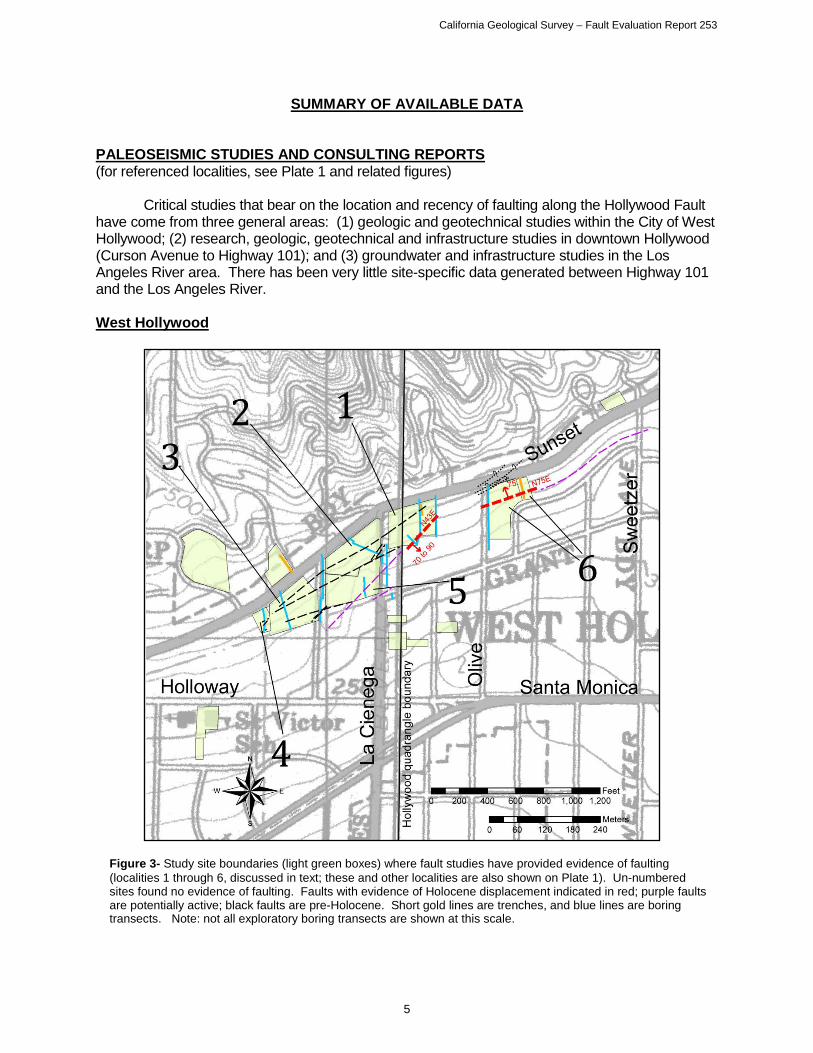
PALEOSEISMIC STUDIES AND CONSULTING REPORTS (for referenced localities, see Plate 1 and related figures) Critical studies that bear on the location and recency of faulting along the Hollywood Fault have come from three general areas: (1) geologic and geotechnical studies within the City of West Hollywood; (2) research, geologic, geotechnical and infrastructure studies in downtown Hollywood (Curson Avenue to Highway 101); and (3) groundwater and infrastructure studies in the Los Angeles River area. There has been very little site-specific data generated between Highway 101 and the Los Angeles River. West Hollywood
Figure 3- Study site boundaries (light green boxes) where fault studies have provided evidence of faulting (localities 1 through 6, discussed in text; these and other localities are also shown on Plate 1). Un-numbered sites found no evidence of faulting. Faults with evidence of Holocene displacement indicated in red; purple faults are potentially active; black faults are pre-Holocene. Short gold lines are trenches, and blue lines are boring transects. Note: not all exploratory boring transects are shown at this scale.

California Geological Survey – Fault Evaluation Report 253
6
The City of West Hollywood Fault Precaution Zone Map, and Geologic and Seismic Hazard Technical Background Report, prepared by KFM Geoscience, Inc. (2010) is a crucial part of the City of West Hollywood General Plan. Included in the KFM report is a summary of Fault Rupture Hazard Studies from 29 sites that are on file with the City, collected from 1997 to 2013. Of these reports, 8 sites yielded data that active faulting exists within those sites or otherwise helped constrain the fault location near the western boundary of the Hollywood Quadrangle. Of these 8 sites, several studies were performed adjacent or in close proximity to one another; these are shown on Figure 3.
An investigation by Harza (1998, Figure 3, locality 1) was one of the earliest studies in
this area that found two zones of faulting: a northern and a southern fault zone. Paleoseismic studies from borings and trenching at the site indicate these north-dipping faults of the northern fault zone do not offset an argillic soil horizon estimated to be over 120,000 years old based on degree of soil profile development. This northern fault zone includes several strands, which they report strike from N50°E to N70°E, dipping from 50° to 60° NW. Striae and slickensides measured in bucket auger borings provided evidence for north-side-down normal sense of displacement for these northern strands.
The southern fault zone (herein discussed as Fault 1) was reported as a northeast striking, southeast dipping fault that vertically offset Quaternary deposits at least 150 feet and acts as a groundwater barrier. Harza (1998) recommended a building setback zone for Fault 1 as a precautionary method until further studies could be made. Recent work, including observations from down-hole logged bucket auger borings and 14C dating of the soils by WLA (2004) have determined this southern fault zone (Fault 1) is active. Figure 4 illustrates the upward terminations of three strands (D, E, and F) of Fault 1. Fault 1 is oriented N50° to 55°E, dipping 53° to 56° SE as reported from bucket auger down-hole observations. Charcoal samples from faulted soil horizons revealed dates about 9,910 to 10,190 ybp, and 15,250 to 16,650 ybp. WLA (2004) also reported an unfaulted soil horizon above fault strand D to be 8,590 to 8,990 ybp, suggesting a minimum age of faulting at fault strand D. They suggested that, because the fault tips of strands D, E, and F all occur at about the same stratigraphic position, these three closely spaced splays ruptured in the most recent earthquake. Based on the detrital charcoal samples, they concluded the most recent surface-rupturing earthquake on strands D, E, and F of Fault 1 occurred between ~8,500 and 10,000 years ago.
A report by WLA (1998c) at locality 2 finds that four faults underlie the site. They state
that these faults are overlain by multiple unbroken Pleistocene soils and that the southernmost fault has displaced Pleistocene deposits and is overlain by unbroken Holocene deposits. Additional details gathered from exploratory borings provided insight that the northern fault zone is found to offset a marine wave-cut (abrasion) platform at depth. Evidence includes a gently dipping, planar surface of quartz diorite bedrock, overlain by a thin veneer of beach sand, and smooth, rounded, non-quartz diorite cobbles and pebbles. They reported the age of this marine wave-cut platform is constrained by the age of the overlying alluvial sediments, where they estimated this abrasion platform to be between 400,000 to 900,000 years old. Further, they report a significant amount of platform tilting is present between fault-bound blocks. However, measurable evidence of late Quaternary folding or tilting of the overlying sediments was not present at the site.

California Geological Survey – Fault Evaluation Report 253
7
Figure 4 - Upward terminations of fault strands D, E, and F within Fault “1”, Locality 1; modified from
WLA, 2004.

California Geological Survey – Fault Evaluation Report 253
8
A study by WLA (1998b), located southwest of Alta Loma Road at Sunset Boulevard (locality 3), mapped four faults across the site that are reported as inactive based on unfaulted late Pleistocene soils that overlie the faults. These faults were reported to be secondary faults and not the main trace of the Hollywood Fault. They report that similar to locality 2, these faults are part of the northern fault zone and are found within the marine wave-cut abrasion platform at depth. They infer the main trace to lie well south of Sunset Boulevard in this location.
An interesting detail about the Hollywood Fault as reported by WLA (1998c) and
discussed by T. Rockwell (p.c., 2013), is that the gently sloping marine abrasion surface consists of one and possibly two paleo-marine terraces at depth in this area, with a terrace riser (or sea cliff) at the back of each terrace. Some of the escarpments observed along the base of the Santa Monica Mountains, previously thought to be the location of the Hollywood Fault, are now interpreted as paleo-sea cliffs.
Work completed by WLA (2007b) south of Sunset Boulevard at locality 4 found no active
faults are present at the site. They encountered three inactive secondary faults at the site that were described to be part of the inactive northern fault zone, as noted at localities 1, 2 and 3]. They reported these faults are overlain by distinctive, continuous buried Pleistocene soils.
A study by ECI (1999a) at locality 5, found the northern fault zone and marine abrasion
platform to be overlain by unbroken Pleistocene age soils in all of their borings, indicating Holocene faulting has not occurred at this location. Fault 1 underlying the site was also judged to be not active, based on apparent continuity of overlying pre-Holocene stratigraphy as interpreted from their borings. However, the correlated contacts are not clearly continuous and some Holocene offset cannot be precluded. Based on the relatively small offset of the quartz diorite basement terrain (relative to other sites) and the generally normal separation on the on-site faults, ECI (1999a) concluded that the principal trace of the Hollywood Fault must lie to the south of their site.
Studies located on the southeast corner of Sunset Boulevard and Olive Avenue at
Locality 6 (Applied Earth Sciences, 1997; Johnson, 1999; Law/Crandall, 2001) found that a northern and southern set of faults crossed the site. The northern fault zone, as in studies to the west, was reported as not active based on unfaulted Pleistocene soils at the site. Additionally, these studies encountered the marine abrasion platform and associated cobble and boulder size clasts of well-rounded quartz diorite and other exotic clasts, with well-sorted, clean, fine- to medium-grained sand. They interpreted the northern fault zone as a minor, secondary fault zone that accommodated local extension in a left step of the Hollywood Fault zone. The active southern fault zone is steeply north-dipping, and extends into alluvial units of Holocene age up to within 15 feet of the ground surface (Figure 5). Law/Crandall (2001) determined this strand is active based on radiocarbon dating of detrital charcoal samples, indicating the faulted soils were approximately 9,000 to 10,000 years old. Both Law/Crandall (2001) and Applied Earth Sciences (1997) recommended structural setbacks from the fault. This southern strand vertically offsets bedrock by at least 150 feet of south-side down separation, and also forms a steep groundwater step. Unfaulted Pleistocene sediments were documented south of the southern fault zone.

California Geological Survey – Fault Evaluation Report 253
9
A study by Schell (1998) was performed for a site located south of Sunset Boulevard along Harper Avenue (locality 7, Plate 1). Boreholes were drilled for the site, and were extended north across Sunset Boulevard and a steep escarpment. Borings revealed a steep groundwater step, and an offset of quartz diorite bedrock in excess of 150 feet near Sunset Boulevard. Based on this data and geomorphic expression of the fault scarp, Schell interpreted that the main trace of the Hollywood Fault lies north of his site, along the south edge of Sunset Boulevard. He concluded that there were no significant faults to the south based on apparent
Figure 5 - Cross section showing south-side down offset on the southern fault zone at the southeast corner of Sunset Blvd. and Olive Drive, West Hollywood (site 6). Thickness of marine sand decreases to the south. Modified from Law/Crandall, 2001.

California Geological Survey – Fault Evaluation Report 253
10
continuity of several sediment packages of increasing relative age with depth, with the lower units identified as pre-Holocene. A study by ECI (2001a) was completed for a proposed development located south of Sunset Boulevard at Havenhurst Drive at locality 8 (shown on Plate 1). This site is adjacent to locality 7 and ECI included data from that work in their analysis (Schell, 1998) in addition to their own borings extending offsite toward Sunset Boulevard. After analysis of groundwater levels, topographic data, soil development characteristics, and stratigraphic correlation across the southern portion of ECI’s site, they concluded the fault zone immediately south of Sunset Boulevard may be wider than originally mapped by Schell, where they mapped a second north-dipping active fault strand to the south of Schell’s trace. Continuity of pre-Holocene stratigraphy beneath the site, based on borings, was used to preclude any additional young faulting. Ages of stratigraphic units were based on one radiocarbon date and relative soil development characteristics. Downtown Hollywood Much of the synthesis and reported details in the downtown Hollywood area go back to Dolan et al. (1997). Work by Dolan et al. (1997) included geomorphic analysis of tectonic landforms along the fault trace using historic topographic maps (1920s vintage) and field reconnaissance. They also presented and analyzed data from several geotechnical studies. They interpreted at least three major fault splays: the Franklin Avenue strand, the Yucca Street strand, and a northern strand as shown in Figure 6 (see also Plate 1). Details of individual parts of their study are discussed below.
Figure 6 – Detailed mapping and investigations by Dolan et al. (1997, their figures 4 and 6), shown overlying a 1953 topographic map base of the Hollywood area. “G” indicates groundwater barrier. Dark shaded areas indicate fault scarps. This historic topographic map is composited from 1923-1925 plane table surveys, with a 5-foot contour interval up to the 500 foot elevation contour and is similar to the topographic data set used by Dolan et al. (1997).

California Geological Survey – Fault Evaluation Report 253
11
Hollywood - Vicinity of La Brea Ave Earlier work by Crook et al. (1983) and Crook and Proctor (1992) included trenching at
a site within the Hollywood area at Wattles Garden Park at Franklin and Sierra Bonita Avenues (locality 9, Plate 1). They found several thin shallowly north-dipping gouge layers and a thicker (60+ cm) gouge mass that they assume to be part of the Hollywood Fault Zone. There were no datable materials. A second trench, further down the fan surface found no faulting but was likely too shallow to be conclusive.
At locality 10, detailed studies by Dolan et al (1997), and Earth Technology Corporation
(1993) took place at three locations in conjunction with the 1993 MetroRail Boreholes/subway tunnel investigations along the Hollywood Fault Zone: Camino Palmero-Martel Avenue Transect; North La Brea Avenue Transect; and at Vista Street, as shown on Figure 7. Also included in this study were data from Los Angeles County storm drain trenches (Vista Street and Fuller Avenue), and the La Cienega and San Fernando Valley Sewer Relief Tunnel project (1953, as reported by Earth Technology Corp, 1993) west of Vista Street.
Figure 7 - North Hollywood area, locality 10, showing location of shallow trench data (gold lines) and borehole transects (blue lines) completed for the Metro Red Line study (Earth Technology Corporation (1993), sewer relief trenches and storm drain tunnel. Green squares indicate study localities: A - Vista Street storm drain transect; B - Camino Palmero-Martel Avenue Metro RedLine transect; C- Fuller Avenue storm drain trench; D - La Brea Avenue Metro RedLine transect. Dashed red line segments along transects indicate the active fault trace or projection based on supporting data from adjacent sites. Purple dashed lines represent fault strands of indeterminate age. Black lines are faults recommended herein for zoning.

California Geological Survey – Fault Evaluation Report 253
12
Along the Vista Street storm drain transect (Figure 7, site A), the Hollywood Fault was not encountered in the ~1400 foot long trench, however (Dolan et al., 1997) reported the depth of this trench was likely insufficient to observe the fault trace. The La Cienega and San Fernando Valley Sewer Relief Tunnel project (1953, as reported in Earth Technology Company, 1993) along Sierra Bonita west of site A, encountered faulted granite with gouge and breccia in test borings. Along the Camino Palmero-Martel Avenue Metro RedLine transect (Figure 7, site B), evidence for faulting included groundwater barriers and quartz diorite bedrock faulted over alluvium, with average dips of ~77° to the north. Dolan et al. (1997) and Earth Technology Corporation (1993) reported up to four fault strands with apparent north side-up displacement of the granitic bedrock at depth (Figure 8), however the southern-most strand appears to be the youngest based on offset younger soils. Groundwater elevation changes were reported on the order of 40 or 50 feet across the fault as shown in Figure 8 (inset). This site was further explored (Dolan et al., 2000) with successive bucket auger borings that revealed additional evidence that one, and possibly two surface ruptures had occurred within the past 20,000 years, the most recent event occurring about 7,000 to 9,500 years ago. Additionally, based on the downhole observations made within the boreholes for this study, Dolan et al. (2000) reported that all of the fault strands encountered were near vertical with a dip about 85° northward, and that the most recent surface rupture resulted in north-side down separation. This sense of near-surface separation contrasts with the reverse sense at depth, supporting the contention of Dolan et al. (1997) that there is a strong component of strike-slip displacement (presumed left-lateral).
Storm drain trench excavations by Los Angeles County Department of Public Works
along Fuller Avenue (Figure 7, site C), revealed a secondary strand of the Hollywood Fault, oriented N59°E, 74°NW with north-side-up vertical separation (reported by Dolan et al., 1997). This fault displaced the base of a possibly Holocene clayey sand.
Figure 8 - Cross section of continuously cored boreholes along the northern half of Camino Palmero transect. Note down to the north soil profiles, particularly between B-10 and B-12, across the active fault strand. Depth to groundwater was encountered at about 55 feet on the north, and about 89 feet bgs to the south. Figure modified from Dolan et al. (1997).

California Geological Survey – Fault Evaluation Report 253
13
At the La Brea Avenue Transect (Figure 7, site D) evidence for faulting includes quartz
diorite apparently thrust over Quaternary alluvium, similar to the Camino Palmero site (Dolan et al., 1997; Earth Technology Corporation, 1993). Shallow groundwater was encountered north of the fault at depths between about 10 feet to 43 feet, whereas south of the fault groundwater was not encountered within the upper 200 feet of borings. They reported the fault dip steepens with depth, ranging from 25° to 60° to the north. Hollywood - Vicinity of Highland Avenue A study by MTC Engineering (2012c), located on the southwest corner of Bonita Terrace and Orchid Avenue (locality 11, Plate 1) found no clear evidence of faulting, although a zone of steepening of the bedrock at depth between two bucket auger borings was noted in our review. They encountered basaltic volcanic bedrock, and they reported clean sandy gravel in each of the bucket auger borings was in sharp contact with the bedrock. Rounded cobbles up to about 10-inch diameter in a fine- to coarse-grained sand matrix, and clean sand layers were encountered directly overlying the bedrock. Our review of this data suggests the marine abrasion platform previously discussed for sites in West Hollywood (localities 1 through 6) may exist in this part of Hollywood. In studies by Leighton Consulting (2011) and GeoPentech (2013a; 2013b) at 1805 Highland Avenue, evidence was reported for at least three faults at this site (locality 12). Groundwater steps and discontinuous stratigraphy across the site suggest several fault strands may exist within a broad zone of faulting at this site. Three fault strands appear to displace an earliest Holocene/late Pleistocene horizon (approximately 11-14 thousand years old) and at least one of the strands may displace late Holocene sediments (Geopentech, 2013b). Studies are on-going to further characterize the location and orientation of the fault strands, recency of activity, and how these features relate to faults mapped at the site directly to the east. Studies performed at 1840 Highland Avenue (locality 13) by LAW/Crandall (2000) and GeoPentech (2001a, b; 2013c) found evidence of several well-constrained fault strands crossing the northern portion of the site. The faults in the northern and central portion of the site were judged to be active based on three distinct groundwater steps and offsets in stratigraphic units (including Holocene deposits) observed in continuous core borings and CPT transects. They reported faulting consisted of steeply north-dipping faults (about 800) for these northern strands, and have established a building setback zone. In the southern portion of the site, they reported continuous Holocene and Pleistocene soils and stratigraphic units underlie this portion of the site, precluding any additional young faulting. Just to the east of this site, at Las Palmas St., unpublished studies cited by Crook and Proctor (1992) found a 30-foot difference in groundwater levels between two borings on opposite sides of this fault zone.
A study for the Los Angeles MetroRail project (Converse et al; 1981, 1983) found evidence that the Hollywood Fault is located south of Yucca Street at Cahuenga Boulevard (locality 14). Their boring #28B, also described by Crook and Proctor (1992), encountered alluvium to a depth of 120 feet, followed by 10 feet of brecciated sandstone, alluvium and siltstone, which in turn overlies alluvium to the total depth at 205 feet. The location for this fault corresponds well with differences in groundwater reported at locality 15 to the east, and a groundwater barrier just south of Yucca Street to the west (F. Denison, 1991, p.c. in Dolan et al., 1997).

California Geological Survey – Fault Evaluation Report 253
14
Hollywood - Vicinity of Hollywood Boulevard and Vine Street Geotechnical studies were done by Langan and Associates (2012a; 2012b) for the proposed Millennium Hollywood development located south of Yucca Street, between Ivar Avenue and Argyle Avenue (locality 15). Although faulting was not specifically identified in these reports, our review of the subsurface data from several borings indicated groundwater depth differences across the site as well as significant differences in sub-surface materials that support the presence of a fault beneath the site.
Borings from an adjacent project by Group Delta (2006) located at the southwest corner of Argyle Avenue and Yucca Street (locality 16), revealed groundwater elevation differences across the site. Review of this data when compared to borings from the adjacent sites, also suggest a significant difference in groundwater elevation between this project and the Hollywood Millennium site to the south (locality 15).
Just east of Argyle Avenue and north of Hollywood Boulevard (locality 17) geotechnical studies were done for the Blvd6200 project (Geotechnologies, Inc., 2006 and 2013). Although faulting was not specifically identified in these reports, a strong break in slope existed across the northern portion of this parcel that has been interpreted as a fault scarp by previous researchers as well as in our review and field reconnaissance. Additionally, geotechnical borings drilled for the project encountered higher groundwater levels in the northern portion of the site, and deeper groundwater levels in the southern portion of the site with recommendations made for a dewatering system. A review of the boring logs and cross sectional analysis reveals the stratigraphy does not appear very continuous in this area, and the drop in groundwater level appears to correlate well with the break in slope at the surface. These two pieces of evidence suggest active faulting exists along a west-northwest trend at this location. West Los Feliz area Only one geotechnical study has come to our attention in this area which might bear on the presence of active faulting. A study was conducted by Pacific Soils Engineering (1961), for tract development located north of Los Feliz Boulevard, between Fern Dell Drive and Winona Boulevard at locality 18. They identified a northeast-trending bedrock fault at the northern end of the property, and although the fault appeared to juxtapose granitic basement rock against alluvium, the fault was judged to be not active. A water seep was noted after grading (Pacific Soils Engineering, 1962) that was not on the identified fault, but it did lie along an interpreted geomorphic scarp within the alluvial fan deposits, as noted in our review of vintage air photos (discussed later in this Fault Evaluation Report). Previous mapping by Neuerburg (1953) in this area indicates two roughly parallel fault traces that were mapped in the granitic bedrock northeast of the site and likely project toward this development. The lack of any geomorphic expression in crystalline rock, as well as their location and orientation, suggest that these two fault traces are not active. Los Angeles River/Atwater Area
Along the west side of Riverside Drive near Los Feliz Boulevard (locality 19), two
fault/geotechnical studies were completed by AMEC (2012, 2013) for the City of Los Angeles Northeast Interceptor Sewer (NEIS) project. The 2013 study included data from two seismic reflection surveys, performed by Advanced Geoscience, Inc. (2013). These seismic surveys

California Geological Survey – Fault Evaluation Report 253
15
identified at least 6 fault traces which dip steeply (north and south) and are interpreted to include the north-dipping main trace of the Hollywood Fault Zone. Advanced Geoscience, Inc. (2013) reports that the main fault and several secondary faults appear to be trending to the east, based on two sets of seismic data. Evidence for faulting found in borings along the transect line includes: thickening of young alluvium across several borings within the fault zone, a thickening and offset of older alluvium deep within closely-spaced borings, and deeper offsets within sedimentary bedrock (Puente Formation) and quartz diorite. Artesian groundwater conditions are also reported within a narrow zone as noted in a cross-section prepared by the City of Los Angeles, included here as Figure 9. In the Atwater area, well data as reported by State Water Rights Board (1962) indicate a steep drop in groundwater levels near the mapped fault trace. They reported shallow Puente Formation bedrock was encountered in borings drilled on the north side of a concealed fault trace, and also noted rising water levels in the area of Los Feliz Boulevard. Fault displacements were postulated to have affected the base of the valley fill within the Los Angeles River narrows area, notably where a small bedrock knob is present north of the fault and has “created a constriction in the water-bearing materials” and a depression in the groundwater level immediately to the south. Further, they reported fairly thick packages of clay-rich sediments predominate to the north, and gravelly sands to the south, generally near San Fernando Road and the northern projection of Silver Lake Boulevard.
Williams and Wilder (1971) reported a steep south-facing groundwater gradient exists
about half way between the Forest Lawn wells (near Glendale Blvd and San Fernando Road), and the Pollock Field (near Garden Ave. and Fletcher Dr.). In their cross section, they indicated a gray organic clay layer is vertically offset by a steeply south-dipping fault, with down to the south displacement of the clay. Converse, Davis and Associates (1970) reported on the “top of clay” layers within groundwater wells in the Atwater area. Review of the well logs indicated a groundwater level differential and top of clay differential in the area near Fletcher Dr. and San Fernando Road. Our own review of several of the well logs from the Converse, Davis and Associates report, reveals thick clay zones at depth that appear to be discontinuous in the vicinity of Silver Lake Boulevard and La Clede Avenue. This location is similar to the groundwater differential reported by Williams and Wilder (1971).
Gravity data from Chapman and Chase (1979) reveals a steep gravity gradient along the fault that coincides at depth with the eastern projection of the Hollywood Fault Zone.

California Geological Survey – Fault Evaluation Report 253
16
Figure 9 – Cross section with Fault ‘A’ interpreted as the main trace within the active fault zone. Note differential thickness of recent alluvium, and depth of older alluvium between Fault ‘A’, and Fault ‘C-3’. Kqd = Cretaceous quartz diorite; Tp = Puente Formation; Tm = Modelo Formation; Qoa = Quaternary older alluvium; Qal = Quaternary alluvium; af = artificial fill. Cross section modified from City of Los Angeles Geotechnical Engineering Group (2013). Grids are 10’ in height and 100’ in width. .

California Geological Survey – Fault Evaluation Report 253
17
AERIAL PHOTO, LIDAR, MAP INTERPRETATION, FIELD OBSERVATIONS and GEOMORPHIC ANALYSIS (for referenced localities, see Plate 2)
The following geomorphic analysis is based on review of vintage aerial photographs,
topographic maps, LiDAR data and field observations. Field observations were performed during November and December 2013 for approximately 3 days.
DATA SOURCES Vertical aerial photographs – 1927-1928 Vertical aerial photographs from two flights (1927 and 1928) by Fairchild Aerial Surveys were studied in stereo pairs to identify and interpret landforms along the fault traces. Development of the landscape (grading for streets, houses and other structures) even at this early date make interpretation a challenge. However, many features of the landscape are still discernible. Historic oblique photographs – 1921-1938 Vintage oblique aerial photographs provided a unique view of the historic landscape, providing illuminating images of much of the landscape prior to full development. These images provided an independent check on the features interpreted from vertical aerial photos and topographic maps. The vintage photos were taken by Spence Aerial Surveys and Fairchild Aerial Surveys and are archived in the Geography Department at the University of California, Los Angeles. Historic maps – 1926-1928 A remarkable series of topographic maps was prepared in the 1920s for the County of Los Angeles at a scale of 1:24,000. These were published in the atypical format of a 6-minute by 6-minute quadrangle as opposed to the more standard 7.5-minute map format. These maps are notable for two reasons. First, they capture the landscape at a time when much of the local land development had either not occurred or was of a less disruptive nature. Secondly, these maps have 5-foot contours and were drawn by topographers with an excellent sense of landform. As a result, these maps provide a very illuminating view of the landscape and reveal numerous features that are suggestive of tectonic influences. We analyzed the topography as depicted on the Hollywood and Burbank 6-minute quadrangles from 1926 and the Glendale 6-minute quadrangle from 1928 (all at an original scale of 1:24,000). We prepared an interpretive map from these topographic bases, delineating locally incised drainages and a complex set of nested alluvial fans being shed from the Santa Monica Mountains (Figures 11, 12, 13, 14 & 17). In particular we have made note of abrupt transitions from erosion (the channels) to deposition (the fans) and, where these are aligned with other corroborative or suggestive features, have interpreted fault movement to explain this change in sedimentary regime. LiDAR A digital elevation model derived from a LiDAR survey of Los Angeles County (Los Angeles Regional Imagery Acquisition Consortium, 2006) was useful for verifying some of the geomorphic features identified from other sources as well as detecting additional features.

California Geological Survey – Fault Evaluation Report 253
18
DISCUSSION To aid discussion we have divided the fault zone, as it crosses the Hollywood Quadrangle, into five segments (Figure 10). The westernmost segment (segment 1), from within the city of West Hollywood, trends northeast along the southern edge of the Santa Monica Mountains, primarily as a single trace. Segments 2 and 3 trend more east-west and are expressed in several near-parallel left-stepping fault strands. Segment 4 trends east-northeast, paralleling Los Feliz Blvd., and consists of at least two sub-parallel fault strands. Eastward from the Los Angeles River we describe Segment 5 which appears to consist of a single surface trace until the eastern boundary of the map.
Segment 1 extends from the west margin of the map northeasterly to the vicinity of Laurel Canyon (Figure 11). The fault is expressed here by a well-developed scarp along the base of the hills (S1a). Some less-prominent scarps, north of the identified fault, may be related to a paleo-shoreline identified in the area (WLA, 1998c). Several small scarps near the base of the mountain front on Plate 2 (Site A1) are thought to be related to this paleo-shoreline feature. Several subtle slope breaks in the ground surface to the southeast may indicate additional splays, but these are less certain and may just mark the distal extent of fan deposition. A prominent scarp-like feature (S1b) at the edge of the map is crossed, on projection to the west, by fault studies which found no evidence of active faulting along that trend. The young Holocene-age alluvial fan emanating from Laurel Canyon has entirely obscured surface evidence of the fault in that location.
Figure 10 - index to fault segments discussed in the text. Red lines are faults identified for zoning.
Figure 11 - Geomorphic features along Segment 1. Base map from 1926 Hollywood and Burbank 6’ quadrangles.

California Geological Survey – Fault Evaluation Report 253
19
Segment 2 trends east-west from Laurel Canyon to Beachwood Drive (Figure 12). The western portion is distinguished by a slightly sinuous mountain front with small fans emanating from small to medium-sized canyons. The mouths of these canyons are in rough alignment as far east as La Brea Avenue, suggesting some linear structural control, but the fault may be buried and overlapped by fan deposition so that the fault trace would be somewhat south of the current slope break. Oversteepened and eroded slopes at the south end of several intervening ridges are interpreted to be related to faulting. More subtle breaks in slope gradient to the south are possibly related to the distal edges of the small alluvial fans and cannot be ascribed with any certainty to faulting (Plate 2, site A2). The south end of the first ridge to the east of Laurel Canyon (S2a) appears oversteepened and is likely a fault scarp. Dolan et al. (1997) also noted the scarp in this area. A break in slope also veers away from this scarp and across a local fan coming off of the slopes, suggesting young displacement. Subtle tonal lineaments (Plate 2) suggest the fault location to the east across the Nichols Canyon drainage.
East of La Brea Avenue the fault bends or steps southward to create the steep southern front of a prominent knoll (S2b) and several other ridges to the east. Dolan et al. (1997) found this Franklin Avenue strand to be the most prominent south-facing scarp in the downtown area. The Yucca Street strand, which exhibits a 5-6 m high scarp, also acts as a groundwater barrier west of the alluvial fan at Cahuenga Blvd. The drainage from Cahuenga Pass, as it crosses this trend, appears as if it is deflected in a left-lateral sense (S2c) and very shortly changes from an incised channel to a depositional fan, suggesting a change in base level at this point. Another southward step is suggested by the south-trending ridge west of Cahuenga Boulevard (S2d) and then expression is lost across the drainage descending from the Hollywood Reservoir area. However, the channel from that canyon appears to have been incised above the mouth of the canyon (S2e), switching to a depositional mode to the south, which suggests a base level change at a fault at that location. The fault location eastward is indicated by a very steep south margin to the hillslopes (S2f). A distinct change in slope gradient is also visible across several north-south streets in this area in both site reconnaissance and air photo interpretation, including Vine and adjacent streets (Plate
Figure 12 - Geomorphic features along Segment 2. Base map from 1926 Hollywood and Burbank 6’ quadrangles.

California Geological Survey – Fault Evaluation Report 253
20
2, site A3). The eastern extension of this fault coincides with the initiation of a small depositional fan indicated in the vintage topographic map (S2h), with an incised drainage visible just to the north in the 1927 and 1928 aerial images. A southern fault splay, indicated to the west from geotechnical studies (adjacent to Vine Street), is supported by the upstream incision of another small drainage near the projected crossing of that fault (S2g).
The Hollywood Bowl Fault is mapped north of Segment 2. Trending northeast, it is discontinuously marked by erosional fault line features, such as topographic saddles and some degraded slope facets (see features identified by Dolan et al., 1997, depicted herein on Plate 2, site A4). These geomorphic features closely follow the mapped fault contact between granitic bedrock to the north and Cretaceous and Tertiary sediments to the south.
Segment 3 overlaps Segment 2 at its west end and Segment 4 at its east end (Figure 13). It appears to function as a transition in the stepover between those two segments. The western end is suggested by a slight steepening of the fan gradient below Beachwood Drive and Franklin Avenue (S3a), and an incision to deposition transition just to the east (S3b). The main alluvial fan of Brush Canyon conceals the trace for a short distance and then the approximate fault location is indicated by the abrupt slopes just north of Franklin Avenue (S3c, S3e). This prominent scarp is also marked by the initiation of fan deposition from the Fern Dell drainage (S3d) as well as a break in the fan gradients. Geomorphic expression of this fault segment dies out about 0.5 km west of Vermont Avenue. There is another line of subdued and discontinuous scarps, mapped by Dolan et al. (1997; also see Figure 6), that splays west-northwest from the main fault trace. This possible fault appears to die out with no expression across Brush Canyon or at the Hollywood Reservoir
Figure 13 - Geomorphic features along Segment 3. (brown triangles indicate saddles discussed in Segment 4) Base map from 1926 Burbank and 1928 Glendale 6’ quadrangles.
California Geological Survey – Fault Evaluation Report 253
21
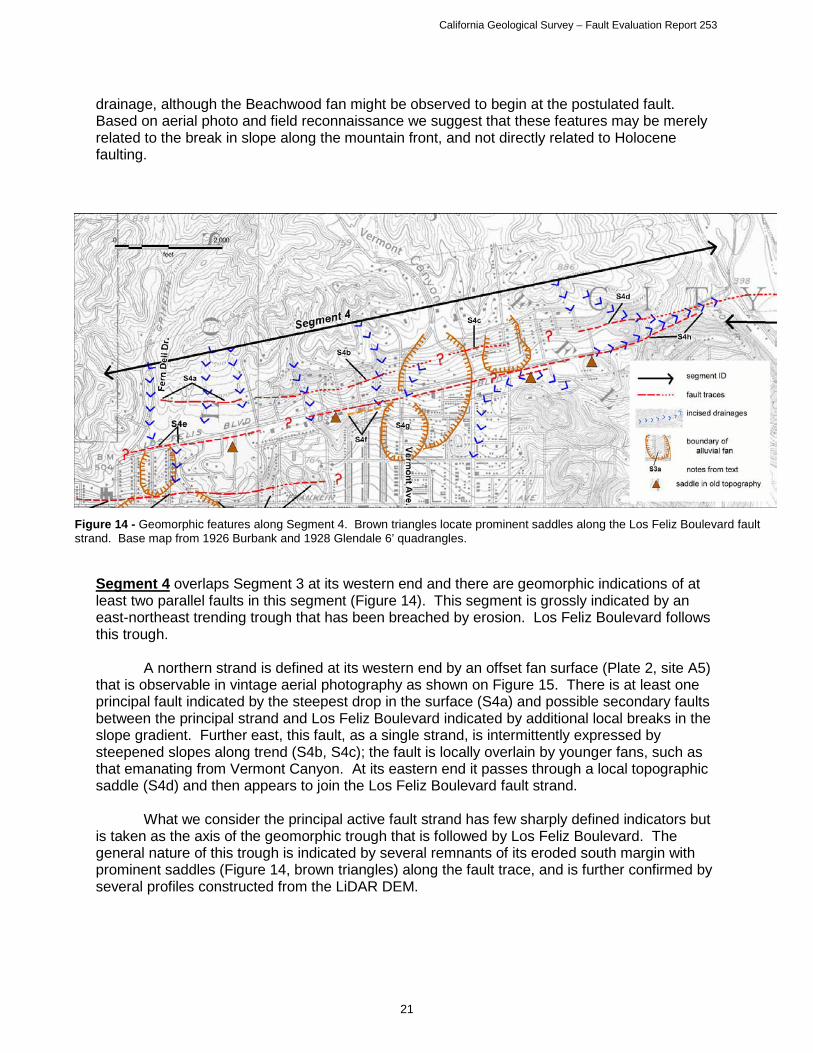
drainage, although the Beachwood fan might be observed to begin at the postulated fault. Based on aerial photo and field reconnaissance we suggest that these features may be merely related to the break in slope along the mountain front, and not directly related to Holocene faulting.
Segment 4 overlaps Segment 3 at its western end and there are geomorphic indications of at least two parallel faults in this segment (Figure 14). This segment is grossly indicated by an east-northeast trending trough that has been breached by erosion. Los Feliz Boulevard follows this trough. A northern strand is defined at its western end by an offset fan surface (Plate 2, site A5) that is observable in vintage aerial photography as shown on Figure 15. There is at least one principal fault indicated by the steepest drop in the surface (S4a) and possible secondary faults between the principal strand and Los Feliz Boulevard indicated by additional local breaks in the slope gradient. Further east, this fault, as a single strand, is intermittently expressed by steepened slopes along trend (S4b, S4c); the fault is locally overlain by younger fans, such as that emanating from Vermont Canyon. At its eastern end it passes through a local topographic saddle (S4d) and then appears to join the Los Feliz Boulevard fault strand.
What we consider the principal active fault strand has few sharply defined indicators but is taken as the axis of the geomorphic trough that is followed by Los Feliz Boulevard. The general nature of this trough is indicated by several remnants of its eroded south margin with prominent saddles (Figure 14, brown triangles) along the fault trace, and is further confirmed by several profiles constructed from the LiDAR DEM.
Figure 14 - Geomorphic features along Segment 4. Brown triangles locate prominent saddles along the Los Feliz Boulevard fault strand. Base map from 1926 Burbank and 1928 Glendale 6’ quadrangles.

California Geological Survey – Fault Evaluation Report 253
22
There are several additional detailed observations that provide better location control and interpretive confidence for this fault. At locality S4e there is an apparent left-lateral offset of the Fern Dell drainage that is on the order of 130 m. A small, steep and inferentially young fan had, prior to modern development, started to build below the cut-off segment of this drainage that lies upstream. Further east, just west of Vermont Avenue, an oblique aerial photo from 1921 reveals some lineaments in a then-recently graded slope below Los Feliz Boulevard (S4f; Figure 16). These lineaments, parallel to the road, may be faults. At Vermont Avenue there is a small young fan that appears to be forming just south of the fault (S4g). Contours on the 1928 topographic map suggest a subtle swale may have been evolving just upstream of the fault at this point across an older, now abandoned, fan that drained Vermont Canyon. The fault location is suggested at the east end of this segment by a linear eroded drainage (S4h) and a coincident tonal lineament visible in the vertical aerial imagery.
A third fault strand, still farther south, may be an eastern extension of Segment 3 but it lacks any youthful expression in this area. Although this strand was previously mapped by others, as shown on Plate 1, field checking and vintage air photo review noted only gentle fan slopes and granitic bedrock outcrops with no indication of any youthful fault-related features along the trace.
Figure 15 - Oblique aerial view of the Mead Estate from 1928, showing principal and minor scarps (Yellow dotted lines) extending across the property. Site is located at the west end of Los Feliz Boulevard (Plate 2, site 5). (Photo by Fairchild Aerial Surveys, 2/25/1938, from UCLA Geography Department).

California Geological Survey – Fault Evaluation Report 253
23
Figure 16 - Oblique aerial photo near the intersection of Vermont Ave. and Los Feliz Blvd. showing fresh grading south of Los Feliz. Blvd. Lineaments (highlighted with red) are possible fault traces. (Photo by Spence Aerial Photos, circa 1921; from UCLA Spence collection).
Figure 17 - Geomorphic features along Segment 5. Base map from 1928 Glendale 6’ quadrangle.

California Geological Survey – Fault Evaluation Report 253
24
Segment 5 continues eastward across the abandoned flood plain of the Los Angeles River in the Atwater area (Figure 17). An elongate knoll, just east of the river, has its southern terminus at the inferred fault location (S5a) where there are also some faint tonal lineaments and a possible scarp along the fault. Farther east the Hollywood Fault is expressed as a series of low, discontinuous breaks in the flood plain surface with south side down orientation, as previously observed by Weber (1979; 1980). At the eastern edge of the quadrangle the drop is as much as 2-3 m (Plate 2, site A6). There is a possible pressure ridge where the fault crosses Silver Lake Boulevard (S5b); it is visible in the elevation of several residential lots in spite of the roads having been graded level. Although scarps are noticeable in several of the streets, some of the previously mapped features (scarps and lineaments) have been obscured by development. East of the map boundary there are additional features to support the location of the fault as it steps northward, including aligned tonal and vegetation lineaments (S5c). The pair of faults appear to define a knoll evident in the older topographic map; the knoll is separated from the adjacent hills by the northern strand.
DISCUSSION and CONCLUSIONS
Segment 1 The trace of the Hollywood Fault has historically been mapped very close to the mountain front in this area (Hoots, 1930; Dibblee, 1991; Dolan et al., 1997). Recent geotechnical studies within the city of West Hollywood have located the principal active trace of the fault at several sites (see Plate 1; figure 3). These studies have also shown that, although the fault is concealed by young sediment in many areas, the Holocene deposits are quite thick and have been displaced by recent faulting (Harza, 1998; ECI, 2001a; LAW/Crandall, 2001; WLA, 2004)). Some scarps, north of the principal fault trace, have been shown to be related to an ancient shoreline and these are not associated with any evidence of active faulting. Several subtle slope breaks further out from the mountain front are ambiguous in origin and not directly attributable to faulting. Segment 2 This segment of the fault zone is generally located by relatively abrupt, though intermittent, scarps. The fault location has been confirmed by several studies, including those by Dolan et al. (1997, 2000), Geopentech (2001 & 2013c) and LAW/Crandall (2000) and studies for the Los Angeles Metro Rail subway project (Earth Technology Corporation, 1993). Additional locations are inferred from subsurface data generated in other geotechnical investigations (Langan 2012 a, b; Group Delta, 2006; Geotechnologies, 2006, 2013). Holocene activity has been documented by Dolan et al. (2000) and is also suggested by the interpreted fault effects on young fan development.
The Hollywood Bowl Fault, although identified in bedrock mapping (Dibblee, 1991), and possible scarps mapped by Dolan et al. (2000), has only very subdued geomorphic expression that is likely erosional in origin or at least erosionally modified. Segment 3 Segment 3 partly follows the mapping of Dolan et al. (2000), but we have made some different associations across the Brush Canyon fan, connecting those traces that seem to have the strongest influence on recent fan deposition and incision. The fan incision/deposition transitions provide some of our fault location evidence, in addition to interpreted scarps at the base of the hills.

California Geological Survey – Fault Evaluation Report 253
25
The effects on the fans, as well as an inferred role in transferring slip between segments 2 and 4 suggest Holocene activity on this segment. This fault has been mapped to continue eastward, to join with a bedrock fault mapped just west of the Los Angeles River (Dibblee, 1991; Dolan et al., 1997), but we see little evidence of activity on this eastern extent and, instead, infer that slip is being transferred to the faults of Segment 4. The northern trace of Dolan et al. (2000), which cuts across the mouth of Brush Canyon and Beachwood Drive, does not appear as youthful and dies out to the west with little evidence of fault displacement. Segment 4 This is a somewhat enigmatic fault segment, having at the same time the least geotechnical evidence and little detail in the way of previously mapped fault traces but having some of the strongest geomorphology to indicate the presence of the fault zone.
The northern fault trace was shown by Dibblee (1991) as entirely concealed. Dolan et al. (1997, 2000) mapped the fault on the basis of the steepened slopes to the north. Weber showed a less continuous surface expression. We could verify discontinuous weak scarp segments approximately as shown by Weber, but the best evidence of this fault is in the scarps and offset fan surface visible in the vintage images at the west end of the fault (e.g. Figure 15). However, no corresponding features could be seen on further projection to the west. We judge this fault as likely Holocene based on the prominent scarps and its association with other elements of the fault zone.
What we infer to be the principal trace of the fault, roughly followed by Los Feliz Boulevard, had not been previously identified except for a short lineament mapped by Weber. We note that this lineament defines a subtle geomorphic trough indicated by a few eroded remnants of its south margin. Additional evidence comes from the apparent effect on the Fern Glen and Vermont Canyon drainages. A southern fault, shown by both Dibblee (1991) and Dolan et al. (1997, 2000) about 1/3 of a kilometer south of Los Feliz Boulevard, is well expressed geomorphically to the west (part of Segment 3) and in the bedrock to the east (from Lamar, 1970). There may well be a buried continuous fault here but it lacks geomorphic evidence of recency in the central and eastern portions. It is also possible that the eastern bedrock segment of this fault connects to the zone of differential subsidence and the hypothetical Santa Monica Fault extension of Hill et al. (1979), discussed below, but there is no surface or subsurface data to support this connection. Segment 5 The eastward continuation of the Hollywood Fault across the Los Angeles River valley, and possible connection with the Raymond Fault, has been shown in various locations by Dibblee (1991), Hill et al. (1979), and Weber et al. (1980). Most of these fault representations are shown as concealed and have been poorly constrained. The trace that we have mapped is based on borings and seismic studies along the west side of the Los Angeles River for the City of Los Angeles Northeast Interceptor Sewer Project (NEIS) by AMEC (2012 & 2013) and Advanced Geoscience, Inc. (2013), and geomorphic features mapped by Weber et al., (1980), and is further supported by several groundwater studies and groundwater data (Converse, Davis and Associates, 1970; State Water Rights Board, 1962; Williams and Wilder, 1971).
Activity of this strand is based on detailed subsurface investigations from the NEIS project, tonal lineaments and breaks in slope observed in vintage air photo review and field reconnaissance, and analysis of subsurface clay layers within the groundwater well data (Converse, Davis and Associates, 1970).

California Geological Survey – Fault Evaluation Report 253
27
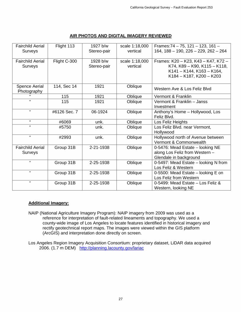
AIR PHOTOS AND DIGITAL IMAGERY REVIEWED
Fairchild Aerial
Surveys Flight 113 1927 b/w
Stereo-pair scale 1:18,000
vertical Frames:74 – 75, 121 – 123, 161 – 164, 188 – 190, 226 – 229, 262 – 264
Fairchild Aerial Surveys
Flight C-300 1928 b/w Stereo-pair
scale 1:18,000 vertical
Frames: K20 – K23, K43 – K47, K72 – K74, K89 – K90, K115 – K118, K141 – K144, K163 – K164, K184 – K187, K200 – K203
Spence Aerial Photography
114, Sec 14 1921 Oblique Western Ave & Los Feliz Blvd
“ 115 1921 Oblique Vermont & Franklin “ 115 1921 Oblique Vermont & Franklin – Janss
Investment “ #6126 Sec. 7 06-1924 Oblique Anthony’s Home – Hollywood, Los
Feliz Blvd. “ #6069 unk. Oblique Los Feliz Heights “ #5750 unk. Oblique Los Feliz Blvd. near Vermont,
Hollywood “ #2993 unk. Oblique Hollywood north of Avenue between
Vermont & Commonwealth Fairchild Aerial
Surveys Group 31B 2-21-1938 Oblique 0-5476: Mead Estate – looking NE
along Los Feliz from Western – Glendale in background
“ Group 31B 2-25-1938 Oblique 0-5497: Mead Estate – looking N from Los Feliz & Western
“ Group 31B 2-25-1938 Oblique 0-5500: Mead Estate – looking E on Los Feliz from Western
“ Group 31B 2-25-1938 Oblique 0-5499: Mead Estate – Los Feliz & Western, looking NE
Additional Imagery:
NAIP (National Agriculture Imagery Program): NAIP imagery from 2009 was used as a reference for interpretation of fault-related lineaments and topography. We used a county-wide image of Los Angeles to locate features identified in historical imagery and rectify geotechnical report maps. The images were viewed within the GIS platform (ArcGIS) and interpretation done directly on screen.
Los Angeles Region Imagery Acquisition Consortium: proprietary dataset, LiDAR data acquired
2006. (1.7 m DEM) http://planning.lacounty.gov/lariac
California Geological Survey – Fault Evaluation Report 253
28
REFERENCES REVIEWED
** References indicated with double asterisk are consulting reports cited in text; * Consulting reports reviewed but not cited have single asterisk.
**Advanced Geoscience, Inc., 2013, Report of Seismic Compressional-Wave Reflection Survey
for Investigation of Hollywood Fault Zone, Los Angeles Department of Public Works Northeast Interceptor Sewer Tunnel Phase 2A (NEIS2A) Project, Los Feliz Boulevard and Riverside Drive, Los Angeles, CA, dated June 11, 2013.
*Advanced Geotechniques, 1998, Geological Fault Study –Proposed Residential Buildings,
1016, 1018 and 1020 Hilldale Avenue, West Hollywood, CA, Project No. 98-403G, dated July 8, 1998.
*Advanced Geotechniques, 2013, Fault Rupture Hazard Investigation, 935 North San Vicente
Boulevard, West Hollywood, CA, Project No. 13-412, dated March 19, 2013. **AMEC, 2012, Geotechnical/Environmental Data Report – Northeast Interceptor Sewer Phase
2A (NEIS 2A) Riverside Drive Segment, Task Order Solicitation (TO) 06-097D, for the City of Los Angeles Department of Public Works, Bureau of Engineering, dated September 12, 2012.
**AMEC, 2013, Geotechnical/Environmental Data Report – Northeast Interceptor Sewer Phase
2A (NEIS 2A) In the Area of the Hollywood Fault along Riverside Drive, Task Order Solicitation (TOS) 06-097G, for the City of Los Angeles Department of Public Works, Bureau of Engineering, dated July 2, 2013.
**Applied Earth Sciences, 1997, Geological Fault Study, Proposed Commercial/Residential
Building, 8410 Sunset Boulevard, West Hollywood, California, dated December 18, 1997.
*Applied Earth Sciences, 1998, Geological Fault Study, Proposed Commercial Building 8950-
8970 Sunset Boulevard, West Hollywood, CA, Project No. 98-303-01, dated March 23, 1998.
*Applied Earth Sciences, 2004, Geotechnical Investigation, Proposed 6-Unt Condominium
Building Project, 8265-8267 Fountain Avenue, West Hollywood, CA, Project No. 04-338-02, dated March 26, 2004.
*AGI Geotechnical, Inc., 1997, Fault Trench Investigation, 8410 Sunset Boulevard, West
Hollywood, California, Project No. 7-1904-01, dated August 13, 1997. *Associated Soils Engineering, Inc., 1995, Geotechnical Exploration Report – Capitol Records
Improvements, 1750 North Vine Street, Hollywood, CA Project No. 95-4920, dated September 26, 1995.
Bryant, W.A., and Hart, E.W., 2007, Fault-Rupture Hazard Zones in California, Alquist-Priolo
Earthquake Fault Zoning Act with Index to Earthquake Fault Zones Maps: California Geological Survey. Special Publication 42, 42 p. (digital version only, electronic document available at ftp://ftp.consrv.ca.gov/pub/dmg/pubs/sp/Sp42.pdf ).

California Geological Survey – Fault Evaluation Report 253
29
Chapman, R.H., and Chase, G.W., 1979, Geophysical Investigation of the Santa Monica-Raymond fault zone, Los Angeles County, California, in: Hill, R.L., Sprotte, E.C., Chapman, R.H., Chase, G.W., Bennett, J.H., Real, C.R., Slade, R.C., Borchardt, G., Weber, F.H., 1979, Earthquake Hazards Associated with faults in the Greater Los Angeles Metropolitan area, Los Angeles County, California, including faults in the Santa Monica-Raymond, Verdugo-Eagle Rock, and Benedict Canyon Fault Zones, California Division of Mines and Geology, Open File Report 79-16 LA, Chapter E, Plate 1G.
City of Los Angeles Geotechnical Engineering Group, 2013, Draft of Geotechnical Baseline
Report for NEIS 2A project, Plate No. 3D dated 8/28/2013. *Converse, Davis and Associates, 1970, Ground Water Investigation Vicinity of Forest Lawn,
Glendale – Los Angeles, CA, Conducted for Western Oil and Gas Association, Project No. 70-044-AH, Drawing 1, map scale 1 in = 1,000 ft, dated April 2, 1970.
*Converse Ward Davis Dixon, Earth Sciences Associates, Geo/Resource Consultants, 1981,
Geotechnical Investigation Report, Volumes 1 and 2, for Southern California Rapid Transit District, Metro Rail Project, November, 1981.
*Converse Consultants, Earth Sciences Associates, Geo/Resource Consultants, 1983,
Seismological Investigation and Design Criteria, for Southern California Rapid Transit District, Metro Rail Project, dated May 15, 1983, Parts 1 and 2.
County of Los Angeles, Department of Public Works, 2013, Groundwater Well Database,
accessed November 5, 2013 at http://dpw.lacounty.gov/general/wells/# Crook, R., Jr., and Proctor, R.J., 1992, The Santa Monica and Hollywood Faults and the
Southern Boundary of the Transverse Ranges Province: in Pipkin, B.E., and Proctor, R.J., editors; Engineering Geology Practice in Southern California, Association of Engineering Geologists, Southern California Section, Special Publication 4, pp.233-246.
Crook, R., Jr., Proctor, R.J., and Lindvall, C.E., 1983, Seismicity of the Santa Monica and
Hollywood faults determined by trenching: Final technical report, U.S. Geological Survey, Contract No. 14-08-0001-20523, dated February 28, 1983, 26 p.
Dibblee Jr., T.W., 1991, Geologic map of the Hollywood and Burbank (south ½) Quadrangles,
Los Angeles County, California: Dibblee Geological Foundation, Map DF-30, 1:24,000 scale.
Dolan, J.F., Sieh, K., Rockwell, T.K., Guptill, P., and Miller, G., 1997, Active tectonics,
paleoseismology, and seismic hazards of the Hollywood fault, northern Los Angeles basin, California: GSA Bulletin, v. 109, no. 12, pp.1595-1616.
California Geological Survey – Fault Evaluation Report 253
30
Dolan, J.F., Stevens, D., and Rockwell, T.K., 2000, Paleoseismologic Evidence for an Early to Mid-Holocene Age of the Most Recent Surface Rupture on the Hollywood Fault, Los Angeles, California: Bulletin of the Seismological Society of America, Vol. 90, No. 2, pp.334-344.
**Earth Consultants International, 1999a, Fault Rupture Hazard Investigation, Proposed Sunset
Marquis Hotel Expansion, Portion of Lot 2 through 5, Tract 6140, City of West Hollywood, CA, Project No. 998103-001, December, 1999, revised report (in association with William Lettis and Associates, Inc.).
*Earth Consultants International, 1999b, Report, Fault Location Study at 9056 West Sunset
Boulevard, City of West Hollywood, Los Angeles County, CA, Project No. 988121-001, dated April 29, 1999.
**Earth Consultants International, 2001a, Fault Investigation for the property at 1433-37
Havenhurst Drive, City of West Hollywood, Los Angeles County, CA, Project No. 2030.01, dated October 19, 2001.
*Earth Consultants International, 2001b, Report, Study of the Potential for Surface Fault
Rupture at the Property on 8788 Shoreham Drive, in the City of West Hollywood, Los Angeles County, California, Project no. 2012.01, dated May 1, 2001.
*Earth Consultants International, 2002, Fault Investigation for the property at 1433-37
Havenhurst Drive, City of West Hollywood, Los Angeles County, CA, Project No. 2030.01; report submitted October 19, 2001, dated January 31, 2002.
*Earth Consultants International, 2003, Report, Study of the Potential for Surface Fault Rupture
in the Southern Portion, Plus 50 feet South, of a Proposed Development at 8703 West Knoll Drive, in the City of West Hollywood, Los Angeles County, CA. Project No. 2206.01, dated June 4, 2003.
**Earth Technology Corporation, 1993, Investigations of the Hollywood Fault Zone Segment 3,
Metro Red Line, Project No. 92-2038, dated July 1993. *ECI – see Earth Consultants International, various dates *Fugro West, Inc., 2004a, Fault Rupture Hazard Study of 1136 and 1142 La Cienega Blvd.,
West Hollywood, CA 90405, Project No. 3371.001/3371.002, dated May 17, 2004. *Fugro West, Inc., 2004b, Response to Review Comments, Fault Rupture Hazard Study, 1137
Hacienda Place, West Hollywood, CA, Project No. 3412.001, dated November 2, 2004. *Fugro West, Inc., 2005a, Report of Fault Rupture Hazard Study, 1351 Havenhurst Drive, West
Hollywood, CA, Project No. 3425.001, dated February 15, 2005. *Fugro West, Inc., 2005b, Response to 2nd Review Letter, Fault Rupture Hazard Study of 1136
and 1142 La Cienega Blvd., West Hollywood, CA 90405, Project No. 3407.003, dated April 12, 2005.
California Geological Survey – Fault Evaluation Report 253
31
*Fugro West, Inc., 2006, Addendum to Fault Rupture Hazard Study Report issued March 1, 2006, 8265 Fountain Avenue, West Hollywood, CA, Project No. 3508.001, April 20, 2006.
**GeoPentech, 2001a, Potential Fault Surface Rupture Hazard and Proposed Development at
1840 Highland Site, Hollywood District, Los Angeles, CA, Project No. 00010C, dated January 24, 2001.
*GeoPentech, 2001b, Addendum 1 to January 24, 2001 Report: Potential Fault Surface Rupture
Hazard and Proposed Development at 1840 Highland Site, Hollywood District, Los Angeles, CA, Project No. 00010C, dated August 20, 2001.
**GeoPentech, 2013a, Review of Faulting Issues at 1805 Highland Avenue Adjacent to the
Hollywood United Methodist Church, Hollywood District, Los Angeles, CA, Project No 12043A, dated January 25, 2013.
**GeoPentech, 2013b, Fault Investigation “Phase 1”, 1805 Highland Avenue, Hollywood United
Methodist Church, Los Angeles, CA, Project No. 12043A, dated June 24, 2013. **GeoPentech, 2013c, Response to the City of Los Angeles Department of Building and Safety,
Geologic Report Correction Letter Dated August 27, 2012, and Addendum No. 5 to January 24, 2001 Report” Potential Fault Surface Rupture Hazard and Proposed Development at 1840 Highland Site, Hollywood District, Los Angeles, CA, Project No. 08020A, dated July 2, 2013.
*GeoSystems, 2000, Response to City of West Hollywood Geotechnical, Geology and Seismic
Review Sheet, dated April 26, 2000, for Pacific Hills School, 8626 Holloway Drive, West Hollywood, CA, Project No. GS99-1209-12, dated August 18, 2000.
*Geotechnologies, Inc., 2005, Geotechnical Engineering Investigation, Proposed Mixed-Use
Structure, Southeast Corner of Sunset Boulevard and Doheny Drive, West Hollywood, CA, Project No. 18730, dated October 14, 2005.
**Geotechnologies, Inc., 2006, Geotechnical Engineering Investigation, Proposed BLVD6200
Development, 6200 Hollywood Boulevard, Hollywood, CA, File No. 18969, dated August 14, 2006.
*Geotechnologies, Inc., 2007, Geotechnical Engineering Investigation, Proposed Sunset Plaza
Expansion, 8600 Sunset Boulevard, West Hollywood, CA, Project No. 19385, dated April 10, 2007.
*Geotechnologies, Inc., 2009, Addendum 1, Response to Geotechnical, Geology and Seismic
Review Sheet, Proposed Sunset Plaza Expansion, 8600 Sunset Boulevard, West Hollywood, CA, Project No. 19385, dated January 20, 2009.
**Geotechnologies, Inc., 2013, Geotechnical Observations During Construction, Proposed
BLVD6200 Development, 6201 Hollywood Boulevard, Hollywood, CA, File No. 18969, dated August 16, 2013.

California Geological Survey – Fault Evaluation Report 253
32
**Group Delta Consultants, Inc., 2006, Preliminary Geotechnical Report, Proposed High Rise Residential Development, 6230 Yucca Street, Hollywood, California, Project No. L-718, dated November 17, 2006, 21 pages, 3 figures, and Appendices A through D.
**Harza Engineering Company, 1998, Fault Rupture Hazard Investigation, Proposed After
Sunset Project, Southeast Corner of Sunset and La Cienega Boulevards, West Hollywood, CA, dated January 28, 1998 (in association with Earth Consultants International, Inc.).
Hauksson, E., Wenzheng, Y., and Shearer, P.M., 2012, Waveform Relocated Earthquake
Catalog for Southern California (1981 to June 2011): Bulletin of the Seismological Society of America, Vol. 102, No. 5, pp.2239-2244.
Hill, R.L., Sprotte, E.C., Chapman, R.H., Chase, G.W., Bennett, J.H., Real, C.R., Slade, R.C.,
Borchardt, G., Weber, F.H., 1979, Earthquake Hazards Associated with faults in the Greater Los Angeles Metropolitan area, Los Angeles County, California, including faults in the Santa Monica-Raymond, Verdugo-Eagle Rock, and Benedict Canyon Fault Zones, California Division of Mines and Geology, Open File Report 79-16 LA.
Hildenbrand, T.G., Davidson, J.G., Ponti, D.J., and Langenheim, V.E., 2001, Implications for the
Formation of the Hollywood Basin from Gravity Interpretations of the Northern Los Angeles Basin, California, U.S. Geological Survey, Open File Report 2001-394, 24 p.
Hoots, H.W., 1930, Geology of the eastern part of the Santa Monica Mountains, Los Angeles
County: U.S. Geological Survey Professional Paper 165, p. 83 -134, map scale 1:24,000.
*J. Byer Group, Inc., 1997a, Geologic and Soils Engineering Exploration – Proposed
Retail/Commercial Building, Portion of Lot 3, Tract 2662, 8569 Sunset Boulevard, West Hollywood, CA, Project No. JB17319-I, dated June 16, 1997.
*J. Byer Group, Inc., 1997b, Fault Location Study – Proposed Retail/Commercial Building,
Portion of Lot 3, Tract 2662, 8569 Sunset Boulevard, West Hollywood, CA, Project No. JB17319-I, dated October 17, 1997.
*J. Byer Group, Inc., 1997c, Addendum - Geologic and Soils Engineering Exploration –
Proposed Retail/Commercial Building, Portion of Lot 3, Tract 2662, 8569 Sunset Boulevard, West Hollywood, CA, Project No. JB17319-I, dated December 29, 1997.
*J. Byer Group, Inc., 2002, Geotechnical Engineering Exploration Update, Proposed Parking
Structure, Portion of Lot 1, Tract 18237, 1722 – 1730 North Vine Street, Hollywood, CA, Project No. JB 18935-B, dated February 7, 2002.
**Johnson, J.A., Ph.D., 1999, Fault Location Investigation, Proposed Parking Structure – House
of Blues, 8430 Sunset Blvd., West Hollywood, CA, Project No. 98-10-6090, dated January 31, 1999.
Jones, L.M., Sieh, K., Hauksson, E., and Hutton, L.K., 1990, The 3 December 1988 Pasadena,
California Earthquake: Evidence for Strike-slip Motion on the Raymond Fault: Bulletin of the Seismological Society of America, Vo., 80, No. 2, pp.474-482.

California Geological Survey – Fault Evaluation Report 253
33
**KFM GeoScience, 2010, Geologic and Seismic Technical Background Report, City of West Hollywood General Plan Update, West Hollywood, Los Angeles County, California, Project No. CWH 08-14E, dated March 15, 2010.
Lamar, D.L., 1970, Geology of the Elysian Park-Repetto Hills area, Los Angeles County,
California: California Division of Mines and Geology Special Report 101, 45 p.: Plate 1, scale 1:24,000.
*Land Phases, Inc., 2004, Results of Fault Rupture Hazard Study, Proposed 8-Unit
Condominium Building, 1152 North La Cienega Boulevard, West Hollywood, CA, Project No. GJ-040250, dated November 10, 2004.
**Langan Engineering & Environment al Services, 2012a, Preliminary Geotechnical Engineering
Study, Millennium Hollywood Development, Hollywood, CA, Project No. 700019501, dated May 10, 2012.
**Langan Engineering & Environmental Services, 2012b, Fault Investigation Report for the
Hollywood Development, Vesting Tentative Tact 71837, 1720 – 1770 N. Vine Street, 1745 – 1753 N. Vine Street, 6236 – 6334 W. Yucca Street, 1733 – 1741 N. Argyle Avenue, 1746 – 1764 N. Ivar Street, Hollywood, CA, Project No. 70019502, dated November 30, 2012.
*Law/Crandall, 1998a, Data Report of Fault Rupture Hazard Investigation, Proposed After
Sunset Project, Southeast Corner of Sunset and La Cienega Boulevards, West Hollywood, CA, Law/Crandall Project No. 70131-7-0497, dated January 28, 1998.
*Law/Crandall, 1998b, Supplemental Data Report of Fault Rupture Hazard Investigation,
Proposed After Sunset Project, Southeast Corner of Sunset and La Cienega Boulevards, West Hollywood, CA, Law/Crandall Project No. 70131-7-0497-002, dated February 26, 1998.
**Law/Crandall, 2000, Report of Fault Rupture Hazard Investigation, 1840 North Highland
Avenue, Hollywood District, Los Angeles, California, Project No. 70131-9-0337, dated February 11, 2000.
*Law/Crandall, 2001, Report of Fault Rupture Hazard Investigation, Proposed Sunset/Olive
Mixed-Use Development, West Hollywood, CA, Project No. 70131-0-0119.0002, dated June 26, 2001.
**Leighton Consulting, Inc., 2011, Fault Rupture Hazard Evaluation – Proposed Mixed Use
Development, 1805 Highland Avenue, Hollywood, Los Angeles, CA, Project No. 603180-001, dated October 26, 2011.
Los Angeles Region Imagery Acquisition Consortium, 2006, proprietary dataset, LiDAR data
acquired 2006. (1.7 m DEM) http://planning.lacounty.gov/lariac *MACTEC Engineering and Consulting, Inc., 2004, Report of Fault Rupture Hazard
Investigation, Proposed Residential Development, 1019 San Vicente Boulevard, West Hollywood, CA, Project No. 4953-04-3271, dated December 7, 2004.

California Geological Survey – Fault Evaluation Report 253
34
*MTC Engineering, Inc., 2012a, Addendum Report – Preliminary Geotechnical Engineering Investigation, Proposed Three-Story Building with Basement Parking, 1811, 1817, 1825 N. Orchid Ave., and 6904 Bonita Terrace, Los Angeles, CA, Project No. 548-10-1SA2, dated August 2, 2012.
*MTC Engineering, Inc., 2012b, Engineering Geology Investigation – Fault Study and Seismic
Risk Assessment Report – Maman Design/Orchid-Bonita New 3-Story Residential Buildings, 1811, 1817, 1825 N. Orchid Ave., and 6904 Bonita Terrace, Los Angeles, CA, Project No. 548-10-1SFA, dated August 5, 2012.
**MTC Engineering, Inc., 2012c, Addendum Report – Preliminary Geotechnical Engineering
Investigation, Proposed Three-Story Building with Basement Parking, 1811, 1817, 1825 N. Orchid Ave., and 6904 Bonita Terrace, Los Angeles, CA, Project No. 548-10-1SA3, dated October 22, 2012.
Neuerburg, G.T., 1953, Geology of the Griffith Park Area, Los Angeles County, California, State
of California, Division of Mines, Special Report 33, map scale 1” = 1600 ft. **Pacific Soils Engineering, Inc., 1961, Geologic Investigation of Tentative Tract 24455, City of
Los Angeles, Work Order 3177, dated August 7, 1961. **Pacific Soils Engineering, Inc., 1962, Water seepage on and adjacent to lot 67, Tract 24455,
Los Feliz Area, City of Los Angeles, CA, Work Order 3811, dated September 20, 1962. **Schell, B. A., 1998, Surface Fault-Rupture Investigation, 1404 & 1414 Harper Avenue, City of
West Hollywood, Los Angeles County, California, Project No. 98-125, dated October 22, 1998.
Smith, Drew P., 1978, Fault Evaluation Report FER 51, Santa Monica Fault, California Division
of Mines and Geology: unpublished report, dated May 31, 1978. State Water Rights Board, 1962, Report of Referee, Volume 1, Case No. 650079, Text and
Plates, dated July, 1962, 382 pages, 36 plates, accessed December 2013 from: http://ularawatermaster.com/public_resources/Report-of-Referee-Volume-I.pdf
*SubSurface Designs, Inc., 2002, Addendum I: Response to City of West Hollywood Review
Sheet, 1146 N. Hacienda Place, West Hollywood, CA, Project No. 3955, dated January 10, 2002.
*SubSurface Designs, Inc., 2001, Fault Rupture Hazard Investigation, Proposed condominium
complex, 1146 N. Hacienda Place, West Hollywood, CA, Project No. 3955, dated August 27, 2001.
*The Earth Group, Inc., 1982, Environment al Impact, Hollywood fault Zone, Proposed
Condominium Project at 1220 Sunset Plaza Drive, Los Angeles, CA, Work Order P-81019, dated July 15, 1982.
Upper Los Angeles River Area Watermaster, 2013, Watermaster Service in the Upper Los
Angeles River Area, Los Angeles County, CA, 2011-12 Water Year, October 1, 2011 to September 30, 2012, http://ularawatermaster.com/public_resources/WY_2011-12_ULARA_WM_Rpt_-5-2013.pdf

California Geological Survey – Fault Evaluation Report 253
35
*Van Beveren & Butelo, 2009, Report of Geologic Fault Hazard Investigation-Proposed Office
Building and Subterranean Parking, 8801 Sunset Boulevard, West Hollywood, CA, Project No. 51-1-07022-002, dated February 24, 2009.
Weber, F. H. Jr., Bennett, J.H., Chapman, R.H., Chase, G.W., and Saul, R.B., 1980,
Earthquake Hazards Associated with the Verdugo-Eagle Rock and Benedict Canyon Fault Zones, Los Angeles County, California: California Division of Mines and Geology, Open File Report 80-10 LA.
**William Lettis & Associates, Inc., 1998a, Supplemental Fault Rupture Hazard Investigation,
After Sunset Project, SE corner of Sunset and La Cienega Boulevards, West Hollywood, CA, WLA Project No. 1234, dated March 2, 1998.
*William Lettis & Associates, Inc., 1998b, Fault Rupture Hazard Investigation, Proposed Sunset
Millennium Project, Dennis Holt Property, City of West Hollywood, CA, Project No. 1230, dated October 7, 1998, (in association with Earth Consultants International, Inc.).
**William Lettis & Associates, Inc., 1998c, Justification for 50-foot Setback Distance for the
Petersen After Sunset Site, SE corner of Sunset and La Cienega Boulevards, West Hollywood, CA, dated October 16, 1998.
*William Lettis & Associates, Inc., 1999, Fault Rupture Hazard Investigation for the Proposed
Sunset Place Project Site, Sunset Boulevard between Doheny Drive and Hammond Street, West Hollywood, CA, Project No. 1235, dated February 17, 1999.
*William Lettis & Associates, Inc., 2000, Fault Rupture Hazard Investigation of Fault 1, East
Parcel of the Sunset Millennium Project, Project No. 1403, dated August 22, 2000, (in association with Earth Consultants International, Inc.).
**William Lettis & Associates, Inc., 2004, Summary of Fault Rupture Hazard Investigations of
Fault 1, East Parcel of the Sunset Millennium Project, City of West Hollywood, CA, Project No. 1403C, dated April 16, 2004.
*William Lettis & Associates, Inc., 2007a, Findings for the Fault Rupture Hazard Issues at 9040
& 9056 Sunset Boulevard, West Hollywood, letter dated June 25, 2007. **William Lettis & Associates, Inc., 2007b, Fault Rupture Hazard Investigation, Sunset Plaza
Project, 8600 W. Sunset Boulevard, West Hollywood, CA, Project No. 1902, dated August 23, 2007.
Williams, D.E., and Wilder, D.G., 1971, Gasoline Pollution of a Ground-Water Reservoir – A
Case History: Ground Water, Volume 9, issue 6, p. 50 – 56, November, 1971. *WLA – see William Lettis & Associates, various dates


![[EUREGEO2015] Geological 3D modelling. Poster ... - icgc.cat · (VS2) Thrust Fault Fault Filón Sur ore-body San Dionisio ore-body B 3D geological map of “Cerro Colorado” open-pit](https://static.fdocuments.net/doc/165x107/5f5f392ee4d50253202e2c3e/euregeo2015-geological-3d-modelling-poster-icgc-vs2-thrust-fault-fault.jpg)