
Caaaarrrdddiiiinnniiiiaaaa RRRRooooaaaadddd...
114
C C C C C C a a a a a a r r r r r r d d d d d d i i i i i i n n n n n n i i i i i i a a a a a a R R R R R R o o o o o o a a a a a a d d d d d d P P P P P P r r r r r r e e e e e e c c c c c c i i i i i i n n n n n n c c c c c c t t t t t t S S S S S S t t t t t t r r r r r r u u u u u u c c c c c c t t t t t t u u u u u u r r r r r r e e e e e e P P P P P P l l l l l l a a a a a a n n n n n n July 2008 Prepared by Cardinia Shire Council in consultation with the Growth Areas Authority
Transcript of Caaaarrrdddiiiinnniiiiaaaa RRRRooooaaaadddd...
CCCCCCCCaaaaaaaarrrrrrrrddddddddiiiiiiiinnnnnnnniiiiiiiiaaaaaaaa RRRRRRRRooooooooaaaaaaaadddddddd
PPPPPPPPrrrrrrrreeeeeeeecccccccciiiiiiiinnnnnnnncccccccctttttttt SSSSSSSSttttttttrrrrrrrruuuuuuuuccccccccttttttttuuuuuuuurrrrrrrreeeeeeee PPPPPPPPllllllllaaaaaaaannnnnnnn
July 2008
Prepared by Cardinia Shire Council in consultation
with the Growth Areas Authority
CCCCCCCC aaaaaaaa rrrrrrrr dddddddd iiiiiiii nnnnnnnn iiiiiiii aaaaaaaa RRRRRRRR oooooooo aaaaaaaa dddddddd PPPPPPPP rrrrrrrr eeeeeeee cccccccc iiiiiiii nnnnnnnn cccccccc tttttttt SSSSSSSS tttttttt rrrrrrrr uuuuuuuu cccccccc tttttttt uuuuuuuu rrrrrrrr eeeeeeee PPPPPPPP llllllll aaaaaaaa nnnnnnnn JJJJJJJJ uuuuuuuu llllllll yyyyyyyy 22222222 00000000 00000000 88888888
iiiiiiii
TABLE OF CONTENTS
1. Introduction ......................................................................................................................................................................................- 1 - 1.1 Role of the precinct structure plan........................................................................................................................................................- 1 - 1.2 How to use this precinct structure plan .................................................................................................................................................- 3 -
1.2.1 Document approval and revision ............................................................................................................................................... - 3 - 1.2.2 Monitoring and review .............................................................................................................................................................. - 3 -
1.3 Area to which the Precinct Structure Plan applies ..................................................................................................................................- 4 - 1.4 Metropolitan and regional context.........................................................................................................................................................- 5 -
1.4.1 Growth Area Framework Plan.................................................................................................................................................... - 5 - 1.5 Local context.......................................................................................................................................................................................- 8 -
1.5.1 Lot size and ownership pattern.................................................................................................................................................. - 8 - 1.5.2 Surrounding land use and pattern ............................................................................................................................................. - 8 - 1.5.3 Facilities and services in and within the proximity of the precinct................................................................................................. - 9 -
1.6 Site Features..................................................................................................................................................................................... - 14 - 1.6.1 Topography, landscape and landform ...................................................................................................................................... - 14 - 1.6.2 Biodiversity ............................................................................................................................................................................ - 14 - 1.6.3 Groundwater / salinity ............................................................................................................................................................ - 16 - 1.6.4 Waterways............................................................................................................................................................................. - 16 - 1.6.5 Heritage ................................................................................................................................................................................ - 17 -
2. Precinct Structure Plan....................................................................................................................................................................- 19 - 2.1 Vision ............................................................................................................................................................................................... - 19 - 2.2 New Community Structure ................................................................................................................................................................. - 20 - 2.3 Land Use Budget ............................................................................................................................................................................... - 23 - 2.4 Demographic Projections ................................................................................................................................................................... - 27 -
3. Themes ............................................................................................................................................................................................- 29 - 3.1 Transport.......................................................................................................................................................................................... - 30 -
3.1.1 Objectives.............................................................................................................................................................................. - 30 - 3.1.2 Development Principles........................................................................................................................................................... - 30 -
3.2 Housing & Lot Size Diversity............................................................................................................................................................... - 41 - 3.2.1 Objectives.............................................................................................................................................................................. - 41 -
CCCCCCCC aaaaaaaa rrrrrrrr dddddddd iiiiiiii nnnnnnnn iiiiiiii aaaaaaaa RRRRRRRR oooooooo aaaaaaaa dddddddd PPPPPPPP rrrrrrrr eeeeeeee cccccccc iiiiiiii nnnnnnnn cccccccc tttttttt SSSSSSSS tttttttt rrrrrrrr uuuuuuuu cccccccc tttttttt uuuuuuuu rrrrrrrr eeeeeeee PPPPPPPP llllllll aaaaaaaa nnnnnnnn JJJJJJJJ uuuuuuuu llllllll yyyyyyyy 22222222 00000000 00000000 88888888
iiiiiiiiiiii
3.2.2 Development Principles........................................................................................................................................................... - 43 - 3.3 Activity centres.................................................................................................................................................................................. - 50 -
3.3.1 Objectives.............................................................................................................................................................................. - 50 - 3.4 Employment and economic activity ..................................................................................................................................................... - 62 -
3.4.1 Objectives.............................................................................................................................................................................. - 62 - 3.4.2 Development Principles........................................................................................................................................................... - 64 -
3.5 Community infrastructure................................................................................................................................................................... - 65 - 3.5.1 Objectives.............................................................................................................................................................................. - 65 - 3.6.1 Objectives.............................................................................................................................................................................. - 69 - Local Open Space Landscape Plan ...................................................................................................................................................... - 75 -
3.6 Biodiversity ....................................................................................................................................................................................... - 77 - 3.7.1 Objectives.............................................................................................................................................................................. - 77 - Plan 16: Biodiversity Management Plan............................................................................................................................................... - 78 -
3.7 Image, character and unique features ................................................................................................................................................ - 81 - 3.8.1 Objectives.............................................................................................................................................................................. - 81 - 3.8.2 Development Principles........................................................................................................................................................... - 83 -
3.8 Heritage............................................................................................................................................................................................ - 84 - 3.9.1 Objectives.............................................................................................................................................................................. - 84 - 3.9.2 Development Principles........................................................................................................................................................... - 84 -
3.9 Physical services................................................................................................................................................................................ - 86 - 3.10.1 Objectives.............................................................................................................................................................................. - 86 - 3.10.2 Development Principles........................................................................................................................................................... - 87 - Water .......................................................................................................................................................................................... - 87 - Sewerage.......................................................................................................................................................................................... - 87 - Drainage .......................................................................................................................................................................................... - 87 - Electricity ......................................................................................................................................................................................... - 87 - Gas .......................................................................................................................................................................................... - 88 - Telecommunications .......................................................................................................................................................................... - 88 - Gas Transmission Pipeline Easement................................................................................................................................................... - 88 -
3.10 Development staging ......................................................................................................................................................................... - 89 - 3.11.1 Objective ............................................................................................................................................................................... - 89 - 3.11.2 Development Principles........................................................................................................................................................... - 89 -
4. Infrastructure Investment Plan ......................................................................................................................................................- 90 - 4.1 Introduction ...................................................................................................................................................................................... - 90 -
CCCCCCCC aaaaaaaa rrrrrrrr dddddddd iiiiiiii nnnnnnnn iiiiiiii aaaaaaaa RRRRRRRR oooooooo aaaaaaaa dddddddd PPPPPPPP rrrrrrrr eeeeeeee cccccccc iiiiiiii nnnnnnnn cccccccc tttttttt SSSSSSSS tttttttt rrrrrrrr uuuuuuuu cccccccc tttttttt uuuuuuuu rrrrrrrr eeeeeeee PPPPPPPP llllllll aaaaaaaa nnnnnnnn JJJJJJJJ uuuuuuuu llllllll yyyyyyyy 22222222 00000000 00000000 88888888
iviviviv
4.2 Infrastructure and services required to support development of the precinct. ........................................................................................ - 92 - 4.3 Project co-ordination ......................................................................................................................................................................... - 92 - 4.4 Delivery and monitoring ..................................................................................................................................................................... - 92 -
5. Other Information .........................................................................................................................................................................- 100 - 5.1 Glossary.......................................................................................................................................................................................... - 100 - 5.2 Supporting Information.................................................................................................................................................................... - 104 -
CCCCCCCC aaaaaaaa rrrrrrrr dddddddd iiiiiiii nnnnnnnn iiiiiiii aaaaaaaa RRRRRRRR oooooooo aaaaaaaa dddddddd PPPPPPPP rrrrrrrr eeeeeeee cccccccc iiiiiiii nnnnnnnn cccccccc tttttttt SSSSSSSS tttttttt rrrrrrrr uuuuuuuu cccccccc tttttttt uuuuuuuu rrrrrrrr eeeeeeee PPPPPPPP llllllll aaaaaaaa nnnnnnnn JJJJJJJJ uuuuuuuu llllllll yyyyyyyy 22222222 00000000 00000000 88888888
vvvv
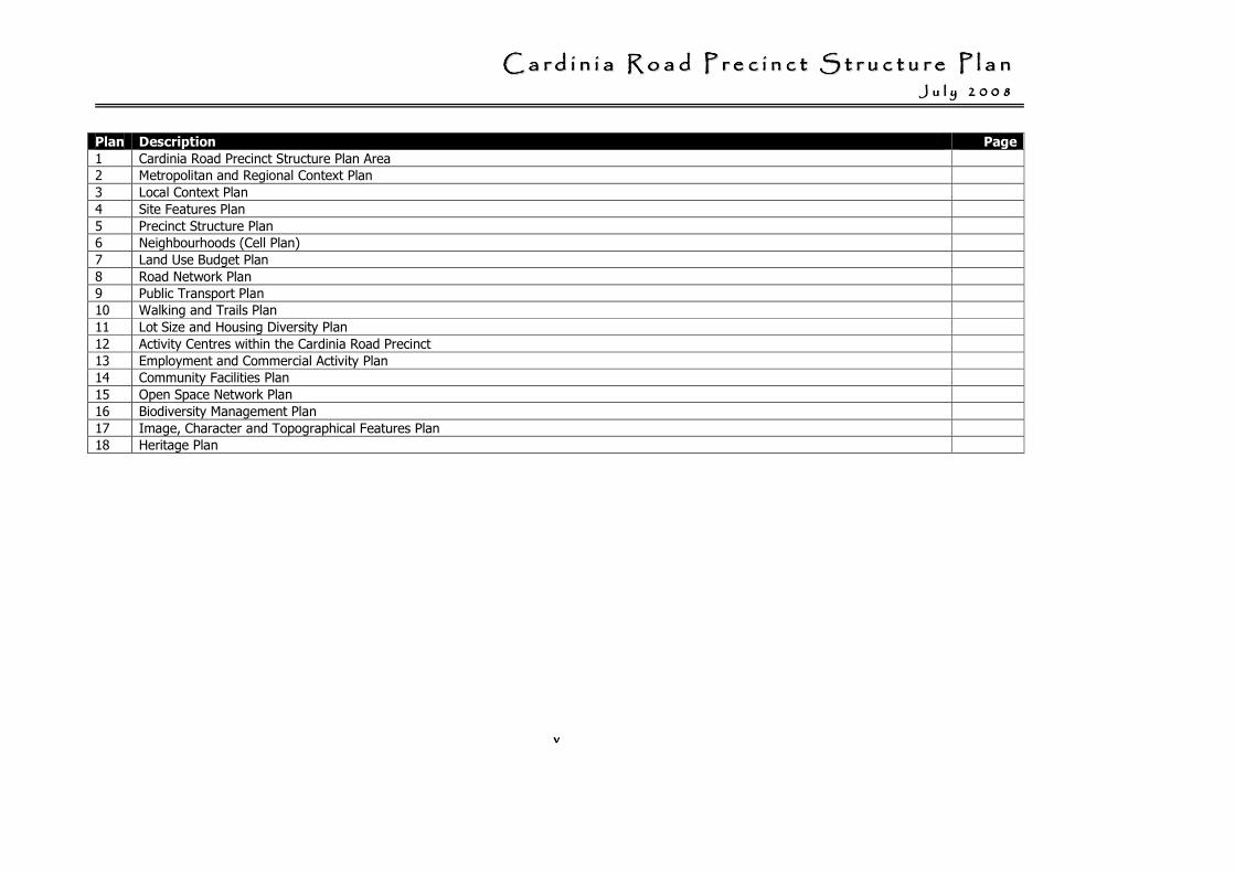
Plan Description Page
1 Cardinia Road Precinct Structure Plan Area
2 Metropolitan and Regional Context Plan
3 Local Context Plan
4 Site Features Plan
5 Precinct Structure Plan
6 Neighbourhoods (Cell Plan)
7 Land Use Budget Plan
8 Road Network Plan
9 Public Transport Plan
10 Walking and Trails Plan
11 Lot Size and Housing Diversity Plan
12 Activity Centres within the Cardinia Road Precinct
13 Employment and Commercial Activity Plan
14 Community Facilities Plan
15 Open Space Network Plan
16 Biodiversity Management Plan
17 Image, Character and Topographical Features Plan
18 Heritage Plan
CCCCCCCC aaaaaaaa rrrrrrrr dddddddd iiiiiiii nnnnnnnn iiiiiiii aaaaaaaa RRRRRRRR oooooooo aaaaaaaa dddddddd PPPPPPPP rrrrrrrr eeeeeeee cccccccc iiiiiiii nnnnnnnn cccccccc tttttttt SSSSSSSS tttttttt rrrrrrrr uuuuuuuu cccccccc tttttttt uuuuuuuu rrrrrrrr eeeeeeee PPPPPPPP llllllll aaaaaaaa nnnnnnnn JJJJJJJJ uuuuuuuu llllllll yyyyyyyy 22222222 00000000 00000000 88888888
vivivivi
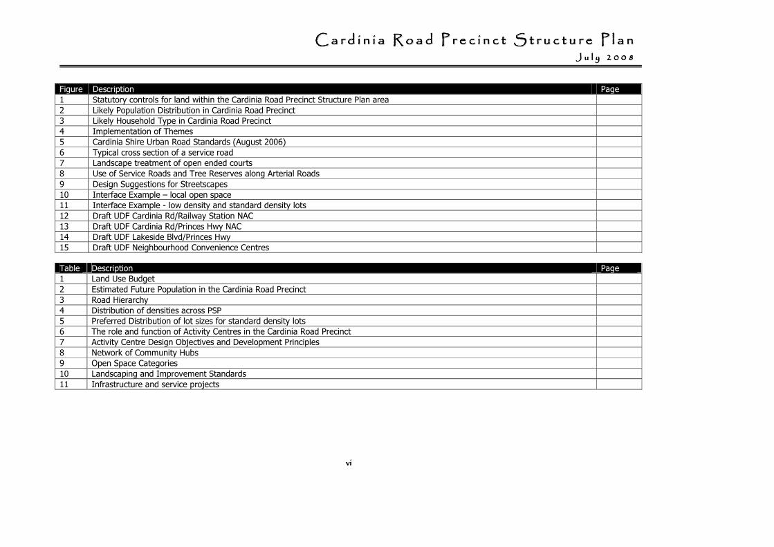
Figure Description Page
1 Statutory controls for land within the Cardinia Road Precinct Structure Plan area
2 Likely Population Distribution in Cardinia Road Precinct
3 Likely Household Type in Cardinia Road Precinct
4 Implementation of Themes
5 Cardinia Shire Urban Road Standards (August 2006)
6 Typical cross section of a service road
7 Landscape treatment of open ended courts
8 Use of Service Roads and Tree Reserves along Arterial Roads
9 Design Suggestions for Streetscapes
10 Interface Example – local open space
11 Interface Example - low density and standard density lots
12 Draft UDF Cardinia Rd/Railway Station NAC
13 Draft UDF Cardinia Rd/Princes Hwy NAC
14 Draft UDF Lakeside Blvd/Princes Hwy
15 Draft UDF Neighbourhood Convenience Centres
Table Description Page
1 Land Use Budget
2 Estimated Future Population in the Cardinia Road Precinct
3 Road Hierarchy
4 Distribution of densities across PSP
5 Preferred Distribution of lot sizes for standard density lots
6 The role and function of Activity Centres in the Cardinia Road Precinct
7 Activity Centre Design Objectives and Development Principles
8 Network of Community Hubs
9 Open Space Categories
10 Landscaping and Improvement Standards
11 Infrastructure and service projects
CCCCCCCC aaaaaaaa rrrrrrrr dddddddd iiiiiiii nnnnnnnn iiiiiiii aaaaaaaa RRRRRRRR oooooooo aaaaaaaa dddddddd PPPPPPPP rrrrrrrr eeeeeeee cccccccc iiiiiiii nnnnnnnn cccccccc tttttttt SSSSSSSS tttttttt rrrrrrrr uuuuuuuu cccccccc tttttttt uuuuuuuu rrrrrrrr eeeeeeee PPPPPPPP llllllll aaaaaaaa nnnnnnnn JJJJJJJJ uuuuuuuu llllllll yyyyyyyy 22222222 00000000 00000000 88888888
vii
Acknowledgements
Design Urban
Department of Transport
Ecology Partners
Growth Areas Authority
John Piper Traffic Pty Ltd
Land Design Partnership
SM Urban Pty Ltd
Department of Planning & Community Development – Priority Development Panel (PDP)
CCCCCCCC aaaaaaaa rrrrrrrr dddddddd iiiiiiii nnnnnnnn iiiiiiii aaaaaaaa RRRRRRRR oooooooo aaaaaaaa dddddddd PPPPPPPP rrrrrrrr eeeeeeee cccccccc iiiiiiii nnnnnnnn cccccccc tttttttt SSSSSSSS tttttttt rrrrrrrr uuuuuuuu cccccccc tttttttt uuuuuuuu rrrrrrrr eeeeeeee PPPPPPPP llllllll aaaaaaaa nnnnnnnn JJJJJJJJ uuuuuuuu llllllll yyyyyyyy 22222222 00000000 00000000 88888888
- 1 -
1. Introduction
1.1 Role of the precinct structure plan
The Cardinia Road Precinct Structure Plan (CRPSP) has been prepared by the Cardinia Shire Council in conjunction with the Growth Areas Authority (GAA), government agencies, service authorities and major stakeholders.
A precinct structure plan (PSP) is a key document that:
• enables the conversion of non-urban land to urban land to commence under the Urban Growth Zone;
• sets out the vision for how land should be developed and the desired outcomes to be achieved;
• determines the overall layout of future land use and development;
• details the form and conditions that must be met by future land use and development;
• determines the use and development controls that will apply in the schedule to the zone; and,
• determines what permits may be granted under the zone.1
1 Urban Growth Zone, VPP Practice Note, June 2008, p 1
The CRPSP is a long-term strategic plan that describes how the Cardinia Road Precinct will be developed. It is designed to:
• ensure that the key strategic planning issues in a precinct are considered when planning ahead for urban development;
• identify and address any opportunities and constraints that will affect future urban development;
• ensure communities in new urban areas have good access to services, transport, jobs, shops, open space and recreation facilities;
• give developers, investors and local communities greater certainty and confidence about future development in growth areas; and,
• provide the framework, conditions and requirements for the consideration of planning permits.
CCCCCCCC aaaaaaaa rrrrrrrr dddddddd iiiiiiii nnnnnnnn iiiiiiii aaaaaaaa RRRRRRRR oooooooo aaaaaaaa dddddddd PPPPPPPP rrrrrrrr eeeeeeee cccccccc iiiiiiii nnnnnnnn cccccccc tttttttt SSSSSSSS tttttttt rrrrrrrr uuuuuuuu cccccccc tttttttt uuuuuuuu rrrrrrrr eeeeeeee PPPPPPPP llllllll aaaaaaaa nnnnnnnn JJJJJJJJ uuuuuuuu llllllll yyyyyyyy 22222222 00000000 00000000 88888888
- 2 -
The precinct structure plan sets objectives and provides for their implementation in relation to:
• land use (such as residential of varying densities, industrial, core business and peripheral commerical, open space, heritage, education facilities and community infrastructure);
• transport (such as the primary arterial and local arterial road network, collector roads & public transport);
• activity centres and employment areas; and,
• open space both unencumbered (passive & active) and encumbered (waterways and biodiversity and environmental sensitive areas).
Further reference material
Detailed baseline and other technical information documenting the preparation of this Precinct Structure Plan is listed in References.
CCCCCCCC aaaaaaaa rrrrrrrr dddddddd iiiiiiii nnnnnnnn iiiiiiii aaaaaaaa RRRRRRRR oooooooo aaaaaaaa dddddddd PPPPPPPP rrrrrrrr eeeeeeee cccccccc iiiiiiii nnnnnnnn cccccccc tttttttt SSSSSSSS tttttttt rrrrrrrr uuuuuuuu cccccccc tttttttt uuuuuuuu rrrrrrrr eeeeeeee PPPPPPPP llllllll aaaaaaaa nnnnnnnn JJJJJJJJ uuuuuuuu llllllll yyyyyyyy 22222222 00000000 00000000 88888888
- 3 -
1.2 How to use this precinct structure plan
The Urban Growth Zone (UGZ) requires a precinct structure plan to be incorporated in the planning scheme before urban development can start.
Once a precinct structure plan applies to the land, Clauses 37.07-9 to 37.07-16 of the Urban Growth Zone apply. They are designed to:
• provide certainty about the nature of future development;
• reduce the number of development approvals needed once a precinct structure plan applies;
• remove notice requirements and third party review rights from planning permit applications; and,
• ensure that permits granted for urban development generally conform to the plan.2
Figure 1 outlines the statutory planning controls for land within the Cardinia Road Precinct Structure Plan area
1.2.1 Document approval and revision
This precinct structure plan was approved by the Minister for Planning on X XXXX 2008.
2 Urban Growth Zone, VPP Practice Note, June 2008, p 6
1.2.2 Monitoring and review
The Growth Areas Authority and the Cardinia Shire will jointly monitor the implementation of this Precinct Structure Plan.
The effectiveness of the CRPSP will be evaluated regularly, at least every five years.
It is expected that this CRPSP will be revised and updated from time to time as required.
CCCCCCCC aaaaaaaa rrrrrrrr dddddddd iiiiiiii nnnnnnnn iiiiiiii aaaaaaaa RRRRRRRR oooooooo aaaaaaaa dddddddd PPPPPPPP rrrrrrrr eeeeeeee cccccccc iiiiiiii nnnnnnnn cccccccc tttttttt SSSSSSSS tttttttt rrrrrrrr uuuuuuuu cccccccc tttttttt uuuuuuuu rrrrrrrr eeeeeeee PPPPPPPP llllllll aaaaaaaa nnnnnnnn JJJJJJJJ uuuuuuuu llllllll yyyyyyyy 22222222 00000000 00000000 88888888
- 4 -
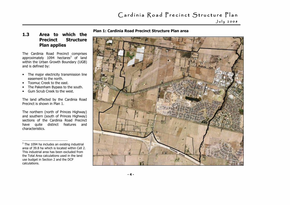
1.3 Area to which the Precinct Structure Plan applies
The Cardinia Road Precinct comprises approximately 1094 hectares3 of land within the Urban Growth Boundary (UGB) and is defined by:
• The major electricity transmission line easement to the north.
• Toomuc Creek to the east. • The Pakenham Bypass to the south. • Gum Scrub Creek to the west.
The land affected by the Cardinia Road Precinct is shown in Plan 1.
The northern (north of Princes Highway) and southern (south of Princes Highway) sections of the Cardinia Road Precinct have quite distinct features and characteristics.
3 The 1094 ha includes an existing industrial area of 39.8 ha which is located within Cell 2. This industrial area has been excluded from the Total Area calculations used in the land
use budget in Section 2 and the DCP calculations.
Plan 1: Cardinia Road Precinct Structure Plan area
CCCCCCCC aaaaaaaa rrrrrrrr dddddddd iiiiiiii nnnnnnnn iiiiiiii aaaaaaaa RRRRRRRR oooooooo aaaaaaaa dddddddd PPPPPPPP rrrrrrrr eeeeeeee cccccccc iiiiiiii nnnnnnnn cccccccc tttttttt SSSSSSSS tttttttt rrrrrrrr uuuuuuuu cccccccc tttttttt uuuuuuuu rrrrrrrr eeeeeeee PPPPPPPP llllllll aaaaaaaa nnnnnnnn JJJJJJJJ uuuuuuuu llllllll yyyyyyyy 22222222 00000000 00000000 88888888
- 5 -
1.4 Metropolitan and regional context
1.4.1 Growth Area Framework Plan
The Casey - Cardinia Growth Area includes land within the City of Casey and the Shire of Cardinia.
The Cardinia Road Precinct is a significant land area located central to Cardinia’s portion of the Casey - Cardinia Growth Area.
The Growth Area Framework Plan (DSE) 2006 predicts that the Casey - Cardinia growth area is expected to:
• Grow by 135,000 – 170,000 people; and,
• Provide for employment in local businesses and industries to grow to between 100,000 and 140,000 jobs.4
4 Growth Area Framework Plans, DSE, 2006 p7
Regional components of the Growth Area Framework Plan of particular importance to the Cardinia Road Precinct are:
• The site falls within an area identified as a ‘strategic development area’ (which requires further examination in relation to salinity, groundwater and environmental values).
• 3 major components of the Strategic Road Network:
- Princes Highway (Arterial Road) runs east – west through the centre of the Precinct and is a Principal Public Transport Network (PPTN) for a Bus Route.
- Pakenham Bypass (Freeway) is the southern boundary of the Precinct.
- Cardinia Road (Arterial Road) runs north – south through the centre of the southern section of the Precinct and is a strategically important link between the Pakenham Bypass and Princes Highway.
• Major components of the Principal Public Transport Network (PPTN) include:
- A railway line that runs though the southern section of the precinct with a ‘committed’ station.
- A PPTN Bus Route along Princes Highway.
• A significant Regional Open Space area is identified at Toomuc Recreation Reserve.
• Significant waterways are identified at the eastern and western boundary of the precinct (Toomuc and Gum Scrub Creeks).
• Two large Neighbourhood Activity Centres (NACs). These sites are located at Lakeside Boulevard / Toomuc Reserve, and Cardinia Road (immediately south of the railway line).
CCCCCCCC aaaaaaaa rrrrrrrr dddddddd iiiiiiii nnnnnnnn iiiiiiii aaaaaaaa RRRRRRRR oooooooo aaaaaaaa dddddddd PPPPPPPP rrrrrrrr eeeeeeee cccccccc iiiiiiii nnnnnnnn cccccccc tttttttt SSSSSSSS tttttttt rrrrrrrr uuuuuuuu cccccccc tttttttt uuuuuuuu rrrrrrrr eeeeeeee PPPPPPPP llllllll aaaaaaaa nnnnnnnn JJJJJJJJ uuuuuuuu llllllll yyyyyyyy 22222222 00000000 00000000 88888888
- 6 -
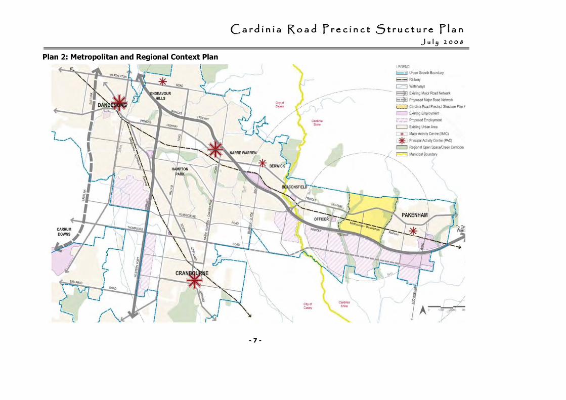
The following regional components outside of the CRPSP area can ultimately be accessed via the PPTN bus route or rail line, or along the strategic road network:
• A Principal Activity Centres (PAC) west of the precinct at Fountain Gate (within the City of Casey).
• 2 Major Activity Centres (MACs), one at Pakenham, and another proposed MAC at Officer.
• Existing employment areas at Pakenham.
• Proposed employment areas south of the proposed Freeway (Pakenham Bypass).
• A proposed Mixed Use Employment node at Berwick (within the City of Casey).
Plan 2 depicts the metropolitan and regional context of the Cardinia Road Precinct.
CCCCCCCC aaaaaaaa rrrrrrrr dddddddd iiiiiiii nnnnnnnn iiiiiiii aaaaaaaa RRRRRRRR oooooooo aaaaaaaa dddddddd PPPPPPPP rrrrrrrr eeeeeeee cccccccc iiiiiiii nnnnnnnn cccccccc tttttttt SSSSSSSS tttttttt rrrrrrrr uuuuuuuu cccccccc tttttttt uuuuuuuu rrrrrrrr eeeeeeee PPPPPPPP llllllll aaaaaaaa nnnnnnnn JJJJJJJJ uuuuuuuu llllllll yyyyyyyy 22222222 00000000 00000000 88888888
- 7 -
Plan 2: Metropolitan and Regional Context Plan
CCCCCCCC aaaaaaaa rrrrrrrr dddddddd iiiiiiii nnnnnnnn iiiiiiii aaaaaaaa RRRRRRRR oooooooo aaaaaaaa dddddddd PPPPPPPP rrrrrrrr eeeeeeee cccccccc iiiiiiii nnnnnnnn cccccccc tttttttt SSSSSSSS tttttttt rrrrrrrr uuuuuuuu cccccccc tttttttt uuuuuuuu rrrrrrrr eeeeeeee PPPPPPPP llllllll aaaaaaaa nnnnnnnn JJJJJJJJ uuuuuuuu llllllll yyyyyyyy 22222222 00000000 00000000 88888888
- 8 -
1.5 Local context
1.5.1 Lot size and ownership pattern
The precinct is predominately made up of land currently being used for rural/farming purposes. Around 20% of the PSP area is developed as part of the Delfin Lakeside Estate (located south of the Princes Highway) with another 4% being part of the Industrial zoned land (north of Princes Highway).
Excluding the Delfin Lakeside Estate and the Industrial zoned land approximately:
• 19% of the properties are less than 2 ha;
• 33% of properties are within a 2 to 8 ha lot range;
• 48% of the lots are greater than 8 ha (and of this large lot range close to 50% of the lots are greater than 20 ha); and,
• around 70% of the PSP area is within in the ownership of developers such as Delfin Lend Lease, Metricon, Babcock and Brown and VicUrban.
1.5.2 Surrounding land use and pattern
The northern boundary of the Cardinia Road Precinct is defined by the Urban Growth Boundary (UGB). The Cardinia Road Precinct is located along the southern fringe of the foothills to the Dandenong Ranges.
Recommendations in Melbourne 2030 Final Report: Casey-Cardinia Committee for Smart Growth, June 2005 make specific reference to recognising and protecting:
• visual amenity and view lines to the significant green ridges;
• the visual backdrop to the southern foothills of the Dandenong Ranges; and,
• the significant hilltops.5
Melbourne 2030 Final Report: Casey-Cardinia Committee for Smart Growth, June 2005 designates land south of the proposed Pakenham Freeway (Pakenham Bypass) as ‘Possible Long Term Employment’.
This land has been reserved for employment land in the long term, as development in the South Dandenong area fills available space.6
Land east of the Toomuc Creek predominately comprises of an established urban environment.
Land west of the precinct is located within the ‘Officer Precinct’ which is identified for future urban development and is subject to a separate Precinct Structure Plan process.
5 Melbourne 2030 Final Report: Casey-Cardinia Committee for Smart Growth, June 2005, p 37 6 Melbourne 2030 Final Report: Casey-
Cardinia Committee for Smart Growth, June 2005, p 95
CCCCCCCC aaaaaaaa rrrrrrrr dddddddd iiiiiiii nnnnnnnn iiiiiiii aaaaaaaa RRRRRRRR oooooooo aaaaaaaa dddddddd PPPPPPPP rrrrrrrr eeeeeeee cccccccc iiiiiiii nnnnnnnn cccccccc tttttttt SSSSSSSS tttttttt rrrrrrrr uuuuuuuu cccccccc tttttttt uuuuuuuu rrrrrrrr eeeeeeee PPPPPPPP llllllll aaaaaaaa nnnnnnnn JJJJJJJJ uuuuuuuu llllllll yyyyyyyy 22222222 00000000 00000000 88888888
- 9 -
1.5.3 Facilities and services in and within the proximity
of the precinct
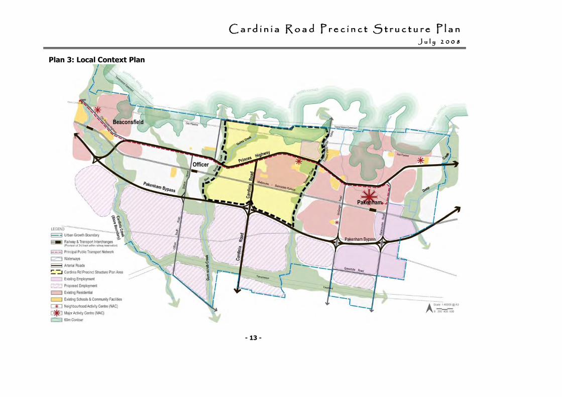
Road Network
• Princes Highway is an arterial road which runs east – west through the centre of the PSP area. The Princes Highway is designated as a Principal Public Transport Network (PPTN) route.
• The Pakenham Bypass runs south of the existing Princes Highway route and provides full freeway conditions with two lanes each way between Beaconsfield and Nar Nar Goon. An interchange is located at Cardinia Road.
• Cardinia Road is an arterial road that is planned to be a key transit route which runs north - south through the centre of the Cardinia Road Precinct, linking Princes Highway to the Pakenham Bypass.
Public Transport
• Within the Cardinia Road Precinct, the Principal Public Transport Network (PPTN) includes the Princes Highway; and,the Gippsland Railway line / ‘Pakenham’ railway line.
• An inter-regional bus service currently serves the Princes Highway. The PPTN is supplemented by a local bus services that provide connections to and within Delfin Lakeside Estate to Pakenham Town Centre / railway station and Fountain Gate Shopping Centre.
• The Cardinia Road Precinct is traversed by the Gippsland Railway line which provides suburban rail services and V-line services along the Pakenham railway line. Currently the nearest existing train station is located at Officer to the west of the PSP, with the Pakenham railway station located to the east of the PSP.
• A new station is proposed in the Cardinia Road Precinct immediately east of Cardinia Road. The Victorian Government’s transport blueprint Meeting Our Transport Challenges7 commits to the delivery of the station commencing in 2012.
7 Meeting Our Transport Challenges:
Connecting Victorian Communities, Victorian Government, May 2006.
CCCCCCCC aaaaaaaa rrrrrrrr dddddddd iiiiiiii nnnnnnnn iiiiiiii aaaaaaaa RRRRRRRR oooooooo aaaaaaaa dddddddd PPPPPPPP rrrrrrrr eeeeeeee cccccccc iiiiiiii nnnnnnnn cccccccc tttttttt SSSSSSSS tttttttt rrrrrrrr uuuuuuuu cccccccc tttttttt uuuuuuuu rrrrrrrr eeeeeeee PPPPPPPP llllllll aaaaaaaa nnnnnnnn JJJJJJJJ uuuuuuuu llllllll yyyyyyyy 22222222 00000000 00000000 88888888
- 10 -
Activity Centres
• A Neighbourhood Activity Centre is located within the Delfin Lakeside Estate and is already partially developed. The activity centre contains a supermarket, petrol station, restaurants and speciality shops. A major complex containing a police station, the Country Fire Authority and State Emergency Services is also located within proximity to this activity centre.
• Residents in the Cardinia Road Precinct will have access to higher order centres within Cardinia Shire, such as the Major Activity Centres at the Pakenham Town Centre (to the east of the PSP) and the future Officer Town Centre (to the west of the PSP).
• Centres located within the neighbouring municipality of the City of Casey include the Major Activity Centre in Berwick, and the Principal Activity Centres at Fountain Gate / Narre Warren.
Social and Community Infrastructure
• The following facilities/services are located within the Delfin Lakeside Estate:
- A Community Centre which is a Council operated facility (a double unit kindergarten, maternal and child health centre, plus other community programs).
- A private primary / secondary school (anticipated intake of a total of 1,000 students by 2011);
- the Cardinia Cultural Centre; and,
- a new state primary school within the Delfin Lakeside Development is proposed to be opened in 2009.
Parkland and open space
Within the Cardinia Road Precinct, there are a number of existing areas of open space including:
• Toomuc Reserve which is a regional / district sports reserve including an indoor sports and aquatic centre, 2 ovals, an athletics track, and 2 baseball diamonds.
• Lake Reserve (Delfin Lakeside Estate) which is a 8 ha district park with an 6.5 ha lake including a short course rowing course, surrounding passive recreation areas and a pathway constructed around the lake.
• Toomuc Creek which is a linear park along the creek with significant areas of revegetation undertaken through community involvement.
• A number of local parks have been established in the Delfin Lakeside Estate with open grassed areas, landscaping and playground facilities.
CCCCCCCC aaaaaaaa rrrrrrrr dddddddd iiiiiiii nnnnnnnn iiiiiiii aaaaaaaa RRRRRRRR oooooooo aaaaaaaa dddddddd PPPPPPPP rrrrrrrr eeeeeeee cccccccc iiiiiiii nnnnnnnn cccccccc tttttttt SSSSSSSS tttttttt rrrrrrrr uuuuuuuu cccccccc tttttttt uuuuuuuu rrrrrrrr eeeeeeee PPPPPPPP llllllll aaaaaaaa nnnnnnnn JJJJJJJJ uuuuuuuu llllllll yyyyyyyy 22222222 00000000 00000000 88888888
- 11 -
Physical and service infrastructure
Water services
• South East Water is responsible for the provision of reticulated water services within the Cardinia Road Precinct.
• Sewerage
• South East Water is responsible for the provision of reticulated sewerage services within the Cardinia Road Precinct.
• The Precinct will be serviced by three trunk sewers which service different catchments:
- Toomuc Creek Branch Sewer;
- Cardinia Road Branch Sewer; and,
- Gum Scrub Creek Branch Sewer.
Drainage
• Melbourne Water is responsible for the provision of the main drainage network.
• Cardinia Shire Council is responsible for the provision of the local drainage network.
• Melbourne Water has prepared three drainage schemes which cover the Cardinia Road Precinct and that set out the infrastructure requirements for the main drainage network as follows:
- Pakenham West Drainage Scheme;
- Cardinia Road Drainage Scheme; and,
- Officer Drainage Scheme.
• The drainage schemes set out the infrastructure required for the safe passage of stormwater to avoid damage to property from flooding and measures to manage the quantity and quality of stormwater discharged downstream in order to minimise impacts on the downstream environment
.
CCCCCCCC aaaaaaaa rrrrrrrr dddddddd iiiiiiii nnnnnnnn iiiiiiii aaaaaaaa RRRRRRRR oooooooo aaaaaaaa dddddddd PPPPPPPP rrrrrrrr eeeeeeee cccccccc iiiiiiii nnnnnnnn cccccccc tttttttt SSSSSSSS tttttttt rrrrrrrr uuuuuuuu cccccccc tttttttt uuuuuuuu rrrrrrrr eeeeeeee PPPPPPPP llllllll aaaaaaaa nnnnnnnn JJJJJJJJ uuuuuuuu llllllll yyyyyyyy 22222222 00000000 00000000 88888888
- 12 -
Electricity
• SPI AusNet is responsible for the provision of the electricity supply system to service development in the Cardinia Road Precinct.
• The existing electricity supply system can be extended to accommodate the proposed development.
Gas
• Origin Energy is responsible for the provision of the gas supply network to service development in the Cardinia Road Precinct.
• The existing gas supply network can be extended to accommodate the proposed development.
• The Longford to Dandenong gas transmission pipeline passes through the northern part of the Cardinia Road Precinct in a 24 metre wide easement.
• GasNet is responsible for the operation and management of the pipeline. Restrictions exist in relation to building structures and undertaking works within the easement.
Telecommunications
Telstra is the principal authority responsible for the provision of telecommunications services for the Cardinia Road Precinct.
Plan 3 depicts the local context of the Cardinia Road Precinct.
CCCCCCCC aaaaaaaa rrrrrrrr dddddddd iiiiiiii nnnnnnnn iiiiiiii aaaaaaaa RRRRRRRR oooooooo aaaaaaaa dddddddd PPPPPPPP rrrrrrrr eeeeeeee cccccccc iiiiiiii nnnnnnnn cccccccc tttttttt SSSSSSSS tttttttt rrrrrrrr uuuuuuuu cccccccc tttttttt uuuuuuuu rrrrrrrr eeeeeeee PPPPPPPP llllllll aaaaaaaa nnnnnnnn JJJJJJJJ uuuuuuuu llllllll yyyyyyyy 22222222 00000000 00000000 88888888
- 13 -
Plan 3: Local Context Plan
CCCCCCCC aaaaaaaa rrrrrrrr dddddddd iiiiiiii nnnnnnnn iiiiiiii aaaaaaaa RRRRRRRR oooooooo aaaaaaaa dddddddd PPPPPPPP rrrrrrrr eeeeeeee cccccccc iiiiiiii nnnnnnnn cccccccc tttttttt SSSSSSSS tttttttt rrrrrrrr uuuuuuuu cccccccc tttttttt uuuuuuuu rrrrrrrr eeeeeeee PPPPPPPP llllllll aaaaaaaa nnnnnnnn JJJJJJJJ uuuuuuuu llllllll yyyyyyyy 22222222 00000000 00000000 88888888
- 14 -
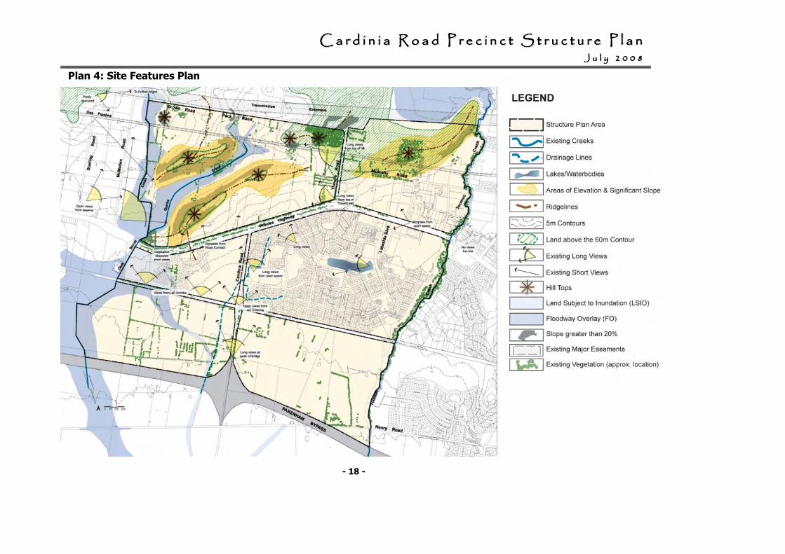
1.6 Site Features
Plan 4 Site Features shows the key features of the Cardinia Road Precinct.
1.6.1 Topography, landscape
and landform
The land to the north of the Princes Highway is identified as ‘Foothill Ranges’ and is characterised by undulating topography with significant east west ridgelines. The ridgelines define the south western extent of the Eastern Victorian Uplands, the southern formation of the Great Dividing Range. There are also a number of hilltops associated with this Upland formation.
Land on the ridgelines and hilltops, north of Princes Highway (particularly above the 60 metre contour), are a ‘visually prominent landscape element’ within the region. This area is the general elevation at which the ‘flatlands’ rise noticeably to form the ridges and these ‘high points’ are very visible from many locations within the PSP. The ridgelines and hilltops provide a distinct and familiar point of reference in the landscape.
The land to the south of the Princes Highway is generally flat with few landscape features.
Lines of vegetation along creeks, roads and paddock boundaries provide a sense of local visual containment. The Toomuc and Gum Scrub Creek corridors provide the opportunity to define a strong landscape character and sense of place for the precinct.
Some stands of remnant vegetation both within the precinct and on the hills to the north provide a significant contribution to the visual character and quality of the area.
1.6.2 Biodiversity
Flora
The broad vegetation types existing prior to European settlement in the precinct is as follows:
• Grassy Forest (generally on the higher land north of the Princes Highway);
• Damp Heathy Woodland (generally along Thewlis Road and Cardinia Road corridors);
• Plains Grassy Woodland (generally in the southern part and eastern part of the precinct around the Purton Road industrial area and Toomuc Reserve);
• Swampy Riparian Complex (generally south of Princes Highway and along Gum Scrub Creek corridor); and,
• Swampy Riparian Woodland (along Toomuc Creek Corridor).
Land in the Cardinia Road Precinct has largely been cleared of indigenous vegetation as part of the previous use of the land for grazing purposes.
CCCCCCCC aaaaaaaa rrrrrrrr dddddddd iiiiiiii nnnnnnnn iiiiiiii aaaaaaaa RRRRRRRR oooooooo aaaaaaaa dddddddd PPPPPPPP rrrrrrrr eeeeeeee cccccccc iiiiiiii nnnnnnnn cccccccc tttttttt SSSSSSSS tttttttt rrrrrrrr uuuuuuuu cccccccc tttttttt uuuuuuuu rrrrrrrr eeeeeeee PPPPPPPP llllllll aaaaaaaa nnnnnnnn JJJJJJJJ uuuuuuuu llllllll yyyyyyyy 22222222 00000000 00000000 88888888
- 15 -
Very little remnant native vegetation remains, although small patches of remnant vegetation occur primarily along roadsides, railways, Toomuc Creek, Gum Scrub Creek, at the corner of Thewlis and Peck Roads, and north of Mulcahy Road.
Of the broad vegetation types identified in Victoria’s Native Vegetation Management Framework, only isolated remnants exist in the following locations:
• Grassy Forest - north of Mulcahy Road to the east of Thewlis Road;
• Grassy Forest and Damp Heathy Woodland - the south west corner of Thewlis Road and Peck Road;
• Swampy Riparian Woodland and Swampy Woodland - along the Toomuc Creek (generally north of the railway line); and,
• Swamp Scrub – patches located along the Gum Scrub Creek.
Fauna
The overall value of most habitats within the study area for fauna is low as the study area had been highly modified and dominated by exotic pasture grasses of low ecological value.
Remnant vegetation, roadside vegetation and planted vegetation provides habitat for many species (primarily birds). Roadside vegetation in the study area also provides linkages to larger areas of woodland and forest to the north of the study area. Overall, a small number of common and introduced birds are likely to use habitats within the study area, while ground dwelling fauna are expected to be depleted.
No fauna species of national or state significance were recorded within the study area, however one nationally threatened fauna species (Growling Grass Frog) is known to reside in the study area.
The nationally endangered Growling Grass Frog has been recorded south of the Princes Highway.
Ecological advice prepared as part of the development of the CRPSP confirmed that it is important that as many occupied and adjacent unoccupied waterbodies are conserved as possible to assist in the Frog’s conservation.
In relation to the CRPSP area:
• Likely frog movement corridors are located south of the railway line reservation and within Gum Scrub Creek.
• Habitat protection/connectivity and investigation areas for habitat creation / augmentation are located within the proposed Melbourne Water stormwater treatment wetland, Gum Scrub Creek and Toomuc Creek.8
In addition to this, a small localised cluster of occupied sites, including breeding sites is located within the constructed wetlands of the Delfin housing estate. This small cluster
8 Targeted Survey and Conservation Management Plan for the Growling Grass Frog Litoria raniformis: Pakenham Urban Growth
Corridor, Pakenham, Victoria, Ecology Partners Pty. Ltd., September 2006, Figure 3a
CCCCCCCC aaaaaaaa rrrrrrrr dddddddd iiiiiiii nnnnnnnn iiiiiiii aaaaaaaa RRRRRRRR oooooooo aaaaaaaa dddddddd PPPPPPPP rrrrrrrr eeeeeeee cccccccc iiiiiiii nnnnnnnn cccccccc tttttttt SSSSSSSS tttttttt rrrrrrrr uuuuuuuu cccccccc tttttttt uuuuuuuu rrrrrrrr eeeeeeee PPPPPPPP llllllll aaaaaaaa nnnnnnnn JJJJJJJJ uuuuuuuu llllllll yyyyyyyy 22222222 00000000 00000000 88888888
- 16 -
represents an area of high conservation significance due to the large population size. However, the report identifies that the future viability of some of these sites is uncertain, given the lack of movement corridors to occupied sites to the south.
A focus of development in the Cardinia Road Precinct is on the restoration of habitat, particularly along the Toomuc and Gum Scrub Creek corridors and within the stormwater treatment wetlands.
1.6.3 Groundwater / salinity
Land within the urban growth area has high salinity risk based on groundwater depths of 0 m – 2.0 m and 2.0 m – 5.0 m.
The high groundwater table is partly caused by the loss of vegetation in the foothills area to the north, particularly geology of Silurian Sedimentary origin.
Sinclair Knight Merz (SKM) undertook a comprehensive review of the available hydrogeological technical documents.
A review of the SKM work9 was undertaken by Coomes Consulting Group, in consultation with SKM. The Coomes Report concluded that design and construction techniques are available to address and manage watertable issues to ensure that urban development is not impacted by existing watertable constraints.
9 The review was restricted to the areas
indicated as most severely affected in the Growth Area.
1.6.4 Waterways
The Cardinia Road Precinct is within the catchment of Western Port.
Western Port is recognised as a site of international importance in terms of its wetlands and as a site for migratory shorebirds. The wellbeing of this ecosystem is directly related to the health of its catchment.
A major threat to the Western Port environment including seagrass beds is the deposition of sediment and pollutants from upstream catchments.
The two major waterways within the precinct are the Toomuc Creek and Gum Scrub Creek.
These waterways have been substantially altered from their natural state and the index of stream conditions show a high proportion of the waterways in the Westernport catchment as being in a poor or degraded condition.
CCCCCCCC aaaaaaaa rrrrrrrr dddddddd iiiiiiii nnnnnnnn iiiiiiii aaaaaaaa RRRRRRRR oooooooo aaaaaaaa dddddddd PPPPPPPP rrrrrrrr eeeeeeee cccccccc iiiiiiii nnnnnnnn cccccccc tttttttt SSSSSSSS tttttttt rrrrrrrr uuuuuuuu cccccccc tttttttt uuuuuuuu rrrrrrrr eeeeeeee PPPPPPPP llllllll aaaaaaaa nnnnnnnn JJJJJJJJ uuuuuuuu llllllll yyyyyyyy 22222222 00000000 00000000 88888888
- 17 -
The management of the quantity and quality of water discharged from the Precinct (and the Growth Area as a whole) is critical to protecting the environment of the Western Port, and in controlling erosion.
1.6.5 Heritage
Aboriginal Cultural Heritage
Recent archaeological studies within the Shire of Cardinia have revealed evidence of the use of the region by indigenous people. It is apparent that remains of indigenous campsites are likely to occur across the entire Koo Wee Rup floodplain.
Indigenous archaeological sites are associated not only with existing stream channels, but with landform elements such as prior stream channels, levees, sandy alluvium and hills on and to the north of the Koo Wee Rup Plain.
The Aboriginal heritage study for the urban growth corridor, has suggested that:
• intact and deeply buried indigenous archaeological sites, are more likely to survive in sand and sandy alluvium on the Koo Wee Rup Plain and on the floodplains of the upper reaches of Cardinia, Toomuc, Deep and Ararat Creeks and the Bunyip River; and,
• on the shallow alluvial and clay soils, essentially eroded surfaces, which have formed on the Silurian bedrock of the hills in the north of the Urban Growth Corridor, indigenous archaeological sites are more likely to be found within 200 mm - 300 mm from the surface.
In this context, they are more likely to have been disturbed by land use since European settlement and land clearance.
Indigenous archaeological sites are most likely to be located by conducting heritage assessments using a combination of surface archaeological surveys and sub-surface testing.
European heritage
No sites of European heritage significance are located within the Cardinia Road Precinct Structure Plan area.
However, the Pakenham Cemetery (Thewlis Road) has been identified as requiring further research as to whether a citation should be made.
CCCCCCCC aaaaaaaa rrrrrrrr dddddddd iiiiiiii nnnnnnnn iiiiiiii aaaaaaaa RRRRRRRR oooooooo aaaaaaaa dddddddd PPPPPPPP rrrrrrrr eeeeeeee cccccccc iiiiiiii nnnnnnnn cccccccc tttttttt SSSSSSSS tttttttt rrrrrrrr uuuuuuuu cccccccc tttttttt uuuuuuuu rrrrrrrr eeeeeeee PPPPPPPP llllllll aaaaaaaa nnnnnnnn JJJJJJJJ uuuuuuuu llllllll yyyyyyyy 22222222 00000000 00000000 88888888
- 18 -
Plan 4: Site Features Plan
CCCCCCCC aaaaaaaa rrrrrrrr dddddddd iiiiiiii nnnnnnnn iiiiiiii aaaaaaaa RRRRRRRR oooooooo aaaaaaaa dddddddd PPPPPPPP rrrrrrrr eeeeeeee cccccccc iiiiiiii nnnnnnnn cccccccc tttttttt SSSSSSSS tttttttt rrrrrrrr uuuuuuuu cccccccc tttttttt uuuuuuuu rrrrrrrr eeeeeeee PPPPPPPP llllllll aaaaaaaa nnnnnnnn JJJJJJJJ uuuuuuuu llllllll yyyyyyyy 22222222 00000000 00000000 88888888
- 19 -
Development is much Development is much Development is much Development is much more than just the more than just the more than just the more than just the subdivision of land.subdivision of land.subdivision of land.subdivision of land.
It is about the It is about the It is about the It is about the development of new development of new development of new development of new neighbourhoods and neighbourhoods and neighbourhoods and neighbourhoods and
communities where people communities where people communities where people communities where people will live and interact.will live and interact.will live and interact.will live and interact.
2. Precinct Structure Plan
2.1 Vision
The vision for the Cardinia Road Precinct is to create a new community that is structured to:
• Reduce greenhouse gas emissions and promote a healthy, active way of life by reducing car dependency by taking full advantage of the proposed Cardinia Road rail station, with well designed higher density housing, activity centres, and subdivision design to maximise walking and cycling to the station. This will also be achieved by planning for local employment and supporting activity centres along the SmartBus serviced Princes Highway corridor supported by local bus services.
• Develop a broad social-economic mix through provision of a range of housing and lifestyle opportunities from higher density housing near the services and amenity of the station, activity centres and landscape responsive open space and lower densities around the northern ridges.
• Create good transport and community links to surrounding precincts in the west, east and south, both in terms of road and trail links, and in terms of planning for access to a hierarchy of retailing, employment, open space, community and education facilities.
• Create well designed
development that embraces sustainable urban development practices such as treed roads and streets, well designed higher density housing and activity centres and provision of recycled water to each home and business.
•
Provide positive environmental outcomes through the provision of a range of open space opportunities, including natural open space for the conservation of environmental features such as remnant vegetation, prominent hill tops and open corridors along the Toomuc Creek and Gum Scrub Creek for stormwater management, habitat restoration, passive recreation and as a landscape feature.
CCCCCCCC aaaaaaaa rrrrrrrr dddddddd iiiiiiii nnnnnnnn iiiiiiii aaaaaaaa RRRRRRRR oooooooo aaaaaaaa dddddddd PPPPPPPP rrrrrrrr eeeeeeee cccccccc iiiiiiii nnnnnnnn cccccccc tttttttt SSSSSSSS tttttttt rrrrrrrr uuuuuuuu cccccccc tttttttt uuuuuuuu rrrrrrrr eeeeeeee PPPPPPPP llllllll aaaaaaaa nnnnnnnn JJJJJJJJ uuuuuuuu llllllll yyyyyyyy 22222222 00000000 00000000 88888888
- 20 -
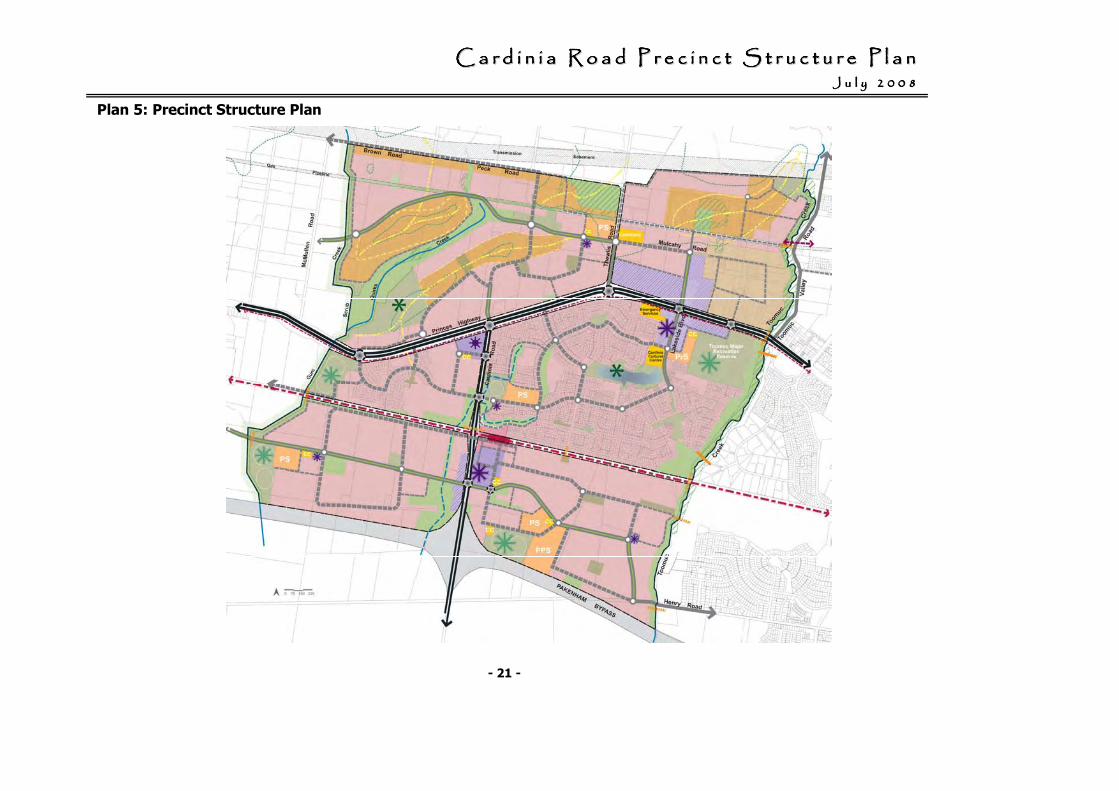
2.2 New Community Structure
The Cardinia Road Precinct Structure Plan is provided in Plan 5.
The components of the Cardinia Road Precinct Structure are as follows:
• A range in housing densities that will lead to the creation of a variety of housing types across various levels of affordability, catering for people in different stages of their lives.
Housing densities will be responsive to the character of the natural environment and site characteristics.
Medium density housing will be provided in strategic locations within close proximity to activity centres, public transport and ‘higher’ amenity areas, such as open space.
• Neighbourhood Activity Centres and / or Neighbourhood Convenience Centres within walking or cycling distance of each dwelling, and/or located along a legible and safe road network.
The Activity Centres will be a community focus, which includes a cluster of community facilities such as community buildings, open space and education purposes.
• A clear road hierarchy and layout that includes a local arterial road network that provides a strong and attractive urban environment through landscaping.
• A grade separated crossing of Cardinia Road and the railway line is a significant element of the road network to allow safe and efficient north / south bound traffic movement to / from the Pakenham Bypass.
• Direct and accessible bus routes will be within 400 m of 95% of homes via a PPTN network (Princes Highway) and / or the main / local road network.
• A train station located on the Gippsland Railway Line that is an integral part of the adjoining Neighbourhood Activity Centre.
• Safe walking and cycling paths are provided via the road network and the open space trail network, which includes pedestrian bridges over the creek network and pedestrian underpasses of the rail network (to be funded by the Development Contributions Plan).
• A number of open space areas are provided ranging from local open space, passive open space (conservation/restoration areas and linear open space) and active open space (district sport reserves) to cater for the variety of interest and ages within the community.
• The protection and enhancement of habitat of the Growling Grass Frog via the drainage network.
• The protection of the visually prominent landscape element north of the Princes Highway by encompassing the land within public open space and limiting the type / density of development.
CCCCCCCC aaaaaaaa rrrrrrrr dddddddd iiiiiiii nnnnnnnn iiiiiiii aaaaaaaa RRRRRRRR oooooooo aaaaaaaa dddddddd PPPPPPPP rrrrrrrr eeeeeeee cccccccc iiiiiiii nnnnnnnn cccccccc tttttttt SSSSSSSS tttttttt rrrrrrrr uuuuuuuu cccccccc tttttttt uuuuuuuu rrrrrrrr eeeeeeee PPPPPPPP llllllll aaaaaaaa nnnnnnnn JJJJJJJJ uuuuuuuu llllllll yyyyyyyy 22222222 00000000 00000000 88888888
- 21 -
Plan 5: Precinct Structure Plan
CCCCCCCC aaaaaaaa rrrrrrrr dddddddd iiiiiiii nnnnnnnn iiiiiiii aaaaaaaa RRRRRRRR oooooooo aaaaaaaa dddddddd PPPPPPPP rrrrrrrr eeeeeeee cccccccc iiiiiiii nnnnnnnn cccccccc tttttttt SSSSSSSS tttttttt rrrrrrrr uuuuuuuu cccccccc tttttttt uuuuuuuu rrrrrrrr eeeeeeee PPPPPPPP llllllll aaaaaaaa nnnnnnnn JJJJJJJJ uuuuuuuu llllllll yyyyyyyy 22222222 00000000 00000000 88888888
- 22 -
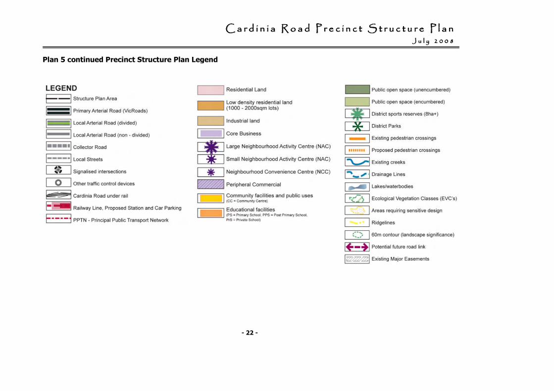
Plan 5 continued Precinct Structure Plan Legend
CCCCCCCC aaaaaaaa rrrrrrrr dddddddd iiiiiiii nnnnnnnn iiiiiiii aaaaaaaa RRRRRRRR oooooooo aaaaaaaa dddddddd PPPPPPPP rrrrrrrr eeeeeeee cccccccc iiiiiiii nnnnnnnn cccccccc tttttttt SSSSSSSS tttttttt rrrrrrrr uuuuuuuu cccccccc tttttttt uuuuuuuu rrrrrrrr eeeeeeee PPPPPPPP llllllll aaaaaaaa nnnnnnnn JJJJJJJJ uuuuuuuu llllllll yyyyyyyy 22222222 00000000 00000000 88888888
- 23 -
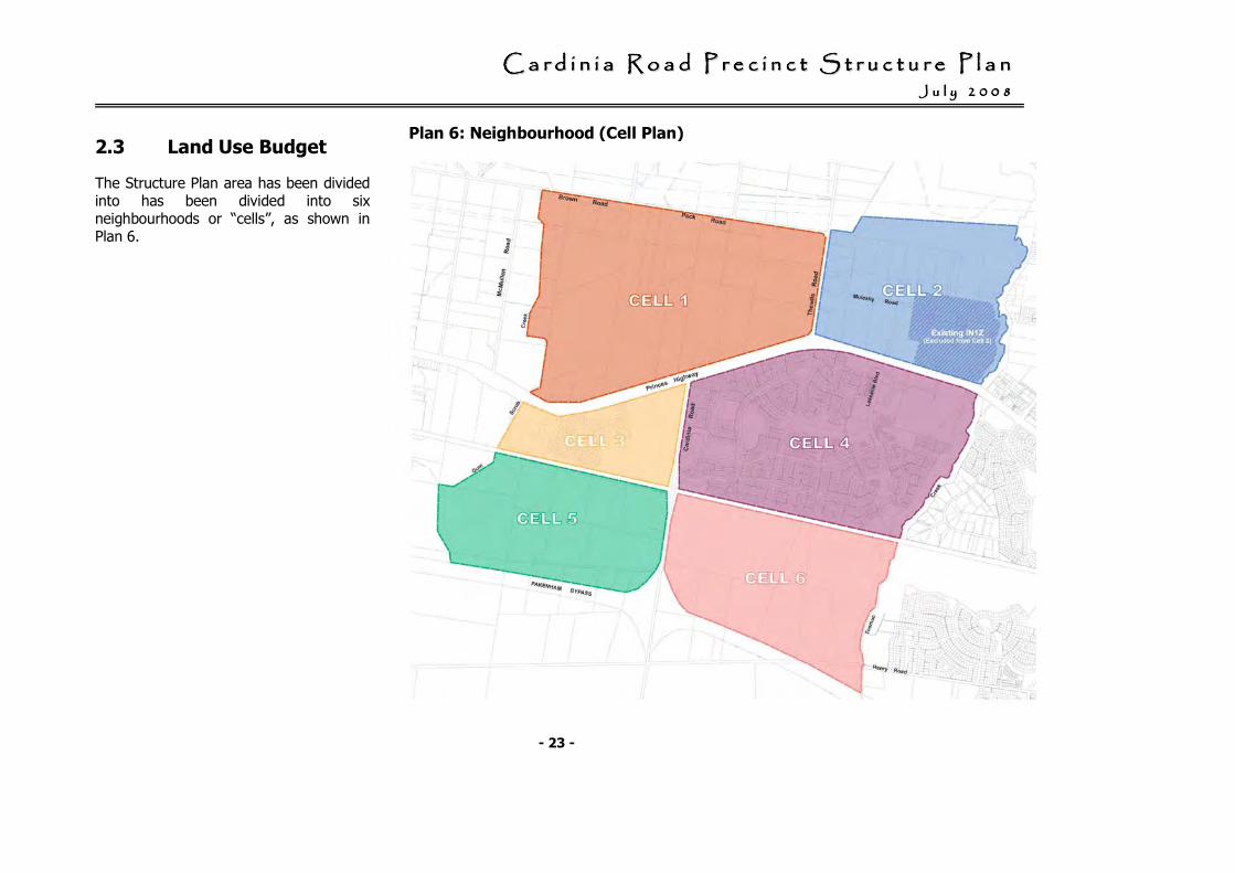
2.3 Land Use Budget
The Structure Plan area has been divided into has been divided into six neighbourhoods or “cells”, as shown in Plan 6.
Plan 6: Neighbourhood (Cell Plan)
CCCCCCCC aaaaaaaa rrrrrrrr dddddddd iiiiiiii nnnnnnnn iiiiiiii aaaaaaaa RRRRRRRR oooooooo aaaaaaaa dddddddd PPPPPPPP rrrrrrrr eeeeeeee cccccccc iiiiiiii nnnnnnnn cccccccc tttttttt SSSSSSSS tttttttt rrrrrrrr uuuuuuuu cccccccc tttttttt uuuuuuuu rrrrrrrr eeeeeeee PPPPPPPP llllllll aaaaaaaa nnnnnnnn JJJJJJJJ uuuuuuuu llllllll yyyyyyyy 22222222 00000000 00000000 88888888
- 24 -
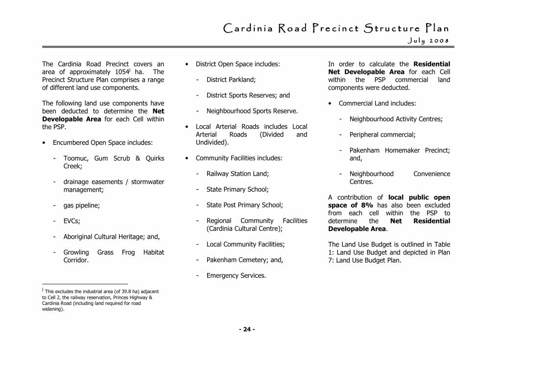
The Cardinia Road Precinct covers an area of approximately 1054j ha. The Precinct Structure Plan comprises a range of different land use components.
The following land use components have been deducted to determine the Net Developable Area for each Cell within the PSP.
• Encumbered Open Space includes:
- Toomuc, Gum Scrub & Quirks Creek;
- drainage easements / stormwater management;
- gas pipeline;
- EVCs;
- Aboriginal Cultural Heritage; and,
- Growling Grass Frog Habitat Corridor.
j This excludes the industrial area (of 39.8 ha) adjacent
to Cell 2, the railway reservation, Princes Highway & Cardinia Road (including land required for road widening).
• District Open Space includes:
- District Parkland;
- District Sports Reserves; and
- Neighbourhood Sports Reserve.
• Local Arterial Roads includes Local Arterial Roads (Divided and Undivided).
• Community Facilities includes:
- Railway Station Land;
- State Primary School;
- State Post Primary School;
- Regional Community Facilities (Cardinia Cultural Centre);
- Local Community Facilities;
- Pakenham Cemetery; and,
- Emergency Services.
In order to calculate the Residential Net Developable Area for each Cell within the PSP commercial land components were deducted.
• Commercial Land includes:
- Neighbourhood Activity Centres;
- Peripheral commercial;
- Pakenham Homemaker Precinct; and,
- Neighbourhood Convenience Centres.
A contribution of local public open space of 8% has also been excluded from each cell within the PSP to determine the Net Residential Developable Area.
The Land Use Budget is outlined in Table 1: Land Use Budget and depicted in Plan 7: Land Use Budget Plan.
CCCCCCCC aaaaaaaa rrrrrrrr dddddddd iiiiiiii nnnnnnnn iiiiiiii aaaaaaaa RRRRRRRR oooooooo aaaaaaaa dddddddd PPPPPPPP rrrrrrrr eeeeeeee cccccccc iiiiiiii nnnnnnnn cccccccc tttttttt SSSSSSSS tttttttt rrrrrrrr uuuuuuuu cccccccc tttttttt uuuuuuuu rrrrrrrr eeeeeeee PPPPPPPP llllllll aaaaaaaa nnnnnnnn JJJJJJJJ uuuuuuuu llllllll yyyyyyyy 22222222 00000000 00000000 88888888
- 25 -
Table 1: Land Use Budget
Land Use Cell 1 Cell 2 Cell 3 Cell 4 (1) Cell 5 Cell 6 Total
Total Area (ha) 284.4 124.5 68.8 257.1 147.4 171.8 1054.0
Deductions (2)
- Encumbered Open Space (ha) 43.5 12.9 6.4 21.6 18.4 9.7 112.5
- District Open Space (ha) 16.2 0.0 8.0 34.4 8.0 8.0 74.6
- Local Arterial Roads (ha) 8.8 1.5 0.0 2.1 6.0 7.0 25.4
- Community Facilities (ha) 3.9 2.2 0.3 9.4 3.9 13.9 33.6
Net Developable Area (ha) 212.0 107.9 54.1 189.6 111.1 133.2 807.9
Breakdown of Net Developable Area (ha) Cell 1 Cell 2 Cell 3 Cell 4* Cell 5 Cell 6 Total
- Core Retail & Peripheral Commercial (ha) 0.5 19.2 3.8 9.8 3.7 8.1 45.1
- Residential land (ha) 211.5 88.7 50.3 179.8 107.4 125.1 762.8
Net Residential Developable Area (ha) Cell 1 Cell 2 Cell 3 Cell 4* Cell 5 Cell 6 Total
- 8% Local Public Open Space of Residential land (ha) 16.9 7.1 4.0 14.4 8.6 10.0 61.0
Total Net Residential Developable Area 194.6 81.6 46.3 165.4 98.8 115.1 701.8
(1) Existing Urban Area
(2) Further detail in relation to the deductions is outlined in the Cardinia Road Precinct Development Contributions Plan, June 2008
CCCCCCCC aaaaaaaa rrrrrrrr dddddddd iiiiiiii nnnnnnnn iiiiiiii aaaaaaaa RRRRRRRR oooooooo aaaaaaaa dddddddd PPPPPPPP rrrrrrrr eeeeeeee cccccccc iiiiiiii nnnnnnnn cccccccc tttttttt SSSSSSSS tttttttt rrrrrrrr uuuuuuuu cccccccc tttttttt uuuuuuuu rrrrrrrr eeeeeeee PPPPPPPP llllllll aaaaaaaa nnnnnnnn JJJJJJJJ uuuuuuuu llllllll yyyyyyyy 22222222 00000000 00000000 88888888
- 26 -
Plan 7: Land Use Budget Plan
Plan 7: Land Use Budget Plan
CCCCCCCC aaaaaaaa rrrrrrrr dddddddd iiiiiiii nnnnnnnn iiiiiiii aaaaaaaa RRRRRRRR oooooooo aaaaaaaa dddddddd PPPPPPPP rrrrrrrr eeeeeeee cccccccc iiiiiiii nnnnnnnn cccccccc tttttttt SSSSSSSS tttttttt rrrrrrrr uuuuuuuu cccccccc tttttttt uuuuuuuu rrrrrrrr eeeeeeee PPPPPPPP llllllll aaaaaaaa nnnnnnnn JJJJJJJJ uuuuuuuu llllllll yyyyyyyy 22222222 00000000 00000000 88888888
- 27 -
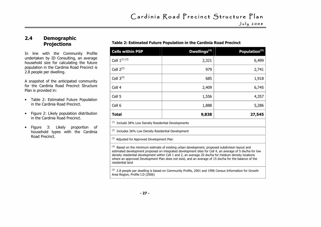
2.4 Demographic Projections
In line with the Community Profile undertaken by ID Consulting, an average household size for calculating the future population in the Cardinia Road Precinct is 2.8 people per dwelling.
A snapshot of the anticipated community for the Cardinia Road Precinct Structure Plan is provided in:
• Table 2: Estimated Future Population in the Cardinia Road Precinct.
• Figure 2: Likely population distribution in the Cardinia Road Precinct.
• Figure 3: Likely proportion of household types with the Cardinia Road Precinct.
Table 2: Estimated Future Population in the Cardinia Road Precinct
Cells within PSP Dwellings(4) Population(5)
Cell 1(1) (3) 2,321 6,499
Cell 2(2) 979 2,741
Cell 3(3) 685 1,918
Cell 4 2,409 6,745
Cell 5 1,556 4,357
Cell 6 1,888 5,286
Total 9,838 27,545
(1) Include 38% Low Density Residential Developments
(2) Includes 36% Low Density Residential Development
(3) Adjusted for Approved Development Plan
(4) Based on the minimum estimate of existing urban development, proposed subdivision layout and estimated development proposed on integrated development sites for Cell 4, an average of 5 dw/ha for low density residential development within Cell 1 and 2, an average 20 dw/ha for medium density locations where an approved Development Plan does not exist, and an average of 15 dw/ha for the balance of the residential land
(5) 2.8 people per dwelling is based on Community Profile, 2001 and 1996 Census Information for Growth Area Region, Profile I.D (2006)
CCCCCCCC aaaaaaaa rrrrrrrr dddddddd iiiiiiii nnnnnnnn iiiiiiii aaaaaaaa RRRRRRRR oooooooo aaaaaaaa dddddddd PPPPPPPP rrrrrrrr eeeeeeee cccccccc iiiiiiii nnnnnnnn cccccccc tttttttt SSSSSSSS tttttttt rrrrrrrr uuuuuuuu cccccccc tttttttt uuuuuuuu rrrrrrrr eeeeeeee PPPPPPPP llllllll aaaaaaaa nnnnnnnn JJJJJJJJ uuuuuuuu llllllll yyyyyyyy 22222222 00000000 00000000 88888888
- 28 -
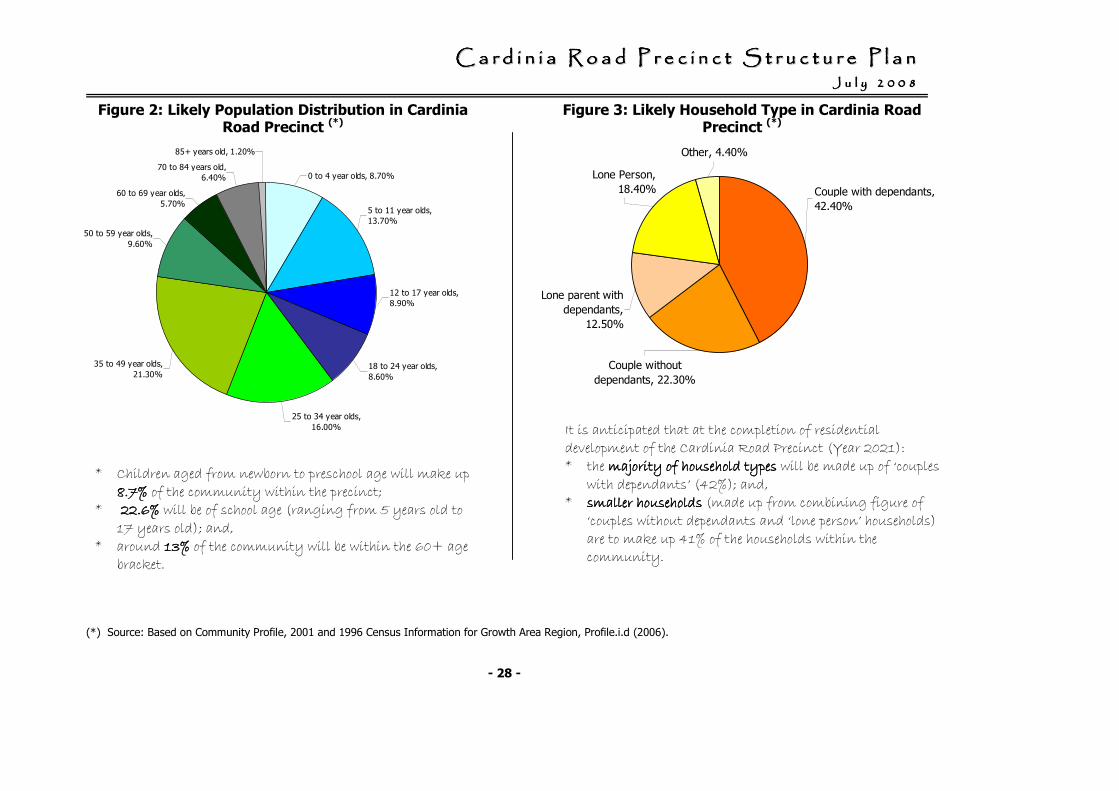
0 to 4 year olds, 8.70%
5 to 11 year olds,
13.70%
12 to 17 year olds,
8.90%
18 to 24 year olds,
8.60%
25 to 34 year olds,
16.00%
35 to 49 year olds,
21.30%
50 to 59 year olds,
9.60%
60 to 69 year olds,
5.70%
70 to 84 years old,
6.40%
85+ years old, 1.20%
* Children aged from newborn to preschool age will make up 8.7%8.7%8.7%8.7% of the community within the precinct;
* 22.6%22.6%22.6%22.6% will be of school age (ranging from 5 years old to 17 years old); and,
* around 13%13%13%13% of the community will be within the 60+ age bracket.
It is anticipated that at the completion of residential development of the Cardinia Road Precinct (Year 2021): * the majority of household typesmajority of household typesmajority of household typesmajority of household types will be made up of ‘couples
with dependants’ (42%); and, * smaller householdssmaller householdssmaller householdssmaller households (made up from combining figure of
‘couples without dependants and ‘lone person’ households) are to make up 41% of the households within the community.
Figure 2: Likely Population Distribution in Cardinia Road Precinct (*)
Figure 3: Likely Household Type in Cardinia Road Precinct (*)
(*) Source: Based on Community Profile, 2001 and 1996 Census Information for Growth Area Region, Profile.i.d (2006).
Couple with dependants,
42.40%
Couple without
dependants, 22.30%
Lone parent with
dependants,
12.50%
Lone Person,
18.40%
Other, 4.40%
CCCCCCCC aaaaaaaa rrrrrrrr dddddddd iiiiiiii nnnnnnnn iiiiiiii aaaaaaaa RRRRRRRR oooooooo aaaaaaaa dddddddd PPPPPPPP rrrrrrrr eeeeeeee cccccccc iiiiiiii nnnnnnnn cccccccc tttttttt SSSSSSSS tttttttt rrrrrrrr uuuuuuuu cccccccc tttttttt uuuuuuuu rrrrrrrr eeeeeeee PPPPPPPP llllllll aaaaaaaa nnnnnnnn JJJJJJJJ uuuuuuuu llllllll yyyyyyyy 22222222 00000000 00000000 88888888
- 29 -
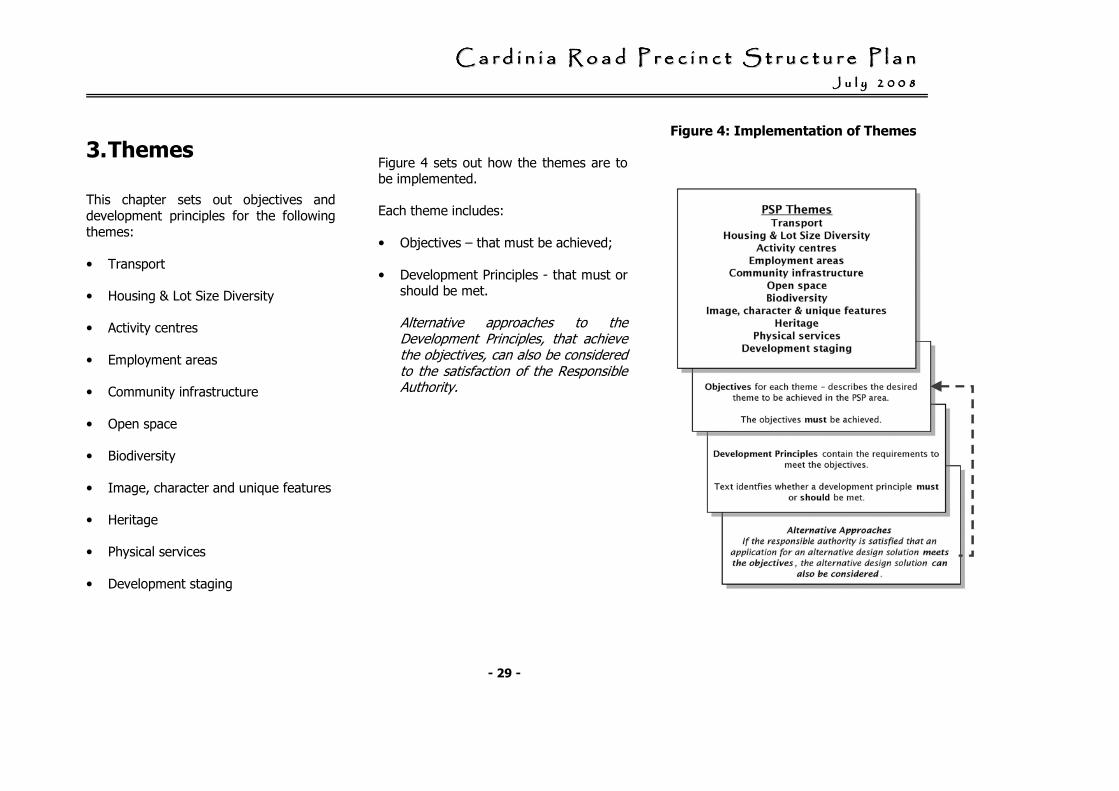
3. Themes
This chapter sets out objectives and development principles for the following themes:
• Transport
• Housing & Lot Size Diversity
• Activity centres
• Employment areas
• Community infrastructure
• Open space
• Biodiversity
• Image, character and unique features
• Heritage
• Physical services
• Development staging
Figure 4 sets out how the themes are to be implemented.
Each theme includes:
• Objectives – that must be achieved;
• Development Principles - that must or should be met.
Alternative approaches to the Development Principles, that achieve the objectives, can also be considered to the satisfaction of the Responsible Authority.
Figure 4: Implementation of Themes
CCCCCCCC aaaaaaaa rrrrrrrr dddddddd iiiiiiii nnnnnnnn iiiiiiii aaaaaaaa RRRRRRRR oooooooo aaaaaaaa dddddddd PPPPPPPP rrrrrrrr eeeeeeee cccccccc iiiiiiii nnnnnnnn cccccccc tttttttt SSSSSSSS tttttttt rrrrrrrr uuuuuuuu cccccccc tttttttt uuuuuuuu rrrrrrrr eeeeeeee PPPPPPPP llllllll aaaaaaaa nnnnnnnn JJJJJJJJ uuuuuuuu llllllll yyyyyyyy 22222222 00000000 00000000 88888888
- 30 -
3.1 Transport 3.1.1 Objectives
• To provide a sustainable transport network that reduces dependence of car use and encourages walking and cycling within neighbourhoods.
• To provide an efficient, legible and safe local road network that:
- complements the role and function of the arterial road and highway networks; and,
- provides good internal movement within and between neighbourhoods and good access to external destinations.
• To provide a well planned public transport network that connects to the new railway station, and provides for the safe and efficient operation of bus movements.
• To provide for safe and efficient pedestrian and bicycle movements to connect the station, activity centres and major community facilities.
• To ensure that the new railway station forms the key focus of a new activity centre, and is supported by park and ride facilities.
• To provide for landscaping of roads and streets to create key public spaces, landscape corridors and provide a contribution to the creation of an attractive urban environment.
• To create an attractive and safe interface with major arterial roads and encourage the provision of services roads along arterial roads
• To plan for the future grade separation of Cardinia Road at the Gippsland Railway line
• To mitigate impacts of traffic noise from the Pakenham Bypass to an acceptable level
3.1.2 Development Principles
3.1.2.a Transport Network
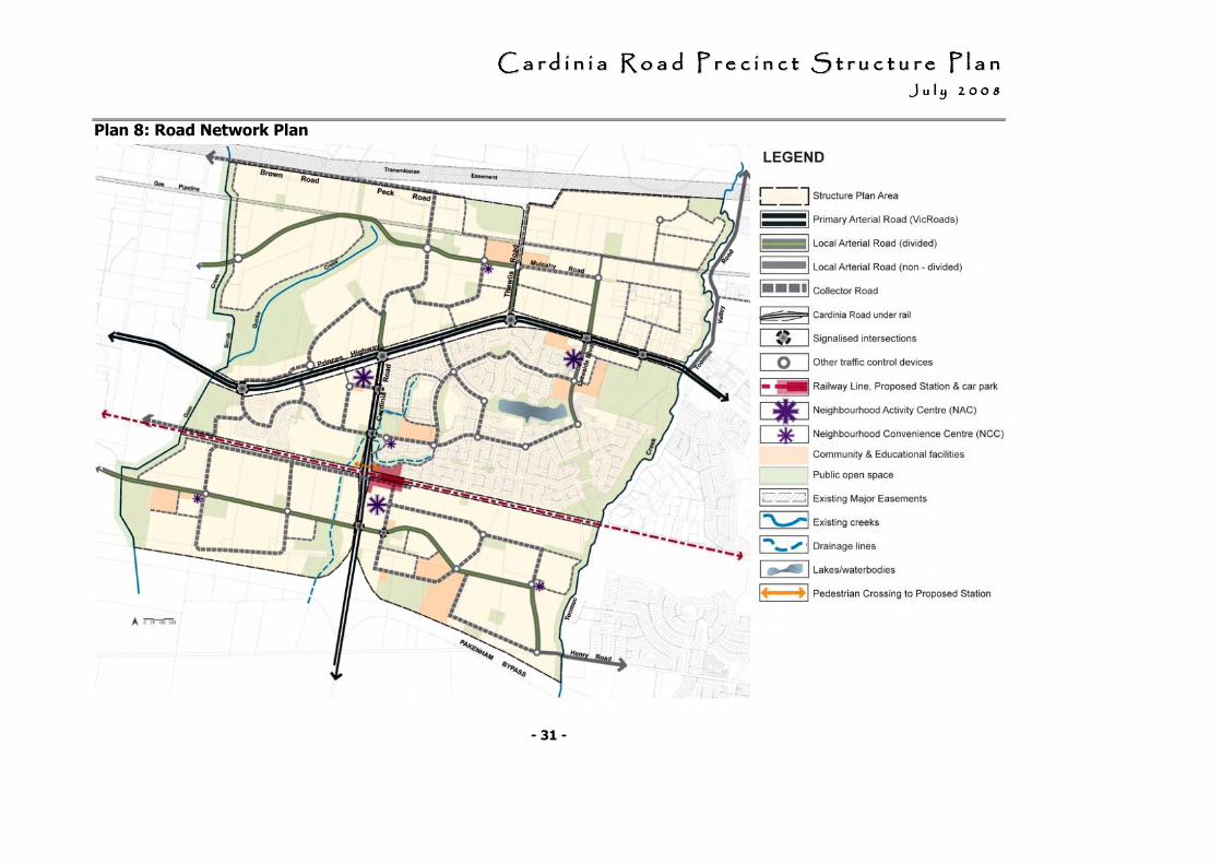
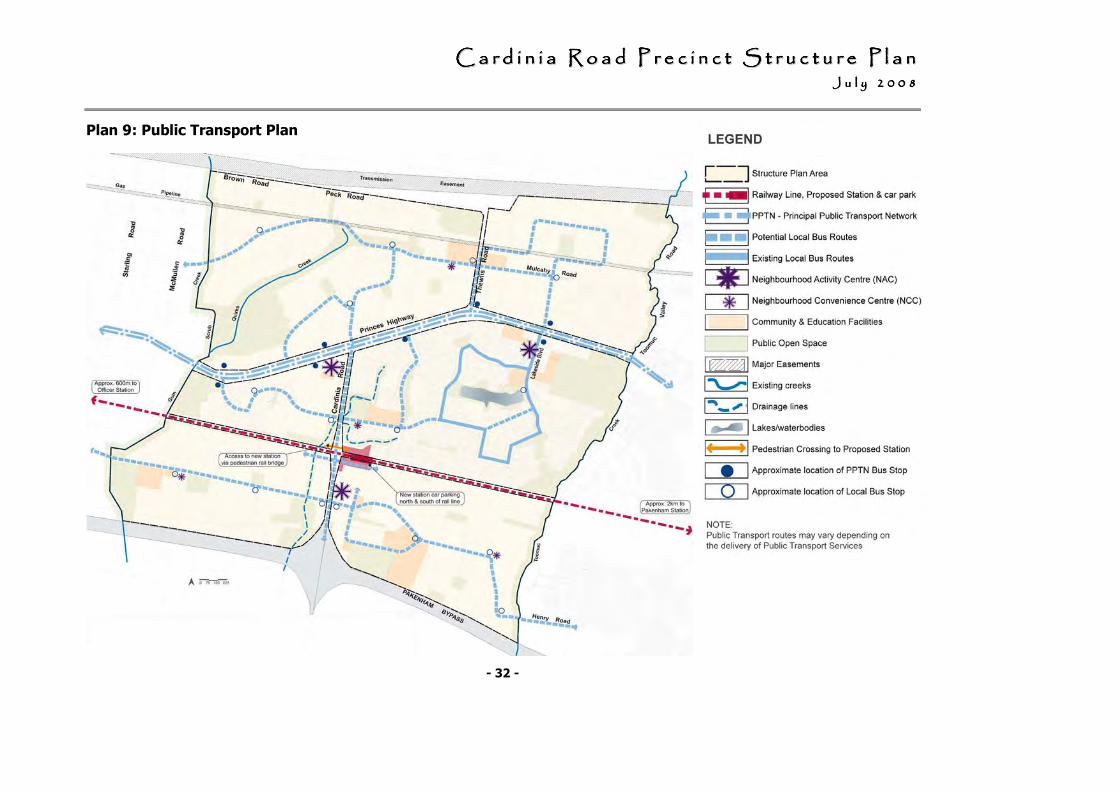
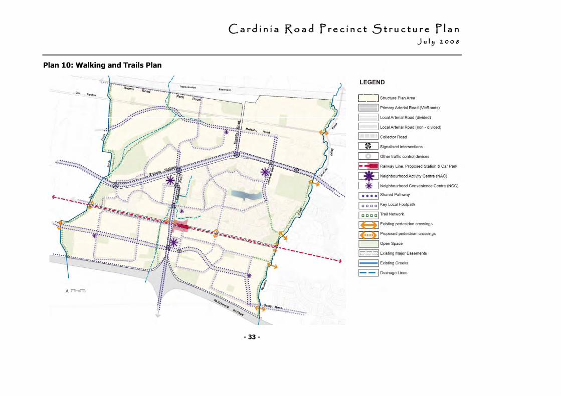
The development of the transport network should meet the requirements of:
• Plan 8: Road Network Plan;
• Plan 9: Public Transport Network Plan;
• Plan 10: Walking and Trails Network Plan;
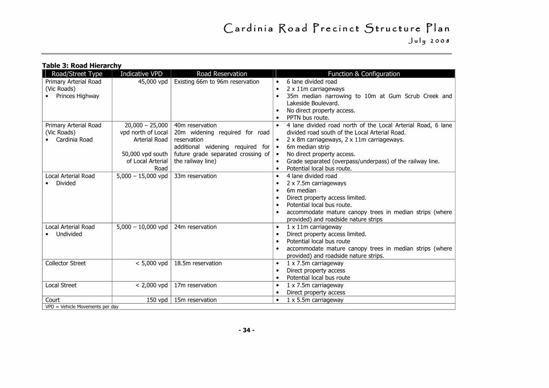
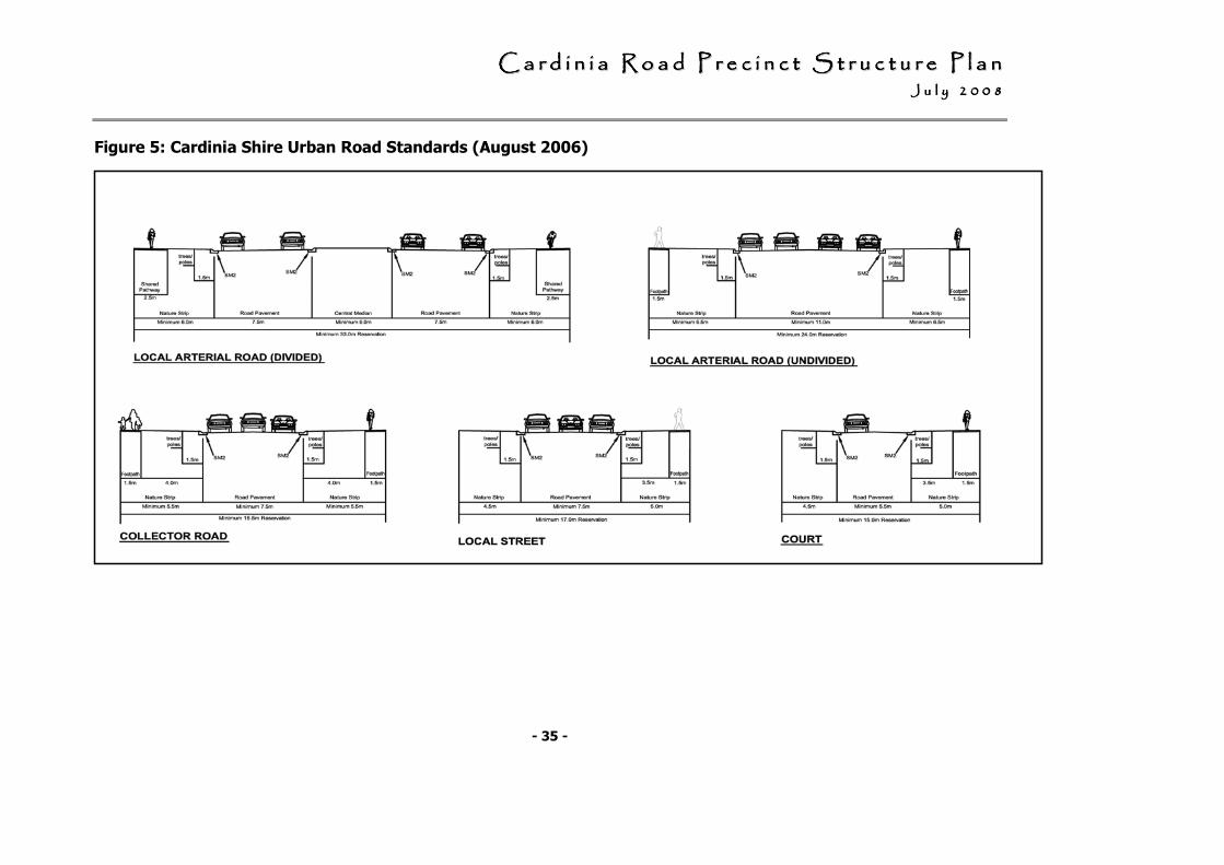
• Table 3: Road Hierarchy; and,
• Figure 5: Cardinia Shire Urban Road Standards (August 2006).
CCCCCCCC aaaaaaaa rrrrrrrr dddddddd iiiiiiii nnnnnnnn iiiiiiii aaaaaaaa RRRRRRRR oooooooo aaaaaaaa dddddddd PPPPPPPP rrrrrrrr eeeeeeee cccccccc iiiiiiii nnnnnnnn cccccccc tttttttt SSSSSSSS tttttttt rrrrrrrr uuuuuuuu cccccccc tttttttt uuuuuuuu rrrrrrrr eeeeeeee PPPPPPPP llllllll aaaaaaaa nnnnnnnn JJJJJJJJ uuuuuuuu llllllll yyyyyyyy 22222222 00000000 00000000 88888888
- 31 -
Plan 8: Road Network Plan
CCCCCCCC aaaaaaaa rrrrrrrr dddddddd iiiiiiii nnnnnnnn iiiiiiii aaaaaaaa RRRRRRRR oooooooo aaaaaaaa dddddddd PPPPPPPP rrrrrrrr eeeeeeee cccccccc iiiiiiii nnnnnnnn cccccccc tttttttt SSSSSSSS tttttttt rrrrrrrr uuuuuuuu cccccccc tttttttt uuuuuuuu rrrrrrrr eeeeeeee PPPPPPPP llllllll aaaaaaaa nnnnnnnn JJJJJJJJ uuuuuuuu llllllll yyyyyyyy 22222222 00000000 00000000 88888888
- 32 -
Plan 9: Public Transport Plan
CCCCCCCC aaaaaaaa rrrrrrrr dddddddd iiiiiiii nnnnnnnn iiiiiiii aaaaaaaa RRRRRRRR oooooooo aaaaaaaa dddddddd PPPPPPPP rrrrrrrr eeeeeeee cccccccc iiiiiiii nnnnnnnn cccccccc tttttttt SSSSSSSS tttttttt rrrrrrrr uuuuuuuu cccccccc tttttttt uuuuuuuu rrrrrrrr eeeeeeee PPPPPPPP llllllll aaaaaaaa nnnnnnnn JJJJJJJJ uuuuuuuu llllllll yyyyyyyy 22222222 00000000 00000000 88888888
- 33 -
Plan 10: Walking and Trails Plan
CCCCCCCC aaaaaaaa rrrrrrrr dddddddd iiiiiiii nnnnnnnn iiiiiiii aaaaaaaa RRRRRRRR oooooooo aaaaaaaa dddddddd PPPPPPPP rrrrrrrr eeeeeeee cccccccc iiiiiiii nnnnnnnn cccccccc tttttttt SSSSSSSS tttttttt rrrrrrrr uuuuuuuu cccccccc tttttttt uuuuuuuu rrrrrrrr eeeeeeee PPPPPPPP llllllll aaaaaaaa nnnnnnnn JJJJJJJJ uuuuuuuu llllllll yyyyyyyy 22222222 00000000 00000000 88888888
- 34 -
Table 3: Road Hierarchy
Road/Street Type Indicative VPD Road Reservation Function & Configuration Primary Arterial Road (Vic Roads) • Princes Highway
45,000 vpd Existing 66m to 96m reservation • 6 lane divided road • 2 x 11m carriageways • 35m median narrowing to 10m at Gum Scrub Creek and
Lakeside Boulevard. • No direct property access. • PPTN bus route.
Primary Arterial Road (Vic Roads) • Cardinia Road
20,000 – 25,000 vpd north of Local
Arterial Road
50,000 vpd south of Local Arterial
Road
40m reservation 20m widening required for road reservation additional widening required for future grade separated crossing of the railway line)
• 4 lane divided road north of the Local Arterial Road, 6 lane divided road south of the Local Arterial Road.
• 2 x 8m carriageways, 2 x 11m carriageways.
• 6m median strip • No direct property access. • Grade separated (overpass/underpass) of the railway line. • Potential local bus route.
Local Arterial Road • Divided
5,000 – 15,000 vpd 33m reservation • 4 lane divided road • 2 x 7.5m carriageways
• 6m median • Direct property access limited. • Potential local bus route. • accommodate mature canopy trees in median strips (where
provided) and roadside nature strips
Local Arterial Road • Undivided
5,000 – 10,000 vpd 24m reservation • 1 x 11m carriageway • Direct property access limited. • Potential local bus route • accommodate mature canopy trees in median strips (where
provided) and roadside nature strips.
Collector Street < 5,000 vpd 18.5m reservation • 1 x 7.5m carriageway
• Direct property access • Potential local bus route
Local Street < 2,000 vpd 17m reservation • 1 x 7.5m carriageway • Direct property access
Court 150 vpd 15m reservation • 1 x 5.5m carriageway VPD = Vehicle Movements per day
CCCCCCCC aaaaaaaa rrrrrrrr dddddddd iiiiiiii nnnnnnnn iiiiiiii aaaaaaaa RRRRRRRR oooooooo aaaaaaaa dddddddd PPPPPPPP rrrrrrrr eeeeeeee cccccccc iiiiiiii nnnnnnnn cccccccc tttttttt SSSSSSSS tttttttt rrrrrrrr uuuuuuuu cccccccc tttttttt uuuuuuuu rrrrrrrr eeeeeeee PPPPPPPP llllllll aaaaaaaa nnnnnnnn JJJJJJJJ uuuuuuuu llllllll yyyyyyyy 22222222 00000000 00000000 88888888
- 35 -
Figure 5: Cardinia Shire Urban Road Standards (August 2006)
Figure 8: Cardinia Shire Urban Road Standards (August 2006)
CCCCCCCC aaaaaaaa rrrrrrrr dddddddd iiiiiiii nnnnnnnn iiiiiiii aaaaaaaa RRRRRRRR oooooooo aaaaaaaa dddddddd PPPPPPPP rrrrrrrr eeeeeeee cccccccc iiiiiiii nnnnnnnn cccccccc tttttttt SSSSSSSS tttttttt rrrrrrrr uuuuuuuu cccccccc tttttttt uuuuuuuu rrrrrrrr eeeeeeee PPPPPPPP llllllll aaaaaaaa nnnnnnnn JJJJJJJJ uuuuuuuu llllllll yyyyyyyy 22222222 00000000 00000000 88888888
- 36 -
3.1.2.b Arterial Roads
Arterial Roads and Service Roads
A combination of design treatments should be used along arterial roads to add visual interest.
Long sections of rear fencing along arterial roads will not be supported.
Provision is to be made for points of pedestrian permeability between the arterial and local arterial roads, with landscape treatment.
The design of service roads may include the following design solutions:
• Short sections of side or rear fencing incorporated in the overall design layout.
• Housing separated from, but still addressing the arterial road.
• A reserve that allows for dense tree plantations.
• Open - ended courts, with associated landscape treatment.
• Limited access points to arterial roads to key points where traffic can be managed.
• Links and connections into the local road networks within residential development.
• Have regard to:
- Figure 6: Typical cross-section of a service road;
- Figure 7: Landscape treatment of open ended courts; and,
- Figure 8: Use of Service Roads and Tree Reserves along arterial road.
CCCCCCCC aaaaaaaa rrrrrrrr dddddddd iiiiiiii nnnnnnnn iiiiiiii aaaaaaaa RRRRRRRR oooooooo aaaaaaaa dddddddd PPPPPPPP rrrrrrrr eeeeeeee cccccccc iiiiiiii nnnnnnnn cccccccc tttttttt SSSSSSSS tttttttt rrrrrrrr uuuuuuuu cccccccc tttttttt uuuuuuuu rrrrrrrr eeeeeeee PPPPPPPP llllllll aaaaaaaa nnnnnnnn JJJJJJJJ uuuuuuuu llllllll yyyyyyyy 22222222 00000000 00000000 88888888
- 37 -
Signalised Intersections
Signalised intersections should, be provided where there is an intersection of a primary arterial road with another primary arterial road, local arterial road or an access point to a high traffic generating use (eg: industrial precinct, activity centre).
Signalised intersections should provide a direct and safe crossing point of the primary arterial road for pedestrians and cyclists.
Freeway Noise Attenuation
The developer will be required to attenuate traffic noise from the Freeway to a level of 63 dB (or level determined in consultation with Council and Vic Roads) to the satisfaction of Vic Roads.
Noise attenuation measures should be designed and constructed (at the cost of developers) to the standards outlined in the Noise Mitigation Report undertaken by Marshall Day Acoustics and LandDesign in consultation with VicRoads and Council.22
22 The Noise Mitigation Report is to be funded by the Cardinia Road Precinct Development Contributions Plan, June 2008
Cardinia Road Grade separation
The Cardinia Road Grade Separation23 must be designed to ensure:
• efficient north and south bound traffic movement to and from the Pakenham Bypass;
• an appropriate interface with surrounding commercial or retail development;
• physical and visual connectivity between the Station, Activity centre, and surrounding development;
• provision is made for a bridge for a collector road which runs parallel to the railway line reservation, on the south side; and,
• provision is made for a bridge for a pedestrian /cycle link across Cardinia Road on the north side.
The preferred urban design outcome for the Cardinia Road Grade Separation is for an underpass.
23 The grade separation of Cardinia Road and the
Gippsland Railway line is partly funded by the Cardinia Road Precinct Development Contributions Plan, June 2008
CCCCCCCC aaaaaaaa rrrrrrrr dddddddd iiiiiiii nnnnnnnn iiiiiiii aaaaaaaa RRRRRRRR oooooooo aaaaaaaa dddddddd PPPPPPPP rrrrrrrr eeeeeeee cccccccc iiiiiiii nnnnnnnn cccccccc tttttttt SSSSSSSS tttttttt rrrrrrrr uuuuuuuu cccccccc tttttttt uuuuuuuu rrrrrrrr eeeeeeee PPPPPPPP llllllll aaaaaaaa nnnnnnnn JJJJJJJJ uuuuuuuu llllllll yyyyyyyy 22222222 00000000 00000000 88888888
- 38 -
3.1.2.c Public Transport
Cardinia Road Railway Station
Cardinia Road Railway Station must be designed to:
• be integrated with the Neighbourhood Activity Centre on the south side of the railway line;
• provide for bus access, taxi facilities and include pedestrian and bicycle access;
• incorporate features to help to identify the station as key facility in the area;
• provide a park and ride role for the Cardinia Road Precinct and wider region;
• incorporate significant car parking spaces, including 1.4ha on the north and 1.6ha south side of the railway line; and,
• provide options for multi deck parking to meet potential future carparking demand.
Bus Network
Roads designated as potential bus routes should be designed to:
• accommodate bus movements;
• provide bus stop facilities at strategic locations along the Princes Highway PPTN bus route and local bus route24; and,
• provide controlled means of pedestrian access across the Princes Highway.
24 8 bus stop facilities on the PPTN and 16 bus stop
facilities within the local bus network are funded by the Cardinia Road Precinct Development Contributions Plan, June 2008
Bus stops facilities should:
• be located as close as possible to Activity Centres and activity generating land uses;
• have an average stop spacing of 300 metres between each stop;
• be provided with direct and safe pedestrian access connected to an existing pedestrian/shared path.
• include a bus bay, shelter, sealed pathway access and lighting for bus stops along the PPTN and a bus bay, shelter and sealed pathway access for the local bus network25; and,
• be to the satisfaction of the Public Transport Division of the Department of Transport.
25 Detail of works required, timing of provision and allocated cost is outlined in the Cardinia Road Precinct Development Contributions Plan, June 2008
CCCCCCCC aaaaaaaa rrrrrrrr dddddddd iiiiiiii nnnnnnnn iiiiiiii aaaaaaaa RRRRRRRR oooooooo aaaaaaaa dddddddd PPPPPPPP rrrrrrrr eeeeeeee cccccccc iiiiiiii nnnnnnnn cccccccc tttttttt SSSSSSSS tttttttt rrrrrrrr uuuuuuuu cccccccc tttttttt uuuuuuuu rrrrrrrr eeeeeeee PPPPPPPP llllllll aaaaaaaa nnnnnnnn JJJJJJJJ uuuuuuuu llllllll yyyyyyyy 22222222 00000000 00000000 88888888
- 39 -
3.1.2.d Walking and Trails
Shared pathways26 should be provided:
• along primary arterial and local arterial roads;
• along Toomuc Creek and Gum Scrub Creek (which includes an underpass of the railway line); and,
• adjacent to the Pakenham Bypass.
Shared pathways should be designed and located to maximise passive surveillance and provided in wide road verges with safe crossing points at key locations.
The local street network should be designed to provide permeable and safe routes for walking and cycling to activity centres, community facilities, parks and open space, major trail networks and public transport.
26
This is to be funded by the Cardinia Road Precinct
Development Contributions Plan, June 2008
A pedestrian underpass of the railway line for pedestrians and cyclists should be provided approximately midway between Cardinia Road and Toomuc Creek, and as part of the Toomuc Creek and Gum Scrub Creek trail networks.27
Bicycle Parking Facilities
Bicycle parking facilities should be provided in activity centres, at the railway station and at other appropriate locations in accordance with the requirements contained in the planning scheme.
27 These are to be funded by the Cardinia Road Precinct
Development Contributions Plan 2008
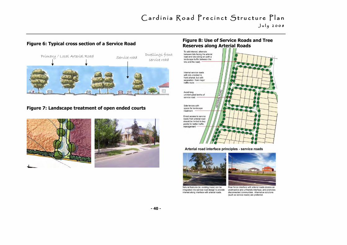
CCCCCCCC aaaaaaaa rrrrrrrr dddddddd iiiiiiii nnnnnnnn iiiiiiii aaaaaaaa RRRRRRRR oooooooo aaaaaaaa dddddddd PPPPPPPP rrrrrrrr eeeeeeee cccccccc iiiiiiii nnnnnnnn cccccccc tttttttt SSSSSSSS tttttttt rrrrrrrr uuuuuuuu cccccccc tttttttt uuuuuuuu rrrrrrrr eeeeeeee PPPPPPPP llllllll aaaaaaaa nnnnnnnn JJJJJJJJ uuuuuuuu llllllll yyyyyyyy 22222222 00000000 00000000 88888888
- 40 -
Figure 8: Use of Service Roads and Tree Reserves along Arterial Roads
Figure 7: Landscape treatment of open ended courts
Primary / Local Arterial Road Reserve
Service road Dwellings front service road
Figure 6: Typical cross section of a Service Road
CCCCCCCC aaaaaaaa rrrrrrrr dddddddd iiiiiiii nnnnnnnn iiiiiiii aaaaaaaa RRRRRRRR oooooooo aaaaaaaa dddddddd PPPPPPPP rrrrrrrr eeeeeeee cccccccc iiiiiiii nnnnnnnn cccccccc tttttttt SSSSSSSS tttttttt rrrrrrrr uuuuuuuu cccccccc tttttttt uuuuuuuu rrrrrrrr eeeeeeee PPPPPPPP llllllll aaaaaaaa nnnnnnnn JJJJJJJJ uuuuuuuu llllllll yyyyyyyy 22222222 00000000 00000000 88888888
- 41 -
3.2 Housing & Lot Size Diversity
3.2.1 Objectives
• To ensure greater housing choice, diversity and affordability and provide a range of lot sizes, housing types and lifestyle opportunities to satisfy the needs and aspirations of the community and provide for changing needs overtime.
• To provide a range of residential densities across the precinct to respond to local circumstances and housing market conditions, and to support the efficient provision of infrastructure and services.
• To ensure an increase in housing density occurs in the context of a commensurate increase in the standard of urban design and infrastructure delivery.
• To provide residential neighbourhoods with attractive streetscapes and a high quality
urban design and distinct urban character.
• To ensure that the dwelling, rather than the garage, is the dominant feature of the streetscape.
• To provide lot sizes and housing types that are responsive to the character of the natural and built environment in the area and respond to principles of environmental sustainability.
• To provide for lower density development in areas with significant slope; significant vegetation; the prominent ridgelines; and/or at the interface with green wedge areas.
• To ensure that, on lower density lots, building envelopes are provided on lower density lots that are located to protect vegetation and visual prominence of ridgelines, maintaining the natural skyline of the ridge.
• To encourage medium density housing within 400 m walking distance of an activity centre and/or the proposed railway station.
• To provide integrated housing sites within or at the interface of activity centres, and overlooking local and linear open space.
• To achieve an appropriate interface with open space and between areas of different densities.
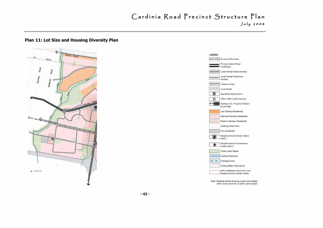
CCCCCCCC aaaaaaaa rrrrrrrr dddddddd iiiiiiii nnnnnnnn iiiiiiii aaaaaaaa RRRRRRRR oooooooo aaaaaaaa dddddddd PPPPPPPP rrrrrrrr eeeeeeee cccccccc iiiiiiii nnnnnnnn cccccccc tttttttt SSSSSSSS tttttttt rrrrrrrr uuuuuuuu cccccccc tttttttt uuuuuuuu rrrrrrrr eeeeeeee PPPPPPPP llllllll aaaaaaaa nnnnnnnn JJJJJJJJ uuuuuuuu llllllll yyyyyyyy 22222222 00000000 00000000 88888888
- 42 -
Plan 11: Lot Size and Housing Diversity Plan
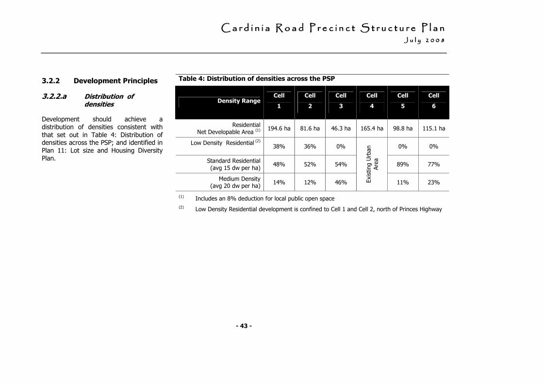
CCCCCCCC aaaaaaaa rrrrrrrr dddddddd iiiiiiii nnnnnnnn iiiiiiii aaaaaaaa RRRRRRRR oooooooo aaaaaaaa dddddddd PPPPPPPP rrrrrrrr eeeeeeee cccccccc iiiiiiii nnnnnnnn cccccccc tttttttt SSSSSSSS tttttttt rrrrrrrr uuuuuuuu cccccccc tttttttt uuuuuuuu rrrrrrrr eeeeeeee PPPPPPPP llllllll aaaaaaaa nnnnnnnn JJJJJJJJ uuuuuuuu llllllll yyyyyyyy 22222222 00000000 00000000 88888888
- 43 -
3.2.2 Development Principles
3.2.2.a Distribution of densities
Development should achieve a distribution of densities consistent with that set out in Table 4: Distribution of densities across the PSP; and identified in Plan 11: Lot size and Housing Diversity Plan.
Table 4: Distribution of densities across the PSP
Density Range Cell
1
Cell
2
Cell
3
Cell
4
Cell
5
Cell
6
Residential Net Developable Area (1)
194.6 ha 81.6 ha 46.3 ha 165.4 ha 98.8 ha 115.1 ha
Low Density Residential (2)
38% 36% 0% 0% 0%
Standard Residential (avg 15 dw per ha)
48% 52% 54% 89% 77%
Medium Density (avg 20 dw per ha)
14% 12% 46% Existing U
rban
Are
a
11% 23%
(1) Includes an 8% deduction for local public open space
(2) Low Density Residential development is confined to Cell 1 and Cell 2, north of Princes Highway
CCCCCCCC aaaaaaaa rrrrrrrr dddddddd iiiiiiii nnnnnnnn iiiiiiii aaaaaaaa RRRRRRRR oooooooo aaaaaaaa dddddddd PPPPPPPP rrrrrrrr eeeeeeee cccccccc iiiiiiii nnnnnnnn cccccccc tttttttt SSSSSSSS tttttttt rrrrrrrr uuuuuuuu cccccccc tttttttt uuuuuuuu rrrrrrrr eeeeeeee PPPPPPPP llllllll aaaaaaaa nnnnnnnn JJJJJJJJ uuuuuuuu llllllll yyyyyyyy 22222222 00000000 00000000 88888888
- 44 -
3.2.2.b Residential Development
Residential Development includes both ‘standard’ density residential lots and ‘medium’ density residential lots and low density in constrained areas.
Standard Density
Standard density residential includes lots with sizes generally within the range of 350 sq m to 750 sq m.
Lot sizes across ‘standard’ density areas should achieve an overall density of 15 dwellings per hectare with the preferred distribution of lot sizes outlined on Table 5.
Table 5: Preferred Distribution of lot
sizes for standard density lots
Lot size range Distribution
350 sq m to 500 sq m 35% - 40%
500 sq m to 600 sq m 20% – 30%
600 sq m to 750 sq m 35% – 40%
Medium density
Medium density residential development should include a mix of smaller lots ranging in size from 300 sq m to 450 sq m, as well as integrated housing sites.
Medium density residential development should:
• be provided in areas identified in Plan 11: Lot size and Housing Diversity Plan.
• be an average of 20 dwellings per hectare (Net Residential Development Area) in areas within 400 m walking distance of an activity centre and / or the proposed railway station *;
• overlook, abut or be within close proximity of open space; and,
• be provided in a variety of forms – terrace / townhouse development, cottage lots, shared driveway housing, integrated development sites as well as retirement villages / aged care facilities.
* Note: The 400 m criteria does not apply to Neighbourhood Convenience Centres (NCCs).
CCCCCCCC aaaaaaaa rrrrrrrr dddddddd iiiiiiii nnnnnnnn iiiiiiii aaaaaaaa RRRRRRRR oooooooo aaaaaaaa dddddddd PPPPPPPP rrrrrrrr eeeeeeee cccccccc iiiiiiii nnnnnnnn cccccccc tttttttt SSSSSSSS tttttttt rrrrrrrr uuuuuuuu cccccccc tttttttt uuuuuuuu rrrrrrrr eeeeeeee PPPPPPPP llllllll aaaaaaaa nnnnnnnn JJJJJJJJ uuuuuuuu llllllll yyyyyyyy 22222222 00000000 00000000 88888888
- 45 -
Additional sites allocated for medium density and/or sites that propose a higher density may be considered provided that sites are in strategic locations that satisfy the objectives and development principles for medium density development as outlined in this Precinct Structure Plan.
Low Density
Low density residential development should:
• be provided in areas identified in Plan 11: Lot size and Housing Diversity Plan.
• comprise lots of 1,000 sq m to 2,000 sq m which have proportionally wider frontages to maximise side setbacks and create openness between dwellings;
• should be provided in locations constrained by significant slope; significant vegetation; the prominent ridgelines; and/or the interface with green wedge areas.
3.2.2.c Subdivision Lot Design
All densities
Lots should be:
• generally rectangular in shape on streets aligned on a north – south or east – west axis to maximise building and energy efficiency; and,
• designed so as to ensure garages are not the dominate front façade element of the house and/or the streetscape. This provision also applies to integrated development sites.
Public open space design should ensure that an appropriate interface with surrounding development is achieved.
Standard Density
Lots should be designed to:
• Create a sense of street address and streetscape character;
• Ensure garages are not the dominant front façade element across the width of the lot;
• Maximise the opportunity for more useable private open space.
• Enable rear accessed garages on narrow fronted lots.
CCCCCCCC aaaaaaaa rrrrrrrr dddddddd iiiiiiii nnnnnnnn iiiiiiii aaaaaaaa RRRRRRRR oooooooo aaaaaaaa dddddddd PPPPPPPP rrrrrrrr eeeeeeee cccccccc iiiiiiii nnnnnnnn cccccccc tttttttt SSSSSSSS tttttttt rrrrrrrr uuuuuuuu cccccccc tttttttt uuuuuuuu rrrrrrrr eeeeeeee PPPPPPPP llllllll aaaaaaaa nnnnnnnn JJJJJJJJ uuuuuuuu llllllll yyyyyyyy 22222222 00000000 00000000 88888888
- 46 -
Medium Density
A variety of styles and types of medium density development are encouraged to further enhance lot diversity
Integrated housing sites / lots of less than 300 sq m should be:
• developed by one builder as an integrated development project; and,
• be provided within or at the interface of activity centres, or overlooking local and linear open space.
Lots with shared driveway access should be designed to ensure:
• housing fronts out to both streets and / or parkland;
• that a shared driveway or ‘garage court’ provides access to garages sited off street to minimise the visual impact of garages on the streetscape; and,
• private open space is maximised through careful design of the dwelling
Lots with direct park frontage or road /park frontage with rear access are encouraged and should be designed to ensure:
• the rear lane access to garages lessens the visual impact on the streetscape;
• strong building form along the park edge provides a backdrop and interface to open space; and,
• wide footpaths are provided along the frontage to ensure an ‘address’ for dwellings.
Avoid rear lanes that:
• provide concealment opportunities; and,
• Are curved, have T-intersections or are longer than 150m.
Low Density Development
Lots in low density areas must be designed to include building envelopes that:
• maximise vegetation retention and ensures the protection of existing vegetation and/or areas requiring revegetation;
• are located on the flatter part of sites, to limit any cut and fill on the sites; and,
• are located away from the tops of significant ridgelines to retain the prominence of ridgelines, and provide for the revegetation of ridgelines.
Lots should be designed to be proportionally wider than deep, to maximise side setbacks and create openness between dwellings.
Low density residential areas should include the provision to include the use of colours and material that are reflective of the natural surrounds.
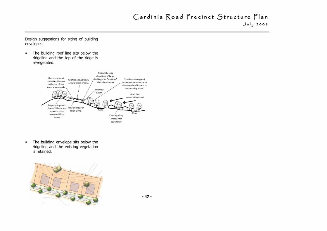
CCCCCCCC aaaaaaaa rrrrrrrr dddddddd iiiiiiii nnnnnnnn iiiiiiii aaaaaaaa RRRRRRRR oooooooo aaaaaaaa dddddddd PPPPPPPP rrrrrrrr eeeeeeee cccccccc iiiiiiii nnnnnnnn cccccccc tttttttt SSSSSSSS tttttttt rrrrrrrr uuuuuuuu cccccccc tttttttt uuuuuuuu rrrrrrrr eeeeeeee PPPPPPPP llllllll aaaaaaaa nnnnnnnn JJJJJJJJ uuuuuuuu llllllll yyyyyyyy 22222222 00000000 00000000 88888888
- 47 -
Design suggestions for siting of building envelopes:
• The building roof line sits below the ridgeline and the top of the ridge is revegetated.
• The building envelope sits below the ridgeline and the existing vegetation is retained.
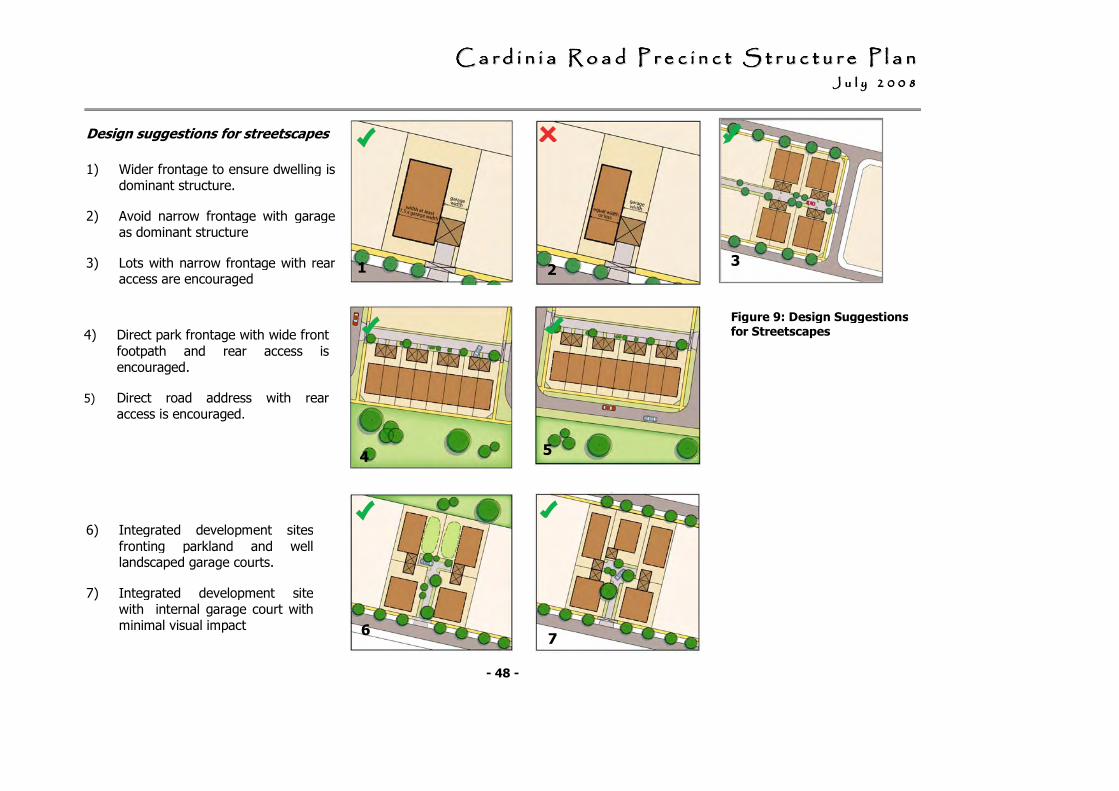
CCCCCCCC aaaaaaaa rrrrrrrr dddddddd iiiiiiii nnnnnnnn iiiiiiii aaaaaaaa RRRRRRRR oooooooo aaaaaaaa dddddddd PPPPPPPP rrrrrrrr eeeeeeee cccccccc iiiiiiii nnnnnnnn cccccccc tttttttt SSSSSSSS tttttttt rrrrrrrr uuuuuuuu cccccccc tttttttt uuuuuuuu rrrrrrrr eeeeeeee PPPPPPPP llllllll aaaaaaaa nnnnnnnn JJJJJJJJ uuuuuuuu llllllll yyyyyyyy 22222222 00000000 00000000 88888888
- 48 -
Design suggestions for streetscapes
.
1) Wider frontage to ensure dwelling is dominant structure.
2) Avoid narrow frontage with garage as dominant structure
3) Lots with narrow frontage with rear access are encouraged
6) Integrated development sites fronting parkland and well landscaped garage courts.
7) Integrated development site with internal garage court with minimal visual impact
7 6
4) Direct park frontage with wide front footpath and rear access is encouraged.
5) Direct road address with rear access is encouraged.
1 2 3
4 5 4
Figure 9: Design Suggestions for Streetscapes
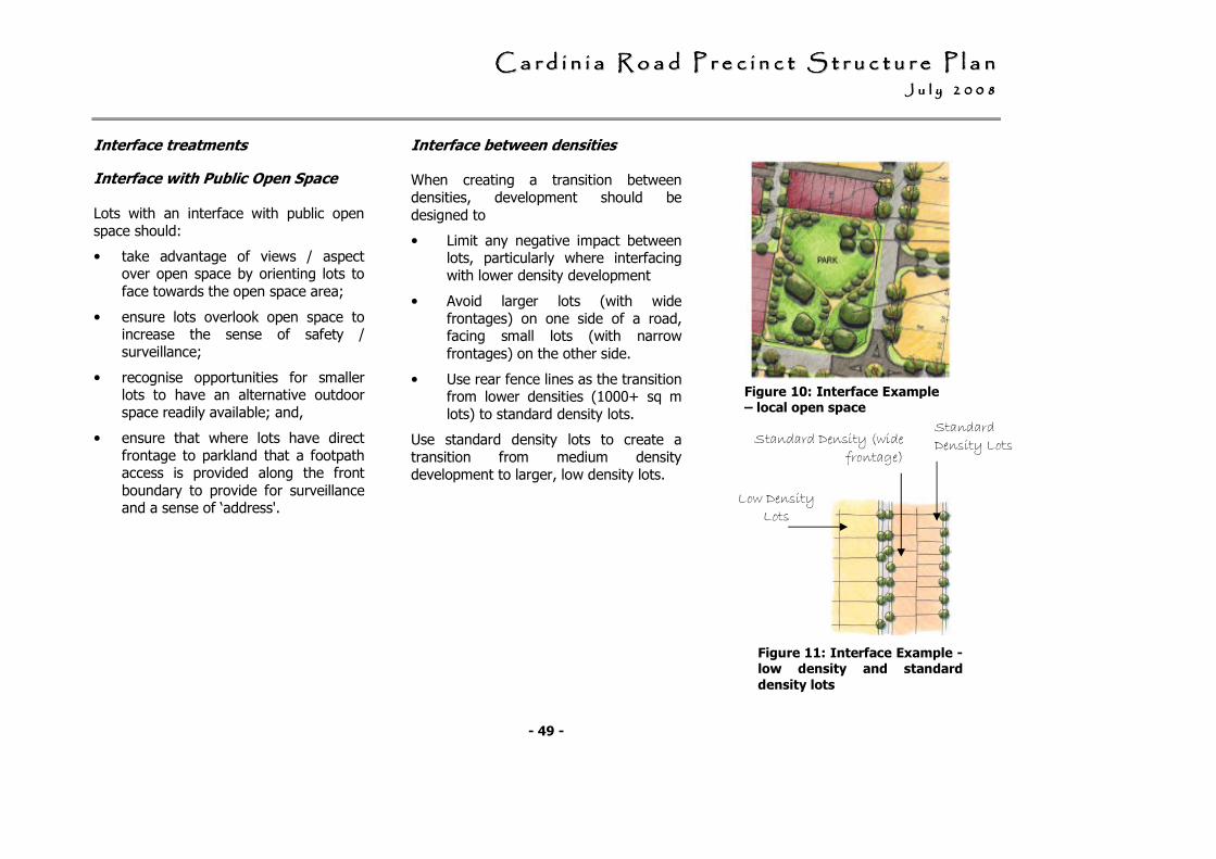
CCCCCCCC aaaaaaaa rrrrrrrr dddddddd iiiiiiii nnnnnnnn iiiiiiii aaaaaaaa RRRRRRRR oooooooo aaaaaaaa dddddddd PPPPPPPP rrrrrrrr eeeeeeee cccccccc iiiiiiii nnnnnnnn cccccccc tttttttt SSSSSSSS tttttttt rrrrrrrr uuuuuuuu cccccccc tttttttt uuuuuuuu rrrrrrrr eeeeeeee PPPPPPPP llllllll aaaaaaaa nnnnnnnn JJJJJJJJ uuuuuuuu llllllll yyyyyyyy 22222222 00000000 00000000 88888888
- 49 -
Figure 10: Interface Example – local open space
Interface treatments
Interface with Public Open Space
Lots with an interface with public open space should:
• take advantage of views / aspect over open space by orienting lots to face towards the open space area;
• ensure lots overlook open space to increase the sense of safety / surveillance;
• recognise opportunities for smaller lots to have an alternative outdoor space readily available; and,
• ensure that where lots have direct frontage to parkland that a footpath access is provided along the front boundary to provide for surveillance and a sense of ‘address'.
Interface between densities
When creating a transition between densities, development should be designed to
• Limit any negative impact between lots, particularly where interfacing with lower density development
• Avoid larger lots (with wide frontages) on one side of a road, facing small lots (with narrow frontages) on the other side.
• Use rear fence lines as the transition from lower densities (1000+ sq m lots) to standard density lots.
Use standard density lots to create a transition from medium density development to larger, low density lots.
Figure 11: Interface Example - low density and standard
density lots
Low Density Lots
Standard Density (wide frontage)
Standard Density Lots
CCCCCCCC aaaaaaaa rrrrrrrr dddddddd iiiiiiii nnnnnnnn iiiiiiii aaaaaaaa RRRRRRRR oooooooo aaaaaaaa dddddddd PPPPPPPP rrrrrrrr eeeeeeee cccccccc iiiiiiii nnnnnnnn cccccccc tttttttt SSSSSSSS tttttttt rrrrrrrr uuuuuuuu cccccccc tttttttt uuuuuuuu rrrrrrrr eeeeeeee PPPPPPPP llllllll aaaaaaaa nnnnnnnn JJJJJJJJ uuuuuuuu llllllll yyyyyyyy 22222222 00000000 00000000 88888888
- 50 -
3.3 Activity centres
3.3.1 Objectives
• To develop a network of vibrant, well serviced and accessible Neighbourhood Activity Centres and Neighbourhood Convenience Centres that form the focus of a new community.
• To ensure that activity centres provide a mix of retail, commercial, entertainment, and community activities to meet the needs of the local community.
• To achieve well designed, safe, attractive, and street based activity centres as expressed in the design objectives for each activity centre.
• To ensure all activity centres are accessible by public transport and that activity centres are designed to facilitate the use of public transport, connected to the pedestrian and bicycle network, and that all residents within the precinct live within a walkable distance of an activity centre.
• To provide for future retail, commercial or residential redevelopment opportunities within activity centres.
• To encourage higher density residential development within 400 metres of a neighbourhood activity centre.
3.3.2 Development Principles
The development of the Activity Centres within the Cardinia Road Precinct should be based on:
• Plan 12: Activity Centres in the Cardinia Road Precinct; and,
• Table 6: The role, function and indicative floor space of the Activity Centres in the Cardinia Road Precinct.
• Table 7: Activity Centre Design Objectives and Design Principles.
Detailed Urban Design Framework Plans must to be prepared for the Activity Centres subsequent to the Cardinia Road Precinct Structure Plan.
Specific requirements for these are set out with Draft Urban Design Frameworks that provide an indicative design solution in:
• Figure 12: Draft UDF – Cardinia Rd / Railway Station NAC
• Figure 13: Draft UDF – Cardinia Rd / Princes Hwy NAC
• Figure 14: Draft UDF – Lakeside Blvd / Princes Hwy NAC
• Figure 15: Draft UDF –Neighbourhood Convenience Centre
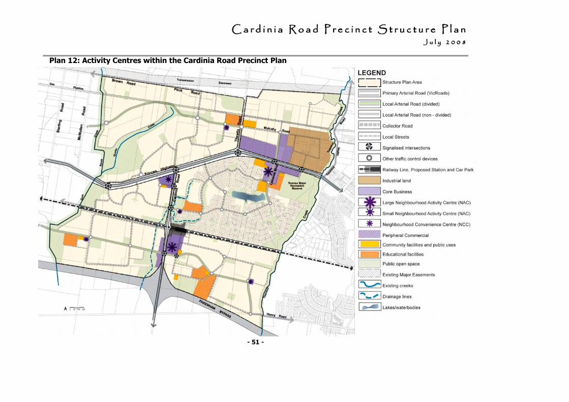
CCCCCCCC aaaaaaaa rrrrrrrr dddddddd iiiiiiii nnnnnnnn iiiiiiii aaaaaaaa RRRRRRRR oooooooo aaaaaaaa dddddddd PPPPPPPP rrrrrrrr eeeeeeee cccccccc iiiiiiii nnnnnnnn cccccccc tttttttt SSSSSSSS tttttttt rrrrrrrr uuuuuuuu cccccccc tttttttt uuuuuuuu rrrrrrrr eeeeeeee PPPPPPPP llllllll aaaaaaaa nnnnnnnn JJJJJJJJ uuuuuuuu llllllll yyyyyyyy 22222222 00000000 00000000 88888888
- 51 -
Plan 12: Activity Centres within the Cardinia Road Precinct Plan
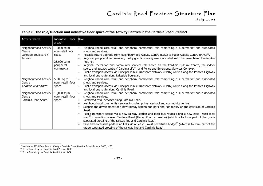
CCCCCCCC aaaaaaaa rrrrrrrr dddddddd iiiiiiii nnnnnnnn iiiiiiii aaaaaaaa RRRRRRRR oooooooo aaaaaaaa dddddddd PPPPPPPP rrrrrrrr eeeeeeee cccccccc iiiiiiii nnnnnnnn cccccccc tttttttt SSSSSSSS tttttttt rrrrrrrr uuuuuuuu cccccccc tttttttt uuuuuuuu rrrrrrrr eeeeeeee PPPPPPPP llllllll aaaaaaaa nnnnnnnn JJJJJJJJ uuuuuuuu llllllll yyyyyyyy 22222222 00000000 00000000 88888888
- 52 -
Table 6: The role, function and indicative floor space of the Activity Centres in the Cardinia Road Precinct
Activity Centre Indicative floor areas*
Role
Neighbourhood Activity Centre Lakeside Boulevard / Toomuc
10,000 sq m core retail floor space 25,000 sq m peripheral commercial
• Neighbourhood core retail and peripheral commercial role comprising a supermarket and associated shops and services.
• Possible future upgrade from Neighbourhood Activity Centre (NAC) to Major Activity Centre (MAC)28. • Regional peripheral commercial / bulky goods retailing role associated with the Pakenham Homemaker
Precinct. • Regional recreation and community services role based on the Cardinia Cultural Centre, the indoor
sports and aquatic centre (“Cardinia Life”), and Police and Emergency Services Complex. • Public transport access via Principal Public Transport Network (PPTN) route along the Princes Highway
and local bus route along Lakeside Boulevard.
Neighbourhood Activity Centre Cardinia Road North
5,000 sq m core retail floor space
• Neighbourhood core retail and peripheral commercial role comprising a supermarket and associated shops and services.
• Public transport access via Principal Public Transport Network (PPTN) route along the Princes Highway and local bus route along Cardinia Road.
Neighbourhood Activity Centre Cardinia Road South
10,000 sq m core retail floor space
• Neighbourhood core retail and peripheral commercial role comprising a supermarket and associated shops and services.
• Restricted retail services along Cardinia Road. • Neighbourhood community services including primary school and community centre. • Support the development of a new railway station and park and ride facility on the east side of Cardinia
Road. • Public transport access via a new railway station and local bus routes along a new east - west local
road29 connection across Cardinia Road (Henry Road extension) (which is to form part of the grade separated crossing of the railway line and Cardinia Road).
• Safe and accessible pedestrian links via an east – west pedestrian bridge30 (which is to form part of the grade separated crossing of the railway line and Cardinia Road).
28 Melbourne 2030 Final Report: Casey – Cardinia Committee for Smart Growth, 2005, p 70. 29 To be funded by the Cardinia Road Precinct DCP. 30 To be funded by the Cardinia Road Precinct DCP.
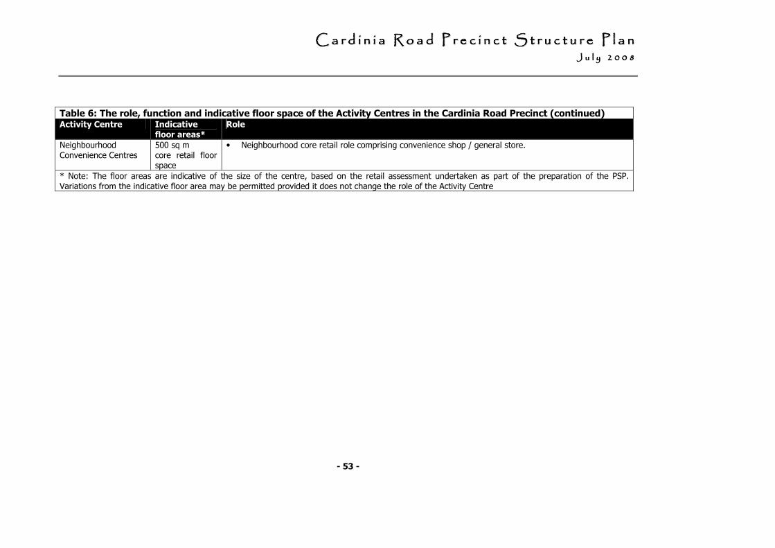
CCCCCCCC aaaaaaaa rrrrrrrr dddddddd iiiiiiii nnnnnnnn iiiiiiii aaaaaaaa RRRRRRRR oooooooo aaaaaaaa dddddddd PPPPPPPP rrrrrrrr eeeeeeee cccccccc iiiiiiii nnnnnnnn cccccccc tttttttt SSSSSSSS tttttttt rrrrrrrr uuuuuuuu cccccccc tttttttt uuuuuuuu rrrrrrrr eeeeeeee PPPPPPPP llllllll aaaaaaaa nnnnnnnn JJJJJJJJ uuuuuuuu llllllll yyyyyyyy 22222222 00000000 00000000 88888888
- 53 -
Table 6: The role, function and indicative floor space of the Activity Centres in the Cardinia Road Precinct (continued) Activity Centre Indicative
floor areas*
Role
Neighbourhood Convenience Centres
500 sq m core retail floor space
• Neighbourhood core retail role comprising convenience shop / general store.
* Note: The floor areas are indicative of the size of the centre, based on the retail assessment undertaken as part of the preparation of the PSP. Variations from the indicative floor area may be permitted provided it does not change the role of the Activity Centre
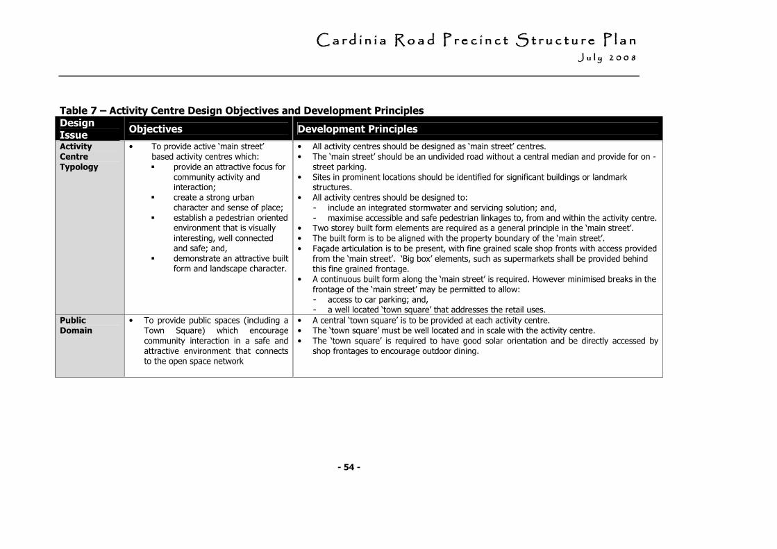
CCCCCCCC aaaaaaaa rrrrrrrr dddddddd iiiiiiii nnnnnnnn iiiiiiii aaaaaaaa RRRRRRRR oooooooo aaaaaaaa dddddddd PPPPPPPP rrrrrrrr eeeeeeee cccccccc iiiiiiii nnnnnnnn cccccccc tttttttt SSSSSSSS tttttttt rrrrrrrr uuuuuuuu cccccccc tttttttt uuuuuuuu rrrrrrrr eeeeeeee PPPPPPPP llllllll aaaaaaaa nnnnnnnn JJJJJJJJ uuuuuuuu llllllll yyyyyyyy 22222222 00000000 00000000 88888888
- 54 -
Table 7 – Activity Centre Design Objectives and Development Principles
Design Issue
Objectives Development Principles
Activity
Centre
Typology
• To provide active ‘main street’ based activity centres which:
� provide an attractive focus for community activity and interaction;
� create a strong urban character and sense of place;
� establish a pedestrian oriented environment that is visually
interesting, well connected and safe; and,
� demonstrate an attractive built form and landscape character.
• All activity centres should be designed as ‘main street’ centres. • The ‘main street’ should be an undivided road without a central median and provide for on -
street parking. • Sites in prominent locations should be identified for significant buildings or landmark
structures. • All activity centres should be designed to:
- include an integrated stormwater and servicing solution; and, - maximise accessible and safe pedestrian linkages to, from and within the activity centre.
• Two storey built form elements are required as a general principle in the ‘main street’. • The built form is to be aligned with the property boundary of the ‘main street’.
• Façade articulation is to be present, with fine grained scale shop fronts with access provided from the ‘main street’. ‘Big box’ elements, such as supermarkets shall be provided behind this fine grained frontage.
• A continuous built form along the ‘main street’ is required. However minimised breaks in the
frontage of the ‘main street’ may be permitted to allow: - access to car parking; and, - a well located ‘town square’ that addresses the retail uses.
Public
Domain
• To provide public spaces (including a Town Square) which encourage
community interaction in a safe and attractive environment that connects to the open space network
• A central ‘town square’ is to be provided at each activity centre. • The ‘town square’ must be well located and in scale with the activity centre.
• The ‘town square’ is required to have good solar orientation and be directly accessed by shop frontages to encourage outdoor dining.
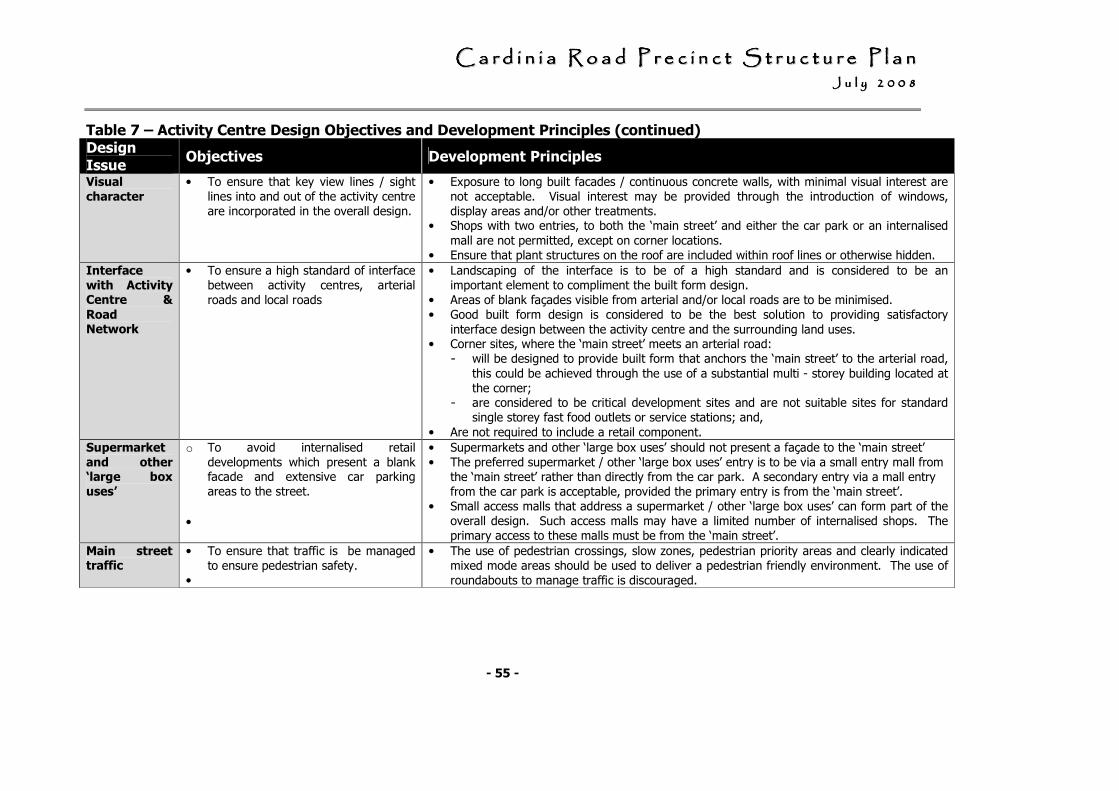
CCCCCCCC aaaaaaaa rrrrrrrr dddddddd iiiiiiii nnnnnnnn iiiiiiii aaaaaaaa RRRRRRRR oooooooo aaaaaaaa dddddddd PPPPPPPP rrrrrrrr eeeeeeee cccccccc iiiiiiii nnnnnnnn cccccccc tttttttt SSSSSSSS tttttttt rrrrrrrr uuuuuuuu cccccccc tttttttt uuuuuuuu rrrrrrrr eeeeeeee PPPPPPPP llllllll aaaaaaaa nnnnnnnn JJJJJJJJ uuuuuuuu llllllll yyyyyyyy 22222222 00000000 00000000 88888888
- 55 -
Table 7 – Activity Centre Design Objectives and Development Principles (continued) Design Issue
Objectives Development Principles
Visual
character
• To ensure that key view lines / sight lines into and out of the activity centre are incorporated in the overall design.
• Exposure to long built facades / continuous concrete walls, with minimal visual interest are not acceptable. Visual interest may be provided through the introduction of windows, display areas and/or other treatments.
• Shops with two entries, to both the ‘main street’ and either the car park or an internalised
mall are not permitted, except on corner locations. • Ensure that plant structures on the roof are included within roof lines or otherwise hidden.
Interface
with Activity Centre &
Road Network
• To ensure a high standard of interface between activity centres, arterial roads and local roads
• Landscaping of the interface is to be of a high standard and is considered to be an important element to compliment the built form design.
• Areas of blank façades visible from arterial and/or local roads are to be minimised. • Good built form design is considered to be the best solution to providing satisfactory
interface design between the activity centre and the surrounding land uses. • Corner sites, where the ‘main street’ meets an arterial road: - will be designed to provide built form that anchors the ‘main street’ to the arterial road,
this could be achieved through the use of a substantial multi - storey building located at the corner;
- are considered to be critical development sites and are not suitable sites for standard single storey fast food outlets or service stations; and,
• Are not required to include a retail component.
Supermarket
and other ‘large box
uses’
o To avoid internalised retail developments which present a blank facade and extensive car parking areas to the street.
•
• Supermarkets and other ‘large box uses’ should not present a façade to the ‘main street’ • The preferred supermarket / other ‘large box uses’ entry is to be via a small entry mall from
the ‘main street’ rather than directly from the car park. A secondary entry via a mall entry from the car park is acceptable, provided the primary entry is from the ‘main street’.
• Small access malls that address a supermarket / other ‘large box uses’ can form part of the overall design. Such access malls may have a limited number of internalised shops. The primary access to these malls must be from the ‘main street’.
Main street traffic
• To ensure that traffic is be managed to ensure pedestrian safety.
•
• The use of pedestrian crossings, slow zones, pedestrian priority areas and clearly indicated mixed mode areas should be used to deliver a pedestrian friendly environment. The use of roundabouts to manage traffic is discouraged.
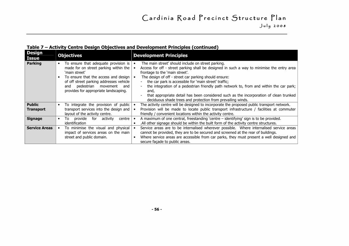
CCCCCCCC aaaaaaaa rrrrrrrr dddddddd iiiiiiii nnnnnnnn iiiiiiii aaaaaaaa RRRRRRRR oooooooo aaaaaaaa dddddddd PPPPPPPP rrrrrrrr eeeeeeee cccccccc iiiiiiii nnnnnnnn cccccccc tttttttt SSSSSSSS tttttttt rrrrrrrr uuuuuuuu cccccccc tttttttt uuuuuuuu rrrrrrrr eeeeeeee PPPPPPPP llllllll aaaaaaaa nnnnnnnn JJJJJJJJ uuuuuuuu llllllll yyyyyyyy 22222222 00000000 00000000 88888888
- 56 -
Table 7 – Activity Centre Design Objectives and Development Principles (continued) Design Issue
Objectives Development Principles
Parking • To ensure that adequate provision is made for on street parking within the ‘main street’
• To ensure that the access and design
of off street parking addresses vehicle and pedestrian movement and provides for appropriate landscaping.
• The main street’ should include on street parking. • Access for off - street parking shall be designed in such a way to minimise the entry area
frontage to the ‘main street’. • The design of off - street car parking should ensure:
- the car park is accessible for ‘main street’ traffic; - the integration of a pedestrian friendly path network to, from and within the car park;
and, - that appropriate detail has been considered such as the incorporation of clean trunked
deciduous shade trees and protection from prevailing winds.
Public
Transport
• To integrate the provision of public
transport services into the design and layout of the activity centre.
• The activity centre will be designed to incorporate the proposed public transport network.
• Provision will be made to locate public transport infrastructure / facilities at commuter friendly / convenient locations within the activity centre.
Signage • To provide for activity centre identification
• A maximum of one central, freestanding ‘centre – identifying’ sign is to be provided. • .All other signage should be within the built form of the activity centre structures.
Service Areas • To minimise the visual and physical impact of services areas on the main
street and public domain.
• Service areas are to be internalised wherever possible. Where internalised service areas cannot be provided, they are to be secured and screened at the rear of buildings.
• Where service areas are accessible from car parks, they must present a well designed and secure façade to public areas.
CCCCCCCC aaaaaaaa rrrrrrrr dddddddd iiiiiiii nnnnnnnn iiiiiiii aaaaaaaa RRRRRRRR oooooooo aaaaaaaa dddddddd PPPPPPPP rrrrrrrr eeeeeeee cccccccc iiiiiiii nnnnnnnn cccccccc tttttttt SSSSSSSS tttttttt rrrrrrrr uuuuuuuu cccccccc tttttttt uuuuuuuu rrrrrrrr eeeeeeee PPPPPPPP llllllll aaaaaaaa nnnnnnnn JJJJJJJJ uuuuuuuu llllllll yyyyyyyy 22222222 00000000 00000000 88888888
- 57 -
3.3.3 Urban Design Framework
Requirements
Cardinia Road / Railway Station Neighbourhood Activity Centre
The Urban Design Framework must show:
• A 'main street' running parallel to Cardinia Road (north - south).
• Traffic signals at the intersection of the 'main street' with the east - west local arterial road.
• Provision for temporary access for south bound traffic travelling along Cardinia
Road.
• Options for providing permanent access
for south bound traffic on Cardinia Road if the grade separation proceeds as an underpass.
• The railway station designed to be integrated within the activity centre, ensuring that:
- views to the station along the ‘main street’ are an important feature of the centre’s design;
- the built form of the railway station provides an opportunity for the
development of a superior public domain environment;
- the design outcome invites and engenders civic pride, while offering a safe and enjoyable place to use; and,
- bus access, taxi facilities and
pedestrian and bicycle access is included in the design.
• Provision for safe and efficient pedestrian / bicycle and vehicular north – south access along Cardinia Road to the new railway station and the activity centre pending the construction of the grade separation of Cardinia Road and the railway line.
• How at grade car parking provides
opportunities to be used for future redevelopment of multi-level carparking, and potential residential apartments / additional commercial/retail activity.
• How the proposed activity centre provides for a substantial residential component and can accommodate future access and servicing needs to these sites
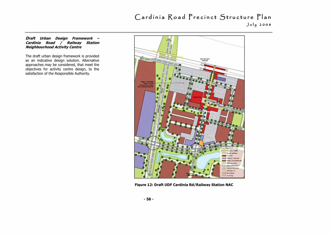
CCCCCCCC aaaaaaaa rrrrrrrr dddddddd iiiiiiii nnnnnnnn iiiiiiii aaaaaaaa RRRRRRRR oooooooo aaaaaaaa dddddddd PPPPPPPP rrrrrrrr eeeeeeee cccccccc iiiiiiii nnnnnnnn cccccccc tttttttt SSSSSSSS tttttttt rrrrrrrr uuuuuuuu cccccccc tttttttt uuuuuuuu rrrrrrrr eeeeeeee PPPPPPPP llllllll aaaaaaaa nnnnnnnn JJJJJJJJ uuuuuuuu llllllll yyyyyyyy 22222222 00000000 00000000 88888888
- 58 -
Draft Urban Design Framework – Cardinia Road / Railway Station Neighbourhood Activity Centre
The draft urban design framework is provided as an indicative design solution. Alternative approaches may be considered, that meet the
objectives for activity centre design, to the satisfaction of the Responsible Authority.
Figure 12: Draft UDF Cardinia Rd/Railway Station NAC
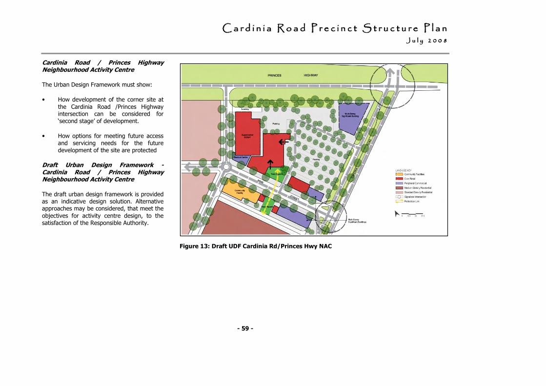
CCCCCCCC aaaaaaaa rrrrrrrr dddddddd iiiiiiii nnnnnnnn iiiiiiii aaaaaaaa RRRRRRRR oooooooo aaaaaaaa dddddddd PPPPPPPP rrrrrrrr eeeeeeee cccccccc iiiiiiii nnnnnnnn cccccccc tttttttt SSSSSSSS tttttttt rrrrrrrr uuuuuuuu cccccccc tttttttt uuuuuuuu rrrrrrrr eeeeeeee PPPPPPPP llllllll aaaaaaaa nnnnnnnn JJJJJJJJ uuuuuuuu llllllll yyyyyyyy 22222222 00000000 00000000 88888888
- 59 -
Cardinia Road / Princes Highway Neighbourhood Activity Centre
The Urban Design Framework must show:
• How development of the corner site at
the Cardinia Road /Princes Highway intersection can be considered for ‘second stage’ of development.
• How options for meeting future access and servicing needs for the future development of the site are protected
Draft Urban Design Framework - Cardinia Road / Princes Highway Neighbourhood Activity Centre
The draft urban design framework is provided as an indicative design solution. Alternative approaches may be considered, that meet the
objectives for activity centre design, to the satisfaction of the Responsible Authority.
Figure 13: Draft UDF Cardinia Rd/Princes Hwy NAC
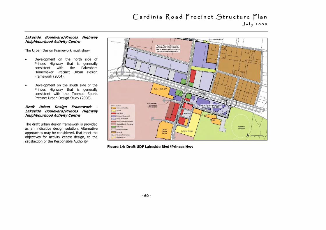
CCCCCCCC aaaaaaaa rrrrrrrr dddddddd iiiiiiii nnnnnnnn iiiiiiii aaaaaaaa RRRRRRRR oooooooo aaaaaaaa dddddddd PPPPPPPP rrrrrrrr eeeeeeee cccccccc iiiiiiii nnnnnnnn cccccccc tttttttt SSSSSSSS tttttttt rrrrrrrr uuuuuuuu cccccccc tttttttt uuuuuuuu rrrrrrrr eeeeeeee PPPPPPPP llllllll aaaaaaaa nnnnnnnn JJJJJJJJ uuuuuuuu llllllll yyyyyyyy 22222222 00000000 00000000 88888888
- 60 -
Lakeside Boulevard/Princes Highway Neighbourhood Activity Centre
The Urban Design Framework must show
• Development on the north side of
Princes Highway that is generally consistent with the Pakenham Homemaker Precinct Urban Design Framework (2004).
• Development on the south side of the
Princes Highway that is generally consistent with the Toomuc Sports Precinct Urban Design Study (2006).
Draft Urban Design Framework - Lakeside Boulevard/Princes Highway Neighbourhood Activity Centre
The draft urban design framework is provided
as an indicative design solution. Alternative approaches may be considered, that meet the objectives for activity centre design, to the
satisfaction of the Responsible Authority
Figure 14: Draft UDF Lakeside Blvd/Princes Hwy
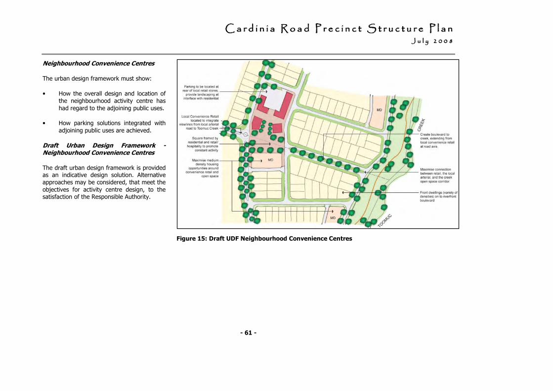
CCCCCCCC aaaaaaaa rrrrrrrr dddddddd iiiiiiii nnnnnnnn iiiiiiii aaaaaaaa RRRRRRRR oooooooo aaaaaaaa dddddddd PPPPPPPP rrrrrrrr eeeeeeee cccccccc iiiiiiii nnnnnnnn cccccccc tttttttt SSSSSSSS tttttttt rrrrrrrr uuuuuuuu cccccccc tttttttt uuuuuuuu rrrrrrrr eeeeeeee PPPPPPPP llllllll aaaaaaaa nnnnnnnn JJJJJJJJ uuuuuuuu llllllll yyyyyyyy 22222222 00000000 00000000 88888888
- 61 -
Neighbourhood Convenience Centres
The urban design framework must show:
• How the overall design and location of the neighbourhood activity centre has
had regard to the adjoining public uses.
• How parking solutions integrated with
adjoining public uses are achieved.
Draft Urban Design Framework - Neighbourhood Convenience Centres
The draft urban design framework is provided as an indicative design solution. Alternative approaches may be considered, that meet the
objectives for activity centre design, to the satisfaction of the Responsible Authority.
Figure 15: Draft UDF Neighbourhood Convenience Centres
CCCCCCCC aaaaaaaa rrrrrrrr dddddddd iiiiiiii nnnnnnnn iiiiiiii aaaaaaaa RRRRRRRR oooooooo aaaaaaaa dddddddd PPPPPPPP rrrrrrrr eeeeeeee cccccccc iiiiiiii nnnnnnnn cccccccc tttttttt SSSSSSSS tttttttt rrrrrrrr uuuuuuuu cccccccc tttttttt uuuuuuuu rrrrrrrr eeeeeeee PPPPPPPP llllllll aaaaaaaa nnnnnnnn JJJJJJJJ uuuuuuuu llllllll yyyyyyyy 22222222 00000000 00000000 88888888
- 62 -
3.4 Employment and economic activity
3.4.1 Objectives
• To provide opportunities for local employment through the integration of economic activities into the development of the precinct; such as;
- the provision of a network of activity centres with a mix of retail, commercial, leisure and community services activities; and,
- the establishment of community services (public and private) and other activities (such as childcare centres and nursing homes) which provide employment as well as services to the local community.
• To maximise accessibility to and within employment opportunity areas, particularly by public transport, cycling and walking to ensure an improved quality of life of residents, as well as reducing the demands for travel.
• To provide for a mix of retail, commercial, leisure and other services to support the needs of workers of nearby business and industry.
• To minimise potential amenity impacts between existing industrial activity and residential development.
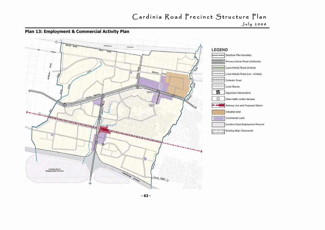
CCCCCCCC aaaaaaaa rrrrrrrr dddddddd iiiiiiii nnnnnnnn iiiiiiii aaaaaaaa RRRRRRRR oooooooo aaaaaaaa dddddddd PPPPPPPP rrrrrrrr eeeeeeee cccccccc iiiiiiii nnnnnnnn cccccccc tttttttt SSSSSSSS tttttttt rrrrrrrr uuuuuuuu cccccccc tttttttt uuuuuuuu rrrrrrrr eeeeeeee PPPPPPPP llllllll aaaaaaaa nnnnnnnn JJJJJJJJ uuuuuuuu llllllll yyyyyyyy 22222222 00000000 00000000 88888888
- 63 -
Plan 13: Employment & Commercial Activity Plan

CCCCCCCC aaaaaaaa rrrrrrrr dddddddd iiiiiiii nnnnnnnn iiiiiiii aaaaaaaa RRRRRRRR oooooooo aaaaaaaa dddddddd PPPPPPPP rrrrrrrr eeeeeeee cccccccc iiiiiiii nnnnnnnn cccccccc tttttttt SSSSSSSS tttttttt rrrrrrrr uuuuuuuu cccccccc tttttttt uuuuuuuu rrrrrrrr eeeeeeee PPPPPPPP llllllll aaaaaaaa nnnnnnnn JJJJJJJJ uuuuuuuu llllllll yyyyyyyy 22222222 00000000 00000000 88888888
- 64 -
3.4.2 Development Principles
• The development of the employment areas should meet the requirements of Plan 13: Employment and Commercial Activity.
• Design and development of activity centres should provide for a mix of retail, commercial, leisure and community services activities; and demonstrate the capacity for future expansion
• Education and community services (public and private) and other activities (such as childcare centres and nursing homes) should be encouraged:
- within community hubs;
- within/or on the edge of activity centres;
- on either collector roads or local arterial roads; and/or,
- within walking distance of public transport.
• Restricted retailing should be encouraged along the Princes Highway frontage and within the Pakenham homemaker centre where within land shown as peripheral commercial.
• Potential amenity impacts at interface between the existing industrial precinct and residential development should be minimised through the provision of an acoustic fence and landscaping buffer.
CCCCCCCC aaaaaaaa rrrrrrrr dddddddd iiiiiiii nnnnnnnn iiiiiiii aaaaaaaa RRRRRRRR oooooooo aaaaaaaa dddddddd PPPPPPPP rrrrrrrr eeeeeeee cccccccc iiiiiiii nnnnnnnn cccccccc tttttttt SSSSSSSS tttttttt rrrrrrrr uuuuuuuu cccccccc tttttttt uuuuuuuu rrrrrrrr eeeeeeee PPPPPPPP llllllll aaaaaaaa nnnnnnnn JJJJJJJJ uuuuuuuu llllllll yyyyyyyy 22222222 00000000 00000000 88888888
- 65 -
3.5 Community infrastructure
3.5.1 Objectives
• To provide a network of community hubs across the precinct as focal points for community activity and interaction.
• To provide a range of community facilities, cultural venues and services to meet the varying needs of local residents.
• To promote high quality architecture and flexible design and use of community facilities to accommodate changing community needs over time
• To provide for community facilities and services delivered by government and non-government education, health and community service providers.
• To encourage the co-location of community facilities with activity centres, open space, and transport facilities.
• To maximise access to community facilities especially by public transport, walking and cycling.
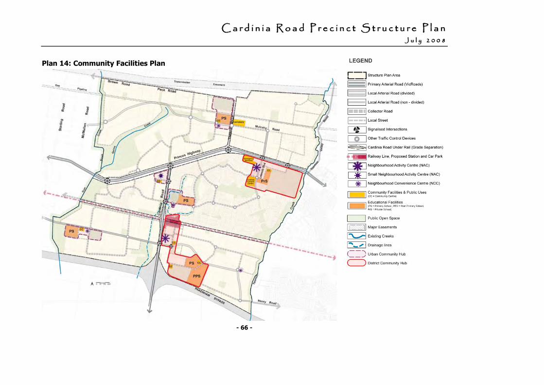
CCCCCCCC aaaaaaaa rrrrrrrr dddddddd iiiiiiii nnnnnnnn iiiiiiii aaaaaaaa RRRRRRRR oooooooo aaaaaaaa dddddddd PPPPPPPP rrrrrrrr eeeeeeee cccccccc iiiiiiii nnnnnnnn cccccccc tttttttt SSSSSSSS tttttttt rrrrrrrr uuuuuuuu cccccccc tttttttt uuuuuuuu rrrrrrrr eeeeeeee PPPPPPPP llllllll aaaaaaaa nnnnnnnn JJJJJJJJ uuuuuuuu llllllll yyyyyyyy 22222222 00000000 00000000 88888888
- 66 -
Plan 14: Community Facilities Plan
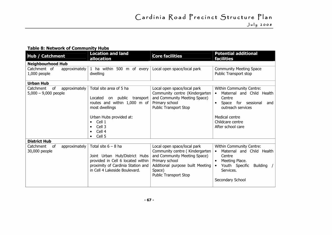
CCCCCCCC aaaaaaaa rrrrrrrr dddddddd iiiiiiii nnnnnnnn iiiiiiii aaaaaaaa RRRRRRRR oooooooo aaaaaaaa dddddddd PPPPPPPP rrrrrrrr eeeeeeee cccccccc iiiiiiii nnnnnnnn cccccccc tttttttt SSSSSSSS tttttttt rrrrrrrr uuuuuuuu cccccccc tttttttt uuuuuuuu rrrrrrrr eeeeeeee PPPPPPPP llllllll aaaaaaaa nnnnnnnn JJJJJJJJ uuuuuuuu llllllll yyyyyyyy 22222222 00000000 00000000 88888888
- 67 -
Table 8: Network of Community Hubs
Hub / Catchment Location and land
allocation Core facilities
Potential additional
facilities Neighbourhood Hub
Catchment of approximately 1,000 people
1 ha within 500 m of every dwelling
Local open space/local park
Community Meeting Space Public Transport stop
Urban Hub
Catchment of approximately 5,000 – 9,000 people
Total site area of 5 ha Located on public transport routes and within 1,000 m of most dwellings Urban Hubs provided at: • Cell 1 • Cell 3 • Cell 4 • Cell 5
Local open space/local park Community centre (Kindergarten and Community Meeting Space) Primary school Public Transport Stop
Within Community Centre: • Maternal and Child Health
Centre
• Space for sessional and outreach services
Medical centre Childcare centre After school care
District Hub
Catchment of approximately 30,000 people
Total site 6 – 8 ha Joint Urban Hub/District Hubs provided in Cell 6 located within proximity of Cardinia Station and in Cell 4 Lakeside Boulevard.
Local open space/local park Community centre ( Kindergarten and Community Meeting Space) Primary school Additional purpose built Meeting Space) Public Transport Stop
Within Community Centre: • Maternal and Child Health
Centre • Meeting Place. • Youth Specific Building /
Services. Secondary School
CCCCCCCC aaaaaaaa rrrrrrrr dddddddd iiiiiiii nnnnnnnn iiiiiiii aaaaaaaa RRRRRRRR oooooooo aaaaaaaa dddddddd PPPPPPPP rrrrrrrr eeeeeeee cccccccc iiiiiiii nnnnnnnn cccccccc tttttttt SSSSSSSS tttttttt rrrrrrrr uuuuuuuu cccccccc tttttttt uuuuuuuu rrrrrrrr eeeeeeee PPPPPPPP llllllll aaaaaaaa nnnnnnnn JJJJJJJJ uuuuuuuu llllllll yyyyyyyy 22222222 00000000 00000000 88888888
- 68 -
3.5.2 Development Principles
The development of the community infrastructure should meet the requirements outlined in:
• Table 8: Network of Community Hubs; and,
• Plan 14: Community Facilities within the Cardinia Road Precinct.
Design of community facilities
All community facilities should be designed to:
• provide for the multi-use of facilities by different groups within the community;
• facilitate the efficient and shared use of resources and facilities; and,
• provide for disability access, and incorporate Crime Prevention Through Environmental Design (CPTED)Safe Design Principles where appropriate.
Location of non-government schools
Non-government schools are encouraged to co-locate with open space and other schools and community facilities.
Non-government schools should be located within walking distance to the principal public transport network.
CCCCCCCC aaaaaaaa rrrrrrrr dddddddd iiiiiiii nnnnnnnn iiiiiiii aaaaaaaa RRRRRRRR oooooooo aaaaaaaa dddddddd PPPPPPPP rrrrrrrr eeeeeeee cccccccc iiiiiiii nnnnnnnn cccccccc tttttttt SSSSSSSS tttttttt rrrrrrrr uuuuuuuu cccccccc tttttttt uuuuuuuu rrrrrrrr eeeeeeee PPPPPPPP llllllll aaaaaaaa nnnnnnnn JJJJJJJJ uuuuuuuu nnnnnnnn eeeeeeee 22222222 00000000 00000000 88888888
- 69 -
3.6 Open space
3.6.1 Objectives
• To provide and develop a range of open space types to meet the active and passive needs of the community and protect and restore environmental values and features.
• To provide a range of appropriately sized and well distributed open spaces to meet local and district open space needs.
• To provide for the protection and enhancement of areas of environmental significance and to integrate these areas with open space systems.
• To create an attractive urban environment with a strong sense of place through the provision and landscaping of open space.
• To ensure that open space development standards provide for a sustainable future maintenance regime.
• To encourage and promote the early development of open space through subdivisional works, the development contribution plan; and/or Council’s Capital Works Programs.
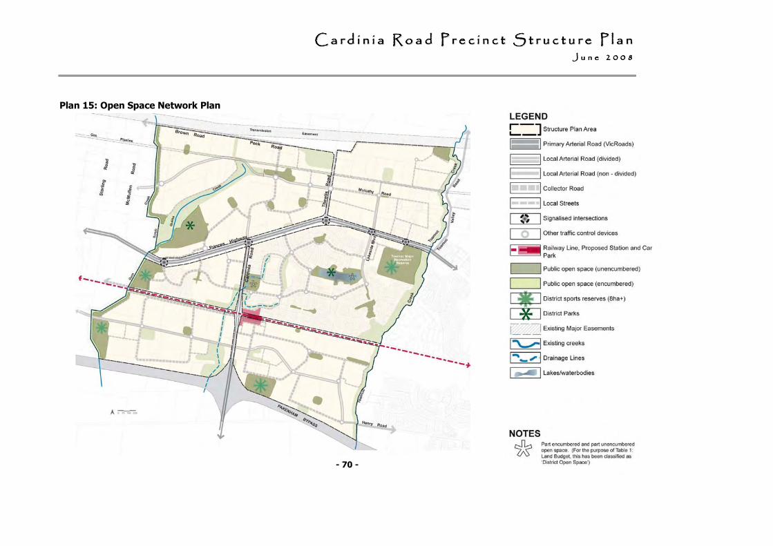
CCCCCCCC aaaaaaaa rrrrrrrr dddddddd iiiiiiii nnnnnnnn iiiiiiii aaaaaaaa RRRRRRRR oooooooo aaaaaaaa dddddddd PPPPPPPP rrrrrrrr eeeeeeee cccccccc iiiiiiii nnnnnnnn cccccccc tttttttt SSSSSSSS tttttttt rrrrrrrr uuuuuuuu cccccccc tttttttt uuuuuuuu rrrrrrrr eeeeeeee PPPPPPPP llllllll aaaaaaaa nnnnnnnn JJJJJJJJ uuuuuuuu nnnnnnnn eeeeeeee 22222222 00000000 00000000 88888888
- 70 -
Plan 15: Open Space Network Plan
CCCCCCCC aaaaaaaa rrrrrrrr dddddddd iiiiiiii nnnnnnnn iiiiiiii aaaaaaaa RRRRRRRR oooooooo aaaaaaaa dddddddd PPPPPPPP rrrrrrrr eeeeeeee cccccccc iiiiiiii nnnnnnnn cccccccc tttttttt SSSSSSSS tttttttt rrrrrrrr uuuuuuuu cccccccc tttttttt uuuuuuuu rrrrrrrr eeeeeeee PPPPPPPP llllllll aaaaaaaa nnnnnnnn JJJJJJJJ uuuuuuuu nnnnnnnn eeeeeeee 22222222 00000000 00000000 88888888
- 71 -
3.6.2 Development Principles
The open space network must meet the requirements outlined in the following:
• Table 9a: Open Space Contributions;
• Table 9b: Open Space Categories; and,
• Plan 15: Open Space Network*.
* Note: The configuration of the shape of the open space area may be modified to the satisfaction of the Responsible Authority.
Public Open Space Contribution
A minimum public open space contribution of 8% of the land to be subdivided must be provided as part of the subdivision of land for residential purposes.
The 8% public open space contribution must comprise land unencumbered by other constraints (eg: land required by Melbourne Water for drainage purposes, land within service easements) to allow its full use for recreation purposes.
Any encumbered public open space should be provided in addition to the 8% unencumbered public open space contribution for recreation purposes.
Where the size and location of a parcel of land being subdivided is unable to provide open space within the framework set out the structure plan, a cash contribution in lieu of the provision of land for open space should be provided.
Funds collected through these contributions should be used to offset the provision of land for open space on a parcel of land being subdivided where the amount of open space to be provided exceeds the 8% public open space contribution.
CCCCCCCC aaaaaaaa rrrrrrrr dddddddd iiiiiiii nnnnnnnn iiiiiiii aaaaaaaa RRRRRRRR oooooooo aaaaaaaa dddddddd PPPPPPPP rrrrrrrr eeeeeeee cccccccc iiiiiiii nnnnnnnn cccccccc tttttttt SSSSSSSS tttttttt rrrrrrrr uuuuuuuu cccccccc tttttttt uuuuuuuu rrrrrrrr eeeeeeee PPPPPPPP llllllll aaaaaaaa nnnnnnnn JJJJJJJJ uuuuuuuu nnnnnnnn eeeeeeee 22222222 00000000 00000000 88888888
- 72 -
Table 9a: Open Space Contributions
Cell and Net Residential Developable Area (ha)
Cell 1
211.5
Cell 2
88.7
Cell 3
50.3
Cell 4
179.8
Cell 5
107.4
Cell 6
125.1
District Sports Reserves* 0.0 0.0 8.0 8.0 8.0
District Parkland* 16.2 0.0 0.0 0.0 0.0
Neighbourhood Sports Reserve* 0.0 0.0 0.0 0.0 0.0
Local Open Space (8% of Net Residential Developable Area) 16.9 7.1 4.0
Not applic
able
Existing U
rban A
rea
8.6 10.0
Note: Further information in relation to the Land Use Budget for each Cell is provided in Table 1: Land Use Budget in Section 2 of this PSP.
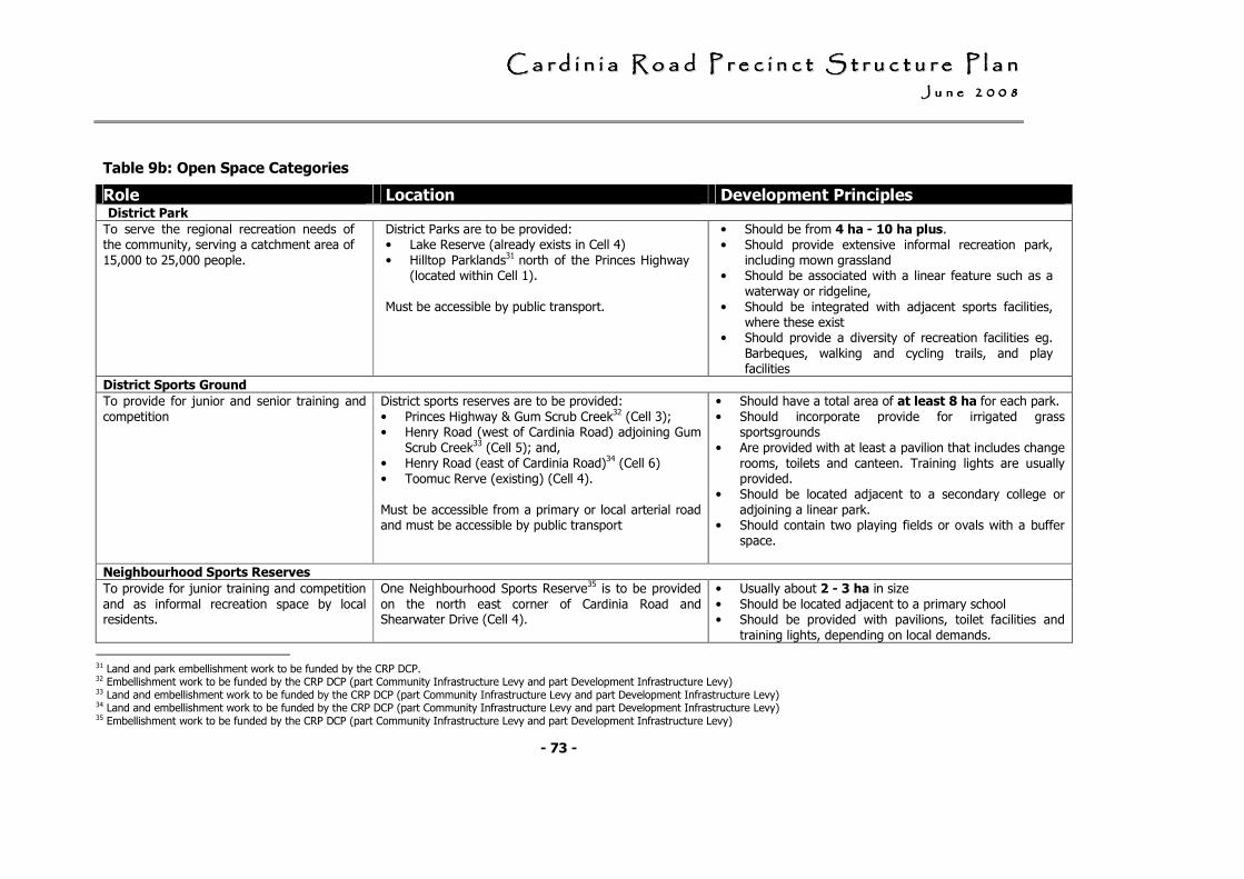
CCCCCCCC aaaaaaaa rrrrrrrr dddddddd iiiiiiii nnnnnnnn iiiiiiii aaaaaaaa RRRRRRRR oooooooo aaaaaaaa dddddddd PPPPPPPP rrrrrrrr eeeeeeee cccccccc iiiiiiii nnnnnnnn cccccccc tttttttt SSSSSSSS tttttttt rrrrrrrr uuuuuuuu cccccccc tttttttt uuuuuuuu rrrrrrrr eeeeeeee PPPPPPPP llllllll aaaaaaaa nnnnnnnn JJJJJJJJ uuuuuuuu nnnnnnnn eeeeeeee 22222222 00000000 00000000 88888888
- 73 -
Table 9b: Open Space Categories
Role Location Development Principles District Park
To serve the regional recreation needs of the community, serving a catchment area of
15,000 to 25,000 people.
District Parks are to be provided: • Lake Reserve (already exists in Cell 4)
• Hilltop Parklands31 north of the Princes Highway (located within Cell 1).
Must be accessible by public transport.
• Should be from 4 ha - 10 ha plus.
• Should provide extensive informal recreation park, including mown grassland
• Should be associated with a linear feature such as a
waterway or ridgeline,
• Should be integrated with adjacent sports facilities, where these exist
• Should provide a diversity of recreation facilities eg.
Barbeques, walking and cycling trails, and play facilities
District Sports Ground
To provide for junior and senior training and
competition
District sports reserves are to be provided:
• Princes Highway & Gum Scrub Creek32 (Cell 3); • Henry Road (west of Cardinia Road) adjoining Gum
Scrub Creek33 (Cell 5); and, • Henry Road (east of Cardinia Road)34 (Cell 6)
• Toomuc Rerve (existing) (Cell 4).
Must be accessible from a primary or local arterial road and must be accessible by public transport
• Should have a total area of at least 8 ha for each park.
• Should incorporate provide for irrigated grass sportsgrounds
• Are provided with at least a pavilion that includes change
rooms, toilets and canteen. Training lights are usually provided.
• Should be located adjacent to a secondary college or
adjoining a linear park. • Should contain two playing fields or ovals with a buffer
space.
Neighbourhood Sports Reserves
To provide for junior training and competition
and as informal recreation space by local residents.
One Neighbourhood Sports Reserve35 is to be provided
on the north east corner of Cardinia Road and Shearwater Drive (Cell 4).
• Usually about 2 - 3 ha in size
• Should be located adjacent to a primary school • Should be provided with pavilions, toilet facilities and
training lights, depending on local demands.
31 Land and park embellishment work to be funded by the CRP DCP. 32 Embellishment work to be funded by the CRP DCP (part Community Infrastructure Levy and part Development Infrastructure Levy) 33 Land and embellishment work to be funded by the CRP DCP (part Community Infrastructure Levy and part Development Infrastructure Levy) 34 Land and embellishment work to be funded by the CRP DCP (part Community Infrastructure Levy and part Development Infrastructure Levy) 35 Embellishment work to be funded by the CRP DCP (part Community Infrastructure Levy and part Development Infrastructure Levy)
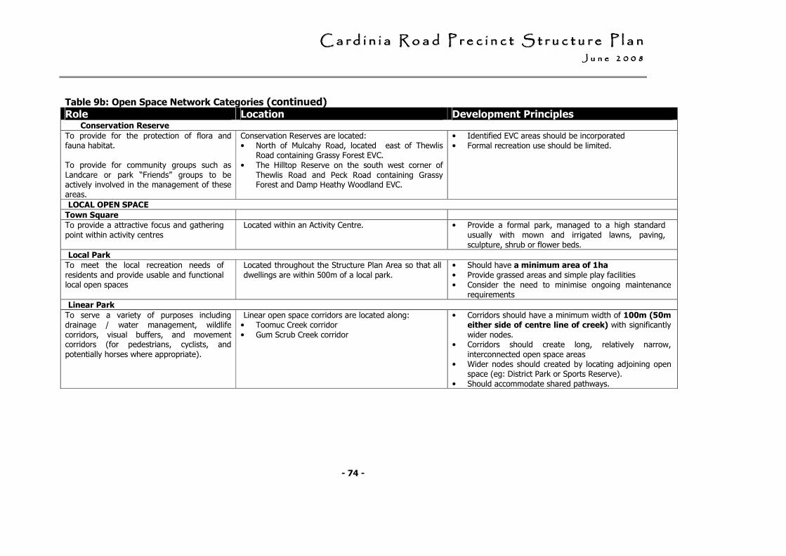
CCCCCCCC aaaaaaaa rrrrrrrr dddddddd iiiiiiii nnnnnnnn iiiiiiii aaaaaaaa RRRRRRRR oooooooo aaaaaaaa dddddddd PPPPPPPP rrrrrrrr eeeeeeee cccccccc iiiiiiii nnnnnnnn cccccccc tttttttt SSSSSSSS tttttttt rrrrrrrr uuuuuuuu cccccccc tttttttt uuuuuuuu rrrrrrrr eeeeeeee PPPPPPPP llllllll aaaaaaaa nnnnnnnn JJJJJJJJ uuuuuuuu nnnnnnnn eeeeeeee 22222222 00000000 00000000 88888888
- 74 -
Table 9b: Open Space Network Categories (continued) Role Location Development Principles Conservation Reserve
To provide for the protection of flora and fauna habitat. To provide for community groups such as
Landcare or park “Friends” groups to be actively involved in the management of these areas.
Conservation Reserves are located: • North of Mulcahy Road, located east of Thewlis
Road containing Grassy Forest EVC.
• The Hilltop Reserve on the south west corner of
Thewlis Road and Peck Road containing Grassy Forest and Damp Heathy Woodland EVC.
• Identified EVC areas should be incorporated
• Formal recreation use should be limited.
LOCAL OPEN SPACE
Town Square
To provide a attractive focus and gathering
point within activity centres
Located within an Activity Centre. • Provide a formal park, managed to a high standard
usually with mown and irrigated lawns, paving,
sculpture, shrub or flower beds.
Local Park
To meet the local recreation needs of
residents and provide usable and functional local open spaces
Located throughout the Structure Plan Area so that all
dwellings are within 500m of a local park.
• Should have a minimum area of 1ha
• Provide grassed areas and simple play facilities
• Consider the need to minimise ongoing maintenance requirements
Linear Park
To serve a variety of purposes including drainage / water management, wildlife
corridors, visual buffers, and movement corridors (for pedestrians, cyclists, and
potentially horses where appropriate).
Linear open space corridors are located along: • Toomuc Creek corridor
• Gum Scrub Creek corridor
• Corridors should have a minimum width of 100m (50m either side of centre line of creek) with significantly
wider nodes. • Corridors should create long, relatively narrow,
interconnected open space areas • Wider nodes should created by locating adjoining open
space (eg: District Park or Sports Reserve).
• Should accommodate shared pathways.
CCCCCCCC aaaaaaaa rrrrrrrr dddddddd iiiiiiii nnnnnnnn iiiiiiii aaaaaaaa RRRRRRRR oooooooo aaaaaaaa dddddddd PPPPPPPP rrrrrrrr eeeeeeee cccccccc iiiiiiii nnnnnnnn cccccccc tttttttt SSSSSSSS tttttttt rrrrrrrr uuuuuuuu cccccccc tttttttt uuuuuuuu rrrrrrrr eeeeeeee PPPPPPPP llllllll aaaaaaaa nnnnnnnn JJJJJJJJ uuuuuuuu nnnnnnnn eeeeeeee 22222222 00000000 00000000 88888888
- 75 -
Local Open Space Landscape Plan
A detailed landscape plan must be prepared for local open space as part of the overall landscape concept plan for the development. The local landscape plan must show where relevant:
• how significant view corridors have been considered;
• significant vegetation, including remnant vegetation and provide details for protection and retention;
• incorporation of stormwater management and techniques to improve stormwater quality, particularly along drainage lines;
• open space landscaped to at least a base improvements standard as part of subdivision construction works;
• ensure walking and cycling routes are provided with good surveillance; and,
• the parks and open space objectives set out in the Safer Design Guidelines for Victoria (2005).
The landscape plan and associated works, including the future maintenance regime, must be in accordance with Council’s adopted standards as set out in the Council’s Landscape Development Guidelines.36
All landscaping and improvement works for public open space should be undertaken in accordance with Table 10.
36 Landscape Development Guidelines, Cardinia Shire Council (June 2007)
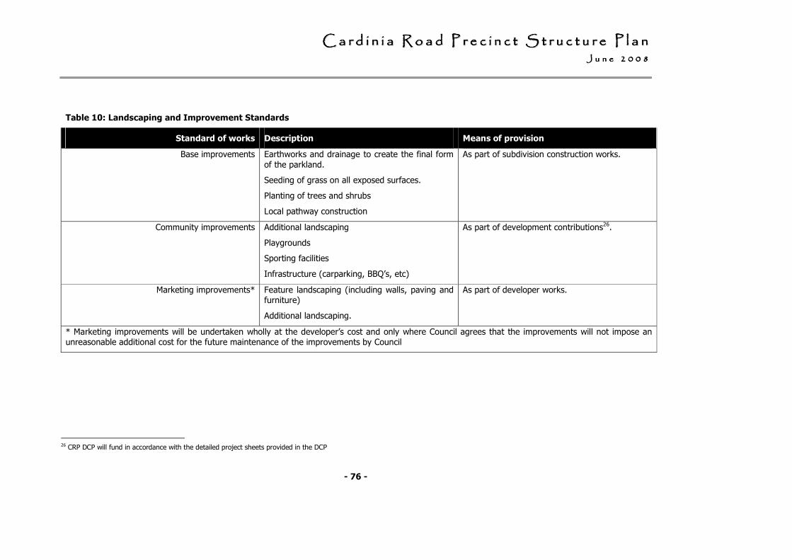
CCCCCCCC aaaaaaaa rrrrrrrr dddddddd iiiiiiii nnnnnnnn iiiiiiii aaaaaaaa RRRRRRRR oooooooo aaaaaaaa dddddddd PPPPPPPP rrrrrrrr eeeeeeee cccccccc iiiiiiii nnnnnnnn cccccccc tttttttt SSSSSSSS tttttttt rrrrrrrr uuuuuuuu cccccccc tttttttt uuuuuuuu rrrrrrrr eeeeeeee PPPPPPPP llllllll aaaaaaaa nnnnnnnn JJJJJJJJ uuuuuuuu nnnnnnnn eeeeeeee 22222222 00000000 00000000 88888888
- 76 -
Table 10: Landscaping and Improvement Standards
Standard of works Description Means of provision
Base improvements Earthworks and drainage to create the final form
of the parkland.
Seeding of grass on all exposed surfaces.
Planting of trees and shrubs
Local pathway construction
As part of subdivision construction works.
Community improvements Additional landscaping
Playgrounds
Sporting facilities
Infrastructure (carparking, BBQ’s, etc)
As part of development contributions26.
Marketing improvements* Feature landscaping (including walls, paving and furniture)
Additional landscaping.
As part of developer works.
* Marketing improvements will be undertaken wholly at the developer’s cost and only where Council agrees that the improvements will not impose an unreasonable additional cost for the future maintenance of the improvements by Council
26 CRP DCP will fund in accordance with the detailed project sheets provided in the DCP
CCCCCCCC aaaaaaaa rrrrrrrr dddddddd iiiiiiii nnnnnnnn iiiiiiii aaaaaaaa RRRRRRRR oooooooo aaaaaaaa dddddddd PPPPPPPP rrrrrrrr eeeeeeee cccccccc iiiiiiii nnnnnnnn cccccccc tttttttt SSSSSSSS tttttttt rrrrrrrr uuuuuuuu cccccccc tttttttt uuuuuuuu rrrrrrrr eeeeeeee PPPPPPPP llllllll aaaaaaaa nnnnnnnn JJJJJJJJ uuuuuuuu llllllll yyyyyyyy 22222222 00000000 00000000 88888888
- 77 -
3.6 Biodiversity
3.7.1 Objectives
• To protect and restore key areas of native habitat and create new waterway corridor and habitat links.
• To provide for the long term conservation management of areas of significant native vegetation and fauna habitat
• To create open space corridors which incorporate stormwater treatment wetlands along the Toomuc Creek and Gum Scrub Creek
• To protect and restore habitat for the Growling Grass Frog in accordance with the management plan for the urban growth area.
• To effectively manage stormwater and to improve downstream water quality flows into Western Port.
• To encourage the collocation of public recreation and open spaces to assist in buffering of reserves and waterways.

CCCCCCCC aaaaaaaa rrrrrrrr dddddddd iiiiiiii nnnnnnnn iiiiiiii aaaaaaaa RRRRRRRR oooooooo aaaaaaaa dddddddd PPPPPPPP rrrrrrrr eeeeeeee cccccccc iiiiiiii nnnnnnnn cccccccc tttttttt SSSSSSSS tttttttt rrrrrrrr uuuuuuuu cccccccc tttttttt uuuuuuuu rrrrrrrr eeeeeeee PPPPPPPP llllllll aaaaaaaa nnnnnnnn JJJJJJJJ uuuuuuuu llllllll yyyyyyyy 22222222 00000000 00000000 88888888
- 78 -
Plan 16: Biodiversity Management Plan
CCCCCCCC aaaaaaaa rrrrrrrr dddddddd iiiiiiii nnnnnnnn iiiiiiii aaaaaaaa RRRRRRRR oooooooo aaaaaaaa dddddddd PPPPPPPP rrrrrrrr eeeeeeee cccccccc iiiiiiii nnnnnnnn cccccccc tttttttt SSSSSSSS tttttttt rrrrrrrr uuuuuuuu cccccccc tttttttt uuuuuuuu rrrrrrrr eeeeeeee PPPPPPPP llllllll aaaaaaaa nnnnnnnn JJJJJJJJ uuuuuuuu llllllll yyyyyyyy 22222222 00000000 00000000 88888888
- 79 -
3.7.2 Development Principles
Biodiversity management should meet the requirements outlined in Plan 16: Biodiversity Management Plan.
Growling Grass Frog Habitat
Frog movement corridors are located south of the railway line reservation and within Gum Scrub Creek. Movement corridors should be a minimum width of 20m wide. Collocation of open space, pathways or road and rail reserves adjacent to the movement corridor is encouraged.
Habitat protection and creation opportunities exist along the Toomuc and Gum Scrub Creek corridors and within the stormwater treatment wetlands.
The status of the Growling Grass frog in the northern portion of the study area (north of Princes Highway) is not known, and requires further assessment.
Habitat and movement corridors should be designed and constructed in accordance with the Conservation Management Plan for the Growling Grass Frog
Waterway buffers, Rehabilitation and Conservation Works
The open space corridors along the Toomuc Creek and Gum Scrub Creek should have a minimum width of 100m (50 m each side of the centre line of the creek) to provide for vegetation buffers and the protection and enhancement of the creek system in addition to other uses.
Rehabilitation and conservation works are provided for in the open space corridors through both drainage plan requirements and, for the balance of the required land, through the Development Contribution Plan.
The Development Contribution Plan also provides for rehabilitation and conservation works at the District Park.
Ecological Vegetation Classes
Where practical and sustainable, identified areas of EVC should be incorporated in to the design of open space reserves.
Remnant Vegetation
Small patches of remnant vegetation exist along roadsides, railways and at the following locations:
• Grassy Forest north of Mulcahy Road to the east of Thewlis Road;
• Grassy Forest and Damp Heathy Woodland the south west corner of Thewlis Road and Peck Road;
• Swampy Riparian Woodland and Swampy Woodland along the Toomuc Creek (generally north of the railway line); and,
• Patches of Swamp Scrub along the Gum Scrub Creek.
Where practical and sustainable, remnant vegetation should be retained in road reserves, large lots or incorporated into the design of public open spaces,
CCCCCCCC aaaaaaaa rrrrrrrr dddddddd iiiiiiii nnnnnnnn iiiiiiii aaaaaaaa RRRRRRRR oooooooo aaaaaaaa dddddddd PPPPPPPP rrrrrrrr eeeeeeee cccccccc iiiiiiii nnnnnnnn cccccccc tttttttt SSSSSSSS tttttttt rrrrrrrr uuuuuuuu cccccccc tttttttt uuuuuuuu rrrrrrrr eeeeeeee PPPPPPPP llllllll aaaaaaaa nnnnnnnn JJJJJJJJ uuuuuuuu llllllll yyyyyyyy 22222222 00000000 00000000 88888888
- 80 -
Native Vegetation Precinct Plan
A Native Vegetation Precinct Plan is not warranted for the Cardinia Road Precinct Structure Plan due to:
• the limited amount of remnant vegetation in the study area (as determined by a Regional Indigenous Vegetation Survey, January 2004);
• the requirement to undertake Flora and Fauna Assessments and Vegetation Management Plans; and,
• the overall design of the Structure Plan which identifies EVCs within open space reserves.
Flora and Fauna Assessment
A detailed flora and fauna assessment is required to be undertaken to identify flora and fauna values and must be submitted with an application for subdivision.
Vegetation Management Plan
A vegetation management plan is required for locations of remnant vegetation.
The vegetation management plan must:
• identify areas of flora and fauna habitat to be retained, protected or removed, lopped or destroyed;
• set out measures for retention and protection of significant vegetation, both short term (i.e during construction) and long term; and,
• set out management measures forth protection and enhancement of threatened species habitat.
Landscape Concept Plan
A landscape concept plan is required to be undertaken and must respond to biodiversity values by:
• identifying any proposals to enhance biodiversity in the region and enhance planting opportunities within urban areas;
• retaining mature isolated trees through their incorporation into open space, road reserves and larger lots; and,
• maximising opportunities for revegetation in urban areas, particularly on ridgelines.
CCCCCCCC aaaaaaaa rrrrrrrr dddddddd iiiiiiii nnnnnnnn iiiiiiii aaaaaaaa RRRRRRRR oooooooo aaaaaaaa dddddddd PPPPPPPP rrrrrrrr eeeeeeee cccccccc iiiiiiii nnnnnnnn cccccccc tttttttt SSSSSSSS tttttttt rrrrrrrr uuuuuuuu cccccccc tttttttt uuuuuuuu rrrrrrrr eeeeeeee PPPPPPPP llllllll aaaaaaaa nnnnnnnn JJJJJJJJ uuuuuuuu llllllll yyyyyyyy 22222222 00000000 00000000 88888888
- 81 -
3.7 Image, character and unique features
3.8.1 Objectives
• To create a strong sense of place that emphasises the landscape character and topographical features of the precinct.
• To preserve view corridors to and from significant landscape features. and ensure development does not detract from visual amenity.
• To recognise the strong contribution that open corridors along the Toomuc Creek and Gum Scrub Creek make as a landscape feature.
• To recognise the strong contribution that the ridgelines and valleys make to the landscape character of the region.
• To ensure a sustainable response to topography in terms of managing erosion, overland flow and water quality; addressing revegetation (on slopes in particular) and ensuring development does not detract from visual amenity.
Formatted: Bullets andNumbering

CCCCCCCC aaaaaaaa rrrrrrrr dddddddd iiiiiiii nnnnnnnn iiiiiiii aaaaaaaa RRRRRRRR oooooooo aaaaaaaa dddddddd PPPPPPPP rrrrrrrr eeeeeeee cccccccc iiiiiiii nnnnnnnn cccccccc tttttttt SSSSSSSS tttttttt rrrrrrrr uuuuuuuu cccccccc tttttttt uuuuuuuu rrrrrrrr eeeeeeee PPPPPPPP llllllll aaaaaaaa nnnnnnnn JJJJJJJJ uuuuuuuu llllllll yyyyyyyy 22222222 00000000 00000000 88888888
- 82 -
Plan 17: Landscape Character and Topographical Features Plan
CCCCCCCC aaaaaaaa rrrrrrrr dddddddd iiiiiiii nnnnnnnn iiiiiiii aaaaaaaa RRRRRRRR oooooooo aaaaaaaa dddddddd PPPPPPPP rrrrrrrr eeeeeeee cccccccc iiiiiiii nnnnnnnn cccccccc tttttttt SSSSSSSS tttttttt rrrrrrrr uuuuuuuu cccccccc tttttttt uuuuuuuu rrrrrrrr eeeeeeee PPPPPPPP llllllll aaaaaaaa nnnnnnnn JJJJJJJJ uuuuuuuu llllllll yyyyyyyy 22222222 00000000 00000000 88888888
- 83 -
3.8.2 Development Principles
Use, development and subdivision should respond to the image, character and unique features as depicted in Plan 17: Image, Character and Unique Features Plan.
Ridgelines and vegetation
• Lots should be designed so that dwellings can be built below the top of ridgelines and either vegetation is retained or the hilltops are revegetated.
Open Space Corridors
• Open space corridors should contribute to the preservation of drainage lines, including the existing valley and creek systems, and the need to provide drainage across the floodplain.
• Open space corridors along the Toomuc Creek and Gum Scrub Creek should have a minimum width of 100 metres, with significantly wider sections though the location of adjoining open space such as hilltops and sporting reserves.
• Design of open space should respond to view corridors.
Topographical assessment plan requirements
A topographical assessment plan will be required that shows how:
• existing view corridors to landmarks are protected;
• opportunities for new or enhanced view corridors in open space, along roadways etc are created;
• the urban structure and road and allotment layout responds to topography and will assist i n terms of managing erosion and overland flow; and,
• opportunities for revegetation are provided along ridgelines and within larger lots.
CCCCCCCC aaaaaaaa rrrrrrrr dddddddd iiiiiiii nnnnnnnn iiiiiiii aaaaaaaa RRRRRRRR oooooooo aaaaaaaa dddddddd PPPPPPPP rrrrrrrr eeeeeeee cccccccc iiiiiiii nnnnnnnn cccccccc tttttttt SSSSSSSS tttttttt rrrrrrrr uuuuuuuu cccccccc tttttttt uuuuuuuu rrrrrrrr eeeeeeee PPPPPPPP llllllll aaaaaaaa nnnnnnnn JJJJJJJJ uuuuuuuu llllllll yyyyyyyy 22222222 00000000 00000000 88888888
- 84 -
3.8 Heritage
3.9.1 Objectives
• To acknowledge that the Shire of Cardinia is the traditional land of indigenous clans.
• To ensure indigenous archaeological sites are identified and managed in accordance with statutory requirements.
3.9.2 Development Principles
Aboriginal Cultural Heritage
• Individual planning permit applications will need to comply with regulatory requirements in relation to preparation of an Aboriginal Cultural Heritage Management Plan. These areas are shown on Plan 18: Heritage as areas of Cultural Heritage Sensitivity.
European Heritage
• With the exception of the locally significant Pakenham Cemetery, there are no sites of European heritage significance within the CRPSP.
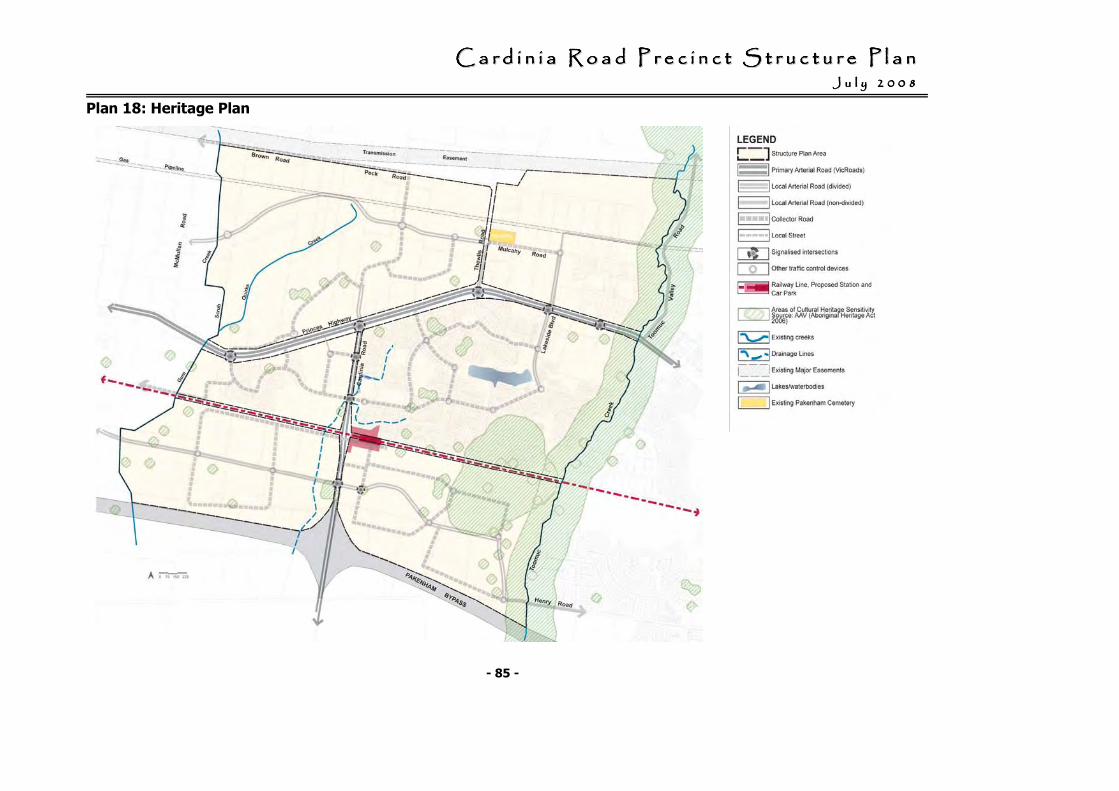
CCCCCCCC aaaaaaaa rrrrrrrr dddddddd iiiiiiii nnnnnnnn iiiiiiii aaaaaaaa RRRRRRRR oooooooo aaaaaaaa dddddddd PPPPPPPP rrrrrrrr eeeeeeee cccccccc iiiiiiii nnnnnnnn cccccccc tttttttt SSSSSSSS tttttttt rrrrrrrr uuuuuuuu cccccccc tttttttt uuuuuuuu rrrrrrrr eeeeeeee PPPPPPPP llllllll aaaaaaaa nnnnnnnn JJJJJJJJ uuuuuuuu llllllll yyyyyyyy 22222222 00000000 00000000 88888888
- 85 -
Plan 18: Heritage Plan
CCCCCCCC aaaaaaaa rrrrrrrr dddddddd iiiiiiii nnnnnnnn iiiiiiii aaaaaaaa RRRRRRRR oooooooo aaaaaaaa dddddddd PPPPPPPP rrrrrrrr eeeeeeee cccccccc iiiiiiii nnnnnnnn cccccccc tttttttt SSSSSSSS tttttttt rrrrrrrr uuuuuuuu cccccccc tttttttt uuuuuuuu rrrrrrrr eeeeeeee PPPPPPPP llllllll aaaaaaaa nnnnnnnn JJJJJJJJ uuuuuuuu llllllll yyyyyyyy 22222222 00000000 00000000 88888888
- 86 -
3.9 Physical services 3.10.1 Objectives
• To integrate use of all water resources including rainwater, reused water, recycled water and stormwater.
• To provide all developed lots in the Cardinia Road Precinct with:
- a potable water service;
- electricity;
- a reticulated sewerage service;
- drainage;
- gas; and,
- telecommunications.
• To provide recycled water to be used for purposes such as toilet flushing and garden watering on individual residential properties and the watering of public open space in order to reduce the level of consumption of potable water.
• To ensure that if lots are not able to be serviced by a reticulated recycled water supply system, new dwellings and / or commercial buildings be provided with a rainwater tanks purposes such as toilet flushing and garden watering.
• To ensure that Water Sensitive Urban Design treatment measures (eg: wetlands) are provided in both the main and local drainage network.
• To ensure that the the community in the Cardinia Road Precinct have access to the Broadband network.
CCCCCCCC aaaaaaaa rrrrrrrr dddddddd iiiiiiii nnnnnnnn iiiiiiii aaaaaaaa RRRRRRRR oooooooo aaaaaaaa dddddddd PPPPPPPP rrrrrrrr eeeeeeee cccccccc iiiiiiii nnnnnnnn cccccccc tttttttt SSSSSSSS tttttttt rrrrrrrr uuuuuuuu cccccccc tttttttt uuuuuuuu rrrrrrrr eeeeeeee PPPPPPPP llllllll aaaaaaaa nnnnnnnn JJJJJJJJ uuuuuuuu llllllll yyyyyyyy 22222222 00000000 00000000 88888888
- 87 -
3.10.2 Development Principles
• The physical services requirements will be implemented through the planning permit process, through the requirements of service authorities put in place through a combination of regulation and planning permit referral conditions and requirements.
Water
• The reticulated potable water supply must be designed and constructed in accordance with the requirements of South East Water to provide a potable water service to the boundary of all developed lots in the Cardinia Road Precinct.
• The reticulated recycled water supply must be designed and constructed in accordance with the requirements of South East Water to provide a recycled water service to the boundary of all developed lots in Cells 1, 3, 5 & 6 in the Cardinia Road Precinct.
• If lots are not able to be serviced by a reticulated recycled water supply system, then as an alternative to reduce potable water use, new dwellings and or commercial buildings must be provided with a rainwater tank to collect roof runoff for purposes such as toilet flushing and garden watering.
Sewerage
• The reticulated sewerage system must be designed and constructed in accordance with the requirements of South East Water to provide a reticulated sewerage service to the boundary of all developed lots in the Cardinia Road Precinct.
Drainage
• Water quality objectives are set out in the Urban Stormwater – Best Practice Environmental Management Guidelines 1999. They are achieved through the main drainage network and must be designed and constructed in accordance with the requirements of relevant drainage scheme and Melbourne Water.
• The local drainage network must be designed and constructed in accordance with the requirements of the Cardinia Shire Council.
• Water Sensitive Urban Design treatment measures (eg: wetlands) should be implemented in both the main and local drainage network.
Electricity
• The electricity supply system must be designed in accordance with the requirements of SPI AusNet and be provided to the boundary of all lots in the Cardinia Road Precinct.
• All new electricity supply infrastructure must be provided by underground means (excluding substations) and all existing above ground electricity lines in the local road network must be removed and placed underground as part of development.
CCCCCCCC aaaaaaaa rrrrrrrr dddddddd iiiiiiii nnnnnnnn iiiiiiii aaaaaaaa RRRRRRRR oooooooo aaaaaaaa dddddddd PPPPPPPP rrrrrrrr eeeeeeee cccccccc iiiiiiii nnnnnnnn cccccccc tttttttt SSSSSSSS tttttttt rrrrrrrr uuuuuuuu cccccccc tttttttt uuuuuuuu rrrrrrrr eeeeeeee PPPPPPPP llllllll aaaaaaaa nnnnnnnn JJJJJJJJ uuuuuuuu llllllll yyyyyyyy 22222222 00000000 00000000 88888888
- 88 -
Gas
• The gas supply network must be designed in accordance with the requirements of Origin Energy and be provided to the boundary of all lots in the Cardinia Road Precinct.
Telecommunications
• It is required that the community in the Cardinia Road Precinct have access to the Broadband network and developers must allow flexibility for future technology such as fibre optic cabling.
Gas Transmission Pipeline Easement
• It is preferred that the Gas Transmission pipeline easement be used as a road.
• The location of the Gas Transmission pipeline easement within a long linear reserve bordered by rear fences should be avoided.
CCCCCCCC aaaaaaaa rrrrrrrr dddddddd iiiiiiii nnnnnnnn iiiiiiii aaaaaaaa RRRRRRRR oooooooo aaaaaaaa dddddddd PPPPPPPP rrrrrrrr eeeeeeee cccccccc iiiiiiii nnnnnnnn cccccccc tttttttt SSSSSSSS tttttttt rrrrrrrr uuuuuuuu cccccccc tttttttt uuuuuuuu rrrrrrrr eeeeeeee PPPPPPPP llllllll aaaaaaaa nnnnnnnn JJJJJJJJ uuuuuuuu llllllll yyyyyyyy 22222222 00000000 00000000 88888888
- 89 -
3.10 Development staging 3.11.1 Objective
To ensure that the staging of development is integrated with existing development and infrastructure
3.11.2 Development Principles
• Staging will be principally driven by the development program of developers within the precinct, market demand, and the economic availability of infrastructure services.
• Development should proceed from the interface with existing development.
• Development should not create circumstances in which residents will be unreasonably isolated from commercial and community facilities or public transport.
• Access to a development must be via a sealed road.
• Development should, to the maximum extent practicable, be integrated with adjoining developments, including the timely provision of connecting roads and walking / cycling paths.
• If the above staging principles are not met, the developer will be required to bring forward infrastructure (i.e. fund up front) to the extent necessary to meet the principles outlined above.
CCCCCCCC aaaaaaaa rrrrrrrr dddddddd iiiiiiii nnnnnnnn iiiiiiii aaaaaaaa RRRRRRRR oooooooo aaaaaaaa dddddddd PPPPPPPP rrrrrrrr eeeeeeee cccccccc iiiiiiii nnnnnnnn cccccccc tttttttt SSSSSSSS tttttttt rrrrrrrr uuuuuuuu cccccccc tttttttt uuuuuuuu rrrrrrrr eeeeeeee PPPPPPPP llllllll aaaaaaaa nnnnnnnn JJJJJJJJ uuuuuuuu llllllll yyyyyyyy 22222222 00000000 00000000 88888888
- 90 -
4. Infrastructure Investment Plan
4.1 Introduction
This initial Infrastructure Investment Plan (IIP) sets out the need and requirements for infrastructure and services to meet the needs of development the precinct.
This initial IIP is being further developed and by the Growth Areas Authority and the Cardinia Shire Council and will be updated when its development is complete
The Structure Plan identifies a range of physical and social infrastructure required as part of the development of the Cardinia Road Precinct.
This infrastructure is to be provided through a number of mechanisms including:
• subdivision construction works by developers;
• development contributions (community infrastructure levy and development infrastructure levy);
• utility service provider contributions; and,
• capital works projects by Council, state government agencies and community groups.
Subdivision construction works
As part of subdivision construction works, new development in the Cardinia Road Precinct is required to meet the cost of delivering the following infrastructure:
• Local Arterial Roads (undivided), collector roads and local streets.
• Landscaping of local arterial roads (undivided), collector roads and local streets.
• Intersection works and traffic management measures along local arterial roads (undivided), collector roads and local streets.
• Uncontrolled intersection works providing access from an arterial road (primary and local) to a collector road or local street.
• Council approved fencing and landscaping (where required) along arterial roads.
• Local pedestrian and bicycle paths along local arterial roads (undivided), collector roads and local streets and within local parks.
• Basic improvements to local parks / open space including levelling, grassing, tree planting and local paths.
• Local drainage systems.
• Infrastructure as required by utility services providers including water, sewerage, drainage, electricity, gas, and telecommunications.
Development Contribution Plan
A development contribution plan has been prepared for the Cardinia Road Precinct in conjunction with this Structure
Formatted
CCCCCCCC aaaaaaaa rrrrrrrr dddddddd iiiiiiii nnnnnnnn iiiiiiii aaaaaaaa RRRRRRRR oooooooo aaaaaaaa dddddddd PPPPPPPP rrrrrrrr eeeeeeee cccccccc iiiiiiii nnnnnnnn cccccccc tttttttt SSSSSSSS tttttttt rrrrrrrr uuuuuuuu cccccccc tttttttt uuuuuuuu rrrrrrrr eeeeeeee PPPPPPPP llllllll aaaaaaaa nnnnnnnn JJJJJJJJ uuuuuuuu llllllll yyyyyyyy 22222222 00000000 00000000 88888888
- 91 -
Plan. The Development Contribution Plan is an incorporated document of the Cardinia Planning Scheme.
The key infrastructure and services items to be included in the development contributions plan are outlined in this section.(These items are either fully funded or partly funded by the Cardinia Road Precinct DCP).
Community Infrastructure Levy (CIL)
The Development Contribution Plan requires that new development in the Cardinia Road Precinct meets the cost of delivering the following community infrastructure items funded through the Community Infrastructure Levy (CIL):
• Improvements to district sports grounds (pavilions, floodlighting, etc).
• Community centre (Community Meeting Place)
• Library facilities.
Development Infrastructure Levy (DIL)
The Development Contribution Plan requires that new development in the Cardinia Road Precinct meets the cost (in whole or part) of delivering the following development infrastructure funded through the Development Infrastructure Levy (DIL):
• Land acquisition and construction costs for road widening along Cardinia Road (declared Main Road).
• Land acquisition and construction costs for upgrading the Local Arterial Road network from an ‘Undivided’ to a ‘Divided’ road design.
• Controlled intersection works along Princes Highway (Arterial Roads), Cardinia Road (Main Road) and Henry Road east (adjacent to an Activity Centre).
• Land acquisition and construction costs for a grade separated crossing of Cardinia Road and the railway line.
• Land required for a railway station.
• Bus stop facilities (regional and local bus network).
• Land for District Parkland and District Sports Reserves.
• Development of District Parkland and District Sports Reserves.
• Higher order pedestrian and cycle trail network (including pedestrian bridges over creek network and pedestrian underpass of railway line).
• Land acquisition and construction costs for community centres providing children’s services.
• Land acquisition for library facilities.
• Construction of community centres (Maternal Child Health / Kindergarten & Youth)
• Construction of roundabouts within the local arterial road network.
• Local park improvements including playground equipment.
CCCCCCCC aaaaaaaa rrrrrrrr dddddddd iiiiiiii nnnnnnnn iiiiiiii aaaaaaaa RRRRRRRR oooooooo aaaaaaaa dddddddd PPPPPPPP rrrrrrrr eeeeeeee cccccccc iiiiiiii nnnnnnnn cccccccc tttttttt SSSSSSSS tttttttt rrrrrrrr uuuuuuuu cccccccc tttttttt uuuuuuuu rrrrrrrr eeeeeeee PPPPPPPP llllllll aaaaaaaa nnnnnnnn JJJJJJJJ uuuuuuuu llllllll yyyyyyyy 22222222 00000000 00000000 88888888
- 92 -
• A Noise Mitigation Report undertaken by Marshall Day Acoustics and LandDesign in consultation with VicRoads and Council to address the Noise Attenuation Issues generated by the Pakenham Bypass.
4.2 Infrastructure and services required to support development of the precinct.
Table 11 sets out the initial list of infrastructure and services required within the precinct to support its development, including details of: • Infrastructure Group.
• Infrastructure Category.
• Project Title.
• Project Description.
• Co-ordinating Agency. (The agency responsible for the coordination and approval of the project. Other agencies and / or developers may have an involvement in the project)
• Timing.
• Indicative Capital Cost ($2008).
4.3 Project co-ordination
The following projects have been grouped, as it has been identified that if delivered together or in a co-ordinated way, the projects will deliver significant benefits to the community beyond the benefits of each project being delivered individually.
Project group 1: - Road widening of Cardinia Road, grade separation of railway line, local road adjacent to bridge and construction of new railway station. (In order to provide minimal disruption to the rail service and prevent a point of congestion at the railway line crossing, Cardinia Council believes that the grade separation of Cardinia Road should be construction at the time of the Railway Station construction.)
Project group 2: New railway station and bus interchange at station.
Project group 3: Community Facilities, Primary Schools and District Sport Reserves.
Project group 4: Trail network with rehabilitation and conservation works within creek corridor.
Project group 5: Bus stops on PPTN, street lighting and trail network along Princes Highway.
Project group 5: Community facilities (Youth), District Sport Reserve and Secondary College.
4.4 Delivery and monitoring
This initial IIP is being further developed by Cardinia Shire and the Growth Areas Authority. The final IIP will be incorporated into the Cardinia Planning Scheme once complete.
The Growth Areas Authority is developing a consistent process to manage the implementation and co-ordination of key projects in IIPs throughout the growth areas. This process will include an approach to manage the monitoring of growth area IIPs.
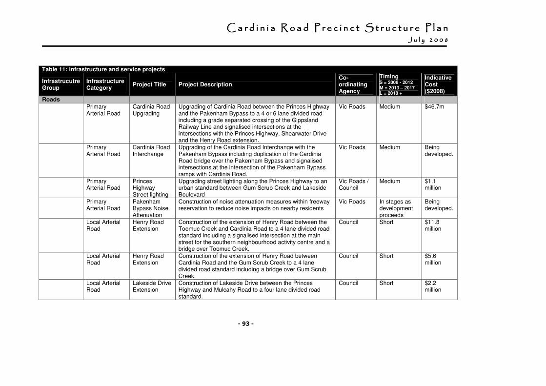
CCCCCCCC aaaaaaaa rrrrrrrr dddddddd iiiiiiii nnnnnnnn iiiiiiii aaaaaaaa RRRRRRRR oooooooo aaaaaaaa dddddddd PPPPPPPP rrrrrrrr eeeeeeee cccccccc iiiiiiii nnnnnnnn cccccccc tttttttt SSSSSSSS tttttttt rrrrrrrr uuuuuuuu cccccccc tttttttt uuuuuuuu rrrrrrrr eeeeeeee PPPPPPPP llllllll aaaaaaaa nnnnnnnn JJJJJJJJ uuuuuuuu llllllll yyyyyyyy 22222222 00000000 00000000 88888888
- 93 -
Table 11: Infrastructure and service projects
Infrastrucutre Group
Infrastructure Category
Project Title Project Description Co-ordinating Agency
Timing S = 2008 - 2012 M = 2013 – 2017 L = 2018 +
Indicative Cost ($2008)
Roads Primary
Arterial Road Cardinia Road Upgrading
Upgrading of Cardinia Road between the Princes Highway and the Pakenham Bypass to a 4 or 6 lane divided road including a grade separated crossing of the Gippsland Railway Line and signalised intersections at the intersections with the Princes Highway, Shearwater Drive and the Henry Road extension.
Vic Roads Medium $46.7m
Primary Arterial Road
Cardinia Road Interchange
Upgrading of the Cardinia Road Interchange with the Pakenham Bypass including duplication of the Cardinia Road bridge over the Pakenham Bypass and signalised intersections at the intersection of the Pakenham Bypass ramps with Cardinia Road.
Vic Roads Medium Being developed.
Primary Arterial Road
Princes Highway Street lighting
Upgrading street lighting along the Princes Highway to an urban standard between Gum Scrub Creek and Lakeside Boulevard
Vic Roads / Council
Medium $1.1 million
Primary Arterial Road
Pakenham Bypass Noise Attenuation
Construction of noise attenuation measures within freeway reservation to reduce noise impacts on nearby residents
Vic Roads In stages as development proceeds
Being developed.
Local Arterial Road
Henry Road Extension
Construction of the extension of Henry Road between the Toomuc Creek and Cardinia Road to a 4 lane divided road standard including a signalised intersection at the main street for the southern neighbourhood activity centre and a bridge over Toomuc Creek.
Council Short $11.8 million
Local Arterial Road
Henry Road Extension
Construction of the extension of Henry Road between Cardinia Road and the Gum Scrub Creek to a 4 lane divided road standard including a bridge over Gum Scrub Creek.
Council Short $5.6 million
Local Arterial Road
Lakeside Drive Extension
Construction of Lakeside Drive between the Princes Highway and Mulcahy Road to a four lane divided road standard.
Council Short $2.2 million
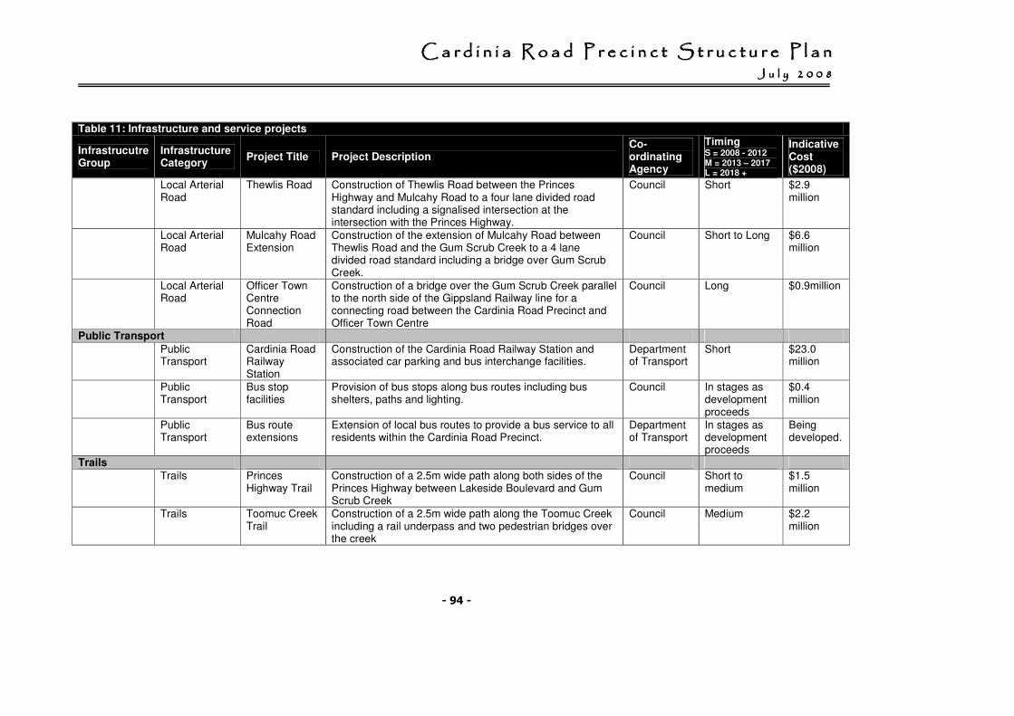
CCCCCCCC aaaaaaaa rrrrrrrr dddddddd iiiiiiii nnnnnnnn iiiiiiii aaaaaaaa RRRRRRRR oooooooo aaaaaaaa dddddddd PPPPPPPP rrrrrrrr eeeeeeee cccccccc iiiiiiii nnnnnnnn cccccccc tttttttt SSSSSSSS tttttttt rrrrrrrr uuuuuuuu cccccccc tttttttt uuuuuuuu rrrrrrrr eeeeeeee PPPPPPPP llllllll aaaaaaaa nnnnnnnn JJJJJJJJ uuuuuuuu llllllll yyyyyyyy 22222222 00000000 00000000 88888888
- 94 -
Table 11: Infrastructure and service projects
Infrastrucutre Group
Infrastructure Category
Project Title Project Description Co-ordinating Agency
Timing S = 2008 - 2012 M = 2013 – 2017 L = 2018 +
Indicative Cost ($2008)
Local Arterial Road
Thewlis Road Construction of Thewlis Road between the Princes Highway and Mulcahy Road to a four lane divided road standard including a signalised intersection at the intersection with the Princes Highway.
Council Short $2.9 million
Local Arterial Road
Mulcahy Road Extension
Construction of the extension of Mulcahy Road between Thewlis Road and the Gum Scrub Creek to a 4 lane divided road standard including a bridge over Gum Scrub Creek.
Council Short to Long $6.6 million
Local Arterial Road
Officer Town Centre Connection Road
Construction of a bridge over the Gum Scrub Creek parallel to the north side of the Gippsland Railway line for a connecting road between the Cardinia Road Precinct and Officer Town Centre
Council Long $0.9million
Public Transport
Public Transport
Cardinia Road Railway Station
Construction of the Cardinia Road Railway Station and associated car parking and bus interchange facilities.
Department of Transport
Short $23.0 million
Public Transport
Bus stop facilities
Provision of bus stops along bus routes including bus shelters, paths and lighting.
Council In stages as development proceeds
$0.4 million
Public Transport
Bus route extensions
Extension of local bus routes to provide a bus service to all residents within the Cardinia Road Precinct.
Department of Transport
In stages as development proceeds
Being developed.
Trails Trails Princes
Highway Trail Construction of a 2.5m wide path along both sides of the Princes Highway between Lakeside Boulevard and Gum Scrub Creek
Council Short to medium
$1.5 million
Trails Toomuc Creek Trail
Construction of a 2.5m wide path along the Toomuc Creek including a rail underpass and two pedestrian bridges over the creek
Council Medium $2.2 million
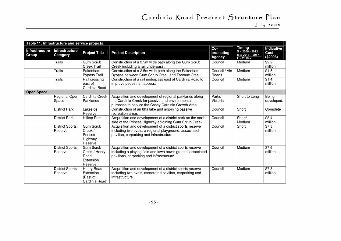
CCCCCCCC aaaaaaaa rrrrrrrr dddddddd iiiiiiii nnnnnnnn iiiiiiii aaaaaaaa RRRRRRRR oooooooo aaaaaaaa dddddddd PPPPPPPP rrrrrrrr eeeeeeee cccccccc iiiiiiii nnnnnnnn cccccccc tttttttt SSSSSSSS tttttttt rrrrrrrr uuuuuuuu cccccccc tttttttt uuuuuuuu rrrrrrrr eeeeeeee PPPPPPPP llllllll aaaaaaaa nnnnnnnn JJJJJJJJ uuuuuuuu llllllll yyyyyyyy 22222222 00000000 00000000 88888888
- 95 -
Table 11: Infrastructure and service projects
Infrastrucutre Group
Infrastructure Category
Project Title Project Description Co-ordinating Agency
Timing S = 2008 - 2012 M = 2013 – 2017 L = 2018 +
Indicative Cost ($2008)
Trails Gum Scrub Creek Trail
Construction of a 2.5m wide path along the Gum Scrub Creek including a rail underpass.
Council Medium $2.2 million
Trails Pakenham Bypass Trail
Construction of a 2.5m wide path along the Pakenham Bypass between Gum Scrub Creek and Toomuc Creek.
Council / Vic Roads
Medium $1.5 million
Trails Rail crossing east of Cardinia Road
Construction of a rail underpass east of Cardinia Road to improve pedestrian access.
Council Medium $1.4 million
Open Space Regional Open
Space Cardinia Creek Parklands
Acquisition and development of regional parklands along the Cardinia Creek for passive and environmental purposes to service the Casey Cardinia Growth Area
Parks Victoria
Short to Long Being developed.
District Park Lakeside Reserve
Construction of an 8ha lake and adjoining passive recreation areas
Council Short Complete
District Park Hilltop Park Acquisition and development of a district park on the north side of the Princes Highway adjoining Gum Scrub Creek
Council Short/ Medium
$8.4 million
District Sports Reserve
Gum Scrub Creek / Princes Highway Reserve
Acquisition and development of a district sports reserve including two ovals, a regional playground, associated pavilion, carparking and infrastructure.
Council Short $7.3 million
District Sports Reserve
Gum Scrub Creek / Henry Road Extension Reserve
Acquisition and development of a district sports reserve including a playing field and lawn bowls greens, associated pavilions, carparking and infrastructure.
Council Medium $7.6 million
District Sports Reserve
Henry Road Extension (East of Cardinia Road)
Acquisition and development of a district sports reserve including two ovals, associated pavilion, carparking and infrastructure.
Council Medium $7.3 million
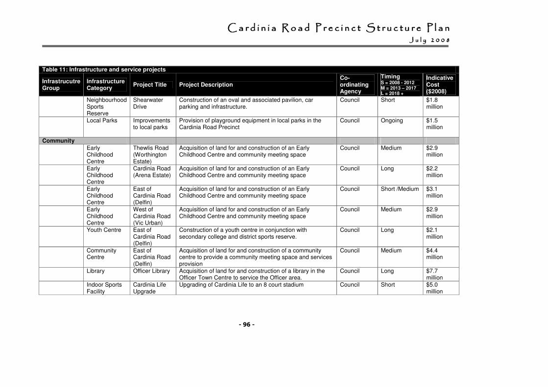
CCCCCCCC aaaaaaaa rrrrrrrr dddddddd iiiiiiii nnnnnnnn iiiiiiii aaaaaaaa RRRRRRRR oooooooo aaaaaaaa dddddddd PPPPPPPP rrrrrrrr eeeeeeee cccccccc iiiiiiii nnnnnnnn cccccccc tttttttt SSSSSSSS tttttttt rrrrrrrr uuuuuuuu cccccccc tttttttt uuuuuuuu rrrrrrrr eeeeeeee PPPPPPPP llllllll aaaaaaaa nnnnnnnn JJJJJJJJ uuuuuuuu llllllll yyyyyyyy 22222222 00000000 00000000 88888888
- 96 -
Table 11: Infrastructure and service projects
Infrastrucutre Group
Infrastructure Category
Project Title Project Description Co-ordinating Agency
Timing S = 2008 - 2012 M = 2013 – 2017 L = 2018 +
Indicative Cost ($2008)
Neighbourhood Sports Reserve
Shearwater Drive
Construction of an oval and associated pavilion, car parking and infrastructure.
Council Short $1.8 million
Local Parks Improvements to local parks
Provision of playground equipment in local parks in the Cardinia Road Precinct
Council Ongoing $1.5 million
Community Early
Childhood Centre
Thewlis Road (Worthington Estate)
Acquisition of land for and construction of an Early Childhood Centre and community meeting space
Council Medium $2.9 million
Early Childhood Centre
Cardinia Road (Arena Estate)
Acquisition of land for and construction of an Early Childhood Centre and community meeting space
Council Long $2.2 million
Early Childhood Centre
East of Cardinia Road (Delfin)
Acquisition of land for and construction of an Early Childhood Centre and community meeting space
Council Short /Medium $3.1 million
Early Childhood Centre
West of Cardinia Road (Vic Urban)
Acquisition of land for and construction of an Early Childhood Centre and community meeting space
Council Medium $2.9 million
Youth Centre East of Cardinia Road (Delfin)
Construction of a youth centre in conjunction with secondary college and district sports reserve.
Council Long $2.1 million
Community Centre
East of Cardinia Road (Delfin)
Acquisition of land for and construction of a community centre to provide a community meeting space and services provision
Council Medium $4.4 million
Library Officer Library Acquisition of land for and construction of a library in the Officer Town Centre to service the Officer area.
Council Long $7.7 million
Indoor Sports Facility
Cardinia Life Upgrade
Upgrading of Cardinia Life to an 8 court stadium Council Short $5.0 million
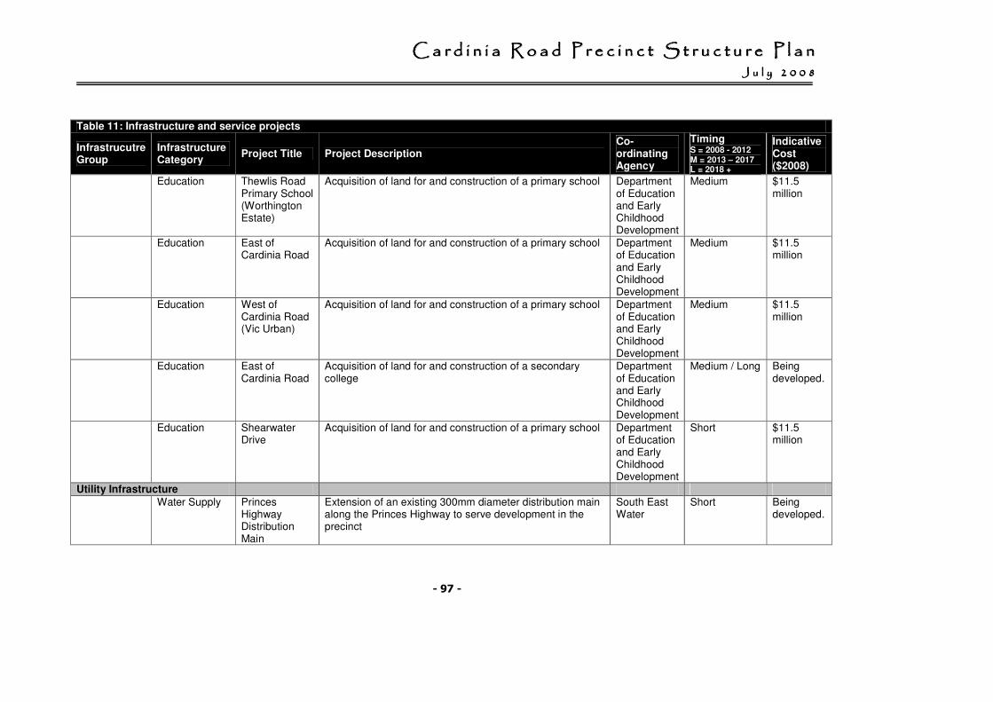
CCCCCCCC aaaaaaaa rrrrrrrr dddddddd iiiiiiii nnnnnnnn iiiiiiii aaaaaaaa RRRRRRRR oooooooo aaaaaaaa dddddddd PPPPPPPP rrrrrrrr eeeeeeee cccccccc iiiiiiii nnnnnnnn cccccccc tttttttt SSSSSSSS tttttttt rrrrrrrr uuuuuuuu cccccccc tttttttt uuuuuuuu rrrrrrrr eeeeeeee PPPPPPPP llllllll aaaaaaaa nnnnnnnn JJJJJJJJ uuuuuuuu llllllll yyyyyyyy 22222222 00000000 00000000 88888888
- 97 -
Table 11: Infrastructure and service projects
Infrastrucutre Group
Infrastructure Category
Project Title Project Description Co-ordinating Agency
Timing S = 2008 - 2012 M = 2013 – 2017 L = 2018 +
Indicative Cost ($2008)
Education Thewlis Road Primary School (Worthington Estate)
Acquisition of land for and construction of a primary school Department of Education and Early Childhood Development
Medium $11.5 million
Education East of Cardinia Road
Acquisition of land for and construction of a primary school Department of Education and Early Childhood Development
Medium $11.5 million
Education West of Cardinia Road (Vic Urban)
Acquisition of land for and construction of a primary school Department of Education and Early Childhood Development
Medium $11.5 million
Education East of Cardinia Road
Acquisition of land for and construction of a secondary college
Department of Education and Early Childhood Development
Medium / Long Being developed.
Education Shearwater Drive
Acquisition of land for and construction of a primary school Department of Education and Early Childhood Development
Short $11.5 million
Utility Infrastructure Water Supply Princes
Highway Distribution Main
Extension of an existing 300mm diameter distribution main along the Princes Highway to serve development in the precinct
South East Water
Short Being developed.
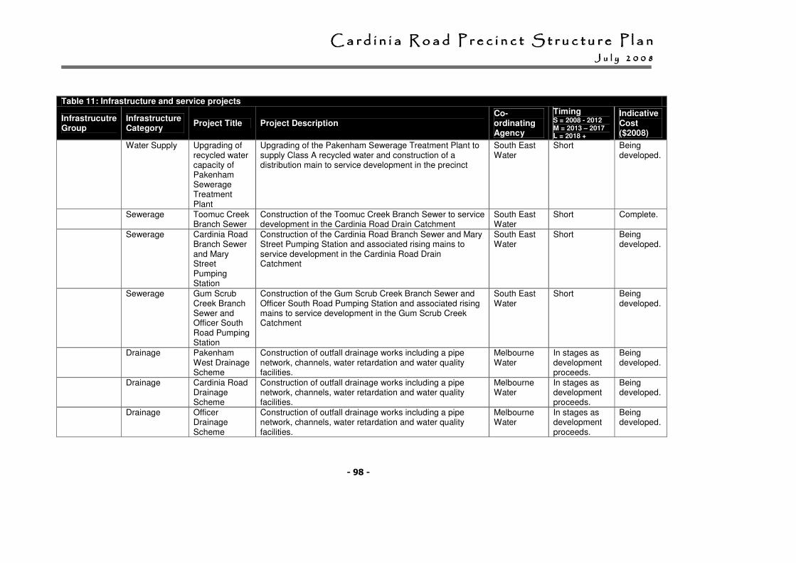
CCCCCCCC aaaaaaaa rrrrrrrr dddddddd iiiiiiii nnnnnnnn iiiiiiii aaaaaaaa RRRRRRRR oooooooo aaaaaaaa dddddddd PPPPPPPP rrrrrrrr eeeeeeee cccccccc iiiiiiii nnnnnnnn cccccccc tttttttt SSSSSSSS tttttttt rrrrrrrr uuuuuuuu cccccccc tttttttt uuuuuuuu rrrrrrrr eeeeeeee PPPPPPPP llllllll aaaaaaaa nnnnnnnn JJJJJJJJ uuuuuuuu llllllll yyyyyyyy 22222222 00000000 00000000 88888888
- 98 -
Table 11: Infrastructure and service projects
Infrastrucutre Group
Infrastructure Category
Project Title Project Description Co-ordinating Agency
Timing S = 2008 - 2012 M = 2013 – 2017 L = 2018 +
Indicative Cost ($2008)
Water Supply Upgrading of recycled water capacity of Pakenham Sewerage Treatment Plant
Upgrading of the Pakenham Sewerage Treatment Plant to supply Class A recycled water and construction of a distribution main to service development in the precinct
South East Water
Short Being developed.
Sewerage Toomuc Creek Branch Sewer
Construction of the Toomuc Creek Branch Sewer to service development in the Cardinia Road Drain Catchment
South East Water
Short Complete.
Sewerage Cardinia Road Branch Sewer and Mary Street Pumping Station
Construction of the Cardinia Road Branch Sewer and Mary Street Pumping Station and associated rising mains to service development in the Cardinia Road Drain Catchment
South East Water
Short Being developed.
Sewerage Gum Scrub Creek Branch Sewer and Officer South Road Pumping Station
Construction of the Gum Scrub Creek Branch Sewer and Officer South Road Pumping Station and associated rising mains to service development in the Gum Scrub Creek Catchment
South East Water
Short Being developed.
Drainage Pakenham West Drainage Scheme
Construction of outfall drainage works including a pipe network, channels, water retardation and water quality facilities.
Melbourne Water
In stages as development proceeds.
Being developed.
Drainage Cardinia Road Drainage Scheme
Construction of outfall drainage works including a pipe network, channels, water retardation and water quality facilities.
Melbourne Water
In stages as development proceeds.
Being developed.
Drainage Officer Drainage Scheme
Construction of outfall drainage works including a pipe network, channels, water retardation and water quality facilities.
Melbourne Water
In stages as development proceeds.
Being developed.
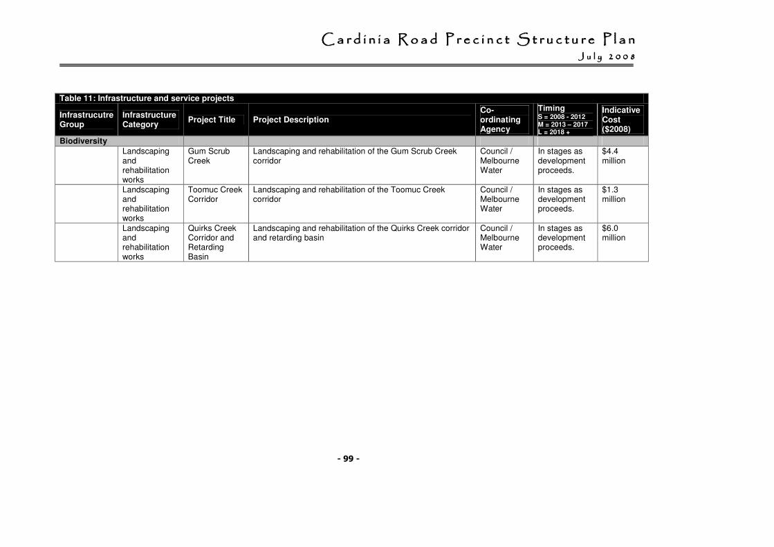
CCCCCCCC aaaaaaaa rrrrrrrr dddddddd iiiiiiii nnnnnnnn iiiiiiii aaaaaaaa RRRRRRRR oooooooo aaaaaaaa dddddddd PPPPPPPP rrrrrrrr eeeeeeee cccccccc iiiiiiii nnnnnnnn cccccccc tttttttt SSSSSSSS tttttttt rrrrrrrr uuuuuuuu cccccccc tttttttt uuuuuuuu rrrrrrrr eeeeeeee PPPPPPPP llllllll aaaaaaaa nnnnnnnn JJJJJJJJ uuuuuuuu llllllll yyyyyyyy 22222222 00000000 00000000 88888888
- 99 -
Table 11: Infrastructure and service projects
Infrastrucutre Group
Infrastructure Category
Project Title Project Description Co-ordinating Agency
Timing S = 2008 - 2012 M = 2013 – 2017 L = 2018 +
Indicative Cost ($2008)
Biodiversity
Landscaping and rehabilitation works
Gum Scrub Creek
Landscaping and rehabilitation of the Gum Scrub Creek corridor
Council / Melbourne Water
In stages as development proceeds.
$4.4 million
Landscaping and rehabilitation works
Toomuc Creek Corridor
Landscaping and rehabilitation of the Toomuc Creek corridor
Council / Melbourne Water
In stages as development proceeds.
$1.3 million
Landscaping and rehabilitation works
Quirks Creek Corridor and Retarding Basin
Landscaping and rehabilitation of the Quirks Creek corridor and retarding basin
Council / Melbourne Water
In stages as development proceeds.
$6.0 million
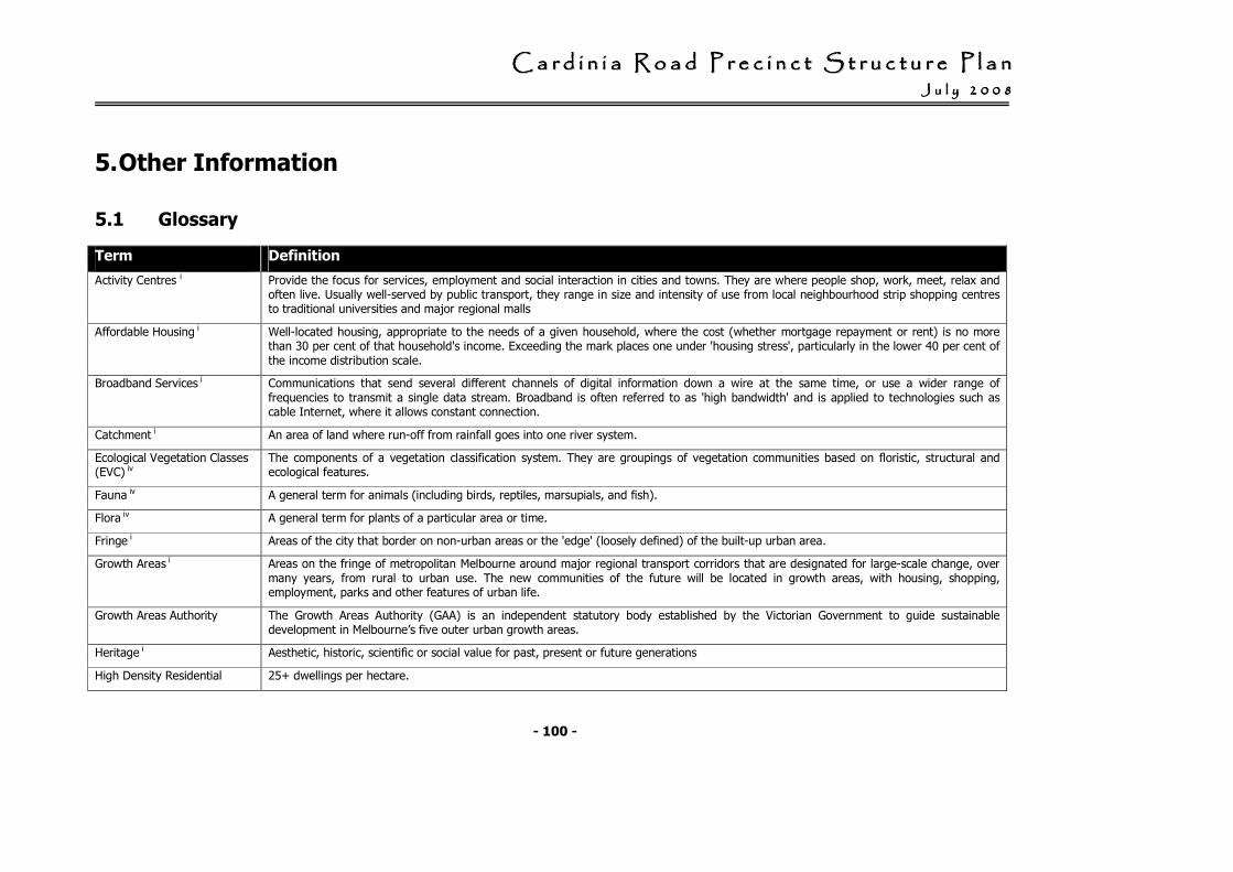
CCCCCCCC aaaaaaaa rrrrrrrr dddddddd iiiiiiii nnnnnnnn iiiiiiii aaaaaaaa RRRRRRRR oooooooo aaaaaaaa dddddddd PPPPPPPP rrrrrrrr eeeeeeee cccccccc iiiiiiii nnnnnnnn cccccccc tttttttt SSSSSSSS tttttttt rrrrrrrr uuuuuuuu cccccccc tttttttt uuuuuuuu rrrrrrrr eeeeeeee PPPPPPPP llllllll aaaaaaaa nnnnnnnn JJJJJJJJ uuuuuuuu llllllll yyyyyyyy 22222222 00000000 00000000 88888888
- 100 -
5. Other Information
5.1 Glossary
Term Definition
Activity Centres i Provide the focus for services, employment and social interaction in cities and towns. They are where people shop, work, meet, relax and often live. Usually well-served by public transport, they range in size and intensity of use from local neighbourhood strip shopping centres to traditional universities and major regional malls
Affordable Housing i Well-located housing, appropriate to the needs of a given household, where the cost (whether mortgage repayment or rent) is no more than 30 per cent of that household's income. Exceeding the mark places one under 'housing stress', particularly in the lower 40 per cent of the income distribution scale.
Broadband Services i Communications that send several different channels of digital information down a wire at the same time, or use a wider range of frequencies to transmit a single data stream. Broadband is often referred to as 'high bandwidth' and is applied to technologies such as cable Internet, where it allows constant connection.
Catchment i An area of land where run-off from rainfall goes into one river system.
Ecological Vegetation Classes (EVC) iv
The components of a vegetation classification system. They are groupings of vegetation communities based on floristic, structural and ecological features.
Fauna iv A general term for animals (including birds, reptiles, marsupials, and fish).
Flora iv A general term for plants of a particular area or time.
Fringe i Areas of the city that border on non-urban areas or the 'edge' (loosely defined) of the built-up urban area.
Growth Areas i Areas on the fringe of metropolitan Melbourne around major regional transport corridors that are designated for large-scale change, over many years, from rural to urban use. The new communities of the future will be located in growth areas, with housing, shopping, employment, parks and other features of urban life.
Growth Areas Authority The Growth Areas Authority (GAA) is an independent statutory body established by the Victorian Government to guide sustainable development in Melbourne’s five outer urban growth areas.
Heritage i Aesthetic, historic, scientific or social value for past, present or future generations
High Density Residential 25+ dwellings per hectare.
CCCCCCCC aaaaaaaa rrrrrrrr dddddddd iiiiiiii nnnnnnnn iiiiiiii aaaaaaaa RRRRRRRR oooooooo aaaaaaaa dddddddd PPPPPPPP rrrrrrrr eeeeeeee cccccccc iiiiiiii nnnnnnnn cccccccc tttttttt SSSSSSSS tttttttt rrrrrrrr uuuuuuuu cccccccc tttttttt uuuuuuuu rrrrrrrr eeeeeeee PPPPPPPP llllllll aaaaaaaa nnnnnnnn JJJJJJJJ uuuuuuuu llllllll yyyyyyyy 22222222 00000000 00000000 88888888
- 101 -
Term Definition
Development
Higher Density Housing i Housing units on a given area of land that are more numerous than the average in the surrounding locality
Incompatible Land Uses i Land uses that have negative effects on adjacent land uses.
Linear Open Space Network i Corridors of open space, mainly along river valleys, the coast, disused railways lines and aqueducts, that link together forming a network.
Low Density Residential Development
5 dwellings per hectare (net).
Major Activities Centre (MAC) ii
Similar characteristics to Principal Activity Centres but serves a smaller catchment area Supplements the network of Principal Activity Centres Provides additional scope to accommodate ongoing investment and change in retail, office, service and residential markets
Medium Density Residential Development
Average 20 dwellings per hectare (net). Generally more than one dwelling on an ordinary house block, or any form of attached housing such as townhouses or apartments.
Municipal Strategic Statement (MSS) i
Part of the Local Planning Policy Framework, these contain the strategic planning land-use and development objectives of the relevant planning authority, the strategies for achieving these objectives, and the relationship to controls over the use and development of land in the planning scheme.
Neighbourhood Activity Centre (NAC) ii
Generally, a limited mix of uses meeting local convenience needs Generally less than 10,000 square metres of retail floor space Accessibility to a viable user population by walking/cycling Accessibility by local bus services and public transport links to one or more Principal or Major Activity Centre Important community focal point, ideally close to schools, libraries, child care, health services, police stations and other facilities that benefit from good public transport
Net Residential Developable Land
Total area less encumbered open space, district open space, local arterial roads, community facilities, commercial and industrial land.
Potable Water i Water suitable for humans to drink.
CCCCCCCC aaaaaaaa rrrrrrrr dddddddd iiiiiiii nnnnnnnn iiiiiiii aaaaaaaa RRRRRRRR oooooooo aaaaaaaa dddddddd PPPPPPPP rrrrrrrr eeeeeeee cccccccc iiiiiiii nnnnnnnn cccccccc tttttttt SSSSSSSS tttttttt rrrrrrrr uuuuuuuu cccccccc tttttttt uuuuuuuu rrrrrrrr eeeeeeee PPPPPPPP llllllll aaaaaaaa nnnnnnnn JJJJJJJJ uuuuuuuu llllllll yyyyyyyy 22222222 00000000 00000000 88888888
- 102 -
Term Definition
Precinct Structure Plan iii A long term strategic planning mechanism for ensuring better designed, safer and more sustainable communities.
They are intended to: • Set objectives for housing yields, choice and affordability. • Provide for dwelling densities in line with government strategies and policies for viable public transport, activity centres and services. • Ensure communities in Melbourne’s five growth areas have better access to services, transport, jobs, shops, open space and
recreation facilities. • Give developers, investors and local communities greater certainty and confidence about future development in Melbourne’s growth
areas.
Principal Activity Centre (PAC) ii
A mix of activities that generate high numbers of trips, including business, retail, services and entertainment. Being generally well served by multiple public transport routes (some being on the rail network), and on the PPTN or capable of being linked to that network A large catchment covering several suburbs, and attracting activities that meet metropolitan needs Having potential to grow and support intensive housing developments without conflicting with surrounding land uses
Principal Public Transport Network (PPTN) i
A high-quality public transport network that connects Principal and Major Activity Centres, and comprises the existing radial fixed-rail network, extensions to this radial network and new cross-town bus routes.
Salinity i The total amount of water-soluble salts present in the soil or in a stream.
Sewerage System i A network of pipes (sewers) to collect waste water and transfer it to a central plant for sewage treatment.
State Planning Policy Framework (SPPF) iv
The framework comprises general principles for land use and development in Victoria and specific policies dealing with settlement, environment, housing, economic development, infrastructure and particular uses and development. To ensure integrated decision-making, planning authorities and responsible authorities must take account of, and give effect to, the general principles and the specific policies contained in the SPPF
Standard Density Residential Development
Lots with sizes generally within the range of 350 sq m to 750 sq m.
CCCCCCCC aaaaaaaa rrrrrrrr dddddddd iiiiiiii nnnnnnnn iiiiiiii aaaaaaaa RRRRRRRR oooooooo aaaaaaaa dddddddd PPPPPPPP rrrrrrrr eeeeeeee cccccccc iiiiiiii nnnnnnnn cccccccc tttttttt SSSSSSSS tttttttt rrrrrrrr uuuuuuuu cccccccc tttttttt uuuuuuuu rrrrrrrr eeeeeeee PPPPPPPP llllllll aaaaaaaa nnnnnnnn JJJJJJJJ uuuuuuuu llllllll yyyyyyyy 22222222 00000000 00000000 88888888
- 103 -
Term Definition
Stormwater i Rainwater that runs off streets and gutters, enters drains and waterways and is eventually discharged to the sea; in Victoria, stormwater is untreated but may be filtered by traps or wetlands.
Structure Plans i Planning tools that set out an integrated vision for the desired future development of a place, and establish a planning and management framework to guide development and land-use change in order to achieve stated environmental, social and economic objectives.
Transport Interchange i Places where people change modes of transport, for example, from train to bus.
Urban Design Framework Urban design frameworks are design tools that provide physical interpretations of local visions and strategies. They focus on managing change and setting new directions for integrated development of the urban environment.
Urban Growth Boundary (UGB) i
A management tool to contain urban areas and limit their expansion. It divides land that is urban – to be used for housing, shops, factories – from land that is non-urban and to be used for purposes such as conservation, agriculture, mineral extraction, airports and the like. An urban growth boundary encourages urban consolidation and protects valued non-urban areas from urban development.
Walkable i Walkable communities, or locations, make footpath-based travel as easy as possible for all members of the community including children, people with prams/shopping carts and people using mobility aids. Walkability encompasses issues of safety (traffic and personal), attractive surroundings, distance between destinations, gradients, appropriate surfaces and physical barriers to access such as steps and gutters.
Waste water (or effluent) i Water that has been used for various purposes by households, businesses and industry; includes domestic sewage (grey water and black water) and trade wastes. Effluent is treated waste water.
Wildlife corridor i Strips of land that provide for the movement of wildlife between larger areas of habitat.
i DOI (2002) Melbourne 2030, Planning for sustainable growth
ii MacroPlan Aust (2007) Cardinia Urban Growth Area, Retail Review, Final Report
iii DSE (2006) Precinct Structure Planning Guidelines
iv DSE Glossary of Planning Terms

CCCCCCCC aaaaaaaa rrrrrrrr dddddddd iiiiiiii nnnnnnnn iiiiiiii aaaaaaaa RRRRRRRR oooooooo aaaaaaaa dddddddd PPPPPPPP rrrrrrrr eeeeeeee cccccccc iiiiiiii nnnnnnnn cccccccc tttttttt SSSSSSSS tttttttt rrrrrrrr uuuuuuuu cccccccc tttttttt uuuuuuuu rrrrrrrr eeeeeeee PPPPPPPP llllllll aaaaaaaa nnnnnnnn JJJJJJJJ uuuuuuuu llllllll yyyyyyyy 22222222 00000000 00000000 88888888
- 104 -
5.2 Supporting Information
The following documents may assist in understanding the background to the vision, objectives and other requirements of this precinct structure plan.
Ashton Traffic Services Pty Ltd, October 2004, Traffic Model for Cardinia Growth Corridor, Calibration, Prepared for Cardinia Shire Council.
Biosis Research Pty Ltd, February 2005, Pakenham Bypass: Conservation Management Plan for the Growling Grass Frog Litoria raniformis, Pakenham, Victoria.
Cardinia Shire Council, October 2004, Sustainable Development and Greenhouse Reduction Strategy, Draft Discussion Paper.
Cardinia Shire Council, June 2007, Landscape Development Guidelines.
Cardinia Shire Council, 2004, Environment Management Strategy, Actions for a sustainable future 2004 – 2007.
Cardinia Shire Council, 2007, Council Plan 2007 - 2011, Creating the future.
Casey - Cardinia Library Corporation, September 2005, Casey - Cardinia Libraries 2030.
Centre for Population and Urban Research, August 2004, Socio-economic Characteristics of Casey and Cardinia Residents and the Implications for Melbourne 2030.
Collaborations: Planning with your community Pty Ltd, September 2004, Cardinia Shire Council, Social Planning Framework for Growth Areas 2004 – 2030.
Department of Sustainability & Environment, June 2005, Potentially Contaminated Land, General Practice Note.
Department of Sustainability & Environment, March 2006, Preparing a native vegetation precinct plan, VPP Practice Note.
Department of Infrastructure, October 2002, Melbourne 2030, Planning for Sustainable Growth. [Appendum November 2003]
Department of Natural Resources and Environment, March 2003, Victoria’s Native Vegetation Management – A Framework for Action.
Department of Sustainability and Environment, July 2005, Safer Design Guidelines for Victoria.
Department of Sustainability and Environment, May 2005, Activity Centre Design Guidelines.
Department of Sustainability and Environment, June 2005, Melbourne 2030, Final Report: Casey-Cardinia Committee for Smart Growth
Department of Sustainability and Environment, November 2005, A Plan for Melbourne’s Growth Areas.
Ecology Australia, January 2004, Shire of Cardinia Indigenous Vegetation Survey (EVC) Maps.
CCCCCCCC aaaaaaaa rrrrrrrr dddddddd iiiiiiii nnnnnnnn iiiiiiii aaaaaaaa RRRRRRRR oooooooo aaaaaaaa dddddddd PPPPPPPP rrrrrrrr eeeeeeee cccccccc iiiiiiii nnnnnnnn cccccccc tttttttt SSSSSSSS tttttttt rrrrrrrr uuuuuuuu cccccccc tttttttt uuuuuuuu rrrrrrrr eeeeeeee PPPPPPPP llllllll aaaaaaaa nnnnnnnn JJJJJJJJ uuuuuuuu llllllll yyyyyyyy 22222222 00000000 00000000 88888888
- 105 -
Ecology Australia, January 2004, Shire of Cardinia, Indigenous Vegetation Survey, Pakenham Growth Corridor & adjoining area.
Ecology Australia, January 2004, Shire of Cardinia, Indigenous Vegetation Survey, An Inventory of site of Biodiversity Significance in the Pakenham Growth Corridor & adjoining area.
Ecology Partners, June 2006, Strategic Advice on the Growling Grass Frog Litoria raniformis, Officer Structure Plan, Officer, Victoria, Report for Cardinia Shire Council.
Ecology Partners, September 2006, Targeted Survey and Conservation Management Plan for the Growling Grass Frog Litoria ranifomis, Pakenham Urban Growth Corridor, Pakenham, Victoria [Adopted by Council].
Ecology Partners Pty Ltd, March 2007, Fauna Assessment for the Cardinia Road Precinct Structure Plan, Cardinia Shire, Victoria.
EDAW (Aust) Pty Ltd and Jeavons Recreation and Tourism Planners, December 2000, Recreational Open Space
Strategy, Cardinia Shire Council, [Adopted by Council Dec 2000].
Edaw Gillespies, August 2003, Pakenham Growth Corridor Provision of Sporting Reserves Study.
Essential Economics, July 2004, Casey-Cardinia Growth Area Plan Regional Case Study on Employment Creation and the Underlying Contributing Factors.
Essential Economics Pty Ltd, June 2003, Key Commercial and Industrial Land Uses and the Urban Growth Corridor, Prepared for Cardinia Shire Council.
Essential Economics Pty Ltd, August 2005, Cardinia Road Precinct Recommended Activity Centre Hierarchy, Input to Council's Structure Plan for the Cardinia Road Precinct - Draft 17 August 2005, Prepared for Cardinia Shire Council.
Graeme Butler & Associates, 1996, Cardinia Shire (North) Heritage Study. Volumes 1, 2 & 3.
Heritage Insight, April 2004, Shire of Cardinia Urban Growth Corridor, Aboriginal Heritage Study. Report to the Shire of Cardinia.
Id.Profile, Cardinia Shire Community Profile, 2001 and 1996 census information for Growth Area Subregion.
Inter Council Aboriginal Consultative Committee (ICACC), December 2006, Aboriginal Heritage Management, Planning Practice Note.
John Piper Traffic Pty Ltd in conjunction with Ashton Traffic Pty Ltd, August 2007. Cardinia Road Precinct Development Contributions Plan, Future Traffic Estimates and Road Infrastructure Requirements, Revision 7.
Land Design Partnership for Cardinia Shire Council, July 2004, Pakenham Town Centre Urban Design Framework.
Land Design Partnership for Cardinia Shire Council, November 2004, Pakenham Homemaker Precinct, Princes Highway, Urban Design Framework, [Adopted by Council Nov 2004].
Land Design Partnership for Cardinia Shire Council, May 2005, Pakenham Rail Station Urban Design Framework, [Adopted by Council].
CCCCCCCC aaaaaaaa rrrrrrrr dddddddd iiiiiiii nnnnnnnn iiiiiiii aaaaaaaa RRRRRRRR oooooooo aaaaaaaa dddddddd PPPPPPPP rrrrrrrr eeeeeeee cccccccc iiiiiiii nnnnnnnn cccccccc tttttttt SSSSSSSS tttttttt rrrrrrrr uuuuuuuu cccccccc tttttttt uuuuuuuu rrrrrrrr eeeeeeee PPPPPPPP llllllll aaaaaaaa nnnnnnnn JJJJJJJJ uuuuuuuu llllllll yyyyyyyy 22222222 00000000 00000000 88888888
- 106 -
Land Design Partnership, September 2005, Officer Recreation Reserve - Open Space Planning Indicative Opinion of Probable Costs.
Land Design Partnership for Cardinia Shire Council, August 2006, Toomuc Sports Precinct Urban Design Study, Draft.
Land Design Partnership, April – June 2004, Casey - Cardinia Urban Growth Boundary Landscape Assessment Maps.
Land Design Partnership, July 2004, Landscape Assessment, Casey - Cardinia Urban Growth Area, Summary Report for Shire of Cardinia, City of Casey and DSE.
Land Design Partnership, March 2006, Toomuc Reserve Pakenham, Landscape Master Plan Review, Prepared for Cardinia Shire Council.
MacroPlan Australia, March 2007, Cardinia Urban Growth Area, Retail Review, Final Report, prepared for Cardinia Shire Council [Endorsed by Council April 2007].
Melbourne Water, March 2006, Officer & Cardinia Road Precinct Drainage Scheme Maps.
National Economics, November 2004, Casey - Cardinia Growth Area Planning Review Draft.
Parklinks Pty Ltd, May 2003, Pedestrian and Bicycle Strategy, Actions Report.
Parsons Brinckerhoff (PB), February 2004, Monitor Well Locations (topography, surface water sampling locations, groundwater elevation, depth of groundwater), Maps.
Ratio Consultants Pty Ltd in association with SGS Economic & Planning and National Economics, October 2003, Prosperity for the Next Generation Regional Economic Strategy for Melbourne's South East (2003 - 2030), Prepared for and behalf of Melbourne's South East Councils.
Rik Brown - Botanical Consultant, January 2005, Cardinia Shire Flora Surveys, Prepared for Cardinia Shire Council.
Robin Saunders, Steven Porter & Alan Thatcher, Report of the Independent Panel, January 2004, Pakenham Bypass Panel Report (EES and Amendments).
SGS, July 2004, Casey - Cardinia Strategic Review.
SGS Economics Planning, July 2004, Casey - Cardinia Growth Area Plan, Job Diversity Study, Prepared for the City of Casey.
Sinclair Knight Mertz (SKM), September 2003, Cardinia Shire Salinity Project, Extent and Severity of Salinity in the Cardinia Shire Council.
Sinclair Knight Mertz (SKM), March 2005, Melbourne 2030 Casey - Cardinia Growth Corridor, Land Capability Study on the Casey - Cardinia Growth Corridor.
Sinclair Knight Mertz (SKM), June 2005, Melbourne 2030 Casey - Cardinia Growth Corridor, Shallow Watertable constraints on urban development.
Sinclair Knight Mertz (SKM), March 2005, Assessing the impact of urban development on groundwater discharge to waterways - Berwick / Pakenham Corridor, Prepared for DSE.
CCCCCCCC aaaaaaaa rrrrrrrr dddddddd iiiiiiii nnnnnnnn iiiiiiii aaaaaaaa RRRRRRRR oooooooo aaaaaaaa dddddddd PPPPPPPP rrrrrrrr eeeeeeee cccccccc iiiiiiii nnnnnnnn cccccccc tttttttt SSSSSSSS tttttttt rrrrrrrr uuuuuuuu cccccccc tttttttt uuuuuuuu rrrrrrrr eeeeeeee PPPPPPPP llllllll aaaaaaaa nnnnnnnn JJJJJJJJ uuuuuuuu llllllll yyyyyyyy 22222222 00000000 00000000 88888888
- 107 -
Sinclair Knight Mertz (SKM), April 2005, Cardinia Shire 2004/05 NHT Salinity Project, Guidelines for building on a saline environment, Background Report.
Sinclair Knight Mertz (SKM), June 2005, NHT Salinity Project 2004/2005, Draft guidelines for building on a saline environment.
Sinclair Knight Mertz (SKM), June 2005, Revised Planning Decision Support Framework for Salinity.
Sinclair Knight Mertz (SKM), June 2005, Melbourne 2030 Casey - Cardinia Growth Corridor, Shallow Watertable constraints on urban development.
Sinclair Knight Mertz (SKM), February 2007, Cardinia Road Rail Crossing, Cardinia Road Underpass Feasibility Report, Revision A.
Southern Regional Housing Working Group, April 2006, Southern Regional Housing Statement (Final Report).
Stratcorp, June 2005, Cardinia Growth Corridor Sports Strategy.
Urban Enterprise Pty Ltd, July 2007, Cardinia Road Precinct Development Contributions Plan.
WBM Oceanics Australia, November2002, Cardinia Shire Council Stormwater Management Plan. Volumes 1, 2 & 3.
[End of document]