
LATROBE PLANNING SCHEME AMENDMENT...
13
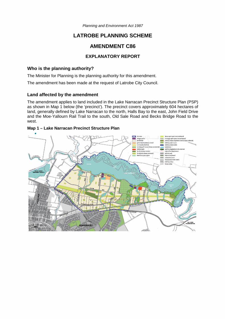
Planning and Environment Act 1987 LATROBE PLANNING SCHEME AMENDMENT C86 EXPLANATORY REPORT Who is the planning authority? The Minister for Planning is the planning authority for this amendment. The amendment has been made at the request of Latrobe City Council. Land affected by the amendment The amendment applies to land included in the Lake Narracan Precinct Structure Plan (PSP) as shown in Map 1 below (the ‘precinct’). The precinct covers approximately 604 hectares of land, generally defined by Lake Narracan to the north, Halls Bay to the east, John Field Drive and the Moe-Yallourn Rail Trail to the south, Old Sale Road and Becks Bridge Road to the west. Map 1 – Lake Narracan Precinct Structure Plan
Transcript of LATROBE PLANNING SCHEME AMENDMENT...
Planning and Environment Act 1987
LATROBE PLANNING SCHEME
AMENDMENT C86
EXPLANATORY REPORT
Who is the planning authority?
The Minister for Planning is the planning authority for this amendment.
The amendment has been made at the request of Latrobe City Council.
Land affected by the amendment
The amendment applies to land included in the Lake Narracan Precinct Structure Plan (PSP)as shown in Map 1 below (the ‘precinct’). The precinct covers approximately 604 hectares ofland, generally defined by Lake Narracan to the north, Halls Bay to the east, John Field Driveand the Moe-Yallourn Rail Trail to the south, Old Sale Road and Becks Bridge Road to thewest.
Map 1 – Lake Narracan Precinct Structure Plan

The amendment also broadly applies to the Moe and Newborough township boundary areaas shown in Map 2 below.
Map 2 – Moe and Newborough township boundary area
What the amendment does
The amendment incorporates the Lake Narracan PSP, Development Contributions Plan,Native Vegetation Precinct Plan and updated Moe-Newborough Structure Plan into theLatrobe Planning Scheme; applies the Urban Growth Zone and Development ContributionsPlan Overlay to the Lake Narracan area; updates the Schedule to the Commercial 1 Zone;removes the Development Plan Overlay Schedule 5 to the Lake Narracan PSP area, andupdates the Schedules to Clauses 52.01,52.16, 61.03 and 81.01.
Specifically, the amendment:
Modifies Clause 21.02 (Municipal Vision) by updating the Latrobe City Strategic LandUse Framework Plan to include the precinct within the Moe-Newborough main townboundary (refer to Attachment 1 for a copy of the revised framework plan).
Modifies Clause 21.04 (Settlement) by introducing the precinct as part of the designatedurban growth area and by including the updated Moe-Newborough Structure Plan as areference document.
Amends Clause 21.05 (Main Towns) by updating the Moe-Newborough Structure Plan.
Modifies Clause 21.05 (Main towns) by acknowledging the precinct as part of theMoe/Newborough township area and by amending the residential, commercial andinfrastructure strategies as required in accordance with the updated Moe-NewboroughStructure Plan.
Amends Clause 21.05-8 (Main Towns – Reference Documents) to include the updatedMoe-Newborough Structure Plan.
Amends Clause 21.07 (Economic Sustainability) by updating the Lake Narracan precinctas part of the Moe/Newborough township area and by including the Retail Advice reportfor Lake Narracan as a reference document.

Incorporates the Lake Narracan PSP March 2015, Lake Narracan DevelopmentContributions Plan March 2015 and Lake Narracan Native Vegetation Precinct PlanMarch 2015 by listing them in the Schedule to Clause 81.01.
Introduces the Urban Growth Zone (UGZ) to the Latrobe Planning Scheme.
Introduces and applies Schedule 1 to the Urban Growth Zone (UGZ1) to land (excludingLake Narracan) in the precinct. This schedule sets out the land use and developmentcontrols for the precinct. The schedule requires land use and development to begenerally in accordance with the incorporated Lake Narracan PSP.
Introduces the Development Contributions Plan Overlay to the Latrobe PlanningScheme.
Introduces and applies Schedule 1 to the Development Contributions Plan Overlay(DCPO1) to the land area within the precinct to ensure contributions are provided forinfrastructure and community facilities.
Updates the Schedule to the Commercial 1 Zone to insert a maximum leasable floorarea of 1,500 square metres for shop for both the neighbourhood activity centres withinthe precinct.
Removes the Development Plan Overlay Schedule 5 (DPO5) between the Moe-YallournRail Trail and John Field Drive where the PSP will now apply.
Updates the Schedule to Clause 52.01 to require public open space contributions in theprecinct.
Updates the Schedule to Clause 52.16 to insert the Lake Narracan Native VegetationPrecinct Plan to manage the removal and retention of native vegetation in the precinct.
Updates the Schedule to Clause 61.03 to reflect changes to the planning Scheme maps.
Incorporates the Small Lot Housing Code, June 2013 into the Latrobe planning schemeby listing it in the schedule to Clause 81.01.
Strategic assessment of the amendment
Why is the amendment required?
The amendment is required to implement the State Planning Policy Framework and LocalPlanning Policy Framework with regard to growth in regional Victoria. The introduction ofnew zoning to the Lake Narracan precinct and incorporation of Lake Narracan PSP,Development Contributions Plan and Native Vegetation Precinct Plan in the LatrobePlanning Scheme are required to facilitate new urban development and associatedinfrastructure provision and open space outcomes.
How does the amendment implement the objectives of planning in Victoria?
The amendment implements a number of the objectives of planning in Victoria under Section4 of the Planning and Environment Act 1987 (Act). In particular:
To provide for the fair, orderly, economic and sustainable use and development of land
The amendment seeks to apply consistent controls across the precinct for urbandevelopment and sets out what development and community infrastructure is required toensure the fair and equitable provision of works, services and facilities needed by thenew community to secure a good quality of life.
To provide for the protection of natural and man-made resources and the maintenanceof ecological processes and genetic diversity.
In parallel with the Lake Narracan PSP, a Native Vegetation Precinct Plan has beenprepared for the precinct to identify significant vegetation for retention and vegetation
acceptable for removal. Specifically, the Lake Narracan PSP retains large areas ofvegetation on the southern banks of Lake Narracan, particularly at the eastern end ofthe precinct. Further vegetation is retained within the Moe Golf Course and along theexisting Moe-Yallourn Rail Trail, Old Sale Road and Becks Bridge Road.
To secure a pleasant, efficient and safe working, living and recreational environment forall Victorians and visitors to Victoria.
The amendment, through the incorporation of a Development Contributions Plan,supports the orderly upgrade and improvements to the existing and future arterial roadnetwork in the area. New local parks, sport facilities and natural systems will contributeto the creation of a pleasant living and recreational environment for the local communityand visitors to the area.
The amendment, through the PSP, ensures that housing will have good proximity toeducation, convenience services, community facilities and employment opportunitiesand will allow residents to have a larger choice in terms of travel modes in reachingthese destinations.
To protect public utilities and other assets and enable the orderly provision and co-ordination of public utilities and other facilities for the benefit of the community.
The amendment has been prepared to enable servicing of the new urban developmentover time. The PSP encourages transport choice and a reduction in private car use byproviding a highly inter-connected road network allowing for looped bus routesinterconnecting with the existing townships of Moe and Newborough and potentialconnections to Metropolitan Melbourne via the existing regional Moe railway station. ThePSP provides for the creation of a network of pedestrian and bicycle paths across theprecinct and connecting to key local assets like Lake Narracan and the Moe-Yallourn railtrail.
The PSP provides for enhancement and improvement to the Lake Narracan environsand foreshore which will play an important stormwater management role, habitat fornative flora and fauna as well as providing a strong community focus through variousrecreation opportunities including, district playgrounds and shared trails for cycling andwalking.
To balance the present and future interests of all Victorians
The PSP identifies land within the precinct for arterial road upgrades, sports reserves,local parks and the provision of stormwater management assets. The new communitieswill contribute to the cost of this new infrastructure in accordance with the DCP and inline with the new community’s use of them. Collecting funds for infrastructure up-frontwill also avoid the need for costly public spending in the future to ‘reclaim’ privatelydeveloped land for public purposes.
How does the amendment address any environmental, social and economiceffects?
Environmental effects
The amendment will result in the retention of significant vegetation identified in the LakeNarracan Native Vegetation Precinct Plan along the southern banks of Lake Narracan, withinthe Moe Golf course and along the Moe-Yallourn rail train, Old Sale Road and Becks BridgeRoad. Where possible, the PSP incorporates areas of environmental significance into theopen space networks.
A stormwater study was prepared in conjunction with the preparation of the Lake NarracanPrecinct Structure Plan to ensure water flows and environs are managed. Stormwater flowswill be managed through an integrated system that aims to manage flows beyond theprecinct and to provide best practice stormwater quality treatment for the precinct area. A

stormwater management strategy has been prepared concurrently with the PSP which hasinformed the location of the stormwater quality treatment wetlands and waterways.
The distribution of open space within the precinct ensures that a majority of residentialproperties have access to a range of local parks within a walkable 400 metres. Furthermore,through the introduction and subsequent implementation of the PSP and DevelopmentContributions Plan, the entire precinct will benefit from improvements and enhancements tothe Lake Narracan foreshore.
The amendment will contribute towards increased transport choice and potential reductionsin private car use, as the precinct establishes. The PSP has developed a road network ofarterial and local roads that are capable of accommodating bus routes throughout theprecinct and connecting into the existing townships to the south. The precinct will have ahighly inter-connected road network, minimising dead-ends and containing continuousshared pathways on key routes.
The amendment, via the Development Contributions Plan, sets out what new infrastructureincluding sports and community facilities, road and trail upgrades, parks and waterways arerequired to service the new communities. This new infrastructure will ensure that newresidents do not place an unfair burden on existing community assets in the area. Theinfrastructure maximises opportunities for new residents to safely and efficiently accessemployment and everyday services, including shopping and engage in locally based socialactivities.
Economic effects
The PSP includes two neighbourhood activity centres providing local shops, services andfacilities to the new community and creating local employment opportunities within theprecinct.
The amendment enables the delivery of a range of lifestyle opportunities to meet the needsof a variety of household sizes and budgets. It encourages the development of a range ofhouse types from the conventional to medium and high density residential development.
Social Effects
The amendment is expected to generate positive social benefits for Latrobe City and thetownships of Moe and Newborough through the provision of a range of residential densitiesthat are well served by community facilities and other key infrastructure including agovernment primary school, retail areas, parks and other community facilities.
Planning for the development of community infrastructure such as sporting reserves andother community facilities, which will have a close spatial relationship with residentialneighbourhoods, will assist in the creation of a ‘sense of place’ by fostering social interactionwithin the immediate and wider community.
Does the amendment address relevant bushfire risk?
All of the precinct area is currently a declared Bushfire Prone Area under the BuildingRegulations 2006 due to its generally open and vegetated character. This declarationrequires buildings in the area to meet minimum bushfire resistant construction standards.
The precinct is not affected by the Bushfire Management Overlay.
The Country Fire Authority has been consulted as part of the PSP preparation process andthere is no need for the amendment to include further provisions to address bushfire risk.
Does the amendment comply with the requirements of any Minister’s Directionapplicable to the amendment?
The amendment complies with the Ministerial Direction on the Form and Content of PlanningSchemes under section 7(5) of the Act.
The amendment also complies with the following relevant Ministerial Directions:

Direction No. 1 Potentially Contaminated Land
Ministerial Direction No. 1 does not strictly apply to most of the land affected by theamendment as the amendment is rezoning land that has typically been used for variousagricultural uses.
A precautionary desktop environment site assessment has been carried out for all of the landwhether or not it meets the definition of ‘potentially contaminated land’. The assessmentidentified areas subject to historical localised land uses that are potentially subject tocontamination, these included a vehicle maintenance garage, a former poultry/broiler farmand a former piggery site. The amendment (via the UGZ schedule) requires furtherinvestigation, assessment and remediation of all land within the precinct prior to sensitiveland uses commencing (e.g. housing, schools and child care).
Direction No. 12 - Urban Growth Areas
Part 6 of Ministerial Direction 12 requires that when preparing an amendment to introduce orchange provisions in a schedule to the UGZ, a planning authority must evaluate and includein the explanatory report a discussion about:
How the amendment implements any Growth Area Framework Plan applying to the land
The Gippsland Regional Growth Plan 2014 (GRGP) applies to the land and identifies Moeand surrounding hinterland as capable of accommodating additional growth. The GRGPseeks to proactively encourage and facilitate opportunities of development in these areas.More specifically, the GRGP identifies the land north of Moe and Newborough (i.e. thesubject precinct) as an area of investigation for future urban growth.
The GRGP supports the implementation of land use strategies and structure plans (in linewith the amendment) for the regional cities and regional centres to accommodate growthover the next 20 to 30 years.
How does the amendment accord with the Precinct Structure Planning Guidelines(October 2009)?
Objective one: To establish a sense of place and community
The topography of the precinct adjacent to Lake Narracan is generally flat land then risesto a higher terrace to the south. The rise in the land provides opportunities for views to thesurrounding land. The proximity of the lake comes with drainage and flooding issues,however through careful placement of land uses in different areas of the lake in the PSP,such as Becks Bay Village Centre and Fernlea Village Centre along the foreshore, asense of place and community will be established. The precinct also contains significantstrands of trees, including the nationally significant Strezelecki gum, grassy woodlandsand native grasslands.
The PSP seeks to utilise the existing land forms, lake and natural assets to build uniqueand individual townships. The two neighbourhood activity centres, Becks BayNeighbourhood Activity Centre and Fernlea Neighbourhood Activity Centre will utilise andimprove on existing assets along Lake Narracan to build a unique neighbourhoodexperience.
The Becks Bay Neighbourhood Activity centre will focus around a civic square withopportunities for neighbourhood shops and higher order retail trading. The Becks BayNeighbourhood Activity Centre will be complemented by a future government primaryschool and a community centre for future residents. Improvements to the foreshore areaof Lake Narracan will provide district playgrounds, wetlands and retention of significantvegetation.
The proposed Fernlea Neighbourhood Centre will leverage off the existing Holiday Parkand naval cadet sites both to be retained in the precinct. Located between waterwaysand opposite the existing jetty and beach will provide an individual neighbourhoodcharacter. The foreshore parks and beach area are to be expanded with interconnectedshared trails for passive recreation for the future community.

The location of both centres will allow for a diverse mix of housing and retail opportunitiesin the Lake Narracan precinct, providing for the future residents and complementing theexisting retail precincts in Moe and Newborough.
School and community facility buildings have been proposed on connector streets centralto catchment areas and co-located for the future residential community.
The road network will complement the existing and future road network connecting toadjoining neighbourhoods. Nature strips along roadways will be of sufficient width tosupport long term tree growth and contribute to the attractiveness of this new urban area.
Objective two: To create greater housing choice, diversity and affordable places to live
The amendment seeks to introduce guidelines and requirements in the PSP as acomprehensive guide to delivering diversity that provides for a range of densities acrossthe area. This allows for increased choice to homebuilders and purchasers to build ahouse of the size they desire, in the location they prefer, while meeting policy goalsseeking higher dwelling densities in this regional area.
The introduction of the Small Lot Housing Code, to be incorporated in the Schedule toClause 81.01, will provide developers with the ability to deliver diverse housing optionspromptly and within required design guidelines.
Objective three: To create highly accessible and vibrant activity centres
Two neighbourhood activity centres are provided to the north of the precinct with a highdegree of accessibility for future residents from within the precinct. The neighbourhoodactivity centres will be accessible via key connector road networks within the precinct andarterial road networks connecting to Moe and Newborough.
A network of off-road shared paths are provided for both north-south and east-west travelwithin the precinct and connecting to the south of existing townships. This, together withthe potential for connector roads capable of providing future bus routes allows futureresidents a variety of transport options to the neighbourhood activity centres.
The neighbourhood activity centres will provide two unique neighbourhood centreexperiences, with accessibility to shops, services and facilities for the future community.
Objective four: To provide for local employment and business activity
The PSP is expected to deliver approximately 336 local jobs as shown in Table 4 of thePSP. The two neighbourhood activity centres will provide associated employmentopportunities largely around retail, office and services within and around the activitycentres.
The neighbourhood activity centres, in conjunction with home based occupations,government primary school and community facilities, will provide a variety of localemployment opportunities.
Objective five: To provide better transport choices
The road network has been designed to provide the opportunity for a comprehensive busnetwork that would integrate with the townships of Moe and Newborough. Futureresidents can also utilise the existing regional rail network (i.e. V Line) at Moe RailwayStation, approximately 5 kilometres from the precinct.
The road network has been designed to provide bus capable connector and arterial roadsthroughout the precinct. The PSP also provides upgrades to the existing road network toensure key transport routes are better connected and managed in residential areas.Haigh Street is connected to Thompsons Road to provide direct connection to the Moetownship and to McPherson Road providing direct connection from Moe to LakeNarracan. An extension of John Field Drive north also provides for a direct link betweenthe township of Newborough and Lake Narracan.

The existing assets of the Moe-Yallourn Rail Trail and the foreshore to Lake Narracanallow for cycling and walking connections throughout the precinct. Together with thenetwork of off-road shared paths proposed along the road network there is alsoopportunity for an off-road shared path along the central electricity easement through theprecinct. The cycle and walking trail network is deliberately aimed at providing access tokey local destinations including the neighbourhood activity centres, open space thegovernment primary school and community centres.
Objective six: To respond to climate change and increased environmental sustainability
The PSP aims to locate residential lots within 400m of a potential future bus route. Theguidelines and requirements in the PSP ensure that stormwater quality treatment willmeet or exceed best practice and that environmental and conservation values will not beadversely affected as a result of the future urban development in the precinct.
The provision for off-road shared path facilities as specified and required in the PSP willalso encourage the use of sustainable transport modes within the precinct.
All of the elements planned for the precinct, as described in the response to objectivesabove and below, have sustainability and climate change adaptability built into theirdesign. They provide for:
Access to key services and facilities for the future community resulting in reducedtravel times including by means other than the currently dominant private car mode
Management of natural systems, and the effects of development on natural systems,so as to minimise or offset detriment to those systems
Efficient use of land for multiple purposes where practicable.
Objective seven: To deliver accessible, integrated adaptable community infrastructure
A community facility hub is proposed to be co-located with the government primary schooladjacent to Lake Narracan and the proposed Becks Bay Neighbourhood Activity Centre.The co-location will provide opportunities for more efficient use of land and a vibrantpublic place.
The proposed connector road network, possible bus networks and off-road shared pathswithin the precinct will provide excellent access to the community hub.
How the provisions give effect to the intended outcomes of the precinct structure plan
The PSP remains the guiding document for development. The General Residential Zonewill be applied to most of the residential areas of the PSP, providing the flexibility toenable a diversity of housing options to be delivered across the precinct. The Commercial1 Zone will be applied to the neighbourhood activity centres, complemented by as-of-rightfloor space limits in the UGZ schedule.
How a translation of the provisions can be achieved, once development anticipated bythe precinct structure plan is substantially complete.
Most outcomes will be delivered through subdivision permits prior to translation of thePSP to standard provisions. Subdivision permits will implement most of the non-standardprovisions.
An assessment of how development has proceeded and where public land uses havebeen established closer to the time of translation will provide a better guide to where zoneboundaries should be settled.
Other than the UGZ, standard provisions are used to implement the plan including openspace contributions through Clause 52.01 and native vegetation removal and retentionthrough Clause 52.16. These will stay in place until all relevant contributions are collectedand native vegetation is securely managed or offset.

Direction No. 11 Strategic assessment of amendments
This explanatory report addresses the requirements of this direction.
S46m(1) - Direction on Development Contributions Plan
This direction seeks to direct planning authorities in relation to the preparation andcontent of a development contributions plan.
The Development Contributions Plan (DCP) has been prepared in accordance with theintent and provisions of these Directions.
The DCP sets out $57,529,989 of local infrastructure works for the precinct. The DCPlevies $56,258,404 of this amount from developers in the precinct. The balance of fundingis the responsibility of Latrobe City Council.
The proposed development contribution rates as at March 2015 are:
Community infrastructure levy
This is for a limited range of proposed community facilities as at March 2015, totalling$3,280,000. The proposed levy is set at $881 per dwelling, being the maximumallowable charge under the Planning and Environment Act 1987, to enable additionalcommunity facilities identified in the future to be funded by this levy.
Development infrastructure levy: rate expressed as the cash charge per netdevelopable hectare of land usually levied at the time of subdivision/development
Lake Narracan DCP
Intersections $58,589
Roads $13,959
Culverts $2,959
Open space $24,229
Community facilities $10,488
Wetlands $29,282
Waterways $27,107
TOTAL $166,614 per netdevelopable hectare ofland
How does the amendment support or implement the State Planning PolicyFramework and any adopted State policy?
The amendment represents an integrated decision making process that balances theconflicting objectives of the relevant State planning policies as follows:
Clauses 11.01 Activity centres, 11.02 Urban growth, 11.03 Open space, 11.05 Regionaldevelopment - The amendment incorporates the Lake Narracan precinct structure plan.The PSP sets out an orderly structure for development of the precinct taking intoaccount the existing and planned townships of Moe and Newborough, realising theimportance of the Moe town centre bringing zoned land supply to the market, providingland to allow for sustainable growth and development within regional Victoria.
Clause 12.01 Biodiversity – The land within the PSP has found to contain significantscattered Strzelecki gum trees, listed under the Environment Protection and BiodiversityConservation Act 1999 and habitat values. A Native Vegetation Precinct Plan has beenprepared in conjunction with the PSP and will manage the protection and removal ofnative vegetation.

Clause 16.01 Integrated housing – The Lake Narracan precinct will promote a variety ofhousing typology with an average density of 11 dwellings per hectare. Although theproposed density is slightly lower than the density of 15 dwellings per hectare asenvisaged in the Scheme, the proposed density is considered to be appropriate giventhe regional context of the precinct and that a diversity of housing can be achievedbased on the guidelines provided in the PSP. Housing in the precinct will be fullyserviced. New residents will have access to existing services and local employmentopportunities in the Lake Narracan precinct and in adjacent developed neighbourhoods.
Clause 17.01 Commercial - The amendment provides two neighbourhood activitycentres providing local shops, services and conveniences to the catchment within thePSP. These activity centres are to complement the activity centres within existing Moeand Newborough townships but are not to compete with them. This is achieved throughan update to the Commercial 1 Zone Schedule in relation to maximum leasable floorarea for shop.
Clause 18.01 Land use and transport planning, 18.02 Movement networks - Theprecinct is strongly integrated with the existing and planned arterial and local roadnetwork. The proposed road network provides a robust structure for traffic and transportmovements for walking, cycling and future bus networks within and through the precinct.
Clause 19.02 Community infrastructure, 19.03 Development infrastructure - Acomprehensive development contributions plan has been prepared for the LakeNarracan precinct. The DCP will ensure the provision of planned infrastructure for majorroads, intersections, bicycle paths, sports facilities and open space are provided for thefuture community. Water, sewer and drainage services are readily connectable from theadjacent townships into the precinct.
How does the amendment support or implement the Local Planning PolicyFramework, and specifically the Municipal Strategic Statement?
Municipal Strategic Statement:
Clause 21.02 – Municipal Vision. This policy provides a strategic framework and visionfor Latrobe. The Latrobe Strategic Land Use Framework Plan within Clause 21.02ensures that the vision of the Latrobe is achieved. The framework plan identifies theMoe/Newborough area as main town. The Lake Narracan precinct to the north isidentified as being partly flood affected and a major waterway. However, further strategicwork undertaken by Council and the MPA has identified the district as suitable forexpansion of the existing townships and appropriate for accommodating new growth anddemand. The precinct is identified in the Gippsland Regional Growth Plan 2014 as anarea for future urban growth. Accordingly, this amendment seeks to update theFramework Plan to reflect the State’s planning direction.
Clause 21.03 – Natural Environment Sustainability. The Latrobe region is identified ascontaining significant native flora and fauna. The PSP in conjunction with the NativeVegetation Precinct Plan seeks to retain significant strands of vegetation wherepossible. The importance of the habitats along the Lake Narracan foreshore and existingflora and fauna values are to be maintained and impacts avoided.
Clause 21.04 – Built Environment Sustainability. Clause 21.04 seeks to ensure thateach town grows but also maintains a 10 to 15 year urban land supply. The Moe –Newborough township is identified as a key part of a networked city with Morwell,Traralgon and Churchill. The areas of Lake Narracan should be planned to ensure thearea can be developed in an integrated manner. The amendment is generally consistentwith this Clause as the PSP is a long term urban development plan for precinct.
Clause 21.05 – Main Towns. In order to implement the objectives and strategies of theGippsland Regional Growth Plan and the State Planning Policy in relation to regionalurban growth in general, the amendment seeks to update this Clause by including theprecinct as part of the Moe and Newborough township and by replacing the Moe

Newborough Structure Plan with an updated one. Other than including the precinct aspart of the township area, there are also minor updates to the Moe and NewboroughStructure Plan to reflect the recent changes to the township area, such as rezoning anddevelopment as authorized under the previously gazetted planning schemeamendments and/or planning permit approvals.
Clause 21.07 – Economic Sustainability. The PSP includes two Village Centres whichwill function as neighbourhood activity centres to provide daily convenience shoppingneeds to the catchment within the PSP. These Village Centres are consistent with theimportant directive as outlined in this Clause which is to protect existing businesses, withemphasis on centres such as Moe Central Activity District, that play a weekly shoppingrole. This is achieved through an update to the Commercial 1 Zone Schedule in relationto maximum leasable floor area for shop within the Village Centres.
Clause 21.08 - Liveability. The amendment supports this policy through preparing anintegrated plan with new residential communities with local parks, sports reserve,neighbourhood activity centres, a government primary school and retention of significantvegetation building a sense of place. It is envisaged in the PSP that the development willprovide for a residential product adjoining a lake that is not currently offered in LatrobeCity.
Does the amendment make proper use of the Victoria Planning Provisions?
The amendment meets the form and content requirements of the Victoria PlanningProvisions. The application of the UGZ is considered an appropriate tool to guide future useand development of the precinct through the specification of conditions and requirements forpermits. Furthermore, the DCP overlay is the appropriate tool to implement levies for thedevelopment of new development and community infrastructure.
How does the amendment address the views of any relevant agency?
The amendment has been prepared in consultation with Latrobe City Council and affectedagencies. Comments made through agency consultation have been incorporated into theamendment.
Does the amendment address relevant requirements of the TransportIntegration Act 2010?
The amendment is likely to have a significant impact on the transport system at a local level.It will require upgrades to nearby parts of the regional road network and will allow thecreation of a new local road network that will set the future pattern of development in theprecinct. It will contribute to the development of the bus network in the area.
The proposed additions and changes to the existing transport system in and adjacent to theprecinct will meet the transport system objectives by:
Providing for an interconnected road system that responds to the likely level of usegenerated by the precinct and hence facilitating investment in housing and local retailservices in the area.
Enabling efficient access to existing and planned employment and services in andaround the local area and region through connections to the arterial road network, thepotential future rail station and planned extensions to bus services.
Ensuring the road network minimises impacts on the site’s topography, native vegetationand water flow regimes.
Providing locally based sports and recreational facilities to reduce the need for extendedtravel.
Designing roads that are of a suitable scale and compatible with the expected traveldemand. Development infrastructure identified in the Lake Narracan DevelopmentContributions Plan will generally be provided as sufficient demand arises for the relevant

infrastructure item and provides the opportunity for the efficient construction of itemsconcurrent with subdivisional development.
Integrating the construction of bus stop facilities with the development process tominimise construction costs and provide the opportunity to optimise the location of busstops and design of roads in relation to bus routes and associated facilities.
Involving relevant government bodies in the provision of transport infrastructure andservices in the decision making process of the amendment.
Resource and administrative costs
What impact will the new planning provisions have on the resource andadministrative costs of the responsible authority?
The amendment may have some impact on the resources and administrative costs of theresponsible authority, as there will be ongoing implementation and maintenance of the PSP.
Where you may inspect this amendment
The amendment is available for public inspection, free of charge, during office hours at thefollowing places:
Metropolitan Planning AuthorityLevel 25, 35 Collins StreetMelbourne VIC 3000www.mpa.vic.gov.au
Latrobe City CouncilCorporate Headquarters Moe Service Centre Moe Library141 Commercial Road 44 Albert Street 30 Kirk StreetMorwell VIC 3840 Moe VIC 3825 Moe VIC 3825
Churchill Service Centre Traralgon Service Centre9-11 Phillip Parade 34-38 Kay StreetChurchill VIC 3842 Traralgon VIC 3844
The Amendment can also be inspected free of charge at the Latrobe City Council website:www.latrobe.vic.gov.au and at the Department of Environment, Land, Water and Planningwebsite at www.delwp.vic.gov.au/public-inspection .

Attachment 1: Revised Latrobe City Strategic Land Use Framework Plan