By: SAEED NAIRIZI TOOSSAB CONSULTING ENGINEERS marzo/fostering/integrated.pdf · SAEED NAIRIZI...
31
INTEGRATED WATER RESOURCES MANAGEMENT IWRM IN CRITICAL ARID BASIN OF IRAN(MASHHAD BASIN) By: SAEED NAIRIZI TOOSSAB CONSULTING ENGINEERS
Transcript of By: SAEED NAIRIZI TOOSSAB CONSULTING ENGINEERS marzo/fostering/integrated.pdf · SAEED NAIRIZI...

INTEGRATED WATER RESOURCES
MANAGEMENT
IWRMIN CRITICAL ARID BASIN OF
IRAN(MASHHAD BASIN)
By:
SAEED NAIRIZI
TOOSSAB CONSULTING ENGINEERS

Catchments Area : 16400 km2
Length of Basin: 370 kmMean annual rainfall : 275 mmAltitude
Max: 3302 mMean: 1328 mMin: 390 m
Total Population in Basin: 3 Millionwater scarcity index: 370 m3/capita/year

Mashhad city 1972 Area : 15 km2 , Pop. : 0.55 million

Mashhad city 2003 Area : 160 km2 , Pop. : 2.5 million

Surface WaterSurface WaterMain branches :Freeze , Akhlamad , Golmakan , Shandiz , Torogh , Radkan , Ardak , Kalateh menar , Kardeh , Mahnesa
Torogh
Kar
deh
Ard
ak
Shandiz
Mah
nesa
KashafrodMean Annual runoff :
250 MCM
Used Water : 205 MCM
Outflow : 45 MCM

Kashafrood Groundwater Resources (The Main)
Ground water recharge : 945 MCM/yearGround water extraction :1145 MCM/yearGround water deficit : -200 MCM/year
W.L. Drawdown from 1963 to 1973 : 7 m (0.7 m/year)W.L. Drawdown from 1974 to 2002 : 33 m (1.2 m/year)

Mashhad Plain Groundwater Use

Mashhad Plain Groundwater Use
4.6 x 10⁹ m3 Over-exploitation

Mashhad Plain Groundwater Use
4.6 x 10⁹ m3 Over-exploitation
2.5 x 10⁹ m3 Over-exploitation

Agricultural Development in Kashafrod Basin
Year 1972Irrigated Area : 100,000 haPercentage of Cereals on crop patterns: 72

Agricultural Development in Kashafrod Basin
Year 2003Irrigated Area : 130,000 haPercentage of Cereals on crop patterns : 55

Development of Industries in Kashafrod Basin
0
500
1000
1500
2000
2500
3000
3500
4000
1965 1975 1985 1995 2005year
Num
ber
Number of Industrial Plants

Kashafrood basin water uses in different sectors
Surface water resources : 205 MCMGroundwater resources : 1145 MCM
Agriculture1,040 MCM
(77%)
Industry& Services
75 MCM(6%)
Potable235 MCM
(17%)

Kashafrood groundwater Quality (Ec dS/m)
Mashhad Plain
Narimani Plain
Agh Darband Plain

Land Subsidence in Mashhad Plain

Challenges and problemsChallenges and problemsSurface water control : more than 80%There is no more surface water to control
Groundwater table drawdown : more than 1 m/year
Rapid population and water use growth
Surface and ground water pollution
Sectarian water resource management
Land subsidence

The Solution
IWRMWith focus on
Water DemandManagement
And
Participatory Decision Making
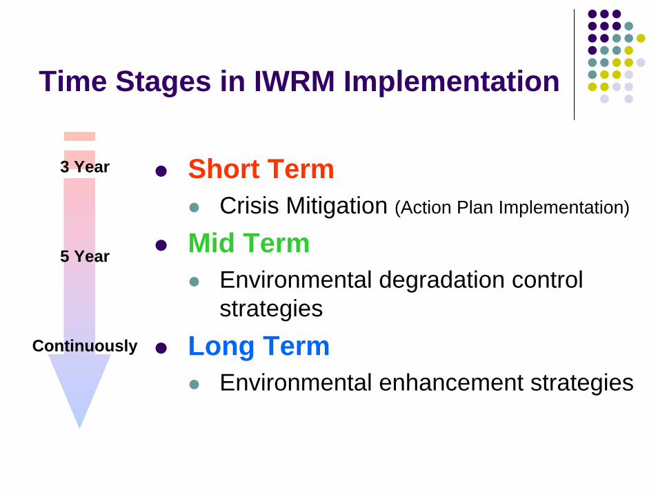
Time Stages in IWRM Implementation
3 Year
5 Year
Short TermCrisis Mitigation (Action Plan Implementation)
Mid TermEnvironmental degradation control strategies
Long TermEnvironmental enhancement strategies
Continuously

Crisis Mitigation
Action Plan

Main Steps in Action Plan
Planning and conducting studies related to IWRMSetting up Basin Management StructurePreparing and executing EAPPreparing guidelines for mid and long term strategiesPreparing Decision Support System Preparing monitoring and evaluation system

Planning and Conducting studies for IWRM
Quantitative and qualitative assessment of existing water resourcesEvaluating and estimating present consumption and future demands on water, related to different sectorsEvaluating present status of water governance & stakeholder participationDevelopment of a basin-wide water knowledge database Preparing suggestion for:
EAPStrategies guideline (Mid & Long Term)Participatory decision making framework & DSS Monitoring & Evaluation System
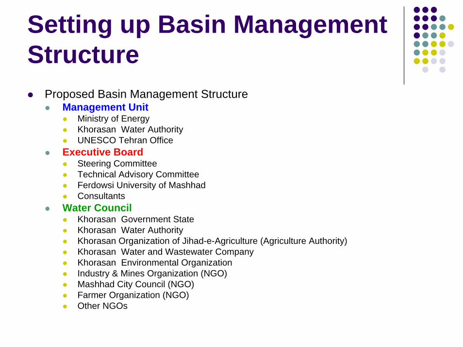
Setting up Basin Management Structure
Proposed Basin Management StructureManagement Unit
Ministry of EnergyKhorasan Water AuthorityUNESCO Tehran Office
Executive BoardSteering CommitteeTechnical Advisory CommitteeFerdowsi University of MashhadConsultants
Water CouncilKhorasan Government StateKhorasan Water AuthorityKhorasan Organization of Jihad-e-Agriculture (Agriculture Authority)Khorasan Water and Wastewater CompanyKhorasan Environmental OrganizationIndustry & Mines Organization (NGO)Mashhad City Council (NGO)Farmer Organization (NGO)Other NGOs

Setting up Basin Management Structures
Duties and Responsibilities of Management UnitFunding support of proposed projectsPlanning macro strategies in the basinEvaluating effectiveness of executed projectsInternational communication and experience transferReviewing Executive Board reportsPlanning investment policiesPursuing projects demands through higher levels of the government executivesPresenting progress reports to National Water Supreme Council

Setting up Basin Management Structures
Duties and Responsibilities of Executive BoardPursue to supply funding supportsApproving the projects outcomes and deliverablesSubmitting approved policies and projects to State Planning Council to be executed by the related organizationsAssessing IWRM performance in different sectorsStating dialogues with Water Council for coordination of policies and projectsSubmitting progress reports to Management UnitOrganizing workshops and seminars to improve capacity building and public awarenessProvision of new rules and regulations to be adopted by related organizations
Setting up Basin Management Structures
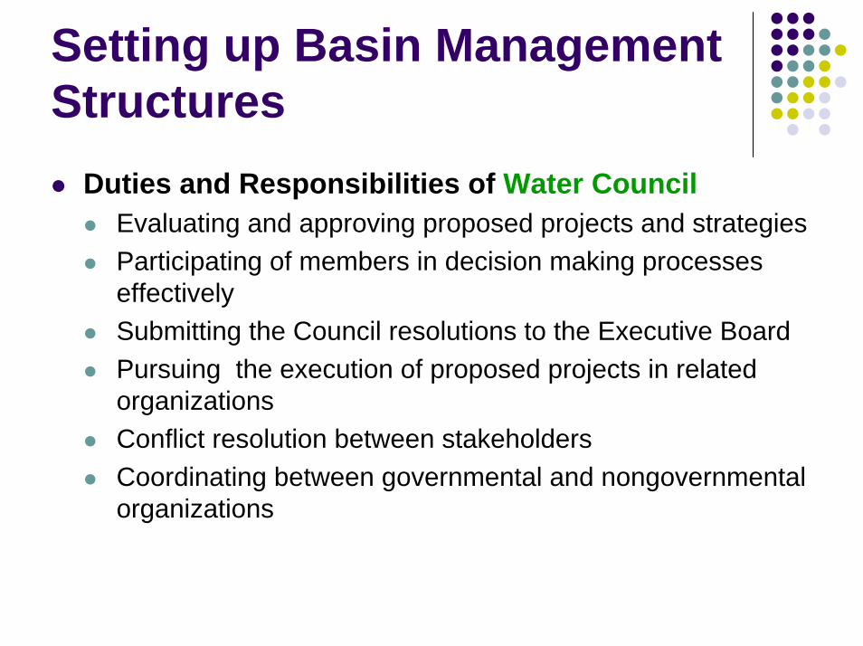
Duties and Responsibilities of Water CouncilEvaluating and approving proposed projects and strategiesParticipating of members in decision making processes effectivelySubmitting the Council resolutions to the Executive BoardPursuing the execution of proposed projects in related organizationsConflict resolution between stakeholdersCoordinating between governmental and nongovernmental organizations

Preparing and Executing Emergency Action Plan
EAP (in short term) toDecline in groundwater over-exploitation rateDecline in water resources pollutionRe-Allocating water resources to different sectorsPromoting water recycling and application of non-conventional watersPreparing regulations and guidelines

Preparing guidelines for Mid and Long Term Strategies
Land Use PlanningWater Productivity EnhancementDemand Management Implementation:
Improving water use pattern in different sectorsAllocating water with different qualities to different consumptions
Water Harvesting

Preparing Decision Support System
DSS ElementsMeasurement system
Remote sensing In-situ measurement surveys
Rule and knowledge basesData basesGIS
Information system
Natural system models
User functional models
Economic models
Model system
Evaluation toolsStrategy development
tools
System development
tools
Simple diagnostic tools
Analysis system
Geographical
presentationsU
ser friendly interface
user

Preparing Monitoring and Evaluation System
Setting up an office to assess progress and revise plansPreparing evaluation indexes of IWRM effectiveness Monitoring evaluation indexes in IWRM systemRevise plan (if necessary)
Reporting to Basin Management Unit

Ongoing TasksHolding a Workshop Regarding IWRM Objectives in the Basin
Setting up Steering Committee
Setting up Technical Advisory Committee
Providing Financial Sponsors
Preparing a draft version of IWRM TOR and Methodology to be executed by an appropriate consultant

Thank YouFor
Your Attention