BUILDING AMARAVATI: BETWEEN WESTERN URBAN …
71
BUILDING AMARAVATI: BETWEEN WESTERN URBAN DREAMS AND INDIAN REALITIES A RESEARCH PAPER SUBMITTED TO THE GRADUATE SCHOOL IN PARTIAL FULFILLMENT OF THE REQUIREMENTS FOR THE DEGREE MASTER OF URBAN AND REGIONAL PLANNING BY SRAVANI MIKKILINENI NIHAL PERERA, PhD - ADVISOR BALL STATE UNIVERSITY MUNCIE, INDIANA DECEMBER 2018
Transcript of BUILDING AMARAVATI: BETWEEN WESTERN URBAN …

BUILDING AMARAVATI: BETWEEN WESTERN URBAN DREAMS AND INDIAN REALITIES
A RESEARCH PAPER
SUBMITTED TO THE GRADUATE SCHOOL
IN PARTIAL FULFILLMENT OF THE REQUIREMENTS
FOR THE DEGREE
MASTER OF URBAN AND REGIONAL PLANNING
BY
SRAVANI MIKKILINENI
NIHAL PERERA, PhD - ADVISOR
BALL STATE UNIVERSITY
MUNCIE, INDIANA
DECEMBER 2018

ii
ACKNOWLEDGEMENT
I would like to express my sincere gratitude to Dr. Nihal Perera for his enormous support and
patience throughout this project. His book, People Spaces has been my inspiration for this
entire project, that helped in gaining a new perspective on the India I’ve known since
childhood. I would also like to thank Dr. John West for his time dedicated in working and
sharing his thoughts and ideas. His perspective helped me understand the world I live in more
richly.
I would like to extend my special thanks to Vimukthi Kaushalya Herath, Nirmani Liyanage and
Yuyi Wang whose work and thoughts inspired me particularly. I also thank Cole Jackson for
dedicating his time and helping me in proofreading this paper. Also, I would like to
acknowledge my friends, colleagues, and the urban planning department faculty and staff for
making my time at Ball State University a wonderful experience.
A special thanks goes to APCRDA assistant zonal director, Ajay, for his discussion and thought-
provoking conversations during my internship, for providing an unique perspective on my
studies. Last but not the least, I would like to thank my friend Satya Charan for providing me
constant support and motivation throughout my research.
Thank you everyone for helping me through out this journey.

iii
LIST OF FIGURES PAGE
Figure – 1: Location of Andhra Pradesh in India………………………………………………………………………..22
Figure – 2: Location of proposed capital city area…………………………………………………………………….23
Figure – 3: Master plan of Amaravati………………………………………………………………………………………..25
Figure – 4: Master plan of Chandigarh……………………………………………………………………………………….26
Figure – 5: Township model of Amaravati………………………………………………………………………………….27
Figure – 6: Nine themed cities……………………………………………………………………………………………………30
Figure – 7: Integrated existing settlements in the master plan of Amaravati………………………….32
Figure – 8: Amaravati government complex………………………………………………………………………………33
Figure -9: Components of government complex……………………………………………………………………….34
Figure – 10: Legislature building design in Amaravati………………………………………………………………35
Figure – 11: High court design in Amaravati……………………………………………………………………………..36
Figure – 12: Graphical representation of reasons why landowners contributed their land to the
land pooling scheme………………………………………………………………………………………………………………….42
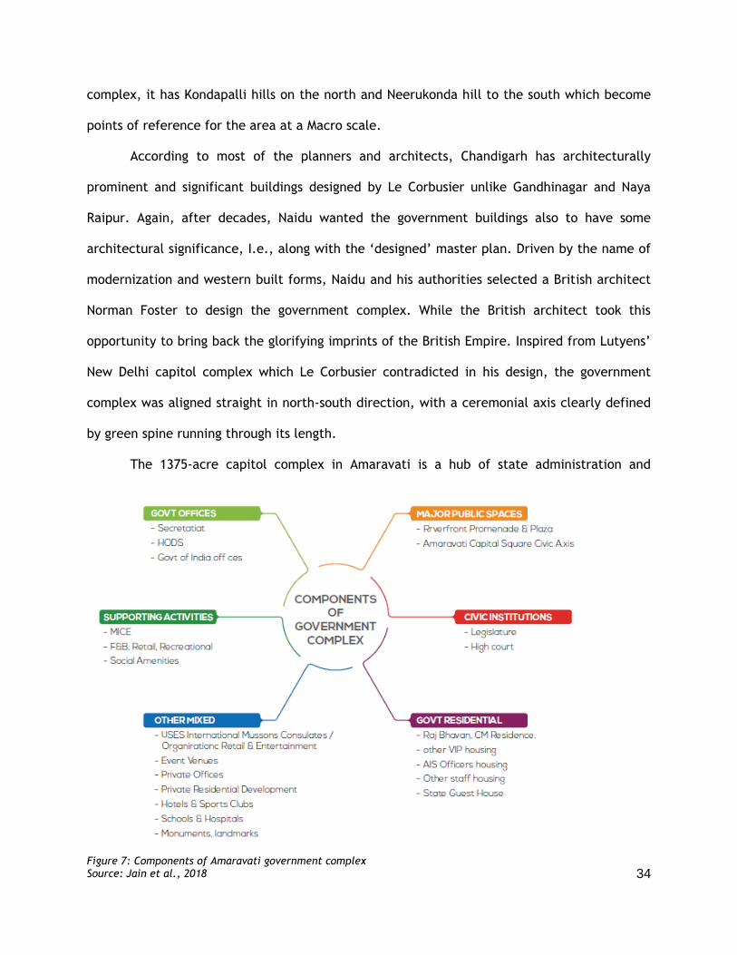
Figure – 13: LPS returnable commercial and residential plots in Amaravati……………………………43
Figure – 14: Bulldozers taking down banana plantation in Amaravati area……………………………..45
Figure - 15: Agriculture lands turned into grazing lands in the site designated for Amaravati
…………………………………………………………………………………………………………………………………………………..48
Figure - 16: Interim government complex in Amaravati………………………………………………………….54
Figure – 17: Single lane road to Amaravati with Naidu’s hoardings………………………………………..55
Figure – 18: Beginnings of new road in Amaravati……………………………………………………………………55
Figure – 19: Land in Amaravati area that is yet to acquire……………………………………………………..59
Figure – 20: Informal spaces by local farmers in Vijayawada………………………………………………….63

iv
TABLE OF CONTENTS PAGE
ACKNOWLEDGEMENT ii
LIST OF FIGURES iii
Chapter - 1: INTRODUCTION 1
Chapter - 2: HISTORICAL AND THEORETICAL BACKGROUNDS 5
POLITICAL CONSTRUCTION OF AMARAVATI
THE LITERARY BACKGROUND AND CONCEPTUAL TOOLS
Chapter - 3: AMARAVATI: Urban Dreams 20
THE MASTER MIND
LOCATION
CONCEPTUALIZATION
MASTER PLAN
CAPITOL COMPLEX
Chapter - 4: AMARAVATI: Materializing urban dreams 38
THE CREATION OF APCRDA
LAND [UN]SUITABILITY
LAND POOLING ISSUES
FUNDING PROBLEMS
Chapter - 5: AMARAVATI: People’s Contestations 58
Chapter - 6: CONCLUSION 62
REFERENCES 65

1
INTRODUCTION
Since independence in 1947, India has built many planned cities. These include four new
capital cities built from scratch: Bhubaneswar, Chandigarh, Gandhinagar, and Naya Raipur,
i.e., in addition to refugee, lesser administrative and industrial towns. These capital cities
were built because of the creation of new provinces (later states). Chandigarh was created as
the capital of Haryana and Punjab in response to losing its capital Lahore to Pakistan, when
India and Pakistan were separated at independence. While Bhubaneswar was built as Cuttack,
the capital of Orissa, as the previous capital from where the British administered Orissa
Province, was vulnerable to frequent flooding and suffered from spatial constraints.
Gandhinagar and Naya Raipur were built as capitals of Gujarat and Chattisgarh as they were
created anew separating from the states of Bombay and Madhya Pradesh. This paper focuses
on India’s fifth and the latest state capital, Amaravati which is still being built, after Andhra
Pradesh lost its capital Hyderabad due to the separation of Telangana.
The idea of building a new capital city for Andhra from scratch is not new in India. In
fact, the government has been fascinated in doing so for decades since their independence,
as they can lay their dreamed vision of the world on an empty land. The Chief Minister (CM)
of bifurcated Andhra Pradesh, Nara Chandrababu Naidu is one of the dreamers who wanted
the city to be “modern-Indian,” a vision that is similar to Jawaharlal Nehru’s when
Chandigarh was planned. Nehru was mesmerized by modern, scientific and rebelled against
old traditions and old towns that held people in “ignorance” and “superstition.” He wanted to
urbanize the villages (Kalia 1987), as villages and bullock carts were not a picture of the
essential joys of life to him (Prakash 2002). While similar to Nehru in ideals, Chandrababu
Naidu’s most frequent frame of reference for Amaravati is Singapore. Quoted as “the people’s
capital of Andhra Pradesh,” (APCRDA, 2018) Amaravati is envisioned to be a world-class city
which would increase the prominence of Andhra Pradesh in the world.

2
Driven by the desire to create a modern image like in Amaravati, the leaders who
created Chandigarh hired foreign planners, acquired people’s land, evicted people,
transformed agricultural land, and awaited for architecture to fit into the place. Architects
like Charles Correa hope that after hundred years Chandigarh would fit seamlessly into the
Punjabi ethos (Prakash 2012). This is what is happening in Amaravati too, but in a new
context, at a different time. Hence the question: Is Amaravati following the same trajectory
of Chandigarh? Should Andhra residents also wait for hundred or more years to fit Amaravati
into Andhra Pradesh? Who determines the urban character of Amaravati? Were social and
cultural aspects of the citizens considered in its planning?
At an interview with a freelance journalist Rollo Romig (2017, pp.17), Chief Minister
Chandrababu Naidu said the following about the planning of Amaravati: “I’m not thinking [of]
today and tomorrow [but] thousands of years [from now], for future generations. I want to
stretch my capacity beyond my limitations.” Le Corbusier who had the similar thought process
while designing for Chandigarh also stated that India is jumping into the second era of
mechanization, instead of sinking into the groupings and errors of the first era, but he would
give India the architecture of modern times and fulfill the mission (Prakash 2012). Yet, like
David Harvey argues, “Good design becomes meaningless tautology if we consider that man
will be reshaped to fit in whatever environment we create” (Harvey 1973, Pp.46). Indeed,
one could easily observe the “Indianization” of Chandigarh. The process also raises some
significant questions about the planning and development of Amaravati and its future.
The master plan which is more of a design rather than a plan pays more attention to
its aesthetics, visual aspects but not much to the social and cultural aspects of its residence.
With the thought that humans last only for few decades but buildings last for centuries,
planners and architects tend to give more importance to those concrete blocks over people’s
livelihoods (Kalia 1987). Hence the major goal of this paper is to examine a potential flaw in

3
urban policy that does not meet the local standard of living and people’s aspirations. Also, to
highlight the impact of foreign planning ideas thus examining the gap between western
dreams of dominant actors who have power and the Indian lifestyles of ordinary people and
their livelihoods. As a result, inspiring the planners to rethink the city plan and change it to
meet citizen’s aspirations for the city and their own spaces within it.
This project examines the designs and plans of Amaravati from the people's standpoint
responding to the question: Whether the urban dreams of Amaravati are supported by the
realities or are they forced onto the reality? Following Nihal Perera’s (2016) work on People’s
Spaces, by “people” this paper refers to ordinary citizens who have no power to create the
space as the state or capital, but commonly expected to live in spaces provided by these
institutions. However, as Perera demonstrates, people cannot live in abstract spaces
conceived by these actors but have to create through negotiation. Their own lived spaces that
support their daily activities and cultural practices are also negotiated in the process. This
study on Amaravati was carried out through the observation of people’s activities and their
spaces, photographic and audio documentation, informal discussions, interviews,
ethnographies of people, archival research of plans, and interviews with planners. However,
to protect the identity of the farmers pseudo names were used in this paper. Also, I use
frameworks as close as possible to those employed by people, but within the larger
intellectual frameworks I developed during my graduate studies, to interpret my own
observations.
This paper will first describe and explain the dreams of Naidu and his authorities,
starting from the factors that were considered in the selection of the location and site,
followed with an explanation of the master plan done by a Singaporean planning firm,
Surbana Jurong Pvt. Ltd. Further explaining the design concepts and planning done by an
architecture firm led by the famous British architect Norman Foster who was selected as the

4
designer of Amaravati’s 900-acre core capitol complex. With reference to the inability of
Chandigarh and Gandhinagar design to support Indian lifestyle, the object of this paper is to
examine the Amaravati plan from local people’s perspectives. The study focuses on the
measures taken by the government to implement these designs explained in the later
chapter.
Documenting my findings, I would highlight that new designs and advanced
construction techniques do not by themselves make the dream of planning and building urban
environments come true; they certainly do not make the planned city successful. It is the
upliftment of people’s lives that makes it successful. As it employs people’s views to critique
the plan, this paper will suggest ways to combine people’s aspirations into urban dreams.

5
HISTORICAL AND THEORETICAL BACKGROUND
India’s experience of planned development of state capitals began immediately after
independence. The historical context for the formation of Amaravati is also long, the political
struggles for a language-based state beginning in the early 1950s. This chapter will provide
these two contexts for the study in the reverse order, first exploring the origin of the idea of
a separate state and its political materialization. In so doing, the chapter will conduct a
literature review for the study.
POLITICAL CONSTRUCTION OF AMARAVATI:
The dream of Amravati began with the linguistic-nationalist dream of creating a
Telugu speaking state in 1952. This desire for a linguistic-nationalist state is shared by many
other linguistic groups in India. However, the struggle for Telangana began long before it was
established, perhaps when the last Nizam, Mir Osman Ali Khan did not want it to be annexed
to India at independence. He even made a complaint to the United Nations. Later, after the
three decades (1969-2014) of struggle, Telangana state was established in 2014. This thesis
focuses on the planning and creation of the new capital of Andhra Pradesh after losing its
former capital to the new state.
When India became independent from the British Empire in 1947, it inherited the
administrative boundaries from British India. These borders were results of historical and
political events leading up to colonialism and to facilitate the strategic needs of the colonial
administration of British India. The post-colonial national government felt that the
reorganization of state borders was necessary; one of their proposals was to reorganize states
based on languages. Even before the end of colonialism, in 1920, the members of Indian
National Congress adopted the linguistic reorganization of Indian states as one of its political
goals. In 1927, the Congress declared that it was committed to the “redistribution of

6
provinces on a linguistic basis” and reaffirmed this stance several times. It was also included
in the election manifesto for the first national elections of independent India in 1947.
However, soon after independence the Congress-led government became concerned that the
states formed solely on a linguistic basis might be unsuitable and might even pose a risk to
the national unity.
On 17 June 1948, Rajendra Prasad, the President of the Constitutional Assembly set up
the Dhar Commission (Lit: Linguistic Provinces Commission) to recommend whether the states
should be reorganized on linguistics basis. On 10 December 1948, the commission proposed
"the formation of provinces [based] exclusively or even mainly linguistic considerations is not
in the larger interests of the Indian nation" (Kumar 1976, pp. 70-71). Soon after the report
was published, the Congress, at its Jaipur session, set up a committee, called the JVP
committee, to study the recommendations of the Dhar Commission. The name follows its
participants, mainly Jawaharlal Nehru (Prime Minister of India) and Vallabhbhai Patel (Deputy
Prime Minister of India); it also included the President of the Congress, Pattabhi Sitaramayya.
In its report dated 1 April 1949, the Committee stated that the time was not suitable for the
formation of new provinces but added: "if public sentiment is insistent and overwhelming,
we, as democrats, must submit to it, but subject to certain limitations in regard to the good
of India as a whole". (in Windmiller 1954, Pp.300)
The struggle for a Telugu state continued: the demand for the creation of a Telugu-
majority state out of areas belonging to Madras State had become powerful by 1952. Potti
Sreeramulu, one of the activists demanding the formation of a Telugu-majority state, began
a fast for the same cause and died on 16 December 1952. Subsequently, the government of
India announced that it would go ahead with the creation of a new state. This was the first
language-based state (Windmiller 1954, Pp.293) and this sparked agitation all over the
country, with various linguistic groups demanding separate states. This is precisely what the

7
Congress feared. To reorganize the states, the national government set up the State
Reorganization Commission (SRC) under the chairmanship of Fazl Ali, a former Supreme
Court judge, in December 1953.
In another move, the commission, due to public demand, recommended the
downsizing of Hyderabad State, merging Marathi speaking region in Hyderabad with Bombay
and Kannada speaking region with Mysore state. According to paragraph 386 of the SRC report
After taking all these factors into consideration we have come to the conclusion that it will be in the interests of Andhra as well as Telangana, if for the present, the Telangana area is to constitute into a separate state, which may be known as the Hyderabad State with provision for its unification with Andhra after the general elections likely to be held in or about 1961 if by a two thirds majority the legislature of the residuary Hyderabad State expresses itself in favor of such unification. Hyderabad Pradesh Congress Committee (PCC) chief along with 80% of other congress
delegates elected in 1955 opposed the merger. Thus, the Home Minister Pandit Govind
Ballabh Pant decided to merge Andhra State and Telangana to form Andhra State on 1
November 1956 with the help of a gentleman’s agreement. The agreement provided
safeguards from discrimination against Telangana by the government of Andhra Pradesh. The
violations of this agreement are cited as one of the reasons for formation of separate state
for Telangana.
Two political conflicts marked the period of 1969 to 1973; these were carried out by
Jai Telangana and Jai Andhra movements. Social tensions arose due to the influx of people to
Telangana mainly Hyderabad from the coastal Andhra region. Protests started with a hunger
strike by a student from Khammam District demanding the implementation of safeguards
(gentlemen agreement) promised at the creation of Andhra Pradesh. The movement that
staged the protests slowly manifested into a demand for a separate Telangana. In 1973, a
political settlement was reached with the Government of India with a six-point formula
agreeing upon by the leaders of the two regions to prevent any recurrence of such conflicts in
the future.

8
In 1997, the Bharatiya Janata Party (BJP) state unit passed a resolution seeking to
separate Telangana. In 2000, members of the Congress Party in the legislative assembly from
the Telangana region who are for the separation of Telangana state formed the Telangana
Congress Legislators Forum and submitted a memorandum to the president of the Congress
Party, Sonia Gandhi, requesting her support for the Telangana state. In April 2001, a new
political party named Telangana Rashtra Samithi (TRS), led by Kalvakuntla Chandrashekar
Rao, was formed with the single-point agenda of creating a separate Telangana state with
Hyderabad as its capital.
In April 2002, L. K. Advani, Union Home Minister, wrote a letter to the Member of
Parliament (MP) of Lok Sabha (the national house of representatives), A. Narendra rejecting a
proposal to create Telangana state. In the next national elections in 2004, Congress Party
formed a coalition government with TRS; In February 2009, the state government declared
that it had no objection, in principle, to the formation of a separate Telangana and that the
time had come to move forward decisively on this issue. On 29 November 2009, TRS president
Rao started a fast-unto-death, demanding the Congress Party to introduce a bill in the
national Parliament establish the Telangana state.
On 9 December 2009, Union Minister of Home Affairs P. Chidambaram announced that
the Indian government would start the process of forming a separate Telangana state,
pending the introduction and passage of a separation resolution in the Andhra Pradesh
assembly. On 3 February, the government appointed a five-member committee headed by
Justice Sri Krishna to consider the issue; it reported six solutions. The committee proposed to
keep the state united by guaranteeing the socio-economic development and political
empowerment of Telangana region through the creation of a statutorily empowered
Telangana Regional Council. The Alternative was to bifurcate the state into Telangana and
Seemandhra per existing boundaries, with Hyderabad as the capital of Telangana and

9
Seemandhra with a new capital. After several agitations, on 20 February 2014, the Telangana
bill was passed by Rajya Sabha in Delhi, with the support of Congress, TRS and BJP.
Thus, Andhra Pradesh was bifurcated per the Andhra Pradesh Re-Organization Act
2014 of 1 March 2014. Through the Act, the Indian Parliament defined the boundaries of the
two states and divided the assets and liabilities. Per the Act, Hyderabad became the joint
capital of the states of Telangana and Andhra Pradesh for a period of not more than 10 years
after which it becomes the capital of (new) Telangana state. in April 2015, Amaravati was
announced as the new capital of bifurcated Andhra Pradesh.
THE LITERARY STUDY AND CONCEPTUAL TOOLS:
The planned capitals of India: Bhubaneswar, Chandigarh, Gandhinagar, and Naya
Raipur are the predecessors of Amaravati. Literature on them provide the basic literary-
intellectual background to planned cities in India, Amaravati in particular. Chandigarh and
Gandhinagar occupy the extremes of being most influenced by European and Indian ideas
respectfully. Amaravati has certainly been influenced by these two projects. The critics
provide us much information and concepts to learn how new cities were conceived in India.
While the subject is well debated, Ravi Kalia’s books on each of these cities provide a
common platform to compare and contrast the literature on them. In this section, literature
on each city from different sources is discussed in chronological order.
Making of Chandigarh:
The author of Chandigarh’s Le Corbusier - The struggle for modernity in Post-Colonial
India, Vikramaditya Prakash (2002) was born and grew up in Chandigarh as the son of one of
nine Indian architects who assisted in designing the city. He shares his intimate knowledge on
the “artificial city” by bringing in stories of the planners, architects and bureaucrats vying
10
over the colonial past and the symbolic future of India. He too is an architect; so, he provides
insights into design aspects. Basing on Le Corbusier's sketch books, Prakash interprets his flow
of ideas in making Chandigarh and gives a detailed explanation on the conceptualization of
the buildings that made the capitol complex, although it is impossible to verify whether Le
Corbusier even meant the same as Prakash understood and explained in his book.
Whereas, Ravi Kalia (1987) provides a broad understanding of Chandigarh with a
detailed picture of its political history, planning and architecture, drawing on a multitude of
sources and interviews he conducted, providing insights into most of the actors involved in
the planning process, in Chandigarh - In Search of Identity. He identifies Chandigarh as the
most visible example among new cities, designed to fulfill deep rooted psychological needs
and to meet pressing political exigencies India was facing at independence. However, Kalia
(1987) points out that no attention was paid to the fact that an entirely man-made
environment is a unique product of a particular society and culture. It threatens to transform
the experience of the existing culture without first creating necessary preconditions for such
transformation (Kalia 1987).
The major aspect that was considered by the decision makers was the potential to
replace the material and psychological loss of Lahore which had been a hub of commercial
and cultural activities of the Punjabis before West Punjab was assigned to Pakistan at the
“partitioning of India.” Shimla, Amritsar, Jalandhar, Ludhiana and Ambala were the five cities
that were considered as possible alternatives for the new capital initially. If inadequate
facilities and poor infrastructure precluded the conversion of an existing city into the new
capital of East Punjab, the lobbying by strong political pressure groups to support claims of
different cities made the selection impossible (Kalia 1987).
According to Kalia (1987), Indecisions over the site for new capital would have
lingered longer had not the Prime Minister of India, Jawaharlal Nehru, who championed the
11
project and personally intervened. Economic limitations of the state government and Nehru’s
interest in making the new capital a representation of modern India assured an active role for
the central government. As Prakash (2002) says, it would not have been possible without
Nehru’s personal interest and financial assistance from the central government. In contrast,
In regard to Amaravati, there is neither Prime Minister’s interest nor financial support
anywhere near what was received by Chandigarh, further discussed in chapter four.
In consultation with the government of India, the government of East Punjab selected
the current Chandigarh site in March 1948. The differential in costs for land acquisition, it’s
safe distance from Pakistan and the prospect of building a modern town to represent India,
justified the location for Chandigarh. The decision received the enthusiastic support of Nehru
who said on his first visit to Chandigarh: “The site chosen is free from the existing
encumbrances of the old towns and old traditions. Let it be the first large expression of our
creative genius flowering on our newly earned freedom” (Kalia 1987, Pp.12).
The most expedient and cost-effective solution was to adopt an existing city as the
new capital and simply build new legislative buildings (Prakash,2002, Pp.6). Thinking that
humans last for few years, but buildings last for centuries, they gave more importance to
those concrete blocks over people’s livelihoods (Kalia,1987; Pg. 88). Kalia (1987) gives a
detailed description of the controversies starting from the selection of site which can be very
well related to Amaravati, discussed in further chapters.
The two phases of the Chandigarh project required about 28,000 acres of land in fifty-
eight villages with a population of 21,000 people made up of 6,228 families. Of the total
28,000 acres, 22,000 were cultivated land. Its acquisition affected 6,807 landholders, out of
which 6,215 possessed less than 10 acres of land. Only 16 landholders possessed more than 50
acres (Kalia 1987). This led to the formation of Anti - Rajdhani Committee (Anti- Capital
Committee) which blamed the government for creating another refugee problem (in addition

12
to the one caused by the partitioning). Other Congress leaders too opposed the site but for
their own reasons, especially for not selecting their own towns for the capital.
Adding to this controversy was the selection of architects to plan and design
Chandigarh. The person who emerged as the first claimant to Chandigarh’s modernity was a
senior Indian bureaucrat, A. L. Fletcher, “Officer on Special Duty” to the government of
Punjab assigned solely to deal with the new capital. While in July 1948, P.L. Verma, the chief
engineer of the Public Works Department (the agency responsible for the construction of the
city) proposes an international competition for the design of Chandigarh, Fletcher totally
disagrees. Instead, he proposes that “We must be guided by the views of those who have had
such experience with the building of new towns and follow the practice evolved in countries
that have built or building towns.” (Prakash 2002, Pp. 35)
In favor to him, the Punjab government officials were inclined to visit Europe to find a
suitable architect-planner for Chandigarh, but Nehru rejected the request. According to
Kalia, Nehru had a practical side to him: “The average American or English town planner will
probably not know the social background of India. He will therefore, be inclined to plan
something which might suit England or America but not so much India.” (Kalia,1987; pp.26)
Pointing to New Delhi as an example, he concluded, it is attractive in a way, but most
inconvenient and most un-Indian. This made the Punjab government eventually contract with
Albert Mayer, an American who had been building in Uttar Pradesh.
Trained as an architect and town planner, Mayer recognized that his assignment of
planning new villages in India would involve new sets of factors unlike the towns in the west.
He was honest in admitting his lack of experience and grounding in India as his major
shortcoming. The centerpiece of Mayer’s master plan was to organize the city into residential
neighborhood unit called the “super block;” that were further divided into three equal
blocks. Each super block accommodated the basic amenities of a neighborhood such as

13
market, primary, and secondary schools, hospital, meeting hall, etc. He was planning to
develop the overall urban form by the multiplication of such units rather than from a single
dominant formal concept. His main goal in Chandigarh was to create a peaceful city, not
where complications counteracted by other complications.
Mayer contracted an American architect Matthew Nowicki to visualize the
architecture. The intention of Nowicki, in all his residential block designs, was to blend
modern architectural solutions with the Indian way of life including temples and bazaars.
These bazaars although modern in form, contained Indian features such as shops with the
provision to sit on the floor and separate area for street hawkers. Also, for building material,
Nowicki concluded that “brick may prove to be the cheapest medium,” a conclusion that is
proven to be true in India today (Kalia,1987; pp.68). However, one will never know to what
extent of Indian in feeling and function Mayer-Nowicki’s design would eventually have been,
as Nowicki dies in an airplane crash on 31st August 1950.
After the death of Nowicki of the Mayer team, the Franco/Swiss architect Le Corbusier
was hired to execute the Mayer’s plan. However, he quickly and swiftly took over Albert
Mayer’s plan and transformed it to his own sense of order and clarity (Prakash 2002, Pp.45).
He searched for a new language, a language that could be used to deal with the challenges of
the industrial age. He wanted to produce an architecture that would be “Indian” of the
second half of the twentieth century. The sentiment is quite similar to that of Mayer, but
with a difference as Mayer looked into the India’s past, especially bustling bazaars and
closely-knit village communities. While Le Corbusier looked at India through his own
interpretative lens with all the paraphernalia of industrialization. Thinking that humans last
for few years, but buildings last for centuries, they gave more importance to those concrete
blocks over people’s livelihoods (Kalia,1987) which is again being followed in Amaravati.

14
Kalia (1987) compares the designs of Mayer and Le Corbusier saying: Mayer placed
greater emphasis on the socio-economic factors of the city, its potential for future growth,
the peculiarities of Indian traffic, the social customs of the people and other related issues.
Similar to Chief Minister Chandrababu Naidu ideology in Amaravati, Le Corbusier remained
concerned with the physical attributes of the city and the monumentality of the building
designs. Restricting him further from introducing his ideas in Chandigarh was the non-
industrial character of India and his own unfamiliarity with the Indian lifestyle.
In just a decade since the inception of the city considerable unplanned growth
mushroomed within the restricted periphery zone of Chandigarh. Due to the overcrowding of
the city, squatter population, slums, and tenements had sprung up in the outskirts of the city.
With the increase in population many unauthorized shops and street hawkers which is
common in India had emerged in Chandigarh; and dwellings meant for one family had one
family in each room (Kalia, 1987). To which Le Corbusier called the situation “a crisis of
authority”. Although, after many efforts and decades of work it was proven that Chandigarh
was a designed city but not a planned city.
The artificiality of the manmade environment of Chandigarh became subjected to
natural influences of the local socio-political culture and tradition. The city region is dotted
with new satellite towns, which were never included in the master plan of Chandigarh. The
reason for this has been mainly the urbanization of rural areas surrounding Chandigarh.
Alarmed by the unrestrained urban growth, both within the city and on the periphery of the
Chandigarh, a coordination committee was formed in 1975 to prepare a regional plan for
Chandigarh and for the urban areas falling within its zone of influence.
According to Kalia’s evidence, cities in South Asia do not have a modernizing influence
but their visible “modern” or supposedly modern attributes are mere manifestations of
“middle- and upper-class lifestyles” (Kalia, 1987; Pg.: 148). The assumptions of the
15
Chandigarh master plan were based on the consumption patterns of the middle classes of
industrialized countries in the West and the expectation that these opportunities would
expand to that middle level and that the lower classes would be induced to climb to that
level.
While Kalia (1987) presents his evidence, Vikram Aditya Prakash (2002) shares his own
experience in his book.
Every time I went on the capitol esplanade as a student, there was always someone from Kansal, the village just north, bathing a buffalo, washing clothes, playing cricket or just passing through on a bicycle or scooter. The legislators and judges never bothered to walk onto the esplanade, since they always came and went by car from the lower level. As a consequence, in spite of the security and the official sanctity of the place, the esplanade has become open territory for all sorts of unofficial activities. Even the security men have strung up lines to dry their laundry. (Prakash 2002, Pp.146)
Although people reside, work and play in buildings, their behavior is not determined
by the buildings, but by the economic, cultural and social relationships with them (Harvey,
1973). According to Prakash’s own experience, the innumerable architects who pass through
Chandigarh generally preferred to wait until the village people pass on, so they can get a
clear shot of the buildings. They try to edit the laundry picture from frame, unsuccessfully
and then complain about the callous Indian government’s disrespect for the great
French/Swiss architect’s creations (Prakash 2002).
Architects like Charles Correa hopes that Chandigarh would fit seamlessly into Punjab
after hundred years as a famous old Indian town; similar to those of Fatehpur-Sikri, Patrick
Geddes, Golconda, Mandu which were once considered as foreign elements but now as the
integral part of the Indian landscape and acknowledging Le Corbusier as the greatest Indian
architect (in Prakash, 2002). While the author Ravi Kalia concludes that new design and
construction themselves do not make the dream of planning and building better urban
environments come true (Kalia 1987). It’s the people who live in it and their diverse social,
cultural and economic relationships which shape the space around them. Yet our knowledge

16
of these spaces is minimal, which are leading us to these [un]planned cities like Chandigarh
and continuing to the Andhra Pradesh’s capital Amaravati.
Gandhinagar: Capital of Gujarat:
If Chandigarh is Le Corbusier’s city, Bhubaneswar bears the German Otto Koenigsberger’s
signature. Gujarat’s capital Gandhinagar made a strong rival to Corbusier’s planning of
Chandigarh with its purely indigenous effort in planning and development by Indians.
The Building of Gandhinagar by Prakash Madhusudan Apte (2012) and Gandhinagar:
Building National Identity in Post-Colonial India by Ravi Kalia (2004) are the two major
sources of literature on the construction of Gandhinagar, the new capital of Gujarat, India, in
1960. Both authors describe and explain the building of Gandhinagar. However, they organize
the information from two different perspectives and say two different stories. Many a times
they are complementary, but there are significant differences.
Apte, (2012) the only surviving town planner of Gandhinagar, gives an inside view of
the planning approach, the thought processes, concepts and technical details that went into
the planning and design of the city. While Kalia (2004) explains the geography and political
history of the project by recounting India’s progression through pre-colonial, British, modern
and postmodern theory and practice and analyzes the roots of the chief planner Hargovind
Kalidas Mewada’s thoughts. The work of Apte and Kalia are influenced by their own
disciplines, urban planning and history.
Kalia (2004) does not elaborate on the planning process or the considerations behind
the planning of Gandhinagar and there is no evaluation of the basic concepts of the plan
itself. He focuses on the project and its politics. The book largely relies on secondary data
from people, in Apte’s words on “who were mere kids when Gandhinagar was being built,
though they occupy important positions in the present government” (Apte 2012, Pp.8). It

17
seems that Apte refers to leading architects of India such as Charles Correa and Bala krishna
Doshi whom Kalia extensively interviewed.
According to Kalia (2004), Mewada preferred the simplified forms of modernism, but
also recognised that cities are places of memory of the collective past. In the context of
centralised control inherent in new city development, many national governments in the
twentieth-century have looked up to the modernist ideal of planned cities as a solution for
urban congestion, slowing rural depopulation and restoring regional balance. In both colonial
and postcolonial India, the urban debate and architectural discourse was never particularly
local; it was energetically universal. Universal in Kalia can be interpreted as Western. The
shape of this ideal that Nehru had provided for India, through his involvement in Chandigarh,
was fervently embraced by India’s political leaders. This was a central ideal that was
variously interpreted in the plans and building of Gandhinagar in Gujarat.
In Gujarat, the young visionary Doshi tried to visualize the future of Indian cities in the
image of the new world provided by Louis Kahn and his new interpretation of the modern
skyscraper. In addition to the influence of Le Corbusier that India received via Chandigarh,
Ahmedabad where Doshi lives was also highly influenced by Kahn.
According to Kalia (2004), Mewada strongly felt that the ultimate success of the
capital would depend not only on careful city planning and its architectural form but also on
the creation of the public spaces and civic areas where people could assemble to enjoy the
visual pleasures of the buildings adding vitality and the attractiveness of the city (Kalia 2004).
The sentiment was very similar to one expressed by Kahn. In a sense, for Kalia, most of
planning of Gandhinagar comes from Kahn through Mewada. For Apte (2012), this is a
misconception in Kalia’s book.
Under the United Nations program of technical cooperation, Gujarat government
arranged Mewada to receive international assistance from the British academic Vernon Z.

18
Newcombe. Newcombe suggested that Indian architects and planners in the Public Works
Department travel to Europe to study new technologies and ideas in order to design their
cities and homes in India (Kalia 2004). The reason for this debate on the conflict between
Indian and Western thought systems abated recently because of the growing number of
Indians travelling overseas from the working and middle class. Even though they use the
traditional Indian adornments as part of their aesthetics, they return home demanding the
comforts of western homes and cities. The Indian diaspora in Western countries, particularly
in North America had been instrumental in influencing extended family members in India in a
quiet but deep way to aspire to many of the same creature comforts and new technologies
that are available in the west (Kalia 2004).
Similar to the site of Amaravati which is located near the banks of Krishna River, the
5738 hectare site of Gandhinagar is also situated on the banks of the Sabarmati River. Unlike
Amaravati, the soil was mostly sandy loam suitable for construction. In order to stop erosion
of land along the river, the forest department reclaimed about 1400 acres of Kotar (ravine)
lands on both banks of Sabarmati River on which approximately 1,41,155 seedlings of trees
were planted (Apte 2012). According to Prakash Apte (2012), in building Gandhinagar, which
is almost 10,000 acres, only 5 trees were uprooted. All of these were mango fruit trees which
were trimmed to a height of 8 feet and removed retaining much of the root bulb with manual
labour and transplanted them. A special nursery was established, and plants were provided at
no cost to citizens (Apte 2012). The planning of Gandhinagar gave the common man very little
chance to complain about, except about the lack of urban environment present in
Ahmedabad.
The grouping of residential buildings in Gandhinagar have the resemblance of pols,
clusters of housing units around courtyards on narrow lanes common in cities in Gujarat.
Grouped along a street, the houses open to courtyards used for social inter-course between

19
people of all ages; it is also as a play area for children. Eight categories of residential plots,
ranging from a minimum of 135 sq.mt. to a maximum of 1600 sq. mt. were made available for
people in general. Each residential community has a hierarchy of about four categories of
private plots and government quarters to achieve a balanced social and economic structure.
Also, for each category of house for government employees, at least two to three alternative
designs were developed to obtain a more varied pattern in the government housing area.
Buildings for schools were located within the sector to provide visual relief and break
monotony of residential buildings all along the road. After planning the government cluster
Apte conducted a social survey of the neighborhood and community relationships in the
cluster to find gratifying results. He found that the feeling of neighborliness and interpersonal
relationships was much better than in the Western concept of grouping houses around a
square open space which was followed in Chandigarh (Apte 2012).
Apte (2012) critiques Chandigarh’s town plan as static, devoid of any Indian character
in the design of residential areas. Unlike Gandhinagar, he comments that each level of
government employees was separately grouped and the hierarchy is accentuated more in line
with the British colonial settlements rather than a representation of true democracy that
India aspired. He confirms that Gandhinagar was intentionally not meant to be a masterpiece
that carry the personal stamp of the architect. The Gandhinagar planners tried to follow
Gujarat’s own traditions, cultural heritage and the teachings of Gandhi but adopt the state of
art building materials and technology. In concluding his comparison between these two
capital cities, he says that Chandigarh represents the building of national identity in Post-
colonial India, while Gandhinagar stands as the true identity of India (Apte 2012).
20
AMARAVATI: URBAN DREAMS
The definition of development in Asian cities for a large majority of leaders and planners is
catching up with the West or its modified versions by adapting to globalization or creating a
global city. For these leaders, the early adoption of new trends, practices, and models in the
West, or a proxy such as Singapore or Shanghai, increases the competitiveness of their city.
(Perera and Tang; 2013). At present, this is the perception of Andhra Pradesh leaders and
planners towards the capital city Amaravati.
The master brain behind the planning and development of Amaravati is the Chief
Minister of Andhra Pradesh, Chandrababu Babu Naidu, who earlier played a major role in the
development of Hyderabad before bifurcation. Although it is quoted as the people’s capital,
the way the city is being planned and built shows little interest in the social, cultural needs of
the people. The plan focuses on industrial and infrastructure growth, providing favorable
business climate, excellent infrastructure, good law and order and cordial industrial relations,
with the aim of positioning the state as the most preferred destination for investors. These
projects are explicitly profit-oriented and commodified in nature, with the corporate sector
playing a powerful role in their conceptualization, planning, development and governance
(Ramachandraiah, 2016).
Naidu was born on 20 April 1950 at Naravaripalle, Chittoor district, in the Rayalaseema
region of Andhra Pradesh to an agricultural family. He thus knows about the life in the field of
agriculture. Unfortunately, his priorities to the field of farming are minimal compared to
others. He served as the chief minister of Andhra Pradesh from 1994 to 2004. It is during this
period that he drew his ambitious plans for Hyderabad, turning it into an information
technology hub. It was during his tenure, that several IT companies opened offices in what
came to be known as Cyberabad. While he was praised by sections of the national and

21
international press, critics accused him for concentrating development exclusively on
Hyderabad, ignoring rural areas of the state and farmers’ issues.
This mistake of his, developing Hyderabad exclusively leaving other parts of Andhra
Pradesh behind, left him with a major challenge after bifurcation. As Hyderabad, i.e., the
major source of revenue for Andhra Pradesh, went to Telangana, the downsized Andhra
Pradesh had to figure out how to generate enough revenue and survive as an independent
state. Not to repeat the same mistake, the government has decided to go for decentralized
development of the state with three mega cities and upgrade fourteen cities in Andhra
Pradesh into smart cities along with the development of the capital, Amaravati. Though the
fourteen smart cities get the plans of dedicated industrial park and infrastructure,
Amaravati’s function as a capital is unique. The state government has decided to establish a
green field capital city as a livable, environmentally sustainable and people’s capital. This
chapter investigates the city’s claims to be of the people’s from the ordinary citizen’s stand
point and to highlight the impact of foreign planning ideas in the Indian cities.
According to Susantha Goonatilake (1984, Pp.107), “independence did not result in
new theoretical orientations but in a shift towards broader dependence on new centers of
dominance.” In the field of planning and architecture, the post-colonial leaders having an
objective to construct a modern nation continue to depend on the ideas that originated from
the West during the colonial era. Post-independence, this is the ideology that formed as a
base for the planning of Chandigarh.
Every step taken by the government in proposing and developing Amaravati reminds us
of the planning of Chandigarh. Starting from the selection of the site, the government had to
face many similar hardships as Chandigarh from strong political pressure groups who were
pulling the new capital to their cities. However, a committee of five “core” experts led by
chairman Sivaramakrishnan, former Secretary in Urban Development at the national level,

22
was appointed by the government to study various alternatives regarding the new capital.
After considerable indecision, the potential location of the new capital was narrowed down to
three distinct regions of Uttarandhra consisting of Visakhapatnam region, Rayalaseema arc
and Kalahasti-Nadikudi spine in addition to the Vijayawada-Guntur region.
In India, urbanization has meant “something larger and more abstract than what could
be found in existing cities” (Perera and Tang; 2013, Pp.5). Naidu with similar ideology, did
not want a city’s existing infrastructure to impede his vision of building a “world-class city”.
This made him choose the region between Vijayawada-Guntur that has more open agricultural
lands (non-built up land) for the construction of capital city exempting the existing
settlements. By using agricultural land to build a capital, he gave least importance to farming
and people’s livelihoods. Apart from this, the factors that favored the choice of location for
new capital city included access to everyone, centrality to the state’s geography, rail, road
and airways connectivity, proximity to ports like Kakinada, Machilipatnam, availability of
water, existing infrastructure to initiate the development, proximity to urban areas like
Vijayawada and Guntur,
apart from its cultural
and political history of
more than 2000 years.
Vastu (a
traditional Hindu system
of architecture) played
an important role in site
selection based on its
topography, position of
nearby hills and water bodies. Considering each of these elements, the proposed capital
Figure 1: Location of Andhra Pradesh in India Source: Jain et al., 2018

23
Amaravati City of Andhra Pradesh (figure:1) falls under Guntur district between Vijayawada
and Guntur cities on the upstream of Prakasam Barrage on the Krishna River. The 217.23 Sq.
Kms site is home to 97,960 people living in 25 villages (as per Primary Census Abstract Tables
Census 2011), located within three mandals: Thullur, Tadepalli and Mangalagiri. Though the
physical spaces of these existing villages are considered in the concept plan, their social and
cultural practices are not taken into account. Planners have not only refused to acknowledge
and incorporate the pervasive transformations and underlying collective behaviors into
decision-making but also continue to believe in planning’s efficacy only as a rationally
applicable technology (Vidyarthi, 2013). In other words, planners are driven by optimism that
they can create new forces of change with mere physical structures and restrictive
legislation.
The name Amaravati
is derived from the
ancient temple town
which is also located
in the same region.
However, it is not
integrated into the
general master plan,
leaving it on the
outskirts of the
proposed new capital
city (figure:2). The
ancient city including nearby locations and Dharanikota were the capital of the Satavahana
dynasty that held sway over much of the Deccan region between 230 BCE and 220 BCE. By
Figure 2: Location of proposed capital city Source: Jain et al., 2018

24
way of its links with the Satavahana Empire, it is steeped in Andhra’s history and heritage. It
had also been a prominent center of Buddhist studies in the 2nd century BCE. It was believed
that the Emperor Ashoka himself commissioned the famed Buddhist Stupa of Amaravati. The
stupa is very well known and is inscribed with panels depicting life and teachings of the Lord
Buddha, Buddhist sculptures and slabs with Buddhist inscriptions. Adapting the name from
such great ancient capital city Amaravati, Naidu believes that the capital city has both ‘vastu
balam’ (strength of vastu) and ‘nama balam’ (strength of name), indicating that both the
name and the location are auspicious (Sujatha, 2015).
By using the name Amaravati for the new capital, Andhra Pradesh Chief Minister
managed to strike an emotional chord especially with countries like Singapore and Japan,
where Buddhism is the most widely practiced religion. Japanese Minister of Economics, Trade
and Industry Yosuke Takagi at the foundation ceremony mentioned that it is a great pride and
honor to stand this sacred land as they have learnt about this great land of Amaravati as a
great seat of learning for Buddhism right from 3rd century BCE in Japan. This is from where
the seed of Japanese nation’s culture and values have emerged (Iyer, 2015). He also assured
that, Japan will come forward to contribute its experience and technology to this sacred
place. While Singapore based firms has prepared three master plans for Amaravati and is
ready to partner in its development.
Though the government leaders had unanimity to the location of the new capital, they
shared common vision concerning the nature of the city. They view the city as a formal-
economic artifact; recognize international business districts, corporate headquarters, and
chain restaurants; privilege mega projects designed by “starchitects”; and observe the
Westernization of cities (Perera, Tang; 2013). Majority of the post-colonial leaders and
planners consider Chandigarh as the great step forward for Indian planning which was done by
Swiss architect Le Corbusier. Though there were other cities like Gandhinagar planned by

25
Indian planners after Chandigarh, nothing has come close to its scale or intense publicity. So,
with its inspiration from Chandigarh, the government looks outside of India for architects and
planners who can imagine Amaravati to be a modern world class city with western
environments. As a matter of fact, no doubt that such type of planning can only be done by
international architects and planners who has the minimal or no knowledge about the social
and cultural aspects in India.
One another reason behind the selection of planners from Singapore and UK based
Foster partners as architects to design the capitol complex, is to attract the investors from
various parts of the world with the help of its publicity. Naidu is leaving no stone unturned to
compensate the loss of Hyderabad, especially in attracting the revenue towards the capital
city. In the name of planning he was trying to build up partnerships with Japan and Singapore
expecting their firms to set up their base in the state. Locating the capital city between
India’s key economy generating cities namely Chennai, Bangalore, Hyderabad, Visakhapatnam
and Jagdalpur all of which lie within 300-400 km is expected to attract skilled and talented
people from these cities.
MASTER PLAN:
Chandrababu Naidu’s travel to
Singapore, Japan and China in 2015
has been central to his conception
of Amaravati. Enamored by
Singapore’s transformation into a
leading financial hub in Asia, he was
trying to build his capital city in
Singapore’s image.
According to the master plan Figure 3: Master Plan of Amaravati Source: Jain et al., 2018

26
(figure:3), the development of the Amaravati is in the form of a rectangular grid aligned to
cardinal directions with primary roads
aligned to north-south poles and the
equator. Though the grid plan dates
from antiquity and has originated in
multiple cultures, Harappa and
Mohenjo-Daro, are the major cities of
the Indus Valley Civilization which
built blocks divided by a grid of
straight streets, running north-south
and east-west. However, it became
more prominent in India when planned in Chandigarh by Le Corbusier (figure:4) who believed
grid iron plan as the only correct way of approaching the ‘modern’ problems of city planning
(Kalia 1987). In support of his belief he pointed to the grid iron pattern of the thirteenth
century bastides in the south of France and to American colonial cities of the seventeenth to
nineteenth centuries, including the plan for Washington (Kalia,1987).
Naidu wanting Amaravati to be an ultra-modern and world class city was driven by the
patterns of colonial cities. The word “modern” in India implies to something contemporary,
western, superior and better. Admiration of Chandigarh’s planning and Naidu wanting
Amaravati to be one of those cities which is often referred as ‘developed’ got him attracted
to the straight patterned, and perfect angular roads design.
Secondly, vastu which is considered to play a very important role in planning
especially in Andhra Pradesh, is the ‘traditional’ Hindu Indian system of architecture, under
which the designs are intended to integrate man-made structures with nature, utilizing
geometric patterns, symmetry and directional alignments. Naidu, being a Hindu believes in
Figure 4: Master Plan of Chandigarh Source: Kamiya, 2017

27
vastu enormously. He was particular about the alignment of the central administrative center
and all major city roads. Also, Andhra Pradesh being dominated by Hindus are keen about
vastu in any residential or commercial developments. The grid network helps in developing
east and west facing residential developments in the future which is considered mandatory
requirement in vastu. Following these developments of modernity along with traditions, Naidu
and planners call Amaravati as a “modern-Indian” city; an everyday phrase and a translation
of ‘East-West’ since Nehruvian India.
Naidu’s fascination towards modern developments did not end with a gridiron pattern
but continued deeper to follow
the concept of ‘neighborhood
unit’ (figure:5). The concept was
formed as a comprehensive
physical planning tool by New
York planner Clarence Perry in
the 1920s, for designing self-
contained neighborhood in
metropolitan areas. It specifies
four basic design elements: civic
institutions (especially a school
and a community center), parks
and playgrounds, convenience
stores, and a hierarchical
configuration of streets providing
safe pedestrian access to all
public facilities. Originally
Figure 3:Township model of Amaravati Source: Jain et al., 2018

28
‘neighborhood unit’ concept was conceived as a remedy for the perceived ills in American
cities, while the concept became stock planning item in the post-war United States and
traveled to many countries including China, Britain and India (in Vidyarthi, 2013). Parts of
India that has already attempted to indigenize the neighborhood unit are; in Delhi as
‘Mohalla’ unit, in Eastern India’s Bokaro Steel Plant’s township and in Rajasthan’s Jawahar
Nagar. However, the concept has merely adapted to the environment of their respective
places and resulted in dramatical changes accordingly to their present-day neighborhood
(Vidyarthi, 2013) leaving crucial implications for the planning practice and literature.
Amaravati following the same trajectory as the above neighborhoods will not be any different
from them.
Amaravati township plan remind us of the “sectors”, a title for neighborhood units that
became popular in Indian practice after Chandigarh, which employ the tenets of the
neighborhood unit such as arterial roads on all sides, a hierarchical network of internal roads,
predominantly residential land-use, open spaces and parks. Also, Jawahar Nagar’s planners
attempted to improve the same upon the perceived shortcomings of the Chandigarh’s
neighborhoods. Amaravati’s plan differed from Perry’s idea of neighborhood but is somewhat
similar to Jawahar Nagar’s planning, with schools provided at the core of each sector and
commercials in the central area or in a segregated block; except for the religious facilities
which the capital city included. According to Sanjeev Vidyarthi’s (2013) observations in
Jawahar Nagar, centrally placed school did not work in Indian cities and shops adjoining
houses attracted the opposition of elite residents.
Unlike in United States, schools in India are provided by individual state authorities so
due to lack of funds they become dumping grounds in many instances. Moreover, as Vidyarthi
(2013) points out, a neighborhood unit neither eliminates nor restricts residents’ preferences
and usages of provided public facilities, so they can send their children to a school in another

29
neighborhood. Also, almost all of the middle-class parents prefer expensive “English medium”
or private schools that usually provide a complete education from nursery to high school
level, contradicting the planning of providing a hierarchy of primary and secondary schools
within quarter, half and one-mile radii. Thus, the ill fate of school sites in newly planned
neighborhoods reduced the significance of their central location in neighborhoods for Indian
planner (Vidyarthi, 2013).
Also, the Krishna and Guntur districts comprise of the best agricultural lands and is
often referred to as the rice bowl of the country. Farmers often bring these fresh vegetables,
fruits, flowers and many others directly from their farm lands and sell them on carts road side
at low prices. Thus, the wide range of bazaars and informal spaces that are part of the
culture are not even considered into the plan. When planners do not acknowledge these local
activities and culture, people initially familiarize the (abstract) space and tend to transform
into their own lived spaces within their own capacities. Yet nothing can completely prevent
ordinary people from transforming abstract (and absolute) space into livable space or carving
out the latter from the former (Perera,2016).
For instance, in three decades Jawahar Nagar saw major transformations from the
original planned unit by planners. Such as upgrading a plot concerning mandatory restrictions
and prescribed heights, conversion of houses into shops and offices and transformation of
public spaces. As evident, people are not passive recipients of the dreams of the dominant
actors. Thus, highlighting that Indian planners have not only refused to acknowledge and
incorporate the pervasive transformations and underlying collective behaviors into decision-
making but also continue to believe in planning’s efficacy only as a rationally applicable
technology (Vidyarthi, 2013).
Naidu when asked in an interview by Romig (2017) about his vision towards Amaravati,
says that “I’m not thinking [of] today and tomorrow, but thousands of years, for future

30
generations….”. While Jawahar Nagar saw a drastic change from its original conception in just
three decades, one might question Amaravati’s similar township planning asking; Can
Amaravati retain its township planning as planned at least for 50 years after implementation?
Navratna: city of Nine Themes:
Combining the above described township model blocks together, a final master plan
was developed by the Singapore planners. However, the concept plan was proposed with nine
themed development cities in the capital city (figure:6), which is expected to be a hub of
activities serving a unique function and as employment generators within the capital. This is
not the first time for a city to have different themed districts, though Amaravati might be the
first to have all the nine different themes. Cities like Delhi, Bangalore, Chennai, Mumbai,
Hyderabad have
their own
experiences either
with government
city or electronic
city or knowledge
city or with
financial city in
various ways. While
one can relate
closely with the
experiences in
Bangalore and
Hyderabad due to
its familiarity with the nearly similar cultural behaviors between people. Apart from the
Figure 4: Nine themed cities of Amaravati Source: Jain et al., 2018

31
behavior styles of people, the similarity between these cities and Amaravati is, that a
Singapore-based transnational real-estate developer specializing in building high-tech
enclaves, was involved in establishing such areas in both Bangalore and Hyderabad. While
Chandrababu Naidu played a major role in Hyderabad by acquiring seventeen villages to
create a world-class high-tech enclave called Cyberabad (called as electronic city in
Amaravati concept plan).
The master plan of Hyderabad focuses on software related industries, but in support to
them massive private investments in real estate development complemented the high-tech
enclave. To accommodate the rich and elite and support working class people in this industry,
investors focused on developing modern apartments, gated condominiums, sprawling golf
course, shopping malls, hostels for working men and women, and rows of exotic restaurants
and star hotels. Additionally, the concentration of IT parks at one place encouraged people to
commute (from home place) which increased its traffic flow in morning and evening hours.
Now, Madhapur, the south western region of Cyberabad is one of those most congested areas
in Hyderabad and is trying to resolve its problems like any other places in the city.
According to Cindi Katz (2004), people rely on the knowledge they have accumulated
throughout their lives to reproduce their livelihoods, in the face of dramatic social,
economic, and political changes. Thus, the displaced local villagers resisting relocation
negotiated a livelihood, by establishing small tea shacks, local food and vegetable stalls, and
other small shops in open and unused areas along the main roads and around high-tech
construction sites in Cyberabad (Das, 2013). Proving that a space cannot be confined with
boundaries and laws when they are different from the social and cultural practices. This can
be better understood in Nihal Perera’s (2016) work on “people’s spaces”, where one can
understand how people transform the planned spaces (done by dominant actors) to their own
lived spaces within existing conditions. However, Hyderabad’s Cyberabad acts as a practical

32
example to just one themed city in Amaravati, while one can expect the consequences of
creating nine such unique districts.
Apart from creating nine themed
cities, the proposed master plan integrated
the existing village settlements as R1 by
providing commercial center and public
facilities in close proximity to the existing
settlements (figure:7). These are the 24
revenue villages and part of Tadepalli
municipality of Guntur district on which the
capital city is being built upon. Most of the
villager’s open (non-built) agricultural lands
were acquired for the construction of the
capital city, leaving the existing
settlements (built environment) untouched.
Planners mention that the master plan will
ensure conservation of existing settlements
and create employment opportunities for
the existing population. However, it clearly
shows that the physical space of the village is accommodated in plan, but minimal importance
is given to their socio-cultural aspects.
Amaravati quoted as people’s capital
by the planners claim to serve the public health, safety and welfare. Yet, it resembles that,
knowledge of the spaces ordinary people produces for and through daily activities and
cultural practices are minimal. The (abstract) spaces created by the powerful actors such as a
Figure 5: Integrated existing settlements in the master plan of Amaravati Source: Jain et al., 2018

33
colonial regime, state policy or a world heritage designation are incomplete and contain
cracks, fissures and fussy boundaries (Perera, 2016). When people occupy these, they create
(negotiate) lived spaces for their daily activities and cultural practices within given
possibilities and constraints. This creates a conflict between abstract spaces and lived spaces
i.e., between the way authorities intend for a space to be used and the way the space is
ultimately used. Some of these transformations has been illustrated in detail in the next
chapter.
GOVERNMENT / CAPITOL COMPLEX:
Chandigarh’s capitol complex was placed in the north-east corner of the capitol to take
advantage of Shivalik hill in the background. In contrast, Capitol complex of Gandhinagar was
placed in the heart of the city with a central greenery of 60mt. wide having a riverfront
behind. However, Amaravati having the combination of both natural features, is located in
the heart of the capital city (figure:8). Having Krishna River at the north edge of the
Figure 6: Amaravati government complex Source: Jain et al., 2018
34
complex, it has Kondapalli hills on the north and Neerukonda hill to the south which become
points of reference for the area at a Macro scale.
According to most of the planners and architects, Chandigarh has architecturally
prominent and significant buildings designed by Le Corbusier unlike Gandhinagar and Naya
Raipur. Again, after decades, Naidu wanted the government buildings also to have some
architectural significance, I.e., along with the ‘designed’ master plan. Driven by the name of
modernization and western built forms, Naidu and his authorities selected a British architect
Norman Foster to design the government complex. While the British architect took this
opportunity to bring back the glorifying imprints of the British Empire. Inspired from Lutyens’
New Delhi capitol complex which Le Corbusier contradicted in his design, the government
complex was aligned straight in north-south direction, with a ceremonial axis clearly defined
by green spine running through its length.
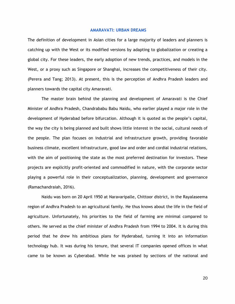
The 1375-acre capitol complex in Amaravati is a hub of state administration and
Figure 7: Components of Amaravati government complex Source: Jain et al., 2018

35
governance (figure:9). It consists of ‘iconic’ civic institutions of legislature, high court,
secretariat, Raj Bhavan and housing for various government functionaries. Naidu wanted the
government complex to be
‘inviting and accessible’ to
people, so that it justifies
the caption of people’s
capital in his point of view.
Also, inspired by New York’s
Central Park and public squares, a central vista, riverfront and a capital square were designed
for people to come and
interact with ‘their’ capital.
Also, to keep the spaces active and vibrant at all times of the day, residential, offices,
recreational and cultural uses were designed as the part of the government complex. While
the riverfront to north-east will house the city’s civic core and central business district (CBD).
The legislature building (figure:10) designed by Norman Foster consists of the
Legislative Assembly, the Legislative Council, central hall and hosts several ancillary functions
within the building. The ‘iconic’ building spreads over 400 acres on the ceremonial axis is 250
mt. tall. With the thought that humans last only for few decades but buildings last for
centuries, the design was more significant, that it does not fit in with any of the present
architecture buildings in the capital region or in India. In other words, without the flag, no
one will be able to recognize it as an Indian state’s legislative building. Architects claim that
the design represents ‘people and their aspirations’. Also, public and tourists are allowed into
the core of the building, is justified as giving prominence to Amaravati as “people’s capital”
in their perspective. Thus, questioning the meaning of “people” in their point of view.
Figure 8: Legislature building design in Amaravati by Norman Foster Source: Jain et al., 2018

36
Moreover, the high court
(figure:11) proposed to be built in
the justice city, south of the
Amaravati government complex, is
inspired by Indian stupas. Along with
the dream of catching up with the
west, Naidu made sure that the
designs include the symbols and
monuments that could be called their
own. In this context, Indian leaders and architects think of this design as a great creation that
could powerfully affect Indian architecture in the future.
During his visit to India, Norman Foster told the press that “the [Amaravati] design
brings together our decades-long research into sustainable cities, incorporating the latest
technologies that are currently being developed in India” (Norman Foster visits Amaravati,
2018, Para:2). The concept plans itself indicates that the architects were eager to implement
their dream designs and Naidu sharing the same vision as the Norman Foster’s team turned
Amaravati into a land for experiments.
With my own experience in a video conference with the Foster’s team (as an intern at
APCRDA), Indian planners had a tough time explaining the need for more parking lots than
provided. When asked about the provision of more parking lots, Foster’s team was unable to
understand the conditions in India and cultural practices in it. The architects were providing
parking within conditions and sizes in New York which are very different than in India. Parking
has become a huge problem in India and the congestion intensifies when political leaders and
their vehicular parking are considered in design because of the high security they need. Lack
of adequate parking space would only result in turning green spaces into parking lots. Such
Figure 9: High court design in Amaravati by Norman Foster Source: Jain et al., 2018

37
small-space making efforts of people add up to huge transformations surpassing any
production of formal space (Perera, 2016).
The blue-green (representing water as blue, vegetation as green) master plan creates
interfaces between water themed public spaces such as lake-parks, waterfront corridors, and
linear parks, reserving 30 % of capital city area for the open space and recreational zone. The
plan which is highly concerned about nature pays very little attention to social and cultural
aspects. Also, nature, in this plan, is neither the existing farmlands nor wildlife but the
cleansed and purified spaces that are capable of making visual effects prominent.
In short, Amaravati is not a planned but a designed capital, to implement the urban
dreams of a capital city by different and dominant social actors within various conceptions. It
demonstrates the continuing hegemony of the colonial culture, imported colonial and
modernist planning approaches and consumerism (Perera, 2005). However, materializing
these dreams were no easy for the state government. The next chapter details out the
interactions that occur in the process of materializing these dreams by focusing on the ways
in which they are being negotiated and how the final outcomes are being produced.

38
AMARAVATI: MATERIALIZING URBAN DREAMS
Although Amaravati is visualized with glass and steel structures, stylish designs, shopping
malls, high-rise complexes, and flyovers, the realities and existing conditions behind these
facades tell us a different story. In the context of the previous chapter which provides the
imaginations of dominant actors for a “good life,” this chapter tries to showcase the ground
conditions of the capital city, highlighting the impact of dominant urban dreams on the lives
and livelihoods of the subjects. “People” in this chapter refers to the ordinary citizens who
have no power to create a space as the state and capital (Perera, 2016). In other words, they
are meant to be subjects of the abstract spaces created by the state and capital. This chapter
details the interactions between the (dominant) dreams and (ground) realities, and the
negotiations between the dominant actors and the subjects along these lines, the former
attempting to materialize their dreams while the latter trying to create livable places. The
challenges also came from within the government, both national and state. I will focus on
the ways in which the dreams are negotiated, and the outcomes are produced.
As introduced above, Amaravati is visualized to be a world class city by the state
government is being built on 33,000 acres (217 Sq.km.) of land owned by individual farmers
between Vijayawada and Guntur along the banks of river Krishna. The new capital comprises
of 24 revenue villages and part of Tadepalli municipality of Guntur district spanning across an
area of 53,748 acres. The 33,000 acres of land on which it is built consists of two types:
drylands and wetlands. The wet or jareebu lands are classified highly fertile which can
support the growing of over 120 varieties of crops that yield crops thrice a year with the
water table at 15 to 20 feet. There is no other agricultural hub in India that produces these
many varieties of crops or provide yields of this magnitude. According to the farmers in this
region, it takes thousands of years to create a top soil of such richness; it has taken farmers
decades of effort to enhance the fertility of the land. However, this is not the first time in

39
India to build a capital city on fertile lands. Chandigarh which is being an inspiration for
capital cities in India was also built on rich and fertile agricultural land displacing farmers of
seventeen villages (Kalia, 1987).
The government usually targets land owned by farmers for land pooling or acquisition
because of their inability to defend or fight against dominant actors. This unequal power
relations make it easy for the government to acquire land. The main organization that is
coordinating between Naidu’s (state government’s) dreams and the people in capital region
and capital city is APCRDA. The Capital Region Development Act 2014’ has formed APCRDA for
the purpose of planning, coordination, execution, supervision, financing, funding and also for
promoting and securing the planned development of the capital region and capital city area
for the state of Andhra Pradesh.
The first challenge to the transformation of Andhra Pradesh’s dreams into reality came
from the central government of India. In 2014, the government of India formed a committee
under the Andhra Pradesh Reorganization Act 2014 to explore site options for the new capital
as mentioned in the above chapter. Headed by K.C. Sivaramakrishnan, the committee
included urban planners and design experts. In August 2014, the committee argued
(Sivaramakrishnan, K.C., et al.,2014), that the decentralization of the development could
bring the governance closer to people, encourage balanced development, and avoids civic
problems typically associated with big cities. It also emphasized that large-scale takeover of
fertile agricultural land is short-sighted, i.e., building on the selected site would diminish
food security in the long run.
According to the Sivaramakrishnan-committee report (2014), Guntur and Krishna have
the second highest population in the state at 49 lakhs (4.9m) and 45 lakhs (4.5m) with a
workforce of nearly 23.8 lakhs and 20.48 lakhs respectively. Of this work force, 65% in Guntur
and 56% in Krishna are farmers and agricultural laborer. The committee report, in fact,

40
rejected the present site, emphasizing that any attempt to convert agricultural land into non-
agricultural use, especially at this scale, would seriously displace this workforce rendering
them unemployed, and lead to the loss of valuable agricultural land, the disappearance of
small holdings and farmers, and solely benefit land speculation and increase profit for real
estate operators. Also, the Geological Survey of India carried out a seismic micro zonation for
this area and highlighted the problems of high-water table and vulnerable soil types which
together may cause severe problems for foundations, due to the loss of bearing capacity. This
is one of the reasons for not having many high-rise buildings in this area.
Despite the Committee’s recommendations, Naidu announced the location of the
capital city between Guntur and Vijayawada cities. To acquire the required land for the
visually world-class city, state government resorted to land pooling schemes (LPS), i.e.,
pooling the land, develop them and return a part of the newly serviced land to the owners.
Land pooling is supposed to be voluntary and an alternative to land acquisition. APCRDA was
directed to undertake the development of the city through land pooling in capital city area.
Negotiating every project on the ground, especially with people, is very crucial in
India. The outcome of state action is almost always negotiated by local people on the ground,
including the owners of land and users. As the Andhra government attempts to materialize its
dreams, the people who are affected by the project also take part in it. While some welcome
the changes, others do not; some of these others play a passive role while others resist and
protest. The rest of the chapter details out how various groups of people have taken part in
the project, as collaborators, protestors, and mostly in between, paying special attention to
the contradictions between the dreams and the realities.

41
LAND POOLING SCHEME:
Land pooling is a scheme implemented by the state government where the land
owners surrender their land in return for a smaller plot of urban, serviced land (returnable
plot) in the capital city area that is of higher value than the land relinquished. In other words,
the state government provides infrastructure and public facilities in the pooled land, often
keeps the land with it for future sale, and return a portion of the land to the owners in
proportion to their original share (Ramachandraiah, 2016). Several states in India have
adopted land pooling methods for different types of projects over the years. However, the
significant difference of Amaravati’s land pooling concept between them is the scale of the
project. Along with the serviced land, the land owners will also receive a range of livelihood
support measures including inter alia an annuity, skill upgrading and support for setting up
self-employed enterprises.
In short, the ‘benefits’ given by the state government under LPS are; (i) returnable
plots of urban land in Amaravati City’s perimeter; (ii) annuity payments for a period of ten
years; and (iii) other benefits including waiver of agricultural loans, skill training, and interest
free loans for setting up enterprises. Among the 53,748 acres of total land available under the
capital city area, 38,581 acres of land was targeted under the land pooling scheme. While
34,690 acres of land were consented under LPS, 33,201 acres was pooled and included in
development agreement by March 2018.
In LPS documentation, a multi-departmental team within APCRDA made a graphic
representation (figure:12) highlighting the reasons why landowners contribute their land to
the land pooling scheme. According to this graphic, 24% of the land owners found the
compensation offered for land attractive; 22% of them wanted to contribute to the making of
the capital city; 15% felt agriculture was not a viable occupation; 24% joined the scheme as
everyone else in the village was joining; and 14% felt that the pooling system offered a better

42
package than compensation under land acquisition. The respondents are diverse; they include
absentee landlords who live abroad and hire agricultural laborer to work in their fields,
owners of dry land with no proper ground water supply or irrigation systems, parents whose
children are settled abroad in different occupations and small landowners or farmers who
feared the dominant actors and had no other choice as the majority of their village who
voluntarily contributed their land for the capital-building project.
One of them is Nivas Rao who gave up 8 acres of his jasmine and vegetable farm. The
process started in 2015 when an official from APCRDA held an informal meeting, at the
panchayat office in Nidamarru village. Rao recalls the official making some grand statements
in Telugu: “I welcome you all to give your land today and be part of the future city. But if you
decide not to pool your land, then we will have no option but to acquire it through the Land
Acquisition Act.” He was boggled because he had to struggle getting compensation under the
land acquisition act in 1983 with Visakhapatnam Urban Development Authority (UDA). When it
seemed like the state would take his land no matter what, he hedged his bets. On the very
Figure 10: Graphical representation of reasons why landowners contributed their land to the land pooling scheme
43
final day, he agreed to give his last 8 acres to the land pooling scheme because he feared the
alternative: land acquisition. Rao is now among over 28,000 farmers who have pooled their
land towards the construction of the city of Amaravati and helped the AP government collect
86% of the targeted 38,581 acres according to an APCRDA project report as on March 2018.
Returnable urban plots:
‘Returnable plots’ is a term that is often referred to the smaller plots of urban
serviced land in the capital city area, that is of higher value than the land relinquished, that
will be returned to those who pooled their land. According to the APCRDA report (2018), 95%
of the capital city
area is owned by
landowners of
returnable plots
(figure:13). These
plots were returned
through an electronic
lottery conducted in
the presence of
landowners, village
elders, public
representatives, and
other stakeholders.
However, there were objections to the plots having road hits (a plot facing a T-junction road
where the road straightly hits the plot), and south or west facing plots, which are considered
problematic according to vastu. Also, people raised concerns on the plot location.
Figure 11: LPS returnable commercial and residential plots in Amaravati Source: Jain et al.,2018
44
The majority of people in India, especially rural areas, bury the dead or cremate the
corpses in their own farm land. In all 29 revenue villages that form Amaravati, people follow
the practice of cremation. So, few private plots in Amaravati also consist of graveyards with
stones of remembrance of their ancestors. APCRDA did not promise to return serviced plots at
the same places, including the stones. Amaravati planners are trying hard to impose an
overdetermined communal lifestyle upon the land owners
Yet people’s cultures and lifestyle prevent them of accepting such Western modernist
ideologies. Thus, people who received the plots with graveyards showed discontent and
refused to accept the new land as compensation for their old farm land, considering them as
bad omen. Instead, they demanded for another plot in another location. APCRDA is yet to find
a solution to this and other cultural issues.
Annuity Payments:
Annuity payments is the second component of the compensation package. According to
this program, that landowners who have contributed land to LPS will receive compensation
from the APCRDA. These payments are paid at the rate of INR 30,000 or INR 50,000 per acre
of contributed land, with 10% adjustment per year for inflation, over a period of ten years.
The amount is based on the net crop loss per an acre of dry or Jareebu lands respectively.
Nearly 26,830 farmers received compensation and, according to it project report (2018),
APCRDA spent INR 429.70 crores in annuity. All others who depended on agricultural land, i.e.
landless agricultural labor, are provided with a pension of INR 2500 per month for a period of
10 years.
According to the state government, this 10-year period is for agricultural laborers to
adapt to non-agricultural income-generating activities. Poorer and vulnerable groups will also
be provided with further livelihood support and access to the social development schemes

45
and additional livelihood schemes which are yet to be designed. Participating farmers began
receiving annuity payments as part of their LPS benefits package in May 2015. AS per the
announcement of Naidu, APCRDA began distributing monthly pensions in May 2015 to the
agricultural laborers and tenant farmers who resided in the capital city area as of December
8, 2014.
While government assumes that it is providing support for people in an efficient and
appropriate manner, Nageswara Rao who receives INR 30,000 a month says it does not cover
his son’s medical college fees. He says that owning an agricultural land gave him the
flexibility to sell small pieces of land when he needed large sums of money, like for a house,
wedding, or college. While building a city with IT companies, banks and hospitals, saying that
their next generations never have to farm, makes him ask how will their son become a doctor
if his farmer father can no longer afford to educate him? “People in cities think farmers are
sentimental when they are attached to land, but that is because you don’t understand our
rationale” said one of the
farmers. Further, he did not
realize that as soon as he
agreed to pool his land for
Amaravati, he had to stop
farming. He thought that he
could farm until APCRDA
pushed them to stop
cultivating to convince the
visiting teams of potential investors and realtors and start construction. Another farmer
Venkatapathy Naidu adds that he could not watch bulldozers taking down his banana
plantation (figure:14), and now 20 of his 36 pooled acres are barren. He stealthily grows
Figure 12: Bulldozers taking down banana plantation in Amaravati area
46
paddy, turmeric and lemons on the remaining land left after giving away to land pooling.
However, there are other land owners like Rao who totally support the land pooling scheme;
he volunteered his 40 acres of land to the capital city project. Being the last farmer in his
family and having his son and daughter as doctors abroad, he gave his land to save his family’s
economic future, not necessarily to contribute to the capital city project. However, he still
trusts the government. He is not happy with the speed of construction and is planning to ask
the government to pay monthly compensation for 15 instead of 10 years. It is hard to see the
correlation between his demand and the speed of the capital city project. He is definitely
interested in making the project beneficial to him.
The majority of upper middle-class landowners, i.e., non-farmers, left the small
landowners or farmers with no choice except taking the annuity payments. These farmers
either turned into shopkeepers in the existing villages or are still searching for other sources
of employment. While comments of Nageswara Rao on annuity payments tell us that their
agricultural land, especially their livelihoods that were tied to these lands are irreplaceable
no matter what the government pays. Overall, the land owners are striving hard to overcome
their loss of agricultural lands and the livelihoods tied to those, while the agricultural
laborers who worked in fields are in search of other jobs like autorickshaw drivers,
construction workers, and house maids.
Other Benefits:
The other benefits that APCRDA is extending to LPS participants include the waiving of
agricultural loans, the provision of interest-free loans for self-employment, educational
facilities and access to medical facilities. According to the APCRDA, these social development
initiatives help the farmers, landowners, and landless pensioners, particularly women and

47
marginal farmers and other weaker sections, in smoothly overcoming the transit from
agricultural to urban life.
However, there are gaps in its implementation too. The national government has
released the required funds directly to Rythu Sadhikara Samstha for onward payment to
banks per government norms. Even after the farm loan waiver scheme was implemented in
2014, many farmers still complain that they were being left out, and some others say they
just got a partial waiver (Ramachandraiah, 2016). Also, many of them complain that their
loans have still not been waived, and they are unable to get new ones because of non-
repayment of the old ones. Some claim that the waiver has benefited big farmers and
landowners, leaving out tenant farmers and landless poor.
Apart from waiving loans, APCRDA, through its nodal agency Andhra Pradesh Skill
Development Corporation (APSSDC), is providing skill development training to the youth. It is
further trying to establish a skill development institute by partnering with various reputed
NGOs and private sector entities. According to its report (year), APCRDA has begun the second
phase training in various domains including painting underground cabling, plumbing, general
supervisors, mobile AC technicians, beauticians, and two-wheeler Motor Mechanics. However,
1560 members trained in this program consisted more of educated unemployed youth.
As the state government and APCRDA were organizing the above social initiatives,
people in the existing villages continued to reproduce their lives. Some of the landless
laborers and uneducated people initiated to survive on animal husbandry, feeding herds of
cows, sheeps and goats. The empty barren lands turned into grazing lands for goats and
sheeps. This was not just limited to the surrounding farmers. Along with nine other men from
his village, Mallampalli, in the neighboring Krishna district, Ravindra Babu, 34-year-old goat
herder had travelled over 150 kilometers along with 1,000 goats, inching along highways and
by lanes, thus reaching the site of the future capital (figure:15). He said that some men from

48
their village came to scout the place and then word just got around that there is empty land
where goats can be taken to graze. Earlier, many of them used to drive their goats up to the
Vellampalli forest, 80 kilometers south of the site designated for Amaravati. At present, they
are surviving on this land not knowing what will happen next, once the building of the capital
city gets under way.
Similarly, not knowing what will happen after building a city and about the new laws
of the capital city, people in undisturbed settlements (existing villages) in the capital city are
in a hurry to lay further claims to their property; many add additional floors to existing
buildings and build on the vacant lands. According to the Andhra Pradesh Government Order,
at the minimum, a 30 feet road is required for a four-story building to be constructed but,
after the announcement of capital city area, the landowners started to construct four to five
storied structures abutting 10-foot roads, leaving no setbacks. These are the small properties
mostly owned by landowners involved in land pooling. They are expected to build according
to policies and live in abstract city spaces created by the authorities. While these people hire
architects and engineers to simply comply with the law on paper, so to satisfy the authorities.
On site, they achieve the maximum usage of land, building their homes with the help of local
building contractors, fulfilling their own needs and wants. In regard to cities such as Gangtok,
Perera (2016) had demonstrated that builders neither totally adopt, nor totally reject
Figure 13: Agricultural lands turned into grazing lands in the site designated for Amaravati

49
dominant perceptions; they exercise their agency in the “room for maneuvering” between
adopting and rejecting. This is precisely what we see in Amaravati. The builders see
opportunities and adopt various tactics to negotiate rules and regulations adapting them to
suit their own needs and wants while remaining “legal” (Perera,2016). While the surrounding
agricultural lands are forced to leave barren, land owners and farmers are being left with no
option in the existing villages.
Since the proposed capital city (or the site) does not have any living options except in
existing villages, APCRDA officials and others travelling to and from Amaravati for surveys,
take food stops in these villages. People in the villages now sell coconut water, fruits, and
other foods on movable carts to satisfy this huge demand by the travelers. Thus, in
attempting to live their lives better within their own capacities, people have begun to
transform their own environments. For instance, Mandadam village where almost everyone
was a farmer was famous for its fruits and flowers. After these farmers gave up all their land
to the state government under the land-pooling scheme for the new capital, most of them
introduced they themselves as “real-estate agents” or “businessmen”. One advertises
“comfortable hostel accommodation for working men” at affordable rates. Other promises to
deliver bottled water at the doorstep. While some landless owners have erected Informal food
stalls by the roads, auto rickshaw drivers advertise their phone numbers to transport
employees to and from the transitional secretariat (discussed in the next section).
These are the consequences of land pooling of nearly 33,000 acres of agricultural lands
for the capital city, but the state government is getting ready to land pool 3000 acres more to
build the outer ring road. National Highway Authority of India (NHAI) has already approved
Singapore's firm Surbana Jurong’s plan of Ring Road. This is the means for the state
government to collect the required land for the road using the land pooling method without
bearing the financial burden. The six-track outer ring is expected to pass through 49 villages
50
in Krishna and 38 in Guntur district. The nearby Vijayawada city has been facing traffic
problems for more than three decades due to passing traffic on Hyderabad-Chennai and
Chennai-Kolkata highways. Thus, the purpose of the outer ring is to prevent vehicles making
long-distance trips between Hyderabad, Visakhapatnam and Kolkata, passing Amaravati, from
entering the city.
Amaravati city requires more land than the pooled 33,000 acres and the 3,000 acres
“acquired” for the outer ring road. As evident in Chandigarh, the outer ring will not be the
boundary of the city. Chandigarh was planned with a green belt around it, but with time,
private developments grew around the city. It saw a high influx of people into the city and
surrounding areas, making the city build satellite towns; Amaravati seems to be on the same
path. According to the previous experience, land around the proposed 6-lane roads would
encourage the realtors to construct further commercial and high-rise buildings instead of
farming; this could lead to the loss of a larger quantity of productive farm fields.
TRIP TO SINGAPORE:
As a part of negotiation, APCRDA hosted a 3-day trip to Singapore exclusively for
farmers who gave away their land for the capital. As Singapore is the model in Naidu’s vision,
APCRDA wanted the farmers to use the compensation provided by the government to seek
alternative means of livelihood guided by Singapore. According to the APCRDA officials 123
eligible farmers among the 153 that applied were sent on trips to Singapore in four smaller
groups in the months of November 2017 and February 2018. They were selected based on
several criteria; priority was given to those interested in becoming entrepreneurs and starting
their own businesses (Janyala, 2017). However, it was not free of cost for the farmers; they
had to pay for the flight expenses that was about INR 25,000. The government spent on
accommodation, food, visa, insurance, and the local tour in Singapore city. When an APCRDA

51
official asked the farmers if they had any questions regarding the trip, the first question,
asked by 60-year old Simha, was, “How many lakhs can I take to Singapore? How much gold
can I buy?” While Madhu told the Indian Express news agency (2017) that “the officials told us
that we will get a lot of ideas on how to do small- and medium-size businesses. I want to start
a flower supply business and am hoping to get ideas on how to start a flower garden in the
middle of the capital region.” However, according to Indian Express news agency, many
people have admitted that they were looking forward to shopping or visiting universal studios
at Disneyland which is far away from the thought of the APCRDA officials.
People are fascinated by the name Singapore as they hear the name frequently from
their leader as one of the world class cities. Many of these farmers have not stepped out of
Andhra Pradesh. They have no idea about the international travel, or rules and culture in
Singapore; they were worried about the language barrier. An APCRDA official was sent as
translator who would guide them during the three-day tour. This is a great opportunity for a
middle-class family that can neither afford the entire expenditure of the trip accommodation,
nor understand a foreign language. Considering this as an opportunity to step out their village
and have a holiday, these farmers were willing to spend their airfare. Ultimately, this was a
trip organized on the dreams of the weak, by the dominant actors with power, to accomplish
their goals.
FUNDING AND PROGRESS OF THE CAPITAL CITY:
According to the concept plan, Amaravati is expected to be built in three phases that
continues until 2050. The first phase, spanning the first ten years (2015-2025), includes the
building of government administrative core along with the ceremonial axis and parts of the
SEED development area: the business park and the light industrial area. It is expected to
provide housing for 850,000 people which is about 39% of the total population of Amaravati

52
capital city. According to APCRDA’s estimate, the building activity requires about INR 58,000
crores, in the next 20 years. Till date, the central government has given only INR 1,500 crores
for the project; an additional INR 1,000 crores are expected to be released in phases. In
comparison, with Nehru’s involvement, the builders of Chandigarh did not have to look for
expenses. Nehru’s involvement in the project made the central government play an active
role. In regard to Amaravati, the lack of financial support from Prime Minister of India,
Narendra Modi and the continuous deferment of the releasing of funds by the World Bank
work as a hindrance for Naidu’s materialization of Western urban dreams in India.
Despite the hardships, Naidu is adamant. He told Agency France-Presse (Tabassum,
2018) that “I am not changing any plans for Amaravati. I only have to work harder to make it
a reality”. The state government has been trying hard to pull as many sources as possible, but
the World Bank continues to be its major source.
In May 2017, a few landowners from capital villages had written to the Bank alleging
harm from the LPS. The inspection panel registered a request for inspection in June 2017, and
it has been making trips to the capital region to interact with the landholders. There were
also alleged rumors that the opposition party YSR congress is supporting these landowners,
i.e., their agitations, for its political benefit. When asked about the deferment of funds from
the World Bank and other sources, at an informal conversation, an Assistant Zonal Planning
Officer answered with utmost confidence that “funds will be approved no matter what. If not,
the World Bank there will be another source. Amaravati will not be stopped” (personal
communication, 2017).
In the meantime, a loan of INR 1275 crores from Housing and Urban Development
Corporation Limited (HUDCO) was sanctioned in December 2017 to fund the first-tier
infrastructure, mainly the most significant roads. Also, various commercial banks such as
53
Andhra Bank, Indian Bank and Vijaya Bank came forward to extend short term funds for
various development works in the capital city.
However, as the World Bank made the second deferment in August 2018, APCRDA will
not be able to rely on this source till 2019. The application for funds would not move to the
appraisal stage, i.e., for final approval, without a clean-chit (a certificate of exoneration
given by law enforcement agencies to suspects in a crime) from the panel of inspectors. This
may not happen until the elections which is scheduled for April 2019. With no certainty
whether the voters will give him the mandate, Naidu is struggling hard to collect funds and
start construction. This way no other party that might come to power in April 2019 will be
able to stop the building of the capital city that he dreamt.
Apart from banks, Naidu introduced programs like “My Brick-My Amaravati” where an
individual can contribute INR 10 per brick online that will be used in the construction of the
capital. In return they are given a receipt in the form of a certificate bearing Naidu’s
signature, and their names mentioned as ‘partners of Amaravati’ on the website. As on 13
October 2018, 2,28,016 had donated 57,30,711 bricks towards Amaravati; this is since 2015.
No one ever knows how this money would actually be used.
The estimated construction cost of the proposed government buildings like Raj
Bhavan, High Court, the Legislative Assembly, Council, the Secretariat, and other
departments are over INR 2400 crores. As it would take couple of years to build the designed
government complex in Amaravati, the immediate need to shift the entire state
administration from Hyderabad leads to the construction of an interim government complex
in Velagapudi, a village in Thullur mandal in Guntur district. It is located on the Vijayawada-
Amaravati route. Within a total area of 45,129 acres, 27,082 acres have been used to
construct six two-storied buildings. The six buildings include legislature building, secretariat

54
and headquarters of government departments. The entire administration has been shifted
from Hyderabad to Velagapudi, by 2017.
The interim government complex (figure:16) was built round the clock, using three
eight-hour shifts, in 6 months. Left with no option to support their livelihood after giving their
land for land pooling, most of the agricultural laborers joined the construction labor pool,
making it easier for the government to find construction labor. Since there were no proper
roads, while the major road is under construction, a single lane macadamized road was laid
temporarily from Vijayawada to Velagapudi. Both sides of the single lane road are still
covered with green fields where several families and farmers from nearby villages come and
stand in front of the lands watching helplessly, while a man cycled by with an ice cream cart
sell them refreshments. A village once known only for prime agricultural production and roads
which hardly bore two-wheelers is now barricaded for security with checkpoints of Police
battalions. The road up to the Velagapudi interim government complex is dressed up with
rows of APCRDA flags on either side with the name Amaravati and Naidu’s photo on it
(figure:17).
Figure 14: Interim government complex in Velagapudi Source: Jain et al., 2018

55
Though the Secretariat has started functioning from the Interim Government Complex
(IGC) at Velagapudi, there is no housing available for the 2,500 employees. They live in
Vijayawada, Guntur, and Mangalagiri. Thus, many farmers have taken up auto rickshaw hiring
as an alternative income-earning method and the autorickshaw has become the main means
of transportation for the state employees. As mentioned in the previous section, autorickshaw
drivers advertise their telephone numbers to get clients.
In the meantime, the state government is in the process of constructing government
housing complexes in Amaravati, with necessary social infrastructure including roads, schools,
healthcare facilities, civic amenities and infrastructure (figure:18). Time will tell whether the
Figure 18: Beginnings of new road in Amaravati Source: Romig, 2017
Figure 17: Single lane road to Amaravati with Naidu’s hoardings (billboards) on either side.

56
employees will move to Amaravati with only basic necessary infrastructure built for them.
The outcome could be similar to Gandhinagar which could not attract the lawyers and judges
to move to the capital of Gujarat and had to build the high court in Ahmedabad (Kalia, 1987).
Nonetheless, well known universities such as Sri Ramaswamy Memorial Institute of
science and Technology (SRM) and Vellore Institute of Technology (VIT) have already started
their academic classes in Amaravati in semi-built structures, Amrita University has started
construction in 2018. Also, Indo-UK Institute of Health Medicity 1,000-bed hospital and the
National Institute of Design are expected to start their construction soon. However, there are
rumors that investors and state institutions are taking a step back and are waiting for the
results of next elections to start construction. The opposition parties are against the building
of Amaravati and most people think that, if they win, Amaravati as planned may not
materialize. Also, as the lack of funds delays construction for the designed city, people
including those who volunteered their lands to land pooling are worried that the elections
may put a stop to the new capital project. This would cause a huge loss for the land owners
who got involved in the LPS.
In sum, an ultimate success of the capital would not only depend on its architectural
forms and thousand years of vision but also depend on accommodation of present cultural
practices and local lifestyles of people. This is a city that is planned from a distance through
numbers, maps and images, overlooking the individuals, livelihoods, their desires and spaces.
The dominant actors involved in the planning and development of Amaravati assumed their
role as the agents of change who can ‘modernize’ the peasants. Trip to Singapore, land
pooling schemes with social benefits like training younger generations were some of their
practices to modernize them. As their career development provides both livelihoods and
social status for a significant population across national boundaries (Perera, 2010). While the
landowners and the existing settlers were considered as the recipients of better life in the

57
world class city with no agency or voice. In the planners’ and politician’s perspective they are
the bodies that needs to be ordered and organized. Yet, the recipients successfully interpret
and modify the norms within their local contexts that planners refuse to acknowledge which
is already being followed in the existing settlements in the capital city area.

58
AMARAVATI: PEOPLE’S CONTESTATIONS
The world class city that is being created is a totally different reality from the world in which
local people live. This gap has put enormous pressure on local people to transform into
subjects of this new city which is almost impossible for them. The negotiation of an
acceptable middle ground requires an effort of impossible proportions. People are also
diverse; while some are encouraged by the project, others are not. As explained in the
previous chapter, the APCRDA used land pooling scheme as a means of acquiring land for the
capital city. Despite APCRDA and Naidu’s claim that most people gave their lands voluntarily,
few groups held out. This chapter focuses on these protesting groups and people who did not
agree to give their lands to the capital city. This chapter attempts to understand the people’s
perspective towards the development in a local context, for not taking part in the capital
project, and resistance.
The 74-year old Narayana, retired journalist and social activist from Vijayawada was
probably the first person in Andhra Pradesh to raise his voice against Naidu’s plan to create a
‘world class’ capital on the floodplains of Krishna River. He does not own any land in the
proposed capital region but was concerned with the environmental aspects of the capital city
project. He filed a case in high court with the intent of fighting all the way to the National
Green Tribunal (NGT), stating that it comes under the earthquake-prone third seismic
zone. Also, he argued that a black cotton soil which can support the growing of over 120
varieties of crops and yield at least three times a year is not good for heavy construction.
These soils are unsuitable to carry heavy structures; this makes it difficult to sustainably build
structures taller than two floors. Despite his age, illness and debt, he spent over INR 55 lakh
on fighting this case at the NGT. He sold his land in Hyderabad to cover the expenses he
occurred since February 2015, claiming that fertile land along the Krishna River is being

59
destroyed for urbanization (Tarafdar, 2017). However, in November 2017 NGT ruled in favour
of the state government allowing the construction of the capital city.
While such social activists tried hard, protesting, and approaching the institutions of
justice, used their agency and tactics, the farmers, especially the landowners, refused to
hand over their lands to the government and continue farming (figure:19). Thus, the AP
government relied heavily on using police as an instrument of coercion and intimidation
(Ramachandraiah, 2016). According to
Romig’s (2017) interview with a
farmer, Rao, in the village, several
battalions of police stationed
themselves in the most recalcitrant
villages to make their presence felt
before the land pooling sign up
deadline in late 2014. Also, to their
surprise, several farm fields
mysteriously caught fire and police
summoned the villagers for questioning about the arson. Instead of questioning about the
arson, in the interrogation sessions that lasted until dawn, the police mostly asked why they
were not handing over their land (Romig, 2017).
Despite many threats, about five percent of the farmers held out and tremendous
pressure was brought on them. One of those villages was Nidamarru which is a major
wholesale supplier of flowers to markets throughout Andhra Pradesh and Telangana.
Resistance to land pooling has been high in these river bank villages as they have the most
fertile lands. According to the master plan this area is to be converted into Amaravati’s
electronic city, with information technology companies and computer chip manufacturers.
Figure 19: Land in Amaravati area that is yet to acquire

60
However, jasmine farmers like Vijayama are reluctant to give their lands to the state
government. She employs around 300 local women as pluckers, who are in support with her in
this resistance. These women are worried that the new city could not bring any new
opportunities to them, except for urban jobs to work as maids or cleaners, which they wish to
avoid. For Vijayama there is no compensation that can replace her 20 acres of land (Romig,
2017).
However, this is not the case in Dondapadu village where the land is dry and nearly
not as productive as Nidamarru. An anonymous resident there who was struggling to live his
life there had built a three-story building on the land he received from the land pooling
scheme. Every former farmer in this village has expressed great happiness regarding the
technique. Land pooling scheme has met little opposition in such villages.
Yet, the division of dry and wet lands by the APCRDA has also created problems in a
few places. A landowner who owns wetland that borders the village of dryland is at stake. A
few hundred farmers have been vocal against the pooling system based on this unruly
division. One of them is the 59-year-old farmer Raja Reddy. Initially he wanted to pool his
land but withdrew when the APCRDA classified it as dry land and offered him lower
compensation than he expected. Reddy grows vegetables, paddy, Bengal gram, turmeric and
bananas in his six acres of land and earns INR 1.5 lakh per month. Reddy argues in his own
words: “Suppose I give my land and stop farming for 10-15 years, taking a INR 50,000 monthly
compensation from the government. What if Amaravati never comes up, or what if the land
prices don’t shoot up as they expect? I’ll be left with no income, and a small piece of land
that is un fertile and undeveloped” (Mohan, 2017).
When an APCRDA official was questioned about these resistances, they replied with
utmost confidence that the agency will definitely takeover the fields, leaving the farmers
with no choice. As said, the Andhra Pradesh Assigned Lands Act (prohibition of transfers) was

61
enacted. That is, planners in the APCRDA has made sure that the farmers who held out their
lands in resistance can no longer be sold or transferred to anyone, leaving the only option of
surrendering them to APCRDA. Also, in 2016, Southern Power Distribution Company Limited
(SPDCL) took the decision to snap all agriculture connections in the capital city area, but the
on-field process started in 2017. According to the farmers, the removal of distribution and
transmission relay (DTR) lines is their first measure to put an end to cultivation forcing the
farmers to give up their lands to APCRDA. Yet, for now cultivation has not stopped in few
places where there is still power.
In short, it is hard to gain much through protests if powerful actors possess the power
to implement the projects and are determined to carry out (Perera, 2016). When people are
involved in the negotiation of space, culture acts as a major factor besides the state, capital
and economy. Amaravati is coming up on the land where the culture is deeply attached with
agriculture. Most of the major holidays revolve around farming in the region, which the new
city seeks to erase. This has been the culture that has evolved over a period of hundred
years. For the farmers like Vijayama it is the only life they want. Although it is a miracle for
the great mass of strugglers where the land is not very productive (dry land) like Dondapadu
village, it is of a great distress to the jareebu productive land owners.

62
CONCLUSION
Overall, the study shows that the planners of projects that claim to serve public health,
safety and welfare have minimal knowledge of ordinary people’s everyday activities and
cultural practices and pays less attention to these. Amaravati never a unanimous idea. Like
Chandigarh, some favoured the building of a new capital while others vigorously opposed and
argued that it would destroy prime agricultural lands of the country. However, the ideology of
the dominant political actor Naidu revealed the formal political power he held, but also over-
weighed the economic and social arguments of the oppositions.
Although, Naidu is respected for his enormous efforts in trying to bring about
transformation, he is also criticized by local people for acquiring the lands through LPS, not
considering the culture and the environment of the region. His frequent comparison of
Amaravati to Singapore, which has little in common, is another aspect that is often criticized.
Additionally, the LPS in Amaravati which is considered as the most successful of its kind in
India has also created uncertainties and tensions even among those who willingly gave their
lands and cooperated with the government due its delay in construction. Yet, irrespective of
these criticisms Naidu is adamant in fulfilling the dream of Amaravati. Singapore’s
transformation from a fishing village to model a megalopolis within a generation is Naidu’s
inspiration. This kind of intention in mind, Naidu turned towards Singapore in planning the
master plan of Amaravati.
The Singapore-based planners of the Amaravati project who have very little knowledge
of everyday activities of ordinary people in India produced a township model that is far from
local realities. The UK-based architects studied ancient monuments and famous places in the
region with the intention of producing an environment that India can call its own. As a
product of the processes of searching for India’s own symbols and monuments and trying to
bridge the gap between “ancient” and “modern”, the designs for the high court resulted in a

63
combination of abstract Indian ancient-monuments. The concept of abstraction in the designs
is highly preferred because it’s the most valued in west and claims to represent the world
neutrally (Prakash, 2002). However, the cultures that the architects studied and adopted in
their designs were given the least importance by planners.
It is not wrong to get inspired from the other countries, especially the well to do ones,
but one should not overlook the resources available in its local region produced by their own
people. A great resource India is its agriculture and bustling bazaars that support livelihood of
local people in the region which the development model does not consider. People in India
are more used to eating food from road-side carts and buying fresh vegetables and fruits that
sold on carts. Andhra Pradesh which is known as the food bowl of India has more such
informal businesses which get produce directly from the farms. In Western countries, such
foods are sold in farmers markets (rythu bazaars in India) which are much expensive than in
big box stores. In Indian rythu bazaars, the produce is much cheaper than anywhere else. No
matter how much they transform, such informal markets are the source for a wide-range of
ordinary people.
Amaravati project is causing rapid urbanization in Vijayawada, resulting in more
concrete apartment blocks and wide roads. Yet, people produce their lived spaces by carving
Figure 20: Informal space by local farmers in Vijayawada

64
out room for their daily activities (figure. 20) which can be a subject for deeper study.
Although Amaravati’s planning model might be different from Vijayawada, the recipients who
are going to live in the city have the same culture. As illustrated in chapter four, the farmers
and agricultural labourers have already made up such informal businesses roadside on the way
to Amaravati from Vijayawada. Thus, the capital city’s planning resembles the initial
situations of Jawahar Nagar and Chandigarh, which saw a dramatic change after completion.
In sum, this study is an attempt to convey the gap between Naidu’s urban dreams
which follows foreign ideals and conceptualized by foreign planners but contested and
transformed by local people’s lived processes. Amaravati is just not erasing the prime
agricultural land but is also bringing drastic changes to the livelihoods of the farmers and
agricultural labour. The formal spaces planned as per the master plan is thus an alienated
space from the nature and people. However, in Chandigarh and Jawahar Nagar, people
localize themselves, their activities, and spaces in one way or another. Understanding
people’s spaces requires us to pay attention to the “messy” spaces they produce (Perera,
2016). When planners refuse to acknowledge and incorporate these spaces in the system, such
people will become beggars or burden to the society of which there is no of lack in India.

65
REFERENCES
Apte, P. M. (2012) The building of Gandhinagar. India: Power press. Das, D. (2013) Ordinary lives in extraordinary Cyberabad, in Transforming Asian Cities: Intellectual impasse, Asianizing space, and emerging translocalities, ed.: Perera, N., and Tang W. S: 112-122. New York: Routledge. Norman Foster visits Amaravati, (2018, May) Foster+ Partners, Retrieved from https://www.fosterandpartners.com/news/archive/2018/05/norman-foster-visits-amaravati/ Goonatilake, S. (1984) Aborted Discovery: Science and creativity in the Third World, London: Zed Books. Harvey, D. (1973) Social justice and the city, University of Georgia press. Iyer, Ravi. S., (2015, October 24) Foundation laying ceremony of Amaravati, The People’s capital of Andhra Pradesh. [Weblog Post] Miscellaneous topics. Retrieved from http://ravisiyermisc.blogspot.com/2015/10/foundation-laying-ceremony-of-amaravati.html Jain, A., Cherukuri, S., Rao. R., Sundari, N. Mohan, S.S., Pardhasaradhi. D.L.,...Sowmya, V., (2018) Amaravati Project report, Andhra Pradesh Capital Region Development Authority, 3. Janyala. S. (2017, October 30) Amaravati farmers leave for Singapore today: Will test CM Chandrababu Naidu’s promises, The Indian Express. Kalia, R ((2004) Gandhinagar: Building national identity in postcolonial India. University of South Carolina Press. Kalia, R (1987) Chandigarh: In search of an identity. Southern Illinois University Press. Kamiya, T., (2017), Architectural work of Le Corbusier in Chandigarh, UNESCO World Heritage, Retrieved from http://www.kamit.jp/02_unesco/21_corbusier/cor_eng.htm. Katz, C. (2004) Growing up Global: Economic restructuring and children’s everyday lives, Minnesota, MN: University of Minnesota Press. Kodandaram, M. (2009) Telangana Marginalised. The New Indian Express. Retrieved 2013-05-23. Kumar, V. (1976). Committees and Commissions in India Vol. 1: 1947-54. Concept. Pp. 70–71. Mohan. R. (2017, November 29) Price of a dream city: Andhra farmers are caught in the uncertain promise of Amaravati. The News Minute. Perera, N., and Tang W. S. (2013) Transforming Asian Cities: Intellectual impasse, Asianizing space, and emerging translocalities, New York: Routledge. Perera, N. (2013) Critical Vernacularism, in Transforming Asian Cities: Intellectual impasse, Asianizing space, and emerging translocalities, ed.: Perera, N., and Tang W. S: 75-93. New York: Routledge.

66
Perera, N. (2005) The Making of a National Capital: Conflicts, Contradictions, and Contestations in Sri Jayawardhanapura, in National Symbols, Fractured Identities: Contesting the National Narrative, Michael Geisler, ed.: 241-272. VT: Middlebury College Press. Perera, N. (2016) People’s Spaces: Coping, Familiarization, Creating. New York: Routledge.
Perera, N., (2010) When Planning Ideas Land: Mahaweli’s People-Centered Approach, in
Crossing Borders: International Exchanges and Planning Practices, Patsy Healey and Robert
Upton, eds.: 141-72. New York: Routledge
Pradhan, S. (2005) Everyday building: The production of the Middle class built-environment in Gangtok, India, in People’s Spaces: Coping, familiarization, creating, ed.: Nihal Perera: 175-193. New York: Routledge. Prakash, V. (2002) Chandigarh’s Le Corbusier: The Struggle for Modernity in Postcolonial India. University of Washington Press. Ramachandraiah, C (2016) Making of Amaravati: A landscape of speculation and intimidation, in Review of urban affairs, Economic and Political weekly,Vol. 17 (April, 2016), 68-75. Romig, R. (2017) Urban dreams: India builds a city from scratch, The California sunday magazine, Retrieved from https://story.californiasunday.com/urban-dreams. Sivaramakrishnan. KC., Ravindran, KT., Revi, A., Roy, R., Shah, J. (2014) Report of the Committee Appointed by the Ministry of Home Affairs, Union of India to Study the Alternatives for a New Capital for the State of Andhra Pradesh (also known as Sivaramakrishnan Committee), Government of India. SriKrishna, B.N., Duggal, Vinod K., Singh, R., Shariff, A., Kaur, R. (2010) Committee for Consultations on the Situation in Andhra Pradesh Report (also known as Sri Krishna Committee), New Delhi: Government of India. Sujata (2015, April) Amaravati: Andhra’s new capital, Maps of India, Retrieved from https://www.mapsofindia.com/my-india/government/amaravati-andhras-new-capital. Tabassum, H.,(2018) A city like no other: Hopes on hold for Amaravati, a model Indian capital, News 18, Retrieved from https://www.news18.com/news/india/a-city-like-no-other-hopes-on-hold-for-amravati-a-model-indian-capital-1763699.html. Tarafdar, S.S., (2017, May 11) Pandalaneni Srimannarayana lonely fight against the AP government, First post. Tarafdar, S.S., (2017, May 9) How AP’s landless turn penniless in the name of development, First post. Vidyarthi, S. (2013) Indianizing the neighborhood unit: The Jawahar Nagar plan, in Transforming Asian Cities: Intellectual impasse, Asianizing space, and emerging translocalities, ed.: Perera, N., and Tang W. S: 190- 206. New York: Routledge.

67
Windmiller, M. (1954). Linguistic Regionalism in India. Pacific Affairs, vol.27, no.4, 291-318.