Broward County 100-Year Flood Elevation Map and Associated ...€¦ · TBE Tobon Engineering, Inc....
25
Broward County Future Conditions Flood Map and Modeling Evaluation Committee Presentation September 27, 2017
Transcript of Broward County 100-Year Flood Elevation Map and Associated ...€¦ · TBE Tobon Engineering, Inc....
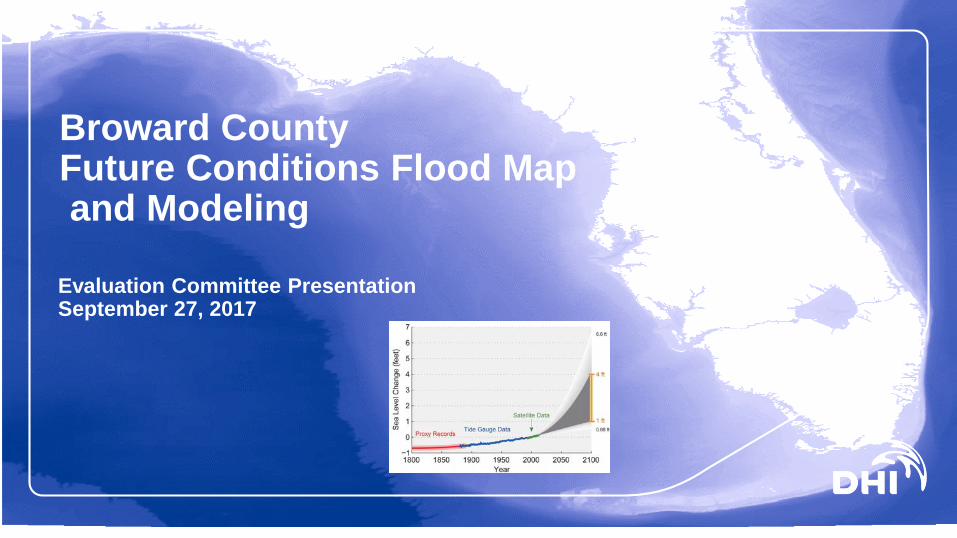
Broward CountyFuture Conditions Flood Mapand Modeling
Evaluation Committee PresentationSeptember 27, 2017

© DHI
• General Introduction to the DHI Team • Approach to the Project• Tools, Utilities and Technology• Response to Committee Questions• Conclusions
• Additional talking points and further details are provided in the accompanying handouts to this presentation
Agenda

Project Team
DHI Water and EnvironmentGIT Consulting Brizaga ConsultingTobon EngineeringSurfBigData
(See handout for additional details on firms, personnel)
Introduction, Personnel and Project Roles
© DHI

Why the DHI Team
© DHI
Future conditions flood mapping in a complex urban/coastal environmentUsually only performed with oversimplification:
by FEMA, communities, consultants
Success requires integrating political, domain, and technology issues Coastal remodeling is likely required: core capability of DHI Extensive knowledge of regulations and local context Model integration inland/coastal, updating models for performance Development and delivery of technology: DHI’s core value proposition Communication and outreach Long term support to Broward County is a DHI priority
Broward County 100-Year Flood Elevation Map and Associated Modeling
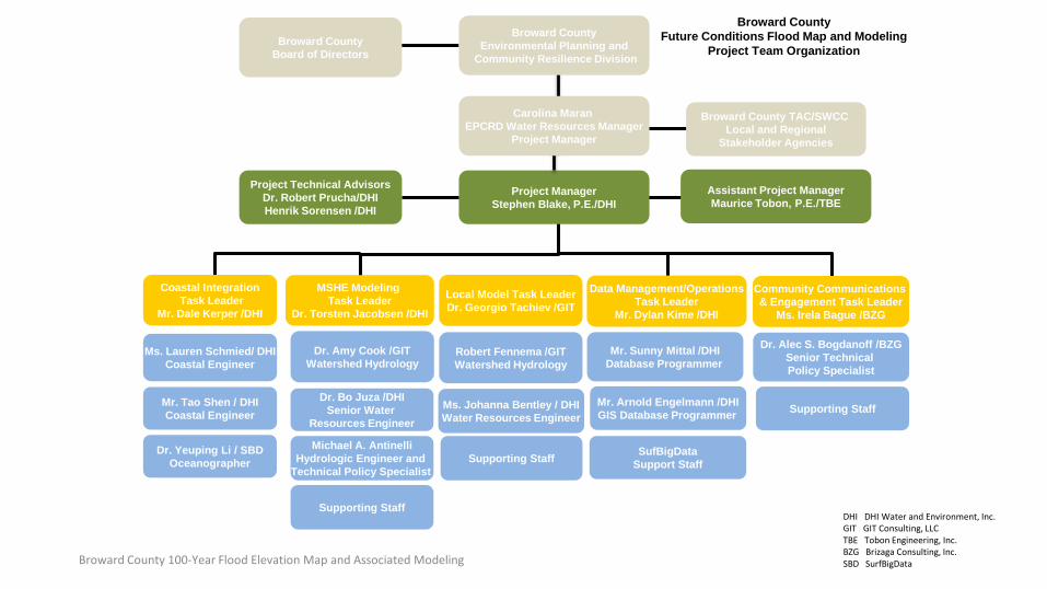
Broward CountyBoard of Directors
Project ManagerStephen Blake, P.E./DHI
Broward CountyFuture Conditions Flood Map and Modeling
Project Team Organization
SufBigDataSupport Staff
Project Technical AdvisorsDr. Robert Prucha/DHIHenrik Sorensen /DHI
Robert Fennema /GITWatershed Hydrology
MSHE Modeling Task Leader
Dr. Torsten Jacobsen /DHI
Dr. Bo Juza /DHISenior Water
Resources Engineer
Local Model Task LeaderDr. Georgio Tachiev /GIT
Mr. Sunny Mittal /DHIDatabase Programmer
Data Management/OperationsTask Leader
Mr. Dylan Kime /DHI
Broward CountyEnvironmental Planning and
Community Resilience Division
Broward County TAC/SWCC Local and Regional
Stakeholder Agencies
Mr. Arnold Engelmann /DHIGIS Database Programmer
Ms. Johanna Bentley / DHIWater Resources Engineer
Coastal IntegrationTask Leader
Mr. Dale Kerper /DHI
Ms. Lauren Schmied/ DHICoastal Engineer
Mr. Tao Shen / DHICoastal Engineer
Carolina Maran EPCRD Water Resources Manager
Project Manager
Dr. Alec S. Bogdanoff /BZGSenior Technical Policy Specialist
Community Communications & Engagement Task Leader
Ms. Irela Bague /BZG
Supporting Staff
Dr. Amy Cook /GITWatershed Hydrology
Michael A. AntinelliHydrologic Engineer and
Technical Policy Specialist Supporting Staff
Supporting StaffDHI DHI Water and Environment, Inc.GIT GIT Consulting, LLCTBE Tobon Engineering, Inc.BZG Brizaga Consulting, Inc.SBD SurfBigData
Dr. Yeuping Li / SBDOceanographer
Assistant Project ManagerMaurice Tobon, P.E./TBE
Broward County 100-Year Flood Elevation Map and Associated Modeling

Key team members and Roles • Torsten Jacobsen, DHI MSHE Modeling Task Leader• Georgio Tachiev, GIT Consulting Local Model Task Leader• Bob Prucha, consultant DHI MIKE SHE Technical Advisor• Dale Kerper, DHI Coastal Integration Task Leader• Lauren Schmied, DHI Coastal Engineer • Dylan Kime, DHI Development Task Leader• Michael Antinelli, Brizaga Coastal Engineer and Floodplain Manager• Alec Bogdanoff, Brizaga Climate Scientist and Policy Advisor• Irela Bague, MAGBE Outreach Task Leader• Stephen Blake, DHI Project Manager
With assistance of Tobon Engineering and SurfBigData for project management, data management, web systems integration, and development.

DHI Team Advantages
© DHI
• Experience with Florida Water Resources issues and Climate Change.
• Dedicated expert staff: FEMA flood mapping & modeling procedures, using MIKE SHE / MIKE 11 and many other models and tools used in Florida.
• The technical development capabilities to make using models and creating and sharing map products, scenarios, and results easy and efficient.
Broward County 100-Year Flood Elevation Map and Associated Modeling
MIKE SHE overland flow results. Water depth and flow velocity vectors.
• A uniquely qualified team of coastal flood hazard specialists with climate change expertise relevant to south Florida region.
• An active, present, and locally focused team of experts, including specialists in communication and outreach, stakeholder engagement, and project management.
Project Approach
© DHI
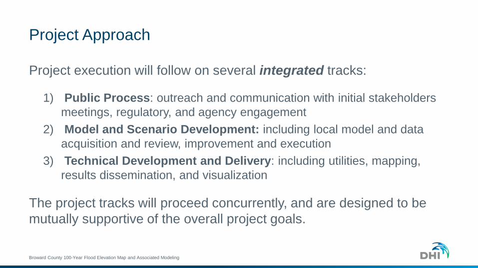
Project Approach
Project execution will follow on several integrated tracks:
1) Public Process: outreach and communication with initial stakeholders meetings, regulatory, and agency engagement
2) Model and Scenario Development: including local model and data acquisition and review, improvement and execution
3) Technical Development and Delivery: including utilities, mapping, results dissemination, and visualization
The project tracks will proceed concurrently, and are designed to be mutually supportive of the overall project goals.
Broward County 100-Year Flood Elevation Map and Associated Modeling
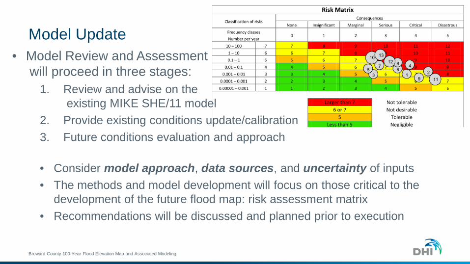
Model Update• Model Review and Assessment
will proceed in three stages:1. Review and advise on the
existing MIKE SHE/11 model2. Provide existing conditions update/calibration3. Future conditions evaluation and approach
• Consider model approach, data sources, and uncertainty of inputs• The methods and model development will focus on those critical to the
development of the future flood map: risk assessment matrix• Recommendations will be discussed and planned prior to execution
Broward County 100-Year Flood Elevation Map and Associated Modeling

Model Improvements
• MIKE SHE model updates will include corrections and Existing Conditions updates
• Future Conditions: use new features available in the current release forrepresenting future land use, adaptation measures, 1D network changes
• Coastal Study Integration elements• MIKE SHE model boundary development• Nature of the FEMA Coastal Zone Study, availability• Rerun with future conditions: Sea Level Rise, Landuse, Adaptation etc.
Broward County 100-Year Flood Elevation Map and Associated Modeling

Coastal Model Integration
Broward County 100-Year Flood Elevation Map and Associated Modeling
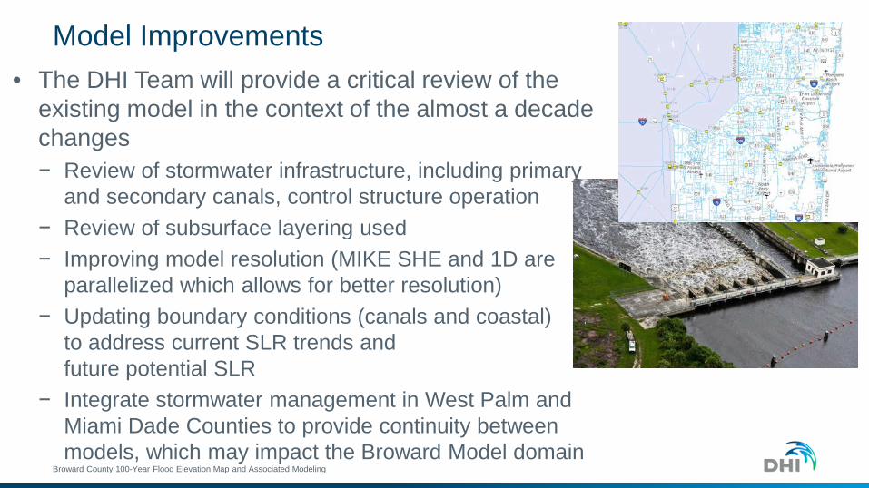
Model Improvements• The DHI Team will provide a critical review of the
existing model in the context of the almost a decade changes − Review of stormwater infrastructure, including primary
and secondary canals, control structure operation− Review of subsurface layering used− Improving model resolution (MIKE SHE and 1D are
parallelized which allows for better resolution)− Updating boundary conditions (canals and coastal)
to address current SLR trends and future potential SLR
− Integrate stormwater management in West Palm and Miami Dade Counties to provide continuity between models, which may impact the Broward Model domain
Broward County 100-Year Flood Elevation Map and Associated Modeling

Model Validation
• Validation only possible for current & past observed conditions Apply to exiting conditions modeling/recent events
• Event simulation will provide opportunity on going comparison and model improvements
• Uncertainty analysis and ensemble evaluation will help to provide reliability for future condition flood mapping
Broward County 100-Year Flood Elevation Map and Associated Modeling

Validation Techniques and Application• Provide robust statistical analysis of stage and discharge
timeseries and cumulative discharges using automation procedures.
• Use regional and local data - observed (DBHYDRO) and computed/modeled to improve model performance within domain.
• Emphasizing performance for critical infrastructure (airport, port, hospitals, and other critical facilities).
• It is critical to provide integration between inner inland hydrology (Water Conservation Areas/Everglades) and Coastal Hydrology (bridging inland and ocean hydrology – from local models to regional ADCIRC models).
Broward County 100-Year Flood Elevation Map and Associated Modeling
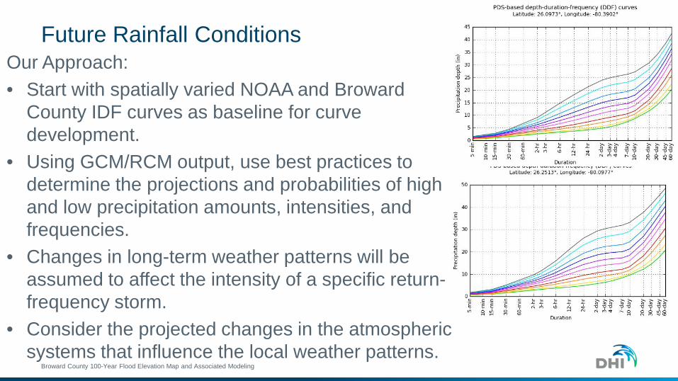
Future Rainfall ConditionsOur Approach:• Start with spatially varied NOAA and Broward
County IDF curves as baseline for curve development.
• Using GCM/RCM output, use best practices to determine the projections and probabilities of high and low precipitation amounts, intensities, and frequencies.
• Changes in long-term weather patterns will be assumed to affect the intensity of a specific return-frequency storm.
• Consider the projected changes in the atmospheric systems that influence the local weather patterns.
Broward County 100-Year Flood Elevation Map and Associated Modeling
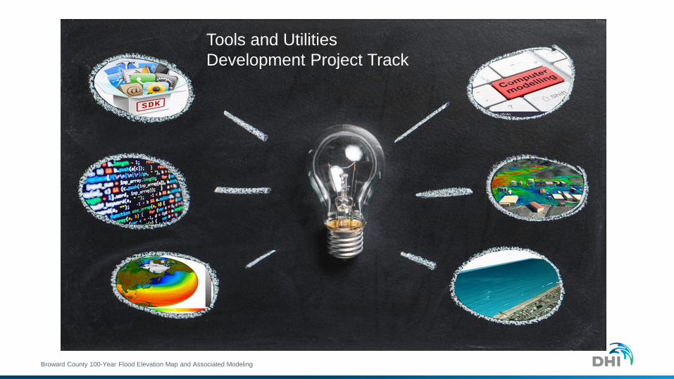
Tools and UtilitiesDevelopment Project Track
Broward County 100-Year Flood Elevation Map and Associated Modeling
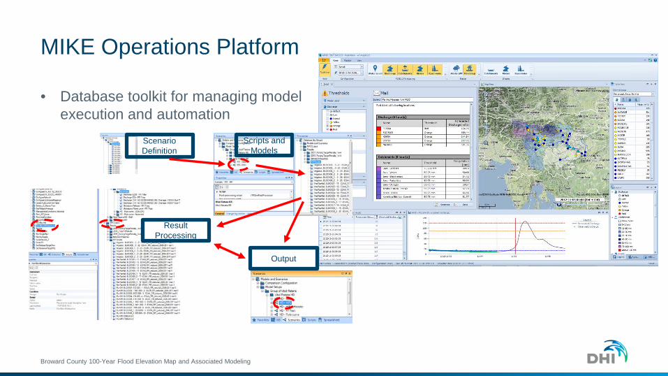
MIKE Operations Platform
• Database toolkit for managing model execution and automation
Broward County 100-Year Flood Elevation Map and Associated Modeling
Result Processing
Scripts and Models
Output
Scenario Definition

Tools and UtilitiesDevelopment Project Track
Develop a Dynamic Risk Assessment capability using DHI’s platform• Develop and store storm scenarios for each
design event• Automate model runs and processing for
repeatability• Include functionality for input of groundwater
data model results, coastal zone map and boundary input
• Routines to publish to map and web portal• Functionality to support the public outreach
and communication of input and resultsBroward County 100-Year Flood Elevation Map and Associated Modeling
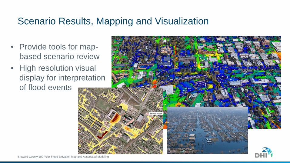
Scenario Results, Mapping and Visualization
• Provide tools for map-based scenario review
• High resolution visual display for interpretation of flood events
Broward County 100-Year Flood Elevation Map and Associated Modeling

Scenario Results, Mapping and Visualization
Coastal Scenario comparison via web portal
MIKE SHE Results explorer via web portal
Broward County 100-Year Flood Elevation Map and Associated Modeling

Map Development• Automated map development within ArcGIS workflow• All data and results provided by MIKE Operations• Map development and stylings preset within map document• Web portal for published results/scenario exploration
MIKE Operations
Python Toolkit/SDK
Dynamic Floodmap
Broward County 100-Year Flood Elevation Map and Associated Modeling

Community Outreach and CommunicationHow outreach will inform the project• Community outreach will be a cornerstone of our
process, and we must start with the end in mind.• There are two goals: access and utilize the best
information available for model buildout, and build public support for the project and its purpose.
• Local agencies will be critical to help inform model boundary/future conditions and calibrate findings.
• The outreach process will include the provision of communication materials detailing the outcome and effects of the project to build public support.
• The outreach process will be deliberate with specific goals outlined for each meeting/event.
Broward County 100-Year Flood Elevation Map and Associated Modeling
Conclusions
• The DHI Team provides all of the required capabilities necessary to accomplish Broward County’s goals and schedule for this project.
• DHI’s investment in tools and technical capabilities make our team ideally suited to meet the inherent technical challenges, and support them over the long term.
• The DHI Team has the knowledge of and relationships with local agencies, SFWMD, and FEMA that are required for this project.
• DHI and its partners provide the skills in coastal and inland model application, technical development and delivery and community outreach and communication to support these goals.
Broward County 100-Year Flood Elevation Map and Associated Modeling