Brooklyn-Queens Greenway · York Aquarium, Coney Island Museum & Sideshow ... The Brooklyn/Queens...
77
Transcript of Brooklyn-Queens Greenway · York Aquarium, Coney Island Museum & Sideshow ... The Brooklyn/Queens...


TABLE OF CONTENTS
The Brooklyn-QueensGreenway Guide
INTRODUCTION . . . . . . . . . . . . . . . . . . . . . . . . . . .21 CONEY ISLAND . . . . . . . . . . . . . . . . . . . . . . . . . .32 OCEAN PARKWAY . . . . . . . . . . . . . . . . . . . . . . . . . .113 PROSPECT PARK . . . . . . . . . . . . . . . . . . . . . . . . . . .164 EASTERN PARKWAY . . . . . . . . . . . . . . . . . . . . . . .225 HIGHLAND PARK/RIDGEWOOD RESERVOIR . . .296 FOREST PARK . . . . . . . . . . . . . . . . . . . . . . . . . . . . .367 FLUSHING MEADOWS CORONA PARK . . . . . . . .428 KISSENA-CUNNINGHAM CORRIDOR . . . . . . . . .549 ALLEY POND PARK TO FORT TOTTEN . . . . . . . .61
CONCLUSION . . . . . . . . . . . . . . . . . . . . . . . . . . . .70GREENWAY SIGNAGE . . . . . . . . . . . . . . . . . . . . .71BIKE SHOPS . . . . . . . . . . . . . . . . . . . . . . . . . . . . .73

ntroduction
The Brooklyn-QueensGreenway (BQG) is a 40-mile, continuous pedestrianand cyclist route fromConey Island in Brooklyn toFort Totten, on the LongIsland Sound, in Queens.
The Brooklyn-Queens Greenway pro-vides an active and engaging way ofexploring these two lively and diverseboroughs. The BQG presents thecyclist or pedestrian with a widerange of amenities, cultural offerings,and urban experiences—linking 13parks, two botanical gardens, the NewYork Aquarium, the BrooklynMuseum, the New York Hall ofScience, two environmental educationcenters, four lakes, and numerous ethnic and historic neighborhoods.The guidebook also provides informa-tion about nearby public transporta-tion, restrooms, places to eat, and bikeshops.
The Brooklyn-Queens Greenway ispart of the larger New York CityGreenway System, an interconnectednetwork of bicycle and pedestrianpathways linking parks and commu-nities throughout the five boroughs.The Department of City Planning’s1993, A Greenway Master Plan for NewYork City, which outlined 350 miles ofpotential trails, noted that greenwaysare “…at once the parks for the 21stcentury and a part of the transporta-tion infrastructure, providing forpleasant, efficient, healthful, and envi-ronmentally sound travel by foot,bicycle or skates.”
New York City Department of Parks &Recreation (Parks) works closely withthe Departments of Transportationand City Planning on the planningand implementation of the City’sGreenway Network. Parks has juris-diction and maintains over 100 milesof greenways for commuting andrecreational use, and continues toplan, design, and construct additionalgreenway segments in each borough,utilizing City capital funds and anumber of federal transportationgrants.
In 1987, the Neighborhood Open Space Coalition spearheaded the concept of the Brooklyn-QueensGreenway, building on the work ofFrederick Law Olmsted, Calvert Vaux,and Robert Moses in their creations ofthe great parkways and parks ofBrooklyn and Queens. Feasibility anddesign studies were completed in 1988with the help of many City agenciesand civic and community groups.Recent City administrations have seenfit to further this vision of a chain ofgreen from shore to shore, and today,the Brooklyn-Queens Greenway formsa critical component of the City’sGreenway system.
This publication was made possiblethrough funds from the IntermodalSurface Transportation Efficiency Act(ISTEA) under the TransportationEnhancement (TEP) Program, admin-istered by the New York StateDepartment of Transportation (NYS DOT).
IThe Brooklyn-Queens Greenway System2

The Brooklyn-Queens Greenway System 3
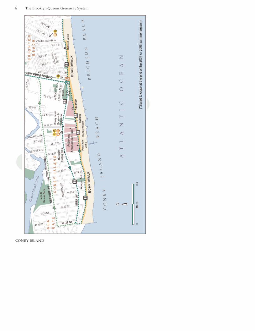
ConeyIsland
5.5 miles (loop)Biking—45 minutes; Walking—3 hoursConey Island Beach and Boardwalk,Keyspan Park, Nathan’s Famous, AsserLevy/Seaside Park, AstrolandAmusement Park (slated to close at theend of 2007 or 2008 summer season),Abe Stark Skating Rink, ParachuteJump, Deno’s Wonder WheelAmusement Park, The CycloneRollercoaster, Brighton Beach, The NewYork Aquarium, Coney Island Museum& Sideshow
Surf Avenue is a busy commercial streetwith no marked bike lane and plenty ofdistracted drivers. The boardwalk is awell-used, auto-free pedestrian route.Bikes are allowed on the boardwalkbetween 6 a.m. and 10 a.m.
MileTravel towards the right, west, on Surf
Avenue. Turn left on 37th Street.Turn left onto Riegelmann Boardwalk
(Between 10:00 a.m. and 6:00 a.m., cyclists must dismount and walk their bikes on boardwalk. For alternate bike route see below.)
At the end of the boardwalk, turn around and backtrack.
Veer right onto Seabreeze Walk.End at Ocean Parkway at
Seabreeze Avenue.
Length:Estimated travel time:
Attractions:
Character:
Directions at a GlanceStarting at the end of Ocean Parkway
Coney Island Alternate Bike Route
When the boardwalk is closed to cyclists, follow this route. Instead of turning left onto
West 37th Street, turn right onto West 37thStreet and ride to Neptune Avenue. Turn right
onto Neptune Avenue and ride to OceanParkway. Turn left onto Ocean Parkway topick up the next segment of the Greenway.
1
0.0
1.91.95
4.6
5.45.5
CONEY ISLAND
CONEY ISLAND
The Brooklyn-Queens Greenway System4

The Brooklyn/Queens Greenway System 5
CONEY ISLAND
Subways
The D, F, N, and Q lines all stop atConey Island. (For the latest transitinformation, visit the MTA website atwww.mta.info or call 718-330-1234).
Where to Eat
Go past the Wonder Wheel for take-away hotdogs, corn on the cob, friedclams and other classic American fastfood. In Brighton Beach, you can paya little bit more and get a sit-downmeal at several boardwalk cafés.
Public Restrooms
There is a restroom near West 27th
Street and Surf Avenue. The board-walk has public restrooms at West 30th
Street, Stillwell Avenue, West 8th Street,and Brighton 2nd Street. They are openMemorial Day to Labor Day from 9a.m. to 6 p.m.
Area History
Coney Island is no longer a trueisland. When European settlers firstarrived, it was a narrow sliver of land,separated from the rest of Long Islandby a salty creek that was crossable atlow tide. Coney Island's name comesfrom the Dutch name “KonignEisland” or Rabbit Island. The reasonsfor the name are lost in the murk oftime. It could be that the originalgrasslands and scrub here supported ahopping colony of long ears.
Development began in 1829, uponcompletion of the Coney Island Hotel
in the area now known as Sea Gate.This was a respectable establishment,but by the turn of the nineteenth cen-tury, Coney Island had become NewYork's wild west, an area notorious forits rowdy drinking and gamblinghalls, prize fights, and rampant prostitution. Respectable society hadmoved east. The era's most wealthyand celebrated flocked to ManhattanBeach, where majestic hotels lined thebeach. The prosperous middle classsummered at Brighton Beach, wherethe architecture was impressive, butless grand.
West Brighton was the buffer zonebetween the high and low-life. Thiswas the destination for day-tripping,working class folks who came bysteamship, ferry, or trolley to sing inthe beer halls, eat in the enormousrestaurants, shake a leg in the dancehalls, and try their luck in the pennyarcade. This is the section of the beachthat became the Coney Island of popular imagination, especially withthe advent of pioneering amusementparks: Steeplechase in 1897, Luna Parkin 1903, and Dreamland in 1904. Thesewere ambitious creations, forerunners to today's Disneyland and
Wonder Wheel: The ferris wheel with the rollercoaster on the inside. When the inside car swingsout, many a stomach has been left behind.

The Brooklyn/Queens Greenway System6
CONEY ISLAND
Six Flags parks. For a dime, you wereadmitted to fanciful exotic villages,crowded as any Lower East Sidestreet, where every twist in the waybrought another enticement to spendsome fun money on a ride, a show, agame, or a dance.
As the twentieth century wore on,these amusement parks lost much oftheir novelty. They disappeared inreverse order of their completion.Dreamland burnt to the ground in1911; it took a series of fires in the1940s to close down Luna Park.Steeplechase Park didn't close until1964. But the three decades from 1920to 1950 were arguably Coney Island'sheyday. On a hot summer weekendafternoon, thousands of New Yorkerswould take the subway to partake ofConey Island at its most elemental:sand, surf, and Nathan's hot dogs.
With the rise of the automobile, ConeyIsland's primacy waned, with
thousands making the trek to LongIsland and New Jersey beachesinstead. Some would say that this wasa relief. The well-known photographer,Weegee, published three famous pictures−one each in 1940, 1945, and1952 showing thousands of beach-goers packed shoulder to shoulder.Today, however, Surf Avenue and theConey Island boardwalk remain alively scene, a favorite trip for manyNew Yorkers. Significant changeswithin Coney Island are anticipatedwith the area’s planned redevelop-ment, guided by a strategic plan thatwas unveiled for the area in 2005. Theplan focuses on creating new housingand strengthening the area as a year-round entertainment destination withseaside attractions.
Trip Description
The trip starts at the corner of SurfAvenue and Ocean Parkway. Mostpeople will be tempted to head
Thrills: Coney Island art tends toward the brightly colored Macabre.

CONEY ISLAND
The Brooklyn/Queens Greenway System 7
straight to the Boardwalk, which hasmany entrances beckoning from SurfAvenue. But Surf Avenue is also wellworth exploring in its own right, withmany star attractions and a livelypedestrian scene. For bike riders, SurfAvenue offers an opportunity to staymounted and rolling when the board-walk is closed to bike riding.
Heading west on Surf Avenue, you’llquickly notice Asser Levy/SeasidePark. The centerpiece of this park isits amphitheater, whose stage iscrowned by a high-tech white tent.Information on amphitheater eventscan be found on the Parks &Recreation website,www.nyc.gov/parks. The park pro-vides a nice refuge from the hurly-burly of the surrounding streets andthe boardwalk, for those just seekingsome good old-fashioned green grassand shade.
The world-famous Cyclone roller-coaster stands proud at West 10th
Street. Don’t let the wood and theantique looks fool you—the ride is asmuch fun as any of the high-techtheme park extravaganzas in the suburbs.
The zone between West 12th and West16th Streets is the haunt of the outra-geous. The happening corner here isWest 12th Street and Surf Avenue,where you’ll find the Coney IslandSideshow. This modest showhouse isdedicated to keeping alive thethrilling underbelly of Americana—
besides the sideshow, the venue hostsregular burlesque and rock-and-rollshows. Hours of operation can befound at www.coneyisland.com forboth the Sideshow and Museum.
Look no further than the ConeyIsland Museum at 1208 Surf Avenue
Nathan’s: A table for four without the table
for photographs and artifacts from theresort area’s yesteryears. Up for agame of chance and/or skill? You cantry your hand in the amusementarcades along this stretch of avenue.
Moving along, you’ll go from honky-tonk to spiffy family fun. The old siteof Steeplechase Park is occupied byKeyspan Park, a minor league baseball stadium that is home to theBrooklyn Cyclones. Visit www.brooklyncyclones.com for game and event schedules.
The Abe Stark Skating Rink stands atthe corner of West 19th Street and SurfAvenue. If you want to take a spin onthe ice, this pro-quality facility is open
to the public on weekends and schoolholidays from the Beginning ofOctober to the beginnig of April.Other times it’s used by ice hockeyleagues. Don’t have a pair of skates?No problem—you can rent them here.
After Keyspan Park, Surf Avenuebecomes a residential area, a zone ofhousing developments and assisted-living facilities. One worthy detour isthe Santos White Community Gardenat 2110 Mermaid Avenue. Turn right atWest 21st Street, and go up one block.This garden looks great anytime ofyear.
Turn left on West 37th Street to reachthe boardwalk (or right for the
CONEY ISLAND
The Brooklyn/Queens Greenway System8
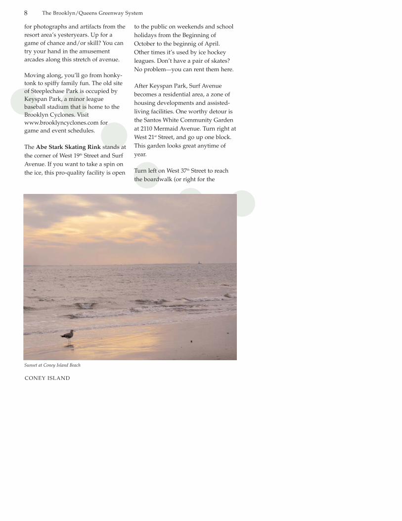
Sunset at Coney Island Beach

CONEY ISLAND
The Brooklyn/Queens Greenway System 9
alternative bike route).
The Coney Island boardwalk is trueNew York, not just for its legend, butfor its here-and-now, quick-changetransformations. On a summer weekend, the entire two-and-a-halfmile stretch is a crowded blur ofgood-natured pleasure seekers. Theboardwalk’s varied qualities shineforth best midweek or in the off-season, when the crowds havethinned. The boardwalk’s one trueand constant companion is the beach,a well-kept stretch of sand punctuatedby several stone jetties and a fishingpier. In fact, some pedestrians mightbe tempted to skip the boardwalk andwalk the entire length of the beach.
The boardwalk is quietest near itswestern terminus at West 37th Street.For beach and ocean lovers, this is theplace to come if you’re seeking a littlemore solitude, especially early in themorning or on a nippy winter day.
Coney Island’s iconic Parachute
Jump, rises near West 19th Street. At262 feet, the Parachute Jump is ConeyIsland’s most distinctive landmark. Itwas first installed at the New YorkWorld’s Fair of 1939-40 at FlushingMeadows in Queens, then moved in1941 to its present location. When itwas operating, riders were lifted by acable to the top then dropped, to floatgently down to the ground. TheParachute Jump ceased operating in1964, and fell into disrepair. It recentlyunderwent a $5 million refurbishment.While it no longer functions as a ride,it remains an icon of Coney Island history.
Steeplechase Pier juts out into theocean across from the West 16th Streetwalkway. This is a popular spot foranglers and those who just want to getout over the water. You’ll probablyfind the beach starting to become a bitmore crowded here.
Moving past the back end of KeyspanPark, you will arrive at the ConeyIsland of popular legend, a zone of
Coney Island skyline
CONEY ISLAND
10 The Brooklyn-Queens Greenway System
rambunctious amusements. Astrolandis the heart of the scene here.Astroland was opened in 1962 and, asits name implies, many of the park’soriginal rides took their cue from theera’s space program. These daysyou’re more likely to hear hip-hoprather than doo-wop, but you can stillride smiling satellites and rockets tothe moon. Astroland was recently pur-chased by a private developer and isanticipated to close at the end of the2007 or 2008 summer season. Want toget up higher than anybody? Buy aticket to Deno’s Wonder Wheel, animmense Ferris wheel at the foot ofWest 12th Street.
The New York Aquarium at ConeyIsland is the next stop along theboardwalk. This is not a sideshowattraction, but a world-class zoologicalfacility. The Aquarium covers 14 acres,is home to 350 species of aquaticwildlife, including penguins, sharks,and seals, and is a terrific place for
families. For information, visitwww.nyaquarium.com.
Brighton Beach fronts the boardwalkbetween Asser Levy/Seaside Park andCorbin Place. Today, Brighton Beach isa neighborhood of Russian émigrés;some have called it Little Odessa, aftera town in the Ukraine on the BlackSea. On a warm day, the boardwalkhere sports plenty of folks wearingbathing suits and sunglasses. But theboardwalk is also a European-stylepromenade, the route of dressed upfolks walking arm in arm with shinedshoes and perfect hairdos. If youappreciate the beauty of the ocean, butcan do without gritty beach culture,this is the perfect destination.Boardwalk cafés invite you to sitdown and watch this parade go bywhile you enjoy a selection from theRussian/English menu.
Backtrack on the boardwalk to a stair-way known as Seabreeze Walk, which
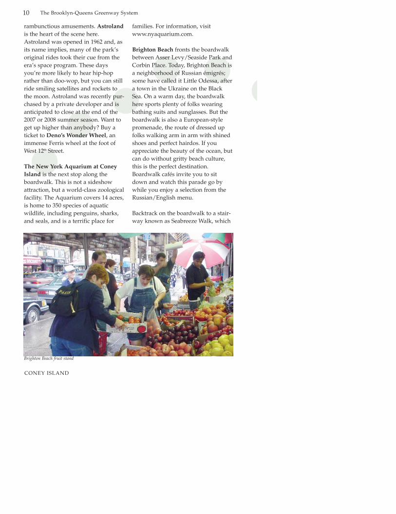
Brighton Beach fruit stand

The Brooklyn/Queens Greenway System 11
OCEAN PARKWAY
OceanParkway
5.9 miles (one way)Biking—45 minutes; Walking—2 hoursGravesend Cemetery, residential neighborhoods of Manhattan Terrace,Ocean Parkway, Borough Park, andDitmas Park
Sheltered historic parkway with crosstraffic at intersections.
MileStart on Ocean Parkway where it meets
Seabreeze Avenue. Head north on Ocean Parkway staying on the left, (western) side, of the parkway.
Follow Ocean Parkway to Church Avenue. Bicyclists must keep to thebike lane.
At southwest corner of Church Avenue,cross Ocean Parkway to
eastern side. Cross Church Avenue to northeast corner, then cross service road to bike/pedestrian path.
Follow path as it curves towards the east.
Path ends. Cross East 8th Street. Turn left.
Turn right at Park Circle. Follow circle counter-clockwise to entrance of Prospect Park.
End at the park entrance.
Length:Estimated travel time:
Attractions:
Character:
Directions at a GlanceStarting at corner of
Ocean Parkway and Surf Avenue
20.0
5.1
5.3
5.7
5.75
5.8
5.9
Hand in Hand: Some moments are too good for cycling.

The Brooklyn/Queens Greenway System12
Subways
The F, Q and B (the B train does notoperate on weekends) trains eachmake several stops on streets parallelto Ocean Parkway. (For the latesttransit information, visit the MTAwebsite at www.mta.info or call 718-330-1234).
Where to Eat
Ocean Parkway is almost completelyresidential, however, you can findbusinesses, including neighborhoodrestaurants and grocery stores, onmany of the intersecting streets.Neptune Avenue, and Avenues U, P,N, I, J, Kings Highway, DitmasAvenue, and Church Avenue areespecially bustling. The Assyrian-Jewish shopping center at the cornerof East 3rd Street and Kings Highwayis a great place to shop for middle-eastern specialties. Avenue J is thespot for kosher restaurants and bak-eries. One of the best pizzerias in thecity, DiFara’s Pizza, is located onAvenue J and East 15th Street.
Public Restrooms
Public restrooms can be found: inGrady Playground near Brighton 4th
Road and Brighton 4th Street; in theColonel David Marcus MemorialPlayground near East 5th Street andAvenue P; in Friends Field Park nearEast 4th Street and Avenue L; in Di Glio Playground near McDonaldAvenue and Avenue F and at theParade Grounds near Prospect Park.
OCEAN PARKWAY

The Brooklyn/Queens Greenway System 13
Area History
Conceived by Frederick Law Olmstedand Calvert Vaux in 1866, OceanParkway was to be one of the fourlegs of a parkway system radiatingout from Prospect Park. Only two ofthe legs were built: Eastern Parkwayand Ocean Parkway, finished in 1880.The parkways were inspired by theboulevards of Paris and Berlin, butleave it to Americans to make themwider and longer.
The Olmsted/Vaux parkways weredesigned to be both scenic and practical. The main thoroughfare, thecarriage drive, was originally con-ceived as a "shaded pleasure drive,"but now functions as a busy roadway.Shaded, grassy malls buffer both sidesof the drive. Here’s where you’ll findthe bike and pedestrian paths andlong rows of benches. Service roadsline the outer edge of the parkway,providing safe access and parking.
In 1894, a strip of Ocean Parkway’spedestrian lane became the country’sfirst bicycle path. Reportedly, so manybicyclists crowded the path on opening day, the city was forced towiden it. In 1983, the National ParkService declared Ocean Parkway aNational Scenic Landmark. Travelingalong Ocean Parkway is more aboutthe pleasure of the whole route, ratherthan any particular "sights" along theway. It is about the trees and the grassthat provide a green counterpoint to ahodge-podge of twentieth-centuryNew York buildings, from luxuryapartments to substantial single-family houses, plus a few synagogues,schools, and other institutions. Thearchitecture ranges from solid brickpre-war cooperative housing to con-temporary single-family residences.Along the way are some surprisingdetails, including the entrance arch to270 Ocean Parkway, which is pure1960s Miami Beach.
Ocean Parkway on a summer day
OCEAN PARKWAY
The Brooklyn/Queens Greenway System14
It’s the people who make OceanParkway interesting. On a busy weekend day, you’ll encounter hundreds. Typical users includeOrthodox Jewish families walking onthe Sabbath, Russian retirees readingCyrillic-printed newspapers, andmany, many other walkers, bikers,bladers, and sit-on-a-bench-and-watch-the-world-go-byers.
Trip Description
Ocean Parkway starts a block awayfrom the Coney Island boardwalk. Thebike path runs along the western mallof the parkway. Don’t let the trees andthe grass lull you into complacency atintersections, however. Cars makingright-hand turns off of OceanParkway can be unaware that bicy-clists and pedestrians are crossing the streetalongside of them. So look twice, thenlook again.
After a couple of blocks, the on- andoff-ramps of the Belt Parkway interrupt the flow of Ocean Parkway.Fortunately for bicyclists, the authorized route is fairly well-signed.Just remember to stay on the westernside of the parkway, and you’ll befine. The eastern side is reserved for pedestrians only.
After the Belt Parkway, it’s a straightshot through middle-class Brooklyn toChurch Avenue, where the parkwayends. A couple of worthwhile meanders will reveal both the contem-porary life in the neighborhoods surrounding Ocean Parkway, as wellas the deep historical roots ofBrooklyn.
Just north of Coney Island is a smallarea whose grid system of streets is atodd angles to the neighborhoodaround it. This is what remains of theold town of Gravesend, a villagefounded in 1643 by a group of English
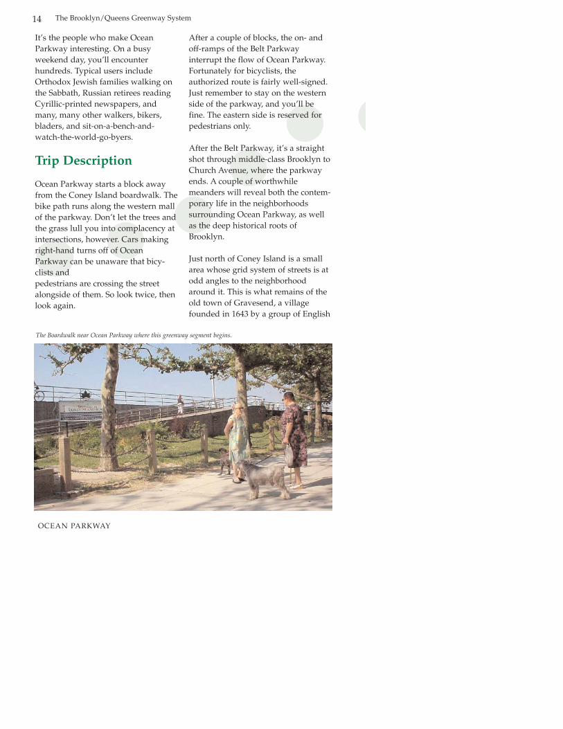
The Boardwalk near Ocean Parkway where this greenway segment begins.
OCEAN PARKWAY

15
settlers lead by Lady Deborah Moody.By all accounts, Lady Moody wasboth cultured and fiercely independ-ent. She became the first femalegrantee for land ownership in theNew World. Gravesend was the onlypermanent settlement in early colonialAmerica planned and directed by awoman. The outlines of the originalvillage design are still easily dis-cernible on the map: look for a largesquare set at a counter-angle to thesurrounding grid. The square isbisected on each side, forming foursmaller squares. The village grave-yard, perhaps the most visible rem-nant of old Gravesend, sits at the out-side corner of one of the smallersquares, at the intersection of VanSicklen Street and Village Road South.The graveyard is closed to the public,but you can peek in through the fence.To explore Gravesend, take a left onAvenue V.
Kings Highway crosses OceanParkway a block past Avenue R.Kings Highway is another exceptionto Brooklyn’s grid system, runningroughly south to northeast. This wasan old Native American path, thenlater a farm road. During theAmerican Revolution, British troopsmarched up Kings Highway, to present day East New York, to attackAmerican forces.
Olmsted and Vaux designed OceanParkway to extend all the way to theentrance to Prospect Park but with theconstruction of the ProspectExpressway, a brain child of RobertMoses, Ocean Parkway (as a park-
way) ends abruptly at ChurchAvenue.
When you come to Church Avenue,cross Ocean Parkway to the right, andmake a left across Church Avenue.The path continues on OceanParkway, which becomes a serviceroad at this point, running alongsidethe Prospect Expressway. The bikepath ends near the pedestrian bridgeat East 8th Street, but the service roadcontinues to Park Circle. Follow ParkCircle counter-clockwise to theProspect Park entrance (between thetwo horse statues, called the HorseTamers).
The Brooklyn/Queens Greenway System
OCEAN PARKWAY
The Brooklyn/Queens Greenway System16
PROSPECT PARK
ProspectPark
1.6 miles for half loop, 3.2 miles for theentire park loopBiking—15 minutes; Walking—1 hour,suggest 2-3 hours to explore.
Parade Ground, Prospect Lake, WollmanRink, Audubon Center at the Boathouse,Prospect Park Zoo, Lefferts Homestead,Carousel, Bandshell, Third StreetPlayground, Battle Pass, HarmonyPlayground, Vale of Cashmere, TennisHouse, Concert Grove
Asphalt road throughout the park that isauto-free on weekends and non-rushhours.
MileFollow Park Circle into Prospect Park,
passing Parade Ground on your right.Turn right onto South Lake Drive.
Follow South Lake Drive towards Grand Army Plaza. Veer right to park exit road.
End at Grand Army Plaza.
If you are traveling the Greenway fromNorth to South, enter the Park atGrand Army Plaza, turn onto WestDrive. Follow West Drive to the ParkCircle exit.
Length:
Estimated travel time:
Attractions:
Character:
Directions at a GlanceStarting at Park Circle
entrance to Prospect Park
3
0.0
0.1
1.6
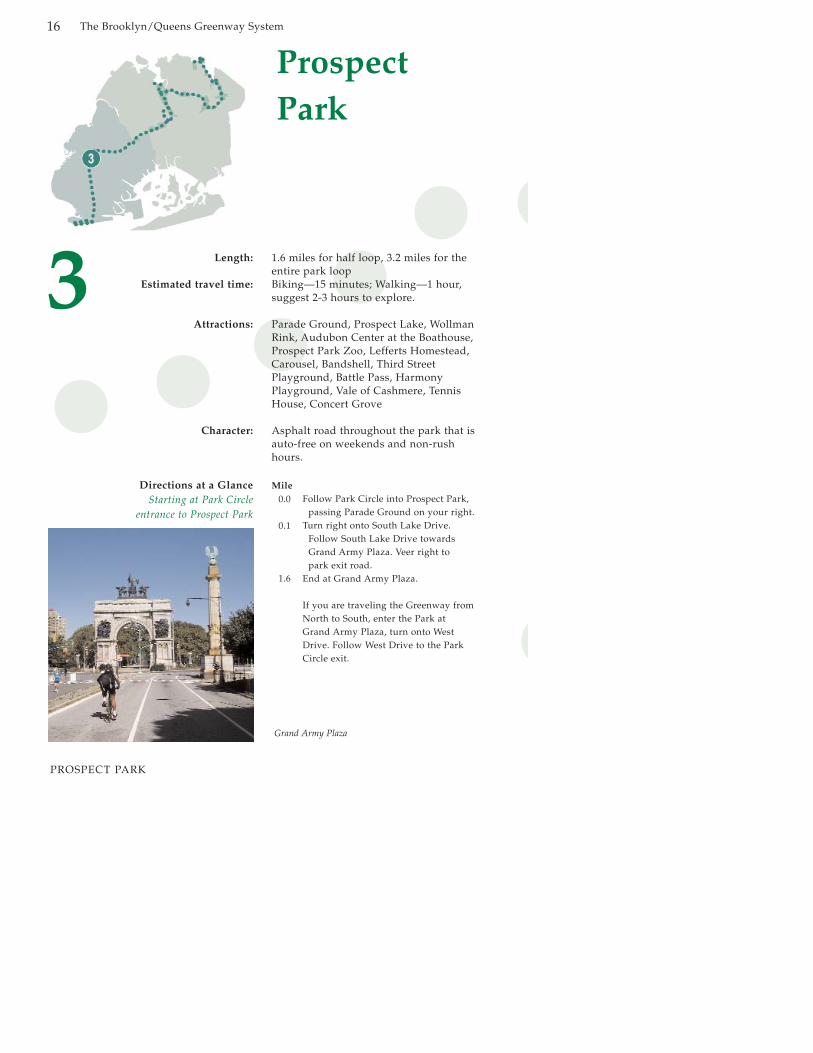
Grand Army Plaza

The Brooklyn/Queens Greenway System 17
PROSPECT PARK
Subways
To get to Park Circle, take the F trainto Ft. Hamilton Parkway or the Q toParkside Avenue. To get to GrandArmy Plaza take the 2 or 3. (For thelatest information, visit the MTA web-site at www.mta.info or call 718-330-1234).
Where to Eat
There are several food kiosks withinthe park as well as Song Bird Cafe inthe Boathouse. Outside the park, ParkSlope’s Seventh Avenue, WindsorTerrace’s Prospect Park West andFlatbush Avenue have a wide varietyof restaurants and several grocerystores.

The Brooklyn/Queens Greenway System18
PROSPECT PARK
Public Restrooms
Prospect Park has several public restrooms which are open daily from 8 a.m. to 7 p.m. Restrooms can also befound within the Brooklyn PublicLibrary’s Central Library.
Area History
Frederick Law Olmsted’s and CalvertVaux’s first foray into New York Citywas designing Manhattan’s CentralPark in 1858. Then they took whatthey had learned and designedBrooklyn’s Prospect Park.
Prospect Park takes its name fromMount Prospect, which lies on theother side of Flatbush Avenue fromthe park. The borough fathers hadoriginally intended Mount Prospect tobe part of Prospect Park. But CalvertVaux convinced them that FlatbushAvenue would be a marring disruption. Luckily, tracts of land to
the south of their allocated parcelswere available for purchase, and the526-acre diamond outline of ProspectPark was born. The park was laid outin 1866 and 1867.
The land had a significantRevolutionary War history. Look forBattle Pass on the East Drive just northof the zoo (look for the plaque). This isthe site of one of the major actions inthe Battle of Brooklyn, which was thefirst battle between the UnitedColonies and the British, following theissuance of the Declaration ofIndependence. At this spot on August27, 1776, British forces overwhelmedsome 900 Americans under the com-mand of Major-General John Sullivan.After the Americans surrendered, some500 were killed by Scot Highlanders,German Hessians and English infantryand cavalry.
For information on upcoming eventswithin Prospect Park, stop at any
Prospect Park Boathouse
The Brooklyn/Queens Greenway System 19
PROSPECT PARK
entrance sign where there are mapsand up-to-date program information,visit the Prospect Park website atwww.prospectpark.org, or contact theProspect Park Alliance at 718-965-8999.
On weekends and outside of rushhour, Prospect Park is auto-free. Mostof your company will be huffing, puffing joggers and serious racingbicyclists. Don’t use them as an example. Instead, experience the Parkat a leisurely pace, much as youwould inside a horse-driven carriageon a no-rush Sunday afternoon. Open up your senses, and see theunfolding views as a series ofpanoramic pictures.
Trip Description
The following trip description starts atPark Circle.
You will see the Parade Ground atthis location which has bathrooms, asnackbar, tennis, basketball and vol-leyball courts and soccer and baseballfields.
After you pass Park Circle, you can’tmiss the Peristyle, also known as theGrecian Shelter, on your right.Designed by McKim, Mead & Whitein the neoclassical style with columns,the structure both shelters and punctuates the landscape.
Rounding another bend, you’ll be onEast Lake Drive which climbs steadilypast Wollman Rink into theMidwood section of the park. Butdon’t miss the Prospect ParkAudubon Center, (www.prospect-parkaudubon.org) housed in theBoathouse, which lies behind sometrees just past Concert Grove. Thecenter has nature exhibits and an idyllic esplanade along the tiny
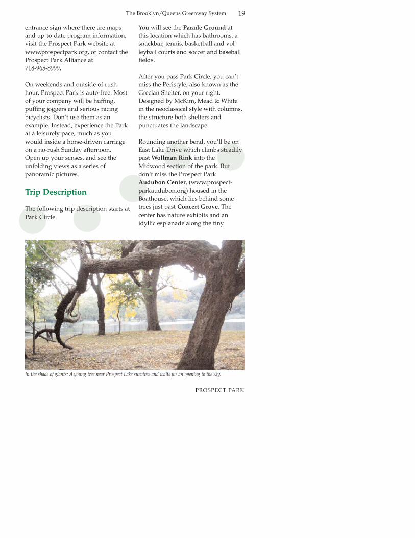
In the shade of giants: A young tree near Prospect Lake survives and waits for an opening to the sky.

20
PROSPECT PARK
The Brooklyn-Queens Greenway System
Lullwater Lake—well worth a stop.
The Prospect Park Zoo is anotherworthwhile stop for nature-lovers. Itspresence in the park is muted, butyou’ll notice its back boundary nes-tled into the outer edge of theMidwood. The Prospect Park Zoo isopen all summer and spring week-ends and has lots of great activities aswell as a bathroom and snackbar. Formore information go to www.prospectparkzoo.com.
You’ll find the entrance to the zoo onFlatbush Avenue if you take the parkroad exit by the Boathouse and thenturn left. If you do this, you’ll passLefferts Homestead, a restored DutchFarmhouse built in 1777, and the festive Carousel.
Back on the drive in the park, you’llreally start to climb as you venturefurther into the Midwood, the shady
heart of the park’s wild forest. Take itslow and let the world pass you by.You’ll be having a much better time.To your left will be a steep woodedslope, the backside of the terminalmoraine that forms the backbone ofthe park.
Relief will be in sight as you reach thenorthern end of the Long Meadow.You’ll still be climbing, but for notmuch longer. The Vale of Cashmerewill be to your right. This is an espe-cially pretty and tranquil spot with itslush flowering vegetation and flowingwater fountains. It gets its name froman epic poem in 1817 by Sir ThomasMoore. If you wish, follow the pathdown to an intricate series of formalponds.
The drive exits at Grand Army Plaza.After you get yourself to Grand ArmyPlaza, look around a bit. This is one ofthe grandest urban spaces in New
A family enjoys a day in the sun at Prospect Park’s Long Meadow.
The Brooklyn/Queens Greenway System 21
PROSPECT PARK
York. The plaza is an oval. Its center-piece is an 80-foot arch, designed byJohn H. Duncan, designer of Grant’sTomb in Manhattan. Completed in1892, the arch honors the Union forcesin the Civil War with sculptures byFrederick McMonnies, who also designed the Horse Tamers. The fountain in the center, BaileyFountain, recently restored, was com-pleted in 1932. The fountain featuresallegorical figures often interpreted asWisdom and Fertility. On Saturdays,this is the site of a lively farmers mar-ket, where you can pick up a snack.
If you are entering the park fromGrand Army Plaza, turn right ontoWest Drive. The West Drive starts offnice and easy with the Long Meadowon your left. This segment is almost amile long. Past the Tennis House,you’ll see the Pools, which mark thebeginning of the park’s Ravine, whichwas restored between 1998 and 2000.
The first building you’ll encounter toyour left is the Picnic House, and thenthe Tennis House. A little further on toyour left you’ll see the Bandshell at 9th Street. This is the venue forCelebrate Brooklyn, a fabulous seriesof free performances held each summer. Call 718-768-0855 or go to www.celebratebrooklyn.org.
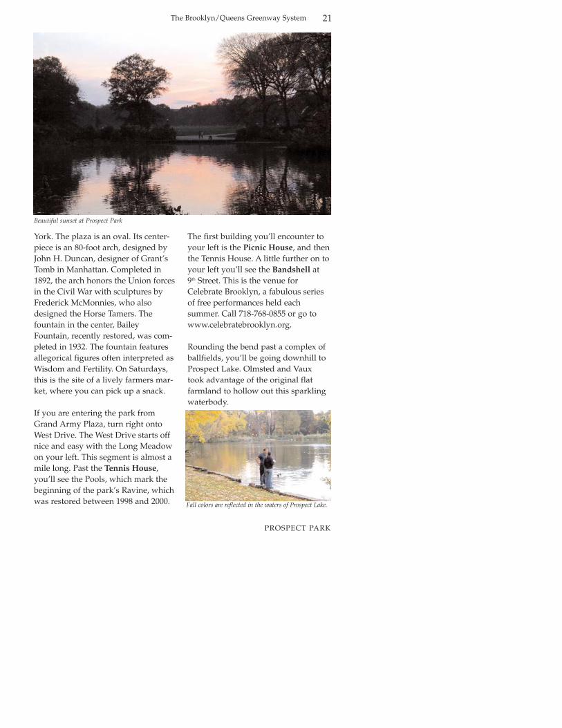
Rounding the bend past a complex ofballfields, you’ll be going downhill toProspect Lake. Olmsted and Vauxtook advantage of the original flatfarmland to hollow out this sparklingwaterbody.
Beautiful sunset at Prospect Park
Fall colors are reflected in the waters of Prospect Lake.

The Brooklyn/Queens Greenway System22
EASTERN PARKWAY
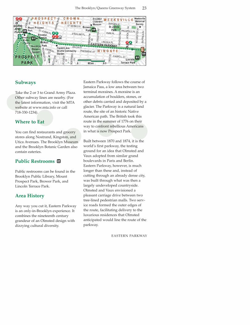
EasternParkway
2.5 milesBiking—30 minutes; Walking—1.5 hoursBrooklyn Public Library’s Central Library,Brooklyn Botanic Garden, BrooklynMuseum, Weeksville Historical Society,Brooklyn Children’s Museum, MountProspect Park, McNair Park, FranklinAvenue Shuttle Community Garden, historic neighborhoods of ProspectHeights, Crown Heights, Wingate
Sheltered historic parkway with cross-traffic at intersections.
MileBegin in front of Prospect Park at Grand
Army Plaza. Cross Flatbush Avenue to plaza in front of the Brooklyn Public Library’s Central Library.
Walk across plaza to Eastern Parkway. Cross Eastern Parkway at Underhill, traveling around circle counter-clockwise
Turn right on service road.Multi-use path begins on median strip between service road and main drive ofparkway.
Cross Eastern Parkway at Washington Avenue. Cross Washington Avenue topedestrian/bike path through
parkway mall.End at Buffalo Avenue.
Length:Estimated travel time:
Attractions:
Character:
Directions at a GlanceStarting at northern corner of
Prospect Park, at intersection of Grand Army Plaza and
Flatbush Avenue in front ofthe Brooklyn Public Library
4
0.0
0.1
0.2
0.6
2.5
Tropical Paradise: The space-age conservatory at theBrooklyn Botanic Garden provides relief from winter without the high airfares.
The Brooklyn/Queens Greenway System 23
EASTERN PARKWAY
Subways
Take the 2 or 3 to Grand Army Plaza.Other subway lines are nearby. (Forthe latest information, visit the MTAwebsite at www.mta.info or call 718-330-1234).
Where to Eat
You can find restaurants and grocerystores along Nostrand, Kingston, andUtica Avenues. The Brooklyn Museumand the Brooklyn Botanic Garden alsocontain eateries.
Public Restrooms
Public restrooms can be found in theBrooklyn Public Library, MountProspect Park, Brower Park, andLincoln Terrace Park.
Area History
Any way you cut it, Eastern Parkwayis an only-in-Brooklyn experience. Itcombines the nineteenth centurygrandeur of an Olmsted design withdizzying cultural diversity.
Eastern Parkway follows the course ofJamaica Pass, a low area between twoterminal moraines. A moraine is anaccumulation of boulders, stones, orother debris carried and deposited by aglacier. The Parkway is a natural landroute, the site of an historic NativeAmerican path. The British took thisroute in the summer of 1776 on theirway to confront rebellious Americansin what is now Prospect Park.
Built between 1870 and 1874, it is theworld’s first parkway, the testingground for an idea that Olmsted andVaux adopted from similar grandboulevards in Paris and Berlin.Eastern Parkway, however, is muchlonger than these and, instead of cutting through an already dense city,was built through what was then alargely undeveloped countryside.Olmsted and Vaux envisioned a pleasant carriage drive between twotree-lined pedestrian malls. Two serv-ice roads formed the outer edges ofthe route, facilitating delivery to theluxurious residences that Olmstedanticipated would line the route of theparkway.
The Brooklyn/Queens Greenway System24
EASTERN PARKWAY
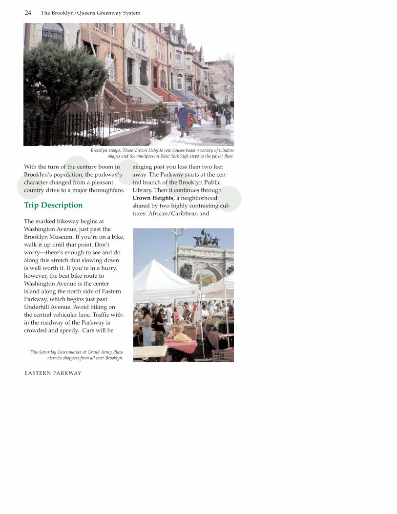
With the turn of the century boom inBrooklyn’s population, the parkway’scharacter changed from a pleasantcountry drive to a major thoroughfare.
Trip Description
The marked bikeway begins atWashington Avenue, just past theBrooklyn Museum. If you’re on a bike,walk it up until that point. Don’tworry—there’s enough to see and doalong this stretch that slowing downis well worth it. If you’re in a hurry,however, the best bike route toWashington Avenue is the centerisland along the north side of EasternParkway, which begins just pastUnderhill Avenue. Avoid biking onthe central vehicular lane. Traffic with-in the roadway of the Parkway iscrowded and speedy. Cars will be
zinging past you less than two feetaway. The Parkway starts at the cen-tral branch of the Brooklyn PublicLibrary. Then it continues throughCrown Heights, a neighborhoodshared by two highly contrasting cul-tures: African/Caribbean and
Brooklyn stoops: These Crown Heights row houses boast a variety of window shapes and the omnipresent New York high steps to the parlor floor.
This Saturday Greenmarket at Grand Army Plazaattracts shoppers from all over Brooklyn.

The Brooklyn/Queens Greenway System 25
EASTERN PARKWAY
Lubavitcher Jewish.
Let’s start at Grand Army Plaza. Firststop: the Central Library of theBrooklyn Public Library(www.brooklynpubliclibrary.org) system, whose modernist façade facesthe arch. You really owe it to yourselfto step inside and admire the stonecarvings over the entry. Once inside,you’ll pass through a wide hallway toenter a light-filled atrium that, withthe removal of the paper card catalog,now functions as a lively exhibitionspace. The library has bike racks outfront.
As you begin traveling up EasternParkway, you will see Mount ProspectPark on the south side, and, on thenorth side a row of large apartment buildings, at one time among the mostprestigious addresses in Brooklyn.Traveling along the southern, park-
side of the route by foot is recommended.
Mount Prospect Park is a pleasant little park that contains the secondhighest point in Brooklyn. The parkfeatures a brand new playground,bathrooms and one of the lushestlawns in New York City.
Right next door you’ll find the northentrance to the world-famousBrooklyn Botanic Garden(www.bbg.org). Gardens are creaturesof the seasons, and the BrooklynBotanic Garden takes advantage of allfour of them. This 52-acre facility isjam-packed with amazing featuresincluding the Cranford Rose Gardenin early summer and the always love-ly Japanese garden. Even in thedepths of winter you might find ablooming witchhazel outdoors, or youcan visit the indoor Conservatory,
Brooklyn Botanic Garden in bloom

The Brooklyn/Queens Greenway System26
EASTERN PARKWAY
which replicates desert, rainforest, andtemperate habitats. The BrooklynBotanic Garden also has bathroomsand a café.
The adjacent Brooklyn Museum ofArt is housed in a formidable BeauxArts building. It is the second largestart museum in New York City, whichin a city of art museums, says a lot. ItsEgyptian collection is top notch andterrifically displayed. The museumalso contains bathrooms and a café aswell as a beautiful plaza for anyone torest and enjoy. For current exhibitsand events, visit their website atwww.brooklynart.org. If you aren’tcareful, you can spend the entire dayhere. But you won’t want to miss therest of the parkway.
The bike lane begins at WashingtonAvenue on the south side of theParkway. Dr. Ronald E. McNair Park
anchors the corner here. This is a veryformal and dignified—yet leafy—park, a befitting memorial for the sec-ond African American to venture intospace. The park is located withinCrown Heights where the West IndianCarnival parade takes place each yearon Labor Day. Hundreds of thousandsline the route to cheer on a colorfulprocession of floats, steel drum bandsand dancers. And the Caribbean foodand craft stalls that line the serviceroads on that day would be a greatreason to come even if the parade wasnot happening.
From here on, the buildings along theParkway become a mixture of middle-class family row houses and smallapartment buildings. You’ll soon passthe Franklin Avenue ShuttleCommunity Garden. In its modestway, this garden is an expression ofthe culture of the local community. A
Sukkah: Jewish custom requires dining in an open to the sky “desert hut” for eight days in autumn.
The Brooklyn/Queens Greenway System 27
EASTERN PARKWAY
team of expert gardeners concentrateon growing the food that they grewup farming and eating.
The Parkway bends at BedfordAvenue. Just a little past this intersection, stop and look behind youfor a pleasant view of stately trees,solid buildings, and active people.New York at her best.
The Brooklyn Children’s Museum(www.bchildmus.org) is a wonderfulside trip, especially if you’re travelingwith children. You’ll find it at the corner of St. Marks and BrooklynAvenues, six blocks to the north of theParkway. The museum complex incor-porates bits of recycled architecture,including a trolley kiosk from theQueensboro Bridge and an immensesewer pipe. But the creative exhibi-tions are the real reason for going.
Just a little bit before BrooklynAvenue, pedestrian traffic includesmore and more bearded men dressedin black suits, sporting fedoras. This isa sign that you’re entering theLubavitcher Hasidic area of CrownHeights. The Lubavitcher communityis a branch of Orthodox Judaism withhistorical roots in eastern Europe.Because they are restricted from riding in automobiles or even elevators on the Sabbath, theLubavitcher Hasidim live in close-knitneighborhoods where they can walkto temple, a practice that also creates astrong sense of local community. Theirworld headquarters is at the busy corner of Kingston Avenue.
The Parkway moves along to LincolnTerrace Park. Eastern Parkway’s upsand downs are gradual, so you mayfind surprising the park’s initial steepslope—but remember, you are climb-
Weeksville: A nineteenth century free black agricultural colony becomes a venue for the celebration of afro centric cultural life as the stilt-man “spirit” dances to a traditional drum band.

The Brooklyn/Queens Greenway System28
EASTERN PARKWAY
ing a moraine. Many of the trees inthe park are magnificent. The high-light is a grand European-style alléelined with large Sycamores. The tenniscourts on Buffalo Avenue are popular,a good place to witness some excellent back and forth.
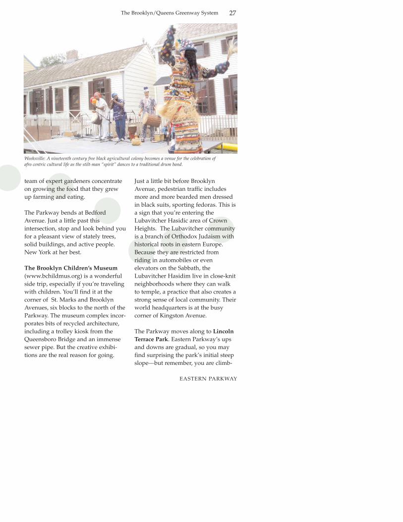
You are now officially in the historiccommunity of Weeksville. This areawas settled by free blacks in the late 1830s. It was one of the few places inNew York in which black peoplecould own property. The Parkwayactually destroyed the character of thecommunity by barging through theold streets and imposing a grid uponwhat had been a rambling villagestreetscape. The remnants of this community can be seen at 1698-1708Bergen Street, between Buffalo andRochester Avenues, where the Societyfor the Preservation of Weeksville(www.weeksvillesociety.org) is
headquartered.
Eastern Parkway ends two blocks past Rochester Avenue, near the intersection of Ralph Avenue. EasternParkway Extension, which does nothave sheltered malls, continues onfrom Ralph Avenue. Turn off EasternParkway at Buffalo Avenue to start thenext segment of the Greenway.
Lubavitcher Headquarters at the corner of Eastern Parkway and Kingston Avenue.
The Brooklyn-Queens Greenway System 29
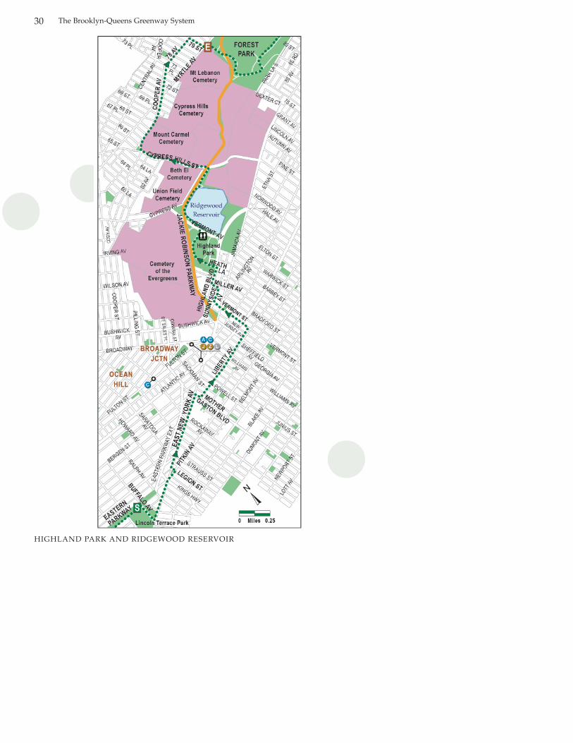
HighlandPark/RidgewoodReservoir6.6 milesBiking—1 hour; Walking—3 hoursHighland Park, Ridgewood Reservoir,several historic cemeteries, neighborhoods of Brownsville, OceanHill, and Highland Park
This leg starts out on fairly busy streetsand includes a hefty climb. LushHighland Park and a skirt around theedge of Ridgewood Reservoir are amplerewards to the perseverant.
MileTravel south on Buffalo Avenue along
eastern edge of park.Turn left on East New York Avenue.Continue forward on Pitkin Avenue.Turn left on Legion Street, then right at
East New York Avenue.Right on Mother Gaston Boulevard.Left on Liberty Avenue.Left on Vermont Street.Right on Sunnyside Avenue.Left on Miller Street (very steep).Right on Highland Boulevard.Left on Heath Place into Highland
Park. Follow Greenway signs through park.
Cross Vermont Avenue to stairs leading up to trail around Ridgewood Reservoir. Turn right at trail.
Right at ramp to Cypress Avenue. Turn right on Cypress Avenue.
Left at Cypress Hills Street (careful—heavy traffic and no traffic lights for pedestrians and bicyclists).
Turn right on Cooper Avenue.Ease forward to 78th Avenue.Turn right on 79th Street.Turn left on Myrtle Avenue.End at Myrtle Avenue opposite
79th Street.
Length:Estimated travel time:
Attractions:
Character:
Directions at a GlanceStart at Eastern Parkway and Buffalo
Avenue, at the northeast corner of Lincoln Terrace Park
5
0.0
0.20.60.7
1.31.42.22.82.93.03.1
3.7
4.3
4.4
5.26.06.36.56.6
The garden cemetery movement of the nineteenthcentury led to the development of sculpture parks on
the hills of Brooklyn and Queens.
HIGHLAND PARK AND RIDGEWOOD RESERVOIR
The Brooklyn-Queens Greenway System30
HIGHLAND PARK AND RIDGEWOOD RESERVOIR
The Brooklyn/Queens Greenway System
HIGHLAND PARK AND RIDGEWOOD RESERVOIR
Subways
Take the 3 train to Sutter Avenue-Rutland Road or the 3 or 4 to CrownHeights-Utica Avenue. (For the latestinformation, visit the MTA website atwww.mta.info or call 718-330-1234.)
Where to Eat
You’ll find restaurants and grocerystores on Fulton Street and alongMyrtle Avenue.
Public Restrooms
Public restrooms can be found inHighland Park.
Area History
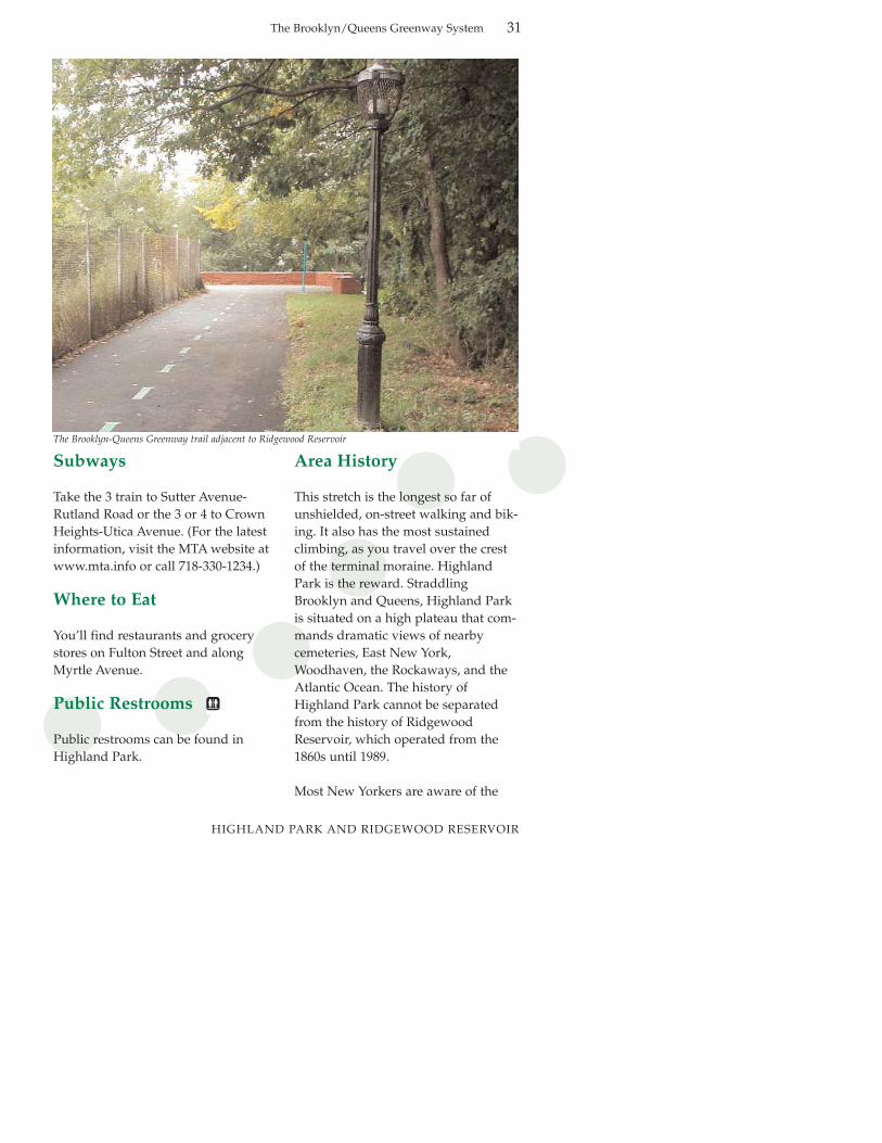
This stretch is the longest so far ofunshielded, on-street walking and bik-ing. It also has the most sustainedclimbing, as you travel over the crestof the terminal moraine. HighlandPark is the reward. StraddlingBrooklyn and Queens, Highland Parkis situated on a high plateau that com-mands dramatic views of nearbycemeteries, East New York,Woodhaven, the Rockaways, and theAtlantic Ocean. The history ofHighland Park cannot be separatedfrom the history of RidgewoodReservoir, which operated from the1860s until 1989.
Most New Yorkers are aware of the
The Brooklyn-Queens Greenway trail adjacent to Ridgewood Reservoir
31
The Brooklyn/Queens Greenway System32
HIGHLAND PARK AND RIDGEWOOD RESERVOIR
extensive system of reservoirs in theCatskill Mountains that supply modern New York City. Less known isthe fact that in the mid-1800s, the Cityof Brooklyn received its drinkingwater from an extensive system ofreservoirs, lakes, conduits, and pumping stations in Long Island thateventually stretched as far asMassapequa. Ridgewood functionedas the main reservoir for Brooklyn,working in tandem with the smallerMount Prospect Reservoir, which waslocated in what is now MountProspect Park, near the beginning ofthe Eastern Parkway leg of theBrooklyn-Queens Greenway.Ridgewood Reservoir has not beenused since 1989; the last of its threesections was drained in that year.
Trees, shrubs, and other plants havetaken root in the three basins, creatinga thriving young forest on the site ofthe former reservoir. The reservoirproperty was recently transferred to
the Department of Parks & Recreationfor development as public parkland.
In 1891, the City of Brooklyn purchased the land surrounding thereservoir for park purposes under thejurisdiction of the Highland ParkSociety. The park might have beennamed Ridgewood Park. However, asprivate park operated at the time bythat name in Brooklyn, and the ParksDepartment feared that people wouldget confused. Then in 1905, Parksextended the property to the south bypurchasing the Schenck estate, whichincluded a Dutch-style farmhouse thatwas removed in 1940. Highland Parktook its present shape in 1906-08,when Parks acquired a third parcel tothe west from the Department ofWater Supply, Gas and Electricity.
Trip Description
The beginning of this leg of the Greenway takes the traveler through
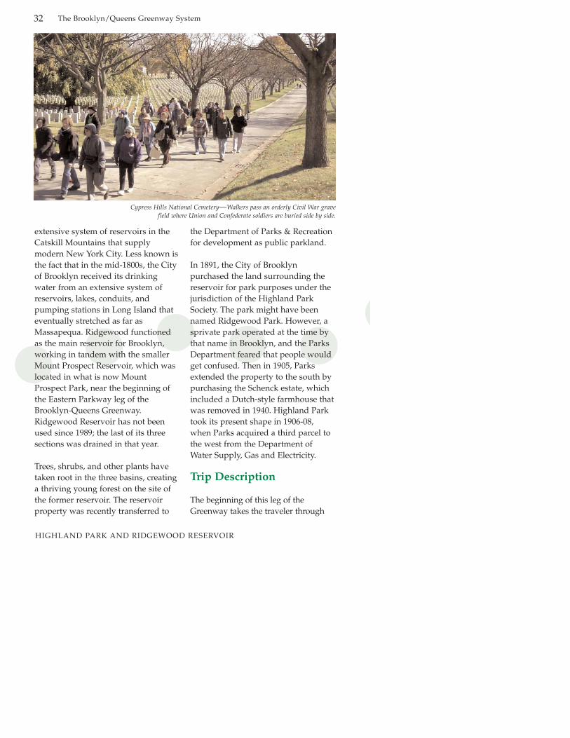
Cypress Hills National Cemetery—Walkers pass an orderly Civil War grave field where Union and Confederate soldiers are buried side by side.

The Brooklyn/Queens Greenway System 33
HIGHLAND PARK AND RIDGEWOOD RESERVOIR
the vibrant neighborhoods ofBrownsville and East New York, beforeclimbing the moraine into HighlandPark. Traffic in spots can be heavy.Bicyclists new to city streets areencouraged to dismount and walktheir bikes on the sidewalks if they’refeeling overwhelmed. The point of the Greenway is to slow down and havefun, taking in the life of a perhapsunfamiliar neighborhood, not to getfrom point A to point B in the quickest time.
Travelling down the edge of LincolnTerrace Park, enjoy the line of statelysycamores along the park’s edge. Turnleft on East New York Avenue, andfollow it to where it merges withPitkin Avenue. Continue on Pitkin andtravel one block to Legion Street,which forms the long end of a pleas-ant triangle park. Notice the fine old
movie palace that stands at Legion and Pitkin, which is no longerin use as a cinema.
Turn left on Legion Street, and then goa short block to pick up East NewYork Avenue again, where you willturn right. Continue on East NewYork Avenue to Mother GastonBoulevard, where you’ll turn right.Turn left on Liberty Avenue, whichtravels through an industrial area.Turn left on Vermont Street, whichwill bring you back into a residentialarea. Vermont Streets starts to climb toSunnyside Avenue, where you’ll turnright. Turn left on Miller Street, whereyou’ll really be asked to climb. Mostbicyclists may find it easier and saferto just walk up this block to HighlandBoulevard. Turn right, and be on thelookout on your left for Heath Place,which will lead you into Highland
Highland Park
HIGHLAND PARK AND RIDGEWOOD RESERVOIR
Park, where the Greenway againbecomes green.
The Greenway through the park isexceptionally well marked. HighlandPark is a beautiful expanse of tree-filled green, well-used by the community. It is short on architecturalpretensions, and long on trees, grass,and recreational amenities such asbaseball fields and basketball courts. Iteven has a community garden for children, tucked in the park’s south-west corner along Jamaica Avenue.
The Greenway winds pleasantlythrough the park until it reaches busyVermont Avenue. Cross VermontAvenue (take your time!) and walk upthe steps to the trail aroundRidgewood Reservoir. By the way,you have left Brooklyn and are now inQueens.
Turn right on the trail around thereservoir, and get ready for some
spectacular views over the Brookynflatlands. After a bit over half a mile,you’ll spot Cypress Hill Avenue andthe ramp that will take you down to it.
The trail around Ridgewood Reservoircan feel somewhat isolated. Althoughthe trail makes a complete looparound the reservoir, turn left toremain closer to street traffic. At thefar corner of the reservoir you’ll passsome abandoned buildings and then,in quick succession, a stairway andthen a ramp to Cypress Hills Street—take one, you pick.
Turn right on Cypress Hills Avenue,and then left when you come toCypress Hills Street. Frankly, this isone of the most confusing turns on theGreenway—there is no elegant way todo it. You may want to backtrack upCypress Hills Street to the pedestrianlights if traffic is too heavy. But eventhese crossings aren’t complete.
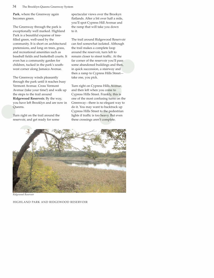
Ridgewood Reservoir
34 The Brooklyn-Queens Greenway System

HIGHLAND PARK AND RIDGEWOOD RESERVOIR
Ultimately, you want to be headingdownhill, towards the blue-green copper dome of what is theHungarian Benevolent SocietyBuilding. Once you’re on your waythough, the downhill run is a fittingreward for whatever frustration youmay have experienced coming uphill.On your left you will pass the Beth ElCemetery, where Harry Houdini isburied.
Turn right on Cooper Avenue. Justbefore Cooper Avenue jogs left you’ll
be nicking a corner of Cypress HillsCemetery (718-277-2900), where JackieRobinson and Mae West are buried. Atthe intersection of 78th Avenue, CooperAvenue turns abruptly left, towardsthe north. Do not follow CooperAvenue. Continue straight aheadalong 78th Avenue. Follow 78th Avenueto 79th Street and turn right. Go a cou-ple of short blocks to 79th Lane, oppo-site the end of which you’ll see theentrance to Forest Park, which is thenext leg of our journey.
Attached houses line a hillside as the Greenway heads to Highland Park.
The Brooklyn/Queens Greenway System 35
The Brooklyn/Queens Greenway System36
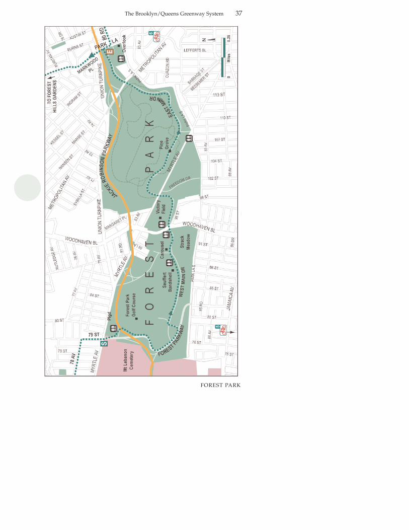
FOREST PARK
Forest Park
3.5 milesBiking—45 minutes; walking—2 hoursForest Park, which includes SeuffertBandshell, Strack Pond, hiking trails, thePine Grove, and Forest Park Carousel,Forest Hills Gardens (side trip)
Protected park trails and low-traffic parkroads. Forest Park Drive is auto-freebetween Woodhaven Boulevard andMetropolitan Avenue.
MileFollow marked trail around basketball
court, bocce court and playground, then through a tunnel. The trail skirts the edge of the Forest Park Golf Course.
Trail runs into roadway to Jackie Robinson Parkway. Do not try to crossthis road—it is a blind curve and cars are going very fast and not looking forpedestrians. Instead, turn left on walkway and continue on to intersection of Forest Park Drive.
Turn left, following signs for SeuffertBandshell and Forest Park Golf Course.
Cross Woodhaven Boulevard.Cross Myrtle Avenue.Cross Metropolitan Avenue.End at Forest Park Drive and
Park Lane.
Length:Estimated travel time:
Attractions:
Character:
60.0
0.6
0.7
1.62.03.23.5
Directions at a GlanceStarting at Myrtle Avenue entrance
to the park, across from 79th Lane
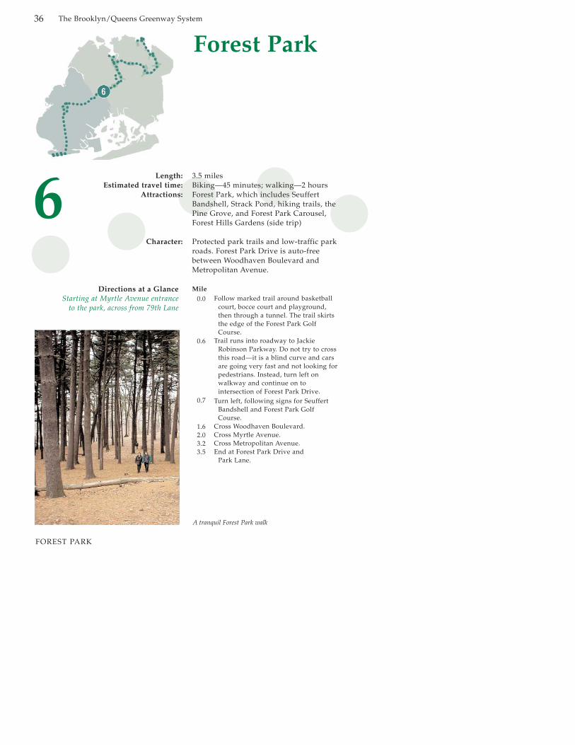
A tranquil Forest Park walk
The Brooklyn/Queens Greenway System 37
FOREST PARK
Subways
The J and Z (Z line rush hours only,no weekends) lines roughly parallelForest Park through the Queensneighborhood of Woodhaven. TheWoodhaven Boulevard stop offersan uncomplicated route to ForestPark and our starting point. (For thelatest information, visit the MTAwebsite at www.mta.info or call718-330-1234).
Where to Eat
There are a number of eateries onMetropolitan Avenue.
Public Restrooms
There are restrooms in Forest Parkat the Myrtle Avenue entrance, thevisitor center on WoodhavenBoulevard and Forest Park Drive,Victory Field on WoodhavenBoulevard and near the Overlook.
Area History
Forest Park is one of the most pristine parks in New York City.Forest Park Drive was designed bythe firm of Frederick Law Olmstedin the 1890’s. Of the park’s 543acres, 411 are woodland. The rest ofthe park includes a golf course, ballfields, tennis courts, a bandshell,and even a carousel. This is a parkthat you could spend the dayexploring.
The history of this park is an interesting example of inter-borough
jostling. It was originally purchasedby Brooklyn, parcel by parcel,between the years 1895 and 1898, inthe days when it was a forward-thinking metropolis and Queenswas still a loose amalgam of farmingvillages. The land, part of the termi-nal moraine ridge line, is sloping.Not useful for farming, it was seenas a recreational resource for out-doors-starved Brooklynites. Afterthe incorporation of Queens intogreater New York City in 1898, theland was designated and preservedas part of the Queens park system.
While you’re here, take a good lookat the park’s topography and vegetation. It preserves distinctiveglacial features: kettle hole ponds,knobby hilltops (kettles and knobs),and “erratic” boulders. The forest isstill largely native red oak and blackoak. Many of the trees are over 150years old.
The neighborhoods surrounding thepark—Woodhaven, Richmond Hill,Kew Gardens, and Forest Hills—make wonderful sidetrips. Thegrand Victorian houses of northRichmond Hill are especially worthseeking out.
Trip Description
The Greenway through Forest Parkis well-marked. You’ll follow thebike route as it curves around thebuildings and playing fields,through a tunnel, and then out nearthe Forest Park Golf Course. Theforest is well managed; you’ll
The Brooklyn-Queens Greenway System38
FOREST PARK

The Brooklyn-Queens Greenway System
experience a refreshing variety ofindigenous plants, including viburnums, ferns, and even—in season—ephemeral forest floorwildflowers.
You enter the park near a boccecourt, which is just past the basket-ball court. Bocce is an Italian gamethat resembles a kind of leisurelylawn bowling mixed with shuffle-board. If a game is in progress, youowe it to yourself to stop and watcha European tradition still beingpassed on through a cohesive Italiancommunity. You’ll find a restroom inthe park building next to the boccecourts.
After a leisurely tour around thegolf course, you’ll bump up againstsome concrete barriers. The curvingroad on the other side leads up tothe Jackie Robinson Parkway. Theautomobiles are traveling fast and
can’t see you until it’s too late tostop. Do not try to cross this road.Instead, turn left on the walkwayand follow it a short distance untilthe roadway forks with Forest ParkDrive. Take the left fork, followingthe signs indicating Forest Park GolfCourse and Seuffert Bandshell.Traffic is light through here, andthere is a designated bike lane. Sotake it slow and enjoy the forest.You’ll soon spot Seuffert Bandshellnear Woodhaven Boulevard. Seuffertis a true Queens institution. Thefacilities have gone through severalincarnations, the most recentupgrade being completed in 2000.During the warmer months, it’s avenue for a wide variety of music.
The Forest Park Carousel presidesjust up the hill from the bandshell.The carousel’s fancifully andintricately carved animals, createdin 1903, are the work of Daniel
Shingle roofed pre-war homes along a tree lined boulevard at the edge of Forest Park
39
FOREST PARK

The Brooklyn/Queens Greenway System
Muller, who created twelvecarousels in his lifetime. This is oneof the only two that have survived.
At some point you might want todismount and follow one of the sidepaths (no bike riding allowed) foran even more intimate experience ofthe forest. Forest Park is known as ahiker’s park for good reason. Justbefore you cross WoodhavenBoulevard, you may want to stopand experience the PFC LaurenceStrack Pond on foot. Strack Pond isa beautiful kettle pond teeming withlife including plants, salamanders,frogs and other wetland species.This pond provides nature loverswith a great spot to see butterflies,red-tailed hawks, and great blueherons. Visitors can enjoy thepond’s trail and viewing area whilelistening to the calls of the TuftedTitmouse, the Baltimore Oriole, andthe Kingbird.
After you cross Woodhaven, the hiking opportunities multiply. EastMain Drive, closed to traffic, is aspecial stretch of the Greenway.Keep your eye out for the PineGrove. This is an expanse of ever-green pine trees which was plantedin 1914 after a tree blight devastatedthousands od chestnut trees. Theground is soft and fragrant drom allthe fallen pine needles. The canopyis evergreen and softly rustling. In1923, an additional 70 pine treeswere planted on either side of thedrive, one for each Richmond Hillor Woodhaven casualty of WorldWar I.
For more extensive hiking throughthis 165-acre oak forest, take one ofthe three marked trails that all beginalong the East Main Drive. The BlueTrail starts next to the LIRR over-pass and is a 1.7-mile loop. The 2.4-mile Orange Trail can be picked upopposite the Pine Grove and takesyou along the forest’s perimeter. TheYellow Trail, designated aMillennium Trail in 2000, is locatednear Metropolitan Avenue, and isone mile. Both the Blue and YellowTrails have interpretive signs andmaps.
Shortly after crossing MetropolitanAvenue you’ll spot the Overlook.This is the Queens ParkHeadquarters. While the view hereis now blocked by trees and buildings, it’s still a good spot tostop and loll on the grass to collectyour energy before heading off intoa more trafficked part of theGreenway.
Strack Pond is home to a three-acre freshwater wet-land habitat. It’s a great spot for bird and naturelovers to enjoy the kettle pond’s tranquility.
40
FOREST PARK

The Brooklyn-Queens Greenway System
Side Trip:Forest Hills GardensThis sidetrip takes you though Forest Hills Gardens, a landmark inurban planning.
Forest Hills Gardens is a 175-acreplanned community designed byFrederick Law Olmsted, Jr. (landscapearchitect) and Grosvenor Atterbury(architect). Inspired by EbenezerHoward’s Garden City Movement, thedevelopment was supposed to havebeen a model for middle-income communities, providing a taste of pre-industrial building and countryside for people toiling away inthe city. Halfway through the development, however, a residents’organization took over and installed aseries of restrictive covenants, turningthe development into an upper-income community. Ironically, thesesame restrictive covenants may havepreserved the character of the area.Today, this is a neighborhood of magnificent Tudor-style homes, lushgreenery and stately trees.
To get there, take this route:On leaving Forest Park, turn left on
Park Lane. Cross the highway onMarkwood Place into Forest HillsGardens. Note: At this point, pleasewalk your bike. This is a one-wayroute into a private residential commu-nity. The streets here are not public. Ifyou want to preserve access for thefuture, please be on your best behavior.
Follow Markwood Place to GreenwayNorth, which is the road that circlesForest Hill Gardens. Greenway Northturns into Greenway South atGreenway Terrace. Stop and take it allin. Greenway Terrace is a brick-pavedevocation of a European town square.The Long Island Railroad station is aparticularly fine example of Tudor-style building.
Cross the square and exit under theLIRR tracks, turning right ontoContinental Avenue.
Cross Queens Boulevard. HereContinental Avenue ends, and you areat the corner of 70th Road. Continuedown 70th Road to 112th Street. Turnright on Jewel Avenue. Jewel Avenueis one of the more challenging blocksof the Greenway, with heavy trafficand a highway entrance speeding carsup even more. Ride carefully here.
Jewel Avenue turns into 69th Road.After it crosses the Grand CentralParkway (where you have a goodview of Flushing Meadows-CoronaPark), cross 69th Road at the trafficlight on the corner, then backtrackslightly on foot to the marked pavedpath into Flushing Meadows CoronaPark.
Forest Hills Gardens was designed as an idealized tudor village with green spaces.
41
FOREST PARK

The Brooklyn/Queens Greenway System42
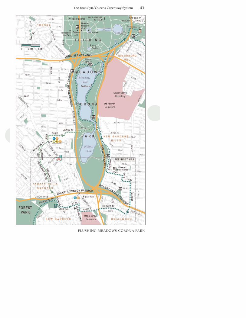
FLUSHING MEADOWS-CORONA PARK
FlushingMeadows-Corona Park
5.2 milesBiking—1 hour; walking—3 hoursFlushing Meadows Corona Park,Unisphere, New York State Pavilion,Ederle Terrace, Queens Zoo, QueensMuseum of Art, Hall of Science, neighborhoods of Kew Gardens, ForestHills, and BriarwoodHistoric Flushing (side trip)
A combination of on-street traveling andsheltered park route.
MileCross left on Jewel Avenue as it crosses
Flushing Meadows Corona Park.Turn right onto trail alongside
Meadow Lake. Follow trail aroundsouthern edge of lake (right side).
Exit trail before it curves to the left around north end of Meadow Lake.
Cross parking lot heading towards small, slightly arched bridge that crosses tiny Flushing River. Follow on marked trail that roughly follows the river.
After crossing under the Long Island Expressway, turn right at Meridian Road. Follow Meridian Road to Fowler Path. Turn right onto Fowler Path, past Lawrence Playground to the Park exit on College Point Boulevard.
Length:Estimated travel time:
Attractions:
Character:
Mile See also inset map.Turn right onto Park Lane.Left on Onslow Place, then short right
on Grenfell Street, then immediately turn left onto 82nd Avenue.
Right on Kew Gardens Road.Left onto 83rd Avenue.At 134th Street, travel straight ahead
on Hoover Avenue. Pass MapleGrove Cemetery on your right.
Left on Main Street.Left on 77th Road.Right on 141st Street.Left on 77th Avenue.Right on Park Drive East.
7
3.0
3.2
4.2
4.3
5.1
Directions at a GlanceStart at Park Lane and Forest Park Drive
0.00.1
0.50.60.8
1.31.82.02.12.3
The Brooklyn/Queens Greenway System 43
FLUSHING MEADOWS-CORONA PARK

The Brooklyn/Queens Greenway System44
FLUSHING MEADOWS-CORONA PARK
Subways
The E, F, G and R getyou close to thesouthern and middlepart of FlushingMeadows-CoronaPark. Take the E or Ftrain to UnionTurnpike/KewGardens and travelsouth to pick up theroute at Kew GardensRoad and 83rdAvenue.
The 7 train runsalong the northernend of the Park, with stops at 111thStreet, Shea Stadium, and in down-town Flushing. (For the latest information, visit the MTA website atwww.mta.info or call 718-330-1234).
Where to Eat
Ederle Terrace is home to a New YorkCity institution, Knish Nosh, or saveyour appetite for the many ethnicstores and restaurants in Flushing,which is 10 minutes away from theend of the route. You can also findrestaurants and food stores alongQueens Boulevard and Austin Street.
Public Restrooms
Public restrooms can be found inFlushing Meadows Corona Park nearEderle Terrace, the Paserelle Plaza,the Queens Zoo and several otherlocations.
Area History
This segment of the Greenwayexplores Flushing Meadows-CoronaPark, one of the great examples ofurban land reclamation. The areastarted out as a vast salt marsh. A saltmarsh is a low coastal grassland thatis covered periodically by the risingtide. Salt marshes are found on theedges of estuaries, places where ariver flows into the ocean. The predominant plant species is Spartina,a tough grass that excretes salt, andthus is adapted to the edge betweenthe land and the sea. While eaten byvery few creatures, Spartina shelters arich array of life. Before urbanization,Flushing and the other salt marshesthat rimmed the estuary served NewYork City well. Salt hay was harvestedfor the market gardens, where it wasused as a winter mulch.
Greenway alongside Meadow Lake

The Brooklyn/Queens Greenway System 45
FLUSHING MEADOWS-CORONA PARK
Inse
t m
ap

The Brooklyn/Queens Greenway System46
But by the end of the nineteenth century, the biological richness ofFlushing Meadows was eschewed forthe convenience of having a nearbydump. By the 1920s, trainloads ofgarbage arrived daily from Brooklyn,including carloads of still smolderingfurnace ashes. The surreal, smokinglandscaped earned the area the name“the Valley of the Ashes” in F. ScottFitzgerald's novel, The Great Gatsby.
In an early case of environmentalrestoration, the land was painstaking-ly reclaimed. In the 1930s, RobertMoses, who was the ParksCommissioner at the time, directedthe relocation of over 50 million cubictons of garbage. The dump was transformed into a showpiece site forboth the 1939 and 1964 World’s Fairs.Today, the park is the cultural andsporting heart of Queens.
This park is used every day by peoplefrom the entire region. People come toplay, stroll along the Flushing Bay
promenade, to enjoy the sounds of asummer concert, to visit one of thepark’s outstanding cultural institu-tions, or simply to relax in a beautifulgarden. The many recreational playingfields and playgrounds in the park areused for activities that reflect the vastethnic mix of Queens; soccer andcricket are especially popular.
Presiding at the center of the fair site,the Unisphere is awe-inspiring. Thistwelve-story iconic monument of theglobe represents Queens like nothingelse. Even though you've probablyseen hundreds of images of this work,nothing prepares you for the sheerenormity of it. The Unisphere wasbuilt in 1963 out of 350 tons of steelfor the 1964 fair. Not surprisingly, theU.S. Steel Corporation was theUnisphere's sponsor.
The park houses four other leadingcultural and educational institutions.The active Queens Museum of Art(www.queensmuseum.org) is housed
The Unisphere stands behind a walking tour in Flushing Meadows-Corona Park.
FLUSHING MEADOWS-CORONA PARK
The Brooklyn/Queens Greenway System 47
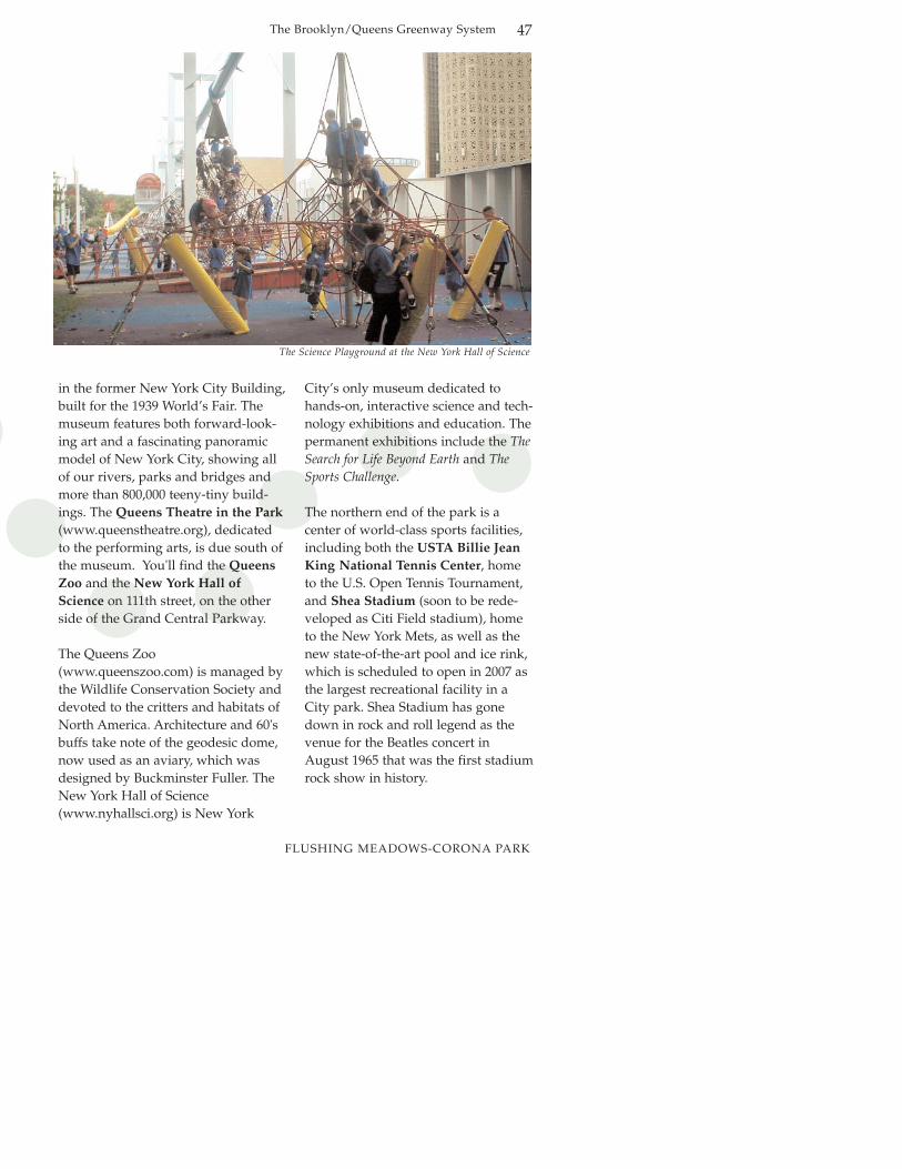
in the former New York City Building,built for the 1939 World’s Fair. Themuseum features both forward-look-ing art and a fascinating panoramicmodel of New York City, showing allof our rivers, parks and bridges andmore than 800,000 teeny-tiny build-ings. The Queens Theatre in the Park(www.queenstheatre.org), dedicatedto the performing arts, is due south ofthe museum. You'll find the QueensZoo and the New York Hall ofScience on 111th street, on the otherside of the Grand Central Parkway.
The Queens Zoo(www.queenszoo.com) is managed bythe Wildlife Conservation Society anddevoted to the critters and habitats ofNorth America. Architecture and 60'sbuffs take note of the geodesic dome,now used as an aviary, which wasdesigned by Buckminster Fuller. TheNew York Hall of Science(www.nyhallsci.org) is New York
City’s only museum dedicated tohands-on, interactive science and tech-nology exhibitions and education. Thepermanent exhibitions include the TheSearch for Life Beyond Earth and TheSports Challenge.
The northern end of the park is a center of world-class sports facilities,including both the USTA Billie JeanKing National Tennis Center, hometo the U.S. Open Tennis Tournament,and Shea Stadium (soon to be rede-veloped as Citi Field stadium), hometo the New York Mets, as well as thenew state-of-the-art pool and ice rink,which is scheduled to open in 2007 asthe largest recreational facility in aCity park. Shea Stadium has gonedown in rock and roll legend as thevenue for the Beatles concert inAugust 1965 that was the first stadiumrock show in history.
The Science Playground at the New York Hall of Science
FLUSHING MEADOWS-CORONA PARK
The Brooklyn/Queens Greenway System48
Trip Description
You have a short but complex hop tothe beginning of Flushing Meadows-Corona Park (see inset map, page 45).The route takes you past the QueensCounty Courthouse and throughsome lovely, leafy areas, including thepleasant, middle-class neighborhoodsof Kew Gardens and Kew GardenHills. The stretch of 83rd Avenue toHoover Avenue borders Maple GroveCemetery. Maple Grove was estab-lished in 1875. It is still in use and iswell tended. While you're on 83rd
Avenue, as you cross QueensBoulevard you see Queens BoroughHall and the Queens Court Building,two pleasant modernist buildings.
Once you're in Flushing Meadows-Corona Park, you’ll be making yourway northwards towards the site ofboth the 1939 and 1964 World’s fairs.It may be preferable to stay on thepath bordering the lake, but beware, itcan get muddy after heavy rain. Thisis a great park for both bird and peo-ple watching. The lake is a popularspot for all kinds of aquatic fowl,especially during the spring andautumn migration seasons. The terrain here is large grassy fieldsaround substantial Meadow Lake.
The action picks up at the end ofMeadow Lake. Follow the Greenwaysigns that direct you underneath theLong Island Expressway into theWorld’s Fair site. Spend some timeexploring this fascinating corner of thecity, taking in the Unisphere, a variedassortment of statues and pocket
gardens, and perhaps the QueensMuseum of Art, the Queens Zoo, orthe Hall of Science.
After you’ve had your fill of exploring, get back on the Greenwayby finding the road that parallels theFlushing River along Meridian Road(the Park service road). Watch for aPark sign for Fowler Path. Turn rightonto Fowler Path, past LawrencePlayground, which will take you outof the Park to College PointBoulevard.
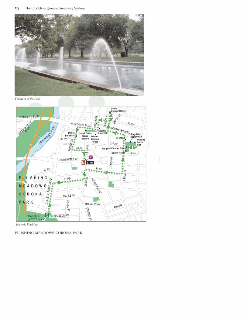
Side Trip - Historic Flushing
Directions at a Glance:
Mile0.0 Starting at College Point Boulevard
outside Flushing Meadows-Corona Park. Turn left onto College Point Boulevard.
0.2 Turn right on 41st Road.0.4 Turn left on Main Street.0.5 Turn right on 41st Avenue.0.8 Turn left on Bowne Street.0.9 Just past Bowne House at 37st Street,
turn right into Margaret Carman GreenContinue through Margaret Carman Green onto 37th Street (to see Kingsland Homestead and Weeping Beech Park).
1.0 Backtrack through Margaret Carman Green and turn right onto Bowne Street.
1.1 Turn left on Northern Boulevard.1.2 Turn right on Leavitt Street to
137th Street.1.3 Backtrack on Leavitt one short block and
right onto 35th Place.1.4 Left on Linden Place.1.5 Cross Northern Boulevard and go right
past Main Street.1.7 Turn left on Prince Street.1.9 Turn left on 38th Avenue.2.0 Turn right on Main Street.2.2 End at Roosevelt Avenue and
Main Street, at subway stop for #7 line.
FLUSHING MEADOWS-CORONA PARK
The Brooklyn/Queens Greenway System 49
This side trip takes you into the oldtown of Flushing, providing a glimpseboth into its long and important history and its rich cultural present.
The route traces some of this history.Once you’re there, you’ll find a com-pelling array of other historical build-ings, houses of worship, stores andrestaurants, and bustling sidestreets.
A new historical trail system withsigns highlighting historically signifi-cant sights within downtoen Flushing,including the Bowne House, TheLewis H. Latimer House, KingslandHomestead, The Weeping BeechTree, and Margaret Carman Greenwas completed in 2007.
Flushing held a reputation for religious freedom almost from itsfounding. In 1657 Governor PetrusStuyvesant declared the DutchReformed Church the official religion of the colony. A group ofseventeenth century Quakers, thecommon name for members of theReligious Society of Friends, repliedto Stuyvesant with a document entitled the Flushing Remonstrance,which is considered the first decla-ration of religious freedom inAmerican history. Stuyvesant jailedthe leading signers, and in 1662exiled John Bowne, whose housewas used for Quaker meetings. TheDutch West India company allowedBowne to return, carrying orders toStuyvesant to cease his persecution,thus codifying a certain level of reli-gious freedom, at least in New York.The Quakers became an important
commercial and political force.Francis Lewis, a Quaker andFlushing landowner, was a signer ofthe Declaration of Independence.
Trip Description
Starting at College Point Boulevardoutside of Flushing Meadows-CoronaPark, travel north to 41st Road, makinga right turn to Main Street. Foot andvehicular traffic are quite heavy in thearea; cyclists may want to walk bikesand enjoy the hustle, bustle, and history.
Turn right onto 41st Avenue and leftonto Bowne Street. The John BowneHouse is at 37-01 Bowne Street. Thekitchen wing, built in 1661, was thecontroversial meeting spot. This isalso the oldest surviving structure inQueens. The Bowne House is ownedand operated by the Bowne HouseHistorical Society (www.bowne-house.org) and is a member of theHistoric House Trust of New YorkCity (www.historichousetrust.org).
Just past Bowne House, turn right intoMargaret Carman Green. Situated inWeeping Beech Park, this plot wasnamed after Margaret I. Carman, aFlushing native who devoted manyyears to preserving Flushing’s history.Her efforts resulted in the opening ofthe Flushing Freedom Trail; the 1.3-mile trail stops along historical sites,many of which are associated with theunderground railroad that lead south-ern slaves to freedom. After her deathin 1976 this tree-lined square ofWeeping Beech Park was named in
FLUSHING MEADOWS-CORONA PARK
The Brooklyn/Queens Greenway System50
Fountain of the Fairs
Historic Flushing
FLUSHING MEADOWS-CORONA PARK

The Brooklyn/Queens Greenway System 51
her memory. The green is landscapedwith willow oaks.
Continuing through the Green to 37th
Avenue, Kingsland Homestead is onthe left. This Dutch-style house wasbuilt by Charles Doughty, a Quakerfarmer, in 1774. It reflects the relative-ly greater prosperity of the colonyafter a century of development.Kingsland Homestead is owned andoperated by the Queens HistoricalSociety (www.queenshistoricalsoci-ety.org) and is a member of theHistoric House Trust of New York City.
Just past Kingsland Homestead is thesite of the Weeping Beech Tree, one oftwo living NYC landmarks until itsdeath in 1998. The Weeping BeechTree was planted in 1847 by SamuelBowne Parsons, owner of one ofFlushing’s large plant nurseries. Theshoot was acquired in Belgium. Allweeping beech trees in the UnitedStates are descended from this one.Though it died and was cut down in1998, its daughters are still foundfronting its remains here in WeepingBeech Park.
Backtracking through MargaretCarman Green, turn right onto BowneStreet where you will find George FoxStone just before Northern Boulevard.This boulder was named after GeorgeFox, the founder of the Society ofFriends, who came to North Americain 1672 and preached here under astand of oak trees.
Turn left on Northern Boulevard. Turnright onto Leavitt Street to visit theLewis H. Latimer House, which is at
the corner of Leavitt and 137th Street.Born the son of runaway slaves fromVirginia, Latimer educated himself inthe craft of drafting. Besides being thechief draftsman on Thomas Edison’steam, he was a brilliant inventor him-self, coming up with the carbon fila-ment for the electrical light bulb. Healso drew up the original drawings forAlexander Graham Bell’s telephone.This was his house, but not at its orig-inal location—it used to be on HollyAvenue in Flushing. The house isowned by the City of New York, oper-ated by the Lewis H. Latimer Fundand is a member of the Historic HouseTrust of New York City.
Backtracking on Leavitt Street oneshort block to 35th Avenue, turn rightto Linden Place and left to NorthernBoulevard. On the corner is FlushingTown Hall(www.flushingtownhall.org), erectedin 1864, the Romanesque Revival stylebuilding is run by the non-profitFlushing Council on Culture and theArts. It is home to exhibits, specialevents, opera, jazz and theater. It haslong been a center of community life;entry to the building is free duringnormal business hours.
Cross Northern Boulevard to theFriends Meeting House. Liberatedfrom having to meet in secret in theirhomes, the Quakers were finally ableto build a place for open congregation.A portion of this austere structure wasbuilt in 1694, making it the oldestbuilding in continuous use for reli-gious purposes in New York City.
FLUSHING MEADOWS-CORONA PARK

The Brooklyn/Queens Greenway System52
Flushing Town Hall reminds passersby that the plaza has a deep history.
FLUSHING MEADOWS-CORONA PARK
The Brooklyn/Queens Greenway System 53
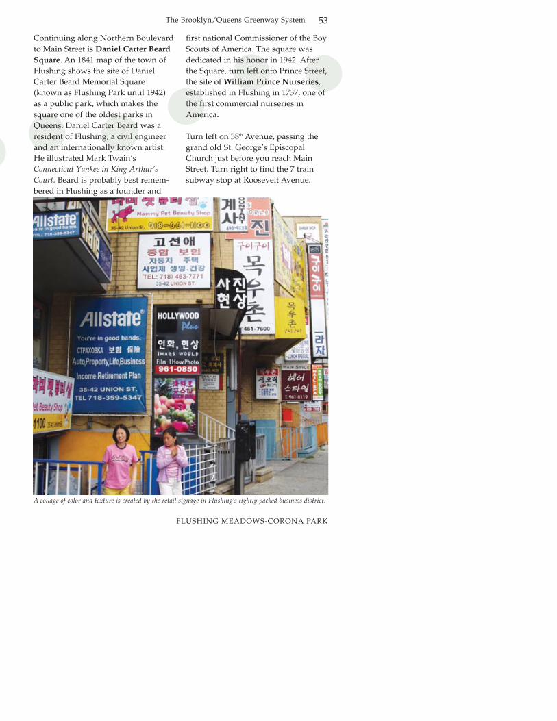
Continuing along Northern Boulevardto Main Street is Daniel Carter BeardSquare. An 1841 map of the town ofFlushing shows the site of DanielCarter Beard Memorial Square(known as Flushing Park until 1942)as a public park, which makes thesquare one of the oldest parks inQueens. Daniel Carter Beard was aresident of Flushing, a civil engineerand an internationally known artist.He illustrated Mark Twain’sConnecticut Yankee in King Arthur’sCourt. Beard is probably best remem-bered in Flushing as a founder and
first national Commissioner of the BoyScouts of America. The square wasdedicated in his honor in 1942. Afterthe Square, turn left onto Prince Street,the site of William Prince Nurseries,established in Flushing in 1737, one ofthe first commercial nurseries inAmerica.
Turn left on 38th Avenue, passing thegrand old St. George’s EpiscopalChurch just before you reach MainStreet. Turn right to find the 7 trainsubway stop at Roosevelt Avenue.
A collage of color and texture is created by the retail signage in Flushing’s tightly packed business district.
FLUSHING MEADOWS-CORONA PARK

The Brooklyn/Queens Greenway System54
KISSENA-CUNNINGHAM CORRIDOR
Kissena-CunninghamCorridor
5 milesBiking—45 minutes; walking—2 hoursKissena Corridor Park, QueensBotanical Garden, Kissena Park,Kissena Park Historic Grove, KissenaPark Velodrome
Mixed residential streets and shelteredpark trails.
Mile
Trail veers right and leaves street at 170th Street, skirting edge of Kissena Park Golf Course.
Cross Fresh Meadow Lane.At Utopia Parkway, dismount. On
sidewalk, turn left, walk about 50 yards to Underhill, then turn right to cross Utopia. Remount, then continue forward on Underhill.
Cross 188th Street.Cross 58th Avenue.At 196th Street, trail veers right to
bridge over Long Island Expressway. At end of bridge, trail enters Cunningham Park, passing through Saint Francis Preparatory School and Public School 179 facilities.
Just before Francis Lewis Boulevard, trail hooks right back towards 199th Street.
Trail enters wooded corridor following 199th Street.
Bridge over 73rd Avenue.Bridge over Francis Lewis BoulevardTrail ends at ballfields.
Length:Estimated Travel time:
Attractions:
Character:
MileTurn right on College Point Boulevard.
and left on Booth Memorial Avenue using the crosswalks for safety at thisbusy intersection.
Turn left on 137th Street.Turn right on 56th Avenue. Cross Main
Street and continue to end.Right on 142nd Street.Turn left on 56th Road.Turn left at 150th Street. Trail enters
Kissena Corridor near end of 150th Street.
Follow trail around ball courts to Peck Avenue and 151st Street.
Continue forward on Peck Avenue.Just before Kissena Boulevard, trail
veers left kitty-corner from the 153rdStreet sign. Cross Kissena Boulevardto corner of Rose Avenue and KissenaBoulevard. Follow marked trail intoKissena Park.
Cross 164th Street to UnderhillAvenue. Continue forward onUnderhill Avenue.
8
2.7
2.82.9
3.23.63.7
4.0
4.2
4.54.85.0
Directions at a GlanceStarting at College Point Boulevard and Fowler Path (next to Lawrence Playground)
0.0
0.40.5
0.70.91.3
1.2
1.41.6
2.3
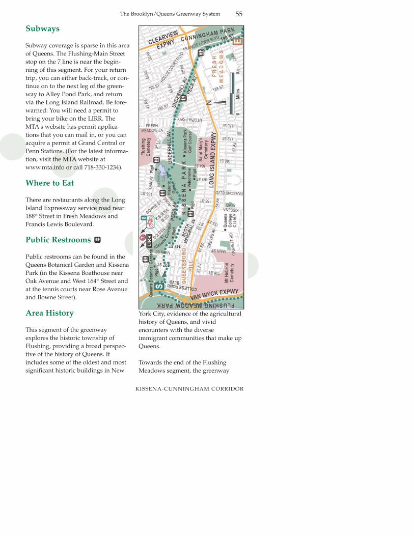
The Brooklyn/Queens Greenway System 55
KISSENA-CUNNINGHAM CORRIDOR
Subways
Subway coverage is sparse in this areaof Queens. The Flushing-Main Streetstop on the 7 line is near the begin-ning of this segment. For your returntrip, you can either back-track, or con-tinue on to the next leg of the green-way to Alley Pond Park, and returnvia the Long Island Railroad. Be fore-warned: You will need a permit tobring your bike on the LIRR. TheMTA's website has permit applica-tions that you can mail in, or you canacquire a permit at Grand Central orPenn Stations. (For the latest informa-tion, visit the MTA website atwww.mta.info or call 718-330-1234).
Where to Eat
There are restaurants along the LongIsland Expressway service road near188th Street in Fresh Meadows andFrancis Lewis Boulevard.
Public Restrooms
Public restrooms can be found in theQueens Botanical Garden and KissenaPark (in the Kissena Boathouse nearOak Avenue and West 164th Street andat the tennis courts near Rose Avenueand Bowne Street).
Area History
This segment of the greenwayexplores the historic township ofFlushing, providing a broad perspec-tive of the history of Queens. Itincludes some of the oldest and mostsignificant historic buildings in New
York City, evidence of the agriculturalhistory of Queens, and vivid encounters with the diverse immigrant communities that make upQueens.
Towards the end of the FlushingMeadows segment, the greenway
roughly follows the channelized rem-nant of the Flushing River. By seven-teenth century standards, theFlushing River was navigable, makingthe colonial town of Flushing a minorport serving the farmsteads of the sur-rounding region. The town wasfounded in 1642 by a colony from theDutch city of Vlissingen—in Dutch,‘v’ is pronounced similarly to ‘f’ inEnglish. The town was officially char-tered in 1645.
Almost from the beginning, specialtyfarming was an important part of theeconomy of Flushing. Possibly thefirst commercial nursery in the UnitedStates was established in 1735 by thePrince family. Leave it to the British—during the Revolutionary War, theBritish chopped down 3,000 cherrytrees to make supports for hop vines,used in brewing beer. GeorgeWashington visited the nursery in1789, as part of a presidential tour ofLong Island. The site of the nursery islocated just south of NorthernBoulevard, between Prince Street andFlushing Creek. The site is completelybuilt over and no trace of the nurseryremains.
You can still find traces of the largenineteenth century nursery founded by the brothers SamuelBowne Parsons and Robert BrownParsons, descendants of one of theoldest and most socially prominentfamilies in Flushing. Their nurseryprovided many of the trees used byOlmsted and Vaux in Central Parkand Prospect Park. In the mid-1870s,Samuel Parsons opened a new
nursery near Kissena Lake. He evenbuilt a road, now known as ParsonsBoulevard, to lead customers to hisestablishment. Samuel satisfied theeclectic and exotic horticultural tastesof the Victorian era and introducedmany new plants into the trade,including the still popular Japanesemaples. When he died in 1906, thecity purchased the land of his nurseryand combined it with several otherparcels to form Kissena Park. In 1981,a group of summer interns happenedupon an unusually diverse collectionof trees near Rose Avenue andParsons Boulevard. A survey of thespecies found nearly 100 separatespecies of trees, including many rari-ties. This 14-acre plot is now knownas the Historic Grove.
Two other recent renovations havespiffed up Kissena Park. Historically,Kissena Lake was a natural pond. Inthe 1930s, it was drained and linedwith concrete, making it a “bathtublake.” Over the years, it becamechoked with algae and phragmites, aninvasive weed. A recently completedrenovation has left the lake sparkling,with a new aeration system, a naturaledge leading to the lake, and a pro-tected island for turtles and waterfowl.
Just south of the lake you'll find theKissena Park Velodrome, or bicycletrack. This 400-meter, banked asphalttrack was originally built in 1962 forthe Olympic trials. It fell into disrepair, but a major renovation completed in 2004 reaffirmed its sta-tus as the robust hub of New York
The Brooklyn/Queens Greenway System56
KISSENA-CUNNINGHAM CORRIDOR
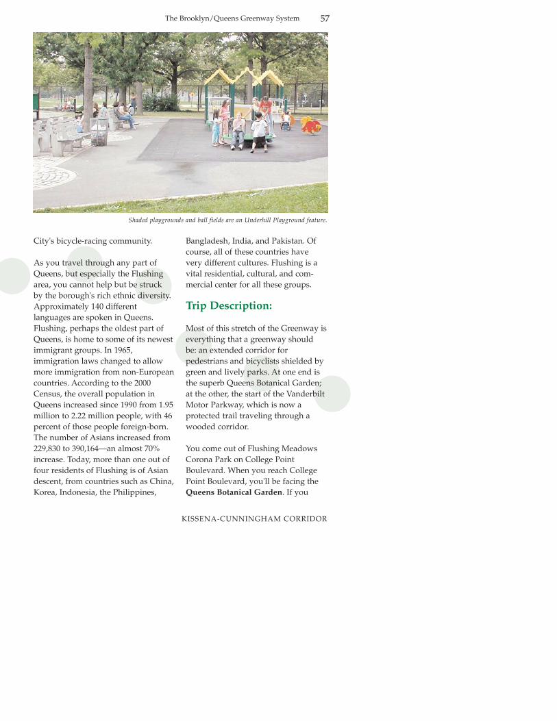
Shaded playgrounds and ball fields are an Underhill Playground feature.
City's bicycle-racing community.
As you travel through any part ofQueens, but especially the Flushingarea, you cannot help but be struck by the borough's rich ethnic diversity.Approximately 140 different languages are spoken in Queens.Flushing, perhaps the oldest part ofQueens, is home to some of its newestimmigrant groups. In 1965, immigration laws changed to allowmore immigration from non-Europeancountries. According to the 2000Census, the overall population inQueens increased since 1990 from 1.95million to 2.22 million people, with 46percent of those people foreign-born.The number of Asians increased from229,830 to 390,164—an almost 70%increase. Today, more than one out offour residents of Flushing is of Asiandescent, from countries such as China,Korea, Indonesia, the Philippines,
Bangladesh, India, and Pakistan. Ofcourse, all of these countries havevery different cultures. Flushing is avital residential, cultural, and com-mercial center for all these groups.
Trip Description:
Most of this stretch of the Greenway iseverything that a greenway should be: an extended corridor for pedestrians and bicyclists shielded bygreen and lively parks. At one end isthe superb Queens Botanical Garden;at the other, the start of the VanderbiltMotor Parkway, which is now a protected trail traveling through awooded corridor.
You come out of Flushing MeadowsCorona Park on College PointBoulevard. When you reach CollegePoint Boulevard, you'll be facing theQueens Botanical Garden. If you
The Brooklyn/Queens Greenway System 57
KISSENA-CUNNINGHAM CORRIDOR

want to visit, cross College PointBoulevard to Blossom Avenue, thenfollow the perimeter of the garden tothe main entrance on Main Street nearDahlia Avenue. The Queens BotanicalGarden is a gem, a botanical gardenthat takes seriously its relationship tothe diverse cultures and needs ofQueens residents. For more informa-tion on hours of operation andupcoming events go to www.queensbotanical.org or call 718-886-3800.
Backtracking to College PointBoulevard, turn right, then make a lefton Booth Memorial Avenue. You’ll beclimbing steeply. Walkers may want tofollow the perimeter of the botanicalgarden along 133rd Street, then Elderand Peck Avenues, then right to 56th Avenue.
Bicyclists—keep with the flow of traf-
fic by staying on Booth MemorialAvenue, turning left at 137th Street. At56th Avenue, turn right; after you crossMain Street, you’ll be on the edge ofKissena Corridor Park. Follow 56th
Avenue to 142nd Street. Turn right onto142nd Street and left onto 56th Road to150th Street.
Gardeners and appreciators of Asianvegetables will want to make a shortsidetrip to visit a vast community garden mostly worked by people ofKorean descent. The garden is noteworthy not only for its scale, butalso for the interesting techniques andvegetables employed by the garden-ers. To find it, turn left at 146th Street,then left again at Colden Street, whichfollows the northeastern edge of theKissena Corridor Park. You’ll find thegardens between Laburum andJuniper Avenues, appropriately, acrossfrom Rachel L. Carson Intermediate
Beautiful stone work can be found in Kissena Park.
KISSENA-CUNNINGHAM CORRIDOR
The Brooklyn/Queens Greenway System58

The sonic playground in Underhill Playground
School. Backtrack to Booth MemorialAvenue to get back on the Greenway.
At 150th Street, the Greenway turnsleft, into Kissena Corridor Park—lookfor the tell-tale greenway markers aswell as large wooden posts paintedbrown. The trail wraps around the farend of the ball courts to meet up withPeck Avenue. Follow Peck Avenueuntil just before it stops at KissenaBoulevard. You’ll notice the trail veersslightly to the left, providing a safecrossing to the corner of Rose Avenue.
Cross Kissena Boulevard into KissenaPark, passing through gates decoratedwith steel profiles of an old-fashionedrailroad locomotive. A marker in thepavement designates the spot throughwhich a rail line ran. Follow the signs,which designate a clear route throughthe park. To learn more about the natural and social history of the park,look for the staircase leading up to the
Kissena Park Environmental Centerand the Historic Grove.
The route exits the park at 164th Streetand Underhill Avenue. FollowUnderhill Avenue until it ends at 170th
Street. Bear right onto a trail that travels alongside the Kissena ParkGolf Course.
The protected section of the trail endsat Utopia Parkway. If you’re on a bike,dismount and, staying on the side-walk, turn left and walk a few yardsover to Underhill Avenue. CrossUtopia Parkway, hop back on yourbike, and proceed on UnderhillAvenue. You’ll be crossing 188th Streetand 58th Avenue. At 196th Street, thetrail veers to the right to travel on thepedestrian bridge over the LongIsland Expressway. At the end of thebridge you are now in CunninghamPark. Follow the trail as it passesbetween two schools, Public School
KISSENA-CUNNINGHAM CORRIDOR
The Brooklyn/Queens Greenway System 59

179 on your right, and Saint FrancisPreparatory School on your left. Justbefore Francis Lewis Boulevard, thetrail hooks right, back towards 199th
Street. This hook can be a little trickyto find: if you find yourself on thesidewalk along the Francis LewisBoulevard, you’ve gone too far.
Near 199th Street, the trail begins tofollow a wooded corridor, which isthe route of the old Vanderbilt MotorParkway. This segment of theGreenway, somewhat arbitrarily, endsalong 199th Street near 75th Avenue.The Greenway bypasses one of themost interesting parts of CunninghamPark: the southern forest with itsmature trees and kettle ponds. Unlikemany forests in New York City, theunderstory here is largely intact,allowing many different ferns andwildflowers to flourish—a wonderfulside trip before the next leg of our
journey. To get there, continue traveling forward on 199th Street, thencross Union Turnpike to enter thepark. Bicyclists, please respect the delicate character of this forest byeither locking up your bike or walkingit as you explore this rare, nearly pristine area.
To get back to a subway, retrace theroute back to Main Street, turn right toRoosevelt Avenue where you'll findthe last stop on the 7 line, or go on tothe last segment of the Greenway.
Community gardeners taking a break from the midday sun
KISSENA-CUNNINGHAM CORRIDOR
The Brooklyn/Queens Greenway System60

The Brooklyn-Queens Greenway System
Alley PondPark toFort Totten
9.6 milesBiking—1.5 hours; walking—3 hoursVanderbilt Motor Parkway, Alley PondPark, Alley Pond Environmental Center,Joe Michaels Mile, Little Bay Park, FortTotten Park, Throgs Neck Bridge, neighborhood of Bayside.
Mostly sheltered park corridors withsome on-street sections. The only heavytraffic is briefly encountered at NorthernBoulevard.
MileTurn left on 230th Street.Turn right on 67th Avenue.Turn left on 233rd Street.Cross West Alley Road, then straight
ahead on East Hampton Boulevard, to end.
Soft left onto 232nd Street.Left on 50th Avenue, then right on
Horatio Parkway.Right on Cloverdale Boulevard.Right on Northern Boulevard.Cross Northern Boulevard to beginning
of Joe Michaels Mile. Follow marked route past Fort Totten to the base of the Throgs Neck Bridge.
End near Utopia Parkway.
Length:Estimated travel time:
Attractions:
Character:
MileFollow the well-marked trail, which is
the remnant of the Vanderbilt Motor Parkway, over the bridge crossing atFrancis Lewis Boulevard, then, near ballfields, tunnel under the Clearview Expressway.
Trail ends at Winchester Boulevard. Turn around and backtrack.
Trail exits park corridor at Cloverdale Boulevard. You will turn right, then travel forward on Cloverdale.
Near 76th Avenue, trail turns right, enters park again. Follow marked trail to exit at Cloverdale and 73rd Avenue.
Forward on Cloverdale Boulevard.Turn right on 69th Avenue.
9
4.04.14.24.5
5.25.3
5.55.86.0
9.6
0.0
2.5
3.1
3.2
3.73.8
Directions at a GlanceStarting at 75th Avenue and 199th Street in Cunningham Park
61
ALLEY POND PARK TO FORT TOTTEN
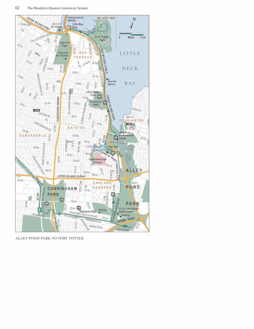
The Brooklyn-Queens Greenway System62
ALLEY POND PARK TO FORT TOTTEN
The Brooklyn-Queens Greenway System
Subways
There are no subways close to thissegment of the Greenway. At the endof the segment you can backtrack tothe Flushing-Main Street stop on the 7 line (see inset map p. 70). The LongIsland Railroad provides the closestpublic transportation. TheAuburndale, Bayside, and Douglastonstops are relatively near sections of theGreenway. You need a permit to bringyour bike on the train. The MTA’swebsite has permits applications thatyou can mail in, or you can acquire apermit at Grand Central or PennStation. (For the latest information,visit the MTA website atwww.mta.info or call 718-330-1234).
Where to Eat
There are numerous restaurants onNorthern Boulevard and a snack baron Joe Michaels Mile that is open fromApril to October.
Public Restrooms
Public restrooms can be found atTelephone Playground at 75th Avenueand Bell Boulevard, Alley Pond Park:67th Avenue and 230th Street; AlleyPond Environmental Center;Crocheron Park: Little Neck Parkwayand 33-35 Avenues; John Golden Park:215th Place and 32nd Avenue.
Area History
This is one of the most historicallyrich segments of the Greenway. It travels through the outer reaches of
the old Flushing township to LittleNeck Bay, encountering Fort Tottenand the Throgs Neck Bridge. The seg-ment begins by running through thecorridor of the historic Long IslandMotor Parkway, known as theVanderbilt Motor Parkway. The ideafor the Parkway was prompted in1906 by William K. Vanderbilt Jr., adescendant of the family that presidedover the New York Central Railroadand Western Union. Vanderbilt con-ceived of the route as a raceway, but italso served as a fast track for thewealthy to their estates on LongIsland. Later, during the 1920s andprohibition, the route became knownas Rum-Runners Road, since as a pri-vate road it was so frequently used bybootleggers outrunning the police. Itwas featured in the 1937 movie Topper,starring Cary Grant. The movie isworth renting to get a sense of thepastoral landscape of the area 60 yearsago. You’ll find the area is now builtover with neat-as-a-pin middle-classhouses. In the 1930s, Robert Mosesundercut the Vanderbilt by construct-ing the free-of-toll Northern StateParkway. With its revenue severelyreduced, the Vanderbilt shut down in1938, to be shortly resurrected byMoses as a recreational path.
Alley Pond Park is at the other end ofthe Vanderbilt Motor Parkway. AlleyPond Park is a vast, rambling parkfeaturing some of the most dramatickettle ponds and satisfying forest andmarsh experiences in New York City.Kettle ponds were formed during theretreat of the big glaciers 20,000 yearsago. Huge blocks of dense glacial icebecame mixed with the rest of the rub-bly glacial till. When the ice melted, itleft a big hole in the ground. Twenty
63
ALLEY POND PARK TO FORT TOTTEN

The Brooklyn-Queens Greenway System
thousand years later, these big holesremain as isolated ponds, largely fedby precipitation instead of streams orsprings.
Lovers of big old trees will find plenty to adore throughout the park’s woodlands. Be on the lookout forhuge old tulip trees, as well as beechand red oak. The bottom of the kettlessupport red maple swamps. Birdwatching is popular, thanks to thepark’s varied habitats. And the park isable to support the most variedamphibian population in New YorkCity outside of Staten Island.
The area has a long human history.The Matinecock were the first nationto inhabit the area. In 1637, a man ofEuropean descent named ThomasFoster acquired 600 acres surroundingAlley Pond and, in 1663, built a per-manent home. Forays by theMatinecock were still occurring, and
the house was fortified with stonewalls. Around 1750, Alley Creek wasdammed and its energy harnessed fora grist mill. The area became a com-mercial center, with commercial ves-sels traveling up Alley Creek. In 1821,the north shore’s first post office wasinstalled near the grist mill. A stage-coach ran between Douglaston, at themouth of the creek, and Brooklyn. Thearea even had its own notoriouslyrowdy bar, named the Bumble Bee’sNest.
Unfortunately, during the 1950s thepark fell victim to habitat fragmenta-tion in connection with the building ofthe Long Island Expressway/CrossIsland Parkway Interchange andcloverleaf. Even Alley Pond, afterwhich the park is named, was partlyfilled in to create a bridge base for theExpressway. (The Pond has recentlybeen restored in a different location).By the late 60s, the remnants of the
The Joe Michaels Mile section of the Greenway as it approaches its terminus near Fort Totten
64
ALLEY POND PARK TO FORT TOTTEN

The Brooklyn-Queens Greenway System
park were critically degraded. Its gul-lies were favorite dumping grounds,especially for cars. In the face of thatand of plans for more highway con-struction through the park, filling in ofPea Pond, and elimination of many ofthe park trails, a vibrant citizensmovement emerged to save and rein-vigorate the park and its habitats. In1969, an umbrella group called theAlley Restoration Committee hosted a“Walk in the Alley.”
The Alley Pond EnvironmentalCenter provides education on theenvironments, creatures, and issues ofthe park, and preserving the environment in an urban setting.You’ll find their offices at 228-06Northern Boulevard, just east of theCross Island Parkway. Visit their web-site for information on current pro-grams and events: www.alleypond.com or call 718-229-4000.
You’ll notice that this is a hilly area.Alley Pond Park follows the slope ofthe glacial moraine down to LittleNeck Bay, and the Greenway goesright along with it, weaving in andout of the park and local sideroads.Little Neck Bay is a glorious naturalsetting, and indeed the Queens neighborhood of Bayside was the preserve of the rich and famous,including many of the early film starsof the 1910s and early 20s. The filmindustry was new and Queens was amajor production center. Perhapscomedian W.C. Fields is its bestremembered resident. It is also thelocation of silent film star RudolphValentino’s summer home, which isnow a restaurant called Caffé on theGreen. Escaping the rampages ofhighway construction, Little NeckBay’s opposite shore in NassauCounty still preserves its posh subur-ban character.
The Greenway curves past Fort
Alley Pond
65
ALLEY POND PARK TO FORT TOTTEN

The Brooklyn-Queens Greenway System
Totten, a historic Army base, a largeportion of which was transferred tothe Parks Department and opened tothe public in 2005. A bucolic militarycampus featuring open space areas,military fortifications dating back tothe Civil War, and turn-of-the-centuryhistoric buildings, Fort Totten repre-sents an exciting new addition to theCity’s park system. The fort, original-ly called the Fort at Willets Point, wasestablished in 1857 as a major compo-nent in the defense system of NewYork Harbor. Its sister fort, FortSchuyler, can be spotted across thebay on the Bronx side of the ThrogsNeck Bridge. Together, both fortsformed a pinch point, or narrows toprevent enemy ships from enteringthe East River from the Long IslandSound.
Located on the northern end of FortTotten, the Historic Battery is the siteof fortifications dating from the CivilWar, the late ninteenth century, andthe early twentieth century. FortTotten is also home to the Officers’Club which is designated a local historic landmark and listed on theNational Register of Historic Places.
Located adjacent to the fort is LittleBay Park, a waterfront park which,like Fort Totten, offers sweeping viewsof Long Island Sound, Little Bay, andthe Throg’s Neck Bridge.
Trip Description
The Greenway proceeds easterly onVanderbilt Motor Parkway. Built formotorcars, today this part of the
Greenway is popular with all mannerof human-powered recreationists. Ona typical excursion, you willencounter folks out for a heavy-dutywork-out or just an afternoon strollwith the family. Bicyclists, follow thewell-marked trail to its end onWinchester Boulevard. Pedestriansmay want to turn into the main partof the park a little bit sooner.
To avoid erosion and conflicts withpedestrians, most of the park’s naturalpaths are off-limits to bicycle riders. Inorder to explore some of the moreinteresting areas of the park, you willneed to dismount. One such attractionis Little Alley Pond. To find it afterbacktracking from WinchesterBoulevard, you will stop short of theCloverdale exit. Instead, after crossingthe bridge over the Grand CentralParkway, you will turn right at thesecond path. You’ll soon encounterLittle Alley Pond, a classic glacial kettle pond. The stairs a little furtheron, have a convenient asphalt rampfor walking your bike if you have one.Poke around the pond a bit, and thenreturn to the trail.
The fortifications of Fort Totten, now New York City parkland
66
ALLEY POND PARK TO FORT TOTTEN

The Brooklyn-Queens Greenway System
Continuing on, you should find aGreenway sign directing you to thetrail exit at Cloverdale Boulevard offto your right. In any event, you cansee Cloverdale from the trail. Moveforward on Cloverdale and veryshortly, near 76th Avenue, a Greenwaysign will indicate a right turn backinto the park. Follow the signed routeto the trail exit at Cloverdale and 73rd
Avenue. You will find yourself in aquiet residential neighborhood, although the traffic on 73rd Avenue canbe a bit speedy.
Carefully cross 73rd Avenue to moveforward on Cloverdale, then turn right
on 69th Avenue. You will turn leftagain on 230th Street, right on 67th
Street, then left on 233rd Street. Whatyou are doing is following the contourof the park in a zig-zag manner.
Continue on to West Alley Road,which you will cross (carefully) to thebeginning of East HamptonBoulevard. There is a glorious trailcalled the Tulip Tree Trail that beginsnear here. At one time, the Tulip TreeTrail was part of a series of bike pathsthat Robert Moses designed next tomany of his expressways. Access tothis trail for bicycle transportation hasbeen blocked. The compensation to
67
ALLEY POND PARK TO FORT TOTTEN
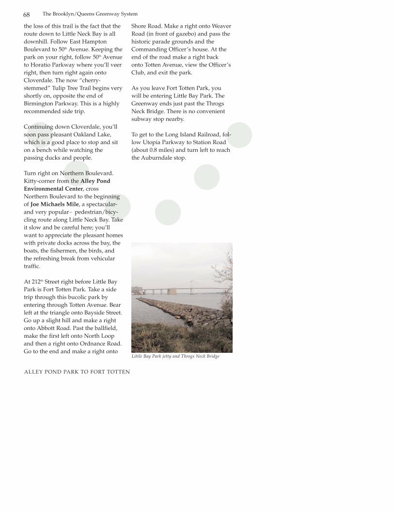
the loss of this trail is the fact that theroute down to Little Neck Bay is alldownhill. Follow East HamptonBoulevard to 50th Avenue. Keeping thepark on your right, follow 50th Avenueto Horatio Parkway where you’ll veerright, then turn right again ontoCloverdale. The now “cherry-stemmed” Tulip Tree Trail begins veryshortly on, opposite the end ofBirmington Parkway. This is a highlyrecommended side trip.
Continuing down Cloverdale, you’llsoon pass pleasant Oakland Lake,which is a good place to stop and siton a bench while watching the passing ducks and people.
Turn right on Northern Boulevard.Kitty-corner from the Alley PondEnvironmental Center, crossNorthern Boulevard to the beginningof Joe Michaels Mile, a spectacular-and very popular— pedestrian/bicy-cling route along Little Neck Bay. Takeit slow and be careful here; you’llwant to appreciate the pleasant homeswith private docks across the bay, theboats, the fishermen, the birds, andthe refreshing break from vehiculartraffic.
At 212th Street right before Little BayPark is Fort Totten Park. Take a sidetrip through this bucolic park byentering through Totten Avenue. Bearleft at the triangle onto Bayside Street.Go up a slight hill and make a rightonto Abbott Road. Past the ballfield,make the first left onto North Loopand then a right onto Ordnance Road.Go to the end and make a right onto
Shore Road. Make a right onto WeaverRoad (in front of gazebo) and pass thehistoric parade grounds and theCommanding Officer’s house. At theend of the road make a right backonto Totten Avenue, view the Officer’sClub, and exit the park.
As you leave Fort Totten Park, youwill be entering Little Bay Park. TheGreenway ends just past the ThrogsNeck Bridge. There is no convenientsubway stop nearby.
To get to the Long Island Railroad, fol-low Utopia Parkway to Station Road(about 0.8 miles) and turn left to reachthe Auburndale stop.
The Brooklyn/Queens Greenway System68
Little Bay Park jetty and Throgs Neck Bridge
ALLEY POND PARK TO FORT TOTTEN

The Brooklyn/Queens Greenway System 69
To get back to the 7 subway stationin Flushing, follow these directions:(See map).• Left on Utopia Parkway.• Right on 26th Avenue, crossing
Francis Lewis Boulevard.• Left on Bayside Lane.• Left on 155th Street (far corner of
Bowne Park—a welcome relief).• Right on 32nd Avenue.• Left on Miller Street, rounding the
square to Prince Street.• Right on Prince Street.• Left on Northern Boulevard, go
one block.• Right on Main Street to subway stop.
ALLEY POND PARK TO FORT TOTTEN

onclusion
We hope you find thisguidebook useful andthat you will take advan-
tage of the Brooklyn-QueensGreenway, and that you will takeadvantage of connections to the 13-mile Shore Parkway Greenway alongBrooklyn’s waterfront and theRockaway Gateway Greenway.Thanks to a significant commitment toexpanding waterfront access, theimportance of greenways has increas-ingly been recognized, as demonstrat-ed by the recent completion of the 32-mile Manhattan Waterfront Greenway.Future greenway projects will connectwith the Brooklyn-Queens Greenwayand extend the greenway system inboth boroughs.
Among the projects in developmentare the Laurelton Southern Greenway,a 32-mile greenway, which will runalong the southern and eastern shores
of Queens and eastern Brooklyn, con-necting Highland Park to Fort Tottenand Little Bay Park. The Queens EastRiver and North Shore Greenway is a10.6 mile greenway which will runfrom the Pulaski Bridge in Queens tothe Flushing Bay Promenade alongthe East River and North Shore shore-lines in Queens. Finally, the BrooklynWaterfront Greenway will run alongBrooklyn’s East River waterfront fromthe Pulaski Bridge to Erie Basin andbeyond to Pier 69 in Bay Ridge.
Greenways provide both recreationaland public health benefits while helping to promote tourism, providing an alternative mode oftransportation for both recreation andcommuting. We hope you will takeadvantage of this and other green-ways to get to your destinations. Forfurther information on citywidegreenways or greenway-relatedevents, please visit our website atwww.nyc.gov/parks.
CThe Brooklyn-Queens Greenway System70
CreditsDesign ................................ Edward FahertyResearch & Writing ........... NOSC StaffPhotography ...................... Dave Lutz
AcknowledgementsNew York City Department of Parks
& RecreationNew York State Department
of TransportationFurthermore, A Program of the
J. M. Kaplan FundNeighborhood Open Space Coalition (NOSC)
Special thanks to:
Dorothy Lewandowski, Queens Borough Commissioner
Julius Spiegel, Brooklyn Borough Commissioner
Joshua Laird, Assistant Commissioner for Planning & Natural Resources
Jennifer Hoppa, Deputy Director, PlanningMartin Maher, Brooklyn Chief of StaffTupper Thomas, Prospect Park AdministratorDebby Kuha, Forest Park AdministratorEstelle Cooper, Flushing Meadows
Corona Park AdministratorJanice Melnick, Northeast Queens Park
AdministratorEric Goetz, Queens Park ManagerJennifer Kao, Project Manager, PlaningTweeps Phillips, Project Manager, PlanningJohn Mattera, Parks Librarian

The Brooklyn-Queens Greenway System 71
Greenway Signage
The route is marked by the Greenwaylogo, a round green medallion
On-street Signage
Regulatory Sign
Pavement Marking
Greenway Safety Tips
Signal to Others. Establish eye contact with motorists to ensure thatthey know you are on the road.Cyclists and skaters should signal allturns and stops; sound your bell orcall out a warning when approachingothers, then pass safely on the left.
Beware of Car Doors. Motorists can unexpectedly open doors of parkedcars. Ride in a straight line at leastthree feet away from parked cars.
Be Careful at Intersections. Avoidbeing in a turn-only lane if you wantto go straight through an intersection.
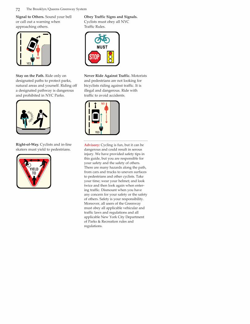
The Brooklyn/Queens Greenway System72
Signal to Others. Sound your bell or call out a warning when approaching others.
Stay on the Path. Ride only on designated paths to protect parks, natural areas and yourself. Riding offa designated pathway is dangerousand prohibited in NYC Parks.
Right-of-Way. Cyclists and in-lineskaters must yield to pedestrians.
Obey Traffic Signs and Signals.Cyclists must obey all NYC Traffic Rules.
Never Ride Against Traffic. Motoristsand pedestrians are not looking forbicyclists riding against traffic. It isillegal and dangerous. Ride with traffic to avoid accidents.
Advisory: Cycling is fun, but it can bedangerous and could result in serousinjury. We have provided safety tips inthis guide, but you are responsible foryour safety and the safety of others.There are many hazards along the path,from cars and trucks to uneven surfacesto pedestrians and other cyclists. Takeyour time; wear your helmet; and looktwice and then look again when enter-ing traffic. Dismount when you haveany concern for your safety or the safetyof others. Safety is your responsibility.Moreover, all users of the Greenwaymust obey all applicable vehicular andtraffic laws and regulations and allapplicable New York City Departmentof Parks & Recreation rules and regulations.
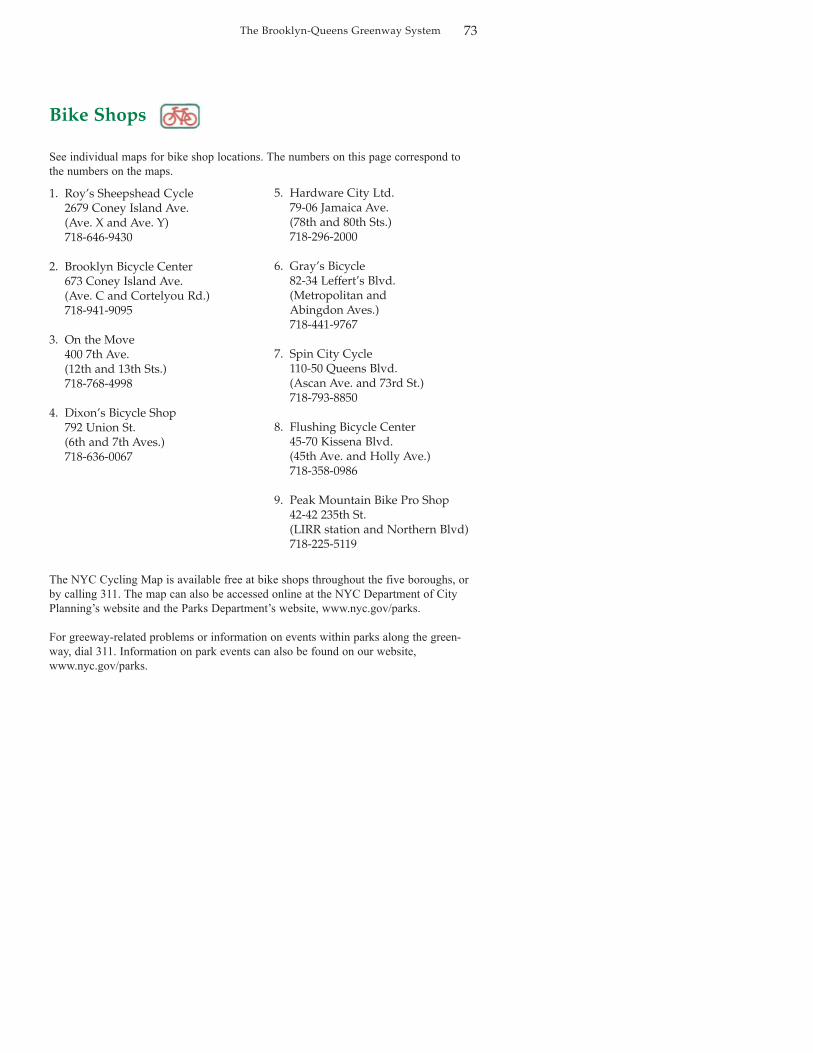
1. Roy’s Sheepshead Cycle2679 Coney Island Ave.(Ave. X and Ave. Y)718-646-9430
2. Brooklyn Bicycle Center673 Coney Island Ave.(Ave. C and Cortelyou Rd.)718-941-9095
3. On the Move400 7th Ave.(12th and 13th Sts.)718-768-4998
4. Dixon’s Bicycle Shop792 Union St.(6th and 7th Aves.)718-636-0067
5. Hardware City Ltd.79-06 Jamaica Ave.(78th and 80th Sts.)718-296-2000
6. Gray’s Bicycle82-34 Leffert’s Blvd.(Metropolitan and Abingdon Aves.)718-441-9767
7. Spin City Cycle110-50 Queens Blvd.(Ascan Ave. and 73rd St.)718-793-8850
8. Flushing Bicycle Center45-70 Kissena Blvd.(45th Ave. and Holly Ave.)718-358-0986
9. Peak Mountain Bike Pro Shop42-42 235th St.(LIRR station and Northern Blvd)718-225-5119
The Brooklyn-Queens Greenway System 73
Bike Shops
See individual maps for bike shop locations. The numbers on this page correspond tothe numbers on the maps.
The NYC Cycling Map is available free at bike shops throughout the five boroughs, orby calling 311. The map can also be accessed online at the NYC Department of CityPlanning’s website and the Parks Department’s website, www.nyc.gov/parks.
For greeway-related problems or information on events within parks along the green-way, dial 311. Information on park events can also be found on our website,www.nyc.gov/parks.

NOTES:

NOTES:

NOTES: