Brookings Area Master Transportation...
59
Brookings Area Master Transportation Plan June, 2011 S OUTH D AKOTA D EPARTMENT OF T RANSPORTATION C ITY OF B ROOKINGS C ITY OF A URORA B ROOKINGS C OUNTY
Transcript of Brookings Area Master Transportation...

Brookings Area Master Transportation Plan
June, 2011
SOUTH DAKOTA DEPARTMENT OF TRANSPORTATION
CITY OF BROOKINGS
CITY OF AURORA
BROOKINGS COUNTY

Brookings Area Master Transportation Plan
June, 2011
The preparation of this report has been financed in part through grant(s) from the Federal Highway Administration and Federal Transit Administration, U.S. Department of Transportation, under the State Planning and Research Program, Section 505 of Title 23, U.S. Code. The contents of this report do not necessarily reflect the official views or policy of the U.S. Department of Transportation. The preparation of this report has been financed through the South Dakota Department of Transportation’s SPR Funding for Local Agencies program. The contents and recommendations of this report do not necessarily reflect the officials views, policy, or endorsement of the South Dakota Department of Transportation.
TABLE OF CONTENTS Executive Summary 1 Goals and Objectives 3 Procedures 4 Existing Conditions 5
Transportation System Needs 5 Functional Classification 12 Traffic Counts 12 External Travel 12 Volumes and Level of Service 14 Safety 18 Bicycle and Pedestrian 19 Transit 19 Special Events 20 Freight 20 Air 20
Future Conditions 22 Forecasting 22 Future Volumes and Level of Service 22 Pedestrian and Bicycle Plans 23 Transit Plans 24 List of Needs 24
Standards Development 31 Major Streets Plan 31 Design Standards 31 Pedestrian and Bicycle Facilities 31 Typical Street Cross-sections 31
Public Involvement 37 Transportation Program 44
Project List with Cost Estimates 44 Additional Projects 48 Funding Potential 50
Appendix On CD
Part 1 – Traffic Count Summary Sheets Part 2 – Medary Avenue Technical Memorandum Part 3 – Special Events Technical Memorandum Part 4 – Design Standards Documents Part 5 – Online Survey Responses Part 6 – Other Technical Memoranda Part 7 – Cost Estimates Part 8 – Synchro files

Table of Figures
1 – Study Work Flow 4 2 – Public Survey Responses 5 3 – Transportation Issues, Northwest Quadrant 6 4 – Transportation Issues, Northeast Quadrant 7 5 – Transportation Issues, Southwest Quadrant 8 6 – Transportation Issues, Southeast Quadrant 9 7 – Transportation Issues, SDSU Campus Area 10 8 – Transportation Issues, Recreation Path/Bike Path Connectivity 11 9 – Major Street Plan 13 10 – External to External Trips 15 11 – 2010 Traffic Counts 16 12 – 2010 Intersection Level of Service 17 13 – Crash Analysis Summary 18 14 – Parks and Trails Map 21 15 – Traffic Analysis Zones 25 16 – 2020 Traffic Counts 26 17 – 2035 Traffic Counts 27 18 – 2020 Intersection Level of Service 28 19 – 2035 Intersection Level of Service 29 20 – List of Transportation Needs 30 21 – Future Pathways and Trails 31 22 – Proposed SDSU Fixed Routes 33 23 – Major Streets Plan 34 24 – Typical Sections 35 25 – Typical Sections 36 26 – Travel Mode Distribution 37 27 – Overall Regional Traffic Safety 38 28 – Traffic Congestion Concern 39 29 – Expected Difficulty of Travel in 20 Years 40 30 – Satisfaction with Components of the Transportation System 41 31 – Allocation of an $100 Investment to Transportation Components 42 32 – Portion of Taxes Going to Transportation Should… 43 33 – Support for a Slight Increase in Local Taxes for Transportation 43 34 – Project List with Cost Estimates 49 35 – Potential Projects – Short Term 51 36 – Potential Projects – Medium Term 52 37 – Potential Projects – Long Term 53

Brookings Area Master Transportation Plan Page 1
Executive Summary This transportation plan has been prepared as part of the larger community planning effort conducted for the Brookings area. It has been conducted under the supervision and funding of the South Dakota Department of Transportation and the Federal Highway Administration, with cooperation and participation of the City of Brookings, Brookings County and the City of Aurora. It uses the general transportation goals and objectives identified in the Brookings comprehensive plan and reflects other state and local planning studies. The plan is comprised of the following components: Current conditions assessment Data were gathered concerning current traffic volumes, traffic origins and destinations, crashes, and public perceptions regarding the transportation system. The data were analyzed to determine where improvements may be needed. Public perceptions were measured using survey instruments, including an extensive online survey. Some key findings of the surveys were: • The primary mode of transportation in the Brookings area is the passenger car, with
a large majority indicating that they drive to work, school or other activities. Other significant modes include carpools, walking, biking, motorcycles, transit, and taxis.
• The public views the safety of the transportation system favorably, with about 66% rating it adequate, good, or excellent.
• About 73% rated congestion as a minor or non-existent problem. • When asked to allocate a hypothetical $100 for transportation improvements,
survey respondents assigned the most to maintaining and improving existing roads and streets, followed by investments in new roads and streets, existing rural roads, and transit.
• About 45% responded that the proportion of taxes directed to transportation should be increased slightly.
• Over 60% expressed support for a slight increase in taxes to improve roads and streets.
Future conditions assessment A traffic forecasting model was built and traffic volumes were forecast for 2020 and 2035. Traffic operations were analyzed to determine future transportation needs. The transportation needs were assembled into a list of potential projects. Public involvement The public was involved in the planning process through the survey instruments, a website, a Facebook™ page, and public meetings. Public input was sought on transportation needs early in the process and on the list of potential transportation projects later in the study.

Brookings Area Master Transportation Plan Page 2
Prepare design standards and other support documents Current regulations and guidance for design of transportation improvements were reviewed and updated documents were provided for consideration. Prepare project program and study document The final project program was prepared based on input from the public, elected officials, transportation professionals, and the Study Team. The study process was documented in this report. The project program can be found in Figure 34.

Brookings Area Master Transportation Plan Page 3
Goals and Objectives This Master Transportation Plan for the Brookings Area exists within the larger framework of comprehensive community planning that has been undertaken by the City of Brookings and other local governments. The City of Brookings has evaluated growth trends and community desires to create a statement of the planned community vision contained in Vision 2020, the most recent comprehensive plan. Strategies for implementing the community’s transportation vision are contained in the goals and objectives stated in the Vision 2020 report and reproduced below: Transportation Goal: Develop and maintain a comprehensive transportation system that meets the current and future needs of Brookings. Transportation Objectives:
• Encourage an energy efficient system that provides adequate access to high volume traffic generation points.
• Minimize negative transportation effects upon residential neighborhoods. • Promote efficient traffic flows around residential institutional uses such as
schools, churches and major public recreation areas. • Promote the installation of sidewalks and trails to facilitate safe travel for
pedestrians and bicyclists. The goal and objectives are further detailed through the statement of the following transportation policies:
• Prevent through traffic on local streets within established neighborhoods. • Create and maintain a grid system of major streets throughout the City. • Require direct pedestrian and bicycle access from residential neighborhoods to
schools, commercial centers and recreation areas. • Separate vehicular traffic from pedestrian and bicycle traffic wherever possible
through the use of sidewalks and recreational trails. • Design residential street layouts to minimize both overall street lengths and the
quantity of site grading required. • Limit driveway entrances on arterial streets and collector streets wherever
possible. • Require continuity of collector streets between adjacent subdivisions. • Secure sufficient rights-of-way to accommodate the City’s major street plan.
The guidance provided by these statements of community vision has been used throughout the preparation of this transportation plan.

Brookings Area Master Transportation Plan Page 4
Procedures Preparation of this transportation plan followed a dual-track process. As shown in Figure 1, assembly and analysis of data provided input to the evaluation of existing and future conditions. The end result of the data and evaluation tracks was a program of future transportation improvements.
The study data was assembled from existing databases and from counts and surveys conducted by the project team in 2010. Roadway capacity analysis was conducted using Highway Capacity Manual techniques via Trafficware® SYNCHRO software. A new regional travel demand model was prepared to facilitate traffic forecasts.
FIGURE 1 – STUDY WORK FLOW

Brookings Area Master Transportation Plan Page 5
Existing Conditions A useful transportation planning effort begins with a comprehensive inventory of the existing transportation system. That inventory needs to include not just technical data, but also public perceptions of the existing transportation system. Therefore, the study proceeded with data gathering on two fronts: 1) assembly of technical information from traffic counts, origin/destination surveys, and database searches, and 2) survey of the public perception of existing transportation system needs. Transportation System Needs A list of potential transportation system needs was generated through a multi-pronged input effort, including:
• Input from the project Study Team, comprised of State and Local transportation officials.
• Input from the public via written and spoken comments at the first public meeting. • Input from the public via an online survey instrument. • Input from the public via email and Facebook comments.
The input comments were assembled on Figures 3 – 8, reproduced on the following pages. They indicate that the primary areas of concern are related to the growing congestion in the City’s commercial areas, the crossings of Interstate 29 and roadways providing access to the Industrial Park. Other comments target the SDSU campus area and other isolated areas of concern. The online survey instrument asked many qualitative questions about the perception of the Brookings-area transportation system, but also went further to evaluate the public’s assessment of the most important transportation issues in the Brookings area. Figure 2 shows the relative composite rankings of those issues. A more detailed summary of the survey results is contained in the Public Involvement section of this report.
020406080
100120
6TH STR
EET …
IMPR
OVE
20TH …
22ND AVE
NUE …
MED
ARY
…
34TH
AVE
NUE …
MAIN AVE
NUE …
8TH STR
EET …
17TH
AVE
NUE …
SDSU
ARE
A …
32ND AVE
NUE …
WESTERN
…
32ND STR
EET …
RAILRO
AD …
12TH
STR
EET …
INDUSTRIAL …
RESPONSES
RESPONSES
FIGURE 2 – PUBLIC SURVEY RESPONSES


Brookings Area Master Transportation Plan Page 12
Functional Classification A well-functioning transportation system depends on having streets serving all the types of transportation needs, from local access and circulation streets to Interstate highways. The existing Brookings-area roadway system provides the full compliment of streets and highways, with each street section classified according to its planned function. The existing functional classification of the street system is shown in the current Major Streets Plan, Figure 9. It should be noted that the functional classification system maintained by local government may differ slightly from the Federal functional classification maintained by SDDOT due to mileage limitations on certain types of roadways. Traffic Counts Vehicular turning movement counts were conducted to supplement existing traffic volume databases. Turning movement counts were performed as follows:
• US 14 bypass/Medary Ave. – 6:30 AM – 6:30 PM • 8th St. S./Main Ave. – 6:30 AM – 6:30 PM • US 14 bypass/Western Ave. – 7 AM – 11 AM, 2 PM – 6 PM • US 14 bypass/22nd Ave. – 7 AM – 11 AM, 2 PM – 6 PM • 11th St./22nd Ave. - 7 AM – 11 AM, 2 PM – 6 PM • 8th St./22nd Ave. - 7 AM – 11 AM, 2 PM – 6 PM • 6th St./13th Ave. - 7 AM – 11 AM, 2 PM – 6 PM • 6th St./I-29 NB - 7 AM – 11 AM, 2 PM – 6 PM • 6th St./32nd Ave. - 7 AM – 11 AM, 2 PM – 6 PM • 3rd St./Main Ave. - 7 AM – 11 AM, 2 PM – 6 PM • 3rd St./Medary Ave. - 7 AM – 11 AM, 2 PM – 6 PM • 2nd St. S./Main Ave. - 7 AM – 11 AM, 2 PM – 6 PM • 2nd St. S./Medary Ave. - 7 AM – 11 AM, 2 PM – 6 PM • 8th St. S./Medary Ave. - 7 AM – 11 AM, 2 PM – 6 PM • 8th St. S./17th Ave. - 7 AM – 11 AM, 2 PM – 6 PM • 20th St. S./Main Ave. - 7 AM – 11 AM, 2 PM – 6 PM • 20th St. S./Medary Ave. - 7 AM – 11 AM, 2 PM – 6 PM • 20th St. S./17th Ave. - 7 AM – 11 AM, 2 PM – 6 PM • 32nd St. S./Medary Ave. - 7 AM – 11 AM, 2 PM – 6 PM • Eastbrook Dr./22nd Ave. - 7 AM – 11 AM, 2 PM – 6 PM • 12th St. S./17th Ave. - 7 AM – 11 AM, 2 PM – 6 PM
Count summary sheets have been provided in the Appendix, Part 1. External Travel Origin/destination studies were conducted from September through October, 2010 to provide background data for the planning study and a basis for determining the amount of traffic

FIGURE 9 – EXISTING MAJOR STREETS PLAN
Brookings Area Master Transportation Plan Page 14
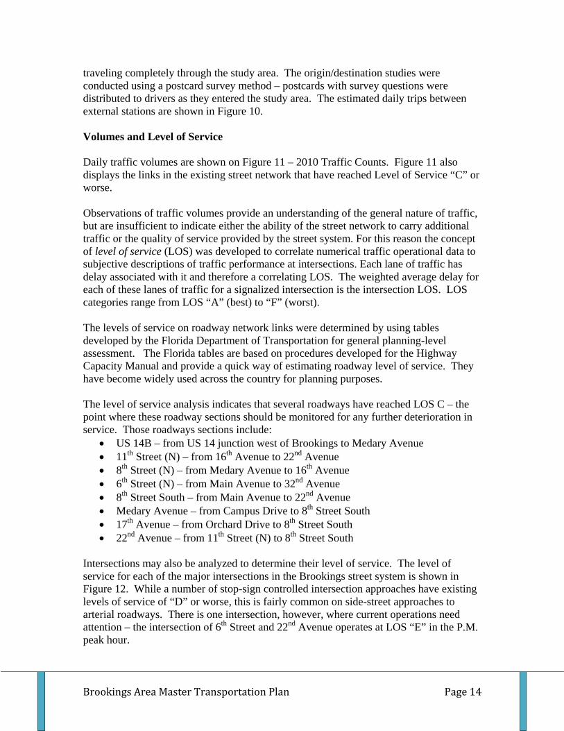
traveling completely through the study area. The origin/destination studies were conducted using a postcard survey method – postcards with survey questions were distributed to drivers as they entered the study area. The estimated daily trips between external stations are shown in Figure 10. Volumes and Level of Service Daily traffic volumes are shown on Figure 11 – 2010 Traffic Counts. Figure 11 also displays the links in the existing street network that have reached Level of Service “C” or worse. Observations of traffic volumes provide an understanding of the general nature of traffic, but are insufficient to indicate either the ability of the street network to carry additional traffic or the quality of service provided by the street system. For this reason the concept of level of service (LOS) was developed to correlate numerical traffic operational data to subjective descriptions of traffic performance at intersections. Each lane of traffic has delay associated with it and therefore a correlating LOS. The weighted average delay for each of these lanes of traffic for a signalized intersection is the intersection LOS. LOS categories range from LOS “A” (best) to “F” (worst). The levels of service on roadway network links were determined by using tables developed by the Florida Department of Transportation for general planning-level assessment. The Florida tables are based on procedures developed for the Highway Capacity Manual and provide a quick way of estimating roadway level of service. They have become widely used across the country for planning purposes. The level of service analysis indicates that several roadways have reached LOS C – the point where these roadway sections should be monitored for any further deterioration in service. Those roadways sections include:
• US 14B – from US 14 junction west of Brookings to Medary Avenue • 11th Street (N) – from 16th Avenue to 22nd Avenue • 8th Street (N) – from Medary Avenue to 16th Avenue • 6th Street (N) – from Main Avenue to 32nd Avenue • 8th Street South – from Main Avenue to 22nd Avenue • Medary Avenue – from Campus Drive to 8th Street South • 17th Avenue – from Orchard Drive to 8th Street South • 22nd Avenue – from 11th Street (N) to 8th Street South
Intersections may also be analyzed to determine their level of service. The level of service for each of the major intersections in the Brookings street system is shown in Figure 12. While a number of stop-sign controlled intersection approaches have existing levels of service of “D” or worse, this is fairly common on side-street approaches to arterial roadways. There is one intersection, however, where current operations need attention – the intersection of 6th Street and 22nd Avenue operates at LOS “E” in the P.M. peak hour.

DAILY INCOMINGSTATION COUNT TRAFFIC 1 2 3 4 5 6 7 8 9 101 ‐ US 14 WEST OF BROOKINGS 7300 3650 37 37 183 1462 ‐ BROOKINGS COUNTY 77 NORTH OF BROOKINGS 2000 1000 30 20 203 ‐ US 14 EAST OF BROOKINGS 5000 2500 100 75 754 ‐ 473RD AVENUE SOUTH OF BROOKINGS 300 150 305 ‐ 22ND AVENUE SOUTH OF BROOKINGS 1600 8006 ‐ BROOKINGS COUNTY 77 SOUTH OF BROOKINGS 2000 1000 10 107 ‐ I‐29 EXIT 133 SOUTHBOUND 1600 1600 192 16 328 ‐ I‐29 EXIT 133 NORTHBOUND 1900 1900 722 579 ‐ I‐29 EXIT 132 SOUTHBOUND 1200 1200 2410 ‐ I‐29 EXIT 132 NORTHBOUND 1700 1700 85 17
FIGURE 10 ‐ EXTERNAL STATIONS AND EXTERNAL TO EXTERNAL TRIPS
OUTGOING TRIPS


Brookings Area Master Transportation Plan Page 18
Safety
The safety of the current Brookings transportation system was evaluated through review of crash location data, public comments and previous reports provided by the SDDOT Road Safety Inspection (RSI) program. Locations with clusters of crashes were identified through the use of crash plots or RSI references. The crash data for the cluster locations were then analyzed to determine potential needed safety improvements. The results of the crash analysis are shown in Figure 13.
NUMBER
OF POTENTIAL POTENTIAL
LOCATION REPORTS IN 4 YEARS CAUSES IMPROVEMENTS
6TH STREET/MEDARY AVENUE 26
VEHICLES EXTENDING LEFT TURN ARROW CHECK SIGNAL TIMING
6TH STREET/16TH AVENUE 9 VISIBILITY TO WEST ON 16TH
CONTINUE TO MONITOR ‐ VOLUME DROPPING
6TH STREET/22ND AVENUE 58
LANE CONFIGURATION, SIGNAL PHASING UPDATE WITH RECONSTRUCTION
22ND AVENUE, 6TH TO 12TH ST. S. 61
NARROW LANES, SLOW SPEED DRIVEWAYS UPDATE WITH RECONSTRUCTION
6TH STREET/25TH AVENUE 8
NON‐STANDARD LANES/ALIGNMENT UPDATE WITH RECONSTRUCTION
6TH STREET/I‐29 NORTHBOUND 10 RAMP DELAYS SIGNAL INSTALLED 6TH STREET/32ND AVENUE 13 SIDE STREET DELAYS SIGNAL INSTALLED US 14B/WESTERN AVENUE 3
TRUCK TRAFFIC, NO LEFT TURN LANES, LIGHTING
MONITOR, UPDATE WITH RECONSTRUCTION
8TH STREET S/MEDARY AVENUE 8 NO TRENDS CONTINUE TO MONITOR 8TH STREET (N)/MEDARY AVENUE 6 INTERSECTION VISIBILITY
MONITOR, REMOVE PARKING AND SIGHT OBSTRUCTIONS
5TH STREET (N)/MEDARY AVENUE 9 CAPACITY RESTRAINTS UPDATE WITH RECONSTRUCTION 8TH ST. S./MAIN AVENUE 10
NON‐STANDARD LANES/ALIGNMENT UPDATE WITH RECONSTRUCTION
6TH ST./12TH AVENUE 6 NO TRENDS CONTINUE TO MONITOR 12TH STREET S/17TH AVENUE 2 NO TRENDS
HIGH DEMAND DURING SCHOOL PASSAGE TIMES
12TH STREET S/22ND AVENUE 3 NO TRENDS CONTINUE TO MONITOR 6TH STREET/WESTERN AVENUE 9
MULTIPLE APPROACHES, CURVED ROADWAY
REDUCE CONFLICT POINTS, PROVIDE POSITIVE GUIDANCE
A special analysis was conducted at 12th Street S./17th Avenue because of public comments received in conjunction with the study survey of public opinion. There were several comments indicating excessive delays and potential safety problems at that location. An observation at the site showed that there were considerable traffic backups
FIGURE 13 – CRASH ANALYSIS SUMMARY

Brookings Area Master Transportation Plan Page 19
during the morning and afternoon travel periods for the adjacent middle school and near-by intermediate school. The locations of the schools result in nearly every driver traveling to either school passing through the all-way stop intersection at 12th Street S/17th Avenue. The intersection is also a pedestrian crossing for students and is staffed by a crossing guard. The traffic backups haven’t shown up in the current level of service analysis, but the future-year analysis indicates a capacity problem at this intersection. It appears reasonable to plan for future intersection improvements, including signalization.
The congestion at 12th Street South/17th Avenue points out the need for conducting studies for new schools to provide the input of experienced traffic engineers on vehicle circulation and pedestrian safety issues. School transportation issues can often be counter-intuitive and difficult to solve without experienced advice.
There were a number of on-line survey responses related to the safety of the railroad crossings in Brookings. There is also a history of concern among Brookings residents about a potential increase of rail service on the Dakota, Minnesota and Eastern railroad that bisects the area. Crash statistics do not show a current safety problem at the existing at-grade railroad crossings. Many cities, however, are planning for grade-separated crossings on arterial streets to avoid future traffic delays and safety problems. If Brookings adopted a policy to provide grade separations on important arterials, the most likely locations would be on Main Avenue, 22nd Avenue and 34th Avenue. Building grade separations on Main Avenue and 22nd Avenue could involve significant disruption of existing traffic patterns and potential right-of-way impacts in the vicinity of the railroad crossings. The cost of each grade separation could be relatively high due to the long structures required.
Bicycle and Pedestrian
Bicycle and pedestrian travel in Brookings is characterized by an established network of facilities with plans for future expansion. A system of multi-use recreation trails serve parts of the community and has recently been expanded to the east side of Interstate 29. The existing system of trails is shown in Figure 14. Other bicycle and pedestrian travel occurs on existing streets and sidewalks.
The South Dakota State University campus sees considerable pedestrian and bicycle travel which extends to off-campus residences and destinations. These pedestrian and bicycle interactions with the larger community could be encouraged with continued planning for future pedestrian and bicycle facilities, particularly designated lanes/paths.
A specialized study of pedestrian issues along Medary Avenue on the SDSU campus was conducted and a technical memo outlining the analysis and recommendations of that special study has been included in the Appendix Part 2.
Transit
The Brookings Area is served by Brookings Area Transit Authority (BATA), which provides advance-reservation transit service throughout the community and weekly service to other communities. BATA has conducted extensive system assessment and

Brookings Area Master Transportation Plan Page 20
planning for the future. Their current business plan calls for establishment of a new fixed route system serving the SDSU campus and other schools, commercial destinations in the downtown and outlying areas, and employment destinations. The BATA plan presents an exciting opportunity for public transportation service, but also present challenges in terms of funding.
Special Events
A number of special events occur in the Brookings area each year and create high demand on the local transportation system. Those events include the Sidewalk Arts Festival, SDSU sporting events, and sporting events/programs at the Swiftel Center. Special studies were conducted for the Sidewalk Arts Festival and SDSU football game events. Memoranda detailing the findings and recommendations of those special studies are included in the Appendix.
Freight
Freight transportation needs in the Brookings area are met by truck and rail services. The primary routes for intrastate and interstate truck traffic through the study area are Interstate 29 and US 14. Smaller truck volumes also use SD 324 and county roads to access the study area. Local hauling of bulk materials occurs on US 14B, 34th Avenue and 475th Avenue. Additional delivery activity occurs on Brookings city streets.
Freight rail service is provided by the Dakota, Minnesota and Eastern (DM &E) railroad which travels east and west through Brookings and provides connections to the Canadian Pacific rail network and other railroad systems. There are several sidings on the DM & E within the study area to serve sources for grain, sand/gravel, warehoused goods and ethanol.
Comments received from businesses and the general public during the study indicate that freight needs are currently being met and should continue to be met with normal growth of trucking and rail services. Business comments, however, supported improvements on 34th Avenue to provide a second paved access to the industrial park and sand/gravel sites.
Air
General aviation services are provided at the Brookings Municipal Airport through a fixed-base operator. The nearest commercial passenger service is provided at Watertown or Sioux Falls. A recent airport planning effort has resulted in a new master plan and Environmental Assessment which identified realignment of runways at the existing airport as the preferred alternative for future airport facilities.
While there is a desire for commercial passenger service in Brookings, public comments indicated that having more affordable air travel alternatives at Sioux Falls or Watertown is more important to the Brookings-area traveler than other potential changes to local air service. Planned changes to the Brookings Municipal Airport should continue to provide needed service.

Brookings Area Master Transportation Plan Page 21
FIGURE 14 – PARKS AND TRAILS MAP

Brookings Area Master Transportation Plan Page 22
Future Conditions Transportation operating conditions were estimated for 25 years in the future to provide insight on which transportation improvements will be needed within the planning horizon. The future operating conditions were estimated by first forecasting future levels of traffic, and then analyzing operations based on the forecast traffic. Finally, future transportation deficiencies were identified and a list of transportation needs prepared. The current Brookings comprehensive plan, Vision 2020, is reaching maturity and will need to be updated. Land use plans from Vision 2020 were augmented with recent development and zoning information to allow production of 25-year traffic forecasts. Traffic Forecasting Traffic volumes for 2020 and 2035 were forecast through preparation and use of a travel demand model. The model was prepared using QRS II software and correlates traffic volumes to land use and subsequent trip generation within traffic analysis zones (TAZ’s). The TAZ structure is shown in Figure 15 and represents areas of fairly uniform land use types with TAZ boundaries that fall along major area roadways. The model output was used to factor traffic counts and produce the 2020 and 2035 traffic forecasts. Link forecasts were evaluated using Florida Department of Transportation planning level of service tables to provide assessment of future operations. (See page 15 for discussion of use of Florida level of service tables.) QRS II software was used because its cost is within reach of most municipal users and its flexible data structure allows use of simple land use/travel demand relationships. It is recommended that the forecasting model be periodically updated to allow it to provide continuing service. The next update should be scheduled for 2015. A model update process consists of gathering new count data, revising the street network to reflect construction, and revising and recalibrating the actual forecasting model. Under current rules, cities are not eligible for Federal urban planning funds until their population reaches 50,000 persons. Future Volumes and Level of Service Forecast traffic volumes and Levels of Service for the 2020 and 2035 Brookings-area roadway network are shown in Figures 16, 17, 18 and 19. The analysis shows that the following roadway sections are anticipated to reach LOS “C” by 2035:
• US 14B – US 14 junction west of Brookings to Medary Ave. • 11th Street (N) – 16th Ave. to 22nd Ave. • 8th Street (N) – Medary Ave. to 16th Ave. • 6th Street – Western Ave. to 22nd Ave. • 6th Street – I-29 to 32nd Ave. • US 14 – US 14B junction east of Brookings to 476th Ave. • 2nd Street South – Division Ave. to Main Ave.

Brookings Area Master Transportation Plan Page 23
• 8th Street South – Western Ave. to Main Ave. • 8th Street South – 17th Ave. to 22nd Ave. • 20th Street South – Main Ave. to 22nd Ave. • 32nd Street South – Main Ave. to Medary Ave. • Western Avenue – US 14B to 6th Street • Main Avenue – 6th Street to 20th Street South • Medary Avenue – US 14B to 6th Street • Medary Avenue – 3rd Street to 20th Street South • 17th Avenue – Orchard Drive to 8th Street South • 22nd Avenue – US 14B to 11th Street (N) • 22nd Avenue – 8th Street South to 32nd Street South
The following roadway sections are expected to reach LOS “D” by 2035:
• 6th Street – 22nd Avenue to I-29 • 8th Street South – Main Ave. to 17th Ave. • Main Avenue – 20th Street South to 32nd Street South • Medary Avenue – 6th Street to 3rd Street • 22nd Avenue – 11th Street to 8th Street South
In addition, the following intersections are expected to reach an actionable level of service by 2035:
• 6th Street/13th Avenue • 6th Street/22nd Avenue • 6th Street/25th Avenue • 3rd Street/Medary Avenue • Eastbrook Drive/22nd Avenue • 8th Street South/Main Avenue • 12th Street South/17th Avenue • 20th Street South/Main Avenue • 20th Street South/17th Avenue • 20th Street South/22nd Avenue • 32nd Street South/22nd Avenue
Pedestrian and Bicycle Plans The planned network of multi-use recreation trails and bicycle facilities is shown in Figure 21. This planned network was prepared through a community-based planning process and represents a 2030 planning horizon. Pedestrian travel will also be facilitated by sidewalks in all new street development. A potential gap in the network of multi-use facilities may be prevented by inclusion of a side-path along Medary Avenue, from 6th Street to 12th Street South. The Medary Avenue side-path may be built as part of other street reconstruction projects or by expansion of existing sidewalks. Details of the Medary Avenue side-path are shown in Figure 21.

Brookings Area Master Transportation Plan Page 24
Pedestrian issues are also closely related to the planning and operations of schools. Tools such as coordinated school district/city planning, safe routes to school programs and school circulation studies provide the means for creating a safe, efficient pedestrian system and are recommended for implementation by Brookings-area local governments and agencies. Transit Plans Brookings Area Transit Authority (BATA) has created a business plan for establishing a fixed-route system serving major destinations in the Brookings area. The fixed-route system is shown in Figure 22. It will require community financial support to become a reality, but has the potential to eliminate single-vehicle trips on the system and extend the time until street investments need to be made. List of Needs A list of future transportation needs was prepared based on future year traffic analysis, safety analysis, existing plans and public comments. That list of needs is shown in Figure 20 and will serve as a basis for preparation of the ultimate project program found later in this report.

Brookings Area Master Transportation Plan Page 25
FIGURE 15 – TRAFFIC ANALYSIS ZONE MAP


NEED SOURCE SCOPEMAIN AVENUE, 20TH ST. S. TO 32ND ST. S. FORECAST CAPACITY, PUBLIC COMMENT WIDEN TO 4‐LANE OR 5‐LANE SECTIONMEDARY AVENUE, 6TH ST. TO 8TH ST. S. FORECAST CAPACITY, PUBLIC COMMENT, BIKE PLAN, SAFETY ANALYSIS INTERSECTION IMPROVEMENTS AT 6TH ST., 3RD ST.
PROVIDE SIDEPATH BICYCLE ROUTE22ND AVENUE, 11TH ST. TO 8TH ST. S. FORECAST CAPACITY, PUBLIC COMMENT, SAFETY ANALYSIS INTERSECTION IMPROVEMENTS AT 6TH ST.
PROVIDE 11' OR 12' LANESPROVIDE RADIUS COMMERCIAL DRIVEWAYS
6TH STREET, 22ND AVE. TO I‐29 FORECAST CAPACITY, PUBLIC COMMENT, SAFETY ANALYSIS INTERSECTION IMPROVEMENTS AT 25TH AVE.WIDEN TO 6‐LANE OR PROVIDE 20TH ST. S. OVERPASS
8TH STREET SOUTH, MAIN AVE. TO 22ND AVE. FORECAST CAPACITY, PUBLIC COMMENT, SAFETY ANALYSIS WIDEN TO 5‐LANE SECTIONINTERSECTION IMPROVEMENTS AT MAIN AVE.
20TH STREET SOUTH, MAIN AVE. TO 22ND AVE. FORECAST CAPACITY, PUBLIC COMMENT INTERSECTION IMPROVEMENTS, RIGHT‐OF‐WAY FOR EXPANSION20TH STREET SOUTH, 22ND AVE. TO 34TH AVE. FORECAST CAPACITY, PUBLIC COMMENT PROVIDE NEW ROUTE, INTERSTATE OVERPASS34TH AVENUE, 8TH ST. S. TO SD 324 PUBLIC COMMENT PROVIDE PAVED RURAL ARTERIAL CROSS‐SECTION17TH AVENUE, SELECTED IMPROVEMENTS PUBLIC COMMENT INTERSECTION IMPROVEMENTS/SIGNAL AT 12TH ST. S.SDSU AREA IMPROVEMENTS PUBLIC COMMENT, OBSERVATION, SAFETY ANALYSIS PEDESTRIAN IMPROVEMENTS ON MEDARY
SELECTED INTERSECTION IMPROVEMENTS32ND AVENUE, SELECTED IMPROVEMENTS PUBLIC COMMENT PROVIDE NEW STREET CONNECTION TO US 14BRAILROAD CROSSING IMPROVEMENTS PUBLIC COMMENT GATE ARMS OR GRADE SEPARATION ON MAIN, WESTERN, 17TH, 22ND, 34THWESTERN AVENUE IMPROVEMENTS PUBLIC COMMENT PROVIDE PAVED COLLECTOR STREET TO SINAI ROAD32ND STREET SOUTH IMPROVEMENTS PUBLIC COMMENT, FORECAST CAPACITY INTERSECTION IMPROVEMENTS MAIN AVE., 22ND AVE.US 14B, WESTERN AVE. TO 22ND AVE. PUBLIC COMMENT, OBSERVATION PROVIDE LEFT TURN LANES/LIGHTING AT WESTERN, 16TH, STADIUM
FIGURE 20 ‐ LIST OF TRANSPORTATION NEEDS

Brookings Area Master Transportation Plan Page 31
Standards Development A City’s goals and objectives are frequently translated into policies and procedures that guide future growth and development. Those policies and procedures have been included in updates and additions to Brookings’ administrative documents, including the Major Streets Plan, Design Standards and Typical Street Cross-sections. Major Streets Plan An updated version of the Major Streets Plan is shown in Figure 23. The Major Streets Plan was updated to show extensions of the urban street network into growth areas surrounding the city. Design Standards Design Standards were created for the City of Brookings to help guide development of new transportation facilities. The Design Standards strengthen the connection between land uses and transportation facilities, provide access management standards and procedures for assessing the potential transportation impacts of new developments. The Design Standards are reproduced in the Appendix and are accompanied by a number of supporting documents. Pedestrian and Bicycle Facilities Extensive planning of bicycle and multi-user recreational facilities has already taken place in the Brookings area and a plan document has been adopted. Pedestrian and bicycle travel, however, also needs to be included as part of any future expansion of the transportation network. For that reason, pedestrian and bicycle facilities have been included as part of the Typical Street Cross-sections found in the Design Standards and in this report. Typical Street Cross-sections The Typical Street Cross-sections are keyed to the various functional classes and will help guide the design of roadways shown in the Major Streets Plan. They are shown in Figures 24 and 25.

FIGURE 21 – FUTURE PATHWAYS AND TRAILS PLAN

FIGURE 22 – PROPOSED FIXED ROUTES (BROOKINGS AREA TRANSIT)
LEGEND
• Red and black lines indicate existing streets
• Other line types indicate proposed routes


Brookings Area Master Transportation Plan Page 37
Public Involvement Public participation in the transportation planning process was actively solicited throughout the study process and public comments have helped to drive the development and selection of future transportation projects. Public involvement opportunities included:
• Comments provided as part of the origin/destination survey • Structured responses to the online survey instruments • Comments submitted via email and Facebook • Written and verbal comments provided at two public meetings
Open communication was also maintained with the Study Advisory Team and local elected officials throughout the study. The online survey instrument provided specific information on public attitudes to a number of aspects of Brookings area transportation. A detailed summary of the survey responses is contained in the Appendix, Part 5. The survey shows that auto travel is the primary means of transportation in the community, but that other travel modes are also present. Figure 26 shows the distribution of travel modes.
0%
10%
20%
30%
40%
50%
60%
70%
80%
90%
100%
TRAVEL MODE
HOUSEHOLD MEMBERS (%)
FIGURE 26 – TRAVEL MODE DISTRIBUTION

Brookings Area Master Transportation Plan Page 38
Survey respondents rated overall regional traffic safety favorably, with 66% responding adequate, good or excellent, while 34% responded poor or needs improvement. Traffic safety responses are shown in Figure 27.
Brookings area traffic congestion didn’t appear to be a major concern of the survey respondents. Figure 28 shows that 73% rated traffic congestion as a minor or non-existent problem.
0.00%
5.00%
10.00%
15.00%
20.00%
25.00%
30.00%
35.00%
40.00%
TRAFFIC SAFETY
SURVEY RESPONSES (%)
FIGURE 27 – OVERALL REGIONAL TRAFFIC SAFETY

Brookings Area Master Transportation Plan Page 39
Persons completing the survey feel that the difficulty of travel to some Brookings area destination to increase in the future. Figure 29 displays the response spectrum and shows that travel to and from SDSU is expected to be among the most difficult trips in the future, a concern that could be alleviated by a combination of street improvements, transit, walking and bicycling. Travel to and from the Industrial Park is also expected to be a future concern.
0%
10%
20%
30%
40%
50%
60%
70%
MAJOR PROBLEM MINOR PROBLEM NOT A PROBLEM
CONGESTION CONCERNS
PERCENT RESPONDING
FIGURE 28 – TRAFFIC CONGESTION CONCERNS

Brookings Area Master Transportation Plan Page 40
Satisfaction with various components of the regional travel system was measured, with the responses shown in Figure 30. Ease of travel across the area were rated as the components needing improvement the most.
0%
10%
20%
30%
40%
50%
60%
DOWNTOWN INDUSTRIAL PARK
SDSU MALL AREA WAL‐MART AREA
DIFFICULT
MODERATE
EASY
FIGURE 29 – EXPECTED DIFFICULTY OF TRAVEL IN 20 YEARS

Brookings Area Master Transportation Plan Page 41
NEEDS
COMPONENT POOR IMPROVEMENT ADEQUATE GOOD EXCELLENTEASE OF TRAVEL TO/FROM BROOKINGS AND OTHER CITIES 2% 13% 31% 40% 14% ADEQUACY OF SIGNING ON STREETS/HIGHWAY 3% 18% 36% 36% 7% AVAILABILITY OF SAFE WALKING/PEDESTRIAN FACILITIES 6% 27% 38% 22% 7% MAINTENANCE OF INTERSTATES/HIGHWAYS 2% 24% 37% 30% 6% AVAILABILITY OF SAFE BICYCLING FACILITIES 9% 31% 33% 20% 7% EASE OF TRAVEL FROM NORTH SIDE OF BROOKINGS TO SOUTH 7% 36% 39% 17% 1% EASE OF TRAVEL FROM EAST SIDE OF BROOKINGS TO WEST 10% 34% 38% 17% 2%
MAINTENANCE OF RURAL ROADS 7% 32% 48% 12% 2% AVAILABILITY OF PUBLIC TRANSIT SERVICES 9% 30% 41% 17% 3%
MAINTENANCE OF CITY STREETS 9% 25% 43% 20% 2%
Question 21 of the survey provided the respondents an opportunity to allocate transportation investments into categories, rating the percent of a hypothetical $100 investment that would be assigned to components of the transportation system. The results of that question are shown in Figure 31.
FIGURE 30 – SATISFACTION WITH COMPONENTS OF THE TRANSPORTATION SYSTEM

Brookings Area Master Transportation Plan Page 42
Survey respondents were carefully favorable toward investing in transportation, with the largest response favoring a slight increase in the proportion of taxes going to transportation and a similar percent of the respondents somewhat supporting a slight increase in local taxes for transportation improvements. Those responses are shown in Figures 32 and 33.
$‐
$5.00
$10.00
$15.00
$20.00
$25.00
$30.00
DOLLAR ALLOCATION
FIGURE 31 – ALLOCATION OF AN $100 INVESTMENT TO TRANSPORTATION COMPONENTS

Brookings Area Master Transportation Plan Page 43
0.0%
5.0%
10.0%
15.0%
20.0%
25.0%
30.0%
35.0%
40.0%
45.0%
50.0%
REMAIN THE SAME
INCREASE SLIGHTLY
DECREASE SLIGHTLY
DON'T KNOW
RESPONSE PERCENT
0.0%
5.0%
10.0%
15.0%
20.0%
25.0%
30.0%
35.0%
40.0%
45.0%
STRONG SUPPORT
SOMEWHAT SUPPORT
DON'T SUPPORT
DON'T KNOW
RESPONSE PERCENT
FIGURE 32 – PORTION OF TAXES GOING TO TRANSPORTATION SHOULD…
FIGURE 33 – SUPPORT FOR A SLIGHT INCREASE IN LOCAL TAXES FOR TRANSPORTATION

Brookings Area Master Transportation Plan Page 44
Transportation Program The final section of this plan documents the preparation of a program of transportation projects for future construction. The List of Transportation Needs was prioritized based on public input and the available funding for transportation improvements was forecast for the coming 25 years. The potential funding was applied to the ranked projects to result in the final transportation program. Project List with Cost Estimates The previously-prepared Project List was modified to show planning-level estimates of construction cost (current day cost). The resulting Project List with Cost Estimates is shown in Figure 34. Each of the projects is discussed in the following paragraphs: Main Avenue/20th Street S. – Traffic Signals Delays and poor peak-hour level of service have prompted public requests for traffic signals at Main Avenue/20th Street S. Signal warrant analysis shows that signals will be needed at this location within a matter of years. Main Avenue, 20th Street S. to 32nd Street S. Traffic forecasts indicate that a four or five-lane roadway will be needed before 2035. Construction may be phased with a short-term project to reconstruct to a 3-lane urban roadway, followed by later addition of two more lanes. Medary Avenue, 6th Street to 15th Street S. In addition to a 2012 resurfacing project, intersection improvements at 3rd Street, including a traffic signal, and a side-path bicycle route will be needed. The side-path may also be extended north to the SDSU campus. An additional left-turn phase is also needed on the traffic signal at 6th Street. 22nd Avenue, 11th Street to 8th Street S. Capacity and safety of this roadways section will be enhanced by providing wider lanes and curb radii on commercial driveways. 25th Avenue, between 9th Street and 10th Street Future development will be facilitated by extending 25th Avenue north to connect with 10th Street, which will provide access to 22nd Avenue.

Brookings Area Master Transportation Plan Page 45
6th Street, 22nd Avenue to west of 34th Avenue Reconstruction of this roadway section provides the opportunity to remedy a number of safety and capacity problems while revitalizing the busiest roadway in Brookings. 6th Street, west of Western Avenue to Main Avenue Reconstruction of this roadway section will improve the Western Avenue intersection and update the urban arterial. Construction is currently planned for 2013. 6th Street, Main Avenue to Medary Avenue Reconstruction of this roadway section will complete the reconstruction of 6th Street through Brookings. 8th Street South, Main Avenue to 22nd Avenue Traffic forecasts indicate that expansion of this roadway to 5 lanes will be needed between 5 and 15 years in the future. Safety improvements are also needed at the 8th Street South, Main Avenue intersection. 20th Street South, Main Avenue to Cumberland Court Construction of a 3-lane urban roadway is needed to serve the growing residential areas west of Main Avenue. 20th Street South, Main Avenue to 22nd Avenue The potential for a new Interstate crossing or interchange could create the need to widen this roadway in the time period after 2035. Therefore, additional right-of-way should be protected before the adjacent property is fully developed. 20th Street South, 22nd Avenue to 34th Avenue Analysis shows that an additional I-29 overpass or interchange will provide needed congestion relief on 6th Street and allow additional access to the industrial park. Of the alternatives considered, a new 20th Street S. interchange provides the greatest congestion relief. Any additional Interstate access is subject to Federal requirements for study and review. 34th Avenue, 8th Street S. to 20th Street S. 34th Avenue was recently reconstructed to provide an urban arterial roadway between 6th Street and 8th Street S. Providing a paved rural arterial roadway will connect to the potential new overpass/interchange at I-29 and provide alternative paved service to the industrial park. This project could include a grade-separate railroad crossing.

Brookings Area Master Transportation Plan Page 46
34th Avenue, 20th Street S. to SD 324 Improving the existing gravel roadway to a paved rural arterial roadway as far as 32nd Street S. will complete a vital arterial roadway between US 14 and SD 324. Selected improvements and resurfacing may also be needed between 32nd Street S. and SD 324. 17th Avenue, selected improvements Providing intersection widening and a traffic signal at 12th Street S. will help alleviate current and future congestion problems. SDSU Area improvements Pedestrian improvements on Medary Avenue were identified as part of a previous Technical Memorandum (included in Appendix, Part 2). These and selected intersection improvements will allow the street system to match campus growth. 32nd Avenue, 10th Street to US 14B Completion of this section of 32nd Avenue will provide a collector roadway extending between US 14B and Prince Drive. 15th Street S., 7th Avenue The City of Brookings has planned for these development-driven projects to connect gaps between existing portions of these streets. Transit System Additional Services Brookings Area Transit has planned for expansion of services to include fixed routes between SDSU and other in-town destinations. While many of the costs associated with expanded service may be covered by Federal Transit Administration funding, local support will also be needed. It is appropriate to consider the transit costs along with the other transportation projects. Bike/Pedestrian Planned Improvements The 2010 Park Master Plan identified a city-wide system of sharrows, trails and other improvements which will also be part of the transportation system. This project will facilitate consideration and implementation of the improvements. Railroad Crossing Improvements – Grade Separated Crossings A planned expansion of service on the Dakota, Minnesota & Eastern Railroad spurred talk about adding grade-separated crossings on arterial streets in Brookings to deal with

Brookings Area Master Transportation Plan Page 47
expected delays and emergency response problems. Since the purchase of the DM&E by the Canadian Pacific Railroad, the likelihood of a large increase in rail traffic is uncertain. Grade separations, however, still have the capability to address potential rail crossing delays and safety problems. Building grade separations comes with a large potential cost for structures and impacts on existing properties. A grade-separation project has been included in the program to allow consideration along with other railroad crossing treatments. Further study of the benefits and costs of building grade-separated crossings is recommended. Sample guidelines for study of grade-separated crossings is included in Appendix, Part 4. Railroad Crossing Improvements – Gate Arms and other Improvements This project would provide gate arms and associated improvements at the existing railroad crossings on Western Avenue, Medary Avenue, 17th Avenue, and possibly 34th Avenue. Western Avenue Improvements – Trail Ridge Road to south of 20th Street South Western Avenue would be improved to a paved collector street to serve the developing residential neighborhoods in southwest Brookings. Western Avenue Improvements – south of 20th Street South to Sinai Road This long-term improvement would extend the paved collector street south to serve planned development. 32nd Street South Improvements Traffic forecasts indicate that intersection improvements will be needed at the Main Avenue and 22nd Avenue intersections before 2035. US 14B – Intersection improvements at 16th Avenue, Stadium Drive Analysis indicates that turn lanes and intersection lighting will be needed to address safety needs. US 14B – Intersection improvements at Western Avenue Analysis indicates that turn lanes and intersection lighting will be needed to address safety needs.

Brookings Area Master Transportation Plan Page 48
Additional Projects One additional project was discussed as part of this study whose scope remains unclear. Currently a traffic signal serves the 6th Street/12th Avenue intersection and has provided service to the SDSU campus for many years. Campus roadways and parking are being updated, however, with the result that 13th Avenue having higher importance. But, 13th Avenue is narrow and has on-street parking, curb-side sidewalk and an offset intersection at 6th Street. The campus revisions and the potential fixed-route transit service both have the potential to reduce the vehicular traffic on 12th and 13th, which could produce a reduced need for a traffic signal at 12th or 13th. The question of whether to move the traffic signal to 13th Avenue will continue to be considered as campus revisions occur.

NEED SCOPE TIMING ESTIMATED COSTMAIN AVENUE/20TH ST. S. INTERSECTION TRAFFIC SIGNALS SHORT‐TERM 150,000$ MAIN AVENUE, 20TH ST. S. TO 32ND ST. S. RECONSTRUCT WITH 3‐LANE SECTION SHORT‐TERM 4,154,245$ (2013 PROJECT)MAIN AVENUE, 20TH ST. S. TO 32ND ST. S. WIDEN TO 4‐LANE OR 5‐LANE SECTION LONG‐TERM 1,727,253$ MEDARY AVENUE, 6TH ST. TO 15TH ST. S. (2012) RESURFACING SHORT‐TERM 1,000,000$ MEDARY AVENUE, 6TH ST. TO 8TH ST. S. INTERSECTION IMPROVEMENTS AT 6TH ST., 3RD ST. MEDIUM‐TERM 1,300,708$
PROVIDE SIDEPATH BICYCLE ROUTE22ND AVENUE, 11TH ST. TO 8TH ST. S. INTERSECTION IMPROVEMENTS AT 6TH ST. ‐ INCLUDED IN 6TH ST. PROJECT MEDIUM‐TERM 6,962,320$
RECONSTRUCT TO PROVIDE 11' OR 12' LANESPROVIDE RADIUS COMMERCIAL DRIVEWAYS
25TH AVENUE, EXTENSION NORTH TO 10TH ST. EXTEND EXISTING SECTION APPROXIMATELY 1250' NORTH MEDIUM‐TERM 965,000$ (DEVELOPER DRIVEN PROJECT)6TH STREET, 22ND AVE. TO END DIVIDED SECTION INTERSECTION IMPROVEMENTS AT 25TH AVE., 22ND AVE. SHORT‐TERM 3,976,000$ (CURRENT 2014 PROJECT) RECONSTRUCTION6TH STREET, WEST OF WESTERN AVE. TO MAIN RECONSTRUCTION SHORT‐TERM 4,730,000$ (2013 PROJECT)6TH STREET, MAIN TO MEDARY RECONSTRUCTION MEDIUM‐TERM 3,547,500$ 8TH STREET SOUTH, MAIN AVE. TO 22ND AVE. WIDEN TO 5‐LANE SECTION MEDIUM‐TERM 6,956,520$
INTERSECTION IMPROVEMENTS AT MAIN20TH STREET SOUTH, MAIN AVE. TO PROVIDE 3‐LANE COLLECTOR APPROXIMATELY 1800' WEST OF MAIN SHORT‐TERM 1,390,000$ CUMBERLAND COURT20TH STREET SOUTH, MAIN AVE. TO 22ND AVE. PROTECT RIGHT‐OF‐WAY LONG‐TERM 1,470,000$ 20TH STREET SOUTH, 22ND AVE. TO 34TH AVE. PROVIDE NEW ROUTE, INTERSTATE OVERPASS OR INTERCHANGE MEDIUM‐TERM $ 7.2 M TO $15M34TH AVENUE, 8TH ST. S. TO 20TH ST. S. PROVIDE PAVED RURAL ARTERIAL CROSS‐SECTION, IMPROVE RR CROSSING MEDIUM‐TERM 2,347,870$ 34TH AVENUE, 20TH ST. S. TO SD 324 PROVIDE PAVED RURAL ARTERIAL CROSS‐SECTION LONG‐TERM 6,143,609$ 17TH AVENUE, SELECTED IMPROVEMENTS INTERSECTION IMPROVEMENTS/SIGNAL AT 12TH ST. S. SHORT‐TERM 431,404$ SDSU AREA IMPROVEMENTS PEDESTRIAN IMPROVEMENTS ON MEDARY SHORT‐TERM 371,200$
SELECTED INTERSECTION IMPROVEMENTS32ND AVENUE, SELECTED IMPROVEMENTS PROVIDE NEW STREET CONNECTION TO US 14B SHORT‐TERM 1,313,920$ (2012 PROJECT)15TH STREET SOUTH, 7TH AVENUE PROVIDE COLLECTOR STREET CONNECTIONS SOUTH OF 12TH ST. S. MEDIUM‐TERM 1,909,000$ (PETITION INITIATED PROJECTS)TRANSIT SYSTEM ADDITIONAL SERVICES ESTABLISH FIXED ROUTE SYSTEM, ETC. (SEE NOTE) SHORT‐TERM 1,188,175$ BIKE/PED PLANNED IMPROVEMENTS SHARROWS, TRAILS, BRIDGE LONG‐TERM 6,062,798$ RAILROAD CROSSING IMPROVEMENTS GRADE SEPARATED CROSSING AT 22ND AVE. LONG‐TERM 13,897,728$ RAILROAD CROSSING IMPROVEMENTS PROTECT CROSSINGS WITH GATE ARMS, ETC. (WESTERN, MEDARY, 17TH, 34TH) SHORT‐TERM 1,200,000$ WESTERN AVENUE IMPROVEMENTS PROVIDE PAVED COLLECTOR STREET TO SOUTH OF 20TH ST. S. MEDIUM‐TERM 3,715,860$ WESTERN AVENUE IMPROVEMENTS PROVIDE PAVED COLLECTOR STREET TO SINAI ROAD LONG‐TERM 8,689,134$ 32ND STREET SOUTH IMPROVEMENTS INTERSECTION IMPROVEMENTS MAIN AVE., 22ND AVE. LONG‐TERM 431,404$ US 14B, WESTERN AVE. TO 22ND AVE. PROVIDE LEFT TURN LANES AND LIGHTING AT 16TH AVE., STADIUM DR. SHORT‐TERM 781,608$ US 14B, WESTERN AVE. TO 22ND AVE. PROVIDE LEFT TURN LANES AND LIGHTING AT WESTERN AVE. SHORT‐TERM 390,804$
NOTES: 1) Transit system additional services includes a mixture of capital costs and on‐going expenses and represents 5 years of additional local support. Other funding will also be required from Federal and State sources. See the BATA Business Plan for more details. 2) Cost estimates calculated using present day costs and may include all or portions of cost reports in State and Local programs and Appendix Part 7
FIGURE 34 ‐ PROJECT LIST WITH COST ESTIMATES

Brookings Area Master Transportation Plan Page 50
Funding Potential Financial planning is an essential part of civic improvements such as those contained in this transportation plan. The realities of available financial resources will determine whether projects can be built and will constrain the implementation of the project program. Therefore, it is useful to estimate the amount of funding that may be available during the life of this plan. Transportation improvements in South Dakota may be funded by Federal, State or Local sources, with most projects receiving some mixture of funding sources. The South Dakota Department of Transportation administers Federal and State funds through a number of programs, including those specifically for the Interstate system, for urban roadways, for bridges, and for road safety. In addition, SDDOT has special programs for industrial park roads, transportation system enhancements and safe routes to school, among others. Counties and cities receive an annual apportionment of Federal funds and each local government has state-authorized revenue sources that are used for transportation. Historically, SDDOT has spent an average of about $1.7 million per year in the Brookings area through all programs. The City of Brookings allocates approximately $1.5 million per year to transportation from sales and use tax. The City may also assess some costs to adjacent property owners. Based on these findings, we estimate that approximately $3.2 million per year will be available to fund projects in this plan. Over the 25-year life of this plan the current sources could produce a total of $80 million, expressed in current-year dollars. With the economy recovering from a severe recession and governments on all levels dealing with recession-impacted budgets, the reliability of any revenue projections is subject to question. The funding potential provided here has been prepared with the best available information, but should be reviewed as conditions change. While the estimate above provides financial context, it does not tell the whole story of transportation funding. Each year, the SDDOT and the local government entities program projects based on available funds. Those decisions are made based on whether a project qualifies for funding under the requirements of each funding source. Programming decisions are also based on the comparative advantages and disadvantages of each project. This plan provides information to make those programming decisions possible.


Brookings Area Master Transportation Plan Page 54
Concluding Remarks The projects shown in Figures 34 – 37 are the result of technical analysis and input provided by the public, elected officials and the project Study Team. They are available to be chosen for inclusion in the local and statewide construction programs. The selection of projects is based on the latest understanding of transportation needs, public demand and available funding. This plan is intended to serve as a resource for local and state planning and programming officials. It is limited, however, by a planning horizon of approximately 25 years and should be periodically updated to maintain the best utility.

Brookings Area Master Transportation Plan Page 55
APPENDIX (On CD)
PART 1 – Traffic Count Summary Sheets
PART 2 – Medary Avenue Technical Memorandum PART 3 – Special Events Technical Memoranda
PART 4 – Design Standards Documents PART 5 – Online Survey Responses PART 6 – Other Technical Memos
PART 7 – Cost Estimates PART 8 – Synchro files