Brief Company Introduction - EU-Japan · Brief Company Introduction EU-Japan Partnering Support...
12
Tokyo 2015, March 9th Brief Company Introduction EU-Japan Partnering Support Mission in the Space Sector - Networking Seminar Rainer Fockelmann, GAF AG
Transcript of Brief Company Introduction - EU-Japan · Brief Company Introduction EU-Japan Partnering Support...

Tokyo 2015, March 9th
Brief Company Introduction
EU-Japan Partnering Support Mission in the Space Sector - Networking Seminar
Rainer Fockelmann, GAF AG

2
Basic Facts / Association
EU-Japan Partnering Support Mission in the Space Sector | Networking Seminar
Basic facts:
• Private sector company, headquarters
located in Munich, GERMANY
• Founded in 1985, 30 years of professional
experience in applied earth observation
• Today ~200 staff members, one of the leading and
largest EO-GI companies in Europe
• Shareholder:
Tokyo 2015, March 9th
Specialised in:
• EO data reception, distribution and
value adding
• Geo-information services and applications
• International technical assistance and
consulting (>500 projects)

GAF – Overview Large ProjectsImplementation Large Projects - Overview
1 Number of Projects
1
1
1
1
21
11 1
1
1
21
1
1
1
1 1
2
2
9
86
2
2
110
21
1 1
1
1
5
12
14
1
2
2
6
1
2
22
3
5
2
1
2
2
31
2
2
3
1
2
1
2
323
3
31
3
3
2
3
21
2
3
17
1
41
4
2
1
3
2
3
2
1
3
1
1
1
1
1
1
1
1
3 1
2
Realised GAF Projectsupdated 2014
International network of Partner Companies and Technical Experts
3EU-Japan Partnering Support Mission in the Space Sector | Networking SeminarTokyo 2015, March 9th

GAF – Overview Large ProjectsCompany Services Overview
Services offered:
• Geo-Data Store
• Data Processing
• Information Systems
• Software Development
• Integrated Services
• Management Consulting
4EU-Japan Partnering Support Mission in the Space Sector | Networking SeminarTokyo 2015, March 9th

Project domains:
• Agriculture Policy
• Border Information
• Civil Security
• Coastal Zone/Marine
• Defense/Military Security
• Forestry Policy
• Land Management
• Mineral Sector
• Nature Resources
• Water Management
Thematic Application Areas
5EU-Japan Partnering Support Mission in the Space Sector | Networking SeminarTokyo 2015, March 9th
2005 2008 2009 2010 2011
©GAF AG
Example Mining in Madagascar

Product Features:
• VHRO data (spatial
resolution <1m)
• 3D product
• Flight animation
• Produced entirely
from EO data – no
additional data
from the ground
needed
Example: Tri-Stereo Digital Surface Model
6EU-Japan Partnering Support Mission in the Space Sector | Networking SeminarTokyo 2015, March 9th
Tri-Stereo DSM Example Armenia – Flight over downtown Yerevan

Project: Copernicus Emergency Management Service
• Global application
• EO data delivery: 24 hours after activation
• Multi-sensor approach
• Thematic map delivery: Also after 24 hours
• Operational Service 24/7/365
Example: Emergency Mapping
7EU-Japan Partnering Support Mission in the Space Sector | Networking SeminarTokyo 2015, March 9th
Left:
Example Flood
Mapping in Niger
Right:
Earthquake
grading map in
Italy

Project:
• Copernicus air quality downstream service
• Air quality information for Paris (France)
• Ease-to-use information on O3, NO2, PM10
• Local information (grid resolution 50*50m)
• Mobile Application:
Example: Air Quality Downstream Service
8EU-Japan Partnering Support Mission in the Space Sector | Networking SeminarTokyo 2015, March 9th

Deforestation & forest degradation due to
timber exploitation – Eastern Cameroon
Example: REDD+ Service
9EU-Japan Partnering Support Mission in the Space Sector | Networking SeminarTokyo 2015, March 9th
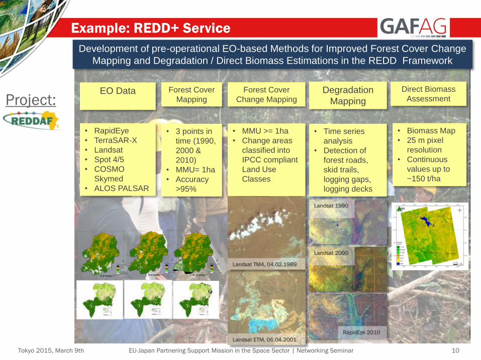
Example: REDD+ Service
10EU-Japan Partnering Support Mission in the Space Sector | Networking SeminarTokyo 2015, March 9th
Forest Cover
Mapping
Forest Cover
Change MappingDegradation
Mapping
• 3 points in
time (1990,
2000 &
2010)
• MMU= 1ha
• Accuracy
>95%
• Biomass Map
• 25 m pixel
resolution
• Continuous
values up to
~150 t/ha
Development of pre-operational EO-based Methods for Improved Forest Cover Change
Mapping and Degradation / Direct Biomass Estimations in the REDD Framework
EO Data
• RapidEye
• TerraSAR-X
• Landsat
• Spot 4/5
• COSMO
Skymed
• ALOS PALSAR
Direct Biomass
Assessment
• MMU >= 1ha
• Change areas
classified into
IPCC compliant
Land Use
Classes
• Time series
analysis
• Detection of
forest roads,
skid trails,
logging gaps,
logging decks
Landsat TM4, 04.02.1989
Landsat ETM, 06.04.2001
Landsat 1990
Landsat 2000
RapidEye 2010
Project:

Value proposition
11EU-Japan Partnering Support Mission in the Space Sector | Networking SeminarTokyo 2015, March 9th
Highly interested in:
• Climate Change/REDD: Seeking for partnerships with
Japanese companies to extend project activities in Asia
and other regions
• Consulting/Technical Assistance projects: Cooperation
in developing countries in order to serve Multi-lateral
Development Banks such as Asian Development Bank
or World Bank
• Earth Observation data: Enlargement of Japanese EO
data portfolio (by including new/upcoming Japanese
sensors) for data reselling/distribution to other regions
• EO data application on mobile devices (transfer of
business models to Europe or to Japan)
• Expansion of products and services together with
Japanese partners, such as Copernicus Downstream
Services, Air Quality Monitoring, Emergency Mapping…

Thank you very much
for your attention!
Contact:
Rainer Fockelmann
Email: [email protected]
GAF AG, Arnulfstr.199, D-80634 Munich, Germany
http://www.gaf.de, [email protected]
End of Presentation
12EU-Japan Partnering Support Mission in the Space Sector | Networking SeminarTokyo 2015, March 9th