Bioregional Mapping as a Participatory Tool in the Community Based
28
Bioregional Mapping as a Participatory Tool in the Community Based Watershed Management Project in Santo André, Greater São Paulo, Brazil Erika de Castro ∗ Alison McNaughton † Prepared for delivery at the 2003 meeting for the Latin American Studies Associations, Dallas, Texas, March 27-29, 2003 ∗ Erika de Castro is Project Manager of the project “Community Based Watershed Management in Santo André” at the Centre for Human Settlements, School of Community and Regional Planning, University of British Columbia, Rm. 233, 1933 West Mall, Vancouver, B.C. Canada V6T 1Z2. Tel: 604-822-5518; Fax: 604-822-5254; e-mail: [email protected] † Alison McNaughton is a Masters student at the School of Community and Regional Planning, University of British Columbia. She is currently in Brazil working for the project “Community Based Watershed Management in Santo André.”
Transcript of Bioregional Mapping as a Participatory Tool in the Community Based
Bioregional Mapping as a Participatory Tool in the Community Based Watershed Management Project
in Santo André, Greater São Paulo, Brazil
Erika de Castro∗
Alison McNaughton†
Prepared for delivery at the 2003 meeting for the Latin American Studies Associations,
Dallas, Texas, March 27-29, 2003
∗ Erika de Castro is Project Manager of the project “Community Based Watershed Management inSanto André” at the Centre for Human Settlements, School of Community and Regional Planning,University of British Columbia, Rm. 233, 1933 West Mall, Vancouver, B.C. Canada V6T 1Z2. Tel:604-822-5518; Fax: 604-822-5254; e-mail: [email protected]
† Alison McNaughton is a Masters student at the School of Community and Regional Planning,University of British Columbia. She is currently in Brazil working for the project “Community BasedWatershed Management in Santo André.”

Erika de Castro and Alison McNaughton 1
Bioregional Mapping as a Participatory Tool in the Community Based Watershed Management Project
in Santo André, Greater São Paulo, Brazil
Erika de Castro and Alison McNaughton
"The atlas should be used as a jumping off place for decision making about the future. From the holistic image of placethat the maps collectively communicate, what actions could be adopted to achieve sustainable prosperity? What
priorities emerge from a survey of damaged lands and unsolved social ills? What underutilized potentials can be put towork to help achieve sustainability? The atlas can become a focus for discussions setting a proactive plan for positive
change."1
The CIDA-funded Community-Based Watershed Management project (CBWM) is developing aframework for effective watershed management in Santo André, São Paulo, Brazil. Unliketraditional planning approaches, which rely heavily on top-down legislative and legalistic methods,the CBWM project strives to protect and rehabilitate environmentally sensitive areas by involvingpeople in the development process as 'stewards' of the environment. By addressing both socio-economic and environmental issues, the project addresses problems inherent in a rapidlydeveloping metropolitan area undergoing economic restructuring and the impacts on poor residentsliving in informal settlements.
The formulation of the CBWM framework, structured around community participation andlearning-by-doing, is shaped by residents' inputs on all related issues and enables the community tosteer itself and guide the project implementers into developing appropriate community planningand information processing capacity to resolve the complex issues of watershed management in anurban and periurban context. The Santo André municipality recognizes the need for newoperational tools for environmental management that move beyond traditional top-down masterplanning. The project implements participatory action research, social impact assessment,community economic development, gender planning and environmental education. This paperoutlines key outcomes and the relevance of a particular methodology -- bioregional mapping -- tothe project.
Under the larger goals of the CBWM project, the community based bioregional mapping, apowerful tool for community empowerment and for the development of technical capacity to aid inthe administration of existing resources, is being implemented as a participatory means ofcommunity needs assessment and strategy formulation in the three Pilot Projects within thewatershed areas. This involves a highly effective process whereby community members, localgovernment, and planners work together to identify and understand the various biophysical andsocio-cultural elements of their surroundings and develop a strategy for building locally controlledand self-reliant economies that are closely tied to the use and sustainability of the surroundingecosystems. Generating a greater sense of community ownership, as well as an increased awarenessamong community members of the direct impact of their actions on their surroundings, itcontributes to the overall project goals and related activities which are aimed at stimulating a sense
1 From Harrington, Sheila (Ed). (1995). Giving the Land a Voice: Mapping our Home Places. Salt Spring IslandCommunity Services Society, Salt Spring Island, B.C.
Bioregional Mapping as a Participatory Tool2
of stewardship within the community by imparting the importance of the watershed to eachresident's political, social, economic and physical well being.
Introduction
Environmental degradation in cities of developing countries, such as Brazil, is threatening theavailability and quality of natural resources, particularly water resources, as a result of uncontrolleddevelopment in watershed areas. While those most affected by deterioration of the physicalenvironment are the urban poor, poverty is also itself a major factor in urban environmentaldegradation. It is the poor who occupy the ecologically fragile lands in exclusionary land andhousing markets (Bartone, 1996).
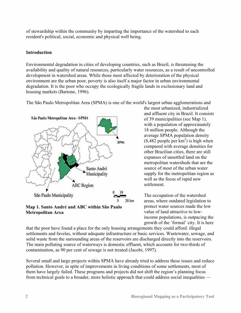
The São Paulo Metropolitan Area (SPMA) is one of the world's largest urban agglomerations andthe most urbanized, industrializedand affluent city in Brazil. It consistsof 39 municipalities (see Map 1),with a population of approximately18 million people. Although theaverage SPMA population density(8,482 people per km2) is high whencompared with average densities forother Brazilian cities, there are stillexpanses of unsettled land on themetropolitan watersheds that are thesource of most of the urban watersupply for the metropolitan region aswell as the focus of rapid newsettlement.
The occupation of the watershedareas, where outdated legislation toprotect water sources made the lowvalue of land attractive to low-income populations, is outpacing thegrowth of the ‘formal’ city. It is here
that the poor have found a place for the only housing arrangements they could afford: illegalsettlements and favelas, without adequate infrastructure or basic services. Wastewater, sewage, andsolid waste from the surrounding areas of the reservoirs are discharged directly into the reservoirs.The main polluting source of waterways is domestic effluent, which accounts for two-thirds ofcontamination, as 90 per cent of sewage is not treated (Jacobi, 1997).
Several small and large projects within SPMA have already tried to address these issues and reducepollution. However, in spite of improvements in living conditions of some settlements, most ofthem have largely failed. These programs and projects did not shift the region’s planning focusfrom technical goals to a broader, more holistic approach that could address social inequalities ––
Map 1. Santo André and ABC within São PauloMetropolitan Area
Erika de Castro and Alison McNaughton 3
the loci of urban environmental problems as well as the environmental degradation associated withpoor neighbourhoods in environmentally sensitive areas.
Top-down methods such as master planning and restrictive legislation, highly centralized, withlittle or no public participation, shaped the SPMA from the mid 1960s until the mid 1980s when thecountry was ruled by a military dictatorship. However, not only did these approaches not provide aframework to adequately guide the rapid urban growth occurring throughout the metropolitan area,but they inadequately dealt with the political complexity associated with a multi-stakeholderplanning process. As a consequence, none of the Master Plans formulated for São Paulo have beensuccessfully implemented. Restrictive legislation, such as the Watershed Protection Law enacted in1975, has also failed. Settlement continued irrespective of legal restrictions and increasing numbersof low-income families have settled in environmentally sensitive watershed areas. In the specificcase of São Paulo watersheds, land policies have been used to essentially ‘promote’ thedevelopment of informal settlements while officially hindering it. This ambiguous approach towatershed protection has led to the deterioration of water quality for the metropolitan region and ofthe quality of life for low-income settlers in sensitive areas.
Two major components over the last decades have created changes in Brazilian planning. One wasthe democratization process and approval of the new constitution in 1988, which represented a shiftaway from centralized control to the decentralization of urban management functions back to themunicipal level. This has led to the increasingly important role of municipal governments inproviding for the welfare of citizens (Samuels 2000). Municipalities are by necessity becomingmore pro-active in terms of service provision and development policy (Rodrigues-Pose, Tomaney,and Klink 2001). The other component was the increasing success of the Workers Party (PT) in theadministration of Brazilian cities. This party has, at the core of its political agenda, a strong supportfor public participation in local decision-making processes. In the Brazilian context, participatoryplanning has a relatively recent history, rooted in the political movements that have brought the PTto power in many municipalities and increased their recognition at the national level. The PTsupports active citizen participation in local decision-making, and is internationally recognized forits work in implementing a participatory budgeting process in many Brazilian cities. This involvesa push towards greater citizen participation in local government activities. The Brazilian PT in anumber of different municipal governments has been involved in the project of increasing citizeninvolvement in local decision-making (Abers 2000, Ostrom 1996).
Parallel to these changes, there were a number of legislative changes that are of particular relevanceto environmental management and which reinforced the decentralization process.2 The State Lawof Recovery and Protection of Watersheds acknowledges the reality of settlement within thewatersheds, encourages the formulation of emergency plans to provide basic services to the humansettlements within respective municipalities’ watersheds (most of which are “illegal” in terms of
2 These included State Law No. 7663, passed in 1991, decentralizing policy for water resource management
via the Water Basin Committees (Comitês de Bacia, comprised of representatives of state and localgovernment as well as civil society organizations). State Law No. 9034 of 1994, in conjunction with theabove mentioned legislation, requires that “emergency plans,” “environmental plans” and “sustainabledevelopment plans” need to be drawn up for the water basins, which are then to be submitted to the WaterBasin Committees for approval.
Bioregional Mapping as a Participatory Tool4
the 1975/1976 law) and recognizes the municipal right to enact regulations in watershed areaswithin municipal boundaries.3
Santo André
The city of Santo André, one of the SPMA municipalities, is approximately 175,000 km2 with anestimated population of 665,000 people. Along with the other cities in the Greater ABC Region(Santo André, São Bernardo do Campo, São Caetano, Diadema, Mauá, Ribeirão Pires, Rio Grandeda Serra - see Map 1), it has played an important role in the economic development of the SPMA,representing the core of industrialization, and making it one of the most important developmentpoles in the country. Notwithstanding the strong economic base, the whole region has been underincreasing industrial decentralization. Formal sector industrial employment has increasingly beendiminishing, provoking changes in the whole human geography of the region. In order to developand co-ordinate proactive strategies for the region to address negative impacts of macroeconomicrestructuring, these seven municipalities under the leadership of Santo André implemented theCouncil of the Greater ABC Region. This consortium of political leadership aims to maintain theABC Region’s dominance as an economic centre through an integrated approach to social,economic and environmental policies. Santo André has had rapid and unsuccessfully managed urban growth. Land use developmenthappened in a random, chaotic way, lacking any systematic integrated planning process. Most ofthe new low-income housing is informal settlements and favelas that are increasingly occupying thewatershed areas. Santo André has approximately 30,000 people living within its watershed. Thisaccounts for around four per cent of its total population, the remainder of which live in the higherdensity northern portion of the municipality. These settlements violate municipal land use andenvironmental legislation, and are unhealthy living environments with non-existent or very lowlevels of physical and social services––particularly sewerage treatment and garbage collection.They are also poorly located in relation to urban services.
Santo André is presently governed by the Workers Party, which is committed to a high degree ofpublic participation in the urban management process. The participatory budget (“orçamentoparticipativo”) process attests to this commitment. This process involves equal numbers ofrepresentatives from the municipal administration and the community, and it is the locus wheresocio-economically marginalized groups are able to make meaningful inputs into decisions aboutexpenditure and investment priorities. The Municipal Councils (conselhos municipais) also
3 The new legislation reinforces the process of decentralized watershed management through the tripartite
water basin committees (Porto 1998). For each basin, a committee comprising representatives from state,local government and civil society organizations is to be established, and be involved in making anemergency plan for the restoration of watersheds, and an environmental plan––including a socio-economicdevelopment plan. In addition, the subcommittee of the Billings-Tamanduatei basin is also responsible forthe formulation of a sustainable development plan dealing with land use, occupation and environmentalprotection of the Billings Reservoir. In order to avoid contradictory regulations being enacted incontiguous municipalities sharing the same water basin, any new enactment of regulations will need to beconsistent with state laws that are in the process of being formulated for each water basin––which, in thecase of Santo André, refers to the Alto-Tietê Basin.
Erika de Castro and Alison McNaughton 5
demonstrate the strong relationship between the municipality and community. These councilscomprise representatives from local government, community, and the private sector and areinvolved in the definition of sectoral policies, the implementation of urban management systems,and the monitoring and evaluation of programs and projects.
The Community Based Watershed Management Project (CBWM)
The CBWM project is a four-year CIDA-funded project that started in October 1998. It wasestablished in order to organize a system that addresses the environmental, social and economicallysustainable occupation of the watershed areas. The stated goal of the project is to make municipalwatershed management in Santo André more effective, participatory and responsive to the needs ofinformal settlements.
CBWM is a multi-stakeholder approach to planning in environmental protection areas thatrepresents a fundamental change in the way planning and watershed management has traditionallybeen conducted in Brazilian cities and states. Consequently, the process has been designed toinclude a wide range of stakeholders in the conceptualization, design, and implementation ofplanning guidelines. This includes marginalized groups such as low-income communities, women,and “illegal” residents who have traditionally been excluded from decision-making processes.
The CBWM project proposes a different approach to the environmental protection of this area thatwill integrate the needs of the area residents with conservation efforts. Thus, the project is making acritical contribution to rezoning by developing environmental and social analyses methodsappropriate to the needs and capacities of the ABC municipalities. In addition, the project isadvancing conflict resolution, public communication, community participation, gender analysis andcommunity economic development skills, all of which are needed to ensure that the zoning and itsimplementation at the community (neighbourhood) level is effective and fair. Project activitieshave been developed around the following main areas: information collection and diagnosis;planning the formulation of the framework; pilot projects; training; and planning the planningprocess.
There are a number of significant issues that have contributed to the project’s success:• Institutionalization: Integration of CBWM principles and methods into key institutional
structures and processes in the region is a central element of the project. • Political support: Support from political figures – and in particular the mayor of Santo
André – was crucial to ensure a serious commitment of municipal staff to project activities.• Community support: The emphasis on stakeholders in the planning process ensures the
involvement of key interest groups that are often marginalized in planning decision-makingprocesses.
• Legal mechanisms: Some legal mechanisms have been instituted to provide support forlonger-term upgrading and infrastructure implementation services.
• Funding: The goal of this project is to provide the main tools – policies, plans, methods, andskills – that will guide the longer-term development of the Watershed Protection Area.
Bioregional Mapping as a Participatory Tool6
Implementation of CBWM
One of the primary issues that have arisen in the CBWM project involves partners learning moreabout the difficulties of capacity building and learning from one another. Transferring knowledge isnever straightforward; it is difficult to transform knowledge into long-term skills and concreteresults. This process takes a long time to have a significant impact on changing practices andhabits.
All partners need to acknowledge the importance of trust in international development projects. It isextremely difficult to build trust between institutions with different cultures and outlooks. It isessential, therefore, to have a permanent system of communication within the project itself, one thatwill take into account differences in institutional cultures within the country, and betweencountries.
There are a number of planning issues that are relevant to all partners involved:• Adaptability: If a project is to be successful, it must be adaptable to the circumstances and
priorities of each partner. Partners must have a clear understanding of the objectives andgoals to be achieved, and these must be established through consensus. A multidisciplinaryplanning approach, which includes the participation of the major partners, is essential.
• Communication: A permanent system of communication is the basis for successful co-operation. A project must be designed and planned from the perspective of its stakeholders,which means that their key questions have to be recognized. Close relationships must bebuilt between the executing institutions and the stakeholders.
• Project management and teamwork: The importance of flexibility must be recognized interms of project management. It is not always easy to predict the dynamics of a projectonce it is underway, since it is subject to various external factors, and it may requirechanges in focus, strategy, and institutional coordination mechanisms. An important successfactor for projects is to empower coordinators to play a facilitating role and to manageconflicts. In principle, coordination should be decentralized, participatory, and frameworkbased. Effective teamwork is very important to a project’s success.
• Strong commitments: The project’s success depends on commitments from all the partnersat the outset and their participation in the project's management structure in order to ensurethat local characteristics and circumstances are taken into consideration.
PARTICIPATION TOOLS
There has been an ongoing movement by Brazilian municipalities, especially in Santo André,towards participatory processes and the engagement of outside experts through processes oftechnology transfer by international development practitioners. Approaches such as rapid ruralappraisal, participatory rural appraisal, and participatory action research have been developed totake the decision-making power out of the hands of ‘outsiders’ and place it in the hands of localpeople who are the recipients of development planning and the benefits and mistakes (Chambers1983, 1993, 1997; Fals-Borda and Rahman 1991; Kemmis and McTaggart 1988; McTaggart 1997;Rahman and Baduri 1982). These approaches aim to develop a range of practical methods andparticipatory tools that both open communication among various stakeholders and explain realities
Erika de Castro and Alison McNaughton 7
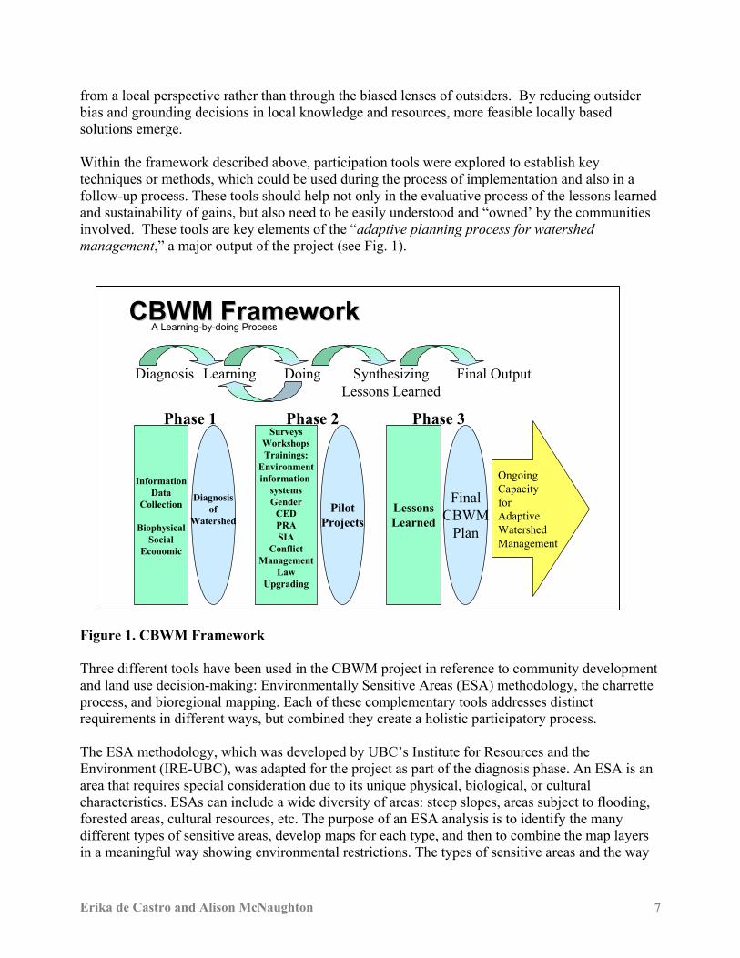
from a local perspective rather than through the biased lenses of outsiders. By reducing outsiderbias and grounding decisions in local knowledge and resources, more feasible locally basedsolutions emerge. Within the framework described above, participation tools were explored to establish keytechniques or methods, which could be used during the process of implementation and also in afollow-up process. These tools should help not only in the evaluative process of the lessons learnedand sustainability of gains, but also need to be easily understood and “owned’ by the communitiesinvolved. These tools are key elements of the “adaptive planning process for watershedmanagement,” a major output of the project (see Fig. 1).
Figure 1. CBWM Framework
Three different tools have been used in the CBWM project in reference to community developmentand land use decision-making: Environmentally Sensitive Areas (ESA) methodology, the charretteprocess, and bioregional mapping. Each of these complementary tools addresses distinctrequirements in different ways, but combined they create a holistic participatory process.
The ESA methodology, which was developed by UBC’s Institute for Resources and theEnvironment (IRE-UBC), was adapted for the project as part of the diagnosis phase. An ESA is anarea that requires special consideration due to its unique physical, biological, or culturalcharacteristics. ESAs can include a wide diversity of areas: steep slopes, areas subject to flooding,forested areas, cultural resources, etc. The purpose of an ESA analysis is to identify the manydifferent types of sensitive areas, develop maps for each type, and then to combine the map layersin a meaningful way showing environmental restrictions. The types of sensitive areas and the way
A Learning-by-doing Process
InformationData
Collection
BiophysicalSocial
Economic
Diagnosisof
Watershed
Phase 1Surveys
WorkshopsTrainings:
Environmentinformation
systemsGender
CEDPRASIA
ConflictManagement
LawUpgrading
PilotProjects
Phase 2
LessonsLearned
FinalCBWM
Plan
OngoingCapacityfor AdaptiveWatershedManagement
Phase 3
Diagnosis Learning Doing SynthesizingLessons Learned
Final Output
CBWM FrameworkCBWM Framework
Bioregional Mapping as a Participatory Tool8
in which they are integrated reflect the interests and viewpoints of local stakeholders. Results areused in the development of zoning maps and community development maps as well as in thescreening phase of environmental impact analyses of specific project proposals.
The charrette process represents a design exercise that stresses interdisciplinary work on difficultproblems in an intense setting, resulting in illustrations that show the implications of particularplanning policies. In the case of CBWM, officials from the municipality, community members, andgraduate students from the Faculty of Architecture and Urbanisme (FAU-USP) wrestled with thepressing and difficult problem of how to design a sustainable neighbourhood for the poorest peopleliving in the watershed, in the favela Pintassilgo (Pilot Project 2). This exercise explored andillustrated several possibilities for upgrading and expanding the settlement. The charrette had aprimary goal of illustrating compelling visions of what a sustainable community in the watershedareas might look like in order to inform future land use, urban design, and environmental policy forthe whole area. At the same time, the direct participation of municipal staff ensured that the projectwas grounded in existing policy and institutional frameworks. It also ensured the direct transfer ofknowledge between all participants, including municipal decision-makers, members of thecommunity and designers. This was the initial step in the process of finding creative approachesthat must be continued through further design refinement. The output of this process was apublication “Sustainable Watersheds: Urban Landscape Design for Low-Income Settlements”published by the Centre for Human Settlements.
A third tool to contribute to land use planning (and the main focus of this paper) is bioregionalmapping. Maps, in addition to their cartographic applications, have been used in education andscience to provide a visual representation of knowledge. They provide a complementary alternativeto natural language as a means of communicating knowledge. In many disciplines various forms ofmaps are already used as knowledge representation systems. It is no coincidence that the wordsimage and imagination have the same roots. It has been known from early times that visual imageryplays a significant role in the creative processes of many people (Arnheim 1969). Many disciplinesdeveloped visual languages for concept maps, cognitive maps in education, and Novak (1977)developed a system of concept maps that has been widely applied in the evaluation of students'learning in the school system (Novak and Gowin 1984). A wide variety of different forms ofconcept map have been applied in education (Lambiotte, Dansereau, Cross and Reynolds 1989). Inmanagement, Axelrod (1976) proposed cognitive maps as a means of representing the conceptualstructures underlying decision-making. In the history of science, the dynamics of concept mapshave been used to represent the processes of conceptual change in scientific revolutions (Nersessian1989, Thadgard 1992).
Parallel to these developments, planning has had a long history of using maps for defining,describing, and portraying natural systems and man-made interventions. Community participatoryplanning is, thus, a natural area whereas visual translation of knowledge, enhanced awareness ofthe natural and man-made surroundings and decision-making systems could be mingled through amethodology that is easily developed and visually highly responsive to communities.
Mapping at the parcel level involves direct experience with a piece of land (surveying frommeasurements, observations, experiences). The purpose of this type of mapping is to betterunderstand the interrelationships and dynamic nature of the land. Having this knowledge will
Erika de Castro and Alison McNaughton 9
enable users of the land to make better decisions, at the everyday and longer-range level, aboutactivities to take place on this land. Residents can be taught simple techniques for evaluating andmonitoring such things as rain collection on impermeable surfaces (roofs and pavement), as well asbasic techniques for measuring soil erosion, slope stability etc. Mapping at the parcel level willlikely make an individual aware of the relationships with other parcels – i.e. at the larger level –that can otherwise be known as the bioregion.
Bioregional Mapping
While maps created by scientists are widely recognized as authoritative documents, they are not theonly legitimate source of valuable information about a place. The creation of maps at thecommunity level is a practice, which is currently, used among communities in England, Europe,Newly Independent States of the former Soviet Union, Australian, the United States, and Canada.
Beginning in the 1970s and continuing until the present time in North America and in WesternEurope, theories and methods of social learning and communicative action have been developed asthe basis of participatory planning for professional planners (Forester 1989; 2000; Friedman 1987;Habermas 1984; Healey 1997; Sager 1994). Theories and methods of social learning andcommunicative action start with the premise that open communication and dialogue build a moreholistic array of planning options. Participatory planning has evolved from social learning ideallytranslating into decision-making based upon a more consensual approach where a wider range ofvoices is included in the final plan or decision.
Theories of bioregionalism, social ecology, and communicative action highlight the empoweringeffects of participatory involvement in the process of identifying and valuing one’s ownenvironmental context. Many authors identify the value of citizen participation in local resourceidentification and decision making as central to the project of building good civil society andeffective environmental stewardship (Greenwood and Levin 1998), (Linehan and Gross 1998),(Luz 2000), (McGinnis 1999), (Plant and Plant 1992), (Slocombe 1993), (Slocum et al. 1995),(Western and Wright 1994).
Recognizing the knowledge of the people who live in a place is an essential objective ofbioregional mapping. This type of mapping draws on existing knowledge among communitymembers, as well as enabling them to collect new information, and to consolidate it with existinginformation to form a concise and more complete picture of their community. Community mappingcan be used in support of learners and to support a wide variety of visual thought processes inindividuals and groups. Mapping tools are to be used to support collaborative learning by sharingthe maps, working together on linked maps, and sharing knowledge.
Bioregional mapping is a strategy for building locally controlled and self-reliant economies that areclosely tied to the use and sustainability of the surrounding ecosystems. As a methodology forcitizen involvement in resource identification and local decision-making, it presents a significantcontribution to the Brazilian municipal context. It is an inexpensive, accessible and highly effectiveprocess whereby community members, local government, and planners work together to identifyand understand the various biophysical and socio-cultural elements of their surroundings. This
Bioregional Mapping as a Participatory Tool10
generates a greater sense of community ownership, as well as an increased awareness amongcommunity members of the direct impact of their actions on their surroundings. It is a significanttool for community empowerment and for the development of technical capacity to aid in theadministration of existing resources. The skills necessary for implementing a community basedmapping strategy are easily transferable and can be taught through a training the trainer strategyused during the process of creating a series of maps. Maps generated through this process becomeaccessible resources for the community that can be easily updated by community members andused for future project development (Aberley 1993). This type of mapping is concerned with documenting the interrelationships of environment andhuman activity, to create a snapshot of existing conditions, a record of an extended period of time,and also possibly a tool for visions of the future. Bioregional maps can be used as a baseline ofinformation about an area so that when change occurs, it can accurately be measured andmonitored. Because bioregional maps are inexpensive to produce and easy to update, they are idealfor use in documenting change over time.
As a means of building awareness of community landscapes towards local empowerment,bioregionalism and social ecology are theories grounded in participatory methods that alsoincorporate a strong concern for the promotion of ecologically sustainable activities (McGinnis1999; Linehan and Gross 1998.) Mapping practices associated with these theories have been welldeveloped in the North American and Western European contexts and are employed by manycommunity groups, organizations and local governments to map community environments andresources for greater local empowerment (Aberley 1998). A strong base of organizations currentlyusing these practices exists in British Columbia, with a central focus in the lower mainland. Someorganizations use the mapping process as a tool for strategic planning for community economicdevelopment (Ecotrust Canada).
Mapping as a Participatory Planning Method
By collaboratively developing maps, people strengthen their community self-identification andincrease awareness of existing biophysical, socio-economic, and cultural resources and valueswithin the community. It is a participatory process for evaluating the appropriateness and feasibilityof various community development initiatives, as well as for organizing existing resources andknowledge thereof into some sort of cohesive framework. This can also be used as the groundworkfor future activities like community visioning, heritage planning, eco-tourism, etc. One potentialuse of community based (bioregional) mapping as a participatory planning tool and process incommunity development in an international context is to explore the role of action researchmethodologies in evaluating project activities and development approaches. Or use action researchas a methodology for evaluating and assessing the outputs of the mapping project. Anotheroutcome of mapping is to gain insight into the nature of relationships. Community based mappingcan contribute to positive linkages between decision makers within local management frameworksas well as with other groups (NGOs) and local community members in the context of a complexdevelopment project whose area is limited by jurisdictional boundaries, but that is impacted by orhas impacts on other areas in the region.
Erika de Castro and Alison McNaughton 11
Community based mapping as a participatory planning method also enhances capacity forcommunication between community members and local decision-makers regarding issues of landuse, environmental awareness, education initiatives, and tourism and heritage development. Thistool is beneficial in terms of meeting the project goal of making watershed management moreparticipatory, accountable, and responsive to the needs of local citizens and to ensure ecologicalintegrity.
In the task of implementing this tool, the objectives are four-fold: 1. To implement community based mapping as a participatory process in order to increase
awareness of local issues as well as foster better communication between community membersand decision makers so that community members become more involved in decision-making
2. To evaluate community based mapping processes in terms of suitability for increasing capacityfor municipal decision-making that is participatory in nature, responsive to the needs of localcitizens, and effective in maintaining ecological integrity within the watershed.
3. To evaluate community based mapping strategy in terms of its effectiveness in garnering andmaintaining high levels of community participation, with special consideration for issues ofgender and youth.
4. To provide recommendations that might aid municipal authorities and community members indeveloping effective strategies for future participatory processes.
Bioregional mapping is an accessible method of community empowerment. It is less about teachingskills to be an expert cartographer, and more about community building. All segments of thecommunity can be involved in the bioregional mapping process. Though it is important that themaps are accurate, it is essential that the techniques used to create the maps involve communitymembers so that they have a sense of ownership of the maps and of membership in theircommunity.
The use of effective, systematic methods for community participation and the review of the factsshown on the maps before final completion will ensure that the maps are quite accurate and theywill be converted easily to digital format if so desired. Also, the generation of enthusiastic andcontinued participation by community members will contribute to the establishment of a vision ofsustainable development that the community will be interested in actively pursuing. Opportunitiesto implement economic, environmental, and socially just plans are facilitated by community buy-in.
Bioregional mapping is relatively straightforward and creates a tool with a great deal of organizingpotential. By consolidating a wide range of information about biophysical and cultural featurestogether in one place, both community and planners awareness can be raised towards the possibledirections for the future. Bioregional mapping is not intended to raise expectations of communitymembers for certain actions to take place, but rather to raise awareness of existing conditions, andhighlight areas where positive change might be facilitated. This can often include areas wheregreater community participation in stewardship activities is highlighted as beneficial to thecommunity in bringing about positive change. This also means that options for change anddevelopment that can be led by community members themselves can also be highlighted, asopposed to simply highlighting areas that require assistance from external planners and experts.
Bioregional Mapping as a Participatory Tool12
Bioregional Mapping Methods
There are several different ways in which the bioregional mapping process can be implemented.Participation by community members can range from consultative to fully active in creation ofmaps. The following are several suggestions for different mapping processes to involve communitymembers in different capacities:• Consultative: The maps are created by specialists, either alone or in cooperation with other
experts. Community members are involved in consultation with experts for sharing information,but do not actively participate in the creation of the maps.
• Cooperative Participatory: The maps are created by specialists in cooperation with communitymembers. Both community members and the specialists participate in the collection of data, andits representation on the maps. A specialist often directs this process, although a morefacilitatory role is desirable.
• Self-Directed Participatory: The maps are created by community members who consultspecialists, but are not directed by them. Community members are often involved in decisionsabout what features to map, and will ultimately decide what information is of great enoughvalue to be included on the maps. This method is the most representative of communitymembers’ feelings about a place, but may not provide all information desired if the maps havebeen commissioned for a specific purpose.
In the case of CBWM, it is very important that community members feel that they are activelyinvolved in the creation of the atlas, including participating in decisions about what features are tobe mapped, in order to build community stewardship. It is understood also, that the maps are toprovide information regarding a specific purpose; therefore, some direction from specialists isconsidered valuable. Since specialists have a great deal of existing knowledge and informationabout certain aspects of the area, they can be of great benefit to the mapping process by providinginformation and knowledge to community members. In this way, relationships between specialistsand members of the community can be strengthened and more informed decision-making that issupported by the community can occur.
Environmental protection as a development priority has a relatively recent history in Brazil. Mostenvironmental legislation to date is top-down, regulatory and difficult to enforce in light of extremepressure from urbanizing areas. The development of the community based watershed managementapproach is a major contributor to greater awareness building and stewardship among local citizens.The incorporation of an accessible, comprehensive technique for spatially identifying resources andissues at the local level that could contribute to or create barriers to development is paramount tosuccess (CHS 1998; 2002; Rodriguez-Pose et al. 2001). While the existing literature onparticipatory planning in Brazil is very rich, little mention of community based mapping techniquesis made. Bioregional mapping offers a unique advantage to resource gathering for equitableawareness building and inclusive participatory planning in the Brazilian municipal context.
Another positive element of the biomapping process involves the capacity to deal with the conflictbetween uses and users within watersheds. Community mapping provides a forum for theexpression of diverging opinions. Because people from varying backgrounds are working togetherto create the maps, an accurate and realistic portrait of the community can be created that allowsroom for dissent, and also provides a space for dialogue, and hopefully by extension, conflict
Erika de Castro and Alison McNaughton 13
resolution. Also, the different values that determine various visions can be identified and dealt with.Currently, in North American planning, various participatory techniques are being used to enablegroup members to resolve conflicts by extrapolating their original purposes from their perceivedneeds. When people go back to thinking about what essential things they need or desire, it becomeseasier to realize that other solutions might exist that can be compatible with various groups.
Biomapping Outcomes
The following section outlines the development process, immediate outputs, and forecastedoutcomes, as well as replicability to other projects.
Through the use of various participatory methods and tools informed by such theories, the centralpurpose of the community-based mapping project was to engage local residents and officials in theprocess of identifying together the biophysical, social, cultural, and economic factors relevant totheir community. Partners in the implementation of the project included staff from the localmunicipality and from neighbouring municipalities, as well as leaders from community basedorganizations and NGOs. Contact with representatives from these organizations was previouslyestablished through earlier phases of the CBWM project.
The project activities were divided into several phases, namely: preparation, presentations,workshops, group mapping sessions, and continuing evaluation. Preparation involved the gatheringof background resources from various municipal departments and the preparation of materials andbase maps for the workshops, meetings with Brazilian partners to discuss the scope of the mappingto be undertaken and future potential applications, as well as briefing sessions to ensure that theprinciples underlying and practical steps of the mapping process were clearly understood by thosewho would be involved in the training. The presentation and workshop phase included a publiclecture and one-day introductory workshop with a Canadian bioregional mapping consultant, aswell as several smaller training the trainer workshops in community and institutional settings.
The group mapping sessions included a series of 12 weekly sessions with mapping participants andtrainers in the village of Paranapiacaba. Following this, the products of the mapping activities werepresented at a regional community meeting and discussed by participants, local planners andmembers of visiting communities. Continuing monitoring and evaluation is underway with thoseparticipants and trainers involved in the initial sessions, to develop next steps in the strategy. It hasbeen recognized that perceptions of participants about specific community needs and dynamics willinfluence the application of these tools and will in turn be influenced by their use. Identifying andmapping the various features of their community, quality of life and relationships with othercommunities has and will continue to inform participants and planners, enabling them to contributevaluable knowledge to the local decision-making process that better reflects the situation and needsof local residents, positively affecting their quality of life.
The products generated, including maps, a collection of reference materials and reports relatinginformation about the community’s circumstances, have informed community members and localdecision makers. Continuing evaluation of the effectiveness of participatory methods in furtheringunderstanding of community circumstances will help community members and local officials adapt
Bioregional Mapping as a Participatory Tool14
future processes to better meet their needs. The awareness of the importance of transparency inplanner/community interactions and the increased awareness of the value of participatory processesfor assessment of needs, based on the information gathered, will help municipal officials structureprocesses and service delivery to better meet the needs of local residents.
The more comprehensive and integrated understanding of the watershed area and the surroundingregion stemming from the mapping process contributes to a basis for development that is sensitiveto community needs and ecosystem limits, while also being realistic and appropriate to communityresources and economic development objectives. The knowledge generated will also contribute tothe existing literature on participatory planning tools and theories, and will be used in informingother communities regarding potential technology transfers.
This approach focused on gathering contextual information to meet community needs rather thansimply extracting information. This was to include the collection and analysis of data with a focuson understanding the roles of participatory approaches to landscape appraisal and environmentalstewardship in the context of the CBWM project in the watershed settlement of Paranapiacaba,Brazil.
In order to explicate the process, the following provides a step-by-step description of the variousphases in project development and implementation, with reflections on the process.
Phase One: data gatheringA review of available base maps and secondary sources of biophysical and cultural informationabout Paranapiacaba was completed. Topographic base maps for the project area exist at scales of1:10,000 and 1:2,000 for the village site. These maps were created from planimetric aerial photostaken in 1990. Many other sources of biophysical data were found to exist at the local governmentoffice of environmental management, located at the site of Pilot Project 2 in Parque Andreense.These included expert-oriented data surrounding geological features, land use designations andregulatory zoning, location of high sensitivity to geomorphologic change (unstable slopes), datafrom discharge stations in the watershed protection area, general books on plant and animal speciesof the area, and local climatology, history of the railway company and the development of the townof Paranapiacaba. Also available were many earlier research projects that had been completed withrelevance to Paranapiacaba, its socio-historic importance and the ecological value of thesurrounding area. These included various proposals for heritage preservation and tourismdevelopment plans, a good amount of relatively recent census data gathered from the populationand a study of local attitudes towards tourism development.
A great deal of current information (that made use of much of this earlier data) related to ongoingstrategic eco and heritage tourism development exists at the Santo André municipal office inParanapiacaba and was in use by local planners for the creation of possible future visions for thetown. Local government employees, including biologists and planners, proved to be an invaluablesource of information in terms of understanding of complex information and awareness ofrelationships between the various sources of data and actual ongoing planning and developmentactivities. It was recognized that in order for the data available to be incorporated into thecommunity based mapping process in such a way that it could be useful, shared learning anddecision making was required between planners, community members, and the various local
Erika de Castro and Alison McNaughton 15
government employees with expertise in a particular field. It was anticipated that this would occurthrough the weekly mapping workshop process.
Phase II: Interviews and Workshops Openly structured interviews between key informants and mapping coordinators includeddiscussions with Brazilian and Canadian project partners and participants. It was hoped that thesediscussions would help guide the project towards addressing the most relevant issues for the localcommunity, as well as highlight potential strategies for adapting project methodologies to makethem as useful as possible. From discussions with Canadian project partners and previous projectparticipants, it was noted that maintaining participation by locals and government officials, andensuring that project outputs would be valued and utilized in future planning initiatives so thatoutcomes could contribute to community involvement in decision making would be the two biggestchallenges, and potentially two of the most important factors in project success.
A one-day workshop involving municipal partners, community leaders, NGO representatives andcommunity members was organized to discuss the application of the mapping tool and the roles andresponsibilities to be assumed by project participants. Background materials about the theoreticalunderpinnings of the bioregional mapping tool, and strategies and a step-by-step implementationguide as well as suggestions for basic mapping categories were prepared and translated for theBrazilian team. A list of materials was developed, responsibilities for various preparations for theworkshops were decided, and other logistics were worked out. It was decided that the mosteffective way to introduce the technique to the communities and to a wider public would be to hosta public lecture, followed by a one-day participatory workshop with a Canadian bioregionalmapping expert, UBC Professor Douglas Aberley.
The public presentation focused on the theory and value of bioregional mapping strategies and wasattended by members of local communities, government, university students, and public. The one-day workshop following this was also attended by local planners and community members, whoreceived a hands-on introduction to some of the aspects of bioregional mapping including thecreation of maps of home places (cognitive mapping), as well as learning to identify features andlocal issues on a community scale map. During the one-day workshop, participants discussedissues of concern in the local community and brainstormed about potential mapping subjects. Dateswere also determined for the start of the weekly mapping workshop series.
Phase III: Mapping processData collection, analysis and representation of information on maps were undertaken in cooperationwith community members over a series of 12 one-day sessions. Major participatory elements of themapping process included: initial community visioning workshop to generate community interest,and weekly mapping sessions.
In the town of Paranapiacaba, these were intended to include training workshops on various datagathering and assessment techniques, data gathering by community members about specificcommunity resources and features, compilation and analysis of data, and representation of data onmaps. Over a series of 12 weeks, it was projected that participants would be able to learn theadvanced bioregional mapping method and produce a series of approximately 10 bioregional mapsrelevant to specific issues of concern.
Bioregional Mapping as a Participatory Tool16
In order to begin to address the issues of immediate importance to planners and local participants,the mapping strategy was re-evaluated. It was determined that greater connection with thosemembers of the community who were not participating was needed, as well as greater connectionbetween the mapping process and participants’ everyday lives. Less complicated, more relevantmaps were needed. Beginning with a simplified 1:2000 base map of the village of Paranapiacaba,mapping participants were asked to identify areas of local importance in terms of perceivedenvironmental problems, appealing locations, locations of services, etc. Participants used a 35 mmcamera to document these things in the community. This served as a mechanism for interactingwith other community members, and for facilitating discussion of local issues in a concrete visualsense. The photos were later used to demonstrate issues and locate important features on the mapsof the community. The photo-documenting strategy was extremely effective in generating greaterawareness of the project among other community members.
Short mapping workshopsSeveral short mapping workshops were undertaken in the community of Parque Andreense. Theseincluded four-hour local orientation sessions where community members joined governmentofficials in touring the local area, pointing out features of interest and photographing them for useon maps. This session was also intended to generate interest and awareness of the project amonglocal community members. Following this initial orientation, participants from Parque Andreenseand planners collaborated to create one bioregional map of Parque Andreense, which demonstratedhome places, favourite places, past community improvements and current areas of concern. Thisshort mapping exercise was intended to teach the techniques of bioregional mapping to theplanners, as well as the community members from Parque Andreense in order that they mightcontinue to work on more projects in the future. The participants in Parque Andreense expressedinterest in continuing the mapping process in their community, specifically in areas related tohealth services, and identification of community needs. The planners will likely use the techniquesin other communities for participatory needs identification and other related activities.
Phase IV: Presentation of initial resultsResearch findings of the initial pilot processes and the bioregional atlas created in cooperation withthe communities were presented at a community event, as well as at a regional workshop involvingmunicipal partners and representatives from other municipalities. A final report was submitted tothe municipality, to CIDA, and to the School of Community and Regional Planning at UBC.Outcomes of the mapping process continue to be discussed and future plans for project activitiesare under development. Phase V: Ongoing partnershipsSince the initial series of mapping workshops in Paranapiacaba and Parque Andreense,communications with project partners in Brazil have been maintained and the mapping processcontinues to develop and grow. In Paranapiacaba, plans are underway to map the surrounding forestas part of the development of a participatory parks management program, while in ParqueAndreense, youth mapping of critical health and local environment issues will form part of anupcoming regional conference. Discussion around the idea of inserting oral history processes intobioregional mapping techniques and drawing from the results to produce works with the Theatre ofthe Oppressed is also underway. Spin offs, and adaptations of the technique are already
Erika de Castro and Alison McNaughton 17
blossoming, both in nearby communities, and farther away in related programs and initiatives.Several municipalities that attended the initial workshops requested more information about themapping process. Potential for future regional collaboration in all of the ABC regions and BillingsReservoir basin has been evolving. Also, the project “Cidades Saudáveis” by CEPEDOC– Schoolof Public Health USP, has undertaken mapping processes in several cities in São Paulo state andhas produced a book of outcomes in one community and is working on processes in othercommunities.
Conclusion
The partner teams are jointly creating a framework for community-based watershed managementby promoting a comprehensive and participatory environmental, social, and economic assessmentof the watershed area. Project sustainability depends on the ability to recognize and map theinterests of stakeholders, partners, and beneficiaries from the planning stage. Therefore, it is veryimportant to identify strong partners with a common commitment and to establish an effectiveinternal communications system throughout the life of the project. The knowledge exchangeinvolved in the project must be understood as a two-way process, during which new informationwill emerge.
This project offers important opportunities to refocus the nature of water resource management andcommunity involvement in this issue. Having identified a range of concerns, including gender andyouth, tenure regularization, preservation, income-generation alternatives, and environmentaleducation as important issues to be addressed, the project was embraced by the residents of theaffected communities. Equally important has been the manner in which the municipality hasapproached this project based on a commitment to partnership with the communities and theCanadian team, which has led to a more dynamic and responsive project.
Identifying and measuring the indirect impacts and unexpected results must be part of any projectanalysis. As well, an assessment of the development process must extend beyond the time frame ofproject implementation. It is difficult to capture the indirect results of a project, since there are nospecific instruments for this purpose. However, a range of information has been generated that canserve as the basis for analyzing indirect results, primarily in qualitative terms. It is essential thatqualitative analysis is part of the project cycle, and that a mechanism or tool be established forcommunicating those results to cooperating agencies to ensure that the performance and scope ofprojects are properly assessed.
Projects should be understood not only in terms of transferring technical and technologicalinformation, but also as having a broader role in changing attitudes in terms of increasing equity,reducing poverty, improving quality of life, and preserving the environment. Similarly, projectsshould also promote local know-how and "citizenship education." Approaches that could beadopted to maximize results include encouraging a decentralized and participatory strategy basedon partnerships, adopting pilot projects or demonstration models, using creative and innovativeprinciples and mechanisms, and defining an outreach strategy that will make the project morevisible and assist with its replicability
Bioregional Mapping as a Participatory Tool18
BIBLIOGRAPHY
Aberley, Doug, ed. 1993. Boundaries of Home: Mapping for Local Empowerment. Gabriola Island:New Society Publishers.
Aberley, Doug. 1998. Community-based Mapping in British Columbia: A Bioregional PlanningManual. Vancouver, B.C.: Doug Aberley.
Abers, Rebecca Neaera. 2000. Inventing Local Democracy: Grassroots Politics in Brazil. Boulder,Colorado: Lynne Rienner Publishers Inc.
Arnheim, R. 1969. Visual Thinking. Berkeley, California, University of California Press.
Axelrod, R. 1976. Structure of Decision. Princeton, New Jersey, Princeton University Press.
Bartone, C. 1996. Urban Environment Management Strategies: Case Studies from São Paulo,Brazil and Kumasi, Ghana. Washington DC: World Bank.
CBWM Project Reports. 1998-2000. Vancouver: Centre for Human Settlements.
Centre for Human Settlements, UBC and Municipality of Santo André. 1998. Community-BasedWatershed Management in Santo André, Sao Paulo, Brazil.
Centre for Human Settlements, UBC, and Prefeitura de Santo André. 2001. Community BasedWatershed Management in Santo Andre: Annual Report and Workplan 2001-2002.
Centre for Human Settlements, UBC, and Prefeitura de Santo André. Community-Based WatershedManagement: Pilot Project 3 Proposal. 2002
Centre for Human Settlements, UBC, and Prefeitura de Santo André. 2002. SustainableWatersheds: Urban Landscape Design for Low Income Settlements. The PintassilgoCommunity Design Charrette. Santo André, Brazil.
CEPEDOC – Centro de Estudos, Pesquisa e Documentação em Cidades/Municípios Suadáveis –Faculdade de Saúe Pública da UNiversidade de São Paulo, Porjeto Bertioga MuncípioSaudável – Subsidios para Revisão do Plano Diretor de Bertioga à Luz do Estatuto daCidade, October 2002
Christensen, Neal A. 1995 “Sustainable Community-Based Tourism and Host Quality of Life” inLinking Tourism, the Environment, and Sustainability McCool, Stephen F. and Watson, AlanE., Eds. United States Department of Agriculture.
Forester, John. 1989. Planning in the Face of Power. Berkeley: University of California Press.
Forester, John. 2000. The Deliberative Practitioner. Cambridge, MA: MIT Press.
Friedman, John. 1987 Planning in the Public Domain: From Knowledge to Action. Princeton, NJ:Princeton University Press.
Greenwood, Davydd J., Levin, Morten. 1998. Introduction to Action Research: Social Research forSocial Change. Thousand Oaks California: Sage Publications, Inc.
Habermas, Jurgen. 1984. The Theory of Communicative Action: Vol I: Reason and Rationalizationof Society. London: Polity Press.
Erika de Castro and Alison McNaughton 19
Harrington, Sheila, ed. 1995. Giving the Land a Voice: Mapping our Home Places. Salt SpringIsland Community Services Society. Salt Spring Island, B.C.
Healey, Patsy. 1997. Collaborative Planning. Vancouver: UBC Press.
Jacobi, P. 1997. “Environmental Problems in São Paulo,” Journal of Contingencies and CrisisManagement. 5 (3): 131-139.
Kovarick, L. 1993. A espoliação urbana. São Paulo: Paz e Terra.
Lambiotte, J.G., Dansereau, D.F., Cross, D.R. and Reynolds, S.B. 1989. Multirelational semanticmaps. Educational Psychology Review. 1(4) 331-367.
Leitmann, J. 1994. Rapid Urban Environmental Assessment, Lessons from cities in the developingworld Vol 2. UNDP/World Bank UMP, 15. Washington DC: World Bank.
Linehan, John R. and Gross, Meir. 1998. “Back to the Future, Back to Basics: the Social Ecologyof Landscapes and the Future of Landscape Planning.” Landscape and Urban Planning. 42:207-223.
Luz, Frieder. 2000. “Participatory Landscape Ecology – A Basis for Acceptance andImplementation” Landscape and Urban Planning 50: 157-166.
Maricato, E. 1996. Metropole na perifeira do capitalismo. São Paulo: Hucitec.
McGinnis, Michael Vincent, ed. 1999. Bioregionalism. London: Routledge.
Nersessian, N.J. 1989. Conceptual change in science and in science education. Synthese 80(1) 163-184.
Nielson, G.M. and Rosenblum, L., Ed. 1991. Visualization' 91: Proceedings of the Second IEEEConference on Visualization. Los Alamitos, California, IEEE Computer Society Press.
Novak, J.D. 1977. A Theory of Education. Ithaca, Illinois, Cornell University Press.
Novak, J.D. and Gowin, D.B. 1984. Learning How To Learn. New York, Cambridge UniversityPress.
Ostrom, Elinor. 1996. “Crossing the Great Divide: Coproduction, Synergy, and Development”World Development 24.6: 1073-1087.
Plant, Judith and Plant, Christopher, eds. 1992. Putting Power in its Place: Create CommunityControl. Gabriola Island: New Society Publishers.
Porto, M. 1998. “The Brazilian Water Law: a new level of participation and decision-making,”Water Resources Development. 14 (2): 175-182.
Ribeiro, Matilde, Jarschel, Haidi and Arlete Goes Bento, Luzia. 1999. Gender and Empowerment:Strategies of Women’s Empowerment. Municipality of Santo Andre:Office of Women’sRights, Secretary of Citizenship and Social Action.
Rodriguez-Pose, Andres, John Tomaney and Jeroen Klink. 2001. “Local Empowerment ThroughEconomic Restructuring in Brazil: The Case of the Greater ABC Region.” Geoforum 32: 459-469
Sager, Tore. 1994. Communicative Planning Theory. Aldershot, Hants: Avebury.

Bioregional Mapping as a Participatory Tool20
Samuels, David. 2000. “Reinventing Local Government? Municipalities and IntergovernmentalRelations in Democratic Brazil.” Democratic Brazil: Actors, Institutions, and Processes.Peter R. Kingstone and Timothy J. Power, eds. Pittsburgh: University of Pittsburgh Press.
Santos, M. 1993. A urbanização brasileira. São Paulo: Hucitec.
Slocombe, D. Scott. 1993. “Environmental Planning, Ecosystem Science, and EcosystemApproaches for Integrating Environment and Development.” Environmental Management.17.3: 289-303.
Slocum, Rachel et al., eds. 1995. Power, Process and Participation: Tools for Change. London:Intermediate Technology Publications.
Thadgard, P. 1992. Conceptual Revolutions. Princeton, New Jersey, Princeton University Press.
Western, David, and Wright, R. Michael, eds. 1994. Natural Connections: Perspectives inCommunity-Based Conservation. Washington D.C.:Island Press,.
Erika de Castro and Alison McNaughton 21
ANNEX 1
The Seven Step Planning Method
At the initial mapping session, we recommend using a technique called the seven-step method ofplanning to start the process. This method was developed by Professor Peter Boothroyd from theCentre for Human Settlements and School of Community and Regional Planning at the Universityof British Columbia, a planner with considerable experience working with communities. The powerof this model, as described by Boothroyd, lies in its ability to make the planning process moreaccessible to community members, and to increase the ability of community groups to effectivelyidentify and achieve goals. It is recommended that the technique be used not only at the level ofplanning direct actions, but also at recursive levels of planning how to plan the actions, and how toimplement the chosen actions. Some of the steps have also been adapted from Giving the Land aVoice: Mapping our Home Places (Harrington 1995).
1. IDENTIFYING THE TASK - All people interested in participating in the maps will worktogether to identify first the essential purpose of the project. This may be to create aconsolidated record of information about a community, to improve community-plannerrelations, or improve community quality of life, etc.
2. STATING GOALS - Participants will identify various goals related to the task. These can bedifferent for different parties involved, and it is acceptable if they conflict. Goals are whatdifferent individuals hope to achieve through the process of the task. Examples might be to“have an inclusive process,” “achieve tangible results,” “create a visual record,” “allow roomfor dissent,” etc.
3. REVEALING FACTS - Facts are all existing and possible strengths, weaknesses, opportunities,and threats to the task. It is important to note at this stage, that facts are identified after the task,so that relevance to it can be established.
4. BRAINSTORMING POSSIBILITIES - Any possible actions that might be used to reach thediverse goals. Ideas should be offered without fear of criticism, the purpose of this stage issimply to become aware of the diverse range of existing possible actions.
5. ORGANIZING AND IDENTIFYING OPTIONS - At this stage, possibilities are organized intocategories of choices of possible actions.
6. EVALUATING THE OPTIONS - Participants evaluate possibilities in terms of how well theyachieve stated goals. This can be achieved through listing pros and cons, or through usingmatrices, etc.
7. MAKING THE DECISION - Finally a decision is made using whatever procedure has beenagreed upon, as to which option to pursue.
Bioregional Mapping as a Participatory Tool22
*It is important to note that, in the use of this model, the order of the steps is not rigid, and therecursive nature of the model should enable participants to revisit earlier steps at various stages ofthe process both as a way of ensuring that they are staying on track with the stated task and goals,and also as a means of checking that this task and these goals are appropriate.
Erika de Castro and Alison McNaughton 23
ANNEX 2
Project Description and Terms of Reference Map
The following is a general guide to be used when creating a biomapping atlas and lists thecontents, as well as the purpose and the acknowledgements.
Biophysical series:Location key – this map is designed to give the reader an idea of how the area fits into the local,
regional, national and global contexts. It can also demonstrate population, and area.Geology – this can demonstrate surficial or bedrock features, depending on local importanceSoils – this can show types, distribution, agricultural potential, etc.Topography – this demonstrates the physical profile of the area, elevations and interesting
landformsHydrology – this can demonstrate such features as rivers, lakes, storm rivers, flooding areas,
stations for monitoring flow, average discharges, rainfall, origins of river/lake names, etc.Hydrology/human intervention – this would demonstrate how hydrological features are modified by
people. This includes reservoirs, dams, hydro-electric stations, wells, contamination, etc.Climate – this demonstrates local variations, information about seasonal variations, global climate
change, etc.Terrestrial and freshwater vegetation – this demonstrates major species, species at risk, historic
and present extent (if known), endangered/extinct species, etc.Terrestrial and freshwater wildlife – this demonstrates major species, species at risk, migration
patterns, habitat and foodchain, historic and present extent (if known), endangered/extinctspecies, etc.
Avifauna – Birds - this demonstrates major species, species at risk, migration patterns, habitat andfoodchain, historic and present extent (if known), endangered/extinct species, etc.
Insects - this demonstrates major species, species at risk, migration patterns, habitat and foodchain,historic and present extent (if known), endangered/extinct species, etc.
Ecosystems – this demonstrates any variations in ecosystems within the area, Potential Natural Disasters – demonstrates different types (earthquake, volcano, flood, fire, etc)
and shows historical occurrence, as well as future risksEnvironmental Quality Hotspots – this demonstrates types and locations of point source and non-
point source pollution. It also describes existing environmental disputes, denotes degradedhabitats, etc.
Socio-cultural series:Known archaeological sites – this demonstrates any known indigenous settlements, areas where
archaeological evidence has been discovered, etc.History and Culture – this can be a series of maps demonstrating different periods in the history of
the area and of the town. The maps would discuss important personalities, historic roles,events, places, development of economic activity, trade, agriculture, change over time,building of infrastructure, etc.
Bioregional Mapping as a Participatory Tool24
Political Boundaries – this would delineate existing political boundaries including municipal, state,etc. It might also demonstrate voting trends, etc.
Demographics (general) – this would demonstrate present and historic population, age/sex ratios,income, education, other population related statistics including health, immigration,emigration, comparison of statistics to other areas, etc.
Demographics (gender issues) – this would demonstrate present and historic trends in genderspecific issues, including issues important to men or women specifically. This could relate toincome, hours of work per day, existing services, health, domestic violence, etc.
Major Economic and Cultural Developments – this would demonstrate past, existing and futureeconomic and cultural issues. It would include the locations of industry, establishment ofinstitutions like schools and cultural centres, festivals, important historical figures, etc.
Key Power holders – this map can demonstrate patterns of property ownership or employmenthistoric or current, public and private service jurisdictions, and any other relevant issues.
Economy – this can be a series of maps specific to the range of economic activities important in thearea. It can represent both the formal and the informal economy and can highlight exchangeswith other areas, influx of employees, major employers, etc.
Infrastructure/transport – This map would demonstrate existing transport linkages,communications, types of transport and goods transported, etc.
Infrastructure/energy – this map would show transmission lines, types of energy used andconsumption patterns (gas, etc) as well as any relevant conservation issues.
Infrastructure/water, liquid and solid waste – this map would show sewerage, waste and watertreatment plants, water sources and lines, landfills, recycling initiatives.
Infrastructure/parks and protected areas – this map demonstrates locations of parks and protectedareas, trends in use, candidate areas for future designation. It could also show trails, trail useand areas where restoration is underway or needed, etc.
Conclusion – this map would provide a brief summary of the atlas findings, as well as ofparticipants’ feelings about the process and suggestions for further research or use of the atlas.
*The above map topics are intended as a guide only. Choose the topics that are most appropriate tothe purpose of the maps. Although the choice of map topics will be somewhat restricted by theinformation available, a potential topic should not be eliminated based on lack of resources. It isimportant also to map where information is missing, to demonstrate the need for furtherdocumentation, and to provide whatever information is available in a clear manner.
Creating the groups for each mapMap groups can be created in various ways, based on interest, time availability or random choice.In order that participants learn as much as possible from the process, it is suggested that each grouphave people with a range of ages, genders and abilities.
Group strategizingWhen creating maps within a group, it may be wise to have a group discussion about the purpose ofthe particular map, as well as what elements are important, and a brainstorming session about ideasfor styles, etc. (You could use the seven-step model here.) Equality in group participation should bestressed, and efforts should be made not to categorize participants according to abilities, but ratherto ensure that all participants get an equal chance to contribute to all aspects of the map.Participants may agree, however, to take on certain roles and responsibilities.
Erika de Castro and Alison McNaughton 25
Data gatheringThis can be accomplished through various means. A wide range of information will be madeavailable in the mapping resource room, but groups can or should seek out other information wherepossible. Information about the topics can range from the general to the very site specific and bothare very valuable. In addition to existing sources, data can be gathered from observation, fromprimary research (such as the use of GPS for trail mapping or asking residents about history, etc.).Participants should not worry if the same data is used for different maps. Overlapping is common,as all things are essentially related, and things that appear more than once in the atlas will only befurther highlighted, which is to the benefit of the maps. Also, this overlapping stresses theinterrelated nature of all things, and highlights how various factors affect each other.
Visual representationThere are many ways to represent data on the maps including text, graphs, charts, symbols,pictures, art, etc. Many different techniques can be used together on one single map to produceoutstanding results. Participants should worry less about how professional the maps appear, andmore about how well they tell the story of the particular topic, and how easy they will be for othersto understand, to learn something from.
Reviewing and editingThis is the stage at which groups share their maps with each other, give comments and feedback,check facts, and make final decisions about the layout and design of their maps. Until now, allelements should be only temporarily affixed to the maps, and removable to view different optionsof presentation.
Final presentation of mapsThis step is very important as it represents the culmination of all of the hard work and learningachieved by the mapping groups. At this point, participants will share their knowledge andunderstanding of the issues they studied with a wider audience. They will tell the story of how theyresearched and made the maps, as well as the story of place that they are representing in the maps.
Universal Design ParametersIn order to ensure that all maps are somewhat consistent and will fit together nicely into the finalatlas, the following design parameters are suggested. These can be modified as desired to meet theneeds of the particular atlas.
An introductory essay, or introduction to the topic to be discussed will be located directly beneatheach map title box in the upper left corner of each map. This essay should introduce the topic andsummarize the story told in the particular map.
Sources of information used in the map should be quoted within each text box, or in a separate textbox somewhere on the map so that people can easily learn where to find more information about atopic.
All text for the maps should be created on a computer using a minimum 18 point font so that it willbe easily legible when the maps are reduced.
Bioregional Mapping as a Participatory Tool26
The atlas will have a title page and a standardized title block with map number which will appear inthe upper portion of each map produced.
A universal format for referencing information must be decided upon.
General tips for mappingIt is easy to get bogged down in too many details and facts. Try to tell a story with your map, andhighlight information that will draw attention to this. Charts and graphs are a good way to show alot of information in a small space, as is the use of patterns and symbols on the maps. Text fills upspace quickly, so be careful with the words that you choose. Imagine that you are looking at themap for the first time and what would you want to know about the topic.
Map outputs will vary with time committed to mapping as well as with number of activeparticipants. It is reasonable to expect that a group of 4-5 participants could produce a map (ifinformation was already available) in 2-3 sessions of 4 hours. More time spent will, of course,mean more detailed maps.