BIOLOGY AND GEOLOGY - OUP
11
BIOLOGY AND GEOLOGY SECONDARY 3 ANDALUSIA CORE
Transcript of BIOLOGY AND GEOLOGY - OUP
www.oupe.es
BIO
LOG
Y A
ND
GEO
LOG
Y
BIOLOGYAND GEOLOGY
BIOLOGYAND GEOLOGY
SECO
ND
AR
Y 3
SECONDARY 3
SECONDARY 3Oxford University Press is the world’s authorityon the English language.
As part of the University of Oxford, we are committed to furthering English language learning worldwide.
We continuously bring together our experience, expertise and research to create resources such as Biology and Geology, helping millions of learners of English to achieve their potential.
ANDALUSIA
CORE
CORE
9780190536305_GENiOX_3ESO_LA_BIOLOGY_GEOLOGY_CUBIERTAS.indd Todas las páginas 2/4/20 16:08

UNIT 9 The shaping of the Earth's relief68
UNIT 9 The shaping of the Earth's relief
The Earth’s surfaceRelief is the shape of landforms on the Earth’s surface. Over millions of years, internal and external forces have worked to form and change the mountains, valleys, plains and plateaus.
New landforms are created by activity within the Earth’s interior. Then, these landforms are slowly changed by external processes in the Earth's atmosphere and the hydrosphere. The landscape of an area is characterised by the relief, vegetation and the effects of human activity there.
Differences in relief Climate, in particular temperature and precipitation, is a key factor in sculpting1 the Earth's diverse landforms.
Climate influences...
the conditions that produce ice in glacial areas and rivers in temperate2 areas.
the presence of vegetation and humans.
However, there can be a great variety of landforms in the same climate zone. One factor is the type of rocks in the zone and its structure and geological history.
Hard and resistant rocks, such as granite and quartzite, form sharp ridges3.Soft rocks, such as clay or chalk, erode more easily forming smooth shapes. This makes it easier for vegetation to grow. This variation is called differential erosion.
1
1sculpt: give form to something. 2temperate: mild.3ridge: high pointed area along the top of a mountain.
1 In your notebook, make a chart to show if these natural forces are internal or external: volcanic activity, floods, avalanches, earthquakes. With a classmate, add more.
2 Listen and correct the false sentences. Compare your sentences with a classmate.
3 Look at the photos above. With a classmate, describe the differences between the landscapes. Use these words:
Round, sharp, deep, high, soft clay, hard rocks, vegetation
4 With a classmate, discuss three natural forces that make this ocean cliff erode.
CLIL activities
Las Cárcavas de Patones and La Pedriza are approximately 40 km apart.
UNIT 9 The shaping of the Earth's relief68

UNIT 9 The shaping of the Earth's relief
External geological agents and processesExternal geological agents cause changes in the Earth's relief. This occurs through the force of water, ice and wind. Vegetation and human activity can also play an important role.
Water is the most common and powerful external geological agent of erosion because it's constantly moving through the Earth's water cycle. On the cold mountain tops and in dry deserts, there is very little liquid water. In these areas, ice and wind are the primary agents of erosion.
When the Sun’s energy reaches the Earth, it warms the atmosphere. This heat generates wind. Gravity causes the water in rivers, glaciers and underground to move to the sea. Gravity is also responsible for the tides1.
External geological processes are actions exerted2 on the relief by external geological agents. The processes, in order, are weathering, erosion, transportation and sedimentation.
WeatheringWhen rocks deep within the Earth come to the surface, they are exposed to environmental conditions that cause them to disintegrate. Weathering is caused by wind, water, ice, oxidation, changes in temperature and living things.
There are different types of weathering:
Physical weathering occurs when rocks break. It can happen when water enters cracks in the rock. As water turns to ice, it expands and breaks the rock.
Chemical weathering occurs when minerals dissolve3 or chemically change into other minerals. This process is responsible for the formation of caves.
Biological weathering occurs when plants and animals alter4 rocks physically and chemically.
2
1tide: regular rise and fall in sea levels.2exert: apply.3 dissolve: when a solid mixes with a liquid.
4alter: modify.
5 Answer the questions in your notebook. Then compare your answers with a classmate.
a. What natural agents change the Earth's relief?
b. Explain the Sun's role in weathering.
6 Look at the picture of a tree breaking a rock. With a classmate, describe how this can happen. Is this process fast or slow?
7 Listen and identify the four agents that shape the relief.
CLIL activities
Caves are formed by the dissolution of limestone.
Plants can cause physical and chemical weathering.
UNIT 9 The shaping of the Earth's relief 69
70 UNIT 9 The shaping of the Earth's relief
1tear: damage by pulling apart.2 collide: crash against. 3 modify: change.
8 Listen to the four statements. In your notebook, write erosion, transportation or sedimentation.
9 Draw a flow chart to summarise the processes you can see in the diagram. Share it with a classmate.
10 Research and compare two different landscapes in your local area. Find out which external geological agents change the relief. Write a report and present it to the class.
CLIL activities
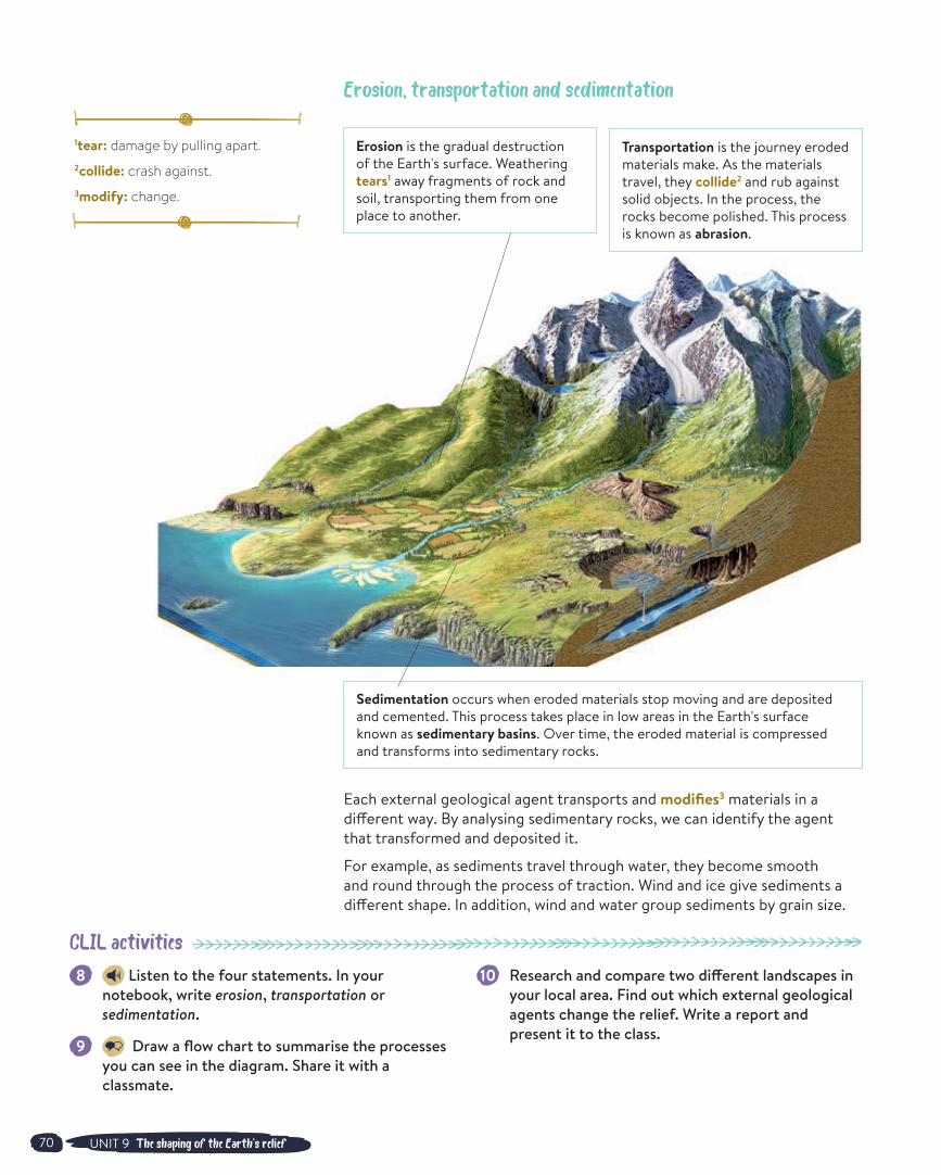
Erosion, transportation and sedimentation
Each external geological agent transports and modifies3 materials in a different way. By analysing sedimentary rocks, we can identify the agent that transformed and deposited it.
For example, as sediments travel through water, they become smooth and round through the process of traction. Wind and ice give sediments a different shape. In addition, wind and water group sediments by grain size.
Erosion is the gradual destruction of the Earth's surface. Weathering tears1 away fragments of rock and soil, transporting them from one place to another.
Sedimentation occurs when eroded materials stop moving and are deposited and cemented. This process takes place in low areas in the Earth's surface known as sedimentary basins. Over time, the eroded material is compressed and transforms into sedimentary rocks.
Transportation is the journey eroded materials make. As the materials travel, they collide2 and rub against solid objects. In the process, the rocks become polished. This process is known as abrasion.

71UNIT 9 The shaping of the Earth's relief
Surface waterRivers are the biggest sculpting force that shape the Earth's relief. River channels are concave1 with different parts:
In the upper course of a river, the land is mountainous and steep2. Erosion and transportation happen here. The river erodes the land into a V-shaped valley.
In the middle and lower course, the river travels slower because the land is flatter. The river loses its energy and deposits the materials it carries.
Rivers give a round shape to the sediments they carry. Rivers also classify sediments according to their grain size. Larger sediments are deposited first. Silt and clay-sized sediments are deposited last.
River reliefWaterfalls and rapids are formed in the upper course of the river. They are common when the riverbed changes suddenly from hard rock to soft rock. In the lower and middle course, we can find meanders, which are curves and turns in the river's channel. The mouth is where the river enters a lake, larger river or ocean. The sediments carried by the river are deposited in the mouth, forming deltas and estuaries.
Deltas Estuaries A delta is a landform created by the sediment deposited by the river as it enters the ocean. They can be found on sea and ocean shores where the tides are low.
An estuary is a partially enclosed body of water at a river mouth. They form when sea water rises and mixes with river water. As the river deposits its sediments into the estuary, the land changes. They're normally found where tides are high.
Torrents and desertsIn desert landscapes, we can find reliefs that have been sculpted by the fast moving water of torrential3 rains. Erosion happens quickly because of several factors.
There's an absence of plants. This is normal in desert areas because water is scarce4. Plants help to protect land from floods and erosion.
Steep slopes prevent water infiltrating the rock. The water moves quickly towards stream channels.
Desert soil is made up of sand and clay, which erode easily.
3
1concave: curving inwards. 2steep: rising or falling sharply.3 torrential: falling fast in abundant quantities.
4scarce: insufficient.
11 Listen and answer the questions in your notebook.
a. What’s the longest river in the world? How long is it?
b. What’s the widest river in the world? How wide is it?
c. What’s the deepest river in the world? How deep is it?
12 With a classmate, compare the upper course of a river to its middle and lower course. Where are floods most likely to occur?
13 Draw a Venn diagram to compare an estuary and a delta.
14 Write a paragraph about how water shapes desert relief. Use these words: torrential rain, flash floods, overflowing water. stream channels
CLIL activities
The Tabernas Desert in Almería receives very little rainfall, approximately 200 L/m2 per year.
Parts of a river

72 UNIT 9 The shaping of the Earth's relief
1 permeable: allows liquids to move through it.
2saturate: completely wet.3 pore: small hole on a surface.4saline: containing salt.
15 With a classmate, prepare a short presentation about how aquifers work. Organise your ideas in your notebook.
16 Listen and answer the questions about fossil water.
a. What is fossil water? b. Is fossil water a renewable resource? c. What will happen to fossil water aquifers when
we take out all the water inside?
17 TASKS T E A M Make an information poster about water consumption in Spain. Research these questions: Where does Spain and your region get its water supply? How many dams and reservoirs are there? How much water does one person use every day?
CLIL activities
Underground waterAquifers are underground containers of water made of rock or sand. Water is stored inside the holes and cracks of the rock.
Aquifers are porous, which means they have pores that can fill up with water, just like a sponge.
They are also permeable1, which allows for the water inside to circulate.
4
Rainwater or melted snow travels down into the ground until it reaches a permeable layer. The saturated2 area of the aquifer is where the pores are filled with water. Above this there's another layer in which the pores3 are filled with air. It's known as the unsaturated area.
Many people rely on the fresh water found in aquifers. They build wells to extract the water from the ground.
When people take out too much water before precipitation can refill it, the aquifer suffers from overexploitation.
refilling – discharging = variation in amount of water stored in aquifer
Overexploitation can cause wells to dry up, which can allow an intrusion of sea water. This makes the water stored in the aquifer more saline4 and unusable for drinking and irrigation.
Aqu
ifer
Aerationzone
WATERTABLE
Saturated zone
Precipitation
River above thewater table
Infiltration
Impermeable / cap rock
River belowthe water table
Discharge to the sea
Salt water

73UNIT 9 The shaping of the Earth's relief
Karsts Karst is a distinctive1 type of landform formed by underground water that dissolves soluble rocks. Carbonate rocks such as limestone undergo2 a special type of chemical weathering known as carbonatisation.
On the surface and the interior of karst landscapes, we can find a range of shapes such as caves, springs and sinkholes.
The dissolved carbonate can precipitate3 underground in caves as the water loses some of the CO2. This process leads to the formation of stalactites and stalagmites.
5
1 distinctive: different and easily noticed.
2undergo: experience.3 precipitate: create a solid from a solution.
18 Listen and answer the questions in your notebook.
a. What kind of rock is limestone? What's it made of? b. What happens to limestone in water? c. Why does limestone weather quickly?
19 Find out more about how stalactites and stalagmites are formed. Share your research with a classmate.
20 TASKS T E A M Make your own karstic model using plasticine. Include the formations shown in the diagram.
CLIL activities
Undergroundlake
Chasm
Sinkhole Stalactite
StalagmiteColumnCave
Limestonepavement
Limestone
Formations of karst modelling
Torcal de Antequera, Málaga. The Caves of Nerja, Málaga. Torca de Lobo, Cuenca.

74 UNIT 9 The shaping of the Earth's relief
1dynamic: characterised by constant change.2crash: hit hard.3isolate: separate.
21 Look at the diagram and identify coastal landforms formed by erosion and by deposition. Choose an example of each to explain how it forms to a classmate.
22 Listen and answer the questions in your notebook.
a. What is a tsunami? b. What causes most tsunamis? c. How tall can they be? d. How fast can they travel?
23 With a classmate, research and make a fact sheet of the advantages and disadvantages of building a sea wall.
CLIL activities
Coastal reliefsCoastal landscapes are highly dynamic1. Powerful ocean waves crash2 against the land. Rivers deposit sediments as they join the sea, forming deltas and estuaries. Even human activity changes the landscape. We can observe all of these factors at play on beaches.
6
Landforms created by erosionCliffs and abrasion platforms are the main shapes created by erosion. We can also find arches and stacks.Landforms created by depositionBeaches, sand dunes and tombolos are formed by the deposition of sediments. Tombolos are narrow stretches of land that connect islands to the coast. When a tombolo isolates3 a bay from the open sea, they form a lagoon.
Waves are commonly caused by wind and are particularly powerful during storms. Tides constantly pull and push the sea away and towards the coast. Drift currents travel parallel to the coast. When drift currents meet an obstacle, they stop and deposit materials they’re carrying.
Types of coastal reliefsThe coast of Spain is 6 000 km long and displays contrasting characteristics. The Atlantic coastal regions show the erosive effects of strong waves and currents produced by the Atlantic Ocean. In these regions, we can find high cliffs and rivers ending in estuaries. The Mediterranean coast and the Gulf of Cádiz have fewer waves and currents, resulting in long sandy beaches. Here, the rivers form deltas where they meet the sea.
Beach
Coastal arch
Sandspit
Sea inlet
Stack
Marsh
Cliff
Coastallagoon
Tombolo

75UNIT 9 The shaping of the Earth's relief
The windWind is a significant factor in changing the landscape of desert and coastal areas. This is because of the abundance of fine, loose1 materials, such as sand and clay, and the absence of plants and humidity.
Winds can reach very high speeds, however the low density of the air means, in comparison to rivers or glaciers, its ability to erode and transport materials is limited.
Deflation. The wind carries away fine sediments leading to the creation of desert pavement or reg.
Wind erosion, transportation, sedimentation and modelling
Wind can erode materials in two different ways. A common landform found in deserts is bare rock (hamada) or stony surfaces. Sandy deserts, with hills of sand, called dunes, formed by wind, are less common.
The sedimentation of sand takes place where wind meets an obstacle and deposits the sand it was carrying. This is how sand dunes are formed. Wind blows sand up the windward side of the dune, which is a gentle slope. Then the sand falls off the leeward side, which is sheltered from the wind and has a steep slope.
Fine particles, like silt and clay, can travel hundreds of kilometres like clouds of dust. They fall to the ground when it rains creating mud storms. They originate deposits known as loess. These types of deposits are very fertile3.
7
1loose: not attached.2 honeycomb: structure of joined cavities or cells.
3 fertile: capable of producing rich vegetation.
25 Draw and label a simple diagram to show how wind shapes sand dunes. Include labels indicating the windward and leeward side. Share it with a classmate.
26 Research to find out why tafoni are often found on coastal cliffs.
CLIL activities
Abrasion. The wind hits the surfaces of rocks with the sand it carries. This is how mushroom rocks or honeycomb2 rocks are formed.
El Corralejo dunes in Fuerteventura
24 Listen to the report about singing sand dunes. Answer true or false. Correct the false sentences in your notebook.
a. Weather conditions must be windy, hot and dry.
b. The sound is produced by raindrops hitting the sand.
c. This is a common phenomenon.
CLIL activities

76 UNIT 9 The shaping of the Earth's relief
1slope: inclined surface.
27 In your notebook, make a flow chart to show how glaciers are formed and can shape the relief.
28 Listen to the students talking about glaciers. What mistakes do they make?
29 With a classmate, use the diagram to describe the process of cryoclasty. Use these words.
First over many years this causes
30 Research fjords and their relationship to glaciers. Write a short report.
CLIL activities
The power of iceGlaciers are thick bodies of ice that cover a large area of land. They're found in the North Pole and South Pole as well as in high mountain ranges. Glaciers form as snow accumulates on one place over hundreds of years. This snow becomes compacted by its own weight, turning it into ice. Glaciers store about 70% of the Earth's freshwater supply.
Gravity and the glacier's own weight keep them constantly moving down the mountain slopes1, just like a flowing river. However, most glaciers only move about 25 centimetres per day because they are so large and heavy.
There are two major categories of glaciers.
Continental glaciers form on continental surfaces, cover large areas and are several kilometres thick. They are also called ice sheets or ice caps.
Alpine glaciers are found in high mountain valleys.
Ice: erosion, transportation, sedimentation and modelling As glaciers move, they transport rocks and sediment. This scratches and erodes the surface of the land underneath it. This is called glacial abrasion.
Rock glaciers are landforms that occur when glaciers move down the mountain and mix with large masses of rock and debris. This creates a thick layer of rocky material which covers the ice.
Types of glacier modellingCirques are bowl-shaped valleys that are formed by glaciers as they erode the mountain landscape. The ablation zone is the lower part of the glacier that melts or breaks off as it moves into warmer areas. A moraine is the accumulation of rocks and soil left behind by the glacier.
Periglacial modellingRocks can fracture when water enters the cracks and then repeatedly freezes and thaws. This is known as gelifraction or cryoclasty.
8
glacierstartflow
of ice
glacial abrasion
Erosive activity of ice
Cryoclasty process
1 2
3 4

77UNIT 9 The shaping of the Earth's relief
Living things and reliefThe biosphere is the layers of the Earth where organisms exists. It's made up of the lithosphere (the solid surface), the hydrosphere (the water) and the atmosphere (the air). These three parts interact so that the planet is able to support life.
Living things and the atmosphereThe Earth's original atmosphere was very different from the one we have today. It contained more CO2 and less O2. Many factors helped it evolve.
Cyanobacteria1, algae and plants carried out photosynthesis, which reduced the levels of CO2 and increased the O2 in the atmosphere. Oxygen contributes to the chemical weathering experienced by many rocks rich in iron.
Plants and microorganisms stored CO2 in the geosphere as coal and oil.
Limestone rock formed with the help of organisms with skeletons and carbonate shells, such as corals, red algae, molluscs and calcareous plankton.
Living things and the groundOur planet changed dramatically when it started to be colonised2 by lichens and plants. These organisms helped form the soil we know today. Animals living in soil help air enter into it. This air, with the help of water filtering into the ground, increases the weathering of rock.
Humans and their geological impactHumans have become the main agent modelling the Earth’s relief. The construction of cities, roads, reservoirs, mines and quarries has a great transforming impact. Humanised landscapes are now all over the planet while natural landscapes are mainly found in uninhabitable³ areas.
Human activity affects the dynamics of external agents. Water reservoirs accumulate sediments that are unable to continue their eroding activity downstream. Deforestation exposes the ground, which increases erosion and desertification. Global warming alters glacier and coastal dynamics. It also increases extreme phenomena, such as hurricanes and floods.
9
1 cyanobacteria: division of prokaryotic microorganisms related to the bacteria but capable of photosynthesis.
2 colonise: live or grow in large numbers in a particular area.
3 uninhabitable: a place where life cannot occur.
31 With a classmate, look at the photos and discuss how human activity has changed the landscape.
32 Listen to the report and answer the questions in your notebook.
a. What three human activities are mentioned. b. What does Anthropocene mean? c. How long will human impact on the landscape
last?
33 Research carbon footprint. Discuss what you find with a classmate.
34 In pairs, make a poster showing how we can reduce our carbon footprint at home.
CLIL activities