Beyond the Golden Gate Oceanography, Geology, Biology, and ...
84
Circular 1198 Beyond the Golden Gate— Oceanography, Geology, Biology, and Environmental Issues in the Gulf of the Farallones U.S. Department of the Interior U.S. Geological Survey
Transcript of Beyond the Golden Gate Oceanography, Geology, Biology, and ...

Circular 1198
Beyond the Golden Gate— Oceanography, Geology, Biology, and Environmental Issues in the Gulf of the Farallones
U.S. Department of the Interior U.S. Geological Survey

Edited by Herman A. Karl, John L. Chin, Edward Ueber, Peter H. Stauffer, and James W. Hendley II
Circular 1198
Beyond the Golden Gate— Oceanography, Geology, Biology, and Environmental Issues in the Gulf of the Farallones
U.S. Department of the Interior U.S. Geological Survey
U.S. Department of the Interior Gale A. Norton, Secretary
U.S. Geological Survey Charles G. Groat, Director
Any use of trade, product, or firm names in this publication is for descriptive purposes only and does not imply endorsement by the U.S. Government.
U.S. Geological Survey, Reston, Virginia: 2001
For additional copies please contact:
USGS Information ServicesBox 25286Denver, CO 80225
This report and any updates to it are available at http://geopubs.wr.usgs.gov/circular/c1198/
Additional USGS publications can be found at http://geology.usgs.gov/products.html
For more information about the USGS and its products:
Telephone: 1-888-ASK-USGS (1–888–275–8747) World Wide Web: http://www.usgs.gov
ISBN 0-607-95030-7
Published in the Western Region, Menlo Park, California Manuscript approved for publication June 18, 2000
Production and design by Sara Boore and Susan Mayfield
Text and illustrations edited by Peter H. Stauffer, James W. Hendley II, and George A. Havach
CD-ROM prepared by Michael F. Diggles
Cooperating Organizations
Bodega Marine Laboratory (University of California at Davis)
British Geological Survey
California Department of Health Services
Environmental Protection Agency
Kernfysisch Versneller Instituut, Groningen, The Netherlands
National Oceanic and Atmospheric Administration Gulf Of The Farallones National
Marine Sanctuary Cordell Bank National Marine Sanctuary National Marine Fisheries Service
National Park Service
Point Reyes Bird Observatory
U.S. Army Corps of Engineers
U.S. Geological Survey
U.S. Navy
Contributors
Bodega Marine Laboratory (University of California at Davis)
Stephen R. Wing
British Geological Survey David G. Jones Philip D. Roberts
California Department of Health Services Gregg W. Langlois Patricia Smith
Environmental Protection Agency Allan Ota
Kernfysisch Versneller Instituut, Groningen, The Netherlands
Johannes Limburg
National Oceanic and Atmospheric Administration Gulf of the Farallones National
Marine Sanctuary Jan Roletto Edward Ueber
Cordell Bank National Marine Sanctuary Dan Howard
National Marine Fisheries Service Peter Adams Tom Laidig
National Park Service Scot Anderson
Point Reyes Bird Observatory Scot Anderson Peter Pyle
U.S. Geological Survey John L. Chin Walter E. Dean James V. Gardner Russell W. Graymer James W. Hendley II Herman A. Karl Kaye Kinoshita Marlene A. Noble Stephanie L. Ross Holly F. Ryan William C. Schwab Peter H. Stauffer Florence L. Wong

Contents
1 2 4
6 8
12 16 20 24 26 28
30 32 36 40 42 44 48 52 56
60 62 66 68
72 72 73 75 77
Back pocket
Foreword Charles G. GroatBeyond the Golden Gate—Introduction Herman A. Karl and Edward UeberTechniques and Technology of Exploration in the Gulf of the Farallones Kaye Kinoshita and John L. Chin
Oceanography and Geology of the Gulf of the Farallones Regional Setting John L. Chin and Russell W. Graymer Earthquakes, Faults, and Tectonics Holly F. Ryan, Stephanie L. Ross, and Russell W. Graymer Landscape of the Sea Floor Herman A. Karl and William C. Schwab Current Patterns Over the Continental Shelf and Slope Marlene A. Noble Sediment of the Sea Floor Herman A. Karl Chemical Composition of Surface Sediments on the Sea Floor Walter E. Dean and James V. Gardner Heavy-Mineral Provinces on the Continental Shelf Florence L. Wong
Biology and Ecological Niches in the Gulf of the Farallones Phytoplankton Gregg W. Langlois and Patricia Smith Krill Dan Howard Free-Floating Larvae of Crabs, Sea Urchins, and Rockfishes Stephen R. Wing Salmon Peter Adams Seabirds Peter Pyle Marine Mammals Jan Roletto White Sharks Scot Anderson Continental Slope Communities Tom Laidig
Issues of Environmental Management in the Gulf of the Farallones Disposal of Dredged Material and Other Waste on the Continental Shelf and Slope John L. Chin and Allan Ota Search for Containers of Radioactive Waste on the Sea Floor Herman A. Karl Measuring Radioactivity from Waste Drums on the Sea Floor David G. Jones, Philip D. Roberts, and Johannes Limburg
Further Reading Oceanography and Geology Biology Environmental Issues
Glossary
CD-ROM containing full-length technical version of Circular 1198

ForewordBoth scientists and decisionmakers have become increasingly aware of the need to understand the complexity of natural systems when considering actions that affect individual aspects of resources and the environment. The interconnectedness of the physical and biological elements of a natural system is often appreciated in the abstract, but sometimes not as much as it should be in scientific studies. Too frequently, how the interaction of all elements of a system influence the organism, habitat, or process being focused on is given only lip service or general observations. Although not intended to be an integrated study, this report on oceanographic, geological, biological, and environmental aspects of the Gulf of the Farallones is an excellent example of a study describing the many facets of a complex marine system.
In marine systems, the geologic foundation and sediment dynamics of the sea floor define the basic environment for communities of bottom-dwelling organisms, which are influenced by circulation patterns that also affect organisms living in the water column. Decreased light penetration caused by turbidity affects the plankton, the base of the marine food web, and thus affects fish and other marine populations. We sometimes consider the most dynamic and influential elements of marine systems to be the currents, waves, and mobile species that are monitored regularly because they change frequently on a human time scale. However, this report demonstrates how geologic processes, including crustal processes manifested as earthquakes, can also be influential on the same time scale. The inclusion of a chapter on tectonics brings this point home.
This report also demonstrates the impact that a past tendency towards an “out of sight, out of mind” approach to the use of the ocean floor for waste disposal has had on future use of marine resources and how new technology can improve the situation. Concerns over possible leakage from drums of radioactive waste dumped until about 1970 on the ocean floor in the Gulf of the Farallones affected the marketability of fish caught in the area. Technology has only recently enabled scientists to locate the drums and begin assessing the actual risk. Similarly, new technology has allowed proposed sites for disposal of dredged material to be evaluated with a more thorough understanding of bottom conditions and processes.
Studies that help provide an integrated knowledge of complex natural systems, like these on the Gulf of the Farallones, give decisionmakers and the public an enhanced ability to avoid the mistakes of the past and promote sustainable use of environments and resources essential to human society.
Charles G. Groat Director, U.S. Geological Survey
1

ed as potential sites for
ents dredged from San
izations eventually par
, including Point Reyes
alifornia Department of
the British Geological
CD–ROM in the pocket at the back of
the book. Links to the complete Circular
and related topics can be found at http://
walrus.wr.usgs.gov.
Acknowledgments.—The view of the Gulf of the Farallones presented here resulted from the
Beyond the Golden Gate—IntroductionHerman A. Karl and Edward Ueber
The beauty and power of the ocean fascinate
many people. The sea has been a source of
sustenance, recreation, contemplation, and
inspiration, as well as a challenge for explo
ration and discovery, for mankind since pre-
history. Although much has been discovered
and reported about them, the sea, the life in
than 185 miles from Bodega Bay north of
San Francisco to Cambria south of Mon
terey. They protect an area larger than the
States of Connecticut and Rhode Island
combined, about 7,000 square miles of the
California coastal ocean.
The U.S. Geological Survey (USGS)
areas being consider
the disposal of sedim
Francisco Bay.
Many other organ
ticipated in this work
Bird Observatory, C
Health Services, and
tion from these studies
Gulf of the Farallones
ctuary to better manage
e ecological resources
rmation was also used
onmental Protection
g the first deep-ocean
ged material on the
nited States, west of
Continental Slope out-
f the sanctuary.
lar endeavors to pull
efforts of scores of people over a 12-year period, from the first sampling and surveying cruise in 1989 to final publication of this book in 2001. It is not possible to single out each person who contributed in one way or another to this endeavor. The work of each is greatly appreciated, but some deserve special mention. William Schwab, David Twichell, David Drake, and David Rubin served as co-chief scientists with John Chin and Herman Karl on the 1989 and 1990 cruises and contributed significantly to their design and implementation. William Dan-forth and Thomas O’Brien led the teams that processed sidescan-sonar data in near-real time while at sea. Arthur Wright of Williamson and Associates provided helpful insights during the search for barrels of radioactive waste using the SeaMARC1A sidescan sonar. Pat S. Chavez, Jr., and his group
2
the sea, and the landscape beneath the sea
continue to be largely shrouded in mystery.
Despite the fact that the oceans occupy 71
percent of the Earth’s surface and are crucial
to our survival, we invest more in learning
about other planets than we invest in learn
ing about the world beneath the sea.
Perhaps more than any other open space
remaining on our planet, the oceans are a
common-use area for both work and play
for much of the world’s population. This
observation is particularly true in those areas
began a major geologic and oceanographic
study of the Gulf of the Farallones in 1989.
This investigation, the first of several now
being conducted adjacent to major popula
tion centers by the USGS, was undertaken to
establish a scientific data base for an area of
1,000 square nautical miles on the Continen
tal Shelf adjacent to the San Francisco Bay
region. The results of this study can be used
to evaluate and monitor human impact on
the marine environment.
In 1990, the project expanded in scope
Survey. The informa
is being used by the
National Marine San
and protect the uniqu
of the gulf. This info
in 1994 by the Envir
Agency in designatin
disposal site for dred
Pacific coast of the U
San Francisco on the
side the boundaries o
This USGS Circu
of the coastal ocean off major urban com when the USGS sponsored a multidis back the shroud of mystery that covers the
d of the Golden Gate,
r some of the diverse
ms in the Gulf of the
ssing issues of contam
posal. The sections
e topics of Oceanogra
ology and Ecological
f Environmental Man
of the Farallones.
e paper version of the
echnical summaries.
contained on the
did preliminary computer enhancements of sidescan images that helped identify nongeologic features on the sea floor, such as radioactive waste barrels. John Penvenne of Triton Technologies developed the principal methodology to detect barrels and classify objects in the SeaMARC1A imagery. Kaye Kinoshita and Norman Maher supported the early stages of assembling this book. William van Peeters coordinated the use of the U.S. Navy’s DSV Sea Cliff and Advanced Tethered Vehicle. The USGS Marine Facility in Redwood City, California, provided operational support on shore and at sea. The officers and crews of the USGS ship R/V Farnella, NOAA ship R/V McArthur, the Navy’s ship Pacific Escort, and the support vessel Laney Chouest greatly aided the work in the gulf.
plexes. In these multiuse “urban oceans,”
environmental and ecological concerns must
be balanced against the human, economic,
and industrial demands of adjacent large
population centers. With ever-increasing
stress being placed on the ecosystems of the
oceans by human activities, many areas of
the oceans around the United States have
been designated as protected sanctuaries and
reserves. Three contiguous National Marine
Sanctuaries—Cordell Bank, Gulf of the Far
allones, and Monterey Bay—stretch more
ciplinary investigation with four other Fed
eral agencies—Environmental Protection
Agency, Army Corps of Engineers, U.S.
Navy, and Gulf of the Farallones National
Marine Sanctuary (part of the National Oce
anic and Atmospheric Administration)—to
survey and sample the Continental Slope
west of the Farallon Islands. This study
was primarily designed to provide infor
mation on the location and distribution of
approximately 47,800 containers of low-
level radioactive waste and obtain data on
ocean waters seawar
revealing to the reade
habitats and ecosyste
Farallones and discu
ination and waste dis
of this book cover th
phy and Geology, Bi
Niches, and Issues o
agement in the Gulf
The chapters in th
book are short, less t
The full chapters are
Beyond the Golden Gate—Introduction

MAP OF THE SAN FRANCISCO BAY REGION AND THE GULF OF THE FARALLONES
CORDELL BANK
NATIONAL MARINE
SANCTUARY
MONTEREY BAY
NATIONAL MARINE
SANCTUARY
Bodega Head Bodega Bay
SAN FRANCISCO
OAKLAND
SAN JOSE
Richmond
Santa Cruz
Monterey
Año Nuevo
Point Reyes
Alameda
Livermore
Vallejo
Bolinas Lagoon
San Pablo Bay
Tomales Bay
Half Moon Bay
GULF OF THE FARALLONES NATIONAL MARINE SANCTUARY
Farallon Islands
SacramentoRi
ver
SA
N
FR
AN
CI S
CO
B
AY
Suisun Bay
38°00'N
37°30'
37°00'
122°30'W 122°00'
Golden Gate
MarinPeninsula
MO
NT
ER
EY B
AY
PACIFIC
OCEAN
Farallon Islands
0 20 KILOMETERS
0 20 MILES
Noonday Rock
North Farallon
Middle Farallon
Southeast Farallon
Seal Rock
Maintop Island
123°00'W
37°45'N
Farallon Islands
0 5 KILOMETERS
5 MILES0
Beyond the Golden Gate—Introduction 3

ed gamma-ray spectrom
and operated by the
al Survey, called the EEL
l-like appearance, was
the radioactivity of the
mma detector can measure
in the Gulf of the Farallones. These instru
ment packages also measured water clarity,
conductivity, salinity, and temperature.
A camera sled designed and built by
the U.S. Geological Survey was towed
from a research vessel along a preplanned
the Gulf of the Farallones
Although the oceans occupy 71 percent of
the Earth’s surface, they continue to be
largely shrouded in mystery. From the
surface it is impossible to see into the
ocean depths, and actually going into
those depths is both costly and hazardous.
together in a spatial frame of reference.
Four types of navigation sensors were used
to determine the locations of objects and
features on the sea floor—Global Position
ing System (GPS) satellites, Loran-C, and
two ranging navigation systems (Del Norte
A towed seab
eter belonging to
British Geologic
because of its ee
used to measure
sea floor. The ga
Techniques and Technology of Exploration inKaye Kinoshita and John L. Chin
artificial radioactivity in
r material to an effective
ttom depth of about a foot.
owed, data are sent up the
a shipboard computer and
ously.
ples of the sea bottom
two devices. A gravity
the bottom by a heavy
to obtain round cores
diameter and as much
his type of coring device
trackline to take pictures of the sea floor in
the gulf. Video was recorded continuously
and still photographs were taken every
10 to 15 seconds. The images of the sea
floor obtained with the camera sled were
used to visually verify information col
lected from both sidescan-sonar mapping
and physical sampling.
Visual observations were also made
with Sea Cliff, a manned deep-submer
gence vehicle (DSV) operated by the U.S.
Navy. Sea Cliff also had the capability
Because the oceans are crucial to our
survival, we must try to understand the
interactions of their complex physical and
biological systems. In pursuit of this
understanding, scientists seek many kinds
of information—the depth, composition,
temperatures, and movements of the water;
the shape and composition of the sea
bottom; and the types and abundances of
the animals and plants living in the water
and at the bottom. Some of these kinds
of information can be obtained at the sur
and Benthos). The output from the GPS,
Loran-C, and Del Norte systems was fed
directly into a navigation program running
on a microcomputer. This program pro
vided important real-time location infor
mation, which was relayed to computers in
onboard science laboratories and the ship’s
bridge. The Benthos system was a stand-
alone system, which had its own program
and display and ran separately from the
integrated navigation system.
Two types of equipment using sound
both natural and
surficial sea-floo
maximum subbo
As the probe is t
towing cable to
recorded continu
Physical sam
were taken with
corer, driven into
weight, was used
about 4 inches in
as 10 feet long. T
face from ships, others require the low waves—sidescan sonar and seismic-reflec was used where the sediment was expected
ddy. The other sampling
a Van Veen grab sampler,
y much like a clam shell.
des of the shell touch the
se and scoop up a sample.
used where the sea floor
be sandy, because sand
be penetrated by or
ity corer.
ckages were attached to
the sea floor to measure
direction of ocean currents
to take physical samples with the use of
mechanical arms. The Navy’s unmanned
Advanced Tethered Vehicle (ATV) was
also used to obtain additional video and
photographs of the sea floor. The ATV can
be remotely “driven” to a specific site, and
it proved to be the most precise way used
so far in the Gulf of the Farallones to view
objects on the sea floor.
ering of cameras and sampling devices,
and still others are best acquired through
exploration in submersible vehicles, both
manned and unmanned. Exploration in the
Gulf of the Farallones has made use of a
wide variety of such techniques.
When collecting multiple sets of geo
physical and geological data over a wide
area of the sea floor, precisely determining
the location of an object or feature is criti
cal. Navigation was therefore the common
denominator that linked all data types
tion systems—were used to map the sea
floor in the gulf. Images from three differ
ent sidescan systems were cut and pasted
together to create “mosaics,” which pro-
vide excellent map views of the area of
sea floor studied in the gulf. Both 3.5-kilo-
hertz (kHz) and 4.5-kHz high-resolution
seismic-reflection systems were used to
profile and look at the shallow subbottom
(uppermost 160 feet) of the sea floor. A
10-kHz system was also used to provide
accurate bathymetric information.
to be soft and mu
device used was
which works ver
When the two si
sea floor they clo
This device was
was expected to
would not easily
retained in a grav
Instrument pa
lines moored to
the velocity and
Techniqu4
es and Technology of Exploration in the Gulf of the Farallones
Techniques and Technology of Exploration in the Gulf of the Farallones 5
Two types of equipment using sound waves—sidescan sonar and seismic-reflection systems—were used to map the sea floor in the Gulf Of the Farallones. Each system is housed in a hydrodynamic “towfish” that is towed just below the ocean surface from a ship. The SeaMARC1A sidescan-sonar system is shown here outside of its protective shell. The inset shows the towfish that was used for high-resolution seismic-reflection systems.
Samples of the sea bottom were taken with two devices. A gravity corer (above) was used where the sediment was expected to be soft and muddy. A clam-like Van Veen grab sampler (left, in closed position), used where the sea floor was expected to be sandy, collected samples such as the sand and brittle stars shown (top).
This U.S. Geological Survey camera sled, towed from a research vessel along pre-planned tracklines, was used to take pictures of the sea floor in the Gulf of the Farallones.
Sea Cliff (above), a manned deep-submergence vehicle operated by the U.S. Navy, was used to directly observe the sea bottom and to take physical samples with its mechanical arms. The Navy’s unmanned Advanced Tethered Vehicle (above right) was also used to take video footage and still photographs of the sea floor.

The San Francisco Bay region of California is famous for its stunning landscapes and
complex geology. Adjacent to this region, in the watery world of the Pacific Ocean
beyond the Golden Gate, lies the Gulf of the Farallones, a physical environment equally
complex and fascinating, but less obvious, less visible, and therefore more mysterious.
Scientific studies are revealing that the sea floor of the gulf, like the region onshore,
was crafted by geologic forces that include movements of the San Andreas Fault system,
major changes in sea level, and the action of rivers. The ceaseless work of oceanic
currents has further sculpted the sea bottom in the gulf into landscapes that today range
from flat plains and giant sand ripples to deep canyons and rugged mountains, some of
whose highest summits poke above the water to form the Farallon Islands.


cisco Bay region strad
y zone between two of the
ctonic plates. The Pacific
oving northward relative
erican Plate, and this
ce along the San Andreas
separated by broad basins and narrow val
leys. Many of the ridgecrests in the
Coast Range, the major mountain range in
the region, rise above 1,000 feet, and a
few above 4,000 feet. The highest peaks
include Mount Hamilton at 4,373 feet,
8
Oceanography and Geology of the Gulf of the Farallones
Regional Setting John L. Chin and Russell W. Graymer
The Gulf of the Farallones lies in the off-
shore part of the San Francisco Bay region
just beyond the Golden Gate. The bay
region is home to more than 6 million
people and has long been regarded as
one of the most beautiful regions in the
listening devices) and underwater cameras
and video equipment.
The landscape features of the San
Francisco Bay region are the cumulative
result of millions of years of Earth his-
tory, involving the building and subse
The San Fran
dles the boundar
Earth’s major te
Plate is slowly m
to the North Am
motion takes pla
ork of associated sub-
ollectively called the San
one (see chapter on Earth-
nd Tectonics). Rocks east
as Fault Zone were
n approximately their
. However, many of the
in the zone, like the Fran
e Marin Headlands, are
s that have been scraped
of North America over
lion years.
f the rocks found west of
Mount Diablo at 3,849 feet, and Mount
Tamalpais at 2,606 feet.
As recently as about 10,000 years ago,
at the end of the last ice age, great sheets
of ice (glaciers) covered much of Earth’s
northern hemisphere. Because so much
water was stored in these glaciers, sea
level was about 300 feet lower than at
present, and the coastline of the San Fran
cisco Bay region was situated as much as
35 miles seaward of its present position,
near coastal hills whose tops are now the
Farallon Islands. The melting of the ice
United States. It annually draws hundreds
of thousands of tourists from all over
the world to enjoy its hilly, often fog-
shrouded terrain and its mild, Mediterra
nean climate, as well as to experience its
cultural richness and diversity. The histori
cal settlement of the bay region is inti
mately related to its geography, natural
harbors, and mild climate.
The San Francisco Bay region extends
from the Point Reyes Peninsula southward
to Monterey Bay and from the coast east-
ward to the Sacramento-San Joaquin Delta
quent wearing down of mountains, volca
nic eruptions and resulting outpourings of
lava, large and small earthquakes, and the
never-ending processes of wind and water
erosion and deposition. Many of these
processes are occurring today, although
some of them occur at rates so slow that
little change may be perceived over the
course of a human lifetime. The sedi
mentary deposits and rocks of the region
range in age from hundreds of millions
of years to those still forming today.
The entire spectrum of rocks present in
Fault and a netw
parallel faults, c
Andreas Fault Z
quakes, Faults, a
of the San Andre
mainly formed i
present positions
rocks found with
ciscan chert at th
ocean-floor rock
off onto the edge
the past 150 mil
The oldest o
Fault were formed hun
the south, some near
of Los Angeles, and
nsported northward by
the San Andreas and its
. Rocks west of the fault
being transported north-
inches per year and after
s may reach the area
today.
ges in the San Francisco
mostly northwest and are
sheets caused worldwide sea level to rise,
forming the Gulf of the Farallones and San
Francisco Bay.
If the vast volume of ocean water that
now covers the floor of the gulf could be
removed, people would see a varied land
scape. That landscape is as rich in diver
sity and rugged splendor as that on the
nearby shore (see chapter on Landscape of
the Sea Floor).
and also includes the offshore area out to
a water depth of about 11,500 feet, which
is the outer edge of the Continental Slope.
This offshore area, where many residents
of the region and tourists go to watch the
annual migration of whales, as well as to
boat and fish, includes the Gulf of the Far
allones and the Farallon Islands. Although
the sea floor in this area cannot be visually
observed, scientists have learned much
about it by using acoustic instruments
(instruments that utilize sound sources and
the region records only a fraction of
the Earth’s history. The rock types range
from the salt-and-pepper granitic rocks at
Point Reyes and on the Farallon Islands,
through various types of volcanic rocks
(such as the pillow basalts in the Marin
Headlands), to sedimentary rocks, such
as the red to brown bricklike chert that
forms the cliffs of the Marin Headlands
and many of the hills of San Francisco,
and the young sand-dune deposits that
occur along the Pacific Coast.
the San Andreas
dreds of miles to
the present site
subsequently tra
movement along
associated faults
are, in fact, still
ward at about 2
millions of year
where Alaska is
Mountain ran
Bay region trend
Oce
anography and Geology of the Gulf of the Farallones
A
B
The Gulf of the Farallones lies in the offshore part of the San Francisco Bay region (see map at left) just beyond the Golden Gate (views above). A, View eastward from the Marin Headlands toward the Golden Gate Bridge and downtown San Francisco; Alcatraz Island can be seen at the upper left, Treasure and Yerba Buena Islands and the San Francisco Bay Bridge are seen in the middle distance, and the hills of the heavily populated east bay, which includes the city of Oakland, can be seen beyond the Bay Bridge. B, View westward through the Golden Gate looking out into the Gulf of the Farallones. C, Closeup westward view of the Marin Headlands taken from a similar vantage point as photograph A; the headlands are mostly composed of Franciscan chert and pillow basalts (see next page). (U.S. Geological Survey photographs by Phil Stoffer.)
Regional Setting 9
C

Some rocks of the San Francisco Bay region dating from the Mesozoic Era (250 to 65 million years ago): Franciscan cherts (top left) and pillow basalts (bottom left) of the Marin Headlands, which were originally formed on the ocean floor 150 to 100 mil-lion years ago. (U.S. Geological Survey photographs by Bruce Rogers.)
Some sedimentary rocks of the San Francisco Bay region dating from the Tertiary Period (65 to 1.6 mil-lion years ago). Above, deposits of an approximately 50-million-year-old submarine landslide exposed near Año Nuevo on the coast south of San Francisco; left, a beach cobble of the Purisima Formation on the coast south of San Francisco containing abundant fossils, mostly clams, that lived in shallow marine waters a few million years ago and are similar to those living in the region’s coastal waters today. (U.S. Geological Survey photographs by Phil Stoffer.)
10 Oceanography and Geology of the Gulf of the Farallones

Geologic map of San Francisco Bay region, showing the San Andreas Fault, related faults, and regional rock types.
Quaternary (less than 1.6 million years old) deposits of the marine and coastal Merced Formation in an eroded seacliff at Fort Funston Beach in San Francisco (U.S. Geological Survey photograph by Phil Stoffer). The white band in the middle of this approximately 150-foot cliff is the Rockland Ash, a layer of volcanic ash from a powerful eruption that occurred in the Lassen area of northern California about 600,000 years ago. That eruption was 50 times larger than the 1980 eruption of Mount St. Helens, Washington, and because the winds at the time of the eruption were blowing southward, ash several inches thick was deposited as far south as the San Francisco Bay area. Map shows known distribution of the Rockland Ash, and inset shows particles from it magnified about 70 times.
Regional Setting 11
on so susceptible to
d is a significant factor
geology and geomor
region. The Pacific
erican Plates are sliding
st each other at an aver-
onshore north of Half Moon Bay
are parts of large fault blocks that
contain granitic rocks believed to be
originally derived from the southern
Sierra Nevada. At least 17 such fault-
bounded structural blocks (terranes) of
12
Oceanography and Geology of the Gulf of the Farallones
Earthquakes, Faults, and Tectonics Holly F. Ryan, Stephanie L. Ross, and Russell W. Graymer
On April 18, 1906, the San Francisco
Bay region was rocked by one of the
most significant earthquakes in history.
This magnitude 7.8 earthquake began
on a segment of the San Andreas Fault
that lies underwater in the Gulf of the
potential for large, destructive earth-
quakes in the region. The Loma Prieta
earthquake killed 63 people, injured
more than 3,700 others, and caused
property damage in excess of $6 bil
lion. It should be kept in mind, how-
cisco Bay regi
earthquakes an
in creating the
phology of the
and North Am
relentlessly pa
ut 2 inches per year.
otion occurs in cat
s of movement—earth
the San Andreas Fault
San Francisco, the San
system is a complex
about 50 miles wide.
om offshore to as far
ies of Vallejo and
addition to the San
, the numerous faults
f the San Andreas
different sizes and rock types have
been identified in the bay region.
To help reduce injuries and prop
erty damage from future earthquakes
in the San Francisco Bay region, it is
necessary to have a good understand
ing of the geology of this region. This
must encompass both the onshore and
offshore geology, including that of the
Gulf of the Farallones.
Farallones, just a few miles offshore
of San Francisco. The quake ruptured
nearly 270 miles of the fault from
San Juan Bautista to Cape Mendocino.
Damage from the intense shaking
during the earthquake, along with
the devastation from the ensuing fire,
wreaked havoc in San Francisco, a
city of 400,000 inhabitants at the time.
Although the official death toll from
the earthquake was reported to be about
700, it is now widely believed that the
ever, that devastation occurred only in
limited areas because the epicenter of
this earthquake was on a somewhat
remote segment of the San Andreas
Fault, 70 miles south of San Francisco
in the Santa Cruz Mountains. An earth-
quake of similar magnitude located
closer to the center of a densely popu
lated urban area is capable of causing
much greater damage and loss of
life. This was shown by the 1995
Kobe, Japan, earthquake (magnitude
age rate of abo
Most of this m
astrophic burst
quakes—along
system. Near
Andreas Fault
zone of faults
It stretches fr
east as the cit
Livermore. In
Andreas Fault
that are part o
actual loss of life was three to four 6.9), which caused more than 6,000 Fault system include the San Gre
d, Rogers Creek, and
lts.
geomorphology (sur
of the San Francisco
consequence of the
otion of past and pres
ults within the San
system, and of the jux
locks of different rock
ments along these faults.
he Farallon Islands off-
tara Mountain located
times greater. In addition, more than 50
percent of the population of the city
was homeless following the earthquake.
Today, a large metropolitan area
of more than 6 million people covers
more than 7,000 square miles around
San Francisco Bay. Many small earth-
quakes occur in the bay region every
year, although only those greater than
about magnitude 3 are usually felt. The
1989 magnitude 6.9 Loma Prieta earth-
quake was a strong reminder of the
deaths, injured 35,000 people, resulted
in $100 billion in property damage,
and destroyed the homes of more than
300,000 people.
The rigid outer shell of the Earth
is made up of large “tectonic plates”
that move horizontally relative to one
another. The Gulf of the Farallones
includes part of the boundary between
two of the Earth’s largest tectonic
plates. Tectonic motion along this
boundary is what makes the San Fran
gorio, Haywar
Calaveras Fau
Much of the
face features)
Bay region is a
location and m
ently active fa
Andreas Fault
taposition of b
types by move
For example, t
shore and Mon
Oceanography and Geology of the Gulf of the F
arallones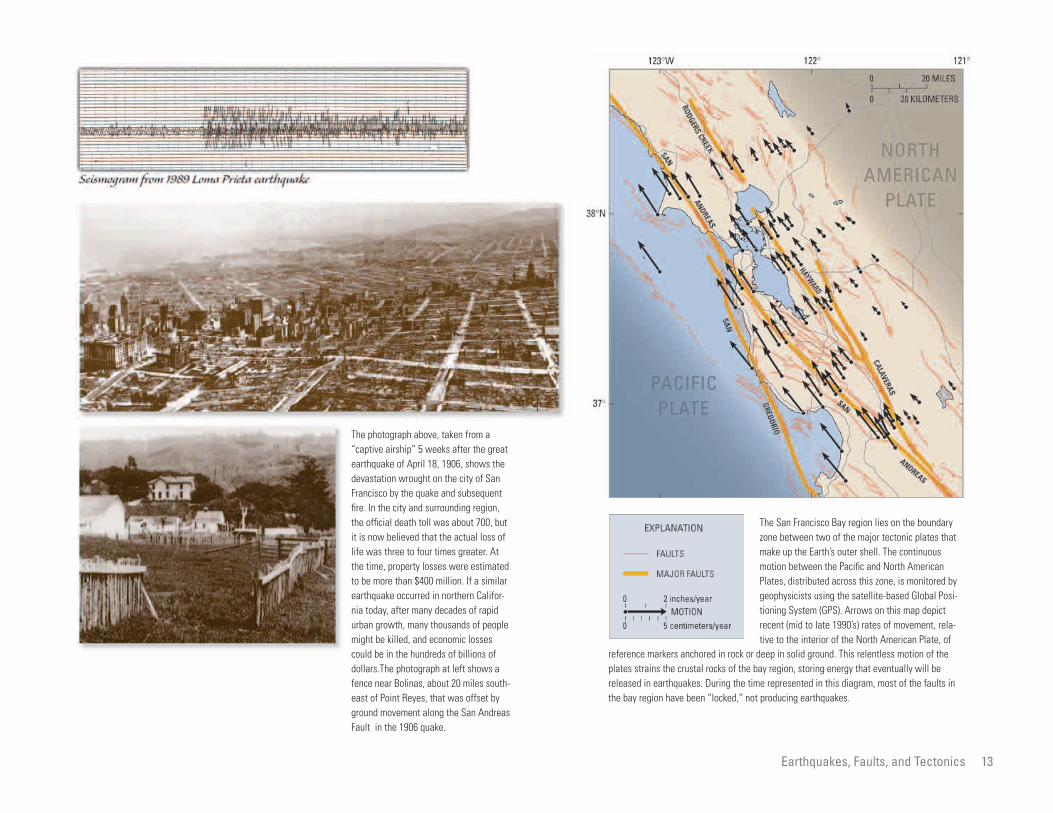
The photograph above, taken from a “captive airship” 5 weeks after the great earthquake of April 18, 1906, shows the devastation wrought on the city of San Francisco by the quake and subsequent fire. In the city and surrounding region, the official death toll was about 700, but it is now believed that the actual loss of life was three to four times greater. At the time, property losses were estimated to be more than $400 million. If a similar earthquake occurred in northern California today, after many decades of rapid urban growth, many thousands of people might be killed, and economic losses could be in the hundreds of billions of dollars.The photograph at left shows a fence near Bolinas, about 20 miles south-east of Point Reyes, that was offset by ground movement along the San Andreas Fault in the 1906 quake.
The San Francisco Bay region lies on the boundary zone between two of the major tectonic plates that make up the Earth’s outer shell. The continuous motion between the Pacific and North American Plates, distributed across this zone, is monitored by geophysicists using the satellite-based Global Positioning System (GPS). Arrows on this map depict recent (mid to late 1990’s) rates of movement, relative to the interior of the North American Plate, of
reference markers anchored in rock or deep in solid ground. This relentless motion of the plates strains the crustal rocks of the bay region, storing energy that eventually will be released in earthquakes. During the time represented in this diagram, most of the faults in the bay region have been “locked,” not producing earthquakes.
Earthquakes, Faults, and Tectonics 13

Terrane map of the San Francisco Bay region. Beneath the landscape of the bay region lie fragments of at least 17 different bedrock types that have been transported and juxtaposed by movement along faults. The major basement rock types can be ascribed to either the Franciscan terranes or the Salinian terranes. Rocks
of the Salinian terranes, whereas those east of the San Andreas Fault are generally part of the
rock types that formed in very different geologic environments and some of which were trans-
present positions.
west of the San Andreas Fault are generally part
Franciscan terranes. These major terranes, separated by the San Andreas Fault, are composed of
ported long distances by tectonic motion to their
14 Oceanography and Geology of the Gulf of the Farallones

In 1999, the U.S. Geological Survey and cooperators released this earthquake probability map for the San Francisco Bay region. The threat of earthquakes extends across the entire region, and a major quake is likely before 2030. As continuing research reveals new information about earthquakes in the bay region, these probabilities are revised.
Earthquakes, Faults, and Tectonics 15

tures are collectively
s). A regional map com
e data established that at
r discrete fields of bed-
the Continental Shelf
Reyes and Half Moon
no large underwater landslides were dis
cerned on the sonographs. Conspicuous
geomorphic features in the southern part
include Pioneer Canyon and Pioneer
Seamount. Sediment is accumulating in
Pioneer Canyon and on Pioneer Sea-
16
Oceanography and Geology of the Gulf of the Farallones
Landscape of the Sea FloorHerman A. Karl and William C. Schwab
Various forces sculpt the surface of the
Earth into shapes large and small that
range from mountains tens of thousands
of feet high to ripples less than an inch
high in the sand. We can easily see these
morphologic features on dry land, and
However, light does not penetrate far in
water, and so photographs cannot be pro
duced that show entire mountains and
valleys beneath the sea. Just as under-
water cameras can take photographs of
only very small areas and objects not
sions (these fea
called bedform
piled from thes
least four majo
forms occur on
between Point
ds are separated by
etches of flat, featureless
rticular interest is a
sions floored by ripples
hs of about 3 feet. These
ich are common east of
ands between Point Reyes
Gate, form the largest of
f bedforms. The shelf in
s morphologically com
lexity reflects an intri
istory and a wide variety
oceanographic processes
mount, suggesting that this area is depo
sitional, in contrast to the active trans-
port environment found on the shelf.
USGS sonographs made of the Gulf
of the Farallones have several practical
applications. For example, the evidence
of strong currents, as indicated by large
ripples in coarse sand, suggests that
dredge material and pollutants disposed
of at sites on the Continental Shelf could
be redistributed over large areas. Also,
commercial fisherman can use these
images to locate the substrates preferred
most are accessible to be explored and
appreciated by us as we walk and drive
across or fly over them. In contrast,
people can travel at sea without ever
being aware of the existence of large
mountains and deep valleys hidden by
tens of feet to tens of thousands of feet
of water. At one time, it was impossible
to see the landscape beneath the sea
except by direct observation, and so the
bottom of the deep oceans remained as
mysterious as the other side of the Moon.
Methods of using sound to map the fea
far distant, divers and submersibles can
observe only very small areas of the
ocean bottom. Such methods of observa
tion are analogous to walking around at
night with a flashlight and trying to see a
mountain or a forest. It is possible in
this way to see rocks, pebbles, leaves,
and trees along your path, but not the
entire mountain and forest. To observe
and make images of the mountains and
valleys under the sea, scientists have
developed instruments that use sound
(acoustic energy) as a way to “insonify”
Bay. These fiel
monotonous str
sea floor. Of pa
series of depres
with wavelengt
depressions, wh
the Farallon Isl
and the Golden
the four fields o
the study area i
plex. This comp
cate geologic h
of geologic and
the shelf to transport,
sit sediment.
ed from the Continental
GS show that the rugged
the Gulf of the Faral
by numerous small can
cover is thin or absent.
art contrasts markedly
rn part of the gulf, which
ged and draped by a
sediment. Sediment in
rt appears stable because
by bottom fishes and crabs.
tures of the sea floor were developed inthe decades after World War I, and we
now know that mountains larger than any
on land and canyons deeper and wider
than the Grand Canyon exist beneath our
oceans.
Images of large areas of the land sur
face are taken by cameras in aircraft and
acquired by sensors in satellites. Optical
instruments (cameras) record reflected
light to produce images (photographs)
of mountains, plains, rivers, and valleys.
(flood with sound waves) rather than
illuminate (flood with light) those fea
tures. Computers are used to process
the acoustic data so that the resulting
sound images (sonographs) resemble
aerial photographs (light images).
Data collected from the Continental
Shelf in the Gulf of the Farallones by the
U.S. Geological Survey (USGS) reveal
various features on the seabed, including
outcropping rock and several types of
ripples, dunes, lineations, and depres
that operate on
erode, and depo
Data collect
Slope by the US
northern part of
lones is scarred
yons. Sediment
This northern p
with the southe
is much less rug
thin blanket of
the southern pa
Oceanography and Geology of th
e Gulf of the Farallones
To w f ish
S i d e s c a n Sea bottom
In the diagram above, a sidescansonar “towfish” is pulled behind a ship, imaging a broad swath of the sea floor. When combined, such swaths form sidescan-sonar “mosaics” or maps of large areas of the sea bottom. The mosaic at left shows depressions (dark areas) floored by sand ripples east of the Farallon Islands between Point Reyes and the Golden Gate, and the mosaic at right shows unusual and complex bedforms, possibly ribbons of sand moving over the sea floor.
0
0
0
0
Lines are ship’s tracks
MAPPING THE SEA FLOOR USING SIDESCAN SONAR
s w a t h
400 METERS
1,300 FEET
400 METERS
1,300 FEET
Landscape of the Sea Floor 17

Sea bottom
Sonar beam
In the diagram above, a hull-mounted, narrow-beam sonar system is producing a continuous profile of the sea floor as the ship moves. The sample profile at right, taken across a submarine canyon, shows the rugged sea-bottom topography typical of the northern Gulf of the Farallones.
S h i p ’ s t r a c k
0
0
0 0
MAPPING THE SEA FLOOR USING NARROW-BEAM SONAR
NARROW-BEAM-SONAR PROFILE
500 METERS
1,650 FEET
50 M
ETER
S
165
FEET
18 Oceanography and Geology of the Gulf of the Farallones

Three-dimensional bathymetric map of the Continental Slope in the Gulf of the Farallones. This image was created using sonar.
Landscape of the Sea Floor 19

nd Slope
990’s, several programs
by the U.S. Geological
r organizations to gather
ut how currents, nutrients,
aterial move through the
within the conspicuous submarine canyons
that cut into the continental margin.
However, many of the current patterns
in the Gulf of the Farallones are altered by
the region’s unique sea-floor topography;
20
Oceanography and Geology of the Gulf of the Farallones
Current Patterns Over the Continental Shelf aMarlene A. Noble
The waters of the Gulf of the Farallones
extend along the central California coast
from Point Reyes southeastward to Año
Nuevo. This unique region of coastal
ocean contains valuable biological, rec
They diminish offshore, becoming over-
whelmed by steadier currents as water
depth increases.
Tidal currents and waves are important
in the coastal ocean. They mix the water
During the 1
were undertaken
Survey and othe
information abo
and suspended m
llones. The area studied by
s about 1,000 square nauti
gulf and ranges in water
to 10,500 feet. These stud
the general features of the
t patterns in the area are
observed elsewhere along
orthern California conti
r the Continental Shelf
theastward and slightly
mer, causing nutrient-rich
pwell onto the shelf. Shelf
ostly northwestward in
therefore, the local characteristics of flow,
such as the amplitude of currents, their
detailed response to winds, and the
strength of the summer upwelling, are spe
cific to an area. In summer, the promon
tory of Point Reyes causes shelf currents
to turn offshore and flow over the slope.
The abrupt steepening of the slope in
the northern part of the area studied also
causes northwestward-flowing slope cur-
rents to turn toward the deep ocean. Both
of these features enhance the exchange
of water, nutrients, and other suspended
materials among the shelf, slope, and deep
reational, commercial, and educational
resources. Sandy beaches provide living
space for a wide variety of organisms.
Seabirds nest along the beaches, in the
rocky cliffs above them, and on the Far
allon Islands. Animals ranging from the
small anemones found in tide pools to the
elephant seals off Año Nuevo live in these
waters. This coastal region is also a play-
ground for people, Californians and visi
tors alike. In addition, fishing and com
mercial shipping activities are an integral
part of the economy in the region.
Tides are the most familiar ocean phe
column, allowing nutrients near the seabed
to reach plants growing in the lighted sur
face regions. Tides move nutrients and
other suspended materials vertically and
back and forth, but they generally do not
transport these materials large distances.
On the Continental Shelf and Slope
in the Gulf of the Farallones oceanic cur-
rents flow through the area transporting sus
pended sediment, nutrients that allow plants
to grow, and possible pollutants. Until
recently, however, not much was known
about how strong the currents are, in what
direction they flow, or how rapidly flow pat-
Gulf of the Fara
the USGS cover
cal miles of the
depth from 660
ies showed that
complex curren
similar to those
the central and n
nental margin.
Currents ove
tend to flow sou
offshore in sum
cool waters to u
currents flow m
rrents are strong over the
o be the dominant features
near the shoreline or
. The strong waves that
nter storms commonly
on the sea floor to be
d carried both along and
on the Continental Slope
northward in all seasons.
ver the slope are weak
ns near the seabed or
ocean relative to what happens along the
simple, straight shelf more common north
of the gulf.
The complex current patterns in the
Gulf of the Farallones help to make the
coastal waters of the area a truly unique
resource. Knowledge of these patterns is
essential if competing demands on this
resource are to be balanced.
nomenon. They are easily seen at the sea
shore; beaches are covered and exposed
twice a day. Tidal currents, the largest cur-
rents in San Francisco Bay, move water
in and out of the estuary. At the Golden
Gate, ebb-current velocities during spring
tide can reach 7 miles per hour. Small sail-
boats bucking a strong tide can have trou
ble just getting back in through the Golden
Gate. Timing of the return is critical. Out-
side the Golden Gate, in the coastal ocean,
tidal currents are strong near the coastline.
terns change with time or location. Even
less was known about how current patterns
affect the many creatures that live in the
coastal ocean, how currents modify the nat
ural sediment on the sea floor, or about the
eventual fate of natural sediment or mate-
rials dumped in the gulf. Knowledge is
needed about these important factors so that
people can make reasonable decisions about
how to manage the coastal waters, ensuring
that recreational and commercial activities
do not harm the environment.
winter. Tidal cu
shelf and tend t
in flow patterns
within estuaries
occur during wi
cause sediment
resuspended an
off the shelf.
The currents
flow dominately
Tidal currents o
except for regio
Oceano
graphy and Geology of the Gulf of the Farallones
The California Current is part of a permanent, ocean-wide gyre in the surface waters of the North Pacific. It forms the east part of this gyre, which is defined in the west by the Kuroshio Current (Pacific Gulf Stream), in the north by the North Pacific Current, and in the south by the North Equatorial Current. In the Gulf of the Farallones, currents over the Continental Slope are quite distinct from the southeastward-flowing water of the California Current farther offshore. These slope currents are confined to a relatively narrow band sea-ward of the Continental Shelf and flow northwest-ward, parallel to the topography, as the California Undercurrent. In the gulf, the undercurrent is generally found over the slope in water depths less than 2,600 feet. Bathymetry in meters (1 m = 3.281 ft).
SanFrancisco
Wind from north
Upwelling cold water
fromdepth
SanFrancisco
Downwelling warm
surface waterWind from south
8
37°N
124°W 122°
35°
10 50
55
60
12
14
16
°C °F
SURF
ACE
WAT
ER T
EMPE
RATU
RE
San Francisco
Monterey
Current Patterns Over the Continental Shelf and Slope
Strongly reversed conditions, common during El Niños
In spring and summer, strong winds blowing toward the equator, together with the Coriolis effect (the tendency of winds and currents to veer to the right in the Northern Hemisphere and to the left in the Southern Hemisphere), push surface water away from the California coast. To fill its place, nutrient-rich colder water rises to the surface in
Typical spring and summer conditions, intensified during Las Niñas
the yearly upwelling that makes the ocean off northern California so cold in spring and summer and the Gulf of the Farallones so biologically productive. When El Niño atmospheric phenomena occur, they disrupt this pattern and cause downwelling, which pre-vents the replenishment of nutrients to surface waters and can have a major impact on sea life. For example, in 1997–98, thousands of seals and sea lions starved to death when
downwelling warm water drove away many of the fish and squid on which they normally fed. Young animals, such as the sea lion pup shown here, were particularly vulnerable. Areas of
cold, upwelled water (blue) along the central California coast are shown in the satellite image below (NOAA AVHRR satellite data, processed at Naval Postgraduate School).
June 18, 1989
WATER MOVEMENTS AND WINDS OFF THE NORTHERN CALIFORNIA COAST
21

One method the U.S. Geological Survey has used to measure ocean currents in the Gulf of the Farallones is strings of instrument packages attached to mooring lines anchored on the sea bottom. Surface moorings are mainly used in shallower water. Photograph below shows a cur-rent meter with an attached transmissometer (instrument to measure water clarity) being lowered into the waters of the gulf. Inset shows surface mooring (float) used for a bottom-anchored string of intrument packages.
STRINGS OF INSTRUMENT PACKAGES ARE USED TO MEASURE OCEAN CURRENTS
22 Oceanography and Geology of the Gulf of the Farallones

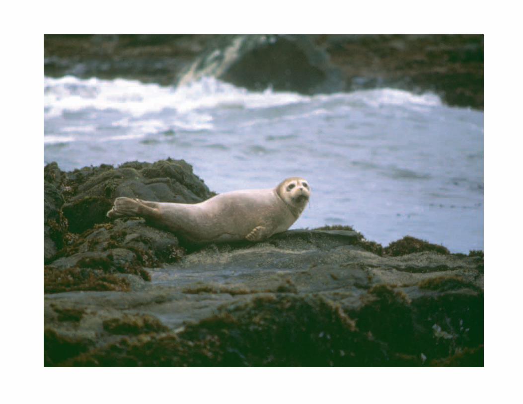
These photographs were taken from a U.S. Geological Survey instrument station lowered to the sea floor in the Gulf of the Farallones. Strong bottom currents can create sand ripples (left), and weaker currents can leave a smooth sea bottom (right, with a curious seal).
Current Patterns Over the Continental Shelf and Slope 23

iety of animals and plants
sanctuary. Such informa
d by commercial fisher-
for locating fishes and
er a particular substrate.
tionally strong currents are required to
transport large amounts of sand from the
shelf to the slope, but such situations are
extremely uncommon.
It is not yet known whether the
24
Oceanography and Geology of the Gulf of the Farallones
Sediment of the Sea FloorHerman A. Karl
Many people perceive the sea floor to be a
smooth blanket of sand similar to a sandy
beach. For some areas of the sea floor
this is true, but just as the sandy beach
is flanked by rocky headland and muddy
grained sediment. As sampling tech
niques improved and more information
was collected, scientists learned that the
ocean bottom is as texturally varied and
morphologically complex as the land
manage the var
that live in the
tion is also use
men as an aid
crabs that pref
wetland, so are the smooth sandy plains of surface. The physical characteristics (for The sea floor in the Gulf of the
sists of many different
ate, including rock out-
and, clay, and deposits of
Some of these different
ate are found very close
nd have abrupt boundar
em. On the Continental
rridor of sand extends
the Golden Gate to the
s. Silty sand and sandy
corridor to the northwest
and a band of silt extends
eyes.
textural patterns and bedforms on the
Continental Shelf in the Gulf of the
Farallones reflect entirely present-day
processes or whether some of these fea
tures are remnants of processes that
operated during lower stands of sea level
in the past. During the glacial cycles of
the past several million years, sea levels
were lowered to as much as 445 feet
below present-day sea level. Therefore,
ancient relict features created during
lower stands of sea level are common
on Continental Shelves worldwide. Such
lowstands of sea level would have
the sea floor flanked by various different
substrates. This is the case for much of the
sea floor in the Gulf of the Farallones.
The earliest general model of sedi
ment distribution across the sea floor
was that the size of sediment particles
gradually decreased with increasing
water depth. According to this model,
the nearshore consisted of a blanket of
sand—an extension of the sandy shore—
that was gradually replaced by silt and
then by clay in deeper water. This model
was based on the concept that the energy
example, size, shape, composition) and
the distribution of sediment are the
result of a complex interaction among
geologic, oceanographic, and biologic
processes. Moreover, scientists know
that the distribution of sediment on
the Continental Shelf is made more
complex by deposits of relict sediment.
Relict sediment is that material, gener
ally coarse sand and gravel, left on the
shelf when it was exposed during times
of lower sea level.
Evidently, then, the distribution of
Farallones con
types of substr
crops, gravel, s
broken shells.
types of substr
to each other a
ies between th
Shelf a wide co
westerly from
Farallon Island
silt bound the
and southeast,
around Point R
he sediment on the sur
tinental Slope is finer
rm than that on the Con
n the Gulf of the Faral
less, most of the surficial
e Continental Slope in the
f of the Farallones stud
y, a condition that is
ental slopes are gener
ed by silt and clay). The
abundance of sand is
stood. In general, excep
exposed virtually all of the shelf in the
Gulf of the Farallones.
of ocean currents and waves decreased
from shallow water to deeper water and
that, therefore, smaller particles could
only settle to the bottom in less ener
getic, deeper water.
This early model was based on very
limited data. These limited data led sci
entists to believe that the deep ocean
floor, from which very few samples had
been collected and of which no direct
observations were possible, consisted of
a uniform and monotonous layer of fine-
different types and grain sizes of sed
iment and rocks provides clues about
the geologic history of an area and the
types of ocean currents that deposited
or reworked the sediment. Moreover, the
different substrates provide habitats for
the various organisms that live on, in,
and near the sea floor. Information about
substrates in Gulf of the Farallones
National Marine Sanctuary is used by
scientists investigating biodiversity and
ecologic systems to help understand and
In general, t
face of the Con
and more unifo
tinental Shelf i
lones. Nonethe
sediment on th
area of the Gul
ied is very sand
unusual (contin
ally characteriz
reason for this
not fully under
Oceanography and Geology o
f the Gulf of the Farallones
76 854
1 INCH0
2 CM0
1 INCH0
2 CM0
1 INCH0
2 CM0
1 INCH0
2 CM0
1 INCH0
2 CM0
3
2
1
1 INCH0
2 CM0
1 INCH0
2 CM0
1 INCH0
2 CM0
Samples and photographs of the sea floor in the Gulf of the Farallones collected by the U.S. Geological Survey reveal a variety of substrates, including rock out-crops, gravel, sand, clay, and deposits of broken shells. Some of these different types of substrate are found very close to each other, and the boundaries between them are abrupt. In general, surficial sediment on the Continental Slope in the gulf is finer and less varied in composition and texture than that on the Continental Shelf. This map shows sediment size distribution on an area of the shelf to the northeast of the Farallon Islands.
Sediment of the Sea Floor 25

on the Sea Floor
ographic influences on cir
ulf include the south-
alifornia Current during
he northward-flowing Cali
rent during the summer.
centrations of elements associated with
clay minerals, such as aluminum, lithium,
potassium, and sodium. Calcium carbon-
ate (CaCO3), mainly from the shells of
pelecypods (oysters, clams, and mussels),
26
Oceanography and Geology of the Gulf of the Farallones
Chemical Composition of Surface SedimentsWalter E. Dean and James V. Gardner
Sediments cover most of the sea floor in
the Gulf of the Farallones, with a few
areas of exposed bedrock. To help deter-
mine the origin and distribution of these
sediments, 112 core samples were taken
metamorphic, and igneous rocks. About
500,000 years ago, drainage from interior
California broke through to the Pacific
Ocean at the Golden Gate, providing addi
tional sources of sediment from as far
The main ocean
culation in the g
ward-flowing C
the winter and t
fornia Undercur
by the U.S. Geological Survey at sites on away as the Sierra Nevada. The Conti Strong offshore currents can also be
er northwesterly winds,
al upwelling of cold water.
ted by tides also help
seaward transport of sedi
.
f chemical analysis of the
llected from the sea floor
e Farallones can be used
to identify sources and
s of sediment (see chapter
ral Provinces on the Con
The sandy sediments on
Shelf between the Golden
is a very minor constituent of surface sedi
ments in the gulf.
the sea floor from the shallow shelf downto a water depth of about 10,000 feet.
These samples were analyzed for 28 major
and trace elements, organic carbon, and
calcium carbonate.
Many factors have affected the history,
transport, and distribution of sediments in
the Gulf of the Farallones, including the
shape of the sea floor, sea-level fluctua
tions, and current patterns. The Continen
tal Shelf in much of the gulf has a low
gradient of about 0.1 degree, and water
depth ranges from less than 160 feet to
nental Shelf between the Golden Gate
and the Farallon Islands is covered with
sandy sediment, which has been repeat
edly reworked by fluctuations in sea level
and great (100-year) storms. Major low
erings of sea level during global glacia
tions have exposed the shelf in the gulf as
dry land several times, most recently from
about 20,000 to 15,000 years ago. In these
glacial periods, sea level was lowered by
hundreds of feet, because of the large
amount of water tied up in ice sheets on
land. During these lowstands, a river prob
caused by summ
leading to coast
Currents genera
account for the
ment in the gulf
The results o
core samples co
in the Gulf of th
as “fingerprints”
transport pattern
on Heavy-Mine
tinental Shelf).
the Continental
rallon Islands contain
minerals that are rich in
, titanium, phosphorus,
elements. The sediments
acent to the Farallon
low concentrations of
and the chemical elements
them; instead, these sedi
silica (SiO2). Sediments
Continental Slope have
of organic matter and
uently, have higher con
about 400 feet. The Continental Slope in
much of the gulf has a steeper gradient of
about 3 degrees, and water depth reaches
about 11,500 feet at its base. Although the
shelf is uncut by channels and canyons,
the upper slope is incised with numerous
gullies and submarine canyons, including
Pioneer Canyon.
Before 500,000 years ago, the main
sources of sediment to the Gulf of
the Farallones were the nearby onshore
areas with their variety of sedimentary,
ably coursed across all of what is now
the Continental Shelf in the gulf, although
no channel has yet been identified. About
15,000 years ago, rising sea level caused
by the melting of the ice sheets once again
drowned the Continental Shelf.
Water movement in the Gulf of the Far
allones affects the distribution of sediment
on the sea floor and the movement of sedi
ment across the Continental Shelf to the
deep sea (see chapter on Current Patterns
over the Continental Shelf and Slope).
Gate and the Fa
abundant heavy
iron, magnesium
and many trace
immediately adj
Islands contain
heavy minerals
associated with
ments are rich in
deposited on the
higher contents
clay and, conseq
Oceanography and Geology of the Gulf of the Farallones

0.6
0.4
0.8
0.4
0.2
0.2
0.4
0.4
0.4
0.6
0.8
1.0 1.2
3.0
1.4 1.8
2.4 2.
2
123°20'W 123°00' 122°40'
Farallon
69
66
67 6864
65
63
61
6768 66
62
74
71
71
70
72
73 69
69
6867
70
69
37°40'
38°00'N
37°20'
123°20'W 123°00' 122°40'
Farallon
Sample site
Contours of organic-carbon content (weight percent)
0.2Sample site
Contours of silica content (weight percent)
66
The content of organic carbon (carbon from the remains of organisms) in sea-floor sediments from the Gulf of the Farallones is relatively high for an area of ocean adjacent to a continent, reflecting the high biologic productivity supported by the nutrient-rich seasonal upwelling of the California Current system. The finer-grained sediments on the Continental Slope in the gulf have higher contents of organic carbon than the mostly sandy sediments on the Continental Shelf.
Sea-floor sediments on the Continental Shelf in the Gulf of the Farallones have high contents of silica (SiO2), especially adjacent to the Farallon Islands, where granitic sand has been shed from the islands. The silica content of sediments is lower on the Continental Slope, because the clay minerals making up much of the sea-bottom mud there are lower in silica. The higher silica content in sediments on the slope at the south end of the map probably reflects sand moving down Pioneer Canyon.
CONTENT OF SILICA AND ORGANIC CARBON IN SEA-FLOOR SEDIMENTS
Islands
Islands
Chemical Composition of Surface Sediments on the Sea Floor 27

Shelf
major sources in the
ia region: (1) the large
types of the Franciscan
) granitic materials shed
Nevada and similar rocks
of the shelf, is also found on the shelf
near the ridge.
Minerals derived from the Franciscan
terranes characterize surface sediment on
the Continental Shelf in the northern
28
Oceanography and Geology of the Gulf of the Farallones
Heavy-Mineral Provinces on the Continental Florence L. Wong
Minerals are integral to every aspect of
our lives—from esthetically pleasing gem
stones to more mundane but essential
components of concrete. In geology, min
erals are useful in unraveling certain
west of the major tectonic feature known
as the San Andreas Fault Zone, which
separates two different types of basement
rock: granitic rocks of the Salinian block
on the west, and various sedimentary, vol
ples reflect two
central Californ
variety of rock
terranes and (2
from the Sierra
questions, such as where do large bodies canic, and metamorphic rocks of the Fran in the central California region. The two
ssemblages are distrib
t areas of the shelf; how
developed is less clear.
and chemical composi
ts from the Gulf of the
e four depositional prov
t are composed of granitic
that reflect sources in the
anes of northern Califor
c sediment comes from
e dominant source is the
The sediment from this
sported down the Sacra
Gulf of the Farallones. These minerals
represent reworked shelf deposits, ero
sion of dune deposits accumulated
during the last low stand of sea level,
and coastal erosion of Franciscan bed-
rock exposures.
of sediment come from (source), how do
they move around (transport processes),
and where do they settle (distribution).
This chapter looks at these geologic
issues in the Gulf of the Farallones
by examining small (sand-size) mineral
grains of high specific gravity (“heavy
minerals”— in this study, minerals at
least 2.96 times as dense as water). Small
grains are apt to be transported great dis
tances by natural processes. In contrast,
large mineral grains are not transported
far before coming to rest in a depositional
ciscan terranes to the east (see chapter on
Earthquakes, Faults, and Tectonics).
The surficial sediment in the Gulf of
the Farallones was initially eroded from
rocks onshore and then transported and
deposited in the present offshore basin.
The agents of this process included fault
ing and folding of the Earth’s crust and
changes in global climate, including gla
ciation. The sediment of the sea floor in
the gulf (see chapter on Sediment of the
Sea Floor) is composed of sand, mud,
some gravel, and biologic debris, such as
mineralogical a
uted in differen
this distribution
The mineral
tion of sedimen
Farallones defin
inces—two tha
debris and two
Franciscan terr
nia. The graniti
two sources. Th
Sierra Nevada.
source was tran
uin drainage and through
ay and the Golden Gate.
e is the granitic base
e Salinian block west of
s Fault system. Sediment
ource is spread over the
llones to a limited extent
lden Gate and to at
dge south of the Gate.
ution of sediment from
f the Farallon Islands-
dge, along the west edge
basin and thus are not as diagnostic as
smaller grains. Therefore, small particles
of heavy minerals are good clues to sedi
ment source, transport, and distribution.
The Gulf of the Farallones extends
from Point Reyes on the north to Año
Nuevo on the south and from the Golden
Gate westward across the Continental
Shelf to the Continental Slope beyond
the Farallon Islands-Cordell Bank ridge.
Water depths on the shelf are generally
less than 330 feet. Most of the gulf lies
shells and bone fragments.
Sediment on the Continental Shelf in
the Gulf of the Farallones west of San
Francisco Bay was systematically sam
pled by the U.S. Geological Survey in
1989 to study its characteristics, distribu
tion, and origin. Various properties of the
samples were analyzed, including grain
size and mineralogic and chemical com
position (see chapter on Chemical Com
position of Surface Sediments on the Sea
Floor). The minerals present in the sam
mento-San Joaq
San Francisco B
The lesser sourc
ment rocks of th
the San Andrea
from a Sierran s
Gulf of the Fara
north of the Go
least the shelf e
A small contrib
Salinian rocks o
Cordell Bank ri
Oceanography and Geology of the Gulf of the Farallones

A
Width of image is 4 millimeters.
B
Width of image is 2.25 millimeters.
Length of bar is 0.5 millimeters.
D
Photographs taken through microscopes of samples of bottom sediments collected from the Gulf of the Farallones (1 millimeter equals 0.04 inch). A, Sample consisting mostly of medium-grained shell material. B, Sample consisting of “light” (less than 2.96 times as heavy as water) mineral grains; most light-colored grains are of the minerals quartz or feldspar; dark grains are glauconite, a clay mineral. C, Grains of two “heavy” minerals—hypersthene (left) and hornblende (right)—mounted on a glass slide for examination under a microscope in polarized light. D, The same grains photographed in cross-polarized light. The characteristics of the grains under each type of illumination were used to identify the minerals.
Map of the Gulf of the Farallones, showing sites where the U.S. Geological Survey collected bottom-sediment samples for mineralogical analysis. Grains of fine and very fine sand (about 0.002 to 0.010 inch in diameter) were separated and then divided into “light” minerals (less than 2.96 times as heavy as water) and “heavy” minerals (more than 2.96 times as heavy as water). Numbers on the map show the abundance of heavy minerals as a percent of sample weight, and the sizes of the shaded boxes are proportional to this abundance. The thick blue line marks the approximate boundary between areas covered by different heavy-mineral assemblages. The mineralogy and geochemistry of sediments from the Gulf of the Farallones define two main depositional provinces—one composed of granitic debris and one that indicates a source in the Franciscan terranes of northern California. The granitic sediment comes from two sources. The dominant source of granitic sediment is the Sierra Nevada. The sediment from this source was transported down the Sacramento-San Joaquin drainage and through San Francisco Bay and the Golden Gate. The lesser source of granitic sediment is the basement rocks of the Salinian terranes west of the San Andreas Fault system, including the Farallon Islands. Minerals derived from the Franciscan terranes characterize surface sediment on the Continental Shelf in the northern Gulf of the Farallones. These minerals represent reworked Continental Shelf deposits, erosion of dune deposits accumulated during the last lowstand of sea level, and coastal erosion of Franciscan bedrock.
Heavy-Mineral Provinces on the Continental Shelf 29
C

Year round, thousands of people are attracted to the cold waters of the Gulf of the
Farallones for its whale and bird watching, beautiful coastal tide pools, and com
mercial and sport fishing. Few realize that the organisms that they see and catch are
only a small part of a rich and complex marine ecosystem.
Scientists have found that the distribution and abundance of marine flora and fauna
in the gulf are directly related to the physical and chemical conditions of its waters.
Upwelling of deep nutrient-rich waters along the coast during the spring and summer
months of most years feeds microscopic plankton that support a complex but fragile
web of organisms, from Dungeness crabs, chinook salmon, and brown pelicans to
elephant seals, great white sharks, and giant blue whales. The Cordell Bank, Gulf of
the Farallones, and Monterey Bay National Marine Sanctuaries help to protect and
preserve this marine abundance.

g the day and migrate to
night to absorb nutrients.
can also be associated
ng, in which warmer off-
ve shoreward, pushing
waters down and along the
colors, such as brown, green, and yellow,
and are in any case not a tidal phenomenon.
Nearly all phytoplankton blooms along
the California coast and within the Gulf
of the Farallones involve nontoxigenic spe
cies. Conversely, most incidents of paralytic
32
Biology and Ecological Niches in the Gulf of the Farallones
Phytoplankton Gregg W. Langlois and Patricia Smith
Phytoplankton play a key role in the marine
ecology of the Gulf of the Farallones.
These microscopic, single-celled plants are
found in greatest abundance in nearshore
coastal areas, typically within the upper
160 feet of the water column. The name
sity and abundance of marine life in the
Gulf of the Farallones would be impos
sible. Phytoplankton provide food for a tre
mendous variety of organisms, including
zooplankton (microscopic animals), bivalve
molluscan shellfish (mussels, oysters, scal
synthesize durin
deeper areas at
Such conditions
with downwelli
shore waters mo
coastal surface
er areas. Research in other
ld has shown that dino
ommonly associated with
downwelling.
than 5,000 known species
plankton, approximately 40
de have been linked with
xins. These marine biotox
tle to lethal effects on
f marine life. Human con
n seafood items (especially
nd mussels) are also at
shellfish poisoning (PSP) in humans caused
by eating shellfish caught in California
waters have occurred in the absence of vis
ible blooms of toxin-producing phytoplank
ton. Because the coastal area encompassed
by the marine sanctuary has been the focal
point for PSP toxicity in California, and
because of the continued increase in com
mercial bivalve shellfish aquaculture within
this area, the California Department of
Health Services has intensified its biotoxin
monitoring efforts in the area.
“phytoplankton” consists of two Greek
words meaning “plant” (phyto) and “wan
derer” (plankton). There are two major
groups of phytoplankton—(1) fast-growing
diatoms, which have no means to propel
themselves through the water, and (2)
flagellates and dinoflagellates, which can
migrate vertically in the water column in
response to light. Each group exhibits a
tremendous variety of cell shapes, many
with intricate designs and ornamentations.
All species of phytoplankton are at the
lops, and clams), and small fish (such as
anchovies and sardines). These animals,
in turn, provide food for other animals,
including crabs, starfish, fish, marine birds,
marine mammals, and humans.
The coastal area of the Gulf of the Far
allones undergoes periods of strong upwell
ing during the spring and summer months
(see chapter on Current Patterns over the
Continental Shelf and Slope). In addition to
delivering colder, nutrient-rich waters from
depth, coastal upwelling concentrates phy
sea floor to deep
parts of the wor
flagellates are c
such nearshore
Of the more
of marine phyto
species worldwi
production of to
ins can have sub
various forms o
sumers of certai
clams, oysters, a
mercy of oceanic currents for transport to toplankton near the surface. This concen risk. It remains difficult to avoid the harm
iated with blooms of these
ause phytoplankton ecol
understood.
ulf of the Farallones, red
on natural phenomenon,
g from August through
relaxation of coastal
s in a warmer, more stable
shore that appears to favor
pulations. The commonly
ide” is misleading, because
looms frequently are other
The key to understanding the combina
tion of physical, chemical, and biological
factors that result in blooms of the phyto
plankton species that produce PSP toxins
may lie within the Gulf of the Farallones.
Such understanding would greatly assist in
the protection of public health.
areas that are suitable for their survival and
growth. Thus, physical processes can play a
significant role in determining the distribu
tion of phytoplankton species. Rapid cell
division and population growth in phyto
plankton can produce millions of cells per
liter of seawater, resulting in visible blooms
or “red tides.”
With the potential for such high produc
tivity, it is not surprising that phytoplankton
are the first link in nearly all marine food
chains. Without phytoplankton, the diver
tration of cells in sunlit surface waters,
together with increased nutrients, may pro-
vide a competitive edge for the faster grow
ing diatoms during upwelling events. Con
versely, a stratified water mass consisting
of a layer of warmer surface water and a
deeper layer of colder, nutrient-rich water
can form following upwelling. These con
ditions favor the development of dinofla
gellate blooms, such as toxic “red tides,”
because these types of phytoplankton can
actively swim to the surface to photo-
ful effects assoc
toxic species bec
ogy is not fully
Within the G
tides are a comm
usually occurrin
October, when a
upwelling result
water mass near
dinoflagellate po
used term “red t
phytoplankton b
Biology and Ecolo
gical Niches in the Gulf of the Farallones
SIMPLIFIED DIAGRAM OF THE FOOD WEB IN THE GULF OF THE FARALLONES
Marine birds
Humans
Humans
Mussels Phytoplankton
Scallops Clams Anchovies Starfish
Large fish Sharks
Oysters Zooplankton Sardines
Crabs
Baleen whales Seals
Without phytoplankton, the diversity and abundance of marine life in the Gulf of the Farallones would be impossible. Phytoplankton provide food for a tremendous variety of organisms, including zooplankton (microscopic animals), bivalve molluscan shellfish (mussels, oysters, scallops, and clams), and small fish (such as anchovies and sardines). These animals, in turn, provide food for other animals, including crabs, starfish, fish, marine birds, marine mammals, and humans.
Phytoplankton 33

Photographs of diatoms taken through a microscope. Coscinodiscus (left) and the chain of Chaetoceros (right) are centric diatoms. Pseudonitzschia (bottom) produces domoic acid, which can contaminate shell-fish and cause “amnesic shellfish poisoning” in humans who eat the shellfish. Symptoms include abdominal cramps, vomiting, disorientation, memory loss, and even death. Scale bars are in micrometers (µm); 1 micrometer is one-millionth of a meter or about 1/25,000 of an inch.
34 Biology and Ecological Niches in the Gulf of the Farallones

Photographs taken through a microscope of the armored dinoflagellates Ceratium (left), Dinophysis (right) and Alexandrium catenella (bottom). Some species of Dinophysis produce toxins that can cause severe diarrhea (diarrhetic shellfish poisoning) in humans who eat contaminated shellfish. Alexandrium catenella produces toxins that can cause “paralytic shellfish poisoning” in humans who eat contaminated shellfish. Symptoms include nausea, vomiting, diarrhea, abdominal pain, and tingling or burning lips, gums, tongue, face, neck, arms, legs, and toes and later shortness of breath, dry mouth, a choking feeling, confused or slurred speech, lack of coordination, and even death. Scale bars are in micrometers (µm); 1 micrometer is one-millionth of a meter or about 1/25,000 of an inch.
Phytoplankton 35

ping humpback (and other
capable of engulfing a large
a single gulp. These dense
rey provide the several tons
equired by these whales
er feeding season.
into surface waters each night. As dawn
approaches, they return to deep water for
the day. This migration pattern is shared
with many other organisms in the ocean, and
during the day krill form part of the so-called
“deep scattering layer” that fishermen see
36
Biology and Ecological Niches in the Gulf of the Farallones
Krill Dan Howard
Just as there are growing seasons on land,
so there are growing seasons in the ocean as
well. In the Gulf of the Farallones, the grow
ing season begins in early spring, when the
first phytoplankton blooms (large increase of
microscopic plants) of the year fuel growth
if food resources are scarce. Because krill
can increase and decrease their size, it can
be difficult to determine their age or the age
distribution of a population of animals from
their sizes.
Krill have legs called “swimmerets” that
huge mouth, a ga
baleen whales) is
volume of krill in
aggregations of p
of food per day r
during the summ
the Farallones, the two most
of krill are Thysanoessa spi
usia pacifica. They are typi
ch long and live for about 2
sa spinifera is found mostly
r over the continental shelf,
sia pacifica is usually found
owards the margin of the
. Between them they are a
e for salmon (krill pigments
its characteristic pink to
ckfish, seabirds, and whales.
on their depth sounders. The timing of this
daily event in response to changing light
intensities provides Euphausia pacifica with
several advantages. By moving upward at
night, Euphausia pacifica minimizes expo-
sure to daytime predators, while grazing in
surface waters where food is abundant. They
also realize an energy gain by returning
during the day to the colder deep water,
where metabolism slows. Releasing eggs in
warmer surface waters speeds development
times, thus reducing the time exposed to
at higher levels of the marine food web. In
California, as in many parts of the world,
euphausiid shrimp, commonly called “krill,”
are one of the beneficiaries of this early-sea-
son production and are a critical link in the
marine food web. Feeding on phytoplankton
(microscopic plants) and small zooplankton
(animals), krill populations expand and by
being eaten by other marine animals, trans
fer energy from the lowest (primary pro
ducer) level into the upper levels of the
marine food web. They are often referred
have evolved to look like small feathers and
function like fins, giving them great mobility
and agility for life in the water column. They
feed while swimming, using their modified
front legs to form a food basket that strains
food from the water while they swim.
Krill are typically very gregarious, which
means they are often found in large, concen
trated groups, including dense swarms with
as many as 100,000 krill per cubic yard
of ocean water. This swarming behavior
makes krill especially vulnerable to preda
In the Gulf of
abundant species
nifera and Eupha
cally about 3/4 in
years. Thysanoes
in shallower wate
whereas Euphau
in deeper water t
shelf and beyond
major food sourc
give salmon flesh
orange color), ro
to as “keystone” species because they play tors. Swarming activity starts sometime in Krill are the main reason hungry humpback
visit the gulf in the sum
for the rigors of the
h of these krill species dem
daptations that enable them
e constant predation pres
through fall, Thysanoessa
at the surface during the
unclear what is driving this
efits must outweigh the cost,
d predation.
cifica, controlled by light
out of ocean depths and
predators; it also ensures that hatching larvae
are in productive waters when they start feed
ing, increasing their chances of survival.
Krill are a critical link in the Gulf of the
Farallones marine food web and in marine
food webs around the world. They directly or
indirectly support the survival and well-being
of many animals living in different oceans.
Knowing the key position filled by krill in
many marine ecosystems, we need to ensure
that their populations remain healthy—for the
well-being of all.
such an important role in the functioning of
many marine ecosystems.
Krill hatch from free-floating eggs and
pass through larval and juvenile stages before
maturing into adults. This development pro
cess involves a series of molts (casting off the
rigid outside skeleton that restricts growth),
during which segments and appendages are
gradually added. While the new outside skel
eton is still soft, the individual can increase
its size. Adult euphausiids have the unique
ability to actually shrink in size after a molt
spring and continues through the fall. These
aggregations can commonly be located in the
Gulf of the Farallones by finding flocks of
diving seabirds or clusters of birds picking
at the surface. Fishermen use these feeding
flocks to help them locate salmon feeding on
the undersides of the krill swarms. Lunging
humpback whales that break the surface of
the water are also a good indication that
krill are swarming at or near the surface.
Surface swarms provide ideal feeding condi
tions for these large filter feeders. With its
and blue whales
mer—to fatten up
coming year. Bot
onstrate special a
to succeed despit
sure. From spring
spinifera swarm
day. Though it is
behavior, the ben
which is increase
Euphausia pa
intensity, migrate
B
iology and Ecological Niches in the Gulf of the Farallones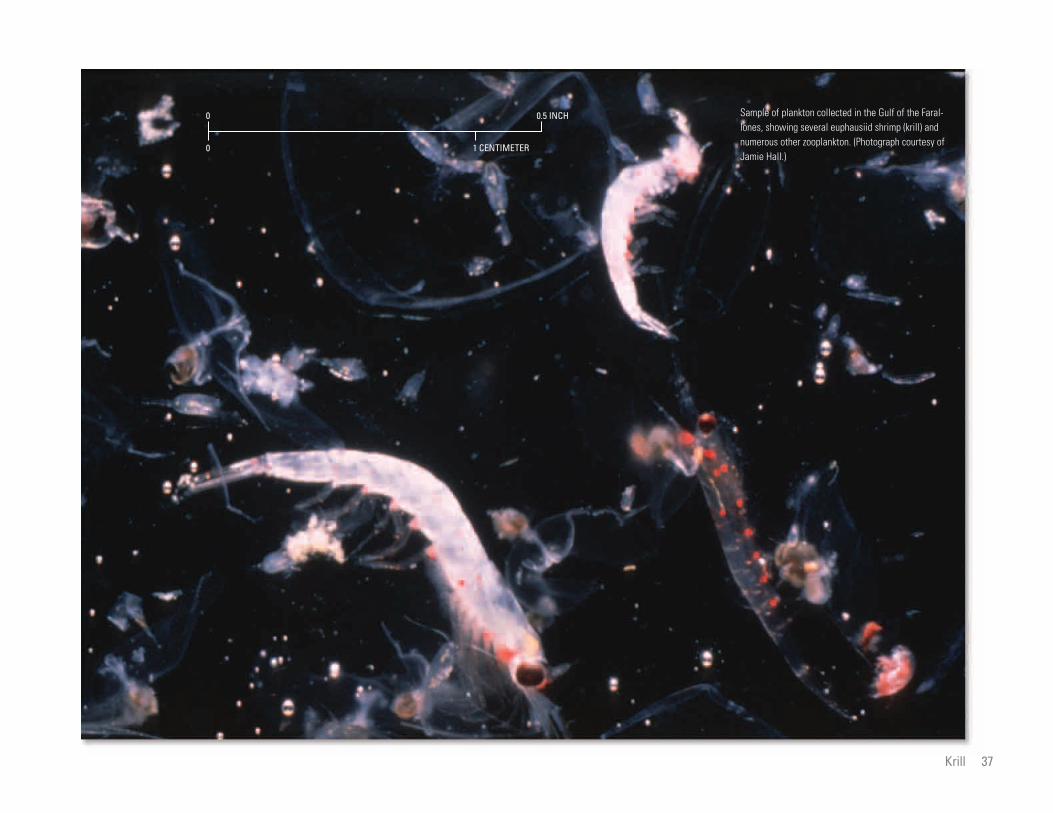
1 CENTIMETER
0.5 INCH0
0
Sample of plankton collected in the Gulf of the Farallones, showing several euphausiid shrimp (krill) and numerous other zooplankton. (Photograph courtesy of Jamie Hall.)
Krill 37
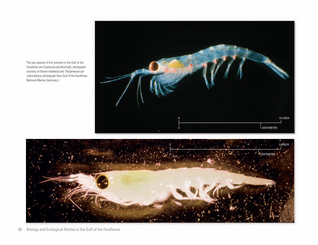
The two species of krill common in the Gulf of the Farallones are Euphausia pacifica (right, photograph courtesy of Steven Haddock) and Thysanoessa spinifera (below, photograph from Gulf of the Farallones National Marine Sanctuary.)
1 CENTIMETER
0.5 INCH0
0
1 CENTIMETER
0.5 INCH0
0
38 Biology and Ecological Niches in the Gulf of the Farallones

Lunging humpback whales feeding on surface swarms of krill are a common sight in the Gulf of the Farallones in the summer. (Photograph courtesy of Thomas R. Kieckhefer, Pacific Cetacean Group.)
Seabirds feeding on swarming krill in the Gulf of the Farallones. (Photograph from Gulf of the Farallones National Marine Sanctuary.)
Krill 39

nd Rockfishes
th, and some settle out of
n and onto the sea floor for
ge.
and 1995, an upwelling jet
Reyes and an upwelling
nd (south) of the point were
larval retention/accumulation south of Point
Reyes. Nearly twice as many crab larvae
settle at Point Reyes and to the south, where
warmer gulf water is constantly present, than
to the north, where settlement occurs only
when the northerly winds that cause upwell
40
Biology and Ecological Niches in the Gulf of the Farallones
Free-Floating Larvae of Crabs, Sea Urchins, aStephen R. Wing
Free-floating larvae of bottom-dwelling
marine organisms play an important role in
the ecology of the Gulf of the Farallones and
are a major food source for many species,
including salmon and seabirds. Free-floating
larvae are also the primary means by
In 1992, a study was begun to understand
how coastal oceanographic processes influ
ence the distribution of crab and sea-urchin
larvae around Bodega Head, a coastal head-
land at the northern margin of the gulf. This
required the cooperative efforts of many
ported to the nor
the water colum
their next life sta
In both 1994
seaward of Point
shadow downwi
currents, temperature, and
rface waters. Information
the boundaries between four
sses: (1) newly upwelled
c water from offshore, (3)
ay outflow, and (4) a mix
er types that was called
different water masses con
ypes of larvae. In general,
al development for crabs of
ould be found within, but
ulf water. This water mass
ind shadow south of Point
ing subside and relaxation currents move
northward. Sea urchin larvae also settle
during specific oceanic conditions, but less
predictably than crabs.
Consistent larval dispersal from any sub-
population of adult animals may be limited
to the length of an embayment. For example,
two such embayments on the northern Cali
fornia coast are from Point Reyes to Point
Arena and from Point Arena to Cape Men
docino. Because strong seaward currents
form at each end of these embayments
during upwelling, larvae caught in these cur-
which several important species are dis
persed along the northern California coast.
Most commercially harvested invertebrates
(for example, sea urchins and crabs) and
some fish populations are made up of a net-
work of adult subpopulations spread along
the coastline, connected almost solely by
larval dispersal.
In the Gulf of the Farallones many com
mercially important coastal species, such
as Dungeness crab (Cancer magister), red
sea urchin (Strongylocentrotus francisca
nus), and rockfish (Sebastes spp.), have
organizations, including Gulf of the Faral
lones and Cordell Bank National Marine
Sanctuaries, U.S. National Marine Fisheries
Service, Scripps Institution of Oceanogra
phy, Point Reyes Bird Observatory, Oregon
State University, California Department of
Fish and Game, and Pacific Fisheries Envi
ronmental Group.
Sampling extended over several years
and was done both from aboard ships and
at shore stations. Results indicate that during
periods of upwelling, larvae accumulate in
the warm water that collects between the
evident from the
salinity of the su
was collected at
distinct water ma
water, (2) oceani
San Francisco B
ture of these wat
“gulf water.” The
tained different t
all stages of larv
several species c
not outside, the g
is found in the w
t, rockfish larvae were
ncentrations offshore in oce
the boundary between
water and gulf water. The
lones provides a pathway
inct masses of water con
and rockfish larvae are
ported to suitable juvenile
e gulf and to the north.
ent becomes more epi
quent with increasing
ment away from the area of
rents would be swept out to sea and have no
chance of developing and becoming a part of
the adult population.
The data collected in this study on the
distribution of free-floating larvae in the
Gulf of the Farallones provide critical infor
mation on the lifecycles of commercially
important bottom-dwelling species. Because
these larvae are a food source for many
marine species, this information is crucial to
the effective management and conservation
of coastal marine ecosystems in the gulf.
swimming larval forms that drift as plank-
ton during the spring. These larvae are
subject to the strong offshore and south-
ward flow present in the California Current
system during the spring upwelling season
(see chapter on Current Patterns Over the
Continental Shelf and Slope). Understand
ing how larvae of these species maintain
themselves at latitude and are transported
inshore into suitable juvenile habitat is
important in ensuring the long-term viabil
ity of these fisheries.
Farallon Islands and Point Reyes in the
northern gulf. Larval accumulation was also
observed in the upwelling shadows, or
eddies, that form behind other capes and
headlands when the wind is blowing from
the north and surface water is moving in
a southerly offshore direction. When the
northerly winds that cause upwelling relax,
this larvae-rich water moves north in buoy
ancy-driven currents that remain coastally
trapped. During this time many larvae that
have been retained in the gulf are trans-
Reyes. In contras
found in high co
anic water and at
newly upwelled
Gulf of the Faral
along which dist
taining both crab
likely to be trans
habitats within th
Larval settlem
sodic and less fre
northward move
Biology and Ecological Niches in the Gulf of the Farallones

1 CENTIMETER
0.5 INCH0
0
Larval crab from the Gulf of the Farallones, greatly magnified.
Sample of plankton collected in the Gulf of the Farallones, showing a larval rockfish, euphausiid shrimp (krill), and other zooplankton. (Photograph from Gulf of the Farallones National Marine Sanctuary.)
Red sea urchins, harvested for sushi, are one of many commercially important coastal species in the Gulf of the Farallones with swimming larval forms that drift as plankton during the spring. (Photograph from Gulf of the Farallones National Marine Sanctuary.)
Free-Floating Larvae of Crabs, Sea Urchins, and Rockfishes 41

of Crabs, Sea Urchins,
. These larvae are the last
ating or swimming) stage
sink to the bottom and
ult shape. More than 7,000
Gate until October, but in lower and lower
concentrations as they move up the Sacra
mento River system to spawn. The follow
ing February, the next year’s 3-year-old
chinook salmon begin to enter into the
42
Biology and Ecological Niches in the Gulf of the Farallones
Salmon Peter Adams
Two species of salmon—chinook salmon
(Oncorhynchus tshawytscha) and coho
salmon (O. kisutch)—are commonly found
in the Gulf of the Farallones. Chinook
salmon fishing is the activity that brings the
nas Point in the north to Point San Pedro
in the south. While in this area they
feed almost equally on Pacific herring and
anchovies. The herring have just migrated
back to their feeding grounds outside
Floating Larvae
and Rockfishes)
pelagic (free-flo
before the crabs
take on their ad
most people out on the waters of the gulf. of the Golden Gate from San Francisco Dungeness megalopa have been found in a
salmon stomach.
June, chinook start feeding
enile rockfish offshore near
nds. These rockfish are
e fish that as adults will
m habitats. In years when
h are abundant, they are
ey and dominate the chi-
g these months, whereas
ce years, chinook salmon
krill.
etween mid-June and mid-
k salmon abruptly move
gulf, and the cycle begins again.
During strong El Niño years, the
normal sequences of chinook salmon prey
do not develop because the large increase
in ocean temperature disrupts the prey’s
normal behavior. As a result, the aggrega
tions of salmon that feed on these prey
do not form, and chinook salmon of a
given length weigh much less than normal.
California’s commercial salmon catch also
drops severely, and the recreational catch
is far below average.
In 1995, the chinook fishery in the gulf was
valued at more than $24 million.
Chinook (or king) salmon are key pred
ators in the gulf, and their distribution and
occurrence are related to their seasonal
diet cycle. Most chinook salmon found in
the gulf are 3-year-old fish returning from
the open ocean that are preparing to enter
the Sacramento River system, where they
will spawn and then die. After the eggs
hatch the following spring, the juvenile
salmon will grow for 7 months in freshwa
ter. They then migrate to the ocean, where
Bay, where they spawned from November
through February, and anchovies are gath
ering in nearshore waters before moving
into the bay beginning in April.
In April, chinook salmon are found
from north of the Golden Gate to Point
Reyes and offshore to the Farallon Islands.
There they feed on invertebrates, largely
the euphausiid shrimp (krill) Thysanoessa
spinifera. Krill are taken as prey from
surface and subsurface swarms that occur
over a wide area of the gulf during April
and May. The pink to orange color of
single chinook-
In May and
on krill and juv
the Farallon Isla
late pelagic-stag
migrate to botto
juvenile rockfis
the preferred pr
nook diet durin
in low-abundan
feed mainly on
Sometime b
July, the chinoo
arallon Islands to directly
olden Gate, the so-called
s.” Here, chinook salmon
on anchovies, which had
Francisco Bay in May
in spawning in the warmer
e, when the water in the
ecause of the absence of
ater, anchovies move out
nto the gulf where they
ing into October. Chinook
in front of the Golden
they will live for 2 years before returning
to the gulf. Coho (or silver) salmon along
the California coast are listed as a threat
ened species under the Endangered Spe
cies Act, and their capture has been pro
hibited since 1993. Native-run (versus
hatchery) chinook salmon are also a candi
date for a threatened-species listing.
Chinook salmon returning from the
open ocean move into the Gulf of the Far
allones in February and March, when they
are found off the Golden Gate from Boli
salmon flesh during this period is due to
a carotenoid pigment in the exoskeleton of
the krill (for more information, see chapter
on Krill). This flesh color has become so
popular that now there are fisheries for
krill, which are freeze-dried and fed to
pen-reared salmon as a finishing product
to produce this color.
For a brief 2- or 3-week period in
April, the chinook’s diet is dominated by
the megalopa larvae of the Dungeness crab
(Cancer magister) (see chapter on Free-
from near the F
in front of the G
“middle ground
feed exclusively
moved into San
and June to beg
water. After Jun
gulf warms up b
cold upwelled w
of the bay and i
continue spawn
Salmon remain
Biology and Ecological Niches in the Gulf of
the Farallones
38°00'N
0 10 KILOMETERS
0 10 MILES
SAN FRANCISCO
Bolinas
Point San Pedro
Point Reyes
San Pablo Bay
Farallon Islands
SA
N
FR
AN
CI S
CO
BA
Y
123°00'W 122°30'
Anchovies
Anchovies
Pacific herringCrab larvae
Juvenile rockfish
Krill
Krill
March
February
Migrating chinook salmon
May and June
July through October
ToSacramento River
April
As shown in this simplified diagram, 3-year-old chinook salmon returning from the open ocean move into the Gulf of the Farallones in February and March and feed on Pacific herring and anchovies off the Golden Gate from Bolinas Point in the north to Point San Pedro in the south. In April, they feed on invertebrates, largely the euphausiid shrimp (krill) Thysanoessa spinifera. For a brief 2- or 3-week period in April, the chinook salmon’s diet is dominated by larvae of the Dungeness crab (Cancer magister). In May and June, chinook salmon start feeding on krill and juvenile rockfish near the Farallon Islands. Sometime between mid-June and mid-July, chinook salmon abruptly move from near the Farallon Islands to directly in front of the Golden Gate, the so-called “middle grounds.” Here, chinook salmon feed exclusively on anchovies. Chinook salmon remain in front of the Golden Gate until October, but in lower and lower concentrations as they move up the Sacramento River system to spawn. The following February, the next year’s 3-year-old chinook salmon begin to enter into the gulf, and the cycle begins again.
37°30'
Chinook salmon fishing is the activity that brings the A chinook salmon (Oncorhynchus tshawytcha). Most chinook salmon found in the Gulf of the Farallones are 3-year-old fish that are returning most people out on the waters of the Gulf of the from the open ocean and preparing to enter the Sacramento River system, where they will spawn and then die. (Photograph from U.S. Food Farallones. This large salmon was caught in the gulf. and Drug Administration.) (Photograph from National Marine Fisheries Service.)
Salmon 43
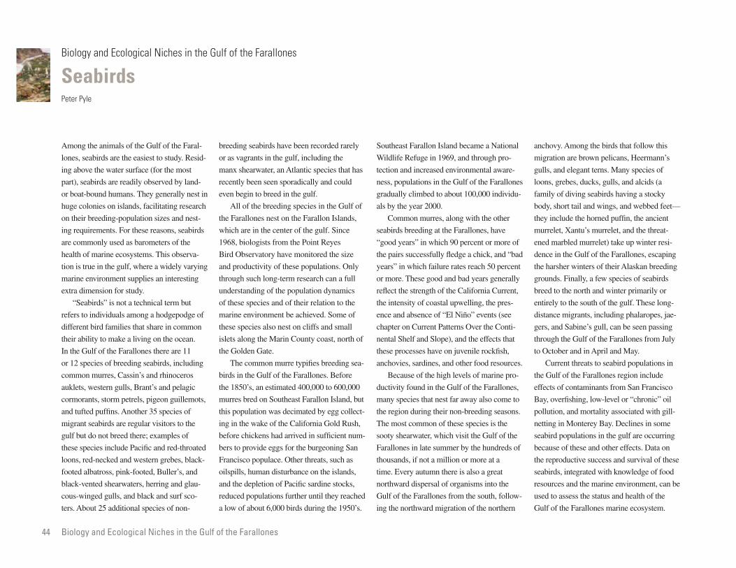
n Island became a National
in 1969, and through pro
ased environmental aware
in the Gulf of the Farallones
d to about 100,000 individu
anchovy. Among the birds that follow this
migration are brown pelicans, Heermann’s
gulls, and elegant terns. Many species of
loons, grebes, ducks, gulls, and alcids (a
family of diving seabirds having a stocky
44
Biology and Ecological Niches in the Gulf of the Farallones
Seabirds Peter Pyle
Among the animals of the Gulf of the Faral
lones, seabirds are the easiest to study. Resid
ing above the water surface (for the most
part), seabirds are readily observed by land-
or boat-bound humans. They generally nest in
breeding seabirds have been recorded rarely
or as vagrants in the gulf, including the
manx shearwater, an Atlantic species that has
recently been seen sporadically and could
even begin to breed in the gulf.
Southeast Farallo
Wildlife Refuge
tection and incre
ness, populations
gradually climbe
huge colonies on islands, facilitating research All of the breeding species in the Gulf of als by the year 2000.
rres, along with the other
at the Farallones, have
hich 90 percent or more of
ully fledge a chick, and “bad
ailure rates reach 50 percent
ood and bad years generally
h of the California Current,
oastal upwelling, the pres
of “El Niño” events (see
nt Patterns Over the Conti
Slope), and the effects that
ave on juvenile rockfish,
es, and other food resources.
body, short tail and wings, and webbed feet—
they include the horned puffin, the ancient
murrelet, Xantu’s murrelet, and the threat
ened marbled murrelet) take up winter resi
dence in the Gulf of the Farallones, escaping
the harsher winters of their Alaskan breeding
grounds. Finally, a few species of seabirds
breed to the north and winter primarily or
entirely to the south of the gulf. These long-
distance migrants, including phalaropes, jae
gers, and Sabine’s gull, can be seen passing
through the Gulf of the Farallones from July
to October and in April and May.
Current threats to seabird populations in
on their breeding-population sizes and nest
ing requirements. For these reasons, seabirds
are commonly used as barometers of the
health of marine ecosystems. This observa
tion is true in the gulf, where a widely varying
marine environment supplies an interesting
extra dimension for study.
“Seabirds” is not a technical term but
refers to individuals among a hodgepodge of
different bird families that share in common
their ability to make a living on the ocean.
In the Gulf of the Farallones there are 11
or 12 species of breeding seabirds, including
the Farallones nest on the Farallon Islands,
which are in the center of the gulf. Since
1968, biologists from the Point Reyes
Bird Observatory have monitored the size
and productivity of these populations. Only
through such long-term research can a full
understanding of the population dynamics
of these species and of their relation to the
marine environment be achieved. Some of
these species also nest on cliffs and small
islets along the Marin County coast, north of
the Golden Gate.
The common murre typifies breeding sea-
Common mu
seabirds breeding
“good years” in w
the pairs successf
years” in which f
or more. These g
reflect the strengt
the intensity of c
ence and absence
chapter on Curre
nental Shelf and
these processes h
anchovies, sardin
e high levels of marine pro
the Gulf of the Farallones,
t nest far away also come to
their non-breeding seasons.
n of these species is the
, which visit the Gulf of the
summer by the hundreds of
a million or more at a
n there is also a great
sal of organisms into the
lones from the south, follow
migration of the northern
the Gulf of the Farallones region include
effects of contaminants from San Francisco
Bay, overfishing, low-level or “chronic” oil
pollution, and mortality associated with gill-
netting in Monterey Bay. Declines in some
seabird populations in the gulf are occurring
because of these and other effects. Data on
the reproductive success and survival of these
seabirds, integrated with knowledge of food
resources and the marine environment, can be
used to assess the status and health of the
Gulf of the Farallones marine ecosystem.
common murres, Cassin’s and rhinoceros
auklets, western gulls, Brant’s and pelagic
cormorants, storm petrels, pigeon guillemots,
and tufted puffins. Another 35 species of
migrant seabirds are regular visitors to the
gulf but do not breed there; examples of
these species include Pacific and red-throated
loons, red-necked and western grebes, black-
footed albatross, pink-footed, Buller’s, and
black-vented shearwaters, herring and glau
cous-winged gulls, and black and surf sco
ters. About 25 additional species of non-
birds in the Gulf of the Farallones. Before
the 1850’s, an estimated 400,000 to 600,000
murres bred on Southeast Farallon Island, but
this population was decimated by egg collect
ing in the wake of the California Gold Rush,
before chickens had arrived in sufficient num
bers to provide eggs for the burgeoning San
Francisco populace. Other threats, such as
oilspills, human disturbance on the islands,
and the depletion of Pacific sardine stocks,
reduced populations further until they reached
a low of about 6,000 birds during the 1950’s.
Because of th
ductivity found in
many species tha
the region during
The most commo
sooty shearwater
Farallones in late
thousands, if not
time. Every autum
northward disper
Gulf of the Faral
ing the northward
Biology and Ecological Niches in the Gulf of the Farallones

The common murre typifies breeding seabirds in the Gulf of the Farallones. Before the 1850’s, an estimated 400,000 to 600,000 murres bred on Southeast Farallon Island, but this population was decimated by egg collecting in the wake of the California Gold Rush (see inset, courtesy of the California State Library), before chickens had been brought in sufficient numbers to provide fresh eggs for the burgeoning San Francisco populace.
Seabirds 45

A tufted puffin eating a small fish. Only 50 or 60 of these birds breed on the Farallon Islands each year, in deep rocky crevices within the cliffs. Where these striking birds go in the winter is unknown, evidently somewhere far out at sea. Populations of tufted puffins numbered in the thousands during the 1800’s; recent declines are attributed to a degradation in the marine environment and, possibly, to the disappearance of Pacific sardines in the 1940’s. (Photograph from Gulf of the Farallones National Marine Sanctuary.)
A South Polar skua, the avian “king of the sea” with a 4-foot wingspan, in search of victims in the Gulf of the Farallones. Breeding deep in the Southern Hemisphere, skuas disperse over the oceans during the nonbreeding seasons (summer and fall in the Northern Hemisphere), as far north as the Gulf of Alaska. Skuas are piratic and forcibly extract food from their victims—shearwaters, petrels, gulls, and even albatrosses. They are solitary marauders, nowhere common, but in the gulf they are always a menace to visiting seabirds.
46 Biology and Ecological Niches in the Gulf of the Farallones

Western gulls (chick shown below) nesting on South-east Farallon Island. Populations of western gulls in the Gulf of the Farallones since 1950 have benefited from feeding at land-based dumpsites and fish-processing plants, expanding from about 6,000 breeding birds historically to more than 25,000 birds during the early 1990’s. (Photographs from Gulf of the Farallones National Marine Sanctuary.)
Seabirds 47
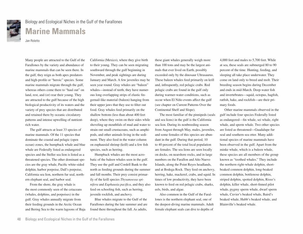
les generally weigh more
d may be the largest ani
ved on Earth, possibly
y the dinosaur Ultrasaurus.
hales feed primarily on krill
y, red pelagic crabs. Red
4,000 feet and males to 5,700 feet. While
at sea, these seals are submerged 80 to 90
percent of the time. Hunting, feeding, and
sleeping all take place underwater. They
come on land only to breed and molt. Their
breeding season begins during December
48
Biology and Ecological Niches in the Gulf of the Farallones
Marine Mammals Jan Roletto
Many people are attracted to the Gulf of the
Farallones by the variety and abundance of
marine mammals that can be seen there. In
the gulf, they reign as both apex predators
and high-profile or “heroic” species. Some
marine mammals migrate through the gulf,
California (Mexico), where they give birth
to their young. They can be seen migrating
southward through the gulf beginning in
November, and peak sightings are during
January and March. A few juveniles may be
seen year round. Gray whales are “baleen”
these giant wha
than 100 tons an
mals that ever li
exceeded only b
These baleen w
and, infrequentl
found in the gulf only
ater conditions, such as
iño events affect the gulf
urrent Patterns Over the
lf and Slope).
iliar of the pinnipeds (seals
the gulf is the California
its nonbreeding season
ough May, males, juveniles,
es of this species are abun
During that period, 10
the total local population
and ends in mid-March. Deep-water fish
and invertebrates—squid, octopus, hagfish,
ratfish, hake, and rockfish—are their pri
mary foods.
Other marine mammals observed in the
gulf include four species Federally listed
as endangered—fin whale, sei whale, right
whale, and sperm whale. Two other species
are listed as threatened—Guadalupe fur
seal and southern sea otter. Many addi
tional species of marine mammals have
been observed in the gulf. Apart from the
whereas others come there to “haul out” on
land, rest, and (or) rear their young. They
are attracted to the gulf because of the high
biological productivity of its waters and the
variety of prey species that are distributed
and retained there by oceanic circulatory
patterns and intense upwelling of nutrient-
rich water.
The gulf attracts at least 33 species of
marine mammals. Of the 11 species that
dominate the coastal and pelagic (open
ocean) zones, the humpback whale and blue
whales—instead of teeth, they have numer
ous long overlapping strips of elastic fin
gernail-like material (baleen) hanging from
their upper jaws that they use to filter out
food. Gray whales feed primarily on the
shallow bottom (less than about 400 feet
deep), where they swim on their sides while
shoveling up mouthfuls of mud and water to
strain out small crustaceans, such as amphi
pods, and other animals living in the sedi
ment. They also feed in the water column
on euphausiid shrimp (krill) and a few fish
pelagic crabs are
during warmer-w
occur when El N
(see chapter on C
Continental She
The most fam
and sea lions) in
sea lion. During
from August thr
and some femal
dant in the gulf.
to 40 percent of
whale are Federally listed as endangered species, such as herring. are females. The sea lions are seen locally
rshore rocks, and in large
Farallon and Año Nuevo
e Point Reyes headlands,
ock. They feed on anchovy,
ackerel, crabs, and squid. In
ductivity, they have been
n red pelagic crabs, sharks,
lgae.
n in the Gulf of the Faral
hern elephant seal, one of
ng marine mammals. Adult
seals can dive to depths of
minke whale, which is a baleen whale,
these species are all members of the group
known as “toothed whales.” They include
the northern right-whale dolphin, short-
beaked common dolphin, long-beaked
common dolphin, bottlenose dolphin,
striped dolphin, spotted dolphin, Risso’s
dolphin, killer whale, short-finned pilot
whale, pygmy sperm whale, dwarf sperm
whale, Cuvier’s beaked whale, Baird’s
beaked whale, Hubb’s beaked whale, and
Blainville’s beaked whale.
species and the Steller sea lion is listed as a
threatened species. The other dominant spe
cies are the gray whale, Pacific white-sided
dolphin, harbor porpoise, Dall’s porpoise,
California sea lion, northern fur seal, north-
ern elephant seal, and harbor seal.
From the shore, the gray whale is
the most commonly seen of the cetaceans
(whales, dolphins, and porpoises) in the
gulf. Gray whales annually migrate from
their feeding grounds in the Arctic Ocean
and Bering Sea to the warm lagoons of Baja
Humpback whales are the most acro
batic of the baleen whales seen in the gulf.
They use the gulf and Cordell Bank to the
north as feeding grounds during the summer
and fall months. Their prey consist primar
ily of the krill species Thysanoessa spi
nifera and Euphausia pacifica, and they also
feed on schooling fish, such as herring,
juvenile rockfish, and anchovy.
Blue whales migrate to the Gulf of the
Farallones during the late summer and are
found there throughout the fall. As adults,
on docks, on nea
numbers on the
Islands, along th
and at Bodega R
herring, hake, m
times of low pro
known to feed o
eels, birds, and a
Also commo
lones is the nort
the deepest-divi
female elephant
B
iology and Ecological Niches in the Gulf of the Farallones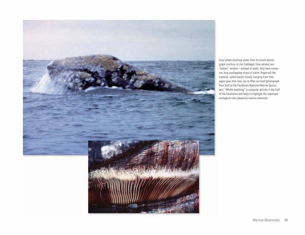
Gray whale straining water from its mouth (photo-graph courtesy of Jim Cubbage). Gray whales are “baleen” whales—instead of teeth, they have numerous long overlapping strips of elastic fingernail-like material, called baleen (inset), hanging from their upper jaws that they use to filter out food (photograph from Gulf of the Farallones National Marine Sanctuary). “Whale watching” is a popular activity in the Gulf of the Farallones and helps to highlight the important ecological roles played by marine mammals.
Marine Mammals 49

Pacific white-sided dolphin (above) and northern right-whale dolphin (below) swimming under-water. (Photograph courtesy of Ken Balcomb.)
Adult females and immature northern elephant seals at Southeast Farallon Island. Inset shows the characteristic nose of an adult male. (Photographs from Gulf of the Farallones National Marine Sanctuary.)
Humpback whale swimming underwater. (Photograph from Gulf of the Farallones National Marine Sanctuary.)
50 Biology and Ecological Niches in the Gulf of the Farallones

Harbor seals resting on shore. (Photograph from Gulf of the Farallones National Marine Sanctuary.)
Adult male and female Steller sea lions at a breeding colony. This species is Federally listed as threatened under the Endangered Species Act. (Photograph courtesy of Robert Wilson.)
Immature California sea lions at play in the surf. (Photograph by Jan Roletto, Gulf of the Farallones National Marine Sanctuary.)
Marine Mammals 51

iliar areas where they
been successful. The largest
e smallest home ranges and
k tracked covered the larg
The larger, older sharks
experienced and therefore
two white shark attacks on humans per year
and about one fatality per decade (chances
of drowning in the State’s coastal waters are
at least 100 times greater). In most of these
instances, the shark has bitten only once and
then released the person immediately. Those
52
Biology and Ecological Niches in the Gulf of the Farallones
White Sharks Scot Anderson
Each fall, white sharks (Carcharodon car
charias) are observed around the Farallon
Islands, preying on seals and sea lions (pin
nipeds) (see chapter on Marine Mammals).
The shark’s dark back and light underbelly
blend with the surrounding environment,
channels. The fall haul out of elephant seals
is commonly their first visit to the islands.
Many of these seals are from other colonies,
such as those at the Channel Islands or
Point Año Nuevo to the south, and they may
be unaware of white sharks patrolling the
by looking in fam
have previously
sharks covered th
the smallest shar
est home range.
seem to be more
arch.
und that white sharks in
arallones maintain a con
rature of nearly 80°F in the
) water of the gulf. This
ove quickly and to capture
arine mammals, such as
of the world’s predatory
rease their body tempera
bient water temperature,
e is limited to warmer trop
d large swells affect the
bitten usually survive if they can make it
to shore, so swimming alone is not advised.
Some evidence suggests that white sharks do
not like the “taste” of people but sometimes
mistake them for there favorite prey, pin
nipeds. Therefore, it is not advisable to swim
or surf near colonies of pinnipeds, where
white sharks may be actively feeding. Areas
where there has been a history of shark
attacks should also be avoided. For these
reasons, sport divers avoid the waters around
the Farallon Islands.
The population of white sharks off Cal
hiding the shark from unsuspecting pinni
peds. White sharks spend a great deal of
time searching for food; it may be weeks or
a month between feeding opportunities.
The peak in predation, in the fall months,
is related to the number of young (1- and
2-year-old) northern elephant seals arriving
at the islands at this time. These immature
seals are the preferred prey of the white
shark at the Farallon Islands. Observations
there indicate that the white sharks eat
young elephant seals seven times more fre
quently than they eat other pinnipeds, such
waters around the Farallon Islands.
Studies of white sharks in the Gulf of
the Farallones begun in 1987 have revealed
the remarkable way in which these predators
are able to locate and catch pinnipeds.
Using photographs of dorsal and tail fins,
and underwater videotapes of entire sharks,
it has been possible to identify individual
white sharks and follow their movements
in the gulf over many years. Several of the
larger sharks have been seen in the same
areas for more than 5 years. When individual
sharks are identified, they are always seen in
know where to se
Monitoring fo
the Gulf of the F
stant body tempe
cold (54 to 57°F
allows them to m
warm-blooded m
pinnipeds. Most
sharks cannot inc
ture above the am
and so their rang
ical waters.
High tides an
rk predation on pinnipeds
und the Farallon Islands.
force many of the seals
ir haul-out space. This
y explain why significantly
elephant seals—sometimes
ne day—are observed when
ombined with high tides.
hite shark’s fearsome rep
wood image, attacks on
ively rare. In northern and
, there is on average one or
ifornia’s coast is probably small, having
perhaps a few hundred to a few thousand
adults. White sharks are important predators
in the State’s marine ecosystems. In 1994,
with the support of scientists, fishermen,
surfers, divers, and others, the State of Cali
fornia placed the white shark on the list of
species protected in its waters.
as California sea lions and harbor seals.
Immature elephant seals arrive at the Far
allon Islands to come ashore beginning in
September and continuing through Novem
ber. The small pocket beaches and surge
channels around the islands offer undis
turbed “haul out” sites and resting areas.
Unlike California sea lions, which are the
most numerous pinnipeds on the islands,
elephant seals cannot climb high up on the
islands’ rocky shores. Therefore, they are
restricted to the pocket beaches and surge
the same area. However, some of the sharks
are regular visitors, whereas others are only
intermittently seen in the gulf.
By 1995, monitoring of individual white
sharks around the Farallon Islands, using
small transmitters swallowed by the animals,
had documented their movement patterns
and internal temperatures. The movement
patterns indicate that each shark has an area
that it covers by zigzagging back and forth.
These sharks are not swimming aimlessly;
they increase their odds of finding pinnipeds
rate of white sha
in the waters aro
Such conditions
to move from the
displacement ma
more attacks on
two or three in o
large swells are c
Despite the w
utation and Holly
humans are relat
central California
Biology an
d Ecological Niches in the Gulf of the Farallones
White sharks do not swim aimlessly; they increase their odds of finding seals by looking in familiar areas where they have previously been successful. The map shows the movements of a white shark tracked during October 21–29, 1993, around Southeast Farallon Island, using a transmitter swallowed by the animal.
The white shark is a fearsome predator, well adapted to live in cold water, where food is more abundant. It is far from a “primitive” cold-blooded fish but is actually a highly evolved warm-blooded animal.
Fisherman's Bay
Mirounga Bay
Maintop Bay
MOVEMENTS OF A WHITE SHARK OVER 9 DAYS
Southeast Farallon Island
0
0 200 FEET
100 200 METERS
White Sharks 53

The white shark searches for food visually, staying near the sea bottom in water less than 90 feet deep (top) and paralleling the ocean’s surface in deeper water (bottom). In both situations, the shark’s dark back and light under-belly blend with the surrounding environment, hiding the shark from seals and sea lions, its usual prey.
10:36 00
30
60
90
120
0
30
60
90
120
150
10
20
30
40
0
10
20
30
40
50
10:51 11:06 11:21 a.m.
11:57 � � � � � � � � � � � � � � � � � � � � � � � � � � � � 12:12 � � � � � � � � � � � � � � � � � � � � � � � � � � � �� � � � � �12:27� � � � � � � � � � � � � � � � � � � � �� � � � � � � 12:42 p.m.
Dept
h, in
met
ers
Dept
h, in
met
ers
Dept
h, in
feet
De
pth,
in fe
et
Time
Time
SHALLOWER WATER
DEEPER WATER
WHITE SHARKS SEARCH FOR FOOD VISUALLY
54 Biology and Ecological Niches in the Gulf of the Farallones

Gulls hover over a predatory attack by a white shark on a northern elephant seal. Southeast Farallon Island is in the background.
Attack by white sharks is violent and quick; the sharks can strike quickly because they are warm blooded.
White Sharks 55

ny larger, older fish caught
ters are limp and soft when
urface.
at different depths on the
pe have different life his
One major fishery of note is for hagfish,
the skin of which is used to make what are
sold as “eel skin” wallets. Hagfish are not
true eels but are a primitive group of fish that
have no bones or jaws. Instead of bones, they
56
Biology and Ecological Niches in the Gulf of the Farallones
Continental Slope CommunitiesTom Laidig
In the shallow coastal areas of the Gulf of
the Farallones, as in other regions of the
world, fishing pressure has increased and
numbers of fish have decreased over the
past few decades. As many fish stocks have
waters—some deep-sea rockfish live more
than 70 years.
Many of the animals living in the perpet
ual darkness of the Continental Slope have
developed light-producing organs. These
their tissues, ma
from deeper wa
brought to the s
Fishes living
Continental Slo
declined, some fishermen have been forced serve various functions, such as communi tories. Species living near the top of the
elagic (open-ocean) young
rst few months to years of
n the upper water column
ut in relatively shallow
te downslope as they grow
er sole, sablefish, and rock-
e of life history; however,
ing deeper, such as rattails,
nd slickheads, have young
ame depths as the adults.
w species occur at all or
he Continental Slope. Spe
ne depth commonly are
have cartilage, and instead of jaws, they have
a large sucker-like mouth similar to that of
a lamprey or a leech. Once attached, hagfish
use a tongue with many tiny teeth to dig into
their prey. Once inside, the prey is eaten from
the inside out. Besides its unique method
of eating, the hagfish has another interesting
trait—it produces copious amounts of slime,
probably used to discourage predators, which
gives the fish its nickname, the “slime eel.”
Except for fishing activities, the Con
tinental Slope and its communities of
fish and invertebrates are still virtually
untouched by humans, offering scientists
to look elsewhere to fill their nets.
Traditional fishing grounds in the gulf
have been located on the Continental Shelf,
a rather flat, relatively shallow area of the
sea floor adjacent to the coast. At a depth
of about 600 feet, the bottom starts to drop
off more rapidly on what is called the Con
tinental Slope. It is on upper and middle
parts of this steeper slope that the new fish
ing grounds have been established. Because
the fish inhabiting these deeper waters are
less understood than those in shallower
water, there is a danger of overharvesting,
cating with members of their own kind (as
in courtship), attracting food (like attracting
moths to a flame), and avoiding being eaten
(flashing a light in a predator’s eyes can
give an animal a chance to get away).
Another adaptation to the darkness is
an absence of color diversity. With no
light, colors have little function. Therefore,
animals living on the Continental Slope
are generally a dark color, like black,
brown, or red. Among the fishes, rockfish
and thornyheads are dominantly red. Red
objects appear black at depth, allowing red
slope produce p
that spend the fi
life swimming i
and then settle o
water and migra
and mature. Dov
fish have this typ
most species liv
deep-sea soles, a
that live in the s
Relatively fe
most depths on t
cies occupying o
lar species at other depths.
the eel-like hagfish, which
pths on the slope.
mmercial fisheries operat
Continental Slope off
t catch Dover sole, sable-
rockfishes, and thorny-
these fishes occupy similar
erally are caught together.
active fishery is for rat-
g fish with a large head
at tapers to a point.
the opportunity to study a generally undis
turbed natural system. New methods, such
as viewing animals and their habitat by
underwater video cameras in submarines
and in remotely operated vehicles, have
been particularly productive in providing a
new understanding of fish and invertebrates
living on the slope. In the Gulf of the Faral
lones, scientists are using these methods to
collect data at increasingly greater depths,
providing critical information needed to
better protect these areas from overuse.
which could threaten the long-term viabil
ity of these newer fisheries.
The deep waters of the Continental
Slope are characterized by nearly freezing
temperatures, extremely low light condi
tions, and very high pressures. Because
of the cold, organisms that live at these
depths have slower metabolisms—they eat
less frequently, are slower in digesting
their food, and move and grow more
slowly. They also attain greater ages than
their counterparts that live in shallower
organisms to blend in with their dark sur
roundings.
The water pressure on the sea floor at the
top of the Continental Slope is more than
10 times higher than at the surface, and at
the bottom of the slope the pressure can
be more than 100 times higher than at the
surface. To compensate for this high pres
sure, organisms have a large percentage of
water in their tissues, bones, and shells that
replaces other substances, such as gases and
calcium. Owing to the high water content of
replaced by simi
An exception is
is found at all de
Productive co
ing today on the
California’s coas
fish, deep-living
heads. Many of
habitats and gen
One increasingly
tails, a deep-livin
and a long tail th
Biology and Ecological Niches in the Gulf of the Farallones

Northern lampfish with light organs (small white circles) along its underside. This small fish, only about 2.5 inches long, also displays the dark coloration typical of many animals on deeper parts of the Continental Slope. (Photograph courtesy of K. Sakuma and D. Roberts.)
Because of the absence of light on the Continental Slope, animals living there are generally either a dark color, such as the sablefish (left), or red, such as the shortspine thornyhead (right).
Continental Slope Communities 57

Juvenile rockfish swimming over Cordell Bank in the northern Gulf of the Farallones. Species of fish living near the top of the Continental Slope in the gulf produce pelagic (open-ocean) young that spend the first few months to years of life swimming in the upper water column and then settle out in relatively shallow water and migrate downslope as they grow and mature. (Photograph courtesy of Robert Schmieder, Cordell Expeditions.)
A red-banded rockfish on the Continental Slope in the Gulf of the Farallones. Relatively few species of fish occur at all or most depths on the slope. Those occupying one depth commonly are replaced by similar species at other depths. For example, greenstriped and stripetail rockfishes live on muddy bottoms on the upper part of the slope, whereas at greater depth they are replaced by species of thornyheads.
58 Biology and Ecological Niches in the Gulf of the Farallones

Thornyheads, giant brittle stars, and other animals on the deeper Continental Slope in the Gulf of the Farallones. (Photograph from Gulf of the Farallones National Marine Sanctuary.)
Continental Slope Communities 59
Since the mid-1800’s, when the California Gold Rush first brought frantic development
to the San Francisco Bay region, the waters of the bay and of the Gulf of the Farallones,
beyond the Golden Gate, have been used to dispose of manmade waste. Perhaps of
greatest concern are thousands of barrels of low-level radioactive waste dumped in the
gulf during several decades following the Second World War. To evaluate the hazard
from radioactivity to the marine environment, including increasingly important fisheries,
scientists have begun the search for containers of radioactive waste on the sea floor
of the gulf.
Another issue is the need to find suitable places in the gulf to dump material dredged
from shipping channels in San Francisco Bay. Studies of the sea floor in the gulf have
already enabled the Environmental Protection Agency to designate the Nation’s first
deep-ocean disposal site for dredge spoils.


the Continental Shelf and Slope
ban on the dumping of radio-
e oceans took effect in 1983.
ental Protection Agency
y responsible for desig
posal sites for the United
region. The primary task of the LTMS was
to develop a long-range plan for meeting the
bay region’s need to dispose of an estimated
300 million cubic yards of dredged material
over the next 50 years. The EPA, a leading
62
Issues of Environmental Management in the Gulf of the Farallones
Disposal of Dredged Material and Other Waste onJohn L. Chin and Allan Ota
The history of waste disposal in the Gulf
of the Farallones is directly linked with the
history of human settlement in the San Fran
cisco Bay region. The California Gold Rush
of 1849 triggered a massive influx of people
1969, the U.S. military disposed of chemical
and conventional munitions at several sites in
the gulf, mostly by scuttling World War II era
cargo vessels.
The hulks of ships, possibly dating as far th
waters. A global
active waste in th
The Environm
(EPA) is currentl
nating ocean dis
and rapid, chaotic development in the bay back as the 17 century, litter the sea floor in States. The U.S. Army Corps of Engineers
PA’s concurrence, issues
disposal of dredged mate-
sites. Only sediments eval
(non-toxic) by EPA stan
posed of in the marine
Bay’s 85 miles of navi
require annual maintenance
y’s average depth is about
nkers and container vessels
60 feet of water for safe
ental concerns and limited
Federal agency in this effort, had the respon
sibility for selecting a location for an ocean
disposal site for dredged material.
In 1990, the U.S. Geological Survey
(USGS) was asked by EPA, USACE, and
the Navy to investigate four study areas for
locating potential disposal sites for dredged
material in the Gulf of the Farallones. This
survey also tested the feasibility of using sid
escan sonar to locate the radioactive-waste
containers in the gulf (see chapter on Search
for Containers of Radioactive Waste on the
Sea Floor).
region. Vast quantities of contaminated sedi
ment and water from mining in the Sierra
Nevada were carried by rivers into San
Francisco Bay, and some was carried by
currents through the Golden Gate and into
the gulf. The burgeoning region’s inhabitants
also contributed to the waste that flowed or
was dumped into the bay. Eventually, waste
began to be dumped directly into the gulf.
Hundreds of millions of tons of waste has
been dumped into the Gulf of the Farallones.
Since the 1940’s, this has included sediment
the gulf. From 1951 to 1987, many vessels
were deliberately sunk there. Most of these
probably pose little environmental hazard
because they were carefully prepared before
sinking. One exception may be the highly
radioactive World War II aircraft carrier USS
Independence, exposed in atomic tests at
Bikini Atoll in 1946 and sunk by the U.S.
Navy in 1951 at an unspecified location off
the California coast, possibly in the gulf.
Since at least 1959, some sediment
dredged from San Francisco Bay and from
(USACE), with E
permits for ocean
rial at designated
uated as “clean”
dards may be dis
environment.
San Francisco
gable waterways
dredging. The ba
19 feet, but oil ta
need from 40 to
transit. Environm
(sand and mud) dredged from shipping chan the sandbar outside the entrance to the bay disposal capacity for dredged material in
e it necessary to find suit-
s in the ocean beyond the
ch for the management of
osal of dredged material
Bay was coordinated
effort begun in 1990 as
artnership of four agencies
y about 30 other public
izations. This effort was
e Long Term Management
for the San Francisco Bay
Each of the four study areas was evalu
ated by the USGS for the presence of deposi
tion and erosion, sediment transport path-
ways, and the likely effect deposited dredged
material might have on the stability of the sea
floor (see earlier chapters).
Using the results of the USGS studies,
EPA in 1994 designated the San Francisco
Deep-Ocean Disposal Site. This site is
55 miles beyond the Golden Gate and 5
miles outside of the Gulf of the Farallones
National Marine Sanctuary in 8,200 to 9,800
feet of water.
nels, waste from oil refineries and fruit can
neries, acids from steel production, surplus
munitions and ships from World War II, other
unwanted vessels, and barrels of low-level
radioactive waste.
Because of navigational errors and inad
equate record keeping, the location of most
waste dumped in the gulf is poorly known.
Between 1946 and 1970 approximately
47,800 containers of low-level radioactive
waste were dumped into the gulf south and
west of the Farallon Islands. From 1958 to
(the Golden Gate Bar) has been dumped onto
the Continental Shelf in the gulf. Much of
this material is from dredging to maintain
shipping channels into and within the bay,
but some is from other engineering projects.
Until 1970, ocean disposal of both radio-
active and nonradioactive waste was accept-
able under government policy. That year, the
United States terminated all ocean disposal
of radioactive waste materials. In 1972, Con
gress passed the Ocean Dumping Act, which
regulates the dumping of wastes into ocean
the bay have mad
able dumping site
Golden Gate.
A new approa
dredging and disp
for San Francisco
under a regional
a Federal-State p
and later joined b
and private organ
formally called th
Strategy (LTMS)
Issues of Environmental Management in the Gulf of the Farallones

123°30'W 123° 122°30'
38°N
Map of the Gulf of the Farallones, showing sites of historical waste disposal, as well as locations of U.S. Environmental Protection Agency (EPA) Study Areas (shaded) and Alternative Sites (dotted out-lines). Study Areas 2 through 5 and Alternative Sites 3 through 5 were investigated by the U.S. Geological Survey (USGS) for possible designation by the EPA as disposal sites for dredged material. After the USGS reconnaissance survey, Study Areas 3, 4, and 5 on the Continental Slope were retained, and Study Areas 1 and 2 on the Continental Shelf were eliminated from further consideration. In 1994, the EPA designated Alternative Site 5 as the San Francisco Deep-Ocean
37°30'
Study Area 2
Study Area 1
Pt. Reyes
Study Area 3
Study Area
4
Study Area 5
Alternative Site 5
Alternative Site 3
Alternative Site 4
San Francisco
Farallon Islands San
Francisco Bay
Half Moon Bay
50 m
50 m
200 m500 m
1500 m
2500 m
GUMDROP SEAMOUNT
CORDELL BANK
GUIDE SEAMOUNT
PIONEER CANYON
SS Puerto Rican
USS Independence?
6 +
5 + + 2
+ 7
+ 1
4 +
10 + 8 + +
11
+3A
12 13
9
+ 3B
0
0 0 KILOMETERS
20 NAUTICAL MILES
BATHYMETRIC (DEPTH) CONTOURS IN METERS (1 METER = 3.281 FEET)
2
Disposal Site.
SITES OF HISTORICAL WASTE DISPOSAL
1 - 5 + Dredged material 8 - 10 + Low-level radioactive waste
6 + Acid waste Farallon Islands Radioactive
7 + Cannery waste Waste Dump (FIRWD)
11 - 13 Explosives and munitions
Disposal of Dredged Material and other Waste on the Continental Shelf and Slope 63

Historically, much of the sediment dredged from the San Francisco Bay to maintain shipping channels has been disposed of in the bay itself, particularly in its deeper parts, such as near Alcatraz Island. These computer-generated oblique images of the bay floor south of Alcatraz Island show the effects of dumping millions of cubic yards of dredged material between 1894 and the mid-1980’s in the area outlined by the red circles. The images were created by the U.S. Geological Survey using historical bathymetric data and recent multibeam (acoustic) mapping. (Grid squares are 100 yards on a side, and submarine vertical exaggeration is x10.)
64 Issues of Environmental Management in the Gulf of the Farallones

The USS Independence during active service as a U.S. Navy aircraft carrier (left). The ship is shown below as it appeared after being exposed to atomic tests at Bikini Atoll in 1946. (U.S. Navy photographs.)
Detail of a U.S. Geological Survey sidescan-sonar mosaic from an area of the upper Continental Slope about 20 miles southwest of the Farallon Islands. On this image was discovered what is interpreted to be the USS Independence (CVL 22), a dangerously radioactive aircraft carrier scuttled in 1951. Also visible is the stern section of the SS Puerto Rican, an oil tanker that sank in 1984.
Disposal of Dredged Material and other Waste on the Continental Shelf and Slope 65
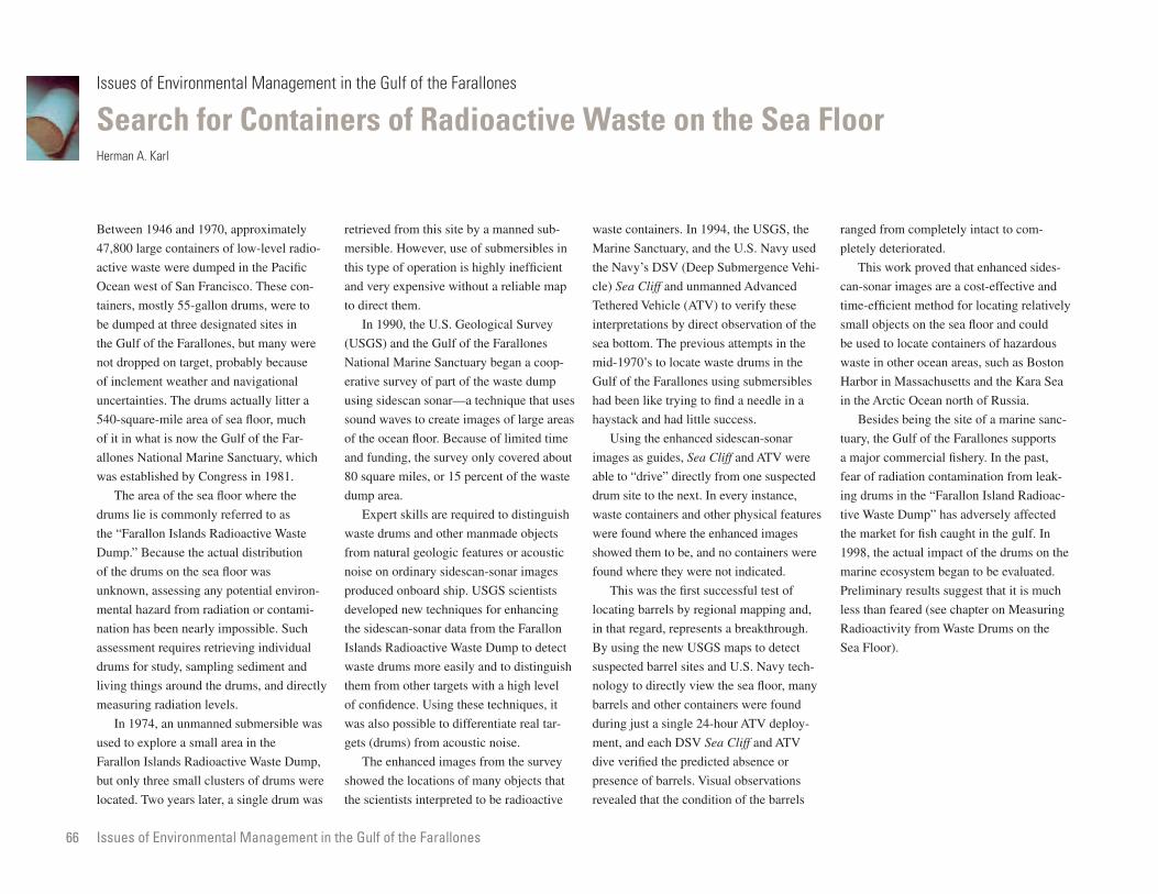
n the Sea Floor
s. In 1994, the USGS, the
ry, and the U.S. Navy used
(Deep Submergence Vehi
d unmanned Advanced
e (ATV) to verify these
y direct observation of the
ranged from completely intact to com
pletely deteriorated.
This work proved that enhanced sides-
can-sonar images are a cost-effective and
time-efficient method for locating relatively
small objects on the sea floor and could
66
Issues of Environmental Management in the Gulf of the Farallones
Search for Containers of Radioactive Waste oHerman A. Karl
Between 1946 and 1970, approximately
47,800 large containers of low-level radio-
active waste were dumped in the Pacific
Ocean west of San Francisco. These con
tainers, mostly 55-gallon drums, were to
be dumped at three designated sites in
retrieved from this site by a manned sub
mersible. However, use of submersibles in
this type of operation is highly inefficient
and very expensive without a reliable map
to direct them.
In 1990, the U.S. Geological Survey
waste container
Marine Sanctua
the Navy’s DSV
cle) Sea Cliff an
Tethered Vehicl
interpretations b
previous attempts in the
cate waste drums in the
llones using submersibles
ing to find a needle in a
d little success.
hanced sidescan-sonar
s, Sea Cliff and ATV were
irectly from one suspected
next. In every instance,
and other physical features
re the enhanced images
be, and no containers were
y were not indicated.
be used to locate containers of hazardous
waste in other ocean areas, such as Boston
Harbor in Massachusetts and the Kara Sea
in the Arctic Ocean north of Russia.
Besides being the site of a marine sanc
tuary, the Gulf of the Farallones supports
a major commercial fishery. In the past,
fear of radiation contamination from leak
ing drums in the “Farallon Island Radioac
tive Waste Dump” has adversely affected
the market for fish caught in the gulf. In
1998, the actual impact of the drums on the
marine ecosystem began to be evaluated.
the Gulf of the Farallones, but many were
not dropped on target, probably because
of inclement weather and navigational
uncertainties. The drums actually litter a
540-square-mile area of sea floor, much
of it in what is now the Gulf of the Far
allones National Marine Sanctuary, which
was established by Congress in 1981.
The area of the sea floor where the
drums lie is commonly referred to as
the “Farallon Islands Radioactive Waste
Dump.” Because the actual distribution
of the drums on the sea floor was
(USGS) and the Gulf of the Farallones
National Marine Sanctuary began a coop
erative survey of part of the waste dump
using sidescan sonar—a technique that uses
sound waves to create images of large areas
of the ocean floor. Because of limited time
and funding, the survey only covered about
80 square miles, or 15 percent of the waste
dump area.
Expert skills are required to distinguish
waste drums and other manmade objects
from natural geologic features or acoustic
noise on ordinary sidescan-sonar images
sea bottom. The
mid-1970’s to lo
Gulf of the Fara
had been like try
haystack and ha
Using the en
images as guide
able to “drive” d
drum site to the
waste containers
were found whe
showed them to
found where the
first successful test of
by regional mapping and,
presents a breakthrough.
USGS maps to detect
sites and U.S. Navy tech
ly view the sea floor, many
r containers were found
gle 24-hour ATV deploy
DSV Sea Cliff and ATV
predicted absence or
els. Visual observations
condition of the barrels
Preliminary results suggest that it is much
less than feared (see chapter on Measuring
Radioactivity from Waste Drums on the
Sea Floor).
unknown, assessing any potential environ
mental hazard from radiation or contami
nation has been nearly impossible. Such
assessment requires retrieving individual
drums for study, sampling sediment and
living things around the drums, and directly
measuring radiation levels.
In 1974, an unmanned submersible was
used to explore a small area in the
Farallon Islands Radioactive Waste Dump,
but only three small clusters of drums were
located. Two years later, a single drum was
produced onboard ship. USGS scientists
developed new techniques for enhancing
the sidescan-sonar data from the Farallon
Islands Radioactive Waste Dump to detect
waste drums more easily and to distinguish
them from other targets with a high level
of confidence. Using these techniques, it
was also possible to differentiate real tar-
gets (drums) from acoustic noise.
The enhanced images from the survey
showed the locations of many objects that
the scientists interpreted to be radioactive
This was the
locating barrels
in that regard, re
By using the new
suspected barrel
nology to direct
barrels and othe
during just a sin
ment, and each
dive verified the
presence of barr
revealed that the
Issues of Environmenta
l Management in the Gulf of the Farallones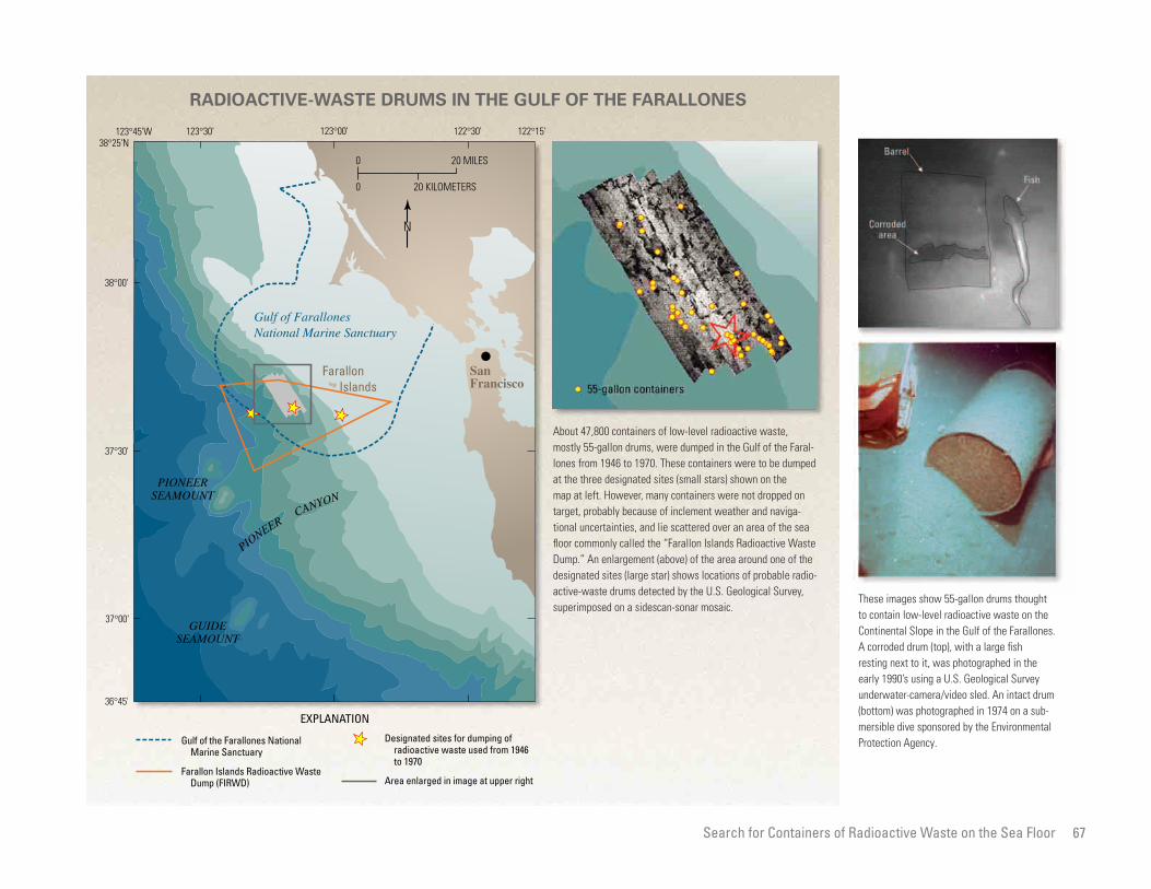
RADIOACTIVE-WASTE DRUMS IN THE GULF OF THE FARALLONES
•San Francisco
Gulf of Farallones National Marine Sanctuary
36°45'
37°00'
37°30'
38°00'
38°25'N 122°15'122°30'123°00'123°30'123°45'W
PIONEER SEAMOUNT
PIONEER
CANYON
Farallon Islands
GUIDE SEAMOUNT
20 KILOMETERS0
0 20 MILES
N
Gulf of the Farallones National Marine Sanctuary
Farallon Islands Radioactive Waste Dump (FIRWD)
EXPLANATION
Designated sites for dumping of radioactive waste used from 1946 to 1970
Area enlarged in image at upper right
About 47,800 containers of low-level radioactive waste, mostly 55-gallon drums, were dumped in the Gulf of the Farallones from 1946 to 1970. These containers were to be dumped at the three designated sites (small stars) shown on the map at left. However, many containers were not dropped on target, probably because of inclement weather and navigational uncertainties, and lie scattered over an area of the sea floor commonly called the “Farallon Islands Radioactive Waste Dump.” An enlargement (above) of the area around one of the designated sites (large star) shows locations of probable radio-active-waste drums detected by the U.S. Geological Survey, superimposed on a sidescan-sonar mosaic.
These images show 55-gallon drums thought to contain low-level radioactive waste on the Continental Slope in the Gulf of the Farallones. A corroded drum (top), with a large fish resting next to it, was photographed in the early 1990’s using a U.S. Geological Survey underwater-camera/video sled. An intact drum (bottom) was photographed in 1974 on a submersible dive sponsored by the Environmental Protection Agency.
Search for Containers of Radioactive Waste on the Sea Floor 67

n the Sea Floor
he gulf along several track-
e mostly at depths between
et, but some extended down
epth of about 4,900 feet.
oor sediment were col
is of the EEL results and
some of the very low levels of artificial radio-
nuclides detected in the area surveyed may
simply be from fallout from atmospheric
nuclear testing done during the Cold War.
It should be borne in mind that no data
have yet been obtained for large areas of the
68
Issues of Environmental Management in the Gulf of the Farallones
Measuring Radioactivity from Waste Drums oDavid G. Jones, Philip D. Roberts, and Johannes Limburg
South and west of the Farallon Islands, off-
shore from the Golden Gate and the San
Francisco Bay region, is an area of sea
floor commonly referred to as the “Farallon
Islands Radioactive Waste Dump.” This area
was where approximately 47,800 large con
to enhance the sonar images, USGS scientists
were able to identify many objects that they
believed to be radioactive-waste containers.
These identifications were confirmed in 1994
using U.S. Navy submersibles.
In late 1994, discussions between the
radioactivity in t
lines. These wer
300 and 3,000 fe
to a maximum d
Samples of sea-fl
lected on the bas
ed in areas where clusters
n previously identified
abed topography was too
ottom towing of the EEL.
ments made by the EEL on
laboratory analyses of sedi
dicate only very low levels
nuclides (radioactive atoms,
137, that do not occur natu
uced by nuclear reactions)
reas of the Farallon Islands
te Dump. These results are
hat had been reported in the
Farallon Islands Radioactive Waste Dump.
In particular, the deeper water areas where
the majority of containers are believed to
have been dumped remain virtually unstud
ied, both in terms of the radionuclide content
of the sediments and the actual locations of
the containers.
To date, container locations have only
been mapped in 15 percent of the Farallon
Islands Radioactive Waste Dump and radio-
nuclide concentrations examined in only
about 10 percent of the dump area. Although
the areas studied are the shallower parts of
tainers, mostly 55-gallon drums, of low-level
radioactive waste were dumped between
1946 and 1970. The containers were to be
dumped at three designated sites, but they
actually litter an area of sea floor of at least
540 square miles in water depths ranging
from about 300 feet to more than 6,000 feet.
The Gulf of the Farallones and adjacent
areas support a major commercial fishery and
are also used extensively for sport fishing and
other forms of recreation. Fears of radioactive
contamination from leaking containers have in
the past had an adverse impact on the fishery.
USGS and the British Geological Survey
(BGS) led to a proposal to carry out a radio-
activity survey of parts of the area where the
drums had been mapped, using the BGS’s
proven towed seabed gamma-ray spectrom
eter system. This system, called “EEL”
because of its eel-like appearance, is towed
along the sea floor and had to be modified
to operate in the deeper waters found in the
survey area. Previous attempts to measure
radioactivity on the sea floor in the Farallon
Islands Radioactive Waste Dump had been
restricted to the analyses of samples of
also were collect
of drums had bee
but where the se
rugged for safe b
Both measure
the sea floor and
ment samples in
of artificial radio
such as Cesium-
rally but are prod
in the surveyed a
Radioactive Was
similar to those t
studies.
the EEL survey suggest
m drums in the Farallon
ve Waste Dump, but it
has caused only a localized
uclides on the sea floor
ata do not suggest any
ion of radionuclide levels on
Most of the observed vari
r radioactivity are due to
l radioactivity and show a
to geological features, and
the site most accessible to people and where
contamination would be of most concern,
further studies must be done to fully evalu
ate the possible hazards from radioactivity
in the Farallon Islands Radioactive Waste
Dump. This could be important because, as
many fish stocks have declined in the shal
low coastal areas of the Gulf of the Faral
lones, some fishermen have been forced to
fish in the deeper waters of the Continental
Slope to fill their nets (see chapter on Conti
nental Slope Communities).
However, the actual locations of the drums
on the sea floor was unknown, and therefore
evaluating potential hazards from radiation or
contamination was nearly impossible.
In the early 1990’s, the U.S. Geological
Survey (USGS) and the Gulf of the Farallones
National Marine Sanctuary surveyed part of
the waste dump using sidescan sonar—a tech
nique that uses sound waves to create images
of large areas of the ocean floor (see chapter
on Search for Containers of Radioactive Waste
on the Sea Floor). By using new techniques
water, sediments, and marine animals and
plants. Sediments from only a relatively
small number of sites had been sampled,
although in the mid-1970‘s some samples
were collected from areas near drums found
by chance using submersibles.
Using drum locations indicated on the
USGS sidescan-sonar images, a survey was
designed to investigate regional-scale levels
of radioactivity in the sea floor sediments of
the gulf. In 1998, the BGS EEL was used to
make continuous measurements of sea-floor
limited previous
The results of
some leakage fro
Islands Radioacti
appears that this
increase in radion
in the gulf. The d
significant elevat
a regional scale.
ations in sea-floo
changes in natura
good correlation
Issues of Environmental Management in the Gulf of the Farallones

A seabed gamma-ray spectrometer belonging to and operated by the British Geological Survey, called the EEL because of its eel-like appearance, was used to measure the radioactivity of the sea floor in the Gulf of the Farallones. As shown in this diagram, the probe, housed in a protective hose (green), is towed along the sea floor. Data are sent up the towing cable to a shipboard computer and recorded continuously. The gamma-ray detector can measure both natural and artificial radioactivity in the top foot or so of sea-floor surface material.
123°14'
37°35'
37°36'
37°37'
37°38'
37°39'
37°40'N
123°13' 123°12' 123°11' 123°10' 123°09'W
3.5 2.9 2.6 2.3 2.1 1.9 1.7 1.5 1.3 1.1 1.0 0.8 0.6 0.4 0.2 0.0
-0.2 -0.6 -0.9 -1.7
137Cs, in Becquerels per kilogram (Bq/kg)
Sample site Waste drum Suspected drum Drum cluster
0
0 KILOMETERS
2 MILES
N
Distribution of measured cesium-137 (137Cs) radioactivity for the survey of the 900-meter dump (see area B on map,
2
next page). This is an example of a plot produced from gamma-ray radioactivity data collected by the EEL in the Gulf of the Farallones. The EEL data from the gulf do not suggest any significant elevation of radionuclide levels on a regional scale. Most of the observed variations in sea-floor radioactivity are due to changes in natural radioactivity and show a good correlation to geological features but almost no correlation to the distribution of low-level radioactive-waste drums. Apparent negative radioactivity values are an artifact of data-processing calculations, combined with the statistical uncertainty inherent in measuring extremely low radioactivity levels.
Measuring Radioactivity from Waste Drums on the Sea Floor 69

Map showing areas of the Gulf of the Farallones where levels of sea-floor radioactivity were measured using the British Geological Survey EEL. Also shown is the approximate extent of the Farallon Islands Radio-active Waste Dump. This area was where approximately 47,800 large containers, mostly 55-gallon drums, of low-level radioactive waste were dumped between 1946 and 1970. The containers were to be dumped at three designated sites (informally referred to as the 90-meter, 900-meter, and 1,800-meter sites), but they actually litter an area of sea floor of at least 540 square miles in water depths ranging from about 300 feet to more than 6,000 feet.
70 Issues of Environmental Management in the Gulf of the Farallones

This photograph shows the British Geological Survey’s EEL being prepared for deployment in the Gulf of the Farallones. Housed within the green hose of the EEL are several instruments, including a gamma-ray detector that measures radioactivity on the sea floor.
Measuring Radioactivity from Waste Drums on the Sea Floor 71

Further Reading Chin, J.L., Karl, H.A., and Maher, N.M., in Oceanography, v. 8, p. 191–279. tal shelves in the early 1990’s: Reviews of Geophysics, Supplement to v.33, p. 1225–1236.
Maher, N.M., Karl, H.A., Chin, J.C., and Schwab, W.C., 1991, Station locations and grain-size analysis of surficial sediment samples collected on the continental shelf, Gulf of Farallones during cruise F2–89–NC, January 1989: U.S. Geological Survey Open-File Report 91–375–A, 42 p.
McCulloch, D. S., 1985, Evaluating tsunami potential, in Ziony, J. I., ed., Evaluating earthquake hazards in the Los Angeles region: U. S. Geological Survey Professional Paper 1360, p. 375-413.
7
Oceanography and Geology http://facs.scripps.edu/surf/nocal.html http://walrus.wr.usgs.gov/ http://quake.usgs.gov/ http://www.abag.ca.gov/bayarea/eqmaps/ http://quake.geo.berkeley.edu/
Alt, D.D., and Hyndman, D.W., 1975, Roadside geology of northern California: Missoula, Mont., Mountain Press, 244 p.
Atwater, B.F., Cisternas V., Marco, Bourgeois, Joanne, Dudley, W.C., Hendley, J.W., II, and Stauffer, P.H., 1999, Surviving a tsunami—lessons from Chile,
1997, Shallow subsurface geology of the continental shelf, Gulf of the Farallones, Calif., and its relationship to surficial seafloor characteristics: Marine Geology, p. 251–269.
Chin, J.L., Rubin, D.M., Karl, H.A., Schwab, W.C., and Twichell, D.C., 1989, Cruise report for the Gulf of the Farallones cruise F1–89–NC, F2–89–NC off the San Francisco Bay area: U.S. Geological Survey Open-File Report 89–417, 4 p.
Collins, C.A., Garfield, N.R., Paquette, G., and Carter, E., 1996, Lagrangian measurements of subsurface poleward flow between 38°N and 43°N along the
Holland, H.D., 1979, Metals in black shales—a reassessment: Economic Geology, v. 74, p. 1676–1679.
Howard, A.D., 1979, Geologic history of middle California: Berkeley, University of California Press, 113 p.
Huyer, A., Kosro, P.M., Fleischbein, J., Ramp, S.R., Stanton, T., Washburn, L., Chavez, F.P., Cowles, T.J., Pierce, S.D., and Smith, R.L., 1991, Currents and water masses of the coastal transition zone off northern California, June to August, 1988: Journal of Geophysical Research, v. 96, p. 14809–14832.
Karl, H.A., ed., 1992, Comprehensive geological and geophysical survey of
McPhee, John, 1993, Assembling California: New York, Noonday Press, 304 p.
Michael, A.J., Ross, S.L., Schwartz, D.P., Hendley, J.W., II, and Stauffer, P.H., 1999, Major quake likely to strike between 2000 and 2030: U.S. Geological Survey Fact Sheet 152-99, 4 p.
Miesch, A.T., 1981, Computer methods for geochemical and petrologic mixing problems, in Merriam, D.F., ed., Computer applications in the earth sciences: New York, Plenum, p. 244–265.
Nichols, F.H., Cloern, J.E., Luoma, S.N. and Peterson, D.H., 1986, The modification of an estuary: Science, v. 231, p. 567–573.
Noble, M., and Gelfenbaum, G., 1990, A
2
Hawaii, and Japan: U.S. Geological Survey Circular 1187, 18 p.
Atwater, B.F., Hedel, C.W., and Helley, E.J., 1977, Late Quaternary depositional his-tory, Holocene sea-level changes, and vertical crustal movement, southern San Francisco Bay, Calif.: U.S. Geological Survey Professional. Paper 1014, 15 p.
Baedecker, P.A., ed., 1987, Geochemical methods of analysis: U.S. Geological Survey Bulletin 1770, 129 p.
Belderson, R.H., Kenyon, N.H., Stride, A.H., and Stubbs, A.R., 1972, Sonographs of the sea floor, a picture atlas: Amsterdam, Elsevier Publishing, 185 p.
Brink, K.H., 1983, The near-surface dynamics of coastal upwelling: Progress
west coast of the United States during summer, 1993: Geophysical Research Letters, v. 23, no. 18, p. 2461–2464.
Conomos, T.J., ed., 1979, San Francisco Bay, the urbanized estuary: San Francisco, American Association for the Advancement of Science, Pacific Division, 493 p.
Dean, W.E., and Gardner, J.V., 1995, Geochemistry of surface sediments in the Gulf of the Farallones: U.S. Geological Survey Open-File Report 95–527, 57 p.
Dymond, J., Suess, E., and Lyle, M., 1992, Barium in deep-sea sediment; a geochemical proxy for paleoproductivity: Paleoceanography, v. 7, p. 163–181.
Gardner, J.V., Field, M.E., and Twichell,
the gulf of the Farallones Region, central California: U.S. Geological Survey administrative report to U.S. Environmental Protection Agency, 188 p.
Karl, H.A., Schwab, W.C., Drake, D.E., and Chin, J.L., 1992, Seafloor morphology and sidescan-sonar mosaics, in Karl, H.A., ed., Comprehensive geological and geophysical survey of the Gulf of the Farallones region: U.S. Geological Survey administrative report to U.S. Environmental Protection Agency, p. 30–54.
Kious, W. J., and Tilling, R. I., 1996, This dynamic Earth—the story of plate tectonics: U. S. Geological Survey, 77 p.
Klovan, J.E., and Miesch, A.T., 1976, Extended CABFAC and QMODEL
pilot study of currents and suspended sediment in the Gulf of the Farallones: U.S. Geological Survey Open-File Report 90–476.
Noble, M.A., and Kinoshita, K., 1992, Cur-rents over the slope off San Francisco CA: U.S. Geological Survey Open-File Report 92-555.
Noble, M.A., and Ramp, S.R., 2000, Sub-tidal current patterns over the central California—evidence for offshore veering of the undercurrent and for direct, wind-driven slope currents: Deep-Sea Research II, v. 47, p. 871-906.
Noble, M., Ramp, S.R., and Kinoshita, K., 1992, Current patterns over the
in Oceanography, v. 12, p. 223–257. California Division of Mines and Geology,
1980, Geologic map of California, San Francisco sheet: Sacramento, California Division of Mines and Geology, scale 1:250,000.
Chin, J.L., Karl, H.A., and Maher, N.M., 1992, Characterization of EPA study areas No. 3, 4, and 5 on the Farallon slope using high-resolution seismic-reflection profiles, in Karl, H.A., ed., Comprehensive geological and geophysical survey of the Gulf of the Farallones region: U.S. Geological Survey administrative report to U.S. Environmental Protection Agency, p. 55–103.
D.C. (eds.), 1996, Geology of the United States’ seafloor—the view from GLORIA: Cambridge, Cambridge University Press, 364 p.
Engleman, E.E., Jackson, L.L., Norton, D.R., and Fischer, A.G., 1985, Determination of carbonate carbon in geological materials by coulometric titration: Chemical Geology, v. 53, p. 125–128.
Hall, J.F., 1966, Fleishacker Zoo to Mussel Rock (Merced Formation)—a Plio-Pleistocene nature walk: California Division of Mines, Geological and Mineral Infomation Service, v. 19, p. S22–S25.
Hickey, B.M., 1979, The California Current system—hypotheses and facts: Progress
computer programs for Q-mode factor analysis of compositional data: Computers and Geosciences, v. 1, p. 161–178.
Largier, J.L., Magnell, B.A., and Winant, C.D., 1993, Subtidal circulation over the northern California shelf: Journal of Geophysical Research, v. 98, no. C10, p. 18147–18179.
Lentz, S.J., ed., 1991, The coastal ocean dynamics experiment (CODE): Collected Reprints [see Journal of Geophysical Research, v. 92, no. C2, p. 1987].
Lentz, S.J., ed., 1995, U.S. contributions to the physical oceanography of continen
Further Reading

Alton, M.S., and Blackburn, C.J., 1972, Diel changes in the vertical distribution of the euphausiids, Thysanoessa spinifera Holmes and Euphausia pacifica Hansen, in coastal waters of Washing-ton: California Fish and Game, v. 58, no.3, p. 179–190.
Anderson, D.M., 1994, Red tides: Scientific American, August, p. 62–68.
Barlow, J., 1993, The abundance of cetaceans in California waters estimated from ship surveys in summer/fall 1991: U.S. National Oceanic and Atmospheric Administration, National Marine Fisheries Service/Southwest Fisheries Science Center Administrative Report
shelf and slope adjacent to the Gulf of the Farallones; executive summary: U.S. Geological Survey Open-File Report 92-382, 26 p.
Paduan, J.D., and Rosenfeld, L.K., 1996, Remotely sensed surface currents in Monterey Bay from shore-based HF radar (CODAR): Journal of Geophysical Research, v. 101, p. 20669–20686.
Page, R.A., Stauffer, P.H., and Hendley, J.W., II, 1999, Progress toward a safer future since the 1989 Loma Prieta earth-quake: U.S. Geological Survey Fact Sheet 151-99, 4 p.
Ramp, S.R., Jessen, P.F., Brink, K.H., Niiler, P.P., Daggett, F.L., and Best, J.S.,
Wahrhaftig, Clyde, 1984, A streetcar to subduction and other plate tectonic trips by public transport in San Francisco: Washington, D.C., American Geophysical Union, 76 p.
Wallace, R.E., ed., 1990, The San Andreas fault system: U.S. Geological Survey Professional Paper 1515, 283 p.
Ward, P.L., 1990, The next big earthquake in the Bay area may come sooner than you think: U.S. Geological Survey, 23 p.
Washburn, L., Swenson, M.S., Largier, J.L., Kosro, P.M., and Ramp, S.R., 1993, Cross-shelf sediment transport by an anticyclonic eddy off northern California: Science, v. 261, p. 1560–1564.
Biology http://www.prbo.org/ http://www-bml.ucdavis.edu/bmlresearch.html http://www.nps.gov/pore/ http://www.pfeg.noaa.gov/tib/index.htm http://sanctuaries.nos.noaa.gov/
Ainley, D.G., 1976, The occurrence of sea-birds in the coastal region of California: Western Birds, v. 7, p. 33–68.
Ainley, D.G., and Allen, S.G., 1992, Abundance and distribution of seabirds and marine mammals in the Gulf of the Farallones: Stinson Beach, Calif., Point Reyes Bird Observatory, Long-Term Management Strategy (LTMS) study
LJ–93–09, 39 p. Bonnell, M.L., Pierson, M.O., and Farrens,
G.D., 1983, Pinnipeds and sea otters of central and northern California 1980–83; status, abundance, and distribution: Santa Cruz, University of California, Minerals Management Service Contract Report 14–12–0001–29090.
Botsford, L.W., Quinn, J.F., Wing, S.R., and Brittnacher, J.G., 1993, Spatial management of a benthic invertebrate, the red sea urchin Strongylocentrotus franciscanus: Proceedings of the Inter-national Symposium on Management Strategies for Exploited Fish Populations, Alaska Sea Grant College Pro-gram Report 93-02.
Botsford, L.W., Wing, S.R., and Largier, J.L.,
1991, The physical structure of cold filaments near Point Arena, California, during June, 1987: Journal of Geophysical Research, v. 96, p. 14859–14884.
Rosenfeld, L.K., Schwing, F.B., Garfield, N., and Tracy, D.E., 1994, Bifurcated flow from an upwelling center; a cold water source for Monterey Bay: Continental Shelf Research, v. 14, no. 9, p. 931–964.
Ryan, Holly, Gibbons, Helen, Hendley, J.W., II, and Stauffer, P.H., 1999, El Niño sea-level rise wreaks havoc in California’s San Francisco Bay region: U.S. Geological Survey Fact Sheet 175-99, 4 p.
Schlee, J.S., Karl, H.A., and Torresan, M.E., 1995, Imaging the sea floor: U.S. Geological Survey Bulletin 2079, 24 p.
Wilde, P., Lee, J., Yancey, T., and Glogoczowski, M., 1973, Recent sediments of the central California continental shelf. Part C. Interpretation and summary of results: Berkeley, University of California, Hydraulic Engineering Laboratory Technical Report HEL 2–38, 83 p.
Wong, F.L., and Klise, D.H., 1986, Heavy mineral, clay mineral, and geochemical data of surface sediments from coastal northern California rivers: U.S. Geological Survey Open-File Report 86–574, 13 p.
Working Group on California Earthquake Probabilities, 1988, Probabilities of large earthquakes occurring on the San Andreas Fault: U. S. Geological Survey Open-File Report 88-398, 62 p.
group final report to U.S. Environmental Protection Agency (region 9), 300 p.
Ainley, D.G., and Boekelheide, R.J., eds., 1990, Seabirds of the Farallon Islands: Stanford, Calif., Stanford University Press, 450 p.
Ainley, D.G., Sydeman, W.J., Hatch, S.A., and Wilson, U.W., 1994, Seabird population trends along the west coast of North America; causes and the extent of regional concordance: Studies in Avian Biology, v. 15, p. 119–133.
Allen, S.G., 1994, The distribution and abundance of marine birds and mammals in the Gulf of the Farallones and adjacent waters, 1985–1992: Berkeley, University of California, Ph.D. thesis, 300 p.
Allen, S.G., and Huber, H.R., 1987, Pinniped
1998, Population dynamic implications of larval dispersal in meroplanktonic populations, in Pillar, S.C., Moloney, C.L., Payne, A.I.L., and Shillington, F.A., eds., Benguela dynamics—Impacts of variability on shelf-sea environments and their living resources: South African Journal of Marine Science, v. 19.Boyd, I.L., ed., 1993, Marine mammals; advances in behavioral and population biology (Zoological Society of London Symposia, no. 66): New York, Oxford University Press, 426 p.
Boydstun, L.B., Hallock, R.J., and Mills, T.J., 1992, Salmon, in Leet, W.L.,. Dewees, C.M., and Haugen, C.H., eds.,
Shepard, F.P., 1973, Submarine geology: New York, Harper and Row, 517 p.
Strub, P.T., Kosro, P.M., and Huyer, A., 1991, The nature of the cold filaments in the California Current system: Journal of Geophysical Research, v. 96, p. 14743–14768.
Thatcher, W.R., Ward, P.L., Wald, D.J., Hendley, J. W., II, and Stauffer, P.H., 1996, When will the next great quake strike northern California?: U. S. Geological Survey Fact Sheet 094-96, 2 p.
Vine, J.D., and Tourtelot, E.B., 1970, Geochemistry of black shales—a summary report: Economic Geology, v. 65, p. 253–272.
Working Group on California Earthquake Probabilities, 1990, Probabilities of large earthquakes in the San Francisco Bay Region, California: U. S. Geological Survey Circular 1053, 51 p.
Working Group on Northern California Earthquake Potential, 1996, Database of potential sources for earthquakes larger than magnitude 6 in northern California, U.S. Geological Survey Open-File Report 96-705, 53 p.
Yancey, T.E., and Lee, J.W., 1972, Major heavy mineral assemblages and heavy mineral provinces of the central California coast region: Geological Society of America Bulletin, v. 83, p. 2099–2104.
assessment in Point Reyes, California, 1983 to 1984; final report to Point Reyes/ Farallon Islands National Marine Sanctuary: San Francisco, U.S. National Oceanic and Atmospheric Administration Technical Memorandum NOS MEMD 7, 71 p.
Allen, S.G., Ainley, D.G., Fancher, L., and Shuford, D., 1987, Movement and activity patterns of harbor seals (Phoca vitulina) from Drakes Estero population, California, 1985–86; final report to Point Reyes/Farallon Islands National Marine Sanctuary: San Francisco, U.S. National Oceanic and Atmospheric Administration Technical Memorandum NOS MEMD 6, 36 p.
Further Reading 73
behavior and physiology: Berkeley, University of California Press, 414 p.
LeBoeuf, B.J., Ono, K., and Reiter, J., 1991, History of the Steller sea lion population at Año Nuevo Island, 1961–1991: La Jolla, Calif., U.S. National Oceanic and Atmospheric Administration, National Marine Fisheries Service/Southwest Fisheries Service Center Administrative Report LJ–91–45C, 9 p.
Lowry, M.S., Oliver, C.W., and Macky, C., 1990, Food habits of California sea lion, Zalophus californianus, at San Clemente Island, California, 1981–86: Fisheries Bulletin, v. 88, p. 509–521.
Mauchline, J., 1980, The biology of
74
California’s living marine resources and their utilization: Berkeley, University of California Sea Grant Publication UCSGEP–92–12, p. 60–65.
Briggs, K.T., Tyler, W.B., Lewis, D.B., and Carlson, D.R., 1987, Bird communities at sea off California, 1975–1983: Studies in Avian Biology, v. 15, p. 1–74.
Calambokidis, J., Cubbage, J.C., Steiger, G.H., Balcomb, K.C., and Bloedel, P., 1990, Population estimates of hump-back whales in the Gulf of the Farallones, California: Report to Inter-national Whaling Commission, special issue 12, p. 325–333.
Dierauf, L.A., 1990, CRC handbook
Franks, P.J.S., 1992, Phytoplankton blooms at fronts; patterns, scales, and physical forcing mechanisms: Review of Aquatic Science, v. 6, no. 2, p. 121–137.
Gage, J.D., and Tyler, P.A., 1991, Deep-sea biology; a natural history of organ-isms at the deep-sea floor: New York, Cambridge University Press, 504 p.
Gaskin, D., 1985, Ecology of whales and dolphins: Portsmouth, N.H., Heinemann Educational Books, Inc., 434 p.
Haley, D., 1986, Marine mammals of east-ern North Pacific and Arctic waters: Seattle, Wash., Pacific Search Press, 312 p.
Hallegraeff, G.M., 1993, A review of
phins (genus Delphinus) from the east-ern North Pacific: Los Angeles, Calif., Los Angeles County Natural History Museum Contributions in Science, no. 442, 35 p.
Jones, M.L., Swartz, S.L., and Leather-wood, S., eds., 1984, The gray whale, Eschrichtius robustus: San Diego, Calif., Academic Press, 600 p.
Jones, P.A., and Szczepaniak, I.D., 1992, Report on seabird and marine mammal censuses conducted for the Long-Term Management Strategy (LTMS), August 1990 through November 1991: San Francisco, Calif., report to U.S. Environmental Protection Agency (region 9).
Jones, R.E, 1981, Food habits of smaller
mysids and euphausiids: Advances in Marine Biology, no. 18, p. 1–680.Morgan, L.E., Wing, S.R., Botsford, L.W., Lundquist, C.J., and Diehl, J.M., 2000, Spatial variability in red sea urchin (Strongylocentrotus franciscanus) cohort strength relative to alongshore upwelling variability in northern California: Fisheries Oceanography, v. 9, p. 83-98.
Orr, R.T., Helm, R., and Schoenwald, J., 1989, Marine mammals of California: Berkeley, University of California Press, 92 p.
Oua, H.E., and Oua, B.L., eds., 1979, Behavior of marine animals: New York, Plenum Press, v. 3.
Price, D.W., Kizer, K.W., and Hansgen,
of marine mammal medicine: Boca Raton, Fla., Chemical Rubber Co. Press.
Dohl, T.P., Guess, R.C., Dunman, M.L., and Helm, R.C., 1983, Cetaceans of central and northern California, 1980–83; status, abundance, and distribution: Santa Cruz, University of California, Minerals Management Service Contract Report 14–12– 0001–29090.
Eschmeyer, W.N., Herald, O.W., and Hammann, H., 1983, A field guide to Pacific Coast fishes: Boston, Houghton Mifflin, 336 p.
Fitch, J.E., and Lavenberg, R.J., 1968, Deep-water fishes of California: Berkeley, Uni
harmful algal blooms and their apparent global increase: Phycologia, v. 32, no. 2, p. 79–99.
Hallegraeff, G.M., Anderson, D.M., and Cembella, A.D., eds., 1995, Manual on harmful marine microalgae: UNESCO, International Oceanographic Commission Manuals and Guides, no. 33, 550 p.
Hamner, W.M., Hamner, P.P., Strand, S.W. and Gilmer, R.W., 1983, Behavior of Antarctic krill, Euphausia superba; chemoreception, feeding, schooling, and molting: Science, v. 220, no. 22, p. 433–435.
Hanan, D.A., Jones, M.L., and Beeson, M.J., 1993, Harbor seal census in California, May–June, 1992: Final
marine mammals from Northern California: California Academy of Sciences Proceedings, v. 42, no. 16, p. 409–433.
Kieckhefer, T.R., 1992, Feeding ecology of humpback whales in continental shelf waters near Cordell Bank, California: San Jose, Calif., San Jose State University, M.S. thesis, 86 p.
Kieckhefer, T.R., 1996, Euphausiids fill critical food niche: Upwellings, News-letter of the Pacific Cetacean Group, UC–MBEST Center, Marina, Calif., 1996 upwelling season issue, p. 2–3.
King, J.E., 1983, Seals of the world: Ithaca, N.Y., Cornell University Press.
Klimley, A.P., and Ainley, D.G., eds., 1996, Great white sharks: New York,
K.H., 1991, California’s paralytic shellfish poisoning prevention pro-gram, 1927–89: Journal of Shellfish Research, v. 10, no. 1, p. 119–145.
Pyle, P., and Gilbert, L.,1996, Occurrence patterns and trends of cetaceans recorded from Southeast Farallon Island, California, 1973–1994: North-west Naturalist, v. 77, p. 1–8.
Pyle, P., and DeSante, D.F., 1994, Trends in waterbirds and raptors at Southeast Farallon Island, California, 1974–1993: Bird Populations, v. 2, p. 33–43.
Quinn, J.F., Wing, S.R., and Botsford, L.W., 1993, Harvest refugia in marine invertebrate fisheries—Models and
versity of California Press, 155 p. Forney, K.A., 1993, Status of populations
of odontocetes along the coast of California in 1992: La Jolla, Calif., U.S. National Oceanic and Atmospheric Administration, National Marine Fisheries Service/Southwest Fisheries Science Center Draft Manuscript SOCCS5, 79 p.
Fraga, S., Anderson, D.M., Bravo, I., Reguera, B., Steidinger, K.A., and Yentsch, C.M., 1988, Influence of upwelling relaxation on dinoflagellates and shellfish toxicity in Ria de Vigo, Spain: Estuarine, Coastal and Shelf Science, v. 27, p. 349–361.
report to U.S. National Oceanic and Atmospheric Administration, National Marine Fisheries Service/Southwest Fisheries Science Center.
Hart, J.L., 1973, Pacific fishes of Canada: Fisheries Research Board of Canada Bulletin 180, 740 p.
Healy, M..C., 1991, Life history of chi-nook salmon (Oncorhynchus tshawytscha), in Croot, C. and Margolis, L., eds., Pacific salmon life histories: Vancouver, British Columbia, Canada, University of British Columbia Press, p. 311–394.
Heyning, J.E., and Perrin, W.F., 1994, Evidence for two species of common dol
Academic Press, 517 p. Leatherwood, S., and Reeves, R.R., 1983,
The Sierra Club handbook of whales and dolphins: San Francisco, Sierra Club Handbooks.
Leatherwood, S., Reeves, R.R., Perrin, W.F., and Evans, W.E., 1988, Whales, dolphins and porpoises of the eastern North Pacific and adjacent Arctic waters; a guide to their identification: Mineola, N.Y., Dover Publications, 256 p.
LeBoeuf, B.J., and Kaza, S., 1981, Natural history of Año Nuevo: Pacific Grove, Calif., Boxwood Press.
LeBoeuf, B.J., and Laws, R., eds., 1994, Elephant seals; population ecology,
Further Reading

the Farallon Islands Radioactive Waste Dump Site, California: U.S. Geological Survey Open-File Report 01-062, 23 p.
Jones, D.G., Roberts, P.D., Strutt, M.H., Higgo, J.J., and Davis, J.R., 1999, Distribution of Cs-137 and inventories of Pu-238, Pu-239/240, Am-241 and Cs-137 in Irish Sea intertidal sediments: Journal of Environmental Radioactivity, v. 44, p. 159-189.
Joseph, A.B., Gustafson, P.F., Russell, I.R., Schuert, E.A., Volchok, H.L., and Tamplin, A., 1971, Sources of radio-activity and their characteristics, in Radioactivity in the marine environment: Washington, D.C., National Academy of Sciences, p. 6-41.
applications to the red sea urchin, Strongylocentrotus franciscanus: American Zoologist, v. 33, p. 537-550.
Reeves, R.R., Stewart, R.R., and Leather-wood, S., 1992, The Sierra Club hand-book of seals and sirenians: San Francisco, Sierra Club Handbooks.
Renouf, D., ed., 1990, Behavior of pinnipeds: New York, Chapman and Hall.
Ridgway, S.H., and Harrison, R., eds., 1981–94, Handbook of marine mammals: New York, Academic Press, 5 v.
Riedman, M., 1990, The pinnipeds; seals, sea lions and walruses: Berkeley, University of California Press.
Simard, Y., and Mackas, D.L., 1989, Mesoscale aggregations of euphausiid sound
Wing, S.R., Botsford, L.W., and Quinn, J.F., 1998, The impact of coastal circulation on the spatial distribution of invertebrate recruitment, with implications for management, in Jamieson, G.S., and Campbell, A., eds., Proceedings of the North Pacific Symposium on Invertebrate Stock Assessment and Management: Canadian Special Publication of Fisheries and Aquatic Sciences, v. 125, p. 285-294.
Wing, S.R., Botsford, L.W., Ralston, S.V., and Largier, J.L., 1998, Meroplanktonic distribution and circulation in a coastal retention zone of the northern California upwelling system: Limnology and Oceanography, v. 43, no. 7, p.
sidescan sonar and bathymetry images: Journal of Marine Geodesy, v. 18, p. 197–211.
Colombo, P., and Kendig, M.W., 1990, Analysis and evaluation of a radio-active waste package retrieved from the Farallon Islands 900-meter disposal site: Environmental Protection Agency Report 520/1–90–014, 65 p.
Dyer, R.S., 1976, Environmental surveys of two deep-sea radioactive waste disposal sites using submersibles, in Inter-national Symposium on the Management of Radioactive Wastes from the Nuclear Fuel Cycle, Vienna, Austria, 1976, Proceedings: International Atomic Energy Agency Report IAEA–
Karl, H.A., ed., 1992, Comprehensive geological and geophysical survey of the Gulf of the Farallones region, central California: administrative report to U.S. Environmental Protection Agency, 146 p.
Karl, H.A., Drake, D.E., and Schwab, W.C., 1992, Cruise narrative, chap. 1 in Karl, H.A., ed., Comprehensive geological and geophysical survey of the Gulf of the Farallones region, central California: U.S. Geological Survey administrative report, p. 9–21.
Karl, H.A., Schwab, W.C., Wright, A. St.C., Drake, D.E., Chin, J.L., Danforth, W.W., and Ueber, E., 1994, Acoustic mapping as an environmental manage
scattering layers on the continental shelf of Vancouver Island: Canadian Journal of Fisheries and Aquatic Sciences, v. 46, p. 1238–1249.
Siniff, D.B., and Ralls, K., 1988., Population status of California sea otters: Los Angeles, U.S. Minerals Management Service, Pacific OCS Final Report 88–0021.
Smith, S.E., and Adams, P.B., 1988, Day-time surface swarms of Thysanoessa spinifera (Euphausacea) in the Gulf of the Farallones: California Bulletin of Marine Science, v. 42, no. 1, p. 76–84.
Stallcup, R., 1990, Ocean birds of the nearshore Pacific: Stinson Beach, Calif., Point Reyes Bird Observatory, 214 p.
1710-1721. Wing, S.R., Largier, J.L., and Botsford,
L.W., 1998, Coastal retention and onshore transport of meroplankton near capes in eastern boundary currents, with examples from the California Current, in Pillar, S.C., Moloney, C.L., Payne, A.I.L., and Shillington, F.A., eds., Benguela dynamics—Impacts of variability on shelf-sea environments and their living resources: South African Journal of Marine Science, v. 19, p. 119-127.
Wing, S.R., Largier, J.L., Botsford, L.W., and Quinn, J.F., 1995, Settlement and transport of benthic invertebrates in an intermittent upwelling region: Limnology and Ocean
Su/65, p. 317-338. Food Standards Agency/Scottish Envi
ronmental Protection Agency, 2000, Radioactivity in food and the environment, 1999 (RIFE-5): Scotland, Food Standards Agency/Scottish Environmental Protection Agency.
Griggs, G.B., and Hein, J.R., 1980, Sources, dispersal, and clay mineral composition of fine-grained sediment off central and northern California: Journal of Geology, v. 88, p. 541-566.
Jones, D.G., 1994, Towed sea-bed gamma ray spectrometer ‘Eel’ is radiometric instrument for wide range of offshore mineral exploration, environmental
ment tool, I. Detection of barrels of low-level radioactive waste, Gulf of the Farallones National Marine Sanctuary, California: Ocean and Coastal Management, v. 22, p. 201-227.
Kershaw, P.J., Denoon, D.C., and Wood-head, D.S., 1999, Observations on the redistribution of plutonium and americium in the Irish Sea sediments, 1978 to 1996—concentrations and inventories: Journal of Environmental Radio-activity, v. 44, p. 191-221.
Miller, J.M., Roberts, P.D., Symons, G.D., Merrill, N.H., and Wormald, M.R., 1977, A towed sea-bed gamma-ray spectrometer for continental shelf surveys, in Nuclear Techniques and Min-
Stern, S.J., 1990, Minke whales (Balaenoptera acutorostrata) of the Monterey Bay area: San Francisco, Calif., San Francisco State University, M.S. thesis, 289 p.
Trillmich, F., and Ono, K.A., eds., 1991, Pinnipeds and El Niño; responses to environmental stress: New York, Springer-Verlag, 293 p.
VanBlaricom, G.R., and Estes, J.A., 1988, The community ecology of sea otters: New York, Springer-Verlag, 265 p.
Wing, S.R., Botsford, L.W., Largier, J.L., and Morgan, L.E., 1995, The spatial structure of relaxation events and crab settlement in the northern California upwelling system: Marine Ecology Progress Series, v. 128, p. 199-211.
ography, v. 40, p. 316-329.
Environmental Issues http://www.spn.usace.army.mil/ http://www.epa.gov/region9/water/
dredging/sfdods/
Booth, J.S., Winters, W.J., Poppe, L.J., Neiheisel, J., and Dyer, R.S., 1989, Geotechnical, geological, and selected radionuclide retention characteristics of the radioactive-waste disposal site near the Farallon Islands: Marine Geotechnology, v. 8, p. 111-132.
Chavez, P.S., Jr., and Karl, H.A., 1995, Detection of barrels on the seafloor using spatial variability analysis on
survey applications: Sea Technology, August 1994, p. 89-93.
Jones, D.G., Miller, J.M., and Roberts, P.D., 1988, A seabed radiometric survey of Haig Fras, S. Celtic Sea, UK: Proceedings of the Geologists Association, v. 99, p. 193-203.
Jones, D.G., Roberts, P.D., and Miller, J.M, 1988, The distribution of gamma-emitting radionuclides in surface sediments near the Sellafield Plant: Estuarine Coastal and Shelf Science, v. 27, p. 143-161.
Jones, D.G., Roberts, P.D., Limburg, J., Karl, H., Chin, J.L., Shanks, W.C., Hall, R., and Howard, D., 2001, Measurement of seafloor radioactivity at
Further Reading 75

Further Readin76
eral Resourcenational Atom465-498.
Miller, J.M., ThoP.D., and Cresurement of mtribution usintrometer: Ma13, p. 315-31
National OceaniAdministratioradioactive wOceanic and tration PrelimSurvey, 12 p.
Noshkin, V.E., WEagle, R.J., aRadionuclideronment nearLawrence Livversity of CaUCRL-52381
PneumoDynamiSurvey of radsites: El SeguDynamics Cotems DevelopReport ASD
Ringis, J., JonesCaringal, R.Rphysical inveof a sea bed gheavy mineraPalawan, S.WGeological SWC/92/65, 5
Schell, W.R., annuclides at thdisposal site Health Physi
Spencer, D.W., 1reconsidered:(summer), p.
s: Vienna, Austria, Inter-ic Energy Agency, p.
mas, B.W., Roberts, amer, S.C., 1982, Meaarine radionuclide dis
g a towed sea-bed specrine Pollution Bulletin, v. 9. c and Atmospheric n, 1990, Farallon Islands aste dumps: National Atmospheric Adminisinary Natural Resource
ong, K.M., Jokela, T.A.,
nd Brunk, J.L., 1978,
Suchanek, T.H., Lagunas Solar, M.C., Raabe, O.G., Helm, R.C., Gielow, F., Peek, N., and Carvacho, O., 1996, Radionuclides in fishes and mussels from the Farallon Islands nuclear waste dump site, California: Health Physics, v. 71, p. 167-178.
Tetra Tech, Inc., 1992, Baseline ecological assessment of disposal activities in the Gulf of the Farallones; information identification, evaluation, and analysis: Pasadena, Calif., Tetra Tech, Inc., 44 p.
U.S. Environmental Protection Agency, 1993, Environmental impact statement (EIS) for designation of a deep water ocean dredge material disposal site off San Francisco, California: U.S. Envi
g
s in the marine env the Farallon Islandermore Laboratory
lifornia Report No., 17 p.
cs Corporation, 19ioactive waste dispndo, California, Pnrporation, Advancment Division, Te
4634-F. , D.G., Roberts, P.D., 1993, Offshore g
stigations includinamma spectrometels in Imuruan Bay,. Philippines: Brit
urvey Technical Re4 p. d Sugai, S., 1980, Re U.S. radioactive near the Farallon Iscs, v. 39, p. 475-49990, Ocean disposa Oceanus, v. 33, no4–12.
is: , Uni
61, osal eumo-
ed Syschnical
., and eo
g use r for
N.W. ish
ronmental Protection Agency, 625 p. U.S. Environmental Protection Agency,
Region 9, and U.S. Army Corps of Engineers, San Francisco District, San Francisco Bay Conservation and Development Commission, 1996, Long-term management strategy (LTMS) for the placement of dredged material in the San Francisco Bay region: U.S. Environmental Protection Agency, 2 v.
Waldichuk, M., 1960, Containment of radioactive waste for sea disposal and fisheries off the Canadian Pacific coast, in Proceedings of International Atomic Energy Agency Symposium on Disposal of Radioactive Wastes:
port
adio-waste lands: 6. l . 2
Vienna, Austria, International Atomic Energy Agency, v. 2.

lon Islands from the shore to the Farallon Escarpment; part of the Continental Shelf.
Fault. A fracture or zone of fractures in the Earth along which there has been displacement of the sides relative to one another.
Flagellates. Microorganisms possessing whip-like flagella, which they use for propulsion.
Franciscan Complex/Assemblage. A disorderly assemblage of rocks of various characteristics in the Coast Ranges of California that have undergone unsystematic disturbance; typical rocks of this assemblage crop out in the vicinity
Glossary
Acoustic release package. A device that upon command releases current meters or other instruments from the weight that holds them to the sea floor.
Acoustic system. Pertaining to a package of devices that puts sound energy into the water column, receives signals reflected from the sea floor and layers of rock and sediment below the sea floor, and displays and records the reflected signals.
Advection [oceanography]. The horizontal or vertical flow of water as an ocean
of silica (SiO2), often from the tiny skeletons of aquatic microorganisms.
Continental margin. The ocean floor that is between the shoreline and the deep (abyssal) ocean floor.
Continental shelf. That part of the continental margin from the shoreline to the continental slope or, where there is no noticeable break in slope, to a depth of about 660 feet (200 meters).
Continental slope. That part of the continental margin that is between the continental shelf and the deep (abyssal) ocean floor.
Convergent boundary [currents]. An area or zone where ocean currents come
water bodies move apart from each other.
Divergent boundary [plate tectonics]. A boundary between two plates that are moving apart from each other.
Eclogite. A granular rock composed essentially of garnet and sodic pyroxene.
Ekman transport. The current generated from wind blowing over the surface of the water, where the surface current moves at 45 degrees to the right of the wind direction (northern hemisphere) and successively deeper layers of water move increasingly to the right until at some depth the water is moving opposite the wind direction; the net transport
current. together. is 90 degrees to the right of the wind of San Francisco. Franciscan mélange. A variation of Fran
ciscan Assemblage; a mélange is characterized by fragments and blocks of various rock types of all sizes.
Gabbro. A dark, granular intrusive rock; the intrusive equivalent of basalt.
Geomorphological. Pertaining to the general configuration of the Earth’s surface; the nature and origin of landforms.
Geophysics. The study of the Earth by quantitative physical means.
Glacier. A large mass of ice formed by the accumulation, compaction, and recrystallization of snow.
Global Positioning System (GPS). A net-work of satellites used for navigation.
Amphipod. Any small crustacean of the order Amphipoda with vertically thin bodies and sets of legs used for both swimming and hopping; one common variety is the “sand flea.”
Arc volcanism. The processes associated with the extrusion of lava on and adjacent to a chain of islands (for example, the Aleutians) rising from the deep sea floor.
Asthenosphere. The zone of the Earth’s upper mantle, below the lithosphere, where rock is weak and capable of flowing.
Basalt. A dark, fine-grained extrusive igneous rock.
Convergent boundary [plate tectonics]. A boundary between two tectonic plates that are moving toward each other.
Coring device. An apparatus used to take vertical, cylindrical or rectangular sections of sediment from the sea floor.
Core sample. A vertical, cylindrical or rectangular sample of sediment from which the nature or stratification of the sea-floor deposits may be deter-mined.
Crust [Earth’s]. The outermost layer or shell of the Earth.
Current meter. A device that measures the speed and direction of ocean currents.
Deep submergence vehicle. A submarine
direction. El Niño. An anomalous warming of the
surface waters of the eastern tropical Pacific Ocean, which can have world-wide and significant effects on weather, ocean currents, and sea life and can cause droughts, floods, and other natural disasters.
Entrenched valley. A deepened, incised valley that suggests rapid vertical uplift or lowering of base level.
Epicenter. The point on the Earth’s surface that is directly above the focus of an earthquake.
Euphausiid. A group of small planktonic marine shrimp, commonly called krill,
Bathymetric contour. A line on a map that is capable of submerging to very that are an important food source for Granite. A light-colored plutonic rock rich in quartz and feldspar.
Granitic. Of or pertaining to granite. Gravity corer. A device with a long cylin
drical pipe topped by a heavy weight used to take samples of sea-floor sediments.
Graywacke. A dark-gray, hard, coarse-grained sandstone that consists of poorly sorted, angular to subangular mineral grains embedded in a clay matrix.
Great Valley of California. Also called the Central Valley, it is a nearly flat alluvial plain in the central part of California about 450 miles long and on average 50 miles wide. Geologically, the Great
showing equal depth below sea level on the sea floor.
Bathymetry. The measurement of ocean depths and the charting of the topography of the sea floor.
Bioturbated. Said of sediments disturbed by organisms.
Blueschist. A metamorphic rock with a blue color due to the presence of certain minerals produced at high pressures in the Earth.
Camera transect. A track across the sea floor along which a camera takes a series of photographs.
Chert. An extremely fine-grained (micro-crystalline) sedimentary rock composed
great depths, usually used for research. Diabase. An dark intrusive igneous rock. Diatom. A microscopic single-celled plant
that secretes a silica (SiO2) skeleton; diatoms are abundant in both marine and fresh water.
Dike. A tabular igneous intrusion that cuts across the bedding or foliation of the host rock.
Dinoflagellate. A single-celled microscopic organism with resemblances to both plants and animals; most species are marine, and some are the cause of toxic “red tides.”
Divergent boundary [currents]. The area or zone where different currents or
many marine animals, including some whales.
Eustatic [sea level]. Said of worldwide changes in sea level that affect all the world’s oceans.
Exotic terrane. A geologic terrane that has moved far from its place of origin and is unrelated to those adjacent to it.
Factor analysis. A mathematical technique used to discover simple patterns in relations among variables.
Farallon Escarpment. The steep submarine slope in the region of the Farallon Islands; part of the Continental Slope.
Farallon Shelf. The gently sloping part of the sea floor in the vicinity of the Faral
Glossary 77

scoops up samples of sediment from the sea floor.
Stream valley. An elongate depression in the Earth’s surface carved by a stream.
Structural fold. A fold in rock or strata produced by deformation.
Subaerial. Processes or conditions, such as erosion, that exist or operate in the open air at the Earth’s surface.
Subduction. The process of one lithospheric plate descending beneath another along a convergent boundary.
Subduction zone. A zone along which subduction occurs.
Tectonic plate. One of the large plates of lithosphere constituting the surface of the Earth that move horizontally relative
78
Valley is a large, elongate northwest-trending structural trough filled with a thick sequence of sediments that range in age from Jurassic to present.
Heavy minerals. Detrital minerals that have a specific gravity higher than a standard, usually 2.85.
Highstand. Generally referring to the highest eustatic sea levels during any period of geologic time.
Ice Age. A time of extensive glacial activity; most recently the Pleistocene, which began about 1.6 million years ago and lasted until about 10,000 years ago.
Igneous. Said of rocks or minerals that solidified from molten or partly molten material.
Megalopa (megalops). An advanced larval stage of crabs, just preceding the adult stage.
Mesozoic. An era of geologic time from about 225 to about 65 million years ago, best known as the time of the dinosaurs.
Metamorphic. Pertaining to rocks and minerals that have been changed by heat and pressure.
Oceanic plate. A tectonic plate of the Earth’s lithosphere that is characterized by thin basaltic crust; moves horizon-tally and adjoins other plates along seismically active zones.
Pelagic. Said of marine organisms whose environment is the open ocean, rather than the bottom or shore areas.
ing of the remains of one-celled marine animals called radiolarians.
Ranging navigation system [Del Norte/ Benthos]. A system used relatively close to shore to determine a precise position at sea.
Red tide. A reddish discoloration of seawater caused by a bloom of toxic dinoflagellates.
Salinian terrane/block (Salinia). A 300-mile-long slice of rock that forms most of the basement in the central coastal part of California, west of the San Andreas Fault; this terrane has been interpreted to be displaced north-ward from a southward extension of the Sierra Nevada or possibly from even
to one another. Terrane. A fault-bounded body of rock of
regional extent, characterized by a geologic history different from that of adjacent terranes.
Terrestrial lowland. An area or place of low-lying land, especially near the coast.
Towfish. A device towed on a cable behind a ship; commonly applied to a sidescansonar transceiver.
Transform boundary. In plate tectonics, a plate boundary that ideally shows pure strike-slip displacement (two plates sliding horizontally past each other).
Transmissometer. A device that measures levels of light in the water, providing
Intervalometer. A timing device on a submarine camera that automatically operates the shutter at predetermined intervals.
Intrusion. The process of emplacement of magma in preexisting rock, leading to the formation of igneous rocks in the form of dikes, plutons, and batholiths.
Lava. Molten material erupted (extruded) at the surface of the Earth; also, the rock that solidifies from such material.
Limestone. A sedimentary rock composed chiefly of calcium carbonate (CaCO3), often from the shells of marine organisms.
Lithosphere. The solid outer portion of the
Photic (euphotic) zone. The upper zone of ocean waters in which sunlight penetrates sufficiently to support photosynthesis; generally the upper 150 to 450 feet of the water column.
Photosynthesis. The process by which plants make organic compounds from carbon dioxide and water using the energy of sunlight, a byproduct of which is the production of free oxygen; photosynthesis is the primary basis for food production on Earth.
Phytoplankton. Aquatic plants, mostly microscopic, that have a planktonic lifestyle.
Pillow basalt. A type of basalt that is characterized by pillow-shaped structures, generally interpreted to indicate that it
farther south. Sea-floor spreading. The process in which
new ocean crust is created by upwelling of magma at midoceanic-ridge spreading centers; as new crust is created, it moves horizontally away from the ridge.
Seismic-reflection profile. A profile produced from the return of acoustic energy reflected off the sea floor and off density discontinuities at layers below the sea floor.
Seismometer. An instrument that detects Earth motions.
Serpentine. A group of common minerals, commonly a mottled shade of green, that form by alteration of olivine and
an estimate of the amount of suspended particulate matter.
Tsunami. A gravitational seawave initiated by a short-duration, large-scale disturbance of the sea floor, usually by strong earthquake.
Unconformity. A substantial break or gap in the geologic record where a rock unit is overlain by another that is not next in stratigraphic succession.
Water column. A vertical section of water from the surface to the bottom of a body of water.
Zooplankton. Aquatic animals, mostly microscopic, that have a planktonic life-style.
Earth; it includes the crust and upper-most mantle, above the asthenosphere.
Lithostratigraphic unit. A layer of rock defined on the basis of lithologic characteristics and stratigraphic position.
Loran-C. A high-precision navigation system.
Lowstand. Generally referring to the lowest eustatic sea levels during any period of geologic time.
Magma. Molten rock below the Earth’s surface.
Magnitude (M). A measure of the strength (energy released) of an earthquake.
Mantle [Earth’s]. The zone of the Earth below the crust and above the core.
was erupted under water. Plankton. Aquatic plants and animals,
chiefly microscopic, that drift or float in the water and are the main basis of marine food webs.
Plate tectonics. A theory of global tectonics in which the lithosphere is divided into a series of plates that move horizontally relative to one another.
Primary producers. Green plants, including most phytoplankton; so called because they produce, through photo-synthesis, the organic compounds that form the beginning link in food webs.
Radiolarian chert. A layered (well bedded) microcrystalline rock consist
other magnesium-rich minerals found in igneous and metamorphic rocks.
Serpentinite. A characteristically green rock consisting almost wholly of serpentine-group minerals; it is a common rock type in coastal central California.
Shelf break. An abrupt change in slope that marks the boundary between the Continental Shelf and Slope.
Sidescan sonar. An acoustic device that emits sound signals to the side of a ship’s track; these signals are reflected back from the sea floor, revealing its character.
Souter Van Veen grab sampler/corer. A jawed or clam-like device that grabs or
Glossary

Oceanography and Geology of the Gulf of the Farallones The San Francisco Bay region of California is famous for its stunning landscapes and complex geology. Adjacent to this region, in the
watery world of the Pacific Ocean beyond the Golden Gate, lies the Gulf of the Farallones, a physical environment equally complex and
fascinating, but less obvious, less visible, and therefore more mysterious.
Scientific studies are revealing that the sea floor of the gulf, like the region onshore, was crafted by geologic forces that include movements
of the San Andreas Fault system, major changes in sea level, and the action of rivers. The ceaseless work of oceanic currents has further
sculpted the sea bottom in the gulf into landscapes that today range from flat plains and giant sand ripples to deep canyons and rugged
mountains, some of whose highest summits poke above the water to form the Farallon Islands.
Biology and Ecological Niches in the Gulf of the Farallones Year round, thousands of people are attracted to the cold waters of the Gulf of the Farallones for its whale and bird watching, beautiful
coastal tide pools, and commercial and sport fishing. Few realize that the organisms that they see and catch are only a small part of a
rich and complex marine ecosystem.
Scientists have found that the distribution and abundance of marine flora and fauna in the gulf are directly related to the physical and
chemical conditions of its waters. Upwelling of deep nutrient-rich waters along the coast during the spring and summer months of most years
feeds microscopic plankton that support a complex but fragile web of organisms, from Dungeness crabs, chinook salmon, and brown pelicans
to elephant seals, great white sharks, and giant blue whales. The Cordell Bank, Gulf of the Farallones, and Monterey Bay National Marine
Sanctuaries help to protect and manage this marine abundance.
Issues of Environmental Management in the Gulf of the Farallones Since the mid-1800’s, when the California Gold Rush first brought frantic development to the San Francisco Bay region, the waters of the
bay and of the Gulf of the Farallones, beyond the Golden Gate, have been used to dispose of manmade waste. Perhaps of greatest concern are
thousands of barrels of low-level radioactive waste dumped in the gulf during several decades following the Second World War. Another issue
is the need to find suitable places in the gulf to dump material dredged from shipping channels in San Francisco Bay.
To evaluate the hazard from radioactivity to the marine environment, including increasingly important fisheries, scientists have begun
the search for containers of radioactive waste on the sea floor of the gulf. Studies of the sea floor in the gulf have already enabled the
Environmental Protection Agency to designate the Nation’s first deep-ocean disposal site for dredge spoils.
Prepared in cooperation with:
LA
BORATORY
BO
DEGA MARINEEPA