Bicycle and Pedestrian Transportation...
143
PREPARED BY THE EASTERN SHORE METROPOLITAN PLANNING ORGANIZATION FOR MEMBER LOCAL GOVERNMENTS IN COLLABORATION WITH THE ALABAMA DEPARTMENT OF TRANSPORTATION. EASTERN SHORE METROPOLITAN PLANNING ORGANIZATION Bicycle and Pedestrian Transportation Plan January 2014 Not Yet Adopted
Transcript of Bicycle and Pedestrian Transportation...

PREPARED BY THE EASTERN SHORE METROPOLITAN PLANNING ORGANIZATION FOR MEMBER LOCAL GOVERNMENTS IN COLLABORATION WITH THE ALABAMA
DEPARTMENT OF TRANSPORTATION.
EASTERN SHORE METROPOLITAN PLANNING ORGANIZATION
Bicycle and Pedestrian Transportation Plan
January 2014 Not Yet
Adopte
d

EASTERN SHORE METROPOLITAN PLANNING ORGANIZATION
Bicycle and Pedestrian Transportation Plan
This document is posted on the Internet at http://easternshorempo.org
For information regarding this document, please contact:
Matthew Brown, MPO Coordinator
Phone: 251-990-4640 Mobile: 251-923-7098
Sarah C. Hart, MPO Coordinator Assistant Phone: 251-990-4643 Mobile: 251-753-9269
This Bicycle and Pedestrian Plan was prepared as a cooperative effort of the U. S. Department of Transportation (USDOT), Federal Highway Administration (FHWA), Federal Transit Administration (FTA), Alabama Department of Transportation (ALDOT), and local governments in partial fulfillment of Task 6.7 of the FY 2014 Unified Planning Work Program and requirements of Title 23 USC 134 and 135 (amended by MAP-21, Sections 1201 and 1202, July 2012). The contents of this document do not necessarily reflect the official views or policies of the U. S. Department of Transportation.
i
Not Yet
Adopte
d

Policy Board, Advisory Committees, and MPO Staff
Policy Board
Voting Members
Mayor Timothy Kant, City of Fairhope, Vice Chairperson
Councilmember Jack Burrell, City of Fairhope
Mayor Dane Haygood, City of Daphne
Councilmember Joe Davis, City of Daphne
Commissioner Chris Elliott, Baldwin County Commission, District 2
Commissioner J. Tucker Dorsey, Baldwin County Commission, District 3
Mayor Mike McMillan, City of Spanish Fort
Mayor Billy Middleton, Town of Loxley
Vince Calametti, P.E., Southwest Region Engineer, Alabama Department of Transportation
Non-Voting Members Mark Bartlett, Division Administrator, Federal Highway Administration Robert J. Jilla, Bureau Chief, Transportation Planning and Modal Programs, ALDOT Richard Johnson, Chairperson, Technical Advisory Committee Andrew James, Chairperson, Citizens Advisory Committee
Technical Advisory Committee
Voting Members
Richard Johnson, P.E., Public Works Director, City of Daphne, Chairperson
Jennifer Fidler, Public Works Director, City of Fairhope, Vice Chairperson
Adrienne Jones, Director of Community Development , City of Daphne
Jonathan I. Smith, Planning and Building Director, City of Fairhope
Carl Nelson, Planning Commission Chairperson, City of Spanish Fort
Richard T. Rider II, Superintendent of Utilities, Town of Loxley
Joey Nunnally, P.E., Pre-Construction Engineer, Baldwin County Highway Department
Taylor Rider, Director of Transportation, Baldwin County Rural Area Transit System
Don Powell, P.E., Southwest Region Pre-Construction Engineer, Alabama Department of Transportation
Bill Harbour, Representative for the Baldwin County Board of Education (BCBE)
Non-Voting Members
Dr. Emmanuel C. Oranika, PhD, Metropolitan Transportation Planning Administrator (ALDOT)
Heiko Einfeld, Representative, Eastern Shore Chamber of Commerce
Patrick Northcutt, Central Baldwin Chamber of Commerce
Pam Caudill, Director, Fairhope Airport Authority
Clint Andrews, Planning and ROW Program Manager, Federal Highway Administration
Greg Smith, P.E., City Engineer, City of Robertsdale
Representative, City of Daphne
Representative, City of Fairhope
Representative, City of Spanish Fort
Representative, Town of Loxley
Trucking Representative
Representative, U.S. Arm Corps of Engineers
ii
Not Yet
Adopte
d

Citizens Advisory Committee
Donald Ouellette, City of Daphne David Stejskal, City of Fairhope
Rick Davis, City of Daphne James Groutt, City of Fairhope
Marcus Bowman, City of Daphne Tedson Meyers, City of Fairhope, Vice Chairperson
Willie Robison, City of Daphne Troy Strunk, City of Fairhope
Benjamin Butzbaugh, City of Spanish Fort Representative, Baldwin County (Vacant)
Richard Ullo, City of Spanish Fort Andrew James, Baldwin County , Chairperson
James Foy, Town of Loxley Johnny Chaney, Baldwin County
Kim Sanderson, Town of Loxley Bill Ammons, Baldwin County
Bicycle and Pedestrian Advisory Committee
Phil Hooper, City of Daphne, Vice Chairperson Alodia Arnold, City of Spanish Fort
Ben Meisler, City of Daphne Kathie LaRose, City of Spanish Fort
Mark Wetzel, City of Daphne Phyllis Beam, Town of Loxley
Debbie Strahley, City of Daphne Representative, Town of Loxley (Vacant)
Jeff Hudson, City of Fairhope, Chairperson Katherine Monroe, Baldwin County
Michael Scott Boone, City of Fairhope Barbara Williams, Baldwin County
Katie Bolton, City of Fairhope Greg Walker, Baldwin County
Elizabeth Brown McGriff, City of Fairhope Representative, Baldwin County (Vacant)
Policy Board, Advisory Committees, and MPO Staff
iii
Not Yet
Adopte
d

EASTERN SHORE
METROPOLITAN PLANNING ORGANIZATION
RESOLUTION NO. 2014-20
Adopting the 2014 Bicycle and Pedestrian Transportation Plan
WHEREAS, the Eastern Shore Metropolitan Planning Organization (MPO) is the organization designated
by the Governor of the State of Alabama as being responsible, together with the State of Alabama, for
implementing the applicable provisions of 23 USC 134 and 135 (amended by MAP-21 Sections 1201 and 1202,
July 2012); 42 USC 2000d, 7401; 23 CFR 450 and 500; 40 CFR 51 and 93; and
WHEREAS, the U.S. Department of Transportation and Federal Highway Administration issued guidance in
June 2009 and March 2010 establishing requirements for bicycle and pedestrian improvements to federally
funded highways in Alabama; and
WHEREAS, pursuant to those federal agency directives, the Alabama Department of Transportation instructed
the MPOs to prepare Bicycle and Pedestrian Plans as MPO formal planning documents and submit those plans
for review and approval; and
WHEREAS, consistent with the declaration of these provisions, the Eastern Shore Metropolitan Planning
Organization Planning Staff, in cooperation with the Alabama Department of Transportation, has prepared a
Final Eastern Shore Metropolitan Planning Organization 2014 Bicycle and Pedestrian Transportation Plan; now
THEREFORE, BE IT RESOLVED that the Eastern Shore Metropolitan Planning Organization (MPO) adopts
the Final Eastern Shore Metropolitan Planning Organization 2014 Bicycle and Pedestrian Transportation Plan.
The foregoing resolution was adopted and approved on the 24th day of September, 2014, by the Eastern Shore
Metropolitan Planning Organization Policy Board.
________________________ Date: ______
Mayor Timothy Kant, Chairperson
ATTEST:
________________________ Date: _______
iv
Not Yet
Adopte
d

Title/Contacts . . . . . . . . . . . . . . . . . . . . . . . . . . . . . . . . . . . . . . . . . . . . . . . . . . . i Membership . . . . . . . . . . . . . . . . . . . . . . . . . . . . . . . . . . . . . . . . . . . . . . . . . . . . ii Resolution . . . . . . . . . . . . . . . . . . . . . . . . . . . . . . . . . . . . . . . . . . . . . . . . . . . . . . iv Table of Contents . . . . . . . . . . . . . . . . . . . . . . . . . . . . . . . . . . . . . . . . . . . . . . . . v EXECUTIVE SUMMARY SECTION 1.0: INTRODUCTION 1.1 Why Plan? . . . . . . . . . . . . . . . . . . . . . . . . . . . . . . . . . . . . . . . . . . . . . . . . . . . 2 1.2 Vision and Planning Process . . . . . . . . . . . . . . . . . . . . . . . . . . . . . . . . . . . . . 4 1.3 Title VI as Part of the Planning Process . . . . . . . . . . . . . . . . . . . . . . . . . . . . 8 1.4 Timeline . . . . . . . . . . . . . . . . . . . . . . . . . . . . . . . . . . . . . . . . . . . . . . . . . . . . . 10 1.5 Public Outreach Overview and Results . . . . . . . . . . . . . . . . . . . . . . . . . . . . 11 SECTION 2.0: CYCLISTS, FACILITIES, AND ROUTES 2.1 User Classifications . . . . . . . . . . . . . . . . . . . . . . . . . . . . . . . . . . . . . . . . . . . . 15 2.2 Facilities . . . . . . . . . . . . . . . . . . . . . . . . . . . . . . . . . . . . . . . . . . . . . . . . . . . . . 17 2.3 Dedicated State and Local Bike and Pedestrian Routes . . . . . . . . . . . . . . . . 22 SECTION 3.0: EXISTING CONDITIONS AND POLICIES 3.1 Current Levels of Cycling and Walking . . . . . . . . . . . . . . . . . . . . . . . . . . . . . 25 3.2 Street and Walking Conditions . . . . . . . . . . . . . . . . . . . . . . . . . . . . . . . . . . . 26 3.3 Existing Laws and Policies . . . . . . . . . . . . . . . . . . . . . . . . . . . . . . . . . . . . . . . 29 SECTION 4.0: TRENDS, CHALLENGES, AND BENEFITS 4.1 Emerging Trends . . . . . . . . . . . . . . . . . . . . . . . . . . . . . . . . . . . . . . . . . . . . . . 33 4.2 Challenges . . . . . . . . . . . . . . . . . . . . . . . . . . . . . . . . . . . . . . . . . . . . . . . . . . . 35 4.3 Benefits . . . . . . . . . . . . . . . . . . . . . . . . . . . . . . . . . . . . . . . . . . . . . . . . . . . . . 37 SECTION 5.0: ACTION PLAN 5.1 Short Range Plan . . . . . . . . . . . . . . . . . . . . . . . . . . . . . . . . . . . . . . . . . . . . . . 38 5.2 Short Range Project List . . . . . . . . . . . . . . . . . . . . . . . . . . . . . . . . . . . . . . . . 39 5.3 Long Range Plan . . . . . . . . . . . . . . . . . . . . . . . . . . . . . . . . . . . . . . . . . . . . . . 40 5.4 Long Range Project List . . . . . . . . . . . . . . . . . . . . . . . . . . . . . . . . . . . . . . . . . 41 SECTION 6.0: FUNDING AND PROPOSED PROJECTS 6.1 Funding Sources . . . . . . . . . . . . . . . . . . . . . . . . . . . . . . . . . . . . . . . . . . . . . . 44 APPENDIX A – Maps APPENDIX B – Public Outreach APPENDIX C – Sample Survey and Survey Results APPENDIX D – Bicycle and Pedestrian Infrastructure Needs Analysis APPENDIX E – Thirty Days on a Bicycle - A Look at Obstacles Faced by Utilitarian Cyclists APPENDIX F – Acronyms
Table of Contents
v
Not Yet
Adopte
d

FIGURES Figure 1.1 – Planning Process . . . . . . . . . . . . . . . . . . . . . . . . . . . . . . . . . . . . . . . . . 7 Figure 2.1 – Sidewalk (Off-Street). . . . . . . . . . . . . . . . . . . . . . . . . . . . . . . . . . . . . . 16 Figure 2.2 – Shared Use Paths. . . . . . . . . . . . . . . . . . . . . . . . . . . . . . . . . . . . . . . . . 16 Figure 2.3 – Paved Shoulder (On – Street) . . . . . . . . . . . . . . . . . . . . . . . . . . . . . . . 17 Figure 2.4 – Bike Lanes (On – Street) . . . . . . . . . . . . . . . . . . . . . . . . . . . . . . . . . . . 17 Figure 2.5 – Bike Lanes (Separated) . . . . . . . . . . . . . . . . . . . . . . . . . . . . . . . . . . . . 18 Figure 2.6 – Bike Lanes (Protected) . . . . . . . . . . . . . . . . . . . . . . . . . . . . . . . . . . . . 18 Figure 2.7 – Shared Lane (On – Street). . . . . . . . . . . . . . . . . . . . . . . . . . . . . . . . . . 19 Figure 2.8 – Eastern Shore Trail . . . . . . . . . . . . . . . . . . . . . . . . . . . . . . . . . . . . . . . 21 Figure 3.1 – Bicycle and Pedestrian Network Map . . . . . . . . . . . . . . . . . . . . . . . . 25 Figure 3.2 – Bicycle and Pedestrian Infrastructure Needs Analysis Map . . . . . . . 26 Figure 4.1 – Fuel Cost Trends Over Ten Years. . . . . . . . . . . . . . . . . . . . . . . . . . . . . 33 TABLES Table 1.1 – Plan Development Timeline . . . . . . . . . . . . . . . . . . . . . . . . . . . . . . . . . 10 Table 3.1 – Needs Analysis Review Factors. . . . . . . . . . . . . . . . . . . . . . . . . . . . . . . . 27 Table 5.1 – Short Range Project List . . . . . . . . . . . . . . . . . . . . . . . . . . . . . . . . . . . . 39 Table 5.2 – Long Range Project List . . . . . . . . . . . . . . . . . . . . . . . . . . . . . . . . . . . . . 41
Figures and Tables
vi
Not Yet
Adopte
d

Executive Summary
Traditionally, bicycle and pedestrian planning has catered heavily toward recreational cycling. While recreational users can legally utilize the roads within the transportation network, recreational users generally have a negative impact on the network’s capacity due to the fact that recreational trips generally do not replace vehicle trips and cyclists typically travel below the posted speed limit. When a motorist encounters a cyclist, the motorist is often forced to travel at slower than posted speeds until there is an opportunity to safely pass the cyclist. As a result of these encounters, many motorists have developed negative connotations of bicycling and have imputed these negative connotations to the bicycle and pedestrian community as a whole. Transportation planners are tasked with promoting infrastructure and operations strategies that have positive impacts on network capacity. For this reason the Eastern Shore MPO Bicycle and Pedestrian Transportation Plan takes a distinctly different approach to bicycle and pedestrian planning. The plan focuses on promoting utilitarian cycling and walking while still accommodating recreational and leisure users. A utilitarian trip moves a person or product from location A to location B with the aim of accomplishing a specific purpose at location B. A trip is classified as utilitarian if the user would have taken a motor vehicle but for the user’s decision to travel by bicycle or on foot. Thus, utilitarian trips remove vehicles from the roadway and have a positive impact on network capacity. The MPO conducted a survey of individuals who live or work within the MPO planning area. Of the 413 survey respondents, 44% indicated that they would be willing to travel for 16 minutes or longer on foot for a trip they would normally travel in a vehicle. Similarly, 47% indicated that they would be willing to travel for 16 minutes or longer by bicycle for a trip they would normally travel in a vehicle. The average pedestrian can walk about 1 mile in 16 minutes. The average cyclist can travel two to three miles in 16 minutes. According to the Federal Highway Administration 2009 National Household Travel Survey, approximately 20% of all vehicle trips are shorter than one mile. If more people choose to walk or cycle for their shorter trips instead of driving their vehicles this would increase the efficiency of the network and ultimately result in a positive impact on the network. The majority of survey respondents indicated that constructing interconnected sidewalks and bike lanes/wide shoulders would do the most to encourage them to walk or bicycle for trips they would normally take in a vehicle. This Plan evaluates missing links in the bicycle and pedestrian network and encourages local governments to consider infrastructure improvements in those areas. The Plan encourages local governments install shared use paths whenever possible as these paths accommodate all users and provide some separation from motor vehicle traffic. The ESMPO Bicycle and Pedestrian Transportation Plan focuses on cycling and walking as a means of transportation (utilitarian users). The Plan also examines the relationship between cyclists and walkers and the average motorist with an aim of increasing bicycle and pedestrian safety while not impeding motorists as they move through the transportation network. Combined, these efforts can reduce traffic congestion, increase safety, and promote economic vitality.
Not Yet
Adopte
d

1
Not Yet
Adopte
d

1.1 Why Plan?
Why plan? Planning is a crucial element in the success of any endeavor. The Eastern Shore MPO is tasked with planning for future transportation needs within the Metropolitan Planning Area. Transportation is the action of moving someone or something from point A to point B with the aim of accomplishing a specific purpose at point B. The ability to move goods and services around a region is necessary for the existence of a healthy economy. The population on the Eastern Shore is expected to increase 21% by the year 2020, and 67% by the year 2040. More population equals more travelers on the road. An increase in travelers will result in more congestion if the transportation network is not equipped to handle the traffic. Increased congestion limits the ability of goods and services to flow freely from one use to another and ultimately puts a strain on the economy. A weak economy has far reaching effects, nearly all of which reduce the quality of life. A sound transportation planning process allows local elected officials to foresee problems in the transportation network and proactively address those problems. This proactive approach will reduce or minimalize future transportation problems while simultaneously maintaining a strong local economy and good quality of life. Where does bicycle and pedestrian (Bike/Ped) planning fit into the transportation planning process? There is little question that cycling, walking, and running have many societal benefits. According to the Pedestrian and Bicycle Information Center1 walking and cycling improve health and the overall quality of life. Cycling, walking, and running raise the quality of life for residents by providing a source for leisure and recreation as well as an alternate means of commuting to work, school, or play. While leisure and recreational activities are important in a community, the MPO’s focus in developing this plan is on bicycle and pedestrian activities that directly relate to transportation. Bike/Ped matters intersect with transportation in two areas. First, when an individual decides to cycle, run, or walk from point A to point B instead of driving a car, that individual’s decision results in one less vehicle on the congested roadways. Thus, Bike/Ped planning has its most profound affect on transportation when the planning results in more individuals deciding to bike or walk as an alternative to driving their cars. According to the Federal Highway Administration 2009 National Household Travel Survey, approximately 20% of all vehicle trips are shorter than one mile. A one mile trip takes 2-3 1. The Pedestrian and Bicycle Information Center is a program of the University of North Carolina Highway Safety Research Center; available at www.pedbikeinfo.org
More Population = More Travelers = More Congestion
More Congestion = Strain on Economy
2
Not Yet
Adopte
d

minutes by car, 5-7 minutes by bicycle, 15-20 minutes by foot. Converting just one-half of these one-mile-or-less vehicle trips to trips by bicycle or on foot would significantly impact traffic. Whenever possible, Bike/Ped planning should focus on providing incentives that encourage commuters to consider alternative modes of transportation or removing barriers that impede commuters from making such a decision. Second, Bike/Ped matters also intersect with transportation when recreational and leisure cyclists, runners, or walkers utilize the existing roadways, highways, and sidewalks. Recreational cycling, walking, and running do not technically qualify as forms of transportation. While the user may be moving from one point to another, that movement is not done with the aim of accomplishing a specific purpose at point B. In transportation, movement on a road network is the means to the some specific intended end. In recreation and leisure, the movement itself (burning calories, enjoying the scenery, etc) is the specific end sought. Recreational cyclists or walkers are equivalent to mountain bikers, skateboarders, swimmers, golfers, or football players, except that recreational cyclists carry out their recreation on the existing public road network. Because these individuals utilize the road network for their recreation, Bike/Ped planning must consider the best means of avoiding conflicts between motorists and multi -modal users. Bike/Ped planning should try to ensure that users can safely utilize the public road network without unnecessarily interfering with normal automobile, motor carrier, and emergency vehicle traffic. Why plan for cyclists and pedestrians? Cyclists and pedestrians are constantly interacting within the larger transportation system. Planning for their use of the roads and sidewalks within the larger network will help maximize safety and efficiency and create an environment where more travelers can choose to leave their automobiles at home and walk or cycle to their destinations.
1.1 Why Plan? 3
Not Yet
Adopte
d

1.2 Vision and Planning Process
Vision The Vision for the Eastern Shore MPO Bicycle and Pedestrian Plan is to improve the quality of life for the citizens living along the Eastern Shore of Baldwin County while supporting a robust transportation system and economy. This plan will focus on cycling and walking as means of transportation (moving people or goods from point A to point B with the aim of accomplishing a specific purpose at point B). This plan will also examine the relationship between cyclists and walkers and the average motorist with an aim of increasing bicycle and pedestrian safety while not hindering the ability of motorists to move through the transportation network. Combined, these efforts can reduce traffic congestion, increase safety, and promote economic vitality.
Planning Process Federal Guidelines The MPO Bicycle and Pedestrian Transportation Plan implements the 3-C planning process: • Comprehensive (including all modes) • Cooperative (involving a broad array of stakeholders and other interested parties) • Continuous (being updated at least every five years)
The 3-C planning process is established in Federal statute and is required for areas designated as urbanized (population of 50,000 and above). The Bicycle and Pedestrian Plan is one of the key products of the planning process for the Eastern Shore Metropolitan Planning Organization (ESMPO). The Moving Ahead for Progress in the 21st Century Act (MAP-21), adopted by Congress on July 6, 2012, retained the eight planning factors of SAFETEA-LU as Scope of the Planning Process. The Bicycle and Pedestrian Process must consider all of these planning factors:
1. Support the economic vitality of the metropolitan area, especially by enabling global competitiveness, productivity, and efficiency;
2. Increase the safety of the transportation system for motorized and non-motorized users;
3. Increase the security of the transportation system for motorized and non-motorized users;
4. Increase the accessibility and mobility options available to people and for freight; 5. Protect and enhance the environment, promote energy conservation, improve
quality of life, and promote consistency between transportation improvements and State and local planned growth and economic development patterns;
6. Enhance the integration and connectivity of the transportation system, across and between modes, for people and freight;
7. Promote efficient system management and operation; and 8. Emphasize the preservation of the existing transportation system.
4
Not Yet
Adopte
d

United States Code Section 23 USC 217(g) states:
Bicyclists and pedestrians shall be given due consideration in the comprehensive transportation plans developed by each metropolitan planning organization and State in accordance with sections 134 and 135, respectively. Bicycle transportation facilities and pedestrian walkways shall be considered, where appropriate, in conjunction with all new construction and reconstruction of transportation facilities, except where bicycle and pedestrian use are not permitted.
Section 217(i) further states that “no bicycle project may be carried out under this section unless the Secretary has determined that such bicycle project will be principally for transportation, rather than recreation, purposes.” Further guidance from the Federal Highway Administration (FHWA) requires that
In the planning, design, and operation of transportation facilities, bicyclists and pedestrians should be included as a matter of routine, and the decision not to accommodate them should be the exception rather than the rule. There must be exceptional circumstances for denying bicycle and pedestrian access either by prohibition or by designing Highways that are incompatible with safe, convenient walking and bicycling.
The FHWA guidance defines three instances of Exceptional Circumstances that would permit a project to proceed without adding bicycle and pedestrian facilities:
1. Bicyclists and pedestrians are prohibited by law from using the roadway. In this instance, an effort may be necessary to accommodate bicyclists and pedestrians elsewhere within the right-of-way or within the same transportation corridor
2. The cost of establishing bikeways or walkways would be excessively disproportionate to the need or probable use. Excessively disproportionate is defined as exceeding twenty percent of the cost of the larger transportation project. This twenty percent figure should be used in an advisory rather than an absolute sense.
3. Where sparsity of population or other factors indicate an absence of existing and future need.
According to FHWA an MPO must at a minimum:
1. Consider the context of the project setting. In other words, MPO’s should consider whether the general project area includes features like neighborhoods, shopping, schools, transit, or other facilities likely associated with the needs of bicyclists or pedestrians;
2. Consider any evidence of existing, informal bicycle-pedestrian activities such as a worn, dirt path along an existing road;
3. Consider any reference to bicycle or pedestrian needs in the planning process for the project area;
4. Consider public, agency or other comments requesting such facilities;
1.2 Vision and Planning Process 5
Not Yet
Adopte
d
5. Include maps and other appropriate documentation; e.g., project listing tables, identifying specific bicycle-pedestrian projects proposed in the LRTP. The maps and documentation should be consistent with the treatment of traditional "highway“ projects in the LRTP; and
6. Include a policy statement that bicycling and walking facilities will be incorporated into all transportation projects unless exceptional circumstances exist.
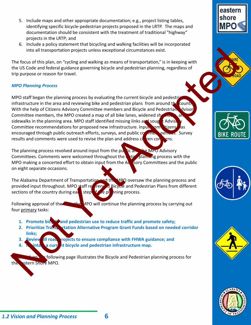
The focus of this plan, on “cycling and walking as means of transportation,” is in keeping with the US Code and federal guidance governing bicycle and pedestrian planning, regardless of trip purpose or reason for travel. MPO Planning Process MPO staff began the planning process by evaluating the current bicycle and pedestrian infrastructure in the area and reviewing bike and pedestrian plans from around the country. With the help of Citizens Advisory Committee members and Bicycle and Pedestrian Advisory Committee members, the MPO created a map of all bike lanes, widened shoulders, and sidewalks in the planning area. MPO staff identified missing links and sought Advisory Committee recommendations for proposed new infrastructure. Input from citizens was encouraged through public outreach efforts, surveys, and public comment periods. Survey results and comments were used to revise the plan and address citizen concerns. The planning process revolved around input from the public and the MPO Advisory Committees. Comments were welcomed throughout the entire planning process with the MPO making a concerted effort to obtain input from the Advisory Committees and the public on eight separate occasions. The Alabama Department of Transportation and the MPO oversaw the planning process and provided input throughout. MPO staff referenced Bicycle and Pedestrian Plans from different sections of the country during each step of the planning process. Following approval of the Plan, the MPO will continue the planning process by carrying out four primary tasks:
1. Promote bicycle and pedestrian use to reduce traffic and promote safety; 2. Prioritize Transportation Alternative Program Grant Funds based on needed corridor
links; 3. Review all road projects to ensure compliance with FHWA guidance; and 4. Maintain a current bicycle and pedestrian infrastructure map.
Figure 1.1 on the following page illustrates the Bicycle and Pedestrian planning process for the Eastern Shore MPO.
1.2 Vision and Planning Process 6
Not Yet
Adopte
d

1.2 Vision and Planning Process
Initial Evaluation
Creating Bike/Ped
Map
BPAC
TAC
CAC Preparation
of Rough Draft
BPAC
TAC
CAC
Policy Board
Completing Formal Draft
Publish For Public Comment
Public Meeting 1
Public Meeting 2
Response to Public
Comments
Approval of Draft by the Committees and Policy
Board
Publish For Public Comment
Response to Public
Comments
Approval of Final Plan by
the Committees and Policy
Board
Public Survey
Figure 1.1 – Bicycle and Pedestrian Transportation Planning Process
Prioritize TAP Grant Funds
based on needed corridor
links
Review all road projects to
ensure compliance with FHWA guidance
Maintain current
Bike/Ped infrastructure
map
Promote Bike/Ped use to
reduce traffic and promote
Bike/Ped safety
Initial Advisory Committee Review of
Bike/Ped Network
Full MPO Review of Draft Bike/Ped Plan
Full MPO Review of Draft Bike/Ped Plan
Full MPO Review of Final Bike/Ped Plan
Post-Approval Planning Process
Reinitiate Planning Process After Five Years
Public Meeting 1
Public Meeting 2
7
Not Yet
Adopte
d
1.3 Title VI as Part of the Planning Process
Title VI as Part of the Planning Process Title VI of the Civil Rights Act of 1964 ensures that no person is excluded from participation in, denied the benefit of, or subjected to discrimination under any program or activity receiving federal financial assistance on the basis of race, color, national origin, age, sex, disability, or religion. The planning process is open to all members of the public. MPO staff work diligently to provide information about MPO planning activities to all interested parties. Executive Order 12898: Federal Actions to Address Environmental Justice in Minority Populations and Low-Income Populations, was signed by President Clinton in 1994. It required that programs, policies, and activities affecting human health or the environment identify and avoid disproportionately high and adverse effects on minority and low-income populations. The intent was to ensure that no racial, ethnic, or socioeconomic group bears a disproportionate share of negative environmental consequences, including social and economic effects, throughout the planning process or during transportation project development. The MPO will ensure the full and fair participation by all potentially affected communities and prevent the denial of, reduction in, or significant delay in the receipt of benefits of transportation system improvements by minority and low-income populations. The MPO evaluates residential, employment ,and transportation patterns of low-income and minority populations, to the extent possible, using census information and socioeconomic data from reliable and available sources. The MPO interacts with community leaders representing low-income and minority populations and groups by consulting with the Public Housing Authority, the Area Agency on Aging, local churches, and other agencies. The MPO encourage s the media, including TV, radio, and print, to disseminate information about transportation planning projects and activities. The MPO holds public meetings in locations and at times that are comfortable, familiar, and convenient. Limited English Proficiency (LEP) As required by Title VI of the Civil Rights Act of 1964, Executive Order 13166, and FTA Circular FTA C 4702.1B, October 2012, the MPO has completed a Four Factor Analysis of the Eastern Shore Metropolitan Planning Area to determine requirements for compliance with the Limited English Proficiency (LEP) provisions. Based on the analysis, the MPO has identified a population within the MPA that may require MPO assistance in participating in the planning process. According to the US Census Bureau’s American Communities Survey, 2007-2011, 904 LEP persons (who speak Spanish) reside within the census tracts that intersect the Metropolitan Planning Area. (See ESMPO LAP Plan). Though more specific data does not exist, the likely number of LEP Spanish speaking persons actually residing within the MPA is estimated to be around 600. According to the same American Communities Survey, all other language groups with LEP persons are estimated at 500 or lower. The MPO is in the process of developing an LAP Plan to address the needs of Spanish speaking person residing within the MPA.
8
Not Yet
Adopte
d

Rehabilitation Act of 1973, Section 504 Section 504 of the Rehabilitation Act prohibits discrimination based on disability in Federally assisted programs. No individual will be excluded from, denied the benefits of, or be discriminated against under any program receiving Federal funds. The Eastern Shore MPO will encourage participation from those with disabilities and will accommodate the needs of those with disabilities in order to allow participation throughout the planning process. Americans with Disabilities Act (ADA) The Americans with Disabilities Act (ADA) relates to civil rights and was signed into law in 1990. The ADA prohibits discrimination based solely on disability. It provides protections against discrimination similar to the Civil Rights Act of 1964, which is based on race, religion, sex, national origin, and other characteristics. ADA essentially defines disability as a physical or mental impairment that limits life activity. The ADA encourages the participation of people with disabilities in the development of transportation and paratransit plans and services. The Eastern Shore MPO will accommodate those with mobility limitations or other impairments in all aspects of the planning process. All Title VI programs, processes, and Acts are included in the 2013 Eastern Shore Public Participation Plan located on the Eastern Shore MPO Website at http://easternshorempo.org. For further information regarding this Section, please view the 2013 PPP or contact an MPO staff person shown on page i of this document.
1.3 Title VI as Part of the Planning Process 9
Not Yet
Adopte
d

1.4 Timeline
Table 1.1 – Plan Development Timeline
The Eastern Shore MPO Bicycle and Pedestrian Transportation Plan was developed over the course of one year with initial input provided by the Advisory Committees in January 2014 and the Final Plan adopted in January 2015. Table 1.1 below provides a Timeline of the Plan development. The Alabama Department of Transportation (ALDOT) approves the Draft and Final Eastern Shore MPO Bicycle and Pedestrian Plan as part of Department document review policy. Once a draft is approved, ALDOT forwards copies to FHWA and FTA for comment. Once the review by the agencies is complete and the MPO approves the Final version, ALDOT makes distribution of the Final to the agencies.
10
Summary of Activity: Dates: Meeting:Initial Evaluation January 14 & 15, 2014 BPAC, CAC, & TAC
Development of Network Map January - May 2014 N/A
Preparation of Rough Draft May - July 2014 N/A
First MPO Review July 15, 16, 23, 2014 BPAC, CAC, TAC and Policy
Board
Survey Distribution/Collection August 1 - 21, 2014 N/A
Complete Formal Draft August 1 - 21, 2014 N/A
Publish Draft Plan for Public
CommentAugust 22 – September
22, 2014
N/A
First Public Meetings September 9 & 11, 2014 Fairhope/Spanish Fort
MPO Review and Adopt Draft Plan September 23 & 24, 2014 BPAC, CAC, TAC and Policy
Board
Publish Final Plan for Public
Comment
October N/A
Second Public Meetings November Daphne/Robertsdale
MPO Review and Adopt Final Plan January BPAC, CAC, TAC and Policy
Board
Not Yet
Adopte
d

1.5 Public Outreach Overview and Survey Results
Initial Evaluation MPO staff compiled tables of contents from Bicycle and Pedestrian Plans from different cities across the nation. The tables of contents were presented to the Advisory Committees at the January 2014 meetings as examples for the Eastern Shore MPO Bicycle and Pedestrian Transportation Plan. MPO staff encouraged committee members to give input on elements they would like to see included in the Eastern Shore Plan. Members of the public were also given an opportunity to provide comments at each of the advisory committee meetings. Development of Network Map Members of the Bicycle and Pedestrian Advisory Committee (BPAC) and the Citizens Advisory Committee (CAC) were recruited to help complete a Bicycle and Pedestrian Network Map. MPO staff used input from the committee members to prepare a Bicycle and Pedestrian Network Map. Members of the public were given an opportunity to provide feedback on the network map at the January, March, and May 2014 advisory committee meetings. First MPO Review MPO Staff presented the working draft Bicycle and Pedestrian Transportation Plan to the Advisory Committees and Policy Board at the July 2014 MPO meetings. The purpose of the first review was to provide Committee members and Policy Board members with an opportunity to view and comment on the draft plan prior to formal publication to the public. MPO staff also sought input on proposed survey questions. Comments from the committee members and Policy Board members were incorporated into the plan as appropriate. Any formal written comments received formal written responses and can be viewed in Appendix B. Opportunity was also provided at each meeting for the public to comment on the plan. Survey Distribution and Collection Public input was solicited and data was collected through the use of a survey. MPO staff published an electronic survey on August 1, 2014. The MPO sought to control the response pool so that survey results would represent the opinions of the public at large. If a survey response pool in not controlled then various interest groups can promote the survey among their members in an effort to skew the results. MPO staff requested that each member government email the survey to their entire staff contact list. That American Association of Retired Persons (AARP) agreed to email the survey to its members within the MPO planning area. The Baldwin County Board of Education also emailed the survey to its entire employee email list. MPO staff also prepared a paper copy of the survey and collected results from throughout the MPO planning area. The distribution of internet and paper surveys resulted in 505 responses. Survey results were collected through November 21,2014. The
11
Not Yet
Adopte
d

survey included the following questions:
1. Do you live or work within the MPO Planning Area? 2. What is your current age? 3. What is your gender? 4. On average, how many hours a week do you spend walking or running? 5. Where do you walk or run most often? 6. What is the primary purpose of your walking or running trip? 7. What, if anything, would encourage you to commute to work, school, errands, etc, by foot instead
of by car? 8. Assuming sidewalks were in place, what is the longest you would be willing to walk for a trip that
you would normally drive in your car? 9. On average, how many hours a week do you spend riding your bike? 10. Where do you cycle most often? 11. What is the primary purpose of your cycling trip? 11. What, if anything, would encourage you to commute to work, school, errands, etc., by bike instead
of by car? 12. Assuming bike lanes and sidewalks were in place, what is the longest you would be willing to bike
for a trip that you would normally drive by car? 13. If a road had a bike lane or 4'- wide shoulder designated for cyclists, would you ride your bike in the
designated area? 14. Are there any bicycle or pedestrian projects you would like to see completed? If yes, list below.
Detailed results and a sample of the survey can be found in Appendix C. The above survey will be conducted at least once every quadrennium to help measure the effectiveness of this plan. Publish Draft Plan for Public Comment MPO staff distributed the Draft Bicycle and Transportation Pedestrian Plan for Public Comment from August 22, 2014, through September 22, 2014. The Draft Plan was distributed to the following locations:
Daphne City Hall, Clerk's Office, Daphne Daphne Public Library, Daphne Eastern Shore Chamber of Commerce, Fairhope Fairhope City Hall, Clerk's Office, Fairhope Fairhope Public Library, Fairhope Baldwin County Fairhope Satellite Courthouse, Commission Office, Fairhope Baldwin Rural Area Transportation System (BRATS) Hub, Fairhope Loxley Town Hall, Clerk's Office, Loxley Loxley Public Library, Loxley Alabama DOT, Division Engineer, Mobile BRATS Hub and Headquarters, Robertsdale Baldwin County Central Annex II, Highway Department, Robertsdale Central Baldwin Chamber of Commerce, Robertsdale Baldwin County Central Annex Commission Office, Robertsdale Robertsdale Public Library, Robertsdale Baldwin County Central Annex, Baldwin County Library Cooperative, Robertsdale Spanish Fort City Hall, Clerk's Office, Spanish Fort Eastern Shore Chamber of Commerce, Spanish Fort Oscar Johnson Memorial Library, Silverhill
MPO staff incorporated public comments into the plan as appropriate. The MPO prepared written responses to all written comments received accept anonymous comments
1.5 Public Outreach Overview 12
Not Yet
Adopte
d

submitted through the survey. All comments and responses received, along with the Comment Processing Form and the Public Notice, can be viewed in Appendix B. First Round of Public Meetings Public participation was also encouraged through public meetings. Two public meetings were held for the public to learn more about the Draft Plan. The first meeting was held on September 9, 2014, at the Baldwin County (Fairhope) Satellite Courthouse. Four members of the public attended the meeting and three comment was were received from attendees. Comments and responses can be viewed in Appendix B. The second meeting was held on September 11, 2014, at the Daphne City Hall. Six members of the public attended the meeting and one comments was received from attendees. Comments and responses can be viewed in Appendix B. Second MPO Review and Approval of Draft Plan MPO Staff presented the Draft Bicycle and Pedestrian Transportation Plan to the Advisory Committees and Policy Board at the September MPO meetings. Advisory Committee members and Policy Board members were provided electronic copies of the Draft Plan and several hard copies were made available at the meetings. Comments from the committee members and Policy Board members were incorporated into the plan as appropriate. Opportunity was also provided at each meeting for the public to comment on the plan. Publish Final Plan for Public Comment MPO staff distributed the Final Bicycle and Pedestrian Plan for Public Comment from December 2, 2014, through January 5, 2015. The Final Plan was distributed to the same locations in the planning area as the Draft Plan.
Comments were received and were recorded in the Comment Processing Form. Comments and MPO responses, along with the Comment Processing Form and the Public Notice, can be viewed in Appendix B. Second Round of Public Meetings Public participation was encouraged through public meetings. Two public meetings were held for the public learn more about the Final Plan. The first meeting was held on ____ at _____. (#) members of the public attended the meeting and (#) comments were received. Comments received and responses by MPO staff can be viewed in Appendix B. The second meeting was held on ____ at _____. (#) members of the public attended the meeting and (#) comments were received. Comments received and responses by MPO staff can be viewed in Appendix B. Final MPO Review and Approval of Final Plan The Advisory Committees and Policy Board reviewed the Final plan in January 2015, following the final public comment period. The Advisory Committees approved the plan and recommended to the Policy Board for approval. The MPO Policy Board adopted the Final Bicycle and Pedestrian Plan on January #, 2015. Opportunity was also provided at each meeting for the public to comment on the plan.
1.5 Public Outreach Overview 13
Not Yet
Adopte
d
14
Not Yet
Adopte
d

Various user classification systems have been employed in bicycle and pedestrian planning in the past. FHWA and the American Association of State Highway and Transportation Officials AASHTO have traditionally focused on the skill level of the user when classifying cyclists or pedestrians. However, AASHTO’s most recent publication of its Guide for the Development of Bicycle Facilities, 4th Ed. broadens its look at classifications and considers trip purpose and user skill in more general terms. Because the Eastern Shore MPO is responsible for transportation planning, this plan takes special interest in cyclists and pedestrians who are using the network to transport themselves from point A to point B. With input from the Bicycle and Pedestrian Advisory Committee, MPO staff created a Cyclist and pedestrian user classification system that categorizes users by trip purpose. The MPO has developed user classifications for cyclists and pedestrians based on trip purpose rather than skill level in order to identify facility types that will appeal to utilitarian users. A utilitarian user is a user who is biking or traveling by foot to work, school, on errands, etc.. Classification of users based on trip purpose is critical for bike and pedestrian transportation planning. A user classification system will assist planners in prioritizing those bicycle and pedestrian projects that provide the most benefit to all users of the transportation system. The Eastern Shore MPO’s user classifications are as follows: Class 1 - Utilitarian A utilitarian user cycles or walks as part of that user’s required daily activities or as part of an activity for which the user would otherwise drive a motor vehicle. A utilitarian trip moves a person or product from location A to location B with the aim of accomplishing a specific purpose at location B. The specific purpose at location B may be commercial (trip to work or shopping), education (trip to school), or even leisure and recreation (trip to gym, park, or beach). The distinguishing characteristic of a utilitarian trip is that a utilitarian trip would have been taken with a motor vehicle had the user not made the decision to instead travel by bicycle or on foot. Class 3 - Recreational A recreational user cycles or runs as exercise and/or sport. Recreational trips are generally made by cyclists or pedestrians with advanced skills and often involve long walks, runs, or rides lasting one or more hours and covering many miles. Recreational trips also include trips by off-road bicyclists and hikers. Class 3 - Leisure A Leisure user cycles or walks for relaxation or simple enjoyment. Leisure trips are generally made by children, families, and seniors. Exercise may be a benefit of a leisure trip, but exercise is not the primary purpose or product of the trip. Leisure trips are generally shorter trips lasting less than one hour and taking place within a one-half mile radius of the point-of-origin.
2.1 User Classifications
15
Not Yet
Adopte
d

If classification based on trip purpose is not considered, transportation dollars might be spent creating facilities that will have only limited use. While adding a recreational facility to the community may have some transportation benefits, the limited funding available suggests dedicating those funds to improvements that would have some substantive impact on the overall network. The MPO pursues the most efficient use of the federal, state, and matching fund dollars available to it.
2.1 User Classifications 16
Not Yet
Adopte
d
2.2 Facilities
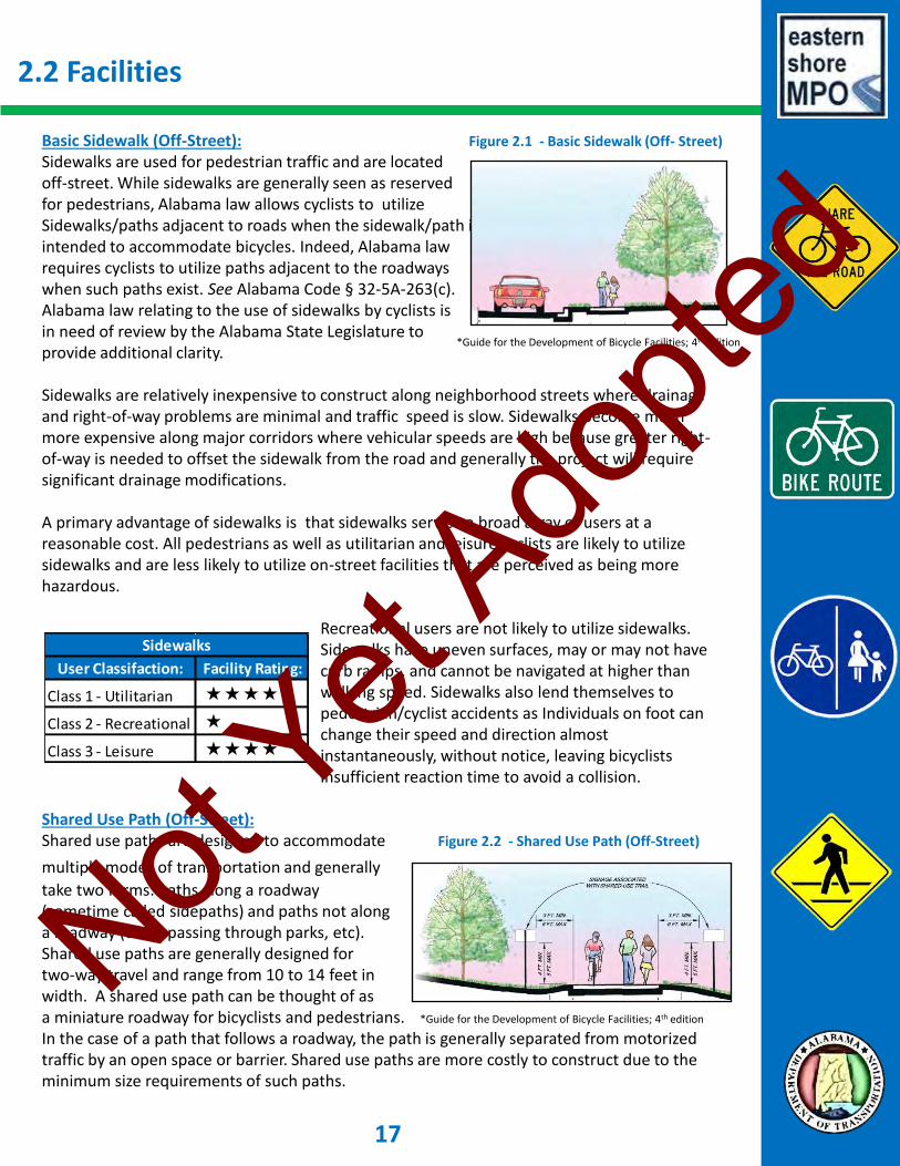
Basic Sidewalk (Off-Street): Figure 2.1 - Basic Sidewalk (Off- Street)
Sidewalks are used for pedestrian traffic and are located off-street. While sidewalks are generally seen as reserved for pedestrians, Alabama law allows cyclists to utilize Sidewalks/paths adjacent to roads when the sidewalk/path is intended to accommodate bicycles. Indeed, Alabama law requires cyclists to utilize paths adjacent to the roadways when such paths exist. See Alabama Code § 32-5A-263(c). Alabama law relating to the use of sidewalks by cyclists is in need of review by the Alabama State Legislature to provide additional clarity. Sidewalks are relatively inexpensive to construct along neighborhood streets where drainage and right-of-way problems are minimal and traffic speed is slow. Sidewalks become much more expensive along major corridors where vehicular speeds are high because greater right-of-way is needed to offset the sidewalk from the road and generally the project will require significant drainage modifications. A primary advantage of sidewalks is that sidewalks service a broad array of users at a reasonable cost. All pedestrians as well as utilitarian and leisure cyclists are likely to utilize sidewalks and are less likely to utilize on-street facilities that are perceived as being more hazardous. Recreational users are not likely to utilize sidewalks. Sidewalks have uneven surfaces, may or may not have curb ramps, and cannot be navigated at higher than walking speed. Sidewalks also lend themselves to pedestrian/cyclist accidents as Individuals on foot can change their speed and direction almost instantaneously, without notice, leaving bicyclists insufficient reaction time to avoid a collision. Shared Use Path (Off-Street): Shared use paths are designed to accommodate Figure 2.2 - Shared Use Path (Off-Street)
multiple modes of transportation and generally take two forms: paths along a roadway (sometime called sidepaths) and paths not along a roadway (often passing through parks, etc). Shared use paths are generally designed for two-way travel and range from 10 to 14 feet in width. A shared use path can be thought of as a miniature roadway for bicyclists and pedestrians. *Guide for the Development of Bicycle Facilities; 4th edition
In the case of a path that follows a roadway, the path is generally separated from motorized traffic by an open space or barrier. Shared use paths are more costly to construct due to the minimum size requirements of such paths.
User Classifaction: Facility Rating:
Class 1 - Utilitarian
Class 2 - Recreational
Class 3 - Leisure
Sidewalks
*Guide for the Development of Bicycle Facilities; 4th edition
17
Not Yet
Adopte
d
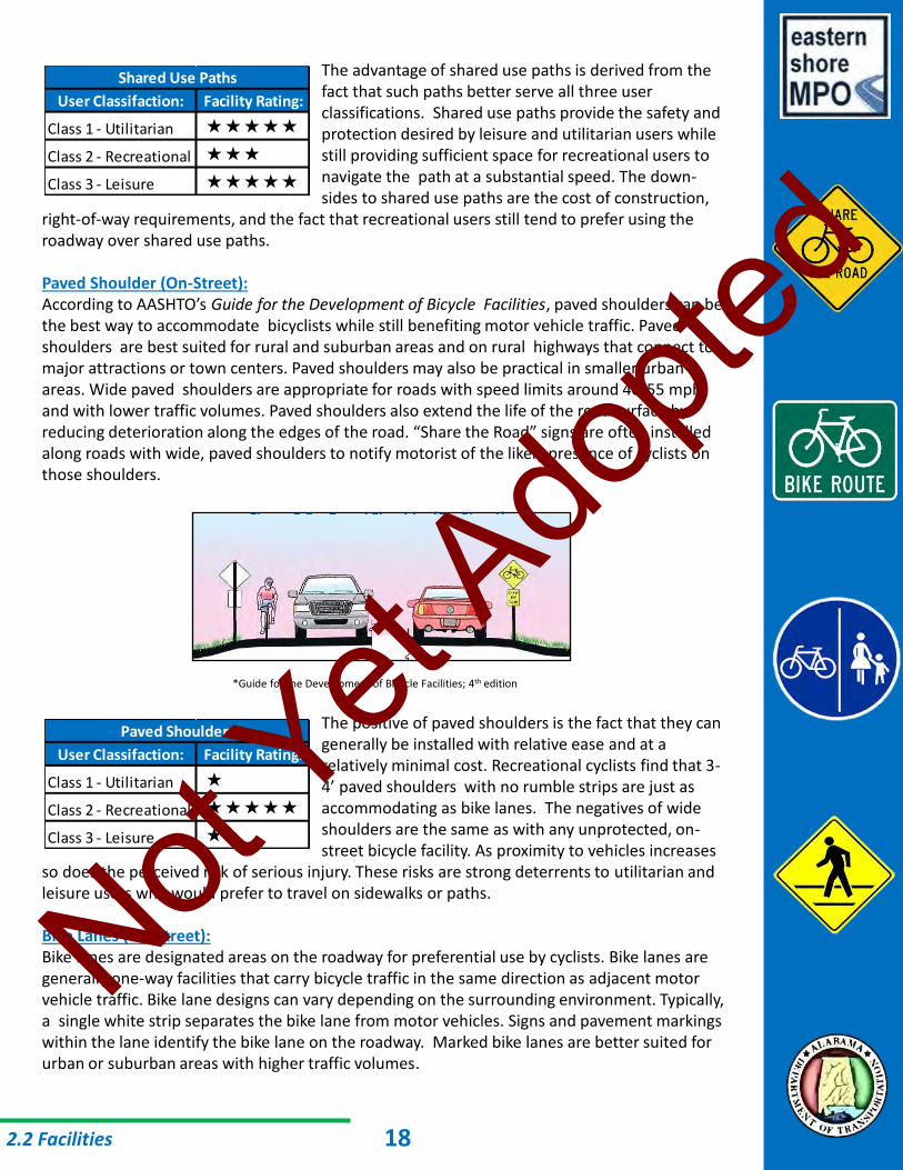
The advantage of shared use paths is derived from the fact that such paths better serve all three user classifications. Shared use paths provide the safety and protection desired by leisure and utilitarian users while still providing sufficient space for recreational users to navigate the path at a substantial speed. The down- sides to shared use paths are the cost of construction, right-of-way requirements, and the fact that recreational users still tend to prefer using the roadway over shared use paths. Paved Shoulder (On-Street): According to AASHTO’s Guide for the Development of Bicycle Facilities, paved shoulders can be the best way to accommodate bicyclists while still benefiting motor vehicle traffic. Paved shoulders are best suited for rural and suburban areas and on rural highways that connect to major attractions or town centers. Paved shoulders may also be practical in smaller urban areas. Wide paved shoulders are appropriate for roads with speed limits around 40-55 mph and with lower traffic volumes. Paved shoulders also extend the life of the road surface by reducing deterioration along the edges of the road. “Share the Road” signs are often installed along roads with wide, paved shoulders to notify motorist of the likely presence of cyclists on those shoulders.
Figure 2.3 - Paved Shoulder (On-Street)
*Guide for the Development of Bicycle Facilities; 4th edition
The positive of paved shoulders is the fact that they can generally be installed with relative ease and at a relatively minimal cost. Recreational cyclists find that 3- 4’ paved shoulders with no rumble strips are just as accommodating as bike lanes. The negatives of wide shoulders are the same as with any unprotected, on- street bicycle facility. As proximity to vehicles increases so does the perceived risk of serious injury. These risks are strong deterrents to utilitarian and leisure users who would prefer to travel on sidewalks or paths. Bike Lanes (On-Street): Bike lanes are designated areas on the roadway for preferential use by cyclists. Bike lanes are generally one-way facilities that carry bicycle traffic in the same direction as adjacent motor vehicle traffic. Bike lane designs can vary depending on the surrounding environment. Typically, a single white strip separates the bike lane from motor vehicles. Signs and pavement markings within the lane identify the bike lane on the roadway. Marked bike lanes are better suited for urban or suburban areas with higher traffic volumes.
2.2 Facilities
User Classifaction: Facility Rating:
Class 1 - Utilitarian
Class 2 - Recreational
Class 3 - Leisure
Paved Shoulders
User Classifaction: Facility Rating:
Class 1 - Utilitarian
Class 2 - Recreational
Class 3 - Leisure
Shared Use Paths
18
Not Yet
Adopte
d

The positives of on street bike lanes are very similar to those of paved shoulders, though dedicated bike lanes require more design and construction work which increases the project cost. Recreational cyclists generally prefer dedicated bike lanes because cyclists have a place on the road that they can claim as their own. The negatives of bike lanes are the same as the negatives of wide shoulders with the addition of slightly higher design and construction costs due the need to meet specific standards. Utilitarian and leisure users are also more likely to utilize dedicated bike lanes over unmarked, paved shoulders as the markings provide a greater sense of safety. Two additional variations of bike lanes provide additional protection to users and further increase the likelihood that the bike lane will be used by utilitarian and leisure cyclists. Separated Bike Lane: A separated bike lane has two outer stripes with smaller stripes running diagonally between the two, creating greater separation between the cyclist and vehicle. This design requires increased roadway space and increases the cost of design and construction. However, the added separation makes these bike lanes more welcoming to utilitarian and leisure users while still meeting the needs of recreational users. Figure 2.5 - Bike Lanes (Separated) *Guide for the Development of Bicycle Facilities; 4th edition
Protected Bike Lane: Protected bike lanes have a physical barrier separating the Figure 2.6 - Bike Lanes (Protected)
bike lane from the vehicle travel lanes. Common barriers include cement curbs, landscaping, bollards, and parked cars. AASHTO discourages using physical barriers to create protected bike lanes, stating that raised devices make it difficult for bicyclists to traverse because of the fixed barrier. A physical barrier also makes it difficult for a vehicle to pull off the road in case of an emergency or mechanical failure. Recently, the Federal Highway Admin- stration has spoken out in support of protected bike lanes on grounds that protected lanes make cyclists feel safer and therefore encourage increased ridership.
2.2 Facilities
User Classifaction: Facility Rating:
Class 1 - Utilitarian
Class 2 - Recreational
Class 3 - Leisure
Bike Lanes (On-Street)
User Classifaction: Facility Rating:
Class 1 - Utilitarian
Class 2 - Recreational
Class 3 - Leisure
Bike Lanes (Separated)
Figure 2.4 - Bike Lanes (On-Street)
*Guide for the Development of Bicycle Facilities; 4th edition
19
*Guide for the Development of Bicycle Facilities; 4th edition
Not Yet
Adopte
d

Protected bike lanes are also more difficult to maintain. Though a protected bike lane would most likely be used by all three user types, protected lanes come with a number of negatives as outlined above. Shared Lane (On-Street): Shared lane facility is a default designation for roadways that Figure 2.7 Shared Lane (On-Street)
lack designated bicyclist and pedestrian facilities. Shared lanes exist practically everywhere. Automobiles and bicycles both use the roadway with no specific bicycle designation or design. Shared lanes are travel lanes with no shoulders and are common on rural streets or residential streets that have relatively low travel speeds, low traffic volumes, and adequate sight distance. When traffic volumes and travel speeds are very low bike lanes and sidewalks are often unnecessary. Marked shared lanes are useful on low speed roads where there is insufficient right-of-way to construct bike lanes or sidewalks. This situation is common in downtown business districts. In such cases markings can be placed in the vehicle travel lane to indicate that cyclists are welcome to utilize the main travel lane of the roadway. Shared lanes work well only under specific conditions. In short, if travel volumes and travel speeds are low enough that cyclists and pedestrians of all three classifications feel comfortable using the roadway to walk or cycle, then a simple shared lane approach may be sufficient for that particular situation. Intersections/Crossings Intersections can be very hazardous for pedestrians and cyclists. This hazard is due, in great part, to the disregard of signage and traffic control devices at intersections and crossings. Those tasked with designing pedestrian and cyclist infrastructure at intersections should consider the latest research for possible new design considerations that can increase the safety and efficiency of transportation modes. Signalized Intersections Pedestrian crosswalks should be provided wherever sidewalks connect with a signalized intersection. A ladder or crosshatch pattern should be used on the crosswalk to make the pathway more visible to motorists. Engineers should consider specifying crosswalks with greater widths at intersections commonly utilized by children, the elderly, or the disabled. Appropriate signage should be installed to direct pedestrians and motorists as to the proper use of the intersection. Cyclists sharing the road or utilizing a dedicated bike lane should conform to the rules of traffic applicable to all motorists. Several additional design features that can be considered at signalized intersections include bike boxes, two-stage turn queue boxes, median refuge islands, or through bike lanes.
2.2 Facilities
*Guide for the development of Bicycle Facilities, 4th edition
20
User Classifaction: Facility Rating:
Class 1 - Utilitarian
Class 2 - Recreational
Class 3 - Leisure
Bike Lanes (Protected)
Not Yet
Adopte
d

A bike box is a specially marked area at the head of a traffic lane at a signalized intersection that provides cyclists with a safe and visible way to get ahead of queuing traffic and make left turns if necessary. Two-stage turn queue boxes assist cyclists in making left turns at multi-lane signalized intersections from a right side bike lane. Median refuge islands facilitate both bicycle and pedestrian crossings by providing a protected space at the center of the street. Through bike lanes help cyclists to correctly position themselves so as to avoid conflicts with turning vehicles at intersections. Engineers should consult the American Association of State Highway and Transportation Officials (AASHTO) or National Association of City Transportation Officials (NACTO publications for further information on the design of bike and pedestrian crossings at intersections. Unsignalized Intersections In 2008 the Federal Highway Administration approved the use of Rectangular Rapid Flashing Beacons (RRFBs). RRFBs are user activated, amber flashing lights that can be used to supplement warning signs at unsignalized intersections. These beacons can be activated either manually by a push-button or passively through automatic detection. RRFBs should be used to alert drivers to yield where bicyclists have the right-of-way crossing a road. Studies show that RRFBs significantly increases driver yielding at crossings. Engineers should consult AASHTO or NACTO publications for further information on the design of bike and pedestrian crossings at unsignalized intersections. Roundabouts Roundabouts create a unique situation for cyclists and pedestrians. Roundabouts require motorists to merge in and out of the intersection without necessarily having to come to a complete stop. This constant merging in and out by vehicles can create a hazardous situation for cyclists, especially in multilane roundabouts. As a result, bike lanes are typically terminated in advance of roundabouts. Advanced cyclists can merge into traffic and travel through the roundabout as a vehicle. Less experienced cyclists (particularly utilitarian and leisure) can be provided with an opportunity to merge onto a sidewalk surrounding the roundabout via ramps connecting the bike lane to the sidewalk. A sidewalk with crosswalks is often constructed around a roundabout for use by pedestrians and dismounted cyclists. Engineers should consult AASHTO or NACTO publications for further information on the design of roundabouts for use by pedestrians and cyclists. Parking Bicycle parking facilities are perhaps the most neglected element of a functional bicycle transportation network. Bicycles are unique in that they do not generally come with anti-theft devices and do not require a key to operate. A bicycle’s light weight also increases the likelihood of theft. A properly designed bicycle rack provides cyclists with a location to secure their bikes. Planned bike racks will also encourage the more aesthetic and orderly storage of bicycles. Appropriate signage can also be installed to help direct cyclists to locations where they can park their bikes. Engineers should consult AASHTO or NACTO publications for further information on the design of bicycle parking facilities.
2.2 Facilities 21
Not Yet
Adopte
d

2.3 Routes
Federal Routes The ALDOT Bicycle and Pedestrian Plan (2010) denotes one U.S. Bicycle Route, Route 25, that runs north and south along State Route 225 and follows the Underground Railroad Bicycle Route. U.S. Bicycle Route 25 begins at the intersection of US Highway 31 and State Route 225 in Spanish Fort and continues north all the way up to northern Michigan. The Route’s southern most point connects with the Eastern Shore Trail .
State Routes According to the ALDOT Bicycle and Pedestrian Plan (2010) there is one state bike route currently passing through the MPO Planning Area. It follows a path identical to that of U.S. Bicycle Route 25 except that NS1 continues East/West on US 98 where the Eastern Shore Trail ends, and then connects with the City of Foley’s Planned Greenway System at the Magnolia River. The state is currently working on the development of an updated statewide Bicycle and Pedestrian plan.
Local Routes Eastern Shore National Recreation Trail: 36 miles The multi-modal trail starts at Battleship Park on the Causeway, crosses Mobile Bay into Daphne, and runs along US Highway 98 and Scenic Highway 98 before ending at Weeks Bay Estuary. The trail runs through the City of Daphne, the City of Fairhope, and unincorporated areas of Baldwin County. Construction of the missing link on US 98 between CR 13 and SR 181 is anticipated to begin December 2014, which will fully connect the 36 mile trail.
User Classifaction: Facility Rating:
Class 1 - Utilitarian
Class 2 - Recreational
Class 3 - Leisure
U.S. Bicycle Route 25
User Classifaction: Facility Rating:
Class 1 - Utilitarian
Class 2 - Recreational
Class 3 - Leisure
State Bicycle Route NS1
User Classifaction: Facility Rating:
Class 1 - Utilitarian
Class 2 - Recreational
Class 3 - Leisure
Eastern Shore Trail
Figure 2.8 – Eastern Shore National Recreation Trail
Map created by the Eastern Shore Trailblazers (thetrailblazers.org)
22
Not Yet
Adopte
d

Local Routes (continued) South Beach Park Trail: .25 miles Located in Fairhope, the South Beach Park Trail runs along the banks of the Mobile Bay. The quarter-mile concrete trail features six bench seats located throughout the wooded park area just south of the Fairhope Municipal Pier. The trail is primarily used by leisure walkers and runners and occasionally leisure cyclists. The trails is also used, to some extent, by recreational runners. Robertsdale Bike and Walking Trail: 1.75 miles The Robertsdale Bike and Walking Trail is an asphalt and concrete multi-modal trail that runs 1.75 miles through the City of Robertsdale. The trail starts on US Highway 90 and runs through the middle of town to State Route 104. Because the trail is separated from the roadways, it is a popular destination for leisure users and some recreational users. The trail is also well suited for utilitarian users. Recreational cyclists tend to find that the trail is too congested for high speed cycling. Loxley Municipal Park Walking Trail: .5 miles The Loxley Municipal Park Walking Trail is a paved and striped circular trail designed for walking, jogging, cycling, rollerblading and skateboarding. The trail measures one-half mile long and progresses through the municipal park which also includes picnic areas, an adjoining playground, and a ball field complex. Similar to the South Beach and Robertsdale trails above, the Loxley trail serves primarily leisure users. While the trail is well suited for utilitarian users it does not connect commuters to destinations or attractions. The trail is also unsuitable for recreational cyclists.
2.3 Routes
User Classifaction: Facility Rating:
Class 1 - Utilitarian
Class 2 - Recreational
Class 3 - Leisure
South Beach Park Trail
User Classifaction: Facility Rating:
Class 1 - Utilitarian
Class 2 - Recreational
Class 3 - Leisure
Robertsdale Bike and Walking Trail
User Classifaction: Facility Rating:
Class 1 - Utilitarian
Class 2 - Recreational
Class 3 - Leisure
Loxley Municipal Park Walking Trail
23
Not Yet
Adopte
d

24
Not Yet
Adopte
d
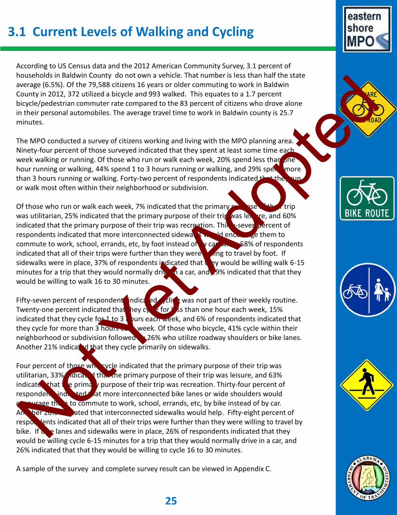
3.1 Current Levels of Walking and Cycling
According to US Census data and the 2012 American Community Survey, 3.1 percent of households in Baldwin County do not own a vehicle. That number is less than half the state average (6.5%). Of the 79,588 citizens 16 years or older commuting to work in Baldwin County in 2012, 372 utilized a bicycle and 993 walked. This equates to a 1.7 percent bicycle/pedestrian commuter rate compared to the 83 percent of citizens who drove alone in their personal automobiles. The average travel time to work in Baldwin county is 25.7 minutes. The MPO conducted a survey of citizens working and living with the MPO planning area. Ninety-four percent of those surveyed indicated that they spent at least some time each week walking or running. Of those who run or walk each week, 20% spend less than one hour running or walking, 44% spend 1 to 3 hours running or walking, and 29% spend more than 3 hours running or walking. Forty-two percent of respondents indicated that they run or walk most often within their neighborhood or subdivision. Of those who run or walk each week, 7% indicated that the primary purpose of their trip was utilitarian, 25% indicated that the primary purpose of their trip was leisure, and 60% indicated that the primary purpose of their trip was recreation. Thirty-seven percent of respondents indicated that more interconnected sidewalks would encourage them to commute to work, school, errands, etc, by foot instead of by car, while 58% of respondents indicated that all of their trips were further than they were willing to travel by foot. If sidewalks were in place, 37% of respondents indicated that they would be willing walk 6-15 minutes for a trip that they would normally drive in a car, and 29% indicated that that they would be willing to walk 16 to 30 minutes. Fifty-seven percent of respondents indicated cycling was not part of their weekly routine. Twenty-one percent indicated that they cycle for less than one hour each week, 15% indicated that they cycle for 1 to 3 hours each week, and 6% of respondents indicated that they cycle for more than 3 hours each week. Of those who bicycle, 41% cycle within their neighborhood or subdivision followed by 26% who utilize roadway shoulders or bike lanes. Another 21% indicated that they cycle primarily on sidewalks. Four percent of those who cycle indicated that the primary purpose of their trip was utilitarian, 33% indicated that the primary purpose of their trip was leisure, and 63% indicated that the primary purpose of their trip was recreation. Thirty-four percent of respondents indicated that more interconnected bike lanes or wide shoulders would encourage them to commute to work, school, errands, etc, by bike instead of by car. Another 26% indicated that interconnected sidewalks would help. Fifty-eight percent of respondents indicated that all of their trips were further than they were willing to travel by bike. If bike lanes and sidewalks were in place, 26% of respondents indicated that they would be willing cycle 6-15 minutes for a trip that they would normally drive in a car, and 26% indicated that that they would be willing to cycle 16 to 30 minutes. A sample of the survey and complete survey result can be viewed in Appendix C.
25
Not Yet
Adopte
d

3.2 Street and Walking Conditions
Bicycle and Pedestrian Network MPO staff completed a Bicycle and Pedestrian Network Map to provide a visual representation of the sidewalk/multi-modal paths and bike lane/wide shoulders in the planning area. Although the sidewalk network along the Eastern Shore is vast, there are significant gaps in the network that prevent pedestrians and cyclists from utilizing the entire network. The full network map can be viewed in Appendix B.
Currently there is approximately 271 linear miles of sidewalk within the planning area and 57.3 miles of roads with wide shoulders or bike lanes. Spanish Fort • Sidewalks: 14.9 miles • Shoulders/Bike Lanes: 8.8 miles Daphne • Sidewalks: 64.9 miles • Shoulders/Bike Lanes: 21.5 miles Fairhope • Sidewalks: 83.7 miles • Shoulders/Bike Lanes: 21.5 miles Loxley • Sidewalks: 3.7 miles • Shoulders/Bike Lanes: 0.6 miles Baldwin County (in Planning Area) • Sidewalks: 84 miles • Shoulders/Bike Lanes: 12 miles
The present network has significant gaps throughout. Some gaps are in older subdivisions that were built before sidewalks were required during development. Some gaps are on longer corridors that extend through both rural areas and urban pockets of growth. The network map will be updated continually. An up-to-date map will allow MPO staff, committee members, and board members to identify gaps within the Planning Area’s multimodal network. MPO staff will evaluate potential projects to fill some of the existing network gaps.
Figure 3.1 – Bicycle and Pedestrian Network Map Based on 2010 U.S. Census
26
Not Yet
Adopte
d

Bicycle and Pedestrian Infrastructure Needs Analysis MPO staff, in coordination with the MPO Advisory Committees, developed a list of twenty-two potential bicycle and/or pedestrian routes. Each of these routes would serve to fill “gaps” within the existing bicycle and pedestrian network. MPO staff analyzed each route to determine which routes most warrant new or upgraded bike/ped infrastructure. Factors considered included lack of existing infrastructure, traffic speed, traffic volume, and travel demand (or connectivity to existing residential and commercial developments). Each route received a score between 1 and 4 for each factor. The identified routes do not constitute planned routes. The identified routes represent ideal locations for future bicycle and pedestrian infrastructure based solely on the factors reviewed. Other factors such as route length, project cost, and site conditions can also affect a project and render the project unfeasible. The Advisory Committees and the Policy Board should view the Infrastructure Needs Analysis list as a pool of potential projects to aid in the identification of projects to be added to the MPO Visionary List. Table 3.1 below displays the factors considered during the Infrastructure Needs Analysis. Table 3.1 – Needs Analysis Review Factors A complete list of the potential routes reviewed in the Bike/Ped Needs Analysis, along with the score assigned to each factor, is available for viewing in Appendix E. A map of the analyzed routes is available on the following page.
3.2 Routes 27
Score 1: Score 2: Score 3: Score 4:
On-Street No facilities Share the Road Wide Shoulder Bike Lane
Off-Street No facilities Walkable ROW Sidewalk Multi-Use Path
Score 1: Score 2: Score 3: Score 4:
Speed > 55 mph Traffic Volume ≤ 55 Traffic Volume ≤ 45 Traffic Volume ≤ 25
Score 1: Score 2: Score 3: Score 4:
Volume > 5,000 Volume ≤ 5000 Volume ≤ 2000 Volume ≤ 500
Score 1: Score 2: Score 3: Score 4:
No Access Some Indirect Access Some Direct Access Direct Access
Existing Facilities:
Traffic Speed:
Traffic Volume:
Travel Demand (Residential & Commercial Access):
Not Yet
Adopte
d

Figure 3.2 – Bicycle and Pedestrian Infrastructure Needs Analysis Map Based on 2010 U.S. Census
3.2 Routes 28
Not Yet
Adopte
d

3.3 Existing Laws and Policies
MPO & Federal Requirements The Eastern Shore Metropolitan Planning Organization, as a recipient of federal dollars, is required to implement federal law and regulations on all bike and pedestrian infrastructure projects. The federal requirements are discussed in more detail in the planning process section of this plan (see Section 1.2 Vision and Planning Process). The primary federal regulation governing bike and pedestrian transportation infrastructure is the requirement that “[b]icycle transportation facilities and pedestrian walkways shall be considered, where appropriate, in conjunction with all new construction and reconstruction of transportation facilities, except where bicycle and pedestrian use are not permitted.” As noted in Section 1.2 above, the MPO adopts ALDOT and FHWA’s policy that “bicycling and walking facilities will be incorporated into all transportation projects unless exceptional circumstances exist.” Section 1.2 summarizes additional federal laws and guidance (as amended by MAP-21) including a requirement that “no bicycle project may be carried out under this section unless the Secretary has determined that such bicycle project will be principally for transportation, rather than recreation, purposes.” 23 USC 217(i). All sidewalks constructed in the MPO Planning Area on functionally classified roadways and all projects utilizing federal funds, regardless of location, will be compliant with Section 504 of the Rehabilitation Act of 1973 and the Americans with Disabilities Act of 1990. The ESMPO Bicycle and Pedestrian Advisory Committee has developed a policy that is attached to all paving and resurfacing projects before recommending the project be moved to one of the Long Range Transportation Plan project lists. The policy states that “[a]ll paving and resurfacing projects include at least 3 foot shoulders with no scoring, and, if possible, bike lanes.” State of Alabama Title 32, Chapter 5A of the Alabama Code contains the Alabama Rules of the Road Act. While the Act as a whole provides a number of important laws relating to the use of Alabama roadways, several specific sections further address pedestrian and bicycle use of the road network. Article 10 addresses pedestrians’ rights and duties, Article 12 addresses bicycles, and Article 13 addresses bicycle safety. The complete Alabama Code is available online at http://www.legislature.state.al.us/. Several key provisions are summarized below: Pedestrian Laws:
• Section 32-5A-210 Pedestrian to obey traffic-control devices and traffic regulations. • Section 32-5A-211 Pedestrians have the right-of-way in crosswalks. • Section 32-5A-212 Pedestrian required to cross at crosswalks except in certain
situations.
29
Not Yet
Adopte
d

• Section 32-5A-215 Pedestrians not permitted on roadway when sidewalk is available;
if no sidewalk available then must walk facing traffic as near to the edge as possible. • Section 32-5A-218 Pedestrians have the right-of-way on sidewalks.
Bicycle Laws:
• Section 32-5A-260 All traffic laws apply to persons riding bicycles.
• Section 32-5A-263 Required to ride bicycles on right side of roadway. May not ride more than two abreast. Must use usable path wherever available adjacent to roadway.
• Section 32-5A-265 Required lamps and reflectors for nighttime riding.
• Section 32-5A-283 Cyclists under the age of 16 must wear a helmet.
Applicability of State Laws in Municipalities: There is often confusion regarding whether state laws for motorists, pedestrians, and cyclists apply on local roads within a city or a county. According to Alabama Code § 12-14-1, the municipal court within each city has jurisdiction to hear all violations of state law committed within the police jurisdiction of the municipality. Alabama law permits these violations to be prosecuted as breaches of municipal ordinances. Municipalities may have additional laws that govern the use of the transportation network within the city. Curb/Ramp Retrofits: ALDOT Regions and Divisions currently have a funded program underway for installation of curb ramps and retrofits on jurisdictional roadways during resurfacing and other eligible projects. Some retrofitting is subject to ALDOT maintenance scheduling. Baldwin County Policies Baldwin County has no local laws governing the activities of cyclists and pedestrians. The Baldwin County Commission adopted a planning policy in the 2012 County Subdivision Regulations that encourages developers to include sidewalks in new subdivisions. Although it is not mandated by ordinance, developers typically require contractors to construct sidewalks when new homes are built. City of Fairhope Policies The City of Fairhope has adopted several ordinances involving pedestrians and cyclists. Fairhope ordinances can be viewed at www.municode.com. Several of Fairhope’s ordinances are summarized below:
• Section 15-4 Bicycles not allowed in the Fairhopers Community Park. 3.3 Existing Laws and Policies 30
Not Yet
Adopte
d

• Section 19-7 Unlawful for any person to partially block any sidewalk within the City.
• Section 20-10 Cannot operate bicycle on municipal pier.
• Section 20-14 Designates specific sidewalks for the use of cyclists, walkers, and joggers. Bicycles may not be ridden on certain sidewalks within downtown area. Bicycles may be lawfully operated on any sidewalk outside the downtown area. Cyclists must always yield to pedestrians. Bicycles ridden on the streets must have a horn or bell.
The City of Fairhope Subdivision Regulations require that all streets include a pedestrian area comprised of a planting strip and a sidewalk and that all sidewalks shall be installed prior to final plat approval. In 2009, the City of Fairhope adopted the State of Alabama’s first Complete Streets Policy. The City of Fairhope also has a Bicycle-Pedestrian Advisory Committee, which serves as a subcommittee of the Fairhope Planning Commission. City of Daphne Policies The City of Daphne has adopted several ordinances involving pedestrians and cyclists. Daphne’s ordinances can be viewed at www.municode.com. Several of Daphne’s ordinances are summarized below: • Section 11-11 Sidewalks must be constructed on both sides of the street in residential and
commercial subdivisions. • Section 11-14 The City of Daphne requires that 10% of the common areas in certain
developments be dedicated to landscaped or recreational areas, which can include pedestrian paths, bike racks, etc.
• Section 15-10 Within City parks, bicycles may only be operated on designated bikeways and roadways.
• Section 18-2 Unlawful to drive a motor vehicle on sidewalks.
The City of Daphne Land Use Ordinance requires the installation of concrete or asphalt sidewalks on both sides of the street in residential and commercial subdivisions, including along the perimeter of all developments where adjacent to City right-of-way. The City of Daphne adopted a Complete Streets Policy in 2010. City of Spanish Fort Policies The City of Spanish Fort Subdivision Regulations requires sidewalks not less than 4 feet in width along both sides of all new streets in all new subdivisions. The sidewalks must be installed with a four and a half foot minimum grassed area between the street. Town of Loxley Policies The Town of Loxley has no specific bicycle and pedestrian rules or regulations.
3.3 Existing Laws and Policies 31
Not Yet
Adopte
d

32
Not Yet
Adopte
d

4.1 Trends
Population Growth and Moving Down South Baldwin County has seen steady population growth of 2% per year over the past 10-15 years. The population of the Eastern Shore MPO Planning Area is expected to increase 21% by the year 2020 and 67% by the year 2040. The planning area is a beautiful and attractive area for growing families, business people, and retiring seniors. The South continues to attract the most domestic migrants of any U.S. region. The trend to move south in the U.S. stems from the warm southern climate and strong business atmosphere in the southern states, among other factors. While the State of Alabama itself has not seen particularly astounding growth, Baldwin County ranks as one of the fastest growing metropolitan areas of the Country. With Airbus locating a new manufacturing facility in Mobile County, Baldwin County can expect to see strong growth for at least the next decade and most likely well beyond that time. New EPA standards and CMAQ Congress passed the Clean Air Act in 1970. In 1990 the Clean Air Act was amended to require further reduction in the amount of allowable vehicle tailpipe emissions and initiate more stringent control measures in areas that still failed to meet the National Ambient Air Quality Standards (NAAQS). In 1991, Congress passed the Intermodal Surface Transportation Efficiency Act. This legislation brought transportation into the multi-modal arena and also set the stage for a new focus on environmental programs. From this came the new Congestion Mitigation and Air Quality Improvement (CMAQ) Program. The CMAQ program was implemented to support surface transportation projects and other related efforts that contribute to air quality improvements and provide congestion relief. Jointly administered by FHWA and the Federal Transit Administration (FTA), the CMAQ program was reauthorized under the Transportation Equity Act for the 21st Century (TEA-21) in 1998, the Safe, Accountable, Flexible, and Efficient Transportation Equity Act: A Legacy for Users (SAFETEA-LU) in 2005, and most recently, the Moving Ahead for Progress in the 21st Century Act (MAP-21) in July 2012. CMAQ funding is only available in areas of nonattainment (areas that fail to meet the air quality standards). The Eastern Shore MPO Planning Area currently meets national air quality standards, but the Environmental Protection Agency (EPA) is poised to release new air quality standards that would make the MPO a non-attainment area. The release of these new standards has been pushed back to 2015, with designation in 2016. If the Eastern Shore is designated non-attainment for ground-level ozone (O3), as expected, the MPO would be eligible to compete for statewide CMAQ funding, which at the present time is available only to Birmingham. Health Obesity and overall health have become a hot topic nationally over the last decade. The United States has seen a dramatic increase in obesity since 1992, with more than one-third of U.S. adults suffering from obesity. Health conditions associated with obesity continue to increase and Alabama has one of the highest obesity prevalence rates in the country. Approximately 17% of children and adolescents are considered to be obese. National campaigns and programs have been created to work against adult and childhood obesity. While it is not the role of elected
33
Not Yet
Adopte
d

officials and transportation planners to fight obesity and health problems, cycling and walking as forms of transportation can take cars off the road while having the added benefit of improving the health of adults and children. Mobility: commuting to work According to the Federal Highway Administration’s 2009 National Household Travel Survey, approximately 20% of all vehicle trips are shorter than one mile. Alabama is somewhat unique in terms of the travel patterns of its citizens. Due to the rural nature of the state, Alabamians tend to drive further distances for work, shopping, school, etc. Baldwin County and the MPO planning area are no exception. Many residents within the Planning Area commute to Mobile County for work. According to the US Census Bureau, 66% of all commuter trips within the planning area are 10 miles or greater. The existing data does not break down the 10-mile-or-less commuter trips. However, very few of these trips likely fall into the 3-miles-or-less category, pushing them out of the range that many people would consider to be a reasonable cycling commute. Increased transportation costs Transportation costs have steadily increased along with the cost of almost every other good and service. The price of fuel has seen a dramatic spike over the last 10 years. At some point, rising transportation costs will likely cause commuters to take a second look at commuting via bicycle or by foot.
4.1 Trends
Figure 4.1 – Fuel Cost Trends Over Ten Years
Chart provided by GasBuddy.com (link)
34
Not Yet
Adopte
d

4.2 Challenges
Lack of Utilitarian Users The vast majority of cyclists and pedestrians in the planning area are recreational or leisure users of the network. Unless the number of utilitarian cyclists and pedestrians increase, it will be difficult for bicycle and pedestrian trips, as a an alternative form of transportation, to have any measurable effect on capacity issues. Rural Nature of the Planning Area Baldwin County is the largest county in the State of Alabama, covering 1,590 square miles. The land area of the Eastern Shore MPO planning area is approximately 311 square miles. The urbanized area is approximately 143 square miles. The rural nature of the county contributes to the low number of utilitarian users in the planning area. In certain parts of the county, necessary day-to-day trips can take considerable time to complete even by motor vehicle. Travel Time to Work The mean travel time to work in Baldwin County is 25.7 minutes. A large percentage of the workforce that live in Baldwin County commutes to work in Mobile County. Recent data collected by the Mobile MPO reveals that Baldwin County residents make approximately 35,700 trips to and from Mobile County every day. With employees driving such distances to work, automobiles are more convenient and some trips become virtually impossible to make by foot or by bicycle. Climate and Convenience The climate in south Alabama and along the Eastern Shore ranges from very humid and hot in the summer to cold and sometimes freezing temperatures in the winter. The extreme conditions during both summer and winter discourages cycling and walking. Utilitarian users are particularly impeded by weather conditions. Often times traveling even a short distance can cause discomfort in the form of intense heat. Getting cyclists and pedestrians to ride their bikes or walk, versus jumping into their climate controlled vehicle, is a significant challenge to overcome. Appendix E provide some additional insight regarding coping with the region’s extreme climate as a utilitarian cyclist. Preconceived Notions of Cyclists and Pedestrians Unfortunately, cyclists and pedestrians are sometimes perceived as burdens on the transportation system, often resulting in bad behavior by motorists. While this perception may be true in cases when a bicyclist or pedestrian impedes motor traffic, planners and other state and local officials should be alert to opportunities to change that mind set and establish cycling and walking as positive alternatives to driving. Preconceived notions will certainly be a challenge. Citizens need to be informed and educated on how cycling and walking can improve traffic conditions by taking vehicles off the road network. Safety Concerns Citizens in the planning area have reported that safety concerns are a main drawback of walking and cycling in the area. Although there are several types of facilities within the planning area, citizens are hesitant to use them for leisure or utilitarian purposes as a result of safety concerns associated with cyclist and pedestrian interactions with automobiles.
35
Not Yet
Adopte
d

Lack of Transit Interconnectivity The lack of regularly scheduled public transit routes (fixed routes) limits the ability of cyclists and pedestrians to take longer trips. Combining multiple modes of transportation exponentially expands the trip options for walkers and bicyclists in the planning area. Engineers and planners should coordinate with local public transit providers to consider infrastructure improvements that will increase bicycle and pedestrian access to public transit facilities.
36 4.2 Challenges
Not Yet
Adopte
d

4.3 Benefits
Reduced Traffic Levels Increasing the number of utilitarian cyclists and pedestrians can reduce traffic congestion on the roadways. With the population continuing to grow in the planning area, the traffic levels will continue to increase. Getting citizens out of their vehicles and walking or riding bicycles will decrease traffic levels and create a more usable and functional transportation network. This would extend to those who work outside of walking or cycling distance or who live in rural areas of the county. Reduced Wear and Tear on Roadways By getting citizens out of their vehicles and onto the bicycle and pedestrian network, the roadway network will see less wear and tear. A personal vehicle can weigh anywhere from 3,000 to 12,000 pounds. A bicycle and its rider typically weigh around 175-200 pounds. The reduced weight on the roadways can help decrease the wear and tear on the roads and increase the life cycle of the pavement. Increased Physical Activity and Overall Health Walking and cycling have positive effects on health and increases the quality of life for those who walk and ride bikes. Increasing heart rate, moving around, and using your muscles contributes to weight loss and overall improved health. Utilitarian users are achieving two objectives by commuting and exercising at the same time. The ESMPO will collaborate, as appropriate, with the public health sector to promote biking and walking as well as investigate possible new funding sources related to personal health and wellbeing. Reduced Fuel Consumption and Pollution Increasing the level of utilitarian cyclists and pedestrians will reduce the amount of fuel consumption as well as reduce the vehicle emissions being released into the air. Walking and cycling consume no fuel and release no emissions. Lower Maintenance Costs and Initial Investment (Bicycle versus Car) The initial investment in purchasing a vehicle is significantly higher than purchasing a bicycle. Local bicycle shops (Pro Cycle and Triathlon and The Bike Shop) sell commuter bikes that range from $400 to $3,000, with the average being around $700. Although some would view these as expensive bikes , there are few cars that are available for a purchase price in that range. Far less expensive commuter bikes are available through retail centers such as Walmart. In 2013, the American Automobile Association (AAA) reported that the average cost for car ownership is 60.8 cents per mile. Bicycles also require maintenance, but bicycle tires and other accessories cost significantly less than similar items for automobiles. Forbes Magazine compared the costs and savings of bicycle commuting, reporting that commuting on a bicycle provides a cost savings of around $1,000 for the first year and around $2,000 for the second year. However, there is a time loss element that was not factored into this equation. Commute time is longer on a bicycle.
37
Not Yet
Adopte
d

38
Not Yet
Adopte
d

5.1 Short Range Plan
Education and Marketing Educational Programs School Program: The Eastern Shore MPO plans to implement an educational program that will be presented at local schools aimed at recruiting commuter cyclists from a young age. The program will need participation and support from MPO staff, local law enforcement officers, and BPAC members.
• MPO Staff: Staff members will create the educational materials needed, including pamphlets, short videos, and presentations as appropriate. Staff members will schedule, organize, and participate in the school presentation.
• Law enforcement: MPO staff will coordinate with local municipal law enforcement to secure, where possible, the participation of law enforcement officers who will attend the school meetings to briefly discuss the safety of cycling and how to safely cycle to school.
• BPAC Members: Representatives from the BPAC will participate in the school program by giving a short presentation to students on the advantages and benefits of walking and cycling for leisure and walking and cycling to school.
Educational Videos: MPO staff will investigate the possibility of producing short educational videos and pamphlets to place in the waiting areas of local government facilities as a pilot program to introduce commuter cycling and safety to the general public. Citizens who are waiting to receive services provided by local government staff will be exposed to the videos and pamphlets while they wait. Community Outreach Walk and Cycle to Work Campaign: Partnering and building relationships with large employers to create a culture of commuter cyclists and pedestrians. MPO staff will identify large employers within the planning areas and work with those companies to promote and encourage walking and cycling to work. National Walk to School Day: MPO staff will collect needed information and promote the National Walk to School Day. Staff will also work with local schools to increase participation in the event. National Ride Your Bike to School Day: MPO staff will collect needed information and promote the National Ride Your Bike to School Day. Staff will also work with local schools to increase participation in the event. Strive Not to Drive Campaign: Staff members will research programs that encourage entire communities to walk or cycle to work, at least one day a year. This event would be farther reaching than any of the proposed school or work programs and events. Municipal Bike/Ped Committees: Provide support and guidance to local governments who are interested in establishing a bicycle and pedestrian committee.
39
Not Yet
Adopte
d

Increase safety measures to combat fear of cycling and walking Intersection Improvements: Crossing improvements should be present at all intersections where a sidewalk or bike lane connects to a signalized intersection. MPO staff will use the walkability analysis to identify needed intersection Improvements within the current transportation network. Needed intersection improvements will be presented to the advisory committees and Policy Board, where members will decide whether a particular project will be added to the Short Range Project List. The MPO will investigate the possibility of installing user activated flashing beacons at un-signalized intersections. Studies show that flashing beacons significantly increase driver yielding at crossings. Increase User Facilities Increased presence of bicycle facilities such as bike racks will encourage cycling and walking. Bike racks provide a safe place for cyclists to store bikes while they are at school, working, or shopping. MPO staff would recommend Increased inventory, or initial presence, of bike racks at County facilities, City facilities, schools, and shopping centers in the planning area. Although federal funds may not be used for all locations listed above, MPO staff will implement a marketing campaign to encourage the use of alternative funding sources available to privately owned companies and individuals. The MPO will coordinate with local public transit providers to consider infrastructure improvements that will increase bicycle and pedestrian access to public transit facilities. The MPO will include a bicycle and pedestrian component in the ESMPO Community Transit Plan. Research additional funding sources MPO staff will continually research funding sources that may be available for bicycle and pedestrian projects.
5.1 Short Range Plan 40
Not Yet
Adopte
d

5.2 Short Range Project List
Table 5.1 – Bicycle and Pedestrian Short Range Projects List
Detailed information for each of the infrastructure projects listed above can be found in the Eastern Shore MPO 2040 Long Range Transportation Plan (easternshorempo.org).
41
Project Description:Year of
Expenditure (YOE):
YOE
Estimated Cost:Funding Source:
School Bike/Ped Safety Education Program 2015 $1,500 MPO Planning Funds
Bike/Ped Education and Safety Videos Pilot Program 2015 $2,500 MPO Planning Funds
Community Events 2015 $1,500 MPO Planning Funds
Study of Intersections in MPA for needed Safety Improvements 2015 $3,000 MPO Planning Funds
Report re Potential Bicycle Rack Locations 2016 $2,000 MPO Planning Funds
US 98 and SR 104 from Rock Creek Pkwy to Section St; New Multi-use Path 2015 $633,850 TAP Grant
SR 225 from Blakeley Way to School Road; New Sidewalk 2016 $582,032 TAP Grant
SR 181 from Quail Creek Dr to .25 mi. south of CR 48; New Sidewalk 2016 $386,755 TAP Grant
Scenic Hwy 98 at Point Clear Creek; Construction of Pedestrian Bridge 2017 $135,200 TAP Grant
Short Range Projects:
Not Yet
Adopte
d
5.3 Long Range Plan
Complete missing links in the network MPO staff will utilize the completed Bicycle and Pedestrian Network Map, along with recommendations from the Advisory Committees, to target essential missing links in the network. Missing links that will connect current routes to areas of high employment, schools, shopping, and essential day-to-day activities will hold the highest priority. Sixty-two percent of respondents to the Bike/Ped Survey said they would be more likely to ride their bicycle to work if there were more interconnected multi-use paths and/or bike lanes/wide shoulders. Have all major employers and all schools participating in commuting programs MPO staff will introduce cycling and walking to work programs to employers and school staff in the Short Range Plan. In the Long Range Plan, MPO staff will set a goal to see more students commute to their destinations on a regular basis. Staff will continue working with employers and schools, educating the public, and promoting commuter cycling and walking events with the aim of increasing the number of local residents commuting via bicycling and or by foot.
42
Not Yet
Adopte
d

5.4 Long Range Project List
Due to a lack of funding for bicycle and pedestrian infrastructure, the MPO currently has no specific long range bicycle and pedestrian projects. The Infrastructure Needs Analysis on page 27 of this Plan provides some guidance regarding routes that have been identified as ideal locations for bicycle and pedestrian infrastructure in the future.
43
Not Yet
Adopte
d

44
Not Yet
Adopte
d

6.1 Funding Sources
Transportation Alternative Program (TAP) Tap grants provide funding for projects that encourage alternative forms of transportation such as pedestrian and bicycle facilities, projects that improve non-driver access to public transportation, and projects that improve mobility. Many types of bicycle and pedestrian projects are eligible for TAP grants, including construction of sidewalks and bike trails. TAP grants require a 20% local match. Recreational Trails Program (RTP) Funds for this program are set aside from the Transportation Alternative Program. The federal funds are distributed by the states for projects that develop and maintain recreational trails for projects eligible for RTP grants include developing and maintaining trails used for hiking, bicycling, in-line skating, equestrian use, and all terrain vehicles. RTP grants require a 20% local match. Surface Transportation Program (STP) STP funds can be used for a wide variety of projects, both construction and non-construction. Sidewalks, bicycle parking facilities, traffic calming projects, and encouragement programs are some of the projects eligible for STP funds. These projects can be on local and collector classified roads that are not part of the Federal-Aid Highway System. STP funds require a 20% match. Highway Safety Improvement Program (HSIP) Several types of projects are eligible for funds through the Highway Safety Program. Projects will improve the overall safety of motorists and pedestrians. Some of the projects eligible include: Bicycle lanes on road, bridges / overcrossings, crosswalks (new or retrofit), curb cuts and ramps, paved shoulders, shared use paths / transportation trails, sidewalks (new or retrofit), and signs and signal improvements. Projects eligible for these funds must be identified as having safety issues. The funds generally require a 20% match. Congestion Mitigation and Air Quality Improvement (CMAQ) Program The CMAQ program is intended to support surface transportation projects and other efforts that contribute to air quality improvements. The Eastern Shore MPO Planning Area currently meets national air quality standards, but the Environmental Protection Agency (EPA) is poised to release new air quality standards that would make the MPO a non-attainment area. The release of these new standards has been pushed back to 2015, with designation in 2016. Therefore, the Eastern Shore MPO is not eligible to receive these funds until it is designated a non-attainment area. Federal Transit Administration Funds for certain bicycle and pedestrian projects are available through the Federal Transit Administration (FTA). Grants from the FTA are used for the design, construction, and maintenance of facilities connecting pedestrians and cyclists to public transportation . Projects include capital improvements such as walkways and bicycle facilities providing access to public transit facilities, bicycle storage facilities at transit hubs, and equipment for transporting bicycles on public transit vehicles. Bicycle and pedestrian projects funded through the FTA require a 10% local match.
45
Not Yet
Adopte
d

Appendices
APPENDIX A – Maps APPENDIX B – Public Outreach APPENDIX C – Sample Survey and Survey Results APPENDIX D – Bicycle and Pedestrian Infrastructure Needs Analysis APPENDIX E – Thirty Days on a Bicycle A Look at Obstacles Faced by Utilitarian Cyclists APPENDIX F – Acronyms Not
Yet Ado
pted

Appendix A Maps
EXISTING BIKE AND PEDESTRIAN NETWORK A-1 BICYCLE AND PEDESTRIAN INFRASTRUCTURE NEEDS ANALYSIS A-2 PROPOSED AND EXISTING NETWORK WITH POPULATION DENSITY A-3 PROPOSED AND EXISTING NETWORK WITH EMPLOYMENT DENSITY A-4 PLANNED BIKE AND PEDESTRIAN PROJECTS A-5
Not Yet
Adopte
d

A-1
Not Yet
Adopte
d

A-2
Not Yet
Adopte
d

A-3
Not Yet
Adopte
d

A-4
Not Yet
Adopte
d

A-5
Not Yet
Adopte
d

Appendix B Public Outreach
PUBLIC NOTICE FOR PUBLICATION OF DRAFT PLAN B-1 PUBLIC NOTICE FOR PUBLIC MEETINGS FOR DRAFT PLAN B-3 WRITTEN COMMENTS AND RESPONSES FOR DRAFT PLAN B-5 ANONYMOUS COMMENTS FROM SURVEY B-25 PUBLIC NOTICE FOR PUBLICATION OF FINAL PLAN B-31 PUBLIC NOTICE FOR PUBLIC MEETINGS ON FINAL PLAN B-33 WRITTEN COMMENTS AND RESPONSES ON FINAL PLAN B-35 COMMENT PROCESSING FORMS B-37
Not Yet
Adopte
d

PUBLIC NOTICE FOR PUBLICATION OF DRAFT PLAN
B-1
Not Yet
Adopte
d

PUBLIC NOTICE FOR PUBLICATION OF DRAFT PLAN (CONTINUED)
B-2
Not Yet
Adopte
d

PUBLIC NOTICE FOR PUBLIC MEETINGS FOR DRAFT PLAN
B-3
Not Yet
Adopte
d

WRITTEN COMMENTS AND RESPONSES FOR DRAFT PLAN
B-4
Not Yet
Adopte
d
WRITTEN COMMENTS AND RESPONSES FOR DRAFT PLAN (CONTINUED)
B-5
Not Yet
Adopte
d

WRITTEN COMMENTS AND RESPONSES FOR DRAFT PLAN (CONTINUED)
B-6
Not Yet
Adopte
d
WRITTEN COMMENTS AND RESPONSES FOR DRAFT PLAN (CONTINUED)
B-7
Not Yet
Adopte
d
WRITTEN COMMENTS AND RESPONSES FOR DRAFT PLAN (CONTINUED)
B-8
Not Yet
Adopte
d
WRITTEN COMMENTS AND RESPONSES FOR DRAFT PLAN (CONTINUED)
B-9
Not Yet
Adopte
d
WRITTEN COMMENTS AND RESPONSES FOR DRAFT PLAN (CONTINUED)
B-10
Not Yet
Adopte
d

WRITTEN COMMENTS AND RESPONSES FOR DRAFT PLAN (CONTINUED)
B-11
Not Yet
Adopte
d

WRITTEN COMMENTS AND RESPONSES FOR DRAFT PLAN (CONTINUED)
B-12
Not Yet
Adopte
d

WRITTEN COMMENTS AND RESPONSES FOR DRAFT PLAN (CONTINUED)
B-13
Not Yet
Adopte
d
WRITTEN COMMENTS AND RESPONSES FOR DRAFT PLAN (CONTINUED)
B-14
Not Yet
Adopte
d
WRITTEN COMMENTS AND RESPONSES FOR DRAFT PLAN (CONTINUED)
B-15
Not Yet
Adopte
d

WRITTEN COMMENTS AND RESPONSES FOR DRAFT PLAN (CONTINUED)
B-16
Not Yet
Adopte
d

WRITTEN COMMENTS AND RESPONSES FOR DRAFT PLAN (CONTINUED)
B-17
Not Yet
Adopte
d
WRITTEN COMMENTS AND RESPONSES FOR DRAFT PLAN (CONTINUED)
B-18
Not Yet
Adopte
d

WRITTEN COMMENTS AND RESPONSES FOR DRAFT PLAN (CONTINUED)
B-19
Not Yet
Adopte
d

WRITTEN COMMENTS AND RESPONSES FOR DRAFT PLAN (CONTINUED)
B-20
Not Yet
Adopte
d

WRITTEN COMMENTS AND RESPONSES FOR DRAFT PLAN (CONTINUED)
B-21
Not Yet
Adopte
d

WRITTEN COMMENTS AND RESPONSES FOR DRAFT PLAN (CONTINUED)
B-22
Not Yet
Adopte
d

WRITTEN COMMENTS AND RESPONSES FOR DRAFT PLAN (CONTINUED)
B-23
Not Yet
Adopte
d
WRITTEN COMMENTS AND RESPONSES FOR DRAFT PLAN (CONTINUED)
B-24
Not Yet
Adopte
d

WRITTEN COMMENTS AND RESPONSES FOR DRAFT PLAN (CONTINUED)
B-25
Not Yet
Adopte
d
WRITTEN COMMENTS AND RESPONSES FOR DRAFT PLAN (CONTINUED)
B-26
Not Yet
Adopte
d

WRITTEN COMMENTS AND RESPONSES FOR DRAFT PLAN (CONTINUED)
B-27
Not Yet
Adopte
d

WRITTEN COMMENTS AND RESPONSES FOR DRAFT PLAN (CONTINUED)
B-28
Not Yet
Adopte
d
WRITTEN COMMENTS AND RESPONSES FOR DRAFT PLAN (CONTINUED)
B-29
Not Yet
Adopte
d

WRITTEN COMMENTS AND RESPONSES FOR DRAFT PLAN (CONTINUED)
B-30
Not Yet
Adopte
d
WRITTEN COMMENTS AND RESPONSES FOR DRAFT PLAN (CONTINUED)
B-31
Not Yet
Adopte
d
WRITTEN COMMENTS AND RESPONSES FOR DRAFT PLAN (CONTINUED)
B-32
Not Yet
Adopte
d

WRITTEN COMMENTS AND RESPONSES FOR DRAFT PLAN (CONTINUED)
B-33
Not Yet
Adopte
d
WRITTEN COMMENTS AND RESPONSES FOR DRAFT PLAN (CONTINUED)
B-34
Not Yet
Adopte
d

WRITTEN COMMENTS AND RESPONSES FOR DRAFT PLAN (CONTINUED)
B-35
Not Yet
Adopte
d

WRITTEN COMMENTS AND RESPONSES FOR DRAFT PLAN (CONTINUED)
B-36
Not Yet
Adopte
d

WRITTEN COMMENTS AND RESPONSES FOR DRAFT PLAN (CONTINUED)
B-37
Not Yet
Adopte
d

WRITTEN COMMENTS AND RESPONSES FOR DRAFT PLAN (CONTINUED)
B-38
Not Yet
Adopte
d

WRITTEN COMMENTS AND RESPONSES FOR DRAFT PLAN (CONTINUED)
B-39
Not Yet
Adopte
d

WRITTEN COMMENTS AND RESPONSES FOR DRAFT PLAN (CONTINUED)
B-40
Not Yet
Adopte
d

WRITTEN COMMENTS AND RESPONSES FOR DRAFT PLAN (CONTINUED)
B-41
Not Yet
Adopte
d

WRITTEN COMMENTS AND RESPONSES FOR DRAFT PLAN (CONTINUED)
B-42
Not Yet
Adopte
d

WRITTEN COMMENTS AND RESPONSES FOR DRAFT PLAN (CONTINUED)
B-43
Not Yet
Adopte
d

WRITTEN COMMENTS AND RESPONSES FOR DRAFT PLAN (CONTINUED)
B-44
Not Yet
Adopte
d

WRITTEN COMMENTS AND RESPONSES FOR DRAFT PLAN (CONTINUED)
B-45
Not Yet
Adopte
d

WRITTEN COMMENTS AND RESPONSES FOR DRAFT PLAN (CONTINUED)
B-46
Not Yet
Adopte
d

WRITTEN COMMENTS AND RESPONSES FOR DRAFT PLAN (CONTINUED)
B-47
Not Yet
Adopte
d

WRITTEN COMMENTS AND RESPONSES FOR DRAFT PLAN (CONTINUED)
B-48
Not Yet
Adopte
d

WRITTEN COMMENTS AND RESPONSES FOR DRAFT PLAN (CONTINUED)
B-49
Not Yet
Adopte
d

ANONYMOUS COMMENTS FROM BIKE/PED SURVEY
B-50
• “My Family does more cycling than I do. And its mainly on main thoroughfares. I stick to Leisure rides & trails.”
• “I live on Styx River Rd in Stapleton. A lot of nice new homes are being built in the area but there are no sidewalks. The speed limit is 45. Many people exceed the limit, including log trucks, making it very dangerous to walk or run. I drive to Daphne or Fairhope to run on sidewalks or trails. I run 3 miles, 3 to 4 times a week.”
• “More of them in Baldwin County in general - and not just in the city limits - rural residents need sidewalks and walking/biking areas too.”
• "Start enforcing the traffic law for the cyclists that don't obey them.” • “Mountain bike trails built" • “Connect Silverhill with Robertsdale so can use bike to run errands instea of drive” • "I would like to see paths or sidewalks that encourage walking and biking.” • “For sections of road 45mph and greater: paths that are completely off the roadway, for
cyclists to bike at peace and with no fear of being run down by a hurling diesel truck or hitting a jogging pedestrian.”
• “Greenways (parkways) for getting from here to there without having to deal with cars.” • “For super-busy 4 way intersections, I would like to see above ground round-abouts for
cyclists (as seen in Germany).” • “PSA's to inform motorists to use caution.“ • “Implementation of a minimum standard of ethics for motorists obtaining a drivers'
permit.” • “City planning that encourages people to drive less by making streets more walkable and
placing and emphasis on downtowns (with restaurants, markets, coffee shops, hardware stores etc. all in one place) accessible by a quick pedal or walk.”
• “If we had alternate methods of getting around that WERE NOT cars, (i.e. bus, bike, and walking, carpooling) we may see less cars on the streets. More cars on the street spells less safety for everybody. But, the auto-centric world view is one based on convenience and individuality - traits that are almost as ingrained in the consciousness of your average American as apple pie. I for one, find the conditions in my area (Spanish Fort near 225 and 31) so dangerous, that I refuse to pedal my bike around. But there you have it: what would be considered as ""Downtown Spanish Fort"" ?? "
• “Spanish Fort and Malbis areas” • “Bike lanes in the more rural areas of the County where there are a lot of cyclers or bike-
a-thon type events. The road gets to be too congested when there are cyclers out and it gets very dangerous for cars to watch out for other vehicles and cyclists.”
• “Home to School pathways” • “This is a must - A sidewalk between Daphne High and Daphne Middle. The side of the
road is horrible there and there are no walking paths. Also, I would like to see it extended all the way down Hwy 13 to Hwy 104, but that should be phase II. The sidewalk connecting the two schools is a must. Also a bike path on scenic 98 would be nice.”
• “Highway 31 within city limits of Spanish Fort” • “There is a great need for a pedestrian and bicycle trail along Hwy 181 for those who
work at the mall area and walk or bike to work each day. They are traveling by foot across the overpass for I-10 on the edge of the overpass and there is no walking area for pedestrians there. It is very dangerous and will result in an accident if not remedied.”
Not Yet
Adopte
d

B-51
• “More sidewalks and bike trail in Daphne. Make Baldwin county overall more walking and cycling friendly. “
• “A family member was nearly killed when hit by a car in this county. Two of our friends were killed. We do not ride bikes in this county unless in a designated park. Gulf Shores, Daphne Village Point, or Blakeley State parks are best for cyclists.”
• “A family member was nearly killed when hit by a car in this county. Two of our friends were killed. We do not ride bikes in this county unless in a designated park. Gulf Shores, Daphne Village Point, or Blakeley State parks are best for cyclists.”
• “I don't know of any in my immediate area that have been started, but I would love to see the one completed around the Gulf State Park cabins and campground area in order to travel to Wal Mart and restaurants. I would love to see bicycle and pedestrian projects happen in the Stapleton area where I live. There are many people who walk and ride bikes in our community. Even at 45 mph it is very dangerous. We have no sidewalks or road shoulders to be on. Thank you for this survey!”
• “I would like to see sidewalks in Silverhill.” • “I live along Bromley Road. We have many cyclists on this road daily. This dangerous,
curvy road needs a bike/pedestrian path.” • “County Road 1” • “Designated bike paths throughout the county. It's not safe for people to ride bikes
along with cars. Drivers these days are on their phones instead of paying attention to bikers or pedestrians. Way too many people have been hit by cars and killed while riding their bikes in this county!”
• “Bike path for Hwy 104” • “I live on CR 13 and would love to see a bike lane that connected from Daphne
Elementary School across CR 64 all the way to Fairhope. That would be great!!” • “I'd like to see a sidewalk on the western side of Hwy 98 in Fairhope, south of Twin
Beach Road (across from Fairhope Highschool. My family and I would like to walk/bike downtown, but don't feel safe accessing current sidewalks. (We live in Huntington Woods.)”
• “The extension of the bike trail from the Battleship to Weeks Bay” • “Sidewalks in Lake Forest subdivision” • “In Fairhope the bike lanes are dangerous. I will not allow my children on them. They
are only allowed to ride on a sidewalk as it is safer. People don't understand bike lanes. They should be removed in downtown area.”
• “Lake forest side walks.” • “Yes because people riding bikes in the road is dangerous and ridiculous . Bikes should
not be allowed where cars are!” • “I would like to see Lake forest have sidewalks in the center (the med) where it is a
grassy area. The grass isn't always cut so its very difficult to get a run or walk in...plus we could use jogging stollers as well”
• “No. I feel that the bicycle or pedestrian lanes are not a necessary expense to our cities or county. One could easily use designated biking and/or walking trails for their recreational needs. We already have taxpayers dollars at work for means of transportation I don't see the point in putting these types of projects in place.“
• “Silverhill to Robertsdale. Would love to see one on State Hwy 55. Dangerous to ride there now.”
ANONYMOUS COMMENTS FROM BIKE/PED SURVEY (CONTINUED)
Not Yet
Adopte
d

B-52
• “Would like to see multi-use trails that can accommodate golf carts, bicycles, and pedestrians.”
• “Bike paths throughout the area to prevent cyclists from being on/in the roadway.” • “Sidewalk from Greeno E to 181” • “More bike lane networks and pedestrian path networks throughout the Fairhope
Planning Jurisdiction.” • “Get bikes off the road or at the least bikes should yield to automobiles, not visa versa.
You can paint pretty little lines for bike paths every where and you may post signs all around saying "share the road" but there is one absolute, when a bike and an automobile collide, the bike ALWAYS loses. Bike riders on roadways cause problems. When I ride, I don't ride in the road as a car approaches and dare them to run me over just because I may have a right to "share the road". I get well out of the way or pull over and allow the traffic to pass. Just some common sense.”
• "Designated bike routes are useful. I would love to see ashalted shoulders on county right of ways- any where, but if they were close to my home I would bike more.”
• “I do not agree with bicycle's and pedestrian's competing with a mass of energy that weigh's 2000+ pounds. I would not and do not ride or walk in the road even with a provided designated lane.”
• “Anything that would get them OFF the road. I'm not a big fan of sharing the road with anything other than vehicles, its not safe for the pedestrians or the drivers when they share the road. With the cell phone use and all the careless drivers on the road, bikes and runners need to be off the roadway and on a designated path.”
• “Do away with the bicycle lanes in Fairhope and eliminate the numerous amount of diagonal parking spaces. There are too many cars in town, the driving lanes next to the bike paths are too narrow for many vehicles, the diagonal parking spaces are too short for many vehicles and you cannot see oncoming traffic (cars or pedestrian) when trying to pull out of any streets or parking lots. I've almost been hit several times. Also, traffic in town rarely stops for pedestrian crosswalks. Driving or walking in downtown Fairhope is a nightmare. It's only a matter of time before someone is killed.”
• “bike paths, bike paths, bike paths” • “sidewalks around the parks” • “In Lake Forest subdivision and along Hwy. 13.” • “I like the cross walks we have in place now. They are noticeable and helpful for the
pedestrian and motorist. I am not sure where more would be needed.” • “In lake Forest and along hwy 13 between daphne high and daphne middle schools” • “Perhaps along the Causeway and along Spanish Fort Blvd/Highway 31 to Bay Minette.
Also along Highway 98.” • “I would like to have a bike lane added when highway 31 is widened .It would be great
for our whole county if we had a bike lane from Spanish Fort to Stapleton. This is a central area in the county that would give cyclist a great area to ride. This could also lead to running and riding fund raisers in our communities.”
• "Better Lighting for people who walk early mornings in the dark in the road!” • “Better Cross lightings for people on sidewalks to cross the streets!” • “More Rules for walkers and bicycle riders, on where they can ride bicycles , more
lighting on the bikes , rules for when people can walk such as not in the dark, and no bicycles out during dark hours.”
ANONYMOUS COMMENTS FROM BIKE/PED SURVEY (CONTINUED)
Not Yet
Adopte
d
B-53
• “Better Ways to see bicycles in early mornings, when it is dark!” • “Better Ways to see bicycles when coming around curves or hills!” • “Extended sidewalks on N/S Gayfer Ave. “ • “More bike lanes” • “Sidewalks along at least one side of all highways would be great....55, 59, 98, 181, 13,
104..............................I don't think bike lanes are safe enough on these roads. People are not considerate enough or careful enough for bike traffic on the roadside. I think a sidewalk or path that is separated from the highway would be much safer and would encourage more people to use bikes for exercise, errands, etc. When weather is good, it would even encourage riding bikes to work sometimes.”
• “Lake Forest desperately needs safe walking/biking lanes or sidewalks. Right now it's not even an option the way people drive through there. We have to take our granddaughter to another location where it is safe to walk or ride her bike.”
• “More trails and paths not along road ways. “ • “I would personally like to see all of them removed as it is very dangerous for bicyclists
and pedestrians to be walking next to main thoroughfares!” • “More walking trails outside of the city limits. Downtown is inconvenient and crowded.” • “all sidewalks connected and leading to the schools” • “All pedestrians and bicyclists need a dedicated place to walk/ride….especially
bicyclists as many ride in or along the roads now and it is illegal to pass a bicycle in a no passing zone. This causes traffic to back up and then motorists get angry with the cyclists.”
• “I would like a bike trail on the side of HWY 31 in Spanish Fort” • “Sidewalks were built on the northbound side of 98 near the High School. None were
built on the south side. We live on the south side. My child does not walk to school due to this and the difficulty crossing Hwy. 98 in front of the high school.”
• “Sidewalk between Daphne High School and Daphne Middle School.” • “I always slow down and move over if a cyclist is on the road that I am traveling. Please
do not allow bicycles or pedestrians on the bayway or the proposed new bridge. They should remain on the causeway.”
• “Sidewalks on Bromley Road! That area is exploding in population, and there is really no safe place to run or walk outside of my subdivision. It's pretty boring to run around and around and around to get my six miles in!”
• "Sidewalk along Champions Drive in Daphne connecting Canterbury Estates with neighboring subdivision and school. Walking Champions Way Between Canterbury Estates and Daphne High can be dangerous and many make this walk daily.”
• “Also, a sidewalk along CR 13 connecting Daphne high School to the sidewalk system that begins on Whispering Pines Rd at Daphne Middle School. This would allow all residents around Daphne High School including Lake Forrest residents to be connected to the immense sidewalk system that starts at Daphne Middle while also connecting Daphne High School to all residents living along the interconnected sidewalk system in Daphne. Thank You!"
• “A 4 foot sidewalk on county road 13 between the high school and middle school.” • ‘Yes, along Gayfer Road Extension, County Road 13, County Road 48, county Road 55.” • “Bike lanes would make our county much safer! Hwy 90 in Daphne” • “Mobile Bay (across)!”
ANONYMOUS COMMENTS FROM BIKE/PED SURVEY (CONTINUED)
Not Yet
Adopte
d

B-54
• “i would love to see one from Loxley (town center) to CBMS, which is where I work. I can't guarantee I would make it right, but hope to by the end of this school year.”
• “I have a brand new bike that I bought ten years ago but rarely ride for leisure because I feel it is too dangerous. Yes, I would like to see bicycle lanes that are not adjacent to traffic.”
• “I live in Spanish Fort and would love to see a bike/running trail developed in that community along hwy 31”
• “any ongoing” • “more sidewalks..” • “All projects promoting bicycle or pedestrian safety would be beneficial to residents of
this area.” • “Along Boothe Rd between Belle Chase subdivision and the new through street
connecting to Bishop.” • “separated bike lane (not just shoulder) on Hwy 98 and/or 13, on Eastern Shore.” • “Bike Share kiosks” • “Gayfer Road in Fairhope, east of hwy 98.” • “Yes, I would like a sidewalk in the vicinity of County Roads 71, 62, 64, 69. I run every
morning and I'm nervous about the cars that I have to avoid while running on the side of the road.”
• “Would like to see a bicycle and pedestrian path in Spanish Fort” • “the is a sidewalk along hwy 98 that stops before mary ann beech road and pick up
again about 2 miles up. We would love to be able to bike on that as we live off of Mary Ann Beech Road.”
• “I am temporarily working at Elberta Middle School. The school needs much better and safer walker / bike rider access.”
• “Sidewalk connecting Main Street to Hwy 98 in Fairhope along Parker Road; it would connect to the Eastern Shore Trail sidewalk. The sidewalk should extend to the Publix parking lot. Many people would use this sidewalk to access Publix if there were a safe route there.”
• “I would love to see sidewalks in my subdivision. It is very hilly and curvy, so cars cannot always see you walking. I would feel safer on sidewalks.”
• "Connecting Daphne Middle to Daphne HS , County road 13!!!!!" • “Bicycle paths in Fairhope, specifically along highway 13.” • “bicycle trails in Fairhope AWAY from roads” • "I would like to see Bay Minette connected to other parts of the county.” • “I would also like to see different communities within the cities, interconnected. You
would think living in the unincorporated area would free you up to walk, run and bike more but it doesn't. It actually inhibits you because of the lack of shoulders and the speed of vehicles."
• “More paths along Highway 181 and 64. That is my route to work and I would love to ride my bike to work. I would also love to see paths along 98.”
• “cycling trails so I don't have to ride on roadway” • “Completed sidewalks from Daphne Middle to Daphne High, The whole block around
Daphne Middle and High to Hwy 181 and 64.” • “Would to see sidewalks in LAke Forest and around Daphne Middle to Lake Forest.” • "Along Hwy 31 in the city of Spanish Fort.” • “Along Hwy 225 in the city of Spanish Fort."
ANONYMOUS COMMENTS FROM BIKE/PED SURVEY (CONTINUED)
Not Yet
Adopte
d

B-55
• “I would like to see the bike route finished that starts at Spanish Fort and follows the Eastern Shore down to Weeks Bay.”
• “I would like to see pedestrian/bike friendly path along Holmes bridge and crossway that is safe.”
• “Lake Forest subdivision needs some sidewalks.” • “Hwy 90 to the eastern shore mall” • “Sidewalks in Spanish Fort for pedestrians to walk.” • “Now that more subdivisions are being built past County Road 13, I would like to see
more sidewalks connecting them...the ones implemented already are loved and used regularly. Even going as far as downtown. Sidewalks are wonderful.”
• “Spanish Fort especially Spanish Fort Estates needs sidewalks!” • “I have requested many times that the sidewalks be extended on n. Cedar street all the
way to county rd 26. It is a very busy street with schools, parks, nursing homes, etc. there is no place for the school children to wait for their bus safely except for in the ditch. It is very dangerous for anyone to walk or bike on this street. Please, please, please consider extending the sidewalks before someone gets hit by a car. Thank you.”
• “Again I ask the city to,please consider the dangerous roads on N. cedar and also on Peachtree Ave. There are kids playing by these roads constantly, walking, skateboarding, riding their bikes, catching the school,buses, etc. it would be great to have a bike walk down N. cedar to connect the neighborhood to the parks, schools, and nursing homes on it.”
• “I would like bike lanes or paths along designated county roads.” • “From Greeno Road down Highway 104 to the Flower Clock” • “More sidewalks” • “No. Honestly it is a waste of taxpayer money and most of the speed limits in and
around Baldwin County are too slow already! It already takes me 45 minutes to get to work on a good day, and I do not want to be slowed down even more by pedestrians and bicyclists.”
• “None that I can think of.” • “It would be nice if there were bike paths of asphalt next to sidewalks. Asphalt is a
much nicer ride then cement. There are no breaks in asphalt.” • “I'm a volunteer with RIDEYELLOW and it's a bike ride for cancer and it starts in Bay
Minette and it continues into Stockton and Rabun I would love to see the roads wider for bikes....it's a Tribute Route / 10 Mile / 37 Mile / 62 Mile....”
• “Bike lanes please! Too many people have been hurt or killed.” • “Bike paths in communities in the northern Baldwin County, particularly the Stockton
Community would be great.” • “I believe we still have too many safety and pedestrian-awareness issues in the south to
make walking and biking a primary mode of transportation. Just today I was cut off while trying to change lanes to allow for a cyclist. Big bubbas in big trucks need educating. And, since we know sometimes learnin' doesn't work in the south, we need to look at laws to punish those who fail to recognize a cyclist or walker (above and beyond the standard penalties)”
• “Greenways come to mind. I would love to see any recognition of these areas promoting walking and bike riding (and strolling babies).”
• “Anything to make cycling safer.” • “yes, on the new bridge over the bay :)”
ANONYMOUS COMMENTS FROM BIKE/PED SURVEY (CONTINUED)
Not Yet
Adopte
d
B-56
• “I would love to see the aerobic trail in Robertsdale extended.” • "Sidewalk down Jimmy Faulkner in Spanish Fort.” • “Sidewalks or bike lane down HWY 90" • “A sidewalk connecting all three schools: Rockwell, Spanish Fort High and Spanish Fort
Middle. It would be great to have that not just for exercise but also for our students that did have to walk .....”
• “I would like to see a bicycle project that connects neighborhoods on County Road 48 with the nearby Walmart in Fairhope and the intersection of 181 and 48. I frequently bike on that dangerous road because there is no alternative if I wish to ride to the downtown Fairhope area.”
• “More projects like the Eastern Shore Trail.” • “Complete the sidewalks to the end of County Road 1. It would be wonderful if they
continued to the deadened at Weeks Bay.” • “A sidewalk connecting Loxley to Robertsdale and Robertsdale to Silverhill.” • “I would love to see bike paths and sidewalks in place. It is much safer to walk/cycle in a
designated area. More people would walk/cycle if there was a safe way to do it.” • “There needs to be a sidewalk on Gayfer Extension from Greeno to Bishop so students
can walk to Fairhope Intermediate from Arbor Gates and the new apartments across the street. Really, I see so many cyclists on Gayfer extension there should at least be a bike lane all the way to 181.”
• “I live in a subdivision off Jimmy Faulkner drive and see a lot of bicycle traffic along this road as it is a great road for cycling. It would be great to add a shoulder for the cyclist for safety and to also allow traffic to flow better.”
• “More interconnected sidewalks just outside of downtown Fairhope.” • "No. We live with a major 4 lane highway going through our town. That in itself make
us not a walking/ bike riding community.” • "CR 13 needs bike lanes. It's nice south of Hwy 64 (about 1/2 mile south) but before
then, it's dangerous, especially around Daphne High School.” • “Need CR 13 sidewalk from middle school to the high school NOW!! I see students
walking along the road and I sometimes ride my bicycle to work and the time I'm on CR 13 is VERY DANGEROUS.”
• “I sometimes run on Hwy 13 and it is very difficult without proper sidewalks from middle school to the high school. What kills me is you just spent money resurfacing that road but you still can't see fit to put in a sidewalks nor make a bike lane on that road. "
• “Daphne City is improving. I would like to see Lake Forest have added bike paths.” • “I would like to see a sidewalk connecting Robertsdale to Silverhill along Hwy. 104. Also,
Hwy. 104 is designated as a bike highway, but the road needs to be widened for bikers. They ride in the road and make it dangerous when cars are traveling both ways. The grass is usually too high for them to ride off road when cars are coming.”
• “I would like off-road trails, such as the one down scenic 98, in more places. like HWY 225 and Jimmy Faulkener drives. Too many people are on their phones and texting for me to feel safe riding or running on the shoulder of the roads.”
• "I think all the roads should give pedestrian the option to walk or ride a bike as another means of transportation. Especially since there is no real form of bus service. "
• “Yes, My daughter and many for her friends in the neighborhood of Edington Place (off of Morphy) would like to ride bikes to the Intermediate School. They are not able to because there is not a sidewalk to 13.”
ANONYMOUS COMMENTS FROM BIKE/PED SURVEY (CONTINUED)
Not Yet
Adopte
d

B-57
• "It would be great if all walking/running paths were asphalt and not concrete. Concrete is the absolute worst surface for running and the reason why you see runners on the roads and not the sidewalks."
• “We would love to see a sidewalk that runs on Old Battles Rd from Greeno Rd (98) down to Section St (3). Cars drive very fast on this road and it is not safe for me or my family to exercise or enjoy a leisurely evening walk.”
• “I would be very supportive of more interconnected bike paths all over Baldwin County!!”
• “I live right off of County Road 38 in Summerdale and outside the city limits right off the new Baldwin Beach Express, and already utilize my private drive Brown Lane and part of the county maintained road as my walking path, but if I lived closer to town I would definitely use the walking or bike trails if they existed in Summerdale which is not in the proposed zone. Robertsdale which is the closest area to my home has a very nice trail and I know a lot of people that use it daily and I would too if I lived closer. I think it is a great idea for every town to promote walking/cycling paths.”
• “I would like to see more sidewalks put in place for walking or biking. I would also like to see actual bike stands put near schools and businesses so bicycles can be locked up and kept close to the business or school.”
• “I choose to live in Fairhope, we have wonderful facilities for recreation."
ANONYMOUS COMMENTS FROM BIKE/PED SURVEY (CONTINUED)
Not Yet
Adopte
d

B-58
COMMENT PROCESSING FORMS
Not Yet
Adopte
d

B-59
Not Yet
Adopte
d
Appendix C Sample Survey and
Survey Results
SAMPLE SURVEY C-1 SURVEY RESULTS C-5
Not Yet
Adopte
d

SAMPLE SURVEY
C-1
Not Yet
Adopte
d

SAMPLE SURVEY
C-2
Not Yet
Adopte
d

SAMPLE SURVEY
C-3
Not Yet
Adopte
d

SURVEY RESULTS
C-4
Total Respondents
I live in the Planning Area.*
I work in the Planning Area.*
435
1. Do you live or work within the MPO Planning Area? Choose all that apply.
356
336
*Includes respondents who said they both lived and worked in the planning area.
0-18
19-40
41-64
65+
0
126
267
42
2. What is your current age?
Male
Female
3. What is your gender?
105
330
None
Less than 1 hour
1-3 hours
More than 3 hours
4. On average, how many hours a week do you spend walking or running?
126
29
89
191
0 200 400
0%
29%
61%
10%
24%
76%
7%
20%
44%
29% Not Yet
Adopte
d

SURVEY RESULTS
C-5
Not Applicable - I do not walk or run
Within your neighborhood or subdivision
On sidewalks along roads within your community
On the edge of the roadway
On dedicated path or trail not along a roadway
5. Where do you walk or run most often?
48
75
91
40
187
Not Applicable - I do not walk or run
Recreational (for exercise or sport)
6. What is the primary purpose of your walking or running trip?
Utilitarian (walk to work, walk to school, running errands, or walk to
dinner, etc.)
110
262
30
33
Leisure (for relaxation or simple enjoyment; NOTE: Exercise may be
a secondary benefit in this category)
Nothing, all of my trips are further than I am willing to travel by foot
More interconnected sidewalks
Better intersection design to make crossing easier and safer
Slower speed limits
Showers and similar facilities at workplace, school, etc
7. What, if anything, would encourage you to commute to work, school, errands,
etc, by foot instead of by car?
48
21
93
162
252
9%
42%
21%
17%
11%
8% 7%
60%
25%
0 100 200 300Not
Yet Ado
pted

SURVEY RESULTS
C-6
None. I will always drive
5 minutes or less
6-15 minutes
16-30 minutes
More than 30 minutes
8. Assuming sidewalks were in place, what is the longest you would be willing to
walk for a trip that you would normally drive in your car?
57
128
161
48
41
None
Less than 1 hour
1-3 hours
More than 3 hours
9. On average, how many hours a week do you spend riding your bike?
26
67
93
249
Not Applicable - I do not ride a bike
Within your neighborhood or subdivision
On sidewalks and along roads within your community
On the roadway shoulders or bike lanes
On dedicated path or trail not along a roadway
10. Where do you cycle most often?
242
23
51
40
79
10%
11%
37%
29%
13%
57% 21%
16%
6%
56% 18%
9%
12%
5%
Not Yet
Adopte
d
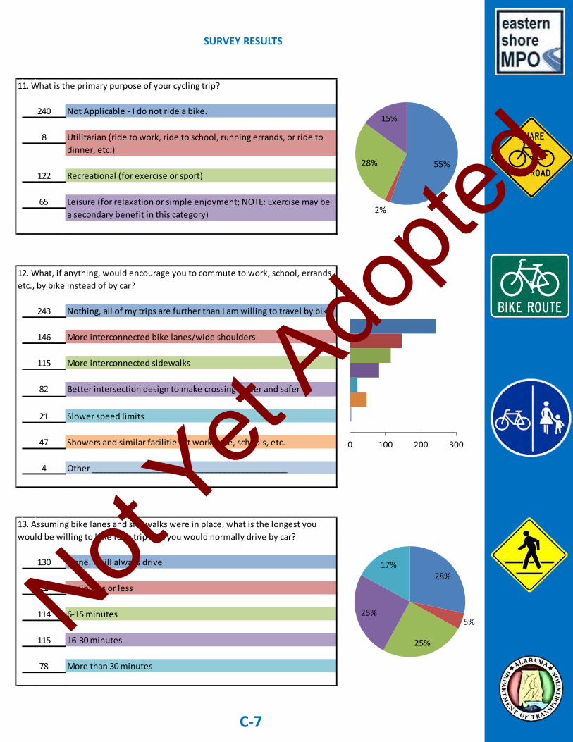
SURVEY RESULTS
C-7
Not Applicable - I do not ride a bike.
Recreational (for exercise or sport)
11. What is the primary purpose of your cycling trip?
65
122
8 Utilitarian (ride to work, ride to school, running errands, or ride to
dinner, etc.)
Leisure (for relaxation or simple enjoyment; NOTE: Exercise may be
a secondary benefit in this category)
240
Nothing, all of my trips are further than I am willing to travel by bike
More interconnected bike lanes/wide shoulders
More interconnected sidewalks
Better intersection design to make crossing easier and safer
Slower speed limits
Showers and similar facilities at workplace, schools, etc.
Other ____________________________________________
115
146
243
4
12. What, if anything, would encourage you to commute to work, school, errands,
etc., by bike instead of by car?
47
21
82
None. I will always drive
5 minutes or less
6-15 minutes
16-30 minutes
More than 30 minutes
13. Assuming bike lanes and sidewalks were in place, what is the longest you
would be willing to bike for a trip that you would normally drive by car?
78
115
114
22
130
55%
2%
28%
15%
0 100 200 300
28%
5%
25%
25%
17%
Not Yet
Adopte
d

SURVEY RESULTS
C-8
15. Are there any bicycle or pedestrian projects you would like to see
completed? If yes, list below.
________________________________________________________
____________________See Appendix B______________________
________________________________________________________
No, never
Yes, but only if cars are driving at 25 mph or less
Yes, but only if cars are driving at 45 mph or less
Yes, always
14. If a road had a bike lane or 4'- wide shoulder designated for cyclists, would
you ride your bike in the designated area?
98
82
96
159 37%
22%
19%
22%
Not Yet
Adopte
d

Appendix D Bicycle and Pedestrian
Infrastructure Needs Analysis
Not Yet
Adopte
d

D-1
Ro
ute
:To
: Fr
om
:Ex
isti
ng
Faci
litie
s:Fa
cilit
y Ty
pe:
Traf
fic
Spee
d:
Traf
fic
Vo
lum
eTr
avel
Dem
and
On
-Str
ee
t2
- S
har
e t
he
Ro
ad
Off
-Str
ee
t2
- W
alka
ble
RO
W
On
-Str
ee
t2
- S
har
e t
he
Ro
ad
Off
-Str
ee
t2
- W
alka
ble
RO
W
On
-Str
ee
t2
- S
har
e t
he
Ro
ad
Off
-Str
ee
t2
- W
alka
ble
RO
W
On
-Str
ee
t2
- S
har
e t
he
Ro
ad
Off
-Str
ee
t2
- W
alka
ble
RO
W
On
-Str
ee
t2
- S
har
e t
he
Ro
ad
Off
-Str
ee
t2
- W
alka
ble
RO
W
On
-Str
ee
t2
- S
har
e t
he
Ro
ad
Off
-Str
ee
t2
- W
alka
ble
RO
W
On
-Str
ee
t2
- S
har
e t
he
Ro
ad
Off
-Str
ee
t2
- W
alka
ble
RO
W
On
-Str
ee
t2
- S
har
e t
he
Ro
ad
Off
-Str
ee
t2
- W
alka
ble
RO
W
On
-Str
ee
t2
- S
har
e t
he
Ro
ad
Off
-Str
ee
t2
- W
alka
ble
RO
W
On
-Str
ee
t3
- W
ide
Sh
ou
lde
r
Off
-Str
ee
t2
- W
alka
ble
RO
W
3 -
Sp
ee
d ≤
45
2 -
Vo
lum
e ≤
50
00
2 -
So
me
Ind
ire
ct A
cce
ss
3 -
Sp
ee
d ≤
45
1 -
Vo
lum
e >
50
00
4 -
Dir
ect
Acc
ess
3 -
Sp
ee
d ≤
45
1 -
Vo
lum
e >
50
00
4 -
Dir
ect
Acc
ess
3 -
Sp
ee
d ≤
45
4 -
Vo
lum
e ≤
50
02
- S
om
e In
dir
ect
Acc
ess
3 -
Sp
ee
d ≤
45
3 -
Vo
lum
e ≤
20
00
2 -
So
me
Ind
ire
ct A
cce
ss
3 -
Sp
ee
d ≤
45
1 -
Vo
lum
e >
50
00
2 -
So
me
Ind
ire
ct A
cce
ss
3 -
Sp
ee
d ≤
45
2 -
Vo
lum
e ≤
50
00
Tab
le 2
.5 -
Bic
ycle
an
d P
edes
tria
n In
fras
tru
ctu
re N
eed
s A
nal
ysis
- R
ou
te L
ist
CR
44
Bo
oth
e R
dSR
18
1
SR 1
81
CR
44
Qu
al C
ree
k D
r
SR 1
81
Qu
al C
ree
k D
rC
R 4
8
CR
13
CR
44
3 -
So
me
Dir
ect
Acc
ess
3 -
Sp
ee
d ≤
45
1 -
Vo
lum
e >
50
00
4 -
Dir
ect
Acc
ess
3 -
Sp
ee
d ≤
45
2 -
Vo
lum
e ≤
50
00
Nic
ho
ls A
ve E
xt
CR
13
CR
48
SR 1
04
CR
13
SR 1
04
CR
64
2 -
So
me
Ind
ire
ct A
cce
ss
1 -
Sp
ee
d >
55
mp
h1
-V
olu
me
> 5
00
04
- D
ire
ct A
cce
ss
SR 1
04
Mai
n S
tU
S 9
8
US
98
SR 1
04
Ro
ck C
ree
k
Pkw
y
CR
13
Ple
asan
t R
dC
ham
pio
ns
Way
CR
13
Ch
amp
ion
s W
ayU
S 9
0
Not Yet
Adopte
d

D-2
Ro
ute
:To
: Fr
om
:Ex
isti
ng
Faci
litie
s:Fa
cilit
y Ty
pe:
Traf
fic
Spee
d:
Traf
fic
Vo
lum
eTr
avel
Dem
and
On
-Str
ee
t3
- W
ide
Sh
ou
lde
r
Off
-Str
ee
t2
- W
alka
ble
RO
W
On
-Str
ee
t3
- W
ide
Sh
ou
lde
r
Off
-Str
ee
t2
- W
alka
ble
RO
W
On
-Str
ee
t2
- S
har
e t
he
Ro
ad
Off
-Str
ee
t1
- N
o f
acili
tie
s
On
-Str
ee
t2
- S
har
e t
he
Ro
ad
Off
-Str
ee
t1
- N
o f
acili
tie
s
On
-Str
ee
t1
- N
o f
acili
tie
s
Off
-Str
ee
t1
- N
o f
acili
tie
s
On
-Str
ee
t2
- S
har
e t
he
Ro
ad
Off
-Str
ee
t1
- N
o f
acili
tie
s
On
-Str
ee
t2
- S
har
e t
he
Ro
ad
Off
-Str
ee
t2
- W
alka
ble
RO
W
On
-Str
ee
t2
- S
har
e t
he
Ro
ad
Off
-Str
ee
t1
- N
o f
acili
tie
s
On
-Str
ee
t2
- S
har
e t
he
Ro
ad
Off
-Str
ee
t1
- N
o f
acili
tie
s
On
-Str
ee
t2
- S
har
e t
he
Ro
ad
Off
-Str
ee
t1
- N
o f
acili
tie
s
On
-Str
ee
t2
- S
har
e t
he
Ro
ad
Off
-Str
ee
t1
- N
o f
acili
tie
s
On
-Str
ee
t3
- W
ide
Sh
ou
lde
r
Off
-Str
ee
t1
- N
o f
acili
tie
s
3 -
So
me
Dir
ect
Acc
ess
3 -
Sp
ee
d ≤
45
1 -
Vo
lum
e >
50
00
4 -
Dir
ect
Acc
ess
1 -
Sp
ee
d >
55
mp
h1
-V
olu
me
> 5
00
03
- S
om
e D
ire
ct A
cce
ss
1 -
Sp
ee
d ≤
55
Tab
le 2
.5 -
Bic
ycle
an
d P
edes
tria
n In
fras
tru
ctu
re N
eed
s A
nal
ysis
- R
ou
te L
ist
(Co
nti
nu
ed)
3 -
Sp
ee
d ≤
45
1 -
Vo
lum
e >
50
00
4 -
Dir
ect
Acc
ess
1 -
Sp
ee
d ≤
55
1 -
Vo
lum
e >
50
00
3 -
So
me
Dir
ect
Acc
ess
3 -
Sp
ee
d ≤
45
1 -
Vo
lum
e >
50
00
4 -
Dir
ect
Acc
ess
SR 1
04
US
98
SR 5
9
US
90
US
98
Bay
vie
w D
r1
- S
pe
ed
≤ 5
51
-V
olu
me
> 5
00
04
- D
ire
ct A
cce
ss
1 -
Sp
ee
d >
55
mp
h1
-V
olu
me
> 5
00
04
- D
ire
ct A
cce
ss
3 -
Vo
lum
e ≤
20
00
4 -
Dir
ect
Acc
ess
1 -
Sp
ee
d >
55
mp
h1
-V
olu
me
> 5
00
04
- D
ire
ct A
cce
ss
1 -
Sp
ee
d >
55
mp
h1
-V
olu
me
> 5
00
03
- S
om
e D
ire
ct A
cce
ss
1 -
Sp
ee
d ≤
55
1 -
Vo
lum
e >
50
00
3 -
So
me
Dir
ect
Acc
ess
1 -
Sp
ee
d ≤
55
1 -
Vo
lum
e >
50
00
US
98
R
ock
Cre
ek
Par
kway
CR
64
US
98
CR
64
Wh
isp
eri
ng
Pin
es
Ch
amp
ion
s W
ayC
R 1
3SR
18
1
US
31
SR 5
9SR
18
1
US
90
Bay
vie
w D
rSR
18
1
US
90
SR 1
81
US
59
SR 2
25
Wh
ite
ho
use
Fo
rk
Rd
Ge
ne
ral C
anb
y
Blv
d
Rai
ls t
o T
rails
CR
54
Pin
e G
rove
Rd
Ext
US
31
SR 1
81
Sch
oo
l Ro
ad
SR 2
25
Ge
ne
ral C
anb
y B
lvd
US
31
Not Yet
Adopte
d
Appendix E Thirty Days on a Bicycle
A Look at Obstacles Faced by Utilitarian Cyclists
Not Yet
Adopte
d

Thirty Days on a Bicycle – A Look at Obstacles Faced by Utilitarian Cyclists
SUMMARY OF OBSERVATIONS
The Eastern Shore Bicycle and Pedestrian Plan focuses on cycling and walking as means of transportation. The Plan places special emphasis on encouraging local resi- dents to consider cycling or walking as an alternative to driving their vehicles. It is difficult to fully appreciate the obstacles faced by potential utilitarian users unless these obstacles are experienced firsthand. In an effort to gain some personal “field” experience, MPO Coordi- nator, Matthew Brown, committed to cycling to and from work for at least thirty days. Insights gained from the experience are summarized in the following pages. Commute – Over the course of 30 days I cycled over 110 miles. My shortest trip was around 0.25 miles and my longest trip was just over 3 miles. My most com- mon trip was the 1.6 mile, one-way ride to and from work. A quarter mile trip was a breeze no matter the temperature. In fact, travel by bicycle is almost more pleasant for very short trips on hot days because a vehicle’s air conditioning generally takes a few minutes to cool the interior temperature of the vehicle. The 1.6 mile commute was also relatively comfortable. I often commuted home for lunch between noon and 1 PM. To my surprise, I rarely broke a sweat on these rides as long I did not overexert myself. The trip took me 10 minutes if I traveled at a relaxed pace. This trip time was just 5 minutes longer than the same commute by car. Commutes that were over 2 miles in length proved to be somewhat less comfortable. I found that I was generally starting to get very warm and a little sweaty towards the end of my 3 mile trips, even when those trips took place in the early morning. While a little sweat never hurt anyone, no one likes to arrive at work in the morning already feeling grungy. Based on my observations, trips that are 2 miles or less in length are ideal for utilitarian cycling. Even on warm summer afternoons, a 2 mile trip can be made at a leisurely pace with little discomfort. Trips less than two miles generally take under 12 minutes on a bicycle, which is not extraordinarily longer than a 2-mile trip would take by car. Weather – The most common concern raised by potential utilitarian cyclists is that Alabama summers are too warm for cycling. While it is true that Alabama summers are warm, most individuals fail to consider that the movement of the bicycle generates a pleasant breeze for the cyclist. This breeze, while not as nice as air conditioning, goes a long way in keeping the cyclist cool on short rides.
E-1
Not Yet
Adopte
d

Another major obstacle for potential utilitarian cyclists is the potential of rainfall. Without question, utilizing a bicycle as a form of transportation requires some amount of planning and flexibility. If it looks as though it may rain then the cyclist may need to consider departing a little earlier then planned. If it is raining at the close of the work day, the cyclist may need to consider extending the work day until the rain has stopped. A cyclist can also make arrangements with a co-worker to provide a backup ride home. Someone from my office graciously provided me with a ride home during a torrential downpour at the close of a work day. Once during my 30 day experiment the weather turned sour while I was in transit home for lunch. A few rain drops quickly turned into a shower and then turned into a downpour. When I arrived home I had to throw my clothes in the dyer for 20 minutes. A utilitarian cyclist may want to consider purchasing some emergency rain ponchos. These disposable ponchos can be purchased for 50 cents to $1 and would provide some emergency protection from the rain on short commutes. Professionalism – A third major obstacle for commuter cyclists is the potential for cycling to complicate things at work. For instance, you may work in a field where a sports coat and tie or dress pants and a blouse are normal attire. Though the attire for my position changes based on the schedule for any given day, it is not uncommon for me to wear a jacket and tie. On one occasion I wore a sports coat and tie while cycling in to work. The morning was exceptionally cool. During most summer days, cycling while wearing a jacket is all but impossible. I accommodated for this by leaving my two most commonly worn sports coats permanently at work. This proved to be an effective solution. Another big issue I faced was the inability to commute long distances once I was at work. If I was asked to attend a meeting in Robertsdale or Daphne, commuting by bicycle from my office in Fairhope would not be possible or efficient. Options are limited in this area. One option is to just drive your personal vehicle to work on days when you know you will have a meeting outside the office. Another option is to catch a ride with a coworker who will also be attending the meeting. Both of these options require a certain amount of planning. A third option is to utilize a company vehicle for these types of trips. While option three is probably the most convenient, it may not be available for all employees. Shortly into my 30 day trial the County provided a vehicle to the Commission Office staff which they allow me to use as needed. Gear – Some people might think that commuting to work by bicycle requires an expensive bicycle and other specialized equipment. Really only three things are needed: 1) a reliable bicycle, 2) a decent bicycle pump, and 3) a bicycle helmet. And, I must confess, in my first 30 days of cycling I never acquired a helmet. So, even number 3 is technically not necessary. Though adults are not required by law to wear a helmet in Alabama, a helmet is a must when cycling on the roadway and can also save your life when cycling at slow speeds on a sidewalk. Purchasing a helmet is on my to-do list. The idea for my 30 day trial began with the purchase of an aluminum, single speed road bike for $40 at a garage sale. The bicycle is manufactured by Mongoose, which is by no means an upscale bike brand. The bike can be purchased new from large department stores for less than $200. This particular bike has skinny road tires (700c) which result in a slightly bumpier ride on the sidewalks. While $40 is hard to beat, I plan to look for a bike
E-2
Not Yet
Adopte
d

that is a little bigger, has wider tires, a more comfortable seat, and perhaps five speeds. While the single speed did the job, use of some lower gears would have been nice when cycling up small inclines. Miscellaneous Obstacles – For safety reasons, nearly all of my cycling took place on sidewalks. While sidewalks provide a safe and convenient cycling path, at some locations the sidewalk can be very uneven and bumpy. This is particularly true at locations where the sidewalk meets the road. However, this was a minor obstacle and would be even less of an issue if riding a bicycle with wider tires. When riding my bicycle on the sidewalks, I periodically encountered obstacles blocking my path. On one occasion the obstacle was a pile of limbs covering the sidewalk. On other occasions the obstacles were city trucks or some other vehicles parked on the sidewalk. On most occasions I was able to maneuver around the vehicles, but on a few occasions I was forced to dismount my bike. Once again, this was only a minor obstacle. A final obstacle I observed related to safety. The only time I interacted with vehicles was when I was forced to cross a road. For the most part motorists were very accommodating. On some occasions a blind spot would result in motorist not being able to see me. I was forced to act with extra caution until I was confident that the motorist was aware of my presence. At intersections, motorists commonly pulled out so that their vehicles blocked the sidewalk. In these cases I always tried to cycle around the back side of the vehicle. I was always careful to give deference to the motorists, realizing that in a collision I would always be the loser. Benefits – Cycling as a form of transportation does have many benefits. Though cost savings may be one benefit, do not expect cycling to solve your budget woes by switching from a vehicle to a bicycle. My personal vehicle gets 38 miles per gallon of gasoline. Applying this amount to my 110 miles of cycling, I saved $9.32 over the course of 30 days. At that rate I will need to cycle 7 months just to recover my investment into a $40 bike, a $20 bike bump, and a $5 replacement tire inner tube. It is important to look beyond the direct cost savings when considering cycling as a form of transportation. First, everyone feels better and is more productive when they exercise every day. I had an expensive gym membership in 2013, which I allowed to lapse in 2014. I did not have enough time to consistently get to the gym. Cycling has been a great substitute. With between 15 and 25 miles of cycling each week, I accomplish some basic exercise and my commute at the same time; all without having to purchase a gym membership. Though commuter cycling does not necessarily provide a cardio vascular workout, it is exercise never-the-less, and helps busy professionals, parents, and students remain healthy while keeping up with their busy schedules. CONCLUSION – Overall, my 30 day experiment on a bicycle was a great experience. I plan to continue cycling to work for the foreseeable future. I would strongly encourage those who live within two miles of their work to consider launching their own 30 day cycling experiment. Some might be surprised how much they enjoy the change.
E-3
Not Yet
Adopte
d

Day 1 – Monday July 14, 2014 First day on the bicycle to work. Am riding an inexpensive street bike (Mongoose Rachet—I think) that I purchased for $40 at a garage sale. The bike is single speed with an aluminum frame. Had to replace the tube in one tire which also introduced me to Presto valves. This was a learning experience all of its own. First ride took me about 10 minutes and was very pleasant. Didn’t even break a sweat. The only negative was the very uncomfortable seat. I rode the sidewalks for the entire trip except the short portion close to my home that does not have a sidewalk. Sidewalk worked well for my trip purpose. Had to pull off the side walk once for about 3 yards to give way to a jogger. Was no problem. Biggest complication today will be my need to commute to Robertsdale. Will require me to cycle back to my home to pick up my vehicle. Will need to look for some creative solutions to some of these practical roadblocks to commuting by bicycle. 6.4 miles total of cycling today. Start weight 215 lbs. Day 2 – Tuesday, July 15, 2014 Had two meetings in Daphne today. Attire is a sports coat and preferably a tie. Couldn’t think of a practical way to fit cycling into the day’s schedule. Certainly not prepared to cycle up to Daphne. If it was just one meeting I would consider my routine from yesterday. Day 3 – Wednesday, July 16, 2014 Had another meeting in Daphne today. Since it was just one meeting that would end around lunch time I road my bike to work at 7 AM and then road back home a little after 9 AM to pick up my car. I thought I would finish the meeting, return home for lunch, and then take my bike back to work after lunch. Sarah Hart left early to setup for the meeting and took my laptop and all other needed materials in her vehicle. After the meeting I made the mistake of carrying my laptop and several items back with me in my car. When I got home it occurred to me that there would be no way for me to get these items back to work with just my bicycle. As a result I was forced to drive my car back to work after lunch. Best option in the future would probably be to leave early for such meetings and ride with Sarah. 3.2 miles of cycling today. Day 4 – Thursday, July 17, 2014 No meetings today so perfect day for cycling. And, I couldn’t have asked for better weather. We had a record low of 64 degrees today, breaking the earlier record of 65 degrees set back in 1886. The morning ride into work at 7 AM this morning was gorgeous. I rode home and back for lunch, and then back home when I left work at 5:30 PM. The temperature had increased considerably for the afternoon rides. I am a little concerned about riding in our true summer weather since the weather this week has been unusually pleasant. 6.4 miles of cycling today. Day 5 – Friday, July 18, 2014 A new experiment today. Cycled to work this morning as I have over the past week, but also decided to cycle to my 10:30 AM meeting with Mayor Kant at Fairhope City Hall. This will be the furthest west I have ventured with my bike and my first time commuting to an official work meeting. My general policy for any meetings with a Policy Board member is that I always want to be wearing at least a sports coat. Because the weather it too hot for me to cycle with a sports coat on, I decided to fold my sports coat and carry it in a satchel. This seemed to work well but was maybe a little tacky.
E-4
Not Yet
Adopte
d

Day 5 – Friday, July 18, 2014 (continued)
The trip to the Mayor’s office took me about 13 minutes. About 100 yards from the entrance it started to drizzle, but I was close enough that I really didn’t get wet. However, the weather was so warm and muggy that, upon arrival, I elected not to wear my sports coat. During the meeting it rained steadily. Thankfully the rained stopped just as our meeting concluded and I was able to cycle home. There was some thunder and lightning which concerned me a little. My plans to cycle home after work were foiled by torrential rain at 5 PM. Thankfully, Gloria Bitto, Commissioner Elliott’s assistant passes near my home on hear way home and offered to drop me off. 5 miles of cycling today.
Day 6 – Saturday, July 19, 2014
No cycling today.
Day 7 – Sunday, July 20, 2014
My wife dropped me off at the courthouse on our way home from church so I could cycle home with my bike. 1.2 miles of cycling today. 22.2 miles of cycling for the week.
Day 8 – Monday, July 21, 2014
Every Monday morning at 6 AM I attend a Bible study at Bayside Orthopedics at the corner of US 98 and Gayfer Road. I left the house at around 5:40 AM on my bicycle and arrived at Bayside Orthopedics a few minutes before 6:00. It was surprisingly muggy at 5:40 AM and I was happy to step into the AC. The trip was my first ride longer than two miles. Following the Bible study I cycled the 0.8 miles to work for the morning. I cycled to the Venue in downtown Fairhope for a lunch meeting. Had to leave the sidewalk once for a pile of debris and once for a pedestrian. No big deal. Surprisingly, the lunch ride was more enjoyable than the early morning ride. Cycled home from work at the end of the day. 8.2 miles of cycling today.
Day 9 – Tuesday, July 22, 2014
Good day of cycling until my ride home for lunch. Started to drizzle about one-third of the way into the trip. Increased steadily until it reached a downpour about 300 yards from the house. I was soaked when I walked through the door. I tossed my clothes in the dryer during lunch. The rain stopped after about 30 minutes and I cycled back to work. Tomorrow I have a Policy Board meeting and I plan to wear a nicer black suit. I want to cycle in but don’t want to carry that particular jacket in my satchel. I arranged for my wife to drop that jacket off at the office while she was out running errands for the day. Thankfully the County brought in a new (used) vehicle for the commission and housekeeping folks at the courthouse and they have agreed to allow us to use it when necessary. Now I can cycle in, throw on my jacket, and drive up to our meeting in Spanish Fort. 6.2 miles of cycling today. Weighed in at around 211 today.
E-5
Not Yet
Adopte
d

Day 10 – Wednesday, July 23, 2014
Cycled in wearing my suit pants and a dress shirt. Threw on my suit coat and tie when I arrived at the office. Skipped lunch today and returned home by bike after 5. It was actually fun cycling to and from work with dressier clothes on. 3.2 miles of cycling today.
Day 11 – Thursday, July 24, 2014
Quite a bit of cycling today. Normal routine through the day except that I actually cycled in wearing a sports coat and tie. Was curious as to whether the addition of the sports coat would make the ride unbearably warm. The ride in was very pleasant. Don’t think I would wear a sports coat for a ride in the afternoon though. At 5:30 PM I had a meeting at the downtown library and cycled to that meeting, after which I cycled down to the pier to meet my wife and daughter for a picnic dinner. Threw the bike in the mini-van and road home with the family. I have to admit that I actually enjoyed cycling on some of the streets in Fairhope, west of Section Street. I can understand how bicyclist feel like they have much more freedom on the roads. I am not saying that I plan to cycle on roads with heavy traffic like Fairhope Avenue, but the “back” roads like Bancroft and Magnolia Avenue seem to provide a pleasant and safe riding experience. I still don’t have a bicycle helmet though, so before I spend much more time in the road I should plan on picking one of those up. Received a call today from my Dentist in downtown Fairhope saying they have an opening for 8:00 AM tomorrow morning. This works perfect for me cycling in to the dentist first thing tomorrow. 7 miles of cycling today.
Day 12 – Friday, July 25, 2014
Cycled 3.1 miles into the dentist. The trip took me just under 20 minutes and I arrived about 10 minutes before 8. I was pretty warm when I arrived but cooled off quickly in the AC. The office was open early and they had me in the dentist chair a few minutes before 8. The appointment was very quick and I was finished and back at work by 8:40 AM. I have to admit that I was impressed with the fact that I was able to cycle to and from a dentist appointment and still be at work by 8:40 AM. Remainder of the cycling for the day went as usual. 9.6 miles of cycling today.
Day 13 – Saturday, July 26, 2014
No cycling today.
Day 14 – Sunday, July 27, 2014
No cycling today. 34.2 miles of cycling for the week. Running Total: 56.4 miles
E-6
Not Yet
Adopte
d

Day 15 – Monday, July 28, 2014
No cycling today. My Monday morning Bible study was temporarily moved to a location near Rock Creek. Not only is the trip much longer than my target range of 2 miles, the route also lacks sidewalks. I am certainly not going to ride my bike on the roadway on US 98. I also had meetings in Robertsdale today so these things combined made my decision to stick with the car today.
Day 16 – Tuesday, July 29, 2014
Normal cycling today. Absolutely amazing weather for July. 6.4 miles of cycling. Weighed in at around 215 lbs. I think this can be blamed on all the unhealthy eating from the previous week.
Day 17 – Wednesday, July 30, 2014
Worked through lunch today so a little less cycling. 3.2 miles of cycling.
Day 18 – Thursday, July 31, 2014
Worked through lunch again today so another day of less cycling. 3.2 miles of cycling.
Day 19 – Friday, August 1, 2014
Met a friend for lunch at Duck’s BBQ which is pretty close to the office. Still amazing weather for August. 4.2 miles of cycling.
Day 20 – Saturday, August 2, 2014
At a church camp through Saturday. No cycling today.
Day 21 – Sunday, August 3, 2014
No cycling today. Only 17 miles of cycling for the week. Running Total: 73.4 miles
Day 22 – Monday, August 4, 2014
Normal cycling today. 6.4 miles of cycling.
Day 23 – Tuesday, August 5, 2014
Normal cycling today except I also cycled down to the bank which added about an extra half mile. 6.9 miles of cycling.
E-7
Not Yet
Adopte
d

Day 24 – Wednesday, August 6, 2014
Normal cycling today. 6.4 miles of cycling.
Day 25 – Thursday, August 7, 2014
Normal cycling today. 6.4 miles of cycling.
Day 26 – Friday, August 8, 2014
Crossed the 100 miles of cycling mark on my way in to work this morning. Based on the fuel efficiency of my personal vehicle (38 mpg) I have saved $8.47 in fuel after four weeks of cycling. At this rate I will have to cycle for the rest of my life just to break even on the cost of my bike. Had to run some errands after work so drove my car back from lunch. 3.2 miles of cycling.
Day 27 – Saturday, August 9, 2014
No cycling today.
Day 28 – Sunday, August 10, 2014
No cycling today. 30.3 miles for the week. Running Total: 103.7 miles
Day 29 – Monday, August 11, 2014
Cycled to morning Bible study at 5:30 AM. Had a good trip and arrived at work at around 7:15 AM. Had a meeting in Pensacola at 1 so I cycled home for a quick lunch at 11:40 and pulled out to Pensacola in my personal vehicle at noon. Drove directly back to the office following the meeting. 4.8 miles of cycling.
Day 30 – Sunday, August 12, 2014
Beautiful ride to the office this morning. Great way to start off day 30 in my cycling experiment. Has been a great experience. Worked through lunch today. 3.2 miles of cycling.
E-8
Not Yet
Adopte
d

Appendix F Acronyms
3-C Comprehensive, Cooperative, and Continuing ADA Americans with Disabilities Act ADEM Alabama Department of Environmental Management ALDOT Alabama Department of Transportation APA American Planning Association AQ Air Quality AASHTO American Association of State Highway and Transportation Officials BPAC Bicycle and Pedestrian Advisory Committee CAC Citizen Advisory Committee CAD Computer Aided Design CFR Code of Federal Regulations COOP Continuity of Operations Plan DBE Disadvantaged Business Enterprise DRI Developments of Regional Impact DOT Department of Transportation EPA Environmental Protection Agency ESRI Environmental Scientific Research Institute ETS Environmental Technical Section FAS Federal Aid System FHWA Federal Highway Administration FTA Federal Transit Administration FY Fiscal Year GIS Geographic Information System GHG Greenhouse Gases ITS Intelligent Transportation System LRTP Long Range Transportation Plan MAP-21 Moving Ahead for Progress in the 21st Century MPA Metropolitan Planning Area MPO Metropolitan Planning Organization MOVES Motor Vehicle Emission Simulator NAAQS National Ambient Air Quality Standards NACTO National Association of City Transportation Officials NEPA National Environmental Policy Act of 1969 NHS National Highway System O3 Ozone PL Planning Funds PM 2.5 Particulate Matter 2.5 - Pollution in the form of tiny particles or droplets in the air that are two and one half microns or less in width. PPP Public Participation Plan (or Process depending on use)
Not Yet
Adopte
d

SAFETEA-LU Safe, Accountable, Flexible, Efficient Transportation Equity Act: A Legacy of Users SIP Statewide Implementation Plan SPR State Planning and Research STIP Statewide Transportation Improvement Program TAC Technical Advisory Committee TAP Transportation Alternatives Program TAZ Traffic Analysis Zone TEA-21 Transportation Equity Act for the 21st Century TDP Transit Development Plan TIP Transportation Improvement Program TSM Transportation System Management UPWP Unified Planning Work Program USC United States Code
Not Yet
Adopte
d