Better Access to Multiple PPDM Data Stores EPOS4 Well ...
29
17.1sp1 December 2011 Building on the 17.0 release, 17.1 focuses on improving Petrosys connectivity with better access to multiple PPDM data stores, extension of EPOS connectivity to well data, ESRI file geodatabase support, and numerous incremental changes to spatial and geoscience applications access. EPOS4 Well, Grid, Culture Connectivity The Paradigm plugin, released with seismic connectivity in 17.0, has been extended in 17.1 to allow Petrosys access to well, grid and culture data in EPOS4. Use Paradigm Wells Paradigm-EPOS wells can now be used throughout Petrosys. Well data, including header information, markers, marker attributes and directional surveys, can be used within Mapping, 3D Viewer and Grid, Contour and Volumetrics. Workflows that are now available include: • direct display of wells, directional surveys and markers, along with annotations, including use of Paradigm-EPOS selection lists and well DBs • investigation of the well header to obtain details of individual wells • direct gridding of wells, including the use of directional surveys, depths, well markers and attributes • import of wells, surveys and markers to Petrosys WDFs for offline storage via the Well Import Wizard Get Grids Petrosys can now access grids stored within Paradigm-EPOS. Grids can be imported, displayed, in 2D or 3D, and used in various surface modeling operations, including grid creation and contouring. In conjunction with the existing ability to write Petrosys grids into EPOS, this provides the Petrosys / Paradigm user with the ability to create workflows that leverage the best of both applications. Accessible Culture Culture data stored within Paradigm-EPOS is accessible as a spatial data type for mapping using the Petrosys Display/GIS option, and for translation of EPOS culture into other formats via the Spatial Data Translator. With this extended data access a user can, for example, export Paradigm culture, well directional surveys, OpenWorks seismic lines, Petrosys dbMap culture and data from ArcGIS to a single kml file for display in Google Earth. Better Access to Multiple PPDM Data Stores The ability to edit well data and access formation tops and directional surveys when using multiple PPDM data stores has been significantly improved through the extension of functionality associated with 'secondary connections' in dbMap. Esri File Geodatabase Supported Version 17.1 introduces support for Esri File Geodatabases. At this stage this functionality is available on Windows. File Geodatabases are accessible in both import and export contexts and are accessible throughout Petrosys where spatial data can be used, including: • as an import or export data source in the Spatial Data Translator • for display via Display/GIS • as a gridding input in Surface Modeling ArcSDE 10sp3 Support Petrosys has added support on Linux and Windows for the recently released ArcSDE 10sp3. Connecting to ArcSDE 10sp3 servers is identical to earlier versions of ArcSDE ensuring there is no additional learning curve to using your latest SDE data within Petrosys. Additional Culture Exchange with Petrel Petrosys has added functionality to export spatial objects to various Petrel Culture data types. For example, a shapefile can be used as input to the Spatial Data Translator and exported as polygons; or a Petrosys contour file can be exported to Petrel as a collection of Petrel contours. Additional Petrel culture data types can now be used as input to Petrosys functions. Petrosys can now display point data, complementing the existing support for Petrel polylines. Petrosys Surface Modeling now has Petrel culture data as an input source, allowing seamless gridding of Petrel point and polyline data. Petrosys 17.1sp1 Release Notes - 1/29
Transcript of Better Access to Multiple PPDM Data Stores EPOS4 Well ...

17.1sp1December 2011
Building on the 17.0 release, 17.1 focuses on improving Petrosys connectivity with better access to multiple PPDM data stores, extension of EPOS connectivity to well data, ESRI file geodatabase support, and numerous incremental changes to spatial and geoscience applications access.
EPOS4 Well, Grid, Culture ConnectivityThe Paradigm plugin, released with seismic connectivity in 17.0, has been extended in 17.1 to allow Petrosys access to well, grid and culture data in EPOS4.
Use Paradigm WellsParadigm-EPOS wells can now be used throughout Petrosys. Well data, including header information, markers, marker attributes and directional surveys, can be used within Mapping, 3D Viewer and Grid, Contour and Volumetrics. Workflows that are now available include:
• direct display of wells, directional surveys and markers, along with annotations, including use of Paradigm-EPOS selection lists and well DBs
• investigation of the well header to obtain details of individual wells
• direct gridding of wells, including the use of directional surveys, depths, well markers and attributes
• import of wells, surveys and markers to Petrosys WDFs for offline storage via the Well Import Wizard
Get GridsPetrosys can now access grids stored within Paradigm-EPOS. Grids can be imported, displayed, in 2D or 3D, and used in various surface modeling operations, including grid creation and contouring.
In conjunction with the existing ability to write Petrosys grids into EPOS, this provides the Petrosys / Paradigm user with the ability to create workflows that leverage the best of both applications.
Accessible CultureCulture data stored within Paradigm-EPOS is accessible as a spatial data type for mapping using the Petrosys Display/GIS option, and for translation of EPOS culture into other formats via the Spatial Data Translator.
With this extended data access a user can, for example, export Paradigm culture, well directional surveys, OpenWorks seismic lines, Petrosys dbMap culture and data from ArcGIS to a single kml file for display in Google Earth.
Better Access to Multiple PPDM Data StoresThe ability to edit well data and access formation tops and directional surveys when using multiple PPDM data stores has been significantly improved through the extension of functionality associated with 'secondary connections' in dbMap.
Esri File Geodatabase SupportedVersion 17.1 introduces support for Esri File Geodatabases. At this stage this functionality is available on Windows. File Geodatabases are accessible in both import and export contexts and are accessible throughout Petrosys where spatial data can be used, including:
• as an import or export data source in the Spatial Data Translator• for display via Display/GIS• as a gridding input in Surface Modeling
ArcSDE 10sp3 SupportPetrosys has added support on Linux and Windows for the recently released ArcSDE 10sp3. Connecting to ArcSDE 10sp3 servers is identical to earlier versions of ArcSDE ensuring there is no additional learning curve to using your latest SDE data within Petrosys.
Additional Culture Exchange with PetrelPetrosys has added functionality to export spatial objects to various Petrel Culture data types. For example, a shapefile can be used as input to the Spatial Data Translator and exported as polygons; or a Petrosys contour file can be exported to Petrel as a collection of Petrel contours.
Additional Petrel culture data types can now be used as input to Petrosys functions. Petrosys can now display point data, complementing the existing support for Petrel polylines. Petrosys Surface Modeling now has Petrel culture data as an input source, allowing seamless gridding of Petrel point and polyline data.
Petrosys 17.1sp1 Release Notes - 1/29

Well Gridding EnhancementsThe well data input to the surface modeling has been overhauled to improve consistency across all well data sources. This has given some well sources additional functionality, including:
• more prevalent well selection methods• improved access functions for well data to grid• well formation rules for Petrosys dbMap and all thirdparty data sources• consistency between the operations and interface available in 2D and 3D mapping
and griddingNote: When an existing task file is opened in v17.1 it will be automatically upgraded to use the new features. Once saved, this task file will no longer be able to be used by earlier versions of Petrosys.
Well Selections from Petra and Petrel ImportsWell selection files (.wsl) can now be saved by the Well Import Wizard when importing wells from Petra and Petrel. The well selection file created can then be used to filter wells when direct connecting to the original input data source for use in 2D and 3D mapping and surface modelling.
Spatial Display Performance ImprovementsMapping performance enhancements in 17.1 include a dramatic improvement in the speed of Display/GIS from dbMap culture data sources, and speed improvements in opening huge Petrosys polygon files.
More Powerful DbMap Runtime Query Parameters The power of runtime parameters, which allow pre-defined database queries to include interactive prompts, has been extended through having the choices in lookup prompts targeted on the basis of previous responses and through improved use of wildcards.
EPSG Database Upgraded to 7.9Petrosys has upgraded the version of the EPSG database from 7.6 to the current release 7.9. For details on changes between these databases, please see the OGP Geomatics homepage at http://www.epsg.org.
Existing SQLite clients will have their database upgraded automatically during installation. For dbMap clients Petrosys provides the required upgrade scripts as a part of the standard install - please contact your database administrator to perform the upgrade.
Drag and Drop Folders and FilesVersion 17.1 adds drag and drop of files and folders from your favourite file manager into various places on Windows and Linux. A folder with a Petrosys project can now be dropped on the launcher to change to that project, or into the project selector to add the project to the project list. Files can be dropped into any file selection to pick that file without having to navigate to them independently from the file picker.
Petrosys 17.1sp1 Release Notes - 2/29

EnhancementsPetrosys release 17_1_1 [0 entries]
Bug FixesPetrosys release 17_1_1 [1 entries]
Mapping/Spatial32951 Mapping no longer crashes when using shapefiles with Point or Multi-Point types
Detailed Release NotesPetrosys release 17_1_1 [1 entries]
Mapping/Spatial Bug Fixes
Mapping no longer crashes when using shapefiles with Point or Multi-Point types 32951
A bug was introduced in 17.1 where using /Display/AnyData with Point or MultiPoint spatial data sources could cause Mapping to crash. Further, if Mapping did not crash the display could be corrupted. If the map was then saved, upon reopening Mapping could crash or the display corrupted.
A workaround for a corrupted display was available - opening the layer via Display/Modify and OKing the layer would correct the layer.
This bug is now fixed such that invalid data is no longer accessed, preventing crashing and displaying the spatial data as expected.
Petrosys 17.1sp1 Release Notes - 3/29
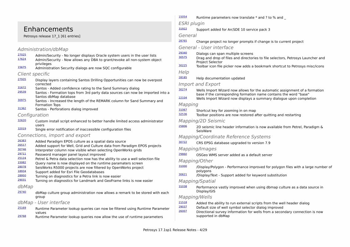
EnhancementsPetrosys release 17_1 [61 entries]
Administration/dbMap27025 Admin/Security - No longer displays Oracle system users in the user lists17624 Admin/Security - Now allows any DBA to grant/revoke all non-system object
privileges15675 Administration Security dialogs are now SQC configurable
Client specific27935 Display layers containing Santos Drilling Opportunities can now be overpost
corrected31672 Santos - Added confidence rating to the Sand Summary dialog29539 Santos - Formation tops from 3rd party data sources can now be imported into a
Santos dbMap database30975 Santos - Increased the length of the REMARK column for Sand Summary and
Formation Tops31362 Santos - Perforations dialog improved
Configuration32620 Custom install script enhanced to better handle limited access administrator
users32019 Single error notification of inaccessible configuration files
Connections, import and export26383 Added Paradigm EPOS culture as a spatial data source26517 Added support for Well, Grid and Culture data from Paradigm EPOS projects30746 Interpreter column now visible when selecting OpenWorks grids29711 Password manager panel layout improved25124 Petrel & Petra data selection now has the ability to use a well selection file15082 Query name is now displayed on the runtime paramaters screen28078 SeisWorks R5000 projects are now filtered by OpenWorks project18934 Support added for Esri File Geodatabases28950 Turning on diagnostics for a Petra link is now easier29031 Turning on diagnostics for Landmark and GeoFrame links is now easier
dbMap29740 dbMap culture group administration now allows a remark to be stored with each
group
dbMap - User interface25169 Runtime Parameter lookup queries can now be filtered using Runtime Parameter
values29768 Runtime Parameter lookup queries now allow the use of runtime parameters
15054 Runtime parameters now translate * and ? to % and _
ESRI plugin31922 Support added for ArcSDE 10 service pack 3
General28765 Change project no longer prompts if change is to current project
General - User interface29340 Dialogs can span multiple screens30575 Drag and drop of files and directories to file selectors, Petrosys Launcher and
Project Selector30225 Toolbar icon file picker now adds a bookmark shortcut to Petrosys misc/icons
Help28185 Help documentation updated
Import and Export30274 Wells Import Wizard now allows for the automatic assignment of a formation
base if the corresponding formation name contains the word "base"22104 Wells Import Wizard now displays a summary dialogue upon completion
Mapping31067 Shortcut key for zooming in on map32536 Toolbar positions are now restored after quitting and restarting
Mapping/2D Seismic 25806 2D seismic line header information is now available from Petrel, Paradigm &
SeisWare
Mapping/Coordinate Reference Systems30722 CRS EPSG database upgraded to version 7.9
Mapping/Images29860 OSGeo WMS server added as a default server
Mapping/Other31000 /Display/Polygon - Performance improved for polygon files with a large number of
polygons30621 /Display/Text - Support added for keyword substitution
Mapping/Spatial31038 Performance vastly improved when using dbmap culture as a data source in
Display/GIS
Mapping/Wells21518 Added the ability to run external scripts from the well header dialog29037 Default size of well symbol selector dialog improved26007 Directional survey information for wells from a secondary connection is now
supported in dbMap
Petrosys 17.1sp1 Release Notes - 4/29

26808 Display/Wells/dbMap - Well Header screen now allows editing from a secondary connections
28357 Formation top information for wells from a secondary connection is now supported in dbMap
23840 Improved consistency in terminology relating to well related thicknesses26399 Well header screen now available for Paradigm-EPOS
Petrel plugin24934 Petrel culture/polygon/point data handling improvements
Project Selector31475 Cancelling copy now removes partially copied project29416 Group combobox now ordered alphanumerically29150 New project parent directory immediately updates UI31944 Project Selector administration dialog layout improved29322 Project selector list speed improved32097 Speed of group administration dialog improved
Surface Modeling29259 Fault/Extract Z values from seismic panel layout improved
Surface Modeling/Gridding30950 Gridding from well data improved across all data types26397 Support added for Paradigm well data in gridding28264 Support added for SeisWare well data in gridding
Web map server32055 Authentication is no longer required for cross domain policy files
Well data30408 dbMap Well production screens and charts now support secondary connections25040 Display/Wells now shows the CRS of the well data source
Petrosys 17.1sp1 Release Notes - 5/29
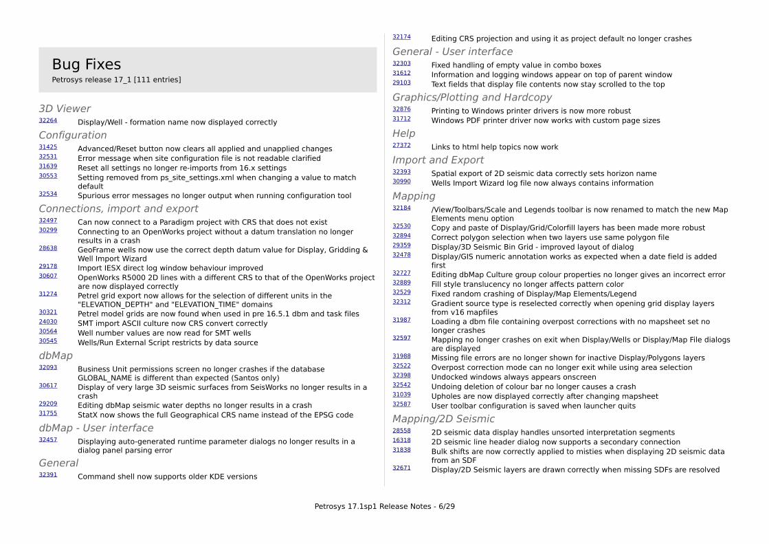
Bug FixesPetrosys release 17_1 [111 entries]
3D Viewer32264 Display/Well - formation name now displayed correctly
Configuration31425 Advanced/Reset button now clears all applied and unapplied changes32531 Error message when site configuration file is not readable clarified31639 Reset all settings no longer re-imports from 16.x settings30553 Setting removed from ps_site_settings.xml when changing a value to match
default32534 Spurious error messages no longer output when running configuration tool
Connections, import and export32497 Can now connect to a Paradigm project with CRS that does not exist30299 Connecting to an OpenWorks project without a datum translation no longer
results in a crash28638 GeoFrame wells now use the correct depth datum value for Display, Gridding &
Well Import Wizard29178 Import IESX direct log window behaviour improved30607 OpenWorks R5000 2D lines with a different CRS to that of the OpenWorks project
are now displayed correctly31274 Petrel grid export now allows for the selection of different units in the
"ELEVATION_DEPTH" and "ELEVATION_TIME" domains30321 Petrel model grids are now found when used in pre 16.5.1 dbm and task files24030 SMT import ASCII culture now CRS convert correctly30564 Well number values are now read for SMT wells30545 Wells/Run External Script restricts by data source
dbMap32093 Business Unit permissions screen no longer crashes if the database
GLOBAL_NAME is different than expected (Santos only)30617 Display of very large 3D seismic surfaces from SeisWorks no longer results in a
crash29209 Editing dbMap seismic water depths no longer results in a crash31755 StatX now shows the full Geographical CRS name instead of the EPSG code
dbMap - User interface32457 Displaying auto-generated runtime parameter dialogs no longer results in a
dialog panel parsing error
General32391 Command shell now supports older KDE versions
32174 Editing CRS projection and using it as project default no longer crashes
General - User interface32303 Fixed handling of empty value in combo boxes31612 Information and logging windows appear on top of parent window29103 Text fields that display file contents now stay scrolled to the top
Graphics/Plotting and Hardcopy32876 Printing to Windows printer drivers is now more robust31712 Windows PDF printer driver now works with custom page sizes
Help27372 Links to html help topics now work
Import and Export32393 Spatial export of 2D seismic data correctly sets horizon name30990 Wells Import Wizard log file now always contains information
Mapping32184 /View/Toolbars/Scale and Legends toolbar is now renamed to match the new Map
Elements menu option32530 Copy and paste of Display/Grid/Colorfill layers has been made more robust32894 Correct polygon selection when two layers use same polygon file29359 Display/3D Seismic Bin Grid - improved layout of dialog32478 Display/GIS numeric annotation works as expected when a date field is added
first32727 Editing dbMap Culture group colour properties no longer gives an incorrect error32889 Fill style translucency no longer affects pattern color 32529 Fixed random crashing of Display/Map Elements/Legend32312 Gradient source type is reselected correctly when opening grid display layers
from v16 mapfiles31987 Loading a dbm file containing overpost corrections with no mapsheet set no
longer crashes32597 Mapping no longer crashes on exit when Display/Wells or Display/Map File dialogs
are displayed31988 Missing file errors are no longer shown for inactive Display/Polygons layers32522 Overpost correction mode can no longer exit while using area selection32398 Undocked windows always appears onscreen32542 Undoing deletion of colour bar no longer causes a crash31039 Upholes are now displayed correctly after changing mapsheet32587 User toolbar configuration is saved when launcher quits
Mapping/2D Seismic 28558 2D seismic data display handles unsorted interpretation segments16318 2D seismic line header dialog now supports a secondary connection31838 Bulk shifts are now correctly applied to misties when displaying 2D seismic data
from an SDF32671 Display/2D Seismic layers are drawn correctly when missing SDFs are resolved
Petrosys 17.1sp1 Release Notes - 6/29

Mapping/Bubble Maps28414 Dbm files containing multiple bubble map layers are now drawn correctly when
the redraw button is pressed
Mapping/Coordinate Reference Systems28610 CRS Editor stores decimal values exactly as entered by the user31717 CRS matching improved for shapefiles containing RSO based projections28402 CRS now handled correctly while editing dbMap seismic line coordinates as
Easting Northing26726 Improvements to well symbol and drawing tools stored coordinates
Mapping/Editors32701 CFP Editor - Refresh and drawing issues fixed31509 CFP Editor no longer crashes after undoing contour creation32738 Editing a grid layer in mapping no longer hides all other Display/Grid/Values
layers32550 Undo and redo of Mapping changes is disallowed while overpost correcting text
Mapping/Images31135 ArcSDE rasters loaded with an offset are now displayed in the correct position24432 Selection of any supported CRS now available when displaying raster from WMS
servers
Mapping/Map Sheets31548 Display/Map Elements/Other Mapsheet Ref Grid now has a mapsheet selector
Mapping/Other31989 Modifying faults layer with missing SMT file will now bring up the modify dialog32306 Undo is now always disabled when in georeferencing mode
Mapping/Spatial30866 Display/Spatial no longer crashes while working with large shape files32790 Query attributes shows correct attributes for Petrosys polygon files32789 Zooming in and then out on ArcSDE layers no longer results in nothing being
drawn
Mapping/Wells31729 Annotation queries returning well locations now post in the correct location when
a mismatch occurs between the project default CRS and the CRS of the well database
26337 Compute bottom hole option on well header coordinates dialog now configurable for different data models
31805 Display/Wells no longer shows overpost corrected text and original text simultaneously
30231 Generic Well header dialog now handles data from multiple sources which is displayed simultaneously
27529 Inoperative Selection-list option removed from Display/Wells OpenWorks and GeoFrame in Mapping and 3D Viewer
31833 Wells selection using a form is now restored correctly after reopening a DBM file
Paradigm-EPOS plugin30028 Attempting to read interpretation data from large Paradigm 3D surveys should no
longer result in a crash32208 Querying a Paradigm-EPOS survey while connected to an associated project now
returns the correct survey CRS 29463 Selecting grid horizons in the Paradigm Grid Export dialog no longer allows
reconnection to a project for which user permission has been revoked
Project Selector29429 Appropriate buttons are now enabled when an invalid project is selected29271 Can no longer assign properties to invalid projects29499 Copy project to an existing directory no longer allowed28298 Deleting current project now deselects31489 Full Lockdown user project selector no longer redraws during project listing32592 GroupLockdown users defined via * can now use Groups32319 Invalid projects now cleared from templates list32584 Newly added "empty projects" now appear in the project list immediately29377 Rename and copy of path mapped projects now works29500 Selecting a group then unselecting maintains Parent Location path31301 User and Group administration dialog layout more flexible
Seismic data18261 Display and Import of 3D seismic surfaces and grids from GeoFrame returns data
in consistent units29831 SDF Seismic - Reports/Line Length no longer crashes when no map sheet file or
name is selected28653 Velocities/Depth Converter now lets you select SDF and SLS files in dialogs that
use them
Surface Modeling29240 Interactive panel resized32430 Spatial Data Translator logs information output to diagnostics window
Surface Modeling/Grid Operations31551 Grid/Process/Arithmetic now has a mapsheet selector if AOI is defined by a
mapsheet
Surface Modeling/Gridding15858 Back interpolate to WDF - Thickness TVD now finds correct intersections30620 Back interpolation to SDF now correctly preserves fault settings30723 Back interpolation to WDF works when attribute is used25300 Correct panel is now displayed when gridding from dbMap Formation Tops23807 Grid data scan now ignores missing well coordinates24116 Gridding formations ignored wells with no directional survey or bottom hole
location for PPDM 3.7/3.8 datasources30611 Gridding from an SDF and selecting VAV as the input data type now disables the
second horizon name28731 Gridding well data using a query now uses the surface location if a NULL value is
returned by the query
Petrosys 17.1sp1 Release Notes - 7/29

Surface Modeling/Volumetrics28236 Grid-based-slice volumetrics / Thickness method - Individual slice volume and
area reporting has been made more consistent
Web map server32647 All map layer types now rendered in the expected order32648 Configuration panel will not locked up on finish32345 User validation now works when authentication enabled32885 WMS Server - Colors are now correct32352 WMS Server now prevents users from connecting when they enter the wrong
username/password
Well data30754 Database information now correctly used to retrieve a wells Final Total Depth
across different data models32842 Fixed crash in well selection using expression panel
Petrosys 17.1sp1 Release Notes - 8/29

Detailed Release NotesPetrosys release 17_1 [172 entries]
3D Viewer Bug Fixes
Display/Well - formation name now displayed correctly 32264
Display/Wells formation annotation posts formation "name". Previously in version 17 it would incorrectly post "author".
Administration/dbMap Enhancements
Admin/Security - No longer displays Oracle system users in the user lists 27025
Petrosys no longer displays Oracle system users in the Admin/Security user lists.
Admin/Security - Now allows any DBA to grant/revoke all non-system object privileges 17624
Petrosys no longer limits grant/revoke privileges to Petrosys roles.
Administration Security dialogs are now SQC configurable 15675
The Administration Security dialogs have been updated to allow configuration through SQC files.
Petrosys 17.1sp1 Release Notes - 9/29

Client specific Enhancements
Display layers containing Santos Drilling Opportunities can now be overpost corrected 27935
It is now possible to use overpost correction on display layers containing data from the SANTOS specific option Display/Prospects & Leads/Drilling opportunities.
Santos - Added confidence rating to the Sand Summary dialog31672
The Sand Summary dialog now displays and allows the editing of a Confidence Rating.
Santos - Formation tops from 3rd party data sources can now be imported into a Santos dbMap database 29539
The Wells Import Wizard has been updated to allow the importing of formation tops into a Santos specific dbMap database.
Santos - Increased the length of the REMARK column for Sand Summary and Formation Tops 30975
The remarks field for the Formation Tops and Sand Summary dialogs now allows for 240 characters, where as previously it was limited to 50 and 60 respectively.
Santos - Perforations dialog improved 31362
The Perforations dialog now includes the perforation status code. In addition, Shots per foot, Formations and Sands information has been moved from the display panel into the scrolled list, enabling a simplified view of data.
Configuration Enhancements
Custom install script enhanced to better handle limited access administrator users 32620
The custom install script, which can be used to assist the rollout of Petrosys on Windows, has been enhanced to support systems where the PC administrator does not have access to the network administrative install point. It also handles cases where the custom install script has been renamed, for example, to support rolling out of different versions.
Single error notification of inaccessible configuration files 32019
Previously, when configuration files were inaccessible (e.g. if file permissions did not allow reading) the user would receive multiple error messages warning of the condition. This has now been fixed so the user receives a single notification of the error.
Configuration Bug Fixes
Advanced/Reset button now clears all applied and unapplied changes 31425
Resetting configuration settings now clears any unapplied changes. Previously it was possible for unapplied changes made prior to the reset to be applied.
Error message when site configuration file is not readable clarified 32531
Improved error message when config system cant access a file
Reset all settings no longer re-imports from 16.x settings 31639
Previously, resetting all configuration settings would cause any 16.x settings to be imported and upgraded into 17 again. This has now been corrected, so 16.x settings will only be imported once.
Setting removed from ps_site_settings.xml when changing a value to match default 30553
Site settings are now not automatically reverted if they match the defaults
Petrosys 17.1sp1 Release Notes - 10/29
Spurious error messages no longer output when running configuration tool 32534
Previously, on Linux only, QSharedMemory error messages would be output to the console when running Configuration and Settings. These error messages had no affect on the performance of the software, however were distracting.
Connections, import and export Enhancements
Added Paradigm EPOS culture as a spatial data source 26383
Petrosys 17.1 introduces support for Paradigm-EPOS culture data as a spatial data source to the version 17 stream.
Functionality available in 17.1:
➢ Direct display of culture, polygon and boundary sets using the Display/Spatial function in mapping.
➢ Direct import of Paradigm culture, polygon and boundary sets to supported formats using the Spatial Data Translator - available in either Gridding and Contouring, or from the Import and Export options in the Petrosys Launcher.
Some Paradigm data is not stored within the EPOS framework. This data is not available through the EPOS development kit and is therefore not accessible to Petrosys.
For further information on connectivity with Paradigm please contact Petrosys Support.
This functionality has been previously released in 16.10.
Added support for Well, Grid and Culture data from Paradigm EPOS projects 26517
Petrosys can now access Well, Grid & Culture data from Paradigm EPOS projects.
The new functionality includes:
Wells
➢ Direct display of well header, well markers and directional surveys
➢ Direct gridding of well header depths, well markers and well marker attributes
➢ Direct import of well header, well markers and directional surveys to Petrosys WDF files.
Direct display, gridding and import includes support for filtering data using Well Selection lists created within Paradigm.
Grids
➢ Direct display of grids
➢ Direct contouring of grids
➢ Direct import of grids to Petrosys grid files.
The ability to write Grids to Paradigm-EPOS was added in Petrosys version 16.9.
Culture
➢ Direct display
➢ Direct import to Petrosys CUL, ESRI Shapefile or KML using the Spatial Data Translator
Petrosys 17.1sp1 Release Notes - 11/29

Some Paradigm data is not stored within the EPOS framework. This data is not available through the EPOS development kit and is not accessible to Petrosys. For further information on connectivity with Paradigm please contact Petrosys Support.
Interpreter column now visible when selecting OpenWorks grids30746
When selecting an OpenWorks grid for display or import (e.g. via /Display/Grid/Colorfill with OpenWorks selected as the data source) a column has now been added to show the interpreter for the grid. Other columns have also been renamed to better match what is seen in the OpenWorks application.
Password manager panel layout improved 29711
The layout of the password manager dialogs has been improved so resizing allocates space more intelligently.
Petrel & Petra data selection now has the ability to use a well selection file 25124
Petrosys now allows the ability to use a well selection file for data selection when displaying, gridding and/or importing well data from Petrel and Petra. To create a well selection file for either data source, use the Wells Import Wizard to list the wells, select/unselect wells as required, then use the RMB menu to save the well selection file.
Query name is now displayed on the runtime paramaters screen15082
When a user is prompted to enter values for a query that includes runtime parameters, the query name is now displayed in the window title. This can help give context to users entering values.
SeisWorks R5000 projects are now filtered by OpenWorks project28078
When a user is asked to select a new SeisWorks R5000 project, they are now asked to select one or more OpenWorks projects first to filter the list of SeisWorks projects returned. This considerably increases the speed of reading a list of SeisWorks projects for sites with a large number of OpenWorks projects.
Support added for Esri File Geodatabases 18934
Petrosys v17 now includes support for Esri File Geodatabases for the Windows platform only. File Geodatabases are spatially aware databases that can be used to store vector data similar to how a shapefile does. File Geodatabases allow storage of any number of "feature classes", each of which is roughly equivalent to a shapefile in that they each store a different shape type in a different CRS.
Esri File Geodatabases may be used in the following contexts within Petrosys:
➢ Mapping - /Display/GIS - display of feature classes
➢ Mapping- Right Mouse Button/Export spatial - writing feature classes
➢ Spatial data translator - reading and writing feature classes
➢ Surface Modeling - Grid/Create Grid - support for gridding feature classes as a spatial source of data
Notes on supported usage:
➢ Support for both reading and writing feature classes (including limited support for feature classes within a dataset)
➢ No support for layer types other than feature class
➢ No support on Linux at present
➢ No support for blob or raster fields
➢ CRS support is limited to a subset of EPSG CRSs supported by the Esri File Geodatabase API (custom CRSs cannot be used)
Turning on diagnostics for a Petra link is now easier 28950
Previously, to turn on advanced diagnostics logging for a Petra link, a user needed to edit an SQC file and copy it into a specific directory. Advanced diagnostics can now be turned on using File/Preferences/Diagnostics BEFORE connecting to a Petra project.
Turning on diagnostics for Landmark and GeoFrame links is now easier 29031
Previously, to turn on advanced diagnostics logging for the Landmark & GeoFrame links, a user needed to set an environment variable in an xterm before launching Petrosys from that same xterm.
Advanced diagnostics can now be turned on using File/Preferences/Diagnostics BEFORE connecting to an OpenWorks, SeisWorks, GeoFrame or IESX project.
Connections, import and export Bug Fixes
Can now connect to a Paradigm project with CRS that does not exist 32497
It is now possible to connect to a Paradigm project if it has a CRS name assigned that does not exist in Paradigm. This can occur if a project from an external vendor/client has been restored in Paradigm. Previously you would get an error that the connection was lost, and would not be able to connect to the project. Now you are prompted to select a CRS to use with the project.
Petrosys 17.1sp1 Release Notes - 12/29

Connecting to an OpenWorks project without a datum translation no longer results in a crash 30299
When connecting to an OpenWorks project that has a datum which has not been translated to a Petrosys one, the application no longer crashes. You now get an error describing the problem.
GeoFrame wells now use the correct depth datum value for Display, Gridding & Well Import Wizard 28638
When reading GeoFrame wells using Display/Wells, Grid/Create grid or File/Import/Wells, the depth datum (KB) used for computing subsea reference depths was incorrect for some wells. This occurred for wells in GeoFrame where the "Kelly_Bushing_Reference" attribute was different to the "Working Datum" seen on the well header. The "Working Datum" value from the GeoFrame well header is now read for all options.
This was not a problem when importing wells using the File/Import/Geoquest/GeoFrame-wdf option.
Import IESX direct log window behaviour improved 29178
Previously the Import IESX log window would appear on top of the import windows and could not be dismissed. It has been changed so the dialog can now be closed.
OpenWorks R5000 2D lines with a different CRS to that of the OpenWorks project are now displayed correctly 30607
Displaying 2D seismic data from OpenWorks or SeisWorks R5000 projects now shows lines that have a different CRS to that of the OpenWorks project. Previously these lines did not appear because Petrosys was checking the bounding box corner points of the 2D line, assuming they were Easting/Northing coordinates derived from the OpenWorks project CRS. This is not always the case, and it is even possible for the bounding box coordinates to be Latitude/Longitude values.
Petrel grid export now allows for the selection of different units in the "ELEVATION_DEPTH" and "ELEVATION_TIME" domains 31274
When running the /Export/Grids option from the Petrel plugin (Tools/Petrosys -> Import/Export) it is now possible to select the domain data units to convert from. If you select domain "ELEVATION_TIME", you can select either milliseconds or seconds, and for the domain "ELEVATION_DEPTH", you can select either feet or metres.
Petrel model grids are now found when used in pre 16.5.1 dbm and task files 30321
If you have a .dbm file created prior to 16.5.1 which contains a /Display/Grid/* item that uses Petrel model grids, it can now be opened and the grid will be displayed correctly. Previously, the Petrel model grid would not be found, and nothing would appear on the map.
Similarly, any .tsk files created prior to 16.5.1 that contain Petrel grids will now work correctly.
SMT import ASCII culture now CRS convert correctly 24030
A bug where Import/SMT/Import ASCII culture file was incorrectly reading EN coordinates as LL values has been fixed. The end result polygon file therefore had wrong coordinates and would not display in the correct location.
Well number values are now read for SMT wells 30564
Previously, Petrosys was reading Well name values from SMT but not Well number values. We now read Well name and Well number values and they are available in direct display, direct import to Petrosys WDF files and on the SMT Well header screen.
Wells/Run External Script restricts by data source 30545
The Run external script option available from the Right-Mouse-Button menu when you select a well on the map was returning a list of all external scripts. It now correctly limits to only scripts applicable to the selected well's datasource.
Petrosys 17.1sp1 Release Notes - 13/29

dbMap Enhancements
dbMap culture group administration now allows a remark to be stored with each group 29740
A remark can now be stored with each Petrosys Culture group in a dbMap database. This is useful for storing meta data about a culture group.
dbMap Bug Fixes
Business Unit permissions screen no longer crashes if the database GLOBAL_NAME is different than expected (Santos only) 32093
The Business Unit Permissions screen crashed if the GLOBAL_NAME of the Oracle database did not match the naming convention previously used for this field. This has been resolved so that the GLOBAL_NAME is no longer used.
Display of very large 3D seismic surfaces from SeisWorks no longer results in a crash 30617
When attempting to read and display a grid from SeisWorks that is too large to display using the available memory, Petrosys mapping now gives a warning that there is insufficient memory available to display the grid. It is advisable, as stated in that warning, to restart Petrosys mapping when this occurs.
Editing dbMap seismic water depths no longer results in a crash29209
The stability of the /Edit/Seismic/Lines/dbMap/Edit/Water depths option has been improved so that it no longer crashes intermittently.
StatX now shows the full Geographical CRS name instead of the EPSG code 31755
The Petrosys StatX software now displays the full Geographical CRS name in the uphole selection status text, left-hand summary display and as part of the exported statistics report. Previously, only the EPSG code for the relevant CRS was given.
dbMap - User interface Enhancements
Runtime Parameter lookup queries can now be filtered using Runtime Parameter values 25169
Petrosys now allows runtime parameter lookup queries to be filtered based on other runtime parameter values.
Runtime Parameter lookup queries now allow the use of runtime parameters 29768
Petrosys runtime parameter lookup queries can now contain other runtime parameters. However, whatever runtime parameter is used in the lookup query must be present in the runtime parameter query used in the runtime parameter lookup query.
Runtime parameters now translate * and ? to % and _ 15054
Petrosys runtime parameters now correctly translate the wildcard characters * and ? to the corresponding SQL wildcards % and _.
dbMap - User interface Bug Fixes
Displaying auto-generated runtime parameter dialogs no longer results in a dialog panel parsing error 32457
A problem has been fixed where in some cases when trying to use runtime parameters, Petrosys would display a dialog panel parsing error.
Petrosys 17.1sp1 Release Notes - 14/29

ESRI plugin Enhancements
Support added for ArcSDE 10 service pack 3 31922
Petrosys is now compatible with ArcSDE 10.0 service pack 3 servers on all platforms other than Solaris, where support remains limited to ArcSDE 9.3.
General Enhancements
Change project no longer prompts if change is to current project28765
In the situation where a project change (via the Project Selector) would cause an attached tool (e.g. Mapping) to change into the same project, the user is no longer prompted to acknowledge the project change.
This situation could occur if a project change request was cancelled by the user in the attached tool and then subsequently a second project change back to the original project initiated.
General Bug Fixes
Command shell now supports older KDE versions 32391
In some cases the command shell (from Application Launcher/File/Command Shell... on Linux only) would not appear on some older versions of KDE. This has now been fixed so the command shell can be called on all versions of KDE.
Editing CRS projection and using it as project default no longer crashes 32174
An issue where the CRS database could be used before it had loaded and then leading to a crash has been fixed.
Petrosys 17.1sp1 Release Notes - 15/29

General - User interface Enhancements
Dialogs can span multiple screens 29340
Certain windows, such as mapping, are now allowed to span multiple windows but are restricted to the virtual desktop.
Drag and drop of files and directories to file selectors, Petrosys Launcher and Project Selector 30575
Drag and drop of folders and files have been added to a number of places in Petrosys.
Project directories can be dragged from a File Manager to the Petrosys Launcher to change to that project. Project directories can also be dragged to the Project Selector to add the project to the project list.
Files and directories can be dragged file and directory selector widgets to select the file or directory.
This feature is supported on Windows and Linux under all popular window managers.
Toolbar icon file picker now adds a bookmark shortcut to Petrosys misc/icons 30225
The toolbar icon file selector now adds a bookmark shortcut to Petrosys misc/icons. This provides easier navigation to the Petrosys icons directory to pick Petrosys icon files.
General - User interface Bug Fixes
Fixed handling of empty value in combo boxes 32303
Now empty value in combo boxes is treated the same way it was in v16.
Information and logging windows appear on top of parent window 31612
A number of information and log windows have been changed so they will appear on top of their parent windows. In previous versions it was possible for the child window to appear underneath the parent window.
Text fields that display file contents now stay scrolled to the top29103
Previously, in version 17, text fields that display file contents would scroll to the bottom of the input. This would make it difficult to use in situations like previewing files to define import formats.
Graphics/Plotting and Hardcopy Bug Fixes
Printing to Windows printer drivers is now more robust 32876
In some situations printing to a Windows printer driver could fail with either a blank page or a few marks on the page, this is now fixed. This could also happen when selecting to output to a file rather than direct to the device.
Windows PDF printer driver now works with custom page sizes31712
When printing to a Windows printer that is a PDF driver the custom paper size now works, depending on the vendor of the PDF driver. As a work around if a PDF driver doesn't handle custom paper sizes with Petrosys perform the following:
➢ Control Panel > View devices and printers > Print server properties
➢ Check 'Create a new form', enter a form name and enter appropriate dimensions
➢ Click the 'Save Form' button and hit OK
➢ This will now be available in the 'Printer Setup' dialog as a paper size
Petrosys 17.1sp1 Release Notes - 16/29

Help Enhancements
Help documentation updated 28185
Various help topics have been created and updated to better reflect the current software. Changes include:
➢ the Petrosys Launcher now has a help topic to provide guidance on correct usage
➢ use of Petrel culture import and export features
➢ use of Esri File Geodatabases documented
➢ version 17 Getting Started Guide improved
Help Bug Fixes
Links to html help topics now work 27372
Linking to html topics now works correctly in help. Previously html help topic links would not be displayed in the online help.
Import and Export Enhancements
Wells Import Wizard now allows for the automatic assignment of a formation base if the corresponding formation name contains the word "base" 30274
A check box is now provided on the Wells Import Wizard formation/zone mapping step dialog to allow the user to enable or disable the auto matching of top/base assignment. This is enabled by default.
Wells Import Wizard now displays a summary dialogue upon completion 22104
The Wells Import Wizard now displays a summary dialog at the end of the import showing the number of wells processed, the number of well headers added/updated. It also displays similar information for formation tops, zones and directional surveys.
Import and Export Bug Fixes
Spatial export of 2D seismic data correctly sets horizon name32393
When a 2D seismic data layer is displaying horizon data and is exported via the RMB/Export Spatial data option, an attribute is created in the output data containing the horizon data values. In previous versions, this attribute was incorrectly named - it is now set to a combination of the horizon name and data type.
Wells Import Wizard log file now always contains information 30990
The Wells Import Wizard now always writes information to the log file. Under certain conditions the log file was being written but contained no information.
Petrosys 17.1sp1 Release Notes - 17/29

Mapping Enhancements
Shortcut key for zooming in on map 31067
Users can now activate Zoom-in mode by pressing 'z'.
Toolbar positions are now restored after quitting and restarting32536
The user placement of toolbars in Mapping is now restored between Mapping sessions. Previously, each time Mapping was started the toolbars would be placed in their default locations.
Mapping Bug Fixes
/View/Toolbars/Scale and Legends toolbar is now renamed to match the new Map Elements menu option 32184
The toolbar name "Scale and Legends" has been changed to match the change done to the corresponding menu option Display/Map Elements. The toolbar is now named "Map Elements Toolbar".
Copy and paste of Display/Grid/Colorfill layers has been made more robust 32530
Copying and pasting of Display/Grid/Colorfill layers previously caused a crash in certain circumstances - particularly for layers in groups.
Correct polygon selection when two layers use same polygon file32894
In Mapping, when the same polygon file is displayed in multiple layers with different polygon selections, the selection will be correctly retained the layer is opened for modification. Displaying the same polygon file twice is a good way to get different display styles for different polygons in the same file.
Previously the selection of one layer would be used to set the selection of a subsequently opened layer.
Display/3D Seismic Bin Grid - improved layout of dialog 29359
The Display/3D Seismic Bin Grid dialog has had the layout improved so that the overall size has been decreased without losing context.
Display/GIS numeric annotation works as expected when a date field is added first 32478
In previous versions, if a date type field was the first field in the list of annotations in Display/GIS (previously Display/Spatial), subsequent numeric fields would be drawn as blank.
Editing dbMap Culture group colour properties no longer gives an incorrect error 32727
In previous 17 versions, the "Admin/Culture Data Groups..." panel would not allow changes to be saved due to an incorrect error regarding pattern fill size.
Fill style translucency no longer affects pattern color 32889
In earlier v17 versions, setting a translucency for a fill style would incorrectly be applied to the pattern color. Translucency is now only applied to the background color as expected.
Fixed random crashing of Display/Map Elements/Legend 32529
Display/Map Elements/Legend has been fixed and is not crashing now.
Gradient source type is reselected correctly when opening grid display layers from v16 mapfiles 32312
Display/Grid/Colorfill layers loaded from a dbm file created using v16 or earlier, with "clip to mapsheet" unticked could incorrectly show "clip to mapsheet" as ticked when the panel was opened in v17 versions of Petrosys.
Loading a dbm file containing overpost corrections with no mapsheet set no longer crashes 31987
In previous v17 versions of Petrosys, if a dbm was loaded that contained overpost corrections and no mapsheet was currently selected (for example, after starting in a new project) then Mapping would crash.
Mapping no longer crashes on exit when Display/Wells or Display/Map File dialogs are displayed 32597
In previous 17 versions, Mapping would crash when the program was quit while the Display/Wells or Display/Map File dialogs were displayed. This crash had no effect on user data as the crash occurred after prompting to save the current map and during the process termination sequence.
Petrosys 17.1sp1 Release Notes - 18/29

Missing file errors are no longer shown for inactive Display/Polygons layers 31988
In previous v17 versions of Petrosys, if a Display/Polygon layer referenced a polygon file that did not exist, an error would incorrectly be shown each time the map was drawn.
Overpost correction mode can no longer exit while using area selection 32522
In previous 17.0 versions it was possible to exit the overpost correction mode when the area select tool was active. This could then lead to Mapping crashing. This has been corrected to conform to the 16 behaviour, where it was not possible to exit overpost correction mode while the select tool was active.
Undocked windows always appears onscreen 32398
Previously it was possible for undocked windows (e.g. Mapping/Display/Modify window) to appear off screen. This could happen if the resolution or display configuration changed between Petrosys sessions (e.g. changing from a multi-screen docking station to laptop screen).
This has now be fixed so windows will always appear in the visible area of the display.
Undoing deletion of colour bar no longer causes a crash 32542
In previous versions of Petrosys, undoing the deletion of a Display/Colorbar layer could cause a crash in some circumstances.
Upholes are now displayed correctly after changing mapsheet31039
If a map contains a layer displaying upholes, the mapping window now refreshes correctly if the mapsheet is changed to one covering a different area. Previously, no upholes or a subset of the upholes would appear on the new mapsheet.
User toolbar configuration is saved when launcher quits 32587
A bug where Mapping user toolbar configuration was incorrectly removed when launcher quits has been fixed.
Mapping/2D Seismic Enhancements
2D seismic line header information is now available from Petrel, Paradigm & SeisWare 25806
Petrosys now has the ability to display 2D seismic line header information for data from Petel, Paradigm & SeisWare.
Mapping/2D Seismic Bug Fixes
2D seismic data display handles unsorted interpretation segments 28558
In previous versions, the Display/2D Seismic option did not draw 2D seismic data or ribbon maps correctly for interpretation segments that were not sorted. This was observed as missing data or ribbon segments.
2D seismic line header dialog now supports a secondary connection 16318
The displaying of 2D seismic line header information from a secondary dbMap connection now queries the correct database.
Bulk shifts are now correctly applied to misties when displaying 2D seismic data from an SDF 31838
The misties tab on the Display/2D Seismic option (applicable only when displaying data from an SDF) has an option to include bulk shift data. In previous versions, this option did not have any effect. It now correctly incorporates bulk shift data into the mistie display.
Display/2D Seismic layers are drawn correctly when missing SDFs are resolved 32671
In previous v17 versions of Petrosys, missing SDFs could be resolved when Display/2D Seismic layers were loaded, but the layers would still not get drawn on the map.
Petrosys 17.1sp1 Release Notes - 19/29

Mapping/Bubble Maps Bug Fixes
Dbm files containing multiple bubble map layers are now drawn correctly when the redraw button is pressed 28414
Fixed a bug where a dbm file containing multiple bubble map layers was not drawn correctly when the redraw button was pressed.
Mapping/Coordinate Reference Systems Enhancements
CRS EPSG database upgraded to version 7.9 30722
The EPSG CRS data available within Petrosys has been upgraded from version 7.6 to version 7.9. Please refer to http://www.epsg.org for specific details of changes between these versions.
Mapping/Coordinate Reference Systems Bug Fixes
CRS Editor stores decimal values exactly as entered by the user28610
In previous versions, entering certain numbers for projection parameters in the Admin/CRS/Projected CRS Editor could result in an approximate number being stored and displayed. For example, a number ending with .7 may have been stored as .6999999. Such numbers are now stored as entered.
CRS matching improved for shapefiles containing RSO based projections 31717
In previous versions, shapefiles containing a Rectified Skew Orthomorphic based CRS would be matched to a custom CRS when read. In particular, this bug affected Timbalai 1948 /RSO Borneo (ft) (EPSG:29872) and Timbalai 1948 / RSO Borneo (m) (EPSG 29873).
CRS now handled correctly while editing dbMap seismic line coordinates as Easting Northing 28402
In previous versions, when seismic lines stored as geographic coordinates were edited as Easting-Northing, the coordinates were not correctly converted to the correct projected CRS. Now, the correct conversion to and from the mapsheet projected CRS is performed while editing.
Improvements to well symbol and drawing tools stored coordinates 26726
The coordinate values for the various Display/Drawing Tools layers are stored and saved into dbm files in a more robust manner that allows their position to be maintained when displaying on different mapsheets or opening in different projects.
Petrosys 17.1sp1 Release Notes - 20/29

Mapping/Editors Bug Fixes
CFP Editor - Refresh and drawing issues fixed 32701
The Contour, Fault and Polygon editor has a number of issues with elements not being drawn correctly fixed. This lead to the impression that the contour, fault or polygon had been lost when it was not being drawn on the screen. The majority of the issues were only present on Linux.
CFP Editor no longer crashes after undoing contour creation 31509
In previous versions, selecting and deselecting a contour to extend in the contour, faults and polygon editor could cause a crash if the map happened to be redrawn.
Editing a grid layer in mapping no longer hides all other Display/Grid/Values layers 32738
When a grid is edited, Display/Grid/Value layers are no longer hidden, unless they are displaying from the same grid being edited.
Undo and redo of Mapping changes is disallowed while overpost correcting text 32550
This prevents a potential crash due to Mapping display layers changing while being overpost corrected. As part of this change, panning has also been disabled while area select is active in overpost correction mode as this could lead to the software entering a hung state from which it was not possible to exit overpost correction mode.
Mapping/Images Enhancements
OSGeo WMS server added as a default server 29860
The OSGeo WMS server (http://vmap0.tiles.osgeo.org/wms/vmap0) has been added as a WMS server to the default list of servers. This helps users get started with the WMS display option by providing some sample imagery.
The NASA JPL WMS server has been removed from the default WMS server list as it no longer provides a full WMS compliant service.
Mapping/Images Bug Fixes
ArcSDE rasters loaded with an offset are now displayed in the correct position 31135
In previous versions, when Display/Picture/Raster was used to display ArcSDE raster images that had been loaded with an offset, the offset was not considered when positioning the image, resulting in the image being displayed in an incorrect location. The offset is now honored when the image is displayed.
Selection of any supported CRS now available when displaying raster from WMS servers 24432
The Display/Picture/Raster Image WMS datasource now allows selection of an arbitrary CRS from the supported list provided by a WMS server. In previous versions, the CRS was limited to those using WGS84 (if available) to work-around limitations in third-party WMS servers, which are no longer relevant.
Mapping/Map Sheets Bug Fixes
Display/Map Elements/Other Mapsheet Ref Grid now has a mapsheet selector 31548
A bug where Mapping Display/Map Elements/Other Mapsheet Reference Grid was missing a mapsheet selector for the user to select a mapsheet has been fixed.
Petrosys 17.1sp1 Release Notes - 21/29

Mapping/Other Enhancements
/Display/Polygon - Performance improved for polygon files with a large number of polygons 31000
The responsiveness of the /Display/Polygon panel has been significantly improved when it deals with large polygon files.
/Display/Text - Support added for keyword substitution 30621
The /Display/Text option now supports automatic keyword substitution. This allows the use of keywords like <<MAPFILE.FILENAME>> to be placed in the text and they will be dynamically substituted on each redraw. The full set of keywords is available by clicking on Help and searching for the "RUNTIME TEXT SUBSTITUTION" topic.
Mapping/Other Bug Fixes
Modifying faults layer with missing SMT file will now bring up the modify dialog 31989
Previously, if a SMT Fault layer had a missing data source, then, when attempting to open the layer for modification the user was presented with four error messages and the dialog failed to open. This is now fixed in 17.1.
Undo is now always disabled when in georeferencing mode 32306
Previously undo could still be enabled in some situations when in georeferencing mode and, if clicked, could lead to a crash. The undo button is now disabled while in georeferencing mode.
Mapping/Spatial Enhancements
Performance vastly improved when using dbmap culture as a data source in Display/GIS 31038
The performance of dbMap culture data displayed via Display/GIS has been vastly improved (of the order of 10 times) by optimizing the spatial query used to extract the displayed data.
Mapping/Spatial Bug Fixes
Display/Spatial no longer crashes while working with large shape files 30866
Display/Spatial is now more robust while handling large shape files. Previously, a crash could occur while it tried to allocate the required memory.
Query attributes shows correct attributes for Petrosys polygon files 32790
In previous v17 versions, when Display/GIS was used to display a Petrosys polygon file, the RMB/Query Attributes panel incorrectly included multiple copies of the polygon name attribute, where it now includes a single name attribute only.
Zooming in and then out on ArcSDE layers no longer results in nothing being drawn 32789
Display/GIS now handles zooming of ESRI SDE data on the map more robustly. In previous version, SDE data might disappear after several zooming in and out.
Petrosys 17.1sp1 Release Notes - 22/29

Mapping/Wells Enhancements
Added the ability to run external scripts from the well header dialog 21518
Added the ability to run external scripts to the well header dialog. This functionality was previously only available by right clicking a well displayed on a map and selecting the Run External Script option from the popup menu. This option is now available in the well header dialog.
Default size of well symbol selector dialog improved 29037
Previously the default size of the well symbol selector may not display all columns of the available well symbols. This has been changed so all well symbols columns are shown.
Directional survey information for wells from a secondary connection is now supported in dbMap 26007
Directional survey information for wells from a secondary connection can now be displayed using either Display/Wells/dbMap or Edit/Wells/dbMap.
Display/Wells/dbMap - Well Header screen now allows editing from a secondary connections 26808
Petrosys now allows the editing of well header data from a secondary dbMap database connection.
Formation top information for wells from a secondary connection is now supported in dbMap 28357
Formation top information for wells from a secondary connection can now be displayed using either Display/Wells/dbMap or Edit/Wells/dbMap.
Improved consistency in terminology relating to well related thicknesses 23840
There is now a more unified and consistent approach to terminology regarding well related thicknesses throughout the software.
In relation to formations and zones, the term "Isopach" has been replaced with "Thickness".
Also, when gridding well formations or zone thicknesses, the term TVD (True Vertical Depth) is now used instead of TVT (True Vertical Thickness). The exception to this is for clients with custom TVT & TST calculation support in dbMap, using dipping bed information. For these clients, both TVD and TVT thicknesses are now available when gridding dbMap well data. All other well data sources only support gridding TVD thicknesses.
Well header screen now available for Paradigm-EPOS 26399
Petrosys now has the ability to display well header information for Paradigm.
Mapping/Wells Bug Fixes
Annotation queries returning well locations now post in the correct location when a mismatch occurs between the project default CRS and the CRS of the well database 31729
While displaying wells directly from a database, and using an annotation query that returns the posting location, the text now appears in the correct location when the project default CRS is different to that of the wells.
Compute bottom hole option on well header coordinates dialog now configurable for different data models 26337
The compute bottom-hole location option in the well header coordinates dialog previously made use of a query that could not handle different data models. The option has now been modified so it can now be configured to handle a variety of different data models.
Display/Wells no longer shows overpost corrected text and original text simultaneously 31805
In previous versions, selecting a well on the map that has overpost corrected text would result in the original text also being displayed.
Generic Well header dialog now handles data from multiple sources which is displayed simultaneously 30231
A crash has been fixed which occurred while displaying well header information from multiple data sources at the same time. Handling of multiple data sources by the generic well header dialog has also been improved. Changing the selection should now update the dialogue correctly, where previously it would not update and could cause a crash on exiting the dialog.
Inoperative Selection-list option removed from Display/Wells OpenWorks and GeoFrame in Mapping and 3D Viewer 27529
The Selection - list option has been removed from the filtering options on the dialogs relating to the display of wells from GeoFrame and OpenWorks in mapping and 3D viewer. There was no functionality implemented for these options, so they have been removed.
Petrosys 17.1sp1 Release Notes - 23/29

Wells selection using a form is now restored correctly after reopening a DBM file 31833
Well selection defined by a form was previously not being saved correctly to a DBM file. These values are now stored within a DBM file, and should be restored correctly every time the map is loaded.
Paradigm-EPOS plugin Bug Fixes
Attempting to read interpretation data from large Paradigm 3D surveys should no longer result in a crash 30028
A warning is now displayed when 3D seismic interpretation data from Paradigm-EPOS cannot be displayed using the available memory. As stated in this warning message, Petrosys mapping should be restarted, as the attempt to display the data has likely resulted in memory corruption.
Querying a Paradigm-EPOS survey while connected to an associated project now returns the correct survey CRS 32208
Where the CRS of a Paradigm-EPOS survey differs from the CRS of the project to which it is assigned, Petrosys now reads the CRS of the survey, rather than the CRS of the project. Previously, when a survey was retrieved from a project, the CRS associated with the survey would be that of the project. This is not always correct, as the CRS a survey can be different from the project of which it is a part. This should no longer occur. In all cases, while reading from a Paradigm project, the CRS of the survey within the project will be honored.
Selecting grid horizons in the Paradigm Grid Export dialog no longer allows reconnection to a project for which user permission has been revoked 29463
Fixed a crash which occurred when attempting to query grids through an invalid connection. Now, when reconnecting to a project, the user permission for that project is checked in case it has changed. If the user no longer has the appropriate permissions, the application will present a dialog asking for a replacement connection. This prevents the 'Select grid' button from being activated when there is not a valid connection, which in turn prevents a crash which occurred when a query was attempted through an invalid connection.
Petrel plugin Enhancements
Petrel culture/polygon/point data handling improvements 24934
The Petrosys plugin for Petrel has been improved to include the ability to
➢ display of Petrel point data in Display/GIS
➢ import/export of Petrel point data
➢ gridding of Petrel data
➢ export spatial data to Petrel via Spatial data translator
Petrosys 17.1sp1 Release Notes - 24/29

Project Selector Enhancements
Cancelling copy now removes partially copied project 31475
If a project copy operation is cancelled, the partially copied project will now be deleted from the file system. Previously cancelling a project copy would result in a part-copied project remaining on the file system and in the project list.
In addition a number of error conditions are now detected and reported to the user.
Group combobox now ordered alphanumerically 29416
Groups and tags are now sorted alphanumerically in project selector comboboxes. Previously they were unsorted, making it difficult to find the required group or tag in a long list.
New project parent directory immediately updates UI 29150
Entering a path in the new project dialog verifies the path as you type and enables the OK button if the path and the other project parameters are valid. Also, if the path matches the group path of an existing group, the group will be automatically selected, unless a group has already been chosen.
Project Selector administration dialog layout improved 31944
The group, user and tags administration dialogs have been merged into a single tabbed administration dialog. This gives a simpler interface to all the administration functions of the project selector.
Project selector list speed improved 29322
A small optimisation to path mapping in the project selector has improved the speed of populating the project list.
Speed of group administration dialog improved 32097
Fixed an issue where the group administration dialog would take a long time to appear.
Project Selector Bug Fixes
Appropriate buttons are now enabled when an invalid project is selected 29429
Previously it was possible for actions such as Remove to be disabled when an invalid project was selected. The project selector now enables appropriate buttons when an invalid project is selected, either as a single selection or as a part of a multi-selection.
Can no longer assign properties to invalid projects 29271
The properties dialog can now no longer be accessed on invalid projects. Previously it was possible for the user interface to show that properties could be modified on invalid projects, but those changes would have not been applied.
Copy project to an existing directory no longer allowed 29499
To prevent corruption of projects it is no longer possible to copy a project to a project name that already exists (as a directory). To copy a project you must provide a path that doesn't already exist. If it is desired to replace an existing project with a copy, first delete the existing project and then make the copy.
Deleting current project now deselects 28298
Deleting the current project sets the Petrosys Launcher to a state where no project is set, prompting the user to select a project before allowing them to launch any other applications. Previously the deleted project would still be set as the current project, causing unpredictable behaviour.
Full Lockdown user project selector no longer redraws during project listing 31489
Previously Full Lockdown users may have seen the Project Selector interface being redrawn while the list was being populated. This has been fixed so the project selector is drawn only once.
GroupLockdown users defined via * can now use Groups 32592
A group with user * correctly gives all non-listed users access to the group. Previously non-listed users (who are represented by the * user) would not see any groups.
Invalid projects now cleared from templates list 32319
Template projects list now will only include valid template projects. Previously it was possible for an invalid project to appear in the list of templates if it had been assigned to the Templates group.
Newly added "empty projects" now appear in the project list immediately 32584
Previously, when an empty project was created via new, the project would not appear in the project list immediately. Refreshing the list would cause the project to appear, however this was inconvenient. This has been fixed, so all new projects will appear in the list immediately after creation.
Petrosys 17.1sp1 Release Notes - 25/29

Rename and copy of path mapped projects now works 29377
Renaming or copying a path mapped project is now possible. Previously the mapped path was not available for renaming or copying operations.
Selecting a group then unselecting maintains Parent Location path 29500
New and Copy dialogs retain and restore the path set when the group is set to None. Previously a group change would clear the Parent Location path.
User and Group administration dialog layout more flexible 31301
A splitter has been added to the user and group administration screens to allow for longer paths and customisable layout.
Seismic data Bug Fixes
Display and Import of 3D seismic surfaces and grids from GeoFrame returns data in consistent units 18261
Time data for 3D seismic surfaces and grids will now be consistently displayed or imported in ms. This behavior can be overridden by setting the PS_USE_STORAGE_SYSTEM_TIME_UNITS environment variable. If this environment variable is set then the time data is returned in the GeoFrame storage units for the surface or grid.
For non-Time data, surfaces and grids will be consistently returned in the storage system units for that measurement.
In previous versions direct displayed surfaces and grids would always be returned in storage system unit for that measurement and imported grids would be storage in display system units.
SDF Seismic - Reports/Line Length no longer crashes when no map sheet file or name is selected 29831
When running Reports/ Line length from within Seismic SDF, if no map sheet file or name was selected, the program would either produce an error or exit or both. This has now been fixed and the behaviour is to allow for no map sheet to be selected, which results in no AOI clipping in the report.
Velocities/Depth Converter now lets you select SDF and SLS files in dialogs that use them 28653
The File/Select option in the Velocities/Depth Converter has been removed. The SDF and SLS selectors are now included in dialogs that use them.
Surface Modeling Enhancements
Fault/Extract Z values from seismic panel layout improved 29259
The layout of the Faults/Extracting Z values from seismic dialog has been improved to make it easier to use.
Surface Modeling Bug Fixes
Interactive panel resized 29240
The default width of interactive parameters dialog has been reduced. Previously it would appear as an unnecessarily wide panel.
Spatial Data Translator logs information output to diagnostics window 32430
Spatial data translator log output in Surface Modeling now outputs to log window. Previously the log information would be output to the console window, if it was available.
Surface Modeling/Grid Operations Bug Fixes
Grid/Process/Arithmetic now has a mapsheet selector if AOI is defined by a mapsheet 31551
Previously the Grid/Process/Arithmetic Output Geometry tab did not display a mapsheet selector when the area of interest was set to Mapsheet. It was only possible to select a mapsheet from the default mapsheet as selected by Mapping.
This has been corrected so a mapsheet selector is available, so any mapsheet can be selected to define the area of interest.
Petrosys 17.1sp1 Release Notes - 26/29

Surface Modeling/Gridding Enhancements
Gridding from well data improved across all data types 30950
The user interface and the supporting code for well data sources are now consistent across all types of well data. All types of well data are now supported by gridding.
Also, a more comprehensive set of operations may now be performed to gather appropriate well data for gridding. Data may now be gathered from well header depths, formation tops and from user-defined custom queries, set up to extract data for gridding.
Workflows from 16.9.3 and before which contain a gridding task from a well data source will be upgraded after they are saved in 17.1. Once a task file is saved in 17.1, it can no longer be used in older versions.
Formation selection using formation rules is now the same as that which is found in the Well Display option in dbMap. This selection method is available for Petrosys dbMap & third party well data sources.
Well data selection is also available in the Create Grid, Well Tie and Phantom options in gridding.
Support added for Paradigm well data in gridding 26397
Paradigm-EPOS wells are now supported as a data source in gridding.
Support added for SeisWare well data in gridding 28264
SeisWare wells are now supported as a data source in gridding.
Surface Modeling/Gridding Bug Fixes
Back interpolate to WDF - Thickness TVD now finds correct intersections 15858
Intersections are now found when using Thickness TVD grids to back interpolate to WDF files. Note that the terminology has changed and that "Thickness TVD" corresponds to the "Isopach TVT" option for earlier versions of software.
Back interpolation to SDF now correctly preserves fault settings30620
While creating a back interpolation to SDF task, fault file settings are now correctly displayed in the dialog. Fault information is also now embedded in the dialog, where previously it was only available after clicking an icon.
Back interpolation to WDF works when attribute is used 30723
A problem with back interpolation to WDF using an attribute has been fixed. Previously it could crash intermittently.
Correct panel is now displayed when gridding from dbMap Formation Tops 25300
Selecting the data type "Wells" and the data source "dbMap formation tops" in the Data Source Selection dialog in gridding now results in the correct panel being displayed.
Grid data scan now ignores missing well coordinates 23807
When scanning data in the Geometry tab, the code now correctly handles well selection files and any missing values. This results in correct calculation of the grid origin and extents once the scan is complete.
Gridding formations ignored wells with no directional survey or bottom hole location for PPDM 3.7/3.8 datasources 24116
Gridding from PPDM3.7 well data sources will only use data stored in the bottom hole (BH) column if it is supposed to. Most sites should use the surface value.
Gridding from an SDF and selecting VAV as the input data type now disables the second horizon name 30611
Gridding from an SDF using VAV as the data type will now cause the selection box for the second horizon to become blanked out.
Gridding well data using a query now uses the surface location if a NULL value is returned by the query 28731
Creating a grid using input data from a well query that returns the posting location now uses the surface location of the well if a NULL value is retrieved by the query. Previously, it was possible for the location of a different well to be used if no coordinates were returned by the query.
Surface Modeling/Volumetrics Bug Fixes
Grid-based-slice volumetrics / Thickness method - Individual slice volume and area reporting has been made more consistent 28236
When running the thickness grid slice volumetrics, there used to be inconsistencies in the areas reported. The xml report has been modified so that areas reported are consistent with the console report.
Petrosys 17.1sp1 Release Notes - 27/29

Also the volume reported in each individual slice used to show the total volume beneath the incremental area used in the slice. This has been changed to make it display the total volume for the pseudo-horizontal thickness slice. This makes reporting of areas and volumes consistent with the old grid-based volumetrics method, as well as with the slice volumetrics reporting used for tops and top/base methods.
Web map server Enhancements
Authentication is no longer required for cross domain policy files32055
Web browsers reading cross domain policy files (e.g. crossdomain.xml) from the Petrosys WMS server no longer need to authenticate when authentication is enabled. They will be asked to authenticate when accessing maps, map content listings or lists of available services.
Web map server Bug Fixes
All map layer types now rendered in the expected order 32647
In previous versions of v17, the WMS server served dbm layers in reversed order and did not display certain layer types - 2D seismic from SDF in particular.
Configuration panel will not locked up on finish 32648
The WMS configuration wizard accessible from the option "/File/Export/Publish map to WMS" in Mapping will now allow you to create the process without locking you out of the main screen on completion.
User validation now works when authentication enabled 32345
In the Petrosys WMS server validating users was not working if authentication was turned on.
WMS Server - Colors are now correct 32885
In version 17.0, the red and blue components of RGB colour definitions were swapped. This would cause the colours rendered for a image returned by the WMS server to be incorrect. This has now been fixed so the colour definition is now correct.
WMS Server now prevents users from connecting when they enter the wrong username/password 32352
Fixed bug in WMS service allowing users to connect with wrong username/password.
Petrosys 17.1sp1 Release Notes - 28/29

Well data Enhancements
dbMap Well production screens and charts now support secondary connections 30408
Well production data and charts can now be generated using secondary data connections rather than just the primary connection. The data for these reports will be obtained from the connections the associated well was read from.
Display/Wells now shows the CRS of the well data source 25040
The Well Display dialog in both Mapping and 3D viewer now shows the CRS for all well data sources with a single CRS. Data sources with CRSs (for example, where a separate CRS exists for each well or for individual wells within the data source) the CRS is not shown.
Well data Bug Fixes
Database information now correctly used to retrieve a wells Final Total Depth across different data models 30754
The correct well depth database columns are now correctly used to retrieve a wells Final Total Depth across different data models, resulting in improvements while displaying wells, gridding and making directional survey calculations. Previously, different data models were using incorrect database information.
Fixed crash in well selection using expression panel 32842
"Remove" button does not cause a crash any more.
Petrosys 17.1sp1 Release Notes - 29/29