best of the Pedal the Peak District...
13
Pedal the Peak District explore the best of the Peak District on two wheels 9 journeys of discovery by bike Explore the spectacular countryside of the Peak District by bicycle on quiet lanes and traffic-free trails. Pretty villages, superb views, interesting history, fascinating wildlife and geology – it’s all here for you to enjoy on these nine journeys of discovery. Complete with Ordnance Survey maps and helpful advice, these carefully researched routes offer the very best of the Peak District on two wheels. www.visitpeakdistrict.com/cycleroutes
Transcript of best of the Pedal the Peak District...

Pedal the Peak District
explore the best of the Peak District on two wheels 9 journeys of discovery by bike
Explore the spectacular countryside of the Peak District by bicycle on quiet lanes and traffic-free trails. Pretty villages, superb views, interesting history, fascinating wildlife and geology – it’s all here for you to enjoy on these nine journeys of discovery.
Complete with Ordnance Survey maps and helpful advice, these carefully researched routes offer the very best of the Peak District on two wheels.
www.visitpeakdistrict.com/cycleroutes

The nine routes in this brochure have been chosen to offer you some of the best views, the most picturesque villages, the quietest lanes (and former railway lines) and an abundance of cycle friendly cafes and pubs for refreshments. Hear the birdsong and smell the wildflowers as you pedal and give yourself time to stop awhile at the interesting places en-route. This is a special landscape and you need time to admire those views!
Following the routes The routes have been designed as leisurely day rides for reasonably fit riders and involve some hills, so
choose a route suitable to your level of fitness, and don’t feel disheartened if you have to get off and push occasionally. Just enjoy the fresh air and exercise! Route 1 is the easiest, and they become progressively more challenging so that Route 9 requires the highest level of fitness. They use open public roads (traffic is generally light and the short busier sections where you should take extra care are marked on the map) with some sections of traffic free trails. Each route is highlighted on its own Ordnance Survey map with arrows showing which way round to go and added directions at certain points to help you with navigation.
Although the routes are not waymarked, all the information you need is on the route maps, so it will help to study them before you cycle. Some of the shorter routes may be suitable for adventurous families but none are suitable for very young children. Route maps are at 1:50,000 scale (1¼ inches to 1 mile) except route 9 which is at a slightly smaller scale of 1:40,000.The website www.visitpeakdistrict.com/ cycleroutes has detailed information about accommodation, refreshment stops and places to visit on each of the nine routes. Check it out to make sure you don’t miss anything!
Pedal the Peak District
The Peak District, situated right at the heart of England, offers some of the most awe-inspiring and varied landscapes in the country. From the rolling hills and limestone dales of the White Peak to the high heather-clad moorlands of the Dark Peak, this is countryside to explore slowly by bike.
Key to the mapsPeak District National Park boundary (above)
Cycle route
Special care
Cycle hire
Alternative off-road route
Visitor information
Peak District National Park boundary
Key to the route descriptions SO Straight on R Turn right L Turn left SP Signpost T T-junction X Crossroads
www.visitpeakdistrict.com/cycleroutes
i
Buxton
Bakewell
Ashbourne
Matlock
Chapel-en-le-Frith
Glossop
6
3
7
5
4
1
8
2
9
Leek
Hathersage

Little Hucklow
ROU
TE IN
FORM
ATI
ON
Dis
tanc
e: 8
.5m
iles/
13.7
km
(no
rth
loo
p)
18.7
mile
s /3
0.1k
m (
sou
th lo
op
)
Sta
rt a
nd F
inis
h: A
shb
ou
rne
C
ycle
Hire
, DE6
2A
A. J
ust
to
th
e n
ort
h o
f Ash
bo
urn
e
tow
n c
en
tre
on
th
e
Tiss
ing
ton
Tra
il
Terr
ain
: No
rth
loo
p -
sta
rts
on
th
e t
raffi
c-f
ree
Tiss
ing
ton
Tr
ail
an
d re
turn
s b
y ro
ad
th
rou
gh
Tiss
ing
ton
an
d
Ma
pp
leto
n. M
od
era
te h
ills
Sou
th lo
op
- ro
lling
hills
an
d
pe
ac
efu
l la
ne
s. A
str
etc
h o
f u
nsu
rfa
ce
d t
rac
k th
rou
gh
O
sma
sto
n P
ark
ma
y n
ee
d
to b
e w
alk
ed
Refre
shm
ent
s: T
issin
gto
n,
Ash
bo
urn
e. M
ap
ple
ton
, Sh
irle
y
Toile
ts: A
shb
ou
rne
, Ti
ssin
gto
n a
nd
Th
orp
e
Ma
ps:
Ord
na
nc
e S
urv
ey
Lan
dra
ng
er 1
19 B
uxt
on
&
Ma
tloc
k a
nd
128
De
rby
&
Burt
on
up
on
Tre
nt
Tota
l Asc
ent
: 149
m (
no
rth
)
Tota
l Asc
ent
: 482
m (
sou
th)
Fro
m L
on
gfo
rd
lea
ve R
ou
te
68.
R a
t T. L
H
ollin
gto
n.
Pass
du
ck
po
nd
. SO
at c
ross
roa
ds.
R a
t T s
ign
ed
M
ap
ple
ton
Exit
ca
r pa
rk L
to
Tiss
ing
ton
Lea
ve c
ar p
ark
th
rou
gh
tu
nn
el.
Follo
w s
ign
s fo
r R
ou
te 6
8
to L
on
gfo
rd
R ju
st b
efo
re
ch
urc
h
L SP
Mo
ore
nd
L SP
Kn
ive
ton
Sta
rti
8.5
mile
s
18.7
mile
s
3
5
2
4
6
Ro
ute
4R
ou
te 3
Ro
ute
5R
ou
te 6
Ro
ute
7R
ou
te 8
Ro
ute
9
Gingerbread and great oaksExplore the rolling Derbyshire countryside taking in the timeless Georgian architecture of Ashbourne and visit traditional estate villages.
Starting from Ashbourne, famous for delicious gingerbread and the annual Shrovetide Football match, cycle southwards through picturesque villages taking in the thatched cottages of Osmaston, where you can still see lakes in the parkland of the former Osmaston Manor.
Cycle along the scenic traffic-free Tissington Trail, a former railway. Take a breather in Tissington, famous for its well dressings in the summer and stop to admire Tissington Hall, a fine Jacobean mansion. As you head back towards Ashbourne along the quiet lanes of the Dove Valley take in the views of the tranquil landscape with its patchwork of dry stone walls.
1. Osmaston, 2. Ashbourne Gingerbread Shop, 3. Tunnel on the Tissington Trail at Ashbourne, 4. Tissington Hall, 5. Cycling on the Tissington Trail, 6. Cycling at Osmaston
Rout
e 1
Ro
ute
2
1
www.visitpeakdistrict.com/cycleroutes
1

ROUTE INFORMATIONDistance: 6.8miles/11km (Roaches loop), 10.8miles /17.4km (Rudyard loop)
Start and Finish: Tittesworth Reservoir ST13 8SW (or Rudyard Lake or Leek)
Terrain: Lakes Loop - An undulating route mainly on quiet country roads. The trail next to Rudyard Lake may become difficult after rain. Steep ascent and descent on way back to Meerbrook. Roaches loop - Challenging but rewarding climbs. There is a short section on the busy A53 between Blackshaw Moor and Upper Hulme.
Refreshments: Tittesworth Reservoir, Rudyard (summer only), Leek,and Meerbrook. Tea room on Roaches loop
Toilets: Rudyard, Tittesworth and LeekMaps: Ordnance Survey Landranger 118 The Potteries and 119 Buxton & MatlockTotal Ascent: 248m (Roaches)
Total Ascent: 328m (Rudyard)
Follow signed route to visit Leek
Leave track and R over bridge SO crossroads with A523
Go under railway bridge then immediately L to Rudyard Station. R on track. Follow railway N keeping lake on L
L RudyardR into High Up Lane
L towards Roaches tea room
L to Meerbrook
L SP Blackshaw Moor and Leek
L at pub signed Blackshaw Moor and Leek
Follow signs to Meerbrook
i
6.8 miles
10.8 miles
4
3
2
5
Start
5
Ro
ute
4R
ou
te 3
Ro
ute
1R
ou
te 5
Ro
ute
6Ro
ute
2
2
Ro
ute
7R
ou
te 8
Ro
ute
9
Roaches and reservoirsUncover a landscape shaped by water, experience traditional villages and enjoy spectacular gritstone edges.
Starting from Tittesworth Reservoir, cycle towards the pretty village of Meerbrook, with the Roaches as a dramatic gritstone backdrop. Turning left after the Lazy Trout towards Leek there are beautiful views of Tittesworth reservoir which has over 100 hectares of rich wildlife habitat. Lapwing, snipe and curlew are regular visitors to the fields around here and when water levels fall in the summer the exposed mud attracts birds such as oystercatchers, plovers and herons.
Soon the road diverges from the lake as you climb up and then down to join the Staffordshire Way, just south of Rudyard Reservoir. (From here you can take an optional visit to the market town of Leek, famous for its textiles and antiques emporia). Follow the former railway line through the woodland landscape alongside the reservoir - on summer weekends and holidays you may even find yourself cycling next to the miniature Rudyard Lake Steam Railway! The reservoir was built in the 1880s to feed the canals in the Midlands, later the famous poet Rudyard Kipling was named after the locality by his parents who visited here.
After returning to Tittesworth you can enjoy a rewarding climb on another short loop towards Ramshaw Rocks, Hen Cloud and The Roaches which together form a magnificent gritstone escarpment. Drop back down to Tittesworth to complete the whole figure-of-eight route.
1. View from the Roaches towards Tittesworth Reservoir, 2. Rudyard Reservoir, 3. Tittesworth Reservoir, 4. Ramshaw Rocks, 5. The Roaches
www.visitpeakdistrict.com/cycleroutes
1
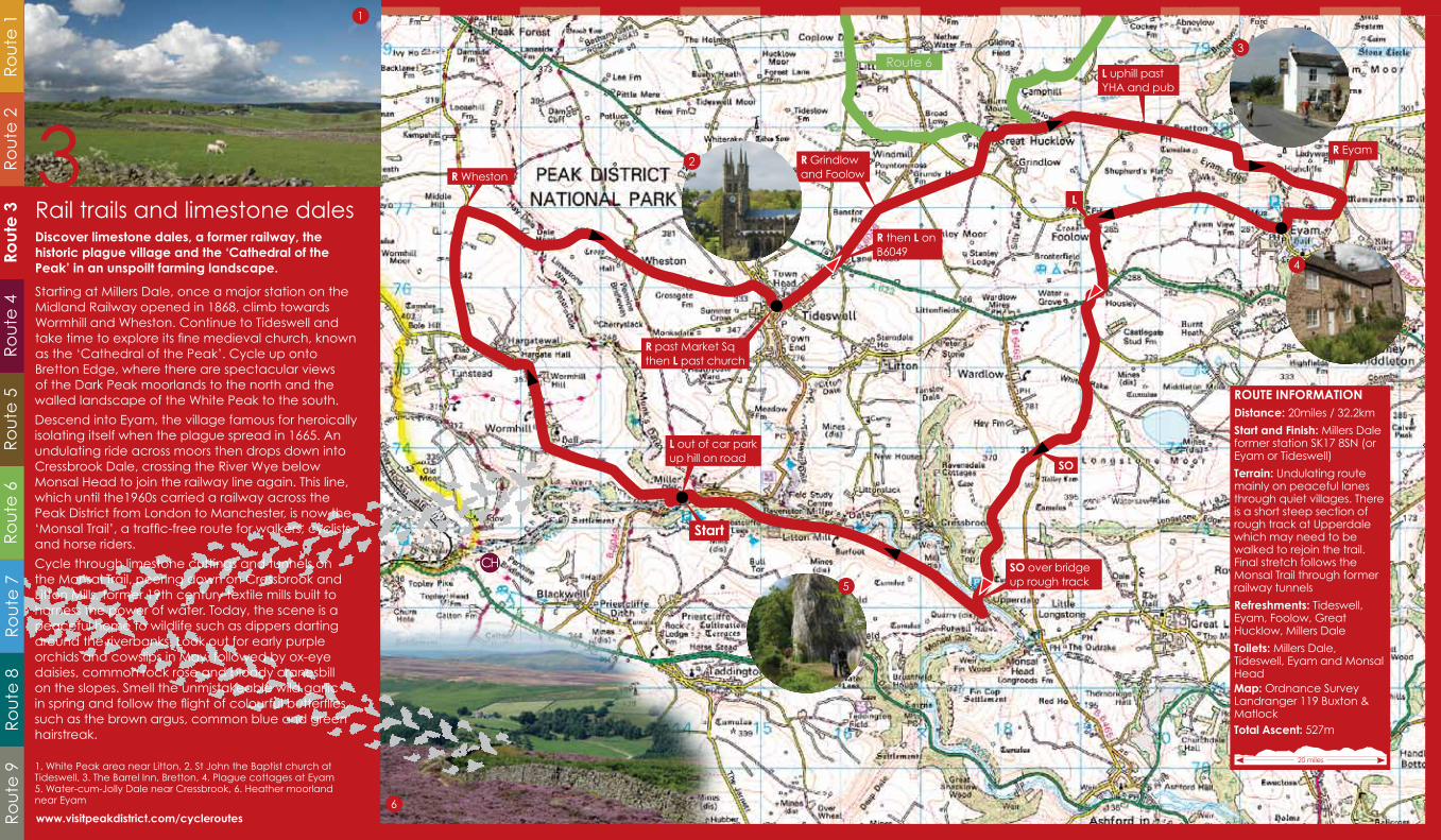
ROUTE INFORMATIONDistance: 20miles / 32.2km
Start and Finish: Millers Dale former station SK17 8SN (or Eyam or Tideswell)
Terrain: Undulating route mainly on peaceful lanes through quiet villages. There is a short steep section of rough track at Upperdale which may need to be walked to rejoin the trail. Final stretch follows the Monsal Trail through former railway tunnels
Refreshments: Tideswell, Eyam, Foolow, Great Hucklow, Millers Dale
Toilets: Millers Dale, Tideswell, Eyam and Monsal HeadMap: Ordnance Survey Landranger 119 Buxton & MatlockTotal Ascent: 527m
R Grindlow and Foolow
L uphill past YHA and pub
R past Market Sq then L past church
R then L on B6049
SO
L
SO over bridge up rough track
L out of car park up hill on road
R Eyam
R Wheston
20 miles
2
5
Route 63
Start
4
6
Ro
ute
4Ro
ute
3R
ou
te 1
Ro
ute
5R
ou
te 6
Ro
ute
2
3
Ro
ute
7R
ou
te 8
Ro
ute
9
Rail trails and limestone dalesDiscover limestone dales, a former railway, the historic plague village and the ‘Cathedral of the Peak’ in an unspoilt farming landscape.
Starting at Millers Dale, once a major station on the Midland Railway opened in 1868, climb towards Wormhill and Wheston. Continue to Tideswell and take time to explore its fine medieval church, known as the ‘Cathedral of the Peak’. Cycle up onto Bretton Edge, where there are spectacular views of the Dark Peak moorlands to the north and the walled landscape of the White Peak to the south.
Descend into Eyam, the village famous for heroically isolating itself when the plague spread in 1665. An undulating ride across moors then drops down into Cressbrook Dale, crossing the River Wye below Monsal Head to join the railway line again. This line, which until the1960s carried a railway across the Peak District from London to Manchester, is now the ‘Monsal Trail’, a traffic-free route for walkers, cyclists and horse riders.
Cycle through limestone cuttings and tunnels on the Monsal Trail, peering down on Cressbrook and Litton Mills, former 19th century textile mills built to harness the power of water. Today, the scene is a peaceful home to wildlife such as dippers darting around the riverbanks. Look out for early purple orchids and cowslips in May, followed by ox-eye daisies, common rock rose and bloody cranesbill on the slopes. Smell the unmistakeable wild garlic in spring and follow the flight of colourful butterflies, such as the brown argus, common blue and green hairstreak.
1. White Peak area near Litton, 2. St John the Baptist church at Tideswell, 3. The Barrel Inn, Bretton, 4. Plague cottages at Eyam 5. Water-cum-Jolly Dale near Cressbrook, 6. Heather moorland near Eyam
www.visitpeakdistrict.com/cycleroutes
1

ROUTE INFORMATIONDistance: 21miles/33.8km or 18miles/29km (short cut) Start and Finish: Middleton Top visitor centre and cycle hire DE4 4LS
Terrain: Traffic free trails, unsurfaced roads (which can be muddy following wet weather) and quiet country lanes with moderate hills. The shorter ride follows signed route 54A back to the start).
Refreshments: Middleton Top, Parwich, Carsington Water, Wirksworth
Toilets: Middleton Top, Carsington and WirksworthMap: Ordnance Survey Landranger 119 Buxton & MatlockTotal Ascent: 579m
First R
L
R - 54A to Carsington
L SP Bradbourne
Follow signs for route 54L
L follow 54A to start or R follow dam wall to Millfields
Follow Carsington Water circular bike route to tarmac road (Upperfield)
L at Blind Lane
L at Moon Lane
L - B5035 to Ashbourne
R in Hopton and follow 54A to rejoin trail back to Middleton Top
21 miles
2
3
4
5
6
Start
Rout
e 4
Ro
ute
3R
ou
te 1
Ro
ute
5R
ou
te 6
Ro
ute
2
4
Ro
ute
7R
ou
te 8
Ro
ute
9
Biking and birdsong around CarsingtonDiscover a tranquil landscape shaped by leadmining and quarrying as you cycle through the limestone hills and dales.
Starting from Middleton Top, where an engine once hauled wagons up from Cromford Canal, head along the former railway (now the High Peak Trail) through a landscape shaped by quarrying but now a peaceful haven for wildlife. Visit the pretty village of Parwich, where there were several leadmines in medieval times.
Continue onto Bradbourne and around Carsington Water, a large reservoir with a visitor centre, café and varied birdlife. In spring the reservoir is home to breeding birds such as lapwings, redshanks, tree sparrows, redstarts and ravens. In winter up to 6,000 birds may gather on the reservoir - including goldeneyes, tufted ducks, gadwalls, wigeons, teals and coots. You may also catch a glimpse of some regular rare visitors - divers, grebes and waders. Although many of these birds can be viewed from the track around the reservoir, there are also a number of specific hides provided where you can get closer without disturbing them.
Climb up through scattered settlements towards Wirksworth, a bustling market town with its cobbled yards and local craft shops and where lead was mined since Roman times. The town is home of the Barmote (the oldest industrial court in Britain) and an impressive Norman parish church.
1. Carsington Water, 2. Parwich village, 3. Ridge and furrow fields at Bradbourne, 4. Parwich lane, 5. Tree sparrow, 6. High Peak Trail
www.visitpeakdistrict.com/cycleroutes
1

R B5
057
Win
ste
rR
Ma
tloc
k a
nd
Ke
lste
dg
e
L
R o
ut
of
sta
tion
L a
t tr
affi
c li
gh
ts.
Follo
w ri
ver t
ow
ard
s Le
a B
ridg
e. U
ph
ill sig
ne
d H
ollo
wa
y
L
Ove
r le
vel
cro
ssin
g
L O
ker
ga
ted
roa
d
L Be
nt
Lan
e
L p
ast
ch
urc
h
L th
en
R
L SP
Ash
ove
r
L SP
Br
ac
ken
field
R
R
L SP
Up
pe
r H
ollo
wa
y
i
i
R to
Up
pe
rto
wn
SO L
id L
an
e
ROU
TE IN
FORM
ATI
ON
Dis
tanc
e: 2
4mile
s/38
.6km
Sta
rt a
nd F
inis
h: M
atlo
ck
sta
tion
DE4
3N
A
(or C
rom
ford
Wh
arf
)
Terr
ain
: A h
illy ri
de
on
m
ain
ly q
uie
t ro
ad
s. A
fte
r a
ch
alle
ng
ing
clim
b o
ut
of t
he
D
erw
en
t va
lley
the
rou
te
follo
ws
sce
nic
roa
ds
ac
ross
h
igh
mo
orla
nd
. A
sh
ort
se
ctio
n o
f th
e A
6 c
an
be
b
usy
at
time
s
Refre
shm
ent
s: M
atlo
ck,
M
atlo
ck
Bath
, Cro
mfo
rd,
Cro
mfo
rd M
ill, C
rom
ford
W
ha
rf, A
sho
ver
Toile
ts: M
atlo
ck,
Ma
tloc
k Ba
th, C
rom
ford
, Ash
ove
r
Ma
p: O
rdn
an
ce
Su
rve
y La
nd
ran
ge
r 119
Bu
xto
n &
M
atlo
ck
Tota
l Asc
ent
: 748
m
24 m
iles
2
3
5
4
L
SO
Sta
rt
Ro
ute
4R
ou
te 3
Ro
ute
1Ro
ute
5R
ou
te 6
Ro
ute
2
5
Ro
ute
7R
ou
te 8
Ro
ute
9
Matlock moors, hills and millsJourney through a landscape full of history and heritage with breathtaking views.
Starting from Matlock, once famous for its spa, cycle towards Cromford and the Derwent Valley Mills World Heritage Site, the birthplace of the industrial revolution. Then onto Holloway, where Florence Nightingale, ‘The Lady with the Lamp’ used to live.
Enjoy the quiet lanes as you cycle up towards Ogston Reservoir taking in the views of the Amber Valley. Stop and explore the village of Ashover with its Norman church before climbing up onto Beeley Moor with spectacular views over the heather moorland towards the gritstone edges of the Peak District. Drop down into the Derwent Valley again at Darley Dale, with views across to the edge of Stanton Moor.
Cross over the A6 road and the railway line, part of the old Midland Railway’s route between Manchester and London which was closed in 1968. Nowadays steam trains operated by Peak Rail run on this section of the line down to Matlock. On your return look out for the ancient yew tree at St Helen’s Church, Churchtown (thought to be 2000 years old with an enormous girth of 33 feet!).
1. Beeley Moor, 2. The Heights of Abraham, Matlock Bath, 3. Sir Richard Arkwright’s Masson Mill, Cromford, 4. Matlock Bath, 5. Ashover
www.visitpeakdistrict.com/cycleroutes
1
R over bridge
R at T follow signs to Castleton
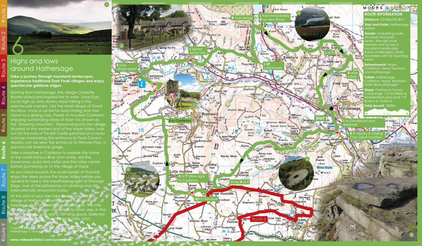
ROUTE INFORMATIONDistance: 22miles/35.4km
Start and Finish: Hathersage station
Terrain: Undulating route on roads and quiet lanes - through small hamlets and across a moorland landscape. Some challenging climbs rewarded with far reaching views
Refreshments: Hope, Castleton, Great Hucklow and Hathersage
Toilets: Hathersage, Castleton, Hope, Bamford, Hollin Bank (Stanage)
Maps: Ordnance Survey Landranger 110 Sheffield & Huddersfield area and 119 Buxton & MatlockTotal Ascent: 1003m
L to Castleton
SO to Windmill
Sharp R at T
R to Abney & Gliding Club Great Hucklow
L to Grindleford and Bakewell
R after toilets
L at T
L then immediately R up New Road
L SP Ladybower
L signed Aston only
R past village green
22 miles
i
Route 3
6
4
7
3
2
Start
5
Ro
ute
4R
ou
te 3
Ro
ute
1R
ou
te 5
Rout
e 6
Ro
ute
7R
ou
te 8
Ro
ute
9R
ou
te 2
Highs and lows around HathersageTake a journey through moorland landscapes, experience traditional Dark Peak villages and enjoy spectacular gritstone edges.
Starting from Hathersage, the village Charlotte Bronte visited and inspired her to write ‘Jane Eyre’, cycle high up onto Abney Moor taking in the spectacular scenery. Visit the small village of Great Hucklow, once a centre for lead mining and now home to a gliding club. Pedal on towards Castleton, enjoying outstanding views of Mam Tor, known as the ‘shivering mountain’. Descending into the village, situated at the western end of the Hope Valley, look out for the ruins of Peveril Castle perched on a rocky outcrop overlooking the entrance to Peak Cavern. Nearby can be seen the entrance to Winnats Pass, a spectacular limestone gorge.
Take a breather in Castleton to explore the home of the world famous Blue John stone, visit the showcaves, pubs and cafes and the visitor centre before journeying on to the village of Hope.
As you head towards the small hamlet of Thornhill, enjoy the views across the Hope Valley before you ascend to take in the breathtaking sight of Stanage Edge, one of the birthplaces of climbing and still internationally renowned today.
At the end of your ride take time to explore the village of Hathersage, which once had a large needle, button and wire drawing industry. The mills still stand but are now converted to other uses. In the churchyard you can see a 10ft long grave, believed to be that of Robin Hood’s friend ‘Little John’.
1.Losehill Ridge, 2. Castleton, 3. Ladybower Reservoir, 4. Millstone near Hathersage, 5. Stanage Edge, 6. Little Hucklow, 7. Pevril Castle
www.visitpeakdistrict.com/cycleroutes
6
1

L Brown sign to Chatsworth
L before the roundabout
R Flagg and Chelmorton
R at T SP Ashford
Take road to L of Rutland Hotel
L Follow brown sign for Arbor Low
R SP Middleton
Follow signs to RowsleyR (no sign)
R over bridge
L afterchurch
i
30km
Route 8
ROUTE INFORMATIONDistance: 26.5miles / 42.6km
Start and Finish: Hassop Station (DE45 1NW) or Bakewell station (DE45 1AQ)
Terrain: This route starts with a warm up on the Monsal Trail before a series of quiet roads through typical White Peak scenery. Only the stretch through Chatsworth to Rowsley is busier. Includes a number of testing climbs
Refreshments: Hassop Station, Bakewell, Monyash, Flagg (café just off route), Chatsworth, Rowsley, Peak Village, Beeley, Pilsley, Baslow
Toilets: Bakewell, Monyash, Middleton by Youlgrave, Peak Village (Rowsley), Calton Lees (Beeley), Baslow
Map: Ordnance Survey Landranger 119 Buxton & MatlockTotal Ascent: 842m
26.5 miles
Start
3
4
6
2
5
Ro
ute
4R
ou
te 3
Ro
ute
1R
ou
te 5
Ro
ute
6R
ou
te 2
7
Rout
e 7
Ro
ute
8R
ou
te 9
Stately homes and standing stonesExperience typical White Peak landscape, a Stone Age henge and a Bronze Age stone circle, magnificent historic houses and their parklands.
Start from Hassop or Bakewell former stations on the Monsal Trail. Passing through the busy market town of Bakewell famous for its pudding and medieval bridge over the River Wye, head up towards the village of Sheldon. You pass the remains of Magpie Mine before continuing on to Monyash, an attractive village with limestone cottages and farmhouses centred on the village pond.
Carry on towards Youlgrave and via the hamlet of Alport before climbing up to Stanton in the Peak, an attractive gritstone village from where you can make a short diversion to see the Nine Ladies Stone Circle on Stanton Moor. Before you drop down to Rowsley look out over the Wye Valley to Haddon Hall, a lovely medieval manor house and the location of many films.
Follow the signs to Chatsworth, enjoying views of the Duke of Devonshire’s home as you cycle through rolling parkland. Take time if you can to visit the house and gardens, one of England’s finest stately homes with many art treasures and fine furniture. Turn left before the river as you come into Baslow to follow a quiet lane to Hassop and left again before Great Longstone to rejoin the Monsal Trail.
1. Chatsworth, 2. Ashford-in-the-Water, 3. Monyash, 4. Arbor Low stone circle, 5. Deer at Chatsworth, 6. Café at Hassop Station on the Monsal Trail
www.visitpeakdistrict.com/cycleroutes
1
CA
RE:
ste
ep
de
sce
nt,
fa
rm t
raffi
c.
Ple
ase
clo
se
ga
tes
on
roa
d
be
hin
d y
ou
ROU
TE IN
FORM
ATI
ON
Dis
tanc
e: 9
.5m
iles/
15.3
km
(sh
ort
loo
p)
23m
iles/
37km
(f
ull
loo
p)
Sta
rt a
nd F
inis
h: P
ars
ley
Ha
y C
ycle
Hire
, SK1
7 0D
G
Terr
ain
: Mu
ch
of t
his
rou
te
is a
lon
g q
uie
t tr
affi
c-f
ree
fo
rme
r ra
ilwa
y lin
es.
Th
ere
a
re s
tee
p a
sce
nts
on
th
e
linki
ng
rou
te u
p t
o W
ett
on
Lo
w a
nd
up
to
th
e A
515
at
Also
p S
tatio
n. T
wo
str
etc
he
s o
f ga
ted
roa
ds
ca
n b
e
mu
dd
y.
Refre
shm
ent
s: P
ars
ley
Ha
y,
Ha
rtin
gto
n, H
ulm
e E
nd
, W
ett
on
Mill
an
d A
lsto
ne
field
Toile
ts: P
ars
ley
Ha
y,
Ha
rtin
gto
n, H
ulm
e E
nd
, W
ars
low
, We
tto
n M
ill,
Alst
on
efie
ld a
nd
Ha
rtin
gto
n
sta
tion
Ma
p: O
rdn
an
ce
Su
rve
y La
nd
ran
ge
r 119
Bu
xto
n &
M
atlo
ck
Asc
ent
: 355
m (
sho
rt lo
op
)
Asc
ent
: 102
5m (
full
loo
p)
L o
n
Tiss
ing
ton
Tr
ail
Cro
ss b
ridg
e o
ver r
ive
r an
d p
ass
th
rou
gh
Hu
lme
En
d v
illag
e b
efo
re
join
ing
Ma
nifo
ld T
rac
k o
n L
L e
nte
r ga
ted
roa
d.
Ple
ase
clo
se g
ate
s b
eh
ind
yo
u.
Cro
ss ri
ver a
nd
re
join
tra
il
L le
ave
tra
il, c
ross
b
ridg
e, a
sce
nd
La
rkst
on
e L
an
e
Take
L fo
rk
Oxc
lose
La
ne
. C
limb
ste
ep
ly
to ro
ad
9.5
mile
s
23 m
iles
Bea
r R a
s yo
u
en
ter v
illag
e,
sign
po
ste
d
Ash
bo
urn
e
4
3
2
Ro
ute
7
Sta
rt
Lea
ve t
rail
sign
ed
H
art
ing
ton
54C
.Pl
ea
se d
ismo
un
t o
n
ste
ep
tra
ck
to ro
ad
.
Ro
ute
4R
ou
te 3
Ro
ute
1R
ou
te 5
Ro
ute
6R
ou
te 2
8
Ro
ute
7Ro
ute
8R
ou
te 9
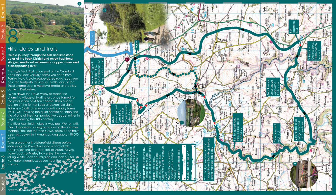
Hills, dales and trailsTake a journey through the hills and limestone dales of the Peak District and enjoy traditional villages, medieval settlements, copper mines and a disappearing river.
The High Peak Trail, once part of the Cromford and High Peak Railway, takes you north from Parsley Hay. A picturesque gated road leads you past the footpath to Pilsbury Castle, one of the finest examples of a medieval motte and bailey castle in Derbyshire.
Cycle down the Dove Valley to reach the charming village of Hartington, once famed for the production of Stilton cheese. Then a short section of the former Leek and Manifold Light Railway – (built to serve surrounding dairy farms 1904-1934) passing the quiet hamlet of Ecton, the site of one of the most productive copper mines in England during the 18th century.
The River Manifold makes its way past Wetton Mill, then disappears underground during the summer months. Look out for Thors Cave, believed to have been occupied by humans as long ago as 10,000 years.
Take a breather in Alstonefield village before recrossing the River Dove and a hard climb back to join the Tissington Trail at Alsop. As you travel back to Parsley Hay enjoy the views of rolling White Peak countryside and look out for Hartington signal box as you near the end of your journey.
1. Hartington signal box on the Tissington Trail, 2. Cycling on the Manifold Track, 3. Hartington, 4. Wetton Mill
www.visitpeakdistrict.com/cycleroutes
1

L at crossroads to Goyt Valley and Buxton
R Wormhill and Tongue Lane Industrial Estate
A53 into Buxton follow signs for station and A6
R then immediate L at traffic lights
ROUTE INFORMATIONDistance: 28miles/45km
Start and Finish: Chapel-en-le-Frith or Buxton stations Terrain: Several steep climbs on this challenging route are rewarded with far-reaching views. After the beauty of the Goyt Valley a short stretch on a busy main road brings you back into Buxton (option of alternative off road route avoiding A53)
Refreshments: Chapel-en-le-Frith, Buxton. Café at Chestnut Centre (just off route)
Toilets: Chapel-en-le-Frith, Buxton, Goyt Valley
Map: Ordnance Survey Landranger 109 Manchester & surrounding area, 110 Sheffield & Huddersfield area, 118 The Potteries and 119 Buxton & MatlockTotal Ascent: 964m
L after recycling centre
R Market StreetSO at traffic lights
L signed Goyt Valley
L signed Goyt Valley
One way only
L then R
i
28 miles
52
3
4
L to Buxton
Start
Ro
ute
4R
ou
te 3
Ro
ute
1R
ou
te 5
Ro
ute
6R
ou
te 2
9
Ro
ute
7R
ou
te 8
Rout
e 9
High moors and gritstone torsTravel through high moorland landscapes with awe-inspiring views and visit the spa town of Buxton, home to a series of popular summer festivals.
Start at Chapel-en-le-Frith, founded in 1225, then climb the hill up to the viewpoint of Eccles Pike. Look out for the topograph showing the distinctive landforms in a 360 degree circle around the Peak District.
Continue westwards and after a challenging climb enjoy rewarding moorland views from Pym Chair and Windgather Rocks.
Take the road towards Kettleshulme, which was part of the Salt Way from Cheshire, following signs to the beautiful Goyt Valley and its stunning reservoirs and woodland.
Cycle through Buxton, famous for its healing spring water and beautiful Georgian Crescent. Stop off for a free spirit- reviving drink of the natural mineral waters at St Anne’s Well before heading off to the village of Peak Forest, once part of a Royal Hunting Forest. The final leg of the journey takes you past Ford Hall, home to William Bagshawe, the Apostle of the Peak and a member of one of the oldest families in the area.
1. The Goyt Valley, 2. Chapel-en-le-Frith, 3. The Crescent at Buxton, 4. Windgather Rocks, 5. Church of St Charles King and Martyr, Peak Forest
www.visitpeakdistrict.com/cycleroutes
1
See www.visitpeakdistrict.com to view a wide range of places to stay, search for ‘Cyclists Welcome’ accommodation or order a copy of the Peak District Visitor Guide. Alternatively contact one of the Tourist Information or Visitor Centres below.
Tourist Information and Visitor CentresAshbourne 01335 343666Bakewell 01629 816558Buxton 01298 25106Castleton 01629 816572Chesterfield 01246 345777Derby 01332 255802Derwent Valley 01773 880474Edale 01433 670207Leek 01538 483741Matlock 01629 583388Upper Derwent 01433 650953 www.visitpeakdistrict.com
Travel to the Peak DistrictLocated at the very heart of England, the Peak District & Derbyshire is easy to reach. Railway stations close to the nine cycling routes are:
Whaley Bridge and Buxton (Manchester line).
Matlock Bath and Matlock (Derwent Valley line from Derby).
Chinley, Edale, Hope, Bamford and Hathersage (Hope Valley line between Manchester and Sheffield).
For information contact: www.traveline.org.uk www.nationalrail.co.uk www.peakdistrict.gov.uk/visit www.transportdirect.info
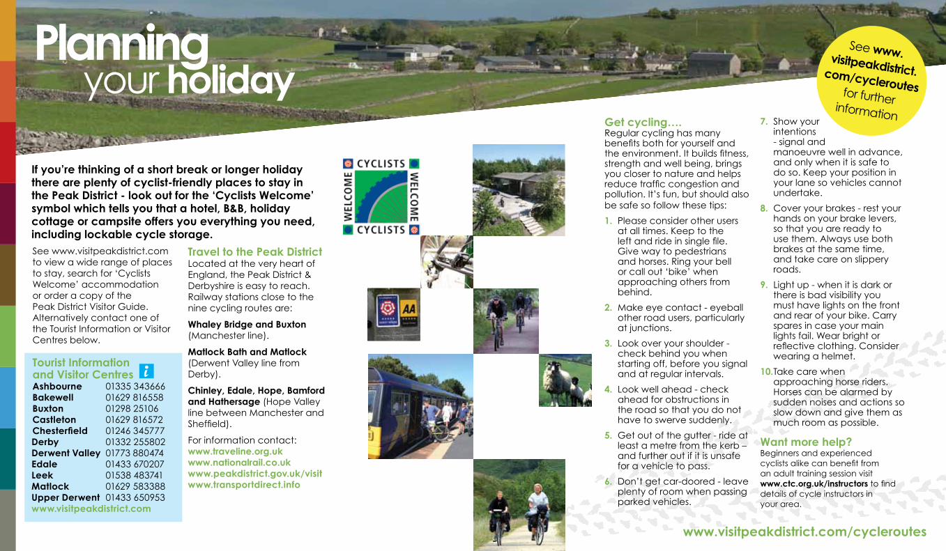
If you’re thinking of a short break or longer holiday there are plenty of cyclist-friendly places to stay in the Peak District - look out for the ‘Cyclists Welcome’ symbol which tells you that a hotel, B&B, holiday cottage or campsite offers you everything you need, including lockable cycle storage.
Planning your holiday
www.visitpeakdistrict.com/cycleroutes
Get cycling….Regular cycling has many benefits both for yourself and the environment. It builds fitness, strength and well being, brings you closer to nature and helps reduce traffic congestion and pollution. It’s fun, but should also be safe so follow these tips:
1. Please consider other users at all times. Keep to the left and ride in single file. Give way to pedestrians and horses. Ring your bell or call out ‘bike’ when approaching others from behind.
2. Make eye contact - eyeball other road users, particularly at junctions.
3. Look over your shoulder - check behind you when starting off, before you signal and at regular intervals.
4. Look well ahead - check ahead for obstructions in the road so that you do not have to swerve suddenly.
5. Get out of the gutter - ride at least a metre from the kerb – and further out if it is unsafe for a vehicle to pass.
6. Don’t get car-doored - leave plenty of room when passing parked vehicles.
7. Show your intentions - signal and manoeuvre well in advance, and only when it is safe to do so. Keep your position in your lane so vehicles cannot undertake.
8. Cover your brakes - rest your hands on your brake levers, so that you are ready to use them. Always use both brakes at the same time, and take care on slippery roads.
9. Light up - when it is dark or there is bad visibility you must have lights on the front and rear of your bike. Carry spares in case your main lights fail. Wear bright or reflective clothing. Consider wearing a helmet.
10. Take care when approaching horse riders. Horses can be alarmed by sudden noises and actions so slow down and give them as much room as possible.
Want more help?Beginners and experienced cyclists alike can benefit from an adult training session visit www.ctc.org.uk/instructors to find details of cycle instructors in your area.
i

www.electricbicyclenetwork.com
It’s cycling but not as we know it. Electric bicycles
dismiss headwinds and flatten hills. Everyone can
enjoy the great outdoors on two wheels!
AVAILABLE AT SELECTED
HOTELS, B&Bs, CAMPSITES
& TOURIST ATTRACTIONS
THIS SEASON!
BEAT THE HILLS!
Find your nearest hire & charge points:
Published by the Peak District National Park Authority and Visit Peak District with financial assistance from Cycling England An Orange Box Design, www.obdesign.co.uk
Whilst every effort has been made to present routes where it is legal to cycle, individuals are always responsible for their own safety and the safety of others. All information is provided in good faith by the publisher and producer and was believed to be accurate at the time of publication.
We would like to thank members of Chesterfield Cycle Campaign and Sheffield section CTC for their assistance in the development and
checking of the routes. We also acknowledge the advice received from Derbyshire and Staffordshire County Councils.
Photographs courtesy of Visit Peak District & Derbyshire, Peak District National Park Authority, Natural England and Greg Walker.
All maps reproduced from Ordnance Survey digital map data © Crown Copyright and database rights 2011. 100005734
Cycle Hire CentresIf you haven’t got your own bike, or haven’t brought it on holiday with you, there are a number of cycle hire centres in the area (look out for symbol on the route maps) including:
Ashbourne Mapleton Lane, Ashbourne, Derbyshire DE6 2AA Open March to October every day, November to February limited opening. Tel: 01335 343156 email: [email protected] www.peakdistrict.gov.uk/cycle
Derwent (near Bamford) Fairholmes Car Park, Derwent, Bamford, Hope Valley S33 0AQ Open March to October every day, November to February limited opening. Tel: 01433 651261 email: [email protected] www.peakdistrict.gov.uk/cycle
Parsley Hay (near Buxton) Parsley Hay, near Buxton, Derbyshire SK17 0DG Open March to October every day, November to February limited opening. Tel: 01298 84493 email: [email protected] www.peakdistrict.gov.uk/cycle
Middleton Top Middleton by Wirksworth, Derbyshire DE4 4LS Restricted opening. Tel: 01629 823204 www.derbyshire.gov.uk
Other centres are at Blackwell Mill (on the Monsal Trail near Buxton), Carsington Water, Hassop Station (on the Monsal Trail near Bakewell) and Waterhouses (Manifold Valley).Remember to secure your vehicle and remove ALL valuables if leaving your car parked. If you see anything suspicious please contact Staffordshire Police on 0300 123 4455 or Derbyshire Police 0345 123 3333.
www.visitpeakdistrict.com/cycleroutes