Beachrock Removal Assessment Proposed Beach … Removal Assessment Proposed Beach Improvements ......
9
15074 Page (i) Beachrock Removal Assessment Proposed Beach Improvements Seven Mile Beach, Grand Cayman
Transcript of Beachrock Removal Assessment Proposed Beach … Removal Assessment Proposed Beach Improvements ......
15074 Page (i)
Beachrock Removal Assessment Proposed Beach Improvements
Seven Mile Beach, Grand Cayman

15074 Page (ii)
BEACHROCK REMOVAL ASSESSMENT PROPOSED BEACH IMPROVEMENTS
SEVEN MILE BEACH, GRAND CAYMAN
TABLE OF CONTENTS
1. EXECUTIVE SUMMARY ..................................................................................................... 4
2. GLOSSARY OF TERMS ................................................................................................... 10
3. INTRODUCTION & OVERVIEW ....................................................................................... 13
4. LOCATION ....................................................................................................................... 14
5. OVERVIEW AND SETTING .............................................................................................. 16
6. BEACHROCK REMOVAL AND SAND REPLACEMENT TRIAL ...................................... 17
7. BEACHROCK, BEACH SAND AND REPLACEMENT CONSIDERATIONS .................... 22
8. ENVIRONMENTAL EVALUATION ................................................................................... 25
9. PROJECT ALTERNATIVES ............................................................................................. 26
10. COASTAL FACTORS ....................................................................................................... 27
11. FINDINGS ......................................................................................................................... 30
12. MODELLING RESULTS ................................................................................................... 31
13. OVERALL SUMMARY OF FINDINGS .............................................................................. 32
14. REVIEW OF OTHER STUDIES ........................................................................................ 34
15. RECOMMENDATIONS ..................................................................................................... 36
16. APPENDIX A HISTORIC AERIAL PHOTOGRAPHY ........................................................ 37
17. APPENDIX B HISTORIC BEACH PROFILES .................................................................. 38
18. APPENDIX C TOPOGRAPHY & BATHYMETRY ............................................................. 39
19. APPENDIX D BEACHROCK GEOLOGICAL INVESTIGATIONS BY DR JONES ............ 40
20. APPENDIX E MARINE BIOLOGY STUDY BY CARDNO ................................................. 41
21. APPENDIX F COASTAL ENGINEERING MODELLING STUDY BY CGA & ATM ........... 42
22. APPENDIX G COASTAL WORKS APPLICATION FOR TRIAL INVESTIGATION .......... 43
23. APPENDIX H PROPOSED REPLACEMENT SAND ......................................................... 44
24. APPENDIX J BEACHROCK & PEAT REMOVAL METHODOLOGY STATEMENT ......... 45
25. APPENDIX K MINISTRY OF ENVIRONMENT CONDITIONS FOR TRIAL ...................... 46
26. APPENDIX L STUDIES, REPORTS & DOCUMENTS REVIEWED .................................. 47

15074 Page (iii)
INDEX OF TABLES & FIGURES
FIGURE A – PROPOSED REMOVAL OF BEACHROCK AND PEAT .................................................................... 4
FIGURE B – EXISTING AND PROPOSED SECTIONS THROUGH THE SHORELINE ............................................. 5
FIGURE C – BEACHROCK IN FRONT OF THE RED AND BLUE PROPERTIES AND TIKI BEACH .......................... 13
FIGURE D – PROJECT LOCATION ON GRAND CAYMAN’S WEST BAY PENINSULA ........................................ 14
FIGURE E – PROJECT SITE ................................................................................................................... 15
FIGURE F – BEACHROCK IN FRONT OF 11B17 ........................................................................................ 16
FIGURE G – BEACHROCK REMOVAL TRIAL ON DECEMBER 7TH 2016 ......................................................... 17
FIGURE H – SAND RECOVERY AND WASHING EAST OF THE FORMER WEST BAY ROAD .............................. 18
FIGURE J – PLACEMENT OF APPROVED SAND ON THE SEABED AFTER REMOVAL OF THE BEACHROCK ......... 18
FIGURE K – EXCAVATED BEACHROCK ................................................................................................... 19
FIGURE L – TRIAL AREA 24 HOURS AFTER THE BEACHROCK WAS REMOVED ............................................. 20
FIGURE M – TRIAL AREA 48 HOURS AFTER THE BEACHROCK WAS REMOVED ............................................ 20
FIGURE N – BEACHROCK REDUCED TO FINE BEACH SAND ....................................................................... 21
FIGURE O – SAND PARTICLES UNDER MICROSCOPE ............................................................................... 22
FIGURE P – BEACHROCK EXPOSED AT LOW TIDE .................................................................................... 23
FIGURE Q – VOLUMETRIC MODELLING OF THE PROPOSED EARTHWORKS USING 3D MODELLING ................ 24
FIGURE R – CARDNO ENVIRONMENTAL EVALUATION REPORT .................................................................. 25
FIGURE S – EXISTING AND PROPOSED SECTIONS THROUGH BEACHROCK ................................................ 28
FIGURE T – SELECTION OF HISTORIC REVIEWS/STUDIES CONSULTED ...................................................... 29
FIGURE U – BEACH BERM AND DUNE DEFINITIONS .................................................................................. 30
FIGURE V – LONG TERM SHORELINE IMPACTS AFTER 1 – 5 YEARS .......................................................... 36
15074 Page (4)
1. EXECUTIVE SUMMARY
PURPOSE
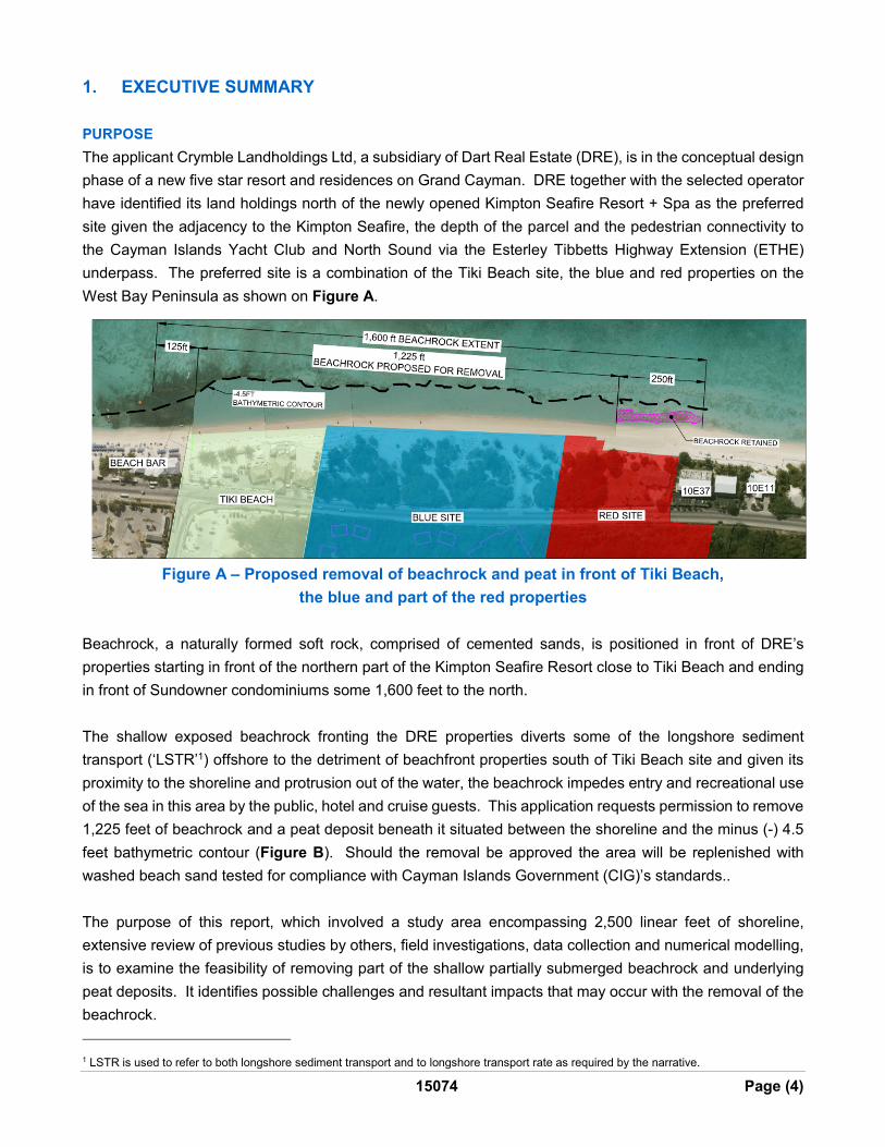
The applicant Crymble Landholdings Ltd, a subsidiary of Dart Real Estate (DRE), is in the conceptual design
phase of a new five star resort and residences on Grand Cayman. DRE together with the selected operator
have identified its land holdings north of the newly opened Kimpton Seafire Resort + Spa as the preferred
site given the adjacency to the Kimpton Seafire, the depth of the parcel and the pedestrian connectivity to
the Cayman Islands Yacht Club and North Sound via the Esterley Tibbetts Highway Extension (ETHE)
underpass. The preferred site is a combination of the Tiki Beach site, the blue and red properties on the
West Bay Peninsula as shown on Figure A.
Figure A – Proposed removal of beachrock and peat in front of Tiki Beach,
the blue and part of the red properties
Beachrock, a naturally formed soft rock, comprised of cemented sands, is positioned in front of DRE’s
properties starting in front of the northern part of the Kimpton Seafire Resort close to Tiki Beach and ending
in front of Sundowner condominiums some 1,600 feet to the north.
The shallow exposed beachrock fronting the DRE properties diverts some of the longshore sediment
transport (‘LSTR’1) offshore to the detriment of beachfront properties south of Tiki Beach site and given its
proximity to the shoreline and protrusion out of the water, the beachrock impedes entry and recreational use
of the sea in this area by the public, hotel and cruise guests. This application requests permission to remove
1,225 feet of beachrock and a peat deposit beneath it situated between the shoreline and the minus (-) 4.5
feet bathymetric contour (Figure B). Should the removal be approved the area will be replenished with
washed beach sand tested for compliance with Cayman Islands Government (CIG)’s standards..
The purpose of this report, which involved a study area encompassing 2,500 linear feet of shoreline,
extensive review of previous studies by others, field investigations, data collection and numerical modelling,
is to examine the feasibility of removing part of the shallow partially submerged beachrock and underlying
peat deposits. It identifies possible challenges and resultant impacts that may occur with the removal of the
beachrock.
1 LSTR is used to refer to both longshore sediment transport and to longshore transport rate as required by the narrative.
15074 Page (5)
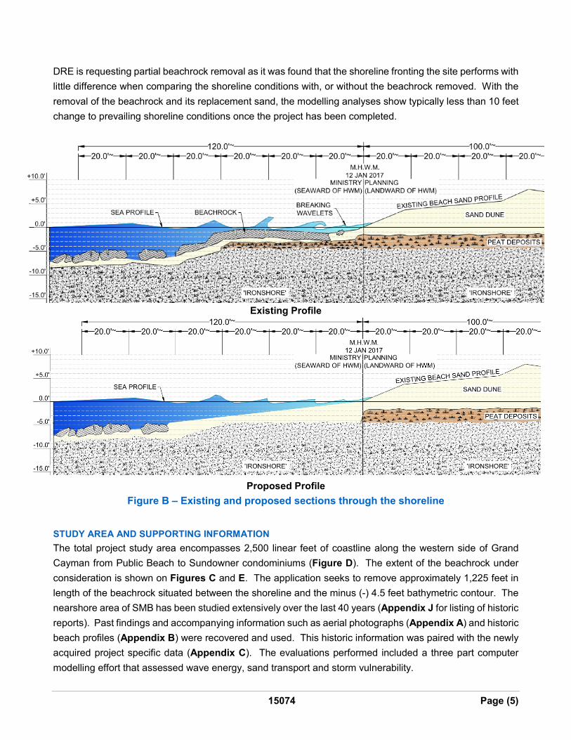
DRE is requesting partial beachrock removal as it was found that the shoreline fronting the site performs with
little difference when comparing the shoreline conditions with, or without the beachrock removed. With the
removal of the beachrock and its replacement sand, the modelling analyses show typically less than 10 feet
change to prevailing shoreline conditions once the project has been completed.
Existing Profile
Proposed Profile
Figure B – Existing and proposed sections through the shoreline
STUDY AREA AND SUPPORTING INFORMATION
The total project study area encompasses 2,500 linear feet of coastline along the western side of Grand
Cayman from Public Beach to Sundowner condominiums (Figure D). The extent of the beachrock under
consideration is shown on Figures C and E. The application seeks to remove approximately 1,225 feet in
length of the beachrock situated between the shoreline and the minus (-) 4.5 feet bathymetric contour. The
nearshore area of SMB has been studied extensively over the last 40 years (Appendix J for listing of historic
reports). Past findings and accompanying information such as aerial photographs (Appendix A) and historic
beach profiles (Appendix B) were recovered and used. This historic information was paired with the newly
acquired project specific data (Appendix C). The evaluations performed included a three part computer
modelling effort that assessed wave energy, sand transport and storm vulnerability.

15074 Page (6)
BEACHROCK AND BEACH SAND
The offshore formation is commonly referred to as beachrock, a naturally formed soft rock, primarily
comprised of cemented sands. Please refer to project specific report ‘Geology of Onshore and Offshore
Beachrock, Seven Mile Beach, Blocks 10 (Part) and 11 (Part), Beachrock Study’ by Dr Brian Jones
(Appendix D). The subject formation extends from the shoreline seaward for up to approximately 150 feet
as shown in Figure B. A request (Appendix G) was made in March 2016 to CIG to complete a limited trial
beachrock removal project. The trial was approved by CIG in November 2016 and was executed on
December 7th 2016. An average beachrock thickness of 12 inches was encountered in the trial area which
was underlain in places by a thin layer of coarse sand and instances of organic peat up to 2 feet in thickness.
Based on the findings of the trial, it is estimated that there is approximately 4,860 cubic yards of beachrock
and possibly up to a further 3,550 cubic yards of peat present in the area proposed for removal and
replacement with beach sand.
The excavated area will be replenished with a greater volume of compatible beach sand. In preparation for
the trial, permission was granted by the Department of Environment (DOE) acting on behalf of CIG to use
sand sourced from the site. The sand is located to the east of the former West Bay Road (WBR). This sand
was analysed and washed to meet the DOE consultant’s specifications for replacement sand compatible with
SMB sediments. There are sufficient deposits on the applicant’s properties to provide beach compatible
sand for the proposed beachrock and peat removal project. The applicant proposes to use of the same
sand source as used for the trail and to adhere in principle to the same preparation procedures as developed
for the trial (refer to Appendix H). An enhanced sand washing, handling and placement methodology is
included in the engineering documentation submitted as part of the application documents package.
ENVIRONMENTAL CONSIDERATIONS
Completion of an environmental evaluation and inventory was accomplished by the environmental consulting
firm Cardno to acquire a good understanding of the character and extent of the exposed beachrock. Please
refer to Appendix E for a link to the report. Cardno also documented the habitats and species that reside
in, or frequent the beachrock area. The effort included mapping the differing habitats observed on and
around the rock. The fieldwork included establishing transects and recording species’ presence and
frequency. The findings concluded that none of the observed habitats or species were unique or of an
endangered nature. The environmental conditions (due to the breakdown and moving of beachrock slabs
and covering with sand during nor’westers) provides an ephemeral habitat. The habitat character was found
to be marginally more diverse for the southern third of the study area.
The completed mapping effort helped document the physical extent of the rock formation. The shallow
exposed (rather than buried) portion of the beachrock poses a potential hazard to swimmers. It was found
to extend continuously approximately 1,600 feet along the shoreline from just south of Tiki Beach northwards
to Sundowner (Figures A and E).
15074 Page (7)
PROJECT ALTERNATIVES
A general list of recreational beach improvements or management steps considered to address the presence
of the beachrock extending along the SMB shoreline from Tiki Beach northwards is presented in Section 9.
The partial beachrock removal concept (alternative 6) was selected as the preferred alternative because it
was found that the shoreline performs with little difference when comparing the shoreline conditions with, or
without the beachrock removed. With the removal of the beachrock and its replacement with sand, the
modelling analyses show typically less than 10 feet change in the shoreline location once the project has
been completed. This implies that there is no need for ongoing maintenance, shore protection structures or
re-nourishment requirements. The closure of the former West Bay Road2 and DRE’s decision not to construct
permanent substantial buildings to the west of the former road allows the beach in this location to continue
to adjust naturally (Figures A and E).
Eight (8) alternatives are considered and reviewed in Section 9 Project Alternatives. The selected alternative
has the advantage that it does not require the creation of manmade structures on the beach and does not
require onerous unsustainable episodes of renourishment.
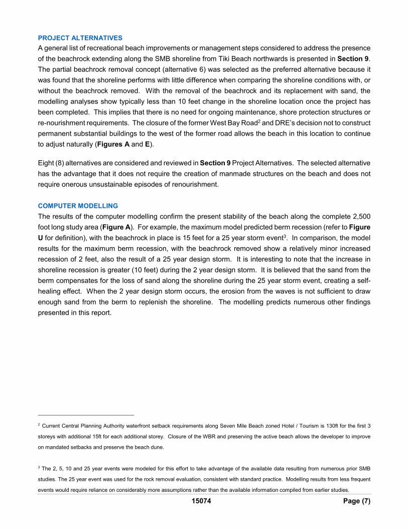
COMPUTER MODELLING
The results of the computer modelling confirm the present stability of the beach along the complete 2,500
foot long study area (Figure A). For example, the maximum model predicted berm recession (refer to Figure
U for definition), with the beachrock in place is 15 feet for a 25 year storm event3. In comparison, the model
results for the maximum berm recession, with the beachrock removed show a relatively minor increased
recession of 2 feet, also the result of a 25 year design storm. It is interesting to note that the increase in
shoreline recession is greater (10 feet) during the 2 year design storm. It is believed that the sand from the
berm compensates for the loss of sand along the shoreline during the 25 year storm event, creating a self-
healing effect. When the 2 year design storm occurs, the erosion from the waves is not sufficient to draw
enough sand from the berm to replenish the shoreline. The modelling predicts numerous other findings
presented in this report.
2 Current Central Planning Authority waterfront setback requirements along Seven Mile Beach zoned Hotel / Tourism is 130ft for the first 3
storeys with additional 15ft for each additional storey. Closure of the WBR and preserving the active beach allows the developer to improve
on mandated setbacks and preserve the beach dune.
3 The 2, 5, 10 and 25 year events were modeled for this effort to take advantage of the available data resulting from numerous prior SMB
studies. The 25 year event was used for the rock removal evaluation, consistent with standard practice. Modelling results from less frequent
events would require reliance on considerably more assumptions rather than the available information compiled from earlier studies.

15074 Page (8)
FINDINGS AND RECOMMENDATIONS
The following findings and recommendations have been developed from consideration of the technical points
and outcomes compiled from the field investigations and the subsequent computer modelling. The computer
modelling results show that the project will allow more sand to be transported along the shoreline rather than
offshore of the beachrock. This will likely result in increased shoreline recession (of less than 10 feet) along
the red and blue properties during storm events with a post storm recovery similar to what now occurs on
adjacent parts of the beach without exposed beachrock. Partial removal of the beachrock will allow Tiki Beach
and the Kimpton Seafire beach to experience a more stable, sandy shoreline.
Beach recession during nor ’wester storms is slightly greater with the beachrock removed when compared
to what currently occurs; beach advancement post storm is expected to be similar to adjacent section of
beach without beachrock. This recovery is expected to be of a similar order of about 20 feet based on the
beach profiles reviewed.
The recommendations for the proposed beachrock removal project arising from the study are as follows.
1. Obtain CIG’s approval of the proposed source of beach replacement sand
CIG gave its consent to use the applicant’s sand deposits on the site as the replacement sand for the trial
beachrock removal in December 2016, subject to compatibility testing and washing. There is sufficient sand
supply on site for the proposed beachrock and peat removal project. Post trial review with the DOE indicated
that continued use of this sand source will be favourably considered as replenishment sand for SMB (subject
to DOE’s specification for compliance testing and preparation procedures). Therefore, the applicant is
applying to use of the subject sand as replacement sand for the proposed project. The request to use this
sand forms part of the coastal works permit application for the proposed project.
2. Remove the beachrock and peat located in front of the red and blue properties and Tiki Beach
Recognizing the small differences in beach oscillation - for both beach accretion and recession - between
the ‘with project’ and ‘without project’ conditions, removal of beachrock and peat located in front of the red,
blue and Tiki properties can be accomplished with minimal impact on the beach. The future waterfront
development opportunities are the result of the eastward relocation of West Bay Road to the ETHE Highway.
This land use adjustment allows for buildings to be placed off the active beach and located to the east of the
former WBR. Not constructing permanent substantial buildings in the active beach zone will maintain the
beach’s ability to build outwards and recede (flex) in a natural fashion without manmade restraints.
At the southern end of the beachrock, approximately 125 feet of beachrock is located in front of the Kimpton
Seafire Resort, however it is at depths in excess of -4.5 feet and is not considered an obstacle to the LSTR
or recreational users. At the northern end, the applicant does not own the properties fronted by beachrock.
These properties have been built on the active beach dune as the building sites were constrained by the
former road. To maintain the existing beach environment in front of these neighbouring properties, it is
proposed to retain the northern 250 feet of beachrock. Refer to recommendation 4 below.
15074 Page (9)
The results of the trial confirmed that the beachrock and peat can be removed with relative ease and speed
using hydraulic excavators to limit the generation of turbidity. A detailed construction operations plan and
methodology statement is included in the application (Appendix J).
3. Continue to measure beach profiles
As part of the permitting conditions for the trial project, DOE required the sand profile in the vicinity of the
trial investigation area be surveyed monthly for 12 months (see Appendix K). Post trial conversations with
the DOE suggest that the value of this monitoring is now being questioned given the small area of beachrock
removed during the trial. It is felt by DRE’s team that this monitoring will not provide additional useful data
to the proposed project.
At completion of the proposed project, a periodic beach and seabed monitoring programme should be
developed with the DOE and carried out by the property owner to monitor the newly developed shoreline.
This is to build a baseline of information to help determine if there are any adjustments such as recession
hot spots or localized accretion that should be incorporated into a future SMB beach management plan.
4. Retain the beachrock at the very northern end of Parcel 10E48 (part of red property) and in front of
Sundowner
Retain a 250 foot long section of beachrock at the very northern end of the red property (part of 10E14,
10E48) and in front of Sundowner condominiums (10E37) to maintain the prevailing beach fluctuation
conditions at this location. With the removal of the beachrock in front of the red and blue properties, the
southerly LSTR rate is expected to increase. Allowing the very northerly end of the beachrock to remain will
help avoid drawing sand southwards from the neighbouring property. The beachrock left at the northern end
will continue to serve as a groin interrupting the southerly flow of sand. Even though the modelling predicts
that the movement of the beach in front of Sundowner will be within 5 feet of what currently occurs, it is felt
that given Sundowner is constructed in the active beach zone and thus close to the shoreline which is typical
of buildings on SMB, it would be a courteous and good neighbourly consideration not to apply for the removal
of this section of beachrock and maintain the prevailing conditions at this location.
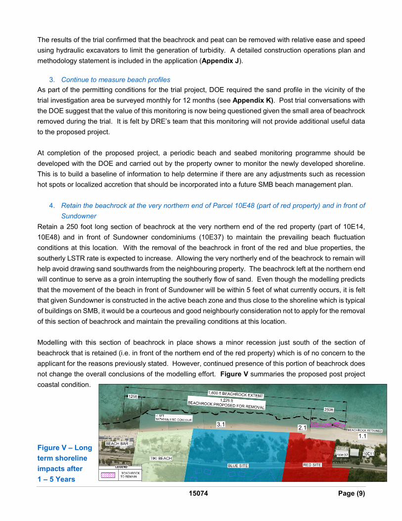
Modelling with this section of beachrock in place shows a minor recession just south of the section of
beachrock that is retained (i.e. in front of the northern end of the red property) which is of no concern to the
applicant for the reasons previously stated. However, continued presence of this portion of beachrock does
not change the overall conclusions of the modelling effort. Figure V summaries the proposed post project
coastal condition.
Figure V – Long
term shoreline
impacts after
1 – 5 Years