Battle of Lundy’s Lane - Niagara Falls, Ontario · PDF file1. The Funeral Pyre. As...
2
Walking Tour Follow this trail to experience the American advance and the British defense on the Lundy’s Lane Battlefield. Stops at key locations will help you understand what occurred here on July 25, 1814. You may begin your walking tour (approximately 1.7 km in total distance) at any point, but we recommend starting at the Niagara Falls History Museum or the Battle Ground Hotel Museum. If you prefer to drive part of the circuit, several parking lots are available (see map). For more information on the War of 1812 in Niagara: l Visit the Gale Family War of 1812 Gallery at the Niagara Falls History Museum l Check out the books and related materials available at the Museum Gift Shop l Tour the Chippawa Battlefield Park and visit Willoughby Historical Museum on the Niagara River Parkway. l Visit – eighteentwelve.com, discover1812.com, 1812history.com, or visit1812.com. Niagara Falls History Museum 5810 Ferry Street Niagara Falls, Ontario 905.358.5082 www.niagarafallsmuseums.ca Walking Tour The Battle of Lundy’s Lane July 25, 1814 ree Years of War in Niagara ON JUNE 18, 1812, THE AMERICANS DECLARED WAR ON GREAT BRITAIN. NIAGARA WAS A FOCAL POINT. THE BRITISH HAD FORTS AT BOTH ENDS OF THE NIAGARA RIVER (FORT GEORGE AND FORT ERIE) TO PROTECT THE PENINSULA FROM INVASION. THE MAJOR AMERICAN MILITARY BASE IN THE REGION WAS FORT NIAGARA, DOMINATING THE HEAD OF THE NIAGARA RIVER IN YOUNGSTOWN, NEW YORK, ACROSS FROM FORT GEORGE. For three years, Niagara was under almost constant siege. In October of 1812, American forces invaded at Queenston Heights. This engagement was the first major battle between the forces and provided a prelude of things to come. It also showed the early weaknesses of the underprepared American Army. The war resumed in the spring of 1813, with better prepared American forces. An American victory at York (Toronto) encouraged a new Niagara campaign. In May, a landing force captured Fort George. They held onto the Fort until December of 1813, at various times expanding and contracting from that point. Most of Niagara then was under American occupation. When the Americans withdrew in December, they burned the village of Niagara (Niagara-on-the-Lake). In 1814, the Americans invaded Niagara again. This time the focus was to the south, at Fort Erie. They captured the Fort and proceeded into the peninsula again, with engagements at Chippawa (July 5, 1814) and then Lundy’s Lane (July 25, 1814). Following these two devastating clashes, the Americans withdrew to Fort Erie and endured a British siege of the fort (August 15 - September 17). In November, however, compelled to reinforce their eastern seaboard, the Americans retreated across the border and the occupation of the Niagara Frontier was over. The War officially ended on December 24th, 1814 with the signing of the Treaty of Ghent. Financial assistance provided by: Connect with Niagara Falls Museums: Prelude to Battle You are standing on Main Street, part of the historic Portage Road. Believed to have been an old native trail, it was used as a portage around the Falls and rapids of the Niagara River. As the main north/south road in the area, it was used by both armies during the War of 1812. Defeated at the Battle of Chippawa on July 5, 1814, the British and Canadian forces withdrew along the road to Fort George, pursued by the Americans under General Jacob Brown. Running short of supplies and needing reinforcements, Brown’s forces were unable to press their advantage. After burning the village of St. Davids, they returned along Portage Road to their camp in Chippawa, where obtaining supplies from the American side of the Niagara River was much easier. Aware of American movements, British and Canadian troops, under General Phineas Riall, began forming up along Lundy’s Lane at its junction with Portage Road on the morning of July 25, 1814. British pickets at Willson’s Tavern (south of this spot, near the Falls) were spied by advance American scouts. Shortly after 5 p.m., an American Brigade, under General Winfield Scott, began marching up Portage Road from Chippawa, chasing the British pickets from Willson’s Tavern and approaching within half a kilometre (approximately 500 yards) of Lundy’s Lane. General Scott began to form his brigade here (numbering slightly more than 1000 men) in and around the Chestnut woods, just south of Barker’s Lane. He sent a messenger to General Brown at Chippawa with the information that British troops were facing him down in force and he was preparing for an attack. General Brown later reinforced the American forces with an additional 1500 men. e British Position In the early evening of July 25th,1814, the British commander, Lt. General Gordon Drummond stood on this hilltop. Having just received intelligence that an American force was marching northward in this direction along the Portage Road, he realized this site would make an excellent defensive position. Accordingly, he set up his artillery pieces (two 24-pounders, two 6-pounders and a 5 ½ inch howitzer) and deployed his troops (initially 2000 men with later reinforcements of over 1700) in a wide arc to the right and left of the guns. While at this location (see inset map), explore the Graves Significant to the War of 1812 and the rest of the cemetery. e Americans Attack Scott’s Brigade emerged from the Chestnut woods shortly after 7 p.m. Ahead, they saw the height of land at Lundy’s Lane, containing a small cemetery and a meeting house, all surrounded by farmers’ fields. The British had placed their artillery on this height in preparation for battle. The Americans surged forward, attempting to take the British position. This and repeated attempts failed and they endured heavy losses. Later, under cover of darkness, the American 21st Infantry made its way up the southeast slope of the hill. In a surprise flank attack, they captured the British guns. e British Counter Attacks Following the capture of his artillery by the Americans, Lt. General Drummond and his troops retreated from their defensive position on the height of land in the cemetery to this area on the north side of the hill. Starting before 10 p.m. and lasting over the next several hours, Drummond led three unsuccessful counterattacks to try and recapture the British guns. In each case, the fighting was vicious and bloody. Around midnight, with both sides completely exhausted, the Americans withdrew to their camp at Chippawa. They left the British guns behind, allowing Drummond to reclaim them the following morning. e Aſtermath After the fiercest and bloodiest battle of the War of 1812, General Brown ordered the American withdrawal southward. The American forces were not expelled from the position they won, but retired voluntarily. The British regained possession of the battlefield, but were in no condition to pursue their enemy. Although both the British and Americans claimed victory, neither side won decisively. Casualties Both sides suffered heavy losses during the Battle of Lundy’s Lane and these were severe in proportion to the number of combatants. The casualty rates were nearly equal, as both sides recorded around 800 casualties, which included men killed, wounded or missing. This was the highest single casualty rate for the War of 1812. Battlefield Tourism Following the close of the War of 1812, the battlefield became a popular tourist destination. For many decades, veterans of the battle were available to conduct personal tours. In 1845, the first of five viewing towers was erected, mostly wooden frame structures with a lofty viewing platform overlooking the battlefield. One of these towers was built on this spot by Adam Fralick, owner of the adjacent tavern which is now the Battle Ground Hotel Museum. Fralick’s tower was a prominent landmark in the city, visible for several miles. In the late 1800s, the tower was dismantled and replaced with a steel structure known as the Lundy’s Lane Observatory. Until 1921, its steam operated elevator whisked visitors to a viewing platform 31 metres (102 ft) high. Interest in the battlefield as a destination waned when the American Civil War provided Americans with new battlefields to visit and other local attractions gained popularity. British Regulars defending Lundy’s Lane. Lundy’s Lane Observation Towers www.niagarafalls.ca Ver 1.0 (07/12)
Transcript of Battle of Lundy’s Lane - Niagara Falls, Ontario · PDF file1. The Funeral Pyre. As...
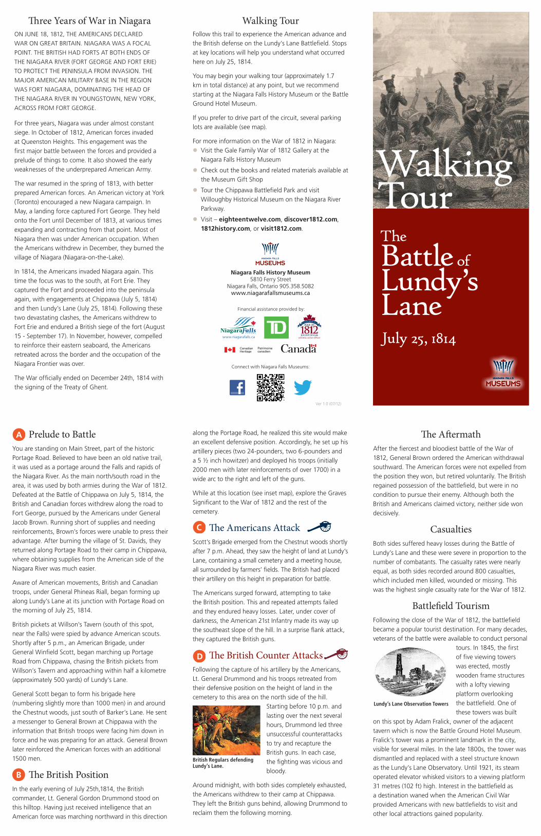
Walking TourFollow this trail to experience the American advance and the British defense on the Lundy’s Lane Battlefield. Stops at key locations will help you understand what occurred here on July 25, 1814.
You may begin your walking tour (approximately 1.7 km in total distance) at any point, but we recommend starting at the Niagara Falls History Museum or the Battle Ground Hotel Museum.
If you prefer to drive part of the circuit, several parking lots are available (see map).
For more information on the War of 1812 in Niagara:lVisit the Gale Family War of 1812 Gallery at the
Niagara Falls History Museum
lCheck out the books and related materials available at the Museum Gift Shop
lTour the Chippawa Battlefield Park and visit Willoughby Historical Museum on the Niagara River Parkway.
lVisit – eighteentwelve.com, discover1812.com, 1812history.com, or visit1812.com.
Niagara Falls History Museum5810 Ferry Street
Niagara Falls, Ontario 905.358.5082 www.niagarafallsmuseums.ca
Walking TourThe Battle of Lundy’s LaneJuly 25, 1814
Three Years of War in NiagaraON JUNE 18, 1812, THE AMERICANS DECLARED
WAR ON GREAT BRITAIN. NIAGARA WAS A FOCAL
POINT. THE BRITISH HAD FORTS AT BOTH ENDS OF
THE NIAGARA RIVER (FORT GEORGE AND FORT ERIE)
TO PROTECT THE PENINSULA FROM INVASION. THE
MAJOR AMERICAN MILITARY BASE IN THE REGION
WAS FORT NIAGARA, DOMINATING THE HEAD OF
THE NIAGARA RIVER IN YOUNGSTOWN, NEW YORK,
ACROSS FROM FORT GEORGE.
For three years, Niagara was under almost constant siege. In October of 1812, American forces invaded at Queenston Heights. This engagement was the first major battle between the forces and provided a prelude of things to come. It also showed the early weaknesses of the underprepared American Army.
The war resumed in the spring of 1813, with better prepared American forces. An American victory at York (Toronto) encouraged a new Niagara campaign. In May, a landing force captured Fort George. They held onto the Fort until December of 1813, at various times expanding and contracting from that point. Most of Niagara then was under American occupation. When the Americans withdrew in December, they burned the village of Niagara (Niagara-on-the-Lake).
In 1814, the Americans invaded Niagara again. This time the focus was to the south, at Fort Erie. They captured the Fort and proceeded into the peninsula again, with engagements at Chippawa (July 5, 1814) and then Lundy’s Lane (July 25, 1814). Following these two devastating clashes, the Americans withdrew to Fort Erie and endured a British siege of the fort (August 15 - September 17). In November, however, compelled to reinforce their eastern seaboard, the Americans retreated across the border and the occupation of the Niagara Frontier was over.
The War officially ended on December 24th, 1814 with the signing of the Treaty of Ghent.
Financial assistance provided by:
Connect with Niagara Falls Museums:
Prelude to BattleYou are standing on Main Street, part of the historic Portage Road. Believed to have been an old native trail, it was used as a portage around the Falls and rapids of the Niagara River. As the main north/south road in the area, it was used by both armies during the War of 1812. Defeated at the Battle of Chippawa on July 5, 1814, the British and Canadian forces withdrew along the road to Fort George, pursued by the Americans under General Jacob Brown. Running short of supplies and needing reinforcements, Brown’s forces were unable to press their advantage. After burning the village of St. Davids, they returned along Portage Road to their camp in Chippawa, where obtaining supplies from the American side of the Niagara River was much easier.
Aware of American movements, British and Canadian troops, under General Phineas Riall, began forming up along Lundy’s Lane at its junction with Portage Road on the morning of July 25, 1814.
British pickets at Willson’s Tavern (south of this spot, near the Falls) were spied by advance American scouts. Shortly after 5 p.m., an American Brigade, under General Winfield Scott, began marching up Portage Road from Chippawa, chasing the British pickets from Willson’s Tavern and approaching within half a kilometre (approximately 500 yards) of Lundy’s Lane.
General Scott began to form his brigade here (numbering slightly more than 1000 men) in and around the Chestnut woods, just south of Barker’s Lane. He sent a messenger to General Brown at Chippawa with the information that British troops were facing him down in force and he was preparing for an attack. General Brown later reinforced the American forces with an additional 1500 men.
The British PositionIn the early evening of July 25th,1814, the British commander, Lt. General Gordon Drummond stood on this hilltop. Having just received intelligence that an American force was marching northward in this direction
along the Portage Road, he realized this site would make an excellent defensive position. Accordingly, he set up his artillery pieces (two 24-pounders, two 6-pounders and a 5 ½ inch howitzer) and deployed his troops (initially 2000 men with later reinforcements of over 1700) in a wide arc to the right and left of the guns.
While at this location (see inset map), explore the Graves Significant to the War of 1812 and the rest of the cemetery.
The Americans AttackScott’s Brigade emerged from the Chestnut woods shortly after 7 p.m. Ahead, they saw the height of land at Lundy’s Lane, containing a small cemetery and a meeting house, all surrounded by farmers’ fields. The British had placed their artillery on this height in preparation for battle.
The Americans surged forward, attempting to take the British position. This and repeated attempts failed and they endured heavy losses. Later, under cover of darkness, the American 21st Infantry made its way up the southeast slope of the hill. In a surprise flank attack, they captured the British guns.
The British Counter AttacksFollowing the capture of his artillery by the Americans, Lt. General Drummond and his troops retreated from their defensive position on the height of land in the cemetery to this area on the north side of the hill.
Starting before 10 p.m. and lasting over the next several hours, Drummond led three unsuccessful counterattacks to try and recapture the British guns. In each case, the fighting was vicious and bloody.
Around midnight, with both sides completely exhausted, the Americans withdrew to their camp at Chippawa. They left the British guns behind, allowing Drummond to reclaim them the following morning.
The AftermathAfter the fiercest and bloodiest battle of the War of 1812, General Brown ordered the American withdrawal southward. The American forces were not expelled from the position they won, but retired voluntarily. The British regained possession of the battlefield, but were in no condition to pursue their enemy. Although both the British and Americans claimed victory, neither side won decisively.
Casualties Both sides suffered heavy losses during the Battle of Lundy’s Lane and these were severe in proportion to the number of combatants. The casualty rates were nearly equal, as both sides recorded around 800 casualties, which included men killed, wounded or missing. This was the highest single casualty rate for the War of 1812.
Battlefield TourismFollowing the close of the War of 1812, the battlefield became a popular tourist destination. For many decades, veterans of the battle were available to conduct personal
tours. In 1845, the first of five viewing towers was erected, mostly wooden frame structures with a lofty viewing platform overlooking the battlefield. One of these towers was built
on this spot by Adam Fralick, owner of the adjacent tavern which is now the Battle Ground Hotel Museum. Fralick’s tower was a prominent landmark in the city, visible for several miles. In the late 1800s, the tower was dismantled and replaced with a steel structure known as the Lundy’s Lane Observatory. Until 1921, its steam operated elevator whisked visitors to a viewing platform 31 metres (102 ft) high. Interest in the battlefield as a destination waned when the American Civil War provided Americans with new battlefields to visit and other local attractions gained popularity.
British Regulars defending Lundy’s Lane.
Lundy’s Lane Observation Towers
www.niagarafalls.ca
Ver 1.0 (07/12)

1 The Funeral PyreAs bodies from the battle were too numerous for a conventional burial, many fallen soldiers were burned in a huge funeral pyre, which was constructed in this area of the cemetery. Prior to its modern day use as a Church parking lot, historians and archaeological experts confirmed that no human remains are located on the site.
2 Lundy’s Lane MonumentThe Lundy’s Lane Monument (1895) commemorates those who dedicated their lives to the sovereignty of British North American.
3 Laura SecordA legendary Canadian heroine, Laura Secord walked 30 kilometres (19 miles) westward from the vil-lage of Queenston to Beaverdams, to warn the British of an impend-ing American attack in June 1813.
4 Christopher BuchnerChristopher Buchner, who fought at Chippawa and Lundy’s Lane, saw the battle fought here on his own land. His fences were used to fuel the funeral pyre. He became the first lessee of the Government to operate a ferry boat below the Falls. His son, John Buchner, was taken prisoner in the Battle. It is rumoured he escaped his guards when they stopped to pick cherries.
5 Lt. Col. Cecil Bisshopp British leader of successful earlier battles at Frenchman’s Creek, Beaverdams and Black Rock, died of battle wounds and was buried here in 1813.
6 Lt. William Hemphill The only British officer killed here whose grave is marked.
Graves in Drummond Hill Cemetery Significant to the War of 1812
Lundy’s Lane Ferry Street
Barker Street
Drum
mond Road
Main Street
Peer Street
Sylvia Place
Hanan A
ve.
Buchner Place
Prelude to BattleThe Americans Attack
The British Position
Drummond Hill Cemetery
The British Counter Attacks
Battle Ground Hotel Museum
Coronation Park
Ruth Redmond Memorial
Drummond Hill Presbyterian Church
Old Portage Road
(To Queenston)
(To Chippawa)
(To Q.E.W. Highway)
Pedestrian Crossing
Pedestrian Crossing
Pedestrian Crossing
P
P
(To Falls)
Niagara FallsHistory Museum
7 Richard LeonardThe British officer who held General Drummond’s extreme right flank in the battle here, later built a home adjacent to the battlefield. Following the war, he became Colonel of the 1st Lincoln militia and Sheriff of Niagara.
8 Captain Abraham Hull Son of American General William Hull (who surrendered Detroit to the British) and nephew of Captain Isaac Hull (Commander of the U.S.S. Constitution). Lying mortally wounded, he was tended by British Lieutenant John Le Couteur.
* Memorial to Unidentified American Soldier
The Battle of Lundy’s LaneWalking Tour • July 25, 1814
Walking Tour Route (Approx 1.7 km)
Tour Stop
Interpretive Sign
Parking
Map Legend
Thank God, I escaped with only the loss of one horse shot under me. We have been following the enemy and hope to drive them out of the country. I wish you were beside me just now for 10 minutes just to see the grandest falls in the world. No description that I have ever seen comes up in any degree to the original.Colonel Hercules Scott, 103rd British Reg. to his sister – Falls of Niagara, 30th July, 1814
Our victory was complete, but, alas, this victory gained by exhibitions of bravery never surpassed in this country, was converted into a defeat by a precipitate retreat, leaving the dead, the wounded and captured artillery, and our hard earned honor to the enemy.Major-General Peter B. Porter, American Army, to Governor D.D. Tompkins – Fort Erie, U.C., 29th July, 1814Note: Map is Not to Scale
Lundy’s LaneLundy’s Lane
THE FALLS
Stan
ley
Ave
.
Dru
mm
on
d R
d.
Do
rch
este
r R
d.
LUNDY’S LANE FERRY ST.
MAIN ST.
Q.E
.W. H
IGH
WA
Y(T
o Bu
ffalo
, NY,
USA
)
HIGHWAY 420
(Bridge to USA)
Niagara FallsNew York
Victoria
Ave
.
Falls
view
Blv
d. Nia
gara P
arkwayPO
RTA
GE
RD.
(To
Toro
nto
)
(To
Chip
paw
a)
(To
Quee
nsto
n)