B1cavatians in The lomal Valley - University of Peshawar
15
B1cavatians in The lomal Valley BJ PROF: AH HASAN DANI
Transcript of B1cavatians in The lomal Valley - University of Peshawar
B1cavatians in
The lomal Valley
BJ
PROF: AHMAD HASAN DANI

CONTENTS
Foreword. Page
SUm.ma.ry of Results
I The Gomal Valley 1
II Previous work in the Gomal Valley 15
III The New Explorations in the Go mal Valley 22
lV Excavation at Gumla 35
v Excavation at Hathala 54
VI Terracotta Objects 64
(A) Human figurines 64
(B) Animal figurines 72
(C) Miscellaneous Objects 76
(D) Wheels & carts 77
(E) Missiles & Triangular Cakes 78
(F) Balls, Dire-Throwers and Others '19
< G) Ritual Tiny Saucers & Pots 80
VII Metal and Bone Objects 83
VIII Beads, button & bangles 86
IX stone Objects 92
x Pottery from Gumla 130
XI Conclusion 164
Appendix (Radio-Car bon Dates) 176
(ix)
CHAPTER 1
Nomenclature:-THE GOMAL VALLEY
The Gomal is a vast alluvial plain of the "Derajat" in West Pakistan. Extending along the right bank of the river Indus, the plain slopes south-eastward and drains the water into the Indus from the west.em hills that separate Pakistan from Afghanistan. Once across these hills the traveller has a breathing space for rest in the � ma1 valley, which leads him directly without any further hilly barrier over the great Iridus river to the ext.ensive plams that have constituted. the main granary of the r�on. For those coming from the side of Afghanistan, particularly along the south� margin of flats right over Herat, Kandahar and Gha.zni, the Gomal provides an easy access - alike to the travellers, settlers and invaders who have had an avaricious eye for the rich harvest of the Indus. No wonder that from tllme 1.mmem.orJal right down till today the Gomal has been a rendezvous of the Powindas' - "foot. marchers" th�ugh long currents of time from Afghmistan into Pakistan. As these Powindas, and other D1.eJ1 of their kind, have been coming from the Central high massifs of Afghanistan into the plains of Pa.klistan along with their cattle, camels and goats during the cold months of the winter to find fOOd for themselves and fodder for their animals, the river channel through which they pass and the plain where they encamp, have both bome the significant name of Gomal, deriving from the Vedic Sanskrit Gomati, meaning "Possessing COWS".2
With this name the scholars have generally associated. another word Thatagush, which appears in the inscriptions3 of the Achaemenian em�ror Darius. It has been Sanskrltised by Dr. Sircar as Satagu, obvl· ously implying "a land of hundred cattles". This meaning brings the word closest to the usual fonn of Gomal. Resemblance has also been sought with the term Sattagudai used by Herodotus th the following pas&, age:
"The Sattagudai and the Gimdariol and the Dadikai and the Aparo.ta!, who were alf reckoned together, paid 1'10 talents. Tb.is was the seventh aatrapy".'
Sir Olaf ca.roes has discussed in deta.11 the identification and has also gone a step further fn associating with it the Pukhtun tribes, the Khattaks and the Shit.alts. However, these tribes have never been assoc1a,, ted with the Gomal Valley.
Western Hllls:- Sir Aurel Stein6 bas quoted two literary evidences to trace the ancient history of the western hills. The first is ta.ken from Hiuen Tsang, which ts given below:
"The common report says on the west. em frontier of this country (Le. Fa-La-Na = Bannu) is the kingdom of Ki-K.iang-na (Kikana?). The people Jd.ve amid the great mountains and valleys in separate clans. They have no chief ruler. They breed an immense quantity of sheep and horses. The shell horses are of a large size. and the
3. D.C. Sircar - Sdtct lnscrlpiiom, Cakutta,1942, Pp. S ff.
1. The woro is thus explained. " uJ ..tt,,
Powattdizb, s.m. (6th) (P.V. cJ�..tt ). Thename given to die nomad tribes of Afghanswho move about with their flocks and herds "·
SD4 act as carriers bctweei:t their own country 5• and India". Ravert1 - Dictio/14'1 of ,the Pusbto language, Pp. 1106, 1140 � 1�53.
Herodotus, Book _3, 91.Sir Olaf Caroc: The Pdlbtms, London, 1962,Pp.36-40
2. A.A. Macdondl and A.B. K�th-:- Y etlic lilll�.Vol. 1, reprinted by Motilal, 1�7. P. 238.
1
6. "An Archaeological Tour in Wazir.istan andBaluchistan. in M etJIOirs of the A rcbtMologicalSllf"W'Y of lndilJ. No. 37 Pp. 29-30.
'
•
Gomal Excavations [Ancient Pakistan
countries around breed but few, 8Dd therefore they are highly valued" •1
Sir Aurel Stein gives the variant reading Chi-chiang-na and identifies it with the hill region now known as Waziristan. He further quotes from. Baladhuri2 and refers to the early Arab raid and defeat in Qiqan
of "a large host of Turkish horsemen the fastness of whose mounts is specially praised". This mid took place along with the Arab advance into Bamm. As Qiqan is said to have lain between Multan and Kabul, it ts generally believed that the Arab place name is identical with that given by Hiuen Tsang and that finally it should signify mod.em Waziristan. However, there is no record of these place names in any subsequent literature.
Later Names:-
In the ee.rly British records "Derajat'' is a familiar word used for this transIndus region. It is the plural of "Derah" signifying "encampment," or in general "a house or dwelling" and implies jointly the areas included within the control of Dera Ismail Krum, Dera Fateh Khan and Dera Ghazi Khan - three well-known towns named after three Baloch chiefs who, ori· ginally hailing from Kech Makran, found· ed them in the late fifteenth century AD. Since then the Baloch tribe hes played a prominent part in this region. The British constituted two districts named after Dera Ismail Khan and Dera Ghazi Khan, both of which still continue although their boundaries have changed considerably. Today while Dera Ismail Khan lies west of the Indus, the city of Dera Ghazi Khan
I. Samuel ··Beal - Chinese Accounts of India,reprinted in Calcutta, 1958, Vol. IV. P. 468.
2 .. For original see Futuh-ul·Buldan, Urdu tr. by Sayyid Abut Khair Maududi, Karachi, 1962. Pp. 613-614. Arabic text, Cairo edition, Pp. 438-39.
3. Gazetteer of the De;a Ismail Khan District(1883-84) P. 199.
lies to its east. But it must be not.eel that the old city of Dera Ismail Khan has been washed away by the river. The new city at its present site was founded in 1823 by Nawab Sher Mohammac::l Khan.3
Another old term still remembered is the Makkalwad4 or Makkalwadh/• Haverty rightly discards the old spellings "Mukelwad" and "Mucklewad", and observes: "In the most recent maps, this tract appears as 'Kolache. The town (now a tehsil headquarter) of Kulachi lies a little over 26 miles west of Derah-i-Ismail Khan." The Gazetteer records: "The term Daman (see below) originally applied only to that portion of the trans-Indus tract lying immedi at.ely under the hills and forming the Daman or the skirt of the hills. The eestem portion of the tract towards the Indus was known as Makkalwad. The term Daman 1s now applied indiscriminat.ely to the whole country from the Indus to the hills. The term Makkalwad has fallen out of use though it is occasionally employed to distinguish the country towards the Indus from the subm.ontane tracts, which are mainly occupied by the Pathan tribes". Raverty quoting from a Persian work Sair-ul-Bilad gives a complete picture in connection with the tribe "the Hut" .6 He translates:-
"This 1s a noble tribe of the Baluch, and consists about 20,000 families, who dwell in the territory of Derah-i-Ismail Khan. Their portion of it extends from the village of Rang (Rangpur) to Paharpur, a distance of 50 kuroh in length, and from the Sind river to Daman, 12 kuroh in breadth. The cultivation is much the same as that of the District of Derah-1-Ghazi Khan, and the water of the river GumuI which issues from the mountain barrier t.o the west, is expended in the irrigation
.1,. Ibid, Pp. 3-4. 5. H.G. Raverty - Notes on Afghanistan anti
part of Baluchistan, London 1888, Pp. 4.-5.Pp. 36-40,
6. Ibid� Pp. 4.Sr-4.52,
2
• .. ,.
... .
...
•
.. ,
•
•
r • ..
,I
•

Vol. V, 1970.71] Comal valley
of the tract of the country held by the Hut Khan. and from the Derah of Ismail Khan tribe. The lands also which the waters of to Paharpur, they call Makkalwadh, after that river reach, are called Gumul. the above-mentioned. old town.'•
"As this tribe resided, in times by-gone, at the town of Makkalwadh, - the plain country immediat.ely north of Sanghar. on the right bank of the Sind river, is so called, - their country is also called Makkalwadh. It brings 1n a revenue of just five lakhs of rupees. The seat of � vernment of this part, that is to say. Mak· ka.lwadh, is Derah·i·Ismail Khan, & considerable city, founded by Ismail Khan of the Hut tribe; and the products of Sind and Hind, Iran and Turan &re disposed. of here."
Later on while tracing the route from Khusbab on the Jhelam to D.I. Khan. Re.verty again quotes from the same work. ''From Hamoli you go fourteen kuroh west, inclining south-west to Kablur (modern Kallar Kot), an ancient town with sixty villages and their lands dependent OD it. The Sind river lies two kuroh to the west of the place; and one kuroh south of it is Naghari (correctly Nagarl) from which you go another kuroh in the same direction to Nuwan, another to Umar Wall, and three in the direction of southwest, to SUwadpur. Half & kuroh more brings you to MaJdaLJwadh, previously mentioned in the account of the Baluch tribe of Hut. Both these last-named plac.es are ancient towns, and the latter was. in the olden time, the capital of the Hut tribe. When Ismail Khan and other ch1efa of the Hut acquired considerable stat.e and dignity, they abandoned the territory which had been their former dwelling place (i.e. Makran). and founded & large city (town) on the other side of the Sind, and styled it the Derah of Isma.11 Khan. From that period these two towns began to go to decay, and were neglected and now they a� deso�.
Thus according to this Persian source Makkalwad included both trans-Indus as well as cis-Indus areas, and in the la.st century the district of Dera Ismail Khan incorporat.ed both these tracts. But today the cis-Indus area, generally known as Sina Sagar Doab, comprising Laiyy& and Bhakkar tehslls, has been cut off from that district and joined with Panjab districts. There is no trace of the old town of Makkalwad.
The meaning of the word Makkalwad is not difficult to surmise. It consists of two parts - Makkal and wad. The latter is derived from Wada1 meentng an enclosed. area. Makkal appears to be a proper name.
· Its original fonn is difficult to surmise.In any case the term Makkalwad appearsto be a survival from the pre-Muslimperiod. Can we look into it the form Qiqanwhich we get from the Arab sources ?
The Daman:- Raverty has given a good account. He writes:2 "Daman, as its name indicates, lies at the foot or skirt of the Koh-i-Sulaiman, and extends from Tak to Chaudh Wa'an and west to Z.a.rkani so, called after & clan or section of the Shpun Baitnis. On the east it joins the district de· pendent on the Der.ah of Ismail Khan; and on the west, extends to the foot of the mountains r the easternmost skirts pf the great range - which the Afghan inha,. bitants here style Ghar, - the Pushto word for mountain - and also Shu'al. Daman, therefore, is about forty kuroh long, from north to south and about twenty kuroh broad, from west to east. Its surface is ge.. nerally flat, and is sometimes sandy, but consists chiefly of clay and sand which
l, Apte's Sanskrit - Eng!ish Dicti0114,Y, Reviicd "Upto this period of time the tract of edition, Poona 1959, P. 1410.
country extending from Kahlur to Darya 2. Haverty, Op. Cit •• P. 328.
3
..
•
•
;
Gomil E11 civations · [Ancient Pakistan
have become considerably hardened, indi· ca.ting that it has been formetl of the debris washed down from the mighty range in the course of centuries, but, more particularly, from the easternmost er lowest ridges or the outer chain, which are composed of Wldstone grey in colour. Near the hills this hardened surface is 'partially covered by a broad belt of boulders and small loose stones washed down in time of floods. Where there is no water available for irri· gaticn purposes, this surface is bare of grass but it is partially covered with low tamarisk jangal, and the jawasa or camelthorn (hedysarum alhagi), but the trees are few, and seldom attain any consider. A-b� height. The rainy season of this part is the wint:er; and the custom of sinking wells. is unknown, and river water is used f.or all purposes. When the rivers becomedry they dig in their beds to about the depthcf a man's stature, and pure water issuesforth, and suffices for the use of man andbeast".
Mihtar Sulaiman:- The Daman can be understood only in term of the lofty west. em hill that intervenes between the Dera· jat and the Kandahar - Ghazni area of Afghanistan. Raverty has collected together all the traditions and the details of the routes that pass over it to the west. First to quote is the distant view. "The westernmost ridges, which can be plainly distinguished from Multan, a distance of over eighty miles, on a clear day, and the highest of which is snow-capped in winter, are what is commonly known as the range of Mihtar Sulaiman, from its highest peak, callE:d the Takhi·i-Sulaiman, previously re· !erred to, but styled by the Musalman people of these parts the Koh-i-Siyah, and byHindus, Kala Pahar, or Black MO\mtains,for such is the colour they assume, whilethe lower or eutemmost range, by reasonof their colour, a yellowish red, are styledthe Koh·i-Surkh, and Rata Pah.ar, but theiatrer name is not sd common as the former, both to Musalnulns and Hindus".' It
1. Raverty, Op. Cit., P. S.
is further narrated, "West of the town of Chaudh Wa'an (see Fig. 1) rises that lofty psak of the Koh·f-Sulaiman or Koh·i·Siyah,called the Talcht-i-Sulaiman, or 'Solomon's Throne' (see Pl. 2 a), giving name to the whole oi the stupendous range. The Af.. gh!ms style it Kesah-Ghar, and Kasi-Ghar,and also Shu-al. It is a very lofty mcuntain, and on the summit of it is the place of pil· grirnage, known to the Af.ghan people as the Ziarat ( or Shrine or place of Pilgrim· age) of the Patriarch, Suliman ........ · ..
"From the town of Chaudh-Wa'an to the Ziarat of Hazra.t Suliman, on its summit, is a distance of twenty-five kuroh, and the way t.'lither is well-known. This great range of mountains intervenes between Kandahar and the Derah·jat, extending l.e�hways froin the Darah of Khaibar andJalalabad on the north, to Siwi and Dadaron the south, a distance of just three hun·dred kuroh, and in breadth, including itsoffshoots, one hundred kuroh. Withinthese limits, forming an extensive territorythere are numerous darahs and plateaus;and it was herein, but especially in the vici·niiy of, and around, Kasi-Ghar, or Shu-al,that the Afghan tribes, according to theirtraditions, first took up their abode, andsubsequently spread out in all directions".2
R1.verty further gives the tradition in full; "The Afglw.ns call it Ghar, Kasi Ghar,
and Kesah Ghar, which they say, is be· cause it is the father3 of, and the greatest among, mountains. Tliey likewise call it Shu-al, 3nd Shu-al Ghar, as previously mentioned. Persian speaking people, or Tajziks, call it Koh·i·SUllinan, and Koh-i..Siyah; and these names �re applied as the general de· signation of the whole of this great range. The tndition among the people of this
2. Ibid, P. 329.3. R2verty notes the probability that "Kasi Chu
is a corruption of Kaisi Char, oi: the mountainof the descendants of Kais·i·Abdur-R'ashid, thefounder of the Af&nan race". Foot note onP. 522.
4
,,
• ,.
,
· . . . ,
•• ...

ANCIENT MOUNDS IN GOMAL & KURRAM VALLE...S
MlL£$ 10 5
N D I A
h I //
O SCALE,-1=1(\...0MILES
10 �0 !l,O 40
70
.·,D���- ...
Q MUSAKHEL SITE. 14 MILES N. OF MIANWALI, OUTSIDE THIS MAP.
REFERENCE
SHAIDAN SPINWAM DRE-DHERAI IDAK KHAJU RI ZARIF KHAN SHAH ZAMAN LAKI KOT KOT KAT KOT ALADAD DAB RA KARAM SHAH HATHALA BUD-Kl-·OH ERAI HISAM DH ERAI RAHMA N DHERAI GOMAL KALAN GU M LA
19 ZARKANI 20 SURKH .DHERAt @ MARHA SHARIF �-
SIR. AUREL STEINS ROUTE . . . . . .... .E�-�3.l
.. JvODERNTOWNS .cr::J iANCIENT SIT ESC£1'i INTERNATIONAL BOUN· DARY LINE .... -� I
ROAD ........ _gi RIVER ....... �. AEOVE .100.0.F.T. C::J
. ABOVE ,BOSO F.T. J:?;4�3 ABOVE .. 0. .OFT. -
' PREHISTORIC SITES WIT HIN ......... Q
~; 9" .1 ; • I 6&
"3~'l.'l
1 '5,."r>-~ 2
3 ~s 4 x0~BANNU 5 ~
6 7 8
~ ~ ~ 11
2 . ~l
C':,
' ~
~
~

••
••
BRONZE AGE SITES
IN WEST PAKISTAN &
THE f'EIGHBOURING AREAS
O d fO 14!0 Scale
100 STATUTE .. LP· 400
MODERN CITIES...... ... . . . . . . ... . . . . . . .. . . . . • . . . . . . . •
!NOUS CNILlZATION & RELATED CULTURES •.....•
· SITES CF GANDHARA GRAVE CULTURE .. . . . . . . . Q
AFG HA IS TAN
ARA
t::i"f '
AN
"'�· .. - •• ,4'
SEA
N D A
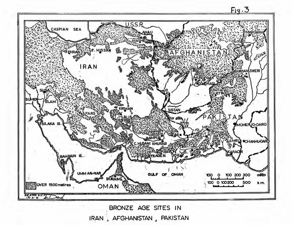
IRAN
. GULF
I OF
',,\
OMAN
BRONZE AGE SITES IN
AFGHANISTAN PAKISTAN
100 0 It I,,
Fa .3
100 200 300 I I
·' 100 0 100200 500 � lfNll�ZIM11.....a.�..__.,.._ ... _.f
km.
'

Vol. 'V. 1970.71] Gomal Valley
part is, that the Patriarch SnUman (SOlomon) used to sit at, or upon (hence the name Takht), a certain place thereon, on a ledge of rock, and that, close to the place in question, there is a small rnasjid ..... . .... which is said to be of that Patriarch's founding, and which is resorted to by the Afghans as a place of pilgrimage. Further, that there is a great copper pot or caldron to be seen there, large -enough to cook a hundred manns of food, and iron rivets of sufficient size and strength to support this great caldron. Near the place where this vessel lies, a Muhammadan darvesh has built himself a dwelling, and there he performs his devotions. On the summit of this place a red flag js raised, after the manner of darweshes. The sides of this vast mountain range are clothed, every here and there, especially on the lower sides, and in the great clefts, but chiefly· in the more sheltered places towards the summit, by dense forests of firs and wild olives; and about its sides and on its offshoots, and near its Ziarat-Gah, or place of Pilgrimage, the Afghan tribe of Sherani, which contains many branches or divisions, dwell".1
Physical features of Mihtar Sulaiman:na.verty defines the northern limit thus. "In reality the river Kurmah (i.e. Kurram) and its affluents above the Darah of Kurmah, sepa.rate the Spin Ghar, or Koh-i-Safed, or White Mountain range from the range of Mihtar Sulaiman".2 About the marginal ranges Raverty writes: ''Range of Mihtar �ulaiman is flanked on the outside, more . or less, on all four sides, from the Indus on the· east, to the Tarnak on the west, and from the river of the Kurmah Darah on the ncrth, to the plain of Kachchhi on the south, . . . . . . . . I may first mention that the Pushto and Tajzik words for red are constantly occurring in the names of these parts; namely Sur ( the feminine form of which is Sarah) in the former language, and Surkh in the latter. The Turkish equt.
1. Haverty, Op. Cit., Pp. 522·23.2. Ibid. P. �-
valent of Koh·i·Surkh would be Kizil Tash or Ulan Tagh, which we have. On the eastern or Indus side we have the addition of the Hindi names for both ranges, red being rata; while farther south again, even on the western boundary of the Siwistan province of Thathah or Sind, we have the same reference to the peculiar colour of the red range, in Koh-i-Lakha and Lakhi Range .• . . . . . .. It will be thus observed that the Koh-1-Surkh, or SUr Ghar, or Ulan Tagh, runs most regularly outside the eastern and westiern slopes of the range of Mihtar SUlaiman or Koh-i-Siyah; and, that, while on the north it is not quite so clearly defined, it is on the south, but like the higher range, is the most disturbed and deranged in that direction".3 He further adds: "On the south-east or Indus side, both ranges are strangely confused, an� the Koh-iSurkh dies away towards the Indus, and the plain of Kachchhi or Kachch Gand.abah; while iD the south-west direction, in the neighbourhood of Kandahar, the Koh·i· Surkh range dies away in the red sandy tract towards the Arghand Ab or Arghand River, and the Hirmand or Hilmand, where the former river unites with the latter, and other tributaries".' About the main mountain, Haverty says: "The different branch ranges of the Koh-i-Mihtar Sulairnan or Koh-i-Siyah ..... : . . . . . . . may be termed the four walls of a vast irregular parallelogram rising up from the tracts around. Its eastern, and one of its lo�gest sides, runs from north to south, with a slight inclination to the westwards towards its lower end; while the opposite one, which is the longest of all, runs on the average, from its extreme northern point, in the direction of south-west or very nearly so. The upper o,r northern side, ext.ending from Mi-yanm,ey Lari Ghashaey towards Tat or Talah, on the river Kurmah, runs in e. direction nearly south-east, and is the na;rrowest of all; and the lower or southem one runs
3. Ibid. Pp. 458-59.4. Ibid. P. 460.
9..
..,
..
(,
a

. .
Comal F.xcavations [Ancient Pakistan
from west to east with a slight bend southwards, but is very much broader in proportion than the northern side. The whole irreguia.r parallelogram is . . . . . . . . extending about seventy-five miles in breadth on the north, one hundred and seventy-five miles on the south, two hundred and fifty miles long on the mst, and three hundred miles long on the west.
· "The immense space enclosed betweenthese four boundaries thus explained,though less in elevation than its boundarywalls, is of much greater elevation than thetracts of country outside them; and thisintermediate space is what is known as thepusht or back of the Koh-i-Mihtar Sulalman. . . . . . . . . The upper portion of this intermediate space again is much �ore el�vated than the lower; there is a depression in the middle; the north-western portion is higher than the north-east.em, and the south-western than the southaeastern, tlie general run of the country being from north-west to south-east, but the part north of Gumul, where that river runs from west to eest, is more mountainous than the south.em "portion, and where the Gumul flows towards the Indus this depression is greatest, as the nm of the different rivers pla.µlly indicates" .1
Raverty also describes the various rid· ges of the Mihtar Sulaiman: "The westem boundary cf the Derah-jat ...... consists of. a mighty mountain barrier, �ntaining t\yo ranges, in some parts rising to the height of n�ly 12000 feet, including numerous singularly parallel ridges running alIil.ost due north and south. What I refer to h-ere more parti�ly commence, on the north, froin the Ghwallri pass, where the river GumuI pierces the two ranges. . ....• . � .. These ranges here commence with two ridges,· the western one being the higher. These · ridges increase in number as they run south-wards, especially those of the easternmost and less elevat.ed range of
1. Ibid. Pp. 463.65.
mountains. A little to the south of the Ghwaliri pass, and a little to the north of the Takhtri-Sulaiman, or Sulaiman's Throne, there are no less than seven distinct ridges, not including the highest ridge, in which is the TakhU-Sulairnan, three of which belong to the former, and the rest to the latter range of mount.a.ins. It is hereabou.t that the three rivers or mountain streams pierce these mountains, and form passes ........... These ridges continue, with variation in their number from four to ten until, at the point where the Suri river, forming the pass of that name, in the dis· trict of Derah-1-�hazi Khan pierces the two cha.ins, we have .no less than twelve distinct ri�, llke battalions •• �. r. · •••• : which increase in height from east to west to the highest range".2 Raverty3 again identifies the northern point where the two ranges separate with Maidan-i-l_iustam, as noted by Babar. He quotes here Baber:
''The Maidan-i-Rustam lies in the midst . of a Kohlstan or mountain tract, near to
the crest of a mountain range, and is an-exceedingly pleasant spot. Between two mount.a.ins a long jal-gah stretches out, and towards the .south side of it, at the foot of an eminence or rising ground, there is a small spring, and around it are several very large poplar trees. On the way that leads up !rom the side of Gardaiz upon this Maidan-1-Rustam there are other pleasant �rings, and there are numerous trees there likewise, but these- trees are not large. Although the fal-gah in that direction is the most contracted, nevertheless, below this again, the trees are exceedingly green, and the ulang verdant and very pleasant. We
· came upon. a mountain which is on thesouth side of the Maid.an-i-Rustam; and theKobistan o! Kannash (Karman and Kurmah), and the . Kohistan of Bangash lie.spread out at· you feet like a carpet".
. .
tn the southem part of this fal-gah the
2. lbiJ. P. 5.I. ·
3. lbiJ. Pp. 455-57.
I
..
,
•

. . Vol. V. 1970-71] Gomal valley
Tocbi river. and tbe river of Zurmat t.ake their rtse. Raverty also believed that the Right-hand Gumul also rose therein. According to him in the vicimty of this Maidan lie the ruins. of the ancient fortified city of Za.bul. Whether this is true or not, that region, � now �ed Sha.wal and lies at the western extremity of N�rtb Waziristan.
' ·. . .. Rout�s tm:ough the western hills:-The routes are generally divided into two groups. - Ca). those which run through. lower Derajat and OVf!lr. the southern: portJ.o� of Mj.Jl� SnJairo�n, .and Cb) · those which go across upper Derajat and over·. the northerft portion ot the SulaiIMn mountain. The. routes of group. (a.) converge on to. De� Qbazi Khan ; and Multan. on · the· east and towards the .west cut across. the �p.ob and.finally lead Qn to Kanda.bar. The :i;9t1tes of group· (b) cover a wide range on thie .east- froll) Multan:to Lab.ore and also feed across the Salt Range .to Rawalpindi. Qn tl)e west they by-pass the Takht-i-Sulai· man and leaving it on. the south they proceed onward and fin$lly divide into two -the first leading to �dahar and the second to Ghazni and Kabul. It has, however, been shown above that there are routes running north and south in between the parallel ridges of Mihtar Sulaiman. These routes connect the various terrains within tlle hill ranges from one to the other. But in · general ·the usual caravans follow the direction noted above. With the perpetuar tton of the usual routes we will note clear demarcatien· of the cultural affiliations.
Routes of groop· (a):- Raverty1 bas" counted twenty-five rolll.t$ fn this part. From the north he begins from the Kaurali pass, 51h miles north of the Wahwa pass, which generally divides the distrlcts of Dera Ismail Khan and Dera Ghazi Khan. But t.he most important pass of this part is the Sangha.r· darah; which. -leads to Kandahar by·Chottali, Dogh ·and .Tal, and people can
1. Ibid. Pp. 7·21.
7
-
also go over to Ghazrn and Kabul by pass,. ing on to Borah route. The 2;hob hill � rates Chotiali and Borah. From the eastern slope of this hill the river Zhob takes its origin. A route branching off from Sanghar goes over to Sakhi Sarwar pass, named after a saint Muhammad Pir who died in A.D. 1291 and whose tomb stands there. Ra.verty notes. "In the reign of Akbar Badsha-h couriers are said to have been in the c�nstap.t.ha}?it of r�ing Multan from Kandahar, by this rOU;te, in six. days, and. mangoes l+$ed to be conveyed to that city from Multan in the same period of tiI;ne" .• 2
The sputhernmost route is through the Sl.lri ·pass named after tha.t of the river. which rises on the east side of the southern. portion of the Koh-i-Siyah, encircling the Shum p� on the south.
• • • t
Routes of group (b):- Ravert,a has given· a. detailed. description of the passes leading westwards from the upper Derajat. Sir Thomas Holdiclr' has noticed in a general way the routes adopted by Vig11e. and Broadfoot frOm this part of Ghazni. It seems that he- has not read Raverty at all � relied more on the recent explorations than on the informations gathered . from literature and from the caravan marchers as was mostly done by Raverty although he has discussed in detail the explorations of Vigne and Broadfoot. Vigne started from Drabind and folJowed the Gomal rou� along the Gomal river and then to· Sar· wandi pass to Gazdarra and onward to Ghazni. Broadfoot started· from Ghazni southwai-ds to Pannah and then to Sarwandi Pass.
Raverty speaks of over a · hundred passes whick lead westwards. Some of· these merely lead· into the ouier ridges of the Koh-i-Surkh but most o
f them traverse
the highest and inner ridges of that range.. . . .
2. · IMJ; P. 12.3.,· lbil. P'p. -,w.as. ·.,, ·. ·· · · ·..
4. The Cates of Indill, London, 1910, Chapter XVand XVI.
•
,
. ·~
,. . .. . ,.
•
•
•
,
I ~

Gomal Excavatlom [Ancient Pakistan
Only a few of them lead into the ma.in passes which go beyond. In this part they exist chiefly south of Tank. Raverty records only seven main passes "which lead over the mighty range of east.em Sulaiman, and these, conunencing from the north from the Tonchi Ghashaey, down as fa.r as the Kaurah Pass in the Lower Derah-Jat are -that by the Kewa Tangaey and up the darah of the Kewa river and the Tanghran T.angaey, into the upper part of the Tonchi Darah, and from thence by Urghun and Sih· Rauzah to Ghazntn over the western range of Mihtar Sulaiman, already described; by the Tak pass up the darah of Dzamad river, and by Zabul to Kabul; by the Ghwayt-Larey Ghashaey up the darah of the Gumul; the Zao or Naraey Tarkaey Ghashaey; the Drabhan Ghashaey; the Shingao Ghashaey; and the Shwayey Larey by the Dahanah Ghashaey".
Raverty rightly remarks that the route by Gomal hits directly Kabul and Kandahar as well as Ghazni. He poin� out the advantage "that, after the crest of the great western range of Mihtar Sulaiman ts crossed, there is a choice of four parallel routes, near each other, leading to Ghaznln; and routes to Kabul, one of which Outram fol· lowed in 1839; others to Kandahar, and to Pushang (Pishin> and Kwatah (Quetta), by which the Bombay Column of the Anny of the Indus returned in that same year, and which cross two other routes from the Dsrah-Jat".
Approach to GomaZ Plain:- Raverty has rightly included the Kurrum and Tochi routes for an exit from Derajat to the west. As will be discussed below, the BamlU and Gomal plains are so intimately linked that a. slight detour would make the abovenortherly routes easily approachable. Theselatter routes. can be approached by passingdirectly f�m the Gomal plain to Bannuplain through Pezu gap or by following thehilly track westward from Tank and then,going northward via Razmak and SpJnwam
.. ,.
from South to North Waziristan, as was done by Sir Aurel Stein in 1927. We also know that the Arabs, who were coming from Sijistan, first struck Bannu by follow· ing either Tochi or Kurrum route, and from there they looked forward towards Al·Ahwar (modem Lahur in Swabi Tehsil of Mardan district) or towards Multan en route Gomal plain, This plain is an inter· mediary between the Indus valley and the western hills and, as has been said before, it affords a resting place to the people coming from the west. But mis sojoum is of a different type from the one obtained in the Peshawar valley. From Peshawar one has t.o pass eastward again through a broken country until one has cleared the Salt Range in the district ot Jhelwn. Similarly in the south the whole desert of Baluchistan intervenes before ooe reaches the mouths of the Indus. Through Gomal alone one can pass directly into the plains of the Pa.njab. Hereabout the trans-Indus and CisIndus regions form a unitary patt.em, and therefore the Gomal plain and the Sind Sagar Doa.b - the tract between the Indus and the Jhelwn - have been intimately connected throughout history. It is through the Gomal plain that the routes lead to Central and southern Panjab and further down to Sind on one side and eastward to Rajas, than, East Panjab and the Ganges Valley. On the western side the valleys of Argandab and Helmand can be reached directly. While the cities of Ghaznl and Kabul lie to the north, Kandahar stands in the south. For those coming from the direction of ancient Aria and Arachosia Gomal plain has the greatest attraction. Any cultural pattern that develops on either side of the int.ervening Koh-1-Sulaiman has the grea. test chance of influencing one to the other. The mountain chain is no doubt a great barrier but the frequented routes are likely to provide the necessary links.
The Salt Range:- Raverty hM' also deseribed. the routes leading from this plain to Peshawar. The early Bri�. travellers,
8
•
•
•
...

Vol. V, 19i0.71] . Comal valley .
like Elphinstone, passed on from Goma1 plain tQ Peshawar. Today there is a motorable road going from Peshawar via Kohat and Bannu tp Dera: Ismail Khan. That road is now being devel<>ped further via Taunsa Sharif to Multan. There is only one rail connection coming from Mianwali and
.. Kalabagh leading on one side to Bamiu and on the other via Pezu gap to Tank. But there is no direct rail connection from Peshawar to Kohat - a distance of only forty miles, or from Koha.t to Bannu - a dist.an· ce of seventy-nine miles, or from Bannu tcDera Ismail Khan - a distance of eighty. nine miles. Partly this is due to the British -policy of building rail communif'..ationsemanating from Rawalpindi westward forthe purpose of defence. Hence all the railoollllections t.o Peshawar, Kohat, Bannu
· and Tank link up with the main Britishcantonment at Rawalpindi. But t.o a certainextent the physical barrier has also to bereckoned. When one passes by road fromPeshawar t.o Kohat, the hills of the Adam·khel darra start from 20th mile and con.tinue just 2 miles short of Kohat - a namewhich is very significant, literally implyingthe "Hill Market Town" (Koh + hat orhatti in Panjabi). Actually there are hillsin and around the Kohat city. Only a smalltoya <stream) brings down the water fromthe upper hills. This has been tamed int.oTanda dam for the supply of water to thispart. On going south, hardly five milesaway, the hills again show up. We have tocross several r.gnges of bare rocks, in between which some land is brought underscanty cultivation until we come t.o theSalt-mining zone where evecy vegetationcomes to an eT'.d. It is difficult even t.o main,.ta.in the road!'; act the•J are eaten away byth� sub·scil S"lt. Th� w!lter is also scarce inthis area. Thr. c-z:nuded rocks stand likewalls and the read passes in a very windin9; fashion. This feature continues untilWP. come t.o Latambar - the last villa.Jreoocupfed by the Kh.attak tribe on this side.It is hardly twenty miles from Bannu.
Thereafter the hills disappear and the Bannu plain generally slopes t.owards the Pezu gap and Shaikh Buddin hill.
The ranges of hills starting from Adam· khel darra to La.tambar. continue al.most eighty miles and stand like a great barrier between Gomal-Bannu plain and Peshawar valley. It is ooly for this reason that the Gandha.ra art, which developed in the latter valley in the early historic period, had practica.lly no influence at all in the former plain. The intervening hills, which include the great salt-bearing ranges, spread out eastward. The Kurram river skirts these ranges on the south and breaks through it at Darra-i-Tang just before joining with the Indus river, not far from Shaikh Buddin hill. The Salt Range crosses the Indus around Kala�h and continues the same pattern eastward in the districts of Mianwali, Campbellpur, Rawalpindi and Jhelam. This range makes a big swoop from Kalabagh to almost the vicinity of Jhelam city. The main Panja.b plain lies outside the circle of this swoop. On it.s inner side the land oJs broken and stony with patches of thick loessic soil deposit. Along with this Salt Range the hill pattern also continues eastward and we meet with the long chain of Ka.ta-Chitta range in Campbellpur district and Margalla range in Rawalpindi dis· trict. These ranges hang on t.o the spurs that shoot down from the Himalayas. As a result for a traveller passing through the
.northern passes, like Khaibar, the hills and the broken country face him every now and then. Although several routes go over the Salt Range from south to north, this Range has a peculiar geographic and geo, logic phenomenon and has affected the life pattern in the Indus Zone throughout history. Apg.rt from the fact that later in his· tory the hill tops of this Range, from Jhe-lam to Shaikh Buddin hill, were utilised for holding fortresses, stupas and temples, as we note during the days of the Hindu
9
•
.. ...
,
r.
..
Gomal Excavations [Ancient Pakistan
Sha.his (8th to 10th· centuries A.D.), it makes for a great difference in the landscape and consequent life pattern of the people. It is therefore easy for us to find different cultural patterns north and south of the Salt Range.
Bannu Plain:- Bannu plain may roughly be said to start from south of Latambar in the north to Pezu gap - a distance of
· nearly sixty miles, and d.esoending fromthe western hills and the gorge at Kurramgarhi it is closed by the Salt Ran� on theeast. The plain is wat.e� by three mainrivers - Kurram, Tochi and Gambhil andultimately all of them join together beforebreaking through Darra-i-Tang. The plain
· is in the hands of mainly Banuchis in the· north and Marwats in the south. The Ba
nuchi area is well watered from the Kurramgarb.i. wat.er works but the Marwat
.. plaL11 is dry and sandy. The plain slopes from north-west to south-east. At Kurramgarhi the w3.ter works have now cut through the mounds and ancient ruins ·cfcrtifled) that were earlier recorded by
· Sir Aurel Stem.1 The pot.sherds are stillstrewn over a wide area. From that siteright upto Gambhila several mounds areseen by the road side. It is at the old confluence of Tochi and Kurram rivers thatth.s ia.>ncus site of Akkra is situated. TheMa�,at plain on the south "is � vast treeless pl2.in of unc'lulating sandy downs, merg.
. ing to the west into a fringe of soft loamy clay, furrowed, as with some giant's plough, with numerous deep narrow water-courses,
. which converge atn,..ost a.t the same. point, in the Gamblla, or lose themselves before reaching it in the sand. Immediately under the hills to the west this lomiy soil is overlaid by a. layer of gravel, and smooth rounded stones, called by the people "dozakhikanri'', or "hell-stones", owing to thefiblack �.corched appearance . . . .. . . . . . . It fs a country cf wonde.Tful contrasts. Seen inautumn or in a yea.r of drou�ht, it appears a bleak howling wildnerness, fit for home
1. Sir Aurel Stein, Mtmoirs of 'A.SJ. No. 37,Pp. lS.20.
for the whistling heat·laden dust storm that often sweeps across its surface in the hot m�; but seen in late spring, if a few showers of blessed rain have fallen opportunely, it presents to the eye an in· terminable waving sea of wheat" •2
As we proceed southward from Bannu on the motorable road we pass through countless trees of dates planted on either side and far in the midst of green fields. This verdure green extends only to that
. part where the water for irrigation is available. Further southward the land gradually ·rises and. the soil is mixed up with heaps of sand so much so that on either side of the road sand banks follow up formiles. Just before the PezU gap begins, wefind ourselves on a height of about two thousand feet. From the right a range comes from Mihtar Sulaiman. It is ca.Iled Bhitart hill from the fact that the Bhitani tribe occupies the western part of this range. At the Pezu gap it suddenly drops down and makes a severe warping (Pl. 3 a) of the earth for a distance of about four miles. As a result our road descends and winds through the broken ridges of this
· hill, A dri£d up river of an earlier age inter·venes and. we pass on to a next series of
·ranges show.mg many pleistocene depositsabove sandstone blocks. Far down at theheight of 1000 feet stands the village ofPazu that lies at the foot of Shaikh Buddinhill soaring all alone like a majestic outcrop (Pl. 3 b).
..
The Intervening hills:- The ·1ow hillsthat. intervene between Bannu and Dera Ismail Khan districts do not rectuir� any greatrisk in crossing. From Bannu side theylook like a marginal hedging demarcatingthe· two districts. From the Indus side theyprovide a solid bank to the firm flow ofthe river. The nearest line of hills on thisside is called the Khasor range. It is alsoknown as Ratta Roh or red mountains fromthe fact of the red loa.T.y earth that coversit: It � from 2000 to 3500 feet fn height.The description is well worth quoting:2. S.S. Thorburn, Bt!nnu, London, 1876, Pp. 7-8.
10·
..
..