AURARIA HIGHER EDUCATION CENTER
54
AURARIA HIGHER EDUCATION CENTER MASTER PLAN UPDATE 2012
Transcript of AURARIA HIGHER EDUCATION CENTER

AURARIA HIGHER EDUCATION CENTERMASTER PLAN UPDATE 2012


TABLE OF CONTENTS
1. Executive Summary
2. Changing Elements
3. Neighborhoods
4. Building Site Uses & Parameters
5. Campus Design Principles
6. Circulation System
7. Public Urban Space
8. Infrastructure Improvements
9. Signage Plan
10. Connecting Auraria
11. Acknowledgments
Opposite Page Figure TC.1: 2012 Auraria Campus Neighborhood Plan

Figure 1.1: Tivoli Student Union

1 EXECUTIVE SUMMARY
Located at the core of the City of Denver and the heart of the larger metropolitan area, the Auraria Campus occupies 150 acres within a ten minute walk of the 16th Street Mall, Denver’s theater and convention district, and many of its most vibrant mixed-use neighborhoods. Leaders of the campus’ three educational institutions – along with campus administrators – have long valued the proximity of the campus to the civic core and the relationship with the business and cultural community the location provides for cross-cultivating opportunities.
As the Denver metropolitan area has grown in the last two decades, so too has the student population educated at the Auraria Campus. As of the fall 2011 semester, the student population on the campus was 43,711 students between the Community College of Denver (CCD), Metropolitan State University of Denver (MSU Denver) and the University of Colorado Denver (CU Denver).
In 2007, the Auraria Campus via the Auraria Higher Education Center (AHEC) and its constituent institutions – CCD, MSU Denver and CU Denver – undertook a master planning eff ort that redefi ned the urban campus. Th e campus came to be in the 1970s through an urban renewal eff ort and was developed in the model of a suburban offi ce park.
Th e 2007 Auraria Campus Master Plan created a new vision for the campus – one that allowed
the constituent institutions to develop their own buildings in institutionally managed neighborhoods. Th e neighborhood concept also embraced a shared neighborhood where a majority of the academic programs, classrooms and shared uses (e.g. Auraria Library) would be located to continue to capitalize on the effi ciencies allowed by the shared campus.
Th e new vision for the Auraria Campus is of a highly urban environment inspired by the nearby urban neighborhoods of Lower Downtown with its strong street walls defi ning active and lively street corridors fi lled with pedestrian scaled amenities. Th e Plan also seeks to knit the campus and the city together across Speer Boulevard and the other campus edges by developing new buildings close to the city edge with a fi ner grain development pattern typical of many successful urban centers.
Since the Master Plan was approved, each of the institutions have developed their own neighborhood plan. AHEC staff has worked with the institutions to move their plans forward, while continuing to refi ne the overall plan. Further discussions with City of Denver as well as other stakeholders, have caused some of the major ideas in the 2007 plan to be reconsidered. Based on these further refi nements, an updated Master Plan has been developed to ensure campus and stakeholder buy in, as well as to document these changing decisions. Some of the major changes include street layout and expansion of the institutional neighborhoods.
1
Figure 1.2: Tivoli Commons looking towards the MSU Denver Hotel & Hospitality Learning Center

AURARIA CAMPUS 2012 MASTER PLAN UPDATE

2 CHANGING ELEMENTS
Th e Auraria Campus, originally planned for 13,000 full time (equivalent) students, opened in 1976. Th anks to members of Historic Denver and other preservation groups, architecturally and culturally signifi cant buildings that were located on what became the campus were preserved including the Tivoli Brewery, St. Elizabeth’s Church, St. Cajetan’s Church, the Emmanuel Gallery, and the historic homes along what is now 9th Street Historic Park. At the time the new campus was created, the fi rst academic buildings were developed at three stories or less and concentrated on the eastern half of the campus. Portions of the west edge of the campus are in the 100-year fl oodplain of the South Platte River, and the majority of campus land west of 9th Street was dedicated to surface parking. Over the years, the campus has added acreage increasing the edge of the campus further west in to what was previously industrial land.
Th e 2007 Master Plan presented a campus transformed – from a suburban offi ce park to that of an urban neighborhood embracing its location adjacent to downtown Denver. Th e Auraria Campus consists of approximately 150 acres bounded primarily by Auraria Parkway, Speer Boulevard and Colfax Avenue.
Th e principles identifi ed in the 2007 Master Plan remain true for the campus through this update.
Expand and intensify the campus to 1. meet the current and future needs of the
constituent institutions in a way that is consistent with the physical quality and character of the Auraria Campus.Enhance the identity of the individual 2. institutions without undermining the shared identity of the Auraria Campus.Support the educational objectives of the three 3. institutions by creating new opportunities for learning in buildings and outdoors.Create strong physical and programmatic 4. connections from the campus to Denver’s core, transit systems, and the regional park and parkways.Develop a plan that represents sustainable 5. planning and design.
Institutional NeighborhoodsOne of the major ideas in the 2007 Master Plan was the creation of a neighborhood for each of the three institutions that call the Auraria Campus home. Th ese neighborhoods allow the institutions to concentrate administrative functions, create program specifi c buildings and allow for unique identities. Since the adoption of the 2007 plan, each institution has created and adopted its own neighborhood plan outlining the development opportunities and constraints that exist for each.
Th e changes to the institutional neighborhoods is discussed in Section 3 of this document.
3
Figure 2.2: Lawrence Street bisecting the campus in the 1980s
Opposite PageFigure 2.1: Auraria Campus Master Plan
Figure 2.3: Auraria Campus Boundary in 2012

Figure 2.4: Relocated athletic fi elds, Walnut realignment and 7th St closure in 2007 Master Plan
4
AURARIA CAMPUS 2012 MASTER PLAN UPDATE
Despite the low event numbers, the Auraria Campus has determined that in order to provide better circulation options as well as continue to be a partner with the City of Denver, 7th Street shall remain a through street. Talks with Denver have indicated their willingness to explore traffi c calming measures along 7th between Curtis and Walnut Streets. One concept is to create a fl exible lane in each direction between Curtis and Walnut Streets that could provide on-street parking during the day, and then serve as a traffi c lane during evenings and/or events. Denver has proposed the addition of a bike lane on 7th Street through the campus that would tie in to a facility on Osage providing an important connection to the 10th and Osage Light Rail Station.
7th StreetUpon completion of the 2007 Master Plan, discussions with the City of Denver revealed their concerns over this potential elimination of the street grid. While closing 7th Street would provide traffi c calming and reduce the amount of cut through traffi c, it would also eliminate the only through vehicular street on the campus connecting the two main arterials of Colfax and Auraria Parkway.
Following numerous conversations with the City and County of Denver, it has been determined that closing 7th Street is not an option. 7th Street serves an important role in the City‘s street network as it connects Auraria Parkway and Colfax, and provides a secondary traffi c relief valve for events at the Pepsi Center. Based on a campus transportation study conducted by Fehr and Peers in 2007, the daily traffi c volume on 7th Street at campus access points is approximately 12,000 vehicles. Based upon counts and a spot license plate survey approximately 10-15% of the vehicles that enter the campus on 7th Street use it as a through street and do not stop anywhere on campus.
Counts were also done on a weekend in October 2007 to determine the impact of Pepsi Center events. Concerts were held on both Friday and Saturday nights, and the maximum hourly count caused by event traffi c in either direction was approximately 400 vehicles. Th e peak event traffi c occurred from 5-7pm and then again from 11pm – midnight.
Figure 2.5: Relocated athletic fi elds and 2008 Property Acquisition (Colfax Property); Walnut realignment

5
station to the 38th and Blake light rail station as identifi ed in the 2007 Downtown Area Plan. Th e Campus believes that the revised road layout allows for the Larimer connectivity in the future while also keeping the Walnut connection to the west which provides access to Sports Authority Field at Mile High.
Field RelocationFreeing up prime developable land at the corner of Speer and Auraria Parkway to allow for public private development was made possible in the master plan by relocating the campus’ athletic fi elds to the west end. As the 2007 plan was being developed, across the country institutions of higher education were using public private development as a way to gain new facilities as well as provide a revenue stream to the campus. Unfortunately, the 2008 recession decreased the likelihood of developing such partnerships across a 15 acre section of campus. However, it was still felt that this land had a higher and better use than grass fi elds which restricts their usability.
Following the recognition of not being able to close 7th Street, the campus determined that the fi elds no longer fi t on the land identifi ed in the master plan. Aft er careful consideration and in consultation with the adjacent La Alma Lincoln Park Neighborhood Association, the campus purchased approximately 13 acres south of 5th
Street and under the Colfax viaduct to be used for fi elds.
Th e land was originally paid for by all four institutions on the Auraria Campus, but aft er recognizing that the fi elds were likely to be used primarily by MSU Denver, an agreement was reached amongst the institutions that split ownership of the Colfax Property between AHEC and MSU Denver. Th is agreement allows MSU Denver to design, program and fund raise/construct the fi elds to support their athletic programs as well as their academic programs via the Human Performance and Sport Department.
All of the above potential solutions will be studied in conjunction with Denver so 7th Street can be transformed into a neighborhood street while still providing important connectivity for both the campus and surrounding neighborhoods. Th e campus’ bike plan recognizes Denver’s intention to build a bike lane facility on 7th Street.
Walnut Street and Larimer StreetAnother element of the street network shown in the 2007 Master Plan was the relocation of Walnut Street and the addition of Larimer Street extending from 8th Street to 5th Street. While this improved the overall connectivity of the west end of campus, it placed two intersections within close proximity of one another, as well as moving one intersection closer to the busy intersection of Auraria Parkway and 7th Street. As the campus discussed the issue of 7th Street with City of Denver Public Works, these street issues were also raised. Th e transportation study and Denver offi cials agreed that Walnut Street as shown in the 2007 Master Plan was too close to Auraria Parkway, as well as Larimer Street, which would decrease the functionality of 7th Street.
Th e implementation of Larimer Street through the campus terminating at the Auraria West Light Rail Station was an idea embraced by downtown Denver. Th e intent of Larimer is to improve connectivity between downtown and the campus, as well as allow for a future transit route connecting the light rail
Figure 2.6: Multi-Purpose Field in front of Tivoli in 2012 Master Plan

In exchange, the institutions agreed to amend the Master Plan to include a multi-purpose fi eld in front of the Tivoli Student Union that would provide event and recreation opportunities for the larger student body. Th is fi eld, along with improvements to the section of 10th Street in front of the Tivoli Student Union, is shown on the updated Master Plan to refl ect this agreement (as shown in Figure 2.6). Th e multi-purpose fi eld will enhance the Larimer Street corridor by providing a space that can be used for events that interest the campus as well as the larger community, thereby drawing people and activity down Larimer. It will also enhance the student union by providing outdoor space and recreational opportunities outside the building that Auraria’s students call home.
Auraria LibraryAs part of the 2007 Master Plan, the current library facility was proposed to be relocated to a new building where the Plaza Building exists today. Th is was recommended as the planning team thought that the existing facility was +/- 100,000 square feet short of the study and stack space needed for expansion over the next twenty years. It was determined that the facility had little to no expansion potential because of the inadequate electrical and networking capabilities. Also contemporary library design practices call for a much higher fl oor-to-fl oor height then the current building provides. Th e master plan also recognized the need for more collaborative learning space including additional breakout rooms, expanded computer commons, and increased study carrels.
10th
Stre
et
AURARIA CAMPUS 2012 MASTER PLAN UPDATE
Figure 2.7: Proposed fl oor plan for fi rst fl oor of Auraria Library
6
Lawrence Street Mall

Th us, the campus has for four years carried a new Library/Study Center project on its fi ve year capital construction list totaling 380,000 square feet for approximately $160,000,000 ($157,261,556). Given the lack of state funding for higher education and capital construction projects, it is unlikely that this project will be funded in the next fi ve to ten years. Additionally, there was no project on the list that would address the relocation of departments currently within the Plaza Building which was the intended site for the new Library/Study Center. As the Library needs to serve its patrons and account for continued student and faculty growth, a vision has been established that allows the Library to better utilize its existing space.
Given the advent of the internet and increased use of digital resources, the Library has found that there is enough space within the building to store its 900,000 volume collection. Additionally, since certain reference materials and other print resources are available on-line, the Library licenses and purchases these electronic equivalents thus providing 24/7 access to valuable information tools and freeing up shelving and fl oor space. Th e campus believes that through adaptive re-use of the fi rst fl oor and providing for a more traditional library environment on the second fl oor, the foreseeable and future needs for the program and building can be addressed.
Regarding the points made in the 2007 Master Plan
about the lack of expansion space as well as fl oor-to-fl oor height, the current building was designed as an open warehouse-like facility with columns on a 30 foot grid. Th is provides for a very fl exible space that has been chopped up over time. Th e renovation plan seeks to restore that fl exibility and openness to the space. As such, this master plan update retains the Auraria Library in its existing facility. Th is change allows the Plaza Building to remain in its current confi guration with expansion opportunities as shown in the Master Plan diagram (Figure 2.9).
Student Enrollment and Space Needs DataIt should be noted that this master plan update did not revise any of the student enrollment projections or space needs data as presented in the 2007 Master Plan. Th ose assumptions continue to be held to for future campus planning. While enrollments at CCD have dramatically increased, it is primarily a function of the economy and those growth rates are not expected to be sustained in the long term.
7

6
AURARIA HIGHER EDUCATION CENTER MASTER PLAN AND PUBLIC/PRIVATE PARTNERSHIP FRAMEWORK
2007 Master PlanFigure 2.8: 2007 Master Plan

Figure 2.9: 2012 Master Plan

Figure 3.1: Expanded Neighborhood Concept Plan

3 NEIGHBORHOODS
11
To enhance individual institutional identity and provide a land use structure to guide Auraria Campus growth, the Master Plan has been organized into neighborhoods. Th e 2007 Master Plan had called for three compact institutional neighborhood centers, an urban district in the northernmost corner of the campus, and a Campus Crossroads neighborhood consisting of shared spaces near the center of campus. Th is idea has been further developed and refi ned in the years since the 2007 plan.
Th e Institutional Neighborhoods provide the opportunity for the administrative center of each institution to have a distinctive and recognizable character – through a combination of elements including, but not limited to, architecture, signage, and exterior treatments – while maintaining a level of visual continuity with the larger Auraria Campus. Th e neighborhoods will allow each institution to provide specialized academic space that is unique to their particular institution and the populations they serve, in addition to aff ording public private opportunities and other fundraising concepts that are institution specifi c. It will also off er distinct “addresses” for each institution along one of the signifi cant streets surrounding the campus.
Th is plan identifi es an expanded neighborhood concept (as shown in Figure 3.1). Th is concept takes the original institutional neighborhoods and expands them along one of the three major streets surrounding
the campus - Colfax Avenue, Speer Boulevard and Auraria Parkway. Th is allows each of the institutions the ability to identify and direct future students to a specifi c address.
CCD’s neighborhood now stretches down the entire length of Colfax Avenue and includes the building sites on either side of 7th Street. MSU Denver’s neighborhood has been expanded to include all of the building sites along Auraria Parkway, which stretches from the new Hotel and Hospitality Learning Center and then down 5th Street to the site of the new athletic fi elds on the Colfax Property. CU Denver’s expanded neighborhood fi lls in the remaining edge of campus along Speer Boulevard and reaches across Speer to include their three properties in downtown Denver.
In addition to academic facilities, it is desired that each neighborhood have access to parking. Th is will be accomplished with the siting of a parking structure within each of the neighborhoods.
Existing buildings within the neighborhoods will be transitioned over time through various space trades to house programs/departments for the institution in whose neighborhood the building exists. Programs or functions in buildings that are to be replaced with a new structure, should be incorporated in the planning of new facilities by each institution.
Th e core of the campus will remain a shared
neighborhood where buildings housing shared disciplines and services will be located. Th e shared neighborhood will consist primarily of existing buildings with the opportunity for three new buildings in the area between 7th to 9th and Curtis to Lawrence. Two of the three have an identifi ed program - one being the relocation of the Early Learning Center to a site that provides better vehicular access, and the second being the site for the Engineering and Technology Building. Th e third site will accommodate any future shared needs that might arise. Also part of the shared neighborhood are several key public urban spaces. Th e Multi-Purpose Field in front of the Tivoli seeks to extend the social activities that take place in the Tivoli Student Union to the outside. Th is space is planned to be a truly student oriented space and will not be used for collegiate athletics or academic courses. Th is fi eld will become a major gathering place for students from all three institutions to come together, as well as members of the larger Denver community. Further discussion of these important public spaces is discussed in Section 7. Th e shared neighborhood represents the core vision of the Auraria experience – shared facilities operated to serve the needs of the campus’s three academic institutions.
It should be noted that the Campus Village neighborhood is not controlled by AHEC. Campus

AURARIA CAMPUS 2012 MASTER PLAN UPDATE
12
Village is a private student housing development that was developed in conjunction with the CU Real Estate Foundation. Campus Village does expect to expand but it will be on the west side of the light rail tracks. Development along 5th Street will be done in partnership with AHEC, CCD, MSU Denver and CU Denver. Th e campus desires to create a campus main street along 5th that would provide a mix of uses to help activate the Auraria West Light Rail Station as well as connect to the athletic fi eld development. 5th Street will serve as a bridge between the campus and the future development at the Pepsi Center and La Alma Lincoln Park neighborhood.
Th e original neighborhoods can be seen in the adjacent Figure 3.2 which created a defi ned area for each institution. Th is defi ned area did not encourage institutional interaction with the rest of the campus. Th e expanded neighborhoods encourage institutional investment across the campus as well as ensuring that the shared neighborhood remains a vibrant heart of the Auraria Campus with facilities that all students can access.
Campus BookstoreAs a part of the neighborhood expansion, the campus bookstore will also undergo a metamorphosis as it too, changes to address each institution. Th e Tivoli Student Union houses the campus bookstore on two fl oors which currently serves all three institutions. In order for the bookstore to better serve each entity and allow unique merchandising opportunities, the bookstore is being re-envisioned.
Th e fi rst level of the bookstore in the Tivoli will become the MSU Denver Bookstore and the second level of the Tivoli will become the CU Denver Bookstore. To make this happen, the elements in the bookstore related to CCD will be relocated to the fi rst level of South Classroom. Th e fi rst fl oor of South which is primarily classroom and lab space as of spring 2012, will be freed up due to space exchanges between MSU Denver and CCD. Th is will allow the fi rst fl oor along Champa Street to be repurposed as the CCD Bookstore as well as lounge and cafe space. Th is will provide activation to the fi rst fl oor of the building as well as to the building’s courtyard.

Figure 3.2: 2007 AHEC Master Plan - Campus Neighborhoods
13

AURARIA CAMPUS 2012 MASTER PLAN UPDATE
14Figure 4.1: Master Plan Building Land Use

and downtown Denver. Both the addition and the renovation are LEED Gold certifi ed.
MSU Denver opened its new Student Success Building in mid March 2012. Th is building is the fi rst created within an institutional neighborhood that is funded by and serves only one institution. Among the many functions of the 145,000 square foot building is a one stop shop for all MSU Denver students to register for classes, pay tuition, apply for student aid, and much more. Th e second fl oor houses classrooms for the First Year Student Success Program. Th e building also contains offi ces for faculty and staff , the alumni association, a decision theater and a business incubator space.
As a result of the Student Success Building, MSU Denver has undertaken a $10,000,000 renovation project of existing campus buildings as current users move in to the new space. Th is backfi ll renovation touches six existing buildings and will provide new offi ce and classroom space for the institution.
MSU Denver is also constructing a Hotel and Hospitality Learning Center which is a mixed-use building containing a 150 room hotel and conference center, as well as 28,000 square feet of academic space. Th is academic space is home to MSU Denver’s Hospitality, Tourism and Events department. Th e building which broke ground in March of 2011 is anticipated to open in August of 2012.
CCD broke ground on its new Student Learning and Engagement Building in January of 2012. Th e building will be the fi rst new building in CCD’s neighborhood and will contain primarily student services including a one stop shop for registration, bursar, and fi nancial aid. In addition, the 85,000 square foot building will house classrooms, tutoring rooms, faculty offi ces and cafe. Th e building is anticipated to be complete in March 2013. CCD will undertake a backfi ll renovation of portions of the 1st and 2nd fl oors of South Classrooms.
CU Denver has started planning Academic Building 1, which will be the fi rst new building in their neighborhood. It will be located at the corner of Speer and Larimer which is presently a parking lot. It too will provide a one stop shop for student services, faculty offi ce space and large lecture halls. Th e building is expected to contain 130,000 square feet. Anticipated completion of this building is fall 2014. Upon completion of the new building, CU Denver will also undertake a backfi ll renovation project focused on vacated space both on the Auraria Campus as well as in their buildings downtown.
Th e remaining development sites have been further refi ned in both use and likely user since the 2007 Master Plan. Figure 4.1 shows the potential building sites and their anticipated use for the updated Master Plan.
Aft er the completion of the 2007 Master Plan, all three of the academic institutions have proceeded with the planning and construction of buildings in their neighborhoods. Some are nearing completion, while others have only just begun the initial planning phase. Below is a list of projects that have been started since the 2007 Master Plan was completed.
Th ese projects, along with the expanded neighborhoods which is discussed in Section 3, have changed the anticipated use of some future building sites. Additionally, the idea of specifi c areas of public-private development is no longer. Instead, opportunities for public-private partnerships can be found within any of the neighborhoods as the institutions seek partnerships that further their academic missions. Th ese partnerships are no longer viewed as stand alone facilities that could provide a potential revenue stream to fund academic facilities elsewhere on campus.
Th e Auraria Science Building Addition opened in December 2009, followed by the renovated building in December 2010. Th is building provides an additional 196,000 square feet of shared academic and offi ce space focused primarily around biology, chemistry, and earth & atmospheric sciences. Th e building also represents one of the fi rst steps towards creating an urban edge as this building sits on the edge of the Speer Boulevard right-of-way which shrinks the perceived distance between the campus
15
4 BUILDING SITE USES & PARAMETERS

Building Number Footprint (square feet) Anticipated # of Floors (range) Projected Total Sq Ft (range) Anticipated Use
1 28,250 4-6 113,000 - 169,500 MSU Denver Neighborhood Building
2 35,000 4-6 140,000 - 210,000 MSU Denver Neighborhood Building
3 15,000 6 90,000 Potential Hotel addition
4 50,000 3-5 150,000 - 200,000 Parking structure & potential CU Denver academic use
5 28,250 3-5 84,750 - 141,250 CU Denver Neighborhood Building
6 33,750 4-6 135,000 - 202,500 CU Denver Neighborhood Building
7 50,000 5 130,000 CU Denver Academic Building 1
8 37,000 2 74,000 Plaza Building - 2 additions
9 10,500 2 21,000 PE Building Addition - new gym and track space
10 26,000 4-5 104,000 - 130,000 CU Denver Engineering & Physical Sciences Building
11 10,000 4-5 40,000 - 50,000 CU Denver North Classroom addition
12 25,000 4-5 100,000 - 125,000 CU Denver Neighborhood Building
13 13,500 4 54,000 CU Denver Instructional Lab Wing
14 41,170 4-6 164,680 - 247,020 CU Denver academic building
15 32,000 4-6 128,000 - 192,000 CU Denver academic building including some structured parking
16 36,000 4-6 144,000 - 216,000 CU Denver Neighborhood Building
17 16,000 3-4 48,000 - 64,000 CCD Neighborhood Building
18 30,000 3-4 90,000 - 120,000 South Building Addition: replace 1 story building with 4 story
19 60,000 3-5 180,000 - 300,000 CCD Neighborhood Building
20 35,000 3-5 105,000 - 175,000 CCD Neighborhood Building
21 30,000 3-5 90,000 - 150,000 CCD Neighborhood Building
22 32,000 4 82,000 CCD Student Learning & Engagement Building
23 20,000 3-4 60,000 - 80,000 Shared Academic Building
24 20,000 1.5-2 30,000 - 40,000 Early Learning Center
25 45,000 4-5 180,000 - 225,000 Shared Academic Building
26 36,000 4-5 144,000 - 180,000 Shared Academic Building
27 96,000 4-5 384,000 - 480,000 Parking structure
28 40,000 4 160,000 MSU Denver Neighborhood Building
29 40,000 4-5 160,000 - 200,000 MSU Denver Neighborhood Building
30 40,000 4-5 160,000 - 200,000 MSU Denver Neighborhood Building
31 34,000 4-5 136,000 - 170,000 MSU Denver Aviation Building
32 42,000 4-5 168,000 - 210,000 MSU Denver Neighborhood Building
33 42,000 4-5 168,000 - 210,000 MSU Denver Neighborhood Building
34 94,000 4-5 376,000 - 470,000 Parking Structure with street front retail/offi ce/academic space
35 30,000 4-5 120,000 - 150,000 MSU Denver Neighborhood Building
36 30,000 4-5 120,000 - 150,000 Mixed Use Building
37 26,000 4-5 104,000 - 130,000 Mixed Use Building
38 16,500 4 66,000 MSU Denver Neighborhood Building
39 70,000 4-5 280,000 - 350,000 MSU Denver Neighborhood Building
40 168,500 3-4 300,000 - 674,000 Athletic/Academic facility
41 22,000 2-3 44,000 - 66,000 Shared student life
42 52,000 4 208,000 Parking Structure
16 Table 4.1: Buildable Site Footprints and Anticipated Number of Floors

Figure 4.2: Master Plan Buildable Sites
17

Buildable Site AreaTh e Auraria Campus has 2.3 million gross square feet of building space with approximately 242,300 square feet under construction as of mid 2012. Based on the building sites shown in Figure 4.2, the campus can accommodate another 5,553,430 to 7,480,270 square feet of development (which may vary depending on the number of fl oors built).
However, the sites shown represent a box of developable area, and it is unlikely any of these sites would be developed in that manner. Taking out approximately 25% of this overall buildable square footage to accommodate landscape and good building design, it is likely that the campus could reasonably expect another 4,165,013 to 5,610,203 square feet of development once the campus is fully built out. Assumptions about the number of fl oors for each site, as well as footprints and expected uses are shown in Table 4.1. Again, it is expected that each building site would likely yield less square footage than shown in this table. Th e number of fl oors is for planning purposes only, and is meant to only be a guideline, not a requirement.
In order to accommodate the future growth needs of the campus, some existing buildings will need to be demolished to make way for new buildings that use the campus’ limited land more wisely. Others, such as the Early Learning Center, are planned to relocate to meet the needs and users of the program. Many parents drive directly to the Early Learning Center and its location next to Colfax limits accessibility due to light rail and lack of
allowed turning movements.
Th e one story Technology Building, also located along Colfax, and which can be subject to fl ooding since its ground fl oor is lower than the level of Colfax, will be replaced to create a campus building that meets the needs of CCD as well as providing a welcoming campus entry at the Colfax at Auraria Light Rail Station. Once the Campus Police are no longer located in the Administration Building, the 5th Street side of the building should be opened up to allow entry in to the building along with creating outdoor seating between 5th Street and the building.
Figure 4.3 outlines existing buildings, planned buildings and those buildings that must be demolished to make way for new campus buildings.
Issues Related to Specifi c Building Sites/UsesTh e following represents the campus’ understanding of known issues that would need to be addressed with redevelopment of the various sites. Th is information is provided for informational purposes and should not be treated as an exhaustive list. It is also based on the footprints shown in this Plan. If footprints change, other issues may arise or no longer be a factor in the development of a specifi c site.
Sites 1 and 2 - Once the baseball fi eld is relocated to • the Colfax Property, MSU Denver intends to locate the soft ball fi eld on this site for the interim period.
AURARIA CAMPUS 2012 MASTER PLAN UPDATE
18

usable space and the possibility for an indoor track. Th is new facade will provide activation and related events in conjunction with the Tivoli Multi-Purpose Field.
Sites 10, 11 and 12 - Th ere is an existing piece of • public art as well as an engineering monument within the courtyard space that may or may not be impacted by the future building. Full use of the footprint shown is only possible once the Larimer bus turn around is removed, and buses are relocated to 11th Street (thus requiring 11th Street between Larimer and Auraria Parkway to be constructed) as discussed in Section 6. It is recommended that these sites be studied together to determine the best layout for new building sites taking into account the desired pedestrian connection along the old alley between Speer and 12th, termination of the Larimer Street view at the North Classroom clock tower, and creating edges along Larimer and Speer. Th e footprint of these building sites is likely to change based on that detailed analysis suggested above and is dependant on the programmatic needs for CU Denver, as well as the possible desire to create a public space at the southwest corner of Speer and Larimer.
Sites 12 and 13 - Developing these sites will require • a new solution for the detention ponds for the Science Building which currently occupy these areas. Site 12 as shown does not impact the piece
of public art in the area or the North Chiller Plant.
Sites 14 and 15 - Development of this site • will require special attention to the view from downtown Denver to the adjacent St. Elizabeth’s Church. While not an offi cially recognized view corridor, the view of Arapahoe Street ending on the Church has sentimental value. Additionally, this footprint assumes that the existing pull-off drive that exists on the east side of St. Francis Way is removed once the St. Francis Way and Arapahoe loop is constructed. St. Francis Way would be the entry off Speer, and Arapahoe would be the exit point to Speer. Th is would allow one way traffi c and on-street parking on St. Francis Way between St. Elizabeth’s Church, site 17, and sites 14 and 15.
Site 17 - Th e Master Plan assumes a new • building in the current location of the St. Francis Center which would need to be demolished.
Site 18 - Th e Master Plan assumes the existing • one story southern wing of South Classroom is rebuilt with at least a three story structure to match the adjacent building and provide more square footage adjacent to the light rail.
Site 19 - A new building on this site would •
19
Prior to any future building on these sites, the soft ball fi eld would need to be relocated as shown in the Master Plan.
Sites 4 and 6 - Existing soccer fi eld needs • to be relocated before sites are available for development.
Sites 5 and 7 - To develop these sites, a sanitary • sewer line running through the middle of the site (halfway between Speer and 12th) will need to be relocated. Th e footprints shown on the Master Plan suggest working with the City of Denver to narrow the utility easements reserved in the former 12th St right-of-way from a width of 80 feet to 60 feet. Th is would provide additional buildable area on the western edge of these sites. Site 5 is shown as connecting to the Academic Building 1 footprint in order to increase the footprint of that building due to the limitations imposed by the easements in vacated Walnut Street. Th e determination on whether or not this connection will be made will be decided during building design based upon the direction provided by CU Denver.
Site 9, PE/Events Center - To transition this • building to a shared student recreation and wellness center, the Master Plan proposes an addition to this building on the Larimer and 10th Street edges to provide new entries, more

20
Site 21 - Development of this site assumes that CCD’s • Children’s College program is relocated and the existing building is demolished. To achieve optimal layout and orientation related to both Colfax and Champa, it would be best if this site and site 20 were developed at the same time. Development of these sites will also require the elimination of the current cul-de-sac at Champa and creation of a pedestrian area connecting to 9th Street.
Site 23 - Development of this site will require the • relocation of the existing Curtis Street cul-de-sac at 9th as well as relocation of utilities (electric and telecommunication) that serve the Golda Meir house, Rectory and St. Cajetan’s Church. Additionally a sanitary sewer line will need to be relocated and the storm detention system redone.
Site 24 - Development of this site has similar • constraints to site 23, except for the Curtis Street cul-de-sac.
Site 26 - Development on this site will require the • relocation of a large detention pond located at the eastern corner of Lawrence and 7th Streets.
Site 27 - Development of a new parking structure on • this site will require the demolition of the existing 7th Street Garage, along with a relocation of the Parking and Transportation Department offi ces.
take the place of the existing South Chiller Plant, Steam Plant and Technology Building. Prior to development of this site as shown, steam service would need to be eliminated to the campus (or rerouted) as well as the buildings served by the South Chiller Plant would have to have their own cooling service installed. Th e Technology Building would need to be demolished and the exterior trash pick-up area that exists outside the building will need to be relocated. Th is site will also need to pay particular attention to the Colfax at Auraria Light Rail Station to assist with creating a better entry gateway to the campus at 10th Street as well as allowing additional transit plaza area for those waiting for trains. Th ere are interim development solutions that can be explored on this site to improve the Colfax edge as well as provide additional usable space in what is now a parking lot next to the building. Th ese options will likely be explored to help improve the campus’ presence on Colfax as well a as provide additional square footage since demolition and a new structure would be a signifi cant expense.
Site 20 - Developing this site requires that the Early • Learning Center is relocated to site 24. To achieve optimal layout and orientation related to both Colfax and Champa, it would be best if this site and site 21 were developed at the same time. Development of these sites will also require the elimination of the current cul-de-sac at Champa and creation of a pedestrian area connecting to 9th Street.
AURARIA CAMPUS 2012 MASTER PLAN UPDATE

Site 31 - Th is site houses the Irrigation Pump • House which contains the campus’ Flour Mill Well. Th is well provides irrigation water to half of the campus. Th is well will need to be incorporated in to any new structure built on this site and aff ords the opportunity for a water demonstration lab concept. Once the grass turf fi elds are relocated to the Colfax property, the well should be re-examined for usefulness and to determine whether it should be maintained. Site 32 and 33 - Development of these sites will • require the realignment of Walnut Street as shown in the Master Plan, which will also require relocating a television line.
Site 37 - Part of this site contains the Printing • and Distribution Center that would need to be demolished in order to redevelop the entire site.
Site 39 - Development of a new building • will require relocation of the programs and demolition of the existing 7th Street Classroom and Facilities Annex Buildings.
Site 40 - Development of a new athletic/academic • building on this site will require relocation of the Facilities Management Building as well as the modular classroom and offi ce buildings. A 20” high pressure gas line impacts the site and the line will either need to be relocated or the
building will need to be set back to keep the line in place. It is estimated that this gas line will take 13 months and cost approximately $250,000 - $350,000 to relocate. Underneath this site is a former Qwest, now CenturyLink, long distance fi ber optic line that previously ran under the Burnham Yard Lead that used to exist in this location. Not many details are known about this line other than it will need to be relocated between manhole to manhole which will involve an area beyond this site.
Site 41 - Th e placement of this building assumes • the relocation of the long distance fi ber optic line mentioned in the discussion of Site 40.
Site 42 - In order to build a parking structure on • this site, the 20” high pressure gas main that also impacts site 40 will have to be relocated. If this line is relocated, it is recommended that it be relocated out of site 40 as well. It is estimated that this gas line will take 13 months and cost approximately $250,000 - 350,000 to relocate. Th is structure may encompass an offi ce/retail space on the fi rst fl oor along 7th Street to provide street activation. Th is will increase costs to build the structure as well as occupy space that was intended for parking which may suggest looking at adding an additional level of parking. Th is option should be explored during design.
Arts Building - A future addition is planned for •
the Arts Building which would consist of a 40,000 square foot addition along its Lawrence Street edge to provide additional space for the institutions’ arts programs.
Colfax Property - Purchased in 2008, this • property is intended to be the home of MSU Denver’s athletic and academic fi elds, and associated shared uses. Development of this property requires coordination with the Colorado Department of Public Health and Environment and former owner Chevron to relocate monitoring wells; Xcel Energy to underground the current overhead power; and, with various utilities to relocate their facilities in Cottonwood and 14th Avenue. Curb, gutter and sidewalk is needed around all sides of the property. Shoshone will need to be built connecting to Old Colfax, which will allow the vacation of Cottonwood and 14th Avenue. Acquisition of the two adjacent parcels that were not a part of the 2008 acquisition should be pursued to provide future fl exibility for the fi elds (these parcels front Old Colfax). If the properties are acquired, it is desired that the soft ball fi eld be located on the property to provide a consolidated athletic fi eld complex as shown in the Master Plan. If that does not happen, the area adjacent to 5th Street which is shown as a recreational space could become the soft ball fi eld.
21

Figure 4.3: Master Plan and Buildings to be Replaced
22
23
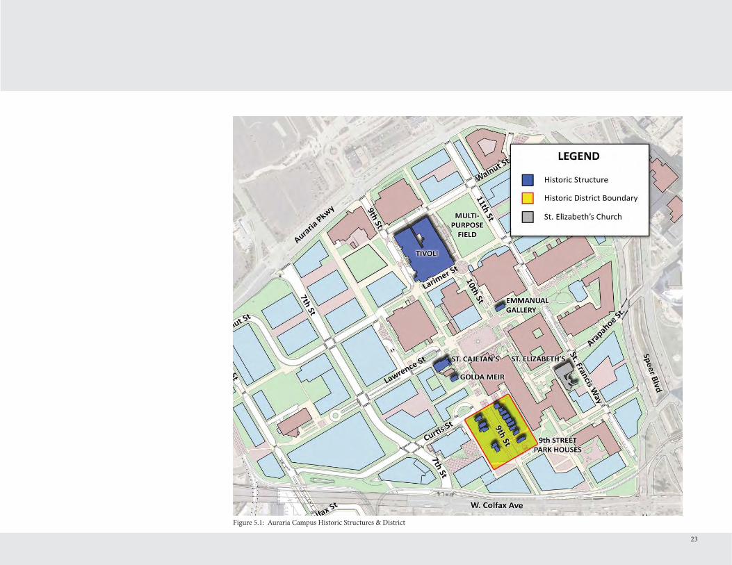
Figure 5.1: Auraria Campus Historic Structures & District

AURARIA CAMPUS 2012 MASTER PLAN UPDATE
Figure 5.2: Design Intent for the Tivoli Multi-Purpose Field and 11th Street (image by SmithGroupJJR)
24

5 CAMPUS DESIGNPRINCIPLES
Th e Auraria Campus Master Plan provides a framework for a more urban campus that seamlessly connects to downtown Denver. Th e following provides overall design guidance for projects on the campus. Th e Auraria Campus Design Guidelines provide more specifi c design direction.
Buildings should be built to the edge of the site • where possible.
Pedestrian oriented uses are encouraged on the • fi rst fl oor along major streets (be they vehicular or pedestrian).
Primary building entrances should be located • along major streets (be they vehicular or pedestrian).
Large building facades should have their mass • broken up to create a more interesting and pedestrian friendly façade.
Th e use of large blank walls should be minimized.•
Where possible, sidewalks should be eight feet • wide with a four foot amenity zone. Th is amenity zone should contain either a tree lawn or trees in grates depending upon the location.
New buildings should be four to six stories in • height, though increased density should be
25
considered near the transit stations on campus.
Rooft op equipment should be minimized where • possible.
A double row of trees is desired along 7th Street.•
Existing historically signifi cant buildings (shown on • Figure 5.1) on the campus should be preserved and respected as new development occurs around these buildings. Historically signifi cant buildings include the Tivoli Student Union, Emmanuel Gallery, St. Cajetan’s, Golda Meir House and the 9th Street Park Historic District. While St. Elizabeth’s Church is a designated landmark, it is not owned or operated by AHEC and thus is presumed to continue to exist in its current condition.
Buildings should shape outdoor space so that an • outdoor room can be created to encourage use of and movement through the space.
Buildings located between Larimer and Auraria • Parkway between Speer and 10th Street, shall be designed in a way that respects the view of the Tivoli Student Union from downtown Denver. Each building will be looked at individually in relation to existing buildings and planned buildings, to understand how the building, its placement and height will impact the view of the Tivoli from Larimer Square and 14th Street, along with other
locations downtown, in addition to the impact of mountain views from certain areas of 14th Street. Th e campus, as a state agency, is not subject to the Old City Hall View Plane so long as the project is considered a state building. Th e Tivoli tower serves as a wayfi nding marker on the campus as well as downtown, and discrete opportunities to discover that view bring vibrancy to the pedestrian experience.
New buildings and major renovations shall • comply with state regulations related to High Performance Design Certifi cation, and focus on making energy effi cient buildings.
Th e Auraria Campus embraces creating • landscapes appropriate to the Colorado environment through the use of elements such as regional materials and low water use plants.

Figure 6.1: Auraria Campus Vehicular Circulation and Service Route Plan
AURARIA CAMPUS 2012 MASTER PLAN UPDATE
26

6 CIRCULATION SYSTEM
Th is 2012 Master Plan improves on the recommendations for circulation made in the 2007 plan. Th e circulation system has been revised based on continuing the existing alignment of 7th Street, along with updating the network based on RTD’s West Corridor project. Vehicular access needs to be provided from surrounding streets to the parking reservoirs on the campus, but will not be allowed in the main section of campus. Many of the campus streets are private with only 7th, portions of Walnut, 5th and sections of Curtis Streets being dedicated City of Denver right-of-way.
Th e Plan provides improved and additional pedestrian connections between destination points on and at the edges of the campus. Pedestrian drop-off at the campus edges is a component of pedestrian circulation that also appears to be failing to support current and future needs. Th e Plan addresses this by improving the eff ectiveness of existing drop-off areas and relocates the Curtis Street turnaround closer to 8th Street, creating a pedestrian area in its place at 9th and Curtis.
Th e main vehicular access to the campus remains from the three main roads that surround the campus - Auraria Parkway, Colfax Avenue and Speer Boulevard. As part of the Auraria West Station Area Plan from the City of Denver, it was recommended to create a loop road as part of the future Pepsi Center redevelopment of their parking lots. Th is road
27
will connect 5th Street and 7th Street and help link the campus, Pepsi Center and the La Alma/Lincoln Park neighborhood to the south of campus. Th is recommendation has been included in this Master Plan.
As part of the relocation of the RTD light rail station, Curtis Street was realigned to provide connectivity between 7th and 5th Streets.
Future street alignments shown in the Master Plan include the following.1. Extension of 11th Street to Auraria Parkway which would accommodate campus vehicular traffi c as well as bus and bike traffi c. It is envisioned that this would become a signalized intersection that would further disperse traffi c on Auraria Parkway. With this improvement, the 12th Street access on to Auraria Parkway would become a right-in only. Exiting would be via 11th Street.
2. Realignment of Walnut Street between 5th and 7th Streets that would allow the extension of Larimer Street from Speer to 5th Street. Th is will also include the extension of Walnut Street between 9th and 11th Streets.
3. As the fi elds are built on the Colfax property, the existing street network will need to be changed. It is recommended that the sections of 14th Avenue and Cottonwood Street be eliminated, and Shoshone Street connected to Old Colfax. Th is would allow the cul-de-sac to be eliminated and provide better connectivity
to 13th Avenue and the La Alma Lincoln Park neighborhood.
Road WidthsFor future road changes, the Master Plan makes recommendations on the width and facilities that will be included in each street section. Th e following represents the planned design that was built in to the overall Plan.
Th rough CU Denver’s planning process for Academic Building 1, it has been determined that 12th Street will operate as a two-way street with on-street parking between Larimer and Auraria Parkway. However, the section between Auraria Parkway and Walnut will become one-way only in from Auraria Parkway once the 11th and Auraria Parkway intersection is constructed. Improvements on 12th Street will be phased with buildout of the CU Denver neighborhood.
1. 11th Street between Larimer and Auraria ParkwayTh is section of 11th Street has a total right-of-way (ROW) of 80 feet with a curb to curb of 53 feet. Th at 53 feet is split as follows. a. On-street parking lane - 8 feet b. Bike lane - 6.5 feet c. Travel lane (south) - 11 feet d. Travel lane (north) - 11 feet e. Bike lane - 6.5 feet

28
Figure 6.2: Auraria Campus Parking Master Plan
AURARIA CAMPUS 2012 MASTER PLAN UPDATE

f. Bus lane - 10 feet (assuming buses are 8’- 6” wide)
2. Larimer between Speer and 11th StreetTh is section of Larimer has a total ROW of 80 feet. If on-street parking is pursued on Larimer, this width is needed. However, this area could be narrowed to 60 feet if an easement relinquishment is pursued for the 20 feet of space between the southern edge of the Denver Water easement and the southern edge of the old ROW line. If parking is provided with CU Denver’s Academic Building 1, then the preferred solution is to have parking on the opposite side as well. Th ere is some storm sewer pipe in this area between 12th and Speer that could be relocated that would allow this narrowing to be pursued.
Th e curb to curb for this section will be 40 feet wide and divided as follows. a. On-street parking lane - 8 feet b. Shared travel/bike lane (sharrow, west) - 12 feet c. Shared travel/bike lane (sharrow, east) - 12 feet d. On-street parking lane - 8 feet Th is assumes removal of the median at Speer. Th is cross section assumes that any future trolley or streetcar would operate in mixed traffi c.
Representatives of the City of Denver Public Works Department recommended that Larimer be a one-way street on to the campus with exiting allowed on 11th to Auraria Parkway. While the campus
29
understands Denver’s concerns with two-way traffi c at Larimer and Speer, it is recommended that Larimer be studied with the creation of 11th Street in a traffi c study that examines proposed improvements for the northeast quadrant of the campus to determine the best solution.
3. Arapahoe between Speer and 11th StreetIn conjunction with this improvement, St. Francis Way will be one-way in to the campus, and 11th will operate as one-way between St. Francis and Arapahoe. Arapahoe will then provide the exit from campus to Speer Boulevard as a signalized intersection allowing cars to go straight or turn right on southbound Speer. At 11th Street, Arapahoe will be 25 feet wide and will then widen to 32 feet wide halfway up to Speer. Th is will allow a 10 foot bi-directional bike lane and one 11 foot lane, that widens to allow an additional 11 foot lane that will allow right turns.
St. Francis Way will retain its curb-to-curb width of 25 feet but it will be converted to a left and right turn lane at 12.5 feet each to allow turning movements on to 11th Street.
4. 11th between St. Francis Way and ArapahoeTh is section of 11th will be a one-way street to facilitate the in and out movement from Speer Boulevard between St. Francis Way and Arapahoe Street. Th is section will have a curb to curb width of 38 feet divided as follows. a. Bi-directional bike lane - 10 feet
b. Buff er - 1 foot c. On-street parking lane - 8 feet d. Travel lane (north) - 11 feet e. On-street parking lane - 8 feet
5. Walnut Street between 7th and 5th StreetsWalnut Street will be rebuilt to provide a connection to Larimer Street east of 7th Street. Th is new street will have a curb to curb width of 44 feet with a total ROW of 80 feet (it will remain a public street). Th e street will consist of the following. a. Bike lane - 5 feet b. Travel lane - 12 feet c. Alternating turn lane - 10 feet d. Travel lane - 12 feet e. Bike lane - 5 feet
Service Access & Drop-Off LocationsTh e Plan strengthens the existing system of limiting non-service access into the campus. It also strives to concentrate service, delivery and bike traffi c in to designated paths ensuring pedestrians can expect mixed traffi c in certain areas.
Th e Plan seeks to create additional drop-off s located near each of the three institutions’ neighborhoods. Th ese will allow for visitors to be brought to the campus and easily dropped off or picked up at one of the neighborhood centers without slowing or impeding other vehicular or service traffi c. It also helps build on institutional identity allowing the

30
Figure 6.3: Auraria Campus Public Transportation Plan
AURARIA CAMPUS 2012 MASTER PLAN UPDATE

31
campus to more easily communicate where visitors or new students can be dropped off to reach one of the three institutions.
Every building on campus, even those at the heart of the pedestrian zone, need service access. Th is oft en times includes large trucks for deliveries, trash/recycling removal as well as fi re department trucks and ambulances. Th ese paths should be designed and constructed to ensure that pedestrian confl icts remain at a minimum and where possible, sidewalks should be added to clearly separate the areas. Th e designated services areas are shown in Figure 6.1, but are subject to modifi cation as development occurs.
Parking SupplyParking is located at campus edges to minimize the need for vehicular traffi c through the campus while still providing convenient walking distances between parking facilities and campus destinations. Parking locations are strategically selected to provide a space inventory supply that supports each neighborhood, while maintaining the advantages of a single campus-wide system operated under AHEC.
Th e Plan allows phasing from mostly surface parking to structured parking. It is anticipated that the 7th and Curtis (Juniper Lot) parking structure as well as 11th and Walnut parking structure (assuming MSU Denver is able to move soccer fi elds to the Colfax Property before 2017) will be the next structures built
on the campus. If either are not possible, it is likely that the Elm Lot parking structure will then be built.
Parking capacity in the Master Plan is maintained at the current level of approximately 6,300 to 7,000 spaces, even with predicted growth for each of the three institutions. Th e policy of maintaining parking at current levels is based on a commitment to reduce the reliance on the use of single occupancy vehicles and encourage alternative transportation. Th is corresponds to a recent trend in decreased parking demand due to increased use of public transit.
Parking areas can be seen on Figure 6.2. Th ere will continue to be on-street parking along portions of 11th Street/St. Francis Way and 5th Street, with new on-street metered parking provided on 12th and Larimer. It is likely that parking lots on the southwest end of campus will remain as surface lots due to their location underneath the Colfax viaduct. Th e surface parking lot adjacent to the fi eld development is not owned by AHEC, but is instead leased for parking due to the existing billboard. Th at condition could change over time.
Less than ten years ago, more than three in four campus students, faculty, and staff drove to the campus and more demand existed for parking than was supplied. Today, regional transit initiatives have made a large impact with nearly 30 percent of students using transit to get to the campus. Parking is heaviest the fi rst
two weeks of each fall and spring semester, but following those weeks demand evens out.
As of the spring 2012 semester, the Auraria Campus provided 6,229 parking spaces. With the loss of Redwood Lot due to CU Denver construction, removal of the temporary Cottonwood Lot and the future addition of the Curtis Lot parking structure providing 606 spaces (a net gain of 448 spaces), the campus will have 6,191 parking spaces. A second parking structure, likely at 11th and Walnut containing 575 spaces should be constructed and planned to open for the fall 2015 semester just aft er the Dogwood Lot (351 spaces) is lost to construction for MSU Denver.
An additional parking structure is shown in the Elm Lot at 5th and Walnut with an expected capacity of 1,195 spaces. Th e Master Plan continues to show a smaller footprint for the 7th Street Garage which is presently located between Lawrence and Walnut from 7th to 8th Streets. Th is garage which was built in the mid-1990s, recently received a $1,500,000 upgrade to fi x various elements and extend its life another 20 years. Th is garage will not be rebuilt until likely 2030, at which time it will occupy a smaller footprint to allow the connection of Larimer Street to 7th Street.
Once the remaining surface parking lots are lost to construction, it is likely that another structure

32
Figure 6.4: Auraria Campus Bike Network
AURARIA CAMPUS 2012 MASTER PLAN UPDATE

of at least 1,000 spaces will be needed to continue to provide at least 6,000 spaces on campus. Th e location for this structure is unknown and a number of solutions should be studied including having new buildings with built-in parking, increasing the size of planned structures, increasing alternative transportation options to reduce parking demand, and the potential of an off -site solution.
Public TransportationTh e ability to have less parking is mostly due to the high availability of public transit both on and around the campus. Starting in the late 1990s with the fi rst light rail demonstration line, the available transit options have continued to increase. In May 2013, the fi ft h light rail line to serve the campus will open with the start of West Corridor service. Th e public transportation options can be seen on Figure 6.3, showing light rail stations, bus stops as well as a future transit shuttle operating on Larimer Street potentially between the 38th/Blake Station and 5th/Larimer adjacent to the Auraria West Light Rail Station. While this shuttle is shown with a suggested route through the campus based on the Larimer Street alignment, its timing, operation and ownership is not known. Bus stops on Auraria Parkway and Colfax are shown in their present location, but are subject to change via RTD’s annual service changes.
Larimer Bus Stop Th e Master Plan proposes a relocation of a RTD
33
bus stop that currently exists along Larimer. A large bus turn around exists on Larimer in the approximate location of what used to be 11th Street. Th is bus turn around used to be larger and was moved one block east in the mid-2000’s in order to accommodate the creation of the Tivoli Commons outdoor space. Th is bus turn around serves as the end of the line and beginning of the line for RTD bus routes serving the campus. Th is area allows buses to be parked and essentially wait until the new route begins, and bus drivers use campus buildings for their restroom break. Th is creates a rather unfriendly environment along Larimer as at times there are as many as four buses waiting at one time.
In order to continue to allow bus access to the campus by at least the 15 route (serving East Colfax), the bus stop will be relocated once 11th Street is built between Larimer and Auraria Parkway. Buses will continue to enter the campus on Larimer, and passengers will disembark on Larimer just prior to 11th Street. Buses will then turn right on 11th Street where this will be a bus lane with enough room for three of RTD’s articulated buses to queue. Passengers will board buses leaving the campus at the corner of 11th and Walnut Streets. Buses will then continue on 11th and exit via the Auraria Parkway. 11th and Auraria Parkway will be a signalized intersection.
Bike Network PlanNot only are more students, faculty, and staff opting for public transit rather than automobile to travel to
and from the campus, but bicycle and skateboard use has also increased. Th e Plan responds to this demand through enhanced bike facilities on campus with connections to off -campus facilities.
Th e Auraria Campus has seen a strong increase in the number of bike commuters. Th e campus added many new bike racks in 2011 to meet the growing demand especially in warm weather. On many days some campus bike racks exceed their recommended capacity. In order to prepare a plan that safely accommodates both bikes, skateboards, and the campus’ electric carts, the existing off -campus bike routes were studied, along with the existing on-campus routes where electric carts are allowed.
Additionally, a bike parking survey was completed during the 2011 fall semester in order to understand where bike riders are parking their bikes and what areas may benefi t from additional racks. Th e survey was completed on a Monday and Th ursday to address the class schedules, and it was found that Monday from 1-2:30pm had the highest concentration of bikes parked on campus with a total of 606. Th e areas with the highest numbers of bikes were as follows.
North Classroom - Speer and Lawrence1. Arts Building2. 11th Street adjacent to the Science Building3. Champa Street median between South and 4. Central Classrooms

As of January 2012, the campus provided 115 bike racks which at maximum capacity could park up to 1,334 bikes. Th ere remains little shared space with the opportunity to provide large bike parking reservoirs. Instead, each new building will be responsible for providing bike parking. Th e amount of bike parking shall be discussed with Auraria Campus Planning as building use may impact the amount, but a general rule of thumb is one bike parking space for every 10,000 gross square feet. It is recommended that the bike parking survey be completed every fall semester to ensure that the appropriate amount and location of bike parking continues to be provided.
One of the primary requests received from students and staff on the Auraria Campus is to provide a bike network on campus. Th is Plan seeks to create one strong east-west bike route along Curtis Street to connect downtown to all points of the campus. Th is connection would be complemented by several new north-south connections along 11th Street (St. Francis Way), 8th Street corridor, and along 5th Street down to Shoshone Street. Th ese new connections will occur as either dedicated bike lanes or by sharing the roadway with traffi c using a sharrow symbol to mark space for bike riders. Skateboards and campus carts would be expected to use these bike lanes as well. Speer would also become a designated bike route connecting Auraria Parkway to Champa Street. In the short-term this will occur using existing sidewalk. Th is use will need to be monitored to determine if additional sidewalk width is needed in the future, or if a facility separated from the pedestrians is needed based on high
use of the corridor by both pedestrians and bikes.
A dismount zone would remain in areas of the campus, but would be revised to allow the connections shown on Figure 6.4. Curtis and 11th Street will be the fi rst to be implemented and the design of these facilities must ensure that pedestrian safety is paramount, and that adequate signage is provided. Th e short term bike network plan can be seen in Figure 6.7. Th ese new connections are major improvements and will strengthen Auraria’s commitment to supporting all means of transportation.
Denver’s bike sharing program, B-Cycle began in the summer of 2008 with the Democratic National Convention. Since then the system has grown to 53 stations around downtown Denver and has plans for many more stations in the years to come. Th e bike network plan on Figure 6.4 shows three possible locations for B-Cycle Stations should funding come available to locate the stations on the Campus. Ideally the 9th and Curtis location would go in at the time the Curtis bike lane is constructed.
Th e campus needs to continue to work with Denver to ensure bike facilities in downtown connect to both Cherry Creek and the campus. Additionally, improving access to the Cherry Creek trail for both pedestrians and bicyclists is important to improving mobility as well as embracingthe creek as an important urban amenity.
AURARIA CAMPUS 2012 MASTER PLAN UPDATE
Figure 6.5: Bi-directional bike lane example, Kent Street in NewYork City
Figure 6.6: Bi-directional bike lane example with buff er and on-street parking, Montreal, Canada
34

Figure 6.7: Short Term Bike Network Plan
35

AURARIA CAMPUS 2012 MASTER PLAN UPDATE
36
Figure 7.1: Arts Building and Auraria Library Public Urban Space 2012

Figure 7.2: Public Urban Space
7 PUBLIC URBAN SPACE
Th e 2012 Master Plan calls for an integrated open space system that connects campus green spaces and plazas along major pedestrian routes as seen in Figure 7.2. Th ere are many shared public urban spaces throughout campus. Each institution is creating their own campus
37
square or main street concept. MSU Denver will be creating a neighborhood square as they develop the buildings in their main neighborhood. CU Denver has future opportunities for a square, but the heart of their neighborhood will be Larimer as the neighborhood main street. CCD is creating a space with their Student Learning and Engagement Building which will eventually connect via Champa to their main neighborhood square at South Classroom.
Th e Plan creates three special entry plazas for the campus at the following locations. Th ese are meant to be areas with special treatment celebrating one’s arrival at the Auraria Campus. 1. Auraria West Station Area 2. Colfax at Auraria Station Area 3. Auraria Parkway/Speer Boulevard/Walnut Street/Market Street
Th e three main shared public urban spaces will be the Tivoli multi-purpose fi eld, the Lawrence Street Mall from Speer to 9th Street, and 9th Street Park. Th is area spans the 9th Street Historic District with a new space created by the relocation of the Curtis Street turn around by creating a unique pedestrian space adjacent to the Arts Building that connects to the Lawrence Street Mall. New patios will activate the Mall along the Arts Building and Auraria Library providing a place to see and be seen, and enjoy Colorado’s many sunny days.

38
Figure 8.1: Auraria Campus Sanitary Sewer Improvements
AURARIA CAMPUS 2012 MASTER PLAN UPDATE

8 INFRASTRUCTURE IMPROVEMENTS
In 2010, the Auraria Campus undertook an extensive infrastructure study to determine what utilities currently exist on campus. Aft er the infrastructure systems were identifi ed, that information was used to create an Infrastructure Master Plan which will be used to guide future development on the campus so that the proper infrastructure can be planned as each new building is added to the campus. When a project is proposed, planners will look at the campus wide picture when making infrastructure improvement recommendations so that improvements can be made at once following an overall recommended framework instead of slowly over time.
Th e following represents the executive summary for each of the utility systems on campus. For more information, consult the Infrastructure Master Plan (IMP) document as prepared by the Matrix Design Group. Images from the IMP are based on a February 2011 version of the campus master plan, which has since changed, but IMP images have not been updated.
Sanitary Sewer SystemTh e Auraria Campus is served by City of Denver Wastewater infrastructure. Based on sanitary sewer modeling results, capacity limitations will be encountered for certain areas, and by the year 2031 under a full build out scenario. In addition, much of the existing system will be nearing, or will have surpassed, its predicted lifespan. Th e IMP
39
recommends multiple sanitary sewer projects aimed at alleviating possible capacity limitations, structural failings or existing sanitary sewer location confl icts with proposed buildings as shown in Figure 8.1. Th ese projects should be timed with the construction of the proposed buildings which will require the capacity increase and/or pipe relocation. Improvements to the sanitary sewer system should be made before certain proposed buildings are operational. Th e following is an overview of seven recommended projects. 1. 5th Street upsizing and extension 2. 7th Street realignment and upsizing 3. 9th Street realignment and upsizing 4. Addition of a new 8” main to accommodate fl ows generated by the building that replaces the Technology Building 5. Colfax property realignment 6. Larimer Street Metro Wastewater connection and upsizing 7. Rehabilitation of mains
WaterTh e Campus contains approximately 5.2 miles of water mains. Th e public water system infrastructure was evaluated based upon four criteria: near-term capacity, long-term capacity, as well as condition and relocation assessments that might be necessary to accommodate future building sites.
Approximately 54% (14,716 lineal feet) of these pipes are proposed to be improved over the next 20 years at a
cost of approximately $5.1 million.
Primary improvements will be centered around new buildings having to update existing 6” lines to 8” lines. Th ere will be some water realignment associated with the Colfax property development, as well as new water service will be needed for future building sites that do not have water service near by. Th ese improvements are depicted in Figure 8.2.
Stormwater Management & Floodplain IssuesTh e existing network of 6.5 miles of underground storm drain pipe infrastructure is extensive across the campus and is functioning adequately during typical storm events. Th ere are currently 21 stormwater detention/water quality ponds across the campus.
Th ere are three main fl ood hazard sources - South Platte River, Cherry Creek and the tributary basin itself (a combination of the Auraria Campus and the upstream tributary area consisting of the Lincoln Park neighborhood). A large portion of the campus is mapped within the South Platte River 100-year fl oodplain. However, this fl oodplain will be confi ned to the channel corridor aft er completion of the City & County of Denver/Urban Drainage and Flood Control District project in 2012, which will remove the Auraria Campus from the FEMA regulatory fl oodplain which is shown

40
Figure 8.2: Auraria Campus Water System Improvements

41
in Figure 8.3. Th e regulatory Cherry Creek 100-yera fl oodplain is confi ned to the drainage corridor and does not encumber the campus. In general, the most probable fl ood hazard threat to the campus is rainfall in excess of storm pipe capacities (most only carry a fi ve year event), resulting in surface fl ow of stormwater runoff across the campus.
A summary of recommended storm sewer improvements in shown on Figure 8.4.
Gas, Steam and Chilled WaterTh ese systems were reviewed to evaluate energy cost saving strategies and identify critical needs to extend the existing mechanical utilities to accommodate future development. Based on an evaluation of the cost-benefi t and economic viability of replacing existing steam heat exchangers with gas-fi red boiler systems was recommended. As development occurs by Technology and the Science Buildings, the two chiller plants on the campus may be replaced over time with individual building systems.
Telephone and Fiber Optic CablingTh e campus telecommunications infrastructure system consists of underground ducts (conduits), vaults (manholes), and cabling (fi ber optic and copper) used to connect campus buildings to one another for communications purposes. Th e existing telecommunications infrastructure system is nearly at capacity in certain critical areas. Th e existing
ductbank system barely has enough capacity to support the fi rst few of the new buildings. Once the infrastructure reaches its capacity, AHEC will no longer be able to accommodate additional telecommunications connectivity to support future campus growth. Th e current centralized hub-based connectivity architecture (originating at the Arts Building) does not provide redundancy in the event of major damage to cable (or cables), ductbanks or vaults, localized building specifi c power outages and fl ooding, etc. Maintaining the current centralized architecture will present new and diffi cult pathway challenges as the campus continues to expand - the current architect essentially requires all communications cabling to ultimately return to the central hub in the Arts Building.
To address these needs, the existing campus telecommunications infrastructure system will need to be augmented and expanded in a phased manner, and the underlying connectivity architecture will need to be modifi ed. It is recommended that a distributed hub architecture be established which will be located in strategic locations throughout the campus. Each distributed hub will be connected to at least one other distributed hub which will provide redundancy for the core network between the hubs.
Figure 8.3: Floodplain before and aft er exhibit from the IMP

Figure 8.4: Auraria Campus Storm Sewer Improvements
42

Recommended distributed hubs are the MSU Denver Student Success Building, North Classroom, Central Classroom and the Administration Building. Some amount of cabling and ductbank will be needed to set up this distributed hub system.
Electrical Distribution SystemAn electrical distribution system master plan was prepared by RMH Group in 2010/11. Th e medium voltage distribution system is loaded to near capacity. In order to address present and future growth, Xcel Energy’s power feeders external to the campus must be upgraded in a phased approach. Xcel has suggested a plan for growth of the power sources feeding the campus. Campus growth will also require the expansion of the campus distribution infrastructure (vaults, duct banks and cabling).
Th e medium voltage system provides power to nearly all campus buildings except for the Tivoli Student Union, King Center, Administration Building, the former Printing & Distribution Center, St. Francis Center and the surface parking lots.
In 1976, a highly reliable 13.2kV primary metered power distribution system was installed and Xcel Energy was contracted to provide up to 8 million Volt Amps (mVA) of power. A fully redundant, primary selective switchgear system rated for 400 amperes was installed in the Arts Building to service the campus. Th e Science Building Addition and
Renovation project to increase Xcel’s capacity from 8mVA to 12.7mVA. Modifi cations to the AHEC owned switchgear were made, and Science was expected to bring the campus load up to between 9.2 mVA and 9.5 mVA.
Xcel began a project in late 2011 to split their existing service between the Arts Building and new switchgear which will be located in the Holly Lot in the vacated area of 8th Street adjacent to Curtis Street. Auraria will install new switchgear and the current electrical capacity for the campus will be split between these two systems.
Th e next phase will involve Xcel Energy again upgrading their service to the campus so that more capacity can be provided. Th is work will hopefully happen in 2012 so that there will be enough capacity for when the new CCD and CU Denver buildings start consuming electricity.
In the future, Xcel Energy has expressed a desire to have the campus remove the buildings fed separately by Xcel and have them fed by the campus system.
Th e Colfax property fi eld development will be allowed to be fed separately by Xcel due to it being adjacent to Xcel service and its distance from the campus distribution system.
43

Figure 9.1: Auraria Campus Signage Location Plan
44
AURARIA CAMPUS 2012 MASTER PLAN UPDATE
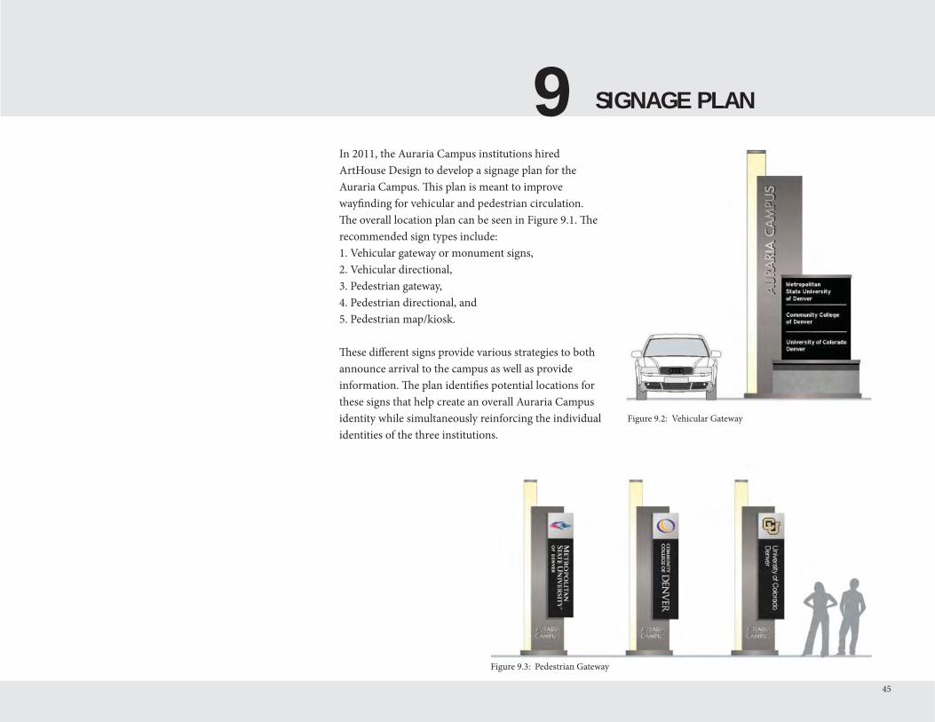
9 SIGNAGE PLAN
45
In 2011, the Auraria Campus institutions hired ArtHouse Design to develop a signage plan for the Auraria Campus. Th is plan is meant to improve wayfi nding for vehicular and pedestrian circulation. Th e overall location plan can be seen in Figure 9.1. Th e recommended sign types include:1. Vehicular gateway or monument signs,2. Vehicular directional, 3. Pedestrian gateway,4. Pedestrian directional, and5. Pedestrian map/kiosk.
Th ese diff erent signs provide various strategies to both announce arrival to the campus as well as provide information. Th e plan identifi es potential locations for these signs that help create an overall Auraria Campus identity while simultaneously reinforcing the individual identities of the three institutions.
Figure 9.2: Vehicular Gateway
Figure 9.3: Pedestrian Gateway

AURARIA CAMPUS 2012 MASTER PLAN UPDATE
Figure 10.1: Identifi ed Intersections for Connect Auraria Study
46

10 CONNECTING AURARIA
Connecting the Auraria Campus to downtown Denver has long been a goal of both the campus and downtown constituencies. Connecting is not just a physical exercise, but also involves programmatic, social and economic connections. Having an educational institution as a part of the downtown provides numerous educational and employment opportunities for both students on the campus as well as the downtown workforce.
Programmatic, Social and Economic ConnectionsTh e prospects to enhance connections with Denver are highlighted throughout this Master Plan, including such initiatives as development of the multi-purpose/special events fi eld in front of the Tivoli. Creating a diverse and functional space where social activities can occur (outdoor performances, recreation, etc.), further promotes the opportunities for the institutions to engage in partnerships with Denver entities as it provides an environment for summer concert series and other activities which involve and invite the communities to come together. Th is is supplemented by focusing on the Larimer Street development including the creation of street level activity in buildings (such as the PE/Events Center modifi cation, etc.) and creating a streetscape environment that is welcoming to users.
Th e campus desires connections to be two-way - both students participating in the retail, offi ce and entertainment that downtown provides, and having
downtown residents participate in the campus.
Other “connection” opportunities include the interim development of the Colfax edge of the campus through building modifi cation and visual exposure of program, the adoption of a bike network that penetrates and passes through the campus, the addition of quiet neighborhood streets which penetrate and support the neighborhoods, and the engagement of public/private partnerships where appropriate for the institutions within their neighborhood or in the shared neighborhood.
Campus events such as theater and music productions should be shared with the downtown community through announcements in email newsletters such as DDP Skylines and LoDown on LoDo.
Additionally, the Tivoli Student Union is an iconic Denver symbol that can be used to host events. Th e campus should work with its downtown partners to encourage large events be held at the Tivoli. Doing so brings people to the campus and increases their awareness of this special place.
All such opportunities, combined with programmatic components, serve to connect the Auraria Campus with downtown Denver.
Improving these multi-faceted connections was a key goal of the 2007 Master Plan as well as the 2007
Downtown Area Plan, and remains in this updated 2012 Plan. Th e 2009 Economic Impact report found that the campus’ direct and indirect impact on the City and County of Denver at that time was $381 million and supported nearly 3,700 workers. Th e report found that Auraria Campus students spent much of their money in Denver, as nearly 30 percent of the students at the time lived in Denver. Th is spending equates to $1.1 million in sales tax and property tax revenue to Denver. Not only does a population of approximately 43,000 students add vibrancy to downtown streets, it adds revenue to adjacent retailers and the city itself.
Connect Auraria CoalitionIn late 2010, a group was formed to study how improvements could be made to better connect the campus with downtown Denver both physically and programmatically. Th is group consisted of representatives from the campus; City of Denver - Community Planning & Development, Parks & Recreation and Public Works; Downtown Denver Partnership; LoDo District; Pepsi Center; and La Alma Lincoln Park Neighborhood Association. Th is is an important goal of the 2007 Downtown Area Plan, as it deals with two of the seven transformative projects - Connecting Auraria and Grand Boulevards, as well as the Auraria Campus Master Plan.
Th e City of Denver applied for funding from the
47

48
AURARIA CAMPUS 2012 MASTER PLAN UPDATE
Denver Regional Council of Governments (DRCOG) to fund a next steps study to recommend physical improvements at certain intersections along Auraria Parkway, Speer Boulevard and Colfax Avenue to improve pedestrian and bike mobility as well as safety. Th ese streets were all designed with the car being the fi rst priority, and little attention was paid to how pedestrians would cross. Colfax has been further complicated by the addition of light rail. As the campus is a destination within downtown, safe access to and from is incredibly important, particularly since one of the institutions resides both east and west of Speer Boulevard.
Th is funding became available in late 2011 and required a City of Denver match which was not available until 2012. A consultant will be hired in 2012 with study completion likely in mid 2013.
Identifi ed intersections included in the study are shown on Figure 10.1 and identifi ed as: 1. Auraria Parkway - 7th and 9th Streets; 2. Speer Boulevard - Walnut, Larimer, Lawrence and Arapahoe; and 3. Colfax Avenue - 9th (Mariposa) and 10th (Lipan).
Physical Improvements to Enhance ConnectivityTh e following recommendations are based on concepts shown in the Master Plan. Transportation and physical improvements to the intersections will be a focus of the Connect Auraria Coalition study, and so are subject to
change. However, these ideas are presented as the campus’ vision for physical changes that will improve connectivity.
Speer BoulevardIt is recommended that the campus work with the City of Denver to acquire or jointly develop the medians between Speer Boulevard. Th ese medians are located between Lawrence and Auraria Parkway as seen in Figure 10.2. Campus related development in these areas would reduce the perceived distance between downtown and the campus, as well as provide street activation for pedestrians.
At a minimum, adding or improving streetscape to the areas between north and southbound Speer would help soft en the environment and provide a barrier between cars and pedestrians. Th is would also provide a visual cue to drivers that pedestrians share the space.
Colfax AvenueTh e City of Denver oft en treats Colfax as if it ended at Speer Boulevard. A recent example of this mindset was a bond funded project to improve the medians between Broadway and Speer. Th e City should be encouraged to provide the same level of treatment to the section of Colfax adjacent to the campus as it does to the section between Speer and Broadway. Based on the recent median improvements, this Plan encourages the same median treatment be
Figure 10.2: Medians in Speer Boulevard

applied between Speer and 7th to assist with making Colfax more of a grand boulevard as indicated in the Downtown Area Plan.
As properties are redeveloped on the south side of Colfax, wider sidewalks and streetscape amenities are desired along with a transition to uses fronting Colfax, and not cars as it is today. As the campus redevelops its Colfax edge, buildings will be encouraged to provide activity and visibility along Colfax, as well as improve the main pedestrian entries at 9th and 10th.
Auraria ParkwayMSU Denver has already brought development closer to the Parkway edge, and that edge should be continued with future development. As uses are added along the Parkway, the sidewalk width should be investigated along the campus side to ensure there is enough room for pedestrians and bikes since it is a designated bike route. Where possible, the double row of trees fl anking either side of the sidewalk should be continued to provide relief from the busy road, provide shade and work in conjunction with the medians to present a landscaped grand boulevard. However, the median ends do need to be modifi ed at so that a pedestrian refuge may be provided in the middle of Auraria Parkway given the amount of time it takes to cross the Parkway and short amount of time to do so.
As the Pepsi Center land on the other side of Auraria Parkway is redeveloped over time, the campus is encouraged to work with the developers to seek projects that provide entertainment and campus supportive uses, and front Auraria Parkway with entrances and activity. Activity along 9th Street leading to the Pepsi Center light rail station is also desired as that is the closest station to the northern edge of the MSU Denver neighborhood.
49

AcknowledgmentsCampus development guidance and expanded neighborhood visioning: - Cliff Richardson: Interim President, Community College of Denver - Stephen Jordan: President, Metropolitan State University of Denver - Jerry Wartgow: Chancellor Emeritus, University of Colorado Denver - Don Elliman: Interim Chancellor, University of Colorado Denver - Barbara Weiske: Executive Vice President for Administration, Auraria Higher Education Center
Th is 2012 Master Plan Update was prepared by the AHEC Planning Department. - Jill Jennings Golich: Campus Planner - Carl Meese: Assistant Campus Planner
Th is document was reviewed by the partnership of SmithGroupJJR and Jones Lang LaSalle.
References1. 2007 Auraria Campus Master Plan Update by Studio INSITE and Sasaki Associates - 20072. Campus Parking Plan Review and Update by Carl Walker - November 2007 3. Auraria Higher Education Athletic and Recreation Facilities and Fields Study by Barker Rinker Seacat - November 2007 4. Auraria Campus Circulation Study by Fehr and Peers - December 20075. Electrical Distribution Master Plan by RMH Group - November 20106. Infrastructure Master Plan by Matrix Design Group - 20117. Auraria Higher Education Campus Wayfi nding Plan by ArtHouse Design - September 20118. Th e Economic and Fiscal Impacts of the Downtown Denver Auraria Campus by Development Research Partners - June 2009
Th e Auraria Higher Education Center Master Plan Update 2012 was approved by the Auraria Board of Directors on June 27, 2012.
Th e Auraria Higher Education Center Master Plan Update 2012 is supplemented by the Auraria Campus Strategic Implementation Plan prepared by SmithgroupJJR and Jones Lang LaSalle.
ACKNOWLEDGMENTS11
50