Asi Edee T’seda Dile: Tåîchô Nation Traditional Knowledge ...
97
1 Asi Edee T’seda Dile: Tåîchô Nation Traditional Knowledge and Use Study September 15 th , 2012 Rachel Olson, Ph.D (Candidate), Firelight Group Research Cooperative in collaboration with Georgina Chocolate, Tåîchô Government (TG)
Transcript of Asi Edee T’seda Dile: Tåîchô Nation Traditional Knowledge ...
1
Asi Edee T’seda Dile: Tåîchô Nation
Traditional Knowledge and Use Study
September 15th, 2012
Rachel Olson, Ph.D (Candidate), Firelight Group Research Cooperative in
collaboration with Georgina Chocolate, Tåîchô Government (TG)
2
Contents
Section 1 Outline of the Report ................................................................................................................6
1.1 Introduction ..................................................................................................................................6
1.2 Overview .......................................................................................................................................6
1.3 What is a Project Specific Traditional Use Study (TUS)? ...............................................................7
1.4 Limitations of the Report ..............................................................................................................8
1.5 The Authors ...................................................................................................................................8
Section 2 The Project ................................................................................................................................9
2.1 Description of Fortune Minerals NICO Mine Project ....................................................................9
2.2 Existing Proponent Studies ........................................................................................................ 10
2.2.1 Findings of Proponent’s Consultation ................................................................................ 10
2.2.2 Utilization of TK within Project Design............................................................................... 11
2.2.3 Contribution to Impact Assessment .................................................................................. 11
Section 3 Tåîchô Nation ......................................................................................................................... 12
3.1 Culture and History .................................................................................................................... 12
3.2 Tåîchô Government and the Tåîchô Agreement ....................................................................... 14
3.3 Tåîchô Traditional Knowledge ................................................................................................... 14
3.3.1 Dè ....................................................................................................................................... 14
3.3.2 Place names ....................................................................................................................... 15
3.3.3 Asi ede t’seda dile ............................................................................................................ 17
3.3.4 Idaa Trail ............................................................................................................................ 18
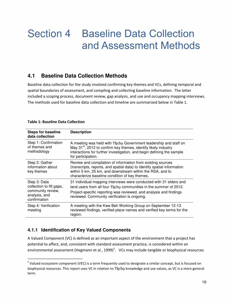
Section 4 Baseline Data Collection and Assessment Methods .............................................................. 19
4.1 Baseline Data Collection Methods ............................................................................................. 19
4.1.1 Identification of Key Valued Components ......................................................................... 19
4.1.2 Temporal and Spatial Boundaries of Assessment .............................................................. 21
4.1.3 Interview Methodology ..................................................................................................... 24
4.2 Impact Assessment Methods ..................................................................................................... 25
4.2.1 Summary ............................................................................................................................ 25
4.2.2 Valued Components for Assessment ................................................................................. 25

3
4.2.3 Temporal and Spatial Boundaries for Assessment ............................................................ 25
Section 5 Fortune Minerals NICO Mine Project Baseline and Assessment ........................................... 26
5.1 Baseline Summary for Site-specific VCs within the NICO LSA and RSA ..................................... 26
5.1.1 Loss of Use ......................................................................................................................... 34
5.2 Baseline Summary for Non-site-specific VCs within the Project LSA and RSA........................... 37
5.2.1 Trails and Transportation Corridors ................................................................................... 37
5.2.2 Water, Wild Foods, Medicinal Plants and Contaminants .................................................. 38
5.2.3 Waterfowl, Fur bearing, and Trapping ............................................................................... 40
5.2.4 Caribou and Moose ............................................................................................................ 41
5.2.5 Intangible Cultural Resources: Tåîchô Knowledge and Cultural Transmission .................. 44
5.3 Assessment of Anticipated Project Effects on Site-specific VCs within the NICO LSA and RSA. 45
5.3.1 Site-specific Subsistence Values......................................................................................... 45
5.3.2 Site-specific Habitation Values ........................................................................................... 46
5.3.3 Site-specific Cultural/Spiritual Values ................................................................................ 47
5.3.4 Site-specific Transportation Values.................................................................................... 48
5.3.5 Site-specific Environmental Feature Values ...................................................................... 48
5.4 Assessment of Anticipated Project Effects on Non-site-specific VCs within the NICO LSA and
RSA 48
5.4.1 Trails and Transportation Corridors ................................................................................... 49
5.4.2 Waterfowl, Fur bearing and Trapping ................................................................................ 49
5.4.3 Caribou and Moose ............................................................................................................ 49
5.4.4 Water, Wild Foods, Medicinal Plants and Contaminants .................................................. 50
5.4.5 Intangible Cultural Resources ............................................................................................ 50
5.5 Residual NICO Project Effects .................................................................................................... 51
5.5.1 Determination of Significance ............................................................................................ 54
Section 6 Summary and Conclusion....................................................................................................... 54
6.1 Recommendations ..................................................................................................................... 55
6.2 Closure ....................................................................................................................................... 55
Section 7 References Cited .................................................................................................................... 56
Section 8 Appendices ............................................................................................................................. 58
8.1 Consent Form ............................................................................................................................. 59
8.2 Interview Guide .......................................................................................................................... 60
4
8.3 Direct to Digital Capture Method .............................................................................................. 76
8.4 Quote Table................................................................................................................................ 78
List of Figures
Figure 1: Reported Tåîchô place name values within the LSA .................................................................. 16
Figure 2: Watersheds of the NWT (NWT and INAC, 2010) ....................................................................... 17
Figure 3: Dene Mapping Project trails for 600 trapper/hunters interviewed by the Dene Nation in the
1970s and 1980s. Used with permission of the Grand Chief. ................................................................... 18
Figure 4: RSA and LSA shown in relation to Fortune Minerals NICO proposed project ............................ 23
Figure 5: Reported Tåîchô subsistence values within the LSA by activity class ......................................... 27
Figure 6: Reported Tåîchô site-specific use values within the RSA and LSA .............................................. 28
Figure 7: Reported Tåîchô habitation use values within the LSA .............................................................. 29
Figure 8: Reported Tåîchô cultural use values within the LSA................................................................... 30
Figure 9: Reported Tåîchô transportation use values within the LSA ....................................................... 31
Figure 10: Reported Tåîchô environmental values within the LSA ............................................................ 32
Figure 11: Reported current Tåîchô loss of use areas due to fear of contaminants or other industrial
impacts ....................................................................................................................................................... 36
Figure 12: Impact Pathway for Trails and Transportation due to Perception of contamination .............. 37
Figure 13: Impact Pathway for Trails and Transportation due to increased footprint and disturbance ... 38
Figure 14: Impact pathway for fish and fish habitat .................................................................................. 40
Figure 15: Potential increased mortality in muskrats due to water quality .............................................. 41
Figure 16: Potential loss of important seasonal habitat for culturally and economically important species
including caribou and moose. .................................................................................................................... 44
Figure 17: Erosion of Cultural Practices and Language due to increased presence of industry ................ 45
List of Tables
Table 1: Baseline Data Collection ............................................................................................................. 19
Table 2: List of Participants ....................................................................................................................... 24
Table 3: Reported Tåîchô Site-Specific Use Values in Relation to the NICO Lease Boundary, LSA, and
RSA ............................................................................................................................................................. 33
Table 4: Residual NICO Project Effects ....................................................................................................... 52
5
Acronyms and Abbreviations
AAA American Anthropological Association
AANDC Aboriginal Affairs and Northern Development Canada
DAR Developer’s Assessment Report
EIA(s) Environmental Impact Assessment(s)
E-W East-West
Firelight Group or Firelight Firelight Group Research Cooperative
IAIA International Association for Impact Assessment
KIRs key indicator resources
LSA local study area
RSA regional study area
TEK traditional ecological knowledge
the Agency Canadian Environmental Assessment Agency
the proponent Fortune Minerals Ltd.
TUS traditional use study or studies
UOM use-and-occupancy mapping
VC(s) valued component(s)
6
Section 1 Outline of the Report
1.1 Introduction
This report provides information and assessment based on available Tåîchô knowledge and land use
data in the vicinity of the NICO Mine Project (the NICO Project or the Project) proposed by Fortune
Minerals Limited (Fortune or the proponent) within the traditional lands of the Tåîchô.
The Project (defined in Section 2) would be a Cobalt-Gold-Bismuth-Copper mine 160 kilometres
northwest of Yellowknife, 50 kilometres northeast of Whatì, 70 kilometres southeast of Gamèti, 145
kilometres southwest of Wekweèti, and 88 kilometres north of Behchokö, in the heart of the Tåîchô
region of the Northwest Territories.
The primary goal of this study is to articulate available Tåîchô knowledge and use values related to the
proposed Project area including:
• use by and importance of the area to Tåîchô citizens (historical, current and future);
• existing areas of lost use resulting from impacts by past developments in the area; and
• how the Project is likely to influence Tåîchô knowledge and use, including the practice of
aboriginal and treaty rights, within and adjacent to the proposed Project footprint.
The report integrates information from multiple sources, including primary data from a 2012 mapping
study, secondary literature reviews, evidence of use from previous Tåîchô studies, as well as additional
and supplemental Tåîchô information and analysis. The report is intended for consideration as part of
the NICO Project’s environmental assessment under the Mackenzie Valley Resource Management Act
(MVRMA), and to inform consultation between Tåîchô and the Crown regarding the proposed Project.
The project lease of Fortune Minerals is completely surrounded by Tåîchô lands. However, the Project
itself is on Crown lands that pre-dated the Tåîchô land claim.
1.2 Overview
The report is organized into six sections.
Section 1 outlines the report, including goals and limitations.
Section 2 provides a summary description of the NICO Project, based on information filed by the
proponent with the Mackenzie Valley Environmental Impact Review Board (MVEIRB). It also
7
includes consideration of how the proponent addresses effects on Tåîchô knowledge and use
within their Developer Assessment Report (DAR) and subsequent filed documents on the public
record for the environmental assessment.
Section 3 provides contextual information regarding the Tåîchô, including a general ethno-
historical summary, a brief discussion of Tåîchô government and rights.
Section 4 presents the methods used for baseline data collection and impact assessment.
Section 5 provides baseline information and impact assessment predictions regarding Tåîchô
knowledge and use within the NICO footprint, local study area (LSA), and beyond within the RSA
(regional study area). It includes an identification of site-specific and non-site specific values.
Section 6 summarizes the findings and conclusions.
1.3 What is a Project Specific Traditional Use Study (TUS)?
A project-specific traditional use study (TUS) is the “the collection of interview data about traditional use of resources and occupancy of lands by First Nations persons, and the presentation of those data in
map form” within a geographically-bounded area (Tobias, 2000:iv). A project-specific TUS is a
systematic and evidence-based form of investigation that applies traditional knowledge and social
science to accomplish goals. The goals of a project-specific TUS often include:
Describing the knowledge, use and interests of a community in relation to a proposed project or
area;
Assessing potential project effects; and
Identifying mitigations or recommendations that may reduce negative effects and maximize
positive ones.
For the purposes of this study, only the first two points will be addressed. It is understood that further
dialogue between the Tåîchô Government, Fortune, the Review Board and other parties to the
environmental assessment will occur based on the findings of this Report, at which time appropriate
mitigation and monitoring measures may be identified.
Mapping is a critically important component of a TUS as it provides an easy to visualize picture of how
complex land use practices relate in space to each other and to potential developments.
“First Nations people carry maps of their homelands in their heads. For most people,
these mental images are embroidered with intricate detail and knowledge, based on the
community’s oral history and the individual’s direct relationship to the traditional territory and its resources. Land use and occupancy mapping is about documenting
8
those aspects of the individual’s experience that can be shown on a map…” (Tobias,
2000: 1)
Good community mapping practice emphasizes individual map biography interviews in which
individuals are interviewed about their own use of the land during their lifetimes, and should include
documentation of prior informed consent, and well documented methods for data collection and
management (Tobias 2010; see Appendices 4 through 6).
1.4 Limitations of the Report
This report is based on research conducted by the Firelight Group Research Cooperative (Firelight) and
the Tåîchô Government. It is part of a project-specific Tåîchô knowledge and use study conducted in
response to the proposed Project. This study was designed to meet these immediate needs.
Information provided herein is the most current available to the Tåîchô. It is based on the
understandings of the authors, and is not intended as a complete depiction of the dynamic and living
system of use and knowledge maintained by Tåîchô elders and members. Absence of data does not
mean absence of use or value. Additional studies are necessary to fill information gaps regarding Tåîchô
knowledge and use, and the resources, criteria, thresholds, and indicators necessary to sustain
meaningful practice of Tåîchô rights into the future.
This report integrates and includes information from several sources (see Section 4), including primary
data collection, and review of secondary literature. This report is specific to the NICO Project, and
should not be relied upon to inform other projects or initiatives without written consent of the Tåîchô
Government.
This report has focused primarily on the knowledge of Tåîchô elders. The reasons for this are discussed
in more detail below in Section 4.1.3. Because of this, the study did not focus on present day users of
the area. The study does conclude that there is present use of the area by Tåîchô citizens, however, the
extent to which present use is captured within the study results is limited. This study does not include a
review of the archaeology that links the oral history to the found sites of the area. This is a gap that
should be filled in the future.
Nothing in this submission should be construed as to waive, reduce, or otherwise constrain Tåîchô
rights within, or outside, regulatory processes. Nor should it be construed as to define, limit, or
otherwise constrain the treaty or aboriginal use or rights of other First Nations or aboriginal peoples.
1.5 The Authors
Rachel Olson, the lead author of this report, is currently a PhD Candidate in Social Anthropology from
the University of Sussex in England. Ms. Olson has more than 15 years’ experience working in the fields of community-based research, and traditional use and traditional knowledge studies with First Nations.
9
Ms. Olson has worked with several First Nations communities in the North (including northeastern
British Columbia, northern Alberta, and the Yukon) on various research projects relating to traditional
land uses, environmental health, and oral history studies. In 2002, she completed a Masters of
Research in Social Anthropology at the University of Aberdeen, focusing on consultation process with
First Nations and the Oil and Gas Industry. Rachel has also worked as a consultant for the LINKS (Local
and Indigenous Knowledge) program at UNESCO in Paris, France. In 2009 Ms. Olson co-founded the
Firelight Group Research Cooperative, of which she is currently a Director.
Interviews specific to this report were conducted by Rachel Olson, Alistair MacDonald, and Justin
Bourke of the Firelight Group, and were completed with the support and assistance of staff from Tåîchô
Government, including Georgina Chocolate, Rita Wetrade, Shirley Beaverho, and Kerri Garner. Tåîchô
translation services were provided by James Rabesca, Jonas Lafferty, Mary Adele Wetrade, and Francis
Zoe Fish. Cartography was provided by Steven DeRoy, who has been working since 1998 with aboriginal
communities in North America, focusing on cartography, GIS, community training, and technical services
(see Appendix 6 for CV). Support with maps was also provided by Ryan Chenkie, Lands Department.
An internal peer review of the draft report was completed by the Firelight Group. Additional review and
support was provided by Dr. Craig Candler and Carolyn Whittaker of the Firelight Group. The draft
report was also reviewed by the Kwe Beh Working Group of the Tåîchô Government. While others have
assisted, reviewed and made suggestions, the opinions and conclusions expressed herein are those of
the primary author, Rachel Olson.
The Tåîchô Government has reviewed the Firelight Group report, and designed recommendations and
mitigation measures, as well as made its own estimations of significance.
Section 2 The Project
2.1 Description of Fortune Minerals NICO Mine Project
Fortune Minerals Limited (Fortune) is proposing to develop a poly-metallic mine (the NICO Project) 160
kilometres northwest of Yellowknife and 50 kilometres northeast of Whatì, 79 kilometres from Gamèti,
145km from Wekweèti, 88 kilometres from Behchokö, and 170 kilometres from Yellowknife. The
proposed mine is wholly surrounded by Tåîchô Lands , as defined through the Tåîchô Land Claim and
Self Government Agreement (the Tåîchô Agreement).
The project would be built in roughly 12 to 18 months. The mine would operate for approximately 19
years as an open pit mine, with underground mining for the first two years. The rock from the mine and
10
the tailings from the processing of the rock that has ore in it will be placed in layers beside the mine
(called the co-disposal facility). Water from the co-disposal facility will be collected for use in the
process plant, or treated for safe release.
The project would include up to 269 jobs (during the two years when underground and surface mining
occurs) and then 188 jobs for the 17 years thereafter. These figures were presented at the Review
Board Hearings in August, 2012. The numbers for Tåîchô people have not been confirmed to date.
The proposed project is located within asi ede t’seda dile1, and is about 10 kilometres away from
K’iàgoti (Hislop Lake).
2.2 Existing Proponent Studies
The proponent conducted Traditional Knowledge studies in 2011-2012 and used those in their
assessments of impact. Excerpts from these studies are included in Section 5 of the DAR. The Tłįchǫ Government issued a Technical Report on the proponent’s report (Insufficiency Report: Fortune Mineral’s Traditional Knowledge Study) which found significant gaps in the ability of the Fortune Study
to capture the importance of the Project area to Tåîchô citizens. Fortune’s TK study focused on the
historical and recent TLU and TK of the Tåîchô and Mètis. TLU and TK data were incorporated into the
DAR in a range of sections, including Fish and Habitat (Section 12), Vegetation (Section 14), Wildlife
(Section 15) and the Human Environment (Section 16).
2.2.1 Findings of Fortune Mineral’s TK Study
Full review of the TK report findings submitted by Fortune Minerals is not included here. However, in
the proponent’s TK report, the following findings were noted:
Interviewees identified many concerns with mining (such as leaks, harm to water quality or
wildlife and people) in Section.3.1.
The proponent found evidence of current and past hunting and trapping of both the local and
regional study area. Hunting and trapping summary continue to occur within the RSA and LSA,
including areas overlapped by the NICO project (pg. 5-12). The data from the proponent
identifies a range of animals used for fur and meat.
Interviewees found differences in animal health between now and the past, especially in
caribou (Section 5.3.2.6). In this section, the loss of use of the area around Rayrock Mine is also
described. Elders interviewed also indicated that the caribou migration may change because of
mining related noise.
1 Spelling of Dene terms were used in conjunction with http://tlicho.ling.uvic.ca/users/main.aspx
11
The area is used extensively for fishing, and a range of species are noted in Section 5.3.3 of the
DAR. Fishing occurs in both the local and regional study areas, and the names of lakes are
provided in English (in 5.3.3.2).
Fish appearance, taste and overall fish health have changed, and in particular near Rayrock
mine, people are not harvesting fish or drinking water.
Plant harvesting is found throughout the regional study area and the local study area, and these
species are identified (including berries and medicinal plants) in Section 5.3.4.
Cabins, camps and culturally important sites are identified in the local and regional study area in
Section 5.3.5.
Burial sites were identified in the regional study area, but not in the local study area (of Section
5.3.5.5)
No cultural areas were identified in the research directly in the area (5.3.5.6).
Trails and travel routes were identified in the local and regional study area (5.3.6).
2.2.2 Utilization of TK within Project Design
Fortune Minerals has cited concerns with water quality as a key factor to relocating the processing
facility to the south (Saskatchewan). This means fewer chemicals would be transported into the region
and used in the processing that takes place in the first stages of separation of the rock from the ore.
Fortune Minerals has also agreed to keep the height of the co-disposal facility low enough that it cannot
be seen from K’iàgoti.
2.2.3 Contribution to Impact Assessment
The findings of the developer’s TK report have been used in a variety of assessments of the DAR, including in:
Wildlife (Section 15.3.5)
Caribou (Section 8.3.2.3)
Vegetation (Section 14.2.1.4)
Fish and Aquatic Health (Section 12.2.6.3)
Closure and Reclamation (9.4.2)
Human Environment (Section 16)
12
Section 3 Tåîchô Nation
The Tåîchô are an Athapaskan-speaking group of Dene or Northern Athapaskans who inhabit an area of
nearly 295,000 square kilometres, located between Great Slave and Great Bear lakes in the Northwest
Territories of Canada (Andrews, 2011). The Tåîchô leader Chief Monfwi defined the area known as
Môwhì Gogha Dè Nîîtåèè as the traditional area of the Tåîchô.
Tåîchô population is approximately 4,000 and they live primarily in the four Tåîchô communities:
Gamèti, Behchokö, Whatì, and Wekweèti. Behchokö is the largest Tåîchô community with
approximately 1950 people as of 2011. Behchokö houses the central offices for the Tåîchô Government
and the Tåîchô Community Services Agency. The communities of Gamèti, Wekweèti and Whatì are
isolated, smaller communities located inland off the main NWT highway system. They are only
accessible by regular scheduled commercial air service all year round. However in the winter, from
January through March, an ice road highway is built across the tundra and frozen lakes joining these
communities (Tåîchô Government, 2012).
3.1 Culture and History
The following summary of culture and history of the Tåîchô is a brief overview. For more detailed
ethnographies of the Tåîchô, please refer to the works of June Helm (1972, 1981, 1994), Allice Legat
(2001, 2007, 2012), and Tom Andrews (2011). In an entry for the Canadian Encyclopedia, Helm and
Andrews describe the following:
“From ancient times to the present, Tåîchô have hunted the barren-ground caribou in
the boreal forest during winter and followed them to the edge of the barrens in spring,
where they meet them again in the fall. Moose and hare of the forest, and migratory
waterfowl and fish have also been important food resources for the Tåîchô ….
Fort Rae (1852), on the north arm of Great Slave Lake, was the first trading post
established on the Tåîchô lands and the Tåîchô began to be drawn into the fur trade
around the beginning of the 19th century. Roman Catholic missionaries began the
conversion of Tåîchô in 1859. Schools that were established at Tåîchô settlements
during the late 1950s facilitated access to southern schooling and prepared children for
non-traditional occupations. Behchokö (formerly Rae-Edzo) has transformed into a
13
year-round settlement for (the majority) of Tåîchô …. the traditional reliance on
hunting, fishing and fur trapping remains vital.” (p. 1)
The area around K’ià g’otì is a part of this cultural history. The early fur trade almost completely
destroyed the beaver and muskrat populations in the Marion River, and beavers were reintroduced to
the region. When settlements were being established in Gamèti and Behchokö, some Tåîchô families
decided to settle permanently in this already established occupancy area. As John B. Zoe explains:
“Near the mouth of the river that flows into K’ià g’otì, there is an old village, evidenced
by crumbled stone fireplaces. It was an encampment, a staging area for harvesting of
fish, moose, caribou, small game and fur-bearing animals. The group’s harvest was
transported to the trading posts, in exchange for goods and equipment related to
survival on the land. The K’ià g’otì Whaido kogola is one of similar villages located
north and south of the historical site. They are all located at strategic areas that can
sustain the community livelihood as well as for trade.
In the 1960’s, social assistance and incentives for building log houses were extended by
government to attract people from the bush, to facilitate and introduce children to
modern education. The present day sites for the communities of Gamèti was chosen
by the community leaders. People started to settle in year round settlements, and in a
short period, the nomadic follow the seasonal lifestyle had come to an end. Harvest for
food and trapping continues, by hunters and trappers on a seasonally, based from their
communities.
Since August 4th, 2005, the recognition of the Tåîchô Agreement and the establishment
of the Tåîchô Government has been about self-determination. There is every intention
to reinvigorate community self-reliance, building on traditional strengths, to give
recognition for the re-establishment of traditional pursuits.
In time, when people choose to re-establish their communities, the land should
continue to sustain the people again.
Sometime after Gamèti was being set up, people decided to build cabins, there was
another group that wanted to build cabins in that area, Hislop Lake. So it was
happening during the same time, a year or two apart, Gamèti was set up and you had
the other group, they had their cabins built [near Hislop Lake]. Because it was a federal
program to get people out of the bush and into, into communities or establishments,
give them addresses I guess for the first time, a lot of the people wanted to stay where
they were. And so when they chose the site of Gamèti, they built cabins. And another
group chose Hislop Lake, built their cabins.”
14
The remnants of the stone chimneys are still present around Hislop Lake as well as many distinctive
dèetsîî [wooden fish caches sites] along the Gòlo Tì Deè River. As this report will detail, this area was
once a larger settlement of the Tåîchô Nation and is still used by Tåîchô citizens.
3.2 Tåîchô Government and the Tåîchô Agreement
The Tåîchô Land Claims and Self-Government Agreement was signed on August 25 2003, 82 years after
Treaty 11 was signed by Chief Môwhì in 1921. The Agreement was signed by representatives of the
Dogrib Treaty 11 Council, the Government of the Northwest Territories (GNWT) and the Government of
Canada. The Tåîchô Agreement is the first combined land claim and self-government agreement in the
Northwest Territories.
The Tåîchô Government is the governing authority within Tåîchô Lands. The Tåîchô Government has the
power to pass laws, enforce its own laws, delegate its powers and authority, and establish structure of
Tåîchô Government and its internal management. The powers and authority of the Tåîchô Government
came into effect in 2005, and are reviewed in Section 2.1 of the Tåîchô Constitution.
2.1 The purpose of the Tåîchô Government and its institutions is to act in the best interest of
the Tåîchô and to respect all laws including Tåîchô laws, by among other thing, acting to
preserve, protect and promote our Aboriginal and Treaty rights and way of life – including our
culture, language, heritage, lands, economy and resources – for all Tåîchô today and for future
generations to come for as long as the land shall last.
3.3 Tåîchô Traditional Knowledge
In this section, a brief description of some key concepts will be explored. First, it is important to
contextualize the term “knowledge” and “traditional knowledge” within the Tåîchô system of both
having knowledge and being knowledgeable. This understanding is critical because it is directly tied to
the landscape and the ability to experience and use Tåîchô lands.
3.3.1 Dè
The first concept is “dè”. This terms is commonly been translated as “land”, however, as Legat (2012) notes, dè is a “living entity and is in constant flux as a result of the lives and interactions of all beings” (p. 2). In 1994, elder Phillip Zoe described the dè in this way:
There are no empty spaces. All spaces are used by something: fox, fish, trees, humans,
wind, northern lights. It may look empty, but all the dè is used. (Cited in Legat, 2012: p.
96)
Tåîchô traditional knowledge is rooted in understanding the de through experience on the land. As
Legat (2012) describes, “to know is to maintain proper, respectful relationships with all that is part of the dè” (p. 18). Travelling through and experiencing the de is central to the Tåîchô way of knowledge.

15
By travelling through the landscape, “youth are educated and socialized in Tåîchô culture” (Andrews, 2011: p. 34).
3.3.2 Place names
Andrews (2011) notes that the Tåîchô landscape is codified at various levels with place names and that
these names are:
“…associated with narratives that relate knowledge pertinent to the rules and moral
codes of society, history and mythology, worldview, kinship, relationships with
neighboring groups, relations with other-than-human persons, resources and their
distribution, and other aspects of society, culture, and environment.” (p. 34)
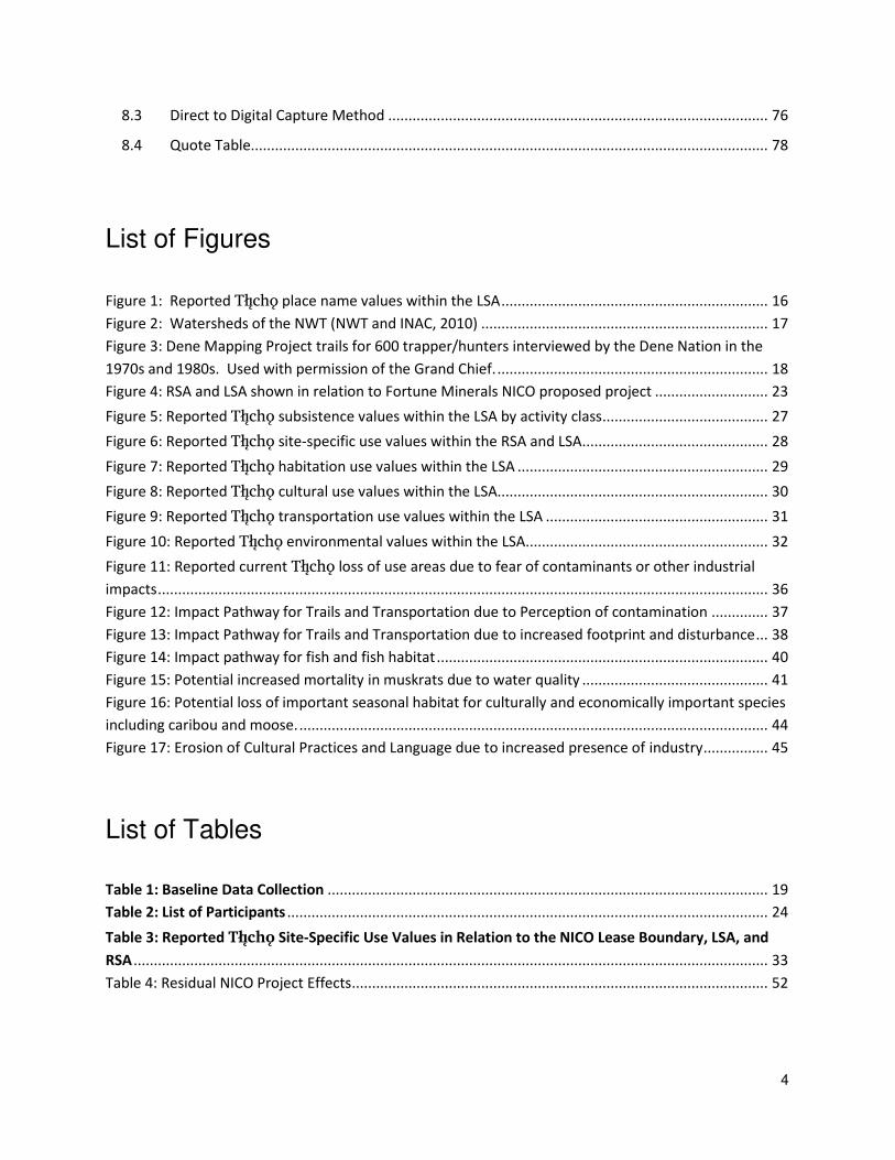
In the area of the proposed project, this study recorded 46 place name values within the project RSA.
The following map (Figure 1) shows these place names. The study has also used passed work of the
Tåîchô Government place names as a base layer for all the maps throughout this report. It is important
to understand that these place names are important “indicators of bio-geographical knowledge” (Legat et. al, 2001: p. 20). As John B. Zoe explained, “Place names is not something that… they just slap on for
no purpose. It's [got to] have a reason for it”.

16
Figure 1: Reported Tåîchô place name values within the LSA
17
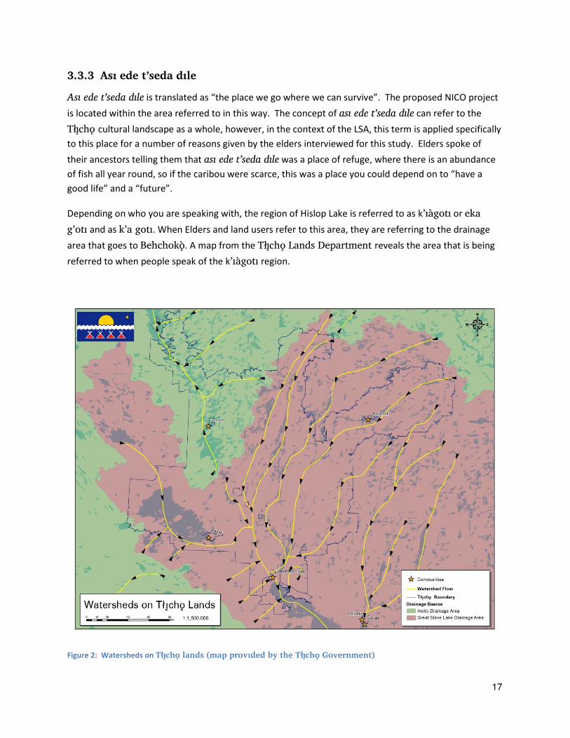
3.3.3 Asi ede t’seda dile
Asi ede t’seda dile is translated as “the place we go where we can survive”. The proposed NICO project is located within the area referred to in this way. The concept of asi ede t’seda dile can refer to the
Tåîchô cultural landscape as a whole, however, in the context of the LSA, this term is applied specifically
to this place for a number of reasons given by the elders interviewed for this study. Elders spoke of
their ancestors telling them that asi ede t’seda dile was a place of refuge, where there is an abundance
of fish all year round, so if the caribou were scarce, this was a place you could depend on to “have a good life” and a “future”.
Depending on who you are speaking with, the region of Hislop Lake is referred to as k’iàgoti or eka
g’oti and as k’a goti. When Elders and land users refer to this area, they are referring to the drainage
area that goes to Behchokö. A map from the Tåîchô Lands Department reveals the area that is being
referred to when people speak of the k’iàgoti region.
Figure 2: Watersheds on Tåîchô lands (map provided by the Tåîchô Government)

18
3.3.4 Idaa Trail
Asi ede t’seda dile is also located along the main travel route of the Idaa trail. As noted above, travel
and knowledge are inextricably linked within the Tåîchô cosmology and cultural landscape. The Idaa
trail will be discussed in further detail below (Section 5.2.1), however, it is important to emphasize here
the centrality of Asi ede t’seda dile within this important travel route. The following map shows the
vital use of the Idaa Trail which is the darkest location below Great Bear Lake. It demonstrates the use
of the area in the 1970s and 1980s.
Figure 3: Dene Mapping Project trails for 600 trapper/hunters interviewed by the Dene Nation in the 1970s and 1980s. Used
with permission of the Grand Chief.
19
Section 4 Baseline Data Collection and Assessment Methods
4.1 Baseline Data Collection Methods
Baseline data collection for the study involved confirming key themes and VCs, defining temporal and
spatial boundaries of assessment, and compiling and collecting baseline information. The latter
included a scoping process, document review, gap analysis, and use and occupancy mapping interviews.
The methods used for baseline data collection and timeline are summarized below in Table 1.
Table 1: Baseline Data Collection
Steps for baseline data collection
Description
Step 1: Confirmation of themes and methodology
A meeting was held with Tåîchô Government leadership and staff on May 31
st, 2012 to confirm key themes, identify likely industry
interactions for further investigation, and begin defining the sample for participation.
Step 2: Gather information about key themes
Review and compilation of information from existing sources (transcripts, reports, and spatial data) to identify spatial information within 5 km, 25 km, and downstream within the RSA, and to characterize baseline condition of key themes.
Step 3: Data collection to fill gaps, community review, analysis, and confirmation
31 individual mapping interviews were conducted with 31 elders and
land users from all four Tåîchô communities in the summer of 2012.
Project-specific reporting was reviewed, and analysis and findings reviewed. Community verification is ongoing.
Step 4: Verification meeting
A meeting with the Kwe Beh Working Group on September 12-13 reviewed findings, verified place names and verified key terms for the region.
4.1.1 Identification of Key Valued Components
A Valued Component (VC) is defined as an important aspect of the environment that a project has
potential to affect, and, consistent with standard assessment practice, is considered within an
environmental assessment (Hegmann et al., 1999)2. VCs may include tangible or biophysical resources
2 Valued ecosystem component (VEC) is a term frequently used to designate a similar concept, but is focused on
biophysical resources. This report uses VC in relation to Tåîchô knowledge and use values, as VC is a more general
term.

20
(e.g. particular places or species), as well as more social or knowledge based VCs (e.g. place names or
traditional knowledge regarding a particular area).
In the context of Tåîchô knowledge and use, the identification of VCs provides a way to focus on what is
most important with respect to a particular project. The VCs for this assessment were determined
through:
• consideration of past work with Tåîchô community members and staff;
• review of materials from past Tåîchô studies; and
• meeting held with Tåîchô leadership and staff.
4.1.1.1 Site-specific Values
For the purpose of this report, site-specific values include values that are reported as specific and
spatially distinct, and that may be mapped (though exact locations may be considered confidential).
Site-specific values, such as cabins or kill sites, reflect specific instances of use that anchor the wider
practice of livelihood within a particular landscape. For example, a particular moose kill site may be
mapped with a precise point, but that value is correctly interpreted as an anchor or focal point for a
wide spectrum of other related livelihood practices and values, including:
• wider hunting areas covered in efforts to find the moose;
• practice of navigation and tracking in order to access the moose;
• religious or ceremonial practices that may be associated with the hunt;
• food processing and preparation techniques to utilize the moose; and
• the range of social relationships and knowledge transmission (teaching) activities that are
required for a successful hunt to occur.
In other words, every mapped site-specific value implies a much wider range of activities and a wider
geographic area upon which the meaningful practice of that use relies. Therefore, the area covered by
recorded site-specific use values should be understood as a tiny portion of the area actually required for
the meaningful practice of Tåîchô livelihood. (Candler et al, 2010)
Site-specific VCs for baseline collection include five classes of site-specific values:
• subsistence values (including harvesting and kill sites, plant food collection areas, and
trapping areas reported within the LSA and RSA);
• habitation values (including temporary or occasional, and permanent or seasonal camps
and cabins reported within the LSA and RSA);
• cultural/spiritual values (including burials, village sites, ceremonial areas, and medicinal
plant sites reported within the LSA and RSA);
• transportation values (including trails, water routes, and navigation sites reported within
the LSA and RSA); and
• environmental feature values (including specific highly valued habitat for moose and
caribou reported within the LSA and RSA).
21
4.1.1.2 Non-site-specific Values
For the purpose of this report, non-site-specific values are those that may be specific to a resource or
other concern, but are spatially indistinct or difficult to map. Non-site-specific values often represent
the critical conditions or elements that must be present for the continued practice of aboriginal rights,
such as hunting and gathering of wild foods. As such, non-site specific values range from the direct
presence of traditionally hunted animals and other wild foods on the land, to continued access to
traditional hunting areas and non-contaminated sources of wild foods. Non site-specific values include
intangible cultural resources, such as the transmission of knowledge across generations and the
continued use of traditional place names.
Non-site-specific VCs included in this assessment are:
Trails and transportation corridors;
Waterfowl, fur bearing and tapping;
Caribou and moose;
Water, Wild Foods, Medicinal Plants and Contaminants; and
Intangible cultural resources (including Tåîchô transmission of knowledge and language).
4.1.2 Temporal and Spatial Boundaries of Assessment
The temporal boundaries for baseline data collection include past, present, and planned future Tåîchô
knowledge and use. For the purpose of this study:
• a past value refers to an account of knowledge and use prior to living memory;
• a present value refers to an account of knowledge and use within living memory; and
• a planned future value refers to anticipated or intended knowledge or use patterns by the
individual or their expectation for use by their descendants.
Spatial boundaries for baseline collection include:
• the Project lease boundary, extended by a 250m zone of influence (ZOI) to represent edge
effects ;
• the LSA, defined as an area within 5 km of the Project footprint, within which intense
project-related disturbance can be expected; and
• the larger RSA (defined below), within which project-related effects may interact with
Tåîchô values (see Figure Two).
A 250 m ZOI around the industrial footprint is used to document site-specific impacts on VCs, based on
evidence that this distance is a reasonable approximation for a zone within which the abundance of
wildlife and land use by humans may be altered (Management and Solutions in Environmental Science,
2010).
Five km (just over three miles) is an approximation of the distance easily travelled in a day trip from a
point (such as a cabin, camp or other location) by foot through bush, as when hunting, and returning to
22
the point of origin (Candler et al. 2010: 29). It is used as a reasonable approximation of the area of
regularly relied-upon resource use surrounding a given transportation or habitation value
The RSA is a broader area within which direct or indirect effects of the Project may be anticipated, such
as noise, dust, odors, access management activities, traffic, effects on water, and other forms of
disturbance experienced by Tåîchô citizens. For this project, the RSA is defined by a 25 km area around
the Project Lease Boundary. Attention to downstream effects is based on Tåîchô concerns regarding
loss of use due to increased fear or concerns regarding waterborne contamination caused by the
Project. Due to the potential displacement of Tåîchô land use, it is also possible there will be indirect
project effects outside the RSA as Tåîchô members avoid areas perceived to be affected by the Project.

23
Figure 4: RSA and LSA shown in relation to Fortune Minerals NICO proposed project
24
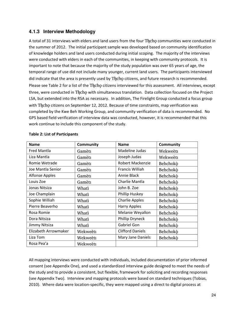
4.1.3 Interview Methodology
A total of 31 interviews with elders and land users from the four Tåîchô communities were conducted in
the summer of 2012. The initial participant sample was developed based on community identification
of knowledge holders and land users conducted during initial scoping. The majority of the interviews
were conducted with elders in each of the communities, in keeping with community protocols. It is
important to note that because the majority of the study population was over 65 years of age, the
temporal range of use did not include many younger, current land users. The participants interviewed
did indicate that the area is presently used by Tåîchô citizens, and future research is recommended.
Please see Table 2 for a list of the Tåîchô citizens interviewed for this assessment. All interviews, except
three, were conducted in Tåîchô with simultaneous translation. Data collection focused on the Project
LSA, but extended into the RSA as necessary. In addition, The Firelight Group conducted a focus group
with Tåîchô citizens on September 12, 2012. Because of time constraints, map verification was
completed by the Kwe Beh Working Group, and community verification of data is recommended. No
GPS based field verification of interview data was conducted, however, it is recommended that this
work continue to include this component of the study.
Table 2: List of Participants
Name Community Name Community
Fred Mantla Gamèti Madeline Judas Wekweèti
Liza Mantla Gamèti Joseph Judas Wekweèti
Romie Wetrade Gamèti Robert Mackenzie Behchokö
Joe Mantla Senior Gamèti Francis Williah Behchokö
Alfonse Apples Gamèti Annie Black Behchokö
Louis Zoe Gamèti Charlie Mantla Behchokö
Jonas Nitsiza Whatì John B. Zoe Behchokö
Joe Champlain Whatì Phillip Huskey Behchokö
Sophie Williah Whatì Charlie Apples Behchokö
Pierre Beaverho Whatì Harry Apples Behchokö
Rosa Romie Whatì Melanie Weyallon Behchokö
Dora Nitsiza Whatì Phillip Dryneck Behchokö
Jimmy Nitsiza Whatì Gabriel Gon Behchokö
Elizabeth Arrowmaker Wekweèti Clifford Daniels Behchokö
Liza Tom Wekweèti Mary Jane Daniels Behchokö
Rosa Pea’a Wekweèti
All mapping interviews were conducted with individuals, included documentation of prior informed
consent (see Appendix One), and used a standardized interview guide designed to meet the needs of
the study and to provide a consistent, but flexible, framework for soliciting and recording responses
(see Appendix Two). Interview and mapping protocols were based on standard techniques (Tobias,
2010). Where data were location-specific, they were mapped using a direct to digital process at
25
1:50,000 scale or finer, using points, lines or polygons. The direct-to-digital mapping method is
described in Appendix Three. Interview data was coded in such a way that disaggregation of individual
participant data is possible, and first hand and second hand information is distinguishable.
All mapping interviews were recorded using digital audio recording and digital video recording of the
map surface, and through interview notes captured on interview forms or in notebooks. Questions
were designed to gain an understanding of the participant’s background and relationship to the study areas, patterns of avoidance and use (including hunting, trapping, fishing, and related practices), and
how the participant’s use has changed over time. Where data was location-specific, it was mapped
using points, lines, or polygons. Temporal information regarding season and year was recorded where
possible. Coding of data took place on screen so that it could be reviewed as it was entered. Interviews
averaged approximately one and a half hours. For some participants, there was not adequate time to
address their use and occupancy in relation to the entire study area. Where this was the case, areas in
closest proximity to proposed Project footprints were emphasized.
4.2 Impact Assessment Methods
4.2.1 Summary
Assessing the impact of the Project involved identifying key VCs, defining temporal and spatial
boundaries of assessment, and identifying anticipated effects on VCs based on a mixture of the density
and importance of use and occupancy values, the location of the values in relation to the proposed
Project, and what land users had to say about potential effects.
4.2.2 Valued Components for Assessment
VCs for assessment are the same as those noted above for baseline collection. See Section 4.1.1.1 for
site-specific VCs, and Section 4.1.1.2 for non-site-specific VCs.
4.2.3 Temporal and Spatial Boundaries for Assessment
The temporal and spatial boundaries for assessment correspond to those for baseline collection (see
Section 4.1.2 and Figure 2).
It is important to note that, like many social and ecological values, First Nations traditional use values
exist within an ongoing process of interdependent environmental, cultural, economic, and social change
that is rooted in the past and extends into the future. The assessment of impacts provides a prediction
of likely future change resulting from the Project given available information. Tåîchô knowledge and
use involve complex and dynamic cultural and ecological systems, and it is important to note that what
may appear to be minor changes in a single component may have larger and unexpected consequences
for the whole.

26
Section 5 Fortune Minerals NICO Mine Project Baseline and Assessment
This section provides baseline and assessment of likely effects specific to the Project on Tåîchô
knowledge and use.
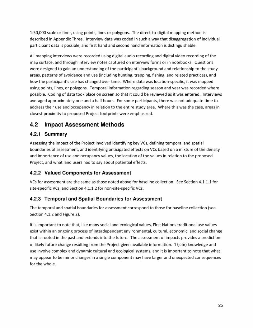
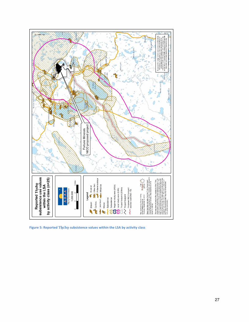
5.1 Baseline Summary for Site-specific VCs within the NICO LSA and RSA
Figure 3 provides a map of Tåîchô site-specific data reported within the NICO Project LSA including 72
site-specific use values within the proposed Project Lease Boundary. 179 site-specific use values were
identified within the LSA (within 5 km of the proposed NICO footprint), including subsistence values,
and 39 habitation values clustered primarily at the mouths of the Goloti Dee at the north and east
sides of K’iàgoti Temporary habitation, including overnight camping sites, are located in and around
the Project footprint.
The pattern and density of occupation sites indicates the area is both a major Tåîchô transportation,
and an ecological focal point within which patterns of Tåîchô cultural practice are focused. While not
every site-specific value includes time information, reported time of last use for habitation values within
the LSA range from the 1960s to today.
There were 358 Tåîchô use, occupancy and other values were identified in the RSA, the majority of
them in the area of Asi edee t’seda dile, and in the surrounding lakes and watershed. All mapped
values are based on the use and knowledge of Tåîchô citizens.
All Tåîchô data (points, lines and polygons) are shown with no buffers. Table 3 provides an account of
reported Tåîchô site-specific values inside or within 250 m of the NICO Lease Boundary, within the LSA,
and RSA.
27
Figure 5: Reported Tåîchô subsistence values within the LSA by activity class
28
Figure 6: Reported Tåîchô site-specific use values within the RSA and LSA

29
Figure 7: Reported Tåîchô habitation use values within the LSA
30
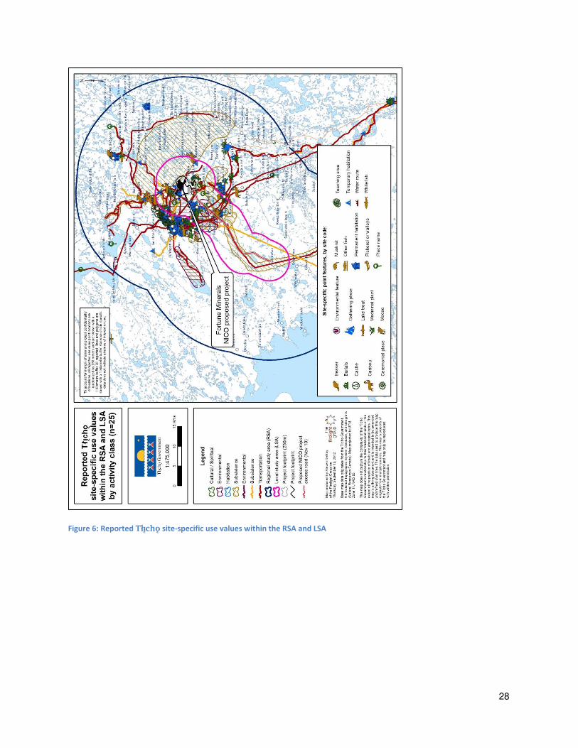
Figure 8: Reported Tåîchô cultural use values within the LSA
31
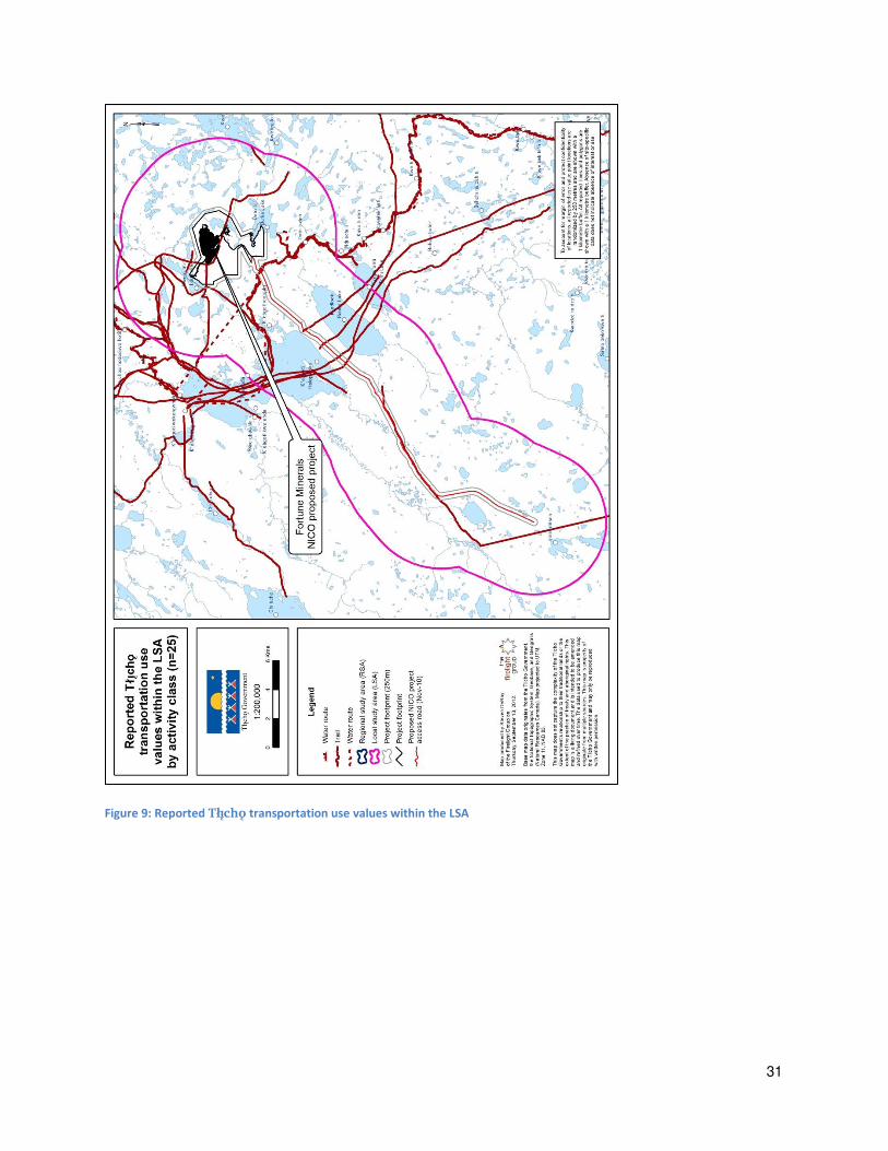
Figure 9: Reported Tåîchô transportation use values within the LSA
32
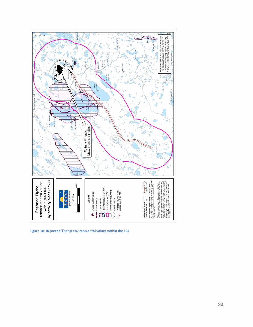
Figure 10: Reported Tåîchô environmental values within the LSA
33
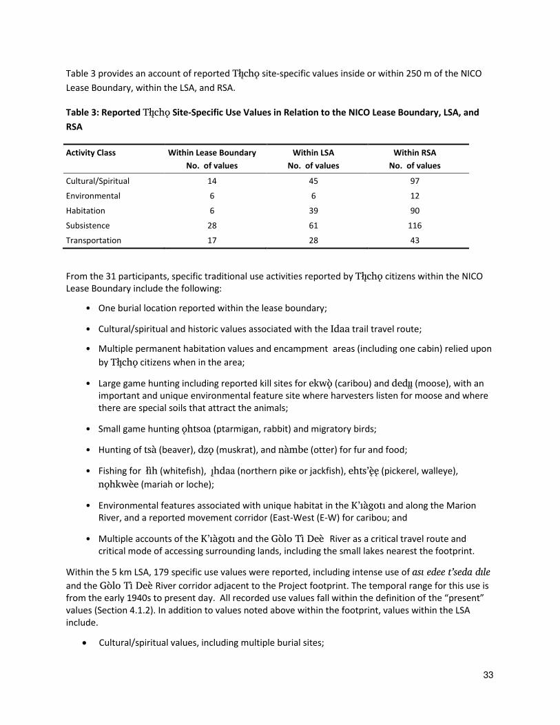
Table 3 provides an account of reported Tåîchô site-specific values inside or within 250 m of the NICO
Lease Boundary, within the LSA, and RSA.
Table 3: Reported Tåîchô Site-Specific Use Values in Relation to the NICO Lease Boundary, LSA, and
RSA
Activity Class Within Lease Boundary
No. of values
Within LSA
No. of values
Within RSA
No. of values
Cultural/Spiritual 14 45 97
Environmental 6 6 12
Habitation 6 39 90
Subsistence 28 61 116
Transportation 17 28 43
From the 31 participants, specific traditional use activities reported by Tåîchô citizens within the NICO
Lease Boundary include the following:
• One burial location reported within the lease boundary;
• Cultural/spiritual and historic values associated with the Idaa trail travel route;
• Multiple permanent habitation values and encampment areas (including one cabin) relied upon
by Tåîchô citizens when in the area;
• Large game hunting including reported kill sites for ekwö (caribou) and dedîî (moose), with an
important and unique environmental feature site where harvesters listen for moose and where
there are special soils that attract the animals;
• Small game hunting ôhtsoa (ptarmigan, rabbit) and migratory birds;
• Hunting of tsà (beaver), dzô (muskrat), and nàmbe (otter) for fur and food;
• Fishing for åìh (whitefish), îhdaa (northern pike or jackfish), ehts’ëê (pickerel, walleye),
nôhkwèe (mariah or loche);
• Environmental features associated with unique habitat in the K’iàgoti and along the Marion
River, and a reported movement corridor (East-West (E-W) for caribou; and
• Multiple accounts of the K’iàgoti and the Gòlo Tì Deè River as a critical travel route and
critical mode of accessing surrounding lands, including the small lakes nearest the footprint.
Within the 5 km LSA, 179 specific use values were reported, including intense use of asi edee t’seda dile
and the Gòlo Tì Deè River corridor adjacent to the Project footprint. The temporal range for this use is
from the early 1940s to present day. All recorded use values fall within the definition of the “present” values (Section 4.1.2). In addition to values noted above within the footprint, values within the LSA
include.
Cultural/spiritual values, including multiple burial sites;

34
Preferred hunting areas along the Gòlo Tì Deè River and surrounding lakes for fur bearing
(beaver and muskrats) and migratory birds (ducks); including one reported trapline area north
of the Footprint that has been reported to be actively used and continues to be used every year
for the past 20 years (T30, T31);
28 reported temporary habitations or other overnight structures (camps) and nine reported
values associated with cabins and permanent habitation areas within the LSA. Based on
reported last use, activity levels in the area have declined over time but is still used continuously
and regularly by Tåîchô citizens since before 1960 to the present;
Almost 20 reported kill sites with the majority (more than 15) associated with successful caribou
hunting along portions of asi edee t’seda dile adjacent to and surrounding the Project (within
the LSA), as well as successful moose hunting sites (T5, T7, T9, T10, T13, T19) ranging from the
1940s to 2005 for caribou, and up to 2002 for moose.;
Preferred subsistence fishing îhdaa (Jackfish, whitefish, and pickerel) along the Gòlo Tì Deè
River, and particularly at the mouth of the rivers on the north and east side of K’iàgoti ;
including multiple fish caches along the Gòlo Tì Deè River; and
Multiple environmental features, including important caribou habitat, an E-W movement
corridor across RSA. (T5, T8, T13, T18, T23, T30).
Collection areas for berries and firewood and other materials.
Based on Tåîchô interviews, the density of Tåîchô use within the Lease Boundary and LSA is the result of
a number of contributing reasons.
Consistent with the many habitation values (camps and cabins) reported by Tåîchô citizens, the
LSA is accessible by boat along the Gòlo Tì Deè River, and by winter road, and the associated
stretch of river includes a series of regularly used and historically known camps and cabins
relied upon and returned to by Tåîchô citizens and families over a long period of time;
Consistent with the high number of fishing values reported, especially for whitefish, and
pickerel at the mouth of K’iàgoti and the River at and near the north and east inflow and
outflow of the lake provide a rich and reliable source of fish.
Critical to the current and ongoing use of the LSA by Tåîchô citizens, the Gòlo Tì Deè River and
smaller streams flowing from the small lakes around the Project, provide sources of fresh
drinking water (for people and animals) that are still trusted as clean alternatives to the waters
downstream from the Rayrock mine site, which are now widely regarded with suspicion by
Tåîchô hunters and land users (see further discussion of loss of use areas below).
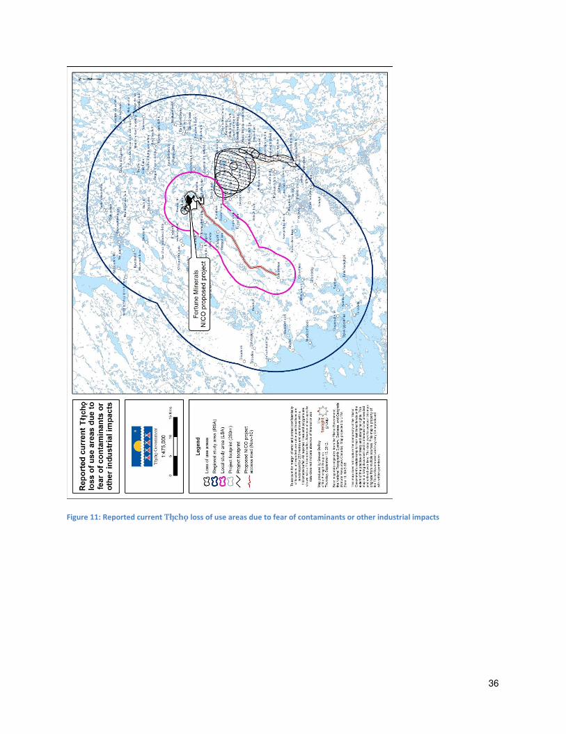
5.1.1 Loss of Use
Figure 8 shows areas of general loss of use due to industrial impacts reported by Tåîchô citizens in the
RSA, as well as instances of specific lost use due to resource or water quality (perceived contamination).
Areas of general loss of use are locations that Tåîchô citizens have reported using for subsistence,
habitation, or other uses, but that are now partly or fully avoided due to perceived contamination or

35
other concerns. As indicated by Tåîchô users, current general loss of use extends beyond the LSA and
into the RSA, and is related to the Rayrock mine site and downstream from this site.
As shown in Figure 8, the area immediately south of the Project is currently avoided by at least some
Tåîchô users because of existing industrial impacts. Of the 31 Tåîchô citizens reporting use within the
LSA, six reported some degree of lost use due to concerns regarding pollutants and contamination of
the area near Rayrock mine and downstream. It is important to note that not all participants were
asked about loss of use, but the majority of participants mentioned the Rayrock mine site and the
surrounding area that has been damaged. As discussed below, the common perceptions of the
participants of the NICO Project is likely to expand the area of avoidance, or lost use, further to the
north and northwest.
Existing loss of use within the LSA and RSA is due to a range of factors including terrestrial disturbance,
concerns regarding industrial contaminants, and construction of roads:
“It’s in the middle of the Tåîchô Region, it’s the place of the caribou, the place of the wildlife, and also that’s where the caribou so we may not see any caribou going to that area because it’s right in the middle of the heart of the Tåîchô Region. Like Rayrock, I
remember, I have seen the kind of things that have occurred to that area because of the
Rayrock mine and also that if Fortune Minerals, if it goes ahead… it will have an impact on the wildlife, even with humans, human health. If they use poisonous stuff, heavy
chemicals, it may be dangerous, so we may not have any wildlife from that area go to
our area…. because we really don’t know the outcome of that.” –Jonas Nitsiza
“Rayrock mine… [I] wouldn’t drink the water up there...up to Hislop. After that we can
drink water, we’re scared to drink water from Rayrock mine…. Concerned about this area, it’s a good fishing area. If they spoil the water, what is going to happen to the fish, this is what the people are worried about, the fish around that area.” –Alphonse Apples
“There’s a small little pickerel but it’s nice and fat, in really good shape, that’s where they used to be. What they do, there was a note now that Fortune Minerals are saying
that there was a big note there right by the camp, at Lou Lake, you are not to fish that
lake…. Even after the sign has been cut down, people don’t go to that area to fish anymore because they are a little afraid, they are concerned.” Alphonse Apples
36
Figure 11: Reported current Tåîchô loss of use areas due to fear of contaminants or other industrial impacts
37
5.2 Baseline Summary for Non-site-specific VCs within the Project LSA and RSA
Key non-site specific VCs include the following (as described in Section 4.1.1.2):
Trails and transportation corridors;
Water, Wild Foods, Medicinal Plants and Contaminants;
Waterfowl, fur bearing and trapping;
Caribou and moose; and
Intangible cultural resources (including Tåîchô transmission of knowledge and language).
5.2.1 Trails and Transportation Corridors
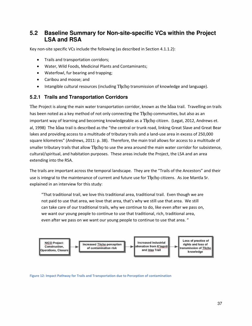
The Project is along the main water transportation corridor, known as the Idaa trail. Travelling on trails
has been noted as a key method of not only connecting the Tåîchô communities, but also as an
important way of learning and becoming knowledgeable as a Tåîchô citizen. (Legat, 2012, Andrews et.
al, 1998) The Idaa trail is described as the “the central or trunk road, linking Great Slave and Great Bear
lakes and providing access to a multitude of tributary trails and a land-use area in excess of 250,000
square kilometres” (Andrews, 2011: p. 38). Therefore, the main trail allows for access to a multitude of
smaller tributary trails that allow Tåîchô to use the area around the main water corridor for subsistence,
cultural/spiritual, and habitation purposes. These areas include the Project, the LSA and an area
extending into the RSA.
The trails are important across the temporal landscape. They are the “Trails of the Ancestors” and their use is integral to the maintenance of current and future use for Tåîchô citizens. As Joe Mantla Sr.
explained in an interview for this study:
“That traditional trail, we love this traditional area, traditional trail. Even though we are
not paid to use that area, we love that area, that’s why we still use that area. We still can take care of our traditional trails, why we continue to do, like even after we pass on,
we want our young people to continue to use that traditional, rich, traditional area,
even after we pass on we want our young people to continue to use that area. “
Figure 12: Impact Pathway for Trails and Transportation due to Perception of contamination
38
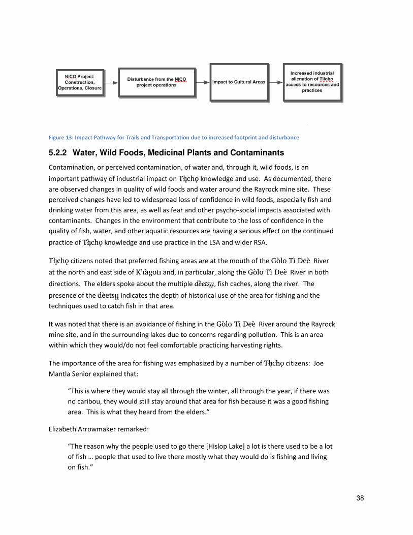
Figure 13: Impact Pathway for Trails and Transportation due to increased footprint and disturbance
5.2.2 Water, Wild Foods, Medicinal Plants and Contaminants
Contamination, or perceived contamination, of water and, through it, wild foods, is an
important pathway of industrial impact on Tåîchô knowledge and use. As documented, there
are observed changes in quality of wild foods and water around the Rayrock mine site. These
perceived changes have led to widespread loss of confidence in wild foods, especially fish and
drinking water from this area, as well as fear and other psycho-social impacts associated with
contaminants. Changes in the environment that contribute to the loss of confidence in the
quality of fish, water, and other aquatic resources are having a serious effect on the continued
practice of Tåîchô knowledge and use practice in the LSA and wider RSA.
Tåîchô citizens noted that preferred fishing areas are at the mouth of the Gòlo Tì Deè River
at the north and east side of K’iàgoti and, in particular, along the Gòlo Tì Deè River in both
directions. The elders spoke about the multiple dèetsîî, fish caches, along the river. The
presence of the dèetsîî indicates the depth of historical use of the area for fishing and the
techniques used to catch fish in that area.
It was noted that there is an avoidance of fishing in the Gòlo Tì Deè River around the Rayrock
mine site, and in the surrounding lakes due to concerns regarding pollution. This is an area
within which they would/do not feel comfortable practicing harvesting rights.
The importance of the area for fishing was emphasized by a number of Tåîchô citizens: Joe
Mantla Senior explained that:
“This is where they would stay all through the winter, all through the year, if there was
no caribou, they would still stay around that area for fish because it was a good fishing
area. This is what they heard from the elders.”
Elizabeth Arrowmaker remarked:
“The reason why the people used to go there [Hislop Lake] a lot is there used to be a lot
of fish … people that used to live there mostly what they would do is fishing and living
on fish.”
39
Harvesting medicinal plants were also emphasized in asi edee t’seda dile. The elders describe
this in the following:
“That area that we’re talking about was very important and very useful, we were brought up around that area, around that Hislop area. Even the trees provide medicines
and it’s good for cold, all kinds of medicines that comes from plants and trees.” Fred Mantla
“Yes, back in days for healing purposes I guess a lot of people depend on the traditional
medicines. It’s a fear that once the development gets underway all the traditional medicines will
disappear with it as well. Certainly this is the point of view directly coming from our elders.
They’re the ones that have great concerns about what might happen after development, mine develops…. the elders, they knew what type of plants and what type of trees are good for any
illness I guess. They identified them. They depend a lot on the traditional medicines. Even the
blueberries and the cranberries, a lot of animals really live on it too as well too because in the
event that their land is ruined in the future and what animal will be feeding on it?” Harry Apples
This fear of contamination was voiced by many participants. Alphonse Apples asked:
“[We are] concerned about this area, it’s a good fishing area. If they spoil the water,
what is going to happen to the fish? This is what the people are worried about, the fish
around that area.”
Francis Williah explained avoidance around the Rayrock mine site:
“We traveled on the Rayrock mine area a long time ago … we caught a big, jumbo white fish. The size of the fish was so huge that we [caught] about 40 of them, and one
toboggan and it was hard for the dog team to pull it … we no longer go out, back to that area for trapping, hunting and fishing anymore, because the water is polluted in the
area. We can't drink water from that lake either.”
Louis Zoe explained that he “wouldn’t drink the water up there...up to Hislop, after that we can drink water, we’re scared to drink water from Rayrock mine”.
Fred Mantla also spoke about the water and contamination. He said:
“If the mine goes ahead, all the things that were there will be spoiled one way or
another once the mine goes ahead. That’s one of the reasons sometimes you feel a little down, when you think about those kinds of things. You can’t say you feel good about… When you go out in the boat, you take a cup, just along the river, just anywhere you travel, you can dip your cup into the river or the water or the lake but if the mine
ever goes ahead, you won’t be able to do that.”

40
Figure 14: Impact pathway for fish and fish habitat
5.2.3 Waterfowl, Fur bearing, and Trapping
Tåîchô citizens reported using the area of the Project, LSA and RSA for hunting ducks, trapping beaver
and muskrats, and trapping other fur bearing animals. While it has been noted that trapping had been
an “important economic pursuit for centuries after the arrival of Europeans”, it has been “in decline for the past several decades” (Andrews, 2011: p. 29). Despite its decline as a primary economic activity,
trapping is still actively practiced within the Project LSA. Chief Daniels describes his experiences
trapping in the northern part of the LSA each year for the past 20 years as:
“My in-laws and my brother-in-law were doing it and all that… And my brother-in-law
also passed on before my father-in-law so I know -- I knew there was a trail out there
and I talked to the younger brother-in-law… and I said it’s such a waste for our ancestors
to do all these things and not being utilized afterwards, to try to keep something going.
And so… this should continue and I’ll make the effort… and try to get that trail back. So
over the years I’ve started recognizing the trails as told from my brother and some other
people, extending the trail… I figured I’d see it with my own eyes and familiarize myself with the area and the trails. And that’s how this all began. And I was always trapping
anyways… Yes, it has become a primary [trapline]… But this is something that I can just
continue because one year after another -- and hopefully I get to share this with the kids
and that I’d like to try to get familiarized with the area.”
Jonas Nitisiza also described hunting for ducks and fur bearing in this area. He explained:
“I have been making use of that area almost every year, we spent early fall in that area
and it will freeze in that area and then we spend the winter. And right now we will go
towards Gamèti into Whatì. We’ve been making use of the area for beaver hunting,
we have made use of our canoes to travel through the area… At that time the lake was
really difficult to travel on, it was breaking up and I remember bypassing some areas.
There were old cabins in that area I remember which we bypassed and we followed the
lakes. I remember it was really late in the spring, the ice was thawing out, most lakes
the ice was thawing out, some lakes there was no more ice on the lake, in the area to do
the spring beaver hunting. Some of these days, an area where it is good for birds, for
41
ducks, waterfowl, there were many lakes like that in the area, it must have been a good
area for these ducks and was good feeding area. I can remember it was dark with so
many ducks, and [we] had set up nets, gill nets in that area, over land, and they snared
these ducks that were flying by and how they harvested their ducks there, this is where,
that area that I’ve pinpointed, where we done this and fishing for ducks and also we did some spring hunting there for beaver and muskrat.”
Changes to migratory birds and fur bearing have been observed in the Project LSA and RSA, especially
around Rayrock mine. This has led to loss of use and avoidance in areas of the Project LSA and RSA.
Charlie Mantla remarked that:
“I think we killed a little over a hundred muskrat each [in the spring hunt of the 70’s]. We saw some dead fish floating and some dead muskrat been floating around, just
below the [Ray Rock] mine site. … There was approximately seven dead muskrats floating on the river.”
Chief Daniels also shared his observations on a changing seasonal patterns and their effect on trapping,
and hunting. He states:
“I noticed just due to the climate… things are changing. Most of these lakes are
connected to streams. And that means -- I’ve noticed anyways that the melt has been thawing -- it’s getting -- do you say rapid -- this year -- a little more. It’s not like before. Before natural thaw or this year -- last year -- it seemed a little faster… I had to unhitch a
sleigh just to try to make it across some lakes our last season. So because the wolverine
season is longer than the rest, we’ll have boats out a little longer, too.”
Waterfowl, fur bearing, and trapping are of key cultural importance to Tåîchô citizens. The seasonal
round of these subsistence activities is a core component of the practice of Tåîchô knowledge and rights
on Tåîchô lands.
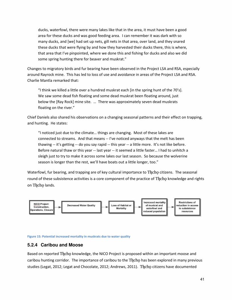
Figure 15: Potential increased mortality in muskrats due to water quality
5.2.4 Caribou and Moose
Based on reported Tåîchô knowledge, the NICO Project is proposed within an important moose and
caribou hunting corridor. The importance of caribou to the Tåîchô has been explored in many previous
studies (Legat, 2012; Legat and Chocolate, 2012; Andrews, 2011). Tåîchô citizens have documented
42
extensive harvesting of caribou and moose in the Project Lease Boundary, LSA, and RSA, as well as
identified this area as important habitat and a key corridor. The concern regarding changes to these
populations and the ability to continue to hunt and use this area was voiced consistently in each
interview.
The area has been and continues to be a key component of Tåîchô subsistence practices. Jonas Nitsiza
explains caribou hunting there in the past:
“The caribou used to migrate to that area, when the caribou used to migrate from the
calving grounds, all the way from there, that’s the way it was, when the caribou migrate to the treeline and just below the hill, like Hislop Lake, we used to hunt over there. I’m pretty sure that is the main migrating, there must be a lot of caribou trails, caribou have
used that area where the Fortune Minerals mine is about to, but they used to migrate
through there and towards us all the way to Whatì from there.”
Pierre Beaverho explained how the caribou avoid mine sites, and speaks about the relationship of the
Rayrock mine to the current proposed Project LSA and RSA. He said:
“So Hislop Lake, where the Carl's Mine [Fortune Minerals mine] is, normally you have
caribou migrating path through that area where the mine is. It would come to that
mine site to our area, to our land and then it goes back, take the same route back to the
land, they would bypass the mine site. That's a migrating path for the caribou.”
Jimmy Nitsiza also shared that:
“This area is mostly used by animals, we go prepared for hunting in that area, even with
dog team, we used to go there for caribou, we did utilize trucks and snowmobiles to go
hunting in this area. It’s a fine hunting area for us… When I think about it, I always think
about the animals on the land which I have used for food. I have never had commercial
(store-bought) food but I always depended on wildlife off the land.”
The historical use of the Project LSA and RSA for hunting is clear, and the present use of the area was
also emphasized by Tåîchô citizens. Current use is described by Robert Mackenzie:
“The area, all the area is not that damaged right now I guess, so area's pretty well clean
and, so that the animals are free to roam around that area, which is good. And even the
bay, you could always paddle over there and we don't have any problem killing any, lot
of moose out there.”
He goes on to explain how the old cabins sites are currently used for hunting camps. He explains:
“We do hunt from here because some caribou on Hislop Lake, and if we can't find any
caribou on Hislop Lake, we go down to the northeast area and that's where we go down
to the Hislop Lake where there's a cabin on Hislop Lake … used to be a village one time, there's still a lot of houses there right now it's more or less abandoned cabins.
43
Sometimes we use those houses to overnight because all depending if we carry our own
gear such as tents.”
Chief Clifford Daniels, in reviewing this report, suggested that there is present use of this area beyond
what is captured in the maps. He said,
“There is more than what is on there, because from end to end of the lake, (last winter) there were people in every direction harvesting the caribou. We just sit there on the
cabin and look at the kill sites from the area, there is a lot more than what is shown.”
The Project footprint has also been identified as a unique environmental feature for moose hunting.
Joe Mantla Sr. explains:
“See where the Fortune Minerals mine is, right on top of those hills, they would walk, it
would take them I don’t know how long, maybe a night maybe, but they used to get on top of that hill, at night, they would listen to see if there was any moose that’s making noise during the mating season. They would hear a noise, let’s just say, over there and then during the day whatever they were hearing a moose, during the day they would
walk over… Let’s just say if there was a noise of moose from the area, if someone was sitting on the hill, when the wind is blowing that way, the moose will probably be able
to smell him so they wouldn’t go there, they had to watch out for the wind. Only if the wind is blowing this way, they would go there. They would listen for the moose all
night, just when the daybreak comes, they would go there.”
He goes on to explain how the area is currently used:
“So Hislop Lake, our father used to go hunting on the hill... all the way on the hill, this is
where they used to go sleeping on the hill and look out for moose… they used to go up
there, so Hislop Lake… this is where our ancestors lived and this is where we used to travel, we use the route today even in the summer, in the winter, if you’re hungry, we’ll go hunting for ducks, fish and this is what we live now, and where we travel through.”
Concern for the moose and caribou and their habitat within the Project LSA and RSA was expressed by
many Tåîchô citizens. Rosa Romie said:
“… if the chemicals go to the contaminated area, if the chemical’s contaminating stuff and it goes out into the environment, the caribou rely on lichen. So, in the summer, the
caribou will eat lichen, and some of those shrubs … the caribou will get ill, it will be unhealthy -- it won't be healthy, and so if the mining goes ahead, the caribou are
sensitive to noise, then the caribou will avoid those areas.”
Jonas Nitsiza comments:
“It’s in the middle of the Tåîchô Region, it’s the place of the caribou, the place of the wildlife, and also that’s where the caribou [go, so] we may not see any caribou going to

44
that area because it’s right in the middle of the heart of the Tåîchô Region. Like
Rayrock, I remember, I have seen the kind of things that have occurred to that area
because of the Rayrock mine.”
Multiple Tåîchô caribou harvesting sites are included in the subsistence activity class shown in
Table 3, and shown in Figure 3 and Figure 4.
Figure 16: Potential loss of important seasonal habitat for culturally and economically important species including caribou
and moose.
5.2.5 Intangible Cultural Resources: Tåîchô Knowledge and Cultural Transmission
In additional to concerns regarding impact to more concrete use values, many Tåîchô citizens also
identified concerns of potential impact of the Project on intangible cultural resources, including
language and the transmission of knowledge regarding areas lost due to industrial effects, as well as the
ability to practice Tåîchô knowledge and use more broadly.
Particular kinds of knowledge—in the form of place based stories, place names, and histories—are
associated with particular places (Basso, 1996) and the cultural practices or uses that take place there.
Actions that destroy a place or cause the use of a place to be lost (e.g. because of fear of contaminants),
especially over long periods of time, frequently result in a gap in the transmission of place based
knowledge, and eliminate the place as a cultural resource for remembering, teaching, and learning the
knowledge associated with it.
The concern over loss of intangible cultural heritage was stated by many of the Tåîchô participants. Joe
Mantla Sr. explains:
“We take our kids through the river, we want them to use it for the future, this is why
we used to travel through the river from there, from Gamèti to Behchokö … That is our
area, we may lose all of our tradition areas, the different trails, in the winter time we go
from here to, we use that trail, and if they have some more buildings in that area, will
we ever be able to use that area and that’s a concern that I do have and a lot of us do
not like that at all. Our ancestors and our forefathers really could use up that area, that
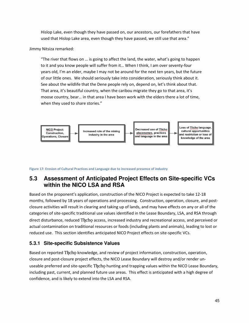
45
Hislop Lake, even though they have passed on, our ancestors, our forefathers that have
used that Hislop Lake area, even though they have passed, we still use that area.”
Jimmy Nitsiza remarked:
“The river that flows on … is going to affect the land, the water, what’s going to happen to it and you know people will suffer from it… When I think, I am over seventy-four
years old, I’m an elder, maybe I may not be around for the next ten years, but the future of our little ones. We should seriously take into consideration, seriously think about it.
See about the wildlife that the Dene people rely on, depend on, let’s think about that.
That area, it’s beautiful country, when the caribou migrate they go to that area, it’s moose country, bear… in that area I have been work with the elders there a lot of time, when they used to share stories.”
Figure 17: Erosion of Cultural Practices and Language due to increased presence of industry
5.3 Assessment of Anticipated Project Effects on Site-specific VCs within the NICO LSA and RSA
Based on the proponent’s application, construction of the NICO Project is expected to take 12-18
months, followed by 18 years of operations and processing. Construction, operation, closure, and post-
closure activities will result in clearing and taking up of lands, and may have effects on any or all of the
categories of site-specific traditional use values identified in the Lease Boundary, LSA, and RSA through
direct disturbance, reduced Tåîchô access, increased industry and recreational access, and perceived or
actual contamination on traditional resources or foods (including plants and animals), leading to lost or
reduced use. This section identifies anticipated NICO Project effects on site-specific VCs.
5.3.1 Site-specific Subsistence Values
Based on reported Tåîchô knowledge, and review of project information, construction, operation,
closure and post-closure project effects, the NICO Lease Boundary will destroy and/or render un-
useable preferred and site-specific Tåîchô hunting and trapping values within the NICO Lease Boundary,
including past, current, and planned future use areas. This effect is anticipated with a high degree of
confidence, and is likely to extend into the LSA and RSA.
46
Inside the NICO Lease Boundary, 28 documented Tåîchô site-specific subsistence values, including
caribou and moose harvesting areas, will be destroyed and/or rendered essentially un-useable by the
Project. Within the Project LSA (which includes the footprint), up to 61 documented Tåîchô site-specific
subsistence values will be adversely impacted by direct disturbance, reduced Tåîchô access, increased
industry and recreational access, and fear associated with increased contamination of traditional
resources or foods (including plants and animals), leading to increased scope and intensity of avoidance
or reduced use. These include important and currently used caribou, moose, small game (e.g., rabbit,
beaver, duck, and ptarmigan), fishing, and plant food (berries and other plants) harvesting areas inside
the Project LSA.
Within the Project RSA (which includes the LSA), 116 Tåîchô site-specific subsistence values have been
documented, including a large concentration of values in the area of K’iàgoti, the Gòlo Tì Deè River
and surrounding lakes. Beyond the LSA, but within the RSA and including Tåîchô values along the Gòlo
Tì Deè River, the values most at risk of project effects are downstream of the NICO Project along the
Gòlo Tì Deè River and the surrounding lakes. The Project is also likely to result in increased perceived
contamination of traditional resources and foods, including plants and animals, leading to lost or
reduced use downstream (also see non-site-specific effects below in Section 5.4).
5.3.2 Site-specific Habitation Values
Based on reported Tåîchô knowledge, and review of project information, construction, operation,
closure and post-closure project effects, the NICO Lease Boundary will destroy and/or render un-
useable preferred and site-specific Tåîchô habitation values within the footprint, including past, current,
and planned future use areas. This effect is anticipated with a high degree of confidence, and is likely to
extend into the LSA and RSA.
Inside the NICO Lease Boundary, six documented Tåîchô site-specific habitation values are anticipated
to be destroyed and/or rendered un-useable by the Project. These include past cabin sites, as well as
encampment sites. Within the NICO LSA, up to 39 documented Tåîchô site-specific habitation values
are likely to be impacted by reduced Tåîchô access, increased industry and recreational access, and loss
of use due to perceived increases in contamination of traditional resources or foods (including plants
and animals) upon which habitation areas rely, leading to increased scope and intensity of avoidance or
reduced use.
Within the NICO RSA (which includes the LSA), 90 site- specific habitation values have been
documented. These include regularly used cabins, village sites, and camp sites. As with subsistence
values noted above, Tåîchô citizen’s observations include increased perceived contamination of
traditional resources and foods (including plants and animals), upon which use of habitation areas rely,
likely leading to lost or reduced use (also see non-site-specific effects below in Section 5.4).
The past habitation of the area and its importance in the present and for future use is described by John
B. Zoe and Madeline Chocolate below.
47
“There were people living there until 1970, but after the federal government moved in
after that time, if people wanted to get social assistance they had to move into the
community and go into school. Once you started that school, there was no way to get
into the bush and leave that school. So then you had a seasonal trapping start, where
just the men went and they left their kids and family behind and they might take their
oldest one not in school with them. And they carry on passing on that knowledge. There
is that background legacy. It doesn’t mean that we have given up. It is only in the past 20 years, we have talked about going back there as families, through programs that we
are putting in place through our own programs with our own governance since 2005.
But right now this knowledge will be scooped up and shoveled, there is no reason why
people won’t be living there in the future and have those dreams.” John B. Zoe
“My grandparents were raised in that area. Even after my grandparents died, my Dad
lived there. But then a forest fire burned through that area. And the log house burned
down. Then some people came through the area and used the burned logs in a fire
themselves. Even after his parents died, my Dad raised us in that area. I recall places
where we lived. I recall playing out there. And going out to snare in that area. And my
Mom and Dad went every year to trap, up until the day my Dad lost his eyesight and
then they stopped going out there. Then my Mom died, but I am still grieving and we
are not going back there until we are done grieving. We will go back with my brothers,
but it still hurts to go there because there are people who are buried in that area.” Madeline Chocolate
5.3.3 Site-specific Cultural/Spiritual Values
Based on reported Tåîchô knowledge, and review of project information, and anticipated construction,
operation, closure and post-closure project effects, the NICO Lease Boundary will likely destroy and/or
impact Tåîchô cultural/spiritual values within the lease boundary and road construction, including a
burial, and cultural areas associated with the burial site. This effect is anticipated with a high degree of
confidence, and is likely to extend into the LSA and RSA.
Within the Project LSA, up to 45 documented Tåîchô site-specific cultural/spiritual values are likely to be
impacted by direct disturbance, reduced Tåîchô access, increased industry and recreational access, or
other disturbances.
Within the RSA (and including the LSA), 97 Tåîchô site-specific cultural/spiritual values are documented.
These include ceremonial places, medicine collection places, and burial sites sensitive to a variety of
effects, including water quality changes. At least some of these cultural/spiritual values are likely to be
impacted by the Project as a result of increased perceived contamination of traditional resources and
foods (including medicine plants), leading to avoidance or reduced use (also see non-site-specific effects
below in Section 5.4).
48
5.3.4 Site-specific Transportation Values
Based on reported Tåîchô knowledge, and review of project information, and anticipated construction,
operation, closure and post-closure project effects, the NICO Lease Boundary will likely impact Tåîchô
transportation values within the footprint. This effect is anticipated with a high degree of confidence,
and is likely to extend into the LSA and RSA.
Within the Project LSA, 14 documented Tåîchô transportation values as well as non-site specific
transportation values.
5.3.5 Site-specific Environmental Feature Values
Based on reported Tåîchô knowledge, and review of project information, and anticipated construction,
operation, closure and post-closure project effects, the NICO footprint will likely destroy or impact
Tåîchô environmental feature values within the footprint, including unique areas of caribou habitat, an
east-west movement corridor for moose and other animals, and water conditions. This effect is
anticipated with a high degree of confidence, and is likely to extend into the LSA and RSA.
Within the NICO LSA, Tåîchô site-specific environmental features include important moose and caribou
habitat areas, fur bearing, and migratory bird areas. This includes the identification of the rocky hilltops
as unique areas used for moose hunting. These values are likely to be impacted by direct disturbance,
reduced Tåîchô access, increased industry and recreational access, perceived increases in contamination
of traditional resources or foods (including plants and animals), leading to increased scope and intensity
of avoidance or reduced use, as well as other disturbances.
Beyond the LSA, but within the RSA, the values most at risk of project effects are areas of caribou and
moose habitat, as well as areas downstream of the Project along the Gòlo Tì Deè River. Use of some
or all of these environmental feature values are likely to be impacted by the Project as a result of
increased perceived contamination of traditional resources and foods (including plants and animals),
leading to avoidance or reduced use (also see non-site-specific effects below in Section 5.4).
5.4 Assessment of Anticipated Project Effects on Non-site-specific VCs within the NICO LSA and RSA
Based on the proponent’s application, construction of the NICO Project is expected to take 12-18
months, followed by 18 years of operations and processing. Construction, operation, closure, and post-
closure activities will include clearing and taking up of lands, and may have effects on any or all of the
categories of non-site-specific traditional use values identified in the footprint, LSA, and RSA through
direct disturbance, reduced Tåîchô access, increased industry and recreational access, and perceived or
actual contamination on traditional resources or foods (including plants and animals), leading to lost or
reduced use. This section identifies anticipated NICO Project effects on non-site-specific VCs.
Identified non-site specific VCs include the following:
Trails and transportation corridors;
49
Waterfowl, fur bearing and trapping;
Caribou and moose;
Water, Wild Foods, Medicinal Plants and Contaminants Water; and
Intangible cultural resources (including Tåîchô transmission of knowledge and language, and
practice).
5.4.1 Trails and Transportation Corridors
Tåîchô citizens have identified important trails in the Project Lease Boundary, LSA, and RSA. These trails
are of great importance to the Tåîchô people in past, current, and for future use. There is concern that
the Project will disturb travel on these trails, including increased perceived contamination, which is
likely to result in increased Tåîchô avoidance or loss of use of the area. This effect is anticipated with a
high degree of confidence.
5.4.2 Waterfowl, Fur bearing and Trapping
Tåîchô citizens have identified important duck habitat and hunting areas within the RSA. Based on
reported Tåîchô knowledge and review of project information, the construction, operation, closure, and
post-closure project effects of the NICO Project, there is concern that the Project may disturb bird
hunting areas, and the availability of culturally important populations of waterfowl. This effect is
anticipated with a medium degree of confidence due to lack of detailed information regarding regional
waterfowl populations in the region.
In addition to potentially disturbing hunting patterns, the Project is also anticipated to increase
perceived contamination, which is likely to result in increased Tåîchô avoidance or loss of use related to
waterfowl populations downstream of the Project.
Tåîchô citizens have identified important fur bearing (beaver and muskrat) trapping and hunting areas
within the LSA and RSA. Project effects related to changes to beaver and muskrat habitat may impact
the current or future availability of muskrats and other fur bearing as a preferred and culturally
important resource for Tåîchô knowledge and use practice. This effect is anticipated with a medium
degree of confidence due to lack of detailed information regarding muskrats and fur populations in the
RSA.
5.4.3 Caribou and Moose
Tåîchô citizens have identified important caribou habitat within the footprint, LSA and RSA. Based on
reported Tåîchô knowledge and review of project information, the construction, operation, closure, and
post-closure project effects of the NICO Project is likely to affect the range of culturally important
populations.
50
5.4.4 Water, Wild Foods, Medicinal Plants and Contaminants
Based on reported Tåîchô knowledge and review of project information, the construction, operation,
closure, and post-closure project effects of the NICO Project will disturb culturally important areas for
fishing. This effect is anticipated with a high degree of confidence.
Based on reported Tåîchô knowledge and review of project information, the construction, operation,
closure, and post-closure project effects of the NICO Project will contribute to already perceived high
levels of industrial contaminants surrounding the Rayrock mine. The NICO Project is likely to result in
increased intensity, scope, and area of Tåîchô avoidance and loss of use, particularly downstream of the
Project along the Gòlo Tì Deè River and including documented areas of traditional use, and areas of
past, current, and planned future use. This effect is anticipated with a high degree of confidence.
5.4.5 Intangible Cultural Resources
Based on reported Tåîchô knowledge and review of project information, the construction, operation,
closure, and post-closure project effects of the NICO Project will reduce or eliminate opportunities for
the transmission of Tåîchô knowledge specific to areas within the Project footprint and/or LSA. These
effects will potentially extend to the RSA as a result of potential expansion of loss of use areas
associated with contamination and perceived effects of industrial mining.
Practice of Tåîchô knowledge within portions of the NICO LSA is anticipated to be eliminated for
multiple Tåîchô generations. As the focus group participants noted:
“I don’t think anyone will go there after they start. This is the only area in the north
where we don’t have registered traplines. The unspoken rule is that everyone can set traps in that area. It is understood. That knowledge would be gone.” (John B. Zoe)
“Even though Rayrock is cleaned up, people don’t go there anymore. Even after this
place is used, people won’t go there. That way of life in that area will be gone.” (Georgina Chocolate)
“We would lose the use of that land.” (Madelaine Chocolate)
“Our ancestors used that land. It is supposed to be used for our children. Even if it is
destroyed, then it won’t be there for our children. If we won’t go, then our children won’t go there. It will stop a generation of children from going there.” (Georgina
Chocolate)
“I love going out on the land. It is part of our life. It really hurts to think about it. If we
can’t go out on the land, I wouldn’t last long.” (Sonny Zoe)
These statements reveal that there would be multiples losses, including:
51
Spirituality and tie to this particular area of land;
Sense of place of this area;
A place to teach the place names and travel in that place;
Access to particular medicines;
Ability to teach the children about that particular region for more than two generations;
Trapping, harvesting, and berry picking from that particular area;
Income from selling the furs associated with trapping from that area; and
Food value from animals that are harvested in the area.
Project contributions to perceived contamination of wild foods and water are anticipated to be
particularly important to the future survival of Tåîchô knowledge and use in the RSA.
These effects are anticipated with a high degree of confidence.
5.5 Residual NICO Project Effects
Given anticipated project effects on Tåîchô knowledge, use, and rights practice, and considering existing
mitigations proposed in the applications, the residual (post-mitigation) effects of the NICO Project on
Tåîchô knowledge and use are anticipated to range from moderate to very high. Table 4 provides a
characterization of the residual effects and a rating of environmental consequence for each VC.
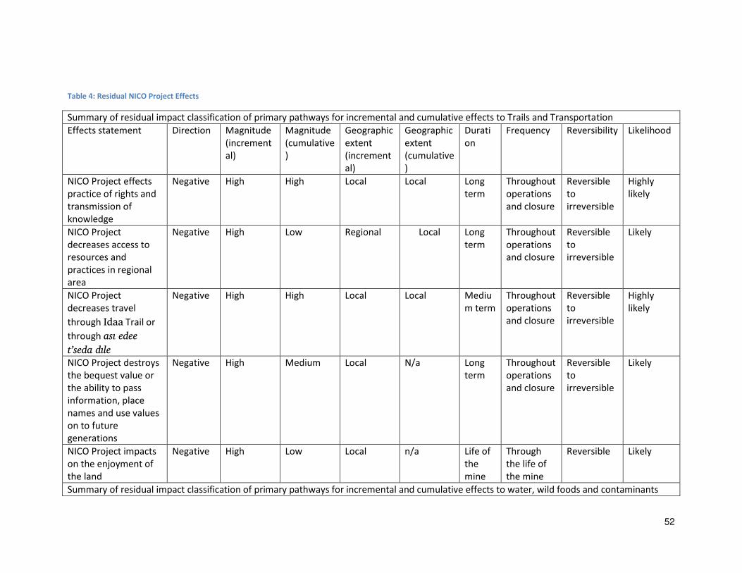
52
Table 4: Residual NICO Project Effects
Summary of residual impact classification of primary pathways for incremental and cumulative effects to Trails and Transportation
Effects statement Direction Magnitude
(increment
al)
Magnitude
(cumulative
)
Geographic
extent
(increment
al)
Geographic
extent
(cumulative
)
Durati
on
Frequency Reversibility Likelihood
NICO Project effects
practice of rights and
transmission of
knowledge
Negative High High Local Local Long
term
Throughout
operations
and closure
Reversible
to
irreversible
Highly
likely
NICO Project
decreases access to
resources and
practices in regional
area
Negative High Low Regional Local Long
term
Throughout
operations
and closure
Reversible
to
irreversible
Likely
NICO Project
decreases travel
through Idaa Trail or
through asi edee
t’seda dile
Negative High High Local Local Mediu
m term
Throughout
operations
and closure
Reversible
to
irreversible
Highly
likely
NICO Project destroys
the bequest value or
the ability to pass
information, place
names and use values
on to future
generations
Negative High Medium Local N/a Long
term
Throughout
operations
and closure
Reversible
to
irreversible
Likely
NICO Project impacts
on the enjoyment of
the land
Negative High Low Local n/a Life of
the
mine
Through
the life of
the mine
Reversible Likely
Summary of residual impact classification of primary pathways for incremental and cumulative effects to water, wild foods and contaminants

53
NICO Project
increases
perception of
water
contamination in
Datoti (Burke
Lake)or
surrounding small
lakes.
Negative High Low Local to
regional
Low Long-
term
Throughout
operations
and closure
Reversible
to
irreversible
Likely
NICO Project
decreases access
to culturally
important
subsistence
resources
Negative High Low Local n/a Medium Throughout
operations
and closure
Reversible
to
irreversible
Likely
Waterfowl, aquatic fur, and trapping
Restriction or
reduction in access
to subsistence
resources
Negative Medium Low Local N/a Medium
term
Throughout
operations
and closure
Reversible
to
irreversible
Likely
Caribou and moose
Habitat for moose
and caribou is
decreased
Negative Medium Low Local n/a Long term Throughout
operations
and closure
Reversible
to
irreversible
Likely
Access is increased
to herds and slows
the recovery of
Bathurst caribou
Negative Medium Low Regional Regional Medium
term
Throughout
operations
and closure
Reversible
to
irreversible
Highly
likely
Intangible cultural resources
Restriction of
cultural knowledge
Negative High Medium Local n/a Long term Throughout
operations
and closure
Reversible
to
irreversible
Highly
likely

54
5.5.1 Determination of Significance
Significance determinations have not been made by the Firelight Group. As the Review Board has
acknowledged, significance is best defined by the culture holders themselves. “The Review Board relied on the most reliable and accurate experts it could when making its determinations about cultural
impacts—the Aboriginal cultural groups themselves. Cultural impacts are best identified and addressed
when relayed by the holders of the cultural knowledge, the community members themselves (MVEIRB
2005).
Section 6 Summary and Conclusion
The proposed NICO Project is within and surrounded by lands historically and currently relied upon by
Tåîchô citizens for the practice of knowledge, use and rights, including hunting, trapping, gathering,
fishing, and associated cultural and livelihood practices. Analysis of mapped data demonstrates that
lands and waters within the LSA and RSA have been widely used by Tåîchô citizens over a long period of
time and continue to hold value. The area continues to be used. These lands and waters also include
unique and important species-specific values (including preferred fishing sites and harvesting areas for
moose and caribou) integral to the for the meaningful practice of Tåîchô citizen rights and interests set
out in the Tåîchô Agreement, as well as location-specific values (including habitation areas,
transportation corridors, and other values). Reliable, peaceful, and unimpeded access to preferred
areas that are historically known and personally familiar is integral to the transmission and current and
future practice of Tåîchô knowledge and use within the Project footprint, LSA and RSA.
Based on the baseline assessment, the Project will have an impact on Tåîchô knowledge and use,
including (i) the use of lands and resources by Tåîchô citizens, and (ii) unique heritage resources
(tangible and intangible) of value or concern to the Tåîchô people and Government.
In summary, this report finds the following conclusions:
1) The data shows where Tåîchô have used the entire area and specific sites. They have been
there, are there presently, and will return in the future.
2) Based on the baseline assessment, the Project will likely have an impact on wildlife, fish
and plant harvesting and effect the social and cultural environment and heritage resources; and
3) Tåîchô Government will be providing recommendations on measures to mitigate these
effects.
55
6.1 Recommendations
The primary recommendation of this assessment is that Fortune Minerals, and the Federal and
Territorial Crown undertake a process agreeable to and involving the Tåîchô to ensure that adequate
quantity and quality of resources exist for the continuation of Tåîchô knowledge and use into the future.
Where impacts to Tåîchô knowledge and use cannot be avoided then they should be mitigated to below
a significant level, using effective strategies, subject to monitoring agreeable to the Tåîchô.
The Firelight Group finds, based on the data collected for this report, that there will be significant
adverse impact on the traditional use and knowledge of the Tåîchô people, on the socio-cultural
environment. There is potential for loss of use, loss of knowledge, and effect on this into the future.
The effects of the proposed Project, though small on the landscape, can radiate out to impact on
confidence for use in the area. The mitigation and monitoring on this component in particular will be
vital to the continued use of this area for Tåîchô people.
The Firelight Groups recommends that further research be undertaken to gain a deeper understanding
of the traditional knowledge that exists in this area.
The Tåîchô Government will review this report and provide mitigation and monitoring
recommendations in the presentation to the Review Board to be made before the public hearings.
6.2 Closure
Should there be questions or clarification required regarding this report and assessment, please email
requests to [email protected].
Signed DATE.
ORIGINAL SIGNED
Rachel Olson, Ph.d (Candidate), Social Anthropology
Director
__________________________
The Firelight Group
864 Dunsmuir, Victoria, BC, V9A 5B7
T: +1 (604) 770-4566
C: +1 (778) 686-4547
56
Section 7 References Cited
Andrews, T.D. (2011). ‘There will be many stories”: Museum anthropology, collaboration and the T h . Doctoral Dissertation, University of Dundee, Scotland, 2011.
Basso, K. (1996). Wisdom Sits in Places: Landscape and Language Among the Western Apache.
Albuquerque: University of New Mexico.
Berkes, F. (1999). Sacred Ecology: Traditional Ecological Knowledge and Resource Management.
Philadelphia: Taylor & Francis.
Candler, C., R. Olson, & S. DeRoy. (2010). As Long as the Rivers Flow: Athabasca River Knowledge, Use
and Change. Edmonton: Parkland Institute, University of Alberta.
Health Canada. (2005). Addressing Pyschosocial Factors Through Capacity Building: A Guide for
Managers of Contaminated Sites. Ottawa: Ministry of Health.
Hegmann, G., C. Cocklin, R. Creasey, S. Dupuis, A. Kennedy, L. Kingsley, W. Ross, H. Spaling & D. Stalker.
(1999). Cumulative Effects Assessment Practitioners Guide. Hull, Quebec: Prepared by AXYS
Environmental Consulting Ltd. & the CEA Working Group for the Canadian Environmental Assessment
Agency.
Helm, J. (2000). The People of Denendeh: Ethnohistory of the Indians of the Northwest Territories.
Montreal & Kingston: McGill-Queens University Press.
Helm, J. (1994). Prophecy and Power among the Dogrib Indians. Lincoln and London: University of
Nebraska Press.
Helm, J. (1972). The Dogrib Indians. In Hunters and Gatherers Today, ed. M. Bicchieri, pp. 51-89. New
York: Holt, Rinehart and Winston.
Helm, J. (1965). Bilaterality in the socio-territorial organization of the Arctic drainage Dene. Ethnology 4:
pp. 361-385.
Helm, J., Gillespie, B. (1981). Dogrib oral tradition as history: War and peace in the 1820s. Journal of
Anthropological Research 37(1): 8-27.
Helm, J., Lurie, N. (1966). General background: The Dogrib hand game. Ottawa: Department of Secretary
of State, National Museum of Canada. Bulletin 205.

57
Legat, A. (2007). Walking the land, feeding the fire: A T h ethnography on becoming knowledgeable. A
thesis presented for the degree of Doctor of Philosophy in Social Anthropology at the Univ. of
Aberdeen, Scotland.
Legat, A. (2012). Walking the land, feeding the fire: A T h ethnography on becoming knowledgeable.
University of Arizona Press.
Legat, A., and G. Chocolate. (2012). Boreal Caribou Habitat and Habitat Use in Wek’eezhii. Tlicho Knowledge Component. Prepared for the Wek’eezhii Renewable Resources Board. Yellowknife, NT.
Legat, A., Chocolate, G., Chocolate, M., Williah, P., Zoe, S.A. (2001). Habitat of Dogrib traditional
territory: Placenames as indicators of biogeographical knowledge. Whàehdôò Nàowo Kö Dogrib Treaty
11 Council. Yellowknife, NWT, Canada.
Legat, A., Chocolate, G., Gon, B., Zoe, S.A., Chocolate, M. (2001). Caribou migration and the state of
their habitat. Whàehdôò Nàowo Kö Dogrib Treaty 11 Council. Yellowknife, NWT, Canada.
Mackenzie Valley Environmental Impact Review Board (MVEIRB). 2005. Letter from MVEIRB to the
Minister of Indian and Northern Affairs re: New Shoshoni Venture Preliminary Diamond Exploration.
Yellowknife, NT: MVEIRB.
Management and Solutions in Environmental Science. (2010). Effects on Traditional Resources of the
Athabasca Chipewyan First Nation: The Joslyn Creek Project Specific and Cumulative Effects in the Oil
Sands Region. Report prepared for Athabasca Chipewyan First Nation.
Northwest Territories Department of Environment and Natural Resources, and Canadian Department of
Indian Affairs and Northern Development. (2010). Northern Voices, northern waters: NWT Water
Stewardship Strategy. Yellowknife, NT.
Palmer, A. (2005). Maps of Experience: The Anchoring of Land to Story in Secwepemc Discourse.
Toronto: University of Toronto Press.
Ryan, J. (1995). Doing things the right way: Dene traditional justice in Lac La Martre, NWT. Lac La Martre
Band Council, Dene Cultural Institute. Yellowknife, N.W.T, Arctic Institute of North America.
Tobias, T. (2000). Chief Kerry’s Moose: a Guidebook to Land Use and Occupancy Mapping, Research
Design and Data Collection. Vancouver: Union of British Columbia Indian Chiefs & Ecotrust Canada.
Tobias, T. (2010). Living Proof: The Essential Data-Collection Guide for Indigenous Use-and-Occupancy
Map Surveys. Vancouver: Ecotrust & the Union of British Columbia India Chiefs.
United Nations Public Administration Network. (2006). A Comprehensive Guide for Social Impact
Assessment. Centre for Good Governance.
Vanclay, F. (2003). International Principles for Social Impact Assessment. Impact Assessment and Project
Appraisal, 21(1), 5-11.

58
Section 8 Appendices
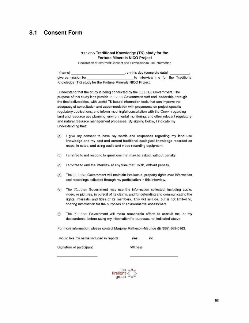
59
8.1 Consent Form

60
8.2 Interview Guide
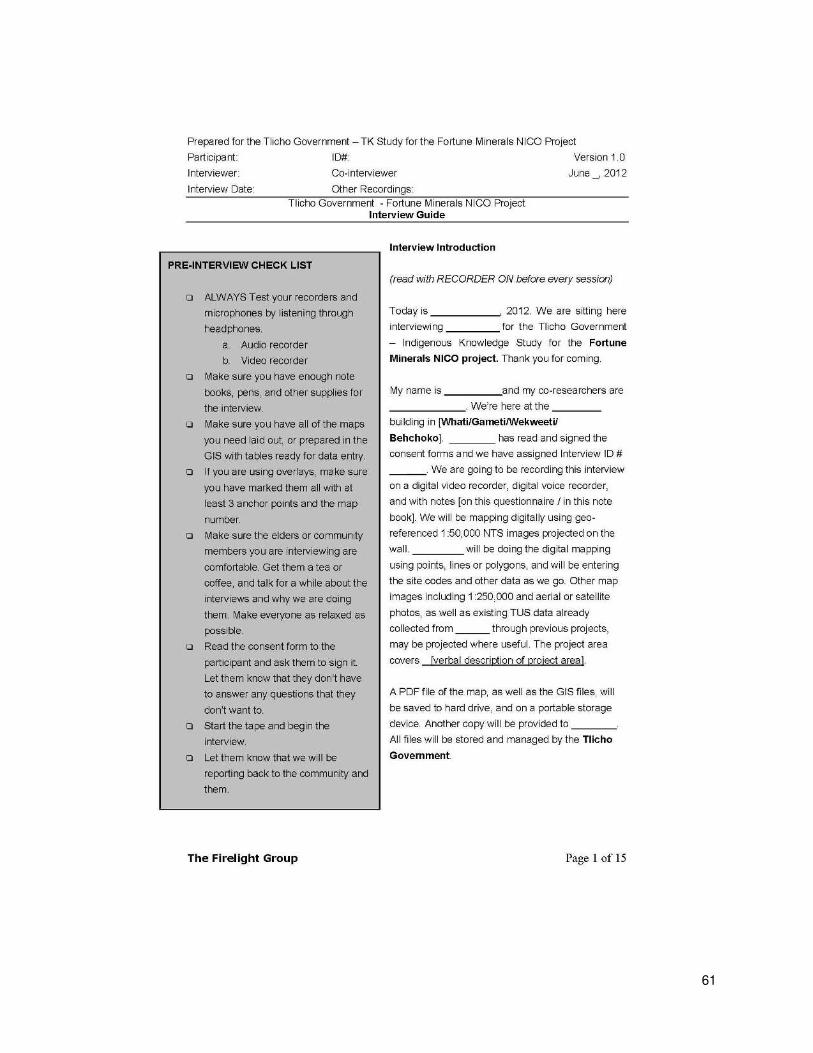
61
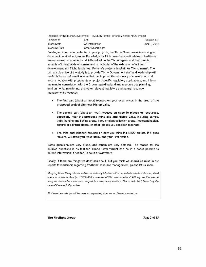
62
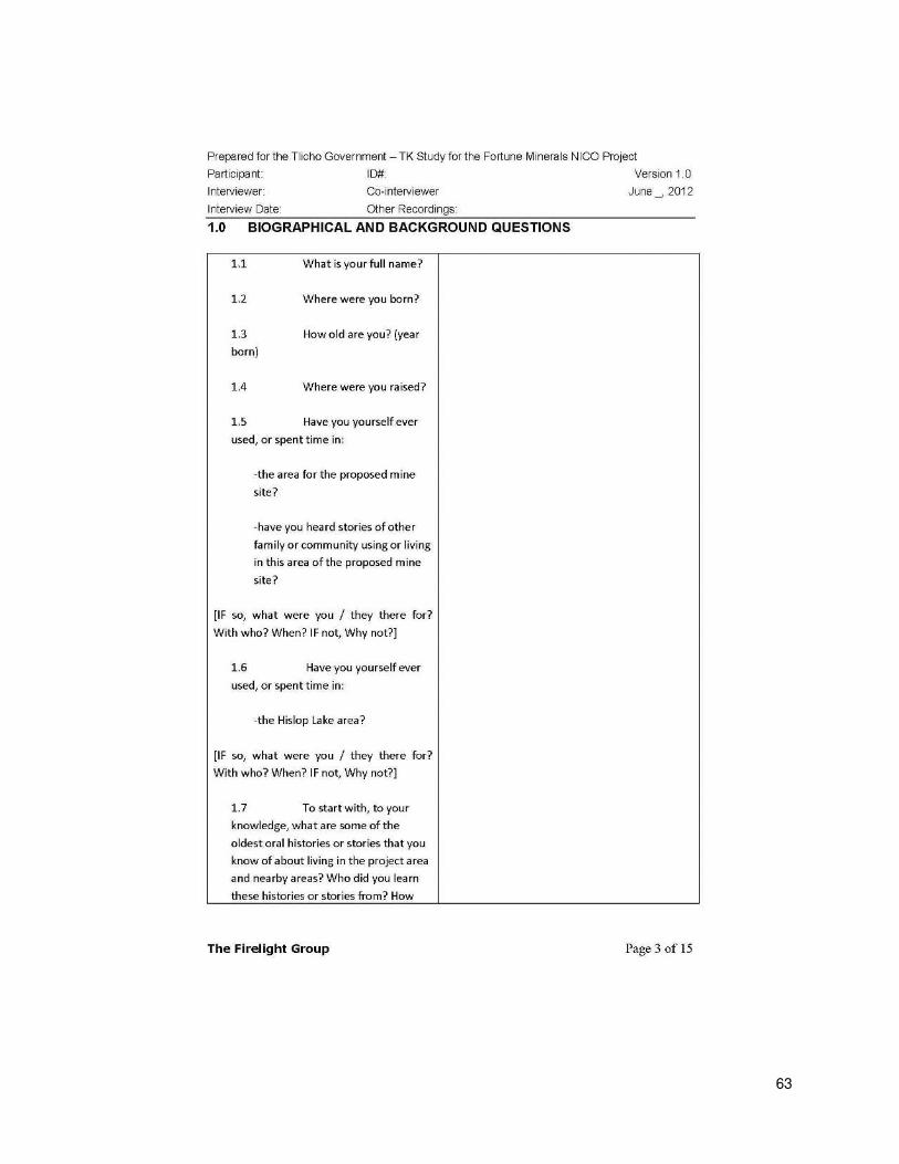
63
64
65

66
67
68
69
70
71
72

73
74

75

76
8.3 Direct to Digital Capture Method
The methods for spatial data capture (direct to digital mapping) for the study were developed by Dr.
Craig Candler and Steven DeRoy of the Firelight Group and were designed to reliably document detailed
First Nation community use, knowledge, and avoidance in relation to the industrial projects.
Interview Team and Materials
Interviews were conducted with at least two team members present, plus the participant. One team
member was primarily responsible for conducting the interview and taking hard copy notes. The second
member was primarily responsible for managing the mapping software and recording data within the
mapping software used, in this case Google Earth or Google Earth Pro. All interviews were mapped
using Google Earth Pro version 6.0.2 running on a windows based laptop with a tablet pen, necessary
for drawing lines and areas. A digital projector and laser pointer, digital video camera, and tripod were
also used as part of the mapping kit.
Study Area
The study area and the ability to navigate in Google Earth were explained to each participant at the
beginning of the interview through reference to maps projected on the wall.
Base Maps
Google Earth imagery was chosen as the digital base map for mapping sites. Using a projector, the map
image was projected onto a clear wall or screen. In order to improve readability and help the
participant orient themselves, other geographic information system (GIS) shape files were overlaid on
top of the Google Earth image. Where conversion from other formats was required, a licensed version
of Google Earth Pro was used. Supplemental GIS data originated from the following Government of
Canada online GIS data repositories or other sources, including the following.:
• National Framework – Hydrology, Drainage Network:
ftp://ftp.geogratis.gc.ca/frameworkdata/hydrology/analytical/drainage_network/canada/
• Atlas of Canada 1,000,000 National Frameworks Data, Canadian Place Names:
http://www.geogratis.gc.ca/download/frameworkdata/popplace/
• National Framework Canada Lands Administrative Boundary (CLAB) Level 1 (First Nation
reserves): http://www.geogratis.gc.ca/download/frameworkdata/Cda_Lands_Adm_L1/
• National Topographic System 1:50,000 reference grid: ftp://ftp2.cits.rncan.gc.ca/pub/index/
• Data regarding the footprint of the proposed project
Interview Process
In Google Earth, a folder called “TEK” was created to store all new mapped data. Each participant was given a folder named by their participant code (e.g. T01). Within the participant’s folder, three folders were created to store newly mapped data. For example, participant “T01” had points stored in the T01_points folder, lines in the T01_lines folder, and areas in the T01_areas folder. Each participant’s mapped data (points, lines, and areas) were saved as a Keyhole Markup Language (KML) file. The entire
database was stored as a KMZ file (KML files are often distributed as KMZ files, which are zipped KML
files with a .kmz extension).
77
We mapped new sites using Google Earth at a scale of 1:50,000 or better. That being said, most sites
were mapped at a scale of 1:5,000 or better, increasing the accuracy of the location of sites identified.
Where possible, we added timestamps to include month or season, and the year the activity occurred.
In some cases, people were able to identify specific dates or the beginning, middle, or end of a month.
At the end of the interview, audio files were saved in an audio folder and all video files in the video
folder on the computer. Names for audio and digital files were saved in the following format:
[Participant ID]_[Participant Name]_[Interview Date MMMDDYYYY]_[file#].[file type]
For example, M01_JOHNDOE_FEB282011_1.mp3
Post-Interview Data Processing
After the interviews were completed, the data was backed up onto a portable hard drive. All data was
mapped using a standardized Universal Transverse Mercator, Zone 12 projection. We downloaded a GIS
conversion tool developed by the Department of Natural Resources for the State of Minnesota called
DNR Garmin
(http://www.dnr.state.mn.us/mis/gis/tools/arcview/extensions/DNRGarmin/DNRGarmin.html). DNR
Garmin is a reliable tool to convert points, lines and areas collected in Google Earth KML format to ESRI
Shape file format. KML files (e.g. M01_points.kml) from the “KML” folder were converted into Shape
files (M01_points.shp) and stored in a folder called “Shape.” Each dataset was checked for consistency and accuracy before converting new data files.
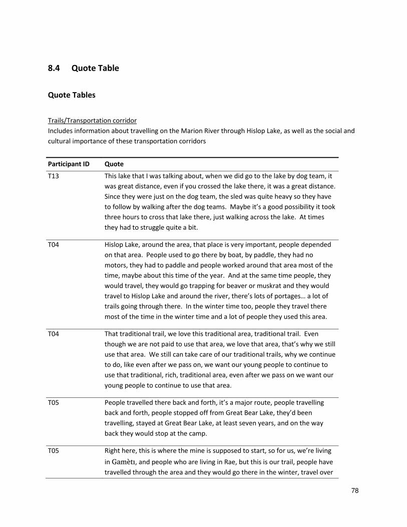
78
8.4 Quote Table
Quote Tables
Trails/Transportation corridor
Includes information about travelling on the Marion River through Hislop Lake, as well as the social and
cultural importance of these transportation corridors
Participant ID Quote
T13 This lake that I was talking about, when we did go to the lake by dog team, it
was great distance, even if you crossed the lake there, it was a great distance.
Since they were just on the dog team, the sled was quite heavy so they have
to follow by walking after the dog teams. Maybe it’s a good possibility it took three hours to cross that lake there, just walking across the lake. At times
they had to struggle quite a bit.
T04 Hislop Lake, around the area, that place is very important, people depended
on that area. People used to go there by boat, by paddle, they had no
motors, they had to paddle and people worked around that area most of the
time, maybe about this time of the year. And at the same time people, they
would travel, they would go trapping for beaver or muskrat and they would
travel to Hislop Lake and around the river, there’s lots of portages… a lot of trails going through there. In the winter time too, people they travel there
most of the time in the winter time and a lot of people they used this area.
T04 That traditional trail, we love this traditional area, traditional trail. Even
though we are not paid to use that area, we love that area, that’s why we still use that area. We still can take care of our traditional trails, why we continue
to do, like even after we pass on, we want our young people to continue to
use that traditional, rich, traditional area, even after we pass on we want our
young people to continue to use that area.
T05 People travelled there back and forth, it’s a major route, people travelling back and forth, people stopped off from Great Bear Lake, they’d been travelling, stayed at Great Bear Lake, at least seven years, and on the way
back they would stop at the camp.
T05 Right here, this is where the mine is supposed to start, so for us, we’re living in Gamèti, and people who are living in Rae, but this is our trail, people have
travelled through the area and they would go there in the winter, travel over
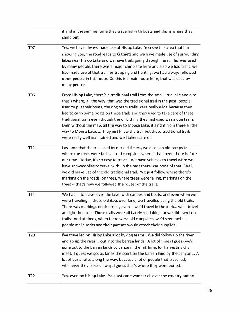
79
it and in the summer time they travelled with boats and this is where they
camp out.
T07 Yes, we have always made use of Hislop Lake. You see this area that I’m showing you, the road leads to Gamèti and we have made use of surrounding
lakes near Hislop Lake and we have trails going through here. This was used
by many people, there was a major camp site here and also we had trails, we
had made use of that trail for trapping and hunting, we had always followed
other people in this route. So this is a main route here, that was used by
many people.
T06 From Hislop Lake, there’s a traditional trail from the small little lake and also that’s where, all the way, that was the traditional trail in the past, people used to put their boats, the dog team trails were really wide because they
had to carry some boats on these trails and they used to take care of these
traditional trails even though the only thing they had used was a dog team.
Even without the map, all the way to Moose Lake, it’s right from there all the way to Moose Lake, … they just knew the trail but these traditional trails
were really well maintained and well taken care of.
T11 I assume that the trail used by our old timers, we'd see an old campsite
where the trees were falling -- old campsites where it had been there before
our time. Today, it's so easy to travel. We have vehicles to travel with; we
have snowmobiles to travel with. In the past there was none of that. Well,
we did make use of the old traditional trail. We just follow where there's
marking on the roads, on trees, where trees were falling, markings on the
trees -- that's how we followed the routes of the trails.
T11 We had … to travel over the lake, with canoes and boats, and even when we were traveling in those old days over land, we travelled using the old trails.
There was markings on the trails, even -- we'd travel in the dark... we'd travel
at night time too. Those trails were all barely readable, but we did travel on
trails. And at times, when there were old campsites, we'd seen racks --
people make racks and their parents would attach their supplies.
T20 I've travelled on Hislop Lake a lot by dog teams. We did follow up the river
and go up the river … out into the barren lands. A lot of times I guess we'd gone out to the barren lands by canoe in the fall time, for harvesting dry
meat. I guess we got as far as the point on the barren land by the canyon … A lot of burial sites along the way, because a lot of people that travelled,
whenever they passed away, I guess that's where they were buried.
T22 Yes, even on Hislop Lake. You just can't wander all over the country out on

80
the lake, because we just don't follow up on the river because there's a lot of
open water on the river, and some currents on the lake. You have to kind of
cross this area to the lake, our way.
T22 There's one area that we had to port, all the way down the [Marion] river, up
the river, by canoe, paddling. Whenever night falls I guess, between the time
we sleep, we don't paddle at night
T27 So when we did travel though, we would go to the lake or a smaller
one. We tracked the moose a short distance because once you get
down to the bigger lake, Hislop Lake, only then you can try to cross,
you could come over. The way things are, you're so close to one
another, going up to travel across the water. There were a few people
that for outlying regions they were coming, they would spend time
with us. There were people from Wekweèti… and a couple more
families made trips and spent time with us in Hislop Lake.
T27 Most of the people that encouraging the mine to develop, they haven't lived
at Hislop Lake in their time. Just other people right there said that some
traveling, he had a house there too. Rayrock Mine, today I guess it's an
abandoned mine now, now let's clean up out there. Prior to mining there, set
up on Hislop, on the Rayrock site, there used to be a trail, a dog team trail,
the only route that we used to go in and out to the area, but right now it's not
used intensively because of the possibility of contaminated water.
T28 Today if you want to travel and hunt, anybody out there, tourists, they are
free to do that. And then over time, I think things have changed, from the
days when people had to walk … But now today they use a lot of equipment
to go get water or something like that. Yes, our ancestors they did -- travel,
they did travel a lot only by foot, either that or by paddling the summer and
by snowshoe in the wintertime. There’s a reason why when I said I don’t know how to read the map -- those people only covered the land by foot, so
they know they land inside out
T28 There are a lot of times our ancestors used to travel to the barren lands and it
would freeze over there, and they’d have to walk back over ice. So a lot of times they’d leave their birchbark canoes, and today you see a lot of remnants of the....up behind the -- parts of birchbarks.
81
Fishing
Participant ID Quote
T04 The people, they used to travel around that area. And this is where they
would stay all through the winter, all through the year, if there was no
caribou, they would still stay around that area for fish because it was a good
fishing area. This is what they heard from the elders.
T04 White fish and if they set nets around the river area then they would fish
around the area and make caches around there and they would store their
fish there all winter long, they would use the fish, when it’s getting warmer, I guess they run out of fish so along the river this is where they used to [store
them].
T04 He set nets all around that area, this is where they used to stick the fish,
there was a camp there, there would stick fish around there…This is what they used to do. They make a dam so they would catch the fish back in the
fall time and in the spring…They make a dam, they put the logs over each other and the fish, they can’t go through it so they don’t go the other way. So if you make kind of like a cache, they put it in the foundation and then they
make kind of like a floor and they will put three logs over it and where the
opening they would just leave the opening there.
T04 And around the river there’s about thirty caches, the old ones, there’s some old rotten caches there. When they take fish for the whole winter they
would just store the fish in there and then they would just leave them there
until they used it all.
T04 The dam that traps the fish and where it was going to go in the water, it’s kind of like…. At the end it kind of goes up and then down, it’s where you make the foundation, you just level over it and then you put a log, three over
each other and the fish would go over it. And you catch fish in about two
days, you going to fill out the whole cache, you catch about two hundred
fishes in two days with nets, then you won’t catch that much fish, so the fish, they just go into it right away. And all the fish will fill the whole boat in one
trip and they would take it out and make another trip again and then they’d go again. So they catch fish fast that way, this is how the ancestors, they
used to make [fish caches]. When they finished with it they take it out
again… so they would just take it apart again, so whoever wants to use it they
use it, other than that the other people they would use it too, one after
another. So this is how the ancestors used to live of the fish.

82
T04 Our forefathers have used that area for a long time. That Hislop Lake, people
used to go there all the time. That’s a good area for fishing, they want an area, go to Hislop Lake, that’s a good fishing area.
T05 A lot of people have made use of that area, a lot of good fish on both sides.
It’s good to eat that fish so in the past they would hardly any caribou in that
area, they would just go around, just below the tree line, years ago, they did
not go too way below the tree line but there were caribou out there by the
tree line, the caribou would not migrate through that area like they do today
so the reason why it was used, it’s a really good area for fishing.
T05 All that way and from living from that camp, they used to walk all the way,
they used to use snowshoes and also there was two little pups that were
hitched into a harness and they used to pull the weight of the fish back to the
camp on a toboggan.
T05 Our ancestors, all of that area had been used, all along the river and then also
along the other river, there’s a lot of good fish as well on both sides, this and all the way up over there.
T01 From here, Hislop Lake, my uncle knows the way, in the springtime we travel
for muskrat, travelling and our dad used to travel along that area and at one
time we would travel on the river and it would take us a couple of days and
we would come to Hislop Lake. And this is where they camped and this is the
most important place because even travelling from Rae, you would stop there
around that area because there’s good fishing area and they have fishing cabins and if you go travel around that area, it’s always the best time to stop there, even in the winter, because when you travel through the winter, you
have to get fish there. It’s just like you got a big travelling bag.
T01 When people go there [Hislop Lake], they stop there and maybe they fix up
tent, and people they go trapping, they stop there along that river, mostly all
the time. And that’s a very important place like they have to hold onto it just like holding it in their hand. In the fall time, they go fishing, it’s just like there’s something kept for you.
T10 With ten canoes, we'd use the Hislop River and all along the river, so and also
right on K’iàgoti. And also from K’iàgoti all the way to Behchokö.
T12 The lake was really good. It was clean and clear, a lot of good fishing. And
then in the fall there would come beaver and also in the fall time they would
build a pen, a cache pen, and catch the fish there. … in the winter time, they stored all the fish that they could gain, and stick it up in pens, in cache pens,
and make that use throughout the winter, to always have a food supply for
83
dog team.
T14 The reason why the people used to go there [Hislop Lake] a lot is there
used to be a lot of fish … people that used to live there mostly what they would do is fishing and living on fish.
T19 Most of the people spend springtime around the area [Hislop Lake], some
cases they had a freeze up right there in the area. And they go up Hislop
River. They even on the river I guess, in order to, to get more fish, they make
up some kind of fish ladder … If you don't want to use a net, what they could use, they could use a fish trap. So that's how they harvest their fish. The
river itself is not a fast-moving river, so it's just far enough so that the fish
traps I guess on the setup, setup about 20 or so logs together, and then just
like a scoop I guess just fish on the river like a funnel
T19 [There is] a lot of fishing areas around that Hislop Lake River. Then the river
goes right back down to Marion Lake
T20 We travelled on the Rayrock mine area a long time ago … we caught a big, jumbo white fish. The size of the fish was so huge that we [caught] about 40
of them, and one motor toboggan and it was hard for the dog team to pull it
… we no longer go out, back to that area for trapping, hunting and fishing anymore, because the water is polluted in the area. We can't drink water
from that lake either.
T21 Yes, all kinds of fish on that Hislop Lake. You name it, most of the fish, even
[call suckers?] and [losh?], whitefish, [ecro?], yes there are some pikes. I
don't know about the trout, but... yes, [there] is a lot of fish, all kinds of fish,
and the fish are healthy and big. And hardly anybody goes there now maybe
the population has increased. A lot of fish in that area right now.
T26 the most we could catch is probably 50 whitefish. Back them days you know
they don’t have the long nets because, the 50 yard or whatever, I mean -- once the mines developed, like I said, all this stuff that’s available for harvesting might not be available in the future.
T27 Although we got a lot of fish out there, the type of fishes out there, we make
some grind fish out of it and then sometimes we just slice it in half and smoke
it, and then try to preserve it for future, for the dogs. And then we had a
setting out in the land, we have a place or a tank.
T27 There used to be a lot of fish in that area, right on this area, where we used to
-- -- the creeks up over there. They say a lot of fish I guess, there's a lot of fish
that pass down up through. There's not only one area. There's an abundance
84
of fish, the fish is abundant all over the area, on the river.
Caribou and moose (hunting)
Includes areas and habitat important for these species, and captures impacts to these values from
transportation corridors and other linear features, contaminants in the environment, and loss of
habitat.
Participant ID Quote
T13 This lake here, there’s a large rock hill there, when we were travelling there with the dog team, you see that hill there, this is where we entered the lake
there, that’s where we entered the lake a long time ago with a dog team, that’s how they travelled a long time ago. We travelled by the shoreline and
then there was another old trail going to Rae Lake. Today we have another
trail, dog team, normally that’s where we camp, near Hislop Lake. And the elders would tell us this. Don’t go to this area, the ice is very thin in this area,
it’s not safe, the only time they went there, that area, was when the caribou were able to use that area.
T13 But this is a story that I will share with you. It must have been in the spring,
Charlie was with me, Charlie ……….. was with me, we went there with dog team. We knew where people made use of land, they would talk about this
area, elders always talked about this area. I have worked many times with
many elders, at times we would sit with them and so they shared stories with
us and many people have made use of this area. As you know the area we
are talking about, a good fishing area, as for woodland caribou, there was no
woodland caribou, there was caribou, caribou used that land in this area.
This area that I’m showing you is all caribou land, all the way to Gamèti.
T13 This area is mostly used by animals, we go prepared for hunting in that area,
even with dog team, we used to go there for caribou, we did utilize trucks
and snowmobiles to go hunting in this area. It’s a fine hunting area for us… When I think about it, I always think about the animals on the land which I
have used for food. I have never had commercial (store-bought) food but I
always depended on wildlife off the land.
T04 And if they should go by boat and they shot some caribou they would store
the food in between the rocks, the rock crevices and this is how they stored
their meat. And they would put the meat, because at the same time there
was ice, so they would hang their meat in there too to keep it for later. And
then they cover it up so it would keep cold all summer. It was just like a
freezer when they covered it up through the crevices.

85
T04 Yeah, we all travelled around that area, where the river goes, he said he
stayed there all summer long, at Hislop Lake and they would travel around in
the fall time and there’s moose and they would listen, hear where the moose would be, they’d go hunting for it, and they would stay on a couple of those hills to look out for the moose. They would listen and look around for it. And
if they see ……., they would follow to the moose and that was how they used to hunt.
T04 See where the Fortune Minerals mine is, right on top of those hills, they
would walk, it would take them I don’t know how long, maybe a night maybe, but they used to get on top of that hill, at night, they would listen to see if
there was any moose that’s making noise during the mating season. They would hear a noise, let’s just say, over there and then during the day
whatever they were hearing a moose, during the day they would walk over.
T04 Let’s just say if there was a noise of moose from the area, if someone was sitting on the hill, when the wind is blowing that way, the moose will
probably be able to smell him so they wouldn’t go there, they had to watch out for the wind. Only if the wind is blowing this way, they would go there.
They would listen for the moose all night, just when the daybreak comes,
they would go there.
T05 When the caribou were migrating back to the calving grounds, right around
the lake, over here, all along the lake, when the caribou were migrating back
to the calving grounds, the whole of the lake, you can see all over the lake.
T07 The caribou used to migrate to that area, when the caribou used to migrate
from the calving grounds, all the way from there, that’s the way it was, when the caribou migrate to the treeline and just below the hill, like Hislop Lake,
we used to hunt over there. I’m pretty sure that is the main migrating, there
must be a lot of caribou trails, caribou have used that area where the Fortune
Minerals mine is about to, but they used to migrate through there and
towards us all the way to Whatì from there.
T03 But then now since there is mining and it got here and all that, you
hardly see [them] – the [caribou] hardly go around that area where
there’s mining.
T06 They used to go there for muskrat, beavers, they used to go there [Fortune
Mine Site] for hunting, that’s the only area they use for hunting for moose and the caribou would migrate to that area, the caribou would hang around
this.
86
T06 In the fall time we used to shoot moose in this area and also when the
caribou used to come around, they used to go to Chimnee [?] and Hislop
Lake, when the caribou migrate to this area. There is one, in the month of
Easter, in the month of April, I had shot three caribou through there on the
winter road, just where the winter road exist.
T06 The caribou would not go to the burned area, they would usually hang
around the non-burned area where the forest fire was … Because their food would be destroyed by the forest fire… The only thing that will regrow is just probably a few plants that will regrow and all their food, lichen and so forth,
will all be destroyed by forest fire so the caribou would not hang around
where the forest fire was.
T10 So Hislop Lake, where the Carl's Mine is, normally you have caribou migrating
path through that area where the mine is. It would come to that mine site to
our area, to our land and then it goes back, take the same route back to the
land, they would bypass the mine site. That's a migrating path for the
caribou.
T11 if the chemicals go to the contaminated area, if the chemical’s contaminating stuff and it goes out into the environment, the caribou rely on lichen. So, in
the summer, the caribou will eat lichen, and some of those shrubs … the caribou will get ill, it will be unhealthy -- it won't be healthy, and so if the
mining goes ahead, the caribou are sensitive to noise, then the caribou will
avoid those areas.
T19 We do hunt from here because some caribou on Hislop Lake, and if we can't
find any caribou on Hislop Lake, we go down to the northeast area and that's
where we go down to the Hislop Lake where there's a cabin on Hislop Lake … used to be a village one time, there's still a lot of houses there right now it's
more or less abandoned cabins. Sometimes we use those houses to
overnight because all depending if we carry our own gear such as tents. This
whole area, yellowish dotted line, that's where the elders, used to be a village
right there, right on that land
T19 The area, all the area is not that damaged right now I guess, so area's pretty
well clean and, so that the animals are free to roam around that area, which
is good. And even the bay, you could always paddle over there and we don't
have any problem killing any, lot of moose out there.
T19 We killed maybe 30 or more [caribou in the 1960’s], might seem quite a bit but we used it for human consumption as well as dog teams. So we get the
scraps I guess dog team, most of the caribou meat we want to make dry meat
87
out of it. Yes, we were taught how to survive on our land and how to treat
land so I guess we take what we need and then we don't waste anything. We
even have to clean the guts to use it for you know dog food. The only thing
that's probably left at the camp is probably bones. Nowadays, the hunting
had changed I guess, a lot of wastage after the hunt. Back then I guess we
disposed our unwanted meat into land, even the hide I guess disposed well
on the land, so left on the lake.
T22 We shot over 30 caribou [on a hunting trip in the 70’s]. It was some time
after Easter. There were a lot of old folks that just barely made it back. I
guess the snow was all thawed out, and just little patches of snow that we
travelled all the way back.
T28 Before our ancestors, our forefathers used to -- they hunted the caribou in
brushback on a lake crossing … We harvested our meat and we didn’t waste any part of the caribou. We eat with the shinbones, all of those leg bones, we
use that, we bundle it up so that they dried up like that. And what they’d do, they’d use it for firewood in the wintertime. So nothing was really wasted.
Waterfowl, Fur bearing and Trapping
Participant ID Quote
T07 There’s another area, there’s a river there that comes to this lake here, near this lake. The elders have always had spring camp here. Spent a spring there
hunting beaver and muskrats.
T13 I would travel up to here, trap this area, from here I finally found my way to
go to Hislop Lake. When I camped overnight there I had dog teams by the
lake there, it was late at night, it was night time, because I know, I went out
to the lake with the snowshoes, I was kind of afraid because the ice might not
be too thick but I did walk across this area, I came across a trail, this trail was
used by a dog team, that’s the first time that he realized there was people trapping in that area. At that time I was just trapping.
T08 I have been making use of that area almost every year, we spent early fall in
that area and it will freeze in that area and then we spend the winter. And
right now we will go towards Gamèti into Whatì. We’ve been making use of the area for beaver hunting, we have made use of our canoes to travel
through the area, talk to Gamèti ………, at that time the lake was really
88
difficult to travel on, it was breaking up and I remember bypassing some
areas. There were old cabins in that area I remember which we bypassed and
we followed the lakes. I remember it was really late in the spring, the ice was
thawing out, most lakes the ice was thawing out, some lakes there was no
more ice on the lake, in the area to do the spring beaver hunting. Some of
these days, an area where it is good for birds, for ducks, waterfowl, there
were many lakes like that in the area, it must have been a good area for these
ducks and was good feeding area. I can remember it was dark with so many
ducks, and also he remembers they had set up nets, gill nets in that area, over
land, and they snared these ducks that were flying by and how they
harvested their ducks there, this is where, that area that I’ve pinpointed, where we done this and fishing for ducks and also we did some spring
hunting there for beaver and muskrat.
T10 You see this Hislop lake, all around the shoreline, at this time of year, many
beaver in that area. They're also in the wintertime. You can see many dams
and many lodges made by the beaver in that area. In the spring, you can see
all the markings made by the beaver, where they've gnawed on the trees and
where they have fed. And once, they will leave the area for the beavers,
leave it in the spring and come back, come back in the fall and live in the area
throughout the winter.
T12 There were many good fishing spots on that lake there. Many ducks, beaver,
muskrat. There was a bond up there.
T22 I think we killed a little over a hundred muskrat each [in the spring hunt of
the 70’s]. We saw some dead fish floating and some dead muskrat been floating around, just below the [Ray Rock] mine site. … There was approximately seven dead muskrats floating on the river.
T27 There were a lot of fish year round. We never ran out. Then the spring
comes down and then we've got to change to a different -- trapping for
muskrats and rabbits. Once the trapping season is over, then come to fishing,
and go back to the same area. Yes, it's an area there, it's a good area for
rabbits… We'd stop for drying meat and trapping smaller animals, we'd get
out of this, that's how we stored everything
89
Habitation/Gathering Place
Includes areas of habitation, elders growing up and living in the area surrounding Hislop Lake.
Participant ID Quote
T13 I want to share a story with you about Hislop Lake. Before when we used to
use our dog team, we used to go to that area with the dog team… Before that cabin was ever built, we used to go to that area… And also it was on top the hill but we did go up, we spent three nights over there, and from there we
used to hunt where the Fortune Minerals mine exists and also past that area.
My late brother and I was cold, we spent a night over there without a tent,
that’s when the elders used to tell stories.
T04 There was about six houses there. And there’s some old fireplaces there,
around there, there’s no houses there right now but there used to be, before there used to be houses, it’s just like there was a foundation around the area there, maybe they burned it. But the people they used, they lived there
before, a long time ago.
T04 But now, all the roof on top they were all made out of logs and the top of the
roof was made out of moss and in the corner they put the chimney, it’s big in the corner. Because it is made out of stones and it’s kept the house warm,
even when it’s cold in the winter time so now nobody lives around that area so he doesn’t know who used to live around there, so that was in the olden times, that was before the people that came around. So those log houses
were made out of wood. They just put logs over each other and they would
make a hole in there and they would put the logs together, this is how they
make the log houses.
T08 He always had his camp there. This area that you see here, this size of land, it
is a good area for moose hunting, mink, wolverines, there’s a lot of wolverines in that area, mink, moose, this old man used to base his camp
there quite often, it was his mink camp there because it was good there for
moose.
T06 There’s all kind of burial sites right around the whole of Hislop, people just go anywhere and go bury.
T10 As for that Hislop lake, a long time ago with the elders, the lake elders, they
had spent much of their strength on the lake there and after [Easter?], they
would have their spring there, the ice melting, they would continue to do
some hunting for beaver and muskrats. From there, they will travel all the
way to Marion Lake. They will have their spring break there, spring there on
the Hislop Lake, beaver hunting and muskrat hunting, once they have gained
90
enough [talk?], they will move all the way down the river to Marion Lake. So
this area always contained people. It never seemed to be without people in
this area, through winter, summer, fall, [K’iàgoti ] that lakes people have
travel through there every summer, every winter.
T15 But there’s a lot of people [40:00] in our family all living in this section [Hislop Lake] that we know we live only on the water. So even when
like for holidays or for gathering, things like that, we gather in {
Behchokö] and sometimes we travel there and live with our families
and we’re thinking about that lake; what’s going to happen in the future
T26 Yes, there are a lot of people are buried there. A lot of people are buried in
the, majority of people are buried on the end of Marion Lake Village, right on
the bay here, a lot of people are buried there, there’s a gravesite there. Right on the area where the, that’s where the graveyards are. It’s even along the Marion River on the shores a lot of people are buried along the river bank,
T26 This is where my uncle had a house on that island. We used to spend spring
hunt over there on the island. We’d go down the river. This is where we
have a freeze-up over there and this is where my uncle’s house, my grandfather’s house is on the end of Hislop Lake.
T26 Yes, if you actually move around a lot so some cases we don’t have a house, all you got to do is pitch a tent and just sit there anywhere between two,
three weeks to a month at a time.
T27 I used to remember when I was young… just a little baby. Years, I guess now,
we stayed in one area, on one lake. This is where we were hunting for
caribou. We would make some dry meat in the springtime after the spring
hunt I guess, when we go down to pick up, retrieving it and go get your corn.
A lot of times we go back there and then you have to freeze up you know,
what you had from the spring hunt, when the ice goes away. A lot of times I
guess around the parameter, it would take us not only down the Harbour
Lake area to go trapping. On the way, the caribou migrate inland, you'd see a
lot of caribou in the area. I think more or less we'd go hunting every year,
every season. A lot of times I guess, although we spent a lot of time at Hislop
Lake because I guess, for the people that scattered all over that part of the
region. Right on the -- where the river runs into Hislop I guess, that's where
we camped a lot of times there.
T27 We used to go out for fall hunting for moose. The only appropriate area for
hunting this area, would be where the mine is, the post. In the fall time,
91
when we were hunting moose, the area where I was okay with that, was this
area, good moose hunting.
Water, Wild Foods, Medicinal Plants and Contaminants Water, Wild Foods, Medicinal Plants and
Contaminants (drinking water, gathering foods, pollution)
Considers continued access of Tåîchô members to non-contaminated sources of water and wild foods,
including fish, berries and other plants; considers impacts on these values from industrial development
of the land.
Participant ID Quote
T05 There’s a small little pickerel but it’s nice and fat, in really good shape, that’s where they used to be. What they do, there was a note now that Fortune
Minerals are saying that there was a big note there right by the camp, at Lou
Lake, you are not to fish that lake…. Even after the sign has been cut down, people don’t go to that area to fish anymore because they are a little afraid,
they are concerned.
T05 Rayrock mine… he wouldn’t drink the water up there...up to Hislop, after that we can drink water, we’re scared to drink water from Rayrock mine.
T05 Concerned about this area, it’s a good fishing area. If they spoil the water, what is going to happen to the fish, this is what the people are worried
about, the fish around that area.
T07 So maybe there’s some exploration that’s happening at the Fortune Minerals, that’s why the caribou is avoiding using that area, they don’t migrate to that area like they once did.
T07 If the mine opens it doesn’t flow to area, it flows to Behchokö and also the
only place if flows from that NICO Project mine, it flows into Behchokö. If
they use the chemicals it will affect, we know, we really don’t know what kind of chemicals or stuff that they may be using. It’s in the middle of the Tåîchô Region, it’s the place of the caribou, the place of the wildlife, and also that’s where the caribou so we may not see any caribou going to that area because it’s right in the middle of the heart of the Tåîchô Region. Like
Rayrock , I remember, I have seen the kind of things that have occurred to
that area because of the Rayrock mine and also that if Fortune Minerals, if it
goes ahead, it flows into, it will have an impact on the wildlife, even with
humans, human health. If they use poisonous stuff, heavy chemicals, it may

92
be dangerous, so we may not have any wildlife from that area go to our
area. Because we really don’t know the outcome of that.
T01 That area that we’re talking about was very important and very useful, we were brought up around that area, around that Hislop area. Even the trees
provide medicines and it’s good for cold, all kinds of medicines that comes from plants and trees, it’s good for cold and not only that, the huge land that we have, ……………………. [1:18:26] but if the mine goes ahead, all the things
that were there will be spoiled one way or another once the mine goes
ahead. That’s one of the reasons sometimes you feel a little down, when you think about those kinds of things. You can’t say you feel good about, you don’t feel good about it … When you go out in the boat, you take a cup, just along the river, just anywhere you travel, you can dip your cup into the
river or the water or the lake but if the mine ever goes ahead, you won’t be able to do that.
T06 Even Rayrock , people do not, right now, avoid or do not use the Rayrock
area at all because it’s all been contaminated. So people do not use that area any more, have to avoid. … If the mine [goes ahead], … that area will never be the same. They’ll do what they have to do. If they want to consult
with the community, then this way we will say what we have to say to them.
Just look at some of these existing mines. They are just destroying our
environment, us elders, we’re not really going to benefit from it.
T09 When they took that minerals out of the ground [at Rayrock ], how
destroyed most of the things that, destroyed the fish that it was the plants,
fish, it really destroyed a lot of the plants and fish and even if you hunt in
that area, it's very difficult for the people.
T09 that lichen it's, it's a good caribou food substance, lichen, it's a really good
area for the caribou. That's where the caribou migrate to an area from
there. So we are concerned about the possible mine opening. It's going to
have the impact on the other caribou, the beaver, the muskrat, all the things
that we harvest we are concerned about, even the ducks, the ptarmigan, the
rough grouse, all the wildlife there we're concerned about.
T10 If they're gonna go ahead, we do not want our water to be contaminated
any further, or our land.
T15 We drink water, we make tea with water. So all the water, all the lake, even
the lake where the little river that joins -- we know what’s going to happen. And it’s all just like one like one big lake that drains together.
93
T17 When something is [dug] out, no matter what, like, in a year or two, they'll
put everything back in place, but it has been ruined, and it will never look
the same. Plus, if they have been drilling, and all the dust flies up, and the
wind picks it up, it -- the dust flies, and I suppose whatever the dust is -- how
far it goes, [00:20:00] an animal will come around and pick it up, and it's
going to -- is it safe to eat it? … So if we're looking at another dig-up right
now where they're talking about having that mine again, it's going to be
more like Ray Rock too, because of all the chemicals and everything.
T17 But we need to look more deeply into where the river flows. That's my
concern. And all the dust flying in the area is another concern from
underground. How many poison is in -- digging out of the ground? I'm
afraid for the animals and the people; so if they want to open the mine, it's
really good to look at both sides. The land and the water is my big concern,
because people live on the land.
T20 Yes, we're concerned about the abandoned area of [Rayrock ] mine, living
downstream from it, and then if another proposed mine is being developing
and get into production, we're living downstream from it too, so we have
two; one abandoned mine and one operating mine. It will have some impact
on this area for sure in the future.
T22 Just the migration, I guess it's controlled by the nature of the food that's
available for them I guess. They'll be able to migrate this way. I don't think
the pollution will cause all over the land. The only area that mostly
concerned is the tailing swamp ever leaked I guess, all that is going to go in
the water.
T26 back then days the elders, they knew what type of plants and what type of
trees are good for any illness I guess. They identified them. They depend a
lot on the traditional medicines. Even the blueberries and the cranberries, a
lot of animals really live on it too as well too because in the event that their
land is ruined in the future and what animal will be feeding on it? That’s even the grouse and the ptarmigans I guess all live on berries … a lot of people, they use a lot of spruce gum for chew as a gum and a lot of times
they use that to repair their canoes … They just dry it up and then the next thing they know they patch it up with spruce gum. So spruce gum is very
important too.
T26 Yes, back in days for healing purposes I guess a lot of people depend on the
traditional medicines. It’s a fear that once the development gets underway all the traditional medicines will disappear with it as well. Certainly this is
the point of view directly coming from our elders. They’re the ones that
94
have great concerns about what might happen after development, mine
develops.
T27 out on the Hislop River, the lake is not clean. All the animals and the fishes
in the river, they are not healthy. They used to have a lot of elders that used
to live there, like all around this place…. and grease in the water, where the
elders were. There were no moose there at the river. I guess nobody every
complained about diseased animal or disease of the fish or anything. The
fish were really healthy when you cook fish that is healthy. But today the
fish are all kind of soggy and kind of soft in some areas. On the area on
Hislop River, it was a good area for rabbits. They even got one mountain
named after rabbits, because of the abundance of the rabbits in that area.
It's an ideal area for caribou.
T27 The area where my grandfather had a house, the fireplace is still up,
although… used by some people that use it for firewood.
T28 back in those days you owned the land I guess, you went hunting, you could
survive. Today, people don’t --- we changed how we eat.
Intangible cultural resources (cultural, spiritual, etc.)
Considers ability of Tåîchô to continue transmission of language and traditional knowledge, and impacts
to this ability from industrial development of the land.
Participant
ID
Quote
T13 I want a good life for my people. A long time ago when people made use of land, people
did love each other, love was so strong amongst people, if they caught enough fish, they
would share their fish with each other. If one person killed some animal, they would
share the meat with each other, that’s how strong love was.
T04 So Hislop Lake, our father used to go hunting on the hill... all the way on the hill, this is
where they used to go sleeping on the hill and look out for moose… they used to go up there, so Hislop Lake… this is where our ancestors lived and this is where we used to
travel, we use the route today even in the summer, in the winter, if you’re hungry, we’ll go hunting for ducks, fish and this is what we live now, and where we travel through.
T04 we take our kids through the river, we want them to use it for the future, this is why we
used to travel through the river from there, from Gamèti to Behchokö.
95
T13 We do not know what the future will know but the minerals that is found in that area, if
they going to get the minerals out, so people, how will that affect the people in
Behchokö, will it be okay? Maybe it will affect them but you know Rayrock , yes, for
three years I’ve cut logs and woods.. now that he had created the sickness, they make me think, like he had caught an illness, maybe all my people. The river that flows on … is going to affect the land, the water, what’s going to happen to it and you know people will suffer from it. That’s what I think. When I think, I am over seventy-four years old, I’m an elder, maybe I may not be around for the next ten years, but the future of our little ones.
We should seriously take into consideration, seriously think about it. See about the
wildlife that the Dene people rely on, depend on, let’s think about that. That area, it’s beautiful country, when the caribou migrate they go to that area, it’s moose country, bear… in that area I have been work with the elders there a lot of time, when they used to share stories.. But when I think about it, when I personally think about it, when they
open that mine, will the water ever be the same? Galooti, it’s a really good fish area, in Hislop Lake, good fish… I recall when the elders would tell stories about this area.
T04 That is our area, we may lose all of our tradition areas, the different trails, in the winter
time we go from here to, we use that trail, and if they have some more buildings in that
area, will we ever be able to use that area and that’s a concern that I do have and a lot of us do not like that at all. Our ancestors and our forefathers really could use up that area,
that Hislop Lake, even though they have passed on, our ancestors, our forefathers that
have used that Hislop Lake area, even though they have passed, we still use that area.
T01 People from Gamèti, our ancestors, our forefathers and also from here to Hottah [?]
Lake, and also a lot of elders, I was born out on the land, other people and also every
elder that used that area, that’s where we come from. Our elders had to use that area,
that’s why there’s some burials there. And also we had used this area constantly, this is our area, this is our land, and also this is the place of our ancestors and this is where we
were born and raised and we had to use this area. The reason why, that is our area and
also we go back and forth, that is our area, this is our land. When the people used to live
out on the land, that’s why there are a lot of people that are buried there, around our area.
T01 look at the mining, it’s going to destroy everything, once that mine is there he’s going to destroy it, he’s going to contaminate it and destroy the river as well. Look around that area, look at the Galooti area, it wouldn’t be like before, it will never be the same once that mine goes ahead.
T01 There’s a lot of wildlife, people to depend on, a lot of good things, a lot of good wildlife in that area. And also some people would say what I’m saying now, that area was very, very useful. So when we went to that mine, it’s right on top of the hill, and also once it rained
from the top of that hill, the water will seep into the lake, some of these tailings will seep
96
into the river, to the lakes, and it will all go to Hislop River and it will go all the way to
Behchokö. In the future, after the time, after the people, these things will never be the
same near Behchokö, that’s the way we look at it. That’s why, and the people will suffer from the mine, the people from Behchokö and it will destroy the river, the lakes,
drinking water will be contaminated, polluted, it will destroy the fish as well, that’s what we think. When we think about it, we see if the mine’s going to go, once they take things, the ore from the mine, once the mine goes ahead, things will never be the same.
Everything will be destroyed, everything will be contaminated, this is what, in the past,
we learn from experience. We had taught ourselves someday, we’ve got some of those tasks exist in mind that this will occur.
T06 The days of the birch bark canoe, all of that area was used, the whole area was used for
hunting, people lived there before. People used to live year round, like my mom’s dad, they used to live in those area and they used it for harvesting moose, rabbit and in the
past there were a lot of people.
T06 All the elders have used that area and sometimes they used to have a tradition, it could
have been a handgame or a jump dance, have people gathered in that area, do you think
traditional activities took place up there, hand game or drum dance.
T09 This is the elder before he passed away, he spoke to his family members. He was talking
to you as he said according to his husband there's a place like a point, it's a point where
there's birch trees there. This old man said, "If you ever across where you're going
through a difficult time, pray over my grave, give me your message and I will give you
back what you're asking for.” This is what the elder said. So this is more or less a sacred
spot; sacred burial site. Beautiful.
T09 When you do hunt there [Hislop Lake], you will not be without any, you'll be fortunate if
you kill something there. So one of the things that they do is when they cross the Hislop
Lake, they will go to the gravesite to pray over the grave and ask for … things that they might need. It's a sacred place.
T12 And we had to carry all the children. It was a difficult life. The journey was tough, but
with our children -- we didn't have any money. We couldn't get money from … social assistance. We didn't have no traveling allowance. We couldn't get no money at all. The
only way we lived was gaining from the land. Animals and fish and things from the life.
But it was life.
T17 If I was to make a decision, I would leave as things how it is. Not open mine pits or things
like that. Because people had harvests to live on the land. They had traps and went
hunting, and that's how life used to be. But today as the new generation, people can't
live without hot dogs, hamburgers, Kentucky Fried Chicken. Everything is new to them,
and they are being raised on it. So compared to the old days, people do need assistance
97
or things like that. They used to live on the land, but today? No. Everybody has to go to
the store almost every day.
T26 Back them days people have to survive, they survived solely off the land hunting and
tracking, fishing. Back in those days, there’s no such thing as mattress.. (…), When a man killed a caribou, they used the caribou skin. They harvest anything out of a caribou. They
would use the hide for clothing. They used the hide for mattress too. Heard of a hide
mattress? Some of the families I guess don’t have equipment to go out trapping and don’t have the proper equipment too so it’s hard to go where they want to go.
T26 We were lucky if we had some tea and tobacco. People, they survived on back them days
with just… country food such as dry meat and dry fish. This is how I was brought up, it’s how I was raised … I could live through it and I could do it if I had to do it again. Early in the morning before the sunrise I guess one of our parents used to push out of our bed
and tell us to go out and check your net. Go check your net. Either that or go and check
your snares. Before meals that’s what they sent us out to do. Yes, despite the cold weather we did that and how windy it was or how cold it was. Some nights I guess we
even had to set a net in the cold winter nights he says. … You don’t, you’re not going to survive so we had to do that. That’s the majority of people to survive, that’s how they were brought up so that’s the reason they got great respect for the animals.
T28 Today, there’s nothing wrong with sharing our resources or whatever comes from the
land, but yet -- but what little comes from the government, and then they raised up all
the living conditions on us, the living conditions are too costly now.
T28 when I was at Hislop Lake. They had a beautiful land, beautiful scenery, and the water’s clear. And I was raised on the land, so I really enjoyed living there when I was there … We tried to make ourselves visible on the land, so when we’d see a broken twig, it was a description that we were there, so that’s how -- that’s how well we did respect the land.