ARCHAEOLOGICAL RPORT - binghamheritage.org.uk · roots, small skerry peb-bles, medium-grained...
13
CB35 VERNON HOUSE, MARKET PLACE ARCHAEOLOGICAL RPORT CONTENTS SITE HISTORY LOCATION AND PROTOCOL ANALYSIS OF RESULTS Description of pit Finds Interpretation
Transcript of ARCHAEOLOGICAL RPORT - binghamheritage.org.uk · roots, small skerry peb-bles, medium-grained...
CB35
VERNON HOUSE, MARKET PLACE
ARCHAEOLOGICAL RPORT
CONTENTS
SITE HISTORY
LOCATION AND PROTOCOL
ANALYSIS OF RESULTS
Description of pit
Finds
Interpretation
CB35
VERNON HOUSE, MARKET PLACE
SITE HISTORY
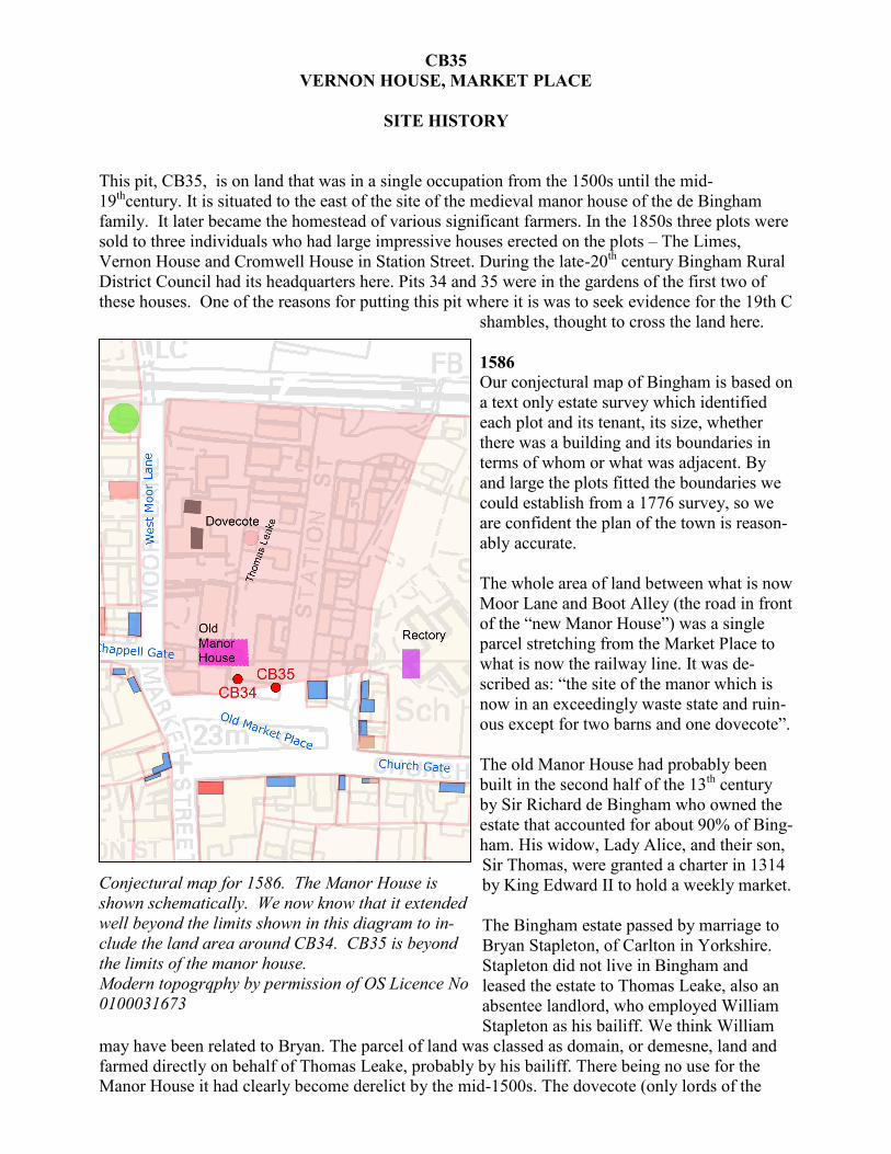
This pit, CB35, is on land that was in a single occupation from the 1500s until the mid-
19thcentury. It is situated to the east of the site of the medieval manor house of the de Bingham
family. It later became the homestead of various significant farmers. In the 1850s three plots were
sold to three individuals who had large impressive houses erected on the plots – The Limes,
Vernon House and Cromwell House in Station Street. During the late-20th century Bingham Rural
District Council had its headquarters here. Pits 34 and 35 were in the gardens of the first two of
these houses. One of the reasons for putting this pit where it is was to seek evidence for the 19th C
shambles, thought to cross the land here.
1586
Our conjectural map of Bingham is based on
a text only estate survey which identified
each plot and its tenant, its size, whether
there was a building and its boundaries in
terms of whom or what was adjacent. By
and large the plots fitted the boundaries we
could establish from a 1776 survey, so we
are confident the plan of the town is reason-
ably accurate.
The whole area of land between what is now
Moor Lane and Boot Alley (the road in front
of the “new Manor House”) was a single
parcel stretching from the Market Place to
what is now the railway line. It was de-
scribed as: “the site of the manor which is
now in an exceedingly waste state and ruin-
ous except for two barns and one dovecote”.
The old Manor House had probably been
built in the second half of the 13th century
by Sir Richard de Bingham who owned the
estate that accounted for about 90% of Bing-
ham. His widow, Lady Alice, and their son,
Sir Thomas, were granted a charter in 1314
by King Edward II to hold a weekly market.
The Bingham estate passed by marriage to
Bryan Stapleton, of Carlton in Yorkshire.
Stapleton did not live in Bingham and
leased the estate to Thomas Leake, also an
absentee landlord, who employed William
Stapleton as his bailiff. We think William
may have been related to Bryan. The parcel of land was classed as domain, or demesne, land and
farmed directly on behalf of Thomas Leake, probably by his bailiff. There being no use for the
Manor House it had clearly become derelict by the mid-1500s. The dovecote (only lords of the
Conjectural map for 1586. The Manor House is
shown schematically. We now know that it extended
well beyond the limits shown in this diagram to in-
clude the land area around CB34. CB35 is beyond
the limits of the manor house.
Modern topogrqphy by permission of OS Licence No
0100031673
manor were allowed to keep doves) and the barn
were still in use; the close was probably used for
grazing. Stapleton sold the estate to Sir John Stan-
hope in 1590. His seat was at the nearby village of
Shelford, so also would have had no use the manor
house.
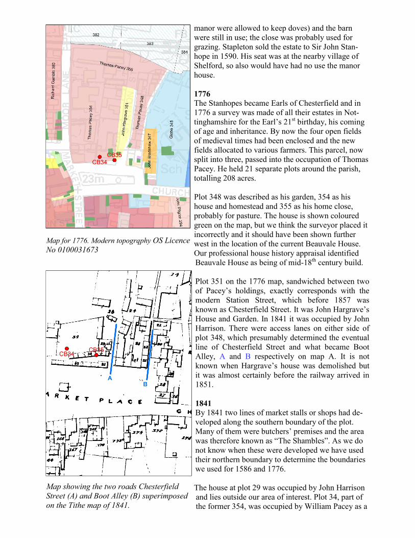
1776
The Stanhopes became Earls of Chesterfield and in
1776 a survey was made of all their estates in Not-
tinghamshire for the Earl’s 21st birthday, his coming
of age and inheritance. By now the four open fields
of medieval times had been enclosed and the new
fields allocated to various farmers. This parcel, now
split into three, passed into the occupation of Thomas
Pacey. He held 21 separate plots around the parish,
totalling 208 acres.
Plot 348 was described as his garden, 354 as his
house and homestead and 355 as his home close,
probably for pasture. The house is shown coloured
green on the map, but we think the surveyor placed it
incorrectly and it should have been shown further
west in the location of the current Beauvale House.
Our professional house history appraisal identified
Beauvale House as being of mid-18th century build.
Plot 351 on the 1776 map, sandwiched between two
of Pacey’s holdings, exactly corresponds with the
modern Station Street, which before 1857 was
known as Chesterfield Street. It was John Hargrave’s
House and Garden. In 1841 it was occupied by John
Harrison. There were access lanes on either side of
plot 348, which presumably determined the eventual
line of Chesterfield Street and what became Boot
Alley, A and B respectively on map A. It is not
known when Hargrave’s house was demolished but
it was almost certainly before the railway arrived in
1851.
1841
By 1841 two lines of market stalls or shops had de-
veloped along the southern boundary of the plot.
Many of them were butchers’ premises and the area
was therefore known as “The Shambles”. As we do
not know when these were developed we have used
their northern boundary to determine the boundaries
we used for 1586 and 1776.
The house at plot 29 was occupied by John Harrison
and lies outside our area of interest. Plot 34, part of
the former 354, was occupied by William Pacey as a
Map for 1776. Modern topogrqphy OS Licence
No 0100031673
Map showing the two roads Chesterfield
Street (A) and Boot Alley (B) superimposed
on the Tithe map of 1841.

was given in the census as “potter”. Whether she
was a retailer or maker is unknown. This was re-
placed in about 1851 by the present “chequer brick
patterned” block including Picture Café.
The 1851 census has William Pacey as a farmer here
with 220 acres, a shade more than in 1776, and em-
ploying four labourers. By 1861 his son, also Wil-
liam, had taken over the 200 ?? acres, employing 5
men and 3 boys. In 1857 three parcels of land were
separated from plot 34 and sold. Plan A shows that
what is now number 18 Market place was built By
William Chettle, as “The Limes” and number 18a by
William Clifton, as “Vernon House”. Clifton was a
master builder and Chettle a seed cake merchant.
The 1910 map shows outbuildings to Vernon House
that are no longer present. Perhaps this was Clifton’s
work yard. In 1871 Clifton was listed as a timber
merchant.
Neither family was in occupation after that and the
census returns do not help identify their successors
as the order of entries is not necessarily the se-
quence on the ground.
20th century
The 1910 map shows all three “new houses”. From
1893 until at least 1918 a Lace Manufacturer named
James Adcock lived at Vernon House. He was succeeded by 1922 by Mr William Topham, a pri-
vate resident. The trades’ directory for 1893 lists Henry Owen Westwood, MD, at The Limes but
subsequent editions had him in Church Street. From 1922 until 1942 George Brown JP lived there.
The two houses later became the offices of Bingham Rural District Council until the formation of
Rushcliffe Borough in 1974, since when they have been used as private offices.
Plan A: North to the right. Dated 1857 this
shows how the land was divided up and sold
for development. The Limes was built on the
piece sold to Mr Chettle. Vernon House was
built on William Clifton’s land. Chesterfield
Street is now Station Street.
O.S. map for 1910
Modern map based on O.S. maps showing the two
houses, The Limes and Vernon House having been
joined together. OS Licence No 0100031673
CB35
VERNON HOUSE
LOCATION AND PROTOCOL
NGR 470504. 339984
Height OD Not measured; close to CB01E: c25.426 m [error .062 m]
Dig dates 13th – 17th June 2014
Pit site Front lawn of Vernon House, the eastern half of the building built
by joining with The Limes. It was rented by SureStart during the
time of the dig.
Pit protocol 1-metre test pit dug to 1.8 metres max. Sieving at 10 cm spit inter-
vals. The ground surface slopes to the south. A horizontal was es-
tablished at a layer of bricks at 65cm in the north face and 60 cm in
the south face. Bedrock was encountered at 125 cm falling away to
184 cm bottom of the pit.

CB35
ANALYISIS OF RESULTS
Description of pit
The succession in the pit is fairly simple:
Topsoil to 20 cm depth
Made ground to 70 cm
Subsoil to 125 to 150 cm depth
Bedrock
The topsoil is dark brown
fine, sandy loam with
around 2% sandstone
pebbles to 1 cm and
small brick pieces. The
brick is mostly found
near the bottom of this
unit.
Beneath the topsoil is
more dark brown sandy
loam, though it is some-
what lighter in colour
than the topsoil, being
less organic. There are
large roots and sparse
pebbles in it. At around
65 cm depth (north face)
a layer of small brick
pieces, about 5 cm thick,
was encountered. There
were sandy lenses at this
level elsewhere in the pit.
Both this and the context
above it have been
classed as made ground.
Beneath the layer of
brick pieces is fairly uni-
form medium brown
sandy clay with charcoal
that could be carbonised
roots, small skerry peb-
bles, medium-grained
sandstone pebbles and
cobbles to 6 cm. This is
interpreted as the original
subsoil.
The bedrock is medium-
grained sandstone,
A Topsoil, dark brown fine sandy loam with 2% sandstone pebbles
up to1cm.
B Made ground, dark brown sandy loam, slightly lighter than A.
Large roots, sparse pebbles.
C Layer of brick pieces to 2 cm with 1-2 cm sandstone pebbles,
lenses of light brown sand.
D Medium brown sandy clay. 1% charcoal could be carbonised
roots. Small skerry pebbles; sandstone pebbles/cobbles to 6 cm.
Uniform with depth
E Medium sandstone, tabular slabs 6-9 cm thick, tilted and
slipped. Rotted sandstone between. Red-brown sandy clay with
sandstone pebbles in the SW corner of pit. Dug to 180 cm along
S face
N.B. The ground level
slopes to the south. The
horizontal surface in the
north face at 65 cm is at
60 cm in the south face.

thought to be the Triassic Hollygate Sandstone. The upper surface slopes to the south. Slabs of
sandstone 6 – 9 cm thick, have become dislocated and have slipped from their original setting.
CB35 at 20 cm showing the small stones and
brick pieces at the bottom of the topsoil.
CB35 at 60 cm showing the top of the sandy
clay subsoil context. The layer of bricks seen
here in the north face is not everywhere in the
pit.
CB35 NE corner, showing the layer of brick
pieces at c 65cm depth marking the boundary
between the topsoil and the subsoil.
CB35. Top of stone feature in NW corner is at
127cm.
CB35 looking N. Stone feature with base of
pit exposed at 140cm
CB35 Stone feature fully exposed. At 160cm.
Red-brown clay at the bottom on the south
side.
Some of the sandstone beneath these slabs is rotted. The pit was dug to 184 cm along the south
face. Here a red-brown sandy clay with sandstone pebbles in it was encountered in the south west
corner. It is thought that this is a remnant layer of till.
Finds
Building materials include brick, plaster, floor tile, black-glazed roof tile, slate and a limestone
roof tile. Except for the 4 black glazed roof tiles, which were all in the made ground, all the build-
ing material was found mainly in topsoil and the made ground. However, some of the plaster was
found at the top of the subsoil (70-80 cm depth) while there were isolated finds of plaster and brick
as deep as spits 12 and 13. This was below the lowest pottery that was found and was accompa-
nied only by bones.
The plaster is white and possibly derived from the adjacent old manor house. None of the brick
fragments, which include a single piece of vitrified brick, could be measured. All were small. The
limestone roof tile did not have a hole, but was recognised by the rock type. It was found in the
topsoil. The most interesting finds were the black-glazed roof tiles. These have been seen in sev-
eral parts of Bingham. Here they were all within the made ground. They were common on stately
buildings in the Tudor period and later.
Coal was found down to 100 cm and with it a piece of clinker.
The metallic material, which included clinker, was found no deeper than 90 cm, which is just be-
low the level of most medieval sherds.
One fragment of clear glass was found in the topsoil, but all the rest were in the made ground
down to 60 cm. There was nothing below. Most of the fragments in the made ground are flat,
clear or pale green window glass 1/16th and 3/32nd inch thick. Most have a strong patina from
chemical reaction between the glass and the soil. There were fragments of an aqua flat-sided bot-
tle and thick, heavy dark green nearly black wine bottles. These last could be anything from 17th
to 19th C. The window glass probably falls into the same range, though most being clear would
make if later rather than earlier.
One piece of bone was decorated and had a metal
stud in it. Its use could not be identified.
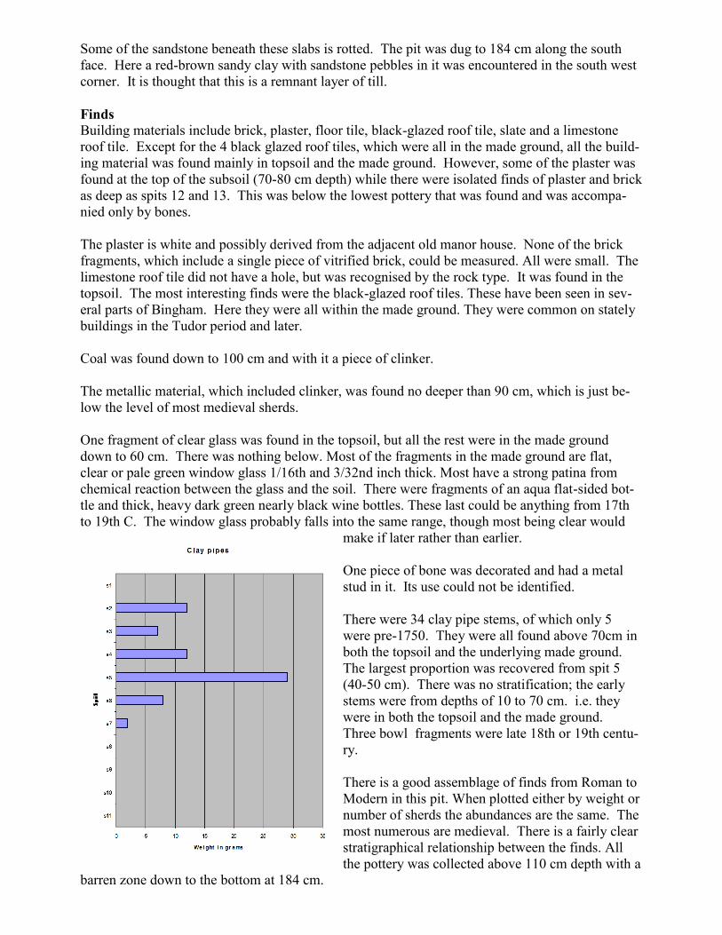
There were 34 clay pipe stems, of which only 5
were pre-1750. They were all found above 70cm in
both the topsoil and the underlying made ground.
The largest proportion was recovered from spit 5
(40-50 cm). There was no stratification; the early
stems were from depths of 10 to 70 cm. i.e. they
were in both the topsoil and the made ground.
Three bowl fragments were late 18th or 19th centu-
ry.
There is a good assemblage of finds from Roman to
Modern in this pit. When plotted either by weight or
number of sherds the abundances are the same. The
most numerous are medieval. There is a fairly clear
stratigraphical relationship between the finds. All
the pottery was collected above 110 cm depth with a
barren zone down to the bottom at 184 cm.
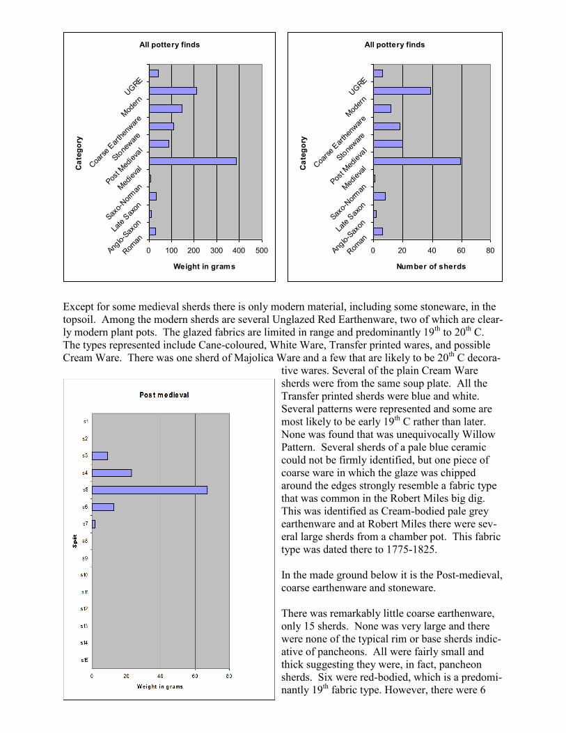
Except for some medieval sherds there is only modern material, including some stoneware, in the
topsoil. Among the modern sherds are several Unglazed Red Earthenware, two of which are clear-
ly modern plant pots. The glazed fabrics are limited in range and predominantly 19th to 20th C.
The types represented include Cane-coloured, White Ware, Transfer printed wares, and possible
Cream Ware. There was one sherd of Majolica Ware and a few that are likely to be 20th C decora-
tive wares. Several of the plain Cream Ware
sherds were from the same soup plate. All the
Transfer printed sherds were blue and white.
Several patterns were represented and some are
most likely to be early 19th C rather than later.
None was found that was unequivocally Willow
Pattern. Several sherds of a pale blue ceramic
could not be firmly identified, but one piece of
coarse ware in which the glaze was chipped
around the edges strongly resemble a fabric type
that was common in the Robert Miles big dig.
This was identified as Cream-bodied pale grey
earthenware and at Robert Miles there were sev-
eral large sherds from a chamber pot. This fabric
type was dated there to 1775-1825.
In the made ground below it is the Post-medieval,
coarse earthenware and stoneware.
There was remarkably little coarse earthenware,
only 15 sherds. None was very large and there
were none of the typical rim or base sherds indic-
ative of pancheons. All were fairly small and
thick suggesting they were, in fact, pancheon
sherds. Six were red-bodied, which is a predomi-
nantly 19th fabric type. However, there were 6
All pottery finds
0 100 200 300 400 500Rom
an
Anglo-S
axonLa
te S
axon
Saxo-
Nor
manM
edie
val
Post M
edie
val
Stone
war
e
Coa
rse
Ear
then
war
eM
oder
nUG
REC
ate
go
ry
Weight in grams
All pottery finds
0 20 40 60 80Rom
an
Anglo-S
axonLa
te S
axon
Saxo-
Nor
manM
edie
val
Post M
edie
val
Stone
war
e
Coa
rse
Ear
then
war
eM
oder
nUG
RE
Ca
teg
ory
Number of sherds
pink-bodied sherds and 2 brown-glazed slip-coated
sherds. These differ mainly in the colour of the
glaze and are likely to be similar in age. They are
usually found in 18th to 19th C deposits. A single
sherd of Light-bodied Coarse Earthenware was re-
covered. Little is known of the date range of this
fabric type.
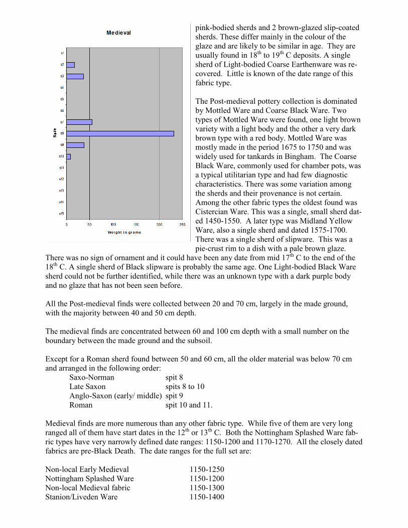
The Post-medieval pottery collection is dominated
by Mottled Ware and Coarse Black Ware. Two
types of Mottled Ware were found, one light brown
variety with a light body and the other a very dark
brown type with a red body. Mottled Ware was
mostly made in the period 1675 to 1750 and was
widely used for tankards in Bingham. The Coarse
Black Ware, commonly used for chamber pots, was
a typical utilitarian type and had few diagnostic
characteristics. There was some variation among
the sherds and their provenance is not certain.
Among the other fabric types the oldest found was
Cistercian Ware. This was a single, small sherd dat-
ed 1450-1550. A later type was Midland Yellow
Ware, also a single sherd and dated 1575-1700.
There was a single sherd of slipware. This was a
pie-crust rim to a dish with a pale brown glaze.
There was no sign of ornament and it could have been any date from mid 17th C to the end of the
18th C. A single sherd of Black slipware is probably the same age. One Light-bodied Black Ware
sherd could not be further identified, while there was an unknown type with a dark purple body
and no glaze that has not been seen before.
All the Post-medieval finds were collected between 20 and 70 cm, largely in the made ground,
with the majority between 40 and 50 cm depth.
The medieval finds are concentrated between 60 and 100 cm depth with a small number on the
boundary between the made ground and the subsoil.
Except for a Roman sherd found between 50 and 60 cm, all the older material was below 70 cm
and arranged in the following order:
Saxo-Norman spit 8
Late Saxon spits 8 to 10
Anglo-Saxon (early/ middle) spit 9
Roman spit 10 and 11.
Medieval finds are more numerous than any other fabric type. While five of them are very long
ranged all of them have start dates in the 12th or 13th C. Both the Nottingham Splashed Ware fab-
ric types have very narrowly defined date ranges: 1150-1200 and 1170-1270. All the closely dated
fabrics are pre-Black Death. The date ranges for the full set are:
Non-local Early Medieval 1150-1250
Nottingham Splashed Ware 1150-1200
Non-local Medieval fabric 1150-1300
Stanion/Liveden Ware 1150-1400
Nottingham Splashed Ware A 1170-1230
Nottingham Green Glazed Variant 1200-1400
Medieval Local Fabric 1200-1500
Nottingham Light-bodied Green Glaze 1220-1330
Early Nottingham Green Glaze 1220-1330
Potterhanworth 1250-1500
Nottingham Coarse orange/pink Sandy Ware 1250-1500
Nottingham Reduced Green glaze 1280-1350
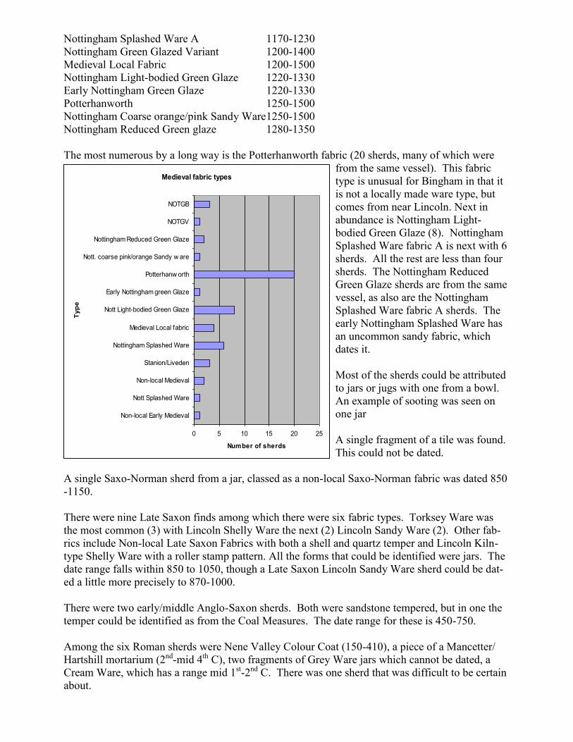
The most numerous by a long way is the Potterhanworth fabric (20 sherds, many of which were
from the same vessel). This fabric
type is unusual for Bingham in that it
is not a locally made ware type, but
comes from near Lincoln. Next in
abundance is Nottingham Light-
bodied Green Glaze (8). Nottingham
Splashed Ware fabric A is next with 6
sherds. All the rest are less than four
sherds. The Nottingham Reduced
Green Glaze sherds are from the same
vessel, as also are the Nottingham
Splashed Ware fabric A sherds. The
early Nottingham Splashed Ware has
an uncommon sandy fabric, which
dates it.
Most of the sherds could be attributed
to jars or jugs with one from a bowl.
An example of sooting was seen on
one jar
A single fragment of a tile was found.
This could not be dated.
A single Saxo-Norman sherd from a jar, classed as a non-local Saxo-Norman fabric was dated 850
-1150.
There were nine Late Saxon finds among which there were six fabric types. Torksey Ware was
the most common (3) with Lincoln Shelly Ware the next (2) Lincoln Sandy Ware (2). Other fab-
rics include Non-local Late Saxon Fabrics with both a shell and quartz temper and Lincoln Kiln-
type Shelly Ware with a roller stamp pattern. All the forms that could be identified were jars. The
date range falls within 850 to 1050, though a Late Saxon Lincoln Sandy Ware sherd could be dat-
ed a little more precisely to 870-1000.
There were two early/middle Anglo-Saxon sherds. Both were sandstone tempered, but in one the
temper could be identified as from the Coal Measures. The date range for these is 450-750.
Among the six Roman sherds were Nene Valley Colour Coat (150-410), a piece of a Mancetter/
Hartshill mortarium (2nd-mid 4th C), two fragments of Grey Ware jars which cannot be dated, a
Cream Ware, which has a range mid 1st-2nd C. There was one sherd that was difficult to be certain
about.
Medieval fabric types
0 5 10 15 20 25
Non-local Early Medieval
Nott Splashed Ware
Non-local Medieval
Stanion/Liveden
Nottingham Splashed Ware
Medieval Local fabric
Nott Light-bodied Green Glaze
Early Nottingham green Glaze
Potterhanw orth
Nott. coarse pink/orange Sandy w are
Nottingham Reduced Green Glaze
NOTGV
NOTGB
Typ
e
Number of sherds
A single sherd of hand-made pottery recorded between 160 and 170 cm depth in the field was lost.
It was thought to be anything from Iron Age to Anglo-Saxon
Interpretation
The topsoil, 20 cm thick, has a layer of small brick pieces and stones at the bottom, which suggests
that this is a discreet deposit, not one that has continuity with the deposit below it. The content is
typical of topsoil in Bingham with mostly modern sherds, but including some medieval and one of
the 17th C clay pipe stems. Other material, such as glass, slate, plaster, coal and various metal ob-
jects are all to be expected. The likelihood is that the topsoil is a result of landscaping at the time
that the two houses were merged to make one in the 1950s.
Beneath the topsoil is a layer called made ground. This also is a re-deposit. A layer of brick piec-
es at the bottom (65-70 cm) suggests that everything above it was deposited here after being
moved from somewhere else. The likelihood is that this took place when the two houses were
built, soon after 1857. This would mean that there should be few finds in the soil younger than mid
19th C. In fact, this layer has a very strong post-medieval signature. Nearly all the clay pipe stems
were dated as post 1750, with a couple of older ones among them. Most of the Modern pottery
had long date ranges, but the few that could be dated closely were made in the late 18th or early
19th C and it is possible that most of the Modern pottery is attributable to the first half of the 19th
C. An interesting feature of this layer is that all the post-medieval pottery was found in it. This
includes early varieties such as Cistercian Ware and Midland Yellow Ware. Also, all the black-
glazed roof tiles were in it. Some medieval sherds were collected from the base of the layer. In
general, there is nothing to suggest that this deposit predates the mid 19th C and the range of earlier
material in it is consistent with the soil having been gathered from a mid 19th C landscape with a
range of earlier pottery types on it. The small number of younger finds would have accumulated
on the ground surface in the period 1850 to mid 20th C.
The part of the succession that is in situ is that below 70 cm and there is a reasonably good stratig-
raphy in it. There is nothing in it younger than medieval. The presence of medieval pottery in the
made ground resting on this subsoil seems to indicate that prior to building in 1857 the ground was
scraped clear of the topsoil with the younger pottery in it.
There is more medieval pottery by number or weight than any other fabric type recorded in the pit.
57% of it was found between 70 and 80 cm depth. Most of the pottery found below 80 cm is Not-
tingham Splashed Ware with a date range of 12th to mid 13th C. Above this the date ranges are
mostly mid 13th C to end 14th C with a few ranging into the 15th C. This date range compares well
with the dates of occupation of the old manor house and it is possible that this rich layer is over-
spill from a domestic rubbish dump near the old manor house. There is an unusual presence in this
collection of a relatively high proportion of pottery not made in Nottingham. Pottery from Potter-
hanworth, which is north of Lincoln, and Stanion/Lyveden, two villages in Northamptonshire,
were present and there were other non-local fabric types, but which cannot be attributed to known
kiln sites. The implication of this is that the owner of the manor house was not constrained by cost
to buying pottery made only in Nottingham.
The presence of the Nottingham Splashed Ware and earlier fabric types indicates an earlier, pre-
mid 13th C history to the site. A similar suite of finds was taken from CB34 and CB01 and
CB01E. It seems to suggest that there may have been a habitation on or near this site from before
the time of the Norman Conquest. Nine Late Saxon sherds may not seem to be many, but com-
pared with most other test pits in Bingham this is a lot. Even having two Anglo-Saxon sherds is
unusual. In nearby CB34, Early, Middle and Late Saxon finds were recorded, while in CB01 and
CB01E there is nothing significant prior to the medieval period. This seems to suggest that when
the old manor house was constructed there was already a long tradition of habitation in the area

around CB34 and CB35.
With only Roman pottery between 100 and 110 cm depth the ground was barren below this to the
rock head at 183 cm. There was no change, however, in the medium. It remained medium brown
sandy clay.
Rock head in the north and west of the pit was medium-grained sandstone interpreted as the Holly-
gate Sandstone, which is shown on the geological map as underlying nearly the whole of Bing-
ham. It is interbedded with thin beds of grey-green sandy clay. This sandstone is rarely seen at
outcrop, but has appeared at the bottom of several test pits. It is the same rock as that used to build
the church tower, the oldest part of the church.
The appearance of the bedrock at first suggested a wall feature, but when an attempt was made to
lift what was thought to be a slab on the top of the wall it was found to be connected to the under-
lying rock. The bedrock fell away to the south where a deposit of red-brown sandy clay with
small sandstone pebbles in it was encountered. This is thought to be the Anglian Till. A ditch was
cut into it and the single, now lost, sherd of handmade pottery was found in the ditch deposit.