Apri//May 1997 Nonpoint Source News-Notes · Nonpoint Source . News-Notes . ... The Control of...
28
Apri//May 1997 #48 Nonpoint Source News-Notes The Condition of the Water-Related Environment The Control of Nonpoint Sources of Water Pollution The Ecological Management & Restoration of Watersheds Notes on the National Scene SDWA '96 Establishes New Directions - Calls for Source Water Protection, Drinking Water SRF, and Public Involvement Congress passed the Safe Drinking Water Act Amendments of 1996 to give the states "more resources and more effective authority to attain the objectives of the [original] Safe Drinking Water Act." But the new law does more than that. It also connects two environmental issues: watershed protection and safe drinking water. Broad Objectives SDWA '96 (as the new law is commonly cited) requires that drinking water standards be set specifically to consider the risks of unsafe water on sensitive subpopulations: children, pregnant women, the sick and elderly. It also directs EPA to use the best available peer-reviewed science, risk assessment, and cost/benefit analysis in establishing these standards - and to provide monitoring flexibility and "relief" (i.e., alternative monitoring provisions under certain conditions) to community water systems. SDWA '96 also - and for the first time - formally requires states to conduct source water delineations and assessments: that is, to establish source water protection areas and assess and make public the susceptibility of public water supplies to contamination. And that's not all. The Act specifically notes that existing watershed delineations and assessments may be used to fulfill SDWA '96 requirements. Last, though not least, to ensure the states' ability to pursue these broad objectives, SDWA '96 authorized a drinking water State Revolving Fund (SRF), modeled after the Clean Water Act INSIDE THIS ISSUE Notes the National Scene SDWA '96 Establishes New Directions in Source Water Protection 1 on Postal Service Joins Chesapeake Bay Effort . . . . . . . . . . . . 3 Northern California T!\.1DL Lawsuit Settled. . . . . . . . . . . . . . . 4 Notes on Riparian and Watershed Management Nation's First (Quantified) Riparian Forest Buffer Goal. . . . . . . . 4 Deluge in the Grand Canyon .. 5 Are Riparian Areas for the Birds? . . . . . . . . . . . . . . . . . . . . . 8 Urban Runoff Notes Seattle'S Salmon Come Home to a Healthier Creek 9 Developer Provides Site for Testing Urban BMPs ... ]0 Reclaiming Greenwich Bay .J] Postal Service Proactive on NPS ... .... ]2 Notes on the Agricultural Environment Farming Practices in Herrings Marsh Run Project . . . . . . . 13 Hops Growers Combine Efficiency and Environmental Concern .. 14 l1'Iews From the States, Tribes, and Localities RF Buys More Than Wastewater Treatment . . . . ]4 Teamwork Makes a Difference in Broad Creek, South Carolina 15 Update: Lower Hood Canal Shellfish Harvest Restored ]6 Technical Notes Quick Nutrient Test - More Than a Convenience . . . . . . . . . . 17 Comparing Monitoring Data. ...................... 18 DNA Fingerprints Lead to Fecal Coliform Identification 19 Notes on Education and Outreach Education and Outreach in Action 20 Mid-Atlantic Maps Boat Sewage Disposal Locations . . . . . . . . . 21 New Stream Videos ............................ 22 Reviews and Announcements Website Links Great Lakes Resources. ................. 22 Applied River Morphology - A Review 22 EPAWatershed Academy Offers Training . . 24 RFPs from AWWARF ........ 25 West Virginia's Troubled Waters . . . . 25 Dredged Material Management Guidance Out in Draft . . . . . . . 25 NPS Electronic Information Exchange News 26 DATEBOOK . 26 THE COUPON 27 All issues of News-Notes are accessible on the NPS Information Exchange on EPA's World Wide Web Site: http://www.epa.gov. See page 26 for log-on information.
Transcript of Apri//May 1997 Nonpoint Source News-Notes · Nonpoint Source . News-Notes . ... The Control of...

Apri//May 1997 #48
Nonpoint Source
News-Notes The Condition of the Water-Related Environment The Control of Nonpoint Sources of Water Pollution The Ecological Management & Restoration of Watersheds
Notes on the National Scene
SDWA '96 Establishes New Directions - Calls for Source Water Protection, Drinking Water SRF, and Public Involvement
Congress passed the Safe Drinking Water Act Amendments of 1996 to give the states "more resources and more effective authority to attain the objectives of the [original] Safe Drinking Water Act." But the new law does more than that. It also connects two environmental issues: watershed protection and safe drinking water.
Broad Objectives
SDWA '96 (as the new law is commonly cited) requires that drinking water standards be set specifically to consider the risks of unsafe water on sensitive subpopulations: children, pregnant women, the sick and elderly. It also directs EPA to use the best available peer-reviewed science, risk assessment, and cost/benefit analysis in establishing these standards - and to provide monitoring flexibility and "relief" (i.e., alternative monitoring provisions under certain conditions) to community water systems.
SDWA '96 also - and for the first time - formally requires states to conduct source water delineations and assessments: that is, to establish source water protection areas and assess and make public the susceptibility of public water supplies to contamination. And that's not all. The Act specifically notes that existing watershed delineations and assessments may be used to fulfill SDWA '96 requirements.
Last, though not least, to ensure the states' ability to pursue these broad objectives, SDWA '96 authorized a drinking water State Revolving Fund (SRF), modeled after the Clean Water Act
INSIDE THIS ISSUE
Notes the National Scene SDWA '96 Establishes New Directions in Source Water Protection 1
on
Postal Service Joins Chesapeake Bay Effort . . . . . . . . . . . . 3 Northern California T!\.1DL Lawsuit Settled. . . . . . . . . . . . . . . 4
Notes on Riparian and Watershed Management Nation's First (Quantified) Riparian Forest Buffer Goal. . . . . . . . 4 Deluge in the Grand Canyon .. 5 Are Riparian Areas for the Birds? . . . . . . . . . . . . . . . . . . . . . 8
Urban Runoff Notes Seattle'S Salmon Come Home to a Healthier Creek 9 Developer Provides Site for Testing Urban BMPs ... ]0 Reclaiming Greenwich Bay .J]
Postal Service Proactive on NPS ... .... ]2
Notes on the Agricultural Environment Farming Practices in Herrings Marsh Run Project . . . . . . . 13 Hops Growers Combine Efficiency and Environmental Concern .. 14
l1'Iews From the States, Tribes, and Localities RF Buys More Than Wastewater Treatment . . . . ]4
Teamwork Makes a Difference in Broad Creek, South Carolina 15 Update: Lower Hood Canal Shellfish Harvest Restored ]6
Technical Notes Quick Nutrient Test - More Than a Convenience . . . . . . . . . . 17 Comparing Monitoring Data. . . . . . . . . . . . . . . . . . . . . . . 18 DNA Fingerprints Lead to Fecal Coliform Identification 19
Notes on Education and Outreach Education and Outreach in Action 20 Mid-Atlantic Maps Boat Sewage Disposal Locations . . . . . . . . . 21 New Stream Videos . . . . . . . . . . . . . . . . . . . . . . . . . . . . 22
Reviews and Announcements Website Links Great Lakes Resources. . . . . . . . . . . . . . . . . . 22 Applied River Morphology - A Review 22 EPA Watershed Academy Offers Training . . 24 RFPs from AWWARF . . . . . . . . 25 West Virginia's Troubled Waters . . . . 25 Dredged Material Management Guidance Out in Draft . . . . . . . 25 NPS Electronic Information Exchange News 26
DATEBOOK . 26
THE COUPON 27
All issues of News-Notes are accessible on the NPS Information Exchange on EPA's World Wide Web Site: http://www.epa.gov. See page 26 for log-on information.

SDWA '96 Establishes New
Directions (continued)
SRF and funded at $1 billion per year for five years. The fund for 1997 has been capitalized at $1.275 billion, and states can use up to 10 percent of their 1997 allocation for source water assessment.
Getting Back to Basics
Until recently, the concern for safe drinking water centered on water treatment services in municipal and industrial facilities serving cities, towns, and villages; the source of the water was largely forgotten. If we thought much about this water at all, we thought of it as "tap water." Drinking water does not, however, originate in the pipes under our feet or in the water tower downtown. Its source is farther afield in the rivers and streams that we swim in and fish, that we harness for power and use for transportation, agriculture, and commerce.
Once this link is made, the need for a coordinated strategy or watershed approach to ensure the quality of drinking water, minimize the risk to public health from waterborne diseases, and protect drinking water sources is clear.
Drinking Water SRF Hastens Guidance
The U.s. Environmental Protection Agency's Office of Ground Water and Drinking Water is preparing guidance to help the states implement the source water protection aspects of SDWA '96. A national public meeting in January facilitated the writing of the draft guidance and provided an opportunity for all stakeholders - environmental and public health groups, nongovernmental organizations, and all federal agencies - to share their concerns and expertise with EPA.
Information received at this meeting and additional public comment is reflected in the draft guidance document and will be further discussed in a series of regional meetings to be held this spring.
Final guidance is due in August 1997; however, the process has been accelerated because states are authorized to use up to 10 percent of their SRF allotments for source water delineation and assessment. This money can be used over several years, but only if it is set aside by September 1997. States may also use up to 10 percent of their drinking water SRF,with no fiscal year limitations, for implementing source water protection programs. (For information on how SRFs
work in NPS control, see article on page 14 of this issue.) Consumer Confidence Reports
Another Take on Public Involvement
SDWA '96 specifies that the
Administrator, in consultation with public water systems, environmental groups, public interest groups, risk communication experts, and the states, and other interested parties, shall issue regulations within 24 months . . . [requiring] each community water system to mail to each customer of the system at least once annually a report on the level of contaminants in the drinking water purveyed by that system.
The Act specifies that these "consumer confidence reports" should contain "brief and plainly worded" information on the source of the water purveyed; definitions and indications of the levels of contaminants, actual and potential; any variances or exemptions that apply; and a statement of health concerns that may result.
The authority given to EPAto consult with the larger community and issue regulations regarding these consumer reports suggests that Congress envisioned them as part of a "greater opportunity for public education and participation" as well as a way of providing "prompt notification of any violations."
Public Involvement, Consumer Confidence
An important concern for EPA and its partners is how to generate public interest and involvement in drinking water issues so that states are motivated to make source water assessments and use them in management initiatives. One way is to focus on consumer confidence reports (see box); another is to publicize the links between watershed protection and drinking water quality and quantity issues; and still another is to copy the model developed so successfully in the Wellhead Protection Program. These approaches are perhaps more complementary than opposing and several them - or all three - may be reflected in the final guidance document.
Still, the question before EPA, water suppliers, environmental groups, and other interested parties (including physicians and those who represent vulnerable populations) is not whether, but how to make information and education available to the general public. The objective, at least is clear: to engage the public's interest in, and demand for, source water protection - and overcome the apparent disconnect between the public's concern for drinking water and its recognition that drinking water comes from rivers, streams, and groundwater in the watershed.
Finding answers to these questions and integrating drinking water safety with watershed protection may lead us to an entirely new paradigm for environmental protection - one in
NONPOINT SOURCE NEWS·NOTES APRIL/MAY 1997, ISSUE #48 2

SDWA '96 Establishes New
Directions (continued)
which EPA is not only a regulator but also, with other federal agencies, health, and environmental advocates, a mentor to communities working on their own.
[For more information on SDWA '96 and the Office of Ground Water and Drinking Water's draft guidance document for source water assessments, contact Kevin McCormack (4606), US. Environmental Protection Agency, Office of Ground Water and Drinking Water, 401 M Street, S.W, Washington, DC 20460. Phone:(202) 260-7772; fax: (202) 260-0732. For copies of the quiderice and the Safe Drinking Water Act, call the Safe Drinking Water Hotline (800) 426-4791.]
Postal Service Joins Effort to Protect the Chesapeake Bay With 1,500 facilities scattered throughout the Chesapeake Bay basin, the U.S. Postal Service has unequaled community presence and tremendous resources to bring to the Chesapeake Bay Program. Indeed, many believe that this new partner can provide exactly what the program needs. "It's a great opportunity for a federal agency to lead by example, by being a good land steward," said Peter Marx, EPAcoordinator of the Chesapeake Bay Program Office. "Its facilities are located in virtually every community in the 64,000 square mile Bay watershed."
As part of an agreement signed last fall between the Postal Service and EPA (see box), the Postal Service will implement pollution prevention practices in post offices throughout Pennsylvania, Delaware, New York, Virginia, Maryland, and the District of Columbia. These practices will reduce pollution from vehicle maintenance facilities by using oil-water separators and curbing stormwater runoff. Postal facilities will demonstrate Bayscapes landscaping techniques, such as integrated pest management, beneficial plants, and water conservation to reduce fertilizer and pesticide use on postal service property. (Bayscapes is a package of environmentally sound landscaping principles developed by the Alliance for the Chesapeake Bay and the U.S. Fish and Wildlife Service.)
Protecting the Bay through Pollution Prevention
Dawn Lebek, Postal Service Environmental Coordinator for the Baltimore District and liaison to the Chesapeake Bay Program, believes that these practices will make a significant contribution to protecting the Bay, but are not the entire solution. Lebek notes that "our efforts will help reduce pollution in the Bay, [but] we are only a piece of a larger puzzle. Ultimately, we hope that our actions will encourage other agencies, businesses, and individuals to adopt pollution prevention measures like these."
Providing Public Outreach Opportunities
The Postal Service is also working closely with EPA to develop
• a poster illustrating the benefits of BayScapes landscaping methods for display in post offices located within the Chesapeake Bay watershed,
• a brochure outlining steps that individuals can take to protect the Bay,
• a Chesapeake Bay awareness cancellation postmark that will be placed on hundreds of thousands of pieces of mail, and
• a model post office that will demonstrate the effectiveness of BayScaping to reduce nonpoint source pollution.
Commitments under the Memorandum of Understanding
u.s. Postal Service
V'
V'
V'
V'
Reduce pollutants entering the Bay from lawncare practices by using BayScapes landscaping methods.
Join other federal agencies in championing the concept of environmental stewardship to preserve and protect the Bay.
Work with local municipalities to increase involvement in Bay restoration and protection efforts.
Contribute to EPA's efforts to increase public awareness at local postal facilities.
u.S. Environmental Protection Agency
V'
V'
V'
Help the Chesapeake Bay Program Communications Office with promotion and public outreach.
Coordinate technical assistance from other Chesapeake Bay Program participants.
Help the Postal Service develop and implement a coordinated action plan, and work with the Postal Service to monitor progress.
APRIL/MAY 1997, ISSUE #48 NONPOINT SOURCE NEWS.NOTES 3

Postal Service Joins Effort to
Protect the Chesapeake Bay
(continued)
The result of these efforts will help both parties uphold their commitments. "We are excited about the possibilities," comments Lebek. "By formulating a strong [biennial] action plan with ambitious but realistic targets and strategies, we can work together to reduce pollution, engage the public, and protect the Chesapeake Bay for generations to come."
"Local postmasters, generally well-known in their communities, will be taking the lead in making local governments aware of the Bay Program's efforts ... ," adds Marx. "They provide a ready liaison for many small upstream communities to learn about, and get involved in, helping their local streams and rivers, and ultimately, the Chesapeake Bay."
[For more information, contact Dawn Lebek, U.S. Postal Service Environmental Coordinator, Baltimore Main Post Office. 900 East Fayette Street, Room 326, Baltimore, MD 21233-9126. Phone (410) 347-4277.]
TMOL Lawsuit Settled in Northern California
The US. EPA, the Ll.S. Department of Justice, and the US. Attorney for California's Northern district have settled one of 20 TMDL lawsuits across the country. The suit, concerning pollution in 18 river basins on California's north coast was brought by 14 environmental and fishing industry groups. In the settlement, filed March 7, EPA made a commitment guaranteeing that the water quality and pollution sources will be assessed and pollution reduction targets established in the 18 river basins by 2007. The assessments, or Total Maximum Daily Loads (TMDLs), are needed because existing pollution controls have not been sufficient to curb excessive sediment loads on rivers and streams in these watersheds.
A CWA Responsibility
The Clean Water Act gives states the primary responsibility for developing TMDLs, although EPA can also develop them. The state of California, which was not a party to the suit, has already agreed to establish TMDLs for about half the basins. Under the settlement, EPA will develop TMDLs for the remaining basins and pick up any that the state fails to complete within the agreement's time frame. The agreement also provides for the establishment of a minimum number of TMDLs each year. EPA will work with timberland owners and local watershed stakeholders to pursue TMDL development in conjunction with sustained timber yield plans, habitat conservation plans for endangered and threatened species, and locally developed watershed management plans.
Notes on Riparian and Watershed Management
Nation's First Riparian Forest Buffer Goal2,010 Miles by 2010
The Chesapeake Bay basin jurisdictions of Maryland, Virginia, Pennsylvania, and the District of Columbia; the u.s. Environmental Protection Agency Administrator Carol Browner, and the Chesapeake Bay Commission are planning to protect existing riparian forests and specifically to reforest 2,010 miles of bay tributaries over the next 13 years - the first goal of its kind in the nation.
"By setting this goal, we help improve water quality in the Chesapeake Bay, provide for accountability in government, and give the public an objective to work toward - 2,010 by 2010," commented Virginia Governor George Allen, speaking on behalf of the Chesapeake Executive Council.
According to Al Todd, US. Forest Service liaison to the Chesapeake Bay Program Office, increasing the riparian forest buffer "may prevent half a million pounds of excess nitrogen from entering the Bay each year," and will directly improve the habitats of cold water and anadromous fish. The 2,010 miles of enhanced habitat will provide woody debris for shelter and an abundance of leafy material- the primary building block of the freshwater food web. "It will also help build a corridor of bird habitat," Todd explained.
NONPOINT SOURCE NEWS·NOTES APRIL/MAY 1997, ISSUE #48 4
Nation s First Riparian Forest
Buffer Goal (continued)
Local Plans Support Regional Agreement
The benefits of forested riparian buffers - streambank stabilization, habitat improvement, sediment and pollution filtering - are widely recognized and many watersheds have made riparian protection a priority. However, this initiative bears watching not only because it has set an ambitious goal but also because it cuts across jurisdictional boundaries.
The regional agreement commits each jurisdiction to develop a riparian buffer implementation plan by June 1998. Each plan will spell out strategies to conserve existing riparian forest corridors, measures to coordinate state programs, and techniques for outreach and education. Each one will also specify exactly how many miles of forested buffer it will restore and how it will meet its goals. In addition to state and private lands, approximately 1.7 million acres of federal lands in the Chesapeake Bay will be included in the riparian buffer plans.
Funding Possibilities - a Search for Incentives
A 31-member Riparian Forest Buffer Panel created by the CEC in 1994 and composed of government officials, environmental activists, farmers, developers, foresters, and scientists recommended that the 2010 goal be met by increasing private sector involvement through incentives like tax reliefs and tree planting credits, and by supporting research, monitoring, technology transfer, and education. The panel suggested taking advantage of existing incentives including cost-share programs, grants, and conservation easements. The panel would also like to see the states try different approaches, perhaps the creation of an income tax credit for landowners who establish buffers on their property.
Todd says that it cost;~on average between $400 and $1,000 per acre to install a riparian buffer, and though each state will fund its plan differently; a number of federal and state conservation incentives such as the Forest Stewardship Program can help offset the costs.
Tools for Using Trees For example, the Conservation Reserve Program, administered by the USDA Natural Resources Conservation Service, can provide agricultural landowners with some easement payments and cost-share programs, and in Maryland, which plans to plant 600 miles of forest buffer by the year 2010, the Buffer Incentive Program already pays landowners $300 per acre to install buffers on streambanks in addition to providing cost-share assistance. In Pennsylvania, the idea of a nonprofit tree trust fund is on the table. As momentum builds, a unique combination of direct incentive programs, volunteerism, state program funding, and new ideas are likely to surface in each state.
Other public agencies and private groups such as the Alliance for the Chesapeake Bay, the Chesapeake Bay Foundation, and Trout-Unlimited have outreach and restoration projects that dovetail with the reforestation goal and lend muscle to the ambitious target. As is often the case, local efforts may forge ahead of larger federal programs. The Elizabeth River Project in Eastern Virginia, for example, has already begun to install buffer zones to help restore native riverine habitat and contribute to the 2,010-mile goal.
"We're seeing a groundswell of community and volunteer involvement" says Todd, who also notes that "building a new riparian stewardship ethic is something else we hope to accomplish."
[For more information. contact AI Todd, US. Forest Service Liaison to the Chesapeake Bay Program Office, or Ann Lackey, Riparian Initiative Fellow, Chesapeake Research Consortium, Chesapeake Bay Program Office. 410 Severn Avenue, Suite 109, AnnapoliS, MD 21403 Phone:(800) 968-7229.J
Deluge in the Grand Canyon A New Twist on an Old Story
Compared to prehistoric floods, last year's planned flood of the Grand Canyon was hardly a record. It lasted two weeks from March 22 to April 7, flowed at a peak rate of only 45,000 cubic feet per second (about half the flow of an average natural flood), topped out at 110 billion
V CITYgreen, an urban planning tool from American Forests, helps map and measure the value of trees in terms of summer energy savings, stormwater management, carbon storage, and urban wildlife habitat. For information and a demo disk, call (202) 667-3300, ext 227, or visit http://www.amfor.org.
V Working Trees for Communities, a color brochure developed by the National Agroforestry Center, illustrates planting practices to protect natural resources, diversify the environment, and conserve energy. To obtain copies, contact Kim Issacson, National Agroforestry Center, USDA Forest Service, Rocky Mountain Station, USDA NRCS, east Campus-University of Nebraska-Lincoln, Lincoln, NE 68583-0822. Phone: (402) 437-5178: fax: (402) 437-5712
APRIUMAY 1997, ISSUE #48 NONPOINT SOURCE NEWS·NOTES 5

Deluge in the Grand Canyon
(continued)
gallons of water, and cost about $3 million in foregone power production and flood conduct studies. It set a new record, however, as the first-ever attempt to use intentional flooding to improve the river and benefit biological diversity and the canyon's human visitors.
Although the flood's initial results were extremely satisfying, scientists engaged in planning and evaluating its immediate and long-term effects agree that the task requires painstaking effort, a sense of history, and a large dose of cooperation.
Prologue to the Event
Flows in the canyon first declined in 1963 when the Glen Canyon Dam began storing water to provide electricity, irrigation water, and additional recreational opportunities in the Southwest. People's lives in the region improved, but not without changes to the river and concern about the dam's effects on the Glen Canyon Recreation Area, the Grand Canyon National Park, and tribal lands of the Navajo, Havasupai, and Hualapai. Finally; in 1982, the Bureau of Reclamation initiated the Glen Canyon Environmental Studies Group to study these effects. In 1988, the group concluded that the dam was causing significant impacts - enough to choke the canyon.
Additional research - and long and arduous consultation - culminated in the 1992 Grand Canyon Protection Act, which authorized operating the dam to store water and help manage the river corridor; and the 1995 Environmental Impact Statement (EIS). The latter assesses conditions resulting from the dam and spells out the preferred alternative for how the dam should be operated. The flood experiment was conducted in accordance with these documents.
Mixed Results
Restored beaches and habitat were foremost among the results the flood was expected to achieve. An immense flow would, investigators hoped, alter the river ecology; renewing the canyon in much the same way that a wildfire helps renew the forest. It would, for example,
• stir up the river bottom, creating new sandbars and washing away banks, vegetation overgrowth, and debris;
• rejuvenate the back channels, thereby helping to warm the water and creating new spawning grounds and nurseries for five native fish, including the humpback chub and razorback sucker;
• help flush nonnative species into Lake Mead to prevent them from preying on, competing with, or spreading disease to the native species;
• release enough organic debris, primarily of plant material in the backwater channels, to create a nutrient surge that would benefit all species.
Many scientists and visitors to the park agree that most of these benefits were achieved. (Only the nonnative fish refused to move. Instead of washing over into Lake Mead, they hid in shoreline vegetation or took refuge in the slower moving tributaries.) According to U.S. Department of Interior Secretary Bruce Babbitt, the flood significantly improved "the size and number of the river's beaches and the creation of backwater habitat."
Other results are still being monitored, however, and may not be as dramatic as the project's organizers had hoped. More time is needed to gage the stability and longevity of these effects, to determine what conditions are optimal, and to assess the effects of natural flooding on the canyon's health. In fact, more than 200 scientists are still gathering data on the event and about 40 separate research projects are now underway.
Still, the flood's immediate results were successful enough to support plans to repeat it in five to 10 years. That's about the same amount of time, nearly a decade, that organizers say it took to plan and achieve this flood.
Some scientists are hoping to apply the expertise and the technology used in this project to other rivers and dams in the United States. For others, the future of controlled flooding is less certain; how to manage the dams on the nation's largest rivers - that is, whether planned flooding can be used to restore the natural functions of these rivers and if so, to what extentis still an open question.
Future Possibilities
APRIL/MAY 1997, ISSUE #48 NONPOINT SOURCE NEWS·NOTES 6
Deluge in the Grand Canyon
(continued)
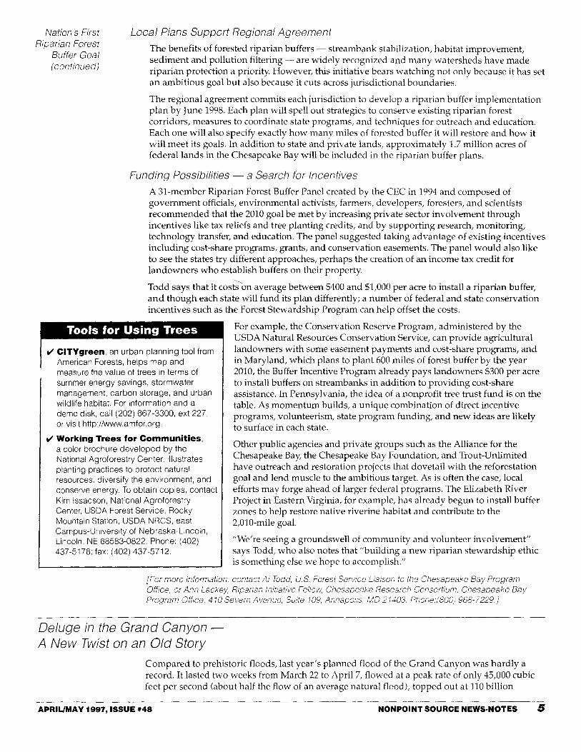
Controlled Flooding Experiment Hailed as Success
Initial scientific data indicate that dozens of new sand beaches were formed and many new backwater habitats for endangered fish were created in Grand Canyon National Park in March and April 1996, when water was allowed to flow through four hollow jet tubes in the Glen Canyon Dam. Water levels in Lake Powell dropped 3.5 feet during the flood flow, but this drop had been anticipated and no water deliveries to states or individuals were affected. Other notable effects:
V
V
V
V
V
Initially, 55 new beaches were created in the first 61 miles of the canyon, the area most depleted by the dam.
Sand bar volumes along the river in the Grand Canyon increased by an average of 53 percent, although the actual lateral area increased by only 5 to 7 percent.
Over 82 new campsites were created, while three were destroyed.
About 80 percent of the beach aggradation occurred in the first 20 to 48 hours of the flood (so shorter, less-expensive, high flows may be sufficient for future ecological restoration).
Several major rapids, for example, Lava Falls and Badger Rapids, were carved and widened by the flood.
V
V
V
Scouring of clay and vegetation bases in the backwaters and marshes increased fish habitat by about 20 percent - though large summer releases (from snowmelt and unusually heavy rains) made some of this habitat unusable.
Nutrients in the form of organic debris in the main river and back channels created a nutrient surge that benefited fish, aquatic insects, and plants, including native willows.
The downstream trout fishery and Native American cultural artifacts and sites in the canyon were not harmed, and no negative impacts were observed on endangered bird species, including the Southwestern willow flycatcher and the peregrine falcon.
Researchers recommend continued on-the-ground monitoring and the use of aerial photography to evaluate the strength of this restoration vis-a-vis continued operations of the dam. They note, for example, that sandbars deposited by the flood are already eroding, and periodic controlled flooding may be necessary to retain their viability.
The consensus achieved for this event is hard to maintain. For example, the Glen Canyon Environmental Studies Group led by Dave Wegner has been disbanded, Department of Interior sources say, not because the department is retreating from the project but because "its mission is complete." The Grand Canyon Research and Monitoring Center will now oversee operations at the dam.
In fact, the model for the new organization is clearly described in the EIS, and it will, like its predecessor, draw support from the Interior Department's Bureau of Reclamation and the U.S. Geologic Service. However, this center, unlike the group it replaces, will be an independent entity that answers directly to the Secretary. Its meetings will be public and its membership diverse.
On October 9, 1996, Secretary Babbitt released a summary of 34 separate draft scientific studies, which, according to the accompanying statement, showed that the flood had been successful in restoring key elements of the river (see box).
The Secretary also signed a "record of decision" that establishes dam operation criteria that will protect the Colorado and the Grand Canyon consistent with the 1992 Grand Canyon Protection Act and the 1995 EIS. "In signing this document, we begin a new chapter in the fabled history of the Grand Canyon and Glen Canyon Dam," Babbitt said, adding that it "marks a sea change in the way we view the operation of large dams."
The new regulations restrict power cooperatives from releasing wildly fluctuating amounts of water through the Glen Canyon Dam. However, they are not expected to affect the cost of power in the western states (which, according to Greenwire [6/145) has already increased about 25 percent since 1991). They do, however, formalize existing agreements to operate the Glen Canyon Dam for environmental purposes in addition to traditional water and power generation benefits. [For more information, contact Paul Bledsoe, U. S. Department of the Interior, Office of the Secretary, Bureau of Reclamation, 18th and C Streets, Washington, D.C. Phone: (202) 208-4662. Or contact Barry Wirth, Bureau of Reclamation Regional Office, 125 South State Street, Room 6103, Salt Lake City, UT 84138-1102. Phone: (801) 524-6477; e-mail: [email protected].}
Permanent Protections
APRIL/MAY 1997, ISSUE #48 NONPOINT SOURCE NEWS·NOTES 7

Are Riparian Areas for the Birds? Most water resources people know the importance of riparian areas in filtering out nonpoint source pollution. But a cooperative project between the Santa Clara Water District and the Coyote Creek Riparian Station (CCRS) in Alviso, California, is demonstrating the value of restored riparian areas for migratory songbirds. Researchers at CCRS have been studying how resident and migratory songbirds use revegetative riparian areas for the past ten years.
Neotropical migrants such as the Swainsons thrush, yellow warbler, and common yellowthroat winter in Mexico and Central America and travel through Alviso in the summer to breed in the Pacific Northwest. Riparian zones between Mexico and the Pacific Northwest serve as important refueling and rest stops for the travelers. In fact, these zones are critical to the birds' survival. Many species are already under pressure from habitat losses in both their tropical wintering grounds and their northern breeding areas.
Designing Flood Controls That Preserve Habitat
Years of research at CCRS indicates that the area is very heavily used as a stopover for migrants. So when intense flooding in 1982 and 1983 prompted the District to implement flood control measures, it tried to design them to benefit wildlife habitat and to protect human development. To keep the riparian corridor intact, the District constructed levees up to 240 yards away from the creek. Though the creek was straightened in some areas, its natural corridor and meander remained.
In 1986, a mitigation plan called for replacing four acres of riparian vegetation lost to construction at the research station. The District asked CCRS to monitor and compare the wildlife use of both the revegetated area and the existing riparian habitats. Since an estimated 90 percent of California's riparian vegetation is degraded or gone, the viability of revegetated areas is crucial.
Chris Otahal, the station's avian research program director, described the pilot revegetation site as a "hodgepodge of plants taken from all over the state." Trees were densely planted, and the resulting shade slowed the development of understory vegetation needed by migrants like the hermit thrush. Other sections, notably "clumps" of cottonwoods and willows, seemed to attract birds.
Vegetative Mosaic Benefits Migrants
In 1992, CCRS made recommendations to the Santa Clara Valley Water District on the design of an eight-acre area at the research station that would provide habitat for neotropical migrant birds. Using plants propagated on site, the District planted clumps of native trees interspersed with blackberry, goldenrod, and mugwort. A dense understory with shrubs such as elderberry; box elder, coyote brush, and young willow yields cover and concealment and a plentiful supply of seeds, berries, and insects. Trees such as cottonwood, willow, and sycamore provide shelter from the weather and protection from predators. The resulting mosaic appears to be more attractive to neotropical migrants than the first revegetated site.
Monitoring of the eight-acre site is still in the early stages, but Otahal has a "gut feeling" about it. "The site is becoming useful to migrants more quickly than the pilot site because the habitat is better," he says. Otahal points out that the earlier experience was a learning project, and since monitoring will continue at CCRS for at least the next 50 years, they are sure to learn even more.
Volunteers Make It Happen
Coyote Creek Riparian Station attributes much progress to its volunteers. Under the guidance of three biologists, 40 volunteers retrieve birds caught in mist-nets with very fine mesh and fit their legs with small metal bands engraved with nine-digit numbers. The numbers are used to track the movements, health, and growth of individual birds. Volunteers also record each birds species, weight, bill length, age, plumage condition, and evidence of breeding. "The volunteers really make it possible to maintain the quality of intensive research we do here at Coyote Creek," says Otahal. "We couldn't do it without them."
The revegetative zones provide much-needed habitat for migratory songbirds, and they should also improve water quality. Comprehensive water quality monitoring in the San Francisco Bay
NONPOINT SOURCE NEWS·NOTES APRIL/MAY 1997, ISSUE #48 8

Are Riparian Areas for the
Birds? (continued)
Estuary is being moved up into the major watersheds of the bay. The San Francisco Estuary Institute will monitor a site located immediately downstream from CCRS. Chances are, such monitoring will show that not only are revegetative areas for the birds, they are also for other wildlife, bird lovers, environmental planners, and water resource managers.
[For more information, contact Chris Otahal, Po. Box 1027, Alviso, CA 95002. Phone: (408) 262-9204; fax: (409) 263-3523; e-mail' [email protected].}
Urban Runoff Notes
Seettle's Salmon Come Home to a Healthier Creek
More than 600 chum salmon returned to Seattle, Washington's, Pipers Creek last fall, making 1996 the fourth consecutive year that salmon have been observed there in substantial numbers. Nancy Malmgren, director of the Carkeek Watershed Community Action Project (CWCAP), credits the success to 18 years of stream restoration and community watershed education capped by an effective salmon-rearing project.
Overfishing, loss of streamside forest, and channel blockages are obvious causes of the salmon's decline; just as damaging, but less obvious, is urban sprawl. Over the years, the watershed has lost 40 percent of its pervious cover. As a result, stormwater runoff - precipitation that used to soak into the ground - now rushes off roads, parking lots, and roofs. It washes away gravel spawning beds, crumbles streambanks, and dumps sediment on the stream, destroying the pools. A big problem, according to Malmgren, was a stormwater system that collected runoff from over one-third of the watershed and dumped it into the creek. Trees that once cooled the water in Pipers Creek to salmon-friendly temperatures have disappeared in favor of street lights and mowed lawns.
The low point came early, in 1929, when, for the first time, no spawning salmon were observed returning to the stream. Things did not improve until the 1980s, when the Community Action
Protecting Trout from Big City Impacts in Wisconsin
Urbanization Affects Sensitive Local Streams [Adapted from the University of Wisconsin-Extension's Keeping Current, November 1996.J
Studies show that once 20 percent of a watershed is roofed and paved, sensitive trout habitat usually disappears from local streams.
As the amount of impervious surface increases in urbanizing areas, so does the amount and intensity of stormwater runoff. The resulting streambank erosion and silt deposition combined with elevated runoff temperatures heated by sun-soaked parking lots and rooftops create an environment that trout find intolerable.
Eau Claire, Wisconsin has developed two stormwater management systems that preserve sensitive trout habitats. One system, constructed at a local auto dealership, diverts clean, cool rainwater around paved areas and filters roof and parking area runoff into grassed swales and gravel infiltration beds (see Nonpoint Source News-Notes, #41, for more information on this project). The other, a regional stormwater infiltration basin, keeps the postdevelopment runoff rates at a 240-acre industrial park to predevelopment levels for up to a 100-year storm event.
[For more information, contact Ron Struss, University of Wisconsin-Extension Water Quality Educator, Geology Department, Room 149 Phillip Halls, Eau Claire, Wisconsin 45702-4004. Phone: (115) 836-5513.]
Project developed the Pipers Creek Early Action Watershed Plan to help restore the creek and reverse the impacts of uncontrolled runoff. A comprehensive watershed education program funding a half-time watershed interpretive specialist was also a key to success.
Seattle Public Utilities created grassy swales and an in-channel detention area to slow and absorb stormwater; trees and other vegetation were replanted along 1.5 miles of the stream; stormwater and sedimentation in the watershed were put under a creek erosion plan; and a wetland restoration plan that would develop a model urban wetland is in the works. In-stream habitats and a fish passage were improved with weirs and rock walls, and cedar railings were installed along the banks to keep human visitors back from the most popular spawning areas.
Return of the Salmon
Salmon restoration began in 1980 with coho salmon. Then in 1984, volunteers began introducing chum fingerlings (now raised by students in 20 area schools and the state hatchery) into the improving stream habitat for their downstream run to the sea. To facilitate their return upstream as three-year-old adults, CWCAP volunteers, Seattle Parks, and Seattle Public Utilities (under direction of the state Fish and Wildlife Department) built a fish passage to ease the salmon past a railroad concrete apron.
At first, the returns were small - no more than 75 fish a year. However, in 1989, CWCAP volunteers under the direction of the Department of Fish and Wildlife created an
APRIL/MAY 1997, ISSUE #48 NONPOINT SOURCE NEWS·NOTES 9

Seattle's Salmon Come Home to a
Healthier Creek (continued)
"imprint pond" where the juvenile salmon can become accustomed to the creek before swimming out to sea. Right on schedule, three years later, the imprinted salmon began returning in growing numbers.
Malmgren is convinced that much of the solution lies in educating watershed residents and changing their behavior. Carkeek Park, which cradles Pipers Creek, is the nucleus of the group'
educational effort. There, volunteers are constructing a model backyard habitat demonstrating creek-friendly landscaping practices. The children's play area next to Carkeek Environmental Education Center is actually a model of a watershed/creek system - "for creative play with a message!" says Malmgren. And every year, Salmon Stewards are stationed in the park during spawning season to answer questions from visitors who come to see the returning fish. Seeing the annual phenomenon first hand has prompted public interest in the watershed and water quality.
Because of Malmgren's efforts - and those of the Seattle Department of Parks and Recreation, the state's Department of Fish and Wildlife, the Seattle Conservation Corps, the Seattle Public Utility and hundreds of volunteers - things are looking up. But Malmgren is reluctant to claim unqualified success. In answer to the schoolchildren who always ask if the salmon they raised will come back, she replies, "We'll do our best to make sure that they do, and we'll try to give them a good home when they do." But she adds privately; "We can bring the salmon back, but if we don't control the stormwater runoff, they'll never become self-sustaining."
[For more information, contact Nancy Malmgren, Carkeek Watershed Community Action Project, 386 NW 112th st., Seattle, WA 98177. Phone: (206) 363-416.}
National Watershed Award: Call for Nominations
Applications are being accepted for the second annual Conservation Fund Industries National Watershed Award that will honor three communities and one corporation for innovative local watershed partnerships protecting water quality.
These awards, administered by the Conservation Fund, are an outgrowth of the National Forum on Nonpoint Source Pollution convened by the Fund and the National Geographic Society. Along with other public and private sector partners, EPA and USDA were members of the Forum and supported the establishment of this awards program.
Applications must be submitted by May 29, 1997. Cash awards will be given to the community projects. Additional information, including the application form and specific award criteria, may be obtained from Terrene Institute. Phone: (703) 548-5473; e-mail: [email protected]; web:http://www.terrene.org/cfaward.htm.
Connecticut Developer Volunteers - Demonstration Site Tests Urban Watershed Management Techniques
Ground breaking begins in May for the Glen Brook Green subdivision, a residential development project designed to minimize stormwater and its effects and to yield hard numbers on the effectiveness of such practices.
According to Project Coordinator Bruce Morton, the site in Waterford, Connecticut, "combines a lot of practices you read about in NPS literature and assume to be good things. The Jordon Cove Urban Watershed Section 319 National Monitoring Project will test the reality - what works, what doesn't, and how well."
The 24-acre site in the Jordon Brook watershed constitutes a real-world lab: part will be developed in a conventional, half-acre lot zoning pattern; part will be built in a cluster design. Baseline monitoring has been ongoing for a year; during and after development, runoff from the sites will be monitored and compared through 2006.
Landowner and developer John Lombardi and his family volunteered the site because they want to see its development "done right." As a participant in the project, Lombardi agreed to delay building for 15 months to accommodate advanced monitoring. The town of Waterford also cooperated, agreeing to accept innovative site planning and development strategies, such as grassed swales in lieu of curbs and gutters.
John C. Clausen, a researcher in water resources at the University of Connecticut's Department of Natural Resource Management and Engineering, is monitoring the project using a paired watershed design. He began background sampling in both areas slated for development in November 1995 to establish a baseline for future comparisons. A nearby subdivision built in 1988 is being used as a control. All three sites drain into Nevins Brook, a tributary to Jordan Brook which discharges into Jordan Cove, a small estuary of Long Island Sound.
10 NONPOINT SOURCE NEWS·NOTES APRIL/MAY 1997, ISSUE #48

Connecticut Developer Volunteers
(continued)
The project will implement construction BMPs on 100 percent of the lots. The goals of the BMPs are
• to maintain postdevelopment average volumes and peak runoff rates at levels similar to predevelopment levels;
• to ensure that annual postdevelopment loadings of total suspended solids are no greater than predevelopment rates;
• to retain sediment on-site during construction; and
• to reduce nitrogen export by 65 percent, bacterial export by 85 percent, and phosphorus export by 40 percent.
During construction, phased grading, seeding of stockpiles, vegetation of open space, cross-grading, and sediment detention swales will reduce runoff and improve its quality. When completed, the development will feature pervious driveway surfaces, landscape plantings, reduced roadway widths, roadside swales, detention swales and a cul-de-sac detention basin.
University of Connecticut Landscape Architecture Associate Professor John Alexopoulos and his students have assisted in the landscape design for the development. The homeowners' association and town will be encouraged to adopt controlled nutrient and pesticide application, alternative road deicers, street sweeping or vacuuming, and vegetation management.
Funding to support the monitoring project is provided by the Connecticut Department of Environmental Protection through a grant from EPA under Section 319 of the Clean Water Act. John Lombardi, the town of Waterford, and other project participants are providing substantial, nonfederal matching funds and in-kind services.
[For more information, contact Bruce Morton, Aqua Solutions, 60 Burnside Avenue, East Hartford, CT 06108, Phone/fax: (860) 289-7664.]
Reclaiming Greenwich Bay
In 1987, the Providence Journal called the city of Warwick a "suburban nightmare." Its haphazard development and NPS pollution had created a serious water quality problem in Greenwich Bay. Last June, the city was one of four local watershed initiatives asked to share its story at the Watershed '96 conference in Baltimore, Maryland. The tale is one of a mayor and a community who are facing their problems head-on with a single commitment: to clean up the Bay. Although quantitative results are not expected for another year, the city has many plans and projects underway to help achieve its goal.
A City Rolls Up Its Sleeves
In December 1992, Greenwich Bay was closed to shellfishing because of unsafe levels of fecal coliform, primarily attributed to human waste. The closing hit the city, especially the shellfishing industry, hard. Shellfishing in Greenwich Bay generates $4 to $6 million annually. Jonathan Stevens, the city's director of planning explains, "The industry is only healthy if it can provide a product on a continual basis. Part-time, conditional reopenings make it hard for businesses to keep dealers, and, as a result, many of the small businesses have died."
At that point, according to Stevens, "a lot of people had written the city off, but Warwick Mayor Lincoln Chafee wasn't about to give up." "Collecting quahogs is part of the fabric of this community," Chafee said. In January 1993, he made the unconditional reopening of Greenwich Bay to shellfishing a top priority.
The Mayor's commitment to the Bay led to an association of government and private agencies working together. City departments, the Rhode Island Department of Environmental Management, Save the Bay, U.S. EPA, the University of Rhode Island, the Rhode Island Shellfisherman's Association, Rhode Island Sea Grant, and the USDA's Natural Resources Conservation Service (NRCS) were among the association's willing partners.
Public support for the clean up has also been strong. In November 1994, the citizens of Warwick passed a $130 million bond referendum for wastewater management and sewer extensions that will reduce pollution to the Bay.
APRIL/MAY 1997, ISSUE #48 NONPOINT SOURCE NEWS·NOTES 11
Reclaiming
Greenwich Bay (continued)
Finding and Fixing the Problems
A University of Rhode Island research team identified specific areas needing sewer extensions and septic system repairs. The team also discovered discharges from a dairy farm in western Warwick and a direct sewage discharge at the old Apponaug Mill.
Using a $196,750 Aqua Fund Grant from the Department of Environmental Management, the city of Warwick is developing a geographic information system to help locate the lush, green backyards indicative of septic failure. The city and NRCS have applied for a $60,000 grant to inventory storm drains that discharge to Greenwich Bay. Nutrient and bacteria measurements associated with the storm drains can be plugged into modeling software to help predict when and where pollution enters the bay.
Providing Solutions
To help remediate failing septic systems, the city offers a unique, municipal grant/loan to residents. Residents can receive grants up to $1,600 and loans up to $2,400 to upgrade or replace failing systems. To date, over 500 systems have been rehabilitated under the program.
The city has also proposed that the sewer authority dedicate $13 million to install innovative septic and "step" collection systems. More efficient than conventional systems, step collection systems trap solids at each residence and feed the liquid discharges to communal leach fields for additional treatment.
Supported by the $130 million bond referendum of 1994, the Warwick Sewer Authority has developed a 10-year, $89-million plan outlining 24 sewer extension projects. The proposed plan is currently before the Department of Environmental Management for review and approval.
A section 312 Clean Vessel Act grant administered by the Department of Environmental Management funded the construction of seven marina pump-out stations in Greenwich Bay to collect waste from boat holding tanks.
The city of Warwick, Department of Environmental Management, and the NRCS helped the owners of the polluting dairy install a cement pad to control animal waste. The sewage discharge at the old Apponaug Mill has also been eliminated through a hook-up to an adjacent sewer line.
Outreach and training programs, including teacher training, training for public officials, and marina operator workshops, are an important part of the initiative.
Strong leadership, coordination, and a carefully constructed, diverse approach to pollutant sources are helping the city remake its dream. Together they have made a clean Greenwich Bay an attainable goal for the near future.
[For more information, contact Jonathan Stevens, Director of Planning, City of Warwick, Planning Department, City Hall Annex, 3275 Post Road, Warwick, RI 02886-7191. Phone: (401) 738-2000, ext. 6289; fax: (401) 738-6639.J
Postal Service Takes A Proactive Approach to NPS The U.s. Postal Service owns roughly 250 million square feet of internal office space - the equivalent of one square foot per person. Recall that it also has the largest delivery fleet in the world, and it will come as no surprise that the Postal Service faces environmental challenges on every front.
Despite its gargantuan size, the Postal Service delivers over 187 billion pieces of mail and recycles over one million tons of waste per year. It also acts aggressively to resolve the stormwater and NPS problems that it confronts in many locations.
For example, a Texas office conserves water and helps recharge the Edwards Aquifer by keeping water in a stormwater discharge pipe that runs across its property. A coffer dam constructed on either end of the underground pipe enhances its pollution reduction function and provides reserve water that is cleaned in oil and water separators and reused for irrigating its landscape.
And in New Orleans, Louisiana, post offices are reducing vehicle contaminants by replacing in-ground vehicle lifts with the aboveground variety and by capturing and reusing oil and antifreeze. This closed-loop system helps to reduce the risk of ground water contamination.
12 NONPOINT SOURCE NEWS·NOTES APRIL/MAY 1997, ISSUE #48

Postal Service Takes A
Proactive Approach to
NPS (continued)
Postal Service Area Environmental Coordinator Bill Hayen oversees operations in Texas and Louisiana. He credits the agency's proactive approach with aiding the improvements. "We have already addressed a lot of the issues, such as removing underground storage tanks, which allows us to move ahead to other challenges," Hayen said.
Postal Service facilities in California are striving to meet NPDES requirements by identifying stormwater outfalls and preventing nonpoint source discharges. Many are eliminating runoff from outside storage areas by placing secondary containment pallets beneath their equipment.
Some post offices are also experimenting with bioremediation using organisms that degrade oil and grease sludge in their oil-grease separators. This practice reduces the frequency of expensive clean-outs, saving each site about $1,000 per year. A number of offices have also switched to biodegradable, nontoxic custodial products. Says Patrick Langsjoen, the environmental compliance coordinator for the Pacific Area, "Common sense often represents good business sense. The waste you don't create saves money in the long run."
These field offices have benefited from the agency's environmental commitment. As Dan DiMiglio, a member of the Postal Service Green Team explains, "You can't have this kind of policy commitment without a cultural commitment." Adds Langsjoen, "We strive to be in the vanguard of organizations, both public and private, that are environmentally concerned corporate citizens."
[For more information, contact Charlie Bravo, Manager, Environmental Management Policy, U.S. Postal Service, 475 L'Enfant Plaza, Room 2140, Washington, DC 20260. Phone: (202) 268-2000; fax: (202) 268-6016.J
Notes on the Agricultural Environment
Farming Practices in Herrings Marsh Run A USDA Water Quality Demonstration Project
Third in a series of articles highlighting results from 16 USDA Water Quality Demonstration Projects included in the 1989 President's Water Quality Initiative.
Duplin County, North Carolina, has one of the highest swine populations in the United States and ranks in the top six North Carolina counties in production of turkeys and broilers. Wastes from these highly successful enterprises are a potential threat to groundwater, which is unusually susceptible to contamination because of the area's shallow water table and unconfined aquifer. But results of a nutrient management project started seven years ago in the Cape Fear River Basin are beginning to allay such concerns.
Through the Herrings Marsh Run Demonstration project, farmers in the area have voluntarily implemented BMPs. Funded by the USDA and managed by the North Carolina Cooperative Extension Service, the NRCS, and the Farm Service Agency, in conjunction with local agencies and agribusinesses, the project has encouraged some poultry producers to compost their dead birds. This practice produces a rich and economical source of nutrients for the growers' crops. Participating crop producers have also started using waste byproducts from the area's livestock and poultry operations rather than commercial ammonium nitrate as fertilizer.
Wayne Davis has become so enthusiastic about such BMPs that he has redesigned his entire operation. Davis, who grows corn, wheat, soybeans, and tobacco on 275 acres, recently added more than 5,000 hogs to his farm to help provide fertilizer for the crops. Davis also practices no-till and a conservation cropping rotation, and he has preserved filter strips around his fields and created grassed waterways to carry and absorb runoff.
Elsewhere in the project area, wetland enhancement and riparian area restoration have further improved the watershed. Surface and groundwater monitoring already documents the positive change: less nitrate-nitrogen in the main stream leaving the watershed and an upgraded biological rating of the stream (from "fair/poor" to "good/fair" during the project).
Improved methods of irrigation using swine wastewater have reduced nitrate concentrations in groundwater, as confirmed by sampling and a predictive model that closely matches actual
testing data, and the model predicts further reductions in nitrate at least through 1998.
APRIUMAY 1997. ISSUE #48 NONPOINT SOURCE NEWS·NOTES 13

Farming Practices in Herrings Marsh Run (continued)
Duplin County has more to brag about these days than livestock production; it can also be proud of its progress in protecting its water resources.
[For more information about this project, contact Maurice Cook, North Carolina State University, Po. Box 7619, Raleigh, NC 27695. Phone: (919) 515-7303. For information about poultry mortality composting. contact James Parsons, North Carolina Cooperative Extension Service, Duplin County Center, po. Box 949, Kenansville, NC 28349. Phone: (910) 296-2143.}
Hops Growers Combine Efficiency and Environmental Concern
Adapted from Oregon's Agricultural Progress, Fall 1996, Oregon State University.
Oregon is second in Ll.S, hop production behind Washington and grows about 5 percent of the world's hops - about 13 million pounds on roughly 8,600 acres in 1995. But this high-value, low-acreage crop, worth about $26 million in 1995, puts a premium on land management.
About six years ago, Oregon State University (OSU) researchers began working with government agencies and hop growers concerned about sustaining the industry economically and environmentally. The work, a cooperative effort among the OSU Agricultural Experiment Station, the Oregon Hop Commission, the Oregon Departments of Environmental Quality and Agriculture, and the growers, is starting to payoff with more efficient, less costly fertilization that protects the environment.
"We found that many growers could reduce the amount of fertilizer they use without reducing their yields," says Neil Christensen, a soil scientist with OSU's Agricultural Experiment Station. This sounds simple, he explains, but it is a hard sell to producers because fertilizer is relatively inexpensive. At about 30 cents a pound, nitrogen fertilizer is cheap insurance for hop growers worried about keeping yields high.
"Most growers are, however, aware of other considerations. They know, for example, that too much nitrate-nitrogen remaining in the soil at harvest is a potential environmental pollutant if it ends up in the groundwater or surface water," says Christensen. "Ideally, you want to end the growing season with only small amounts of nitrate-nitrogen remaining in the soil. Excess nitrate is not only an economic waste, but Oregon's rainy winters tend to move it down into the groundwater system."
OSU researchers closely monitored nitrogen levels and hop yields and suggested adjustments that would reduce or eliminate any excess. "We found that many growers could reduce nitrogen about 50 pounds per acre without reducing yields," says Christensen. Christensen also suggests that producers use cover crops to keep excess nitrogen from leaching during the winter.
"The private sector is now using soil and plant testing techniques we found useful in determining nitrogen needs of hops," says Christensen. "We hope they can confirm our results and refine the management practices." [For more information, contact Neil Christensen, Department of Crop and Soil Science, Oregon State University, 3017 Agriculture and Life Sciences Building 3073, Corvallis, OR 97331-3002. Phone: (541) 737-5733; fax: (541) 737-5725; e-mail: [email protected].}
News From the Statesl Tribes and Localities
State Revolving Fund Program Buys More Than Wastewater Treatment
The Clean Water State Revolving Fund currently offers $20 billion to states to fund critical water quality projects. Funds traditionally used to construct or improve wastewater treatment plants now nourish a vast array of projects-agricultural, rural, and urban runoff control; estuary improvement; wet weather flow control, including stormwater and sewer overflows; and alternative treatment technologies. The common element in these SRF projects is their goal: to protect surface and ground water.
According to EPA's Office of Wastewater Management, any activity in a state's written nonpoint source management plan is eligible for SRF. New York, for example, amended its nonpoint source management plan to include activities addressing the state's most critical water quality
14 NONPOINT SOURCE NEWS·NOTES APRIL/MAY 1997, ISSUE #48

State Revolving Fund Program
Buys More Than
Wastewater Treatment
(continued)
needs, thereby becoming eligible to use SRF funds to upgrade many failing municipal landfills that were contaminating the ground water. Bob Davis, of New York's Division of Engineering and Program Support, says that while localities often had to wait years to receive grant money for the work, the SRF program finances the upgrades quickly while state grants are still pending.
In Missouri, the Agricultural and Small Business Development Authority borrows SRF funds and reloans them to farmers who need the money to purchase animal waste collection equipment or to construct waste storage facilities. Animal waste control eliminates a major nonpoint source of surface water contamination, and storage facilities allow farmers to hold the waste to use as fertilizer. The Authority repays the loan with monies received from the farmers. Farmers pay a slightly higher interest rate, thereby allowing the Authority to maintain a reserve account.
SRF also supports another agricultural project that focuses on an entirely different contaminant. The Pacheco, California, Water District is constructing canals and a pond to collect salty subsurface agricultural drainage. After collection, drainage water can be combined with clean water and reused for irrigation, conserving water overall. Drainage water management also helps the District control salt loading in the area's rivers. The District's dedicated repayment source is a surcharge added to the user fee currently charged to growers receiving water from the District.
How the Clean Water SRF Program Works
Under this program, EPA provides grants or seed money to the states and Puerto Rico to capitalize state loan funds. The states, in turn, provide low-interest loans to communities, individuals, and othersto finance highcpriority water quality activities. As money is paid back into the revolVing fund, new loans are made to other recipients. Currently, the program has over $20 billion in assets.
Because the program is managed largely by the states, project eligibility varies according to each state's program and priorities. Eligible loan recipients may include communities, individuals,citizens' groups,. nonprofits, and others. Loans may be used to enhance the quality of watersheds through a wide range of water quality projects; loansmay also be used for ground water resource protection.
Other localities are also using SRF loans. The city of Port Townsend, Washington,used SRF loans to protect its estuary by purchasing an area known as Winona Wetlands. Potential development in the area threatened the wetlands and was expected to create stormwater management problems. By purchasing the wetlands, the city retained its natural stormwater basin and protected a valuable wildlife habitat. The city uses a portion of each household's stormwater utility fee to repay the $400,000 loan.
SRF monies can also be used to protect ground water. The state of New York borrowed $40 million to address leaking underground storage tanks (LUSTs) and associated ground water and soil contamination. It uses SRF funds to remove LUSTs, install leak detection devices, and remediate ground water. General obligation bonds are used to repay the loan, and the state provides an additional incentive: proceeds from bond issues subsidize the interest rate on loans.
Some SRF projects benefit surface and ground water. Two years ago, Delaware borrowed about $800,000 to establish a septic system repair loan program. Since the program's inception, over 60 systems have been repaired. Homeowners are offered loans up to $10,000 with a 3 percent interest rate and repayment periods up to 20 years. The state does, however, investigate the financial capability of each applicant and places a lien on the property to secure repayment if the homeowner defaults.
Surface and ground water protection is also the aim of an SRF project in Alaska. The cities of Anchorage, Nome, and Kotzebue have used $12.6 million to monitor, upgrade, and design landfills that can operate in permafrost and protect the quality of ground water and surface water. All three cities plan to use tipping/user fees to repay their portions of the loan.
[For more information on the Clean Water SRF, contact Kevin Rosseel, U.S. Environmental Protection Agency, Office of Water (4201), 401 M Street, SIN, Washington, DC 20460. Phone.' (202) 260-3715; fax.' (202) 260-1156; e-mail: [email protected].]
Stakeholders, Cooperation, and Teamwork Making a Difference in Broad Creek
by Ted Hewitt, Watershed Manager, South Carolina Department of Health and Environmental Control
In July 1995, the South Carolina Department of Health and Environmental Control (SCDHEC) closed shellfish harvesting areas in the Broad Creek watershed because of high levels of fecal coliform bacteria. The action triggered an outcry-and a new era of citizen involvement in the watershed.
APRIUMAY 1997, ISSUE #48 NONPOINT SOURCE NEWS-NOTES 15

Stakeholders, Cooperation, and
Teamwork (continued)
Drained by a large tidal creek on Hilton Head Island, the Broad Creek watershed is home to 25,000 permanent residents. Shellfish harvest is important here, as is tourism, which triples the population during the summer season. The closure forced residents- many for the first time to acknowledge the impact of rapid development on water quality and quality of life.
The Clean Water Task Force
Responding to citizen concern, representatives of SCDHEC began meeting with concerned stakeholders in the Broad Creek watershed. The local group represented a wide array of interests and backgrounds, including oystermen, members of local government, community associations, sportfishing organizations, and engineers. The stakeholders were searching for information on the closures and the problems that caused them.
Over time, this group formally organized as the Clean Water Task Force. Endorsed by the governor, it is now working with the governor's office and SCDHEC to help clean up the waters in Beaufort County and identify steps and strategies to prevent other county waters from becoming polluted. Its members playa key role in increasing the public's level of understanding of shellfish and water quality issues in the Broad Creek watershed.
A Foundation for Local Action
SCDHEC responded to the stakeholders demand for more information by increasing its water quality monitoring activities and investigative efforts along Broad Creek. By observing the flow patterns of a biodegradable dye, the agency learned that pollutants discharged into the headwaters of Broad Creek do not flush out in one tidal cycle. Instead, they slosh around in the upper part of the creek until they are either diluted through ensuing tidal changes or die off, as in the case of fecal coliform.
More important for the long term, the investigation also identified and located malfunctioning septic tanks that are a source of elevated fecal coliform levels. SCDHEC is working to repair them or tie them into the local sewer system. As a result of these efforts, SCDHEC has upgraded some of the harvesting classifications from prohibited to restricted.
Coordinating State and Local Efforts
The town of Hilton Head Island also helps bring the state agency and stakeholders together. An EPA section 319 Minigrant from SCDHEC is used to hold meetings with SCDHEC and interested stakeholders to determine the kind of best management practices needed in the watershed. The town also conducts additional monitoring to support SCDHEC's efforts and will launch an extensive nonpoint source pollution outreach campaign.
The town's interest is impressive. "By taking on this project," Minigrants Coordinator Andy Miller explains, "the town has taken on ownership of nonpoint source pollution. This local accountability is essential if nonpoint source is to be controlled,since land use is such an important factor."
A Shared Pursuit
Broad Creek has evolved into a model of bottom-up stewardship in which stakeholders' teamwork produced local solutions to nonpoint source pollution. Nearly all participants realize that stakeholder interest must drive the process, encouraging and supporting agency efforts to provide the base for local decisions.
[For more information, contact Karen Smith, Bureau of Water, South Carolina Department of Health and Environmental Control, 2600 Bull Street, Columbia, SC 29201. Phone: (803) 734-4718.}
Where Are They Now? Shellfish Restrictions Lifted in Washington $ Lower Hood Canal
EDITOR'S NOTE: Nonpoint Source News-Notes (Auqust/Septernber 1995, #42) reported on the establishment of shellfish protection districts in Washington's Puget Sound. Here's an update on that story from Mason County, Washington.
Nearly four years ago, the Washington Department of Health closed 960 acres of shellfish tidelands in the Lower Hood Canal watershed. Last October, after revisiting this restricted area,
16 NONPOINT SOURCE NEWS·NOTES APRIL/MAY 1997, ISSUE #48

Where Are They Now?
(continued)
the department upgraded 500 acres to approved status, reopening the beds to shellfishing. The upgrade is direct evidence that the Lower Hood Canal Clean Water District has effectively addressed nonpoint source pollution in the watershed.
When the Lower Hood Canal was closed, shellfish restrictions were routine in Washington. Shellfishing had been restricted or prohibited in 40,730 acres of commercial shellfish beds since 1981. The economic impact of these closures on the state's $84-million-a-year shellfish industry resulted in the creation of Shellfish Protection Districts. They were mandatory in jurisdictions subject to shellfish bed downgrades or closures resulting from nonpoint source pollution; optional, in other jurisdictions.
Failing on-site septic systems and agricultural runoff in Mason County's Lynch Cove triggered the formation of the Lower Hood Canal Clean Water District in 1993. From 1994 to 1996, the district assessed property owners a yearly fee of $52 to support its efforts. Using these funds, the district began a series of sanitary surveys, inspecting 4,548 of the 5,330 on-site sewage systems in the watershed. A combination of visual and dye-test surveys revealed failures at 474 sites.
Fortunately, most of these failures were relatively easy and inexpensive to repair. Many involved little more than connecting graywater discharges, repairing drain fields, and pumping or replacing septic tanks. County staff identifies failures, assists homeowners, and enforces the repairs. Homeowners do the repairs and pay the costs. So far, over 300 of the failing systems have been repaired and the county continues to pursue access to the 703 sites to which property owners have denied access or have not yet been located.
The district will also use its surveys to hold the ground it has gained. The surveys revealed that regular inspections and maintenance are key to detecting and correcting problems that are otherwise likely to escalate over time. With this in mind, the Lower Hood Canal Clean Water District and other shellfish protection districts in Mason County are creating an operation and maintenance program to ensure that all systems in the county are properly operated, regularly inspected, and maintained. This achievement is essential, not only to the reopening of additional shellfish beds, but in making sure they stay open.
[For more information, contact Mark Tompkins, Mason County Department of Health Services, Po. Box 1666, Shelton, WA 98584. Phone: (360) 427-9670 ext.353; fax: (360) 427-7798.]
Technical Notes
Quick Nutrient Testing - More Than a Convenience
Today's quick and easy alternatives - instant coffee, instant breakfast, one-hour photography - rarely save more than time, but the latest time-saving technology for farmers helps keep excess nitrogen out of fields and streams.
According to Danyal Kasapligil of the Monterey County Water Agency in California, quick nutrient testing helps growers solve the problem of long turnaround times for nutrient testing. Conventionally, plant and soil samples are sent to a lab and processed to determine nutrient levels, and growers may not get results for several weeks. By then, conditions may have changed, rendering the test less useful in helping growers moderate fertilizer use. With quick plant tests, nutrient levels can be determined on the spot, and proper irrigation and fertilization adjustments can be made immediately.
Plant tissue quick tests use electronic sensors connected to nitrogen and potassium meters inserted into freshly squeezed sap from a plant petiole. Within seconds, a nutrient analysis is made.
"By using these quick tests growers can monitor nutrient levels throughout the growing season and apply fertilizers efficiently using drip irrigation," says Kasapligil. Drip irrigation is the preferred method for applying nutrients; adding fertilizers directly to the water supply makes driving heavy machinery over mature crops unnecessary.
Quick plant tissue testing also allows growers to monitor the development and nutrient needs of their crops. Eric Overeem, a private crop consultant in California's Salinas Valley,samples his clients' crops using quick tests about once a week. "By testing on a weekly basis, I can look for
APRIL/MAY 1997, ISSUE #48 NONPOINT SOURCE NEWS·NOTES 17

Quick Nutrient Testing
(continued)
trends rather than make assumptions," he says. Overeem adds that his clients end up using about the same amount of fertilizer, but apply it more effectively, increasing their yields about 10 to 15 percent. Because farmers can more adequately match the crops' nutrient uptake, explains Overeem, the quick testing and fertilizer management also leads to decreased nutrient runoff.
The test has not yet received wide acceptance among growers who are understandably skeptical about its accuracy and reliability. Kasapligil points out, however, that the quick test has been standardized to conventional testing. Understanding the growers' hesitancy to embrace the test whole-heartedly, the Water Resources Agency, Fertilizer Resource Branch, and the University of California Cooperative Extension have scheduled numerous demonstrations and field days to help educate growers in the new techniques. Kasapligil and others hope that with education and outreach growers will take advantage of the benefits of quick plant testing and irrigation management.
[For more information, contact Oanyal Kasapligil, Monterey County Water Resources Agency, Po. Box 930, Salinas, California 93902. Phone: (408) 755-4798.]
Comparing Monitoring Data How do aquatic macroinvertebrate samples collected by different methods compare? A recently completed Wisconsin Water Resources Coordination Project - a pilot project of the Intergovernmental Task Force on Monitoring Water Quality - compared macroinvertebrate data collected by the U'S. Geological Survey (USGS), the Wisconsin Department of Natural Resources (WDNR), the U.S. Forest Service, and volunteers from the Water Action Volunteer Water Quality Monitoring Program (WAV). The outcome of the study is significant for groups seeking to integrate or compare data collected using different sampling methods.
Sampling Regimes
Field staff from each agency and organization sampled the same six streams in the western Lake Michigan drainage basin during three days in May 1995. The sampling effort was carefully coordinated to avoid sampling the same spot twice. In addition, monitors approached sampling locations in a downstream-to-upstream order to avoid capturing organisms dislodged at sites already monitored. Monitors also took care to avoid marginal areas, such as below bridges and near impoundments, where they would be likely to encounter large amounts of silt or vegetation that would sharply influence their results.
After being preserved in the field, most samples were sent to the same lab for analysis. The WAVmonitors, however, identified the aquatic macroinvertebrates in their own samples in the field.
In addition to collecting and identifying the samples, the monitors made visual observations about watershed quality and riparian and in-stream habitat.
Converging Results on Water Quality
Hilsenhoff's Biotic Index (HBI) was used to analyze the data. The analysis revealed that the macroinvertebrate samples collected by the three agencies interpreted water quality conditions similarly for all six streams. The HBI estimates water quality based on the tolerance of aquatic macroinvertebrates to organic pollution and resulting reductions in dissolved oxygen. The resulting water quality values showed little variability. The HBI value for each sample collected at a given stream fell within a single unit of the median HBI value for all samples collected at that stream.
Variations in Other Data
Macroinvertebrate samples collected from the same riffle at each stream contained similar taxa, but the number of individuals within the taxa varied. This variation is probably attributable to the difference between sampling methods. For instance, the USGS method of digging into the substrate increased the proportion of taxa from this habitat.
Several Forest Service samples were dominated by macroinvertebrate taxa not dominant in samples collected by other agencies for the same stream. This result may also be attributable to the sampling method, since the Forest Service does not limit its monitors to one location.
18 NONPOINT SOURCE NEWS·NOTES APRIL/MAY 1997, ISSUE #48

Comparing V1onitoring Data
(continued)
Instead, it requires each monitor to obtain 125 or more individual organisms. As a result, Forest Service monitors may target certain microhabitats abundant with a particular taxa. An additional bias in this approach may result if monitors choose the larger, more visible organisms in their effort to reach the benchmark.
Net size is another issue. The study showed that WDNR collected the greatest number of taxa from five of the six streams while the Forest Service collected the fewest. This difference may be attributed to the fact that the Forest Service uses a larger mesh size than WONK Another cause could be that WDNR generally sampled a larger area and may have encountered more microhabitats.
Visual watershed survey results also varied significantly. No relationship could be found between physical watershed characteristics and the macroinvertebrate communities. Personal bias, differences in observations, and previous knowledge of the site are factors that may have influenced these results.
Interpreting the Findings
The study was successful in identifying some limits to sharing macroinvertebrate data collected using different sampling methods. The results suggest that shared monitoring data can accurately determine water quality using robust measures such as the HB!. In contrast, data sharing may not be feasible in cases where information on specific species assemblages is needed. The study makes a strong case for considering differences in field collection methods when comparing data.
{For more information, contact Mike Miller, Wisconsin Department of Natural Resources, 101 South Webster Street, Madison, WI 53707. Phone: (608) 267-2753; fax: (608) 267-2800; e-mail: [email protected]. Or contact the U.S. Geological Survey, 6417 Normandy Lane, Madison, WI 53719. Phone: (608) 276-3810.]
DNA Fingerprinting Aids Investigation Fecal Coliform Sources Traced to Unlikely Suspects
Tracking the source of fecal coliform contamination may not sound as exciting as reading a good mystery But recent research into fecal coliform pollution in the southern Chesapeake Bay had more than enough suspense to qualify as a mystery, including several suspects and high tech investigative methods. By systematically tracking clues in the field and using DNA fingerprinting in the lab, researchers at the Virginia Polytechnic Institute and State University appear to have cracked the case.
According to George M. Simmons Jr., Alumni Distinguished Professor at Virginia Tech, tracking the source of fecal coliform contamination was actually a spinoff of other research he was conducting on Virginia's Eastern Shore. It started when Roger Buyrn, a local land owner and clam grower, approached him with the case. Buyrn faced losing his clam business because of contaminated harvest areas in a tidal creek. Harvest area closures can have serious negative impacts on the local economy, and they are becoming commonplace. According to the Division of Shellfish Sanitation in Richmond, Virginia, the number of acres condemned over the last two decades for shellfish harvest in Virginia has increased from 62,272 acres in 1970, to 98,826 acres in 1994. Hoping to avoid condemnation of his own harvest area, Buyrn opened up his land to Simmons and his team of student investigators.
Rounding Up the Usual Suspects
Nonpoint fecal coliform sources may come from human waste, agricultural areas, or wildlife. Although identifiable sources of coliform contamination are not always evident, fecal coliform sources are often linked to faulty on-site waste disposal systems. Few of the inlets in the study area however, were inhabited, intensifying the mystery
The researchers tracked fecal coliform levels in the field by sampling at land/water interfaces and across marshes or up creeks. Simmons points out that rigorous sampling in creek beds, marshes, and each tiny rivulet that drained to them was the major tool for tracing the fecal coliform signals. Once the general source areas were identified, the study group monitored them extensively
APRllJMAY 1997, ISSUE #48 NONPOINT SOURCE NEWS·NOTES 19

DNA Fingerprinting
Aids Investigation (continued)
All along, Simmons and his colleagues believed that the sources would be anthropogenic in nature. "It took me about a year to come to grips with the fact that the fecal coliform were not coming from a leaky septic tank or other effluent," said Simmons. "It got to the point where I was climbing trees to see if I could see any potential sources (i.e., houses), but there weren't any. We all were pretty baffled."
Breaking the Case
Simmons used DNA fingerprinting of E. Coli to confirm his growing suspicion that the sources were not human. Simmons's group collected fresh fecal samples from raccoon, waterfowl, otter, muskrat, deer, and humans in the area and analyzed and characterized the DNA of coliform found in the samples. The result was a library of more than 200 DNA patterns distributed through more than 700 E. Colistrains. In the process, the researchers developed a DNA dichotomous key and an index of descriptions for the known strains.
Identifying unknown sources was a challenging endeavor. Some E. Coli strains are specific to certain animal species; others may contain several different strains. "A total of 88 E. Colistrains from unknown sources were fingerprinted, and of those 88 strains, 58 of them resulted in some degree of [species] identification using the dichotomous key of E. Coli strains from known sources." In addition, 22 of the strains closely matched known strains in the existing library. Simmons noted that only eight of the 88 unknown samples collected from the study area could have come from a human source. Comparing E.coli from the samples against the fingerprints of known strains in the DNA library, Simmons traced the sources to deer and raccoon.
Victim's Reprieve
During the winter of 1993, several hundred animals, including deer, raccoon, and muskrat, were removed from the Buyrn property and other nearby areas and by spring 1994, fecal coliform had decreased by one to two orders of magnitude. Threatened areas of the tidal creeks were reopened or escaped closure.
Epilogue
Major funding for this project came from the Virginia Department of Conservation and Recreation, Division of Soil and Water Conservation, and from the Virginia Department of Environmental Quality, Coastal Resources Management Program through a grant from NOAA. In his next case, Simmons hopes to expand the DNA library to see if it is applicable to other parts of the Chesapeake Bay and beyond. As funding becomes available, he would also like to develop libraries for agricultural and urban areas which would also include stormwater runoff. "This research to date indicates that field and laboratory methods, alone or in combination, provide a very high likelihood that nonpoint fecal coliform sources can be identified and remediated for the improvement of water quality," concludes Simmons.
[For more information, contact George Simmons, Jt., Department of Biology, Virginia Polytechnic Institute and State University, Blacksburg, Virginia 24060. Phone: (540) 231-6407); e-mail: [email protected]}
Notes on Education and Outreach
Education and Outreach in Action
• New Ecosystem Learning Centers in Boston and Tampa. Coastal Ecosystem Learning Centers at the New England Aquarium in Boston and the Florida Aquarium in Tampa are the first in a network of educational facilities that Coastal America plans to establish nationwide. The centers are a public-private partnership; federal agencies working in the coastal arena can "piggyback" their public education and outreach efforts on these centers to increase the public's understanding and appreciation of coastal and marine issues. For more information, contact Barbara Elkus, Coastal America, 300 Seventh Street SW, Suite 400, Washington, DC 20250. Phone (202) 401-9928; e-mail: [email protected].
• Florida Certified Yards. The Florida Certified Yards program rewards residents of the Indian River lagoon watershed who practice lagoon-friendly landscaping. Residents accumulate points in the form of "inches" for cutting back on irrigation and fertilization, and
20 NONPOINT SOURCE NEWS·NOTES APRIL/MAY 1997,ISSUE #48

Education and Outreach in
Action (continued)
for planting native vegetation that attracts birds and other wildlife. When a homeowner's "yardstick" measures the full 36 inches, the Extension Service declares the property a Certified Florida Yard and the owner receives a sign to display. The program helps reduce stormwater runoff, which causes an estimated 80 percent of the pollution in Indian River Lagoon. For more information, contact the University of Florida Cooperative Extension Service, Gainesville, FL 32601.
• At-Risk Kids Help Build Boat for Study of Marine and Wetland Ecology. In these days of doing more with less, the Alexandria, Virginia, Seaport Foundation provides apprentice training and mentoring for at-risk youth through the construction of historical watercraft replicas. For example, The Potomac, one of 60 wooden boats constructed during the last four years, has become a floating classroom. In its first year of operation, The Potomac, which accommodates 30 people, has helped over 300 students from elementary and middle schools, summer camps, universities,and the general public study the marine and wetland ecology of the Potomac River. For more information, contact Joe Youcha, Alexandria Seaport Foundation, 100 S. Lee Street, Jones Point Park, Alexandria, VA223114. Phone: (703) 549-7078.
• Androscoggin Canoe Trek. For 19 days last June, people along New England's Androscoggin River celebrated the river's clean up by canoeing the length of the river from its source in New Hampshire to its mouth. The Androscoggin empties into the Kennebec River in Maine just 15 miles from the sea. People along the way joined the trek for a day or more, as they chose. For more information, contact Norm Marcotte, Maine Department of Environmental Protection, 12235 Central Drive, Presque Isle, Maine 04769-2094. Phone: (207) 287-7727;e-mail: [email protected].
• Michigan Farmers Cruise Great Lakes. Farmers in western Michigan conduct water quality and sediment testing in Muskegon Lake and Lake Michigan aboard the research and education vessel w.e. Jackson. The cruise will help farmers make better decisions, says George Bird, training coordinator for USDA's North-Central region. The training is funded by Congress through USDA's Sustainable Agriculture program; the ship, by a $250,000 challenge grant from Muskegon businessman and environmentalist, William G. Jackson, with a matching grant from the state of Michigan, and significant gifts from the Brunswick Foundation and the SPX Corporation.
The 65-foot w.e. Jackson joins a smaller ship, the 45-foot DJ. Angus, as part of the Michigan Water Resource Institute's Outreach Education program, which offers a unique learning experience to west Michigan students from grade school to college. Together, the two ships carried 6,268 people on 248 cruises during the summer of 1996. For more information, contact Stephanie Tuttle at the Water Resources Institute, Grand Valley State University, One Campus Drive, Allendale, MI 49401. Phone: (616)895-6611.
Mid-Atlantic Puts Recreational Boaters on the Map Makes Sewage Disposal Easier
The Delaware Estuary Program and the National Oceanic and Atmospheric Administration in conjunction with the coastal zone management programs of Pennsylvania, New Jersey, and Delaware have developed a Boat Sewage Disposal Facility Location Map for the Delaware Estuary and the New Jersey coast. The map encourages recreational boaters to practice environmentally sound boating activities and to find conveniently located boat sewage disposal facilities. Copies of the map have been distributed to local marina/boat sewage disposal facilities in the Delaware Estuary area. [For more information, contact the Pennsylvania Department of Environmental Protection (717) 787-2529; the New Jersey Department of Environmental Protection at (609)633-7029; or the Delaware Department of Natural Resources and Environmental Control at (302)739-3451, For the location of pumpout facilities anywhere in the United States, cali 1-800-ASK-FISH. This toll-free number is sponsored by the Us. Fish and Wildlife Service and the American Sportfishing Association's Sportfishing Promotion Councit.]
APRIL/MAY 1997, ISSUE #48 NONPOINT SOURCE NEWS·NOTES 21

New Stream Videos Two new videos encourage people to take care of their streams. The Stream Keeper features Bill Nye the Science Guy and targets students in fourth through seventh grades. RestoringAmerica's Streams is for older students and general audiences. Both discuss watersheds and the natural flow of streams.
• The Stream Keeper. The Stream Keeper presents a graphic illustration of the water cycle and demonstrates a topographical map by drawing contour lines on a person's knuckles. For information about The Stream Keeper, contact the Adopt-A Stream Foundation, Northwestern Stream Center, 600-128th Street, SE, Everett, WA 98208. Phone:(206) 316-8592.
• Restoring America's Streams. RestoringAmerica'sStreams follows a diagnosis/ prescription format, and shows students installing bioengineering structures and planting trees in a riparian zone. To order RestoringAmerica's Streams, send $20 to the Izaak Walton League of America, Stream Doctor Project, 707 Conservation Lane, Gaithersburg, MD 20878-2983. Phone: (800) Bug-IWLA.]
Reviews and Announcements
Website Links Great Lakes Resources
The Great Lakes Information Network website, a cooperative effort of agencies and organizations throughout the Great Lakes region, has created a one-stop-shop to the Great Lakes. Accessible at http://www.great-Iakes.net/. the network's site provides information on the Great Lakes region. Topics include the economy, environment, human health, tourism, news, events, and weather. The website provides links to all network members so no matter where surfers get in, they can also access information from the network's other partners.
[For more information, contact Carol Ratza, Great Lakes Information Network Director, Great Lakes Commission, 400 Fourth Street, Ann Arbor, Michigan 48103. Phone: (313) 665-9135; fax: (313) 665-4370 e-mail: [email protected].]
Applied River Morphology - A Review by Neil Berg, USDA Forest Service National Water Quality Liaison to the U.S. Environmental Protection Agency
Applied River Morphology. Dave Rosgen, with illustrations by Hilton Lee Silvey. Pagosa Springs, CO: Wildland Hydrology Books, 1996. Hardcover, 390 pages, $89.
In his most recent accomplishment, noted hydrologist Dave Rosgen collects the nuts, bolts, and underlying foundations for a river classification system based on stream system dynamics. That is his major concern, but a powerful subtheme, which may actually be of more interest to News-Notes readers, is his application of the system to stream restorations.
Luna Leopold (to whom the book is dedicated) emphasizes the importance of the system:
Because the classification depends on knowledge of processes, it is useful not only to describe channels, but also to evaluate how a stream will react through time. . . . As a result, [Rosgenj quickly establishes himself as a leader in river restoration, river control planning, and channel maintenance without dependence on steel and concrete (Foreword, p vi).
Establishing Stream Classifications
Rosgen's classification system incorporates four levels. At Level I, a broad geomorphic determination is made to classify streams into eight primary types regardless of channel material. These descriptions are broad characterizations typically identifiable from aerial photographs and maps, such as "very steep, deeply entrenched, debris transport, torrent streams."
Level II takes up the first level's description of stream types and subdivides them by six different channel materials (bedrock, boulder, cobble, gravel, sand, and silt-clay).
22 NONPOINT SOURCE NEWS·NOTES APRIL/MAY 1997, ISSUE #48

Applied River Worphology
A Review (continued)
Simultaneously, using quantitative field measures of channel characteristics (such as entrenchment ratio, width-to-depth ratio, slope, and sinuosity), streams are segregated into definable groups with predictable patterns of variation.
Level III assessment focuses on analysis of a stream's actual condition and its departures from stream potential. Here, quantitative values for riparian vegetation, flow regime, stream size and order, depositional patterns, debris and channel blockages, and channel stability are determined and compared to defined ranges of "desired" values for these characteristics. Departures from desired characteristics could also be determined by comparing river condition at different points in space, i.e., upstream and downstream of human or naturally induced changes to the stream system.
Level IV verifies the previous level's process-based assessments of stream potential, condition, and stability through more intensive observation and analysis of sediment condition, streamflow, and stability measurements. After reach conditions have been verified, these data are used to establish empirical relationships for testing, validating, and improving the prediction of velocity, hydraulic geometry, sediment transport characteristics, bank erosion rates, and channel stability.
(Readers wanting additional information on this system are referred to the discussion by J.R. Miller and J.B. Ritter in Catena 27:295-299and D. Rosgen's reply in the same volume, pages 301-307.)
Applying Stream Characteristics
Rosgen bases his approach to stream restorations on several pivotal questions:
• What problems are observed?
• What causes these problems?
• What stream type should this be?
• What stream type is probably most stable under the present hydrology and sediment regime?
Armed with this information and the stream classification method, managers can attempt to recreate the river's preproblem dimension, pattern, and profile to reestablish its equilibrium, rather than invoke piecemeal patching of unstable banks with riprap, revetments, or other band-aid materials.
Rosgen Offers Short Courses
This summer and fall Wildland Hydrology will hold a series of river training classes in Pagosa Springs, Colorado. The courses offer a wide range of instructional levels, beginning with the fundamentals in "Applied Fluvial Geomorphology," taught by Rosgen and Luna Leopold, and culminating in the more complex "River Restoration and Natural Channel Design."
Fees are $1,350 for five-day courses; $2,600 for nine-day courses. For more information, contact Wildland Hydrology, 157649 US Highway 160, Pagosa Springs, CO 81147. Phone: (970) 264-7100: fax: (970) 264-7121.
Thus, Rosgen advocates nonstructural approaches to restoration based on reinforcing natural river channel behavior and emphasizes understanding the dynamics of an area's stable channels as models for conditions at the restoration site. He uses the classification scheme to get precise estimates of the hydraulic relationships at work in specific stream and valley morphologies and to establish guidelines for selecting stable stream types for a range of dimensions, patterns, and profiles that are in balance with the river's valley slope and confinement, depositional materials, and streamflow and sediment regime.
Rosgen, now the principal hydrologist and owner of Wildland Hydrology in Pagosa Springs, Colorado, has designed and constructed numerous river restoration projects, taught short courses on stream classification and restoration, and authored many technical papers. In 1993, EPA awarded Rosgen its Outstanding
Achievement award for his stream restoration research and technical accomplishments. In Applied River Morphology, he contributes new insights to our understanding of the many complex and interrelated processes that shape the modern river. His words in the introduction tell us why: "When you gain insight through observations of the river, you want to help others gain the same insight. This is the only way collective progress may be made to prevent the decline of river quality." [For more information, contact Wildland Hydrology, 157649 US Highway 160, Pagosa Springs, CO 81147. Phone: (970) 264-7100; fax: (970) 264-7121.]
APRIUMAY 1997, ISSUE #48 NONPOINT SOURCE NEWS·NOTES 23
EPA Watershed Academy Offers Training Courses The U.S. Environmental Protection Agency has initiated a new program to provide watershed approach training to local, state, tribal, and federal officials and private practitioners of watershed management. The Watershed Academy provides short courses and related referenc materials about watershed processes, functions, and management techniques. Training courses are offered several times a year, as funding permits, usually in EPA regional offices or other central locations.
Doug Norton, an environmental scientist with the Watershed Branch of EPA's Office of Water, says that the agency has been working on getting the Watershed Academy established for more than a year because "people are always asking about training in the watershed approach." And he adds, "we're trying to be creative beyond our own resources for training." In this case, creativity means stretching a small training budget to include the Watershed Academy's own core courses, special course offerings cosponsored with others, developing a catalog of EPAand non-EPA course listings, and watershed reference materials. The Academy will also cooperate with other agencies on watershed course development and maintain a website for distance learning.
The program's message and courses center, Norton says, on elements of the watershed approach that are important to the successful management of a watershed: communications, science, and organizational management elements.
Courses Offered
Courses currently being offered include a two-day course titled "The Statewide Approach to Watershed Management," which is the Academy's most requested course. Another popular course is "The Executive Overview of the Watershed Approach," a one-day (or half-day) course for senior management. "Principles of Watershed Protection and Management" is an introduction to working in watersheds. A fourth course, "Getting in Step: a Pathway to Effective Outreach in Your Watershed," concentrates on the communications elements in the watershed approach. "Watershed Management Tools" will introduce several of the most useful techniques for watershed analysis and management.
In addition to its own courses, the Academy maintains an Internet Catalog of Watershed Training Opportunities containing information about dozens of other watershed-oriented training courses offered by local, state, and federal agencies, and private organizations.
Other Activities
Norton said plans are underway for a distance learning program called Academy 2000, which will permit any watershed manager or interested party with Internet access to participate in an Academy workshop.
The proposal calls for 20 to 50 modules, each requiring one to two hours running time. The planned format includes a class lecture with visuals and accompanying narrative.
The Academy also cosponsors special training events on different aspects of the watershed approach as resources permit, and it is also involved in the Interagency Watershed Training Cooperative, an ongoing multiagency effort, to make better use of the resources available for training by jointly developing courses, sharing scientific expertise, facilities, and other resources. Initial efforts have involved EPA, the Forest Service, Bureau of Land Management, NRCS, Army Corps of Engineers, and Fish and Wildlife Service.
Watershed Academy FY97 Schedule
• June 7 Watersheds 103: "Getting in Step: a Pathway to Effective Outreach in Your Watershed," Kingston, RI. Contact Elizabeth Herron at (401) 874-2905.
• June 18-19 Watersheds 102: "The Statewide Approach to Watershed Management," Helena, MY. Contact Gary Engman (406) 444-5320.
• September 16-17 Watersheds 105: "Watershed Management Tools Primer," Dallas TX. Contact Susan Branning (214) 665-8022.
24 NONPOINT SOURCE NEWS·NOTES APRIL/MAY 1997, ISSUE #48

EPA Watershed Academy Offers Training Courses
(continued)
• September 23-24 Watersheds 101/102: "Principles of Watershed Protection and Management/The Statewide Approach to Watershed Management." Contact Trish Garrigan, fax: (617) 565-4940.
[For more information, contact Doug Norton, fax: (202) 260-1977; or visit the Watershed Academy Web site: http://www.epa.gov/OWOW/watershed/wacademyhtm.J
Request for Proposals from AWWARF
The American Water Works Association Research Foundation's 1997 research agenda focuses on public health protection, utility management, and stewardship of resources. The research topics range from Cryptosporidium and emerging waterborne pathogens to customer perceptions and water resources.
The foundation's Board of Trustees has selected 53 projects worth $9.1 million for 1997 funding. The board approved $6.6 million to sponsor solicited research projects, $1.35 million for unsolicited projects, $365,000 for tailored collaboration projects, and $719,000 for other projects. Requests for proposals have been issued for 36 projects. The overall 1997 budget includes cooperative funding from the U.S. Bureau of Reclamation, the Electric Power Research Institute, the International Life Sciences Institute, and individual utilities.
Requests for proposals for solicited projects are available on the AWWARF web site (www.awwarf.com). Proposals submitted in response to RFPs must be postmarked by May 5 for projects with budgets up to $250,000 in AWWARF funds. Proposals seeking $250,000 or more in AWWARF funds must be postmarked by July 15.
West Virginia's Troubled Waters
Dramatic footage of West Virginia streams impacted by acid mine drainage distinguishes this video produced by Downstream Alliance and the Laurel Run Watershed Association. Troubled Waters takes an eye-opening look at the effects of acid mine drainage on water quality and the wisdom that motivated citizens discover in their willingness to confront the issue.
The flow of acid mine drainage in West Virginia's waters, the chemical reaction that causes it, and its effects on aquatic life and the food chain are vividly portrayed in this video through the expert testimony of three scientists - a fisheries biologist, a geologist, and an entomologist. Nevertheless, the video's message is most compelling in its conclusion, which draws on several eye-witness accounts of grassroots action in a region once thought to be the "worst" example of acid mine drainage in the country. [To order Troubled Waters: Acid Mine Drainage in Northern West Virginia, send $6 (price includes postage) to the Laurel Run Watershed Association, Route 1, Box 261A, Independence, WV 26374. For more information about the video, contact Craig Mains, Downstream Alliance, Po. Box 1492, Morgantown, WV 26505. Phone: (800) 624-8301.J
Dredged Material Management Guidance Out in Draft
The National Dredging Team has developed draft guidance for dredged material management. The Team, formed in 1995, includes representatives from EPA, the Army Corps of Engineers, National Marine Fisheries Service, Office of Ocean and Coastal Resource Management, U'S. Maritime Administration, and the Fish and Wildlife Service.
The guidance seeks to
• make the regulatory process more efficient and timely,
• include a wider range of stakeholders in regional and local dredging planning processes, and
• reduce pollution at its source to help decrease sediment contamination.
The Team views dredged material as a resource that can be used for beneficial purposes when possible. For example, Maryland and the U.s. Congress have allocated funds for the first phase of a 20-year project that will rebuild Poplar Island in the Chesapeake Bay using dredged material. Poplar Island has severely eroded over the years, but clean dredged material could
APRIL/MAY 1997, ISSUE #48 NONPOINT SOURCE NEWS·NOTES 25

Dredged Material Management
Guidance Out in Draft
(continued)
replace saltmarsh habitat and uplands, as well as provide a safer alternative to dumping dredged material into a nearby deep trough, where it releases nutrients into the Bay. Construction is expected to start in the summer of 1997.
[To obtain a copy of the Dredged Material Management Guidance, contact EPA's Oceans and Coastal Protection Division at (202) 260-1952. Or contact Rick Worthington, U.S. Army Corps of Engmeers, Polio Division, 20 Massachusetts Ave, NE; Washington, DC 20314. Phone (202) 761-0120
[For more information about Poplar Island, contact John Gill, U.S. Fish and Wildlife Service, Chesapeake Bay Field Office, 177 Admiral Cochrane Drive, Annapolis, MD 211401. Phone (410) 573-4529.J
NPS Electronic Information Exchange News
The NPS Information Exchange has evolved from a modem-based electronic bulletin board to a system of Internet resources. Documents, including News-Notes issues 1-45, are now located on the NPS Information Exchange World Wide Web site: http://www.epa.gov/OWOW/NPS/npsie.html.
NPSINFO is the Information Exchange's e-mail discussion group.
To subscribe to this group, send an e-mail message to [email protected].
Include the following information in your message: subscribe NPSINFO yourfirstname yourlastname.
After you subscribe, you will receive a welcome message explaining the discussion list and how to post messages to it.
Datebook DATEBOOK is prepared with the cooperation of our readers. If you would like a meeting or event placed in the DATEBOOK, contact the NPS NEWS-NOTESeditors. Notices should be in our hands at least two months in advance to ensure timely publication. A more complete listing is available on the NPS Information Exchange World Wide Web Site (see the NPS Information Exchange box in this issue for directions on how to get on). NOTE: the schedule and locations of EPA's Watershed Training Courses may be found on page 24.
Meetings and Events 1997 June
9-10 Vegetation Identification for Wetland Delineation, Basking Ridge,N], and Andover Township, NT One in a series of wetlands workshops; followed by Hydric Soils, June 11-12, and Methodologyof Delineating Wetlands, June 13-14. Also available other daysllocations. Contact Cooke College Office of Continuing Professional Education, P.O. Box 231, New Brunswick, NJ 08903-0231. Phone: (908) 932-9271; fax: (908) 932-1187.
29-July 3 Water Resources, Education, Training, and Practice: Opportunitiesfor the Next Century, Keystone, CO. Contact American Water Resources Association, 950 Herndon Parkway, Suite 300, Herndon, VA 22070-5531. Phone: (703) 904-1225; fax: (703) 904-1228; e-mail: [email protected]. Or contact Universities Council on Water Resources, 4543 Faner Hall, Mail Code 4526, Southern Illinois University at Carbondale, Carbondale, lL 62901-4526. Phone: (618) 536-7571; fax: (618) 453-2671.
July
20-26 Coastal Zone '97: Chartingthe FutureofCoastal Zone Management, Boston, MA. Contact Jessica Cogan. Phone: (202) 260-7154; fax: (202)260-9960;e-mail: [email protected].
October
19-23 Annual Conference and Symposium on ConjunctiveUseof Water Resources: Aquifer Storage and Recovery, Long Beach, CA. Contact American Water Resources Association, 950 Herndon Pkwy., Ste. 300, Herndon, VA20170-5531. Phone: (703) 904-1225; fax: (703) 904-1228; e-mail: [email protected]. WWWHome Page: http://www.awra.org/ -awra.
November
16-19 International Conference on Advances in Ground-Water Hydrology - A Decade of Progress, Tampa, FL. Contact: American Institute of Hydrology, 2499 Rice St., Ste. 135,51. Paul, MN 55113. Phone: (612) 484-8169; fax: (612) 484-8357; e-Mail: [email protected].
26 NONPOINT SOURCE NEWS·NOTES APRILJMAY 1997, ISSUE #48

Coupon--------------- _ r---------------------------------
Nonpoint Source Information Exchange Coupon #48 (Mail or FAX this coupon to us)
Our Mailing Address: NPS News-Notes, c/o Terrene Institute, 4 Herbert Street, Alexandria, VA22305
Our FAX Number: NPS News-Notes (202) 260-1517 and (703) 548-6299
Use this Coupon to (check one or more)
D Share your Clean Water Experiences
Ask for Information
Make a Suggestion
D D
Write your story, ask your question, or make your suggestions here: Attach additional pages if necessary
D Please add my name to the mailing list to receive News-Notes free of charge.
Change my address. (Please send us your old address, too.) D
______________________Date: _ Your Name:
Organization:
Address:
________________ Zip: _
_
---------------------------------
City/State:
_____________ FAX: Phone:
~
MARCH I APRIL 1997, ISSUE #48 NONPOINT SOURCE NEWS·NOTES 27

Nonpoint Source NEWS-NOTES is an occasional bulletin dealing with the condition of the water-related environment, the control of nonpoint sources of water pollution, and the ecosystem-driven management and restoration of watersheds. NPS pollution comes from many sources and is caused by rainfall or snowmelt moving over and through the ground, As the runoff moves, it picks up and carries away natural pollutants and pollutants resulting from human activity, finally depositing them into lakes, rivers, wetlands, coastal waters, and groundwater. NPS pollution is associated with land management practices involVing agriculture, silviculture, mining, and urban runoff, Hydrologic modification is a form of NPS pollution that often adversely affects the biological integrity of surface waters.
Editorial contributions from our readers sharing knowledge, experiences, and/or opinions are invited and welcomed. (Use the COUPON on page 31.) However, NEWS-NOTES cannot assume any responsibility for publication or nonpublication of unsolicited material or for statements and opinions expressed by contributors. All material in NEWS-NOTES has been prepared by the staff unless otherwise attributed. For inquiries on editorial matters, call (202) 260-3665 or (703) 548-5473 or FAX (202) 260-1517.
For additions or changes to the mailing list, please use the COUPON on page 31 and mail or fax it in. We are not equipped to accept mailing list additions or changes over the telephone.
Nonpoint Source NEWS-NOTES is produced by the Terrene Institute under an EPACooperative Agreement (# 820957-01) from the Assessment and Watershed Protection Division, Office of Wetlands, Oceans and Water, U.S, Environmental Protection Agency. It is distributed free of cost. Views expressed do not necessarily reflect those of EPA or the Terrene Institute. Mention of commercial products or publications does not constitute endorsement or recommendation for use by EPAor the Terrene Institute,
NONPOINT SOURCE
News-Notes C/o Terrene Institute
4 Herbert Street Alexandria, VA 22305
NONPROFITORG. US. POSTAGE
PAID Merrifield, VA
Permit No, 1308