APPLICATION OF SATELLITE RADAR … · band Synthetic Aperture Radar (PALSAR) to determine if it can...
13
Acta Geodyn. Geomater., Vol. 15, No. 2 (190), 173–185, 2018 DOI: 10.13168/AGG.2018.0013 journal homepage: https://www.irsm.cas.cz/acta ORIGINAL PAPER APPLICATION OF SATELLITE RADAR INTERFEROMETRY (PSInSAR) IN ANALYSIS OF SECONDARY SURFACE DEFORMATIONS IN MINING AREAS. CASE STUDIES FROM CZECH REPUBLIC AND POLAND Jan BLACHOWSKI 1) *, Eva JIRÁNKOVÁ 2) , Milan LAZECKÝ 3) , Pavel KADLEČÍK 4) and Wojciech MILCZAREK 1) 1) Wroclaw University of Science and Technology, Faculty of Geoengineering, Mining and Geology, Wybrzeze Wyspianskiego 27, 50-370 Wroclaw, Poland 2) Faculty of Mining and Geology, VSB-TU Ostrava, 17. listopadu 15, 708 33 Ostrava-Poruba, Czech Republic 3) IT4Innovations, VSB-TU Ostrava, 17. listopadu 15, 708 33 Ostrava-Poruba, Czech Republic 4) Faculty of Science, Charles University, Albertov 6, 128 43 Praha 2, Czech Republic *Corresponding author‘s e-mail: [email protected] ABSTRACT Secondary deformations are ground movements occurring in areas of ceased underground mining. These are associated with delayed readjustment of rock mass resulting in subsidence, discontinuous deformations (sinks, cracks, etc.) due to destruction of underground, usually shallow, workings, and elevation of ground surface in response of rock mass to rising groundwater levels following the end of mine water drainage. Comparative analysis of secondary deformations in two former mining areas in the first period after cessation of underground hard coal mining is the subject of this study. We used ERS-1/2 and Envisat satellite radar interferometry data processed with PSInSAR technique and GIS to map vertical (in satellite’s line of sight, LOS) movements of the surface and analyse them in relation to location of coal fields and underground water table rise. In the study, two areas have been compared, the Ostrava city in the Czech part of the Upper Silesian Basin and the Wałbrzych Coal Basin in Poland. The results of analyses based on the results of PSInSAR processing between 1995 and 2000 for the Wałbrzych site indicate uplift (up to +12 mm/year) in closed parts of coal fields and subsidence (up to –8 mm/year) in areas of declining mining. Results of PSInSAR analysis over the Ostrava site indicate decaying subsidence after mine closures in the rate of up to -6 mm/year during 1995-2000. Residual subsidence and gentle uplift have been partly identified at surroundings of closed mines in Ostrava from 2003-2010 Envisat data. In Wałbrzych gentle elevation has been determined from 2002 to 2009 in areas previously subsiding. ARTICLE INFO Article history: Received 7 March 2018 Accepted 13 June 2018 Available online 20 June 2018 Keywords: Subsidence Uplift Coal mining Satellite radar interferometry Czech Republic Poland techniques have already been applied to study surface changes related to both active and inactive underground hard coal mining. Notable applications of SAR interferometry in studies of secondary deformations in post-mining areas have been described by Abdikan et al. (2014), Bateson et al. (2015), Caro-Cuenca et al. (2013), Gee et al. (2017), Mei et al. (2007), Raucoules et al. (2007), and Samsonov et al. (2013), among others. These examples show the scope of InSAR applications for mining related ground movement studies that include application of a variety of SAR sensors, different processing techniques, different mining sites, and diverse goals of these studies. In Abdikan et al. (2014), 18 SAR images acquired between 2007 and 2010 by the Japanese Advanced Land Observing Satellite (ALOS) were used to map surface movements using the Persistent Scatterer Satellite Radar Interferometry (PSInSAR) technique. The authors used Phased Array Type L- band Synthetic Aperture Radar (PALSAR) to determine if it can be successfully applied to identify mining deformation in rural and vegetated areas of INTRODUCTION Surface movements in underground mining areas, e.g. hard coal mines, that appear after the end of mining activity are known as secondary deformations (Chwastek, 1980; Chudek, 2002). These deformations are most often associated with delayed readjustment of overlying rock mass resulting in residual subsidence, sudden destruction of underground, usually shallow, workings, which may result in discontinuous deformations on the surface (e.g.: cracks, fissures, sinkholes) and elevation of ground surface that is the effect of response of rock mass to the rising groundwater levels following the end of mine water drainage. Satellite radar interferometry (InSAR) is now a well-established technique for monitoring ground surface movements that is capable of surveying large areas at a competitive cost and comparable precision compared to other techniques (e.g. levelling and GNSS measurements). A significant advantage of InSAR is that satellite radar images are collected continually and allow to look back and analyse historical ground movements. Various interferometric Cite this article as: Blachowski J, Jiránková E, Lazecký M, Kadlečík P, Milczarek W: Application of satellite radar interferometry (PSInSAR) in analysis of secondary surface deformations in mining areas case studies from Czech Republic and Poland.Acta Geodyn. Geomater., 15, No. 2 (190), 173–185, 2018. DOI: 10.13168/AGG.2018.0013
Transcript of APPLICATION OF SATELLITE RADAR … · band Synthetic Aperture Radar (PALSAR) to determine if it can...
Acta Geodyn. Geomater., Vol. 15, No. 2 (190), 173–185, 2018
DOI: 10.13168/AGG.2018.0013
journal homepage: https://www.irsm.cas.cz/acta
ORIGINAL PAPER
APPLICATION OF SATELLITE RADAR INTERFEROMETRY (PSInSAR) IN ANALYSIS OF SECONDARY SURFACE DEFORMATIONS IN MINING AREAS. CASE STUDIES
FROM CZECH REPUBLIC AND POLAND
Jan BLACHOWSKI 1) *, Eva JIRÁNKOVÁ 2), Milan LAZECKÝ 3), Pavel KADLEČÍK 4) and Wojciech MILCZAREK 1)
1) Wroclaw University of Science and Technology, Faculty of Geoengineering, Mining and Geology, Wybrzeze Wyspianskiego 27,
50-370 Wroclaw, Poland 2) Faculty of Mining and Geology, VSB-TU Ostrava, 17. listopadu 15, 708 33 Ostrava-Poruba, Czech Republic
3) IT4Innovations, VSB-TU Ostrava, 17. listopadu 15, 708 33 Ostrava-Poruba, Czech Republic 4) Faculty of Science, Charles University, Albertov 6, 128 43 Praha 2, Czech Republic
*Corresponding author‘s e-mail: [email protected]
ABSTRACT
Secondary deformations are ground movements occurring in areas of ceased undergroundmining. These are associated with delayed readjustment of rock mass resulting in subsidence,discontinuous deformations (sinks, cracks, etc.) due to destruction of underground, usuallyshallow, workings, and elevation of ground surface in response of rock mass to risinggroundwater levels following the end of mine water drainage. Comparative analysis of secondarydeformations in two former mining areas in the first period after cessation of underground hardcoal mining is the subject of this study. We used ERS-1/2 and Envisat satellite radarinterferometry data processed with PSInSAR technique and GIS to map vertical (in satellite’sline of sight, LOS) movements of the surface and analyse them in relation to location of coalfields and underground water table rise. In the study, two areas have been compared, the Ostravacity in the Czech part of the Upper Silesian Basin and the Wałbrzych Coal Basin in Poland. Theresults of analyses based on the results of PSInSAR processing between 1995 and 2000 for theWałbrzych site indicate uplift (up to +12 mm/year) in closed parts of coal fields and subsidence(up to –8 mm/year) in areas of declining mining. Results of PSInSAR analysis over the Ostravasite indicate decaying subsidence after mine closures in the rate of up to -6 mm/year during1995-2000. Residual subsidence and gentle uplift have been partly identified at surroundings ofclosed mines in Ostrava from 2003-2010 Envisat data. In Wałbrzych gentle elevation has beendetermined from 2002 to 2009 in areas previously subsiding.
ARTICLE INFO
Article history:
Received 7 March 2018 Accepted 13 June 2018 Available online 20 June 2018
Keywords: Subsidence Uplift Coal mining Satellite radar interferometry Czech Republic Poland
techniques have already been applied to study surfacechanges related to both active and inactiveunderground hard coal mining. Notable applicationsof SAR interferometry in studies of secondarydeformations in post-mining areas have beendescribed by Abdikan et al. (2014), Bateson et al.(2015), Caro-Cuenca et al. (2013), Gee et al. (2017),Mei et al. (2007), Raucoules et al. (2007), andSamsonov et al. (2013), among others. Theseexamples show the scope of InSAR applications formining related ground movement studies that includeapplication of a variety of SAR sensors, differentprocessing techniques, different mining sites, anddiverse goals of these studies.
In Abdikan et al. (2014), 18 SAR imagesacquired between 2007 and 2010 by the JapaneseAdvanced Land Observing Satellite (ALOS) wereused to map surface movements using the PersistentScatterer Satellite Radar Interferometry (PSInSAR)technique. The authors used Phased Array Type L-band Synthetic Aperture Radar (PALSAR) todetermine if it can be successfully applied to identifymining deformation in rural and vegetated areas of
INTRODUCTION
Surface movements in underground miningareas, e.g. hard coal mines, that appear after the end ofmining activity are known as secondary deformations(Chwastek, 1980; Chudek, 2002). These deformationsare most often associated with delayed readjustmentof overlying rock mass resulting in residualsubsidence, sudden destruction of underground,usually shallow, workings, which may result indiscontinuous deformations on the surface (e.g.:cracks, fissures, sinkholes) and elevation of groundsurface that is the effect of response of rock mass tothe rising groundwater levels following the end ofmine water drainage.
Satellite radar interferometry (InSAR) is nowa well-established technique for monitoring groundsurface movements that is capable of surveying largeareas at a competitive cost and comparable precisioncompared to other techniques (e.g. levelling andGNSS measurements). A significant advantage ofInSAR is that satellite radar images are collectedcontinually and allow to look back and analysehistorical ground movements. Various interferometric
Cite this article as: Blachowski J, Jiránková E, Lazecký M, Kadlečík P, Milczarek W: Application of satellite radar interferometry(PSInSAR) in analysis of secondary surface deformations in mining areas case studies from Czech Republic andPoland.Acta Geodyn. Geomater., 15, No. 2 (190), 173–185, 2018. DOI: 10.13168/AGG.2018.0013

J. Blachowski et al.
174
(France) for historical assessment of surfacedeformation using C-band (ERS-1 data) and L-band(JERS-1 data). The latter was being used asa complementary tool to the C-band interferometry ina test area that was covered by forests and urbansettlements.
The coal mining area on the French-Germanborder has been also studied by Samsonov et al.(2013) who used 167 SAR ERS-1/2 and Envisatimages acquired between 1995 and 2009 from oneascending and one descending track and created overfive hundred interferograms that were used for timeseries analysis. This approach allowed to detecttemporal variability of surface deformations, i.e.reversal from subsidence to uplift. The authorsdetermined that deformation rate changes were mainlycaused by water level variations in the former mines.
These selected examples prove that currentlya range of payable and free of charge sources ofsatellite radar images are available and numerousprocessing techniques have been developed andsuccessfully applied to study short and long termsurface movements in areas of ceased undergroundmining activity.
In this paper, we aim at comparing researchapproaches applied by two different teams located inthe Czech Republic and in Poland. The subject of ourstudy is the quantification and the comparativeanalysis of secondary deformations in two formerhard coal mining sites where mining finished in1990’s. The first, the Ostrava site is located in theCzech part of the Upper Silesian Coal Basin, and notfar from still active mines in the vicinity of Karviná.The post-mining city of Ostrava is the third largestcity in the Czech Republic with 300 000 inhabitants.The other, the Wałbrzych site lies in the CentralSudetes Mts. with coal-bearing deposits situated in theLower Silesian Coal Basin. The Polish city ofWałbrzych with a population of over 100 000 hasgone through the de-industrialisation processes similarto Ostrava (Fig. 1).
The authors started their studies in both sitesindependently. Milczarek et al. (2017) applied Envisatdata and the PSInSAR technique to determine groundmovements in urbanised parts of Wałbrzych for9/2002 – 7/2009 period. The results indicated an upliftof the surface within boundaries of former miningareas of up to 6 mm/year and on average 4 mm/year.On the other hand, Jiránková and Lazecký (2016)applied the Quasi Permanent Scatterers InSAR(Quasi-PS InSAR) technique to TerraSAR-X satelliteimages to investigate ground movements (subsidence)in the active part of the Ostrava-Karviná coalfieldbetween 10/2013 and 5/2015.
In this study, we use the Permanent ScattererInSAR technique and ERS-1/2, as well as Envisatsatellite data to study and assess the character ofground movements prior to the previously mentionedstudies. We have analysed the final stage of miningand the first years after the end of underground
Zonguldak, located along the Black Sea coast in thenorthwest of Turkey. They obtained a density of218 PS/km2 and observed subsidence rates between-30 and -40 mm/year for individual coalfields thatshowed correlation with volume of produced coal.
Bateson et al. (2015) concerns studies of groundsurface movements in the South Wales Coalfield inUnited Kingdom where 55 ERS-1/2 SAR C-bandimages for the period between 1992 and 1999 wereused and processed with the ISBAS (IntermittentSmall BAseline Subset) technique. Most of under-ground mines in this area closed in 1990’s. Theauthors claimed that the applied technique providedbetter target density than SBAS and PS techniques,and established a large area of uplift with rates of upto 10 mm/year. The uplift was attributed to minewater rebound following the closure of mines and theend of pumping activity that allowed the water levelsto return to equilibrium.
Caro-Cuenca et al. (2013) described results ofa surface deformation study in an area of abandonedcoal mines in Limburg (the Netherlands) andneighbouring countries (Belgium and Germany)carried out with PSInSAR technique. The authorsdetermined the character of surface deformationsfollowing closedown of coal mines in 1994 for thestudy period from 1992 to 2009. They attributed thecalculated uplift of up to 220 mm for the mines inBelgium and up to 125 mm in the Dutch part of thestudy area to rising groundwater levels following theend of mine water drainage. They observedcorrelation between varied rates of ground uplift andchanging water levels in individual coal fieldsforming water-basins separated by faults.
Gee et al. (2017) followed their earlierinvestigations on abandoned coal fields in the UnitedKingdom (NE England) using the Intermittent SmallBaseline Subset (ISBAS) DInSAR technique on ERS-1/2, Envisat, and Sentinel-1 SAR images. Theyobserved uplift of the ground attributed to increases inpore pressure in the rock mass following the cessationof groundwater pumping after mine closure. Theyhave also identified regional differences in the rate ofuplift caused by local geological settings (faults).
The study by Mei et al. (2007) was aimed atmapping and monitoring mines that had operated inAlberta (Canada) through late 1800’s and 1900’s andclosed prior to 1975. The authors tried to locate anddocument precise sites of underground workings(adits and shafts) where only general locations offormer mines were known. The authors used dataacquired between 2004 and 2006 by the CanadianRadarsat-1 satellite and determined subsidence of upto -3.2 mm/year above two abandoned mines. It wasthe first attempt at monitoring ground deformation inthis area where occurrences of surface collapseassociated with destruction of old undergroundworkings were mitigated on a case by case basis.
Raucoules et al. (2007) used conventional SARinterferometry in the coal-mining basin of Lorraine

APPLICATION OF SATELLITE RADAR INTERFEROMETRY (PSInSAR) IN ANALYSIS OF … .
175
Fig. 1 Locations of study areas in the Czech Republic and in Poland.
Basin) sites are situated in the coal basins spread overthe border between the Czech Republic and Poland(Fig. 1). These coal basins originated from depositionof Carboniferous deposits in paralic and limnicenvironments.
THE OSTRAVA SITE
The Upper Silesian Coal Basin covers an area of7 000 km2 of which about 1550 km2 are occupied bythe coal-bearing Carboniferous in the territory of theCzech Republic (Dopita and Aust, 1997). West borderof the basin passes from Nový Jičín in the directiontowards Hošťálkovice to Czech-Polish state borderand further continues to Poland. The borders to thesouth and south-east are not confirmed (Dopita andAust, 1997).
In operational terms, the Czech part of the basincan be divided into Ostrava-Karviná area (alsoreferred to as the Ostrava-Karviná coalfield) and thePodbeskydská oblast area.
The Ostrava-Karviná area is subdivided by theNNE striking Orlová structure into the westernOstrava part where mining finished in 1990’s andeastern Karviná part where mining still has beenoperating. The western Ostrava part is further split by
operations at the Ostrava site (i.e. from 1995 to 2000,and from 2003 to 2010), as well as at the Wałbrzychsite (i.e. from 1995 to 2000). .
Application of satellite data interferometry hasallowed us to look back and obtain quantitative datafor the analysis of surface movements related tounderground mining in developed and built-up partsof these mining sites.
As a result, we have been able to compare thecharacter of deformation process in two differentformer mining sites that have different geological andmining conditions, and correlate the observeddeformations with areas of mining and undergroundwater table rise after end of mine water drainage.
The structure of this paper consists of anintroduction including brief literature review, furtherchapter on geology of the Ostrava (the CzechRepublic) and the Wałbrzych (Poland) mining sites,a description of the PSInSAR processing methodologyused in the study, and the analysis and discussion ofresults.
GEOLOGICAL AND MINING SETTINGS
Both the Ostrava (in the Upper Silesian CoalBasin) and the Wałbrzych (in the Lower Silesian Coal

J. Blachowski et al.
176
Fig. 2 Boundaries of former mining sites of the Ostrava-Karviná coalfield (including former mining sites at thePřibor area).
Member (Dopita and Kumpera, 1993). The amount ofthe seams and their thickness is reduced in thedirection to the east and south in both of theformations. Both coal-bearing formations are built byclaystones, siltstones, sandstones, conglomerates andcoal beds. Sandstones and conglomerates are presentmainly in basal part of Karviná Formation in theSaddle layers (Majer et al., 1985).
Two major tectonic directions take part on thestructural-geological constitution of the UpperSilesian basin - the main lateral in the direction NNE-SSW and the transverse in the direction approximatelyW-E. In addition to that, the structure of the Ostrava-Karviná coalfield is characterized by two dominanttectonic styles to the west and to the east from theNNE-SSW striking Orlová structure. West of theOrlová structure prevails a more complicated, fold-fault style of the Variscan foredeep where the NNE-SSW direction is dominating, while the W-E directionis less frequent. On the contrary, east of the Orlovástructure the subhorizontal strata and a predominanceof normal fault systems are typical with prevailingW-E structural direction. However, the N-S structuraldirection is still pronounced (Dopita and Aust, 1997).The most significant tectonic faults reach even severalhundreds of meters of elevation difference (Majer,1985).
In the final stage of mining activities in theOstrava sub-basin (1991-1994), all the Ostrava mineswere divided into four organizational units on totalarea of about 110 km2 – the Odra (NW of the Ostravacity), Heřmanice (NE), Jan Šverma (SW) and Ostravamines (SE and the city centre). The Czech government
the Michálkovice structure. That operational divisioninto three so-called sub-basins – Ostrava, Petřvald,and Karviná (taken from west to east) (see Fig. 2)enables us to describe the differences in these sub-basins in terms of the progress with mine closure,accompanied by decline of subsidence, andmanagement of mine dewatering (see later in thissection).
The other, the Podbeskydská oblast area issubdivided into 5 parts (Příbor, Těšín, Mořkov,Frenštát, and Jablunkov). The only mining workswere performed in the Příbor area. In the Frenštátpart, where the mining has been also taken underconsideration, the coal exploitation did not occur yet(Majer et al., 1985).
Carboniferous deposits in the Czech part ofUpper Silesian Coal Basin consists of the OstravaFormation and the Karviná Formation on the top. Theparalic Ostrava Formation consists of the Petřkovice,Hrušov, Jaklovec, and Poruba Members. Thecontinental Karviná Formation consists of the Saddle,Suchá, and Doubrava Members. The Carboniferous isburied under overlying Tertiary and Quaternarysediments of variable volume and crops outsporadically in some places of the Ostrava-Karvinácoalfield (e.g. in Petřkovice, Ostrava, Petřvald,Orlová and Karviná).
The Ostrava Formation is up to 3200 m thick, itcontains more than 170 coal seams, with an averagethickness of 73 cm. The Karviná Formation is up to1000 m thick with up to about 90 coal seams. Averagethickness is 180 cm per coal seam and the maximumthickness is 16 m for the lowest layer of the Saddle

APPLICATION OF SATELLITE RADAR INTERFEROMETRY (PSInSAR) IN ANALYSIS OF … .
177
The area of former mines in Wałbrzych coversapproximately 94 km2 (Fig. 3). It is situated in thesouthern part of the Wałbrzych Mts., in intra-mountainous depressions of the Central Sudetes Mts..The region has assorted topography with woodedhills, Mt. Chelmiec (851 m a.s.l.) being the highestone, separated by elongated valleys. Coal miningcaused transformations of the original topographysuch as development of subsidence basins andconstruction of anthropogenic landforms e.g.settlement ponds and waste dumps. The latter,reaching up to 100 m above the ground, aresometimes larger in size than the neighbouring naturallandforms. Terrain elevation differences are up to350 m (Wójcik, 2008).
The beginning of coal mining in Wałbrzychdates back to the second half of the 14th Century. Atthat time, coal was mined from the surface. With theprogress of time, underground methods wereintroduced and coal production intensified. In thesecond half of the 19th Century, mining of coalfieldslocated under settlements and linear infrastructure(roads, railways, etc.) began. After World War II, coalproduction peaked in 1955 with production of 3 250thousand tonnes, later on the values oscillated around2 500 thousand tonnes per year. Mining in threemines: Thorez/Julia, Victoria, and Wałbrzych, thatoperated after 1945 gradually, diminished between1990 and 1998. The Polish government startedcessation of mining works in the Wałbrzych CoalBasin from the end of 1990. The steady drop in coalproduction was accompanied by controlled floodingof underground workings through controlled decreasein mine water drainage of the rock mass. The processof mine flooding was started in 1994 and because offavourable geological settings particular mines wereflooded independently. The sequence of flooding themines was as follows: The Witold-Barbara waterbasin associated with part of the Victoria mine filledbetween 1994 and 1999, the Pokój water basinassociated with part of Thorez/Julia mine filledbetween 1995 and 1997. The Victoria-Chrobry waterbasin in the central part where mining continued wasfilled partly between 1994 and 1998 and completelyfrom 1998 to 2002, the restoration of groundwatertable in Julia basin occurred approx. at the same time.(Fiszer and Gogolewska, 2003). Boundaries of waterbasins and boundaries of coal mines have been shownin Figure 6 in the Results part.
Results of studies, based on processingbenchmark heights from two precise levellingcampaigns have shown differentiated verticalmovements ranging from -0.048 m to +0.189 m afterthe end of mining (1993-2014) indicating present-daysecondary movements on these grounds (Blachowskiet al., 2015). These results relied on two measurementepochs and did not allow to study temporal, as well asspatial (observations were confined to levelling lines)variations in more detail.
called a cessation of mining works in the Ostrava cityin two phases (1991-1992 and 1993-1996), thereforemining activities stopped gradually. Mining finishedin March 1992 at the Jan Šverma mine, in December1992 at the Ostrava mine, in June 1993 at theHeřmanice mine and on 30th June 1994 at the Odramine. After that, all four mines were merged into one,the Odra mine (Černý, 2003). Since then abandonedmines in the Ostrava city have been taken care of.
In the Petřvald sub-basin, mining finished inFebruary 1998. Excavation in the Paskov mine in thePříbor part (to the south of Ostrava) ended in April2017. Coal excavation is currently performed in theKarviná sub-basin. Seven mining areas of about 80km2 are in charge of two active mines: Mine Plant 1(merged previous the ČSA, the Lazy and the Darkovmines) and Mine Plant 2 (former the ČSM mine).
In the Ostrava subbasin, terminating of minedewatering, which had been associated with coalmining for hundreds of years, started in 1995. Thetermination ended in 1997. Natural influx of watersubsequently caused gradual flooding of mines.However, the Ostrava sub-basin is connected bya network of underground man-made structuresthrough the Petřvald sub-basin with the Karviná sub-basin where mining is still in progress. Therefore,regulation and drainage of an excess of undergroundmine water from the Ostrava sub-basin have beenperforming by means of the Jeremenko Water Shaftfrom 2001. Mine water is maintained at the level ofabout -390 m a.s.l. at this shaft that corresponds toabout 600 metres below the surface. Flooding level inother parts of the Ostrava sub-basin differs from siteto site given the existence of separated waterreservoirs (Rapantová and Grmela, 2004). In theKarviná sub-basin mine water level is kept lower than1100 m below the surface.
THE WABRZYCH SITE
The Wałbrzych Coal Basin together with theNowa Ruda Coal Basin form the Lower Silesian CoalBasin associated with hard coal deposits in Czech andthe Polish Sudety Mts. Coal-bearing layers in theWałbrzych area are associated with three of the fourlithostratigraphic Pennsylvanian complexes: theŽacléř, Biały Kamień, and Wałbrzych formations.Altogether, 80 coal seams have been identified,including 48 in the Žacléř Formation and 30 in theWałbrzych Formation. The productive coal levelsvaried in thickness from less than 1 m to over 2 m.The stratal dips of geological layers are towards thecentre of two basins, Sobięcin and Gorce, that areseparated by intrusion of the Chełmiec Mountain.Inclination varies from several to over 30 degrees, andfrom 30 degrees to 60 degrees in the basin edges. Thecomplicated geological structure is the product ofintrusive and compressive tectonic activity. Thethrows of the main faults reaches up to 300 m. Inaddition, there are numerous local faults, with throwsof several metres (Kominowski, 2000).

J. Blachowski et al.
178
Fig. 3 Boundaries of mining sites of the Wałbrzych district.
track 79 it was 1997-08-03 and for track 494 it was1996-04-29. The Envisat data master scene was2005-05-31. A list of satellite scenes, data capturetime and master scene information for all the tracksused in processing has been given in attachment 1.
For the purpose of analysis and visualization ofPSInSAR results, we have used hexagon tessellationand divided the area of abandoned mines into regularhexagons with segment length of 100 m. Regularhexagons are the closest shape to a circle that can beused for regular tessellation of a plane. Theadvantages of a hexagonal grid are: reduced edgeeffects, i.e. the lowest perimeter to area ratio of anyregular tessellation of the plane, identical neighboursand identical distance between centroids for allneighbours. Using GIS spatial join function we havecalculated statistics for particular cells based on theirspatial congruency with PS points. The results havebeen presented and commented in the following part.
RESULTS
OSTRAVA SITE
Urban areas such as the Ostrava city are the mostsuitable targets for InSAR. The coherence is preservedhigh in most of the urbanized area. The phase stablepixels have an outstanding density. Because the rateof subsidence is relatively small in the post-miningtime period, it is possible to reliably estimate thesubsidence velocities by PSInSAR.
Datasets of both ERS-1/2 (1995-2000) – track494 and Envisat (2003-2010) – track 415 satelliteshave been processed using PSInSAR implemented by
MATERIALS AND METHODS
The characteristics of satellite radar inter-ferometry, i.e.: frequency of SAR image acquisition,size of the area covered by observations, accuracy andability to use historical data going back to early1990’s in case of ESA’s satellites allow to determineand study ground displacements in line of sight (LOS)of SAR sensor with much greater flexibility thantraditional surveying techniques that provide discretedata limited to location of levelling lines. In addition,results of levelling campaigns usually requireinterpolation to estimate deformation over largemining area and frequently data are unobtainable afterclosedown of mine.
In both cases, the Ostrava and Wałbrzych sites,the DORIS processing environment was used forformulation of interferograms (Kampes and Usai,1999). Temporal analysis with PSInSAR techniquewas done based on StaMPS algorithms (Hooper et al.,2004). Details of the PSInSAR processing procedurehas been described in (Hooper et al., 2004 andHooper, 2006). The Wałbrzych study has been basedon processing of 31 ERS-1/2 images from track 308and 45 scenes from track 79. In the case of theOstrava site, datasets of ERS-1/2 for track 494 andEnvisat for track 415 satellites have been processed.Altogether 77 images were available, 49 from ERS-1/2 satellite (1995-2000 period) and 28 from Envisatsatellite (2003-2010 period). For both, the Wałbrzychand Ostrava sites the ERS-1/2 orbits were descendingand Envisat orbit was ascending. The master scenesselected for ERS-1/2 track 308 was 1998-01-06, for
APPLICATION OF SATELLITE RADAR INTERFEROMETRY (PSInSAR) IN ANALYSIS OF … .
179
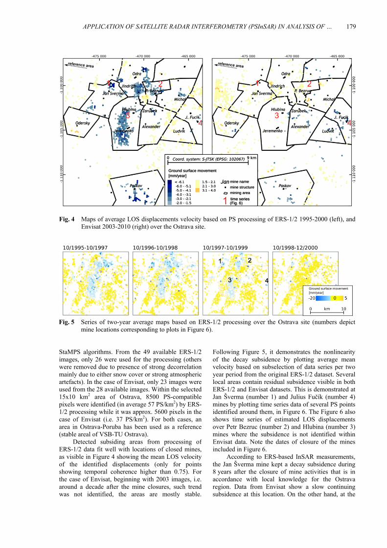
Fig. 4 Maps of average LOS displacements velocity based on PS processing of ERS-1/2 1995-2000 (left), andEnvisat 2003-2010 (right) over the Ostrava site.
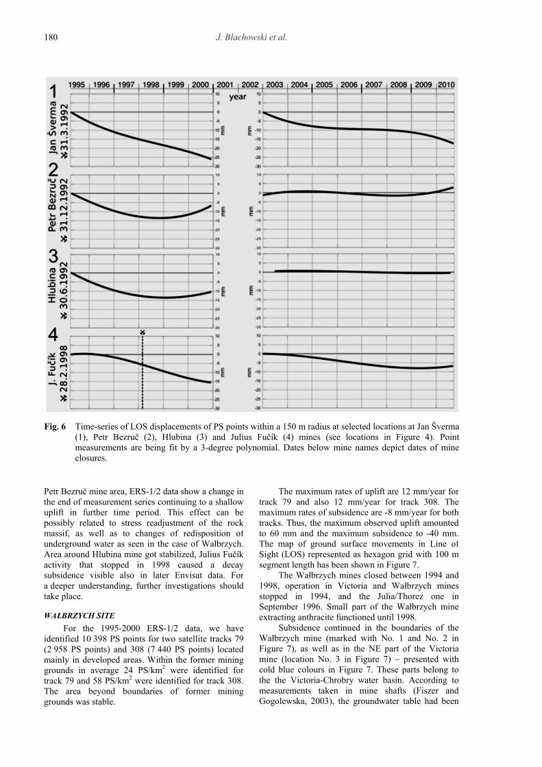
Fig. 5 Series of two-year average maps based on ERS-1/2 processing over the Ostrava site (numbers depictmine locations corresponding to plots in Figure 6).
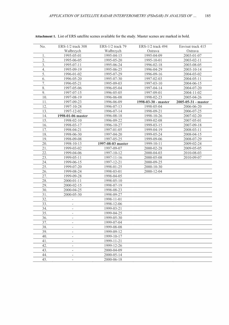
Following Figure 5, it demonstrates the nonlinearityof the decay subsidence by plotting average meanvelocity based on subselection of data series per twoyear period from the original ERS-1/2 dataset. Severallocal areas contain residual subsidence visible in bothERS-1/2 and Envisat datasets. This is demonstrated atJan Šverma (number 1) and Julius Fučík (number 4)mines by plotting time series data of several PS pointsidentified around them, in Figure 6. The Figure 6 alsoshows time series of estimated LOS displacementsover Petr Bezruc (number 2) and Hlubina (number 3)mines where the subsidence is not identified withinEnvisat data. Note the dates of closure of the minesincluded in Figure 6.
According to ERS-based InSAR measurements,the Jan Šverma mine kept a decay subsidence during8 years after the closure of mine activities that is inaccordance with local knowledge for the Ostravaregion. Data from Envisat show a slow continuingsubsidence at this location. On the other hand, at the
StaMPS algorithms. From the 49 available ERS-1/2images, only 26 were used for the processing (otherswere removed due to presence of strong decorrelationmainly due to either snow cover or strong atmosphericartefacts). In the case of Envisat, only 23 images wereused from the 28 available images. Within the selected15x10 km2 area of Ostrava, 8500 PS-compatiblepixels were identified (in average 57 PS/km2) by ERS-1/2 processing while it was approx. 5600 pixels in thecase of Envisat (i.e. 37 PS/km2). For both cases, anarea in Ostrava-Poruba has been used as a reference(stable areal of VSB-TU Ostrava).
Detected subsiding areas from processing ofERS-1/2 data fit well with locations of closed mines,as visible in Figure 4 showing the mean LOS velocityof the identified displacements (only for pointsshowing temporal coherence higher than 0.75). Forthe case of Envisat, beginning with 2003 images, i.e.around a decade after the mine closures, such trendwas not identified, the areas are mostly stable.
J. Blachowski et al.
180
Fig. 6 Time-series of LOS displacements of PS points within a 150 m radius at selected locations at Jan Šverma(1), Petr Bezruč (2), Hlubina (3) and Julius Fučík (4) mines (see locations in Figure 4). Pointmeasurements are being fit by a 3-degree polynomial. Dates below mine names depict dates of mineclosures.
The maximum rates of uplift are 12 mm/year fortrack 79 and also 12 mm/year for track 308. Themaximum rates of subsidence are -8 mm/year for bothtracks. Thus, the maximum observed uplift amountedto 60 mm and the maximum subsidence to -40 mm.The map of ground surface movements in Line ofSight (LOS) represented as hexagon grid with 100 msegment length has been shown in Figure 7.
The Wałbrzych mines closed between 1994 and1998, operation in Victoria and Wałbrzych minesstopped in 1994, and the Julia/Thorez one inSeptember 1996. Small part of the Wałbrzych mineextracting anthracite functioned until 1998.
Subsidence continued in the boundaries of theWałbrzych mine (marked with No. 1 and No. 2 inFigure 7), as well as in the NE part of the Victoriamine (location No. 3 in Figure 7) – presented withcold blue colours in Figure 7. These parts belong tothe the Victoria-Chrobry water basin. According tomeasurements taken in mine shafts (Fiszer andGogolewska, 2003), the groundwater table had been
Petr Bezruč mine area, ERS-1/2 data show a change inthe end of measurement series continuing to a shallowuplift in further time period. This effect can bepossibly related to stress readjustment of the rockmassif, as well as to changes of redisposition ofunderground water as seen in the case of Wałbrzych.Area around Hlubina mine got stabilized, Julius Fučíkactivity that stopped in 1998 caused a decaysubsidence visible also in later Envisat data. Fora deeper understanding, further investigations shouldtake place.
WAŁBRZYCH SITE
For the 1995-2000 ERS-1/2 data, we haveidentified 10 398 PS points for two satellite tracks 79(2 958 PS points) and 308 (7 440 PS points) locatedmainly in developed areas. Within the former mininggrounds in average 24 PS/km2 were identified fortrack 79 and 58 PS/km2 were identified for track 308.The area beyond boundaries of former mininggrounds was stable.

APPLICATION OF SATELLITE RADAR INTERFEROMETRY (PSInSAR) IN ANALYSIS OF … .
181
Fig. 7 Average movements (LOS) of ground surface between 1995-2000 in the Wałbrzych Coal Basin
increase in rock mass hydrostatic pressure as waterfilled voids left in the rock mass and redistribution ofstresses.
DISCUSSION
Information on ground motion has been obtainedfrom ERS-1/2 data processed with PSInSARtechnique. For the Ostrava site Envisat, data has beenused in addition. In case of the Wałbrzych site,datasets for two ERS-1/2 satellite tracks have beenprocessed to determine average ground movements.The Ostrava study is based on data from one track.The same software solutions have been applied,DORIS and StaMPS for analysis of groundmovements in the Ostrava and the Wałbrzych areas.Both studies have focused on urbanised areas offormer mining sites and have been based on thePSInSAR processing methodology. Similar permanentscatterer (PS) point densities have been obtained forboth sites for ERS-1/1 data used.
Mining in the analysed parts of the Ostrava andthe Wałbrzych sites stopped at approximately thesame time, i.e.: 1992 for the Jan Šverma mine, 1994for the Odra, the Victoria and the Wałbrzych minesand 1996 for the Thorez mine. In both regions,cessation of mining was a gradual process. In theWałbrzych region hydrogeological conditions haveallowed for controlled rise of groundwater levels,separately for mines associated with differentunderground water basins. This was the reason for
kept there at -184 m a.s.l. as mining continued thereuntil 1998. The groundwater table was then restoredfrom 1998 to 2002 when it reached 400 m a.s.l. Thedynamics of ground movements in the Wałbrzychmine and the NE part of the Victoria mine areas areshown in Figure 8. They indicate subsidence reaching-30 mm to -40 mm depending on particular site withlocation No. 3 manifesting the most consistentdecaying subsidence trend.
We have identified areas of elevation in theboundaries of the Victoria mine – presented withwarm colours (marked as No. 4 and No. 6 inFigure 7), as well as in the eastern part of the Thorezmine (marked as No. 5 in Figure 7). The values of thelatter are very close to error of their estimation. Thearea of elevation in the western part of the abandonedVictoria mine correlates with the Witold-Barbarawater basin where groundwater table rise between1994 and 1999 from 210 m a.s.l. to 500 m a.s.l., asmine water drainage had been stopped there (Fiszerand Gogolewska, 2003). The area of elevation in theeastern part of abandoned Thorez mine correlates withthe Pokoj water basin where the groundwater table hasbeen restored to 430 m a.s.l. (rise of 210 m) betweenmid-1995 and mid-1997. Mining in these parts ofWałbrzych Coal Basin finished in 1994. Thedynamics of ground surface movements for theseparts are shown in Figure 9. They indicate consistentaveraged elevation reaching up to 25 mm in theseparticular locations. The uplift can be attributed to

J. Blachowski et al.
182
Fig. 8 Time-series of LOS displacements of PS points representing identified areas of subsidence within a150 m radius at selected locations at Wałbrzych mines (see locations in Figure 7).
-8 mm/year for the Ostrava and Wałbrzych sitesrespectively. The rate of elevation in the Wałbrzychsite has been approx. 1.5 higher than the rate ofsubsidence. Significant elevation has been observed inthe Ostrava site in the second period 2003-2010 in onepart (Jan Šverma and Julius Fučík mines) andstabilization in the other (Petr Bezruč and Hlubinamines). These differences in the picture of groundmovements between the compared coal basins can beattributed to dissimilarities in time of mine flooding asregulation of underground water levels has influenceon distribution of pressure in rock massif. This can bethe reason of identified deformations at the givenmine area, as well as regional variances in geologicaland mining settings. Based on the results from bothsites the following general trend for these coal miningsites can be identified: decreasing residual subsidence
differentiated ground movements, subsidence incentral parts of the mining fields where miningstopped completely in 1998 and uplift in externalareas (towards W and NE) where restoration ofunderground water levels had happened earlier(between 1994 and 1998). In case of the Ostrava site,the entire area has experienced gradually decreasingsubsidence, and in the case of the Odra mine,stabilization and gentle uplift in the second period(2003-2010) that was analysed with Envisat data. Forthe Wałbrzych site, results of a study described inMilczarek et al. (2017) for the 2002-2009 period,indicate uplift of up to 4 mm/year in the central part ofthe coal basin where subsidence occurred between1995 and 2000. The other areas remained stable.
Maximum observed subsidence rates weresimilar for both coal basins and reached from -6 to

APPLICATION OF SATELLITE RADAR INTERFEROMETRY (PSInSAR) IN ANALYSIS OF … .
183
Fig. 9 Time-series of LOS displacements of PS points representing identified areas of elevation within a 150 mradius at selected locations at Wałbrzych mines (see locations in Figure 7).
complicated geological and mining conditions andunfavourable economic circumstances. Knowledgefrom other former mining sites suggested that thesesites may experience ground motions following theend of mining. As geodetic surveys by mine serviceshave been stopped limiting access to data needed foranalysis of present day condition of ground surface wehave taken the advantage of satellite radarinterferometry PSInSAR processing technique toobtain surface deformation information. We haveobserved residual subsidence in both areas of up to-8 mm/year, as well as elevation, which we correlatedwith zones where possible readjustment of rock massstress has happened following restoration ofunderground water levels. Rate of elevation wasgreater for Wałbrzych site with value of up to+12 mm/year. The process of upward groundmovement is more visible in the Wałbrzych site.
after cessation of mining followed by gentle elevationand stabilisation (insignificant ground movementssmaller than error of their estimation). Our findingsare in accordance with the results of other studies offormer coal mining sites pointing to the effect ofstress redistribution in rock mass following cessationof water drainage. The presented differences, i.e.faster ground surface response (start of uplift afterrestoration of former groundwater level) in theWałbrzych site than in the Ostrava site arise fromlocal (geological and mining) differences between theanalysed areas.
CONCLUSIONS
We have presented a comparative study of twoformer underground coal mining sites located in theCzech Republic and in Poland. Both areas have beenclosed in the mid 1990’s of the 20th Century due to

J. Blachowski et al.
184
Fiszer, J. and Gogolewska, A.: 2003, Changes ofgroundwater conditions during the process of LowerSilesian Coal Basin closure. Wroclaw University ofTechnology, Institute of Mining Engineering Report,No. 35, (in Polish).
Gee, D., Bateson, L., Sowter, A., Grebby, S., Novellino, A.,Cigna, F., Marsh, S., Banton, C. and Wyatt, L.: 2017,Ground motion in areas of abandoned mining:Application of the Intermittent SBAS (ISBAS) to theNorthumberland and Durham Coalfield, UK. Geosci.,7, 3, 85. DOI: 10.3390/geosciences7030085
Hooper, A., Zebker, H., Segall, P. and Kampes, B.: 2004,New method for measuring deformation on volcanoesand other natural terrains using InSAR persistentscattrers. Geophys. Res. Lett., 31, L23611. DOI: 10.1029/2004GL021737
Hooper, A.: 2006, Persistent scatterer radar interferometryfor crustal deformation studies and modeling ofvolcanic deformation. Ph.D. Thesis, StanfordUniversity.
Jiránková, E. and Lazecký, M.: 2016, Specifics in theformation of subsidence troughs in the Karvina part ofthe Ostrava-Karvina Coal District with the use ofradar interferometry. Acta Geodyn. Geomater., 13,3(183), 263–269. DOI: 10.13168/AGG.2016.0008
Kampes, B. and Usai, S.: 1999, Doris: The Delft object-oriented Radar Interferometric Software. In:Proceedings ITC 2nd ORS Symposium, August 1999.
Kominowski, K.: 2000, Geology and hydrogeology. In:Kowalski, A. (Ed.), Mining and surface protection.Experiences from the Walbrzych mines, CentralMining Institute, Katowice, 33–48, (in Polish).
Mei, S., Poncos, V., and Froese, C.: 2007, InSAR mappingof millimetre-scale ground deformation over FrankSlide, Turtle Mountain, Alberta. Alberta Energy andUtilities Board, EUB/AGS Earth Science Report, 1–62.
Majer, J., Matějček, J., Matušek, Z. et al.: 1985, CoalMining in Czechoslovakia. Profil Ostrava, 800 pp, (inCzech).
Milczarek, W., Blachowski, J. and Grzempowski, P.: 2017,Application of PSInSAR for assessment of surfacedeformations in post-mining area – case study of theformer Walbrzych hard coal basin (SW Poland). ActaGeodyn. Geomater., 14, 1(185), 41–52. DOI: 10.13168/AGG.2016.0026
Raucoules, D., Colesanti, C. and Carnec, C.: 2007, Use ofSAR interferometry for detecting and assessingground subsidence. C. R. Geosci., 339, 5, 289–302.DOI: 10.1016/j.crte.2007.02.002
Rapantová, N. and Grmela, A.: 2004, Hydraulic modellingof liquidated partial coal basins flooding in Ostrava-Karviná coal district. Podzemná voda, 10, 1, 82–93,(in Czech with English summary).
Samsonov, S., d’Oreye, N. and Smets, B.: 2013, Grounddeformation associated with post-mining activity atthe French–German border revealed by novel InSARtime series method. Int. J. Appl. Earth Obs. Geoinf.,23, 142–154. DOI: 10.1016/j.jag.2012.12.008
Wójcik, J.: 2008, Surface change due to mining in theWalbrzych area. Landf. Anal., 9, 339–342, (in Polishwith English summary).
However, complete information on the process ofsecondary deformations in these areas requires longertime of observations and this is the target of furtherstudies.
ACKNOWLEDGMENTS
This work was supported by The Ministry ofEducation, Youth and Sports from the NationalProgramme of Sustainability (NPU II) project„IT4Innovations excellence in science - LQ1602, fromthe Large Infrastructures for Research, ExperimentalDevelopment and Innovations project „IT4Innovations National Supercomputing Center –LM2015070“ and from the Ministry of Science andHigher Education statutory Grant 0401/0123/17realised at the Faculty of Geoengineering, Mining andGeology Wroclaw University of Science andTechnology.
REFERENCES
Abdikan, S., Arıkan, M., Sanli, F.B. and Cakir, Z.: 2014,Monitoring of coal mining subsidence in peri-urbanarea of Zonguldak city (NW Turkey) with persistentscatterer interferometry using ALOS-PALSAR.Environ. Earth Sci., 71, 9, 4081–4089. DOI: 10.1007/s12665-013-2793-1
Bateson, L., Cigna, F., Boon, D. and Sowter, A.: 2015, Theapplication of the Intermittent SBAS (ISBAS) InSARmethod to the South Wales Coalfield, UK. Int. J.Appl. Earth Obs. Geoinf., 34, 249–257. DOI:10.1016/j.jag.2014.08.018
Blachowski, J., Milczarek, W. and Grzempowski, P.: 2015,Historical and present-day vertical movements on oldmining terrains - case study of the Walbrzych CoalBasin (SW Poland). Acta Geodyn. Geomater., 12, 3(179), 227–236. DOI: 10.13168/AGG.2015.0020
Černý, I. (ed.): 2003, Coal mining in Ostrava-Karvinadistrict. Ostrava, Anagram, (in Czech).
Dopita, M. and Aust, J.: 1997, Geology of the Czech part ofthe Upper Silesian Basin. MZP, Praha, 278 pp, (inCzech with English summary).
Dopita, M. and Kumpera, O.: 1993, Geology of the Ostrava-Karviná coalfield, Upper Silesian Basin, CzechRepublic, and its influence on mining. Int. J. CoalGeol., 23, 1-4, 291–321. DOI: 10.1016/0166-5162(93)90053-D
Chudek, M.: 2002, Geomechanics with elements of miningenvironment and ground surface protection.Wydawnictwo Politechniki Śląskiej, Gliwice, (inPolish).
Chwastek, J.: 1980, Mine surveying and protection ofmining areas, Wrocław, (in Polish).
Caro-Cuenca, M., Hooper, A.J. and Hanssen, R.F.: 2013,Surface deformation induced by water influx in theabandoned coal mines in Limburg, the Netherlandsobserved by satellite radar interferometry. J. Appl.Geophys., 88, 1–11. DOI: 10.1016/j.jappgeo.2012.10.003
APPLICATION OF SATELLITE RADAR INTERFEROMETRY (PSInSAR) IN ANALYSIS OF … .
185
Attachment 1. List of ERS satellite scenes available for the study. Master scenes are marked in bold.
No. ERS-1/2 track 308 Wałbrzych
ERS-1/2 track 79 Wałbrzych
ERS-1/2 track 494 Ostrava
Envisat track 415 Ostrava
1. 1995-05-01 1995-04-15 1995-04-09 2003-01-07 2. 1995-06-05 1995-05-20 1995-10-01 2003-02-11 3. 1995-07-11 1995-06-24 1996-02-18 2003-08-05 4. 1995-09-19 1995-06-25 1996-04-29 2003-10-14 5. 1996-01-02 1995-07-29 1996-09-16 2004-03-02 6. 1996-05-20 1995-07-30 1997-02-03 2004-05-11 7. 1996-05-21 1995-09-03 1997-03-10 2004-06-15 8. 1997-05-06 1996-05-04 1997-04-14 2004-07-20 9. 1997-07-15 1996-05-05 1997-09-01 2004-11-02 10. 1997-08-19 1996-06-08 1998-02-23 2005-04-26 11. 1997-09-23 1996-06-09 1998-03-30 - master 2005-05-31 - master 12. 1997-10-28 1996-07-13 1998-05-04 2006-06-20 13. 1997-12-02 1996-07-14 1998-09-21 2006-07-25 14. 1998-01-06 master 1996-08-18 1998-10-26 2007-02-20 15. 1998-02-10 1996-09-22 1999-02-08 2007-05-01 16. 1998-03-17 1996-10-27 1999-03-15 2007-09-18 17. 1998-04-21 1997-01-05 1999-04-19 2008-03-11 18. 1998-06-30 1997-04-20 1999-05-24 2008-04-15 19. 1998-09-08 1997-05-25 1999-09-06 2008-07-29 20. 1998-10-13 1997-08-03 master 1999-10-11 2009-02-24 21. 1999-03-02 1997-09-07 2000-02-28 2009-05-05 22. 1999-04-06 1997-10-12 2000-04-03 2010-08-03 23. 1999-05-11 1997-11-16 2000-05-08 2010-09-07 24. 1999-06-15 1997-12-21 2000-09-25 25. 1999-07-20 1998-01-25 2000-10-30 26. 1999-08-24 1998-03-01 2000-12-04 27. 1999-09-28 1998-04-05 28. 2000-01-11 1998-05-10 29. 2000-02-15 1998-07-19 30. 2000-04-25 1998-08-23 31. 2000-05-30 1998-09-27 32. - 1998-11-01 33. - 1998-12-06 34. - 1999-03-21 35. - 1999-04-25 36. - 1999-05-30 37. - 1999-07-04 38. - 1999-08-08 39. - 1999-09-12 40. - 1999-10-17 41. - 1999-11-21 42. - 1999-12-26 43. - 2000-04-09 44. - 2000-05-14 45. - 2000-06-18