
Appendix G - Oxford Road and Piccailly - Environmental ... · beneficial environmental effects that...
528
Network Rail (Manchester Piccadilly and Oxford Road Capacity Scheme) Order TRANSPORT AND WORKS ACT 1992 NETWORK RAIL (MANCHESTER PICCADILLY AND OXFORD ROAD CAPACITY SCHEME) ORDER DOCUMENT 21: ENVIRONMENTAL STATEMENT DOCUMENT 21.02: MAIN STATEMENT Document Reference 21.02 Author Network Rail Date August 2014 Date of revision and revision number August 2014 P01.5
Transcript of Appendix G - Oxford Road and Piccailly - Environmental ... · beneficial environmental effects that...

Network Rail (Manchester Piccadilly and Oxford Road Capacity Scheme)Order
TRANSPORT AND WORKS ACT 1992
NETWORK RAIL (MANCHESTER PICCADILLY ANDOXFORD ROAD CAPACITY SCHEME) ORDER
DOCUMENT 21: ENVIRONMENTAL STATEMENTDOCUMENT 21.02: MAIN STATEMENT
Document Reference 21.02
Author Network Rail
Date August 2014
Date of revision andrevision number
August 2014P01.5

Network Rail (Manchester Piccadilly and Oxford Road) Order August 2014Main Statement - DRAFTDoc 21.02
[this page left intentionally blank]

Network Rail (Manchester Piccadilly and Oxford Road) Order August 2014Main Statement - DRAFTDoc 21.02
CONTENTS
GLOSSARY ............................................................................................................... 1ABBREVIATIONS...................................................................................................... 71. INTRODUCTION ............................................................................................... 11
1.1 The Scheme ............................................................................................... 11
1.2 The Requirement for an Environmental Statement .................................... 12
1.3 Background to the Project .......................................................................... 12
1.4 Site Location .............................................................................................. 12
1.5 ES Structure ............................................................................................... 15
1.6 Environmental Constraints ......................................................................... 16
2. EIA METHODOLOGY ....................................................................................... 202.1 Introduction ................................................................................................ 20
2.2 Environmental Statement Scope and Content ........................................... 20
2.3 Structure of the Environmental Statement ................................................. 26
2.4 Environmental Statement Technical Chapters ........................................... 28
2.5 Scope of the Assessment .......................................................................... 29
3. SCHEME DESCRIPTION .................................................................................. 363.1 Project Description ..................................................................................... 36
3.3 Context....................................................................................................... 45
3.4 Proposed Scheme ..................................................................................... 49
3.5 Utility Diversions ........................................................................................ 62
3.6 Strengthening of Existing Structures .......................................................... 62
3.7 New Signalling and Overhead Line Electrification Structures .................... 88
3.8 Delivery of the Scheme .............................................................................. 88
3.9 Construction Compounds........................................................................... 89
3.10 Draft Code of Construction Practice ........................................................... 96
3.11 Construction Activities ................................................................................ 98

Network Rail (Manchester Piccadilly and Oxford Road) Order August 2014Main Statement - DRAFTDoc 21.02
3.13 Operation ................................................................................................. 105
4. APPRAISAL OF ALTERNATIVES TO THE SCHEME ................................... 1074.1 Introduction .............................................................................................. 107
4.2 Alternatives .............................................................................................. 107
4.3 Need for the Development ....................................................................... 107
4.4 Alternative Sites ....................................................................................... 110
4.5 Strategic Options ..................................................................................... 110
4.6 Local Alternatives ..................................................................................... 112
4.7 Form of the Scheme ................................................................................ 123
4.8 Conclusion ............................................................................................... 128
5. PLANNING POLICY ....................................................................................... 1295.1 Introduction .............................................................................................. 129
5.2 National Planning and Transport Policy ................................................... 129
5.3 Supplementary Planning Documents ....................................................... 133
6. HISTORIC ENVIRONMENT ............................................................................ 1346.1 Introduction .............................................................................................. 134
6.2 Limitations and Assumptions ................................................................... 134
6.3 Study Area ............................................................................................... 135
6.4 Legislation, Planning and Guidance ......................................................... 135
6.5 Approach and Methodology ..................................................................... 137
6.6 Baseline ................................................................................................... 145
6.7 Assessment of Potential Impacts and Significance of Effects .................. 152
6.8 Mitigation Measures ................................................................................. 156
6.9 Residual Effects ....................................................................................... 158
7. TOWNSCAPE AND VISUAL AMENITY ......................................................... 1627.1 Introduction .............................................................................................. 162
7.2 Limitations and Assumptions ................................................................... 164

Network Rail (Manchester Piccadilly and Oxford Road) Order August 2014Main Statement - DRAFTDoc 21.02
7.3 Study Area ............................................................................................... 164
7.4 Legislation, Planning and Guidance ......................................................... 165
7.5 Approach and Methodology ..................................................................... 167
7.6 Baseline ................................................................................................... 174
7.7 Potential Impacts and Significance of Effects .......................................... 187
7.8 Mitigation Measures ................................................................................. 212
7.9 Residual Effects ....................................................................................... 213
8. TRAFFIC AND TRANSPORT ......................................................................... 2228.1 Introduction .............................................................................................. 222
8.2 Limitations and Assumptions ................................................................... 222
8.3 Study Area ............................................................................................... 222
8.4 Legislation, Planning and Guidance ......................................................... 224
8.5 Approach and Methodology ..................................................................... 227
8.6 Baseline ................................................................................................... 229
8.7 Determining the Significance of Effects ................................................... 235
8.8 Potential Impacts and Significance of Effects .......................................... 236
8.9 Mitigation Measures ................................................................................. 279
8.10 Residual Effects ....................................................................................... 282
9. NOISE AND VIBRATION ................................................................................ 2859.1 Introduction .............................................................................................. 285
9.2 Scope ....................................................................................................... 285
9.3 Legislation, Planning and Guidance ......................................................... 286
9.4 Approach and Methodology ..................................................................... 288
9.5 Baseline ................................................................................................... 293
9.6 Assessment of Construction Noise and Vibration .................................... 293
9.7 Mitigation (NB: this section is subject to review pending further information) ................................................................................................................ 300

Network Rail (Manchester Piccadilly and Oxford Road) Order August 2014Main Statement - DRAFTDoc 21.02
9.8 Summary of Residual Effects ................................................................... 303
10. WATER RESOURCES AND FLOOD RISK .................................................... 30710.1 Introduction .............................................................................................. 307
10.2 Limitations and Assumptions ................................................................... 307
10.3 Study Area ............................................................................................... 307
10.4 Legislation, Planning and Guidance ......................................................... 308
10.5 Approach and Methodology ..................................................................... 312
10.6 Baseline ................................................................................................... 320
10.7 Potential Impacts and Significance of Effects .......................................... 331
10.8 Mitigation Measures ................................................................................. 343
10.9 Residual Effects ....................................................................................... 345
11. GEOLOGY, SOIL AND LAND CONTAMINATION ......................................... 35011.1 Introduction .............................................................................................. 350
11.2 Limitations and Assumptions ................................................................... 350
11.3 Study Area ............................................................................................... 351
11.4 Design Considerations ............................................................................. 351
11.5 Legislation ................................................................................................ 352
11.6 National Planning Policy and Guidance ................................................... 352
11.7 Local Planning Policy ............................................................................... 352
11.8 Relevant Contaminated Land Guidance .................................................. 353
11.9 Approach and Methodology ..................................................................... 354
11.10 Baseline Conditions and Receptors .................................................. 359
11.11 Assessment of Potential Impacts and Significance of Effects ........... 374
11.12 Mitigation Measures .......................................................................... 383
12. ECOLOGY ...................................................................................................... 38912.1 Introduction .............................................................................................. 389

Network Rail (Manchester Piccadilly and Oxford Road) Order August 2014Main Statement - DRAFTDoc 21.02
12.2 Legislation, Planning and Guidance ......................................................... 390
12.3 Approach and Methodology ..................................................................... 392
12.4 Baseline Studies and Evaluation of Ecological Receptors ....................... 401
12.5 Stage 3: Identification of Valued Ecological Receptors ............................ 411
12.6 Identification and Characterisation of Potential Impacts and Assessment ofImpact Significance (Stages 4 and 5)...................................................... 413
12.7 Mitigation, Enhancement Measures and Residual Effects (to be completedfollowing results) ..................................................................................... 422
12.8 Residual Effects ....................................................................................... 429
13. AIR QUALITY ................................................................................................. 43113.1 Introduction .............................................................................................. 431
13.2 Legislation, Planning and Guidance ......................................................... 434
13.3 Approach and Methodology ..................................................................... 436
13.4 Baseline ................................................................................................... 446
13.5 Potential Impacts and Significance of Effects .......................................... 451
13.6 Mitigation Measures ................................................................................. 460
13.7 Residual Effects ....................................................................................... 461
13.8 Summary and Conclusions ...................................................................... 461
14. SOCIOECONOMICS ....................................................................................... 46414.1 Introduction .............................................................................................. 464
14.2 Legislation, Planning and Guidance ......................................................... 466
14.3 Approach and Methodology ..................................................................... 466
14.4 Baseline ................................................................................................... 467
14.5 Potential Impacts and Significance of Effects .......................................... 474
14.6 Mitigation Measures ................................................................................. 481
14.7 Residual Effects ....................................................................................... 482
15. CUMULATIVE EFFECTS ................................................................................ 484

Network Rail (Manchester Piccadilly and Oxford Road) Order August 2014Main Statement - DRAFTDoc 21.02
15.1 Background .............................................................................................. 484
15.2 Cumulative Assessment Methodology ..................................................... 484
15.3 Effects during Construction ...................................................................... 486
15.4 Effects during Operation of the Scheme .................................................. 489
15.5 Significance of Cumulative Effects ........................................................... 493
15.6 Conflict with Other Developments ............................................................ 493
15.7 Northern Hub Proposals........................................................................... 494
15.8 Summary.................................................................................................. 494
16. SUMMARY OF MITIGATION .......................................................................... 49716.1 Introduction .............................................................................................. 497
16.2 Cumulative and Interactive Effects ........................................................... 513

SELECTED TECHNICAL DOCUMENTS OF THE ENVIRONMENTAL IMPACT ASSESSMENT FORMING PART OF PHASE 2 CONSULTATION Along with the draft ES Main Statement, the following three technical reports are included in this folder (Volume 2 of 2) for consultation purposes:
a. Transport Assessment;
b. Manchester Piccadilly Traffic Survey Report; and
c. Flood Risk Assessment These three documents are included at the back of this folder; please see separate tabs, marked a, b and c A FULL SET OF SUPPORTING TECHNICAL DOCUMENTS WILL BE AVAILABLE WITH THE FORMAL APPLICATION The list of documents referred to on the next page, is the full suite of supporting documents that will form part of the final ES at the later application stage. For the avoidance of doubt, the full suite does not form part of phase 2 consultation.

Network Rail (Manchester Piccadilly and Oxford Road) Order August 2014Main Statement - DRAFTDoc 21.02
LIST OF SUPPORTING DOCUMENTS
Document 21.03 Scoping Request Report
Document 21.04 Scoping Opinion
Document 21.05 Ecology Impact Assessment for the Scheme
Document 21.06 Air Quality Impact Assessment for the Scheme
Document 21.07 Socioeconomic Assessment for the Scheme
Document 21.08 Geology, Soil and Land Contamination Assessment for the Scheme
Document 21.09 TWA Order Drawing Reference List
Document 21.10 Utilities Diversions
Document 21.11 Draft Code of Construction Practice
Document 21.12 Heritage Assessment
Document 21.13 Listed Building Consent Drawings
Document 21.14 Photomontage Methodology
Document 21.15 Transport Assessment
Document 21.16 Baseline Noise Monitoring Results
Document 21.17 Noise Calculations/Plan for Construction Noise and Vibration
Document 21.18 Noise Calculations/Plans for Operation Noise and Vibration
Document 21.19 Flood Risk Assessment
Document 21.20 Oxford Road Drainage Survey
Document 21.21 Manchester Piccadilly Drainage Survey
Document 21.22 Cumulative Assessment
Document 21.23 Figures

Network Rail (Manchester Piccadilly and Oxford Road) Order August 2014Main Statement - DRAFTDoc 21.02
[this page intentionally left blank]

Network Rail (Manchester Piccadilly and Oxford Road) Order August 2014Main Statement - DRAFTDoc 21.02
ENVIRONMENTAL STATEMENT FIGURES
Figure 21.2.01 Area 1 Manchester Piccadilly Station .......................................................... 13
Figure 21.2.02 Area 2 Oxford Road Station ........................................................................ 15
Figure 21.2.04 Scheme Railway Context ............................................................................ 42
Figure 21.2.05 – Key Features of the Piccadilly Station Area .............................................. 46
Figure 21.2.06: Key Features of the Oxford Road Station Area ........................................... 47
Figure 21.2.05 Area 1: Piccadilly Station Area .................................................................... 50
Figure 21.2.06 Area 2: Oxford Road Station ....................................................................... 56
Figure 21.2.07: Piccadilly Station – Development Options ................................................ 116
Figure 21.2.08: Oxford Road Station – Development Options ........................................... 120
Figure 21.2.09: Piccadilly Station – Option C .................................................................... 122
Figure 21.2.10: Oxford Road Station – Option A ............................................................... 122
Figure 21.2.11: Scheme Location (Indicative Study Area) ................................................. 223
Figure 21.2.12: Manchester Piccadilly Station Pedestrian Crossing Desire Lines – AM PeakHour .................................................................................................................................. 232
Figure 21.2.13: Manchester Piccadilly Station Pedestrian Crossing Desire Lines – PM PeakHour .................................................................................................................................. 233
Figure 21.2.14: Construction Compound Locations ........................................................... 245
Figure 21.2.15: Compound A Layout and Access Routes ................................................. 246
Figure 21.2.16: Compound B Layout and Access Routes ................................................. 247
Figure 21.2.17: Compound C and Compound D Layout and Access Routes .................... 248
Figure 21.2.18: Fairfield Street/Travis Street Final Highway Layout .................................. 261
Figure 21.2.19: Gloucester Street / Whitworth Street West Final Highway Layout ............. 262

Network Rail (Manchester Piccadilly and Oxford Road) Order August 2014Main Statement- DRAFTDoc 21.02
[this page intentionally left blank]

Network Rail (Manchester Piccadilly and Oxford Road) Order August 2014Main Statement- DRAFTDoc 21.02
CONTENTS OF DOCUMENT 21.23: FIGURES
Figure 21.23.01 Manchester Piccadilly and Oxford Road Stations Location Plan
Figure 21.23.02 Application Site
Figure 21.23.03 Site Layout
Figure 21.23.04 Existing Features in the Surrounding Area
Figure 21.23.05 Proposed Construction Compounds
Figure 21.23.06 Compound Access Routes
Figure 21.23.07 Application Site Location Plan
Figure 21.23.08 Plan of Heritage Assets within the Application Site (East)
Figure 21.23.09 Plan of Heritage Assets within the Application Site (West)
Figure 21.23.10 Plan of HER sites within the eastern section of the 200m Study Area
Figure 21.23.11 Plan of HER sites within the western section of the 200m Study Area
Figure 21.23.12 Areas of archaeological interest within the Application Site subject topotential impact
Figure 21.23.13 Townscape Character Areas
Figure 21.23.14 ZTV and Viewpoint Locations
Figure 21.23.15 Photograph Viewpoints/Montages
Figure 21.23.16 Urban Realm Part 1
Figure 21.23.17 Urban Realm Part 2
Figure 21.23.18 Urban Realm Part 3
Figure 21.23.19 Water Constraints Map A
Figure 21.23.20 Water Constraints Map B
Figure 21.23.21 Water Constraints Map C
Figure 21.23.22 Piccadilly Station Outline Drainage Strategy
Figure 21.23.23 Oxford Road Station Outline Drainage Strategy
Figure 21.23.24 Air Quality Dust Assessment Study Area A
Figure 21.23.25 Air Quality Dust Assessment Study Area B

Network Rail (Manchester Piccadilly and Oxford Road) Order August 2014Main Statement- DRAFTDoc 21.02
Figure 21.23.26 Air Quality Receptor Locations
Figure 21.23.27 Manchester City Council MMC Monitoring Locations
Figure 21.23.28 Site Specific Monitoring Locations
Figure 21.23.29 Non-Statutory Designated Sites within 2km of the Scheme
Figure 21.23.30 Statutory Designated Sites within 10km of the Scheme
Figure 21.23.31 Phase 1 Habitat Survey 1 of 3
Figure 21.23.32 Phase 1 Habitat Survey 2 of 3
Figure 21.23.33 Phase 1 Habitat Survey 3 of 3
Figure 21.23.34 Development Proposals Considered for Cumulative Assessment

Network Rail (Manchester Piccadilly and Oxford Road) Order August 2014Main Statement- DRAFTDoc 21.02
Page 1 of 513
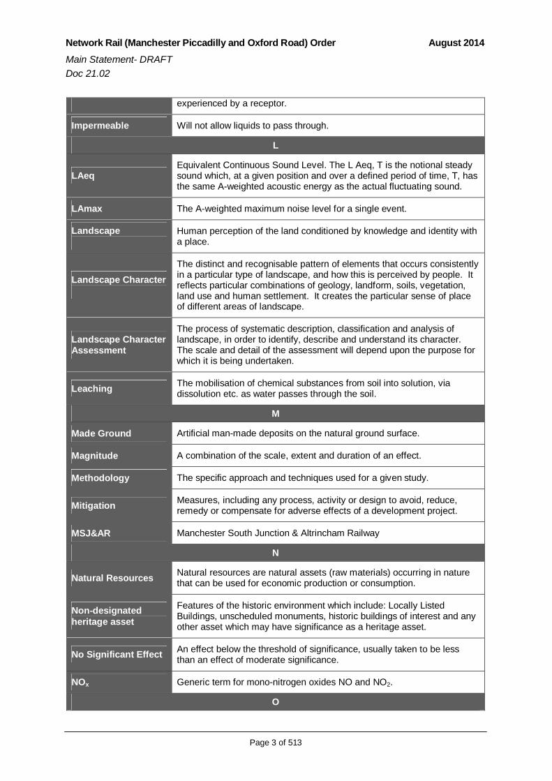
GLOSSARY
Term DefinitionA
Above OrdnanceDatum
“Ordnance Datum” is the mean sea-level and is used as the basis formeasuring the height of any point on land above sea-level.
Abstraction Removal of water from a groundwater or surface water body- usually bymeans of a pump.
Air QualityManagement Area
An area formally designated by the local authority in which levels of airpollution are above specified levels known as “air quality objectives”.
The ApplicationsRules
The Transport and Works (Applications and Objections Procedure)(England and Wales) Rules 2006.
Application Site
All land over which permission through the TWA Order is sought todevelop the Manchester Piccadilly and Oxford Road Stations CapacityScheme. This is the land included within the area edged in red (“the redline boundary”) in the TWA Order application; and some areas (minimal innature) no longer required.
ArchA curved structure usually in a vertical plane that by its shape spans anopening and carries load principally by transmitting a compressive thrustto foundations.
Archaeologicalevaluation
Various methods that can be used to clarify the extent, nature and thequality of archaeological deposits on a site.
B
Ballast Stone material which forms the track-bed of a railway line.
Baseline Information which represents the environmental conditions existing priorto commencement of construction or implementation of development.
Brownfield Previously developed land available for reuse.
C
Chord A line which joins two points.
CoCP Code of Construction Practice.
COL COL refers to the Bolton railway line between Ordsall Lane junction andCastlefield junction.
Contaminated landLand that is in such a condition that either significant harm is beingcaused or there is a significant possibility of such harm being caused, orpollution of controlled waters is being or is likely to be caused.
Construction Effects Effects that occur during the construction phase. These can betemporary or permanent.
Cumulative Effects Effects which arise from a combination or interaction of effects at a

Network Rail (Manchester Piccadilly and Oxford Road) Order August 2014Main Statement- DRAFTDoc 21.02
Page 2 of 513
specific location.
D
dB (A)Sound levels measured in decibels, calculated by a method (“A-weighted ) that takes particular account of the frequencies mostsignificant in traffic-generated noise.
Designated heritageasset
World Heritage Site, Scheduled Monument, Listed Building, ProtectedWreck Site, Registered Park and Garden, Registered Battlefield orConservation Area.
Development Plan A development plan sets out the policies and proposals for thedevelopment, conservation and use of land and buildings in a particularlocal planning authority area.
E
Effects Consequence of a change (impact) experienced by a receptor.
EnvironmentalImpact Assessment
A formal process which assesses the potential environmental effects of aproject.
EnvironmentalStatement
Document in which the results of an EIA are presented to decision-makers and the public.
F
FloodplainFlat or nearly flat land adjacent a stream or river that stretches from thebanks of its channel to the base of the enclosing valley walls andexperiences flooding during periods of high discharge.
Flood Zone 1 Land assessed as having a less than 1 in 1,000 annual probability of riveror sea flooding (<0.1%).
Flood Zone 2Land assessed as having between a 1 in 100 and 1 in 1,000 annualprobability of river flooding (1% – 0.1%), or between a 1 in 200 and 1 in1,000 annual probability of sea flooding (0.5% – 0.1%) in any year.
Gantry Overhead frame from which various structures can be mounted.
H
Heritage asset Building, monument, site, place, area or landscape positively identified ashaving a degree of significance meriting consideration in planningdecisions.
Historic environment The collective term given to encompass the material historic remains inthe landscapes of town and countryside.
Historic EnvironmentRecord
A series of linked computer databases that hold information on knownarchaeological sites, finds, landscapes, buildings and other aspects of thehistoric environment.
Hydrogeology The study of groundwater.
I
Impact A change as a result of the Scheme which causes an effect to be
Network Rail (Manchester Piccadilly and Oxford Road) Order August 2014Main Statement- DRAFTDoc 21.02
Page 3 of 513
experienced by a receptor.
Impermeable Will not allow liquids to pass through.
L
LAeqEquivalent Continuous Sound Level. The L Aeq, T is the notional steadysound which, at a given position and over a defined period of time, T, hasthe same A-weighted acoustic energy as the actual fluctuating sound.
LAmax The A-weighted maximum noise level for a single event.
Landscape Human perception of the land conditioned by knowledge and identity witha place.
Landscape CharacterThe distinct and recognisable pattern of elements that occurs consistentlyin a particular type of landscape, and how this is perceived by people. Itreflects particular combinations of geology, landform, soils, vegetation,land use and human settlement. It creates the particular sense of placeof different areas of landscape.
Landscape CharacterAssessment
The process of systematic description, classification and analysis oflandscape, in order to identify, describe and understand its character.The scale and detail of the assessment will depend upon the purpose forwhich it is being undertaken.
Leaching The mobilisation of chemical substances from soil into solution, viadissolution etc. as water passes through the soil.
M
Made Ground Artificial man-made deposits on the natural ground surface.
Magnitude A combination of the scale, extent and duration of an effect.
Methodology The specific approach and techniques used for a given study.
Mitigation Measures, including any process, activity or design to avoid, reduce,remedy or compensate for adverse effects of a development project.
MSJ&AR Manchester South Junction & Altrincham Railway
N
Natural Resources Natural resources are natural assets (raw materials) occurring in naturethat can be used for economic production or consumption.
Non-designatedheritage asset
Features of the historic environment which include: Locally ListedBuildings, unscheduled monuments, historic buildings of interest and anyother asset which may have significance as a heritage asset.
No Significant Effect An effect below the threshold of significance, usually taken to be lessthan an effect of moderate significance.
NOx Generic term for mono-nitrogen oxides NO and NO2.
O

Network Rail (Manchester Piccadilly and Oxford Road) Order August 2014Main Statement- DRAFTDoc 21.02
Page 4 of 513
Operational Effects Effects that occur during the operational phase. These can be temporaryor permanent.
P
Pathway A route or means by which a receptor could be, or is exposed to, oraffected by a contaminant.
PhotomontageThe superimposing of an image onto a photograph for the purpose ofcreating a realistic representation of proposed or potential changes to aview.
Pier A column, either structural or decorative, in a wall at regular intervals tostrengthen it. A load bearing wall between opening.
Piled foundation Any elongate columnar foundation used to transfer structural loads tocompetent founding material.
Piling The act of driving “piles” (supports) into the ground.
PollutionA change in the physical, chemical, radiological or biological quality of aresource (air, water or land) caused by people or their activities that isinjurious to existing, intended or potential uses of the resource.
Q
Qualitative Qualities or characteristics that cannot be measured numerically.
Quantitative Measurement based on data.
R
Ramsar site Wetland of international importance, designated under the RamsarConvention, 1971.
ReceptorIn general terms, something that could be adversely affected by acontaminant, such as people, an ecological system, property or a waterbody.
Residual Effect An environmental effect that remains, or is predicted to remain, even aftermitigation measures have been applied.
S
The Scheme The proposals authorised by the Network Rail Manchester Piccadilly andOxford Road Stations Capacity Order.
Sensitivity The degree of response of a receiver or instrument to a signal or achange.
Significance The extent to which something matters. Significance of effects is definedas substantial, moderate, minor or negligible.
Spandrel The roughly triangular area between the outer curve of an arch and ahorizontal line above it e.g. an arch carrying a bridge deck.
Source A substance that is in, on or under the land and that has the potential tocause harm or to cause pollution of controlled waters.

Network Rail (Manchester Piccadilly and Oxford Road) Order August 2014Main Statement- DRAFTDoc 21.02
Page 5 of 513
Source ProtectionZone
A defined zone surrounding a groundwater abstraction point (e.g. a wellor a spring), within which certain activities are restricted to preventcontamination of the groundwater.
StakeholderIndividuals, groups or organisations with an interest in the assessment ofthe development or the development itself. Consultation is undertakenwith stakeholders to inform the assessment and finalisation ofdevelopment details.
Superficial Deposits The youngest geological deposits formed during the most recent period ofgeological time.
Surface water runoff Precipitation which travels to watercourses over the surface of the land.
T
Topographic survey A method of determining accurate positions of objects for topographicmaps of large areas.
Topography Description of the shape and physical features of the earth’s surface.
Traffic ManagementPlan An agreed plan to manage traffic during construction.
Train One or more rail vehicles which are coupled together to form a singleoperating unit.
TransportAssessment
A formal assessment of the transport implications of a development whichis published as a report. For more information see the Department forTransport's Guidance on transport assessment (2007).
U
Undesignatedheritage asset
Features of the historic environment which include: Locally ListedBuildings, unscheduled monuments, historic buildings of interest and anyother asset which may have significance as a heritage asset.
V
Visual Amenity The visual quality of a site/area or view.
W
Wagon Heavy Vehicle.
Watching BriefA method of preserving archaeological remains by record in the face ofdevelopment threat. An archaeologist is employed by the developer tomonitor the excavation of foundation and service trenches, landscapingand any other intrusive work.
Water FrameworkDirective
A European Law which aims to improve water environments such aslakes and rivers.
Watercourse A channel in which water flow.

Network Rail (Manchester Piccadilly and Oxford Road) Order August 2014Main Statement- DRAFTDoc 21.02
Page 6 of 513
[this page left intentionally blank]

Network Rail (Manchester Piccadilly and Oxford Road) Order August 2014Main Statement- DRAFTDoc 21.02
Page 7 of 513
ABBREVIATIONS
Abbreviation Term
ANPR Automatic Number Plate Recognition
AOD Above Ordinance Datum
AQMA Air Quality Management Areas
ATC Automatic traffic counts
BGL Below Ground Level
BS British Standard
CDA Critical Drainage Area
CEMP Construction Environmental Management Plan
CoCP Code of Construction Practice
CIRIA Construction Industry Research and Information Association
CR-E Contract Requirements – Environment
CRN Calculation of Railway Noise
CSO Combined Sewage Overflow
CTMP Construction Traffic Management Plan
DCLG Department of Communities and Local Government
Defra Department for Environment, Food and Rural Affairs
DfT Department for Transport
DMRB Design Manual for Roads and Bridgs
EA Environment Agency
EcIA Ecological Impact Assessment
EH English Heritage
EHO Environmental Health Officer
EIA Environmental Impact Assessment
ES Environmental Statement
FRA Flood Risk Assessment
GLVIA Guidelines for Landscape and Visual Impact Assessment
GM Greater Manchester
GMAU Greater Manchester Archaeological Unit
GRIP Governance for Railway Investment Projects
HS1 High Speed 1
HS2 High Speed 2
HER Historic Environment Record
IEA Institute of Environmental Assessment
IfA Institute for Archaeologists

Network Rail (Manchester Piccadilly and Oxford Road) Order August 2014Main Statement- DRAFTDoc 21.02
Page 8 of 513
IRR Inner Ring Road
LLFA Lead Local Flood Authority
LNR Local Nature Reserves
LTP3 Third Local Transport Plan
LVIA Landscape and Visual Impact Assessment
MCC Manchester City Council
MoRPHE Management of Research projects in the Historic Environment
MSJ&AR Manchester South Junction & Altrincham Railway
NGR National Grid Reference
NMP Nuisance Management Plan
NMR National Monuments Record
NNR National Nature Reserves
NO2 Nitrogen Dioxide
NOx Nitrogen Oxides
NPPF National Planning Policy Framework
OLE Overhead Line Electrification
PCU Passenger Car Unit
PFRA Preliminary Flood Risk Assessment
PPE Personal Protective Equipment
PPG Planning Policy Guidance
PPICP Pollution Prevention and Incident Control Plan
PPS Planning Policy Statement
PRoW Public Rights of Way
SAB Sustainable Drainage Systems Approving Body
SAC Special Areas of Conservation
SCC Salford City Council
SFRA Strategic Flood Risk Assessment
SME Secondary Means of Escape
SPA Special Protection Areas
SPZ Groundwater Source Protection Zone
SRF Strategic Regeneration Framework
SSSI Sites of Special Scientific Interest
SUDS Sustainable Urban Drainage System
TA Transport Assessment
TAG Transport Appraisal Guidance
TCA Townscape Character Areas
TfGM Transport for Greater Manchester

Network Rail (Manchester Piccadilly and Oxford Road) Order August 2014Main Statement- DRAFTDoc 21.02
Page 9 of 513
TVIA Town and Visual Impact Assessment
TWA Transport and Works Act 1992
TWAO Transport and Works Act Order
UDP Unitary Development Plan
UMIST University of Manchester Institute of Science and Technology
UU United Utilities
VDV Vibration Dose Value
VP Viewpoints
WCML West Coast Main Line
WFD Water Framework Directive
WPZ Water Protection Zone
WRA Water Resources Act 1991
ZTV Zone of Theoretical Vision

Network Rail (Manchester Piccadilly and Oxford Road) Order August 2014Main Statement- DRAFTDoc 21.02
Page 10 of 513
[this page intentionally left blank]

Network Rail (Manchester Piccadilly and Oxford Road) Order August 2014Main Statement- DRAFTDoc 21.02
Page 11 of 513
1. INTRODUCTION
1.1 The Scheme
1.1.1 Network Rail proposes to improve the capacity of rail infrastructurethroughout the North of England. This is to be achieved through aprogramme of infrastructure improvement works, which when combinedconstitute the Northern Hub. The aim of the Northern Hub is to stimulateeconomic growth by improving the rail network in the North of England andto meet expected increase in demand for rail travel over the next 30 - 60years.
1.1.2 The part of the Northern Hub subject of this Environmental Statement (ES)is the Manchester Piccadilly and Oxford Road Capacity Scheme (theScheme). The purpose of the Scheme is to add to the capacity of the railnetwork so that it can accommodate additional train movements across theCity of Manchester.
1.1.3 The Scheme involves change to the train and passenger handling capacityat Manchester Piccadilly and Oxford Road Stations. It proposes works thatwill increase the number of platforms at Manchester Piccadilly which arecapable of handling through train services, make amendments to the layoutof the track and platforms at Oxford Road Station that mirror the changes atPiccadilly, adjust the vertical and horizontal alignment of existing track alongthe Castlefield Corridor1, and provide new and replacement signalling andOverhead Line Electrification (OLE) structures.
1.1.4 This document is the ES, prepared on behalf of Network Rail, and presentedin support of an application for an Order submitted under Part 1 of theTransport and Works Act 1992 (TWA), including full planning permission.The application is for the Network Rail (Manchester Piccadilly and OxfordRoad Capacity Scheme) Order. Following the grant of the Order, Network
1 A term used to refer to the railway line from Castlefield Junction (west of Deansgate) to Ardwick Junction (east of Piccadilly).
This is a draft version of the Environmental Statement (ES). The design ofthe Scheme is continuing. Further to this, work to reduce the impact of the
construction process is also on going. The process of consultation mayalso give rise to a need to amend these proposals. Change to the
Scheme may require further environmental assessment work, or revisionto the outcome of existing assessment. The final version of the ES
submitted as part of the TWA Order application will reflect any furtherassessments.

Network Rail (Manchester Piccadilly and Oxford Road) Order August 2014Main Statement- DRAFTDoc 21.02
Page 12 of 513
Rail will commence development. Construction is anticipated to begin inJanuary 2016 and to be complete in December 2018.
1.1.5 There are also three listed building consents being applied for which will beassimilated under the TWA procedures.
1.2 The Requirement for an Environmental Statement
1.2.1 The procedures for TWA Applications are described in The Transport andWorks (Applications and Objections Procedure) (England and Wales) Rules2006 (the Applications Rules). The Applications Rules require that unlessthe Secretary of State has provided a screening decision stating that an ESis not necessary, the applicant is required to submit an ES for any Annex Ior Annex II project.
1.3 Background to the Project
1.3.1 Rail is vital to economic prosperity. If rail services are inefficient and do notmeet people’s needs for routing or frequency, business and jobs can suffer.Encouraging people to use trains rather than cars, and reducing carbonemissions from trains - and stations themselves - can also contribute to theUK’s carbon reduction targets. For Manchester to realise the full potential tobe derived from a programme of works that aim to increase rail capacity inthe North of England, including electrification of principal routes, requireschange to capacity at principal stations. This Scheme seeks to address theneed to add to the number of ‘through’ platforms at Manchester PiccadillyStation and to reconfigure the layout of platforms and station buildings atOxford Road Station. To implement these improvements will requirechange to, and upgrade of, existing rail infrastructure. This will include track‘slewing’, new OLE structures, and signalling.
1.4 Site Location
1.4.1 The site for these works is the Castlefield Corridor, an existing railway,within the City of Manchester. The application area will involve works atthree existing stations, Manchester Piccadilly, Oxford Road and Deansgate.The proposed Scheme relates to the construction, operation andmaintenance of a new section of railway track, and improvements to existingrailway infrastructure; partly on land that is outside existing Network Railoperational land. The Scheme is divided into two congruent sections. Theeastern section, known as Area 1, centres on Manchester Piccadilly Station;the western section, Area 2, centres on Oxford Road Station. The two areasmeet at Princess Street or Col 43AA of the railway viaduct. An overview ofthe works is provided below. This section should be read in conjunction withFigure 21.23.01: Manchester Piccadilly and Oxford Road Stations Location

Network Rail (Manchester Piccadilly and Oxford Road) Order August 2014Main Statement- DRAFTDoc 21.02
Page 13 of 513
Plan, Figure 21.23.02: Site of Application Area, Figure 21.23.03: Site Layoutand Figure 21.23.04: Existing Features in the Surrounding Area, all part ofDocument 21: Environmental Statement.
Area 1: Manchester Piccadilly Station
1.4.2 The Scheme at Manchester Piccadilly (see Figure 21.2.01) is to comprise acorridor of development approximately 800 m in length between HoyleStreet and Sackville Street. The site generally follows the existing railwaycorridor, but runs to the south of Platforms 13 and 14 at Piccadilly Station. Itis to encompass land and buildings along Fairfield Street, between LondonRoad and Temperance Street. The western part of the development in thisarea crosses the London Road corridor; a busy arterial route, with severaltraffic lanes that link the city centre with the Mancunian Way (A635 & A57(M)). Fairfield Street provides a connection between the city centre andeast Manchester via Ashton Old Road. Taxis waiting to access PiccadillyStation queue up along Baring Street in the central area of the site. Otherminor roads within the site are Travis Street, Wyre Street and Neild Street.
Figure 21.2.01 Area 1 Manchester Piccadilly Station
1.4.3 The railway lines in this area are raised on bridges and viaducts. East ofLondon Road the structures vary in construction and comprise a mix ofmasonry (brick and stone) arches and girder bridge construction types.

Network Rail (Manchester Piccadilly and Oxford Road) Order August 2014Main Statement- DRAFTDoc 21.02
Page 14 of 513
None of these structures are listed. The viaduct arches between FairfieldStreet and London Road are currently disused. To the west of LondonRoad, the new track will tie into the Manchester South Junction andAltrincham Railway (MSJ&AR) Viaduct.
1.4.4 There are four listed buildings within the Scheme footprint in Area 1; theyare Grade II listed comprising: MSJ&AR Viaduct, the Star and Garter PublicHouse, the Train Shed Piccadilly Station and the Former Goods Office atPiccadilly Station. Manchester City Council (MCC) does not have a list oflocally listed buildings. The Whitworth Street Conservation Area extendsbetween Oxford Road in the west and London Road in the east, andtherefore encompasses the western part of the application site in this Area.
Area 2: Oxford Road Station
1.4.5 The area of the Scheme centred on Oxford Road Station (see Figure21.2.02) is generally confined to the existing railway. However, the existingviaduct structure will be widened in the vicinity of the station. The Schemein this area extends from Sackville Street in the east to just west (NB:awaiting confirmation of final extent of Scheme) of Deansgate Station. Therailway lines are all raised on viaducts and bridges that cross Oxford Road,New Wakefield Street, Great Marlborough Street and Gloucester Street.These are largely of brick and stone construction. A number of commercialbusinesses are located in the viaduct arches along Whitworth Street West,including takeaways, restaurants, a cycle shop and a hardware store.

Network Rail (Manchester Piccadilly and Oxford Road) Order August 2014Main Statement- DRAFTDoc 21.02
Page 15 of 513
Figure 21.2.02 Area 2 Oxford Road Station
1.4.6 There is one Grade II* listed building within Area 2 (The Palace Hotel) andfive Grade II listed comprising the Lass o’ Gowrie Public House, OxfordRoad Railway Station, Deansgate Railway Station, the MSJ&AR Viaductand the Ritz Dance Hall. First opened in 1849, Oxford Road Station wasreconstructed in 1960 and extended in 1969 with the addition of a newthrough platform. The listing describes the building as “the most dramaticexample of the use of timber shell roofs in England”.
1.4.7 To the west of the site, land to the immediate south of the existing railwaylines forms part of the First Street North site (planning permission098439/FO/2012/C1). A mixed-use development, part of the First StreetManchester regeneration masterplan that seeks to regenerate this area ofthe city centre, First Street North will comprise a mixed-use developmentthat will extend to 2.1 million sq. ft. of accommodation. Number One FirstStreet was the first building to be completed at the First Street site in 2010.The First Street North development, currently under construction, will becompleted next and will open to the public prior to the proposed constructionof the Scheme.
1.5 ES Structure
1.5.1 The ES consists of a number of documents:

Network Rail (Manchester Piccadilly and Oxford Road) Order August 2014Main Statement- DRAFTDoc 21.02
Page 16 of 513
Document 21.01: Non-Technical Summary
Document 21.02: Main Statement
Documents 21.03 – 21.22: Technical Supporting Documents
Documents 21.23: Figures, Photographs and Plans
1.6 Environmental Constraints
1.6.1 There are a number of environmental constraints within the application sitewhich have informed the design of the Scheme. Figure 21.23.04: ExistingFeatures in the Surrounding Area identifies the location of these constraints.
Conservation Area
1.6.2 The Whitworth Street Conservation Area is uniquely Mancunian incharacter, its physical form being established by the wealth of fine Victorianand Edwardian buildings erected between 1850 and 1920. The conservationarea was designated by the City Council in September 1974, and wasbounded by Oxford Street, Portland Street, Abingdon Street, Bloom Street,Chorlton Street, Cobourg Street and the Piccadilly to Oxford Road railwayviaduct. It was extended in June 1985 to include an area bounded byWhitworth Street, London Road and the above viaduct. These buildingsreflect the historical importance of the textile industry in the city. Thedistinctive architecture that arose was both functional and expressive of thewealth of the owners. The front of the warehouses facing the main streetwas often used for offices whilst the rear of the building was used forstorage space and for the inspection of the cotton goods in natural light.This led to six or seven storey buildings with opulent and deeply modelledfront facades in brick and/or terracotta. The building style reached itshighpoint in the early years of the twentieth century, and culminated in thegrand Edwardian commercial architecture of Whitworth Street.
Listed Buildings
1.6.3 There are also nine listed structures within the application site. They are:
The Palace Hotel;
The Manchester South Junction and Altrincham Railway(MSJ&AR)Viaduct;
The Star and Garter Public House;
The Train Shed, Piccadilly Station;
The Former Goods Offices, Piccadilly Station;
The Lass O’ Gowrie Public House;

Network Rail (Manchester Piccadilly and Oxford Road) Order August 2014Main Statement- DRAFTDoc 21.02
Page 17 of 513
The Oxford Road Railway Station;
The Deansgate Railway Station; and
The Ritz Dance Hall1.6.4 There are also other non-designated heritage assets within the application
site as detailed within Chapter 6 (Historic Environment) of this ES.
Air Quality
1.6.5 The application site is located within the Manchester Air QualityManagement Area (AQMA) declared in 2007 for exceedance of nitrogendioxide (NO2).
Ecological Designations
1.6.6 Whilst the application site contains habitat with the potential to supportprotected species, however there are no ecological statutory designatedsites within the application site. There are no sites such as Sites of SpecialScientific Interest (SSSIs), Special Protection Areas (SPAs), Wetlands ofInternational Importance (Ramsar sites), National Nature Reserves (NNRs)or Local Nature Reserves (LNRs) located within the Scheme or within 2kmof the application site.
Water Resources
1.6.7 The application site is underlain by a Principal Aquifer, with superficialdeposits identified as Secondary A Aquifer. Part of the application site islocated within Flood Zones 2 and 3, and the Conurbation Core CriticalDrainage Area; and falls within an area located within Groundwater InnerProtection Zones I and II.
Cumulative Effects
1.6.8 There are a number of development proposals adjacent or within theScheme application site. Among them:
Developments under construction at the First Street site, bounded byWhitworth Street West, the River Medlock and Medlock Street;
Development comprising 282 residential apartments (Use Class C3) inbuilding ranging in height from 5 to 29 storeys with ground floorcommercial uses (Class A1 (Shop), Class A2 (Financial andProfessional Services, Class B1 (Office) or Class D1 (Non-Residential);
A planning application under consideration for temporary change ofuse of the Mayfield Depot, Fairfield Street; and

Network Rail (Manchester Piccadilly and Oxford Road) Order August 2014Main Statement- DRAFTDoc 21.02
Page 18 of 513
A number of projects identified in the MCC Development Planincluding the Manchester Oxford Road Corridor, the TfGM Bus PriorityScheme, the Mayfield Strategic Regeneration Framework and theHS2 Strategic Regeneration Framework.
1.6.9 Consideration of these proposals was taken into account when developingthe Scheme design.

Network Rail (Manchester Piccadilly and Oxford Road) Order August 2014Main Statement- DRAFTDoc 21.02
Page 19 of 513
[page is intentionally blank]

Network Rail (Manchester Piccadilly and Oxford Road) Order August 2014Main Statement- DRAFTDoc 21.02
Page 20 of 513
2. EIA METHODOLOGY
2.1 Introduction
2.1.1 The ES reports the findings of the EIA. In doing so, it describes the likelysignificant environmental effects resulting from construction and operation ofthe Scheme and where appropriate, the measures intended to mitigatethese and how these measures will be secured.
2.2 Environmental Statement Scope and Content
Scoping
Scoping is the process that, through research and consultation, identifiesthe environmental issues that will require detailed assessment as part of theEIA. This essentially refines the focus of the EIA on key issues and ensuresthat no important areas are overlooked. Scoping also identifies those issuesthat need not be addressed in detail as they are not considered likely to giverise to significant effects. Scoping also allows early consultation withstakeholders and consultees.
2.2.1 Network Rail submitted a scoping request (Document 21.03) to theDepartment for Transport (DfT) TWA Orders Unit in November 2013 torequest a Scoping Opinion under Rule 8 of the Transport and Works(Applications and Objections Procedure (England and Wales) Rules 2006.The Scoping Report was accepted on 12th November 2013, and after aperiod of consultation, a Scoping Opinion (Document 21.04) was issued on8th January 2014. The Scoping Opinion includes responses from keystakeholders and consultees consulted by the DfT. Throughout the EIAprocess Network Rail continued to consult with relevant stakeholders andconsultees.
2.2.2 Below, Table 2.1 provides a summary of the main comments received.These comments are considered to have been fully addressed in the EIA.The Scoping Opinion provides the basis on which the EIA has been scopedand reported on in this ES.

Network Rail (Manchester Piccadilly and Oxford Road) Order August 2014Main Statement- DRAFTDoc 21.02
Page 21 of 513
Table 2.1 Summaries of Responses to Scoping Request
Consultee Comments
General
The Coal Authority
The application site falls within a defined coalfield area, however it islocated outside the defined ‘Development High Risk Area’ and the area of‘surface coal resource’.The Coal Authority does not expect the Environmental Statement toconsider issues relating to coal mining legacy.
Cultural Heritage
English Heritage (EH)
Makes explicit the requirement for the ES to address the impact of theScheme on locally listed and non-designated heritage structures andbuildings (which was not present within the ‘Potential Effects’ section ofthe Scoping report).Sections of the full ES which will be of particular interest to EnglishHeritage are ‘Archaeology and Cultural Heritage’ (dealt with in section 5of the scoping report) and ‘Townscape and Visual Amenity’ (dealt with insection 6 of the scoping report).The structure and Methodology of the EIA methodology is deemed to be‘uncontentious’.The scoping report adequately identifies the issues to be addressed inrelation to the Historic Environment – and the assessment methodology isappropriate for the densely packed Urban Environment of the proposedScheme.
Manchester City Council(MCC)
Ensure the assessment takes account of records with respect to existingor former burial grounds that may contain human remains.It is noted that this exercise must be completed at least 12 months priorto any excavation works commencing – and that a suitable strategy is inplace should any remains be found. This strategy should be submittedand approved in writing by the city council at least 6 months prior to thecommencement of any excavation works.The discovery of any human remains during site investigation works,ground works or excavating on the site areas will require work to ceaseimmediately and the area is secured. Both the Police and EnvironmentalHealth (Citywide support team) at Manchester City Council should becontacted at the earliest opportunity.
Air Quality
MCC
The methodology for the assessment of air quality impacts of the Schemeduring construction and operational phases is deemed to be acceptable.Comments will be made upon the assessment conclusions and anyproposed mitigation measures – as and when such information issubmitted.
Noise and Vibration
MCC
The methodology for the assessment of noise impacts of the Schemeduring construction and operational phases is deemed to be acceptable.Comments will be made upon the assessment conclusions and anyproposed mitigation measures – as and when such information issubmitted.
Ecology and Nature Conservation

Network Rail (Manchester Piccadilly and Oxford Road) Order August 2014Main Statement- DRAFTDoc 21.02
Page 22 of 513
Environment Agency(EA)
Concerns raised in regards to Oxford Road station improvements optionproposing to cantilever existing viaduct out over River Medlock. Thisoption may cause significant temporary and permanent impacts(negative) to the River Medlock – a key green infrastructure asset andecological network (as is defined in the NW River Basin ManagementPlan). The River Medlock is a heavily modified and failing water body,largely due to its industrial legacy and previous poor ripariandevelopment. The EA seek that any riparian development proposals donot cause further deterioration of the Medlock water-body – andpreferably that design options actively integrate and enhance thecurrently failing WFD water body.The Manchester Core Strategy identifies all Rivers as priority habitats andas key green infrastructure assets; The River Medlock is a key wildlifecorridor in the Manchester conurbation and interconnects with the widerlandscape.The River Medlock is known to support a mixed coarse and brown troutfishery further upstream, and should be recognised as a key receptor.The EA make note of wishing to review the results of forthcoming siteinvestigations and desk studies of the proposed development area.
Landscape and Visual
No responses received from consultees.
Contaminated Land
MCC
It is noted that Chapter 10 of the scoping report adequately identifies themain contamination issues and the potential receptors during and postworks and the need for a site investigation to quantify the potential risksassociated with the proposed development.The consultee outlines their expectations to be applied prior to thecommencement of any development (in order to ensure that the presenceof or the potential for any contaminated land and/or groundwater isdetected and appropriate remedial action is taken in the interests ofpublic safety).Development of a Preliminary Risk Assessment which identifies andevaluates all potential sources and impacts of any ground contamination,groundwater contamination and/or ground gas relevant to the site. Thisrisk assessment shall be submitted in writing to the City Council’s localplanning authority and shall conform to the City Council’s currentguidance document (planning Guidance in Relation to GroundContamination).In the instance that the Preliminary Risk Assessment identifies riskswhich, in the opinion of the Local Planning Authority, require furtherinvestigation - the development shall not commence until a Scheme forthe investigation of the site and the identification of remediation measures(the Site Investigation Proposal) has been submitted and approved inwriting by the City Council’s local planning authority.Measures for investigating the site (identified in the Site InvestigationProposal) shall be carried out before any development commences and areport shall be prepared outlining what measures, if any, are required toremediate the land – known as ‘The Site Investigation Report and/orRemediation Strategy’; and this shall be submitted to and approved bythe City Council local planning authority.When development commences the development shall be carried out inaccordance with the previously agreed remediation strategy and acompletion/verification report shall be submitted to and approved inwriting by the city with the revised remediation strategy, which shall takeprecedence over any previous remediation strategy or earlier revised

Network Rail (Manchester Piccadilly and Oxford Road) Order August 2014Main Statement- DRAFTDoc 21.02
Page 23 of 513
remediation strategy.
Water Environment
EA
Also see Ecology and Nature Conservation (above)Embedded mitigation should reference the Environment Agency’s policyon culverting.It is suggested that in section 10.4.6, of the scoping report, the referencemade to the Bury and Bolton Canal – should be altered to refer to theRochdale canal and basins.The Schemes adoption of Sustainable Urban Drainage Systems (SUDS)is welcomed by the EA.The EA recommend reference to be made to the NW River BasinManagement Plan (a statutory document identifying the environmentalpressures facing waterbodies including morphological issues, as well aswater quality issues); and to the current status of the heavily modifiedRiver Medlock water body - which adjoins the proposed development site.It is recommended that whilst the design option to cantilever and coverthe River Medlock remains a potential final detailed design that the directimpacts to the River Medlock are scoped in as part of the environmentalimpact assessment.The EA point to previous consultation responses which have discusseddesign options that include structures in, on, over or within 8m of theRiver Medlock as requiring the EA’s consent. In addition – the supportingFRA (Flood Risk Assessment) must identify the impacts of the optionsconsidered. Where new structures are proposed, to achieve the Scheme,those structures must show they have no negative impact upon floodrisk(s) associated with the River (dependent upon the nature of thedesign proposals this may require detailed modelling of the river channel– the EA recommend reviewing the river model for the Medlock, which isavailable from the customer services section of the EA’s website).The EA make note of wishing to review the results of forthcoming siteinvestigations and desk studies of the proposed development area.
Canal & River Trust(North West & NorthWales)
The Canal & River Trust are satisfied that the potential risks to the canalinfrastructure have been identified.Designated and non-designated wildlife sites on the Rochdale andAshton canals, in the vicinity of the site, have been recognised; and thepotential impacts to water quality have been identified.Potential Flood Risk issues, as a result of over-topping or breach ofcanals, in the vicinity of the proposed development have beenrecognised.An error in the scoping report to be corrected; The Canal & River Trust isresponsible for the ownership and maintenance of the Rochdale Canal,as opposed to Manchester City Council – as was stated in paragraph12.2.2 of the Scoping report.Canal Hazard Zones: These were previously partly informed by BritishWaterways – The Canal & River Trust may be able to provide more up todate details to inform on these in the future.
2.2.3 During the EIA, the Scheme was found to have no significant effects onsome of the environmental aspects assessed, predominantly as a result ofproposed mitigation in the Scheme design and identified during the EIA. Inorder to ensure that the ES is proportionate and focussed on reportingsignificant environmental effects, as set out in the Government’s Planning

Network Rail (Manchester Piccadilly and Oxford Road) Order August 2014Main Statement- DRAFTDoc 21.02
Page 24 of 513
Policy Guidance on EIA (March 2014), these aspects are not reported indetail within the ES. A brief summary of each aspect and the relevantmitigation is given in the following section, with full details given in thesupporting information (Documents 21.05 to 21.08).
Content of the Environmental Statement
2.2.4 Rule 11 and Schedule 1 of the Applications Rules set out the requiredcontent of an ES for a TWA Order application and state that it must containthe information specified in Part II, and such of the relevant information inPart I as is reasonably required to assess the effects of the project andwhich the developer can reasonably be required to compile. Table 2.2compares the information required with the content of this ES:

Network Rail (Manchester Piccadilly and Oxford Road) Order August 2014Main Statement- DRAFTDoc 21.02
Page 25 of 513
Table 2.2 ES Content Requirements
The Transport and Works (Applications and Objections Procedure) (England and Wales)Rules 2000Schedule 1 INFORMATION TO BE INCLUDED IN ENVIRONMENTAL STATEMENTS
Required Content of an Environmental Statement Relevant Chapter of this ES
1. Description of the development, including in particular -
(a) a description of the physical characteristics ofall of the works covered by the application and theland-use requirements during the construction andoperational phases;
(b) a description of the main characteristics of theproduction processes, for instance, nature andquantity of the materials used;
(c) an estimate, by type and quantity, of expectedresidues and emissions (water, air and soil pollution,noise, vibration, light, heat, radiation and any others)resulting from the operation of the proposed project.
Chapter 3
Chapter 3
Detail provided in TechnicalChapters 6 – 10
2. An outline of the main alternatives studied by theapplicant and an indication of the main reasons forhis choice, taking into account the environmental effects.
Chapter 4
3. A description of the aspects of the environment likely tobe significantly affected by the proposed project,including, in particular, population, fauna, flora, soil,water, air, climatic factors, material assets, includingthe architectural and archaeological heritage,landscape and the inter-relationship between theabove factors.
Detail provided in the TechnicalChapters 6 – 10
4. A description of the likely significant effects of theproposed proejct on the environment, which shouldcover the direct effects and any indirect, secondary,cumulative, short-term, medium-term and long-term,permanent and temporary, positive and negativeeffects of the project, resulting from-
(a) the existence of the project;(b) the use of natural resources;(c) the emission of pollutants, the creation ofnuisances and the elimination of waste, and thedescription by the applicant of the forecastingmethods used to assess the effects on the environment.
Detail provided in TechnicalChapters 6 – 10
5. A description of the measures envisaged to prevent,reduce and where possible offset any significant
Detail provided in TechnicalChapters 6 – 10

Network Rail (Manchester Piccadilly and Oxford Road) Order August 2014Main Statement- DRAFTDoc 21.02
Page 26 of 513
adverse effects on the environment.
6. A non-technical summary of the information providedunder paragraphs 1 to 5 above.
Separate Non-TechnicalSummary Report
7. An indication of any difficulties (technical deficiencies orlack of know-how) encountered by the developer incompiling the required information.
Detail provided in TechnicalChapters 6 – 10
2.3 Structure of the Environmental Statement
2.3.1
2.3.2 The structure of the ES main text is set out in the Table 2.6.

Network Rail (Manchester Piccadilly and Oxford Road) Order August 2014Main Statement- DRAFTDoc 21.02
Page 27 of 513
Table 2.6 Structure of the Environmental Statement
Section Purpose
Chapter 1: Introduction, thesite and its setting (thischapter)
Includes the introduction and background to the site anddevelopment. This chapter provides an outline description of thesite location and a summary of the site’s current physical andenvironmental characteristics.
Chapter 2: EIA Methodology
Sets out the statutory requirement for an ES, including the scope,content and structure and the associated documents that supportthe TWAO application. A description of the scopingconsultation process detailing what environmental aspects havebeen included within the EIA and the environmental aspectsthat have been scoped out.
Chapter 3: SchemeDescription
Provides a description of the proposed Scheme and the likelyconstruction development.
Chapter 4:Consideration ofAlternatives
A summary of the need for the Scheme in terms of the strategicplanning context and the practical needs of the Authority tomanage their future waste generation is given here. Adescription of alternative technologies and sites considered inthe decision making process for the development is also given asis the iterative process at the site to develop the optimumdesign.
Chapter 5:Planning Policy An overview of the planning policy framework for the assessment.
Chapter 6:Historic Environment
A heritage assessment and a desk-based assessment aredescribes which consider the presence of and the impact of theScheme on built heritage, listed buildings and buried archaeologyand their setting. The chapter considers mitigation measures toaddress any potential historic environment effects.
Chapter 7:Landscape and visualImpact
A landscape character and visual amenity assessment whichdescribes the existing features within the identified study is made inthis chapter. Consideration of the quality of the landscape,sensitivity to change and the magnitude of the likely change areassessed, as well as an assessment of the significance of effectson the landscape character and the visual amenity receptors.The chapter considers mitigation measures to address anypotential landscape and visual effects.
Chapter 8:Traffic and Transportation
Provides a description of the number and type of daily vehiclesmovements with an assessment of the effects of these movementson the existing road network.Includes an assessment of the effects on driver and pedestriandelay from the additional movements. Information pertaining topedestrian amenity, fear and intimidation of road users togetherwith accidents and safety information are also included.
Chapter 9:Noise and Vibration
Identifies noise sensitive receptors including residentialdevelopments. It provides a description of the potential noiseimpacts during the construction and operation of the proposedScheme on the surrounding area, including vibration impactsduring the construction and traffic impacts. It reports on the noise

Network Rail (Manchester Piccadilly and Oxford Road) Order August 2014Main Statement- DRAFTDoc 21.02
Page 28 of 513
effects and their significance based on the likelihood ofperceptible changes in noise compared with the existingbaseline, and the likelihood of noise complaints.
Chapter 10:Water and Flood Risk
Contains a detailed review of the hydro-geological and hydrologicalconditions at the site, including water abstractions, waterbalances/catchments, drainage, pollution and flood risks. Anassessment of the impacts of the development duringoperation and construction on the water environment andestimation of significance of the effects has been made. Thechapter specifies mitigation measures to address any potentialeffects on the water environment are provided.
Chapter 11: CumulativeImpacts
Assessment of the potential cumulation of impacts from differentaspects within the Scheme, in addition to impacts in cumulationwith other parts of the Northern Hub programme and otherdevelopments in Manchester.
Chapter 12:Summary of Effects
This chapter provides a summary of the residual effects andconsideration of whether the effects are direct or indirect, thegeographical level of importance (national, regional or local),short or long term, temporary or permanent. It also provides asummary of the mitigation measures proposed within the technicalchapters.
2.3.3 The ES Main Statement is also supported by the following SupportingDocuments which form Document 21: the ES.
Ecology Impact Assessment (EcIA) (Document 21.05);
Air Quality Impact Assessment (Document 21.06);
Socioeconomic Impact Assessment (Document 21.07);
Geology, Soil and Land Contamination Assessment (Document 21.08);
Heritage Assessment (Document 21.12);
Transport Assessment (Document 21.15); and
Flood Risk Assessment (Document 21.19).
2.4 Environmental Statement Technical Chapters
2.4.1 Each of the technical chapters broadly provides the following information,though content is adapted to suit the specific reporting needs of eachsection.

Network Rail (Manchester Piccadilly and Oxford Road) Order August 2014Main Statement- DRAFTDoc 21.02
Page 29 of 513
Table 2.7 Technical Chapter Content
Technical Chapter Content Purpose
Introduction and summary An introduction from the perspective of the specific technicalsubject.
Assumptions and Limitations An indication of any difficulties (technical or experience) incompiling the required information.
Regulatory, planning and policycontext
The subject specific regulatory, planning and policyframework against which the assessment is carried out.Identification of relevant guidance and legislation that hasbeen followed and reference to relevant planning policydocuments that have guided the approach
Assessment methodologyThe method of identifying the environmental aspects,assessing the environmental impacts and the criteria usedfor determining the significance of the effects.
Baseline conditionsA description of the existing conditions, determinedthrough documentary review, site surveys and thedevelopment of environmental models.
Environmental Impact AssessmentIdentification of the key environmental aspects. Anassessment of the potential effects of the developmenton the environment during the remediation, constructionand operation phases.
Mitigation Mitigation measures that are proposed to avoid oralleviate significant adverse environmental effects.
Residual effectsAny adverse environmental effects that remain aftermitigation measures are taken into account. Anybeneficial environmental effects that arise after mitigationmeasures are applied.
2.5 Scope of the Assessment
Study Area
2.5.1 Environmental effects can occur directly or indirectly both within and outsideof the application boundary. As such the baseline studies and theenvironmental assessments take into consideration potential effects over awider area. The geographical scope of the assessment is described in eachindividual technical chapter and also takes account of the following:
The application site as defined by the red line boundary plan shown onFigure 21.23.01: Manchester Piccadilly and Oxford Road StationsLocation Plan;
The nature of the existing baseline environment;

Network Rail (Manchester Piccadilly and Oxford Road) Order August 2014Main Statement- DRAFTDoc 21.02
Page 30 of 513
The pathway for some effects that may extend beyond the boundary ofthe application site (e.g. effects on watercourses, such as the RiverIrwell, may extend some distance downstream and beyond the areadefined as the site);
The area affected (positively, negatively, directly and indirectly) bytransport movements; and
Geographical boundaries of the political and administrative authoritieswhich provide planning and policy context for the Scheme.
2.5.2 The application site boundary reduced during the EIA had been finalised.Therefore, this ES pertains to an assessment of effects pertaining to aslightly wider red line boundary area than that proposed in the TWAapplication. The red line boundary was rationalised by a reduction in thearea of land required to build and operate the Scheme, made possible asthe design progressed and became more refined.
2.5.3 The geographical scale of the effect will be defined in the EIA according towhether it is Local, Unitary Authority, County, National or International.Each topic chapter will discuss the spatial scope that will specifically belooked at for the topic area.
Temporal Scope
2.5.4 The EIA addressed effects anticipated to arise from demolition, construction,temporary and permanent land take, and operation of the proposedScheme, the assessment includes:
Any effects from demolition and construction that may arise as a directresult of construction activities (e.g. demolition, piling, constructing newstructures), the temporary use of land (e.g. construction sites, compoundareas, access routes), or from associated changes in traffic movements(e.g. traffic diversions, road closures, footpath diversions);
Any anticipated effects from the operation of the Scheme, such as newinfrastructure (e.g. new viaduct) or altered traffic flows (permanentclosures); and
Any cumulative or interactive effects.2.5.5 The Scheme has no set decommissioning date, nor is it anticipated that the
proposed Scheme will be decommissioned. Track infrastructure has a finiteoperational life (125 years) and will be replaced as required throughmaintenance, asset surveys and routine track maintenance.
2.5.6 For the purposes of this EIA, the future scenarios for assessment of theScheme are:

Network Rail (Manchester Piccadilly and Oxford Road) Order August 2014Main Statement- DRAFTDoc 21.02
Page 31 of 513
2016 - start of construction period;
2018 – commencement of Scheme operation; and
2033 – 15 years post completion (the year set out in the DMRB as whenmitigation measures are likely to have achieved.
2.5.7 The infrastructure will be developed in line with current Network Rail designstandards and with adherence to Network Rail Environmental ManagementSystems and Sustainability Policy. If the proposed Scheme becomes out ofuse in the future it would not be the intention of Network Rail to remove theinfrastructure. For those reasons decommissioning will not have anyimpacts as part of the proposed Scheme and subsequently will not beassessed within the individual topic chapters.
Environmental Baseline
2.5.8 Paragraph 3 of Schedule 1 to the Applications Rules requires the ES tocontain ‘A description of the aspects of the environment likely to besignificantly affected by the proposed project, including, in particular,population, fauna, flora, soil, water, air, climatic factors, material assets,including the architectural and archaeological heritage, landscape and theinter-relationship between the above factors’.
2.5.9 A variety of field surveys have been undertaken to inform this EIA, withspecific details on methodology and results provided in the relevantchapters. Among them:
Phase 1 Habitat Survey;
Protected Species, including: Breeding Bird, Black Redstart, and Bat;
Geotechnical/Geo-Environmental ground investigation surveys;
Townscape and Visual walkover;
Noise monitoring;
Cultural Heritage walkover.
Water quality sampling; and
Air quality monitoring.
Assessment Methodology

Network Rail (Manchester Piccadilly and Oxford Road) Order August 2014Main Statement- DRAFTDoc 21.02
Page 32 of 513
2.5.10 The EIA identifies the Schemes’ potential environmental impacts, theirorigins and nature and then predicts their likely effects on identifiedreceptors and resources. Environmental resources are defined asbiophysical features. They include those elements of the environment thatare essential to, or of value to, the functioning of natural or human systems.These include areas or elements of ecological, landscape or heritage value,soil, air, watercourses and water bodies, dwellings, places of employmentand community facilities. Environmental receptors are also defined asplaces humans use as dwellings, places of recreation, places ofemployment and community facilities, ecological receptors, water bodies,land and human systems (for example, the employment market).
Impacts
2.5.11 Impacts can be defined as a physical or measurable change in theenvironment which results from the proposed Scheme. Impacts can beclassified according to the following categories:
Beneficial impacts that have a positive influence;
Adverse impacts that have a negative influence;
Temporary impacts that persist for a limited period only due to particularconstruction activities, e.g. construction activities which may generatenoise and vibration.
Permanent impacts that result from an irreversible change to thebaseline environment (e.g. land-take) or which persist for theforeseeable future;
For the purposes of this assessment very short term impacts are thosethat are intermittent or last for the duration of construction or up to 2years; short term impacts last for a period 2-5 years; medium termimpacts last for a period 5-10 years; and long term impacts last longerthan 10 years;
Direct impacts that arise from activities that form an integral part of theproposed Scheme;
Indirect impacts that are not a direct result of Scheme activities but ariseas a result of a complex pathway;
Cumulative impacts that arise as a result of multiple impacts on thesame receptor from existing projects, the Ordsall Chord and/or futureprojects; and
Interrelationship effects that may arise from a combination of impacts(i.e. noise and visual impact) on the same receptor.
Effects

Network Rail (Manchester Piccadilly and Oxford Road) Order August 2014Main Statement- DRAFTDoc 21.02
Page 33 of 513
2.5.12 An effect results from the consequence of change (or impact) acting on theresources or receptors of particular value or sensitivity. The aim of the EIA isto identify and assess effects and how they may affect the identifiedresources and receptors, in order to determine those effects that areconsidered to be significant. In principle there are two criteria thatdetermine the significance of an effect, these are: the sensitivity of thereceptor or resource, and the magnitude of the impact. The interactionbetween these criteria determines the significance of effect, as shown in thefollowing table. In some instances, it is necessary to apply a different set ofcriteria particular to a topic. This has occurred in the following chapters ofthis ES: Historic Environment, Townscape and Visual Impact and Water andFlood Risk. The methodologies for these assessments are clearly set out ineach chapter which also explains the reason as to why a different approachhas been taken in the assessment of effects.
Table 2.8 Determining the Significance of Effects
Mitigation and Monitoring
2.5.13 Measures for mitigating significant adverse effects are proposed whereappropriate in each technical chapter of this ES. Measures have beenproposed that are commensurate with the level and nature of effectanticipated. These proposed mitigation measures have been scrutinised toensure that they are technically feasible and have obtained support fromNetwork Rail. Therefore, all measures proposed are realistic, reasonableand practicable.
2.5.14 A significant amount of mitigation has been inherent in the design of theScheme, due to the collaborative approach that has been taken towards thedesign of the Scheme, whereby sustainability was considered throughout.This has been described in more detail in Chapter 4 (Consideration ofAlternatives). Notwithstanding this approach, the results of the EIA have
RECEPTOR/ RESOURCE SENSITIVITYHigh Medium Low
IMPA
CT
MA
GN
ITU
DE High Major Major Moderate
Medium Major Moderate Minor
Low Moderate Minor Minor
Very low Minor Not significant Not significant
No change None None None

Network Rail (Manchester Piccadilly and Oxford Road) Order August 2014Main Statement- DRAFTDoc 21.02
Page 34 of 513
been incorporated into later iterations of the design, which has then beendiscussed with statutory consultees and other stakeholders.
2.5.15 The mitigation incorporated within the ES is secured through planningconditions forming part of a request to the Secretary of State as part of theTWA application for deemed planning permission for the works authorisedby the Order. One of the conditions will require the draft Code ofConstruction Practice (CoCP) (Document 21.11) to be agreed by therelevant local planning authority.
2.5.16 Monitoring of certain environmental aspects is recommended in order toensure that the mitigation and compensation measures applied to theScheme are appropriate and are successful in mitigating significant adverseeffects. This is particularly pertinent to mitigation required during theConstruction phase. Monitoring of these aspects will be a requirement ofthose contracted to build the Scheme. The monitoring proposed is recordedin the CoCP.
Assumptions and Limitations
2.5.17 Each technical chapter advises whether it has been necessary to base theEIA on any assumptions arising from any technical difficulties. Difficultiesencountered include securing comprehensive source information andrestricted access to third party land.
2.5.18 Some assumptions are made about how the Scheme will be constructed.The location of the support for the Oxford Road Station footbridge is notfinalised; it could be placed under an MSJ&AR viaduct arch or it could beplaced in the River Medlock. The ES assumes that support will be placed inthe River Medlock, on the basis that this would be the worst caseenvironmentally.
2.5.19 The ES also assumes that the Ordsall Chord Scheme will gain approval.
Consultation
2.5.20 Consultation with statutory consultees has been ongoing throughout the EIAin order to refine the scope of assessment and to discuss additional mattersthat arose as the design of the Scheme and assessments progressed.Consultation with the public has occurred in two stages:
September 2013; Stage 1 consultation: The emerging Scheme and initialenvironmental information; and
September 2014; Stage 2 consultations: Selected alignment, design,proposed mitigation, and construction strategy.

Network Rail (Manchester Piccadilly and Oxford Road) Order August 2014Main Statement- DRAFTDoc 21.02
Page 35 of 513
2.5.21 Network Rail has taken the role of responding to comments raised duringconsultation with the public, with responses informed by the EIA team whereappropriate. A detailed account of this interaction with the community isprovided in the Consultation Report submitted with the TWA application.
2.5.22 Insert summary of consultation

Network Rail (Manchester Piccadilly and Oxford Road) Order August 2014Main Statement- DRAFTDoc 21.02
Page 36 of 513
3. SCHEME DESCRIPTION
3.1 Project Description
3.1.1 This chapter of the ES sets out the purpose of the Scheme and the contextin which it is brought forward. It gives an overview of rail capacity problemsin Manchester and how the Scheme relates to the Ordsall Chord. TheScheme is a standalone project, however a decision to implement it will helpmaximise benefits from a wider programme of improvements to the railinfrastructure in the North of England. A description of the Scheme isprovided together with an outline of the method of construction.
3.1.2 The information in this chapter should be read in conjunction with the figuresin Document 21.23 (Figure 21.23.01: Manchester Piccadilly and OxfordRoad Stations Site Location, Figure 21.23.02: Application Site, Figure21.23.03: Site Layout and Figure 21.23.04: Existing Features in theSurrounding Area.
3.2 Overview
The Rail Capacity Problem in Manchester
3.2.1 The Scheme seeks to address the rail capacity problem in Manchester. Anetwork of 14 key rail corridors that converge on Manchester, recognised tobe a rail hub (Manchester Hub), links the cities of the North.

Network Rail (Manchester Piccadilly and Oxford Road) Order August 2014Main Statement- DRAFTDoc 21.02
Page 37 of 513
Figure 21.2.03 Manchester Rail Corridors
Key
1. Southport via Wigan 8. Yorkshire and the Humber and the EastMidlands via Sheffield
2. Preston and the North via Bolton 9. Buxton
3. Blackburn 10. London, Birmingham and the South (viaWest Coast Main Line)
4. Bradford via Rochdale 11. Manchester Airport
5. Yorkshire and the Humber and theNorth East via Leeds
12. Chester via Northwich
6. Glossop / Hadfield 13. Liverpool via Irlam
7. Marple / Romiley 14. Liverpool / Chester via Warrington

Network Rail (Manchester Piccadilly and Oxford Road) Order August 2014Main Statement- DRAFTDoc 21.02
Page 38 of 513
3.2.2 These inter urban and inter regional services are supplemented by expressservices to the North and South of the country.
3.2.3 The historic development of the railway infrastructure in central Manchesterhas had a direct effect on the operation of the network. The railwayinfrastructure in the area dates back to 1830. Its development was drivenby the economic requirements of the time. It was not intended to form acombined rail network and therefore it evolved in a largely piecemealfashion through development by different commercial operators.
3.2.4 The way the railway infrastructure is currently configured now restrictsmovement across Manchester and significantly limits the ability to increaserail capacity and adequately serve the changing transport needs of theregion. This in turn is a very significant constraint on the potential of the railnetwork to contribute to economic growth.
3.2.5 The existing rail network does not reflect the emergence of ManchesterAirport as a key transport node in the region. Manchester Airport is the onlyairport in the North with a network of inter-continental scheduled servicesand is identified by the Department for Transport (DfT) as a keyinternational airport gateway in delivering a sustainable transportsystem. The current rail access to the airport is added onto a largelyVictorian layout and is sub-optimal.
3.2.6 The inability to effectively connect routes in the Manchester Hubpresents key problems:
Valuable connections to inter regional services brings about the need fortrains coming to/from the East (for example, Leeds) to cross the tracks atManchester Piccadilly station which significantly constrain capacity atthat station;
There are associated delays and timetable limitations imposed by thecrossing movement and complexity of track layouts coming intoManchester Piccadilly;
The poor connectivity to Manchester Airport and restrictions on thenumber of services that can be directly routed there; and
The limited connectivity of Manchester Victoria station withservices on the south side of the city, meaning the station isunderutilised.
3.2.7 In its 2009 report, The Northern Way, Network Rail identified theManchester Hub as the single most critical infrastructure investment in railfor the whole of the North because of the limitations of the rail network incentral Manchester, which:

Network Rail (Manchester Piccadilly and Oxford Road) Order August 2014Main Statement- DRAFTDoc 21.02
Page 39 of 513
constrain the frequency and speed of the critical services that link theNorth’s eight City Regions;
impede the development of the most valuable additional servicesthat could be provided to increase rail access to Manchester Airport;
reduce the value of the existing and potential wider trans-Penninenetwork which needs to be able to grow and support an integratednetwork of services to many key urban centres;
make it impossible to provide efficient north-south rail services acrossManchester to connect areas of low employment with areas ofemployment opportunity; and
results in several conflicting train movements in the ManchesterHub area that affects the performance reliability of the network.
3.2.8 Manchester Piccadilly is the city’s major inter-regional railinterchange. It is the busiest station in Manchester and, with 22.9 millionpassengers entering and exiting the station in 2012/13, it is one of the top20 busiest railway stations in the United Kingdom.
3.2.9 The station provides connections to the West Coast Main Line(WCML), Scotland, Yorkshire, East of England and the South East, as wellas Manchester Airport. Manchester Piccadilly has 14 platforms.Twelve of these are terminating platforms, the other two provide a throughstation capability. It supports 1,250 services daily and currently providesconnections to most of the towns and cities across the North of thecountry.
3.2.10 In terms of passenger throughput, Manchester Oxford Road Station is thesecond largest station in Manchester. In the year 2012/13, the five-platformstation served 7.07 million passengers.
3.2.11 The third busiest railway station in Manchester is Manchester Victoria. In2012/13, 6.78 million passengers entered or exited the station. There iscurrently no direct link between Victoria and the two larger stations. This isdue to the configuration of the railway network and the associated railjunctions. At the moment connection can only be made by performing alengthy move which requires the routing of a train to Salford Crescentstation where it would then be reversed in the direction of Ordsall Lanejunction. Such a movement would have a significant effect on capacity andis therefore not included as viable for timetabling.
3.2.12 Trans-Pennine services between Leeds and Manchester Piccadilly serve agrowing inter-urban market between the North West, Yorkshire andthe North East. The ability of these trains to access key destinations in the

Network Rail (Manchester Piccadilly and Oxford Road) Order August 2014Main Statement- DRAFTDoc 21.02
Page 40 of 513
North West including Manchester Airport is limited by capacity acrossManchester.
3.2.13 Other than services from the South (via Crewe), Manchester Airport canonly be reached by passing through, or reversing at, Manchester Piccadilly.Services operating through central Manchester’s other station,Manchester Victoria, currently cannot directly reach the airport.
Scheme Relationship with Ordsall Chord
3.2.14 Network Rail is seeking consent to develop a new section of railinfrastructure, the Ordsall Chord, that will address the capacity problem setout above. The decision to make this TWA Order for Ordsall Chord iscurrently with the Secretary of State for Transport after the public inquiryclosed xx May 2014.
3.2.15 The Ordsall Chord rail link will provide the capability to connect the railcorridors serving Manchester Piccadilly and Manchester Victoria stationsand in doing so provides a new rail routing option across the city. This newrouting will support a change in operation at Manchester Victoria and willsee the station operating predominantly as a through station instead of aterminus.
3.2.16 The ability to route services across the city using the Ordsall Chord willremove the need for services to cross the throat of ManchesterPiccadilly and is the key to releasing capacity within central Manchesterand the Manchester Hub. One of the primary aims of the Scheme is toenable Network Rail in partnership with train and freight operatingcompanies to realise the maximum benefits of Ordsall Chord.
3.2.17 The key benefits of the Ordsall Chord are:
the removal of the need for trains to cross the tracks atManchester Piccadilly;
the freeing up of capacity at Manchester Piccadilly can have a positiveeffect on how many extra train paths will be provided and allowthe increase in frequency of services
the creation of cross-Manchester capacity without passing throughManchester Piccadilly, thus easing passenger congestion at the station;
facilitation of more passengers using the currently under-usedManchester Victoria Station;
ability to operate trains from Manchester Victoria directly to the Airport;
provision for a new direct services to be operated between ManchesterAirport and places such as Bradford, Halifax, Todmorden and Rochdale;

Network Rail (Manchester Piccadilly and Oxford Road) Order August 2014Main Statement- DRAFTDoc 21.02
Page 41 of 513
improved reliability (whenever a bottleneck is removed performanceimproves);
takes full advantage of the newly electrified routes which willconnect Leeds to Liverpool via Manchester Victoria; and
complements the regeneration of the area around Manchester Victoriaand, by alleviating the bottleneck in the Manchester Hub, the OrdsallChord facilitates the delivery of the Northern Hub programme which willunlock the economic potential across the North.
3.2.18 This increase in services will follow a series of infrastructureenhancements as part of the Northern Hub programme of works whichhave been recognised in the Government’s 2012 High Level OutputSpecification (HLOS)2. In total, the enhanced capacity of the network will becapable of providing close to an additional 700 trains each day spreadacross all of the 14 key corridors. The Scheme is one part of a series ofstandalone measures that seek to improve the existing rail infrastructure inthe North of England, the individual benefits of which will accumulate andachieve a value cumulatively greater than the sum of the parts.
3.2.19 The Northern Hub programme of infrastructure improvement is consistentwith needs of other industry stakeholders. The last decade has seensignificant growth in rail use. To balance supply with this increasingdemand and set out a longer-term vision for its business, Network Railprepares Route Utilisation Strategies (RUSs) which provide a vision forimprovements across the network. They do this by considering existingcapacity, infrastructure capability and train operations, followed byforecasting future demand and providing recommendations as to how thisshould best be accommodated. The RUS considers the requirements ofpassengers, train operators, rail freight, industry funders and otherstakeholders. They are based on a whole-industry approach, withinterventions considered such as timetable optimisation, rolling stockchanges and running more trains.
3.2.20 Commuter passenger numbers are increasing with forecasts in NetworkRail’s Route Utilisation Strategy for the north of England which show, from a2014 baseline, the following forecast change in demand:
Forecast increase in peak passenger demand up by 13% in 2019 and21% in 2024;
Forecast increase in all day passenger demand up by 26% in 2019 and39% in 2024; and
Forecast increase in local services up by 39% in 2019 and 51% in 2024.
2 HLOS 2012

Network Rail (Manchester Piccadilly and Oxford Road) Order August 2014Main Statement- DRAFTDoc 21.02
Page 42 of 513
3.2.21 To help meet this demand and stimulate economic growth, Network Railplans to improve connections across the north by delivering faster, morefrequent services for passengers and freight operators.
Figure 21.2.04 Scheme Railway Context
3.2.22 The figure above shows the Scheme in its railway context.
3.2.23 The description of the Scheme set out below provides the basis for the EIArecorded in this ES. The description provided detail that enabled theassessment of environmental effects.
3.2.24 The Scheme has a number of key aims:
To improve railway performance and capacity
3.2.25 Network Rail set out a number of performance and capacity requirementsfor the designers of the Scheme:
To allow 30 mph train operations on all lines within the applicationboundary;
Support 16 passenger train movements per hour, and 2 freight trainmovements per hour, along the Castlefield Corridor;
Provides platforms long enough at both Piccadilly and Oxford RoadStations suitable for eight car trains;
Simplify the existing signalling layout, and facilitate the simultaneousdeparture of trains;
Enable trains to operate with a 2 to 3 minute non-stop and 2 to 3 minutestop headway between trains;
To provide facilities at Oxford Road Station capable of accommodatingthe daily forecast flow of passengers for the design year 2028/29,calculated to be 34,000;

Network Rail (Manchester Piccadilly and Oxford Road) Order August 2014Main Statement- DRAFTDoc 21.02
Page 43 of 513
To integrate the Scheme with neighbouring areas by creating highquality urban public space; and
Maximise the potential commercial development opportunities withoutcompromising transportation needs of the Scheme.
To Improve Accessibility and Realise Investment in The Northern HubProgramme
3.2.26 As outlined above, the Scheme forms part of a wider programme ofimprovements to rail infrastructure in the North. Together with the otherelements of the programme a wide range of benefits will be derived fromimproved services between towns and cities including:
New inter-regional services/trans Pennine services
Faster services across the North between Liverpool, Chester,Manchester and Manchester Airport; and between Sheffield, Leeds, Hulland the North East
New, direct services from Bradford, Halifax and Chester to ManchesterAirport.
The provision of more commuter and local services, with reduce journeytimes.
There will also be benefit for freight services including the ability todouble capacity into the Trafford Park freight terminals for trains carryingcontainers and maintain current capability for other types of freightcommodities.
To Contribute to Climate Change Objectives
3.2.27 To cut down on CO2 emissions, reduce operating costs and speed upjourneys, the government is encouraging the phasing out of diesel trains.
3.2.28 The Climate Change Act (2008) established a long-term policy frameworkand targets to reduce the UKs greenhouse gas emissions by at least 80%compared to 1990 levels, by 2050. The Carbon Plan (2011) subsequentlydrawn up by the government includes a number of actions that relate totransport and the role that the railways can play in meeting climate changetargets. Electrification of the North Trans Pennine route from York toManchester, via Leeds is highlighted as an action that will result insignificant carbon savings as well as increased reliability and shorter journeytimes. The Scheme will help achieve this particular element of thegovernments Carbon Plan, as well as broader policy objectives as theyrelate to reducing CO2 emissions.
3.2.29 The Scheme will extend use of an environmentally friendly mode oftransport. By encouraging increased use of rail transport, the Scheme will

Network Rail (Manchester Piccadilly and Oxford Road) Order August 2014Main Statement- DRAFTDoc 21.02
Page 44 of 513
prevent an increase in private car use and thereby contribute to nationalClimate Change objectives.
3.2.30 The purpose of the Scheme is to not only increase the capacity for trainmovements, but also facilitate increased use of electric trains, which areparticularly energy efficient mode of transport and non-polluting at the pointof use. This is particularly beneficial in areas such as city centres wherethere may already be high concentrations of some pollutants.
To Support Policies to Enhance the Regional Centre
3.2.31 If Manchester as the regional centre is to continue to grow and prosper, itsaccessibility needs to be maintained and the quality of its environmentneeds to continue to improve. The Greater Manchester Combined Authority(GMCA) have set out a series of policies and proposals in the GreaterManchester Local Transport Plan 23 that seek to fulfil this objective.
3.2.32 The Scheme put forward by Network Rail complements key themes set outby the GMCA, among ‘promotion of a dynamic economy’ with an emphasison developing sites in such a way as to minimise their impact on transportnetworks and to be accessible by the more sustainable modes. It is alsoconsistent with proposals to improve rail corridors in the conurbation thatsupport the regional centre’s potential to become the physical location of aworld class knowledge economy.
To Support Regeneration Strategies in the City Centre
3.2.33 Maintaining a thriving economy requires continuous action to attract highlevels of inward investment and achieve a step change in economicperformance. Connectivity is one of the key factors differentiating locationsfor investment and a substantial increase in public transport capacity andefficiency is essential to fulfil ambitious plans for sustainable employment,commercial, education and housing provision in the region.
3.2.34 Within the City of Manchester, the local authority has in place a series ofland use policies and regeneration strategies that set out proposals toregenerate key sites many of which are near to the boundary of the Orderapplication:
First Street Development Framework;
Mayfield Strategic Development Framework, and
HS2 Piccadilly Regeneration Framework.
3 http://www.transportforgreatermanchestercommittee.gov.uk/tfgmc/downloads/file/2112/gmltp2

Network Rail (Manchester Piccadilly and Oxford Road) Order August 2014Main Statement- DRAFTDoc 21.02
Page 45 of 513
3.2.35 Investment in rail infrastructure helps investor confidence and adds to theappeal of Manchester, and these sites in particular as destinations forbusiness and employment.
3.3 Context
3.3.1 The site for the proposed Scheme is within the local authority administrativeboundary of MCC. The Scheme is to increase the capacity of the CastlefieldCorridor. This is currently a two track railway running through ManchesterCity Centre between Castlefield Junction and Manchester Piccadilly EastJunction. This section of track passes through three stations; Deansgate,Oxford Road and Manchester Piccadilly.
3.3.2 The Scheme will enhance the capacity of the rail network. This will facilitatereduction in journey times, reduce the potential for delays and enable anincrease the frequency of train services.
3.3.3 To achieve the capacity improvement requires a series of works along theCastlefield Corridor. In the Piccadilly area, a new section of viaduct is to beconstructed, this is to support two more tracks. To tie the new track intoexisting rail infrastructure requires the widening of existing viaductstructures. To enable train operators to exploit the improvement in trackcapacity requires change to other elements of the rail system. AtManchester Piccadilly, two new platforms that are able to accommodatethrough running trains are to be constructed. To integrate these newplatforms into existing station facilities requires a new footbridge andalterations to the existing Grade II listed train shed.

Network Rail (Manchester Piccadilly and Oxford Road) Order August 2014Main Statement- DRAFTDoc 21.02
Page 46 of 513
Figure 21.2.05 – Key Features of the Piccadilly Station Area
Mayfield Depot
Star and Garter Public House
Fairfield Street
London Road (A6)
MSJ&AR Viaduct
Former UMIST Campus,University of Manchester
Manchester Piccadilly
Macdonald Hotel
Travis Street Substation
Platforms 13 and 14
West to Oxford Road

Network Rail (Manchester Piccadilly and Oxford Road) Order August 2014Main Statement- DRAFTDoc 21.02
Page 47 of 513
Figure 21.2.06: Key Features of the Oxford Road Station Area
The Palace Hotel
Oxford Road Station
Holiday Inn Express
Renaker Development SiteRiver MedlockCast iron bridge over
Gloucester Street (part ofMSJ&AR viaduct)
Cornerhouse
The Green Building
Student Castle during construction
The Ritz Dancehall
Rochdale Canal
Whitworth Street West
MSJ&AR Viaduct
Oxford Road
East to Manchester Piccadilly

Network Rail (Manchester Piccadilly and Oxford Road) Order August 2014Main Statement- DRAFTDoc 21.02
Page 48 of 513
3.3.4 At Oxford Road Station, the realignment of existing tracks and a lengtheningof platforms are necessary. This requires an increase in the footprint of thestation. To achieve this requires widening of existing viaduct structures.This change to the configuration of rail infrastructure has resulted in a needto amend the station layout, whilst the uplift in train handling capacityrequires enhancement in the passenger handling capacity of the station.
3.3.5 Change to the track layout will require the addition of new signals, whilstexisting signals will need repositioning. As the line is electrified, a sequenceof new Overhead Line Electrification (OLE) support structures is needed;there is an additional requirement to reposition some existing OLEstructures for signal sighting purposes. To improve the operating efficiencyand speed of trains to use the Castlefield Corridor and to tie new track intoexisting, will necessitate work to adjust the vertical and horizontal alignmentof the existing tracks.
3.3.6 There is a need as part of the Scheme development to amend the layout ofthe public highway. Some of these changes are to be temporary, tofacilitate construction, others will be permanent. Provision for thesetemporary and permanent changes is to be made in the TWA Orderapplication. The diversion of utilities will also be necessary. An ancillaryactivity to the wider Scheme development, these utility diversions are to becarried out by statutory undertakers.
Main Scheme Features
3.3.7 The following paragraphs outline the main features of the Scheme. Thedescription of the Scheme is in two parts. Area 1 covers those worksNetwork Rail seeks to implement east of Princess Street, and centres onManchester Piccadilly Station. It covers those elements of the Scheme thattie new track starting east of the station at the Piccadilly East Junction intoexisting track on the MSJ&AR Viaduct. Area 2 centres on Oxford RoadStation. It begins with works east of the Station to the point at which thetrack crosses Princess Street along MSJ&AR Viaduct and ends at a pointwest of Deansgate Station.
3.3.8 Figures 21.02.05 and 21.02.06 show these two areas.
Main Scheme Features - Manchester Piccadilly Station (Area 1):
3.3.9 The key elements of the Scheme at Manchester Piccadilly will be theconstruction of a new, elevated section of two-track railway, approximatelyxx m in length. It will begin at Piccadilly East junction and tie into the existingGrade II listed MSJ&AR viaduct west of London Road. A new rail bridge willbe needed where the track crosses London Road.

Network Rail (Manchester Piccadilly and Oxford Road) Order August 2014Main Statement- DRAFTDoc 21.02
Page 49 of 513
3.3.10 Two new elevated platforms are to be built to service through running trains.Canopies along the platforms will be installed for passenger comfort. Thesenew platforms will be integrated with the existing station complex via a newfootbridge. Existing stairways and lifts within the existing station will bealtered to enable this integration and the change in passenger circulation.
Main Scheme Features - Oxford Road Station (Area 2):
3.3.11 To achieve an increase in operating capacity at Oxford Road Stationrequires major changes to the track and signals. To improve track capacityfour of the existing five platforms at the station are to be realigned and theirlength increased. This will enable eight car train services to operate to andfrom the station without restriction. One consequence of this reconfigurationwill be the removal of an existing bay platform. To achieve this realignmentand lengthening of platforms requires widening of the MSJ&AR viaduct tothe north, along Whitworth Street West. The widened viaduct alongWhitworth Street West requires new structural supports; these will reducethe width of the existing public highway, requiring a change to the layout.
3.3.12 Change to the layout of the station platforms will require demolition of theexisting footbridge and construction of a new footbridge to provide access toall platforms. The passenger concourse area is to increase and newplatform canopies installed.
3.4 Proposed Scheme
3.4.1 The Scheme has evolved through an iterative design process and a detailedoption appraisal, described in Chapter 4 (Appraisal of Alternatives to theScheme). Consultation with key stakeholders, including train operators,statutory consultees, the local planning authority and the public hasinformed this collaborative approach to design.
Area 1: Manchester Piccadilly Station
3.4.2 Area 1 is presented in the Figure 21.2.05. The main elements of theScheme in this area will be as follows.

Network Rail (Manchester Piccadilly and Oxford Road) Order August 2014Main Statement- DRAFTDoc 21.02
Page 50 of 513
Figure 21.2.05 Area 1: Piccadilly Station Area

Network Rail (Manchester Piccadilly and Oxford Road) Order August 2014Main Statement- DRAFTDoc 21.02
Page 51 of 513
[this page intentionally left blank]

Network Rail (Manchester Piccadilly and Oxford Road) Order August 2014Main Statement- DRAFTDoc 21.02
Page 52 of 513
Railway Works
3.4.3 There is to be a new two-track railway line from a point at ManchesterPiccadilly East Junction to a point on the listed MSJ&AR Viaduct west ofLondon Road within the University of Manchester campus.. The length ofthe new track will be approximately xx m. This track needs to be elevatedon viaduct and bridges throughout so that it can tie into existing railwayinfrastructure. The design will enable the two new tracks to tie into a singletrack east of Piccadilly; west of the Station the two new tracks will mergeinto the two existing tracks on the MSJ&AR Viaduct – the four tracks filterinto a double track.
3.4.4 A widening to the south side of the existing MSJ&AR Viaduct is proposed;this is to accommodate the new track as it passes into the grounds of theUniversity of Manchester. In this location a new structure – an arch wideningwith concrete piers will extrude from the piers and vaults of the existingviaduct The track on the MSJ&AR Viaduct will be subject of realignmentboth vertically (tamping) and horizontally (slewing). Change to the profile ofthe track is to meet train performance criteria and enable new track tointegrate with existing infrastructure.
New structures and bridges
3.4.5 Structural support is needed for this new, elevated section of track. Thepiers which are to support the viaduct spans, deck and track, will beconstructed in reinforced concrete, above pilled foundations. A span of thenew viaduct will bridge London Road, south of the structure that feeds theexisting track into the MSJ&AR Viaduct. London Road is a major gatewayinto the city centre, and it is proposed that a steel lattice is used on thesouth elevation to match the concrete behind.
Station Development
3.4.6 Two new platforms are to be constructed (Platforms 15 and 16). Theoperating length of both new platforms will be 197 m enabling the operationof through trains, up to eight cars in length.
3.4.7 To encourage passengers to distribute evenly along the platform length, andto ensure their comfort, the design provides for canopy-cover to the fulllength of the platforms. The height of the platforms above street levelmeans the design will incorporate some side screening. Though subject offurther detailed design development, the proposed canopy form is tocomprise an over-arching structure that is to span the full width of the newviaduct. To link the new platforms with the existing Grade II listed train shedthe Scheme is to incorporate a new footbridge. A curved roof for the bridge

Network Rail (Manchester Piccadilly and Oxford Road) Order August 2014Main Statement- DRAFTDoc 21.02
Page 53 of 513
is proposed. This is to set these new elements of the station apart from theexisting. Elliptical in cross section, the roof is to rise from an existingsatellite passenger lounge across the new bridge and drop down to becomethe wall of the south elevation,
Secondary Means of Escape
The design provides for Secondary Means of Escape (SME) at the east andwest ends of the proposed platforms. This will consist of staircasesdescending through the deck of the viaduct to the street level below. Thesestairs will be enclosed at platform level and street level. Adjacent to theSMEs refuge is to be provided for persons of reduced mobility.
Highway and Urban Realm
3.4.8 The layout for new viaduct structural supports seeks, to avoid impact on thehighway layout. Nonetheless, the Scheme will require some change to theexisting highway layout. Support for the new section of viaduct will result ina need to divert a section of Fairfield Street and Travis Street. There is aneed to close a section of Temperance Street to vehicular traffic, thoughthe Scheme design does maintain a pedestrian route. The Travis Streetjunction is also to be subject of change, again a result of new viaductsupports. Either side of Baring Street will be an area of public realm that willconnect the Mayfield area with the station complex. In this area, concretepiers support the bridge deck above.
3.4.9 Altrincham Street and Echo Street both west of London Road will close.This will result in a need to amend access arrangements for Chandos Hall,which is on the University of Manchester campus. Vehicles that service thisstudent accommodation will no longer be able to enter the university site viaAltrincham Street, the new access will be via Sackville Street (furtherrefinement of the design in relation to access to Chandos Hall is ongoingthrough engineering review and stakeholder consultation. Furtherenvironmental assessment will be undertaken as appropriate to inform anydecision). Table 3.1 lists these permanent changes to the highway.
Table 3.1: Roads Permanently Affected by Proposed Scheme
Location Required Change Justification
Temperance StreetPermanent stopping up of accessto/from Temperance Street fromFairfield Street
To accommodate new structure
Junction of FairfieldStreet and
Realignment of junction. Changefrom signalised to give-way forTravis Street approach.
Realignment of highway required toaccommodate new piers
Baring Street betweenFairfield Street and
Realignment of highway.Conversion to taxi only (one-way,
Realignment of highway required toaccommodate new piers.

Network Rail (Manchester Piccadilly and Oxford Road) Order August 2014Main Statement- DRAFTDoc 21.02
Page 54 of 513
Travis Street northbound only)
Altrincham StreetClosed to vehicles. Will still beaccessible by pedestrians andcyclists
Required to support the newstructure
Echo Street Permanent Closure to vehicles Closure required accommodatingnew structure.
3.4.10 The streetscape will also be subject to change, with new surfacingintroduced. A series of smooth ramps and steps are to be introduced whichwill create routes free from impediments. The streetscape element of theScheme will be co-ordinated with coherent materials introduced to the publicenvironment south of Piccadilly Station. These will replace the current in-cohesive palette of material. Materials to be used are detailed in theLandscape Drawing (ref. xxxx),
Travis Street Substation
3.4.11 The alignment for the new section of track will require change to the layoutof the existing Manchester Central Primary Substation. Electricity NorthWest own and operate this facility which is located on Travis Street,. Whilstthe existing lower switch gear can be retained in place there is a need toreposition the existing taller transformers. These are to be swapped fromthe north to the south side of the switchgear; thereby allowing a viaductspan to pass above the reconfigured sub-station. The Scheme requiresremoval of the existing weathering steel shed which is to be replaced with amesh cladding. Between Piccadilly and Oxford Road Stations
3.4.12 The ’up’ and ‘down’5 Oxford Road lines between Piccadilly and Oxford RoadStations run along the continuous MSJ&AR viaduct. The viaduct has twoforms of parapet: they are either brick walls or metallic hand railing.
3.4.13 Track within the existing viaduct structure between the stations will berealigned. Tamping of the track is to take place to adjust the verticalalignment, making it level, whilst slewing works will adjust the horizontalalignment. These adjustments to the existing track will ensure the efficientoperation of trains and help the Scheme achieve the requirement for a trackspeed of 30 mph. They will also improve clearances between trains, theviaduct structures and track infrastructure. The lift in track height will varyalong the route but will be nominal, typically no greater than 100mm; thischange will have the effect of reducing the height of the parapet in relationto the rail level.
5 Railway directions are usually described as up and down, with up being towards a major location. This convention applies totran, track and lineside equipment and to areas near a track. Since trains in the UK run on the left, the up side of a line is on theleft when proceeding in the up direction.

Network Rail (Manchester Piccadilly and Oxford Road) Order August 2014Main Statement- DRAFTDoc 21.02
Page 55 of 513
Area 2: Oxford Road Station
3.4.14 Area 2 represented in Figure 21.2.06 centres on Oxford Road Station. Thearea begins with work east of the Station to the point at which the trackcrosses Sackville Street; it ends at a point west of Deansgate Station.

Network Rail (Manchester Piccadilly and Oxford Road) Order August 2014Main Statement- DRAFTDoc 21.02
Page 56 of 513
Figure 21.2.06 Area 2: Oxford Road Station

Network Rail (Manchester Piccadilly and Oxford Road) Order August 2014Main Statement- DRAFTDoc 21.02
Page 57 of 513
[this page left intentionally blank]

Network Rail (Manchester Piccadilly and Oxford Road) Order August 2014Main Statement- DRAFTDoc 21.02
Page 58 of 513
Revised Track Layout
3.4.15 To mirror the enhanced capacity at Piccadilly, the layout of Oxford RoadStation needs substantial change. To achieve the reduction in time (orheadway) between train movements that will increase the capacity of thestation new track and signals are required.
3.4.16 The station is on the elevated line between Deansgate and PiccadillyStations. The Scheme proposes a change to the track alignment andconsequent reconstruction of the existing four through platforms; 1, 2, 3 and4. The new platforms will provide 150 m of operational length. This changeto the layout will result in the move westward of the ‘through platforms’ bysome 90 m. To achieve this requires removal of the bay platform, number 5.New signals and controls through the whole station area will increase line-speeds and improve the ability to maintain the infrastructure.
Station Redevelopment
3.4.17 The revised layout of the railway requires a substantial redevelopment of theStation. The current station building, platform canopies, footbridge andplatforms are Grade II listed. At present the main concourse, passengerfacilities and footbridge align with the centre of platforms, however changeto the track will result in the central focus of each platform moving westward.The Scheme therefore proposes to extend the ticket hall (creating passiveprovision for a widened gate-line), install a new footbridge to provide accessto all platforms, a new architecturally expressed roof and cladding to thenew footbridge, new canopies to ensure coverage of the full platformlengths, and provision for a secondary means of escape.
Ticket Hall and Concourse Extension
3.4.18 The proposed reconstructed elements of the station are sized toaccommodate the projected passenger demand figures for a design year of2018/29, with 25% uplift. This represents a daily usage of 34, 000passengers, an almost 100% increase on the number of passengersboarding and alighting trains at the station in 2008/09. The total concoursearea available is estimated to be 1240 m2, which will be evenly splitbetween the concourse on the paid side of the ticket hall and the area withinthe proposed new footbridge.
3.4.19 The ticket hall extension refers to the infill area connecting the existinglisted ticket hall and the new footbridge. This zone is to contributeapproximately 600 m2 to the additional concourse area the Scheme willprovide. One of the key functions of the ticket hall extension is to enable a15-gate ticket barrier and provide adjacent space for the ticketing. Bringing

Network Rail (Manchester Piccadilly and Oxford Road) Order August 2014Main Statement- DRAFTDoc 21.02
Page 59 of 513
these key functions deeper into the station will remove an existingbottleneck created by the listed internal structures within the current tickethall. Additional functions of the ticket hall space include additional back-of-house space and possible retail concessions.
3.4.20 The floor area of the ticket hall extension is made up of a combination of theexisting structures of platforms 4 and 5, and new infill over the former trackarea of platform 5 to comprise suspended precast slabs on sleeper walls.The floor also includes a new service trench to connect the new footbridgeto the existing ticket hall.
3.4.21 The superstructure of the ticket hall extension is to be a rectilinear steelframe supporting a lightweight metal roof. The design of this allows acolumn-free space to be created across the full width of the gate-line andsurrounding concourse. The structure, design and layout of the ticket hallextension is to be kept simple so as to provide a discrete visual link betweenthe existing listed ticket hall with conoid roof and the proposed curved roofover the new footbridge.
Footbridge
3.4.22 Change to the platform layout requires the demolition and replacement ofthe existing footbridge. The position of the new footbridge will coincide withthe widest section of the new platforms, so as to encourage efficientdistribution of passengers along the relatively narrow platforms, andalleviate station congestion by enabling a larger concourse. The location ofthe new footbridge,approximately 40 m west of the existing also avoidsinstallation of a new structure directly adjacent to the Green Building, aresidential property that overlooks the station.. The structural support for thebridge will require pilling and new columns south of the station, two of thesefour columns will need to be founded in the River Medlock.
Canopies
3.4.23 To improve passenger comfort and encourage the use of the full length ofplatforms, canopy cover is to be installed along the full length of the newplatforms. A consequence of the revised platform layout will be the removalof listed canopy structures on Platforms 2 and 3. The Scheme will retainportions of canopy that are connected to the existing listed ticket hall. Theprofile of the new canopies are designed to be sympathetic with theretained elements.

Network Rail (Manchester Piccadilly and Oxford Road) Order August 2014Main Statement- DRAFTDoc 21.02
Page 60 of 513
Secondary Means of Escape
3.4.24 A new Secondary Means of Escape (SME) will installed at the west end ofthe proposed Platform 1 leading to an exit at street level onto GloucesterStreet. Refuge for persons of reduced mobility will be provided adjacent tothe SME, and adjacent to platforms lifts. An existing SME will be retained atthe east end of Platform 4, this consists a gated access from the platformonto Station Approach.
New structures – Gloucester Street Bridge and Whitworth Street West
3.4.25 The new layout for track and platforms requires an increase in the footprintfor the Station. The consequence is a proposal to widen the viaductstructures to the north over Whitworth Street West. Extending the stationsouthwards, will affect the bridge over Gloucester Street.
3.4.26 The existing bridge span over Gloucester Street forms part of the MSJ&ARviaduct that has a Grade II listing and is comprised of cast iron archedgirders. These date from the original viaduct construction in 1849, with a1950s post-tensioned concrete bridge-deck extension on the north side.The new track alignment requires removal of that 1950s extension and itsreplacement with a wider bridge deck. These will form part of the extensivebridge widening works, along a 200 m length of Whitworth Street West.
3.4.27 At their western end the new platforms are to extend over Gloucester Street.Consequently, bespoke suspended platform structures are required south ofthe existing viaduct with newly create supporting structures below.
3.4.28 Change to the layout of the track and platforms require a widening of theexisting track, northwards. This widening of xx m (NB: awaiting confirmationof final Scheme design) will take place along some 200 m of WhitworthStreet West. It will have a direct impact on a large proportion of the existingpavement and highway. These will require reconfiguration.
3.4.29 The parapets at the rear face of the platforms will form an important part ofthe external elevation of the station. When developing the Scheme care hasbeen taken to ensure they incorporate architectural detail to enhance theappearance. In some areas, retention of existing bridge parapets isproposed and they will form a rear wall to the new platforms – notably alongPlatform 1 to the east of the new footbridge.
Highway and Urban Realm
3.4.30 The Scheme will affect the existing public realm. The viaduct widening(NB: awaiting confirmation of final Scheme design) will have a direct impacton a large proportion of the existing pavement and highway; as a result they

Network Rail (Manchester Piccadilly and Oxford Road) Order August 2014Main Statement- DRAFTDoc 21.02
Page 61 of 513
require reconfiguration. The structures to support the viaduct will be a majornew element in the public realm; the form of these concrete supports is tobe sculptured accordingly. The arch widenings will have gaps throughwhich the pavement can pass. This will result in a colonnade effect withenhanced frontages to commercial units in the existing viaduct arches.
3.4.31 The streetscape will also be subject to change, with new surfacingintroduced (see Landscape Drawing xx for details)The streetscape elementof the Scheme will be co-ordinated with coherent materials introduced to thepublic environment. These will reflect an area of the city centre, subject ofsignificant redevelopment including the adjacent First Street and MacintoshVillage development schemes.
3.4.32 The reduced width of the carriageway along a section of Whitworth StreetWest will affect the function of the highway. Permanent highwayamendments proposed in this area are in Table 3.2.
Table 3.2: Proposed Permanent Highway Amendments - Vicinity of Oxford Road Station
Location Required Change Justification
Whitworth Street WestRealignment and narrowing of thehighway between GreatMarlborough Street and AlbionStreet
Closure required toaccommodate new structure
Junction of Glouster Streetand Whitworth Street andWhitworth Street West
Realignment of Whitworth StreetWest. Removal of WhitworthStreet West right turn
Closure required toaccommodate new structure.
3.4.33 Due to the construction works, the cycleway (National Route 6) runningalong Whitworth Street West will require diverting via Great BridgewaterStreet to the north. This diversion will be temporary during the constructionphase. The footpath will remain open to allow pedestrian access to andfrom residential properties.
Deansgate (NB: awaiting confirmation of final Scheme design)
3.4.34 The ’up’ and ‘down’ lines between Oxford Road and Deansgate Stationscontinue along the MSJ&AR Viaduct The track west of Oxford Road Stationwill be subject of both vertical and horizontal change to its alignment. Theseworks are to ensure trains using the track are able to operate at improvedspeed and efficiency.
3.4.35 Tamping of the track is proposed to adjust the vertical alignment, making itlevel, and slewing works will adjust the horizontal alignment. Theseadjustments will also improve clearances between trains, the viaduct

Network Rail (Manchester Piccadilly and Oxford Road) Order August 2014Main Statement- DRAFTDoc 21.02
Page 62 of 513
structures and track infrastructure. The lift in track height will vary along theroute but will be nominal, typically no greater than 100mm; this change willhave the effect of reducing the height of the parapet in relation to the raillevel, which again will help to improve clearances.
3.5 Utility Diversions
3.5.1 As part of the wider Scheme development their is a need to divert utilities;an ancillary activity to the wider Scheme development. These utilitydiversions are to be carried out by statutory undertakers and are to beprovided for in the TWA Order application. However, to meet theprogramme to construct the Scheme, Network Rail anticipates that thestatutory undertakers will seek to carry out some of these diversion works inadvance of the making of the Order. A detailed assessment of this will becarried out with the statutory undertakers during detailed design, based onthe lead-time required to procure and complete a diversion, the programmefor consideration of the TWA Order application and the constructiontimetable. In some instances where works may need to be procured beforeare needed, it will be necessary to seek consent from the Local PlanningAuthority. The reconfiguration of the Travis Street substation outlined aboveoutlined above is subject of an application submitted to the Local PlanningAuthority is also to form part of these advanced works.
3.5.2 The details of the diversions are contained in Document 21.10. Determiningthe optimum diversion route has been the subject of discussions betweenutility operators and Network Rail, and has been informed by the results ofthe environmental surveys undertaken as part of the EIA.
3.6 Strengthening of Existing Structures
3.6.1 To facilitate the change in operations along the MSJ&AR corridor a numberof existing structures will require strengthening works Table 3.3 details thestructures that require strengthening and the level of intervention that theywill require.
3.6.2 Any works affecting listed structures will be the subject of applications underthe Planning (Listed Building and Conservation Area) Act 1990. All suchapplications will be ‘called-in’ and considered alongside the TWAOapplication.

Network Rail (Manchester Piccadilly and Oxford Road) Order August 2014Main Statement- DRAFTDoc 21.02
Page 63 of 513
Table 3.3: Works Required to Listed Structures
Section ofTrack/Structure
StructureNumber
Strengthening/Repair Work Required to Structures with Statutory Listing
Section 1: Manchester Piccadilly
CMP2 100 None
CMP2 101 None
CMP2 101A Clean stalactites from soffits and repoint Vegetation removal from arch façade and clean and repoint pier elevations facing Temperance Street
CMP2 102 Vegetation removal/repointing to parapet coping and string course generally Clean pier elevations facing Temperance Street and localised brickwork repairs
CMP2 103 Clean surface staining Repointing and localised brickwork repairs Stitching or recasing cracks Potential strengthening of spandrel wall e.g. anchor or pattress plates Repair historic drainage holes in walls of structure and repair area subject to water leaching Access was not available within the unit at the time of the survey. Further repair work may be identified once access issecured
CMP2 103A Access was not available within the unit at the time of the survey. Further repair work may be identified once access issecured
CMP2 103B Access was not available within the unit at the time of the survey. Further repair work may be identified once access issecured
CMP2 104 Misc. brick repairs/replacement to piers and coping stones Vegetation removal from arch facade Clean surface staining and repoint brickwork on piers Access was not available within the unit at the time of the survey. Further repair work may be identified once access issecured.

Network Rail (Manchester Piccadilly and Oxford Road) Order August 2014Main Statement- DRAFTDoc 21.02
Page 64 of 513
CMP2 105 Misc brick repairs/replacement to piers inc. area of brickwork saturated by water from blocked hopper. Vegetation clearance and repointing to brickwork Remove redundant bracket in brickwork Access was not available within the unit at the time of the survey. Further repair work may be identified once access issecured.
CMP2 106 Repointing and localised brickwork repairs Vegetation removal, cleaning of surface staining and repointing Stitching or recasing cracks Potential strengthening of spandrel wall e.g. anchor or pattress plates Remove existing OLE structure attached to side elevation and removal of parapet on south elevation to accommodatestructure widening Access was not available within the unit at the time of the survey. Further repair work may be identified once access issecured.
CMP2 107 Vegetation removal and repointing and cleaning of surface staining generally to structure Removal of existing signal gantry at track level and removal of parapet on south elevation to accommodate structure widening Access was not available within the unit at the time of the survey. Further repair work may be identified once access issecured.
CMP2 108 Vegetation removal and repointing to base of parapet Localised cleaning of surface staining and repointing of cracks in masonry Removal of existing OLE structure at track level and removal of parapet on south elevation to accommodate structurewidening. Parapet stone to be removed with great care to ensure no damage to adjacent masonry and to enable reused ofthe stone wall elsewhere Access was not available within the unit at the time of the survey. Further repair work may be identified once access issecured.
CMP2 108A Not affected
CMP2 108B Not affected
CMP2 108C Not affected
CMP2 108D Access was not available within the unit at the time of the survey. Repair work may be identified once access is secured.

Network Rail (Manchester Piccadilly and Oxford Road) Order August 2014Main Statement- DRAFTDoc 21.02
Page 65 of 513
CMP2 108E Access was not available within the unit at the time of the survey. Repair work may be identified once access is secured.
CMP2 108F Access was not available within the unit at the time of the survey. Repair work may be identified once access is secured.
CMP2 109 Deck to be widened to provide passive provision for double junction. Existing metal railings on south elevation of bridge deckto be removed Removal of existing OLE structures at track level Existing reinforced concrete cantilever widening to be demolished for the new steel arch ribs to be installed parallel to theexisting arch. Vegetation removal and repointing to piers Access was not available within the unit at the time of the survey. Further repair work may be identified once access issecured
CMP2 109A Existing OLE structure at track level to be removed
CMP2 110 Access was not available within the unit at the time of the survey. Repair work may be identified once access is secured.
CMP2 111 Access was not available within the unit at the time of the survey. Repair work may be identified once access is secured.
CMP2 112 Access was not available within the commercial unit at the time of the survey. Repair work may be identified once access issecured. Repair misc. metalwork in elevation NHUB track alignment is supported on the new concrete widening on large abutment. Structure to be partially infilled. Typical masonry repairs (to outside elevation) such as repointing and localised brick/stonework repairs. Strengthening to spandrel wall may be required, such as anchor or pattress plate Significant vegetation growth to this section may be concealing defects. Masonry repairs may be required once vegetationhas been removed and structure cleaned (DOFF system recommended). Existing parapet on south elevation and OLE/signal gantry structures removed at track level
CMP2 113 Alignment supported on new concrete cantilever widening and existing structure. Existing parapet on south elevation andOLE/signal gantry structures removed at track level Significant vegetation growth to this section may be concealing defects. Masonry repairs may be required once vegetationhas been removed and structure cleaned (DOFF system recommended)

Network Rail (Manchester Piccadilly and Oxford Road) Order August 2014Main Statement- DRAFTDoc 21.02
Page 66 of 513
Repointing and localised brickwork repairs Stitching or recasing cracks Pin and grout hollow sounding areas Potential strengthening of spandrel wall e.g. anchor or pattress plates
CMP2 114 Alignment supported on new concrete cantilever widening and existing structure. Existing parapet on south elevation andOLE/signal gantry structures removed at track level Significant vegetation growth to this section may be concealing defects. Masonry repairs may be required once vegetationhas been removed and structure cleaned (DOFF system recommended). Repointing and localised brickwork repairs Stitching or recasing cracks Pin and grout hollow sounding areas Potential strengthening of spandrel wall e.g. anchor or pattress plates
CMP2 115 Alignment supported on new concrete cantilever widening and existing structure. Existing parapet on south elevation andsignal gantry structures removed at track level Significant vegetation growth to this section may be concealing defects. Masonry repairs may be required once vegetationhas been removed and structure cleaned (DOFF system recommended). Repointing and localised brickwork repairs Stitching or recasing cracks Pin and grout hollow sounding areas Potential strengthening of spandrel wall e.g. anchor or pattress plates
CMP2 116 Alignment supported on new concrete cantilever widening and existing structure. Existing parapet on south elevation andsignal gantry structures removed at track level Significant vegetation growth to this section may be concealing defects. Masonry repairs may be required once vegetationhas been removed and structure cleaned (DOFF system recommended). Repointing and localised brick/stonework repairs Stitching or recasing cracks Pin and grout hollow sounding areas Potential strengthening of spandrel wall e.g. anchor or pattress plates
CMP2 117 Partly infilled to allow new concrete widening to be cantilevered from the infilled arch elements Significant vegetation growth to this section may be concealing defects. Masonry repairs may be required once vegetationhas been removed and structure cleaned (DOFF system recommended). Repointing and localised brick/stonework repairs Alignment supported on new concrete cantilever widening and existing structure. Existing parapet on south elevation

Network Rail (Manchester Piccadilly and Oxford Road) Order August 2014Main Statement- DRAFTDoc 21.02
Page 67 of 513
removed at track level Remove redundant metal bracket and electrical conduit in south elevation
CMP2 118 Partly infilled to allow new concrete widening to be cantilevered from the infilled arch elements Significant vegetation growth to this section may be concealing defects. Masonry repairs may be required once vegetationhas been removed and structure cleaned (DOFF system recommended). Repointing and localised brick/stonework repairs Failed rainwater goods/drainage to be repaired/addressed and masonry repaired. Alignment supported on new concrete cantilever widening and existing structure. Existing parapet on south elevationremoved in part at track level Remove redundant electrical conduit in south elevation
COL 1 RC deck edge cantilever supporting parapet to be demolished New slab to be supported at same bearing centre as existing slab Existing platform signage at track level to be removed
COL 2 Existing OLE structure at track level removed
COL 3 Existing OLE structure at track level removed
COL 4 Existing OLE structure at track level removed
COL 5 Existing signal gantry structure at track level removed
COL 6 Not affected
COL 7 Existing OLE structure at track level removed
COL 7A Not affected
COL 8 Existing OLE structure at track level removed
COL 8A Existing sky lounge south elevation to be part demolished to accommodate pedestrian bridge to new platforms

Network Rail (Manchester Piccadilly and Oxford Road) Order August 2014Main Statement- DRAFTDoc 21.02
Page 68 of 513
COL 8B Cleaning to concrete columns at ground level due to significant leaching/staining to underside of concrete parapet structure
COL 9 Not affected
COL 10 Not affected
COL 11 Not affected
COL 11A Not affected
COL 12 Not affected
COL 13 Not affected
COL 13A Vegetation clearance , repointing and localised brickwork repairs Cleaning of surface staining Repair concrete spall to exposed reinforcement
COL 14 Vegetation clearance, repointing and localised brickwork repairs Stitching or recasing cracks Pin and grout hollow sounding areas
COL 14A Strengthening of metallic deck elements Vegetation clearance, repointing and localised brickwork repairs. Replace missing bricks around relieving arch. Stitching or recasing cracks Pin and grout hollow sounding areas Repair existing drainage
COL 15 Remove corrosion and apply protective paint to pattress plate tie bars Vegetation clearance, repointing and localised brickwork repairs Cleaning of surface staining to north and south elevations generally
COL 15A Vegetation clearance, cleaning and repointing to inner and external pier elevations Remove hoarding on south elevation

Network Rail (Manchester Piccadilly and Oxford Road) Order August 2014Main Statement- DRAFTDoc 21.02
Page 69 of 513
COL 16 Vegetation clearance, repointing and localised brickwork repairs Stitching or recasing cracks Pin and grout hollow sounding areas Removal of south parapet and OLE structure to accommodate tie in from concrete widening Strengthening may be needed for spandrel wall Access was not available within the unit at the time of the survey. Repair work may be identified once access is secured.
COL 16A Repointing and localised brickwork repairs Stitching or recasing cracks Pin and grout hollow sounding areas Installation of anchor bars or pattress plates Removal of south parapet and OLE structure to accommodate tie in from concrete widening Strengthening may be needed for spandrel wall Remove dense vegetation behind downpipe, repoint and provide fixing brackets to hold pipe to wall Access was not available within the unit at the time of the survey. Repair work may be identified once access is secured.
COL 17 Vegetation clearance, repointing and localised brickwork repairs Cleaning of surface staining Stitching or recasing cracks Pin and grout hollow sounding areas Removal of existing pattress plates Provision of replacement support though structural widening Removal of south parapet and OLE to accommodate tie in from concrete widening Strengthening may be needed for spandrel wall Access was not available within the unit at the time of the survey. Repair work may be identified once access is secured.
COL 17A Vegetation clearance, repointing and localised brickwork repairs Cleaning of surface staining Stitching or recasing cracks Pin and grout hollow sounding areas Installation of anchor bars or pattress plates Removal of south parapet to accommodate tie in from concrete widening Strengthening may be needed for spandrel wall
COL 18 Vegetation clearance, repointing and localised brickwork repairs Cleaning of surface staining Stitching or recasing cracks

Network Rail (Manchester Piccadilly and Oxford Road) Order August 2014Main Statement- DRAFTDoc 21.02
Page 70 of 513
Pin and grout hollow sounding areas Removal of existing pattress plates Provision of replacement support though structural widening Removal of south parapet and OLE structure to accommodate tie in from concrete widening Strengthening may be needed for spandrel wall Access was not available within the unit at the time of the survey. Repair work may be identified once access is secured.
COL 19 Repointing and localised brickwork repairs Stitching or recasing cracks Pin and grout hollow sounding areas Removal of existing pattress plates Provision of replacement support though structural widening Removal of south parapet to accommodate tie in from concrete widening Strengthening may be needed for spandrel wall Access was not available within the unit at the time of the survey. Repair work may be identified once access is secured.
COL 20 Repointing and localised brickwork repairs Stitching or recasing cracks Pin and grout hollow sounding areas Removal of existing pattress plates Provision of replacement support though structural widening Removal of south parapet to accommodate tie in from concrete widening Strengthening may be needed for spandrel wall Access was not available within the unit at the time of the survey. Repair work may be identified once access is secured.
COL 21 Repointing and localised brickwork repairs. Stitching or recasing cracks Pin and grout hollow sounding areas Removal of existing pattress plates Provision of replacement support though structural widening Removal of south parapet to accommodate tie in from concrete widening Strengthening may be needed for spandrel wall
COL 22 Repointing and localised brickwork repairs Stitching or recasing cracks Pin and grout hollow sounding areas Removal of existing pattress plates

Network Rail (Manchester Piccadilly and Oxford Road) Order August 2014Main Statement- DRAFTDoc 21.02
Page 71 of 513
Provision of replacement support though structural widening Removal of south parapet and OLE structure to accommodate tie in from concrete widening Strengthening may be needed for spandrel wall Replace missing tie bar
COL 22A Replacement of this cast iron bridge span required due to slewing of track above Cleaning of surface staining to brick elevations and repointing
COL 22B Cleaning of surface staining to inner brick elevations, repointing and localised brickwork repairs Stitching or recasing cracks Pin and grout hollow sounding areas Removal of existing pattress plates Provision of replacement support though structural widening Removal of south parapet to accommodate tie in from concrete widening Strengthening may be needed for spandrel wall
COL 22C To be infilled with foamed concrete Mini piles if necessary to mitigate any potential settlement
COL 23 To be infilled with foamed concrete Mini piles if necessary to mitigate any potential settlement
COL 24 Cleaning of surface staining to inner brick elevations, repointing and localised brickwork repairs Stitching or recasing cracks Pin and grout hollow sounding areas Removal of existing pattress plates Provision of replacement support though structural widening Removal of south parapet and OLE structure to accommodate tie in from concrete widening Strengthening may be needed for spandrel wall
COL 25 Cleaning of surface staining to inner brick elevations, repointing and localised brickwork repairs Vegetation clearance at north west pier Pin and grout hollow sounding areas Removal of existing pattress plates Provision of replacement support though structural widening Removal of south parapet to accommodate tie in from concrete widening Strengthening may be needed for spandrel wall

Network Rail (Manchester Piccadilly and Oxford Road) Order August 2014Main Statement- DRAFTDoc 21.02
Page 72 of 513
COL 26 To be infilled with foamed concrete Mini piles if necessary to mitigate any potential settlement
COL 27 To be infilled with foamed concrete Mini piles if necessary to mitigate any potential settlement
COL 27A Cleaning of surface staining to inner brick elevations, repointing and localised brickwork repairs Stitching or recasing cracks Pin and grout hollow sounding areas Removal of existing pattress plates Provision of replacement support though structural widening Removal of south parapet to accommodate tie in from concrete widening Strengthening may be needed for spandrel wall
COL 27B To be infilled with foamed concrete Mini piles if necessary to mitigate any potential settlement
COL 28 Cleaning of efflorescence leachate staining to soffit Pin and grout hollow sounding areas Removal of south parapet and OLE structure to accommodate tie in from concrete widening Potential strengthening of spandrel wall
COL 29 Repointing and localised brickwork repairs Stitching or recasing cracks Pin and grout hollow sounding areas Cleaning of efflorescence/leachate staining to soffit Removal of moss/algae to barrel soffit at south west pier Removal of signal gantry at track level
COL 30 Repointing and localised brickwork repairs including to string course on south elevation Remove minor corrosion and apply protective paint to underside of pattress plates on south elevation Cleaning of leachate staining to lower barrel ring of brickwork Stitching or recasing cracks Pin and grout hollow sounding areas
COL 31 Repointing and localised brickwork repairs Cleaning of efflorescence/leachate staining to soffit and elevations Remove flaky paint and corrosion and apply protective paint to underside of pattress plates on south elevation

Network Rail (Manchester Piccadilly and Oxford Road) Order August 2014Main Statement- DRAFTDoc 21.02
Page 73 of 513
Remove vegetation on south and north elevations Stitching or recasing cracks Pin and grout hollow sounding areas
COL 32 Repointing and localised brickwork repairs. Replace missing bricks on north elevation. Stitching or recasing cracks Repair and replace hanging electricity conduit Pin and grout hollow sounding areas Remove moss/lichen above arch and to internal elevations
COL 32A Repointing and localised brickwork repairs. Replace missing bricks to internal elevations. Stitching or recasing cracks Pin and grout hollow sounding areas
COL 33 Repointing and localised brickwork repairs Stitching or recasing cracks Pin and grout hollow sounding areas Removal of moss/ lichen and repointing on north elevation and internal elevations
COL 34 Repointing and localised brickwork repairs Removal of moss/lichen on north, south and internal elevations Cleaning of surface staining to soffit and on north and south elevations Stitching or recasing cracks Pin and grout hollow sounding areas
COL 35 Repointing and localised brickwork repairs Stitching or recasing cracks Pin and grout hollow sounding areas Removal of moss/lichen on north and south elevations Cleaning of surface staining on north and south elevations and soffits
COL 36 Repointing and localised brickwork repairs Stitching or recasing cracks Pin and grout hollow sounding areas Removal of moss/lichen on north and south elevations Clean soffits and paint stains from lower part of pier and repoint
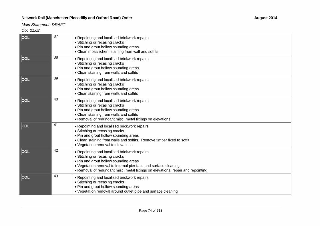
Network Rail (Manchester Piccadilly and Oxford Road) Order August 2014Main Statement- DRAFTDoc 21.02
Page 74 of 513
COL 37 Repointing and localised brickwork repairs Stitching or recasing cracks Pin and grout hollow sounding areas Clean moss/lichen staining from wall and soffits
COL 38 Repointing and localised brickwork repairs Stitching or recasing cracks Pin and grout hollow sounding areas Clean staining from walls and soffits
COL 39 Repointing and localised brickwork repairs Stitching or recasing cracks Pin and grout hollow sounding areas Clean staining from walls and soffits
COL 40 Repointing and localised brickwork repairs Stitching or recasing cracks Pin and grout hollow sounding areas Clean staining from walls and soffits Removal of redundant misc. metal fixings on elevations
COL 41 Repointing and localised brickwork repairs Stitching or recasing cracks Pin and grout hollow sounding areas Clean staining from walls and soffits. Remove timber fixed to soffit Vegetation removal to elevations
COL 42 Repointing and localised brickwork repairs Stitching or recasing cracks Pin and grout hollow sounding areas Vegetation removal to internal pier face and surface cleaning Removal of redundant misc. metal fixings on elevations, repair and repointing
COL 43 Repointing and localised brickwork repairs Stitching or recasing cracks Pin and grout hollow sounding areas Vegetation removal around outlet pipe and surface cleaning

Network Rail (Manchester Piccadilly and Oxford Road) Order August 2014Main Statement- DRAFTDoc 21.02
Page 75 of 513
Section 2: Oxford Road
COL 43AA Repointing and localised brickwork repairs Stitching or recasing cracks Pin and grout hollow sounding areas Removal of misc. metal fixings on elevations, repair and repointing
COL 43A Repointing and localised brickwork repairs Stitching or recasing cracks Pin and grout hollow sounding areas Clean leachates
COL 43B Repointing and localised brickwork repairs Stitching or recasing cracks Pin and grout hollow sounding areas Clean pier elevations Remove existing OLE structure
COL 43C Repointing and localised brickwork repairs Stitching or recasing cracks Pin and grout hollow sounding areas Vegetation removal through arch connecting to COL 43B, remove algae, repoint and repair vertical openings in brick face Clean downside face of pier, repoint and replace missing bricks Replace missing tie bar Vegetation removal from parapet strong course stones and repoint
COL 43D Repointing and localised brickwork repairs Stitching or recasing cracks Pin and grout hollow sounding areas Wash pier face, repoint and replace missing bricks Clean through arch connecting to COL 43E Application of protective paint system to tie bars through arch Vegetation removal from parapet strong course stones and repoint
COL 43E Repointing and localised brickwork repairs Stitching or recasing cracks Pin and grout hollow sounding areas

Network Rail (Manchester Piccadilly and Oxford Road) Order August 2014Main Statement- DRAFTDoc 21.02
Page 76 of 513
Surface cleaning of stains to soffits and pier faces Remove existing OLE structure Vegetation removal from parapet strong course stones and repoint
COL 44 Repointing and localised brickwork repairs Stitching or recasing cracks Pin and grout hollow sounding areas Clean pier faces on both sides Apply protective paint system to tie rod Vegetation removal from parapet strong course stones and repoint
COL 45 Repointing and localised brickwork repairs Stitching or recasing cracks Pin and grout hollow sounding areas Apply protective paint to tie rod Clean pier faces Remove existing OLE structure Remove redundant steel brackets in south elevation Vegetation removal from parapet strong course stones and repoint
COL 45A Repointing and localised brickwork repairs. Replace missing bricks on pier face Stitching or recasing cracks Pin and grout hollow sounding areas Clean surface staining Removal of previous cement repairs and stone replacement to stone string course
COL 46 Repointing and localised brickwork repairs Stitching or recasing cracks Remove wood block at high level and replace with brick Pin and grout hollow sounding areas Cleaning of surface staining to outer and inner elevations and soffits Removal of previous cement repairs and stone replacement to stone string course
COL 47 Repointing and localised brickwork repairs Stitching or recasing cracks Pin and grout hollow sounding areas Cleaning of surface staining to outer and inner elevations and soffits

Network Rail (Manchester Piccadilly and Oxford Road) Order August 2014Main Statement- DRAFTDoc 21.02
Page 77 of 513
Removal of previous cement repairs and stone replacement to stone string course Remove existing OLE structure and metal brackets on south elevation Apply protective paint to existing pattress plates
COL 48 Repointing and localised brickwork repairs Stitching or recasing cracks Pin and grout hollow sounding areas Cleaning of surface staining to outer and inner elevations and soffits Remove vegetation and repoint Strengthening pattress plates Existing newsagent building adjoining structure on south elevation to be demolished Remove existing OLE structure
COL 48A Vegetation removal and repointing Cleaning of surface staining to outer and inner elevations and soffits Remove existing OLE structure
COL 49 Strengthening with spray concrete lining and structural repair to concrete beam corner Repointing and localised brickwork repairs Stitching or recasing cracks Vegetation removal (including moss and leachate at base) and repointing Cleaning of surface staining to outer and inner elevations and soffits Repair rainwater goods Remove redundant metal brackets Remove existing OLE structures and brickwork made good
COL 50 Repointing and localised brickwork repairs Stitching or recasing cracks Existing OLE structure at track level removed
COL 51 Strengthening with spray concrete lining Repointing and localised brickwork repairs Existing signal gantry at track level removed Stitching or recasing cracks Existing platforms realigned and reconfigured at track level
COL 52 Repointing and localised brickwork repairs Stitching or recasing cracks
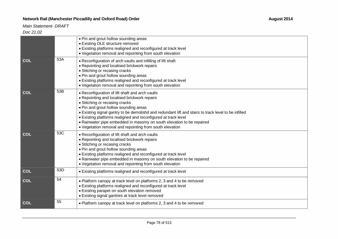
Network Rail (Manchester Piccadilly and Oxford Road) Order August 2014Main Statement- DRAFTDoc 21.02
Page 78 of 513
Pin and grout hollow sounding areas Existing OLE structure removed Existing platforms realigned and reconfigured at track level Vegetation removal and repointing from south elevation
COL 53A Reconfiguration of arch vaults and infilling of lift shaft Repointing and localised brickwork repairs Stitching or recasing cracks Pin and grout hollow sounding areas Existing platforms realigned and reconfigured at track level Vegetation removal and repointing from south elevation
COL 53B Reconfiguration of lift shaft and arch vaults Repointing and localised brickwork repairs Stitching or recasing cracks Pin and grout hollow sounding areas Existing signal gantry to be demolishd and redundant lift and stairs to track level to be infilled Existing platforms realigned and reconfigured at track level Rainwater pipe embedded in masonry on south elevation to be repaired Vegetation removal and repointing from south elevation
COL 53C Reconfiguration of lift shaft and arch vaults Repointing and localised brickwork repairs Stitching or recasing cracks Pin and grout hollow sounding areas Existing platforms realigned and reconfigured at track level Rainwater pipe embedded in masonry on south elevation to be repaired Vegetation removal and repointing from south elevation
COL 53D Existing platforms realigned and reconfigured at track level
COL 54 Platform canopy at track level on platforms 2, 3 and 4 to be removed Existing platforms realigned and reconfigured at track level Existing parapet on south elevation removed Existing signal gantries at track level removed
COL 55 Platform canopy at track level on platforms 2, 3 and 4 to be removed

Network Rail (Manchester Piccadilly and Oxford Road) Order August 2014Main Statement- DRAFTDoc 21.02
Page 79 of 513
Existing platforms realigned and reconfigured at track level Existing parapet on south elevation removed
COL 55A Repointing and localised brickwork repairs Stitching or recasing cracks Pin and grout hollow sounding areas Existing platforms realigned and reconfigured at track level Existing parapet on south elevation removed Vegetation removal and cleaning of surface staining to outer and inner elevations and soffits
COL 55B None
COL 56 Redundant tracks at platform 5 to be removed. Existing OLE structure to be removed
COL 56A None
COL 56B None
COL 57 Strengthening with spray concrete lining of 10 existing steel ribs to stabilise masonry Repointing and localised brickwork repairs Stitching or re-casing of cracks Pin and grout hollow surrounding areas Existing OLE structure at track level removed Existing staircase to platforms within station removed Existing parapet on south elevation removed Vegetation removal and cleaning of surface staining to outer elevations
COL 58 Repointing and localised brickwork repairs Stitching or re-casing of cracks Pin and grout hollow surrounding areas Existing parapet on south elevation removed Vegetation removal and cleaning of surface staining to outer elevations
COL 59 Strengthening with spray concrete lining Repointing and localised brickwork repairs Stitching or re-casing of cracks Pin and grout hollow surrounding areas

Network Rail (Manchester Piccadilly and Oxford Road) Order August 2014Main Statement- DRAFTDoc 21.02
Page 80 of 513
Existing parapet on south elevation removed Vegetation removal and cleaning of surface staining to outer elevations
COL 60 Strengthening with spray concrete lining Repointing and localised brickwork repairs Stitching or re-casing of cracks Existing parapet on south elevation removed Pin and grout hollow surrounding areas Existing arch infill on north elevation to be demolished Vegetation removal and cleaning of surface staining to outer elevations
COL 61 Widening of upside structure Strengthening spandrel walls Removal of parapet on south elevation Removal of concrete span attached to north side of Gloucester Street bridge Strengthen northern portion to match existing spray concrete lining on southern portion Repointing and localised brickwork repairs Stitching or re-casing of cracks Pin and grout hollow surrounding areas Vegetation removal and cleaning of surface staining
COL 62 Reconfiguration of upside structure Removal of northern portion of arch and breakdown of abutment Repointing and localised brickwork repairs Stitching or re-casing of cracks Pin and grout hollow surrounding areas Infill north side of structure Replace propping action of removed portion of arch Removal of concrete span attached to north side of Gloucester Street bridge Vegetation removal, repointing and cleaning of surface staining on elevations Removal of existing OLE structure at track level Repair misc. metal work to opening on north elevation and apply protective paint
COL 62A Removal of concrete span attached to north side of Gloucester Street bridge Removal of parapet on south elevation and existing OLE structure at track level Vegetation removal, repointing and cleaning of surface staining on elevations

Network Rail (Manchester Piccadilly and Oxford Road) Order August 2014Main Statement- DRAFTDoc 21.02
Page 81 of 513
COL63 63 Repointing and localised brickwork repairs Removal of parapet on south and north elevations and existing OLE structure at track level Traverse stitching of arch barrel Tying of proposed widening to existing structure Vegetation removal, repointing and cleaning of surface staining on elevations
COL 64 Spray concrete strengthening Repointing and localised brickwork repairs Stitching or re-casing of cracks Pin and grout hollow surrounding areas Removal of parapet on south and north elevations Traverse stitching of the barrel Tying of proposed widening to existing structure Vegetation removal, repointing and cleaning of surface staining on elevations
COL 65 Spray concrete strengthening Repointing and localised brickwork repairs Stitching or re-casing of cracks Pin and grout hollow surrounding areas Removal of parapet on south and north elevations and removal of OLE structure at track level Traverse stitching of the barrel Tying of proposed widening to existing structure Vegetation removal, repointing and cleaning of surface staining on elevations
COL 66 Spray concrete strengthening Repointing and localised brickwork repairs Stitching or re-casing of cracks Pin and grout hollow surrounding areas Removal of parapet on south and north elevations Traverse stitching of the barrel Tying of proposed widening to existing structure Vegetation removal, repointing and cleaning of surface staining on elevations
COL 67 Repointing and localised brickwork repairs Removal of parapet on south and north elevations Traverse stitching of arch barrel Tying proposed widening to existing structure

Network Rail (Manchester Piccadilly and Oxford Road) Order August 2014Main Statement- DRAFTDoc 21.02
Page 82 of 513
Vegetation removal, repointing and cleaning of surface staining on elevations Repair rainwater pipes on south elevation and associated brickwork
COL 68 Hollow abutment to down side to be in filled or over-slabbed Repointing and localised brickwork repairs Removal of parapet on south and north elevations and OLE structure at track level Removal of pattress plates Replacement support through adjacent structural widening Repointing and localised brickwork repairs Removal of parapet on south and north elevations Anchor bars to spandrel walls Vegetation removal, repointing and cleaning of surface staining on elevations
COL 69 Repointing and localised brickwork repairs Removal of parapet on south and north elevations Removal of pattress plates Replacement support through adjacent structural widening Repointing and localised brickwork repairs Removal of parapet on south elevation and OLE structure at track level Anchor bars to spandrel walls Vegetation removal, repointing and cleaning of surface staining on elevations
COL 70 Repointing and localised brickwork repairs Removal of pattress plates Replacement support through adjacent structural widening Repointing and localised brickwork repairs Removal of parapet on south and north elevations Anchor bars to spandrel walls Vegetation removal, repointing and cleaning of surface staining on elevations
COL 71 Widening to both elevations Strengthen spandrel walls Repointing and localised brickwork repairs Removal of parapets on north and south elevations and existing OLE structure at track level Removal of pattress plates Replacement support through adjacent structural widening Repointing and localised brickwork repairs

Network Rail (Manchester Piccadilly and Oxford Road) Order August 2014Main Statement- DRAFTDoc 21.02
Page 83 of 513
Stitching or recasing cracks Clean surface staining on north elevation Access was not available within the unit at the time of the survey. Repair work may be identified once access is secured.
COL 72 Widening to both elevations Strengthen spandrel walls Repointing and localised brickwork repairs Removal of parapets on south and north elevations and existing OLE structure at track level Removal of pattress plates Replacement support through adjacent structural widening Repointing and localised brickwork repairs Stitching or recasing cracks Clean surface staining on north elevation Access was not available within the unit at the time of the survey. Repair work may be identified once access is secured.
COL 73 Widening to both elevations Strengthen spandrel walls Repointing and localised brickwork repairs Removal of parapets on south and north elevation and OLE structure at track level Removal of pattress plates Replacement support through adjacent structural widening Repointing and localised brickwork repairs Stitching or recasing cracks Clean surface staining on north elevation
COL 74 Widening to both elevations Strengthen spandrel walls Repointing and localised brickwork repairs Removal of parapets on south and north elevations and existing OLE structure at track level Removal of pattress plates Replacement support through adjacent structural widening Repointing and localised brickwork repairs Stitching or recasing cracks
COL 75 Widening to downside Strengthen spandrel walls Repointing and localised brickwork repairs

Network Rail (Manchester Piccadilly and Oxford Road) Order August 2014Main Statement- DRAFTDoc 21.02
Page 84 of 513
Removal of parapets on north and south elevations and existing OLE structure at track level Removal of pattress plates Replacement support through adjacent structural widening Repointing and localised brickwork repairs Stitching or recasing cracks
COL 76 Widening to downside Strengthen spandrel walls Repointing and localised brickwork repairs Removal of parapet on south elevation and existing OLE at track level Removal of pattress plates Replacement support through adjacent structural widening Repointing and localised brickwork repairs Stitching or recasing cracks
COL 77 Removal of parapet and construction of cantilevered walkway to south elevation Remedial works to low mileage pier Stitching or recasing of cracks Pin and grout hollow surrounding areas Repointing and localised brickwork repairs Clean surface staining Access was not available within the unit at the time of the survey. Repair work may be identified once access is secured.
COL 78 Repointing and localised brickwork repairs Stitching or recasing of cracks Pin and grout hollow surrounding areas
COL 79 Stitching or recasing of cracks Pin and grout hollow surrounding areas Repointing and localised brickwork repairs Existing OLE structure at track level to be removed Vegetation removal and repointing to south elevation
COL 80 Repointing and localised brickwork repairs including replacement of 3 missing bricks to pier Stitching or recasing cracks Pin and grout hollow sounding areas Replace missing tie bar

Network Rail (Manchester Piccadilly and Oxford Road) Order August 2014Main Statement- DRAFTDoc 21.02
Page 85 of 513
COL 81 Repointing and localised brickwork repairs Stitching or recasing cracks Pin and grout hollow sounding areas
COL 81A Repointing of abutments Painting parapet railings Addressing drainage issues
The following rows are dependent on works proposed in and around Deansgate Station which are still to be determined
COL 82 Repointing and localised brickwork repairs Stitching or recasing cracks Pin and grout hollow sounding areas
COL 83 Repointing and localised brickwork repairs Stitching or recasing cracks Pin and grout hollow sounding areas
COL 84 Repointing and localised brickwork repairs Stitching or recasing cracks Pin and grout hollow sounding areas
COL 85 Repointing and localised brickwork repairs Stitching or recasing cracks Pin and grout hollow sounding areas
COL 85A Concrete flat span No works assumed
COL 86 Repointing and localised brickwork repairs Stitching or recasing cracks Pin and grout hollow sounding areas
COL 87 Repointing and localised brickwork repairs Stitching or recasing cracks Pin and grout hollow sounding areas
COL 87A OLE support required to Downside platform support structure. Steelwork fixing detail to existing collonade supports required.

Network Rail (Manchester Piccadilly and Oxford Road) Order August 2014Main Statement- DRAFTDoc 21.02
Page 86 of 513
COL 88 Repointing and localised brickwork repairs Stitching or recasing cracks Pin and grout hollow sounding areas
COL 89A Assumed no works
COL 90 Repointing and localised brickwork repairs Stitching or recasing cracks Pin and grout hollow sounding areas
COL 91 Repointing and localised brickwork repairs Stitching or recasing cracks Pin and grout hollow sounding areas
COL 91A Repointing and localised brickwork repairs Stitching or recasing cracks Pin and grout hollow sounding areas
COL 92 Repointing and localised brickwork repairs Stitching or recasing cracks Pin and grout hollow sounding areas
COL 92A Repointing and localised brickwork repairs Stitching or recasing cracks Pin and grout hollow sounding areas
COL 92B Assumed no works
COL 93 Assumed no works
COL 93A Assumed no works
COL 94 Assumed no works
COL 94A Assumed no works
COL 94B Assumed no works

Network Rail (Manchester Piccadilly and Oxford Road) Order August 2014Main Statement- DRAFTDoc 21.02
Page 87 of 513
[this page left intentionally blank]

Network Rail (Manchester Piccadilly and Oxford Road) Order August 2014Main Statement- DRAFTDoc 21.02
Page 88 of 513
3.7 New Signalling and Overhead Line Electrification Structures
3.7.1 As part of the Scheme new signals are proposed east and west of OxfordRoad Station and east and west of Piccadilly Station. These signallingworks are essential to allow for required train operations and standagedistances. Where the proposed works adversely affect existing signals, theywill be repositioned to comply with safety requirements. LED-type signalswill be used throughout.
3.7.2 The track is already electrified; however, the change to the layout of the twostations, the new signal layout, the improved line operating speed, togetherwith local widening of the MSJ&AR Viaduct requires change to the sitingand an upgrade of several OLE structures. These are necessary to meetthe requirement to supply electric power to railway trains. A number ofrailway electrification projects for rail lines in the North are underway, orhave approval. This programme of electrification will result in the wider useof electric powered trains throughout the region; the Scheme needs tocomplement this wider programme of modernisation.
3.7.3 Where the proposal is to add OLE portals to widened sections of viaductthey will be positioned on top of new pre cast spandrels. Where thestructures are to be fixed to an existing viaduct wall the portals will becantilevered and attached to the existing viaduct via a steel bracket.Subject to detailed design, no OLE structure portal will go to ground andtherefore no piling will be necessary.
3.8 Delivery of the Scheme
Introduction
3.8.1 The construction of the Scheme will entail a number of elements, including aseries of enabling works, a number of construction compounds and thepresence of construction plant and machinery. The components of theconstruction process are described in more detail in the following sections.
3.8.2 It needs to be noted that the construction methodology presented belowprovides a viable approach to the implementation of the Scheme. It isbased on information made available by the contractor who will build theScheme. This will be refined during the detailed design phase of the projectand is therefore subject to change. However, the methodology is robust forthe purposes of the assessment, which takes a worst-case scenarioapproach in the assessment of significant environmental effects. Whenprocuring the construction works, Network Rail, will ensure those contractedto undertake the work are bound by the obligations of the Code ofConstruction Practice.

Network Rail (Manchester Piccadilly and Oxford Road) Order August 2014Main Statement- DRAFTDoc 21.02
Page 89 of 513
3.9 Construction Compounds
3.9.1 Construction of the scheme requires a series of construction compounds,close to the principal engineering works. At these four compounds it will benecessary to provide temporary facilities for accommodating and supportingthe workforce and the pre-construction activities, temporary works, enablingworks and construction of permanent works. These will vary in size andfunction, but will typically include the following:
Temporary construction management offices;
Car parking;
Secure area for storing and servicing plant and equipment;
Pre-assembly of equipment;
Materials storage;
Staff welfare facilities; and
Security3.9.2 The four compound areas proposed are in close proximity to the proposed
line of work. The compounds will be occupied for up to 30 months.
3.9.3 Table 3.4 lists each construction compound, its location and intended use.Reference should also be made to Figure 21.23.05: Proposed ConstructionCompounds.

Network Rail (Manchester Piccadilly and Oxford Road) Order August 2014Main Statement- DRAFTDoc 21.02
Page 90 of 513
Table 3.4: Proposed Construction Compound
Compound Location Purpose/Use/Principal Facilities AccessArrangements
A
Occupation ofthe formerMayfieldStation, andworkforceparking areaunder PiccadillyStation.
The primary compound for the Scheme. Thecompound will be used as the main sitewelfare and office accommodation, and themain parking area for staff. Staff working atOxford Road as well as those working atPiccadilly will assemble here.The area will facilitate the works required tobuild the new section of track, the viaductsupport structures at Piccadilly and forintegration of the track into the MSJ&ARviaduct and the station elements of theproposal. It will also be used for temporarymaterial storage and to provide a constructionworking area and plant storage. Major itemsof plant will include 120 and 50 tonne pilingrigs and associated plant and 500, 120 and50 tonne mobile lifting platforms for bridgeinstallations. Smaller items of plant willinclude fork lift trucks, dumpers andexcavators. Activity allocated within thecompound area will include;Former Platform Area
Material storage and plant access duringconstruction phase of the construction tofacilitate platforms 15/16 Material storage (elevated area) and plantaccess for OLE bracket and portal leginstallation Staff car parking Storage of OLE equipment on elevatedstorage area
Mayfield Ground Floor
Office accommodation, welfare and toprovide access to construct new viaductwidening Material storage and plant access duringconstruction phase. Material storage (elevated area) and plantaccess for OLE bracket and portal leginstallation Personnel access points
Arch space underneath Piccadilly Station:
To be used for the use of staff parking. Asafe walking area will be provided for staff toaccess the other compound areas
Public Highway
Fairfield Street is to close for the duration ofconstruction operations associated with
From the A57 (M)Mancunian Way tothe south via HoyleStreet to accessand TemperanceStreet/ChapelfieldRoad/Hoyle Streetfor exit.

Network Rail (Manchester Piccadilly and Oxford Road) Order August 2014Main Statement- DRAFTDoc 21.02
Page 91 of 513
Piccadilly Station. The working area will also incorporate thearches up to North Western Street, allowinga stopping area for vehicles entering thesite. A clear emergency access will be requiredthroughout the duration of the works and willbe agreed with the highway authority prior totheir commencement.
Facilities within the compound will include;
Manned security gates at the access point Cabins incorporating offices,reception/welcome area, meeting rooms,breakout area, kitchen, toilets and washblock and drying room. Smoking shelter Materials laydown area Working/fabrication area Segregated waste area General parking area with maintained levelsurface; including site office personnelparking spaces (to include disabled andvisitor spaces). Designated dirty vehicle parking area Car park spaces and a minibus drop-off andpickup point. Bunded fuel area covered to preventrainwater build-up. Fully bunded, plant refuelling points. Wheel wash-down facilities Fenced designated safe walking areas. Vacant arches situated beneath PiccadillyStation are to be utilised for additional staffparking, and designated personnel safewalking routes between work areas and thecompound.
Compound HoardingHoarding is to be erected where there isdirect interaction with the public and otherusers of the Mayfield area.
B York StreetNCP Car Park
Primary use will be as a temporarymaterial/plant storage and access forpersonnel and plant who will be installingOLE and other structures onto the MSJ&ARviaduct. The proposed use of the areainclude:
Satellite office accommodation, welfare andto provide access to undertake OLEreplacement gantry works Material storage and plant access duringconstruction phase of the construction tofacilitate the installation works for bothPiccadilly and Oxford Road OLE works Material storage and plant access for OLE
Access from theA57 (M) MancunianWay to the south viaSackville Street,Charles Street andPritchard Street.Egress to the A57(M) via York Street,Charles Street,Hulme Street and

Network Rail (Manchester Piccadilly and Oxford Road) Order August 2014Main Statement- DRAFTDoc 21.02
Page 92 of 513
bracket and portal leg installation Personnel access points Staff car parking Facilities within the compound will include: Manned security gate Cabins incorporating offices, and a meetingroom and staff welfare facilities. Materialslaydown area Working/fabrication area Site office personnel parking spaces, Minibus drop-off and pickup point. Bunded, plant-refuelling points. Designated safe walking areas.
Cambridge Street.
C CambridgeStreet
This area will be used to assemblecomponents for the new Oxford Road stationand the viaduct widening to take place to thesouth of the existing of the station.Major items of plant required to construct theScheme in this location will include a 120tonne mobile crane, a 50 tonne crane, andmobile lifting platforms for the bridgeinstallation works. Smaller items of plant willinclude fork lift trucks, dumpers andexcavators.Facilities proposed but not limited to are asfollows:
Manned security gate Cabins incorporating offices,reception/welcome area, meeting roomsand staff welfare facilities Materials laydown area Working/fabrication area Segregated waste area General parking area with maintained levelsurface; to include site parking spaces,(including disabled and visitor spaces). Designated dirty vehicle parking area Car parking spaces minibus drop-off andpickup point. Bunded fuel area covered to preventrainwater build-up. Fully bunded, plant refuelling points. Wheel wash-down facilities
Fenced off designated safe walking areas.
Access and egressto and from thesouth, the A57 (M)Mancunian Way, viaCambridge Street.
D Albion Street
Primarily allocated as a wagon holding areafor deliveries to site and as an alternativeparking area for residents affected by theproposed works being undertaken onWhitworth Street West:
Office accommodation, and staff welfarefacilities and to provide access deliveryvehicles and Whitworth Street Westresidents Personnel access points Staff car parking
Access will be fromthe A57 (M)Mancunian Way viaMelbourne Street,Great JacksonStreet, City RoadEast and Little PeterStreet. Egress tothe A57 (M) will bevia Medlock Street.

Network Rail (Manchester Piccadilly and Oxford Road) Order August 2014Main Statement- DRAFTDoc 21.02
Page 93 of 513
Wagon Holding Area or alternative residentparking compound
Facilities proposed but not limited to are asfollows:
Manned security gate Cabins to incorporate offices a meetingroom, toilets, kitchen and drying room. Allocated car parking spaces for WhitworthStreet West residents Site office personnel parking spaces Minibus drop-off and pickup point Complete with fenced off designated safewalking areas. Vehicle holding area for large volumedeliveries i.e. concrete wagons

Network Rail (Manchester Piccadilly and Oxford Road) Order August 2014Main Statement- DRAFTDoc 21.02
Page 94 of 513
Construction Compound Access
3.9.4 A number of strategic traffic routes are identified to access the constructioncompounds primarily via the A57 (M), the Mancunian Way. Constructiontraffic will be directed towards construction compounds from the south of thecity.
3.9.5 The routes to access the construction site compounds are shown on Figure21.23.06: Compound Access Routes. The compounds are accessible asfollows:
Compound A via Hoyle Street
Compound B via Charles Street and Pritchard Street
Compound C via Cambridge Street
Compound D via City Road East3.9.6 All junctions along the construction traffic routes have been subject of an
assessment to determine whether they can accommodate the anticipatedconstruction traffic, in relation to both scale and type of vehicle. The detailof proposed traffic management measures is included in Chapter 8 (Trafficand Transport) of this ES.
3.9.7 The construction of the Scheme will affect road infrastructure in terms oftemporary road closures and diversions. The number and duration of thesetemporary closures and diversions will be kept to a minimum though theywill be required along the roads listed in Table 3.5.

Network Rail (Manchester Piccadilly and Oxford Road) Order August 2014Main Statement- DRAFTDoc 21.02
Page 95 of 513
Table 3.5: Temporary Road Closures
Location Required Closures Indicative Dates
Area 1: Vicinity of Piccadilly Station
Altrincham Street Limited access during constructionphase. Full construction period.
Fairfield StreetFull closure between TemperanceStreet and Taxi drop off / short staycar park at Piccadilly
2 options: Closure for constructionduration or several stagedclosures during construction.
Baring StreetFull closure and realignment ofBaring Street highway betweenFairfield Street and Travis Street.
Closure for full construction period.
Travis StreetFull closure between Sheffield Streetand Wyre Street. Access to theStar and Garter will be retained.
Closure for full construction period.
Temperance StreetPermanent stopping up of access to /from Temperance Street fromFairfield Street.
Permanent closure.
Various locations fornight time closure toinstall OLE andsignal gantries
Full road closure 1 night-time closure per road.
Area 2: Vicinity of Oxford Road Station
Junction ofGloucester St andWhitworth St West
Full junction closure4 Days (Dec 2016)17 days (July 2017)
Oxford RoadPartial lane closure, southboundbetween Palace Hotel to CharlesStreet.
Short term closures TBC. Timingscan be flexible for example off-peak works.
Whitworth StreetWest / Albion Street
Temp Traffic Management may berequired at junction to allow HGVs toaccess Whitworth Street.
Full construction period.
Whitworth StreetWest
Southern side of carriagewaybetween Albion Street and GreatMarlborough Street. Either one-waysystem of full closure.Various staged closures.
Utilities: Jan 2015 – Dec 2015Construction: Jan 2016(approximately 36 months)
Whitworth StreetWest
Full closure of Whitworth St Westbetween Albion Street andGreat Marlborough Street.
4 * 3 day closures1 * 5 day closure1 * 4 day closure1 * 20 day closure during OxfordRoad blockade(timing to be discussed with MCC)
Gloucester Street Full closure of Gloucester Streetbridge during construction. Jan 2016 (approx 36 months)
Various locations fornight time closures
Full road closure 1 night time closure per road.

Network Rail (Manchester Piccadilly and Oxford Road) Order August 2014Main Statement- DRAFTDoc 21.02
Page 96 of 513
Location Required Closures Indicative Datesfor OLE and signalgantry installations
Oxford Road StationApproach Full closure During station possessions.
3.9.8 Traffic Management measures that will be applied during construction willbe agreed with the local highway authority prior to the start of construction,and subject of active monitoring, review and management throughoutScheme implementation.
3.10 Draft Code of Construction Practice
3.10.1 In order to minimise the likely impacts of construction, a draft Code ofConstruction Practice (CoCP) has been prepared, provided in Document21.11. The CoCP sets out the measures, which will be undertaken by theappointed contractor to ensure both site safety and good site practice withregard to the environment. It captures relevant statutory codes, standardsand Acts applicable to the regulation of construction practice and its effectson health and safety and the environment.
3.10.2 Adherence to the CoCP by the contractor is to be a contractual requirement.The draft CoCP provides a set of measures to which Network Rail has madea commitment. A planning condition will be proposed to provide themechanism for enforcement of the Code. The CoCP will be finalisedthrough discussions with the relevant local planning authority which isManchester City Council. Compliance with the CoCP will not discharge thecontractor, or its agents, from complying with any statutory requirements inforce at the time. The CoCP will be set out in two parts: Part A will comprisethe intentions and scope of the document; Part B will set out the deliveryplan.
Working Hours
3.10.3 The CoCP is the instrument to be used to control the hours of work on theScheme. Normal working hours during the construction period will be 0700hours (NB: awaiting confirmation from Network Rail) to 1800 hours Mondayto Friday) and 0700 – 1300 Saturdays, with 30 minutes either side forsetting up and organising, or clearing the site. Quiet work, for example,plant maintenance, may take place outside these core hours. Certainelements of the works are required to take place outside normal workinghours. The nature of the Scheme requires that to avoid disrupting weekdaypassenger services a series of work will take place over weekends, andbank holidays. During these periods of ‘possession of the railway’, night-

Network Rail (Manchester Piccadilly and Oxford Road) Order August 2014Main Statement- DRAFTDoc 21.02
Page 97 of 513
time working and Sunday daytime working will take place dependent on thedurations involved. In long possessions and blockades of the railway, 24hour working will take place to ensure maximum use is made of the workingwindow.
Material Delivery and Construction Traffic
3.10.4 To minimise disruption to public highways, construction traffic is to beremoved from the network as quickly as possible. Within each constructioncompound sufficient space will be provided to ensure that vehicles can enterand manoeuvre within the site before re-entering the public highway. Inaddition, the delivery regime for the delivery of materials will be based on a‘just in time’ principle, with the inventory of materials and equipment on sitekept to a minimum and only brought to the site ‘just’ prior to their need aspart of the construction process. This ‘just in time’ approach is designed tomaximise efficiency of operations by eliminating a large inventory ofmaterials and equipment, reduce the size of compounds needed to supportconstruction, and contribute to shorten project time and to reduce costs.
3.10.5 The basic constituent parts of the proposed bridge structures, such asconcrete, steel and shuttering material and support systems, will arrive viaroad. These will be delivered to the construction work points to avoiddouble handling and movement of material. The majority of these deliverieswill occur by HGV articulated lorries which will be directed to designatedloading points within the construction compounds.
3.10.6 Whilst it is the intention to use pre-cast elements wherever practical in theevent of concrete deliveries, concrete wagons will be used and the concretewill be directly discharged close to the construction work area as far aspossible to limit the amount of double handling within the site.
3.10.7 Deliveries comprising heavy haulage/abnormal loads (i.e. bridge decks,cranes, heavy engineering plant and equipment) will take place outside of‘standard’ working hours, and will be subject of the prior agreement of theHighway’s Agency and Greater Manchester Police. There will be instanceswhere other abnormal loads are required. This includes the delivery ofcranes, piling rigs and other pieces of heavy engineering equipment forspecific construction activity. The routes anticipated for abnormal loaddelivery, in order of preference are:
M602 J3 – A57 Regent Road – A57 (M) Mancunian Way – B6469
M602 J3 – A57 Regent Road – A57 (M) Mancunian Way – A5103
M602 J3 – A57 Regent Road – A57 (M) Mancunian Way – A5067

Network Rail (Manchester Piccadilly and Oxford Road) Order August 2014Main Statement- DRAFTDoc 21.02
Page 98 of 513
3.10.8 Specialist haulers and trailers will deliver to site large material components(such as bridge decks). Major steelwork elements to form the bridgestructures will be delivered by road on articulated and fixed bed lorry.Wherever possible, components are to be pre-fabricated to enabledeliveries on articulated vehicles and assembly on site.
3.10.9 The strategic construction routes that are proposed to access theconstruction site compounds are shown on Figure 21.23.06: CompoundAccess Routes.
3.10.10 Where practical, engineering trains will be used to deliver railway materials(such as railway ballast and sleepers); similarly redundant railway materialwill be removed from the site. It is proposed that the main car parking areafor use by construction workers will be within Compound A. Car parking atother work sites will be restricted to avoid unnecessary disruption on theexisting network.
3.11 Construction Activities
3.11.1 An overview of the key construction activities required for each of the twoelements of the scheme as per the Area description, are noted in Section2.3 above.
Area 1: MSJ&AR Viaduct and Piccadilly Station
Enabling Works
3.11.2 The construction Compound A will be used to provide material andresources for work in Area 1. Works that will enable set up and use of thecompound will include:
Modifying existing site entry and egress via Hoyle Street;
Modification to the kerb lines at the existing site access to theCompound;
Create hard standing areas within the Compound;
Install new utility connections as required in Compounds A and B (water,sewer (foul), electric and telecoms);
Erect site hoarding around construction working areas; and
Any useable or recyclable mineral based arising from the enabling workswill be loaded on to lorries and transferred to the crusher stockpile thatwill be set up in Compound A.

Network Rail (Manchester Piccadilly and Oxford Road) Order August 2014Main Statement- DRAFTDoc 21.02
Page 99 of 513
Viaduct Widening Construction Sequence Piccadilly Station
Proposed Construction Phase 1
3.11.3 The initial works in the vicinity of Piccadilly Station will involve divertingutilities; primarily those beneath the surface of Fairfield Street, TemperanceStreet and London Road. A key element of these works will be work toreconfigure the Travis Street sub-station. The contractor will also implementhighway realignment works, retaining wall and the temporary stopping up offootways.
Proposed Construction Phase 2
3.11.4 The second phase of works relate to the permanent closure of TemperanceStreet, temporary closures of Travis Street, Fairfield Street and AltrinchamSt. The contractor will put in place traffic management measures andundertake work to re-align Fairfield Street.
Proposed Construction Phase 3
3.11.5 During the next phase of the construction, the principal activity will be toconstruct the foundations build the piers that will provide the structuralsupport for the new elevated track sections. The first element of theseworks will be along Altrincham Street and Temperance Street. This willenable widening of the viaduct which is to support the new track as it tiesinto the existing Piccadilly East Junction. The construction team is to thenput in place structural supports along Fairfield Street and Altrincham Street,either side of London Road allowing a new bridging section to be installedover London Road. The main viaduct structure connecting the two tie inswill commence construction once the supporting structures are in place, thedeck that will support the new track bed will be lifted in place.
Proposed Construction Phase 4
3.11.6 The main activity at this stage will be construction of the new islandplatforms. East of the station, eight xxx (NB: awaiting confirmation of finalScheme design from Network Rail) portals are to be removed and existingcables relating to track operations re-positioned and new cables put inplace. West of these new platforms and along the MSJ&AR viaduct removalof existing OLE structures and their replacement with new OLE structureswill take place.
Proposed Construction Phase 5
3.11.7 With the new platforms in place, work to construct and install the new stationelements of the scheme will begin. A key component of these works will be

Network Rail (Manchester Piccadilly and Oxford Road) Order August 2014Main Statement- DRAFTDoc 21.02
Page 100 of 513
the building of the new bridge that is to integrate the new platforms with theexisting train shed and provide new areas for passenger to dwell andcirculate. Associated with these works will be the new canopies to beinstalled to shelter for those boarding and alighting from trains. The othersignificant element of work the contractor plans to complete during thisphase is the laying of the twin track along the new, elevated structure.
Proposed Construction Phase 6
3.11.8 scheme will be subject of ‘fit-out’ for public use. It is at this stage work toconnect the new section of track with existing rail infrastructure will becompleted
Area 2: MSJ&AR Viaduct and Oxford Road Station
Enabling Works
3.11.9 There are three construction compounds located in the vicinity of OxfordRoad Station, these being Compounds C and D1 and D2. A number ofenabling works are required to facilitate the set-up of these compounds.
Modification of the existing site entry and egress to the Compounds Cand D1/D2;
Create hard standing areas within Compound C;
Install any utility connections as required for Compounds C and D1/D2(water, sewer (foul), electric and telecoms);
Set up site hoarding around construction working areas.
lorries and transferred to the crusher stockpile that will be set up inCompound A.
Proposed Construction Phase 1
3.11.10 The initial phase of the scheme in the Oxford Road Station area will be todivert utilities; primarily those beneath the surface of Whitworth Street West.Highway realignment works a temporary footway stopping up and temporarycycleway diversion, again along Whitworth Street West, will follow. Withinthe existing station footprint lineside equipment along both sides of theviaduct will be relocated. The decommissioning of Platform 5 will then takeplace and the relevant section of track removed. Work to widen the viaductwill then be implemented, initially north of the existing station (approximately200 m in length) will then take place, construction of a 150 m viaductwidening to the south of the existing station, including a section acrossGloucester Street.

Network Rail (Manchester Piccadilly and Oxford Road) Order August 2014Main Statement- DRAFTDoc 21.02
Page 101 of 513
3.11.11 This initial phase of work will also see new OLE structures installed andremoval of redundant OLE structures along the length of the MSJ&ARviaduct between Deansgate and Piccadilly Stations. Renewal of OLE wirefrom Deansgate to Piccadilly will also take place.
Proposed Construction Phase 2
3.11.12 During the main construction, works a staging program of platformreconstruction will be undertaken starting with platform 1, parts of platform 4a 125 m section of the new Platform 4 will be constructed (excluding theGloucester Street section).Removal of the track that serves the existingPlatform 1 will follow and new track put in its place. The contractor will installnew OLE structures on the widened viaduct section, the installing of newrailway signal structures on Platforms 1 and 4 will then follow. Duringconstruction of Platforms 1 and 4 new foundations for the new footbridge willbe prepared.
3.11.13 Phase 2 will then progress with further track renewals then removal of theexisting north deck across Gloucester Street. New structures to providesupport for a new bridge deck, and then the new deck across GloucesterStreet put in place. Work to complete Platform 4, including the laying of newtrack will follow. Once work to reconfigure the layout of the platforms iscomplete and new track installed, work to construct a new footbridge willtake place
Proposed Construction Phase 3
3.11.14 Demolition of Platform 2 and 3 will take place during a proposed blockade ofthe station.
Proposed Construction Phase 4
3.11.15 New track will be laid to service the new Platforms 2 and 3. Installation ofnew signal structures and contact wires that allow electrified trains tooperate using the realigned platforms will complete works that alter thefootprint of the existing station.
Proposed Construction Phase 5
3.11.16 Once this new element of the station is complete removal of the existingfootbridge will take place.
Rail Infrastructure
3.11.17 Rail infrastructure will be incorporated into each area on completion of thestructural works explained in the preceding section. These include:

Network Rail (Manchester Piccadilly and Oxford Road) Order August 2014Main Statement- DRAFTDoc 21.02
Page 102 of 513
Formation of the track bed;
Laying of line and ballast; and
Installation of OLE structures, wiring and other works.3.11.18 On completion of these works there will be a short period of commissioning
to precede the commencement of rail operations.
3.12 Construction Programme
3.12.1 The TWAO Application is likely to be subject to a public inquiry, probably inspring 2015. If approved, works will commence as soon as possible afterapproval, in winter 2016. The estimated duration of the construction phaseis 30 months. The estimated date to complete the scheme is December2018. The need to minimise the impact of construction work on theoperational railway means that the programme is designed to fit specificphases of construction into periods of railway closure, or ‘possessions’scheduled for public holidays. Table 3.6 presents an outline of theprogramme for the scheme; this is not a sequential series of actions, butrather it provides an indication of when works will occur within each area,some of which will be concurrent, or parallel to other works
3.12.2 This section provides an overview of the key construction activities requiredfor each of the two areas of the Scheme as per the Area description
3.12.3 A schedule of dates for constructing the proposed Scheme is contained inthe tables below:

Network Rail (Manchester Piccadilly and Oxford Road) Order August 2014Main Statement- DRAFTDoc 21.02
Page 103 of 513
Table 3.6: Outline Construction Programme Piccadilly Station
Construction Area Anticipated StartDate
Anticipated FinishDate Anticipated Programme of Activity and Expected Duration
Viaduct wideningworks AltrinchamStreet
May 2016 April 2017 Including works to London Road bridge scheduled for April 2017
Bridge InstallationLondon Road April 2017 April 2017 Combined possession and road closure will be required to install new
bridge
Bridge InstallationFairfield Street April 2017 April 2017 Completed during possession
Viaduct wideningworks toTemperance Street
May 2016 Dec 2016 Temperance street is closed to highways traffic permanently it will re-opened to foot traffic December 2018
Main viaductstructureconstruction
June 2016 July 2018
Footbridgeinstallation and fitout
Jan 2017 Dec 2018 Main structure completed December 2018 with final signal works April2019

Network Rail (Manchester Piccadilly and Oxford Road) Order August 2014Main Statement- DRAFTDoc 21.02
Page 104 of 513
Table 3.7: Outline Construction Programme Oxford Road Station
Construction Area Anticipated StartDate
Anticipated FinishDate Anticipated Programme of Activity and Expected Duration
Viaduct wideningWhitworth St West May 2016 Dec 2017
Includes new urban realm works to footways and Whitworth Street WestNorth and South During the construction works sections of the road will berequired to be closed for large delivery’s and during main blockades toallow cranes to operate.
Viaduct wideningSouthern side (FirstStreet)
May 2016 Dec 2016
New footbridgeinstallation May 2016 Oct 2017
Installed to allow passenger movement within station allowing platform 2and 3 island construction once the island platforms completedFit out will continues to the end of October 2017
Platform works 1,2,3and 4 May 2016 Oct 2017 Platform 5 decommissioned Dec 2016
Gloucester streetbridge extension Dec 2016 April 2017 The bridge area will require a road closure from May 2016 until Oct 2017
Main stationcompletion works Jan 2017 Oct 2017

Network Rail (Manchester Piccadilly and Oxford Road) Order August 2014Main Statement- DRAFTDoc 21.02
Page 105 of 513
3.13 Operation
3.13.1 Table 3.7 shows the operational use of the Scheme in terms of net trainmovements. This table presents the operational train movements in thebaseline year (i.e. 2016), and the future movements in the years afteropening (i.e. 2033). The table assumes that the Ordsall Chord, subject of aseparate TWAO application, made in September 2013 receives approvaland the capacity benefit of the project is realised. This will maximise thechange in operations to be realised by the Scheme subject of this Orderapplication.
Table 3.7: Train Movements Baseline and Assessment Years (NB: this will be updated whenthe data from the Noise chapter has been received)
Section2016 DM 2016 DS 2033 DM 2033 DS
Day Night Day Night Day Night Day Night
xx xx
xx xx
DM - ‘Do minimum’, maintain the status quoDS - ‘Do something’, construct and operate the Scheme
3.13.2 There is no operational lighting associated with the track elements of theScheme. There will be junction lighting, which will be permanent but onlyused when required for maintenance. The lighting will be directional andlocated below parapets to avoid ‘spill’ into surrounding areas.
Decommissioning
3.13.3 The Scheme has a design life of 125 years, although the lifespan of thestructural form is likely to be considerably longer than this in practice. Thelifespan of the development means it is not appropriate or feasible toconsider and include an assessment of the likely potential effects arisingduring this stage of the project. All materials used to construct the Schemecould be recycled in the event of decommissioning.

Network Rail (Manchester Piccadilly and Oxford Road) Order August 2014Main Statement- DRAFTDoc 21.02
Page 106 of 513
[this page left intentionally blank]

Network Rail (Manchester Piccadilly and Oxford Road) Order August 2014Main Statement- DRAFTDoc 21.02
Page 107 of 513
4. APPRAISAL OF ALTERNATIVES TO THE SCHEME
4.1 Introduction
4.1.1 The Applications Rules require this document provides:
“An outline of the main alternatives studied by the applicant and anindication of the main reasons for his choice, taking into account theenvironmental effects.”
4.2 Alternatives
4.2.1 The potential designs for the Manchester Piccadilly and Oxford RoadCapacity Scheme (the Scheme) involved an examination of the mainoptions that would achieve the development objectives, taking intoconsideration engineering, environmental and construction issues. Criteriaused to evaluate options included, but were not limited to:
Compliance with the need to deliver a specified increase in capacity;
Journey time improvements;
Environmental constraints;
Key stakeholder issues;
Construction methodology and access;
Capital cost; and
Consents required.
4.3 Need for the Development
4.3.1 The strategic need to develop rail infrastructure throughout the North ofEngland received recognition through the work undertaken by the NorthernWay6. They identified the economic case for enhancement andimprovements to rail services that could drive economic growth throughoutthe North of England.
4.3.2 The Northern Way Growth Strategy (2004) highlights the importance ofpromoting the sustainable growth of the North’s transport links to supportproductivity and growth whilst promoting an enhanced quality of life, as wellas meeting national environmental obligations. To unlock economic benefitsto the region as a whole this strategy supports an increase in the capacityand speed of rail links between the North’s City Regions.
6 The Northern Way was a collaboration of the three northern Regional Development Agencies

Network Rail (Manchester Piccadilly and Oxford Road) Order August 2014Main Statement- DRAFTDoc 21.02
Page 108 of 513
4.3.3 In 2006, the Northern Way published the ‘Strategic Direction for Transport’report examined which transport improvements would best serve the CityRegions in light of the 2004 strategy. The single most important investmentidentified in the report was the need for investment in the North’s railnetwork, specifically investment in the ‘Manchester Hub’ due to the fact thatit critically affects both freight and passenger services across the whole ofthe North of England. The ‘Manchester Hub’ is the network of rail corridorsthat link and cross in and around central Manchester (see Figure 21.2.03).
4.3.4 ‘The Northern Way’ issued a commission for a study in 2007. The purposeof the study was to assess current and future constraints in the ManchesterHub network, and to identify changes that would be required to the railsystem to enable it to provide uplift to the economy7. Part of thecommission was to examine options for assessment in order to identify aprogramme of works to progress through to development stages.Importantly, the report highlights a number of significant constraints in theManchester Hub such as junction conflicts, limited track capacity,overcrowding on local and inter-regional services and platformovercrowding. It further explains the large number of enhancementproposals required to address some of the constraints. This led to the‘Manchester Hub Conditional Output Statement’ (2009) which wasundertaken by Network Rail at the request of the DfT.
4.3.5 This study identifies the importance to the North’s sustainable economicgrowth of the need to improve rail services within the region. The absenceof a facility to move trains efficiently along the Castlefield Corridor togetherwith problems relating to platform capacity at Manchester Piccadilly wereidentified as a critical transport issue. The study determined these capacityissues were having an adverse impact upon the efficiency of the networkwithin central Manchester with consequences on the efficiency of theregional network.
4.3.6 The ‘Output Statement’ presented an extensive evidence base about theeconomic performance of the North and how transport links in general andrail links in particular affect efficiency and competitiveness. The reportaffirmed that to support economic growth there needs to be adequate railcapacity, in order that journeys are reliable and journey times arereasonable. It emphasised that the Manchester Hub was a challenge worthdevoting considerable resources to tackling with benefits widely distributedacross the North.
7 Manchester Hub: Objectives, Options and Next Steps (prepared by Steve Davies Gleave (August 2007))

Network Rail (Manchester Piccadilly and Oxford Road) Order August 2014Main Statement- DRAFTDoc 21.02
Page 109 of 513
4.3.7 Therefore, in line with the aspirations for the ‘Manchester Hub’ and in light ofthe recommendations made in the 2007 and 2009 reports, Network Railtook forward these recommendations and developed the ‘Northern Hub’programme. The Northern Hub programme consists proposals forimprovements to the rail network to enable growth in the economy and meetexpected growing demand for rail travel over the next 60 years. Thecapacity and railway conflicts within the Manchester rail network present themost significant bottleneck in achieving these aspirations.
4.3.8 The Scheme is a key component in overcoming restrictions in the currentnetwork. It is significant in its own right, but will also enable Network Rail torealise benefits from other elements of the Northern Hub programme. Forexample, it provides the capacity within the rail system to take fulladvantage of the Ordsall Chord development which will allow trains to traveldirectly between Manchester’s three main railway stations (Victoria,Piccadilly and Oxford Road), thereby improving journey times andpassenger service. It also removes current conflicts and capacityconstraints at the throat of Manchester Piccadilly by re-routing trains thatcross it. It allows for new routes to cross Manchester and accessManchester Airport. The Scheme will improve performance of the networkat both local and regional levels. Without the proposed development,significant interventions would be required to address this problem on theexisting network and to meet the aspirations set out by the Northern Way.
4.3.9 The Scheme has a completion and operational target date of December2018. A Statement of Aims which forms part of the submitted TWAapplication summarises the aims of the development.
The ‘Do Nothing’ Alternative
4.3.10 An important part of the EIA process is to consider the ‘do-nothing scenario’,i.e. what would occur if the proposed development did not go ahead. In thisinstance, the environmental baseline under the ‘do-nothing’ scenario wouldremain unchanged in that there would be no physical changes to theenvironment. However, the benefits of the proposed Scheme would not berealised, such as the improved connectivity through Manchester measuredin journey times, frequency, reliability and reduction in overcrowding. Theenhancement in the passenger environment at Piccadilly and Oxford RoadStations would also remain unrealised. Moreover, a significant opportunityto help stimulate the economy of the North of England would be lost.
4.3.11 It is acknowledged that without the Scheme the effects which this ESrecords would not occur. To minimise adverse impacts of the Scheme asfar as practicable the environmental effects of the development,

Network Rail (Manchester Piccadilly and Oxford Road) Order August 2014Main Statement- DRAFTDoc 21.02
Page 110 of 513
environmental and sustainability considerations have been key factors inevolving the design. The sections below outline the application of aniterative design process by the applicant.
4.4 Alternative Sites
4.4.1 The options selection can be considered in terms of the following:
Strategic decisions regarding the choice of rail corridor and the generalform of the Scheme proposed;
Options for track alignment, station layout; and
Form of the Scheme proposed.4.4.2 The operational nature of the Castlefield Corridor means there were no
alternative locations where the Ordsall Chord connects via the MSJ&ARViaduct with rail infrastructure at Piccadilly East Junction. The current tracklayout, the locations of Piccadilly and Oxford Road Stations and the need tointegrate the Scheme into an urban environment limit the options for theScheme.
4.5 Strategic Options
4.5.1 The Scheme has evolved through distinct stages. The first stage sought toidentify and compare a range of high level strategic options across theManchester rail network which would deliver key improvements. Thepreferred solution progressed to the second stage; an investigation of localoptions. This included an assessment of viability of each alternative interms of environmental, operational, engineering design and cost. Thenfollowed a process of design development in which preferred solutions werethe subject of refinement. The Governance for Railway Investment Projects(GRIP) is Network Rail’s management and control process for the deliveryof projects and is mandatory for all significant projects8.
Strategic Alternatives (GRIP Stages 1 and 2)
4.5.2 The ‘Manchester Hub Conditional Output Statement’ (2009) identified arange of infrastructure interventions to provide the capability for rail serviceimprovements that would contribute to growing the economy of the North.Within the central Manchester area three key issues were identified:
East West and North South services crossing on the approach toPiccadilly
8 The eight GRIP stages are: GRIP 1 – Output definition; GRIP 2 – Pre-feasibility; GRIP 3 – Option Selection; GRIP 4 – SingleOption development; GRIP 5 – Detailed design; GRIP 6 – Construction, test and commission; GRIP 7 – Scheme hand back,and GRIP 8 – Project close out

Network Rail (Manchester Piccadilly and Oxford Road) Order August 2014Main Statement- DRAFTDoc 21.02
Page 111 of 513
Manchester Piccadilly Platform Capacity, and
Capacity to cross Manchester via the Castlefield corridor.4.5.3 Infrastructure interventions with potential to address the issues of capacity
and capability in the centre of Manchester and on radial routes wereidentified.
4.5.4 The strategic analysis of different ways to address the key challengesconsisted of two different series of interventions. The primary differencebetween the two options was how conflicting train movements to the east ofPiccadilly Station would be resolved. A qualitative assessment wasundertaken to compare alternatives. These considered the impact ofproposed infrastructure improvements on train performance, disruptionduring construction, viability, environmental impact (at a high level) and theimpact on future track proposals.
4.5.5 The selection of the Ordsall Chord as the most effective way of unlockingrail capacity within Manchester made it imperative to address the capacity ofthe Castlefield Corridor. A key constraint on this capacity is the ‘throughplatforms’ at Manchester Piccadilly.
4.5.6 On the Castlefield corridor, provision of two additional through platforms atManchester Piccadilly to the south of the platforms 13 and 14 will allowtrains to arrive in one platform while another train is departing in the samedirection from another. To improve the capacity of the corridor, change atManchester Oxford Road station needs to replicate those at Piccadilly. Thisis to enable it to operate in the same manner – allowing the scheduling ofstopping trains to run at three minute intervals rather than the existing fourminutes.
4.5.7 The strategic assessment options also endorsed:
Major improvements to Manchester Victoria allowing many moreservices to use the station and providing improved facilities forpassengers; and
New tracks on the Trans Pennine line between Leeds and Liverpool andon the Hope Valley between Sheffield and Manchester to allow fasttrains between the major towns and cities to overtake slower trains.
4.5.8 To progress the 2016 intervention Network Rail has submitted a TWAOapplication to build the Ordsall Chord. The application was submitted inSeptember 2013 and was subject of an Inquiry held 23 April to 16 May2014. At the time of this submission the applicant is awaiting the decision ofthe Secretary of State.

Network Rail (Manchester Piccadilly and Oxford Road) Order August 2014Main Statement- DRAFTDoc 21.02
Page 112 of 513
4.5.9 To deliver the Northern Hub in central Manchester therefore requires majordevelopment, it is intended that these changes are delivered in two mainphases. The 2016 infrastructure intervention will re-route current servicesthrough the central Manchester area reducing the number of crossing routesand utilising the new Ordsall Chord to connect Manchester Victoria directlywith Manchester Piccadilly station. The 2018 infrastructure intervention willbuild on the previous 2016 works and involve capacity improvements to theCastlefield Corridor subject of the application for which this ES forms part.
4.6 Local Alternatives
4.6.1 Once the strategic decision was taken to improve the capacity of theCastefield Corridor, Network Rail began a process to select the mostappropriate local alternatives. The evaluation process is based on the DfT’sTransport Analysis Guidance for transport interventions. Some fifteenacceptability and viability criteria were used to assess the merits of theoptions. These criteria comprise four themes, including consideration ofimpacts on Consents, Environment and Sustainability.

Network Rail (Manchester Piccadilly and Oxford Road) Order August 2014Main Statement- DRAFTDoc 21.02
Page 113 of 513
Table 4.1 List of Option Selection Criteria
Selection Criteria
Railway Engineering, Operation and Maintenance Theme 1
1 Complies with improved capacity specification
2 Journey Time/ Driver Use ability
3 Robust network performance
4 Maintainability
5 Operational safety
6 Passive provision for future railway work
Constructability and Access Theme 2
7 Construction Methodology
8 Construction Access
9 Possessions of the rail network
Cost and Business Case Theme 3
10 Capital Cost
11 Whole Life Cost
Consents, Environment and Sustainability Theme 4
12 Environmental Constraints
13 Key Stakeholder Issues
14 Environmental Impact
15 Land Use Impact
4.6.2 The initial GRIP 2 Study considered 14 development options with twovariants to improve capacity within the Castlefield Corridor. Nine of theoptions and both of the variants were considered to either not meet theremit, to be operationally practical or to present highly novel issues for whichno reasonable solution could be easily identified. The remainingalternatives (three for Piccadilly, two for Oxford Road) were subject ofenvironmental and engineering assessments, and consultation with relevantstakeholders. Among the key criteria used for comparative assessment ofalignments were:
Capacity compliance (optimum speed profile of 30 mph);
Anticipated journey time (with a view to reducing times where possible);
Indicative capital cost (value for money);
Construction methodology (duration and degree of relative difficulty);

Network Rail (Manchester Piccadilly and Oxford Road) Order August 2014Main Statement- DRAFTDoc 21.02
Page 114 of 513
Construction access requirements;
Environmental constraints (extent and nature);
Consents required and associated programming implications; and
Likely issues of key stakeholders and the publicPiccadilly Development Options
4.6.3 The objective of the proposal is to provide two additional platforms at thePiccadilly Station on the Oxford Road Lines. This is to release extracapacity on the Castlefield Corridor and provide for alternative platformworking; functionality that will allow simultaneous operation of two platforms- where the arriving train does not impede a train that is leaving thealternative platform at the same time.
4.6.4 To integrate the new section of track with existing rail infrastructure it mustbe elevated and put in place south of the viaduct that supports platforms 13and 14 at Piccadilly. The proposal is that the new platforms, 15 and 16,service ‘Down’9 direction traffic and reconfiguration of existing platforms 13and 14 takes place to service ‘Up’ direction traffic. Options for the design forthe track to service new platforms 15 and 16 must also incorporate free‘overlaps’ for the normal direction of travel. These track overlaps are toenable the alternative platform functionality and simultaneous operation oftwo trains travelling in the same direction.
4.6.5 Option A - comprised the construction of a new platform island with twothrough platform faces, to create Platforms 15 and 16. This proposal alsoincludes the removal of mid-platform signals on Platforms 13 and 14.
4.6.6 Option B - comprised the construction of a new platform island with twothrough platforms faces, to create Platforms 15 and 16, at ManchesterPiccadilly Station. However, Platforms 13 and 14 would be modified (movedto the west) to give passive provision for improved (train) access to Platform12.
4.6.7 Option C - This option is the same as Option A, but with the retention of theexisting mid-platform signals on Platforms 13 and 14. This would reducethe length of train able to operate at Platforms 13 to 16, compared withOption A.
9 The terms ‘Up’ and ‘Down’ are Rail industry standards and are defined thus: ‘Up’ as moving in a direction from Salford towardsManchester Piccadilly, the capital, the original Railway Company’s headquarters or the lowest mileage; ‘Down’as in a directionaway from Manchester, the local capital, the original Railway Company’s headquarters or towards Salford.

Network Rail (Manchester Piccadilly and Oxford Road) Order August 2014Main Statement- DRAFTDoc 21.02
Page 115 of 513
[this page left intentionally blank]

Network Rail (Manchester Piccadilly and Oxford Road) Order August 2014Main Statement- DRAFTDoc 21.02
Page 116 of 513
Figure 21.2.07: Piccadilly Station – Development Options

Network Rail (Manchester Piccadilly and Oxford Road) Order August 2014Main Statement- DRAFTDoc 21.02
Page 117 of 513
[this page left intentionally blank]

Network Rail (Manchester Piccadilly and Oxford Road) Order August 2014Main Statement- DRAFTDoc 21.02
Page 118 of 513
4.6.8 Evaluation of the alternatives found Option C to represent the bestperforming alignment against the selection criteria. It meets all the requiredengineering, operation and maintenance specifications. With regard toenvironmental and sustainability matters, Option B had the largest footprintand a comparatively larger impact on the public realm, including thehighway network and would result in the demolition of the listed Star andGarter Public House.
Oxford Road Development Options
4.6.9 Following the GRIP 2 recommendation to introduce two platforms for eachdirection capable of independent operations at Oxford Road Station,alternatives were examined in detail. This functionality is to allow operationof two trains in the same direction, such that the arriving train will notimpede another departing an alternative platform for the same direction atthe same time. To facilitate this requirement both platform starting signalshad to be provided with free ‘overlaps’. The current station layout providesfour through platforms; however both platforms for the ‘Up’ and ‘Down’direction share the same overlaps. The effect is to constrain capacity. Tochange the layout of the track the structural footprint of the station has toincrease.
4.6.10 Different option combinations were subject of assessment in detail forOxford Road Station. These each comprise viaduct widening to either theeast or west of the station with differing options for station improvements.Below is an outline of the two main alternatives.
4.6.11 Option A – This proposal was to extend the existing platforms to the westwith resultant widening of the existing railway over Whitworth Street West.The option comprises widening of viaducts on extended piers to thesouthern and northern faces of the viaduct. The southern extension willconsist of a beam cantilevered from a pier extension. The northernextension will consist of structural widening matching to existing spanarrangements. The option will require modification to the Grade II ListedGloucester Street Bridge. Change in the track layout will require a remodelof the current concourse with removal of Platforms 1-5 and replacement withPlatforms 1-4 on a new alignment. This new arrangement will require awidening of platforms which will cantilever to the north and south side ofGloucester Street Bridge and a remodel of existing platform canopies.
4.6.12 Option B - The purpose of Option B was to seek to minimise the overallfootprint of the scheme and extend existing platforms to the south and west,with resultant widening over Whitworth Street West and New WakefieldStreet. The option comprises structural widening of viaducts on extended

Network Rail (Manchester Piccadilly and Oxford Road) Order August 2014Main Statement- DRAFTDoc 21.02
Page 119 of 513
piers and portals to the southern face of the viaduct. Further to the west,there would be some demolition of the existing viaduct and wideningthrough a cantilevered structure over the River Medlock. This would alsorequire the demolition of the low level buildings within the curtilage ofHotspur House. Demolition and replacement of Gloucester Street Bridgewould also be required: a result of new track locations that require newplatforms to cantilever over both sides of the bridge. This option would alsorequire redevelopment of the existing concourse, with removal of Platforms1-5 and their replacement with Platforms 1-4 on a new alignment. Platformcanopies would also be remodelled.
4.6.13 The process of evaluating these main local alternatives involvedengagement with stakeholders. This consultation led the design team toassess further alternatives.
4.6.14 Option C – This option proposes the extension of the railway to the southeast, over New Wakefield Street requiring permanent land take on NewWakefield Street and Oxford Road. The viaduct would span Oxford Road,the River Medlock and would also require permanent land take on CharlesStreet. A tunnel would be created for pedestrians and traffic using NewWakefield Street.
4.6.15 Option D – The option comprises the extension of the railway in a north-easterly direction, leading to demolition and reconstruction of a number ofbuildings on Caley Street, Wakefield Street and James Leigh Street as wellas the existing Grade II listed Oxford Road station. The viaduct would crossOxford Road and impact significantly on the Grade II* listed Palace Hotel.
4.6.16 Option E – This option is a combination of Options C and D and attempts toaddress the land take associated with these two options. However, due tothe geometry required to facilitate the necessary track and signallingalignment, this option requires the extension of the railway in a northwesterly, south westerly and south easterly direction, resulting in impacts toWhitworth Street West, First Street, the River Medlock, New WakefieldStreet and Charles Street.
4.6.17 The last three options C, D, and E were all discounted due to the significantland take requirements, project cost and potential environmental impactsassociated with them.

Network Rail (Manchester Piccadilly and Oxford Road) Order August 2014Main Statement- DRAFTDoc 21.02
Page 120 of 513
Figure 21.2.08: Oxford Road Station – Development Options

Network Rail (Manchester Piccadilly and Oxford Road) Order August 2014Main Statement- DRAFTDoc 21.02
Page 121 of 513
[this page left intentionally blank]

Network Rail (Manchester Piccadilly and Oxford Road) Order August 2014Main Statement- DRAFTDoc 21.02
Page 122 of 513
4.6.18 It was concluded that the alternatives which best met the rail performance,environmental and other criteria and would be subject of furtherdevelopment would be:
Piccadilly Station - Option C: New Platforms 15 and 16 at Piccadilly toaccommodate a two by four-car Class 380 (retaining mid-platformSignals on Platforms 13 and 14); and
Figure 21.2.09: Piccadilly Station – Option C
Oxford Road Station - Option A: An extension of Platforms 1, 2, 3 and 4with the removal of the current Platform 5.
Figure 21.2.10: Oxford Road Station – Option A
4.6.19 The selection of these two options has avoided or reduced some potentialhighly significant environmental impacts by:

Network Rail (Manchester Piccadilly and Oxford Road) Order August 2014Main Statement- DRAFTDoc 21.02
Page 123 of 513
Retaining the Grade II listed Star and Garter public house with the leastcontextual change;
Minimising impacts from construction activities on the Macdonald Hotel(further refinement of the design in relation to access at the MacdonaldHotel is ongoing through engineering review and stakeholderconsultation. Further environmental studies will be undertaken asappropriate to inform any decision);
Minimising impacts on the Fairfield Street and Travis Street junction;
Having a positive impact on the urban setting and greater opportunitiesfor public realm improvements;
Reducing land take and negation of need for demolition andreconstruction of buildings and listed structures at Oxford Road Station,Caley Street, James Leigh Street, Oxford Road, Charles Street and NewWakefield Street;
Avoiding of significant impacts to the First Street Development, the mainHotspur House building, the Green Building and the Grade II* listedPalace Hotel during construction;
Retaining Grade II Gloucester Street cast iron bridge; and
Minimising construction impacts4.6.20 The Piccadilly and Oxford Road elements of the Scheme were subject to
the next stage of the Network Rail management and control process (GRIPStage 3 - Option Selection). Throughout this design stage, options weresubject of assessment against a range of criteria: operational, financial,constructability, and environmental. Engagement with appropriatestakeholders informed these criteria. The infrastructures associated witheach of these key elements of the Scheme were also subject to asustainability appraisal and modelled to assess their carbon footprint. Theresults of these appraisals informed the option selection, they will providetools to reduce the environmental impact of the Scheme as it progressesinto detailed design10.
4.7 Form of the Scheme
4.7.1 Once the options for track alignment and station layout were selected,Option C at Piccadilly and Option A at Oxford Road, the preferred solutionswere subject of further refinement. This design work has evolved into theScheme subject of the TWAO application.
10 These reports can be made available on request.

Network Rail (Manchester Piccadilly and Oxford Road) Order August 2014Main Statement- DRAFTDoc 21.02
Page 124 of 513
Manchester Piccadilly
4.7.2 Having selected Option C as the best performing alignment against theselection criteria, it was subject of further refinement. Each potentialconnection point with existing track provides different radii for thepermanent way, providing different options for the siting of platforms andintegration of new station elements into the existing building. Keyenvironmental factors which had influence on the choice of option to betaken through to detail design were:
Impact on the listed Star & Garter Public House;
The extent of the structural footprint;
Impact on the Grade II Listed Sculptural Wall and Sound Buffer; and
The existing highway network and road traffic flows.4.7.3 Other criteria that informed selection of the preferred solution included:
Track operability;
Track vertical alignment, track form and headroom;
The existing built environment, in particular the Travis Street PrimarySubstation and the Macdonald Manchester Hotel and Spa;
The existing interchange between rail and taxis, private cars, Metrolinkand bus services;
Emerging schemes promoted by others, among them:
o Mayfield Strategic Development Site;o High Speed 2 (HS2) station proposals; ando Metrolink capacity improvements
4.7.4 The station component of the design had to evolve to take into account theemerging solution for the track alignment, integration of that solution into theexisting operations of the station, and a complex interface with the existingurban realm. The design gave consideration to:
How to construct new platforms 15 and 16 to provide an operationallength of 195 m (enabling 8 train car operations);
How to build a bridge to link the new platforms to the existing stationbuilding;
Internal works within an existing satellite lounge;
Provision of a new secondary means of escape (SME);

Network Rail (Manchester Piccadilly and Oxford Road) Order August 2014Main Statement- DRAFTDoc 21.02
Page 125 of 513
Canopies for the new platforms;
Modification to the existing satellite lounge to provide structural supportfor the new bridge;
The interface with civil works, in particular the viaduct structures; and
The need to integrate the station design elements with railway systems4.7.5 The option selected as is subject of this ES was the alternative which most
effectively balanced the prescribed rail performance, engineering andenvironmental criteria. The preferred alternative is one which:
Provides a footprint to minimise the impacts on the existing urbaninfrastructure and avoids direct impact on the listed Star and GarterPublic House and Acoustic Wall;
Avoids direct impact on the Macdonald Manchester Hotel and retains theTravis Street sub-station, subject to re-configuration and change incladding; and
Maintains the function of existing highways and those of the existinginterchange facilities on Fairfield Street
4.7.6 In making the choice of option to progress, Network Rail was mindful of theneed not to inhibit the aspirations of other developments. The Scheme:
Retains the existing highway connectivity, via Travis Street, with thenorth of Piccadilly Station, the site of the proposed HS2 station; and
Minimises the impact of the scheme on proposals to regenerate theMayfield area, south of the Station
Oxford Road Station
4.7.7 At Oxford Road the Option A proposal complies with GRIP2recommendations to introduce two platforms for each direction able tooperate independently. The alternative platform functionality allowsunimpeded operation of two trains in the same direction such, that thearriving train would not impede another train departing the alternativeplatform for the same direction at the same time.
4.7.8 This option also satisfied stakeholder requirements identified duringconsultation for provision of a covered walkway between Oxford RoadStation and the First Street Development.
4.7.9 Although the existing layout of the station consists of four through platforms,both platforms for the ‘Up’ and ‘Down’ direction share the same track‘overlaps’. In order to provide independent ‘overlaps’ the structural footprint

Network Rail (Manchester Piccadilly and Oxford Road) Order August 2014Main Statement- DRAFTDoc 21.02
Page 126 of 513
of the station requires extending. GRIP 2 concluded with a decision toextend the Station in the north-west direction. The track layout thatincorporates free ‘overlaps’ and extends platforms so they are suitable for 8-car trains. The effect is to extend the footprint of the station to the west,north or south.
4.7.10 The need to reconfigure the track, platforms and signalling led to theassessment of a range of options to revise the layout and capacity of thestation building and improve passenger circulation. The refinement of thedesign was informed by environmental, engineering and other factors.Among the environmental issues to influence the final layout were:
The listed status of Oxford Road Station;
Proximity of the River Medlock;
The need to integrate heritage elements of the existing station, andavoid impact on heritage assets such as the Palace Hotel;
Integration of the station design with the urban realm and urban setting;and
The impact of the development on existing residential and commercialproperty
4.7.11 Other factors included the need to:
Achieve railway capacity and operational criteria;
Minimise impacts on Whitworth Street West;
Provide a solution that can be constructed in a method appropriate tolocal constraints;
Provide 5.3 m minimum headroom for street traffic; and
Preserve commercial and retail opportunities on adjacent sites.4.7.12 Decisions regarding station design also took into account:
Construction methods;
How to provide a new footbridge and step-free access to all platforms;
The need to incorporate a new architecturally-expressed roof andcladding to new building;
A need to extend the existing ticket hall to accommodate a widenedgate-line;
New platform canopies;

Network Rail (Manchester Piccadilly and Oxford Road) Order August 2014Main Statement- DRAFTDoc 21.02
Page 127 of 513
How to accommodate future provision of a secondary means of escape(SME); and
How to retain existing listed ticket hall structures and adjacent existingcanopies on Platform 4 and how to incorporate the redundant Platform 5
4.7.13 The requirement to introduce alternative platform functionality had the effectof increasing the length of the station footprint by 80 m. Whilst the preferredsolution identified at this stage was to extend this footprint westwards, aproposal to extend the footprint eastwards was also subject of furtherassessment. This was a response to feedback from stakeholders who wishto see alternatives to the widening of the existing viaduct over WhitworthStreet subject of further study. The study of this option concluded that itwould have a negative impact on the setting and character of NewWakefield Street, would require demolition of Oxford Place which containsboth business and residential property, whilst the impact of an increasedexposure to noise and vibration would have an adverse impact on otherbuildings and their occupants. These environmental factors were not theonly reason this option was not the subject of further refinement. Todevelop this option would require complex and extensive demolition andconstruction works, excessive capital cost and also compromise theoperational functionality of the railway, meaning this alternative wasdiscounted.
4.7.14 The preferred option for development is a variant of the solution identified atthe GRIP 2 stage. It incorporates measures to minimise the increase in thesize of the footprint and minimise adverse impacts. Steps to reduce theextent of the Scheme included optimisation of the track alignment and ‘lens’shaped platforms which provide 7.8 m widths in the centre and taper to 4 mat their ends. Refinements in design resulted in a footprint to significantlyreduce the impact on Whitworth Street West. Throughout this stage ofdesign development, evaluation of options took into account theircomparative impacts on townscape and visual amenity, ecology and waterresources, heritage assets, residential amenity, heritage assets and trafficand transport. Alternatives were discounted where there would be a highimpact on the residential Green Building and New Wakefield Street whichwere difficult to mitigate, those which would adversely impact on the FirstStreet Development Area, where they required viaduct extensions to thesouth (over the River Medlock) or the viaduct to be extended significantly tothe north requiring traffic movements along Whitworth Street Westto besingle direction only.

Network Rail (Manchester Piccadilly and Oxford Road) Order August 2014Main Statement- DRAFTDoc 21.02
Page 128 of 513
4.8 Conclusion
4.8.1 An assessment process to evaluate strategic alternatives to the Schemewas undertaken. Once the strategic decision was made to progress with aprogramme of rail improvements incorporating the development of a newOrdsall Chord, it became necessary to improve the capacity of theCastlefield Corridor. Options to improve the capacity of the track andstations at Piccadilly and Oxford Road were subject to operational,engineering and environmental studies. The preferred options were then thesubject of further design development. The approach to the development ofthe preferred options was iterative and allowed sustainability andenvironmental considerations to be embedded within the option selectionand design. The Scheme takes into account comments received duringconsultation with statutory consultees, interest groups and the localcommunity. As a result, the Scheme as proposed and assessed in this ESrepresents the optimum design from a technical, environmental andfinancial perspective.

Network Rail (Manchester Piccadilly and Oxford Road) Order August 2014Main Statement- DRAFTDoc 21.02
Page 129 of 513
5. PLANNING POLICY
5.1 Introduction
5.1.1 This chapter is an overview of statutory planning policy and other guidancethat applies to this Scheme or the area in which it is located. Thedevelopment of the Scheme has taken into account these policies.
5.1.2 This chapter identifies the relevant policies and their general requirements.A more detailed assessment of the degree to which the Scheme isconsistent with the requirements of these policies is contained within thePlanning Statement submitted in support of the TWA application.
5.2 National Planning and Transport Policy
National Planning Policy Framework (NPPF) (March 2012)
5.2.1 The NPPF has replaced (with the exception of PPS 10: Planning forSustainable Waste Management) the previous Planning Policy Guidanceand Planning Policy Statements with a single document and sets out theGovernment’s economic, environmental and social planning policies forEngland. The NPPF will provide the planning policy context for this ES.
5.2.2 The NPPF continues to recognise the objective of sustainable development,delivered by local authorities through Local Plans. With respect tosustainable development, the assumption in determining planningapplications is that the default answer to development is ‘yes’ except wherethis would compromise key sustainable development principles (Paragraph15).
5.2.3 The core planning principles identified in the NPPF (Paragraph 17)recognise that planning should proactively drive and support sustainableeconomic development. Planning can enable delivery of homes, business,infrastructure and local places that the country needs; to encourageeffective use of land by reuse. It can actively manage patterns of growth ormake the fullest use of public transport, walking and cycling and focussignificant development in locations that are, or can be made sustainable.
5.2.4 The Government is committed to ensuring that the planning system doeseverything it can to support long term, sustainable economic growth andhas made it clear that significant weight should be placed upon the need tosupport economic recovery through the planning system and relatedconsent regimes (Paragraph 19).

Network Rail (Manchester Piccadilly and Oxford Road) Order August 2014Main Statement- DRAFTDoc 21.02
Page 130 of 513
5.2.5 The NPPF recognises that transport plays an important role in facilitatingsustainable development (paragraph 29). Crucially, NPPF states that LocalAuthorities should work with transport providers to develop strategies for theprovision of viable infrastructure (Paragraph 30).
5.2.6 NPPF sections and paragraphs of particular relevance to the proposeddevelopment are set out below:
Section 1: Building a Strong Competitive Economy – The Government iscommitted to growing the economy, and the planning system canencourage sustainable growth;
Section 4: Promoting Sustainable Transport – The transport systemneeds to be balanced in favour of sustainable transport modes, givingpeople a real choice about how they travel (Paragraph 29); andencouragement should be given to measures aimed at reducinggreenhouse gas emissions and congestion (Paragraph 30);
Section 7: Requiring Good Design - Good design is a key aspect ofsustainable development and should contribute positively to makingplaces better for people (Paragraph 56);
Section 10: Meeting the Challenge of Climate Change, Flooding andCoastal Change - Sustainable development can help secure radicalreductions in greenhouse gas emissions, minimising vulnerability andproviding resilience to the impacts of climate change. Local planningauthorities should ensure flood risk is not increased elsewhere and onlyconsider development appropriate in areas at risk of flooding whereinformed by a site-specific flood risk assessment following theSequential Test, and if required the Exception Test (Paragraph 103);
Section 11: Conserving and Enhancing the Natural Environment – thissets out the government’s key principles to be applied to ensure thatdevelopment plans and decisions taken on planning applicationscontribute to and enhance the natural and local environment and ensurethe protection of biodiversity and the natural environment;
Section 12: Conserving and Enhancing the Historic Environment - Thekey objective guiding new development is that it should preserve thehistoric environment. When considering the impact of a proposeddevelopment on the significance of a designated heritage asset, greatweight should be given to the asset’s conservation. The more importantthe asset, the greater the weight should be. As heritage assets areirreplaceable any harm or loss should require clear and convincingjustification; and
Section 13: Facilitating the sustainable use of minerals in order to takeaccount of the contribution that substitute or secondary and recycled

Network Rail (Manchester Piccadilly and Oxford Road) Order August 2014Main Statement- DRAFTDoc 21.02
Page 131 of 513
materials and minerals waste would make to the supply of materials,before considering extraction of primary materials, whilst aiming tosource minerals supplies indigenously.
5.2.7 Published in March 2014, Planning Practice Guidance serves to supportnational planning policy.,. This Guidance replaced a number of previousguidance documents, circulars and statements. The Planning Statementprovides more information.
National Transport Policy5.2.8 Railways are a vital part of the UK’s transport infrastructure. The UK
Government have released a number of White Papers, strategic policiesand recommendations that support growth in the rail sector and promote thedevelopment of sustainable transport. Investment in rail infrastructure is akey component in a suite of policies that seek to deliver sustainabletransport.
5.2.9 The reason for this is a comprehensive, sustainable and high-performingtransport system is an important enabler of sustained economic prosperityand forms an important role in the economic response to accommodatingdevelopment.
5.2.10 The vision of the European Transport Policy for 2010 (2001) was to developa transport system capable of shifting the balance between modes oftransport and revitalising the railways. Rail and other environmentallyfriendly modes of transport should be provided the means to becomecompetitive.
5.2.11 The Future of Transport (2004), issued by the Department for Transport,built upon the European Transport Policy for 2010 (2001) was to develop atransport system that can shift the balance between modes of transport andrevitalise the railway. The principle themes are, sustained investment,improvements in transport management and planning ahead. TheGovernment’s investment strategy has been increasingly focused onproviding extra rail capacity reflecting the substantial increase in rail trafficover the past decade. The Government’s priority for rail is to increasecapacity. This carries on from the investment strategy set out in theTransport 2010: the 10 Year Plan [2000], which sought to deliver modernhigh quality rail schemes, and a modern train fleet.
5.2.12 The Eddington Transport Study [2006] recommended that investment in railshould focus on enhancing capacity and reliability of the network whereovercrowding or congestion problems indicate that the transport system is

Network Rail (Manchester Piccadilly and Oxford Road) Order August 2014Main Statement- DRAFTDoc 21.02
Page 132 of 513
coming under strain. The Department for Transport ‘Delivering aSustainable Railway (2007)’ took the recommendation further. Thedocument and provides a strategic basis for prioritising increased capacityin response to record passenger numbers, overcrowding problems, and tocreate ‘headroom’ for rail to grow further.
5.2.13 Delivering a Sustainable Railway (2007) recognises that the biggestcontribution rail can make is to expand its capacity to accommodate thosewho want to make ‘green’ travel choices and to provide the quality ofservice necessary for the retention of customers. Rail is recognised as anexcellent low-carbon option for an increasing number of travellers, and canprovide further opportunities to reduce emissions from journeys betweencities.Local Planning Policy
5.2.14 Section 38(6) of the Planning and Compulsory Purchase Act 2004 requiresplanning applications to be determined in accordance with the DevelopmentPlan unless material considerations indicate otherwise. Policy that isrelevant to the Scheme ES is listed below. The Planning Statementprovides further information on the content and degree to which the Schemecomplies with policy in the Development Plan. Each Technical Chapter ofthis ES considers the potential for likely impacts of the Scheme in thecontext of these policies.
Manchester City Council – Core Strategy Development Plan (July 2012)
Policy CC 9 Design & Heritage
Policy EN 1 Design Principles and Strategic Character Areas
Policy EN 3 Heritage
Policy EN 8 Adaptation to Climate Change
Policy EN 9 Green Infrastructure
Policy EN 10 Safeguarding Open Space
Policy EN14 Flood Risk
Policy EN 15 Biodiversity and geological Conservation
Policy EN 17 Water Quality
Policy EN 18 Contaminated Land and Land Stability
Policy PA 1 Developer Contributions
Policy DM1 Development Management

Network Rail (Manchester Piccadilly and Oxford Road) Order August 2014Main Statement- DRAFTDoc 21.02
Page 133 of 513
5.3 Supplementary Planning Documents
5.3.1 In addition to the policies identified above, the EIA has taken cognisance ofthe Supplementary Planning Document – Guide to Development inManchester (April 2007).
5.3.2 The following policies are of particular relevance:
Table 5.1 Supplementary Planning Guidance
Local Authority Document Pertinent Policies
Manchester CityCouncil
Guide to Developmentin Manchester –Supplementary PlanningDocument and PlanningGuidance (April 2007)
Section 3: Accessibility Section 4: Environmental Design Section 4: Water Management and WeatherResilience Section 4: Construction Management Section 4: Biodiversity Section 4: Waterways Section 11: Open Spaces, Rivers and Canals Section 11: Conservation areas
5.3.3 In addition to these documents, Network Rail has taken into account anumber of major regeneration proposals being pursued through theplanning system that serve to reinforce the importance of the Manchester tothe economy of the North of England. A number of these areas receivepolicy support through documents prepared by Manchester City Council,among them:
New East Manchester Draft Strategic Regeneration Framework;
Whitworth Street West Draft development Framework;
HS2 Piccadilly Regeneration Framework;
First Street Development Framework;
Mayfield Strategic Regeneration Framework;
University Hospital South Manchester Strategic Employment Location;and
The Manchester Science Park Draft Regeneration Framework

Network Rail (Manchester Piccadilly and Oxford Road) Order August 2014Main Statement- DRAFTDoc 21.02
Page 134 of 513
6. HISTORIC ENVIRONMENT
6.1 Introduction
6.1.1 This chapter presents the results of an assessment of the potentialsignificant effects of the Scheme on the cultural heritage resource (heritageassets) within the Scheme and a 200m area surrounding the site (referredto as the Study Area). .This has been a desk-based assessment (DBA)which is appended to the Heritage Assessment (Document 21.12). TheDBA has included an assessment of the potential impacts from theconstruction and operational phases of Scheme upon statutory designatedand non-designated heritage assets and their settings.
6.1.2 A number of listed building consent applications will be made alongside theTWA application. Under the Transport and Works Act (Listed Building,Conservation Areas and Ancient Monuments Procedure) Regulations 1992,the applications will automatically be called-in to the Secretary of State sothat they can be considered and decided together with and in the context ofthe TWA application. The Heritage Assessment, supporting figures(21.23.08) and Listed Buildings Consents Drawings which form part of thelisted building consent applications are appended at Document 21.12(Heritage Assessment), Document 21.23 (Figures) and Document 21.13(Listed Buildings Consents Drawings).
6.1.3 It is anticipated that the Scheme will affect 20 heritage assets during theconstruction phase and 16 assets during the operational phase. Eleven ofthe assets are Grade II listed buildings. The effects range from neutral/slightto large and include permanent physical impacts and temporary impactsupon the significance of the setting of the assets. The mitigation strategycomprises an archaeological watching brief, evaluation trenching andbuilding investigations. In addition, information boards will be erected whereit is envisaged that the scheme will impair the appreciation of built heritage.Significant beneficial and adverse residual effects are also predicted for thesetting of six assets which include five Grade II listed buildings.
6.2 Limitations and Assumptions
6.2.1 The assessment of construction impacts incorporates certain assumptionsrelating to the extent of likely intrusive works. It is assumed that only specificareas within the Scheme will be subject to intrusive works at current groundlevel. These will include areas where new foundations are proposed inassociation with the new viaduct structure, and construction compounds

Network Rail (Manchester Piccadilly and Oxford Road) Order August 2014Main Statement- DRAFTDoc 21.02
Page 135 of 513
and areas which require a new road layout. Works will also be undertakenat elevated levels, in association with modifications or additions to existingstructures.
6.3 Study Area
Spatial Scope
6.3.1 The Study Area for the assessment includes the Scheme and a 200m radialarea surrounding the site boundary. Over 250 statutory designated and non-designated heritage assets were identified within the Study Area during theDBA. The collation of this information provides baseline conditions of theScheme. This chapter considers the likely significant effects as directphysical impacts within the Scheme site and on the setting of designatedassets and archaeological remains within a Zone of Theoretical Vision(ZTV). More information about the ZTV and its extent can be found inChapter 7 (Townscape and Visual Amenity).
6.3.2 Location plans of heritage assets assessed in the ES are presented inFigures 2a and 2b of the DBA.
Temporal Scope
6.3.3 The baseline assessment was undertaken in October to December 2013.
6.3.4 The assessment has considered the potential impacts and associatedsignificance of effects at the following stages:
the construction phase (2016);
the operational phase (2018), and
the future year of operation (2033)
6.4 Legislation, Planning and Guidance
6.4.1 Chapter 5 (Planning Policy) of this ES outlines national and local planningpolicy background against which the proposed Scheme has beenconsidered. In addition, the assessment was carried out in accordance withthe relevant professional guidelines - Institute for Archaeologists (IfA) andEnglish Heritage (IfA 2012a Standard and Guidance for ArchaeologicalDesk-based Assessments; IfA 2012b Code of Conduct; English Heritage2006 Management of Research Projects in the Historic Environment(MoRPHE)) in addition to English Heritage’s The Setting of Heritage Assets(2011).

Network Rail (Manchester Piccadilly and Oxford Road) Order August 2014Main Statement- DRAFTDoc 21.02
Page 136 of 513
National Planning Policy
6.4.2 National planning policies on the conservation of the historic environmentare set out in the NPPF, published by the Department of Communities andLocal Government (DCLG) in 2012. Sites of archaeological or culturalheritage significance that are valued components of the historicenvironment and merit consideration in planning decisions are grouped as‘Heritage Assets’. The NPPF states that “Heritage Assets are anirreplaceable resource” the conservation of which can bring “wider social,cultural, economic and environmental benefits...” (DCLG 2012, Section 12:126). It also states that the “...significance of any Heritage Assets affectedincluding any contribution made by their setting...” should be understood inorder to assess the potential impact (DCLG 2012, Section 12: 128). Inaddition to standing remains, Heritage Assets of archaeological interest cancomprise sub-surface remains and, therefore, assessments should beundertaken for a site with potential below ground archaeological deposits.
6.4.3 The NPPF draws a distinction between designated Heritage Assets andother remains considered to be of lesser significance; “...great weightshould be given to the asset’s conservation. Substantial harm to or loss of aGrade II listed building, park or garden should be exceptional. Substantialharm to or loss of designated Heritage Assets of the highest significance,including scheduled monuments, protected wreck sites, battlefields, Grade Iand II* listed buildings and Grade I and II* registered parks and gardens andWorld Heritage Sites, should be wholly exceptional...” (DCLG 2012, Section12: 132). Therefore, preservation in-situ is the preferred course in relation tosuch sites unless exceptional circumstances exist.
6.4.4 It is normally accepted that non-designated sites will be preserved byrecord, in accordance with their significance and the magnitude of the harmto or loss of the site as a result of the proposals, to “...avoid or minimiseconflict between the heritage asset’s conservation and any aspect of theproposals...” (DCLG 2012, Section 12: 129). Non-designated HeritageAssets of archaeological interest will also be subject to the policies reservedfor designated Heritage Assets if they are of equivalent significance toscheduled monuments (DCLG 2012, Section 12: 132).
Local Planning Policy
6.4.5 The Guide to Development in Manchester (Manchester City Council 2007)is a supplementary planning guidance document that was adopted in April2007. The guide is based on saved policies from Manchester Unitary

Network Rail (Manchester Piccadilly and Oxford Road) Order August 2014Main Statement- DRAFTDoc 21.02
Page 137 of 513
Development Plan (UPD). The guide states that the city’s heritage is anasset and references Policy E2.7 of the UPD, which states that buildingsand areas of architectural and historical importance together with theirsetting will be preserved and enhanced.
6.5 Approach and Methodology
Data Capture
6.5.1 The principal sources of information consulted during the compilation of theDBA were historical and modern maps, published and unpublished sourcesand information upon sites held by the Greater Manchester HistoricEnvironment Record (HER).
6.5.2 The following repositories were consulted during the data-gathering process
Greater Manchester HER: this is a database of all knownarchaeological sites in the municipal area and it was consulted toestablish the known sites of Cultural Heritage interest within theScheme and Study Area. The former Greater ManchesterArchaeological Unit (GMAU) archive was also consulted;
Salford Local Studies Library: this local studies library contains manyrelevant published works, as well as photographs, maps and tradedirectories pertinent to the Application Area;
The National Monuments Record (NMR);
Review of publicly available data including reports on any culturalheritage or archaeological work conducted in or near the Study Area;and
Historical maps including Ordnance Survey.6.5.3 The heritage assets within the Scheme are detailed in the Heritage Asset
Gazetteer in Section 4 of the DBA. The gazetteer lists all heritage assetswithin the Scheme as per the references used in this chapter (e.g. HA01).The Listed Buildings within the ZTV are discussed in the HeritageAssessment (Document 21.12).
Assessment Methodologies
6.5.4 The DBA has identified the significance of the cultural heritage resource ofthe Scheme. Although the assessment was carried out in accordance withthe Design Manual for Roads and Bridges (DMRB 2007), it should bestressed that the criteria were enhanced to make them more appropriate to

Network Rail (Manchester Piccadilly and Oxford Road) Order August 2014Main Statement- DRAFTDoc 21.02
Page 138 of 513
archaeology and heritage. Furthermore, professional judgement wasapplied throughout the assessment process.
6.5.5 Potential impacts have been identified as those that could lead to a changeto the heritage asset or its setting. Each potential impact has beendetermined as the predicted deviation from the baseline conditions.
Assessment of Importance
6.5.6 In line with Policy 128 of the NPPF this document describes the importanceof any heritage assets identified within the Study Area. For the purposes ofthis chapter, importance can be defined as the value of a heritage asset tocurrent and future generations because of its heritage interest, which maybe archaeological, architectural, artistic or historic (NPPF Practice Guide2014). A full discussion of importance based upon heritage values ispresented in Section 3.4 of the DBA. In addition, this importance may derivenot only from its physical presence but also from its setting. Theassessment of the importance of setting relies heavily upon EnglishHeritage’s The Setting of Heritage Assets (2011).
6.5.7 The IfA Standard and Guidance for Desk-based Assessment (2012) alsoconsiders that an assessment of the importance of heritage assets shouldinclude archaeological, historic, architectural and artistic interests pertainingto the asset. It should identify the potential impact of proposed or predictedchanges on the importance of the asset and the opportunities for reducingthat impact. Policy 129 of NPPF states that this evidence should be takeninto account when considering the impact of a proposal.
6.5.8 Table 6.1 sets out the categories and criteria of importance of heritageassets used for the purpose of this assessment. Table 6.1 is a generalguide to the attributes of heritage assets and it should be noted that not allthe qualities listed need be present in every case and professionaljudgement is used in balancing the different criteria.
Table 6.1 Criteria used to Determine Importance of Heritage Assets
Importance Criteria Mitigation
Very high(International)
World Heritage Sites;
Sites of International Importance.To be avoided
High (National)Scheduled Monuments;
All Listed Buildings;To be avoided

Network Rail (Manchester Piccadilly and Oxford Road) Order August 2014Main Statement- DRAFTDoc 21.02
Page 139 of 513
Registered Parks and Gardens.
Medium(Regional/County)
Conservation Areas containing buildings that contributesignificantly to their historic character;
Areas of Archaeological Importance;
Locally listed buildings.
Avoidancerecommended
Low(Local/Borough)
Archaeological sites and remains with a local or boroughinterest for education, cultural appreciation or locally listedbuildings;
Assets which contribute to local or cultural understanding ofthe area.
Avoidancerecommended
Negligible(Neighbourhood/Negligible)
Relatively numerous types of remains, of some localimportance;
Isolated findspots with no context;
Areas in which investigative techniques have revealed no, orminimal, evidence of archaeological remains, or whereprevious large-scale disturbance or removal of deposits canbe demonstrated.
Avoidance notenvisaged
Uncertain/Potential
Potential archaeological sites for which there is littleinformation. It may not be possible to determine theimportance of the site based on current knowledge. Suchsites are likely isolated findspots, place names or cropmarksidentified on aerial photographs.
Avoidanceunnecessary
Assessment of Impact Magnitude
6.5.9 Harm to importance is the basis of assessing impact to heritage assets. Inorder to assess the level of harm or potential impact of any futuredevelopment on built heritage or buried archaeological remains,consideration has been afforded to:
Assessing in detail any impact and the significance of the effects arisingfrom any future development of the Scheme;
Reviewing the evidence for past impacts that may have affected thearchaeological sites of interest identified during the DBA; and
Outlining suitable mitigation measures, where possible at this stage, toavoid, reduce, or remedy adverse impacts.
6.5.10 Potential impacts have been identified as those that could harm theimportance of the heritage asset. Each potential impact has beendetermined as the predicted deviation from the baseline conditions, inaccordance with current knowledge of the site and the Scheme. Although

Network Rail (Manchester Piccadilly and Oxford Road) Order August 2014Main Statement- DRAFTDoc 21.02
Page 140 of 513
the impact is assessed in terms of the sensitivity of the asset to themagnitude of change, or potential scale of harm during the Scheme,consideration is afforded to the heritage values of the assets. Themagnitude, or scale of impact on the importance is often difficult to define,but will be termed as substantial harm, moderate harm, slight harm, ornegligible, as shown in Table 6.2.
Table 6.2 Criteria used to Determine Potential Scale of Impact
Magnitude ofImpact Description
MajorChange in environmental factors; complete destruction of the site or feature;change to the site or feature resulting in a fundamental change in ability tounderstand and appreciate the resource and its cultural heritage or archaeologicalvalue/historical context and setting.
ModerateChange in environmental factors; change to the site or feature resulting in anappreciable change in ability to understand and appreciate the resource and itscultural heritage or archaeological value/historical context and setting.
SlightChange to the site or feature resulting in a small change in our ability to understandand appreciate the resource and its cultural heritage or archaeologicalvalue/historical context and setting.
NegligibleNegligible change or no material changes to the site or feature. No real change inour ability to understand and appreciate the resource and its cultural heritage orarchaeological value/historical context and setting.
Assessment of Significance
6.5.11 The interaction of the potential scale of impact (Table 6.2) and theimportance of the heritage asset (Table 6.1) are combined to produce thesignificance of effect. This may be calculated by using the matrix shown inTable 6.3.
Table 6.3 Impact Significance Matrix

Network Rail (Manchester Piccadilly and Oxford Road) Order August 2014Main Statement- DRAFTDoc 21.02
Page 141 of 513
MAGNITUDE
No change Negligible Slight Moderate Major
IMPO
RTA
NC
E
Very High Neutral Slight Moderate/large
Large/verylarge Very large
High Neutral Slight Moderate/slight
Moderate/large Large
Medium Neutral Neutral/slight Slight Moderate Moderate/large
Low Neutral Neutral/slight Neutral/slight Slight Slight/moderate
Negligible Neutral Neutral/slight Neutral/slight Neutral/slight Slight
6.5.12 It is normal practice to state that effects above moderate significance areregarded as significant effects. Mitigation measures as appropriate for eachheritage asset affected are presented in Section 6.6.
Assessing the Importance of Setting to Heritage Assets
6.5.13 The definition of setting used here is taken from the NPPF (2012): setting isthe surroundings in which an asset is experienced. Its extent is not fixedand may change as the asset and its surrounding evolve. Elements of asetting may make a positive or negative contribution to the importance of anasset, may affect the ability to appreciate that importance or may be neutral.Furthermore, the English Heritage document Conservation Principles,Policies and Guidance (2008) states that setting also relates to the asset’slocal context, embracing present and past relationships to the adjacentlandscape. More recently, English Heritage (2011) considers that theimportance of a heritage asset derives not only from its physical presenceand historic fabric, but also from its setting – the surrounding within which itis experienced.
6.5.14 English Heritage in their guidance document, The Setting of HeritageAssets (2011), has provided a stepped approach to the assessment ofimportance of setting to heritage assets. Following the initial identification ofthe heritage asset(s) and associated setting the following steps comprise:
Assessing whether, how and to what degree the settings make acontribution to the importance of the heritage assets;
Assessing the effect of the Scheme on the setting, and the resultingimplications for the importance of the heritage asset(s); and
Maximising enhancement and minimising harm (mitigation).

Network Rail (Manchester Piccadilly and Oxford Road) Order August 2014Main Statement- DRAFTDoc 21.02
Page 142 of 513
6.5.15 A site visit was carried out on designated heritage assets within the ZTVorder to assess the importance of their settings. The designated assetscomprise Grade II* and II Listed Buildings. A description of each asset andan assessment of the importance of their setting are presented in Section 6of the DBA in addition to photographs of the assets within their setting.
6.5.16 In assessing whether, how and to what degree the settings make acontribution to the importance of the heritage assets, a number of potentialattributes of a setting may help in determining its importance. These arepresented in Table 4 of the DBA.
6.5.17 Having assessed the contribution of the setting to the importance of theasset, the effect of the Scheme on the setting can be determined byconsideration of the potential attributes of the Scheme that may affectsetting. These are outlined in Table 5 of the DBA.
6.5.18 Once the contribution of the setting to asset importance has beendetermined and the potential attributes of the Scheme acting upon settinghave been identified, the sensitivity of setting can be determined. This isundertaken using the definitions presented in Table 6.4.

Network Rail (Manchester Piccadilly and Oxford Road) Order August 2014Main Statement- DRAFTDoc 21.02
Page 143 of 513
Table 6.4 Definitions of Sensitivity for the Settings of Heritage Assets
Sensitivity Contribution toimportance Examples of settings
Very high Very substantial
A defined setting that is contemporary with and historicallyand functionally linked with the heritage asset, may containother heritage assets of international or national importance,has a very high degree of intervisibility with the asset andmakes a very substantial contribution to both the importanceof the heritage asset and to the understanding andappreciation of the importance of the asset.
High Substantial
Contemporary with and historically and functionally linkedwith the heritage asset, with minor alterations (in extentand/or character), has a high degree of intervisibility with theasset and which makes a substantial contribution to both theimportance of the heritage asset and to the understandingand appreciation of the importance of the asset.
Medium Moderate
Contemporary with and/or historically and/or functionallylinked with the heritage asset but with alterations which maydetract from the understanding of the heritage asset, and/orwith a moderate degree of intervisibility with the asset and/orwhich makes a moderate contribution to the importance ofthe heritage asset and/or a moderate contribution to theunderstanding and appreciation of the importance of theasset.
Low Minor
Largely altered so that there is very little evidence ofcontemporaneous and/or historic and/or functional links withthe heritage asset, and/or with a low degree of intervisibilitywith the asset and/or which makes a minor contribution toboth the importance of the heritage asset and to theunderstanding and appreciation of the importance of theasset.
6.5.19 Changes may occur in the surroundings of an asset that neither affects theircontribution to the importance of the asset, nor the extent to which itsimportance can be experienced. In such instances it will be considered thatthere is no impact upon setting.
6.5.20 The criteria for assessing the magnitude of indirect impacts on setting arepresented in Table 6.5.

Network Rail (Manchester Piccadilly and Oxford Road) Order August 2014Main Statement- DRAFTDoc 21.02
Page 144 of 513
Table 6.5 Magnitude of Impact on the Setting of an Asset
Magnitude Criteria
Majorbeneficial
The contribution of setting to the cultural heritage asset’s importance isconsiderably enhanced as a result of the Scheme; a lost relationship between theasset and its setting is restored, or the legibility of the relationship is greatlyenhanced. Elements of the surroundings that detract from the asset’s culturalheritage importance or the appreciation of that importance are removed.
Moderatebeneficial
The contribution of setting to the cultural heritage asset’s importance is enhancedto a clearly appreciable extent as a result of the Scheme; as a result therelationship between the asset and its setting is rendered more readily apparent.The negative effect of elements of the surroundings that detract from the asset’scultural heritage importance or the appreciation of that importance is appreciablyreduced.
Minorbeneficial
The setting of the cultural heritage asset is slightly improved as a result of theScheme, slightly improving the degree to which the setting’s relationship with theasset can be appreciated.
Negligible The setting of the cultural heritage asset is changed by the Scheme in ways thatdo not alter the contribution of setting to the asset’s importance.
Minor adverse
The contribution of the setting of the cultural heritage asset to its importance isslightly degraded as a result of the Scheme, but without adversely affecting theinterpretability of the asset and its setting; characteristics of historic value can stillbe appreciated, the changes do not strongly conflict with the character of the site,and could be easily reversed to approximate the pre-Scheme conditions.
Moderateadverse
The contribution of the setting of the cultural heritage asset to its importance isreduced appreciably as a result of the Scheme. Relevant setting characteristicscan still be appreciated but less readily.
Major adverseThe contribution of the setting of the cultural heritage asset to its importance iseffectively lost or substantially reduced as a result of the Scheme, the relationshipbetween the asset and its setting is no longer readily appreciable.
6.5.21 The interaction of the sensitivity of setting (Table 6.4) and the impact on thesetting (Table 6.5) produce the significance of effect. This may becalculated by using the matrix shown in Table 6.6.

Network Rail (Manchester Piccadilly and Oxford Road) Order August 2014Main Statement- DRAFTDoc 21.02
Page 145 of 513
Table 6.6 Significance Matrix for Setting
MAGNITUDE
No change Negligible Slight Moderate Major
IMPO
RTA
NC
E
Very High Neutral Slight Moderate/large
Large/verylarge Very large
High Neutral Slight Moderate/slight
Moderate/large Large
Medium Neutral Neutral/slight Slight Moderate Moderate/large
Low Neutral Neutral/slight Neutral/slight Slight Slight/moderate
Negligible Neutral Neutral/slight Neutral/slight Neutral/slight Slight
6.6 Baseline
Geology
6.6.1 The solid geology across the entire Study Area consists of sandstonecomprising the Chester Pebble Beds Formations, a sedimentary bedrockformed approximately 246 to 251 million years ago in the Triassic Period.The superficial geology across the remaining portion of the Study Areaconsists of Devensian Till (www.bgs.ac.uk).
Topography
6.6.2 As a region, Manchester lies within an undulating lowland basin, which isbounded by the Pennine uplands to the east and to the north. The regioncomprises the Mersey river valley, which is dominated by its heavilymeandering river within a broad floodplain (Countryside Commission 1998,125). The River Irwell forms a tributary of the Mersey and runs north-south400m west of the application site. The topography slopes westwards fromPiccadilly Station towards the River Irwell, falling from c. 41m to c. 33mabove Ordnance Datum (AOD).
Archaeological Potential of the Scheme
6.6.3 A detailed historical and archaeological background and context for theScheme is presented in Section 4 of the DBA which considers those assetswithin the 200m Study Area and is summarised here. Table 6.7 explains thehistoric archaeological periods and corresponding date ranges used in thissection.

Network Rail (Manchester Piccadilly and Oxford Road) Order August 2014Main Statement- DRAFTDoc 21.02
Page 146 of 513
Table 6.7 Summary of British Archaeological Periods and Date Ranges
Period Date Range
Prehistoric
PalaeolithicMesolithicNeolithicBronze AgeIron Age
500,000 – 10,000 BC10,000 – 3,500 BC3,500 – 2,200 BC2,200 – 700 BC700 BC – AD 43
Romano-British AD 43 – AD 410
Early Medieval AD 410 – AD 1066
Late Medieval AD 1066 – AD 1540
Post-medieval AD 1540 – c. 1750
Industrial Period c. AD 1750 – 1901
Modern Post – 1901
6.6.4 A total of 57 heritage assets were identified within the Scheme, of whichnine are Listed Buildings (one Grade II* and 8 Grade II).
Scheduled Monuments
6.6.5 There are no Scheduled Monuments within the application site. The site ofthe Castlefield Roman Fort is located approximately 250m west of theScheme.
Listed Buildings
6.6.6 Nine Listed Buildings are present; one is Grade II* and the remainder areGrade II Listed. These are presented in Table 6.8 below. A further Grade II*and ten Grade II Listed Buildings are present within the ZTV (ref landscapechapter). These are shown in Table 6.9.
Table 6.8 Grade II* and Grade II Listed Buildings within the Scheme
HA NumberListed Building EntryNumber Listing Grade Description
HA27 1271429 Grade II* Palace Hotel
HA12 1200837 Grade II Manchester South Junction andAltrincham Railway Viaduct (MSJ&AR)
HA03 1200827 Grade II Star and Garter Public House

Network Rail (Manchester Piccadilly and Oxford Road) Order August 2014Main Statement- DRAFTDoc 21.02
Page 147 of 513
HA09 1283014 Grade II Train Shed, Piccadilly Station
HA08 1197919 Grade II Former Goods Offices, PiccadillyStation
HA15 1247482 Grade II Lass O' Gowrie Public House
HA32 1255053 Grade II Manchester Oxford Road Station
HA53 1376146 Grade II Deansgate Railway Station
HA35 1200827 Grade II Ritz Dance Hall
Table 6.9 Grade II* and Grade II Listed Buildings within the ZTV
Listed Building EntryNumber
Listing Grade Description
388288 Grade II* Police and Fire Station
1400857 Grade II Sculptural Wall and Sound Buffer
1200838 Grade II Orient House
1218253 Grade II Granby House
1247482 Grade II Lock No. 90
1197774 Grade II Chorlton New Mill
1282998 Grade II The Macintosh Works
1218746 Grade II Chimney Stack
1247609 Grade II* Palace Theatre
1247609 Grade II Institute of Science & Technology
Prehistoric Period (500,000BC – AD43)
6.6.7 No known heritage assets associated with this period were identified withinthe Scheme.
Romano-British Period (AD43 – AD410)
6.6.8 Three heritage assets dating to this period lie within Scheme and arepresented in Table 6.10.

Network Rail (Manchester Piccadilly and Oxford Road) Order August 2014Main Statement- DRAFTDoc 21.02
Page 148 of 513
Table 6.10 Heritage Assets dating to the Romano-British Period (AD43 to AD410)
HA Number Type Description
HA51 Roman road Manchester-Buxton Roman Road
HA52 Roman road Manchester to Ribchester Roman Road
HA55 Roman road, templeand crematory
Land at Owen Street, near potential sites of a Romanroad, a Mithratic temple and cemetery
Early Medieval Period (AD410 – AD1066), Late Medieval Period (AD1066 –AD1540) and Post-medieval Period (AD1540 – c. AD1750)
6.6.9 No known heritage assets associated with these periods are present.
Industrial Period (c. AD1750 – c. 1901)
6.6.10 39 heritage assets dating to this period are present and are presented inTable 6.11.

Network Rail (Manchester Piccadilly and Oxford Road) Order August 2014Main Statement- DRAFTDoc 21.02
Page 149 of 513
Table 6.11 Heritage Assets dating to the Post-medieval Period (AD1540 to c. AD1750)
HA Number Type Description
HA01 Printworks Mayfield Printworks (Site of)
HA02 Communications/Railway/RailwayStation Mayfield (Goods) Station
HA04 Worker’s Housing Worker’s housing north of Travis Street(Site of)
HA05 Communications/Railway/Railwaystation
Piccadilly Station (former London RoadStation)
HA06 Worker’s Housing Worker’s housing north of Ashton Street(Site of)
HA07 Workshop Workshop under viaduct arch onAltrincham Street
HA10 Worker’s Housing Borough Buildings
HA11 Workers Housing/Commercial/Religious Properties on Granby Row (Site of)
HA13 Workers Housing/Commercial Properties at Junction of Charles Streetand Brook Street (Site of)
HA14 Cotton Mill Garret Mill
HA16 Worker’s Housing Worker’s housing on Prichard Street (Siteof)
HA18 Worker’s Housing Worker’s housing on Wilson Street (Siteof)
HA20 Worker’s Housing Worker’s housing on Makin Street (Siteof)
HA21 Cotton Mill/Offices/WeighingMachine/Boiler House Mynshull Mill (Site of)
HA22 Cotton Mill/Engine House/BoilerHouse/Pump Medlock New Mill (Site of)
HA23 Worker’s Housing Worker’s housing on Mounsey Street(Site of)
HA24 Worker’s Housing Worker’s housing on Medlock Street (Siteof)
HA25 Single Room Property Single Room Property

Network Rail (Manchester Piccadilly and Oxford Road) Order August 2014Main Statement- DRAFTDoc 21.02
Page 150 of 513
HA Number Type Description
HA28 Warehouse Possible Warehouse on New WakefieldStreet (Site of)
HA29 Commercial Property Grand Central Public House
HA30 Workshop A row of three workshops under viaductarches on New Wakefield Street
HA31 Public House/ Workers Housing A row of three buildings on WakefieldStreet
HA33 Factory Factory, Great Marlborough Street (Siteof)
HA34 Factory/Foundry/Industrial Site Bellhouse Workshops (Site of)
HA36 Engineering Workshop/Industrial Site Engineering workshops (site of)
HA37 Chimney Engine House/Finishing Works/Industrial Site/ Warehouse/Water tower Warehouse (site of)
HA39 Engine House/Weaving Shed/FinishingWorks/Industrial Site
Chorlton New Mill: Weaving Shed andEngine House (Site of)
HA40 Cotton Mill/Printing Works Hotspur House
HA42 Workshop Two premises within the viaduct arches
HA43 Blind Back House/House Coppock's Buildings (site of)
HA44 Early Cotton Mill//Dye Works/House Dye Works/ Workers' Housing (site of)
HA45 Worker’s Housing/Coal Wharf/IronWorks/Pumping Station/Hospital
Gloucester Street (now Whitworth StreetWest)
HA46 Back to back house /Blind back house/Public house
Gaythorn Vaults Public House & WorkersHousing (site of)
HA47 Back to Back Houses/ Iron Works/ NailFactory
Pillo Hotel, 10-12 Whitworth Street,Manchester
HA48 Cotton mill/ Finishing works/ Textile mill/Factory/ Wire mill Gaythorn Mill, Albion Street (site of)
HA49 Timber Yard/Chemical Works/Starch Mill Chemical Works, Little Peter Street (siteof)

Network Rail (Manchester Piccadilly and Oxford Road) Order August 2014Main Statement- DRAFTDoc 21.02
Page 151 of 513
HA Number Type Description
HA50 Worker’s Housing Workers’ Housing on Hewitt Street
HA55 Back to Back Housing/Terrace Housing Land at Owen Street, Castlefield
HA57 Engineering Workshop (multi-period) Area of Olympia, Owen Street,
Modern Period (post 1901)
6.6.11 Six heritage assets date to this period and are shown in Table 6.12.
Table 6.12 Heritage Assets dating to the Modern Period
HA Number Type Description
HA17 Warehouse Commercial building
HA19 Warehouse Commercial building
HA26 Commercial and residential The Imperial Arcade
HA31 Warehouse Commercial Property
HA38 Warehouse Barclay House
HA57 Industrial Premises Area of Olympia (Site of), Owen Street(multi-period)
Heritage Assets of Unknown Date
6.6.12 Two heritage assets are of unknown date and are presented in Table 6.13.

Network Rail (Manchester Piccadilly and Oxford Road) Order August 2014Main Statement- DRAFTDoc 21.02
Page 152 of 513
Table 6.13 Heritage Assets of unknown date
HA Number Type Description
HA54 Excavated Feature Features at Knott Mill Bridge
HA56 Cellar Vaulted Cellars (remains of), Knott Mill
6.7 Assessment of Potential Impacts and Significance of Effects
6.7.1 The assessment of the potential impacts and effects of the Scheme uponthe heritage assets are considered during the construction phase (andincluding ancillary works directly associated with the proposed Scheme), theoperational phase and include any cumulative effects.
6.7.2 The impact upon specific clusters of historic buildings, or historic andconservation areas, is assessed in Chapter 7 (Townscape and VisualImpact). The cumulative impact of the Scheme upon the historicenvironment, including the consideration of adjacent developments, isdetailed in Chapter 11 (Cumulative and Interaction between Effects). Theinformation in these documents was augmented through detaileddiscussions with the design team, engineers, and construction team.
Construction Impacts
6.7.3 Table 6.14 shows the identified significant construction effects on heritageassets within the Scheme. Assets on which the Scheme will have nosignificant impact are no included in this table. These 45 assets can befound in Table 17 of the DBA.

Network Rail (Manchester Piccadilly and Oxford Road) Order August 2014Main Statement- DRAFTDoc 21.02
Page 153 of 513
Table 6.14 Significance of Construction Effect
HA Importance Impact MagnitudeSignificanceof Effect
Below-ground Archaeology
HA01 Medium
Direct impact as a result of grounddisturbance associated with limitedexcavation to enable new sewerageconnections between the Schemecompounds and off-site sewers.
MajorAdverse
Moderate/large
HA04 LowDirect impact resulting from the constructionof new viaduct foundations north of TravisStreet.
MajorAdverse
Slight/moderate
HA06 LowDirect impact resulting from proposedsignificant changes of the road layout in thevicinity of Piccadilly Station approach.
MajorAdverse
Slight/moderate
HA44 MediumDirect impact and possible disturbance as aresult of ground regrading and the provisionof piling and crane mats.
MajorAdverse
Moderate/large
Non-Designated Historic Buildings
HA02 Medium
Direct disturbance resulting from the use ofthe building as the main compound for thescheme during construction. Aspects of theoriginal structure may be subject tomodification or destruction in order tofacilitate machinery and services.
MinorAdverse
Slight
HA40 Medium
Direct impact and disturbance of latenineteenth century machine sheds and paperstore associated with the widening of theMSJ&AR viaduct.
ModerateAdverse
Moderate
Statutory Designated Heritage Assets
HA12 HighDirect impact and disturbance caused by thewidening of the MSJ&AR viaduct includingthe partial demolition of Arch 62.
MajorAdverse
Large
HA32 High
Direct impact resulting from alterations andmodifications of the station structures.It is also envisaged there will be temporaryimpacts upon the setting of the asset due tothe presence of construction works and plant,some disruption to the visibility of the asset.
ModerateBeneficial
Moderate/large
6.7.4 The Scheme is shown to have an effect on eight heritage assets:

Network Rail (Manchester Piccadilly and Oxford Road) Order August 2014Main Statement- DRAFTDoc 21.02
Page 154 of 513
Below ground archaeology
HA01 (below ground remains of Mayfield Print Works) will experience aLarge adverse effect from ground disturbance as a result of excavationenabling new sewerage connections;
HA04 (workers housing north of Travis Street) will experience aModerate adverse effect from construction of the new viaductfoundations north of Travis Street;
HA06 (workers houses north of Ashton Street) will experience aModerate adverse effect from changes to the road layout near toPiccadilly Station;
HA44 (dye works/cotton mill/workers housing) will experience a Largeadverse effect as a result of ground regarding and the provision of pilingand crane mats;
The Scheme also has the potential to impact upon hitherto unknownRomano-British remains, particularly within the Oxford Road section ofthe Scheme. The full extent of these assets is unknown, but aprecautionary approach to the assessment assumes that the Schememay affect these buried assets.
Non designated historic buildings
HA02 (the former Mayfield Station) will experience a Slight adverseeffect due to disturbance from the use of the main building as aconstruction compound. Aspects of the structure may be subject tomodification to facilitate this use;
HA40 (Hotspur House) will experience a Moderate adverse effect due todemolition of an enclosure wall and late nineteenth century low-lyingengine shed and paper store as a result of widening of the viaduct;
Statutory designated heritage assets
HA12 (Grade II Listed MSJ&AR Viaduct) will experience a Largeadverse effect caused by widening of the viaduct, which will masksections of the historic structure, including parts of the cast iron bridgeover Gloucester Street, and partial demolition of Arch 62; and
HA32 (Manchester Oxford Road Station) will experience a Largebeneficial effect from alterations and modifications to the Stationstructures. There will also be a temporary impact upon the setting of theasset during the construction works as a result of disruption to thevisibility of the asset.
Operational Impacts

Network Rail (Manchester Piccadilly and Oxford Road) Order August 2014Main Statement- DRAFTDoc 21.02
Page 155 of 513
6.7.5 Table 6.15 sets out the significant impacts on heritage assets arising fromthe operation of the Scheme.
Table 6.15: Significance of Operational Effects
HA Importance Impact Magnitude Significanceof Effect
Non-designated Historic Buildings
HA02 MediumThe Scheme may slightly reduce thecapacity to recognise that theexisting railway structures are part ofthe historic industrial environment.
Negligible Slight
HA05 Medium Negligible Slight
HA38 Low Negligible Slight
HA40 Medium
The modern appearance Scheme willhave an adverse impact upon theoriginal setting of the asset, which iscurrently retained through use ofcontemporary building materials andconstruction techniques.
MinorAdverse Slight
HA41 Low
The widening of the viaduct mayslightly reduce the capacity torecognise the asset as part of thehistoric industrial environment.
NegligibleAdverse Slight
Statutory Designated Historic Buildings
HA03 HighThe Scheme will result in slightchanges to the fabric andappearance of the built environment.
Negligible Slight
HA08 High Negligible Slight
HA09 High Negligible Slight
HA12 High
The addition of rails and the wideningof the viaduct will alter theappearance of the asset at certainlocations along its course.
ModerateAdverse Large
HA32 High
Modifications to the Station areenvisaged to be sympathetic in formand materials and will serve toimprove its functionality.
MajorBeneficial
Large(Positive)
HA35 HighThe colour, form and texture of theScheme may distract attention fromthe asset.
MinorAdverse Moderate
Statutory Designated Heritage Assets within the ZTV
LB3882 High The Scheme will result in slight Negligible Slight

Network Rail (Manchester Piccadilly and Oxford Road) Order August 2014Main Statement- DRAFTDoc 21.02
Page 156 of 513
HA Importance Impact Magnitude Significanceof Effect
88 changes to the fabric andappearance of the built environment.
LB1400857 High Negligible Slight
LB1282998 High
It is envisaged that the proposeddevelopment will be partially visiblefrom the key view to the north andwill, therefore, have an impact uponthe setting.
MinorAdverse Moderate
LB1197774 High Minor
Adverse Moderate
LB1218746 High Minor
Adverse Moderate
6.7.6 There will be no significant impacts on below-ground heritage assets duringthe operation of the Scheme.
6.7.7 There will be an effect on the importance of the setting of 16 heritage assetsduring Scheme operation. The buildings which will be affected within theScheme include a Large adverse effect on the viaduct itself and associatedbridge over Gloucester Street (HA12), a Medium adverse effect on the RitzDance Hall (HA35) and a Slight adverse effect on HA02, HA03, HA09,HA08, HA05, HA40, HA41 and HA38).
6.7.8 Oxford Road Station (HA32) will experience a Large beneficial effect as aresult of the Scheme implementation.
6.7.9 Affected Listed Buildings within the ZTV include the Macintosh Works (LB1282998), Chorlton New Mill (LB 1197774) and associated chimney stack(LB 1218746), which will all experience Medium adverse effects. Twofurther listed buildings within the ZTV will experience Slight adverse effects(LB388288, LB1400857).
6.8 Mitigation Measures
6.8.1 The section sets out the mitigation that will be implemented to reduce thepotential impacts as identified during the assessment, and has beendevised in consultation with the Manchester Archaeological AdvisoryService and the regional inspector for English Heritage.
Construction Mitigation

Network Rail (Manchester Piccadilly and Oxford Road) Order August 2014Main Statement- DRAFTDoc 21.02
Page 157 of 513
6.8.2 Several mitigation measures are proposed to reduce the potential effectsarising from the construction phase of the Scheme.
Watching brief
6.8.3 An archaeological watching brief will be maintained during constructionworks in areas likely to expose historic fabric that is not currently visible,and the recording of which might increase the understanding of the methodof construction of historic structures. This would be particularly relevantduring any modifications to the MSJ&AR viaduct (HA12) and the bridgeover Gloucester Street, where unknown details relating to the constructionstyle of the structures could be revealed.
6.8.4 A watching brief will also be required during ground works to enable theidentification and recording of below ground archaeology uncovered duringconstruction works. This will be required during the construction of any newroad layouts due to potential impacts upon HA06 and during the excavationof service trenches required at the site of HA01, within the former MayfieldStation. The potential for Romano-British remains in the west of the Schemewill also necessitate a watching brief during all intrusive works west ofOxford Road.
Building investigations
6.8.5 Historic building investigations in accordance with English Heritageguidelines (English Heritage 2006) will be undertaken for historic buildingssubject to direct effects. This is likely to be necessary for sections of theMSJ&AR viaduct (HA12) that might be masked by the development.Similarly, the cast iron bridge over Gloucester Street (part of HA12), themachine sheds and paper stores associated with Hotspur House (HA40)and a limited number of structural elements associated with the formerMayfield station (HA02) will require a programme of building investigationcomprising English Heritage Level I, II, and III-type surveys.
Evaluation trenching
6.8.6 The character, extent and survival of below-ground remains within theScheme is at present unknown and warrants further investigation,particularly at those locations where significant ground disturbance isexpected. Below-ground archaeology likely to be subject to a direct impactwill be preserved by record in advance of / or during the construction works.Known archaeological assets where this will be necessary are the sites of
Network Rail (Manchester Piccadilly and Oxford Road) Order August 2014Main Statement- DRAFTDoc 21.02
Page 158 of 513
Mayfield Printworks (HA01), workers housing north of Travis Street (HA04)and workers housing north of Aston Street (HA06).
Information boards
6.8.7 Temporary impacts upon setting will occur as a result of construction worksand associated plant in the vicinity of Oxford Road Station (HA32). Asobstructed views may slightly diminish the ability to understand the asset,information boards depicting the building and explaining its historicalimportance will allow an increased understanding of the asset to bepresented during construction. The boards will be positioned at each site ofconstruction works associated with the structure.
Operation Mitigation
6.8.8 Effects experienced as a result of Scheme operation will arise as a result ofthe impact of the Scheme on the setting of heritage assets. Generally, themitigation to reduce effects on setting of built heritage assets will relate toScheme design and the selection and use of materials. Where possible, thedesign features should be discussed with English Heritage and a landscapearchitect specialising in townscape design during the detailed design phaseof the Scheme.
6.9 Residual Effects
6.9.1 Provided that the mitigation measures listed above are undertaken asappropriate, it is not anticipated that there will be any significant residualimpacts during the construction period or upon buried archaeologicalremains.
6.9.2 There are number of Slight, but not significant, effects on the setting ofheritage assets in the Study Area. Refinements to the Scheme design inlater design stages may reduce these effects further.
6.9.3 However, there are a number of significant residual effects arising duringoperation of the Scheme include:
A Large adverse effect on the Grade II Listed MSJ&AR Viaduct (HA12);
A Large beneficial effect on Oxford Road Station (HA32);
A Moderate adverse effect on four Grade II listed buildings (LB 1197774,LB 1218746, LB 1282998 and HA35).

Network Rail (Manchester Piccadilly and Oxford Road) Order August 2014Main Statement- DRAFTDoc 21.02
Page 159 of 513
Table 6.16 Residual Effects
Receptor Sensitivity Impact Significance MitigationResidualSignificance
Operational Phase
HA02 Medium
Slight reduction incapacity torecognise existingrailway structuresform part ofhistoric industrialenvironment
Slight None Slight
HA03 High
Slight changes tofabric andappearance ofbuilt environment
Slight None Slight
HA05 Medium
Slight reduction incapacity torecognise existingrailway structuresform part ofhistoric industrialenvironment
Slight None Slight
HA08 High Slight changes tofabric andappearance ofbuilt environment
Slight None Slight
HA09 High Slight None Slight
HA12 High
Addition of railsand widening ofviaduct will alterappearance atcertain locations
Large None Large
HA32 High
Modifications tothe station areenvisaged to besympathetic inform andmaterials and willserve to improveits functionality
Large None Large(Positive)
HA35 High
Colour, form andtexture of Schememay detractattention from theasset
Moderate None Moderate
HA38 Low
Scheme alongWhitworth StreetWest will result inchanges to thefabric andappearance of thebuilt environment
Slight None Slight
HA40 Medium Modern Slight None Slight

Network Rail (Manchester Piccadilly and Oxford Road) Order August 2014Main Statement- DRAFTDoc 21.02
Page 160 of 513
Receptor Sensitivity Impact Significance MitigationResidualSignificance
appearance ofScheme will havean adverse visualimpact upon theoriginal setting ofthe asset
HA41 Low
The widening ofthe viaduct maypermanentlyreduce thecapacity torecognise theasset as part ofthe historicindustrialenvironment
Slight None Slight
Statutory Designated Heritage Asset within the ZTV
LB388288 High
Slight changesto the fabric andappearance ofthe builtenvironment.
Slight None Slight
LB1400857 High Slight None Slight
LB1282998 High Scheme will be
partially visiblefrom key view tothe north andwill have a directpermanentimpact on thesetting
Moderate None Moderate
LB1197774 High Moderate None Moderate
LB1218746 High Moderate None Moderate

Network Rail (Manchester Piccadilly and Oxford Road) Order August 2014Main Statement- DRAFTDoc 21.02
Page 161 of 513
[this page left intentionally blank]

Network Rail (Manchester Piccadilly and Oxford Road) Order August 2014Main Statement- DRAFTDoc 21.02
Page 162 of 513
7. TOWNSCAPE AND VISUAL AMENITY
7.1 Introduction
7.1.1 The purpose of this chapter is to assess the potentially significanttownscape and visual amenity effects associated with the ManchesterPiccadilly and Oxford Road Capacity Scheme (the Scheme).
7.1.2 The townscape assessment considers the potential impacts on the existingtownscape character, its quality and value and the effects, positive ornegative, that the Scheme may have.
7.1.3 The visual amenity assessment considers the potential impacts on thoseusers that might be visually affected by the Scheme such as local residents,pedestrians, motorists and rail users.
7.1.4 The potential impacts and effects are considered at construction andoperational.
7.1.5 This assessment is to be read in conjunction with the Scoping Report(Document 21.03) which includes the Townscape and Visual Amenityassessment methodology. This chapter is also supported by the followingfigures:
Figure 21.23.13: Townscape Character Areas;
Figure 21.23.14: ZTV and Viewpoint Locations;
Figure 21.23.15: Photo Viewpoints (1 to 14);
Figure 21.23.16: Urban Realm Part 1;
Figure 21.23.17: Urban Realm Part 2; and
Figure 21.23.18: Urban Realm Part 3.7.1.6 The most significant effects to townscape are identified as follows:
Extension of the viaduct into Altrincham Street and Whitworth StreetWest could have an effect on the linear street form by narrowing of thestreet and could affect the quality and value of the street environmentthrough shadowing;
The cladding over of parts of the MSJ&AR viaduct and the GloucesterStreet Bridge, both Grade II listed buildings, could affect the quality ofthe distinct historic architecture and its contribution to the character ofthe townscape;

Network Rail (Manchester Piccadilly and Oxford Road) Order August 2014Main Statement- DRAFTDoc 21.02
Page 163 of 513
The overshadowing presence and large covered spaces of the proposedcolonnade structures could affect the quality and value of proposedurban realm spaces and their use; and
The colonnade structures could have the potential to have a detrimentaleffect on character of existing and proposed architecture over time.
7.1.7 The most significant effects on visual amenity are identified as follows:
Extension of the viaduct into Whitworth Street West could bring theScheme closer to residential apartments and the height and scale of theproposed Oxford Road Station footbridge structure could overshadowand block views;
Changes to public realm could reduce visibility and accessibility fromarchway recesses and quality of streetscape; and
Restriction or removal of important streetscape vistas that visuallyconnect the city at street level
7.1.8 Key mitigation proposals will include the following:
Aligning the route to minimise direct effects on existing buildings andminimise visual effects on residents;
Design of external lighting to street and pedestrian areas to reduced lighttrespass, glare and spillage and illuminate covered spaces; and
Design and provision of public realm spaces using hard and softmaterials to unify and link the Scheme with surrounding areas
7.1.9 Significant townscape residual effects are predicted to result from thefollowing:
The colonnade structures could have a detrimental effect on thecharacter of existing and proposed architecture over time;
Direct impacts on listed buildings; and
Loss of historic built references and linear street form from the extensionof the viaduct into Altrincham Street and Whitworth Street West.
7.1.10 Significant visual residual effects are predicted to result from the following:
Close proximity of structures to residential apartments, such as viaductextensions (Whitworth Street West) and Oxford Road Station (NewWakefield Street);
Reduced visibility and accessibility for pedestrians and cyclists fromarchway recesses and quality of streetscape;

Network Rail (Manchester Piccadilly and Oxford Road) Order August 2014Main Statement- DRAFTDoc 21.02
Page 164 of 513
Impacts on visual amenity from scale and massing of structures at streetlevel, in particular, along Altrincham Street;
Impacts on visual amenity from overshadowing of new structures onWhitworth Street West;
Narrowing and shadowing to Whitworth Street West with a reduction inthe quality of visual amenity;
Shadowing to New Wakefield Street with a reduction in the quality ofvisual amenity; and
Obscured city vistas and open sky views.
7.2 Limitations and Assumptions
7.2.1 The focus of this assessment is on the townscape and visual amenityimpacts of the Scheme as determined by the methodology referred to inSection 7.5. It sits alongside the assessment made of the impact on thecultural heritage of the area. The design of the Scheme, the changesproposed to the station buildings, railway structures and public realm areassessed for other such technical areas using specialism-specificapproaches or methodology which may result in different conclusions beingdrawn as to the impacts, positive or negative, of the Scheme.
7.3 Study Area
Spatial Scope
7.3.1 The proposed spatial scope of the townscape and visual assessment hasbeen set for 500 m around the Scheme footprint, due to its location within ahighly developed urban area with limited views. The area over which thereis likely to be views of the Scheme is shown in Figure 21.23.14 ZTV andViewpoint Locations.
Temporal Scope
7.3.2 This assessment has considered the potential impacts and associatedsignificance of effect at the following stages:
Construction phase (2016);
Operational phase (2018); and
Future year of operation (2033).

Network Rail (Manchester Piccadilly and Oxford Road) Order August 2014Main Statement- DRAFTDoc 21.02
Page 165 of 513
7.4 Legislation, Planning and Guidance
Townscape Planning Designations7.4.1 The Scheme lies partly within the Whitworth Street Conservation Area to the
north of and including the MSJ&AR viaduct, west of the London Road andeast of Oxford Street.
7.4.2 There are many listed buildings within the 500 m study area, including bothPiccadilly and Oxford Road Stations and the Manchester South Junctionand Altrincham Railway Viaduct (MSJ&AR) Grade II listed buildings andseveral Grade II and Grade II* buildings within the Whitworth StreetConservation Area. The Heritage Assessment (Document 21.12) shows thelocations of these heritage assets.
Local Planning PolicyManchester Core Strategy 2012 – 2027
7.4.3 The Manchester Core Strategy is the key document in the ManchesterLocal Plan and includes a range of policies which promote theenhancement of the built and natural environment. Relevant landscapepolicies include the following:
Objective 6 Environment
Policy EN1 – Design Principles and Strategic Character Areas
The Council expects all development in Manchester to follow the sevenprinciples of urban design and have regard to the strategic character area inwhich the development is located. The seven principles include:
Character: a place with its own identity.
Continuity and enclosure: a place where public and private places areclearly distinguished.
Quality of the public realm: a place with attractive and successfuloutdoor areas.
Ease of movement: a place that is easy to get to and move through.
Legibility: a place that has a clear image and is easy to understand.
Adaptability: a place that can change easily.
Diversity: a place with variety and choice.

Network Rail (Manchester Piccadilly and Oxford Road) Order August 2014Main Statement- DRAFTDoc 21.02
Page 166 of 513
This policy seeks to ensure that opportunities for good design, particularlyon rail routes, shall be realised and enhances the local character area (CityCentre Character Area) in the following ways;
By considering the City’s heritage and continue the rich pattern ofactivity in the core area.
Developments should contribute positively to the experience of all atstreet level.
Opportunity should be realised to enhance existing and provide newareas of meaningful open space, and the maintenance and improvementof the City’s permeability should be considered with proposals.
Policy EN3 – Heritage
The Council is committed to protecting the historic and heritage features ofits districts, including those in the City Centre and recognises the need toensure new development respects the character and setting of buildings ofacknowledged importance.
Policy EN9 – Green Infrastructure
The Council will promote and protect green infrastructure by ensuring thatnew development will:
Contribute to the provision, extension and maintenance of greeninfrastructure, for example the River Medlock.
Policy EN15 – Biodiversity and Geological Conservation
The Council will seek to maintain and enhance sites of biodiversity andgeological value throughout the City, identifying opportunities to enhance,restore or create new biodiversity to contribute to linkages; for examplealong the River Medlock.
Townscape Character
7.4.4 Figure 21.23.13 shows the location of the Townscape Character Areas inrelation to the Scheme.
7.4.5 The Core Strategy divides the City into a number of Strategic CharacterAreas (Policy EN1 Design Principles and Strategic Character Areas). TheScheme lies within the City Centre Character Area, described as follows:
“The City Centre contains a rich legacy which reflects its urban evolution tothe current day and includes listed buildings, conservation areas,

Network Rail (Manchester Piccadilly and Oxford Road) Order August 2014Main Statement- DRAFTDoc 21.02
Page 167 of 513
archaeological remains and an historic street pattern. Its core area presentsa particularly dense environment and accommodates a wide and closelyintegrated range of uses including commercial, civic and residentialactivities. Relative to the amount of development there is limited open spaceand this includes a range of civic and less formal green spaces andwaterways. Outside the core and associated with the Inner Relief Routethere are less attractive spaces and less densely developed areas withsignificant elements of cleared land. The City Centre is the focus of theCity’s transport routes.”
7.4.6 To enable a better understanding of the historic development, assets andcharacter of the area, the Scheme EIA includes Heritage Assessments andUrban Impact Studies for Piccadilly Station and Oxford Road Station thatidentifies and appraises identified Historic Character Areas within the widerarea.
7.4.7 In addition, a description of the Archaeological and Cultural Heritageimportance of the area and potential impacts is contained in Chapter 6(Historic Environment) of this ES.
7.4.8 Heritage assets and their setting contribute to character. The aboveinformation was therefore used to aid the identification of local TownscapeCharacter Areas which are made up of a sum of various attributes thatmight include heritage assets, setting, views, urban form, spaces, materialsand streetscape from which to assess townscape significance.
7.5 Approach and Methodology
7.5.1 The assessment was carried out in accordance with the EIARegulations and also complies with the following best practiceguidance:
Guidelines for Landscape and Visual Impact Assessment (GLVIA),Landscape Institute and Institute of Environmental Management andAssessment, 3rd Edition, 2013;
Landscape Character Assessment - Guidance for England andScotland, Countryside Agency and Scottish Natural Heritage, 2002;
Transport Appraisal Guidance (TAG), Department of Transport, 2004;and
Advice Note 01/11: Photography and Photomontage in Landscape andVisual Impact Assessment, Landscape Institute (2011).

Network Rail (Manchester Piccadilly and Oxford Road) Order August 2014Main Statement- DRAFTDoc 21.02
Page 168 of 513
7.5.2 The assessment covers two distinct but related areas; townscape characterassessment and visual amenity assessment.
Townscape character assessment
7.5.3 Townscape differs from heritage, in that it encapsulates all aspects of theurban form and not just those of an historic nature. The TownscapeCharacter Assessment includes the description of topographical features,urban and movement patterns, land use, streetscapes and heritagecontexts. The existing townscape character is assessed for its value, qualityand sensitivity to change and capacity to accommodate change of thenature proposed.
7.5.4 Impacts on individual properties of historic value e.g. Listed Buildings andScheduled Monuments are assessed as part of the EIA and are detailed inChapter 6 (Cultural Heritage) of the ES. Following best practice guidance,the following approach is adopted:
Describe the characteristic features of identified townscape areas;
Appraise the townscape value by assessing:
o The importance of characteristic features;o Why and who they are important to; and
o Relationships in overall townscape forms and patterns;
Describe how proposals impact on townscape features, including effectson their distinctive quality and substantial local diversity; and
Define the overall significance of effect.Visual amenity assessment
7.5.5 The potential visual effects arising from the Scheme are assessed byconsidering the potential visibility of the Scheme from within the study area.In the detailed analysis, the potential visual effects on key receptors arejudged from a number of agreed viewpoints, shown in Figure 21.23.14: ZTVand Viewpoint Locations.
7.5.6 The Visual Amenity Assessment evaluates the sensitivity of key receptorsand considers the effect on groups of similar receptors (views from publicopen space, Public Rights of Way (PRoW), transport corridors, residentialproperties, places of work and recreational users).
Determine Significance of Effects

Network Rail (Manchester Piccadilly and Oxford Road) Order August 2014Main Statement- DRAFTDoc 21.02
Page 169 of 513
7.5.7 This section explains the methodology used in the townscape and visualassessment. To predict and describe the potential effects on the townscapeand visual resource, baseline information is combined with the differentcomponents of the Scheme at all its different stages (construction andoperation). Effects can take a variety of forms:
Direct effects are those imposed on landscape elements that occurwithin the Scheme as a direct result of development, such as the loss ofexisting trees, vegetation and public open space;
Indirect effects may occur some distance from the Scheme but within thestudy area as a consequence of the Scheme occurring, such as theremoval of built form which would allow views in from surrounding areas;
Effects can be short, medium or long term in terms of duration;
Effects can be permanent (removal or introduction of a new feature) ortemporary (hoardings or cranes present during a finite constructionperiod); and
Adverse effects are those that cause detriment to the pre-developmentsituation; beneficial effects are those that restore or improve thetownscape or visual amenity; neutral effects might change the existingsituation, but on balance make the situation neither better nor worse.
7.5.8 The significance of an effect is a product of the sensitivity of the receptor,and the magnitude of the impact upon it. The definitions of townscape andvisual receptor sensitivity are set out in Table 7.1.

Network Rail (Manchester Piccadilly and Oxford Road) Order August 2014Main Statement- DRAFTDoc 21.02
Page 170 of 513
Table 7.1 Description of the Sensitivity of Visual Receptors
Sensitivity Townscape Receptors Visual Receptors
Very High
Important/highly valued townscaperecognised by national or regionaldesignation and visited by largenumbers of visitors/tourists. Veryhigh sensitivity todisturbance/change in keycharacteristics.The qualities for which thetownscape is valued are in verygood condition, with a clearlyapparent and distinctive character.This distinctive character is highlysusceptible to relatively smallchanges.
Important and highly utilised views from withinnationally or internationally designatedtownscapes or adjoining townscape with focalpoint or orientation in the direction of theproposed Scheme.Views from, to or within the setting of a Grade IListed building.Exceptional and iconic views from townscapefeatures of recognised historic importance.Widely visited sites important for tourism andurban identity.
High
Townscape of high valuerecognised by local designation. Ofinterest to visitors and tourists asan important part of their stay in thecity. High sensitivity todisturbance/change in keycharacteristics.The qualities for which thetownscape is valued are in goodcondition, with a clearly apparentand distinctive character. Thisdistinctive character is susceptibleto change.
Viewers with proprietary/ high interest in theireveryday visual environment and/or withprolonged and regular viewing opportunities.Such receptors would include: Residents experiencing views from dwellings Visitors/ tourists viewing from theiraccommodation or touring the city or walkingthe streets; and Workers taking a break in local parks andamenity areas.
Views from, to or within the setting of importanthistorical buildings within the city (not Grade 1Listed, but recognised in local planningdocuments).
Medium
Townscape of moderately valuedcharacteristics and reasonablytolerant of change.Townscape is not recognised byany form of designation.The townscape is relatively intact interms of distinct characteristics, buthas some modern elements.The townscape is relatively tolerantof change.
Viewers with moderate interest in theirenvironment, and discontinuous and/or irregularviewing periods. Such receptors would include: Visitors to the city passing through the area People at their place of work with a viewacross the area. Passengers on trains, buses or in othervehicles.
Low
Relatively degraded or low valuetownscape, in poor condition.Distinct elements/ features ofcharacter maybe present, but arenot contributing to an overall intactcharacter area.The townscape has potentialcapacity to accommodatesignificant change.
Viewers with a passing interest in theirsurroundings and momentary viewing periods.Small numbers or low sensitivity of viewersassumed.Such receptors include: Drivers of moving vehicles including trains;and People at their place of work with only partialglimpses of the surrounding area.

Network Rail (Manchester Piccadilly and Oxford Road) Order August 2014Main Statement- DRAFTDoc 21.02
Page 171 of 513
Negligible
Very poor quality townscape withurban blight.Derelict area with low ecological oramenity benefits.Significant potential toaccommodate new development ofany kind that would unify and bringcoherence to the area.
Transient and unimportant views in the directionof the proposed Scheme, rarely utilised byindividuals in that location.Unspecified and/or sporadic views from andwithin the setting of industrial or derelict areas.May include views from fast moving vehicles orbusy transport corridors.
Magnitude
7.5.9 Each effect on a receptor needs to be assessed in terms of its size or scale,the geographical extent of the area influenced, and its duration andreversibility. The assessment considers the magnitude of change theScheme could exert on a receptor because of:
The proximity of the Scheme to the receptor - generally the magnitude ofeffect reduces with increasing distance as it progressively exerts lessinfluence;
The extent to which the Scheme can be seen, and the extent to whichviews of the Scheme are screened or filtered by intervening elementssuch as landform, woodland, buildings or mitigation planting; and
The visibility of the Scheme and its resulting effects on character.7.5.10 The assessment of the magnitude of potential visual impacts is an
assessment of the extent of change upon visual amenity as a direct result ofthe Scheme, and depends upon several factors including:
The scale of change in the view with respect to the loss and/or additionof new features;
The degree of contrast, or integration of/compatibility with any newfeatures with existing features in the view;
The duration of the effect (temporary or permanent, intermittent orcontinuous - temporary effects are considered to be less significant thanlonger term or permanent effects);
The distance of the receptor from the source of the effect;
The angle of view and presence of intervening vegetation or features;
The dominance of the impact feature in the view; and
Seasonal variation.

Network Rail (Manchester Piccadilly and Oxford Road) Order August 2014Main Statement- DRAFTDoc 21.02
Page 172 of 513
7.5.11 The assessment will assume that the change would be seen in clearvisibility and under appropriate lighting conditions and considers:
The attributes of the townscape where the Scheme would be sited (i.e.the scale and character of the townscape in which it would be viewed;the presence or absence of townscape and landscape features; and thescale / enclosure of the townscape within the field of view);
The design and siting of the Scheme itself; and
The atmospheric conditions prevalent at the time of viewing.
7.5.12 Definitions of magnitude of townscape and or visual impacts are outlined inTable 7.2.

Network Rail (Manchester Piccadilly and Oxford Road) Order August 2014Main Statement- DRAFTDoc 21.02
Page 173 of 513
Table 7.2: Description of the Magnitude of Landscape/Townscape or Visual Impact
Magnitude Type Criteria
Very Large
AdverseLoss of resource and/or quality and integrity of resource; severe damageto key characteristics, features or elements or major permanent/longterm change in the existing view, change very apparent involving highlevel of change in character and composition of pre-Scheme view.
BeneficialLarge scale or major improvement of resource quality; extensiverestoration or enhancement; major improvement of attribute quality ormajor improvement to the visual receptor.
Large
Adverse
Loss of resource, but not adversely affecting the integrity; partial lossof/damage to key characteristics, features or elements or medium tohigh permanent/long term change in the existing view, change veryapparent involving medium to high level of change in character andcomposition of pre-Scheme view.
BeneficialBenefit to, or addition of, key characteristics, features or elements;improvement of attribute quality or medium to high level of improvementto the visual receptor.
Moderate
Adverse
Some measurable change in attributes, quality or vulnerability; minorloss of, or alteration to, one (maybe more) key characteristics, featuresor elements or medium permanent /long term change in the existingview, change apparent involving change in character and compositionof pre-Schemeview.
BeneficialMinor benefit to or addition of, one (maybe more) key characteristics,features or elements; some beneficial impact on attribute or a reducedrisk of negative impact occurring or medium improvement to the visualreceptor.
Slight
Adverse
Very minor loss or detrimental alteration to one or more characteristics,features or elements or minor permanent/long term change in theexisting view, change will be distinguishable from surroundings whilstcomposition and character of view, although altered will be broadlysimilar to pre-change circumstances.
Beneficial Very minor benefit to or positive addition of one or more characteristics,features or elements or slight improvement to the visual receptor.
No change n/aNo loss or alteration of characteristics, features or elements; noobservable in either direction or character and composition of viewsubstantially unaltered.
7.5.13 The two principal criteria determining significance are the sensitivity of thereceptor to change as a result of the Scheme, and the magnitude of thechange (or impact). In order to come to an overall conclusion on thesignificance of townscape and visual effects, the separate judgements

Network Rail (Manchester Piccadilly and Oxford Road) Order August 2014Main Statement- DRAFTDoc 21.02
Page 174 of 513
about the sensitivity of the receptors and the magnitude of the impacts needto be combined. This is shown in Table 7.3.
Table 7.3 Significance of Townscape and Visual Impact
Receptor Sensitivity
High Medium Low
Mag
nitu
de
Very Large Very Large Large/Moderate Moderate/Slight
Large Large/Moderate Moderate/Slight Slight
Moderate Moderate/Slight Slight Slight/Neutral
Slight Slight/Neutral Slight/Neutral Neutral
No change Neutral Neutral Neutral
7.6 Baseline
Introduction
Site Context
7.6.1 The application site lies on the southern edges of the city centre. Its narrowroute follows the line of the MSJ&AR viaduct and railway from PiccadillyStation in the east to Oxford Road Station in the west, following the valley ofthe River Medlock.
7.6.2 The Scheme site is crossed by the A6 London Road, Fairfield Street,Princess Street and Oxford Road, which act as main arterial roads into thecity centre.
7.6.3 Part of the site, to the north of the MSJ&AR viaduct between London Roadand Oxford Road, lies within the Whitworth Street Conservation Area.
7.6.4 While there are few listed buildings within the Scheme site, the area hasimportant historic significance in Manchester’s development during theindustrial revolution. Areas within and surrounding the Scheme site retainmuch of the historic grid street pattern and historic buildings. Modernbuilding introductions shape the character of the area and continue toinfluence the locations of modern buildings in the area.
Landform and Drainage
7.6.5 Manchester sits on a large plain which stretches from the west coast to thePennines. Changes in topography within the city tend to be small

Network Rail (Manchester Piccadilly and Oxford Road) Order August 2014Main Statement- DRAFTDoc 21.02
Page 175 of 513
undulations. The Scheme site lies within the valley of the River Medlock,and this is marked by a distinct southerly slope and large bends in thecourse of the river creating contrasting spaces within the overlying streetgrid system. The Rochdale Canal traverses the area from northeast to southwest and flows gently downhill through a series of nine locks, two of whichare in the Whitworth Street Conservation Area.
Land Use and Settlement
7.6.6 The land uses and settlement patterns in the areas through which theScheme passes are a mixture of commercial, retail, industrial, educational,residential and transport, including rail and road.
7.6.7 Piccadilly and Oxford Road Stations and the MSJ&AR viaduct are dominantland uses that, together with the River Medlock corridor, have influenced thetype and location of many of the land use types and patterns within theapplication site. In general, areas east of London Road are dominated byPiccadilly Station and industrial areas to the south of the station. West ofLondon Road and east of Princess Street, land use is almost entirelyassociated with Manchester University, including student accommodationwith some private hotel and residential uses. West of Princess Street, landuses become a mix of retail along Oxford Road, predominant residentialland use to the south of the MSJ&AR viaduct and a mix of residential andretail to the north.
Cultural Heritage
7.6.8 Having regard for its historical character, evidenced in the many listedbuildings and conservation areas, Manchester has and is still undergoingmajor urban changes. High quality modern buildings have been introducedinto the historic areas and old mill buildings converted to apartments. Thecity’s industrial and historical past is still visible in its buildings, railwayviaducts and street pattern.
7.6.9 An important centre in Roman and Medieval times, Manchester played asignificant role in the industrial revolution in the 18th century and much of itscharacter is derived from the physical legacy of the Victorian age ofinnovation and wealth which is clearly displayed throughout the areas of theapplication site.

Network Rail (Manchester Piccadilly and Oxford Road) Order August 2014Main Statement- DRAFTDoc 21.02
Page 176 of 513
Townscape Character Areas
7.6.10 To enable the potential effects on the differing townscapes through whichthe Scheme passes to be assessed, a number of different local townscapecharacter areas (TCAs) have been identified from site observation. Figure21.23.13 shows the locations of the TCAs.
7.6.11 These townscape character areas are as follows:
TCA1: Piccadilly;
TCA2: University;
TCA3: Whitworth East;
TCA4: Whitworth West;
TCA5: River Medlock and Mills;
TCA6: Medlock Street; and
TCA7: Castlefield.

Network Rail (Manchester Piccadilly and Oxford Road) Order August 2014Main Statement- DRAFTDoc 21.02
Page 177 of 513
Table 7.4 Baseline Description of TCA 1
TCA 1 Piccadilly
This TCA is defined by London Road to the west, the Mancunian Way to the south, Hoyle Street tothe east, Sheffield Street to the north east and Store Street to the north. The Whitworth Street CAlies to the immediate west of the area, adjoining London Road.
Builtform/Landuses
Railway land uses have influenced the character of the area including the existingPiccadilly and former Mayfield Stations and the significant amount of viaductstructure. Red brick is the most prevalent material of the buildings, in addition tosome use of buff brick and natural stone in other heritage buildings such as the Starand Garter pub.Listed buildings in the area include the Train Shed Piccadilly Station, Former GoodsOffices Piccadilly Station and the Star and Garter public house, all Grade IIdesignated. The industrial uses to the south relate to the historic character of thearea but much was demolished in the 1960’s leaving areas of derelict land andunused gaps in the historic fabric that have no clear function or purpose.The most significant buildings in this area are considered to include:
The Manchester Macdonald Hotel built as a post-war office block and refurbishedinto the current day hotel in 2007. The curved, concrete and glass multi storeybuilding is a dominant and high quality feature of this area. It is considered to be ofHigh sensitivity due to its important function in the city and valued contribution totownscape quality and is therefore susceptible to change; The Star and Garter Pub, Grade II listed building, is a traditional pub at the cornerof Fairfield Street and Travis Street. The building has a significant historic value butits former surroundings have long gone leaving it in an isolated location in adegraded setting. It is therefore considered to be of Low sensitivity and relativelytolerant of change; and The Piccadilly Station building consisting of buff coloured brick platform buildingssupported on cast iron columns and girders. The building is distinctive and makes avery important and valued contribution to townscape. Platforms 13/14, spanningFairfield Street, and the lift tower to the side are not part of the listing designationand their undistinguished character, together with poor surrounding townscapequality, detract from the main station building. The building is considered to be ofMedium sensitivity and relatively tolerant of change.
Streetscape The quality of spaces between buildings is poor. There remain areas that are derelictor grassed over and have no function. Streets are cluttered with parked cars.
VistasThere are no significant vistas or views. Fairfield Street’s long, straight alignmentallows some direct views towards the viaduct but Platforms 13/14 break the view andPiccadilly Station’s main facade is set back from the road and somewhat detractedfrom by immediate taxi ranks and townscape clutter.
Setting
London Road at its junction with Altrincham Way and Whitworth Street forms thesetting to the Whitworth Street CA. The edge of the CA is already influenced by itsedge with the busy London Road and proximity to Piccadilly Station. The oftenneglected or derelict condition of urban realm spaces in the character area createspoor quality settings to listed buildings and is a significant detractor to townscapequality generally.
Sensitivity The area does not lie within a CA and contains few listed buildings. Piccadilly Station

Network Rail (Manchester Piccadilly and Oxford Road) Order August 2014Main Statement- DRAFTDoc 21.02
Page 178 of 513
andCapacity toAcceptChange
exerts a strong influence on the area and the Star and Garter while not outstanding,is a feature of historic interest. While its townscape value is undistinguished it playsan important role as the southern setting to the Whitworth Street CA. The townscapewithin the character area is therefore considered to be of Low sensitivity and isrelatively tolerant to change.
Table 7.5 Baseline Description of TCA 2
TCA 2 University
The TCA is defined by the railway viaduct in the north, London Road to the east, Mancunian Way tothe south and Oxford Road to the west.
Builtform/Landuses
This whole area was redeveloped in the 1960’s as part of the expansion of theUniversity of Manchester Institute of Science and Technology (UMIST). The area iscomposed of university accommodation, lecture theatres, laboratory spaces andoffices. Designed as a series of separate buildings which are primarily finished inconcrete or brick and painted white; their appearance is functional with nodistinguishing features. The area does not lie within a CA.The eastern built edge to the character area is demarked by a Grade II listed wall.
Streetscape The pedestrianised campus is served by a number of small green spaces the mostsignificant being a formal garden and former bowling green at the heart of thecampus.
Vistas There is a view from the square to the railway viaduct which has some interestvalue but generally there are no distinguishing views from public areas within theuniversity campus.
SettingThe University and Altrincham Street form the setting to the Whitworth Street CA,the southern boundary of which is defined by the MSJ&AR viaduct. The edgebetween the university and the CA is defined by Altrincham Street, an importantpedestrianised route in the city that sensitively integrates the modern universityenvironment with the CA via pedestrian links beneath the viaduct archways.
SensitivityandCapacity toAcceptChange
The area does not lie within a CA, contains no listed buildings and has no distinctivefeatures. While its townscape value is undistinguished it plays an important role asthe southern setting to the Whitworth Street CA. The townscape is thereforeconsidered to be of Medium sensitivity and reasonably tolerant of change.

Network Rail (Manchester Piccadilly and Oxford Road) Order August 2014Main Statement- DRAFTDoc 21.02
Page 179 of 513
Table 7.6 Baseline Description of TCA 3
TCA 3 Whitworth East
This TCA is defined by the Rochdale Canal/Whitworth Street to the north, London Road to the east,the railway viaduct to the south (including the viaduct itself) and Oxford Road to the west.
Builtform/Landuses
The buildings on and off Whitworth Street date largely from the middle of thenineteenth century through to the Edwardian period and consist of formerwarehouses and offices, built when Manchester was the largest textile centre in theworld. Buildings are six or seven stories high and display ornate high quality facadesin brick and terracotta with unusually large windows that let light into the formerworkshops. These buildings present an area of high quality historic character.The area covers a significant part of the Whitworth Street CA and contains 7 Grade IIlisted buildings and 4 Grade II* listed buildings.
Streetscape
The streets display a distinctive historic grid layout with Whitworth Street being thelargest and widest and served by narrower roads leading to pedestrianised sectionsand green open spaces towards Granby Row. This mix of scale, use and publicrealm spaces provides an interesting and attractive streetscape, enhanced by use oftraditional quality paving materials such as stone fags and setts.Areas towards the eastern side of the character area have lesser streetscape qualitybut, retaining remnants of original cobble streets that have importance to the overallhistoric character of the area. The tall buildings either side of Whitworth Street are imposing and dominating atstreet level. The wide historic grid like street layout emphasises the scale andimportance of the buildings.
Vistas
Buildings along Whitworth Street serve to direct views along the street but provide nolandmark view in either direction due to the intervention of 20th century buildings andinfrastructure blocking views to the viaduct system in the west.A smaller, interesting succession of views and vistas are experienced as oneprogresses along the narrower grid pattern of streets leading to Granby Street, to theopenings into the green spaces of the Vimto Garden and through the viaduct arches.The arches themselves are important connecting links into the Character Area andserve to frame views to buildings and act as focal points for art works.
SettingThe Character Area lies within the Whitworth Street CA which includes the MSJ&ARviaduct. The settings of the dominant historic townscape are generally of highquality, lessening towards the eastern end at its junction with London Road/FairfieldStreet.
SensitivityandCapacity toAcceptChange
The townscape is recognised as having high value and distinctive character and istherefore considered to be of High sensitivity with a low capacity to accept change.

Network Rail (Manchester Piccadilly and Oxford Road) Order August 2014Main Statement- DRAFTDoc 21.02
Page 180 of 513
Table 7.7 Baseline Description of TCA 4
TCA 4 Whitworth West
This TCA is bounded by Deansgate Locks/Rochdale Canal to the north, Oxford Road to the east,viaduct to the south (including the viaduct itself) and Deansgate to the west.
Builtform/Landuses
The area has a mixed built character, primarily modern 20th century high rise brickbuildings combining residential, office and commercial uses together with theMSJ&AR railway viaduct and Rochdale Canal that have a continued influence on thecharacter and layout of the area. While there are few of the 19th century red brickbuildings remaining, the viaduct and its arches give the area its special character.Several of the arches towards the eastern end of Whitworth Street West are used bysmall businesses and add life and purpose to these often unused spaces.
Streetscape
The streets follow a typical grid layout and are enclosed in nature by the tall buildingsand the dominant viaduct structure that line Whitworth Street West. Streets andflagged pavements are typically wide. Buildings typically come right up to the back ofthe pavement. Traffic is a dominant feature and the street environment can beunwelcoming to the pedestrian.More recent taller structures than previously existed in this area have diluted theunderlying historic character to an extent. However, the historic street structure, theviaduct and canal continue to unify the new with the old and continue to influence apositive and strong historic presence to the streetscape.
VistasThe enclosed nature of the streets allows few open views. However the grid likestreet layout enables longer range views that allow the eye to follow the dramaticsweep of the viaduct structure as it hugs Whitworth Street West and enables glimpseviews to the Palace Hotel on Oxford Road.
Setting The area is not within a CA but at its east and western edges forms a backdropsetting to the Whitworth Street and Castlefield CAs.
SensitivityandCapacity toAcceptChange
The area does not lie within a CA and has undergone much change in the north withthe introduction of modern residential apartment buildings. The character of the areais still however influenced by several distinctive listed buildings such as the MSJ&ARviaduct and is therefore considered to be of Medium Sensitivity and relatively tolerantto change.

Network Rail (Manchester Piccadilly and Oxford Road) Order August 2014Main Statement- DRAFTDoc 21.02
Page 181 of 513
Table 7.8 Baseline Description of TCA 5
TCA 5 River Medlock and Mills
This TCA is bounded by the MSJ&AR railway viaduct / Whitworth Street West to the north, OxfordRoad to the east, Charles Street / Hulme Street to the south and Medlock Street to the west.
Builtform/Landuses
The area is primarily characterised by former 19th century mill and warehousebuildings, notably Hotspur House, Chorlton New and Old Mills Grade II listedbuildings and the MSJ&AR viaduct, which give reference to the area’s industrial past.The old buildings have a solid, robust and plain architectural appearance whose redbrick construction and small grid pattern windows are reflected in more modernsurrounding buildings giving a unified character to the area.New and converted old buildings provide residential, office and studentaccommodation with some retail at ground floor street level.Oxford Road Station, a Grade II listed building featuring unusual timber roofs frontedby an enclosed, elevated approach to the station of undistinguished character furthershapes the character of this area include. Flanking 20th century buildings adjacent tothe cinema on the corner of Whitworth Street West, exhibit a poor visual appearanceand tend to diminish the quality of the gateway entrance.The First Street Development is a major new development under construction thatwill incorporate retail, entertainment and leisure uses. The scale of this developmentwill dominate this area and sharply contrast with the older character areas east ofGloucester Street. Land cleared and awaiting the above development remains openor used as temporary car parking and currently portrays poor townscape qualitiesand value, particularly on the north side of Hulme Street.The River Medlock is significant in terms of its impact in shaping the layout andfunction of adjacent buildings and its open channel is an important but neglectedfeature of this character area and sensitive to change.Gloucester Street Bridge, a Grade II listed cast iron bridge represents an attractiveand distinctive feature when viewed from Gloucester Street and its bright paintworkadds a positive feature when seen against the dull brickwork of the viaduct andneglected open space in the loop of the river.The area does not lie within a CA and contains five Grade II listed buildings.
Streetscape
The River Medlock and railway viaduct each have had an influence on the streetpattern and character of the townscape.The main arterial roads of Hulme Street, Charles Street, Great Marlborough Streetand Oxford Road follow a strong grid pattern and are typically wide, emphasising thedominant scale and importance of flanking buildings. While streets have few treesand have generally ordinary townscape surface treatments, their character value liesin their distinctive scale and strong orientation.The viaduct restricts and channels vehicular and pedestrian movements north andsouth to the main arterial routes of Gloucester Street, Oxford Road and SackvilleStreet only. Between these roads, buildings come typically close to or almosttouching the viaduct between Oxford Road and Sackville Street and short sidestreets off Charles Street, give access to the viaduct arches and at York Street,access to a car park in the loop of the River Medlock to the north of the characterarea. The side streets and their buildings have little changed since their constructionin the 19th century. While many of the original cobble streets remain, the overallstreetscape displays a neglected and run-down appearance.East of Oxford Street vehicular access is limited to New Wakefield Street whichclosely follows the base of the viaduct linking with Great Marlborough Street.Continued access along the base of viaduct is via a narrow pedestrian access only.The streets close to the viaduct are typically narrower and enclosed by the viaduct

Network Rail (Manchester Piccadilly and Oxford Road) Order August 2014Main Statement- DRAFTDoc 21.02
Page 182 of 513
structure and towering arches on the north and close proximity of buildings to thestructure.New Wakefield Street retains its cobbled street character and charm and isconsidered of high value due to its unique combination of original streetscapefeatures and buildings that combine successfully with more modern buildingsintroductions.
Vistas
Narrow streets near to the viaduct limit views out. Where openings allow key viewscan be had from the Oxford Street Station to Oxford Road and glimpses of thelandmark Palace Hotel building.Interesting views can also be experienced from Gloucester Street towards the milland chimney of Chortley New Mill and north towards Gloucester Street Bridge andviaduct.In the west, views of the iconic ‘Hilton’ building, are dominant in the skyline whentravelling north on Medlock Street.
Setting
The TCA supports a mix of historic and modern influences that combine relativelysuccessfully to retain a predominantly historic character. The setting/s to retainedhistoric elements in the wider townscape sense have been respected in part wherenew build has sought to reflect the style and materials of adjacent historic structuresand retain original street features such as cobble surfacing. In contrast, there areareas that have been significantly neglected affecting the quality of settings over timeand have a negative influence on the quality and value of an historic area; notablythe neglected condition of the River Medlock open channel and adjacent derelictland having a negative influence on the adjacent listed structures (viaduct,Gloucester Street Bridge, Chorlton New Mill and Chorlton Old Mill).The largestinfluence and impact on setting however, comes from the effects of demolition andconstruction work associated with the First Street Development within the characterarea and large scale demolition and current vacant land use south of Charles Streetoutside of the area. These will have temporary and possible permanent negativeeffects on the immediate settings to historic structures.
SensitivityandCapacity toAcceptChange
The area does not lie within a CA and contains few listed buildings. The townscapehas distinctive historic features such as the viaduct and mill buildings but has manymodern elements, large scale building construction and derelict spaces. Thetownscape within the character area is therefore considered to be of MediumSensitivity and is relatively tolerant to change.

Network Rail (Manchester Piccadilly and Oxford Road) Order August 2014Main Statement- DRAFTDoc 21.02
Page 183 of 513
Table 7.9 Baseline Description of TCA 6
TCA 6 Medlock Street
This TCA is bounded by the MSJ&AR viaduct to the north, Hulme Street to the south, Medlock Streetand Albert Street to the west and Cambridge Street to the east.
Builtform/Landuses
East of Medlock Street the area has undergone substantial building clearance to makeway for the First Street Development. Few buildings remain and include the MSJ&ARviaduct and the Hotspur Building as the only remaining historic buildings and amodern multi storey office block. The dominant land use is vacant land allocated forfuture development and currently used for temporary carparking.West of Medlock Street the area is characterised by modern brick and glass multi-storey office blocks and apartment buildings interspersed by areas of vacant landused for temporary carparking.
Streetscape Recent urban tree planting along Medlock Street east side and part of a new footpathsystem introduced as part of the First Street development enhance the predominantlyhard streetscape environment and filter views east across the large areas of vacantland.The quality of the streetscape along Hulme Street is very poor characterised bysubstandard pavements left from now demolished buildings and flanked either side bycarparking on vacant land.
Vistas Large open spaces left by vacant land allow the opportunity to view a continuousstretch of the MSJ&AR viaduct.
Setting The effects of demolition and construction work associated with the First StreetDevelopment have negative effects on the immediate setting to the MSJ&AR viaductand the Castlefield CA.
SensitivityandCapacity toAcceptChange
The area does not lie within a CA but abuts the Castlefield CA in the north westcorner. The area has undergone substantial change and demolition of historicbuildings to make way for the First Street developments and is considered therefore tohave a Low Sensitivity and is tolerant of change.

Network Rail (Manchester Piccadilly and Oxford Road) Order August 2014Main Statement- DRAFTDoc 21.02
Page 184 of 513
Table 7.10 Baseline Description of TCA 7
TCA 7 Castlefield
Builtform/Landuses
The variety of building materials used in Castlefield is wide, and its character tendsto be more rugged and industrial than other parts of the city.The MSJ&AR viaduct contributes a dominant and positive element to the CA andserves as a physical and visual link to the historic core in the Liverpool Road andPotato Wharf Canal Basin.
StreetscapeThe presence of the Inner Ring Road and large car parking areas has intrusivenegative impacts on the quality of the streetscape. Isolated areas of original cobbledstreets remain in the historic core around the Museum of Science and Industry andadd character to the area.
Vistas Wide open views towards the MSJ&AR viaduct are possible within the CA providingpositive visual contributions and interest to visitors in the area.
Setting The presence of large car parks on derelict land spaces and industrial units createnegative elements that lessen the quality of peripheral areas of the CA.
SensitivityandCapacity toAcceptChange
The townscape is recognised as having high value and distinctive character and istherefore considered to be of High Sensitivity with a low capacity to accept change.
Visual Amenity Baseline
7.6.12 The densely built city centre location naturally limits and obscures views ofthe Scheme site at street level to within 500m or less. High rise buildings,both old and new, will enable elevated views towards sections of theScheme, seen as a small part of an extensive panorama across the city.
7.6.13 The viaduct is a familiar and visually dominant structure within the city. Ingeneral the arches and walls are notable at street level while the railwayitself is the feature seen from upper floors of neighbouring buildings.
7.6.14 The nature of views are strongly influenced by the grid like street patterncreating typically framed views at the end of roads and linear views thatfollow the line of the viaduct. Although streets are arranged on a rectilineargrid, no street runs straight for any distance before changing direction. Thiscreates subtle changes and interest, with views along a street beingmodified or foreshortened by the elevations of buildings.
7.6.15 The views from receptors include users of footpaths and pedestrianisedstreets such as Altrincham Way are important to consider, as are those from

Network Rail (Manchester Piccadilly and Oxford Road) Order August 2014Main Statement- DRAFTDoc 21.02
Page 185 of 513
residential properties and from users of the main roads and from therailway.
7.6.16 Visual Receptors include:
Table 7.11 Visual Amenity Receptors
Receptors
Residential
There are many residential apartment blocks, including student accommodationwithin the application site. Some of the closest include the Hacienda Apartmentsoverlooking the MSJ&AR viaduct on Whitworth Street West, infill apartments on NewWakefield Street, student accommodation within the university campus south ofAltrincham Street and hotel users at the Macdonald Hotel. Views in general areexpected to be of the upper parts of the viaduct structure and the railway itself,fragmented by intervening tall buildings. High sensitivity.
Motoristsand otherroad users
The MSJ&AR viaduct cuts across the north west/south east orientated main arterialroads of London Road, Fairfield Street, Princess Street and Oxford Road. Views arenarrowed towards the viaduct bridge crossing by tall buildings lining the roads.Elsewhere, smaller intersecting roads are typically set back from the viaduct creatingoblique and limited views towards the Scheme site seen through gaps betweenbuildings. The exception is New Wakefield Street that hugs the base of the viaductsouth of Oxford Road Station and Whitworth West Street and part of Fairfield Streetthat follow the line of the MSJ&AR viaduct. Travellers here will experience closeviews at street level and will be less aware of upper changes due to the height of theviaduct structure. Medium sensitivity.
Rail usersTravellers on the Piccadilly/Oxford Road lines will pass directly through the Schemesite and will experience close views of the realigned viaduct and associated line andstation improvements at an elevated level. Passengers are unlikely to be aware ofchanges at street level. High to Medium sensitivity.
Pedestrians/Cyclists
There are many road side footpaths and pedestrianised routes within the Schemesite often running directly parallel or beneath the viaduct. Users include workers,university students, shoppers, residents and tourists who will experience close viewsat street level and will be less aware of upper changes due to the height of theviaduct structure. High sensitivity.
Viewpoints
7.6.17 In order to assess the potential effects of the Scheme on visual receptors,14 key viewpoints were selected in consultation with MCC. Twelve of theseviewpoints were selected as suitable to assess both townscape and visualimpacts and heritage (see Document 21.12: Heritage Assessment). Theseviewpoints have also been used to create photomontages depicting theScheme. The remaining two viewpoints were identified and selected toassess townscape and visual impacts only. The location of visual amenity

Network Rail (Manchester Piccadilly and Oxford Road) Order August 2014Main Statement- DRAFTDoc 21.02
Page 186 of 513
viewpoints is illustrated on Figure 21.23.14 ZTV and Viewpoint Locationsand are summarised in Table 7.12 below.
7.6.18 The methodology for the production of the photomontage images is locatedin Document 21.14.
Table 7.12 Summary of Viewpoints (VP) included in the Visual Assessment
VP Location/ description TVIA and/or HeritageAssessment Photomontage
1 From Fairfield Street (at Temperance Street) toplatforms 13 and 14.
TVIA and HeritageAssessment Yes
2 From Baring Street towards platforms 13 and 14. TVIA and HeritageAssessment Yes
3 From platforms 13 and 14 towards the MacdonaldHotel and University buildings. TVIA Assessment No
4 From A6 London Road TVIA and HeritageAssessment Yes
5 From Altrincham Street to platforms 13 and 14. TVIA and HeritageAssessment Yes
6 From Fairfield Street (at Whitworth Street) lookingtowards platforms 13 and 14 Heritage Assessment Yes
7 From Granby Row adjacent to the VimtoSculpture Gardens.
TVIA and HeritageAssessment Yes
8 From Altrincham Street where the new structurejoins viaduct
TVIA and HeritageAssessment Yes
9 From Whitworth Street at the junction of OxfordRoad towards Oxford Road Station.
TVIA and HeritageAssessment Yes
10 From Cambridge Street towards GloucesterStreet Bridge
TVIA and HeritageAssessment Yes
11From Whitworth Street West (Gloucester Street)towards Gloucester Street Bridge in theforeground and Palace Hotel in the background.
Heritage Assessment Yes
12 From the Rochdale Canal towards WhitworthStreet West TVIA Assessment No
13 From Albion Street towards Oxford Road Station TVIA Assessment Yes
14 From Whitworth Street West (Deansgate end)towards Albion Street and viaduct Heritage Assessment Yes

Network Rail (Manchester Piccadilly and Oxford Road) Order August 2014Main Statement- DRAFTDoc 21.02
Page 187 of 513
7.7 Potential Impacts and Significance of Effects
Townscape Effects
7.7.1 This section assesses the significance of townscape effects at constructionand operation on the identified Townscape Character Areas as described in6.7 Townscape Baseline.
TCA 1: Piccadilly
Construction
7.7.2 The construction works in the Piccadilly area will be significant and willinclude road closures to Fairfield and Temperance Street, trafficmanagement to London Road during the construction of the London Roadbridge and the frequent use of cranes in the construction of the stationstructures and OLE, including the widening of the MSJ&AR viaduct andremoval and relocation of the Corten steel sub-station.
7.7.3 These construction works will have negative localised impacts on thehistoric qualities of the Victorian railway infrastructure and buildings thatinclude the Star and Garter, which dominant this area and affect thecharacter of areas and quality of spaces between buildings and structures.However, the degree of change is tempered by the generally poor quality ofspaces and lack of distinctive architectural detail that exists in this area.
7.7.4 The immediate edges of the Whitworth CA will witness some minor negativeimpacts from works occurring within its setting but overall the CA is notconsidered to be affected.
7.7.5 The occupation of the former Mayfield Station and former platforms as a sitecompound (A) will have no alteration to the observable features of the siteand therefore there will be No Change to the townscape character of thisarea.
7.7.6 Magnitude of change is considered to be Moderate adverse and resultingsignificance of effect on townscape would be temporary Slight adverse.
Operation
7.7.7 The new structures on Fairfield Street, London Road and TemperanceStreet, as listed below, will bring apparent and permanent localised changeto the character and relationship of spaces and surrounding buildings.

Network Rail (Manchester Piccadilly and Oxford Road) Order August 2014Main Statement- DRAFTDoc 21.02
Page 188 of 513
Widened listed MSJ&AR viaduct (approx 200m);
New viaduct structure (approx 250m);
New London Road bridge (platforms 15 and 16);
New bridge structure; and
New OLE structures.7.7.8 New distinctive station structures and platforms will bring some positive
improvements to townscape qualities and streetscapes. However, newcolonnade structures could have a detrimental effect on the character ofexisting and proposed architecture over time. Although benefits to the publicrealm are expected there will be negative impacts on some areas wherevisibility and accessibility are reduced.
7.7.9 Magnitude of change is considered to be Moderate adverse and resultingsignificance of effect on townscape would be Slight adverse.
TCA2: University
Construction
7.7.10 The majority of the university campus and its buildings south of the viaductwill not be directly affected by construction work. However, constructionworks to widen the viaduct onto Altrincham Street and to close the streetuntil works are completed will restrict access to public realm spaces and theuniversity campus. The quality of the streetscape pattern and public realmspaces and their usage will be negatively affected.
7.7.11 The sense of place and setting to the Whitworth CA will be adverselyaffected by construction works, by temporary closure of importantpedestrian links beneath the viaduct, the presence of cranes in the skylineand the impacts on the historic relevance of the viaduct and its role assetting to the CA.
7.7.12 The setting to the Grade II listed wall adjacent to the London Road will betemporarily affected by construction works having a slight adverse effect onthe listed wall structure.
7.7.13 Magnitude of change is considered to be Large adverse and resultingsignificance of effect on townscape would be temporary Moderate adverse.
Operation

Network Rail (Manchester Piccadilly and Oxford Road) Order August 2014Main Statement- DRAFTDoc 21.02
Page 189 of 513
7.7.14 While physical impacts on this TCA will be limited to a relatively small partof the overall TCA, the impacts on the wider sense of place from changes tothe character of Altrincham Street and its important public realm function tothe TCA and city as whole will be more widely felt. The main impacts wouldhave the following impacts:
A negative impact on the sense of place created by the existing openvisual qualities, small scale art spaces, historic references of the viaductand short open pedestrian links beneath the viaduct arches;
Although benefits to the public realm are expected there will be negativeimpacts on some areas where visibility and accessibility are reduced;
Lack of forward visibility for pedestrians and cyclists to avoid recesses inviaduct;
Blocking of important streetscape vistas and open sky views that visuallyconnect the city at street level; and
Colonnade structures could have a detrimental effect on the character ofexisting and proposed architecture over time.
7.7.15 Magnitude of change is considered to be Large adverse and resultingsignificance of effect on visual amenity would be permanent Moderateadverse.
TCA3: Whitworth East
Construction
7.7.16 There will be minor adverse localised impacts on the setting of the CAadjacent to the viaduct at the eastern edges of the TCA from construction ofthe new London Road Bridge and elevated works to erect new gantries andsolid parapets/noises barriers. The quality of the townscape towards theeastern edges of the CA is generally of a lesser quality, influenced by theLondon Road; therefore the magnitude of change is considered to belimited.
7.7.17 While the construction of the railway extension into Altrincham Street willhave limited impact on the wider TCA, temporary closure of pedestrianaccess and public realm/art spaces beneath the viaduct arches will havelocalised negative impacts on the quality of the immediate setting, andreduce its sense of place, function and vibrancy that comes from the freeflow of pedestrian movement and connectivity between different characterspaces.

Network Rail (Manchester Piccadilly and Oxford Road) Order August 2014Main Statement- DRAFTDoc 21.02
Page 190 of 513
7.7.18 Construction compound B, currently being used for city car parking andsituated within the Whitworth Street CA, will be used for staff parking,materials storage and office accommodation. Proposed uses will be similarto existing and no changes are expected.
7.7.19 Overall the magnitude of change is considered to be Moderate adverse andresulting significance of effect on townscape would be temporary Moderateadverse.
Operation
7.7.20 There will be minor adverse localised impacts on the setting of the CAadjacent to the viaduct from the larger new gantries and solidparapets/noise barriers in the skyline.
7.7.21 The railway extension into Altrincham Street will affect the setting to the CAhaving negative impacts on the character and connectivity of the urbanrealm spaces from the overshadowing effects of the covered arches andreduction in light and visibility between the CA and Altrincham Street. Themagnitude of change is considered to be Slight adverse and resultingsignificance of effect on townscape would be temporary Slight adverse.
TCA 4: Whitworth West
Construction
7.7.22 Construction activities in close proximity to the Whitworth Street CA at itseastern end are considered to have Moderate localised negative impacts onthe quality of the CA. No changes are anticipated to the Castlefield CA dueto the distance from works.
7.7.23 Within the TCA itself the proposed widening to the existing viaduct wouldreduce the width of the street and temporarily limit pedestrian and vehiclemovements impacting on the quality of the spaces between buildings andthe streetscape environment.
7.7.24 When viewed from the west, the building of the viaduct extension andOxford Road Station footbridge structure will increasingly block the vistaeastwards towards the landmark Palace Hotel and truncate views along thelength of the viaduct obscuring important historical references that give thearea its sense of place.
7.7.25 The magnitude of change is considered to be Large adverse and resultingsignificance of effect on townscape would be temporary Large adverse.

Network Rail (Manchester Piccadilly and Oxford Road) Order August 2014Main Statement- DRAFTDoc 21.02
Page 191 of 513
Operation
7.7.26 The design of the colonnade structures that extend into Whitworth StreetWest, the Oxford Street Station footbridge structure and new OLE gantrieswill bring apparent and permanent localised change to the character andrelationship of urban realm spaces to surrounding buildings.
7.7.27 New distinctive station structures will have landmark qualities as a result oftheir scale and visual presence. However, the colonnade structures couldhave a detrimental effect on the character of existing and proposedarchitecture over time.
7.7.28 Physical impacts on the TCA are primarily limited to Whitworth Street Westand while benefits to public realm areas are expected as part of thescheme, the extension of the viaduct into Whitworth Street West will have adirect impact on the linear street form by narrowing of the street and willindirectly affect the quality and value of the street form through shadowing.
7.7.29 The Oxford Road Station footbridge structure will block the vista eastwardstowards the landmark Palace Hotel obscuring important historicalreferences that give the area its sense of place. Cladding over of parts ofthe MSJ&AR viaduct will affect the quality of the distinct historic architectureand its contribution to the character of the townscape.
7.7.30 The degree of change to the existing townscape character is tempered bythe generally non distinctive and narrow pedestrian environment and mixedquality of the primarily modern 20th century architecture that exists in thisarea.
7.7.31 The magnitude of change is considered to be Magnitude of change isconsidered to be Moderate adverse and resulting significance of effectwould be permanent Moderate adverse.
TCA5: River Medlock and Mills
Construction
7.7.32 Construction activities impacting on this TCA are associated with thebuilding of the new Oxford Road Station footbridge and platforms and willinclude crane activity and construction works at high level, temporaryclosures of New Wakefield Street and piling works into part of the RiverMedlock.

Network Rail (Manchester Piccadilly and Oxford Road) Order August 2014Main Statement- DRAFTDoc 21.02
Page 192 of 513
7.7.33 Construction compound C, currently being used to facilitate the First StreetDevelopment, will be located on waste ground off Cambridge Street and willserve as parking for residents affected on Whitworth Street West and worksoffice accommodation and material holdings. The site will be enclosed by2.4m high hoardings which will screen the site from street level.
7.7.34 There will be temporary negative impacts on the historic character of thearea from direct impacts on the Grade II MSJ&AR viaduct and GloucesterStreet Bridge and impacts on the streetscape environment in NewWakefield Street and indirect impacts to the setting of Hotspur House,Chorlton New and Old Mills Grade II listed buildings from the building ofwidened platforms and footbridge structures.
7.7.35 Whilst there are existing negative influences from the First StreetDevelopment and the neglected condition of the River Medlock corridor andits adjoining derelict land, the magnitude of change is considered to betemporary Large adverse and resulting significance of effect would betemporary Moderate adverse.
Operation
7.7.36 Permanent adverse impacts on townscape are expected to result from thefollowing effects:
Direct impacts on listed buildings (Grade II MSJ&AR viaduct andGloucester Street Bridge) affecting their quality and contribution to thehistoric character of the area;
Overshadowing of the New Wakefield Street from the height of newplatform structures above the existing viaduct; reducing the quality andenjoyment of the street environment;
Height and scale of new structures in close proximity to existingbuildings; and
Effects on the River Medlock banks from proximity of new structures andshadowing of the corridor from height of proposed building aboveexisting viaduct.
7.7.37 Whilst most impacts to this TCA are negative, the degree of overall changehas to be considered in the context of impacts on the historical setting of theTCA from the adjoining First Street Development and existing areas ofneglected townscape adjacent to the River Medlock.
7.7.38 The magnitude of change is therefore considered to be Large adverse andresulting significance of effect would be Moderate adverse.

Network Rail (Manchester Piccadilly and Oxford Road) Order August 2014Main Statement- DRAFTDoc 21.02
Page 193 of 513
TCA6: Medlock Street
Construction
7.7.39 Construction activities impacting on this TCA are associated with the newOxford Road Station platform extensions that partly oversail the MSJ&ARviaduct and new OLE gantries which will include crane activity andconstruction works at high level, all occurring in close proximity to theconstruction of the First Street Development that occupies a significant partof this TCA.
7.7.40 The Albion Street construction compound D will be located on an areacurrently used as parking and will serve as parking for residents affected onWhitworth Street West together with works office accommodation. The sitewill be enclosed by 2.4m high hoardings which will screen the site fromstreet level. (The location of Compound D is subject to ongoing review andstakeholder consultation, including recommendations for alternative sites.Further environmental assessment will be undertaken as appropriate toinform any decisions.)
7.7.41 There will be temporary negative impacts on the quality and value of theMSJ&AR viaduct from structural platform extensions, however, the settingof the viaduct is already affected by the close proximity of the First StreetDevelopment.
7.7.42 The magnitude of change is considered to be temporary Slight adverse andresulting significance of effect would be Neutral.
Operation
7.7.43 The wider changes to the TCA will come primarily from the continuingprogress of the First Street Development. Widening of the viaduct in thenorth eastern sections of the TCA may have implications on urban realmproposals within the First Street Development but the main impact will belocalised and come from the direct negative impacts on the quality andvalue of the MSJ&AR viaduct and its historic references to Manchester’sindustrial past. The magnitude of change is considered to be temporarySlight adverse and resulting significance of effect would be Neutral.
TCA7: Castlefield
Construction

Network Rail (Manchester Piccadilly and Oxford Road) Order August 2014Main Statement- DRAFTDoc 21.02
Page 194 of 513
7.7.44 Construction activities will be limited to some OLE gantry improvements andare not expected to have any negative change to the character of the TCAand Castlefield Conservation Area.
Operation
7.7.45 There will be no impacts as a result of operational activities.
Visual Effects
7.7.46 The potential visual effects arising from the Scheme has been assessedthrough the consideration of the potential visual changes within the studyarea and in the analysis of the potential visual effects from 14 viewpoints(noted below as VP). 12 of the viewpoints are presented as photomontagesof the proposed scheme [Figure 21.23.15: Viewpoints 01B, 02B, 04B, 05B,06B, 07B, 08B, 09B, 10B, 11B, 13B and 14B]. The viewpoints are assessedfor each of the main visual receptors which include residential,pedestrian/cyclists, commercial, road and rail users.
Area 1 (Piccadilly Station)
VP1 Star and Garter, Fairfield Street (refer to Figure 21.23.15 – 01A/B)
7.7.47 The construction activities likely to have an effect on visual amenity includeroad closures to Fairfield and Temperance Street, the construction of theLondon Road bridge and the frequent use of cranes in the skylineassociated with the construction of the station structures and OLE, includingthe widening of the MSJ&AR viaduct and removal and relocation of theCorten steel sub-station.

Network Rail (Manchester Piccadilly and Oxford Road) Order August 2014Main Statement- DRAFTDoc 21.02
Page 195 of 513
Table 7.13 VP1: Construction Impacts
Construction
Residential
There are virtually no residential properties in the areas close to Piccadilly Station.The nearest property is the Star and Garter which has second floor livingaccommodation. Its current views are towards Travis Street and the rail bridge,Fairfield Street and platforms 13 and 14. The quality of the views is considered to bepoor due to an unwelcoming street environment and vehicle dominated surroundingsthat create a poor quality setting. The Scheme recognises the local historic value ofthe Star and Garter and allows for its retention. However, the following will causesignificant visual effects; close proximity of works associated with the building of newstructures, widening of the viaduct and changes to the highway configuration onFairfield Street and Travis Street bridge, the presence of cranes, scaffolding,hoardings, lighting and construction associated vehicles and the close proximity ofsite compound 1 to the south east of the Public House will have significant visualimpacts. As described, the quality of the existing visual amenity is already adverselyaffected. Magnitude of change to the Star and Garter building: Moderate adverse;significance of effect: Moderate adverse.Between Fairfield Street and Oxford Road, residential properties within the studyarea are primarily associated with student accommodation, typically in high risebuildings with elevated panoramic views across the city. While unable to get accessto these buildings, the field survey concluded that student residents would mostlyview the elevated construction works and cranes in the skyline near to AltrinchamStreet and London Road. Works would not dominate the view but would be seen asa small part of the wider urban context and existing developments in the area.Magnitude of change to student high rise accommodation: Slight adverse;significance of effect: Slight adverse.
Pedestrians/Cyclists
During construction, access to Fairfield Street will be significantly restricted orclosed. The effects on the visual amenity of receptors allowed continued access willbe significant as a result of the scale of activities and building works to extend theviaduct into Fairfield Street. Hoardings would screen lower level workings but highlevel building work and cranes would be closely visible. Magnitude of change:Moderate adverse; significance of effect: Moderate adverse.
Commercial
Users of the Star and Garter will experience changes to visual amenity similar to thatfor residential users of the Public House and for pedestrians and cyclists. Hoardingswould screen lower level workings but high level building work and cranes would beclosely visible. Magnitude of change: Moderate adverse; significance of effect:Moderate adverse.
Road UsersUsers of Fairfield Street will experience similar changes to visual amenity topedestrians and cyclists. Magnitude of change: Slight adverse; significance of effect:Slight adverse.
Rail UsersRail users will be visually aware of the major construction activities involving theextension of platforms 13 and 14. Hoardings will be used to screen workings.Magnitude of change: Slight adverse; significance of effect : Slight adverse.

Network Rail (Manchester Piccadilly and Oxford Road) Order August 2014Main Statement- DRAFTDoc 21.02
Page 196 of 513
Table 7.14 VP1: Operation Impacts
Operation
Residential
The negative visual impacts created by new structures coming closer to the buildingand obscuring existing skyline views will be partly off-set by potential public realmimprovements to Fairfield Street and linkages to Piccadilly Station beneath the newstructures. Magnitude of change to the Star and Garter: Moderate adverse;significance of effect: Moderate adverse.
Pedestrians/Cyclists
New viaduct structures extending into Fairfield Street including parapets, gantriesand the new station canopy will visually dominate and narrow down the street. Publicrealm improvements to Fairfield Street will be partially negated by the reducedvisibility and accessibility from archway recesses and reduction in historic sense ofplace from covering over of the viaduct.Magnitude of change: Moderate adverse; significance of effect: Moderate adverse.
CommercialUsers of the Star and Garter will experience negative changes to visual amenityfrom closer proximity of new structures. This will be partly offset by improvements topublic realm spaces in Fairfield Street and connections to Piccadilly Station.Magnitude of change: Slight adverse; significance of effect: Slight adverse.
Road UsersUsers of Fairfield Street will experience similar but more transitory effects to visualamenity as pedestrians and cyclists. Magnitude of change: Slight adverse;significance of effect: Slight adverse.
Rail Users Magnitude of change: No Change; significance of effect: Neutral.

Network Rail (Manchester Piccadilly and Oxford Road) Order August 2014Main Statement- DRAFTDoc 21.02
Page 197 of 513
VP2 Baring Street towards Platforms 13 and 14 (refer to Figure 21.23.15 –02A/B)
Table 7.15 VP2: Construction Impacts
Construction
Residential There are no residents in this area.
Pedestrians/Cyclists
Access to Baring Street will be significantly restricted or closed. The effects on thevisual amenity of receptors allowed continued access will be significant, resultingfrom scale of the construction activities and building works in the immediate viewrelating to extending platforms 13 and 14 south into Fairfield Street. Hoardingswould screen lower level workings but high level building work and cranes woulddominate. Magnitude of change is considered to be Moderate adverse and resultingsignificance of effect on visual amenity would be temporary Moderate adverse.
Commercial
There may be limited visibility for users of old warehouse premises at the junction ofBaring Street due to undetermined occupation and restricted number of windowswith views out. Any users of these buildings would experience limited changes totheir visual amenity from construction activities. Magnitude of change is consideredto be Slight adverse and resulting significance of effect on visual amenity would betemporary Slight adverse.
Road UsersUsers of Fairfield Street will experience similar changes to visual amenity topedestrians and cyclists. Magnitude of change: Slight adverse; significance of effect:Slight adverse.
Rail Users Not applicable in this area.
Table 7.16 VP2: Operation Impacts
Operation
Residential Not applicable in this area.
Pedestrians/Cyclists
New viaduct structures extending into Fairfield Street and higher than existingstructures in the skyline including parapets, gantries and new station canopy willnegatively impact on the visual amenity of users. Public realm improvements toFairfield Street will be partially negated by the reduced visibility and accessibilityfrom archway extensions and recesses.Magnitude of change is considered to be Moderate adverse and resultingsignificance of effect on visual amenity would be Moderate adverse.
Commercial
Any users of commercial premises would experience limited changes from theimpact of closer structures. Potential public realm improvements to Fairfield Streetwould partly off-set impacts.Magnitude of change is considered to be Slight adverse and resulting significance ofeffect on visual amenity would be Slight adverse.
Road Users As for VP1.
Rail Users Not applicable in this area.

Network Rail (Manchester Piccadilly and Oxford Road) Order August 2014Main Statement- DRAFTDoc 21.02
Page 198 of 513
VP3 From Platforms 13 and 14 towards the viaduct and Macdonald Hotel(refer to Figure 21.23.15 - 03)
Table 7.17 VP3: Construction Impacts
Construction
Residential
Not applicable in this area.Pedestrians/Cyclists
Commercial
Road Users
Rail Users
The current visual experience of users of platforms 13 and 14 is consideredto be poor with typical views across car parking towards the MacdonaldHotel and Sub Station. During the major construction period, hoardings willbe used to screen workings and existing open views towards theMacdonald Hotel and beyond will become increasingly restricted.Magnitude of change: Slight adverse; significance of effect: Slight adverse.
Table 7.18 VP3: Operation Impacts
Construction
Residential
Not applicable in this area.Pedestrians/Cyclists
Commercial
Road Users
Rail Users
The new platforms and station improvements will considerably improve thequality of visual amenity experienced by rail users through the provision ofhigh quality architecture, enclosure from the weather and an open, light andairy environment. Magnitude of change: Moderate beneficial; significance ofeffect: Moderate beneficial.
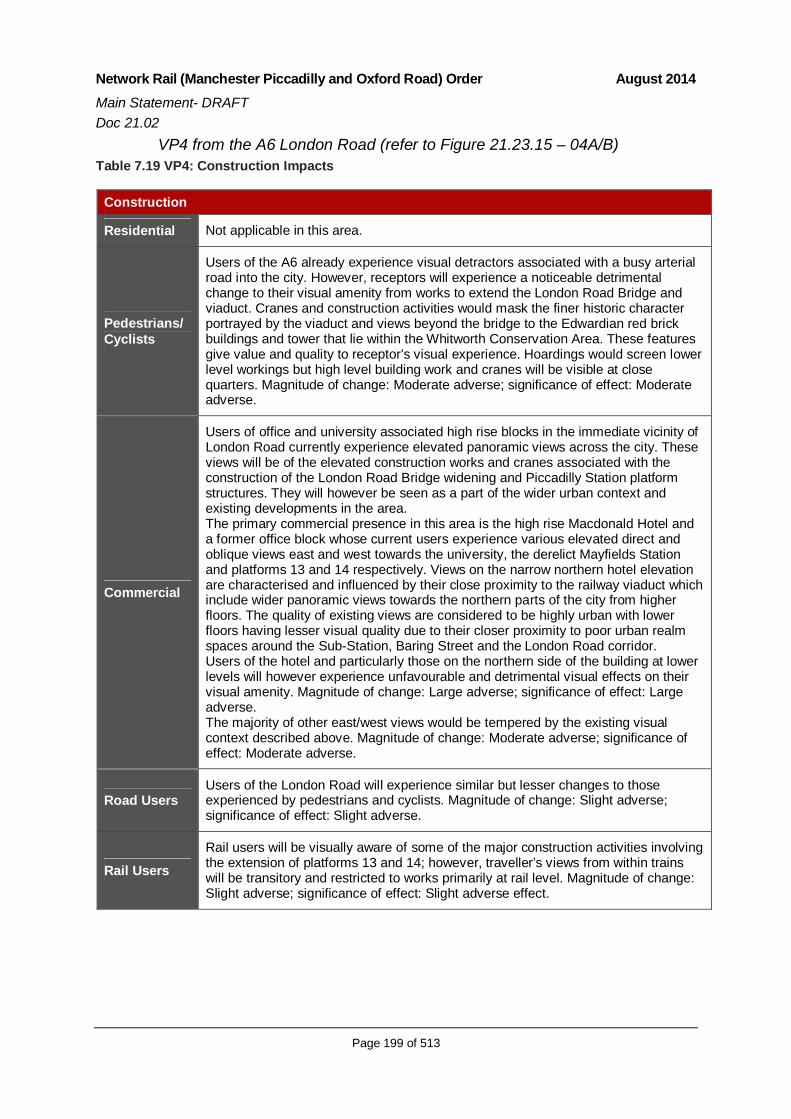
Network Rail (Manchester Piccadilly and Oxford Road) Order August 2014Main Statement- DRAFTDoc 21.02
Page 199 of 513
VP4 from the A6 London Road (refer to Figure 21.23.15 – 04A/B)Table 7.19 VP4: Construction Impacts
Construction
Residential Not applicable in this area.
Pedestrians/Cyclists
Users of the A6 already experience visual detractors associated with a busy arterialroad into the city. However, receptors will experience a noticeable detrimentalchange to their visual amenity from works to extend the London Road Bridge andviaduct. Cranes and construction activities would mask the finer historic characterportrayed by the viaduct and views beyond the bridge to the Edwardian red brickbuildings and tower that lie within the Whitworth Conservation Area. These featuresgive value and quality to receptor’s visual experience. Hoardings would screen lowerlevel workings but high level building work and cranes will be visible at closequarters. Magnitude of change: Moderate adverse; significance of effect: Moderateadverse.
Commercial
Users of office and university associated high rise blocks in the immediate vicinity ofLondon Road currently experience elevated panoramic views across the city. Theseviews will be of the elevated construction works and cranes associated with theconstruction of the London Road Bridge widening and Piccadilly Station platformstructures. They will however be seen as a part of the wider urban context andexisting developments in the area.The primary commercial presence in this area is the high rise Macdonald Hotel anda former office block whose current users experience various elevated direct andoblique views east and west towards the university, the derelict Mayfields Stationand platforms 13 and 14 respectively. Views on the narrow northern hotel elevationare characterised and influenced by their close proximity to the railway viaduct whichinclude wider panoramic views towards the northern parts of the city from higherfloors. The quality of existing views are considered to be highly urban with lowerfloors having lesser visual quality due to their closer proximity to poor urban realmspaces around the Sub-Station, Baring Street and the London Road corridor.Users of the hotel and particularly those on the northern side of the building at lowerlevels will however experience unfavourable and detrimental visual effects on theirvisual amenity. Magnitude of change: Large adverse; significance of effect: Largeadverse.The majority of other east/west views would be tempered by the existing visualcontext described above. Magnitude of change: Moderate adverse; significance ofeffect: Moderate adverse.
Road UsersUsers of the London Road will experience similar but lesser changes to thoseexperienced by pedestrians and cyclists. Magnitude of change: Slight adverse;significance of effect: Slight adverse.
Rail UsersRail users will be visually aware of some of the major construction activities involvingthe extension of platforms 13 and 14; however, traveller’s views from within trainswill be transitory and restricted to works primarily at rail level. Magnitude of change:Slight adverse; significance of effect: Slight adverse effect.

Network Rail (Manchester Piccadilly and Oxford Road) Order August 2014Main Statement- DRAFTDoc 21.02
Page 200 of 513
Table 7.20 VP4: Operation Impacts
Operation
Residential Not applicable in this area.
Pedestrians/Cyclists
The quality and value of the viewing experience would be lowered by the newstructures masking the historic character portrayed by the viaduct and views beyondthe bridge to the Whitworth Conservation Area. Magnitude of change: Slightadverse; significance of effect: Slight adverse.
Commercial
Office and university associated high rise blocks will have limited views of the newcanopies on platforms 15 and 16 seen in the context of the wider urban context andexisting developments in the area. Changes to visual amenity will be limited.Magnitude of change: No Change; significance of effect: Neutral.The users of the Macdonald Hotel will experience varying negative changes from thecloser proximity of the railway and new platform canopies that extend into the sky. Ingeneral the north and north eastern elevations will see the most changes from closeviews of platform canopies. These extend into what is already a tightly arrangedurban space and some lower floors of the hotel on the northern and north easternelevations will experience overshadowing and visual obstruction from closestructures. The majority of hotel users however will experience less negative changeby having limited and oblique views of the Piccadilly Station structures. Mitigationopportunities to redefine and improve the current poor visual qualities of the areasaround Temperance Street and Baring Street will make some local areaimprovements that will help lessen visual effects.Overall, the magnitude of change to north and north eastern elevations of the hotel:Large adverse; significance of effect: Large adverse.The majority of other east/west views would be tempered by the existing visualcontext described above. Magnitude of change: Slight adverse; significance ofeffect: Slight adverse.
Road UsersUsers of the London Road will experience similar but lesser changes to thoseexperienced by pedestrians and cyclists. Magnitude of change: Slight adverse;significance of effect; Slight adverse.
Rail UsersStructural changes will bring small noticeable changes to rail passengers broughtabout by minor restrictions to views caused by overhead canopy structures andclose proximity to the Macdonald Hotel. As views are transitory and fleeting, themagnitude of change: Slight adverse; significance of effect: Slight adverse.

Network Rail (Manchester Piccadilly and Oxford Road) Order August 2014Main Statement- DRAFTDoc 21.02
Page 201 of 513
VP5 from Altrincham Street to platforms 13 and 14 (refer to Figure 21.23.15– 05A/B)
Table 7.21 VP5: Construction Impacts
Construction
Residential Not applicable in this area.
Pedestrians/Cyclists
During construction, the access from Altrincham Street to London Road andbetween the Macdonald Hotel will be significantly restricted or closed.The effects on the visual amenity of receptors allowed continued access will besignificant and detrimental and would have the following effects:
Overshadowing from the new viaduct structure; Loss of green space to the side of the Macdonald Hotel; Loss of visual quality from reduced visibility from archway extensions andrecesses; and Loss of city vistas and open sky views along Altrincham Street.
Magnitude of change: Large adverse; significance of effect: Large adverse.
Commercial Views for the Macdonald Hotel as for VP4.
Road UsersViews as for VP4.
Rail Users
Table 7.22 VP5: Operation Impacts
Operation
Residential Not applicable in this area.
Pedestrians/Cyclists
During construction, the access from Altrincham Street to London Road andbetween the Macdonald Hotel will be significantly restricted or closed.The effects on the visual amenity of receptors allowed continued access will besignificant and detrimental and would have the following effects:
Overshadowing from the new viaduct structure; Loss of green space to the side of the Macdonald Hotel; Loss of visual quality from reduced visibility from archway extensions andrecesses; and Loss of city vistas and open sky views along Altrincham Street.
Magnitude of change: Large adverse; significance of effect: Large adverse.
Commercial
Views as for VP4.Road Users
Rail Users

Network Rail (Manchester Piccadilly and Oxford Road) Order August 2014Main Statement- DRAFTDoc 21.02
Page 202 of 513
VP6 from Fairfield Street (refer to Figure 21.23.15 – 06A/B)
Table 7.23 VP6: Construction Impacts
Construction
Residential Not applicable in this area.
Pedestrians/Cyclists
Located within the Whitworth Street Conservation Area, receptors are likely to viewcranes in the sky and the construction of the platform canopies extending above theexisting platforms 13 and 14. The visual character of current platform 13 and 14lacks distinctive character and is already a visual detractor to views from theConservation Area. Visual effects from construction works are therefore consideredto be limited. Magnitude of change: Slight adverse; significance of effect: Slightadverse.
Commercial Buildings on Fairfield Street are primarily for office use and have limited obliqueviews towards Piccadilly Station. Properties on the west side of the street lie withinthe Whitworth Street Conservation Area and the Fire Station on the adjacent side isa Grade II listed. Minor negative changes are expected to the visual setting ofbuildings within the CA and the visual amenity of users of these buildings from viewsof cranes dominant in the sky and associated construction works at high level.Magnitude of change: Slight adverse; significance of effect: Slight adverse.
Road Users
Rail Users Not applicable in this area.
Table 7.24 VP6: Operation Impacts
Operation
Residential Not applicable in this area.
Pedestrians/Cyclists
The new platform canopy to 15 and 16 will be visually more dominant in the skylinethan existing structures when viewed from the Whitworth Street Conservation Area.On balance, the new structures will be of higher architectural quality than existing.However, it is considered that the structure could potentially detract from the qualityand value of the historic viewing experience characterised by the ornate red brickand terracotta buildings along Fairfield Street. Magnitude of change: Slight adverse;significance of effect: Slight adverse.
CommercialMagnitude of change: No change; significance of effect: Neutral.
Road Users
Rail Users Not applicable in this area.

Network Rail (Manchester Piccadilly and Oxford Road) Order August 2014Main Statement- DRAFTDoc 21.02
Page 203 of 513
VP7 from Granby Street at the Vimto Sculpture (refer to Figure 21.23.15 –07A/B)
Table 7.25 VP7: Construction Impacts
Construction
Residential
Oblique elevated views of cranes and construction works associated with newgantries, solid parapets/noise barriers and the viaduct extension works intoAltrincham Street and distant views of cranes associated with the Oxford RoadStation work will be experienced from local high rise student apartments. Views ofworks would be seen as part of wider panoramic views across the city and otherdevelopments in the area; magnitude of change: Slight adverse; significance ofeffect: Slight adverse.
Pedestrians/Cyclists
Skyline views of cranes and construction works associated with new gantries,parapets and noise barriers (location and heights of noise barriers to be confirmed)would be partially visible but predominantly screened by tree canopies within theVimto Sculpture Gardens. Magnitude of change: Slight adverse; significance ofeffect: Slight adverse.
Commercial Not applicable in this area.
Road Users
This area has limited road access and is used for short stay parking. Car userswould have limited awareness of high level cranes due to the enclosure provided bytrees and the existing viaduct structure itself. Construction works in this area are notexpected to make any significant alteration to the visual amenity of road users.Magnitude of change: No change; significance of effect: Neutral.
Rail Users Magnitude of change: No change; significance of effect: Neutral.
Table 7.26 VP7: Operation Impacts
Operation
Residential Not applicable in this area.
Pedestrians/Cyclists
Minor adverse visual effects from views of new OLE gantries and solid parapets inskyline. Significance Neutral.Significance Neutral. Magnitude of change: No change; significance of effect:Neutral.
Commercial Not applicable in this area.
Road UsersMagnitude of change: No change; significance of effect: Neutral.
Rail Users

Network Rail (Manchester Piccadilly and Oxford Road) Order August 2014Main Statement- DRAFTDoc 21.02
Page 204 of 513
VP8 from Altrincham Street adjacent University (refer to Figure 21.23.15 –08A/B)
Table 7.27 VP: Construction Impacts
Construction
Residential As for VP7.
Pedestrians/Cyclists
The effects on the visual amenity of receptors from extending the viaduct into andcovering Altrincham Street will be significant and detrimental and would have thefollowing effects:
Loss of attractive public realm spaces, open visual qualities and sense of placecreated by the historic viaduct structure, small scale art spaces and shortpedestrian links beneath the viaduct arches and University campus and VimtoSculpture Gardens, resulting in overshadowing from the new viaduct structure andlarge covered spaces; Reduced visibility and accessibility from archway colonnade construction.
Magnitude of change: Large adverse; significance of effect: Large adverse.
Commercial
The visual amenity of users of University Buildings largely to the south that havedirect views to the viaduct along Altrincham Street will be detrimentally affected byworks to cover and extend the viaduct over Altrincham Street will experience moretransitory but similar effects to pedestrians and cyclists.Magnitude of change: Large adverse; significance of effect: Large adverse.
Road Users Not applicable in this area.
Rail Users As for VP7.
Table 7.28 VP8: Operation Impacts
Operation
Residential As for VP7.
Pedestrians/Cyclists
Quality of viewing experience lowered by new structures reducing visibility andaccessibility from colonnades and archway recesses. Loss of linear vistas alongAltrincham Street visually connecting the city along this important pedestrian routeand reduction in historic visual qualities of viaduct.Magnitude of change: Large adverse; significance of effect: Large adverse.
CommercialNot applicable in this area.
Road Users
Rail Users As for VP7.

Network Rail (Manchester Piccadilly and Oxford Road) Order August 2014Main Statement- DRAFTDoc 21.02
Page 205 of 513
Area 2 (Oxford Road Station)
VP9 Oxford Street/Whitworth Street West (refer to Figure 21.23.15 – 09A/B)
Table 7.29 VP9: Construction and Operation Impacts
Construction/Operation
Residential
Residential apartments would experience close elevated views of construction of thenew platforms and footbridge structure. Cranes in the immediate view will be visuallydisruptive but seen in the context of the existing station and other developments inthe area. Adverse change to visual amenity will therefore be moderately felt giventhe context of existing views which will be assisted by there being limited expansiononto Whitworth Street West at this eastern end. Magnitude of change to residents inhigh rise apartments at the eastern end of Whitworth Street West: Moderateadverse; significance of effect: Moderate adverse.The visual effects to residential properties towards the western end of WhitworthStreet West will be substantially higher and are described under VP11.
Pedestrians/Cyclists
During construction, access to Whitworth Street West south side will be restricted orclosed. National Cycle Route 6 will be diverted via Great Bridgewater Street. Theeffects on the visual amenity of cyclists will be significant resulting from scale of theconstruction activities and building works to extend the viaduct into Whitworth StreetWest. Hoardings would screen lower level workings but high level building work andcranes would be closely visible. Effects will be less noticeable in the area of the busyOxford Road junction with more significant reduction in the quality of the visualenvironment experienced towards the Marlborough Street Bridge. Magnitude ofchange: Moderate adverse; significance of effect: Moderate adverse.
Commercial
There are a number of commercial users on or close to the Oxford Road/WhitworthStreet East junction including Sainsbury’s, The Ritz Dance Hall and Palace Hotelboth Grade II listed, a cinema and a number of small retail shops, with the exceptionof the Palace Hotel whose upper floor users facing Oxford Road would have directviews towards cranes and the new footbridge. Most users of commercial premiseshave limited or no views out towards construction work.Users entering commercial premises will experience similar visual impacts topedestrians and cyclists where the scale of construction development will havepotentially overshadowing effects as a result of extensions into the street and theheight of new structures in the skyline seen in the context of existing localconstruction projects associated with the First Street Development. Magnitude ofchange: Moderate adverse; significance of effect: Moderate adverse.
Road Users Effects as for VP13.
Rail UsersFor rail passengers crossing the Oxford Road junction towards the station forecourtthey will experience minor detrimental changes to their visual amenity from views toconstruction works in Whitworth Street West and in the sky above the stationentrance. Magnitude of change: Slight adverse; significance of effect: Slight adverse.

Network Rail (Manchester Piccadilly and Oxford Road) Order August 2014Main Statement- DRAFTDoc 21.02
Page 206 of 513
VP10 Gloucester Street (refer to Figure 21.23.15 – 10A/B)
Table 7.30 VP10: Construction Impacts
Construction
Residential
The construction works arising from the Oxford Road Station expansion will bevisually apparent in the following ways: The construction of the footbridge structure slightly west of the Green Building andthe cladding over of the Grade II Listed Gloucester Street Bridge and viaductparapets will be highly visible and mask the historic viaduct structure; Works to build foundations into the River Medlock for the station footbridgeinvolving cranes and drilling equipment will be directly overlooked by surroundingapartments; and The qualities of the listed Gloucester Street Bridge.
Construction works will be seen in the context of skyline cranes associated with theFirst Street Development and the existing derelict condition of land adjacent to theRiver Medlock which lessen the historic visual qualities of the area. Magnitude ofchange: Large adverse; significance of effect: Moderate adverse.The visual effects on residents of the Green Building and on New Wakefield Streetwill be much greater as a result of the close proximity of construction worksassociated with the footbridge that will dominate and over shadow existing views.Magnitude of change: Large adverse; significance of effect: Large adverse.
Pedestrians/Cyclists
The effects on the visual amenity of receptors will result from the scale of thebuilding works to extend the viaduct over Gloucester Street Bridge and constructionof the footbridge structure and loss of historic visual qualities from cladding overMSJ&AR viaduct and Gloucester Street Bridge. The existing visual qualities of thisarea are mixed. Magnitude of change: Large adverse; significance of effect:Moderate adverse.
Commercial Not applicable in this area.
Road Users Magnitude of change: Moderate adverse; significance of effect: Moderate adverse.
Rail Users Not applicable in this area.
Table 7.31 VP10: Operation Impacts
Operation
ResidentialNarrowing and overshadowing of properties on New Wakefield Street fromoverhanging new platform structures reducing the quality and enjoyment of thestreet environment. Large adverse magnitude of change and resulting significance ofeffect on visual amenity would be Large adverse.
Pedestrians/Cyclists Significance of effects as for construction.
Commercial Not applicable in this area.
Road Users Significance of effects as for construction.
Rail Users Not applicable in this area.

Network Rail (Manchester Piccadilly and Oxford Road) Order August 2014Main Statement- DRAFTDoc 21.02
Page 207 of 513
VP11 Whitworth Street West (refer to Figure 21.23.15 – 11A/B)
Table 7.32 VP11: Construction Impacts
Construction
Residential
Residential apartments built up to the edge of pavement on Whitworth Street Westnear to the Marlborough Street Bridge currently experience close elevated views ofthe viaduct and station platforms. The scheme extends the station to the north-westwhich would take the platforms and track (supported on a large viaduct structure)over Whitworth Street West. These structures would also come in close proximity tothe apartments on the north side of the street.Associated construction operations will include the use of cranes, scaffolding andelevated construction works which will have an impact on the visual amenity ofapartment users. This would be particularly so for those at lower levels who woulddirectly view the new structural works and street level changes. The height of theproposed footbridge structure would be similar to that of the adjacent upper floorapartments and likely to dominant views from residential properties facing WhitworthStreet West. The expansion of new structures into the street is also anticipated tocreate areas of shadowing which could potentially reduce the quality of visualamenity to residents, commercial properties and pedestrian users.Magnitude of change: Large adverse; significance of effect: Large adverse.
Pedestrians/Cyclists
During construction, access to Whitworth Street West will be significantly restricted.The effects on the visual amenity of receptors will be significant, resulting from thescale of construction activities and building works to extend the viaduct intoWhitworth Street West. Hoardings would screen lower level workings but high levelbuilding work and cranes would be closely visible. The scale of constructiondevelopment will have potentially overshadowing effects on the remaining streetenvironment and the historic visual experience that the current brick viaduct andarches provides. Magnitude of change: Large adverse; significance of effect: Largeadverse.
CommercialThere are a small number of street level commercial premises occupying space inthe railway viaduct arches. Users of premises in the arches will be subject totemporary or permanent closure to be agreed with Network Rail. Magnitude ofchange: Moderate adverse; significance of effect: Moderate adverse.
Road UsersVisual effects would be similar to pedestrians and cyclists but more fleeting in natureand with views generally restricted to street level changes. Magnitude of change:Slight adverse; significance of effect: Slight adverse.
Rail UsersRail users will be visually aware of the major construction activities involving thefootbridge and platforms extensions. Hoardings will be used to screen workings.Magnitude of change: Slight adverse: significance of effect: Slight adverse.

Network Rail (Manchester Piccadilly and Oxford Road) Order August 2014Main Statement- DRAFTDoc 21.02
Page 208 of 513
Table 7.33 VP10: Operation Impacts
Operation
Residential
Large apartment blocks facing onto Whitworth Street West would experience bothdirect and oblique views of the new footbridge structure that would partially obscureviews south across the city. The visual amenity of users would be significantlyaffected towards Marlborough Road where new structures come out into the streetand closer to apartment windows, creating potential overshadowing effects to thefirst 3-4 floors of apartments. Upper floor apartments would be less affected by thecloseness and shadowing of the extension. Residents already overlook a railwayviaduct and construction activities associated with the First Street Development.Magnitude of change where views are closest to new structures: Large adverse;where views become more oblique or from upper floors: Moderate adverse;significance of effect: Large to Moderate adverse.
Pedestrians/Cyclists
The effects on the visual amenity of receptors will be significant resulting from scaleand extension of the Scheme into Whitworth Street West Magnitude of change:Moderate adverse; significance of effect: Moderate adverse.
Commercial Users of commercial premises at street level would experience similar but lesserimpacts to those of pedestrians. Potential shadowing to premises from the extensionmay affect light quality within the premises and visual quality of the property whenviewed at street level. Magnitude of change: Slight adverse; significance of effect:Slight adverse.
Road Users
Rail UsersRail users will be visually aware of the major construction activities involving thefootbridge and platforms extensions. Hoardings will be used to screen workings.Magnitude of change: Slight adverse; significance of effect: Slight adverse effect.

Network Rail (Manchester Piccadilly and Oxford Road) Order August 2014Main Statement- DRAFTDoc 21.02
Page 209 of 513
VP12 Rochdale Canal off Whitworth Street West (refer to Figure 21.23.15 -12)
Table 7.34 VP12: Construction Impacts
Construction
Residential
Glimpsed views of construction works associated with the platform expansion wouldbe possible from a limited number of properties and would be similar to the currentviews of cranes in the skyline associated with the First Street Development. Themajority of apartments would not view the construction works due to the screeningeffect of intervening apartment blocks facing Whitworth Street West.Magnitude of change: Slight adverse; significance of effect: Moderate adverse.
Pedestrians/Cyclists
The canal is enclosed by tall apartment blocks that contain and influence the visualexperience of receptors following the canal path. There are a number of restrictedviews towards the Scheme seen between tall apartment buildings along WhitworthStreet West where views would be similar to that shown in the photograph whichcurrently shows the cranes associated with the First Street Development. Magnitudeof change: Slight adverse; significance of effect: Slight adverse.
Commercial
Not applicable in this area.Road Users
Rail Users
Table 7.35 VP12: Operation Impacts
Operation
Residential Significance of effect: Slight adverse
Pedestrians/Cyclists Significance of effect: Slight adverse
Commercial
Not applicable in this area.Road Users
Rail Users

Network Rail (Manchester Piccadilly and Oxford Road) Order August 2014Main Statement- DRAFTDoc 21.02
Page 210 of 513
VP13 Albion Street/Whitworth Street West (refer to Figure 21.23.15 –13A/B)
Table 7.36 VP13: Construction Impacts
Construction
Residential
As covered under VP9 and VP11, the north side of Whitworth Street West isdominated by residential apartments typically built close to the edge of pavementand directly facing the street in close proximity to the adjacent viaduct structure.Existing skyline views are currently dominated by several cranes involved in thedevelopment of the First Street development.Properties in the Hacienda Apartments near to the Albion Street junction wouldexperience both direct and oblique views of cranes and upper level building workassociated with the alignment expansion works and gantry replacements.Apartments nearer to Marlborough Street Bridge would experience closer and moredirect views of the expanded platform extending into the street and closer toadjacent properties. Magnitude of change: Moderate adverse; significance of effect:Moderate adverse.
Pedestrians/Cyclists
During construction, access to Whitworth Street West will be significantly restricted.The effects on the visual amenity of receptors will be significant, resulting from thescale of construction activities and building works to extend the viaduct intoWhitworth Street West. Hoardings would screen lower level workings but high levelbuilding work and cranes would be closely visible. The scale of constructiondevelopment will have potentially overshadowing effects on the remaining streetenvironment and the historic visual experience of the brick viaduct and arches.Magnitude of change: Moderate adverse; significance of effect: Moderate adverse.
Commercial
Users entering commercial premises will experience similar visual impacts topedestrians and cyclists. The scale of construction development will have potentiallyovershadowing effects as a result of extensions into the street and the height of newstructures in the sky. These views currently look onto construction projectsassociated with the First Street Development. Magnitude of change: Slight adverse;significance of effect: Slight adverse.
Road UsersAs for VP 11
Rail Users

Network Rail (Manchester Piccadilly and Oxford Road) Order August 2014Main Statement- DRAFTDoc 21.02
Page 211 of 513
Table 7.37 VP13: Operation Impacts
Operation
Residential
Large apartment blocks facing onto Whitworth Street West wouldexperience both direct and oblique views of the new footbridge andexpanded platform extending into the street. The visual amenity of userswould be significantly affected towards Marlborough Road where newstructures come out into the street and closer to apartment windows,creating potential overshadowing effects. Magnitude of change: Moderateadverse; significance of effect: Moderate adverse.
Pedestrians/Cyclists As for VP11
Commercial
Overshadowing effects as a result of extensions into the street and theheight of new structures in the sky. These views will be seen in the contextof existing local construction projects associated with the First StreetDevelopment. Magnitude of change: Moderate adverse: significance ofeffect: Moderate adverse.
Road UsersAs for VP 11
Rail Users
VP14 from Whitworth Street West at Deansgate (refer to Figure 21.23.15 –14A/B)
Table 7.38 VP14: Construction Impacts
Construction
Residential Not applicable in this area.
Pedestrians/Cyclists
There will be some minor adverse changes to the existing view of theviaduct resulting from visibility of cranes and OLE works in the skyline andincreasing obscuring of the viaduct as extension works progress. Hoardingswould screen lower level workings. Views of the Scheme are narrow andlimited in extent and seen in the context of existing cranes associated withthe First Street Development. Magnitude of change: Slight adverse;significance of effect: Slight adverse.
Commercial Users entering commercial premises will experience similar visual impacts topedestrians and cyclists. Overall, magnitude of change is considered to beSlight adverse and resulting significance of effect on visual amenity wouldbe temporary Slight adverse.
Road Users
Rail Users Not applicable in this area.

Network Rail (Manchester Piccadilly and Oxford Road) Order August 2014Main Statement- DRAFTDoc 21.02
Page 212 of 513
Table 7.39 VP14: Operation Impacts
Operation
Residential Not applicable in this area.
Pedestrians/Cyclists
The narrow character of the view and modern new structures of the OLE and viaductextension would not look particularly out of place when seen against the urbanbackdrop and Hacienda Apartments. The cladding over of the viaduct will howeverobscure an important historic feature and visual reference to the industrial past thatcurrently visually links through to the historic red brick buildings in the foreground.Magnitude of change: Slight adverse; significance of effect: Slight adverse.
CommercialMagnitude of change: Slight adverse; significance of effect: Neutral.
Road Users
Rail Users Not applicable in this area.
7.8 Mitigation Measures
7.8.1 Mitigation measures have been informed by feedback received fromstatutory consultees and developed through an iterative design process.
7.8.2 The design has evolved to minimise impacts on the urban realm and arange of scheme options has been considered from an engineeringperspective. A preferred option was identified that avoids the removal of theStar and Garter Grade II Public House and minimises development northand south of the viaduct. More information on the design iterations can befound in Chapter 4 (Appraisal of Alternatives to the Scheme).
7.8.3 Potential adverse townscape/ visual effects have been mitigated throughthe design as follows:
Through route alignment to minimise direct effects on existing buildings,Paying particular attention to minimising visual effects on residents;
Having due regard for important designations, historic and townscapefeatures and their settings (such as the Star and Garter Public House);
Providing pedestrian connectivity and public realm spaces beneathviaduct extensions and colonnades and other affected areas by linkingto key areas including both stations and areas north and south of theviaduct;
Providing unified public realm elements (hard and soft) to help unify thescale of the contemporary scheme with the small grain historic

Network Rail (Manchester Piccadilly and Oxford Road) Order August 2014Main Statement- DRAFTDoc 21.02
Page 213 of 513
townscape characterised by the viaduct and, creating a morecomfortable, enhancing experience at pedestrian level;
Use of hoardings to limit visual impacts during the construction phase;
Through lighting and paved surfacing to ensure best assimilation into theexisting townscape;
Design of external lighting to street and pedestrian areas with reducedlight trespass, glare and spillage; and
Application of appropriate sealants and coatings to concrete colonnadesto minimise weather staining and graffiti damage.
7.8.4 Overall, these mitigation measures have been incorporated into the Schemedesign to minimise visual and townscape effects’ where possible. TheScheme will therefore contribute positively to the regeneration of this area.
7.9 Residual Effects
7.9.1 It may not be possible to completely mitigate all adverse impacts due to thenature and scale of the Scheme. Significant residual effects (i.e. moderateor worse effects) are identified below and summarised in Table 7.40.
Townscape
Area 1 (Piccadilly)
7.9.2 No significant residual townscape effects were identified in Area 1 followingthe application of mitigation.
Area 2 (Oxford Road)
7.9.3 Some moderate adverse residual townscape effects are predicted to remainin the Whitworth West TCA. These effects are due to:
Permanent impacts to MSJ&AR viaduct and Gloucester Road Bridgeaffecting the quality of the distinct historic architecture and itscontribution to the historic sense of place of TCA’s;
Reduction in visual quality, accessibility and streetscape pattern ofpublic realm space along Whitworth Street West and New WakefieldStreet from reduced visibility from archway extensions and recesses;
Loss of views to landmark Palace Hotel reducing the visual connectionwith the historic city from street level; and
Concrete colonnade structures negatively affecting character of existingand proposed architecture over time.

Network Rail (Manchester Piccadilly and Oxford Road) Order August 2014Main Statement- DRAFTDoc 21.02
Page 214 of 513
7.9.4 No residual effects are anticipated to the Medlock Street and CastlefieldTCAs including the Castlefield Conservation Area
Visual Amenity
Area 1 (Piccadilly)
7.9.5 Some Large adverse residual visual effects are predicted to remain forusers of the Macdonald Hotel due to close proximity of the Scheme torooms on the northern elevations and to pedestrians and cyclists usingAltrincham Street from loss of open vistas connecting the city and reducedvisibility and accessibility from widened viaduct structure.
7.9.6 Maturing canopies of proposed street trees forming part of the public realmprovisions will, in time, help reduce residual visual effects for residents ofthe Star & Garter PH and pedestrians and cyclists in close proximity to theScheme at Baring, Temperance and Fairfield Street to Slight adverse.
7.9.7 From viewpoint 3, the new platforms and station improvements provided aspart of the Scheme will lead to a permanent Moderate beneficial effect.
Area 2 (Oxford Road)
7.9.8 Some Moderate adverse residual visual effects are predicted to remain forsome residential receptors in apartments directly facing the new stationfootbridge on Whitworth Street West and New Wakefield Street due to closeproximity and shadowing effects of the Scheme.
7.9.9 Moderate adverse residual effects would also remain to pedestrians andcyclists using Whitworth Street West where the Scheme narrows andshadows the road and obscures important city views towards the PalaceHotel.

Network Rail (Manchester Piccadilly and Oxford Road) Order August 2014Main Statement- DRAFTDoc 21.02
Page 215 of 513
[this page left intentionally blank]

Network Rail (Manchester Piccadilly and Oxford Road) Order August 2014Main Statement- DRAFTDoc 21.02
Page 216 of 513
Table 7.40: Residual Townscape and Visual Amenity Effects
ReceptorDescription/Sensitivityand Magnitude of Impact Significance of Effect Mitigation
Significance ofResidual Effect
TOWNSCAPE EFFECTS
Area 2 (Oxford Road Station)
TCA 4:WhitworthWest
Bounded by DeansgateLocks/Rochdale Canal tonorth, Oxford Rd to theeast, viaduct to the south(including the viaduct itself)and Deansgate to the west.Not in a Conservation Areabut forms the setting to theCastlefield CA in the west.Sensitivity MediumMagnitude Large
Construction: Effects include localised impacts onWhitworth CA setting and reduction in quality of spacesbetween buildings and street from viaduct widening andrestricted access. Increasing reduction in views to PalaceHotel and covering of listed viaduct obscuring historicalreferences and characterTemporary Large adverseOperation: Scale of new structures will have landmarkqualities however extension of viaduct into Whitworth Streetwill affect linear street form and affect quality throughshadowing. New structures block vista to Palace Hotel andwidening viaduct lessens its historical contribution to TCA.Changes tempered by generally non distinctive pedestrianenvironment and mixed quality of predominant existing 20th
architecturePermanent Moderate adverse
Provision ofpublic realmspaces includinghard and softlandscaping tounify and linkScheme withsurroundingareas.
Moderateadverse

Network Rail (Manchester Piccadilly and Oxford Road) Order August 2014Main Statement- DRAFTDoc 21.02
Page 217 of 513
ReceptorDescription Sensitivity/Magnitude of Impact Significance of Effect Mitigation
Significance ofResidual Effect
VISUAL AMENITY EFFECTS
Area 1 (Piccadilly)
VP 1Residential,Pedestrians/ Cyclists,Road Users,Rail Users
From Fairfield Street (atTemperance Street) lookingtowards platforms 13 & 14.
Sensitivity High
Magnitude Moderate
Construction: Quality of visual amenity to residents of Star& Garter and pedestrians/cyclists from road closure,construction of London Road Bridge, cranes and high levelworks associated with OLE, station structures and wideningof MSJ&AR.Temporary Moderate adverseOperation: Negative impacts created by new structurescloser to Star & Garter partly off-set by public realmimprovements to Fairfield Street and surrounds. Reducedvisibility to pedestrians and cyclists from extended viaductand recesses.Permanent Moderate adverse
Provision ofpublic realmspaces includinghard and softlandscaping tounify and linkScheme withsurroundingareas.
Moderateadverse
VP 2Pedestrians/ Cyclists,Commercial, RoadUsers.
From Baring Street lookingnorth towards platforms 13& 14. (Refer to Figure21.23.15 – 02B)
Sensitivity High
Magnitude Moderate
Construction: Quality of visual amenity to from roadclosure restrictions and close proximity and scale ofbuilding works. Hoardings screening lower level workingsbut high level works and cranes would dominant view.Temporary Moderate adverseOperation: Negative impacts created by new higher thanexisting structures extending into FairfieldStreet/Temperance Street. Public realm improvementspartially offsetting reduced visibility and accessibility fromarchway extensions and recesses.Permanent Moderate adverse
Provision ofpublic realmspaces includinghard and softlandscaping tounify and linkScheme withsurroundingareas.
Moderateadverse

Network Rail (Manchester Piccadilly and Oxford Road) Order August 2014Main Statement- DRAFTDoc 21.02
Page 218 of 513
ReceptorDescription Sensitivity/Magnitude of Impact Significance of Effect Mitigation
Significance ofResidual Effect
VP3Rail Users
From platforms 13 & 14looking towards theMSJ&AR viaduct andMacdonald Hotel.
Sensitivity Medium
Magnitude Slight
Construction: Major structural work largely screened fromview by hoardings. Existing open views will be increasinglyrestricted having minor detrimental effects.Temporary Slight adverseOperation: New platforms and internal stationimprovements will improve quality of visual amenityexperience through provision of high quality buildings,enclosure from weather and open, light and airyenvironment.Permanent Moderate beneficial
Provision ofpublic realmspaces as partof stationimprovements.
Moderatebeneficial
VP4Pedestrian/Cyclists,Commercial, RoadUsers, RailUsers
From the A6 London Roadlooking towards the LondonRoad Bridge andMacdonald Hotel. (Refer toFigure 21.23.15 – 04B)
Sensitivity High
Magnitude Large
Construction: Cranes and works to extend the LondonRoad Bridge and MSJ&AR increasingly obscuring historicvisual qualities of listed viaduct and views to Edwardianbuildings and tower to the north of the bridge. Hoardingswill screen lower level workings. Users of Macdonald Hotelrooms on northern elevations will experience unfavourablevisual impacts from works and building closer to buildingand cranes at upper levels plus removal of Sub-Station.Temporary Large adverseOperation: Quality of viewing experience would be loweredby new structures masking historic features of MSJ&ARand obscuring views to Whitworth CA beyond bridge. Slightadverse.Users of Macdonald Hotel northern elevations will see mostchange from very close views of platforms havingovershadowing/obstructing effects.Permanent Large adverse
Provision ofpublic realmspaces includinghard and softlandscaping tounify and linkScheme withsurroundingareas.
Large adverse(MacdonaldHotel north)

Network Rail (Manchester Piccadilly and Oxford Road) Order August 2014Main Statement- DRAFTDoc 21.02
Page 219 of 513
ReceptorDescription Sensitivity/Magnitude of Impact Significance of Effect Mitigation
Significance ofResidual Effect
VP5Pedestrian/Cyclists,Commercial, Rail Users
From Altrincham Street /University looking towardsthe London Road andplatforms 13 & 14 (Refer toFigure 21.23.15 – 05B)
Sensitivity High
Magnitude Large
Construction: Access from Altrincham Street to LondonRoad and between Macdonald Hotel closed duringconstruction and loss of linear vistas along AltrinchamStreet visually connecting the city along this importantpedestrian route. Views of cranes in skyline and high levelwork constructing parapets and erecting OLE.Temporary Large adverseOperation: Quality of viewing experience would be loweredby new structures masking historic features of MSJ&ARand obscuring views to Whitworth CA beyond bridge. Slightadverse.Users of Macdonald Hotel northern elevations will see mostchange from very close views of platforms havingovershadowing/obstructing effects.Permanent Large adverse
Provision ofpublic realmspaces includinghard and softlandscaping tounify and linkScheme withsurroundingareas.
Large adverse
VP8Residential,Pedestrian/Cyclist,Commercial, RoadUsers, RailUsers
From Altrincham Streetlooking towards the LondonRoad Bridge. (Refer toFigure 21.23.15 – 08B)
Sensitivity High
Magnitude Large
Construction: Access from Altrincham Street to LondonRoad closed during construction and loss of linear vistasalong Altrincham Street visually connecting the city alongthis important pedestrian route. Views of cranes in skylineand high level work constructing parapets and erectingOLE.Temporary Large adverseOperation: Quality of viewing experience e lowered by newstructures reducing visibility and accessibility fromcolonnades and archway recesses. Loss of linear vistasalong Altrincham Street visually connecting the city alongthis important pedestrian route.Permanent Large adverse
Provision ofpublic realmspaces includinghard and softlandscaping tounify and linkScheme withsurroundingareas.
Large adverse

Network Rail (Manchester Piccadilly and Oxford Road) Order August 2014Main Statement- DRAFTDoc 21.02
Page 220 of 513
ReceptorDescription Sensitivity/Magnitude of Impact Significance of Effect Mitigation
Significance ofResidual Effect
Oxford Road Station Area 2
VP9Residential,Pedestrian/Cyclists,Commercial, RoadUsers
From Whitworth Street (atjunction with Oxford Road)looking towards theentrance to Oxford RoadStation. (Refer to Figure21.23.15 – 09B)
Sensitivity High
Magnitude Very Large
Construction: Adjacent residential apartments wouldexperience close elevated views of cranes and elevatedworks to construct new platforms and footbridge includingstreet level changes. Access restrictions, cyclewaydiversion and scale of building works extending intoWhitworth Street West would affect visual amenity ofpedestrians/cyclists.Temporary Moderate adverseOperation: Direct and oblique views of new footbridgestructure into skyline, partially obscuring views across citytogether with viaduct extension and having someshadowing effects to properties and street users.Permanent Moderate adverse
Provision ofpublic realmspaces includinghard and softlandscaping tounify and linkScheme withsurroundingareas.
Moderate
VP10Residential,Pedestrian/Cyclists,Road Users
From Cambridge Streetlooking towards the Grade11 listed Gloucester StreetBridge. (Refer to Figure21.23.15 – 10B)
Sensitivity High
Magnitude Large
Construction: Adjacent residential apartments would viewcranes in skyline and elevated construction of footbridgeand cladding over of MSJ&AR and Gloucester StreetBridge. Piling works to build foundations into River Medlock.Temporary Large to Moderate adverseOperation: Scale of footbridge structure dominant in view.Visual effects on listed buildings and loss of historic visualqualities by covering over the MSJ&AR viaduct andGloucester Street Bridge. Residents in Green Building andon New Wakefield Street experiencing overshadowing andobstruction to views from close proximity of widened viaductand height of footbridge.Permanent Large to Moderate adverse
Provision ofpublic realmspaces includinghard and softlandscaping tounify and linkScheme withsurroundingareas.
Moderate

Network Rail (Manchester Piccadilly and Oxford Road) Order August 2014Main Statement- DRAFTDoc 21.02
Page 221 of 513
ReceptorDescription Sensitivity/Magnitude of Impact Significance of Effect Mitigation
Significance ofResidual Effect
VP11Residential,Pedestrian/Cyclists,Road Users,Rail Users
From Whitworth StreetWest at Gloucester Street,looking in the direction ofthe Oxford Road Stationand the Palace Hotel.(Refer to Figure 21.23.15 –11B)
Sensitivity High
Magnitude Moderate
Construction: Adjacent residential apartments wouldexperience close elevated views of cranes and elevatedworks to construct new platforms and footbridge includingstreet level changes. Access restrictions, cyclewaydiversion and scale of building works extending intoWhitworth Street West would affect visual amenity ofpedestrians/cyclists.Temporary Large adverseOperation: Direct and oblique views of new footbridgestructure into skyline, together with viaduct extensionhaving some shadowing effects to properties and streetusers. Obscuring views of the Palace Hotel landmark.Permanent Large to Moderate adverse
Provision ofpublic realmspaces includinghard and softlandscaping tounify and linkScheme withsurroundingareas.
Moderate
VP13Residential,Pedestrian/Cyclists,Commercial, RoadUsers
From Albion Street lookingtowards Whitworth StreetWest and the MSJ&ARviaduct.
Sensitivity High
Magnitude Moderate
Construction: Properties in the Hacienda Apartmentswould experience direct and oblique views of cranes andupper level building work associated with the alignmentexpansion and gantry replacements plus street levelchanges, seen in context of existing First StreetDevelopment workTemporary Moderate adverseOperation: Overshadowing effects possible fromextensions into the street and height of new structures inskyline. Reduction in historical visual references by impactsto MSJ&AR viaduct. Permanent Moderate adverse
Provision ofpublic realmspaces includinghard and softlandscaping tounify and linkScheme withsurroundingareas.
Moderate

Network Rail (Manchester Piccadilly and Oxford Road) Order August 2014Main Statement- DRAFTDoc 21.02
Page 222 of 513
8. TRAFFIC AND TRANSPORT
8.1 Introduction
8.1.1 This chapter identifies and assesses the likely significant effects of theconstruction and operational impacts of the Manchester Piccadilly andOxford Road Capacity Scheme (the Scheme) on the transport network.
8.1.2 This chapter is informed by the Transport Assessment (TA), which can befound in Document 21.15. The assumptions and limitations used in thisassessment are based on the anticipated construction programme.
8.1.3 Key stakeholders have been consulted during the development of thisChapter. Stakeholders consulted include:
Transport for Greater Manchester (TfGM); and
Manchester City Council (MCC).8.1.4 An initial meeting was held on 19th November 2013 to agree the scope and
methodology of the assessment, and the modelling to be undertaken.Representatives of MCC and TfGM attended the meeting. Further meetingswere held on the 1st April 2014 and 23rd April 2014.
8.2 Limitations and Assumptions
8.2.1 This assessment does not consider the impact of modal shift as a result ofthe completion of the full Northern Hub package of works.
8.3 Study Area
Spatial Scope
8.3.1 The study area stretches along the southern edge of Manchester CityCentre. The predominant land uses within the site include railwayinfrastructure, surface car parking, commercial and residential.
8.3.2 The River Medlock runs through the study area.
8.3.3 Figure 21.2.11 shows the location of the Scheme. This shows the mainstudy area for the TA. The study area has been selected as it is the mainarea that is affected by the Scheme.

Network Rail (Manchester Piccadilly and Oxford Road) Order August 2014Main Statement- DRAFTDoc 21.02
Page 223 of 513
Figure 21.2.11: Scheme Location (Indicative Study Area)
Temporal Scope
8.3.4 The assessment considers four different years:
2012: Baseline;
2016: During Construction;
2018: Scheme Completion; and
2033: 15 Years Post Completion.8.3.5 Assessment for these years captures the full extent of traffic and transport
impacts of the various stages of the Scheme, and enables a comparisonwith baseline data.
8.3.6 The peaks periods assessed for all assessment years were identified intraffic surveys undertaken on the highway network adjacent to ManchesterPiccadilly. Traffic surveys were undertaken on the 3rd February 2014. Thesurveys identified the following weekday peak hours.
AM Peak Hour: 0900 - 1000;
Inter-Peak: 1145 - 1245; and
PM Peak Hour: 1645 - 1745.
Manchester OxfordRoad Station
Manchester PiccadillyStation
Image: (C) 2013 Google Earth
Area 1Area 2

Network Rail (Manchester Piccadilly and Oxford Road) Order August 2014Main Statement- DRAFTDoc 21.02
Page 224 of 513
8.4 Legislation, Planning and Guidance
8.4.1 Chapter 5 (Planning Policy) of this ES sets out the current planning policycontext, locally, regionally and nationally and identifies the planning policybackground at all levels. The Scheme has been developed in line withexisting policy. The following transport policies have been used to informthis ES as well as the TA:
NPPF (DCLG, March 2012);
Guidance on TA (DfT, March 2007);
Environmental Assessment of Road Traffic (IEA, 1993); and
Greater Manchester Local Transport Plan 3.8.4.2 An outline of key policies in each of these documents relevant to the
proposed Scheme is given below.
National Planning Policy Framework (NPPF): Chapter 4 PromotingSustainable Transport - March 2012
8.4.3 NPPF states that encouragement should be given to solutions that supportreductions in greenhouse gas emissions and reduce congestion. Localauthorities should identify and protect, where there is robust evidence, sitesand routes which could be critical in developing infrastructure to widentransport choice.
8.4.4 It also states a Transport Statement, or TA, and a Travel Plan shouldsupport any development proposals that generate significant amounts ofmovement. A TA has been prepared to accompany this application. TheContractor, once commissioned, will be required to prepare a Travel Planbefore construction commences.
The Guidance on TA (DfT, 2007)
8.4.5 This guidance builds on national government policy and states that newdevelopments should include a TA as part of the planning application. Theguidance outlines the requirements for a TA, and further emphasises theneed to encourage sustainable development whilst managing the existingtransport network and mitigating residual effects. It also sets out how toanticipate the transport impacts, improve accessibility and safety for alltransport modes whilst prioritising on walking, cycling and public transportwherever possible.
Greater Manchester Local Transport Plan 3

Network Rail (Manchester Piccadilly and Oxford Road) Order August 2014Main Statement- DRAFTDoc 21.02
Page 225 of 513
8.4.6 The third Local Transport Plan (LTP3) for Greater Manchester sets out thetransport strategy and objectives for Greater Manchester between 2011 and2026.
8.4.7 There is significant support for the Northern Hub programme within theLTP3, with repeated references to the Scheme throughout the document interms of improving connectivity across the North West region and increasingthe attractiveness of rail travel.
8.4.8 The LTP3 states that the Northern Hub improvements ‘are critical towardsthe end of the decade, as this would yield long term economic benefits forthe whole area.’
8.4.9 The following objectives within the LTP3 are of particular relevance to theScheme:
To ensure that the transport network supports the Greater Manchestereconomy;
Prioritised investment in cost-effective major transport investment thatwill create maximum economic benefit;
Access for freight to key economic centres;
Delivery of lower carbon transport options;
Increased levels of walking in Greater Manchester;
A network of safe cycle routes in support of increased cycling in GreaterManchester; and
Efficiency and reliability of current networks.Mayfield Strategic Regeneration Framework (Aug 2013)
8.4.10 The Mayfield Strategic Regeneration Framework (SRF) follows studiescommissioned by MCC, TfGM and London & Continental Railways. TheSRF outlines proposals for a mix used-redevelopment of Mayfield on landbounded by A6 London Road and Fairfield Street. This development wouldfeature 4,800 – 7,800 sq m of office space, 1,330 homes, a hotel, and apublic park.
8.4.11 Network Rail was consulted in the development of this document, one of thekey purposes of which is to maximise potential opportunities forregeneration created by the Northern Hub.
8.4.12 Significant alterations to the transport network were proposed as part of thisSRF, including:

Network Rail (Manchester Piccadilly and Oxford Road) Order August 2014Main Statement- DRAFTDoc 21.02
Page 226 of 513
The relocation of the taxi drop-off to the north of the station;
A new Metrolink concourse and arrival concourse;
Possible closure of Fairfield Street and subsequent bus route relocation;
Pronounced pedestrian and cycle routes from Mayfield to PiccadillyStation;
Alterations of junctions A6/Travis St, A6/A635, A635/Hoyle St; and
Internal traffic connections that are people focused and will help avoidreliance on car use.
8.4.13 The closure of Fairfield Street is an option that requires review, and wouldform part of a further transport study.
HS2 Manchester Piccadilly SRF (Aug 2013)
8.4.14 The HS2 Manchester Piccadilly SRF outlines proposals for the regenerationof the area surrounding Manchester Piccadilly Station in order to maximisethe opportunities of the planned HS2 Station.
8.4.15 HS2 is the biggest UK transportation project in generations, providing ahigh-speed rail link between London, Birmingham, Sheffield, Leeds andManchester, reducing journey times by up to an hour and deliveringsignificant economic benefit to these cities.
8.4.16 To capture these benefits, this SRF outlines the delivery of a multi-modaltransport hub, 4,500 new homes, 625,000 sq m of office space, 100,000 sqm of retail space, a hotel, cultural and community buildings, and publicspaces.
8.4.17 The proposals include improved pedestrian permeability, which wouldinclude crossings underneath the station linking to Mayfield. Improvedfacilities to interchange between modes of public transport propose toinclude a new bus route, with coach parking and taxi layover to the north ofthe station. Additional bicycle storage will also be delivered.
8.4.18 New roads will be built to provide access to the redeveloped area north ofthe station. This includes a new boulevard that will link the A6 to the A635,providing a major new connector from east to central Manchester. Optionsof closing Fairfield Street are to be considered as part of the Mayfieldredevelopment.
8.4.19 Three new multi-storey car parks are proposed to accommodate theanticipated demand at the station for ‘park and ride’. Metrolink and the new

Network Rail (Manchester Piccadilly and Oxford Road) Order August 2014Main Statement- DRAFTDoc 21.02
Page 227 of 513
Platforms 15 and 16 that form part of this Scheme are integrated into theframework, along with options to reposition Metrolink.
Transport Strategy for Manchester City Centre (November 2010)
8.4.20 The Transport Strategy for Manchester City Centre was produced with thevision to enable a world-class transport network, one that will supportongoing sustainable growth in the city centre. The strategy documentidentifies the key transport policies and interventions that are needed todeliver this strategic goal.
8.4.21 Among the developments that the document highlights are proposals forthose areas of the city labelled Piccadilly Gateway and Eastern Gateway.Regeneration of these areas is anticipated to provide thousands of jobs.Improved connectivity from Piccadilly Station, resulting from continuedstation improvements, would facilitate this. Another key objective is toimprove connectivity along the Oxford Road corridor. Overall trips to the citycentre are anticipated to increase by a third as a result of employmentgrowth.
8.4.22 The document emphasises the need to secure new rail infrastructure.Among key issues that need to be addressed are overcrowding during peakperiods, network capacity and station facilities. The document anticipatesthe Northern Hub programme will contribute to the resolution of theseissues, which receives policy support within the Transport Strategy.
8.4.23 Piccadilly and Oxford Road Stations will also specifically benefit frommeasures to improve accessibility by other modes of transport. Among themthe ‘Cross City Bus’ proposals within Manchester which aims to deliverimproved access to Oxford Road Station for pedestrians, cyclists and bususers. A Manchester cycling strategy will improve linkage to the stations andthe city centre.
8.5 Approach and Methodology
8.5.1 A full TA for the proposed development has been prepared in accordancewith the Guidance on TA (DfT, 2007). The scope of the TA was discussedand agreed with MCC and TfGM.
8.5.2 The assessment has considered the likely effects of the Scheme. It hasconsidered both the construction and operational stages.

Network Rail (Manchester Piccadilly and Oxford Road) Order August 2014Main Statement- DRAFTDoc 21.02
Page 228 of 513
8.5.3 This assessment is in accord with the guidelines for the EnvironmentalAssessment of Road Traffic (IEA, 1993). It includes a description of theScheme site and its accessibility, the adjacent public highway network,existing rights of way, public transport, pedestrian routes and cycleaccessibility.
8.5.4 The results of the TA inform the assessment of potential impacts upon AirQuality, as reported in Chapter 2 (EIA Methodology) and Document 21.06 ofthis ES.
Highway Impact
8.5.5 The TA considers the impact on the following roads in the study area:
Area 1: Manchester Piccadilly Station
Fairfield Street
Mancunian Way
Aytoun Street
London Road
Ducie Street
Store Street
Travis Street
Sheffield Street
Baring Street
Mancunian Way
Area 2: Manchester Oxford Road Station
Whitworth Street West
Whitworth Street
Albion Street
Medlock Street
Mancunian Way
Gloucester Street
Cambridge Street
Hulme Street

Network Rail (Manchester Piccadilly and Oxford Road) Order August 2014Main Statement- DRAFTDoc 21.02
Page 229 of 513
Chester Street
Charles Street
Upper Brook Street
Princess Street8.5.6 The Greater Manchester (GM) SATURN model was used to assess the
impact of the Scheme on the local highway network. The model is ownedand maintained by TfGM. The GM SATURN model contains the followingpeak hours:
AM peak of 0700 - 0900; and (NB: to be confirmed by Network Rail)
PM peak of 1730 – 1830.8.5.7 It should be noted that the modelled peak hours do not coincide with the
peak hours observed at Piccadilly Station.
8.5.8 The following scenarios have been assessed using the GM SATURN model:
2012 Base Year;
2016 Do Nothing;
2016 Construction;
2018 Do Nothing;
2018 Do Something (Scheme opening year);
2033 Do Nothing; and
2033 Do Something.
8.6 Baseline
Highway Network
Area 1: Manchester Piccadilly Station
8.6.1 To record current traffic flows turning counts at key junctions in the vicinity ofPiccadilly Station were carried out on 4th February 2014. AutomaticNumber Plate Recognition (ANPR) surveys were also undertaken on 4thFebruary to allow analysis of taxi movements around Piccadilly. Automatictraffic counts (ATC) were undertaken along Fairfield Street and at theentrance/exit to the station short stay car park, taxi pick up and drop offarea. This was carried out for a week long period between the 4th Februaryand 11th February.

Network Rail (Manchester Piccadilly and Oxford Road) Order August 2014Main Statement- DRAFTDoc 21.02
Page 230 of 513
8.6.2 The survey identified the peak hours on the highway network at PiccadillyStation as:
AM Peak Hour: 0900 - 1000;
Inter-Peak: 1145 - 1245; and
PM Peak Hour: 1645 - 1745.8.6.3 The survey results show that there are high traffic flows around Manchester
Piccadilly Station, particularly along London Road, Fairfield Street andTravis Street where there are peaks of 687, 561 and 259 vehicles per peakhour respectively. The Travis Street peak is due to vehicles turning fromeastbound Fairfield Street to northbound Travis Street. Appendix B of the TAdetails these flows.
8.6.4 The surveys found that the weekend peak was variable at the different trafficcount locations, but tended to be later than the weekday peaks, with moreemphasis on a PM peak and a less defined AM peak. The ManchesterPiccadilly Station exit road had weekend peaks of 180 vehicles per hour at1900 on the Saturday and 189 per hour at 2100 on the Sunday. The Dropoff/Pickup Zone Exit Lane recorded two peaks on each of Saturday andSunday.
8.6.5 Peaks of 153 vehicles at 1100 and 126 at 1700 were observed on theSaturday, whereas peaks of 154 at 1100 and 149 at 1700 were observed onthe Sunday. At the Station Entry Lane, a peak was observed at 1900 onSaturday and Sunday, of 378 and 363 respectively. On Fairfield StreetSaturday peaks were observed on the eastbound and westbound at 1900, of467 and 471 respectively. On the Sunday, an eastbound peak was observedof 469 at 1900, whereas the westbound peaks were observed to be 394 at1400 and 380 at 1900.
Area 2: Oxford Road Station
8.6.6 Traffic flows from the GM 2012 SATURN model have been analysed for thearea around Manchester Oxford Road Station.
8.6.7 In the AM peak hour the model shows that Oxford Road and Oxford Streethave high northbound traffic flows, with 904 vehicles and 827 vehicles,respectively. The southbound route on Oxford Road shows a significantlylower flow of vehicles, but a high percentage, 57%, of heavy vehicles(buses). This is due to restrictions to vehicles at the Whitworth Street /Oxford Road junction. High traffic flows can also be seen westbound along

Network Rail (Manchester Piccadilly and Oxford Road) Order August 2014Main Statement- DRAFTDoc 21.02
Page 231 of 513
Whitworth Street, with between 329 and 431 seen adjacent to ManchesterOxford Road Station. The flows eastbound are also relatively high, withbetween 255 and 363 vehicles at the AM peak hour. Other routes show lesssignificant levels.
8.6.8 The model results for the PM peak hour shows that Oxford Road and OxfordStreet again have high northbound traffic flows, with 719 vehicles and 645vehicles, respectively. Whitworth Street shows high traffic flow in bothdirections, with between 255 and 387 vehicles at the PM peak hour.
Walking and Cycling
Area 1: Manchester Piccadilly Station
8.6.9 The turning counts undertaken on 4th February 2014 recorded the numberof pedestrians crossing the roads at the surveyed junctions. The resultshave been used to identify pedestrian desire lines.
8.6.10 The main desire line from Piccadilly Station is to and from PiccadillyGardens. There is also a strong desire line towards the west andManchester University. The junctions of Fairfield Street/London Road andDucie Street/London Road are key conflict points for pedestrians accessingthe station.
8.6.11 A limited number of pedestrians currently approach Piccadilly from the southand east.
8.6.12 Figures 21.2.10 and 21.2.11 show the AM and PM peak pedestrian crossingdesire lines.

Network Rail (Manchester Piccadilly and Oxford Road) Order August 2014Main Statement- DRAFTDoc 21.02
Page 232 of 513
Figure 21.2.12: Manchester Piccadilly Station Pedestrian Crossing Desire Lines – AM PeakHour
Key
No. of Pedestrians Crossing
50
2000
Image: (C) 2013 Inforterra Ltd & Bluesky (C) 2013 Google Earth

Network Rail (Manchester Piccadilly and Oxford Road) Order August 2014Main Statement- DRAFTDoc 21.02
Page 233 of 513
Figure 21.2.13: Manchester Piccadilly Station Pedestrian Crossing Desire Lines – PM PeakHour
Key
No. of Pedestrians Crossing
50
2000
8.6.13 The number of cycle trips observed on the highway network immediatelysurrounding Manchester Piccadilly Station was low. The cycle counts can beseen in Appendix C of the TA.

Network Rail (Manchester Piccadilly and Oxford Road) Order August 2014Main Statement- DRAFTDoc 21.02
Page 234 of 513
Area 2: Oxford Road Station
8.6.14 Observations made on site visits to the study area on 20th January, 4thFebruary and 27th February 2014 have shown high levels of pedestrianflows can be found at all arms of the Oxford Road/Whitworth Street junction,especially at the AM and PM peak hours. Pedestrian flows are low acrossand along Gloucester Street. This junction provides a conflict for pedestriansaccessing Manchester Oxford Road Station.
Public Transport
Area 1: Manchester Piccadilly Station
8.6.15 Manchester Piccadilly Station is served by Metrolink and bus services.
8.6.16 Manchester Piccadilly Station is half a kilometre away from the closest majorpublic transport interchange at Piccadilly Gardens. This provides access tobus services travelling to most Manchester destinations. ShudehillInterchange is 1.25km away and serves most Manchester destinations.
8.6.17 In immediate proximity to Manchester Piccadilly Station there are nine busstops and one light rail (Metrolink) station.
8.6.18 The TA provides detail on the bus services at Manchester Piccadilly Station.
Area 2: Oxford Road Station
8.6.19 Oxford Road is one of the busiest bus corridors in Europe and provides thestation with excellent bus accessibility. In immediate proximity to the stationthere are eight bus stops. The closest Metrolink stop is approximately half akilometre away at St Peter’s Square.
8.6.20 Further details on the bus services at Manchester Oxford Road Station areprovided in the TA.
Taxis
Area 1: Manchester Piccadilly Station
8.6.21 There is regularly a backlog of taxis queuing beyond the designated taxirank/waiting area. This backlog extends along Baring Street and BuxtonStreet.
8.6.22 The ANPR survey provides data on the number of vehicles entering andexiting the taxi rank. These key findings were found:

Network Rail (Manchester Piccadilly and Oxford Road) Order August 2014Main Statement- DRAFTDoc 21.02
Page 235 of 513
AM Peak
o 143 taxis travel Eastbound along Fairfield Street, from the SouthPump Street junction, to the taxi rank;
o 77 taxis exit the taxi rank exit and return to the taxi rank entrance;and
o 71 travel Westbound along Fairfield Street.
Inter Peako 74 taxis travel Eastbound along Fairfield Street from the South Pump
Street junction to the taxi rank.
PM Peak
o No significant taxi movements.
8.6.23 It can be assumed that the 77 taxis recorded exiting the taxi rank andreturning to the taxi rank entrance during the AM peak are taxis returning topick up further passengers, but that must use Baring Street and BuxtonStreet to queue in the observed taxi rank backlog to do so. This is also likelyto apply to taxis arriving from other locations, such as the 143 taxis recordedat the AM peak travelling eastbound along Fairfield Street, from the SouthPump Street junction, to the taxi rank.
Area 2: Oxford Road Station
8.6.24 There is a small taxi rank located on Whitworth Street West, oppositeStation Approach, with taxis queuing back along Whitworth Street West.
8.7 Determining the Significance of Effects
8.7.1 The GM SATURN model has been used to determine the impact of theScheme on traffic flows in the study area. The significance of effects hasbeen based on the development type, the surrounding area, the compositionof vehicles, the nature of the local road network, any delay to bus servicesand any severance to bus services or public rights of way for walkers andcyclists caused by the development.
8.7.2 The sensitivity of receptors is categorised in accordance with Table 8.1below; and is based upon the relative value or importance attached to aparticular receptor. Value is categorised according to four main gradesranging between a high value to negligible value.

Network Rail (Manchester Piccadilly and Oxford Road) Order August 2014Main Statement- DRAFTDoc 21.02
Page 236 of 513
Table 8.1: Sensitive Receptors
Sensitivity Typical Criteria
High Any transport effects lead to degradation of performance of the national transportnetwork (including the rail network) which leads to permanent or substantial issues.
Medium Any transport effects lead to degradation of performance of the regional transportnetwork which leads to permanent or substantial issues.
Low Any transport effects which lead to degradation of performance of the localtransport network which leads to temporary issues.
Negligible Any transport effects are insignificant and the transport network will continue tooperate as normal.
8.7.3 In assessing the magnitude of potential impacts, due regard is given to thescale, nature and duration of the impact. Definitions of magnitude of impactrange between very large and no change; these are defined in Table 8.2below.
Table 8.2: Magnitude of effect
Magnitude of impact Typical criteria descriptors
Very LargeLoss of a road feature/public right of way that adversely affects theintegrity of the transport network, or a severe change in traffic flows,journey times and/or journey quality.
LargeLoss of a road feature/public right of way that does not adversely affect theintegrity of the transport network, or a moderate change in traffic flows,journey times and/or journey quality.
Moderate Alteration to a key road feature/public right of way or a minor change intraffic flows, journey times and/or journey quality.
Slight Very minor change to road feature/public right of way or transportcharacteristics
No change No change to road features/public right of way or transport characteristics
8.8 Potential Impacts and Significance of Effects
Construction
8.8.1 The construction programme for the Scheme shows principal activities areto take place between January 2016 and December 2018. In advance of

Network Rail (Manchester Piccadilly and Oxford Road) Order August 2014Main Statement- DRAFTDoc 21.02
Page 237 of 513
the major works, the diversion of utilities will take place between January2015 and December 2015.
8.8.2 OLE structure installations are required along the railway line betweenDeansgate and Piccadilly and up to Travis Street. This will require variousover night/weekend closures. Network Rail will co-ordinate with MCC tominimise the effect.
Parking
8.8.3 Staff parking will be located at Compound A (Mayfield Depot) for workers onboth Oxford Road and Piccadilly. A shuttle bus will transfer staff to theirworksites. There will be limited parking available at the other constructioncompounds.
Utilities Diversion
8.8.4 Utilities diversions are required prior to the main construction phase.Utilities diversions will take place using staged lane closures. No full roadclosures will be required.
Required Temporary Road Closures
8.8.5 The construction phase will require a number of temporary road closures.Table 8.3 provides a full list. The main closures are required along FairfieldStreet, Whitworth Street West and Gloucester Street.
8.8.6 Fairfield St – A consequence of constructing Platforms 15 and 16 aboveFairfield St, and the realignment of the existing carriageway would require asignificant number of closures of Fairfield Street. To minimise the potentialdisruptive effect that this will have, the closure of Fairfield St throughout theconstruction period is recommended.
8.8.7 Whitworth Street West – The southern side of the carriageway betweenAlbion Street and Great Marlborough Street will require various closures inorder to allow for the construction of the widened viaduct. Two trafficmanagement options are available:
Option 1 – Remove on street parking bays and cycle lane and maintaintwo-way traffic; or
Option 2 – Implement one-way traffic.

Network Rail (Manchester Piccadilly and Oxford Road) Order August 2014Main Statement- DRAFTDoc 21.02
Page 238 of 513
8.8.8 Gloucester Street – This will be closed for the full construction periodbetween Gloucester Street Bridge and Whitworth Street West. Access toHotspur House is to be maintained during the closure.

Network Rail (Manchester Piccadilly and Oxford Road) Order August 2014Main Statement- DRAFTDoc 21.02
Page 239 of 513
[this page left intentionally blank]

Network Rail (Manchester Piccadilly and Oxford Road) Order August 2014Main Statement- DRAFTDoc 21.02
Page 240 of 513
Table 8.3: Temporary Road Closures Required During Construction
Location Required Closures Indicative Dates
Junction of Gloucester Street andWhitworth Street West Full junction closure
4 Days (Dec 2016)17 days (July 2017)
Whitworth Street West / Albion StreetTemporary traffic management may be requiredat junction to allow HGVs to access WhitworthStreet West.
Full construction period.
Whitworth Street West
Southern side of carriageway between AlbionStreet and Great Marlborough Street. Either one-way system of full closure. Various stagedclosures.
Utilities: Jan 2015 – Dec 2015Construction: Jan 2016 (approx 36 months)
Whitworth Street West Full closure of Whitworth Street West betweenAlbion Street and Great Marlborough Street.
4 * 3 day closures1 * 5 day closure1 * 4 day closure1 * 20 day closure during Oxford Rd blockade (timing to be discussedwith MCC)
Gloucester Street Full closure of Gloucester Street bridge duringconstruction. Jan 2016 (approximately 36 months)
Various locations for night timeclosures for OLE and signal gantryinstallations
Full road closure 1 nighttime closure per road.
Oxford Road Station Approach Full closure During station possessions.
Altrincham Street Limited access during construction phase. Full construction period.
Fairfield Street Full closure between Temperance Street and Taxidrop off / short stay car park at Piccadilly Closure for construction duration.

Network Rail (Manchester Piccadilly and Oxford Road) Order August 2014Main Statement- DRAFTDoc 21.02
Page 241 of 513
Location Required Closures Indicative Dates
Baring Street Full closure and realignment of Baring Streethighway between Fairfield St and Travis Street. Closure for full construction period.
Travis StreetFull closure between Sheffield Street and WyreStreet. Access to the Star and Garter will beretained.
Closure for full construction period.
Temperance Street Permanent stopping up of access to / fromTemperance Street from Fairfield Street. Permanent closure.
Oxford Road Partial lane closure, southbound between PalaceHotel to Charles Street.
Short term closures TBC. Timings can be flexible for example off-peakworks.

Network Rail (Manchester Piccadilly and Oxford Road) Order August 2014Main Statement- DRAFTDoc 21.02
Page 242 of 513
Table 8.4: Required Permanent Road Closures and Layout Amendments
Location Required Changes Justification
Temperance Street Permanent stopping up of access to / from TemperanceStreet from Fairfield Street. Closure required to accommodate new structure.
Junction of Fairfield Street andTravis Street
Realignment of junction. Change from signalised to give-wayfor Travis Street approach.
Realignment of highway required to accommodate newpiers.
Baring Street between FairfieldStreet and Travis Street
Realignment of highway. Conversion to taxi only (one-way,northbound only).
Realignment of highway required to accommodate newpiers.
Altrincham Street Closed to vehicles. Will still be accessible by pedestriansand cyclists Required to support the new structure.
Whitworth Street West Realignment and narrowing of highway between GreatMarlborough Street and Albion Street. Closure required to accommodate new structure.
Junction of Gloucester Street andWhitworth Street West
Realignment of Whitworth Street West. Removal ofWhitworth Street West right turn lane. Closure required to accommodate a new structure.

Network Rail (Manchester Piccadilly and Oxford Road) Order August 2014Main Statement- DRAFTDoc 21.02
Page 243 of 513
[this page left intentionally blank]

Network Rail (Manchester Piccadilly and Oxford Road) Order August 2014Main Statement- DRAFTDoc 21.02
Page 244 of 513
Construction Programme and Staffing
8.8.9 To provide a robust assessment of the construction impact an estimate ofthe levels of staffing during various stages of the construction has beenmade and is provided in Table 8.5.
Table 8.5: Peak Construction Staff
Construction ActivityOxford Road Daily
ConstructionWorkers
Piccadilly DailyConstruction
Workers
CombinedConstruction
WorkersFoundations 68 107 175Piers 81 102 183Highways 26 98 124Platforms Civil’s 66 146 212Bridge 56 87 143Possession Works 81 111 192
Construction Compounds and Routes
8.8.10 In order to complete the construction works a number of constructioncompounds have been identified. The compound locations have beenidentified based on their proximity to the main construction sites and theiraccess to the train line. The following section describes each compoundsite.
8.8.11 Figure 21.2.14 provides an overview of the compound locations.

Network Rail (Manchester Piccadilly and Oxford Road) Order August 2014Main Statement- DRAFTDoc 21.02
Page 245 of 513
Figure 21.2.14: Construction Compound Locations
8.8.12 Table 8.6 provides an overview of the usage of each compound.
Table 8.6: Compound Summary
Compound Number and Name Usage
A. Part occupation of the former MayfieldStation (Chamber 1), former platform areaand designated staff car parking underPiccadilly Station
Primary compound for Piccadilly Station worksincluding staff car parking for Piccadilly and OxfordRoad construction staff.
B. York Street Euro Car Park Compound Storage and access to undertake OLEreplacement gantry works.
C. Cambridge Street Compound Primary compound for Oxford Road Station works.
D. Albion Street CompoundHGV holding area for deliveries to site. Area foralternative parking for residents affected byproposed works on Whitworth Street West.
A
B
CD

Network Rail (Manchester Piccadilly and Oxford Road) Order August 2014Main Statement- DRAFTDoc 21.02
Page 246 of 513
Compound A: Mayfield Depot
8.8.13 Located at the Mayfield Depot, Compound A will act as the staff compoundfor works at Oxford Road and Piccadilly Stations and will provide a storagearea for materials and small plant.
8.8.14 Access for staff and small deliveries will be from the rear of the building withaccess from Hoyle Street. Access for HGVs will be provided via anentrance off Fairfield Street.
8.8.15 The location close to Piccadilly Station means the Compound has goodaccess to public transport services (trains, Metrolink and buses) forconstruction workers.
8.8.16 A staff shuttle bus will provided to transport construction staff to the OxfordRoad site.
8.8.17 Figure 21.2.15 shows Compound A with associated vehicle and pedestrianaccess points.
Figure 21.2.15: Compound A Layout and Access Routes
Key
Vehicle Access Route
Vehicle Egress Route
Pedestrian Access / Egress fromPiccadilly Station

Network Rail (Manchester Piccadilly and Oxford Road) Order August 2014Main Statement- DRAFTDoc 21.02
Page 247 of 513
8.8.18 It is recommended that no more than 50 parking bays be provided forconstruction staff. Cycle storage facilities information on public transportservices should also be provided on site.
Compound B: York Street NCP Car Park
8.8.19 The use of Compound B is as an access area to install OLE structures alongthe train line between Oxford Road and Piccadilly Stations. It will provide amaterials laydown area with staff facilities. Parking space for constructionstaff will be limited.
8.8.20 Figure 21.2.16 shows the compound layout and access points.
Figure 21.2.16: Compound B Layout and Access Routes
Compound C: Cambridge Street
8.8.21 Compound C is located on the western side of Cambridge Street. Thecurrent use of the site is as a compound during the construction of theadjacent First Street development. Figure 21.2.17 shows the proposedroutes to and from the compound.
Key
Vehicle Access Route
Vehicle Egress Route

Network Rail (Manchester Piccadilly and Oxford Road) Order August 2014Main Statement- DRAFTDoc 21.02
Page 248 of 513
Figure 21.2.17: Compound C and Compound D Layout and Access Routes
Compound D: Albion Street HGV Holding Area
8.8.22 Compound D is to provide a holding area for Heavy Goods Vehiclesaccessing the Oxford Road site.
8.8.23 Compound D will also be used as temporary parking during those periodswhen there will be restrictions for access to Whitworth Street West.
Construction Traffic
8.8.24 The impact on traffic during the construction period can be broken down intofour components:
Construction Staff Trips;
Development HGV Trips;
Internal Trips (trips between compounds); and
Redistribution of baseline traffic due to traffic management.
Key
Vehicle Access Route
Vehicle Egress Route

Network Rail (Manchester Piccadilly and Oxford Road) Order August 2014Main Statement- DRAFTDoc 21.02
Page 249 of 513
8.8.25 Based on the current construction programme there will be 212 workers perday at the various compound sites during the peak phase of construction.
8.8.26 The main area for staff parking will be located at Compound A, with 66 staffbased at the Oxford Road compounds and 146 at the Piccadilly compounds.
8.8.27 There is a lack of guidance and literature on the trip generation associatedwith construction sites. However, an assumption of three people per vehiclewas used for the Ordsall Chord Transport Assessment, a figure accepted bythe local authorities. Therefore, for the purpose of assessing this Schemethis assumption is retained. Vehicle occupancy will be a key part of theGreen Travel Plan. Table 8.7 shows the breakdown of vehicles arriving anddeparting the site by time of day. This shows a peak of 36 vehicle arrivalsduring the AM Peak Hour and departure of 36 vehicle during the PM Peak.
Table 8.7: Staff Construction Trips
Time Period Assumed Percentage ofWorkers
Number of Vehicles Arriving (AM)and Departing (PM)
0730 – 0800 25% 180800 – 0900 (peak hour) 50% 36
0900 – 0930 25% 181630 – 1700 25% 181700 – 1800 50% 361800 – 1830 25% 18
8.8.28 The distribution of construction workers is calculated using an average oftwo existing city centre zones in the SATURN model. The constructionworkers are added to the 2016 Do Something SATURN model using aseparate user class.
8.8.29 Baseline traffic is reassigned using the 2016 SATURN model. Aconstruction scenario has been created that includes the proposed roadclosures at Fairfield Street and Whitworth Street West. This ensures thatthe worst case scenario has been modelled.
8.8.30 HGV trips will peak during Period 4 of construction, with 56 trips per dayover a 3-month period.
8.8.31 All HGV trips will occur during the construction working hours between 0700(NB: to be confirmed by Network Rail) and 1800. Based on an assumed

Network Rail (Manchester Piccadilly and Oxford Road) Order August 2014Main Statement- DRAFTDoc 21.02
Page 250 of 513
uniform pattern of arrivals and departures, there will be a total of threearrivals and departures per hour during the peak construction period. Thisequates to one arrival and departure every 20 minutes.
8.8.32 IEMA guidelines provide two rules to define the scale and extent of anassessment of impacts upon the transport network. These rules require theinclusion in the assessment of:
All roads where traffic flows or number of HGVs are predicted toincrease by more than 30%; and
Any specifically sensitive areas where traffic flows are predicted toincrease by 10% or more.
8.8.33 The increase in HGV trips predicted is below this 10% threshold, thereforeno significant effects are anticipated. Nevertheless, HGV movements havebeen included as part of the SATURN model.
8.8.34 In terms of the distribution of trips, HGVs will come eastbound via theMancunian Way. HGVs for Oxford Road will go to Compound D, whilstHGVs for Piccadilly will go to Compound A.
8.8.35 Table 8.8 identifies the change in vehicle and HGV movements duringconstruction in 2016 compared to the number of movements in 2016 werethe Scheme not to proceed.
8.8.36 The results show that there will be large changes in the traffic levels acrossthe study area with reductions in flow around the stations but increases inflow along alternative routes such as London Road and the Mancunian Way.

Network Rail (Manchester Piccadilly and Oxford Road) Order August 2014Main Statement- DRAFTDoc 21.02
Page 251 of 513
[this page left intentionally blank]

Network Rail (Manchester Piccadilly and Oxford Road) Order August 2014Main Statement- DRAFTDoc 21.02
Page 252 of 513
Table 8.8: Change in Trips (2016 Construction – 2016 Do Nothing)
Road From To
Light Vehicles Heavy Vehicles % Change Total Veh
AM PeakHour
PM PeakHour
AM PeakHour
PM PeakHour
AM PeakHour
PM PeakHour
WhitworthStreet West
Deansgate Albion Street 10 139 0 -1 2% 32%
Albion Street Deansgate -58 86 0 -1 -19% 54%
Albion Street Gloucester Street -356 -394 -2 -1 -100% -100%
Gloucester Street Albion Street -422 -569 -13 -2 -99% -99%
Gloucester Street Oxford Road -313 -347 -12 -9 -100% -100%
Oxford Road Gloucester Street -391 -558 -21 -12 -100% -100%
WhitworthStreet
Oxford Road Princess Street 79 -144 2 4 41% -33%
Princess Street Oxford Road 10 287 -13 -31 0% 69%
Princess Street Sackville Street 172 10 2 5 100% 4%
Sackville Street Princess Street -8 64 -7 -1 -5% 24%
Sackville Street Aytoun Street -239 -380 7 11 -56% -67%
Aytoun Street Sackville Street -360 -296 -13 8 -47% -41%
Aytoun Street London Road N/A N/A N/A N/A N/A N/A
London Road Aytoun Street -46 231 -11 -2 -9% 70%

Network Rail (Manchester Piccadilly and Oxford Road) Order August 2014Main Statement- DRAFTDoc 21.02
Page 253 of 513
Road From To
Light Vehicles Heavy Vehicles % Change Total Veh
AM PeakHour
PM PeakHour
AM PeakHour
PM PeakHour
AM PeakHour
PM PeakHour
Fairfield Street
Aytoun Street London Road -291 -333 -1 4 -62% -65%
London Road Aytoun Street -358 -224 -13 8 -47% -34%
London Road Travis Street -391 -438 -14 -12 -100% -100%
Travis Street London Road -542 -391 -31 -19 -100% -100%
Travis Street Mancunian Way -338 -299 -13 -12 -100% -100%
Mancunian Way Travis Street -174 -339 -19 -15 -100% -100%
Albion StreetGreat BridgewaterStreet Whitworth Street 7 -335 0 2 2% -48%
Whitworth Street Great BridgewaterStreet 11 339 -4 8 1% 41%
Medlock StreetWhitworth Street Mancunian Way -62 -569 -7 3 -13% -54%
Mancunian Way Whitworth Street -60 224 0 12 -6% 31%
Princess RoadMancunian Way Greenheys Lane
West -69 857 -1 -2 -2% 42%
Greenheys LaneWest Mancunian Way -74 -591 -3 32 -5% -26%
MancunianWay
Chester Road Princess Road 99 -681 3 72 3% -17%
Princess Road Chester Road -90 348 -3 59 -3% 15%
Princess Road Cambridge Street 164 68 0 72 6% 5%

Network Rail (Manchester Piccadilly and Oxford Road) Order August 2014Main Statement- DRAFTDoc 21.02
Page 254 of 513
Road From To
Light Vehicles Heavy Vehicles % Change Total Veh
AM PeakHour
PM PeakHour
AM PeakHour
PM PeakHour
AM PeakHour
PM PeakHour
Cambridge Street Princess Road -95 383 -6 56 -4% 23%
Cambridge Street Upper Brook Street 112 -288 0 68 3% -5%
Upper Brook Street Cambridge Street -118 354 -4 95 -3% 15%
Upper Brook Street London Road 135 -1029 -8 54 5% -26%
London Road Upper Brook Street -121 343 -4 94 -3% 14%
London Road Fairfield Street 112 -948 2 45 7% -34%
Fairfield Street London Road 69 766 21 86 4% 49%
GloucesterStreet
Whitworth StreetWest Hulme Street -69 -88 -9 -9 -100% -100%
Hulme Street Whitworth StreetWest -56 -50 -12 -8 -100% -100%
CambridgeStreet
Hulme Street Chester Street 94 -272 0 1 29% -39%
Chester Street Hulme Street 18 181 0 5 4% 67%
Chester Street Mancunian Way 124 -278 1 1 30% -34%
Mancunian Way Chester Street 30 283 -1 4 6% 107%
Mancunian Way Cavendish Street -93 -173 -2 3 -14% -23%
Cavendish Street Mancunian Way 48 -113 1 14 7% -11%

Network Rail (Manchester Piccadilly and Oxford Road) Order August 2014Main Statement- DRAFTDoc 21.02
Page 255 of 513
Road From To
Light Vehicles Heavy Vehicles % Change Total Veh
AM PeakHour
PM PeakHour
AM PeakHour
PM PeakHour
AM PeakHour
PM PeakHour
Hulme StreetCambridge Street Oxford Road -12 157 10 12 0% 57%
Oxford Road Cambridge Street 76 -256 9 11 24% -36%
Chester StreetCambridge Street Oxford Road -4 76 0 0 -4% 621%
Oxford Road Cambridge Street 13 -32 0 0 13% -21%
Oxford StreetPortland Street Whitworth Street N/A N/A N/A N/A N/A N/A
Whitworth Street Portland Street 0 0 -2 37 -1% 35%
Oxford Road
Whitworth Street Charles Street 87 166 5 -21 26% 49%
Charles Street Whitworth Street -1 -144 8 44 6% -41%
Charles Street Chester Street 0 0 -3 -28 -3% -24%
Chester Street Charles Street 0 0 -3 34 -2% 34%
Chester Street Grovesnor Street 0 0 -3 -28 -3% -24%
Grovesnor Street Chester Street 13 75 -2 34 4% 64%
Charles Street
Oxford Road Princess Street 15 -135 0 -1 11% -47%
Princess Street Oxford Road -1 -379 1 1 0% -74%
Princess Street Sackville Street 7 163 0 1 3% 258%

Network Rail (Manchester Piccadilly and Oxford Road) Order August 2014Main Statement- DRAFTDoc 21.02
Page 256 of 513
Road From To
Light Vehicles Heavy Vehicles % Change Total Veh
AM PeakHour
PM PeakHour
AM PeakHour
PM PeakHour
AM PeakHour
PM PeakHour
Sackville Street Princess Street 37 -77 0 0 80% -48%
PrincessStreet
Portland Street Whitworth Street -53 -310 -3 -24 -23% -64%
Whitworth Street Portland Street N/A N/A N/A N/A N/A N/A
Whitworth Street Charles Street -20 -746 0 2 -20% -90%
Charles Street Whitworth Street 112 167 -1 -1 70% 161%
Charles Street Sackville Street 7 -744 0 1 5% -82%
Sackville Street Charles Street 93 163 0 2 25% 54%
Upper BrookStreet
Sackville Street Grosvenor Street 8 -386 -1 6 1% -26%
Sackville StreetGrosvenor Street Sackville Street 83 175 4 9 13% 33%
SackvilleStreet
Portland Street Whitworth Street N/A N/A N/A N/A N/A N/A
Whitworth Street Portland Street -19 134 3 20 -2% 21%
Whitworth Street Charles Street -68 -8 -1 0 -89% -51%
Charles Street Whitworth Street -144 97 12 17 -17% 21%
Charles Street Mancunian Way /Princess Street N/A N/A N/A N/A N/A N/A
Mancunian Way /Princess St Charles Street -58 367 12 17 -6% 97%

Network Rail (Manchester Piccadilly and Oxford Road) Order August 2014Main Statement- DRAFTDoc 21.02
Page 257 of 513
Road From To
Light Vehicles Heavy Vehicles % Change Total Veh
AM PeakHour
PM PeakHour
AM PeakHour
PM PeakHour
AM PeakHour
PM PeakHour
Aytoun Street
Portland Street Ducie Street N/A N/A N/A N/A N/A N/A
Ducie Street Portland Street -1 6 0 -1 -1% 7%
Ducie Street Whitworth Street N/A N/A N/A N/A N/A N/A
Whitworth Street Ducie Street 11 -239 -1 7 2% -27%
London Road
Newton Street Ducie Street 183 -103 13 5 560% -30%
Ducie Street Newton Street 0 0 10 9 123% 104%
Ducie Street Store Street 195 -315 11 12 43% -30%
Store Street Ducie Street N/A N/A N/A N/A N/A N/A
Store Street Fairfield Street -33 -383 7 15 -4% -36%
Fairfield Street Store Street -49 314 -11 3 -8% 85%
Fairfield Street Travis Street 104 -277 -4 -1 19% -31%
Travis Street Fairfield Street 211 545 -9 7 24% 115%
Travis Street Mancunian Way -20 -553 -26 -3 -7% -47%
Mancunian Way Travis Street 211 545 -9 7 24% 115%
Mancunian Way Grosvenor Street 106 -352 -1 6 11% -24%

Network Rail (Manchester Piccadilly and Oxford Road) Order August 2014Main Statement- DRAFTDoc 21.02
Page 258 of 513
Road From To
Light Vehicles Heavy Vehicles % Change Total Veh
AM PeakHour
PM PeakHour
AM PeakHour
PM PeakHour
AM PeakHour
PM PeakHour
Grosvenor Street Mancunian Way 137 424 0 12 10% 41%
Ducie Street
Aytoun Street London Road 12 -243 0 9 2% -29%
London Road Aytoun Street N/A N/A N/A N/A N/A N/A
London Road Dale Street 165 142 1 9 45% 39%
Dale Street London Road 164 144 9 17 59% 52%
Store Street
London Road Boad Street -154 -288 8 8 -94% -97%
Boad Street London Road -293 -268 14 22 -80% -78%
Boad Street Great AncoatsStreet -164 -310 7 7 -94% -97%
Great AncoatsStreet Boad Street -415 -287 14 21 -85% -79%
Travis Street
London Road Fairfield Street N/A N/A N/A N/A N/A N/A
Fairfield Street London Road -123 -281 -22 -2 -100% -100%
Fairfield Street Sheffield Street -188 -207 -2 -4 -100% -100%
Sheffield Street Fairfield Street -651 -400 -36 -11 -100% -100%
Sheffield Street Great AncoatsStreet -178 -181 -2 -4 -100% -100%
Great AncoatsStreet Sheffield Street -529 -377 -36 -11 -100% -100%

Network Rail (Manchester Piccadilly and Oxford Road) Order August 2014Main Statement- DRAFTDoc 21.02
Page 259 of 513
Road From To
Light Vehicles Heavy Vehicles % Change Total Veh
AM PeakHour
PM PeakHour
AM PeakHour
PM PeakHour
AM PeakHour
PM PeakHour
SheffieldStreet
Store Street Travis Street -122 -24 0 0 -100% -100%
Travis Street Store Street -10 -27 0 -1 -99% -100%
Great JacksonStreet
Albion Street Great JacksonStreet -3 -19 0 1 -2% -9%
Great JacksonStreet Albion Street -31 10 0 0 -18% 8%
City Road EastCity Road East Chester Road 31 22 0 0 15% 10%
Chester Road City Road East -1 136 0 1 -1% 1972%

Network Rail (Manchester Piccadilly and Oxford Road) Order August 2014Main Statement- DRAFTDoc 21.02
Page 260 of 513
[this page left intentionally blank]

Network Rail (Manchester Piccadilly and Oxford Road) Order August 2014Main Statement- DRAFTDoc 21.02
Page 261 of 513
Operation
8.8.37 This section sets out the operational effects of the Scheme.
Road Network
Area 1: Manchester Piccadilly Station
8.8.38 The highway along Fairfield Street will be realigned to accommodate the piersrequired to support the new track structure. The realignment will help toreduce vehicle speeds and make the area more pedestrian and cycle friendly.
8.8.39 The junction of Baring Street and Fairfield Street is to be subject ofreconfiguration and will become a priority junction. The junction of TravisStreet and Fairfield Street will reduce from a 4-arm signalised junction to a 3-arm signalised junction.
8.8.40 The stretch of Baring Street between Travis Street and Fairfield Street is to bedesignated for ‘taxis only’; its use will be as an overflow waiting area for taxisserving Piccadilly.
8.8.41 The proposal to amend the highway layout is shown in Figure 21.2.18.
Figure 21.2.18: Fairfield Street/Travis Street Final Highway Layout
Area 2: Oxford Road Station
8.8.42 The widening of the existing viaduct into Whitworth Street West will result in areduction in the space available for the highway. To limit the impact of the

Network Rail (Manchester Piccadilly and Oxford Road) Order August 2014Main Statement- DRAFTDoc 21.02
Page 262 of 513
Scheme on the operation of the highway and to provide space for cycle lanesand footways the removal of on-street parking bays is proposed.
8.8.43 Due to the limited amount of highway width available, the right turn fromWhitworth Street West into Gloucester Street is to be removed. Figure21.2.19 shows the proposed layout.
Figure 21.2.19: Gloucester Street / Whitworth Street West Final Highway Layout
Walking and Cycling
Area 1: Manchester Piccadilly Station
8.8.44 The proposal to realign the highway will ensure a more pedestrian and cyclefriendly environment. Cycle lanes are to be created on both sides of FairfieldStreet between Travis Street and London Road. In addition, pedestrian phasewill be included at the traffic signals at the junction of Fairfield Street andTravis Street.
8.8.45 A raised crossing platform will be provided across Fairfield Street to improvepedestrian safety and connectivity.
Area 2: Oxford Road Station
8.8.46 The removal of on-street parking provides an opportunity for constructingimproved cycle lanes along Whitworth Street West. The removal of on-streetparking will create a safer environment for cyclists.

Network Rail (Manchester Piccadilly and Oxford Road) Order August 2014Main Statement- DRAFTDoc 21.02
Page 263 of 513
Public Transport
8.8.47 There are no proposed changes to the provision of public transport in thesurrounding area as a result of the Scheme over and above the substantialimprovements to the improved rail services that will be derived from theScheme at Manchester Piccadilly and Manchester Oxford Road stations.
Taxi Operations
Area 1: Manchester Piccadilly Station
8.8.48 A formal taxi queuing area will be created along Baring Street betweenFairfield Street and Travis Street. The operation of the current taxi pick uparea will not change.
Area 2: Oxford Road Station
8.8.49 There will be no changes to taxi provision at Oxford Road Station.
Parking
8.8.50 The extension of the viaduct into Whitworth Street West will require theremoval of a number of on-street ‘pay and display’ parking bays.
Operational Traffic
8.8.51 Impacts of the Scheme during the operational phase will result from therealignment of highways described above.
8.8.52 The forecast redistribution of traffic has been calculated using the GMSATURN model. Table 8.9 shows the difference between traffic in 2018, postconstruction and without the Scheme. Table 8.10 provides a similarcomparison for the future year of 2033.
8.8.53 The results show that the Scheme, when complete, will have a negligibleimpact on traffic flows in Manchester.

Network Rail (Manchester Piccadilly and Oxford Road) Order August 2014Main Statement- DRAFTDoc 21.02
Page 264 of 513
[this page left intentionally blank]

Network Rail (Manchester Piccadilly and Oxford Road) Order August 2014Main Statement- DRAFTDoc 21.02
Page 265 of 513
Table 8.9: 2018 Traffic Flows
Road From ToLight Vehicles Heavy Vehicles % Change Total Veh
AM PeakHour
PM PeakHour
AM PeakHour
PM PeakHour
AM PeakHour
PM PeakHour
Whitworth StreetWest
Deansgate Albion Street 1 -8 0 0 0% -2%
Albion Street Deansgate 0 0 0 0 0% 0%
Albion Street Gloucester Street 11 -23 0 0 3% -6%
Gloucester Street Albion Street -5 -5 0 0 -1% -1%
Gloucester Street Oxford Road -3 -52 0 0 -1% -14%
Oxford Road Gloucester Street -1 -9 0 0 0% -2%
Whitworth Street
Oxford Road Princess Street -3 -26 0 0 -2% -6%
Princess Street Oxford Road 0 2 0 0 0% 0%
Princess Street Sackville Street -2 -8 0 0 -1% -2%
Sackville Street Princess Street 0 -7 0 0 0% -2%
Sackville Street Aytoun Street -1 -4 0 0 0% -1%
Aytoun Street Sackville Street 0 -6 0 0 0% -1%
Aytoun Street London Road N/A N/A N/A N/A N/A N/A
London Road Aytoun Street 1 5 0 0 0% 1%
Fairfield Street
Aytoun Street London Road -1 0 0 0 0% 0%
London Road Aytoun Street 0 -3 0 0 0% 0%
London Road Travis Street 0 -7 0 0 0% -2%
Travis Street London Road 1 1 0 0 0% 0%
Travis Street Mancunian Way 0 1 0 0 0% 0%
Mancunian Way Travis Street 1 4 0 0 1% 1%
Albion Street Great Bridgewater Street Whitworth Street 0 -4 0 0 0% -1%

Network Rail (Manchester Piccadilly and Oxford Road) Order August 2014Main Statement- DRAFTDoc 21.02
Page 266 of 513
Road From ToLight Vehicles Heavy Vehicles % Change Total Veh
AM PeakHour
PM PeakHour
AM PeakHour
PM PeakHour
AM PeakHour
PM PeakHour
Whitworth Street Great Bridgewater Street -1 -3 0 0 0% 0%
Medlock StreetWhitworth Street Mancunian Way -14 5 0 0 -2% 1%
Mancunian Way Whitworth Street 0 -4 0 0 0% 0%
Princess RoadMancunian Way Greenheys Lane W 0 0 0 0 0% 0%
Greenheys Lane W Mancunian Way 0 0 0 0 0% 0%
Mancunian Way
Chester Road Princess Road -1 1 0 0 0% 0%
Princess Road Chester Road 0 1 0 0 0% 0%
Princess Road Cambridge Street 1 3 0 0 0% 0%
Cambridge Street Princess Road 0 1 0 0 0% 0%
Cambridge Street Upper Brook Street 2 16 0 0 0% 0%
Upper Brook Street Cambridge Street -1 1 0 0 0% 0%
Upper Brook Street London Road 1 5 0 0 0% 0%
London Road Upper Brook Street -1 0 0 0 0% 0%
London Road Fairfield Street 0 1 0 0 0% 0%
Fairfield Street London Road -1 0 0 0 0% 0%
Gloucester StreetWhitworth Street West Hulme Street 14 25 0 0 17% 27%
Hulme Street Whitworth Street West -4 1 0 0 -8% 1%
Cambridge Street
Hulme Street Chester Street 14 -2 0 0 4% 0%
Chester Street Hulme Street -4 -2 0 0 -1% -1%
Chester Street Mancunian Way 2 -2 0 0 0% 0%
Mancunian Way Chester Street -16 -3 0 0 -3% -1%
Mancunian Way Cavendish Street 0 -1 0 0 0% 0%
Cavendish Street Mancunian Way 0 0 0 0 0% 0%

Network Rail (Manchester Piccadilly and Oxford Road) Order August 2014Main Statement- DRAFTDoc 21.02
Page 267 of 513
Road From ToLight Vehicles Heavy Vehicles % Change Total Veh
AM PeakHour
PM PeakHour
AM PeakHour
PM PeakHour
AM PeakHour
PM PeakHour
Hulme StreetCambridge Street Oxford Road -1 26 0 0 0% 8%
Oxford Road Cambridge Street -2 3 0 0 0% 0%
Chester StreetCambridge Street Oxford Road 0 0 0 0 0% 0%
Oxford Road Cambridge Street 0 1 0 0 0% 0%
Oxford StreetPortland Street Whitworth Street N/A N/A N/A N/A N/A N/A
Whitworth Street Portland Street 0 0 0 0 0% 0%
Oxford Road
Whitworth Street Charles Street 0 -20 0 0 0% -6%
Charles Street Whitworth Street 0 -9 0 0 0% -3%
Charles Street Chester Street 0 0 0 0 0% 0%
Chester Street Charles Street 0 0 0 0 0% 0%
Chester Street Grovesnor Street 0 0 0 0 0% 0%
Grovesnor Street Chester Street 0 1 0 0 0% 0%
Charles Street
Oxford Road Princess Street 1 8 0 0 0% 3%
Princess Street Oxford Road 0 -6 0 0 0% -1%
Princess Street Sackville Street 0 21 0 0 0% 55%
Sackville Street Princess Street 0 7 0 0 0% 4%
Princess Street
Portland Street Whitworth Street 0 2 0 0 0% 0%
Whitworth Street Portland Street N/A N/A N/A N/A N/A N/A
Whitworth Street Charles Street -1 -23 0 0 -1% -3%
Charles Street Whitworth Street -1 0 0 0 -1% 0%
Charles Street Sackville Street 0 -2 0 0 0% 0%
Sackville Street Charles Street 0 20 0 0 0% 7%
Upper Brook Street Sackville Street Grosvenor Street 0 -2 0 0 0% 0%

Network Rail (Manchester Piccadilly and Oxford Road) Order August 2014Main Statement- DRAFTDoc 21.02
Page 268 of 513
Road From ToLight Vehicles Heavy Vehicles % Change Total Veh
AM PeakHour
PM PeakHour
AM PeakHour
PM PeakHour
AM PeakHour
PM PeakHour
Grosvenor Street Sackville Street 1 -1 0 0 0% 0%
Sackville Street
Portland Street Whitworth Street N/A N/A N/A N/A N/A N/A
Whitworth Street Portland Street 0 0 0 0 0% 0%
Whitworth Street Charles Street 0 0 0 0 0% 0%
Charles Street Whitworth Street 1 3 0 0 0% 0%
Charles Street Mancunian Way /Princess Street N/A N/A N/A N/A N/A N/A
Mancunian Way / PrincessStreet Charles Street 2 -10 0 0 0% -2%
Aytoun Street
Portland Street Ducie Street N/A N/A N/A N/A N/A N/A
Ducie Street Portland Street 0 0 0 0 0% 0%
Ducie Street Whitworth St N/A N/A N/A N/A N/A N/A
Whitworth St Ducie Street 1 0 0 0 0% 0%
London Road
Newton Street Ducie Street 0 1 0 0 1% 0%
Ducie Street Newton Street 0 0 0 0 0% 0%
Ducie Street Store Street 3 2 0 0 1% 0%
Store Street Ducie Street N/A N/A N/A N/A N/A N/A
Store Street Fairfield Street 0 -3 0 0 0% 0%
Fairfield Street Store Street 1 5 0 0 0% 1%
Fairfield Street Travis Street -1 6 0 0 0% 1%
Travis Street Fairfield Street 1 4 0 0 0% 1%
Travis Street Mancunian Way 0 4 0 0 0% 0%
Mancunian Way Travis Street 1 4 0 0 0% 1%
Mancunian Way Grosvenor Street 1 3 0 0 0% 0%

Network Rail (Manchester Piccadilly and Oxford Road) Order August 2014Main Statement- DRAFTDoc 21.02
Page 269 of 513
Road From ToLight Vehicles Heavy Vehicles % Change Total Veh
AM PeakHour
PM PeakHour
AM PeakHour
PM PeakHour
AM PeakHour
PM PeakHour
Grosvenor Street Mancunian Way 0 -1 0 0 0% 0%
Ducie Street
Aytoun Street London Road 1 0 0 0 0% 0%
London Road Aytoun Street N/A N/A N/A N/A N/A N/A
London Road Dale Street 0 0 0 0 0% 0%
Dale Street London Road 1 1 0 0 0% 0%
Store Street
London Road Boad Street 2 7 0 0 1% 2%
Boad Street London Road -1 2 0 0 0% 0%
Boad Street Great Ancoats Street 1 1 0 0 0% 0%
Great Ancoats Street Boad Street -2 1 0 0 0% 0%
Travis Street
London Road Fairfield Street N/A N/A N/A N/A N/A N/A
Fairfield Street London Road 1 -2 0 0 1% -1%
Fairfield Street Sheffield Street 0 -3 0 0 0% -2%
Sheffield Street Fairfield Street 0 0 0 0 0% 0%
Sheffield Street Great Ancoats Street 1 -2 0 0 0% -1%
Great Ancoats Street Sheffield Street 1 -4 0 0 0% -1%
Sheffield StreetStore Street Travis Street 0 5 0 0 1% 9%
Travis Street Store Street 0 0 0 0 1% -1%
Great Jackson StreetAlbion Street Great Jackson Street 0 0 0 0 0% 0%
Great Jackson Street Albion Street -2 1 0 0 -1% 1%
City Road EastCity Road East Chester Road 2 -1 0 0 1% -1%
Chester Road City Road East 0 0 0 0 0% 0%

Network Rail (Manchester Piccadilly and Oxford Road) Order August 2014Main Statement- DRAFTDoc 21.02
Page 270 of 513
[this page left intentionally blank]

Network Rail (Manchester Piccadilly and Oxford Road) Order August 2014Main Statement- DRAFTDoc 21.02
Page 271 of 513
Table 8.10: 2033 Traffic Flows
Road From ToLight Vehicles Heavy Vehicles % Change Total Veh
AM PeakHour PM Peak Hour AM Peak
Hour PM Peak Hour AM PeakHour PM Peak Hour
WhitworthStreet West
Deansgate Albion Street -1 -30 0 0 0% -6%Albion Street Deansgate -7 27 0 0 -3% 8%Albion Street Gloucester Street 1 -77 0 0 0% -18%Gloucester Street Albion Street -4 6 0 0 -1% 1%Gloucester Street Oxford Road -7 -72 0 0 -2% -19%Oxford Road Gloucester Street -2 -63 0 0 0% -9%
WhitworthStreet
Oxford Road Princess Street -4 -45 0 -1 -1% -8%Princess Street Oxford Road 2 -16 0 0 0% -3%Princess Street Sackville Street -3 -17 0 0 -1% -4%Sackville Street Princess Street 0 5 0 0 0% 2%Sackville Street Aytoun Street -5 -17 0 0 -1% -2%Aytoun Street Sackville Street -1 -9 0 0 0% -1%Aytoun Street London Road N/A N/A N/A N/A N/A N/ALondon Road Aytoun Street 3 2 0 0 0% 1%
Fairfield Street
Aytoun Street London Road 0 0 0 0 0% 0%London Road Aytoun Street -1 -10 0 0 0% -1%London Road Travis Street -1 0 0 0 0% 0%Travis Street London Road 1 -2 0 0 0% 0%Travis Street Mancunian Way -2 1 0 0 -1% 0%Mancunian Way Travis Street 0 1 0 0 0% 0%
Albion St
Great BridgewaterStreet Whitworth Street -1 -9 -1 0 0% -1%
Whitworth Street Great BridgewaterStreet 12 -17 0 0 1% -2%

Network Rail (Manchester Piccadilly and Oxford Road) Order August 2014Main Statement- DRAFTDoc 21.02
Page 272 of 513
Road From ToLight Vehicles Heavy Vehicles % Change Total Veh
AM PeakHour PM Peak Hour AM Peak
Hour PM Peak Hour AM PeakHour PM Peak Hour
Medlock StreetWhitworth Street Mancunian Way -6 5 0 0 -1% 0%Mancunian Way Whitworth Street 7 -30 0 0 1% -4%
Princess RoadMancunian Way Greenheys Lane W 1 6 0 0 0% 0%Greenheys Lane W Mancunian Way -1 -2 0 0 0% 0%
MancunianWay
Chester Road Princess Road 2 31 1 0 0% 1%Princess Road Chester Road -4 -2 0 0 0% 0%Princess Road Cambridge Street 7 30 0 0 0% 1%Cambridge Street Princess Road 3 -8 0 0 0% 0%Cambridge Street Upper Brook Street 7 32 0 0 0% 1%Upper Brook Street Cambridge Street -2 -14 0 0 0% 0%Upper Brook Street London Road 5 7 0 0 0% 0%London Road Upper Brook Street -3 -14 0 0 0% 0%London Road Fairfield Street 1 0 0 0 0% 0%Fairfield Street London Road 1 6 -1 0 0% 0%
GloucesterStreet
Whitworth StreetWest Hulme Street 11 -85 0 -1 13% -40%
Hulme Street Whitworth StreetWest 0 1 0 0 0% 1%
CambridgeStreet
Hulme Street Chester Street 8 -33 0 0 2% -4%Chester Street Hulme Street -4 11 0 0 -1% 4%Chester Street Mancunian Way 6 -22 0 0 1% -2%Mancunian Way Chester Street -6 14 0 0 -1% 5%Mancunian Way Cavendish Street 0 -7 0 0 0% -1%Cavendish Street Mancunian Way 0 -9 0 0 0% -1%
Hulme StreetCambridge Street Oxford Road -1 -3 0 0 0% -1%Oxford Road Cambridge Street -1 19 0 0 0% 3%

Network Rail (Manchester Piccadilly and Oxford Road) Order August 2014Main Statement- DRAFTDoc 21.02
Page 273 of 513
Road From ToLight Vehicles Heavy Vehicles % Change Total Veh
AM PeakHour PM Peak Hour AM Peak
Hour PM Peak Hour AM PeakHour PM Peak Hour
Chester StreetCambridge Street Oxford Road 0 0 0 0 0% 2%Oxford Road Cambridge Street 0 9 0 0 0% 3%
Oxford StreetPortland Street Whitworth Street N/A N/A N/A N/A N/A N/AWhitworth Street Portland Street 0 0 0 2 0% 2%
Oxford Road
Whitworth Street Charles Street -1 2 0 1 0% 1%Charles Street Whitworth Street -1 -63 0 2 -1% -16%Charles Street Chester Street 0 0 0 2 0% 1%Chester Street Charles Street 0 -8 0 0 0% -8%Chester Street Grovesnor Street 0 0 0 2 0% 1%Grovesnor Street Chester Street 0 1 0 0 0% 0%
Charles Street
Oxford Road Princess Street -1 41 0 1 -1% 14%Princess Street Oxford Road 0 21 0 1 0% 6%Princess Street Sackville Street 3 0 0 0 1% 14%Sackville Street Princess Street 0 -16 0 0 1% -6%
Princess Street
Portland Street Whitworth Street -1 -22 1 0 0% -3%Whitworth Street Portland Street N/A N/A N/A N/A N/A N/AWhitworth Street Charles Street 1 -29 0 0 1% -3%Charles Street Whitworth Street 1 5 0 0 1% 3%Charles Street Sackville Street -2 0 0 0 -1% 0%Sackville Street Charles Street 1 31 0 0 0% 11%
Upper BrookStreet
Sackville Street Grosvenor Street -2 0 0 0 0% 0%Grosvenor Street Sackville Street 0 18 0 0 0% 3%
Sackville StreetPortland Street Whitworth Street N/A N/A N/A N/A N/A N/AWhitworth Street Portland Street 3 9 0 0 0% 1%

Network Rail (Manchester Piccadilly and Oxford Road) Order August 2014Main Statement- DRAFTDoc 21.02
Page 274 of 513
Road From ToLight Vehicles Heavy Vehicles % Change Total Veh
AM PeakHour PM Peak Hour AM Peak
Hour PM Peak Hour AM PeakHour PM Peak Hour
Whitworth Street Charles Street 0 -17 0 0 1% -20%Charles Street Whitworth Street 1 7 0 0 0% 1%
Charles Street Mancunian Way /Princess Street N/A N/A N/A N/A N/A N/A
Mancunian Way /Princess Street Charles Street -1 8 0 0 0% 2%
Aytoun Street
Portland Street Ducie Street N/A N/A N/A N/A N/A N/ADucie Street Portland Street 0 0 0 0 0% 0%Ducie Street Whitworth St N/A N/A N/A N/A N/A N/AWhitworth St Ducie Street -2 -1 0 1 0% 0%
London Road
Newton Street Ducie Street -1 1 0 0 -1% 0%Ducie Street Newton Street 0 0 0 0 0% 0%Ducie Street Store Street -3 1 0 0 -1% 0%Store Street Ducie Street N/A N/A N/A N/A N/A N/AStore Street Fairfield Street -1 1 0 0 0% 0%Fairfield Street Store Street 3 2 0 0 0% 1%Fairfield Street Travis Street 0 12 0 0 0% 1%Travis Street Fairfield Street 3 2 0 0 0% 0%Travis Street Mancunian Way -2 9 0 0 0% 1%Mancunian Way Travis Street 3 2 0 0 0% 0%Mancunian Way Grosvenor Street 1 15 0 0 0% 1%Grosvenor Street Mancunian Way -2 -8 0 0 0% -1%
Ducie Street
Aytoun Street London Road -2 -1 0 1 0% 0%London Road Aytoun Street N/A N/A N/A N/A N/A N/ALondon Road Dale Street 0 -1 0 0 0% 0%Dale Street London Road 0 0 0 0 0% 0%

Network Rail (Manchester Piccadilly and Oxford Road) Order August 2014Main Statement- DRAFTDoc 21.02
Page 275 of 513
Road From ToLight Vehicles Heavy Vehicles % Change Total Veh
AM PeakHour PM Peak Hour AM Peak
Hour PM Peak Hour AM PeakHour PM Peak Hour
Store Street
London Road Boad Street -3 0 0 0 -13% 0%Boad Street London Road 0 -1 0 0 0% 0%
Boad Street Great AncoatsStreet -3 4 0 0 -8% 1%
Great AncoatsStreet Boad Street 0 1 0 0 0% 0%
Travis Street
London Road Fairfield Street N/A N/A N/A N/A N/A N/AFairfield Street London Road -2 -3 0 0 -1% -1%Fairfield Street Sheffield Street 2 -5 0 0 1% -2%Sheffield Street Fairfield Street -1 -11 0 0 0% -2%
Sheffield Street Great AncoatsStreet 2 -6 0 0 2% -3%
Great AncoatsStreet Sheffield Street -1 -8 0 0 0% -2%
Sheffield StreetStore Street Travis Street 0 -2 0 0 0% -2%Travis Street Store Street 0 1 0 0 -1% 1%
Great JacksonStreet
Albion Street Great JacksonStreet 0 0 0 0 0% 0%
Great JacksonStreet Albion Street 4 8 0 0 2% 3%
City Road EastCity Road East Chester Road -4 -8 0 0 -2% -4%Chester Road City Road East 0 0 0 0 0% 3%

Network Rail (Manchester Piccadilly and Oxford Road) Order August 2014Main Statement- DRAFTDoc 21.02
Page 276 of 513
[this page left intentionally blank]

Network Rail (Manchester Piccadilly and Oxford Road) Order August 2014Main Statement- DRAFTDoc 21.02
Page 277 of 513
Whitworth Street West/Gloucester Street Junction
8.8.54 LinSIG junction assessment software has been used to provide a moredetailed assessment of the operation of the Whitworth StreetWest/Gloucester Street to assess the impact of the removal of the right turnlane from Whitworth Street West.
8.8.55 A Transport Assessment written by SKTP for a residential developmentalong Cambridge Street has informed the LinSIG assessment as the newdevelopment may have a cumulative effect. To ensure a consistentassessment traffic data from the Cambridge Street assessment has beenused. The LinSIG assessment considers the impact of the change to thejunction layout with and without the additional traffic generated by theCambridge Street development.
8.8.56 The following scenarios have been assessed:
2016 Do Nothing without Cambridge Street Development;
2016 Do Nothing with Cambridge Street Development;
2016 Do Something (with right turn lane removed) without CambridgeStreet Development; and
2016 Do Something (with right turn lane removed) with CambridgeStreet Development.
8.8.57 Table 8.11 shows the LinSIG results for the AM peak hour. Table 8.12shows the results for the PM peak hour.

Network Rail (Manchester Piccadilly and Oxford Road) Order August 2014Main Statement- DRAFTDoc 21.02
Page 278 of 513
Table 8.11 – AM Peak Hour LinSIG Results
AM 2016 Do Nothing Without Cambridge Street Development
Approach Deg Sat Delay (seconds /PCU)
Mean MaxQueue (PCU)
Whitworth Street West (East) 52.6% 15.1 7.4Gloucester Street (South) Left Turn 27.7% 29.4 1.9Gloucester Street (South) Right Turn 52.0% 32.9 4.3Whitworth Street West (West) 37.0% 13.7 4.3AM 2016 Do Nothing With Cambridge Street Development
Approach Deg Sat Delay (seconds /PCU)
Mean MaxQueue (PCU)
Whitworth Street West (East) 57.7% 17.4 8.4Gloucester Street (South) Left Turn 29.8% 27.4 2.2Gloucester Street (South) Right Turn 56.5% 31.7 5.2Whitworth Street West (West) 48.1% 16.4 5.9AM 2016 Do Something Without Cambridge Street Development
Approach Deg Sat Delay (seconds /PCU)
Mean MaxQueue (PCU)
Whitworth Street West (East) 49.8% 14.8 9.2Gloucester Street (South) Left Turn 31.8% 32.6 2.0Gloucester Street (South) Right Turn 59.7% 38.1 4.8Whitworth Street West (West) 60.6% 24.3 9.1AM 2016 Do Something With Cambridge Street Development
Approach Deg Sat Delay (seconds /PCU)
Mean MaxQueue (PCU)
Whitworth Street West (East) 51.0% 13.6 8.2Gloucester Street (South) Left Turn 40.1% 34.9 2.6Gloucester Street (South) Right Turn 76.0% 47.9 6.8Whitworth Street West (West) 75.1% 28.0 11.0
8.8.58 The AM results show that in both Do Nothing scenarios all approaches tothe junction operate well within capacity. The Gloucester Street approachsuffers the greatest level of delay.
8.8.59 In the Do Something scenarios the junction operates within capacity withoutthe Cambridge Street Development. Once the Cambridge St Developmentflows are added the capacity approaches 76% on the Gloucester Stapproach and 75.1% on the Whitworth St West (West) approach. This isapproaching congested conditions. Traffic approaching from GloucesterStreet would suffer an average of 47.9 seconds delay.

Network Rail (Manchester Piccadilly and Oxford Road) Order August 2014Main Statement- DRAFTDoc 21.02
Page 279 of 513
Table 8.12 – PM Peak Hour LinSIG Results
PM 2016 Do Nothing Without Cambridge Street Development
Approach Deg Sat Delay (seconds /PCU)
Mean MaxQueue (PCU)
Whitworth Street West (East) 56.1% 12.7 9.9Gloucester Street (South) Left Turn 41.6% 40.3 2.1Gloucester Street (South) RightTurn 56.5% 43.2 3.4Whitworth Street West (West) 24.8% 10.2 3.0PM 2016 Do Nothing With Cambridge Street Development
Approach Deg Sat Delay (seconds /PCU)
Mean MaxQueue (PCU)
Whitworth Street West (East) 68.0% 15.1 13.6Gloucester Street (South) Left Turn 50.5% 42.9 2.6Gloucester Street (South) RightTurn 68.7% 49.4 4.5Whitworth Street West (West) 30.1% 11.2 3.8PM 2016 Do Something without Cambridge Street Development
Approach Deg Sat Delay (seconds /PCU)
Mean MaxQueue (PCU)
Whitworth Street West (East) 56.1% 12.7 9.9Gloucester Street (South) Left Turn 41.6% 40.4 2.2Gloucester Street (South) RightTurn 56.5% 43.3 3.6Whitworth Street West (West) 47.8% 17.9 5.7PM 2016 Do Something With Cambridge Street Development
Approach Deg Sat Delay (seconds /PCU)
Mean MaxQueue (PCU)
Whitworth Street West (East) 67.2% 15.1 14.2Gloucester Street (South) Left Turn 53.1% 45.8 3.1Gloucester Street (South) RightTurn 72.4% 54.5 5.3Whitworth Street West (West) 71.9% 30.1 9.4
8.8.60 The PM results show a similar pattern with the junction operating well withincapacity.
8.9 Mitigation Measures
Mitigation Measures
8.9.1 A number of measures have been included in the Scheme which aredesigned to reduce potential impacts arising from its construction andoperation. These measures have been developed through a combination ofdesign option selection and ongoing consultation with stakeholders, such asMCC and TfGM.

Network Rail (Manchester Piccadilly and Oxford Road) Order August 2014Main Statement- DRAFTDoc 21.02
Page 280 of 513
Area 1 Manchester Piccadilly
8.9.2 The proposed realignment of Fairfield Street will reduce vehicle speedsalong the route. This will provide a safer space for both pedestrians andcyclists using Fairfield Street.
8.9.3 Additional measures are also proposed to improve pedestrian safety andconnectivity along Fairfield Street. A raised crossing platform acrossFairfield Street will be provided and a pedestrian phase will be introduced tothe crossings at the junction with Travis Street.
8.9.4 The proposed alterations to Baring Street between Travis Street andFairfield Street will provide an additional formal taxi only waiting area overand above the spaces already provided for the taxis servicing PiccadillyStation in front of the short space car park and along Fairfield Street.
Area 2 Oxford Road Station
8.9.5 During the construction period, construction workers will be travelling to theOxford Road site. Limited parking will be provided for construction workersnear to the site; spaces will be provided at Compound A and shuttle busesprovided to the Oxford Road site to reduce the amount of constructionphase generated traffic to the area.
8.9.6 For short periods of time during the construction period, residents ofWhitworth Street West may be unable to access their residential parkingfacilities. Alternative parking for the residents affected will be providedduring these times at Compound D.
8.9.7 The Scheme will reduce the width of Whitworth Street West. It is proposedto remove a number of pay and display parking spaces to allow room forcycle lanes and footways, ensuring a cyclist and pedestrian friendlyenvironment.
Additional mitigation
8.9.8 Following the identification of impacts as a result of the Scheme constructionand operation, further measures are proposed to mitigate or reduce theresulting effects.
8.9.9 Where temporary road closures are required along Whitworth Street Westand Fairfield Street during the construction phase, the identification andimplementation of suitable diversion routes will take place through themechanism of the Construction Traffic Management Plan (CTMP). The
Network Rail (Manchester Piccadilly and Oxford Road) Order August 2014Main Statement- DRAFTDoc 21.02
Page 281 of 513
closure of Whitworth Street West will also require the diversion of NationalCycle Route 6. The proposed diversion will be well lit and designed tominimise conflict with vehicles.
8.9.10 The proposed changes to Whitworth Street West will require the permanentclosure of a number of pay and display on-street parking bays along thestreet. Consultation with MCC is on-going as to the most appropriateprovision of alternatives as a result of this impact.
8.9.11 Wyre Street will be opened up during the construction phase to providetemporary access to businesses along Baring Street whilst changes aremade to Fairfield Street and Travis Street.
8.9.12 The informal taxi queuing area along Baring Street will be closed duringconstruction. Increased taxi queuing capacity will be provided at thePiccadilly Station pick up/drop off area and along Fairfield Street to managethe impact of the closure.
8.9.13 The permanent realignment of Fairfield Street and the revised taxi waitingarea to be provided along Baring Street during operation of the Scheme willbe developed in consultation with MCC and TfGM.
8.9.14 The temporary road closures required during construction will alsonecessitate the diversion of bus routes. Replacement routes and bus stopswill be identified and advanced publicity of service changes will be provided.
8.9.15 The Scheme will also result in the permanent removal of the right turn fromWhitworth Street West to Gloucester Street. The performance of the junctionwill be thoroughly tested during the detailed design stage to ensure signalsettings are optimised. This will be undertaken in consultation with MCC andTfGM Urban Traffic Control.
Construction Traffic Management Plan
8.9.16 A Construction Traffic Management Plan will also be prepared. This willfocus on routes, signage and access routes for construction vehicles withthe aim of minimising traffic impact from the Scheme. It will the mechanismfor delivery some of the mitigation described above including:
The number and location of construction compounds and their uses;
The routes to be used, by both pedestrians and vehicles, to access theconstruction compounds, and how these routes will be implemented in

Network Rail (Manchester Piccadilly and Oxford Road) Order August 2014Main Statement- DRAFTDoc 21.02
Page 282 of 513
terms of signage, instructions to construction staff and visitors, anddissemination of site information;
Arrangements for use of public transport or the staff shuttle bus,travelling to work by bicycle and for provision of limited compoundparking will be included;
The timing and length of proposed road closures, diversions for vehicles,pedestrians, cyclists, buses and alternative waiting areas for taxis;
Provision of resident parking for Whitworth Street West residents duringtemporary closure of Whitworth Street West including vehicle andpedestrian route information; and
Measures to reduce disturbance or nuisance from vehicles, such asensuring engines are switched off and not left idling, wheel washingfacilities, sheeting of vehicles where appropriate, and provision ofwaiting and turning areas for construction vehicles off the publichighway.
8.9.17 The CTMP will be developed in consultation with MCC and TfGM to ensureare appropriate and deliverable.
Green Travel Plan
8.9.18 A Green Travel Plan will also be prepared for implementation during theconstruction phase. This will incorporate staff travel policies for travel to,from and between compounds.
8.9.19 The objective of the Green Travel Plan is to achieve an average of threeconstruction workers per vehicle, in line with the Transport Assessmentassumptions.
8.9.20 Policies are likely to include the provision of a minibus to shuttle staffbetween compounds.
8.9.21 Both the Green Travel Plan and Construction Traffic Management Plan areto be prepared in full consultation with MCC and TfGM.
8.10 Residual Effects
8.10.1 Table 8.13 is a summary of the Residual Traffic and Transport Effects of theScheme.

Network Rail (Manchester Piccadilly and Oxford Road) Order August 2014Main Statement- DRAFTDoc 21.02
Page 283 of 513
Table 8.13: Residual Traffic and Transport Effects
Receptor/Resource Sensitivity Description of Impact Magnitude of
Impact Mitigation Significance ofResidual Effect
Construction Phase
Local HighwayNetwork Low
Various temporary road closuresrequired including Fairfield Streetand Whitworth Street West.
High Identification of suitable diversionroutes.
Moderate
Access tobusinesses andresidencessouth ofFairfield Stalong BaringStreet
Low
The temporary closure of FairfieldStreet and Travis Street willrestrict vehicle access tobusinesses along Baring Street.
Medium
Opening up of Wyre Street toprovide alternative access route.Option to provide access from theMancunian Way service slip(located to the south of theMacdonald Hotel).
Minor
Pedestrian andCycle Network Low
Local temporary diversion routesrequired including along NationalCycle Route 6, which runs alongWhitworth Street West.Altrincham Street will be closedduring construction.
Low
Well signposted and publiciseddiversion routes. Ensurediversion routes are well lit andsafe. Minimise conflicts withvehicles.
Minor
Car ParkingLow
Permanent closure of on-streetparking bays along WhitworthStreet West.
LowConsultation with MCC withregards to the appropriateprovision of alternatives.
Minor
LowTemporary loss of access to off-road residential parking alongWhitworth Street West
Medium Provision of alternative residentparking at Compound D.
Minor
Public Transport Low
Local temporary diversion of busservices required during theconstruction phase due to roadclosures.
Medium
Ensure suitable replacementroutes and bus stops areidentified. Ensure advancedpublicity of service changes isprovided.
Minor
Taxi Provision NegligibleClosure of ad-hoc taxi queuingarea along Baring Street duringconstruction.
MediumProvide increased taxi queuingcapacity at the station taxi drop offarea and along Fairfield Street.
Minor

Network Rail (Manchester Piccadilly and Oxford Road) Order August 2014Main Statement- DRAFTDoc 21.02
Page 284 of 513
Receptor/Resource Sensitivity Description of Impact Magnitude of
Impact Mitigation Significance ofResidual Effect
Operational Phase
Local HighwayNetwork –Whitworth StreetWest
Low
Permanent removal of right turnfrom Whitworth Street West toGloucester Street. Realignmentof Gloucester Street.
Low
Ensure that the performance ofthe junction is thoroughly testedwith signal settings optimised atthe detailed design stage. Ensureon-going consultation with MCCand TfGM Urban Traffic Control.
Minor
Local HighwayNetwork –Fairfield Street /Baring Street /Travis Street
Low
Permanent realignment ofFairfield Street along with arevised taxi waiting area alongBaring Street.
LowEnsure that the final design isdeveloped in consultation withMCC and TfGM.
Minor
Car Parking LowPermanent removal of on-streetparking bays along WhitworthStreet West.
Low Consultation with MCC. Minor

Network Rail (Manchester Piccadilly and Oxford Road) Order August 2014Main Statement- DRAFTDoc 21.02
Page 285 of 513
9. NOISE AND VIBRATION
9.1 Introduction
9.1.1 This chapter sets out the noise and vibration assessment of the Scheme.
9.1.2 The impacts of the increase in noise levels on occupants of nearbydwellings from construction or operation of the proposed Scheme mayinclude interference with activities such as speech interference and sleepdisturbance. Annoyance can also result from the noise itself, or frominterference with an activity. The effects on non-residential properties aredependent on the use of the property; for example, in an office, the maineffect might be speech interference.
9.1.3 The impacts of the increase in perceptible vibration on occupants of nearbydwellings, resulting from construction or operation of the proposed Scheme,could lead to an adverse response and possibly annoyance. The effects onnon-residential properties are dependent on the use of the property; impactswill different in an office (where annoyance may be the principal impact) tothose experienced in a technical facility housing vibration-sensitiveequipment (where vibration could interfere with the facility’s function). Thesubjective response to vibration is often motivated by concern over potentialstructural or cosmetic damage to property. This effect is unlikely to resultfrom operation of the railway but might result from construction activities,where, for example, activities such as percussive piling operations arecarried out at locations very close to buildings.
9.2 Scope
Study Area
9.2.1 The study area extends 300m from construction activity for the assessmentof construction effects and 300m from the nearest running rail foroperational effects. This distance meets the requirements of the NoiseInsulation (Railways and Other Guided Transport systems) Regulations1996. The study area for perceptible vibration from construction andoperation of the scheme is 100m from construction activity (construction) orthe nearest running rail (operation).

Network Rail (Manchester Piccadilly and Oxford Road) Order August 2014Main Statement- DRAFTDoc 21.02
Page 286 of 513
Temporal Scope
9.2.2 The assessment of construction noise and vibration has been carried out forthe year 2016. The assessment of operational noise and vibration had beenmade for the year 2016, based on existing baseline flows and the train flowsanticipated in the year 2031, 15 years after opening of the Scheme.
9.3 Legislation, Planning and Guidance
9.3.1 The legislative framework and guidelines relevant to this assessmentinclude:
Noise Insulation Regulations (Railways and Other Guided Systems)1996;
Control of Pollution Act 1974;
Environmental Protection Act 1990;
Noise and Statutory Nuisance Act 1993;
Land Compensation Act 1973;
Environmental Noise (England) Regulations 2006);
The NPPF including the Noise Policy Statement for England 2010;
BS 5228-1, Code of Practice for Noise and Vibration Control on OpenConstruction Sites. Part 1: Noise, 2009, British Standards Institute;
BS 5228-2, Code of Practice for Noise and Vibration Control on OpenConstruction Sites. Part 2: Vibration, 2009, British Standards Institute;
BS 7385-2, Evaluation and measurement for vibration in buildings –Guide to damage levels from ground borne vibration, 1993, BritishStandards Institute;
BS 6472, Guide to evaluation of human exposure to vibration inbuildings Part 1. 2008, British Standards Institute;
BS 8233 Sound Insulation and Noise Reduction for Buildings-Code ofPractice. 1999. British Standards Institute;
BS 4142, Method for Rating Industrial Noise Affecting Mixed Residentialand Industrial Areas. 1997. British Standards Institute;
The Design Manual for Roads and Bridges, Volume 11, Section 3,. Part7 Noise and Vibration; and
U.S. Department of Transportation and the Federal TransportAdministration, 2006, Transit Noise and Vibration Impact, AssessmentGuidance Manual.

Network Rail (Manchester Piccadilly and Oxford Road) Order August 2014Main Statement- DRAFTDoc 21.02
Page 287 of 513
9.3.2 The first of these documents, the Control of Pollution Act 1974 is theprimary legislation used to control construction noise. It recognises that abalance is to be struck between constraints to construction and the impactof construction activity. The legislation uses the concept of ‘best practicablemeans’ for the reduction of construction noise. For all construction activityon this Scheme, it is proposed that the contractor will apply to the localauthority for ‘prior consent’ under Section 61 of the Act. In order to approvea ‘Section 61 Agreement’ the local authority will generally require noisecalculations, based on the contractor’s chosen methods of working, thatdemonstrate that the ‘best practicable means’ will be used.
9.3.3 The Noise Insulation (Railways and other Guided Transport Systems)Regulations 1996 set out the requirement on the part of Network Rail toprovide noise insulation, an initial assessment of which is included in thisstudy11.
9.3.4 The Regulations require that Network Rail provide noise insulation at aneligible building if:
During the day time (06:00-24:00 hrs) the railway wayside noise levelsfollowing completion of the additional or altered works (relevant noiselevels) are greater by at least 1dB(A) than the railway noise levelsimmediately prior to the altered or additional works (prevailing noiselevels);
The relevant noise level is greater than or equal to 68dB (A); and
The noise caused by the movement of vehicles on the additional oraltered works makes an effective contribution to the relevant noise levelof at least 1dB(A).
9.3.5 Similar criteria are provided for the night-time (00:00-06:00 hrs); howeverhere, the relevant noise level must be greater than or equal to 63dB(A).
11 Noise Insulation Regulations: Definition of Terms: (1) ‘Eligible buildings’ are defined in the Regulations as building or part of abuilding within 300m metres of the additional or altered works which is either a dwelling or a building used for residentialpurposes. (2) ‘Additional works’ - railway track that is installed alongside existing track, whilst (3) ‘altered works’ - track that is‘relocated in either the horizontal or vertical plane, otherwise than as a result of re-ballasting, remodelling or renewal of thepermanent way’. (4) ‘Remodelling’ is defined as ‘relocation of track work within lateral limits constituted by the outer runningrails of the outermost tracks of a set of tracks’. (5) ‘Prevailing noise levels’ are the railway wayside noise levels that occurimmediately before the construction of initial works or the carrying out of altered works and (6) ‘ ‘Relevant noise level’ is theequivalent noise level that occurs on completion of the works.

Network Rail (Manchester Piccadilly and Oxford Road) Order August 2014Main Statement- DRAFTDoc 21.02
Page 288 of 513
9.4 Approach and Methodology
Construction Noise
9.4.1 Noise from construction activities has been calculated using NoiseMapmodelling software which incorporates the procedures set out in BS 52282009 Part 1. Façade noise levels have been calculated for day time andnight time periods. The effects arising from the activities have then beenassessed using the ABC method recommended in BS 5228, in whichconstruction noise levels for day and night time periods are comparedagainst noise criteria, as shown in Table 9.1 below.
Table 9.1: BS 5228 Noise Assessment Categories
Evaluation PeriodAssessment Category (dB LAeq.T)
A B C
Night time (23:00-07:00) 45 50 55
Evening and Weekends* 55 60 65
Day time (07:00-19:00) 65 70 75
* Evenings period 19:00-23:00 weekdays; weekends period 13:00-23:00 Saturdays and 07:00-23:00Sundays.
Category A: threshold values to use when ambient noise levels (when rounded to the nearest 5dB)are less than these values.
Category B: threshold values to use when ambient noise levels (when rounded to the nearest 5dB)are the same as Category A values.
Category C: threshold values to use when ambient noise levels (when rounded to the nearest 5dB)are higher than Category A values.
The Category (A, B or C) is to be determined separately for each time period and the lowest noisecategory is then used throughout the 24-hour cycle, e.g. a site which is category A by day andcategory B or C in the evening and night will be treated as category A for day, evening and night.
9.4.2 Ambient noise levels at most properties in the study area fall into CategoryB. A construction noise level which exceeds the Category B thresholds forthe day, evening or night time periods is considered to be a significant noiseimpact. The level of impact takes into account the amount by which thevalues presented in Table 9.1 for Category B are exceeded. The resultingimpacts are rated as moderate (<5 dB), high (5 <15 dB) and very high(>=15 dB).

Network Rail (Manchester Piccadilly and Oxford Road) Order August 2014Main Statement- DRAFTDoc 21.02
Page 289 of 513
General Assumptions: Construction
9.4.3 The Scheme will require construction of new viaduct structures, includingpiling of foundations, in situ casting of pillars and craning in of pre-fabricatedarches. Existing track will be realigned as necessary and new track laid,with new OLE and signalling works. A new bridge is to be installed atPiccadilly Station; the existing footbridge at Oxford Road Station is to bereplaced on a new alignment.
9.4.4 Much of the civil engineering work will be carried out during normal workinghours (Monday to Friday from 07:00 to 18:00 hours and on Saturdays from07:00 to 13:00 hours with 30 minutes either side for setting up). Activitieswhich impinge on safe operation of the railway, such as track works andsignalling, will be carried out under possessions over Saturday nights,weekends or, for the major phases, complete blockades during which 24hour working will be required.
9.4.5 Construction activities will be mitigated to minimise impacts on the localresidents using ‘best practicable means’ as described in The Control ofPollution Act 1974. The dates and durations of these blockades are set outin the construction programme provided in Excel format (26/2/14).
Construction traffic noise
9.4.6 A simplified assessment has been made of potential noise effects arisingfrom construction traffic accessing the Scheme work sites. The potentialchange in noise level at buildings adjacent to construction traffic routes hasbeen calculated using a simplified Calculation of Road Traffic Noise (CRTN)method taking in to account change in road traffic flows. In accordance withthe Design Manual for Roads and Bridges (DMRB), a significant noiseimpact will be identified where the noise change at residential dwellings isgreater than or equal to 3dB.
Construction Vibration
9.4.7 Vibration caused by construction activities such as piling and groundpreparation has been calculated using the method set out in BS 5228 Part2. The potential effects of vibration on nearby building structures includingcosmetic or structural damage have been assessed using the criteria setout in the Standard. The effects on occupants of buildings have beenassessed using the criteria contained in BS 6472.

Network Rail (Manchester Piccadilly and Oxford Road) Order August 2014Main Statement- DRAFTDoc 21.02
Page 290 of 513
Operational Noise and Vibration
Airborne Noise from Trains
9.4.8 Airborne noise from operation of trains on the railway has been calculatedusing the Calculation of Railway Noise (CRN) as embodied in the NoiseMapcomputer model. Façade noise levels (LAeq,T (dB)) have been calculated atreceptors positioned to represent buildings and groups of buildings for theday (07:00-23:00 hrs) and night time periods (23:00-07:00 hrs), for both thebaseline without the Scheme and 15 years after the Scheme has been built.Additional noise calculations have been made using CRN at residentialreceptors used in the study to determine eligibility for noise insulation. TheAshdown Methodology, derived for the assessment of High Speed 1 (HS1),has been used for the calculation of maximum sound pressure levels duringtrain pass-by (LAmax,F).
9.4.9 Noise impacts at residential receptors have been identified for the day timeand night time using the change in LAeq,16hr and LAeq,8hr resulting fromoperation of the scheme and rated using the scale shown in Table 9.2. Inaddition, during the night time period, noise impacts associated with sleepdisturbance at residential receptors have been identified where there will bean increase in LAeq,8hr of greater than or equal to 1dB and the maximumpass-by noise level will be greater than or equal to 85dB LAmax,F.
Table 9.2: Operational Noise Criteria
Noise change (dB) Impact Classification Effect
Decrease of 3 dB ormore Significant decrease Positive Effect
Change of less than 3dB Negligible No Effect
Increase of 3-5 dB Minor
Negative EffectIncrease of 5-10 dB Moderate
Increase of greater than10 dB Major
9.4.10 At receptors where road traffic noise makes a substantial contribution toambient noise levels, day time road traffic noise levels (LAeq,16hr ) have beencalculated using CRTN and added to pre- and post-Scheme railway noiselevels to allow calculation of the overall change in ambient noise levels. Inorder to give a worst case assessment, the road traffic flows used were

Network Rail (Manchester Piccadilly and Oxford Road) Order August 2014Main Statement- DRAFTDoc 21.02
Page 291 of 513
50% of the forecast values, the maximum speeds were limited to 20kph,and no allowance was made for the forecast increase in road traffic flowsbetween 2016 and 2031. The roads modelled in this study include OxfordRoad (Charles Street-Whitworth Street West), Whitworth Street West,Gloucester Street, Albion Street, City Road East, Hulme Street and GreatMarlborough Street.
9.4.11 Night time ambient noise levels have been assumed, as a worst case, to bedominated by railway noise. Road traffic noise modelling has therefore notbeen carried out for this period.
9.4.12 The noise impacts arising from the Scheme have been illustrated on noiseassessment plans, for day and night time periods, supported by tables,which contain detailed results of the noise calculations at each receptor.These are included in Document 21.18.
9.4.13 The identification of significant effects arising from these impacts, and theassessment of any proposed mitigation, has been made on the basis of thenumber and severity of impacts. Significant noise effects on business andcommunity facilities have taking in to account the magnitude of noiseimpact, the use of the building and the sensitivity of the receptor.
Noise from Idling Trains and Platform Public Address Systems (NB: thissection will be completed following provision of further information byNetwork Rail; platform public address systems in relation to Platforms 15and 16 at Piccadilly Station are the subject of ongoing design refinementand consultation. Further environmental assessment will be undertaken toinform any decision.)
9.4.14 There is no provision in the future timetabling of trains for the holding ofidling trains at signals, and noise effects from this source have therefore notbeen included in the assessment.
9.4.15 The change in platform layout is likely to require changes to the publicaddress systems. The effect of this on nearby dwellings has been assessedduring day and night periods using the method set out in BS4142, or usingappropriate criteria for internal noise levels taken from BS 8233.
Remote Airborne Noise Effects
9.4.16 The proposed Scheme is an integral component of the Northern Hub and assuch it is not possible to disaggregate the increase in rail traffic flows andsubsequent wayside railway noise levels arising from the combined

Network Rail (Manchester Piccadilly and Oxford Road) Order August 2014Main Statement- DRAFTDoc 21.02
Page 292 of 513
schemes of the Northern Hub from those arising from the Scheme on itsown. An assessment of the remote noise effects arising from intensificationof rail traffic on the network has been made previously in the Ordsall ChordStudy using the methodology previously employed on HS1. Forecastchange in rail traffic flows has been used to calculate the change in day andnight time noise levels immediately adjacent to the track. Ambient noiselevels at dwellings directly overlooking the railway were considered likely tobe dominated by railway noise and hence it can be assumed that they willexperience an equivalent change in noise levels. The terms in Table 9.2were used to describe the noise impact.
Operational Structure-borne noise
9.4.17 Noise resulting from vibration of the viaduct structures could radiateoutwards toward buildings alongside the railway. This is referred to asstructure-borne noise and is taken into account using standard trackcorrection factors in CRN. Vibration of the under-surfaces of the archescould cause noise to radiate into the business facilities located below theviaduct and occupants will already experience structure-borne noise whichis heard as a rumble during the passage of trains on the railway. Thecriteria generally accepted in the UK for the assessment of structure-borne/ground-borne noise are based on those proposed by the U.S.Department of Transportation and the Federal Transport Administration.Noise levels measured using this index (LpASmax) are maximum ‘A’ weightedpass-by noise levels, which assuming that the future viaduct structure andtrack support structure do not differ significantly and there are no significantchanges in train types, will be dependant largely on speed. There is noproposed change in line speed associated with Scheme (NB: this statementis subject to review pending further information from Network Rail) andtherefore no appreciable change in structure-borne noise will result fromoperation of the Scheme.
Operational Perceptible Vibration
9.4.18 Levels of perceptible vibration have been calculated using a semi-empiricalmethodology used on previous railway projects including the West CoastMain Line (WCML). The effect of vibration on residential buildings has beenconsidered in terms of both absolute Vibration Dose Value (VDV) andchange in level, using criteria previously developed for HS1 and also usedon the WCML. Where the baseline VDV is less than 0.2 ms-1.75 during theday time (07:00 - 23:00 hrs) and 0.1 ms-1.75 during the night time (23:00 -

Network Rail (Manchester Piccadilly and Oxford Road) Order August 2014Main Statement- DRAFTDoc 21.02
Page 293 of 513
07:00 hrs), vibration impact has been evaluated according to the categoriesshown in the first two columns in Table 9.3. Where it is greater, thepercentage increase category in the third column has been used. Theidentification of significant effects arising from these impacts, and theassessment of any proposed mitigation, has been made on the basis of thenumber and severity of impacts on dwellings.
Table 9.3. Perceptible Vibration from Trains: Description of Impact on Dwellings
Day timevdv (ms-1.75)
Night timevdv (ms-1.75) Increase in vdv Description of
impact
>0.2 - 0.4 >0.1- 0.2 25-40% Minor
>0.4 - 0.8 >0.2 - 0.4 >40-100% Moderate
>0.8 >0.4 >100% Major
9.4.19 The effect of perceptible vibration on businesses and community facilitieslocated adjacent to or directly under the railway has been assessed usingthe criteria set out in BS6472 taking into account the use of individualpremises. The significance of the effects arising from these impacts onbusiness and community facilities has been identified taking in to accountthe magnitude of vibration impact and the use of the building.
9.5 Baseline
9.5.1 Baseline noise levels within the environs of the Scheme provide a basis forthe construction noise and operational noise assessment. Monitoring wascarried out between October and December 2013 and detailed results arepresented in Document 21.16. Weather conditions during the period wereexcellent with light winds and little precipitation. Detailed reports for theperiod from the nearby Manchester Airport are also included in Document21.16.
9.5.2 Existing ambient noise levels are typical of a busy urban area, dominated bya combination of road traffic and railway noise.
9.6 Assessment of Construction Noise and Vibration
9.6.1 During the construction period, it has been assumed that the businesspremises located beneath the existing viaduct structures will be vacatedand therefore these receptors have not been included in the assessment.
Construction Noise

Network Rail (Manchester Piccadilly and Oxford Road) Order August 2014Main Statement- DRAFTDoc 21.02
Page 294 of 513
9.6.2 Day time and night time noise levels have been calculated for each monthof the 30 month long construction period, and the results are set out inDocument 21.17. These represent the highest noise levels that might occurduring a particular month, and the cells of the tables are high-lighted torepresent the degree of noise impact for day and night time periods.Although a period of a month has been used, this should not be taken toindicate that this is the duration of the impact. In many instances, the noiseimpact will be over short periods, for example night time noise impactsoccurring during a weekend possession. Exceptions to this include theplanned blockades at the Easter, summer and Christmas periods duringwhich 24 hour working will occur and noise impacts will be prolonged.Similarly, noise impacts resulting from the day time construction works onthe viaducts will occur for a substantial proportion of the monthlyassessment period.
9.6.3 The assessment is based on worst-case noise levels and does not includemitigation.
London Road-Fairfield Street
9.6.4 At the Piccadilly Point Hall Student Hall of residence, the construction of theviaduct during day time work will cause moderate noise impacts. Workcarried out during night time as part of the Easter and Christmas blockadeswill give rise to high noise impacts and may cause sleep disturbance tooccupants with windows in facades overlooking the railway. This would be asignificant negative effect.
9.6.5 At the Star and Garter Public House, construction activities will give rise tovery high noise impacts during both the day time and night time periods.Both the function of the building as a music venue and the usage of theresidential accommodation within the building will be affected, which wouldbe a significant effect on the Public House.
9.6.6 The Macdonald Hotel will experience high and very high noise impactsduring day and night time periods respectively and occupants of the roomsin the wing of the building adjacent to the railway will be at risk of sleepdisturbance. Taking into account the duration of the construction andmagnitude of the impact, this would be significant effect on the hotel.
University of Manchester Campus

Network Rail (Manchester Piccadilly and Oxford Road) Order August 2014Main Statement- DRAFTDoc 21.02
Page 295 of 513
9.6.7 During the day time period the structure of the viaduct will provide screeningfor buildings to the north of the railway from the civil engineering workscarried out on the south of the railway; however, high noise impacts willoccur at buildings to the south including Wright Robinson Hall (BarnesWallis Building) and the Renold Building. Night time work carried out duringthe Easter 2017 blockade, which will include track works, will give rise tovery high noise impacts at the halls of residence overlooking the railwayincluding Chandos, Wright Robinson, Lambert and Fairfield Halls.Residents would be at risk of sleep disturbance during this period.
9.6.8 Taking into account the duration and magnitude, and the buildings affected,these noise impacts would be considered a significant negative effect on theUniversity Campus.
Oxford Road
9.6.9 Buildings on Oxford Road in the environs of the Station are, for the mostpart, commercial. Night time construction noise works at the east of thestation will give rise to very high noise impacts at the Palace Hotel and theHoliday Inn and levels will be sufficiently high that residents in roomsoverlooking the station will be at risk of sleep disturbance. Taking intoaccount the duration of the construction and magnitude of the impact, thiswould be a significant effect.
Oxford Road Station: New Wakefield Street to River Street
9.6.10 Day time civil engineering works on the viaduct at Oxford Road Station willcause high noise impacts at the Green Building and moderate noiseimpacts at the flats in River Street and the Foundry. Night time works willgive rise to very high noise impacts at flats in New Wakefield Street, theStudent Castle and the Green Building. Taking into account the durationand magnitude of these impacts and the number of dwellings affected, thiswould be considered a significant effect on this area.
Whitworth Street West
9.6.11 During the day time, civil engineering works will give rise to high noiseimpacts at the residential apartments overlooking the station including theHacienda and the Lock Building. The majority of the construction of theviaduct can be accomplished during day time; however, the arches for thesouth side of the viaduct must be craned in during night time which will giverise to very high noise impacts at the apartments on Whitworth Street West

Network Rail (Manchester Piccadilly and Oxford Road) Order August 2014Main Statement- DRAFTDoc 21.02
Page 296 of 513
overlooking the railway. Similar noise impacts will occur during the craningin of the Gloucester Road bridge extension.
9.6.12 These impacts will also affect the activities of business premises located inthe base of these buildings; however, it may be possible to mitigate theeffects with hoardings. Taking into account the number of dwellings andmagnitude of the noise impact, this would be considered to be a significanteffect on this area.
Little Peter Street and Jordan Street
9.6.13 OLE works will give rise to moderate to very high noise impacts at the flatson Little Peter St and Jordan Street; however these would be short induration. Civil engineering work on the viaduct during the April 2017blockade will also cause moderate to very high day and night time noiseimpacts. Taking into account the duration and magnitude of these impactsand the number of dwellings affected, this would be considered a significanteffect on this area.
Great Bridgewater Street
9.6.14 The flats in Great Bridgewater Street are partially screened fromconstruction activities by the structure of the flats on Whitworth Street West;however, moderate to very high noise impacts will still occur during the nighttime period. Taking into account the duration and magnitude of theseimpacts and the number of dwellings affected, this would be considered asignificant effect on this area.
Construction Vibration
9.6.15 The principal activity likely to give rise to vibration in properties adjacent tothe Scheme works is that of piling of the foundations of the new viaduct. Inorder to minimise potential vibration impacts, it is proposed that an auguredpiling technique will be adopted and that piling be carried out during normalday time working. Calculated vibration levels, expressed in terms of peakparticle velocity and the equivalent vibration dose value, are set out in Table9.4 for the nearest properties. Vibration levels at all receptors are below thethreshold at which there is risk of cosmetic building damage and below thelevel at which there would be a probability of adverse comment using thecriteria in BS6472. There are therefore no significant effects arising fromvibration from piling activities.
Table 9.4: Calculated Construction Vibration Levels

Network Rail (Manchester Piccadilly and Oxford Road) Order August 2014Main Statement- DRAFTDoc 21.02
Page 297 of 513
Location Approx. Distanceto Pile (m) PPV Vibration (ms-1.75)
Star and GarterPublic House 12 0.173 0.118
Macdonald Hotel 10 0.219 0.150
Wright RobinsonHall 14 0.142 0.097
35-37 WhitworthStreet West 13 0.156 0.107
33 WhitworthStreet West 17 0.110 0.075
Construction Traffic
9.6.16 The transport of personnel, materials and equipment will lead to additionalroad traffic flows as set out in Chapter 8 (Traffic and Transport), and as aconsequence, an increase in road traffic noise on roads in Manchester.However, the calculated increases in noise levels on affected roads are lessthan 1dB and therefore there are no significant impacts.
9.6.17 The temporary road closures required to facilitate construction will alsocause changes in road traffic noise levels. Where traffic noise levels arereduced as a result of closure, this reduction will in most cases be offset bynoise from construction activity and there will be no significant benefit.However, at properties adjacent to London Road between Newton Streetand Ducie Street, road traffic noise levels will increase by approximately3dB and there will be a minor noise impact at these properties.
Assessment of Operational Noise and Vibration
Operational Noise
9.6.18 The noise impacts arising from operation of the Scheme during the day andnight time periods are illustrated on noise assessment plans contained inDocument 21.18. The receptors at which noise calculations andassessments have been made are denoted by a ‘T’ symbol and a uniquereceptor number, which corresponds to the number in the first column ofTables in Document 21.18 where the detailed results of the calculations areset out. The level of noise impact is highlighted by colouring of the affectedproperties, with the colour (see key) representing the scale of impact.

Network Rail (Manchester Piccadilly and Oxford Road) Order August 2014Main Statement- DRAFTDoc 21.02
Page 298 of 513
9.6.19 The factors affecting the change of noise levels resulting from operation ofthe Scheme are complex and vary in importance at individual receptors.These factors are:
The change in timetabled train flows - there will be an increase in daytime train traffic flows, leading to an increase in day time noise levels,but a small decrease in night time flows;
The movement of the railway nearer to receptors will in most casescontribute to increased noise levels, for example at Barnes Wallis Hall(near Piccadilly Station) and at Whitworth Street West, adjacent toOxford Road Station. However where receptors are close to the railwayand below rail height, this may contribute to a reduction in noise levels,for example at the Star and Garter public house;
The change in train types - some noisier older vehicles are due to beremoved from service over the period of assessment, including theClass 142 passenger trains; this will lead to a reduction in noise levels;and
The incorporation of mitigation in the form of a 1.4 metre high parapet inthe design of the new viaduct sections.
London Road-Fairfield Street
9.6.20 At the Piccadilly Point Hall Student Hall of residence, on the majority offloors, railway noise levels will decrease by more the 3dB during the nighttime period on all but the uppermost floors; however during the day timethere is no significant change.
9.6.21 At the Star and Garter Public House, levels of railway noise will decrease bymore than 3dB during both the day time and night time periods. However atthe Macdonald Hotel there will be a minor increase in railway noise levelson the upper floors during both the day and night time periods. During thenight time period, the lower floors will experience a reduction in noise levelsof greater than 3dB.
University of Manchester Campus
9.6.22 During the day time period, noise levels at Wright Robinson Hall (BarnesWallis Building) will decrease by more than 3dB on the lower floors andshow a minor increase on the upper floors. Noise levels during the nighttime period will increase on the upper floors by less than 3dB; howeverfuture maximum pass-by noise levels will exceed 85dB and there will be anincreased risk of sleep disturbance for occupants of rooms with windows onthe affected façade. At Chandos, Lambert and Fairfield Halls, there will be

Network Rail (Manchester Piccadilly and Oxford Road) Order August 2014Main Statement- DRAFTDoc 21.02
Page 299 of 513
a minor increase in day time noise levels; however there will no significantchange in night time noise levels. These impacts would be considered asignificant negative effect on the University Campus.
9.6.23 The administration building will also experience a minor increase in noiselevel during the day time; however the utility of offices with windows on thefaçade overlooking the railway would not be affected. Noise levels at thecampus buildings on the opposite side of the railway, including the RenoldBuilding, will decrease by more than 3dB during the day time on the lowerfloors.
New Wakefield Street to River Street
9.6.24 There will be a minor noise increase during the day time at flats on the thirdfloor of 9 New Wakefield Street (roughly two dwellings); however there willbe no significant change in noise levels during the day or night time on theother floors. There will be a similar day time noise increase on Floors 3-7 ofthe Student Castle. The flats on all floors of the Green Building on thefaçade overlooking the station (roughly 20 dwellings) will experience aminor increase in noise levels during the day time but no significant changein noise levels during the night time. Flats in the adjacent building in RiverStreet will also experience a minor noise increase during the day timeaffecting roughly ten dwellings on the façades overlooking the station.Taking into account the number of dwellings and magnitude of the noiseimpact, this would be considered to be a significant effect on this area.
Operational Vibration
9.6.25 The combination of the increase in timetabled passenger train flows and insome areas, the re-location of the railway, will give rise to change in levelsof perceptible vibration.
9.6.26 The nearest residential property to the railway, both now and followingcompletion of the Scheme, is the Green Building which is about 5m from theviaduct. Both current and future calculated vibration levels at this locationare below the level at which a minor impact would be identified. There aretherefore no vibration effects on residential properties calculated to arisefrom the operation of the Scheme.
9.6.27 Vibration calculations indicate that day time levels of vibration at themajority of businesses located in the viaduct arches directly underneath therailway are currently below 0.4ms-1.75 and will continue to be below thislevel during future operation of the railway. In addition, during the day time

Network Rail (Manchester Piccadilly and Oxford Road) Order August 2014Main Statement- DRAFTDoc 21.02
Page 300 of 513
period, the increase in passenger and freight traffic will give rise to anincrease in VDV of approximately 19%, which is less than the level of 25%at which minor impacts would be identified. Increased levels of vibrationmay however arise in business premises directly beneath the sites of thenew S&C as a result of the passage of trains. Noise Insulation Regulations
9.6.28 A preliminary assessment of the requirement to provide noise insulation asa result of the operation of the Scheme indicated that future relevant dayand night time noise levels were below that at which noise insulation wouldbe required.
Noise from Public Address Systems (to be completed)
9.6.29 At Piccadilly Station the revised platform layout places components of thestation PA system closer to the Macdonald Hotel, a potential cause ofannoyance to occupants of rooms in the façade nearest the station. AtOxford Rd Station similar effects may occur at the Green Building and Flatsin Whitworth St. West
9.6.30 These potential noise effects will be mitigated through detailed acousticdesign of the new PA system. Typical measures would include use of astate of the art system which adjusts the level of announcements to takeinto account the prevailing background noise level and the type ofannouncement being made i.e standard information or emergency. Othermeasures include increasing the number of speakers and hence reducinglevels from individual speakers, preventing announcements on emptysections of platform, and finally provision of screening.
9.7 Mitigation (NB: this section is subject to review pending furtherinformation)
Construction
9.7.1 The management of construction noise, which includes all reasonableefforts to minimise construction noise effects will be secured by a planningcondition of the Order. This will include preparation and implementation ofthe CoCP. As a minimum, this will include the maintenance and operation ofa noise and vibration management plan, which will incorporate:
A requirement to apply for pre-activity consent using Section 61 of theControl of Pollution Act (CoPA) 1974 for all construction activities that,

Network Rail (Manchester Piccadilly and Oxford Road) Order August 2014Main Statement- DRAFTDoc 21.02
Page 301 of 513
after mitigation, will still exceed the thresholds at noise sensitivereceptors (NSRs). The Section 61 consent will require the application of‘best practicable means’ (as defined in section 72 of the CoPA) to thefinal construction methods to be employed on the Scheme to minimisenoise effects;
A requirement to implement any possible noise mitigation (such asbarriers and screens) where these are feasible and effective;
The adoption of augered piling to be undertaken during day time workingonly;
A requirement to re-assess the noise from the final constructionsolutions to be implemented, using guidance in BS5228: 2009: Parts 1and 2);
A requirement to offer grants for the provision of Operational NoiseInsulation where operational noise increases make properties eligible;this would be offered prior to the commencement of the constructionphase; and
Preparation of a temporary re-housing policy to mitigate effects onresidents of those properties that qualify. This policy would apply wherethe ‘Very High’ trigger levels are exceeded, as identified in BS5228.Discretionary Noise Insulation would be offered in the first instance. Thedetailed assessment of affected properties will be completed six monthsin advance of construction. This process will be managed by NetworkRail in discussion with the EHO at MCC.
9.7.2 It will also be a commitment of the CoCP that the Scheme obtains Section61 Noise and Vibration consent from MCC in compliance with the CoPA1974. This will require the services of a suitably qualified acoustician who isa Member of the Institute of Acoustics (MIOA). The acoustician will assessthe proposed construction methodology, identify the predicted noise levelsthat will be generated and add this noise to the background noise levelspreviously measured during the EIA. From this, the acoustician is able topredict when noise levels described as likely to cause a nuisance underBS5228 will be breached.
9.7.3 The assessment process leads to the acoustician preparing a Section 61consent application to the relevant local authority outlining clearly theplanned works and the residual impact from noise and vibration withmitigation in place. The Section 61 consent application further details themeasures in place that ensure ‘best practicable means’ have been appliedin reducing noise and vibration. The application also details othermanagement tools such as stipulation of required contractor behaviour,

Network Rail (Manchester Piccadilly and Oxford Road) Order August 2014Main Statement- DRAFTDoc 21.02
Page 302 of 513
rules required during site works, letter drop strategy and how complaintsand inquiries will be dealt with.
9.7.4 The acoustician will identify where even with the application of ‘bestpracticable means’, noise and vibration levels are nevertheless predicted totrigger those stated in BS5228 as likely to cause a nuisance to affectedresidents over a certain duration of time. These events will be detailed in theSection 61 consent application and include a description of the process inplace to manage this residual risk. This will include a relevant temporary re-housing policy (incorporating discretionary noise insulation) as detailed inBS5228 and committed to in the CoCP.
9.7.5 Throughout this process, the acoustician will be liaising with the MCC ingaining informal agreement for the strategy proposed ahead of formallyagreeing the Section 61 that will be signed by all parties.
9.7.6 The potential disturbance from construction traffic will be managed as perthe Construction Traffic Management Plan described in Chapter 8 (Trafficand Transport).
9.7.7 The Scheme contractor will be required to operate and advertise theNetwork Rail 24-hour helpline service to handle enquiries from the generalpublic. All calls, the responses given and the actions subsequently taken willbe logged in an appropriate manner.
9.7.8 The staff of the Helpline will be regularly briefed on the constructionprogramme. The Helpline facility will be supplied with an on-site contactthroughout the construction process to respond to detailed queries. NetworkRail is committed to responding to calls on this Scheme immediately in realtime. The Helpline will be included in the CoCP as part of the ExternalCommunications Plan.
9.7.9 In the case of night time and weekend working, liaison with affectedoccupiers is essential. Night time and weekend working is planned under aschedule of railway possessions. Consideration will be given to screening tomitigate potential noise levels and the application of noise insulation (on adiscretionary basis), but some re-housing may be required.
Operation
9.7.10 Due to the elevated nature of the Scheme in such a built up area, options tomitigate operational noise are limited. The route will benefit from the 1.4m

Network Rail (Manchester Piccadilly and Oxford Road) Order August 2014Main Statement- DRAFTDoc 21.02
Page 303 of 513
high parapet walls which will screen receptors where line of sight to therailway is broken (those that are at or below the level of the parapet walls).
9.7.11 In order to mitigate for operational noise impacts, the Scheme designincorporates absorptive acoustic materials on the inside of the parapet wallsin critical locations where it is feasible without requiring additional changesto the existing infrastructure. This is a discrete mitigation measure whichwould be within the railway boundary, reducing noise at source.
9.7.12 Where operational noise impacts from the Scheme are sufficient to triggerthe Noise Insulation Regulations, qualifying facades will be offered noiseinsulation grants. This process is instigated six months prior to thecommencement of the construction phase. Any qualifying properties will beapproached by Network Rail and noise insulation will be offered.
9.8 Summary of Residual Effects
Construction Noise
9.8.1 In the environs of Piccadilly Station, residual noise effects arising fromconstruction of the Scheme will occur at Piccadilly Point Hall (a student hallof residence), the Star and Garter public house and the Macdonald Hotel,and include very high noise impacts during the night time period. Thiswould be a significant negative effect on the area.
9.8.2 At the University of Manchester campus, high noise impacts will occurduring the day time at buildings to the south of the railway including WrightRobinson Hall (Barnes Wallis Building) and the Renold Building. However,during the night time period, very high noise impacts will occur at WrightRobinson Hall (Barnes Wallis Building) and Chandos, Lambert and FairfieldHalls. These would be considered a significant negative effect on theUniversity Campus.
9.8.3 On Oxford Road, night time construction noise at the east of the station willgive rise to very high noise impacts at the Palace Hotel and the Holiday Inn.Levels will be sufficiently high that residents in rooms overlooking thestation will be at risk of experiencing sleep disturbance.
9.8.4 Day time civil engineering works on the viaduct to the south of the stationwill cause high noise impacts at the Green Building and flats in River Street,whilst night time working will give rise to very high noise impacts at flats inNew Wakefield Street and River Street, the Student Castle and the GreenBuilding. This would be a significant effect on this area.

Network Rail (Manchester Piccadilly and Oxford Road) Order August 2014Main Statement- DRAFTDoc 21.02
Page 304 of 513
9.8.5 During the day time and night time very high noise impacts will occur at theresidential apartments on Whitworth Street West overlooking the stationincluding the Hacienda and the Lock Building. During the night timeresidents are likely to experience sleep disturbance. This would be asignificant effect on this area.
9.8.6 Significant residual effects will also occur in the areas of Little Peter Street,Jordan Street and Great Bridgewater Street.
Construction Vibration
9.8.7 There are no residual vibration effects arising from construction of theScheme.
Operational Noise
9.8.8 In the environs of Piccadilly Station, there will be significant residual noiseeffects at the Star and Garter Public House and at the Macdonald Hotel.
9.8.9 Within the University of Manchester Campus, there will be residual noiseeffects at the Halls of Residence which would be considered a significantnegative effect on the Campus.
9.8.10 There will be daytime residual noise effects at flats New Wakefield Street,on Floors 3-7 of the Student Castle, on all floors of the Green Building onthe façade overlooking the station and in the adjacent building in RiverStreet, which would be considered to be a significant effect on this area.
Operational Vibration
9.8.11 There are no residual vibration impacts calculated to arise from operation ofthe scheme on either residential properties adjacent to the railway. Somebusinesses located directly beneath the sites of new S&C may experiencevibration effects as a result of the passage of trains over the S&C.
Network Rail (Manchester Piccadilly and Oxford Road) Order August 2014Main Statement- DRAFTDoc 21.02
Page 305 of 513
Table 9.5: Residual Effects (NB: to be completed on confirmation of mitigation measures)
Receptor/Resource
Sensitivityor Receptor
Descriptionand Magnitude
of Impact
(includewhether this isindirect, short,
medium or longterm, temporary
orpermanent,etc)
Significanceof Effect Mitigation
Significanceof Residual
Effect
ConstructionPhase
TabText style
OperationalPhase

Network Rail (Manchester Piccadilly and Oxford Road) Order August 2014Main Statement- DRAFTDoc 21.02
Page 306 of 513
[this page intentionally left blank]

Network Rail (Manchester Piccadilly and Oxford Road) Order August 2014Main Statement- DRAFTDoc 21.02
Page 307 of 513
10. WATER RESOURCES AND FLOOD RISK
10.1 Introduction
10.1.1 This chapter provides an assessment of the potential hydrological effectsthat the proposed Scheme may have on the surrounding area and assessesthe potential implications of any such hydrological effects on the Scheme.The assessment includes a summary of the current local conditions and,where appropriate, identifies mitigation measures for any significant effectsthat may arise as part of the Scheme.
10.1.2 The aspects of the water environment considered within this chapter includesurface water features, groundwater resources, flood risk and surface waterdrainage.
10.1.3 A Flood Risk Assessment (FRA) has been completed in accordance withthe National Planning Policy Framework (NPPF) (DCLG, 2012). The FRA isincluded in Document 21.19.
10.1.4 Water Constraints Maps have been prepared to support the assessment ofthe potential impacts of the Scheme on the water environment. The mapsare included in Figure 21.23.19 to Figure 21.23.21.
10.2 Limitations and Assumptions
10.2.1 There is limited information on the existing drainage systems within theScheme site. Therefore, further investigation will be required to understandthe potential impacts of surface water runoff generated by the newplatforms/tracks if they are to be discharged to the existing drainagesystems. This will be undertaken during the detailed design phase of theScheme to enable understanding of existing drainage systems and facilitatedesign of Scheme water management systems.
10.3 Study Area
Spatial Scope
10.3.1 The spatial scope of the assessment includes the Scheme site and a radialstudy area extending up to 250m from the Scheme site in order to include allthe water features that may be affected by the Scheme.
10.3.2 Where appropriate, the spatial scope of this assessment may extend furtherthan the proposed radial study area. This is most applicable to impactsassociated with fluvial flood risk, where discharge or modification to awatercourse could have an effect on downstream or upstream receptors.

Network Rail (Manchester Piccadilly and Oxford Road) Order August 2014Main Statement- DRAFTDoc 21.02
Page 308 of 513
Temporal Scope
10.3.3 The assessment has considered the potential impacts and associatedsignificance of effect at the following stages:
the construction phase (2016);
the operational phase (2018); and
the future year of operation (2033).
10.4 Legislation, Planning and Guidance
10.4.1 The management of water resources is governed by a range of legislativeguidance set out in international (European), national and local policies andplans. This assessment has been prepared taking these plans and policiesinto account.
10.4.2 The coordination of policies for the water environment is managed by theDepartment of Environment, Food and Rural Affairs (Defra). Many flood riskand water quality requirements are set at European level, which are thentransposed into UK law. The enforcement of flood risk and water qualityrequirements in England is managed by the Environment Agency (EA).
International (European)
Water Framework Directive (2000/60/EC)
10.4.3 The overall objective of the Water Framework Directive (WFD) (togetherwith its two daughter directives, the Groundwater Directive (2006/118/EC)and the Priority Substances Directive (2008/105/EC)) is to bring about theeffective co-ordination of water environment regulation and policy acrossEurope. The main aims of the legislation are to ensure that all surface waterand groundwater bodies reach ‘good’ status (in terms of ecological andchemical quality and water quantity, as appropriate). Other aims of theWFD are to:
prevent further deterioration and protect and enhance the status of waterbodies;
promote sustainable water use based on long-term protection ofavailable water resources;
enhance protection and improvement of the aquatic environment throughspecific measures for the progressive reduction of discharges, emissionsand losses of priority substances and the cessation or phasing out ofdischarges, emissions and losses of the priority hazardous substances;
ensure the progressive reduction of pollution of groundwater and preventits further pollution; and
Network Rail (Manchester Piccadilly and Oxford Road) Order August 2014Main Statement- DRAFTDoc 21.02
Page 309 of 513
contribute to mitigating the effects of floods and droughts.10.4.4 The WFD also contains provisions for controlling discharges of dangerous
substances to surface waters and groundwater. Various substances arelisted as (i) hazardous substances which are considered the most harmful tohuman health and the aquatic environment and which, under the WFD, areto be eliminated; and (ii) other pollutants which, under the WFD, are to bereduced.
Floods Directive (2007/118/EC)
10.4.5 The key objective of the Floods Directive is to coordinate the assessmentand management of flood risk within Member States. The Floods Directiverequires Member States to assess if all water courses and coast lines are atrisk from flooding; to map the flood extent and assets and humans at risk inthese areas; and take adequate and coordinated measures to reduce thisflood risk. The Directive also reinforces the rights of the public to access thisinformation and to be consulted in the planning process.
National
National Planning Policy Framework (NPPF)
10.4.6 The NPPF identifies how new developments must take into account floodrisk, including making allowance for climate change impacts. The sequentialtest is used as the principal step to identify preferred locations, i.e. those notexposed to risk of flooding. If no such site is available or suitable anddevelopment is deemed necessary in a flood zone, an exception test can beconducted through an appraisal of risk, and appropriate reduction andmanagement measures can be implemented.
The Water Act 2014
10.4.7 The provisions of the Water Act has been introduced to make water suppliesmore resilient to natural hazards such as drought and floods, create anational water supply network, ensure access to affordable flood insuranceand increase competition in the water industry.
10.4.8 The Act requires the implementation of a range of measures to managewater resources in sustainable ways, increase efficiency in the use of waterand reduce demand for water, to reduce pressure on water resources.
Flood Risk Regulations 2009 and Flood and Water Management Act 2010
10.4.9 The Flood Risk Regulations 2009 transpose the Floods Directive intoEnglishand Welsh law. Specifically, they place duties on the EA and theLead Local Flood Authority (LLFA) to prepare a Preliminary Flood Risk

Network Rail (Manchester Piccadilly and Oxford Road) Order August 2014Main Statement- DRAFTDoc 21.02
Page 310 of 513
Assessment, flood risk maps, flood hazard maps and flood riskmanagement plans for areas at significant risk.
10.4.10 The Flood and Water Management Act 2010 created the role of the LLFA(typically the unitary authority or country council, as applicable) to takeresponsibility for leading the co-ordination of local flood risk management intheir areas. The Act also establishes a Sustainable Drainage SystemsApproving Body (SAB) within the LLFA to promote, approve and adoptsustainable drainage systems in new developments and re-developmentsbefore construction begins. The SAB is predicted to come in force in 2015.
10.4.11 Together these documents have made significant changes to the way inwhich flood risks are assessed and managed throughout the UK.
Environment Agency Groundwater Protection: Policy and Practice (GP3)
10.4.12 The EA is the statutory body responsible for the protection and managementof groundwater resources in England. Part 4 of this document sets out i) thekey groundwater legislation and how this is interpreted by the EA and ii) theEA’s policy on activities that pose a risk to groundwater and how the EA willrespond to activities and proposals.
Water Resources Act 1991
10.4.13 The Water Resources Act 1991 (WRA) consolidated previous waterlegislation in relation to both the quality and quantity of water resources, andit remains the main legislation for the management of water resources in theUK. Under Section 85 of the WRA 1991 it is an offence to cause orknowingly permit polluting matter to enter into ‘controlled waters’, that isrivers, estuaries, coastal waters or groundwaters, without permission.Permission is generally obtained as a discharge consent granted by the EA.The EA sets conditions which may control volumes and concentrations ofparticular substances or impose broader controls on the nature of theeffluent, taking into account any relevant water quality standards from ECDirectives.
Environmental Permitting (England and Wales) Regulations 2010
10.4.14 The Environmental Permitting (England and Wales) Regulations 2010 arekey in relation to the management of water resources in the UK. UnderRegulation 38 together with Regulation 12 it is an offence to cause orknowingly permit a “water discharge activity” or a “groundwater activity”without, or in breach of, an environmental permit. Environmental permitsare granted by the EA which sets permit conditions controlling matters suchas volumes and concentrations of particular substances or other controls on

Network Rail (Manchester Piccadilly and Oxford Road) Order August 2014Main Statement- DRAFTDoc 21.02
Page 311 of 513
the nature of the effluent, taking into account water quality standards fromthe relevant EU Directives.
Pollution Prevention Guidelines (PPGs)
10.4.15 The following EA Pollution Prevention Guidelines (PPGs) are relevant to theproposed Scheme:
PPG1 provides practical advice on site drainage;
PPG5 provides guidance for works in, near or liable to affectwatercourses; and
PPG6 provides guidance on the control of water pollution duringconstruction.
Local
MCC’s Core Strategy Development Plan (adopted July 2012)
10.4.16 There are a number of policies within the Core Strategy which refer to floodrisk, climate change and water quality. In summary:
Policy EN 8 states that all new developments are expected to beadaptable to climate change. This is expected to be achieved by interalia minimisation of flood risk by appropriate siting, drainage andtreatment of surface areas to ensure rain water permeability;
Policy EN 14 states that:
i) New developments should be directed away from the sites atgreater risk of flooding, and towards sites with little or no risk offlooding. All sources of flooding should be considered;
ii) A site-specific Flood Risk Assessment (FRA) is required for alldevelopments that covers an area greater than 1ha or are locatedin area identified to be at risk of flooding; on sites greater than0.5ha within Critical Drainage Areas (CDAs) and Canal HazardZones identified in the Strategic Flood Risk Assessment (SFRA);
iii) All new developments should minimise surface water runoff,including through Sustainable Drainage Systems (SUDS) and theappropriate use of Green Infrastructure. Developers should haveregard to the surface water runoff rates in the SFRA User Guide.In CDAs, evidence to justify the surface water runoff approach /rates is required;
iv) If a culverted or ‘hidden’ section of river is located beneath theproposed development site, further investigation is required.Where feasible and appropriate development should seek to openup culverted/hidden rivers to reduce the associated flood risk anddanger of collapse.

Network Rail (Manchester Piccadilly and Oxford Road) Order August 2014Main Statement- DRAFTDoc 21.02
Page 312 of 513
Policy EN 17 states that:
i) Developments should avoid any adverse impact on water quality,including during the construction phase, and wherever possibleshould seek to enhance water quality;
ii) Development should minimise surface water runoff fromdevelopment and associated roads, and maximise the use ofappropriate SUDS to minimise groundwater contamination, and toavoid pollutants reaching watercourses;
iii) Development close to a watercourse should also ensure thatwaste or litter cannot enter the watercourse from the site;
iv) Development should, where feasible and appropriate, seek toopen up any culverted or hidden watercourse beneath the site toimprove the ecological status of that watercourse.
Other Supplementary Guidance Documents Relevant to the Scheme
Manchester City, Salford City and Trafford Councils Level 1 HybridSFRA (JBA Consulting, March 2010);
Manchester City, Salford City and Trafford Councils Level 2 HybridSFRA (JBA Consulting, March 2011);
Manchester SFRA User Guide (JBA Consulting, May 2010) – It statesthat development located in brownfield site should aim for a minimumreduction of 50% in surface water runoff rates; and
Manchester City Council Preliminary Flood Risk Assessment (JBAConsulting, May 2011).
10.5 Approach and Methodology
Approach
10.5.1 The approach for this assessment comprised:
A review of international, national and local legislation, policies andguidelines in relation to water resources, water quality and flood risk;
Baseline conditions in and around the Scheme site through discussionwith the client and design team, literature review and consultation withrelevant authorities;
Identification of potential receptors;
Identification of potential risks to water resources, water quality and floodrisk from the proposed Scheme and the potential impacts, magnitude ofchange and significance of effect during both construction andoperational phases;
Development of mitigation strategies through consultation with the client,design team and relevant authorities;
Network Rail (Manchester Piccadilly and Oxford Road) Order August 2014Main Statement- DRAFTDoc 21.02
Page 313 of 513
Identification of opportunities for enhancement of water quality and watermanagement through design and mitigation; and
Summary of residual effects.Methodology
10.5.2 The methodology adopted for the assessment of impacts on the waterenvironment is based on the methodology outlined within the Design Manualfor Roads and Bridges (DMRB) Volume 11, Section 3, Part 10: RoadDrainage and the Water Environment (HD 45/09), November 2009. TheDMRB promotes the following approach:
Estimation of the importance of the receptor;
Estimation of the magnitude of the impact; and
Assessment of the significance of the effect based on importance of thereceptor and magnitude of the impact.
10.5.3 The approach used to estimate the importance of water environmentreceptors, magnitude of the impacts and significance of effects is provide inTable 10.1, Table 10.2 and Table 10.3 below.

Network Rail (Manchester Piccadilly and Oxford Road) Order August 2014Main Statement- DRAFTDoc 21.02
Page 314 of 513
Table 10.1: Estimating the Importance / Sensitivity of Water Environment Receptors
Importance/Sensitivity
Criteria Example
Very HighAttribute has a highquality and rarity onregional or nationalscale
Water body of very good chemical or biological quality, i.e. Water Framework Directive (WFD) Class ‘High’.Site designated under EC or UK habitat legislation: Special Area of Conservation (SAC), Special Protection Area(SPA), Site of Special Scientific Interests (SSSI), Water Protection Zone (WPZ), Ramsar site, species protectedby EC legislation.EC designated Salmonid fishery.Principal aquifer providing a regionally important resource or supporting site protected under EC and UK habitatlegislation.Source Protection Zone (SPZ) 1 - A source used for public or local potable water supply.Water body of high amenity value, including areas of bathing and where water immersion sports are regularlypracticed.Floodplain or defence protecting more than 100 residential properties from flooding.Areas which are highly vulnerable. With reference to NPPF, these can include essential infrastructure, emergencyservices and basement dwellings.
HighAttribute has a highquality and rarity onlocal scale
Water body of good chemical and biological quality, i.e. WFD Class ‘Good’Species protected under EC or UK habitat legislationEC designated Cyprinid fishery.Principal aquifer providing locally important resource or supporting river ecosystem. SPZ 2 - A source used fordomestic non-potable water supply.Water body of a moderate amenity value including public parks, boating, non-contact water sports, popularfootpaths adjacent to watercourses, or watercourses running through housing developments/town centres.Floodplain or defence protecting between 1 and 100 residential properties or industrial premises from flooding.Areas which are more vulnerable. With reference to NPPF, these can include hospitals, residential units,educational facilities and waste management sites.
MediumAttribute has amedium quality andrarity on local scale
Water body of fair chemical or biological quality, i.e. WFD Class ‘Moderate’.Aquifer providing water for agricultural or industrial use with limited connection to surface water. SPZ 3.Water body of particular local social/cultural/educational interest. Water body of low amenity value with onlycasual access, e.g. along a road or bridge in a rural area.Floodplain or defence protecting 10 or fewer industrial properties from flooding.Areas which are less vulnerable. With reference to NPPF, these can include retail, commercial and generalindustrial units, agricultural/forestry sites and water/sewage treatment plants.

Network Rail (Manchester Piccadilly and Oxford Road) Order August 2014Main Statement- DRAFTDoc 21.02
Page 315 of 513
Importance/Sensitivity
Criteria Example
LowAttribute has a lowquality and rarity onlocal scale
Water of poor or bad chemical or biological quality, i.e. WFD Class ‘Poor’Low sensitivity aquatic ecosystem.Non-Aquifer.Water body of no amenity value, seldom used for amenity purposes, in a remote or inaccessible area.Floodplain with limited constraints and a low probability of flooding of residential and industrial properties.Areas which are considered to be water-compatible. With reference to NPPF, these can include flood controlinfrastructure, docks/marinas, pumping stations and recreational/landscape areas.

Network Rail (Manchester Piccadilly and Oxford Road) Order August 2014Main Statement- DRAFTDoc 21.02
Page 316 of 513
Table 10.2: Estimating the Magnitude of an Impact
Magnitude Criteria Example
Very LargeAdverse
Results in loss ofattribute and / orquality and integrityof the attribute
Loss or extensive change to a fishery / designated Nature Conservation Site.Loss of or extensive change to an aquifer / groundwater supported designated wetland.Change to the environmental status/classification of a water feature, including water quality classification.Changes to site resulting in an increase in discharge/runoff of > 75% with flood/sewerage exceedencepotential.Increase in peak flood level (1% annual probability event (APE)) > 100mm.Loss of flood storage areas.
LargeAdverse
Results in effect onintegrity of attributeor loss of part ofattribute
Partial loss or change to a fishery / designated Nature Conservation Site. Loss in the productivity of a fishery.Partial loss or change to an aquifer/ groundwater supported designated wetlands.Pollution of a receiving water body, but insufficient to change the environmental status/classification, includingwater quality classification.Changes to site resulting in an increase in discharge/runoff within system capacity.Changes to site resulting in an increase in discharge/runoff of > 50% with flood/sewerage exceedencepotential.Increase in peak flood level (1% APE) > 50mm.
ModerateAdverse
Results in somemeasurable changein attributes qualityor vulnerability
Potential low risk of some pollution to a surface water or groundwater body, but insufficient to cause loss inquality, fishery productivity or biodiversity.Changes to site resulting in an increase in discharge/runoff of > 25% with flood/sewerage exceedencepotential.Increase in peak flood level (1% APE) > 10mm.
SlightAdverse
Results in effect onattribute, but ofinsufficientmagnitude to affectthe use of integrity
The proposed scheme is unlikely to affect the integrity of the water environment.No measurable impact upon an aquifer.No measurable increase in discharge/runoff and/or no flood/sewerage exceedence potential.Negligible change in peak flood level (1% APE) < 10mm.
No change No measurableeffect on attributes No loss or alteration of characteristics, features or elements; no observable in either direction.

Network Rail (Manchester Piccadilly and Oxford Road) Order August 2014Main Statement- DRAFTDoc 21.02
Page 317 of 513
Magnitude Criteria Example
SlightBeneficial
Results in beneficialeffect on attribute,but of insufficientmagnitude to bemeasurable
The proposed scheme is unlikely to affect the integrity of the water environment.No measurable impact upon an aquifer.No measurable decrease in discharge/runoff.Negligible reduction in peak flood level (1% APE) < 10mm.
ModerateBeneficial
Results in somebeneficial effect onattribute or areduced risk ofnegative effectoccurring
Potential for slight reduction in pollution to a surface water or groundwater body, but insufficient to causenoticeable benefit in quality, fishery productivity or biodiversity.Changes to site resulting in a decrease in discharge/runoff > 25%.Reduction in peak flood level (1% APE) > 10mm.
LargeBeneficial
Results in moderateimprovement ofattribute quality
Moderate improvement to a fishery / designated Nature Conservation Site. Potential increase in theproductivity of a fishery.Reduced pollution of a receiving water body, but insufficient to change the environmental status/classification,including water quality classification.Changes to site resulting in a decrease in discharge/runoff > 50%.Reduction in peak flood level (1% APE) > 50mm.
Very LargeBeneficial
Results in majorimprovement ofattribute quality
Significant improvement to a fishery / designated Nature Conservation Site.Removal of existing polluting discharge, or removing the likelihood of polluting discharges occurring.Change to the environmental status/classification of a water feature, including water quality classification.Changes to site resulting in a decrease in discharge/runoff of > 75%.Reduction in peak flood level (1% APE) > 100mm.

Network Rail (Manchester Piccadilly and Oxford Road) Order August 2014Main Statement- DRAFTDoc 21.02
Page 318 of 513
Table 10.3: Estimating the Significance of Potential Effects
MAGNITUDE OF IMPACT
Negligible Slight Moderate Large / Very Large
IMPO
RTA
NC
EO
FA
TTR
IBU
TE
Very High Neutral Moderate/ Large Large/ Very Large Very Large
High Neutral Slight/ Moderate Moderate/ Large Large/ Very Large
Medium Neutral Slight Moderate Large
Low Neutral Neutral Slight Slight/ Moderate

Network Rail (Manchester Piccadilly and Oxford Road) Order August 2014Main Statement- DRAFTDoc 21.02
Page 319 of 513
[this page intentionally left blank]

Network Rail (Manchester Piccadilly and Oxford Road) Order August 2014Main Statement- DRAFTDoc 21.02
Page 320 of 513
10.6 Baseline
10.6.1 This section provides a description of the current baseline conditions withrespect to the water environment.
10.6.2 All the main water features within the study area that may be affected by theScheme are shown in the Water Constraints Maps in Figure 21.23.19 to21.23.21.
10.6.3 The baseline information has been obtained from the following sources:
Envirocheck Report, Landmark, May 2012;
Results of Surface Water Analysis, Alcontrol Laboratories, December2013;
Manchester City, Salford City and Trafford Councils Level 1 HybridSFRA (JBA Consulting, March 2010);
Manchester City, Salford City and Trafford Councils Level 2 HybridSFRA (JBA Consulting, March 2011);
Manchester SFRA User Guide (JBA Consulting, May 2010);
Manchester City Council Preliminary Flood Risk Assessment (JBAConsulting, May 2011);
GeoRecord Plus+ Report, British Geological Survey, May 2012;
Phase 2 Ground Investigation and Assessment First Street North, AskDevelopments Ltd by Capita Symonds, January 2012;
Oxford Road – Geotechnical Desk Study and Ground InvestigationScoping Report, Parsons Brinckerhoff, July 2013;
Northern Hub Project, Part 1: Oxford Road Station and Approaches,Initial Drainage Survey and Condition, Parsons Brinckerhoff, November2013 (Document 21.20);
Northern Hub Project, Part 2: Piccadilly Station and Approaches, InitialDrainage Survey and Condition, Parsons Brinckerhoff, January 2014(Document 21.21);
British Geological Survey viewer:http://mapapps.bgs.ac.uk/geologyofbritain/home.html;
Manchester Piccadilly Station Geotechnical Desk Study and GroundInvestigation Scoping Report, Parsons Brinckerhoff, September 2013;and
River Basin Management Plan, North West River Basin District,Environment Agency, December 2009.

Network Rail (Manchester Piccadilly and Oxford Road) Order August 2014Main Statement- DRAFTDoc 21.02
Page 321 of 513
Surface Water Features10.6.4 The main surface water environment receptors identified within the study
area that have the potential to be affected by the Scheme are shown in theWater Constraints Maps in Figure 21.23.19 to 21.23.21.
10.6.5 The River Medlock passes through the Scheme site and is designated as a‘main river’ under EA jurisdiction. It flows in close proximity to Oxford RoadStation and is adjacent to the improvement works proposed for this area.The river also flows approximately 150m to the south of Piccadilly Station.The lower reach of the River Medlock that crosses the Scheme site hasbeen extensively modified and is partially culverted between the City ofManchester Stadium and Deansgate/Chester Road area.
10.6.6 From Oxford Road Station, the River Medlock flows west beneath theBridgewater Canal to discharge to the River Irwell, approximately 1.3km tothe west of the Oxford Road Station. Under normal flow conditions the levelof the river is lower than the water level in the Bridgwater Canal and theriver is carried in a tunnel under the Castlefield canal basin, reappearing atPotato Wharf where it is supplemented by excess canal water draining intoa circular weir. When the river is at high flow the tunnel cannot cope andriver water enters the canal, flows across the basin, and exits via the weirand manually operated gates.
10.6.7 Rochdale Canal is located approximately 50m to the north of Area 2 (OxfordRoad Station) and approximately 350m to the north of Area 1 (PiccadillyStation). The Rochdale Canal connects the Ashton Canal to the BridgewaterCanal. It is designated as an ‘ordinary watercourse’ and is under thejurisdiction of the Canal & River Trust.
10.6.8 The River Tib is a minor tributary of the River Medlock. It has been culvertedalong its entire length since circa 1820. Its source is in Miles Platting. Fromhere, it flows underneath Oldham Road and Tib Street to reach the citycentre. After flowing underneath West Mosley Street, the river crossesPrincess Street to flow underneath the Manchester Town Hall, the CentralLibrary, Whitworth Street and the First Street development area beforejoining the River Medlock at Gaythorn, close to Deansgate Station. TheRiver Tib flows underneath the MSJ&AR viaduct approximately 60m to theeast of Albion Street. It is planned that the river will be diverted as part ofongoing works at the First Street Development site.
10.6.9 The River Irwell is located approximately 1.3km to the west of Oxford RoadStation. This part of the river is designated as ‘ordinary watercourse’ underthe management of Manchester City Council (MCC) and Salford CityCouncil (SCC).

Network Rail (Manchester Piccadilly and Oxford Road) Order August 2014Main Statement- DRAFTDoc 21.02
Page 322 of 513
10.6.10 A list of all the surface water features identified in the study area is providedin Table 10.4, and their locations are shown in the Water Constraints Mapsin Figure 21.23.19 to 21.23.21.
Table 10.4: Water Features in the Study Area
10.6.11 No active surface water abstractions were identified within the study area.
10.6.12 Nine licensed discharge consents were identified in the study area. Theirdetails are provided in Table 10.5, and their locations are shown in theWater Constraints Map in Figure 21.23.19.
Reference on WaterConstraints Map Water Feature Location
National Grid Reference (NGR)
E N
TN01 River Medlock Various 383916 397459
TN02 Rochdale Canal Various 383854 397541
TN03 Culvert River Medlock 383949 397427
TN04 Culvert River Medlock 384155 397459
TN05 Railway Bridge River Medlock 384169 397489
TN06 Culvert River Medlock 383883 397445
TN07 Culvert River Medlock 384329 397512
TN08 Culvert River Medlock 384406 397409
TN09 Culvert River Medlock 384436 397443
TN10 Culvert River Medlock 384990 397596
TN11 Culvert River Medlock 385035 397593
TN12 Culvert River Medlock 385286 397579
TN13 Culvert River Medlock 385398 397675
TN14 Culvert River Medlock 385432 397734
TN15 Ashton Canal Various 384939 398131
TN16 Culvert River Medlock 383812 397461
TN17 Weirs River Medlock 383846 397407
TN18 MedlockTunnels
River Medlock 383361 397454
TN19 BridgewaterCanal
Various 383168 397462
TN20 River Tib Various 383761 397551
TN21 River Irwell Various 382542 397423

Network Rail (Manchester Piccadilly and Oxford Road) Order August 2014Main Statement- DRAFTDoc 21.02
Page 323 of 513
Table 10.5: Active Surface Water Discharge Consent Points (Envirocheck report, May 2012)
Surface Water Quality
10.6.13 The EA monitor water quality of rivers within the UK in accordance with theWFD (2000/60/EC) and the results can be viewed on the EA website. Forsurface waters there are two separate classifications for water bodies:ecological and chemical.
10.6.14 The ecological status of a water body is based on the biological quality,general chemical and physic-chemical quality, water quality with respect tospecific pollutants, and hydromorphological quality. There are five classes ofecological status: high, good, moderate, poor or bad.
10.6.15 The chemical classification status is assessed by compliance with theenvironmental standards for chemicals that are listed in the EnvironmentalQuality Standards Directive 2008/105/EC, which include priority substances,priority hazardous substances and eight other pollutants carried over fromthe Dangerous Substances Daughter Directives. The chemical status
Referenceon WaterConstraintsMap
Discharge Type Location
NGRReceivingWaterE N
DC01 Public Sewage: StormSewage Overflow
Albion Street/HewittStreet 383700 397465 River
Medlock
DC02 Public Sewage: StormSewage Overflow
Great BridgwaterStreet 383810 397455 River
Medlock
DC03 Public Sewage: StormSewage Overflow
Cambridge StreetCombined SewageOverflow (CSO),Gaythorn
383850 397410 RiverMedlock
DC04 Public Sewage: StormSewage Overflow
Lower OrmondStreet/Hulme Street 384070 397360 River
Medlock
DC05 Public Sewage: StormSewage Overflow
Chester Street (CSO)Gaythorn 384080 397350 River
Medlock
DC06 Public Sewage: StormSewage Overflow
OxfordRoad/GrosvenorStreet
384150 397460 RiverMedlock
DC07 Public Sewage: StormSewage Overflow
Mallard Street offCharles Street 384170 397500 River
Medlock
DC08 Public Sewage: StormSewage Overflow
York Street/CharlesStreet 384180 397500 River
Medlock
DC09 Public Sewage: StormSewage Overflow
NewcastleStreet/Chester Street 383780 397260 Not
Supplied

Network Rail (Manchester Piccadilly and Oxford Road) Order August 2014Main Statement- DRAFTDoc 21.02
Page 324 of 513
classification is determined by the worst test result. There are two classes ofchemical status of a water body: good or fail.
10.6.16 The River Medlock is classified as a ‘heavily modified water body’ and theRochdale Canal is classified as an ‘artificial water body’ in accordance withthe WFD. By definition, artificial and heavily modified water bodies are notable to achieve natural conditions. Instead the classification and objectivesfor these water bodies, and the biology they represent, are measuredagainst ‘ecological potential’ rather than status.
10.6.17 The EA’s surface water quality results for the River Medlock and RochdaleCanal are summarised in Table 10.6.
Table 10.6: Surface Water Quality Status (EA website, January 2014)
River CurrentEcological Status
CurrentChemical Status
2015 PredictedEcologicalStatus
2015 PredictedChemicalStatus
River Medlock Poor Potential Does not requireassessment* Poor Potential Does not require
assessment*
RochdaleCanal Good Potential Does not require
assessment* Good Potential Does not requireassessment*
*The pollutants are not discharged into this water body in significant quantities
10.6.18 The Scheme proposes construction works to be carried out in closeproximity to the River Medlock. Therefore, water sampling was carried outon 28th November 2013 to obtain information on the current water quality ofthe River Medlock. This data can be used as the current baseline if watermonitoring is required during the construction phase i.e. to monitor anyimpacts of the works on current water quality in close proximity to theScheme. The results of this analysis are shown in Table 10.7.

Network Rail (Manchester Piccadilly and Oxford Road) Order August 2014Main Statement- DRAFTDoc 21.02
Page 325 of 513
Table 10.7: River Medlock - Results of Water Quality Analysis
Parameter Value
pH (pH units) 8.12
Dissolved Oxygen (mg/l) 8.82
Nitrogen as Ammonia NH3 (mg/l) <0.2
Biochemical Oxygen Demand (BOD) (mg/l) <2
Total Hardness as CaCO3 (mg/l) 254
Copper (µg/l) 3.53
Phosphorus (mg/l) 0.569
Zinc (mg/l) 0.023
Groundwater
10.6.19 Review of geology within the application site indicates that it is underlain bysuperficial deposits in the form of Till, Devensian – Diamicton. Bedrockgeology is indicated to comprise Chester Pebble Beds Formation –Sandstone.
10.6.20 The EA Groundwater Maps identify bedrock within the study area as beingpredominantly a Principal Aquifer. Superficial deposits within the area ofOxford Road Station and on land to the west of the Station are classified asa Secondary A Aquifer. The extent of the aquifers is shown in the WaterConstraints Map in Figure 21.23.20.
10.6.21 The area in the vicinity of Oxford Road Station lies in a Groundwater SourceProtection Zone 3 (SPZ3). A SPZ denotes an aquifer that is used for publicpotable water supply and activities within the SPZ are controlled by the EAto reduce contamination risks. SPZ3 denotes the total catchment area whichis the total area needed to support the water demand abstracted from thissource. The majority of the study area is not located within a GroundwaterSource Protection Zone. The extent of the SPZ3 is shown in the WaterConstraints Map in Figure 21.23.20.
10.6.22 The EA monitor groundwater quality throughout the UK and the results canbe viewed on the EA website. Groundwater quality is assessed against aseries of conditions which are defined in the WFD (2000/60/EC).Groundwater quality is assessed through five chemical and four quantitativetests. Each test is applied independently and the results combined to give

Network Rail (Manchester Piccadilly and Oxford Road) Order August 2014Main Statement- DRAFTDoc 21.02
Page 326 of 513
an overall assessment of the groundwater body’s chemical and quantitativestatus based on the worst reported values. Groundwater quality is classedas either good or poor status. Information on the groundwater quality withinthe study area is summarised in Table 10.8.
Table 10.8: Groundwater Quality Status in Manchester and East Cheshire Permo-TriassicSandstone Aquifers (EA website, January 2014)
Current QuantitativeQuality
CurrentChemical Quality
2015 PredictedQuantitative Quality
2015 PredictedChemical Quality
Poor Poor(deteriorating) Poor Poor
10.6.23 Review of the Envirocheck report indicates that there are no activegroundwater discharge consent points or active groundwater abstractionpoints within the study area.
10.6.24 The Manchester Oxford Road Geotechnical Desk Study and GroundInvestigation Scoping Report indicates that groundwater is likely to be foundat around 5m below ground level (bgl) in the Oxford Road Station area. TheManchester Piccadilly Station Geotechnical Desk Study and GroundInvestigation Scoping Report states that no indication of groundwater levelsare given from historical exploratory borehole logs obtained from the BGS,as these details have not been recorded or groundwater was not struckduring the investigation. The groundwater levels in the Scheme site mightbe influenced by the River Medlock and perched water tables associatedwith made ground. Intrusive ground investigation has not been carried out atthe time of undertaking this assessment.
Flood Risk
10.6.25 A detailed summary of existing flood risk within the Scheme site is providedin the Flood Risk Assessment (FRA) attached in Document 21.19.
Fluvial Flood Risk
10.6.26 The EA Flood Map for Planning indicates that some parts of the Schemesite (Construction Compounds B and D) that are located adjacent to theRiver Medlock are within the Flood Zone 2 (medium risk) and Flood Zone 3(high risk) respectively. These areas receive flood warnings from the EA.The NPPF describes Flood Zone 2 as land assessed as having between a 1in 1000 and 1 in 100 annual probability of river flooding (0.1% -1%) andFlood Zone 3 as land assessed as having a 1 in 100 or greater annualprobability of river flooding (>1%). The extent of the flood zones is shown inthe Water Constraints Map in Figure 21.23.19.

Network Rail (Manchester Piccadilly and Oxford Road) Order August 2014Main Statement- DRAFTDoc 21.02
Page 327 of 513
Flood Risk from Surface Water
10.6.27 The SFRA Level 2 identifies that the Scheme site is located in theConurbation Core CDA. CDAs are areas where there is known to be either ahigh risk of localised flooding from ordinary watercourses, culverts, or othersources or where the sewer system is operating at, or near to, full capacityand is particularly sensitive to rainfall exceedence events and surface waterrunoff.
10.6.28 The EA Surface Water Flood Map indicates that the area located within thebend of the River Medlock to the north of the existing railway line is at lowrisk of surface water flooding. Other small pockets of surface water floodrisk are identified throughout the Scheme site although these are most likelyassociated with small depressions in topography and do not suggest asignificant surface water flood risk issue. The extent of these areas is shownin the Water Constraints Map in Figure 21.23.20.
Flood Risk from Canals and Reservoirs
10.6.29 The SFRA Level 2 provides results of two indicative ‘Canal Hazard Zones’that have been created for the Bridgewater, Ashton and Rochdale Canals tomap areas identified to be at risk in the event of breach. The potentialbreach areas were sub-divided into two Canal Breach Zones: Canal BreachZone A and Canal Breach Zone B. Canal Breach Zone A is described as anarea that will be affected by a breach of a canal embankment due to itsheight and width. Canal Breach Zone B is described as an area that is lesslikely to be affected by breach of the canal embankment. The SFRAindicates that Oxford Road Station and its vicinity are located in CanalBreach Zone B. The same report indicates that Piccadilly Station is notlocated in the area at risk of flooding from canal breach. The area to thenorth of Piccadilly Station is located in Canal Breach Zone A. However, thisarea is outside of the Scheme site boundary and it will have no impact onthe proposed Scheme. The extent of the Canal Breach Zones is shown inthe Water Constraints Map in Figure 21.23.19.
10.6.30 The EA Risk of Flooding from Reservoirs Map indicates that the area in thevicinity of Oxford Road Station and land located to the south of the RiverMedlock is at risk of flooding in the event of the failure of a reservoir. Theextent of this area is shown in the Water Constraints Map in Figure21.23.20.
Flood Risk from Groundwater
10.6.31 The SFRA Level 2 indicates that the area of Oxford Road Station and landto the west and south of the Station are at risk of groundwater flooding.

Network Rail (Manchester Piccadilly and Oxford Road) Order August 2014Main Statement- DRAFTDoc 21.02
Page 328 of 513
However, there are no known historic records of groundwater flooding in thisarea.
10.6.32 The Manchester PFRA indicates that the Scheme site is located in an areaidentified as being less than 25% susceptible to groundwater flooding. Riskshave been identified based on review of the underlying bedrock andsuperficial geology.
Existing Drainage
10.6.33 The length of track in the area of the proposed Scheme is supportedpredominantly by brick masonry arch viaducts, with occasional steel andconcrete flat spans. It is assumed that the track bed drains through theballast sub-grade onto the bridge deck waterproofing, and then water drainsinternally through the structures to downpipes inlaid into the supportingbrickwork of the piers. Downstream of the piers, the downpipes either outfallto adjacent surfaces to be collected by the highway drainage, are connectedto an underground drainage system, or soak away into the underlying soils.
10.6.34 The existing drainage of the University of Manchester Institute of Scienceand Technology (UMIST), especially adjacent to the railway arches inAltrincham Street, receives some flow either directly or indirectly from theexisting railway structures. Their condition is not known.
10.6.35 No information on the internal drainage of the railway viaduct structures orof the piers was available at the time of completing the assessment. Moreinformation will be available as the design progresses to the detailed stagepost-consent. It is recommended that further site investigation is completedto improve understanding of the existing drainage network throughout theproposed Scheme.
10.6.36 A highways drainage system is located in the vicinity of the proposedScheme. It is not known whether Network Rail has any existing connectionsto this system or if there is capacity in this system to receive additional flow.
10.6.37 It is unlikely that Network Rail has any existing discharge permits todischarge surface water runoff into the River Medlock.
10.6.38 There are a number of public sewers located in the vicinity of the proposedScheme. The majority of these sewers are identified as combined andreceive both surface water and foul water flow. Information on theircondition and whether the existing railway structures are connected to themwas not available at the time of the assessment. A number of chamberssurrounding Piccadilly Station are identified within the existing combinedsewer system as having combined sewer overflows.

Network Rail (Manchester Piccadilly and Oxford Road) Order August 2014Main Statement- DRAFTDoc 21.02
Page 329 of 513
10.6.39 Piccadilly Station is drained by the combined drainage system and outfallstowards London Road. Oxford Road Station and its approaches are alsodrained by the combined drainage system. Platform drainage comprises anumber of drainage channels set into the platforms. The drainage channelsalso receive flow from the roof downpipes. It is assumed that the drainagechannels then connect to an outfall into the platform/track drainage systemswithin the voids of the supporting structures.
10.6.40 A detailed description of the existing drainage at Oxford Road Station andCOL line is provided in ‘Part 1: Oxford Road Station and Approaches –Initial Drainage Survey and Condition’ report attached in Document 21.20. Adetailed description of the existing drainage at the Piccadilly Station andCOL and CMP2 lines is provided in ‘Part 2: Piccadilly Station andApproaches Initial Drainage Survey and Condition’ report attached inDocument 21.21.
Receptor Sensitivity
10.6.41 Potential water environment receptors have been identified throughinvestigation of baseline conditions. The relative importance of thesereceptors has been defined based on guidance provided in Table 10.1, andis summarised in Table 10.9 below.

Network Rail (Manchester Piccadilly and Oxford Road) Order August 2014Main Statement- DRAFTDoc 21.02
Page 330 of 513
Table 10.9: Summary of Receptor Importance
Receptor Description Importance
River Medlock
The current ecological potential of the river is classified as‘Poor’.It is a key wildlife corridor in the Manchester conurbation andinterconnects with the wider landscape environment.No active water abstractions were identified in the study area.The river is located in a heavily urbanised area and publicfootpaths are located along the river. Therefore, it providesmoderate amenity value.A number of surface water discharge consents were identified inthe study area.
High
Groundwaterresources
The area in the vicinity of Oxford Road Station lies inGroundwater SPZ3, the rest of the application site is not locatedin a Groundwater SPZ.The groundwater quality is classified as ‘Poor’.Vast majority of the application site is identified as PrincipalAquifer.No groundwater abstractions or discharge consents within thestudy area.
Medium
People andpropertiesdownstream
The proposed Scheme is located in a heavily urbanised area,including residential and commercial properties as well aseducation facilities. The current ecological potential of the river isclassified as ‘Poor’.
High
Rochdale Canal
The current ecological potential of the canal is classified as‘Good’.It is identified as one of the key green infrastructure routes inManchester.The canal is located in a heavily urbanised area and publicfootpaths are located along the river. Therefore, it providesmoderate amenity value.No active water abstractions from the canal were identified.No discharge consents to the canal were identified.
High
10.6.42 The Rochdale Canal is located approximately 350m to the north-west ofArea 1 (Piccadilly Station) and 50m north of Area 2 (Oxford Road Station) ofthe proposed Scheme. The canal is separated from the proposed Schemeby existing buildings with no direct access to the canal itself. Review ofdrainage plans indicate that the public sewers drain south towards the RiverMedlock and therefore do not drain to the Rochdale Canal. Surface waterrunoff is highly unlikely to migrate overland to the Canal due to the relativelyflat surrounding topography. Rochdale Canal is therefore highly unlikely tobe affected by the Scheme and is not assessed further as a receptor.

Network Rail (Manchester Piccadilly and Oxford Road) Order August 2014Main Statement- DRAFTDoc 21.02
Page 331 of 513
10.7 Potential Impacts and Significance of Effects
10.7.1 This section sets out the potential for impacts on the water environment andhow these may arise, followed by an assessment of the magnitude of theseimpacts in relation to the Scheme and an assessment of significance ofeffects. The assessment of potential impacts of the proposed Scheme onthe water environment has been carried out prior to the application of certainmitigation. Mitigation measures are proposed as part of the implementationof the Scheme and these are discussed Section 10.8.
10.7.2 A Flood Risk Assessment has been prepared for the Scheme and it isenclosed in Document 21.19. An outline drainage strategy has beenprepared separately for the Piccadilly Station and Oxford Road Stations.The proposed outline drainage strategies for the Stations are shown inFigure 21.23.22 and 21.23.23 respectively.
10.7.3 The potential impacts are summarised in Table 10.10 at the end of thisChapter.
10.7.4 Potential risks to hydrogeology, including groundwater movement andquality, are addressed in detail in Document 21.08 (Geology, Soil and LandContamination Report) of this ES. Specific risks to ecology, includingaquatic and terrestrial species and habitats, are addressed in detail inDocument 21.05 (Ecology Impact Assessment) of this ES.
Potential Construction Impacts
10.7.5 Construction impacts are principally associated with temporary pollution ofsurface water runoff that could be generated in the construction areas thatmay impact surface water quality and groundwater quality.
10.7.6 The potential impacts on the water environment during construction couldinclude:
Increased sediment loads in the River Medlock as a result of site runoffcontaining elevated suspended sediment levels;
Disturbance of contaminated material may cause leaching ofcontaminants into groundwater resources and/or migration ofcontaminated sediment offsite in the unlikely event that appropriatecontaminated land assessments are not undertaken or site riskassessments are not in place;
Disturbance of contaminated material within the channel of the RiverMedlock may affect both surface water and groundwater quality;

Network Rail (Manchester Piccadilly and Oxford Road) Order August 2014Main Statement- DRAFTDoc 21.02
Page 332 of 513
Hydrocarbons and oils could be released following the ineffectivemanagement of vehicles accessing the site resulting in leakage fromoil/fuel storage tanks and accidental spillages;
Accidental leaks of hazardous materials, such as concrete and cementproducts, could find their way into surface water runoff without effectivesite management;
Dust and debris could arise as a result of ineffective site managementand demolition works; and
Flood risk to construction workers and construction plant, particularly ifworks are being carried out within an area at risk from flooding.
10.7.7 The potential for emissions to water during Scheme construction, includingthose described above, will be managed through the design andimplementation of the Code of Construction Practice (CoCP). The CoCP is adocument that will act as a mechanism to ensure water resources areprotected and will be contractual requirement for the Scheme contractor.The detail on this mitigation can be found in Section 10.8 (MitigationMeasures). The following assessment of effects of the Scheme assumes theCoCP is not in place.
10.7.8 Potential impacts on the water environment as a result of constructionactivities are discussed below. The magnitude of the impact and subsequentsignificance of effect is determined in accordance with the methodology asset out in Table 10.2 and Table 10.3, and through consideration of receptorsensitivity as summarised in Table 10.9.
Sediment
10.7.9 Increased sedimentation of the River Medlock could occur as a result of theproposed new footbridge support that is proposed to be constructed withinthe channel of the River Medlock adjacent to the existing railway viaduct atOxford Road Station. Site runoff containing elevated suspended sedimentlevels could also, without effective site management, result from landclearance, excavation, dewatering of excavations, stockpiles, wheelwashings and movement of materials to and from the site.
10.7.10 High sediment load can have direct adverse effects on water bodies byincreasing turbidity (thus reducing light penetration and reducing plantgrowth), and by smothering vegetation and bed substrates (thus impactingon invertebrate and fish communities through the destruction of feedingareas, refuges and breeding /spawning areas). Indirect adverse effects canalso be associated with suspended sediments that have inorganic or organiccontaminants such as heavy metals and pesticides.

Network Rail (Manchester Piccadilly and Oxford Road) Order August 2014Main Statement- DRAFTDoc 21.02
Page 333 of 513
10.7.11 Potential impacts temporary. Water quality within affected water bodies willimprove over time as sediments settle or are trapped by vegetation.
10.7.12 The magnitude of the impact is likely to be most significant when workingwithin the river channel, in areas adjacent to a water body and in periods ofheavy rainfall.
Hydrocarbons and oils
10.7.13 The release of hydrocarbons and oils into on-site drainage systems or fromdirect runoff and infiltration to groundwater could occur during theconstruction period without appropriate management of refuelling of vehiclesand plant, leakage from oil/fuel storage tanks and accidental spillages.
10.7.14 Hydrocarbons form a film on the surface of a water body depleting oxygenlevels and can be toxic to freshwater fish. Even at very low concentrationsthe film can negatively impact on the visual appearance of a water body.Impacts are direct and temporary – water quality within an affected waterbody will improve over time as pollutants disperse and are treated by naturalprocesses.
10.7.15 The dispersion and impact of hydrocarbons that enter groundwaterresources is dependent on the type of overlying geology, depth togroundwater table and characteristics of the aquifer. However, groundwatercontamination is difficult to treat and can have an adverse indirect effect onthe quality of abstracted water or rivers that receive groundwater baseflow.
Hazardous materials
10.7.16 The use of hazardous products on site could, without effective management,present a pollution risk because of the potential for accidental spillages andthe uncontrolled release of washdown water and runoff. Runoff andwashdown may enter a water body, adversely affecting the aquaticenvironment or contaminating surface water and groundwater abstractions.
10.7.17 The most common source of pollution is from concrete and cementproducts. These products are highly alkaline and corrosive – fish can bephysically damaged and their gills blocked, and both vegetation and the bedof the receiving water body can be smothered.
10.7.18 For the most part it is only when large quantities of hazardous substancesare spilled, or the spillage is directly into the water body, that a significantrisk of acute toxicity will arise in the receiving water. The magnitude of anyimpact will depend on the scale and nature of any potential incident and istherefore difficult to predict.

Network Rail (Manchester Piccadilly and Oxford Road) Order August 2014Main Statement- DRAFTDoc 21.02
Page 334 of 513
Dust and debris
10.7.19 Construction activities located on site have the potential to release dust anddebris that, without effective control measures, may be blown into adjacentwater bodies.
10.7.20 Increased dust levels in water bodies may reduce the levels of light reachingaquatic plant and animal species. Debris blown into water bodies candecrease the recreational and aesthetic quality of the water body. Impactsare direct and temporary.
Flood risk
10.7.21 Flooding of the site during the construction phase could cause damage toplant and other equipment and could restrict emergency access and egressroutes, putting construction workers at risk.
10.7.22 Flood risk impacts are direct and temporary – construction workers andconstruction plant would only be at flood risk during particular storm events.
Contaminated materials
10.7.23 During construction works there is potential for disturbance of contaminatedmaterials which could cause contaminants to mobilise and pollute surfacewaters and groundwater.
10.7.24 A detailed assessment of potential impacts from potential landcontamination and the mitigation measures incorporated into the Scheme tomanage them is provided in Document 21.08.
Assessment of Construction Impacts
Area 1 (Piccadilly Station)
10.7.25 The River Medlock is located approximately 150m to the south of Area 1 ofthe proposed Scheme. Surface water runoff is unlikely to migrate overlandto the River Medlock due to the relatively flat surrounding topography anddistance from the Scheme.
10.7.26 The vast majority of Piccadilly Station and its surroundings is hard surfacedand is served by public sewers. Some of these sewers are believed todischarge to the River Medlock. Surface water runoff from the Scheme sitecould be intercepted by the public sewerage system and discharged to theRiver Medlock.
10.7.27 Due to the limited pathways by which runoff may enter the River Medlock,the magnitude of potential impacts of sediment, hydrocarbons or hazardous

Network Rail (Manchester Piccadilly and Oxford Road) Order August 2014Main Statement- DRAFTDoc 21.02
Page 335 of 513
materials entering the River Medlock in surface water runoff are consideredto be Slight Adverse, and the significance of effect is considered to be SlightAdverse.
10.7.28 The vast majority of the proposed Scheme area is hard surfaced. Potentialpollutants are therefore unlikely to infiltrate to groundwater. In the isolatedgrassed areas located adjacent to the proposed Scheme, the layer ofnegligible permeable superficial deposits (see section 10.6.20) will limitinfiltration of pollutants to the Principal Aquifer.
10.7.29 Due to limited potential for infiltration, the magnitude of the potential impactfrom the infiltration of hydrocarbons or hazardous materials to the PrincipalAquifer is considered to be No Change, and the significance of potentialeffect is considered Neutral.
10.7.30 The River Medlock is not considered to be located close enough to theproposed Scheme that it would be impacted upon by dust and debris.Therefore, it is predicted that there will be No Change with regards to themagnitude of the potential impact, and the significance of potential effect isestimated to be Neutral.
10.7.31 The area of the proposed Scheme is located entirely in Flood Zone 1.Therefore, the risk of flooding during construction is low. The magnitude ofpotential impact is assessed to be No Change, and the significance of theeffect is estimated to be Neutral.
Area 2 (Oxford Road Station)
10.7.32 The River Medlock is located adjacent to Area 2 of the proposed Scheme. Anew footbridge support is proposed within the channel of the River Medlock.Therefore, there is potential for the Scheme to affect water quality of theriver through direct spillage or through surface water migration.
10.7.33 The magnitude of the potential impact of sediment, hydrocarbons, dust anddebris or hazardous materials entering the River Medlock in surface waterrunoff is considered to be Moderate Adverse, and the significance of thepotential effect is also estimated to be Moderate Adverse.
10.7.34 Area 2 of the Scheme is entirely hard surfaced; hence it is unlikely forpotentially polluted surface water runoff to infiltrate to groundwater.Therefore, the magnitude of the potential impact from hydrocarbons orhazardous materials infiltrating the Principal Aquifer is assessed to be NoChange, and the significance of potential effect is considered to be Neutral.
10.7.35 The area of the proposed Scheme is located entirely within Flood Zone 1.Construction of the proposed footbridge support within the channel of the

Network Rail (Manchester Piccadilly and Oxford Road) Order August 2014Main Statement- DRAFTDoc 21.02
Page 336 of 513
River Medlock would reduce capacity of the channel which may increase therisk of flooding in the area or elsewhere. The EA confirmed that no changein water levels will be accepted after construction of the structure within theriver channel to ensure that it will not increase risk of flooding in the area. Itis recommended that the duration of construction works within the channelis reduced as far as practicable to minimise the period of time when capacityof the channel is reduced. Hydraulic modelling of the river with and withoutthe structure in the channel will be carried out to identify its potential impacton the water levels, and to identify whether widening of the river channel inclose proximity to the structure would provide sufficient compensation toensure that the proposed structure will not increase the risk of flooding.During construction, the magnitude of potential impact is assessed to beModerate Adverse, and the significance of the effect is estimated to beModerate Adverse, as a result of the works required to install the supportstructure.
10.7.36 The EA confirmed that if the proposed temporary structures are locatedwithin the river channel for up to a maximum of 2 months, they would notrequire hydraulic modelling. The anticipated construction programme for thisaspect of work is 6 weeks. Modelling may still be required to inform potentialmitigation measures.
10.7.37 Any works within the river channel or within 8m of the channel will besubject to the approval of the EA.
Construction Compounds
10.7.38 Two of the four proposed construction compounds are located in areas ofhigher flood risk: Flood Zone 2 (Compound D) and in Flood Zone 3(Compound B). The location of the construction compounds is shown in theWater Constraints Map in Figure 21.23.19 to 21.2.3.21. All of thecompounds will be used primarily for temporary material/plant storage andconstruction working areas. The magnitude of the potential impact isassessed to be Moderate Adverse, and the significance of the effect isestimated to be Moderate Adverse.
10.7.39 A more detailed assessment of flood risk is provided in the Flood RiskAssessment enclosed in Document 21.19.
Summary of construction impacts
10.7.40 Table 10.10 provides a summary of potential impacts on the waterenvironment during construction and the associated magnitude andsignificance of these risks to identified receptors.

Network Rail (Manchester Piccadilly and Oxford Road) Order August 2014Main Statement- DRAFTDoc 21.02
Page 337 of 513
Table 10.10 Summary of construction impacts
Receptor Importance Impact Magnitude Significance
Area 1 (Piccadilly Station)
River Medlock High
Sediment Slight Adverse Slight Adverse
Hydrocarbons andoils Slight Adverse Slight Adverse
Hazardousmaterials Slight Adverse Slight Adverse
Dust and debris No Change Neutral
Groundwaterresources High
Sediment N/A N/A
Hydrocarbons andoils No Change Neutral
Hazardousmaterials No Change Neutral
Dust and debris N/A N/A
People and plant High Flood risk No Change Neutral
Area 2 (Oxford Road Station)
River Medlock High
Sediment ModerateAdverse
ModerateAdverse
Hydrocarbons andoils
ModerateAdverse
ModerateAdverse
Hazardousmaterials
ModerateAdverse
ModerateAdverse
Dust and debris ModerateAdverse
ModerateAdverse
Contaminatedmaterial
ModerateAdverse
ModerateAdverse
Groundwaterresources High
Sediment N/A N/A
Hydrocarbons andoils No Change Neutral
Hazardousmaterials No Change Neutral
Dust and debris N/A N/A
People and plant High Flood Risk ModerateAdverse
ModerateAdverse
Construction Compounds
People and plant High Flood Risk ModerateAdverse
ModerateAdverse

Network Rail (Manchester Piccadilly and Oxford Road) Order August 2014Main Statement- DRAFTDoc 21.02
Page 338 of 513
Potential Operation Impacts
10.7.41 The potential impacts on the water environment during operation couldinclude:
Surface water runoff could be affected by a build-up of pollutants instation areas, which could enter water courses or infiltrate to groundwater; and
An increase in flood risk could occur as a result of changes in drainagebrought about by Scheme implementation.
Surface water runoff
10.7.42 The proposed Scheme is located in the heavily urbanised centre ofManchester. Surface water runoff has the potential to pick up silts andhydrocarbons from hard paved areas or areas where vehicles or train carsare stood for a period of time. If this runoff enters a water body, it couldincrease water turbidity, deplete oxygen levels and be toxic to the aquaticenvironment. Discharge via infiltration to ground water could also causepermanent deterioration of groundwater quality.
Flood Risk
10.7.43 The entire application site is located in a CDA. The SFRA User Guideprovides guidance on the reduction of surface water runoff in relation toCDAs; development should aim for a minimum reduction in surface waterrunoff rates of 50%.
10.7.44 The design of the Scheme will inherently act to attenuate the rate of surfacewater runoff. The ballast in and around the track components of the Schemewill naturally delay surface water flow and will act as the principal mitigationmeasure in respect of surface water runoff. In addition, the followingprinciples will be considered during the detailed design phase of the surfacewater drainage system in relation to the flood risk both to and from theScheme:
The design of below ground systems to ensure no surface water floodingup to a 1 in 30 year event;
The management of surface water for events greater than a 1 in 30 yearevent and up to a 1 in 100 year event;
The management of climate change impacts; and
Consideration of runoff for events larger than a 1 in 100 year with 30%increase in rainfall intensity to allow for climate change.

Network Rail (Manchester Piccadilly and Oxford Road) Order August 2014Main Statement- DRAFTDoc 21.02
Page 339 of 513
10.7.45 Without effective management, the capacity of surface water managementfeatures could be reduced or systems could become blocked. For theScheme’s below ground drainage network, this could result in overlandflows occurring more regularly than the 1 in 30 year design storm. For theproposed structures, this could result in flood risk occurring more regularlythan the 1 in 100 year plus climate change design storm.
10.7.46 Ineffective management could also leave the system vulnerable to laterstorm events, which, although temporary occurrences, could result inpermanent damage to or reduced capacity of the drainage system.
10.7.47 A detailed assessment of flood risk as a result of the proposed Scheme isprovided within the Flood Risk Assessment in Document 21.19.
Assessment of Operation Impacts
Area 1 (Manchester Piccadilly)
10.7.48 The vast majority of Area 1 is hard surfaced with isolated grassed areaslocated adjacent to the proposed Scheme. Infiltration techniques for themanagement of surface water runoff are not considered feasible.
10.7.49 The proposed Scheme will not increase the amount of impermeable surfacein Area 1 and will therefore not increase the rate or volume of surface waterrunoff generated in the area. Existing drainage will be retained whereappropriate.
10.7.50 Surface water runoff from the new canopy and sections of track will bedrained to a new surface water drainage system. Details of the system willbe developed during the detailed design stage of the Scheme, post consent,in consultation with appropriate stakeholders, such as MCC and UnitedUtilities (UU).
10.7.51 The proposed outline drainage strategy identifies the location of potentialattenuation measures that may be required to support the inherentattenuation action of the Scheme ballast if further reduction of surface waterrunoff rates is identified as being appropriate. With these measuresincorporated into the drainage strategy, the magnitude of potential impact isconsidered to be No Change, and the significance of effect is assessed tobe Neutral.
10.7.52 Without effective management and maintenance, there is potential for siltspresent on roofs or platforms to transfer to the River Medlock throughsurface water runoff. The magnitude of this potential impact on the quality ofthe River Medlock is considered to be Slight Adverse, and the significanceof the effect is also assessed to be Slight Adverse.

Network Rail (Manchester Piccadilly and Oxford Road) Order August 2014Main Statement- DRAFTDoc 21.02
Page 340 of 513
10.7.53 There is also potential for contamination from areas of track within thestations where train cars wait for periods of time. This contamination mayenter the River Medlock during heavy storm events in surface water runoffvia sewerage systems. The magnitude of this potential impact and thesignificance of effect are considered to be Moderate Adverse.
10.7.54 Potential blockage of the sewerage systems or reduction of their capacitycaused by ineffective management or storm events could pose flood risk tousers of the Scheme or people and properties elsewhere. The magnitude ofpotential impact and the significance of effect are considered to be SlightAdverse.
Area 2 (Oxford Road Station)
10.7.55 Area 2 of the proposed Scheme is entirely hard surfaced. Infiltrationtechniques for the management of surface water runoff are therefore notconsidered feasible.
10.7.56 The proposed Scheme will not increase the amount of impermeable surfacein Area 2 or the volume or rate of surface water runoff generated in the area.Existing drainage systems will be retained where possible.
10.7.57 The surface water runoff generated from the new Station canopy andwidened sections of the viaduct is proposed to be managed via a newsurface water drainage system. The system will be developed during thedetailed design stage, post consent, in consultation with appropriatestakeholders.
10.7.58 The proposed outline drainage strategy identifies the location of potentialadditional attenuation measures that may be required to support the actionof the ballast inherent in the Scheme deisgn. With these measuresincorporated into the drainage strategy, the magnitude of potential impact isconsidered to be No Change, and the significance of effect is assessed tobe Neutral.
10.7.59 There is potential for silt to be present in the surface water runoff from roofsand platforms. Hydrocarbons or hazardous materials are unlikely to bepresent. The magnitude of the potential impact on the water quality in theRiver Medlock is assessed to be Slight Adverse, and the significance ofpotential effect is also estimated to be Slight Adverse.
10.7.60 There is also potential for contamination from areas of track within thestations where train cars wait for periods of time. This contamination mayenter the River Medlock during heavy storm events via surface water runoff.

Network Rail (Manchester Piccadilly and Oxford Road) Order August 2014Main Statement- DRAFTDoc 21.02
Page 341 of 513
The magnitude of this potential impact and the significance of effect areconsidered to be Moderate Adverse.
10.7.61 Potential blockage of the sewerage systems or reduction of their capacitycaused by ineffective management or storm events could pose flood risk tousers of the Scheme or people and properties elsewhere. The magnitude ofthe potential impact and the significance of effect are considered to be SlightAdverse.
10.7.62 The proposed alterations are located in Flood Zone 1. Construction of theproposed footbridge support within the channel of the River Medlock wouldreduce capacity of the channel which may increase the risk of flooding in thearea or elsewhere. The EA confirmed that no change in water levels will beaccepted after construction of the structure within the river channel toensure that it will not increase risk of flooding in the area. Hydraulicmodelling of the river with and without the structure in the channel will becarried out to identify its potential impact on the water levels, and to identifywhether widening of the river channel in close proximity to the structurewould provide sufficient compensation to ensure that the proposed structurewill not increase the risk of flooding. The hydraulic modelling of the river willbe undertaken during the detailed design phase of the Scheme. Consideringthe proposed compensation measure, the magnitude of potential impact isassessed to be No Change, and the significance of effect is estimated to beNeutral.
Summary of operation impacts
10.7.63 Table 10.11 provides a summary of potential impacts on the waterenvironment during operation and the associated magnitude andsignificance of these risks to identified receptors.

Network Rail (Manchester Piccadilly and Oxford Road) Order August 2014Main Statement- DRAFTDoc 21.02
Page 342 of 513
Table 10.11: Summary of potential impacts during operation
Receptor Importance Impact Magnitude Significance
Area 1 (Piccadilly Station)
RiverMedlock High
Surface water runoff:new roofs and platforms Slight Adverse Slight Adverse
Surface water runoff:new areas where trainsor vehicles arestationary
ModerateAdverse
ModerateAdverse
GroundwaterResources Medium Surface water runoff N/A N/A
Users ofProposedScheme
High
Increased flood risk:increase in surfacewater runoff andexceedence of drainagesystems
No Change Neutral
Flood risk: poorlymaintained surfacewater managementfeatures
Slight Adverse Slight Adverse
Property andpeopleelsewhere
Very high
Increased flood risk:increase in surfacewater runoff andexceedence of drainagesystems
No Change Neutral
Flood risk: poorlymaintained surfacewater managementfeatures
Slight Adverse Slight Adverse
Area 2 (Oxford Road Station)
RiverMedlock High
Surface water runoff:new roofs and platforms Slight Adverse Slight Adverse
Surface water runoff:newareas where trainsor vehicles arestationary
ModerateAdverse
ModerateAdverse
GroundwaterResources Medium Surface water runoff N/A N/A
Users ofProposedScheme
High
Increased flood risk:increase in surfacewater runoff andexceedence of drainagesystems
No Change Neutral
Flood risk: poorlymaintained surfacewater managementfeatures
Slight Adverse Slight Adverse
People andpropertyelsewhere
Very high
Increased flood risk:increase in surfacewater runoff andexceedence of drainagesystems
No Change Neutral
Flood risk: poorly Slight Adverse Slight Adverse

Network Rail (Manchester Piccadilly and Oxford Road) Order August 2014Main Statement- DRAFTDoc 21.02
Page 343 of 513
Receptor Importance Impact Magnitude Significance
maintained surfacewater managementfeatures
10.8 Mitigation Measures
10.8.1 This section provides a summary of the proposed mitigation measures thatwill control or reduce the potential impacts identified. The proposedmitigation comprises mitigation designed as part of the Scheme (e.g. watermanagement measures incorporated into the Scheme such as design ofsurface water and foul water drainage systems and Scheme layout) as wellas construction and Scheme implementation measures which will be set outin the Code of Construction Practice (CoCP).
Construction
10.8.2 Potential impacts during the construction phase of the Scheme will bemanaged and controlled through a Code of Construction Practice (CoCP), adraft version of which is appended in Document 21.11. This document willact as a mechanism for the implementation of Scheme mitigation andmanagement measures and will be a contractual requirement on theScheme Contractor.
10.8.3 The CoCP will ensure that water resources are appropriately protectedthrough the delivery of a Pollution Prevention and Incident Control Plan(PPICP). The application of the PPICP will also be part of the planningconditions for the Order.
10.8.4 The PPICP will be a site-specific document taking account of the Schemework sites as well as construction compounds and will address bothpollution prevention and response measures. It will take account of relevantguidance such as the EA’s Pollution Prevention Guidelines (PPG),documents issued by the Construction Industry Research and InformationAssociation (CIRIA) and accepted industry practice.
10.8.5 Measures proposed in the PPICP will cover:
Flooding;
Site drainage, including surface runoff and effluent created during de-watering activities;
Control of pollution of surface water;
Storage of pollutant materials;

Network Rail (Manchester Piccadilly and Oxford Road) Order August 2014Main Statement- DRAFTDoc 21.02
Page 344 of 513
Plant and machinery maintenance, including storage of oil and dieseland maintenance of machinery operated by hydraulics;
Protection from vandalism;
Concrete washout facilities; and
Emergency response.
10.8.6 With respective to flood risk specifically, it is recommended that theconstruction compounds are signed up to the EA’s Floodline WarningsDirect system, which provides information on flood warnings and is updatedon a daily basis. A Flood Evacuation Plan should also be prepared for theseareas. The plan will apply to all sources of flooding and should include thefollowing, but not be limited to:
Evacuation procedures or procedures for safe refuge;
People responsible for evacuation and/or safe refuge;
Evacuation and emergency refuge routes;
Flood warning codes; and
Local emergency services contact details.
10.8.7 All contractors should be made aware of potential flood risk and be familiarwith emergency procedures. It is also recommended that compound areaground levels are reinstated to their original condition. These measures willbe included as part of the CoCP.
10.8.8 The PPICP will be prepared at the detailed design stage of the Scheme, inconsultation with the EA, MCC and other relevant stakeholders asappropriate.
Operation
10.8.9 As described, the use of ballast as part of the Scheme will deliver theattenuation of surface water runoff rates inherently. The design of the outlinedrainage strategy may include further attenuation measures which take intoaccount the aspirations of the SFRA User Guide guidance on surface waterrunoff. It is recommended that further site investigation is completed toimprove understanding of the existing drainage network throughout theproposed Scheme. Soil infiltration tests may also be useful to establishwhether infiltration methods are appropriate for consideration.
10.8.10 During the detailed design stage of the Scheme, surface water drainagedesign will consider the following principles:

Network Rail (Manchester Piccadilly and Oxford Road) Order August 2014Main Statement- DRAFTDoc 21.02
Page 345 of 513
The design of below ground systems to ensure no surface water floodingup to the 1 in 30 year event;
The management of surface water for events greater than the 1 in 30year event and up to the 1 in 100 year event;
The management of climate change impacts; and
Consideration of runoff for events larger than the 1 in 100 year with 30%increase in rainfall intensity to allow for climate change.
10.8.11 The design of the outline drainage strategy will include attenuationmeasures which comply with the requirements of the MCC’s Core Strategy.
10.8.12 Detailed hydraulic modelling will be undertaken to ensure that the design ofthe footbridge support works in the River Medlock will have as small animpact as possible and that appropriate mitigation will ensure that flood riskwill not be increased as a result of the Scheme. Current proposed mitigationcomprises widening of the river channel to mitigate for the water levelchange as a result of the footbridge support structure. This would ensureflood risk would not change as a result of the Scheme.
10.9 Residual Effects
10.9.1 Significant effects identified in Table 10.10 and 10.11 have been assessedand mitigation measures proposed to minimise the scale of the impact onthe water environment. Residual effects are summarised in Table 10.12.
Construction
Area 1 (Piccadilly Station)
10.9.2 Following the implementation of the PPICP, including measures to managesediment, hydrocarbons, oils or hazardous materials in surface water runoff,dust and debris and flood risk, no residual effects are predicted forconstruction phase of the Scheme in Area 1.
Area 2 (Oxford Road Station)
10.9.3 Construction works proposed for Oxford Road Station are located in veryclose proximity to the River Medlock and include the proposed footbridgesupport within the river channel. Even with the proposed mitigationmeasures in place and good site practice, it will be difficult to eradicate therisk of increased sediment loading from disturbance of material within thechannel during construction. However, in this case construction impacts aretemporary and are not anticipated to cause any long term effects beyond theconstruction phase, due to the temporary nature of potential emissions and

Network Rail (Manchester Piccadilly and Oxford Road) Order August 2014Main Statement- DRAFTDoc 21.02
Page 346 of 513
the distance between the Scheme and downstream surface water receptors(Bridgewater Canal and River Irwell). Therefore, if mitigation measures areimplemented along with good site practice, the residual impacts to the waterenvironment during the construction phase of development are consideredto be Slight Adverse.
10.9.4 Adverse impacts during operation will be mitigated through the detaileddesign of the Scheme and are, for the most part, considered to benegligible.
10.9.5 Flood risk from overland flows will be a residual risk if storm conditionsexceed those predicted for the 1 in 100 year event or are significantlyinfluenced by climate change (beyond that which has been accepted by theEA). Such storm conditions could cause exceedence of flows within thesewerage systems and overland flooding and could pose a risk to peopleand properties. Therefore, the residual impact is considered to be SlightAdverse. This impact could not be practically mitigated and this is acceptedby the EA.
10.9.6 Residual flood risks may also occur if changes are made to the Scheme orsurface water management measures post construction. Built informationregarding the drainage system will be provided in the site operations manualto ensure that conveyance and attenuation structures are well maintainedand not interfered with.

Network Rail (Manchester Piccadilly and Oxford Road) Order August 2014Main Statement- DRAFTDoc 21.02
Page 347 of 513
[this page intentionally left blank]

Network Rail (Manchester Piccadilly and Oxford Road) Order August 2014Main Statement- DRAFTDoc 21.02
Page 348 of 513
Table 10.12: Residual Effects on Water Environment
Receptor/Resource
SensitivityofReceptor
DescriptionandMagnitude ofImpact
Significanceof Effect Mitigation
Significanceof ResidualEffect
Construction Phase
RiverMedlock High
Increasesedimentloading – shortterm andtemporaryimpact
ModerateAdverse
Good sitepractice,implementation ofPPICP
Slight Adverse
Operational Phase
People andproperties High
Overlandflooding fromexceededflows in theseweragesystemscaused bysevere stormevents greaterthan the 1 in100 year
SlightAdverse
The drainagesystems will bedesigned tomanage flows forup to andincluding the 1 in100 year stormevent with 30%climate changeallowance.Flooding causedby storm eventsthat exceed thisreturn period hasbeen accepted bythe EA.
Slight Adverse

Network Rail (Manchester Piccadilly and Oxford Road) Order August 2014Main Statement- DRAFTDoc 21.02
Page 349 of 513
[this page intentionally left blank]

Network Rail (Manchester Piccadilly and Oxford Road) Order August 2014Main Statement- DRAFTDoc 21.02
Page 350 of 513
11. GEOLOGY, SOIL AND LAND CONTAMINATION
NB: The assessment of Geology, Soil and Land Contamination reflects a previousiteration of Scheme design where the footbridge support structure was not located inthe River Medlock. PB recognises that this is inconsistent with the rest of the ES. Anupdated chapter will be prepared to reflect the final Scheme design, once theScheme design has been confirmed.
11.1 Introduction
11.1.1 This chapter presents the assessment of potential impacts of the proposedthe Scheme from, and on, geology, soils and land contamination. Thisassessment considers impacts both of construction and operation.
11.1.2 It describes the assessment methodology, outlines the existing conditionswith respect to soils and geology, and provides details on potential receptorsthat may be affected by the Scheme.
11.1.3 This chapter should be read in conjunction with the following reports:
Manchester Oxford Road Geotechnical Desk Study and GroundInvestigation Scoping Report, 109172-D-ECV-REP-ECV-000008;
Draft Addendum to Manchester Oxford Road Geotechnical Desk Studyand Ground Investigation Scoping Report, 109172-D-ENV-REP-PBL-000003;
Manchester Piccadilly Station Geotechnical Desk Study and GroundInvestigation Scoping Report, 109172-D-ECV-REP-ECV-000010; and
Draft Addendum to Piccadilly Station Geotechnical Desk Study andGround Investigation Scoping Report, 109172-D-ENV-REP-PBL-000004.
11.2 Limitations and Assumptions
11.2.1 Further information will be obtained through the completion of intrusiveground investigation surveys prior to construction. In the interim, thisassessment has used desk study information and has taken a precautionaryapproach to assessing the significance of potential effects and whenidentifying mitigation measures. As a result, it is possible that the potentialfor effects has been overstated. The assessment assumes that industry bestpractice will be implemented during the construction phase of the works.

Network Rail (Manchester Piccadilly and Oxford Road) Order August 2014Main Statement- DRAFTDoc 21.02
Page 351 of 513
11.3 Study Area
Spatial Scope
11.3.1 Due to the nature of the potential effects being considered, contaminationassessment has included the area up to 1 km (where relevant) from theapplication boundary.
11.3.2 For ease of comparison, the chapter has, where applicable, included adistinction between the Area 1: Piccadilly Station and Area 2: Oxford RoadStation areas of the Scheme.
Temporal Scope
11.3.3 The baseline desk study assessment was undertaken during 2013 and theassessment has considered the potential impacts and associatedsignificance of effect of and upon geology, soils and land contamination andassociated waters at the following stages:
the construction phase (2016); and,
the operational phase (2018).
11.4 Design Considerations
11.4.1 The Scheme has been designed from the outset to minimise its impactswhere practicable. In respect of geology, soil and land contamination suchdesign considerations include:
Utilising existing structures where possible;
Minimising land take where possible and if necessary making ittemporary (i.e. only during the construction phase) where possible; and
Minimising ground disturbance and retaining hardstanding.11.4.2 Chapter 4 (Appraisal of Alternatives to the Scheme) of the ES describes in
more detail the options considered during early stages of Scheme designand summarises the key benefits of the selected Scheme option.
11.4.3 The following assessment also takes into account the implementation ofmitigation measures during the construction phase of the Scheme. Thoughthese mitigation measures are not described as embedded mitigation (thedefinition of which is not distinct), they are integral to the Scheme. Thereforeto assess potential impacts without taking these measures into accountwould be misleading. Chapter 6 sets out the mitigation measures applied tothe Scheme in relation to geology, soils and land contamination.

Network Rail (Manchester Piccadilly and Oxford Road) Order August 2014Main Statement- DRAFTDoc 21.02
Page 352 of 513
11.5 Legislation
11.5.1 The following legislation forms the framework for undertaking thisassessment:
Construction (Design and Management) (CDM) Regulations 2007;
Town and Country Planning Act 1990 – Section 55; and
Environmental Protection Act (EPA) 1990, Part 2A and relevantsecondary guidance.
11.6 National Planning Policy and Guidance
11.6.1 The following national planning policies and guidance have been consideredwhen undertaking this assessment:
National Planning Policy Framework, Department for Communities andLocal Government, March 2012;
National Planning Practice Guidance, March 2014; and
Design Manual for Roads and Bridges (DMRB) Determining Significanceof Environmental Effects. Volume 11 Section 2 Part 5 (HA 205/08).
11.7 Local Planning Policy
11.7.1 The following local planning policies and guidance have been consideredwhen undertaking this assessment:
Manchester City Council Contaminated Land Strategy, updated March2011;
North West of England Plan, Regional Spatial Strategy to 2021, PolicyEM2 – Remediating Contaminated Land Government Office for the NorthWest, 2008; and
Manchester City Council Controlling Pollution from Construction Sites,2011.
11.7.2 Manchester Core Development Policy EN18 states that the Council will givepriority for the remediation of contaminated land to strategic locations. Anyproposal for development of contaminated land must be accompanied by ahealth risk assessment.
11.7.3 MCC’s Contaminated Land Strategy aims to improve the quality of life forManchester people: to protect people from risks to health; protect the landand water environment; support regeneration of the City; and encourage there-use of previously developed land. The strategy sets out how the Councilaims to tackle the legacy of contamination and encourage best use of thisresource.

Network Rail (Manchester Piccadilly and Oxford Road) Order August 2014Main Statement- DRAFTDoc 21.02
Page 353 of 513
11.8 Relevant Contaminated Land Guidance
11.8.1 The following guidance has been utilised in the preparation of thisassessment:
Contaminated Land Report (CLR) 11: Model Procedures for theManagement of Land Contamination (Environment Agency and Defra2004);
CIRIA C552 – Contaminated Land Risk Assessment – A Guide to GoodPractice 2001; and
Department of the Environment (DoE) Industry Profile series of reports,Environment Agency, 1995.
11.8.2 CRL 11 provides a framework for the decision making involved in managingthe risks from land potentially affected by contamination.

Network Rail (Manchester Piccadilly and Oxford Road) Order August 2014Main Statement- DRAFTDoc 21.02
Page 354 of 513
11.9 Approach and Methodology
11.9.1 The methodology set out in the Geology, Soils and Land Contaminationchapter of the Scoping Report has been followed in preparing this chapter.
11.9.2 The land contamination assessment for this stage of the works has beenundertaken in accordance with the Environment Agency ‘Model Proceduresfor the Management of Land Contamination Guidance (CLR11) (2004)’,which provides an assessment of the potential risk to relevant receptors viathe identification and subsequent iterative assessment of pollutant linkages.This has been carried out in the desk studies undertaken for the Scheme toenable establishment of baseline conditions.
11.9.3 In order to assess the potential impact of each of the potential contaminantlinkages, they have been ‘ranked’ according to both the probability andseverity of any likely impact. This approach is based on guidance presentedin CIRIA Document C552 ‘Contaminated Land Risk Assessment – A Guideto Good Practice 2001’.
11.9.4 For each of the contaminant linkages, an estimate has been made of:
The potential severity of the risk; and
The likelihood of the risk occurring.
11.9.5 The following tables present the classification of the severity and likelihoodof the risk.
Table 11.1: Severity of Risk Classification
Severe Acute risks to human health;Major pollution of controlled waters (watercourses or groundwater).
Medium Chronic (long-term) risk to human health;Pollution of sensitive controlled waters (surface waters or aquifers).
Minor Requirement for protective equipment during site works to migrate health effects;Damage to non-sensitive ecosystems or species.

Network Rail (Manchester Piccadilly and Oxford Road) Order August 2014Main Statement- DRAFTDoc 21.02
Page 355 of 513
Table 11.2: Probability of Risk
High Likelihood Contaminant linkage may be present, and risk is almost certain to occurin the long term, or there is evidence of harm to the receptor.
Likely Contaminant linkage may be present, and it is probable that the risk willoccur over the long term.
Low Likelihood Contaminant linkage may be present and there is a possibility of the riskoccurring, although there is no certainty that it will do so.
Unlikely Contaminant linkage may be present but the circumstances under whichharm would occur are improbable.
11.9.6 An overall evaluation of the level of risk is gained from a comparison of theseverity and probability as presented in the table below:
Table 11.3: Risk Evaluation Matrix
Severity of Risk
Severe Medium Minor
Prob
abili
ty
High Likelihood Very high risk High risk Moderate/low risk
Likely High risk Moderate risk Low risk
Low Likelihood Moderate risk Moderate/low risk Very low risk
Unlikely Moderate/low risk Low risk Very low risk
11.9.7 The assessment of risks associated with each of the potential contaminantlinkages identified at the Scheme is used as a basis for assessment of thesignificance of effects.
11.9.8 The assessment of potential impacts involves four stages:
1) Establishing the extent of sources of contamination;
2) Establishing receptor/resource sensitivity or value;
3) Establishing magnitude/severity of impact; and
4) Defining significance of effect.
11.9.9 The approach for each stage is discussed below.

Network Rail (Manchester Piccadilly and Oxford Road) Order August 2014Main Statement- DRAFTDoc 21.02
Page 356 of 513
Stage 1: Establishing Sources of Contamination
11.9.10 The extent of identified sources of existing land contamination can bedescribed qualitatively in the categories shown within the table below.
Table 11.4: Descriptive Scale for Extent of Sources of land Contamination
QualitativeDescription ofSource (Hazard)
Extent/Previous Land Use
MajorPrevious or ongoing activity on or near to a site with high potential to causeland contamination (e.g. gas works, chemical works, landfills) or siteinvestigation data indicating widespread or severe contamination.
ModeratePrevious or ongoing activities with some potential to cause moderatecontamination (e.g. railways, collieries and scrap yards) or site investigationdata indicating limited contamination.
MinorGreenfield site or site with previous/present activities with low potential tocause land contamination (e.g. residential, retail or offices) or site investigationdata indicating no significant contamination.
No ChangeGreenfield site with no ongoing or previously recorded activities with potentialfor land contamination.
11.9.11 The possible contamination sources have been assessed in the desk studyusing the Department of the Environment (DoE) Industry Profile series ofreports and CLR8 (Potential Contaminants for the Assessment of Land,DEFRA/Environment Agency, March 2002).
Stage 2: Establishing Receptor/Resource Sensitivity or Value
11.9.12 The presence and sensitivities of receptors at risk from potential landcontamination have been assessed by considering the following:
Surrounding land uses, based on mapping and existing planningdesignations;
Proposed end-use, based on the nature of the Scheme;
Type of construction operations that will be necessary as part of theScheme;
Surrounding sites of nature conservation importance; and
Geology, hydrogeology and hydrology of the Scheme and itssurrounding area.
11.9.13 The sensitivity of potential receptors (attributes) can be describedqualitatively according to the categories shown within the table below:

Network Rail (Manchester Piccadilly and Oxford Road) Order August 2014Main Statement- DRAFTDoc 21.02
Page 357 of 513
Table 11.5: Defining Sensitivity for Receptors
AttributeSensitivity
High Medium Low
End Users Residential Allotments,play areas
Landscaping or publicopen space
‘Hard’ end use (e.g.industrial, car parking)
ConstructionWorkers
Extensive earthworksand demolition ofbuildings
Limited earthworks Minimal disturbance ofground
SurroundingLand Uses
Greenfield site,residential area
Open space,commercial area Industrial area
ControlledWaters
Primary Aquifer ofsurface water in closeproximity to site
Secondary Aquifer
Aquitard or aquicludebeneath site, or nosurface water body inclose proximity to site
EcologicalSystems
Nationally orinternationallydesignated ecologicalsites
Locally designatedecological sites
No sites of significantecological value closeby
BuiltEnvironment
Buildings of high historicvalue or other sensitivity
Buildings, includingservices andfoundations
Not applicable
Stage 3: Establishing magnitude/severity of impact
11.9.14 The magnitude of impact, and typical descriptions, is detailed within thetable below (adapted from the DMRB12) Design Manual for Roads andBridges (DMRB) Determining Significance of Environmental Effects. Volume11 Section 2 Part 5 (HA 205/08).
12 Design Manual for Roads and Bridges (DMRB) Determining Significance of Environmental Effects. Volume 11 Section 2 Part5 (HA 205/08)

Network Rail (Manchester Piccadilly and Oxford Road) Order August 2014Main Statement- DRAFTDoc 21.02
Page 358 of 513
Table 11.6: Criteria for Assessing the Magnitude of Contamination Impacts
Magnitude ofimpact
Type Typical criteria descriptors
Very Large/High
AdverseLoss of resource and/or quality and integrity of resource;severe damage to key characteristics, features or elements;exposure to acutely toxic contaminants.
BeneficialLarge scale or major improvement of resource quality;extensive restoration or enhancement; major improvementof attribute quality.
Large/MediumAdverse
Loss of resource, but not adversely affecting the integrity;partial loss of/damage to key characteristics, features orelements; short-term exposure to contaminants with chronic(long-term) toxicity.
Beneficial Benefit to, or addition of, key characteristics, features orelements; improvement of attribute quality.
Moderate/Low
AdverseSome measurable change in attributes, quality orvulnerability; minor loss of, or alteration to, one (maybemore) key characteristics, features or elements.
Beneficial
Minor benefit to, or addition of, one (maybe more) keycharacteristics, features or elements; some beneficialimpact on attribute or a reduced risk of negative impactoccurring.
Slight/Very LowAdverse Very minor loss or detrimental alteration to one or more
characteristics, features or elements.
Beneficial Very minor benefit to or positive addition of one or morecharacteristics, features or elements.
No change Not applicable No loss or alteration of characteristics, features or elements;no observable impact in either direction.
Stage 4: Defining significance of effect
11.9.15 The approach to assigning significance of effect relies on reasonedargument, professional judgement and taking on board the advice and viewsof appropriate organisations. In order to aid the decision-making process,each potential effect has been assigned a significance category. Thesignificance of effect maybe adverse, beneficial or neutral and dependsupon the importance of the receptor and the magnitude of impacts.
11.9.16 The methodology for determining the significance of effect categories isdetailed in Chapter 2 (EIA Methodology) of the ES and presented in Table11.7 below:

Network Rail (Manchester Piccadilly and Oxford Road) Order August 2014Main Statement- DRAFTDoc 21.02
Page 359 of 513
Table 11.7: Determining the Significance of Effect
RECEPTOR/RESOURCE SENSITIVITY
High Medium Low
IMPA
CT
MAG
NIT
UD
E High Major Major Moderate
Medium Major Moderate Minor
Low Moderate Minor Minor
Very low Minor Insignificant Insignificant
No change None None None
Integration of mitigation measures
11.9.17 In relation to contaminated land, there are certain proposed measures whichare integral to the Scheme construction and would be undertaken as amatter of course by Network Rail and the Scheme contractors. Theassessment of impacts therefore takes into account the implementation ofthese mitigation measures during the construction phase of the Scheme; toassess potential impacts without taking these measures into account wouldbe misleading. Chapter 6 sets out the mitigation measures applied to theScheme in relation to geology, soils and land contamination.
11.10 Baseline Conditions and Receptors
11.10.1 This chapter comprises the results of the desk based assessments (DBA) ofinformation pertinent to geology, soil and land contamination. The DBAincludes a preliminary risk assessment and conceptual site model in generalaccordance with CLR11 methodology. The assessment is presented in thedocuments detailed below:
Area 1: ref. Manchester Piccadilly Station Geotechnical Desk Study andGround Investigation Scoping Report, September 2013 (ref 109172-D-ECV-REP-PBL-000010) and supplemented by the Addendum toManchester Oxford Road Geotechnical Desk Study and GroundInvestigation Scoping Report , July 2013, (Ref. 109172-D-ENV-REP-PBL-000003); and
Area 2: Manchester Oxford Road Geotechnical Desk Study and GroundInvestigation Scoping Report, July 2013 (ref. 109172-D-ECV-REP-PBL-000008)) and Addendum to Manchester Piccadilly Station GeotechnicalDesk Study and Ground Investigation Scoping Report, Ref. 109172-D-ENV-REP-PBL-000004.

Network Rail (Manchester Piccadilly and Oxford Road) Order August 2014Main Statement- DRAFTDoc 21.02
Page 360 of 513
11.10.2 The documents referenced above included the study of historical OrdnanceSurvey mapping, geological mapping and historical borehole records,environmental records, records of landfills and a Coal Authority MiningReport. These records have been used to inform this assessment.
Geology and Hydrogeology
11.10.3 Geology and hydrogeology have been determined with reference to thefollowing:
Envirocheck Reports from the Landmark Group, including geology mapsSJ89NE and SJ89NW solid and drift;
Readily available BGS borehole logs (SJ89NW3636-3643, located southof Altrincham Street; SJ89NW241, located south of Oxford Road Station;SJ89NE17, east of Mayfield Station; SJ89NW15, located west ofMayfield Station; and SJ89NE1389, located south of Mayfield Station,SJ89NW117 & SJ89NW118, located on City Road East to the west ofthe First Street Redevelopment); and
Phase 2 Ground Investigation and Assessment, First Street North, AskDevelopments Ltd, Capita Symonds, January 2012.
Area 1 Piccadilly Station
Table 11.8: Geology and Hydrogeology: Area 1 Piccadilly Station
Formation Extent and DescriptionAnticipatedDepth(m bgl)
AquiferClassification
Made Ground
BGS map indicates present beneath much ifnot all of the Scheme.The descriptions include variable proportions ofgranular and cohesive materials, comprising ofash, brick, concrete, foundry slag anddemolition rubble.
1m to 8.5m N/A
SuperficialDeposits
The BGS maps indicates the Scheme,including Compound 1 is underlain by GlacialTill. BGS borehole logs indicate superficialdeposits are locally absent. Glacial Till was notreadily encountered during the previous siteinvestigation works. Alluvium comprising clayeysilt, silt and sand and gravel was identified atSJ89NW3636-3645, located south ofAltrincham Street.
Absent to6.7m
UnproductiveStrata
Solid Geology
Chester Pebble Beds:Red-brown and orange, trough cross-beddedand massive sandstones or pebbly sandstones.The sequence is reported as being inter-bedded with subordinate reddish brownmudstones.
Surfaceencounteredbetween1.5m to 8.5m
PrincipalAquifer

Network Rail (Manchester Piccadilly and Oxford Road) Order August 2014Main Statement- DRAFTDoc 21.02
Page 361 of 513
11.10.4 The upper solid geology (Chester Pebble Beds) is classified by theEnvironment Agency as a Principal Aquifer. These are defined as geologicalstrata that exhibit high inter-granular and/or fracture permeability. Theyusually provide a high level of water storage and may support water supplyand/or river base flow on a strategic scale. The superficial Glacial Tilldeposits, where present beneath the Scheme, have been classified asunproductive strata. These are geological strata with low permeability thathave negligible significance for water supply or river base flow.
11.10.5 Area 1 of the Scheme is not located within any Source Protection Zones asdesignated by the Environment Agency.
11.10.6 The BGS borehole log SJ89NE1389, located south of Mayfield Station,indicates groundwater resting at 30 feet (9.1m) below ground level.Notwithstanding the above, the groundwater regime beneath the Schememay differ from that given above.
11.10.7 Site specific information on groundwater quality across the proposedScheme will be obtained during the intrusive site investigation works.
Area 2 Oxford Road Station
Table 11.9: Geology and Hydrogeology: Area 2 Oxford Road Station
Formation Extent and DescriptionAnticipatedDepth(m bgl)
AquiferClassification
Made Ground
BGS map indicates present beneath much ifnot all of the Scheme.The descriptions include variable proportions ofgranular and cohesive materials, comprising ofash, brick, concrete, foundry slag anddemolition rubble.
1m to 9.3m N/A
SuperficialDeposits
The BGS maps indicate the eastern part ofArea 2 including Oxford Road Station andCompound 2 is underlain by Glacial Till. Thewestern part, including Compound 3, is directlyunderlain by Glaciofluvial Sand and Graveldeposits.BGS boreholes located along City Road Eastrecorded ‘Sand, clay and stone’ over ‘Sand andballast’ (interpreted by Parsons Brinckerhoff asGlaciofluvial Sand and Gravel deposits) directlyoverlying sandstone bedrock at 9.4m bgl.Site specific information from the First Streetredevelopment encountered locally absentglaciofluvial deposits of soft to firm slightlysandy silty clay with occasional gravel provento 13m bgl. BGS borehole SJ89NW241,located approximately 60m south of OxfordRoad Station, encountered made ground overclay (Glacial Till), proven to 7.93m bgl
Absent to13m
UnproductiveStrata

Network Rail (Manchester Piccadilly and Oxford Road) Order August 2014Main Statement- DRAFTDoc 21.02
Page 362 of 513
Formation Extent and DescriptionAnticipatedDepth(m bgl)
AquiferClassification
SolidGeology
The BGS maps indicate the area is largelyunderlain by sandstone of the Chester PebbleBeds Formation (CPB) of the SherwoodSandstone Group. The CPB are red-brown andorange, trough cross-bedded and massivesandstones or pebbly sandstones. Thesequence is reported as being inter-beddedwith subordinate reddish brown mudstones.The BGS maps also identify an approximately100m wide linear subcrop of Manchester MarlFormation in a north west to south eastdirection beneath Oxford Road Station. TheManchester Marl underlies conformably theSherwood Sandstone and is described by theBGS as red marl with thin beds of fossiliferousmarine limestone and dolomite
Surfaceencounteredfrom 3.5m to13m.
ChesterPebble Bedsare a Principalaquifer;ManchesterMarls are aSecondary Baquifer.
11.10.8 BGS borehole logs beneath the current University of Manchester Institute ofScience and Technology (UMIST) University, south of Mayfield Station andthe Phase 2 Ground Investigation & Assessment, First Street North, byCapita Symonds, Jan 2012 indicate made ground locally directly overlyingSherwood Sandstone bedrock.
11.10.9 The upper solid geology beneath the majority of Area 2 is Chester PebbleBeds, classified by the Environment Agency as a Principal aquifer. APrincipal aquifer is defined as geological strata that exhibit high inter-granular and/or fracture permeability. They usually provide a high level ofwater storage and may support water supply and/or river base flow on astrategic scale. The Manchester Marls is classified as a Secondary Baquifer; this is defined as being of predominantly lower permeability layerswhich may store and yield limited amounts of groundwater due to localisedfeatures such as fissures, thin permeable horizons and weathering. Theseare generally the water bearing parts of non-aquifers.
11.10.10The superficial Glacial Till deposits are classified as unproductive strata;these are geological strata with low permeability that have negligiblesignificance for water supply or river base flow. The Glaciofluvial depositsare classified as a Secondary A aquifer; these are permeable layers capableof supporting water supplies at a local rather than strategic scale, and insome cases forming an important source of basal flow to rivers.
11.10.11A Source Protection Zone (Zone 3 Total Catchment: The total area neededto support the discharge from the protected groundwater source) is locatedwithin Area 2 of the proposed Scheme, to the west of Oxford Road Station.

Network Rail (Manchester Piccadilly and Oxford Road) Order August 2014Main Statement- DRAFTDoc 21.02
Page 363 of 513
This is for an abstraction centred approximately 1.5km south of Oxford RoadStation.
11.10.12The report First Street North, Phase 2 Ground Investigation andAssessment, Capita Symonds, January 2012, identified groundwater strikesin probeholes between 1.3 and 3.1m bgl; indicative of localised perchedgroundwater within Made Ground deposits. Resting groundwater levelswere recorded between 8.0m and 13.0m bgl; i.e. 24.9m and 26.2m aboveOrdnance Datum (AOD), and indicative of west-north-westerly flowdirection. Notwithstanding the above, the groundwater regime beneath theScheme may differ from that detailed above.
11.10.13Site specific information on groundwater quality across the proposedScheme will be obtained during the intrusive site investigation works.

Network Rail (Manchester Piccadilly and Oxford Road) Order August 2014Main Statement- DRAFTDoc 21.02
Page 364 of 513
Mining and Underground Structures
Area 1
11.10.14According to Coal Authority records the Manchester Piccadilly section of theScheme is in a zone of influence from working at two coals seams at depthsof 1050m and 1100m. These were last worked in 1958 with any groundmovement likely to have already taken place.
11.10.15During the development of the UMIST campus, to the west of what is nowSackville Street, in 1968 an extensive network of flooded tunnels 10 feetbelow the surface of the sandstone bedrock was discovered. Over 1000 feetof tunnel and 7 access shafts were recorded. Speculation at the time wasthat the underground workings provided water storage for the print workswhich occupied the UMIST site from the 1830's. It has been reported thatthe 'Dunlop Mills' to the west have an underground reservoir in thesandstone that provided a water supply for fire-fighting. It is understood thatafter the inspection the tunnels were grouted. The potential presence ofthese structures below the Scheme will be further assessed during the sitespecific investigation works.
Area 2
11.10.16There are no records of mining activity having taken place within the studyarea. According to Coal Authority records the Scheme is not within the zoneof likely physical influence on the surface from any past or presentunderground workings.
Ground Gas
11.10.17The Environment Agency website (http://maps.environment-agency.gov.uk)shows no recorded landfill sites within 250m of the Scheme. Consequently,potential ground gas sources are likely to be primarily associated with MadeGround derived from historic activities and earthworks as well as naturallyoccurring organic deposits e.g. alluvium.
11.10.18The natural superficial strata beneath the Scheme includes glacial till,glaciofluvial sand and gravel and alluvium. Bedrock beneath the Scheme issandstone of the Chester Pebble Beds Formation and Manchester MarlsFormation. Alluvium deposits are a potential source of ground gas (i.e.methane, carbon dioxide and hydrogen sulphide). None of the othersuperficial deposits or the bedrock are considered to represent a potentiallysignificant source for ground gas generation. Given the location of thealluvium and the proposed end use as a railway elevated on a viaduct, there

Network Rail (Manchester Piccadilly and Oxford Road) Order August 2014Main Statement- DRAFTDoc 21.02
Page 365 of 513
is considered to be a low risk potential pollutant linkage between a groundgas source and end users.
11.10.19Notwithstanding the factors considered above, ground gas conditionsbeneath the Scheme will be further assessed as part of the site investigationworks.
Potential Sources of Contamination
11.10.20The Scheme, in relation to potentially contaminative uses and sensitivereceptors) has been reviewed with reference to historical map and recordsincluded in the Envirocheck Report, BGS borehole logs, and referencematerial as detailed in the desk studies.

Network Rail (Manchester Piccadilly and Oxford Road) Order August 2014Main Statement- DRAFTDoc 21.02
Page 366 of 513
Table 11.10: Principal Sources of Ground Contamination - Area 1: Piccadilly Station
Activity LocationWithinFootprint ofScheme
Dates(approx) Potential contaminants
Printing works Multiple locations adjacent to theScheme No From 1893
Asbestos, Polychlorinated biphenyls (PCBs),hydrocarbons, amines, acids, alkalis,Ethylenediaminetetraacetic acid (EDTA), toluene, xylene,naphthalene, methanol, butanol, peroxides.
Various Engineeringworks, warehouseand works
Multiple locations throughout thearea and environs, primarily tothe south of the current railway.
Yes From pre 1908to present day
Asbestos, solvents, hydrocarbons (oils and greases),BTEX, heavy metals, PAH.
Garage South of the railway and east ofSackville Street Yes 1955 to 1964 Hydrocarbons (oils and fuels), solvents, asbestos, MTBE,
trimethyl lead.
Iron Works South of the railway and east ofSackville Street Yes Pre 1894 -
1962Heavy metals, asbestos, hydrocarbon fuels, oils andgreases, acids.
Nut & Bolt Works South of Altrincham Street andwest of Lower Albion Street Yes Pre 1894 -
1962Heavy metals, asbestos, hydrocarbon fuels, oils andgreases, acids.
Cotton Mills South of Altrincham Street andwest of Lower Albion Street Yes Pre 1894 -
1962Organic solvents, heavy metals, inorganic compounds,sizing agents, detergents, fungicides and pesticides.
Mayfield Dye & PrintWorks (includinginfilled reservoirs)
South of Piccadilly Station &Fairfield Street Yes Pre 1893 to
1922Organic solvents, chlorinated solvents, glycols oils, heavymetals, sulphates, asbestos, phenols, oils, hydrocarbons,
Engineering Works Multiple locations, principallysouth of the railway Yes Pre 1893 to
present day
Heavy metals, phenols, hydrocarbons (lubricating andheating oil), chlorinated and non-chlorinated solvents,asbestos, sulphates, acids (e.g. hydrochloric,hydrofluoric, sulphuric, chromic & nitric), alkalis (e.g.hydroxides, carbonates, silicates & sodium hydroxide).
DepotsBetween Echo Street and GranbyRow and adjoining TemperanceStreet and the Mancunian Way
Yes 1971 topresent day
Hydrocarbons, fuel additives, antifreeze, solvents(chlorinated and non-chlorinated), brake fluids, asbestos,battery acids, detergents, heavy metals, PAH
Electricitysubstation Wyre Street Yes 1994 to
present day Oils, PCBs, asbestos, heavy metals.
Petrol retail garage Between Travis Street andFairfield Street Yes 1922 to 1984 Hydrocarbons (fuels), MTBE, BTEX, Trimethyl lead.

Network Rail (Manchester Piccadilly and Oxford Road) Order August 2014Main Statement- DRAFTDoc 21.02
Page 367 of 513
Activity LocationWithinFootprint ofScheme
Dates(approx) Potential contaminants
Tannery South of Piccadilly Station andnorth of the Mancunian Way No Pre 1893 to
1908
Heavy metals (incl. chromium sulphate and potassiumdichromate), phenols, cresols, PAH (incl. naphthalene),formaldehyde, solvents (white spirit), organic compoundsand hydrocarbons, possible biological agents.
Iron Works South of Altrincham Street No 1893 - 1950Heavy metals, phenols, hydrocarbons (lubricating andheating oil), coal tar derived products, chlorinated andnon-chlorinated solvents, asbestos, sulphates.
Rubber Works South of Piccadilly Station andnorth of the Mancunian Way Yes Pre 1893 to
1955
Phenols, halogenated cyanoalkanes, oils, greases,solvents, organic acids, PAH, hydrocarbons, heavymetals, sulphur compounds, disulphides,
Waste materials andstorage andrecycling
South and east of MayfieldStation Yes Current Heavy metals, VOCs, SVOC, phenol, acids, alkalis,
hydrocarbons (oils and fuels), paints, solvents.
Railway lines andgoods yards Northeast of Piccadilly Station Yes 1893 to 1971 Hydrocarbons (fuel oils) PAH, glycols, heavy metals,
solvents.

Network Rail (Manchester Piccadilly and Oxford Road) Order August 2014Main Statement- DRAFTDoc 21.02
Page 368 of 513
Table 11.11: Principal Sources of Ground Contamination - Area 2: Oxford Road Station
Activity LocationWithinFootprint ofScheme
Dates(approx) Potential contaminants
Gas Works(including gasholders)
Beneath the Scheme andcompound areas immediatelysouth of the area to the west ofOxford Road Station and east ofAlbion StreetGasometer immediately south ofOxford Road Station
Yes 1908 - 1965
Benzene, toluene, xylenes, Polyaromatic hydrocarbons(PAHs), phenols, organo-sulphur compounds, petroleumnaptha, sulphuric and hydrochloric acids, sodiumhydroxide, sulphates, carbonates, phosphates, cyanide,sulphur, heavy metals, asbestos, coal tars
Hotspur Printingworks
Within the footprint, immediatelysouth of the railway, and west ofCambridge Street
Yes1948 (disusedbuildingsremain)
Asbestos, Polychlorinated biphenyls (PCBs), Coke, coal,hydrocarbons, amines, acids, alkalis,Ethylenediaminetetra-acetic acid (EDTA), toluene,xylene, naphthalene, methanol, butanol, peroxides,asbestos
Finishing WorksSouth of the River Medlock andeast of Cambridge Street Yes 1908 to 1922
Hydrocarbons (oils and fuels), solvents, PAH, heavymetals.
Rubber Works South of Oxford Road Station Yes 1923 to 1972
Isoprene, halogenated cyanoalkanes, carbon black, oils(C20 chains), sulphur, phenols, amines, organic acids,paraffin waxes (C18-C50), polymerised products(C>500), toluene, xylene, benzene, chlorinated solvents,petroleum naptha, anthracene, phenanthrene,benzo(a)pyrene), sodium hydroxide, zinc, iron,polychlorinated biphenyls (PCBs), asbestos
Garage South of Oxford Road Station Yes 1948Hydrocarbons (oils and fuels), solvents, asbestos, MTBE,trimethyl lead.
Printing worksMultiple locations throughout thearea, notably along Oxford Roadand Charles Street
Yes From 1922
Asbestos, Polychlorinated biphenyls (PCBs), Coke, coal,hydrocarbons, amines, acids, alkalis,Ethylenediaminetetraacetic acid (EDTA), toluene, xylene,naphthalene, methanol, butanol, peroxides.

Network Rail (Manchester Piccadilly and Oxford Road) Order August 2014Main Statement- DRAFTDoc 21.02
Page 369 of 513
Activity LocationWithinFootprint ofScheme
Dates(approx) Potential contaminants
Various Engineeringworks, warehouseand works
Multiple locations throughout thearea and environs, primarily tothe south of the current railway
Yes From pre 1908to present day
Asbestos, solvents, hydrocarbons (oils and greases),BTEX, heavy metals, PAH.
Saw mill packingcase works
North of the railway east of YorkStreetCharles Street
Yes 1908 to 1964Solvents, heavy metals, resin hardeners (ammoniumcompounds), hydrocarbons, coal tars/creosote, oils,greases, asbestos.
Oil Works South of Charles Street No 1893 – 1964 Hydrocarbons, MTBE, asbestos, heavy metals.
DepotsImmediately south of the Schemeand east of Lower Albion Street Yes 1971
Hydrocarbons, fuel additives, antifreeze, solvents(chlorinated and non-chlorinated), brake fluids, asbestos,battery acids, detergents, heavy metals, PAH
Railway lines andgoods yards
Northeast of Piccadilly Station Yes 1893 to 1971Hydrocarbons (fuel oils) PAH, glycols, heavy metals,solvents.

Network Rail (Manchester Piccadilly and Oxford Road) Order August 2014Main Statement- DRAFTDoc 21.02
Page 370 of 513
11.10.21Further site specific information will be obtained through completion ofintrusive ground investigation surveys prior to construction. In the interim,this section uses desk study information to assess the significance ofpotential impacts and when identifying mitigation measures. As a result it ispossible that the potential effect has been overstated.
11.10.22Potential sources of contaminants arising from construction activitiesthroughout the Scheme are presented in Table 11.12 below.
Table 11.12: Potential Sources of Principal Contaminants during Construction
Activity Potential Contaminants
Excavation and FoundationPiling
Concrete and borehole drilling fluids. Made Ground andshallow soils impacted with contaminants of concern.
Material and equipmentstorage
Hydrocarbons (fuels and oils), suspended and dissolvedsolids (run-off from stockpiled materials and pick up of soilfrom vehicle movements), leachate from stockpiledconstruction materials and soil. It is assumed that thepotential risks of contamination from storage of equipmentand materials will be managed during construction in theCode of Construction Practice (CoCP, see Chapter 6) andthis source has therefore not been considered further.
11.10.23The operation of the Scheme will take place above ground level. As such nonew sources are considered to be generated during operation which mayimpact upon geology, hydrogeology, soil or land.
11.10.24The potential sources of contamination identified at the Scheme, and aqualitative assessment of their magnitude of extent (based on the results offuture ground investigation or assessment of previous/current potentiallycontaminative uses), are summarised within the table below. Based on thesite specific ground investigation data available for the whole of the Schemeand due to the likely variable nature of made ground, historic sources ofcontamination have been assessed together.

Network Rail (Manchester Piccadilly and Oxford Road) Order August 2014Main Statement- DRAFTDoc 21.02
Page 371 of 513
Table 11.13: Potential Magnitude of Extent for Sources of Land Contamination
Contaminant Source Magnitude
Contamination of ground associated with historic industrial uses and made ground on andoff-site
Range of potentialcontaminants includingmetals and metalloids,inorganic compounds andorganic compounds (e.g.heavy metals, PAH andTPH, VOC & SVOC),asbestos
Major (worst case assumed due to range of industries identifiedduring the desk study which includes gas, dye and print and rubberworks within the footprint of the compound areas).The risk associated with the railway widening works and operationis moderate due to the limited scope for large scale industry inclose proximity to the railway.
Ground gases (methaneand carbon dioxide)
Moderate
Contamination associated with current uses of the Scheme
Fuels and oils associatedwith spills.Contaminated materialsused during thedevelopment
Moderate
Contamination associated with construction works
Excavation and FoundationPiling
Moderate
Material and equipmentstorage
Low
Natural Superficial
Organic and inorganiccompounds. Metals. MinorGround gases (methaneand carbon dioxide)
Identified Contaminant Linkages
11.10.25Contaminant linkages associated with the current ground conditions areshown in the following table:

Network Rail (Manchester Piccadilly and Oxford Road) Order August 2014Main Statement- DRAFTDoc 21.02
Page 372 of 513
Table 11.14: Potential Magnitude of Extent for Sources of Land Contamination
Source Pathway Receptor Probability Severity Risk
Soil contamination associated withhistoric land uses and made ground
Dermal contact,inhalation, ingestion andInhalation of vapours
Human health – constructionworkers, visitors andneighbouring residents
Unlikely1 Medium Low risk
Groundwater contaminationassociated with historic land usesand made ground2 Inhalation of vapours
Human health – site workersand visitors, off-site humanhealth
Low Likelihood MediumModerate /low risk
Methane and carbon dioxide gasassociated with made ground andnatural alluvium
Migration through soil andaccumulation in confinedspaces
On- and off- site buildings:workers, visitors, and off-sitehuman health
LowLikelihood3 Severe
Moderaterisk
Organic and inorganic contamination(e.g. phenols, metals, hydrocarbons,PAH, sulphates) in the made ground
Direct contact with soiland controlled waters,migration / leaching intosoil and groundwater
Infrastructure (e.g. corrosionof water pipes) and sulphateattack of foundation
Likely Severe High risk
Contaminated ballast and fuel spillsalong the existing elevated rail line
Ingestion, dermal contact,inhalation
Maintenance workers/engineers Unlikely4 Minor Very low risk
Notes:1 - Presence of hardstanding will negate exposure pathways.2 - No specific source (e.g. tanks) identified, but may be present based on historic uses.3 - No major sources are anticipated. Alluvium is not anticipated in the vicinity of permanent structures4 - Short duration and assume appropriate PPE is worn.

Network Rail (Manchester Piccadilly and Oxford Road) Order August 2014Main Statement- DRAFTDoc 21.02
Page 373 of 513
Future baseline
11.10.26No further relevant changes are anticipated to the current baselineconditions.
Constraints and uncertainties
11.10.27The largest uncertainty in the current baseline is the potential variability ofthe ground, particularly in relation to contamination. Information that needsto be established through site investigation includes:
Distribution of Made Ground across the site;
Confirmation of ground model;
Concentrations of contaminants in the soil, distribution of contamination(i.e. widespread or localised);
Concentrations of contaminants in the groundwater;
Groundwater depth, hydraulic gradient and whether groundwater is inhydraulic connectivity with the River Medlock and River Tib; and
Ground gas concentrations and flow rate.

Network Rail (Manchester Piccadilly and Oxford Road) Order August 2014Main Statement- DRAFTDoc 21.02
Page 374 of 513
11.11 Assessment of Potential Impacts and Significance of Effects
11.11.1 The attribute importance of receptors has been identified in line with theapproach set out in Table 11.15 and are summarised below and discussedin more detail in the following section:
Table 11.15: Sensitivity of Receptors
Receptor Attributeimportance Rationale
End Users
Low Network Rail Workers: Operational railway will be aboveground level so no interaction with ground is anticipated.
LowSite Visitors (train operators, rail passengers): Operationalrailway will be above ground level so no interaction withground is anticipated.
Constructionworkers Medium
Possibility for significant earthworks and modification/demolition of buildings or structures during the Constructionphase.
Maintenanceworkers Low Minimal disturbance of ground anticipated.
Surrounding LandUses
High Neighbouring residents: high due to the proximity duringconstruction.
Medium Neighbouring commercial/ industrial works: Medium due tothe proximity during construction.
Controlled waters –Groundwater High The majority of the Scheme overlies a Principal Aquifer.
Controlled waters –Surface Water High Surface water (River Medlock) in close proximity to the
Scheme.
Built Environment High Proximity of structures, including listed structures, to theScheme.
Ecological Systems Low
There are no relevant ecological receptors either within orin the vicinity of the Scheme, and the Scheme is thereforenot viewed as a relevant ecological receptor with regards toland contamination.
11.11.2 Several areas of land at ground level within the Scheme footprint will beretained to provide future access for maintenance or repairs to the rail line(for example for positioning cranes). It is assumed that these areas will notbe publically accessible during the operation of the Scheme. Relevanthuman receptors during the operation will therefore be restricted tomaintenance workers and engineers and is unlikely to result in grounddisturbance. The sensitivity of these receptors is considered to be low.
11.11.3 The sensitivity of construction and maintenance workers is considered to bemedium and low respectively due to potential earthworks (albeit relativelylimited extent and temporary).

Network Rail (Manchester Piccadilly and Oxford Road) Order August 2014Main Statement- DRAFTDoc 21.02
Page 375 of 513
11.11.4 Temporary land take currently includes four compound areas. It is assumedthat these areas will not be publically accessible during the works. Whilstcumulative risks are being considered for the current Scheme, assessmentof impacts on any receptors introduced due to subsequent development ofthese by third parties is outside the remit of this chapter.
11.11.5 Residential properties are located adjacent to or in close proximity toScheme at locations along its length.
11.11.6 Residential receptors are located within close proximity to temporarycompounds in several areas, particularly Compounds B and C.
11.11.7 The sensitivity of surrounding residential human receptors throughout theScheme is considered to be high.
11.11.8 The sensitivity of human receptors associated with the surroundingcommercial or industrial uses, or highways throughout the Scheme ismedium.
11.11.9 The sensitivity of controlled water receptors (groundwater and surfacewater) throughout the Scheme is considered to be high due to the presenceof the Principal Aquifer and the proximity of the proposed works to the RiverMedlock and River Tib. Furthermore, a Source Protection Zone (Zone 3) ispresent beneath Area 2 of the Scheme.
11.11.10The proposed development comprises redevelopment of Oxford RoadStation, widening of the existing viaduct at Piccadilly Station and towardsOxford Road Station. Existing historical structures within the footprint will belargely retained. Due to the proximity of the structures and as some ofthese structures (e.g. areas of Oxford Road Station, the viaducts andneighbouring properties) are listed the sensitivity of the built environmenthas been assessed as high.
11.11.11‘Ecological harm’ within the context of Part 2A of the EnvironmentalProtection Act is confined to specified receptors as set out within Table A ofthe Statutory Guidance as follows:
an area notified as an area of special scientific interest under Section 28of the Wildlife and Countryside Act 1981;
any land declared a national nature reserve under Section 35 of that Act;
any area designated as a marine nature reserve under Section 36 of thatAct;
an area of special protection for birds established under Section 3 of thatAct;

Network Rail (Manchester Piccadilly and Oxford Road) Order August 2014Main Statement- DRAFTDoc 21.02
Page 376 of 513
any European Site within the meaning of Regulation 10 of theConservation (Natural Habitats etc) Regulations 1994 (i.e. SpecialAreas of Conservation and Special Protection Areas);
any candidate Special Areas of Conservation or potential SpecialProtection Areas given equivalent protection;
any habitat or site afforded policy protection under Technical AdviceNote 5 (TAN5) on nature conservation (i.e. candidate Special Areas ofConservation, potential Special Protection Areas and listed Ramsarsites); or
any nature reserve established under Section 21 of the National Parksand Access to the Countryside Act 1949.
11.11.12An assessment of the impacts relating to and upon ecological receptors arediscussed in Chapter 2 (EIA Methodology) and Appendix 2.3 of the ES.
Assessment of Predicted Effects - Construction
11.11.13The following section describes the predicted impacts on receptors andresources, as a result of the construction of the proposed Scheme.Construction impacts have been assessed assuming that mitigationmeasures relating to the construction have been implemented.
11.11.14As site investigation data is not currently available for the majority of theScheme; a worst case has been assumed – i.e. that contamination ispresent in the soil at concentrations that could present a risk to receptors.As a result, the potential for effects will have been over-stated.
Impacts on Construction Workers
11.11.15Excavation and material management works associated with theconstruction phase could create the potential for adverse impacts toconstruction workers due to oral, inhalation or dermal contact withpotentially harmful contaminants, present within Made Ground soils, and theinhalation of soil derived dusts. Records of previous site investigationswithin the area of the Scheme show Made Ground present beneath theproposed redevelopment and proposed compound areas. Given thehistorical land use there is potential for a wide range of contamination to bepresent.
11.11.16Activities that are likely to lead to exposure of soils are:
Levelling works for construction compounds and pile/crane mats;
Creation of access roads;
Excavations for installation of services/utilities;

Network Rail (Manchester Piccadilly and Oxford Road) Order August 2014Main Statement- DRAFTDoc 21.02
Page 377 of 513
Stockpiles of arisings from levelling works;
Excavation and stockpiling of spent ballast; and
Generation of arisings from piling of piers for the viaduct wideningabutments.
11.11.17There are no known landfilling activities within 250m of the scheme. Thedescriptions and anticipated thickness of Made Ground and natural(superficial and solid) geology indicate that the potential for gas generationis generally low. However, potential for ground gas to accumulate inconfined spaces at the Scheme (e.g. deep excavations for utilities) remains.
11.11.18Assuming that the mitigation measures relating to construction have beenimplemented effects on construction workers are expected to be low.
Impacts to human receptors/users of surrounding land
11.11.19Residential properties are located adjacent to and in close proximity (lessthan 100m) to the railway widening works. The principal areas of residentialproperties are located to the north of Whitworth Street, south of OxfordRoad Station, and within the Manchester University campus adjacent toAltrincham Street. Potential sources associated with excavations include theemission of potentially contaminated dust. The receptor sensitivity is high.Following the implementation of mitigation measures during construction themagnitude is very low (adverse) and the significance is therefore minor.
11.11.20Residential properties are located adjacent to the proposed compoundareas off Albion Street and Cambridge Street. Residential properties arelocated in proximity (i.e. within 100m) of the Mayfield Station compound. It isanticipated that the compounds will be used for material deliveries, storageof demolition (including old ballast) and construction materials. Ballast isunlikely to be a source of contaminated dust. The receptor sensitivity is high.Following the implementation of mitigation measures during construction themagnitude is very low (adverse) and the significance is therefore minor.
11.11.21The proposed widening works and compound areas are located in closeproximity to commercial or industrial properties. Therefore, relevantreceptors comprise adult workers or visitors of medium sensitivity. Followingthe implementation of mitigation measures during construction themagnitude is very low (adverse) and therefore not significant.
11.11.22Baseline risks associated with migration of ground gas/landfill gas intobuildings and subsequent explosion have been identified as a potential risk.Due to the location of the planned services either located on the viaduct orinto existing services, the impact is considered to be no change andtherefore not significant.

Network Rail (Manchester Piccadilly and Oxford Road) Order August 2014Main Statement- DRAFTDoc 21.02
Page 378 of 513
11.11.23Baseline risks associated with migration of potential volatile contaminantsinto buildings and subsequent inhalation have been identified as a potentialrisk. The proposed works are unlikely to alter this risk as neither substantialearthworks nor changes to the more sensitive land uses are proposed. Anysource of volatile vapours is likely to be localised (e.g. associated withhistoric storage tanks or Made Ground), so the risk of newly constructedservices intercepting this source and creating a new preferential pathwayinto a neighbouring building is very low. The impact is considered to be nochange and therefore not significant.
Impacts on controlled waters
11.11.24The River Tib is understood to be culverted beneath the Scheme and isunlikely to be in continuity with groundwater or affected by the constructionor operational phases on the Scheme. Notwithstanding the above, any subsurface works, including piling, will require that the River Tib is located sothe culvert is not disturbed and river quality is not adversely impacted.
11.11.25The current design proposal is that no piers will be constructed in the RiverMedlock. Piers will be landed in close proximity to the River. Thefoundation design of the piers will comprise piling, with foundations likely tobe into rock at relatively shallow depth.
11.11.26Adverse impacts to controlled waters may arise due to the creation ofpreferential pathways during the piling process. This could allow existingcontamination to impact the underlying groundwater (and subsequently theRiver Medlock). Depending on the piling methods employed, there is thepotential for drilling fluids to impact upon underlying groundwater andsurface water. Mitigation will include undertaking a piling risk assessment inaccordance with EA guidance and selection of appropriate pilingmethodologies and regulatory approval. The impact is considered to be verylow (adverse). Due to the high sensitivity of the controlled water receptors,the significance of the effect is minor.
11.11.27The work also has potential to create preferential pathways for lateralmigration of affected groundwater towards the River Medlock via serviceruns or drains. Mitigation measures (described in Chapter 10 (WaterResources and Flood Risk) of the ES) will be implemented to controldrainage and surface water run-off; therefore the impact is very low. Due tothe high attribute importance of the River, the significance of effect is minor.
11.11.28Where soil is disturbed for installation of utilities and shallow foundations(where appropriate) there is potential for mobilisation of contaminants intothe groundwater and subsequent migration to the River Medlock. Mitigationmeasures will be included to control drainage and surface water run-off;

Network Rail (Manchester Piccadilly and Oxford Road) Order August 2014Main Statement- DRAFTDoc 21.02
Page 379 of 513
therefore the impact is very low. Due to the high attribute importance of theRiver, the significance of effect is minor.
11.11.29Where there are excavations at the surface there is potential for exposingcontaminated soil and generating contaminated run-off which may enter theRiver Medlock directly or via drains. This may also include high suspendedsediment load. Mitigation measures will be included to control drainage andsurface water run-off; therefore the impact is very low. Due to the highattribute importance of the River, the significance of effect is minor.
11.11.30Earthworks associated with widening of the bridge abutments will requireremoval of shallow Made Ground and result in a low (beneficial)improvement of ground conditions. Given the high sensitivity of groundwaterconditions the significance is moderate.
11.11.31There is potential for introduction of contaminated materials to the ground orgroundwater during the construction phase. This may occur due to incorrectstorage or spillages of materials such as paints, fuels or cement. Materialsstorage will include mitigation measures to manage run-off and surfacespills. The resultant impact is very low to a high sensitivity receptor. Thesignificance of the effect is therefore minor.
Impacts on the Built Environment
11.11.32Concrete foundations and piled foundations are susceptible to attack fromsulphates and acids in the ground. Water pipes are also susceptible toattack from metals and organic compounds in soil and groundwater. TheScheme would introduce a significant volume of concrete into the groundand disturb existing soils. Due to the presence of historic and listedbuildings and structures the sensitivity of the built environment is high. Theimpact is considered to be low (adverse) as the design is being undertakento minimise the impact to existing building and structures; the significance ofthe effect is therefore moderate.
11.11.33A summary of impacts and effects during construction, assuming theimplementation of mitigation measures, is presented in the table below:

Network Rail (Manchester Piccadilly and Oxford Road) Order August 2014Main Statement- DRAFTDoc 21.02
Page 380 of 513
Table 11.16: Summary of Impacts and Significance of Effects during Construction
Attribute/Receptor Description of Impact Magnitude of
ImpactReceptorSensitivity
Significanceof Effect
Constructionworkers
Short term exposure tocontaminants withacute/chronic toxicity
Low (adverse) Medium Minor
Short term exposure toasbestos (acute toxicity) Low (adverse) Medium Minor
Migration of ground gasinto confined spaces –explosion/ asphyxiation
Low (adverse) Medium Minor
Humanreceptorsoutside theScheme
Short term exposure ofneighbouring residents.
Very low(adverse) High Minor
Short term exposureneighbouring commercialworkers
Very low(adverse) Medium Insignificant
Migration of ground gasinto buildings –explosion/asphyxiation
Very low(adverse)
Medium InsignificantHigh(residentialareas only)
Minor
Migration of hydrocarbonvapours into buildings
No change(adverse)
Medium NoneHigh(residentialareas only)
None
ControlledWaters(groundwateraquifer andsurfacewater)
Creation of preferentialpathways during pilingallowing vertical migrationof contaminants.
Very low(adverse) High Minor
Creation of preferentialpathways by installation ofservices allowing lateralmigration of contaminants.
Very low(adverse) High Minor
Mobilisation ofcontaminants duringexcavations and leachinginto groundwater.
Very low(adverse) High Minor
Contaminated run-off fromexcavations and directdischarge to River, ordischarge via drains.
Very low(adverse) High Minor
Spillage of constructionmaterials
Very low(adverse) High Minor
Removal of contaminatedmaterial Low (beneficial) High Moderate
Introduction ofcontaminants into groundduring construction (e.g.cement during pilling)
Very low(adverse) High Minor
Builtenvironment(see alsoground gasrisks to off-sitereceptors)
Aggressive ground andgroundwater – chemicalattack of concrete andservices.
Low (adverse) High Moderate

Network Rail (Manchester Piccadilly and Oxford Road) Order August 2014Main Statement- DRAFTDoc 21.02
Page 381 of 513
Predicted effects - Operation
11.11.34The potential for impacts during the operational phase of the Scheme islimited. Anticipated potential effects are discussed below:
Impacts to end-users
11.11.35Potential impacts to end users by contamination would be limited tomaintenance workers and engineers working on the elevated structures.The final Scheme will include the increased use of electric trains inpreference to the current diesel powered units. The site end users aremedium sensitivity. The impact is low (beneficial) and the significance ofeffect is minor.
11.11.36Several areas of land at ground level will be retained to provide futureaccess for maintenance or repairs to the rail line (for example for positioningcranes). It is assumed that these areas will not be publically accessibleduring the operation. Assessment of impacts to any receptors introduceddue to subsequent development of former compound areas by third partiesis outside the remit of this chapter. There are therefore no other relevanthuman health receptors within the Scheme footprint.
Impacts to the built environment
11.11.37Baseline risks associated with aggressivity of ground and groundwater havebeen identified during the construction phase. These are ongoing riskswhich will continue during the operational phase. The impacts on the newstructures are assessed as very low (adverse) and the significance is minor.

Network Rail (Manchester Piccadilly and Oxford Road) Order August 2014Main Statement- DRAFTDoc 21.02
Page 382 of 513
Impacts to off-site human health receptors
11.11.38Once the Scheme is operational there would be no impacts to off-sitehuman receptors due to exposure to contaminated dust. It is anticipatedthat all compound areas will be covered by hardstanding and any futureareas for locating cranes or access points will either be covered byhardstanding or fully vegetated.
11.11.39There would be ongoing potential for impact associated with ground gasmigration along service runs or drains into residential buildings. Based onanticipated ground conditions, impacts from ground gas are anticipated tobe no change and therefore not significant. However the ground gas regimeat the site will be fully characterised as part of the ground investigation.
Impacts to controlled waters
11.11.40Due to the proposed rail line being elevated above ground level, risksassociated with any operational impacts (e.g. spillages) would not impactthe ground (these would be contained in the track area). As such noimpacts are considered.
11.11.41There are ongoing impacts associated with creation of preferential pathwaysfor migration of contaminants into underlying groundwater and migration ofwater towards the River Medlock and River Tib (i.e. service runs and drainsand pathways created during pilling). Following the piling risk assessmentand selection of an appropriate piling technique, the impact is considered tobe very low and the significance is minor.
11.11.42There are no additional impacts to the built environment, in terms ofcontamination, as a result of the operation of the Scheme.
11.11.43This assessment is summarised in Table 11.17 below.

Network Rail (Manchester Piccadilly and Oxford Road) Order August 2014Main Statement- DRAFTDoc 21.02
Page 383 of 513
Table 11.17: Summary of Impacts and Significance of Effects during Construction
Attribute/ Receptor Description of Impact Magnitude ofImpact
AttributeSensitivity
Significanceof Effect
MaintenanceWorkers
Short term exposure tocontaminated materialson the track (e.g. fromspillages)
Low(beneficial) Medium Minor
Built environment(see also groundgas risks to off-sitereceptors)
Aggressive ground andgroundwater – chemicalattack of concrete andservices.
Very low High Minor
Neighbouringhuman healthreceptors
Migration of ground gasinto buildings – explosion/asphyxiation
No changeMedium None
High None
Controlled Waters
Creation of preferentialpathways by installation ofservices allowing lateralmigration ofcontaminants.
Very low High Minor
11.11.44The application of the criteria for determining the significance of potentialeffects in relation to contaminated land results is an overstated magnitude ofeffect. This is particularly pertinent for acute risks from gas/ asbestos inrelation to residential receptors, as the sensitivity is high. These criteria donot allow for any application of the associated level of risk. For the Scheme,the risk of effect is low; therefore the likelihood of the significant effectspredicted above occurring is minimal.
11.12 Mitigation Measures
11.12.1 This section describes the mitigation measures that will be applied to ensurethat no significant effects occur in relation to geology, soils and landcontamination as a result of the construction or operation of the Scheme.
11.12.2 The measures described also take into account the standard industry bestpractices that will be employed during the construction and operationalphases of the Scheme.
Pre-construction
11.12.3 It should be noted that the requirement for any mitigation measuresproposed in this section will be reviewed upon the completion of a groundinvestigation survey. Therefore, the measures contained herein may besubject to amendment. Any amendments will be discussed and agreed withthe relevant authorities/stakeholders.

Network Rail (Manchester Piccadilly and Oxford Road) Order August 2014Main Statement- DRAFTDoc 21.02
Page 384 of 513
11.12.4 The desk studies (109172-D-ENV-REP-PBL-000003 and 109172-D-ENV-REP-PBL-000004) have identified potential sources of contamination as wellas potential receptors. These potential linkages now require confirmationthrough site investigation. It is proposed that any intrusive investigationshould address both geo-environmental and geotechnical aspects in orderto offer best value for the Scheme.
11.12.5 The geo-environmental investigation will facilitate both human health andcontrolled waters risk assessments for the Scheme, to enable thedevelopment of a conceptual site model. This would be conducted in linewith CRL11 and with the appropriate guidance and consultation from therelevant regulators.
11.12.6 Where contamination is identified, remediation may be required. In thiscase a Remediation Options Appraisal will be prepared, in line with CLR11,which will take into consideration aspects such as cost, sustainability andlong term liabilities in the selection of appropriate techniques.
11.12.7 It has been assumed that any remediation identified would be carried out,and would therefore avoid potential effects on end-users and controlledwaters.
11.12.8 The information obtained from the investigation will be used to evaluate therisk assessments undertaken with regard to human health, controlled waterand ground gas and assessment of risks to foundations and water pipes.The outcome of the geo-environmental investigation would also inform:
Concrete design;
Specification of materials for structures/services;
Strategy for re-use/disposal of excess arisings;
Methodology and materials selection for foundation design (e.g. pilingtechnique);
Gas protection measures, if required;
Contingency planning for any future work which may be required; and
Need for any additional investigation to target areas of uncertainty.11.12.9 Standard risk assessment, including a piling risk assessment, would also be
undertaken prior to the final design and construction of the Scheme.
11.12.10If required and where it directly impacts on proposed earthworks, furtherdelineation will be carried out where soil contamination is identified thatpresents a potential risk to receptors, to identify whether this is widespreador localised. However, it is noted that the potential risk of effects to humanand environmental receptors from disturbing contaminated soil is low given

Network Rail (Manchester Piccadilly and Oxford Road) Order August 2014Main Statement- DRAFTDoc 21.02
Page 385 of 513
the very limited amount of excavation required for the construction of theScheme.
11.12.11Where contamination identified during the intrusive investigation appears tobe localised (i.e. a hotspot) and assessed to present a potential risk toreceptors, consideration will be given to remediation or removal of thematerial. Where small volumes of material are involved excavation ofmaterial is often the most effective mitigation measure. This would becarried out in accordance with the Waste Management Hierarchy for theScheme. For larger volumes remediation may be appropriate.
11.12.12Where soil contamination is widespread, it is likely to be of limited benefit toremediate small areas for the proposed works (e.g. where piers are landed).In this case construction techniques will need to take into consideration therequirement to mitigate for the potential impacts (e.g. disturbance ofcontamination or creation of preferential pathways).
11.12.13The handling, storage and removal of potentially contaminated material willbe subject to current waste management legislation and guidance, andappropriate disposal or reuse of materials, including the need for pre-treatment, should be considered as part of the remedial design.
Construction
11.12.14The design and implementation of the construction works will be undertakenin accordance with a Code of Construction Practice (CoCP). This will set outthe measures to be included in all works in relation to contaminated land,such as preparation of the Pollution Prevention and Incident Control Plan(PPICP), environmental training for personnel, record keeping and theidentification, mitigation and remediation of contaminated land. The CoCPwill be a planning condition of the Scheme consent and a contractualrequirement on the Scheme contractor.
11.12.15The CoCP will include measures relating to waste management, dustsuppression techniques, bunding to prevent surface run-off and correctstorage of construction materials.
Construction Workers
11.12.16Risks to construction workers during the construction phase of the Schemewill be mitigated by the correct implementation of Health and Safetymeasures, such as suitable working methods and the correct use ofpersonal protective equipment (PPE).
11.12.17PPE will be site-specific and based on the outcome of the residual risksidentified from the human health risk assessment. This may include, but is

Network Rail (Manchester Piccadilly and Oxford Road) Order August 2014Main Statement- DRAFTDoc 21.02
Page 386 of 513
not limited to hard hat, eye protection, appropriate gloves, overalls andhearing protection. For further guidance, reference should be made to theHealth and Safety Executive document EH40 ‘Workplace ExposureLimits’13. Additional mitigation measures that may be appropriate for theScheme construction sites include:
Additional PPE (e.g. face masks );
Monitoring of gas concentrations in excavations and ensuringprocedures are in place to manage this risk;
Emergency shower facilities located close to the site entrance;
Clear signage of contaminated land.11.12.18In relation to the potential for exposure to dust, mitigation measures are
described in Chapter 2 (EIA Methodology) and Appendix 21.06 of the ES.This recommends that a site specific dust management measures beincluded in the Nuisance Management Plan captured in the CoCP inconsultation with the relevant local authorities. The measures identifiedwithin the NMP will provide protection from generation of dust withcontaminants that may pose a risk to human health.
11.12.19Where previously unidentified contamination is revealed during constructionworks, work will temporarily cease and a procedure for managing the risk tocontrolled waters or human health receptors will be developed prior to worksre-commencing. This will include the requirement to complete a site specificrisk assessment of contamination in accordance with the EA’s ‘ModelProcedures for the Management of Land Contamination, CLR 11’. This willbe closed out by submission of the completed reports to regulators for ‘sign-off’.
Mitigation of impacts on off-site receptors/surrounding land
11.12.20Potential adverse impacts have been identified relating to generation of dustfrom exposed soil during the works. Specific measures to mitigate thepotential for dust are provided in Chapter 2 (EIA Methodology) andAppendix 21.06 of the ES. This recommends that site specific dustmanagement measures be included in the NMP, part of the CoCP. Thesemeasures will include protection from generation of dust with contaminantsthat may pose a risk to off-site human health. These control measures willbe submitted for regulatory approval.
11.12.21Adverse impacts relating to potential off-site migration of ground gas viaconduits (drains, service runs etc.) have been identified. Based on
13 Health & Safety Executive (HSE) (2005) Workplace Exposure Limits. EH40

Network Rail (Manchester Piccadilly and Oxford Road) Order August 2014Main Statement- DRAFTDoc 21.02
Page 387 of 513
anticipated ground conditions, risks from ground gas are anticipated to below. The ground gas regime at the site will be fully characterised as part ofthe ground investigation. If sources of ground gas are identified gasappropriate mitigation measures will be included in the design.
Impacts on controlled waters
11.12.22Potential adverse effects due to creation of preferential pathways duringpiling will be managed by undertaking a piling risk assessment inaccordance with EA guidance on appropriate pile design and regulatoryapproval of the piling design to be adopted will be obtained. Remediation orimmobilisation of contaminants in soil around the piles could also berequired and this will be captured in the CoCP via the PPICP.
11.12.23Mitigation measures will address potential adverse effects fromcontaminated run-off (generated by rainwater in contact with contaminatedsoil on the ground surface or stockpiled) impacting upon surface waterreceptors, either directly or via drains. This may also include highsuspended sediment load. Mitigation measures will be included within aSite Drainage Plan and as part of the PPICP, via the CoCP). Mitigation willinclude:
Bunds will be used to prevent run-off entering watercourses;
Compounds will have hard surfacing to prevent infiltration;
Site drainage will discharge direct to sewer;
Localised contamination identified during the ground investigation will beremediated/removed as appropriate;
Mitigation will include a procedure to manage previously unidentifiedcontaminated ground encountered during the works;
Soil arisings from piling will be placed directly into vehicles for removaloff-site rather than stockpiling; and
Any surplus soil arisings from levelling or excavation works that hasvisual or olfactory evidence of contamination will be stored in coveredskips, or on a sheeted stockpile placed on hardstanding pending itsremoval or treatment.
11.12.24There is potential for introduction of contaminated materials to the ground orgroundwater due to incorrect storage or spillages of construction materials/fuels. Mitigation includes design of operational pollution preventionmeasures are included as a requirement in the CoCP. Impacts due toincorrect storage and spillage will be mitigated by the following:
Design of a Drainage Plan for the site;
Compounds will comprise hardstanding;

Network Rail (Manchester Piccadilly and Oxford Road) Order August 2014Main Statement- DRAFTDoc 21.02
Page 388 of 513
Environmental training for all personnel (as per CoCP);
Designated re-fuelling areas on hardstanding with interceptor drainage,bunds or similar;
Spill kits will be readily available;
Storage areas for materials will be identified;
Deliveries will be planned in advance; and
A Nuisance Management Plan will be produced as part of the CoCP.Impacts on the Built Environment
11.12.25Mitigation of significant adverse effects to concrete and services due tocontact with contaminated soil and groundwater will involve characterisationof the ground conditions in advance of the works and use of this in thedesign and selection of suitable materials.
Operation
11.12.26Adverse impacts have been identified for maintenance workers duringoperation. This is due to contact with contaminated materials track side.Mitigation measures will include wearing of appropriate PPE and health andsafety procedures in place (e.g. avoiding contact with any visiblycontaminated material).
11.12.27During site operation, potential effects on geology, ground conditions andhydrogeology and hydrology from any contaminative materials will be inaccordance with appropriate guidance and in line with the measuresdescribed in the CoCP.
11.12.28Other impacts identified during operation relate to potential contaminatedwater moving along preferential pathways created by piled foundations orconduits and the aggressivity of the ground. Providing appropriate groundinvestigation is completed and any mitigation measures are put in placeduring the construction phase, no further mitigation would be required forthe operation of the Scheme.

Network Rail (Manchester Piccadilly and Oxford Road) Order August 2014Main Statement- DRAFTDoc 21.02
Page 389 of 513
12. ECOLOGY
THIS IS AN INTERIM DRAFT CHAPTER. THERE ARE OUTSTANDING INFORMATIONREQUIREMENTS FOR THE ENVIRONMENTAL ASSESSMENT AND THEREFORE THEINFORMATION WITHIN THE CHAPTER IS SUBJECT TO CHANGE.
12.1 Introduction
12.1.1 This chapter presents the Ecological Impact Assessment (EcIA) for theproposed Manchester Piccadilly and Oxford Road Capacity Scheme(henceforth referred to as the Scheme). The EcIA determines the value ofthe ecological receptors, assesses the potential ecological impacts of theScheme during construction and operation, and determines the significantenvironmental effects on populations at an appropriate geographic scale.Avoidance and mitigation measures are set out and a summary of residualeffects provided for both the construction and operational phase.
12.1.2 This chapter (together with Appendices 6.1 – 6.6) is not intended to be readas a stand-alone assessment. Reference should also be made to theinformation provided in other sections of this ES, including: Chapters 9(Water and Flood Risk); Chapter 8 (Noise and Vibration); and Appenidx x.x:Air Quality.
12.1.3 Reference is made in this chapter to the Scheme and this relates to all landencompassed within the red line planning application boundary.
Limitations and Assumptions
12.1.4 The high-level areas (i.e. the top of the railway viaducts) were includedwithin the Extended Phase 1 Habitat survey but support an active train line.Many of these areas also feature limited track-side clearance for a surveyorthus imposing health and safety constraints. Observations of the habitatspresent in these areas were therefore made by surveyors using the trainservice on the viaduct and from accessible platform areas. The survey wasalso complimented by the use of online aerial photography. This is notconsidered to be a significant constraint to the survey due to the limitedextent of habitats present within these areas, as well as the habitats beingcommon and homogeneous in nature.
12.1.5 Surveys of the high-level areas (i.e. the top of the railway viaducts andplatform areas at Oxford Road, Deansgate and Piccadilly Stations) werecarried out in December 2013. It is noted that December is a sub-optimaltime of year to undertake an Extended Phase 1 Habitat Survey for botanicalinformation particularly. However, in this case, it was not considered to bean overriding limitation, as the semi-natural habitat present at high-level waslimited to hard standing and scattered scrub.

Network Rail (Manchester Piccadilly and Oxford Road) Order August 2014Main Statement- DRAFTDoc 21.02
Page 390 of 513
12.1.6 Restricted views of several tall (15m) buildings were encountered across theScheme during bat roost potential surveys. Surveyors were unable to fullyassess upper floors or roofs of these buildings to assess their bat roostpotential. However, due to the generally unfavourable wind conditions atthese heights and habitat preferences of pipistrelle bats (Pipistrellus spp.), itwas considered unlikely that bats would be found roosting in these areas. Inaddition, during bat activity surveys in 2013 and 2014, surveyors were extravigilant in these areas. This was therefore not considered to be anoverriding constraint to the survey methodology.
Spatial Scope
12.1.7 The spatial scope of this EcIA was established during the scoping phase ofthe EIA, with consideration of the likely significant ecological effects of theScheme. The spatial scope varies for each ecological receptor inaccordance with species/habitat-specific best practice and the likely zone ofinfluence of the impacts. The distance for each receptor is determined fromthe approximate centre of the Scheme as follows:
European designated sites up to 10 km;
Statutory and non-statutory designated sites up to 2 km;
Desk study for protected and notable species up to 2 km (up to 1 km forbreeding birds and up to 2 km for all other protected and notablespecies); and
Field surveys for habitats and protected, notable and invasive species upto 100 m (50 m for the Extended Phase 1 Habitat survey and up to 100m for bat, breeding bird and black redstart surveys).
12.1.8 This spatial scope is considered to be appropriate due to the location of theScheme within a highly modified urban area with limited semi-natural habitatvalue. Survey areas are shown in Figures 6.1-6.6 within Appendix 6.2.
Temporal Scope
12.1.9 The baseline assessment was undertaken in 2014. The ecological impactsare assessed at construction and at operation years 1 and 15 (2018 and2033).
12.2 Legislation, Planning and Guidance
12.2.1 The requirements of legislation, planning policy and guidance that relate tothe assessment of potential environmental impacts are discussed in Chapter4 (Planning Policy) of the Environmental Statement (ES). This sectionoutlines legislation, policy and guidance that relates specifically to this EcIA.

Network Rail (Manchester Piccadilly and Oxford Road) Order August 2014Main Statement- DRAFTDoc 21.02
Page 391 of 513
12.2.2 The following key articles of legislation are considered pertinent to theScheme for the purposes of this EcIA assessment:
The Conservation of Habitats and Species Regulations ( 2010) (asamended) also referred to as the Habitats Regulations;
The Wildlife and Countryside Act (WCA) (1981) (as amended);
Countryside and Rights of Way (CRoW) Act (2000);
The Natural Environment and Rural Communities (NERC) Act (2006);
Protection of Badgers Act (1992); and
Salmon and Freshwater Fisheries Act (1975).12.2.3 Full details of the legislation and policy used in this assessment can be
found in the Extended Phase 1 Habitat Survey Report (Appendix 6.3).
National Planning Policy
12.2.4 The National Planning Policy Framework (NPPF) (DCLG, 2012), sets outthe Government’s planning policies for England and how these are applied.
12.2.5 In general this framework states that, in terms of biodiversity, the planningsystem should contribute to and enhance the natural and local environmentby recognising the wider benefits of ecosystem services, minimising impactson biodiversity and providing net gains to biodiversity where possible. Thiswill contribute to the Government’s commitment to halt the overall decline inbiodiversity, including the establishment of coherent ecological networksthat are more resilient to current and future issues.
Local Planning Policy
12.2.6 The Scheme falls within the remit of Manchester City Council (MCC).
12.2.7 The MCC Framework lists two relevant policies:
Policy EN9: Green Infrastructure; and
Policy EN15: Biodiversity and Geological Conservation.12.2.8 These two policies are given due consideration within the context of this
EcIA.
Biodiversity Action Plans
12.2.9 In addition to species protected by law, other species have been identifiedwithin Section 41 of the NERC Act 2006 as requiring conservation action,such as Species and Habitats of Principal Importance for the conservationof biodiversity in England. These are habitats and species listed on the UK

Network Rail (Manchester Piccadilly and Oxford Road) Order August 2014Main Statement- DRAFTDoc 21.02
Page 392 of 513
Biodiversity Action Plan (UK BAP)14. This Act places a biodiversity duty onpublic bodies, such as planning authorities, to ensure that biodiversity isintegrated within all relevant policies and decisions made.
12.2.10 The following priority species and habitats of relevance to the Scheme arerepresented within the UK BAP: house sparrow (Passer domesticus);common bullfinch (Pyrrhula pyrrhula); northern lapwing (Vanellus vanellus);brown trout (Salmo trutta); noctule bat (Nyctalus noctula); soprano pipistrellebat (Pipistrellus pygmaeus); brown long-eared bat (Plecotus auritis);hedgehog (Erinaceua europaeus); Freiberg’s screw-moss (Tortulafreibergii); grass-wrack pondweed (Potamogeton compressus); rivers;standing open waters and canals; open mosaic habitats on previouslydeveloped land; and eutrophic standing waters.
12.2.11 The Local BAP for Greater Manchester [November 2013] 15 contains 13action plans. The following five plans are considered pertinent to theScheme: urban managed green space; canals; black redstart (Phoenicurusochruros); bats; and floating water plantain (Luronium natans).
12.3 Approach and Methodology
Approach
12.3.1 The approach for this EcIA is based on guidance issued by the Institute ofEcology and Environmental Management (IEEM, 2006). The methodsinvolve the following key stages:
Stage 1: Consultation;
Stage 2: Baseline Studies and Evaluation of Ecological Receptors;
Stage 3: Identification of Valued Ecological Receptors;
Stage 4: Identification and Characterisation of Potential Impacts; and
Stage 5: Assessment of Impact Significance.12.3.2 These stages and their associated methodologies are described in more
detail in Sections 6.5 – 6.9 below.
Stage 1: Consultation
12.3.3 Consultation was undertaken with the statutory and non-statutoryorganisations listed below. The study area, types of survey and method of
14 http://jncc.defra.gov.uk
15 http://www.gmbp.org.uk/site/index.php?option=com_content&task=view&id=9&Itemid=27

Network Rail (Manchester Piccadilly and Oxford Road) Order August 2014Main Statement- DRAFTDoc 21.02
Page 393 of 513
assessment have been agreed with these bodies as appropriate. Their dataand/or responses can be found in Appendix 6.1.
Natural England (NE);
Greater Manchester Ecology Unit (GMEU);
Manchester City Council (MCC); and
The Environment Agency (EA).12.3.4 Furthermore, a number of public consultation events have been held, the
details of which are provided within the ES.
Stage 2: Methodology for Baseline Studies and Evaluation of EcologicalReceptors
Scope of the Assessment
12.3.5 The ecological baseline for the Scheme has been developed through deskstudy review and an Extended Phase 1 Habitat Survey with respect to thelikely Zone of Influence16 of the Scheme. This enabled identification ofecological receptors and of further surveys required in order to assesswhether these receptors are likely to be significantly affected by theScheme.
12.3.6 The Scheme requires further consideration of the following species/ speciesgroups:
black redstart; and
bats12.3.7 The pertinent methodologies for the desk study review and field surveys that
were undertaken to establish the ecological baseline for the Scheme aresummarised below. Full survey methodologies are provided within theAppendices 6.3-6.6.
Survey Methodologies
Desk Study
12.3.8 A desk study exercise was undertaken between July and December 2013 toidentify records of protected, notable and invasive species and habitats andprotected sites up to 2 km from the Scheme. The search area was extendedup to 10 km for European protected sites.
16 The Zone of Influence for a Scheme is defined as any ecological area or resource (i.e. ecological receptor) that may be affected by the biophysical changes caused by any activities that are related to
the Scheme (throughout construction and operation).

Network Rail (Manchester Piccadilly and Oxford Road) Order August 2014Main Statement- DRAFTDoc 21.02
Page 394 of 513
12.3.9 The following data sources and organisations were consulted as part of thedesk study: The Multi-Agency Geographic Information for the Countryside(MAGIC) website17 [July, 2013]; the Local Biological Records Centre(Greater Manchester Local Records Centre at the GMEU); and OrdnanceSurvey maps (scale of 1:10,000) and online aerial photography18 [July,2013].
Extended Phase 1 Habitat Survey
12.3.10 An Extended Phase 1 Habitat Survey was undertaken for the Scheme onthe 10th and 11th of June 2013 in accordance with standard methodology(JNCC, 2010) 19 . The Phase 1 study area included all habitats within and upto 50 m from the Scheme where access was permitted.
12.3.11 A subsequent visit was undertaken to survey high-level areas (i.e. the top ofthe railway viaduct and station areas) on 9th December 2013. This wasundertaken through observations from the operational train service.
12.3.12 Further details of the Phase 1 survey methodology can be found inAppendix 6.3.
Black Redstart
12.3.13 Black redstarts are listed under Schedule 1 of the Wildlife and CountrysideAct 1981 (as amended), which provides enhanced protection for thisspecies during the breeding season. Black redstarts are also listed on theGreater Manchester BAP and are amber-listed bird species on the Birds ofConservation Concern List.
12.3.14 The survey methodology for black redstart was informed by the BlackRedstart Survey Protocol (taken from Greater Manchester BiodiversityProject [GMBP, 2007]20 and Bird Monitoring Methods (Gilbert et al, 1998)21
to identify the presence of feeding or breeding black redstarts within andadjacent to the Scheme.
12.3.15 Black redstart surveys comprised five surveys completed between April andJune 2014 within the optimal survey period.
17 www.magic.gov.uk
18 www.Google Earth.com19 The Handbook for Phase 1 habitat survey - a technique for environmental audit (JNCC, 2010) .20 Greater Manchester Biodiversity Project (2007). Make Room for Black Redstarts: A Species Action Plan for GreaterManchester21 Gilbert G, Gibbons DW and Evans J (1998). Bird Monitoring Methods: A manual of techniques for key UK species. RSPB,Bedfordshire

Network Rail (Manchester Piccadilly and Oxford Road) Order August 2014Main Statement- DRAFTDoc 21.02
Page 395 of 513
12.3.16 Further details of the survey methodology can be found in Appendix 6.5.
Bats
12.3.17 All native UK bat species and their roosts are fully protected by UK lawunder the Wildlife and Countryside Act 1981 (as amended), and theConservation of Habitats and Species Regulations 2010 (as amended).
12.3.18 All bat surveys were completed in accordance with standard best practicesurvey guidelines, including: The Bat Mitigation Guidelines (2004); The BatWorkers Manual (2004); and The Bat Conservation Trust’s Bat Surveys:Good Practice Guidelines (2012). All surveys were carried out in suitableweather conditions (>8°c and no more than light rain or wind).
Bat Roost Surveys (Buildings, Bridges and Viaducts)
12.3.19 A bat roost potential survey was undertaken to assess the likelihood ofroosting bats within all suitable structures up to 100 m from the Scheme(including buildings, bridges and viaducts) in July and November 2013.
12.3.20 Several moderate and high potential buildings and viaducts were identifiedincluding Buildings B33, B36, B37, B86 and B89 and Viaduct 11 (V11).
12.3.21 Where landowner permission was enabled and structural integrity of thebuildings permitted internal inspections of Viaduct (V11) were completed inMarch 2014 and June 2014 and with an internal inspection of Buildings(Mayfield B86 and B89) in August 2014.
12.3.22 Due to structural instability internal access could not be gained to BuildingsB33 and B36; nor could internal access be gained to B37 due to restrictedlandowner access. This was not considered a significant limitation given theexternal emergence surveys completed on the buildings in accordance BCTGuidelines .
12.3.23 The Phase 1 Habitat Survey confirmed that there were no trees suitable forroosting bats within the survey area and as such no further surveys orassessment is considered necessary.
Bat Activity Surveys
12.3.24 The scope of surveys was informed by best practice guidance in respect ofthe minimum recommended survey effort (visit frequency and timing foractivity surveys) for a major infrastructure scheme (Hundt, 2012)22. Underthis guidance, the Scheme is considered to be a large site proposed for a
22 Hundt. L (2012). Bat Surveys: Good Practice Guidelines, 2nd Edition, Bat Conservation Trust. 2nd Ed.

Network Rail (Manchester Piccadilly and Oxford Road) Order August 2014Main Statement- DRAFTDoc 21.02
Page 396 of 513
major infrastructure development (site area >15 ha (or 5 ha for brown fieldsites)). In addition, the habitat quality for bats is generally considered to below due to its urban inner city location although it is recognised that thereare discreet areas of habitat that may provide medium-high habitat quality(e.g. River Medlock). The survey effort for a large site with low habitatquality is one visit per transect each season. This has been adhered toacross 2013 and 2014 surveys.
12.3.25 Three bat transect surveys were completed across the Scheme in July andOctober 2013 and in July 2014 to identify any potential bat roosts andassess levels of bat activity.
12.3.26 The guidance also recommends that automated surveys are undertaken onfour consecutive nights each season. However, automated surveys couldnot be undertaken for the Scheme due to the urban location and the highlikelihood of theft and vandalism of unattended equipment. A number ofadditional factors were also taken into consideration as follows: the likelyuse of the site by bats; the potential effects of the Scheme on the speciesand habitats present; and the level of survey effort employed. It wasconcluded that the overall level of survey effort for the Scheme wasotherwise sufficient and that a lack of static detectors did not act as alimitation to the survey results. Further details of the survey methodologycan be found in Appendix 6.6.
Bat Dusk Emergence and Dawn Re-Entry Surveys
12.3.27 The minimum survey effort of two bat dusk emergence and one dawn re-entry survey were completed between and July and September 2014, withat least two surveys completed in the optimal period of May to August atbuildings of confirmed potential with one dawn re-entry survey surveyscompleted. For buildings with moderate bat roost potential that were to bedirectly affected by the Scheme, two emergence surveys were completed inthe optimal period between August and September to confirm the speciesand nature of the bat roost (if present). Surveys included Buildings: B33,B36, B37 B86 (Mayfield) and B89 and Viaduct 11.
Assessment Methodology
12.3.28 This assessment methodology has been prepared in accordance withpublished EcIA Guidelines (IEEM, 2006)23 which sets out the EcIA process
23 Institute of Ecology and Environmental Management (2006) Guidelines for Ecological Impact Assessment in the UnitedKingdom (version 7 July 2006).

Network Rail (Manchester Piccadilly and Oxford Road) Order August 2014Main Statement- DRAFTDoc 21.02
Page 397 of 513
and details the methodology to be implemented in undertaking EcIAs in theUnited Kingdom
Stage 3: Methodology for Identification of Valued Ecological Receptors(Stage 3)
12.3.29 For the purposes of this assessment, sites, species populations, speciesassemblages and habitats were evaluated with reference to their importancein terms of ‘biodiversity conservation value’ using a geographical scale inaccordance with current IEEM guidance as indicated in Table 12.1.
Table 12.1: Examples of Criteria used to Evaluate Ecology Receptors
Level of Value Examples of definitions
International(includingEuropean)
HabitatsAn internationally designated site or candidate site (Special Protection Area(SPA), provisional SPA (pSPA), Special Areas of Conservation (SAC), candidateSAC (cSAC), Ramsar Site, Biogenetic/Biosphere Reserve, World Heritage Site)or an area that would meet the published selection criteria for designation. Aviable area of a habitat type listed in Annex I of the Habitats Directive, or smallerareas of such habitat, which are essential to maintain the viability of a largerwhole.SpeciesAny regularly occurring population of internationally important species, threatenedor rare in the UK (i.e. a UK Red Data Book species categories 1 and 2 of the UKBAP) or of uncertain conservation status or of global conservation concern in theUK BAP. A regularly occurring, nationally significant population/number of aninternationally important species.
National(UK)
HabitatsA nationally designated site, (Site of Special Scientific Interest (SSSI), NationalNature Reserve (NNR), Marine Nature Reserve (MNR)) or a discrete area, whichwould meet the published selection criteria for national designation (e.g. SSSIselection guidelines). A viable area of a priority habitat identified in the UK BAP,or of smaller areas of such habitat essential to maintain wider viability.SpeciesA regularly occurring, regionally or county significant population/number of aninternationally/nationally important species. Any regularly occurring population ofa nationally important species, threatened or rare in the region or county (seeLBAP). A species identified as of critical importance in the UK BAP.
Regional(North-westEngland)
HabitatsSites that exceed the County-level designations, but fall short of SSSI selectioncriteria. Viable areas of key habitat identified in the Regional BAP or smallerareas of habitat essential to maintain wider viability.SpeciesAny regularly occurring, locally significant population of a species listed as beingnationally scarce, which occurs in 16 of 100 10 km2 squares in the UK or in aRegional BAP. A regularly occurring, locally significant population/number of aregionally important species. Sites maintaining populations ofinternationally/nationally important species that are not threatened or rare in theregion or county.

Network Rail (Manchester Piccadilly and Oxford Road) Order August 2014Main Statement- DRAFTDoc 21.02
Page 398 of 513
Level of Value Examples of definitions
County(MetropolitanBorough ofGreaterManchester)
HabitatsSites recognised by local authorities, e.g. County Wildlife Sites (CWS) and Sitesof Interest for Natural Science (SINS). County sites that the designating authorityhas determined meet the published ecological selection criteria for designation,including Local Nature Reserves (LNR). A viable area of habitat identified inCounty BAP. A diverse and/or ecologically valuable hedgerow network. Semi-natural ancient woodland greater than 0.25 ha.SpeciesAny regularly occurring, locally significant population of a species listed in aCounty BAP due to regional rarity or localisation. A regularly occurring, locallysignificant population of a county/district important species. Sites supportingpopulations of internationally/nationally/regionally important species that are notthreatened or rare in the region or county, and not integral to maintaining thosepopulations. Species that are scarce in the county or that appreciably enrich thecounty habitat resource.
Local(ManchesterCity Centre)
HabitatsAreas of habitat that appreciably enrich the local habitat resource (e.g. species-rich hedgerows, ponds). Sites that retain other elements of semi-naturalvegetation that, due to their size, quality or the wide distribution within the localarea, are not considered for the above classifications.SpeciesPopulations/assemblages of species that appreciably enrich the biodiversityresource within the local context. Sites supporting populations of county/districtimportant species that are not threatened or rare in the region or county, and arenot integral to maintaining those populations.
Site(red lineboundary thatdefines theScheme)
HabitatsAreas of heavily modified or managed vegetation of low species diversity or lowvalue as habitat to species of nature conservation interest.SpeciesA good example of a common or widespread species.
Negligible Sites that retain habitats and/or species of very limited ecological importance dueto their size, species composition or other factors.
12.3.30 It is impractical and inappropriate for an ecological assessment of a schemeto consider all habitats and species that may be affected. Instead it focuseson Valued Ecological Receptors (VERs). VERs are species and habitatspresent within the Zone of Influence that are considered to be of sufficientlyhigh ecological value (as defined during the EcIA process, IEEM, 2006)24
that, should certain levels of impact upon them occur as a result of theScheme, the resulting impact could be considered to be significant.
24 Institute of Ecology and Environmental Management (2006) Guidelines for Ecological Impact Assessment in the UnitedKingdom (version 7 July 2006).

Network Rail (Manchester Piccadilly and Oxford Road) Order August 2014Main Statement- DRAFTDoc 21.02
Page 399 of 513
12.3.31 For the purposes of this assessment, it is considered that no significanteffect can occur to features of lesser importance than local level.
12.3.32 In addition to VERs, due consideration will also will be given to the following:future baseline conditions (e.g. changes in habitat types and coverageand/or declines or increases in the types and abundance of protectedspecies); and non-valued ecological receptors which carry legal protection(i.e. those nature conservation sites, species and habitats of below localimportance).
Stage 4: Methodology for the Identification and Characterisation of PotentialImpacts
12.3.33 The likely impacts of the Scheme during construction and operation, as wellas cumulative impacts, and the potential ecological effects arising fromthem, are identified and characterised, taking into consideration thefollowing parameters:
Positive or negative – whether the impact will result in net loss ordegradation of a VER or whether it will enhance or increase it;
Magnitude – the size or intensity of the impact measured in relevantterms, e.g. number of individuals lost or gained, area of habitat lost orcreated or the degree of change to existing conditions (e.g. noise orlighting levels). The magnitude of impacts is further discussed below;
Extent – the spatial scope of the impact, for example the physical areaaffected or the geographical pattern of the impact;
Duration – the length of time over which the impact occurs;
Reversibility – the extent to which impacts are reversible eitherspontaneously or through active mitigation; and
Timing and frequency – consideration of the timing of events in relationto ecological change, some impacts may be of greater magnitude if theytake place at certain times of year (e.g. breeding season). The extent towhich an impact is repeated may also be of importance.
Establishing Magnitude of Impacts
12.3.34 Impacts can be permanent or temporary, direct or indirect, and can becumulative. These factors are brought together to assess the magnitude ofthe impact on particular VERs as defined in Table 12.2.

Network Rail (Manchester Piccadilly and Oxford Road) Order August 2014Main Statement- DRAFTDoc 21.02
Page 400 of 513
Table 12.2: Definition of the Magnitude of Ecological Impacts
Magnitude Definition
Very LargeA permanent or long-term impact on the extent, size or integrity of a site, habitat,species assemblage or community, population or group. If adverse, this is likely tothreaten its sustainability; if beneficial, this is likely to enhance its conservationstatus.
LargeA permanent or long-term impact on the extent or size or integrity of a site, habitat,species assemblage or community, population or group. If adverse, this is unlikelyto threaten its sustainability; if beneficial; this is likely to be sustainable but is unlikelyto enhance its conservation status.
ModerateA permanent or long-term reversible impact on a site, habitat, species assemblageor community, population or group whose magnitude is detectable but would notthreaten its integrity.
SlightA short-term, reversible impact on the extent or size or integrity of a site, habitat,species assemblage or community, population or group that is within the normalrange for the identified interest feature.
No change No impact or an impact which is beneath the level of perception, within normalbounds of variation or within the margin of error of the ecological assessments.
Stage 5: Methodology for Assessment of Impact Significance
12.3.35 The ecology assessment has used an approach to determining significancewhich is suited to assessing the value of ecological receptors and thepotential for significant effects on those receptors, given the complexity ofhabitats, and the potential effects on their integrity.
12.3.36 Significance is therefore assessed as Adverse, Beneficial or Not Significanton the integrity or the conservation status of VERs within a givengeographical area.
12.3.37 If an effect is found not to be significant at the level at which the resource orfeature has been valued, it may however still be significant at a smallergeographical scale. However, where any effect that is of significance at alevel below the assigned threshold level (site) the receptor has been scopedout of the assessment, unless there are legal implications associated withthe effect, in which case these are clearly stated.
Confidence in Prediction of Effects on Sensitive Receptor
12.3.38 The following four point scale has been adopted to describe the degree ofconfidence in the assessment of the effect on ecological structure andfunction. This confidence level relates to the likelihood that a construction oroperational event or activity will lead to the described ecological effect on asensitive receptor:
Certain/NearCertain – probability estimated at 95 per cent chance orhigher;

Network Rail (Manchester Piccadilly and Oxford Road) Order August 2014Main Statement- DRAFTDoc 21.02
Page 401 of 513
Probable – probability estimated above 50 per cent but below 95 percent;
Unlikely – probability estimated above 5 per cent but below 50 per cent;or
Extremely unlikely – probability estimated at less than 5 per cent.12.3.39 Following the assessment of how each VER may be affected and its
subsequent level of significance, relevant mitigation and/ or compensationmeasures have been identified. They are introduced in accordance withstandard approaches to EIA, as per the Infrastructure Planning (EIA)Regulations (2009). Once identified, the mitigation will be designed toreduce potentially significant impacts. For nature conservation sites thatsupport protected species, there may also be a legal obligation to providesuch mitigation.
12.3.40 The likely effectiveness of all proposed mitigation measures are thenassessed and the residual impacts described.
12.4 Baseline Studies and Evaluation of Ecological Receptors
Introduction
12.4.1 Baseline information regarding ecological features including sites ofimportance for nature conservation, species populations, speciesassemblages and habitats was obtained from desk study review and fieldsurvey and is described below.
12.4.2 This assessment considers both existing and future predicted baselineconditions. Consequently the description and evaluation of ecologicalfeatures requires account to be taken of any likely changes, including forexample, trends in the population size or distribution of species, likelychanges to the extent of habitats and the effects of other proposeddevelopments or land-use changes.
12.4.3 Full reports detailing baseline conditions can be found within individualtechnical reports found in Appendices 6.3 - 6.8.
Desk Study
Designated Sites
Identification of Statutory Designated Sites
12.4.4 There are no statutory designated sites within 2 km of the Scheme.However, there is one European statutory designated site within 10 km ofthe Scheme: the Rochdale Canal SAC.

Network Rail (Manchester Piccadilly and Oxford Road) Order August 2014Main Statement- DRAFTDoc 21.02
Page 402 of 513
12.4.5 The Rochdale Canal SAC. The Rochdale Canal SAC is linked to the RiverMedlock (which is within the Scheme footprint) through a series ofconnected waterways. Please refer to Figure 6.2 in Appendix 6.2 for theSAC location.
12.4.6 The distance from the Scheme to the SAC is approximately 8.3 km throughconnected waterways (upstream through the River Medlock – Ashton Canal– undesignated section of Rochdale Canal – Rochdale Canal SAC), butapproximately 5.3 km north-east of the Scheme over-land. The RochdaleCanal SAC is designated due to the presence of the European protectedspecies floating water plantain. However, it is also of note that certainstretches support the protected species white-clawed crayfish(Austropotamobius pallipes) and the red data book species Americanpondweed (Potamogeton epihydrus).
12.4.7 In accordance with the criteria used to evaluate ecological receptors (Table12.1), SACs are relevant on an international scale and have therefore beenassessed as being of importance at an international level.
Identification of Locally Designated / Non-Statutory Designated Sites
12.4.8 There are three non-statutory designated sites or Sites of BiologicalImportance (SBI) within 2 km of the application boundary. Please refer toTable 6.3 below. Locations are also illustrated in Figure 6.1 in Appendix6.2.
Table 12.3: Non-Statutory Designated Sites within 2km of the Proposed Scheme
Site Name Designation
Approximatedistance anddirection from theproposed Scheme
Summary of Designation Features
RochdaleCanal,Stott’s Lane– DucieStreet Basin
SBI
0.25 km northoverland and 2.6 kmupstream throughaquatic pathways
Canal supporting regionally importantaquatic habitat and species, includinginternationally important populations offloating water plantain (Luronium natans).
AshtonCanal(West)
SBI
0.25 km north-eastoverland and 2.1 kmupstream throughaquatic pathways
Important for its submerged aquatic flora.
River Irwell SBI1.4 km north-westover land or 5.4 kmdownstream
This area is designated for its winteringwildfowl.
12.4.9 In accordance with the criteria used to evaluate receptors these three SBIsites, which are recognised by local authorities, are assessed as havingimportance at a County level.

Network Rail (Manchester Piccadilly and Oxford Road) Order August 2014Main Statement- DRAFTDoc 21.02
Page 403 of 513
Identification of Habitats
12.4.10 The proposed Scheme is located within the urban environment ofManchester City Centre. It comprises a high-level railway viaductsupporting a series of bridges and arches between Deansgate Locks to thewest (west of Deansgate Station), through Oxford Road and PiccadillyStations and terminating at Mancunian Way to the east.
12.4.11 The Phase 1 Habitat Survey identified that in general there was limitedsemi-natural habitat present across the Scheme site. Habitats that wererecorded within 50 m of the Scheme are described below. Habitat codesare also given in accordance with the Phase 1 Habitat Survey handbook(JNCC, 2010). Please also refer to Figure 6.3 in Appendix 6.2.
Scrub (Dense/continuous, scattered: A2)
12.4.12 Scattered scrub was recorded frequently across the Scheme. Buddleja(Buddleja davidii) is a common scrub species and was often found growingwithin and on top of viaduct walls. It was also present on areas of hardstanding, often in conjunction with the tall ruderal community as part ofbrownfield land. Other scrub species recorded included dog rose (Rosacanina), hawthorn (Crataegus monogyna), bramble (Rubus fruticosus agg.),birch (Betula sp.) and gorse (Ulex europeaus). Scattered scrub wasrecorded largely to the south at Owen Street car park and to the east onbrownfield land bordering the Mancunian Way. It was also occasionallyrecorded on the top of viaducts and associated with hard standing acrossthe Scheme.
12.4.13 Dense scrub was recorded occasionally but was largely confined to thesouth-west and eastern areas of the Scheme in small patches. It wasparticularly dominant within the car park located on Owen Street at thewestern end of the Scheme, where it largely comprised dense bramblegrowing up to 1.5m. Goat willow (Salix caprea) and silver birch (Betulapendula) were the other dominant species recorded across the Scheme andare represented as both semi-mature and mature specimens.
12.4.14 This habitat comprises low species diversity and is generally only found insmall scattered areas across the Scheme. It is therefore considered to be oflimited inherent ecological value. However, it is likely to have some value insupporting foraging and nesting bird species and makes a contributiontowards a network of semi-natural habitat across the urban landscape. Thishabitat is therefore considered to be of value at the site level.
Broadleaved Scattered Trees (A3.1)

Network Rail (Manchester Piccadilly and Oxford Road) Order August 2014Main Statement- DRAFTDoc 21.02
Page 404 of 513
12.4.15 Broadleaved scattered trees were recorded across the Scheme and occurfrequently, growing largely as mature city landscaped trees by roadsidesand in close association with amenity grassland. The University ofManchester campus at the centre of the Scheme provided the largestdiversity of ornamental tree species. Common species recorded includedlarge leaved lime (Tilia cordata), ornamental cherry (Prunus spp.) andwhitebeam (Sorbus aria).
12.4.16 Semi-natural broadleaved scattered trees were also recorded along thebanks of the Rochdale Canal. Dominant species recorded include hazel(Corylus avellana), sycamore (Acer pseudoplatanus), alder (Alnusglutinosa), elder (Sambucus nigra) and ash (Fraxinus excelsior).
12.4.17 Scattered trees present across the Scheme were generally ornamental(non-native) and incorporated within formal landscaping Schemes. Theywere frequently semi-mature and have little inherent ecological value (andnegligible bat roosting potential). However, they are likely to have somevalue in supporting foraging and nesting bird species and make acontribution to the semi-natural habitat across the urban landscape. Thishabitat is therefore considered to be of value at the site level.
Semi-improved Neutral Grassland (B2.2)
12.4.18 Semi-improved neutral grassland occurs in one location on a roadside vergealongside Mancunian Way to the east of the Scheme. The grassland istypical of a neutral substrate. Dominant species recorded included cocksfoot(Dactylis glomerata), red fescue (Festuca rubra), Yorkshire fog (Holcuslanatus), false oat grass (Arrhenatherum elatius), bird’s foot trefoil (Lotuscorniculatus) and ribwort plantain (Plantago lanceolata). The sward heightwas 10-20cm at the time of survey and of limited species diversity.
12.4.19 This habitat type was limited, both in botanical diversity and in extent, islikely to be heavily managed and is found in a single location on the Schemewhere it is not connected to any surrounding semi-natural habitat. Inaddition, it does not appear to have any significant value in supportingprotecting species. Semi-improved neutral grassland is therefore consideredto be of negligible value.
Tall Ruderal Vegetation (C3.1)
12.4.20 Tall ruderal vegetation was present across the Scheme occurringoccasionally throughout. It was often associated with bare ground, scruband ephemeral communities, particularly close to derelict land onCambridge Street, to the west of Oxford Road Station. Tall ruderalvegetation was largely recorded on hardstanding substrates associated with

Network Rail (Manchester Piccadilly and Oxford Road) Order August 2014Main Statement- DRAFTDoc 21.02
Page 405 of 513
brownfield sites (post-industrial derelict sites). Dominant species recordedincluded rosebay willowherb (Chamerion angustifolium), creeping thistle(Cirsium arvense), spear thistle (Cirsium vulgare) and common ragwort(Senecio jacobaea).
12.4.21 This habitat comprises low species diversity and is generally only found inlimited and small scattered areas across the Scheme. It is considered to beof limited inherent ecological value and is therefore considered to be ofnegligible value.
Standing Water (G1)
12.4.22 Two canals are located outside of the application boundary but within 100 mof the Scheme extent. These include:
The Bridgewater Canal - located to the south-west of the Scheme and isdirectly connected to it via the River Medlock. It is surrounded by highsided concrete/stone retaining walls. A system of locks is presentthroughout the canal. No marginal or aquatic vegetation is associatedwith the canal, although Buddleja occurs along the walls; and
The Rochdale Canal flows parallel with the Scheme to the north at adistance of approximately 50 m, this section is not designated as anSAC. It also has direct connections to the River Medlock and passesunderneath the viaduct outside of the western Scheme boundary. Thecanal contains a system of locks and high-sided concrete/stone bankswith no marginal or aquatic vegetation present.
12.4.23 No ponds were identified within 500m of the Scheme.
12.4.24 In conjunction with the River Medlock (running water), both these canals actas wildlife corridors through the urban environment, as well as connecting awider network of further aquatic habitats. In turn, they support protectedspecies such as foraging and commuting bats and foraging birds. Standingopen water and canals are both UKBAP and GMBAP habitats. However,this habitat type is of limited extent within the Zone of Influence and much ofits value lies in its association with its connecting role for the River Medlock.This habitat type is therefore considered to be of local value.
Running Water (G2)
12.4.25 A single running watercourse is present within the Scheme; the RiverMedlock. The river flows in a westerly direction from the Piccadilly Stationarea and weaves below the railway viaduct before flowing into theBridgwater Canal at Deansgate Locks. The Bridgwater Canal subsequentlyenters the River Irwell approximately 700 m to the west of the applicationboundary. The river is partially culverted through the city centre, but flows

Network Rail (Manchester Piccadilly and Oxford Road) Order August 2014Main Statement- DRAFTDoc 21.02
Page 406 of 513
underneath the Scheme as open water in several locations (including HoyleStreet near Piccadilly, in two locations close to Charles Street and onCambridge Street close to Oxford Road Station).
12.4.26 The Medlock is relatively shallow (10 – 30cm) and narrow (4-5m wide) witha slow to moderate flow (up to approximately 1m/s). The river is heavilymodified and surrounded by high sided concrete retaining walls. Novegetated banks were visible but flat mud banks occur frequently along thebends of the river. No aquatic or marginal vegetation is present within thechannel, instead debris and litter were frequently found and the water qualityappeared to be poor. However, stands of tall ruderal vegetation are presentalong the mud banks at water level. These are dominated by invasivespecies such as Himalayan balsam (Impatiens glandulifera) buddleja, ferns(e.g. Dryopteris sp.) and liverworts are also growing from the retaining wallsthemselves.
12.4.27 It is however noted that the River Medlock is an ecological resource andwildlife corridor, connecting a wider network of canals and rivers through theurban city centre environment. It is also a UK BAP habitat and has someinherent ecological value in supporting foraging birds and foraging andcommuting bats. Due to poor water quality and the heavily urban nature it isunlikely to sustain a diverse fish population or support mammals such asotter (Lutra Lutra) or water vole (Arvicola amphibius). However, the riveritself is relatively small with limited vegetation to enhance its value as awildlife corridor. It is also culverted across much of the application area.Taking all of these factors into consideration, it is considered that this habitatis of local value.
Amenity Grassland (J1.2)
12.4.28 Amenity grassland occurs across the Scheme but is predominantly found inthe centre of the Scheme, where it is associated with the University ofManchester recreational areas. It also occurs frequently within 50 m of theScheme where it forms roadside verges and parkland. The grassland isheavily managed and at the time of the survey sward height was generallyaround 5cm high indicating a regular mowing regime. Species which areindicative of neutral, species-poor and well managed grassland wererecorded as dominant here. These include: perennial rye grass (Loliumperenne), cocksfoot, annual meadow grass (Poa annua), ribwort plantain,daisy (Bellis perennis), dandelion (Taraxacum officinale) and white clover(Trifolium repens).
12.4.29 Amenity grassland occupies a relatively large proportion of the semi-naturalhabitat present across the Scheme. It has low species diversity and is

Network Rail (Manchester Piccadilly and Oxford Road) Order August 2014Main Statement- DRAFTDoc 21.02
Page 407 of 513
heavily managed and thus has negligible inherent ecological value. Incombination with scrub and trees it may offer some support as steppingstone habitat to protected species, such as bats and birds, though this islikely to be limited. It is also a GMBAP habitat under Local ManagedGreenspace. However, the low biodiversity value and high intensitymanagement of this grassland, along with only a supporting role as steppingstone habitat results in this habitat being considered to be of negligiblevalue in respect of the Scheme.
Ephemeral/Short Perennial Herbs (J1.3)
12.4.30 Ephemeral annual herbs were recorded within the Scheme and were oftenassociated with brownfield land, particularly to the west of the Schemeadjacent with Cambridge Street. The species recorded were typicalcolonising species of nutrient poor, well-drained substrate. Commonspecies included greater willowherb (Epilobium montanum), purple toadflax(Linaria purpurea), coltsfoot (Tussilago farfara), horsetail (Equisetum spp.)and weld (Reseda luteola).
12.4.31 This habitat is limited in extent and diversity within the application boundary.It also has little value in supporting protected species. It is considered to beof negligible value.
Introduced Shrubs (J1.4)
12.4.32 Introduced shrubs present within the Scheme were principally associatedwith commercial and residential properties and the University of Manchestercampus. The shrubs generally form part of an amenity landscaped areawith amenity grassland, ornamental trees and hardstanding. Commonspecies recorded included cherry laurel (Prunus laurocerasus), lavender(Lavendula spp.), lilacs (Ceanothus spp.), hebe (Hebe spp.) andcotoneaster (Cotoneaster spp.).
12.4.33 This habitat comprises low species diversity and is generally found in limitedextent in small scattered areas across the Scheme. Formal beds supportSchedule 9 invasive species such as Cotoneaster which are considered toprovide limited biodiversity value. This habitat is therefore considered to beof negligible value.
Buildings and Hard standing (J3.6; J6)
12.4.34 The Scheme is dominated by man-made structures which include therailway viaduct and arches, buildings and hard-standing (including roadsand extensive areas of car parking). Hardstanding was also present on topof viaducts as concrete flagging and stones and associated with scattered

Network Rail (Manchester Piccadilly and Oxford Road) Order August 2014Main Statement- DRAFTDoc 21.02
Page 408 of 513
scrub. Structures and buildings have the potential to support roosting batsand breeding birds, including the Schedule 1 species, black redstart.
12.4.35 Buildings within the study area offer some opportunities for use by nestingbirds, including black redstart, as well as roosting bats. Whilst this habitattype is common within the city centre it is not known to what extent birds orbats may utilise this habitat feature. Therefore a precautionary approachhas been taken for this assessment and it is considered that buildings andhard standing are of value at the site level.
12.4.36 Bare ground is found infrequently within the Scheme. It is generallyassociated with ephemeral herb and scrub habitat on brownfield land.
12.4.37 It is considered that this habitat type has no inherent ecological value acrossthe Scheme, due to its limited extent. Additionally, it is has no potential tosupport protected species within the context of the urban landscape due toits limited extent. Bare ground is therefore considered to be of negligiblevalue.
Protected Species
Black redstart
12.4.38 Correspondence with GMEU revealed the presence of 45 records for blackredstarts in Manchester city centre, within 1 km of the Scheme. Blackredstarts have been recorded on 45 separate occasions within 1km of theScheme since 2008. Pertinent records include:
two sightings within the application boundary at the Hotspur Press onCambridge Street, approximately 200m south-west of Oxford RoadStation (date unknown);
one record from Oxford Road at the site of the old BBC building,approximately 100m south of the application boundary in 2010;
one record from the Piccadilly basin area (Boad Street), approximately200m north of the application boundary in 2009; and
two records in the Aytoun area (London Road) approximately 200mnorthwest of the application boundary in 2009.
12.4.39 These records are illustrated in Figure 6.5 and provided within Appendix 6.2.
12.4.40 Five black redstart field surveys were completed between May and July2014.
12.4.41 Black redstarts were not recorded during any of the five surveys. However,opportunities remain available for black redstart for foraging and nestingwithin the application boundary and given the large number of desk study

Network Rail (Manchester Piccadilly and Oxford Road) Order August 2014Main Statement- DRAFTDoc 21.02
Page 409 of 513
records within 100 - 200 m, there is potential for black red starts to utilise theZone of Influence in the future. The current known Manchester population ofthis species is estimated at 2-3 pairs and they are listed on the GM BAP.Due to the high number of records within the Scheme extent, and potentialfor nesting within the area black redstart are being considered of importanceat a County level.
Bats (Surveys to be completed in May- September 2014)
12.4.42 The desk study records search from GMEU returned 149 records for batswithin 2 km of the Scheme, including 16 known roosts since 2000. Theserecords were for at least five species of bat including: common pipistrelle(Pipistrellus pipistrellus); soprano pipistrelle (Pipistrellus pygmaeus);Daubenton’s bat (Myotis daubentonii), brown long-eared bat (Plecotusauritus) and whiskered bat (Myotis mystacinus). There were also numerousadditional records for unspecified pipistrelle bats (Pipistrellus sp.) and batspecies which were not identified to genus level (Bat/ Chiroptera sp.).
12.4.43 Ten bat records were located within and across the application boundary.These included commuting and foraging bats of the following species:common pipistrelle (7); unspecified pipistrelle bats (2); and a singleDaubenton’s bat (1) which was likely to be associated with either the Ashtonor Rochdale Canal.
Bat roosts
12.4.44 The bat roost potential assessment undertaken in 2013 identified 119buildings (or collections of similar buildings), 42 bridges and 11 sections ofviaduct for survey within 100 m of the Scheme. The Phase 1 Habitat Surveyconfirmed that there were no trees within the Scheme that provided batroosting potential and the potential for tree roosts was not consideredfurther. Please refer to Figure 6.6 in Appendix 6.2.
Confirmed bat roosts
12.4.45 Two known roost sites have been identified in the Piccadilly area at Mayfield(B86) and in the viaduct beneath Piccadilly Station (V11).
12.4.46 Viaduct V11 underneath Piccadilly Station was assessed as having a‘confirmed’ bat roost in March 2014 following an internal inspection byParsons Brinckerhoff Ecologists. A dead pipistrelle bat was found clinging tothe wall inside this structure. At this stage, it is considered likely that thissite supports low status roosts (transitional/summer roosts) for smallnumbers (<5 individuals) of a common bat species (Pipistrellus sp.).

Network Rail (Manchester Piccadilly and Oxford Road) Order August 2014Main Statement- DRAFTDoc 21.02
Page 410 of 513
12.4.47 Mayfield building (B86) was also confirmed as a bat roost in November 2013during an inspection by another consultancy (Wardell Armstrong, November2013)25. A collection of five bat droppings were recorded beneath a gap inthe ceiling brickwork at a single location. The Consultants considered thatthis roost was likely to be of low status and used by low numbers of non-breeding females or males in the summer. The bat species could not beconfirmed at the time of survey. A further survey by Parsons Brinckerhoff inAugust and September confirmed the likely bat species to be XXXX.
12.4.48 The desk study also confirmed three pipistrelle roosts were identified inclose proximity to the Scheme, including a common pipistrelle maternityroost approximately 100 m south of the application boundary close to theFirst Street development at OS Grid Reference: SJ 837 974. The roost waslocated in a culvert on the River Medlock and was known to support 10-20bats in 2008 (ARUP, 2008) and 33 bats in 2011 (Penny AndersonAssociates Ltd, 2011). This is now the site of an active constructioncompound. Two further roosts for pipistrelle bats (Pipistrellus sp.) wereidentified approximately 200 m and 300 m north of the application boundaryclose to Piccadilly Station in 2010 and 2008 respectively. The 2008 recordwas for a maternity roost. No other information was supplied in relation tothese records.
12.4.49 No further structures were assessed as having a ‘confirmed’ bat roost i.e. nosigns of bat presence (e.g. droppings, urine staining, feeding remains, oractual bats) at this time. In addition, none of the structures assessed ashaving a high potential appeared form the surveys to support a bat roost.Structures with moderate bat roost potential were identified along the lengthof the Scheme, including ten buildings and two bridges. All remainingstructures across the application boundary were considered to have a low ornegligible bat roost potential or could not be assessed for survey at the time(due to access constraints).
12.4.50 Activity surveys - In general, activity surveys undertaken in 2013 and 2014concluded that the majority of the Scheme provides limited foraging andcommuting habitat for bats due to its urban location within Manchester citycentre. Activity levels across the Scheme were generally low and weredominated by common pipistrelle, with one suspected pass by a sopranopipistrelle. Areas of highest bat activity were associated with the RiverMedlock and adjoining land.
25 Wardell Armstrong (November, 2013). Preliminary Ecological Appraisal for Mayfield Depot, Fairfield Road, Manchester.

Network Rail (Manchester Piccadilly and Oxford Road) Order August 2014Main Statement- DRAFTDoc 21.02
Page 411 of 513
12.4.51 Bats are a GM BAP species. Soprano pipistrelle bats which may have beenrecorded foraging on the Scheme are a UK Species of Principal Importance(NERC Act, 2006). Given the desk study records and the idenfitication oftwo confirmed roosts of probable low conservation status within the Schemearea, it is considered that the Scheme is of local value for bats.
Other Protected Species
12.4.52 The potential presence of other protected species was also considered inrespect of the proposed Scheme. This included badger (Meles meles), otter(Lutra lutra), water vole (Arvicola amphibius), great crested newt (Trituruscristatus), reptiles, freshwater and migratory fish and invertebrates.However, no suitable habitat was identified within the Zone of Influence tosupport these species and therefore they are not considered further withinthis assessment. A full justification is provided within the Extended Phase 1Habitat Survey Report provided within Appendix 6.3.
12.5 Stage 3: Identification of Valued Ecological Receptors
12.5.1 As documented previously, each habitat and species or speciesassemblage recorded, has been assigned an ecological value according tothe geographical scale at which it is important in accordance with the IEEMguidelines summarised in Table 6.1. Where sites have designations atdifferent levels (International, National and Regional/ County/ Local) thehighest value has been assigned. VERs are summarised in Table 6.5below.
Table 12.5: Valued Ecological Receptors
Site/ Habitat/ Species Value Evaluation Rationale
Rochdale Canal SAC International European designated site
Rochdale Canal, Stott’s Lane – DucieStreet Basin SBI County Non-statutory/ locally designated site
Ashton Canal (West) SBI County Non-statutory/ locally designated site
River Irwell SBI County Non-statutory/ locally designated site
Running water (River Medlock) Local
An ecological resource and wildlifecorridor. UK BAP habitat with someinherent ecological value to supportbats and birds. Heavily culverted withinapplication area with limited banksidehabitats.
Standing water (Canals) Local
Provides a significant contribution to theecology of the local area and maysupport protected species such asbreeding birds and bats. UK BAP andGMBAP but limited extent within the

Network Rail (Manchester Piccadilly and Oxford Road) Order August 2014Main Statement- DRAFTDoc 21.02
Page 412 of 513
Site/ Habitat/ Species Value Evaluation Rationale
application boundary.
Black redstart County
Precautionary approach, with unusuallyhigh numbers of Black redstart recordsidentified within and adjacent to theapplication boundary. Field surveys in2014 have confirmed there is noforaging or breeding within the Schemeextent. However opportunities tosupport this species are still presentwithin the zone of influence. GMBAPspecies.
BatsLocal (to beconfirmedfollowingsurvey)
UK and GM BAP species. Two batroosts have been identified within thescheme. Surveys have identified thatthe Scheme generally supports lowlevels of bat activity by one commonbat species (common pipistrelle) withone suspected pass by a secondcommon species, soprano pipistrelle.Much of the foraging activity wasassociated the River Medlock.
12.5.2 Table 6.6 summarises the receptors which, based on the baselineconditions, are not considered to be VERs and thus are not consideredfurther as part of this assessment.
Table 12.6: Summary of Non-Valued Ecological Receptors
Site/Habitat/Species Value Evaluation Rationale
Scrub (scattered/continuous) Site
Low species diversity with limited extent. Limited valueto support protected species.
Scattered Trees SiteFrequently present but mostly non-native and/ or semi-mature. Limited potential to support protected species.
Buildings and hard-standing Site
Opportunities to support protected species includingroosting bats and nesting birds such as black redstart.Common habitats within the urban landscape.
Semi-improved neutralgrassland Negligible
Limited in extent and diversity. Found in a singlelocation and intensively managed. Limited value tosupport protected species.
Tall-ruderal vegetation Negligible
Low species diversity and limited in extent. Limitedecological value and unlikely to support protectedspecies due to limited extent.
Amenity grassland Negligible
Low species diversity and high intensity management.Small fragmented areas with negligible inherentecological value.
Ephemeral / short Negligible Low species diversity and diversity. Little value in

Network Rail (Manchester Piccadilly and Oxford Road) Order August 2014Main Statement- DRAFTDoc 21.02
Page 413 of 513
Site/Habitat/Species Value Evaluation Rationale
perennial supporting protected species.
Introduced shrubs Negligible
Low species diversity in small fragmented areas.Negligible inherent ecological value. Supports invasiveSchedule 9 species.
Bare ground NegligibleLittle inherent ecological value. No potential to supportprotected species in this disturbed urban location.
Future Baseline
12.5.3 Significant changes in the baseline conditions between the present time andthe proposed commencement of construction are considered unlikely giventhe limited extent and nature of semi-natural habitat present in this heavilymanaged urban landscape.
12.5.4 Black red starts and bats are mobile transient species and therefore couldoccupy the scheme in the future where bat roost or black red start nestingpotential has been identified to date or in the future where buildings/bridgesviaducts fall into disrepair.
12.6 Identification and Characterisation of Potential Impacts andAssessment of Impact Significance (Stages 4 and 5)
12.6.1 The methodology used to identify and characterise potential impacts, andassess the significance of these impacts is described in Section 6.4.
12.6.2 The assessment has considered the likely significant effects of thedevelopment based upon the parameters provided in Chapter 1(Introduction and EIA Methodology) of the ES. It considers both theconstruction and operational stages of the Scheme.
12.6.3 The assessment of impacts is based upon potential impacts on ecologicalreceptors evaluated as being of local level or above; no consideration isgiven to the ecological receptors scoped out of this assessment as valuedbelow local level (Table 6.7).
12.6.4 Cumulative Impacts are considered further within Chapter 10: CumulativeImpacts and Interaction Between Effects.
Site Preparation / Construction
12.6.5 The potential impacts of the site preparation and construction of the Schemon the VERs are as follows:
Direct loss of terrestrial habitat(s) (temporary and permanent);

Network Rail (Manchester Piccadilly and Oxford Road) Order August 2014Main Statement- DRAFTDoc 21.02
Page 414 of 513
Degradation, fragmentation and/or damage of terrestrial habitat(s);
Direct or indirect effects on aquatic habitats both up and downstream ofthe Scheme;
Direct mortality, harm, disturbance or potential habitat losses of notable,BAP or protected species; and
Indirect effects on designated sites (local or statutory sites) and/or BAPhabitats.
12.6.6 The assessment of these potential impacts on the ecological resource ispresented below:
Designated Sites
Statutory Designated Sites
12.6.7 The Rochdale Canal SAC is located approximately 8.3 km upstreamthrough interconnected waterways (River Medlock – Ashton Canal –undesignated section of Rochdale Canal – Rochdale Canal SAC) andapproximately 5.3 km north-east of the Scheme over-land.
12.6.8 Given the distance between the two sites, it is considered highly unlikelythat the Scheme will have any direct or indirect effects on the SAC or itsinterest features during the construction phase. Furthermore, the RochdaleCanal SAC is upstream of the Scheme and is therefore highly unlikely to beaffected by changes to water quality or the presence of pollutants throughthis pathway. It is also considered highly unlikely that there will be anychanges to the air and noise baseline conditions at the SAC as a result ofthe Scheme given the scale, nature, duration and urban location of theproposed construction works.
12.6.9 In summary, it is considered highly unlikely that the proposed Scheme willhave any significant direct or indirect effects on the Rochdale Canal SAC.Therefore, the construction effects upon this statutory protected site areconsidered to be negligible and not significant.
12.6.10 On this basis, Natural England has confirmed that a Habitat RegulationsAssessment (screening exercise and/or statement of no likely significanteffects) is not required for this Scheme.
Local/Non-Statutory Designated Sites
12.6.11 There are three locally designated SBIs within 2 km of the Scheme.
12.6.12 The Rochdale Canal SBI is 2.6 km upstream of the proposed Schemeboundary, but is separated from it by a distance of just 250 m overland. It isconsidered highly unlikely that this SBI will be significantly affected by the

Network Rail (Manchester Piccadilly and Oxford Road) Order August 2014Main Statement- DRAFTDoc 21.02
Page 415 of 513
Scheme through aquatic pathways due to the direction of flow and distance.In addition, although this SBI is only 250m from the Scheme via terrestrialroutes, it is separated by high rise buildings and busy city centre roads. Assuch, there is no direct habitat connectivity between the two sites. Theurban nature of the surrounding terrain also makes it highly unlikely that theSBI will be exposed to any direct or indirect impacts during construction.The construction effects upon this protected site and its wintering birdinterest features are therefore considered to be of negligible magnitude andnot significant.
12.6.13 Similarly, the Ashton Canal (West) SBI is 2.1 km upstream of the proposedScheme boundary and 250m overland. It is also considered highly unlikelyto be significantly affected by the Scheme given the direction of flow and itsdistance from the proposed works. The construction effects upon thisprotected site are therefore considered to be of negligible magnitude andnot significant.
12.6.14 The River Irwell SBI is located 5.4 km downstream of the scheme and isseparated from it by a distance of approximately 1.4km overland. It isconsidered highly unlikely that this SBI will be significantly affected by theScheme through aquatic pathways due to the direction of flow and distancefrom the Scheme. The construction effects upon this protected site and itswintering bird interest features are therefore considered to be of negligiblemagnitude and not significant. Given the scale and nature of the proposedconstruction works, it is considered highly unlikely that the qualitative orquantitative baseline environmental conditions at the SBI (i.e. air, water,noise or lighting) will change significantly as a result of any direct or indirectScheme effects. The construction effects upon this protected site areconsidered to be negligible and therefore considered to be not significant.
Habitats
Running Water (River Medlock) (UK BAP)
12.6.15 A single running watercourse is present within the Scheme; the RiverMedlock. The river flows in a westerly direction from the Piccadilly Stationarea and weaves beneath the railway viaduct before flowing into theBridgwater Canal at Deansgate Locks. The river flows underneath theScheme as open water in several locations (including Hoyle Street nearPiccadilly, in two locations close to Charles Street and on Cambridge Streetclose to Oxford Road Station).
12.6.16 In general, construction works proposed to take place across the Scheme inproximity to the Medlock are minor. These include construction compoundlocations and/or track refurbishment and Overhead Line Electrification

Network Rail (Manchester Piccadilly and Oxford Road) Order August 2014Main Statement- DRAFTDoc 21.02
Page 416 of 513
(OLE) works to the top of nearby viaduct. There is a small risk of pollutionevents during this time associated with the use and refuelling of vehicles(including plant). There may also be increased levels of disturbance fromnoise, vibration, human and vehicular activity and airborne particulates (e.g.dust). It is considered unlikely that these works will have any significantimpacts upon the river given the nature of works proposed in close proximityto the Scheme.
12.6.17 However, in one location to the immediate south of Oxford Road Station, in-channel works will be required to facilitate the construction of a permanentfootbridge support. These works will take place to the northern side of theriver. Piling will be installed within the river bed and a wall constructedabove this. The dimensions of the structure will be approximately 1.5m wideand 12m long and it is expected that the construction period would be for asix week period. It is noted that the river bed at this location has beensubject to a significant build up of silt to its southern bank which is reducingthe size of the channel. It is therefore considered likely that by furtherrestricting the flow of water (through construction of a supporting wall to thenorthern side of the river (associated with dry working areas and/ortemporary culverting) that this will compromise water flow through thechannel and encourage further deposition of silt. This may also obstruct thepassage of aquatic protected species (including fish and otter) throughManchester into the wider area and therefore significantly affect the value ofthe River Medlock as an ecological resource and wildlife corridor.
12.6.18 Likely construction effects to the River Medlock are therefore considered toinclude potential direct impacts on water quality (including potential pollutionevents such as surface water discharges, mobilisation of contaminatedsediment and airborne particulates) particularly during construction of thefootbridge support at Oxford Road. Additionally, there is potential for indirecteffects on protected and notable aquatic species associated with the riversuch as disturbance and a reduction in quality or quantity of foragingresources.
12.6.19 These effects, in the absence of mitigation, are considered to be likely,temporary (construction period), minor direct and indirect, negative effectswhich are reversible. Given the nature of impacts anticipated and the valueof the habitat it is considered that these effects will be significant at thelocal level.

Network Rail (Manchester Piccadilly and Oxford Road) Order August 2014Main Statement- DRAFTDoc 21.02
Page 417 of 513
Standing Water (Canals) (UK BAP, GMBAP)
12.6.20 Two canals are indirectly connected to the Scheme via the River Medlock:The Bridgewater Canal and The Rochdale Canal. There are no knownworks in close proximity to either watercourse.
12.6.21 There is some potential for indirect impacts on water quality as a result ofpollution events during construction within the River Medlock, as well asincreased levels of disturbance from noise, vibration, human and vehicularactivity. However, it is considered highly unlikely that either canal will besignificantly affected by the Scheme through aquatic pathways due to thedirection of flow and distance from the location of the in-channel works. Inaddition neither canal receives its primary water supply from the RiverMedlock. The construction effects upon these canals are thereforeconsidered to be of negligible magnitude and not significant.
12.6.22 These effects, in the absence of mitigation, are considered to be unlikely,temporary (short term), indirect, negative impacts of negligible magnitudeand the Scheme effects are therefore assessed as being not significant.
Protected, Notable and Invasive Species
Black redstart Five black red start surveys were completed in April to June2014.
12.6.23 Although black redstarts have not been recorded on the Scheme during fieldsurveys undertaken to date, it is considered that the scheme providesforaging and nesting potential. Optimal habitat for black redstart activityincludes derelict land and structures associated with the River Medlockaround the Piccadilly (Star and Garter, Mayfield and Temperance Street)and Oxford Road Stations (Hotspur Press). Potential nesting locations werealso identified in association with the railway viaduct and tall buildingsacross the application boundary.
12.6.24 It is considered unlikely that any significant black redstart foraging areas willbe lost to the Scheme during construction. However, there are likely to besignificant changes to potential breeding habitat across the Scheme,including the modification, loss of and/or disturbance to buildings and orstructures and habitat identified as being of potential importance to blackredstart (see para 1.7.24 above).
12.6.25 Overall, the impact is assessed to be a probable, direct and indirect,permanent, negative effect of minor magnitude. Given the nature of thelikely impacts, including the potential direct loss of black redstart breeding

Network Rail (Manchester Piccadilly and Oxford Road) Order August 2014Main Statement- DRAFTDoc 21.02
Page 418 of 513
site(s) and the presence of black redstart habitat across the Scheme, theimpacts are considered to be significant at the local level.
Bats (surveys to be completed)
12.6.26 The presence of suitable roosting, foraging and commuting bat habitat wasidentified within the application boundary during surveys undertaken to date(2013, 2014).
Bat roosts
12.6.27 Two known roost sites have been identified: in the Piccadilly area atMayfield (B86) and in the viaduct beneath Piccadilly Station (V11). At thisstage, it is considered likely that these sites will support low status roosts(transitional/summer roosts) for small numbers (<5 individuals) of a commonbat species. It is likely that both of these structures will be heavily modified,disturbed and/ or obstructed during construction and therefore both roostingsites will be disturbed and/or lost.
12.6.28 Several other structures have also been identified to provide moderate batroosting potential across the Scheme will be subjected to further survey inJune. These buildings will be heavily modified, disturbed and/ or obstructedduring construction. The BCT Guidelines state that the loss of potential forbat roosting should also be taken into consideration when assessingdevelopments. At this stage the proposed works are therefore consideredto remove a number of sites of bat roost potential which could be used bybats in the future.
12.6.29 There is limited semi-natural habitat present across the Scheme and assuch limited foraging habitat for bats. However, the River Medlock andscattered trees provide some foraging opportunities. Combined with datafrom activity surveys, it is estimated that the application boundary providesforaging habitat for the local bat population. These areas are notconsidered likely to be significantly affected during construction.
12.6.30 It is likely that the temporary presence of construction works associated withthe footbridge in the River Medlock may render this small section of habitatunavailable to foraging bats during this time (approximately 6 weeks).However, these works should not obstruct the passage of bats up and downthe river enabling bats access to other foraging areas.
12.6.31 Currently, it is anticipated that there will be some requirement for night-timeworking during the construction period. This will require temporary lightinginclude security lighting of construction compounds and illumination ofdiscreet working areas across the Scheme. However, it is noted that the

Network Rail (Manchester Piccadilly and Oxford Road) Order August 2014Main Statement- DRAFTDoc 21.02
Page 419 of 513
general Scheme environs are already heavily illuminated due to the urbanlocation and that pipistrelle bats are known to be light tolerant and willactively forage around street lighting. It is therefore not anticipated thatthere will be any significant disturbance effects for foraging or commutingbats during construction.
12.6.32 In the absence of mitigation, it is considered that the potential loss of twosmall low status roosts of nationally common species of bat, a slight loss offoraging habitat and additional disturbance effects to potential bat roostsacross the Scheme is likely to result in a permanent, direct, negative impactof slight magnitude and is significant at the local level.

Network Rail (Manchester Piccadilly and Oxford Road) Order August 2014Main Statement- DRAFTDoc 21.02
Page 420 of 513
Table 12.8: Summary of Construction Impacts and Effects
Valued Ecological Receptor(VER) Value Type of Impact Magnitude
of ImpactsConfidence, Durationand Reversibility Significance of Effect
Statutory Designated Site
Rochdale Canal SAC International Not significant
Non-Statutory / Locally Designated Site
Rochdale Canal, Stott’s Lane –Ducie Street Basin SBI County Not significant
Ashton Canal (West) SBI County Not significant
River Irwell SBI County Not significant
Habitats
Standing water (Canals)(UKBAP, GMBAP) Local Degradation of aquatic habitat; Slight
Unlikely, temporary,indirect, negative,reversible
Not significant
Protected Species
Black redstart County
Temporary and permanent lossof and disturbance to confirmedand potential breeding andforaging habitat across theScheme.
MinorProbable, permanent,direct and indirect,negative,
Significant at the locallevel
Bats Local (tbcLoss and/or disturbance of orobstruction to two low status Slight Probable, permanent,
direct, negative, Significant at the Local

Network Rail (Manchester Piccadilly and Oxford Road) Order August 2014Main Statement- DRAFTDoc 21.02
Page 421 of 513
Valued Ecological Receptor(VER) Value Type of Impact Magnitude
of ImpactsConfidence, Durationand Reversibility Significance of Effect
followingsurvey )
pipistrelle roosts, with slight lossof foraging habitat.
irreversible level

Network Rail (Manchester Piccadilly and Oxford Road) Order August 2014Main Statement- DRAFTDoc 21.02
Page 422 of 513
12.7 Mitigation, Enhancement Measures and Residual Effects (to becompleted following results)
12.7.1 As part of this EcIA, a hierarchy of mitigation has been applied inaccordance with current industry best practice (IEEM, 2006). The hierarchyincludes the following stages in order of importance:
Avoidance/ Prevention: measures taken to avoid or prevent adverseimpacts, e.g. scheme layout; timing of site works.
Reduction/ Mitigation: measures taken to reduce adverse impacts,e.g.: retaining walls; pollution interceptors.
Compensation/ Offsetting: measures taken to offset significant residualadverse impacts, i.e. those that cannot be entirely avoided or mitigatedto the point that they become insignificant: for example, habitat creationor enhancement.
12.7.2 In this section, mitigation measures are proposed for all significantecological impacts on the habitats and species identified in the precedingsections. Generic mitigation measures are provided which include bestpractice methods and general principles that can be applied to the Schemeas a whole, and are relevant to all habitats and species. As summarised inthe opening paragraph, prevention or avoidance of adverse impacts is theprimary aim of ecological mitigation. If this is not possible, measures wouldbe proposed to reduce the impact and if this is also not possible thenmeasures of offsetting the impact would be included in the mitigationstrategy (IEEM 2006)26.
12.7.3 IEEM guidance (IEEM, 2006)27 and planning policy (NPPF) (DCLG, 2012)28
also encourages the delivery of net ecological gain during the EcIA. TheScheme has therefore incorporated measures designed to deliver ecologicalenhancements as well as mitigation and/ or compensation.
12.7.4 Following this, a summary of any residual effects is then made at anappropriate geographic scale.
26 Institute of Ecology and Environmental Management (2006) Guidelines for Ecological Impact Assessment in the UnitedKingdom (version 7 July 2006).
27 Institute of Ecology and Environmental Management (2006) Guidelines for Ecological Impact Assessment in the UnitedKingdom (version 7 July 2006).
28 Department for Communities and Local Government (March 2012). National Planning Policy Framework

Network Rail (Manchester Piccadilly and Oxford Road) Order August 2014Main Statement- DRAFTDoc 21.02
Page 423 of 513
Generic Mitigation to Avoid and Reduce Impacts
12.7.5 As this is an interim chapter, only indicative mitigation measures have beenapplied.
12.7.6 The use of best practice working measures will be implemented duringconstruction, particularly with respect to works within or adjacent to theaquatic environment, including the River Medlock and surrounding canalnetwork. As specified within Chapter 9 (Water and Flood Risk), such workshould be compliant with the Environment Agency Pollution PreventionGuidelines (PPG), including:
PPG 1 – General guide to the prevention of pollution;
PPG 5 – Works in, near or liable to affect watercourses;
PPG 21 – Pollution incident response planning;
PPG 22 – Dealing with spillages on highways; and
PPG 23 – Maintenance of structures over water.12.7.7 A Construction and Environmental Management Plan (CEMP) and Pollution
Incident Response Plan will also be developed in advance of mobilisation tosite, which will be implemented by the appointed Contractor and which is arequirement of the Network Rail standard ‘Contract Requirements -Environment (Ref. NR/L2/ENV/015)’. This will ensure the implementation ofgood construction site management to avoid/ minimise generation ofexcessive litter, dust, noise and vibration. Method Statement(s) will also beprepared and delivered through presentations and/ or toolbox talks inrelation to ecological impacts to ensure compliance with legislation, thecontent of the EIA and any subsequent planning conditions.
12.7.8 It is considered that these generic measures and adherence to the keyprincipals described above will directly offset construction impacts in relationto degradation of aquatic habitats and disturbance of aquatic protectedspecies, of which many are VERs for which significant impacts have beenidentified.
Specific Mitigation measures for VERs
Habitats
Running Water (River Medlock) (UK BAP)
12.7.9 In relation to the River Medlock as an aquatic habitat (running water), theadoption and implementation of the avoidance, reduction and mitigationmeasures identified above, in addition to the measures specified withinChapter 8 (Noise and Vibration), Chapter 9 (Water and Flood Risk) and Air

Network Rail (Manchester Piccadilly and Oxford Road) Order August 2014Main Statement- DRAFTDoc 21.02
Page 424 of 513
Quality are considered sufficient to reduce the potential construction impactsto the extent that they would be not significant in relation to water quality.
Protected and Notable Species
Black redstart
12.7.10 The following avoidance, reduction and mitigation measures, in addition tothe measures specified within the technical chapters previously mentioned,will remove some of the potential construction impacts associated withdisturbance of black red start breeding habitat:
Clearance of breeding bird habitat (i.e. vegetation) to occur outside ofnesting bird season (taken as March to August inclusive);
Potential breeding bird locations on structures to be secured during thewinter months to ensure that breeding birds are not present in areas ofconstruction work on structures during the summer (also ensuring thereare no adverse impacts on other species such as bats);
Where habitat removal or securing of potential nest sites outside of thebreeding bird season is not practical or achievable, a nest check surveywill be undertaken to confirm the absence of breeding birds before thecommencement of works. If any breeding birds are found to be presentthen the nest site and a suitable buffer zone (depending on species) willbe identified and avoided until the fledglings have left the nest; and
Black-redstart specific boxes (Up to 10. No) to be installed to providepermanent nesting habitat outside of the scheme.
12.7.11 It is considered that increasing the quality of available nesting habitat in akey area outside of the Scheme footprint would adequately mitigate for anypotential disturbance impacts and/or loss of actual and potential nestinghabitat during the construction period. The residual impact is thereforeconsidered to be not significant.
Bats
12.7.12 In respect of impacts on bats, it is considered that there will be a loss and/ordisturbance or obstruction to two confirmed roosts as well as loss ofpotential roosting habitat and a slight loss of foraging habitat (RiverMedlock).
12.7.13 The following mitigation measures will be required to maintain FavourableConservation Status of the bat roosts as well as to ensure continuedforaging and commuting in the area during construction.
12.7.14 Where possible, exclusion of construction activities and/or restriction ofaccess to certain areas of the building/viaduct where the bat roost is present

Network Rail (Manchester Piccadilly and Oxford Road) Order August 2014Main Statement- DRAFTDoc 21.02
Page 425 of 513
can be implemented to avoid any loss or disturbance of the roost and allowbats continued unobstructed access to the bat roost.
12.7.15 Where this is not possible, works will be appropriately timed to avoiddisturbance when the bats are present in the roost (for example undertakeworks outside of summer for a summer roost) also outside of winter for ahibernation roost. This will only apply if there is no change to the batroosting area by the time the bats return the following year/season.
12.7.16 Where neither of the above are possible a licence from Natural England willbe sought to use appropriate bat friendly demolition/exclusionmethodologies; this will include provision of replacement roosting inadvance of works such that there is no net loss of bat roost. A licenceapplication will take approximately 10-12 weeks to obtain once all necessarysurveys have been completed. It will also require the roost provision to bemonitored post construction.
12.7.17 A mitigation strategy for loss of confirmed bat roosts will also be required toinclude provision of replacement roosts to offset losses as a result of loss ofpotential roosting habitat and slight loss of foraging habitat. This will includethe provision of up to ten no bat boxes in a superior quality and quantity tothe lost roosts. These will be located in key foraging areas and/or in closeproximity to lost roosts.
12.7.18 Bat roosting is dynamic and transitional in nature and it is possible that batswill move into buildings prior to commencement of construction. If two yearshas lapsed between the surveys and commencement of the workprogramme the bat surveys may require repeating to ensure compliancewith legislation. Furthermore, if bats are found at any point during works,works will need to cease and a licenced bat ecologist contacted to providefurther advice. If a bat roost is identified a European Protected SpeciesLicence (EPSL) may be required if the roost is to be disturbed or lost duringconstruction.
12.7.19 It is noted that there will be some night time working including the use ofexternal lighting sources during construction to targeted areas. Although thisis likely to be of minor impact given the lighting already in existence withinurban Manchester, the following mitigation will need to be applied.
12.7.20 Care will be taken to avoid direct lighting of known roost entrances as thismay cause bats to abandon their roost and is likely to contravene currentlegislation in respect of bats. In addition, care will also be taken to avoidlighting areas during construction or operation where bats have beenrecorded foraging or commuting. This is particularly pertinent for habitatswhere light averse species such as Daubenton’s bat (Myotis daubentonii)

Network Rail (Manchester Piccadilly and Oxford Road) Order August 2014Main Statement- DRAFTDoc 21.02
Page 426 of 513
may forage (e.g. River Medlock/Rochdale Canal). Current availableguidance includes Bats and Lighting in the UK (BCT, 2008), GuidanceNotes for the Reduction of Obtrusive Light GN01:2011 (the Institute ofLighting Professionals, 2011) and ‘Conserving energy at a cost tobiodiversity: Impacts of lighting on bats’ (Stone et al 2012).
12.7.21 Following implementation of these mitigation measures, it is considered thatthere will be no residual effects on bats. Potential impacts to bats duringconstruction are therefore considered to be not significant in the long termi.e. there will be no significant effect on the favourable conservation statusof the local pipistrelle population.
Mitigation for non-VERs
12.7.22 The presence of a number of invasive Schedule 9 species (Wildlife andCountryside Act, 1981 (as amended)), have been identified within theScheme boundary. Three species of invasive plants have been identifiedwithin the application boundary: Japanese knotweed, Himalayan balsamand Cotoneaster. It is an offence under the Wildlife and Countryside Act1981 (as amended) to allow these plants or affected soil to be spread.
12.7.23 The implementation of due diligence measures during construction willinclude a preconstruction survey to identify all invasive species underSchedule 9 of the WCA within the scheme footprint. Mitigation measureswill be developed further within the CEMP to include non-chemical treatmentand/or chemical treatment in advance of construction with disposal ofcontaminated material to a licensed landfill and/or burying of affectedmaterial on site and wheel-washing to ensure compliance with legislation.
Compensation
12.7.24 It should be noted that the Scheme is located within an urban city centrelocation, where opportunities for the purchase of land for mitigation andenhancement purposes are limited. It is also noted that there is nomechanism to apply the Compulsory Purchase process for land required formitigation purposes alone. In addition, the requirement for continuedaccess to all Network Rail land holdings for maintenance purposes (in theinterests of public safety) restricts the availability of locations for off-settingimpacts within the red-line boundary.
12.7.25 In addition to any required bat mitigation measures for the Scheme, optionsfor enhancement were also considered. These included the provision of batboxes, installed in targeted areas of optimal foraging habitat (alongwatercourses, particularly the River Medlock) and the development of bat-friendly landscaping schemes e.g. urban woodlands, urban trees, urban

Network Rail (Manchester Piccadilly and Oxford Road) Order August 2014Main Statement- DRAFTDoc 21.02
Page 427 of 513
wetlands, green roofs, walls, linear features, eco-passages (BCT,September 2012). Reduction of lighting spill onto the river may alsoenhance the river corridor for foraging and commuting bats.
Operational Impacts
Due to the urban Manchester environment, operational effects are limited to:
Habitat degradation as a result of in-river construction works or due tonew lighting schemes.
Details of how this affects the relevant receptors are provided below.
Running Water (River Medlock) (UK BAP)
12.7.26 The presence of a footbridge support within the River Medlockapproximately 1.5m wide and 12m long is likely to restrict water flow throughthis section. This is likely to exacerbate existing siltation problems in thissection and further contribute to restrictions of water flow. The reductions inwater levels and/or flow may significantly affect the future value of the RiverMedlock as an ecological resource and wildlife corridor.
12.7.27 It is not anticipated that there will be any new lighting installation during theoperational phase of the Scheme and therefore no additional operationalimpacts will occur to ecological features as a result.
12.7.28 These effects, in the absence of mitigation, are considered to be likely,permanent, large, direct, negative effects which are irreversible. Given thenature of impacts anticipated and the value of the habitat it is consideredthat these effects will be significant at the local level.
12.7.29 Table 5.9 below provides a summary of unmitigated effects resulting fromthe operational impacts

Network Rail (Manchester Piccadilly and Oxford Road) Order August 2014Main Statement- DRAFTDoc 21.02
Page 428 of 513
Table 12.9 Summary of unmitigated effects resulting from the operational impacts
Valued Ecological Receptor(VER)
Value Type of Impact Magnitude ofImpacts
Confidence, Duration andReversibility
Significance ofEffect
Running water (RiverMedlock) (UK BAP) Local
Degradation of aquatic habitat incudingrestriction of water flow; disturbance andobstruction may decrease the futurevalue of the River Medlock as anecological resource and wildlife corridor
LargeProbable, temporary, directand indirect, negative,reversible
Significant at locallevel

Network Rail (Manchester Piccadilly and Oxford Road) Order August 2014Main Statement- DRAFTDoc 21.02
Page 429 of 513
12.7.30 Mitigation for the effects related to the construction of a footbridge support inthe river are likely to include initial and regular dredging to maintain thechannel for water flow in the long term.
12.8 Residual Effects
12.8.1 Following mitigation residual ecological effects limited to the effects on theRiver Medlock as a result of construction of the footbridge support areconsidered to be not significant. If dredging cannot be undertaken (and /oreffects of dredging if this does need to be undertaken) residual effects maybe significant at a local level.

Network Rail (Manchester Piccadilly and Oxford Road) Order August 2014Main Statement- DRAFTDoc 21.02
Page 430 of 513
Table 12.10: Residual Ecological Effects
Valued EcologicalReceptor (VER) Value Type of Impact Phase Mitigation Significance of
Residual EffectHabitats
Running water (RiverMedlock) (UK BAP) County
Degradation of aquatic habitatincluding restriction of water flow;disturbance and obstruction to fish andotter
Construction andoperation
Best practice constructionmethodology in relation to aquaticenvironments
Not significant

Network Rail (Manchester Piccadilly and Oxford Road) Order August 2014Main Statement- DRAFTDoc 21.02
Page 431 of 513
13. AIR QUALITY
13.1 Introduction
13.1.1 This chapter presents the air quality assessment for the proposedManchester Piccadilly and Oxford Road Capacity Scheme (the Scheme).The assessment summarises baseline air quality conditions, the potential forimpacts arising as a result of the Scheme and, where appropriate, identifiesmitigation measures to reduce the effects that may arise as a result of theScheme.
13.1.2 The chapter assesses the Scheme’s potential to affect air quality duringconstruction and operation, in both Area 1 (Manchester Piccadilly Station)and Area 2 (Oxford Road Station), which may comprise:
Construction
o Particulate matter and dust from enabling works such as demolitionand site preparation;
o Particulate matter and dust from materials handling andtransportation;
o Exhaust emissions and dust from on and off-site construction vehiclemovements; and
o Changes to exhaust emissions from existing traffic due to roadclosures and diversions.
Operationo Changes to exhaust emissions from train movements; ando Exhaust emissions from traffic on the local road network following
opening of the Scheme.13.1.3 To enable construction of the Scheme, a series of temporary road closures
are proposed, requiring a number of diversions. There is potential for thesediversions to cause changes to traffic emissions through re-routing andincreases in queuing traffic. It is anticipated that with appropriate trafficmanagement measures any potential impacts will be minimised.
13.1.4 The Scheme also proposes the permanent closure of Altrincham Street andEcho Street, west of London Road, in Area 1. The road closures are unlikelyto result in changes to air quality due to the small numbers of vehiclescurrently using the roads.
13.1.5 The Scheme will enable the majority of trains using the route to be electric,with minimal local emissions. As the implementation of the Scheme will notgenerate additional vehicle movements, the potential for adverse air qualityimpacts during the operation of the Scheme is limited. In fact, it is likely that

Network Rail (Manchester Piccadilly and Oxford Road) Order August 2014Main Statement- DRAFTDoc 21.02
Page 432 of 513
the Scheme will result in a beneficial effect on air quality in the long term asthe Scheme will facilitate a modal shift towards rail use.
Limitations and Assumptions
13.1.6 This assessment has the following limitations and assumptions:
The background concentrations considered in this assessment arebased on existing data sources and verified using site-specificmonitoring;
There are no sites designated for nature conservation in the study areaand, therefore, the assessment relates solely to potential impacts onhuman health and amenity and excludes ecological impacts;
Dispersion modelling has inherent uncertainties. These are addressedthrough model set up and verification in accordance with Defra andHighways Authority guidance; and
The assessment of impacts on air quality from construction dust is basedon the construction schedule and compound location informationavailable at the time of writing.
Study Area
13.1.7 The study area for the assessment of dust generating activities duringconstruction has been determined with reference to the following criteria:
Areas within 350 m of the boundary of the Scheme for human receptors(IAQM Dust guidance, 2014). This will include dust generating activitieswithin the red line boundary of the Scheme, including all compoundlocations for Area 1 and 2;
Areas within 50 m of construction traffic routes and within 500 m of theboundary of construction compounds for Area 1 and 2 (IAQM Dustguidance, 2014); and
Areas within 200 m of routes on the local road network where asignificant change in traffic (either in terms of flow, speed or composition)is expected as a result of the construction of the Scheme (DMRB, 2007).
13.1.8 These criteria are derived from IAQM on the assessment of constructionactivities and road traffic as set out in Section 13.3.5. The study area isshown in Figures 21.23.24 and 21.23.25.
13.1.9 The study area for the assessment of air quality impacts from the local roadnetwork during construction and operation of the Scheme includes thecentre of Manchester and is encompassed by the following junctions:
The Dawson Street (A6042) and A57 junction to the west;

Network Rail (Manchester Piccadilly and Oxford Road) Order August 2014Main Statement- DRAFTDoc 21.02
Page 433 of 513
The New Bridge Street (A6042) and Great Ducie Street (A56) junctionto the north;
The Fairfield Street (A635) and Chancellor Lane junction to the east;and
The A5103 and Hulme Walk junction to the south.13.1.10 The Design Manual for Roads and Bridges (DMRB) (HA207/07), in relation
to road schemes with the potential to change vehicle flows, defines anaffected road as those experiencing a change of 1000 vehicles per day or200 heavy duty vehicle movements per day, both as an annual average.
13.1.11 The study area encompasses the roads which can be defined as ‘affected’in accordance with the above criteria. Outside of the study area, increasesin traffic due to Scheme are below the DMRB criteria. The study area istherefore appropriate for the assessment of worst case air quality impacts.
13.1.12 Outside of the study area, impacts associated with construction traffic willlessen progressively as the traffic disperses. Since it will be demonstratedthat the effects of the Scheme within the study area are primarily negligible,it is reasonable to conclude that effects outside the study area will also benegligible.
13.1.13 For the assessment of operational impacts from the rail network, the studyarea comprises the network from the Castlefield Junction (to the west) toArdwick Train Station (to the east). This is the section of the network forwhich Network Rail has provided existing and future train movement data.
Temporal Scope
13.1.14 The assessment has considered the potential impacts and associatedsignificance of effect at the following stages of the Scheme:
Baseline year (2012);
Construction phase (2016);
Operational phase (2018); and
Future year of operation (2033).

Network Rail (Manchester Piccadilly and Oxford Road) Order August 2014Main Statement- DRAFTDoc 21.02
Page 434 of 513
13.2 Legislation, Planning and Guidance
13.2.1 This section outlines the legislation, policy and guidance that relatesspecifically to the assessment of local air quality impacts.
National Air Quality Standards and Regulations
Air Quality Strategy for England, Wales, Scotland and Northern Ireland,2007, Defra; and
Statutory Instrument 2010 No 1001, Environmental Protection, The AirQuality Standards Regulations 2010.
National Planning Policies and Guidance
National Planning Policy Framework, 2012; and
Development Control - Planning for Air Quality, 2010 Update,Environment Pollution UK (EPUK).
Assessment Methodology Guidance
Defra, Part IV of the Environment Act 1995, Local Air QualityManagement (LAQM), Technical Guidance LAQM TG(09) 2009;
DMRB, Volume 11, Section 3, Air Quality, May 2007;
Defra, Guidance on Running the DMRB Screening Model, April 2009;
Defra, Note on Projecting NO2 Concentrations, April 2012; and
Institute for Air Quality Management (IAQM), Guidance on theAssessment of Dust from Demolition and Construction, January 2014.
UK Air Quality Strategy and EU Directives
13.2.2 Under the requirements of the Environment Act 1995, the UK governmenthas published an air quality strategy (Defra, 1997, revised in 2000 and2007) which sets out air quality objectives for ambient air29. The objectivesare policy targets, expressed as maximum ambient (outdoor) concentrationsnot to be exceeded, either without exception or with a permitted number ofexceedences within a specified timescale. The overall aim of the strategy isto achieve steady improvement in air quality over the objectiveimplementation time scales and into the long term.
13.2.3 The Environment Act 1995 also set out the principles for Local Air QualityManagement (LAQM) under which Local Authorities are required to reviewcurrent and future air quality within their area against the air qualityobjectives. Where it is anticipated that an air quality objective will not bemet, the Local Authority is required to declare an Air Quality Management
29 Available from: http://www.defra.gov.uk/environment/quality/air/air-quality/approach/

Network Rail (Manchester Piccadilly and Oxford Road) Order August 2014Main Statement- DRAFTDoc 21.02
Page 435 of 513
Area (AQMA) and to produce an Action Plan in pursuit of the achievementof the air quality objectives.
13.2.4 The requirements of the 2008 EU Directive on ambient air quality andcleaner air for Europe (2008/50/EC) are transcribed into UK law by the AirQuality Standards Regulations30. These Regulations place the Secretary ofState under a duty to ensure that air quality limit values are not exceededwithin specified zones by relevant dates. Where there is risk of limit valuesbeing exceeded, the Secretary of State is required to form and implementan action plan to ensure limit values would be met by the dates specified inthe Directive. EU limit values are numerically identical to the UK’s air qualityobjectives but are statutory limits rather than policy targets.
13.2.5 Table 1 shows the UK’s air quality objectives for the pollutants relevant tothe assessment of traffic impacts; nitrogen dioxide (NO2) and particulatematter (PM10 and PM2.5).
Table 13.1: Ambient air quality objectives relevant to the air quality assessment of trafficimpacts for Scheme
PollutantAQS Objective/LimitValue (µg/m3)
Measured as a
NO2 200 µg/m3 1hr mean; not to be exceeded more than 18 times per year
40 µg/m3 Annual mean
PM10 50 µg/m3 24hr mean not to be exceeded more than 35 times per year
40 µg/m3 Annual mean
PM2.5 25 µg/m3 Annual mean (potential reduction to 20 g/m3 by 2020)
National Planning Policy Framework (NPPF)
13.2.6 In relation to local air quality, the NPPF states (para. 124) that
13.2.7 “Planning policies should sustain compliance with and contribute towardsEU limit values or national objectives for pollutants, taking into account thepresence of Air Quality Management Areas and the cumulative impacts onair quality from individual sites in local areas. Planning decisions shouldensure that any new development in Air Quality Management Areas isconsistent with the local air quality action plan.”
13.2.8 For the Scheme, this statement implies that its construction and operationshould be compatible with the actions set out in the Greater Manchester AirQuality Action Plan (part of the Greater Manchester Local Transport Plan),specifically the local annexe relating to Manchester City Council (MCC).
30 The Air Quality Standards Regulations 2010 No 1001

Network Rail (Manchester Piccadilly and Oxford Road) Order August 2014Main Statement- DRAFTDoc 21.02
Page 436 of 513
13.2.9 Furthermore, NPPF states (para. 120) that
13.2.10 “To prevent unacceptable risks from pollution and land instability, planningpolicies and decisions should ensure that new development is appropriatefor its location. The effects (including cumulative effects) of pollution onhealth, the natural environment or general amenity, and the potentialsensitivity of the area or proposed development to adverse effects frompollution, should be taken into account.”
13.2.11 In this context, pollution is taken to include both local air pollutants, coveredby the UK’s air quality strategy and EU directives (e.g. particulate matter,nitrogen dioxide), and dust. In relation to the Scheme and air quality, thisstatement implies that particulate matter and dust emissions duringconstruction should not result in adverse impacts on human health or anyloss of general amenity.
13.3 Approach and Methodology
Approach
13.3.1 The assessment comprises:
A review of national and local legislation, policies and guidelines inrelation to air quality;
A description of baseline conditions;
Identification of key receptors and likely key issues;
Identification of likely impacts on the receptors from the Scheme, interms of magnitude of change and significance of impact, during bothconstruction and operation phases;
Development of mitigation strategies, where appropriate; and
Identification of residual effects, where applicable.13.3.2 The construction phase has the potential to cause visible dust and
particulate emissions (PM10 and PM2.5) from on-site construction activities,as well as construction traffic and changes to the road network from theprogramme of road closures and diversions. Dust impacts from constructionactivities are assessed using the quantitative risk based methodology setout by the Institute for Air Quality Management (IAQM).
13.3.3 The construction works do not pose an odour risk due to the limited potentialfor odorous emissions. Therefore the assessment of odours has beenscoped out of the study.
13.3.4 The assessment of air quality impacts as a result of traffic flow changesduring both construction and operation of the Scheme has been undertaken

Network Rail (Manchester Piccadilly and Oxford Road) Order August 2014Main Statement- DRAFTDoc 21.02
Page 437 of 513
quantitatively using the ADMS Roads dispersion model. The assessmentcomprises modelling of nitrogen oxides (as nitrogen dioxide or NO2) andparticulate matter (as PM10 and PM2.5) the pollutants associated most withemissions from traffic.
Construction Dust
13.3.5 The recent IAQM guidance (IAQM, 2014) provides distance-based criteriafor qualitatively assessing dust impacts from construction activities and theirsignificance. The assessment criteria consider the scale and nature of theworks, classed as small, medium or large, as well as the proximity of thereceptors. Four different types of activities on construction sites areassessed. These are:
demolition;
earthworks;
construction; and
trackout (the transport of dust and dirt from the construction site ontothe public road network where it may be deposited and re-suspendedby vehicles using the network).
13.3.6 In accordance with the guidance, this assessment has considered twoseparate impacts arising from the production of dust during the constructionphase:
Nuisance or loss of amenity due to visible dust soiling; and
The risk to health due to an increase in exposure to small dustparticulates (PM10).
13.3.7 The assessment comprises the following stages:
Determination of the magnitude of potential dust generating activities ofthe Scheme (termed dust emissions class);
Determination of the sensitivity of receptors - identification of sensitiveland uses, the proximity and number of receptors, background PM10concentrations and site specific factors;
Assessment of the potential risks of impacts arising; and
Assessment of whether significant effects are likely following mitigation.13.3.8 The assessment uses a matrix based approach. The criteria and completed
matrices for the Scheme construction activities can be found in Appendix A.
13.3.9 The assessment of significance of construction dust effects has beenassessed in accordance with IAQM guidance, which explains how the aimfor all construction activity should be to prevent significant effects on

Network Rail (Manchester Piccadilly and Oxford Road) Order August 2014Main Statement- DRAFTDoc 21.02
Page 438 of 513
receptors through the use of effective mitigation. The assessment of thesignificance of effects, in accordance with IAQM guidance, thereforeassumes the principle of mitigation being in place at all times, as would bethe case on properly managed construction sites. The guidance considersthat the implementation of effective on-site mitigation will be sufficient toensure that effects are not significant. Nonetheless, it is important toconsider specific characteristics of the Scheme site and the surroundingarea to ensure a robust assessment of dust impacts in relation to thisconclusion.
13.3.10 Network Rail will employ a Code of Construction Practice (CoCP) duringtheir construction of the Scheme, which will be part of the planningconditions for the TWA Order for the Scheme. This will set out the measuresto, as far as reasonably practical, control and limit emissions to theatmosphere in terms of gaseous and particulate emissions from vehiclesand plant, and dust from construction activities. Control of dust in particularwill be set out in the Nuisance Management Plan, required as part of theCoCP.
13.3.11 Therefore the assessment in subsequent sections of this chapter assumesthat mitigation, as set out in Section 6, has been applied.
Construction Traffic Effects
13.3.12 The air quality impacts from construction traffic have been assessed usingthe methodologies set out by the Highways Agency (DMRB, 2007) andDefra (LAQM TG(09)), taking into account guidance on the conversion ofnitrogen oxide (NOx) to nitrogen dioxide (NO2) and the note on projection ofNO2 concentrations.
13.3.13 Air quality concentrations are modelled both with the traffic changesassociated with Scheme construction (During Construction scenario) andwithout (Do Nothing scenario). The concentrations are then compared withthe UK’s air quality objectives.
13.3.14 Detailed dispersion modelling, using the ADMS Roads v3.2 software, isused to model concentrations of NO2 and PM10. The ADMS Roads modelrequires receptor coordinates, emission factors, background pollutantconcentrations, coordinates of vertices on road links as well as traffic datafor each link including light vehicle traffic flows, heavy goods vehicle trafficflow and speeds as an annual average.

Network Rail (Manchester Piccadilly and Oxford Road) Order August 2014Main Statement- DRAFTDoc 21.02
Page 439 of 513
Receptors
13.3.15 The receptors identified for the dispersion model are shown in Table 2 andFigure 21.23.25. These receptors were selected to assess typical and worstcase impacts at potentially sensitive locations such as residential andcommercial properties and potential future properties within the regenerationareas as well as locations of temporary exposure such as rights of way.LAQM TG(09) sets out examples of potentially sensitive locations thatshould be considered as receptors31.
31 Defra LAQM .TG(09) – Box 4.1 – Examples of where the air quality objectives should/ should not apply.

Network Rail (Manchester Piccadilly and Oxford Road) Order August 2014Main Statement- DRAFTDoc 21.02
Page 440 of 513
Table 13.2: Selected air quality receptors
ID Receptor Easting Northing Comments
R1 Bloom Street 384368 397517
R2 Sackville Street 384558 397403
R3 Oxford Street 384178 397440 Short term exposure
R4 Whitworth Street West 383902 397505
R5 Medlock Street 383652 397269
R6 Longworth Street 383417 397686
R7 Bridgewater Viaduct 383215 397425
R8 Peter Street 383718 397932
R9 Lower Mosley Street 383688 397712 Manchester Central Complex
R10 Royce Road 383257 396850 School
R11 Charlton Road 382943 397101
R12 St Egerton Street 382848 397469
R13 Bridge Street 383563 398291
R14 Cross Street 383841 398298
R15 Bloom Street 383154 398569
R16 Longworth Street 383422 397822
R17 Oxford Road 384332 397146 Short term exposure
R18 Boundary Lane 384154 396468 Dental Hospital
R19 Grosvenor Street 384660 397227
R20 Brook Street 384518 397174
R21 Ardwick Green South 385058 397237
R22 Oxford Road 384586 396585
R23 London Road 384847 397625 Macdonald Manchester Hotel
R24 London Road 384786 397581 Manchester University
R25 Litcham Close 384672 397362
R26 113 Fairfield Street 385423 397678
R27 Granby Row 384739 397748
R28 Whitworth Street West 384655 397863
R29 New Wakefield Street 383976 397457Green Building Apartments adjacentto Oxford Road Station

Network Rail (Manchester Piccadilly and Oxford Road) Order August 2014Main Statement- DRAFTDoc 21.02
Page 441 of 513
ID Receptor Easting Northing Comments
R30 Cambridge Street 383913 397374 Short term exposure
R31 Oxford Street 384108 397564
R32 Station Approach 384720 397949
R33 Sackville Street 384322 397858
R34 New York Street 384253 398165 Short term exposure
R35 Thomas Street 384350 398651
R36 Store Street 384952 398094
R37 Victoria Bridge 383734 398733
R38 Princess Street 384026 397999
R39 Nicholas Street 384081 398050
R40 Cotter Street 385270 397405
R41 Coverdale Crescent 385950 396783
R42 Devonshire Street South 385658 396679
R43 Upper Brook Street(Hospital)
385189 396206
R44 Booth Street West 384673 396973
R45 Middlewood Street 382483 398048
R46 Addington Street 384628 398820
R47 Hulme Walk 383598 396790
R48 Fountain Street 384186 398397
R49 Altrincham Street 384604 397673
R50 Baring Street 385066 397680 Short term exposure
R51 Medlock Street 383766 397466Mixed-use development underconstruction adjacent to Compound C
R52 Newcastle Street/Mancunian Way 1
383656 397160
R53 A5103/ Mancunian Way 383898 397058
R54 Mancunian Way 384194 397162
R55Mancunian Way-Manchester MetropolitanUniversity
384137 397389 Short term exposure
R56 Hulme Street 384342 397226

Network Rail (Manchester Piccadilly and Oxford Road) Order August 2014Main Statement- DRAFTDoc 21.02
Page 442 of 513
ID Receptor Easting Northing Comments
R57 Piccadilly/ Ducie Street 384656 398075
R58 Back Piccadilly/NewtonStreet
384565 398300
R59 Great Ancoats Street 385215 398194
R60 Fairfield Street/Chancellor Lane
385698 397620
R61 Newcastle Street/Mancunian Way 2
383872 397108
13.3.16 The receptors chosen include a number of representative worst casereceptors for both short term32 (see comments in Table 2) and long termexposure. Their inclusion is precautionary for the assessment of annualmean impacts, but allows the annual mean concentration (long-termexposure) to be used as a proxy for the assessment of short-term exposure,as set out in Defra guidance33.
Traffic Data
13.3.17 The traffic data was supplied by Parsons Brinckerhoff for the baseline year(2012), construction year (2016), the operational year with the Scheme inplace (2018) and future year of 2033.
13.3.18 Cumulative traffic impacts are included within the Transport for GreaterManchester (TfGM) traffic model on which the traffic scenarios were based.This model is the strategic model for Greater Manchester and it is assumedthat the impacts from all approved developments are included within thefuture year models. Therefore cumulative impacts are included as part of theassessment.
Emission Factors
13.3.19 The ADMS-Roads model incorporates year-specific emissions data for thevehicle fleet. However, recent research has identified that since the middleof the last decade (around 2003-2005), concentrations of NO2 across the
32 The air quality objectives include concentration limits for both long term and short termexposure. For example, for NO2, the period for the short term objective is 1 hour (applicableto where a member of the public may be present for this time e.g. a shopping street); thelong term objective is assessed as an annual mean (applicable to where a member of thepublic may be regularly present for long periods e.g. their home).33 Defra.LAQM.TG(09) – Relationship between the annualmean and 1-hour mean nitrogen dioxide objective.

Network Rail (Manchester Piccadilly and Oxford Road) Order August 2014Main Statement- DRAFTDoc 21.02
Page 443 of 513
UK have not decreased as quickly as would have been expected fromDefra’s national predictions, which were based on anticipated improvementsin vehicle technology (Carslaw et al, 201134). While Defra issued revisedvehicle emissions factors in 2012, it has yet to be fully established that theserevised factors are adequately representing the observed temporal trends.
13.3.20 To allow for this limitation in the assessment, emissions factors for allvehicles and background concentrations from the baseline year (2012) wereapplied to the traffic data for the future years, namely 2016, 2018 and 2033.This is considered to be a conservative approach, as it is anticipated thatthe introduction of very low and zero emissions vehicles into the nationalfleet, particularly from 2015 onwards, will reduce emissions.
Background pollutant concentrations
13.3.21 The pollutant concentration at any location has two components, namely acontribution from local (modelled) sources (such as traffic) and acontribution from more distant sources. Background pollutantconcentrations (those resulting from distant sources and pollutant transport)have been taken from the mapped data provided by Defra.
Verification
13.3.22 The baseline model results were verified against monitored NO2
concentrations for the area from both Manchester City Council data (Section4.2) and a programme of site-specific diffusion tube monitoring (Section4.3). All modelled pollutant concentrations provided in this chapter aregiven as corrected values following verification of the model.
13.3.23 The detailed verification process and calculations can be found in AppendixB.
Significance Criteria
13.3.24 The consideration of whether the impact of emissions from the proposedScheme is significant depends on the magnitude of the impact, theimportance of the affected receptors and the background pollution levels.Even a small impact on a valuable receptor, such as a residential property,may be considered significant, particularly where background pollutionlevels are already high.
13.3.25 Whilst there are no universally accepted criteria for assessing thesignificance of air quality impacts, this assessment adopts the criteria
34 Carslaw, D.C., Beevers, S.D. Westmoreland, E. Williams, M.L. Tate, J.E., Murrells, T. Stedman, J. Li, Y., Grice, S., Kent, A.and I. Tsagatakis (2011). Trends in NO x and NO2 emissions and ambient measurements in the UK. Version: July 2011.

Network Rail (Manchester Piccadilly and Oxford Road) Order August 2014Main Statement- DRAFTDoc 21.02
Page 444 of 513
proposed by Environmental Protection UK (EPUK)35. The change inconcentration is assigned a magnitude of change (small, medium or large)with respect to the objective. The significance criteria for air quality impactsare presented in Table 3. The criteria take into account whether theScheme results in an increase or decrease in pollution levels.
Table 13.3: Significance criteria matrix for air quality effects (annual mean concentrations)
Absolute Concentrationin relation toObjective/Limit Value
Change in Concentration
Imperceptible(<1%) Small (1-5%) Medium (5-10%) Large (>10%)
Increase with SchemeAbove objective withscheme (>40ug/m3)
Negligible Slight adverse Moderate adverse Substantialadverse
Just below objective withscheme (36-40ug/m3)
Negligible Slight adverse Moderate adverse Moderateadverse
Below objective withscheme (30-36 ug/m3)
Negligible Negligible Slight adverse Slight adverse
Well below objective withscheme (<30 ug/m3)
Negligible Negligible Negligible Slight adverse
Decrease with Scheme
Above objective withscheme (>40ug/m3) Negligible Slight beneficial Moderate
beneficialSubstantialbeneficial
Just below objective withscheme (36-40ug/m3) Negligible Slight beneficial Moderate
beneficialModeratebeneficial
Below objective withscheme (30-36 ug/m3) Negligible Negligible Slight beneficial Slight beneficial
Well below objective withscheme (<30 ug/m3) Negligible Negligible Negligible Slight beneficial
Operational Effects
13.3.26 The air quality impacts from the operation of the Scheme have beenassessed quantitatively, using a screening approach which combinesavailable information on train movements (provided by Network Rail) andrail emission factors from literature. The pollutant of greatest concern inrelation to rail emissions is NO2. Given the absence of formal guidance onthe assessment of NOx emissions from diesel trains for future years36, ascreening approach is appropriate.
35 EPUK (2010) Development Control: Planning for Air Quality. EPUK.
36 LAQM TG(09), Table B.2 – Railways states that in relation to assessment of railway sources “Modelling will not be straightforward, thus the assessment is likely to focus on monitoring” this option is, obviously, not available for assessment of trainmovements in future years.

Network Rail (Manchester Piccadilly and Oxford Road) Order August 2014Main Statement- DRAFTDoc 21.02
Page 445 of 513
13.3.27 Emission factors for locomotives and diesel multiple unit (DMU) wereobtained from a 2007 report on the estimation of rail environmental costsproduced for the Department for Transport37 as grams per kilowatt-hour perpowered car. The number of powered cars per train was taken from themost frequent number per train specified in the DETR’s Transport AppraisalGuidance38. Electric trains produce no local emissions of nitrogenoxides.The assumptions used in the assessment are provided in AppendixD.
37 Kollamthodi S, et.al. Estimation of Rail Environmental Costs, AEA, November 2007, ED05260 Issue 1
38 DETR TAG Unit 3.3.4 Regional Air Pollution, Table 1.

Network Rail (Manchester Piccadilly and Oxford Road) Order August 2014Main Statement- DRAFTDoc 21.02
Page 446 of 513
13.4 Baseline
Introduction
13.4.1 This section provides an overview of the current air quality context in thevicinity of the Scheme, through a review of available information andmonitoring data.
13.4.2 The Scheme is located within the Air Quality Management Area (AQMA)declared by Manchester City Council. The AQMA has been declared due tothe high volumes of local road traffic and their associated exhaustemissions, particularly nitrogen oxides (NOx).
13.4.3 The Emissions Inventory for the Greater Manchester Area and Warrington(ENIGMA) confirms that the majority of total emitted pollutants in GreaterManchester are from vehicular emissions. Baseline pollutant concentrationsin Area 1 and Area 2 of the Scheme therefore will be associated withexhaust emissions and to a lesser extent by emissions from rail movements.
13.4.4 Baseline air quality information has been collated from the existing networkof automatic and non-automatic monitoring stations (NO2 diffusion tubes)managed by MCC. The location of the monitoring sites is shown in Figure21.23.27. This monitoring data is also compared with the predictions ofbackground concentrations provided by Defra39. In addition a site specificmonitoring survey was set up to monitor nitrogen dioxide and nitrogenoxides in the vicinity of Area 1 and Area 2. The location of the monitoringsites is shown in Figure 21.23.28.
Manchester City Council (MCC) Data
13.4.5 The nearest automatic monitoring station to Area 1 is located in PiccadillyGardens, approximately 600 m north of Manchester Piccadilly Station. Thissite is part of the UK’s automatic urban and rural network (AURN) for airquality monitoring. Monitoring data recorded at this site are representative ofpollutant concentrations across Area 1 and 2. Table 4 shows the relevantconcentrations monitored at the site between 2010 and 2013 (exceedancesof the objectives are shown in bold).
39 Background maps. Local Air Quality Management Support, Defra. http://laqm.defra.gov.uk/review-and-assessment/tools/background-maps.html

Network Rail (Manchester Piccadilly and Oxford Road) Order August 2014Main Statement- DRAFTDoc 21.02
Page 447 of 513
Table 13.4: Summary of Monitoring Data from Manchester Piccadilly AURN Site (2009 – 2013)
Year NO2 PM2.5
Annual Mean (µg/m3) Hrs > 200 (µg/m3) Annual Mean (µg/m3)
2010 45 162 18
2011 44 0 14
2012 41 0 14
2013 39 0 13
13.4.6
13.4.7 At the Manchester Piccadilly site, annual mean concentrations of NO2 arejust above the air quality objective of 40 µg/m3 between 2010 and 2012, andjust below in 2013. No exceedences of the 200 µg/m3 standard for hourlymean NO2 have been recorded, apart from 2010. During 2010, across theUK as a whole, meteorological conditions contributed to particularly poor airquality.
13.4.8 The nearest automatic monitoring station to Area 2 is located on OxfordRoad, approximately 250 m south of Oxford Road Station. This kerbsidemonitoring site, commissioned by MCC, is adjacent to a major road. Therecorded data are representative of pollutant concentrations along majorroads. At locations further away from major roads, concentrations aregenerally lower. Table 5 shows the relevant concentrations monitored at thesite between 2010 and 2013 (exceedances of the objectives are shown inbold).
Table 13.5: Summary of Monitoring Data from Oxford Road MCC Site (2009 – 2013)
Year NO2 PM10
Annual Mean (µg/m3) Hrs > 200 (µg/m3) Annual Mean (µg/m3)
2010 64 2 31
2011 66 5 32
2012 62 13 30
2013 55 0 31
13.4.9 At the Oxford Road site, annual mean concentrations of NO2 are elevatedacross all years. A number of exceedences of the hourly mean for NO2 werereported during 2010 to 2013, but none above the threshold of 18exceedences allowed by the objective.
13.4.10 There are no distinct trends in NO2 concentrations from the monitoring datarecorded at Manchester Piccadilly and Oxford Road sites between 2010 and2013.

Network Rail (Manchester Piccadilly and Oxford Road) Order August 2014Main Statement- DRAFTDoc 21.02
Page 448 of 513
13.4.11 Concentrations of particulate matter (PM10 and PM2.5 fractions) recorded atboth automatic monitoring sites are well within their respective air qualityobjectives for all years.
13.4.12 There are three diffusion tube (non-automatic) monitoring sites in relativeproximity to Area 1 and Area 2. A summary of the annual mean NO2
concentrations from 2009 to 2013 is provided in Table 6.
Table 13.6: Summary of non-automatic monitoring of nitrogen dioxide (2010 – 2013)
Year SiteHewitt Street (µg/m3)
(Urban Centre) aOxford Street (µg/m3)
(Kerbside) aLockton Close (µg/m3)(Urban Background) a
2010 49 72 45
2011 41 66 40
2012 41 66 39
2013b 43 79 38
a. Denotes Site Classification
b. Bias adjustment factor for 2013 was applied
13.4.13 Hewitt Street and Oxford Street are located in Area 2 and Lockton Close inArea 1. Hewitt Street is an urban centre site, approximately 300 m west ofOxford Road Station, and is adjacent to the elevated train line. Oxford Streetis located in close proximity to Oxford Road Station and is classed as akerbside site. Lockton Close is an urban background site and is locatedapproximately 350 m south of Manchester Piccadilly Station.
13.4.14 The monitoring data presented in Table 6 indicates elevated NO2
concentrations, with exceedences across all three sites. As expected, thehighest concentrations were recorded at Oxford Street, an extremely busyroad, followed by Hewitt Street, adjacent to the rail line. At the onlybackground location, at Lockton Close, recorded concentrations were lowercompared to the other two sites but still above the annual objective of40 µg/m3 for 2010 and 2011 and just below for 2012 and 2013.
Site-specific Monitoring
13.4.15 The site-specific monitoring was commissioned in March 2014 and ran for aperiod of three months. The site-specific monitoring will provide:
A detailed understanding of existing NO2 and NOx concentrationsacross Area 1 and 2 given the limited number of existing monitoringsites; and

Network Rail (Manchester Piccadilly and Oxford Road) Order August 2014Main Statement- DRAFTDoc 21.02
Page 449 of 513
Complement existing baseline information and ensure representativebaseline concentrations are considered as part of this assessment.
13.4.16 The site-specific monitoring deployed 14 NO2 (DT1 – DT14) diffusion tubesand two NOx diffusion tubes (at DT4 and DT13), across Area 1 and Area 2.A summary of the diffusion tube monitoring locations is presented in Table 7and shown in Figure 21.23.28. The majority of diffusion tubes are located atkerbside locations and in close proximity to busy roads apart from DT1, DT4and DT17.
Table 13.7: Diffusion Tube Site-specific monitoring locations
Site Easting Northing Duration Description
DT1 383575 397489 2.5 months Hewitt Street
DT2 383735 397169 2.5 months Medlock Street/Mancunian Way
DT3 383924 397314 2.5 months Cambridge Street
DT4 383908 397511 2.5 months Whitworth Street West (NOx and NO2)
DT6 383903 397616 2.5 months Chepstow Street
DT8 384125 397505 2.5 months Oxford Road DT
DT9 384006 397531
2.5 months Whitworth Street West/Great MarlboroughStreet
DT10 384564 397807 2.5 months Aytoun Street/Fairfield Street
DT11 384684 397922
2.5 months London Road - Next to ManchesterPiccadilly
DT12 384766 397755 2.5 months London Road/Fairfield Street
DT13 384806 397540
2.5 months London Road/Mancunian Way (NOx andNO2)
DT14 385084 397716 2.5 months Fairfield Street/past Travis Street
DT15 385220 397868 2.5 months Travis Street/St Andrew's Street
DT16 385315 397693 2.5 months Fairfield Street/St Andrew's Street
DT17 384363 397327 2.5 months PB Office Manchester
DT18 384376 397716 2.5 months Whitworth Street West 3
13.4.17 There are limited data available from the monitoring survey which ispresented in Table 8.

Network Rail (Manchester Piccadilly and Oxford Road) Order August 2014Main Statement- DRAFTDoc 21.02
Page 450 of 513
Table 13.8: Summary of diffusion tube of nitrogen dioxide March - May 2014
Site Nitrogen dioxide and nitrogen oxides period average (ug/m3)
DT1 47.3 (NO2)
DT2 50.2 (NO2)
DT3 48.0 (NO2)
DT4 59.6 (NO2)
92.7 (NOX)
DT6 59.2 (NO2)
DT8 73.7 (NO2)
DT9 76.9 (NO2)
DT10 65.2 (NO2)
DT11 58.7 (NO2)
DT12 69.1 (NO2)
DT13 54.7 (NO2)
90.3 (NOX)
DT14 59.3 (NO2)
DT15 48.0 (NO2)
DT16 53.3 (NO2)
DT17 41.9 (NO2)
DT18 73.3 (NO2)
Defra Background maps
13.4.18 A comparison of the mapped Defra concentrations for 2012 with monitoredconcentrations at the Manchester Piccadilly and Oxford Road sites indicatethat the data are a robust estimate of background pollutant concentrationsfor the study. Therefore it is appropriate to use the background mapconcentrations in the dispersion model.
Summary
13.4.19 In summary, baseline air quality in the study area is poor at both roadsideand background locations showing exceedences or near exceedences ofthe air quality objective for annual mean nitrogen dioxide. This is consistentwith the declaration of the AQMA by MCC. Concentrations of particulatematter are within their respective air quality objectives.
13.4.20 The Air Quality Action Plan developed by Manchester City Council toimprove air quality focuses on both hard (engineering) and soft (education,incentivisation etc.) measures to reduce emissions from road transport,including those which encourage the use of less polluting forms of transport.

Network Rail (Manchester Piccadilly and Oxford Road) Order August 2014Main Statement- DRAFTDoc 21.02
Page 451 of 513
13.5 Potential Impacts and Significance of Effects
Construction
13.5.1 During the construction phase, potential impacts on local air quality couldarise from:
Onsite construction activities; and
Changes to traffic emissions on the local road network due toconstruction traffic and temporary traffic management measures.
Construction Dust and Particulate Matter
13.5.2 Construction activities can give rise to emissions of visible dust andparticulate matter (PM10 and PM2.5). For larger particles (>75µm), theseemissions can give rise to nuisance dust soiling effects on property andamenity. The small particles (<10µm) can give rise to effects on humanhealth when inhaled.
13.5.3 In assessing the impacts of construction dust using the IAQM methodology,the study area has been sub-divided on the basis of a review of thereceptors potentially affected by works from different areas of the site.These are shown in Figures 21.23.24 and 21.23.25. They correspondapproximately with the following:
Platforms 15 and 16 at Manchester Piccadilly Station;
Oxford Road Station; and
Compound A, B, C and D.13.5.4 It should be noted that there is some potential for cumulative impacts
between these areas and this is taken into account in the assessment withsome properties included in the assessment for more than one compound.These properties are, where appropriate, highlighted in the assessment.Based on the information available to date, the potential exists for activitiesto occur in all areas throughout the entire enabling and construction works(2016 to 2018), although the dust risk would be highly variable throughoutthis period. The assessment is based on the estimated highest levels ofactivity in each compound.
13.5.5 Table 9 provides a summary of the potential receptors in the vicinity of theproposed Scheme site together with an assessment of their sensitivity.

Network Rail (Manchester Piccadilly and Oxford Road) Order August 2014Main Statement- DRAFTDoc 21.02
Page 452 of 513
Table 13.9: Potential receptors for construction impacts and their sensitivity to dust/particulatematter effects. Numbers of receptors and distance bands follow IAQM guidance
Compound SensitivityNumberof HumanReceptors
Distance bands (m)
<20 <50 <100 <350
Compound AMedium (Humans) Few residential properties within 20m, somecommercial including hotel and offices
>100
10-1001-10
Compound BMedium (Humans)Mixed use area but not densely populated;multiple occupancy residential building andcommercial properties within 20m
>100
10-100
1-10
Compound CMedium (Humans)Mixed use area but not densely populated;multiple occupancy residential building andcommercial properties within 20m
>100
10-100
1-10
Compound DHigh (Humans) Mixed use area but not densely populated;multiple occupancy residential building andcommercial properties within 20m
>100
10-100
1-10
ManchesterPiccadilly
High (Humans) A number of University Buildings within 20m,hotel and offices in the surrounding area
>100
10-1001-10
Oxford RoadHigh (Humans) Relatively densely populated area within 20m,some commercial including hotel and offices
>10010-1001-10
13.5.6 In general, the areas potentially affected by the Scheme constructionactivities include a mix of residential and commercial/retail properties.Whilst the area is not densely populated throughout, there are a number ofmultiple occupancy residential buildings in proximity to the Oxford RoadStation, notably the Green Building Apartments on New Wakefield Streetand buildings along Whitworth Street West (located in Area 2). In additionthere are a number of University buildings (some residential) nearManchester Piccadilly Platforms 15 and 16 (located in Area 1). AtCompound D (Area 2) there are multi occupancy buildings along Little PeterStreet and Jordan Street. The area surrounding Compounds D, OxfordRoad and Manchester Piccadilly Stations are judged to be of high sensitivitydue to the number of potential residential receptors lying within 50m ofconstruction activities.
13.5.7 Table 10 provides a summary of the assessment of the dust emissionmagnitude for the Scheme construction activities, which include demolition,

Network Rail (Manchester Piccadilly and Oxford Road) Order August 2014Main Statement- DRAFTDoc 21.02
Page 453 of 513
construction, earthworks and trackout. Further detail of the assessment canbe found in Appendix A.
Table 13.10: Potential receptors for construction impacts and their sensitivity to dust effects
Compound ActivityDustEmissionMagnitude
Comment
Compound A
Demolition N/A No significant demolition activities
Earthworks Small
Topsoil clearance required to landadjacent to sub-station area. Limitedstorage of potentially dusty materials.Working and fabrication area.
Construction Small Relocations of existing substation andancillary works
Trackout MediumAny haul roads constructed will beconstructed with bitmac surfacing tominimise contamination onto the highway
Compound B
Demolition N/A No significant demolition activities
Earthworks N/ANo onsite earthworks, but compound maybe used for limited storage of potentiallydusty materials.
Construction SmallStorage of potentially dusty materials.Working and fabrication area.
Trackout MediumAll sealed surfaces with low potential formaterial transport offsite
Compound C
Demolition Small
Demolition of existing brickwall to allowaccess to Gloucester Street. Low levelbuilding to be demolished to allow accessto permanent works.
Earthworks Medium
Topsoil clearance required (approximatearea 5400 m2). Compound may be usedfor limited storage of potentially dustymaterials
Construction N/A No construction activities planned
Trackout MediumAny roads constructed will be capped offwith sub base and provided withtemporary asphalt
Compound D
Demolition N/A No demolition activities plannedEarthworks N/A No earthworks and no storage of materialsConstruction N/A No construction activities planned
Trackout Small All sealed surfaces with low potential formaterial transport offsite.
ManchesterPiccadilly
Demolition N/A No significant demolition activities
Earthworks MediumStorage of material represent a moderatedust potential, ballast removal for newtrack

Network Rail (Manchester Piccadilly and Oxford Road) Order August 2014Main Statement- DRAFTDoc 21.02
Page 454 of 513
Compound ActivityDustEmissionMagnitude
Comment
Construction MediumPiling/cutting/grinding/sawing; relaying ofnew ballast on track
Trackout SmallAll sealed surfaces with low potential formaterial transport offsite.
Oxford Road
Demolition MediumPartial Demolition of Gloucester Streetbridge and platform 4 and 5
Earthworks Medium Removal of track and ballast
Construction Large
Replacement of Gloucester Street Bridge.Construction of new footbridge. Wideningof existing viaduct. Installation of newbottom ballast and new track.
Trackout MediumAll sealed surfaces with low potential formaterial transport offsite.
13.5.8 The areas around Manchester Piccadilly, Oxford Road and Compound Care identified as having medium to large potential for dust emissions fromconstruction activities. There are a number of receptors in close proximity tothe stations and extensive construction is anticipated. Compound C islocated in close proximity to a new residential development.
13.5.9 The next stage in the assessment is to categorise the risk of the site givingrise to impacts during the construction phase. This is determined using acombination of the dust emission magnitude and the distance to the nearestpotential receptors. The detailed assessment for each compound andactivity is provided in Appendix A.
13.5.10 The following risks where identified in relation to the potential forconstruction activities to cause dust impacts:
Construction activities near to Oxford Road Station could pose a highrisk of dust soiling effects and impacts on human health due to thelarge dust emission magnitude of activities proposed and proximity ofreceptors to the site;
Construction activities near to Manchester Piccadilly were consideredto represent a medium risk of dust soiling impacts due to a mediumdust emission magnitude and receptors in close proximity to the site;and
Dust soiling impacts from the construction compounds were consideredto result in a low to negligible risk apart from Compound C, were therisk was considered medium due to the proximity of residentialproperty.

Network Rail (Manchester Piccadilly and Oxford Road) Order August 2014Main Statement- DRAFTDoc 21.02
Page 455 of 513
13.5.11 It is important to note that even though risks are identified, the significanceof these risks can only be assessed once mitigation measures are taken intoaccount. It would be misleading to assess significance assuming thatconstruction activities could take place without dust management measuresin place, as it is likely that with mitigation the above risks are not realised.
13.5.12 The final stage in the assessment establishes whether the potential impactsidentified will be significant following the consideration of mitigationmeasures that will be employed by Network Rail during construction. Theproposed mitigation measures are outlined in Section 6 and will be includedin the Code of Construction Practice for the Scheme works.
13.5.13 During construction of the Scheme mitigation measures will be implementedand therefore the identified risks are unlikely to be realised. Nevertheless,the IAQM assessment guidance on dust assessment states that “even witha rigorous Dust Management Plan in place, it is not possible to guaranteethat the dust mitigation measures will be effective all of the time, and if, forexample, dust emissions occur under adverse weather conditions, or thereis an interruption in the water supply used for dust suppression, the localcommunity may experience occasional, short term dust annoyance. Formedium and high risk sites in highly or very highly sensitive areas there maybe a slight adverse residual effect.”
13.5.14 For the Scheme, this implies that residual dust soiling impacts will be largelynegligible within the majority of the study area but potentially slight adverseat Oxford Road where receptors were considered to be highly sensitive.
13.5.15 Residual impacts on human health via increased PM10 concentrations aredeemed negligible as background PM10 concentrations are within therelevant air quality objectives. Further details of the assessment ofsignificance of effects to human health are provided in Appendix A. Figures21.23.24 and 21.23.25 provide the context for the assessment of thesensitivity of the areas and the number of receptors in each distance band.
Construction Traffic
13.5.16 Overall the impacts as a result of changes to traffic flows during constructionare marginal. The construction phase will result in increases in the numberof HGV movements, as explained in Chapter 7 (Traffic and Transport) of theES.
13.5.17 Changes in roadside pollution levels are largely imperceptible. The impactsmirror the traffic assessment results with the greatest increases in pollutionlevels occurring along the strategic construction routes and the greatestdecreases occurring along the closed routes. Two receptors experience

Network Rail (Manchester Piccadilly and Oxford Road) Order August 2014Main Statement- DRAFTDoc 21.02
Page 456 of 513
adverse impacts for NO2. Several receptors will experience beneficialimpacts as a result of the road closures reassigning traffic to other parts ofthe road network. This will be temporary, only during the period of the roadclosure. The remaining receptors will experience negligible impacts.
13.5.18 Impacts on PM10 concentrations are negligible at all receptors and thereforetraffic impacts from the construction phase are not significant. The completemodel results are provided in Appendix C.
13.5.19 Table 11 shows a summary of the data for the five most adversely affectedreceptors (only two of which have impacts above 1% of the AQS i.e. slightadverse effect). Impacts at all other receptors (and for PM10) are eitherbeneficial or of negligible significance. Exceedences of the annual mean airquality objective (40 µg/m3) are shown in bold in the table. Theseexceedances are due to existing elevated background concentrations.Concentrations were modelled using 2012 emissions and background dataand can be therefore considered conservative. The assessment ofsignificance of effects follows the criteria set out in Table 3.
13.5.20 The full set of modelled concentrations for annual mean NO2 in the 2012baseline and 2018 With and Without Construction are shown in Appendix C.
Table 13.11: Summary of modelled annual mean nitrogen dioxide at selected receptors(ordered by magnitude of impact)
ID
Annual Mean NO2 (µg/m3)
Baseline2012
WithoutDevelopment
2016
WithDevelopment
2016
Change inconcentration
due toconstruction
traffic
Significance
R58 46.88 41.32 42.62 1.30 Slight AdverseR57 42.96 44.83 45.46 0.63 Slight AdverseR19 36.48 37.29 37.60 0.31 NegligibleR61 52.78 56.53 56.84 0.31 NegligibleR53 40.86 42.74 43.04 0.30 Negligible
13.5.21 There is widespread exceedence of the annual mean objective for NO2
across all modelled scenarios. This is a result of existing poor air quality. Nonew exceedences of the air quality objective are predicted as a result of theconstruction of the Scheme.
13.5.22 The receptor R58, located in Area 1, where the negative change inconcentration is above 1% of the objective, lies along the A6 (London Road)in the vicinity of Manchester Piccadilly. Receptor R57 is located in Area 2along the construction traffic route for Compounds C and D. In a number of

Network Rail (Manchester Piccadilly and Oxford Road) Order August 2014Main Statement- DRAFTDoc 21.02
Page 457 of 513
locations, mainly due to road closures (Whitworth Street West and FairfieldStreet), a decrease in pollutant concentrations is predicted.
13.5.23 In the baseline and future year scenarios, the predicted annual meanconcentration of NO2 is below the indicative 60 µg/m3 limit below which it isconsidered highly unlikely that exceedences of the short-term 1 hournitrogen dioxide objective will occur. Therefore, short-term impacts ofconstruction traffic are negligible.
13.5.24 It should be noted that the traffic assessment is conservative in that itassumes that construction traffic is at the peak construction period flow withthe maximum movement of heavy goods vehicles on the road. This will onlyoccur during short, distinct periods. This means the model will tend to overpredict the traffic flows likely to be experienced on the road links modelled.
Operation
Traffic
13.5.25 Overall the impacts as a result of changes to traffic flows during operationsof the Scheme are marginal and therefore not significant for both NO2 andPM10. Changes in roadside pollution levels are largely imperceptible for bothArea 1 and 2. Table 12 and Table 13 show a summary of the data for thereceptors with the highest predicted impact for years 2018 and 2033respectively. Exceedences of the annual mean air quality objective for NO2
(40 µg/m3) are shown in bold in the table. The exceedances are due toexisting elevated background levels of pollutants. Concentrations weremodelled using 2012 emissions and background data and are thereforeconsidered conservative. The assessment of significance of effects followsthe criteria set out in Table 3.
13.5.26 The full set of modelled concentrations for annual mean NO2 for the Withand Without Scheme in 2018 and 2033 scenarios are shown in Appendix C.The model results for PM10 are also provided in Appendix C.
Table 13.12: Summary of modelled annual mean nitrogen dioxide at selected receptors for2018 (ordered by magnitude of impact)
ID
Annual Mean NO2 (µg/m3)
Baseline2012
WithoutDevelopment
2018
WithDevelopment
2018Change in
concentration Significance
R15 51.67 53.36 53.57 0.21 NegligibleR55 40.79 40.96 41.03 0.07 NegligibleR1 41.11 42.57 42.61 0.04 NegligibleR30 36.02 37.40 37.44 0.04 Negligible

Network Rail (Manchester Piccadilly and Oxford Road) Order August 2014Main Statement- DRAFTDoc 21.02
Page 458 of 513
ID
Annual Mean NO2 (µg/m3)
Baseline2012
WithoutDevelopment
2018
WithDevelopment
2018Change in
concentration Significance
R4 41.72 44.94 44.96 0.02 Negligible
Table 13.13: Summary of modelled annual mean nitrogen dioxide at selected receptors for2033 (ordered by magnitude of impact)
ID
Annual Mean NO2 (µg/m3)
Baseline2012
WithoutDevelopment
2033
WithDevelopment
2033Change in
concentration Significance
R12 48.62 51.45 51.66 0.21 NegligibleR17 53.37 50.44 50.56 0.12 NegligibleR44 38.76 43.38 43.50 0.12 NegligibleR52 46.91 51.03 51.15 0.12 NegligibleR61 52.78 58.44 58.54 0.10 Negligible
13.5.27
13.5.28 There is widespread exceedence of the annual mean objective for nitrogendioxide for both modelled scenarios. This is due to existing poor levels of airquality. No new exceedences of the air quality objective are predicted as aresult of the operation of the Scheme.
13.5.29 The predicted impacts for both operational scenarios at all receptors aremarginal and impacts are of negligence significance for both Areas 1 and 2.The highest negative impact in 2018 was predicted at receptor R15 locatedalong Chapel Street. In 2033 scenario the highest negative impact waspredicted on Egerton Street.
13.5.30 In the baseline and future year scenarios, the predicted annual meanconcentration for NO2 is below the indicative 60 µg/m3 limit below which it isconsidered highly unlikely that exceedences of the short-term 1 hournitrogen dioxide objective will occur. Therefore, short-term impacts ofoperational traffic are negligible.
Rail
13.5.31 Movements of diesel passenger trains are expected to decrease in futureyears with the operation of the Scheme. In contrast, movements of electrictrains will increase substantially with the operation of the Scheme. As aconsequence, emissions from rail movements are predicted to fall with theoperation of the Scheme, though not significantly.

Network Rail (Manchester Piccadilly and Oxford Road) Order August 2014Main Statement- DRAFTDoc 21.02
Page 459 of 513
13.5.32 Table 14 shows the predicted change in train emissions between thebaseline (2012) and the future year (2018). As a direct result of thefacilitation of the use of electric trains by the operation of the Scheme,emissions from passenger units are predicted to fall by 22% with acorresponding increase in kilometres travelled by passenger units.
13.5.33 The operation of the Scheme may enable expansion of freight movements.Table 14 shows that whilst projected freight train emissions increase by20%, the effect of this will be partially offset by the benefits of theelectrification of the passenger rail stock. Detailed information of trainmovements and emissions are provided in Appendix D.
Table 13.14: Summary of baseline and future year emissions from diesel trains in the studyarea. A negative change represents a decrease in emissions in the future
Year
Assumedtotal linklength instudy area(km)
Total DMUkilometresin studyarea
Total EMUkilometresin studyarea
TotalFreightkilometresin studyarea
Total NOxEmissionsDMU instudy area(g/day)
Total NoxEmissionsFreight instudy area(g/day)
2014 3.0 1493.5 611.9 189.0 59740.0 32128.32018 3.0 1171.7 1557.4 226.3 46867.5 38478.4Change2018 - 2012 0.0 -321.8 945.5 37.4 -12872.5 6350.1
13.5.34 LAQM TG(09) requires local authorities to undertake a detailed assessmentof air quality alongside rail lines with a heavy traffic of diesel locomotivesand background concentrations above 25 µg/m3 as part of their local airquality management duties. The line which is affected by the Scheme(through electrification of passenger services) is an example of such a line.As such, MCC undertakes monitoring on Hewitt Street using diffusion tubes,and nitrogen dioxide concentrations exceed the air quality objective by aconsiderable margin. Therefore, the reduction in emissions from trainmovements in the study area is likely to have a beneficial impact.
13.5.35 The assessment of train emissions has not taken into account therequirements of the European Commission’s Non-Road Mobile MachineryDirectives40. For the rail sector, this directive requires that all new enginesused for traction units must meet certain emissions limits. These futurereductions in emissions have not been taken into account in the assessmentand, as such, future emissions are likely to be lower than those provided inTable 14.
40 Directive 97/68/EC, the amendments Directive 2002/88/EC, Directive 2004/26/EC, Directive 2006/105/EC, Directive2011/88/EU and the last amendment Directive 2012/46/EU

Network Rail (Manchester Piccadilly and Oxford Road) Order August 2014Main Statement- DRAFTDoc 21.02
Page 460 of 513
13.5.36 Furthermore, the assessment has not taken into account, quantitatively, anyemissions reductions resulting from modal shift from private road vehiclesand road haulage to rail transport. This is also likely to have significant localair quality benefits in the medium to long term.
13.5.37 There will be a requirement for maintenance vehicles in and around theScheme. However since the number of vehicle movements as an annualaverage is likely to be negligible, any local air quality impacts will beimperceptible.
13.6 Mitigation Measures
Construction Phase
13.6.1 A site specific Nuisance Management Plan (NMP) will be developed andimplemented as part of the Code of Construction Practice (CoCP) for theScheme. Compliance with the CoCP will be a contract requirement for theScheme contractor. The NMP will be developed in consultation with therelevant local stakeholders as part of the Scheme consents process. Thiswill include a stakeholder communications plan to ensure communityengagement before and during work on the Scheme. The NMP will set outhow, as far as reasonably practical, emissions to the atmosphere in terms ofgaseous and particulate pollutants from vehicles and plant used on site anddust from construction activities will be controlled and limited.
13.6.2 The NMP will be developed with cognisance of the IAQM guidelines for dustmanagement with respect to site management, site monitoring, siteplanning, construction traffic management and site activities and inaccordance with best practice for construction activities.
Operational Phase
13.6.3 No air quality-specific mitigation measures are proposed for the operationalphase of the Scheme. However, it should be noted that the Scheme hasbeen designed to encourage the use of less polluting forms of transport thanprivate road vehicles, including the use of public transport. The constructionof a new footbridge at Oxford Road and other pedestrian and cyclist friendsroad enhancements associated with the Scheme will improve the localenvironment and encourage cyclists and walkers. In the medium to longterm, development of this nature can be expected to lead to decreased caruse, and contribute to reduced roadside pollution.

Network Rail (Manchester Piccadilly and Oxford Road) Order August 2014Main Statement- DRAFTDoc 21.02
Page 461 of 513
13.7 Residual Effects
Construction Phase
13.7.1 There will be no significant adverse residual effects associated with theconstruction of Scheme. Impacts identified, relating to construction activitiesand traffic, are temporary and not significant.
Operational Phase
13.7.2 There are no significant adverse residual effects associated with theoperational phase of the Scheme. The electrification of passenger trainsfacilitated by the Scheme together with the potential for decreased use ofprivate vehicles and road haulage will have a beneficial residual impact onlocal air quality.
13.7.3 MCC operate an extensive network of ambient air quality monitoring,including locations dedicated to the assessment of pollution alongsideexisting railway lines. Diesel train movements along the Scheme will besubstantially lower than along existing lines and as a result it is consideredunnecessary to undertake post-construction monitoring.
13.8 Summary and Conclusions
13.8.1 The current levels of air quality in the vicinity of the Scheme are relativelypoor, with widespread exceedences of the air quality objectives, particularlyat the roadside. Manchester City Council has declared an AQMA; the studyarea is located inside this AQMA.
13.8.2 A qualitative assessment of the potential for construction dust effects hasbeen undertaken in accordance with guidance issued by the IAQM (2014).If undertaken without mitigation, construction activities have the potential tohave an adverse, albeit temporary, effect on air quality. The Scheme will bedesigned and implemented to ensure that potential dust impacts are limitedand controlled during construction, taking into account best practice. Theassessment takes into account these control measures.
13.8.3 For certain aspects of the construction phase, principally constructionactivities, the potential for dust emissions were considered to be large. Moregenerally the works associated with the construction of the Scheme wereconsidered to have low to medium potential for dust emissions.
13.8.4 Multiple occupancy residential buildings are present within 20 m of the siteand are considered to have high sensitivity to dust impacts. Whereconstruction activities will take place in the vicinity of these receptors, thereis a high risk of a dust impact, unless measures are in place to manage dust

Network Rail (Manchester Piccadilly and Oxford Road) Order August 2014Main Statement- DRAFTDoc 21.02
Page 462 of 513
emissions. This applies particularly to construction activities at Oxford Roadand Manchester Piccadilly Stations.
13.8.5 As previously described, dust management measures will be inherent in theScheme design and implementation. The Code of Construction Practicerequires the implementation of a site-specific Nuisance Management Planas part of the good practice construction practices undertaken by NetworkRail. The NMP will set out the measures used to control and limit emissionsto air, including dust, during the construction phase of the Scheme. Theimplementation of these dust management measures will ensure that therisk of dust impacts identified will not be realised. Therefore, no significantdust effects will occur during the construction of the Scheme.
13.8.6 The construction of the Scheme could also result in air quality effects as aresult of changes in local emissions associated with a change in traffic flowson the local road network (either positive or negative). A detailed dispersionmodel assessment of potential impacts was undertaken and verified againstlocal monitoring data from the Manchester diffusion tube network.
13.8.7 The traffic changes resulting from the construction phase are predicted toresult in a very slight increase in nitrogen dioxide and particulate matterconcentrations at two of the 61 receptors assessed. Many receptors willexperience a temporary reduction in pollutant concentrations. This is likely aresult of the reassignment of traffic flow as a result of the road diversionsproposed during the construction phase. All other receptors will experiencenegligible effects. Therefore, there will be no significant impacts as a resultof the construction phase of the Scheme.
13.8.8 The traffic changes resulting from operational traffic are predicted to result ina very slight increase in nitrogen dioxide and particulate matterconcentrations at some receptors. All receptors will experience negligibleeffects as a result. Therefore, there will be no significant impacts as a resultof road traffic associated with the Scheme operation.
13.8.9 In terms of rail traffic, the majority of trains using the Scheme route will beelectric, with minimal emissions to air, and overall emissions from railtransport are expected to fall in the study area with the operation of theScheme. In the medium to long term there are likely to be local air qualitybenefits resulting from the operation of the Scheme since it will facilitate ashift to low emission transport.
13.8.10 Overall, it is considered that the air quality effects associated with theScheme are unlikely to:

Network Rail (Manchester Piccadilly and Oxford Road) Order August 2014Main Statement- DRAFTDoc 21.02
Page 463 of 513
interfere with or prevent the implementation of actions being taken byManchester City Council to improve air quality – indeed, it will facilitatecertain actions contained within their Air Quality Action Plans relating toencouraging modal shift;
lead to a breach or a significant worsening of an exceedence of a UKair quality objective where there is relevant exposure;
cause a new AQMA to be declared;
lead to a significant increase in emissions, degradation of air quality orincrease in exposure below the level of a breach of an air qualityobjective; or
result in sustained annoyance in the local population from dust effects.
13.8.11 The conclusion of this assessment is that air quality effects do not representa significant constraint, in the planning context, for the proposed Scheme.During construction slight adverse but temporary effects are possible butunlikely as a result of dust control measures inherent in constructionpractices. No significant residual adverse risks are predicted. Indeed theoperation of the Scheme will result in beneficial impacts on local air quality.

Network Rail (Manchester Piccadilly and Oxford Road) Order August 2014Main Statement- DRAFTDoc 21.02
Page 464 of 513
14. SOCIOECONOMICS
14.1 Introduction
14.1.1 This report contains an assessment of the likely potential socioeconomiceffects of the construction and operation of both the Manchester Piccadillyand Oxford Road Capacity Scheme (the Scheme). The assessment hastaken into account relevant policy considerations as well as determining thelikely potential impact of the Scheme on baseline conditions. The latterapply to the following receptors:
Existing residents living within the vicinity of the Scheme;
The local construction labour force;
The local labour and retail economy; and
Receptors of transport, amenity and public health effects.14.1.2 The baseline evidence presented in this report is the result of a desk study.
This includes data and contextual information which establishes local, subregional and regional population, housing, education and skills, economicand employment trends.
14.1.3 The key impacts (both positive and negative) are as follows:
The magnitude of the employment impact during the construction period;
The magnitude of the employment impact during the operational period;
The magnitude of the direct, indirect, on-site and off-site impacts (bothemployment and employee expenditure impacts);
The duration of the impacts (based on the construction programme andassociated works at both sites); and
Analysis of the amenity and public health impacts of the Scheme.14.1.4 The derivation of each impact described above is based on a combination of
data collection and recognised methodologies for assessing socioeconomiceffects.
Limitations and Assumptions
14.1.5 As with any socioeconomic impact assessment of this type, the findings arereliant on the quality and robustness of key items of information and datathat have been provided.
14.1.6 For this assessment, the employment effects are based on information fromNetwork Rail covering the scope, duration and characteristics of theconstruction programme. This covers, for example, the profiling of the

Network Rail (Manchester Piccadilly and Oxford Road) Order August 2014Main Statement- DRAFTDoc 21.02
Page 465 of 513
construction workforce overtime as well as a profile of the different types ofskills that are required.
14.1.7 This information and data are based on estimations made at the time of thissocioeconomic impact assessment. Although not foreseen at this stage,emerging detail in the construction programme will affect the assessment ifthe profiling and number of workers are subject to alteration.
14.1.8 The assessment is also based on a qualitative rather than a quantitativeevaluation. Again, this is standard practice for assessments of this type asthe main objective is to establish the baseline socioeconomic situation in thearea before describing how these are likely to be impacted by the Scheme.
14.1.9 As described in Section 1.5 below, the assessment is based on an agreed‘scoring’ and ‘ranking’ process whereby each type of effect is scored /graded according to the defined scoring system.
Spatial Scope
14.1.10 The assessment examines the likely significant effects of the proposedScheme on the resources and receptors identified in Chapter 3 (SchemeDescription) of the Environmental Statement (ES). Although thegeographical boundary used for this assessment relates to the area definedby the application boundary, data have also been obtained for the CityCentre Ward (MCC) as 1) both the Oxford Road and Piccadilly sites arewithin this ward and 2) this is the lowest geographical level for whichsocioeconomic and demographic data is available. In addition, this ward isrepresentative of the receptors within the application boundary.
Temporal Scope
14.1.11 In terms of duration of impacts, the following apply:
Long term (10-15 years);
Medium term (5-10 years);
Short term (2-5 years); and
Very short term (<2 years).14.1.12 In addition, the frequency of the socioeconomic impacts is assessed,
particularly in terms of whether they will be continual or intermittent.
14.1.13 The assessment has considered the potential impacts and associatedsignificance of effect at the following stages:
The construction phase (2016);
The operational phase (2018); and

Network Rail (Manchester Piccadilly and Oxford Road) Order August 2014Main Statement- DRAFTDoc 21.02
Page 466 of 513
The future year of operation (2032).
14.2 Legislation, Planning and Guidance
14.2.1 Although there is no legislation directly applicable to socioeconomicassessment, this particular assessment has been undertaken in line withnational, regional and local planning policy (as outlined elsewhere in thisES).
14.2.2 The following policy, strategy and guidance documents have been used toinform this impact assessment:
Delivering a Sustainable Transport System (DaSTS) (2008);
Taking Forward the Review of Sub-National Economic Developmentand Regeneration (December 2007); and
Sustainable Communities: Delivering through Planning, (July 2002).
14.3 Approach and Methodology
14.3.1 The extent to which the Scheme will affect key social and economic featuresof planning policies and strategies will be based on the following approach:
A review of the local documents and plans to identify the key objectivesand strategies that are relevant to the development proposals;
An assessment of the potential impacts and effects on the key social,economic and community objectives in the vicinity of Area 1 and Area 2(Piccadilly and Oxford Road Stations);
The proposed mitigation measures; and
An overall summary of these effects.14.3.2 The qualitative assessment will consider the magnitude of and sensitivity of
receptor areas (local, regional etc) toimpacts, whether the impact is positiveor negative, whether the impact is direct or indirect, secondary or cumulativeand consequently, the significance of any effects.
14.3.3 Only local level effects will be identified and therefore only local policies andplans have been taken into consideration.
14.3.4 Baseline socioeconomic information has been obtained through collation ofavailable data from local and regional government as well as fromrecognised sources, such as Office for National Statistics (ONS) Nomis dataand Index of Multiple Deprivation (IMD) statistics. Other metrics cover itemssuch as housing, crime and health.
14.3.5 The main data sources are as follows:

Network Rail (Manchester Piccadilly and Oxford Road) Order August 2014Main Statement- DRAFTDoc 21.02
Page 467 of 513
ONS Nomis Official Labour Market Statistics;
MCC: Statistics and Census Data (2013/14);
MCC: Public Intelligence Data (2013/14);
Core Strategy (MCC, 2012);
City Centre Profile (MCC, 2011); and
Department of Communities and Local Government (DCLG): EnglishIndices of Deprivation 2010.
14.4 Baseline
Demographics and Employment
14.4.1 The ‘Baseline’ environment is a typical city centre location with mixed landuse in the surrounding area. There are, for example, surface level andmulti-storey car parks, residential apartments, hotels, tourist attractions,recreational areas, commercial and industrial units and leisure facilities inthe vicinity of both Piccadilly and Oxford Road Stations. In addition, severalother new developments are proposed in the vicinity of the Scheme.
14.4.2 Construction of the Scheme will have a significant socioeconomic effect onthis mixed use area, both in terms of employment generation and employeeexpenditure. This is particularly the case given that there will be effectivelytwo construction sites operating concurrently and that the planneddevelopments at both stations will require a large construction workforce.
14.4.3 From an amenity and public health perspective, the ‘Baseline’ positionwould also reflect the mixed characteristics of the land use in the vicinitywith amenity and health issues typical of a city centre.
14.4.4 The Scheme is located in the ‘Central’ (or City Centre) Ward of MCC. Thewards to the immediate south of the Scheme (and thus in close proximity)are Hulme (to the southwest of the sites) and Ardwick (to the southeast ofthe sites).
14.4.5 According to ONS data for 2012, total population in the City Centre Wardwas 18,460 with 17,030 in Hulme and 18,560 in Ardwick.
14.4.6 In terms of population density, 2011 Census data indicates that there wereover 66 persons per hectare in the City Centre Ward with 76.7 and 51 inHulme and Ardwick respectively. These are substantially higher than theaverage density of 43 persons per hectare as observed across Manchesterand indicate the relatively high population density in the area where theworks will take place.

Network Rail (Manchester Piccadilly and Oxford Road) Order August 2014Main Statement- DRAFTDoc 21.02
Page 468 of 513
14.4.7 Baseline employment and economic activity data for the three wards fromthe 2011 Census indicates the following:
City Centre: of the 10,586 who were economically active at the time ofthe Census, 74% were in employment of different types;
Hulme: of the 9,161 who were economically active, 73% were inemployment; and
Ardwick: of the 7,481 who were economically active, 56% were inemployment.
14.4.8 The unemployment rates amongst the economically active for each of thethree wards were 3%, 7% and 12% respectively. This can be compared tothe 10.5% unemployment rate observed throughout Manchester betweenOctober 2012 and September 2013 (the latter data taken from Nomis).
14.4.9 There are also high proportions of full-time students within those who areclassified as economically active. For each of the three wards, these are23%, 19% and 32% respectively. The latter proportion (in Ardwick) reflectsthe extent of higher education establishments in this ward.
14.4.10 The relatively high proportions of those who are ‘economically inactive’ ineach of the wards (i.e. those who are not actively in the labour market andthus not looking for employment) is also largely explained by the largenumbers of economically inactive students.
14.4.11 To demonstrate this, in the City Centre ward, 92% of the economicallyinactive are students (including full-time students).
14.4.12 Based on ward level occupation data from the 2011 Census, the followingtable indicates the respective sector proportions across the three wards.
Table 14.18: Percentage of employees in each sector by ward
City Centre Ardwick Hulme
Agriculture, energyand water 1% 1% 1%
Manufacturing 3% 3% 4%
Construction 2% 3% 2%
Distribution, Hotelsand Restaurants 24% 35% 2%
Transport andCommunication 8% 8% 9%
Financial, RealEstate, Professionaland Administrative
33% 16% 26%
Public 23% 7% 6%

Network Rail (Manchester Piccadilly and Oxford Road) Order August 2014Main Statement- DRAFTDoc 21.02
Page 469 of 513
Administration,Education and Health
Other 6% 7% 6%
14.4.13 The contents of the table demonstrate that in all three wards the majority ofjobs are in the ‘distribution, hotels & restaurants’ and ‘public administration,education & health’ sectors. There are also a significant number of jobs inthe ‘financial’ sector. These are all to be expected given the characteristicsof the area with its reliance on office-based jobs as well as the high numberof hotels and restaurants in this city centre area.
14.4.14 Also indicated is the low proportion of jobs in the ‘construction’ sector.Again, this is to be expected given that this area in the city centre is heavilybuilt up with office developments, leisure facilities (including restaurants),further education colleges and retail outlets.
14.4.15 The table below indicates the proportions of workers in each occupationalskill category in each ward.

Network Rail (Manchester Piccadilly and Oxford Road) Order August 2014Main Statement- DRAFTDoc 21.02
Page 470 of 513
Table 14.19 Percentage of workers by occupational skill category
City Centre Ardwick Hulme
Managers, directorsand senior officials 11% 4% 8%
Professionaloccupations 35% 16% 24%
Associateprofessional andtechnicaloccupations
20% 9% 18%
Administrative andsecretarialoccupations
9% 9% 11%
Skilled tradesoccupations 2% 6% 5%
Caring, leisure andother serviceoccupations
3% 10% 7%
Sales and customerservice occupations 10% 17% 12%
Process, plant andmachine operatives 1% 6% 3%
Elementaryoccupations 8% 22% 13%
14.4.16 The data in the table demonstrates the high proportion of professionaloccupations in the City Centre as well as the high proportion of associatedprofessional and technical occupations.
14.4.17 More detailed analysis of the 2011 Census data also indicates that there arelow numbers of construction workers across all three wards. The majority ofconstruction workers are, for example, in the skilled trades occupationscategory with the following numbers within this category in each ward:
City Centre: 36 construction workers in ‘skilled trade’ category (207workers in total in ‘construction’ sector);
Ardwick: 68 construction workers in ‘skilled trade’ category (147workers in total in ‘construction’ sector); and
Hulme: 61 construction workers in ‘skilled trade’ category (179 workersin total in ‘construction’ sector).
14.4.18 This has implications for the socioeconomic impact of the constructionprogramme:

Network Rail (Manchester Piccadilly and Oxford Road) Order August 2014Main Statement- DRAFTDoc 21.02
Page 471 of 513
Firstly, the ‘pool’ of construction workers in the vicinity of the Scheme isrelatively small. Demand for these workers at other sites across the cityis likely to restrict the availability of suitable construction staff at both theOxford Road and Piccadilly sites; and
Given the scale of the works for the Scheme, additional workers willneed to be i) recruited from within the local pool of potential labourand/or ii) brought in from further afield so as to make up the requisitenumber of workers.
14.4.19 Within the City Centre itself, a large proportion of workers in the constructionsector are in managerial, professional or administrative posts. Out of the207 construction workers identified in the 2011 Census, almost three-quarters of these were in posts of this type.
14.4.20 This reinforces the point that additional construction workers are likely to beneeded over and above those available within the local workforce.
Education and Skills
14.4.21 Data from the 2011 Census shows that there are variations in educationalattainment across the three wards near the Scheme.
14.4.22 The table below illustrates this in terms of the highest level of qualificationattained within each ward.
Table 14.20: Percentage of employees per qualification level by ward
City Centre Ardwick Hulme
No qualifications 3% 18% 11%
Level 1 qualifications 5% 9% 8%
Level 2 qualifications 7% 10% 10%
Level 3 qualifications 27% 28% 23%
Level 4 qualifications 49% 25% 41%
Other qualifications 7% 9% 8%
Apprenticeships 0% 1% 1%
14.4.23 The data in the table reflects the relatively high levels of educationalattainment in the City Centre (especially at Level 4) as well as the lownumber of those in the City Centre who have no qualifications.
14.4.24 This is to be expected given the number of educational establishments inthe area. By contrast, Ardwick (to the southeast of the Scheme) has a muchhigher proportion of those with no qualifications. The ratio of those with noqualifications is almost 1:5.

Network Rail (Manchester Piccadilly and Oxford Road) Order August 2014Main Statement- DRAFTDoc 21.02
Page 472 of 513
14.4.25 Similar trends are evident from more detailed Census data. Based on thedifferent types of qualifications, there is a far higher incidence of highereducational attainment in the City Centre with the following being apparent:
Of all those aged 16 and over in the City Centre (17,526), 10,252, or23%, have 5+ O level (Passes)/CSEs (Grade 1)/GCSEs (Grades A*-C),School Certificate, 1 A level/2-3 AS levels/VCEs, Higher Diploma and aWelsh Baccalaureate Intermediate; and
9,505, or 19%, have 2+ A levels/VCEs, 4+ AS levels, Higher SchoolCertificate, Progression/Advanced Diploma and a Welsh BaccalaureateAdvanced Diploma.
14.4.26 By contrast, the respective numbers in Ardwick are 5,741 and 4,983.
Infrastructure
14.4.27 The Northern Hub is the network of rail corridors that link and cross in andaround the centre of Manchester. A legacy of the competitive developmentby private rail companies from the Victorian era is that the existinginfrastructure limits capacity, affects performance and connectivity ofcommuter and longer distance passenger services terminating in or passingthrough Manchester. The cost of developing the Northern Hub scheme isestimated to be £560 million. The Northern Hub will transform the railnetwork in the north of England, improve connections between the cities andtowns of the North and stimulate economic growth. It is estimated that theNorthern Hub will create up to 23,000 jobs and stimulate economic benefitsto the value of £4.2 billion to the Northern economy.
14.4.28 The railway between Castlefield and Manchester Piccadilly is one of themost intensively used routes in the city with the existing infrastructurecurrently operating at capacity.
14.4.29 Network Rail has therefore developed plans to upgrade this section of linewith extensive improvements planned at both Piccadilly Station and therailway around Oxford Road. The Scheme will help generate much neededadditional capacity for passengers.
14.4.30 Investing in these two packages of work will deliver the following benefits:
Increase the capacity from 10 to 14 passenger trains per hour in eachdirection;
Create an extra path for freight trains, from 1 to 2 trains per hour; and
Provide a consistent 30 mph speed through the city centre.14.4.31 The Manchester Piccadilly site is located at the existing Manchester
Piccadilly Station. The proposal is to introduce two new through platforms by

Network Rail (Manchester Piccadilly and Oxford Road) Order August 2014Main Statement- DRAFTDoc 21.02
Page 473 of 513
constructing a new viaduct (the proposed viaduct alignment is parallel andto the south of the existing viaduct carrying platforms 13 and 14).
14.4.32 The site is bounded by existing railways to the north west and east by avariety of derelict railway infrastructure, student accommodation and theMacdonald Hotel to the south. The University of Manchester is located tothe west and south west of the site.
14.4.33 The Manchester Oxford Road site is located at the site of the existingOxford Road Station and the proposed options extend beyond the currentviaduct footprint of the existing Oxford Road Station. The proposed Schemewould allow for greater capacity at the station by increasing the length of theplatforms and enhancing the signalling.
14.4.34 The Manchester Oxford Road site is bounded on all sides by roads, areas ofpedestrian footfall and commercial and residential buildings.
Recreation and Tourism
14.4.35 Marketing Manchester has determined that the economic impact of tourismon the economy of the Greater Manchester area was £5.8 billion in 2010(un-indexed) and supported 76,965 FTE jobs. The total number of visitorsin 2010 was 8.8 million visitors staying for one night or more and 91.4 millionday visitors.
14.4.36 Marketing Manchester lists the following as the top ten attractions within theGreater Manchester area for 2011 (including visitor numbers):
MOSI (849,759);
The Lowry Centre (783,478);
Chill Factor e (452,000);
Manchester Art Gallery (388,363);
Manchester Museum (360,472);
Runway Business Park (327,000);
Bolton Museum, Aquarium and Archive (325,022);
Manchester United FC Museum (322,096);
Imperial War Museum North (302,298); and
Dunham Massey (219,720)
Network Rail (Manchester Piccadilly and Oxford Road) Order August 2014Main Statement- DRAFTDoc 21.02
Page 474 of 513
14.5 Potential Impacts and Significance of Effects
14.5.1 In this section, various potential socioeconomic impacts are assessed atboth the Piccadilly and Oxford Road sites. As well as the potential impacts,the significance of the effects arising from these impacts is also determined.
14.5.2 The local area in the immediate vicinity of the works, also the source areafor local construction workers, is considered to have a high sensitivity topotential socioeconomic impacts. The wider area, where more skilledworkers will be sourced, is considered to have a medium sensitivity topotential socioeconomic impacts.
Types of Impact
14.5.3 Construction of the Scheme will have potential impacts on the followinggroups:
Labour market;
Local economy; and
Local amenities.14.5.4 The Scheme will also generate longer-term economic impacts as a result of
improved rail services and improved transport ‘connectivity’ withinManchester and the surrounding region.
14.5.5 Each of these potential impacts is discussed in more detail below. Theterms used are based on standard EIA guidance as described in Chapter 2(EIA Methodology) of the ES.
Labour Market
14.5.6 Construction of the Scheme at both the Piccadilly and Oxford Road sites willbe a major civil engineering undertaking comprising several different typesof activity. In terms of the potential impacts on the local labour market, thiswill depend on a) the types of skills that are required and b) the extent towhich these skills can be supplied from the local labour force.
14.5.7 The range of skills required will be extensive with general construction jobslikely to be sourced from the local labour market (such as local constructionand plant hire companies) whilst more specialist skills will be resourced fromfurther afield (such as signalling specialists). Network Rail will promote theuse of local labour and this will be reflected within the main works contractsthat Network Rail places.
14.5.8 This means that in terms of local employment impact, the local area willhave a high sensitivity as suitable workers are likely to be recruited from

Network Rail (Manchester Piccadilly and Oxford Road) Order August 2014Main Statement- DRAFTDoc 21.02
Page 475 of 513
local building/ construction companies and plant hire companies.Discussions with Network Rail and their principal contractors have indicatedthat the objective is to ensure that the majority of the construction workforcewill be sourced from local companies.
14.5.9 The spatial extent of this impact will very much depend on how manyworkers are required at key stages in the construction programme and howmany of these workers can be recruited ‘locally’ (i.e. within a defined spatialarea). As a guide, Network Rail’s contractors have supplied the followinginformation showing the numbers of workers required for each aspect of theproject at each site.
Table 14.21: Construction workers required by project aspect and site
Construction Activity Oxford Road: DailyConstructionWorkers
Piccadilly: DailyConstructionWorkers
CombinedConstructionWorkers
Foundations 68 107 175
Piers 81 102 183
Highways 26 98 124
Platforms CivilEngineering 66 146 212
Bridge 56 87 143
Possession Works 56 87 192
14.5.10 It is anticipated that the more specialist roles will be supplied from outsidethe local area. These will include commissioning specialists, signallingspecialists and other specialist rail engineers. The magnitude of impactsand the sensitivity of areas to them are summarised below.
Magnitude of impact (change in employment): High; and
Sensitivity to impact: a) local area - High, b) wider area for specialistskills - Medium.
14.5.11 The significance of effects resulting from these impacts are summarisedbelow:
Direct: these will be Major (beneficial) in terms of direct on-siteconstruction employment. As shown in the table above, Network Rail’sconstruction team has estimated that over 800 construction workers willbe required at both sites whilst almost 200 workers will be requiredduring the various rail infrastructure possessions;
Indirect: these will be Major (beneficial) in terms of employmentgenerated in off-site supply industries (such as off-site equipment

Network Rail (Manchester Piccadilly and Oxford Road) Order August 2014Main Statement- DRAFTDoc 21.02
Page 476 of 513
suppliers, specialist construction materials suppliers and infrastructuresuppliers); and
Induced: these will be Moderate (beneficial) in terms of employmentgenerated as a result of the spending of the construction workforcewithin the defined spatial area. Examples include additional employmentsupported by spending in local shops, restaurants and other leisure/retail/ tourism businesses.
14.5.12 There will also be secondary employment and labour market impactsassociated with the construction programme. Given that highly ‘marketable’and transferable skills will be introduced into the local workforce as a resultof building the Scheme, these can then be used for other employmentopportunities in the future. This will therefore boost future employmentopportunities for those who work on the Scheme. This impact will thereforehave a Major (beneficial) effect on the local workforce.
14.5.13 Other secondary impacts will be negative in nature and comprise a slightrisk that local construction projects could be ‘crowded out’ through the non-availability of construction and other workers during the building programme.Based on discussions with Network Rail’s contractors, for example, there isevidence from local recruitment agencies that the labour market is operatingclose to capacity at the current time. The implications of this are discussedfurther under other potential ‘negative’ impacts below. Although this risk isslight, the overall effect will be Moderate (adverse).
14.5.14 Once the Scheme (at both sites) is fully operational, there will be a VeryLow magnitude of impact in terms of ongoing labour and maintenancerequirements. This is because the Scheme will require a low level ofongoing maintenance and renewals work. This will have a Minor (beneficial)effect on the local workforce. Any equipment / infrastructure replacementworks are not required for 25 years.
14.5.15 A summary of the effects experienced by the labour market as a result ofthe Scheme is provided below:
Positive effects:
o More people employed in local area (direct, indirect etc.)o Development of skills in local area
o Increase in employment due to Scheme employee spending insupply and service industries
Negative effects:
o Demand for local construction labour ‘crowds out’ other projects
o High labour demand levels increase labour costs (thus making otherlocal projects more expensive to implement)

Network Rail (Manchester Piccadilly and Oxford Road) Order August 2014Main Statement- DRAFTDoc 21.02
Page 477 of 513
14.5.16 Overall, the Scheme will have a Major (beneficial) effect in terms of localemployment given that the ‘Baseline’ analysis indicates both higher thanaverage unemployment in the area as well as a workforce with aproportionately high level of skills in the construction sector. There will thusbe considerable scope to source employment from this labour pool. NetworkRail and its contractors will promote the use of local labour.
Local Economy
14.5.17 The construction programme at Piccadilly and Oxford Road (and influx oflarge numbers of workers to the area) will have several potential impacts onthe local economy. Key impacts will include:
Disruption during construction phase;
Longer term disruption if ‘lost business’ does not return to the area; and
Spend in local economy by construction workforce (also discussed under‘Labour market’ above).
14.5.18 ‘Disruption’ impacts will take several forms. The construction work (andassociated HGV movements) will take place within a very densely populatedurban area.
14.5.19 The works will affect car access to the areas around the Piccadilly andOxford Road Stations as well as bus and other public transport access.Construction activities in the vicinity of the sites will give rise to infringementof roads in the area around the railway viaducts with several large items ofspecialist construction equipment required to build the Scheme. Given thatmitigation measures will be put in place to address this impact, a Minor(adverse) effect is anticipated.
14.5.20 In addition, there will be large volumes of HGV movements to and from theconstruction sites. Construction traffic movements have been evaluated aspart of Chapter 8 (Traffic and Transport) of the ES. Due to the congestionalready on the network, the addition of construction traffic to the trafficmodel has little net impact on the operational performance of the network.This indicates that the traffic movements anticipated can be accommodatedby the network and therefore only a Minor (adverse) effect is anticipated.
14.5.21 Although there is potential for local businesses to be affected, variousmitigation measures are to be put in place. Network Rail will, for example,work with the local authority to develop a detailed Construction TrafficManagement Plan, implemented as part of the CoCP. This will identify themost appropriate HGV ‘haul’ routes to access the site. The use of rail todeliver certain materials will also be explored. The main construction work

Network Rail (Manchester Piccadilly and Oxford Road) Order August 2014Main Statement- DRAFTDoc 21.02
Page 478 of 513
will be undertaken during daylight hours. Key mitigation measures are asfollows:
Oxford Road:
A potential main compound will be developed at Gloucester Street(adjacent to Hotspur Press building); and
‘Haul’ routes to include main inner ring road A57(M) south of OxfordRoad Station to avoid the city centre and temporary alterations to kerbsand footpaths to access site compounds.
Manchester Piccadilly:
Construction options could include compounds in the car park alongsideTravis Street and Fairfield Street, a possible remote compound area onHoyle Street and a small compound area may be required to the west ofLondon Road, south of the existing viaduct;
Temporary road closures; and
Potential ‘haul’ routes to the site (these might include the main arterialinner ring road A57 (M) south and west of Piccadilly Station).
14.5.22 Further details of the mitigation measures are described in the ES. Inaddition, the findings in Chapter 8 (Traffic and Transport) of the ES note thatthe overall impact on traffic is likely to be very low given that the existingroad network is already heavily congested, especially during peak times ofthe day. Given that the proposed construction programme is designed tominimise closures whilst maintaining pedestrian access, the effect on thelocalised economy is likely to be Minor (adverse) during the constructionperiod, especially during the ‘peak’ of construction works.
14.5.23 Longer term, these effects may be mitigated by increased trade attributableto the improved rail services resulting from changes at both Piccadilly andOxford Road Stations. This mitigation may not, however, be sufficient toreturn the economy of the immediate ‘local’ area to the levels of activityobserved before the construction programme started.
14.5.24 There is a risk that any business lost during the construction programme willtransfer to other parts of the city and will not ‘return’ once the project iscompleted and operational.
14.5.25 Network Rail has put in place several consultation initiatives designed toinform local stakeholders and businesses of the extent of the works and thevarious mitigation measures that will be put in place to help mitigate orreduce any negative effects. These include:

Network Rail (Manchester Piccadilly and Oxford Road) Order August 2014Main Statement- DRAFTDoc 21.02
Page 479 of 513
Informal consultation with technical consultees has taken place to helpinform the design of the Scheme. Network Rail’s project team hasshared informal high level information about the emerging plans with theconsultees and liaised with MCC and key developers along the routeto coordinate and integrate development proposals; and
In December 2012, Network Rail set up a Working Party with MCC,EH and TfGM. Its purpose is to share information about theScheme as the design develops and Network Rail anticipates that itwill continue to meet throughout the life of the project.
14.5.26 The magnitude of impacts and sensitivity of areas to them are summarisedbelow:
Magnitude of construction impact on local economy: High; and
Sensitivity to impacts: High in local area, Medium outside the immediatesite area.
14.5.27 Due to mitigation measures proposed as part of the Scheme, the identifiedimpacts are only anticipated to give rise to Minor effects.
14.5.28 There will also be counterbalancing ‘positive’ impacts during theconstruction phase. Workers lodging in the area will, for example, boost thelocal accommodation sector whilst other positive impacts such as increaseddemand for catering from construction workers will also boost the localeconomy. The workers likely to lodge in the area will be those responsiblefor specialist items of rail infrastructure such as signalling, electrical andsystem commissioning.
14.5.29 Commissioning staff will also be required beyond the immediate completionof construction work as new rail infrastructure at both sites will need to befully tested. The expenditure of the construction workforce will also enhancethe economy in the area.
14.5.30 The ‘direct’ and ‘indirect’ effects are summarised below:
Direct: these will be Moderate (adverse), especially for those companiesand businesses directly affected by the programme due to the mitigationmeasures that are proposed with the construction works and associatedvehicle movements; and
Indirect: these will be Moderate (adverse) and will include the indirectimpacts associated with inward investment in the area and the ‘negative’perceptions associated with the disruption.
14.5.31 Although there are unlikely to be significant secondary effects in the localeconomy (as the effects of the construction programme will largely be aresult of direct and indirect impacts), the negative impacts associated withconstruction will also affect sectors such as tourism within the surrounding

Network Rail (Manchester Piccadilly and Oxford Road) Order August 2014Main Statement- DRAFTDoc 21.02
Page 480 of 513
area. This will occur if the negative perceptions associated withconstruction affect these other sectors and thus affect the area’s ability toretain tourism in the longer term.
14.5.32 Although there are several tourist attractions near to both Piccadilly andOxford Road Stations (as listed in 1.6.36), they are not considered to beparticularly sensitive to impacts resulting from the Scheme. Therefore, theScheme will have a Minor (adverse) effect at these tourist attractions. Froman overall perspective, the Scheme will also have a Minor to Moderate(negative) effect in terms of disruption to the local economy.
Local Amenities
14.5.33 The extent to which the construction workforce impacts on local amenitieswill depend on how many of the workers already reside in the area and willcontinue to do so during the construction programme and how many‘commute’ to / from the site.
14.5.34 Given that a large number of construction workers live relatively locally, themagnitude of additional demands placed on local amenities will be Low asonly limited numbers of workers will actually relocate to the area and thusrepresent additional users to these local services. Similarly, there areexcellent public transport links to the area that will enable workers tocommute to both sites. These transport links will significantly reduce theneed for workers to move into the area and will thus reduce the pressure onlocal amenities.
14.5.35 Although the number of workers and their families / dependents moving intothe area on a semi-permanent basis is likely to be low, the potential impactwill depend on the sensitivity of the area to this influx i.e. how much‘capacity’ exists in local schools and hospitals or public support agenciessuch as childcare agencies and the Citizens Advice Bureaux (CAB). If thereare capacity constraints in local schools and colleges, for example, the influxof workers and their families will place additional pressures on these.
14.5.36 Under this scenario, the effect would be Moderate (adverse) in the localarea although as discussed above, this could be mitigated by sourcingworkers from the labour pool already residing in the area. In reality, there isonly a very small possibility that workers will be sourced from outside thelocal area and as a result, the effect is likely to be Minor (adverse).
14.5.37 The magnitude of and sensitivity of receptor areas to the impacts on localamenities are summarised below:
Magnitude of impacts on local amenities: Low; and

Network Rail (Manchester Piccadilly and Oxford Road) Order August 2014Main Statement- DRAFTDoc 21.02
Page 481 of 513
Sensitivity to impacts: High in both the local and immediate site areas.
14.5.38 The ‘direct’ and ‘indirect’ effects, taking into account proposed mitigation,are summarised below:
Direct : these will be Minor (adverse) in terms of local amenities such asschools and hospitals; and
Indirect: these will be Minor (adverse) as there is limited scope foramenities away from the local area to be affected.
14.5.39 ‘Secondary’ effects on local amenities are likely to be Minor (adverse) asthe majority of construction workers will live locally and are unlikely to placeadditional burdens on local schools, hospitals and other public amenities.
14.5.40 A summary of the positive and negative effects experienced by localamenities during the construction period of the Scheme is shown below:
Positive effects: None (this would only arise if sufficient numbers of newworkers justified expansion of existing amenities for the benefit of alllocal residents); and
Negative effects: Minor as there is a slight risk that workers sourcedfrom outside the local area will place additional strains on localamenities.
14.5.41 From an overall perspective, the Scheme will have a Minor (adverse) effecton local amenities. Note also, however, that in overall ‘transport economicbenefit’ terms the Scheme will help improve general connectivity acrossManchester and wider region. Over the longer term, this will benefit localamenities through better access and improved journey times.
14.6 Mitigation Measures
14.6.1 Mitigation is required during the construction phase to ensure that thepotential for adverse effects upon the local area are minimised as far asreasonably practicable.
14.6.2 Mitigation measures proposed comprise:
Network Rail will promote the use of local labour as reflected in theCoCP prepared in relation to the construction works;
Compensation in the form of reimbursement or relocation to localbusinesses directly affected during the Construction phase;
The use of construction compounds to ensure that construction plant andmaterials do not obstruct roads;
A traffic management plan will developed (and implemented through theCoCP) identifying measures to minimise, so far as reasonablypracticable, the impact on the local road network;

Network Rail (Manchester Piccadilly and Oxford Road) Order August 2014Main Statement- DRAFTDoc 21.02
Page 482 of 513
Abnormal loads will be minimised so far as reasonably practicable andwhere they do need to be transported into the construction areas, thiswill happen at night-time to minimise disruption;
A number of strategic construction traffic routes have been identified tomitigate traffic disruption; and
Network Rail will require Contractors to adhere to the CoCP and themethod statements and plans required by it to reduce effects arisingduring the construction phase as far as reasonably practicable.
14.6.3 From a public heath perspective, the noise and various emissionsassociated with the construction work also have the potential to result innegative effects. Mitigation measures include provision of screens, noiseabatement measures and general restrictions as to when certainconstruction activities can take place.
14.6.4 Other mitigation factors will include the provision of information to thoseaffected by the project, including local businesses and tourist sites. This willenable these stakeholders to plan accordingly and to understand the scopeof the work taking place at both sites.
14.6.5 For certain businesses such as hotels, local shops, food outlets and leisurefacilities, the influx of a large construction workforce will increase theirbusiness through increased patronage. This will be emphasised in anycommunications with local businesses to ensure that various positive effectsare appropriately communicated. Network Rail have already put in placevarious stakeholder consultation initiatives designed to explain how variousmitigation measures are to be put in place.
14.7 Residual Effects
14.7.1 These will be Moderate (positive) as the majority of effects will occur duringthe construction phase. There will nevertheless be some important residualeffects in the area as the skills developed as part of the constructionprogramme at both sites will be maintained by the local workforce.
14.7.2 This will have a positive residual effect in that it will improve thecompetitiveness of the workforce and will enhance the workforce’s ability togain employment on other projects when the construction programme iscomplete.

Network Rail (Manchester Piccadilly and Oxford Road) Order August 2014Main Statement- DRAFTDoc 21.02
Page 483 of 513
Table 14.22 Residual Socioeconomic Effects
Receptor/Resource
Sensitivity ofReceptor Description and Magnitude of Impact Significance of
Effect Mitigation Significance ofResidual Effect
Construction Phase
Locallabourmarket
HighShort term beneficial impacts from highernumber of construction workers fromlocal area in employment
Major N/A Major (beneficial)
Locallabourmarket
HighPotential for ‘crowding out’ of other localconstruction projects due to lack ofavailable construction workforce
Moderate
The chance of this occurring isconsidered to be slight, therefore nomeasures are proposed. Residual effectsreflect the unlikelihood of the situationbeing realised.
Minor (adverse)
Localeconomy High Short term, temporary disruption arising
from road closures during construction Moderate
Carefully planned series of temporaryroad closures alongside consultation withlocal stakeholders to reduce disruptionand allow sufficient planning for localbusinesses during the construction phaseas far as possible
Minor (adverse)
Localamenities High
Short term, temporary pressure onamenities caused by small risk ofworkers being sourced from outside thelocal workforce
Moderate
Commitment by Network Rail to hire thevast majority of workers from within thelocal construction workforce, wherepossible
Minor (adverse)
Operational Phase
Locallabourmarket
High
After the construction phase has beencompleted, the residual impacts are likelyto be positive as the skills learnt anddeveloped by the local workforce can beused to beneficial effect on futureprojects
Moderate N/A Moderate (positive)

Network Rail (Manchester Piccadilly and Oxford Road) Order August 2014Main Statement- DRAFTDoc 21.02
Page 484 of 513
15. CUMULATIVE EFFECTS
15.1 Background
15.1.1 This section of the ES describes the potential for cumulative effects to occurduring the construction and operation of the proposed Scheme.
15.1.2 Cumulative effects can result from the following:
The combination of different effects at a specific location;
The recurrence of effects of the same type at different locations; and
The interaction of different effects over time.15.1.3 The potential for each of these effects to occur has been considered as part
of this assessment. In addition, the City of Manchester is currently thesubject of a number of significant regeneration schemes. Consequently, thepotential for cumulative effects to occur because of the construction of otherdevelopment projects in the vicinity of the proposed Scheme duringconstruction has also been considered here.
15.2 Cumulative Assessment Methodology
15.2.1 The assessment of cumulative effects has been based upon the traditionalcomponents of EIA, as described in Table 15.1. The study has also drawnupon the assessment of the individual environmental effects that form partof the EIA, as reported in Chapters 5 to 10 of this ES.

Network Rail (Manchester Piccadilly and Oxford Road) Order August 2014Main Statement- DRAFTDoc 21.02
Page 485 of 513
Table 15.1 Approach to Assessment
Stage in theAssessment Description
Scoping
In defining the technical scope of the cumulative assessment, thefollowing factors have been considered:
Identification of sensitive receptors that may be affected by theScheme, including people, natural resources and built resources;
Outcome of the EIA in terms of the potential for significantenvironmental effects to occur; and
Identification of other developments likely to be under constructionduring the construction of the Scheme.
Collection of baselineinformation
This draws upon the baseline information collected as part of the EIA,which is reported in Chapters 5 to 10 of this ES, and Document 21.22 inrelation to traffic and transport, noise, townscape and visual amenity, thehistoric environment and water resources and air quality.
Environmentalconsequences
This also draws upon the findings of the EIA in terms of predictedenvironmental effects on the topics included in the technical scope of theassessment.
MitigationWhere the EIA predicts significant environmental effects, mitigationmeasures to prevent reduce and where possible remedy these effectshave been proposed. Where the potential for cumulative effects to ariseat a particular receptor, measures proposed to mitigate these effectsindividually will help to minimise these impacts cumulatively.
15.2.2 Determination of significance of cumulative effects is made with reference toVolume 11, Section 2, Part 5 of the Highway’s Agency’s Design Manual forRoads and Bridges. This guidance attempts to standardise significancecriteria for cumulative effects, identifying a framework of five categories fordetermining the significance of cumulative effects. The framework is used asa basis for the assessment of significance of any cumulative effectsidentified and is reproduced in Table 15.2 below.

Network Rail (Manchester Piccadilly and Oxford Road) Order August 2014Main Statement- DRAFTDoc 21.02
Page 486 of 513
Table 15.2: Framework for determining significance of cumulative effect
Significance Effect
Severe Effects that the decision-maker must take into account as the receptor/resourceis irretrievably compromised.
Major Effects that may become a key decision-making issue.
ModerateEffects that are unlikely to become issues on whether the project design shouldbe selected, but where future work may be needed to improve on currentperformance.
Minor Effects that are locally significant.
Not significant Effects that are beyond the current forecasting ability or are within the ability ofthe resource to absorb such a change.
15.3 Effects during Construction
15.3.1 The cumulative effects of constructing the Scheme have been considered inrelation to two main aspects. Firstly, the Scheme is located within a heavilyurbanised area, and as a result, construction of the Scheme is predicted togive rise to a range of impacts such as noise and vibration, dust, townscapeand visual amenity and traffic disruption at some stage during theconstruction phase. A receptor located adjacent to construction works maypotentially, experience an increase in levels of nuisance, in addition to areduction in visual amenity. Each of these impacts may not be significantindividually, but cumulatively may have a significant effect on the amenityand use of that property.
15.3.2 Secondly, the physical context in which the Scheme is to take place is adynamic urban environment. Inevitably, a number of development projectsare currently underway at sites in the vicinity. Consequently, it is likely thata number of other developments may be under construction at the sametime as the proposed Scheme. Where construction works are in closeproximity, and occur at the same time, this may give rise to higher levels ofnuisance than may otherwise occur were the Scheme to be constructed inisolation. Alternatively, where projects overlap but do not take place whollyon the same timescale, this may have the effect of prolonging the durationto which receptors are exposed to environmental effects.
Effects on Amenity
15.3.3 The assessment of cumulative effects on the amenity of receptors that areadjacent to the Scheme draws upon the assessment of impacts elsewherein the ES. A brief summary of effects predicted to occur in both Areas 1 and2 is provided in Table 15.3.

Network Rail (Manchester Piccadilly and Oxford Road) Order August 2014Main Statement- DRAFTDoc 21.02
Page 487 of 513
Table 15.3 Construction Cumulative Effects
Area 1 Vicinity of Piccadilly
Traffic and Transport Noise and Vibration Air Quality Townscape and VisualImpact
Potential for CumulativeImpacts
There will be sometemporary disruption to roadusers. In general, these willoccur at specific phases ofthe works, during temporaryphased lane/road closures,lane restrictions etc. Thiswill affect those needingaccess to the commercialand residential propertiessouth of Fairfield Street,east and west of LondonRoad. Disruption will alsooccur from the closure of asection of Fairfield Streeteast of London Road. Thisis to be in place throughoutthe construction period andwill require implementationof traffic diversions.
The enabling andconstruction works willcause substantial impacts toa small number of receptorslocations, including the Starand Garter public house, theMacdonald Hotel andbuildings within theUniversity of Manchester(including Chandos Hall,Barnes Wallis Hall, theRenold Building andLambert Hall).
There is the potential fordust impacts to occur atproperties which front ontothe proposed Scheme andwhich are located within 100m of construction works.
The construction of theScheme will give rise toshort-term townscape andvisual impacts resulting fromalterations to thestreetscape. Such activitiesinclude temporary traffic andpedestrian management,movement of constructionmachinery (includingcranes) and temporaryworksites.
Occupiers of propertieslocated adjacent to thealignment duringconstruction works willexperience disruptiontemporarily.The residential amenity inthis Area will be subject toa number of impacts duringconstruction which whenconsidered cumulatively willreduce the amenity valueand quality that is currentlyexperienced by theresidential population.
Area 2 Oxford Road Station Area
Traffic and Transport Noise and Vibration Air Quality Townscape and VisualImpact
Potential for CumulativeImpacts
There is to be a degree oftemporary disruption to roadusers. In general, these willoccur at specific phases ofthe works, such as lane orroad closures, lanerestrictions etc. This will
The enabling andconstruction works willimpacts on receptors,including some residentsand businesses onWhitworth Street West, LittlePeter Street, New Wakefield
There is the potential fordust impacts to occur atproperties which front ontothe proposed Scheme andwhich are located within 100m of construction works.
Construction of the Schemewill give rise to short-termtownscape and visualimpacts resulting fromalterations to thestreetscape. Such activitiesinclude temporary traffic and
Occupiers of propertieslocated adjacent to thealignment duringconstruction works willexperience disruptiontemporarily. The residentialamenity in this Area will be

Network Rail (Manchester Piccadilly and Oxford Road) Order August 2014Main Statement- DRAFTDoc 21.02
Page 488 of 513
affect those requiringaccess to commercial andresidential properties.Residents and other usersof Whitworth Street Westwill be particularly affected,with the diversion of utilitiesand phases of theconstruction works causingdisruption onthe highway.
Street, Great BridgewaterStreet, Oxford Road andothers.
pedestrian management,movement of constructionmachinery, including cranesand temporary worksites.The process of building thestructural supports and trackdeck will also have adetrimental effect on someof the receptors near OxfordRoad Station.
subject to a number ofimpacts during constructionwhich when consideredcumulatively will reduce theamenity value and qualitythat is currently experiencedby the residential population

Network Rail (Manchester Piccadilly and Oxford Road) Order August 2014Main Statement- DRAFTDoc 21.02
Page 489 of 513
15.3.4 The Scheme will inevitably cause a degree of disruption while it is beingconstructed. Construction plant and hoardings will be in close proximity andvisible for some residents living close to the Scheme in both Areas 1 and 2.
15.3.5 Noise impacts will occur, albeit for relatively short periods, during noisierconstruction activities. There will be additional construction traffic andtemporary road and footway diversions will further add to effects on localresidents. At particular locations, these impacts will combine to increasedisruption to those living or working close to the Scheme. However, each ofthese effects is subject of mitigation outlined in the Chapters 5 - 10 andsummarised in Chapter 12 (Summary of Mitigation). Impacts arising fromconstruction will be minimised as far as practicable by the Code ofConstruction Practice. A contractual obligation will be in place to ensure thecontractor complies with this Code. This proactive approach requires theassessment of the construction working methods that will be used toundertake the work and the prediction of likely construction noise levels atsensitive receptors. Works will be managed using the ‘best practicablemeans’ available to complete the works.
15.3.6 If noise nuisance levels are still high following the implementation ofmitigation, Network Rail will implement the Noise Insulation and TemporaryRe-housing Policy. This Policy was initially outlined for the Thameslinkprogramme of rail improvements, and is proposed for the Ordsall Chorddevelopment.
15.4 Effects during Operation of the Scheme
15.4.1 In operation, the Scheme will bring about a number of beneficial outcomes,including the provision of additional public transport capacity and publicrealm improvements that enhance opportunities for commercial uses ofspaces within viaduct arches. Improving accessibility will increase overalllevels of economic activity in the area. Access to office space, educationand health facilities and retail facilities will further encourage economicactivity, contribute to regeneration of the city and enhance employmentopportunities.
15.4.2 Upon completion, the footprint of each station will have increased. Forresidents in close proximity to Oxford Road Station the change will have animpact on their amenity. This will result largely from the insertion of viaductstructures into the street scene of Whitworth Street West and thesubsequent realignment of track that will bring train operations closer toreceptors.
15.4.3 The nature and scale of the Scheme is such that there is the potential forcumulative environmental impacts to occur because of its implementation.

Network Rail (Manchester Piccadilly and Oxford Road) Order August 2014Main Statement- DRAFTDoc 21.02
Page 490 of 513
As with the construction phase Network Rail intend to apply the Re-housingPolicy developed to address effects arising on the Thameslink project. As afurther safeguard, provision in law41 is made for owners and occupiers ofresidential properties affected by infrastructure projects to seekcompensation if there is a depreciation in value of their interest in theproperty which is caused by the effects of noise (and vibration if it were tooccur, although this is not predicted) arising from use of the new railway.
41 Under Part 1 of the Land Compensation Act 1973

Network Rail (Manchester Piccadilly and Oxford Road) Order August 2014Main Statement- DRAFTDoc 21.02
Page 491 of 513
Table 15.4: Operational Cumulative Effects
Area 1 Vicinity of Piccadilly
Traffic and Transport Noise and Vibration Air Quality Townscape and VisualImpact
Potential for CumulativeImpacts
Once operational theScheme will result in aminor realignment ofFairfield Street and theintroduction of one way taxionly system on part ofBaring Street.
The Scheme will result inslight increases in ambientnoise levels. The trackdesign incorporatesmeasures that will reduce atsource operational noise,whilst a high level ofmaintenance during theoperation will help avoidnoise levels increasingunnecessarily due to wearand tear of the wheel andrail surfaces.
The Scheme together withthe broader programme ofelectrification will increasethe capacity of the railnetwork to operate electrictrains and is predicted tobring about a smallimprovement in air qualitythroughout the study area.
The installation of the newinfrastructure andimprovements to areas ofpublic realm, together withthe potential for urbanrenewal and redevelopmentparticularly of the Mayfieldarea, which such a Schemewould bring, is considered apositive change to theexisting visual environment,and will add new interestand landmarks to views.
The main environmentalimpacts are predominantlybeneficial for the residentialamenities. Investment intransport infrastructure canbe the catalyst to significantregeneration benefits to thesurrounding area inparticular the MayfieldRegeneration area.
Area 2 Vicinity of Oxford Road
The residual Scheme willresult in a reducedcarriageway width along asection of Whitworth StreetWest, whilst turning the rightturn from Whitworth StreetWest onto Gloucester Streetwill be removed.
As above As above
The installation of the newrail infrastructure will have adetrimental visual impact onsome receptors, particularlyresidents close to OxfordRoad station. Nonetheless,improvements to areas ofpublic realm can beconsidered a positivechange to the existing visualenvironment.
As above, investment intransport infrastructure canbe the catalyst to significantregeneration benefits to thesurrounding area and

Network Rail (Manchester Piccadilly and Oxford Road) Order August 2014Main Statement- DRAFTDoc 21.02
Page 492 of 513
[this page intentionally left blank]

Network Rail (Manchester Piccadilly and Oxford Road) Order August 2014Main Statement- DRAFTDoc 21.02
Page 493 of 513
15.5 Significance of Cumulative Effects
15.5.1 As set out in Section 15.2, the determination of the significance ofcumulative impacts is informed by the HA’s DMRB guidance. With regardsto the cumulative effects identified as a result of the proposed Scheme, it isshown that effects occur within very localised areas at receptors that aresensitive, but can accommodate the identified impacts due to the dynamic,evolving nature of Manchester City Centre. Furthermore, the Scheme hasbeen carefully developed leading to an optimised design, as summarised inChapter 4 (Appraisal of Alternatives to the Scheme) Using the criteria setout in Table 15.2, the cumulative effects identified are therefore determinedto be of minor significance. Therefore mitigation measures over and abovethose set out in the technical chapters are unnecessary.
15.6 Conflict with Other Developments
15.6.1 There are several major redevelopment sites located adjacent to theproposed Scheme. These are listed in Document 21.22. A number of thesewill benefit from the increased transport options provided by the Scheme.Implementation of improvements to other elements of the transportinfrastructure of the city will also take place over the next few years. Theseinclude Cross City Bus and the Metrolink Second City Crossing proposalsthat will further enhance public transport provision close to the area in whichthe Scheme is to be developed.
15.6.2 Mitigation measures such as co-ordinated construction programmes andtraffic management plans generally assist in reducing cumulative effectsduring construction. A draft CoCP has been provided within the ES and willbe agreed with the local planning authority prior to construction starting.This will be a useful tool in ensuring that the details of other constructionprogrammes are discussed between projects to ensure that cumulativeeffects are reduced.
15.6.3 The specific details concerning construction and operation of the Schemeand exact timescales and, therefore, the scale of the cumulative effects areunknown and cannot be assessed at this stage. Nonetheless, there ispotential for works to overlap with other major projects and in suchcircumstances, contractors will be required to control noise from theconstruction works to minimise the cumulative impacts arising from the workand the work activities associated with non-Scheme work sites.
15.6.4 Section 61 of the Control of Pollution Act 1974 (CoPA) allows developersand their building contractors to apply for ‘Prior Consent’ from the localauthority for noise generating activities during the construction phase of a

Network Rail (Manchester Piccadilly and Oxford Road) Order August 2014Main Statement- DRAFTDoc 21.02
Page 494 of 513
development. In their consideration of any submission made, the localauthority will also take into account any proposals by other developersundertaking construction activity at the same time. If, followingimplementation of all mitigation, noise levels are still high, Network Rail willimplement the Noise Insulation and Temporary Re-housing Policy. ThisPolicy was initially outlined for the Thameslink programme of railimprovements, and is part of a package of mitigation measures proposed forthe Ordsall Chord.
15.6.5 Network Rail is actively liaising with both the local highway authority andTransport for Greater Manchester to effectively co-ordinate the managementof traffic movements associated both with construction traffic and with thediversion of traffic arising from the Scheme. This is to minimise cumulativeimpacts associated with concurrent development taking place elsewhere inthe City of Manchester. This co-ordination will take place throughout theScheme development.
15.7 Northern Hub Proposals
15.7.1 Details of the other elements of the Northern Hub Programme of Schemesare also included in Document 21.22. The construction plan for the NorthernHub Programme of Schemes seeks to minimise impacts of theirimplementation upon the network and rail passengers. Assuming that theScheme Order is made, construction would commence in January 2016 andbe complete in December 2018. This programme for construction,combined with the distance of the Scheme from other elements of theNorthern Hub proposals, is sufficient that cumulative impacts upon otherreceptors are not anticipated. Therefore, the potential for significantcumulative effects upon rail passengers (following the existing constructionprogramme or if revised) is unlikely and is discounted from furtherassessment.
15.8 Summary
15.8.1 The assessment of cumulative effects on the amenity of receptors adjacentto the proposed Scheme during operation of the Scheme has drawn uponthe assessment of impacts in Chapters 5 to 10 of the ES.
15.8.2 Cumulative effects have been shown to occur in localised areas of Area 1and Area 2, namely the Macdonald Hotel and university residences close tothe MSJ&AR viaduct, and Whitworth Street West. The Scheme has beenoptimised to ensure that environmental effects are taken into considerationand reduced where possible. The cumulative effects are thereforedetermined to be of minor significance.

Network Rail (Manchester Piccadilly and Oxford Road) Order August 2014Main Statement- DRAFTDoc 21.02
Page 495 of 513
15.8.3 Mitigation measures identified within Chapters 5 to 14 will reduce thepotential effects, with the CoCP as a means to implement them. Advancewarning of the construction programme will be identified to the relevantresidential areas to ensure that they are aware of the duration and the typeof works that will be undertaken. No mitigation measures over and abovethose contained within Chapters 5 to 14 and summarised in Chapter 16(Summary of Mitigation) are considered necessary.
15.8.4 Investment in transport infrastructure is often a catalyst to significantregeneration benefits to the surrounding areas. The residual impact of theScheme will be a significant improvement in public transport. This will makethe regional centre more accessible and increase overall levels of economicactivity in the area. In additions, improvements to the public realm aroundboth Piccadilly and Oxford Road stations are designed to help facilitatefurther redevelopment of adjacent sites for which policy support is in placeto encourage regeneration.
15.8.5 Urban regeneration projects are often seen as potentially having significanteffects requiring serious consideration of cumulative effects because theseprojects often consist of multiple developments within a defined area andimplemented within a similar timeframe. Some cumulative impacts of urbanregeneration developments include noise, traffic, air pollution and visualimpacts, which, if not properly assessed and managed could diminish thequality of the urban and natural environment of the surrounding area.

Network Rail (Manchester Piccadilly and Oxford Road) Order August 2014Main Statement- DRAFTDoc 21.02
Page 496 of 513
[this page intentionally left blank]

Network Rail (Manchester Piccadilly and Oxford Road) Order August 2014Main Statement- DRAFTDoc 21.02
Page 497 of 513
16. SUMMARY OF MITIGATION
16.1 Introduction
16.1.1 This chapter briefly summarises the mitigation measures that will beimplemented to avoid, where possible, remedy or minimise significanteffect, presented in the following tables. The mitigation measures that areproposed are summarised by topic in the following tables.
Network Rail (Manchester Piccadilly and Oxford Road) Order August 2014Main Statement- DRAFTDoc 21.02
Page 498 of 513
[this page intentionally left blank]

Network Rail (Manchester Piccadilly and Oxford Road) Order August 2014Main Statement- DRAFTDoc 21.02
Page 499 of 513
Table 16.1 Historic Environment Mitigation Measures
Historic Environment
The Scheme will affect below ground archaeology through ground disturbance associated with utilities works, viaduct foundations, road realignment andpiling. There will be direct effects on the MSJ&AR viaduct and some indirect, setting effects on a number of heritage assets in the vicinity of the Scheme.
Mitigation Measure Phase Means by which it is secured
An archaeological watching brief will be maintained during construction works likely to expose thehistoric fabric of buildings or groundworks. This is particularly relevant to the MSJ&AR viaduct, thebridge over Gloucester Street and ground works around Piccadilly Station and west of Oxford Road.
Construction Via the CoCP
Historic building investigations in accordance with English Heritage guidelines will be undertaken forhistoric buildings subject to direct effects, such as the MSJ&AR viaduct, Hotspur House and MayfieldStation.
Pre-constructionVia the CoCP and conditionsof the Listed BuildingsConsents
Evaluation trenching may be required where significant ground disturbance is expected. Known siteswhere this will be required are the sites of the Mayfield Printworks, workers housing north of TravisStreet and workers housing north of Aston Street.
Pre-construction Via the CoCP
Information boards will be erected at historic buildings where construction works will affect theirsetting and ability to be understood. The boards will depict the building and explain its historicimportance.
Construction Via the CoCP
Detailed design of the Scheme and the selection and use of materials will take account ofconsultation with English Heritage and architectural design to reduce effects on setting of builtheritage assets.
Post-consentVia planning conditions on theTWA Order and ListedBuildings Consents

Network Rail (Manchester Piccadilly and Oxford Road) Order August 2014Main Statement- DRAFTDoc 21.02
Page 500 of 513
Table 16.2 Townscape and Visual Impact Mitigation Measures
Townscape and Visual Impact
Effects arising from the Scheme relate to both townscape and visual amenity. During construction, construction works, cranes and hoardings will be visible,affecting views to and from and the setting of historic structures such as the Star and Garter public house and the Palace Hotel. Temporary road/laneclosures and diversions will affect the amenity of pedestrians and cyclists. Operation of the Scheme will have townscape effects on Altrincham Street andWhitworth Street West via extension of the viaduct and the introduction of a new, modern structure over parts of the MSJ&AR viaduct. Views from apartmentson Whitworth Street West and the Macdonald Hotel will experience change.
Mitigation Measure Phase Means by which it is secured
Scheme design has been optimised to minimise impacts on urban realm and historic assets, alongsideother environmental and engineering considerations, in the following ways:
Through route alignment to minimise direct effects on existing buildings, Paying particular attention tominimising visual effects on residents; Having due regard for important designations, historic and townscape features and their settings(such as the Star and Garter Public House); Providing pedestrian connectivity and public realm spaces beneath viaduct extensions andcolonnades and other affected areas by linking to key areas including both stations and areas northand south of the viaduct; Use of hoardings to limit visual impacts during the construction phase; Through lighting and paved surfacing to ensure best assimilation into the existing townscape; Design of external lighting to street and pedestrian areas with reduced light trespass, glare andspillage; and Application of appropriate sealants and coatings to viaduct colonnades to minimise weather stainingand graffiti damage.
Scheme design Scheme design proposals
Public realm elements (hard and soft) will be provided to help unify the scale of the contemporaryscheme with the small grain historic townscape characterised by the viaduct and, creating a morecomfortable, enhancing experience at pedestrian level
Detailed design Condition of the TWA Order

Network Rail (Manchester Piccadilly and Oxford Road) Order August 2014Main Statement- DRAFTDoc 21.02
Page 501 of 513
[this page intentionally left blank]

Network Rail (Manchester Piccadilly and Oxford Road) Order August 2014Main Statement- DRAFTDoc 21.02
Page 502 of 513
Table 16.3 Traffic and Transport Mitigation Measures
Traffic and Transport
A programme of temporary road closures during construction will lead to disruption for pedestrians, cyclists, public transport, taxis and private vehicles.There will also be changes in traffic flows. Operational effects will result from a small number of permanent highway changes.
Mitigation Measure Phase Means by which it is secured
The realignment of Fairfield Street will reduce vehicle speeds and provide a safer space forpedestrians and cyclists
Operation
Via planning condition to theTWA OrderA raised crossing platform will be provided for pedestrians crossing Fairfield Street Operation
A pedestrian phase will be added to the crossings at the Fairfield Street/Travis Street junction Operation
There will be provision of a formal taxi only waiting area along Baring Street Operation
There will be provision of staff parking near to Manchester Piccadilly Station and shuttle buses forworkers travelling to Oxford Road
Construction Via the CoCP
There will be provision of resident parking near to Whitworth Street West during temporary roadclosures affecting residents on Whitworth Street West.
Construction Via the CoCP
Suitable route diversions will be identified and implemented through a Construction TrafficManagement Plan (CTMP). This will include bus route diversions, identification of suitable alternativestops and cycle route diversions (such as National Cycle Route 6).
Construction Via the CoCP
There will be provision of alternative on street parking spaces to replace those lost along WhitworthStreet West.
OperationVia planning condition to theTWA Order
Wyre Street will be opened up to allow access to business along Baring Street Construction Via the CTMP in the CoCP
Increased taxi queuing capacity will be provided at Manchester Piccadilly Station and along a smallsection of Fairfield Street during the construction phase
Construction Via the CoCP
As well as setting out route diversions, the CTMP will set out the routes to be used by constructiontraffic and pedestrians, and measures to reduce disturbance and nuisance from vehicles, such asensuring engines are switched off and not left idling, wheel washing facilities, sheeting of vehicleswhere appropriate, and provision of waiting and turning areas for construction vehicles off the publichighway.
Construction Via the CoCP

Network Rail (Manchester Piccadilly and Oxford Road) Order August 2014Main Statement- DRAFTDoc 21.02
Page 503 of 513
A Green Travel Plan will be implemented during the construction phase which will include sustainabletravel policies for construction staff.
Construction Via the CoCP

Network Rail (Manchester Piccadilly and Oxford Road) Order August 2014Main Statement- DRAFTDoc 21.02
Page 504 of 513
Table 16.4 Noise and Vibration Mitigation Measures (NB: this table is subject to review pending further information from Network Rail)
Noise and Vibration
Noise impacts are predicted to arise from construction activities at residences in close proximity to the Stations and viaduct, particularly where constructionactivities take place during the night. During operation, some receptors, particularly lower floors below line of sight of the railway, will experience a reductionin noise levels. Upper floors will experience an increase in noise levels in some locations.
Mitigation Measure Phase Means by which it is secured
Preparation and implementation of the CoCP, including as a minimum:
Requirement to apply for pre-activity consent using Section 61 of the Control of Pollution Act(CoPA); Application of ‘best practicable means’ to final construction methods; Implementation of barriers and screens where feasible and effective; Adoption of augured piling, to be undertaken during the day time only; Requirement to re-assess noise from final construction solutions, using guidance in BS5228: Parts 1and 2; Eligible properties (where operational noise increases are predicted) will be offered provision ofOperational Noise Insulation grants prior to commencement of construction phase; and Preparation of temporary re-housing policy.
Construction
Planning condition on theOrder and contractualrequirement for implementationfor the Scheme contractor
Management of noise from construction traffic in accordance with the Construction TrafficManagement Plan and measures described in Chapter 8 (Traffic and Transport) Construction Via the CoCP
The Scheme contractor will be required to operate and advertise the Network Rail 24-hour helplineservice to handle queries from the general public. Calls made, responses given and actionsundertaken as a result will be logged.
Construction Via the CoCP
During night time working, liaison with affected occupiers will take place alongside consideration ofappropriate screening to mitigate noise levels where appropriate. This will complement the provisionof noise insulation and re-housing, if required.
Construction Via the CoCP
Provision of 1.4m parapet walls on the viaduct, the inside facing walls of which will be coated withabsorptive acoustic materials in critical locations where feasible. Design The Order

Network Rail (Manchester Piccadilly and Oxford Road) Order August 2014Main Statement- DRAFTDoc 21.02
Page 505 of 513
Table 16.5 Water and Flood Risk Mitigation Measures
Water and Flood Risk
The potential for significant effects is associated with potential contaminants contained in the surface water runoff to the River Medlock and the potential forflood risk of the proposed Scheme, in particular construction compounds B and D, and flood risk to other areas caused by the Scheme.
Mitigation Measure Phase Means by which it is secured
Compliance with measures set out in the CoCP and the PPICP covering:
Flooding; Site drainage, including surface runoff and effluent created during de-watering activities; Control of pollution of surface water; Storage of pollutant materials; Plant and machinery maintenance, including storage of oil and diesel and maintenance ofmachinery operated by hydraulics; Protection from vandalism; Concrete washout facilities; and Emergency response.
ConstructionPlanning condition of the Orderand contractual requirement onScheme contractor
It is recommended that construction compounds are signed up to EA’s Floodline Warnings Directsystem Construction Via the CoCP
A Flood Evacuation Plan should be prepared for construction compounds B and D including, butnot limited to:
Evacuation procedures or procedures for safe refuge; People responsible for evacuation and/or safe refuge; Evacuation and emergency refuge routes; Flood warning codes; and Local emergency services contact details
Construction Via the CoCP
All contractors should be made aware of potential flood risk and be familiar with emergencyprocedures. Construction Via the CoCP
Ground levels at the construction compounds should be reinstated to their original conditionfollowing construction works. Construction Via the CoCP

Network Rail (Manchester Piccadilly and Oxford Road) Order August 2014Main Statement- DRAFTDoc 21.02
Page 506 of 513
Site investigation and infiltration tests are recommended to inform the development of the Schemedrainage strategy Pre- construction Planning Condition of the Order
A drainage strategy will be developed to manage surface water drainage Pre-construction Planning Condition of the Order
Detail hydraulic modelling will be undertaken to ensure the design of the footbridge support worksin the River Medlock will have as small an impact as possible and inform to selection of the mostappropriate mitigation option.
Pre-construction Planning Condition of the Order

Network Rail (Manchester Piccadilly and Oxford Road) Order August 2014Main Statement- DRAFTDoc 21.02
Page 507 of 513
Table 16.6 Ecology Mitigation Measures (NB: to be reviewed following completion of bat surveys)
Ecology
Potential impacts were identified during construction in relation to Black Redstart, bats and the River Medlock. A number of mitigation measures areproposed as part of the Scheme design to ensure that these impacts do not lead to significant effects on ecology.
Mitigation Measure Phase Means by which it is secured
Preparation of an Environmental Management Plan Construction Planning condition on the TWAOrder
Clearance of breeding bird habitat (i.e. vegetation) outside of nesting bird season (Marchto August inclusive) Construction
Environmental Management Plan
Potential breeding bird locations to be secured during the winter months to preventbreeding bird presence during construction Construction
Best check surveys to confirm absence of breeding birds before commencement of works ConstructionWhere breeding birds are found to be present, a buffer zone will be put in place untilyoung have fledged Construction
Black redstart specific nest boxes to installed to provide permanent nest habitat outside ofthe Scheme area Construction/ operation
Exclusion of construction activities and/or restriction of access to certain areas of theScheme where possible to avoid loss of, disturbance to or obstruction of access to knownbat roosts
Construction
Works can be timed to avoid times when bats are using a known roost (e.g. works takeplace outside of summer for a summer roost) Construction
Provision of alternative roosting where loss is unavoidable under licence from NaturalEngland including provision of bat boxes Construction/ operation
Direct lighting of known roost entrances will be avoided Construction/ operationPreparation and implementation of the Code of Construction Practice (CoCP) and thePollution Prevention and Incident Control Plan (PPICP) Construction Code of Construction Practice,
planning condition on the TWAOrder and contractualrequirement on Schemecontractor
Compliance with mitigation measures for Noise and Vibration, Water and Flood Risk, andAir Quality Construction/ operation

Network Rail (Manchester Piccadilly and Oxford Road) Order August 2014Main Statement- DRAFTDoc 21.02
Page 508 of 513
[this page intentionally left blank]

Network Rail (Manchester Piccadilly and Oxford Road) Order August 2014Main Statement- DRAFTDoc 21.02
Page 509 of 513
Table 16.7 Geology, soil and land contamination Mitigation Measures
Geology, Soil and Land Contamination
The potential for impacts arises from the risk that receptors (such as piling or foundations, residential properties, construction workers, site occupiers orvisitors or the River Medlock) could be exposed to contaminated soil, groundwater or dust, through direct exposure, spills or the creation of new pathwaysbetween the contaminant and receptor (movement of ground gas or ground water).
Mitigation Measure Phase Means by which it is secured
Geo-environmental site investigation where desk studies have identified potential sources ofcontamination including characterisation of ground gas conditions Pre-construction In line with requirements in
Contaminated Land Report 11Where contamination is identified, a Remediation Options Appraisal will be prepared Pre-construction
Preparation of a contaminated land specific risk assessment, including a piling riskassessment, prior to Scheme construction Pre-construction Code of Construction Practice
If contamination is identified, excavation (in the case of small isolated contamination) orremediation (in the case of larger, more widespread contamination) will be considered
Pre-construction/construction
CLR11, Code of ConstructionPractice, waste managementlegislation
Design and implementation of the Code of Construction Practice ConstructionPlanning condition and contractualrequirement for Scheme contractor
Provision of PPE to construction workers, not limited to hard hat, eye protection, gloves,overalls and hearing protection. Face masks, monitoring of gas concentrations inexcavations, emergency shower facilities and signage of contaminated land may also berequired.
Construction Code of Construction Practice
Compliance with mitigation measures for Air Quality ConstructionNuisance Management Plan viaCoCP
Adherence to measures set out in the Pollution Prevention and Incident Response Plan,which will include:
Bunds will be used to prevent run-off entering watercourses; Compounds will have hard surfacing to prevent infiltration;
ConstructionVia the Code of ConstructionPractice

Network Rail (Manchester Piccadilly and Oxford Road) Order August 2014Main Statement- DRAFTDoc 21.02
Page 510 of 513
Site drainage will discharge direct to sewer; Localised contamination identified during the ground investigation will beremediated/removed as appropriate; Mitigation will include a procedure to manage previously unidentified contaminated groundencountered during the works; Soil arisings from piling will be placed directly into vehicles for removal off-site rather thanstockpiling; Any surplus soil arisings from levelling or excavation works that has visual or olfactoryevidence of contamination will be stored in covered skips, or on a sheeted stockpile placedon hardstanding pending its removal or treatment; Design of a Drainage Plan for the site; Compounds will comprise hardstanding; Environmental training for all personnel (as per CoCP); Designated re-fuelling areas on hardstanding with interceptor drainage, bunds or similar; Spill kits will be readily available; Storage areas for materials will be identified; Deliveries will be planned in advance; and A Nuisance Management Plan will be produced as part of the CoCP.
Characterisation of existing ground conditions to inform design and selection of materialsthat may come into contact with contaminated soil or groundwater Construction Via CoCP
Provision of PPE for track side maintenance workers Operation Via CoCP

Network Rail (Manchester Piccadilly and Oxford Road) Order August 2014Main Statement- DRAFTDoc 21.02
Page 511 of 513
Table 16.8 Air Quality Mitigation Measures
Air Quality
Potential impacts where identified during the construction phase of the Scheme in relation to construction dust. There are no air quality impacts associatedwith the operation of the Scheme; therefore no operational mitigation measures are proposed.
Mitigation Measure Phase Means by which it is secured
Preparation of site specific Nuisance Management Plan in consultation with relevantstakeholders, with respect to site management, site monitoring, site planning, constructiontraffic management and site activities.
Construction Part of the Code of Construction Practice
Compliance with air quality measures in CoCP Construction Via the CoCP and contract with Schemecontractor
Implementation of stakeholder communications plan to ensure community engagementbefore and during construction of the Scheme Construction Via the Nuisance Management Plan
Real time construction dust monitoring for particulates will be undertaken at the siteboundary adjacent to potential receptors, such as residential properties and the MacdonaldHotel. Baseline monitoring will occur in advance of construction works.
Pre-constructionand construction Via the CoCP

Network Rail (Manchester Piccadilly and Oxford Road) Order August 2014Main Statement- DRAFTDoc 21.02
Page 512 of 513
Table 16.9 Socioeconomics Mitigation Measures
Socioeconomics
Major beneficial effects were identified as a result of the increase in employment and the need for support from off-site supply and service industries.Potentially negative effects were identified on local residents and businesses from construction activities (such as road closures, diversions andmovements of construction vehicles) and the pressure on local amenities from the potential influx of construction workers and their families to the area.
Mitigation Measure Phase Means by which it is secured
Network Rail will promote the use of local labour as reflected in the CoCP prepared in relation tothe construction works Construction Code of Construction Practice
Compensation in the form of reimbursement or relocation to local businesses directly affectedduring the Construction phase Construction Private arrangement between
Network Rail and their tenants
The use of construction compounds to ensure that construction plant and materials do notobstruct roads Construction
Code of Construction PracticeA traffic management plan will developed identifying measures to minimise, so far as reasonablypracticable, the impact on the local road network Construction
Abnormal loads will be minimised so far as reasonably practicable and where they do need to betransported into the construction areas, this will happen at night-time to minimise disruption Construction
A number of strategic construction traffic routes have been identified to mitigate traffic disruption Construction
Network Rail will require Contractors to adhere to the CoCP and the method statements andplans required by it to reduce effects arising during the construction phase as far as reasonablypracticable
ConstructionPlanning condition on the TWAorder and contractual requirementon Scheme contractor
Compliance with mitigation measures for Noise and Vibration and Air Quality to ensure mitigationof impacts on amenity Construction
Code of Construction PracticeProvision of information to those affected by the project, including local businesses and touristsites enabling these stakeholders to plan accordingly and to understand the scope of the worktaking place at both sites
Construction

Network Rail (Manchester Piccadilly and Oxford Road) Order August 2014Main Statement- DRAFTDoc 21.02
Page 513 of 513
16.2 Cumulative and Interactive Effects
16.2.1 As the residual cumulative effects are shown to be Minor and localised inextent, no further mitigation over and above that already proposed isconsidered necessary.


![Investigating Environmental Management and Quality · PDF filephilosophies relating to quality and environmental management [1,3]. These philosophies are beneficial to organisations](https://static.fdocuments.net/doc/165x107/5ab9ba977f8b9ac1058e3517/investigating-environmental-management-and-quality-relating-to-quality-and-environmental.jpg)


