Appendix F. Statement of Heritage Impacts
78
Appendix F. Statement of Heritage Impacts Hume Battery Energy Storage System Environmental Impact Statement
Transcript of Appendix F. Statement of Heritage Impacts

Appendix F. Statement of Heritage Impacts
Hume Battery Energy Storage System Environmental Impact Statement
Hume Battery Energy Storage System
Statement of Heritage Impact
IA213400_Hume BESS SOHI | Final
28 July 2020
Meridian Energy Australia
Statement of Heritage Impact Meridian Energy Australia
Statement of Heritage Impact
IA213400_Hume BESS SOHI i
Hume Battery Energy Storage System
Project No: IA213400
Document Title: Statement of Heritage Impact
Document No.: IA213400_Hume BESS SOHI
Revision: Final
Date: 28 July 2020
Client Name: Meridian Energy Australia
Project Manager: Thomas Muddle
Author: Deborah Farina
File Name: IA213400 Hume BESS SOHI_Final
Jacobs Group (Australia) Pty Limited ABN 37 001 024 095 Level 7, 177 Pacific Highway North Sydney NSW 2060 Australia PO Box 632 North Sydney NSW 2059 Australia T +61 2 9928 2100 F +61 2 9928 2444 www.jacobs.com
© Copyright 2019 Jacobs Group (Australia) Pty Limited. The concepts and information contained in this document are the property of Jacobs. Use or copying of this document in whole or in part without the written permission of Jacobs constitutes an infringement of copyright.
Limitation: This document has been prepared on behalf of, and for the exclusive use of Jacobs’ client, and is subject to, and issued in accordance with, the provisions of the contract between Jacobs and the client. Jacobs accepts no liability or responsibility whatsoever for, or in respect of, any use of, or reliance upon, this document by any third party.

Statement of Heritage Impact
IA213400_Hume BESS SOHI ii
Contents Executive Summary ............................................................................................................................................................ iv
1. Introduction ............................................................................................................................................................ 1
1.1 Study area ............................................................................................................................................................................. 1
1.2 The Proposal ........................................................................................................................................................................ 1
1.3 Methodology ....................................................................................................................................................................... 3
1.4 Limitations and Assumptions ........................................................................................................................................ 3
1.5 Report outline ..................................................................................................................................................................... 3
1.6 Authorship and acknowledgements ............................................................................................................................ 4
2. Legislative context ................................................................................................................................................ 5
2.1 Federal Legislation ............................................................................................................................................................ 5
2.1.1 Environment Protection and Biodiversity Conservation Act 1999 ................................................................... 5
2.1.1.1 Commonwealth Heritage List ........................................................................................................................................ 5
2.1.1.2 National Heritage List ....................................................................................................................................................... 5
2.1.1.3 Register of the National Estate ...................................................................................................................................... 5
2.2 State legislation .................................................................................................................................................................. 5
2.2.1 Heritage Act 1977 ............................................................................................................................................................. 5
2.2.1.1 State Heritage Register .................................................................................................................................................... 6
2.2.1.2 Archaeological relics ......................................................................................................................................................... 6
2.2.1.3 Section 170 Heritage and Conservation Registers ................................................................................................. 6
2.2.2 Environmental Planning & Assessment Act 1979 .................................................................................................. 7
2.2.3 Local heritage ...................................................................................................................................................................... 7
2.3 Non-Statutory requirements .......................................................................................................................................... 7
2.3.1 The Burra Charter ............................................................................................................................................................... 7
2.3.2 Urbis, 2013, Conservation Management Plan (CMP), Hume Dam ................................................................... 7
3. Historical context ................................................................................................................................................... 8
3.1 History of Local Area ......................................................................................................................................................... 8
3.1.1 European settlement ........................................................................................................................................................ 8
3.1.2 The Mitchell family ............................................................................................................................................................ 8
3.1.3 Murray Water Storage ...................................................................................................................................................... 9
3.1.4 Construction of the Hume Dam .................................................................................................................................... 9
3.1.5 Modern modifications .................................................................................................................................................... 11
3.2 Physical Description ........................................................................................................................................................ 11
3.3 Heritage Database Searches ........................................................................................................................................ 13
3.3.1 Australian Heritage Database ...................................................................................................................................... 13
3.3.2 State Heritage Register .................................................................................................................................................. 13
3.3.3 Local Heritage ................................................................................................................................................................... 13
3.3.4 Section 170 Heritage ...................................................................................................................................................... 13
3.4 Literature review ............................................................................................................................................................... 14
Statement of Heritage Impact
IA213400_Hume BESS SOHI iii
3.4.1 Urbis, 2013, Conservation Management Plan – Hume Dam ............................................................................ 14
4. Site visit ................................................................................................................................................................. 16
4.1 Personnel and timing ..................................................................................................................................................... 16
4.2 General observations ...................................................................................................................................................... 16
4.3 Results ................................................................................................................................................................................. 16
5. Significance assessment ................................................................................................................................... 21
5.1 Introduction ....................................................................................................................................................................... 21
5.1.1 Significance criteria ......................................................................................................................................................... 21
5.1.2 Grading of significance .................................................................................................................................................. 21
5.2 Assessment of significance ........................................................................................................................................... 22
5.3 Statement of significance ............................................................................................................................................. 24
5.4 Significant elements ....................................................................................................................................................... 25
5.5 Archaeological potential ............................................................................................................................................... 29
6. Impact assessment ............................................................................................................................................. 31
6.1 Proposal .............................................................................................................................................................................. 31
6.2 Assessment of impacts .................................................................................................................................................. 31
6.2.1 Installation of 20MW/40MWh BESS ......................................................................................................................... 31
6.2.2 Ancillary upgrades to existing switchyard ............................................................................................................... 32
6.2.3 Underground electricity network distribution feeder .......................................................................................... 32
6.2.4 Construction of fencing around the perimeter of the BESS compound ....................................................... 33
6.3 Summary ............................................................................................................................................................................. 33
7. Conclusions and recommendations ............................................................................................................... 34
Appendix A. Section 170 Register Inventory Sheets
Statement of Heritage Impact
IA213400_Hume BESS SOHI iv
Executive Summary
Meridian Energy Australia Pty Ltd (Meridian) operate the Hume Dam Hydro Power Station, located approximately 11km east of Albury NSW. Meridian are proposing to construct a Battery Energy Storage System (BESS) and associated infrastructure required to link the BESS to the Hydro Power Station and to existing electricity transmission lines. The Hume BESS Project (referred to here as ‘the proposal’) will increase the Hydro Power Station’s “dispatchability”, which is the effectiveness with which it can supply electricity to the grid and respond to increases and decreases in demand. The BESS will be able to store excess electrical energy produced by the Hydro Power Station during times of low demand. This stored energy will then be available to be released into the grid during periods of high demand.
Jacobs, on behalf of Meridian, is currently drafting an Environmental Impact Statement (EIS) for the assessment of the proposal, in accordance with Division 4.7 of the Environmental Planning and Assessment Act 1979 (NSW).
The proposal would be carried out on WaterNSW land located on the northern side of the Murray River, adjacent to the Hume Dam Hydro Power Station, in the Albury City Council Local Government Area (LGA).
The Project works would include the following elements:
Installation, commissioning, and operation of a 20MW/40MWh BESS
Construction and operational access track from existing internal WaterNSW access road
Ancillary upgrades to the existing substation switchyard to connect the BESS to the National Energy Market
Underground 11 kV electricity cabling infrastructure from the existing switchyard to the BESS
Construction of fencing around the perimeter of the BESS compound.
Hume Dam is listed on the Water NSW s170 Heritage Register as an item of State heritage significance. There are several heritage items within that curtilage of the Hume Dam that are separately listed, most relevantly the three Nissen huts in the Hume Dam Works Compound precinct and the road layout. None of these heritage items will be impacted by the proposed works.
The following general management recommendations have been made.
Recommendation 1 – Protective fencing It is recommended that during construction of the underground electricity network feeder in the road corridor that protective fencing be installed around the two Nissen huts (former fitters’ workshop and vehicle store) and the culvert, drainage and retaining wall to protect them from inadvertent damage. Recommendation 2 – Heritage induction
It is recommended that a heritage induction for non-Aboriginal heritage be carried out as part of general site inductions. The aim of the induction would be to ensure that all staff, contractors and subcontractors are aware of their statutory duties under both the National Parks and Wildlife Act 1974 and the Heritage Act 1977.
Recommendation 3 – Unexpected Finds
It is recommended that in the event of unexpected archaeological finds being uncovered during works that all works in the area should stop, the area should be cordoned off and a suitably qualified archaeologist be engaged to assess the significance and future management of the find(s).
Statement of Heritage Impact
IA213400_Hume BESS SOHI v
Acronyms, Abbreviations and Glossary Acronym/Abbreviation/Term Meaning
AHD Australian Heritage Database
BESS Battery Energy Storage System
Burra Charter Australia ICOMOS Charter for the Conservation of Places of Cultural Significance 2013 (adopted at Burra, South Australia in 1979)
CHL Commonwealth Heritage List
CMP Conservation Management Plan
DPC Heritage Department of Premier and Cabinet (Heritage)
EIS Environmental Impact Statement
EP&A Act Environmental Planning & Assessment Act 1979 (NSW)
EPBC Act Environmental Planning & Biodiversity Conservation Act 1999 (Cth)
ICOMOS International Council on Monuments and Sites
Jacobs Jacobs Group (Australia) Pty Ltd
LEP Local Environmental Plan
LGA Local
Meridian Meridian Energy Australia Pty Ltd
MW Megawatt
MWh Megawatt hour
NHL National Heritage List
NSW New South Wales
RNE Register of National Estate
Section 170 Register Heritage register kept by State government departments and authorities under s170 of the Heritage Act 1977
SHI State Heritage Inventory
SHR State Heritage Register
SoHI Statement of Heritage Impact
SWC State Water Corporation (Now Water NSW)
Statement of Heritage Impact
IA213400_Hume BESS SOHI 1
1. Introduction
Meridian Energy Australia Pty Ltd (Meridian) operate the Hume Dam Hydro Power Station, located approximately 11km east of Albury NSW. Meridian are proposing to construct a Battery Energy Storage System (BESS) and associated infrastructure required to link the BESS to the Hydro Power Station and to existing electricity transmission lines. The Hume BESS Project (referred to here as ‘the proposal’) will increase the Hydro Power Station’s “dispatchability”, which is the effectiveness with which it can supply electricity to the grid and respond to increases and decreases in demand. The BESS will be able to store excess electrical energy produced by the Hydro Power Station during times of low demand. This stored energy will then be available to be released into the grid during periods of high demand.
Jacobs, on behalf of Meridian, is currently drafting an Environmental Impact Statement (EIS) for the assessment of the proposal, in accordance with Division 4.7 of the Environmental Planning and Assessment Act 1979 (NSW). This report assesses the non-Aboriginal heritage values of the Hume Dam and the impacts of the proposal on those values.
1.1 Study area
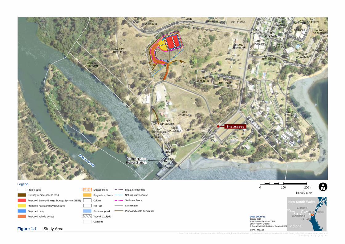
The proposal would be carried out on WaterNSW land located on the northern side of the Murray River, adjacent to the Hume Dam Hydro Power Station, in the Albury City Council Local Government Area (LGA). The Hume Dam is located in the south of NSW, in the Murray Valley at the convergence of the Murray and Mitta Mitta Rivers. The Hume Dam is located 16km east of Albury NSW (Refer to Figure 1-1).
The study area is defined as all areas that would be directly impacted by the proposal. It includes the total proposal footprint, ancillary sites, and any other areas that would be temporarily impacted during construction.
The maximum disturbance area for the proposal would be approximately 1.2 Hectares. The permanent infrastructure (BESS, underground cable and ancillary upgrades to the switchyard) would be under one hectare.
1.2 The Proposal
The Hume Dam Hydro Power Station was commissioned in 1957 and comprises two turbines each producing 29MW of electrical power. The Hydro Power Station supplies electricity to both Albury in New South Wales and Wodonga in Victoria. The amount of power the Hydro Power Station can produce is dependent, in part, on the rate at which water flows through the Hume Dam. This rate of water flow is regulated by water release instructions and downstream water level requirements. This means that the Hydro Power Station has a limited capacity to respond to increases and decreases in demand from electricity users.
Construction of a Battery Energy Storage System would increase the Hydro Power Station’s capacity to respond to changes in demand for electricity. The BESS would store energy produced by the Hydro Power Station during periods of low demand and supply this energy to the grid during periods of high demand. This would enable the Hydro Power Station to control the rate at which energy is supplied to the grid, and to optimise that rate in response to the needs of electricity users.
The proposal aims to showcase the relevance and opportunities offered by coupling a BESS with an existing Hydro Power Station that is subject to water release regulations. By enabling the Hydro Power Station to respond to changes in demand from the grid, the proposal will maximise the economic benefits of the electricity the Power Station generates. If proven successful, this proposal could be replicated at other midscale run-of-river hydropower systems in Australia.
Hume HydroPower Station
MURRAY RIVER
WHITE
BARK
WAY
L ITTLE
MITTASTR
EET
MURRAY STREET
RAY WELSH DRIVE
ELM AVENUE
PEPPE R MINTPA
RADE
TROUT FARM ROAD
Site access
Lot:11DP:740398
Lot:1DP:110091
Lot:1DP:270349 Lot:7004
DP:1025327
Lot:7005DP:1025330
Lot:4DP:270349
Lot:DP:70020
Lot:1DP:528438
Lot:6DP:270349
Lot:7013DP:1025336
Lot:3DP:270349
Lot:1DP:170876
Lot:41DP:591183
Lot:7011DP:1025333
Lot:98DP:753356
Lot:6DP:1135602
Lot:5DP:1135602
Lot:4DP:1135602
Lot:3DP:1135602Lot:1
DP:1135602
Lot:2DP:1135602
Lot:7DP:1135602
Lot:7303DP:1149801
Lot:7302DP:1149801
Lot:1DP:1165089
Lot:3DP:1119422
Lot:2DP:1165089
Lot:7DP:270349
Lot:9DP:270349
Lot:2DP:1215395
Legend0 100 200 m
Date: 31/07/2020 Path: \\jacobs.com\ANZ\IE\Projects\04_Eastern\IA213400\22_Spatial\GIS\Directory\Templates\EIS\IA213400_GIS_F002_ProjectLayout_r1v1.mxdCreated by : XX | QA by : XX
Data sourcesJacobs 2020NSW Spatial Services 2019Service Layer Credits:© Department of Customer Service 2020Figure 1-1 Study Area GDA94 MGA55
WODONGA
ALBURY
KILLARA
BELLBRIDGE
1:5,000 at A4
New South Wales
Victoria
Project areaExisting vehicle access roadProposed Battery Energy Storage System (BESS)Proposed hardstand laydown areaProposed rampProposed vehicle access
EmbankmentRe-grade ex-trackCulvertRip RapSediment pondTopsoil stockpileCadastre
B.E.S.S fence lineNatural water courseSediment fenceStormwaterProposed cable trench line

Statement of Heritage Impact
IA213400_Hume BESS SOHI 3
The BESS is intended to have an operational life of 20 years. Following the end of economic life, above ground components would be removed and land rehabilitated to achieve a safe, stable and non-polluting state.
The BESS itself would comprise batteries housed within containers or similar protective structures. These structures would be mounted on concrete footings, and would consequently involve excavation and other ground-disturbance works.
Two areas have been identified as possible locations for the BESS. Both areas were subject to the assessment process outlined in this document. An underground electricity cable would be laid to link the BESS with the existing switchyard adjacent to Hume Dam. Other ancillary infrastructure would include upgrades to the existing switchyard, and the construction of fences around the BESS.
During construction, additional areas would be impacted by construction vehicle movements and equipment laydown areas.
The Project works would include the following elements:
Installation, commissioning, and operation of a 20MW/40MWh BESS
Construction and operational access track from existing internal WaterNSW access road
Ancillary upgrades to the existing substation switchyard to connect the BESS to the National Energy Market
Underground 11 kV electricity cabling infrastructure from the existing switchyard to the BESS
Construction of fencing around the perimeter of the BESS compound.
1.3 Methodology
The SoHI assessment methodology included the following:
A desktop assessment of known heritage values (including review of historical data, searches of National, State and local heritage databases and literature review)
A site visit to ground-truth the known heritage values
An assessment of the significance of any heritage items to be impacted
An assessment of the impact on those heritage items
Recommendations for the management of heritage items impacted by the proposal, and/or mitigation measures for limiting impact.
1.4 Limitations and Assumptions
This report has been prepared for the sole purpose of assessing the impacts on non-Aboriginal heritage by the proposal defined herein. It has been prepared for the sole use of Meridian. No liability is accepted for any use or reliance on this report by third parties.
All data used in the preparation of this report has been sourced from publicly available information and is assumed correct at the time of writing. The report should be read in full; no excerpts are to be interpreted as representative of the findings of this report.
1.5 Report outline
This SoHI is set out as follows:
Section 1 This introductory section sets out the basic information relating to the proposal and purpose of the report, including the proposal background, study area, proposal details, methodology, limitations and assumptions and authorship.
Statement of Heritage Impact
IA213400_Hume BESS SOHI 4
Section 2 This section sets out the legislation underpinning non-Aboriginal heritage assessment in New South Wales and Australia. This section is intended for information purposes only and should not be substituted for advice from a qualified legal practitioner.
Section 3 This section provides a non-Aboriginal historical background to the study area for contextual purposes. It also contains search results of national, State and local heritage databases.
Section 4 This section describes the site visit undertaken to ground-truth historical background and database results.
Section 5 This section sets out the significance assessment of any heritage items identified within the study area.
Section 6 This section provides an assessment of the impact of the proposal on the heritage significance of any heritage items within the study area and explores any mitigation or management measures to limit any impact.
Section 7 This section provides conclusions and any recommendations for the future management of any heritage items impacted by the proposal.
1.6 Authorship and acknowledgements
This report has been prepared by Jacobs Senior Heritage Consultant, Deborah Farina and Jacobs Heritage Consultants, Clare Leevers and Alison Lamond. It was reviewed by Jacobs Principal Heritage Consultant / Archaeologist, Rose Overberg.
Statement of Heritage Impact
IA213400_Hume BESS SOHI 5
2. Legislative context
The management of non-Aboriginal heritage in Australia is administered at a Federal, State and local level, depending on the significance of the heritage item. Federal legislation covers World, National and Commonwealth heritage, State legislation covers State heritage items and local governments manage items of local heritage significance. Each is managed according to separate legislation, a brief overview of which is here. It should be noted that this overview is provided for information only and should further information be required, legal advice should be sought from a qualified legal practitioner.
2.1 Federal Legislation
2.1.1 Environment Protection and Biodiversity Conservation Act 1999
The Environment Protection and Biodiversity Conservation Act 1999 (EPBC Act) includes ‘national heritage’ as a Matter of National Environmental Significance and protects listed places to the fullest extent under the Constitution. It also establishes the National Heritage List (NHL) and the Commonwealth Heritage List (CHL).
The following is a description of each of the heritage lists and the protection afforded places listed on them.
2.1.1.1 Commonwealth Heritage List
The CHL is established under the EPBC Act. The CHL is a list of properties owned by the Commonwealth that have been assessed as having significant heritage value. Any proposed actions on CHL places must be assessed for their impact on the heritage values of the place in accordance with Actions on, or impacting upon, Commonwealth land, and actions by Commonwealth agencies (Significant Impact Guidelines 1.2). The guidelines require the proponent to undertake a self-assessment process to decide whether or not the action is likely to have a significant impact on the environment, including the heritage value of places. If an action is likely to have a significant impact an EPBC Act referral must be prepared and submitted to the Minister for approval.
2.1.1.2 National Heritage List
The NHL is a list of places with outstanding heritage value to Australia, including places overseas. Any proposed actions on NHL places must be assessed for their impact on the heritage values of the place in accordance with Matters of National Environmental Significance (Significant Impact Guidelines 1.1). The guidelines require the proponent to undertake a self-assessment process to decide whether or not the action is likely to have a significant impact on a matter of National Environmental Significance, including the national heritage value of places. If an action is likely to have a significant impact an EPBC Act referral must be prepared and submitted to the Minister for approval.
2.1.1.3 Register of the National Estate
The Register of the National Estate (RNE) was formerly compiled as a record of Australia’s natural, cultural and Aboriginal heritage places worth keeping for the future. The RNE was frozen on 19 February 2007, which means that no new places have been added or removed since that time. From February 2012 all references to the RNE were removed from the EPBC Act. The RNE is maintained on a non-statutory basis as a publicly available archive.
2.2 State legislation
2.2.1 Heritage Act 1977
The Heritage Act 1977 (Heritage Act) provides a number of mechanisms by which items and places of heritage significance may be protected. The Heritage Act is designed to protect both listed non-Aboriginal heritage items and potential non-Aboriginal archaeological remains or relics. Currently, non-Aboriginal heritage is administered by the Department of Premier and Cabinet (Heritage) (DPC Heritage).
Statement of Heritage Impact
IA213400_Hume BESS SOHI 6
2.2.1.1 State Heritage Register
Section 31 of the Heritage Act creates the State Heritage Register (SHR). Only those items which have been designated as being of state heritage significance in NSW by the Minister are listed on the SHR. Listing on the SHR controls activities such as alteration, damage, demolition and development. When a place is listed on the SHR, the approval of the Heritage Council of NSW is required for any major work, including the following:
Demolishing the building or work
Carrying out any development in relation to the land on which the building, work or relic is situated, the land that comprises the place, or land within the precinct
Altering the building, work, relic or moveable object
Ordinarily, an application under section 60 of the Heritage Act must be made to DPC Heritage in order to carry out any such activities. However, s 4.41 (1) (c) specifically excludes the necessity for applying either a permit under s60 or any other approval under Part 4 of the Heritage Act.
2.2.1.2 Archaeological relics
Part 6 Division 9 of the Heritage Act protects archaeological ‘relics’ from being ‘exposed, moved, damaged or destroyed’ by the disturbance or excavation of land. This protection extends to the situation where a person has ‘reasonable cause to suspect’ that archaeological remains may be affected by the disturbance or excavation of the land. It applies to all land in NSW that is not included in the SHR. A ‘relic’ is defined at s 4 by the Heritage Act as:
Any deposit, artefact, object or material evidence that:
(a) Relates to the settlement of the area that comprises New South Wales, not being Aboriginal settlement, and
(b) Is of State or local heritage significance.
Ordinarily, s 139 of the Heritage Act requires any person who knows or has reasonable cause to suspect that their proposed works will expose or disturb a ‘relic’ to first obtain an Excavation Permit from the Heritage Council of NSW (pursuant to Section 140), unless there is an applicable exception (pursuant to Section 139(4)). However, under s 4.41 (1) (c) of the EP&A Act, the requirement for an approval under s139 is specifically excluded for proposals designated as SSD.
The provisions under Division 5.2 of the EP&A Act, however, apply only to approvals in Part 4 of the Heritage Act. All other sections of the Heritage Act 1977, such as s146 of the Heritage Act 1977 (requiring any person who is aware or believes that they have discovered or located a relic notifying the Heritage Council of NSW and providing details of the location and other information required) remain undisturbed by the EP&A Act.
2.2.1.3 Section 170 Heritage and Conservation Registers
Section 170 of the Heritage Act requires State Government agencies to identify, conserve and manage heritage assets owned, occupied or managed by that agency. Section 170 also requires government agencies to keep a register of heritage items, which is called a Heritage and Conservation Register or more commonly, a s170 Register. The Heritage Act obliges government agencies to maintain their assets with due diligence in accordance with State-Owned Heritage Management Principles approved by the Minister on the advice of the Heritage Council and notified by the Minister to government instrumentalities from time to time.
Statement of Heritage Impact
IA213400_Hume BESS SOHI 7
2.2.2 Environmental Planning & Assessment Act 1979
The Environmental Planning and Assessment Act 1979 (EP&A Act) requires that environmental impacts are considered in land-use planning, including impacts on Aboriginal and non-Aboriginal heritage. Part 4 Division 4.7 of the EP&A Act applies for projects designated as State Significant Development. This influences the way in which other legislation, including the Heritage Act, is applied.
2.2.3 Local heritage
Items of local heritage significance are administered by local councils, under their Local Environmental Plans (LEPs). Many of the LEPs now follow a standard format, which requires development consent prior to the demolition, moving or alteration of a heritage item or potential archaeological deposits (cl. 5.10, standard LEP). A Council may elect to waive this requirement if it is satisfied that the works are minor in nature, are maintenance works, will otherwise not impact on the heritage significance of the item or is exempt development (cl. 5.10 (3)). In all other cases, a development application must be submitted to council and a Statement of Heritage Impact may be required (cl 5.10 (5)).
2.3 Non-Statutory requirements
2.3.1 The Burra Charter
In addition to the above legislation, Australia is party to a number of international treaties and protocols relating to the protection of heritage places. The most important of these is the Australia ICOMOS Charter for Places of Cultural Significance (The Burra Charter), which forms the basis of most heritage legislation and best practice guidelines.
The purpose of the Burra Charter is to provide best practice standards for heritage management. It provides steps for the assessment and management of heritage, as well as principles for the effective conservation, maintenance and/or preservation of items of cultural heritage.
2.3.2 Urbis, 2013, Conservation Management Plan (CMP), Hume Dam
This document was prepared by Urbis on behalf of State Water Corporation (SWC) (now Water NSW) to manage the heritage assets within the curtilage of the Hume Dam. It sets out a comprehensive history of the item, mapping and the item’s heritage and archaeological values. It also contains a list of policies to enable future works within the curtilage of the item whilst conserving its heritage significance.

Statement of Heritage Impact
IA213400_Hume BESS SOHI 8
3. Historical context
This section provides a brief overview of the historical context of the study area in order to understand the significance of the Hume Dam and the impact of the proposal on that significance. For a fuller historical account of the Hume Dam, please see the CMP (Urbis, 2011:67-106).
3.1 History of Local Area
3.1.1 European settlement
Reliable historical records for the initial period of British settlement of the region around Lake Hume are rare (Andrews 1912). The first wave of British colonial settlement in northern Victoria occurred between 1835 and 1840 in an area east and north of the Ovens River in the counties of Bogong and Benambra (Andrews 1912). Spreadborough and Anderson (1983) have summarised the information about land ownership for this period and provide a map of pastoral runs.
Most descriptions of the countryside or the river at the time of European settlement relate to the Riverine Plains to the west of Albury where the country was already eminently suitable for grazing without clearing and pasture improvement. Explorers were quickly followed by squatters and European invaders (Kamminga, 2007).
There are few historical records for the initial period of British settlement of the region around Lake Hume. Explorers Hume and Hovell crossed into Victoria in November 1824 several miles above the current location of the Hume Dam. Soon thereafter the first wave of colonial settlement in northern Victoria occurred between 1835 and 1840 in an area east and north of the Ovens River (Kamminga 2007).
British explorers were quickly followed by “overlanders” and squatters. Overlanding activities involved moving large numbers of stock from NSW to new land in the Port Phillip district between the 1830s and 1850s in response to new markets created by gold rushes. The region attracted many settlers and by 1856 both sides of the Murray River were well populated. By the 1860s there were over 100 holdings in the vicinity of Albury. Within a decade, selectors were displacing the squatters and by 1917 all the easily accessible arable land had been cleared. The descendants of many of these early settler families live in the region today and their names are perpetuated in the list of rural property owners at Lake Hume.
Mining also had a profound impact on the region during the late 19th and early 20th centuries. Evidence of this activity remains to this day. Notable twentieth century works and sites of cultural significance are many, not least of which is the construction of the Hume Dam itself, a massive public works undertaking between 1919 and 1936, further extended during the 1950’s (.
3.1.2 The Mitchell family
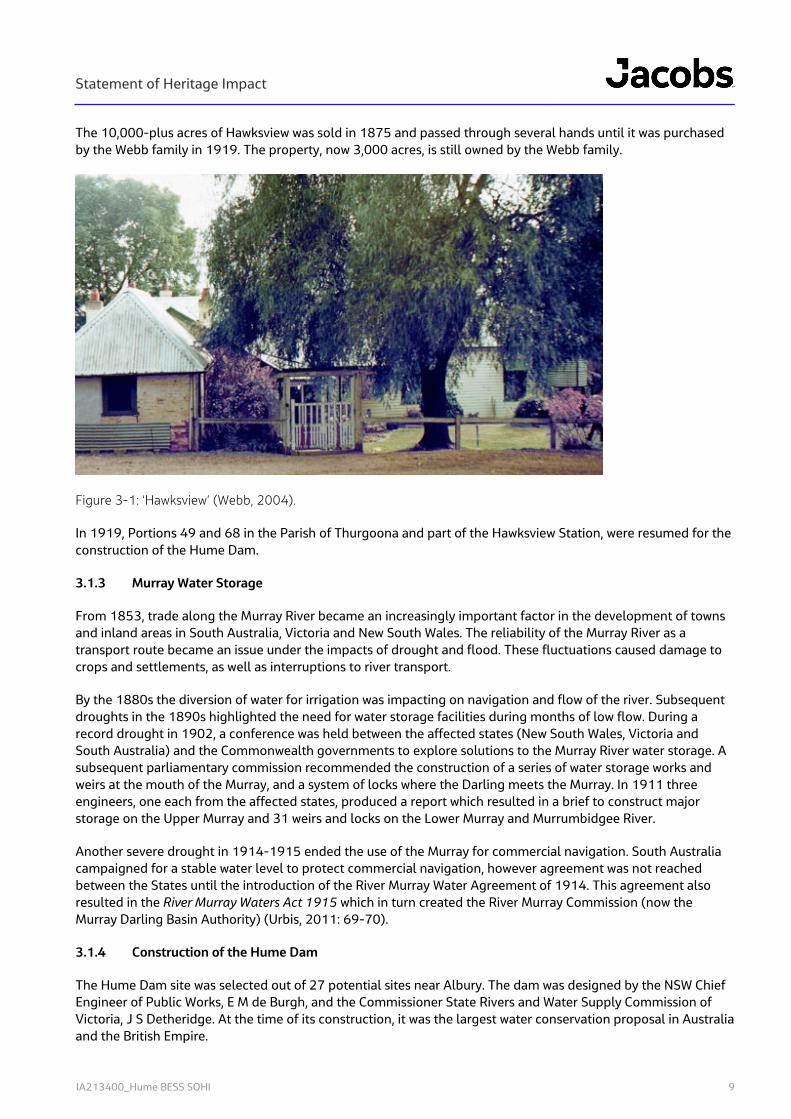
Following Hume and Hovell’s expedition passing through the Albury district in 1824, two brothers, Charles and Paul Huon de Kerrilleau (known as Huon) squatted south of the Murray River on what became known as the “Wodonga Run”. Another brother, Aime, and brother-in-law Robert Brown, arrived shortly afterwards and set up a store for travellers at the Crossing Place near where Hume and Hovell had crossed the river at Albury (Webb, 2004).
The Huons’ sister, Elizabeth Mitchell, was widowed in 1837, and the “Mungabareena Run”, to the west of the Hume Dam, was owned by the Mitchells. In 1842, Elizabeth moved to the “Mungabareena Run” with her children and eventually became known as “the mother of Albury”. In 1859, she gifted her son, John Francis Huon Mitchell, a portion of the Mungabareena Run, which he named “Hawksview”. A homestead had already been built on the western slope of Mount Hawk in 1852. This homestead is still standing, and boasts pit sawn slabs, wooden shingles, home-made bricks, hessian ceiling, a large cellar and gun slits (Webb, 2004). The house is located approximately 1.7 kilometres north of the dam wall.
Statement of Heritage Impact
IA213400_Hume BESS SOHI 9
The 10,000-plus acres of Hawksview was sold in 1875 and passed through several hands until it was purchased by the Webb family in 1919. The property, now 3,000 acres, is still owned by the Webb family.
Figure 3-1: ‘Hawksview’ (Webb, 2004).
In 1919, Portions 49 and 68 in the Parish of Thurgoona and part of the Hawksview Station, were resumed for the construction of the Hume Dam.
3.1.3 Murray Water Storage
From 1853, trade along the Murray River became an increasingly important factor in the development of towns and inland areas in South Australia, Victoria and New South Wales. The reliability of the Murray River as a transport route became an issue under the impacts of drought and flood. These fluctuations caused damage to crops and settlements, as well as interruptions to river transport.
By the 1880s the diversion of water for irrigation was impacting on navigation and flow of the river. Subsequent droughts in the 1890s highlighted the need for water storage facilities during months of low flow. During a record drought in 1902, a conference was held between the affected states (New South Wales, Victoria and South Australia) and the Commonwealth governments to explore solutions to the Murray River water storage. A subsequent parliamentary commission recommended the construction of a series of water storage works and weirs at the mouth of the Murray, and a system of locks where the Darling meets the Murray. In 1911 three engineers, one each from the affected states, produced a report which resulted in a brief to construct major storage on the Upper Murray and 31 weirs and locks on the Lower Murray and Murrumbidgee River.
Another severe drought in 1914-1915 ended the use of the Murray for commercial navigation. South Australia campaigned for a stable water level to protect commercial navigation, however agreement was not reached between the States until the introduction of the River Murray Water Agreement of 1914. This agreement also resulted in the River Murray Waters Act 1915 which in turn created the River Murray Commission (now the Murray Darling Basin Authority) (Urbis, 2011: 69-70).
3.1.4 Construction of the Hume Dam
The Hume Dam site was selected out of 27 potential sites near Albury. The dam was designed by the NSW Chief Engineer of Public Works, E M de Burgh, and the Commissioner State Rivers and Water Supply Commission of Victoria, J S Detheridge. At the time of its construction, it was the largest water conservation proposal in Australia and the British Empire.
Statement of Heritage Impact
IA213400_Hume BESS SOHI 10
Preliminary plans were approved in April 1919 with construction commencing in November of that year. Originally referred to as the “Mitta Mitta Dam site”, in 1920 the River Murray Commission settled on the name, “Hume Reservoir” in honour of Hamilton Hume, an early explorer of the Albury area.
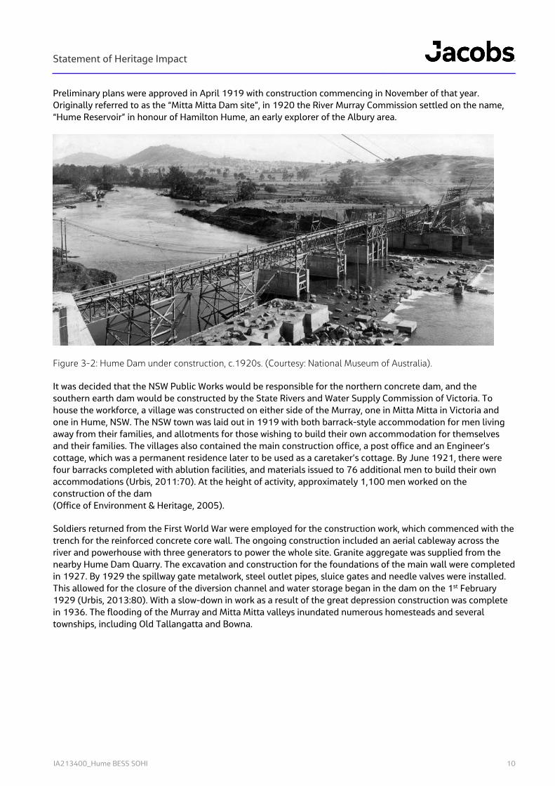
Figure 3-2: Hume Dam under construction, c.1920s. (Courtesy: National Museum of Australia).
It was decided that the NSW Public Works would be responsible for the northern concrete dam, and the southern earth dam would be constructed by the State Rivers and Water Supply Commission of Victoria. To house the workforce, a village was constructed on either side of the Murray, one in Mitta Mitta in Victoria and one in Hume, NSW. The NSW town was laid out in 1919 with both barrack-style accommodation for men living away from their families, and allotments for those wishing to build their own accommodation for themselves and their families. The villages also contained the main construction office, a post office and an Engineer’s cottage, which was a permanent residence later to be used as a caretaker’s cottage. By June 1921, there were four barracks completed with ablution facilities, and materials issued to 76 additional men to build their own accommodations (Urbis, 2011:70). At the height of activity, approximately 1,100 men worked on the construction of the dam (Office of Environment & Heritage, 2005).
Soldiers returned from the First World War were employed for the construction work, which commenced with the trench for the reinforced concrete core wall. The ongoing construction included an aerial cableway across the river and powerhouse with three generators to power the whole site. Granite aggregate was supplied from the nearby Hume Dam Quarry. The excavation and construction for the foundations of the main wall were completed in 1927. By 1929 the spillway gate metalwork, steel outlet pipes, sluice gates and needle valves were installed. This allowed for the closure of the diversion channel and water storage began in the dam on the 1st February 1929 (Urbis, 2013:80). With a slow-down in work as a result of the great depression construction was complete in 1936. The flooding of the Murray and Mitta Mitta valleys inundated numerous homesteads and several townships, including Old Tallangatta and Bowna.
Statement of Heritage Impact
IA213400_Hume BESS SOHI 11
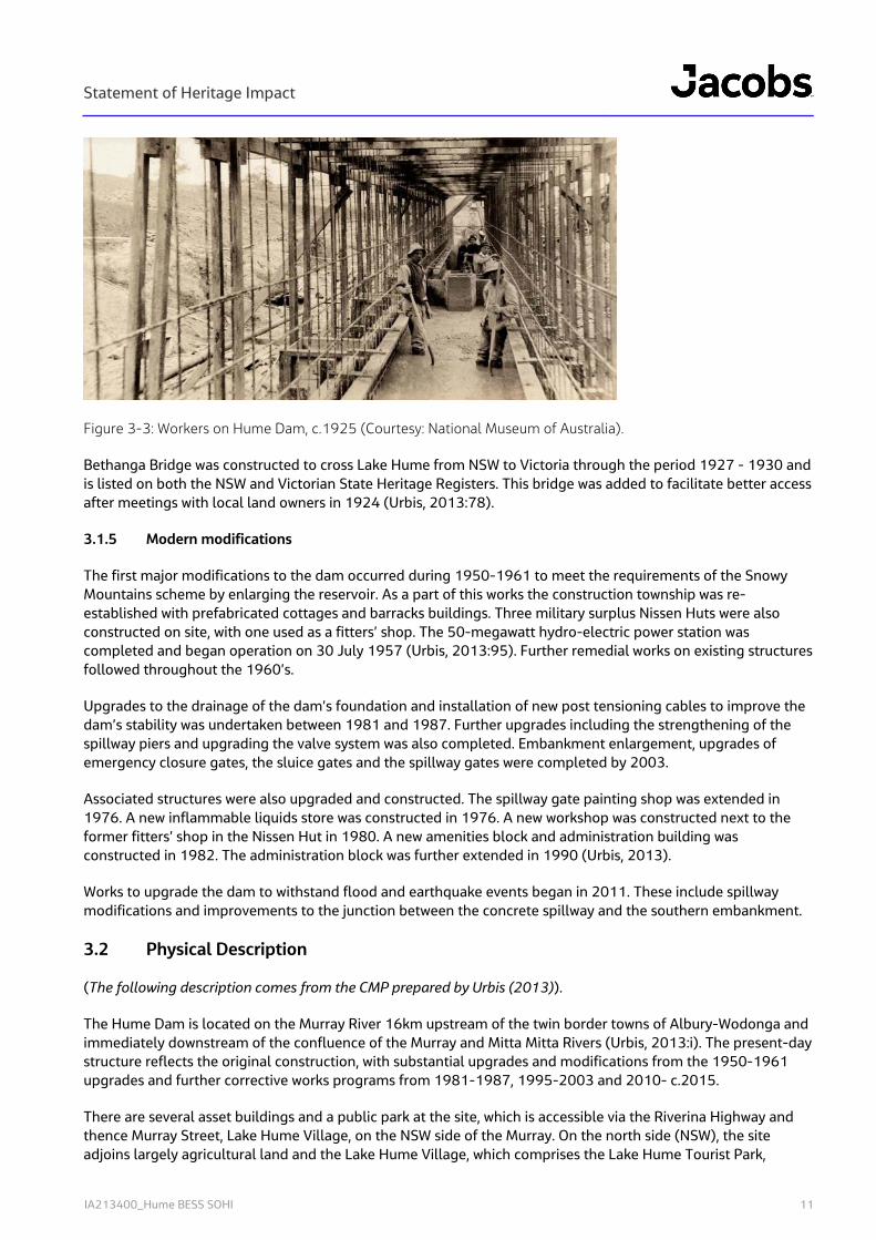
Figure 3-3: Workers on Hume Dam, c.1925 (Courtesy: National Museum of Australia).
Bethanga Bridge was constructed to cross Lake Hume from NSW to Victoria through the period 1927 - 1930 and is listed on both the NSW and Victorian State Heritage Registers. This bridge was added to facilitate better access after meetings with local land owners in 1924 (Urbis, 2013:78).
3.1.5 Modern modifications
The first major modifications to the dam occurred during 1950-1961 to meet the requirements of the Snowy Mountains scheme by enlarging the reservoir. As a part of this works the construction township was re-established with prefabricated cottages and barracks buildings. Three military surplus Nissen Huts were also constructed on site, with one used as a fitters’ shop. The 50-megawatt hydro-electric power station was completed and began operation on 30 July 1957 (Urbis, 2013:95). Further remedial works on existing structures followed throughout the 1960’s.
Upgrades to the drainage of the dam’s foundation and installation of new post tensioning cables to improve the dam’s stability was undertaken between 1981 and 1987. Further upgrades including the strengthening of the spillway piers and upgrading the valve system was also completed. Embankment enlargement, upgrades of emergency closure gates, the sluice gates and the spillway gates were completed by 2003.
Associated structures were also upgraded and constructed. The spillway gate painting shop was extended in 1976. A new inflammable liquids store was constructed in 1976. A new workshop was constructed next to the former fitters’ shop in the Nissen Hut in 1980. A new amenities block and administration building was constructed in 1982. The administration block was further extended in 1990 (Urbis, 2013).
Works to upgrade the dam to withstand flood and earthquake events began in 2011. These include spillway modifications and improvements to the junction between the concrete spillway and the southern embankment.
3.2 Physical Description
(The following description comes from the CMP prepared by Urbis (2013)).
The Hume Dam is located on the Murray River 16km upstream of the twin border towns of Albury-Wodonga and immediately downstream of the confluence of the Murray and Mitta Mitta Rivers (Urbis, 2013:i). The present-day structure reflects the original construction, with substantial upgrades and modifications from the 1950-1961 upgrades and further corrective works programs from 1981-1987, 1995-2003 and 2010- c.2015.
There are several asset buildings and a public park at the site, which is accessible via the Riverina Highway and thence Murray Street, Lake Hume Village, on the NSW side of the Murray. On the north side (NSW), the site adjoins largely agricultural land and the Lake Hume Village, which comprises the Lake Hume Tourist Park,
Statement of Heritage Impact
IA213400_Hume BESS SOHI 12
adjoining the site to the north, and further north of that, the Lake Hume Resort, located on the Hume Road and Riverina Highway and the Lake Hume foreshore. The resort site and the tourist (caravan) park sites were formerly part of the extended Hume Dam site and comprises some workers housing from the 1950s construction phases of the dam (Urbis, 2013:10).
Built infrastructure includes a variety of buildings and structures dating from the original construction phase and subsequent expansion thereafter. Development includes administrative buildings; including the main Hume Dam administration office, workshops; including three Nissen huts transported to the site following WWII as part of the 1950-61 upgrade works, housing; including the original engineers cottage from the initial construction phase and a post WWII cottage, amenities and utilities including the original power station, high voltage switchyard, and hydroelectric power station (1957) and various services. Development is concentrated on the NSW side, with utilitarian structures on the Victorian side, including a shed building and single workshop (Urbis, 2013, 12).
The site’s physical curtilage relates to the geographical area that provides the physical context for heritage significance of Hume Dam and does not necessarily follow land title boundaries. The physical curtilage for Hume Dam is inclusive of the dam structure and main works compound (NSW, the park and cottage precinct, the Elm Avenue and Blast shed precinct and the Victorian Works Compound and former Construction encampment (borrow pits) (Urbis, 2013:40).
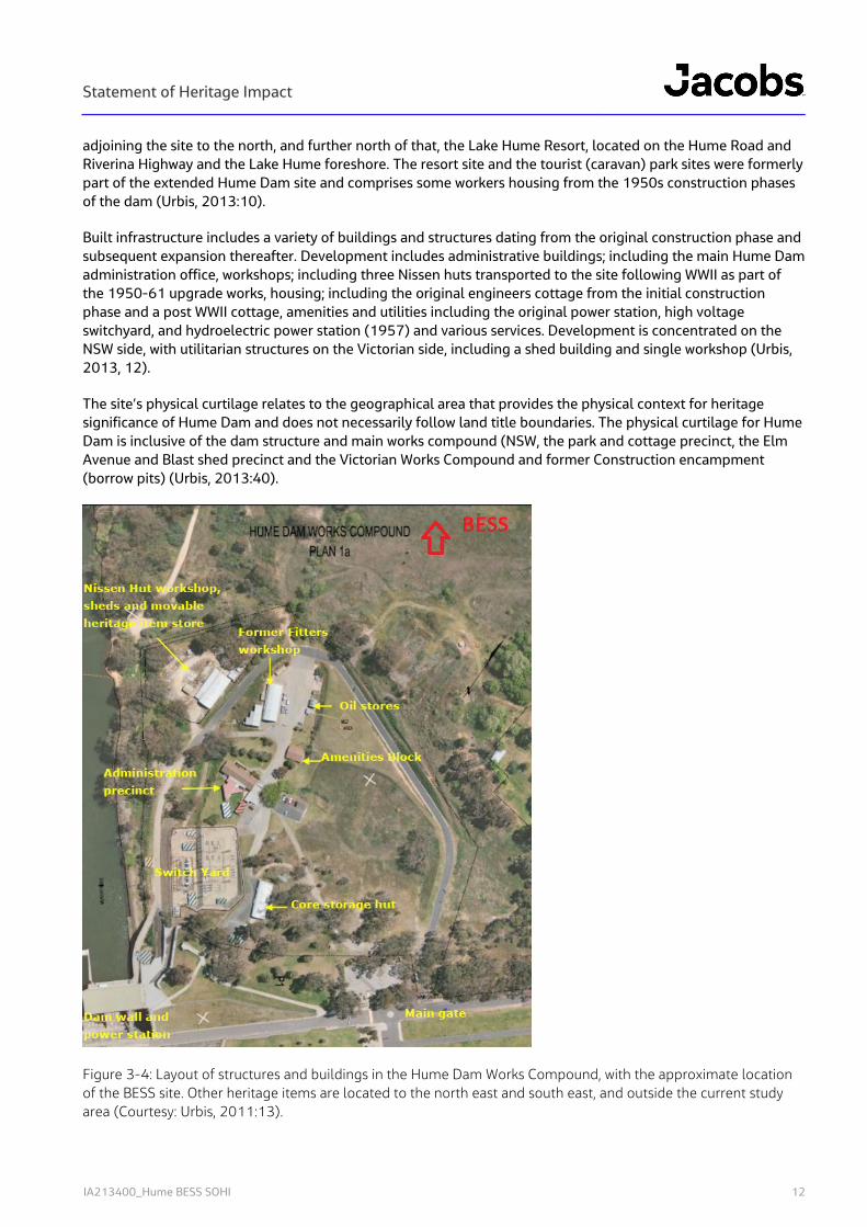
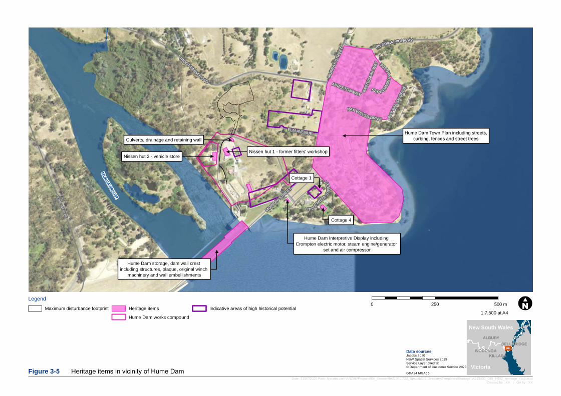
Figure 3-4: Layout of structures and buildings in the Hume Dam Works Compound, with the approximate location of the BESS site. Other heritage items are located to the north east and south east, and outside the current study area (Courtesy: Urbis, 2011:13).
Statement of Heritage Impact
IA213400_Hume BESS SOHI 13
3.3 Heritage Database Searches
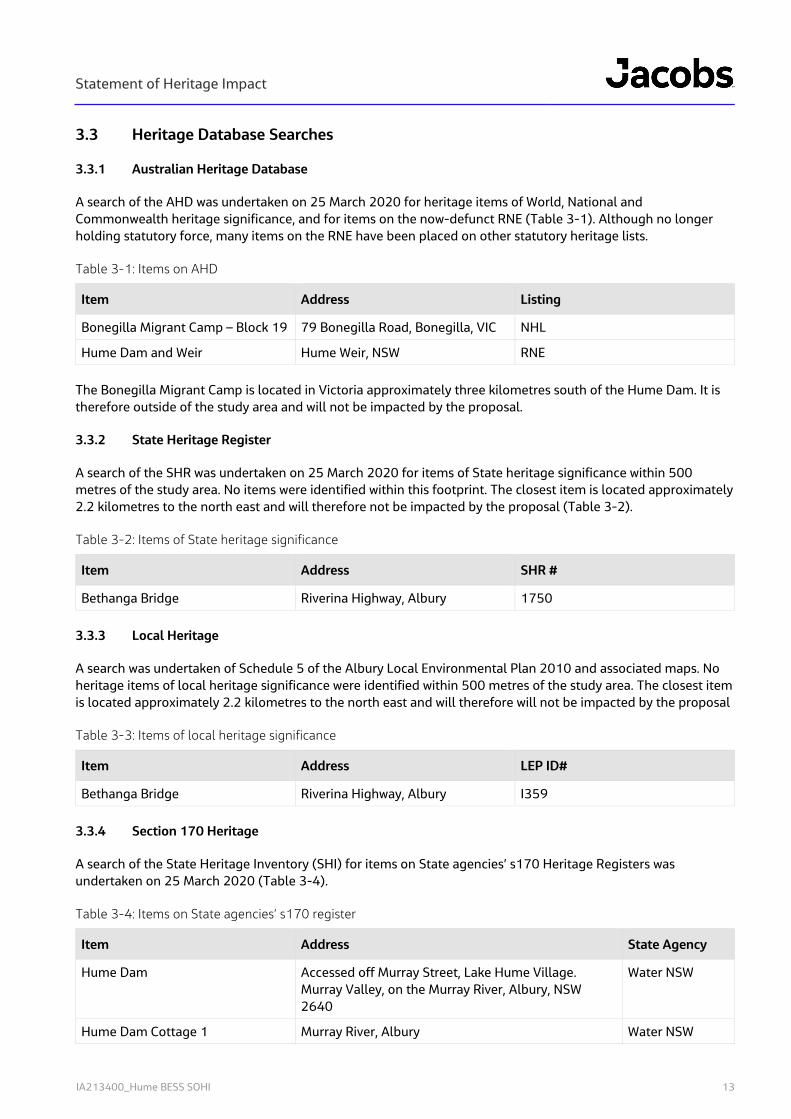
3.3.1 Australian Heritage Database
A search of the AHD was undertaken on 25 March 2020 for heritage items of World, National and Commonwealth heritage significance, and for items on the now-defunct RNE (Table 3-1). Although no longer holding statutory force, many items on the RNE have been placed on other statutory heritage lists.
Table 3-1: Items on AHD
Item Address Listing
Bonegilla Migrant Camp – Block 19 79 Bonegilla Road, Bonegilla, VIC NHL
Hume Dam and Weir Hume Weir, NSW RNE
The Bonegilla Migrant Camp is located in Victoria approximately three kilometres south of the Hume Dam. It is therefore outside of the study area and will not be impacted by the proposal.
3.3.2 State Heritage Register
A search of the SHR was undertaken on 25 March 2020 for items of State heritage significance within 500 metres of the study area. No items were identified within this footprint. The closest item is located approximately 2.2 kilometres to the north east and will therefore not be impacted by the proposal (Table 3-2).
Table 3-2: Items of State heritage significance
Item Address SHR #
Bethanga Bridge Riverina Highway, Albury 1750
3.3.3 Local Heritage
A search was undertaken of Schedule 5 of the Albury Local Environmental Plan 2010 and associated maps. No heritage items of local heritage significance were identified within 500 metres of the study area. The closest item is located approximately 2.2 kilometres to the north east and will therefore will not be impacted by the proposal
Table 3-3: Items of local heritage significance
Item Address LEP ID#
Bethanga Bridge Riverina Highway, Albury I359
3.3.4 Section 170 Heritage
A search of the State Heritage Inventory (SHI) for items on State agencies’ s170 Heritage Registers was undertaken on 25 March 2020 (Table 3-4).
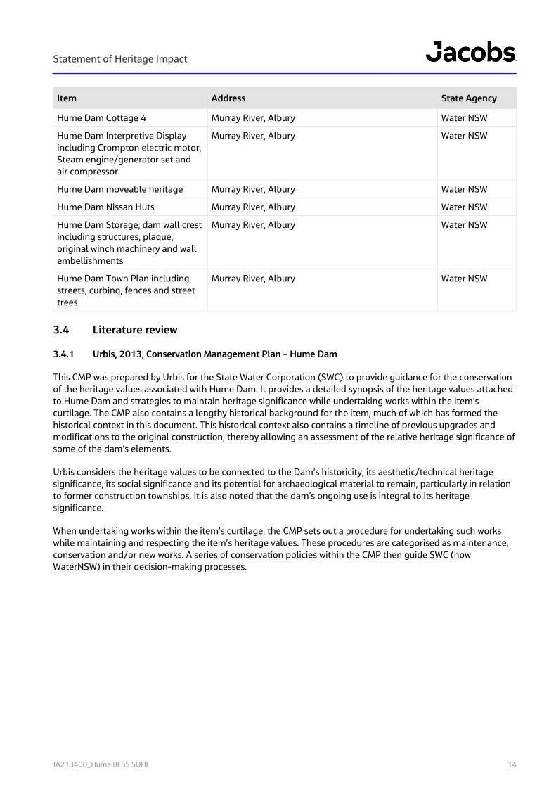
Table 3-4: Items on State agencies’ s170 register
Item Address State Agency
Hume Dam Accessed off Murray Street, Lake Hume Village. Murray Valley, on the Murray River, Albury, NSW 2640
Water NSW
Hume Dam Cottage 1 Murray River, Albury Water NSW
Statement of Heritage Impact
IA213400_Hume BESS SOHI 14
Item Address State Agency
Hume Dam Cottage 4 Murray River, Albury Water NSW
Hume Dam Interpretive Display including Crompton electric motor, Steam engine/generator set and air compressor
Murray River, Albury Water NSW
Hume Dam moveable heritage Murray River, Albury Water NSW
Hume Dam Nissan Huts Murray River, Albury Water NSW
Hume Dam Storage, dam wall crest including structures, plaque, original winch machinery and wall embellishments
Murray River, Albury Water NSW
Hume Dam Town Plan including streets, curbing, fences and street trees
Murray River, Albury Water NSW
3.4 Literature review
3.4.1 Urbis, 2013, Conservation Management Plan – Hume Dam
This CMP was prepared by Urbis for the State Water Corporation (SWC) to provide guidance for the conservation of the heritage values associated with Hume Dam. It provides a detailed synopsis of the heritage values attached to Hume Dam and strategies to maintain heritage significance while undertaking works within the item’s curtilage. The CMP also contains a lengthy historical background for the item, much of which has formed the historical context in this document. This historical context also contains a timeline of previous upgrades and modifications to the original construction, thereby allowing an assessment of the relative heritage significance of some of the dam’s elements.
Urbis considers the heritage values to be connected to the Dam’s historicity, its aesthetic/technical heritage significance, its social significance and its potential for archaeological material to remain, particularly in relation to former construction townships. It is also noted that the dam’s ongoing use is integral to its heritage significance.
When undertaking works within the item’s curtilage, the CMP sets out a procedure for undertaking such works while maintaining and respecting the item’s heritage values. These procedures are categorised as maintenance, conservation and/or new works. A series of conservation policies within the CMP then guide SWC (now WaterNSW) in their decision-making processes.
Hume Dam storage, dam wall crest including structures, plaque, original winch
machinery and wall embellishments
Nissen hut 2 - vehicle storeNissen hut 1 - former fitters' workshop
Hume Dam Interpretive Display including Crompton electric motor, steam engine/generator
set and air compressor
Cottage 1
Cottage 4
Hume Dam Town Plan including streets,curbing, fences and street treesCulverts, drainage and retaining wall
MURRAYRIVERHUME WEIR RD
WHITE
BARK
WAY
APPLETON WAY
RIVERINA HIGHWAY
LIT TLE
MITTA
STRE
ETMURRAY STREET
RAY WELSH DRIVE RAY W
ELSH
DRIVE
ELM AVENUE
MURR
AY ST
REET
PEP P ERMINT
PARADE
TROUT FARM ROAD
Legend0 250 500 m
Date: 31/07/2020 Path: \\jacobs.com\ANZ\IE\Projects\04_Eastern\IA213400\22_Spatial\GIS\Directory\Templates\Heritage\IA213400_GIS_F002_Heritage_r1v3.mxdCreated by : XX | QA by : XX
Data sourcesJacobs 2020NSW Spatial Services 2019Service Layer Credits:© Department of Customer Service 2020Figure 3-5 Heritage items in vicinity of Hume Dam GDA94 MGA55
WODONGA
ALBURY
KILLARA
BELLBRIDGE
1:7,500 at A4
New South Wales
Victoria
Maximum disturbance footprint Heritage itemsHume Dam works compound
Indicative areas of high historical potential
Statement of Heritage Impact
IA213400_Hume BESS SOHI 16
4. Site visit
4.1 Personnel and timing
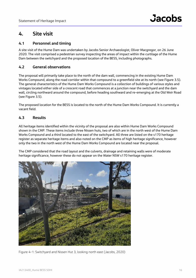
A site visit of the Hume Dam was undertaken by Jacobs Senior Archaeologist, Oliver Macgregor, on 26 June 2020. The visit comprised a pedestrian survey inspecting the areas of impact within the curtilage of the Hume Dam between the switchyard and the proposed location of the BESS, including photographs.
4.2 General observations
The proposal will primarily take place to the north of the dam wall, commencing in the existing Hume Dam Works Compound, along the road corridor within that compound to a greenfield site at its north (see Figure 3.5). The general characteristics of the Hume Dam Works Compound is a collection of buildings of various styles and vintages located either side of a crescent road that commences at a junction near the switchyard and the dam wall, circling northward around the compound, before heading southward and re-emerging at the Old Weir Road (see Figure 3.5).
The proposed location for the BESS is located to the north of the Hume Dam Works Compound. It is currently a vacant field.
4.3 Results
All heritage items identified within the vicinity of the proposal are also within Hume Dam Works Compound shown in the CMP. These items include three Nissen huts, two of which are in the north west of the Hume Dam Works Compound and a third located to the east of the switchyard. All three are listed on the s170 heritage register as separate heritage items and also noted on the CMP as items of high heritage significance, however only the two in the north west of the Hume Dam Works Compound are located near the proposal.
The CMP considered that the road layout and the culverts, drainage and retaining walls were of moderate heritage significance, however these do not appear on the Water NSW s170 heritage register.
Figure 4-1: Switchyard and Nissen Hut 3, looking north east (Jacobs, 2020)
Statement of Heritage Impact
IA213400_Hume BESS SOHI 17
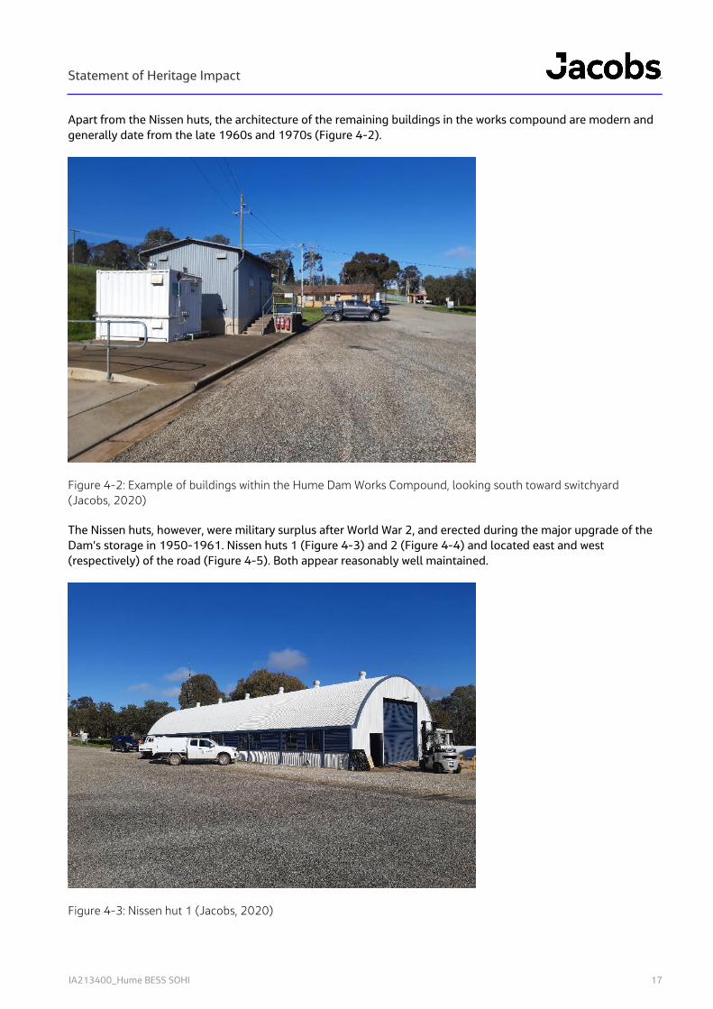
Apart from the Nissen huts, the architecture of the remaining buildings in the works compound are modern and generally date from the late 1960s and 1970s (Figure 4-2).
Figure 4-2: Example of buildings within the Hume Dam Works Compound, looking south toward switchyard (Jacobs, 2020)
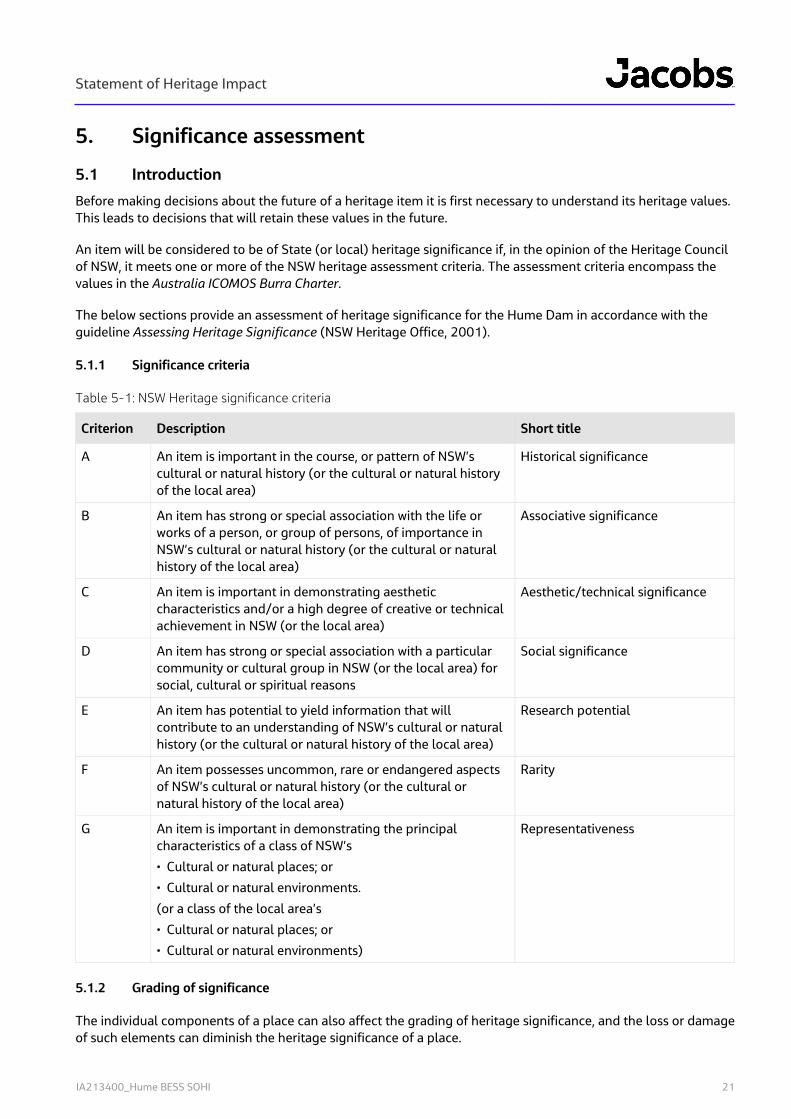
The Nissen huts, however, were military surplus after World War 2, and erected during the major upgrade of the Dam’s storage in 1950-1961. Nissen huts 1 (Figure 4-3) and 2 (Figure 4-4) and located east and west (respectively) of the road (Figure 4-5). Both appear reasonably well maintained.
Figure 4-3: Nissen hut 1 (Jacobs, 2020)
Statement of Heritage Impact
IA213400_Hume BESS SOHI 18
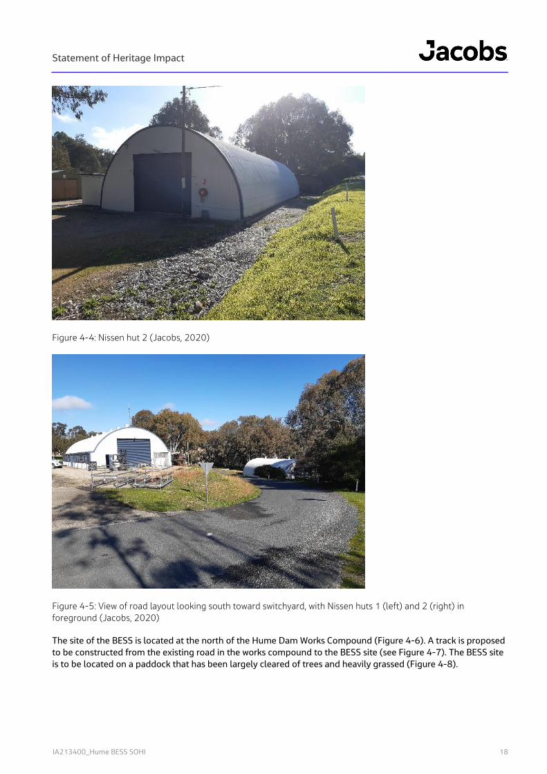
Figure 4-4: Nissen hut 2 (Jacobs, 2020)
Figure 4-5: View of road layout looking south toward switchyard, with Nissen huts 1 (left) and 2 (right) in foreground (Jacobs, 2020)
The site of the BESS is located at the north of the Hume Dam Works Compound (Figure 4-6). A track is proposed to be constructed from the existing road in the works compound to the BESS site (see Figure 4-7). The BESS site is to be located on a paddock that has been largely cleared of trees and heavily grassed (Figure 4-8).

Statement of Heritage Impact
IA213400_Hume BESS SOHI 19
Figure 4-6: View north from Hume Dam Works Compound road toward BESS site. Note retaining wall, culvert and drainage at right of frame (Jacobs, 2020)
Figure 4-7: Looking south east toward Hume Dam and works compound from BESS site. The alignment of the new track to be constructed is marked by unsealed track at left (Jacobs, 2019).

Statement of Heritage Impact
IA213400_Hume BESS SOHI 20
Figure 4-8: View south east over the BESS site (Jacobs, 2020)
Statement of Heritage Impact
IA213400_Hume BESS SOHI 21
5. Significance assessment
5.1 Introduction
Before making decisions about the future of a heritage item it is first necessary to understand its heritage values. This leads to decisions that will retain these values in the future.
An item will be considered to be of State (or local) heritage significance if, in the opinion of the Heritage Council of NSW, it meets one or more of the NSW heritage assessment criteria. The assessment criteria encompass the values in the Australia ICOMOS Burra Charter.
The below sections provide an assessment of heritage significance for the Hume Dam in accordance with the guideline Assessing Heritage Significance (NSW Heritage Office, 2001).
5.1.1 Significance criteria
Table 5-1: NSW Heritage significance criteria
Criterion Description Short title
A An item is important in the course, or pattern of NSW’s cultural or natural history (or the cultural or natural history of the local area)
Historical significance
B An item has strong or special association with the life or works of a person, or group of persons, of importance in NSW’s cultural or natural history (or the cultural or natural history of the local area)
Associative significance
C An item is important in demonstrating aesthetic characteristics and/or a high degree of creative or technical achievement in NSW (or the local area)
Aesthetic/technical significance
D An item has strong or special association with a particular community or cultural group in NSW (or the local area) for social, cultural or spiritual reasons
Social significance
E An item has potential to yield information that will contribute to an understanding of NSW’s cultural or natural history (or the cultural or natural history of the local area)
Research potential
F An item possesses uncommon, rare or endangered aspects of NSW’s cultural or natural history (or the cultural or natural history of the local area)
Rarity
G An item is important in demonstrating the principal characteristics of a class of NSW’s
• Cultural or natural places; or
• Cultural or natural environments.
(or a class of the local area’s
• Cultural or natural places; or
• Cultural or natural environments)
Representativeness
5.1.2 Grading of significance
The individual components of a place can also affect the grading of heritage significance, and the loss or damage of such elements can diminish the heritage significance of a place.
Statement of Heritage Impact
IA213400_Hume BESS SOHI 22
The following table explains the gradings of elements and how they impact on heritage significance (NSW Heritage Office, 2001:11):
Table 5-2: Gradings of significance
Grading Justification Status
Exceptional Rare or outstanding element directly contributing to an item’s local or State heritage significance
Fulfils criteria for State or local listing
High High degree of original fabric. Demonstrates a key element of the item’s significance. Alterations do not detract from significance.
Fulfils criteria for State or local listing
Moderate Altered or modified elements. Elements with little heritage value but which contribute to the overall significance of the item.
Fulfils criteria for State or local listing
Little Alterations detract from significance. Difficult to interpret.
Does not fulfil criteria for State or local listing
Intrusive Damaging to the item’s heritage significance. Does not fulfil criteria for State or local listing
5.2 Assessment of significance
This significance assessment has been adapted from the CMP for Hume Dam (Urbis, 2011:109-115).
Table 5-3: Significance assessment of Hume Dam
Criterion Assessment
A – Historical significance
Hume Dam is of state historical significance for its role in the management and conservation of water within the Murray basin and as one of the great engineering projects of the inter-war period and one of the greatest water conservation projects in Australia and the British Empire. It is one of the first inter-government co-operative projects facilitated by Federation.
Hume Dam reflects the collaborative efforts of three states (NSW, VIC and SA) and the Commonwealth government which culminated in the development of the River Murray Waters Act and the development of the Hume dam and 13 other locks and weirs along the lower Murray. The development facilitated equitable water management along the river and contributed to development along the Murray.
The site also incorporates movable heritage items including the Larner Johnson valve, the spillway gate transporter and original (c.1921) equipment displayed in the public park which contribute to the historical significance of the site.
Staff cottages 1 and 4 are of historical significance at a local level as surviving infrastructure from the significant construction phases associated with the dam development and expansion.
The Nissan huts are of historic significance at a local level as representative buildings reflecting the 1950s upgrade. The buildings are also of significance as surplus military structures associated with the Second World War.
B – Associative significance
The Hume is associated with prominent engineers EM De Burgh, JS Detheridge and G Stewart who were responsible for the development of the River Murray Waters Agreement and the subsequent development of the water infrastructure along the Murray and Murrumbidgee Rivers.
Statement of Heritage Impact
IA213400_Hume BESS SOHI 23
Criterion Assessment
De Burgh and Detheridge were also responsible for the original design of the Hume Dam.
Hume Dam is also associated with the Public Works Department (NSW) and the State Rivers and Water Supply Commission of Victoria, who were responsible for the construction of the dam, subsequent upgrades and associated built infrastructure.
Hume Dam is also associated with explorers Hamilton Hume and William Hovell who first crossed the Murray in the vicinity of the dam site.
C – Aesthetic/Technical significance
Hume Dam is of aesthetic significance for its innovative design, scale and landmark qualities. When completed, it was the second largest dam in the world and was the only dam of its kind to incorporate earthen embankments which was a response to the site topography. It was also the first dam designed to include an energy dissipator.
The design and engineering of the dam on the whole has significantly improved the management and flows of the Murray River system and the dam and pondage has had a significant impact on the aesthetic of the rural landscape which is highly valued by the local community.
The site also incorporates movable heritage items (e.g the Larner Johnson valve, the spillway gate transporter and original (c.1921) equipment displayed in the public park which contribute to the aesthetic significance of the Dam).
Cottage 4 is of local significance and represents the earliest phase of departmental development for housing at the Hume Dam while cottage 1 is representative of post-war PWD housing. Cottages 1 and 4 contribute to the setting of the dam.
The Nissen huts have local aesthetic significance as an example of traditional military designed infrastructure that has been adapted and reused at the site.
D – social significance
Hume Dam has social significance at the state level for its contribution to the regulation of the Murray River. Improved flood and drought control and improved irrigation and navigation of the Murray meant increased population in the local area and the Hume thus had a significant impact on the development and potential for development along the Murray.
The Hume has social significance at the local level for its contribution to the community’s identity as a source of employment. The construction and remedial works to the Hume presented a significant labour undertaking at the time of its construction and lives were lost.
Construction was supported by the development of the construction villages which housed the workers and their families. The dam continues to provide employment opportunities to the local communities of Albury, Wodonga, Bonegilla, Wymah and Talgarno.
Lake Hume also presents a significant recreational resource to the local community and local tourism. Large numbers of tourists and locals visit the dam site to view the spectacular wall and take part in recreation activities on the water and in the surrounding countryside.
E – Research potential
Hume Dam is of state significance for its research values. Overall, the site’s archaeological potential is considered to be medium to high, as changes to the site over time may have also disturbed these areas.
The former construction village presents a significant archaeological resource (although disturbed). Remains of the village are of state significance for their association with the construction of the Dam. Inhabited between 1919 and 1936 the NSW and Victorian construction villages housed over 1000 people (including workers and their families) and provides evidence of life in the village.

Statement of Heritage Impact
IA213400_Hume BESS SOHI 24
Criterion Assessment
Archaeological evidence also likely survives for subsequent phases of development, including the 1950s expansion, and other areas of the site where site buildings were demolished. Potential archaeological finds could contribute further information to what is known in historical sources.
Records of the dam provide scientific environmental and engineering data over an extended period.
The dam itself and the associated body of archival records, original in situ operational equipment and movable heritage items at the site present a significant holistic historical record which may be of interest for research purposes and is of significance for its contribution to the interpretation of the dam.
F - Rarity When completed Hume Dam was the largest in the southern hemisphere and is the only concrete gravity dam of the period to feature earthen embankments. This construction method is attributed to the area’s topography.
Construction villages are typically temporary establishments and few remnants of these construction villages survive in NSW.
Archaeological evidence of and structures associated with the construction villages is therefore considered rare.
G - Representativeness
The Hume Dam is of significance at a state level as a representative example of a concrete gravity dam in a picturesque setting and scale. The concrete dam has a high level of integrity as working infrastructure despite alterations to operational equipment, the concrete dam wall and shoulder embankments.
Cottages 1 and 4 are of significance at a local level as representative cottage dwellings of the post war and inter-war periods respectively, built to a characteristic government pattern book design. They have a moderate level of integrity with alterations largely to the service areas. Cottage 4 is the only site building surviving from the original inter-war construction period (circa 1921).
The Nissen huts are a representative building of military field design popularised in the Second World War. They have a moderate to high level of integrity.
5.3 Statement of significance
This Statement of Significance has been reproduced from the Hume Dam CMP (Urbis, 2011:115-117).
Hume Dam is of state heritage significance for its historic, associative, aesthetic, social and research values.
Hume Dam is of state historic significance for its role in the management and conservation of water within the Murray basin. It reflects the collaborative efforts of three states (NSW, VIC and SA) and the Commonwealth government which culminated in the development of the Hume dam and 13 other locks and weirs along the lower Murray. The Dam construction was one of the great engineering projects of the period and was one of the greatest water conservation projects in the British Empire.
The Hume Dam is also of significance at a state level for its association with prominent engineers E. M De Burgh, J. S Detheridge and G. Stewart and government works departments in Victoria and NSW. The design of the Hume was planned by De Burgh and Detheridge and constructed by the Public Works Department (NSW) and the State Rivers and Water Supply Commission of Victoria. The PWD was also responsible for subsequent upgrades. Hume is also associated with explorers Hamilton Hume and William Hovell.
Hume Dam is of state aesthetic (technical) significance for its innovative design and construction, its scale and landmark qualities. When completed, it was the second largest dam in the world; it included an early use of an energy dissipator and responded to the site topography in its design, incorporating earthen embankments. The
Statement of Heritage Impact
IA213400_Hume BESS SOHI 25
dam is the only concrete gravity dam of the period to feature earthen embankments. The design and engineering of the dam on the whole has significantly improved the management and flows of the Murray River system and the dam and pondage has had a significant impact on the aesthetic of the rural landscape.
The dam is also of significance at a state level as a representative example of a concrete gravity dam in a picturesque setting and scale, demonstrating a high level of integrity as working infrastructure despite modifications.
Hume Dam has social significance at the state level for its contribution to the regulation of the Murray River which has contributed to the development and potential for development along the Murray. The Hume also has social significance at the local level for its contribution to the community’s identity as a long-term source of employment in the valley and as a recreational resource and for local tourism.
Hume Dam is of state significance for its research values. The former construction villages (dating to the initial construction phase (1919-1936)) present a significant archaeological resource (although disturbed). Remains of the village are of state significance for their association with the construction of the Dam and remnants of these typically temporary villages are considered rare. The dam, in situ operational equipment and movable heritage items as well as associated archival materials also provide scientific environmental and engineering data over an extended period and constitute a holistic historical record of the dam.
The area may also include places and items of Aboriginal cultural significance, as the area has been used by local Aboriginal clans who camped in areas along the Murray, which provided access to water and food.
Staff cottages 1 and 4 contribute to the setting of the dam and are of historical, aesthetic and representative significance at a local level as surviving infrastructure from the significant construction phases associated with the dam. Cottages 1 and 4 are of significance at a local level as representative cottage dwellings of the post war and interwar periods respectively, built to a characteristic government pattern book design.
Cottage 4 represents the earliest phase of departmental development for housing at the Hume Dam and is the only site building surviving from the original inter-war construction period (circa 1921) still in the ownership of State Water.
The Nissen huts have local aesthetic and historic significance as an example of traditional military designed infrastructure that has been adapted and reused at the site and demonstrating reflecting the significant 1950s upgrade. The buildings are also of significance as surplus military structures associated with the Second World War. They have a moderate to high level of integrity.
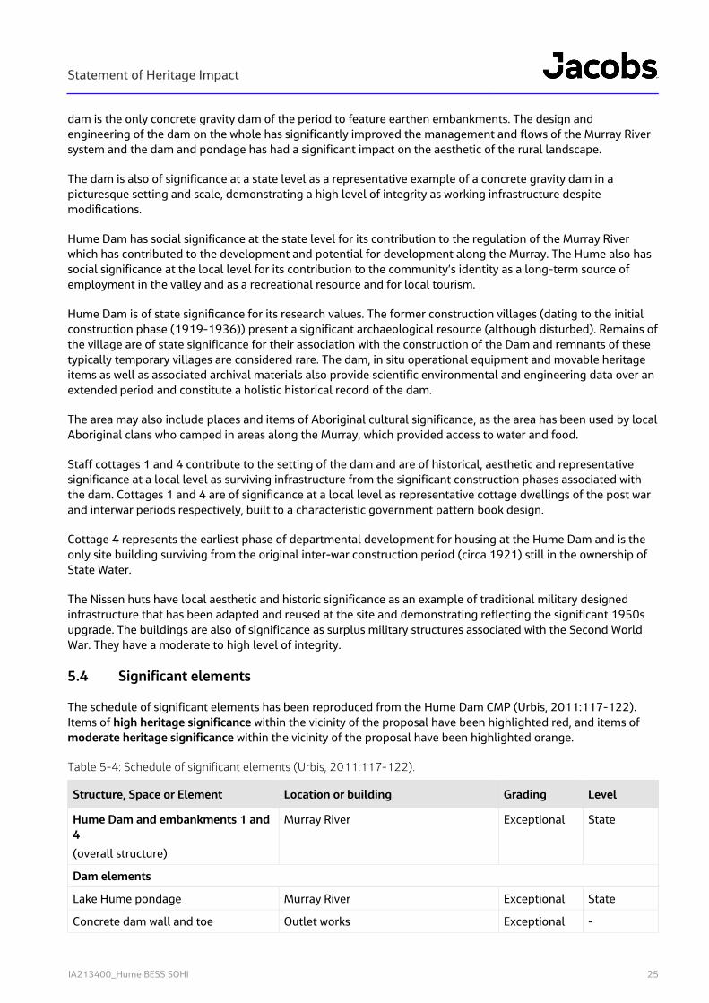
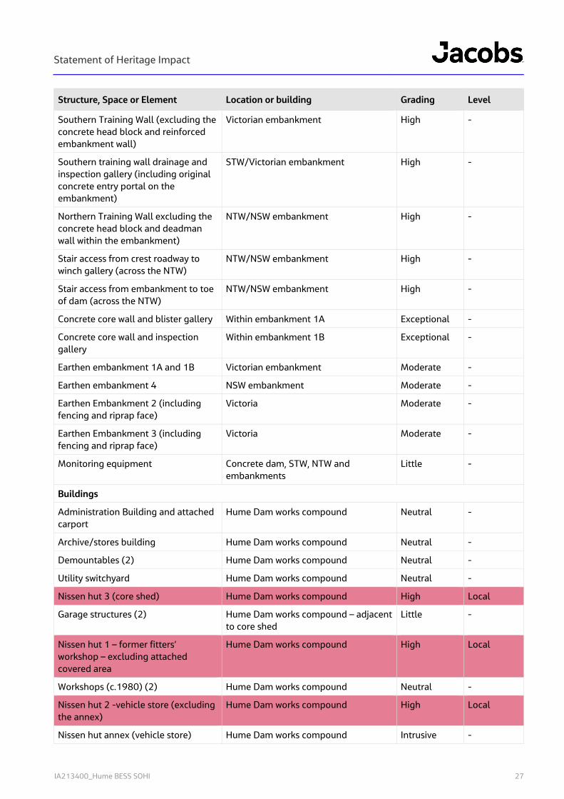
5.4 Significant elements
The schedule of significant elements has been reproduced from the Hume Dam CMP (Urbis, 2011:117-122). Items of high heritage significance within the vicinity of the proposal have been highlighted red, and items of moderate heritage significance within the vicinity of the proposal have been highlighted orange.
Table 5-4: Schedule of significant elements (Urbis, 2011:117-122).
Structure, Space or Element Location or building Grading Level
Hume Dam and embankments 1 and 4
(overall structure)
Murray River Exceptional State
Dam elements
Lake Hume pondage Murray River Exceptional State
Concrete dam wall and toe Outlet works Exceptional -

Statement of Heritage Impact
IA213400_Hume BESS SOHI 26
Structure, Space or Element Location or building Grading Level
Reinforced concrete crest roadway (including gate piers and road barriers but excluding contemporary gates)
Outlet works and spillway High -
Commemorative plaques Outlet works – concrete gate piers Little -
Irrigation and hydro outlets Outlet works Moderate -
Power station Outlet works High -
Power station – original outlet operating equipment
Hydroelectric power station (1957) (excluding interior equipment)
Outlet works (power station)
Outlet works
High
High
-
-
Seepage and inspection gallery (including manholes)
Outlet works and spillway Exceptional -
Winch gallery Outlet works Exceptional -
Winch gallery – Ransoms and Rapier winching equipment (c1926)
Winch gallery – post tensioning cables
Outlet works – winch gallery
Outlet works – winch gallery
High
Moderate
-
-
Winch gallery - Contemporary switchboard and operational equipment for stony sluice gates
Outlet works – winch gallery Little -
Concrete trash racks Outlet works High -
Stilling pool Outlet works High -
Gantry crane and crane No. 2 Outlet works Little -
Valve control cabinet Outlet works Neutral -
Clock-faced gauges to outlets 1-4 Outlet works Little -
Lighting Outlet works Neutral -
Operation safety signage Outlet works Neutral -
Spillway crest, piers, downstream and upstream face
Spillway High -
Dissipator trough/ stilling pool Spillway Exceptional -
Spillway gates and superstructure (concrete
hoist bridge)
Spillway High -
Spillway gate winching equipment Spillway – concrete hoist bridge High -
Steel access stair to superstructure gallery
Spillway Little -
Removable steel bridge across spillway gates
Spillway Little -
Metal railing Spillway Little -
Statement of Heritage Impact
IA213400_Hume BESS SOHI 27
Structure, Space or Element Location or building Grading Level
Southern Training Wall (excluding the concrete head block and reinforced embankment wall)
Victorian embankment High -
Southern training wall drainage and inspection gallery (including original concrete entry portal on the embankment)
STW/Victorian embankment High -
Northern Training Wall excluding the concrete head block and deadman wall within the embankment)
NTW/NSW embankment High -
Stair access from crest roadway to winch gallery (across the NTW)
NTW/NSW embankment High -
Stair access from embankment to toe of dam (across the NTW)
NTW/NSW embankment High -
Concrete core wall and blister gallery Within embankment 1A Exceptional -
Concrete core wall and inspection gallery
Within embankment 1B Exceptional -
Earthen embankment 1A and 1B Victorian embankment Moderate -
Earthen embankment 4 NSW embankment Moderate -
Earthen Embankment 2 (including fencing and riprap face)
Victoria Moderate -
Earthen Embankment 3 (including fencing and riprap face)
Victoria Moderate -
Monitoring equipment Concrete dam, STW, NTW and embankments
Little -
Buildings
Administration Building and attached carport
Hume Dam works compound Neutral -
Archive/stores building Hume Dam works compound Neutral -
Demountables (2) Hume Dam works compound Neutral -
Utility switchyard Hume Dam works compound Neutral -
Nissen hut 3 (core shed) Hume Dam works compound High Local
Garage structures (2) Hume Dam works compound – adjacent to core shed
Little -
Nissen hut 1 – former fitters’ workshop – excluding attached covered area
Hume Dam works compound High Local
Workshops (c.1980) (2) Hume Dam works compound Neutral -
Nissen hut 2 -vehicle store (excluding the annex)
Hume Dam works compound High Local
Nissen hut annex (vehicle store) Hume Dam works compound Intrusive -
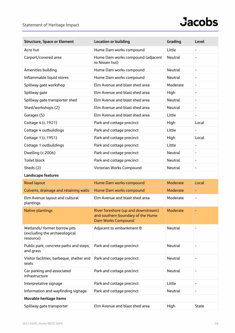
Statement of Heritage Impact
IA213400_Hume BESS SOHI 28
Structure, Space or Element Location or building Grading Level
Acro hut Hume Dam works compound Little -
Carport/covered area Hume Dam works compound (adjacent to Nissen hut)
Neutral -
Amenities building Hume Dam works compound Neutral -
Inflammable liquid stores Hume Dam works compound Neutral -
Spillway gate workshop Elm Avenue and blast shed area Moderate -
Spillway gate Elm Avenue and blast shed area High -
Spillway gate transporter shed Elm Avenue and blast shed area Neutral -
Shed/workshops (2) Elm Avenue and blast shed area Neutral -
Garages (5) Elm Avenue and blast shed area Little -
Cottage 4 (c.1921) Park and cottage precinct High Local
Cottage 4 outbuildings Park and cottage precinct Little -
Cottage 1 (c.1951) Park and cottage precinct High Local
Cottage 1 outbuildings Park and cottage precinct Little -
Dwelling (c.2006) Park and cottage precinct Neutral -
Toilet block Park and cottage precinct Neutral -
Sheds (2) Victorian Works Compound Neutral -
Landscape features
Road layout Hume Dam works compound Moderate Local
Culverts, drainage and retaining walls Hume Dam works compound Moderate -
Elm Avenue layout and cultural plantings
Elm Avenue and blast shed area Moderate -
Native plantings River foreshore (up and downstream) and southern boundary of the Hume Dam Works Compound
Moderate -
Wetlands/ former borrow pits (excluding the archaeological resource)
Adjacent to embankment B Neutral -
Public park, concrete paths and steps, and grass
Park and cottage precinct Neutral -
Visitor facilities, barbeque, shelter and seats
Park and cottage precinct Neutral -
Car parking and associated infrastructure
Park and cottage precinct Neutral -
Interpretative signage Park and cottage precinct Little -
Information and wayfinding signage Park and cottage precinct Neutral -
Movable heritage items
Spillway gate transporter Elm Avenue and blast shed area High State

Statement of Heritage Impact
IA213400_Hume BESS SOHI 29
Structure, Space or Element Location or building Grading Level
Larner Johnston valve Elm Avenue and blast shed area High State
Interpretive display Carpark, park and cottage precinct High State
Stored moveable heritage items (stored in shipping container on site)
Hume Dam works compound Requires assessment. High potential
-
Stored movable heritage items Elm Avenue and blast shed area Requires assessment. High potential
-
Archaeological resource
Former construction villages Victorian Works Compound and NSW encampment
Exceptional State
Archaeology associated with the upgrade works (1950-1961) and subsequent built structures. Including former housing, barracks and mess buildings.
All precincts Moderate Potentially local
5.5 Archaeological potential
The following archaeological potential assessment has been adapted from the Hume Dam CMP (Urbis, 2011:
Historical archaeology is the study of the past using physical evidence in conjunction with historical sources. It focuses on the objects used by people in the past and the places where they lived and worked. It can tell us about the way things were made and used and how people lived their daily lives. Archaeology is not just about objects and remains, it is also about landscapes and links between sites.
Common units for describing archaeological potential are:
known archaeological features/sites (high archaeological potential);
potential archaeological features/sites (medium archaeological potential);
no archaeological features/sites (low archaeological potential).
The site of the former Hume Dam Construction town on the Victorian side of the Murray (known as Mitta Junction) is listed as an archaeological site on the Victorian Heritage Inventory, (inventory number H8325-0002) and has been assessed as being of National significance. The site comprises footings relating to the 1919-1936 construction camp, remnant railway tracks, concrete supports, metal pipes and loading bays with visible depressions.
The area has however been impacted by remedial works which required the removal of soil from the area for use in the dam embankment upgrade. The Murray-Darling Basin Commission (through the Department of Land & Water Conservation) funded an archaeological assessment and partial excavation of the former encampment (including the Camp Ganger's Quarters, Stableman's Quarters and the Industrial Dump areas) in association with remedial works. Archaeological assessment and excavation was undertaken by Austral Archaeology under the Consent to Excavate (CE 98-10) issued by Heritage Victoria (Victorian Heritage database: http://vhd.heritage.vic.gov.au/vhd/heritagevic_new#detail_places;11028). Following the archaeological excavation and remedial works, the area was landscaped as a wetlands area. There is likely some potential for further archaeology associated with the construction town, in areas that were less disturbed.
Statement of Heritage Impact
IA213400_Hume BESS SOHI 30
Construction towns were established on both sides of the Murray and there is potential for similar archaeological finds associated with the NSW encampment on the north side of the river although some areas have been subject to cut and fill in association with earthen works.
The Elm Avenue and Blast Shed precinct has potential for archaeology for former workers cottages, although these were recently demolished. The precinct also has potential for archaeology associated with former barracks and mess buildings. All precincts, including the Hume Dam Works Compound, indicate some archaeological potential connected to the upgrade works (1950-1961).
Overall, the Hume Dam’s archaeological potential is considered to be medium to high, as changes to the site over time may have also disturbed these areas.
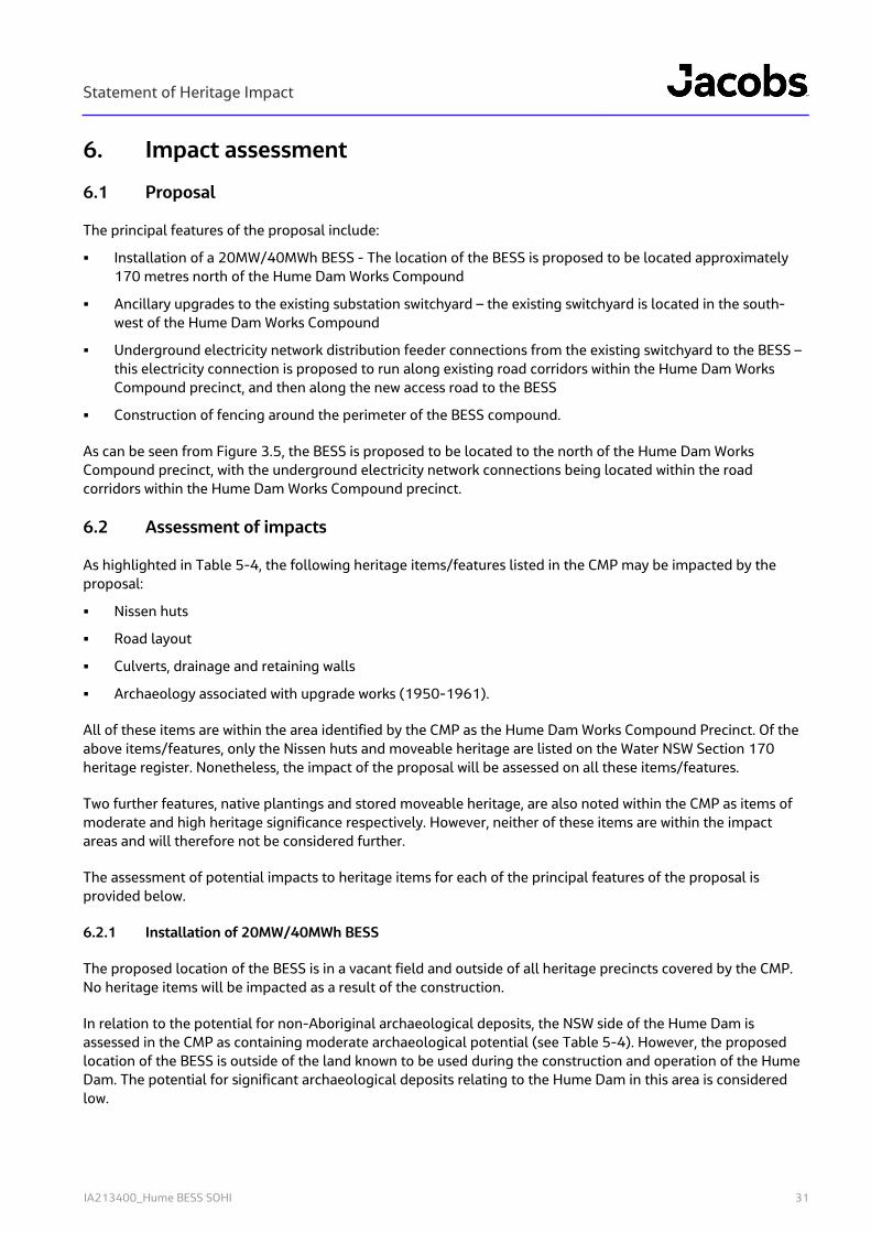
Statement of Heritage Impact
IA213400_Hume BESS SOHI 31
6. Impact assessment
6.1 Proposal
The principal features of the proposal include:
Installation of a 20MW/40MWh BESS - The location of the BESS is proposed to be located approximately 170 metres north of the Hume Dam Works Compound
Ancillary upgrades to the existing substation switchyard – the existing switchyard is located in the south-west of the Hume Dam Works Compound
Underground electricity network distribution feeder connections from the existing switchyard to the BESS – this electricity connection is proposed to run along existing road corridors within the Hume Dam Works Compound precinct, and then along the new access road to the BESS
Construction of fencing around the perimeter of the BESS compound.
As can be seen from Figure 3.5, the BESS is proposed to be located to the north of the Hume Dam Works Compound precinct, with the underground electricity network connections being located within the road corridors within the Hume Dam Works Compound precinct.
6.2 Assessment of impacts
As highlighted in Table 5-4, the following heritage items/features listed in the CMP may be impacted by the proposal:
Nissen huts
Road layout
Culverts, drainage and retaining walls
Archaeology associated with upgrade works (1950-1961).
All of these items are within the area identified by the CMP as the Hume Dam Works Compound Precinct. Of the above items/features, only the Nissen huts and moveable heritage are listed on the Water NSW Section 170 heritage register. Nonetheless, the impact of the proposal will be assessed on all these items/features.
Two further features, native plantings and stored moveable heritage, are also noted within the CMP as items of moderate and high heritage significance respectively. However, neither of these items are within the impact areas and will therefore not be considered further.
The assessment of potential impacts to heritage items for each of the principal features of the proposal is provided below.
6.2.1 Installation of 20MW/40MWh BESS
The proposed location of the BESS is in a vacant field and outside of all heritage precincts covered by the CMP. No heritage items will be impacted as a result of the construction.
In relation to the potential for non-Aboriginal archaeological deposits, the NSW side of the Hume Dam is assessed in the CMP as containing moderate archaeological potential (see Table 5-4). However, the proposed location of the BESS is outside of the land known to be used during the construction and operation of the Hume Dam. The potential for significant archaeological deposits relating to the Hume Dam in this area is considered low.
Statement of Heritage Impact
IA213400_Hume BESS SOHI 32
Prior to being used for the Hume Dam, the primary land use of the proposed location of the BESS was agricultural, primarily grazing. It is unlikely that these activities would result in significant archaeological deposits.
It is therefore concluded that the installation of the BESS will not impact on significant non-Aboriginal heritage or archaeology.
6.2.2 Ancillary upgrades to existing switchyard
The switchyard is located in the south west of the Hume Dam Works Compound (see Figure 3.5). It is not a heritage item and works taking place within the switchyard will not impact any non-Aboriginal heritage.
6.2.3 Underground electricity network distribution feeder
The underground electricity network distribution feeder is proposed to run northwards within the road corridor in the Hume Dam Works Compound from the switchyard to the proposed BESS site. The switchyard is not considered as having any heritage value.
As noted in Table 5-4 above, the road layout is identified in the CMP as a heritage feature of moderate heritage significance. However, the proposed underground electricity network will be installed beneath the existing layout and as the layout, rather than the fabric of the road layout has been identified as having heritage value, it is considered that the installation of the underground electricity network will not impact the road layout.
In relation to the culverts, drainage and retaining walls within the Hume Dam Works Compound, these considered as part of the existing road layout. Originally unsealed, the main loop road was refinished as part of the 1950-1961 upgrade works, and again in the 1970s. The track to the BESS is to commence from the loop road at the double gates in the fence shown in Figure 6-1.
Figure 6-1: Retaining wall (overgrown), culvert and drainage in Hume Dam Works Compound, near Nissan Hut 2 (Jacobs, 2020).
Given the proximity of the culvert, drainage and retaining wall to the proposed works, it is recommended that protective fencing be erected along the roadside adjacent to the culvert.
Although the installation of the underground electricity network distribution feeder will not cause direct impact to any heritage structures within its alignment, there is some potential for inadvertent damage during

Statement of Heritage Impact
IA213400_Hume BESS SOHI 33
construction to individual heritage items located with the Hume Dam Works Compound. These items comprise the two Nissen huts either side of the road (see Figure 3.5). In order to protect these items during constructed, it is recommended that protective fencing be placed between the works and the Nissen huts to eliminate any accidental damage.
In relation to archaeological deposits, the road layout within the Hume Dam Works Compound has not been identified as an area of archaeological potential. In addition, as noted in Section 6.2.1 above, the BESS compound is outside of the heritage precincts for the Hume Dam. It is therefore considered that the installation of the underground electricity network will not impact any significant non-Aboriginal archaeological deposits.
6.2.4 Construction of fencing around the perimeter of the BESS compound
As noted in Section 6.2.1 above, the BESS compound is outside of the heritage precincts for the Hume Dam. The fencing will therefore not cause any impact to any identified non-Aboriginal heritage items or archaeological deposits.
6.3 Summary
Given that the works associated with the proposal will take place outside the curtilage of the significant heritage items associated with the Hume Dam, it is considered that there are no non-Aboriginal heritage constraints associated with this proposal. It should be noted however, that potential exists for damage to two of the Nissen huts and the culvert, drainage and retaining wall within the Hume Dam Works Compound during construction of the underground electricity network feeder, however that potential can be eliminated through the installation of protective fencing during construction.
Statement of Heritage Impact
IA213400_Hume BESS SOHI 34
7. Conclusions and recommendations An assessment of the heritage values of the Hume Dam and the potential impacts to those values has concluded that there are no constraints associated with the proposal, provided that the following recommendations are followed. Recommendation 1 – Protective fencing It is recommended that during construction of the underground electricity network feeder in the road corridor that protective fencing be installed around the two Nissen huts (former fitters’ workshop and vehicle store) and the culvert, drainage and retaining wall to protect them from inadvertent damage. Recommendation 2 – Heritage induction
It is recommended that a heritage induction for both Aboriginal and non-Aboriginal heritage be carried out as part of general site inductions. The aim of the induction would be to ensure that all staff, contractors and subcontractors are aware of their statutory duties under both the National Parks and Wildlife Act 1974 and the Heritage Act 1977.
Recommendation 3 – Unexpected Finds
It is recommended that in the event of archaeological material being uncovered during works that all works in the area should stop, the area cordoned off and a suitably qualified archaeologist be engaged to assess the significance and future management of the find(s).
Statement of Heritage Impact
IA213400_Hume BESS SOHI 35
References and Bibliography
Andrews, A, 1912 The History of Albury 1824-1895, Adams Cooper and Adams, Albury.
Kamminga, J 2007 Lake Hume Aboriginal Heritage Study, unpublished report to Goulburn Murray Water.
NSW Heritage Office, 2001, Assessing Heritage Significance, NSW Government, Sydney.
Office of Environment & Heritage, 2005, Bethanga Bridge, Inventory Sheet on State Heritage Register, accessed on 3 April 2020 from https://www.environment.nsw.gov.au/heritageapp/ViewHeritageItemDetails.aspx?ID=5056556.
Spreadborough, R and Anderson, H, 1983 Victorian Squatters, Red Rooster Press, Ascot Vale.
Urbis, 2013, Conservation Management Plan – Hume Dam. Unpublished report to SWC.
Webb, R, 2004 ‘Hawksview Station’, Albury & District Historical Society Bulletin, Albury, Albury & District Historical Society, No. 433, accessed on 29 June 2020 from https://alburyhistory.org.au/wp-content/uploads/2019/10/Hawksview-Station.pdf.

Statement of Heritage Impact
IA213400_Hume BESS SOHI
Appendix A. Section 170 Register Inventory Sheets
3/25/2020 Hume Dam | NSW Environment, Energy and Science
https://www.environment.nsw.gov.au/heritageapp/ViewHeritageItemDetails.aspx?ID=5062242 1/9
NSW Department of Planning, Industry and Environment
Home Topics Heritage places and items Search for heritage
Hume DamItem details
Name of item: Hume Dam
Other name/s: Hume Lake, Hume Pondage
Type of item: Built
Group/Collection: Utilities - Water
Category: Weir
Primary address: Accessed off Murray Street, Lake Hume Village. Murray Valley, on the Murray River, Albury, NSW 2640
Local govt. area: Albury City
All addresses
Street Address Suburb/town LGA Parish County Type
Accessed off Murray Street, Lake Hume Village. Murray Valley, on the Murray River
Albury Albury City
Primary Address
Statement of signi�cance:
Dam is of state heritage significance for its historic, associative, aesthetic, social and research
values.
Hume Dam is of state historic significance for its role in the management and conservation of water
within the Murray basin. It reflects the collaborative efforts of three states (NSW, VIC and SA) and the
Commonwealth government which culminated in the development of the Hume dam and 13 other
locks and weirs along the lower Murray. The Dam construction was one of the great engineering
projects of the period and was one of the greatest water conservation projects in the British Empire.
The Hume Dam is also of significance at a state level for its association with prominent engineers E. M
De Burgh, J. S Detheridge and G. Stewart and government works departments in Victoria and NSW.
The design of the Hume was planned by De Burgh and Detheridge and constructed by the Public
Works Department (NSW) and the State Rivers and Water Supply Commission of Victoria. The PWD
3/25/2020 Hume Dam | NSW Environment, Energy and Science
https://www.environment.nsw.gov.au/heritageapp/ViewHeritageItemDetails.aspx?ID=5062242 2/9
was also responsible for subsequent upgrades. Hume is also associated with explorers Hamilton
Hume and William Hovell.
Hume Dam is of state aesthetic (technical) significance for its innovative design and construction, its
scale and landmark qualities. When completed, it was the second largest dam in the world; it included
an early use of an energy dissipator and responded to the site topography in its design, incorporating
earthen embankments. The dam is the only concrete gravity dam of the period to feature earthen
embankments. The design and engineering of the dam on the whole has significantly improved the management and flows of the Murray River system and the dam and pondage has had a significant
impact on the aesthetic of the rural landscape.
The dam is also of significance at a state level as a representative example of a concrete gravity dam
in a picturesque setting and scale, demonstrating a high level of integrity as working infrastructure
despite modifications.
Hume Dam has social significance at the state level for its contribution to the regulation of the Murray
River which has contributed to the development and potential for development along the Murray. The
Hume also has social significance at the local level for its contribution to the community?s identity as a
long term source of employment in the valley and as a recreational resource and for local tourism.
Hume Dam is of state significance for its research values. The former construction villages (dating to
the initial construction phase (1919-1936)) present a significant archaeological resource (although
disturbed). Remains of the village are of state significance for their association with the construction of
the Dam and remnants of these typically temporary villages are considered rare. The dam, in situ
operational equipment and movable heritage items as well as associated archival materials also
provide scientific environmental and engineering data over an extended period and constitute an
holistic historical record of the dam.
The area may also include places and items of Aboriginal cultural significance, as the area has been
used by local Aboriginal clans who camped in areas along the Murray, which provided access to water
and food.
Staff cottages 1 and 4 contribute to the setting of the dam and are of historical, aesthetic and
representative significance at a local level as surviving infrastructure from the significant construction
3/25/2020 Hume Dam | NSW Environment, Energy and Science
https://www.environment.nsw.gov.au/heritageapp/ViewHeritageItemDetails.aspx?ID=5062242 3/9
phases associated with the dam. Cottages 1 and 4 are of significance at a local level as representative
cottage dwellings of the post war and inter-war periods respectively, built to a characteristic
government pattern book design.
Cottage 4 represents the earliest phase of departmental development for housing at the Hume Dam
and is the only site building surviving from the original inter-war construction period (circa 1921) still in
the ownership of State Water.
The Nissen huts have local aesthetic and historic significance as an example of traditional military
designed infrastructure that has been adapted and reused at the site and demonstrating reflecting the
significant 1950s upgrade. The buildings are also of significance as surplus military structures
associated with the Second World War. They have a moderate to high level of integrity.
Date significance updated: 15 Jan 14
Note: The State Heritage Inventory provides information about heritage items listed by local and State government agencies. The State Heritage Inventory is continually being updated by local and State agencies as new information becomes available. Read the OEH copyright and disclaimer.
Description
Designer/Maker: E. M De Burgh, J. S Detheridge
Builder/Maker: PWD(NSW) and the State Rivers and Water Supply Commission of Victoria
Construction years:
1919-1936
Physical description:
The Hume dam consists of a concrete gravity section in addition to 4 earthen embankments, 2 of
which have a concrete core wall. Hume is 51m high, with a crest of 2,625m, which includes the main
structure (1,615m) and auxiliary embankments (1,010m). The storage capacity is 3,038,000ML with a
surface area of more than 20,000 hectares and a maximum water depth of 40m.
The concrete section is approx 340m long and includes the outlet section and a spillway section which
is approximately 220m long (with 29 vertical lift gates) and wing walls at its northern and southern
ends referred to as the northern and southern training walls. Embankments 1 (south) and 4 (north)
which adjoin the concrete dam each feature a centrally located vertical reinforced concrete core wall
with earthen shoulders. Embankments 2 and 3, located on the lake of the dam on the Victorian side of
the river, are conventional earthfill construction and were constructed later as part of the 1950s
3/25/2020 Hume Dam | NSW Environment, Energy and Science
https://www.environment.nsw.gov.au/heritageapp/ViewHeritageItemDetails.aspx?ID=5062242 4/9
expansion works.
Outlets Section:
The outlets section is 86.6m long, with a concrete roadway running along the crest of the dam and
across the spillway. The outlet section includes four irrigation outlets (FDC valves), and three hydro
outlets, two of which are connected to the hydroelectric power station, with the third being disused.
The outlets release water downstream through the dam wall from the storage. Concrete trash racks
protect both the irrigation and hydro outlets.
Within the dam wall, there is a seepage and inspection gallery at the base of the dam which connects
into the spillway section. The gallery is constructed in concrete with an arched roof form and houses
various monitoring equipment tracking movement of the dam structure and monitoring seepage and
drainage. A second gallery, referred to as the winch gallery is located beneath the dam crest within the
outlet section only. The winch gallery houses operating equipment for the emergency closure gates
and the main electrical switchboard.
Downstream of the outlets section is a concrete-walled stilling pool 55m long, and 89m wide, with a
partition wall separating the 28m wide section downstream of the irrigation outlets. Sitting within the
stilling pool at the toe of the dam adjacent to the northern training wall, is the hydroelectric power
station, constructed circa 1956 in a post war industrial brutalist style. The original inter-war power
house is also retained adjacent to the northern training wall.
Spillway Section:
The spillway section serves to take excess water downstream away from the dam and features an
ogee crest, to dissipate the velocity of water in flow. The spillway is 219.4m long, with a crest level of
RL 184.76m. It is constructed with 9 gravity blocks with contraction joints at 25m intervals in the lower
sections and joints at half that spacing in the higher sections above the gallery roof. It has 29 vertical
lift gates, each 6.1m wide by 7.9m high, separated by piers 1.5m wide. A reinforced concrete road
bridge crosses the spillway. There is a seepage and inspection gallery at the base of the dam, which
connects to the gallery in the outlet section and to the southern training wall and blister gallery in
Embankment 1. A dissipater structure downstream of the toe in this section provides a stilling pool
24.3m long and further serves to calm water from the dam spillway and reduce potential erosion
3/25/2020 Hume Dam | NSW Environment, Energy and Science
https://www.environment.nsw.gov.au/heritageapp/ViewHeritageItemDetails.aspx?ID=5062242 5/9
downstream.
The 1961 enlargement of the dam included the construction of the reinforced concrete hoist bridge
supporting the lifting equipment for the 29 spillway gates. These gates increase the amount of water
able to be impounded by the dam.
Southern Training Wall (STW)
The southern training wall (STW) is a concrete gravity structure which retains the fill of Embankment 1,
and acts as a training wall for spillway flows. On the downstream side, it contains an inspection gallery
which provides the exit point for seepage from the concrete dam and the blister gallery in
Embankment 1
Northern Training Wall:
Similar to the STW, the northern training wall (NTW) is a concrete gravity structure spanning the
upstream and downstream face of the dam and retaining the fill of Embankment 4.
Earthen Embankments 1, 2, 3 and 4
Embankment 1 is a 1,166m long earth dam with a maximum height of 39m. The embankment is
broken into two sections; the northern section adjoins the spillway and is referred to as Embankment
1a, and the southeastern section which is known as embankment 1b. The embankment is constructed
with a lightly reinforced concrete core wall 0.6m thick at the crest and 1.8m thick at the base founded
on solid rock. A reinforced concrete semi-circular drainage and inspection gallery (known as the blister
gallery) runs along the core wall within embankment 1a and a drainage pipe continues from the bend
within embankment 1b.
Embankment 2 is an homogeneous earthen embankment constructed in the 1950s 1km south/
upstream of Embankment 1b. The embankment is 550m long and the crest 7.2m wide.
Embankment 3 is a zoned earthfill embankment constructed in the 1950s, with rockfill wave protection
on the upstream batter. The embankment is constructed in a saddle approx. 1km south of
Embankment 2. It is 460m long.
Embankment 4 is 131m long and is similar in design to Embankment 1a, but does not have a blister
gallery or downstream berms. Its core wall slots into the NTW with a somewhat similar detail to the
southern junction.
Physical condition and/orArchaeological potential:
The structure is required to be maintained to a standard generally that associated with ANCOLD
guidelines, and regulated by NSW Dam Safety Committee. The structure is subject to an intensive
3/25/2020 Hume Dam | NSW Environment, Energy and Science
https://www.environment.nsw.gov.au/heritageapp/ViewHeritageItemDetails.aspx?ID=5062242 6/9
surveillance regime and incorporates high levels of telemetry and instrumentation monitoring all
aspects of the structures performance. Maintenance occurs within this framework and is documented
and controlled with the assistance of a computer based maintenance management system.
Current maintenance status is within acceptable limits and remedial works underway are addressing
identified deficiencies.
Modifications and dates:
Modifications were carried out during 1950-1961 to enlarge the reservoir to its present capacity of
3,038,000Ml which enabled it to accommodate additional water from the Snowy Mountains Scheme
Between 1981 and 1987 works were undertaken to extend the drainage of the dam's foundation to
relieve uplift pressures and to install a new post-tensioning cable system, which would be restressable.
Outlet valves were also upgraded and the 1920s Larner Johnson valves were replaced.
Further corrective works to the dam in the 1995-2003 program included construction of stabilising
berms along the downstream slope of the embankment (1) and further post tensioning of the southern
training wall to resist loadings imposed by the new berms. The original northern and osuthern training
walls were also strengthened to cope with earthquake loadings, which involved construction of new
reinforced concrete head blocks to accommodate horizontal and vertical post-tensioned anchors.
Hume Dam is currently undergoing upgrade works to improve the structure?s capacity to withstand
extreme flood and earthquake events and bring it into line with contemporary best practice. Proposed
works include the installation of an improved filter and drainage system on the junction between the
concrete spillway and southern embankment; construction of a concrete buttress on the southern
training wall and possible spillway modifications to improve the capacity of the dam to manage extreme floods. Works began in March 2010, with construction expected to take 3-5 years.
Current use: Water Conservation, Supply & Stock, Irrigation, Hydro power, recreation
Former use: Water Conservation, Supply & Stock, Irrigation, Hydro power, recreation
History
Historical notes: The design and construction of the dam involved the cooperation and joint involvement of NSW and
Victoria, with the original design prepared by E M De Burgh, Chief Engineer of Public Works, NSW
3/25/2020 Hume Dam | NSW Environment, Energy and Science
https://www.environment.nsw.gov.au/heritageapp/ViewHeritageItemDetails.aspx?ID=5062242 7/9
and J S Detheridge, Commissioner State Rivers and Water Supply Commission of Victoria. During
construction of the dam, the work force was to be accommodated in two separate townships either
side of the Murray with the Department of Public Works (NSW) being responsible for the northern
concrete dam section and the State Rivers and Water Supply Commission of Victoria being
responsible for the southern earth dam.
The Commission approved preliminary plans of the dam on 25 April 1919 and construction began on
28 November the same year. The construction site was initially referred to as „the Mitta Mitta Dam
site', but in February 1920 the River Murray Commission (RMC) adopted the name „Hume Reservoir'
to honour Hamilton Hume.
The dam was built with a cyclopean construction technique which relied on large granite “plums” being
inserted into the concrete. Designs were amended in the mid 1920s and again in 1930, when the
impact of economic depression began to affect the Hume Dam works. The proposed hydro power
works and construction works were put on hold.
The dam was completed after 17 years and was officially opened on the 28th November 1936 by the
Governor General Lord Gowrie. When completed, Hume Dam was the biggest dam in the southern
hemisphere and among the largest in the world. The Hume was one of the most significant examples
of this type of dam built, though the cost of construction was expensive (5.3 million) and its type was
not used as much in later years. On completion, the dam's catchment measured 6,000 square miles
and it held 2,000,000 acre-feet of water storage. The concrete wall was 1042.5 feet long. The earth
bank within NSW measured 430.5 feet in length and that in Victoria 3,827 feet long, making a total
length of 5,300 feet.
The completed dam incorporated a concrete gravity dam spillway section (710 feet long) with piers
above the crest carrying the roadway and able to support 29 moveable gates (proposed to be installed
with a projected future increase to the storage). The remainder of the concrete construction was a
sluice with a road on top, with seven needle valves, of which three were then used for the hydroelectric
station and stony sluice gates.
Modifications were carried out during 1950-1961 to enlarge the reservoir to its present capacity of
3,038,000Ml which enabled it to accommodate additional water from the Snowy Mountains Scheme.
3/25/2020 Hume Dam | NSW Environment, Energy and Science
https://www.environment.nsw.gov.au/heritageapp/ViewHeritageItemDetails.aspx?ID=5062242 8/9
As with the original construction phase, the upgrade required further infrastructure, including a
construction office (set up in NSW) responsible for the raising of the spillway, and re-establishing a
construction township, which included a number of pre-fabricated cottages and barracks buildings. In
1951 the township included 30 cottages, 6 barracks units, and the construction office as well as a number of workshop buildings Housing included prefabricated cottages, likely built by the Department
of Public Works. Works to the dam and associated infrastructure were carried out by NSW on behalf
of NSW and Victoria.
The dam works involved both enlargement and stabilizing works, including the addition of 29 spillway
gates, and grouting and drainage works to control uplift pressures under the concrete dam as no
provision was made in the original design for uplift pressure. The spillway crest and piers were
modified (raised to RL 607), and works were undertaken to anchor the dam to foundations with post
tensioning cables to resist the increased loading resulting from the elevated water level in the storage.
Uplift pressure measuring apparatus were also installed which required further drilling.
The earthen embankment number 1 on the Victorian side was again modified, with works including
placement of new stone and in 1954 construction of subsidiary Victorian embankments (saddle dams)
Nos 2 and 3 was completed. The height of the embankments was later raised in association with the
increased dam storage
The upgrade works also included the construction of the 50 megawatt hydro-electric power station
which commenced operation on 30 July 1957.
Between 1981 and 1987 works were undertaken to extend the drainage of the dam's foundation to
relieve uplift pressures and to install a new post-tensioning cable system, which would be restressable.
Outlet valves were also upgraded.
Further corrective works to the dam in the 1995-2003 program included construction of stabilising
berms along the downstream slope of the embankment (1) and further post tensioning of the southern
training wall to resist loadings imposed by the new berms. The original northern and osuthern training
walls were also strengthened to cope with earthquake loadings, which involved construction of new
reinforced concrete head blocks to accommodate horizontal and vertical post-tensioned anchors.
Recommended management:
3/25/2020 Hume Dam | NSW Environment, Energy and Science
https://www.environment.nsw.gov.au/heritageapp/ViewHeritageItemDetails.aspx?ID=5062242 9/9
Refer to Conservation Management Plan.
Listings
Heritage Listing ListingTitle
ListingNumber
GazetteDate
GazetteNumber
GazettePage
Heritage Act - s.170 NSW State agency heritage register
References, internet links & images
Type Author Year Title InternetLinks
Archaeological Report
Austral Archaeology Pty Ltd
1997 Archaeological Survey of the Hume Dam Construction Camp Site, prepared for theDepartment of Land and Water Conservation
Written O.H.M Consultants
2006 Heritage Assessment for Hume Dam, State Water Corporation
Note: internet links may be to web pages, documents or images.
(Click on thumbnail for full size image and image details)
Data source
The information for this entry comes from the following source:
Name: State Government
Database number:
5062242
Every effort has been made to ensure that information contained in the State Heritage Inventory is correct. If you find any errors or omissions please sendyour comments to the Database Manager.
All information and pictures on this page are the copyright of the Heritage Division or respective copyright owners.

3/25/2020 Hume Dam Cottage 1 | NSW Environment, Energy and Science
https://www.environment.nsw.gov.au/heritageapp/ViewHeritageItemDetails.aspx?ID=4550117 1/3
NSW Department of Planning, Industry and Environment
Home Topics Heritage places and items Search for heritage
Hume Dam Cottage 1Item details
Name of item: Hume Dam Cottage 1
Other name/s: Hume Weir and Pondage
Type of item: Built
Group/Collection: Utilities - Water
Category: Other - Government & Administration
Location: Lat: 36.20.280 Long: 147.08.052
Primary address: Murray River, Albury, NSW 2640
Local govt. area: Albury City
All addresses
Street Address Suburb/town LGA Parish County Type
Murray River Albury Albury City Primary Address
Owner/s
Organisation Name Owner Category Date Ownership Updated
State Waters State Government
Statement of signi�cance:
All of the work on construction was carried out by 'day labour' and at the height of construction, more than 1100 workers were employed at the dam site housed in two separate fully serviced towns one on either side of the river. Two houses located at Hume Dam embody the two main phases of construction because of their intactness, • Cottage 4 original opening phase • Cottage 1 for the upgrade phase during the 1950’s It is highly valued by the local community and by some 350,000 tourists who visit each year to enjoy water sports and fishing in the dam and camping in the storage environs.
Note: The State Heritage Inventory provides information about heritage items listed by local and State government agencies. The State Heritage Inventory is continually being updated by local and State agencies as new information becomes available. Read the OEH copyright and disclaimer.
Description

3/25/2020 Hume Dam Cottage 1 | NSW Environment, Energy and Science
https://www.environment.nsw.gov.au/heritageapp/ViewHeritageItemDetails.aspx?ID=4550117 2/3
Designer/Maker: Standard Government pattern book design
Physical description:
The house is situated near the Hume Dam wall, which is situated on the upper Murray River below the junction of the Murray and the Mitta Mitta River. The house is one of several but it is in the most intact condition. The house is constructed from weatherboard, corrugated iron roof and verandahs running along two sides. The house has gardens that open onto panoramic views of the dam.
Physical condition and/orArchaeological potential:
Good condition
Modifications and dates:
A carport has been added.
History
Historical notes: Construction commenced in 1919 with the River Murray Commission keen to expedite the works with the need to provide drought protection of the developing settlements along the river and establish new settlements to provide employment for the large number of soldiers returning to Australia after World War I. All the work was carried out by day labor with 1,100 men employed in 1927. The work force was accommodated in two separate townships on either side of the river with the Department of Public Works NSW the construction authority responsible for the northern concrete dam section and the State Rivers and Water Supply Commission of Victoria responsible for the southern earth dam. Construction began on Hume Dam in 1919, and it was the government's vision that the reliable source of water would foster new settlements in the valley and bring confidence and prosperity to its population and would create 'a land fit for heroes', the veterans returning from World War I. Enlargement works were carried out between 1950 and 1961 increasing the storage capacity to its current level of 3,040,000ml. This involved the addition of vertical lift gates to the spillway, and drainage works and post-tensioning of the concrete to provide stability to resist the increased loading of the higher storage. Cottage 1 represents housing for this phase of development at Hume Dam.
Assessment of signi�cance
SHR Criteria b)[Associative significance]
Three engineers of note were involved in formulating an agreement on regulation and sharing of the River Murray waters, which was adopted by the three states. The engineers were E M de Burgh, NSW, J S Detheridge, Victoria and G Stewart, South Australia.
SHR Criteria c)[Aesthetic significance]
The house represents the earliest phase of departmental housing at Hume Dam with panoramic views across the dam.
SHR Criteria d)[Social significance]
The cottages have a high level of social significance for the staff who have lived at the dam and they form part of the setting near the dam wall.
Integrity/Intactness:
The house has a high level of intactness.
Assessment criteria:
Items are assessed against the State Heritage Register (SHR) Criteria to determine the level of significance. Refer to the Listings below for the level of statutory protection.
Recommended management:
The house should be maintained and preserved as part of the administration workshop precinct.

3/25/2020 Hume Dam Cottage 1 | NSW Environment, Energy and Science
https://www.environment.nsw.gov.au/heritageapp/ViewHeritageItemDetails.aspx?ID=4550117 3/3
Listings
Heritage Listing ListingTitle
ListingNumber
GazetteDate
GazetteNumber
GazettePage
Heritage Act - s.170 NSW State agency heritage register
Heritage study
Study details
Title Year Number Author Inspected by Guidelinesused
Heritage Assessment for Hume Dam
2006 OHM Consultants
David McBeath Completed by David McBeath
Yes
References, internet links & imagesNone
Note: internet links may be to web pages, documents or images.
(Click on thumbnail for full size image and image details)
Data source
The information for this entry comes from the following source:
Name: State Government
Database number:
4550117
Every effort has been made to ensure that information contained in the State Heritage Inventory is correct. If you find any errors or omissions please sendyour comments to the Database Manager.
All information and pictures on this page are the copyright of the Heritage Division or respective copyright owners.
3/25/2020 Hume Dam Cottage 4 | NSW Environment, Energy and Science
https://www.environment.nsw.gov.au/heritageapp/ViewHeritageItemDetails.aspx?ID=4550116 1/4
NSW Department of Planning, Industry and Environment
Home Topics Heritage places and items Search for heritage
Hume Dam Cottage 4Item details
Name of item: Hume Dam Cottage 4
Other name/s: Hume Weir and Pondage
Type of item: Built
Group/Collection: Utilities - Water
Category: Other - Government & Administration
Location: Lat: 36.20.280 Long: 147.08.052
Primary address: Murray River, Albury, NSW 2640
Local govt. area: Albury City
All addresses
Street Address Suburb/town LGA Parish County Type
Murray River Albury Albury City Primary Address
Owner/s
Organisation Name Owner Category Date Ownership Updated
State Waters State Government
Statement of signi�cance:
All of the work on construction was carried out by 'day labour' and at the height of construction, more than 1100 workers were employed at the dam site housed in two separate fully serviced towns one on either side of the river. Two houses located at Hume Dam embody the two main phases of construction because of their intactness, • Cottage 4 original opening phase • Cottage 1 for the upgrade phase during the 1950’s It is highly valued by the local community and by some 350,000 tourists who visit each year to enjoy water sports and fishing in the dam and camping in the storage environs.
Note: The State Heritage Inventory provides information about heritage items listed by local and State government agencies. The State Heritage Inventory is continually being updated by local and State agencies as new information becomes available. Read the OEH copyright and disclaimer.
Description
3/25/2020 Hume Dam Cottage 4 | NSW Environment, Energy and Science
https://www.environment.nsw.gov.au/heritageapp/ViewHeritageItemDetails.aspx?ID=4550116 2/4
Designer/Maker: Standard Government pattern book design
Physical description:
The house is situated near the Hume Dam wall, which is situated on the upper Murray River below the junction of the Murray and the Mitta Mitta River. The house is one of several but it is in the most intact condition from the dams opening phase. The house is constructed from brick, weatherboard, corrugated iron roof and verandahs running along two sides. The house has gardens that open onto panoramic views of the dam.
Physical condition and/orArchaeological potential:
Good condition
Modifications and dates:
A carport has been added.
History
Historical notes: Construction commenced in 1919 with the River Murray Commission keen to expedite the works with the need to provide drought protection of the developing settlements along the river and establish new settlements to provide employment for the large number of soldiers returning to Australia after World War I. All the work was carried out by day labor with 1,100 men employed in 1927. The work force was accommodated in two separate townships on either side of the river with the Department of Public Works NSW the construction authority responsible for the northern concrete dam section and the State Rivers and Water Supply Commission of Victoria responsible for the southern earth dam. Work was affected by ' the great depression ' and there were a number of design changes as the work progressed. In 1924 the RMC decided to enlarge the Reservoir from its original planned capacity of 1,357,000Ml to 2,467,000Ml and to add 3 outlets for later hydro-electric generation. In 1934 it was decided to reduce the reservoir capacity to 1,542,000Ml because of financial constraints but to provide for future enlargement. The dam was completed after 17 years and was officially opened in 1936 by the Governor General Lord Gowrie. The cost of construction was $11.1M. Between 1950 and 1961 modifications were carried out to enlarge the Reservoir to its present capacity of 3,040,000Ml which enabled it to accommodate additional water from the Snowy Mountains Scheme. The works involved both enlargement and stabilizing works including the addition of 29 spillway gates, and grouting and drainage works to control uplift pressures under the concrete dam as no provision was made in the original designs for uplift pressure. Other works involved anchoring the dam to the foundations by post-tensioning cables to resist increased loading deriving from raising the water level in the storage. Construction began on Hume Dam in 1919, and it was the government's vision that the reliable source of water would foster new settlements in the valley and bring confidence and prosperity to its population and would create 'a land fit for heroes', the veterans returning from World War I.
Assessment of signi�cance
SHR Criteria b)[Associative significance]
Three engineers of note were involved in formulating an agreement on regulation and sharing of the River Murray waters, which was adopted by the three states. The engineers were E M de Burgh, NSW, J S Detheridge, Victoria and G Stewart, South Australia.
SHR Criteria c)[Aesthetic significance]
The house represents the earliest phase of departmental housing at Hume Dam with panoramic views across the dam.
SHR Criteria d)[Social significance]
The cottages have a high level of social significance for the staff that have lived at the dam and they form part of the setting near the dam wall.
Integrity/Intactness:
The house has a high level of intactness.
Assessment Items are assessed against the State Heritage Register (SHR) Criteria to

3/25/2020 Hume Dam Cottage 4 | NSW Environment, Energy and Science
https://www.environment.nsw.gov.au/heritageapp/ViewHeritageItemDetails.aspx?ID=4550116 3/4
criteria: determine the level of significance. Refer to the Listings below for the level of statutory protection.
Recommended management:
The house should be preserved and maintained as part of the administration workshop precinct.
Listings
Heritage Listing ListingTitle
ListingNumber
GazetteDate
GazetteNumber
GazettePage
Heritage Act - s.170 NSW State agency heritage register
Heritage study
Study details
Title Year Number Author Inspected by Guidelinesused
Heritage Assessment for Hume Dam
2006 OHM Consultants
David McBeath Completed by David McBeath
Yes
References, internet links & imagesNone
Note: internet links may be to web pages, documents or images.
(Click on thumbnail for full size image and image details)
Data source
The information for this entry comes from the following source:
Name: State Government
Database number:
4550116

3/25/2020 Hume Dam Cottage 4 | NSW Environment, Energy and Science
https://www.environment.nsw.gov.au/heritageapp/ViewHeritageItemDetails.aspx?ID=4550116 4/4
Every effort has been made to ensure that information contained in the State Heritage Inventory is correct. If you find any errors or omissions please sendyour comments to the Database Manager.
All information and pictures on this page are the copyright of the Heritage Division or respective copyright owners.
3/25/2020 Hume Dam Interpretive display including Crompton electric motor, Steam engine/generator set and air compressor | NSW Environm…
https://www.environment.nsw.gov.au/heritageapp/ViewHeritageItemDetails.aspx?ID=4550113 1/3
NSW Department of Planning, Industry and Environment
Home Topics Heritage places and items Search for heritage
Hume Dam Interpretive display includingCrompton electric motor, Steamengine/generator set and air compressorItem details
Name of item: Hume Dam Interpretive display including Crompton electric motor, Steam engine/generator set and air compressor
Other name/s: Hume Weir and Pondage
Type of item: Complex / Group
Category: Other - Utilities - Water
Location: Lat: 36.20.280 Long: 147.08.052
Primary address: Murray River, Albury, NSW 2640
Local govt. area: Albury City
All addresses
Street Address Suburb/town LGA Parish County Type
Murray River Albury Albury City Primary Address
Owner/s
Organisation Name Owner Category Date Ownership Updated
State Waters State Government
Description
Designer/Maker: The engineers were E M de Burgh, NSW, J S Detheridge, Victoria and G Stewart, South Australia.
Physical description:
Hume Dam is situated on the upper Murray River below the junction of the Murray and the Mitta Mitta River. Technical description. A very heavy jaw crusher had been installed at the quarry and the railway was complete and ready. At the dam, two 300 KW 480 volt generators had been installed in the powerhouse and a small steam driven generator was supplying light and power to the dam buildings and to the township. Plans were under way to erect the framework for the conveying belt and chute of the concrete distribution system. The mixer house was being built. The head and tail towers of the cableway were being built. A timber bridge 280 feet long and 21 feet wide had been built 900 feet downstream to cart spoil to the Victorian side. The continuing cement shortage had not really affected laying foundations for buildings. A power supply was available for the town from June 1922 onwards. The Lidgerwood cableway being installed at the main dam was complete in January 1923.

3/25/2020 Hume Dam Interpretive display including Crompton electric motor, Steam engine/generator set and air compressor | NSW Environm…
https://www.environment.nsw.gov.au/heritageapp/ViewHeritageItemDetails.aspx?ID=4550113 2/3
Physical condition and/orArchaeological potential:
Good condition - static display
History
Historical notes: Construction commenced in 1919 with the River Murray Commission keen to expedite the works with the need to provide drought protection of the developing settlements along the river and establish new settlements to provide employment for the large number of soldiers returning to Australia after World War I. Steam Plans of the layout of plant at the dam had been prepared and they included an aerial cableway, a mixer house, tracks, and a powerhouse and cement store. The powerhouse would supply power to all electric motors on the site. A very heavy jaw crusher had been installed at the quarry and the railway was complete and ready. At the dam, two 300 KW 480 volt generators had been installed in the powerhouse and a small steam driven generator was supplying light and power to the dam buildings and to the township. Plans were under way to erect the framework for the conveying belt and chute of the concrete distribution system. The mixer house was being built. The head and tail towers of the cableway were being built. A timber bridge 280 feet long and 21 feet wide had been built 900 feet downstream to cart spoil to the Victorian side. The continuing cement shortage had not really affected laying foundations for buildings. A power supply was available for the town from June 1922 onwards. The Lidgerwood cableway being installed at the main dam was complete in January 1923. Air The quarry that was opened up for the dam was 1.5 miles north of the dam and was worked by 1920 on a 500 feet face. A Hadfield stone crusher driven by a Robey 25 hp engine was in operation as was an air compressor driven by a Robey 25 hp engine. The air compressors were used to power the pneumatic drills and other equipment used on the quarry face. Other equipment was being obtained.11 All the work was carried out by day labor with 1,100 men employed in 1927. The work force was accommodated in two separate townships on either side of the river with the Department of Public Works NSW the construction authority responsible for the northern concrete dam section and the State Rivers and Water Supply Commission of Victoria responsible for the southern earth dam. Construction began on Hume Dam in 1919, and it was the government's vision that the reliable source of water would foster new settlements in the valley and bring confidence and prosperity to its population and would create 'a land fit for heroes', the veterans returning from World War I. Although overshadowed by the more spectacular engineering achievement of the 1930s, the Sydney Harbour Bridge, Hume Dam at that time ranked among the largest storage dams in the world.
Assessment of signi�cance
SHR Criteria a)[Historical significance]
Forms part of the interpretation of the site.
SHR Criteria b)[Associative significance]
Three engineers of note were involved in formulating an agreement on regulation and sharing of the River Murray waters, which was adopted by the three states. The engineers were E M de Burgh, NSW, J S Detheridge, Victoria and G Stewart, South Australia.
SHR Criteria e)[Research potential]
The engineering display near the crest of the dam is an important insight to the technology used during the original construction.
Assessment criteria:
Items are assessed against the State Heritage Register (SHR) Criteria to determine the level of significance. Refer to the Listings below for the level of statutory protection.
Recommended management:
Upgrade the interpretation for better visitation.
3/25/2020 Hume Dam Interpretive display including Crompton electric motor, Steam engine/generator set and air compressor | NSW Environm…
https://www.environment.nsw.gov.au/heritageapp/ViewHeritageItemDetails.aspx?ID=4550113 3/3
A roof over the display would better protect these items from the elements.
Listings
Heritage Listing ListingTitle
ListingNumber
GazetteDate
GazetteNumber
GazettePage
Heritage Act - s.170 NSW State agency heritage register
Heritage study
Study details
Title Year Number Author Inspected by Guidelinesused
Heritage Assessment for Hume Dam
2006 OHM Consultants
David McBeath Completed by: David McBeath
Yes
References, internet links & imagesNone
Note: internet links may be to web pages, documents or images.
(Click on thumbnail for full size image and image details)
Data source
The information for this entry comes from the following source:
Name: State Government
Database number:
4550113
Every effort has been made to ensure that information contained in the State Heritage Inventory is correct. If you find any errors or omissions please sendyour comments to the Database Manager.
All information and pictures on this page are the copyright of the Heritage Division or respective copyright owners.
3/25/2020 Hume Dam moveable heritage items | NSW Environment, Energy and Science
https://www.environment.nsw.gov.au/heritageapp/ViewHeritageItemDetails.aspx?ID=4550114 1/4
NSW Department of Planning, Industry and Environment
Home Topics Heritage places and items Search for heritage
Hume Dam moveable heritage itemsItem details
Name of item: Hume Dam moveable heritage items
Other name/s: Hume Weir and Pondage
Group/Collection: Utilities - Water
Category: Other - Government & Administration
Location: Lat: 36.20.280 Long: 147.08.052
Primary address: Murray River, Albury, NSW 2640
Local govt. area: Albury City
All addresses
Street Address Suburb/town LGA Parish County Type
Murray River Albury Albury City Primary Address
Owner/s
Organisation Name Owner Category Date Ownership Updated
State Waters State Government
Statement of signi�cance:
The moveable items that have been collected form an important part of the technology used in the construction These items include but not limited to hand tools, horse drawn scoops, steam fittings They are stored in a container in the workshop area. Their main function is to interpret the working life during construction of the dam. The dam when completed in 1936 represented the largest storage in the southern hemisphere and one of the largest in the world. Today with subsequent enlargement it still ranks as the fourth largest in Australia. Hume is uniquely associated with a cooperative effort of three states and the Commonwealth government in reaching agreement on regulation and sharing of the of the River Murray waters. Three engineers of note were involved in formulating the agreement, E M de Burgh NSW, J S Detheridge Victoria, and G Stewart SA.
Note: The State Heritage Inventory provides information about heritage items listed by local and State government agencies. The State Heritage Inventory is continually being updated by local and State agencies as new information becomes available. Read the OEH copyright and disclaimer.
Description

3/25/2020 Hume Dam moveable heritage items | NSW Environment, Energy and Science
https://www.environment.nsw.gov.au/heritageapp/ViewHeritageItemDetails.aspx?ID=4550114 2/4
Designer/Maker: The engineers were E M de Burgh, NSW, J S Detheridge, Victoria and G Stewart, South Australia.
Physical description:
Small tool and machinery items that can fit into a shipping containerHand tools such as blacksmith tools Horse drawn scoop made from wrought & cast iron Steam fittings
History
Historical notes: A succession of drought years in the 1890s culminating in a record dry year in 1902 reinforced in the minds of the people of the Murray valley, the importance of irrigation and the need for a major water storage to conserve surplus flows for release during low flow months. Stemming from the need to protect the valley from drought, parties interested in irrigation development in NSW and Victoria convened a conference in Corowa in April 1902. Recognizing the need for cooperation and involvement by the states on funding of a major dam and allocation and regulation of the Murray waters, officials of the three states and the new Commonwealth government were represented. A subsequent interstate Royal Commission led to a 1911 conference of three engineers representing the states along the Murray, E M de Burgh from NSW, J S Detheridge from Victoria, and G Stewart from South Australia. These three produced a report on which the River Murray Waters Agreement was based, this was ratified by the various parliaments, and led to the creation of the River Murray Commission, with a brief of administering a scheme embracing the construction of a major storage on the upper Murray and the construction of 31 weirs and locks on the lower Murray and the Murrumbidgee. The most important work was the upper Murray storage and 27 sites were investigated above Albury, but all were found unsuitable due to the depth to bedrock of some 40m. Finally the site of Hume Dam was proven by 158 bores with hard granite found at 12m average depth across the valley. The design and the following construction of the dam involved the cooperation and joint involvement of NSW and Victoria, with the original design prepared by E M de Burgh, Chief Engineer of Public Works NSW and J S Dethridge Commissioner, State Rivers and Water Supply Commission of Victoria. Construction commenced in 1919 with the River Murray Commission keen to expedite the works with the need to provide drought protection of the developing settlements along the river and establish new settlements to provide employment for the large number of soldiers returning to Australia after World War I. All the work was carried out by day labor with 1,100 men employed in 1927. The work force was accommodated in two separate townships on either side of the river with the Department of Public Works NSW the construction authority responsible for the northern concrete dam section and the State Rivers and Water Supply Commission of Victoria responsible for the southern earth dam. Work was affected by ' the great depression ' and there were a number of design changes as the work progressed. In 1924 the RMC decided to enlarge the Reservoir from its original planned capacity of 1,357,000Ml to 2,467,000Ml and to add 3 outlets for later hydro-electric generation. In 1934 it was decided to reduce the reservoir capacity to 1,542,000Ml because of financial constraints but to provide for future enlargement. The dam was completed after 17 years and was officially opened in 1936 by the Governor General Lord Gowrie. The cost of construction was $11.1M. Between 1950 and 1961 modifications were carried out to enlarge the Reservoir to its present capacity of 3,040,000Ml which enabled it to accommodate additional water from the Snowy Mountains Scheme. The works involved both enlargement and stabilizing works including the addition of 29 spillway gates, and grouting and drainage works to control uplift pressures under the concrete dam as no provision was made in the original designs for uplift pressure. Other works involved anchoring the dam to the foundations by post-tensioning cables to resist increased loading deriving from raising the water level in the storage. A 50 megawatt capacity hydro-electric power station was added to the dam and came in to service in 1957. Additional works were carried out from 1985 including the installation of load-monitorable post-tensioning cables to improve the stability of the dam and the spillway southern training wall, with the irrigation outlet valves replaced by modern control valves. Over recent years review of the behaviour of the embankment dam and its interaction with the concrete dam led to the identification of deficiencies which warranted corrective action involving construction of stabilising berms along the downstream slope of the embankment and sealing and drainage works at the junction of the embankment with the concrete dam. These works required further post-tensioning of the southern training wall to resist loadings imposed by the stabilising berm adjacent to the wall. In a continuing process of review and upgrading of the dam, further post-tensioning stabilising of the northern spillway training wall is proposed and refurbishment works are proceeding on upstream closure gates for the dam's irrigation and hydro outlets. The dam was named after the explorer Hamilton Hume. Development in the valley from the
3/25/2020 Hume Dam moveable heritage items | NSW Environment, Energy and Science
https://www.environment.nsw.gov.au/heritageapp/ViewHeritageItemDetails.aspx?ID=4550114 3/4
1850s, was initially dependant on transport along the river by paddle steamers with a period of prosperous river trade playing an important part in opening up the valley. With the completion of the NSW and Victorian railways to the border river traffic rapidly declined. Fluctuations in river flow rendered navigation unreliable and then in the 1880s diversion of waters for irrigation developed, exacerbating this problem. A major storage dam with a system of weirs and navigation locks along the river's length through to South Australia was discussed at a number of intercolonial conferences and after federation agreement between the states of NSW, Victoria, South Australia and the Commonwealth government was reached on allocation and regulation of the waters of the Murray and the scope of necessary works. This agreement was embodied in the Commonwealth's River Murray Waters Act of 1915 which also provided for the establishment of the River Murray Commission, now the Murray-Darling Basin Commission, to administer the scheme. Construction began on Hume Dam in 1919, and it was the government's vision that the reliable source of water would foster new settlements in the valley and bring confidence and prosperity to its population and would create 'a land fit for heroes', the veterans returning from World War I. Although overshadowed by the more spectacular engineering achievement of the 1930s, the Sydney Harbour Bridge, Hume Dam at that time ranked among the largest storage dams in the world.
Assessment of signi�cance
SHR Criteria b)[Associative significance]
Three engineers of note were involved in formulating an agreement on regulation and sharing of the River Murray waters which was adopted by the three states. The engineers were E M de Burgh, NSW, J S Detheridge, Victoria and G Stewart, South Australia.
SHR Criteria e)[Research potential]
The items are of technical importance to better describe the construction technology used at the beginning of the 20th century.
Assessment criteria:
Items are assessed against the State Heritage Register (SHR) Criteria to determine the level of significance. Refer to the Listings below for the level of statutory protection.
Recommended management:
Should be used to interpret the technology used in construction of Hume Dam either on site or at a local heritage society on loan
Listings
Heritage Listing ListingTitle
ListingNumber
GazetteDate
GazetteNumber
GazettePage
Heritage Act - s.170 NSW State agency heritage register
Heritage study
Study details
Title Year Number Author Inspected by Guidelinesused
Heritage Assessment for Hume Dam
2006 OHM Consultants
David McBeath Completed by David McBeath
Yes
References, internet links & imagesNone

3/25/2020 Hume Dam moveable heritage items | NSW Environment, Energy and Science
https://www.environment.nsw.gov.au/heritageapp/ViewHeritageItemDetails.aspx?ID=4550114 4/4
Note: internet links may be to web pages, documents or images.
(Click on thumbnail for full size image and image details)
Data source
The information for this entry comes from the following source:
Name: State Government
Database number:
4550114
Every effort has been made to ensure that information contained in the State Heritage Inventory is correct. If you find any errors or omissions please sendyour comments to the Database Manager.
All information and pictures on this page are the copyright of the Heritage Division or respective copyright owners.
3/25/2020 Hume Dam Nissan Huts (2) | NSW Environment, Energy and Science
https://www.environment.nsw.gov.au/heritageapp/ViewHeritageItemDetails.aspx?ID=4550112 1/3
NSW Department of Planning, Industry and Environment
Home Topics Heritage places and items Search for heritage
Hume Dam Nissan Huts (2)Item details
Name of item: Hume Dam Nissan Huts (2)
Other name/s: Hume Weir and Pondage
Type of item: Built
Group/Collection: Utilities - Water
Category: Other - Government & Administration
Location: Lat: 36.20.280 Long: 147.08.052
Primary address: Murray River, Albury, NSW 2640
Local govt. area: Albury City
All addresses
Street Address Suburb/town LGA Parish County Type
Murray River Albury Albury City Primary Address
Owner/s
Organisation Name Owner Category Date Ownership Updated
State Waters State Government
Statement of signi�cance:
The 2 Nissan Huts form an important link to the ongoing maintenance of the Hume Dam and the major upgrade to the dam’s storage after WW2 Nissan huts were surplus to the Military after the end of the war and were reused at local facilities. It is highly valued by the local community and by some 350,000 tourists who visit each year to enjoy water sports and fishing in the dam and camping in the storage environs. Enlargement works were carried out between 1950 and 1961 increasing the storage capacity to its current level of 3,040,000ml. This involved the addition of vertical lift gates to the spillway, and drainage works and post-tensioning of the concrete to provide stability to resist the increased loading of the higher storage. This required many houses and workshop facilities to be constructed at Hume Dam. The Nissan Huts were part of this upgrade and one of the few remaining assets from this significant period.
Date significance updated: 04 Jun 13
Note: The State Heritage Inventory provides information about heritage items listed by local and State government agencies. The State Heritage Inventory is continually being updated by local and State agencies as new information becomes available. Read the OEH copyright and disclaimer.

3/25/2020 Hume Dam Nissan Huts (2) | NSW Environment, Energy and Science
https://www.environment.nsw.gov.au/heritageapp/ViewHeritageItemDetails.aspx?ID=4550112 2/3
Description
Designer/Maker: Military design
Physical description:
Corrugated iron & portable shed structure used in WW2 and moved to the site after 1945.
Physical condition and/orArchaeological potential:
Good
Current use: Workshops
History
Historical notes: Construction commenced in 1919 with the River Murray Commission keen to expedite the works with the need to provide drought protection of the developing settlements along the river and establish new settlements to provide employment for the large number of soldiers returning to Australia after World War I. Between 1950 and 1961 modifications were carried out to enlarge the Reservoir to its present capacity of 3,040,000Ml, which enabled it to accommodate additional water from the Snowy Mountains Scheme. The works involved both enlargement and stabilizing works including the addition of 29 spillway gates, and grouting and drainage works to control uplift pressures under the concrete dam as no provision was made in the original designs for uplift pressure. Other works involved anchoring the dam to the foundations by post-tensioning cables to resist increased loading deriving from raising the water level in the storage. A 50-megawatt capacity hydroelectric power station was added to the dam and came in to service in 1957.
Assessment of signi�cance
SHR Criteria a)[Historical significance]
The two buildings have been moved on to the site after WW2 usually from local military bases.
SHR Criteria c)[Aesthetic significance]
An example of architecture intrinsically linked with WW2 military field operations
SHR Criteria d)[Social significance]
The building style have a high social significance because of their association with WW2
SHR Criteria e)[Research potential]
Associated with a military field building designed for the Canadian Army during WW1 but became popularly used during WW2
Integrity/Intactness:
The buildings have a high level of integrity and intactness.
Assessment criteria:
Items are assessed against the State Heritage Register (SHR) Criteria to determine the level of significance. Refer to the Listings below for the level of statutory protection.
Recommended management:
Preserve both building in situ. Standard heritage maintenance exemptions to apply.
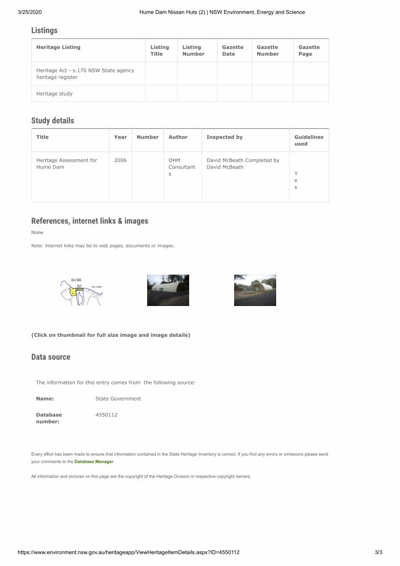
3/25/2020 Hume Dam Nissan Huts (2) | NSW Environment, Energy and Science
https://www.environment.nsw.gov.au/heritageapp/ViewHeritageItemDetails.aspx?ID=4550112 3/3
Listings
Heritage Listing ListingTitle
ListingNumber
GazetteDate
GazetteNumber
GazettePage
Heritage Act - s.170 NSW State agency heritage register
Heritage study
Study details
Title Year Number Author Inspected by Guidelinesused
Heritage Assessment for Hume Dam
2006 OHM Consultants
David McBeath Completed by David McBeath
Yes
References, internet links & imagesNone
Note: internet links may be to web pages, documents or images.
(Click on thumbnail for full size image and image details)
Data source
The information for this entry comes from the following source:
Name: State Government
Database number:
4550112
Every effort has been made to ensure that information contained in the State Heritage Inventory is correct. If you find any errors or omissions please sendyour comments to the Database Manager.
All information and pictures on this page are the copyright of the Heritage Division or respective copyright owners.
3/25/2020 Hume Dam storage, dam wall crest including structure, plaques, original winch machinery and wall embellishments | NSW Environm…
https://www.environment.nsw.gov.au/heritageapp/ViewHeritageItemDetails.aspx?ID=4550111 1/5
NSW Department of Planning, Industry and Environment
Home Topics Heritage places and items Search for heritage
Hume Dam storage, dam wall crest includingstructure, plaques, original winch machineryand wall embellishmentsItem details
Name of item: Hume Dam storage, dam wall crest including structure, plaques, original winch machinery and wall embellishments
Other name/s: Hume Weir and Pondage
Type of item: Built
Group/Collection: Utilities - Water
Category: Water Supply Reservoir/ Dam
Location: Lat: 36.20.280 Long: 147.08.052
Primary address: Murray River, Albury, NSW 2640
Local govt. area: Albury City
All addresses
Street Address Suburb/town LGA Parish County Type
Murray River Albury Albury City Primary Address
Owner/s
Organisation Name Owner Category Date Ownership Updated
State Waters State Government
Description
Designer/Maker: Three engineers of note were involved in formulating the agreement, E M de Burgh NSW, J S Detheridge
Construction years:
1920-1936
Physical description:
Hume Dam is situated on the upper Murray River below the junction of the Murray and the Mitta Mitta River. As the main operating storage of the Murray Valley, the Hume Dam provides water to meet environmental, domestic, stock and irrigation needs. In a typical year 4,000,000Ml is supplied to irrigators on the NSW and Victorian sides of the river. The regulation of the river has brought great benefit to the people of the valley and created new landscapes. Technical description. Hume Dam comprises a 51m high concrete gravity spillway and outlet works segment 318m long across the Murray River and is flanked on the northern NSW side by a 131m
3/25/2020 Hume Dam storage, dam wall crest including structure, plaques, original winch machinery and wall embellishments | NSW Environm…
https://www.environment.nsw.gov.au/heritageapp/ViewHeritageItemDetails.aspx?ID=4550111 2/5
long earthen embankment and on the southern Victorian side by a 1167m long embankment. These embankments incorporate a thin concrete core wall keyed in to the concrete dam. Two saddle embankments are located along the southern Victorian ridge system. The major length of the concrete segment is the spillway which is served by 29 x 6.1m long, 7.92m high vertical lift gates with a total discharge capacity of 7,000 cubic metres per second at full supply level. The remainder of the concrete dam length includes the irrigation outlets involving 4 x 2.74m dia. Boving fixed cone dispersion valves and hydro-electric outlets which serve twin 27.5 MW units. The combined release from these of up to 20,000 Ml / day provides the normal discharge from the dam for downstream requirements extending more than 2,000 river kilometres to South Australia. There were a number of design changes as work progressed between 1919 and 1936. From an original planned capacity of 1,357,000Ml the RMC agreed in 1924 to enlarge the reservoir to 2,467,000Ml, but due to economic conditions this was amended to 1,542,000 Ml but maintaining provision for future enlargement to 2,467,000Ml. The dam was thus completed in 1936 with the spillway operating as an ungated fixed crest. The quantity of concrete in the original dam was 440,000 cubic metres and in the earth embankments some 3,320,000 cubic metres of materials were placed. The experiences of Burrinjuck Dam, of major floods occurring during construction, far exceeding original design predictions, led to a degree of conservatism in proportioning the spillway. That conservatism of a wide spillway width has stood the dam in good stead with later revisions of design floods, such that its flood handling capacity for an early 1900's structure is not seriously deficient relative to modern standards. These early works were carried out by the Public Works Department of NSW, responsible for construction for the concrete dam and by the State Rivers and Water Supply Commission of Victoria responsible for the southern earth embankments. Hume Reservoir has a storage volume of 3,040,000Ml and a surface area at full supply level of 20,200ha. It is the main operating storage of the Murray River system and is located 16km east of Albury on the Murray River which forms the border between NSW and Victoria in that region. In the operational role of the reservoir it is complemented by Dartmouth Dam, a major storage on the Mitta Mitta arm above Hume Dam. These storages provide an assured supply of water for irrigation, domestic and industrial requirements over the 2,200km length of the Murray through to South Australia.
Modifications and dates:
Enlargement works were carried out between 1950 and 1961 increasing the storage capacity to its current level of 3,040,000ml. This involved the addition of vertical lift gates to the spillway, and drainage works and post-tensioning of the concrete to provide stability to resist the increased loading of the higher storage. Subsequently in 1985, in modernisation in strengthening of the concrete dam, additional drainage works were carried out complemented by replacement post-tensioning to meet modern and current standards at the time.
The irrigation outlets in the same period were refurbished by replacement of the 1920s vintage Larner Johnson valves by modern Howell Bunger valves.
In the 1990s, instrumentation systems monitoring the displacements of the earth embankment led to decisions by engineers to institute further corrective works on the downstream slopes of the earth dam and at its junction with the concrete dam. These works were completed in 1997. Additional works have been carried out to stabilise the northern spillway training wall by post-tensioning and refurbishment works on upstream closure gates on the irrigation and hydro outlets of the dam are currently in train.
History
Historical notes: The Murray River was first reported by the explorers Hamilton Hume and William Hovell who crossed the river on 16 November 1824 where Hume Dam now stands. The first commercial utilisation of its waters was in 1853 followed a period of prosperous river trade which played an important part in development of large areas of inland NSW, Victoria and South Australia for European settlement. Navigation however tended to be unreliable due to fluctuations in river flow from month to month and year to year and as far back as 1863 proposals to improve the River Murray system were being developed. Initially the accent was on navigation with the three colonies favoring construction of a series of weirs and locks, however about that time diversion of waters for irrigation commenced and by 1880 it was obvious that increasing diversion for irrigation would have a serious effect on navigation in the river. A succession of drought years in the 1890s culminating in a record dry year in 1902 reinforced in the minds of the people of the Murray valley, the importance of irrigation and the need for a major water storage to conserve surplus flows for release during low flow months. Stemming from the need to protect the valley from drought, parties interested in irrigation development in NSW and Victoria convened a conference in Corowa in April 1902. Recognizing the need for cooperation and involvement by the states on funding of a major
3/25/2020 Hume Dam storage, dam wall crest including structure, plaques, original winch machinery and wall embellishments | NSW Environm…
https://www.environment.nsw.gov.au/heritageapp/ViewHeritageItemDetails.aspx?ID=4550111 3/5
dam and allocation and regulation of the Murray waters , officials of the three states and the new Commonwealth government were represented. A subsequent interstate Royal Commission led to a 1911 conference of three engineers representing the states along the Murray, E M de Burgh from NSW, J S Detheridge from Victoria, and G Stewart from South Australia. These three produced a report on which the River Murray Waters Agreement was based, this was ratified by the various parliaments, and led to the creation of the River Murray Commission, with a brief of administering a scheme embracing the construction of a major storage on the upper Murray and the construction of 31 weirs and locks on the lower Murray and the Murrumbidgee. The most important work was the upper Murray storage and 27 sites were investigated above Albury, but all were found unsuitable due to the depth to bedrock of some 40m. Finally the site of Hume Dam was proven by 158 bores with hard granite found at 12m average depth across the valley. The design and the following construction of the dam involved the cooperation and joint involvement of NSW and Victoria, with the original design prepared by E M de Burgh, Chief Engineer of Public Works NSW and J S Dethridge Commissioner, State Rivers and Water Supply Commission of Victoria. Construction commenced in 1919 with the River Murray Commission keen to expedite the works with the need to provide drought protection of the developing settlements along the river and establish new settlements to provide employment for the large number of soldiers returning to Australia after World War I. All the work was carried out by day labor with 1,100 men employed in 1927. The work force was accommodated in two separate townships on either side of the river with the Department of Public Works NSW the construction authority responsible for the northern concrete dam section and the State Rivers and Water Supply Commission of Victoria responsible for the southern earth dam. Work was affected by ' the great depression ' and there were a number of design changes as the work progressed. In 1924 the RMC decided to enlarge the Reservoir from its original planned capacity of 1,357,000Ml to 2,467,000Ml and to add 3 outlets for later hydro-electric generation. In 1934 it was decided to reduce the reservoir capacity to 1,542,000Ml because of financial constraints but to provide for future enlargement. The dam was completed after 17 years and was officially opened in 1936 by the Governor General Lord Gowrie. Between 1950 and 1961 modifications were carried out to enlarge the Reservoir to its present capacity of 3,040,000Ml which enabled it to accommodate additional water from the Snowy Mountains Scheme. The works involved both enlargement and stabilizing works including the addition of 29 spillway gates, and grouting and drainage works to control uplift pressures under the concrete dam as no provision was made in the original designs for uplift pressure. Other works involved anchoring the dam to the foundations by post-tensioning cables to resist increased loading deriving from raising the water level in the storage. A 50 megawatt capacity hydro-electric power station was added to the dam and came in to service in 1957. Additional works were carried out from 1985 including the installation of load-monitorable post-tensioning cables to improve the stability of the dam and the spillway southern training wall, with the irrigation outlet valves replaced by modern control valves. Over recent years review of the behaviour of the embankment dam and its interaction with the concrete dam led to the identification of deficiencies which warranted corrective action involving construction of stabilising berms along the downstream slope of the embankment and sealing and drainage works at the junction of the embankment with the concrete dam. These works required further post-tensioning of the southern training wall to resist loadings imposed by the stabilising berm adjacent to the wall. In a continuing process of review and upgrading of the dam, further post-tensioning stabilising of the northern spillway training wall is proposed and refurbishment works are proceeding on upstream closure gates for the dam's irrigation and hydro outlets. The dam was named after the explorer Hamilton Hume. A major storage dam with a system of weirs and navigation locks along the river's length through to South Australia was discussed at a number of intercolonial conferences and after federation agreement between the states of NSW, Victoria, South Australia and the Commonwealth government was reached on allocation and regulation of the waters of the Murray and the scope of necessary works. This agreement was embodied in the Commonwealth's River Murray Waters Act of 1915 which also provided for the establishment of the River Murray Commission, now the Murray-Darling Basin Commission, to administer the scheme. Construction began on Hume Dam in 1919, and it was the government's vision that the reliable source of water would foster new settlements in the valley and bring confidence and prosperity to its population and would create 'a land fit for heroes', the veterans returning from World War I. Although overshadowed by the more spectacular engineering achievement of the 1930s, the Sydney Harbour Bridge, Hume Dam at that time ranked among the largest storage dams in the world.
Assessment of signi�cance
SHR Criteria a)[Historical significance]
The dam is significant at a local level because of its impact of the local economy, water management and agriculture. It is significant as an early example of post federation projects.
3/25/2020 Hume Dam storage, dam wall crest including structure, plaques, original winch machinery and wall embellishments | NSW Environm…
https://www.environment.nsw.gov.au/heritageapp/ViewHeritageItemDetails.aspx?ID=4550111 4/5
SHR Criteria b)[Associative significance]
Three engineers of note were involved in formulating an agreement on regulation and sharing of the River Murray waters which was adopted by the three states. The engineers were E M de Burgh, NSW, J S Detheridge, Victoria and G Stewart, South Australia. The dam marks the point at which Murray River was first reported by the explorers Hamilton Hume and William Hovell who crossed the river on 16 November 1824
SHR Criteria c)[Aesthetic significance]
The construction of the dam has had a high impact on the aesthetic values on the rural landscape and has developed a new aesthetic, which is highly valued by the local community for recreation purposes.
SHR Criteria d)[Social significance]
The dam has had a social impact on the town of Albury, Bonegilla, Talgarno and Wymah providing employment and resources that have had a positive impact on the local community. The dam provides a recreational resource for the area.
SHR Criteria e)[Research potential]
The design and engineering has significantly improved sustainable flows to the Murray River system.
Integrity/Intactness:
The Dam site has a high level of integrity as working infrastructure.
Assessment criteria:
Items are assessed against the State Heritage Register (SHR) Criteria to determine the level of significance. Refer to the Listings below for the level of statutory protection.
Recommended management:
That all crest elements be preserved including balustrades, gates, plaques and original machinery in situ. All items identified in the s170 Inventory be subject to the policies in the Heritage Assessment for Hume Dam, 2005. The operational functions of th
Listings
Heritage Listing ListingTitle
ListingNumber
GazetteDate
GazetteNumber
GazettePage
Heritage Act - s.170 NSW State agency heritage register
Heritage study
Study details
Title Year Number Author Inspected by Guidelinesused
Heritage Assessment for Hume Dam
2006 OHM Consultants
David McBeath Completed by: David McBeath
Yes
References, internet links & imagesNone
Note: internet links may be to web pages, documents or images.
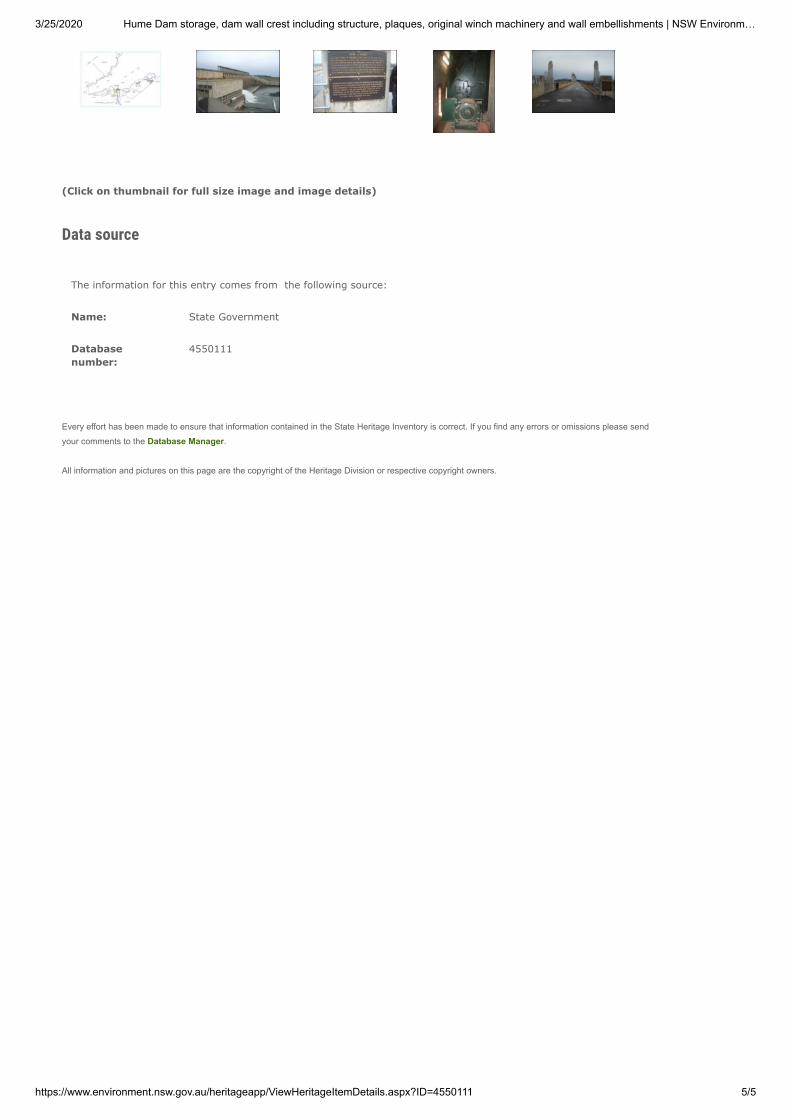
3/25/2020 Hume Dam storage, dam wall crest including structure, plaques, original winch machinery and wall embellishments | NSW Environm…
https://www.environment.nsw.gov.au/heritageapp/ViewHeritageItemDetails.aspx?ID=4550111 5/5
(Click on thumbnail for full size image and image details)
Data source
The information for this entry comes from the following source:
Name: State Government
Database number:
4550111
Every effort has been made to ensure that information contained in the State Heritage Inventory is correct. If you find any errors or omissions please sendyour comments to the Database Manager.
All information and pictures on this page are the copyright of the Heritage Division or respective copyright owners.

3/25/2020 Hume Dam Town Plan including streets, curbing, fences and street trees | NSW Environment, Energy and Science
https://www.environment.nsw.gov.au/heritageapp/ViewHeritageItemDetails.aspx?ID=4550115 1/4
NSW Department of Planning, Industry and Environment
Home Topics Heritage places and items Search for heritage
Hume Dam Town Plan including streets,curbing, fences and street treesItem details
Name of item: Hume Dam Town Plan including streets, curbing, fences and street trees
Other name/s: Hume Weir and Pondage
Type of item: Landscape
Group/Collection: Utilities - Water
Category: Other - Government & Administration
Location: Lat: 36.20.280 Long: 147.08.052
Primary address: Murray River, Albury, NSW 2640
Local govt. area: Albury City
All addresses
Street Address Suburb/town LGA Parish County Type
Murray River Albury Albury City Primary Address
Owner/s
Organisation Name Owner Category Date Ownership Updated
State Waters State Government
Statement of signi�cance:
All of the work on construction was carried out by 'day labour' and at the height of construction, more than 1100 workers were employed at the dam site housed in two separate fully serviced towns one on either side of the river. The remaining streets, curbing, fences and trees embody the size and dimension of the town that was constructed for the two main phases of construction at Hume Dam. Enlargement works were carried out between 1950 and 1961 increasing the storage capacity to its current level of 3,040,000ml. This involved the addition of vertical lift gates to the spillway, and drainage works and post-tensioning of the concrete to provide stability to resist the increased loading of the higher storage. This required many houses and workshop facilities to be constructed at Hume Dam. Many of the street curbing, roads and tree plantings exist although the houses have been removed.
Note: The State Heritage Inventory provides information about heritage items listed by local and State government agencies. The State Heritage Inventory is continually being updated by local and State agencies as new information becomes available. Read the OEH copyright and disclaimer.
3/25/2020 Hume Dam Town Plan including streets, curbing, fences and street trees | NSW Environment, Energy and Science
https://www.environment.nsw.gov.au/heritageapp/ViewHeritageItemDetails.aspx?ID=4550115 2/4
Description
Designer/Maker: The engineers were E M de Burgh, NSW, J S Detheridge, Victoria and G Stewart, South Australia.
Physical description:
Hume Dam is situated on the upper Murray River below the junction of the Murray and the Mitta Mitta River. The remaining streets are still in place on and off State Water controlled land at the Administrative/workshop precinct.
History
Historical notes: Recognizing the need for cooperation and involvement by the states on funding of a major dam and allocation and regulation of the Murray waters, officials of the three states and the new Commonwealth government were represented. A subsequent interstate Royal Commission led to a 1911 conference of three engineers representing the states along the Murray, E M de Burgh from NSW, J S Detheridge from Victoria, and G Stewart from South Australia. These three produced a report on which the River Murray Waters Agreement was based, this was ratified by the various parliaments, and led to the creation of the River Murray Commission, with a brief of administering a scheme embracing the construction of a major storage on the upper Murray and the construction of 31 weirs and locks on the lower Murray and the Murrumbidgee. Construction commenced in 1919 with the River Murray Commission keen to expedite the works with the need to provide drought protection of the developing settlements along the river and establish new settlements to provide employment for the large number of soldiers returning to Australia after World War I. All the work was carried out by day labor with 1,100 men employed in 1927. The work force was accommodated in two separate townships on either side of the river with the Department of Public Works NSW the construction authority responsible for the northern concrete dam section and the State Rivers and Water Supply Commission of Victoria responsible for the southern earth dam. Work was affected by ' the great depression ' and there were a number of design changes as the work progressed. In 1924 the RMC decided to enlarge the Reservoir from its original planned capacity of 1,357,000Ml to 2,467,000Ml and to add 3 outlets for later hydroelectric generation. In 1934 it was decided to reduce the reservoir capacity to 1,542,000Ml because of financial constraints but to provide for future enlargement. The dam was completed after 17 years and was officially opened in 1936 by the Governor General Lord Gowrie. The cost of construction was $11.1M. The dam was named after the explorer Hamilton Hume. Development in the valley from the 1850s was initially dependant on transport along the river by paddle steamers with a period of prosperous river trade playing an important part in opening up the valley. With the completion of the NSW and Victorian railways to the border river traffic rapidly declined. Fluctuations in river flow rendered navigation unreliable and then in the 1880s diversion of waters for irrigation developed, exacerbating this problem. A major storage dam with a system of weirs and navigation locks along the river's length through to South Australia was discussed at a number of intercolonial conferences and after federation agreement between the states of NSW, Victoria, South Australia and the Commonwealth government was reached on allocation and regulation of the waters of the Murray and the scope of necessary works. This agreement was embodied in the Commonwealth's River Murray Waters Act of 1915, which also provided for the establishment of the River Murray Commission, now the Murray-Darling Basin Commission, to administer the scheme. Construction began on Hume Dam in 1919, and it was the government's vision that the reliable source of water would foster new settlements in the valley and bring confidence and prosperity to its population and would create 'a land fit for heroes', the veterans returning from World War I. Although overshadowed by the more spectacular engineering achievement of the 1930s, the Sydney Harbour Bridge, Hume Dam at that time ranked among the largest storage dams in the world.
Assessment of signi�cance
SHR Criteria a)[Historical significance]
The significant town plan at Hume Dam is still intact although many of the houses have been removed.
SHR Criteria b) Three engineers of note were involved in formulating an agreement on regulation and
3/25/2020 Hume Dam Town Plan including streets, curbing, fences and street trees | NSW Environment, Energy and Science
https://www.environment.nsw.gov.au/heritageapp/ViewHeritageItemDetails.aspx?ID=4550115 3/4
[Associative significance]
sharing of the River Murray waters, which was adopted by the three states. The engineers were E M de Burgh, NSW, J S Detheridge, Victoria and G Stewart, South Australia.
SHR Criteria c)[Aesthetic significance]
The formal town plan embodied by streets, curbing, fences and street trees forms part of the aesthetic qualities when visiting Hume Dam.
Assessment criteria:
Items are assessed against the State Heritage Register (SHR) Criteria to determine the level of significance. Refer to the Listings below for the level of statutory protection.
Recommended management:
All original streets, curbing, fences and street trees be maintained in situ at Hume Dam. An oral history and interpretive program be encouraged to engage the visitor to Hume Dam to give a better understanding of the dimension of undertaking a project of the size.
Listings
Heritage Listing ListingTitle
ListingNumber
GazetteDate
GazetteNumber
GazettePage
Heritage Act - s.170 NSW State agency heritage register
Heritage study
Study details
Title Year Number Author Inspected by Guidelinesused
Heritage Assessment for Hume Dam
2006 OHM Consultants
David McBeath Completed by David McBeath
Yes
References, internet links & images
Type Author Year Title Internet Links
Written State Water 2005 Heritage Assessment for Hume Dam
Note: internet links may be to web pages, documents or images.
(Click on thumbnail for full size image and image details)

3/25/2020 Hume Dam Town Plan including streets, curbing, fences and street trees | NSW Environment, Energy and Science
https://www.environment.nsw.gov.au/heritageapp/ViewHeritageItemDetails.aspx?ID=4550115 4/4
Data source
The information for this entry comes from the following source:
Name: State Government
Database number:
4550115
Every effort has been made to ensure that information contained in the State Heritage Inventory is correct. If you find any errors or omissions please sendyour comments to the Database Manager.
All information and pictures on this page are the copyright of the Heritage Division or respective copyright owners.