Appendix B - Transform 66 · I-66 Transit/TDM Technical Report Appendix B Bus Bay, Maintenance, and...
28
Tier 2 Environmental Assessment I-66 Transit/TDM Technical Report Appendix B Bus Bay, Maintenance, and Storage Capacity Analysis Technical Memorandum DRAFT – MAY 2015
Transcript of Appendix B - Transform 66 · I-66 Transit/TDM Technical Report Appendix B Bus Bay, Maintenance, and...

Tier 2 Environmental Assessment I-66 Transit/TDM Technical Report
Appendix B
Bus Bay, Maintenance, and Storage Capacity Analysis Technical Memorandum
DRAFT – MAY 2015

I-66 Corridor Improvements Project – Transit/TDM Technical Report – Appendix B May 2015 Bus Bay, Maintenance, and Storage Capacity Technical Memorandum
Transform 66 Outside the Beltway 1 MEMORANDUM
INTRODUCTION
This technical memorandum assesses the operational constraints of bus transfer facilities at Metrorail and
transit stations that could be served by I-66 corridor bus service, as well as the capacity and constraints
of bus maintenance facilities on the I-66 corridor. This level of analysis will assist in understanding
potential operational constraints with implementing the I-66 transit service recommendations. The
analysis covers 11 Metrorail stations (eight in Fairfax County and three in Arlington County), one Transit
Station in Fairfax County, and two bus maintenance facilities, one in Fairfax County and one in Prince
William County.
Metrorail and Transit Station Area Bus Bay Capacities
Throughout the study area, bus transit providers provide connections to the Metrorail system. The
capacity and current utilization of the existing bus bays at Metrorail stations impacts bus transit service
planning in the area. These services must be considered in the study, as capacity is limited and station
expansion is not possible in most cases. Table B.1 shows the theoretical maximum number of vehicles
each Metrorail and transit station can accommodate based on the number of existing bus bays and on-
street stops; the calculations must be supplemented with field studies and input from the operators for a
true assessment of capacity. Using the Washington Metropolitan Area Transit Authority’s (WMATA’s)
standards, low maximum capacity for a single bus bay is no more than six vehicles per hour and high
maximum capacity is no more than 12 vehicles per hour.1 Routes that terminate at the transfer facility
were double counted as a proxy for the additional time a vehicle might stay as part of its layover time.
Based on the number and frequency of routes serving the stations, the utilization rate was determined for
peak and midday periods. Using the low capacity standards, seven of the 12 stations included in this
study are above capacity and another two are over 80 percent utilized. Using the high capacity standards,
however, Ballston is the only station above capacity, and Greensboro is the only station above 80
percent. These two stations are above capacity at midday.2
1 WMATA’s standards for bus bay capacity vary from six to 12 buses per hour depending on the type of bus service and the facility type. 2 For midday capacity only low capacity standards were assumed.

I-66 Corridor Improvements Project – Transit/TDM Technical Report – Appendix B May 2015 Bus Bay, Maintenance, and Storage Capacity Technical Memorandum
Transform 66 Outside the Beltway 2 MEMORANDUM
Table B.1: Current Bus Capacity and Utilization Rates at Metrorail Stations within the
Study Corridor and at Potential I-66 Transit Service Destinations
Metrorail/Transit Station Metro Line Number of Bus Bays
Number of On-Street Stops
Current Number of Bus Trips per
Hour
Max Vehicle Capacity Per Hour
Peak Capacity Utilized Midday
Capacity Utilized3 End of
Line4 Through Routes
Low5 High6 Low High
Rosslyn Orange Line,
Blue Line, Silver Line
- 5 18 26 30 60 147% 73% 70%
Ballston Orange Line,
Silver Line 77 - 22 67 42 84 212% 106% 119%
East Falls Church Orange Line,
Silver Line 4 - 17 10 24 48 113% 56% 43%
West Falls Church Orange Line 15 - 24 0 90 180 27% 13% 9%
Dunn Loring/Merrifield Orange Line 8 - 9 27 48 96 75% 38% 44%
Vienna/Fairfax-GMU Orange Line 15 - 15 59 90 180 82% 41% 11%
McLean Silver Line 6 - 14 16 36 72 83% 42% 25%
Tysons Corner Silver Line 6 - 13 39 36 72 144% 72% 32%
Tysons West*Park8 - 10 - 11 5 60 120 27% 13% 25%
Greensboro Silver Line - 1 0 10 6 12 167% 83% 120%
Spring Hill Silver Line 5 - 11 27 30 60 127% 63% 25%
Wiehle-Reston East Silver Line 14 1 39 74 90 180 126% 63% 32%
3 Calculated using low capacity standards of 6 buses per bay per hour. 4 This column double counts trips as a proxy for the extra time needed for routes that end at the facility to offload, layover, and board passengers for the return trip. Without accounting for this additional time, the layover space would need to be accommodated off-site. 5 Low capacity standard of six buses per bay, per hour. 6 High capacity standard of 12 buses per bay, per hour. 7 Ballston has eight bays; however, only seven are used for boarding and alighting while the eighth is used for layover. 8 These numbers reflect Fairfax Connector route changes effective May 16, 2015.

I-66 Corridor Improvements Project – Transit/TDM Technical Report – Appendix B May 2015 Bus Bay, Maintenance, and Storage Capacity Technical Memorandum
Transform 66 Outside the Beltway 3 MEMORANDUM
The following sections describe the facilities available at each Metrorail or transit station considered as a
transfer point for I-66 bus service. In addition to the utilization levels as reported in Table B.1, actual
utilization rates based on field observations by WMATA and other jurisdictional staff are reported.
Rosslyn Metrorail Station
The Rosslyn Metrorail station is located on N. Moore Street between Wilson Boulevard and N. Fort Myer
Drive in Arlington, Virginia. The station is underground and has two entrances. The station’s east
entrance is on the west side of N. Moore Street between Wilson Boulevard and 19th Street. The station’s
west entrance is on the east side of Fort Myer Drive between Wilson Boulevard and 19th Street. The
station does not have park-and-ride nor kiss-and-ride facilities.
Due to its urban location the Rosslyn Metrorail station does not have a separate bus facility. Instead there
are five on-street, saw-tooth bus bays on the west side of N. Moore Street, adjacent to the east Metrorail
station entrance. Buses can access the stops traveling southbound on N. Moore Street (Figure B.1).
Six WMATA routes and one Arlington County Transit route serve the station. Additionally, the DC
Circulator, Georgetown University Transit Service, and a number of federal and private shuttles have
stops along N. Moore Street.9 During one peak hour, approximately 44 buses arrive and depart from the
five on-street bus stops.
Low- and high-capacity standards were used to assess current bus stop capacity at the Rosslyn Metrorail
station. Based on low-capacity standards of six buses per hour, per bay, the station is at 147 percent
capacity. Based on high-capacity standards of 12 buses per hour, per bay, the station is at 73 percent
capacity.
According to the Rosslyn Multi-Modal Transportation Study (September 2012), all of the bus bays along
N. Moore Street are heavily used during peak periods. The constrained bus bay capacity limits
opportunities for significant increases in existing service or new bus routes. Buses currently are unable to
use large portions of Fort Myer Drive or N. Lynn Street for passenger pick-up due to the one-way travel
direction, space constraints imposed by the Fort Myer Drive tunnel walls and barriers, and the lack of an
ADA-accessible connection to the Rosslyn Metrorail station. Other nearby streets, including Wilson
Boulevard and 19th Street, are generally too steep for safe bus boarding and unloading. As a result of all
of these constraints, serving Rosslyn with I-66 bus service was eliminated from consideration before any
transit service scenarios were developed.
9 These services were not included in the capacity calculation.

I-66 Corridor Improvements Project – Transit/TDM Technical Report – Appendix B May 2015 Bus Bay, Maintenance, and Storage Capacity Technical Memorandum
Transform 66 Outside the Beltway 4 MEMORANDUM
Figure B.1: Rosslyn Station
Note: Letters correspond to bus bays. Source: www.wmata.com

I-66 Corridor Improvements Project – Transit/TDM Technical Report – Appendix B May 2015 Bus Bay, Maintenance, and Storage Capacity Technical Memorandum
Transform 66 Outside the Beltway 5 MEMORANDUM
Ballston Metrorail Station
The Ballston Metrorail station is located on Fairfax Drive between N. Stuart Street and N. Stafford Street
in Arlington, Virginia. The station serves the Metrorail Orange and Silver Lines. The station is
underground, and the entrance is located at the corner of N. Stuart Street and N. Fairfax Drive. The
station has neither a park-and-ride nor a kiss-and-ride facility.
The Ballston Metrorail station does not have a separate bus facility, due to its urban location. Instead, bus
bays are located outside the station’s entrance along N. Stuart Street, N. Fairfax Drive, and N. Stafford
Street. On N. Stuart Street there are four saw-tooth bays on the eastern side of the street; however, one
of the bays is currently used for layovers. On N. Fairfax Drive, there are three bays, which buses can
access from westbound Fairfax Drive in an off-street, bus-only pull-in curb zone. Buses currently use the
curb between Fairfax Drive and the pull-in zone for layovers. On N. Stafford Street, there is one bus bay,
which is located on the west side of the street (Figure B.2).
Fourteen WMATA routes, six Arlington County Transit Routes, and one PRTC route serve the Ballston
Metrorail Station. During one peak hour, approximately 89 buses arrive and depart from the seven bays.
Low- and high-capacity standards were used to assess current bus stop capacity at the Ballston Metrorail
station. Based on low-capacity standards of 6 buses per hour, per bay, the station is at 212 percent
capacity. Based on high-capacity standards of 12 buses per hour, per bay, the station is at 106 percent
capacity. Observations by Arlington County staff indicated that, as currently configured, the station cannot
accommodate additional service.
The Ballston Station Multimodal Study (April 2013) evaluated the station’s existing operation of the bus
bays. Although the bus facilities are generally congested, the study revealed existing infrastructure has
the capacity to accommodate the station’s current demand.10 The study estimated a 20 percent growth in
public bus service from 2010 to 2020, and 29 percent growth from 2010 to 2030 at the Ballston Metrorail
station.11 In order to provide additional capacity and relieve congestion, the study suggested scheduling
optimization and using Bus Bay A for passenger loading instead of just layover. The addition of a revenue
bus bay would change the low capacity standard to 185 percent, and the high capacity standard to 93
percent. The study developed three concept-level alternatives to improve the transportation facilities and
public space at the Ballston Metrorail station:
Alternative 1. Alternative 1 would maintain the existing curb lines and core bus bay layout but
convert Bus Bay A from a layover to a revenue service bay. This alternative would also include a
provision for public bus layover space within the area.
Alternative 2. Alternative 2 would include some operational changes and expand the east
sidewalk along N. Stuart Street but maintain the four saw-toothed bus bays on N. Stuart Street.
This alternative would also would fill in the existing off-street bus stops in the bus-only pull-in curb
zone on Fairfax Drive to create a larger public space and replace the existing bus stops in the
pull-in curb zone with saw-toothed bus bays.
Alternative 3. Alternative 3 recommends operational changes and installing four saw-toothed bus
bays on the west curb of N. Stuart Street. The bus bays on Fairfax Drive would be converted into
layover space. The section of N. Stuart Street between Fairfax Drive and 9th Street N would be
10 The study was conducted in 2010 and assumed 45 buses per peak hour at the station. 11 The study notes serious limitations in the data and recommends using these numbers as an order-of-magnitude-level.

I-66 Corridor Improvements Project – Transit/TDM Technical Report – Appendix B May 2015 Bus Bay, Maintenance, and Storage Capacity Technical Memorandum
Transform 66 Outside the Beltway 6 MEMORANDUM
converted into a two-way, bus-only roadway with saw-toothed bus bays and 12-foot through lanes
in each direction.
Figure B.2: Ballston Station12
Note: Letters correspond to bus bays.Source: www.wmata.com
12 Bus Bay A is actually located on the eastern side of North Stuart Street, directly south of Bus Bay B. Bus Bay A is a saw-tooth bay but is only used for bus layover. On-street stops B and C were not included in this analysis due to the distance from the Metrorail station.

I-66 Corridor Improvements Project – Transit/TDM Technical Report – Appendix B May 2015 Bus Bay, Maintenance, and Storage Capacity Technical Memorandum
Transform 66 Outside the Beltway 7 MEMORANDUM
East Falls Church Metrorail Station
The East Falls Church Metrorail station is located in the median of I-66 in Arlington, Virginia. The station
serves the Metrorail Orange and Silver Lines, and is the system’s westernmost transfer point between the
Orange and Silver Lines. The pedestrian station entrance is on N. Sycamore Street, underneath the I-66
overpass. The station has a surface parking lot adjacent to the bus loop, which is north of I-66 and the
station entrance.
The bus facility consists of a loop with four saw-toothed bus bays, two on each side of the outer loop and
four layover locations on the center island (Figure B.3). Buses enter the loop from southbound N.
Sycamore Street, and exit onto southbound N. Sycamore Street.
Six WMATA routes and two Arlington County Transit (ART) routes serve the station. During the peak
period, a maximum of 27 buses arrive and depart from the four bays in an hour.
Low- and high-capacity standards were used to assess current bus stop capacity at the East Falls Church
Metrorail Station. Based on the low-capacity standards of six buses per hour, per bay, the station is at
113 percent capacity. Based on the high-capacity standards of 12 buses per hour, per bay, the station is
at 56 percent capacity. Due to the availability of four layover locations, it is expected that any route laying
over more than 10 minutes would be able to use the center island; therefore, the high range standards
are more applicable to this facility.
The East Falls Church Metrorail Station Bus Facility Study (2015) evaluated the operational capacity of
the bus facility. The study found that under existing conditions three of the four bus bays could
accommodate an additional route, while the fourth bus bay was at capacity. In order to accommodate
future route expansions from WMATA and ART, the study developed three alternatives to improve the
bus facilities at the East Fall Church Metrorail station:
No Build. The No Build option would include minor Americans with Disabilities Act (ADA) and
pedestrian walkway improvements to enhance accessibility to the station, but maintain the
existing bus facility layout. It would include a reassignment of the routes in the existing four bus
bays to allow for expansion of transit services in the future.
Alternative 1. Alternative 1 would expand the bus facility by one additional bus bay. This
alternative would maintain the existing bus facility entrances but add the additional bay on the
southern side of the bus loop. This will require adding a shelter, shifting the other two existing
bays on the southern edge to the east and relocating the existing bike lockers. Applying the high-
capacity standards to this expansion, the facility with its existing services would have a peak
utilization rate of 45 percent.
Alternative 2. Alternative 2 will expand the bus facility by two additional bus bays. This
alternative will shift the main entrance to the existing parking lot entrance off of N. Sycamore St.
and add the bays on the western and southern edges of the bus loop. This will require adding two
additional shelters, shifting the other two existing bays on the southern edge to the east and
relocating the bike lockers. Applying the high-capacity standards to this expansion, the facility
with its existing services would have a peak utilization rate of 38 percent.

I-66 Corridor Improvements Project – Transit/TDM Technical Report – Appendix B May 2015 Bus Bay, Maintenance, and Storage Capacity Technical Memorandum
Transform 66 Outside the Beltway 8 MEMORANDUM
Figure B.3: East Falls Church Metrorail Station
Note: Letters correspond to bus bays Source: www.wmata.com

I-66 Corridor Improvements Project – Transit/TDM Technical Report – Appendix B May 2015 Bus Bay, Maintenance, and Storage Capacity Technical Memorandum
Transform 66 Outside the Beltway 9 MEMORANDUM
West Falls Church-VT/UVA Metrorail Station
The West Falls Church-VT/UVA Metrorail station is located in the median of I-66, west of the Dulles Toll
Road, in Idylwood, Virginia. The station serves the Metrorail Orange Line and has two entrances. The
South Entrance is located south of I-66 and provides connections to the station’s mezzanine and platform
via a pedestrian bridge across the Dulles Toll Road. The North Entrance is located in the median of I-66
and has an underpass road connecting it to Dulles Toll Road. The West Falls Church–VT/UVA Metrorail
station has a surface parking lot and a kiss-and-ride facility at the south entrance.
At the North Entrance, there are nine saw-tooth bus bays. The facility consists of a loop with five bays on
the outer-loop of the south side, and four bays on the outer-loop of the north side. The middle of the loop
has space for bus layover. The buses can only enter and exit the bays from the Dulles Toll Road. At the
South Entrance, there are six bus bays. The facility consists of a loop with four bays on the outer-loop of
the east side, and two bays on the outer-loop of the west side. The kiss-and-ride facility is in the center of
the Southside bus loop. Buses enter and exit the Southside facility from Haycock Road (Figure B.4).
Three WMATA routes, two Fairfax Connector Route, and the Washington Flyer Dulles Airport serve the
Metrorail Station. As of the Silver Line opening, Loudoun County Transit no longer operates commuter
buses from the West Falls Church Station. During one peak hour, approximately 24 buses arrive and
depart from the 15 bays.
Low- and high-capacity standards were used to assess current bus stop capacity at the West Falls
Church–VT/UVA Metrorail Station. Based on low-capacity standards of 6 buses per hour, per bay, the
station is at 27 percent capacity. Based on high-capacity standards of 12 buses per hour, per bay, the
station is at 13 percent capacity.
WMATA staff indicated that there is ample capacity on the north side bays, but these can only be
accessed via a ramp from the Dulles Toll Road. A ramp connecting I-66 to the north side would be
required to access these bays from I-66. Bus Bay A on the south side is currently unassigned and
available.

I-66 Corridor Improvements Project – Transit/TDM Technical Report – Appendix B May 2015 Bus Bay, Maintenance, and Storage Capacity Technical Memorandum
Transform 66 Outside the Beltway 10 MEMORANDUM
Figure B.4: West Falls Church Metrorail Station
Note: Letters correspond to bus bays Source: www.wmata.com
I-66 Corridor Improvements Project – Transit/TDM Technical Report – Appendix B May 2015 Bus Bay, Maintenance, and Storage Capacity Technical Memorandum
Transform 66 Outside the Beltway 11 MEMORANDUM
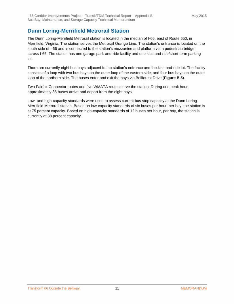
Dunn Loring-Merrifield Metrorail Station
The Dunn Loring-Merrifield Metrorail station is located in the median of I-66, east of Route 650, in
Merrifield, Virginia. The station serves the Metrorail Orange Line. The station’s entrance is located on the
south side of I-66 and is connected to the station’s mezzanine and platform via a pedestrian bridge
across I-66. The station has one garage park-and-ride facility and one kiss-and-ride/short-term parking
lot.
There are currently eight bus bays adjacent to the station’s entrance and the kiss-and-ride lot. The facility
consists of a loop with two bus bays on the outer loop of the eastern side, and four bus bays on the outer
loop of the northern side. The buses enter and exit the bays via Bellforest Drive (Figure B.5).
Two Fairfax Connector routes and five WMATA routes serve the station. During one peak hour,
approximately 36 buses arrive and depart from the eight bays.
Low- and high-capacity standards were used to assess current bus stop capacity at the Dunn Loring-
Merrifield Metrorail station. Based on low-capacity standards of six buses per hour, per bay, the station is
at 75 percent capacity. Based on high-capacity standards of 12 buses per hour, per bay, the station is
currently at 38 percent capacity.

I-66 Corridor Improvements Project – Transit/TDM Technical Report – Appendix B May 2015 Bus Bay, Maintenance, and Storage Capacity Technical Memorandum
Transform 66 Outside the Beltway 12 MEMORANDUM
Figure B.5: Dunn Loring-Merrifield Metrorail Station
Source: www.wmata.com Effective December 14, 2014
Source: www.wmata.com Effective April 27, 2015 – May 30,
2015

I-66 Corridor Improvements Project – Transit/TDM Technical Report – Appendix B May 2015 Bus Bay, Maintenance, and Storage Capacity Technical Memorandum
Transform 66 Outside the Beltway 13 MEMORANDUM
Vienna/Fairfax-GMU Metrorail Station
The Vienna/Fairfax-GMU Metrorail station is located in the median of I-66 in Oakton, Virginia. The station
is the western terminus for the Metrorail Orange Line. The station has entrances on both sides of I-66 and
provides connections to the station’s mezzanine and platform via a pedestrian bridge across I-66. The
Vienna Metrorail station has a parking garage, a surface parking lot, and a kiss-and-ride facility at both
entrances.
At the North Entrance, there are six saw-tooth bus bays. The facility consists of a loop with two bays each
on the outer-loops of the southern, eastern, and western side. The middle of the loop is a surface parking
lot. The buses enter and exit the bays via Virginia Center Boulevard. This entrance is also for cars
entering the parking lot in the middle of the loop. However, the buses have a designated lane around the
loop. At the South Entrance, there are nine bus bays. The facility is a parallel, closed bus bay with a
tapered exit and entrance from Saintsbury Drive (Figure B.6).
Fifteen Fairfax Connector routes, four CUE routes, and three WMATA routes serve the station. During
one peak hour, approximately 74 buses arrive and depart from the 15 bays.
Low- and high-capacity standards were used to assess current bus stop capacity at the Vienna/Fairfax-
GMU Metrorail station. Based on low-capacity standards of six buses per hour, per bay, the station is at
82 percent capacity. Based on high-capacity standards of 12 buses per hour, per bay, the station is
currently at 41 percent capacity.
WMATA staff have indicated that coordination between the providers that serve the station needs to
occur to determine the availability of the bays.13 In the future, however, Vienna will not be accessible from
the I-66 Express Lanes, which makes it difficult to provide direct and efficient service to the station. The
station also only serves the Orange Line, which makes it less desirable for passengers looking for
connections to Tysons.
13 Providers currently serving the Vienna bus bays are WMATA, Fairfax Connector, the City of Fairfax CUE, and the DC2NY Tourist Bus.

I-66 Corridor Improvements Project – Transit/TDM Technical Report – Appendix B May 2015 Bus Bay, Maintenance, and Storage Capacity Technical Memorandum
Transform 66 Outside the Beltway 14 MEMORANDUM
Figure B.6: Vienna Metrorail Station
Note: Letters correspond to bus bays Source: www.wmata.com

I-66 Corridor Improvements Project – Transit/TDM Technical Report – Appendix B May 2015 Bus Bay, Maintenance, and Storage Capacity Technical Memorandum
Transform 66 Outside the Beltway 15 MEMORANDUM
McLean Metrorail Station
The McLean Metrorail station is located on the westbound side of Route 123, east of I-495 and west of
the Dulles Toll Road, in Tysons Corner, Virginia. The station is served by the Metrorail Silver Line. The
station has entrances on each side of Route 123. The North Entrance is on the westbound side of Route
123, just west of the intersection with Scotts Crossing Road. The South Entrance is located on the
eastbound side of Route 123, and provides connections to the mezzanine and platform levels via a
pedestrian bridge over Route 123. A kiss-and-ride is located adjacent to the South Entrance, which is
accessible from Colshire Meadow Drive. There is no park-and-ride facility at McLean Metrorail station.
At the North Entrance, there are two bus bays. The bus facility is a closed, parallel bus bay, with two
tapered ends. Buses enter the bays from westbound Route 123, and exit into traffic on westbound Route
123. At the South Entrance, buses enter and exit the bus loop with three bays from Colshire Meadow
Drive. The kiss-and-ride facility is the middle of the bus loop. There is also one on-street bus bay, located
on the eastbound side of Route 123 (Figure B.7).
Three Fairfax Connector routes and two WMATA routes serve the station. During one peak hour,
approximately 30 buses arrive and depart from the six bays.
Low- and high-capacity standards were used to assess current bus stop capacity at the McLean Metrorail
station. Based on low-capacity standards of six buses per hour per bay, the station is at 83 percent
capacity. Based on high-capacity standards of 12 buses per hour per bay, the station is currently at 42
percent capacity. Based on field observations, WMATA and Fairfax Connector staff have indicated that
there is no available capacity at this station.

I-66 Corridor Improvements Project – Transit/TDM Technical Report – Appendix B May 2015 Bus Bay, Maintenance, and Storage Capacity Technical Memorandum
Transform 66 Outside the Beltway 16 MEMORANDUM
Figure B.7: McLean Metrorail Station
Note: Letters correspond to bus bays Source: www.wmata.com

I-66 Corridor Improvements Project – Transit/TDM Technical Report – Appendix B May 2015 Bus Bay, Maintenance, and Storage Capacity Technical Memorandum
Transform 66 Outside the Beltway 17 MEMORANDUM
Tysons Corner Metrorail Station
The Tysons Corner Metrorail station is located at the intersection of Route 123 and Tysons Boulevard,
west of I-495, in McLean, Virginia. The station is served by the Metrorail Silver Line and has entrances on
both sides of Route 123. The South Entrance is located on the eastbound side of Route 123 and provides
connection to the platform and mezzanine levels via a pedestrian bridge over Route 123. There is no
kiss-and-ride facility at the Tysons Corner station.
At the North Entrance, there are three bus bays. The bus-only entrance is located on southbound Tysons
Boulevard, on the far side of the Tysons Corner Boulevard and Galleria Drive intersection. The facility
consists of three bays within the restricted bus-only area. Buses exit the bays with access onto
westbound Route 123.
At the South Entrance, there are also three bus bays. The bus-only entrance is located on eastbound
Route 123. The facility consists of three bays within the restricted bus-only area. Buses exit the bay area
on Tysons Boulevard (Figure B.8).
Two PRTC routes, four WMATA routes, and five Fairfax Connector routes serve the station. During one
peak hour, approximately 52 buses arrive and depart from the six bays.
Low- and high-capacity standards were used to assess current bus stop capacity at the Tysons Corner
Metrorail station. Based on low-capacity standards of six buses per hour, per bay, the station is at 144
percent capacity. Based on high-capacity standards of 12 buses per hour, per bay, the station is currently
at 72 percent capacity. Based on field observations, WMATA and Fairfax Connector staff have indicated
that there is no available capacity at this station.

I-66 Corridor Improvements Project – Transit/TDM Technical Report – Appendix B May 2015 Bus Bay, Maintenance, and Storage Capacity Technical Memorandum
Transform 66 Outside the Beltway 18 MEMORANDUM
Figure B.8: Tysons Corner Metrorail Station
Note: Letters correspond to bus bays Source: www.wmata.com

I-66 Corridor Improvements Project – Transit/TDM Technical Report – Appendix B May 2015 Bus Bay, Maintenance, and Storage Capacity Technical Memorandum
Transform 66 Outside the Beltway 19 MEMORANDUM
Tysons West Park Transit Station
The Tysons West*Park Transit Station is located at the intersection of Jones Branch and International
Drives, just south of the Dulles Toll Road in McLean, Virginia. The bus station provides no Metrorail
access and is maintained and operated by Fairfax County. Buses can access the station from Jones
Branch Road, and from the on-ramp to the Dulles Toll Road. The Tysons West*Park Transit Station has a
kiss-and-ride facility adjacent to the bus bays, but does not have a park-and-ride facility.
The facility consists of a loop with five saw-tooth bus bays on the inner-loop of the southern side, and five
saw-tooth bays on the inner-loop of the northern side (Figure B.9).
Four Fairfax Connector Routes serve the station. During one peak hour, approximately 16 buses arrive
and depart from the 10 bays.
Low- and high-range capacity standards were used to assess current bus stop capacity at the Tysons
West*Park Transit Station. Based on low-capacity standards of six buses per hour, per bay, the station is
at 27 percent capacity. Based on high-capacity standards of 12 buses per hour, per bay, the station is
currently at 13 percent capacity.

I-66 Corridor Improvements Project – Transit/TDM Technical Report – Appendix B May 2015 Bus Bay, Maintenance, and Storage Capacity Technical Memorandum
Transform 66 Outside the Beltway 20 MEMORANDUM
Figure B.9: Tysons West*Park Transit Station
Source: www.fairfaxcounty.gov

I-66 Corridor Improvements Project – Transit/TDM Technical Report – Appendix B May 2015 Bus Bay, Maintenance, and Storage Capacity Technical Memorandum
Transform 66 Outside the Beltway 21 MEMORANDUM
Greensboro Metrorail Station
The Greensboro Metrorail station is located in the median of Route 7, just north of Route 123 in Tysons
Corner, Virginia. The station is served by the Metrorail Silver Line. The station has entrances on each
side of Route 7 and provides connections to the mezzanine and platform levels via a pedestrian bridge
across Route 7. The Greensboro Metrorail station has no formal parking, but passengers have access to
the retail parking lots adjacent to the station’s East and West Entrances. There is no kiss-and-ride facility
at the Greensboro Metrorail station.
There is currently one on-street bus stop, located on the northbound side of Route 7, approximately 300
feet north of the station’s east entrance (Figure B.10). The stop is only served by Fairfax Connector
Route 422, which originates and terminates at the Greensboro Metrorail Station. During one peak hour,
approximately 10 buses arrive and depart from this stop.
Low- and high-capacity standards were used to assess current bus stop capacity at the Greensboro
Metrorail Station. Based on low-capacity standards of six buses per hour, per bay, the station is at 167
percent capacity. Based on high-capacity standards of 12 buses per hour, per bay, the station is currently
at 83 percent capacity. Based on field observations, WMATA and Fairfax Connector staff have indicated
that there is no available capacity at this stop.

I-66 Corridor Improvements Project – Transit/TDM Technical Report – Appendix B May 2015 Bus Bay, Maintenance, and Storage Capacity Technical Memorandum
Transform 66 Outside the Beltway 22 MEMORANDUM
Figure B.10: Greensboro Metrorail Station
Note: Letters correspond to bus bays Source: www.wmata.com

I-66 Corridor Improvements Project – Transit/TDM Technical Report – Appendix B May 2015 Bus Bay, Maintenance, and Storage Capacity Technical Memorandum
Transform 66 Outside the Beltway 23 MEMORANDUM
Spring Hill Metrorail Station
The Spring Hill Metrorail station is located in the median of Route 7, just west of Spring Hill Road in
Tysons Corner, Virginia. The station is served by the Metrorail Silver Line. The station has entrances on
both sides of Route 7 and provides connections to the mezzanine and platform levels via a pedestrian
bridge across Route 7. There is a kiss-and-ride facility adjacent to the East Entrance.
There are currently five bus bays, located on the northbound side of Route 7, less than one hundred feet
north of the station’s East Entrance (Figure B.11). The bus bay facility is an open and parallel design.
Buses access the bays from northbound Route 7 on a tapered lane. Buses can exit the bays by either
pulling out into traffic or continuing to the end of the bus bay facility, which becomes a traffic lane.
Five Fairfax Connector routes, and one Loudoun County Transit route serve the station. During one peak
hour, approximately 38 buses arrive and depart from the five bays.
Low- and high-capacity standards were used to assess current bus stop capacity at the Spring Hill
Metrorail station. Based on low-capacity standards of six buses per hour, per bay, the station is at 127
percent capacity. Based on high-capacity standards of 12 buses per hour, per bay, the station is currently
at 63 percent capacity. Based on field observations, WMATA and Fairfax Connector staff have indicated
that there is no available capacity at this stop.

I-66 Corridor Improvements Project – Transit/TDM Technical Report – Appendix B May 2015 Bus Bay, Maintenance, and Storage Capacity Technical Memorandum
Transform 66 Outside the Beltway 24 MEMORANDUM
Figure B.11: Spring Hill Metrorail Station
Note: Letters correspond to bus bays Source: www.wmata.com

I-66 Corridor Improvements Project – Transit/TDM Technical Report – Appendix B May 2015 Bus Bay, Maintenance, and Storage Capacity Technical Memorandum
Transform 66 Outside the Beltway 25 MEMORANDUM
Wiehle-Reston East Metrorail Station
The Wiehle-Reston East Metrorail station is located in the median of the Dulles Toll Road in Reston,
Virginia. The station is the western terminus for the Metrorail Silver Line until Phase 2 is completed, which
will extend the line to Loudoun County (projected opening 2018). The station has entrances on both sides
of the Dulles Toll Road, and provides connections to the mezzanine and platform levels via a pedestrian
bridge across the Dulles Toll Road. There is a kiss-and-ride and a park-and-ride facility in a garage above
the North Entrance.
At the North Entrance, there are 10 bus bays in the covered garage. The bus-only entrance and exit to
the garage is located on Reston Station Boulevard. The facility consists of a loop with five bays on the
outer loop of the southern side and five bays on the outer loop of the northern side; one of these 10 bays
is currently used for layover. There is also one on-street bus bay, located on the southbound side of
Wiehle Avenue. There are three designated layover bays on the north side of Wiehle-Reston East
Metrorail station, one of which is in the bus loop. At the South Entrance, there are five saw-tooth bus bays
located on the Dulles Toll Road’s eastbound off-ramp to Wiehle Avenue (Figure B.12).
Twenty-four Fairfax Connector routes, one Loudoun County Transit route, and one Washington Flyer
route serve the station. During one peak hour, approximately 113 buses arrive and depart from the 15
bays.
Low- and high-capacity standards were used to assess current bus stop capacity at the Wiehle-Reston
East Church Metrorail station. Based on low-capacity standards of six buses per hour, per bay, the station
is at 126 percent capacity. Based on high-capacity standards of 12 buses per hour, per bay, the station is
currently at 63 percent capacity.
While Fairfax Connector staff have noted that all bus bays at Wiehle-Reston East are at capacity now
during peak periods, with some off-peak capacity both the north and south side bays, additional capacity
will be available upon completion of the Silver Line Phase II, as a number of routes are cut back to the
west. They note that in addition to the bus bay capacity constraints, traffic queuing on Reston Station
Boulevard on the north side of the station and congested local traffic along westbound Sunrise Valley
Drive on the south side have limited the ability of buses to serve the station in a timely manner.

I-66 Corridor Improvements Project – Transit/TDM Technical Report – Appendix B May 2015 Bus Bay, Maintenance, and Storage Capacity Technical Memorandum
Transform 66 Outside the Beltway 26 MEMORANDUM
Figure B.12: Wiehle-Reston East Metrorail Station
Note: Letters correspond to bus bays Source: www.fairfaxcounty.gov/connector

I-66 Corridor Improvements Project – Transit/TDM Technical Report – Appendix B May 2015 Bus Bay, Maintenance, and Storage Capacity Technical Memorandum
Transform 66 Outside the Beltway 27 MEMORANDUM
BUS MAINTENANCE/STORAGE FACILITIES
West Ox Facility (Fairfax County)
The West Ox Bus Maintenance Facility is located at 4620 West Ox Road in Fairfax, Virginia. The facility is
operated by Fairfax County and is utilized by Fairfax Connector and Metrobus. The facility currently has
capacity for 175 buses based on parking availability and maintenance bay capacity and currently houses
175 buses, 100 Fairfax Connector and 75 Metrobus. The county has a currently unfunded plan to expand
the facility to 275 bus spaces. The additional 100 spaces are not currently assigned and are available for
the proposed Fairfax Transit Development Plan (TDP) recommendations. The future needs for the garage
(and therefore availability for I-66 buses) have not been determined; these needs depend on the
finalization of the Fairfax TDP (currently underway) to determine the anticipated fleet growth as well as
possible reallocation of some Metrobuses to a new facility being constructed near the Huntington
Metrorail station.
Western Bus Facility (PRTC)
The Western Bus Facility is currently under construction by PRTC and is expected to be completed in
2017. It is located near the intersection of Prince William County Parkway and I-66. The facility will have
capacity for 84 buses based on parking availability and maintenance bay capacity. PRTC plans to utilize
35 of those spaces with existing and planned fleet, leaving 49 spaces available to potentially be utilized
by I-66 bus service.