

Appendix B - Planning Report - EPA Tasmania Mines Tasmania, Reniso… · Appendix A - (Certificate...
42
Appendix B - Planning Report
Transcript of Appendix B - Planning Report - EPA Tasmania Mines Tasmania, Reniso… · Appendix A - (Certificate...

Appendix B - Planning Report
Bluestone Mines Tasmania JV Pty Ltd D Dam Tailings Storage Facility
Development Application Submission
April 2014
GHD | Report for Bluestone Mines Tasmania JV Pty Ltd - D Dam Tailings Storage Facility, 32/16878 | i
Table of contents 1. Introduction..................................................................................................................................... 1
1.1 Purpose of Report ................................................................................................................ 1
1.2 Statutory Status ................................................................................................................... 1
1.3 Relationship to DPEMP ....................................................................................................... 2
2. Project Background ........................................................................................................................ 3
2.1 Proposal Overview ............................................................................................................... 3
2.2 Location ............................................................................................................................... 3
3. Planning Controls & Policies .......................................................................................................... 6 3.1 Statutory Reference ............................................................................................................. 6
3.2 Zoning and Use .................................................................................................................... 6
3.3 Status of Proposal ................................................................................................................ 8
4. Planning Assessment ..................................................................................................................... 9
4.1 Environmental Management Zone ....................................................................................... 9 4.2 Clearing and Conversion of Vegetation Code – Schedule E3 ........................................... 17
4.3 Change in Ground Level Code – Schedule E4 .................................................................. 21
4.4 Hazard Management Code – Schedule E6 ....................................................................... 22
4.5 Traffic Generating Use and Parking Code – Schedule E9 ................................................ 25
4.6 Water and Waterways Code - Schedule E10 .................................................................... 27
5. Objectives of Schedule 1 of LUPAA 1993 ................................................................................... 29
5.1 RMPS Objectives (Part 1 of Schedule 1)........................................................................... 29
5.2 Objectives of Planning Process (Part 2 of Schedule 1) ..................................................... 30
6. Conclusion.................................................................................................................................... 32
7. Assumptions and Limitations ....................................................................................................... 33
List of Figures Figure 1 Regional Reserve Area (Source: theList) ................................................................................ 4
Figure 2 Zoning Map (Source: West Coast Interim Planning Scheme 2013) ........................................ 7
Figure 3: Landslide Mapping ................................................................................................................ 24
Appendices Appendix A - (Certificate of Title)

GHD | Report for Bluestone Mines Tasmania JV Pty Ltd - D Dam Tailings Storage Facility, 32/16878 | 1
1. Introduction 1.1 Purpose of Report
This report is prepared for Bluestone Mines Tasmania JV Pty Ltd in relation to the proposal to
construct a new Tailings Storage Facility (TSF) to support the existing operations at the Renison
Bell Tin Mine, west of Rosebery, on Tasmania’s west coast. The report has been structured to
address the requirements of the West Coast Interim Planning Scheme 2013 (the Scheme),
relevant State Policies and Schedule 1 objectives of the Land Use Planning and Approvals Act 1993 (LUPAA).
The scope is subject to certain assumptions and limitations, which are provided in Section 7.
1.2 Statutory Status
The proposed development is a Level 2 Activity as defined under the Environmental Management and Pollution Control Act 1994 (EMPCA). Accordingly it is deemed to be a
discretionary application pursuant to Section 25(1)(a) of EMPCA and Section 57 of LUPAA. The
proposed use and development is also categorised as discretionary under the Scheme. The
project has also been determined to be a “controlled action” under the Commonwealth
Environment Protection and Biodiversity Conservation Act 1999 (EPBCA).
The project is therefore subject to a bi-lateral approvals process, requiring assessment and
approval by the Commonwealth and EPA as well as Council approval. Under section 45 of the
EPBCA, the State assessment process is accredited by the Commonwealth.
West Coast Council is the planning authority responsible for assessing and issuing planning approval for the project in accordance with the requirements of the Land Use Planning and Approvals Act 1993 (LUPAA) and the West Coast Interim Planning Scheme 2013.
The assessment process involves the preparation and submission of a Development Application
(DA) and associated DPEMP to West Coast Council, and the subsequent referral of that
documentation to the EPA for assessment.
Upon approval of the project, the environmental conditions will be set by the EPA and the
Commonwealth and will be forwarded to West Coast Council for inclusion in the DA permit
along with any planning conditions set by Council.
Section S25(8)(b) of EMPCA states:
Where the Board has required conditions or restrictions to be contained in a permit or has directed a planning authority to refuse to grant a permit, the planning authority –
(b) must not include any other condition or restriction which is inconsistent with, or which extends the operation of, any conditions or restrictions which the Board requires to be contained in the permit…
The environmental aspects of the proposal are therefore largely subject to assessment by the
EPA to the extent that there is duplication between the considerations provided under the
Scheme, and those requiring consideration under EMPCA. It is therefore considered that the
EPA’s approval of the application is tantamount to the environmental provisions of the planning
scheme being satisfied.
2 | GHD | Report for Bluestone Mines Tasmania JV Pty Ltd - D Dam Tailings Storage Facility, 32/16878
1.3 Relationship to DPEMP
This report has been prepared to assist the EPA Board and Council in their respective
assessments of the application. It provides an assessment of the proposal against the relevant
planning considerations of the Scheme.
The site and proposal descriptions provided in Section 2 of this document have been
summarised from the DPEMP to provide information relevant to the planning assessment. In
addition, the DPEMP is referred to throughout in Section 4 in addressing the Scheme standards
which relate to environmental considerations covered by the EPA Board’s assessment.
GHD | Report for Bluestone Mines Tasmania JV Pty Ltd - D Dam Tailings Storage Facility, 32/16878 | 3
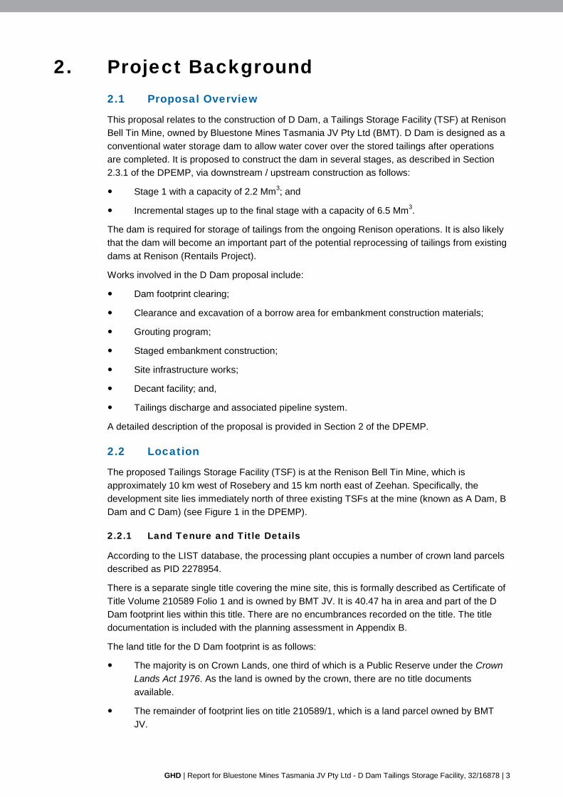
2. Project Background 2.1 Proposal Overview
This proposal relates to the construction of D Dam, a Tailings Storage Facility (TSF) at Renison
Bell Tin Mine, owned by Bluestone Mines Tasmania JV Pty Ltd (BMT). D Dam is designed as a
conventional water storage dam to allow water cover over the stored tailings after operations
are completed. It is proposed to construct the dam in several stages, as described in Section
2.3.1 of the DPEMP, via downstream / upstream construction as follows:
Stage 1 with a capacity of 2.2 Mm3; and
Incremental stages up to the final stage with a capacity of 6.5 Mm3.
The dam is required for storage of tailings from the ongoing Renison operations. It is also likely
that the dam will become an important part of the potential reprocessing of tailings from existing
dams at Renison (Rentails Project).
Works involved in the D Dam proposal include:
Dam footprint clearing;
Clearance and excavation of a borrow area for embankment construction materials;
Grouting program;
Staged embankment construction;
Site infrastructure works;
Decant facility; and,
Tailings discharge and associated pipeline system.
A detailed description of the proposal is provided in Section 2 of the DPEMP.
2.2 Location
The proposed Tailings Storage Facility (TSF) is at the Renison Bell Tin Mine, which is
approximately 10 km west of Rosebery and 15 km north east of Zeehan. Specifically, the
development site lies immediately north of three existing TSFs at the mine (known as A Dam, B
Dam and C Dam) (see Figure 1 in the DPEMP).
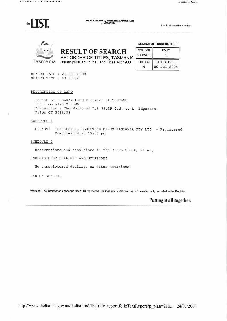
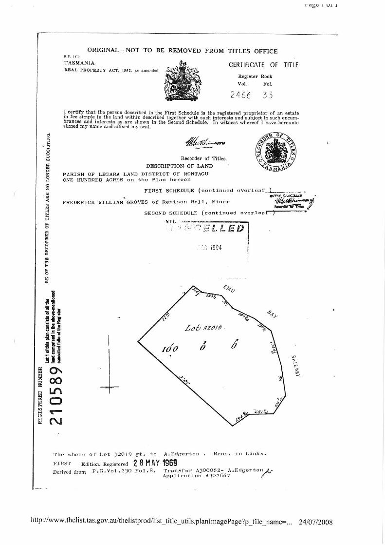
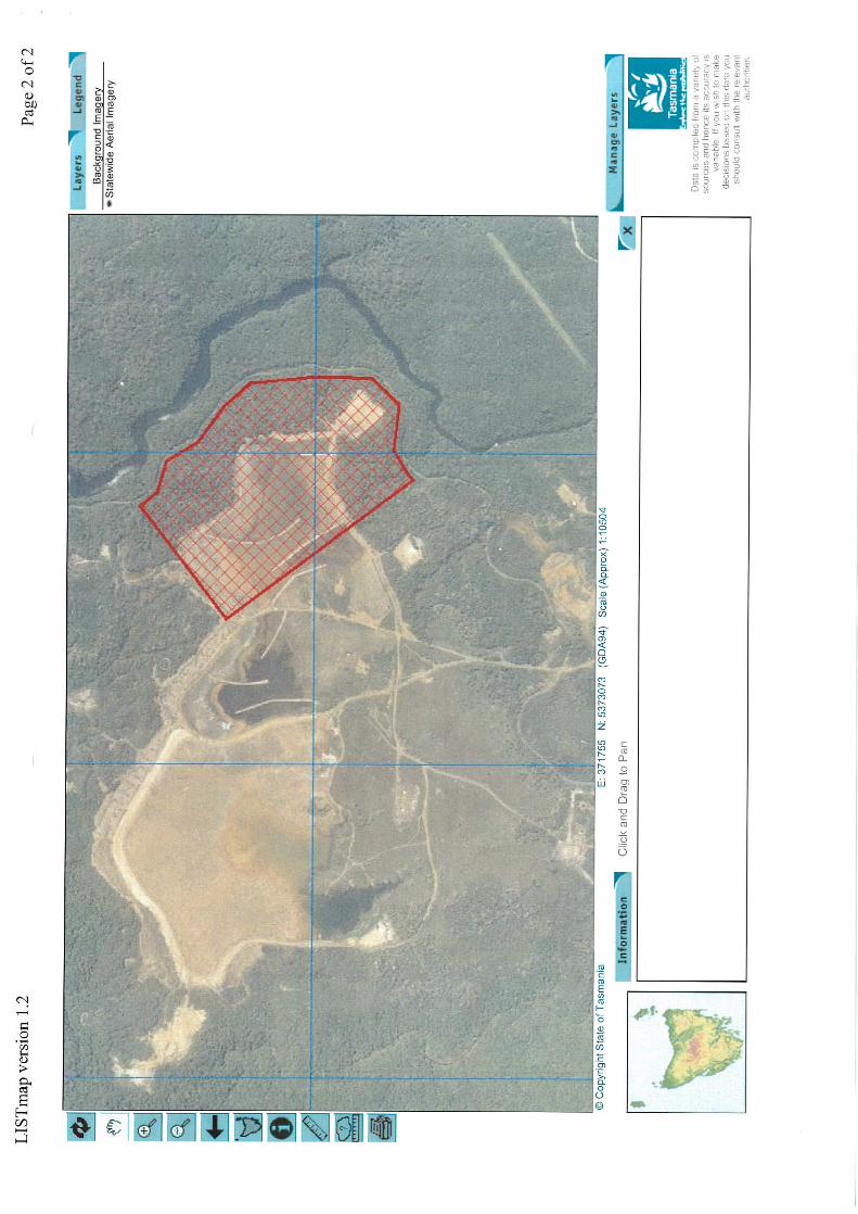
2.2.1 Land Tenure and Title Details
According to the LIST database, the processing plant occupies a number of crown land parcels
described as PID 2278954.
There is a separate single title covering the mine site, this is formally described as Certificate of
Title Volume 210589 Folio 1 and is owned by BMT JV. It is 40.47 ha in area and part of the D
Dam footprint lies within this title. There are no encumbrances recorded on the title. The title
documentation is included with the planning assessment in Appendix B.
The land title for the D Dam footprint is as follows:
The majority is on Crown Lands, one third of which is a Public Reserve under the Crown Lands Act 1976. As the land is owned by the crown, there are no title documents
available.
The remainder of footprint lies on title 210589/1, which is a land parcel owned by BMT
JV.
4 | GHD | Report for Bluestone Mines Tasmania JV Pty Ltd - D Dam Tailings Storage Facility, 32/16878
Although the site involves Crown land, permission to lodge the development application
pursuant to Section 52(1B) of the LUPAA is not required. An exception to the requirement to
obtain Crown landowner permission is provided under Section 52(1H) in relation to the carrying out of mining operations within the meaning of the Mineral Resources Development Act 1995, if
a mining lease has been issued under that Act which authorises those operations.
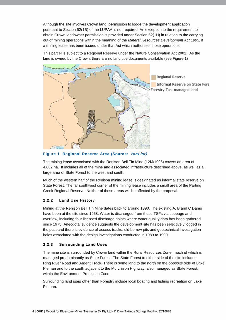
This parcel is subject to a Regional Reserve under the Nature Conservation Act 2002. As the
land is owned by the Crown, there are no land title documents available (see Figure 1)
Legend:
Figure 1 Regional Reserve Area (Source: theList)
The mining lease associated with the Renison Bell Tin Mine (12M/1995) covers an area of
4,662 ha. It includes all of the mine and associated infrastructure described above, as well as a
large area of State Forest to the west and south.
Much of the western half of the Renison mining lease is designated as informal state reserve on
State Forest. The far southwest corner of the mining lease includes a small area of the Parting
Creek Regional Reserve. Neither of these areas will be affected by the proposal.
2.2.2 Land Use History
Mining at the Renison Bell Tin Mine dates back to around 1890. The existing A, B and C Dams
have been at the site since 1968. Water is discharged from these TSFs via seepage and
overflow, including four licensed discharge points where water quality data has been gathered
since 1975. Anecdotal evidence suggests the development site has been selectively logged in
the past and there is evidence of access tracks, old borrow pits and geotechnical investigation
holes associated with the design investigations conducted in 1989 to 1990.
2.2.3 Surrounding Land Uses
The mine site is surrounded by Crown land within the Rural Resources Zone, much of which is
managed predominantly as State Forest. The State Forest to either side of the site includes
Ring River Road and Argent Track. There is some land to the north on the opposite side of Lake
Pieman and to the south adjacent to the Murchison Highway, also managed as State Forest,
within the Environment Protection Zone.
Surrounding land uses other than Forestry include local boating and fishing recreation on Lake
Pieman.

GHD | Report for Bluestone Mines Tasmania JV Pty Ltd - D Dam Tailings Storage Facility, 32/16878 | 5
The nearest residence is adjacent to the Rosebery Golf Course, along the Murchison Highway
about five kilometers towards Rosebery. This property is within the Rural Resource Zone under
the Scheme. The nearest residential properties within the General Residential Zone are at
Rosebery and Zeehan.
6 | GHD | Report for Bluestone Mines Tasmania JV Pty Ltd - D Dam Tailings Storage Facility, 32/16878
3. Planning Controls & Policies 3.1 Statutory Reference
The site is subject to the provisions of the West Coast Interim Planning Scheme 2013 (the
Scheme), in particular Table 8.2 (Environmental Management Zone), Part E.3 (Clearing and
Conversion of Vegetation Code), E.4 Change in Ground level Code, E.10 Water and Waterways
Code.
Clause 4.1.2 of the Scheme requires an application for a permit to include a copy of the
certificate of title, title plan and schedule of easements for the land on which the use and
development is proposed. Copies of available title documentation as identified in Section 2.2.1
are attached is attached in Appendix A. According to the List database there is no schedule of
easements and no encumbrances are recorded on the title.
Although the site involves Crown land, permission to lodge the development application pursuant to Section 52(1B) of the LUPAA is not required. An exception to the requirement to
obtain Crown landowner permission is provided under Section 52(1H) in relation to the carrying
out of mining operations within the meaning of the Mineral Resources Development Act 1995, if
a mining lease has been issued under that Act which authorises those operations.
As discussed within Section 2.2.1, the project relates to an existing Mining Lease (12M/1995).
Furthermore, it fits within the definition of mining operations under the Mineral Resources Development Act 1995, which states:
"mining operations" means any operations or work carried out on a lease area –
(a) To obtain or treat minerals; or
(b) To store or contain minerals or waste material generated by mining on that lease area; or
(c) associated with mining;
The TSF is associated with mining and will store and contain minerals or waste material
generated by mining within the lease area.
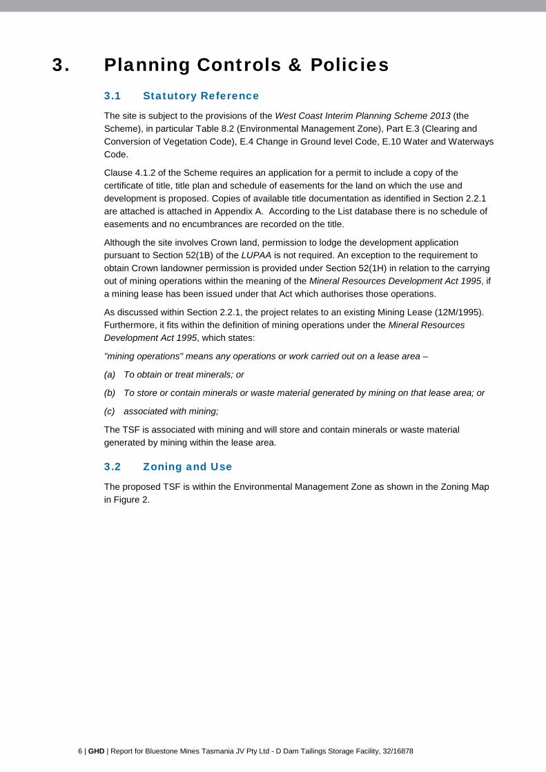
3.2 Zoning and Use
The proposed TSF is within the Environmental Management Zone as shown in the Zoning Map
in Figure 2.
GHD | Report for Bluestone Mines Tasmania JV Pty Ltd - D Dam Tailings Storage Facility, 32/16878 | 7
Figure 2 Zoning Map (Source: West Coast Interim Planning Scheme 2013)
D Dam
Renison Process Plant
8 | GHD | Report for Bluestone Mines Tasmania JV Pty Ltd - D Dam Tailings Storage Facility, 32/16878
The proposed TSF is identified under Table 8.2 of the Scheme as part of the extractive industry
use class which applies to the existing processing mill. The use class is defined under Table 8.2
as:
use of land for extracting or removing material from the ground, other than Resource development, and includes the treatment or processing of those materials by crushing, grinding, milling or screening on, or adjoining the land from which it is extracted. Examples include mining, quarrying, and sand mining.
The use is identified as discretionary in the Environmental Management Zone.
3.3 Status of Proposal
As demonstrated through the following assessment, the proposal complies with the majority of
the acceptable solutions under the Environmental Management zone. However, it relies on an
assessment against the performance criteria relating to:
Environmental Management Zone,
Part E.3 (Clearing and Conversion of Vegetation Code),
E.4 Change in Ground level Code,
E.10 Water and Waterways Code.
The application is unable to meet the acceptable solutions relating to these issues since a small
tributary of Lake Pieman lies partly within the TSF footprint.

GHD | Report for Bluestone Mines Tasmania JV Pty Ltd - D Dam Tailings Storage Facility, 32/16878 | 9
4. Planning Assessment This section assesses the proposal against the development standards of the Environmental
Management Zone and applicable codes under the Scheme. Comment on the compliance with
the acceptable solutions or corresponding performance criteria, where required, is provided in
the tables.
4.1 Environmental Management Zone
4.1.1 Zone Purpose Statements – Clause 29.1.1
The Zone Purpose Statements are provided under Clause 29.1.1 and state:
29.1.1.1 To provide for the protection, conservation and management of areas with significant ecological, scientific, cultural or aesthetic value, or with a significant likelihood of risk from a natural hazard.
29.1.1.2 To only allow for complementary use or development where consistent with any strategies for protection and management.
Comment:
The proposed TSF is contained within the existing TSF complex and within the Bluestone
Mining Lease. The development is complementary to the existing use of the area, and is
assessed as resulting in acceptable impacts on the values of the surrounding land.
The proposal will not result on impacts to historic or cultural heritage values, will not result in
any significant visual intrusion as the development is at a significant distance from the
Murchison Highway. No threatened vegetation communities or flora species were found within
the TSF footprint. The environmental impacts of the project are discussed in Section 4 of the
DPEMP, along with any proposed mitigation and management measures.
As discussed in Section 4.4 of this report, a risk assessment has been undertaken in relation to
landslide hazard, and appropriate mitigation measures have been identified in order to manage
these hazards.
The proposal is therefore consistent with the zone purpose statements for the Environmental
Management Zone.
Local Area Objectives – Clause 29.1.2
Local Area Objectives Implementation Strategy
Environmental management land is protected, conserved and managed to –
(a) sustain biodiversity and ecological process;
(b) retain habitat value for native vegetation communities and fauna species;
(c) protect significant geological features, natural landforms, and aesthetic or scenic landscape, including within the coastline and waterways;
(d) protect places of special cultural value or heritage importance;
Implementation is in accordance with the requirement in Clause 8.10.2 to have regard to the purpose of the zone in determining a permit for a discretionary use.
10 | GHD | Report for Bluestone Mines Tasmania JV Pty Ltd - D Dam Tailings Storage Facility, 32/16878
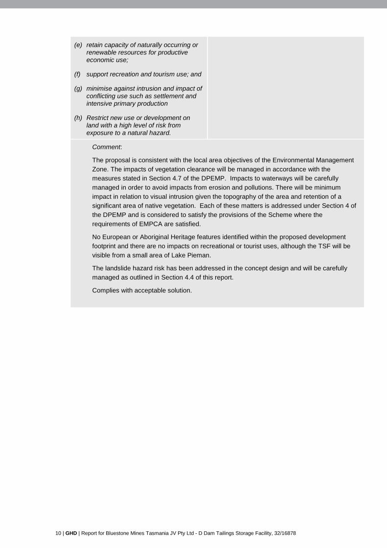
(e) retain capacity of naturally occurring or renewable resources for productive economic use;
(f) support recreation and tourism use; and
(g) minimise against intrusion and impact of conflicting use such as settlement and intensive primary production
(h) Restrict new use or development on land with a high level of risk from exposure to a natural hazard.
Comment:
The proposal is consistent with the local area objectives of the Environmental Management
Zone. The impacts of vegetation clearance will be managed in accordance with the
measures stated in Section 4.7 of the DPEMP. Impacts to waterways will be carefully
managed in order to avoid impacts from erosion and pollutions. There will be minimum
impact in relation to visual intrusion given the topography of the area and retention of a
significant area of native vegetation. Each of these matters is addressed under Section 4 of
the DPEMP and is considered to satisfy the provisions of the Scheme where the
requirements of EMPCA are satisfied.
No European or Aboriginal Heritage features identified within the proposed development
footprint and there are no impacts on recreational or tourist uses, although the TSF will be
visible from a small area of Lake Pieman.
The landslide hazard risk has been addressed in the concept design and will be carefully
managed as outlined in Section 4.4 of this report.
Complies with acceptable solution.
GHD | Report for Bluestone Mines Tasmania JV Pty Ltd - D Dam Tailings Storage Facility, 32/16878 | 11
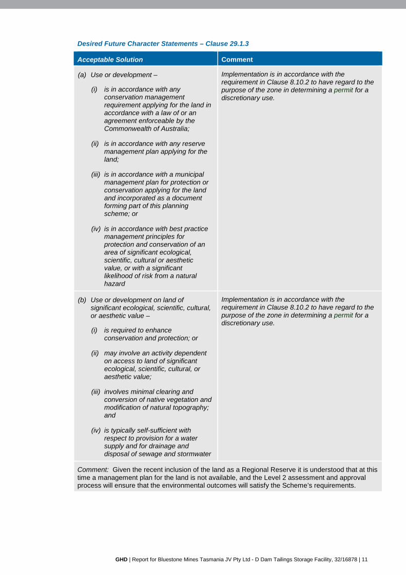
Desired Future Character Statements – Clause 29.1.3
Acceptable Solution Comment
(a) Use or development –
(i) is in accordance with any conservation management requirement applying for the land in accordance with a law of or an agreement enforceable by the Commonwealth of Australia;
(ii) is in accordance with any reserve management plan applying for the land;
(iii) is in accordance with a municipal management plan for protection or conservation applying for the land and incorporated as a document forming part of this planning scheme; or
(iv) is in accordance with best practice management principles for protection and conservation of an area of significant ecological, scientific, cultural or aesthetic value, or with a significant likelihood of risk from a natural hazard
Implementation is in accordance with the requirement in Clause 8.10.2 to have regard to the purpose of the zone in determining a permit for a discretionary use.
(b) Use or development on land of significant ecological, scientific, cultural, or aesthetic value –
(i) is required to enhance conservation and protection; or
(ii) may involve an activity dependent on access to land of significant ecological, scientific, cultural, or aesthetic value;
(iii) involves minimal clearing and conversion of native vegetation and modification of natural topography; and
(iv) is typically self-sufficient with respect to provision for a water supply and for drainage and disposal of sewage and stormwater
Implementation is in accordance with the requirement in Clause 8.10.2 to have regard to the purpose of the zone in determining a permit for a discretionary use.
Comment: Given the recent inclusion of the land as a Regional Reserve it is understood that at this time a management plan for the land is not available, and the Level 2 assessment and approval process will ensure that the environmental outcomes will satisfy the Scheme’s requirements.
12 | GHD | Report for Bluestone Mines Tasmania JV Pty Ltd - D Dam Tailings Storage Facility, 32/16878
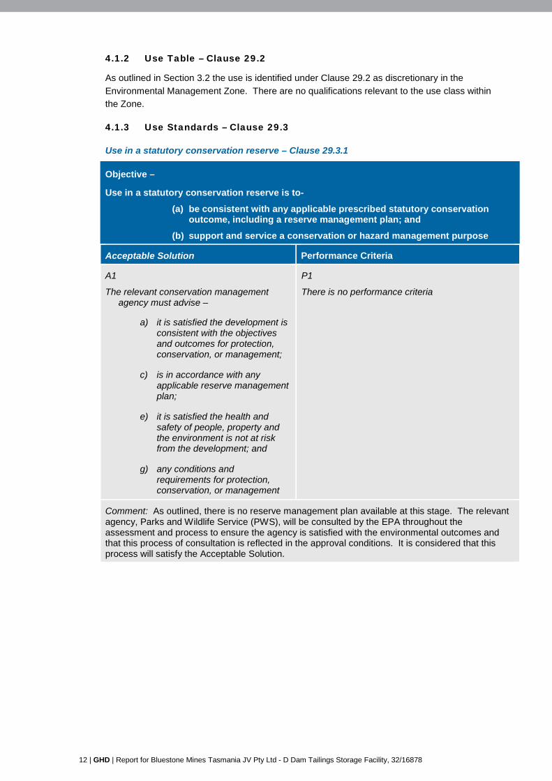
4.1.2 Use Table – Clause 29.2
As outlined in Section 3.2 the use is identified under Clause 29.2 as discretionary in the
Environmental Management Zone. There are no qualifications relevant to the use class within
the Zone.
4.1.3 Use Standards – Clause 29.3
Use in a statutory conservation reserve – Clause 29.3.1
Objective –
Use in a statutory conservation reserve is to-
(a) be consistent with any applicable prescribed statutory conservation outcome, including a reserve management plan; and
(b) support and service a conservation or hazard management purpose
Acceptable Solution Performance Criteria
A1
The relevant conservation management agency must advise –
a) it is satisfied the development is consistent with the objectives and outcomes for protection, conservation, or management;
c) is in accordance with any applicable reserve management plan;
e) it is satisfied the health and safety of people, property and the environment is not at risk from the development; and
g) any conditions and requirements for protection, conservation, or management
P1
There is no performance criteria
Comment: As outlined, there is no reserve management plan available at this stage. The relevant agency, Parks and Wildlife Service (PWS), will be consulted by the EPA throughout the assessment and process to ensure the agency is satisfied with the environmental outcomes and that this process of consultation is reflected in the approval conditions. It is considered that this process will satisfy the Acceptable Solution.
GHD | Report for Bluestone Mines Tasmania JV Pty Ltd - D Dam Tailings Storage Facility, 32/16878 | 13
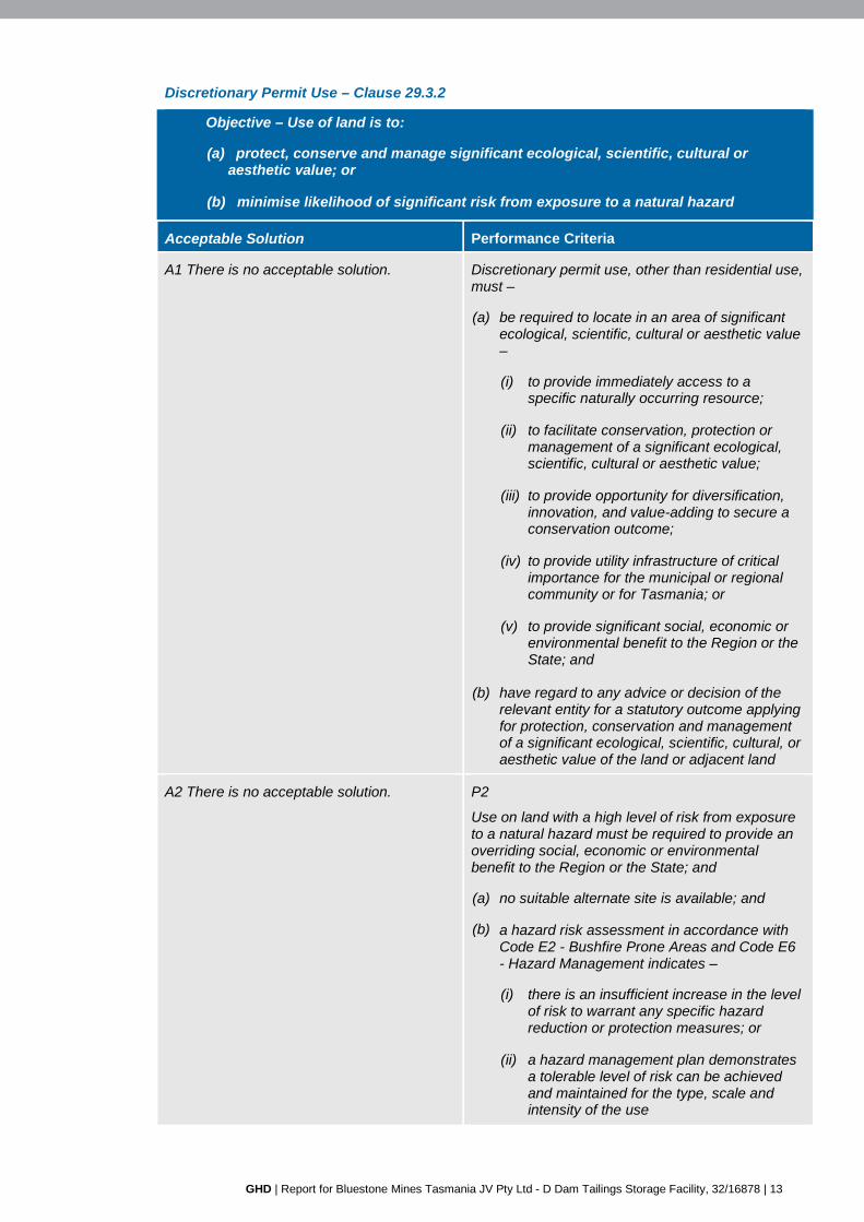
Discretionary Permit Use – Clause 29.3.2
Objective – Use of land is to:
(a) protect, conserve and manage significant ecological, scientific, cultural or aesthetic value; or
(b) minimise likelihood of significant risk from exposure to a natural hazard
Acceptable Solution Performance Criteria
A1 There is no acceptable solution. Discretionary permit use, other than residential use, must –
(a) be required to locate in an area of significant ecological, scientific, cultural or aesthetic value –
(i) to provide immediately access to a specific naturally occurring resource;
(ii) to facilitate conservation, protection or management of a significant ecological, scientific, cultural or aesthetic value;
(iii) to provide opportunity for diversification, innovation, and value-adding to secure a conservation outcome;
(iv) to provide utility infrastructure of critical importance for the municipal or regional community or for Tasmania; or
(v) to provide significant social, economic or environmental benefit to the Region or the State; and
(b) have regard to any advice or decision of the relevant entity for a statutory outcome applying for protection, conservation and management of a significant ecological, scientific, cultural, or aesthetic value of the land or adjacent land
A2 There is no acceptable solution. P2
Use on land with a high level of risk from exposure to a natural hazard must be required to provide an overriding social, economic or environmental benefit to the Region or the State; and
(a) no suitable alternate site is available; and
(b) a hazard risk assessment in accordance with Code E2 - Bushfire Prone Areas and Code E6 - Hazard Management indicates –
(i) there is an insufficient increase in the level of risk to warrant any specific hazard reduction or protection measures; or
(ii) a hazard management plan demonstrates a tolerable level of risk can be achieved and maintained for the type, scale and intensity of the use
14 | GHD | Report for Bluestone Mines Tasmania JV Pty Ltd - D Dam Tailings Storage Facility, 32/16878
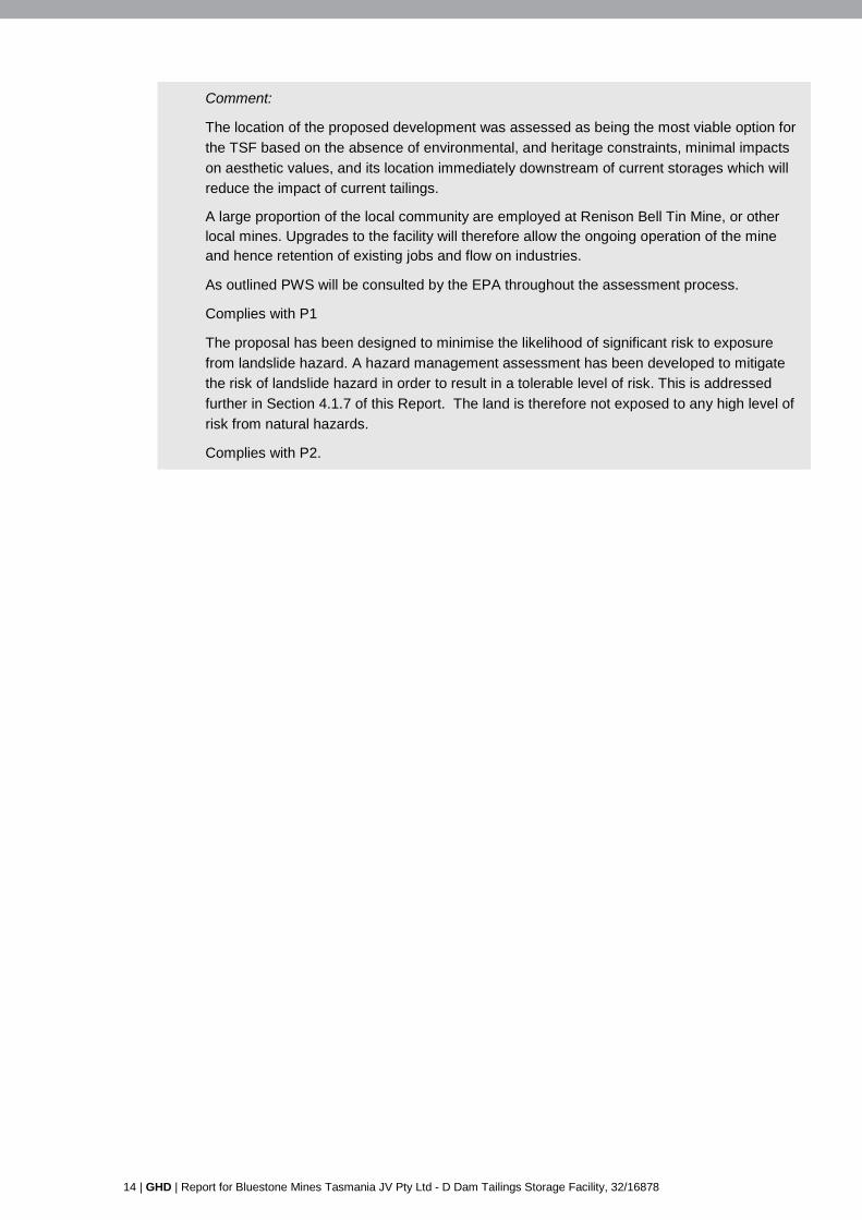
Comment:
The location of the proposed development was assessed as being the most viable option for
the TSF based on the absence of environmental, and heritage constraints, minimal impacts
on aesthetic values, and its location immediately downstream of current storages which will
reduce the impact of current tailings.
A large proportion of the local community are employed at Renison Bell Tin Mine, or other local mines. Upgrades to the facility will therefore allow the ongoing operation of the mine and hence retention of existing jobs and flow on industries.
As outlined PWS will be consulted by the EPA throughout the assessment process.
Complies with P1
The proposal has been designed to minimise the likelihood of significant risk to exposure
from landslide hazard. A hazard management assessment has been developed to mitigate
the risk of landslide hazard in order to result in a tolerable level of risk. This is addressed
further in Section 4.1.7 of this Report. The land is therefore not exposed to any high level of
risk from natural hazards.
Complies with P2.
GHD | Report for Bluestone Mines Tasmania JV Pty Ltd - D Dam Tailings Storage Facility, 32/16878 | 15
4.1.4 Development Standards
Development in a statutory conservation area – Clause 29.4.1
Objective –
Development in a statutory conservation reserve is to-
(a) be consistent with any applicable prescribed statutory conservation outcome, including a reserve management plan; and
(b) support and service a conservation or hazard management purpose.
Acceptable Solution Performance Criteria
A1
The relevant conservation management agency must advise –
a) it is satisfied the development is consistent with the objectives and outcomes for protection, conservation, or management;
b) is in accordance with any applicable reserve management plan;
c) it is satisfied the health and safety of people, property and the environment is not at risk from the development; and
d) any conditions and requirements for protection, conservation, or management
P1
There is no performance criteria
Comment: Refer response to Use in a statutory conservation reserve – Clause 29.3.1 under
Section 4.1.3.
29.4.2 Suitability of a site or lot for use or development
The proposal does not require consideration against these standards, as the proposal does not
involve the subdivision of land.
29.4.3 Location and configuration of development
Objective – The location and configuration of development does not dominate or otherwise detract from the performance, appearance, and character of an area of significant ecological, scientific, cultural or aesthetic value or unreasonably intrude onto the occupation of adjacent land
Acceptable Solution Performance Criteria
A1 A building and any development area must be setback – (a) not less than 20.0m from the frontage to
a road; or
P1 The setback of a building and development area from the frontage or from a side or rear boundary must – (a) be consistent with prevailing frontage setbacks
for any existing and approved building or structure on the site or on adjacent land;
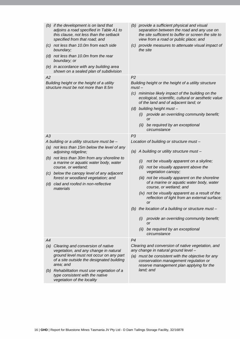
16 | GHD | Report for Bluestone Mines Tasmania JV Pty Ltd - D Dam Tailings Storage Facility, 32/16878
(b) if the development is on land that adjoins a road specified in Table A1 to this clause, not less than the setback specified from that road; and
(c) not less than 10.0m from each side boundary;
(d) not less than 10.0m from the rear boundary; or
(e) in accordance with any building area shown on a sealed plan of subdivision
(b) provide a sufficient physical and visual separation between the road and any use on the site sufficient to buffer or screen the site to view from a road or public place; and
(c) provide measures to attenuate visual impact of the site
A2 Building height or the height of a utility structure must be not more than 8.5m
P2 Building height or the height of a utility structure must – (c) minimise likely impact of the building on the
ecological, scientific, cultural or aesthetic value of the land and of adjacent land; or
(d) building height must – (i) provide an overriding community benefit;
or (ii) be required by an exceptional
circumstance
A3 A building or a utility structure must be – (a) not less than 15m below the level of any
adjoining ridgeline; (b) not less than 30m from any shoreline to
a marine or aquatic water body, water course, or wetland;
(c) below the canopy level of any adjacent forest or woodland vegetation; and
(d) clad and roofed in non-reflective materials
P3 Location of building or structure must –
(a) A building or utility structure must –
(i) not be visually apparent on a skyline; (ii) not be visually apparent above the
vegetation canopy; (iii) not be visually apparent on the shoreline
of a marine or aquatic water body, water course, or wetland; and
(iv) not be visually apparent as a result of the reflection of light from an external surface; or
(b) the location of a building or structure must –
(i) provide an overriding community benefit; or
(ii) be required by an exceptional circumstance
A4 (a) Clearing and conversion of native
vegetation, and any change in natural ground level must not occur on any part of a site outside the designated building area; and
(b) Rehabilitation must use vegetation of a type consistent with the native vegetation of the locality
P4 Clearing and conversion of native vegetation, and any change in natural ground level – (a) must be consistent with the objective for any
conservation management regulation or reserve management plan applying for the land; and

GHD | Report for Bluestone Mines Tasmania JV Pty Ltd - D Dam Tailings Storage Facility, 32/16878 | 17
(b) must - (i) retained sufficient vegetation to maintain
an intact tree canopy and provide screening to cleared and converted areas;
(ii) minimise impact on the visual qualities of a shoreline, skyline, ridge and other prominent landform feature;
(iii) minimise exposure to view from a road, public place, or settlement area; or
(c) must – (i) provide an overriding community benefit;
or (ii) be required by an exceptional
circumstance
Comment:
A1 – Complies. The footprint includes all of the land comprised in PID 2278954 and CT
210589-1, which contains the processing plant, associated infrastructure (including TSFs)
and some of the mine workings. It is approximately 847 ha in area. The proposal does cross
the boundaries of individual parcels, however all of these parcels form part of the larger site
managed by BMT JV, therefore the proposal does not result in visual intrusion issues
amongst the affected parcels. The proposed TSF will not be visible from the Murchison
Highway and will have limited visibility from lake Pieman.
A2 – Not applicable. The proposal does not include the erection of buildings.
A3 – Complies. A visual assessment is provided under Section 4.12 of the DPEMP. The
proposal does not result in significant visual intrusion issues.
A4 – Complies. Clearing and conversion of native vegetation and change in natural ground
level will be restricted to the development area. These issues are considered in Section 4.3
of this report.
29.4.4 Subdivision
This proposal does not require consideration against these standards, as the proposal does not
involve the subdivision of land.
4.2 Clearing and Conversion of Vegetation Code – Schedule E3
E3.6.1 Protection of a threatened native vegetation community or native vegetation providing habitat for a threatened species
Objective – The harvesting of timber or the clearing and conversion of native vegetation is to minimise likely adverse impact on biodiversity, ecological process, and habitat value.
Acceptable Solution Performance Criteria
A1 Vegetation must not be – (a) a threatened native vegetation
community; (b) a threatened species habitat; or (c) within 30m of a water body,
watercourse, wetland, or coastal shoreline
P1 The harvesting of timber or the clearing and conversion of native vegetation must – (a) be justified by exceptional circumstance; or (b) be necessary to deliver an overriding
environmental benefit for the region; and
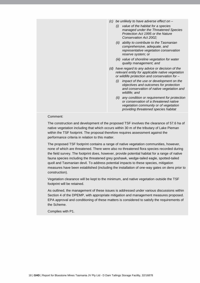
18 | GHD | Report for Bluestone Mines Tasmania JV Pty Ltd - D Dam Tailings Storage Facility, 32/16878
(c) be unlikely to have adverse effect on – (i) value of the habitat for a species
managed under the Threatened Species Protection Act 1995 or the Nature Conservation Act 2002;
(ii) ability to contribute to the Tasmanian comprehensive, adequate, and representative vegetation conservation reserve system; or
(iii) value of shoreline vegetation for water quality management; and
(d) have regard to any advice or decision of the relevant entity for applicable native vegetation or wildlife protection and conservation for – (i) impact of the use or development on the
objectives and outcomes for protection and conservation of native vegetation and wildlife; and
(ii) any condition or requirement for protection or conservation of a threatened native vegetation community or of vegetation providing threatened species habitat
Comment:
The construction and development of the proposed TSF involves the clearance of 57.6 ha of
native vegetation including that which occurs within 30 m of the tributary of Lake Pieman
within the TSF footprint. The proposal therefore requires assessment against the
performance criteria in relation to this matter.
The proposed TSF footprint contains a range of native vegetation communities, however,
none of which are threatened. There were also no threatened flora species recorded during
the field survey. The footprint does, however, provide potential habitat for a range of native
fauna species including the threatened grey goshawk, wedge-tailed eagle, spotted-tailed
quoll and Tasmanian devil. To address potential impacts to these species, mitigation
measures have been established (including the installation of one-way gates on dens prior to
construction).
Vegetation clearance will be kept to the minimum, and native vegetation outside the TSF
footprint will be retained.
As outlined, the management of these issues is addressed under various discussions within
Section 4 of the DPEMP, with appropriate mitigation and management measures proposed.
EPA approval and conditioning of these matters is considered to satisfy the requirements of
the Scheme.
Complies with P1.

GHD | Report for Bluestone Mines Tasmania JV Pty Ltd - D Dam Tailings Storage Facility, 32/16878 | 19
E3.6.2 Clearing of vegetation on land of scenic or landscape value
Objective – The harvesting of timber or the clearing and conversion of native vegetation is to minimise likely adverse impact on scenic or landscape value - (a) on land in the Environmental Living zone, Environmental Management zone, Open
Space zone, and Rural Living zone; or (b) on land identified on the planning scheme map as significant for scenic or landscape
value
Acceptable Solution Performance Criteria
A1
There is no acceptable solution.
P1 The harvesting of timber or the clearing and conversion of vegetation must - (i) be necessary to deliver an overriding social,
economic or environmental benefit to the community; or
(ii) be justified by exceptional circumstances; and iii) there is no suitable alternative site; or
be consistent with the objectives and outcomes for any scenic or landscape management plan incorporated as a document forming part of this planning scheme; and the extent of clearing and conversion must - (i) retain a sufficient intensity and distribution of
vegetation to screen cleared and converted areas;
(ii) not impact on the visual qualities of a shoreline, skyline, ridge, or other prominent landform feature;
(iii) not be exposed to view from a road, public place, or settlement area; and
(iv) include measures to minimise likely adverse impact for scenic or landscape value
Comment:
The proposal required consideration against the Performance Criteria as there is no
Acceptable Solution.
The siting of the development is such that it will not be viewed from any section of the
Murchison Highway. The site is setback a minimum of 1.5 km from the highway. The existing
processing plant, natural topography and native vegetation (including that along the roadside
verge) provide a visual screen. The proposed TSF will have limited visibility from Lake
Pieman. Visual effects are considered further in Section 4.12 of the DPEMP.
Complies with P1.
20 | GHD | Report for Bluestone Mines Tasmania JV Pty Ltd - D Dam Tailings Storage Facility, 32/16878
E3.6.3 Clearing of vegetation on land susceptible to landslide
Objective - The harvesting of timber or the clearing and conversion of vegetation on land susceptible to landslide in accordance with Code E6 – Hazard Management under this planning scheme is to minimise risk for activation of landslide
Acceptable Solutions Performance Criteria
A1 The site must be within an area – (a) exposed to a low level of likely risk from
landslide; and (b) a landslide hazard risk assessment L1
must indicate clearing of native vegetation – (i) can achieve and maintain a
tolerable level of risk; or (ii) there is an insufficient increase in
the level of risk to warrant any specific hazard reduction or protection measures; or
(iii) any condition or requirement for specific hazard reduction or protection measures
P1 There must be a hazard risk assessment L1 to indicate – (a) the use or development is unlikely to cause or
contribute to occurrence of landslide on the site or on adjacent land; and
(b) any condition or requirement for specific hazard reduction or protection measures
Comment:
A hazard analysis and assessment has been undertaken for the project in accordance with
Australian National Committee on Large Dams Incorporated (ANCOLD) guidelines and
AS/NZS 4360:1995 Risk Management. The hazard analysis and risk assessment has
identified that the development is subject to a medium risk of landslide during construction
and flooding during a high rainfall event. Mitigation measures have been developed, and are
outlined in Section 4.14 of the DPEMP.
This matter is addressed in further detail in Section 4.1.7 of this Report.
Complies with P1.
GHD | Report for Bluestone Mines Tasmania JV Pty Ltd - D Dam Tailings Storage Facility, 32/16878 | 21
4.3 Change in Ground Level Code – Schedule E4
E4.6.1 Change in existing ground level or natural ground level
Objective - Change in the existing ground level or the natural ground level by cut or fill is to minimise (a) likely adverse impact on the physical, environmental, cultural, aesthetic, and amenity features of land; and (b) risk from a natural hazard.
Acceptable Solutions Performance Criteria
A1
Cut or fill must -
(a) not be on land within the Environmental Living zone or the Environmental Management zone;
(b) be required to -
(i) provide a construction site for buildings and structures;
(ii) facilitate vehicular access;
(iii) mitigate exposure to a natural or environmental hazard;
(iv) facilitate provision of a utility;
(v) assist the consolidation or intensification of development; or
(vi) assist stormwater management
(c) not result in a modification of surface stormwater water flow to increase –
(i) surface water drainage onto adjacent land;
(ii) pooling of water on the site or on adjacent land; or
(iii) the nature or capacity of discharge from land upstream in a natural or artificial drainage channel;
(d) not destabilise any existing building or increase the requirements for construction of any potential building on adjacent land;
(e) manage disposal of intersected ground water;
P1
Cut or fill must -
(a) make arrangements for the drainage and disposal of stormwater;
(b) make arrangements to stabilise any existing building or to increase the requirements for construction of any potential building on adjacent land;
(c) manage drainage and disposal of intersected ground water;
(d) safeguard the quality of receiving waters;
(e not require a retaining or support structure that would result in a ‘line of influence’ of more than 450mm into any adjacent land unless the owner of adjacent land has provided written consent to enter into an agreement under Part 5 Land Use Planning and Approvals Act 1993 registered on the title of adjacent land providing for the level of constraint; and
(f) not encroach upon or expose, disturb, or reduce cover over an underground utility to less than 1.0m unless the relevant regulatory entity has advised –
(i) it is satisfied the cut or fill will not result in harm to the utility; and
(ii) any condition or requirement it determines are appropriate to protect the utility
22 | GHD | Report for Bluestone Mines Tasmania JV Pty Ltd - D Dam Tailings Storage Facility, 32/16878
(f) safeguard the quality of receiving waters through measures to minimise erosion and release of sediments and other contaminants during each of the site preparation, construction and rehabilitation phase in accordance with Soil and Water Management on Building and Construction Sites 2009;
(g) not require a retaining or support structure that would result in a ‘line of influence’ of more than 450mm into any adjacent land unless the owner of adjacent land has provided written consent to enter into an agreement under Part 5 Land Use Planning and Approvals Act 1993 registered on the title of adjacent land to provide for the level of constraint; and
(h) not encroach upon or expose, disturb, or reduce cover over an underground utility to less than 1.0m unless the relevant regulatory entity has advised –
(i) it is satisfied the cut or fill will not result in harm to the utility; and
(ii) any condition or requirement it determines are appropriate to protect the utility
Comment:
Appropriate arrangements have been made for drainage and stormwater management. The
embankment drainage will divert stormwater outside the D Dam catchment around the TSF
footprint, returning it to the natural drainage line downstream of the embankment. During
early operations, where some of the TSF embankment is made up of natural topography, a
drained access road angled towards the pond will prevent surface runoff from flowing into the
TSF catchment from outside. It will also allow the retention of construction stormwater runoff
from within the TSF footprint to settle in the decant pond prior to discharge to the natural
environment through the decant tower.
Drainage and the treatment of stormwater during the construction phase of the project will be
addressed in the CEMP.
There are no existing buildings that require stabilisation as a result of the development. The
proposal does not require a retaining or support structure that would result in a line of
influence over adjacent land, nor will it impact on an underground utility.
Complies with P1.
4.4 Hazard Management Code – Schedule E6
E6.6.2 Development on land exposed to a natural hazard
Objective – The level of likely risk from exposure to a natural hazard is to be tolerable for the

GHD | Report for Bluestone Mines Tasmania JV Pty Ltd - D Dam Tailings Storage Facility, 32/16878 | 23
type, form, scale and duration of each development
Acceptable Solution Performance Criteria
A1 If the site is within an area of unacceptable risk shown on a natural hazard map forming part of this planning scheme - (a) a hazard risk assessment must
determine - (i) there is an insufficient increase in
the level of risk to warrant any specific hazard reduction or protection measure; or
(ii) a tolerable level of risk can be achieved for the type, form and duration of the development; and
(b) if a hazard risk assessment established need to involve land external to the site for hazard management, the consent in writing of the owner of that land must be provided to enter into a Part 5 agreement to be registered on the tile of the land and providing for the effected land to be managed in accordance with recommendations for hazard management
P1 There is no performance criteria
Comment:
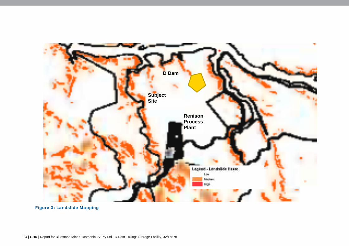
The landslide map (Figure 3) shows that the proposed TSF may potentially be within an area
subject to a medium level of landslide risk.
The hazard analysis and risk assessment in Section 4.14 of the DPEMP has been prepared
in accordance with Australian National Committee on Large Dams Incorporated (ANCOLD)
guidelines and AS/NZS 4360:1995 ‘Risk Management’. The hazard analysis and risk
assessment has identified that the development is subject to a medium risk of landslide
during construction and flooding during a high rainfall event. Mitigation measures have been
devised, as also set out in Section 4.14 of the DPEMP. There is no identified need to involve
land external to the site for the purposes of landslide hazard management.
Potential fire impacts and mitigation measures are discussed in Section 4.14 of the DPEMP.
External fire is considered to pose a very low risk to the operation of D Dam as all structures
will be of concrete construction and the embankments will comprise of bare rock fill and clay.
Complies with A1.
24 | GHD | Report for Bluestone Mines Tasmania JV Pty Ltd - D Dam Tailings Storage Facility, 32/16878
Figure 3: Landslide Mapping
Subject Site
D Dam
Renison Process Plant
GHD | Report for Bluestone Mines Tasmania JV Pty Ltd - D Dam Tailings Storage Facility, 32/16878 | 25
4.5 Traffic Generating Use and Parking Code – Schedule E9
E9.6.1 Road access
Objective – Arrangements for vehicular access to a road and for junctions with a road are to protect safety and operation of a road
Acceptable Solution Performance Criteria
A1
There must be an access to the site from a carriageway of a road R36 –
(a) permitted in accordance with the Local Government (Highways) Act;
(b) permitted in accordance with the Roads and Jetties Act 1935; or
(c) permitted by a license granted for access to a limited access road under the Roads and Jetties Act 1935
P1
There is no performance criteria
Comment:
This standard is not applicable. The only vehicular movements will be internal, associated
with maintenance vehicles, between processing and the TSF.
Management of traffic during the construction phase will be addressed in the CEMP.
E.9.6.2 Design of vehicle parking and loading areas
Objective – Vehicle circulation, loading, and parking areas–
(a) protect the efficient operation and safety of the road from which assess is provided; (b) promote efficiency, convenience, safety, and security for vehicles and users; and (c) provide an appropriate layout and adequate dimension to accommodate passenger or
freight vehicle associated with use of the site
Acceptable Solution Performance Criteria
A1
The layout of a vehicle parking area, loading area, circulation aisle, and manoeuvring area must –
(a) be in accordance with AS/NZS 2890.1 (2004) – Parking Facilities - Off Street Car Parking;
(b) be in accordance with AS/NZS2890.2 (2002) Parking Facilities - Off Street Commercial Vehicles;
(c) be in accordance with AS/NZS 2890.3 1993) Parking Facilities – Bicycle Parking Facilities;
P1
The layout and construction of a vehicle parking area, loading area, circulation aisle, and manoeuvring area must be adequate and appropriate for –
(a) the nature and intensity of the use;
(b) effect of size, slope and other physical characteristics and conditions of the site;
(c) likely volume, type, and frequency of vehicles accessing the site;
(d) likely demand and turnover for parking;
(e) delivery and collection vehicles;
26 | GHD | Report for Bluestone Mines Tasmania JV Pty Ltd - D Dam Tailings Storage Facility, 32/16878
(d) be in accordance with AS/NZS 2890.6 Parking Facilities - Off Street Parking for People with Disabilities;
(e) each parking space must be separately accessed from the internal circulation aisle within the site;
(f) provide for the forward movement and passing of all vehicles within the site other than if entering or leaving a loading or parking space;
(g) be formed and constructed with compacted sub-base and surfaced with an all-weather dustless surface, such as bitumen, concrete, or brick or permeable paving blocks; and
(h) provide for the collection, drainage, and disposal of stormwater
(f) familiarity of users with the vehicle loading and vehicle parking area;
(g) convenience and safety of access to the site from a road;
(h) safety and convenience of internal vehicle and pedestrian movement; and
(i) safety and security of site users
A2
Design and construction of an access strip and vehicle circulation, movement and standing areas for use or development on land within the Rural Living, Environmental Living, Open Space, Rural Resource, or Environmental Management zones must be in accordance with the principles and requirements for in the current edition of Unsealed Roads Manual – Guideline for Good Practice ARRB
P2
Design of internal access roads and vehicle circulation, movement and standing areas for permitted use on land within the Rural Living, Environmental Living, Open Space, Rural Resource, or Environmental Management zones must be adequate and appropriate for the likely type, volume, and frequency of traffic
Comment:
Not applicable. The proposal is not a vehicle generating development, and will not impact on
the efficiency and safe operation of any road.
Proposed traffic management during construction will be addressed in the CEMP.
GHD | Report for Bluestone Mines Tasmania JV Pty Ltd - D Dam Tailings Storage Facility, 32/16878 | 27
4.6 Water and Waterways Code - Schedule E10
E10.6.1 Proximity to a water body, watercourse or wetland
Objective – Development within or adjacent to a water body, water course or wetland is to have minimum impact on –
(a) the ecological, economic, recreational, cultural significance, water quality, and physical characteristic of a water body, watercourse or wetland;
(b) the hydraulic capacity and quality of a water body, watercourse or wetland for ecological viability, water supply, flood mitigation, and filtration of pollutants, nutrients and sediments;
(c) function and capacity of a water body, watercourse or wetland for recreation activity; and
(d) aesthetic features of a water body, watercourse or wetland in the landscape
Acceptable Solution Performance Criteria
A1 There is no acceptable solution
P1
Development must –
(a) be required to access the water body, watercourse, or wetland for –
(i) operational efficiency; (ii) exceptional circumstance; or (iii) significant economic, social or
environmental benefit for the Region;
(b) minimise risk to the function and values of a water body watercourse or wetland R37 , including for -
(i) hydraulic performance; (ii) economic value; (iii) water based activity; (iv) disturbance and change in natural
ground level; (v) control of sediment and contaminants; (vi) public access and use; (vii) aesthetic or scenic quality; (viii) water quality management
arrangements for stormwater and sewage disposal;
(ix) modification of a natural drainage channel;
(x) biodiversity and ecological function; (xi) level of likely risk from exposure to
natural hazards of flooding and inundation; and
(xii) community risk and public safety; and
28 | GHD | Report for Bluestone Mines Tasmania JV Pty Ltd - D Dam Tailings Storage Facility, 32/16878
(c) be consistent with any advice or decision of a relevant entity administering or enforcing compliance with an applicable protection and conservation regulation for –
(i) impact of the development on the objectives and outcomes for protection of the water body, watercourse or wetland; and
(ii) any condition or requirement for protection of the water body, water course or wetland
Comment:
The proposal is assessed against the Performance Criteria as there are no Acceptable
Solutions.
Sections 4.2 and 4.3 of the DPEMP consider the impact of construction of the TSF on the
water quality and quantity of the surrounding watercourses, and identify the existing condition
of ground and surface receiving waters, the applicable water quality performance
requirements to be achieved (including those based on the above legislative instruments)
and the potential impacts of the proposal and recommended mitigation measures. Taking
these results into account, it is considered that the proposal complies with this particular
performance criterion.
As discussed in the above sections of the DPEMP, given the implementation of industry
standard design and operational procedures the resulting seepage and decant water quality
is anticipated to be of a significantly higher quality to that currently occurring and result in a
net positive impact on the receiving environment. Discharges to the environment will be
regulated under EMPCA at limits agreed with the EPA.
As discussed in Section 4.16 of the DPEMP, a CEMP will be prepared prior to construction
that details the erosion and sediment control management measures that will be
implemented during construction.
Approval of these matters by the EPA is considered tantamount to approval under the
Scheme.
Complies with P1.
GHD | Report for Bluestone Mines Tasmania JV Pty Ltd - D Dam Tailings Storage Facility, 32/16878 | 29
5. Objectives of Schedule 1 of LUPAA 1993 The following is an assessment against the principles of Part 1 of Schedule 1 of the Land Use Planning and Approvals Act 1993, which are the objectives of the Resource Management and
Planning System of Tasmania. Part 1 of the Schedule relates to the general sustainable
development objectives of the Resources Management and Planning System (RMPS). Part 2
refers to the objectives of the planning process.
5.1 RMPS Objectives (Part 1 of Schedule 1)
(a) to promote the sustainable development of natural and physical resources and the maintenance of ecological processes and genetic diversity
All permanent watercourses within and surrounding the proposed TSF have been identified.
Adequate management commitments to address the impact of the quantity and quality of these
waterways have been discussed in Sections 4.2 and 4.3 of the DPEMP. This includes on-going
monitoring at a number of locations. Overall, given the implementation of industry standard
design and operational procedures the resulting seepage and decant water quality is anticipated
to be of a significantly higher quality to that currently occurring and result in a net positive impact
on the receiving environment.
All vegetation, threatened species, biodiversity values and natural habitat have been identified
and mitigation and management measures are to be applied. The construction phase will be
undertaken in accordance within the Construction EMP to manage erosion, dust and air
emissions, noise and waste so as to avoid degradation of the land or surrounding waterways.
The proposal is considered acceptable in terms of this Objective.
(b) To provide for the fair, orderly and sustainable use and development of air, land and water;
See above comments. The proposed development will not generate a requirement for any
additional infrastructure servicing or lead to increased traffic generation associated with the site.
The proposed D Dam TSF will provide for additional tailings storage at the Renison Bell Tin
Mine.
A review of mineral resource potential has been conducted in the area of the proposed TSF.
The area proposed as the site for TSF D Dam at Renison is not considered to be prospective for
economic quantities of Sn mineralisation at surface, largely as it is known from a multitude of
drill holes in the area that the Renison mine sequence has been vertically displaced in the order
of seven hundred and seventy metres on the north-eastern side of the Federal - Bassett Fault.
Any significant quantities of Sn mineralisation directly below the TSF are thus going to be at
significant depth, and could still be viably exploited utilising underground mining methods.
(c) To encourage public involvement in resource management and planning;
As the proposal requires discretionary planning approval, it will be placed on public exhibition for
comment in accordance with statutory requirements.
30 | GHD | Report for Bluestone Mines Tasmania JV Pty Ltd - D Dam Tailings Storage Facility, 32/16878
(d) To facilitate economic development in accordance with the objectives set out in paragraphs (a), (b) and (c);
Overall, the proposal is likely to have economic benefits through maintaining a tailings facility
associated with the mine, and hence allowing its ongoing operation
(e) To promote the sharing of responsibility for resource management and planning between the different spheres of Government, the community and industry in the State.
The proposal will provide for the sharing of responsibility for the environmental and planning
assessment between Federal, State and local government consistent with the above objective.
5.2 Objectives of Planning Process (Part 2 of Schedule 1)
(a) to require sound strategic planning and co-ordinated action by State and local government
The proposed environmental conditions as determined by the Board will be incorporated into
the Council planning permit consistent with this objective
(b) to establish a system of planning instruments to be the principal way of setting objectives, policies and controls for the use, development and protection of land
The proposal has been assessed against the relevant provisions of the Scheme. The relevant
development environmental plans have been taken into consideration in the assessment of the
proposed development consistent with this objective
(c) to ensure that the effects on the environment are considered and provide for explicit consideration of social and economic effects when decisions are made about the use and development of land
The DPEMP provides for a detailed consideration of the proposed effects on the environment.
The proposal is consistent with the State Policy on Water Quality Management, 1997
(d) to require land use and development planning and policy to be easily integrated with environmental, social, economic, conservation and resource management policies at State, regional and municipal levels
The proposal will not be contrary to the above objective
(e) to provide for the consolidation of approvals for land use or development and related matters, and to co-ordinate planning approvals with related approvals
This application forms part of a combined environmental and planning assessment process
consistent with this objective.
(f) to secure a pleasant, efficient and safe working, living and recreational environment for all Tasmanians and visitors to Tasmania
The proposal will sit adjacent to existing TSFs at an existing process plant, and will involve
minimal visual impact from surrounding land and waterways. The nearest sensitive use, a
residence, is around five kilometres to the east towards Rosebery
GHD | Report for Bluestone Mines Tasmania JV Pty Ltd - D Dam Tailings Storage Facility, 32/16878 | 31
(g) to conserve those buildings, areas or other places which are of scientific, aesthetic, architectural or historical interest, or otherwise of special cultural value
As discussed in Section 4.9 of the DPEMP, neither the site nor the adjacent properties are
heritage listed under Part D.19 of the Scheme. Should sub-surface Aboriginal sites be identified
during ground disturbing construction works, operational impacts and mitigation measures will
be re-assessed in consultation with Aboriginal Heritage Tasmania.
The development is proposed within an existing mining lease much of which has experienced
past disturbance from logging and mining related activities limiting its aesthetic and cultural
value
(h to protect public infrastructure and other assets and enable the orderly provision and co-ordination of public utilities and other facilities for the benefit of the community
The proposal does not require provision of additional public infrastructure
(i) to provide a planning framework which fully considers land capability
The land is not suitable for agricultural production given that the mine supports an extractive
industry.
32 | GHD | Report for Bluestone Mines Tasmania JV Pty Ltd - D Dam Tailings Storage Facility, 32/16878
6. Conclusion The development application is submitted to West Coast Council to construct a new Tailings
Storage Facility (TSF) to support the existing operations at the Renison Bell Tin Mine, west of
Rosebery.
The proposed development is a Level 2 Activity as defined under the Environmental
Management and Pollution Control Act 1994 (EMPCA) and accordingly is deemed to be
discretionary pursuant to Section 25(1)(a) of EMPCA and Section 57 of LUPAA. The proposed
use and development is also discretionary pursuant to the West Coast Interim Planning Scheme 2013.
The proposal has been assessed as being in overall compliance with the applicable Scheme
provisions, including the relevant objectives and applicable development standards. Subject to
the proposed environmental commitments identified in the DPEMP, the proposal is
recommended to Council for approval.
GHD | Report for Bluestone Mines Tasmania JV Pty Ltd - D Dam Tailings Storage Facility, 32/16878 | 33
7. Assumptions and Limitations This Bluestone D-Dam – Development Application Submission (“Report”):
1. Has been prepared by GHD Pty Ltd (“GHD”) for Bluestone Mines Tasmania JV Pty Ltd
2. May only be used and relied on by Bluestone Mines Tasmania JV Pty Ltd and, to the extent required to assess the Development Application and associated Development Proposal and Environmental Management Plan (DPEMP), West Coast Council and the Environment Protection Authority
3. Must not be copied to, used by, or relied on by any person other Bluestone Mines Tasmania JV Pty Ltd and, to the extent required to assess the Development Application and associated DPEMP, West Coast Council and the Environment Protection Authority without the prior written consent of GHD
4. May only be used for the purpose of assessing the Development Application, and associated DPEMP, for the proposal to construct a new Tailings Storage Facility (TSF) to support the existing operations at the Renison Bell Tin Operations (and must not be used for any other purpose)
GHD and its servants, employees and officers otherwise expressly disclaim responsibility to any
person other than Bluestone Mines Tasmania JV Pty Ltd, West Coast Council and the
Environment Protection Authority arising from or in connection with this Report.
To the maximum extent permitted by law, all implied warranties and conditions in relation to the
services provided by GHD and the Report are excluded unless they are expressly stated to
apply in this Report.
The services undertaken by GHD in connection with preparing this Report:
were limited to those specifically detailed in Section 1.1;
The opinions, conclusions and any recommendations in this Report are based on assumptions made by GHD when undertaking services and preparing the Report (“Assumptions”), including (but not limited to):
Development Application Submission relates to the proposal as described in Section 2 of the DPEMP.
GHD expressly disclaims responsibility for any error in, or omission from, this Report arising from or in connection with any of the Assumptions being incorrect.
Subject to the paragraphs in this section of the Report, the opinions, conclusions and any recommendations in this Report are based on conditions encountered and information reviewed at the time of preparation and may be relied on until [insert a “sunset” timeframe, eg 3 or 6 months], after which time, GHD expressly disclaims responsibility for any error in, or omission from, this Report arising from or in connection with those opinions, conclusions and any recommendations.

GHD | Report for Bluestone Mines Tasmania JV Pty Ltd - D Dam Tailings Storage Facility, 32/16878 | 35
Appendix A - (Certificate of Title)
GHD
2 Salamanca Square Hobart 7000 GPO Box 667 Hobart 7001 T: 03 6210 0600 F: 03 6210 0601 E: [email protected]
© GHD 2014
This document is and shall remain the property of GHD. The document may only be used for the purpose for which it was commissioned and in accordance with the Terms of Engagement for the commission. Unauthorised use of this document in any form whatsoever is prohibited.
Z:\Deliverables\03 Appendix B Planning report\superseded\60711 06 clients comments.docx
Document Status
Rev No.
Author Reviewer Approved for Issue Name Signature Name Signature Date
0 A.Forrest A.Brook H.Kerr 22/1/14
1 A.Forrest A.Brook On file H.Kerr 11/04/14


![PI41329e RENISO TRITON SE 55 · Kinematic viscosity and vapour pressure: RENISO TRITON SE 55 and R245fa ] mm²/s All % figures represent % mass oil in the refrigerant. Temperature](https://static.fdocuments.net/doc/165x107/5f7c388e1bc8fe6d1a3b1866/pi41329e-reniso-triton-se-55-kinematic-viscosity-and-vapour-pressure-reniso-triton.jpg)