Workshop on Flood management in a transboundary context, 13-14.12.2011, Justo Mora
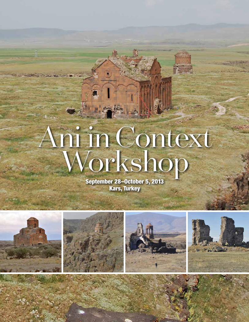
Ani in Context Workshop
September 28–October 5, 2013Kars, Turkey

2
Ani in Context Workshop
September 28–October 5, 2013Kars, Turkey
Copyright ©2014 World Monuments Fund350 Fifth Avenue, Suite 2412New York, New York 10118
ISBN-10: 0-9858943-6-9ISBN-13: 978-0-9858943-6-8
This report in its entirety may be freely circulated; however content may not be reproduced partially or independently without the express permission of World Monuments Fund.
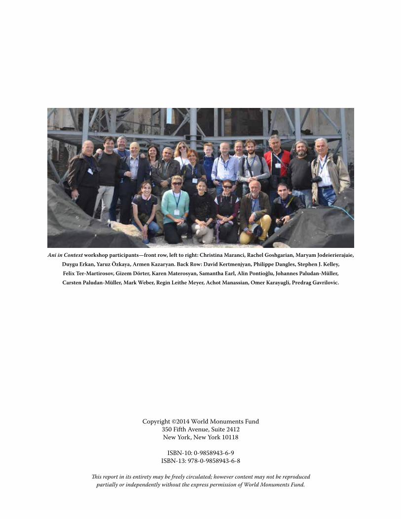
Ani in Context workshop participants—front row, left to right: Christina Maranci, Rachel Goshgarian, Maryam Jodeierierajaie, Duygu Erkan, Yaruz Özkaya, Armen Kazaryan. Back Row: David Kertmenjyan, Philippe Dangles, Stephen J. Kelley, Felix Ter-Martirosov, Gizem Dörter, Karen Materosyan, Samantha Earl, Alin Pontioğlu, Johannes Paludan-Müller, Carsten Paludan-Müller, Mark Weber, Regin Leithe Meyer, Achot Manassian, Omer Karayagli, Predrag Gavrilovic.
ForewordExecutive SummaryRisk Assessment MatrixAni in Context: Introduction and Priority Sites Mren Khtzkonk Horomos TignisMap of Sites SurveyedRisk Assessment Matrix Group 1 Horomos Cathedral of Mren Khtzkonk Tignis Fortress Karmirvank Taylar Church MagazberdRisk Assessment Matrix Group 2 Bagnayr Oguzlu Kizilvenk Bulanık Nakhichevan Uzun Church Digor Erazgavors Shepherd’s Church and BathsRisk Assessment Matrix Group 3 Zibni Bagaran Argina Argo Aritch Alaman AgarakBibliogrpahy and LiteratureAppendix A: Khtzkonk Monastery Assessment Ownership And Logistics History And Description Architectural Assessment Structural Assessment Additional Studies Observations on Tourism Potential and the CommunityRecommendationsAppendix B: Workshop Schedule and Participants
4
6
8
9
10
11
11
12
13
14
14
15
16
17
18
19
20
21
21
22
23
24
25
26
27
28
29
30
30
31
32
33
34
35
36
37
37
38
39
41
43
44
45
46
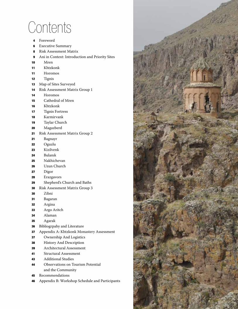
Contents
4
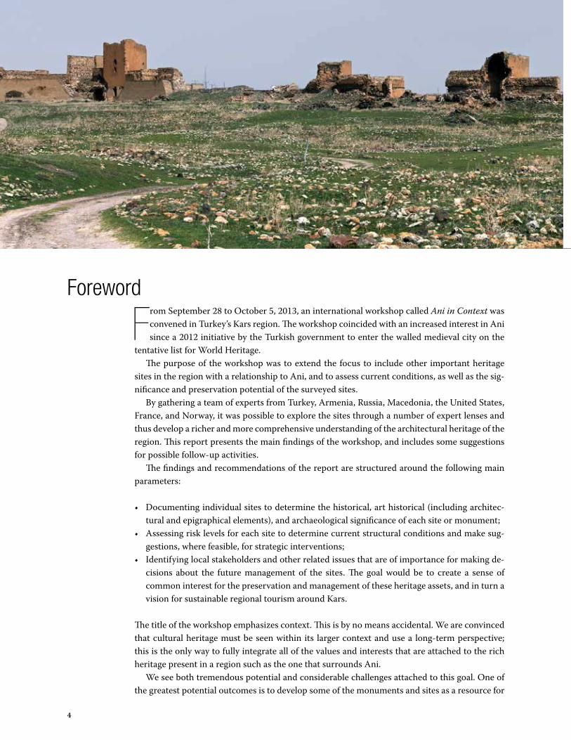
From September 28 to October 5, 2013, an international workshop called Ani in Context was convened in Turkey’s Kars region. The workshop coincided with an increased interest in Ani since a 2012 initiative by the Turkish government to enter the walled medieval city on the
tentative list for World Heritage.The purpose of the workshop was to extend the focus to include other important heritage
sites in the region with a relationship to Ani, and to assess current conditions, as well as the sig-nificance and preservation potential of the surveyed sites.
By gathering a team of experts from Turkey, Armenia, Russia, Macedonia, the United States, France, and Norway, it was possible to explore the sites through a number of expert lenses and thus develop a richer and more comprehensive understanding of the architectural heritage of the region. This report presents the main findings of the workshop, and includes some suggestions for possible follow-up activities.
The findings and recommendations of the report are structured around the following main parameters:
• Documenting individual sites to determine the historical, art historical (including architec-tural and epigraphical elements), and archaeological significance of each site or monument;
• Assessing risk levels for each site to determine current structural conditions and make sug-gestions, where feasible, for strategic interventions;
• Identifying local stakeholders and other related issues that are of importance for making de-cisions about the future management of the sites. The goal would be to create a sense of common interest for the preservation and management of these heritage assets, and in turn a vision for sustainable regional tourism around Kars.
The title of the workshop emphasizes context. This is by no means accidental. We are convinced that cultural heritage must be seen within its larger context and use a long-term perspective; this is the only way to fully integrate all of the values and interests that are attached to the rich heritage present in a region such as the one that surrounds Ani.
We see both tremendous potential and considerable challenges attached to this goal. One of the greatest potential outcomes is to develop some of the monuments and sites as a resource for
Foreword

5
the local communities that surround them. This is an approach that will benefit both the mon-uments and the local communities by creating shared common interest in the preservation and sustainable management of these unique objects. On a larger scale, this can also encourage the development of a viable and sustainable tourism industry in the Kars region as a whole.
We also see great potential in emphasizing the richness and diversity of the history and cul-tural impulses that have shaped the region, where, for instance, we find masterpieces of early Christian architecture alongside Anatolia’s earliest mosque. This diversity and sense of history’s great tides converging have the potential to go well beyond a local audience and become fasci-nating and attractive to an international group of travelers.
As in many parts of the world with rich and abundant cultural heritage, the challenges are considerable. Preservation and sustainable management are not easily extended to every object that one would wish to preserve, and much has already been damaged beyond affordable repair. However, much still remains that could be saved for the future by an early but reasonable allo-cation of resources.
In the report we have tried to prioritize those sites that are particularly important, as well as those with issues that must be dealt with urgently in order to stabilize and safeguard them for the future.
It is our hope that this report can be used as a contribution and inspiration to supplement and encourage the ongoing work in the region and to secure its cultural heritage as an important resource for the future of the area surrounding Ani.
The workshop and this report have benefitted from a fruitful cooperation on an institutional level between Anadolu Kültür, World Monuments Fund, NIKU, Research Center for Anatolian Civilizations at Koç University, and in particular the Norwegian Embassy in Turkey, that so generously allocated the funds to make this initiative possible. We thank all involved for their enthusiasm and support.
Carsten Paludan-MüllerGeneral Director, NIKU
Norwegian Institute for Cultural Heritage Research

6
Between September 29 and October 4, 2013, site visits were realized in the Kars region. On October 5, the wrap up session was held in Kars at the Büyük Kale Hotel where the partici-pants stayed. The workshop was made possible with funding from the Norwegian Embassy
in Ankara.
Goals of workshopThe purpose of the workshop was to convene an array of experts to review conditions and share knowledge of a series of important monuments historically linked to the walled city of Ani, most of which retain their architectural forms and features and bear testimony to Armenian tradi-tion. The cultural landscape of the region surrounding Kars is characterized by these numerous historic structures and architectural remains, which enliven and complete Ani’s rich history. It is a heritage that potentially could be developed into an economic asset for local communities.
On the first day of the workshop, the group visited Ani to familiarize itself with the site and to review the range of conservation issues that it presents. Of particular interest was the ongoing work at Ani Cathedral and Church of the Holy Savior (Surp Amenap’rkitch) that represents a collaborative effort between World Monuments Fund and the Turkish Ministry of Culture and Tourism. In 1996, WMF listed both sites as part of its Watch program to raise awareness and build advocacy on an international level. In subsequent cycles, WMF selected the sites for re-peated inclusion, demonstrating both the urgent need and significant cultural importance of Ani.
Since inclusion in the Watch, WMF has undertaken and supported the documentation and conservation program that will result in the stabilization of Ani Cathedral and Church of the Holy Savior, as well as improved public presentation and interpretation of the Ani archaeological landscape. The interest of the Norwegian Institute for Cultural Heritage Research (NIKU) in Ani complements WMF’s work and advocacy at the site and provided a powerful and valuable forum for expanding appreciation and international participation in the research and interpretation associated with the project.
The 22 sites that were visited were chosen for study because they are within the immediate vicinity of Ani, no more than an hour and a half away. Many of the monuments in question are of high cultural value, but in desperate need of remedial action. This heritage lies on both sides of the Armenian-Turkish border. This workshop focused on the monuments on the Turkish side.
Executive Summary

7
Group methodology for reportWhile the field visits were exploratory and meant for gathering information and collaborative exchange, on the final day the entire group participated in an official wrap-up/closing meeting to refine lessons learned and determine next steps. The sites were reviewed, and a prioritized list was established that weighed historical significance and vulnerability as deciding factors in terms of recommended urgency of intervention. This ranking formed the basis of the Risk As-sessment Matrix that is an integral part of this report.
The outcomes and results of the workshop were multifold. First, the workshop participants were able to establish a list of priority sites which are in need of immediate action. The Cathedral of Mren, Horomos Monastery, Tignis Fortress, and the monastic complex of Khtzkonk fall into the group’s top-tier ranking for their combined significance and vulnerability, and it is these four sites that are recommended for first possible interventions, as elucidated in the section Ani in Context: Introduction and Priority Sites. In addition to generating a list of priority sites, the group decided to focus on Khtzkonk Monastery as a test case study (see Appendix A), detail-ing a multi-disciplinary assessment and formulating a list of suggested actions, including the exploration of options for income generation in the local community. Similar analyses could be performed on the additional sites in the future.
Through the site visits and the creation of the Risk Assessment Matrix, the workshop par-ticipants were able to generate an overview of the 22 sites that were visited, many of which are little-known. The Risk Assessment Matrix is strongly reflected in the brief Site Survey, and the two should be considered in tandem.
Risk Assessment Matrix The Risk Assessment Matrix is considered a preliminary, cursory snapshot of the sites visited by Ani in Context team members. It is based upon the book Risk Preparedness: A Management Manual for World Cultural Heritage by Herb Stovel (ICCROM Rome 1998). All assessment work was visual only, and no exploratory investigative work (such as sondages or material sam-ple testing) was performed. The time devoted to each site was two hours or less. If these sites are assessed further, it will be appropriate to re-evaluate the matrix. In addition, many of the sites were at one time composed of more than one structure, but where these structures no longer exist, they are not included. Cemeteries, mausoleums, and secondary structures were not the focus of the workshop, but these elements may be useful for further study on subsequent visits.
To create the Risk Assessment Matrix the visited sites were given numerical rankings from 1 to 25 for significance and 1 to 35 for vulnerability. These were based on a variety of established factors with the terms used in the significance rankings defined as follows:
• Heritage significance: How much previous research existed on the structure? Was the name of the building known?
• Building form: To what extent could the building’s form be understood based on observa-tions made from the exterior?
• Exterior significant fabric: How much of the (decorative) fabric remained on the building’s exterior?
• Interior significant fabric: How much of the (decorative) fabric remained on the interior? • Archaeological remains: From an archaeological standpoint, how significant were the re-
mains that were found?
Using the rankings generated by the matrix, the sites were then grouped according to the urgen-cy of intervention. The four sites that appear in Group 1 of the matrix, Cathedral of Mren, Khtz-konk Monastery, Horomos Monastery, and Tignis Fortress, are in need of immediate action.

8
Risk AssessmentMatrix
Significance Vulnerability
herit
age
sign
ifica
nce
inta
ctne
ss o
f bui
ldin
g fo
rm
exte
rior s
igni
fican
t fab
ric
inte
rior s
igni
fican
t fab
ric
arch
aeol
ogic
al re
mai
ns
Sign
ifica
nce
Ratin
g
stru
ctur
al in
stab
ility
diffi
culty
of a
cces
s
earth
quak
e
win
d an
d ra
in e
rosi
on
soil
inst
abili
ty
flood
ing
anth
ropo
geni
c
Vuln
erab
ility
Rat
ing
Sign
ifica
nce
+ V
ulne
rabi
lity
Grou
p 1—
Requ
ires
imm
edia
te a
ctio
n
Horomos—Surb Minas 5 4 4 4 5 22 5 4 5 5 1 4 5 29 51
Horomos—Surb Gevorg 5 4 4 4 5 22 5 4 5 5 1 4 5 29 51
Cathedral of Mren 5 4 5 5 5 24 5 5 5 5 1 0 5 26 50
Khtzkonk—Surb Sargis 5 5 5 4 5 24 4 5 4 3 2 0 4 22 46
Horomos—Surb Yovhannes 5 4 2 5 5 21 5 3 5 5 0 0 5 23 44
Horomos—Salle Abside 5 3 2 5 5 20 5 3 5 5 0 0 5 23 43
Tignis Fortress 4 3 3 2 5 17 5 3 5 5 2 0 4 24 41
Karmirvank 4 5 4 4 5 22 4 3 4 3 1 1 3 19 41
Taylar Church 4 4 4 4 5 21 5 2 5 5 0 0 3 20 41
Magazberd 4 3 3 2 5 17 3 5 5 5 1 0 4 23 40
Grou
p 2—
Poss
ible
eve
ntua
l act
ion
Bagnayr—Surb Astvatsatsin 5 3 2 4 5 19 4 0 5 5 0 1 4 19 38
Oguzlu 4 2 4 3 5 18 5 0 5 5 0 0 4 19 37
Kizilvenk 2 5 5 4 5 21 1 0 5 2 0 2 5 15 36
Bulanık 3 2 2 1 5 13 5 3 5 5 1 0 3 22 35
Nakhichevan 4 1 1 0 5 11 5 0 5 5 0 5 4 24 35
Uzun Church 2 2 3 3 5 15 5 0 5 5 0 0 4 19 34
Horomos—“Triumphal Arch” 5 2 2 2 5 16 3 1 3 5 2 0 3 17 33
Digor 5 2 2 1 5 15 4 1 3 5 2 0 5 18 33
Erazgavors 4 1 1 1 5 12 4 1 5 5 1 0 4 20 32
Shepherd’s Church and Baths 4 2 1 1 5 13 4 1 5 5 0 0 3 18 31
Grou
p 3—
No a
ctio
n ne
cess
ary
Zibni 3 4 3 2 5 17 1 0 3 0 0 0 3 7 24
Bagaran—Fortress 5 3 3 3 5 19 0 0 0 1 0 0 3 4 23
Bagaran—“Red” Church 5 0 3 3 5 16 0 0 0 1 0 0 0 1 17
Bagaran—Surb Teodoros 5 1 1 1 5 13 0 0 0 0 1 0 3 4 17
Argina 5 0 1 1 5 12 0 1 0 1 0 0 0 2 14
Argo Aritch 4 0 1 0 5 10 0 1 0 1 0 0 0 2 12
Alaman 4 0 0 0 5 9 0 1 0 1 0 0 0 2 11
Agarak 3 0 0 0 5 8 0 1 0 1 0 0 0 2 10

9
Ani: a royal medieval capital, a center for Silk Route trade, a treasure of art and architecture, a romantic ruin. In the nineteenth century, European travelers were stunned by the quality and number of medieval monuments; today, Ani is recognized across the world as a cul-
tural site of profound significance. Historians of medieval Anatolia and scholars of Armenian, Byzantine, and Islamic architecture have long studied Ani, and a vast bibliography has emerged. Ani has become a focus for projects of archaeological excavation and architectural preservation, and a destination for tourists. But is Ani an isolated phenomenon? What is beyond its walls? To what extent should Ani be understood within the broader cultural landscape of the Kars region? These questions are the focus of the recent workshop, Ani in Context.
The results that emerged from the workshop show that 1) Ani is not isolated, but forms part of a rich network of medieval cultural heritage that extends throughout the Kars region; 2) this broader network has the potential for both tourism and local development; and 3) such devel-opment would hinge on the preservation of monuments that are in many cases perilously close to collapse. These points are exemplified by four monuments: the Cathedral of Mren, Khtzkonk Monastery, Horomos Monastery, and Tignis Fortress.
Ani in Context: Introduction and Priority Sites

10
The Cathedral of MrenThe seventh-century Cathedral of Mren, located south of Ani, is one of the largest domed basilicas preserved from the medieval Caucasus. Mren is celebrated by Byzantinists and Armenologists as rare material evidence for the global wars of the seventh century, an era that witnessed the radi-cal transformation of the political landscape of the Mediter-ranean and Near East. Mren preserves a unique image of the Byzantine emperor Heraclius, and mentions him in its west façade inscription. The Cathedral of Mren is also a key mon-ument for understanding the architectural developments of the tenth and eleventh centuries at Ani. With its attenuated proportions and elegant profiled piers, it is often regarded as a source for the Cathedral of Ani. The royal Bagratid dynasty, who made Ani their capital in 971, also maintained a summer resi-dence at Mren. Mren remained an active site in the thirteenth century, when a rich individual named Sahmadin constructed a large Islamic-style residence with formal relations to monuments at Ani. The Cathedral of Mren has the potential, therefore, to deepen our knowledge of the tre-mendous cultural heritage of the Kars region and to demonstrate the interconnected nature of its monuments. Yet the precarious condition of Mren must first be addressed. In 2008, the entire south wall of the church collapsed; now the northwest corner has begun to crack, and the Hera-clius lintel is no longer supported from below. The significance of the monument and its unsta-ble condition have recently been acknowledged by World Monuments Fund (WMF), which has included it on its 2014 World Monuments Watch. It is vital that Mren be preserved, not only for world history and architecture, but also for the touristic opportunity it holds for the Kars region.
Khtzkonk MonasteryThe monastic complex of Khtzkonk is situated on a dramatic promontory overlooking the Digor River valley. Surb Sargis (founded 1029), the only surviving church of the complex, is a striking rotunda, elevated on a stylobate, wrapped in engaged semi-columns, and topped with a rare example of an umbrella-style cupola. In its composition, Khtzkonk Monastery bears precious

11
evidence for the formation and expansion of the architectural school of Ani. Ani Cathedral and other contemporary mon-uments call attention to the exterior planes of the building through a coherent envelope of engaged columns and arches. Khtzkonk is a particularly refined example of this phenomenon. The exterior of the church, moreover, is covered in inscriptions that record the many donations to and restorations of the mon-astery. These texts demonstrate the social, political, and eco-nomic interconnection of the elites in the region: indeed, one indicates the gift to the monastery of a vineyard at Mren. With its architectural and decorative features, and its extraordinarily picturesque setting in the landscape, Khtzkonk holds great po-tential to attract tourism to the region. Yet Surb Sargis, like Mren Cathedral, is no longer struc-turally stable. Experts in structural engineering and seismology, participants in our workshop, have concluded that emergency measures must be to undertaken ensure the safety of tourists and the preservation of the building.
Horomos Monastery The monastery of Horomos is located ten kilometers north of Ani. It consists of upper and lower monasteries, which were accessed by an extraordinary and unique triumphal arch. Founded in

12
the tenth century, Horomos is a treasure of architecture, featuring ecclesiastical, memorial, and monastic spaces, several unique decorative and architectural elements, and a range of building styles dating from the tenth to the thirteenth centuries. The gorgeous setting of this site, on a bluff overlooking the Akhuryan/Arpaçay River, only enhances its architectural characteristics. Given its size, its royal Bagratid associations, and its strong presence in medieval chronicles, it is thought to be the most important monastery in the vicinity of Ani. The antechamber—or zhamatun—of the main church of Upper Horomos is the best known building at the site. Dating to circa 1038, it is regarded as the earliest preserved example in Armenian architecture of a monastic structure attached to the façade of the church. It is also a building of tremendous architectural virtuosity, featuring a flat, stone-paneled ceiling and an open cupola, both with elaborate decoration. As with Khtzkonk Monastery and Mren Cathedral, this structure is in danger; our experts made note of a series of structural problems with the antechamber, including the instability of the cupola. As a whole, Horomos Monastery presents both an opportunity for projects of preservation and the possibility to develop a supremely picturesque tourist site.
Tignis FortressThe monuments preserved in the territory of Kars include examples of medieval military ar-chitecture. The walls of Ani are surely the best known of this genre, but the citadels and urban fortification of Kars and Bagaran and the smaller fortresses of Magazberd and Tignis prove that Ani was not an isolated case, and attest to the history a region coveted by various invaders. The
fortress of Tignis, overlooking the village of Kalkankale, preserves parts of both inner and outer circuit walls, towers, and evidence for chambers within the towers. Its history remains largely unknown. The fortress certainly presents an impressive, if fragmentary, sense of the power of military architecture: the remains are quite tall. Unfortunately, they are also unstable. A large part of it has been lost since the beginning of the twentieth century, and it is thought that what remains of this magnificent site will disappear if structural measures are not soon undertaken.
Christina MaranciArthur H. Dadian and Ara T. Oztemel Associate Professor of Armenian Art
Tufts University

13
Included in the following survey is the registration status of each site. “Registered” cultural her-itage sites and monuments are those that embody characteristics of the period they pertain to and are identified as cultural property, taking into account their history, art, and region. Follow-ing identification, the property is registered by the Regional Council for Conservation to be pro-tected, to the extent possible, by the state. For more information on monument registration and protection, see http://www.kulturvarliklari.gov.tr/TR,43249/law-on-the-conservation-of-cul-tural-and-natural-propert-.html.
Map of Sites Surveyed
Ani
Shepherd’s Church and BathsHoromos MonasteryTaylar
Karmirvank
Oguzlu
Kizilvenk
Argina
Uzun Church
Erazgavors
Tignis Fortress
Bulanık
Bagnayr
Argo Aritch Magazberd
DigorKhtzkonkAgarak
Alaman
Nakhichevan
Bagaran
Zibni
Cathedral of Mren

14
Horomos Monastery10th–13th centuries
Site Description and SignificanceHoromos was perhaps the most important monas-tery in the vicinity of Ani, the medieval capital of Ar-menia. The complex of monastic buildings of Horo-mos is one of the largest in medieval Armenia and the whole of the Christian east. It consists of Surb Minas, Surb Gevorg, Surb Yovhannes zhamatun, Salle Abside, and the “triumphal arch.” It is an exceptional architectural ensemble that is also admired for its magnificent setting on the nat-ural landscape. There is rich information about the origins and development of the monastery in historical documents and on the epigraphy that lines the walls of numerous monastic buildings.
ConditionThe buildings were already in need of repair in the early twentieth cen-tury. After decades of natural deteri-oration, vandalism to the walls, and illegal excavation, they are now in a state of disrepair.
Urgency and Recommended ActionMatrix Group 1—Requires imme-diate action. Some of the smaller constructions of the complex have already disappeared, and the other structures need immediate and ex-tensive stabilization and restoration.
LOCATION AND ACCESSIBILITY
Merkez/Central DistrictN 40.519818, E 43.62925
The architectural ensemble is located roughly 10 kilometers north of Ani, on the northwest bank of Akhuryan/Arpaçay River. The complex of Horomos is accessible by vehicle, followed by a half-hour walk each way.
REGISTERED
Risk Assessment Matrix Group 1

15
Cathedral of Mren7th century
Site Description and SignificanceConstructed in a.d. 638, at the height of the Byzantine-Persian wars and the start of the Arab conquests, Mren is a touchstone of a world ravaged by conflict and the fruits of collaboration among diverse po-litical constituents. Historians of Armenia, of the late Roman and Persian empires, and of early Islam have studied its inscriptions and sculptures for precious insight into this poorly documented era. At the same time, scholars value Mren as a canonical monument of the “Golden Age” of Armenian architecture, as the largest preserved
domed basilica from seventh-century Armenia, and as an inspiration for the celebrated nearby Cathedral of Ani (a.d. 989). At the same time, Mren is cherished by Arme-nians internationally as part of their cultural heritage.
ConditionSatellite images reveal that Mren is surrounded by an ex-tensive archeological site. On the cathedral itself, there is graffiti and signs of illegal excavations.
Urgency and Recommended ActionMatrix Group 1—Requires immediate action. World Monuments Fund included the Cathedral of Mren on its 2014 World Monuments Watch to underscore the ex-treme urgency of the situation. The south façade has al-ready collapsed and the remainder of the structure is in a very fragile state.
LOCATION AND ACCESSIBILITY
Digor District
N 40.24123, E 43.66160
The abandoned Cathedral of Mren stands on a high plateau bordered at the east and south by the Akhuryan/Arpaçay River valley and by a dry gorge to the west. The closest villages are Kilittası (3 kilometers due south) and Karabagh (5 kilometers to the west). Mren lies in a military zone and is currently not accessible to the public.
REGISTERED

16
Khtzkonk Monastery9th–11th centuries
Site Description and SignificanceThe origins of the monastery date to the post-Arab era, when the first church, Surb Karapet, was built. The monastery had a total of five churches: Surb Karapet, Surb Astuacacin, Surb Stepanos, Surb Gregory, and Surb Sargis, all of which were domed and carefully built out of finely cut stone. Today, only the church of Surb Sargis remains standing.
ConditionThere are signs of illegal excavation and fire inside the church and there are significant amounts of graffiti on the walls.
Urgency and Recommended ActionMatrix Group 1—Requires immediate action. At present the building is not safe for any purpose including tourist visits, and access to the monument should be prohibited. Emergency measures are necessary to stabilize the structure, followed by more in-depth restoration work. For a more detailed explana-tion, see Appendix A: Khtzkonk Monastery Assessment.
LOCATION AND ACCESSIBILITY
Digor DistrictN 40.380384, E 43.376399
Khtzkonk Monastery is not accessible from the road. For access to the site, one must travel west from Digor’s town center, through the gorge, for approximately 4.5 kilometers. Alternately, one can access the site directly from Agarak. The descent is more difficult but the total travel time is significantly reduced using this route.
REGISTERED
17
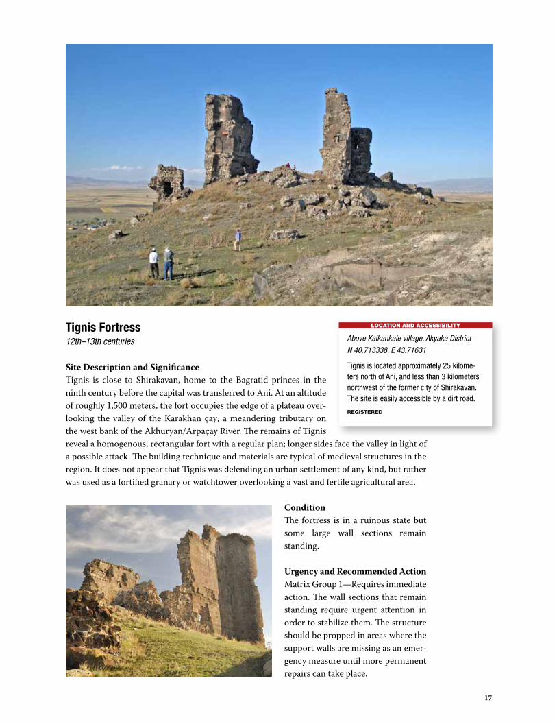
Tignis Fortress12th–13th centuries
Site Description and SignificanceTignis is close to Shirakavan, home to the Bagratid princes in the ninth century before the capital was transferred to Ani. At an altitude of roughly 1,500 meters, the fort occupies the edge of a plateau over-looking the valley of the Karakhan çay, a meandering tributary on the west bank of the Akhuryan/Arpaçay River. The remains of Tignis reveal a homogenous, rectangular fort with a regular plan; longer sides face the valley in light of a possible attack. The building technique and materials are typical of medieval structures in the region. It does not appear that Tignis was defending an urban settlement of any kind, but rather was used as a fortified granary or watchtower overlooking a vast and fertile agricultural area.
ConditionThe fortress is in a ruinous state but some large wall sections remain standing.
Urgency and Recommended ActionMatrix Group 1—Requires immediate action. The wall sections that remain standing require urgent attention in order to stabilize them. The structure should be propped in areas where the support walls are missing as an emer-gency measure until more permanent repairs can take place.
LOCATION AND ACCESSIBILITY
Above Kalkankale village, Akyaka DistrictN 40.713338, E 43.71631
Tignis is located approximately 25 kilome-ters north of Ani, and less than 3 kilometers northwest of the former city of Shirakavan. The site is easily accessible by a dirt road.
REGISTERED
18
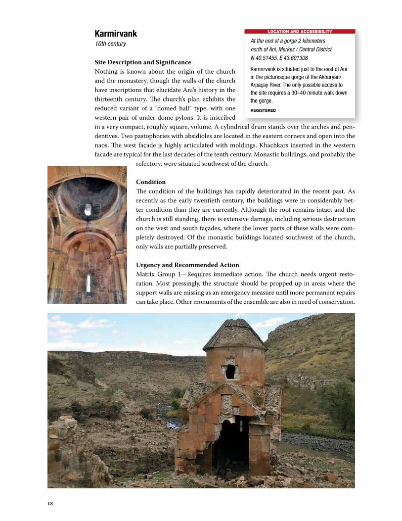
Karmirvank 10th century
Site Description and SignificanceNothing is known about the origin of the church and the monastery, though the walls of the church have inscriptions that elucidate Ani’s history in the thirteenth century. The church’s plan exhibits the reduced variant of a “domed hall” type, with one western pair of under-dome pylons. It is inscribed in a very compact, roughly square, volume. A cylindrical drum stands over the arches and pen-dentives. Two pastophories with absidioles are located in the eastern corners and open into the naos. The west façade is highly articulated with moldings. Khachkars inserted in the western facade are typical for the last decades of the tenth century. Monastic buildings, and probably the
refectory, were situated southwest of the church.
ConditionThe condition of the buildings has rapidly deteriorated in the recent past. As recently as the early twentieth century, the buildings were in considerably bet-ter condition than they are currently. Although the roof remains intact and the church is still standing, there is extensive damage, including serious destruction on the west and south façades, where the lower parts of these walls were com-pletely destroyed. Of the monastic buildings located southwest of the church, only walls are partially preserved.
Urgency and Recommended ActionMatrix Group 1—Requires immediate action. The church needs urgent resto-ration. Most pressingly, the structure should be propped up in areas where the support walls are missing as an emergency measure until more permanent repairs can take place. Other monuments of the ensemble are also in need of conservation.
LOCATION AND ACCESSIBILITY
At the end of a gorge 2 kilometers north of Ani, Merkez / Central DistrictN 40.51455, E 43.601308
Karmirvank is situated just to the east of Ani in the picturesque gorge of the Akhuryan/Arpaçay River. The only possible access to the site requires a 30–40 minute walk down the gorge.
REGISTERED

19
Taylar Church 10th century
Site Description and SignificanceThe plan of Taylar Church represents the Armenian “domed hall” on a smaller scale and in new propor-tions. Unlike mainstream examples, which depict the evolution of this architectural type in Bagratid times that show the eastern pair of pylons verged on the apse, the architect of Taylar reversed the tradi-tional interpretation and situated the dome over the
center of the naos. As a result, the dome’s position on the exterior is slightly displaced from the center of the main volume to the west.
ConditionThe structure is in a dangerous condition. There is serious damage on the southern and eastern support walls and the vault’s close-domed square is completely collapsed. The surfaces are marked with graffiti and the pres-ence of small holes suggests that guns were fired at the walls. There are also indications that the site was previously used as an animal shelter.
Urgency and Recommended ActionMatrix Group 1—Requires immediate action. The monument needs urgent and complete restoration. The structure should be propped in areas where the support walls are missing as an emergency measure until more perma-nent repairs can take place.
LOCATION AND ACCESSIBILITY
Merkez / Central DistrictN 40.537294, E 43.637732
Taylar Church is situated next to the village of Taylar, roughly 2 kilometers northeast of Horomos, on a high bank of the Akhuryan/Arpaçay River. The church is framed by a canyon on all sides except one, where a wall with an arched gate was constructed. The site is accessible by car.
NOT REGISTERED

20
Magazberd 5th century /10th–13th centuries
Site Description and SignificanceMagazberd consists of a small fortress protecting a ford on the Akhuryan/Arpaçay River, and a large ur-ban fortified settlement above it. The city may have existed as early as the late fifth or early sixth century. The existing structure of the fortress is most likely contemporary with the walls of Ani (tenth to thirteenth centuries and later). The main surviving part of the fortification consists of a double wall on its northern side, furnished with three closely set semi-circular towers. The plan of the inner and outer walls closely recalls that of the northern walls of Ani. In the territory of the set-
tlement remain the ruins of several buildings and a large cistern.
ConditionThe site could not be accessed close up and therefore could only be inspected from one side at a distance of about 300 meters. The gate that is flanked by towers appears to be intact and the walls of the fortress are in relatively good condition. The settle-ment, however, is ruined. It was previously used as a garrison for the Turkish army and both the settlement and fortress are closed to visitors. A more detailed assessment of the condition can be determined after a visit and analysis by experts.
Urgency and Recommended ActionMatrix Group 1—Requires immediate action. Permission should be sought to inspect the for-tress close up and to plan for long-term maintenance.
LOCATION AND ACCESSIBILITY
Digor DistrictN 40.475624, E 43.541173
Magazberd is located within a military zone, 1.5 kilometers from a military base, and is therefore inaccessible.
REGISTERED
21
Risk Assessment Matrix Group 2
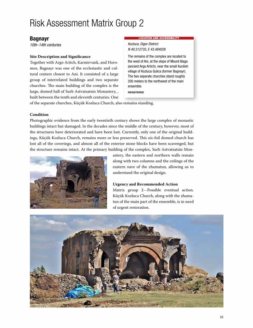
Bagnayr10th–14th centuries
Site Description and SignificanceTogether with Argo Aritch, Karmirvank, and Horo-mos, Bagnayr was one of the ecclesiastic and cul-tural centers closest to Ani. It consisted of a large group of interrelated buildings and two separate churches. The main building of the complex is the large, domed hall of Surb Astvatsatsin Monastery, , built between the tenth and eleventh centuries. One of the separate churches, Küçük Kozluca Church, also remains standing.
ConditionPhotographic evidence from the early twentieth century shows the large complex of monastic buildings intact but damaged. In the decades since the middle of the century, however, most of the structures have deteriorated and have been lost. Currently, only one of the original build-ings, Küçük Kozluca Church, remains more or less preserved. This six-foil domed church has lost all of the coverings, and almost all of the exterior stone blocks have been scavenged, but the structure remains intact. At the primary building of the complex, Surb Astvatsatsin Mon-
astery, the eastern and northern walls remain along with two columns and the ceilings of the eastern nave of the zhamatun, allowing us to understand the original design.
Urgency and Recommended ActionMatrix group 2—Possible eventual action. Küçük Kozluca Church, along with the zhama-tun of the main part of the ensemble, is in need of urgent restoration.
LOCATION AND ACCESSIBILITY
Kozluca, Digor DistrictN 40.512735, E 43.484026
The remains of the complex are located to the west of Ani, at the slope of Mount Alaga (ancient Argo Aritch), near the small Kurdish village of Kozluca Gulica (former Bagnayr). The two separate churches stand roughly 200 meters to the northwest of the main ensemble.
REGISTERED
22
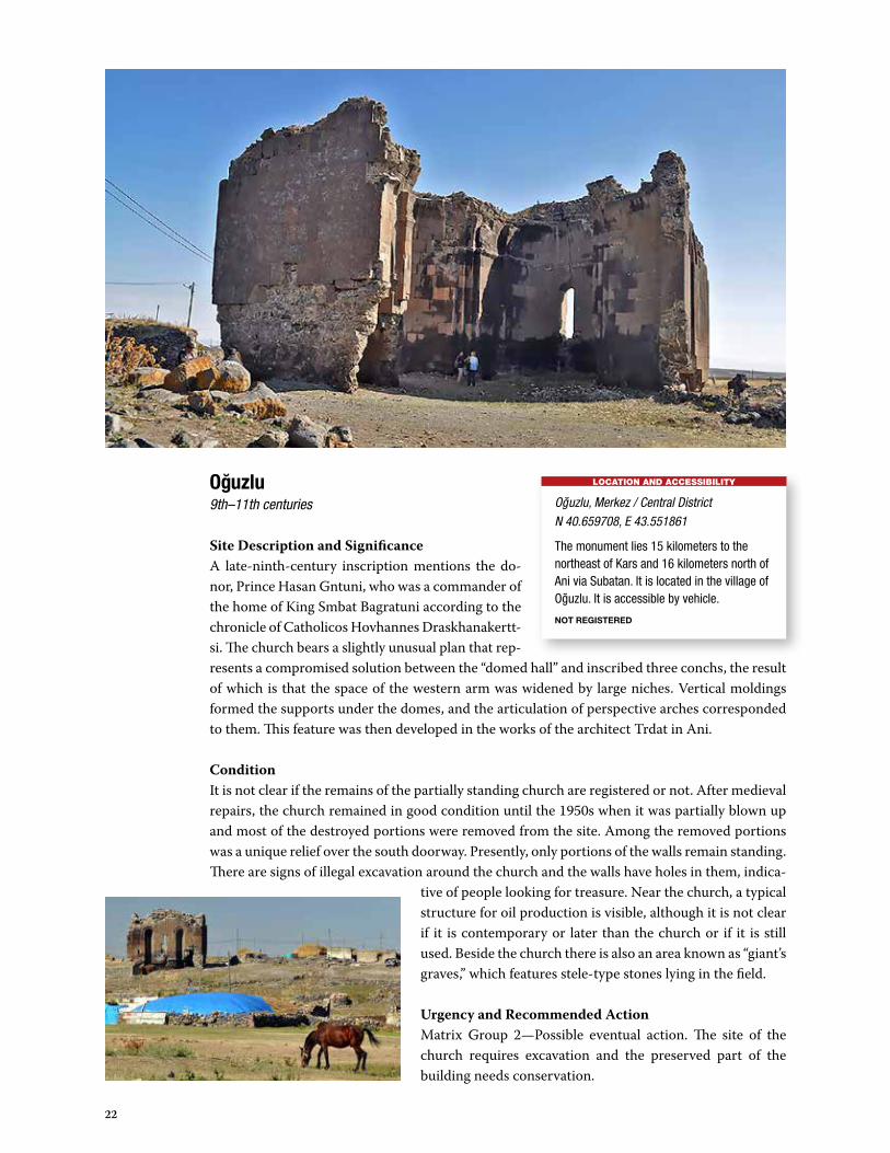
Oguzlu9th–11th centuries
Site Description and SignificanceA late-ninth-century inscription mentions the do-nor, Prince Hasan Gntuni, who was a commander of the home of King Smbat Bagratuni according to the chronicle of Catholicos Hovhannes Draskhanakertt-si. The church bears a slightly unusual plan that rep-resents a compromised solution between the “domed hall” and inscribed three conchs, the result of which is that the space of the western arm was widened by large niches. Vertical moldings formed the supports under the domes, and the articulation of perspective arches corresponded to them. This feature was then developed in the works of the architect Trdat in Ani.
ConditionIt is not clear if the remains of the partially standing church are registered or not. After medieval repairs, the church remained in good condition until the 1950s when it was partially blown up and most of the destroyed portions were removed from the site. Among the removed portions was a unique relief over the south doorway. Presently, only portions of the walls remain standing. There are signs of illegal excavation around the church and the walls have holes in them, indica-
tive of people looking for treasure. Near the church, a typical structure for oil production is visible, although it is not clear if it is contemporary or later than the church or if it is still used. Beside the church there is also an area known as “giant’s graves,” which features stele-type stones lying in the field.
Urgency and Recommended ActionMatrix Group 2—Possible eventual action. The site of the church requires excavation and the preserved part of the building needs conservation.
LOCATION AND ACCESSIBILITY
Oguzlu, Merkez / Central DistrictN 40.659708, E 43.551861
The monument lies 15 kilometers to the northeast of Kars and 16 kilometers north of Ani via Subatan. It is located in the village of Oguzlu. It is accessible by vehicle.
NOT REGISTERED

23
Kizilvenk10th–13th centuries
Site Description and SignificanceThe main space of the cross-domed church and the additional chapels in its four corners are com-pressed into a compact, almost square, volume. A
cylindrical drum stands over the arches and pendentives. The western façade features a monu-mental portal and the other walls have pairs of niches. ConditionThe building suffered damage during the 1877 Russo-Turkish War, but was repaired during the 1880s, according to the inscription on the tympanum over the doorway. Currently, tiles of the roofs are dam-aged, and some cracks are present. The building is pres-ently used for storage, and on one elevation, animal ma-nure has been stacked against the wall. All of the windows are closed and the rest of the structure is sealed from un-wanted intrusion.
Urgency and Recommended ActionMatrix Group 2—Possible eventual action. It is necessary to clean the church from recent local activity. Repairing parts of the walls and the roof will most likely be neces-sary in the coming years.
LOCATION AND ACCESSIBILITY
Yagkesen, Merkez / Central DistrictN 40.475624, E 43.541173
The church is located in the eastern part of the village of Yagkesen, in a private yard.
REGISTERED

24
Bulanık7th century
Site Description and SignificanceThe history of the church is unknown, but the structure can be described as a simple three-conch layout, typical of seventh-century Arme-nian churches. Remnants of doors exist on the western and southern exedrae, as well as a door on the eastern end of the northern exedra which, as an exceptional solution, is adjoined to the apse.
ConditionThe building is ruined and the fragments are in
a dangerous condition. Never-theless, the floor plan and the main shapes of the arms of the cruciform structure are distinguishable. The ru-ins consist of part of the preserved window archivolts with carving.
Urgency and Recommended ActionMatrix Group 2—Possible eventual action. The ruined church requires conservation.
LOCATION AND ACCESSIBILITY
“Yayla” of Hacıveli and Hamzagerek villages, Merkez / Central DistrictN 40.557064, E 43.374943
Bulanık is located between the villages of Bulanık and Hacıveli, approximately 8 kilometers from Bulanık via Subatan. The ruins are in the yayla, or summer settlement, of the village of Haciveli. Situated 2 kilometers from Bulanık, the best route of access to the ruins is from the town itself, where a dirt road leads away from the main road from Kars to Ani. The crossroad is 10 kilometers from Kars. The walk from Bulanık or Hacıveli is roughly 45 minutes or a tractor can be used for access from Bulanık.
NOT REGISTERED

25
Nakhichevan5th–7th centuries
Site Description and SignificanceThe early Christian complex consists of the church and the mausole-um. The passage (which also contains a tomb) leading into the mau-soleum has an inscription about Prince Artavazd Kamsarakan, who is buried there. The Kamsarakans were the family owners of Shirak and Arsharunik, two important provinces of the Ayrarat land of Greater Armenia until the eighth century. The church also contains a single-line inscription with letters typical of seventh-century Armenian epigraphy and the local school has spolia from the church with inscriptions and decorations dating from the same period.
ConditionSometime in the 1880s the locals incorporated the half-preserved church into a new one, and it remained in this condition until 1920. Today, after being mostly destroyed, only remnants from
the rubble of three pylons are preserved. The mausoleum has an entrance underground but it is currently filled with mud.
Urgency and Recommended ActionMatrix Group 2—Possible eventual action. The site requires archaeological investigation. Remains of the church’s pylons must be pre-served, and the mausoleum needs conservation.
LOCATION AND ACCESSIBILITY
Kocaköy, Digor DistrictN 40.288823, E 43.458006
The Church of Surb Stepanos Protomartyr and the mausoleum are located in the village of Kocaköy on the right bank of the Digor River. The site is accessible by car.
REGISTERED
26
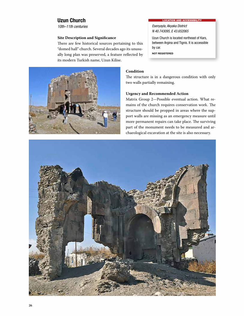
Uzun Church10th–11th centuries
Site Description and SignificanceThere are few historical sources pertaining to this “domed hall” church. Several decades ago its unusu-ally long plan was preserved, a feature reflected by its modern Turkish name, Uzun Kilise.
ConditionThe structure is in a dangerous condition with only two walls partially remaining.
Urgency and Recommended ActionMatrix Group 2—Possible eventual action. What re-mains of the church requires conservation work. The structure should be propped in areas where the sup-port walls are missing as an emergency measure until more permanent repairs can take place. The surviving part of the monument needs to be measured and ar-chaeological excavation at the site is also necessary.
LOCATION AND ACCESSIBILITY
Esenyayla, Akyaka DistrictN 40.743095, E 43.652065
Uzun Church is located northeast of Kars, between Argina and Tignis. It is accessible by car.
NOT REGISTERED

27
Digor5th century
Site Description and SignificanceThe date of the church’s construction and dedication to Surb Sargis in 480 were fixed on the now-lost foundation inscription. It is the first known cross-domed church, with four pylons under the dome, and therefore plays a significant role in helping to better understand the development of Eastern Christian architecture. The church had several interesting architectural shapes, including a large poly-step platform, monumental portals, a row of half columns, and rich carving decoration.
Condition The church was partially damaged by an earthquake at the end of the nineteenth century and it was later completely demolished, probably in the 1950s. Little remains of the church, which has been scavenged by the village. Currently, only the rubble core of a single wall remains, used to house chickens and other possessions belonging to the villagers. There are also signs and stories of illegal excavations.
Urgency and Recommended ActionMatrix Group 2—Possible eventual action. The territory of the former church needs to be cleaned from villagers’ household activ-ities and undergo archaeological examina-tion. Remains of the church need delicate conservation and the structure should be propped in areas where the support walls are missing as an emergency measure until more permanent repairs can take place.
LOCATION AND ACCESSIBILITY
Digor, Digor DistrictN 40.37501, E 43.41212
The village of Digor is located 22 kilometers southwest of Ani, accessible by vehicle. Within the village, remains of the large church are situated on the hill on the northwest part of the settlement.
REGISTERED
28
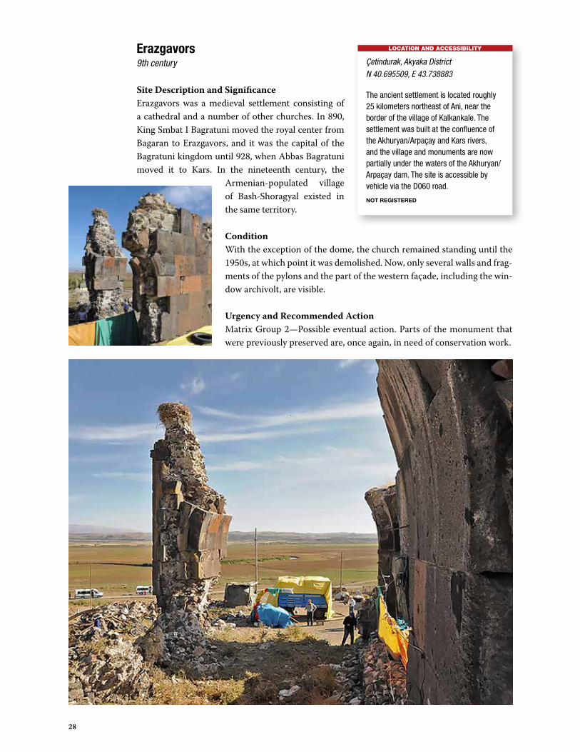
Erazgavors9th century
Site Description and SignificanceErazgavors was a medieval settlement consisting of a cathedral and a number of other churches. In 890, King Smbat I Bagratuni moved the royal center from Bagaran to Erazgavors, and it was the capital of the Bagratuni kingdom until 928, when Abbas Bagratuni moved it to Kars. In the nineteenth century, the
Armenian-populated village of Bash-Shoragyal existed in the same territory.
ConditionWith the exception of the dome, the church remained standing until the 1950s, at which point it was demolished. Now, only several walls and frag-ments of the pylons and the part of the western façade, including the win-dow archivolt, are visible.
Urgency and Recommended ActionMatrix Group 2—Possible eventual action. Parts of the monument that were previously preserved are, once again, in need of conservation work.
LOCATION AND ACCESSIBILITY
Çetindurak, Akyaka DistrictN 40.695509, E 43.738883
The ancient settlement is located roughly 25 kilometers northeast of Ani, near the border of the village of Kalkankale. The settlement was built at the confluence of the Akhuryan/Arpaçay and Kars rivers, and the village and monuments are now partially under the waters of the Akhuryan/Arpaçay dam. The site is accessible by vehicle via the D060 road.
NOT REGISTERED
29
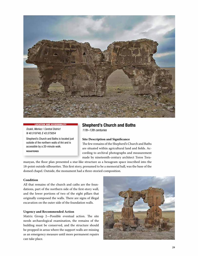
Shepherd’s Church and Baths11th–13th centuries
Site Description and SignificanceThe few remains of the Shepherd’s Church and Baths are situated within agricultural land and fields. Ac-cording to archival photographs and measurement made by nineteenth-century architect Toros Tora-
manyan, the floor plan presented a star-like structure as a hexagram space inscribed into the 18-point outside silhouettes. This first story, presumed to be a memorial hall, was the base of the domed chapel. Outside, the monument had a three-storied composition.
ConditionAll that remains of the church and caths are the foun-dations, part of the northern side of the first-story wall, and the lower portions of two of the eight pillars that originally composed the walls. There are signs of illegal excavation on the outer side of the foundation walls.
Urgency and Recommended ActionMatrix Group 2—Possible eventual action. The site needs archaeological examination, the remains of the building must be conserved, and the structure should be propped in areas where the support walls are missing as an emergency measure until more permanent repairs can take place.
LOCATION AND ACCESSIBILITY
Ocaklı, Merkez / Central DistrictN 40.519749, E 43.575054
Shepherd’s Church and Baths is located just outside of the northern walls of Ani and is accessible by a 20-minute walk.
REGISTERED

30
Zibni7th–10th centuries
Site Description and SignificanceThe small cross-plan domed church of Zibni is largely missing from historical sources, although some of its features were of interest to early twenti-eth-century scholars. Of particular note were the large reliefs of a lion and a bull, although now
they are known only through photographs. The plan of the church is similar to that of a large group of Armenian cross-form churches of the seventh cen-tury, but carved frames of the windows permit comparison with the works of the Ani school from the tenth century.
ConditionOlder residents of the village remember the church, which was destroyed around 1935 by an earthquake. It was later repaired to be used as a mosque, although the carvings and inscription on the outer walls remain. In an effort to protect the monument, the villagers recently renovated it, covering the interior with wood, but part of the accompanying cemetery was demolished during the road construction.
Urgency and Recommended ActionMatrix Group 3—No action required.
LOCATION AND ACCESSIBILITY
Varlı, Digor DistrictN 40.326033, E 43.407473
Zibni is located in the village of Varlı, south of Digor, and is accessible by vehicle. On the hill, to the west of the former church, there is an expansive ancient cemetery with large graves.
REGISTERED
Risk Assessment Matrix Group 3
31
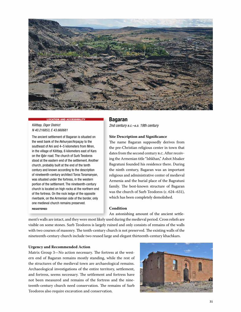
Bagaran2nd century b.c.–a.d. 19th century
Site Description and SignificanceThe name Bagaran supposedly derives from the pre-Christian religious center in town that dates from the second century b.c. After receiv-ing the Armenian title “Ishkhan,” Ashot Msaker Bagratuni founded his residence there. During the ninth century, Bagaran was an important religious and administrative center of medieval Armenia and the burial place of the Bagratuni family. The best-known structure of Bagaran was the church of Surb Teodoros (c. 624–631), which has been completely demolished.
ConditionAn astonishing amount of the ancient settle-
ment’s walls are intact, and they were most likely used during the medieval period. Cross reliefs are visible on some stones. Surb Teodoros is largely ruined and only consists of remains of the walls with two courses of masonry. The tenth-century church is not preserved. The existing walls of the nineteenth-century church include two reused large and elegant thirteenth-century khachkars.
Urgency and Recommended ActionMatrix Group 3—No action necessary. The fortress at the west-ern end of Bagaran remains mostly standing, while the rest of the structures of the medieval town are archaeological remains. Archaeological investigations of the entire territory, settlement, and fortress, seems necessary. The settlement and fortress have not been measured and remains of the fortress and the nine-teenth-century church need conservation. The remains of Surb Teodoros also require excavation and conservation.
LOCATION AND ACCESSIBILITY
Kilittası, Digor District N 40.216853, E 43.660681
The ancient settlement of Bagaran is situated on the west bank of the Akhuryan/Arpaçay to the southeast of Ani and 4–5 kilometers from Mren, in the village of Kilittası, 6 kilometers east of Kars on the Igdır road. The church of Surb Teodoros stood at the eastern end of the settlement. Another church, probably built at the end of the tenth century and known according to the description of nineteenth-century architect Toros Toramanyan, was situated under the fortress, in the western portion of the settlement. The nineteenth-century church is located on high rocks at the northern end of the fortress. On the rock ledge of the opposite riverbank, on the Armenian side of the border, only one medieval church remains preserved.
REGISTERED
32
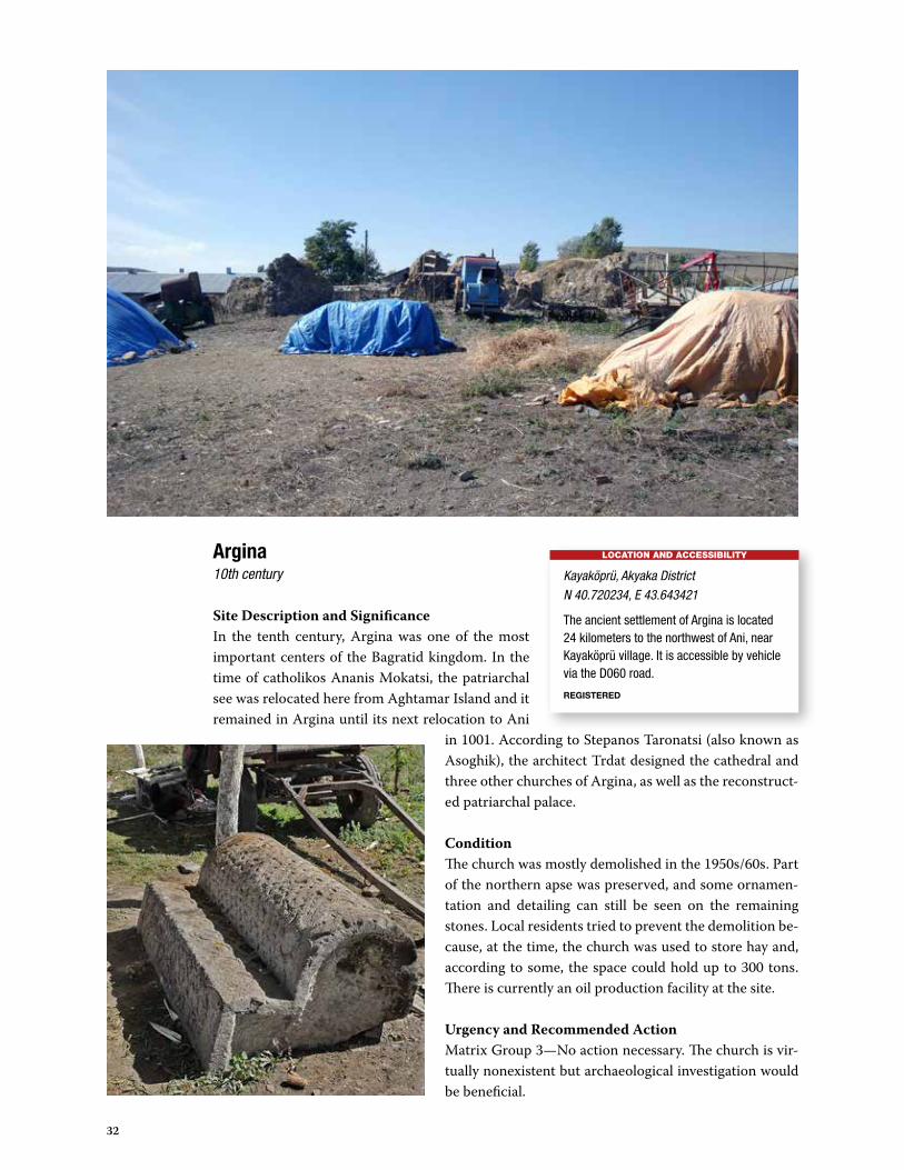
Argina10th century
Site Description and SignificanceIn the tenth century, Argina was one of the most important centers of the Bagratid kingdom. In the time of catholikos Ananis Mokatsi, the patriarchal see was relocated here from Aghtamar Island and it remained in Argina until its next relocation to Ani
in 1001. According to Stepanos Taronatsi (also known as Asoghik), the architect Trdat designed the cathedral and three other churches of Argina, as well as the reconstruct-ed patriarchal palace.
ConditionThe church was mostly demolished in the 1950s/60s. Part of the northern apse was preserved, and some ornamen-tation and detailing can still be seen on the remaining stones. Local residents tried to prevent the demolition be-cause, at the time, the church was used to store hay and, according to some, the space could hold up to 300 tons. There is currently an oil production facility at the site.
Urgency and Recommended ActionMatrix Group 3—No action necessary. The church is vir-tually nonexistent but archaeological investigation would be beneficial.
LOCATION AND ACCESSIBILITY
Kayaköprü, Akyaka DistrictN 40.720234, E 43.643421
The ancient settlement of Argina is located 24 kilometers to the northwest of Ani, near Kayaköprü village. It is accessible by vehicle via the D060 road.
REGISTERED

33
Argo Aritch10th century
Site Description and SignificanceThe monastery was likely founded during the Bagratid period but the earliest date on the remaining inscriptions is 1207. In 1211, Haghbat’s Gospel, the only known gospel fully written in Ani, was presented to Argo Aritch Monastery by the priest Sahak, who notes that his ances-tors constructed a church here.
ConditionArgo Aritch features ruins high along the stream with part of the monastic wall still in existence. There are, however, multiple signs and local stories of illegal excava-tions.
Urgency and Recommended ActionMatrix Group 3—No action necessary. The buildings have been demolished and only a limited amount of remnants and khach-kars have endured.
LOCATION AND ACCESSIBILITY
Alaca, Digor DistrictN 40.484641, E 43.490119
Argo Aritch is located within Alaca village, 7 kilometers west of Ani, 2.5 kilometers from Üçbölük. The monastery remains are located on the eastern slope of Mount Argo Aritch (later Alaga), on the edge of a small gorge. Because the site is situated within the village, it is easily accessible by car.
NOT REGISTERED

34
Alaman7th century
Site Description and SignificanceAccording to a single-line epigraphic description, the church at Alaman was built by Grigor Eghustr and his wife Mariam when the emperor Heraclius was 27 years old, in the times of Nerseh, the over-lord of Shirak and Arsharunik, and Teopighos, the bishop of Arsharuneans. This description was locat-ed on the south façade of the apse and sat level with
the bottom of the altar window. ConditionUntil the early twentieth century the church was still in existence, albeit with some damage to the portals and the outer facings, and missing a section of the roof. In the 1960s, the church was demolished, and today almost nothing remains.
Urgency and Recommended ActionMatrix Group 3—No action necessary. Nothing remains of the church in the village. It could not be located and locals gave conflicting information on its previous location.
LOCATION AND ACCESSIBILITY
Alem, Digor District N 40.427357, E 43.509935
The village of Alem is situated on the south slope of the Alaja mount, to the south of Ani along the old route to Digor. It is 7 kilometers southwest of Üçbölük and can be reached by vehicle through the Köseler village or through Kars, via the Igdır road. The structure was never found, but if it was located in the village, as suggested, it is 11 kilometers to the northeast of Digor from the Kars-Igdır road.
NOT REGISTERED

35
Agarak5th–7th centuries
Site Description and SignificanceAgarak was an early Christian complex that consisted of two church-es: a single-nave basilica and a tetraconch called Surb Stepanos Na-khavka. The village contains several ancient building remains, and it has been suggested that there was a castle and town here in pre-Bagratid times.
ConditionToday, both churches are demolished and the remaining stones are scattered on the site. In the field near the road leading from Digor to Derinöz, some of the foun-dation walls remain visible. Part of an ancient cemetery with several gravestones still exists on the hill to the west of the complex. There are indications of illegal excavations at the site by the
remaining wall foundations.
Urgency and Recommended ActionMatrix Group 3—No action necessary. It is likely that the stones of the old church were reused in the construction of the nearby village of Derinöz. An in-vestigation and survey of the walls in the village might be useful in the future.
LOCATION AND ACCESSIBILITY
Derinöz, Digor DistrictN 40.371463, E 43.371209
The ancient settlement is located near the gorge of the Digor River, on the ancient road between Nakhchevan and Digor. Agarak is accessible by vehicle as it is near the road going from Digor to the village of Derinöz. Alternately, it is a half-hour walk from Khtzkonk Monastery, located on the same ancient road.
REGISTERED

36
Bibliography/Literature• Samuel Anetsi, 1893; Ալիշան Ղ. Այրարատ, 1890, С. 113; Ալիշան, 1881, С. 126.• Strzygowski J. Die Baukunst der Armenier und Europa. Bd. Wien, 1918. S. 105–106. Abb. 25,
99–103, 281, 283.• Стржиговский (рус. перевод). Т. 1. Книга 1. Ереван, 2012. С.127–129. Рис. 25, 99–103.• Toramanyan, 1942. С.310–311. Ил. 231.• Токарский, 1961.• Cuneo P. L’architettura dell scuola regionale di Ani nell’Armenia medievale. Roma, 1977.• Азатян Ш.Р. Порталы, 1987. Ил. 119.• Haroutyunyan, 1992. С. 206, 239–240. Рис. 55. (На арм. яз.).• Donabedian P. Principaux sites arméniens.• Thierry J.-M., Donabedian P., Thierry N. Les arts arméniens. Paris, 1987. p. 558–559.• Sinclair T. A. Eastern Turkey, an Architectural and Archaeological Survey, 1987.• Асратян М.М. Уничтожение памятников армянской архитектуры.• Армянский вопрос. Энциклопедия.• Под ред. К.С. Худавердяна и др. Ереван: изд. Арм. энциклопедии, 1991. С. 241–242.• Hasratyan, 2002. с. 435; Քալանթար Ա. Շրջան Տեկորի արշավախմբի, 2007. С. 157–165. • http://www.virtualani.org/khtzkonk/index.htm.• Robert Bevan «The Destruction of Memory» pages 56—59. 2006, 240 pages ISBN 1-86189-
205-5 (see also in: http://www.press.uchicago.edu/Misc/Chicago/1861892055.html).
References• P. Gh. Alishan, Description of Great Armenia, Venice, 1881, p.126–131.• P.Gh. Alishan, Shirak, Venice, 1890, p.113.• S.Eprikian, Illustrated dictionary of Armenia, Venice, 1903, p.177–181.• J.Strzygowski, Die Baukunst der Armenier und Europa, Wien, 1918, p.104–106.• Torors Toramanian, Armenian Architecture, Erevan, 1942, p. 310-311.• Toros Toramanian, Armenian Architecture, Erevan, 1948, p. 131.• N.Tokarski, Architecture of Armenia, Erevan, 1961, p. 197, 208, 217.• J.M.Thierry, Notes sur des monuments armeniene en Turquie, in REA, II, 1965, p. 170.• O.Kh. Khalpakhchyan, Architecture of Armenia, General History of Architecture in 12
volumes, vol.3, St.Petersbourg -Moscow, 1966, p.225, 237–238, 244.• E. Costa, Schede degli edifice, Roma, Architettura medievale armena, Roma, 1968, p.117.• A. Khatchatryan, Inscriptions et histoire des eglises armeniennes, Recerca sull’architettura
armena-8, Milano, Roma, 1974, p.71.• Paolo Cuneo, L’Architettura della scuola regionale di Ani nell’Armenia medieval, Roma,
1977, p.16–18.• Armenian Soviet Encyclopedia, vol. 5, Erevan, 1979, p.55-56. • Dictionary of Toponyms of Armenia and adjacent territories, vol. 2, Erevan, 1988, p.740–
742.• Paolo Cuneo and coauthors, Architettura Armena, 1988, p. 638-641.
Internet sites• Sim, Steven. “VirtualANI – Dedicated to the Deserted Medieval Armenian City of Ani”.
VirtualANI. Archived from the original on January 20, 2007. Retrieved January 22, 2007.• Google Maps, etc.

37
As a pilot test case, the Ani in Context group members decided to focus on Khtzkonk, com-posed of a remarkable church—Surb Sargis (Sergius)—and the remains of a monastic en-semble from the ninth to eleventh centuries, perched high above a rocky gorge, and located
2 to 3 kilometers west of Digor. Khtzkonk is also on a half-hour walking route from the ancient village of Agarak, and thus seems well-positioned to grow as a potential tourist route in the future.
In order to make the most of the group’s range of expertise, it was decided to create breakout working groups that consisted of:
1) Architecture and structural2) Art, interior finishes, painting, relief, epigraphy3) Archaeology4) Site ownership, access, tourism, logistics, local cultural aspects
World Monuments Fund offered to coordinate production of the report, and once back in New York established an FTP site where participants could upload and share materials over the next several months. The results were then edited and compiled into this report. In the future, it is hoped that the group will be able to use its collective expertise to build similar dossiers for a number of other sites in the region.
A. Ownership and LogisticsLocation: Digor, Kars; Elevation 1,754 meters; N 40.380384, E 43.376399Khtzkonk is 25 kilometers southwest of Ani, near Digor
AccessKhtzkonk is not currently vehicle-accessible, but there are three main ways to access the site (Figure 1). The first option is to walk west from Digor’s town center through the gorge for ap-proximately 4.5 kilometers. The first half of the walk is through fields, and then up onto the right bank of the gorge for the rest of the way. There is no road or pathway in the fields. The second op-tion is along a mountain path that leads from the road between Dagpinar and Digor. The path is barely visible up through the mountain and in some areas is obstructed by fallen rocks. Difficulty level of access is medium-high. Access is also limited by seasonal conditions. The final option is to access the site from the ancient settlement of Agarak, located south of Khtzkonk. The descent is more difficult but the total travel time is significantly reduced using this route.
Appendix A: Khtzkonk Monastery Assessment
Khtzkonk
Digor
Derinöz
Dagpinar
Agarak
Figure 1.
38
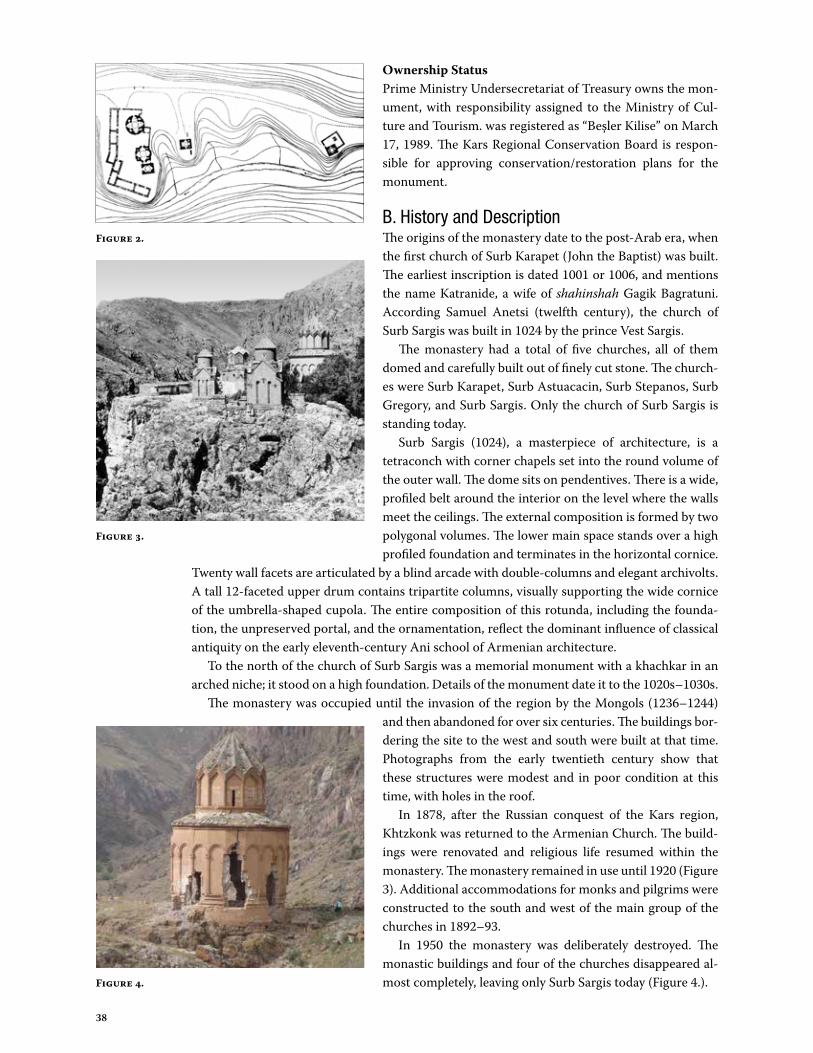
Ownership StatusPrime Ministry Undersecretariat of Treasury owns the mon-ument, with responsibility assigned to the Ministry of Cul-ture and Tourism. was registered as “Beşler Kilise” on March 17, 1989. The Kars Regional Conservation Board is respon-sible for approving conservation/restoration plans for the monument.
B. History and DescriptionThe origins of the monastery date to the post-Arab era, when the first church of Surb Karapet (John the Baptist) was built. The earliest inscription is dated 1001 or 1006, and mentions the name Katranide, a wife of shahinshah Gagik Bagratuni. According Samuel Anetsi (twelfth century), the church of Surb Sargis was built in 1024 by the prince Vest Sargis.
The monastery had a total of five churches, all of them domed and carefully built out of finely cut stone. The church-es were Surb Karapet, Surb Astuacacin, Surb Stepanos, Surb Gregory, and Surb Sargis. Only the church of Surb Sargis is standing today.
Surb Sargis (1024), a masterpiece of architecture, is a tetraconch with corner chapels set into the round volume of the outer wall. The dome sits on pendentives. There is a wide, profiled belt around the interior on the level where the walls meet the ceilings. The external composition is formed by two polygonal volumes. The lower main space stands over a high profiled foundation and terminates in the horizontal cornice.
Twenty wall facets are articulated by a blind arcade with double-columns and elegant archivolts. A tall 12-faceted upper drum contains tripartite columns, visually supporting the wide cornice of the umbrella-shaped cupola. The entire composition of this rotunda, including the founda-tion, the unpreserved portal, and the ornamentation, reflect the dominant influence of classical antiquity on the early eleventh-century Ani school of Armenian architecture.
To the north of the church of Surb Sargis was a memorial monument with a khachkar in an arched niche; it stood on a high foundation. Details of the monument date it to the 1020s–1030s.
The monastery was occupied until the invasion of the region by the Mongols (1236–1244) and then abandoned for over six centuries. The buildings bor-dering the site to the west and south were built at that time. Photographs from the early twentieth century show that these structures were modest and in poor condition at this time, with holes in the roof.
In 1878, after the Russian conquest of the Kars region, Khtzkonk was returned to the Armenian Church. The build-ings were renovated and religious life resumed within the monastery. The monastery remained in use until 1920 (Figure 3). Additional accommodations for monks and pilgrims were constructed to the south and west of the main group of the churches in 1892–93.
In 1950 the monastery was deliberately destroyed. The monastic buildings and four of the churches disappeared al-most completely, leaving only Surb Sargis today (Figure 4.).
Figure 2.
Figure 3.
Figure 4.
39
C. Architectural AssessmentIn his day the very distinguished Vest Sargis, after building many fortresses and churches, built the glorious monastery of Khtskōnk‘.
—Kirakos Gandzakets‘i, c.1200–71
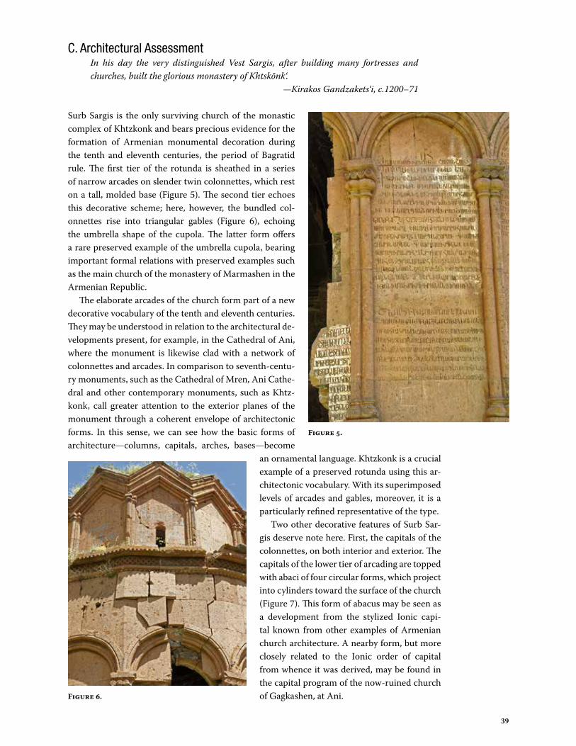
Surb Sargis is the only surviving church of the monastic complex of Khtzkonk and bears precious evidence for the formation of Armenian monumental decoration during the tenth and eleventh centuries, the period of Bagratid rule. The first tier of the rotunda is sheathed in a series of narrow arcades on slender twin colonnettes, which rest on a tall, molded base (Figure 5). The second tier echoes this decorative scheme; here, however, the bundled col-onnettes rise into triangular gables (Figure 6), echoing the umbrella shape of the cupola. The latter form offers a rare preserved example of the umbrella cupola, bearing important formal relations with preserved examples such as the main church of the monastery of Marmashen in the Armenian Republic.
The elaborate arcades of the church form part of a new decorative vocabulary of the tenth and eleventh centuries. They may be understood in relation to the architectural de-velopments present, for example, in the Cathedral of Ani, where the monument is likewise clad with a network of colonnettes and arcades. In comparison to seventh-centu-ry monuments, such as the Cathedral of Mren, Ani Cathe-dral and other contemporary monuments, such as Khtz-konk, call greater attention to the exterior planes of the monument through a coherent envelope of architectonic forms. In this sense, we can see how the basic forms of architecture—columns, capitals, arches, bases—become
an ornamental language. Khtzkonk is a crucial example of a preserved rotunda using this ar-chitectonic vocabulary. With its superimposed levels of arcades and gables, moreover, it is a particularly refined representative of the type.
Two other decorative features of Surb Sar-gis deserve note here. First, the capitals of the colonnettes, on both interior and exterior. The capitals of the lower tier of arcading are topped with abaci of four circular forms, which project into cylinders toward the surface of the church (Figure 7). This form of abacus may be seen as a development from the stylized Ionic capi-tal known from other examples of Armenian church architecture. A nearby form, but more closely related to the Ionic order of capital from whence it was derived, may be found in the capital program of the now-ruined church of Gagkashen, at Ani.
Figure 5.
Figure 6.

40
The decorative program of the interior of Surb Sargis includes the lower part of the elevation at the level of the windows, which is ornamented with a continuous and heavily profiled cor-nice interrupted by a series of window arches (Figure 8). These arches bear the same decorative vocabulary of arcades and capitals found on the exterior. The two framing posts of these arches do not descend, however, to the ground-line of the church interior. Rather, they are pendant arches, terminating about midway down the wall. This is a striking visual feature of the interior, intended to call attention not only to the windows but also, surely, to the dramatic views into the surrounding landscape.
The exterior of Khtzkonk is covered in inscriptions that re-cord both the many restorations and the donations made to the monastery (Figure 9). These texts are fascinating because they demonstrate the social, political, and economic interconnection of the elites in the region, and give immediate meaning to the concept of “Ani in Context.” For example, one of the inscriptions indicates the gift from a certain Brnavor, “servant of Christ,” and his wife Tgha of a vineyard at Mren called Aghtotn (“the Dirty”).
Following the traditions of Armenian architecture from at least the sixth century, epigraphy is positioned here on the out-side, rather than the inside of the structure. The texts are, as at Ani, located within the blind arcades of the exterior. The use of the arcades as framing devices for the text echoes the longstand-ing tradition of canon tables found in Armenian manuscript il-lumination. Very importantly, and further evoking manuscript production, the epigraphy at Khtzkonk preserves polychrome decoration: elements of text are highlighted with red and white paint. This is a striking and rare example of preserved poly-chrome on epigraphy, and deserves careful study.
In sum, Surb Sargis at Khtzkonk preserves precious evidence for the development of architectural decoration and epigraphy in medieval Armenian architecture.
Figure 7. Figure 8.
Figure 9.

41
D. Structural Assessment
A visual assessment of the remaining church of Surb Sargis at Khtzkonk Monastery was per-formed. All assessment work was done from the floor and the surrounding field only.
Seismicity of the AreaTurkey is located in the Alp-Himalaya earthquake belt that extends from the archipelago of the Azores to Southeast Asia. The North Anatolian Fault Zone extends in the east-west direction at the northern part of Turkey and is quite active. In the northeast of Anatolia, there are lateral faults in Sevan in Ar-menia, Balıklıgöl, Iğdır, Ağrı, Dumlu, Çobandede, Kağızman, and Digor in Turkey. The Ministry of Pub-lic Works and Settlement published a seismic hazard map of Turkey in 1996 based on the expected maximum acceleration value (Figure 10). Kars City is located in the second-degree earthquake zone in accordance with this map, meaning that that 0.4–0.3 g maximum acceler-ation is expected.
Since 1924, ten destructive and semi-destructive earthquakes have been reported in the region. The first earthquake occurred on May 13, 1924, affecting Sarıkamış, southwest of Kars. The severest earthquake, with a 6.2 magnitude, occurred in Digor on May 1, 1935. This earthquake affected all the settlements in a 50 kilometer radius.1 According to newspaper ac-counts, almost all the houses were destroyed, monuments were severe-ly damaged, and there were many deaths and injuries. Digor and its sur-roundings experienced 10 aftershocks from this earthquake.2 Digor had a series of earthquakes in 1936, 1938, 1941, 1962, 1972, 1975, 1976, and 1983. The district was seriously affected by the 1988 Erivan earthquake. The magnitudes of these earthquakes were 4.5 to 6.9 MS.
3 The buildings not repaired and maintained were completely demolished during these earth-quakes.4 Landslides and falling rocks are also frequent dangers in this area.
Structural DescriptionThe monument is composed of a lower cylinder that is symmetrically divided into two perpen-dicular axes by four conches. There are eight vaulted chapels with eastward facing conches in the volume between each conch, four at floor level and four one level above the floor. At the center of the structure rises a drum and dome surmounted by an umbrella-shaped conical roof. There is a sloped roof around the drum for the lower cylinder as well. The drum and dome are respectively cylindrical and spherical on the interior.
The foundation, composed of three courses of stone, is exposed on the east side and re-veals that the structure is set on undisturbed stone (Figure 11). It was customary in antiquity for the building masters in seismic areas to avoid resting foundation walls directly on the rock to avoid resonance during seismic events. It is hypothesized that these three courses
1 The Ministry of Public Works, “Disasters condition of the cities,” The Ministry of Public Works publication (in Turkish).
2 Tekir, S., Earthquakes in Kars and its Surrounding (1924-1941) International Journal of History Studies 2012 (in Turkish).
3 The Ministry of Public Works, “Disasters condition of the cities.”4 Tekir, S., Earthquakes in Kars and its Surroundings.
Figure 10.
Figure 11.
42
of stones are laid all through the floor to serve as a mat foundation as is found beneath Roman, Ionian, and Byz-antine monuments.
The monument is constructed as a “midis wall,” an Ar-menian term describing rubble masonry faced on both sides with dressed stone. The stone is ocher in color and appears to be limestone. The mortar is most probably khorasin mortar from Turkey that was typically used in the Byzantine, Seljuk, and Ottoman periods. Khorasin mortars are composed of a mixture of a lime binder, volcanic ash, and aggregate and have pozzolanic attributes. AssessmentThe monument has many cracks and some parts have col-lapsed, yet it is still whole. It is heavily damaged, with com-promised structural elements threatened by gravity and especially by seismic activity.
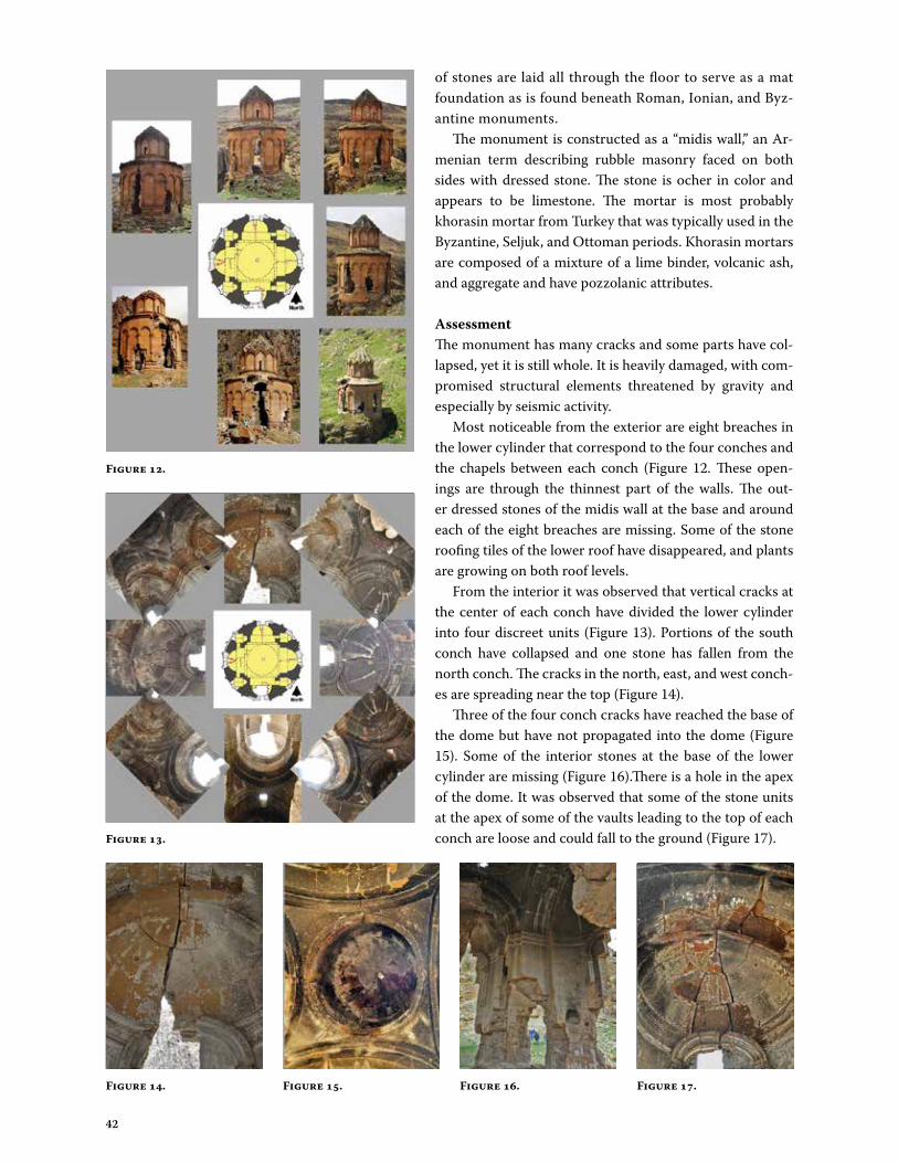
Most noticeable from the exterior are eight breaches in the lower cylinder that correspond to the four conches and the chapels between each conch (Figure 12. These open-ings are through the thinnest part of the walls. The out-er dressed stones of the midis wall at the base and around each of the eight breaches are missing. Some of the stone roofing tiles of the lower roof have disappeared, and plants are growing on both roof levels.
From the interior it was observed that vertical cracks at the center of each conch have divided the lower cylinder into four discreet units (Figure 13). Portions of the south conch have collapsed and one stone has fallen from the north conch. The cracks in the north, east, and west conch-es are spreading near the top (Figure 14).
Three of the four conch cracks have reached the base of the dome but have not propagated into the dome (Figure 15). Some of the interior stones at the base of the lower cylinder are missing (Figure 16).There is a hole in the apex of the dome. It was observed that some of the stone units at the apex of some of the vaults leading to the top of each conch are loose and could fall to the ground (Figure 17).Figure 13.
Figure 12.
Figure 14. Figure 15. Figure 16. Figure 17.
43
E. Additional Studies
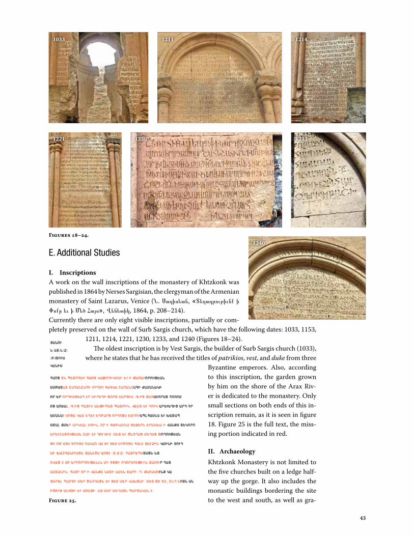
I. InscriptionsA work on the wall inscriptions of the monastery of Khtzkonk was published in 1864 by Nerses Sargisian, the clergyman of the Armenian monastery of Saint Lazarus, Venice (Ն. Սագիսեան, «Տեղագրութիւնք ի Փոքր եւ ի Մեծ Հայս», Վենետիկ, 1864, p. 208–214).Currently there are only eight visible inscriptions, partially or com-pletely preserved on the wall of Surb Sargis church, which have the following dates: 1033, 1153,
1211, 1214, 1221, 1230, 1233, and 1240 (Figures 18–24).The oldest inscription is by Vest Sargis, the builder of Surb Sargis church (1033),
where he states that he has received the titles of patrikios, vest, and duke from three Byzantine emperors. Also, according to this inscription, the garden grown by him on the shore of the Arax Riv-er is dedicated to the monastery. Only small sections on both ends of this in-scription remain, as it is seen in figure 18. Figure 25 is the full text, the miss-ing portion indicated in red.
II. Archaeology Khtzkonk Monastery is not limited to the five churches built on a ledge half-way up the gorge. It also includes the monastic buildings bordering the site to the west and south, as well as gra-
Figures 18–24.
1033 1211 1214
123312301221
1240
Figure 25.

44
naries, bulwarks, several burial sites, and most likely a number of caves used for burial or for housing monks. The steep and rocky base of the monastery suggests a relatively weak stratigraphic po-tential of the ground. It is thus even more important to protect it against damage and hasty excavations.
Observations on Tourism Potential and the Community
• The fields at the entrance to the valley are arable and fertile, and are harvested three times per year (Figure 26). Deeper into the gorge, the rocky topography and narrowness of the land pre-vents agricultural use. There are shepherds and sheep farm-ing around the rocky areas surrounding the monuments. The stream below also has fish (Figure 27).
• Graffiti, fire, and illegal excavations are a threat to the remains of Surb Sargis. Charred fire remains within the church are most likely left by the local shepherds for either cooking the fish they catch from the stream or for heating purposes. Local youngsters climb up to the walls and the dome easily since there is no secu-rity or control at the site. (Figure 28)
• There are indications on the ground that some illegal excava-tions were done by treasure hunters. Some of the walls of the standing church were most possibly destroyed while the trea-sure hunters were searching for the “gold,” or just due to acts of vandalism. (Figure 29)
• Digor Kültür Platformu, established in 2012, uses the image of Surb Sargis as their logo, showing that there is some level of pride in the local town for the cultural heritage within their town borders.
• A British solo traveler heading to Khtzkonk was encountered during the trip.
Tourism Potential• A broad tourism strategy for the region should be encouraged,
whereby the local community obtains related educational and capacity-building opportunities. This may include training of masons and craftsmen in the Kars region in traditional tech-niques to work on monuments of this kind.
• Kars is currently a destination limited to Ani site visits and one-night stays. Kars should be included in tour group programs lasting at least three days, and the local economy should benefit from visits to neighboring sites around the region.
The panoramic and scenic views of the valley leading to Khtzkonk and the monuments would appeal to most of the tourists coming to the area. It could be included in a program as a half-day tour ending with a picnic lunch arranged with simple fare provisioned from the locals. After lunch other monuments in the vicinity of Digor could be visited.
Figure 26.
Figure 27.
Figure 28.
Figure 29.

45
Recommendations
Due to its cylindrical shape, symmetry, and construction materials, Surb Sargis has proven to be amazingly resilient. However, on the basis of the visual assessment, we conclude that the monument in its present condition does not possess adequate structural safety for its location in a seismically active zone. At present the building is not safe for any purpose including tourist visits, and access to the monument should be prohibited.
There is no detailed record of Surb Sargis or the other lost monastery churches. The recom-mendations below layout emergency measures for Surb Sargis, a comprehensive assessment and repair plans for the church, further research measures, and a comprehensive assessment plan for the monastery site.
Priority 1: Short Term (Emergency measures)• Wrap Surb Sargis with tension banding at the top of the lower cylinder of the structure to
counteract further spread of the walls.• Support unstable portions of the conches and vaults with interior scaffolding.• Replace the eight missing portions of the wall at the base of the lower cylinder.
Priority 2A: Comprehensive Assessment and Urgent Repair of Surb SargisA more comprehensive examination of the monument is required in order to develop appro-priate techniques for repair and strengthening. This examination should include the following: • Development of a detailed architecture survey to develop accurate plans, sections, and eleva-
tions using 3D scanning, photogrammetry, or total station.• Precise location and dimensions of all damage and decay of Surb Sargis. • Perform a detailed study with the aid of an accurate topographical survey to document tool
marks, workers marks, integration of epigraphy, etc., which will clarify the history of the monument and of the monastery.
• Laboratory analysis of stone and mortar to determine the strength of the monument and to develop appropriate repair materials and technologies.
• Perform long term monitoring and ambient vibration testing.• Address the existing vertical cracks of the conches and the collapsed lower parts of the lower
cylinder. • Prepare stabilization and consolidation drawings.
Priority 2B: Further Research and Comprehensive Assessment of the Site• Determine why this place was chosen for building Khtzkonk. The plot of the rock on which
the church was constructed is small, and in ancient times churches were often constructed alongside other buildings. It is possible that there was a more ancient Christian sanctuary. As a rule, such a sanctuary would be included in new buildings. It would be useful to clarify the relationship of the monastery to other settlements.
• Map site elements, both below and above ground, using a local GIS system.• Use a geo-radar survey to detect archaeological remains up to 2 meters below the surface.
This would reveal whether there was a wider building footprint, as well as additional struc-tures. This is a useful preliminary measure as it is non-invasive.
• Potentially use LiDAR scanning (scan of landscape from an airplane) to locate constructions not visible on ground level.
• Record and inventory dislocated fragments that were deliberately moved away from the mon-uments, and/or down the valley. This information should also be mapped before the frag-ments are possibly manipulated for inventory and study.
• Identify, record, and store significant lapidary remains scattered by destruction. Determine

46
and indicate if there are any relics that could be stored in another monastery. Check to see if there are any monasteries from that time with a similar list of veneration of the saints, and check to see what the related relics are for those saints.
• From the northeast side of the church a base of stones can be seen showing that the area to build the buildings had at one point been leveled. It is necessary to clean the base of the church to determine the nature of the terrain, and the sequence of building works and history of the site.
• Clear other parts of the area to identify the bases of other buildings and to determine their size and layout. Find the bottom of all religious buildings and fences, as well as residential and commercial buildings.
• Research the source of the stones, where they were shaped, and the ancient roads from which they were transported to the construction site. Also locate where the mortar was prepared.
• In order to clarify the chronology of the construction of the monastery, prepare an analysis of the mortars of the destroyed buildings, and compare it with the mortars of other ancient churches for which datings are clearly established.
• Conduct an analysis of the mortar in the destroyed buildings by comparing it with the formu-lations of other ancient churches in the region for which dating is clearly established.
• Determine how to inventory and sort the stones from the monastery buildings. Research the stones, which will clarify the dating of the construction and reconstructions of the buildings.
• During archaeological work there will certainly appear new challenges that will require refin-ing the plan.
After the emergency measures under Priority I have been implemented and the site has been deemed safe for the protection and preservation of the ruins of Surb Sargis and the monastery site, consideration should be given to charging a visitation fee as well as creating a transportation surcharge for tourists who wish to visit the monastery.
Appendix B: Workshop Schedule and Participants
Day 1: Sunday, Sept. 29• Ani Archaeological Site • Shepherd’s Church and
Baths
Day 2: Monday, Sept. 30• Horomos Monastery • Taylar Church • Karmirvank Church
Day 3: Tuesday, Oct. 1 • Oğuzlu Church • Kizilvenk Church • Argina Church • Uzun Church • Erazgavors • Tignis Fortress
Day 4: Wednesday, Oct. 2• Bulanık • Bagnayr • Argo Aritch• Magazberd• Ani Archaeological Site
Day 5: Thursday, Oct. 3• Digor Basilica • Khtzkonk Monastery• Agarak Church • Alaman
Day 6: Friday, Oct. 4 • Nakhichevan • Bagaran • Zibni • Mren Cathedral
Day 7: Saturday, Oct. 5• Wrap-up session,
Büyük Kale Hotel
Schedule
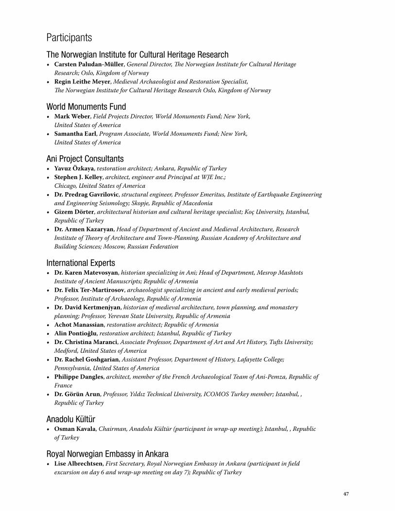
47
Participants
The Norwegian Institute for Cultural Heritage Research• Carsten Paludan-Müller, General Director, The Norwegian Institute for Cultural Heritage
Research; Oslo, Kingdom of Norway• Regin Leithe Meyer, Medieval Archaeologist and Restoration Specialist,
The Norwegian Institute for Cultural Heritage Research Oslo, Kingdom of Norway
World Monuments Fund• Mark Weber, Field Projects Director, World Monuments Fund; New York,
United States of America• Samantha Earl, Program Associate, World Monuments Fund; New York,
United States of America
Ani Project Consultants• Yavuz Özkaya, restoration architect; Ankara, Republic of Turkey• Stephen J. Kelley, architect, engineer and Principal at WJE Inc.;
Chicago, United States of America• Dr. Predrag Gavrilovic, structural engineer, Professor Emeritus, Institute of Earthquake Engineering
and Engineering Seismology; Skopje, Republic of Macedonia• Gizem Dörter, architectural historian and cultural heritage specialist; Koç University, Istanbul,
Republic of Turkey• Dr. Armen Kazaryan, Head of Department of Ancient and Medieval Architecture, Research
Institute of Theory of Architecture and Town-Planning, Russian Academy of Architecture and Building Sciences; Moscow, Russian Federation
International Experts• Dr. Karen Matevosyan, historian specializing in Ani; Head of Department, Mesrop Mashtots
Institute of Ancient Manuscripts; Republic of Armenia• Dr. Felix Ter-Martirosov, archaeologist specializing in ancient and early medieval periods;
Professor, Institute of Archaeology, Republic of Armenia • Dr. David Kertmenjyan, historian of medieval architecture, town planning, and monastery
planning; Professor, Yerevan State University, Republic of Armenia• Achot Manassian, restoration architect; Republic of Armenia • Alin Pontioğlu, restoration architect; Istanbul, Republic of Turkey• Dr. Christina Maranci, Associate Professor, Department of Art and Art History, Tufts University;
Medford, United States of America• Dr. Rachel Goshgarian, Assistant Professor, Department of History, Lafayette College;
Pennsylvania, United States of America• Philippe Dangles, architect, member of the French Archaeological Team of Ani-Pemza, Republic of
France• Dr. Görün Arun, Professor, Yıldız Technical University, ICOMOS Turkey member; Istanbul, ,
Republic of Turkey
Anadolu Kültür• Osman Kavala, Chairman, Anadolu Kültür (participant in wrap-up meeting); Istanbul, , Republic
of Turkey
Royal Norwegian Embassy in Ankara• Lise Albrechtsen, First Secretary, Royal Norwegian Embassy in Ankara (participant in field
excursion on day 6 and wrap-up meeting on day 7); Republic of Turkey

48

3

4
350 Fifth Avenue, Suite 2412New York, NY 10118646-424-9594 • www.wmf.org