András Vadas - Central European University · András Vadas Supervisors: Alice M. Choyke and...
296
Doctoral Dissertation WHO STOLE THE WATER? THE CONTROL AND APPROPRIATION OF WATER RESOURCES IN MEDIEVAL HUNGARY by András Vadas Supervisors: Alice M. Choyke and Katalin Szende Submitted to the Medieval Studies Department, Central European University, Budapest in partial fulfillment of the requirements for the degree of Doctor of Philosophy in Medieval Studies Budapest, Hungary Budapest, 2020 CEU eTD Collection
Transcript of András Vadas - Central European University · András Vadas Supervisors: Alice M. Choyke and...

Doctoral Dissertation
WHO STOLE THE WATER?
THE CONTROL AND APPROPRIATION OF WATER RESOURCES IN
MEDIEVAL HUNGARY
by
András Vadas
Supervisors:
Alice M. Choyke
and
Katalin Szende
Submitted to the Medieval Studies Department, Central European
University, Budapest
in partial fulfillment of the requirements for the degree of Doctor of
Philosophy in Medieval Studies
Budapest, Hungary
Budapest, 2020
CE
UeT
DC
olle
ctio
n

ii
TABLE OF CONTENTS
List of Figures and Tables ......................................................................................................... iv
Acknowledgments ................................................................................................................... viii
A Note on Names ....................................................................................................................... x
1. INTRODUCTION ................................................................................................................ 1
1.1. Riverine Landscapes as Conflict Environments in Pre-Modern Europe – Some
Historiographic Reflections ....................................................................................................... 3
1.1.1. New Directions in Research – Where Environmental, Social, and Technological History
Meet ........................................................................................................................................... 9
1.1.2. Hungary and Central Europe – Research traditions and recent results .......................... 17
1.2. The Goals of this Work ..................................................................................................... 28
1.2.1. The Time and the Space ................................................................................................. 31
1.2.2. About the Sources .......................................................................................................... 32
1.3. The Structure of the Dissertation ...................................................................................... 36
2. THE SPREAD OF WATER MILLS IN MEDIEVAL HUNGARY WITH A CENTRAL
EUROPEAN OVERVIEW.................................................................................................... 38
2.1. Mills and Benedictines – Some Preliminary Considerations ............................................ 40
2.2. The First Water Mills in the Region – Historical Evidence, Linguistics and (the lack of)
Archaeological Data ................................................................................................................. 42
2.3. Conclusions ....................................................................................................................... 53
3. WATERSCAPES AS CONFLICT ENVIRONMENTS IN MEDIEVAL HUNGARY –
ARE THERE ANY PATTERNS? ........................................................................................ 55
3.1. Legal Regulations and Practice surrounding Mill Construction in Medieval Hungary .... 57
3.1.1. Locus molendini – A Place, a Right, a Claim?............................................................... 61
3.1.2. Locus Molendini in Early Literacy – First References and Terminological Unifications63
3.1.3. Terminological Uniformity – Uniformity in Meaning? ................................................. 70
3.1.4. Mills and Mill-places – How Do They Relate to Each Other? ...................................... 77
3.2. Rivers in Urban Landscapes – Rivers, Streams, Moats and Disputes .............................. 80
3.2.1. Major Waterways and Mills – the example of Buda, Óbuda and Pest .......................... 81
3.2.2. Streams and Water – Use of Mills in Urban Environments – the Cases of Zagreb and
Budafelhévíz ............................................................................................................................ 88
CE
UeT
DC
olle
ctio
n

iii
3.2.2.1. Budafelhévíz and its Hot Springs................................................................................ 95
3.2.3. Urban Moats and Water-Use........................................................................................ 102
3.2.3.1. Building Moats, Using its Waters – A Short Overview ............................................ 105
3.2.3.2. The Case of Sopron ................................................................................................... 109
3.2.3.3. The Case of Prešov ................................................................................................... 113
3.2.3.4. Moats, Urban Topographies and Mills – Some Conclusions.................................... 122
3.3 Rivers in Mining Areas - Abundance of Water versus Lack of Access? ......................... 123
3.3.1. Mining Town Privileges and Water-Use ..................................................................... 126
3.3.2. Early Urban Privileges and Water Use ........................................................................ 136
3.3.3. Kremnica and Its Water Mills ...................................................................................... 141
3.3.4. The Foundation of Nová Baňa and its Water Mills ..................................................... 150
3.3.5. Mills in Mining Towns: Who Was Entitled to What? ................................................. 152
3.4. Rivers as Borders – Another Minefield?......................................................................... 153
3.4.1. The Border between Ľubotín and Orlov – What Can a Single Case Reveal? ............. 159
3.4.2. Riverbed Changes and Estate Borders – Was There a Medieval Customary Law in
Hungary? ................................................................................................................................ 162
3.4.3. Riverbeds and Borders – Some Conclusions ............................................................... 172
3.5. Conclusions ..................................................................................................................... 177
4. THE MEN BEHIND THE WHEEL… BUILDING ON WATER IN THE MIDDLE
AGES ..................................................................................................................................... 182
4.1. The Renovation of the Moat of Sopron in 1540 – A Unique Source .............................. 183
4.1.1. The Expenditures on the Work .................................................................................... 189
4.1.2. The Labor Organization ............................................................................................... 191
4.2. Millers ............................................................................................................................. 194
4.3. Ditch and Pond Diggers and Pond Masters .................................................................... 201
4.4. Conclusions ..................................................................................................................... 208
5. CONCLUSIONS AND OUTLOOK ............................................................................... 209
5.2. The Politics of Water – An Epilogue .............................................................................. 212
Appendices ............................................................................................................................. 216
Bibliography........................................................................................................................... 234
CE
UeT
DC
olle
ctio
n

iv
List of Figures and Tables
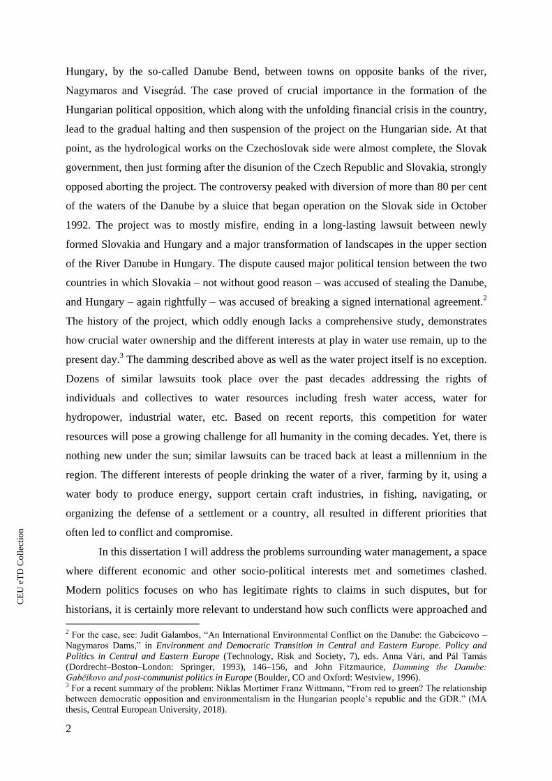
Fig. 1. Areas covered by water and wetlands before river regulation in the Carpathian Basin
(after Woldemár Lászlóffy)
Fig. 2. Major geographical units in the Carpathian Basin (by Béla Nagy)
Fig. 3. Gombaszög with the location of the Pauline abbey (marked with the red cross and the
water mills along the artificial riverbed of the Hernád (First Military Survey)
Fig. 4. The surroundings of Pukanec with the Büksavnica (the one running west-east) and
Verence Streams (running north-south) on the First Military Survey with the two mill-
places on the latter
Fig. 5. Pest, Buda, and Óbuda and their surroundings in ca. 1300 (drawn by Béla Nagy)
Fig. 6. Gradec, Kaptol, and the Medveščak Stream with the mill race on the manuscript map by
Nicholas Angielini
Fig. 7. The mills of Zagreb in the Middle Ages (after Igor Karaman)
Fig. 8. Felhévíz and the Malomtó (Millpond) represented on two late seventeenth-century
illustrations (by H. Bredekow)
Fig. 9. The town of Sopron in the late medieval period with the urban moat, the fish ponds and
the approximate location of the mills
Fig. 10. Zacharias Michel’s Bird’s eye view of Sopron in 1700 (after Jankó, Kücsán, and
Szende, Sopron, Plate C.4)
Fig. 11a. View of the town of Prešov from 1768 by Gaspar Caspar
Fig. 11b. Detail of the view of the town of Prešov with the Upper Mill (no. 23) from 1768 by
Gaspar Caspar
Fig. 12. Topography of Prešov in the late medieval period with the relocation of the mills and the
probable direction of the western section of the urban moat before and after 1435
Fig. 13. Mining towns in medieval Hungary
Fig. 14. The so-called Saint Anne altar at the Virgin Mary Cathedral at Rožňava (detail)
Fig. 15. The mills and the urban topography of Kreminca in the mid-fourteenth century (after
György Györffy)
Fig. 16. The mills of Kremnica and their ownership (1331–1519)
Fig 17. The surrounding of Ľubotín and Orlov on a sheet from the First Military Survey
Fig. 18. Čoltovo and Lekeňa on a sheet from of the First Military Survey
Fig. 19. Szentmárton and Kóród on a sheet of the First Military Survey
Fig. 20. The border between Ónod and Hídvég in the mid-nineteenth century showing the
location of the former bed of the River Sajó in the center
Fig. 21. Monasteries and chapters in the Kingdom of Hungary in the Late Middle Ages (after
Beatrix Romhányi)
Fig. 22: The incomes and expenses of the town of Sopron between 1530 and 1543 in light of its
account books
Fig. 23. Wages according to the 1539/1540-account book of Sopron
CE
UeT
DC
olle
ctio
n

v
List of Abbreviations
ÁMTF Györffy, György. Az Árpád-kori Magyarország történeti földrajza,
4 vols [A historical geography of Hungary in the Árpádian period]
Budapest: Akadémiai Kiadó, 1963–1998.
AO Anjoukori okmánytár / Codex diplomaticus Hungaricus
Andegavensis, 7 vols. Eds. Imre Nagy and Gyula Tasnádi Nagy.
Budapest: Magyar Tudományos Akadémia, 1878–1920.
AOklt Anjou-kori oklevéltár, 43 vols [Angevin cartulary]. Ed. in chief,
Gyula Kristó, and Tibor Almási. Szeged and Budapest: JATE –
MNL OL, 1990–2019.
ÁÚO Árpádkori új okmánytár, 12 vols [New Árpádian-age cartulary].
Ed. Gusztáv Wenzel. Pest–Budapest: Eggenberger Ferdinánd,
1860–1874.
BTOE, vol. 1 Budapest történetének okleveles emlékei/Monumenta diplomatica
civitatis Budapest, vol. 1. Ed. Albert Gárdonyi. Budapest: Budapest
Székesfőváros, 1936.
CD Codex diplomaticus Hungariae ecclesiasticus ac civilis, 11 vols.
Ed. Georgius Fejér. Buda: Typis Regiae Universitatis Hungaricae,
1829–1844.
CDB, vol. 1 Codex diplomaticus et epistolaris regni Bohemiae, vol. 1. Ed.
Gustavus Friedrich. Prague: Sumptibus Comitiorum Regni
Bohemiae, 1904/1907.
CDES Codex diplomaticus et epistolaris Slovaciae, 2 vols. Ed. Richard
Marsina. Bratislava: Academia Scientiarum Slovacae, 1971–1987.
DHA, vol. 1 Diplomata Hungariae Antiquissima, vol. 1. 1000–1131. Ed.
György Györffy. Budapest: Akadémiai, 1992.
EFHU, vol. 3/2 Elenchus fontium historiae urbanae, vol. 3/2. Ed in chief András
Kubinyi. Budapest: Balassi, 1997.
Engel, Archontológia Engel, Pál. Magyarország világi archontológiája: 1301–1457, 2
vols [Lay archontology of Hungary, 1301–1457]. Budapest:
História, 1996.
Házi, Sopron Házi, Jenő. Sopron szabad királyi város története, 13 vols [The
history of the free royal town of Sopron]. Sopron: Székely, Szabó
és Társa Könyvnyomdája, 1921–1943.
CE
UeT
DC
olle
ctio
n

vi
HO Hazai okmánytár / Codex diplomaticus patrius, 8 vols. Ed. Imre
Nagy. Győr and Budapest: Sauervein Géza – Franklin, 1865–1891.
MCZ Tkalčić, Ivan Krstitelj. Povjestni spomenici slob.kralj. grad.
Zagreba. Monumenta historica liberae regiae civitatis Zagrabiae,
11 vols. Zagreb: Brzotisk Albrechta, 1889–1905.
MES Monumenta Ecclesiae Strigoniensis, 4 vols. Eds. Nándor Knauz et
al. Esztergom and Budapest: Horák – Argumentum, 1874–1999.
MGH Monumenta Germaniae Historica
MNL OL Magyar Nemzeti Levéltár Országos Levéltára (National Archives
of Hungary, State Archive), Budapest
MNL OL DF Diplomatikai Fényképgyűjtemény [Photographic Collection of
Diplomatics], U szekció [Section “U”]
MNL OL DL Diplomatikai Levéltár [Archives of Diplomatics], Q szekció:
Mohács előtti gyűjtemény [Section “Q”: Pre-1526 Collection]
MNL OL E Magyar Kincstári Levéltárak [Archives of the Hungarian
Chambers]
MNL OL P Családok, testületek és intézmények levéltárai [Archives of
Families, Corporations, and Institutions]
MNL OL S Térképár [Collection of Maps]
OSZK Országos Széchényi Könyvtár (Széchényi National Library),
Budapest
PMTOE Pest megye történetének okleveles emlékei 1002–1599-ig
[Diplomatic sources on the history of Pest County, 1002–1599].
Ed. László Bártfai Szabó. Budapest: [N. p.], 1938.
RA Az Árpád-házi királyok okleveleinek kritikai jegyzéke / Regesta
regum stirpis Arpadianae critico-diplomatica, 2 vols. Eds. Imre
Szentpétery, and Iván Borsa. Budapest: Akadémiai, 1923–1987.
Tripartitum The Customary Law of the Renowned Kingdom of Hungary: A
Work in Three Parts Rendered by Stephen Werbőczy (The
“Tripartitum”). Ed. and transl. by János M. Bak, Péter Banyó, and
Martyn Rady. Idyllwild, CA: Charles Schlacks, 2005.
UB Urkundenbuch des Burgenlandes und der angrenzenden Gebiete
der Komitate Wieselburg, Ödenburg und Eisenburg, 5 vols. Hans
Wagner, and Irmtraut Lindeck-Pozza. Graz and Cologne: Böhlau,
1955–1999.
CE
UeT
DC
olle
ctio
n

vii
VMMS, vol. 1 Výsady miest a mestečiek na Slovensku. I. 1238–1350 [Privileges of
towns and cities in Slovakia, 1238–1350]. Ed. Ľubomír Juck.
Bratislava: Veda – Vydavatel stvo Slovenskej akadémie vied, 1984.
Zichy A zichi és vásonkeői gróf Zichy-család idősb ágának okmánytára /
Codex diplomaticus domus senioris comitum Zichy de Zich et
Vasonkeő, 12 vols. Eds. Imre Nagy et al. Pest – Budapest: Magyar
Történelmi Társulat, 1871–1931.
ZsO Zsigmondkori oklevéltár, 13 vols [Sigismundian cartulary] (Magyar
Országos Levéltár kiadványai, II. Forráskiadványok 1, 3–4, 22, 25,
27, 37, 39, 41, 43, 49, 52, 55). Eds. Elemér Mályusz et al.
Budapest: Akadémiai, 1951–2017.
Zsoldos, Archontológia Zsoldos, Attila. Magyarország világi archontológiája, 1000–1301
[Lay archontology of Hungary, 1000–1301] (História könyvtár.
Kronológiák, adattárak, 11). Budapest: História – MTA
Történettudományi Intézete 2011.
CE
UeT
DC
olle
ctio
n

viii
Acknowledgments
A PhD dissertation is almost never a private endeavor. It is at least a joint endeveour
between the student and his or her supervisor. Although many other will be named to whom I am
indebted the first thanks must go to my two supervisors, Katalin Szende and Alice M. Choyke.
They believed from the beginning that I would complete this work and helped me in many more
matters than strictly academic ones. Without them I am absolutely positive this dissertation never
would have been completed. They put me in touch with dozens of colleagues and expanded my
scientific network into whole new worlds. I received invaluable help from a number of other
colleagues, friends and research institutions whom I am happy to mention here. First of all, I
should mention other members of the faculty and fellow students of the Department of Medieval
Studies at CEU. The academic milieu within the department offered a huge support and
encouragement, enabling me to complete the present project. József Laszlovszky, despite not
being my supervisor always kept an eye on my work as did Balázs Nagy to whom I have much
more to thank for than that. I am also indebted to the wonderful librarians of ELTE-CEU
Medieval Library, especially Ágnes Havasi, who whenever saw a volume that might be of
interest to me, immediately wrote or showed me the book. She also overlooked my months delay
in returning books. I owe a lot to the staff of the Department of Medieval Studies, especially
Csilla Dobos, who always drew my attention to failure to meet an administrative deadline. She
knows since this happened a couple of times.
Apart from individuals at the CEU Department of Medieval Studies, many others helped
in the completion of this project. I would especially like to thank Professor Gerrit Jasper Schenk
(Technical University of Darmstadt) for acting as one of the external readers of the dissertation,
as well taking the time to attend my defense in Budapest. I am equally grateful to Professor
Richard Hoffmann (York University, Toronto) for accepting the department’s invitation to act as
the second external reader to the dissertation. He not only accepted to act as the external reader
for the dissertation, but exactly ten years ago he was also the reader for my MA thesis.
I am thankful to Christoph Sonnlechner from the Municipal Archive of Vienna, for his
help while I was doing research there and for following up on my work. I am grateful for the
suggestions he made concerning the dissertation as one one of the external readers at the pre-
defense. I am also indebted to András Végh (Budapest History Museum and Pázmány Péter
Catholic University) for acting as the other external reader for the pre-defense. I am happy to
CE
UeT
DC
olle
ctio
n

ix
have had thorough student readers – especially Leslie-Carr Riegel as well as Petar Parvanov,
Tünde Komori, Csete Katona, and Ivona Vargek – who drew my attention to numerous
shortcomings still remaining in the work. Bence Péterfi (Institute of History, Research Centre for
the Humanities, Budapest) has shared innumerable data with me over the last ten years, while
István Tringli (Institute of History, Research Centre for the Humanities, Budapest) always took
the time to read individual chapters of this work. His perspectives on all sort of archival evidence
from the Middle Ages well into Early Modern times greatly contributed to the quality of this
piece of work. I am grateful to Bruno Škreblin (Croatian Institute of History, Zagreb), for his
guidance and help with the Zagreb mills.
In the past six years, I received a lot of help from different institutions in order to finish
this dissertation but the generous grant provided by the Central European University was the
most important support. I am thankful to CEU for providing a number of opportunities to carry
out research abroad, as well as to present different parts of the research at conferences. The travel
grants allowed me to attend conferences and carry out research in Leeds, Beijing, Vienna, and
Oxford, as well as my research stay in Heidelberg, support provided by a joint initiative of the
University of Heidelberg and CEU and sponsored by DAAD. All these various sources of
support were essential for completing this dissertation.
Finally, as always my most sincere thanks go to my family. Apart from my father and
mother, Nagyi, my grandmother, gave me the most important encouragement to become a
historian. Last but not least, I am thankful to my partner, Virág. She not only read many parts of
this work despite not sharing my enthusiasm for medieval water mills which must sometimes
been painful, but she also accepted my frequent absences from home while I was away at
conferences, research trips, etc.
CE
UeT
DC
olle
ctio
n

x
A Note on Names
Where the location of a settlement falls outside of the present-day territory of Hungary, I
always use its current, official place name. If a settlement no longer exists, I use the medieval or
early modern name. Since rivers have sections that flow through present-day Hungary, I will use
the Hungarian names unless they have an English version. With rivers running outside of
present-day Hungary, I use the form of the name used in the relevant countries. I will use the
Hungarian forms of historical county names.
CE
UeT
DC
olle
ctio
n

1. Introduction
“Hungary shall cede to Czechoslovakia the villages of Horvathjarfalu
[Jarovce], Oroszvar [Rusovce] and Dunacsun [Čunovo, part of present-day
Bratislava], together with their cadastral territory as indicated on Map No. IA
annexed to the present Treaty. Accordingly, the Czechoslovak frontier on this
sector shall be fixed as follows: from the point common to the frontiers of Austria,
Hungary and Czechoslovakia, as they existed on January 1, 1938, the present
Hungarian-Austrian frontier shall become the frontier between Austria and
Czechoslovakia as far as a point roughly 500 meters south of hill 134 (3.5
kilometers northwest of the church of Rajka), this point now becoming common
to the frontiers of the three named States; thence the new frontier between
Czechoslovakia and Hungary shall go eastwards along the northern cadastral
boundary of the village of Rajka to the right bank of the Danube at a point
approximately 2 kilometers north of hill 128 (3.5 kilometers east of the church of
Rajka), where the new frontier will, in the principal channel of navigation of the
Danube, join the Czechoslovak-Hungarian frontier as it existed on January 1,
1938; the dam and spillway within the village limits of Rajka will remain on
Hungarian territory.”1
The infamous peace treaty of Paris in 1947 reordered the borders of Hungary and
Czechoslovakia as described above. Along a good part of their lengths, as before the Second
World War, the Danube and the Ipoly Rivers marked the border between the two polities. The
rivers, especially the Danube with its significant flow, seemed to be the most obvious border.
However, in order to provide energy to fuel plans for Socialist industrialization and no less
importantly to bring the political life of the countries closer soon after the Second World War,
the old idea of a major hydropower complex again moved to the forefront. Similar projects
were initiated by the Soviet Union in a number of countries where communists took over
power and joined the Warsaw Pact. The Iron Gate hydropower plant between Yugoslavia and
Romania served similar purposes. While the latter project was completed, the Hungarian-
Czechslovakian project was never fully finished. This, so-called Gabčíkovo–Nagymaros
Dams, planned and partially built in the 1970s–1990s on the Danube, became one of the most
debated industrial projects in the history of both countries. The plan was to dam the river at
two points to create a hydropower complex, one close to Bratislava – at Gabčíkovo – and one
further downstream, close one of the most picturesque points along the River Danube in
1 Treaties of Peace with Italy, Bulgaria, Hungary, Roumania, and Finland (Washington, D.C.: U.S. G.P.O.,
1947), 1–2. (part I.4.c)
CE
UeT
DC
olle
ctio
n
2
Hungary, by the so-called Danube Bend, between towns on opposite banks of the river,
Nagymaros and Visegrád. The case proved of crucial importance in the formation of the
Hungarian political opposition, which along with the unfolding financial crisis in the country,
lead to the gradual halting and then suspension of the project on the Hungarian side. At that
point, as the hydrological works on the Czechoslovak side were almost complete, the Slovak
government, then just forming after the disunion of the Czech Republic and Slovakia, strongly
opposed aborting the project. The controversy peaked with diversion of more than 80 per cent
of the waters of the Danube by a sluice that began operation on the Slovak side in October
1992. The project was to mostly misfire, ending in a long-lasting lawsuit between newly
formed Slovakia and Hungary and a major transformation of landscapes in the upper section
of the River Danube in Hungary. The dispute caused major political tension between the two
countries in which Slovakia – not without good reason – was accused of stealing the Danube,
and Hungary – again rightfully – was accused of breaking a signed international agreement.2
The history of the project, which oddly enough lacks a comprehensive study, demonstrates
how crucial water ownership and the different interests at play in water use remain, up to the
present day.3 The damming described above as well as the water project itself is no exception.
Dozens of similar lawsuits took place over the past decades addressing the rights of
individuals and collectives to water resources including fresh water access, water for
hydropower, industrial water, etc. Based on recent reports, this competition for water
resources will pose a growing challenge for all humanity in the coming decades. Yet, there is
nothing new under the sun; similar lawsuits can be traced back at least a millennium in the
region. The different interests of people drinking the water of a river, farming by it, using a
water body to produce energy, support certain craft industries, in fishing, navigating, or
organizing the defense of a settlement or a country, all resulted in different priorities that
often led to conflict and compromise.
In this dissertation I will address the problems surrounding water management, a space
where different economic and other socio-political interests met and sometimes clashed.
Modern politics focuses on who has legitimate rights to claims in such disputes, but for
historians, it is certainly more relevant to understand how such conflicts were approached and
2 For the case, see: Judit Galambos, “An International Environmental Conflict on the Danube: the Gabcicovo –
Nagymaros Dams,” in Environment and Democratic Transition in Central and Eastern Europe. Policy and
Politics in Central and Eastern Europe (Technology, Risk and Society, 7), eds. Anna Vári, and Pál Tamás
(Dordrecht–Boston–London: Springer, 1993), 146–156, and John Fitzmaurice, amming the anube
abčikovo and post-communist politics in Europe (Boulder, CO and Oxford: Westview, 1996). 3 For a recent summary of the problem: Niklas Mortimer Franz Wittmann, “From red to green? The relationship
between democratic opposition and environmentalism in the Hungarian people’s republic and the GDR.” (MA
thesis, Central European University, 2018).
CE
UeT
DC
olle
ctio
n

3
resolved in the past by posing questions about how pre-modern societies dealt with these
same problems. These questions include what kind of disputes unfolded with regard to the use
of water and the degree to which water conceived as private or as ‘common’? How were
different interests aligned with each other? In this dissertation I raise these questions in the
context of Central Europe, and more particularly, in the Kingdom of Hungary in the Middle
Ages (from the ca. tenth century to the mid-sixteenth century), i.e. the period of the re-
appearance of literacy in the area after the Roman period. Throughout the different chapters of
the dissertation I shall argue that use of water by the societies of the Kingdom of Hungary in
the Middle Ages gave rise to fairly complex sets of customs and norms that, until the Modern
times, were the most important principles in settling water use related disputes. Before
addressing the scope and the hypotheses of the present work, I discuss how scholarship
addressed these questions in the past century.
1.1. Riverine Landscapes as Conflict Environments in Pre-Modern Europe – Some
Historiographic Reflections
Historical scholarship in the last few decades has demonstrated the complexity of
water-related disputes in modern contexts.4 There is strong evidence from many parts of
Europe and beyond however, that those modern water-related disputes – centered on uneven
access to water –, can actually be shown to have begun well before the modern period.5 Due
to the growing water scarcity problem in many regions of the world, especially in urban
environments, researchers have increasingly started to address water-related issues in
historical contexts as well.6 The topic has been approached in scholarship from numerous
4 See e.g. A History of Water, 9 vols, ed. Terje Tvedt (New York: I. B. Tauris, 2009–2011). For theoretical
consideration, mostly focusing on water scarcity: David K. Kreamer, “The Past, Present, and Future of Water
Conflict and International Security,” Journal of Contemporary Water Research & Education 149 (2012): 87–95,
and Scott Moore, “Rethinking Conflict over Water,” in Oxford Research Encyclopedia of Environmental Science
(Oxford: Oxford University Press, 2016); doi: 10.1093/acrefore/9780199389414.013.104. 5 For the ancient period, see: Jonas Berking et al., “Problems Concerning Ancient Water Management in the
Mediterranean,” Journal for Ancient Studies 6 (2016): 74–101. See also two special issues of the journal Water
History 2, no. 2 (2010): Ancient Near East and Americas and 4, no. 1 (2012): Roman and Byzantine Empires,
both including papers read at a conference held at the University of Durham in 2009 (Water and Power:
Hydraulic Management and Conflicts in the Ancient World). For non-European contexts, see e.g. Michele
Campopiano, “Cooperation and Private Enterprise in Water Management in Iraq: Continuity and Change
between the Sasanian and Early Islamic Periods (Sixth to Tenth Centuries),” Environment and History 23
(2017): 385–407, or Ingrid Hehmeyer, A History of Water Engineering and Management in Yemen (Handbook
of Oriental Studies, Section 1. The Near and Middle East, 129) (Leiden and Boston: Brill, 2019), esp. 113–129. 6 On the development of water history scholarship and modern water resource problems, see: Lawrence B. Lee,
“Water Resource History: A New Field of Historiography?,” Pacific Historical Review 57 (1988): 457–467. Lee
CE
UeT
DC
olle
ctio
n

4
research directions and has been studied by technological and architectural historians,
political and legal historians, economic and social historians, and last but not least,
environmental and landscape historians and archaeologists. All these historians have all made
important contributions to the field. Of late, an entirely different approach dealing with an
intellectual history of water has also become a topic of interest among historians and literary
historians. A comprehensive survey of the scholarship on the history of water use and
management in general would be worthwhile as there is a considerable lacuna in this regard.
However, delving into this field would by far exceed the limitations of this dissertation and
given the large extent of the scholarship, could hardly claim to be complete. In the following
pages therefore, I chose to provide an overview of the main research directions as well as the
questions that have been raised concerning pre-modern European contexts with regard to
water-related conflicts. I will try to be more comprehensive however, concerning recent
scholarship on Central Europe compared to other regions, as works produced in various
countries in recent years have only partially reached English- or German-speaking readerships
despite considerable growth in the English and German publications from the region. Major
research directions will be outlined in the following pages. Further specific works will be
referred to and discussed in individual chapters.
The survey, although it refers to works on water use in general, will primarily focus on
mills and milling, because milling environments seem to have played the most important role
in disputes. However, because research tradition into water mills is very extensive, the part
they played in conflict may be somewhat over-emphasized.
The study of historical water management and related conflicts is not entirely new;
historians began to enquire into related questions well over a century ago. The monumental
four-volume study by Richard Bennett and John Elton – History of Corn Milling – is, despite
focusing primarily on milling in England, still the most useful basic handbook on numerous
aspects of milling and water use in the British Isles and continental Europe in the last
millennium. This ground-breaking work set the stage for the research directions of the
twentieth century.7 Further, this monumental work was probably produced in one of the last
moments when it was still feasible as many of the technological aspects were much easier to
study at that time compared to a century later, as numerous mills were still standing, if not
functioning. At the same time the two English historians wrote their work, two research
argues for the importance of the world’s water resource problems in the 1950s and 1960s in the formation of
what he calls water resource history scholarship. 7 Richard Bennett, and John Elton, History of Corn Milling, 4 vols (London: Simpkin, 1898–1904).
CE
UeT
DC
olle
ctio
n

5
directions unfolded and still form an important part of water history scholarship: historical
topography and geography, and more significant from the point of view of this dissertation,
legal history. Historical topographies and regional historical geographies published in France,
Germany, as well as Central Europe all contributed to the study of historical water
management. The datasets gathered within them contain numerous references to toponyms
and topographic features related to human interventions into water systems such as artificial
channels, dykes, dams, sluices, fish ponds, etc.8 Nonetheless, studies into historical water
rights have more relevance for this analysis since by nature these works focused on conflicts
that unfolded in water management and water-use, their resolutions, and resulting regulations
in historical times. In this tradition, German historiography has proven to be most important
and numerous German scholarly works have been dedicated to different legal aspects of water
management. Apart from general works,9 the problems surrounding dykes,
10 mills,
11 fishing
and fishponds12
as well as regional variations in the regulation of water use have been
discussed in detail in many of the German-speaking areas.
8 For France, see the regional monographs written based on the principles laid down by Paul Vidal de la Blache
(idem, Tableau géographique de la France [Paris: Hachette, 1908]). For a critical analysis of these monographs:
André Thibault, “L’analyse des espaces régionaux en France depuis le début du siècle,” Annales de éographie
81, no. 444 (1972): 129–170. For Hungary, see: Tivadar Ortvay, Magyarország régi vízrajza a XIII. század
végéig, 2 vols [Hydrography of ancient Hungary until the end of the 13th century] (Budapest: MTA, 1892). 9 Heinrich Geffcken, “Zur Geschichte des deutschen Wasserrechts,” Zeitschrift der Savigny-Stiftung f r
Rechtsgeschichte. Germanistische Abteilung 21, no. 1 (1900): 173–217, Reinhard Härtel, “Von Wasser- und
Mühlenrecht im Hochmittelalter.” in Recht und Geschichte. Festschrift Hermann Baltl zum 70. Geburtstag, ed.
Helfried Valentinitsch (Graz: Leykam, 1988), 219–236, J. Getzler, A History of Water Rights at Common Law
(Oxford: Oxford University Press, 2004). For a critical survey of the German legal history research into water
use and milling see: Niels Petersen, and Arnd Reitemeier, “Die Mühle und der Fluss. Juristische
Wechselwirkungen,” in Wasser in der mittelalterlichen Kultur : Gebrauch – Wahrnehmung – Symbolik = Water
in Medieval Culture : Uses, Perceptions, and Symbolism (Das Mittelalter. Beihefte, 4), eds. Gerlinde Huber-
Rebenich, Christian Rohr, and Michael Stolz (Berlin: De Gruyter, 2017), 276–290. 10 Julius von Gierke, Geschichte des deutschen Deichrechts, 2 vols (Deutschen Staats- und Rechtsgeschichte, 63
and 128) (Breslau: M. & H. Marcus, 1901–1917), esp. vol. 1. 16–183. 11 Carl Koehne, as Recht der M hlen bis Zum Ende der Karolingerzeit. Ein Beitrag znr eschichte des
Deutschen Gewerberechts (Deutschen Staats- und flechtsgeschichte, 71) (Breslau: M. & H. Marcus, 1904),
idem, “Die Mühle im Rechte der Völker,” Beiträge zur eschichte der Technik 5 (1913): 27–53, Harm
Wiemann, “Beiträge zur Geschichte des Mühlenrechts. Dargestellt an Mühlen der Herrschaft Crimmitschau vom
14.–17. Jahrhundert,” Zeitschrift der Savigny-Stiftung f r Rechtsgeschichte, ermanistische Abteilung 66
(1948): 477–500, Rüdiger Moldenhauer, “Mühlen und Mühlenrecht in Mecklenburg,” Zeitschrift der Savigny-
Stiftung zur Rechtsgeschichte, Germanistische Abteilung 79 (1962): 195–236, Werner Kohl, Recht und
eschichte der alten M nchner M hlen (Miscellanea Bavarica Monacensia, 15 Neue Schriftenreihe des
Stadtarchivs München, 32) (Munich: Stadtarchiv, 1969), Ingo Herbert Kropač, M hlen und M hlenrecht in der
Steiermark ährend des Mittelalters (Dissertationen der Karl-Franzens-Universität Graz, 61) (Graz: Verlag für d.
Techn. Univ. Graz, 1982), esp. 40–65, Christoph Bachmann, “Altbayerns erste bisher bekannte Mühlordnung.
Die Ordnung der Ingolstädter Müller aus dem Jahr 1437,” Sammelblatt des Historischen Vereins Ingolstadt
102/103 (1993): 309–316. 12 Alajos Degré, Magyar halászati jog a középkorban [Fishing law in medieval Hungary] (Budapest: Sárkány
Nyomda, 1939), Hermann Heimpel, “Die Federschnur. Wasserrecht und Fischrecht in der ‘Reformation Kaiser
Siegmunds’,” eutsches Archiv f r Erforschung des Mittelalters 19 (1963): 451–488 and Guido Kisch, Das
Fischereirecht im Deutschordensgebiet (Forschungen und Quellen zur Rechts- und Sozialgeschichte des
Deutschordenslandes, 3) (2nd ed. Sigmaringen: Thorbecke, 1978).
CE
UeT
DC
olle
ctio
n

6
Following in the footsteps of the early legal histories that primarily focused on
normative sources – law codes and other legal regulations instead of actual attempts at
conflict resolution found in documented court cases – came new historical approaches to
waterscapes during the interwar period. These scholars focused on technological as well as
economic and social history. Of course, these three aspects are intertwined. Most of the
important studies from the period are just as much technological and economic histories as
they are economic and social histories. It is not so much the number of studies that is
important from this interwar period as much as the influence of a few works that laid down
the basic questions historians would keep returning to in the following decades.
The most important of these new interwar studies was written by the famous French
historian, Marc Bloch. His study on the spread of water mills, published in 1935, probably
became one of the most frequently referred to works in water history scholarship even
today.13
There is virtually no comprehensive work on water history that does not mention this
critical study which is valuable from technological, economic and social historical points of
view. The main argument in Bloch’s study was that the spread of the watermills was not
primarily due to growing demands by the population, but rather to the landlords’ power to
enforce a ban on milling anywhere but in the lord’s own mill, provided the landlord with
significant income. Although he discussed the technological aspects of the spread of water
mills as well, he was mainly interested in the social organization behind the spread of mills.
He also considered economic demands, but came to the conclusion that in itself, the growing
number of mills in Europe from the tenth century onwards could not be explained by market
demands. Later, increases in mill numbers was partly explained by the growing demand for
industrial mills – especially for the textile14
and metal15
industries – but this trend may have
13 Marc Bloch, “Avènement et conquêtes du moulin à eau,” Annales d’histoire économique et sociale 7 (1935):
538–563, also published in English: idem, “The Advent and Triumph of the Watermill,” in Land and Work in
Mediaeval Europe: Selected Papers by Marc Bloch (London: Routledge, 1967), 136–168. I used the former
when writing the thesis. 14 E[leonora] M[ay] Carus-Wilson, “An Industrial Revolution of the Thirteenth Century,” The Economic History
Review 11, no. 1 (1941): 39–60 (published again in: Internal Colonization in Medieval Europe [The expansion
of Latin Europe, 1000–1500, 2], eds. Felipe Fernández-Armesto, and James Muldoon [Farnham: Ashgate, 2008],
301–322) and R[eginald] A[rthur] Pelham, Fulling Mills : A Study in the Application of Water Power to the
Woollen Industry (London: Society for the Protection of Ancient Buildings, 1958). For fulling mills, see
recently: Adam Lucas, “Fulling mills in medieval Europe. Comparing the manuscript and archaeological
evidence,” in Archéologie des moulins hydrauliques, à traction animale et à vent, des origines à l’époque
médiévale et moderne en Europe et dans le monde Méditerranéen Actes du colloque international, Lons-le-
Saunier du 2 au 5 novembre 2011 (Annales littéraires de l’Université de Franche-Comté, 959), eds. Luc
Jaccottey, and Gilles Rollier (Besançon: Presses Universitaires de Franche-Comté, 2016), 581–594. 15 For a pioneering work, see: B. Gille, “Le moulin à eau, une révolution médiévale,” Techniques et civilizations
3 (1954): 1–15. More recently, see the works of Matheiux Arnoux in the topic, most importantly: “Moulins à fer
et procédé indirect. Innovation technique et conditions géographiques dans la sidérurgie européenne (XIIIe-XVIe
siècles),” in I Mulini nell’Europa medievale Atti del Convegno di San Quirico d’Orcia, 21-23 settembre 2000,
CE
UeT
DC
olle
ctio
n

7
had a rather limited geographical impact on a European scale, especially before the Late
Middle Ages. This research led to another research problem, only discussed from the 1950s
onwards, namely, the degree to which mills should be considered urban phenomena in the
High Middle Ages. Some scholars argued that, unlike most industries, mills were, more or
less, evenly distributed over the countryside and as such contributed to the industrial
development of rural areas. Conversely, many other works pointed to the high concentration
of industrial and flour mills in urban environments.16
Historians keep returning to the problem
of the role water power played in the intensification of medieval industry and the energy
regime of the pre-modern (pre-coal) period.17
It was primarily social and technological historians in the postwar period who
discussed issues of water management.18
Georges Duby, from the Annales School after Bloch,
addressed the issue of water management and argued for the crucial importance of water mills
in the development of the countryside in Western Europe.19
Historians of technology,
following in Duby’s footsteps published a number of influential – and partly popularizing –
books on the role of water mills in the intensification of industry in the Middle Ages.20
Richard Holt’s monograph on English mills, in many ways, represents the most important
summary on the subject until the advent of new approaches that became widespread from the
eds. Paola Galetti, and Pierre Racine (Biblioteca di storia agraria medievale, 21) (Bologna: Clueb, 2003), 317–
328. 16 Bloch, “Avènement et conquêtes,” André Guillerme, Les temps de l’eau la cité, l’eau et les techniques nord
de la France, fin IIIe-début XIXe si cle (Seyssel: Champ Vallon, 1983) and more importantly Germain Sicard,
Aux origines des sociétés anonymes les moulins de Toulouse au Moyen ge (Paris: Édition de l’EHESS, 1953).
Both books have been translated into English: André Guillerme, The Age of Water: The Urban Environment in
the North of France, A. D. 300–1800 (Environmental History Series, 9) (College Station, TX: A & M University
Press, 1988) and Germain Sicard, The Origins of Corporations : the Mills of Toulouse in the Middle Ages (New
Haven, CT and London: Yale University Press, 2015). The latter has oddly been published in English more than
60 years after its original publication. 17 John Langdon, “The Economics of Horses and Oxen in Medieval England, Agricultural History Review 30
(1982): 31–40; idem, “Water-mills and Windmills in the West Midlands, 1086–1500,” Economic History Review
2nd series 44 (1991) 424–444 and more recently: John H. Munro, “Industrial energy from water-mills in the
European economy, 5th to 18th Centuries: the limitations of power,” in Economia e energia, secc. XIII-XVIII : atti
della trentaquattresima Settimana di studi, 15-19 aprile 2002 (Istituto Internazionale di Storia Economica F.
Datini, Prato. Serie 2. Atti delle settimane di studio e altri convegni, 34), ed. Simonetta Cavaciocchi ([Florence]:
Le Monnier, 2003), 223–269. 18 E.g. Lewis Mumford, Technics and Civilization (New York: Harcourt, Brace and Co., 1934) 19 Georges Duby, L’économie rurale et la vie des campagnes dans l’Occident médiéval, 2 vols (Paris: Aubier,
1962). Published in English as Rural Economy and Country Life in the Medieval West (London: E. Arnold,
1962). (I used the former when writing this thesis.) 20 Lynn White Jr., Medieval Technology and Social Change (London: Oxford University Press, 1962), Jean
Gimpel, La Révolution industrielle du Moyen ge (Paris: Seuil, 1975). Published in English as: The Medieval
Machine: The Industrial Revolution of the Middle Ages (New York: Holt, Rinehart & Winston, 1976). For its
impact, see: Shana Worthen, “The Influence of Lynn White, Jr’s Medieval Technology and Social Change,”
History Compass 7, no. 4 (2009): 1201–1217.
CE
UeT
DC
olle
ctio
n

8
1990s in Europe and somewhat earlier in the U.S. Because of its concise and clear
argumentation, this basic handbook remains influential.21
Apart from mills, historians of technology and social historians also became interested
in large water regulation and canalization projects – most importantly the Karlsgraben of
Charlemagne, which was first conceived, to some extent, as a prime example of an expression
of imperial power, and later as a forerunner of the Rhine–Main–Danube Canal.22
The social
background of major water regulation works in the Middle Ages, however, has only been
partially discussed in the literature, despite their potential in the study of the relationship of
state power and water construction on the one hand, and the social organization lying behind
these works on the other.23
Lack of research is probably not independent of the problem of
social historians sometimes distancing themselves from ideas easily identified as Marxist.
One other social historical aspect that has attracted the attention of some scholars is the
importance of mills as local centers. In the countryside where most of the mills stood, simply
because of the distribution of the water resources, and thus often the population as well,
despite the above-mentioned attempts to demonstrate the contrary, these buildings were the
most important objects connected to particular communities. Partly because of the ban, people
from the surrounding areas appeared at mills regularly. Mills became meeting places of the
local communities in villages for its utility but also because the miller would have been one of
the best informed and often most educated of the villagers.24
This has made mills and millers
important objects for social historians of research.
21 Richard Holt, The Mills of Medieval England (Oxford and New York: Basil Blackwell, 1988). 22 Ernst Eichhorn, “Ein Kaiser an der Altmühl. Zwischen Solagrab und Fossa Carolina,” in Karolingisches
Franken, ed. Wolfgang Buhl (Würzburg: Echter, 1973), 107–143, Klaus Grewe, “Der Karlsgraben bei
Weißenburg i.B. und der Fulbert-Stollen von Maria Laach: zwei große Wasserbauprojekte des Mittelalters in
Deutschland,” in Europäische Technik im Mittelalter, 800 bis 1400 Tradition und Innovation, ed. Uta Lindgren
(Berlin: Gebr. Mann, 1996), 111–115, Theodor Fischer, and Markus Strobel, “Von der Fossa Carolina zur Main-
Donau-Überleitung,” in Historische Wassernutzung an Donau und Hochrhein sowie zwischen Schwarzwald und
Vogesen (Schriften der Deutschen Wasserhistorischen Gesellschaft, 10), ed. Christoph Ohlig (Norderstedt:
Books on demand, 2008), 61–71. Cf. Paolo Squatriti, “Digging Ditches in Early Medieval Europe,” Past and
Present 176, no. 1 (2002) 11–65. Most recently, see: roßbaustelle 793 das Kanalprojekt Karls des roßen
zwischen Rhein und Donau ; Begleitbuch zur Ausstellung im Museum f r Antike Schiffahrt des Römisch-
Germanischen Zentralmuseums in Mainz, 30. April 2014 bis 10. August 2014 (Mosaiksteine, 11), eds. Stefanie
Berg-Hobohm, and Peter Ettel (Mainz : Verl. des Röm.-German. Zentralmuseums, 2014). 23 Karl A. Wittfogel, Oriental Despotism: a Comparative Study of Total Power (New Haven, CT: Yale
University Press, 1957), passim. Cf. Terje Tvedt, and Eva Jakobsson, “Introduction,” in Water History is World
History, vol. 1/1. xvii and Squatriti, “Digging Ditches.” 24 See in details on millers Chapter 4 with the relevant literature. Also: Carlo Ginzburg, The Cheese and the
Worms. The Cosmos of a Sixteenth-Century Miller (Baltimore, MD: Johns Hopkins University Press, 1992), Jean
Chapelot, and Robert Fossier, Le village et la maison au moyen ge (Paris: Hachette, 1985). Published in
English: The Village and House in the Middle Ages (Berkeley, CT: University of California Press, 1986), 150ff.
(I consulted the latter when writing the thesis.) More recently, in a Hungarian context, see: Gyöngy Kovács-Kiss,
“Mozaikkockák a fejedelemség kori Kolozsvár mindennapjaiból,” [Mosaics in the everyday life of Cluj in the
period of the Principality of Transylvania] Korunk 24, no. 10 (2013): 100.
CE
UeT
DC
olle
ctio
n

9
To sum up, the first steps in studying historical water management developed from a
number of different directions. First, legal history had a major impact on the first period of
research, and remains one of the most important approaches, especially in German
scholarship. Next, historical geography and local and regional histories contributed to the
study of water management, by collecting data on waterways, fish ponds, fords, etc. Studies
from the 1930s, then began to focus on pre-modern water management; social and economic
historians, along with historians of technology, discussed quite different aspects of historical
water management compared to their predecessors. These aspects continued to be important
in research in the following decades and relatively little new developments can be seen from
the postwar period to the 1990s. Notably, there was very little consideration of the impact of
hydraulic works on their immediate and broader environment, on the one hand, and the
conflicts that went with the exploitation of these water bodies in various economic spheres, by
different actors in towns and country, on the other.
1.1.1. New Directions in Research – Where Environmental, Social, and Technological
History Meet
The last three decades have brought major changes to the research field of historical
water management. General interest in water history has grown continuously, an unsurprising
development given the above mentioned present political and social concerns, but more
importantly, the methods surrounding the way water history could be approached have also
changed significantly. Up to the 1980s, scholarly works, with very few exceptions, treated
water as a passive substance that was to be exploited by past societies or which could be
modified as the technological possibilities permitted.25
From the 1980s, however, a number of
theories by philosophers, sociologists, ecologists, and not least historians, proposed new ways
of dealing with historical – and present day – waterscapes and landscapes in general.26
Historians – especially historical ecologists and environmental historians – increasingly
looked at rivers, not only as objects or as passive elements but also as dynamic actors, which
produced major impacts on surrounding material and social arrangements. In this respect, the
research group that dealt with the waters of Vienna lead by Verena Winiwarter is probably the
25 Cf. Tvedt, and Jakobsson, “Introduction.” 26 Verena Winiwarter, Martin Schmid, and Gert Dressel, “Looking at half a millennium of co-existence: the
Danube in Vienna as a socio-natural site,” Water History 5 (2013): 108.
CE
UeT
DC
olle
ctio
n

10
best example.27
Just as today, the riverscapes evidently were amongst the most dynamic
landscapes in historical times and as such must be understood as complex arrangements,
“socio-natural sites”, as they are frequently described in the literature.
The last three decades witnessed the expansion of environmental history, along with
the growth of environmental archaeology which introduced new sources, methods and,
research questions in connection with rivers. While the question traditionally was how rivers
were modified in order to exploit them, environmental historians turned the question upside
down and in many cases looked at rivers that acted as agents that influenced, worked in
concert with or against the societies surrounding them. As part of this recent research agenda,
river histories have been written where waterways were attributed agency as never before.
Apart from the methodological studies,28
particularly important from this dissertations’s point
of view, is Leona Skelton’s ‘biography’ of the Tyne which looks at four centuries of changes
in the social and economic organization of the river.29
Even if virtually none of the river
environmental histories provide total histories of rivers, the snapshots, or the longer periods
they discuss, show how different social, economic, and political environments affect the ways
societies conceive of and utilize the rivers. As Paula Schönach has recently put it:
“While rivers create opportunities, and impose limits, they don’t determine
the eventual paths that are taken. Competing claims are made, and the various
actors aspire to different kinds of rivers at specific times and places. Water is
political, the riverine waters are political, and the human–river interactions are
political, which brings explorations in river history down to questions of
power.”30
27 See as historiographical introductions to the topic: Christof Mauch and Thomas Zeller, “Rivers in History and
Historiography: An Introduction,” in Rivers in History: Perspectives on Waterways in Europe and North
America, eds. iidem (Pittsburgh: University of Pittsburgh Press, 2008), 1–10, Winiwarter, Schmid, and Dressel,
„Looking at half a millennium of co-existence,” Paula Schönach, “River histories: a thematic review,” Water
History 9 (2017): 233–257, Giacomo Bonan, “Riflessi sull’acqua. Ricerca storica e biografie fluviali,”
Contemporanea Rivista di storia dell’800 e del ‘900 22, no. 2 (2019): 317–328, Matthew Evenden, “Beyond the
Organic Machine? New Approaches in River Historiography,” Environmental History 23 (2018): 698–720. Very
recently, with focus on smaller waters and water-related instrastructure: Raphael Longoni, and Oliver Wetter,
“Urban stream works in Central Europe 1200–1700: municipal administration, hydraulic engineering and flood
reconstruction,” Water History. Online first. https://doi.org/10.1007/s12685-019-00231-6 (last accessed: 4
September, 2019). 28 Although not focusing on the medieval period, Mark Cioc’s book on the Rhine is pioneering in this respect:
idem, Rhine : An Eco-Biography, 1815–2000 (Seattle, WA: Seattle: University of Washington Press, 2002). 29 Leona J. Skelton. Tyne after Tyne An Environmental History of a River’s Battle for Protection, 1529-2015
(Winwick: White Horse Press, 2017). For the problem of river biographies as labels, see the excellent review of:
Paula Schönach, “River histories: a thematic review,” 248–252. 30 Schönach, “River histories,” 244.
CE
UeT
DC
olle
ctio
n

11
In many of the new studies, the focus has been on the contest between water as a
resource and the impact of water on power relations in seeking to harness these waterscapes.
However, as is quite clear if one looks at the recent historiographic overviews of the topic,
this problem has largely been confined to the modern period.31
Nonetheless, as has been
shown by Skelton and other scholars, this approach could very well be applied to the pre-
modern period as well. Skelton’s book and the example of the River Tyne, in many ways
condenses the main problems. The author looks at the “Tyne as an industrial river, a port, a
liquid highway, a salmon river, an open sewer, a source of energy for mills, a regional icon, a
recreational facility, a tourist attraction and a source of regional pride and artistic
inspiration.”32
Although not all the aspects are relevant in pre-modern Central European
contexts, the main sources of conflicts, the different interests of the actors living along the
river, is nicely summarized within these lines. The Tyne, as with other rivers in England and
of course in Central Europe, were exploited for fishing, certainly well before the Early
Modern period that Skelton primarily focused on. Although the catchment of the Tyne is not
represented in the Domesday Book, mills were built along the river by the High Middle
Ages.33
The growing industrial activity required different installations and arrangements along
the river, as well as the construction of harbors. This took place all throughout Central Europe
in the medieval period. The Tyne was rich in salmon, just like the Danube and other major
rivers in Central Europe in sturgeon, but the many obstacles – weirs most importantly –
introduced in the river for milling as well as industrial activities, hindered their migration, an
event that happened along a number of rivers in the British Isles and on the continent.34
In
England, research has put particular emphasis on the problem of the impact of mills and
fishing (weirs) on the inland’s transportation.35
Changes in the ecology of riverine
31 Schönach, “River histories,” and Patrick Fournier, and Sandrine Lavaud, “Rapport historiographique,” in Eaux
et conflits dans l’Europe médiévale et moderne (Flaran conférences), eds. Sandrine Lavaud, and Roland Viader
(Toulouse-Le Mirail: Université de Toulouse-Le Mirai, 2012), 7–31. 32 Skelton, Tyne after Tyne, 25. 33 For the areas covered, see: https://opendomesday.org/ (last accessed: July 26, 2019). 34 Richard C. Hoffmann, “A Brief History of Aquatic Resource Use in Medieval Europe,” Helgoland Marine
Research 59 (2005): 25–26 and H. J. R. Lenders et al. “Historical Rise of Waterpower Initiated the Collapse of
Salmon Stocks,” Nature. Scientific Reports 6, art. no. 29269 (2016): 9–18. 35 See for the example of the Thames: R. H. C. Davis, “The Ford, the River and the City,” Oxoniensis 38 (1973)
258–267, R. B. Peberdy, “Navigation on the River Thames between London and Oxford in the Late Middle
Ages: a Reconsideration,” Oxoniensis 61 (1996): 311–340, esp. the highly informative Fig. 2. on 318, and Derek
Keene, “Issues of Water in Medieval London to c. 1300,” Urban History 28 (2001): 161–179. See also the
following polemic articles for the problem in a broader context: J. Edwards and B. Hindle, “The Transportation
System in Medieval England and Wales,” Journal of Historical Geography 17 (1991) 123–134, J. Langdon,
“Inland water transport in medieval England,” Journal of Historical Geography 19 (1993): 1–11, J. Edwards,
and B. Hindle, ”Comment: Inland Water Transportation in Medieval England,” Journal of Historical Geography
19 (1993): 12–14, E. T. Jones, “River Navigation in Medieval England,” Journal of Historical Geography 26
(2000): 60–75, and J. Langdon, “Inland Water Transport in Medieval England: The View from the Mills: A
CE
UeT
DC
olle
ctio
n

12
environments, due mostly to navigation and the disposal of industrial and domestic waste, as
well as physical interventions in the flow of the rivers also caused controversies.36
This
already lead to changes in fishing conditions in the Middle Ages, as is clear from a number of
sources.37
Most of the relevnt studies however, have addressed major water flows, just as in
Modern contexts, tending to ignore smaller tributaries. While struggles for the use of major
waterways were certainly sources of conflicts, especially along urban riverscapes,38
I shall
argue that small catchments may have been just as frequently sources of conflicts between
competing users. That said, a few studies have sought to address the problem in the recent
years, most importantly many of the papers from a conference held at the Abbey of Flaran in
France.39
As the studies in this conference proceedings as well the coming chapters of this
dissertation show, in the case of small catchments, the players were in many cases involved in
the same sort of economic activities, but because of the limited water resources available, the
Response to Jones,” Journal of Historical Geography 26 (2000): 75–82. See more recently in a German context:
Sascha Bütow, Straßen im Fluss. Schifffahrt, Flussnutzung und der lange Wandel der Verkehrsinfrastruktur in
der Mark Brandenburg und der Niederlausitz vom 13. bis zum 16. Jahrhundert (Studien zur brandenburgischen
und vergleichenden Landesgeschichte, 18) (Berlin: Lukas, 2015), Gerrit Jasper Schenk, “»der straßen halb uff
der Yll«. Wasserwege im Elsass als »kritische Infrastruktur« für Wirtschaft und Gesellschaft (1350-1550),” in
Weg und Steg. Aspekte des Verkehrs esens von der Spätantike bis zum Ende des Alten Reiches (Kraichtaler
Koll, 11), eds. Kurt Andermann, and Nina Gallion (Ostfildern: Thorbecke, 2018), 121–152 and Gerrit Jasper
Schenk, “»Knoten« im »Netz«? Überlegungen zur Hafenstadt als »kritischer Infrastruktur«,” in Flusstäler,
Flussschifffahrt, Flusshäfen Befunde aus Antike und Mittelalter er Tagungsband fasst in 15 Beiträgen die
Ergebnisse der gleichnamigen, internationalen Tagung zusammen (RGZM – Tagungen, 39 Interdisziplinäre
Forschungen zu den Häfen von der Römischen Kaiserzeit bis zum Mittelalter in Europa, 7), eds. Peter Ettel, and
Achim Thomas Hack (Mainz: Verlag des Römisch-Germanischen Zentralmuseums, 2019), 207–236. 36 E.g. Dolly Jørgensen, “Local government responses to urban river pollution in late medieval England,” Water
History 2, no. 1 (2010): 35–52 (with reference to earlier literature), Roberta J. Magnusson, “Water and Wastes in
Medieval London,” in A History of Water, vol. 1/1, 299–313, and Ronald Edward Zupko, and Robert Anthony
Laures. Straws in the Wind: Medieval Urban Environmental Law; the Case of Northern Italy (Boulder, CO:
Westview Press, 1996). 37 See most importantly: Richard C. Hoffmann and Christoph Sonnlechner, “Vom Archivobjekt zum
Umweltschutz: Maximilians Patent von 1506,” Studien zur Wiener eschichte. Jahrbuch des Vereins f r
Geschichte der Stadt Wien 62–63 (2006–2007) [2011]: 79–133. 38 Jean-Pierre Leguay, L’eau dans la ville au moyen ge (Rennes: Presses universitaires de Rennes, 2002) and La
città e il fiume (secoli XIII–XIX), ed. Carlo M. Travaglini (Rome: École Française de Rome, 2008). For the
modern period in general, see: Rivers Lost, Rivers Regained: Rethinking City-River Relations (History of the
Urban Environment), eds. Martin Knoll, Uwe Lübken, and Dieter Schott (Pittsburgh, PA: University of
Pittsburgh Pres, 2017). For individual rivers, see for instance: Pierre-Henri Guittonneau, “Petites villes et espace
fluvial: pratiques sociales et conflits d’usage autour de Paris au XVe siècle,” in The Power of Space in Late
Medieval and Early Modern Europe: The Cities of Italy, Northern France and the Low Countries (Studies in
European urban history, 30), eds. Marc Boone, and Martha C. Howell (Turnhout: Brepols, 2013), 57–76 (for the
Loire), the special issue of Water History 5, no. 2 (2013) (for the Danube), Maria Grazia Nico Ottaviani, Statuti,
territorio e acque nel Medioevo Perugia e Marsciano, Tevere e estóre (Spoleto: Fondazione Centro italiano di
studi sull’alto Medioevo, 2008) (for the Tiber). For the problem of water use in major towns, see the example of
medieval Pest and Buda in Chapter 3.2.1. 39 See esp. Mark F. Gardiner, “Bateliers, pêcheurs et habitants des ports: les conflits sur les droits des rivières
dans l’Angleterre medieval,”, Marc Suttor, “Les conflits pour l’usage et le contrôle de l’eau sur les rivières entre
Seine et Meuse à la fin du Moyen Âge et au début de l’Époque modern,” Emmanuel Grélois, “Les usages
concurrents de la rivière: l’Allier en Basse-Auvergne (XIIIee-XVIIIe siècle),” Denis Reynard, “Conflits et
procès autour de l’utilisation de l’eau de la Sionne (Valais, Suisse), du XVe au début du XXe siècle,” in Eaux et
conflits, 59–70, 71–86, 107–118, and 189–208, respectively. See also: Fleuves et marais, esp. 285–340.
CE
UeT
DC
olle
ctio
n

13
amount of water used by each party became critical. Even smaller interventions to these
waterways could have major impacts both up- and downstream, impacts that frequently lead
to lawsuits.
Researchers have also shown interest in the role and construction of artificial water
systems such as canals, irrigation lines and mill races but until the last few decades, most of
these works emphasized the despotic nature of the ruling authorities who oversaw their
creation. The concept of hydraulic societies – as in many cases, the studies referred to them –
was used to express the ways the interests of the individuals were overwritten by ‘empire
building’.40
In the past decades, emphasis shifted from revealing despotism to looking at the
role of co-operation, on different historical scales in the construction and maintenance of
water management – irrigation, flood-mitigation – systems. A number of recent studies
argued that rulers or ruling groups often entrusted local societies with power and authority in
matters of water regulation.41
In one example, Alan Mikhail recently demonstrated how
different peasant communities in Ottoman Egypt were given full authority to govern irrigation
networks and had the power to force members of the local elites to defer to their will.42
While these new research trends have flourished, existing fields of scholarship have
not, of course, disappeared in the last decades. Apart from the social history aspects of water
management discussed in the previous paragraphs, technological and economic history, as
well as to some extent legal history, are still represented in the scholarship. In technological
history, several important volumes have been published, many of which used methods and
results from another relatively recently emerging research field mentioned above, that is,
environmental archaeology. This combination has significantly contributed to the study of
medieval fishing, milling, irrigation networks and, navigation to mention just a few important
aspects and general works as well as case studies have been published in high numbers in the
40 See e.g. Wittfogel, Oriental Despotism. See its criticism: Robert L. Carneiro, “A Theory of the Origin of the
State,” Science 169, no. 3947 (1970): 733–738. 41 E.g. Paolo Squatriti, Water and Society in Early Medieval Italy, 400–1000 (Cambridge: Cambridge University
Press, 1998), Alan Mikhail, “Oriental Democracy,” Global Environment 7, no. 2 (2014): 381–404, Michele
Campopiano, “Rural communities, land clearance and water management in the Po Valley in the Central and
Late Middle Ages,” Journal of Medieval History 39 (2013): 377‒393, Daniel R. Curtis, and Michele
Campopiano, “Medieval land reclamation and the creation of new societies: comparing Holland and the Po
Valley, c.800‒c.1500,” Journal of Historical eography 44 (2014): 93–108, Greg Bankoff, “The ‘English
Lowlands’ and the North Sea Basin System: A History of Shared Risk,” Environment and History 19, no. 1
(2013): 3–37, John Emrys Morgan, “The Micro-Politics of Water Management in Early Modern England:
Regulation and Representation in Commissions of Sewers,” Environment and History 23 (2017): 409–430, and
Fleuves et marais, une histoire au croisement de la nature et de la culture sociétés préindustrielles et milieux
fluviaux, lacustres et palustres pratiques sociales et hydrosyst mes (Archéologie et histoire de l’art, 19), eds.
Jo lle Burnouf, and Philippe Leveau (Paris: Ministère de l’éducation nationale, de l’enseignement supérieur et
de la recherche, 2004), esp. the part: Gestion des espaces hydrauliques at 341–393. See also a number of works
dedicated to the topic by Petra van Dam. 42 Alan Mikhail, “Oriental Democacy.”
CE
UeT
DC
olle
ctio
n

14
recent decades in Central Europe. Of these works, a volume edited by Paolo Squatriti should
be mentioned as it is one of the most frequently referred to works because of its
comprehensiveness, integrating in many cases technological, social, as well as landscape
history.43
Apart from this edited volume, historians of technology dedicated increasing
attention to the survival of ancient water technologies, including water wheels, in Late
Antiquity and the Early Middle Ages. They also studied their subsequent spread thanks to the
movement of monastic orders in ‘New Europe’ and other vehicals of knowledge transfer.44
Archaeology, not independent of the spread of environmental archaeology and new
prospection techniques, has further contributed to the question of the survival of ancient
technologies, by uncovering a number of early medieval mill complexes.45
Water-related economies have also continued to be an important research topic marked
by numerous conferences and proceedings volumes over the past decades.46
In these studies,
water mills continued to be important foci of research. As was the case before the 1990s, the
43 Working with Water in Medieval Europe (Technology and Change in History, 3), ed. Paolo Squatriti (Leiden,
Boston, and Cologne: Brill, 2000). 44 Örjan Wikander “The water-mill,” in Handbook of Ancient Water Technology (Technology and Change in
History, 2), ed. idem (Leiden: Brill, 2002), 371–400, Roberta J. Magnusson, Water Technology in the Middle
Ages. Cities, Monasteries, and Waterworks after the Roman Empire (Baltimore, MD: The Johns Hopkins
University Press, 2001), and Adam Lucas, Wind, Water, Work Ancient and Medieval Milling Technology
(Technology and Change in History, 8), ed. idem (Leiden: Brill, 2005). See also: Wind and Water in the Middle
Ages: Fluid Technologies from Antiquity to the Renaissance (Penn State Medieval Studies, 2 = Medieval and
Renaissance Texts and Studies, 322), ed. Steven A. Walton (Tempe, AZ: Arizona Center for Medieval and
Renaissance Studies, 2006). See Chapter 2 for details. 45 See most recently: Römische und fr hmittelalterliche Wasserm hlen im Paartal bei asing Studien zur
Landwirtschaft des 1. Jahrtausends (Materialhefte zur bayerischen Vorgeschichte, 103), ed. Wolfgang Czysz
(Kallmünz: Verlag Michael Laßleben, 2016). For archaeological research into milling and water management,
see also: Water Management in Medieval Rural Economy (Ruralia, 5 = Památky archeologické, Supplementum,
17) (Prague: Institute of Archaeology, Academy of Sciences of the Czech Republic, 2005), Archéologie des
moulins hydrauliques, à traction animale et à vent, des origines à l’époque médiévale et moderne en Europe et
dans le monde Méditerranéen Actes du colloque international, Lons-le-Saunier du 2 au 5 novembre 2011, 2
vols, eds. Luc Jaccottey, and Gilles Rollier (Besançon: Presses Universitaires de Franche-Comté, 2016) and Jens
Berthold, “Mühlen im Befund – Eine Übersicht zu archäologischen Erscheinungsformen von Wassermühlen,” in
Wasserm hlen und Wassernutzung im mittelalterlichen Ostmitteleuropa (Forschungen zur Geschichte und Kultur
des östlichen Mitteleuropa, 50), eds. Martina Ma íková, and Christian Zschieschang (Stuttgart: Steiner, 2015),
235–268. 46 See for the most important volumes: Die Wasserversorgung im Mittelalter (Mainz am Rhein: von Zabern,
1991), I mulini nell’Europa medievale atti del convegno di San Quirico d’Orcia, 21-23 settembre 2000
(Biblioteca di storia agraria medievale, 21), ed. Paola Galetti (Bologna: CLUEB, 2003), L’acqua nei secoli
altomedievali : Spoleto, 12–17 aprile 2007, 2 vols (Settimane di Studio del Centro Italiano di Studi sull’Alto
Medioevo, 55) (Spoleto: Presso La sede della Fondazione, 2008), La città e il fiume, Historische Perspektiven
auf Wasserhaushalt und Wassernutzung in Mitteleuropa (Cottbuser Studien zur Geschichte von Technik, Arbeit
und Umwelt, 38), eds. Knut Kaiser et al. (Münster:Waxmann, 2012), L’eaux et conflits, Wasserm hlen und
Wassernutzung, Wasserinfrastrukturen und Macht von der Antike bis zur Gegenwart (Historische Zeitschrift.
Beiheft, N. F., 63), eds. Birte Förster, and Martin Bauch (Berlin: De Gruyter – Oldenbourg, 2015), Gestione
dell’acqua in Europa (XII–XVIII secc.) : selezione di ricerche = Water management in Europe (12th–18th
centuries) : selection of essays) (Serie II, Atti delle ‘settimane di studio’ e altri convegni, 49) (Florence: Firenze
University Press, 2018), sus aquarum interdisziplinäre Studien zur utzung und Bedeutung von e ässern
im Mittelalter (Forschungen zur Geschichte und Kultur des östlichen Mitteleuropa, 54), eds. Christoph
Mielzarek, and Christian Zschieschang (Vienna: Böhlau, 2019).
CE
UeT
DC
olle
ctio
n

15
most important studies dealt with milling industry in England, although a number of works
have also been dedicated to mills on the Iberian Peninsula47
and their role in the Italian48
,
German49
, Austrian50
, French51
economies as well. Amongst the numerous studies on the
milling industry in England, two works stand out. The first, authored by John Langdon, whose
work, despite its title, Mills in the Medieval Economy, is just as much a technological history
as an economic history of the medieval milling industry. His main point centers, nonetheless,
47 For present-day Spain: M. M. Martinez, “Desarrollo historiografico de la molineria hidraulica en la Espana
medieval: perspectivas y resultados,” in I mulini nell’Europa medieval, 103–142, Wasser – Wege – Wissen auf
der iberischen Halbinsel Vom Römischen Imperium bis zur islamischen Herrschaft (Berliner Schriften Zur
Rechtsgeschichte, 6), eds. Ignacio Czeguhn et al. (Baden-Baden: Nomos Verlagsgesellschaft mbH & Co. KG,
2016), Usos sociales del agua en las ciudades hispánicas a fines de la Edad Media (Estudios de historia
medieval, 6), ed. María Isabel del Val Valdivieso (Valladolid: Universidad de Valladolid, 2002), and María
Isabel del Val, “Water: Object of Desire and Source of Conflict in Castile in the Late Middle Ages,” Imago
Temporis. Medium Aevum 8 (2014): 239–262. For Portugal, see: Robert Durand, “Les moulins hydrauliques
dans le Portugal medieval,” in I mulini nell’Europa medieval, 87–102. 48 Milan is overrepresented in the studies, because of the lack of navigable rivers within the town, and the efforts
made by the government of the town to provide canals to allow navigation in the water system of the River Po:
Luisa Chiappa Mauri, I mulini ad acqua nel milanese (secoli X‒XV) ([Milan]: Societa’ Editrice Dante Alighieri,
1984), Giuliana Fantoni, L’acqua a Milano. so e gestione del basso medioevo (1385–1535) (Bologna: Cappelli,
1990), Patrock Boucheron, “Water and power in Milan, c. 1200-1500,” Urban History 28, no. 2 (2001): 180–
193, Maria Paola Zanoboni, “L’acqua come spazio economico: attività commerciali e manifatturiere lungo i
navigli milanesi (sec. XV),” Storia economica 16 (2013): 143–193. For the Italian Peninsula in general, see a
number of studies in the above mentioned three conference proceedings: I mulini nell’Europa medieval, L’acqua
nei secoli altomedievali, and estione dell’acqua in Europa. From a landscape historical point of view, see also:
Este, l’Adige e i Colli Euganei storie di paesaggi, ed. Gian Pietro Brogiolo (Sesto Fiorentino: All’Insegna del
Giglio, 2017). See also: L’acqua nemica fiumi, inondazioni e città storiche dall'antichità al contemporaneo
atti del Convegno di studio a cinquant'anni dall'alluvione di Firenze (1966-2016) : Firenze, 29-30 gennaio 2015
(Biblioteca del Centro per il collegamento degli studi medievali e umanistici in Umbria, 37), eds. Concetta
Bianca, and Francesco Salvestrini (Spoleto: Fondazione Centro italiano di studi sull'alto Medioevo, 2017), esp.
the contribution of: Francesco Salvestrini, “Le inondazioni a Firenze e nella valle dell’Arno dal XII al XVI
secolo,” at 31–60. 49 See the studies in the following volumes: Wasserversorgung im Mittelalter, Historische Perspektiven auf
Wasserhaushalt, and Wasserm hlen und Wassernuztung, and Usus aquarum. Apart from these, mostly
comprehensive studies, about a dozens of local histories an regional histories of milling were published in the
past decades. To name but a few, more important ones: Ilka Göbel, ie M hle in der Stadt M llerhand erk in
öttingen, Hameln und Hildesheim vom Mittelalter bis ins 18. Jahrhundert (Veröffentlichungen des Instituts für
historische Landesforschung der Universität Göttingen, 31) (Bielefeld: Verl. für Regionalgeschichte, 1993), Peter
Theissen, M hlen im M nsterland der Einsatz von Wasser- und Windm hlen im Oberstift M nster vom
Ausgang des Mittelalters bis zur Säkularisation (1803) (Veröffentlichungen der Historischen Kommission für
Westfalen., 22 A Geschichtliche Arbeiten zur westfälischen Landesforschung, wirtschafts- und
sozialgeschichtliche Gruppe, 13 = Beiträge zur Volkskultur in Nordwestdeutschland, 101) (Münster and New
York: Waxmann, 2001), Willi Klein, Zur eschichte des M hlen esens im Main-Kinzig-Kreis (Hanauer
Geschichtsblätter, 40) (Hanau: Selbstverl. d. Hanauer Geschichtsvereins u. d. Wetterauischen Gesellschaft für
die Gesamte Naturkunde zu Hanau, 2003), and Peter Johannes Droste, Wasserbau und Wasserm hlen an der
Mittleren Rur ie Kernlande des Herzogtums J lich, 8. – 18. Jahrhundert (Aachener Studien zur alteren
Energiegeschichte, 9) (Aachen: Shaker Verlag, 2003). 50 Wasser – Fluch und Segen : Schwazer Silber, ed. Wolfgang Ingenhaeff ([Innsbruck]: Berenkamp, 2004), and
especially Ver altetes Wasser im Österreich des Spätmittelalters und der Fr hen euzeit (Forschungen zur
Landeskunde von Niederösterreich, 37), eds. Martin Scheutz, and Herwig Weigl (St. Pölten: Verein für
Landeskunde von Niederösterreich, 2016). 51 Leguay, L’eau dans la ville, L’eaux et conflits, the special issue of the journal, Médiévales no. 36 (1999): Le
fleuve, eds. Odile Kammerer, and Odile Redon, and numerous works of Mathieu Arnoux in the topic. Most
importantly: idem, “Les moulins à eau en Europe occidentale (Ixe-XIIe siècle). Aux origines d’une économie
institutionnelle de l’énergie hydraulique,” in L’acqua nei secoli altomedievali, vol. 2. 693–746.
CE
UeT
DC
olle
ctio
n

16
on an economic question. He argues that although the late medieval period is traditionally
associated with major economic restructuring and the birth of capitalism, this is not true for
the late medieval English milling industry. From the point of view of the present dissertation,
however, his summary of the problems surrounding maintenance and rebuilding of mills in
the late medieval period is at least as important as his overall conclusion.52
The other work is
the recent monograph by Adam Lucas, who studied the ecclesiastical involvement in milling
in medieval England, a topic that is highly relevant to this dissertation because, as we shall
see in the coming chapters, church institutions were especially actively involved in water-
related economies medieval Central Europe including Hungary. Lucas shows that in England,
mostly with the Benedictines and partly with episcopal lords, great emphasis was placed on
their incomes from milling (which in the case of the Benedictines amounted to ca. 10 per cent
of their manorial incomes, a number similar for some church institutions in Central Europe53
),
and thus, took great care to maintain their privileges.54
Of the different spheres of water usage in pre-modern societies, very little attention
has so far been paid to fishing in this rather short survey. This is to a large extent due to the
fact that although some works were dedicated to the topic in the nineteenth and early
twentieth century, greater interest was generated only from the postwar period onwards,
experiencing a real upsurge only from the 1980s.55
Since then the number of works, not least
thanks to the emergence of ichthyoarchaeology and historical ecology mark the unfolding of
this field as a distinct research area.56
In these works, similarly to recent works on milling and
52 John Langdon, Mills in the Medieval Economy: England 1300–1540 (Oxford: Oxford University Press, 2004). 53 Cf. Erik Fügedi, “Az esztergomi érsekség gazdálkodása a XV. század végén,” [The farming of the
archbishopric of Esztergom at the end of the 15th century] Századok 107 (1972): 536 and Hajnalka Kuffart, “Az
esztergomi érsek pisetum-jövedelme Battyányi István udvarbíró idején,” [The pisetum-income of the archbishop
of Eszterom in the period of the provisorship of István Batthyányi] in Veretek, utak, katonák. azdaságtörténeti
tanulmányok a magyar középkorról [Mints, routes, soldiers. Studies in the economic history of medieval
Hungary], eds. István Kádas, Renáta Skorka, and Boglárka Weisz (Budapest: MTA BTK Történettudományi
Intézet, 2018), 93–109. 54 Adam Lucas, Ecclesiastical Lordship, Seigneurial. Power and the Commercialization of Milling in Medieval
England (Farnham and Burlington, VT: Ashgate, 2014). 55 Probably the earliest of these works is: Simon Barthélemy Joseph Noel de la Moriniere, Histoire generale des
peches anciennes et modernes, dans les mers et les fleuves des deux continens, vol. 1 (Paris: Impr. royale, 1815).
See from the early works for Italy: Giuseppe Mira, La pesca nel medioevo : nelle acque interne italiane (Milan:
A. Giuffre, 1937). For a more comprehensive survey of the research tradition into freshwater fisheries with a
focus on Germany, see: Angelika Lampen, Fischerei und Fischhandel im Mittelalter : wirtschafts- und
sozialgeschichtliche ntersuchungen nach urkundlichen und archäologischen Quellen des 6. bis 14.
Jahrhunderts im Gebiet des Deutschen Reiches (Historische Studien, 461) (Husum: Matthiesen, 2000), 14–18.
See for comprehensive surveys on a European scale: Richard C. Hoffmann’s seminal work in the topic idem,
“Development of Aquatic Ecosystems in Medieval Europe” The American Historical Review 101 (1996): 631–
669 and idem, “Medieval Fishing,” in Working with Water, 331–393. 56 Fish Exploitation in the Past: Proceedings of the 7th Meeting of the ICAZ Fish Remains Working Group
(Tervuren: Koninklijk Museum voor Midden-Afrika, 1994), Archéologie du Poisson. 30 ans d’archéo-
ichtyologie au CNRS, eds. Philippe Béarez, Sandrine Grouard, and Benoit Clavel (Antibes: Éditions APDCA,
CE
UeT
DC
olle
ctio
n

17
historical navigation, the problem of the different interests of the people accessing water
bodies has been addressed repeatedly.
Apart from specific works mentioned in the previous pages, the growing general
interest in water and society in the past is indicated by new publication forums. Several
journals founded from the 1990s and the 2000s onwards, have published extensively on water
histories. As environmental history developed both in the U.S. and Western Europe, two
important forums came to existence, Environment and History (founded in 1995) focusing
more on Europe (but more and more opening up to a global scale), and Environmental History
(founded in 1996), which right from its beginnings focused heavily on the Americas, Africa,
and Asia, and mostly the period after 1800.57
A more recent, but very promising endeavor is
the journal of the International Water History Association, Water History, founded in 2009.
The main theme of the journal is centered on the problem of water management and water as
an energy resource in different contexts in historical times. Articles from these journals as
well as the conferences held on the topic in recent decades show clearly the diversity of the
problems that can be addressed within this broad framework as well as the sources that can be
used to answer relevant questions.
In the previous paragraphs I have shown that after being first studied from the
perspective of technological and legal history, other approaches to the history of water
management gained ground, most importantly environmental history, becoming dominant in
studying historical water management from the 1990s onwards. Of course, large lacunae
remain in numerous countries of the region, including Slovakia, Romania or Ukraine. The
new sources, research questions, methods as well as the interdisciplinary approach to various
research problems has brought significant new results in the past decades in the social history
of water as well as a growing interest towards historical water management amongst scholars
in a number of fields.
1.1.2. Hungary and Central Europe – Research traditions and recent results
Scholarship on historical water management in the countries of Central Europe has
had a very different development. Polish, Czech, and Hungarian historians were and are
2008), and for the role of historical ecology in the study of medieval fishing and fisheries, see: Gertrud Haidvogl
et al., “Historical Ecology of Riverine Fish in Europe,” Aquatic Sciences 77 (2015): 315–324. 57 Pretty much the same is true for the most ambitious multi-series volume on water history: A History of Water.
Europe is badly underrepresented, especially the period between antique Rome and the nineteenth century.
CE
UeT
DC
olle
ctio
n

18
interested in somewhat different questions, and despite similar political environments,
scholars researched different aspects of historical water management. This is somewhat
surprising, as the questions raised by social historians in the interwar period and after the
Second World War on the social constructs behind water management works would have
been a topic welcomed in Marxist historiography. Nonetheless, in all three countries,
important results have come from the study of historical waterscapes and management
techniques. The varying scholarly interests, naturally, lies in part in the different geographical
characteristics of these countries. The Czech lands and Hungary are somewhat similar as they
are centered in a basin area. However, dominantly lowland characteristics of Poland, with the
river Vistula flowing along its long axis from the Silesian Beskids in the south to the Baltic
Sea in the north is a different story altogether.58
While in Poland, the northern areas, similarly
to the central lowlands of the Carpathian Basin, possessed extensive wetlands, this was not
typical of the Czech and Moravian landscapes.
In Hungary, after the first steps were taken in the first third of the twentieth century in
studying historical water management from the perspective of legal history, and to some
extent, from a technological historical perspective, little research attention was dedicated to
the question between the 1940s and the 1990s. 59
With the exception of mostly ethnographic
studies on pre-modern water management, virtually no research based on primary sources was
carried out during these five decades. If the problem was considered, it was mostly part of a
more general economic history of either individual settlements or institutions.60
Despite the
lack of innovative research on the role of water in the Middle Ages and the Early Modern
period, some scholars dedicated works on the topic. When writing these works however,
scholars did not appear to have worked with primary sources predating the eighteenth century
at all.61
58 András Vadas, “Geography, Natural Resources and Environment,” in The Oxford Handbook of Medieval
Central Europe, eds. Nada Zečević, and Daniel Ziemann (in preparation) 59 See for the early discussion of these constructions: Sándor Takáts, “Műveltségtörténeti közlemények: a
magyar molnár,” [Studies in intellectual history: the Hungarian miller] Századok 41 (1907), 52‒56, idem,
“Műveltségtörténeti közlemények: a magyar malom I‒II,” [Studies in intellectual history: the Hungarian mill]
Századok 41 (1907), 143‒160 and 236‒249, and idem, “A magyar faragómolnárok I‒II,” [The Hungarian
millers] in Rajzok a török világból, 4 vols [Images from the Ottoman Times], ed. Sándor Takáts (Budapest:
Magyar Tudományos Akadémia, 1915‒1917), vol. 2. 422‒463. See also: Kálmán Lambrecht, A magyar malmok
könyve [The book of Hungarian mills] (Budapest: [N.p.], 1926). 60 See for instance the works of József Papp, Bertalan Andrásfalvy and Tibor Bellon. 61 For the basically only overview of the question: Zsigmond Károlyi, A vízhasznosítás, vízépítés és
vízgazdálkodás története Magyarországon [The history of water use, water construction and water management
in Hungary] (Műszaki tudománytörténeti kiadványok, 13) (Budapest: Tankönyvkiadó, 1960). See also the
chapters written by Károlyi in A magyar vízszabályozás története [The history of water regulation in Hungary],
ed. Dénes Ihrig (Budapest: [Országos Vízügyi Hivatal], 1973).
CE
UeT
DC
olle
ctio
n

19
In more recent decades, as in Western Europe, Hungarian social historians and
archaeologists have addressed the problem of water supply and waste water disposal, although
owing to the problematic source situation, only to a limited extent. The technological aspects
of water supply have been studied for certain urban sites such as Buda, Fehérvár, Sopron or
Esztergom. In the last few years, a growing number of works have dealt with wells and
cisterns in rural areas and market towns.62
Not only human population needed drinking water.
Livestock also required reliable sources of drinking water. The problem has been identified,
though the sources do not allow us to give a definite answer, as to how livestock was watered
during major gatherings of the nobility – such as diets – or during cattle drives to western
markets.63
The disposal of waste water and feces has also been considered and identified in
archaeological research on medieval Buda.64
Fishing has been studied in Hungary from a number of different aspects. An archivist
at the turn of the nineteenth century, Sándor Takáts – whose works, in the absence of more
modern research, are still frequently referred to – wrote a number of studies on fishing along
the Danube with special regard to sturgeon.65
Somewhat later, Alajos Degré wrote a
fundamental study on fishing rights in Hungary using legal sources.66
He saw the roots of
62 András Kubinyi, “Städtische Wasserversorgungsprobleme im mittelalterlichen Ungarn,” in Städtische
Versorgung und Entsorgung im Wandel der Geschichte (Stadt in der Geschichte. Veröffentlichungen des
südwestdeutschen Arbeitskreises für Stadtgeschichtsforschung, 8), ed. Jürgen Sydow (Sigmaringen: Jan
Thorbecke, 1981), 180–190, Sándor Garády, “Buda középkori és újkori vízművei, különös tekintettel a
Svábhegy-Városkút kutatására,” [The medieval and modern water works of Buda with special regard to
Svábhegy-Városkút] Budapest Régiségei 32 (1998): 245–265, Imre Holl, “Sopron (Ödenburg) im Mittelalter,”
Acta Archelogica Academiae Scientiarum Hungaricae 31 (1979): 105–145, Gabriella Fényes, “Középkori vízmű
maradványai Budapest Lánchíd utca 19–21. alól: 1/A lelőhely,” [Remains of a medieval water construction
under 19-21 Lánchíd Street, Budapest] Budapest Régiségei 41 (2008): 193–227, Gyula Siklósi, “Die
Wasserversorgung und das Kanalsystem im mittelalterlichen Székesfehérvár (Stuhlweissenburg),” Antaeus 26
(2003): 217–244, and Ágnes Nagy, “Brunnen und Zisternen im mittelalterlichen Ungarn,” Antaeus 26 (2003):
343–411 (this volume of the Antaeus includes other articles on the topic 63 Cf. László Bartosiewicz, Animals in the Urban Landscape in the Wake of the Middle Ages (BAR International
Series, 609) (Oxford: Brisiths Archaeological Reports, 1995) and András Vadas, “A kecskeméti marhahajtók
megpróbáltatásai és egy végvár jóllakott őrsége,” [The hardships of the cattle drivers of Kecskemét and the well-
fed guards of a borderline fortification] in Genius loci – Laszlovszky 60, eds. Dóra Mérai et al. (Budapest:
Archaeolingua Alapítvány, 2018), 38–40. Online document:
http://files.archaeolingua.hu/Laszlovszky60/Vadas__Laszlovszky60.pdf (last accessed: April 24, 2019) 64 Sándor Garády, “Jelentés az 1936-1942. évben végzett ásatásokról,” [Report of the excavations carried out
between 1936 and 1942] Budapest Régiségei 13 (1943): 418–427. 65 Sándor Takáts, “A komáromi vizahalászat a XVI. században I–II.,” [Sturgeon fishing at Komárno in the 16th
century] Magyar gazdaságtörténelmi szemle 4 (1897): 425–445 and 485–509. 66 Degré, Magyar halászati jog. On disputes related to fishing rights: István Ecsedi, “Rekesztő halászat a Tiszán
és az alföldi kisvizeken,” [Kiddle fishing in the Tisza and the smaller waters in the Middle Ages] éprajzi
Értesítő 18 (1926): 61–75, József Papp, “Halászati jog a Hortobágy vizein,” [Fishing rights on the waters of the
Hortobágy] in Tanulmányok a Hortobágy néprajzához [Studies in the ethnography of the Hortobágy], eds. Béla
Gunda (Debrecen: Kossuth Lajos Tudományegyetem, 1972–1974), 189–205; Bertalan Andrásfalvy, “A paraszti
halászati jog a Duna mentén Tolna és Baranya megyében,” [Peasant fishing rights on the Danube in Tolna and
Baranya counties] Ethnographia 81 (1970): 316–326, idem, A Sárköz és a környező una menti telep lések ősi
ártéri gazdálkodása és vízhasználatai a szabályozás előtt [The Sárköz and the ancient flood plain and water
CE
UeT
DC
olle
ctio
n

20
fishing rights in Hungary in the German legal tradition, the actual presence of which, he failed
to show in most cases. Nonetheless, he uncovered numerous unedited documents that
discussed all sorts of – not solely fishing related – legal disputes that arose around the usage
of both navigable rivers and minor ones. Since then, scholars have pointed to the importance
of fishing in feeding the population, especially during fasting periods when red meat
consumption was prohibited. Fishing along major rivers – similarly to most parts of Europe –
,67
was an important privilege in Hungary which kings gradually gave away to particular
groups such as settlers, church institutions, etc. leading to local controversies.68
The economic
role of medieval fishing is clearly reflected in the construction of numerous and sometimes
extensive fish pond complexes, both on the estates of lay people and the church. Studies have
been dedicated to fish ponds at particular locations, but never on the scale of the Hungarian
Kingdom as whole. To these works, similarly to Western European trends, both
archaeozoology69
and landscape archaeology70
have brought major developments.
Just like in Western Europe, technological historians have also paid attention to the
history of water management. After some studies on the technological aspects of mills, and
most importantly dam construction by the above-mentioned archivist, Sándor Takáts in the
management of the settlements along the Danube] (Vízügyi történeti füzetek, 6) (Budapest: Vízdok, 1973), and
most importantly, idem, una mente népének ártéri gazdálkodása Tolna és Baranya megyében az ármentesítés
befejezéséig (Tanulmányok Tolna megye történetéből, 7) (Szekszárd: Tolna Megyei Tanács, 1975). See also:
István Tringli, “Adalék a magyar vadászati jog középkori történetéhez,” [To the medieval history of hunting
rights] Herman Ottó Múzeum Évkönyve 52 (2013): 213–219. 67 Cf. Kisch, Das Fischereirecht, 23–99. 68 Degré, Magyar halászati jog and István Sugár, “Az egri püspökség és káptalan középkori vizafogó szegyéi a
Tiszán,” [Sturgeon fishing traps of the bishopric and chapter of Eger on the River Tisza in the Middle Ages]
Archívum. A Heves Megyei Levéltár közleményei 9 (1979): 5–33, Erik Fügedi, “Középkori magyar
városprivilégiumok,” [Urban privileges in medieval Hungary] Tanulmányok Budapest Múltjából 14 (1961):
passim. On the fishing rights of the mining town settlers, see Chapter 3.3. 69 László Bartosiewicz et al. “Animal Exploitation in Medieval Hungary,” in Economy of Medieval Hungary
(East Central and Eastern Europe in the Middle Ages, 450–1450, 49), eds. József Laszlovszky et al. (Leiden and
Boston: Brill, 2018), 113–165 (with reference to numerous articles published in recent decades mostly by the
first author of the article). 70 For examples, see: István Viczián, and Csilla Zatykó, “Geomorphology and environmental history in the
Drava valley, near Berzence,” Hungarian Geographical Bulletin 60 (2011): 357–377, and Csilla Zatykó,
“Aspects of fishing in medieval Hungary,” in Processing, storage, distribution of food. Food in the medieval
rural environment. Ruralia VIII, 7th–12th September 2009, Lorca, Spain, ed. Jan Klápšt (Turnhout: Brepols,
2011), 399–408. More recently, see András K. Németh, “Vizek és vízgazdálkodás a középkori Tolna megyében,
I–III.,” [Waters and water management in medieval Tolna County] Wosinsky Mór Múzeum Évkönyve 35 (2013):
121–151, 36 (2014): 223–251, and 37 (2015): 7–39, idem, “Barátok tava: Tájrégészeti és történeti adatok egy
helynév eredetéhez,” [The lake of the brothers. Landscape archaeological and historical data oo the origin of a
placename] Archaeológiai Értesítő 138 (2013): 367–374, Zsuzsa Eszter Pető, Hermits in the heart of the
Hungarian kingdom : medieval monastic landscape of the Pauline order in the Pilis (Archaeolingua. Series
minor, 41) (Budapest: Archaeolingua, 2018), 67–71, and László Ferenczi, “Molendinum ad aquas calidas. A
pilisi ciszterciek az állítólagos Fehéregyházán. Történeti, topográfiai és tájrégészeti kutatás a pilisi apátság
birtokán,” [The Cistercians of Pilis at the alleged ‘Fehéregyháza’ – Historical-topographical and landscape
archaeological study on the estate of the Pilis Abbey] Studia Comitatensia N. S. 1 (2014): 145–160.
CE
UeT
DC
olle
ctio
n

21
early twentieth century,71
interest in the question slowly increased after the Second World
War, Although it focused predominantly on the modern transformations of the waterscapes
(not independent from the visible impact of people on their environment in post-war
industrialization). Zsigmond Károlyi, a historian of technology, wrote the first work that
included important aspects of water management and the role of water in the lowland areas of
the Carpathian Basin in Early Modern period.72
As one of the founding fathers of the
Hydrology – later Danube – Museum, he was one of the few scholars in the region to discuss
the water history in a monograph. Because of his own research field, he understandably
focused on the modern period, especially the period of the great river control projects.
Nevertheless, he was one of the first to draw attention to the extensive farming of the lower
floodplains in the Middle Ages and the Early Modern period, as well as the growing
exploitation of water power in these periods. He discussed the problem of fish farming as well
as the spread of different types of industrial mills.73
The various uses of mills has been
discussed by other historians as well, contributing to the problem of industrial mills and their
importance in economic intensification as well as the question of their spread in the
countryside.74
Partly technological and partly social historical aspects of water management have
been brought up by ethnographers, and later, archaeologists. Based on research results from
very different source materials and methods, the existence of diverse hydraulic systems was
hypothesized. An ethnographer, Bertalan Andrásfalvy argued for the existence of a complex
flood-mitigation system in the Great Hungarian Plain in the pre-modern period, called the
‘fok’ system.75
The dating and the complexity of this system has been at the center of research
by several scholars from different fields of study. Even if it is highly problematic to assume
the existence of this floodplain economy in the medieval period, the debates around the birth
of this system highlight how little we know about pre-modern water management systems.
71 Takáts, “Műveltségtörténeti közlemények: a magyar malom.” 72 Zsigmond Károlyi, A vízhasznosítás, vízépítés és vízgazdálkodás története Magyarországon. (Vázlat) [History
of water-use, water-construction and water management in Hungary (A sketch)] (Budapest: Tankönyvkiadó,
1960). See also: A magyar vízszabályozás története (the relevant part is the work of Zoltán Károlyi) 73 Károlyi, A vízhasznosítás, 59–64. 74 László Makkai, “Östliches Erbe und westliche Leihe in der ungarischen Landwirtschaft der frühfeudalen Zeit,”
Agrártörténeti szemle 45 [Supplementum] (1974): 45. See also: Walter Endrei, “A magyar malomipar, 1550–
1800,” [Hungarian milling industry, 1550–1800] in Műszaki innovációk sorsa Magyarországon malomipar,
vaskohászat, textilipar [The fate of technological innovations in Hungary: milling industry, metallurgy, textile
industry], ed. idem (Budapest: Akadémiai, 1995), 48–54. See Chapter 2 for a comprehensive survey of the
problem. 75 Andrásfalvy, A Sárköz és a környező una menti telep lések, and idem, una mente népének ártéri
gazdálkodása Tolna és Baranya megyében.
CE
UeT
DC
olle
ctio
n

22
The beginning of research into water management systems in the dense network of
waterways covering in the lowland areas of the Carpathian Basin had to await the 1990s. It
was an archaeologist who led this research. Károly Takács assumed the existence of a
complex system of artificial channels in the plain areas of the Carpathian Basin, most
extensively studied in the context of Rábaköz (a micro region in northwest Hungary).76
Maintaining this channel system must have required major labor expenditure. Takács argued
that these channels – that functioned according to him in the early centuries of the Kingdom
of Hungary – were maintained by a service population, operating in the castles of the ispáns.77
According to Takács, maintenance of the system must have come to an end in the thirteenth
century when Hungarian society underwent major social transformations, including the castle
system, which had according to his theory been the basis for the maintenance works. It is not
the place to discuss the questions surrounding the validity of Takács’s otherwise fascinating
idea, but it is important that he was among the first to ask who was in charge of maintaining
these water systems and who was interested or involved in managing waters generally in the
Carpathian Basin. Although the hydrography in this region was very dense, most rivers were
slow flowing so that only limited number of river sections could be exploited for water power.
These river sections were thus, just as valuable as rivers in areas where less dense river
networks served local societies. In order to keep this system up, dams, sluices and races were
built in hilly areas in order to provide a more even distribution of water, necessary in milling,
fish cultivation, as well as irrigation (which probably played a rather limited role in the
medieval period in the Kingdom of Hungary). This hill system was possible on streams rather
than major rivers, but partial dams were sometimes built on significant waterways as well. In
consequence, some landed properties would have acquired water while other lands would
have lost their water supply. This led to numerous legal controversies all throughout Western
Europe as well, although as research focus, has been primarily on major rivers, less attention
has been drawn to this problem.78
Such constructions in the Middle Ages – as today –
76 Károly Takács, “Árpád-kori csatornarendszerek kutatása a Rábaközben és a Kárpát-medence egyéb
területein,” [Investigation into Árpádian period canals in the Rábaköz and other areas of the Carpathian Basin]
Korall no. 1 (2000), 27‒61 and idem, “Árpád-kori csatornarendszerek II,” Korall no. 3–4 (2001): 297–314. For a
summary in English, see: Károly Takács, “Medieval Hydraulic Systems in Hungary: Written Sources,
Archaeology and Interpretation,” in People and Nature in Historical Perspective (CEU Medievalia 5), eds.
József Laszlovszky, and Péter Szabó (Budapest: Archaeolingua – CEU Press, 2003), 289–312. 77 Ispáns (comites) are appointees of the kings who governed medieval counties in the kingdom of Hungary.
Takács suggested that this service population, under the leadership of the ispán, was the social basis for the
maintenance of the system. 78 E.g. Rüdiger Moldenhauer, “Mühlen und Mühlenrecht in Mecklenburg,” Zeitschrift der Savigny-Stiftung zur
Rechtsgeschichte, Germanistische Abteilung 79 (1962): 195–236, and numerous studies in Fleuves et marais,
L’eaux et conflits, and Wasser in der mittelalterlichen Kultur.
CE
UeT
DC
olle
ctio
n

23
provided fertile grounds for dispute. The long-lasting debate mentioned in the introduction
and will be followed up in the epilogue over the Gabčíkovo–Nagymaros-Dam in the 1980s
and 1990s connected to the diversion of the River Danube is a modern example of a very old
trend. While the proposed Gabčíkovo–Nagymaros-Dam was of course, a larger scale project,
it closely parallels the jurisdictional problems that arose when medieval waterways were
dammed and part of their water diverted from the original riverbeds to new channels or mill
races. It also highlights the problems of adjudicating different economic interests of the varied
actors. Even if the rivers were smaller, the problem of diverting rivers on country borders, as
recently demonstrated from a political history perspective, was a clear problem in medieval
Hungary, both along its borders with the Austrian duchies and the Kingdom of Bohemia.79
In the past three decades, growing interest can again be attested amongst historians in
pre-modern water management systems in Hungary. Apart from the unquestionable impact of
the expanding research in Western Europe, the most important factor in this revival has been a
number of new source publications, especially charter summary collections, the DVD and not
much later online publication of the overwhelming majority of medieval Hungarian
documentary evidence.80
The regesta collections have allowed quantitative analyses and also
drew the attention of scholars to numerous relevant cases worthy of more nuanced analyses.
The online databases have facilitated research by easing access to tens of thousands of
unedited legal sources. This ready access has produced a number of collections of sources on
water management from medieval documentary evidence.81
The problem of the impact of water mills82
on riverine environments has been
addressed as well, including their impact on the water regimes of rivers and the artificial
floods they caused from time to time.83
A short but important study by István Tringli should
be mentioned here. He was the first to address the problem of the customary law of mills
79 For the problem, see: Chapter 3.4. Important recent contributions to the question has been made by Bence
Péterfi, “Debates Concerning the Regulation of Border Rivers in the Late Middle Ages: The Case of the Mura
River.” Hungarian Historical Review 8 (2019): 313–335, and Renáta Skorka, “On two sides of the border. The
Hungarian–Austrian border treaty of 1372,” Hungarian Historical Review 8 (2019): 290–312. 80 In details, see Chapter 1.2.2 on the sources. 81 Vajda, “Okleveles adatok,” Tamás Vajda, “Hazai vízimalmaink 1301–1325 közötti okleveles adatai,” [Charter
evidence on Hungarian water mills in the 1301–1325 period] in Középkortörténeti tanulmányok III. [Studies in
medieval history, III] ed. Boglárka Weisz (Szeged: Szegedi Középkorász Műhely, 2003), 193–213 and Tamás
Vajda, “Újabb adatok Árpád-kori vízimalmainkról,” [New Charter evidence on Árpádian Period mills of
Hungary] in Medievisztikai tanulmányok V. [Studies in medieval history, V], eds. Éva Révész, and Miklós
Halmágyi (Szeged: Szegedi Középkorász Műhely, 2007), 211–245. 82 See the numerous publications of Tamás Vajda referred in the different chapters of the dissertation. 83 Andrea Kiss, Floods and Long-Term Water-Level Changes in Medieval Hungary (Springer Water) (Cham:
Springer, 2019), and Tamás Vajda, “Vízimalmok építésével előidézett, mesterséges áradások a középkori
Magyarországon,” in Középkortörténeti tanulmányok 8. A VIII. Medievisztikai PhD-konferencia (Szeged, 2013.
június 17–19.) előadásai [Studies in medieval history, 8. The 8th PhD conference in medieval studies (Szeged,
17–19 June 2013)], eds. Márta Tóber, Ágnes Maléth (Szeged: Szegedi Középkorász Műhely, 2015), 347–362.
CE
UeT
DC
olle
ctio
n

24
construction after Degré’s work from the 1930s.84
He had a much broader dataset at his
disposal than Degré, partly thanks to his editorial work on the cartulary of an influential
Hungarian noble family.85
An urban historian, Katalin Szende, recently revisited the question
of the disparate interests of mill owners operating along the same waterway in the context of
some Hungarian towns using a topographical approach, which had been almost completely
neglected in previous research.86
In the past few years, two research directions can be attested that are to some extent
similar to that which has dominated Western European research, environmental and landscape
history as well as the social history of water management. Archaeologists, as well as
historians, combined written evidence, cartographic data, and field surveys to show how water
management systems worked on a local scale in pre-modern times. László Ferenczi looked at
mills in the immediate surroundings of present-day Budapest,87
Zsuzsa Pető discussed
monastic fish ponds in the Pilis Mountains,88
Ünige Bencze as well as Gusztáv Jakab and his
colleagues studied water management systems in Eastern Transylvania,89
while István Viczián
and Csilla Zatykó reconstructed the water management system along a smaller river and one
its tributary streams in southern Transdanubia (in Hungarian unántúl, meaning the areas
west of the River Danube in Hungary) based on legal evidence and field walks, with its
numerous mills and mill dams.90
The other problem that has been addressed in numerous
84 István Tringli, “A magyar szokásjog a malomépítésről,” [Customary law on construction of mills] in
Tanulmányok a középkorról [Studies in medieval history] (Analecta Medievalia, 1), ed. Tibor Neumann
([Budapest–Piliscsaba]: Pázmány Péter Katolikus Egyetem, 2001), 251–268. 85 A Perényi család levéltára 1222–1526 [Cartulary of the Perényi family, 1222 to 1526] (Magyar Országos
Levéltár kiadványai, II. Forráskiadványok, 44), ed. István Tringli (Budapest: Magyar Országos Levéltár, 2008). 86 Katalin Szende, “Mills and Towns: Textual Evidence and Cartographic Conjectures from Hungarian Towns in
the Pre-Industrial Period,” in Extra muros. Vorstädtische Räume in Spätmittelalter und Fr her euzeit. Espaces
suburbains au bas Moyen ge et à l'époque moderne (Städteforschung, A 91), eds. Guy Thewes, and Martin
Uhrmacher (Cologne and Vienna: Böhlau, 2019), 485–516. A slightly different earlier version of the article:
Katalin Szende, “Malmok a városban. Az energiatermelés topográfiája négy magyar városban az iparosodás
előtt,” [Mills and towns. The topography of energy production in four Hungarian towns in the pre-industrial
period] in Mesterségek és műhelyek a középkori és kora újkori Magyarországon. Tanulmányok Holl Imre
emlékére / Crafts and Workshops in Hungary during the Middle Ages and the Early Modern Period. Studies in
Memory of Imre Holl, eds. Elek Benkő, Gyöngyi Kovács, and Krisztina Orosz (Budapest: MTA BTK Régészeti
Intézet, 2017 [2018]), 485–506. 87 Ferenczi, “Molendinum ad aquas calidas.” 88 Pető, Hermits, 67–70. 89 Ünige Bencze, “Reconstructing a monastic landscape: the example of the Cistercian abbey Cârţa (Kerz,
Kerc),” in Monastic Life, Art, and Technology in 11th–16th Centuries [Special issue of: Annales Universitatis
Apulensis. Series Historica], ed. Ileana Burnichioiu (Alba Iulia: Universitatea „1 Decembrie 1918” din Alba
Iulia, 2015), 29–44, Ünige Bencze, “A medieval Pauline landscape in the Szekler Land,” Transsylvania Nostra
9, no. 34 (2015): 10–17, Gusztáv Jakab et al., “The Environmental History of a Former Salt Town in
Transylvania (Sic, Northern Romania),” Acta Archaeologica Academiae Scientiarum Hungaricae 69 (2018):
185–206, and Gusztáv Jakab et al., “Relict Anthropogenic Ecosystem from the Middle Ages: History of a Salt
Marsh from Transylvania (Sic, N Romania),” Environmental Archaeology 2019, 1–18. 90 Viczián, and Zatykó, “ Geomorphology and environmental history,” and Csilla Zatykó, “Eltűnt berzencei
malmok nyomában,” [In pursuit of the lost mills of Berzence] in Genius loci, 108–112.
CE
UeT
DC
olle
ctio
n

25
studies is the social organization of various water management systems. A recent volume was
dedicated to the topic in which pre-modern and modern case studies were presented in a, more
or less, balanced way.91
In the volume, a study by Tamás Vajda addressed the seigniorial
rights around mills and the milling business possibilities open to different social groups, while
László Gálffy focused on how societies along the Danube depended on the water. The ways
wars influenced water management systems in frontier zones and its impact on riverine
societies has also been discussed.92
Even if there has been a slow but steadily growing interest in past years in Hungary,
the methods and results from Anglo-Saxon, German, French and Italian research have only
slowly influence Hungarian scholarship. Political history still dominates the research agenda
at major research institutions, lacking in a number of basic works and handbooks, even in the
context of water management.93
Moving to look at the state of scholarship in Hungary’s Central European neighbors,
research in Poland has probably been even less active in the study of historical water
management.94
Apart from some individual studies, mostly focusing on the technological and
economic aspects of water power exploitation, little research had been carried out on these
issues until the last few decades.95
In recent years, there has been an upswing in research and
innovative methods have been used to understand pre-modern water management systems.
Scholars have explored the possibilities of reconstructing water management systems using
GIS’and environmental archaeology in addition to more traditional source materials such as
urban statutes and tax registers.96
Looking at water supply systems in medieval Polish towns
91 Víz és társdalom Magyarországon a középkortól a XX. század végéig [Water and society in Hungary from the
Middle Ages to the end of the 20th century], ed. Gergely Krisztián Horváth (Budapest: Balassi Kiadó, 2014). 92 Tamás Vajda, “Földesúri jogok és kötelezettségek a középkori vízimalmok körül,” [Seigniorial rights and dues
around medieval water mills] László Gálffy, “ Dunai társadalmak: Változások a városi folyamtérben Bécs és
Buda között (XIII. század vége–XV. század közepe),” [Danube societies: changes in the urban riverspace
between Vienna and Buda (from end of the 12th to the mid-15th century)] and András Vadas, “Vízgazdákodás és
háborús védekezés: Csákány és a Vas megyei Rába-mente a kora újkorban,” [Water management and war
defense: Csákány and the course of the Rába in Vas County in the Early Modern period] in Víz és társadalom,
79–110, 111–155, and 207–245 respectively. See also, A Landscape of Water. An Environmental History of the
Ottoman–Hungarian Wars (Environmental Humanities in Pre-modern Cultures) (Amsterdam: Amsterdam
University Press [in preparation]). 93 See e.g. a number of studies in Víz és társadalom. 94 Grzegorz Mysliwski, “Utilisation of water in Central Europe (12th–16th cents.),” in Economia e energia, 321–
333. 95 Maria Dembi ska, Przet órst o zbo o e Polsce rednio iecznej (X–XIV wiek) [Grain processing in
medieval Poland (10th–14th centuries)] (Wroc aw: Zak ad Narodowy im. Ossoli skich Wydawnictwo PAN,
1973). 96 Rafa Kubicki, Młynarst o państ ie zakonu krzy ackiego Prusach XIII–XV w. (do 1454 r.) [Milling
Industry in the State of the Teutonic Order in Prussia in the 13th–15th century (to Year 1454)] (Gda sk:
Wydawnictwo Uniwersytetu Gda skiego 2012), idem, “Water mills and rural settlements in the Dominion of the
Teutonic Order in Prussia,” in Usus aquarum, 29–50, Tomasz Związek, “Kszta towanie sieci m ynów wodnych
CE
UeT
DC
olle
ctio
n

26
as well as in the towns of the Teutonic Order has been particularly important.97
The most
important fruit of these recent endeavors is Urszula Sowina’s monograph. She used a wide
variety of written evidence showed how towns such as Kraków and Wroc aw managed to
provide water for their industries and population.98
Apart from studying written sources, water
supply systems in Poland have also been studied from an archaeological point of view.99
While economic history still is important in research, the social history of water management
remains marginal in Polish research.100
Scholars in Bohemia were also not very active in water history research until recent
times. Even in past years only limited research interest can be evidenced. Milling, however,
has generated some interest101
as so fishponds and fishing cultures, but there is a lacuna in
na przyk adzie powiatu koni skiego (ok. 1300–1550),” [The formation of a network of water mills on the
example of the Konin district (approx. 1300–1550)],” Studia Geohistorica no. 2 (2014): 118–142. 97 Urszula Sowina, and Wac aw Kulczykowski, “The first urban water supply systems in the State of the
Teutonic Knights: the transfer of hydrotechnical knowledge,” in Origines et mutationes. Transfer – Exchange –
Power, eds. Aleksandra Girsztowt, Piotr Kitowski, and Andrzej Gierszewski (Kraków: Libron, 2017), 51–62. 98 Urszula Sowina, Water, Towns and People. Polish Lands against a European Background until the Mid-16th
Century (Polish Studies – Transdisciplinary Perspectives, 17) (Frankfurt am Main: Peter Lang, 2016). 99 Jerzy Piekalski, “Elementy infrastruktury średniowiecznego Wroc awia,” [Elements of the infrastructure of
medieval Wroc aw] in Wrocła na przełomie rednio iecza i czasó no o ytnych. Materialne przeja y ycia
codziennego [Wroc aw at the turn of the Middle Ages and Modern times. Everyday life in light of the material
culture] (Wratislavia Antiqua, 6), eds. idem, and Krzysztof Wachowski (Wroc aw: Uniwersytet Wroc awski,
2004), 9–24, Jerzy Piekalski, “The Environment and Living Conditions in Wroclaw (Breslau) in the 16th–18th
Centuries,” in Historical Archaeology in Central Europe, ed. Natascha Mehler (Rockville, MD: Society for
Historical Archaeology, 2013), 379–394, and Pawe Cembrzy ski, Zaopatrzenie w wode i usuwanie nieczystosci
w miastach stref baltyckiej i sudecko-karpackiej w XIII–XVI wieku [Water supply and waste disposal in cities of
the Baltic and Sudeten-Carpatians zones in the 13th–16th centuries] (Wratislavia Antiqua, 14) (Wroc aw:
Uniwersytet Wroc awski, 2011). 100 Apart from Sowina’s works, see the early social topographies: Mateusz Goli ski, Wokół socjotopografii
pó no rednio iecznej idnicy, 2 vols [The sociotopography of late medieval Swidnica] (Wroc aw: Wydawn.
Uniw. Wroc awskiego, 2000), vol. 1 and Jacek Wiesio owski, Socjotopografia pó no rednio iecznego Poznania
[The social topography of late medieval Poznan] (Warsaw: Pa stw. Wydawn. Nauk, 1982). See more recently: O
rzece i wodzie yciu codziennym czło ieka rednio iecza [Rivers and waters in everyday life] (Spotkania
Bytomskie, 8), eds. S awomir Mo dzioch, and Krystian Chrzan (Wroc aw: Wydawnictwo Instytutu Archeologii i
Etnologii Polskiej Akademii Nauk – Ośrodek Bada Nad Kulturą Pó nego Antyku i Wczesnego redniowiecza,
2015). Cf. Marcin Danielewski, “Korabniki, Niewody i Rybitwy z terenu Kujaw jako osady s użebne związane z
książęcym regale wodnym,” [Korabniki, Niewody and Rybitwy in the Kujawy region as service settlements
connected with the ius ducale water system] Roczniki ziejó Społecznych i ospodarczych 71 (2011): 33–53,
and most recently: Tomasz Związek, “The Will, the Mill and the Town. Prolegomena to the Functioning of the
Miller Family in the Late Medieval Town,” in Usus aquarum, 71–86. On waste water management, see: Leslie
Carr-Riegel, “Waste Management in Medieval Krakow: 1257–1500,” (MA thesis, Central European University,
2016) and Ekobiografia Krakowa [Kraków. An Ecobiography], eds. Rafa Szmytka, and Adam Izdebski
(Kraków: Znak, 2018). 101 Martina Ma íková, “St edov ké mlýny v českých zemích (Archeologické a písemné prameny),” [Medieval
mills in Czech lands (archaeological data and written sources)] Mediaevalia Historica Bohemica 10 (2005): 89–
148, Tomáš Petráček, “K otázce datace počátků vodních mlýnů v českých zemích v kontextu zm ny vnímání
dynamiky vývoje českých zemích 10.–12. století,” [On the issue of dating the beginning of water mills in the
Czech lands in the context of changes in the perception of the dynamics of the Czech lands in the 10th–12th
centuries] In Sborník k poctě Jiřího Kalfersta [Studies in honor of George Kalferst] (Hradec Králové: Muzeum
východních Čeché Hradci Králové, 2014), 249–252, Old ich Kotyza, “K počátkům vodních mlýnů v českých
zemích aneb o existenci vltavských jezů a hydraulických mlýnů v Praze 10. století. Poznámky k b evnovskému
aktu ze 14. ledna 993,” [On the origin of water mills in the Czech lands or on the existence of the weirs on the
CE
UeT
DC
olle
ctio
n

27
basic handbooks and overviews of the subject.102
Both mills and fishponds were mostly
studied by archaeologists and environmental archaeologists103
and historians paid less
attention to them despite the importance of fishing culture in the medieval economy of the
Czech lands and the field’s potential using written sources.104
Nonetheless, a recently
published volume shows that medieval waterscape research also is becoming more active in
Bohemia.105
In the volume, apart from a summary of the technological aspects of water mills
in Bohemia,106
the problem of urban water supply was addressed.107
Even if promising research has been initiated in recent years in Central Europe,
including Hungary, communication of the research results to international audiences is only
slowly gaining ground while the adoption of research results from the region rarely appears in
western scholarly work. There are conferences where growing number of attendance from
these countries can be attested while the increasing number of English-language publications
in Hungary and Poland and German publications in Bohemia is likely to gradually change this
situation.
Not every important study dedicated to the topic has been referred to in the previous
pages. A number of monographs of collected volumes on different aspects of water
management will be discussed in the following relevant subchapters. Nonetheless, I have
presented the most important research directions on historical water management in this
overview and pointed out the wide variety of scholarly approaches. In past decades there has
been a clear tendency either to look at the ways societies organized themselves, either top-
down or increasingly from bottom-up, in managing water bodies and water systems of
Vltava and hydraulic mills in Prague in the 10th century. Notes on the B evnov act of 14 January 993] in
Středověká Evropa v pohybu k poctě Jana Klápště / Medieval Europe in Motion in Honour of Jan Klápště, eds.
Ivana Boháčová and Petr Sommer (Prague: Archeologický ústav AV ČR, Praha, v. v. i., 2014), 461–499. 102 Ji í Andreska, “Development of Fish-Pond Culture in Bohemia,” in The fishing culture of the world, 2 vols,
ed. Béla Gunda (Budapest: Akadémiai Kiadó, 1984), vol. 1. 77–83, Frantisek Graus, ějiny venkovského lidu v
echách v době předhusitské, 2 vols [History of the rural population in Bohemia in the pre-Hussite period]
(Prague: Státnínakladatelstvi politické literatury, 1953–1957), vol. 2. 32–35 and 483–486, and Hoffmann,
“Economic development,” 660–662. 103 Vlasta Jankovská, and Jan Pokorný, “Palaeoecology of a medieval fishpond system (Vajgar, Czech
Republic),” Folia Geobotanica 37, no. 3 (2002): 253–273, Ivo P ikryl, “Historický vývoj našeho rybníká ství a
rybničních ekosystémů: Produkce rybníká ství,” [Historical fishponds and fishpond ecosystems] Veronica 1
(2004): 7–10, Adéla Pokorná et al., “The oldest Czech fishpond discovered? An interdisciplinary approach to
reconstruction of local vegetation in mediaeval Prague suburbs,” Hydrobiologia 730, no. 1 (2014): 19–213, and
most recently, see the overview by Lucie Galusová, “Vodní mlýn jako objekt archeologického výzkumu,”
[Water mills as objects of archaeological research] Archaeologia historica 40 (2015): 267–293 104 Andreska, “Development,” and and Hoffmann, “Economic development.” 105 Wasserm hlen und Wassernutzung. 106 Lucie Galusová, and Martina Maríková, “Die Baugestalt der Wassermühlen im mittelalterlichen Böhmen und
Mähren,” in Wasserm hlen und Wassernutzung, 309–324. 107 Jaroslav Jásek, “An Attempt at an Outline of the Historical Development of Water Supply and Sewerage of
Medieval Settlements in the Czech Lands,” in Wasserm hlen und Wassernutzung, 57–76.
CE
UeT
DC
olle
ctio
n

28
different sizes. Numerous studies addressed how various conflicts were resolved; what legal
regulations, customs, and social norms lay behind the organization of the network of
waterways in certain regions, and not least, how these social arrangements impacted the
environment and how environmental processes changed the surrounding social organization.
These problems will be revisited later in the dissertation.
1.2. The Goals of this Work
Looking at the map of the medieval Kingdom of Hungary (Fig. 1) it immediately
becomes apparent why water has always been a crucial resource in the Carpathian Basin. The
geographic conditions of the area are characterized by a basin formed by an ancient sea
surrounded by the high mountains of the Carpathians. The major flat areas in the central part
of the Basin – both the so-called Little and the Great Hungarian Plain (Kisalföld and Alföld) –
comprise a major part of the inhabited area in the Middle Ages (see: Fig. 2). In these
territories, it was necessary to deal with water from the very beginning of Hungarian state
formation (ca. 900-) as vast areas lay in the flood plains of the rivers flowing through the
Basin. Of course, water was also a valuable resource in the hilly and more mountainous areas.
These waters, as elsewhere in Europe, were harnessed to provide water power, to feed fish
ponds, to irrigate lands, to provide drinking water for people as well as water and winter
pasturage for their livestock, to support all sorts of industrial activities, as well as for
transporting goods.
The hypothesis of this dissertation is that precisely because of the dense network of
waterways and their rather uneven water regimes,108
from the tenth century onwards, a system
based on norms of water use formed. By the late medieval period, these unwritten norms had
become customary. If this hypothesis is right, it is fundamental to the understanding of the
development and functioning of water management system to study how water bodies were
organized. In these complex water systems, despite the disparate interests, social status and
political power of the parties involved it was possible to find long-term solutions to the
management of water bodies, a task of the utmost priority for the different actors. In the long-
run, access to water by different landlords depended on other landowners both up and
downstream along the same water way.
108 See: Kiss, Floods and Long-Term Water-Level Changes.
CE
UeT
DC
olle
ctio
n
29
Fig. 1. Areas covered by water and wetlands before river regulation in the Carpathian Basin
(after Woldemár Lászlóffy)109
The way waters were manipulated in order to exploit them in all these varied ways is
far from evident. In the Kingdom of Hungary – at least based on the large amount of legal
textual evidence that has come down to us – disputes connected to the water were dominated
by the problem of rights to the use of bodies of water by individuals and institutions from the
earliest existence of the Hungarian state. The main problems that arose were:
- What rights did landowners have to a river that ran through their estate?
- Did someone have the right to restrict the flow of water of a river when its
source lay on one’s own property?
- How did different players in society conceive of water as a resource: was it
treated like any other kind of property or natural resource on an estate, or was it treated
differently from mineral resources, for example, or forest lands?
109 Although the map has lately been criticized, the basic characteristics of the territory could clearly be seen on
it. See: Zsolt Pinke, and Beatrix Szabó, “Analysis of the map of the Ministry of Agriculture: Water Covered
Areas and Wetlands in the Carpathian Basin Before the Commencement of Flood Protection and Draining,” in 8.
országos interdiszciplináris rastyán konferencia előadásai [Papers presented at the 8th Grastyán
interdisciplinary conference], eds. Virág Rab, and Melinda Szappanyos (Pécs: PTE Grastyán Endre
Szakkollégium, 2010), 207–217.
CE
UeT
DC
olle
ctio
n

30
- What landscape changes did the manipulation of water bodies result in?
- How were these multi-functional waterways managed and who were the main
drivers of the system?
The questions derived from the legal evidence leads to the problem of the
environments in which the debated actions took place. Without understanding the local
environments, the problem of legal patterns of water use cannot be studied. As legal evidence
is the most important group of sources, it is also true that the environmental processes behind
the water constructions can only be studied via the analysis of the surviving legal records –
combined with other evidence discussed below. By the very nature of the surviving legal
evidence (to be discussed in Chapter 1.2.2) the interests of different actors were put down in
writing in one form or another. The production of such texts requires two things: on the one
hand, the existence of complex water systems where the different actors – landowners –
located by a body of water had different economic interests and on the other hand, a juridical
system that allowed the players to negotiate their way through the various issues that
inevitably arose. The evolution of these water systems in the different parts of the Carpathian
Basin and the legal evidence that record these disputes delineate the space and the time-frame
addressed in the coming chapters.
Fig. 2. Major geographical units in the Carpathian Basin (drawn by Béla Nagy)
CE
UeT
DC
olle
ctio
n

31
1.2.1. The Time and the Space
Although as mentioned above, there are some signs that rather complex hydraulic
systems already functioned in the Carpathian Basin from the Early Árpádian period onwards,
it is quite difficult to draw conclusions about the conflicts that surrounded the use of various
kinds of waters in that period because of the scarcity of the available written evidence. In
previous decades, research has made tremendous strides in reconstructing settlement patterns
in the Hungarian Kingdom in the Árpádian period. The monumental, and yet to be completed
work of György Györffy (1917–2000) on the historical geography of Hungary up the early
fourteenth century clearly shows that it is quite difficult to gather data on individual
settlements not to mention data on water systems.110
Written sources up to the second half of
the thirteenth century, apart from registering the existence of different elements of water-
related infrastructure, seldom refer to any of their features. One can presume that these
constructions frequently caused controversies in this early period, too, but these disputes left
little trace in the surviving legal evidence. Thus, it would be premature to draw any
conclusions based on this evidence group. Chapter 2 addresses this early period of literacy in
order to understand how the most important element in waterscapes of medieval Hungary,
water mills, started to spread. Because of the nature of the sources and the probably growing
number of disputes, the later chapters of the dissertation focus on the period that is usually
referred to as late medieval in the context of the Kingdom of Hungary, i.e. the period ranging
from the beginning of Angevin rule (early fourteenth century) to the fall of the medieval state
to the Ottomans in 1526. Of course, neither the death of the last Árpádian ruler, King Andrew
III in 1301 nor the loss at the battlefield of Mohács to the Ottomans and the death of King
Louis II in 1526 can be considered as turning points from the perspective of water
management. Nonetheless, the almost three hundred-year period permits me to pursue
processes, to see how different customs and norms remained stable or changed, how the
privileges of various social groups connected to water use were negotiated and practiced, and
last but not least, how complex water systems were managed over the long term. From the
fourteenth century onwards, there is a clear increase in the surviving written evidence
produced in the Kingdom of Hungary, not so much in the narrative sources but in the legal
110 ÁMTF, vols 1–4.
CE
UeT
DC
olle
ctio
n

32
documents issued each year. From this period on, in at least some regions and social milieus,
there was a clear intention to leave some kind of written record concerning the way a dispute
was settled. There is no point in limiting the scope of the dissertation to the year 1301
although there will be a clear focus on this period thanks to the presence of a more
sophisticated legal system from this later time. Not only can the existence of water-related
infrastructures be ascertained, but some of the legal and non-legal evidence permits me to
analyze the social and environmental background to the recorded disputes. Most of the
problems fall into a time period between 1301 and 1526 although in many cases, examples are
taken from either earlier or later times. Because of the logic of the archival sources, and partly
the edited ones I use, as well as the aims of this dissertation, arbitrary as it is, I will primarily
focus on the later medieval period.
It is somewhat easier to limit the geographic space which will form the basis of the
dissertation. The focus will be on the medieval Kingdom of Hungary. Even though the
borders of this political entity changed significantly during the period studied here, the area
which fell under the authority of the kings of Hungary clearly defines the boundaries of the
area to be considered. I will not discuss Dalmatia although for some periods it belonged to the
authority of the kings of Hungary. However, the legal system of Dalmatia never was aligned
to that of Hungary, and only a limited number of case studies concern Croatia and Slavonia.
The overwhelming majority of the cases to be discussed, both urban and rural, fell
under the aegis of the Kingdom of Hungary. Where relevant, I will make continuous
reference, however, to similarities with other parts of Central Europe, especially for urban
water use because Hungarian urban practice has strong parallels with Polish and Bohemian
towns.
1.2.2. About the Sources
As shown above, different kinds of written evidence have been used to study historical
water management in Western Europe although even to understand water-related disputes
sources other than written ones will also be considered. Archaeology contributes to scholarly
understanding of the impacts of the various kinds of water constructions on other objects
connected to the water, both up- and downstream, while environmental archaeology has been
fundamental in analyzing the problems surrounding the impacts of urbanization and
industrialization on water systems and water qualities. Nonetheless, at the present stage of
CE
UeT
DC
olle
ctio
n

33
research, the primary emphasis will be on written evidence, although, where available, visual
sources, as well as archaeological data and environmental and geographic data will also be
brought in to enhance our understanding of the hydrological processes and legal disputes that
unfolded around water use.
For the medieval period, the written sources that provide good insight on the above
problems are mostly referred to in Hungarian scholarship as oklevelek (similar to charters in
English or litterae in Latin) as well as laws and statutes. Both types of sources represent legal
evidence – as do most sources from medieval Hungary that have come down to us. This legal
focus has certain consequences. First and foremost, water use related issues appear as written
evidence where disputes arose or at least when the customs and rights around the use of water
were not clear. It also means that as long as water was not used intensively or systematically,
there is little chance of finding written evidence reflecting contemporary understanding of
water as a resource or property.
Several charters mention the problem of the water control when creating dams, mills,
sluices, fishponds, etc. This group of evidence – consisting of different kinds of legal
documents that were mostly meant to endow someone or a certain group with rights
including, but not restricted to, property rights as well as settle disputes amongst the parties
named in the texts – provide the most important corpus for research. The disputes themselves
clearly reflect the inclusion of water in farming and the ways certain groups of people
understood their rights to water. Hundreds of cases arose connected to the creation of mills
and other water constructions, in most cases, between members of the local nobility and
townspeople respectively. Often, the nobility and townsmen can be found in dispute with a
variety of church institutions. One usually finds only snapshots of sometimes decade-long
disputes. There are only a few negotiations about which more than a few charters still exist,
though in many cases these documents do contain the texts of earlier ones issued on the same
matter.
The charters I was interested in were gathered from the existing secondary literature
and three different sources: regesta (document summary) collections (most importantly the
Angevin and Sigismundian Cartularies – Anjou-kori and Zsigmondkori oklevéltár111
– and the
online database of the regestas of the Hungarian National Archives112
), published charters in
111 AOklt and ZsO. 112 For the period until August 29, 1526, see note 114, and for the period between August 27, 1526 and 1570, see
the new database of the Hungarian National Archives: https://adatbazisokonline.hu/imgview/reformacio-kora-
mnl-ol-1526-1570/ (last accessed: December 12, 2019).
CE
UeT
DC
olle
ctio
n

34
the major cartularies113
(part of which was included in the Digital Library of medieval
Hungary114
) and finally, in the most important cases, unpublished charters in the collection of
the Hungarian National Archives. The index system of the Angevin and Sigismundian
Cartularies, despite the sometimes too brief charter summaries and the lack of consideration
of numerous archives in the earlier edited volumes of both series, permited the collection of
charters where reference is made to dams, dykes, water mills, channels and, fish ponds. In
addition, the Lexicon latinitatis medii aevi Hungariae (and its recent supplement by Kornél
Szovák)115
also clarifies some of the notions used in medieval charters related to water
constructions. The fifteenth–sixteenth-century sources are less systematically published or
summarized as the sources up to 1426.116
In most cases, fifteenth- to sixteenth-century
charters are published in cartularies of noble families (Zichy, Perényi, Károlyi, Frangepán,
Héderváry, Teleki, Szapolyai, etc.). In addition to these charters, a significant number of late
medieval document summaries – greatly varying in quality – is available in the online
Database of Archival Documents of Medieval Hungary. These have also proven fundamental
to the study of late medieval water use related disputes.
The other type of written evidence comprises laws and regulations. There are a few
late medieval regulations preserved in the Corpus Juris Hungarici that refer to the use of
water.117
The early sixteenth-century summary of customary law, the Tripartitum of Stephen
Werbőczy, refers extensively to the legal questions connected to the construction of mills and
dams. In addition, sixteenth-century statutes and town council registers also preserved water-
related decisions. The comparison of the legislative documents and the disputes reflected in
charters will provide insight into the way water was understood as property both in theory and
practice.118
113 The most important ones: ÁÚO, DHA, vol. 1, HO, Erdélyi okmánytár oklevelek, levelek és más írásos
emlékek Erdély történetéhez [Transylvanian Cartulary. Charter, missals and other written sources to the history
of Transylvania], ed. Zsigmond Jakó et al. (Budapest: Akadémiai, 1997–2004), CD, and the cartularies of noble
families (not listed here, but in the relevant notes throughout the dissertation). 114 A középkori Magyarország digitális könyvtára /The igital library of medieval Hungary, ed. György Rácz.
Online document: http://mol.arcanum.hu/medieval/ (last accessed: June 20, 2014). Later integrated to
http://www.hungaricana.hu (last accessed: September 20, 2019). 115 János Harmatta, ed., Lexicon Latinitatis medii aevi Hungariae, 6 vols (Budapest: Akadémiai and
Argumentum, 1987–2017) and Kornél Szovák, Supplementum ad Lexicon Latinitatis Medii Aevi Hungariae, A‒I
(Budapest: [Argumentum], 2013). 116 This is how far the Sigismundian Cartulary (ZsO) has gotten until now. 117 Béla Némethy, “Vízjogi előzmények a magyar Corpus Jurisban,” [Water law antecedents in the Corpus Iuris]
Víz gyi Közlemények 13 (1931): 126–148 and János Ede Szilágyi, “Vízjog: a vizek tulajdonának és
használatának főbb magyar előírásai a nemzetközi tendenciák tükrében,” [Water law: the major regulations on
the ownership and use of water in Hungary in light of international trends] Sectio Juridica et Politica Miskolc 29
(2011): 595–622. 118 On the customary law on mill construction, see: Tringli, “A magyar szokásjog a malomépítésről” and Chapter
3.1.
CE
UeT
DC
olle
ctio
n
35
From the last decades of the Middle Ages with the spread of literacy, new kinds of
evidence appear including terriers (urbaria), account books, minutes of noble gatherings of
the counties, and from the sixteenth century, maps. These sources are also relevant and will be
used in different chapters and subchapters. They, nevertheless, form only a relatively small
part of the source base of this dissertation. Let me refer very briefly to maps. In many cases in
Western Europe, from the medieval period onwards, the resolutions that followed border
disputes – including borders along water bodies – were recorded by representing the space on
a sketch or a map. This recording can be achieved in different ways. In England, in many
cases, maps were used similarly to our modern understanding and represented those landscape
elements that were important in understanding the situation.119
In other areas, such as the
Kingdom of Hungary, it was very rare to create a map prior to the modern era. Rather, borders
were described in prose, similarly to what has been shown for Ottoman Egypt with the canal
systems discussed in Alan Mikhail’s study.120
Nevertheless, as there is strong continuity in the
location of mills, dams, fords, etc. between the medieval period and the seventeenth or
eighteenth centuries, even modern maps may prove useful in some cases.121
The detailed
maps of the so-called First Military Survey (Josephinische Landesaufnahme) of the Kingdom
of Hungary, carried out in the 1780s, mark all water constructions in the landscape including
mills and fish ponds, etc.122
The source basis of the dissertation is diverse, despite the fact that it primarily focuses
on the most extant written evidence that has survived from the medieval Kingdom of Hungary
– charters. I hope to show in the coming chapters that these sources allow a detailed image to
be formed of the ways water could be modified by local societies for their benefit and how
119 E.g. Laura Lehua Yim, “A Watercourse ‘in Variance’: Re-situating a Sixteenth-Century Legal Map from
Ashbourne, Derbyshire,” Imago Mundi 68, no. 2 (2016): 147–163, William D. Shannon, “Dispute maps in Tudor
Lancashire,” The Local Historian 42, no. 1 (2012): 2–15, Peter Barber, “Mapmaking in England, ca. 1470–
1650,” in The History of Cartography, Vol.3. Cartography in the European Renaissance, ed. David Woodward
(Chicago: Chicago University Press, 2007), 1594–1595, Roger. J. P. Kain, “Maps and Rural Land Management
in Early Modern Europe,” in The History of Cartography, Vol. 3, 706–708. For a collection of similar maps:
Local Maps and Plans from Medieval England, eds. R. A. Skelton, and P. D. A. Harvey (Oxford and New York:
Clarendon and Oxford University Press, 1986). 120 For survining perambulation sketches, see: Andrea Kiss, “Study on the historical geography of the first extent
perambulation sketch from the Carpathian Basin,” Zbornik Odsjeka za povijesne znanosti ZPDZ HAZU 19
(2002): 127–141, Csilla Zatykó, “Medieval Villages and their Landscape: Methods of Reconstruction,” in
People and Nature, 343‒375. Cf. Mikhail, “Oriental Democracy.” 121 András K. Németh, and Gábor Máté, “Szempontok és példák a középkori eredetű malmok és malomhelyek
folytonosságának vizsgálatához,” [Notes and examples to the study of the continuity of medieval mills and mill-
places] in Középkori elemek a mai magyar anyagi kultúrában [Medieval elements in the present-day Hungarian
material culture] (Tanulmányok a Kárpát-medence anyagi kultúrája köréből, 1), eds. Anikó Báti, and Zsigmond
Csoma (Budapest: Agroinform Kiadó és Nyomda Kft., 2014), 47–68. 122 For the edition of the first military survey, see: Az Első Katonai Felmérés 1763–1785 [DVD-Rom] [First
military survey, 1763–1785, DVD-Rom] (Budapest: Arcanum Adatbázis Kft., 2006). Made available online at:
http://mapire.eu (last accessed: August 1, 2019).
CE
UeT
DC
olle
ctio
n

36
past societies resolved conflicts if these benefits were not mutually satisfactory for every party
involved in the life of a water way.
1.3. The Structure of the Dissertation
In this dissertation I wish to understand how the manipulation of the different rivers,
the creation of “socio-natural sites” proceeded, how it impacted various people who lived by
and away from the water bodies. To do so, I will first address the formation of the various
means of exploitation of different water bodies by local economies. Chapter 2 discusses the
spread of the most important infrastructural elements to modify riverscapes in the Kingdom of
Hungary, water mills. This development has traditionally been associated with the foundation
of the Christian state around the year 1000, and the settling of monastic orders, most
importantly the Benedictines, within the kingdom. I will argue that their role in introducing
water mills may have been taken as too self-evident in research. Nonetheless from around the
eleventh and early twelfth century onwards, there seems to have been a small increase in the
number of water mills. By the thirteenth century, this increase lead to a variety of legal cases
that are discussed in the following chapters.
Chapter 3 represents the longest part of the dissertation. It focuses on the fourteenth-
to sixteenth-century rural and urban waterscapes of the Kingdom of Hungary, and looks at the
different ways dams, weirs, and all kinds of stream construction works lead to legal
controversies as well as what sorts of arrangements were made in order to avoid or resolve
these disputes. The first subchapter (Chapter 3.1) examines primarily rural environments. By
studying the term, locus molendini, an argument will be made that from the early fourteenth
century onwards, the rights around using water for milling had already acquired a rather well-
defined legal norm. I then continue the analysis by studying places where the problem of
water rights and access probably comes to light most frequently, that is, in urban space. Here,
a relatively large number of people living in a small area aimed to use water resources for
more diverse activities than in rural spaces. Urban space therefore provides one of the best
“laboratories” for looking at water-related legal disputes. The different subchapters here are
dedicated to a variety of urban environments from two aspects; first the water bodies that
served (or sometimes impeded) the well-being of these settlements, and second, the function,
and legal standing of these settlements. The different water bodies discussed include major
waterways, small rivers and streams, including rivers fed by hot springs, and urban moats
CE
UeT
DC
olle
ctio
n
37
(Chapter 3.2). This part is followed by a study of the problem of water access in a special
town type found in the Kingdom of Hungary, that is, mining towns (Chapter 3.3). These
settlements enjoyed special privileges provided by the kings in order to settle these
settlements with miners and to facilitate their development, and last but not least increase
royal incomes from gold and silver extraction. Water power is a crucial resource for mining
settlements. Therefore, the privileges accorded to these settlements in some cases indicate the
forms in which water rights could have been appropriated by different groups. A special kind
of water-related conflict that is poorly studied, not only in Hungarian but in foreign
scholarship as well, is the problem of rivers as borders is addressed in the following
subchapter (3.4). This, as will be shown, was a source of numerous conflicts where
environmental changes – whether natural changes in the riverbed or artificial alterations of
rivers – leading to lasting fights for riverbeds and the connected floodplains as well as other
lands. Chapter 4 will be dedicated to the social groups behind the different water control and
regulation works. Based on late medieval and sometimes later sixteenth-century sources, I
argue that millers as well as pond masters had a complex task to manage water bodies. Their
duties extended well beyond the mere task of grinding grain and supervising water-levels. In
Chapter 5, apart from drawing some basic conclusions, I point to the modern parallels of
water-related disputes discussed in Chapter 3 and the potential relevance of pre-modern case
studies in understanding present contests for waterscapes.
CE
UeT
DC
olle
ctio
n

38
2. The Spread of Water Mills in Medieval Hungary with a Central European Overview*
It is generally clear from the scholarly literature that by the late medieval period in
majority of the waterways in Western and Central Europe, water mills and the connected
infrastructural elements were one of the most widespread elements of water management.
Water mills were not solely water wheels standing by a river or on it, but in many cases, they
provided even distribution of the water supply, including a number of built elements – mill
races, dams, sluices and mill buildings, all features impacting the amount and the flow of the
waters they exploited. These buildings, as will be discussed in the coming chapters, often
posed obstacles to each other. As soon as water mills became recurrent objects by waterways,
they gave rise to the problem who owned and controlled the water they used. Here in Chapter
2, I discuss the spread of water mills in the Kingdom of Hungary. However, as I have argued,
the written sources are limited for the early period of their first appearance, it is worth
studying the problem in a Central European context. It is generally thought that the spread of
this water technology took place at roughly the same period in Bohemia, Poland, and
Hungary. The spread of water mills is associated with the integration of these countries into
Western Christianity.123
It is an almost century-long commonplace in historiography, that Christianization
played a significant role in spreading technological innovations during the Middle Ages. More
effective use of power must rank among the most important of these innovations. On the one
hand, the spread of the breast harness was fundamental in making more use of animal power
and on the other hand, water mills proved a more effective way of grinding grain than the
usual hand mills of the time. Research dating back to the basic handbook by Richard Bennett
and John Elton mentioned above, attributes the spread of mills in the high medieval period to
the activity of religious orders in various regions of Europe, primarily the Benedictines.124
* This chapter is the significantly modified version of a paper, published as: “Technologies on the Road between
West and East The Spread of Water Mills and the Christianization of East Central Europe,” in The Medieval
Networks in East Central Europe: Commerce, Contacts, Communication, eds. Balázs Nagy, Felicitas Schmieder,
and András Vadas (New York: Routledge, 2018), 123–138. 123 For the Christianization of the countries, see: Christianization and the Rise of Christian Monarchy.
Scandinavia, Central Europe and Rus’ c. 900–1200, ed. Nora Berend (Cambridge: Cambridge University Press,
2007), and Nora Berend, Przemys aw Urba czyk, and Przemys aw Wiszewski, Central Europe in the High
Middle Ages : Bohemia, Hungary and Poland c.900 – c.1300 (Cambridge: Cambridge University Press, 2013),
110–137, and rather recently. Florin Curta, Eastern Europe in the Middle Ages (500–1300), 2 vols (Brill’s
Companions to European History, 19) (Leiden and Boston: Brill, 2019), vol. 1. 470–499. 124 Bennett and Elton, History of Corn Milling. For the role of Cistercians, with primary focus on their role in
spreading industrial mills: Christie Peters, “Industrial milling and the prolific growth of the Cistercian order in
the twelfth and thirteenth centuries,” in Fifty Years of Medieval Technology and Social Change, ed. Steven A.
Walton (London: Routledge, 2020), 150–164.
CE
UeT
DC
olle
ctio
n

39
This thesis was partly supported by the results of two essential studies published in the mid-
1930s by Lewis Mumford and Marc Bloch.125
They both believed that after the Roman period
in most parts of Europe, the re-introduction of water mills was primarily connected to
religious orders. However, Adam Lucas recently drew attention to the different narratives of
the two historians: while Mumford believed that the spread of new technologies was intended
to create better time management for the peasantry, Bloch thought that it rather served to
increase incomes from peasantry connected to ecclesiastical domains.126
Bloch, in his above discussed seminal study, attempted an overview of the spread of
mills in different regions of Europe. His limited access to the secondary literature only
permitted him to sketch out a very approximate chronological sequence. In spite of the fact
that his chronology ultimately proved inaccurate, for example for Ireland or Iberia, his main
conclusion, that the areas that had been subject to longer Roman authority used water mills
earlier compared to other places, is still accepted by historians.127
Since Bloch, however,
archaeological research demonstrated that the use of water mills was much more widespread
in the Roman Empire than had been assumed.128
Despite Bloch’s effort to be comprehensive,
there are areas that lacked secondary literature at the time and were almost completely
omitted by him, especially Central Europe. He, as well as other scholars trying to provide an
overview of the spread of mills in Europe, with a few exceptions, did not engage with the
scholarship of the region even though a number of questions arose with regard to the time
when water mills spread as well as the role of the Benedictines in this process.
This chapter does not aim at providing a comprehensive survey of the entire
technological advancement in Central Europe but seeks to focus attention on some of the
problems noted in recent scholarship with regard to the rather over-simplified notion that
water mills spread through Central Europe with the Benedictine order’s support, very soon
after the arrival of Western religious orders in the region. Here, sources and scholarship for
the Hungarian Kingdom lie at the center of the analysis with reference to the sometimes
strikingly similar questions in Polish, Czech and to some extent in Croatian, Serbian and
125 Mumford, Technics and Civilization, and Bloch, “Avènement et conquêtes du moulin à eau.” 126 Adam Lucas, “The Role of the Monasteries in the Development of Medieval Milling,” in Wind & Water in
the Middle Ages, 89–91. 127 E.g. Finbar McCormick et al., The Archaeology of Livestock and Cereal Production in Early Medieval
Ireland, AD 400–1100 (Reconstructing the Early Medieval Irish Economy EMAP Report 5.1) (Belfast: [N. p.],
2011), 39–42. 128 Örjan Wikander, Exploitation of Water-Power or Technological Stagnation? A Reappraisal of the Productive
Forces in the Roman Empire (Scripta Minora 1983–84, 3) (Lund: Gleerup, 1984) and Handbook of Ancient
Water Technology, esp. his contribution in the volume. See also: Adam Robert Lucas, “Narratives of
Technological Revolution in the Middle Ages,” in Handbook of Medieval Studies: Terms – Methods – Trends,
ed. Albrecht Classen (Berlin: De Gruyter, 2010), 979–980.
CE
UeT
DC
olle
ctio
n

40
Romanian scholarship.129
I offer here a rough chronology of the spread of this technological
device in Hungary in order to better understand how the norms developed for the exploitation
of waterways in local economies.
2.1. Mills and Benedictines – Some Preliminary Considerations
Before turning to Central Europe and the spread of mills in that region, some remarks
are required about why early monastic communities are usually associated with the spread of
the water wheel. Anywhere where grain production was present, grain had to be ground. Most
of this work was carried out using small hand mills found all over Europe on excavated sites
from the Neolithic well up into Modern times – of course in significantly varying qualities.
Hand mills, however, were less effective than water wheels. The quantities that could be
ground with a hand mill, even a rotary hand mill, barely covered family needs and the quality
of the flour it provided was no way comparable to the product of a water mill. A water mill’s
efficiency also differed considerably from rotary hand mills. Water mills, however, could not
be built everywhere. The location of the early Benedictine and other religious houses on
hilltops did not always allow for water to be used sources of energy. Nevertheless, when Saint
Benedict of Nursia wrote his Rule for the abbey he founded at Monte Cassino, he listed mills
as essential elements of the monastery. According to the Rule, mills had to be located within
the inner side of the walls of the monastery, although it is not evident whether he referred to
human muscle driven hand mills or water mills.130
The scarcity of fresh running water may
have been true for many of the early medieval foundations of the order but water used for
producing energy as well as other purposes was usually considered an essential element in
location of monasteries in the High and Late Middle Ages. This policy is reflected in the
famous St Gall monastery plan prepared at Reichenau. Although the rather stereotypic
representation of the mills makes it difficult to decide which kinds were represented, based on
a fairly detailed study it is, more or less, certain that by the early ninth century, water mills
129 For a partial survey of the question, with reference to Poland, Bohemia and Hungary, see: Myśliwski,
“Utilisation of Water.” 130 Monasterium autem, si possit fieri, ita debet constitui ut omnia necessaria, id est aqua, molendinum, hortum,
vel artes diversas intra monasterium exerceantur, ut non sit necessitas monachis vagandi foris, quia omnino non
expedit animabus eorum. Sant Benet de Núrsia [Saint Benedict of Nursia], Regula monachorum (Subsidia
Monastica, 21), ed. Ignasi M. Fossas (Barcelona: Publicacions de l’Abadia de Montserrat, 1997), cap. 66.
CE
UeT
DC
olle
ctio
n

41
were regarded as a defining element of Benedictine abbeys.131
However, at the abbey of
Reichenau – situated on an island in the Bodensee – the water lying so close to the abbey may
have been perceived differently compared to many other monastic sites. Still, in this one case,
the arguments presented primarily by Horn and Born stand, that is, during the Carolingian
period, monastic complexes were imagined as having their own water mills. It has recently
been demonstrated that water mills were spread throughout the broader hinterland of
Reichenau in the Carolingian period. For example, archaeological research revealed a water
mill complex in Bavaria that operated from as early as the late seventh century. This very
early example suggests that mills were used in what is today southern Germany from the early
medieval period onwards.132
Christianity came to Central Europe, the area in the primary focus of this chapter, from
two directions. Following the Roman influence in parts of Central Europe, Christian ideas
spread from the Byzantine Empire and later from western Christian areas through missionary
activity. Western missionaries in Hungary, Poland and Bohemia were key to this spread.
However, in Wallachia and Moldavia as well as other parts of the Balkan Peninsula,
Byzantine missionary activity was certainly more influential.133
Although in recent years, the
use of water mills has been demonstrated in the later Byzantine areas of the Roman Empire,
there is no evidence to suggest that this technology appeared in the Balkans or even the
Carpathian Basin from this direction after the Romans retreated from the region.134
The
question is rather difficult to discuss as hardly any written evidence survived before the
thirteenth century. In addition, it has recently been pointed out that there have been no
archaeological excavations carried out in Bulgaria, Serbia or Macedonia to test the validity of
131 Stiftsbibliothek St. Gallen, Codex Sangallensis 1092. For a comprehensive analysis of the plan, see the
project: Carolingian Culture at Reichenau and St. Gall. Online: http://www.stgallplan.org/ (last accessed: March
16, 2016). For the problem of the mill on the plan, see: Walter Horn and Ernest Born, “Water Power and the Plan
of St. Gall,” Journal of Medieval History 1 (1975): 219–258. The main conclusions of Horn and Born, although
with some caution, are accepted by Lucas, Wind, Water, Work, 208–209. 132 Carl I. Hammer, “‘A Suitable Place for Putting up a Mill.’ Water Power Landscapes and Structures in
Carolingian Bavaria,” Vierteljahrschrift f r Sozial- und Wirtschaftsgeschichte 95 (2008): 319–334. For the
earliest excavated mill in the region north of the Danube: Wolfgang Czysz, ie ältesten Wasserm hlen.
Archäologische Entdeckungen im Paartal bei asing (Thierhaupten: Klostermühlenmuseum, 1998) and idem,
Römische und fr hmittelalterliche Wasserm hlen. 133 See the number of studies by László Koszta on the topic. 134 For mills in the Byzantine Empire, see: K. Th. Raptis, “Water as Power: Early Christian and Byzantine
Watermills in Greece: Typology and Distribution,” in 1st IWA International Symposium on Water and
Wastewater Technologies in Ancient Civilizations: Symposium Preprint Book, eds. A. N. Angelakis, and D.
Koutsoyiannis (Iraklio: National Agricultural Research Foundation, 2006), 109–117, Sophia Germanidou,
“Watermills in Byzantine Greece (5th–12th cents.). A Preliminary Approach to the Archaeology of Byzantine
Hydraulic Milling Technology,” Byzantion 84 (2014): 185–201 (I am thankful for the author for kindly
providing me with her article before it was printed), and Curta, Eastern Europe, vol. 1. 323. For the possible
impact on the north of the Balkans, see: e.g. Dumitru Ţeicu, Watermill in the Banat (Brăila: Museum of Brăila –
“Istros” Publishing House, 2012), 384.
CE
UeT
DC
olle
ctio
n

42
this suggestion.135
The roughly one hundred water mills known to have functioned in early
medieval Bavaria, however, leave no doubt that water mills were used by local groups in the
region where most of the monasteries in Central Europe recruited their members, around the
year 1000. The earliest monastic foundations in Bohemia – B evnov and Ostrov – were both
connected to Regensburg and Niederaltaich, although the first monks arrived in Regensburg
from Rome – another place where water mills were clearly present.136
The first monasteries in
Poland may also have been built around 1000, but until the mid-eleventh century, their history
is quite unclear while a permanent presence of monks in them may not predate the 1040s.
Still, in Bohemia and Silesia, the Bavarian influence was clearly the most important.137
The
situation is similar in the Kingdom of Hungary. The first missionaries are known to have
come to the Carpathian Basin in the second half of the tenth century. Saint Wolfgang and
Bruno (Prunward) were both from southern German areas, the former having been raised at
the above-mentioned abbey of Reichenau. The first monasteries, Pannonhalma (founded in
996), Pécsvárad (1015), Bakonybél (1018), and Zalavár (ca. 1019) all arose during the rule of
Grand Prince Géza and during the reign of St Stephen, his son. The Bohemian influence as
well as the Bavarian, can certainly be detected in Hungary, just as in Silesia.138
Thus, the
monks of the first Western monastic foundations in Central Europe were recruited from areas
where water mills were, if not widespread, then at least well known.
2.2. The First Water Mills in the Region – Historical Evidence, Linguistics and (the lack
of) Archaeological Data
As concluded in the last subchapter, the appearance of the Benedictine order reveals
marked variation within the region. In light of these temporal disparities, it becomes even
135 Biljana Arandjelović, and Ana Momčilović-Petronijević, “The Water Mills Architecture in the South of
Serbia,” AR-Architecture, Research no. 2 (2010): 59–62. See online: http://www.fa.uni-
lj.si/filelib/9_ar/2010/ar2010_2_07. pdf (last accessed: March 10, 2016) 136 Petr Sommer, “The Monastery of Brevnov,” and “The Monastery of Ostrov u Davle,” in Europe’s Centre
around AD 1000, eds. Alfried Wieczorek, and Hans-Martin Hinz (Stuttgart: Theiss, 2000), 266, and 267
respectively. See also: David Kalhous, Anatomy of a Duchy. The Political and Ecclesiastical Structures of Early
Přemyslid Bohemia (East Central and Eastern Europe in the Middle Ages, 450–1450, 19) (Leiden and Boston:
Brill, 2012), esp. 143–169. For the mills in Italy at the time, see: Roberta Magnusson, and Paolo Squatriti, “The
Technologies of Water in Medieval Italy,” in Working with Water, 258–266. 137 Marek Derwich, “The Earliest Monasteries in Poland,” in Europe’s Centre, 334. 138 See Kornél Szovák, “A bencés szerzetesség korai századai Magyarországon,” [The early centuries of the
Benedictines in Hungary] and Szilveszter Sólymos, “Az első bencés szerzetesek hazánkban,” [The first
Benedictine monks in Hungary] in Paradisum plantavit. Bencés monostorok a középkori Magyarországon /
Benedictine Monasteries in Medieval Hungary, ed. Imre Takács (Pannonhalma: Pannonhalmi Bencés Főapátság,
2001), 35–47 and 48–60 respectively.
CE
UeT
DC
olle
ctio
n

43
more interesting to demonstrate the presence of similar time gaps in the appearance of water
mills in the region. First, data from Hungary is considered, followed by comparison with the
available data for Bohemia, Poland and the Balkan states.
In Hungary, a number of scholars have expressed quite varying opinions on the spread
of water mills in the Carpathian Basin. Analysis of the early written evidence – both from
pragmatic and narrative sources – based on the first references to mills, has resulted in
arguments over whether these mills were driven by water power or by human muscle. Many
prominent Hungarian historians have expressed their opinions on these questions including
Péter Váczy, László Makkai, György Györffy, and Gyula Kristó. Besides historians of the
Árpádian period, another group of scholars, historians of technology, have also presented their
arguments supporting one date or another.139
Apart from the written evidence, the question
was and can be studied by the integration of other sources as well. At least two possible
research directions need to be addressed: linguistic and archaeological.
The integration of linguistics into the study of the spread of mills s first appeared in
scholarly literature almost a century ago. Between the 1950s and the 1970s, a debate unfolded
amongst linguists concerning the origin of some words related to milling, including the term
malom (or molna, the Hungarian term for mill).140
Elemér Moór argued that the Slavic origin
of the word shows the early use of water mills amongst the Slavic population living in the
139 Péter Váczy, “A korai magyar történet néhány kérdéséről,” [On some questions of the early Hungarian
history] Századok 92 (1958): 278, Makkai, “Östliches Erbe und westliche Leihe,” 46, idem, “A malom mint a
középkori Európa erő- és munkagépe,” [Mill as the power machine of medieval Europe] in Műszaki innovációk
sorsa Magyarországon, 33, Gyula Kristó, “A korai feudalizmus (1116–1231),” [Age of early feudalism (1116–
1231)] in Magyarország története I/1. Előzmények és magyar történet 1242-ig [History of Hungary, vol. 1/1.
Prehistory and Hungarian history until 1242] (Magyarország története: tíz kötetben), ed. György Székely
(Budapest: Akadémiai, 1978), 1025. For an overview of the historiography of the earliest mention of water mill
in a Hungarian context, see: Tamás Vajda, “Okleveles adatok Árpád-kori vízimalmainkról,” [Documentary data
on Árpádian-age water mills] in Medievisztikai tanulmányok a IV. Medievisztikai Ph -konferencia (Szeged,
2005. június 9–10.) előadásai [Studies in medieval history. Papers read at the 4th conference of medievalists,
Szeged, 9–10 June 2005], eds. Szabolcs Marton, and Éva Teiszler (Szeged: Szegedi Középkorász Műhely,
2005), 193–197 and more recently, see also Tamás Vajda, “Korai bencés apátságaink vízimalmaink: a
szerzetesek szerepe a technikai fejlődésben,” [Water mills of the early Benedictine abbey of Hungary and their
role in technological development] in Episcopus, Archiabbas Benedictinus, Historicus Ecclesiae. Tanulmányok
Várszegi Asztrik 70. sz letésnapjára [Studies in honor of Asztrik Várszegi on the occasion of his 70th birthday]
(METEM Könyvek, 85), eds. Ádám Somorjai OSB, and István Zombori (Budapest: Magyar Egyháztörténeti
Enciklopédia Munkaközösség – Historia Ecclesiastica Hungarica Alapítvány, 2016), 25–45. 140 János Melich, “Malom,” [Mill] Magyar Nyelv 16 (1920): 61–66 and on his footsteps in the 1950s and 1960s:
István Kniezsa, A magyar nyelv szláv jövevényszavai, 2 vols [Slavic loanwords in Hungarian] (Budapest:
Akadémiai, 1955), vol. 1. 325–327 and 342; Elemér Moór, “Malom és molnár,” [Mill and miller]
yelvtudományi Közlemények 67 (1965): 130–138, Dezső Pais, “Pamlény: malom? — és az mn > ml
hangváltozás,” [Pamlény – mill? – and the mn > ml sonant changes] Magyar Nyelv 61 (1965): 455–458, Antal
Bartha, “Gazdaságtörténet és szavak,” [Economic history and the words] Magyar Nyelv 65 (1969): 14–25 and
Elemér Moór, “A szóegyüttesek és a csoportos szóhiányok: művelődéstörténeti tények,” [Joint words and joint
word omissions: intellectual historical facts] Magyar Nyelv 70 (1974): 173–181. See also the reflections of Egon
Maróti on the debate: idem, “A vízimalom európai elterjedésének történetéhez,” [On the history of the spread of
water mills in Europe] Antik Tanulmányok 22 (1975): 55–74.
CE
UeT
DC
olle
ctio
n

44
Carpathian Basin when the Hungarians arrived. Moór concluded that the term was adopted by
the Hungarians from a Slavonic dialect that became the basis of the Slovak language, and
based on that, believed that the adoption of the term may have taken place in the western area
of the Slovak–Hungarian language contact zone, the area of the Little Hungarian Plain. For
present purposes, it is even more important the acoustic changes in the form of the Slovak
word for mill (mlýn) and the adoption of other water management related terms, Moór,
following in the footsteps of István Kniezsa, dated this adoption to the tenth century –
although the issue of whether water mills were used in West-Slavic areas at that time was
neglected. The other problem that was never explained was why, according to them, mlýn
(and molna) referred only to water mills and not hand driven ones.
In historical scholarship, it was probably László Makkai who first referred to this
linguistic debate in an important German language article – although he never mentions what
works he was referring to – also accepting the ninth-century adoption of the term (and of
course of mills).141
Walter Endrei, a historian of technology, accepted Makkai’s view without
explaining why he dated the appearance of mills in the region to eighth [sic!]–ninth-century
Carolingian-rule in the Transdanubian area.142
The dating of the adoption of water mills
among West Slavic peoples and Hungarians well before the year 1000 is unique in the
historiography of the whole region. Symptomatic of the uncertainty in the dating is that
Endrei in his later works does not mention the eighth–ninth-century spread of water mills in
the Carpathian Basin again.143
Since Endrei, Tamás Vajda challenged the validity of the tenth-
century (or even the Carolingian-period) spread of mills in light of archaeological evidence in
a recent article.144
Archaeological data also needs to be taken into account in the Central European
context, partly as with more precise methods, it often contributed information about the
spread of water wheels in many parts of Europe145
and partly because of the limited literacy in
the period this chapter focuses on. Although no archaeological excavation in the Carpathian
141 Makkai, “Östliches Erbe,” 44–45. 142 Walter Endrei, “Malom,” [Mill] in Korai magyar történeti lexikon (9–14. század) [Early Hungarian historical
dictionary, 9th to 14th centuries], ed. Gyula Kristó (Budapest: Akadémiai, 1994), 441. For the Carolingian rule in
the region, see: Curta, Eastern Europe, vol. 1. 101–112 with reference to the basic works on the topic. 143 See for instance his entry “Malom,” [Mill] in Magyar művelődéstörténeti lexikon, 14 vols [Lexicon of cultural
history in Hungary], ed. Péter Kőszeghy (Budapest: Balassi, 2003–2014), vol. 7. 257–258 or idem and György
Balázs, “Vízimalom,” [Water mill] in Magyar művelődéstörténeti lexikon, vol. 12. 485–488. Also available
online in an updated form at: http://mamul.btk.mta.hu/ (last accessed: April 1, 2016). 144 Tamás Vajda, “Régészeti adatok középkori malmainkról,” [Archaeological data on medieval mills in
Hungary] in Középkortörténeti tanulmányok VI. [Studies in medieval history, 6], eds. Péter G. Tóth, and Pál
Szabó (Szeged: Szegedi Középkorász Műhely, 2010), 307–318. 145 See most importantly: Czysz, Römische und fr hmittelalterliche Wasserm hlen.
CE
UeT
DC
olle
ctio
n
45
Basin has yet uncovered any trace of water mills predating written evidence mentioning these
constructions, it is worth considering the research potential of this area as well. In recent
years, archaeological dating methods – most importantly dendrochronology – has
significantly broadened the possibilities of studying the history of various constructions. A
number of medieval mills have been excavated or observed in Hungary during archaeological
research in the last 50–60 years although their dating usually proved to be very problematic.
This is important with regard to this study as some of the mills were even dated to post-
Carolingian times in earlier scholarship.146
Hand mill fragments may also be useful indicators
of the spread of mills in addition to actual archaeological finds of water mills themselves. For
many years, most hand mills (at least the actual grinding stones) were unearthed at sites on the
Great Hungarian Plain. This distribution resulted in the idea that the western parts of the
Carpathian Basin – i.e. those that were under Carolingian authority – were more
technologically advanced than the plains areas within the Basin where hand mills – i.e.
household flour production – dominated for a long time. This view was strongly challenged in
recent years as more and more small grinding stones came to light in Transdanubia as well.147
One very important site should be mentioned in this context: the village of Kána (on the edge
of present-day Budapest) where numerous hand mill fragments were discovered. It is rather
unclear when exactly these hand mills were used there, but most probably the village existed
at roughly the same period as the Benedictine abbey of Kána to which the village belonged.
The abbey was founded in the mid-twelfth century and functioned until the mid-thirteenth (up
to the Mongol invasion). The existence of the large number of hand mills in a village owned
by Benedictines in the mid-twelfth to mid-thirteenth century clearly shows that water mills
were not the only tools available for grinding grains in the mid-Árpádian period, not even
within monastic environments in the so-called medium regni, the power center of the
Kingdom of Hungary, usually believed to be the most developed region at the time.148
146 For the critics of some of these archaeological finds: Vajda, “Régészeti adatok,” and idem, “Árpád- és Anjou-
kori vízimalmaink tájalakító hatása,” [Water mills as driving forces of landscape change in the Árpádian and
Angevin Periods] in Micae mediaevales II. Fiatal történészek dolgozatai a középkori Magyarországról és
Európáról [Studies of young historians on medieval Hungary and Europe], eds. Péter Jakab et al. (Budapest:
ELTE BTK Történelemtudományok Doktori Iskola, 2012), 60–63. 147 Tamás Vajda, “Régészeti adatok.” 148 For the hand mills, see: Szilvia Földesi, “Remarks on the Medieval Millstones at Kána,” in Archaeological
Inversitgations in Hungary in 2004, ed. Júlia Kisfaludi (Budapest: Kulturális Örökségvédelmi Hivatal – Magyar
Nemzeti Múzeum, 2005), 54–55. For an overview of the results of the research on the village of Kána, see:
György Terei, “Az Árpád-kori Kána falu,” [The Árpádian-age village of Kána] in A középkor és a kora újkor
régészete Mgyarországon, 2 vols [Archaeology of the Middle Ages and the Early Modern Period in Hungary],
eds. Elek Benkő, and Gyöngyi Kovács (Budapest: MTA Régészeti Intézet, 2010), vol. 1. 81–111.
CE
UeT
DC
olle
ctio
n
46
As mentioned above, despite the significance of linguistics and archaeological
evidence, written evidence is, of course, of primary importance when determining dates for
the introduction of mills to the area of the Kingdom of Hungary. Some problems do occur,
however, when using early foundation charters and donation documents where the first
references to water mills may be found. Most recently, it has been postulated that the earliest
undoubtedly authentic document which mentions water mills in the Hungarian Kingdom dates
to 1009. The document is a donation charter endowing the newly founded bishopric of
Veszprém. Although the document did not survive in the original, research accepts the
document as an authentic piece of early-eleventh-century writing. Thus, most scholars accept
the document as the first solid proof for the existence of water mills in Hungary.149
In the
charter, King Stephen, apart from listing counties under the authority of the diocese of
Veszprém, bestowed the bishops with lands in three counties: Fejér, Veszprém and Visegrád,
and in the district of the castle of Kolon (all in Western Hungary). The lands, according to the
charter, were donated with: omnibus utensibus iugiterque pertinentiis, scilicet famulis
familiabusque, pratis, vineis, areis, edificiis, campis, terris, agris cultis et incultis,
piscacionibus, aquis aquarumque decursibus, molendinis, viis, inviis tam exitibus quam
inexitibus).150
Looking at the list of utilities, there is little doubt that mills are referred to,
coming as they do immediately after other water related utilities in the text that were water
powered not hand driven.
I argue, however, that in itself this reference does not directly mean that water mills
were really in operation in those parts of the Transdanubian estates transferred to the
bishopric by Stephen at the time of the donation. Four possibilities need to be considered.
First, that indeed there were water mills functioning at that time in the mentioned areas. In
this case, the Benedictines might not have had much impact as previously thought on the
spread of water mills in the counties of the Hungarian Kingdom mentioned in the document.
The impact of Benedictine technical know-how in the first decade of the eleventh century
may not yet have been all that strong.151
The lands in question were obviously held in royal
hands at the time of donation and had no connection with monastic domains, though
149 György Györffy, István király és műve [King Stephen and his legacy] (Budapest: Akadémiai Kiadó, 1977),
419. (For a shorter German version of the book, see: idem, König Stephan der Heilige [Budapest: Corvina,
1988]) Vajda, “Korai bencés apátságaink vízimalmaink,” passim. 150 DHA, vol. 1. 52 (emphasis mine – AV). 151 For their role in early farming practices, see: László Erdélyi, “ Szent István-kori bencések hatása a föld- és
kertmívelésre meg az iparra,” [The role of the Benedictines in the age of St Stephen on gardening and industry]
in Emlékkönyv Szent István király halálának kilencszázadik évfordulóján, 3 vols [Memorial volume on the 900th
anniversary of Saint Stephen’s death], ed. Jusztinián Serédi (Budapest: Szent István Társulat, 1938), vol. 1. 479–
491.
CE
UeT
DC
olle
ctio
n

47
presumably the Church had a great impact on the early organization of royal estates. György
Györffy, following in the footsteps of German diplomatic research as well as of Imre
Szentpétery, drew attention to the fact that this charter displays obvious parallels with charters
issued by the Holy Roman emperors, most importantly of course with those of Henry II.
Philological analysis usually points to the endowment charter issued in favor of St Michael
monastery at Bamberg (Michelsberg) as the closest parallel to the donation charter of
Veszprém. Although this charter did not did list the utilities comprising the donation, another
charter dating to the same year and connected to the same notary did list the donated utilities
in exactly the same order as the one mentioned above.152
Without going into the vexed
question of the person of the notary in the case of the Veszprém-charter, there is no doubt that
he came from the lands of the Empire, either from Northern Italy or from the Southern
German region. In this period, both in Northern Italy as well as in areas north of the Alps,
water mills were frequent constituents of estates.153
The notary, who is likely to have written a
number of similar donations in the Empire issued under the name of Henry II to different
institutions, may not have been very much aware of the physical realities of the estates
affected by the donation. In donations of this kind, one finds lists of all the various utilities
found on estates, although in reality they may not ever have existed. Even mountains, in the
sense of forest related utilities, and their incomes could be donated to landlords living in
lowlands areas. Nevertheless, the inclusion of such elements in these utilities lists aimed at
providing the new owners with the entirety of all possible future incomes related to the piece
of land they had acquired, including income from water mills.154
Thus, the second possibility
is that this element was included because of the presence of this utility in the Empire at the
time the Veszprém bishopric was endowed and because mentioning mills was a formulaic
element of donation charters. Partly connected to this, a third option should be considered. It
has been shown in the context of Carolingian Empire that endowment charters in many cases
included pertinence lists, fairly similar to the one above. They may also express royal will and
152 MGH Diplomata regum et imperatorum Germaniae, vol. 3 [Henrici II et Arduini diplomata] (Hannover:
Hahn, 1900–1903), 488–489 (no. 384). 153 For German speaking areas, see above the works on Bavarian mills, for Italian mills, see: Squatriti, Water and
Society. 154 Berent Schwineköper, “‘Cum aquis aquarumve decursibus’ Zu den Pertinenzformeln der Herrscherurkunden
bis sur Zeit Ottos I.,” in Festschrift f r Helmut Beumann zum 65. eburtstag ed. Kurt-Ulrich Jäschke
(Sigmaringen: Thorbecke, 1977), 22–56, Walter Schlesinger, “Die Hufe im Frankenreich,” in Untersuchungen
zur eisenzeitlichen und fr hmittelalterlichen Flur in Mitteleuropa und ihrer utzung, 2 vols (Abhandlungen der
Akademie der Wissenschaften in Göttingen, Phil.-hist. Klasse 3, 115), eds. Heinrich Beck, Dietrich Denecke,
and Herbert Jankuhn, (Göttingen: Vandenhoeck & Ruprecht, 1979), vol. 1. 40–70, and Anikó Kiss, “A gyulai
várbirtok malmainak története,” [History of the mills in the castle domain of Gyula] A Békés Megyei Múzeumok
Közleményei 5 (1978): 270.
CE
UeT
DC
olle
ctio
n

48
a desire to create a more unified settlement network as well as other economic units. In the
case of the Carolingians, a network of small agricultural units was organized under villas. The
lists of pertinences in such documents rather illustrate the arrangements the rulers intended to
establish as models of production.155
The royal endowments to the newly founded bishoprics
in Hungary, such as Veszprém, may also fit a similar pattern. Due to a lack of sufficient
control sources, however, it is hard to confirm this supposition. Nevertheless, it is clear that in
the early endowment charters, as opposed to some of the Carolingian capitularies and
instructive documents, nothing points clearly to systematic differences or significant variances
that would suggest intentional arrangement in early pertinence lists.
The fourth, and less likely, scenario is that this element represents an interpolation in
the charter. This latter is highly unlikely based on the close parallels of the utilities list to the
above mentioned imperial charters and other donations of Henry II, not to mention a number
of other philological reasons that have been noted in earlier research. The second and, in my
opinion, most likely option, i.e. that mills were mentioned in the utilities list as a possible
future source of income, certainly focuses attention on scholarly opinion that puts the
terminus ante quem of the appearance of water mills in the Carpathian Basin at 1009. The
above-mentioned arguments, however, in no way represent absolute proof that water mills did
not already operated in the Hungarian Kingdom by 1009. Still, this latter aspect should
certainly be taken into account with regard to the Veszprém-charter.
As noted above, research usually attributes the spread of mills to the Benedictines
even though the first reference can really not be connected to their activities. Nevertheless, a
number of references make it quite clear that water mills were introduced at a certain point in
the eleventh century on monastic estates. The foundation charter of the Benedictine abbey of
Tihany from 1055 – the earliest charter from the Hungarian Kingdom preserved in its original
– mentions mills as well as millers. King Andrew I endowed the monastery with a number of
estates from his own. Thus, again nothing actually suggests that these mills were built by
155 See for instance the infamous Capitulare de villis. Published in: MGH Capitularia regum Francorum (MGH
Legum 2.1), ed. Alfred Boretius (Hanover: Hahn, 1883), 82–91 (no. 32). For the problem, see: Christoph
Sonnlechner, “The Establishment of New Units of Production in Carolingian Times: Making Early Medieval
Sources Relevant for Environmental History,” Viator. Medieval and Renaissance Studies 35 (2004): 21–48,
idem, “Raumstrategische, agrarökologische und ökonomische Funktionen von Salzburger Stützpunkten im
Frühmittelalter,” in ie Kirche im mittelalterlichen Siedlungsraum. Archäologische Aspekte zu Standort,
Architektur und Kirchenorganisation (Beiträge zur Mittelalterarchäologie in Österreich, 21), ed. Sabine
Felgenhauer-Schmiedt (Vienna: Österreichische Gesellschaft für Mittelalterarchäologie, 2005), 119–130, and
Christoph Sonnlechner, “Die Etablierung Salzburgs als Netzknoten: karolingische Kirchenstruktur,
Raumstrategien und Organisation der Landnutzung um 800,” in eutsche Königspfalzen (Beiträge zu ihrer
historischen und archäologischen Erforschung, 8: Places of Power – Orte der Herrschaft – Lieux de Pouvoir =
Veröffentlichungen des Max-Planck-Instituts für Geschichte, 11/8), ed. Caspar Ehlers (Göttingen: Vandenhoeck
& Ruprecht, 2007), 199–226.
CE
UeT
DC
olle
ctio
n

49
Benedictines.156
However, this charter leaves little doubt that water mills were present in
Hungary by the middle of the eleventh century at the latest. When, however, they first began
to be used as well as the extent of their distribution remains an open question.
Based on sometimes controversial data, the appearance of mills in the Hungarian
Kingdom can be dated to before 1055 with a number of uncertainties and discrepancies
between the different kinds of source materials. Written evidence from the Czech lands also
has been discussed in contexts similar to the early charters referring to mills in Hungary.
Apart from the unreliable sixteenth-century vernacular, The Czech Chronicle by Wenceslaus
Hájek refers to water mills in the eighth century.157
The earliest data on mills is preserved in a
charter, no less controversial than most of the early written documents from Hungary. The
document in question is the endowment charter of the Benedictine monastery of B evnov.158
The reference to mills in the charter is much more descriptive than the endowment charter of
Veszprém. It mentions mills as well as weirs, not only as general pertinences of estates, but in
a concrete context and at, more or less, well defined locations: cum omni familia et terra
sufficienti ac montem ad meridiem, tendentem a bivio quodam, in quo preciduntur molares,
Schirnovnice dicto … uo molendina sub ipso castro Praga et de ipso flumine Wltaue ad tria
obstacula molendinorum in eodem loco. … ecimam quoque de omni agricultura in Porecze
… et mansum in litore fluminis Wltaue ad horreum construendum et obstaculum in eodem
loco ad molendina edificanda. The document was long considered a highly interpolated
charter however Ji í Pražák not long ago argued that most of the charter indeed dates to the
tenth century.159
Following Pražák‘s work, some scholars accepted that mills and places for
156 DHA, vol. 1. 145–152 or the latest edition of the charter: István Hoffmann, A Tihanyi alapítólevél mint
helynévtörténeti forrás [The foundation charter of Tihany as a source of onomastics] (A Magyar Névarchívum
Kiadványai, 16) (Debrecen: Debreceni Egyetemi Kiadó, 2010), 23–29. For the relevant part, see 28: Sunt igitur
aratra XX cum LX mansionibus, vinitores cum vineis XX, equites XX, piscatores X, agasones V, bubulci III,
pastores ovium III, subulci II, apinarii II, coquinarii II, sutores II, fabri II, aurifex I, dolatores II, molendinarii
cum molendinis II, tornator I, vestimentorum ablutor I, cerdo I, ancille X, preter hec sunt emissarii XXXIIII cum
subditis equabus, vacce C, oves septingente, porci C, apium vasa L. Preter hec ad necessaria fratrum per
singulos annos constituimus de armento regali L poletros. Inter omnes namque sunt servorum ecclesie
mansiones CXL. (emphasis mine – AV) 157 When writing the paper I could only access an older edition of the chronicle: Kronika česká Podle originálu
z r. 1541, 4 vols [Czech Chronicle. From the beginnings to 1541], ed. Václav Flajšhans (Praha: Česká Akademie
v d a um ní, 1918), vol. 1. 97–98, 106 and 176. See also: Bennett and Elton, History of Corn Milling, vol. 2. 77–
78. 158 For the early history of the monastery, see: Dana Koutná-Karg, “Die Anfange des Klosters Brevnov,” in
Tausend Jahre Benediktiner in den Klöstern Brevnov, Braunau und Rohr, ed. P. Johannes Hofmann OSB (St.
Ottilien: EOS Verlag, 1993), 219–230, and also Sommer, “The Monastery of Brevnov.” 159 Ji í Pražák, “Privilegium pervetustum Boleslai,” in Milénium břevnovského kláštera (993–1993). Sborník
statí o jeho významu a postavení v českých dějinách [Millennium of the history of the B evnov monastery (993–
1993). Collection of studies on its significance and role in Czech history], eds. Ivan Hlaváček, and Marie
Bláhová (Prague: Karolinum, 1993), 13–24, and Kalhous, Anatomy of a Duchy, 140–143. For the edition of the
charter, see: CDB, vol. 1. 347–350 (no. 375).
CE
UeT
DC
olle
ctio
n

50
mills mentioned in the charter show that by then, water was regularly being used to produce
power.160
Recently, however, a study by Old ich Kotyza drew attention to some important
points based on which he considered this part of the charter to be an interpolation dating at the
earliest to the late twelfth century.161
One clearly problematic point is the location of these
mills. Despite the Vltava River not being amongst the most significant rivers of Central
Europe, its discharge was still too great to accommodate suitable places for mills to be built
by it. The first medieval mills were usually constructed on minor streams since
technologically, building mills along major rivers with their many obstacles, channels, etc.
required more technological expertise.162
Despite the number of convincing arguments he
presents, Kotyza does not totally dispute the possible existence of mills in the surroundings of
Prague around the year 1000. According to him, however, if mills were present they must
have been located by smaller streams surrounding the town and certainly not built on the
Vltava.
Apart from this controversial charter from 993, the first document that clearly refers to
water mills appears more than a century later, between 1125 and 1140. Jan Klápšte drew
attention to this charter. He emphasized that the document, in which a not particularly rich
canon was in the possession of a mill he inherited from a less significant estate according,
suggests that by that time, a fair number of mills already existed in the Czech lands. Though
Klápšte did not refer to it directly , Ún tice – the village in which the water mill is mentioned
– is located close to Prague which was by then had become a center of ecclesiastical and
political governance leading to more rapid development.163
Another source from 1130, again
similar to the first Hungarian reference dating to 1009, mentions water mills in the utilities list
connected to an estate.164
Literary sources as well as legal evidence can be useful in
discussing the spread of water mills in the Czech lands. The first book of the early-twelfth-
century chronicle of Cosmas of Prague (completed in 1119) refers to millers (molendinarius)
which is more likely to be associated with a specialized group of people working in water
mills than to anyone grinding grain on household equipment such as hand mills.165
160 Ma íková, “St edov ké mlýny,” and Petráček, “Kotázce datace počátků vodních mlýnů.” 161 Kotyza, “K počátkům vodních mlýnů,” 461–499. 162 Hammer, “‘A Suitable Place for Putting’,” and See Chapter 3.2.2 of the present work. 163 Jan Klápšte, The Czech Lands in Medieval Transformation (East Central and Eastern Europe in the Middle
Ages, 450–1450, 17) (Leiden and Boston: Brill, 2012), 320–321. For the original donation, see: CDB, vol. 1.
129–131 (no. 124). 164 CDB, vol. 1. 111 (no. 114). 165 Cosmas Pragensis, Chronicon Boemorum in MGH Scriptores rerum Germanicarum Nova Series, vol. 2, ed.
Bertold Bretholz (Berlin: Wedimann, 1923), 14 (cap. 1/5). For the English translation of the chronicle, see:
Cosmas of Prague, Chronicle of the Czechs (Washington, D.C.: The Catholic University of America Press,
2009), here 44. On the problem of millers, see: Vajda, “Korai bencés,” 34.
CE
UeT
DC
olle
ctio
n

51
In Poland, the scarcity of legal evidence from the period of early statehood and the
lack of reference to water mills in the earliest pieces of Polish historiography – such as the
chronicle of Gallus Anonymus – means there is not sufficient data to argue for or against the
existence of mills in the eleventh or the early twelfth century.166
The first written record dates
to roughly the same period as in the Czech lands, to the middle of the twelfth century – to the
year 1149. Compared to Bohemia and the Hungarian Kingdom, however, the systematic
analysis of the written records has only been partially carried out.167
Research concentrates
more on the late medieval period. Promising results have been recently published concerning
the spread and commercialization of the milling industry. Despite the scarcity of data on the
eleventh–twelfth-century spread of water mills in the Polish areas, there is a well-regarded
source that clearly reflects the way grain was usually ground around the end of the twelfth
century in Poland. The so-called Book of Henryków has made the Cistercian abbey of the
same name one of the best known ecclesiastical institutions in medieval Poland. The codex
contains an extremely detailed summary of the early history of the monastery, including a
number of references to mills and milling. One reference is certainly noteworthy. It was
written by Peter, abbot of the abbey and the author of the first narrative part of the Book of
Henryków. He recalled that: “Let it be known that in those days here in the circuit, water mills
were extremely rare, so the wife of the said Boguchwa the Czech very often stood at the
quern to grind.”168
The short story described in this chapter of the narrative part written by
Peter, comes from ca. 1200. The extreme scarcity of water mills mentioned shows clearly that
even in the region of Henryków in Silesia, milling was predominantly carried out on hand
mills around 1200. This may also have been the situation further north or east.169
Archaeological excavation results to date have not shown the existence of water mills
predating the written sources concerning their presence on rivers in either Bohemia or
166 For this, see in the case of Poland: Anna Adamska, “‘From Memory to Written Record’ in the Periphery of
Medieval Latinitas: The Case of Poland in the Eleventh and Twelfth Centuries,” and Ivan Hlaváček, “The Use of
Charters and Other Documents in P emyslide Bohemia,” in Charters and the Use of the Written Word in
Medieval Society (Utrecht Studies in Medieval Literacy, 5), ed. Karl Heidecker (Turnhout: Brepols, 2000), 83–
100 and 133–144 respectively. 167 Myśliwski, “Utilisation of Water,” 324. The 1149 charter referred to by Myśliwski was not at my disposal
when writing this chapter. Earlier, see: Dembi ska, Przet órst o zbo o e Polsce, esp. 63–72. 168 Sed sciendum, quia in diebus illis erant hic in circuitu aquatica molendina valde rarissima, unde dicti
Bogwali Boemi uxor stabat sepissime ad molam molendo. Edited in: Liber fundationis claustri Sancte Marie
Virginis in Heinrichau (Księga henryko ska), ed. Roman Grodecki (Wroc aw: Muzeum Archidiecezjalne we
Wroc awiu, 1991), 47 (cap. 113). An English edition of the text is to be found in Piotr Górecki, A Local Society
in Transition. the Henrykó Book and Related ocuments (PIMS Studies and Texts, 155) (Toronto: Pontifical
Institute of Mediaeval Studies, 2007), 139. See also on mills here: 40–43. 169 On the spread of mills in the later medieval period, see: Dembi ska, Przet órst o zbo o e Polsce. For the
Teutonic areas, see: Kubicki, Młynarst o państ ie zakonu krzy ackiego Prusach.
CE
UeT
DC
olle
ctio
n

52
Poland.170
Thus, no direct evidence exists for the use of water mills in these areas before the
mid-twelfth century. However, just as with Hungary, a number of hand mill fragments came
to light during excavations both in the Czech lands and different parts of Poland. These results
are certainly worth considering in the context of the linguistic debate in Hungarian
scholarship regarding the adoption of the Hungarian term for mills from a West Slavic
language, sometime before the tenth century.
Although scholarship has dealt less systematically with the spread of water mills in
Croatia, Serbia and Moldavia-Wallachia, what has been published is no less interesting with
regard to the technological changes taking place over the broader region. In the territory of
present-day Croatia, scholars suppose the widespread use of water mills in Roman times
although most of the research comes from Dalmatia which in the eleventh century may have
had weaker contacts with Central Europe than the inland areas. Archaeological data confirms
the existence of ancient water mills by the River Jadro by the town of Salona in the Ancient
period. In the early eleventh century, this river was again used for milling although there is no
data concerning mill operation between the Roman period and the turn of the eleventh
century. Although reference to mills was already made in a tenth-century document, this text
was later shown to be a late medieval forgery. Royal donations to ecclesiastical institutions
demonstrate that in the eleventh century, water mills did operate in the Dalmatian coastal
areas both on the mainland and on the islands although no sources have survived in the
Kingdom of Croatia before the late eleventh century personal union by the Hungarians.171
In
the inland areas of the Balkans, sources only refer to water mills from the late thirteenth
century onwards.172
The Roman influence on medieval milling has been suggested both in
Croatian as well as Romanian scholarship. Some scholars argued for the continuous use of
water mills in the former territory of the Roman province of Dacia. The arguments raised in
the 1970s have been criticized in many ways since then and nowadays most scholars date the
170 Galusová, “Vodní mlýn jako objekt archeologického výzkumu.” 171 Codex diplomaticus Regni Croatiae, almatiae et Slavoniae. iplomatički sbornik Kraljevine Hrvatske s
Dalmacijom i Slavonijom, 2 vols (Monumenta historica Slavorum meridionalium, 2–3), ed. Ivan Kukuljević
Sakcinski (Zagreb: Ex officina societatis typographicae, 1874–1875), vol. 1, 121–122 (no. 138), 154–155 (no.
189), 170–176 (no. 209) and 181–182 (no. 220). On the mills of Salona, see: Lovre Katić, “Solinski mlinovi u
prošlosti,” [The ancient mills of Salona] Starohrvatska prosvjeta Serija III. 2 (1952): 201–219. On mills in
Croatia in the medieval period: Marin Knezović, “Voda u hrvatskim ranosrednjovjekovnim ispravama,” [Water
in the Croatian early medieval documents] Ekonomska i ekohistorija 3, no. 1 (2007): 42–46. 172 Ранко Финдрик [Ranko Findrik], “Увод y проучавање старих воденица [Uvod u proucavanje starih
vodenica],” [Introduction to the study of ancient mills] Саопштења [Saopstenje] 15 (1983) 95–117 and Biljana
Arandjelović and Ana Momčilović-Petronijević, “Arhitektura vodnih mlinov v južni Srbiji,” [The architecture of
water mills in Southern Serbia] AR Arhitektura, raziskave 2 (2010): 59–62.
CE
UeT
DC
olle
ctio
n

53
appearance of mills in this region to the twelfth–thirteenth century, the period when mills start
to be mentioned in the written sources connected to the Banat and Transylvania.173
2.3. Conclusions
Historical scholarship usually associates the spread of various medieval technological
innovations such as water mills with the appearance of monasticism in particular regions,
traditionally considered the “peripheries of Christianity”.174
Central Europe is one of the
regions where Christianization and the spread of monasticism took place within a relatively
narrow time frame. Although Christianization started in the Czech lands as in Poland some
decades earlier than in the Principality (later Kingdom) of Hungary, by the middle of the
eleventh century, the monastic network was denser in Hungary than on the lands of its
northern neighbors. In Dalmatia, a strong Christian ecclesiastical organization already existed
in the Roman period. Some of the bishoprics as well as monasteries were again in operation
by the tenth century.175
The aim of this chapter was to assess the degree to which the spread of
mills is associated with the chronological framework summarized here and to what extent the
first written references or archaeological data on mills can be connected directly with
monastic orders.
The association has proved to be far less evident than usually suggested by historians.
The first references to water mills in the region do not mention that these buildings belonged
to Benedictines, but rather consist of charters endowing church institutions with these
essential and, no less importantly, expensive constructions. The fact that the sources that have
usually come down to us are royal donations favoring different church bodies, should mostly
be attributed to the character of the early products of literacy in Central Europe. Namely, most
eleventh- or early-twelfth-century legal documents were issued in connection with royal
resolutions – primarily donations. By the middle of the eleventh century in Hungary, it is not
173 Ţeicu, Watermill, passim. 174 On the concept, see: Christianization and the Rise of Christian Monarchy and more recently the studies in the
volume: Medieval East Central Europe in a Comparative Perspective: From Frontier Zones to Lands in Focus,
eds. Gerhard Jaritz, and Katalin Szende (New York: Routledge, 2016). 175 See on this matter: Joan Dusa, The Medieval Dalmatian Episcopal Cities. Development and Transformation
(American University Studies, Series IX., History, 94) (New York: Peter Lang, 1991).
CE
UeT
DC
olle
ctio
n

54
only kings but also other laymen who donate to or found monasteries, institutions endowed
with water mills.176
No claim is made here that the spread of monasticism had no impact on the appearance
of water mills in Central Europe since it certainly did. The relationship, however, between
monasteries and mills is likely more complex than previously thought. There is very little
written evidence available from the eleventh–twelfth centuries that would suggest widespread
use of water mills even on ecclesiastical properties, and certainly there is insufficient evidence
to suggest that cereal grains were processed in water mills soon after the spread of
Benedictine monasteries into Central Europe. The economy of ecclesiastical properties was
undoubtedly one of the best organized in that period and thus, supposedly, the spread of mills
on these estates would have been more rapid than elsewhere. There is, however, no grounds to
suggest that from the early eleventh century in the Kingdom of Hungary and from the twelfth
century in Czech lands and in Poland, water mills dominated agrarian production.
Even if the connection between the appearance of monasticism and the spread of water
wheels is probably less than self-evident, it is probably true that water mills only became
widespread in these regions from the twelfth century onwards. Presumably, it is not before the
thirteenth century that their numbers reached the point that they posed obstacles to each
others’ operations. The first lawsuits connected to water use come from this period reflecting
not only the spread of literacy, but probably a shift in water construction traditions.
176 See for instance from 1061: DHA, vol. 1. 170–174. On the criticism of the heavily interpolated charter:
Bernát Kumorovitz L., “A zselicszentjakabi alapítólevél 1061-ből, ‘Pest’ legkorábbi említése,” [The foundation
charter of Zelicsszentjakab from 1061 and the earliest mention of ‘Pest’] Tanulmányok Budapest múltjából 16
(1964): 43‒83.
CE
UeT
DC
olle
ctio
n

55
3. Waterscapes as Conflict Environments in Medieval Hungary – Are There Any
Patterns?
This central chapter of the dissertation is dedicated to the discussion of the main
research problems of the dissertation, i.e. the different kinds of conflicts that arose
surrounding water use based on medieval legal evidence from the Kingdom of Hungary. The
separate subchapters cover different landscapes and different kinds of waterways – from
smaller streams to major water flows – to allow a comprehensive understanding what
conflicts can be found in rural areas, urban landscapes, as well as in the surroundings of towns
with particular characters such as mining towns. I argue that from the turn of the thirteenth
century, probably every water way in the inhabited areas of the Carpathian Basin was
intensively used in local economies, leading to a growing number of resource conflicts. These
conflicts varied significantly depending on the kind of riverscapes. Major rivers, as discussed
in the introduction, needed to satisfy needs that differed from the demands made on lesser
water flows. While the former were exploited for transportation, they also provided industrial
and drinking water, were a source of fish and, to a lesser extent, provided energy. Smaller
rivers and streams played a minor role in transport for the most part but were of signal
importance in providing an even distribution of water-driven grain mills.
The different needs required different interventions to the flow of the rivers. In the first
subchapter (Chapter 3.1) I focus on the formation of norms regarding issues surrounding two
competing mills situated along the same water way, as well as the conflicts between landlords
owning holdings by the waterway where mills were erected. As argued in Chapter 2, it is
probably not until the thirteenth century that lawsuits resulting for competing demands on
water use for powering water mills became more common. Earlier, of course, there had also
been a need for negotiations between landlords who used the same water way, but it is
probably from the thirteenth century onwards that the different actors found it necessary to
ensure their rights to the use of different bodies of water.177
Building on legal evidence, the
first subchapter addresses the formation of customary law on mill construction in the
medieval countryside. It argues that from the fourteenth century onwards, the previously
existing norms and practices probably transformed into widely accepted customary law.
Chapter 3.2 looks at the conflicts surrounding water use in urban environments. As
major settlements developed in Central Europe, as elsewhere, water was and remains one of
177 Cf. The Development of Literate Mentalities in East Central Europe (Utrecht Studies in Medieval Literacy,
9), eds. Anna Adamska and Marco Mostert (Turnhout: Brepols, 2004).
CE
UeT
DC
olle
ctio
n

56
the most important factors in economies.178
Because of major population concentrations and
the resulting enhanced need for resources, more effective resource use became necessary, as
well as closer cooperation between different actors living by a given water body. In many
ways, towns act as showcases for demonstrating a variety of conflicts over resources. I chose
to highlight different towns and different types of waterways from the Kingdom of Hungary
to show what types of conflicts arose and how these were resolved locally. Chapter 3.3
discusses water use in a special town type, mining towns and their surroundings. These towns
were settled from the thirteenth century onwards, mostly by German-speaking (with them
Czech, Slovak, and perhaps, even Polish) people, many of whom in some form were involved
in mining precious metal and other metal ores. Privileges, many of which concerned access to
water for fishing and milling, were of crucial important in the foundation of these settlements.
In this chapter, I argue that water-related economic privileges played fundamental role in the
life of these towns as well as in the villages settled under the leadership of burghers from
mining towns. I show how water use was organized in these towns, where apart from grinding
grain for the rapidly growing population of these towns, water power was necessary in a
number of other industrial spheres in the economy such as crushing ore, sawing timber for
construction and stabilizing mine shafts. A dense network of waterways prevailed in more
mountainous areas in Transylvania and Upper Hungary. It is here that most of the mining
settlements in the medieval Kingdom of Hungary could be found and competition for water
resources, based on the legal evidence, was strong as shown by the number of legal disputes.
Chapter 3.4 looks at another, almost completely ignored aspect, of water-related
conflicts, that is, the role of waters as border markers. Medieval estate boundaries were
mostly formed by natural borders such as hills, ditches, forests, meadows, etc. Of course, in
many cases, trees could be marked in some way or small mounds were built to clarify estate
borders. Almost none of these would seem, at a first sight, as conclusive as boundary as a
border following rivers and streams. However, a closer look at customary law collections, and
legal disputes that arose in connection with estate borders makes it clear that, as borders of
estates, bodies of water, could also be a basis for conflict. In this subchapter, I discuss
thirteenth to the sixteenth century sources from the medieval Kingdom of Hungary that
concern problems in rights to land arising from changes in the direction of riverbeds. I argue
that similar legal disputes were recurrent in medieval Hungary, and despite the formation of a
178 See: Katalin Szende, “Stadt und Naturlandschaft im ungarischen Donauraum des Mittelalters,” in
Europäische Städte im Mittelalter (Forschungen und Beiträge zur Wiener Stadtgeschichte, 52), eds. Ferdinand
Opll, and Christoph Sonnlechner (Vienna, Bozen, and Innsbruck: Studien Verlag, 2010), 365–397.
CE
UeT
DC
olle
ctio
n
57
norm by the late medieval period, it proved of little help in resolving problems of shifting
water borders.
All subchapters are dedicated to specific water related disputes that allow a rather
general image of the problem in a variety of land- and waterscapes in medieval Hungary. Of
course, many other questions also arose but the coming discussion shows that water
management along a range of water bodies involved a complex system of control that in the
long run could only function by applying certain legal principles and, no less importantly,
through continuous negotiations between different actors along the same water way. I aim to
show that because of the nature of water as a substrate and the immediate impact of
intervening the flow of a water flow at other points in riverscapes, water generated conflicts
far exceeded the simple property right disputes.
3.1. Legal Regulations and Practice surrounding Mill Construction in Medieval
Hungary179
As has been argued in Chapter 2, from the Árpádian period, i.e. from the time of early
Hungarian statehood onwards, hydraulic works were carried out on different scales, similarly
to what happened in Poland and Bohemia. These constructions impacted both smaller rivers,
and probably with time, increasingly significant water flows. By the thirteenth century, it is
likely that in the densely populated areas of the Kingdom of Hungary, rights to streams and
smaller rivers became increasingly important to the landlords, and norms on their exploitation
became fully crystallized. As shown in the Introduction, scholars have dedicated some
attention to the formation of these norms, although many questions have only partly been
resolved. What rights did landowner have to rivers running through his land? How could a
landowner restrict the flow of water from a river source located on his own property? How
could one manipulate a water course in order derive income from it? As discussed in Chapters
1 and 2, one of the main motivations for manipulating waters in the Middle Ages in the study
area was to provide energy for grinding grain and using water power for other industrial
activities. These mills, however, seriously affected the current of waterways both up- and
downstream because of mill dams or other constructions that created obstacle in the water
flow. In this chapter, I will concentrate on the period in which well-defined norms in building
179 The subchapter in a shorter and significantly different version has already been published: Vadas, “Some
Remarks on the Legal Regulations and Practice of Mill Construction.” and idem “Terminológiai és tartalmi
kérdések.”
CE
UeT
DC
olle
ctio
n
58
such obstacles to rivers and streams were fixed and a customary law developed from these
norms. I will primarily focus on analyzing one special term, locus molendini, which despite its
frequent occurrence in the legal sources in Hungary, and to a smaller extent elsewhere in
Europe, has yet to be treated in the scholarship.
Trying to find a definition for the term locus molendini (or rather rarely fundus
molendini) in the scholarly literature surprisingly soon leads to a dead end.180
The term,
nonetheless, appears on hundreds of occasions in legal evidence from Hungary. In many
cases, one finds the term in lists of utilities, similar to those discussed in Chapter 2. The main
cartularies of medieval Hungarian legal literacy contain hundreds of other references where
loca molendinorum appear as subjects in legal transactions. Of course, it may well be that the
reason for the low scholarly interest in this term has no special significance and analyzing it
will be of little help in understanding what was intended in these sources. István Tringli, uses
a rather simple definition for the term, claiming: “mill-place (locus molendini) denoted a
place where a water mill once stood, and by rebuilding or restoring this building, milling
could once again take place there.”181
Research in Hungary over the past couple of years
mostly accepted this definition.182
Studies, with a few notable exceptions, neglected to address
the question. A slightly different understanding unfolds in a study written on the mills
mentioned in the cartulary for the place of authentication (locus credibilis)183
of the convent
of Pécsvárad (in southern Hungary). The author of this essay, Tamás Kőfalvi, suggested that
locus molendini referred to a land plot similar to a modern construction site. He came to this
180 For the most important exceptions, see Ingo Herbert Kropač, “Mühlen und Mühlenrecht in der Steiermark
während des Mittelalters,” (PhD-diss. Universität zu Graz, 1982), 40–41, Härtel, “Von Wasser- und Mühlenrecht
im Hochmittelalter, 221, Mathieu Arnoux, “Les moulins à eau en Europe occidentale” 715–720. See also:
Ryszard Kiersnowski, “Znaki graniczne w Polsce średniowiecznej,” [Border signs in medieval Poland].
Archeologia Polski 5 (1960): 267 and Alexandra Chira, “Documentary Evidence on the Uses of Water-Mills in
Medieval Transylvania. A Case Study of the River Someş,” in Usus aquarum, 65–67. 181 Tringli, “A magyar szokásjog a malomépítésről.” 182 E.g. László Szabolcs Gulyás, “A mezővárosi önkormányzat funkciói és társadalmi háttere a középkori
Hegyalján,” [Functions of the autonomy of market towns and its social background in the medieval Hegyalja
region] (PhD-diss., Debreceni Egyetem, 2008), 144, Kristóf Keglevich, “A garamszentbenedeki bencések és
Újbánya polgárai a 14. század közepén,” [The Benedictines of Hronský Beňadik and the burghers of Nová Baňa
in the mid-14th century] in Tiszteletkör történeti tanulmányok raskóczy István egyetemi tanár 60.
sz letésnapjára [Lap of honor. Studies in honor of the 60th birthday of Professor István Draskóczy], eds. Gábor
Mikó, Bence Péterfi, and András Vadas (Budapest: ELTE Eötvös Kiadó, 2012), 144, and László Ferenczi,
“‘Molendinum ad aquas calidas.’ A pilisi ciszterciek az állítólagos ‘Fehéregyházán’. Történeti topográfiai és
tájrégészeti kutatás a pilisi apátság birtokán,” [The Cistercian of Pilis at the alleged ‘Fehéregyháza’. Historical
topographic and landscape archaeological research at the estates of the Pilis abbey] Studia Comitatensia [NS] 1
(2014): 146. 183 Ecclesiestical bodies who were entrusted with issuing legally binding documents in medieval Hungary, with
similar functions as public notaries in Western Europe, but which had less importance in medieval Hungary. See:
László Solymosi, “Die glaubwürdigen Orte (loca credibilia) Ungarns im 14.–15. Jahrhundert,” Archiv F r
Diplomatik 55 (2009): 175–190 and Katalin Szende, Trust, Authority, and the Written Word in the Royal Towns
of Medieval Hungary (Utrecht Studies in Medieval Literacy, 41) (Turnhout: Brepols, 2018), 72–84.
CE
UeT
DC
olle
ctio
n

59
conclusion by studying a charter issued by the convent in 1469. Based on the charter,
according to Kőfalvi, locus molendini was not only well defined by law, but also in a physical
– territorial sense. The document, however, does not actually - or certainly not self-evidently
– support this argument.184
The picture is even more confused if one considers the expression
“abandoned mills” (molendinum desertum) that also occurred in a number of late medieval
documents, although significantly rarely than locus molendini.185
Apart from more recent works mentioned above, earlier legal and technological
histories also addressed the terminological problem. Alajos Degré, in his above-mentioned
work already referred to the need to analyze the term more deeply in order to understand
whether locus molendini referred to an actual plot suitable for erecting a mill or rather to a
legal privilege permitting a mill to be built in a certain place. Even if he failed to provide a
definite answer, he proposed that this term was rather a legal claim or authorization rather
than an actual physical space.186
In a short monograph on the medieval hydrography of Zala
County in the western part of Hungary, József Holub also suggested that the term may not be
directly related to the existence of a mill that had operated earlier on a site but rather denoted
a certain piece of land, the road leading to the land and the possible site of the building
itself.187
He also made an important point; where the actual place of a former mill was
denoted locus molendini, the documents in many cases specifically refer to the existence of a
lost building at the mill-place (for instance locus molendini antiqui).188
Tamás Vajda, on the
one hand, followed the crystallization of the term as a legal technical term by the thirteenth
century, but on the other hand, showed that the medieval documentary evidence allows for
different understandings of the term (which to some extent of course contradicts the actual
184 Tamás Kőfalvi, “Malmok és malomhelyek a pécsváradi konvent hiteleshelyi gyakorlatában.” [Mills and mill-
places in the practice of the credible place of the convent of Pécsvárad] in Studia Professoris – Professor
Studiorum. Tanulmányok Érszegi éza hatvanadik sz letésnapjára [Studies in honor of the 60th birthday of Géza
Érszegi], eds. Tibor Almási, István Draskóczy, and Éva Jancsó (Budapest: Magyar Országos Levéltár, 2005),
158. 185 József Holub, Zala megye középkori vízrajza [Medieval hydrography of Zala County] (A Göcseji Múzeum
közleményei, 23) (Zalaegerszeg: Göcseji Múzeum, 1963), 48–49 and Pavol Maliniak, “Mlynárstvo na strednom
Pohroní v stredoveku a na začiatku novoveku,” [Milling in central Pohronský region in the Middle Ages and in
the beginning of the Modern Age] in Z histórie technicko-hospodárskeho využitia vodných tokov na strednom
Pohroní [From the history of technical and economic use of watercourses in the central Pohronský region], eds.
Ján Žilák, and Pavel Hronček (Banská Bystrica: Centrum vedy a výskumu UMB: Fakulta humanitných vied
UMB, 2011), 38. 186 Degré, Magyar halászati jog, 83 note 48. 187 Holub, Zala megye, 48–49. On mill roads, see: Magdolna Szilágyi, On the Road: The History and
Archaeology of Medieval Communication Networks in East-Central Europe (Series Minor, 35) (Budapest:
Archaeolingua, 2014), 152–154. 188 Holub, Zala megye, 48–49. See for a similar assumption: Dénes Jankovich B., “Adatok a Körösvidék
középkori vízrajzához és a vizek hasznosításához,” [Data to the medieval hydrography and water use of the
Körös region] Békés Megyei Múzeumok Közleményei 16 (1996): 340.
CE
UeT
DC
olle
ctio
n

60
clarification of the legal term by the late Árpádian period). He argued that, in some cases, the
term refers to the actual places of earlier mills (genitivus possesivus) – as suggested by Tringli
– or a plot or place suitable for putting up a mill (genitivus explicativus).189
Vajda proposes a
third meaning, which refers to the actual territory where the mill building stood, having
nothing to do with its state as a building, but is simply a matter of the right of possession.
Earlier, he also proposed that mill-places are only referred to when the owner of the broader
environment of a mill is different from the owner of the mill-place.190
I will revisit this latter
argument later in the present chapter. Finally, an archaeologist, András K. Németh, argued
that “for some reason the plots suitable for erecting mills were kept in mind, even if at that
point in time, there no building was present on the plot.” He leaves the question open, but I
hope to argue that a rather precise answer can be given to that question which in many ways
explains the formation of customary law on using waterways in medieval Hungary.191
Apart
from Hungary, the problem has been raised in German and French historiography in past
decades.192
Here, scholars argued that locus molendini appear in lists of utilities in a rather
stereotypical way, as discussed in the previous chapter, without actually having a well-defined
meaning. Finally, the question is also discussed in Romanian historiography, using written
evidence from the eastern part of the medieval Kingdom of Hungary, Transylvania. It was
argued in scholarship that mill-places were well defined sets of topographic arrangements, but
do not necessarily include actual buildings.193
While Western and Central European scholars
189 Tamás Vajda, “Újabb adatok Árpád-kori vízimalmainkról,” [New data on Árpádian-age water mills] In
Középkortörténeti tanulmányok 5. Az V. Medievisztikai Ph -konferencia [Studies in medieval history, 5. Papers
read at the 5th conference of medievalists] eds. Éva Révész Éva, and Miklós Halmágyi (Szeged: Szegedi
Középkorász Műhely, Szeged, 2007), 211–245, and Tamás Vajda, “Természeti adottságok szerepe és a
környezet-átalakítás mértéke középkori vízimalmainknál,” [Role of natural constraints and interventions in the
environment at water mills in medieval Hungary]. Paper presented at the Second conference of the Hungarian
working group of the European Society for Environmental History, Szeged, 5 November 2011. I am indebted to
Tamás Vajda for having shared his presentation with me. 190 Tamás Vajda, “Hazai vízimalmaink 1301–1325 közötti okleveles adatai,” [Documentary evidence on water
mills in Hungary from 1301 to 1325] in Középkortörténeti tanulmányok. A III. Medievisztikai Ph -konferencia
(Szeged, 2003. május 8–9.) előadásai [Studies in medieval history. Paper presented at the 3rd PhD-conference in
medieval studies, Szeged, 8–9 May 2003], ed. Boglárka Weisz (Szeged: Szegedi Középkorász Műhely, 2003),
212–213. 191 András K. Németh, “Vizek és vízgazdálkodás a középkori Tolna megyében I. Vízimalmok.” [Waters and
water management in medieval Tolna County, I. Water mills] A Wosinsky Mór Múzeum Évkönyve 35 (2013)
[2015]: 123. 192 Karl S. Bader stat., “Kollektaneen zu Geschichte und Streuung eines rechtstopographischen Begriffs,” Blätter
f r deutsche Landesgeschichte 101 (1965): 56–57; Härtel, “Von Wasser- und Mühlenrecht im Hochmittelalter,”
221 and Arnoux, “Les moulins à eau en Europe occidentale,” 715–720. 193 Emil Cernea, “Dreptul asupra vadului de moară” [Legal rights on mill dams] Analele niversității București
40 (1991): 93–95; Livia Magina argued, that mill-places were simply plots suitable for putting up mills: eadem,
“‘Molendinis, Piscinis et Piscaturis’: The Utilisation of Water Resources in the Banat in the Medieval and Early
Modern Periods,” in Government and Law in Medieval Moldavia, Transylvania and Wallachia (Studies in
Russia and Eastern Europe, 11), eds. Martyn Rady, and Alexandru Simon (London: UCL School of Slavonic and
CE
UeT
DC
olle
ctio
n

61
have also noted that locus molendini as a term may have carried specific meaning, it is rather
in Hungarian scholarship, probably owing to the frequent appearance of the term in medieval
legal evidence here, that attempts have been made to understand what it actually meant. Here,
different historians usually came to varied conclusions, and even the explanation for why this
term was used so frequently has not been clearly articulated.
3.1.1. Locus molendini – A Place, a Right, a Claim?
It is impossible to establish the customs of water use based solely on the surviving
royal decrees from medieval Hungary. In the most important compilations of the medieval
laws of Hungary such as the sixteenth-century work of Zakariás Mossóczy known as the
Corpus Juris Hungarici (first printed in 1584), one finds virtually nothing about water rights
in constructing dams and mills next to a particular water body. The absence of such
regulations does not mean however that they did not exist in medieval Hungary. By analyzing
an early fifteenth-century lawsuit, Tringli demonstrated that by that time an established
custom already existed regarding water-control in the Hungary. He argued that the principle
was fairly simple: as expressed in a document dating to 1401, a new mill had to be
constructed so that its placement did not harm another mill’s interests: molendina taliter
debeant edificari, quod preiudicium uni per aliud non inferatur.194
By “another” in this
context, the presence of another similar construction has to be understood, meaning that a new
mill should not cause harm to an older, existing one. Tringli also demonstrated that over time,
the concept of “loss” (preiudicium) was extended to any kind of economic loss caused to
another landlord’s estate, including a decrease in fish, harm to plough lands by floods, and so
on. Indeed, in the late medieval period, there are at least as many cases when the claimed
losses were connected to plough lands as to other mills.195
When dams broke because of
floods or poor construction, they could not only cause major destruction to downstream mills,
but the water also could easily flood the lands downstream around the river. Therefore, a
common source of debate and dispute in the Middle Ages revolved round the height of these
East European Studies, 2013), 65. See also: Alexandra Chira, “Documentary Evidence on the Uses of Water-
Mills,” 65–67. 194 See e.g. MNL OL DL 70 718. Discussed in: Tringli, “A magyar szokásjog a malomépítésről.” 195 See e.g. MNL OL DL 14 969.
CE
UeT
DC
olle
ctio
n

62
mill dams.196
Of course, the problem was not unique to Hungary. Similar regulations were
preserved for instance from the Holy Roman Empire as well as Lithuania.197
Apart from charter evidence, the already mentioned summary of medieval customary
law in Hungary written by Stephen Werbőczy, judge royal and palatine in the early sixteenth
century, remains a key source for dealing with this question. His work, the so-called
Tripartitum, is a major collection of all kinds of non-written, but by the early sixteenth
century, more or less, established, common-law elements in Hungary. The fate of the work is
certainly interesting. It never became a formally sanctioned legal source, but nevertheless, up
to the nineteenth century, it remained the most important reference point when any sort of
legal dispute arose.198
The primacy of the utility established earlier – whether material present or not – is also
emphasized as a general principle in this work: “First, in respect to time, as has just been
discussed: since the other person’s privilege was given earlier, it cannot be abolished by a
later one, not even through a derogatory clause.”199
There are virtually no occasions when this
principle was disregarded. The question is what happened when two landlords were about to
build mills or other water-related constructions close to each other at the same time. An
agreement from 1461 preserved such a case and the solution seems to have been logical: the
contesting parties both agreed to build a mill or a fishery on the same section of the Sárosd
River (on the border between Zala and Somogy Counties in western Hungary) and concurred
that if either party caused damage to the other’s estate (by flooding the other’s mill or lands)
with his construction, they would not sue each other.200
This example indicates that where
there was no primacy in construction time, the risk was shared by the two landowners. It
would be reassuring to identify a few other similar cases in order to collaborate this notion
however it seems like the easiest solution in such cases.
196 E.g. MNL OL DL 31 222, 70 170, 15 070, 15 098, 15 133, 15 344, 103 566, etc. 197 Moldenhauer, “Mühlen und Mühlenrecht in Mecklenburg,” and Zbior pra lite skich od roku 1389 do roku
1529 tudzie rozpra y sejmo e o tych e pra ach od roku 1544 do roku 1563 [Collection of Lithuanian laws
from 1389 to 1529 and parliamentary hearings on these rights from 1544 to 1563], ed. Adam Tytus Dzia y ski
(Pozna : W drukarni na Garbarach, 1841), 213 [De inundacione prati, vel stagni ex stagno alterius]. 198 Werbőczy, Tripartitum. On the work, see the volume: A magyar jog fejlődésének fél évezrede. Werbőczy és a
Hármaskönyv 500 év múltán [Half a millennium of the development of the Hungarian legal system. Werbőczy
and the Tripartitum after 500 years], ed. Gábor Máthé (Budapest: Nemzeti Közszolgálati Egyetem, 2014) (esp.
the contribution of István Tringli) and Martyn Rady, Customary Law in Hungary: Courts, Texts and the
Tripartitum (Oxford: Oxford University Press, 2015). 199 Primo ratione temporis prout dictum est immediate. Quia prius emanavit privilegium alterius quod non potest
tolli per posterius etiam cum clausula derogatoria. Werbőczy, Tripartitum, Book 2. Ch. 11. 1. 200 MNL OL DL 15 540 (January 9, 1461). See the edition of the document in the appendix (no. 4). The charter
is mentioned in Csilla Zatykó, “Adalékok egy 1460-as Zala megyei birtokmegosztó oklevelhez,” [Contributions
to an estate division charter from Zala County from 1460] in “Es tu scholaris.” Ünnepi tanulmányok Kubinyi
András 75. sz letésnapjára [Studies in honor of the 75th birthday of András Kubinyi] (Monumenta historica
Budapestinensia, 13), eds. Beatrix F. Romhányi et al. (Budapest: Budapesti Történeti Múzeum, 2004), 128.
CE
UeT
DC
olle
ctio
n

63
As far as can be determined, the first case when the role of time in such disputes was
clearly expressed is the above-mentioned court resolution from 1401. In the next pages, I aim
to show that this principle may have been applied much earlier in medieval Hungarian
pragmatic literacy. In doing so, the above-mentioned locus molendini, will be discussed.
3.1.2. Locus Molendini in Early Literacy – First References and Terminological
Unifications
It is worth considering when and in what form the notion of ‘mill-place’ came into
being. This is important since the earliest references – probably not by chance as I shall point
out – were preserved in highly interpolated or forged charters. These early references to mill-
places, with a few exceptions, however, use terminologies other than locus molendini. The
terminology usually clearly denotes plots on which a mill formerly stood or rather a plot of
land that would be suitable for erecting a mill.201
This is similar in the early – tenth–eleventh-
century literacy of the Holy Roman Empire, and although it only appears in a single case, the
term shows up as well in a document issued by the Eastern Frankish king, Arnulf.202
The first reference to the term in Hungarian legal evidence has been preserved in the
interpolated foundation charter of the abbey Zselicszentjakab (part of present day Kaposvár)
discussed above in Chapter 2 in the context of the spread of water mills in the medieval
Kingdom of Hungary.203
There is no point in recapitulating the rather exhaustive
historiography of the document here, but it is of key importance for the present discussion that
the document was transcribed and extracted a number of times from the eleventh to the
seventeenth century (1257, 1374, 1377, 1432, seventeenth century), in consequence of which
a number of interpolated sections were added to the text.204
In the document, Otto, ispán of
Somogy County – and later palatine of Hungary205
– amongst his other estates, gave the
newly founded abbey “a mill with mill stone and the plot that belongs to the same mill in
201 Cf. the first reference to water mills in from the Czech lands where mill-places are referred to as loco ad
molendina edificanda discussed in Chapter 2.2. 202 Kropač, “Mühlen und Mühlenrecht,” 40–41 and Härtel, “Von Wasser- und Mühlenrecht,” 221. For the period
of Arnulf: Berent Schwineköper, “‘Cum aquis aquarumqve decursibus’ – Zu den Pertinenzformeln der
Herrscherurkunden bis sur Zeit Ottos I,” in Festschrift f r Helmut Beumann zum 65. eburtstag, ed. Kurt-Ulrich
Jäschke (Thorbecke: Sigmaringen, 1977), 37 and 56. 203 DHA, vol. 1. 170–174 no. 50/II. For criticism of the document, see: Kumorovitz, “A zselicszentjakabi
alapítólevél 1061-ből.” 204 Kumorovitz, “A zselicszentjakabi alapítólevél 1061-ből,” 52. 205 Kumorovitz, “A zselicszentjakabi alapítólevél 1061-ből,” 47–50. See also: Zsoldos, Archontológia, 15, 191,
and 340.
CE
UeT
DC
olle
ctio
n
64
Kesis village” (in villa Kesis molam cum molario et terram ad eandem molam
pertinentem206
). Vajda suggested that this molam term is an early, archaic form of the locus
molendini used later. The earlier term ceased to be used by the thirteenth century.207
By the
late thirteenth century, even if the terminology was not fully unified, by far the most
frequently used term for similar arrangements was locus molendini. However, right in the
middle of the thirteenth century, when research shows that the document was first transcribed
(1257), a number of co-existing forms were still present in describing mill-places. For
instance, in one of the most important sources produced by the Benedictines in Hungary at the
time, the so-called Albeus-conscription, a complete register of the estates and peoples who
lived within the territory of the Benedictine abbey of Pannonhalma, mill-places are sometimes
denoted as locum aptum ad molendinum.208
A number of documents issued by the chapter of
Győr used the terms locus molendini and terra molendini interchangeably.209
The part of the
charter of Zselicszentjakab that included the above reference, however, probably belongs to
the part which indeed dates to the eleventh century. Nonetheless, the earlier term’s
relationship to the term(s) used later for mill-places is rather questionable as the transaction
simply concerned a piece of land with a mill standing on it.
An estate conscription dated to not much later than the foundation charter of the abbey
of Zselicszentjakab is also relevant for the present discussion. The document in question is a
forged charter registering the estates that belonged to the bishopric of Veszprém (in western
Hungary) issued by King Ladislas I on April 29, 1082.210
It has been shown recently that the
forging of the document can be dated to the decade between 1317 to 1327 when the bishopric
of Veszprém probably produced the charter in order to insure its property rights.211
While the
reference to loca molendinorum in the text is not, of course, amongst the earliest references to
mill-places, it is important that in the early fourteenth century, the forgers of the text inserted
206 DHA, vol. 1. 173. The text that has been added to the charter also includes reference to a mill-place: Idem
bonae memoriae vir dedit Sancto Jacobo alium locum Jana nominatum cum saltu lignorum et cum terra ad
unum aratrum pertinente, quatuor mansiones servorum, locum molae cum piscina. The part in question is at
173–174. 207 Vajda, “Okleveles adatok Árpád-kori vízimalmainkról,” 196. 208 [XL.] In predio Karalka (…) habent terram ad tria aratra, preter prata et feneta et pascua peccorum
communiter cum villa et congruum locum aptum ad molendinum. A pannonhalmi Szent-Benedek-Rend története,
12 vols [History of the Benedictine order of Pannonhalma], eds. László Erdélyi, and Pongrácz Sörös (Budapest:
Stephaneum, 1902–1916), vol. 1. 771–787 no. 185. The relevant part, here at 781. 209 MNL OL DL 40 059. Edited in: Ferencz Kubinyi, Jr., Árpádkori oklevelek 1095–1301 / Codex Diplomaticus
Arpadianus (Monumenta Hungariae historica, 1) (Pest: [Osterlamm], 1867), 46–50 no. 58–60. 210 For its best edition, see: DHA, vol. 1. 228–240 no. 81. 211 Balázs Péter Karlinszky, “A veszprémi káptalan a középkorban. A veszprémi székeskáptalan középkori
birtokai,” [The chapter of Veszprém in the Middle Ages. The medieval estates of the chapter] (PhD-diss.,
Pázmány Péter Katolikus Egyetem, 2013), 17–24.
CE
UeT
DC
olle
ctio
n

65
references to mill-places. Once, they actually used a rather peculiar form, referring to vacuum
locum molendini, a term which rarely appears in Hungarian legal texts.212
The earliest authentic reference to mill-place as locus comes from 1138, and is
preserved in the extremely detailed estate conscription of the collegiate chapter of Dömös (in
central Hungary, not far from Budapest) ordered by King Béla II. According to the document,
there were “two mills and two mill-places” in the yet to be localized village called Uten (est
enim ibi molendinum et duo loca molendini [sic!]).213
Though the original charter has not been
preserved the document in which it was transcribed, dated to January 20, 1329, is
unquestionably authentic.214
Similarly authentic is the charter of Stephen, son of Adrian, dated
to 1158, in which he donated his lands called Barátka (present day part of Levice) and
Szántó,215
including a locus molendini located by the River Kompa in the territory of Szántó,
to the Benedictine abbey of Hronský Beňadik after his brother Euzidinus and his nephews
died.216
There are no grounds to suggest that the document is not authentic. The term appears
here but did not reappear in the Dömös conscription in Hungarian textual sources for quite
some time. The use of the term can be attested only from the thirteenth century onwards and it
is likely that the term was not used in entirely identical ways in these early references to the
later, more or less fixed, meaning of locus molendini.
In 1211, mill-place is used again in a different form in the conscription of the
belongings of the Benedictine abbey of Tihany. The description of the borders of Lusta
212 In predio Betereg, quod aliter Soyl nominatur, habet ecclesia terram ad IIII aratra, V servos, III aratores, IIII
vinitores; IX iobagiones, III molendina et unum vacuum locum molendini, prata eciam atque silvam (…) In villa
Vaschul habet ecclesia terram ad IX aratra, vineas X, servos VIII, yobag primos II, hospites iobag VII, aratores
IIIIor, molendina III et I locum molendini. MNL OL DF 200 611. For its critical edition and diplomatic analysis
of the charter: DHA, vol. 1. 228–242 no. 81. For the text, see here: 237–238. There references for some reason
were ommitted by collection of Tamás Vajda: idem, “Okleveles adatok Árpád-kori vízimalmainkról,” 207. 213 Dénes Szabó suggest that the village was close to the Danube or the River Žitava in the vicinity of present-
day Moča. Idem, A dömösi adománylevél hely- és vízrajza [Topography and hydrography of the donation charter
of Dömös.] (A Magyar Nyelvtudományi Társaság Kiadványai, 85) (Budapest: Akadémiai Kiadó, 1954), 44–45. 214 MNL OL DF 238 281. For its best edition, see: Dénes Szabó, “A dömösi prépostság adománylevele
(1138/1329). I–III.,” [Donation charter of the provostry of Dömös (1138/1329)] Magyar Nyelv 32 (1936): 54–57,
130–135, and 203–206. For the research history of the important document, see Gábor Thoroczkay, “A dömösi
prépostság története az alapítástól I. Károly uralkodásának végéig,” [The history of the provostry of Dömös from
its foundation to the end of the rule of King Charles I] Fons 19 (2012): 414–417. 215 For their locations, see: ÁMTF, vol. 1. 420, 428–429, 474, and Kristóf Keglevich, A garamszentbenedeki
apátság története az Árpád- és az Anjou-korban, 1075–1403 [The history of the abbey of Hronský Beňadik in
the Árpádian and Angevin period, 1075–1403] (Capitulum, 8) (Szeged: Szegedi Tudományegyetem Törteneti
Intézete, 2012), 65–66, 178–179, and 193. For the River Kompa (Compa), see: Melinda Szőke, A
garamszentbenedeki apátság alapítólevelének nyelvtörténeti vizsgálata [Linguistic historical study of the
foundation charter of the abbey of Hronský Beňadik] (A Magyar Névarchívum Kiadványai, 33) (Debrecen:
Debreceni Egyetemi Kiadó, 2015), 179. 216 Item aliam possessionem Zanto in vicinato adiacentem cum LXXII mansionibus hospitum, et terram ad XL
aratra, cum fenetis et aliis pertinenciis suis, et locum molendini super fluvium Cumpa, qui transit ipsas
possessiones. For the better edition of the charters, see: MES, vol. 1. 116 no 89. and CDES, vol. 1. 79–80 no. 82,
for its summary: RA, vol. 1/1. 31 no. 90. For the will: Keglevich, A garamszentbenedeki apátság története, 65–
66, 178–179, and 193.
CE
UeT
DC
olle
ctio
n

66
(Lustah, which later became part of the village of Fok, now called Siófok) estate starts
accordingly: “The River called Foc [now called Sió] which flows out from the Bolotyn [Lake
Balaton] from its effluence belongs to the church [the abbey of Tihany]. From this point, it
[the river] flows towards the south and reaches the village of Lusta, then encircles the island –
thus also fully belonging to the aforementioned church –, forming a place suitable for mills.”
217 Accordingly, there the River Fok encircled an area in a manner that allowed easy
construction of mills. The Benedictines probably registered this fact for their own use. Two
things seem clear from the source. First, that at the time there were no mills standing at this
place and there is nothing to indicate there ever had been a mill here before, and second, that
the term does not seem to have any legal relevance. The document seems to have simply
registered a clearly identifiable spot, which is rather normal for similar boundary descriptions.
In 1214, King Andrew II confirmed the donations of Boleslaus, bishop of Vác, to the
convent of Leles. Amongst the numerous donations, there were estates and utilities, including
two mill-places. Although the document uses the term locus molendini, similarly to the two
twelfth-century instances discussed above, it is again a forgery, which as I shall later show is
probably a fact of major importance.218
However, references to two mill-places are preserved
in the undoubtedly authentic estate conscription of the collegiate chapter of Vasvár (western
Hungary) from 1217 where the same Latin term is used.219
A mill, a forest called Rögös, and
further mill-places were registered in the confirmation of the donations of the Cistercian
abbey of Klostermarienberg from 1225, on the Szomód (Zumuld) estate, next to the manor
217 Est Bolotyn, de quo egreditur fluvius, qui vocatur Foc; et ab egressu totus est ecclesie. Tendit autem ad
meridiem et venit ad villam Lustah, circuitque insulam, que tota est prefate ecclesie, facitque loca molendinis
apta. Edited in: A pannonhalmi Szent-Benedek-Rend, vol. 10. 502–517 no. 8. The relevant part, here: 516. For
the mills at Fok and its surrounding, see: Andrea Kiss, “‘Rivulus namque, qui dicitur Fuk, fluens de prefato lacu’
– Fok, Sár, Foksár,” in Antropogén ökológiai változások a Kárpát-medencében [Anthropogenic ecological
changes in the Carpathian Basin], eds. Bertalan Andrásfalvy, and Gábor Vargyas ([Pécs] and Budapest: PTE
Néprajz–Kulturális Antropológia Tanszék–L’Harmattan, 2009), 49‒64. For Lusta estate, see here: 53 and 59,
and Éva Kovács, A Tihanyi összeírás mint helynévtörténeti forrás [The conscription of Tihany as a source of
historical toponymy] (Magyar Névarchívum kiadványai, 34) (Debrecen: Debreceni Egyetemi Kiadó, 2015),
190–191. 218 Iuxta villam [Mager etiam] Wodazow dedit duo territoria cum duobus locis molendinorum. CD, vol. 3/1.
153–163. For the diplomatic analysis of the document, and its more recent edition: Géza Érszegi, “A leleszi
monostor alapítóleveléről, 1214,” [On the foundation charter of the abbey of Leles] Szabolcs-Szatmár-Beregi
Levéltári Évkönyv 16 (2003): 13–28, for the relevant part, see: 24. See also for the summary of the document:
RA, vol. 1/1. 96–97 no. 295. 219 Predium Megehid nomine cum duobus locis molendinorum (…) Habet insuper duo loca molendinorum super
aquam Raba et piscinam unam cum duabus vineis in exitu porte civitatis, iuxta viam, qua pergitur ad Sanctum
Gothardum. Edited in AÚO, vol. 6. 383–385 no. 234. For its more recent edition, see: UB, vol. 1. 72–74 no. 105.
Its summary: RA, vol. 1/1. 105–106 no. 322. See also: Vajda, “Okleveles adatok Árpád-kori,” 197, and 209. (at
the estate of Gely there were two mills not mill-places).
CE
UeT
DC
olle
ctio
n

67
house of the abbot of Tata.220
In 1237, and then in 1239, King Béla IV confirmed the
archbishopric of Esztergom as being in the ownership of the Šahy (Ság) estate. The estate
comprised a mill-place by the River Ipoly.221
These charters all use the term that was more
common later, locus molendini. This, however, does not mean that locus molendini had
become by then the exclusive term for referring to mill-places. As part of the much-studied
lawsuit between the Holy Virgin chapter of Fehérvár (today Székesfehérvár) and the abbey of
Pannonhalma, the estates of the former were conscribed. The document systematically uses
the term “place for a mill” (locus ad molendina) not locus molendini when describing what
were probably similar arrangements as mentioned in previous lines in the documents.222
In
1231, Béla, the younger king (the future Béla IV), authorized ispán Isaac to build four mills
on the River Rábca at Mihályi (in western Hungary) on the four designated places that were
suited for building mills (locorum factam ad opus molendinorum). In return, Isaac had to
promise to remedy the losses caused by foreign (meaning coming from the Holy Roman
Empire. This area marked the frontier223
) raids.224
In 1239, a testimonial, issued by the
palatine of Hungary, Dionysius of the Tomaj clan, put an end to a conflict surrounding land
220 Contulit eciam in Zumuld terram arabilem et tria aratra et pratum, quod situm est iuxta grangyam, quam
predicti fratres construxerunt iuxta pomerium et molendinum quod positum est iuxta grangyam abbatis de Thata
et alium locum molendini ibidem et silvam, que vocatur Rugus, et vineam in Stanch. Edited in: UB, vol. 1. 102–
109 no. 143, here: 106. See also: Lajos Kiss, “Középkori földrajzi nevek magyarázata,” [Explanations of
medieval place names] Magyar Nyelv 86 (1990): 169. [Rögös]. For the estates of the abbey of
Klostermarienberg, see: László Ferenczi, “Management of Monastic Landscapes. A Spatial Analysis of the
Economy of Cistercian Monasteries in Medieval Hungary.” (PhD-diss., Central European University, 2018). 221 Terram Sag, ad Castrum Hunth pertinentem, que potest sufficere usui duorum aratrorum et dimidii, et locum
molendini super aquam Ipul et fenetum. Edited in: ÁÚO, vol. 7. 32–33 no. 20, its summary: RA, vol. 1/2. 192
no. 627. See also: ÁMTF, vol. 3. 240–242, and Vajda, “Okleveles adatok Árpád-kori vízimalmainkról,” 210. For
the confirmation of the donation of the estate from 1239: ÁÚO, vol. 7. 66–67 no. 45., its summary: RA, vol. 1/2.
199–200 no. 654. 222 Preterea Ecclesia habet quandam terram, que vocatur Inka, circumquaque metatam, fenetum sufficientem,
loca apta ad stagna et ad molendina, silvas satis, de quantitate certificari non potitimus, quia incolis caret. In
villa Kulked XX mansiones, terram ad XII aratra, fenetum cum arundineto quasi XL iugera, stagnum in I loco, et
locum ad molendinum, silvam quasi L iugera. MNL OL DF 206 903. Edited in: ÁÚO, vol. 6. 466–477 no. 295,
and: A pannonhalmi Szent-Benedek-Rend, vol. 1. 694–696 no. 107, its summary: RA, vol. 1/1. 145 no. 451. 223 Cf. Károly Tagányi, “Gyepü és gyepüelve, I‒IV.,” [ yepű and gyepűelve] Magyar Nyelv 9 (1913): 97‒104,
145‒152, 201‒206, and 254‒266, and Attila Zsoldos, “A vasi várispánság felbomlása,” [Dissolution of the royal
county district of Vas] Vasi Szemle 54, no. 1 (2000): 27‒46, idem, “Confinium és marchia. Az Árpád-kori
határvédelem néhány intézményéről,” [Confinium and marchia: on some institutions of Árpádian-age frontier
protection] Századok 134 (2000): 99–116, and István Herényi, A nyugati gyep erődítményei erődítmények,
várak yugat-Magyarországon [Constructions of the Western gyepű: fortifications and castles in Western-
Hungary] (Budapest: Heraldika, 2007). 224 De quibusdam molendinis in flumine, quod vulgo Rabucha nuncupatur, constitutis, in loco, qui dicitur
Michal; nos considerantes dicti comitis Isac, et patris eiusdem merita, et fidelitatem, necnon servicia plurima, et
digna etiam remuneratione maiori, dictorum ioubagionum querimoniam et contentionem noluimus exaudire;
donacionem locorum factam ad opus molendinorum a felicis recordacionis Henrico Rege, patruo nostro ratam
habuimus et firmam; ita, quod liceat dicto comiti et heredibus eius in perpetuum sine aliqua contradictione in
quatuor locis molendina edificare; sed cum loca predicta in confinio regni Hungarie sint [sic!] sita; volumus ut
omne dampnum quod propter hoc regno nostro contigerit; sive per hos[tes irruent]es regno Hungarie, sive per
infideles de dicto regno fugientes, nobis resarcire teneatur dictus comes. MNL OL DL 61 131. Its sometimes
highly imprecise edition: CD, vol. 3/2. 254–255, its summary: RA, vol. 1/2. 183 no. 597.
CE
UeT
DC
olle
ctio
n
68
transactions in Szatmár County on landownership. Amongst the lands in question there was “a
mill-place with a house plot that was suitable to put a mill” (locum molendini cum loco curie
apto ad statum molendini).225
Based on this analysis of the documents referring to mill-places up to the mid-
thirteenth century, it can be concluded that even if the term locus molendini already appears in
the sources, it neither seems to prevail in the surviving evidence, nor does it clearly have the
same meaning as in the fourteenth century. The reference to a mill-place in the 1061
endowment charter of the abbey of Zselicszentjakab, as well as the reference in the estate
conscription of the abbey of Tihany almost certainly means something other than a place
where once a mill stood, but rather denotes plots suitable for a mill construction given the
hydrography. The meaning is neither clear in the 1138 reference in the charter of Dömös nor
in the donation of Stephen, son of Adrian, from 1156. The most relevant question to ask at
this point is whether the thirteenth-century references to locus molendini might suggest the
existence of earlier standing mills. The question can only be answered affirmatively if a
reference to a mill that predated can be found in another document referring to a mill-place on
the same estate. (Of course, even in that case, the two are not necessarily the same.) Second, it
may also be indicative if the document mentioning a mill-place refers to a previously standing
mill or elements of a mill’s infrastructure such as a mill race, a dam, or a mill road.
I was unable to find an earlier document telling of a functioning mill at the same spot
either in the early references discussed above or in other sources that refer to mill-places in
the Árpádian period. Of course, there are opposite examples when mill-places are later
described as functioning mills. For instance, two mills operated in the village of Megyehíd,
which had two mill-places (duobus locis molendinorum) in 1217, by 1237.226
One also finds
instances when no mill was built on a mill-place for a long period of time, and different
documents at considerable time intervals refer to a locus molendini in the same place. The
village of Rum in Vas County for instance provides such example; a document in 1250
225 Et si ipsam terram a Pousa et Laurencio recipere non possent, nichilominus darent Ponetho locum molendini
cum loco curie apto ad statum molendini, de suo iure proprio (…) idem Mathias et N[icholaus] statuisse
dixerunt et dedisse Poneto locum molendini cum loco curie apto ad molendinum in superiori parte insule Mathie
et Nicholai in angulatione fluvii Zomus. MNL OL DF 252 590. For its rather low quality edition: CD, vol. 4/1.
167–169, somewhat better is: ÁÚO, vol. 11. 309–310 no. 217, its summary: Az Árpád-kori nádorok és
helyetteseik okleveleinek kritikai jegyzéke [Critical register of the charters of Árpádian-age palatines and their
deputies] (A Magyar Országos Levéltár kiadványai, II. Forráskiadványok, 51), ed. Tibor Szőcs (Budapest:
Magyar Országos Levéltár, 2012), 75–76 no. 62. 226 ÁUO, vol. 6. 383–386 no. 234. See also: Vajda, “Földesúri jogok,” 87; HO, vol. 4. 20–22 no. 7. For
Megyehíd, see: Dezső Csánki, Magyarország történelmi földrajza a Hunyadiak korában. 5 vols [Historical
geography of Hungary in the age of the Hunyadi family] (Budapest: MTA, 1890–1914), vol. 2. 775.
CE
UeT
DC
olle
ctio
n

69
already notes a mill-place in Rum although the charter was proven to be a forgery.227
Nonetheless, an authentic document, introducing the new landlord of Rum to his property in
1263, also mentions a mill-place228
as does a document from 1274, when the then depopulated
Rum was donated by King Ladislas IV to a certain Doroszló, son of Doroszló, with its mill-
place by the River Rába.229
There are two further Árpádian-period charters that are worth
mentioning as there are references in them to earlier mill infrastructure noted in documents
mentioning mill-places. The first is one of the earliest surviving documents issued by the
place of authentication of the abbey of Pécsvárad from 1256. During the perambulation of the
Janus estate, one of the boundary markers is described as an “old mill-place” (vetus locus
molendini).230
In light of the later practice, mentions of “old” or “ancient” (vetus, antiquus)
mill-places, usually denote the place of a once standing mill. The second document with some
possible significance is again a perambulation charter. In registering the borders of the Koksó
(Koxo) in 1262, one of the fixed markers is a broken mill stone lying next to a mill-place.231
It
is probably not by chance that a used mill stone was lying in the direct vicinity of these mill-
places. It was quite usual up to modern times to just discard the mill stone when it wore down
and large stones were frequently used as boundary markers.232
However, this document is not
authentic either, but is probably a late medieval forgery.233
The early references to mill-places raise some points that are worth considering. It is
clear that despite the varying forms of the term locus molendini in Árpádian-period sources,
there are no grounds to suggest that up to the mid-thirteenth century references actually
denoted previously existing, lost mill buildings. Up to the mid-twelfth century, as I hope I
227 ÁÚO, vol. 7. 308–309 no. 215, its summary: RA, vol. 1/2. 289 no. 934. For the forged nature of the
document, see: János Karácsonyi, A hamis, hibáskeltű és keltezetlen oklevelek jegyzéke 1400-ig a Történelmi
Tár 1908 évi számában megjelent pótlások…”-kal kiegészítve [Register of forged, wrongly dated and undtated
charters up to 1400, complemented by the additions published in the Történelmi Tár in 1908] (Aetas Könyvek,
1) (Szeged: Aetas, 1988), 22 no. 105. This forged charter is transcribed in the similarly forged charter of King
Ladislas IV from 1272: RA, vol. 2/1. 147 no. 2189, then these are transcribed in the forged charter of Ladislas
from 1278: RA, vol. 2/2–3. 214 no. 2881. 228 MNL OL DL 47 722., its editions: ÁÚO, vol. 8. 85–86 no. 58 and UB, vol. 1. 287–288 no. 424. 229 MNL OL DL 49 548., its editions: ÁÚO, vol. 9. 60–62 no. 36, UB, vol. 2. 57–58 no. 79. 230 Inde reflectitur versus septemtrionem et descendit ad paludem super qua est vetus locus molendini… MNL
OL DL 78 961. (before September 10, 1256). Edited in: Zichy, vol. 1. 9‒10 no. 12, its summary: Tamás Kőfalvi,
A pécsváradi konvent hiteleshelyi oklevéltára, 1254–1526 [Cartulary of the credible place of the convent of
Pécsvárad, 1254–1526] (Szeged: [SZTE], 2006), 55‒56 no. 2. 231 Et a parte septemtrionali possessioni ecclesie antedicte et in eodem fluvio cu[rrendo] pervenit ad locum
molendini Magistri Magii, et ibi exit de fluvio, et penes eundem fluvium a parte meridionali est una meta terrea,
in qua meta pro signo est fracta pars lapidis molaris, qua separat a possessione Koxo Martini filii Magii, et a
possessione Koxo Benedicti filii Corneli… MNL OL DL 84 029, its edition: ÁÚO, vol. 8. 37–41 no. 26. 232 For early modern borders marked by mill stones: Lajos Takács, Határjelek, határjárás a feudális kor végén
Magyarországon [Boundary signs, paermabulation at the end of feudal age in Hungary] (Budapest: Akadémiai,
1987), 102. 233 Karácsonyi, A hamis, 26 no. 122 and Vajda, “Okleveles adatok Árpád-kori vízimalmainkról,” 213 considers
the document authentic, while György Györffy suggested it is a fourteenth-century forgery: ÁMTF, vol. 1. 113.
CE
UeT
DC
olle
ctio
n
70
demonstrated in Chapter 2, there are very few references to water mills at all. Their numbers
probably remained low up to the late Árpádian period, not only in Hungary, but elsewhere in
Central Europe as well. When documents issued before the mid-thirteenth century mention
mill-places, they probably do not actually refer to previously existing mills, but rather places
suited for erecting a mill. Their appearance in documents may have served to identify these
plots and marked the value of a certain estate or plot.
It is quite clear, even based on the partial survey provided above, that many of the
references to mill-places where the term locus molendini was used almost exclusively, are
found in forged charters. In the case of most of these charters, there are a number of different
reasons to suggest they were forged; however, the use of this term may also be a sign of their
later origin. Before the end of the first third of the thirteenth century, the term rarely appears
in charters in the above form. The use of this term in early charters may indicate the
documents they appear in are forgeries or at least of questionable authenticity.234
The most
relevant question for the present investigation, however, is rather why numerous forged
charters mention mill-places in different locations. In the second half of the subchapter, I will
revisit the problem, studying references to mill-places in the period when the term locus
molendini became prevalent and carried a rather specific meaning.
3.1.3. Terminological Uniformity – Uniformity in Meaning?
By the end of the Árpádian-period, the term used for denoting mill-places becomes
almost exclusively locus molendini, something that does not change until modern times. The
question is how much homogeneity in terminology means unity in the meaning. In the
following lines, the different meanings that unfold in the legal evidence from the fourteenth to
the sixteenth century sources from Hungary are discussed.
One of the meaning-groups revealed by the examination of the evidence from the
Angevin period onwards consists of documents in which the term indeed refers to a place
where a mill once stood or at least a place where some former construction work – either
234 For instance there is a royal charter by Andrew II in which he donates the estate of Tomaj (Tumoy) in 1216.
According to Imre Szentpétery, the authenticity of the document, based on its structure and the landownership is
is dubious. The reference to the mill-place may be an other reason to suggest that the document was forged. Sed
compulsus Pete filius Leustah ob timorem suae possessionis quia Ochz similiter fuit adversarius, emit xl marcis
argenti partem, quae in Tumoy Zaladiensi Tibam praenominatum contingebat et locum unius molendini et decem
libertinos (…) necnon V vineas sitas in Wyta. MNL OL DL 91 101, edited in HO, vol. 6. 11–12 no. 8, its
summary: RA vol. 1/1. 102 no. 310. For the estate structure, see: MES, vol. 1. 214–215 no. 220.
CE
UeT
DC
olle
ctio
n

71
channel-digging or mill-house construction – had been carried out earlier.235
As noted above,
this is the way the term, locus molendini is usually identified in scholarly research. Some
documents, such as land divisions (litterae divisionales), or donations (litterae donationales)
refer to all the elements comprising the infrastructure of a mill located on an estate, but as the
mill at the time of the issuing of the document was not in operation, the building complex was
referred to as a mill with a mill-place.236
In a number of cases, however, only a few previous
works testify that a landowner planned to build a future mill at the site, for example, an
artificial channel meant to divert water towards the mill wheel(s).237
Sometimes whole rivers
were diverted into a new bed in order to acquire water for milling, but the work stopped after
the creation of the new riverbed. For instance, in 1476 when the Pauline monastery of
Gombaszög (presently part of Slavec in Slovakia) exchanged some properties, the one they
gave away possessed a number of mill-places by the new bed they had created for the River
Hernád (for this bed with the later built mills, see Fig. 3). However, there was no mill
working along this artificial riverbed before it was transferred to a new owner in 1476.238
235 E.g. Deinde in meatu seu cursu ipsius putei venit ad fluvium Ipol, et descendit in ipsum fluvium ex inferiori
parte molendini predicti comitis Michaelis et filiorum suorum, et deinde sursum in eodem fluvio Ipol eundo venit
ad locum antiqui molendini, abhinc vadit ab locum molendini Mark filii Johannis prenotati. MNL OL DL 1617
and 66 685, edited in: AO, vol. 1. 10‒13 no. 8, Et de illa transitur penes quoddam stagnum lateris a parte
orientali adiacentis usque ad locum cuiusdam molendini antiqui, ab hinc transit in decursu aque ipsius
molendinarii et atingit terram Pustawzud alio nomine Agagzug vocatam. MNL OL DL 77 809, edited in: Zichy,
vol. 4. 178‒185 no. 153, Ab occidente est una terra, que dicitur Kisvar et ibi est unus locus molendini desolatus
et est molendinum idem Iohannis sartoris et Georgi et Egidi fili Pauli Ianka, sic quod idem molendinum
vendiderat avus uxoris Georgi, qui vocabatur Iacobus, vinea tamen pertinebat ad ecclesiam de Beel. MNL OL
DF 207 754, edited at: http://monasterium.net/mom/HU-PBFL/PannHOSB/1433_V_18/charter (last accessed:
June 16, 2015). 236 Quandam possessionem suam Fonchol vocatam in comitatu Abawyuariensi existentem inter possessiones
Bakta Popy Fay Deuecher Toka et inter eandem possessionem Forrow adiacentem et eisdem undique […]
vicinantem simul cum uno loco molendini sui in quo edificium ad ipsum molendinum aptum et tres rothe lapides
molares […] situari possunt seu edificari, super fluvio Hornadvyze a plaga occidentali scilicet a parte dicte ville
Forow adiacente cum omnibus utilitatibus et pertinenciis suis ac sub eisdem metis antiquis et limitacionibus
quibus ipsam sui predecessores et […] [possi]disset, dedisset, donasset et contulisset. MNL OL DL 2798, edited
in: AO, vol. 3. 55‒57 no. 43. For a similar case, see: MNL OL DL 43 182. 237 Firmitatem vinculum quendam locum pro molendino aptum cum canali in superficie possessionis ipsorum
Wgralregd vocate in fluvio Crisii ex opposito molendini eorum a parte possessionis eiusdem Ladislai Peterd
predicte existentem pro fabrica molendini eidem Ladislao filio Jacovi dedissent donassent et contulissent immo
dederunt donaverunt et contulerunt. MNL OL DL 7521. See also: Jankovich, “Adatok a Körösvidék középkori
vízrajzához,” 337. Intra metas dicte possessionis eorum Eghazasgesen super fluvio Zerethwa aut predicto ryvulo
Holknecheche locum molendini, ubi unus finis clausure ipsius molendini ad metas ipsorum Nicolai et Ladislai
filii sui protendi posset et deberet et sine eo ipsum molendinum construi et edificari nequiret, ibi et in tali loco
iidem Albertus et filii Ewdyn molendinum construi et edificari faciendi haberent facultatem contradictione
ipsorum Nicolai et Ladislai filii sui in eo, quod finis clausure huiusmodi molendini ad metas eorum
protenderetur, obviare eisdemque molendino in eodem portionem de regni consuetudine vendicare non
valentibus. MNL OL DF 275 823 and Modo simili tradiderunt, contulerunt assignarunt antelato Nicolao filio
Benedicti terram ipsorum cum loco molendini super possesionem Gargow in valle post quam vadit ductus aque
seu fossatum ad molendinum cum cunctis utilitatibus et pertinentiis […]. MNL OL DL 63 858. 238 Primo praefati frater Jacobus vicarius et conventus dicti claustri Beatae Mariae Virginis quandam totalem
sylvam antefati claustri Morichzewge vocatam in comitatu Zempleminiensi circa metas possessionis Kak
peaedictae adiacentem, quam ab orientali antiquus meatus fluvii Hernad, ab occidentali vero partibus modernus
CE
UeT
DC
olle
ctio
n

72
Fig. 3. Gombaszög with the location of the Pauline abbey (marked with the red cross and the
water mills along the artificial riverbed of the Hernád (First Military Survey)
Probably, the documents in which reference is made to abandoned (locus molendini
deserti)239
or old (locus molendini antiqui)240
mill-places should also be connected to this,
most logical and widely accepted, meaning of the expression locus molendini. One case is
particularly note-worthy, because it shows that for contemporaries a lost mill may have
carried a different meaning than a mill-place. In 1358, King Louis I (the Great) gave lands
away to the Pauline abbey of Kékes (today Pilisszentlászló in central Hungary). The monks
received lands that surrounded their newly founded monastery, for instance by the stream
bearing the same name as the site of the abbey – Kékes – a lost and ruined mill (molendinum
patiens ruinam et desolatum) as well as another mill-place (locum alterius molendini). There
may have been a reason that the two pieces of lands were described differently.241
meatus dicti fluvii Hernad circumiacerem, simulcum locis molendinorum super eidem meatibus existentem
aliisque universis utilitatibus eiusdem silvae. MNL OL DL 16 955. 239 E.g. see above note: 235 (MNL OL DL 1617 and MNL OL DF 207 754); Ea propter quendam locum
molendini nostri episcopatus Varadiensis desertum cuius sicut et nos ita et predecessores nostri utilitatis modici
fructus perceperunt, qualicunque causa ad presens desertum et penitus desolatum in fluvio Kyskeres supra
opidum nostrum Pyspeky vocatum in campestri videlicet loco et intra terminos eiusdem habitum cum omnibus
suis utilitatibus et pertinentiis ac emolumentis rite et legitime ad idem ab olim pertinentibus et spectantibus.
MNL OL DL 16 570. See for the case also: Beatrix F. Romhányi, “A lelkiek a földiek nélk l nem tarthatók
fenn…” Pálos gazdálkodás a középkorban [“without the earthly, the heavenly can not be sustained…” Pauline
economy in the Middle Ages] (Budapest: Gondolat, 2010), 82. 240 E. g. MNL OL DL 77 809, 58 445, 86 774 or 27 788. 241 Ad supplicationem et instantiam fratrum heremitarum de eadem inclinati, quoddam molendinum nostrum
quodammodo patiens ruinam et desolatum, in rivulo Kekyspataka vocato, in territorio ville nostre regalis
Zenthendre vocate habitum, et locum alterius molendini in eodem rivulo supra predictum molendinum
existentem, ab omni iurisdictione et potestate castri Wyssegradiensis et castellanorum eiusdem prorsus et per
CE
UeT
DC
olle
ctio
n

73
In other cases, the toponyms of mill-places suggest that functioning mill buildings had
once stood there. As in many other cases, the locations were denoted as someone’s molna (the
old Hungarian term for mills), such as Conthmolna (i.e. “the mill of Conth”) or Myskeemolna
(i. e. “the mill of Myske”).242
To some extent, the references to mill-places with a specified
number of wheels are similar. The first such reference comes from 1216, from a supposedly
forged confirmation charter (litterae confirmatoriae). In this document, a mill-place with a
single wheel is noted.243
A confirmation charter issued by the convent of Pécsvárad from 1469
refers to a mill-place with three or four wheels244
while another from 1511 lists an abandoned
mill-place called Zekemolna (“the mill of Zeke”) with two wheels.245
These precise wheel
numbers very likely referred to the number of wheels employed by the former mill on the
same spot.
The last group of documents that in some form refer to previous mills or earthworks
are those which, despite not mentioning any presently standing infrastructural element, refer
to rebuilding a mill on a mill-place.246
One further group of charters is worth considering.
There are a number of documents that refer to locus molendini that were either suited to
building certain types of mills, or where particular types of mills had formerly stood on the
site. Without going into the details of the technological history of mills, the Hungarian legal
material and the customary law collection of Werbőczy, discussed above, refer to two
fundamentally different kinds of structures, under- and overshot (molendinum subtus currens
and molendinum desuper volvens247
) mills. The mill types are associated with waterways of
different character. Some of these documents, without referring to pre-existing mills, tell of
locus molendini for either an over- or an undershot mill. This reference might mean that either
local geographic conditions only permit a certain type of mill –correlated with the value of the
omnia excepta et exempta, cum omnibus ipsorum utilitatibus et pertinentiis universis, auctoritate regalis
excellentie eidem ecclesie sancti regis Ladislai et fratribus heremitis in ea deo famulantibus, elemosinalem et
dotalitiam provisionem facientes, duximus concedenda, imo damus et conferimus pleno iure perpetuo et
irrevocabiliter possidenda tenenda pariter et habenda. MNL OL DL 7121, edited in: AO, vol 7. 70–71 no. 40.
Mentioned in: Romhányi, “A lelkiek a földiek,” 75. See also for abandoned mills: Maliniak “Mlynárstvo na
strednom Pohroní v stredoveku,” 38. 242 MNL OL DL 15 680, edited in: AO, vol. 6. 244–249 no. 160. For naming of mills, see: Christian
Zschieschang, “Zur Benennung von Mühlen im Mittelalter,” in Wasserm hlen und Wassernutzung, 193–232 and
idem, “Beobachtungen zur Entstehung von Mühlennamen westlich der Oder,” in Usus aquarum, 87–162. 243 The charter from 1216: MNL OL DL 91 101. Other examples: MNL OL DL 98 120, 67 620. 244 MNL OL DF 265 871. 245 In loco alterius deserti molendini similiter duarum rotharum Zekemolna nuncupato. MNL OL DL 58 253. 246 MNL OL DL 2553 (reparari facere); 43 505 (restaurandum) or 17 428 (reformare). 247 Cf. Werbőczy, Tripartitum, Book 1. Ch. 133. 136–137.
CE
UeT
DC
olle
ctio
n
74
piece of land248
– or that the previously existing building on that site was either an over or an
undershot mill.249
Cases where no reference is made to the actual physical reality of any previous
construction work will be briefly discussed below. The most evident examples are donations
and other legal evidence that refer to empty mill-places. Such references are found forged
estate-conscription of the bishopric of Veszprém from 1082 mentioned above, which is
relevant for terminologies from the 1310s and 1320s. However, the document does not
contain the only early reference to empty mill-places. For instance, a document from 1279
issued by the chapter of Esztergom, uses the same term.250
Another document group, where the term has a different meaning refer to plots
suitable for putting up mills. As already discussed above, in the twelfth–thirteenth centuries,
although different expressions are employed, phrases occur that possess this meaning. In these
cases, the hydrographic and/or legal conditions provided a basis for building a mill. Such
references can be found in lease agreements as it was in the interest of both the landlord and
the tenant that the contracts described the detailed rights connected to the land.251
A plot
where a mill could be built for personal use was, of course, much more valuable than a piece
of plough land of the same size. Thus, it was important for the tenant to have the right to use
the water and, naturally, the landlord could ask for more rent if there was a place on that land
suitable for a mill.
248 Werbőczy, Tripartitum, Book 1. Ch. 133. 136–137. Cf. György Bónis, Középkori jogunk elemei. Római jog,
kánonjog, szokásjog [Elements of Hungarian medieval law. Roman law, canon low, customary law] (Budapest:
Közgazdasági és Jogi Könyvkiadó, 1972), 167–168 and Vajda, “Árpád- és Anjou-kori vízimalmaink tájalakító
hatása,” 72–74. 249 E.g In villa Woyanouch duas sessiones iobagionales populosas et insuper tres desertas, edificia domorum
habentes, necnon unum locum molendini subtus pellentis, aqua eiusdem nonquam deficiente (…) in villa
Mathewsouch decem sessiones iobagionales populosas et insuper quatuor desertas, necnon septem molendina
subtus pellentia, aquis eorundem nonquam deficientibus et tria loca molendinorum deserta et edificia non
habentia (…) in villa Zorouch tres sessiones iobagionales populosas et unam desertam ac unum molendinum
(…) in Boysinch duas sessiones iobagionales populosas et unam desertam ac locum unius molendini desertum
subtus pellentis, aqua eiusdem nonquam deficiente. MNL OL DL 262 183. (February 6, 1418), for its summary,
with the edition of the relevant part: ZsO, vol. 6. 397‒400 no. 1416 or Coram eodem conventu personaliter
constitutus quendam locum molendini in fine et intra metas possesionis Bandayka in fluvio Thorna appellato
aliis decurrens subtus pellente nunc edificiis destitutum apud manus suas pro centum florenis auri titulo pignoris
habitum dudum dicto condam Petro filio condam Pauli patri suo a Johanni filii Johannis de dicta Ayka
impignoratum prefato Andree doctori et vicario dicti ecclesie Wespriminensi pro eisdem centum florenis auri
puri plene ut dixisset ab eo accepisset simulcum uno loco sessionali in quo molendinator ipsius molendini
moratus fuisset… MNL OL DL 66 292 (September 1, 1467). 250 Item in terra Kochou Magister Etthuruh habet eandem partem, quam prius habuit metis distinctam et
Nicolaus habet similiter eandem porcionem, quam prius habebat metis separatam et molendinum, quod est in
Kochou iuxta ecclesiam cessit Magistro Etthuruh; aliud vero molendinum quod est ibidem in fine ville inferiori
cessit magistro Nicolao et in locis molendinorum adhuc vacuis equalem partes habebunt porcionem. MNL OL
DL 67 264, edited in: ÁÚO, vol. 12. 267–268 no. 225. 251 As noted above Vajda suggested that the term locus molendini is used to describe pieces of lands that had
different owners than the surrounding areas. He may have come to this conclusion based on such least contracts.
CE
UeT
DC
olle
ctio
n

75
Some cases in this document group certainly deserve further attention. The first to be
discussed is a lease agreement between a burgher from the medieval mining town of Pukanec
and the Benedictine abbey of Hronský Beňadik. In this contract – and in a series of similar
ones discussed in somewhat more details in Chapter 3.3.5 –, dating from 1345 (or 1346), a
burgher from the town leased a mill-place by the Büksavnica Stream, a rather insignificant
body of water flowing close to Pukanec. According to the agreement, the mill-place the
burgher acquired was the nineteenth such location that could be found from the influx of the
Büksavnica into the River Hron. Though there is no information in the contract concerning
the location of this mill-place within what was an altogether less than 20-kilometer stretch of
the river, it is highly unlikely that nineteen (or indeed more) mills could have functioned on
this water way at the same time.252
In yet another contract issued by the same institution, the
abbey let a mill-place located by the even smaller Verence Stream which was the sixth such
place from its influx point.253
The folios of the survey-maps of the First Military Survey
discussed in Chapter 1.2.2, systematically represented mills and mill-places alike.254
Despite
the fact that as it has recently been demonstrated mill-places usually remained visible for
centuries, altogether only five mills (either abandoned or functioning) operated on these two
streams in the late eighteenth century (see Fig. 4).255
In light of this and the general principles
surrounding the density of mills in the region, it is more likely that the Benedictines simply
designated places which in their opinion were suitable for building a mill, some of which they
then managed to lease. The Benedictines were very active in these years in the way they made
use of their properties; it was not only the monks at Hronský Beňadik who were active but
there is a surviving and relatively similar lease contact that concerned the abbey of
Pécsvárad.256
References to plots suitable for mills are also preserved in documents other than
those from Hronský Beňadik and Pécsvárad. In one example from 1402, the nobles of the
252 Concessimus seu condonavimus Jacobo, famulo Kaboldi urbararii domini regis, civi de Bakabania, super
fluvium Byksewniche, intra metas possessionis nostri monasterii habitum unum fundum, seu locum molendini
nonum decimum ab inferiori parte ipsius rivuli sursum numerando. For the latest edition of the charter, see:
Kristóf Keglevich, A garamszentbenedeki apátság 13. és 14. századi oklevelei (1225–1403) [13th–14th-century
charters of the abbey of Hronský Beňadik (1223–1403] (Capitulum, 9) (Szeged: Szegedi Tudományegyetem
Történeti Intézete, 2014), 336–337 no. 8. For fairly similar lease contracts, see: see here 334–335 nos. 5 and 6.
On the regulations of distances between mills, see: Moldenhauer, “Mühlen und Mühlenrecht in Mecklenburg,”
221 and Francesco Salvestrini, Libera città su fiume regale. Firenze e l’Arno dall’Antichità al Quattrocento
(Florence: Nardini, 2005). 253 For the latest edition, see: Keglevich, A garamszentbenedeki apátság, 336 no. 7. 254 The sheets of the military surveys are available on: http://mapire.eu (last accessed: June 8, 2019). 255 See for instance: András K. Németh, and Gábor Máté. “Szempontok és példák a középkori eredetű malmok és
malomhelyek folytonosságának vizsgálatához,” [Notes and examples to the study of the continuity of medieval
mills and mill-places] in Középkori elemek a mai magyar anyagi kultúrában [Medieval elements in the present-
day Hungarian material culture] (Tanulmányok a Kárpát-medence anyagi kultúrája köréből, 1), eds. Anikó Báti,
and Zsigmond Csoma (Budapest: Agroinform, 2014), 47–68. 256 MNL OL DL 3683. With some omissions edited in: AO, vol. 5. 267‒268 no. 138.
CE
UeT
DC
olle
ctio
n

76
market town of Szakácsi (today Nagyszakácsi) gave a mill-place and one and a half acres of
land to the local Pauline abbey to build a mill on. The one and a half acres of land was
necessary because the waters of the small Horohalya Stream had to be diverted towards the
mill-place and the channel from the stream ran through these lands. Most probably no work
had previously been carried out to provide water for a mill at that particular site.257
Fig. 4. The surroundings of Pukanec with the Büksavnica (the one running west-east) and
Verence Streams (running north-south) on the First Military Survey with the two mill-places
on the latter
The most interesting meaning of locus molendini may comprise documents in which
reference is being made to free choice mill-places. Perhaps the first such example is preserved
in a land division charter from 1345. In the document, two brothers from the village of
Berencs (today Rétközberencs in northeastern Hungary), the sons of Stephen, son of Keled, a
certain Dominic and Ladislas, shared the estate that they had inherited. According to their
agreement, in addition to a number of plots, Dominic had the right to choose a place
257 Quoddam locum molendini ipsorum intra metas eiusdem possesionis Zakachy in fluvio Harahalya vocato
habitum necnon duo iugera terrarum arabilium inter ipsum locum ipsius molendini in quibus alveum aque ipsius
molendini edificandi preparari deberet necnon cursi antiquo meatu ipsius aque ac quoddam parvum pratum
ibidem existens MNL OL DL 8856.
CE
UeT
DC
olle
ctio
n
77
anywhere on the river called Sebesér (Sebusher, meaning “fast current”) to build a mill.258
In
1445, John, bishop of Oradea, gave one of his men, Nicolas, a piece of land called Kochuba
(Cociuba Mare in Romania) to settle peasants. Apart from these lands, Nicolas received a
mill-place by the River Crișul Negru. However, the location of this future mill was not
identified and the beneficiary had the right to choose it.259
Finally, in 1478, a charter putting
an end to a lawsuit over a number of estates in Heves County left a certain Ladislas of Szőlős
(Zewles) in possession of a mill by the River Tarna. In exchange for that mill, however, the
sons of Michael of Besnyő had the right to choose a mill-place anywhere along the same river
to build another one for themselves.260
3.1.4. Mills and Mill-places – How Do They Relate to Each Other?
Why do charters refer to the mill-places at all? As discussed above, the most important
point of the customary law regarding the water-mills and dam construction was that the earlier
building was the one to be protected in the face of the new one. The key factor seems to be
that legal customs in the fourteenth to sixteenth centuries did not differentiate between a mill
and a place for a mill (mill-place). A new mill had to be adjusted to the other mills as well to
all the loca molendinorum around it. An example from 1315 confirms this supposition. When
discussing this case, István Tringli demonstrated that by the early fourteenth century there
was already an established legal custom that a landowner had no right to endanger other
landowners by building an indefinite number of mills on the same stretch of river.261
From the
perspective of this chapter, however, the case has another, at least as important, lesson. In the
court case that took place before the bishop of Veszprém, the cathedral chapter of Veszprém
258 Nos magistri Nicolaus et Stephanus vicecomites de Zaboch et quatuor iudices de eodem significamus quibus
expedit universis praesentium per tenorem quod magistri Dominicus et Ladislaus filii Stephani filii Keleed
nobiles de Berench accedentes ad nostram personalem praesentiam et nobis uno ore equalique voce et
concorditer atque sana mente significare curaverunt quod in universis eorum possessionis [sic!] ubique
existentibus talem celebrassent in consequens divisionem quod recta dimidietas dicte possessionis Berench
vocate a parte orientali dicto magistro Dominico simul cum suo proprio loco sessionali cessisset praeter locum
cuiusdam molendini a parte meridionali in rivulo Sebuscher habitam [sic!] quod locum magistro Ladislao
antedicto successisset et similiter dimidietas eiusdem possessionis dicto magistro Ladislao scilicet a parte
occidentali suo loco similiter proprio sessionali succedissent. Item idem dominus magister Dominicus unum
locum pro molendino ubi voluerit liberam habebit occupandi facultatem, residuas vero tam villam loca
molendina, quam alias utilitates quovismodo vocitatas communiter possidebunt. MNL OL DL 96 258. 259 Ex uberiori gracia nostra eidem Nicolao unum locum molendini prope dictam possessionem [Kochuba] in
fluvio Fekethe Keres vocato gratiose concedimus ita ut ipse in dicto loco quem elegerit. MNL OL DL 44 405. 260 Idem Iohannes et Georgius pro ipso molendino per dictum Ladislaum de Zewles facto pro se modo simili
unum locum molendini in dicto fluvio Tharna eligere et sibi ipsis aliud molendinum construi facere. MNL OL
DL 18 035. For another similar case, see: MNL OL DL 64 552. 261 Tringli, “ A magyar szokásjog a malomépítésről,” 255.
CE
UeT
DC
olle
ctio
n
78
and the nobles of the village of Jutas, were about to divide the lands and a mill-place
belonging to the sons of an certain Bagar. In the course of the division process, a third party, a
certain Master Mikse (Mykse) protested that the construction of a new mill at this particular
mill-place would hurt his interests as the land in question was situated between two of his
mills.262
It turned out, however, that a mill had indeed earlier stood at the locus molendini in
question. The family of Mikse could not hinder the construction of that mill at that moment
although in 1315 Mikse saw an opportunity to question the rightfulness of the mill-place. He
chose not to do that by questioning the right to construct a mill at that mill-place, but by
questioning the legitimacy of the original mill-construction decades before. The bishop
accepted Mikse’s objection and forbade the construction of a mill at that particular location. It
seems that this prohibition was not implemented, as from the second half of the fourteenth
century, a number of documents testify to the existence of a mill called Bogarmolna (meaning
“mill of Bogar” – or “Bagar”) on the same estate.263
With respect to the present investigation,
however, it is the reasoning within the lawsuit that deserves attention. Mikse was trying to
obstruct the reconstruction of the mill not by emphasizing that at the moment there was no
mill there, but by arguing that it had originally been built unrightfully in that place. The
reasoning of the charter makes it clear that by the early fourteenth century, the legal position
of that piece of land did not change whether it concerned a physical mill or a place for a mill
or not.
If this supposition is true, then it becomes clearly understandable, why from the early
fourteenth century onwards, mill-places appear in legal evidence – especially in charters
related to property disputes – in growing numbers, as well as in forged Árpádian-period
charters produced in the Angevin period and afterwards. Where proof was provided that there
had been a mill-place on a particular plot of land in the Árpádian period that proof would have
forced the later built mills to align to that former building or land plot. Although both special
and in a temporal sense somewhat distant, similar trends have been identified by Mathieu
262 Tandem magister Mykse, filius Reynoldi, de genere Ratholdi, ibidem in instanti coram nobis personaliter
comparens dixit protestando quod predictum molendinum filiorum Bagar olim inter duo molendina sua super
eundem fluvium ab utraque parte tum superiori tum inferiori decurencia, in preiudicium eorum, per facti
potenciam, in indebito et inconvenienti loco fundatum ac hedificatum extitisset et ne per constructionem
molendini in loco molendini filiorum Bagar supradicto, sibi in posterum preiudicium valeat generari, neque
dicta loca molendinorum suorum propriorum, et terre ad eadem pertinentes, in divisionem huiusmodi
inmiscendo, occupentur et alienentur ab ipso, a rehedificacione ipsius molendini, et occupacione terrarum et
locorum molendinorum suorum predietarum, fratres nostros capitulum et nobiles antedictos, perinodum
protestacionis prohiberet et prohibuit coram nobis. MNL OL DF 281 805, edited in: Oklevelek Hontvármegyei
magán-levéltárakból I. 1256–1399 [Charters from private archives of Hont County, 1256–1399], ed. Ferenc
Kubinyi, Jr. (Budapest: [N. p.], 1888), 61–62 no. 42. 263 MNL OL DF 201 008 and 201 009.
CE
UeT
DC
olle
ctio
n

79
Arnoux with regard to the mills built within French territories (i.e. the Western part of the
Carolingian Empire and its successor states) in the ninth–twelfth centuries, where mill-places
similarly served as points of alignment for mills constructed later.264
With the gradually growing number of water-related infrastructural elements – mills,
dams, ponds, etc. – in the Kingdom of Hungary, ensuring water rights probably became
crucial. One of the possible ways to ensure such rights was to have a mill built by a landlord
on a water way before someone else did along the same section of water, so that mills, ponds
or dams up- and downstream to be built in the future would have to be aligned to it . This
work however entailed certain expenses. It was certainly less costly to – after some ground
work or even without any actual intervention – have a charter issued by a place of
authentication or another entitled institution confirming the existence of a mill-place at the
estate in question, as it could potentially ensure the landowner’s future rights to the water
body.
Through analysis of the meaning of the legal technical term, locus molendini, which in
spite of its presence in Western and Central European legal texts, has not been previously
investigated in detail, I reflected on the formation of norms connected to the use of waterways
in medieval Hungary. The term, as I argued above, may be crucial in understanding the
development of customary law connected to the construction of water mills, and probably in
water use in general. The term is prevalent in medieval legal customs throughout Central
Europe and shows that rights acquired earlier to a body of water had primacy over ones
acquired later ones. How this term fully applies to medieval water-related construction has not
yet been studied in depth. From the fourteenth century onwards, there was a clear expansion
in the use of the written word in medieval Hungary, as well as elsewhere in Central Europe.
Probably this was the same period when with the growth in water-related infrastructure, the
finite nature of water-resources was becoming increasingly apparent. Thus, the importance of
protecting one’s property rights as they connected to water use, crystallized. The disputes
connected to access to water resources, as well as the problem of endangering each others’
water-related incomes were present everywhere in the landscape. The examples provided
above mostly concern rural areas in the Kingdom of Hungary although, as I will argue in the
next subchapters, urban environments are by no means exceptions with regard to legal
disputes over water rights. In fact, as I shall argue, the situation was probably just the reverse.
264 Arnoux, “Les moulins à eau en Europe occidentale,” 715–720.
CE
UeT
DC
olle
ctio
n

80
3.2. Rivers in Urban Landscapes – Rivers, Streams, Moats and Disputes
Not only did towns in medieval Europe represent major concentrations of population,
but because they were high density nodes of craftsmanship, they were greater sources of
energy consumption.265
Pre-industrial societies used numerous kinds of power sources, but
mills – either water or wind – remained the most effective until the eighteenth century, when
coal gradually took over as the most effective source of industrial energy. In medieval Central
Europe, both water – as discussed in Chapters 2 and 3.1 – and to a lesser extent and from
somewhat later, wind power was exploited. In the Kingdom of Hungary, wind mills never
became important, mostly because Carpathian Basin is relatively well protected from winds.
As far as can be ascertained from medieval sources, only one wind mill has been documented
in Hungary and even in areas without rivers suited for water mills such as the Danube-Tisza
Interfluve area they only appeared relatively late compared to other parts of Central
Europe.266
The one documented wind mill began operations no later than 1436 in Sopron.267
Apart from that, sources mention wind mills in greater numbers only from the post-Ottoman
period (that is the turning of the seventeenth century) onwards.268
The most important and
effective source of industrial power in towns was therefore certainly running water in the
Middle Ages. Although in general the Carpathian Basin has a relatively dense network of
waterways, the needs of towns had the potential to cause scarcity in water resources. In the
next two subchapters of the dissertation I argue that access to water for different purposes
265 See: Richard C. Hoffmann, “Footprint Metaphor and Metabolic Realities Environmental Impacts of Medieval
European Cities,” in Natures Past: The Environment and Human History (Comparative Studies in Society and
History), ed. Paolo Squatriti (Ann Arbor, MI: University of Michigan Press, 2007), 288–325. See also: James A.
Galloway, Derek Keene, and Margaret Murphy, “Fuelling the City: Production and Distribution of Firewood and
Fuel in London’s Region, 1290–1400,” The Economic History Review NS 49, (1996): 447–472, and James A.
Galloway, “Metropolitan food and fuel supply in medieval England: regional and international contexts,” in
Food supply, demand and trade: Aspects of the economic relationship between town and countryside (Middle
Ages – 19th century) (Comparative Rural History Network – Publications, 14), eds. E. Thoen, and P. Van
Cruyningen (Turnhout: Brepols, 2012), 7–18. 266 Edit Sárosi, Magdolna Szilágyi, and Zsolt Szilágyi, Kecskemét (Magyar Várostörténeti Atlasz, 7) (Budapest:
MTA Történettudományi Intézete, 2018), 93 (mills). See for instance the wind mills in the Teutonic areas: Rafa
Kubicki, “Windmills in the State of Teutonic Order in Prussia, 14th – first Half of the 15th Centuries,” in Origines
et mutationes, 215–232. 267 Házi, Sopron, vol. 2/3. 57 and vol. 1/3. 122. See: Károly Mollay, “A Szélmalom utcai vám 1217–1564,” [The
customs of the Windmühlgasse, 1217–1564] Soproni Szemle 45 (1991): 97–121 and Ferenc Jankó, József
Kücsán, and Katalin Szende, Sopron (Magyar Várostörténeti Atlasz, 1) (Sopron: Győr-Moson-Sopron Megyei
Levéltár Soproni Levéltára, 2010), 66 and 82–83, György Balázs, “Vízimalmok, szárazmalmok, szélmalmok a
18–19. században,” [Water mills, tread mills, wind mills in the 18th–19th centuries] A Magyar Mezőgazdasági
Múzeum Közleményei 1995–1997, 83–100 erroneously dates it to much later. 268 Kálmán Lambrecht, A magyar szélmalom [The Hungarian wind mill], eds. Ágnes Szilágyi, and György
Balázs (Budapest: Magyar Élelmezésipari Tudományos Egyesület, 1911–2004) and Balázs, “Vízimalmok,
szárazmalmok, szélmalmok.”
CE
UeT
DC
olle
ctio
n

81
caused numerous conflicts within urban landscapes and there was already a thorough
competition for water resources from the Middle Ages onwards. In this first subchapter, I
address what kinds of waters were used for milling in medieval urban environments in
medieval Central Europe, and particularly in the Kingdom of Hungary. I then discuss a
special type of town, mining settlements, where, as shall be argued, access to milling waters
was a crucial problem.
Waters are one of the most important factors in deciding to settle in a certain area.
Major waterways in Europe and elsewhere offered the most effective and cheapest forms of
transport in pre-modern times and remained so until the appearance of railway networks.269
Accordingly, many of the major population concentrations in medieval Central Europe are
located by major waterways, or to put it another way, few major population centers lack a
navigable river in their proximities.270
Of course, where special ‘local energy’, such as
mineral resources, was present, this could be different. The first short subchapter here is
intended as a brief discussion of the ways major waterways were exploited as sources of
power in medieval Hungary using the example of the towns of Buda, Óbuda and Pest.271
3.2.1. Major Waterways and Mills – the example of Buda, Óbuda and Pest
Harnessing the energy of waterways was anything but a simple task. These difficulties
are certainly true for major rivers, where the inherent, potential energy posed a constant threat
to water mill operations. As previously noted in the context of the spread of water mills in
Central Europe in Chapter 2, the earliest water mills in were built on minor rivers. However,
the location of these mills does not mean that medieval societies abandoned use of the energy
of major rivers. Although they probably appeared somewhat later than fixed mills in Western
Europe, ship mills also began to appear on rivers.
In Western Europe the first reference to a ship mill dates to the sixth century, but it is
very possible, that similarly to fixed place water mills, they were used by the Romans.
269 Judit Klement, Hazai vállalkozók a hőskorban A budapesti gőzmalomipar vállalkozói a 19. század második
felében [Hungarian enterpreneurs in the heroic age: the enterpreneurs of steam mill industry in the second half of
the 19th century] (Budapest: Eötvös Kiadó, 2012), 56–69. 270 See the studies in the volume: Montagnes, fleuves, forêts dans l’histoire. Barri res ou lignes de convergence?
(Berge, Plusse, Walder in der eschichte. Hindernisse oder Begegnungsräume?), ed. Jean-François Bergier (St.
Katharienen: Scripta Mercaturae, 1989). 271 The three settlements were entirely independent until the modern times (up to 1873), with different privileges
and character. Cf. Medieval Buda in Context (Brill’s Companions for European History, 10), eds. Balázs Nagy et
al. (Leiden and Boston: Brill, 2016).
CE
UeT
DC
olle
ctio
n

82
Procopios in his account of the Gothic siege of Rome in 537 tells of how floating mills were
invented:
“But after the aqueducts had been cut, as I have stated, the water no longer
worked the mills and the Romans were quite unable to operate them with any
animals owing to the scarcity of food in a time of siege; indeed, they were barely
able to provide for the horses, which were indispensable to them. So Belisarios hit
upon the following device. Before the bridge that I just mentioned as being
connected with the circuit-wall, he fastened ropes from the two banks of the river
and stretched them as tight as he could, and then attached to them two boats side-
by-side and two feet apart, precisely where the flow of the water comes down with
the greatest force because of the arch of the bridge, and placing two mills on
either boat, he hung between them the mechanism by which the mills are turned.
Beyond these he fastened other boats, each attached to the one next in order, and
he set the waterwheels between them in the same way for a great distance. So by
the force of the flowing water all the wheels in turn were made to revolve
independently, and thus activated mills with which they were connected and
ground sufficient flour for the city.”272
Although the chronicler probably used the invention of ship mills to highlight the
skillfulness of Belisarios and his people, it nonetheless shows that the technology was already
known in the sixth century. This unique evidence, however, does not mean that similar
constructions were widespread in Western Europe. They were probably seldom to be found in
the region up to the High Middle Ages, similarly to fixed place water mills. Later, they can be
attested in the Rhine valley, where references to ship mills appear in Carolingian sources.
Apart from the Rhine ship mills were perhaps found partly in Italy where they were in
recurrent use from relatively early on, although not long before the year 1000.273
However,
272 For a recent translation of the work, see: Prokopios, The Wars of Justinian, trrans. by H. B. Dewing, revised
by Anthony Kaldellis (Indianapolis, IN: Hackett, 2014), Book V/20. 298. See. Robert J. Forbes, Studies in
Ancient Technology, Volume 2. Irrigation and Drainage, Power [Water- and Windmills], Land Transport and
Road Building, The Coming of the Camel (Leiden: Brill, 1993), 105–106, and Örjan Wikander, “The Water-
Mill,” in Handbook of Ancient Water Technology (Technology and Change in History, 2), ed. idem (Leiden:
Brill, 2000), 383. 273 On ship mills in general, see: Daniela Gräf, Boat Mills in Europe from Early Medieval to Modern Times
(Veröffentlichungen des Landesamtes für Archäologie mit Landesmuseum für Vorgeschichte, 51 Bibliotheca
molinologica, 19) (Dresden: Landesamt für Archäologie mit Landesmuseum für Vorgeschichte, 2006). For early
medieval ship mills, see: Martin Schoebel, “Die Mainzer Rheinmühlen im Mittelalter: Ein Beitrag zur
Geschichte der rheinischen Schiffsmühle,” Blätter f r deutsche Landesgeschichte 129 (1993): 79–115, and
Dietrich Lohrmann, “Schiffsmühlen auf dem Tiber in Rom nach Papsturkunden des 10.–11. Jahrhunderts,” in Ex
ipsis rerum documentis: Beiträge zur Mediävistik. Festschrift f r Harald Zimmermann zum 65. eburtstag, eds.
Klaus Herbers, Hans-Henning Kortüm, and Carlo Servatius (Sigmaringen: Jan Thorbecke, 1991), 277–286.
CE
UeT
DC
olle
ctio
n

83
there were areas where they may have been more widespread than fixed mills.274
Their
appearance in Central Europe and in Hungary, similarly to the appearance of water mills in
general, has been dated to fairly different dates by the various scholars.275
The Polish as well
as the Hungarian sources speak to their existence in the late thirteenth century at the
earliest.276
The first reference in Hungary dates to 1292 and the second to 1305. Both
references concern ship mills running from the section of the Danube by Óbuda, Buda and
Pest.277
By the late thirteenth century, this area had the biggest population concentration in the
Kingdom thus required the highest number of water wheels within this relatively restricted
limited area. The use of ship mills makes sense for these three settlements because the area
was not particularly rich in the smaller rivers and streams that were more suited for building
fixed location mills (see Fig. 5).
274 Germain Sicard, The Origins of Corporations. The Mills of Toulouse in the Middle Ages (New Haven, CT:
Yale University Press, 2015). 275 Walter Endrei, “A magyar hajómalom,” [Ship mills in Hungary] Technikatörténeti Szemle 21 (1995): 10,
Tamás Vajda, “Árpád- és Anjou-kori vízimalmaink tájalakító hatása,” [Water mills as driving forces of
landscape change in the Árpádian and Angevin Periods] in Micae mediaevales II. Fiatal történészek dolgozatai a
középkori Magyarországról és Európáról [Studies of young historians on medieval Hungary and Europe, II],
eds. Péter Jakab et al. (Budapest: ELTE BTK Történelemtudományok Doktori Iskola, 2012), 70, Balázs,
“Vízimalmok, szárazmalmok, szélmalmok,” Zsófia Vajkai, “Malomtípusok és a molnár mesterség a XIX.
századi Magyarországon II.,” [Mill types and millers in 19th-century Hungary] A Magyar Mezőgazdasági
Múzeum Közleményei 1981–1983, 355–363, and Anon. “Hajómalmok,” [Ship mills] in Magyar néprajz, vol. 3.
http://mek.oszk.hu/02100/02152/html/03/23.html (last accessed: March 16, 2018). 276 For Poland, see: Sowina, Towns and People, 84-85. 277 BTOE, vol. 1. 279–281 no. 259 (1292) and AO, vol. 1. 102–103 no. 96 (its summary: AOklt, vol. 2. 371–372
no. 775).
CE
UeT
DC
olle
ctio
n

84
Fig. 5. Pest, Buda, and Óbuda and their surroundings in ca. 1300 (drawn by Béla Nagy)
278
In the fourteenth and fifteenth centuries, the number of ship mills by the rivers in the
Kingdom of Hungary probably increased significantly, as sources increasingly refer to their
presence by a number of rivers, and at smaller settlements than Pest or Buda. However,
remaining with Buda, Óbuda and Pest, the growing number of ship mills, as mentioned in
sources, posed a potential threat to two other important forms of water exploitation, first
navigation, and second, fishing. Ship mills were not limited to the short section of the Danube
by Buda, Óbuda and Pest, but rather occupied more extended stretches close to the shorelines,
thus, harming the interests of both fishermen and ferrymen. The owners of these mills did not
select the sites to harm others, but these were the best spots on the river to mill. First, while
278 András Végh, “Buda-Pest 1300 – Buda-Pest 1400. Two Topographical Snapshots,” in Medieval Buda in
Conext, 178.
CE
UeT
DC
olle
ctio
n

85
ship mills could function in all seasons, the proximity of hot springs along the shores of
Óbuda and Buda meant the icing up of the river started later than on the Pest side. Most of the
ship mills floated close to the Buda and Óbuda shore of the Danube for this reason. The ship
mills seldom stood next to each other simply because they would have easily damaged each
other. They were usually fixed to a large stake driven into the riverbed. These stakes were
called by their Hungarian name, szelep. Originally, probably each ship mill had one szelep (a
stake), but at a certain point, probably in answer to the growing need for milling, more and
more ships were adjoined to each other, with only the first, most upstream vessel being
attached to the stake itself. This crowding lead to a chain of floating mills which hindered
river crossings as well as fishing along long stretches of the river.279
Already the second reference to ship mills mentions conflicts in their locations. The
document from 1305, the Dominican nuns of Margaret Island (Insula leporum or “Island of
the Hares’” by its medieval name, today Margit-sziget) contains a complaint presented to the
Knights Hospitallers of Budafelhévíz about the chapter’s placement of their ship mills above
the ferry at Jenő. The nuns, apart from their dissatisfaction with the location of the mills, also
claimed that millers kept insulting people crossing the river with the Jenő ferry.280
Because of
the growing number of ship mills, the owners of the ferries and the harbors laid complaints
against having more new stakes (szeleps) fixed along the Danube by the millers of the Buda
suburb. In 1462, the Buda chapter and the Dominican nuns of Margaret Island laid a
complaint against a number of burghers of Buda – including an certain John Ács (Alch,
meaning carpenter281
) – because of the presence of numerous ship mills operating between
Felhévíz and Jenő – the latter being one of the two most important crossing points on the river
in the territory of present-day Budapest - a major source of income for the nuns. The mills and
the stakes that held them in place along the river banks made crossing and use of the harbors
impossible.282
Not only was crossing the Danube increasingly difficult because of the growing
279 Judit Benda, “A kereskedelem épületei a középkori Budán, 3. Malmok, pékek és kenyérszékek a
későközépkori Budán,” [Trade buildings in medieval Buda, 3. Mills, bakeries, bread shops at late medieval
Buda] Tanulmányok Budapest Múltjából 38 (2013): 11–12 with reference to the Early Modern situation. See for
the post-Ottoman period: Katalin Simon, “A Duna és a hajómalmok Pest-Budán a 18. században és a 19. század
első felében,” [The Danube and ship mills at Pest-Buda in the 18th and the first half of the 19th century] Urbs:
Magyar Várostörténeti Évkönyv 10–11 (2017): 301–321. 280 MNL OL DL 1691, edited in: AO, vol. 1. 102–103 no. 96 (for its summary: AOklt, vol. 2. 371–372 no. 775). 281 For the problem of carpenters and millers, see Chapter 4. 282 Iidem index et iurati cives fluvium Danobii inter calidas aquas superiores Budenses et porcionem scilicet
possessionariam dictarum dominarum priorisse et sanctimonialium in margine eiusdem Danobii adiacens et
inter possessionem Jenew similiter earundem dominarum sanctimonialium, ubi scilicet semper et ab antiquo
dicti prepositus et capitulum ecclesie Budensis ad dicte domine sanctimoniales portum seu wadum navalem
habuissent, haberentque de presenti, tam ex parte calidarum aquarum quam ex parte dicte possessionis Jenew
vocate, quo scilicet naves hincinde ad portum ipsius Danobii remigio duci solite fuissent, nonnulla molendina
CE
UeT
DC
olle
ctio
n
86
number of ship mills but fishing was also impacted. The noisy machinery kept fish away from
the surroundings of these constructions and therefore from longer and longer stretches of the
Danube. Fishing in the territory of present-day Budapest – that is, from the southern end of
the Szentendrei (or by its medieval name Rosd) Island to the Csepel (or by its medieval name
Great) Island along the Danube was the privilege of the chapter of Buda.283
However,
according to a complaint laid by the chapter, three men, a George Révész (meaning ferryman),
a Paul Aurifaber (meaning goldsmith), and the master of the Saint Nicholas hospital of Pest284
installed ship mills next to the wall of Újbécs (Beechwara), where there never had been mills
before. The new mills caused losses to the fishermen as their catch was halved. The document
even specifies the species of fish that were usually caught in this part of the river, namely,
pike and sturgeon.285
Despite the complaints by the institutions with interests in ferries and fishing along the
Danube around Buda, Óbuda, and Pest, ship mills steadily rose in number. Most of them,
because of the presence of hot springs, were located on the Buda side, but there was at least
one ship mill established close to Pest, and one somewhat further to the south next to a
southern suburb of Pest called Szentfalva (or Szenterzsébetfalva).286
The donation charter
which documents the ship mill by Szentfalva is important from the point of view of present
discussion. In the donation, dating to 1490, Stephen Szapolyai (the father of the later King
John Szapolyai, then eternal chief ispán of Szepes), in recognition of his services, donated a
ligari et locari, ac multos palos et ligna wlgo zelep vocata ad transitum dictarum navium in ipsum fluvium
Danobii incuti et locari fecissent, per hocque dictum wadum adeo impedivissent et in cessanter impedirent, ut
naves in ipso wado hincinde transire nequirent. PMTOE 231 no. 882 (MNL OL DL 15 787). 283 ÁMTF, vol. 4. 502 and 584. 284 On the hospital, see: Katalin Irásné Melis, “Pest kialakulása és a középkori város építési periódusai,”
Budapest Régiségei 47 (2014): 135 and 155. (with erroneously identifying George Révész as the master of the
hospital, dating the document once to 1460 and then some pages later to 1476). 285 Tamen nunc quidam Georgius Rewez, Paulus Aurifaber et magister hospitalis S. Nicolai confessoris de Pesth
in medio meatus ipsius piscature prope murum Beechwara, vbi numquam alias molendina fuissent, senticulis
suis firmiter in profundo Danobii fixis, molendina sua locassent perque recia et piscatores ipsos ita turbarent, vt
vix medietatem piscium, quam antea prendidissent, prendere possent. Nándor Knauz, “A budai káptalan regestái
1148–1649,” [Summary of the documents of the chapter of Buda] Magyar Történelmi Tár 12 (1863): 23–24 and
41. See also: PMTOE 248 no. 949 and László Bártfai Szabó, Óbuda egyházi intézményei a középkorban [Church
institutions of Óbuda in the Middle Ages] (Budapest: [Author’s edition], 1935), 107 no. 142. For sturgeon
fishing, see: Takáts, “A komáromi vizahalászat,” and Bartosiewicz et al. “Animal Exploitation,” 138–142. For
the problem of fish, ferries and mills, see: Hoffmann, and Sonnlechner, “Vom Archivobjekt zum
Umweltschutz.” 286 Bártfai Szabó, Óbuda egyházi intézményei, 105 no. 135. Historia critica regum Hungariae. Vols. 8–19.
Stirpis mixtae: 1301–1526, 12 vols (Budae: Weingand & Koepf, 1788–1794), vol. 13. 718. On Szentfalva (or
Szenterzsébetfalva), see: András Kubinyi, “Budapest története a későbbi középkorban Buda elestéig,” [History
of Budapest in the later Middle Ages, to the fall of Buda] in Budapest története, 5 vols [History of Budapest], ed.
László Gerevich (Budapest: Budapest Főváros Tanácsa, 1975–1980), vol. 2. 15 and 41 note 27; István Tringli,
“Pest megye a késő középkorban,” [Pest County in the late medieval period] in Pest megye monográfiája, vol.
1/2 [Monography of Pest County], eds. Domokos Kosáry, Attila Zsoldos, and István Torma (Budapest: Pest
Megye Monográfia Közalapítvány, 2001), passim (both as Szenterzsébetfalva and Szentfalva), and ÁMTF, vol.
4. 557 (Szenterzsébet).
CE
UeT
DC
olle
ctio
n

87
place for a mill on the Danube to Michael Temesvári Bodó for building a mill.287
The place
for the mill was, this case, no more that a stake, that is, a szelep. The charter of Szapolyai,
probably not accidently, ordered that no tax could be assessed on the building, and most
importantly no one – probably the people of Szentfalva – may disturb the functioning of the
mill. The people of Szentfalva had a significant share of Danube fishing so it is likely that the
latter note refers to potential conflicts of interest between fishermen and the ship mill owner.
The last in the context ship mills in the Danube by Buda, Óbuda and Pest is probably
the clearest indication of the difficulties posed by these constructions for crossing the Danube.
By the Jagiello period, the Hungarian diets, with very few exceptions, took place in the
‘capital’ of the Kingdom, Buda (and Pest).288
While the lesser nobility gathered in the fields
of Rákos, outside of the walls of Pest, the aristocracy met on the Castle Hill of Buda although
the representatives of the ‘chambers’ met. At these times they had to cross the Danube. On
one of these occasions, a group of noblemen, heading to Pest from Buda over the Danube
somehow crashed into a ship mill and the noblemen fell into the water and drowned.289
The
287 Quod in fluvio Danubii in territoriis possessionis nostre Zenthffalwa vocate in comitatu Pestiensi existentis
habite, ubi habilius et utilius videbitur, unum locum molendini integri, quod vulgariter ‘zelep’ appellatur, eligere
et illud molendinum iuxta cursum temporis, estivalis scilicet et hiemalis in loco, ubi voluerit, construi facere et
locare fructusque et utilitates eiusdem ipse Michael Bodo ac sui heredes et successores universi absque
solutione census soliti, qui vulgariter ‘ferthon’ vocatur, et etiam aliarum taxarum nostrarum ordinariarum et
extraordinariarum perpetue, pacifice, quiete et sine contradictione quorumcumque percipere possint et valeant.
Quocirca vobis, iudicibus, iuratis ceterisque populis et iobagionibus nostris in dicta possessione nostra
Zenthffalwa constitutis et existentibus, item cunctis operariis et factoribus nostris in officiolatu eiusdem
possessionis Zenthffalwa qualitercunque existentibus, presentibus atque futuris harum serie firmiter
committimus et mandamus, quatenus dictum locum molendini annotato Michaeli Bodo in dicto fluvio Danubii, in
territoriis eiusdem possessionis Zenthffalwa eligere et illud sibi pacifice construi facere et eidem suisque
heredibus et posteritatibus universis uti, tenere fructusque eiusdem percipere et percipi facere permittatis et
permitti facere debeatis, et aliud nullo modo facere presumpmatis. MNL OL DL 46 153. edited in A Szapolyai
család oklevéltára / ocumenta Szapolyaiana I. Levelek és oklevelek / Epistulae et litterae (1458–1526) (Magyar
történelmi emlékek. Okmánytárak = Monumenta Hungariae historica. Diplomataria), ed. Tibor Neumann
(Budapest: MTA Bölcsészettudományi Kutatóközpont Történettudományi Intézet, 2012), 188–189 no. 198. See
also: András Kubinyi, “Budai és pesti polgárok családi összeköttetései a Jagelló-korban,” [Family contacts of the
burghers of Buda and Pest in the Jagiello period] Levéltári közlemények 37 (1966): 266. (later published under
the same title, in Tanulmányok Budapest középkori történetéről, 2 vols [Várostörténeti tanulmányok, 10], eds.
István Kenyeres, Péter Kis, and Csaba Sasfi [Budapest: Budapest Főváros Levéltára, 2009], vol. 2. 513–570),
and Benda, “A kereskedelem épületei a középkori Budán, 3.,” 11–12. 288 See: András Vadas, and János M. Bak, “Diets and Synods in Buda and Its Environs,” and András Kubinyi,
“Buda, Medieval Capital of Hungary,” in Medieval Buda in Context, 322–344 and 366–385 respectively. 289 In dieta pro festo beati eorgii martyris campo Rákos iuxta contenta decreti celebrata per dominum Joannem
Bornemyzza, regium thesaurarium, in medium regnicolarum regestum istud missum est. Post cuius quidem diete
finem, tertia videlicet die, feria utputa sexta post Stanislai, egregii et memeria perpetua digni viri Ambrosius
Vydfy de Mohorra, Georgius de Kalonda ac magister Nicolaus Vydfy de Woykoch, regni Sclavonie prothono-
tarius unacum Ladislao Keletfy de Stwinack, Anbrosio [sic!] Erdewgh de Wragowcz, et ceteris notabilibus viris,
navi in Danubio ad Pesth de Bwda navigantes tactu cuiusdam molendini submersa pariter occubuerunt
suffocatique aquis decesserunt. Eadem in dieta dominus Emericus de Peren in palatinum ante castrum Budense
est creatus per magistrum Stephanum de Verbewcz tunc prothonotarium presente manu sua. Lajos Thallóczy,
Jajca (bánság, vár és város) története [History of (the banate, castle and town of] Jajce (Magyarország
melléktartományainak oklevéltára. Codex diplomaticus partium regno Hungariae adnexarum, 4) (Budapest:
MTA, 1915), 182–183 no. 114.
CE
UeT
DC
olle
ctio
n

88
event was remembered even in later decades, as the humanist chronicler Antun Vrančić
referred to the unfortunate event, although he dated it to the aftermath of the Dózsa peasant
uprising in 1514.290
Most of the documentary evidence on ship mills refers to their presence on the stretch
of the Danube by medieval Buda, Óbuda and Pest. This is not because this was the only area
where numerous ship mills stood in the medieval period, but rather because it is here that their
presence caused conflicts of interest that lead to court cases. If not from the late medieval
period, then certainly by the sixteenth century, ship mills – sometimes many ship mills –
operated by every major settlement along the Danube.291
Even if ship mills were not rare,
most of the milling in the Kingdom of Hungary, even in urban environments, took place in
fixed location mills built along lesser streams.
3.2.2. Streams and Water – Use of Mills in Urban Environments – the Cases of Zagreb
and Budafelhévíz
As discussed above, even if many of the major population concentrations in Central
Europe and the Kingdom of Hungary, such as Buda, Óbuda and Pest, as well as Zagreb, one
of the most significant medieval towns in the region and later capital of the Kingdom of
Croatia (from 1102 part of the countries of the Hungarian crown) lay close to or directly by
major rivers – the Danube and the Sava respectively – , controlled smaller rivers more easily
therefore used them more systematically in water power exploitation. These smaller bodies of
water represented important resources for local populations in milling as well as for building
different industrial complexes, bathing houses, tanneries, etc. Because of their limited runoffs
and the relatively larger number of people intending to use them, these streams and minor
rivers in urban contexts were frequently sources of conflict. Two examples will be discussed.
First, the case of Zagreb and the small stream that ran by the boundary between the two parts
of the town that in the medieval period were individual legal entities, and second, the case of
the small settlement of Budafelhévíz somewhat to the north of Buda and south of Óbuda (see
Fig. 5), and the exploitation of the hot springs there for building mills and bath houses.
290 1504–1566, memoria rerum. A Magyarországon legutóbbi László király fiának legutóbbi Lajos királynak
sz letése óta esett dolgok emlékezete. Verancsics-évkönyv (Magyar Helikon), ed. József Bessenyei (Budapest:
(Magyar Helikon, 1981), 17–18. Referred to in Benda, “A kereskedelem épületei a középkori Budán, 3.,” 11. 291 K. Németh, “Vizek és vízgazdálkodás, I.,” passim, Béla Czigány, “Adatok a Győr megyei hajósmolnárok
életéhez, I–V.,” Arrabona 2 (1960): 133–139, 4 (1962): 97–116, 5 (1963): 207–228, 7 (1965): 413–428, 9
(1967): 149–178, 10 (1968): 123–140, and 12 (1970): 187–211. See also Simon, “A Duna és a hajómalmok.”
CE
UeT
DC
olle
ctio
n

89
Zagreb provides a special example. It was the smaller water bodies running through
the core of the settlement, not the Sava, the major river near the town292
that was the most
important for the local economy. Zagreb also provides an example of waterways as settlement
borders to be further elaborated in Chapter 3.4. The town in the Middle Ages consisted of two
separate parts, Kaptol and Gradec, founded with a significant time difference. The two
settlements lay very close to each other and were basically divided by a small stream called
Medveščak. Each settlement had somewhat different privileges, legal status, and autonomy
but also shared some functions.293
This situation would have posed difficulties for the
functioning of the town(s) anyway, but the unclear rights of the institutions and inhabitants of
Kaptol and Gradec with respect to the stream that divided them sometimes lead to bloody
conflicts.
The Medveščak – or by its medieval name Cirkvenik (Cyrkvenich) Stream,294
collected the waters of the Medvednica hills, directly north of Zagreb, and entered the
territory of Zagreb from the north. The small stream valley formed the border between the
two settlement parts, which developed on two small but well defined elevations, and
continued towards the River Sava. Kaptol, founded at the turn of the eleventh century and
owned by its bishops and the cathedral chapter, occupied the hill to the east of the Medveščak,
while Gradec, founded by settlers after the Mongol invasion in the 1240s, lay on a plateau on
the top of the Greč elevation west of the stream.295
The inhabitants of both settlements both
tried to exploit the stream. The limited waters flowing along its bed, however, allowed for
only a small number of mills and bathing houses. At least two obstacles made conflicts
inevitable. First, the cathedral chapter seems to have also owned lands on the right bank of the
Medveščak; amongst other things they owned at least three mills on the side that otherwise
lay in the hands of the Gradec citizens. This situation is made clear from a donation charter
292 Marija Karbić, and Bruno Škreblin, “Grad na rijeci ili pored nje: srednjovjekovni Zagreb i rijeka Sava,” [The
Town On or Close to the River: Medieval Zagreb and the Sava River] in Rijeka Sava u povijesti [River Sava in
history] (Bibliotheca Croatica: Slavonica, Sirmiensia et Baranyansia Posebna izdanja, 15), ed. Branko Ostajmer
(Slavonski Brod: Hrvatski Institut za Povijest, 2015), 163–180. 293 Potok u srcu Zagreba uz potok Medveščak-od izvora do uš a / A brook in the heart of Zagreb along the
Medveščak Brook from source to mouth : Muzej grada Zagreba, spanj-studeni 2005, ed. Nada Premerl (Zagreb:
Muzej grada Zagreba, 2005), and Ivka Kljajić, and San Mikulec, “Cartographic-Historical Analyses of the
Medveščak Stream Regulation and Quantum GIS,” Kartografija i geoinformacije – Journal Cartography and
Geoinformation 12, no. 19 (2013): 30–43. 294 Andrija-Ljubomir Lisac, “Mlinarstvo Zagreba od najstarijih vremena do početka XX stoljeća,” [Mills of
Zagreb from the earliest times to the beginning of the 20th century] Zbornik Historijskog zavoda Jugoslavenske
akademije 8 (1977): 220 note 2. 295 See: Nada Klaić, Zagreb u srednjem vijeku [Zagreb in the Middle Ages] (Zagreb: Liber, 1982), Neven Budak,
“Budući da smo htjeli u Zagrebu na brdu Gradecu sagraditi slobodni grad…” [As we Wanted to Build a Free
City in Zagreb on the Hill Gradec…] in Zlatna bula 1242–1992 [Golden bull], ed. Zlatko Stublić (Zagreb: Muzej
grada Zagreba, 1992), 21. For the mills of Zagreb, see: Lisac, “Mlinarstvo Zagreba,” 217–290.
CE
UeT
DC
olle
ctio
n
90
from 1257 in which a canon of the chapter, a certain Peter, gave three mills to the nearby
Cistercian abbey. The recently settled citizens of Gradec were however highly dissatisfied
with the donation and laid a complaint at the court of the ban of Slavonia, Stephen Gutkeled,
against what was for them an unlawful donation. Stephen decided that two mills – the best
and the worst of the three – would be left in the hands of the Cistercian abbey, while the third
would be given to the townspeople of Gradec.296
This last mill remained in the hands of
Gradec’s citizens until it was confiscated by the ban of Slavonia, Nicolas Hahót because of
the treason297
of its owner in the 1340s. The mill was then given to Stephen and Ákos, sons of
the previous ban of Slavonia, Mikcs (Mykch, or Mikac – as he is referred to in Croatian
historiography).298
The other problem that made it difficult for the two communities to share the water
resource was the mill race dug out on the initiative of the community of Gradec. This
construction diverted much of the water from the original riverbed of the Medveščak and
created a second, artificial stream branch. This latter was referred to as Pretoka or Prekopa,
while the main bed of the Medveščak was referred to as Matična. In 1346, the chapter of
Zagreb laid a complaint against the citizens of Gradec in which they claimed that the channel
destroyed the lands of the chapter.299
The representatives of the citizens of Gradec, however,
claimed that the race was dug within the limits of their land. The decision was aggravated by
a fire that burned every document concerning the privileges and the lands of the chapter of
296 Petrus habuisset tria molendina a patre castri Grech, in aqua que dividit terram castri Grech a terra fratrum
Zagrabiensium, que quidem archidiaconus sepedictus ab antiquo possederat titulo empcionis. Verum pro bono
pacis, mediante bano Stephano, exstitit ordinatum ut duo molendina de tribus, scilicet unum melius et aliud
deterius, deberet habere archidiaconus antedictus, tercium vero molendinum, melius deteriori, deberent habere
cives de Grech, suis usibus aplicatum. MCZ, vol. 1. 26–27 no. 32. For the royal confirmation of the ban’s
decision, see MCZ, vol. 1, 29–30 no. 37. For Stephen: Zsoldos, Archontológia, 45. 297 Cf. Engel, Archontológia, vol. 1. 16. 298 Preterea idem Nicolaus banus possessiones quorumdam hominum, ut dicebant, infidclium domini regis,
videlicet quoddam balneum in inferiori parte civitatis Zagrabiensis existens, cum omnibus domibus, utilitatibus
et edificiis suis ac fundo curie in quo idem balneum existit et molendinum eorumdem infidelium in eadem civitate
in fluvio de suburbio castri Medue currenti situm. MCZ, vol. 1. 169–171 no. 194. For Mikcs of Ákos: Engel,
Archontológia, vol. 1. 16, and Antun Nekić, “Oligarchs, King and Local Society : Medieval Slavonia 1301–
1343,” (MA-thesis, Central European University, 2015), passim. For the bathing houses by the stream, see:
Ivona Vargek, “Pleasure or Necessity? Zagreb Baths in the Middle Ages,” (MA-thesis, Central European
University, 2019). 299 Accione eiusdem capituli ecclesie Zagrabiensis in facto possessionario contestata ad octavas festi
Penthecostes tunc affuturas, prorogata, in quibus una accione ipsius capituli Zagrabiensis super facto cuiusdam
fossati taliter proposita, quod ipsi hospites sub monte et in metis dicte civitatis de Grech quoddam fossatum
propria eorum auctoritate et potencia fodere incipiendo et finem eius ad terram dicti capituli deducendo,
quedam aqua per ipsum fossatum deducta terram ipsius capituli destruxisset. In quorum contrarium,
preallegatum fossatum et terram ad quam finis eius fossati perveniret, intra metas dicte civitatis procuratores
eorumdem hospitum adiacere allegarant. MCZ, vol. 1. 445–452 [Addenda] no. 4.
CE
UeT
DC
olle
ctio
n
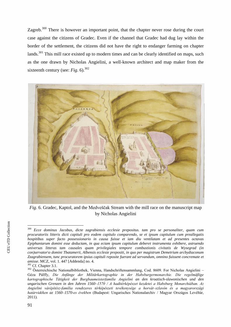
91
Zagreb.300
There is however an important point, that the chapter never rose during the court
case against the citizens of Gradec. Even if the channel that Gradec had dug lay within the
border of the settlement, the citizens did not have the right to endanger farming on chapter
lands.301
This mill race existed up to modern times and can be clearly identified on maps, such
as the one drawn by Nicholas Angielini, a well-known architect and map maker from the
sixteenth century (see: Fig. 6).302
Fig. 6. Gradec, Kaptol, and the Medveščak Stream with the mill race on the manuscript map
by Nicholas Angielini
300 Ecce dominus Jacobus, dicte zagrabiensis ecclesie prepositus. tam pro se personaliter, quam cum
procuratoriis litteris dicti capituli pro eodem capitulo comparendo, se et ipsum capitulum cum preallegatis
hospitibus super facto possessionario in causa fuisse et iam diu ventilatam et ad presentes octavas
Epiphaniarum domini esse deductam, in qua eciam ipsum capitulum deberet instrumenta exhibere, astruendo
universas litteras tam causales quam privilegiales tempore combustionis civitatis de Wysegrad (in
con)servator\o domini Tbatamerii, Albensis ecclesie prepositi, in quo per magistrum Demetrium arcbydiaconum
Zzagrabiensem, tunc procuratorem ipsius capituli reposite fuerant ad servandum, omnino fuissent concremate et
amisse. MCZ, vol. 1. 447 [Addenda] no. 4. 301 Cf. Chapter 3.1. 302 Österreichische Nationalbibliothek, Vienna, Handschriftensammlung, Cod. 8609. For Nicholas Angielini –
Géza Pálffy, ie Anfänge der Militärkartographie in der Habsburgermonarchie. ie regelmäßige
kartographische Tätigkeit der Burgbaumeisterfamilie Angielini an den kroatisch-slawonischen und den
ungarischen Grenzen in den Jahren 1560–1570 / A haditérképészet kezdetei a Habsburg Monarchiában. Az
Angielini várépítész-família rendszeres térképészeti tevékenysége a horvát–szlavón és a magyarországi
határvidéken az 1560–1570-es években (Budapest: Ungarisches Nationalarchiv / Magyar Országos Levéltár,
2011).
CE
UeT
DC
olle
ctio
n

92
The frequent disputes between the two institutions may be easily understood
considering the intensive exploitation of the small stream flowing between the two
settlements. A perambulation from 1328 gives a detailed account of the mills that stood on the
two branches (one natural and one artificial) of the stream. While checking the border, the
surveyors headed from the south to the north along the Medveščak (see Figs. 6 and 7).303
The
first relevant point mentioned from this chapter’s perspective is the mill-place of the parish
priest of the Saint Emeric Church. Moving along the stream against the current, the next two
points of relevance here were the two mills of the “abbot of Zagreb”. These mills are certainly
the same as the mills of the Cistercians that were given to them in 1257 and left in their hands
after the lawsuit against the citizens of Gradec. Above these two mills, the next point in the
perambulation was the mill of the bishop by the same stream, followed by three more mills
owned by the chapter and then again a mill of the bishop, followed by a further three chapter
mills. Above this the two branches mentioned above – the artificially dug out channel and the
old river stream bed – joined again. On the artificial riverbed flowing to the west and
excavated by the citizens of Gradec, that the document tellingly calls the “real bed of the
river” (verum meatum ipsius rivuli), had two further mills on it in the hands of the citizens,
while in the natural and probably sometimes dry bed of the stream, was the “mill of the
hermits” (molendinum Heremitarum). The hermits can be identified as Paulines, whose
hermitage lay next to the town of Zagreb.304
Finally, mills – or a mill with multiple wheels –
owned by the citizens of Gradec, stood on lands (predium) that Nicolas, son of Syrgarinus
received from the chapter, also operated by the natural riverbed. Thus, there were at least
fourteen mills and a mill-place established along a few-kilometer stretch of the not
particularly bountiful waters of the divided Medveščak stream. These waters must have been
among the most intensively used water flows in the territories studied for this dissertation
303 Ad locum molendini super eodem rivulo sancti Emerici prope puteum, deinde per eundem rivulum sursum ad
duo molendina abbatis de Zagrabia super eodem rivulo, que molendina ad metas capituli includuntur, deinde
super ipsum rivulum ad tria molendina capituli, et dehinc ad molendinum damini episcopi, adhinc iterum ad tria
molendina capituli, semper cum dicto rivulo in totum cum molendinis ad capitulum scilicet [?] Zagrabiensem
ecclesiam pertinente, dehinc per verum meatum ipsius rivuli versus septentrionem pervenit ad duo molendina
Grecensia, que aqua de dicto rivulo recepta ducuntur. Abhinc tendit per antiquum meatum sepedicti rivuli ad
molendinum Heremitarum, deinde per antiquum meatum ipsius rivuli transit quedam molendina Gracensia in
vicinitate predii Nicolai” MCZ, vol. 1. 129–130 no. 14. Cf. Igor Karaman. Tisu ljetni Zagreb [Zagreb through a
thousand years] (Zagreb: Školska knjiga, 1994) (map 20). 304 Documenta Artis Paulinorum, 3 vols, eds. Béla Gyéressy, and Ferenc Hervay (Budapest: MTA
Művészettörténeti Kutató Csoportja, 1975–1978), vol. 3. 320–321, and 325. See also: Romhányi¸ Kolostorok és
társaskáptalanok, 55.
CE
UeT
DC
olle
ctio
n

93
research. The use of these waters remained a hotbed of hostilities between the citizens of
Gradec and the chapter of Zagreb.
The disputes between the cathedral chapter and Gradec continued all throughout the
fourteenth century. In 1392, however, they tried to come to an agreement that would have put
an end to the disputes, which as we shall see was not a successful endeavor. In 1392, they
nonetheless agreed, neither the chapter, nor the citizens of Gradec could erect mills in the
lower section of the Medveščak stream – from the Dominican friary, to the Pisani or Krvavi
(meaning “bloody”) Bridge.305
This was the southern (lower) section of the stream. The
bridge was directly downstream from the place where the artificial mill race and the former
natural stream of the Medveščak met. Upstream from this point, as the chapter had had its
mills in this area since the thirteenth century, only they had the right to erect mills up to the
mill of the Chupor family. Their mill stood in the southern part of the New Town (Nova Villa
or Nova Ves). Above this point to the village of Gračani, a tenant peasant village founded by
the citizens of Gradec, the latter town had the right to operate mills. Two institutions, the
Cistercians and the parish priest of Nova Villa, had the right to keep their mills, as they had
been there from the “old times”.306
The latter settlement’s mill is the same as the above-
mentioned mill of the Paulines that the parish priests of Nova Villa came into possession of in
1376 in exchange for other properties.307
305 Cf. Nada Klaić, Povijest Zagreba. 1. Zagreb u srednjem vijeku [History of Zagreb, vol. 1. Zagreb in the
Middle Ages] (Zagreb: SNL, 1982), 477. 306 Molendina vero domini abbatis claustri beate Marie virginis de dicta Zagrabia inter predictas metas et signa
metalia existencia, nos et ipsi cives in suo statu pacifico relinquimus et commisimus; (…) Hoc non pretermisso,
quod incipiendo a predictis duabus metis prope dictum molendinum filiorum Chupor erectis usque predictarn
villam Gracchan prenominati cives a parte occidentali in ipsorum territorio absque jmpedimento et destruccione
rnolendini sancti Johannis Nove ville in porcione seu territorio ipsius civitatis existentis et habiti, molendina et
alia edificia quotquot volunt, edificandi et construendi et aquam seu decursum aque ipsius rivuli de vero cursu
in locis necessariis ad fossata excipiendi liberam habebunt facultatem. MCZ, vol. 1. 341–345 no. 362. 307 MCZ, vol. 1. 250–254 no. 262.
CE
UeT
DC
olle
ctio
n

94
Fig. 7. The mills of Zagreb in the Middle Ages (after Igor Karaman)
In the 1420s, the struggles between Kaptol and Gradec seem to have reignited and
took more violent forms than before. From 1422, a number of documents attest to bloody
conflicts between the inhabitants of the two settlements.308
The hostilities seemed to have
continued after the violent actions in 1422. In 1423, the citizens of Gradec were accused by a
certain George, canon of the chapter of Zagreb, of, amongst other things, digging a ditch in
308 MCZ, vol. 2. 28 no. 30, 28 no. 31, 27 no. 29, 29 no. 31, 29 no. 31, and 28 no. 31 (ZsO, vol. 9. 171 no. 531,
172 no. 533, 221 no. 691, 235 no. 733, 237 no. 739, and 253 no. 795).
CE
UeT
DC
olle
ctio
n

95
order to redirect the flow of the stream.309
Similar accusations came in 1475 but in reverse.
This time, the inhabitants of the chapter town seem to have diverted the original river’s flow
towards their mills and fields, drying out the artificial channel used by the citizens of
Gradec.310
The example of the mills and the related disputes in Zagreb indicates how important
small urban rivers and streams were for local economies. The River Sava, running in the
vicinity of Zagreb was also exploited both for catching fish and building mills. It was also
important in the southern defenses of the town. Nonetheless, the Sava mills were never the
real motors of the local economy of Zagreb as they lay too far from the densely inhabited
areas.311
Thus, despite the significant runoff and the potential for building ship mills,
Medveščak stream lay at the center of the economy and town conflicts.
3.2.2.1. Budafelhévíz and its Hot Springs
The case of Budafelhévíz is similar to that of Zagreb in the sense that the settlement
did not mostly profit from the major river flowing nearby but rather from a lesser stream.
Budafelhévíz and its waters, as noted above, represent a special, but hardly unique example,
not only because of the settlement lay next to the major town of Buda (and Óbuda), but also
because the water flow at the center of its economy was fed by hot springs. One of the musts
for anyone visiting modern Budapest is a visit to a thermal bath on the Buda side, many of
which were founded in the Ottoman period.312
The thermal springs feeding these spas were
known and used already before the Ottomans’ arrival in the region in the mid-sixteenth
century. The most important sign of this earlier knowledge is the settlement of Budafelhévíz.
Its Latin name was Aquae calidae superiores (meaning “upper hot springs”). The area
309 Fluvium Chirkvenik de suo cursu per idem fossatum fluere permisissent MCZ, vol. 2, 44 no. 36. (the original
of the document is lost) 310 Venerunt ad nos cives civitatis zagrabiensis in modo gravis querele, quomodo aquas ipsis ab antiquo
spectatas violenti manu occuparetis, quod nostra credulitate de vobis non fuissemus spectaturi, cum et alia
colloquia habuimus simul, in quibus talia minime fuerunt perpetrata, sicuti domino Georgio de Bexin, bene
notum est, quod nulla parcium alteri parti absque quod aliquod preiudicium aut dampnum inferret, quod in
nostri absencia minime observatum est, ex quo utique aliud non vultis, quam serenissime regie maiestatis
civitatem juribus privare et ipsos condempnare. MCZ, vol. 2. 364–365 no. 295. 311 Karbić, and Bruno Škreblin, “Grad na rijeci.” 312 Adrienn Papp, “Oszmán-török fürdők Budán – A Rudas és Rác fürdő régészeti kutatása (2004–2006),”
[Ottoman bathing houses at Buda – archaeological research of th Rudas and Rác bathing houses, 2004–2006] in
A középkor és a kora újkor régészete Magyarországon, 2 vols [Archaeology of the Middle Ages and the Early
Modern Period in Hungary], eds. Elek Benkő, and Gyöngyi Kovács (Budapest: MTA Régészeti Intézet, 2010),
vol. 1. 207–220, Adrienn Papp, “Fürdők a török kori Budán.” [Bathing houses at Ottoman-period Buda] (PhD-
diss., Eötvös Loránd Tudományegyetem, 2014).
CE
UeT
DC
olle
ctio
n

96
between medieval Óbuda and Buda was particularly rich in thermal springs the usage of
which date back to the Roman period.313
The waters from some of these springs were backed
up to form a small pond, probably by the thirteenth century at the latest. – This pond still
exists today and is called Malomtó (meaning “Mill Lake”). It created an even water-level on
the small stream that ran from the pond towards the Danube (see Fig. 8).314
This stream,
called Malom (“Mill”) Stream was no longer than circa one hundred meters. Because of the
presence of the potential for water power, as well as its proximity to major markets, both in
terms of population concentration and the most important wheat markets of Buda, the area
was particularly attractive for building water mills. The places suited for milling, thanks to
royal donations, were gradually transferred to ecclesiastic institutions, which were, as was
also clear from the example of Zagreb (as well as other towns) were particularly keen on
acquiring mills.
313 Paula Zsidi, “A Duna szerepe Aquincum topográfiájában,” [The role of the Danube in the topography of
Aquincum] Budapest Régiségei 41 (2008): 57–83. 314 Nicolas Marcel de La Vigne, Bvdae ac Pesti ichonographica descriptio tvm etia(m) earv(m) vicinarv(m),
castrorv(m), aggerorv(m), fossarv(m), prospectvv(m), nvda, ac recta scenographica delineatio, aliarvmve dictae
Bvdae obsidionis particvlaritatv(m) à sac(ratissimi) caes(arei) mai(estatis) exercitv, eivsqve praecelsorvm
foederatorvm copiis factae ([Vienna] [?], 1686). Held at: Budapesti Történeti Múzeum [Budapest History
Museum], Metszettár [Collection of prints]. György Rózsa, Budapest régi látképei. 1493-1800. Alte ansichten
von Budapest (2nd ed. Budapest: Új Művészet Kiadó, 1999), Cat. 27, 121, 150, and H. Bredekow, Geometrischer
Grundt-Riß der eunmahl Bekriegten ndt Blutig Besiegten Königlichen ngarischen Resitends Stadt Buda vel
Offen [Vienna] [?)] 1686). Held at: Hessisches Staatsarchiv Marburg, Wilhelmshöher Kriegskarten, vol. 6. no.
20. See for their recent editions at: András Végh, Buda I. kötet, 1686-ig [Buda, I. Until 1686] (Magyar
Várostörténeti Atlasz, 4) (Budapest: Budapesti Történeti Múzeum, Pázmány Péter Katolikus Egyetem
Bölcsészet- és Társadalomtudományi Kar Régészeti Tanszék, and Archaeolingua Alapítvány, 2015). For these
representations, see also: Adrienn Papp, “Török kori lőpormalom Budán,” [Ottoman-period gunpowder mill at
Buda] Keletkutatás 2015 (Tavasz [Spring]): 105–113.
CE
UeT
DC
olle
ctio
n

97
Fig. 8. Felhévíz and the Malomtó (Millpond) represented on two late seventeenth-
century illustrations (by H. Bredekow)
The conflicts around the use of the waters of this very small stream are particularly
well documented mostly because of the above-mentioned interests of church institutions.
While the archives of medieval Buda are almost completely lost, the archives of the monastic
and other ecclesiastic bodies that functioned in the territory of present-day Budapest are much
better preserved. This is particularly true for the documents of the Dominican nuns of
Margaret Island, who had numerous interests in the water related incomes in the surroundings
of their nunnery.315
In the case of Budafelhévíz, not only are the sources particularly well
preserved, but one of the great connoisseurs of medieval Buda and Pest, András Kubinyi,
315 Cf. István Kenyeres, “The Fate of the Medieval Archives of Buda and Pest,” in Medival Buda in Context, 52–
68.
CE
UeT
DC
olle
ctio
n
98
dedicated a monographic study to the development of this medieval settlement.316
Following
in his footsteps, a number of studies also addressed the issue of the mills erected here.317
The earliest institutions with interests in using the waters at this spot were the
Dominican nuns of Margaret Island and the Holy Spirit Hospital. The latter institution lay
close to the pond and was most probably founded on royal initiative. The hospital not only
had mills on the Malom Stream, but also built a bathing house, common extensions of
hospitals in medieval Europe. It is safe to assume that the presence of the hot springs was the
most important factor in their choosing to settle at Felhévíz.318
The earliest reference to a mill
in the area comes from somewhat earlier than the first data on the Holy Spirit Hospital, the
existence of which can only be confirmed from the end of the first third of the fourteenth
century.319
The first mill established by the pond belonged to a certain Peter, son of Uza of the
Kurszán clan, who donated an mill at Felhévíz to the Dominican nuns some time before
1276.320
The next mill by this short stream mentioned in the sources is particularly interesting
from the point of view of what has been discussed in Chapter 3.1. The mill, called Hévízfő
(meaning the “head of hot spring”), probably stood by the outflow of the pond. However, at
the time of the donation (or actually the leasehold) by King Charles I, there was no standing
mill, and the document which tells of the transaction did not refer to the site as a locus
molendini, which could have implied the previous presence of a mill but rather as an “empty
mill plot” (…nos quemdam vacuum fundum molendini Hevezfeö vulgariter nuncupatum).321
The mill was given to citizens of Buda, who built not one but two wheels there, which
316, András Kubinyi. “Budafelhévíz topográfiája és gazdasági fejlődése,” [Topography and economic
development of Budafelhévíz] Tanulmányok Budapest Múltjából 16 (1964): 85–180 (published under the same
title in Tanulmányok Budapest középkori történetéről, vol. 1. 115–182). 317 Benda, “A kereskedelem épületei a középkori Budán, 3,” Szende, “Mills and Towns,” and Végh, Buda. 318 For hospitals in medieval Hungary, see: Judit Majorossy, and Katalin Szende, “Hospitals in Medieval and
Early Modern Hungary,” in Europäisches Spital esen. Institutionelle F rsorge in Mittelalter und Fr her
(Neuzeit Quelleneditionen des Instituts für Österreichische Geschichtsforschung, 5), eds. Martin Scheutz et al.
(Vienna and Munich: Oldenbourg, 2008), 409–454. For the Holy Spirit Hospital, see: Lajos Pásztor, A
magyarság vallásos élete a Jagellók korában [Religious life of the Hungarians in the Jagiello age] (Budapest:
[N.p.], 1940), 53 and 56, Zoltán Somogyi, A középkori Magyarország szegény gye [Taking care of poors in
medieval Hungary] (Palaestra Calasanctiana, 37) (Budapest: Stephaneum, 1941), 37–48, and Kubinyi,
“Budafelhévíz,” 123–129. More recently, see: Judit Lászay, and Adrienn Papp, “Investigations in the
Budafelhévíz baths,” in Régészeti kutatások Magyarországon 2007 / Archaeological Investigation in Hungary
2007, ed. Júlia Kisfaludi (Budapest: Kulturális Örökségvédelmi Hivatal and Magyar Nemzeti Múzeum, 2008),
63–84. 319 MES, vol. 3. 157–158. Végh, Buda, 49. See also: Kubinyi, “Budafelhévíz,”123–124. 320 BTOE, vol. 1. 151, 181, 241–242, and 246. Kubinyi, “Budafelhévíz,” 130 note 336 raised that in the latter
confirmation mills are referred to in the plural. He suggested that the other mills may have been elsewhere, but
this probably only is the traditional plural that is prevailing in similar lists of utilities and belongings. Cf. Chapter
2. 321 CD, vol. 8/4. 369–372 no. 182. For the first reference of a standing mill there, see: CD, vol. 8/4. 292–294 no.
134.
CE
UeT
DC
olle
ctio
n
99
according to the related documents, stood in separate buildings.322
None of these mills stayed
in the hands of citizens of Buda for long, as in the 1360s, after a lasting lawsuit, they finally
came into the hands of the Poor Clares convent in Óbuda, which enjoyed the strong support of
the mother of King Louis I, Elisabeth of Poland.323
There was at least one further mill erected
in this location. This mill was in the possession of the royal castle of Óbuda from the mid-
fourteenth century onwards. The mill’s exact location, however, remains unclear. The earliest
references to the mill locate it between two other mills by which the document certainly
means two of the above-mentioned mills on the Malom Stream.324
Later documents, however,
are less clear about its location. In 1389, the mill is described as being close to the Holy Spirit
Hospital,325
while in 1420, the mill is mentioned as standing close to the Danube and the lands
of the Poor Clares of Óbuda.326
The localization of the mill is further complicated by two
documents dating to 1430, in which the mills are said to stand by the bath house of the nuns
of Margaret Island.327
As the localization of these buildings is anything but precise, for a want
of better information and based on the reference that it stood between two mills, I suggest this
mill was also built by the Malom Stream. In the meantime, some of the mills that were built
here in the course of the late fourteenth century were probably abandoned or fell into
disrepair. This situation is suggested by a donation of three mills or mill sites to the Poor
Clares of Óbuda granted by King Sigismund. The nature of the donation of Sigismund is
somewhat unclear as the documents in some cases refer to three mills, while in other instances
are called mill-places.328
It is likely that the nuns then erected new mills or rebuilt them since
322 CD, vol. 8/4. 292–294 no. 134, and CD, vol. 8/4. 369–372 no. 182. 323 Herta Bertalan, “Das Klarissinnenkloster von Obuda aus dem 14. Jahrhundert,” Acta archaeologica
Academiae Scientiarum Hungaricae 34 (1982): 151–176, and Brian McEntee, “Queen Elizabeth of Hungary
(1320-1380) and Óbuda: Patronage, Personality and Place,” in La diplomatie des états Angevins aux XIIIe et
XIVe si cles / Diplomacy in the countries of the Angevin ynasty in the thirteenth – fourteenth centuries actes
du colloque international de Szeged, Visegrád, Budapest : 13–16 septembre 2007, eds. Zoltán Kordé, and István
Petrovics (Rome and Szeged: Dipart. di Storia Ungh. del Medioevo e della prima Età Moderna Univ. degli Studi
di Szeged and Accademia d’Ungheria in Roma Istituto Storico “Fraknói”, 2010), 209–218 (with reference to the
prolific literature in the topic). 324 Eiusdem molendini in Calidis Aquis prope Ecclesiam hospitalis Sancti Spiritus Budae inter duo molendina in
ipsis Calidis Aquis existentia habitum. MNL OL DL 5289. See also: MNL OL DL 6370, 6625, 6755 with
locating it to the same place. Cf. Végh, Buda, 55 (locating it to the latter place). 325 Molendinum in qualidis aquis existens circa sanctum Spiritum. MNL OL DL 7564, edited in: BTOE, vol. 3/1.
38–39 no. 91. 326 Quoddam molendinum in fluvio Calidarum aquarum superiorum a parte Danubii habitum religiosis
dominabus sanctimonialibus claustri beate virginis de Veteribuda. MNL OL DL 10 956, edited in BTOE, vol.
3/2. 50–51 no. 771. 327 Molendini in superioribus Calidis aquis, in fine eiusdem aque prope balneum religiosarum dominarum
sanctimonialium de Insula ieporum.” MNL OL DL 12 317. (erroneously indicated as MNL OL DL 12 327 at
Kubinyi, “Budafelhévíz,” 131 note 339). BTOE, vol. 3/2. 161 no. 978 and MNL OL DL 12 325, edited in:
BTOE, vol. 3/2. 163 no. 982. 328 MNL OL DL 15119, edited in CD, vol 11. 70–73 no. 20, and BTOE, vol. 3/2. 298 no. 1189. Cf. Kubinyi,
“Budafelhévíz,” 131.
CE
UeT
DC
olle
ctio
n

100
when the mills were again illegally confiscated on the order of the treasurer, Michael Gúti
Ország, by a member of his noble retinue, Nicholas Szász (Zaaz), they were referred to as
standing mills.329
One of these mills was then given to Anthony, a glassmaker from Buda.330
Despite the attempts of the Poor Clares to get their mill back, they finally agreed to lease the
mill (this time again referred to as a mill-place) to Anthony.331
András Kubinyi has shown
that it similarly took great efforts by the Poor Clares to get back the remainder of their former
mills (mill-places at the time).332
The fifteenth century brought numerous further lawsuits.
These, however, exclusively concerned property rights rather than water rights. By the early
sixteenth century, because of the number of mills, waves of lawsuits were brought to the royal
courts addressing the right to use the waters of the Mill Stream by different property owners.
At least one mill was rebuilt by the Poor Clares themselves, and their third mill-place was also
leased. One further ecclesiastical institution, the chapter of Buda, appears as a mill owner in a
document dated to 1481. According to this document, their mill was seized by the court judge
of Buda, Benedict Pider, on the orders of King Matthias.333
It probably is not a complete
coincidence that the most important element on the coat of arms of Pider acquired not much
before, is a mill wheel, possibly an allusion to his previous occupation.334
Pider’s mill stood
between the mill of the castle of Óbuda and a mill owned by the Poor Clares suggesting the
above mentioned, not clearly localized mill of the Óbuda castle, also lay somewhere on this
short stream, probably upstream from the mills of the Poor Clares. The large number of
functioning mills led to water use conflicts from the early sixteenth century onwards.
The first of the three lawsuits analyzed by Kubinyi took place in 1502. The Poor
Clares laid complaint against a man called Caspar Zsemlyesütő (meaning “bun baker”) who
moved the sluice of the nuns’ mill. As is clear from this document, Zsemlyesütő – whose
relative, Andrew also possessed a mill at Felhévíz – had raised the height of the sluice,
backing the stream waters so much, that it flowed back to the mill of the nuns, hindering its
329 MNL OL DL 13179, edited in BTOE, vol. 3/2. 299. no. 1192. 330 MNL OL DL 13 188, edited in BTOE, vol. 3/2. 300 no. 1194. Katalin Holl-Gyürky, “The Use of Glass in
Medieval Hungary,” Journal of Glass Studies 28 (1986): 77–78. 331 MNL OL DL 13 207, edited in BTOE, vol. 3/2. 302–303 no. 1199. The lease contract: MNL OL DL 13 299,
edited in BTOE, vo. 3/3. 309–310 no. 1214. 332 Kubinyi, “Budafelhévíz,” 131. 333 Kubinyi, “Budafelhévíz,” 131. 334 His grant of arms from 1476: MNL OL DL 50 534. Edited in Monumenta Hungariae Heraldica. Magyar
czimeres emlékek, 3 vols, eds. Antal Áldásy, and László Fejérpataky (Budapest: Franklin, 1901–1926), vol. 2.
61–62. Cf. Dániel Kálmán, “A középkori magyar armálisok címerei 1437–1490 között,” [Coats of arms of the
medieval Hungarian grants of arms between 1437 and 1490] in Micae mediaevales V. Fiatal történészek
dolgozatai a középkori Magyarországról és Európáról [Studies of young historians on medieval Hungary and
Europe] (ELTE BTK Történelemtudományok Doktori Iskola Tanulmányok – Konferenciák, 9), eds. Laura
Fábián et al. (Budapest: ELTE BTK Történelemtudományok Doktori Iskola 2016), 149–150.
CE
UeT
DC
olle
ctio
n

101
operation.335
The nuns reasoned that the height of their mill sluice was the same as it had been
in the old days (veteri et antiquo), which in light of what has been discussed in Chapter 3.1, is
no surprise. The efforts of the Poor Clares proved successful over the long run as in 1509
Zsemlyesütő was forbidden to cause further damage to the nuns’ mill property. The rebuilding
– or as it turns out, the extension of the mill into a two wheeled mill – of the nun’s mill that
followed this decision was an opening move in a new lawsuit. The other two ecclesiastical
institutions, the Dominican nuns and the chapter of Buda sued the Poor Clares for having
decreased the water-levels in the Malomtó (Mill Lake) that according to them belonged to all
the mills. The numerous – almost fifty – witnesses – amongst them probably not by chance
bun-bakers and millers336
– claimed that both the mill of the Dominican nuns and that of the
chapter of Buda had lost a significant part of their water-supplies and that grinding the same
amount of grain took almost twice as long as it had previously. The document testifies to the
presence of a fairly complex water system which included underground water cisterns
(cisternas subterraneas) as well as channels (canales) that brought water to the Poor Clares’
mill.337
The palatine, Emeric Perényi, in whose court the case was heard, decided that the
Poor Clares should restore the hydrological conditions predating their intervention. Not much
later, a group – again including millers – investigated whether the Poor Clares had completed
their task, but not surprisingly found that the work had come to a halt.338
The lawsuits
continued at Felhévíz, probably not independently from completing the restoration works on
the Poor Clares’ mill. In 1511, Caspar Zsemlysütő sued the nuns again because the mill he
held as a lease, the royal mill (the previously mentioned mill of the castle of Óbuda), suffered
losses because of the restoration works carried out by the nuns. While the investigation
showed no diminution in the output of Zsemlyesütő’s mill, he nonetheless received 20 gold
florins from the Poor Clares as compensation, while another institution, the chapter of Buda,
probably because of the earlier losses they suffered, received 50 gold florins from the nuns.339
The numerous charters that document the long-lasting struggles to control the waters
of the short Malom Stream demonstrate how important water was as a property, even close to
major rivers such as the Danube. Hot waters, of course, were not the only important resources
at Budafelhévíz, but throughout Europe, where waters froze over in winter,340
these
335 MNL OL DL 22 546. 336 See: Chapter 4. 337 MNL OL DL 26 131. Kubinyi, “Budafelhévíz,” 135. 338 MNL OL 22 014, edited with omissions in: Knauz, “Budai regeszták,” 50–52 no. 77. 339 Kubinyi, “Budafelhévíz,” 135 note 355. See also: Knauz, “Budai regeszták,” 72 no. 94. 340 E.g. the case of the mills along the River Tapolca around Pápa: István Wöller, A Tapolca vízimalmai Pápán
és környékén [The water mills of the River Tapolca at Pápa and its surroundings] (Fejezetek Pápa város
CE
UeT
DC
olle
ctio
n

102
watercourses were amongst the most contested of water resources because of their value in
building water mills as well as bath houses.341
3.2.3. Urban Moats and Water-Use342
As demonstrated in the previous two subchapters, even in the Kingdom of Hungary,
where urbanization, or at least the number of people living in major settlements lagged well
behind Western Europe or Byzantium, water use was a crucial issue in urban space and every
potential water was exploited by local economies. There has been research on a variety of
uses for rivers of different sizes but there was another kind of water body that was present in
many towns in Europe but only partially discussed in the literature in the context of water-use,
that is, moats. Moats surrounding medieval towns (and castles) were important elements in
their defenses. However, by the late medieval period, the overwhelming majority of towns in
Western and Central Europe had expanded well beyond their walls.
With the ever-growing population in the suburbs as well as with increasing economic
production in towns, moats gradually merged into the urban fabric. Not everywhere, and not
always to the same extent, but in many cases, moats became part of urban economies. They
were used in at least three different spheres of urban economies: for milling and, less
frequently, as fish ponds, and as sites for ports. These uses of moats have received
considerably less attention in the scholarship than their military and architectural aspects since
the available sources seldom refer to their non-defensive uses. This paucity of information,
however, does not mean that there are no references to these secondary uses of moats in
regional urban contexts. This subchapter will provide an overview of moats and their water
use based on cartographic and written evidence. I will then focus on two towns in the territory
of medieval Hungary, Sopron and Prešov. I will argue that moats were also systematically
történetéből, 1) (Pápa: Pápa Város Önkormányzata, 1994), or by the River Hévfő at Oradea: Renáta Skorka, “A
váradi ferences rendi kolostorok topográfiája,” [Topography of the Franciscan friaries of Oradea] in agyvárad
és Bihar az Anjou-korban [Oradea and Bihor in the Angevin period] (Tanulmányok Biharország történetéről, 5),
ed. Attila Zsoldos (Nagyvárad: Varadinum Kulturális Alapítvány, 2018), 175–181 and 281 (map). 341 Magnusson, and Squatriti, “The Technologies of Water in Medieval Italy,” 253–254. 342 Parts of this subchapter have already been published: András Vadas, “Economic Exploitation of Urban Moats
in Medieval Hungary with Special Regard to the Town of Prešov,” Mesto a Dejiny 6 no. 2 (2017): 6–21, and
idem, “Városárkok és vízgazdálkodás a késő-középkori Közép-Európa városaiban,” [Urban moats and water
management in the towns of Central Europe in the Late Middle Ages] rbs. Magyar Várostörténeti Évkönyv 10–
11 (2015–2016): 323–353.
CE
UeT
DC
olle
ctio
n

103
exploited in medieval urban economies and should not be regarded only as defensive
elements.
There are very few monographs and edited volumes that discuss urban moats, but
there is a relative rich literature on the urban fortifications at individual settlements.343
This
research was either published as individual studies or as chapters in ‘town biographies’.
Urban archaeology concentrated on the study of fortifications that protected medieval towns.
This can partly be attributed to the fact that in many cases the only town parts that were
relatively accessible for archaeological excavation in towns were fortifications because were
not built over, even in modern towns. Accordingly, dozens of German, Austrian, Czech,
Polish or Hungarian studies address the building histories of the urban fortifications of
specific settlements based on archaeological data, in some cases complemented by the
analyses of the iconographic and/or written evidence. However, there is an almost complete
gap on the economic aspects of medieval (urban) moats. Richard Holt, in a previously
mentioned study on the aquatic economies of medieval England even if only shortly, refers to
the building of moats around castles, manor houses and towns. He points to two important
aspects of moats. First, in England, moats were just as much prestige investments as defensive
constructions344
and second, that they were used in the local economies. He shows that in
England most moats used ground waters and only the more significant ones were fed by
flowing waters through ditches. He gives the example of the moat of medieval Birmingham,
that the moat was used as mill pond. However, he suggests Birmingham’s moat was more an
exception than a rule. British research has also pointed to the moats used as ports.345
In the French territories, a historian of technology, André Guillerme referred to moats
in a comparative perspective. Choosing some settlements in present-day France, he provides
analyses of the relationship between towns and water. The monograph employs methods from
two fields, the history of technology and environmental history. Guillerme is one of the few
authors who address the problem of the different needs of the local economies and defensive
needs when it came to use of moats in local economies. He demonstrates that the period
343 E.g. Die Befestigung der mittelalterlichen Stadt (Städteforschung, A 45), eds. Gabriele Isenberg, and
Scholkmann, Barbara (Cologne, Weimar, and Vienna: Böhlau, 1997), Oliver Creighton, and Robert Higham,
Medieval Town Walls. An Archaeology and Social History of Urban Defence (Stroud: Tempus, 2005), or City
Walls: the Urban Enceinte in Global Perspective. ed. James D. Tracy (New York: Cambridge University Press,
2000). For East Central Europe, see the overview of Teodor Octavian Gheorgiu, Cetatile oraselor: apararea
urbana în centrul si estul Europei în Evul Mediu [Castle towns: urban defense in Central and Eastern Europe in
the Middle Ages] (Bucureşti: Editura Simetria, 2000). 344 Holt, “Medieval England’s Water Related Technologies,” 79ff. 345 Mark Gardiner, “Hythes, Small Ports, and Other Landing Places in Later Medieval England,” in Waterways
and Canal-Building, 90.
CE
UeT
DC
olle
ctio
n

104
starting with the Hundred Years’ War in France brought fundamental changes in the
exploitation of urban waters. From that time, military aspects were to dominate over
economic interests for a long period.346
This is relevant in the context of the Kingdom of
Hungary, as a somewhat similar process can be observed in the context of the Ottoman-
Hungarian wars. A widely debated monograph, by Charles Coulson is worth mentioning here,
not so much in the context of towns, but rather castles and their moats. He considers defenses
built around castles in late medieval France, England, and Ireland to be primarily prestige
investments.347
With that he breaks with traditional approaches in the study of these buildings
from an architectural history perspective.348
As he saw castle fortifications as prestige objects
he also addressed what economic benefit these investments could have had. Coulson refers to
a number of examples of moats exploited in local economies. In the overwhelming majority
of the cases, however, monographs and studies on the fortifications of towns address very
little more than register the presence of urban moats. They seldom include specific references
concerning the way the moats were used or the way waters were regulated to provide moats
with a constant water supply. Before turning to a brief overview of the research carried out in
Hungary on urban fortifications, and moats in particular, reference must be made to a valuable
research aid that will be used extensively in this subchapter, the volumes of the European
Historic Town Atlas Series. The more than 550 atlases produced for individual settlements is
one of the best tools for studying the economic exploitation of moats in pre-modern Europe.
As for mills, moats are also, more or less, systematically registered in the volumes.349
Hungary, as most regions in Europe, lacks any comprehensive work on (urban) moats
and to my knowledge no such literature exists for moats in neighboring countries.350
There is
a considerable gap in the scholarly literature on the defensive structures of towns in medieval
Hungary. In recent years, fortifications in Transylvania, including urban fortifications were
346 Guillerme, The Age of Water. 347 Charles L. H. Coulson, Castles in Medieval Society Fortresses in England, France, and Ireland in the Central
Middle Ages (Oxford: Oxford University Press, 2003). 348 For the problem, in a mostly German context, see Matthias Untermann, “Erscheinungsformen der
Stadtbefestigung,” in Die Befestigung der mittelalterlichen, 3–25. 349 On the series, see: Lords and Towns in Medieval Europe, the European Historic Towns Atlas Project, eds.
Anngret Simms, and Howard B. Clarke (Farnham: Ashgate, 2015), and Nick Millea, Keith Parry, and Adrian
Phillips, “The European Historic Towns Atlas Project,” IMCoS Journal no. 153 (2018): 26–36. For the atlases
published so far: http://www.historictownsatlas.org.uk/content/bibliography (last accessed September 26, 2019) 350 See for exceptions, the example of Freistadt in Upper-Austria: Elisabeth Gruber, Raittung und außgab zum
gepew. Kommunale Rechnungspraxis im oberösterreichischen Freistadt. Edition und Kommentar der
Stadtgrabenrechnung (1389–1392) (Vienna: Böhlau, 2015), and on Vienna: Ferdinand Opll, Heike Krause, and
Christoph Sonnlechner, Wien als Festungsstadt im 16. Jahrhundert. Zum kartografischen Werk der Mailänder
Familie Angielini (Vienna, Cologne, and Weimar: Böhlau, 2017), esp. 176–177.
CE
UeT
DC
olle
ctio
n

105
reviewed in a number of publications.351
There is a less exhaustive catalogue of the castles
and urban fortifications in sixteenth-century Hungary352
as well but these works can hardly be
said to comprehensively cover the medieval Kingdom of Hungary geographically or
chronologically. There are a number of county castle cadastres that have been gathered in the
past decades but they seldom refer to moats. Most of the relevant literature has been written
on the fortification systems of individual towns such as Pest, Trnava, Košice, Sopron, or
Kőszeg where archaeological excavations have been carried out.353
Despite excavations
taking place in recent years on urban fortifications, with the exception of the urban moat of
Sopron, these excavations revealed little information on moats.354
The dissertation of the
architect Péter Rabb provided an overview of the urban fortifications in medieval Hungary.
Although very briefly, he did refer to moats. His work, however, has limited applicability as
primary sources were entirely disregarded by the author as well as to a large extent
archaeological excavation results.355
3.2.3.1. Building Moats, Using its Waters – A Short Overview
By the late medieval period, most of the major towns in Western Europe were not only
surrounded by a wall but also possessed a protective moat, an indispensable element in the
defense of settlements from the period of the widespread use of firearms.356
This rather self-
351 Adrian Andrei Rusu, Castelarea Carpatică. Fortificații şi cetăți din Transilvania şi teritoriile învecinate (sec.
XIII–XIV) [Carpathian Castelaria. Fortifications and citadels in Transylvania and the neighbouring territories]
(Cluj-Napoca: Editura Mega, 2005), and Ákos Karczag, and Tibor Szabó, Erdély, Partium és a Bánság erődített
helyei [Fortified places in Transylvania, Partium and Banate] (2nd ed. Budapest: Semmelweis, 2012). 352 Endre Marosi, XVI. századi váraink, 1521–1606 [Castles in 16th-century Hungary] (Miskolc: Hungária-
Európa Alapítvány and Borsod-Abaúj-Zemplén Megyei Levéltár, 1991). 353 For an overview of the results: Katalin Szende, “A Kárpát-medence középkori városainak régészeti kutatása
az elmúlt két évtizedben,” [Archaeological research into medieval towns in the Carpathian Basin since 1990] in
A középkor és a kora újkor régészete Magyarországon, vol. 1. 149–150. For earlier research see also: Imre Holl,
“Feuerwaffen und Stadtmauern. Angaben zur Entwicklung der Wehrarchitektur des 15. Jahrhunderts,” Acta
Archaeologica Academiae Scientiarum Hungaricae 33 (1981): 201–243. 354 Imre Holl, “Sopron középkori városfalai,” [Town walls in medieval Sopron] Archaeologiai Értesítő 94
(1967): 155–183, 95 (1968): 188–205, 98 (1971): 24–44, 100 (1973): 180–207. The most important from the
point of view of this chapter is 95 (1968): 198–204. On the fortification of the towns in Slovakia with reference
to moats: Martin Miňo, “Niekoľko postrehov k fortifikačným prvkom miest stredoslovenskej banskej oblasti,”
[Some notes on the fortification elements of central Slovakian mining towns] Archaeologia historica 36 (2011):
289–302. On Banská Bystrica: Igor Graus, “Vývoj fortifikácie Banskej Bystrice do konca 16. storočia v
podmienkach špecifík pasívnej obrany stredoslovenských banských miest,” [Development of the fortifications of
the town of Banská Bystrica until the end of the 16th century under the specific conditions of passive defense of
the Middle-Slovakian mining towns] Vojenská história 4 (2000): 3–21. 355 Péter Rabb, “Városi védművek a középkori Magyarországon, 2 vols,” [Urban fortifications in medieval
Hungary] (PhD-diss., Budapesti Műszaki Egyetem, 2005), on fortification moats, see vol.1. 47–48. 356 See: Guillerme, The Age of Water.
CE
UeT
DC
olle
ctio
n

106
evident character of moats is clearly reflected in the architectural treatise of the Italian
humanist, Filarete. According to his treatise the building of the ideal town begins as follows:
“I have ordered that, the first thing tomorrow morning, everyone is to come with
mattocks, shovels, and picks. I want you to be the first to begin the work of
digging the moats. These will be ten braccia away from the wall. I think they
ought to be 30 braccia wide if the dimensions are satisfactory to you. As soon as
this is done the moat should be walled up on both sides. The wall toward the city
will be as high from the ground as the battlements of the wall, that is, three
braccia high from the ground level, and then the battlements. On the opposite side,
it will only be as high as ground level, no more no less.”357
Although the Italian treatise was probably never a basis for the building of towns in
medieval Hungary, the text was not unknown here either. Filarete’s work was translated into
Latin and preserved in one of the codices in King Matthias’s library, the Bibliotheca
Corviniana.358
The most important lesson within the text as far as moats are concerned relates
not so much to the circulation of the text but rather to the fact that by the fifteenth century it
was self-evident that a town had to possess more complex fortification system than a wall. Of
course, as with many fortification elements, the role of moats in the self-representation of a
community, as a prestige investment, should also be considered.359
Moats however were
significant investments that had little short-term benefit. Probably this is the reason the author
of a chronicle of the lives of bishops of Auxerre chose a rather unconventional way to argue
why Hugo of Noyers, an influential bishop at the turn of the twelfth and thirteenth centuries,
ordered one of his smaller residences to be surrounded by a moat:
“Because it was unprotected and was vulnerable to the attacks of plunderers
[Hugo of Noyers] rebuilt the old walls, and constructed moats and high towers in
order to fortify Varzy, his famous town. Next to Saint Eugene’s Church he erected
new buildings for the bishopric with strong walls, great houses, towers and
bastions. In order to protect the bishops, he built even stronger walls, with more
solid walls, towers and outworks. The inner keep boasted towers, fortifications
and advanced defenses of impregnable strength, surrounded by wide, spring-filled
357 Filarete’s Treatise on Architecture Being the Treatise by Antonio di Piero Averlino, Kno n as Filarete, 2
vols, ed. John R. Spencer (New Haven, CT: Yale University Press, 1965), vol. 1. 52–53. 358 Norbert Mátyus, “Filarete és Bonfini. Egy humanista építészeti tankönyv Itáliában és Magyarországon,”
[Filarete and Bonini. A humanist architectural treatise in Italy and Hungary] in Techné. A szakképzés módszerei
az ókorban és a középkorban [Techné. Forms of crafts’ knowledge transfer in the Ancient Times and the Middle
Ages], eds. Márta Munding, Kornél Szovák, and László Takács (Piliscsaba: Avicenna Közel-Kelet Kutatások
Intézete, 2018), 345–370. 359 Holt, “Medieval England’s Water Related Technologies,” 79–82.
CE
UeT
DC
olle
ctio
n

107
ditches. Thanks to the abundance of [water] sources that feed the moat it is not
only no small augmentation of the fortifications, but, by reason of the multitude of
fish they provided, by the mills the bishop built there, and other profitable assets,
they greatly improve the entire establishment.”360
There is limited information available on the building costs of fortification moats, but
based on an account from Sopron from 1540 to be discussed in Chapter 4 and similar sources
from Austria (Freistadt), their construction probably represented a significant financial
burden. Unlike town walls, moats had the potential to generate income since their waters
could be exploited in the ways noted above. This was not merely a potential source of
exploitation. In dozens of towns in Europe moats were considered a well defined, predictable
source of income. In order to have at least some insight on how general it was to use moats in
local economies I studied the volumes of the European Historic Town Atlas series. I had
access to 337 atlases when preparing this subchapter of the dissertation. This sample provides
a relatively good geographical coverage to see whether it was normal to use moats as milling
waters and as fish ponds, or rather exceptional. Of the studied 337 settlements, 207 possessed
some kind of at least partly artificial – that is dug – protective ditch, and of these, 136 had
moats, filled with water at least part of the year. Of the roughly fifty percent of the towns
where moats appear, there were attempts to use the moats in the local economies. However,
due to lack of sources, the use of moats as fish ponds was only seldom mentioned while these
atlas being, more or less, systematic in discussing and representing mills (from cadastral
maps). Of the 76 towns where moats had connected mills, there were two different positions
for mills on moats (as in the case of Sopron to be discussed hereafter). Mostly, mills were
built on a rather arbitrarily chosen section of the moat. In roughly one third of the cases
however, the mills and their sluices may have served as the main element in the regulation of
the water-levels in stretches of the moats themselves. In some cases, of course, mills could be
found in both positions on urban moats. Providing the moats with a constant water flow was a
crucial issue because if water-levels remained low for long periods they could easily silt up
360 Castrum suum nobile Varziacum, quod, propter loci immunita, prius frequentibus patebat depredantium
incursibus, muros reparando antiquos et fossas turribus ingentibus circumsepsit. Domos episcopales juxta
ecclesiam beate Eugenie muro solido, magnificis edificiis, turribus ac propugnaculis a primis condidit
fundamentis. Presidium quoque episcopale ulterius muro solidiori, turribus munitioribus et antemuralibus in
tutam et ad expugnandum diflicilem munitionem provexit, et fossis mire amplitudinis vallavit in girum, in quibus,
grata aquarum exuberantia ex fontibus circumfluentibus eas replens, non modicum facit ad munitionis
augmentum; et tum ex piscium multitudine qui ibi nutriuntur optimi, tum ex molendinis que edificavit ibidem,
tum ex aliis utilitatibus suis, episcopo totique municipio multe commoditatis existunt. Louis M. Duru,
Biblioth que historique de l’ onne; ou, Collection de légendes, chroniques et documents divers pour servir à
l’histoire des différentes contrées qui forment aujord’hui ce département, vol. 1 (Auxerre: Perriquet, 1801), 431–
450, and Coulson, Castles in Medieval Society, 70.
CE
UeT
DC
olle
ctio
n

108
and clearing them could be expensive (see the example of Sopron). Most towns tried to create
moats with an constant water circulation water in them.361
The permanent flow of water was
even more important in moats used for keeping fish. This was probably a widespread practice
in medieval Europe but it is rather rare to find references to moats as places to keep fish in the
secondary literature. Town monographs sometimes make reference to the problem, but no
such systematic study was carried out for the more than 300 towns in the atlas series. On the
one hand, there are indications that fish keeping in moats occurred at individual settlements
from relatively early on. Just to mentioned but to well known examples, both at Quedlinburg,
and at Vienna a number of sections of the moats were rented out to different fisheries,
suggesting the practice was not unique.362
Urban history in Hungary in the last half a century has been preoccupied with what
makes a town a town. If the presence of stone walls is accepted as one of the most important
features of a civitas, there were only a few dozen towns in the region before the fifteenth
century, and even by the early sixteenth century, there may not have been more than ca. fifty
such settlements.363
There is less information on the moats that surrounded these towns as,
just as in other parts of Europe, most had been filled in by Modern times as these towns
expanded well beyond their medieval limits. Which of these moats were filled with water and
which were dry can, in the majority of the cases, be inferred based on hydrogeographic
conditions. Despite the fact that there were only about fifty towns surrounded by stone walls
in medieval Hungary, there were a good number of towns and villages that had earth and
wood fortifications or wooden palisades, in many cases combined with moats. If these
settlements are also considered, there were probably well more than a hundred protective
moats around settlements and castles in the Kingdom of Hungary by the end of the Middle
Ages. The gradual occupation of the Ottomans from the beginning of the sixteenth century
started a new wave of fortification construction as well as moats in the Carpathian Basin.
Some of these towns certainly used their moats both as milling waters and as fisheries,
something I shall demonstrate for two free royal towns, Sopron and Prešov.
361 For similar data from Hungary, see: Jankovich, “Adatok a Körösvidék középkori vízrajzához,” 323. 362 Otto Brunner, ie Finanzen der Stadt Wien von den Anfängen bis ins 16. Jahrhundert (Vienna: Dt. Verl. für
Jugend u. Volk. 1929). 363 András Kubinyi, “Városhálózat a késő középkori Kárpát-medencében,” [Urban network in the late medieval
Carpathian Basin]. Történelmi Szemle 46 (2004): 17–18, and see the detailed overview of the relavant research
history: Bálint Lakatos, Mezővárosi oklevelek Telep lési önkormányzat és írásbeliség a késő középkori
Magyarországon, 1301–1526 [Market town charters. Urban autonomy and literacy in late medieval Hungary]
(Budapest: Bölcsészettudományi Kutatóközpont Történettudományi Intézet, 2019), 11–16. See also: Rabb,
“Városi védművek,” esp. its appendix. Many of its data have to be modified in light of the recent work: Karczag,
and Szabó, Erdély, Partium és a Bánság.
CE
UeT
DC
olle
ctio
n

109
3.2.3.2. The Case of Sopron
The first example is the town of Sopron on the western border of the Kingdom of
Hungary.364
The town has a rather peculiar settlement history; it originates from a Roman
settlement called Scarbantia. The Roman town was encircled by a wall in the Late Roman
period. After the Romans left Pannonia in the early fifth century, the fortification was
abandoned for centuries; however, when in the tenth century, Hungarian settlers inhabited the
area, the fortification was still visible. Hence a royal stronghold, adding a timber and
earthwork rampart to the Roman fortification was founded there sometime in the eleventh
century. Several villages that served the military and administrative population were
established in the vicinity of the fortified area. However, in the thirteenth century, the
settlement’s function changed. The fortified area was transformed into a royal town, and plots
of regular sizes were measured out there and in the suburbs as well.365
The walled area, with
its significant civic population, became one of the best protected Hungarian towns with a
triple wall system and a moat. The archive of the town has the richest holdings concerning the
Middle Ages and the Early Modern times in the territory of present-day Hungary.
Archaeological research has also been carried out in the area of the fortifications.366
364 Jankó, Kücsán, and Szende, Sopron, Gazetteer: 2 (legal status), 7 (population), 26 (mills). References to
archival data on mills can be found in this publication. 365 Katalin Szende, “Neighbourhoods, Suburbs and Ethnic Quarters in the Hungarian Towns of the Thirteenth to
Fifteenth Centuries,” in Cities – Coins – Commerce: Essays presented to Ian Blanchard on the Occasion of his
70th Birthday, ed. Philipp Robinson Rösener (Stuttgart: Franz Steiner Verlag, 2012), 43–64. 366 Jankó, Kücsán, and Szende, Sopron.
CE
UeT
DC
olle
ctio
n

110
Fig. 9. The town of Sopron in the late medieval period with the urban moat, the fish ponds
and the approximate location of the mills
(1 – Foregate and its mill; 2 – Hospital Mill; 3 – Fullers’ Mills; 4 – Fish ponds)
Sopron, despite the fact that it had more than 4000 inhabitants by the late medieval
period, was not rich in waterways. There were two streams flowing through the territory of
the town, the northwest-southeast running Ikva Stream, that carried more water and crossed
the town on the north and the Bánfalvi- or Rák Stream that ran west-east. Not only the moat
but also both streams were exploited for building water mills from the Middle Ages
onwards.367
Because of geomorphologic conditions, the Bánfalvi Stream was used for feeding
water to the town’s moat. The water from the stream circulated around the moat through a
sluice system.368
The town was surrounded by a moat some time in the middle of the
fourteenth century. In 1340, King Charles I supported the construction of the moat by
367 Szende, “Mills in Towns,” 496 – 497, Jankó, Kücsán, and Szende, Sopron, passim and 82 (Gazeteer: Mills). 368 Imre Holl, “Sopron (Ödenburg) im Mittelalter,” Acta Archaeologica Academiae Scientiarum Hungaricae 31
(1979): 110–119.
CE
UeT
DC
olle
ctio
n
111
providing the town with half of the income from the customs paid at Lake Fertő.369
The grant
only mentions fossatum, but does not describe whether it should be a moat or only a ditch.
Scholars think the ditch or moat was completed by 1344 but this date is only approximate
based on the fact that Charles I granted this income for five years of construction. One of the
most important elements of the moat was the sluice that regulated the water-levels on the
western side of the moat. It was part of the building complex of the Foregate (see Chapter 4 as
well) at the northernmost point of the fortification. According to a fragmented account book
from 1437, a mill was also connected by then to the building.370
Probably this was the largest
mill on the moat but certainly not the only one. In 1438 and in the following year, the
Hospital Mill (Spitalm hl) also appears in the sources. It stood in the western side of the moat
in a rather favorable position, right next to the grain market (Kornmarkt).371
From the
sixteenth century onwards, more mills were built into the moat and sources refer to the mills
of the fullers. According to an entry in the account book of the town from 1589, the fullers
had a new mill built in the southwestern part of the moat, which ran with three wheels.372
The
number of mills rose further in the seventeenth century as well.373
The moat in Sopron was not used for milling activities but also for keeping fish as
attested in the sources. The first reference to fish also dates to the fifteenth century and is
preserved in the so-called Notebook (Gedenkbuch, a mixed content, municipal book).
According to an entry from 1496, the town council decided to withdraw Jacob Pilsner from
taking care of the fish ponds (or rather small inlets).374
Based on the entry, it is clear that the
369 MNL OL DF 201 756, January 16, 1340. Házi, Sopron, vol. 1/1. 76–77 no. 136. 370 Item dem Vlreich zimermann hab ich geben 4 tagion per 20, das er dy rinnen zu der mul bey dem voderntor
hat gemacht, facit LXXX den. Házi, Sopron, vol. 2/3. 83 no. 10. 371 Item Thomas Zenikel vnd Johannes Zeniekel geprueder von gurmennt rugent an stat ir selbs auf die
nachgeschriben stucken vnd gueter auf halben tail [von wegen Stephan des Zeniekel purger zu Odenburg vnd
fr(awen) Margareten die dann sein hausfr(aw) gewesen ist] von erst auf ain mayerhoff gelegen am Korenmarkt
vor der Stat Odenburg zenachst der spitalm l. erichtsbuch. Bírósági Könyv 1423–1531 (Sopron Város
Történeti Forrásai, A/2), eds. Jenő Házi, and János Németh (Sopron: Győr-Moson-Sopron Megye Soproni
Levéltára, 2005), 107–108 no. 29 (1438). See also Gerichtsbuch, 117 no. 43 (1440). Item desselben tags hab ich
geben dem Hanns mulner, das er an der m l im graben geczimert hat, dem hab ich beczalt IX taglon per XX,
facit VI sol. den. Házi, Sopron, vol. 2/3. 345 no. 23 (1440–1441), and the tax paid by the miller, Hanns: Házi,
Sopron, vol. 2/3. 345 no. 27 (1442). 372 On the fulling mills see: István Dávidházy, “A soproni posztókallók,” [The fulling mills of Sopron] Soproni
Szemle 43 (1989): 193–205. This is taken over by Jankó, Kücsán, and Szende, Sopron, 27 Fig. 10. For the exact
site of the mill, see recently: József Kücsán, “A Várkerület belső ívének beépítése, 1766–1801,” [The building
up of the inner line of the Grabenrunde, 1766–1801] Soproni Szemle 69 (2015): 329, and 331. Fig. 5. 373 Dávidházy, “A soproni posztókallók,” passim. 374 Anno domini M CCCC Im LXXXXVI-ten Jare Am mitichen Goczleichnambsabent habenn die herrenn den
Teicht Jm Attengräben so et an Cristoff härb seliger gehabt hat Widerumb von dem Erberen Jacob pilsner
eingenomen vnd Jm <vnd seinen Erben,> all versessen Zynns so gemainer stat da von gefallen werdenn ganncz
nachgelassen, Auch da f r gebenn das allt Od gemeir hinder des Khörnmarkh gelegenn mit garten vnd annder
aller zugehorung des Nachper ist des Jacob Joachim seligen einsetz, vnd an der annderen seitten Wolfganng
Osterperger Einseczs ledig vnd frey Actum vtsupra. edenkbuch. Feljegyzési könyv 1492–1543 (Sopron Város
CE
UeT
DC
olle
ctio
n

112
three basins where fish were kept had been created earlier. The basins were located between
the row of houses of present-day Ógabona Square and Újteleki Street, and got their water
from the Ditch of the Fullers, which was connected to the moat itself.375
The use of the fish
basins did not cease in the late fifteenth century but were probably used well up to Early
Modern times. In 1570, a complaint was laid, according to which the mill belonging to the
houses by the Lange Zeile had caused great losses to the fisheries and therefore should not be
re-installed. The Lange Zeile was connected to the southern part of the Inner Town, and was
probably associated with the ponds mentioned earlier.376
It is not clear what source of the
conflicts was, but was probably related either to the amount of the water let into the channel
by the mill owners or pollution from the mill. The small ponds are not only mentioned in
these sources but can also be identified on views of the Early Modern town (see: Fig. 10). The
final source for the fisheries in the moat dates to the early seventeenth century. The last entry
of the rather unique (auto)biography of the mayor of the town, Christoph Lakner, concerns the
fisheries in the town: “in the same year [in 1618] to the great benefit and in a good manner he
had the fish pond cleaned which had been filled with mud from the side of the new tower, and
had it strengthened all around with pales and fences.”377
The lake mentioned here can be
located in the southern part of the town – also visible on the town views. It lay here well up to
the eighteenth century.378
It is quite clear that the moat in Sopron was intensively integrated
within the local economy and represented an important part of town water-use. Despite the
relatively rich source material, the only water use conflict we know of was that between the
mill owners along the Lange Zeile and the owners of the fisheries. However, not only could
Történeti Forrásai, A/3), eds. Károly Mollay, and Károly Goda (Sopron: Győr-Moson-Sopron Megyei Levéltár
Soproni Levéltára, 2006), 60 no. 61 (June 1, 1496). See also: Dávidházy, “A soproni posztókallók,” Fig. 10, and
Jankó, Kücsán, and Szende, Sopron, 27 Fig. 10, and 82 (Fish ponds). For the fish keeper see also: Károly
Mollay, “A Tómalom középkori előzményei (Fejezet a soproni határ történetéből),” [Medieval predecessors of
the Tómalom (An episode from the history of the borders of Sopron)] Sopron Szemle 46 (1992): 154. 375 See also: József Tirnitz, and Anita Szakács, Sopron város tanácsa bírósági jegyzőkönyveinek regesztái I.
1533–1554 [Summaries of the protocols of the court of law of the town of Sopron, 1] (Sopron: Győr-Moson-
Sopron Megye Soproni Levéltára, 1996), 8 (preface of the editors). 376 Anita D. Szakács, Sopron város tanácsa bírósági jegyzőkönyveinek regesztái III. 1570–1579 [Summaries of
the protocols of the court of law of the town of Sopron, 1] (Sopron: Győr-Moson-Sopron Megye Soproni
Levéltára, 2011), 21–22 no. 2 (MNL GyMSML SL IV. A. 1002. a. III. 309–310. p.). 377 Eodem anno piscinulam, e regione turris novae coeno refertam, denuo fructuose et utiliter expurgari fecit,
circumquaque palis et sepibus bene munivit. Lackner Kristófnak, mindkét jog doktorának rövid önéletrajza.
Vitae Christophori Lackhner I. U. D. Hominis, brevis consignatio (Sopron Város Történeti Forrásai, C/5), ed.
Gergely Tóth (Sopron: Győr-Moson-Sopron Megyei Levéltár Soproni Levéltára, 2008): 138–139 cap. 38. See
also: Gergely Tóth, “Előre megírt emlékezet: Lackner Kristóf különös önéletrajza,” [The memory written
untimely: the curious autobiography of Kristóf Lackner] in Lackner Kristófnak, mindkét jog doktorának rövid
önéletrajza 16, and 31. 378 Mátyás Bél, Sopron vármegye leírása / escriptio Comitatus Semproniensis, 3 vols (Sopron Város Történeti
Forrásai, C/4), ed. Katalin Mária Kincses (Sopron: Soproni Levéltár, 2006), vol. 3. 172–173 and 186–187. Cf.
Jankó, Kücsán, and Szende, Sopron, 82.
CE
UeT
DC
olle
ctio
n

113
the different ways waters could be exploited lead to conflicts, but as I shall show in the
following subchapter so did the various needs of a town and the citizens who tried to exploit
the waters of a moat.
Fig. 10. Zacharias Michel’s Bird’s eye view of Sopron in 1700 (after Jankó, Kücsán, and
Szende, Sopron, Plate C.4)
3.2.3.3. The Case of Prešov
This subchapter will focus on the town of Prešov, a town in the northeastern part of
medieval Hungary. As with Sopron, the use of defensive moats in the local economy is well
documented. In this case, the analysis of the mills and the moat can also help significantly in
reconstructing urban topography and the town’s development. The town began to grow
somewhat later than Sopron. The first references to the settlement date back to the thirteenth
century. At this time, it was already in royal hands although no data exists on the wider
CE
UeT
DC
olle
ctio
n

114
freedoms of the settlement which then probably not significant at all. Nonetheless,
importantly, the settlement core already lay in the area of the later town, something suggested
earlier but recently confirmed through archaeological excavations.379
It probably grew to be a
rather significant settlement in the late thirteenth and the early fourteenth century. The town
lies by an important trade route that connected Lesser Poland with the Kingdom of Hungary.
By the late medieval period, the town of Prešov belonged to a group of Hungarian towns that
enjoyed the widest possible liberties (that is free royal towns) despite the fact that it never was
among the most populous settlements in the country.
The building history of the urban fortifications of Prešov is probably amongst the best-
known from the territory of medieval Hungary. This is not primarily due to its conservation as
virtually nothing remains of the medieval fortifications, but because of the particularly
detailed written evidence on the fortifications preserved in the local archives, and only
partially exploited in recent years historians. Apart from medieval documentary evidence,
Early Modern visual source material also significantly contributes to our understanding of the
structure of the fortification.
Both Hungarian and Slovak researchers showed an interest in the medieval history of
the town, however, not independent of the survival of the medieval sources, only some
questions were highlighted in this research.380
Since the fundamental two-volume publication
by the archivist Béla Iványi on the medieval records of the Prešov’s archive, research has
drawn on the substantial evidence published in his work.381
Using this rich source material, a
number of works have been dedicated to different aspects of the history of the town, from its
ethnic composition through its legal history to some elements of the urban topography from
the beginning of the twentieth century. The most important works until recently were based
379 Marián Uličný, and Peter Harčar, “Počiatky mesta Prešova na základe výsledkov najnovších archeologických
výskumov,” [The origins of the town of Prešov deduced from the results of the latest archaeological research]
Archaeologia historica 35 (2010): 393–403. 380 See most importantly the monograph of the town: ejiny Pres ova, 2 vols [The history of Prešov], ed. Imrich
Sedlák (Košice, and Prešov: Východoslovenské Vyd. v Kos iciach – Muzeum Slovenskej Republiky Rád v
Prešove, 1965) vol. 1, and Alžbeta Gácsová, “Spoločenská štruktúra mesta Prešova v 15. storočí a v prvej
polovici 16. storočia,” [The social structure of Prešov in the 15th century and in the first half of the 16th century]
Historický časopis 18 (1970): 347–378. See also: Marcela Domenová, “Daňové písomnosti a sociálno-
ekonomické pomery mesta Prešov v období stredoveku,” [Tax lists and socio-economic processes in th town of
Prešov in the Middle Ages] in Zborník vedeckých prác katedry ekonómie a ekonomiky Anno 2009 [Proceedings
of scientific works of the Department of Economics, University of Prešov in 2009] (Prešov: Prešovská
univerzita, 2009), 231–255. See more recently: Marcela Domenová, “Prešov,” in Lexikón stredovekých miest na
Slovensku [Historical lexicon of Slovakian towns], eds. Martin Štefánik, and Ján Lukačka (Bratislava: Historický
ústav SAV, 2010), 331–351. For the early sixteenth century: Marcela Domenová, “K hospodáreniu mesta Prešov
na základe daňovej-účtovnej knihy z rokov 1528–1537,” [To the economy of Prešov on the basis on the book of
income and expenditure from the years 1528–1537] Annales Presovienses 11 (2011): 25–59. 381 Eperjes szabad királyi város levéltára, 1245–1526, 2 vols [Archive of the free royal town of Prešov], ed. Béla
Iványi (Szeged: Szegedi Városi Nyomda és Könyvkiadó, 1931–1932).
CE
UeT
DC
olle
ctio
n

115
on the testaments that survived in relatively high numbers from the late medieval period.
However, these documents do not add to our image of urban fortifications or their economic
exploitation.382
Recently, a Hungarian historian, László Szabolcs Gulyás, gathered some data
on the history of the fortifications of the town, mostly based on Iványi’s collected
materials.383
However, he made no reference to the moats. Since he focused on the Middle
Ages, he made no use of town views either, a relatively rich source from the seventeenth–
eighteenth centuries which help in the identification of some of the medieval topographical
elements connected to moats.384
There are a number of questions that are not clear with regard to Prešov’s fortification
moats which could be important for the history of the town in general. Precisely when was the
town surrounded by a moat? Did it fully surround the town and was it filled with water?
Following this train of thought, how was the moat exploited in the local economy? As I will
show in the coming subchapter, sources on the construction and the extension of the moat of
Prešov can contribute to our understanding of the growth of some Central European towns
connected to long-distance trade routes in the fifteenth century, as well as show how the use
of the moat by individuals led to conflicts with the town.
The thirteenth-century settlement may not have been much more significant than a
village but probably due to its favorable location by the eastern route connecting newly
emerging centers in the region, Kraków and Buda, it grew in importance as a trading post,
along with Košice.385
Košice, in all likelihood, became important somewhat earlier than
Prešov, from the end of the thirteenth century and continued to grow both in terms of its
privileges and importance throughout the late medieval period.386
With the emergence of
382 Katalin Szende, “Gyermekek, testvérek, házastársak. Családi viszonyok és örökösödési szokások Eperjesen a
középkori végrendeletek tükrében,” [Children, siblings, spouses. Family ties and testimentary practices in Prešov
in light of medieval last wills] Történelmi Szemle 46 (2004): 113–140 (with reference to the author’s other works
in the topic). See also: Marcela Domenová, “Prešovské testamenty do roku 1526. (Diplomaticko-obsahový
rozbor),” [The last will from Prešovs until 1526 (diplomatic content analysis)] Historica Carpatica 33 (2002):
29–68. 383 László Szabolcs Gulyás, “Városfalépítés a középkori Eperjesen,” [Town wall construction at medieval
Prešov] in Falak és választóvonalak a történelemben [Walls and division lines in history] (A Nyíregyházi
Főiskola Történettudományi és Filozófia Intézete Kiadványai. Terminus Könyvek, 1), eds. Attila Buhály, Gábor
Reszler, and György Szoboszlay (Nyíregyháza: Nyíregyházi Főiskola Történettudományi és Filozófia Intézet,
2014), 127–142. 384 Béla Szalai, and Lajos Szántai, Magyar várak, városok, falvak metszeteken, 1515–1800, 3 vols [Hungarian
castles, towns and villages on cuttings] (Budapest: Múzeum Antikvárium, 2006), vol. 2. 70–72. 385 On the routes, see: Katalin Szende, “Kraków and Buda in the Road Network of Medieval Europe,” and István
Draskóczy, “Highways between Buda and Kraków,”in On Common Path, 31–37, and 38–41 respectively. 386 Erik Fügedi, “Középkori magyar városprivilégiumok,” [Medieval Hungarian urban privileges] Tanulmányok
Budapest Múltjából 14 (1961): 27–28, and more recently, see: Attila Zsoldos, “The Path of Košice to the
Privileges of 1347,” and Boglárka Weisz, “The legal background of the trade life of Košice in the Middle Ages,”
in Košice in the Coordinates of European History, eds. Mária Hajduová, and Martin Bartoš (Košice: Kancelária
Ústavného súdu Slovenskej republiky, 2013), 34–49, and 94–111 respectively, Boglárka Weisz, “Kassa
CE
UeT
DC
olle
ctio
n

116
Košice, Prešov may also have gradually developed some importance. However, references to
the early history of the town are not very marked in the sources. The fact, however, that the
first known initiative to surround the settlement with a wall dates back to as early as 1370
reflects the fact that Prešov also grew relatively quickly. The source is a mandate issued by
King Louis I the Great to the nobility of Sáros County to provide lime, stone, and wood to
build the walls of Prešov.387
Although suggested in part of the secondary literature, the
document does not refer to either a ditch or a moat – that was probably only dug somewhat
later.388
By the first third of the fifteenth century, however, Prešov was certainly surrounded
by a moat as well. This is clearly reflected by the tax list of 1428 which refers to the tax-
payers of the houses “by the ditch” (in fossato). Whether this was a moat or only a dry ditch,
the tax list of course does not reveal.389
The town’s expenses concerning the building of the
ditch in 1429 provide further proof of the existence of a more complex fortification system for
the town. As will be highlighted later, the mills referred to as standing by the moat leave no
doubt that by this time the town, at least on its western side, was protected by a moat.390
Another source, likewise from the period of King Sigismund’s reign, also contains a
good number of details about the fortifications, and especially the urban moat. In a charter
from 1435, Sigismund gave permission to reconstruct the fortifications of the town in
response to the recurrent Hussite threat.391
The walls of the town as well as the moat were
then extended. The extension of the moat, however, created a problem. At this time, there
were at least two water mills that depended on the moat’s water. When the moat was
kereskedelmi életének jogi háttere a középkorban,” [The legal background of the trade life of Košice in the
Middle Ages] in Arcana tabularii Tanulmányok Solymosi László tiszteletére, 2 vols [Studies in honor of László
Solymosi], eds. Attila Bárány, Gábor Dreska, and Kornél Szovák (Debrecen and Budapest: ELTE BTK, 2014),
vol. 2. 899–908. 387 MNL OL DL 41 829. 388 Kornél Divald, and Béla Iványi, “Az eperjesi Szent Miklós-templom,” [The St Michael’s Church at Prešov].
Az Országos Magyar Szépművészeti Múzeum Évkönyvei 4 (1924–1926): 38. 389 MNL OL DF 228 604, edited in: Eperjes, vol. 1. 79–92 no. 211, for the inhabitants of the Ditch Street, here:
90–92. The row of houses in tax lists were recurrently referred to as standing by the moat. E.g., MNL OL DF
228 989. 6. p. (1486) or MNL OL DF 229 008 (1488). See on these tax lists: Domenová, “Daňové písomnosti.” 390 Item dedimus XX, den. pro reformatione pontis cirea molendinum medians inter alia duo molendina. MNL
OL DF 228 612. See also Eperjes, vol. 1. 93–103 no. 220, for the relevant part, here: 97–98. 391 MNL OL DF 229 042, for its at some points erroneous editions, see: Carolus Wagner, Diplomatarium
Comitatus Sarosiensis (Posonii and Cassoviae: Sumtibus Joannis Michaelis Landerer, 1780), 228–231 no. 17
and CD, vol. 10/7. 656–659 no. 305. Its regesta: Eperjes, vol. 1. 109–110 no. 237. On the case, see: ejiny
Pres ova, vol. 1. 94, Norma Urbanová, Prešov. Pamiatková rezervácia – Prešov [Monument guide: Prešov]
(Pamiatky mestských rezervácií, 8) (Bratislava: Tatran, 1986), 10–15 and Árpád Nógrády, “A középkor végi
Magyarország mindennapi kenyere (Beregszász lakosságának gabonavásárlásai 1530-ban és a Jagelló-kori
malomvámok),” [The everday bread of Hungary at the end of the Middle Ages. The grain acquisition of the
inhabitants of Berehove in the 1530s and the mill customs of Jagiellonian period] A yíregyházi Jósa András
Múzeum Évkönyve 42 (2000): 162. On the wars of the period, see: Pál Tóth-Szabó, A cseh-huszita mozgalmak és
uralom története Magyarországon [The history of the Czech-Hussite movements and rule in Hungary]
(Budapest: Hornyánszky ny. M. Tud. Akadémia, 1917).
CE
UeT
DC
olle
ctio
n

117
extended, the mills had to be moved. Sigismund gave the town permission to dismantle the
two mills and put them up elsewhere in Prešov. As most of the mill parts were made of wood,
moving them was not considered an impossible task in the Middle Ages.392
The water mills
were not originally built by the town’s authority but were in the hands of two burghers, Peter
Langwart and Peter Blume – according to the tax lists both were wealthy citizens.393
Of
course, according to Sigismund’s permission, these men had the right to rebuild their mills
elsewhere. The mills were indeed re-erected as it was the town itself which took action to
rebuild the water mills. The town saw an opportunity in the relocation of the buildings and
decided to compensate the burgers with some share in the capacity of the mills.394
Only a
limited proportion of the income from the mill went to their previous owners but neither did
the town own a majority share in the mills. Most of the income from the two mills was shared
between different ecclesiastical institutions in Prešov from that time onwards. The town
finally came into full possession of the mills half a century later, in 1494. These conditions
remained the same until modern times.395
From the point of view of urban topography, localization of the original sites of the
mills as well as their new sites from the 1430s onwards is of major importance. Knowing
where the mills were originally placed could identify other topographical elements and
contribute to understanding how the town developed.396
According to the documents issued
concerning the relocation of the water mills, one was originally located right next to the
Upper Gate (molendinum ante superiorem portam). There are a number of data on this mill
from the second third of the fifteenth century onwards and especially from 1494 onwards
when the mill was acquired by the town. The exceptionally detailed accounts of the town
from the late fifteenth century refer to the mill as the Upper Mill (Obermoell, molendinum
superior; see: Figs 8a and 8b).397
Apart from this mill that can be localized relatively
392 E.g. the case of a mill at Čachtice: Extunc prefatus dominus Georgius plebanus et sui successores plebani
habeant potestatem ipsa molendina iterum cum tot rotis quibus fuerit eorum voluntas translocandi et
transformandi in eodem flumine ad alium aptiorem et commodiorem locum ubi ipsis et ecclesie melius videbitur
expedire, neque aliquod aliud molendinum in derogamen et preiudicium illius per nos aut successores nostros
fundari poterit in futurum. MNL OL DL 65 946, edited in: József Teleki, A Hunyadiak kora Magyarországon,
vol. 11 [History of the age of the Hunyadis in Hungary] (Pest: Emich, 1855), 395–397 no. 501. See also: Chapter
3.1. 393 On the two burghers, see: MNL OL DF 228 604, edited in: Eperjes, vol. 1. 79–92 no. 211; MNL OL DF
228 669, edited in: Eperjes, vol. 1. 127–129 no. 283. 394 MNL OL 228 631, for its regesta: Eperjes, vol. 1. 110–111 no. 240; MNL OL DF 228 633, for its regesta:
Eperjes, vol. 1. 111 no. 242; MNL OL DF 228 634, for its regesta: Eperjes, vol. 1. 111 no. 243. 395 MNL OL DF 229 078, for its regesta: Eperjes, vol. 2. 288 no. 714. See also: Nógrády, “A középkor végi,”
162. On the mill incomes after 1526, see: Domenová, “K hospodáreniu mesta Prešov,” 36–37. 396 On the topography of the town, see: Václav Mencl, St edov ká m sta na Slovensku [Medieval towns in
Slovakia] (Bratislava: Universum, 1938), 98, and Dejiny Pres ova, vol. 1. 397 Discussed in: Nógrády, “A középkor végi.”
CE
UeT
DC
olle
ctio
n

118
precisely to the surroundings of the Upper Gate, the location of the other mill which fell
victim to the extension was called the Middle Mill (molendinum medium) can also be
ascertained with a good degree of certainty. A fragment of an account from 1429 mentions
expenses related to the bridge close to the Middle Mill. This bridge probably stood next to the
so-called Middle (or Small) Gate of the town, so the mill was named in a similar manner to
the Upper Mill. From the very same year, the town protocol refers to a street by the Middle
Mill by the town wall.398
The relocation of this mill, however, raises some problems. Unlike
the Upper Mill, it was probably moved somewhat further away from its original location.
Instead of standing in front of the Middle Gate, it was moved to the lower part of the town
after the extension of the town, hence the new name of the mill: Lower Mill (Niedermoell,
molendinum inferior, mola vero civitatis inferioris).399
This suggestion concerning the
location of the mills in various time periods can be confirmed by one of the first detailed
views of the town from 1768. The town view clearly marks the spots of the Upper and the
Lower Mill, both probably operating in the same spots from the mid-fifteenth century
onwards (see Figs 11a and 11b).400
Fig. 11a. View of the town of Prešov from 1768 by Gaspar Caspar
398 In plathea medii molendini penes murum civitatis. MNL OL DF 282 529. 4. p. The relevant entry – with the
omission of important words – in the town protocol book was edited in: Béla Iványi, “Eperjes szabad királyi
város jegyzőkönyve, 1424–1509,” [The protocols of the free royal town of Pres ov, 1424–1509] Történelmi Tár
10 (1909): 121–122. 399 For the latter, see e.g. MNL OL DF 282 538. fol. 112r. See also Figs 8a and 8b. 400 The town view was not included in the collection of Szalai and Szántai: iidem, Magyar várak, 70–72 despite
the fact that it has already been published in 1965: ejiny Pres ova, vol. 1. For the original town view, see:
Prešov, Štátny archív v Prešov, Magistrát Prešov, Zbierka máp a plánov (Inv. č. 2). I am thankful to Blanka
Szeghyová for her help with identifying the map published in: Dejiny Pres ova, vol. 1. without referring to its
repository.
CE
UeT
DC
olle
ctio
n

119
Fig. 11b. Detail of the view of the town of Prešov with the Upper Mill (no. 23) from 1768 by
Gaspar Caspar
Apart from these two mills that functioned for centuries in the western section of the
town’s moat, other mills were also constructed in the town in the Middle Ages. The town’s
accounts repeatedly refer to a fulling mill (molendinum pannificum). The location of this mill
is unknown, but lacking other water resources within the town, this mill may also have used
the moat waters. The early sixteenth century accounts also refer to a smith’s stone (de lapide
vero quo utuntur fabri or cotes fabrorum).401
This statement, based on the modest income
connected to it, suggests that this mill may have been connected somehow to the fulling mill,
or perhaps to the Lower Mill.402
From the fifteenth century onwards, apart from the two flour
mills and the fulling mill, recurrent references were made to a gunpowder mill in Prešov.
Whether this mill used water as a source of energy for the production of saltpeter is unclear.
Neither it is evident whether this was a completely separate mill that exclusively produced
401 For these two, see: Domenová, “K hospodáreniu mesta Prešov,” 37–38. 402 Domenová, “K hospodáreniu mesta Prešov,” 38.
CE
UeT
DC
olle
ctio
n

120
gunpowder, or rather a wheel in another mill, or a flour mill that was used temporarily for
another purpose. There are a number of examples from medieval and Early Modern Hungary,
which suggests that the latter may be more likely. Based on accounts from 1533/1534, Iványi
suggested that the building stood next to a friary. The only mendicant friary that operated in
town in the late medieval period was a Carmelite institution. The building stood by the town
gate on the road leading to Solivar, a settlement lying somewhat to the southeast of Prešov.403
The medieval sources are unclear as to whether a moat also ran on this side of the town or not.
The water in the moat section running by the mills on the west side of town originated from
the nearby River Torysa, (sources do not refer to mills by this more significant river). This
channel can be easily identified on Early Modern maps, including the relevant sheet of the
First Military Survey from the late eighteenth century. The eastern section of the moat was
probably not connected to the River Torysa or the western section of the moat. However,
according to the eighteenth-century description of the town by Matthias Bel, left as a
manuscript,404
the whole town at that time was surrounded by a moat.405
If true, because of the
local geographical conditions, the water in the eastern section of the moat probably came from
a source other than the River Torysa as this area lies at a somewhat higher elevation. The
water may have come from the hills east of the town. It is equally possible that the gunpowder
mill close to the town wall was a dry mill, something that cannot be ruled out for the fulling
mill either. There is no clear evidence for the source of energy used by these industrial
403 The Carmelites took over the building from the Franciscans. On the friary, see: Beatrix F. Romhányi, Kolduló
barátok, gazdálkodó szerzetesek koldulórendi gazdálkodás a késő középkori Magyarországon [Mendicant
brothers, farming friars. Mendicant economy in late medieval Hungary] (Budapest: Martin Opitz, 2018), passim
and Kund Regényi, “Az eperjesi Szentháromság karmelita konvent története,” [History of the Holy Trinity
Carmelite convent at Prešov] in Tanulmányok a középkori magyar történelemről. Az I. Medievisztikai Ph -
konferencia (Szeged, 1999. július 2.) előadásai [Studies in medieval history. Proceedings of the 1st PhD
conference in medieval studies, Szeged, 2 July 1999], eds. Sarolta Homonnai, Ferenc Piti, and Ildikó Tóth
(Szeged: Szegedi Középkorász Műhely, 1999), 103–113. On the relationship of the Franciscan friary and the
Carmelite convent: Romhányi, Kolostorok és társaskáptalanok, 23. 404 On Bél’s description of Sáros County, see: Gergely Tóth, “Bél Mátyás Sáros vármegyéről,” [Matthias Bel on
Sáros County] Gesta. Fiatal miskolci történészek folyóirata 6, no. 2 (2006): 30–49, and idem, “Bél Mátyás
‘Notitia Hungariae novae…’ című művének keletkezéstörténete és kéziratainak ismertetése, 2 vols [Creation
history of Mátyás Bél’s “Notitia Hungariae novae…” and description of its manuscripts] (PhD-diss., Eötvös
Loránd University, 2007), vol. 2. 247–251. 405 Moenia murus geminus, alter altero sublimior et solidior incingit, suffulcientibus eos propugnaculis quorum
duo praecipua mercatorum unum, alterum victorum, non parum addunt ornamenti urbeculae, ut nihil dicamus
de reliquis, quae sartoribus, carnificibusque nomen habent: ea enim pariter singulari munimento moenia, et
urbem ornant. Praeterea adstant portae, superior una, altera inferior, adiecta una portula a latere, quae omnia
turritis tectis condecorant urbis compagem. Totam eam ambiunt fossae, alte satis depressa, quarum una, quae
Tarcza vicina est, oppletur aquis ad summum. Országos Széchényi Könyvtár Kézirattár Fol. Lat. 3783. 34r-v
(Descriptio Comitatus Sarosiensis per Matthiam Belium adornata). On the manuscript, see: Tóth, “Bél Mátyás,”
vol. 2. 251.
CE
UeT
DC
olle
ctio
n

121
complexes although a dry mill certainly existed in the town as confirmed by an entry in the
town accounts from 1521.406
The account books refer to twofurther mills, but neither the location nor the power
source they employed is clear. The first mill to appear chronologically in the sources was a
mill that ground the malt to provide the burghers with beer. As sources mention this mill as
being a “malt mill and a wine house” (malzm hle und einhaus) the building must have held
one of the town pubs.407
Sources in the 1510s also refer to another mill (de molendino
bursatili), that only functioned for a couple of years but neither its location nor whether it was
a water mill is known (see: Fig. 12).408
Fig. 12. Topography of Prešov in the late medieval period with the relocation of the mills and
the probable direction of the western section of the urban moat before and after 1435
The moat in Prešov, given the lack of any other water resources in the walled area of
the town, became an integral element of the local economy. It seems that the citizens who
held plots along the moat tried to take advantage of their easier access to water. This access
406 MNL OL DF 282 538. 407 MNL OL DF 282 535. 408 MNL OL DF 282 538 (image: 533, 625 and 703).
CE
UeT
DC
olle
ctio
n

122
became complicated when the town walls were extended. The citizens could partly extend
their right to have mills by the moat, again returning to the principle of the earlier acquired
right, but the town saw an opportunity in the relocation process to acquire at least part of the
income from milling.
3.2.3.4. Moats, Urban Topographies and Mills – Some Conclusions
In this subchapter I showed that urban economies in pre-modern Europe not only used
major waterways and minor streams, but likewise urban moats to generate income. Moats
were part of the defenses of the towns, although as expensive investments and therefore often
elements in the status representation of the settlement, they still produced no income. As their
military uses were only temporary, many urban economic interests started to exploit them in
different ways. The military needs differed from the needs of the people who used moats for
their economic benefits.409
Of the two cases analyzed in detail, Sopron offers rather general lessons, most of all
that many of the actors in local industries were interested in having access to the moat water.
Fishermen and the fish market – often found in the proximity of the fisheries410
– as well as
the grain market and the fullers all wanted to take advantage of the waters flowing around the
town. The lessons that the example of Prešov provides is at least twofold. One is related to the
topography of the town and urban water use in general. First, King Sigismund’s permission
and the two individual agreements with the mill owners, Peter Langwart and Peter Blume, can
be used to date the extension of the town walls and the streets of the town itself. In this period,
a new street and a row of houses was most probably added to the previously existing
settlement, hence the need to relocate the mills. The documents related to the mills highlight
the fifteenth-century development of town itself. While the Upper Mill probably only had to
move a few meters, the Middle Mill had to be moved further to the south, allowing a
significant extension of the town towards the west. The documents related to the extension of
the fortifications along with the detailed account books of the town from the late fifteenth and
early sixteenth century allowed data to be gathered on mills in the town. They also revealed
that despite the relatively small population of the town compared to that of other free royal
409 See Guillerme, The Age of Water. 410 Szende, “The Sopron Fish Market.”
CE
UeT
DC
olle
ctio
n

123
towns in Hungary, Prešov possessed a high number of such complexes. Whether some of
these mills used water or some other source of energy remains unclear.
This survey of the moats and the exploitation of the waters surrounding Sopron and
Prešov also highlighted some general features regarding urban water management. Population
concentrations such as walled towns in Hungary had to use the waters within their borders
very efficiently to provide various industries with energy, and of course water was necessary
for many of the crafting processes. This hunger for water power led to an increasing number
of mills erected by the edge of moats in the Middle Ages. Researchers identified a number of
similar buildings in dozens of towns in Western as well as Central Europe. The moats of some
towns in the Kingdom of Hungary were also exploited; the examples discussed above are
among the best studied, but the waters running around the castles of Moson and Óvár also
supplied major mills with power411
while a section of the moat of Cluj in Transylvania was
also used as a mill race in the late medieval period. In this latter case, however, the use of this
semi-artificial riverbed probably pre-dated the time a moat was established around the
town.412
From the sixteenth century onwards with the appearance of the Ottomans and new
fortification techniques, military requirements became more significant than the needs of local
economies. However, partly because of the strategic importance of the proximity of mills to
castles and towns, as well as the lasting period of wars of variable intensity, mills and
fisheries kept operating in moats up to Modern times in the Kingdom of Hungary.
3.3 Rivers in Mining Areas - Abundance of Water versus Lack of Access?413
Mining towns form a particular settlement type in the medieval Kingdom of Hungary.
These settlements were granted privileges connected to prospecting for and exploitation of
metal ore found within the bounds of their territories. This aspect marked a common element
among such towns as opposed to the many and varied privileges a settlement could acquire
411 On Magyaróvár: Ágnes Aszt, “A mosonmagyaróvári Bástya utcában végzett régészeti feltárás történeti
tanulságai,” [Historical lessons of the archaeological excavations at Bástya Street in Mosonmagyaróvár] Moson
Megyei Műhely no. 3 (2001): 29–32. 412 On Cluj: Elek Benkő, Kolozsvár magyar k lvárosa a középkorban [The Hungarian suburb of Cluj in the
Middle Ages] (Erdélyi Tudományos Füzetek, 248) (Kolozsvár: Erdélyi Múzeum Egyesület, 2004). 413 An earlier version of this chapter has been published in Hungarian: András Vadas, “A középkori Magyar
Királyság bányavárosai és a malmok különös tekintettel Körmöc- és Újbányára,” [The mining towns of medieval
Hungary with special regard to Kremnica and Nová Baňa] in Márvány, tárház, adomány. azdaságtörténeti
tanulmányok a magyar középkorról [Marble, storage house, donation. Studies in the economic history of
medieval Hungary], eds. Boglárka Weisz, Renáta Skorka, and István Kádas (Budapest: MTA BTK
Történettudományi Intézet, 2019), 483–506.
CE
UeT
DC
olle
ctio
n

124
from kings or other landlords. The geographical distribution of these mining settlements is
therefore closely associated with mountainous areas of the Carpathian Basin, most
importantly, the territory called Upper Hungary (partly coinciding with is today Slovakia) in
the pre-modern period as well as large parts of Transylvania. In the Middle Ages, this
distinction between mining towns and other privileged settlements was not as clear-cut as it is
seen today. These towns were never officially associated with each other. However, two
groups of mining settlements in Upper Hungary frequently formed alliances from the late
medieval period onwards in order to achieve their political and especially economic goals.
Modern scholars refer to these two town groupings as Lower Hungarian mining towns (Alsó-
magyarországi bányavárosok in Hungary), namely: Kremnica, Banská Štiavnica, Banská
Bystrica, Nová Baňa, Pukanec, and Ľubietová, and Upper Hungarian mining towns (Felső-
magyarországi bányavárosok in Hungary), namely Gelnica, Smolník, Rudabánya, Jasov,
Telkibánya, Rožňava, and Spišská Nová Ves (see Fig. 13). The formation of these alliances at
the very end of the Middle Ages does not mean these towns represent a clear group of
settlements marked by common features in terms of their privileges, economies, political life
or their appearance. There are a number of fundamental differences in the way each town
developed while there are also a number of towns, also involved in mining that never became
part of these alliances. This is particularly true for towns in Transylvania where the different
mining centers never formed alliances with each other.414
414 Boglárka Weisz, “A nemesércbányászathoz kötődő privilégiumok az Árpád- és az Anjou-korban,” [Privileges
connected to precious ore mining in the Árpádian and Angevin periods] Történelmi Szemle 50 (2008): 141–162.
For a slightly modified version of this study, see: eadem, “A nemesércbányászathoz kötődő privilégiumok az
Árpád- és az Anjou-korban,” [Privileges connected to precious ore mining in the Árpádian and Angevin periods]
Bányászattörténeti Közlemények 6 (2008): 13–43, eadem, “A bányaváros, mint önálló várostípus a 14.
században,” [Mining town as a distinct type of town in the fourteenth century] Bányászattörténeti Közlemények
19 (2015): 31–57, and eadem, “Mining Town Privileges in Angevin Hungary,” Hungarian Historical Review 2
(2013): 288–312.
CE
UeT
DC
olle
ctio
n

125
Fig. 13. Mining towns in medieval Hungary
The settlements to be discussed in the coming subchapter nonetheless have at least one
common feature: they were founded and/or developed in order to exploit the ores discovered
on their territories, in this case, primarily gold and silver. These settlements, mostly founded
at the initiative of kings in the thirteenth and fourteenth century, received privileges reified in
charters. These privileges connected to the exploitation of the ore, however, quite often they
also put other sorts of economic privileges down in writing beyond prospecting rights. For the
most part, these privileges concern forest and water resources. The importance of forests for
timber is almost self-evident for a newly founded settlement, but of course for such towns,
timber was also necessary to line mine shafts, for building crushing mills, saw mills, and
countless other buildings connected to mining.415
This chapter focuses, however, on the other
natural resource discussed in some of the foundation charters, that is, water. This resource, as
I shall argue, was of crucial importance to mining towns for fishing, for transportation, but
most importantly, for water power used to grind grain and process metal ore as well as lift
material from the mine shafts to the surface and pump water from the mine shafts.
415 For this, see Weisz, “Mining Town Privileges.”.
CE
UeT
DC
olle
ctio
n

126
In the first part of the chapter I focus on the charters of privilege given to mining
towns – and some other royal towns – to see whether the problem of access to water appears
or not. And if it does, how. I aim to understand why we have relatively few references in these
privileges to the right to build water mills or generally exploit water although such
commentary is particularly emphatic in the pragmatic textual sources connected to these
mining towns, especially in documents issued by the settlement authorities.
Following this discussion, I will use the examples of the water mills of two mining
towns, Kremnica, and partly Nová Baňa to address the importance of water power
exploitation in the life of the towns. By studying the documents that include information on
the early water mills in the towns, it becomes possible to ask who had the right to build and to
own mills in the these two towns and in the villages founded by the town of Kremnica and
located in its proximity. By analyzing the privileges and the early documents of mining towns
I argue that although with only two exceptions, the privilege charters of the mining towns do
not make reference to building mills, the settlers in these towns indeed practiced this freedom.
3.3.1. Mining Town Privileges and Water-Use
There is a significant literature on privileging settlements in the thirteenth and
fourteenth centuries in general,416
and recently, a number of detailed studies addressed the
privileges of mining towns specifically.417
Thus, scholars are in a relatively good position to
study the medieval privileges issued to mining towns. The overwhelming majority of the first
charters and later privileges were published in cartularies in the last century and a half, and
most of them were included in good quality cartularies. Accordingly, it is not that hard to
416 Erik Fügedi, “Középkori magyar városprivilégiumok,” [Medieval Hungarian urban privileges] Tanulmányok
Budapest Múltjából 14 (1961): 17–107, Katalin Szende, “A magyar városok kiváltságolásának kezdetei,” [The
beginnings of privileging towns in Hungary] in ebrecen város 650 éves Várostörténeti tanulmányok
[Debrecen is 650 years old. Studies in urban history] (Speculum Historiae Debreceniense. A Debreceni Egyetem
Történelmi Intézet Kiadványai, 7), eds. Attila Pál Bárány, Klára Papp, and Tamás Szálkai (Debrecen: DE BTK
Történelmi Intézet, 2011), 32–56, Katalin Szende, “Power and Identity. Royal Privileges to the Towns of
Medieval Hungary in the Thirteenth Century,” in Urban liberties and citizenship from the Middle Ages up to
no Libertés et citoyenneté urbaines du moyen ge à nos jours (Beiträge zur Landes- und Kulturgeschichte, 9),
eds. Franz Irsigler, and Michel Pauly (Trier: Porta Alba, 2015), 27–68, Katalin Szende, “Mennyit ér a kiváltság?
Városprivilégiumok kibocsátása és rendelkezéseik betartása I. Károly alatt,” [How much are the privileges
worth? The issuing and the implementing of urban privileges during the reign of Charles I] in Pénz, posztó, piac
azdaságtörténeti tanulmányok a magyar középkorról [Money, cloth, market. Studies in the economic history of
medieval Hungary], ed. Boglárka Weisz (Budapest: MTA BTK Történettudományi Intézet, 2016), 285–340, and
Attila Zsoldos, “Károly és a városok,” [King Charles I and towns] in Pénz, posztó, piac, 267–283. 417 Weisz, “A nemesércbányászathoz kötődő privilégiumok,” eadem, “A bányaváros,” and most recently: eadem,
“Az alsó-magyarországi bányavárosok kiváltságai a Zsigmond-korban,” [Privileges provided to the Lower
Hungarian mining towns in the age of King Sigismund] rbs. Magyar Várostörténeti Évkönyv 12 (2018): 21–48.
CE
UeT
DC
olle
ctio
n

127
gather mining town privileges from the thirteenth and fourteenth centuries. The task is
somewhat more complicated in the period of King Matthias and the Jagiellonian Dynasty;
nevertheless most of the privileges of these towns date to a time before 1400. From the point
of view of this chapter, it is rather the early settlement phase of the s that is important. Our
collection (included in the Appendix) not only includes settlements later described as the
Lower- and Upper-Hungarian mining towns, but every mining settlement that acquired a
relatively broad range of privileges. Most of these settlements date to the century between
1250 and 1350. As many of the settlements receiving privileges in this period inherited the
freedoms of their ‘older brothers’ – such as Banská Štiavnica or Partizánska Ľupča (earlier
called Nemecká Ľupča) – they have many commonalities.
As mentioned earlier, these charters of privileges often refer to the freedom to exploit
natural resources lying within the limits of the settlements. Because of need for timber to start
mining activity, as well as the need for timber to build dwellings, the reason behind receiving
freedom to exploit timber resources is somewhat unambiguous. Thus, taking note of such
privileges was almost as important to consider as the freedom to mine. A Hungarian historian,
Boglárka Weisz recently showed that mining towns, beyond what went on within their own
borders, were usually granted authorization to cut timber within a certain radius to extract
timber from the forests to line mine shafts, or for other mining related needs (but usually not
to build houses for the inhabitants). The extent of the area, however, could vary significantly
depending on the location, the needs, the presence of forests within the limits of settlements,
and other factors. There are cases where one-, one and a half-, two-, and three-mile radius
zones were provided for in the privileges. Most commonly found in the charters was the two-
mile zone. Despite this tendency, the privilege charter of Baia de Arieș from 1325 refers to
the one and the half-mile zone that the town received as the “usual zone” for mining towns.418
It is probably more important that the mining folk in these towns could exploit the forest
resources in these areas provided without hurting the interest of another party – that is other
landowners whose property fell within the radius mentioned. This qualification is in
accordance with the principle in the Hungarian legal tradition discussed above that the right
acquired earlier had primacy over the later one.
Gusztáv Wenzel, a pioneer in the study of the history of mining in Hungary and a
great expert source editor demonstrated that the freedoms granted were probably frequent
418 rkundenbuch zur eschichte der eutschen in Siebenb rgen, 7 vols. Eds. Franz Zimmermann et al.
(Hermannstadt and Bucharest: Michaelis and Verlag der Rumänischen Akademie, 1892–1991), vol. 1. 396.
CE
UeT
DC
olle
ctio
n

128
sources of conflict,419
using the example of the Dóczy family and their conflicts with the
mining towns. However, without the presence of forests and timber in the close proximity of
towns, opening a mine would have been significantly more costly. Written as well as
iconographic evidence suggests that by Early Modern times, absence of forest resources in the
hinterland of mining towns became a recurrent problem. For example, the artist of the Saint
Anne altar of the Assumption of the Virgin Mary Cathedral at Rožňava (finished in 1513) set
the scene for the Nativity in the landscape of Rožňava itself. Because of the timber cut for the
mine shafts dug into the hills around the town, the painter depicted a barren hill, devoid of
trees. The image is probably over-exaggerated but clearly shows that cheap, locally accessible
forests were heavily exploited by the mining settlements (see Fig. 14).420
Fig. 14. The so-called Saint Anne altar at the Virgin Mary Cathedral at Rožňava (detail)
In processing the ores unearthed in the mines, however, another resource, water
power, was also of crucial importance. Apart from grinding grain to produce flour, water
419 Gusztáv Wenzel, Az alsó-magyarországi bányavárosok k zdelmei a nagylucsei óczyakkal, 1494–1548 [The
struggles of the Lower Hungarian mining towns with the Dóczy family of Nagylucse] (Értekezések a Történeti
Tudományok Köréből, VI/6) (Budapest: MTA, 1876). 420 Cf. István Batta, “Középkori bányászatunk és kohászatunk a Metercián,” [Medieval Hungarian mining and
metallurgy on the Metercia] Bányászati és kohászati lapok. Kohászat 121 (1988): 275–285. On the forest
management of the Lower Hungarian mining towns, see: Eszter Magyar, A feudalizmus kori erdőgazdálkodás az
alsó-magyarországi bányavárosokban, 1255–1747 [Feudal-age forest management in the Lower Hungarian
mining towns, 1255–1747] (Értekezések a Történeti Tudományok Köréből, Új Sorozat, 101) (Budapest:
Akadémia, 1983). Because of numerous errors in the parts of the book concerning medieval forest management,
the work is only relevant in the parts on the Early Modern period.
CE
UeT
DC
olle
ctio
n

129
power was used in at least two other spheres of economic life in these settlements. The
processing of the major stone blocks brought to the surface started by crushing and grading
the resulting rubble. From the fourteenth century onwards this was most effectively done by
ore-crushing or stamp mills.421
Many of such mills could be found in these towns, comparable
in number to the quantity of wheels dedicated to grinding grain. Saw mills also were
important constructions as the cheapest way to prepare the timber needed for mine shaft
construction. The presence of ground water in the deeper lying mine shafts caused significant
problems in mines throughout Central Europe from the fourteenth and fifteenth century
onwards.422
Water power was also used to pump water out. Animal power, especially horse
power, could also be used in such machineries. Finally, just like horse mills, water power was
also used to bring the ore to the surface.423
Of all the possible ways to harness water power in
mining, all were probably present in the medieval Kingdom of Hungary although probably
some uses only appeared much later than their original foundation at the turn of the thirteenth
century.
Apart from the uses of water power in the mining industry, the local population also
had to be supplied with flour. Supplying some of the mining towns with flour – especially the
most populous, late medieval Banská Bystrica, Banská Štiavnica, and Kremnica in Upper-
Hungary, and Baia Mare in Transylvania – in itself required numerous wheels that processed
not ores but grain. It is difficult to estimate the population of these towns. Nonetheless, if one
accepts that a mill wheel could provide approximately 200 to 300 people with flour, some of
the mining towns had at least five, but in many cases ten, wheels that were used for grinding
421 On the possible forms of metal processing, see: Georgius Agricola, De re metallica libri XII (Basileae:
Hieronymus Froben & Nicolaus Episcopius, 1556). For its English translation, see: idem, De re metallica, eds.
Herbert Clark Hoover, and Lou Henry Hoover (New York: [N.p.] 1950). For the existing forms and their
connections to the milling industry: Adam Lucas, “Industrial Milling in the Ancient and Medieval Worlds: A
Survey of the Evidence for an Industrial Revolution in Medieval Europe,” Technology and Culture 46 (2005): 1–
30, and Zsuzsa Teke, “L’energia idraulica nella siderurgia medioevale ungherese,” in Economia e energia sec.
XIII–XVIII. Atti della “Trentaquattresima Settimana di Studi”, 15–19 aprile 2002, ed. Simonetta Cavaciocchi
(Florence: Le Monnier, 2003), 335–341. 422 Oszkár Paulinyi, “A bányavíz leküzdése érdekében létesített első tározómedencék és váltókerekek,” [The first
water reservoirs and water wheels in the fight against mine water] in azdag föld – szegény ország
Tanulmányok a magyarországi bányaművelés múltjából [Rich soil – poor country. Studies in the history of
Hungarian mining industry] (Gazdaság- és Társadalomtörténeti Kötetek, 3), eds. István Draskóczy, and János
Buza (Budapest: Corvinus Egyetem, Budapesti Közgazdaságtudományi Egyetem Alapítvány and Miskolci
Egyetem, 2005), 315–335. 423 Agricola, De re metallica, 313–317. See also: Attila Szemán, “A reneszánsz bányászatának technikai
fejlődése,” [Technological development of Renaissance mining] in Olvasókönyv a magyarországi reneszánsz
bányászatához. Tanulmányok a 2008-as Reneszánsz év” tiszteletére [Textbook on the history of mining in
Renaissance Hungary. Studies in honor of the “Renaissance year” of 2008] (Központi Bányászati Múzeum
Közleményei, 6), ed. Balázs Schuller (Sopron: Központi Bányászati Múzeum Alapítvány, 2009), 49–78.
CE
UeT
DC
olle
ctio
n

130
grain. In addition, other uses of water power, including various industries such as textiles,
paper producing, gunpowder, and last but not least, brewing, should not be forgotten.424
Although I have argued above that water power played a crucial role in the effective
functioning of mining and in supplying the related population, Hungarian mining town
privileges with two exceptions, fail to refer to the right of settlers to build mills on rivers
within the town limits. This lacunae in the texts does not mean these sources remain silent on
water rights in general while they are detailed with other rights. A number of the charters of
privileges listed in the Appendix do not specify the privileges of the founded settlement at al.
They not only remain silent on economic, but also on legal and ecclesiastic matters. They do,
however, grant the freedoms of other, mining settlements inhabited earlier. Water-related
freedoms are also not specified in the privileges granted to mining towns which refer to the
liberties of other royal towns.425
The adoption of the freedoms of other mining settlements or
royal towns is particularly interesting as the different gold and silver mining towns that served
as models were sometimes given highly differing privileges. As mentioned above, the
freedom to exploit either forest or water resources were anything but consistent.
Fishing and the rights to mill construction, two different kinds of water-use, need to be
discussed in details despite that there are only two privileges that refer to these activities. The
extent to which newly founded mining settlements had the right to use the waters within their
limits is particularly interesting in light of the fact that settlers were provided with the right to
use water for fishing or other purposes in numerous charters of privilege issued for hospites
(foreign settlers) in the Árpádian period as well as during Angevin rule. 426
In addition, there
are a number of privileged settlements other than mining towns that only received partial
rights to use the waters within their limits.
The earliest mining town privilege that contains a relevant passage for this chapter was
held by the settlers of Banská Bystrica from 1255 issued by King Béla IV. The privileges the
king provided the settlers with included both rights to forest resources and water. However, in
the case of the liberties related to water-use, fishing from the River Hron, known to be rich in
424 László Makkai, “Östliches Erbe und westliche Leihe in der ungarischen Landwirtschaft der frühfeudalen
Zeit,” Agrártörténeti szemle 45 [Supplementum] (1974): 45. See also: Walter Endrei, “A magyar malomipar,
1550–1800,” [Hungarian milling industry, 1550–1800] in Műszaki innovációk sorsa, 48–54. On the question, in
details, see: Vadas, A Landscape of War. 425 See for instance, the case of Baia Mare (Asszonypataka), see: Weisz, “A nemesércbányászathoz kötődő
privilégiumok,” 142 and 148. 426 For hospites, see: Erik Fügedi, “Das mittelalterliche Königreich Ungarn als Gastland,” in ie eutsche
Ostsiedlung des Mittelalters als Problem der europäischen eschichte Reichenau-Vorträge : 1970-1972
(Vorträge und Forschungen / Konstanzer Arbeitskreis für Mittelalterliche Geschichte, 18), ed. Walter Schlesinger
(Sigmaringen: J. Thorbecke, 1975), 471–507.
CE
UeT
DC
olle
ctio
n
131
fish, was not permitted. Nonetheless, as part of the rights to prospect for precious metals, the
king also listed – although only at the end of the list of possible forms of prospecting – gold-
panning in the rivers as well as all other water-related rights for people moving into the area.
What these latter rights were was not specified in the privilege charter. I shall argue in the
coming pages that these rights may have included the right to erect mills along the rivers.427
In other mining town privileges, those freedoms that refer to water use rights in detail
mostly focus on the matter of fishing. In the highly interpolated and long-debated charter of
privilege given to Partizánska Ľupča, King Béla IV provided the settlers with the rights to free
fishing on the River Revúca and, just as above in the case of Banská Bystrica, provided the
settlers with the right to prospect for gold, silver, and other metals in the waters.428
It is rather
unclear how to interpret the free rights to fishing in the Revúca as the River Váh flowed closer
to the settlement. It may be worthwhile mentioning that the similarly problematic charter
given to the settlers of Hybe provided by King Béla in 1265 contains provisions similar to
those of Banská Bystrica in terms of prospecting but also forbids fishing in the Váh.429
The
charter of the settlers of Gelnica, reissued in 1287 by King Ladislas IV, also refers to the
problem of fishing rights. In this document, following the privileges issued by Ladislas
himself, Béla IV, and Stephen V, unlimited fishing rights were provided to the fishermen of
the town within the limits of the settlement as described in the charter.430
In 1318, the settlers
of Ružomberok, while receiving the privileges of Partizánska Ľupča in general and having
been provided with the right to fish, were also forbidden from fishing in the River Váh.431
427 Item aurum, argentum et omnia alia metalla per totum comitatum de Zolum infra metas suas exquirere
poterunt tam in terris quam in nemoribus, silvis, aquis, ac liberi sint infra subscriptas metas in omnibus
utilitatibus suis excepta venacione et piscium capcione. CDES, vol. 2. 340–341 no. 491. 428 Item concessimus, quod ab omnium iudicum, baronum et specialiter comitum de Lyptou iudicio et descensu
penitus sint exempti et quod nullus super eosdem descensum presumat facere violentum. Preterea aquam Reuce
piscacioni congruentem reliquimus eisdem hospitibus. Ceterum concessimus, ut in silvis nostris et aquis liberam
habeant facultatem querendi mineram auri, argenti et cupri ubicunque poterunt invenire. De omnibus, cum
invenire poterunt nobis servient secundum, quod de aliis aurifodinis et argentifodinis regie consueverunt
impedire servicium maiestati. VMMS, vol. 1. 44–45 no. 29. On the problems of the charter and its transcriptions,
see: RA, vol. 2/1. 57–64 no. 1933, and Ferdinand Ulicný, “Mestské privilégiá Nemeckej Lupce a otázka ich
pravosti,” [Urban privileges of Partizánska Ľupča and the question of their authenticity] Historické štúdie 5
(1959): 302–324. 429 Item concessimus eisdem hospitibus, ut ipsam totamque terram Hybe, protu est et adiacet, possideant et
liberam in silvis et in aquis intra metas suas eiusdem terre Hybe contemtas versus Scepes venandi et piscandi
habeant facultatem, excepta aqua Vag, in qua nullus ex eis piscari poterit ullo modo. VMMS, vol. 1. 49–50 no.
33. 430 RA, vol. 2/2–3. 385–387 no. 3464. For its edition, see: VMMS, vol. 1. 67–68 no. 66. See also: Tibor Almási,
“Megjegyzések Gölnicbánya Kun László királytól elnyert privilégiumához és megerősítéseihez,” [Notes on
Ladislas the Cuman’s privilege to Gelnica and its confirmation] Acta niversitatis Szegediensis de Attila József
nominatae. Acta Historica 102 (1995): 43–49 (with the edition of the different variants of the document: 46–49). 431 Item totam terram Rosumbergh, prout est et adiacet, possidebunt et liberam in silvis et in aquis intra metas
eiusdem terre contentis venandi et piscandi Iiberam habebunt facultatem, excepta aqua Wagh, in qua nullus ex
eis piscare poterit ullo modo. VMMS, vol. 1 91–92 no. 103.
CE
UeT
DC
olle
ctio
n

132
That settlements were not provided with full access to all waterways for fishing may be
connected to the fact that fishing was a significant source of income for royal counties up to
the mid-fourteenth century. Charters provided for hospes-settlements also refer to bans on
fishing in general, or at least fishing using certain equipment.432
It is certainly important that
the 1318 privilege charter of Ružomberok, by banning fishing on the River Váh, allowed
inhabitants of the town to fish in the River Revúca, similarly to what was granted to
Partizánska Ľupča half a century earlier. It is not exclusively in the Kingdom of Hungary that
settlers only received rights to some of the rivers lying within their borders. In the medieval
Polish urban privileges, this feature appears recurrently and, moreover, a privilege charter
exists – granted to the town of Dobczyce in Lesser Poland – that only allowed fishing when
the ruler was not present.433
The situation is more ambiguous in the 1340 charter given to the inhabitants of
Ružomberok who were granted full rights to fishing. Some lines later however, the document
refers to the right to fish on the Revúca but the Váh was not mentioned. The 1340 charter of
Ružomberok is not only important from the point of view of fishing rights, but is one of the
two charters of privilege provided to mining towns that refers to the right to build mills. When
reference was made to water use rights they did so mostly in the context of fishing or in
connection with the prospecting rights. The 1340 privilege, however, extended the rights of
the inhabitants of Ružomberok and granted the townspeople with the right to build mills.434
Interpretation of this grant is critical in this subchapter. Did this right to exploit water for
milling represent the acquisition of a new right which the settlers did not have previously or
an existing right that was clarified? This is no less interesting from the point of view of
understanding what the remaining water rights, not specified in the Banská Bystrica charter,
may have been.
One possible explanation is that the burghers of Ružomberok did not have a mill at
their disposal or the one they used had not been built by them. The former is highly unlikely
as in the period between the first liberties and their extension, twenty-two years passed during
432 See for instance the case of the hospes privilege of the settlers of Koroleve in Ugocsa County: CD, vol. 5/1.
176–178. Cf. Degré, Magyar halászati jog, 58. On the diplomatic analysis and criticism of the charter, see:
Fügedi, “Középkori magyar városprivilégiumok,” 45–46. 433 Urszula Sowina, Water, Towns and People, 79–82. For the privilege: Akta rodzkie i Ziemskie z czasó
Rzeczypospolitej Polskiej z Archiwum tak zwanego bernardyńskiego e L o ie, 25 vols (Lwów: Towarzystwo
Naukowe, 1868–1914), vol. 3. 29–31 no. 12. 434 Concessimus eciam, ut iidem hospites nostri intra metas eorum infrascriptas, absque preiudicio iuris alieni,
ubique locorum venandi, aves capiendi, piscandi et molendina construendi liberam habeant facultatem …
Preterea aquam Reuce, piscacioni congruentem, reliquimus eisdem hospitibus piscandi. VMMS, vol. 1. 132–
133. no. 161.
CE
UeT
DC
olle
ctio
n

133
which the town could not have functioned without a water mill. Moreover, it is true that by
1325 the settlement was certainly inhabited. A burgher of Ružomberok appears as a witness in
a privilege charter issued for another hospes community.435
The other possibility is that there
were mills built between 1318 and 1340, but as before 1340 their construction was a
seigniorial right and they would have been built by Doncs, the ispán of Zólyom County, who
initiated the settlement process. This latter possibility – apart from the fact that there is no
surviving written evidence about a mill – seems unlikely as there are no parallels to in other
mining towns. Neither is there evidence of the king, nor their ispáns, building mills in any of
the towns founded by them in order to exploit the ores discovered in their territories. I believe
the 1340-charter should rather be understood as an indication of a claim by the burghers to
secure a right that they may have already been practicing, that is, the free building of mills in
order to grind grain and process ore. This idea is supported by the fact that in 1340, after the
death of Doncs, the settlers of Ružomberok managed to get the king to issue a privilege
including a perambulation and the right to prospect without any reference to the ispán’s 1318
privilege.436
I will revisit the question when I discuss the lawsuits connected to the mills
belonging to the settlers of Nová Baňa.
Importantly, none of the early privileges specifically forbade settlers from building
mills, as this was certainly one of the water-related freedoms mentioned in the context of the
Banská Bystrica charter. Alajos Degré, in his monograph cited above on fishing in medieval
Hungary, suggested that these privileges were restricted to drawing water from the rivers and
watering animals. However, nothing suggests that water rights were only limited to these two
elements.437
It is very much possible that when the charter issued to the burghers of
Ružomberok in 1340 referred to their right to build mills, it was not an extension of the rights,
but a clarification of an already existing but not clearly defined privilege.
The fact that apart from the water privileges accorded to the burghers of Ružomberok
only a few settlements – not only mining towns, but privileged settlements in general –
acquired rights to build mills does not mean that others were denied these rights, but rather
that until the mid-fourteenth century it may not have been considered crucial to specify this
right in charters.438
The fact that in 1340 it was included in the privilege can probably be
435 Petrus de Rozemberk: VMMS, vol. 1. 105–106 no. 125. 436 Szende, “Mennyit ér a kiváltság?,” 301–302 notes 70–71. 437 Degré, Magyar halászati jog, 58. 438 Fügedi, “Középkori magyar városprivilégiumok,” 48.
CE
UeT
DC
olle
ctio
n

134
attributed to the growing number of mills built by the Revúca and other rivers in the region.439
Moreover, because of the clarification of the customary law on mill construction discussed in
Chapter 3.1, it became increasingly important for the burghers to have mills built without
major disputes on the rights to water-use. This tendency seems to be confirmed by another
privilege, similar to that awarded in 1340 to the burghers of Ružomberok. The document in
question is a charter issued in 1376 by King Louis I to provide privileges to the Transylvanian
mining towns of Baia Mare and Baia Sprie. The antecedent of the charter is an earlier
privilege issued by the same king in 1347 which refers back to an even older privilege that
was supposedly later consumed by fire. The document, as opposed to what has been
suggested in earlier literature440
has survived.441
The 1347 document contains detailed
information concerning rights to forest use but is silent on the subject of utilities connected to
water. 442
While in Upper Hungary, the fish catch from the rivers, especially from the River
Váh, may have supplied the royal court or the county castles’ population, the fish supply may
have been less important at Baia Mare, an area which was further from the area that the kings
regularly visited.443
It is therefore unlikely that local fishing regulations would have been
stricter. The lack of reference to the right to use the water is unlikely to have implied a ban on
fishing or on the construction of mills. The 1376 privilege, however, brings the question of
water rights to the fore. The charter secures the rights of Baia Mare and Baia Sprie to build
water mills on the rivers within their borders. Apart from the water mills themselves, the
document lists all related utilities that the king provided the burghers with. These, apart from
mills, included “forges, furnaces, laundrys, allodia and other buildings.” The meaning of two
of the Latin words in the list of buildings, casa and balneum, is anything but self-evident.444
The latter is probably easier to decipher because of the context. It is unlikely to be connected
to a bath house, but rather was a place for panning, despite the fact that from the late medieval
439 There is no data on mills, but there is on mill stone mine from the period: MNL OL DL 102 943. For the
summary of the document, see: AOklt, vol. 9. 168 no. 296. 440 Cf. AOklt, vol. 31. 457–458 no. 883. 441 Arhivele Naționale ale României, Serviciul Județean Maramureș, Fond Primăria orașului Baia Mare, Seria 2 –
Documente privilegiale, no. 1 (the document is not available at the Medieval Digital Archive of Romania
(http://arhivamedievala.ro/ however can be accessed at the moment on the website of the archive:
http://arhivelenationale-maramures.ro/webcenter/portal/Maramures [last accessed: November 7, 2019]). I am
thankful to Péter Levente Szőcs for providing information on the document. 442 ocumente privind istoria Rom niei. C. Transilvania. Veacul XIV, 12 vols (Documenta Romaniae historica)
Bucureşti: Acad. Republicii Populare Române, 1953–1985), vol. 4. 673–676 no. 577. For its summary, see.
AOklt, vol. 31. 457–458 no. 883. 443 Cf. Fügedi, “Középkori magyar városprivilégiumok,” 47–48. 444 Quod iam dicti ciues, et hospites nostri dictarum duarum ciuitatum nostrarum molendinum, casas, fornaces,
Balnea, allodia, et alias quaslibet haereditates aedificari facientes, ordinandi, acea in perpetuum ritu aliarum
nostrarum montanarum conseruandi habeant potestatem. CD, vol. 9/5. 96–101 no. 39. Cf. Weisz, “A
nemesércbányászathoz kötődő privilégiumok,” 157.
CE
UeT
DC
olle
ctio
n

135
period one finds bath houses in numerous mining towns.445
The exact meaning of the other
word, casa, however is not evident at all. Boglárka Weisz identified it as some kind of storage
building meant for keeping mining tools. I suggest this is not the most likely meaning of the
word in this context as the other elements listed are all directly related to water use itself. The
word chaza or casa appears in a number of other contemporary documents that concern
mining towns.446
On the one hand, a document from Kremnica issued in 1331 to be discussed
in detail below, suggests that the word was a building directly associated to water-use.447
On
the other hand, the late medieval accounts of Banská Bystrica repeatedly refer to casae in the
form of locus casae. The wording, locum casae, suggests a more specific building than a store
house for tools, especially because the building needed a special locus, probably one directly
by running water.448
Last but not least, the 1376 charter of privilege listed this utility between
different water-related ones which suggests a building that was directly water-related in the
case of casa as well, probably some kind of forging mill.449
Accordingly, the charter allows the burghers of Baia Mare and Baia Sprie to use the
waters of the towns for milling. This right was probably of importance for the mining and the
processing of the ores. King Louis I provided this right to the two mining towns, not as a
special liberty, but in accordance with the “customs of other mining communities” (ritu
aliarum nostrarum montanarum). These words are crucial from the point of view of this
subchapter because to date only one privilege known to provide this right is the 1340 charter
of Ružomberok. Not even that charter, however, listed the water-related utilities to the level of
detail discussed above. Thus, the picture is anything but clear. Based on analysis of
documents predating the 1376 privilege, there are no grounds to suggest that the right to erect
mills was a commonly owned privilege. Nevertheless, based on what has been suggested
above regarding possible ways of interpreting the rather general privileges regarding water
445 On urban bath-houses see: Judit Majorossy, “A test és a lélek fürdője. A középkori pozsonyi fürdőkről,” [The
bath of body and soual. On the medieval bathing houses of Bratislava] in Köztes-Európa” vonzásában Ünnepi
tanulmányok Font Márta tiszteletére [In the attraction of “Mitteleuropa.” Studies in honor of Márta Font], eds.
Dániel Bagi, Tamás Fedeles, and Gergely Kiss (Pécs: Kronosz, 2012), 343–356. 446 This meaning of the word is not referred to in the Lexicon Latinitatis Medii Aevi Hungariae. See the online
database: http://clph.elte.hu/llmaeh/mklsz/simpleserach_b_hu.php (last accessed: January 3, 2020). 447 MNL OL DF 250 152. Michal Matunák, Z dejin Slobodného a Hlavného Banského Mesta Kremnice [History
of the privileges and the town of Kremnica] (Kremnica: Slobodné a hlavné banské mesto, 1928), 455–457 no. 4. 448 László Fejérpataky, Magyarországi városok régi számadáskönyvei (Selmeczbánya, Pozsony,
Beszterczebánya, agyszombat, Sopron, Bártfa és Körmöczbánya városok levéltáraiból) [Old account books of
Hungarian towns (from the archives of Banská Štiavnica, Bratislava, Banská Bystrica, Trnava, Sopron, Bardejov
and Kremnica)] (Budapest: MTA, 1885), 85, 88, and 101. See also on that Miroslav Minárčic, “Metačná listina
svätoantonského panstva z roku 1266 a jej výpovedná hodnota k dejinám banskoštiavnického baníctva,” [A
document from the year 1266 on the estate of Svätý Anton and its significance in the history of the mining
industry at Banská Štiavnica] Montánna história 2 (2009): 46–69. 449 Cf. Schwineköper, “‘Cum aquis aquarumve decursibus’,” 22–56, Härtel, “Von Wasser- und Mühlenrecht,”
221, Anikó Kiss, “A gyulai várbirtok malmainak története, 270. See Chapter 2.
CE
UeT
DC
olle
ctio
n

136
use and the note from the 1376 charter, one may argue that the settlers of mining towns in the
late Árpádian as well as in the Angevin periods practiced the right to use water for their own
purposes, or at least for building mills
In the following subchapter, I analyze the privileges given by kings to other towns
than those enfranchised for mining and some charters of privilege issued to hospites to see
how general it was in the thirteenth and early fourteenth century to provide the settlers with
the right to build mills in order to make an argument either for or against the latter
assumption.
3.3.2. Early Urban Privileges and Water Use
As already indicated above, it was not only mining town privileges that seldom refer
to the issue of mill construction. Other royal charters privileging towns or a group of settlers
do not deal with this question either.450
With the exception of the charter of Vinohradiv from
1262, Árpádian period charters of privilege remain silent on the right of settlers to build their
own mills. Nor do numerous extant documents refer to fishing rights.451
Apart from the
mining town charters discussed above, only the 1261 charter of Újhely,452
that of Vinohradiv
(1262), the one given to the hospites of Győr (1271),453
those given to the settlers of Vasvár
(1279, 1283),454
and the privilege of Bratislava (1291)455
refer to it. The privilege of Újhely
allows the settlers of the town to fish in the River Bodrog, however, the text neither refers to
450 On hospes-privileges, see: Fügedi, “Középkori magyar városprivilégiumok,” 61–64, László Solymosi,
“Hospeskiváltság 1275-ből,” [Hospes privilege from 1275] in Tanulmányok Veszprém megye múltjából [Studies
in the history of Veszprém County], ed. Lajos Madarász (Veszprém: Veszprém Megyei Levéltár, 1984), 17–19,
and more recently: Zsoldos, “Károly és a városok,” 271ff. 451 ÁÚO, vol. 8. 31–32 no. 23. For details of the charter, most recently, see: László Szabolcs Gulyás,
Városfejlődés a középkori Máramarosban [Urban development in medieval Maramureș] (Erdélyi tudományos
füzetek, 280) (Kolozsvár: Erdélyi Múzeum-Egyesület, 2014), 29–39. 452 István Tringli, “Sátoraljaújhely első kiváltságai,” [First privileges of Sátoraljaújhely] in Tiszteletkör Történeti
tanulmányok raskóczy István egyetemi tanár 60. sz letésnapjára [Lap of honor. Studies in history in honor of
the 60th birthday of István Draskóczy], eds. Gábor Mikó, Bence Péterfi, and András Vadas (Budapest: ELTE
Eötvös Kiadó, 2012), 251–259, István Tringli, Sátoraljaújhely (Magyar várostörténeti atlasz, 2) (Budapest: MTA
Történettudományi Intézet, 2011), 7–9. Its edition: EFHU, vol. 3/2. 52–54 no. 43. 453 For its recent critical edition, see: Boglárka Weisz, and Attila Zsoldos, “Másolatok és kiadások. Győr 1271.
évi kiváltságlevelének ma ismert szövegváltozatai,” [Copies and editions. The known variants of the text of the
1271 privilege of Győr] in Márvány, tárház, adomány. azdaságtörténeti tanulmányok a magyar középkorról
[Marble, storage house, donation. Studies in the economic history of the Middle Ages], eds. Boglárka Weisz,
Renáta Skorka, and István Kádas (Budapest: MTA BTK Történettudományi Intézet, 2019), 247–256. 454 EFHU, vol. 3/2. 71–72 no. 59, and 78–79 no. 63. 455 Vladimir Horváth, Bratislavské mestské privilégium [The urban privilege of Bratislava] (Bratislava: Archív
hlavného mesta SR: Obzor, 1991). For a recent diplomatic study on the interpolated charter, see: Žofia Lysá,
“Privilégium pre Bratislavu z roku 1291,” [The privilege of the town of Bratislava from 1291] Historický časopis
59 (2011): 189–214.
CE
UeT
DC
olle
ctio
n

137
other waters nor to other water-related rights. The former is especially important as the river
which ran directly by the newly settled town was not the Bodrog, but rather the smaller
Ronyva River. The waters of the Ronyva had been exploited for milling from the time of the
foundation of Újhegy at the latest, or perhaps even earlier. The first two mills by the river
were donated by the king to the Paulines and to the Augustinian friars, respectively. The fact
that in this case the River Ronyva is not specified in the privilege may be connected to the
early foundation of the Paulines in the area, as well as the donation of the mill to the friars.
The town quarter inhabited by the Paulines enjoyed immunity up to their dissolution in the
late eighteenth century which may indicate an earlier presence than the date the burghers
settled in the area.456
Given these special characteristics of the area where the people were
settled, the reason kings did not give full freedom to use waters everywhere within the borders
of Újhely seems rather clear.
The right to use water is rather emphatic in the privilege charter of Vinohradiv
mentioned above in the context of the freedom to build mills. Not only does the not
particularly lengthy charter refer to the right to build mills, but permission is also given to the
community to fish in the rivers as well as build a harbor. The fact that the privilege goes to
this level of detail on water-related matters, similarly to the Győr charter, may be connected to
the fact that the most important resource in the life of the settlements was water itself. The
1271-privilege given to the settlers of Győr is important as this is a document which defines
the access of settlers to different resources in probably the most exact terms of all
contemporary charters from Hungary. This precision may be due to the fact that by that time,
the settlement was already the center of a county and of a bishopric and the different status of
social groups living within the borders of the town had to be clearly reflected in the
document.457
According to the Győr charter, settlers received two pieces of land around the
456 István Tringli, “Sátoraljaújhely egyházai a reformáció előtt,” [The churches of Sátoraljaújhely before the
Reformation] in Erősségénél fogva várépítésre való. Tanulmányok a 70 éves émeth Péter tiszteletére [Proper
for castle building for its strength… Studies in honor of Péter Németh for his 70th birthday], eds. Juan Cabello,
and Norbert C. Tóth (Nyíregyháza: Szabolcs-Szatmár-Bereg Megyei Önkormányzat Múzeumok Igazgatósága,
2011), 377–396, Tringli, Sátoraljaújhely, 74–75. (Gazetteer: mills), Katalin Szende, “Malmok a városban. Az
energiatermelés topográfiája négy magyar városban az iparosodás előtt,” [Mills in towns. The topography of
energy production in four Hungarian towns before the industrialization] in Mesterségek és műhelyek a középkori
és kora újkori Magyarországon. Tanulmányok Holl Imre emlékére / Crafts and Workshops in Hungary during
the Middle Ages and the Early Modern Period. Studies in Memory of Imre Holl, eds. Elek Benkő, Gyöngyi
Kovács and Krisztina Orosz (Budapest: MTA BTK Régészeti Intézet, 2017 [2018]), 488–489, and Katalin
Szende, “Mills and Towns,” 492–496. 457 Cf. Erik Fügedi, “Győr városának 1271. évi kiváltságlevele,” [The 1271-privilege charter of the town of
Győr] in yőr. Várostörténeti tanulmányok [Győr. Studies in the history of the town], eds. Lajos Dávid, Alfréd
Lengyel, and László Z. Szabó (Győr: Győr Megyei Jogú Város Tanácsa, 1971), 109–117, and Weisz, and
Zsoldos, “Másolatok és kiadások,” (the latter with the literature of the privilege).
CE
UeT
DC
olle
ctio
n

138
castle for their use, with all the associated utilities. These included parts of Malomsok458
bordered by the Danube and the uninhabited piece of land belonging to the Seraphin
monastery of Hronovce (Lekér)459
situated by the River Rába. On the one hand, the charter
certainly included the right to fish in the river waters but given the proximity to the River
Rába, construction of mills may also have been an important source of income for the settlers.
The settlers of Vasvár received their privilege from King Ladislas IV in 1279. In it the king
provided the people living in the territory of the chapter to catch fish and to use the forests
along the Rába – an area particularly rich in forests up to modern times460
– as well as any
other utilities connected to the latter.461
However, other utilities mentioned in the charter only
included those connected to forests not water. The same is true for the partly recapitulated
privilege of the Vasvár settlers issued in 1283.462
Finally, the charter given to the settlers of
Bratislava in 1291 provided rights to catch fish – obviously in the Danube – a third of which
however they had to hand over as tithes to the ispán of Pozsony County.
In sum, while early urban and hospes privileges sometimes referred to the right to use
the waters within a certain area in a relatively detailed manner, most regulations concern
fishing rights, and these regulations only indirectly refer to the construction of water mills.
Why might this be so? Erik Fügedi, in his still fundamental study on the thirteenth-century
charters of privilege, argued that despite their donations, rulers usually remained the owners
of the land itself. According to Fügedi, kings only gave away particular pieces of lands, i.e.
plots, to tenants as well as certain other rights – such as access to forests or waters. This
donation pattern is clearly visible in the privilege from Újhely, in which the issuer, at that
time junior king, kept some of the waters in his hands and endowed church institutions with
connected rights and utilities as a landlord. The same is true for the hospes community of
Győr. In some parts of the town, the settlers were not entitled to use waters for their own
benefit, while on other estates given to the settlers the king provided all connected privileges
and utilities such as rights to the forests and waters. The latter pattern seems to have become
458 ÁMTF, vol. 2. 607. 459 ÁMTF, vol. 2. 598. See: Beatrix F. Romhányi, Kolostorok és társaskáptalanok a középkori Magyarországon
[Monasteries and Collegiate Chapters in Medieval Hungary] (Budapest: Pytheas, 2000), 41. 460 Lajos Juhász, “A Vas megyei Farkaserdő a XVII–XVIII. században,” [Farkas Forest in Vas County in the
seventeenth–eighteenth centuries] Századok 71 (1937) [Supplement]: 553‒575 [37‒69]. 461 Concessimus etiam, ut in silva Raba ligna recipiendi pro usibus suis necessaria, falcandi fenum et herbas et
utendi usu aque sine exactione et impedimento aliquo liberam habeant facultatem. EFHU, vol. 3/2. 68–71 no.
59. 462 Hospites in eadem villa Castri Ferrei ad prepositum et capitulum predicte ecclesie Beati Michaelis
pertinentes ac alii iobagiones, equites, populi, liberi et conditionarii ubique locorum constituti ad eandem
spectantes ecclesiam in aquis, piscationibus fluminum Rabe et Macua, fenetis, cesu lignorum ac aliis utilitatibus
quibuscunque in silva Rabe liberum et securum habeant. EFHU, vol. 3/2. 89–79 no. 63.
CE
UeT
DC
olle
ctio
n

139
increasingly common with such royal donations,463
which is well reflected in the royal charter
privilege given to Ružomberok in 1340.
However, the picture is anything but clear based on what has been discussed in the
subchapter so far. Two almost entirely different conclusions may be drawn. The first
possibility is that in the majority of the cases, the king kept his rights as a landlord so that he
could provide the settlers or some of the settlers with different benefits, either as donations or
leases. These may have included the rights to fishing in the rivers, in some cases only
permitted to fishermen or to build mills by a certain river which serviced either the whole
community or privileged institutions. The other possibility is that despite the fact that most of
the charters do not discuss the issue in detail, in the majority of the cases, settlers did receive
all rights and privileges connected to a certain piece of land unless otherwise specified.
As pointed out in earlier research, early Hungarian urban privileges only rarely refer to
the adoption of foreign legal traditions such as the Magdeburg Law or other urban
privileges.464
This does not mean, however, that elements from these sets of freedoms could
not be identified in the privileges of towns in the Kingdom of Hungary populated by German
settlers.465
The contracts and foundation charters that survive in the Polish territories and in
Bohemia, however, are sometimes much more detailed concerning the issues of water and
forest resources than their Hungarian counterparts. In most cases, the sculteti or advocati or
the community received rights to waters, including the construction of water mills. In one
example, the well-known and much studied foundation charter of Kraków from 1257 explains
in great detail the rights of different groups to the water, either for fishing or building mills.
The document is especially detailed on the right to use the water of the River Vistula, the
most significant river that surrounded the early residence of the Piasts on Wawel Hill.
According to the charter, the locatores, called advocati in the charter, were given significant
rights connected to water-use, and especially building mills. The issuer of the charter,
Boles aw V the Chaste, donated four mills to the advocatus. The mills were constructed
before the foundation of Kraków: two were held by the king himself, one which was owned
by the Knights Templar of Miechow, and one had previously belonged to the Cistercian abbey
463 Cf. Fügedi, “Középkori magyar városprivilégiumok,” 47. 464 Cf. Katalin Szende, “Town Foundations in East Central Europe and the New World: the Use of the Grid Plan
in a Comparative Perspective,” in Medieval East Central Europe in a Comparative Perspective: From Frontier
Zones to Lands in Focus, eds. Gerhard Jaritz, and Katalin Szende (New York: Routledge, 2016), 161–172. 465 On German settling and its legal background, see: Fügedi, “Das mittelalterliche Königreich Ungarn,” and
Katalin Szende, “Iure Theutonico? German settlers and legal frameworks for immigration to Hungary in an East-
Central European perspective,” Journal of Medieval History 45 (2019). Paper:
10.1080/03044181.2019.1612195.
CE
UeT
DC
olle
ctio
n

140
of Jedrzejow.466
Apart from that, and this may be even more important from the point of view
of this subchapter, the duke provided the advocati with the right to build other mills within the
borders of the area specified by the charter, after which the owner had to pay one ferto silver
annually to the duke. According to the privilege, the mills would not have to be built or
maintained by the advocati themselves, but rights to them could be transferred to others,
including the obligation to pay one ferto silver in tax. Thus, the building rights and their
maintenance fell into the burghers’ hands. The Kraków-case is not exceptional, similar
wording can be found in numerous charters of privilege from the thirteenth and fourteenth
century in Central Europe, including the contracts concluded between the abbey of Hronský
Beňadik and the settlers of the mining areas surrounding the lands of the Benedictines to be
discussed later. The Kraków-charter, however, contains one of the most detailed descriptions
and not by chance. The area to which Boles aw V invited settlers was anything but a no man’s
land. There were a number of institutions that had previously operated in the area, as well as
settlements that had already stood there before the Mongol invasion of 1241.467
Therefore, it
may have been crucial to precisely outline the rights of the different parties to the various
sections and banks of the river. The case was somewhat different concerning most of the
settling processes in Hungary discussed above. Here, with a few but notable exceptions, the
foundation charters did not refer to pre-existing settlements or institutions, suggesting that
there was no real competition for resource-use in these areas at the time the areas were settled.
Accordingly, I propose that of the two possible conclusions, it is most likely that
despite the fact that the privileges in the Kingdom of Hungary seldom refer to the right to
build water mills of the settling agents or the settlers of newly founded settlements, it was the
norm to practice this freedom. In order to argue for the validity of this assumption, I will
discuss the water mills built in two mining towns, Kremnica and Nová Baňa, in the next two
466 In eodem etiam fluvio concedimus advocatis, vel quibus ipsi contulerint, duo nostra molendina et tercium,
quod fuit olim fratrum de Meccovia, nec non quartum, quod fuit monachorum de Andreowe, et si plura (sint) in
eodem fluvio molendina sine aliorum tamen nocumento et prejudicio aedificare poterint, eam eis jure
hereditario concedimus facultatem, ita, quod de qualibet rota tam presentium quam futurorum molendinorum
fertonem usualis tunc argenti nobis annuatim persolvere teneantur. Its best edition: Kodeks dyplomatyczny
miasta Krakowa 1257–1506. vol. 1 [Cartulary of the town of Kraków], ed. Franciszek Piekosi ski (Kraków:
Akad. Umiejętności, 1879), 1–3 no. 1. 467 On the foundation-period history of Kraków, see: F[rancis] W. Carter, Trade and Urban Development in
Poland. An Economic Geography of Cracow from its Origins to 1795 (Cambridge Studies in Historical
Geography, 20) (Cambridge: Cambridge University Press, 1994) 57–61, Marcin Starzy ski, Das Mittelalterliche
Krakau. der Stadtrat im Herrschaftsgef ge der polnischen Metropole (Städteforschung, 92) (Cologne: Böhlau,
2015), 15–41, and most recently: Jacek Zinkiewicz, “Creatio. Foundation of Kraków,” in On Common Path:
Budapest and Krakó in the Middle Ages. Exhibition Catalogue, Budapest March 18 – July 24, 2016, eds. Judit
Benda et al. (Budapest: Budapest History Museum, 2016), 87–92.
CE
UeT
DC
olle
ctio
n

141
subchapters. The charters of privilege for these settlements are either unknown or did not
contain references to the rights of the settlers to build their own mills.
3.3.3. Kremnica and Its Water Mills
The case of the water mills in Kremnica seems most telling. On the one hand, changes
in the number of mills over time within the borders of the town are exceptionally well
documented; on the other hand, there are data on the existence of such buildings within a very
short time after the town’s foundation. In the coming pages, I survey the surviving
documentary evidence that concern the water mills within the borders of the town in order to
demonstrate how, when and by whom were these buildings built, and how important they
were to the town’s development.
Before going into detail concerning development of the mills at Kremnica, let me
shortly refer to the foundation of the town itself. The development of the town begins in 1328,
when, on November 1, King Charles I issued a privilege for the settlers. The Hungarian ruler
enfranchised settlers who came from Kutná Hora (Kuttenberg) in Bohemia. Their settling in
Hungary was probably initiated as part of the diplomatic meetings of Charles I and John of
Luxemburg, the king of Bohemia in 1327. The miners and minters – who probably were
mostly Germans, and the latter group probably Italians468
– and those who might settle in the
future were provided with rights similar to those discussed above, such as access to the use of
the surrounding forests. The document, however, includes stipulations that were anything but
usual in the medieval Hungarian legal environment. To wit, in questions not covered in the
privilege, the rights of Kutná Hora are identified as authoritative.469
Accordingly, the charter
fails to discuss numerous aspects of the foundation of the town, including the right to use the
waters found within the borders of the settlement. The burghers of Kutná Hora in general
could use the privileges provided in the summary of the medieval Bohemian royal mining
468 See e.g. the example of Petrus Gallicus de Siena: Katalin Szende, “Királyi kényszer vagy közösségi akarat?
Hivatali írásbeliség a magyarországi bányavárosokban a 13–14. században,” [Royal pressure or common will?
Pragmatic literacy in Hungarian mining towns in the 13th–14th centuries] in Márvány, tárház, adomnány, 519.
For him, see also: Attila Zsoldos, “Sienai ötvösből szepesi alispán. Olaszok és itáliaiak a Druget-nádorok
szolgálatában,” [A Sienese Goldsmith as Alispán of Szepes: Italians in the Service of the Druget Palatines]
Vlágtörténet 7 [39] (2017): 61. 469 Hans-Wolfgang Strätz, “Kuttenberger Bergordnung,” in Lexikon des Mittelalters, vol. 5, eds. Robert Auty et
al. (Munich: Artemis, 1991), 1594.
CE
UeT
DC
olle
ctio
n

142
right (Bergrecht), the so-called Ius regale montanorum.470
This legal text, however, also
remains silent on water rights as well as water mills within the limits of mining towns.
Despite this lack of data, similarly to Kremnica, numerous burghers from Kutná Hora built
and owned mills within the territory of their town.471
The first document that refers to water mills in Kremnica was issued in 1331. By this
time a good number of mills operated within the boundaries of the recently founded town.472
The document is a pledge contract concluded between a certain Stephen Marsilii and Ieclinus
of Olf, both probably burghers of Kremnica, in front of Lupoldus (Hyppolit) master of
minting and chamber count of Kremnica473
as well as judges and jurors of the town. While the
name of Marsilii suggests an Italian origin, a group whose presence is less frequently
discussed for mining towns in Hungary, Ieclinus may be one of the settlers who arrived from
the town of Olpe in the Rhineland.474
According to the contract, Ieclinus of Olf agreed to
repay his debt representing a significant amount of cash and other goods, according to the
details specified in the document, while Marsilii accepted a number of immovable goods from
Ieclinus as a pledge. As customary for similar pledge contracts, apart from the debt-
scheduling, the document also lists the immovable estates that were pledged. Amongst these
immovables, and in order to identify these buildings, a number of mills are mentioned in the
contract in two areas in the town, in the so-called Soler475
and Collner476
valleys (see Fig. 15),
both formed by branches of the Kremnický Stream, the only significant waterway within the
borders of Kremnica.477
The document lists the following water mills:
470 For its edition, see: Ius regale montanorum in Codex juris Bohemici, ed. Hermenegildus Jireček (Prague:
Kober, 1867), 266–435. On the codification process, see: Kaspar von Sternberg, mrisse einer eschichte der
böhmischen Berg erke (Prague: Haase, 1836–1837), Adolf Zycha, as böhmische Bergrecht des Mittelalters, 2
vols (Berlin: Vahlen, 1900) (with another edition of the text in the second volume), and more recently: Guido
Pfeifer, Ius regale montanorum ein Beitrag zur spätmittelalterlichen Rezeptionsgeschichte des römischen
Rechts in Mitteleuropa (Ebelsbach: Aktiv Druck & Verlag, 2002), and Jan Libor, Václav II. a struktury
panovnické moci (Brno: Matice moravská, 2006), 79–162. I am indebted to Renáta Skorka for drawing my
attention to these works. 471 See the database: http://vodnimlyny.cz (last accessed: November 13, 2018). See also: Kate ina Vavrušková,
“Po stopách mlyná ů v Kutné Ho e,” [In the footsteps of the millers in Kutna Hora] Krásné Město no. 2 (2011):
14–18. Online: https://www.cms-kh.cz/po-stopach-mlynaru-v-kutne-hore (last accessed: November 13, 2018) 472 MNL OL DF 250 152. Edited in: Matunák, Z dejin Slobodného, 455–457 no. 4. 473 On him, see: Martin Stefánik, “Italian Involvement in Metal Mining in the Central Slovakian Region from the
Thirteenth Century to the Reign of King Sigismund of Hungary,” I Tatti studies 14/15 (2011–2012): 19–20. 474 Minárčic, “Metačná listina svätoantonského panstva,” 50. 475 Referred to today as Skalka Stream, an east-west running river in the borders of Kremnica, and a tributary to
the Kremnický Stream. More mills are indicated by this stream by Györffy (ÁMTF, vol. 1. 455) as well as
Martin Štefánik, “Kremnica,” in Lexikon stredovekých miest na Slovensku [Lexicon of medieval towns in
Slovakia], eds. idem and Ján Lukačka (Bratislava: Historický Ustav SAV, 2010), 221. 476 North-south running of the Kremnický Stream. 477 ÁMTF, vol. 1. 454–456, Štefánik, “Kremnica,” 221 and 223.
CE
UeT
DC
olle
ctio
n

143
- A mill in the Soler valley owned by Ieclinus478
with one sixth of the river479
;
- The mill of Kadold480
in the Soler valley481
;
- Two mills and a furnace owned by Ieclinus in the Soler valley, around the
mill of Kadold482
;
- A mill next to the estate of Mazaldrus owned by Ieclinus in the Collner valley;
- The mill of the judge of Pukano (Pukanec)483
in the Collner valley;
- The mill of Ieclinus next to that of the judge of Pukano in the Collner valley;
- Ore stamp mill called Kolbe in the Collner valley above the previous one;
- Ore stamp mill owned by Nicholas Putner, probably also in the Collner valley.
Fig. 15. The mills and the urban topography of Kreminca in the mid-fourteenth century (after
György Györffy)
478 He may be identical with a man referred to as a burgher of Hybe: Iván Borsa, A Szent-Iványi család levéltára
1230–1525 [Cartulary of the Szentiványi family] (Magyar Országos Levéltár kiadványai, II. Forráskiadványok,
14) (Budapest: MOL, 1988), 27 no. 38. 479 Probably meaning the right to one sixth of the water of the river. 480 As an urburarius of Pukanec: AOKlt, vol. 29. 296–296 no. 480. (MNL OL DF 237 039). He owned a mill by
the Büksavnica Stream close to Nová Baňa, to be discussed hereafter. Later, he became chamber count of
Kremnica: http://www.corycats.sk/mint/index.php?go=grofi_is (last accessed: November 15, 2018). 481 Later called the Upper Mill (1365, 1366, 1372, 1373) which had four wheels by 1373. Cf. MNL OL DF
249 435. 482 They are probably do not represent two mills, but rather a single mill with two wheels. 483 For Pukano – Bakabánya: Katalin Fehértói, “RATA és TILO,” [RATA and TILO] Magyar yelvőr 122
(1998): 66. Lajos Kiss, Földrajzi nevek etimológiai szótára [Etymological dictionary of geographic names]
(Budapest: Akadémiai, 1978), 76 (Bakabánya).
CE
UeT
DC
olle
ctio
n

144
The above list provides a number of important lessons from the point of view of the
main question of this subchapter. First, water mills probably began to be erected within the
town boundaries from the moment settling began. Based, however, on the number of mills
and their ownership by burghers in other towns, it is very possible that some of the mills even
predate the issuing of the foundation charter. This situation would not be exceptional as I shall
demonstrate using the example of the mills within the boundaries of Nová Baňa. The half
dozen grain mills and the further ore stamp mills and furnaces suggest that the settlement
became significant within a very short period of time. Considering that by its very nature the
contract could not have recorded every mill, the population of the town may have grown
rapidly representing one of the most successful town foundations in the region at the turn of
the thirteenth century. Second, the ownership of these mills is important. Somewhat typically,
the picture is anything but clear, as there is little information on the people mentioned in the
above and similar other documents. However it is clear mills were either in the hands of the
burghers of Kremnica or held by burghers in other nearby mining towns.484
Third, although
this is just partially important for the main argument here, the document is one of the most
important sources on the early topography of the mining town. Based on the contract, it seems
clear that the town grew rapidly from early on and parts of the settlement were found over a
relatively extended area, within two small valleys, one running north-south and the other east-
west.
The number of mills as well as their relative situation could be identified based on the
document, however, the source does not refer to their actual positions along the two streams.
The Hungarian historian, György Györffy as well as Slovak researchers mostly use this
contract when trying to visualize the extent of the town in the period of its foundation.
Györffy suggested that there were five water mills along each of the streams. In the case of
the Collner valley this number is probably right. In the Soler valley, however, there were
probably only three mills, two of which had a single wheel while the third, apart from two
wheels that grounded grain and a third that crushed ore was placed within the same
building.485
Having wheels for different functions housed under the same roof not exceptional
484 Such as the judge of Pukanec and Kadold, who was also active at Pukanec (see below). 485 Item molendinum circa Mazaldrum situm et infra molendinum judicis de Pukano ipsum Jeclinum
contigentem, pro quinquaginta marcis eciam Regii pagamenti. Item unum confum, quod wlgariter Kolbe dicitur
in eadem aqua inferius sita et ibidem Nycolaus dictus Putner habet unum contum, pro quinque marcarum
pagamenti estimamus… and Primo unam rotam cum sexta parte aque in valle Soler pro triginta marcarum
pagamenti. Item duas Rotas et chazam in superflui aqua circa molendinum Kadoldi sitam, pro quadraginta
marcarum Regii pagamenti. Matunák, Z dejin Slobodného, 455–457 no. 4.
CE
UeT
DC
olle
ctio
n
145
and was, in fact, quite normal in the late medieval period. Most importantly, all these mills
were already operating within three years after the foundation charter of the town was issued.
Apart from the mills built within the town itself, from the middle of the fourteenth
century onwards, mills were also erected in villages founded by or with the involvement of
the burghers of Kreminca within the boundaries or close to the town.486
One of the first ones
may have been in the village of Kunešov (at that time Szentmihály), settled by a certain
Vernher of Potska in 1342. Apart from initiating the settling, he and his heirs received
jurisdiction over the villagers.487
The settlers did not receive the rights of Kremnica, but those
of Žilina where the privilege dated back to 1321.488
The settlers of the newly founded
Kunešov, however, could enjoy a freedom that was not specified by King Charles I for Žilina,
but was additionally granted to the locator and the settlers of Kunešov, namely the right to
build along the water.489
This likely signified that soon after the foundation of Kremnica, its
burghers realized how important it was to ensure this right, which as discussed was not
specified in the town’s charter of privilege, but was nonetheless probably treated as an
existing right from early on. In the coming decades, numerous new villages were founded in
the neighborhood of Kremnica, and the contracts connected to their foundations are all
indicative of the liberties that the settlers could usually enjoy. Similarly to Kunešov, the
village of Sklené was founded with the support of Kremnica by the nobles of the later
abandoned Felsőmutna under the leadership of the locator Peter Glaser. Similarly to the
settlers of Kunešov, the people who settled in Sklené were also granted the freedoms of
Žilina. The charter emphasized that the new villagers also received the freedom to build their
own mills among their other rights.490
One other village founded around that time was settled by a certain John (Johannes),
hence the original name of the settlement, Johannesberg (called Kremnické Bane
nowadays).491
The exact date of the foundation is unknown, but it probably occurred around
the middle of the fourteenth century. John Göldner, a burgher of Kremnica, came into
possession of the settlement in 1361. Apart from the right to build on the water, he got
486 For the hospes-villages and their foundations in Upper Hungary, see: Adrienne Körmendy, Melioratio terrae
vergleichende ntersuchungen ber die Siedlungsbe egung im östlichen Mitteleuropa im 13.–14. Jahrhundert
(Prace Komisji historycznej / Pozna skie Towarzystwo przyjació nauk, Wydzia historii i nauk spo ecznych, 48)
(Pozna : Wydawn. Pozna skiego Towarzystwa przyjació nauk, 1995). 487 Matunák, Z dejin Slobodného, 458 no. 6. See also here: 457–458 no. 5. 488 VMMS, vol. 1. 97–98 no. 110. 489 Insuper judici praedicto et suis villanis contullimus, quod quantum in aqua sursum et deorsum poterunt
aedificare, nemo eos audeat infestare. Matunák, Z dejin Slobodného, 458 no. 6. 490 Matunák, Z dejin Slobodného, 459–461 no. 8. 491 On John/Johannes, see: Štefánik, “Kremnica,” 230.
CE
UeT
DC
olle
ctio
n

146
possession of a then four-wheeled mill that had been built in the settlement.492
When Göldner
came into possession of the settlement, he also inherited the rights of Žilina for the settlement.
One further settlement foundation in the neighborhood of Kremnica took place in
1364. The nobles in the above-mentioned settlement of Felsőmutna this time intended to
found villages in the forests belonging to their rather extensive estates. The Mutna – or by its
Árpádian-period name Chernakou493
– forest lay in the southernmost area of historical Turóc
County and was divided into two parts by the river bearing the same name as the county
(Turiec by its modern name).494
The river proved to be an important asset in settling the area
as its runoff by far exceeded that of the rivers in the borders of Kremnica. This fact and the
richly forested land were the most important factors in settling the area. Settlement itself took
quite a while as in 1263, the land of the Mutna Forest had been given to new settlers during
the reign of King Béla IV in return for fishing and hunting services they provided the king.495
In the middle of the fourteenth century, plans to settle the area were finally concluded. The
settling was organized under the leadership of Nicholas, son of Matthew, with the intent to
found village or villages in order to exploit the resources in the uninhabited forest areas.
Nicholas as advocatus received significant benefits, amongst other things two empty plots and
a place suitable for a mill (locus molendini, see Chapter 3.1) – i.e. the right to build a mill – in
the territory of the forest, as well as a place for a mill outside of the forest by the River Turiec,
the latter including a plot for the miller’s house. The settling this time was different because
the hospites were given the rights of the mining town of Krupina.496
However, the advocatus
and his heirs had a special right to receive every sixth denar of the taxes the settlers paid to the
landlords as well as one sixth of the gifts given to the landlords. Since this latter stipulation is
not included in the original privileges of Krupina, this is referred to in the hospes-privilege as
a custom of Žilina. Accordingly, while in general, the charter refers to the rights of the settlers
as being the same as for the inhabitants of Krupina, in one particular instance the charter still
refers to Žilina’s privileges as authoritative.497
492 Matunák, Z dejin Slobodného, 461–462 no. 9. Cf. Štefánik, “Kremnica,” 218. 493 RA, vol. 1/3. 396 no. 1398, 416 no. 1354, 461 no. 1516, and 474 no. 1551. For the early history of the
landownership in the area, see: Elemér Mályusz, Turóc megye kialakulása [The formation of Turóc County] (2nd
ed. Máriabesnyő–Gödöllő: Attraktor, 2005), 99–101, and Béla Bráz, A nagycsepcsényi és muthnai Vladár-család
története és leszármazása [The history and genealogy of the Vladár family of Veľký Čepčín and Mutna]
(Turócszentmárton: Magyar Ny., 1907), passim. 494 For a map of the area, see: Ján Št. Šikura, Miestopisné dejiny Turca [Historical geography of Turóc].
(Bratislava: Slovenská akadémia vied a umení, 1944). 495 RA, vol. 1/3. 416 no. 1354. Its edition: ÁUO, vol. 8. 56. See also: RA, vol. 1/3. 415 no. 1351, its edition:
ÁUO, 8. 55. 496 Cf. Szende, Trust, Authority and the Written Word, 66, 168, and 219. 497 MNL OL DF 249 547 (for its summary, see: AOklt, vol. 48. 287–288 no. 546).
CE
UeT
DC
olle
ctio
n
147
It is no surprise that the nobles of Mutna made major efforts to settle the area in that
period. The rapid growth of close-by Kremnica must have brought previously unprecedented
economic benefits for the settlers in the forest. The proximity to Kremnica, however, was not
only an economic benefit, but over the long run proved a major threat as well, since the
wealthy town, from the beginning of the fifteenth century onwards, made numerous efforts to
get ownership of the villages in the area.498
Kremnica managed to expand its land holdings in
the area, not only in the early fifteenth century, but they continued to do so in the coming
century as well. In the late fifteenth century, the landlords of Mutna – referred to as predium
(perhaps meaning, but not necessarily, a lost settlement499
) at the time – claimed that the
burghers of Kremnica hired mercenaries to take over their territories.500
Not much later, in the
1520s, the authority of Turóc County forbade Kremnica from seizing any part of the village of
Felsőmutna.501
From the point of view of mills, one further hospes-settlement is worth mentioning,
the village of Dolný Turček, also founded in the Mutna Forest. The settlement, lying few
kilometers north of Kremnica, had significant mills as the above mentioned River Turiec
crossed the village. According to a document from 1371, the settlement had two mills by then,
one running with as many as eight wheels and another one with six wheels.502
The document,
apart giving information about one of the largest milling complexes in fourteenth-century
Hungary, also contains an exceptional clause: it annuls every previous document issued by
Kremnica concerning rights to the river. This passage is important in two respects; first, it
strongly contradicts contemporary customary law, which – as discussed in Chapter 3.1 –
accepts the earlier acquired right as superior to the one acquired later in water rights and other
spheres of daily life. Second, the document implies there were earlier decisions of Kremnica
concerning the rights to water in Dolný Turček, documents that are probably lost. I will refer
to the latter problem in the conclusion of this subchapter, as this passage may be of crucial
importance to the present enquiry. The last hospes-village that is worth mentioning is Horná
Štubňa, called Újlehotka at the time. The name is telling as the word is a compound one,
consisting of ‘új’ (meaning “new” in Hungarian) and ‘lehotka’ (a word of Slavic origin,
498 On this, see: ZsO, vol. 2/1. 41 no. 328, 295 no. 2537, 359 no. 3056, 367 no. 3112, 375–376 no. 3181, 461 no.
3838, 465–466 no. 3866, vol. 2/2. 36–37 no. 5431, 230 no. 6718, and vol. 3. 217 no. 697. 499 Árpád Nógrády, “Az elakadt fejlődés,” [Halted development] in Keresztesekből lázadók Tanulmányok 1514
Magyarországáról [From crusders to rebels. Studies on Hungary in 1514], eds. Norbert C. Tóth, and Tibor
Neumann (Budapest: MTA BTK Történettudományi Intézet, 2015), 11–30. 500 MNL OL DL 95 433. (August 21, 1498) 501 MNL OL DL 98 227. (March 30, 1525) 502 Matunák, Z dejin Slobodného, 462–463 no. 10.
CE
UeT
DC
olle
ctio
n

148
meaning forest clearance, used as a loanword in Hungarian).503
The settlers in 1390 were
granted the rights of Krupina, and the leader of the settling process, a certain Bartos and his
heirs, had the right to build mills freely.504
As is evident from the list of settlements discussed above, the burghers of Kremnica
acquired significant properties in the neighborhood of the mining town and had a number of
mills built on these estates. The mills within the borders of Kremnica, however, were not
solely in the hands of the burghers of Kremnica. A number of them were owned by burghers
in other mining towns. For instance, Nicolas Smyt, a burgher from Nová Baňa, came into the
possession of a, by then, four-wheeled water mill, previously owned by the aforementioned
Kadold.505
Soon afterwards, Smyt sold it to a burgher from the town of Louny in Bohemia.506
He was not the only person alien to the town who had a share in the milling industry within
the borders of Kremnica. Burghers from Buda,507
as well as the archbishopric of Esztergom
owned a significant number of mills in the mining town. The latter institution got its hands on
a large mill in the town in the 1460s, after which they leased it to Kremnica. They bought the
mill for 4000 florins and leased it back to the town for as much as 300 golden florins a
year,508
the greatest single source of income from mills in the whole of the archbishopric.509
Apart from the fact that a number of mills were owned by individuals other than the
burghers of Kremica including the largest of such mills in the town, there were more mills for
grinding grain and to crush the ore mined locally in the burghers’ hands. The well-preserved
fifteenth-century account books of the town usually registered the mills and their owners
precisely (see Fig. 16), also noting by which of the two above-mentioned streams (in the Soler
and Collner valleys) the mill was functioning. Although a detailed analysis of the individual
mills would reveal something regarding the historical topography of the town, from the view
point of this subchapter it is less relevant. However, their very existence is certainly important
for understanding water rights in general.
503 János Melich, “Három helynévről: Lehota, Vólya, Ohába,” [On three placenames: Lehota, Vólya, Ohába]
Századok 41 (1907): 321–324. 504 For an edition of the document, see: Matunák, Z dejin Slobodného, 463–464 no. 11. 505 MNL OL DF 249 435. 506 See further, on the interests of the burghers of Nová Baňa in the mills of Kreminca: MNL OL DF 249 443.
Cf. Stefánik, “Nová Baňa,” in Lexikon stredovekých, 298. 507 Mihály Matunák, “Eredeti oklevelek a körmöczbányai püspöki malomról,” [Original charters on the bishop’s
mill at Kremnica] Magyar Történelmi Tár 8 (1907): 321–324. Cf. András Kubinyi, “A budai német patriciátus
társadalmi helyzete családi összeköttetései tükrében a 13. századtól a 15. század második feléig,” [The social
position of the German patriciate of Buda in the light of their family ties from the thirteenth to the second half of
the fifteenth century] in idem, Tanulmányok Budapest középkori történetéről, vol. 2. 496 (published earlier under
the same title at: Levéltári közlemények 42 [1971]: 203–269). 508 Erik Fügedi, “Az esztergomi érsekség gazdálkodása a XV. század végén. I–II. rész,” [Farming of the
archbishopric of Esztergom at the end of the fifteenth century, I–II] Századok 94 (1960): 102–103, and 536. 509 On the acquisition of the mill, see: Matunák, “Eredeti oklevelek,” 324–326 no. 5.
CE
UeT
DC
olle
ctio
n

149
Fig. 16. The mills of Kremnica and their ownership (1331–1519)510
Some lessons can be drawn based on the data discussed above. First, from the
beginning of the existence of the town, the burghers of Kremnica possessed a number of
water mills. In light of the 1331 pledge contract, it may be well worth considering that even if
the privileges granted to Kremnica in 1328 did not refer to this privilege explicitly, the
Germans and settlers from other areas lived with this freedom in practice. The existence of the
freedom to use waterways to erect mills is confirmed by the fact that hospes villages founded
under the leadership of Kremnica were also granted this freedom. Otherwise, the advocati
from the different hospes villages would have acquired more freedoms than the burghers who
commissioned them to lead the settling of the villages. The above-mentioned 1371 document
on Dolný Turček is of crucial importance here, as shows that the town of Kremnica had
already proceeded with their own water rights before the end of the fourteenth century. In the
next short subchapter, I will provide an overview of the history of the water rights related to
the foundation of the mining town of Nová Baňa.
510 Fejérpataky, Magyarországi városok, 625–626 (1442–1443), 625–636 (1450), MNL OL DF 250 101 (1469),
MNL OL DF 250 088 (1489), MNL OL DF 250 090 (1499), MNL OL DF 250 102 (1517), MNL OL DF
250 076 (1518), MNL OL DF 250 077 (1519).
0
10
20
30
40
50
60
70
1331 1450 1469 1489 1493 1499 1517 1518 1519
Number of mill owners
Number of ore crushing
wheels
Number of flour producing
wheels
CE
UeT
DC
olle
ctio
n

150
3.3.4. The Foundation of Nová Baňa and its Water Mills
Unlike the water mills of Kremnica, which despite of the relative abundance of the
available sources, have not been extensively studied, the mills of Nová Baňa have been the
subject of several thorough analyses. In the absence of a foundation charter, the most
important source on the early history of this mining town is the lawsuit that unfolded between
the settlement as it was developing and the Benedictine abbey of Hronský Beňadik
concerning water and property rights.511
Even if the foundation charter has not survived, the
issuing of the document can be very precisely dated to either August or September 1345.512
As such, it represents a relatively close parallel to Kremnica, founded less than twenty years
before. The settlement had already probably started to grow some years before, in the late
1330s, when the burghers of Pukanec began to settle people in the area in order to exploit the
ore that had been discovered.
Along with the beginning of mining activity in the area, the formation of the
settlement right on the border of the royal estate and the lands of the Benedictines of Hronský
Beňadik, also began. The basic problem was that the most important water resources for the
new town sprang from the estate of the Benedictines, and as it is evident from the example of
Kremnica, water resources were crucial for founding a mining settlement. It seems that the
Benedictines at first did not mind the presence of the miners at all, as the abbey expected
some income from a part of their estate which had not been economically viable until then.
The expectations of the abbey first seemed to have been well founded, as not long before
1340,513
the abbey managed to let a mill-place by the Büksavnica Stream to two burghers of
Pukanec who wished to use it in the service of the newly opened mine on the nearby royal
511 For the most important works: Dezső Csánki, and Néda Relković, “Újbánya város levéltára és rövid
története,” [Short history of Nová Baňa and its archive] Levéltári Közlemények 2 (1924): 86–107, ÁMTF, vol. 1.
482, Kristóf Keglevich, A garamszentbenedeki apátság története az Árpád- és az Anjou-korban, 1075–1403 [The
history of the abbey of Hronský Beňadik in the Árpádian and Angevin Periods, 1075–1403] (Capitulum VIII.)
(Szeged: Szegedi Tudományegyetem Törteneti Intézete, 2012), 88–90, idem, “A garamszentbenedeki bencések
és Újbánya polgárai a 14. század közepén,” [The Benedictines of Hronský Beňadik and the burghers of Nová
Baňa in the middle of the fourteenth century] in Tiszteletkör, 137–144, Weisz, “A nemesércbányászathoz kötődő
privilégiumok,” 147–148, eadem, “A bányaváros,” 34–35, and eadem, “Mining Town Privileges,” 291–292.
Slovakian researchers have also discussed the circumstances of the town’s foundation: Richard Marsina, “Štúdie
k Slovenskému diplomatáru. I. Druhá časť,” [Studies in Slovak diplomatics. I. Second part] Historické štúdie 18
(1973): 66–67 and more recently: Štefánik, “Nová Baňa,” 294–304. 512 Weisz, “A nemesércbányászathoz kötődő privilégiumok,” 147. 513 MNL OL DL 25 169. For an earlier edition: CD, vol. 8/4. 273–274. The undated document, mostly based on
Fejér’s Codex diplomaticus has been dated to 1337, erroneously. For its new edition, with a rather convincing
argument on the dating, see: Kristóf Keglevich, A garamszentbenedeki apátság 13. és 14. századi oklevelei
(1225–1403) [Thirteenth- and fourteenth-century documents of the abbey of Hronský Beňadik] (Capitulum, 9).
Szeged: Szegedi Tudományegyetem Történti Intézete, 2014), 333–335 no. 5.
CE
UeT
DC
olle
ctio
n

151
estate. As emphasized in earlier research, the lease contract includes an important passage
according to which the plot and the mill to be built was only a lease and not a property as it
was not on the territory of the royal forest of Savnic. The abbey emphasized therefore that the
customary law of the royal settlers had no legal relevance in the area nor would the future
privileges received by the mining town and its burghers.514
This passage is interesting as it
alludes to the possibility of the settlers enjoying certain rights in the above case. These rights
could have hardly been anything else than the freedom to exploit water resources – that is
putting up a mill – within the borders of their settlement. Besides the leases to the burghers of
Pukanec, from 1345 onwards the abbey started to systematically lease those of its lands
suitable for building mills on. The abbey first provided its provisor, a certain Peter, a place for
a mill by the Büksavnica Stream for payment of one florin annually.515
Some weeks later,
Abbot Siegfried leased another mill-place to a certain Nicolas, son of Leo and Dytel dicto
Moder by the nearby Verence Stream,516
and finally, again in the same period, the above-
mentioned Kadold urburarius took out a lease for a mill-place by the Büksavnica.517
The question of the border between the lands of the abbey and of the king soon
became a source of conflicts. Already, in 1345, King Louis I warned Nová Baňa to respect the
property rights of the monastery. The mills probably were already completed in 1345, and in
order to settle the dispute in 1347, King Louis ordered the leaseholders to pay one florin of
rent to the abbey of Hronský Beňadik after each mill built on their estate. The burghers of
Nová Baňa, despite their repeated promise to do so, did not pay the rent regularly. The related
lawsuit has been studied in detail recently by Kristóf Keglevich therefore I will not discuss
every aspect of this case.518
The most important question in this subchapter is why the
burghers of Nová Baňa may have chosen not to pay the one florin rent. The territory, on
which the mills stood, as discussed above, lay within the borders of the Benedictine abbey’s
lands. However, after Nová Baňa became populated, the leaseholders of mills, probably
lacking detailed perambulations, treated these mills as buildings belonging to their own town.
In response to such claims, King Louis I repeatedly warned the burghers not to violate the
borders of the abbey. However, if the mills stood within the borders of Nová Baňa (and of
course because in their own interests, the leasers argued that), they would not have had to pay
514 Cf. Weisz, “A nemesércbányászathoz kötődő privilégiumok,” 147. Nulla iustitia vel libertatis prerogativa, si
quam ipsorum concives in Bakabanya vel hospites in novis montaniis Schewnycze vocatis ex consuetudine vel ex
donatione regali haberent vel in posterum habere possent. See: Keglevich, A garamszentbenedeki apátság, 334
no. 5. 515 For the best edition, see: Keglevich, A garamszentbenedeki apátság, 335. no 6. 516 Keglevich, A garamszentbenedeki apátság, 336 no. 7. 517 Keglevich, A garamszentbenedeki apátság, 336–337 no. 8. 518 Keglevich, “A garamszentbenedeki bencések és Újbánya polgárai.”
CE
UeT
DC
olle
ctio
n

152
this rent.519
If the mills would really belonged to Nová Baňa, the settlers could have owned
them in their own right, without paying any connected duty, which probably was the
customary law in similar cases.
3.3.5. Mills in Mining Towns: Who Was Entitled to What?
In the previous pages, based on examples from some of the mining towns in medieval
Hungary, populated in the thirteenth and fourteenth centuries, I aimed to demonstrate the
importance of the rights and the legal disputes that surrounded the construction of water mills
and using waters for different purposes in general. As evident from the examples of Kremnica
and Nová Baňa, having mills built in the settlements right after their foundation in order to
ground grain, process the ore mined in the area as well as for preparing timber for building the
mine shafts, was already a crucial issue. Accordingly, despite the fact that in the charters of
privilege of the Upper Hungarian and Transylvanian mining towns, the right to construct mills
and use water resources in general only rarely appear in charters although such questions are
discussed in the early legal documents of the settlements with a strikingly high frequency.
This is also true in the case of the early pragmatic written documents from Kremnica and
Nová Baňa discussed above, where at least half of the documents issued by the authority of
the two towns contain references to related issues.520
Previous researchers attempted to collect the economic and other privileges of mining
and other royal towns that appear in the foundation charters in order to show what freedoms
certain communities acquired in medieval Hungary. Despite the fact that charters given to
mining communities rarely include passages on rights to build mills and exploit the water
resources in general, I hope to have demonstrated in the previous subchapters that for the
settlements founded in the thirteenth and fourteenth centuries, the right to build mills was
actually taken for granted and exploited by the settlers. Therefore, there may be good grounds
to accept the hypothesis suggested in the introduction to the subchapter. One further problem
has to be redefined to some extent: to what degree can the foundation charters of these
settlements be used to understand the economic privileges the settlers received? Apart from
concrete references in them, which of course should not be underestimated, it is very possible
519 Cf. Keglevich, “A garamszentbenedeki bencések és Újbánya polgárai,” 142–143. 520 Katalin Szende, “Királyi kényszer vagy közösségi akarat? Hivatali írásbeliség a magyarországi
bányavárosokban a 13–14. században,” [Royal compulsion or common will? Official literacy in the Hungarian
mining towns in the 13th and 14th centuries] in Márvány, tárház, adomány, 522, and 535–536 (Appendix).
CE
UeT
DC
olle
ctio
n

153
that these documents only included some of the freedoms and economic benefits burghers
possessed in a mining town.
3.4. Rivers as Borders – Another Minefield?521
“This river [Tiber] moreover circles that splendid mountain on which the city of Perugia
is situated and while flowing a great distance through its district, the river itself is
bordered by plains, hills and similar places (…) when I was resting from my lecturing
and in order to relax, was travelling towards a certain villa situated near Perugia above
the Tiber, I began to contemplate the bends of the Tiber, its alluvion, the islands arising
in the river, the changes of the river-bed as well as a host of unanswered questions
which I had come across in practice. (…) I began to consider in various ways what the
legal position was, not believing that I would take it any further (…) while I slept that
night, I had a vision near dawn that a certain man, whose countenance I found gentle,
came to me and he said the following: ‘Write down what you have begun to think about
and since there is a need for illustration, provide mathematical diagrams.”522
The quotation above is from the prologue of a treatise by Bartolus of Sassoferrato
(Saxoferrato), one of the most celebrated jurists of the fourteenth century. Bartolus, who was
probably one of the most influential and, by 1355 (when this text was written), busy
professors at the University of Perugia, decided to take some time off during the year. As is
mentioned in the text, he headed to a villa (the location of which has not been identified by
historians) overlooking the valley of the Tiber. There, he began considering the question of
who the islands emerging in the river belonged to and what happened with the ownership of a
certain piece of land when the river which constitutes its border starts to meander along a
different path, eroding parts of one person’s property and adding to the far bank. The present
subchapter, although extending the problem to (semi-)artificial riverbed changes, addresses
the same question. What happened with the ownership of these lands, and to what degree was
that a source of conflict in the medieval Kingdom of Hungary? Was there a customary law
521 An earlier version of this subchapter has been published: András Vadas, “Border by the River – But Where is
the River? Hydrological Changes and Borders in Medieval Hungary,” Hungarian Historical Review 8 (2019):
336–360. 522 Paul Jacobus du Plessis, “An Annotated Translation of Bartolus’ Tractatus de Fluminibus seu Tyberiadis
(Book 1),” (MA-Th., Potchefstroomse Universiteit, 1999), 35. (I consulted the translation, but corrected it at
certain places). For the best edition of the prologue, see Osvaldo Cavallar, “River of law: Bartolus’s Tiberiadis
(De alluvione),” in A Renaissance of Conflicts: Visions and Revisions of Law and Society in Italy and Spain, eds.
John A. Marino, and Thomas Kuehn (Toronto: Centre for Reformation and Renaissance Studies, 2004), 84–116.
For the printed editions of the work, see Bartolus de Saxoferrato, Tractatus de fluminibus seu Tyberiadis
(Bononiae: Johannes Roscius, 1576), and idem, Tractatus de fluminibus seu Tyberiadis, ed. Guido Astuti (Turin:
Bottega d’Erasmo, 1964) (with the reprint of the 1576 edition of the text).
CE
UeT
DC
olle
ctio
n

154
concerned with adjudging similar cases or was the problem so rare that no stable norm formed
in the Middle Ages? As I have argued in previous chapters, the process of building mills and
creating obstacles in rivers can be traced back to the Árpádian period. However, these issues
were far less evident with border and riverbed changes.
As suggested by the above prologue, filled with a variety of tropes, Bartolus first
thought it was an eccentric idea to discuss an issue like this in a treatise until a mysterious
man urged him to do so. Though the anecdotal story behind the inspiration of the treatise
known as Tractatus de fluminibus seu Tyberiadis (or sometimes referred to in an abbreviated
form simply as Tyberiadis) may not have had much connection to what actually happened, it
is difficult to believe that the whole treatise was completed in just a few weeks’ time as
Bartolus suggests. Existing scholarship on the treatise attributed major importance to the
circumstances surrounding the formation of the work, especially the possible holiday and the
location of the villa mentioned.523
These questions are important, of course, from the point of
view of Bartolus himself, but they are probably less crucial with respect to the issue of rivers
as borders. More interesting, is simply that a major authority on Roman law at this time
engaged in writing a work dedicated to the topic. It seems from the above quote that he did
not consider the question worthy of similar treatment (Et circa multa dubia que de facto
ocurrerant et alia ego ipse ex aspectu fluminis excibatam, quid iuris esset, cepi aliqualiter
intueri, non tamen credens ultra procedere, ne recreationem propter quam accesseram
inpedirem).524
The prologue is somewhat controversial, as Bartolus also states that he
encountered similar problems during his legal practice.
Bartolus’ work consists of three parts and focuses on two questions: who owns the
land if an island emerges from a river and, when the river changes course, how should the
borders of connected estates be demarcated? One of the most important features of the treatise
is that, in its argumentation, it combines legal reasoning and geometry. Bartolus drew
numerous geometric figures with which he meticulously described how newly emerging
islands or newly emerging lands connected to the existing lands should be divided. There are
several variants of these drawings (connected to the manuscript tradition), but an autograph
523 For the political context of the writing, see Helmut Walther, “Wasser in Stadt und Contado. Perugias Sorge
um Wasser und der Flußtraktat Tyberiadis des Perusiner Juristen Bartolus von Sassoferrato,” in Mensch und
Natur im Mittelalter, 2 vols (Miscellanea Mediaevalia, 21), eds. Albert Zimmermann, and Andreas Speer
(Berlin: de Gruyter, 1991), vol. 2. 889–890. See also: Cavallar, “River of law.” 524 Cavallar, “River of Law,” 84. (Appendix)
CE
UeT
DC
olle
ctio
n

155
fragment from the Tyberiadis preserved many figures which can be associated with Bartolus
himself.525
Although as noted above, historians have tended to focus on the circumstances of the
creation of the work and have dealt less with the text itself, the problem of shifting boundaries
touched upon it, comes up in a number of law codes, customary law collections, and various
documents related to lawsuits. And as mentioned, the very fact that Bartolus engaged in
writing such a work suggests that the problem meandering waterways was not as rare as it
seems at a first glance. To what extent were the questions he was raising important as matters
of theory? To what extent did he mean to offer an example, with this text, of the potentials of
combining geometry and law instead of simply addressing a legal problem? Does the
Hungarian source material offer insights into similar problems? How were such cases
resolved in medieval Europe and in Hungary? In this subchapter, I discuss these issues on the
basis of land-related disputes from the Kingdom of Hungary that preserve such cases.
Despite the fact that Bartolus’ work discusses in detail what happens if a piece of land
emerges on the bank of a river because of alluvial activity, he partly disregards a difficulty
which, in light of the Hungarian source material, appears to have been a recurring issue.526
He
never considered what exactly happened if the piece of land in question used to be the
property of the landlord from the other bank of the river, i.e. it did not emerge from the river,
but was detached from one person’s lands and attached by the river to a property belonging to
someone else. In the cases Bartolus discusses, the principles of geometry can be applied using
geometrical diagrams. The general principle he suggests is quite easy to explain in the sense
that it aligns the ownership of the islands on a bank to the parallel landownership. In Bartolus’
treatise, the same applies to lands which emerge from the river as a consequence of years of
alluvial accumulation. This phenomenon in Roman law is usually referred to as accretion, and
it was adjudicated in ancient legal tradition in the same manner as Bartolus.527
This issue was
also important in the case of lands emerging along seashores.528
Of course, in the medieval
Kingdom of Hungary and probably everywhere in Europe (with the exception of the Low
525 Cf. Cavallar, “River of law.” 526 Although the problem of emerging islands also appear in Hungarian legal documents. E.g. AO, vol. 1. 94– 95
no. 87, AO, vol. 4. 10–12 no. 10. See also the case referred to in note 39. 527 Joseph L. Sax, “The Accretion/Avulsion Puzzle: Its Past Revealed, Its Future Proposed,” Tulane
Environmental Law Journal 23 (2010): 305–367. 528 Beatry Augustyn, “Evolution of the dune ecosystem in Flanders during the Middle Ages: anthropogenic
factors versus sea level change theory,” online document: http://www.vliz.be/imisdocs/publications/100070.pdf
(last accessed: April 8, 2018).,” and eadem, “De evolutie van het duinecosysteem in Vlaanderen in de
Middeleeuwen: antropogene factoren versus zeespiegelrijzingstheorie,” [Evolution of the dune ecosystem in
Flanders during the Middle Ages: anthropogenic factors versus sea level change theory] Historisch-Geografisch
Tijdschrift 13, no. 1 (1995): 9–19.
CE
UeT
DC
olle
ctio
n

156
Countries), the formation of new lands was a consequence of shifts in the flow of rivers rather
than the movement of seawaters. This process in legal tradition is usually referred to as
avulsion, a special form of accretion. Bartolus did not suggest a definitive solution to this
question. It is not clear why this issue was partly omitted by Bartolus. It can probably be
connected to the fact that the most important motivation for his work was to demonstrate the
possibilities of integrating geometry and law. This works well in classical cases of accretion,
but for avulsion, the legal principle is paramount with little space left for geometry. Even if
Bartolus disregarded this particular problem, it was nonetheless clearly a recurrent issue in
historical times going back to the beginnings of pragmatic literacy.
As a consequence of this, historians have devoted at least some attention to the
problem for quite some time now. It has been discussed in at least three quite distinct fields of
research: property rights in general, history, and geography/geomorphology. Historians were
the first to study the problem. In most cases, they analyzed emblematic events on a local scale
and considered how the processes in question impacted societies and economic and political
structures. The most important example was a major hydrological change in the valley of the
River Po. The event, usually referred to as Rotta della Cucca (the Cucca breach), first
attracted the attention of Italian historians in the eighteenth century. Ludovico Antonio
Muratori, one of the pioneers of the study of medieval Italy, was the first historian to discuss
the Cucca breach.529
The basis for the assessment of the event is a chapter in Paul the
Deacon’s History of the Lombards, in which Paul describes the floods of AD 589. As he
notes, in this year, several floods occurred along a number of rivers in Italy of which the most
dangerous was the floods of the River Adige.530
Scholarship, building strongly on the work of
Muratori, saw the event as the driving force in the transformation of the riverine landscapes
and the courses of the Rivers Po and Adige. It created extensive marshlands in the
surroundings of the mouth of the two rivers and transformed the borders of properties in the
Veneto. In recent decades, historians have criticized this oversimplifying view of landscape
529 For Muratori’s reading of the 589 floods see Lodovico Antonio Muratori, Annali d’Italia, dal principio
dell’era volgare fino all’anno M CCL, vol. 3/2 (Rome: Stamperia degli eredi Barbiellini, 1752), 339. On this,
see Paolo Squatriti, “The Floods of 589 and Climate Change at the Beginning of the Middle Ages: An Italian
Microhistory,” Speculum 85 (2010): 801. 530 Eo tempore fuit aquae diluvium in finibus Veneciarum et Liguriae seu ceteris regionibu Italiae, quale post
Noe tempore creditur non fuisse. Factae sunt lavinae possessionum seu villarum hominumque pariter et
animantium magnus interitus. Destructa sunt itinera, dissipatae viae, tantum tuncque Atesis fluvius excrevit, ut
circa basilicam Beati Zenonis martyris, quae extra Veronensis urbis muros sita est, usque ad superiores
fenestras aqua pertingeret […] Urbis quoque eiusdem Veronensis muri ex parte aliqua eadem sunt inundatione
subruti. Paulus Diaconus, Historia Langobardorum III. 23. For its edition, see Paulus [Paul the Deacon],
Historia langobardorum in MGH Scriptores Rerum Germanicarum, vol. 48, ed. Georg Waitz (Hannover: Hahn,
1878), 127–128.
CE
UeT
DC
olle
ctio
n

157
changes in the region and have tended to see it as a long process during which the channel
system maintained by the Roman administration and taken over by the Lombards was
intentionally abandoned. The marshes that came into being as a consequence of the end of the
maintenance works, proved useful as a form of protection for the northern Italian territories
against the Exarchate of Ravenna.531
In the explanation of the processes involved, the change in the landholdings was only
a marginal issue, but it nonetheless drew the attention of scholars to the fact that riverine
landscapes were not nearly as fixed in the Early (or High or Late) Middle Ages as they
became in the twentieth and twenty-first centuries, by which time most of the rivers in the
densely inhabited areas of Europe had undergone long regulation processes though
canalization. These landscape changes brought about by position shifts in riverbeds is
probably is the most thoroughly studied medieval landscape change, but at least one other
area is worth considering. In the nineteenth century, research on the changing waterscapes of
the Low Countries also generated interest among Dutch and Flemish historians. As was true
in the Italian case, the most important element of the geographical processes which caught the
attention of historians from the nineteenth century onwards was not primarily the change in
individual estate borders, but rather the major transformation of long stretches of seashore.
Administrative and cartographic documents were the first sources used by historians in the
Low Countries, but as was true in the case of Italy, in the last half century, research done by
geographers and geomorphologists has significantly widened the opportunities to study the
hydrological processes of the Holocene, or in this case, the Late Holocene. Geographers, in
most cases working together with historians, have shown the potential of research on the
avulsion histories of particular rivers in the Low Countries,532
southern France,533
and other
parts of Europe.534
531 Until now the most detailed treatise of the problem is: Squatriti, “The Floods of 589,” 799–826. With a
thorough criticism of the earlier secondary literature. 532 Maarten G. Kleinhans, Henk J. T. Weerts, and Kim M. Cohen, “Avulsion in action: reconstruction and
modelling sedimentation pace and upstream flood water levels following a medieval tidal-river diversion
catastrophe (Biesbosch, The Netherlands, 1421–1750 AD),” Geomorphology 118 (2010): 65–79. See also:
Torbjörn E. Törnqvist, “Middle and late Holocene avulsion history of the River Rhine (Rhine-Meuse delta,
Netherlands),” Geology 22 (1994): 711–714,Tim Soens, “The origins of the Western Scheldt. Environmental
transformation, storm surges and human agency in the Flemish coastal plain (1250–1600),” in Landscapes or
seascapes? The History of the Coastal Environment in the North Sea Area Reconsidered (Comparative Rural
History of the North Sea Area 13), eds. Erik Thoen et al. (Turnhout: Brepols Publishers, 2013), 287–312, and
Winfried Trusen, “‘Insula in flumine nata.’ Ein kanonischer Zivilprozeß aus den Jahren 1357 bis 1363/64 um
eine Insel im Mittelrhein,” Zeitschrift der Savigny-Stiftung f r Rechtsgeschichte Kanonistische Abteilung 68
(1982): 294–338. 533 Mireille Provansal, Georges Pichard, and Edward J. Anthony, “Geomorphic Changes in the Rhône Delta
During the LIA: Input from the Analysis of Ancient Maps,” Sediment Fluxes in Coastal Areas (Coastal Research
Library, 10), eds. Mohamed Maanan, and Marc Robin (Dordrecht: Springer Netherlands, 2015), 47–72 and Jean-
CE
UeT
DC
olle
ctio
n

158
The use of written, cartographic evidence combined with geomorphology not only
lead to studies on changes in riverine landscapes and, accompanying this, the associated land
holding structures in Western Europe, but also produced studies addressing the problem in
Central Europe and Hungary in particular. A number of works were dedicated to the changes
in the waterscape around Vienna in the late medieval period and Early Modern times, changes
which resulted in a number of lawsuits between landowners by the River Danube,535
and
research also demonstrated significant changes in the riverine landscapes in the Carpathian
Basin in historical times, including other sections of the Danube,536
the Tisza,537
the Rába,538
the Mura,539
and the Dráva River540
valleys. Most of the above-mentioned studies, however,
addressed changes in riverbeds and the alluvial development of major rivers in Central
Europe. Much less attention has been dedicated to minor rivers and streams, despite their
potential relevance to these boundary issues. There is ample or adequate source material
available, in part because, like the major rivers, in many cases minor rivers also formed
boundaries of estates, as is evident from the hundreds of perambulation documents, boundary
Michel Carozza et al., “Lower Mediterranean plain accelerated evolution during the Little Ice Age:
Geoarchaeological insight in the Tech basin (Roussillon, Gulf of Lion, Western Mediterranean),” Quaternary
International 266 (2011): 94–104. 534 Landscapes or Seascapes? The History of the Coastal Environment in the North Sea Area Reconsidered
(Comparative Rural History of the North Sea Area, 13), eds. Erik Thoen et al. (Turnhout: Brepols Publishers,
2013). 535 Christoph Sonnlechner, Severin Hohensinner, and Gertrud Haidvogl, “Floods, fights and a fluid river: the
Viennese Danube in the sixteenth century,” Water History 5 (2013):173–194, Severin Hohensinner et al. “Two
steps back, one step forward: reconstructing the dynamic Danube riverscape under human influence in Vienna,”
Water History 5 (2013): 121–143, and iidem, “Changes in water and land: the reconstructed Viennese riverscape
from 1500 to the present,” Water History 5 (2013): 145–172. 536 E.g. Peter Pišút, “Príspevok historických máp k rekonštrukcii vývoja koryta Dunaja na uhorsko-rakúskej
hranici (16.–19. storočie),” [Contribution of historical maps to the reconstruction of the Danube channel
evolution near the old Hungarian-Austrian Border (16th–19th centuries)] in Historické mapy [Historical maps],
ed. Ján Pravda (Bratislava: Kartografická spoločnosť SR– Geografický ústav SAV, 2005), 167–181, Peter Pišút
and Gábor Timár, “A csallóközi (Žitný ostrov) Duna-szakasz folyódinamikai változásai a középkortól
napjainkig,” [Hydrological changes of the Danube in the area of the Žitný ostrov from the Middle Ages to the
present] in Környezettörténet. Az utóbbi 500 év környezeti eseményei történeti és természettudományi források
t krében [Environmental history. Environmental events of the past 500 years in light of historical and scientific
sources], ed. Miklós Kázmér (Budapest: Hantken Kiadó, 2009), 59–74 or Balázs Székely, “Rediscovering the
old treasures of cartography – What an almost 500-year-old map can tell to a geoscientist,” Acta Geodaetica et
Geophysica Hungarica 44 (2009): 3–16. 537 E.g. Gábor Timár, Pál Sümegi, and Ferenc Horváth. “Late Quaternary Dynamics of the Tisza River: Evidence
of Climatic and Tectonic Controls,” Tectonophysics 410 (2005): 97–110. 538 Vadas, Körmend és a vizek, 22 and 67. 539 Bence Péterfi, “Debates Concerning the Regulation of Border Rivers in the Late Middle Ages: The Case of
the Mura River,” Hungarian Historical Review 8 (2019): 313–335, and Renáta Skorka, “On Two Sides of the
Border. The Hungarian–Austrian Border Treaty of 1372,” Hungarian Historical Review 8 (2019): 290–312. 540 “Per sylvam et per lacus nimios” – The Medieval and Ottoman Period in Southern Transdanubia, Southwest
Hungary: the Contribution of the Natural Sciences, eds. Gyöngyi Kovács, and Csilla Zatykó (Budapest: MTA
BTK Régészeti Intézet, 2016), esp. the contribution by István Viczián, “Geomorphological research in and
around Berzence, on the border of the Drava valley and inner Somogy microregion, Hungary,” in “Per sylvam et
per lacus nimios,” 75–91.
CE
UeT
DC
olle
ctio
n

159
markers, and cartographic data.541
The Hungarian source material, especially up to the late
fourteenth century, is somewhat exceptional in this sense, as perambulations make up
probably as much as seven to eight percent of the whole of the medieval legal source material.
When legal disputes concerning riverbed changes occurred, this group of sources is of crucial
importance to this discussion, as perambulations were often carried out as stages in legal
disputes, and one of the most important kinds of disputes (if not the most common) involved
changes in riverbeds. These legal disputes concerned not only natural changes in the
hydrological conditions, but also artificial riverbed modifications for mill races, fish ponds,
irrigation, etc. which in some cases resulted in changes to the borders of estates. Along with
historians and geomorphologists, legal writers also devoted attention to the legal problems
created by changing riverbeds in sections where the rivers themselves acted as boundaries.
These scholars mostly contributed to the problem by analyzing collections of Roman law and
considering the contemporary implications of avulsion.542
All of these approaches listed above are important, as they often contribute to the
contextualization of the results based on the Hungarian source material. In the next pages,
drawing on source material from the medieval Kingdom of Hungary, I will argue that the
problem raised by Bartolus is not entirely theoretical, and there was a, more or less, stabile
customary law concerning how to resolve similar disputes, even if the law was not based on
the principles he argued for.
3.4.1. The Border between Ľubotín and Orlov – What Can a Single Case Reveal?
In 1349, one of the landlords in Sáros County, Rikalf son of Rikalf, wrote a
supplication to King Louis I according to which, the River Poprad had detached a tract from
his land called Ľubotín (Lubotény). While the river had demarcated his land from the king’s
village of Orlov (Orló), when the river’s course changed, flowing through his estate, Ľubotín
(see Fig. 17). The question of who owned the lands of Ľubotín may have not been simple, as
only a quarter of a century earlier, the family had had to appeal to King Charles I when Phillip
Druget, the influential Italian nobleman and member of the king’s entourage, attempted to
541 On the source type, see Péter Szabó, “Sources for the Historian of Medieval Woodland,” in People and
Nature in Historical Perspective (CEU Medievalia, 5), eds. József Laszlovszky, and Péter Szabó (Budapest:
CEU Press – Archaeolingua, 2003), 268–271. On the proportion of perambulation documents in the surviving
documentary evidence, see: Péter Szabó, “Medieval Trees and Modern Ecology: How to Handle Written
Sources.” Medium Aevum Quotidianum 46 (2002): 12–17. 542 E.g. Sax, “The Accretion.”
CE
UeT
DC
olle
ctio
n

160
obtain some of the lands belonging to Ľubotín.543
The endeavor of the Drugets may not have
come as a surprise, as this was the period in which the family rapidly extended its power in
the region. The River Poprad’s changing riverbed may not have been among the potential
threats with which Rikalf had calculated.544
In answer to the appeal, King Louis ordered Sáros
County to investigate the case. The investigation was led by Tivadar, a noble county judge
(iudex nobilium or szolgabíró in Hungarian) and a delegate (homo provinciae), a certain
Jacob, son of Sükösd.545
Over the course of the investigation, they interrogated the local
nobility and tenant peasants, especially those living in two nearby settlements, Plaveč
(Palocsa) and Gerlavágása (meaning “Gerla’s clearance”, a lost settlers’ village somewhere
close to three previously mentioned settlements). The investigation came to the conclusion
that the supplicant was right and the River Poprad had indeed incorporated pieces of lands
detached by river action from Rikalf’s property.546
According to the documents, the changes
in the riverbed were not caused by human intervention but were probably connected to floods
which changed the hydrography of the area, although this was never explicitly stated in the
sources.547
543 MNL OL DL 68 795 (10 April 1324). Cf. Attila Zsoldos, “Hűséges oligarchák.” [Faithful oligarchs] in A
történettudomány szolgálatában. Tanulmányok a 70 éves ecsényi Lajos tiszteletére [In the service of historical
research. Studies in honor of Lajos Gecsényi on his 70th birthday], eds. Magdolna Baráth, and Antal Molnár
(Budapest and Győr: Magyar Országos Levéltár Győr-Moson-Sopron Megye Győri Levéltára, 2012), 347. 544 On the Drugets, see Attila Zsoldos, A ruget-tartomány története, 1315–1342 [The history of the Druget
lands, 1315–1342] (Magyar történelmi emlékek. Értekezések) (Budapest: MTA Bölcsészettudományi
Kutatóközpont Történettudományi Intézet, 2017). 545 On the noble judges of Sáros County, see István Kádas, “Sárosi ‘reform’ Miklós fia Miklós ispánsága idején
(1374–1380)?,” [‘Reform’ in Sáros County during the countship of Miklós son of Miklós (1374–1380)?] in
Micae mediaevales V. Fiatal történészek dolgozatai a középkori Magyarországról és Európáról [Studies of
young historians on medieval Hungary and Europe] (ELTE BTK Történelemtudományok Doktori Iskola
Tanulmányok – Konferenciák, 9), eds. Laura Fábián et al. (Budapest: ELTE BTK Történelemtudományok
Doktori Iskola, 2016), 127–144. For Tivadar see here: 135. 546 MNL OL DL 68 895. (For a summary, see AOklt, vol. 33. 255 no. 505), MNL OL DL 68 894. (For a
summary, see: AOklt, vol. 33. 335–336 no. 684), and MNL OL DL 98 895 (for a summary, see: AOklt, vol. 33.
364 no. 745). 547 On similar cases, and the role of floods in that, see Kiss, Floods and Long-Term Water-Level Changes.
CE
UeT
DC
olle
ctio
n

161
Fig. 17. The surroundings of Ľubotín and Orlov on the sheet of the First Military Survey
Despite the verification of Rikalf’s claim, the dispute was probably not settled. Ten
years later, in 1359, the issue was again brought to the court by Rikalf’s family. Based on the
documents issued in 1359, it is safe to assume that during the ten years between the cases, the
lands in question were used by the kings’ tenant peasants and the territories in question were
never returned to Rikalf and his family. Obviously, in 1349, Rikalf’s intention was to get the
disputed lands back. The investigation concluded with the acknowledgement that these lands
had originally been part of his possessions. This suggests that in such cases, land was thought
to belong to the original owners, in this case Rikalf. But apparently it took ten years to regain
these pieces of land in answer to Rikalf and Peter son of Ladislaus’ complaints, both from the
same family. In the end, the lands were reassigned not (or not only) because they originally
belonged to Rikalf’s family, but because of the merits of the family in service to King Louis I.
This outcome was more beneficial for the king than donating a piece of land which, according
to the custom, belonged to Rikalf’s family.548
This time, the document clearly referred to the
reason for the change in the location of the riverbed. As already seemed likely from the 1349
documents, the main flow of the River Poprád had not been modified artificially, but was due
to the rapid current flow of the river. This time, the case was settled by reinstating the
548 MNL OL DL 68 916 and MNL OL DL 68 917.
CE
UeT
DC
olle
ctio
n

162
previous owners to the lands in question in the presence of a deputy of the chapter of Szepes
(Spišská Kapitula) and a homo regius. As usual, a new perambulation of the disputed land
was carried out where part of the land is described as the former bed of the River Poprad.
Even if, in 1359, the land seems to have been clearly reassigned to Rikalf and his
family, the case was not settled for the remainder of the Middle Ages. Almost fifty years after
this episode, in 1405, at the diet of Abaúj and Sáros Counties held in Košice, the noble judges
and alispáns (vicecomites) of the latter county testified that the same lands which had been
disputed in 1349 and 1359 originally belonged to Ľubotín and, thus, rightfully belonged to the
Rikalf’s successors.549
The set of documents relating to the lands lying by the River Poprad between Ľubotín
and Orlov reveals a number of important issues. In 1349, according to the surviving sources,
Rikalf attempted to prove that the River Poprad had changed its course because demonstrating
this would have allowed him to keep using the lands despite the fact that by then, they lay on
the opposite river bank. The existence of this legal case suggests that even if the changes in
the course of the River Poprad were part of a natural process, landownership was still not
impacted. However, the picture is less clear in lawsuit from 1359 when the lands in question
were (re)instituted to the Rikalf sons in return for services rendered to the crown and not
because they had originally belonged to the family. Nonetheless, the fact that the same lands
were returned back to the Rikalf family suggests that the question was also somehow
connected to the notion of previous ownership. In light of these seemingly contradictory
documents, it is certainly worth considering whether a customary law existed in medieval
Hungary, applicable to similar cases.
3.4.2. Riverbed Changes and Estate Borders – Was There a Medieval Customary Law in
Hungary?
As previously noted, István Tringli not only discussed mill construction but also
devoted some attention to the problem I am addressing here. He suggested that changes in
estate borders as consequence of riverbed changes may have been a problem of minor
importance in medieval Hungary, and these issues were certainly minor compared to the
lawsuits concerning water mills. Simply, the number of lawsuits related to the two problems
549 MNL OL DL 68 950. (For a summary, see ZsO, vol. 2/1. 641 no. 5091). For an edition of the document, see
the appendix (no. 3).
CE
UeT
DC
olle
ctio
n

163
shows that milling rights were certainly disputed more often than lawsuits related to riverbed
changes. As discussed in Chapter 3.1, by the thirteenth century and especially by the early
fourteenth century, the number of mills in Hungary was great enough that the buildings
sometimes obstructed each another. Formation of a relatively well-defined customary law
related to the use of waters and the construction of water mills was the obvious result.
However, the lasting struggle for ownership of the lands between Ľubotín and Orlov suggests
that with regard to riverbed changes, the norm was either ambiguous or that the tenants of
Orlov, on the king’s land, attempted to use their favorable position against Ľubotín. A single
case cannot clarify this issue in the same way as results from multiple legal disputes. Before
doing so, I will turn to the seemingly most self-evident source one can touch upon when
discussing whether a customary law existed concerning a specific question, Stephen
Werbőczy’s Tripartitum. Werbőczy discusses the question in a surprisingly extensive manner
compared to its seemingly minor significance:
‘Then, as the boundaries and borders of many free cities, villages, estates
and many towns and deserted lands are set and defined by rivers and streams; and
by the flood and force of these waters often large pieces of land, meadows and
woods are separated, carried away and attached to the area of another neighboring
city, town or estate; since the river, driven by vehement flood often strays and
spills from its usual course, flow and bed into a new bed; so some people think
and believe that the lands, meadows and woods that were annexed and attached to
the area of another neighboring free city, town or village due to a change in the
flow, course or bed of the river ought to belong to and come into the possession of
that free city, town or village; arguing and stating that their boundaries are set by
the flow, course and bed of the river. But this opinion is not correct.
[1] For, this way many frauds could be committed, and the waters and
rivers—with hidden canals, and sometimes by making shallow dikes, or raising
dams or filling up the bed—could be driven into a new course and bed in any
direction, according to will; thus someone could easily usurp another’s lands,
woods and meadows.
[2] Therefore the opposite opinion shall be accepted as correct (…)’550
550 Werbőczy, Tripartitum, Book 1. Ch. 87. 168–170.
CE
UeT
DC
olle
ctio
n

164
These points in Werbőczy’s work were first discussed in the nineteenth century. In his
discussion of this part of the Tripartitum, Rezső Dell’Adami, a professor of civil law,
suggested that, as opposed to most of this work, in this particular case, Werbőczy applied the
principles of Roman law and not Hungarian customary law to land boundary disputes
connected to changes in the course of water streams.551
In the 1930s, the already mentioned
Alajos Degré returned to the question and also drew attention to the fact that Hungarian
customary law was different from the Roman law that Werbőczy actually applied. Unlike
Dell’Adami, Degré gathered a number of documents which support this contention.552
Following in the footsteps of Degré, Tringli also accepted that the origin of this part of
Werbőczy’s work lay in Roman law. Roman law and the Digest itself is not as unambiguous
on this question as Werbőczy’s text or what has been suggested by later scholars.553
The
Saxon Mirror (Sachsenspiegel) compiled in the early thirteenth century, offers a similar
resolution to the problems as the solution proposed in the Tripartitum, but in German
customary law compilation, research has shown that the influence of the Digest was more
clear-cut.554
When addressing changes to the waterscape, all three law sources start from the
principle that when the course of a river changes rapidly, the detachment of a piece of land
from one person’s property and its reattachment to someone else’s property should not result
in a change in landownership. However, while these two medieval customary law collections
did not include any exception to this principle, the Digest did include a very important one,
namely what happens if this shift in the flow of the river proves lasting.555
From the point of view of this subchapter, the most important question is whether the
points made by Werbőczy represented the practice that existed in the late medieval period or
not. The picture that unfolds on the basis of an analysis of court cases from the period up to
the early sixteenth century is not straightforward. Based on the above example from the River
Poprad valley, it seems, Werbőczy summarized existing customs. I will discuss, however, a
551 Rezső Dell’Adami, Az anyagi magyar magánjog codifikátiója. I. A nemzeti eredet problémája. K lön
lenyomat a «Magyar Themis»-ből [Codification of the Hungarian common law I. The problem of the national
origin. Separatum from the Magyar Themis] (Budapest: Eggenberger, 1877). 552 Degré, Magyar halászati jog a középkorban and Tringli, “A magyar szokásjog a malomépítésről.” 553 See e.g. Johannes Engels, “Der verklagte Flußgott Mäander.” Historia Zeitschrift f r Alte eschichte 51, no.
2 (2002): 204 and Sax, “The Accretion/Avulsion Puzzle.” 554 2. Svat so dat water afschevet deme lande, dat hevet die verloren des dat lant is. Brict it aver enen nien
agang, dar mede ne verl set he sines landes nicht. § 3. Svelk erder sik ok irhevet binnen enem vliete, svelkeme
stade he nar is, to dem stade hort die werder; is he vormiddes, he hort to beiden staden. Dat selve dat die agang,
of he verdroget. – Sachsenspiegel Landrecht. in Monumenta Germaniae Historica. Fontes iuris Germanici
antiqui, Nova series Fontes iuris N.S., 1.1., ed. Karl August von Eckhardt (2nd ed. Göttingen: Musterschmidt,
1955), II. 56. 555 Dig. 41.1.7.2. For its English translation, see: The Digest of Justinian, eds. Alan Watson, Theodor Mommsen,
and Paul Krueger (Philadelphia, PA: University of Pennsylvania Press, 1985).
CE
UeT
DC
olle
ctio
n

165
number of cases showing that in many respects, the chief justice applied a different principle
in law to what prevailed in his time.
The most important step was to gather a sufficient number of cases for quantitative
analysis. The existing secondary literature only refers to a few cases, but by analyzing the
cartularies discussed in Chapter 1.2.2, I managed to identify almost sixty relevant cases (see
their list in the Appendix). There would be no point in discussing each case individually,
mostly because, little information is provided on the background of each legal case. I chose to
analyze either cases which seemed important for an understanding of the different legal norms
or cases which reveal shifts in practice. Based on these individual cases, two questions arose.
First, did (natural) changes in the flow of rivers mean land boundaries were altered as well in
Hungarian legal practice in the Middle Ages? Second, how were natural and artificial
modifications in riverbeds distinguished from each other? The answer to the latter seems
obvious at a first sight although but based on the sources I suggest this issue lay at the heart of
numerous lawsuits.
The earliest lawsuit to illustrate the application of customary law dates from 1338. As
indicated in the document, a certain Ivánka, son of John Turóci, submitted a complaint to the
ispán of Zólyom County, Master Doncs. According to Ivánka, his interests were harmed by a
land transaction that had taken place on Galovany, an estate neighboring his own. Provost
Paul, son of Gele and Gál, son of Jacob, son of Albert agreed to exchange certain pieces of
land. According Ivánka’s complaint, Paul came into possession of a piece of land that
neighbored his own. While Ivánka grew crops, Paul herded animals, and according to Ivánka,
Paul’s animals caused losses to his plough lands and meadows. Paul, however, claimed that
Ivánka had erected boundary markers on fields which he (Paul) had received from ispán
Doncs himself. Ivánka insisted that it was Paul who had erected these boundary markers.
Doncs called Paul and fifty witnesses to appear at the convent of Turóc (Kláštor pod
Znievom) and testify that it was Ivánka who had erected the boundary markers. The case was
further complicated by the fact that Paul was the notary of ispán Doncs. It turned out that it
was Paul himself who penned the charter and that it was Ivánka who had erected the markers.
This element of the case became somewhat obsolete because the boundaries themselves later
changed when the Porouathka stream changed course and detached a piece of land from
Ivánka’s estate, attaching it to Paul’s lands.556
This strongly suggests that, according to both
556 MNL OL DF 249 510. (For a summary, see AOklt, vol. 22. 12–13 no. 5).
CE
UeT
DC
olle
ctio
n
166
parties, independent from the boundary markers, that the border between the two properties
changed with alterations in the location of streambed.
Another case from the following year suggests that similar cases were not always
considered the same way in the Angevin period. In 1339, a case unfolded concerning the
border running between two estates, Čoltovo and Lekeňa (part of present day Bohúňovo) in
Gömör County, not very far from the lands involved in the previous case. The Hablucapataka
stream marked the boundary between the two estates in one section was until the point where
it flowed into the Sajó River (see Fig. 18). The litigants were Paul, son of Gallus, who owned
Čoltovo, and the sons of Nicholas Forgách, Andrew and Nicholas, who owned Lekeňa. Both
parties contended that the other side had taken possession of lands which belonged to them.
According to Andrew, Paul artificially moved the stream into a new riverbed. Witnesses,
however, testified that the change in the course of the river had rather been caused by
flooding. The alluvium carried by the floods filled up the former bed of the stream, and thus,
the water changed course. The importance of proving that the change in the riverbed was
artificial or natural shows that the two cases were assessed differently. It was the change in
the natural riverbed that was accepted as a illegitimate boundary shift in the period and not the
artificial modification of the riverbed. Despite the fact that in this case the riverbed change
should have resulted in change to the ownership of this piece of land, this did not actually
happen. It turned out during the trial that the entire area in question really fell in the lands of
Andrew Forgách. Thus, the disputed territory remained in his hands.557
557 MNL OL DL 102 905 (September 4, 1339) For the edition of an incomplete version of the document (MNL
OL DL 58 505): AO, vol. 3. 597–598 no. 394. For a summary, see AOklt, vol. 23. 250–251 no. 529. See in the
context of floods Kiss, Floods and Long-Term Water-Level Changes, 245–246. The document is fully edited in
the appendix (no. 1).
CE
UeT
DC
olle
ctio
n

167
Fig. 18. Čoltovo and Lekeňa on the sheet of the First Military Survey
From the very same decade, however, there is a case which suggests that for the
parties involved not even natural changes to the course of a river resulted in a change in
landownership. For instance, in 1340, when the boundary between Szentmárton and Kóród
was demarcated (today both lands lie along the border of Coroisânmărtin), a section of the
boundary was formed by the River Holt-Küküllő (a branch or backwater of the River Târnava
Mică). Probably because of the less clearly defined riverbed, the two parties decided they
would erect boundary markers in the dry section of the bed together. They did so in order to
fix the boundary between the lands in case floods washed away the riverbed.558
This indicates
that even natural changes to the boundaries were not associated with a change in ownership or
at least that sometimes parties could come to an agreement that went against such a custom.
Probably, it was in the interests of both parties to exercise caution, as it may not have been
evident which path the river would choose if the old riverbed were filled in. Neither of the
landlords would have known if they would win or lose territory. It is difficult to identify the
exact reason for this kind of agreement, as by the time of the First Military Survey (and
558 MNL OL DL 11 742 (January 2, 1340). For a summary, see AOklt, vol. 24. 9 no. 2.
CE
UeT
DC
olle
ctio
n

168
therefore the first precise mapping of the area), this branch of the River Târnava Mică had
disappeared entirely (see Fig. 19).
Fig. 19. Szentmárton and Kóród on the sheet of the First Military Survey
Even clearer proof of the not fully crystallized customary law regarding these cases is
provided by a boundary dispute from 1347. The two parties involved were the bishopric of
Eger and Stephen, son of Paul of Ónod. One section of the boundary between Ónod and
Hídvég (present day Sajóhídvég) was the bed of the River Sajó. However, as time passed, the
hydrological conditions of the area changed, and two islands emerged with usable lands
(duabus angulationibus vulgo Zygeth vocatis) as well as a place that had good fishing (loca
piscaturarum) on the Ónod side of the river. As part of this hydromorphological change, the
main course of the River Sajó started to run within the borders of Hídvég. The sheet of the
First Military Survey did not permit the identification of this former bed of the River Sajó
between Hídvég and Ónod, but a detailed mid-nineteenth century manuscript map of the area
does (see Fig. 20).559
The bishopric of Eger tried to take possession of the above mentioned
land which was worth 13 marks, but Stephen raised objections to the bishopric’s claim. Paul
Nagymartoni, the chief justice of Hungary, obliged Stephen and thirteen other nobles to swear
an oath that the land in question had belonged to him. As Stephen took the oath along with the
required noble witnesses, the lands in question were returned to him. Furthermore, because he
559 MNL OL S 73. no. 102. (Pál Szattmári, Borsod megyebeli Ónod m. város és határának szabályozás előtti
térképe, 1852 [The map of the town of Ónod and its borders before water regulations, 1852]). Available online:
https://maps.hungaricana.hu/hu/MOLTerkeptar/11395/ (last accessed: December 14, 2018).
CE
UeT
DC
olle
ctio
n

169
had made a false claim, Nicholas Dörögdi, the bishop of Eger, was fined 13 marks.560
This
suggests that, according to the chief justice, the case was clear, and ownership of the land was
not changed simply by the fact that changes in the course of the river had shifted the land
from one bank of the river to the other. The fact that the bishop had to pay a fine suggests that
Nagymartoni considered this the norm. In light of the few cases discussed above, this issue
was not as clear as suggested by the chief justice’s decision. Rather, this case may have been
part of an attempt to create a custom for evaluating similar cases.
Fig. 20. The border between Ónod and Hídvég in the mid-nineteenth century with the former
bed of the Sajó in the center561
Analyses of every single case in which similar issues were involved would be
superfluous, as very few considerations would arise, not found in the disputes discussed
above. The mid-fourteenth-century cases show in relatively good detail that there was no
clearly established customary law for evaluating similar issues at the mid-fourteenth century.
This was the time when rights related to water mill construction were clarified and customary
law on building obstacles in rivers and streams came into existence. The fact that it is hard to
560 Autem dominum Nicolaum episcopum Agriensem pro indebita earumdem particularum terrarum litigiosarum
requisicione in emenda estimacionis earumdem, scilicet in predictis tredecim marcis contra eundem Stephanum
filium Pauli commisimus sentencialiter aggravari. MNL OL DL 3932. (September 14, 1347), Edited (with parts
left out): AO, vol. 5, 118–120 no. 55; For a summary, see AOklt, vol. 31. 445–447 no. 862. See on the
document, Kiss, Floods and Long-Term Water-Level Changes, 259–260. 561 MNL OL S 73. no. 102.
CE
UeT
DC
olle
ctio
n

170
find similarly established legal customs connected to riverbed changes and landownership can
be attributed to the fact that such lawsuits were less common.562
From the late fourteenth century on, however, there were only a few cases in which a
change in the riverbed did not result in change in the ownership of the lands in question.563
Of
course, this does not mean that similar riverbed changes did not prompt lawsuits. Probably a
few hundred similar cases are preserved in the late medieval legal evidence from Hungary. In
all likelihood, these lawsuits point to the same process identified here and would provide a
more solid foundation for the conclusions I am suggesting here. Some of the examples
discussed above, apart from the fact that they point to practices at variance with the late
medieval cases, are exceptional from another perspective as well. Among the almost sixty
cases discovered, there are only about a dozen connected to natural riverbed changes. In the
majority (about three fourths) of these legal disputes, at least some human intervention
contributed to the formation of the new riverbeds. Most of the related arguments were
centered on the nature of the riverbed modifications. Sometimes, the line between artificial
and natural modification was not that evident, which was probably a hotbed for illegal
actions. Probably due to the less regulated flow of rivers in the Carpathian Basin, the rivers
changed their beds much more frequently than they did in the nineteenth and twentieth
centuries, when major regulation works were carried out. This is not only true for the smaller
river branches but also for major rivers. Shifts in the riverbeds of smaller rivers and streams
were probably almost everyday processes, especially in the lowlands and abutting hilly areas
of the Carpathian Basin. The question was frequently not the change itself, but whether the
river would find its way back to its old bed and would continue to flow in it or not. This is
probably why Domitius Ulpianus’ Edict, which was included in Justinian’s Digest, forbade
any intervention that would change the flow of a “public river” (as he and Roman authors
usually refer to permanent waters) after a flood or under any other circumstance. This attitude
goes back to the assumption that rivers that changed course would eventually return to their
original beds, presumably when the water-levels were at their lowest, generally during the
summer months.564
This is why the Digest contained different principles on the basis of which
short-term and long-term modifications of riverbeds which also constituted estate borders
were adjudicated.
562 Tringli, “A magyar szokásjog a malomépítésről,” and Chapter 3.1 in the present work. 563 MNL OL DL 98 381 (for its summary, see ZsO, vol. 8. 251–252 no. 859). See Kiss, Floods and Long-Term
Water-Level Changes, 293. 564 Dig. 43. 12., 13. 1-13., 15. For an English translation, see The Digest of Justinian.
CE
UeT
DC
olle
ctio
n
171
Riverbeds were also often through earthwork building which caused rivers to move to
a new bed. Sometimes these works may have been difficult to identify, as indicated by the
legal evidence from a number medieval Hungarian lawsuits.565
Some pieces of land of
considerable size became attached to other pieces of land in this manner.566
Because of the
major income that was foreseen from the disputed lands, the river banks were torn down and
channels dug to divert the waters. As many of the lawsuits were centered on the way in which
a river’s flow had been modified, apparently the two instances were treated differently in the
legal practice of the late medieval period, i.e. while the change of a river’s flow as a
consequence of natural hydromorphological processes without direct human intervention
resulted in a change in ownership, in opposite instances – with direct human intervention to a
river’s flow demonstrated during court cases –, the ownership of the lands in question was not
impacted.
These deliberate, man-made alterations to the flow of rivers were probably not always
intended as a way of gaining possession of someone else’s land. A case from the early
fifteenth century indicates the extent to which some of the interventions to a river had
unexpected and, more importantly, unwanted consequences, even for those who actually
carried out the intervention. In 1405, two sons of Pető of Gerse, John and Thomas, submitted
a complaint regarding the construction of a new channel by the Sárvíz Stream between their
Gerse and Sármelléke estates (now both part of Gersekarát) and the estates of the nobles of
Telekes. The Pető-sons had dug out the new channel, which was meant to provide water for a
new mill they had built. The stream most probably had a small discharge, so the whole of its
565 E.g. MNL OL DL 52 420, 91 893 (For a summary, see ZsO, vol. 2, 186 no. 61), MNL OL DF 207 457 (for its
summary, see ZsO, vol. 1, 15, no. 138; edited in: Gábor Dreska, “A pannonhalmi konvent hiteleshelyének
működése a Zsigmond-korban: a pannonhalmi konvent hiteleshelyének 1387 és 1437 között készült kiadványai a
Pannonhalmi Bencés Főapátsági Levéltárban,” [The functioning of the place of authentication of the abbey of
Pannonhalma in the Sigismundian period: the documents issued by the place of authentication of Pannonhalma
between 1387 and 1437 in the Archive of the Benedictine Archabbey of Pannonhalma] Levéltári közlemények 68
[1997]: 13), DL 53 871 (For a summary, see ZsO, vol. 5, 191 no. 571, edited: Tivadar Ortvay and Frigyes Pesty,
Oklevelek Temesvármegye és Temesvár város történetéhez. I. 1183–1430 [Documents to the history of Temes
County and the town of Timișoara] [Temesvármegye és Temesvár város története, 4] [Bratislava: Eder István
Könyvnyomdája, 1896], 511–512), 53 984. (For a summary, see ZsO, vol. 6, 380 no. 1377, edited: Ortvay and
Pesty, Oklevelek Temesvármegye és Temesvárváros történetéhez, 543), DL 53 990 (ZsO, vol. 6. 405 no. 1499),
66 938, 16 498, 39 456 (for a summary, see Antal Fekete Nagy, “A Petróczy levéltár középkori oklevelei: első
közlemény,” [Medieval documents of the Petróczy Archive. Part I] Levéltári közlemények 8 [1930]: 261–262 no.
202), DL 36 393 (here: 87–88, no 2. For a summary, see Zsigmond Jakó, A kolozsmonostori konvent
jegyzőkönyvei, 1289–1556, 2 vols [The protocol of the abbey of Kolozsmonostor] (Magyar Országos Levéltár
kiadványai, II, Forráskiadványok, 17) Budapest: Magyar Országos Levéltár, 1990), vol. 1. 717–718 no. 2022),
DL 17 372 (Ferenc Olexik, “Középkori levéltártörténeti adatok,” [Medieval archival history data] Levéltári
Közlemények 13 [1935]: 270–271 no. 9), DL 65 632, 83 932, 95 726, 106 744. (K. Németh, “Vizek és
vízgazdálkodás, I.,” 7 and idem, “Vizek és vízgazdálkodás, II.,” 9. [erroneously dating the document to 1505]),
DL 29 981, and 63 037. 566 E.g. MNL OL DL 30 554.
CE
UeT
DC
olle
ctio
n

172
flow was diverted into this artificial channel. It is reasonable to assume that the original
natural stream was small, since today, the valley stream in question only has intermediate
water in it and only fills after rainfall. The construction of mills by similarly small streams
was not unique to pre-modern times. Later, these mills were often referred to in Hungarian as
pokolidő (meaning “storm time”) or felhőt kiáltó (“sky squalling”) mills.567
Because of the
diversion of the water, the old riverbed, which from that time on probably received no water
for most of the year, started to silt up. The nobles of Telekes used this change to their
advantage. They began to consider the channel as the new riverbed and border between
Telekes and the estates of the Petős. The nobles started to treat the meadows between the two
branches of the river as their own. Even if the new riverbed was meant to serve the interests of
the Pető family, it resulted in detachment of part of their estate and the occupation of these
areas by the nobles of Telekes.568
3.4.3. Riverbeds and Borders – Some Conclusions
This subchapter offered an overview of medieval Hungarian legal customs connected
to a special legal circumstance. The issue of shifting river courses and land boundaries raised
by Bartolus in his treatise, marginal as it may seem, probably had some actual practical
relevance in daily practice. Thus, when the first treatise on geodesy was written on in the
Kingdom of Hungary at the turn of the fifteenth century by the humanist, Peter Lossai, he
attributed the birth of this profession to the annual floods of the Nile in the Ancient times.
According to this author, these floods transformed the boundaries of estates each year,
requiring the plots to be re-measured.569
In addition to this unique source, the legal evidence
567 Anon., “Vízimalmok,” 169–187. Available online: http://mek.niif.hu/02100/02152/html/03/23.html (last
accessed: May 16, 2019) and Sándor Takáts, Művelődéstörténeti tanulmányok a XVI–XVII. századból [Studies in
the intellectual history of the 16th–17th centuries], ed. Kálmán Benda (Budapest: Gondolat, 1961), 177, and 350. 568 MNL OL DL 92 239. (For a summary, see ZsO, vol. 2/1, 446 no. 3726). See the edition of the document in
the appendix (no. 2). 569 OSZK K Cod. Lat. 197. 2r. Edited in: Petri Lossai, otationes et elineationes 1498. Az Országos Széchényi
Könyvtár Cod. Lat. 197 jelű kódexe [Notationes et Delineationes 1498. The Cod. Lat. 197 of the Széchényi
National Library], eds. Zoltán Poronyi, and Alajos Fleck (Pécs: Pécsi Geodéziai és Térképészeti Vállalat, 1969).
For Lossai and his treatise, see: Levente Takács, “A magyar földmérés(i irodalom) kezdetei és az ókori
hagyomány,” [The beginnings of geodesy (geodetic literature) in Hungary and the Ancient tradition] in Hunyadi
Mátyás és kora (Memoria Hungariae, 12 Studia Folkloristica et Ethnographica, 75), eds. Attila Bárány et al.
(Debrecen: MTA-DE Lendület „Magyarország a középkori Európában” kutatócsoport, 2019), 24–33, and Bálint
Lakatos, “Lossai Péter,” [Peter Lossai] in Magyar művelődéstörténeti lexikon [Lexicon of cultural history in
Hungary], 14 vols, ed. Péter Kőszeghy (Budapest: Balassi, 2003–2014), vol. 7. 84–85. On the codex, see: Anna
Boreczky, “Mikor és hol készült Lossai Péter kódexe?,” [When and where was Peter Lossai’s codex produced?]
Magyar Könyvszemle 113 (1997): 249–265.
CE
UeT
DC
olle
ctio
n

173
also suggests that the problem was more practical than theoretical. Although the almost sixty
cases identified and partially presented here are anything but comprehensive, they provide a
sample which allowed identification of a variety of practices and customs. A systematic study
of a greater proportion of the available source material would probably have yielded similar
results, although it might have been possible to presenty the formation of legal customs in
similar cases in a more nuanced manner.
The sources discussed above suggest that from the Angevin period onwards, changes
in the location of riverbeds caused recurrent property disputes. While the disputes in the
fourteenth century do not display a clear pattern, from the fifteenth century on, changes in the
the location of a riverbed went hand in hand with a change in the ownership of the connected
piece of land in an overwhelming majority of court cases. By the fifteenth and early sixteenth
century there existed a, more or less, settled customary law on the basis of which similar cases
were adjudicated. For the preceding period, the sources also suggest that most of these
riverbed changes were not or not solely the outcomes of natural hydromorphological
processes, but rather resulted from intended interventions in the flow of the rivers. The legal
customs mentioned here did not apply in these instances.
It was often not easy, to identify such human interventions, especially because, as
shown above, these processes were sometimes partly artificial and partly natural. At times,
these changes were not even intended by the persons who ordered earthworking or
construction work along a river. Although none of the above-mentioned lawsuits suggest this
problem per se, changing riverbeds may have been caused indirectly by interventions at
entirely different sections of the same water flow. The rather ambiguous nature of these
changes was already recognized in the Middle Ages, which is probably why Werbőczy
attempted to change the existing legal customs in his Tripartitum. To some extent, he applied
Roman law by building on some of the points of Justinian’s Digest. In contrast to what has
been suggested in the earlier secondary literature, however, he did not fully accept the Roman
legal tradition, but modified it to clarify similar situations as much as possible. By stabilizing
the borders of estates even in instances involving changes to the bed of border river, he
probably hoped he had found a way to put an end to similar disputes.
Although the focus of this chapter is not the Early Modern period, it is certainly worth
considering the relevance of the conclusions I have drawn to similar legal procedures in the
sixteenth and seventeenth centuries. However, the body of lawsuits collected for this later
period is not yet comprehensive so at this point it would be foolhardy to generalize. However,
at least one thing is clear from the few sources which the existing literature has drawn on.
CE
UeT
DC
olle
ctio
n
174
First, in the century following the compilation of the Tripartitum and the fall of the medieval
Kingdom of Hungary to the Ottomans, the legal principles written down by Werbőczy were
not systematically applied. Rather, the consuetudo was in effect.570
Nonetheless, almost 150
years after the completion of Werbőczy’s Tripartitum, his principles were accepted as law. In
1655, Act 81 took the relevant passages of the Tripartitum: “With regard to lands which by
[flash] floods or floods that happened or happen slowly were carried away from a land and
were attached to another, Book 1 Title 87 of the Tripartitum has to be applied.”571
Although
by this time, many points of the Tripartitum had become standard points of reference in law
and many of them were also accepted as laws of the Kingdom of Hungary, the practice in the
problem of shifting river-based land boundaries discussed above was still not applied
consistently.
Two further sources are discussed here that prove the latter point. However, as the
present collection is anything but comprehensive for the Early Modern period, these sources
can probably serve as no more than indications that other cases might be revealed uncovered
by a more systematic analysis of similar sources. The first of the two cases mentioned here
comprises a letter from the year in which Act 81 was accepted by King Ferdinand III,
suggesting the problem was still unresolved. Although the most important threats in the area
from the beginning of the sixteenth century onwards were the advancement and the raids of
Ottomans, this was not the only direction in which hostilities occurred. Vas County marked
the western border of Hungary as far back as the Árpádian period. This border was no less
contested than the southern border of the Kingdom of Hungary. As has recently been
discussed in detail, from the thirteenth century onwards, there were recurrent border disputes
between the Holy Roman Empire, the Habsburg territories and the Kingdom of Hungary. This
unrest, apart from a number of peace treaties, gave rise in the Angevin period to border
committees that met regularly.572
Nobles on both sides of the border actively engaged in
plundering and, from time to time, occupyed lands of landlords of the other side of the border.
In December 1655, the provisor of one of the most influential noble families in Transdanubia
570 For legal practice that was not in accordance with the Tripartitum, see e.g. Lajos Szádeczky, Szádeczky
Lajos. Székely oklevéltár V. kötet (1296–1603.) [Székely cartulary, vol. 5] (Kolozsvár: Ajtai K. Albert
Könyvnyomdája, 1896), 61–63 no. 935 and 63–65 no. 936 (Cf. Degré, Magyar halászati jog, 138 and Tringli,
“A magyar szokásjog,” 262. [1547]). See also Péter Tóth, Vas vármegye közgyűlési jegyzőkönyveinek regesztái I.
1595–1600 [Summaries of the minutes of the gatherings of Vas County, I] (Vas megyei levéltári füzetek, 2
(Szombathely: Vas Megyei Levéltár, [N. d.]), 243 no. 719 (November 23, 1600) 571 In facto territoriorum, per exundationem; vel sensim factam aut fiendam alluviem aquarum, ab uno territorio
avulsorum, et alteri adjectorum; observetur tit. 87. partis 1. §. 1608–1657. évi törvényczikkek / Corpus Juris
Hungarici 1608–1657, ed. Dezső Márkus (Budapest: Franklin, 1900), 632. 572 Skorka, “On Two Sides of the Border,” and Péterfi, “Debates Concerning the Regulation of Border Rivers.”
CE
UeT
DC
olle
ctio
n

175
the, Batthyány family, was involved in a lawsuit in Dobersdorf (part of present-day
Rudersdorf) which concerned pieces of land lying by the River Lafnitz. In the letter, it was
Magdalene, the sister of Adam Batthyány (1610–1659), the landlord of the family’s estate
complex, who informed him of this property dispute. According to the letter, the family
insisted that even if the river shifted its course, their lands would not change hands.573
The
opposing party, however, took a different position, perhaps because the River Lafnitz along
this section marked the border between the Kingdom of Hungary and the Austrian duchies574
where the legal practice was also different. In such cases, there was no reason to give priority
to the Hungarian legal system.
Another similar case is preserved from a somewhat later time. In 1680, the nobles of
Vas County met at as usual in Murska Sobota, for their annual gathering to discuss legal
matters and the state of defenses against the Ottomans. The debates this time concerned pieces
of land that lay by the River Mura, which along some of its sections comprised the border
between the Kingdom of Hungary and Styria from the Árpádian period onwards. In our
modern understanding, the River Mura may have done good service as a state and estate
border, however, this area frequently saw disputes, not only because the landlords there were
hungry for plunder but also because the river was prey to extremely rapid hydrological
changes. The frequent floods of this alpine river and the characteristics of the area lying along
the border of Styria and Hungary lead to fundamental changes in the location of riverbeds and
the flood plains on a number of occasions in the Middle Ages and the Early Modern period.
The changing nature of this landscape is very well represented by numerous eighteenth- and
early nineteenth-century manuscript maps that show this section of the River Mura. They
were produced to clarify which islands and peninsulas belonged to which estate and state. In
many cases, the maps not only mark the state of the river at the time the maps were drawn, but
make note of which estate the various pieces of lands formerly to belong to.575
The case from 1680 concerned two estates, Felső-Petánc (part of present-day Petanjci)
on the left bank, which belonged to the Kingdom of Hungary and the Styrian village of Szatóc
573 S egiebirantis az obrai főldeket azide valo hatarhoz szakasztotta az raba visza de attal ugian nem
idegenithetik el obrától. (The Rába did attach the lands in the borders of Dobra to our borders but it does not
mean that they could be alienated from Dobra). The letter of Magdolna Batthyány to Ádám Batthyány, MNL OL
P 1314 no. 5104. (December 30, 1655). 574 Cf. the recent works of Péterfi, “Debates Concerning the Regulation of Border Rivers,” and Skorka, “On Two
Sides of the Border.” See also: Vörös, “Ein Grenzkonflikt zwischen Steiermark und Ungarn.” 575 E.g. OSZK TK no. 1397. (del And. Locatelli, Planum incipit ad terrena Petánc, et Lafeld, de sinitque ad
i[nclytum] co[mi]t[a]tum Zaladiensem seu terenum Deklesin, linea sic dicta Theresiana hinc inde interrupta
[Vienna: (1790?)]), MNL OL S 11 no. 635/1. (Planum VII. Mappa exhibens limites inter Cottum. Castriferrei et
Circulum Marburgensem seu a Lapide 34 usque 55 juxta Basim Linae Theresianae [1829])
CE
UeT
DC
olle
ctio
n
176
(Šratovci [Schrottendorf] on the border of present-day Radenci) on the right bank of the River
Mura. The investigation carried out on the authority of Vas County, focussed on an island of
about a hundred acres in size. The land originally belonged to the village of Felső-Petánc, but
thirty or forty years before the dispute unfolded, the frequent floods of the River Mura tore it
from the lands of Felső-Petánc and attached it to the village of Szatóc. It seems that from the
1640s or 1650s to 1679 the landlords, the Nádasdy family, took no measures to regain their
lands. For these thirty years, the inhabitants of the Styrian village used the lands as if it was
their own. Then, in 1679, Andrew Nádasdy (a member of the less well-off Darabosi branch of
the family) decided to take back the lands in question. Austrian and German territorial law,
similarly to the Hungarian, for this particular problem was probably influenced by Roman law
by the mid-seventeenth century.576
Therefore, similarly to the Hungarian legislation discussed
above, the law of the land would have confirmed Nádasdy’s claim to the land. Andrew
Nádasdy, however was probably either unaware of the Styrian customs in this case or did not
want to engage in a lasting lawsuit against the landlords of Szatóc, the Eggenbergs, at the
time, one of the richest families in Styria. It may have seemed easier to try to reoccupy his
lands by force. His retinue did not stop at simply occupying the lands, however, but also cut
the ropes of the ferry run by the Styrians between the two banks of the Mura. The noble judge
(juratus assessor) of Vas County, Peter Körmendi inquired after the original status of the land
suggesting that he was aware of the legal principles to be followed in such cases, but this
probably was not true for Nádasdy.
These two short episodes are anything but unique along river borders in the Middle
Ages and the Early Modern period. What is remarkable and probably worth considering,
however, is the awareness of the Batthyánys and Andrew Nádasdy’s ignoranceconcerning the
judicial possibilities in such cases. Despite the fact that twenty-five years had passed since the
law was passed it may not yet have been common knowledge by 1680. This may further
demonstrate the point made above that in vases that evidently did not recur often, sometimes
even legal experts – for instance noble judges – lacked a solid knowledge of the norms. In the
Dobersdorf as well as the case of Felső-Petánc, the problems were further complicated by the
fact that the lands not only changed landlords and estates but also the State they belonged to.
Despite these jurisdictional issues the way the procedure was considered in either case does
not seem to have affected. Both sources must remain simple snapshots of a larger picture and
576 Cf. Gunter Wesener, Einfl sse und eltung des römisch-gemeinen Rechts in den altösterreichischen Ländern
in der Neuzeit (16. bis 18. Jahrhundert) (Vienna and Cologne: Böhlau, 1989).
CE
UeT
DC
olle
ctio
n

177
it may well be that the Styrian party eventually appealed against the occupation of the lands if
their customs were different.
3.5. Conclusions
In this chapter I addressed the main questions of the dissertation, namely, how the use
of water bodies by different actors in rural and urban landscapes of the Kingdom of Hungary
in the Middle Ages led to conflicts and negotiated resolutions. The subchapter’s organization
reflect the different sorts of resource-use conflicts that arose in rural and urban contexts
around water exploited for different purposes such as milling, fishing, defense, or navigation
by both major rivers and small streams. The case studies presented show how the conflicts
were resolved and especially, what legal principles were followed by the judicial bodies that
passed judgments in various cases.
Whether a landowner or farmer sowed oats or barley on a particular estate was a
private decision with hardly any impact on surrounding estates. Of course, where herd
animals were kept, it always was the owner’s duty to keep them within the bounds of a
designated pasture.577
Felling trees on one’s own property may have eventually changed the
hydrological conditions, the rates of erosion in areas outside the estate, but this slow
degradation lead to few regulations or lawsuits in Central Europe in pre-modern times. The
exploitation of forest resources also remained within the realm of property rights all
throughout in the Middle Ages.578
Waterways, especially navigable ones, going back to Roman legal tradition, were
treated differently than plough lands or forests. These entities were never considered private
property, but rather belonged to the ruler. Rulers, of course, granted certain related utilities to
institutions, groups or individuals such as fishing rights along the Danube in the territory of
present-day Budapest or the rights of the settlers to use the waters for fishing or building mills
in some of the mining towns of Upper Hungary and Transylvania. The ownership of minor –
non-navigable – rivers and streams, however, also differed from plough lands, meadows, or
forests. The many kinds of possible interventions in the flow of rivers as demonstrated in
577 E.g. Kyra Lyublyanovics, New Home, New Herds : Cuman Integration and Animal Husbandry in Medieval
Hungary from an Archaeozoological Perspective (Archaeolingua. Central European Archaeological Heritage
series, 10) (Oxford: Archaeopress, 2017). 578 Nonetheless, related problems certainly did appear in mining areas in different parts of Central Europe. See:
Kiss, Floods and Long-Term Water-Level Changes, 104–114.
CE
UeT
DC
olle
ctio
n

178
Chapter 3.1, lead to changes in water-levels, water-regimes, siltation, the fish catch,
navigation possibilities, etc.579
If a person intentionally modified a water flow it could often
lead to unintended consequences. Of course, many intended changes directly harmed the
interests of other persons as shown in the examples in this chapter. Because of the nature of
waterways, these consequences could affect large areas and sometimes territories quite distant
from the location of the obstacle built into a river.
Accordingly, the organization of water use on both major waterways, and minor rivers
and streams had to be negotiated between all the actors with interests along these water
bodies. Despite the numerous lawsuits connected to such conflicts, very few medieval laws
focused on water-related questions. Nonetheless, a variety of lawsuits often show that, more
or less, established norms existed for lawful water manipulation. Of course, the absence of
direct regulations led to numerous lawsuits from the beginning of legal literacy in Hungary.
Those cases which have been preserved provide at least some insights into the ways water-
related conflicts were resolved. In many cases, as shown in the previous subchapters, only
parts of the lawsuits have come down to us. There is often little information on the
implications of these decisions. The snapshots offered by these legal debates, clearly
demonstrate the importance of securing rights to water and related utilities for the different
persons and institutions. The growing number of water use related disputes shows that the
waters of the Carpathian Basin were used with increasing intensity over time.
Can any patterns be observed in the numerous legal cases discussed in the previous
subchapters? Were there regions or time periods with more conflicts or were there regional
differences in the resolution of such disputes? There are clearly overrepresented areas of
conflict, but these basically overlap with areas which either have more surviving documentary
evidence or are simply regions for which the sources have been more systematically published
in the past centuries in cartularies. These areas include more urbanized areas, most
importantly the environment of free royal towns as well as mining towns on the one hand, and
regions with a denser network of ecclesiastical institutions – most importantly monasteries
and chapters – on the other (see Fig. 21).
579 Hans-Rudolf Bork et al., Landschaftsentwicklung in Mitteleuropa : Wirkungen des Menschen auf
Landschaften (Gotha and Stuttgart: Klett-Perthes, 1998), 159–214.
CE
UeT
DC
olle
ctio
n

179
Fig. 21. Monasteries and chapters in the Kingdom of Hungary in the Late Middle Ages (after
Beatrix Romhányi)
Areas which appear to have had fewer conflicts overlap with parts of the country that
produced a smaller body of written evidence, either because they were less densely populated
and therefore fewer legal disputes arose, or because the related sources suffered more
destruction than others. Examples include mountain and hill areas such as the Carpathians and
the Bihor Mountains, etc. These areas certainly were less densely populated than the rest of
the Carpathian Basin and many sections of these mountains comprised frontier areas until the
end of the Árpádian period.580
The other badly underrepresented area from the point of view
of legal sources is the Great Hungarian Plain. The absence of sources requires more
explanation. First, the population density of the area, especially in the late medieval period,
the period most surviving documents come from, was certainly lower than other parts of the
central basin area, most importantly Transdanubia.581
Second, in the absence of free royal
towns, and having only a few ecclesiastical institutions entitled to issue legally binding
580 On the population of the mountain areas, see: Körmendy, Melioratio terrae. 581 Cf. Tamás Vajda, “Meghatározható-e a Dél-Alföld késő középkori lélekszáma?,” [Is it possible to give an
estimate of the late medieval population of the Southern Great Hungarian Plain] in Műhelyszemináriumi
dolgozatok I [Research seminar papers, 1], eds. Éva Révész, and Szilvia Kovács (Szeged: SZTE BTK
Történelemtudományi Doktori Iskola, 2013), 145–180, Beatrix F. Romhányi, “Szempontok a Kárpát-medence
térszervezésének változásaihoz (5–14. század),” [Considerations on the changes of the spatial organization of the
Carpathian Basin (5th–14th centuries)] in Hatalmi központok az Avar Kaganátusban – Power Centres of the Avar
Khaganate, eds. Csilla Balogh, József Szentpéteri, and Erika Wicker (Kecskemét: Katona József Múzeum –
MTA BTK MŐT, 2019), 399–420, and Beatrix Romhányi, “A középkori magyar plébániák és a 14. századi
pápai tizedjegyzék,” [The medieval parishes in Hungary and the 14th-century papal tithe records] Történelmi
Szemle 61 (2019): 339–360.
CE
UeT
DC
olle
ctio
n

180
documents, only a relatively sparse documentary evidence survives from the region. This
paucity was certainly strengthened by the fact that this area was most heavily impacted by the
Ottoman occupation, which again influenced the survival of the probably also relatively
limited array of documents produced here. Third, and probably most importantly, the area’s
hydrography differed significantly from the rest of the Carpathian Basin. The few major rivers
in the area, the Danube and the Tisza rivers as well as, to some extent, the streams in the
watershed of the River Körös, had rather slow currents and were of limited importance for
running mills. Apart from these waterways, there were large expanses of marsh that lacked
waterways suited to building mills on. These waterways were mostly used for fishing, which
thanks to the clearer related rights lead to fewer lawsuits. Therefore, instead of emphasizing
the importance of certain geographical areas in water use conflicts, it is probably more precise
to argue that water bodies were certainly more highly contested resources in urban
environments and hilly areas in the countryside.
The picture is not much clearer if the temporal distribution of the cases analyzed here
is examined. Periods where the sources are more common also produce increasing numbers of
legal disputes. However, even more importantly, the distribution of the sources edited in
various cartularies studied and discussed in Chapter 1.2.2 is highly uneven.The majority of
the Árpádian period sources were either published in extenso or in the form of summaries.
The same is true for the first two thirds of the Angevin period. It is not true for the period
from ca. 1365 and 1387, for which sources have only been partially gathered in cartularies.
Thanks to the efforts of a research group, the first forty years of the reign of Sigismund are
again better covered. Consequently, more lawsuits concerning water rights have come to light.
However, the period starting from the mid-1420s onwards is less systematically covered in
the various cartularies. The sources surviving from the reign of King Matthias are particularly
lacking in source editions, with the exception of sources dealing with the diplomatic relations
of the Kingdom of Hungary. This uneven distribution may lead to false conclusions. Even if
the majority of the cases discussed in the previous subchapters fall between the late thirteenth
and the mid-fifteenth century, this does not mean that this is a period with more water-related
lawsuits. It rather indicates that legal documents for this period are more accessible.
Nevertheless, from the fourteenth century onwards, not only was there a steep rise in the
number of surviving documents but there were also concomitant attempts by various
institutions and individuals to secure their rights in connection to water-use.
Even if there is not much possibility to identify spatial and temporal patterns in the
development of water-related disputes and related customary law in the Carpathian Basin in
CE
UeT
DC
olle
ctio
n

181
the Middle Ages, these conflicts seem to have been increasingly present in legal literacy and
in the everyday life of the people and institutions that depended on, or expected, incomes
from industrial and transport activities on water bodies. The fact that the are so very many
water-related cases in the in the first parts of the summary of medieval Hungarian customary
law, the Tripartitum, clearly indicates the role water played in the economic life of medieval
Hungary.
How longthis customary law held on has not yet been discussed. As before, I will
briefly refer to a case that will demonstrate how long-asting these medieval norms were. The
case concerns the Nádasdy family, mentioned above in the context of violent trespass towards
Styria in the 1680s. This time, however, the case records a dispute that concerned the more
prominent heirs of this important Early Modern family. The case is connected to an appeal
made by Francis Nádasdy (1708–1783) and addressed to Veszprém County in September 20,
1770. His appeal concerned a new mill built by the village of Berhida, at the time owned by
the chapter of Veszprém. According to his claim, the newly built mill caused losses to the
water mills of Kiskovácsi (part of present-day Berhida) that he held at the time. The new
mill’s dam, according to Nádasdy’s claim, affected the mills at Kiskovácsi because it changed
the fall of the water reaching the mills at Kiskovácsi located downstream by the Séd Stream,
by which they stood.582
In response to the appeal, a committee was sent to investigate whether
there were grounds for the complaint or not. As the answer confirmed his claims, in the
document mentioned above, Nádasdy demands the chapter’s mill be torn down. The case is
interchangable with dozens if not hundreds of other cases from the Early Modern or Modern
times. The source, if it was in Latin and not Hungarian, which by then had become a
frequently used language in administrative and legal claims under the jurisdiction of the
counties, could have easily been a late medieval document as well. The way such cases were
handled remained virtually the same until Modern times, when water mills themselves
gradually became obsolete.
582 MNL OL P 507 Nádasdy család nádasdladányi levéltára [Nádasladány archive of the Nádasdy family]
Levelezés [Letters] II. 341. 1770.
CE
UeT
DC
olle
ctio
n
182
4. The Men behind the Wheel… Building on Water in the Middle Ages
As discussed in the introductory chapter to the dissertation, water regulation works can
be attested from the period of the foundation of the Hungarian state in the Carpathian Basin.
In this context, the research of Károly Takács that pointed to extensive water-regulation
works in the Árpádian period is certainly of major importance. In case of accepting his points,
ditch systems, water reservoirs and fisheries were built and maintained the latest from the
eleventh or the twelfth centuries in different lowland areas of the Carpathian Basin.583
He
suggested that though in different forms, but dug channel systems existed not only in parts of
the Little Hungarian Plain which he studied in details, but even in the Transtisza region (the
lowland areas east of the Tisza). Although on examples from much later period, research
suggested the existence of channel systems – different in nature than the dug channels
described by Takács – in many other parts of the Carpathian Basin.584
Also from the eleventh
century onwards, as has been discussed in Chapter 2, apart from channel systems, water mills
also started to function. However who planned these channels, mills, and other elements of
water-related infrastructure, and who ran them has not been discussed so far. In the present
chapter, using mostly late medieval and in some cases Early Modern source material, I
discuss the men, and as will be highlighted by a rather unique source, sometimes women,
behind the water regulation works. Although scattered data refers to persons who took part in
similar works in the early centuries of Hungarian statehood, it is only from the fourteenth
century that there is relatively high number of documents that tell of the professions that are
directly related to water construction. The main question I aim to highlight in the coming
pages is what specific knowledge these professions required, and what kind of specific skills
these people had. How did they try to overcome or prevent the disputes that could potentially
arise in consequence of their interventions in waterways? Were there steps in planning and at
the constructions that meant to mediate potential problems?
In doing so, I discuss the representatives of two professions. First, the operators of
water mills, millers will be in the focus, who, as I shall point to, had a number of other duties
than supervising the grounding of grains and other raw materials. Second, an in research a
previously highly underrepresented group ditch and pond diggers (and pond masters) are
discussed. The roles of the practitioners of these professions are first highlighted by a specific
583 Takács, “Árpád-kori csatornarendszerek kutatása,” and idem, “Medieval Hydraulic Systems.” 584 See Andrásfalvy, Duna mente népének ártéri gazdálkodása and the debate that unfolded on the flood plain
economy of pre-modern Hungary such as Korall no. 1 (2000).
CE
UeT
DC
olle
ctio
n

183
source, a part of the account book of the town of Sopron from 1540. Then, using other
evidence – legal sources, account books, terriers, and letters, I highlight the different kinds of
activities they were involved in when practicing their professions. All these sources add some
points to our understanding of the professions, and the ways in which water use was planned
in different contexts. The sources also highlight the high level of integration between the
different professions in water construction in the medieval and Early Modern Kingdom of
Hungary.
4.1. The Renovation of the Moat of Sopron in 1540 – A Unique Source
The water management and the water mills in the town of Sopron have been discussed
in details in Chapter 3.2.3.2. Here I am not intending to discuss the mills of the town in
general, but connected to the rebuilding of the moat of the town and the above mentioned
Foregate Mill (Előkapu) provide some insight in who was involved, and how in a sixteenth-
century water construction project. The moat of the town, as already discussed above in
Chapter 3.2.3.2, was built from the 1340s onwards, and two centuries later, according to the
account book of Sopron, needed major renovation. The sluice at the Foregate may have been
there from the fourteenth century, as it probably was the key infrastructural element in
providing permanent water-level and current in the moat. The permanent flow in the moat, as
has also been touched upon earlier, was important in hindering its silting up as well as in the
usage of the mill connected to the gate.
This latter building was probably not working by the 1540s, and the rebuilding of the
part of the moat was a precondition to the usage of the lost water mill. The works were carried
out in the 1540s, which based on the account book of the Sopron from that year, was one of
the largest expenses of the town, certainly the biggest of the not-regular expenditures.585
The
source provides insights to the organization of labor on the one hand, and the ways how
experts were involved in water construction works on the other. First the building work itself
will be presented, followed by a short discussion of the work organization. In this subchapter I
585 MNL GYMSML SL IV. 1009. a. vol. 6. 1540/1541. 76–82. p. (the account is also accessible as a microfiche
copy: MNL OL X 591 – MNL OL Box 5202). For the source, see also: Szende, “Malmok a városban,” 446–449.
See the edition of the text in the Appendix (no. 5) of the present work. It has been published in: András Vadas,
“Vízépítés és munkaszervezési formák a késő középkori és kora újkori Magyar Királyságban,” [Water
construction and labor organization in late medieval and early modern Kingdom of Hungary] in Techné A
szakképzés módszerei az ókorban és a középkorban [Techné: forms of practical education in the Ancient times
and the Middle Ages] (Studia Philologica, 5), eds. Márta Munding, Kornél Szovák, and László Takács
(Piliscsaba: Avicenna Kutatási Non-profit Kft., 2018), 477–510.
CE
UeT
DC
olle
ctio
n

184
will shortly discuss what professionals were involved in the different work phases and in what
forms they worked together on the project. As the source allows insights, I will also discuss
the wages of the different persons, which sheds light on the prestige and the different level of
expertise the work in question required. This will be followed by a detailed analysis of the
sources from late medieval and Early Modern Hungary on the practitioners of the above
mentioned two professions, millers and ditch diggers (and pond masters).
As mentioned previously, the rebuilding works at the Foregate took place in the year
1540, and this is when the related payments were registered in the account book of Sopron. A
ten folio long list of expenditures is preserved in the account book,586
and for some reason,
right after this, two folios registered the expenses of the previous years – 1539 – on the
moat.587
The latter, based on the different items probably registers a regular, annual work that
was done to keep the moat clean and to provide permanent water current. This work was
carried out under the supervision of the pond master (teichtmaister) called Sigismund. The
account on these folios registered the payments he and his underlings received. The sum is not
significant, and nothing points to the connection between the major rebuilding and this minor
work apart from the fact that they were copied into the account book one after the other. The
total sum of the 1540-works amounted to dozen times the expenditures of 1539. Based on
this, and the listed persons involved it is more or less clear that the works done in 1539 were
not meant for any rebuilding, but to carry out the regular maintenance.
The major rebuilding work preserved on ten folios of the account, however, tells
numerous details about the works, and their organization, and especially the importance of the
miller in the building process. The document registers the expenses in three different parts,
arranged according to the main stages of the work. The first part of the account registers the
building of the moat itself. The work started in the end of February in 1540. In this phase of
the work, neither millers, nor the pond masters were involved as basic works had to be carried
out at the beginning. Then mostly the stone-cutters and his workers were actively involved.
The leading stone-cutter, certain Bartholomew was first paid on the 21st of February
(Saturday),588
which means, he started to work at the beginning of that week, that is, the 15th
of February. After the stone-cutter, the pond digger was the next master involved in the
works. The man, called Martin (Martl) Pehem was referred to in the German text as
586 MNL GyMSML SL IV. 1009. a. vol. 6. 1540/1541. 76–85. p. 587 MNL GyMSML SL IV. 1009. a. vol. 6. 1540/1541. 86–87. p. 588 MNL GyMSML SL IV. 1009. a. vol. 6. 1540/1541. 76. p.
CE
UeT
DC
olle
ctio
n

185
deichtknecht. His task was digging and removing ground from the zwinger.589
His name,
Pehem is certainly interesting, as it alludes to his Bohemian origin. This may be important
because as has been discussed in the introductory part of the dissertation, fish ponds were
particularly important in the Bohemia in the late medieval economy.590
The construction
works at Sopron began relatively early within the year, already in late February. Because of
the sometimes frozen soil these works were usually carried out in later months of the year.
However the weather was particularly mild in February that year, as is suggested by numerous
sources from Central Europe.591
The stone-cutter and his assistant continued their work in the following weeks.
Bartholomew, the stone-cutter, for a day was not working on preparing the bigger blocks for
the bed of the moat, but was breaking smaller stones, which probably also were necessary in
major quantities during the rebuilding. Although the paleography of the word in the account
book is not entirely certain, but it seems that the cutter supervised the breaking of the
tombstones of the Jewish cemetery (iud[en]hof [?]) of the town.592
That probably was the
easiest and cheapest way to get ballast at the time, and as the Jewish community of the town
was forced to leave the city after the battle of Mohács (1526), consequently, there was no
objection against the act.593
The cemetery in question stood next to the Saint Michael’s Gate
in the suburb and the above line in the account book is not the only testimony to its usage as a
quarry. The first data that points to that comes from 1539. Then, as witnessed by the account
book of Michael Töltl, stone was brought on four rounds from the cemetery to the
construction works of the nearby Saint Michael’s Church between the 20th
and the 30th
March.594
In light of this, it is well possible that a year later the cemetery’s remaining stones
589 MNL GyMSML SL IV. 1009. a. vol. 6. 1540/1541. 76. p. 590 Andreška, “Development of Fish-Pond Culture,” Graus, ějiny venkovského, vol. 2. 32–35 and 483–486. See
also: Hoffmann, “Economic Development and Aquatic Ecosystems,” 660. 591 Petr Dobrovolný et al., “Monthly, seasonal and annual temperature reconstructions for Central Europe
derived from documentary evidence and instrumental records since AD 1500,” Climatic Change 101 (2010): 69–
107. For the data from 1540, see: https://www1.ncdc.noaa.gov/pub/data/paleo/historical/europe/dobrovolny2010
temperature.txt (last accessed: January 22, 2017). The whole year was probably one of the warmest and driest in
the last millennium: Oliver Wetter et al., “The Year-Long Unprecedented European Heat and Drought of 1540 –
A Worst Case,” Climatic Change 125 (2014): 349–363. 592 MNL GyMSML SL IV. 1009. a. vol. 6. 1540/1541. 76. p. 593 Cf. “Katalin Szende: Scapegoats or Competitors? The Expulsion of Jews from Hungarian Towns in the
Aftermath of the Battle of Mohács, 1526,” in Expulsion and Diaspora Formation: Religious and Ethnic
Identities in Flux from Antiquity to the Seventeenth Century (Religion and Law in Medieval Christian and
Muslim Societies 5), ed. John Tolan (Turnhout: Brepols, 2015), 64–68. For the re-use of tomb stones in general,
see Carsten Wilke, “Medieval Hebrew Inscriptions: Towards a European Database,” Jewish Studies at the
Central European University 7 (2013): 147–172. I am thankful to Ferenc Dávid for his suggestions made to this
part of the account. 594 For the edition of this part of the account book, see: Magyar-Zsidó oklevéltár, 18 vols [Hungarian–Jewish
cartulary], eds. Ármin Friss et al. (Budaest: Magyar Izraeliták Orzságos Képviselete, 1901–1980), vol. 5/2. 408–
CE
UeT
DC
olle
ctio
n

186
were used as ballast for the rebuilding of the section of the moat around the Foregate. The
breaking of the stones for ballast continued in the beginning of March and so did the digging
of the ditch. In these weeks, the account contains paying offs for the two masters and their
assistants alternately. The payment for a new master appears on the week of the 13th
of
March. From that time on not only the digging was done in the moat, but the works to build in
the stones prepared by cutters also began. The stone-mason (maurer) started to work on
building the mill race of the water mill at the Foregate.595
Most of the similar mill races were
of timber, it is certainly worth to note that a more expensive and lasting material was chosen
here. A few days later, on the 19th
of March, a new master (or rather assistant, a merterknecht)
appears in the account whose duty was to provide the mortar for the building work.596
He
probably worked under the leadership of the stone-mason on building in the major blocks to
the bed of the mill race by the moat. Although he is only referred to as assistant – knecht –
from the fifteenth century onwards sources keep referring to persons working specifically on
producing mortar in building works.597
The masons and the diggers worked continuously in March and April. A new person is
involved in the works from the beginning of May that is the master builder of the town
(statmaister).598
The function first appears in Sopron in the fifteenth century. They are
mentioned first in 1427, and then again in 1432 in the accounts of the mayor Thomas
Schadendorfer, as well as in the accounts of the chamberlain of the town, Ulrich Abenstorffer
in 1466.599
Unlike most of the persons involved in the building work, he received a daily
payment in 1540, which well reflects the prestige of his work. Apart from the daily payment,
he and his assistants once received gratuity as well as bathing money.600
The parts of the
409 no. 15. For the fate of the Jewish cemetery and its stones: Sándor Scheiber, “Középkori zsidó sírkő-
töredékek Sopronban,” [Medieval Jewish tombstone-fragments at Sopron] Soproni Szemle 14 (1960): 357–361. 595 MNL GyMSML SL IV. 1009. a. vol. 6. 1540/1541. 77. p. 596 MNL GyMSML SL IV. 1009. a. vol. 6. 1540/1541. 77. p. For mortars and other professions, see the
illustrations of the Hausbuch der Mendelschen Z ölfbr derstiftung from the same period as the Sopron account
book analyzed here. For descriptions and illustrations of the different professions, see the online database:
http://www.nuernberger-hausbuecher.de/ (last accessed: June 12, 2016). 597 As cementarius, see for instance: Árpád Mikó, “Rész és egész. A magyarországi reneszánsz
kőfaragóműhelyek és kutatásuk,” [Part and the whole. Hungarian Renaissance stone-carvingworkshops and
research into them] in Koppány Tibor hetvenedik sz letésnapjára [For the 70th birthday of Tibor Koppány]
(Művészettörténet – műemlékvédelem 10), eds. István Bardoly, and Csaba László (Budapest: Országos
Műemlékvédelmi Hivatal, 1998), 218 (1491) and as a name István Draskóczy, “Az erdélyi sókamarák ispánjai,
1529–1535: az erdélyi sóbányák sorsa a Szapolyai korszakban,” [Counts of the Salt Chambers of Transylvania,
from 1529 to 1535: the fate of the Transylvanian salt mines in the Szapolyai era] Levéltári Közlemények 75, no.
1 (2004): 30 (1532). For similar from Sopron: Házi, vol. 2/5. 98 (1498), and 438 (1524/25). 598 MNL GyMSML SL IV. 1009. a. vol. 6. 1540/1541. 79. p. 599 Házi, vol. 2/2. 395, vol. 2/3. 3, and vol. 2/4. 262. 600 MNL GyMSML SL IV. 1009. a. vol. 6. 1540/1541. 79. p. For the functions of the latter on the example of
Bratislava, see: Judit Majorossy: “Church in Town. Urban Religious Life in Late Medieval Hungary,” (PhD-
diss., Central European University, 2006), 236–240, and eadem, “A test és a lélek fürdője. A középkori pozsonyi
CE
UeT
DC
olle
ctio
n
187
works connected to the moat itself finished in the middle of June, as that is the latest when
expenses are recorded in the account. While the stone-cutters and masons probably were not
involved in the planning of the water construction, but had rather been instructed to carry out
well-defined tasks, the master builder probably had a key role in identifying the
consequences, the interests in the work.
In parallel with the rebuilding of the moat and the construction of the mill race, the
reconstruction of the mill building itself also began. This part of the work was supervised by
the miller, a certain Urban Kümpf.601
The first steps of its rebuilding also began in February
just as the building works at the moat. In the first phase, apart from non-specified pay-offs,
there are payments registered for the shipping of the timber to be built in to the mill. One of
these pay-offs highlights that the first assistant of the miller was not from Sopron, but from
one of the villages of which Sopron was the landlord called Ágfalva (Agendorf).602
After
February, timber for the building works still had to be brought to the site. Then a well-known
burgher, Francis Siebenbürger was paid off, as his forest was used for felling the trees for the
timber.603
Siebenbürger was from one of the most prominent families of Sopron; apart from
having been known for his trade connections that pointed to well beyond the borders of
Hungary he even became the mayor of the town.604
There is less information on the exact
works done at the mill. Nonetheless the accounts testify to the weekly payment of the miller
continuously during the building works, which shows his fundamental role in the planning
and the supervision. It is probably him who had to continuously check whether the new bed
and the race leading to the mill fitted the mill’s and the moat’s needs. Apart from the miller in
the spring two assistants (muelknecht) were involved in the works, the first payment to whom
was registered at Pentecost (27th
of May).605
In the third part of the account related to the construction works done the costs of the
materials and the shipping is listed. Apart from listing the different expenses here and there
the accounts refer to the usage of the materials. This part of the source however contains some
important additions to the location of the different works done by the moat. Based on one of
fürdőkről,” [The bath of body and soul. On the medieval bathing houses of Bratislava] in Köztes-Európa”
vonzásában Ünnepi tanulmányok Font Márta tiszteletére [In the attraction of “Mitteleuropa” Studies in honor of
Márta Font], eds. Dániel Bagi, Tamás Fedeles, and Gergely Kiss (Pécs: Kronosz, 2012), 354. 601 MNL GyMSML SL IV. 1009. a. vol. 6. 1540/1541. 80. p. 602 MNL GyMSML SL IV. 1009. a. vol. 6. 1540/1541. 80. p. 603 MNL GyMSML SL IV. 1009. a. vol. 6. 1540/1541. 80. p. 604 On him in details, see: Károly Goda, “A soproni városvezető réteg a 15–16. században. A polgármesteri és
városbírói tisztség összehasonlító igazgatási és társadalomtörténete,” [The leading elite of Sopron in the 15th –
16th centuries. The administrative and social history of the positions of majors and town judges] (PhD-diss.,
Eötvös Loránd Tudományegyetem, 2011), 193–194. 605 MNL GyMSML SL IV. 1009. a. vol. 6. 1540/1541. 82. p.
CE
UeT
DC
olle
ctio
n

188
the expenses it is clear that works were also done at the fish pond, or fish hatchery. This was
in the southwestern part of the town, and as discussed in Chapter 3.2.3.2 was connected to the
water system of the moat.606
This shows that the works extended further than the immediate
surroundings of the Foregate. It is possible that the fish hatchery and the channel that
connected the small pond with the moat were covered over then. This would not have been
exceptional in medieval Hungary as a similar construction was shown in the context of
Budafelhévíz where probably more than one race leading to mills was covered over. For the
works done in 1540 at Sopron fir as well as other timber materials were used. Probably the
water in some parts ran in a timber joint which would be rather regular in case of similar
mills. It is rather surprising that, as mentioned above, parts of the race may have been of
stone. The account in this third part lists numerous further metal and wooden materials the
usage of which however is not discussed in details. Part of the timber was certainly used for
the covering up of the mill building.607
The acquisition of the millstone is an interesting part
of the account and somewhat indicative of the roles and importance of millers. The millstone,
one of the key elements of a mill, was acquired from as far as Vienna.608
This may seem
somewhat surprising in light of similar acquisitions. There is relatively scarce data on the
market of millstones in Hungary but by the seventeenth century – and probably already earlier
– Győr was an important center in trading with this object. In majority of the cases the
millstone of the mills in the neighboring Vas County were bought there,609
and in the late
medieval and Early Modern period, an other close-by Hungarian town, Pápa is also referred in
some cases as important in trading with millstones. In 1540, despite the customs (most
importantly the tricesima or thirtieth customs to be paid at the border between Hungary and
the Austrian duchies) they seem to have chosen Vienna to acquire the millstone.610
This may
be explained by the sometimes bad communication towards the Fertő and Hanság areas –
606 MNL GyMSML SL IV. 1009. a. vol. 6. 1540/1541. 83. p. For the hatchery: Dávidházy, “A soproni
posztókallók,” Fig. 5. This is used in: Jankó, Kücsán, and Szende, Sopron, 27. Fig. 10 and 82 (Fish ponds). For
the ownership of the hatchery, see: Mollay, “A Tómalom,” 154. 607 MNL GyMSML SL IV. 1009. a. vol. 6. 1540/1541. 83–84. p. 608 MNL GyMSML SL IV. 1009. a. vol. 6. 1540/1541. 85. p. 609 On millstone mining in Hungary: Gergely Csiffáry, “A gyöngyössolymosi malomkőbányászat története,”
[History of mill stone quarrying at Gyöngyössolymos] in Tanulmányok a kézműipar történetéből [Studies in the
history of craftsmanship], eds. idem, and Klára Dóka (Veszprém: Veszprémi Akadémiai Bizottság, 1999), 161–
189. For the latter problem, see MNL OL P 1314 no. 7606 (September 6, 1637, Ladislas Bozay to Adam
Batthyány) no. 33 860 (August 5, 1646 [this refers to the fair]), and no. 33 647 (September 28, 1646, both by
Stephen Nemsem to Adam Batthyány). 610 MNL OL P 1314 no. 43 747 (February 9, 1611, Andrew Somogy to Adam Batthyány). For the role of Pápa as
a trade center, see: András Kubinyi, “A középkori Pápa,” [Medieval Pápa] in Tanulmányok Pápa város
történetéből. A kezdetektől 1970-ig [Studies in the history of the town of Pápa. From the beginnings to 1970], ed.
idem (Pápa: Pápa Város Önkormányzata, 1994), 75–124.
CE
UeT
DC
olle
ctio
n

189
where Győr lay, however this usually was caused by wet weather, and as mentioned above,
1540 was one, if not the driest and warmest years of the last millennium.611
Even if, because of the nature of the source type, the account does not allow insight to
many of the elements of the building work, the materials, the masters mentioned can help to
understand how and who were involved in water construction works. Before discussing in
details the role the different masters had in the building work and in general, the dimension of
the work is discussed along these pages.
4.1.1. The Expenditures on the Work
The account discussed along these lines probably represents a whole rebuilding work
from the removing of the first spit of ground to the completion of the renovation of the mill,
its race and a section of the moat at Sopron. As the expenses are registered in the account with
great care it is possible to understand the dimension of the building project, as well as to
calculate the proportion of the different expenses, most important that of the wages and
building material. This I hope will demonstrate how important it was to efficiently manage the
water resources at a particular settlement. Although this is not directly connected to the
problem of disputes, however the expenses made on one probably rather small (probably one
wheeled) mill and its surroundings may explain the efforts the different actors of the society
put into securing their rights to use waters.
In the rebuilding work, in the menace of the Ottoman threat probably military
considerations – i.e. the proper functioning of the moat – were very important, but a
significant part of the expenditures was directly connected to the exploitation of waters in the
town. First, the total cost of the work is worth considering. The total cost of the work was 297
pound denars that is 170 golden florins. It would be worth to compare this to the cost of other
contemporary building works in order to have a more precise idea of its dimensions but there
is no research to my knowledge which evidently offers such possibility. What I could do
however is to compare the costs of the work with the budget of Sopron in the year around the
rebuilding works. As the account books of the town survived from the 1530s and 1540s there
is an obvious source to do so. Very little research has been carried out on the account books of
the town for this period. A scholar, István Baraczka analyzed the account book of the town
611 E.g. the directions of lime trade: Mollay, “A Tómalom,” 152–153 (map).
CE
UeT
DC
olle
ctio
n

190
from 1535/1536 back in the 1960s,612
but since this work there was no study of the account
books for the early sixteenth century. In the financial year of 1535/1536 the total income of
the town amounted to ca. 2992 pound denars, while the expenses amounted to 2979 pound
denars. This is however just one single year, which Baraczka analyzed, therefore I chose to
study the account books for the period 1530 to 1543 (see Fig. 22). In the whole period, the
incomes and the expenses both fluctuated between 2000 and 3000 pound denars, but there is a
strong fluctuation in the fifteen years studied. The data of course is to be understood in the
context of the political changes. The turbulent military and political situation in the aftermath
of the battle of Mohács, and the struggles of the two contenders to the Hungarian throne,
Ferdinand I and John I Szapolyai, left their marks on the town and its economy. The total
expenditure in the financial year of 1539/1540 amounted to 2697 pound denars. The roughly
300-pound denar rebuilding work of Sopron’s moat is exactly 11 per cent of the expenditure
in that year. This is certainly a significant amount, and as noted, the biggest investment of the
town in that year.
Fig. 22: The incomes and expenses of the town of Sopron between 1530 and 1543 in light of
its account books613
612 István Baraczka, “Az 1535/36. évi Sopron városi kamarai számadáskönyv néhány tanulsága,” [Some lessons
of the account book of the town of Sopron on the year 1535/1536] Soproni Szemle 23 (1969): 207–215. 613 For the sources of the graph: MNL GYMSML SL IV. 1009. a. 1530/1531 117. p, 1535/1536 112. p,
1536/1537 143. p, 1537/1538 120. p, 1539/1540 50, 132. p, 1540/1541 46, 121. p, 1541/1542 38, 90. p,
1542/1543 55, 141. p.
0
1000
2000
3000
4000
5000
6000
7000
1530/31 1535/36 1536/37 1537/38 1539/40 1540/41 1541/42 1542/43
Incomes (pound denars)
Expenses (pound denars)
CE
UeT
DC
olle
ctio
n

191
It may be worthy to briefly refer to the proportion of the costs of the materials built in
and the wages for the workers. In general, one may assume in a medieval context that the
latter, in overwhelming majority of the cases, added up the majority of the building costs.614
The building work at Sopron was no exception to that, which in light of the nature of the work
itself is no surprise, as in the first phase major ground works took place which did not require
building in any material. The wages paid off to the workers made up 82.4 per cent of the
costs, while the remaining 17.6 per cent was spent on the building materials and the shipping
costs. The proportion of the costs is somewhat more even in case of building houses.615
The
working days spent on the rebuilding of the moat are high, almost 1500 working days. There
were weeks when about a dozen workers were involved in the digging and the building in of
the different materials in the bed of the moat and the mill race. When the digging and the
building of the mill went parallel this certainly rose to above fifteen workers a day. In light of
all this, a relatively big building project unfolds. In the following subchapter the labor
organization and the involvement of the different masters is discussed.
4.1.2. The Labor Organization
One of the problems closely connected to the costs of the work is organization of the
different wage laborers. I give an overview of the ways the different people were organized in
their work, got paid. My aim is to provide an insight to the prestige of the different laborers
by analyzing the ways they were paid off, and to show the high esteem of the masters who
had expertise in water construction. Jenő Szűcs, one of the most innovative Hungarian
medievalists in the twentieth century, half a century ago wrote a detailed study on the work
organization at a major rebuilding and extending of the castle of Bratislava in 1434. Based on
the surviving accounts of half a year he pointed to the importance of studying professions
which lacked guild organization in medieval Hungary. Building industry as well as millers
certainly belonged to this group.616
Despite that the works ordered by King Sigismund of
Luxemburg at Bratislava, one of his important seats in Hungary close to the Holy Roman
614 Cf. e.g. Christopher Dyer, Everyday life in Medieval England (London: Hambledon, 1994), 133–165. See
also: Jenő Szűcs, “A középkori építészet munkaszervezetének kérdéséhez,” [To the question of the labor
organization in medieval building industry] Budapest Régiségei 18 (1958): 320. 615 See e.g. István Hermann, “Egy Pápa belvárosi ház felújítása az 1670-es években. (forrásközlés),” [Rebuilding
of a house in the downtown of Pápa in the 1670s (source edition)] Soproni Szemle 70 (2016): 226 (here the ratio
of costs of the material and the wages was 56 percent to 44 per cent). 616 Szűcs, “A középkori építészet.”
CE
UeT
DC
olle
ctio
n

192
Empire,617
were different in scale to those at Sopron, this is by far the best comparative
material. Even if the scale of the works at Sopron was more limited, a number of different
professions were mentioned in the accounts. The accounts not only help identifying the
different wages the professionals received for their work, but are also instrumental in
understanding the organization of the work under the leadership of the different building
masters. In most cases the accounts of 1540 tell of hired hands paid off daily under the
leadership of a master, who usually got paid weekly. However in the masters’ case, as
previously noted connected to the master builder of Sopron, there were special single
payments made as well. The various people involved had significantly different wages. It is
therefore possible to understand the different degree of prestige, and probably the expertise
the phases of the building work required.
At the works analyzed by Szűcs, the building master, Conrad of Erling’s day wage
was seven times of the wage of the hired hands, and he earned twice as much as the different
masters (carpenter, smith, etc.).618
In the case of Sopron, the difference is also significant; the
miller’s wage was five times the wage of the hired hands. The lowest day wage was those of
women – I will come back to that – 16 denars, while the highest was that of the miller’s
(77.14 denars). One finds the representatives of other professions in the 30 to 44-denar
category, followed by the assistants to the different masters, and finally the hired hands and
women (see Fig. 23).
Labor Wage calculated for a day
(in denars)
Miller (m lner) 77.14
Miller assistant (m hlknecht) 40 and 44
Pond master (deichtmaister) 40
Stone-mason (maurer) 40
Stone-cutter (steinmetz) 40 (1539)
Pond/ditch master assistant
(deichtknecht; maisterknecht) 28, 30, 32 (1539)
Mortar maker assistant (merterknecht) 4 and 28
Stone breaker (steinbrecher) 24
Hired hand (raicher) 16 and 24
Female worker (weib) 16
Fig. 23. Wages according to the 1539/1540-account book of Sopron
617 See his itinerary on the frequency of his visits at Bratislava: Pál Engel and Norbert C. Tóth, Királyok és
királynék itineráriumai (1382–1438), Zsigmond király és császár (1382–1437) [Itinerary of kings and queens,
1382–1438; King and Emperor Sigismund (1382–1437)] (Segédletek a középkori magyar történelem
tanulmányozásához, 1) (Budapest: Magyar Tudományos Akadémia Támogatott Kutatóhelyek Irodája, 2005). 618 Szűcs, “A középkori építészet,” 328.
CE
UeT
DC
olle
ctio
n

193
The day wage in similar accounts mostly depended on the season. In medieval
Hungary, according to wages, two seasons – winter and summer half year – were considered,
but as the source basically dates to after 22 February, that was considered summer season
from the point of view of wages. This is the period when the daylight, therefore the number of
working hours were significantly more than in the winter half year.619
The difference in the
payments for the same kinds of tasks in this case could therefore be explained by the different
experience and proficiency.620
The appearance of female laborers in an account like this is certainly worthy of a note.
While from Western Europe there is a relative abundance of data on the participation of
women in building works, from the territory of the medieval Kingdom of Hungary there is an
almost total lack in similar data.621
Their wage according to the account book was
significantly lower than men doing the same task, ca. 60 per cent of that, which is almost
exactly the same to what has been shown in the case of female workers in English towns, such
as Durham, Newcastle, Lincoln, or York.622
There is but one counter example: when building
the castle of Builth in Wales in 1278, women received only slightly less – ca. 15 per cent –
than men. In England it is only from the seventeenth century onwards that women received
619 Szűcs, “A középkori építészet,” 319–320. See for the winter and summer wages at Sopron: Dezső Dányi, and
Vera Zimányi, Soproni árak és bérek a középkortól 1750-ig [Prices and wages from Sopron from the Middle
Ages to 1750] (Budapest: Akadémiai, 1989), 448–507. By the nineteenth century the summer half year was
between St George’s (24 April) and St Michael’s (29 September) day for which period significantly higher
wages were paid. Cf. Ottó Domonkos, Ár- és bérlimitációk Sopron városban és Sopron megyében, XVI–XIX.
század [Price and and wage limitations at Sopron and in Sopron County, 16th–19th centuries] (Előmunkálatok a
magyarság néprajzához 8) (Budapest: MTA Néprajzi Kutató Csoport, 1980), 111. In Austria, three seasonal
wages were identified by research. Different wages were paid to hired hands in summer, winter and autumn-
spring: Elisabeth Gruber: Raittung und außgab zum gepe ” Kommunale Rechnungspraxis im
oberösterreichischen Freistadt Edition und Kommentar der Stadtgrabenrechnung (1389–1392)
(Quelleneditionen des Instituts für Österreichische Geschichtsforschung, 14) (Vienna: Böhlau, 2015), 73. 620 For the different day wages in the case of masons, see e.g. Házi, vol. 2/5. 285. 621 See for instance for the female laborers at Hall in Tyrol: Klaus Brandstätter, “Schwerarbeitende Frauen im
Mittelalter: Bauarbeiterinnen in Hall in Tirol,” in Margarete „Maultasch”: zur Lebenswelt einer Landesfürstin
und anderen Tiroler Frauen des Mittelalters; Vorträge der wissenschaftlichen Tagung im Südtiroler
Landesmuseum für Kultur- und Landesgeschichte Schloss Tirol, Schloss Tirol, 3. bis 4. November 2006, ed.
Jutta Hörmann-Thurn und Taxis (Innsbruck: Wagner, 2007), 277–281. For similar at Paris, see: Ilona Sz. Jónás,
“Női munka a 13. század végi Párizsban,” [Female work in late-13h-century Paris] in eadem, Sokszínű középkor.
Természet, társadalom, kultúra a középkori Európában [Colorful Middle Ages. Nature, society, culture in
medieval Europe], eds. Balázs Nagy, and Veronika Novák (Budapest: ELTE Eötvös Kiadó, 2010), 341. With a
number of examples from different parts of Europe: Shelley E. Roff, “‘Appropriate to Her Sex?’ Women’s
Participation on the Construction Site in Medieval and Early Modern Europe,” in Women and Wealth in Late
Medieval Europe (The New Middle Ages), ed. Theresa Earenfight (New York: Palgrave, 2010), 109–134. For
female work in towns in Hungary, see: Katalin Szende, “A női munka a középkori gazdaságban,” [Female work
in medieval economy] Aetas 11, no. 1–2 (1995): 179–193, and more recently: Judit Benda, “A csendes háttér. A
nők munkalehetőségei a középkori Budán,” [The silent background. Possibilities of female work in medieval
Buda] Korall no. 60 (2015): 11–40. 622 Donald Woodward, Men at Work: Labourers and Building Craftsmen in the Towns of Northern England,
1450–1750 (Cambridge: Cambridge University Press, 1995) 112. See also: Roff, “Appropriate to Her Sex,” 116.
CE
UeT
DC
olle
ctio
n

194
approximately same wage for a days’ work in the building industry as men.623
As mentioned,
lacking in Hungarian data there is no grounds to offer similar comparative material, but it is
certainly important to note that at Sopron, participation of women in similar works was
probably normal. It is not only in this account that they appear, but in minor rebuilding works
in 1541 the account book again testifies to their presence as hired hands.624
Not only women
were paid daily, but with the exception of the miller, every master, assistant and hired hand.
The miller however had a weekly wage that was fixed. In every case the masters of the
professions received the highest wage, followed by their assistants, earning 2 to 4 denars less
daily. Apart from the daily and weekly payments, as noted above already, there were single
payments connected to different work phases. The biggest of these sums is the 10 pound
denars (2400 denars) that the miller received for installing the millstone, for which he himself
travelled to Vienna as mentioned beforehand. This well indicates how important this element
was on the one hand, and how crucial the role of millers was in the building works on the
other. This was on the one hand the most expensive element of mills, and probably the one
that was the most important from the point of view of the milling process.
As this brief analysis showed there was significant difference in the prestige of the
different professions. Some professions were esteemed higher than others which can be
clearly attested in the salary of the different masters. The high salary of the miller well reflects
the role they had in water construction works. In the following, using different kinds of
written evidence these roles will be highlighted. Apart from the miller, the pond master also
received higher wage than other masters. Their roles will be discussed similarly to that of
millers’. While millers and their duties were highlighted in a number of studies, the tasks of
pond masters and pond diggers has not been intensively researched. Based on the relatively
high wages they received their roles probably were also important in planning and carrying
out water construction.
4.2. Millers
Medieval and Early Modern millers probably were just as much carpenters to our
modern understanding as the leaders of the grounding of grain or other products in the mills.
623 The History of the King’s Works. The Middle Ages, 2 vols, ed. Howard M. Colvin (London: H. M. Stationery
Office, 1963), vol. 1. 297. 624 MNL GYMSML SL IV. 1009. a. vol. 7., 1540/1541, 43–44. p (can be researched as a microfiche: MNL OL
Box 5203).
CE
UeT
DC
olle
ctio
n

195
It is no surprise than, that the building work of the mill at Sopron in 1540 was done under the
guidance of the miller, Urban Kümpf.625
The same is highlighted by the testimony of one of
the best known millers of all times, Menocchio. The miller of Friuli was eternalized by the
classic work of Carlo Ginzburg in his The Cheese and the Worms. When Menocchio was
asked about his profession during his inquisition trial, he answered as: “miller, carpenter,
sawyer, mason, and other things…”626
It seems that in many cases the representative of miller
and carpenter professions could complement each other, however could sometimes lead to
tension between their practitioners. Perhaps it is not by chance that it is no one else than the
otherwise not very positively represented, drunk miller who tells the story of the repeatedly
cuckold carpenter in Chaucer’s Canterbury Tales.627
The close association of the two
professions apart from the fact that in many cases they had common guilds is well represented
by the fact that in medieval towns the living spaces of miller and carpenters in many cases
coincided. For instance, as it has been demonstrated in the case of Bratislava, both carpenters
and millers lived in the suburb close to the Danube.628
Even if sometimes sources tend to tell of tensions between miller and carpenters, one
should not think that the two in medieval Hungary were clearly distinguished.629
In legal
documents, one finds the merging of the two Latin terms – molendinator and carpentarius –
in a number of cases, and one even finds millers mentioned as “Hungarian carpenters”.630
In
Early Modern terriers (urbaria) from Hungary as well as in the list of the incomes of the
estate complex of Gyula from 1525 one finds references to millers whose duty to their
landlord was doing carpentry work.631
In some cases millers were entrusted with very specific
625 For millers in general, with mostly Early Modern examples: Takáts, “A magyar molnár,” and idem “A
magyar malom.” 626 Ginzburg, The Cheese and the Worms, 1. 627 Geoffrey Chaucer, The Canterbury Tales in The Complete Poetry and Prose of Geoffrey Chaucer, ed. John H.
Fisher (New York: Holt, Rinehart and Winston, 1977), 57–68. For the reputation of millers: Paul Freedman,
“The Miller,” in Historians on Chaucer: The General Prologue to the Canterbury Tales, eds. Stephen H. Rigby,
and Alastair J. Minnis (Oxford: Oxford University Press, 2014), 368–385. 628 Judit Majorossy, “A foglalkozás topográfiája. A társadalmi tértől a személyes térig: a társadalmi mobilitás
térbeli elemei a 15. századi Pozsonyban,” [Topography of employment. From the social space to the personal
space: elements of the spatial mobility in 15th-century Bratislava] Korall no. 45 (2011): 102–135. 629 It probably was somewhat more clearly distinguished in medieval England. See: Holt, The Mills of Medieval
England, 101. 630 Magistros carpentarios videlicet molendinorum or molendinatoribus alias hungaris carpentariis. A nagy-
károlyi gróf Károlyi család oklevéltára, 5 vols [Cartulary of the Károly family of Carei], ed. Kálmán Géresi
(Budapest: Nyomatott Kocsi Sándornál, 1882–1897), vol. 1. 362–367 no. 227. Cf. Tamás Vajda, “Vízimalmok
építésével előidézett, mesterséges áradások,” 348, and Mihály Détshy, “Munkások és mesterek az egri vár
építkezésein 1493 és 1596 között. 1. közlemény,” [Workers and masters at the building works of the castle of
Eger between 1493 and 1596, I] Az Egri Múzeum Évkönyve 1 (1963): 190. 631 Endre Veress, yula város oklevéltára. 1313–1800 [Cartulary of the town of Gyula] (Budapest: Stephaneum,
1938), 89, and in terriers, see e.g.: MNL OL E 156 (Magyar Kamara Archívuma. Urbaria et Conscriptiones) a.
Fasc. 089. No. 007. 4. p. (1565); MNL OL E 156 a. Fasc. 065. no. 090. 4, 9. p. (early seventeenth century); MNL
CE
UeT
DC
olle
ctio
n

196
carpenter works for duty to their community. In Sopron for instance, according to a data from
1595 millers were in charge of building the gallows.632
The less distinguished expertise of
millers and carpenters is also highlighted by the fact, that in Hungary, when in the sixteenth
century, the first miller guilds were founded some had carpenters as well as their members.
Despite the fact, that mills were one of the typical spaces of socializing in the Middle
Ages and the Early Modern period,633
millers were not the most popular members of the
society. The seigniorial ban on milling was costly for the tenant peasants,634
and a number of
sources allude to millers intentionally harming the interests of people who came to their mills
to ground their grain.635
The unpopular role of millers is mainly connected to their most
evident role, the leading of the milling in the mill they were in charge of.
This, as has already been implied by the previous parts of the present chapter, however
only made up a small part of the work of millers. The actual daily tasks at the mills were
mostly carried out by their assistants. However, apart from this rather obvious role, at least
three further roles some which have already been highlighted in the previous chapters can be
associated with millers. First, as evident from the Sopron account books, was their role in
planning the construction, and the leading of the building work of mills. This, and neither any
of the ones discussed here was exclusive to millers. In some cases carpenters or masons could
also be found as builders or rebuilders of mills.636
Nonetheless is most cases millers were in
charge of building, and especially the maintenance of the building itself. In light of the 1540
account of Sopron, it is clear that there were phases that required the expertise of the miller
himself. The most important of these was the acquisition and the supervision of the setting up
of the millstone. These were almost always done by the miller in charge of the building in
question.
OL E 156 a. Fasc. 037 No 057 31. p. (February, 1639); MNL OL E 156 a. Fasc. 036. No 016. 10, 12. p. (August
1, 1670); MNL OL E 156 Fasc 36. No 009 4. p. (April 6–9, 1718); MNL OL E 156 a. Fasc. 005. No 029c. 108.
p. (July 6, 1720). For further examples, see: Takáts, “A magyar molnár,” passim. 632 Elemér Winkler, A soproni céhek története a XV–XIX. században [Life of the guilds of Sopron in the 15th–19th
centuries] (Sopron: [Tóth Kny.], 1921), 11. 633 Jeney-Tóth, “Erkölcs és céhek a mindennapokban.” 634 For England: Lucas: Ecclesiastical Lordship, Seigneurial Power, 269–306. For Hungary: Vajda, “Földesúri
jogok és kötelezettségek.” 635 With mostly English examples, see Bennett and Elton: History of Corn Milling, vol. 3. 106–176. The same is
reflected in the 1812 price limitations of Sopron County, in which numerous fines connected to fraud with grain
is mentioned: Domonkos, Ár- és bérlimitációk, 118–119. See also: Holt, The Mills of Medieval England, 104–
105. 636 For the former, see e.g. the Bohemian carpenters paid by the king to build to mills (or a mill with two wheels)
at Belgrade: Registrum proventuum regni Hungariae A Magyar Királyság kincstartójának számadáskönyve
(1494–1495), ed. Tibor Neumann (Budapest: MTA BTK Történettuományi Intézet, 2019), 1111–1112, 1852,
and 1948, or MNL OL E 41 1578. no. 317. For the latter, see e.g. Prímási Levéltár Esztergom, Acta Radicalia,
Classis X.24. File 18. 49. p. (August 8, 1650, contract concluded with Balthasar Boniger, murarius). I am
thankful to Bence Péterfi for drawing my attention to the source.
CE
UeT
DC
olle
ctio
n

197
As part of an earlier work I managed to gather considerable amount of data on the
mills in the Early Modern estate complex of Körmend, owned by aforementioned Batthyánys
at the time.637
The rebuilding works of the two largest water mills in the estate complex, the
manorial mill of Körmend and of Szecsőd (part of present-day Molnaszecsőd) nicely
demonstrate the roles the millers had in maintenance works. These mills, just like most of
them, were frequently damaged by floods, especially ice-floods. In case the damage done by
the flood was not bigger than usually, it was always the miller of the mill in question who was
in charge of the rebuilding. In some cases however, when the losses where greater, others also
appear in the works. For instance, the head of the administration at the estate complex
(provisor) of Körmend, Stephen Nemsem, once traveled to the nearby Egervár – which also
belonged to the same landlords then – to observe the building works of the underwater parts
of the water mill there. So he seems not to have been in charge of supervising the works, but
was rather sent there by his landlord to learn and apply the knowledge acquired there at the
mills at Körmend and Szecsőd.638
The most frequently damaged part of mill complexes were
mill dams. In case not only the logs that formed the upper part of a dam was damaged, but its
foundations as well, the provisors along with the millers sometimes also called for the help of
carpenters. This suggests that even if the millers were the chief experts in building a mill, the
carpenters in general had more expertise with rebuilding a dam from its foundations. This is
nicely demonstrated by the letters sent by the above mentioned Stephen Nemsem. The
provisor informed the landlord, Adam Batthyány, that he had asked a carpenter to come over
from a further estate of Batthyány, Strem to rebuild the foundations of the mill. The German
carpenter prepared the timber needed and then left for home. The miller however could not
decide which material the carpenter meant for the different functions.639
The letter emphasizes
that the carpenter was German, while the miller was Hungarian so it may have had to do with
that, or the different traditions in building, but the miller’s expertise in this seemed to have
been different from that of the carpenter’s. Despite the few examples the sources pointed to,
in the majority of the cases it was probably millers acted as the building masters of the mills
they were entrusted of leading.
637 For a detailed analysis of the sources: Vadas, Körmend és a vizek. 638 MNL OL P 1314 no. 33 782 (June 25, 1650, Stephen Nemsem to Adam Batthyány). 639 MNL OL P 1314 no. 33 741 (August 12, 1649, Stephen Nemsem to Adam Batthyány).
CE
UeT
DC
olle
ctio
n

198
Already beginning in the thirteenth century, there is a whole different task that millers
can be associated with in Hungary. In case water related legal disputes, they were involved as
experts to judge whether norms of water use were kept or not.640
It has already been mentioned with regard to the lawsuits at Budafelhévíz that millers
were asked as witnesses and experts, but the earliest example that confirms their role as
advisors dates to as early as 1282. Two tenant peasants in the village called Patacs (in the
borders of present-day Kamenný Most) in Esztergom County decided to have new mills built
close to an existing one that was run by a certain Simon. Simon laid a complaint against the
building of these new mills claiming that these would set back the functioning of his mill. The
chapter of Esztergom, the landlord of the village sent the dean of the cathedral chapter,
Serafin to investigate the case. He had to do so with the involvement of millers to find out
whether Simon’s claim was right or not. Serafin, along with the “expert millers and miller
masters” (cum peritis molendinariis et molendinorum magistris), probably not independent of
the fact that the chapter would have had an income from the new mills (probably indeed one
mill with two wheels), did not approve Simon’s claim. In the end, the chapter gave permission
to the building of the mills on the condition that the dam of the new mill would not change the
average water-level of the River Hron.641
There are a number of cases documented from the Angevin period when millers were
involved in water-related disputes as experts in the decision making. Just to mention but one,
in 1325 a lawsuit unfolded between the Austin friars and the Paulines at the town of Újhely on
the mills of the two institutions by the River Ronyva.642
As the church institutions were under
the authority of the diocese of Eger, the bishop, Csanád, was entrusted to investigate the case.
The bishop appointed persons expert in milling (in arte molendinaria peritos et expertos), to
help coming to a decision 643
Numerous other cases survive from the fifteenth and sixteenth
centuries as well,644
from which one, studied previously in scholarship, is worth to be
mentioned here. In the middle of the fifteenth century, a long lawsuit unfolded between a
lesser noble, Nicolas of Szalonta and the Pauline monks of the close-by Lád. Nicolas,
according to the monks had the dams of his new mill at Szalonta so high, that it prevents their
640 Tringli, “A magyar szokásjog a malomépítésről,” and Vajda, “Vízimalmok építésével előidézett.” 641 MES, vol. 2. 152–153 no. 126. For the case: Vajda, “Okleveles adatok Árpád-kori vízimalmainkról,” 202–
203, idem, “Árpád- és Anjou-kori vízimalmaink tájalakító hatása,” 65, and idem, “Vízimalmok építésével
előidézett,” 359. 642 Tringli, Sátoraljaújhely, 14, and Szende, “Mills and Towns,” 492–496. See also Chapter 3.3.2. 643 MNL OL DL 2310 (June 10, 1325), edited in: AO, vol. 2. 201–203 no. 182. Cf. Vajda, “Hazai
vízimalmaink,” 198–199, and for the mills at the town, see: Tringli, Sátoraljaújhely (Gazeteer: Mills) and
Szende, “Mills and Towns,” 492–496. 644 E.g. MNL OL DL 54 994, 18 275, 70 714, etc.
CE
UeT
DC
olle
ctio
n

199
downstream mill at Keresztúr to function. According to the claim of the Paulines, not only did
the mill hinder the functioning of the mill of Keresztúr, but the backed up water flooded lands
of the Paulines along the river. Half a dozen documents survive that concern the case and
most of them vividly demonstrate the role of millers in the investigation of the case.645
The
above mentioned close association of millers and carpenters is well reflected in the fact that
the forename of one of the appointed millers, John of Bőcs was Ács (Alch) that is the
Hungarian term for carpenter.646
This expertise in milling later got new forms and at some point gave birth to a new
function, that is attested in Early Modern and Modern sources, the mill judge (molendinae
dominus).647
In his recent book on the market towns in late medieval Hungary, Bálint Lakatos
demonstrated the existence of such experts as early as the turning of the fifteenth century. He
drew attention to a document from Vinţu de Jos from 1510 in which the local Hungarian
townspeople demanded forming parity in the self governance of the settlement, which
according to the document would have included the election of a second mill judge.648
Their
task based on Early Modern parallels may have included the supervision of the mills within
the limits of their settlement as well as helping settling disputes connected to the use of water
for milling.
In some cases millers were entrusted with rather specific roles. In the sixteenth and
seventeenth centuries, a number of sources suggest, that millers by the River Rába in Western
Hungary had important role in organizing the frontier defense system on the Hungarian side
645 MNL OL DL 14 969, 15 098, 15 133, 16 417, 16 288. The documents were summarized in: Zsuzsanna Bándi,
“Északkelet-magyarországi pálos kolostorok oklevelei.” [Charters of the Pauline abbeys of northeastern
Hungary] Borsodi Levéltári Évkönyv 5 (1985): nos. 86, 94, 95, 103, 105, and 106. The case is briefly mentioned
in Éva Gyulai, “Miskolc középkori topográfiája,” [Medieval topography of Miskolc] in Miskolc története I. A
kezdetektől 1526-ig [History of Miskolc, I. From the beginnings to 1526], ed. István Dobrossy (Miskolc: Borsod-
Abaúj-Zemplén Megyei Levéltár, 1996), 215, and Tringli, “A magyar szokásjog,” 256–257. 646 Éva Gyulai, “Termelés és kereskedelem a középkori Miskolcon,” [Production and trade at medieval Miskolc]
in Miskolc története, 312–313. 647 László Lukács, “Sokféle bírák. A faluközösség önigazgatásának „népi” tisztségviselői,” [Many kinds of
judges. The “folk” office holders of the self-governance of the village communities] in Halmok és havasok.
Tanulmányok a hatvan esztendős Bárth János tiszteletére [Mounds and mountains. Studies in honor of the 60th
birthday of János Bárth], eds. Dániel Bárth, and János Laczkó (Kecskemét: Bács-Kiskun Megyei Önkormányzat
Múzeumi Szervezete, 2004), 405–407. 648 MNL OL DF DF 246 004 (January 2, 1510). Edited in: Gustav Gündisch, “Winz und die Sächsische
Nationsuniversität,” in Emlékkönyv Kelemen Lajos sz letésének nyolcvanadik évfordulójára [Memorial book in
honor of the 80th birthday of Lajos Kelemen] (A Bolyai Tudományegyetem kiadványai, I-1), eds. András Bodor
András et al. (Bucharest and Cluj: Tudományos Könyvkiadó, 1957), 323–324. Cf. Bálint Lakatos, “Mezővárosi
és falusi önkormányzati testületek Magyarországon a késő középkorban,” [Councils in late medieval Hungarian
market towns and villages] Századok 148 (2014): 524, and idem, Mezővárosi oklevelek, 76 and 225 (no. 3).
CE
UeT
DC
olle
ctio
n

200
of the Ottoman-Hungarian border.649
As their normal task required great expertise in
regulating the water-level on the river, they knew the ways to back up the river. When from
the mid-sixteenth century onwards, the Rába became the most important natural obstacle
between the Ottoman Empire and the Kingdom of Hungary, with Vienna in its immediate
hinterland hindering the Ottomans from the easy crossing at fords became a key issue. In that,
millers were attributed major role.650
The first millers’ guilds in Hungary came into existence only in the Early Modern
period,651
therefore it is likely that beforehand, and probably even afterwards, the most
important place where millers learned their skills were mills themselves. Millers, before
having been entrusted with a mill probably learned for many years in mills, acting as assistant
to millers. A source from the estate complex of Körmend, along the River Rába, provides a
good example of how long it may have taken for somebody to become a miller. In a letter,
dated to 31 March 1650, the above mentioned Stephen Nemsem wrote a complaint to his
landlord, Adam Batthyány in which he expressed his serious doubts about the new miller who
had been sent to Körmend:
“My lord, if I may write you about the German miller whom Marko Simoncsics
had sent to the local mill whether he known milling or not. My lord, the mill here
is not for him to be a miller at, as the Rába is not like the Lafnitz [a minor left side
tributary of the Rába], here a miller who learned at a mill by the Rába for 30 or 35
years is needed, as he knows how to catch water. The damage the Rába did here, I
showed him, and when I asked how the water shall be regulated, he only
suggested to fill it [probably the dam] again. Even if we solidify it again, we
cannot back up the water, and the water simply flows underneath it [the structure
of the dam]. He is not a person to become miller here, as he does not have any
mastership, and even if so, he does not speak Hungarian and the people would not
be able to answer him here.”652
649 Péter Dominkovits, “Folyóvizek és a XVII. századi vármegyei közigazgatás, bíráskodás (A nyugat-dunántúli
törvényhatóságok példáján),” [Waterways and 17th-century county administration, jurisdiction (on the example
of Western Transdanubian courts of laws] in Víz és társadalom, 166 and 168. 650 See in details, Vadas, A Landscape of War. 651 The earliest known millers’ guilds: 1550: Sassin (part of present-day Šaštín–Stráže), 1570: Pápa, 1576: Vas
County, 1577: Bistrița, 1581: Sibiu. Cf. A magyarországi céhes kézművesipar forrásanyagának katasztere, 2
vols [Cadastre of the sources of Hungarian guilds], eds. István Éri, Lajos Nagy, and Péter Nagybákay (Budapest:
[N. p.], 1975–1976), vol. 2. (Millers guilds’), and Magyar néprajz, 3/2. 44–45 (map 5), and 199–207. 652 Kegmes ram, agnak azt irhatom, Hogy Simonczicz Marko egy nemet molnart kűldőt az itt valo malomban,
hogy megh probaliuk ha erti az molnarsagot avagy nem. Azert Kegmes uram ez nem arra valo hogy az itt valo
malomban molnar lenni mert az Raba nem olyan minth az Lapincz, ide oly molnar kől az ki 30. s 35 eztendeigh
az Raban valo malomban tanult, s, az viznek az eő cziniat tudgya. Az minemő szakasztast az Raba itten tett,
mutattam neki, hogy mikepen köllene vizet el fogni, csak azt mondgya megh köl tölteni. elege tölti k de ugian
nem tudgiuk az vizet el vennj, mind altta fol el az viz s alol szagattia, ez ataliaban nem ide valo molnar, mert sem
mestersege semmi ninczen, mas az ha mestersege volnais magiarul nem tud s itt az emberek nem tudnak
CE
UeT
DC
olle
ctio
n

201
The letter, apart from being one of the most vivid of all sources referring to the
problem of milling in the estate complex of Körmend, also adds a number of rarely discussed
aspects to the position of millers and milling. The source testifies to the fact that milling was
anything but a routine job especially not at a mill by a major, and at the time strategically
important river such as the Rába. According to the source, unlike the leading official of Adam
Batthyány, Marc Simoncsics, the provisor of Körmend, believed that milling by the river was
a rather complex task. This probably was partly connected to the fact that the Rába had
numerous rather disastrous floods in the previous period, and also with the above mentioned
special role of the river in the defense strategy of the Kingdom of Hungary against the
Ottomans.653
Learning milling, like many similar professions, probably started at a very
young age. Even if thirty or thirty-five years of learning may sound somewhat over-
exaggerating it probably took decades to someone from being an assistant to become the
leader of a mill. This has similarly been shown in a number of professions, such as building
industry.654
Milling, because of the specificity of the different rivers and landscapes – that is
mentioned in the letter – probably was amongst the most complex professions that was not
organized in a guild system in medieval Hungary but still was a highly esteemed profession as
is attested by the wages provided by the town of Sopron.
4.3. Ditch and Pond Diggers and Pond Masters
Even if large-scale regulations that modified whole water systems in Europe were
typical endeavors of Modern times, as was shown in the previous chapters waters were
backed up, new channels were dug and in a number of other ways waters were manipulated in
order to provide societies with water, water power, irrigation water, etc. The planning of these
water construction works, however, remain almost invisible especially in the early medieval
period despite that sources recurrently mention ditch and pond digging in Europe, and some
of these written sources suggest that such construction works already from that time on were
valaszolni. MNL OL P 1314 no. 33 778. On the letter, see Vadas, “Környezettörténeti kérdések,” 158 and 266–
267. 653 On floods, see: Vadas, “The ‘waters leave their beds’s” 654 Philippe Bernardi, “Apprentissage et transmission du savoir dans les métiers du bâtiment à Aix-en-Provence à
la fin du Moyen Age (1400– 1550),” in Actes du 1er colloque du CRISIMA. Apprentissages, éducation, initiation,
éducation au Moyen Age (Les cahiers du CRISIMA 1) (Montpellier: [Univ. Paul-Valéry CRISIMA], 1993), 69–
79.
CE
UeT
DC
olle
ctio
n
202
considered to require special expertise.655
Although on no more than one instance, but already
the Domesday Book mentions a ditch digger, a man called Herberd, whose profession was
fossator.656
In England good number of written sources mentions people who worked as ditch
digging masters having been in charge of planning major water regulation works. To mention
but one, in 1277 King Edward I decided to surround the castle of Rhuddlan in Wales with the
water of the sea, on the one hand to make it more protectable and to the castle with better
communication possibilities on the other. For a while this project was supervised by a man
named William of Boston, who hired diggers himself to complete the job. The scale of the
work is well reflected by the fact that on an average 66 diggers were involved in the job. They
worked six days a week for no less than three years (!). This altogether adds up to 20,000
working days. Although there are similar size projects from the early medieval period
onwards, in most cases the sources remain silent about the work organization, and the people
who planned and supervised them.657
Based on the complexity of this work English research
suggests that by the thirteenth century, leading similar projects required a specific expertise,
and it became a separate profession.658
From the numerous possible examples two is to be mentioned here to show that
digging ditches and ponds required major planning and significant knowledge. In the
thirteenth century, the town of Milan decided to engage in a major water-regulation project.
Milan’s access by waterways was virtually impossible which halted the town’s development.
Therefore the town council decided that Milan should be connected to the water system of the
River Po. The best way to do so was by connecting Milan with a left tributary of the Po, the
River Ticino that ran somewhat west from Milan heading from the north towards the Po. The
town appointed no else, that the best known architect of the period, Giacomo Arribotti to lead
the planning and its execution. The job was not solely about digging a ditch between Milan
and the Ticino, but to create a channel (the later Naviglio Grande), that could serve ships that
transported goods from and to Milan.659
In this case the job was much more than just
655 Paolo Squatriti, “Digging Ditches in Early Medieval Europe,” Past and Present 176 (2002): 11–65. 656 K[atharine] S. B. Keats-Rohan, Domesday People: a Prosopography of Persons Occurring in English
Documents, 1066–1166. I. Domesday Book (Woodbridge: Boydell, 1999), 251. 657 See the sources related to the building of the Fossa Carolina. Cf. Squatriti, “Digging Ditches.” 658 Holt, “Medieval England’s Water-Related Technologies,” 80, and more recently: Keith D. Lilley, Christopher
D. Lloyd, and Steven Trick, “Designs and Designers of Medieval ‘New Towns’ in Wales,” Antiquity 81 (2007):
279–293, and James Bond, “Canal Construction in the Early Middle Ages: an Introductory Review,” in
Waterways and Canal-Building, 201. An other ditch digger master is mentioned in 1278: The History of the
King’s Works, vol. 1. 297. 659 For the building of the ditch: P[ietro] Ghinzoni, “Maestro Giacomo Arribotti e il Naviglio Grande reso
navigabile,” Archivio Storico Lombardo 20 (1893): 200–203, with the charter summarizing the works at 202–
203. See further: Magnusson, and Squatriti, “The Technologies of Water in Medieval Italy,” 229–230,
CE
UeT
DC
olle
ctio
n

203
supervising the diggers. It required specific architectural planning, expertise in engineering
and a number of other fields. The other example to be mentioned here is from England from
the same period of time. The project is much smaller than the one at Milan, nonetheless a
detailed account of the work makes it valuable for the present investigation. In the late
thirteenth century, the Cistercian abbey, founded by King Edward I at Vale in England
decided to have a fish pond built. The expenses on the construction were registered precisely,
and the source survived in the archive of the monastery.660
The document, similarly to the
above-discussed account from Sopron, registers the wage of the different laborers, and
mentions the pond digger master and the diggers separately. While the former, William le Fox
received 18 denars a day, the diggers received either 8 or 10 denars only.661
So, even if in this
case, the project was somewhat small, and that the pond digger master probably was also
involved in the project as manual laborer, still received twice the wage of the others because
of his mastership. In Central European context, the similar experts do appear somewhat later
despite the fact that the above mentioned, supposedly Árpádian-age channel system also
required complex planning and execution. From the Late Middle Ages, as growing number of
evidence tells of the building of channels, and most importantly fish ponds, growing need for
similar masters can be attested.662
As mentioned above in Bohemia from the fourteenth century onwards hundreds of fish
ponds were in function, and probably somewhat less, but the Kingdom of Hungary and
Poland also exploited the rivers to create fish ponds. During the reign of the Luxemburg
dynasty, and especially during the reign of Emperor Charles IV and Wenceslas IV almost
hundred major fish ponds were built with royal support and by the end of the Middle Ages,
almost 10,000 smaller and bigger ponds were in use in the Kingdom of Bohemia. 663
The
building of these ponds, especially the bigger ones were also done under the supervision of
pond masters here. Research in Bohemia came to the conclusion, that because of the difficulty
of digging, the day wage of diggers by the early sixteenth century was four times of the
Boucheron, “Water and Power in Milan,” 180–193, for Arribotti see here 182–183. For the later usage of the
Naviglio Grande, Fantoni: L’acqua a Milano, 27–60. 660 For the case, see: Magnusson: Cities, Monasteries, 57. 661 The Ledger Book of Vale Royal Abbey, ed. John Brownbill (Manchester: [N. p.], 1914), 192–231. Online
document: British History Online: http://www.british-history.ac.uk/lancs-ches-record-soc/vol68/pp192-231 (last
accessed: June 1, 2016). 662 Hoffmann, “Medieval Fishing,” and idem, “Economic Development and Aquatic Ecosystems.” 663 Andreška, “Development of Fish-Pond Culture in Bohemia,” 77–80, and Hoffmann, “Medieval Fishing,”
382–383.
CE
UeT
DC
olle
ctio
n

204
payment to average hand laborers in agriculture. Research here attributed this to the difficulty
of the job, but it probably has much more to do with the specific knowledge it required.664
It is also from the late medieval period onwards that sources in the Kingdom of
Hungary recurrently tell of ditch and pond diggers as well as pond masters. This of course
does not mean that this is the time when the profession came into being, as noted it may have
been there since the early Árpádian period. Nonetheless written evidence only points to the
existence of these professions from the fifteenth century onwards, which is true for hundreds
of professions.665
By then they were considered as a group of professionals, who had more
expertise in building water-related infrastructure and were mostly hired in projects like that.
They do occur in account books of towns as well as in different other kinds of evidence.666
A
Hungarian historian, László Szabolcs Gulyás in the recent years studied a large number of
family names in late medieval sources in order to have at least some view of the professions
which were present either in free royal or market towns but lacked guild organization (or
sources on their guilds are lost). He considered pond masters as office holders and did not
consider it a profession.667
It is important to emphasize that apart from sporadic data in town
accounts majority of the references to pond masters as well as pond diggers are family names.
However based on the surviving sources it relatively well definable, what tasks they had. Of
course being a pond master was a largely different profession that being a pond digger, the
former being a much more responsible task.
Based on evidence referring to pond masters, they must have been in charge of
planning the date of harvesting the fish from the ponds, as well as the schedule the date of
sluicing the ponds.668
This task required years of practice, and similarly to the task of the
millers, pond masters also needed knowledge specific to the ponds they were looking after as
the hydrological conditions differed significantly from one pond to another. Pond masters in
some cases were certainly considered as practitioners of an independent profession. This is
reflected again by an example from Sopron, and a fish pond of the town in its eastern suburb
by the Ikva Stream. The first data referring to the pond comes from 1486 when a burgher of
Sopron founded a chapel dedicated to Saint Sebastian close to the pond. However there is no
664 Andreška, “Development of Fish-Pond Culture,” 81. 665 Cf. László Szabolcs Gulyás, “Középkori mezővárosi foglalkozásneveink forrásértékéről,” [On the source
value of profession names from medieval Hungarian market towns] Századok 142 (2008): 437–462. 666 Fejérpataky: Magyarországi városok régi számadáskönyvei, 214, 218–219, 240, etc. 667 László Szabolcs Gulyás, “A középkori magyar városfejlődés migráció- és ipartörténeti vonatkozásai a
történeti személynévtan tükrében II. Személynévadás és kézműipar,” [Migration and industrial historical aspects
of medieval Hungarian urban development in light of historical onomastics, II. Personal naming and
crafsmanship] évtani Értesítő 37 (2015): 139. 668 Cf. Hoffmann, “Economic Development and Aquatic Ecosystems,” 667–668.
CE
UeT
DC
olle
ctio
n

205
further proof of the functioning of the pond. Almost half a century later, in 1525, the town
council of Sopron decided that the pond should be exploited again. The town dedicated the
job to an expert, a pond master, who however is not named in the source. This nonetheless
suggests that even if not in every case, pond mastery was considered a profession.669
Most of the references to pond masters, as noted above, however, survive as family
names in different sources. The first such reference is from 1418, when a source mentions a
tenant peasant called Lawrence Tómester (meaning “pond master” in Hungarian), and a man,
Phillip who bore the same name according to a source from 1431.670
From the second half of
the fifteenth century the name keeps recurring in sources, and a number of evidence suggests
that the name of the profession (or office) became a standard family name. This is more or
less clear in the case of George Tómester who worked as a customs officer.671
This
assumption is supported by another case from the early sixteenth century when at an estate
three tenant peasants bore the name Tómester within a short period of time. Based on the size
of the estate itself, it is highly unlikely that all three would have been able to earn their living
as pond masters.672
It is rather difficult to say anything about the social status of pond masters as in most
cases the name is the only evidence. Both burghers and tenants are mentioned as pond masters
though. Only one person may be worthy of referring to here, the archdeacon of the cathedral
chapter of Győr, Paul Pápay, who as part of his church office was also in charge of the ponds
of the chapter, according to the sources not without mistakes.673
From his careless work, it is
more important for the present analysis that he was of course highly educated, and literate.
However in this case, pond mastership certainly was an office, not a profession for Pápay. As
the chapter of Győr had significant share in the fishing business in the surroundings of the
town, the chapter usually designated someone from the members of chapter to perform this
task.674
In this case most probably the person designated worked together with the actual pond
masters on the different estates the chapter owned.
669 Ain ersame gemain begert, das ain ersamer rat den teucht bei Sand Sebastian sol machen lassen vnd mit
teuchtmaister hanndlen, was gestallt man den aufs nutzlichest, sol auffueren. Házi, vol. 2/2. 198. Cf. Károly
Mollay, “Kőszeg 1532. évi ostroma és Sopron,” [The siege of Kőszeg in 1532 and Sopron] Soproni Szemle 37
(1983): 208 note 28. For the location of the St Sebastian Chapel: Jankó, Kücsán, and Szende, Sopron, 68. 670 Zichy, vol. 6. 516, 518 (1418), vol. 8. 450 (1431), vol. 8. 473. (1432), etc. For further examples, see: Miklós
Kázmér, Régi magyar családnevek szótára, XIV–XVII. század [Dictionary of old Hungarian family names, 14th–
17th centuries] (Budapest: Magyar Nyelvtudományi Társaság, 1993), 1073. 671 Gregorius filius Johannis dicti Tomester tributarius de Zeremlyen. Zichy, vol. 8. 604. 672 A Perényi család levéltára, 354 (1509) and 376 (1513). 673 Vince Bedy, A győri székeskáptalan története [The history of the chapter of Győr] (Győregyházmegye
múltjából, 3) (Győr: Győregyházmegyei Alap Nyomdája, 1938), 359. 674 Bedy, A győri székeskáptalan, 256.
CE
UeT
DC
olle
ctio
n

206
Data on pond diggers is available from later than on pond masters. The earliest dates
to 1466, and comes similarly from the town of Sopron. Payments are recorded for ditch
diggers, who worked on the clearing of the above discussed moat of the town.675
Just like data
on pond masters, most of the fifteenth-century data on pond and ditch diggers come from
personal names.676
One source from the early sixteenth century, however, is certainly worth a
consideration. The 1524-terrier of the bishopric of Veszprém exempts a tenant at the market
town of Sümeg, certain Peter Tóásó (that is “pond digger” in Hungarian) from any seigniorial
dues in exchange for taking care of the ponds of bishopric there.677
The relatively high
number of references to pond diggers from the sixteenth century leaves little doubt that their
task was considered a specific profession. The above analyzed building account also points to
this as their significantly higher day wage than the average paid hands is hard to be explained
otherwise. By the Early Modern period, the task of ditch diggers was clearly distinguished
from that of simple building workers. Sources suggest how much the workers were experts in
water construction was seriously considered when hiring someone. In the Early Modern
period, the already mentioned Batthyány estate complex was one of the best-organized ones
in the Kingdom of Hungary, and many of its estates had fish ponds. The estates of the family
were governed from the estate complex of Güssing in present-day Austria from the mid-
sixteenth century onwards. In a letter dating to 1545 sent by Francis Batthyány from Güssing,
the head of the family and ban of Croatia and chief-ispán of Vas County at the time informs
Christoph Batthyány, his hephew, of having sent a man with expertise in pond digging
(fodiator piscinarum) to him to help building new ponds.678
As part of the economic reforms a
century later Adam Batthyány introduced, numerous new fish ponds were built in the
different estates of the nobleman. In the instructions given to the leading official of the estate
complex of Güssing, Jeremiah Jobbágy, he warned his new officer to carefully choose the
persons to dig the ponds at the estate he was supervising: “Try your best in hiring good and
apt pond diggers, and hire them according to the conventions of hospites. If they find potential
675 Item vmb I fueder holcz zu sprewczen vnd grr sten den teichknechten, als sy den graben gera mbt haben,
XXXII den. and Item den teichknechten von dem statgraben beÿm Sÿnnig Thoman ze ra men XVIII sol. VI den.
Item drein knechten, die den teichmaistern den ersten tag ze r ssten geholffen haben, XXXVI den. Házi, vol. 2/4.
268. 676 Kázmér, Régi magyar családnevek, 1068–1069. 677 Petrus Thoaso integram, exempta ab orani solutione, quia procurat cum piscinis domini reverendissimi etc.
László Kredics, and László Solymosi, A veszprémi p spökség 1524. évi urbáriuma. rbarium episcopatus
Vesprimiensis anno MDXXIV (Fontes Minores ad Historiam Hungariae Spectantes – Új Történelmi tár, 4)
(Budapest: Akadémiai, 1993), 94. 678 MNL OL P 1314 no. 3609. (May 1, 1545, Francis Batthyány to Christoph Batthyány).
CE
UeT
DC
olle
ctio
n

207
or lost ponds renew them and introduce fishes in them.”679
Despite the fact that pond diggers
by training were most experienced in working in water constructions, sometimes were also
hired at other construction sites. For instance, in 1634, when building a new manor house at
Gattendorf according to the testimony of the building accounts, pond diggers were hired to
dig out the foundations of the new building.680
Finally, it is important to have an understanding of the relationship between the pond
masters and the pond diggers. Based on the above analyzed account book from Sopron, the
two professions may have been different, which is crystallized in the considerably different
wages they got. A source, again from the town Sopron however sheds partly different light on
the question. The sources on the so called Tómalom (“Lake Mill” in Hungarian) and the
connected fish pond tell of a Sopron burgher, certain John Schöberel. In 1495 he is mentioned
in the sources as pond digger (teichtknecht), while the pond master was certain George
(teichtmaister). Three years later, however, the pond master was no else than Schöberel. It is
likely that after years of learning at the pond of the Tómalom as an assistant and a pond
digger, he was appointed as master.681
Even if pond masters were considered as masters, their
job still was not amongst the ones valued the most in the building industry. The carpenter at
the building works of the Tómalom at Sopron received 40 per cent higher wage than
Schöberel.682
679 Azonnis légy, hogy valahonét valami jó értelmes tóásókat fogadj, azokkal hospes szerént konvenciót tégy, és
ha oly alkalmatos és puszta halásztók találtatnak avagy vannak azokat meg szépetesd és meg halasítsad (Make
sure to hire good, and smart pond diggers, and provide them with the rights of hospites. And if you find suitable
and abandoned dish ponds or ones that still exist, have them restored and stock fish in them). MNL OL P 1322
(A herceg Batthyány család levéltára. Instrukciók) no. 131. Quoted in: Borbála Benda, “Táplálkozási változások
a főúri udvarok és uradalmak étkezésében a 17. században,” [Changes in the diets of aristocratic courts and
estate complexes in the 17th century] in Környezetváltozás, termelés, fogyasztás a történeti ökológia kérdései
[Environmental change, production and consumption: the questions of historical ecology] (Annales Tataienses
5), eds. János Fatuska, Éva Mária Fülöp, and László Gyüszi, Jr. (Tata: Mecénás Kulturális Közalapítvány, 2006),
85 note 13, edited in: Elek Virágh, “A csicsva-vári udvarbíráknak, Eszterházy és Homonnay részrül adott
utasítása,” [The instructions to court judges of the castle of Čičva given by the Eszterházy and the Homonnay
families] Magyar azdaságtörténelmi Szemle 4 (1897): 341. For the water management works of the Batthyány
family, see: Vadas, Körmend és a vizek, and Károly Gaál, “Adatok a Batthyány-uradalmak halgazdálkodásáról
és halkereskedéséről 1581 és 1657 között,” [Data to the fish farming and fish trade of the Batthyány estate
complexes between 1581 and 1657] in Kultúra a régióban. Válogatott néprajzi tanulmányok (Fontes
Castriferriensis, 3) [Culture in Western Hungary. Selected ethnographic studies], ed. idem ( Szombathely: Vas
Megyei Múzeumok Igazgatósága, 2006), 187–193. 680 Az tó Asso legeninek ki az pincze fundamentumot segitet ásnj (The pond diggers should help to dig out the
foundations of the cellar.). Tibor Koppány, “A gátai számadáskönyvek. Adatok egy 17. század eleji dunántúli
uradalom építkezéseihez,” [The account books of Gattendorf. Data to the building wors of any early-17th-century
estate complex in the Transdanubia] Műemlékvédelmi Szemle 10, no. 1–2 (2000): 150 and 153–154. 681 For the building of the Tómalom, and the pond diggers and masters there: Mollay, “A Tómalom,” 155–156. 682 Házi, vol. 2/5. 42, 61, 89 and 91. See also: Mollay, “A Tómalom,” 155 and idem, “Egy évtized soproni
külkereskedelmének társadalomtörténeti háttere (1483–1489),” [The social historical background of a decade in
the foreign trade of Sopron (1483–1489)] Soproni Szemle 49 (1995): 311.
CE
UeT
DC
olle
ctio
n

208
In light of all this it is worth to come back to the question, how much pond masters
and pond diggers can be considered as practitioners of a distinct profession. The answer is yes
and no, as both positive and negative examples can be shown based on medieval and Early
Modern source material. In some cases pond masters were clearly designated solely to
supervise certain ponds but in some cases they, and probably even more frequently, pond
diggers were hired in other kinds of building works.
4.4. Conclusions
This dissertation chapter provides some insights into the social groups involved in the
water constructions discussed in previous chapters. First, I analyzed a unique source, the
accounts of the rebuilding of the moat of Sopron from 1540. The varied professions
mentioned in the source, as well as the number of water-related professions, made this source
particularly valuable for the my analysis. The role of millers is particularly important in the
source, as well as a previously little-discussed group of people, pond masters and pond
diggers. These professions were then discussed in detail in light of a variety of still extant
account books, terriers, and letters.
Millers, as is clear from these sources had responsibility for a number of other duties
beyond supervising the milling which of course remained their most important task. They also
took part a number of more complex tasks such as mill construction, and sometimes, they
even were involved in water-related legal disputes as experts. The role of pond masters
probably was less complex, but also required significant expertise and many years of practical
experience. A number of other professions were involved in water construction in the Middle
Ages and the tasks of probably many more people were related to water construction. In this
chapter, I showed that although these professions in the Middle Ages were not amongst the
most valued, they were, in fact, fairly complex, and required great expertise.
CE
UeT
DC
olle
ctio
n

209
5. Conclusions and Outlook
In the previous chapters I have demonstrated that a fairly complex water-management
system existed in the Carpathian Basin, going back at least to the period of Hungarian state
foundation. The various needs of different actors gave rise to complex sets of norms and
customs regarding the way water could be used. Despite the lack of detailed written
regulations, many of the elements of the water rights were crystallized throughout the
medieval period. Without specific laws on water construction, resolution of different legal
disputes was based either on property rights partly influenced by Roman legal principles, or
norms and customs. A recurring question is how consistent these customs were.
In the introduction to this dissertation, the question was raised of the extent to which
water rights were conceived of as being different from rights to the exploitation of other
natural resources. Numerous case studies demonstrated that water use customs certainly were
perceived as being set apart by the land owners and before the law. The very nature of water
as a substance lead to a great number of legal cases in the Hungarian Middle Ages as well as
other parts of Central Europe. Any modification in waterways, whether obstacles or outlets
for mill races, irrigation channels etc., may strongly impact other lands both up- and
downstream and were therefore hotbeds of resource conflicts. Consequently, from the time of
early statehood in Hungary, not independent of the impact of Roman law in Hungary,
waterways were never fully conceived as private property. This process started to crystallize
in the Árpádian period along with the growing number of water mills and other water-related
infrastructures, channels, dykes, fishponds, and bridges that appeared in the country. In
Chapter 2, I argued that water mills, proved to be the most important infrastructural elements
of built-up waterscapes in medieval Hungary, appeared some time in the first half of the
eleventh century, and their spread lead to increasing conflicts from the second half of the
Árpádian period onwards. However, by the end of the Árpádian reign, the frequency of mills
along some the smaller rivers and streams may have reached a point when newly erected ones
threatened the functioning of others. This threat may have been twofold. On the one hand,
they could physically hinder the effectiveness of other mills by reducing the amount of
necessary water or slowing down the current required to run the other water wheels. On the
other hand, it may have been against the interest of other landlords to have more mills, as
CE
UeT
DC
olle
ctio
n

210
despite the seigniorial ban on milling, people may have tried to grind their grain in other mills
than those of the landlords if that proved cheaper.683
Some disputes arose, and norms were formulated, although these norms had probably
already been accepted from the early Árpádian period onwards. These principles certainly
existed only as oral traditions that were transmitted by landowners from one generation to the
other. In the second half of the Árpádian period, as has been argued by earlier research, a
Latin tradition also started to appear in the legal life of the country providing an impetus to
register various disputes and their resolutions.684
From the fourteenth century onwards an increasing number of sources attest to water-
use disputes. This is probably partly due to a general decrease in literacy, in the growing need
to secure one’s rights in writing, and lastly in the higher number of built infrastructural
elements in waterways referred to above. Thus, the main chapter of the dissertation addressed
the variety of conflicts that arose around water use from the fourteenth to the sixteenth
century. The growth of literacy strongly suggests rather well-defined norms already existed
with regard to the most important legal problem, the construction of obstacles in waterways.
The legal experts by then had considerable knowledge and practice in providing guidance
when it came to building mills, dams, bridges, sluices, etc. The legal principles that followed
the established norms were rather clear, the earlier mill had primacy over the one built later
and no one had the right to cause losses to another landowner’s property by constructing
obstacles in water flows. These principals were not particular to the Kingdom of Hungary.
The problem must have been common since in other parts of Western and East Central
Europe, smaller rivers and streams were likewise the most important watercourses for milling.
The norms were very similar throughout Europe. Nevertheless, some attempts were made to
create precise regulations, such as the regulations in Mecklenburg, in Florence and is some
parts of France where the distance between the mills was fixed, while in other cases the
maximum height of the dams to be built was defined.685
Nonetheless, the main principle
seems to have been the same as in Hungary.686
I have argued, however, that while norms
existed in the Kingdom of Hungary to deal with less frequently occurring issues such as
property right changes connected to shifts in the course of riverbeds such knowledge was not
so widespread among either legal experts or for the actors in legal disputes.
683 Vajda, “Földesúri jogok,” 85. 684 Tringli, “A magyar szokásjog,” 261–265. 685 Moldenhauer, “Mühlen und Mühlenrecht,” or Gardiner, “Bateliers, pêcheurs et habitants des ports,” 64, 686 Cf. Getzler. A History of Water Rights, 338.
CE
UeT
DC
olle
ctio
n

211
While I hope to have clarified some of the points surrounding the norms of water use
in medieval Hungary in Chapter 3, I also provided a detailed analysis of the issues
surrounding the economic exploitation of waterways in a variety of environments. In Chapter
3.1 I sketched out the general norms with regard to the right of landlords to intervene in
waterways in rural environments. The next two subchapters, Chapters 3.2 and 3.3 addressed
urban environments. The archival and edited primary evidence show many of the water
problems seemed to have occurred in towns – either free royal, mining or towns of other legal
status. This is easy to explain by the fact that the needs of the higher number of people living
within a relatively small area had to be fulfilled compared to the situation in the countryside.
Urban industries, including grinding grain along with the need to catch and keep fish close to
markets, protecting towns with moats, building harbors, navigation, draining wastewater as
well as providing the people with drinking water lead to a number of resource conflicts in
urban environments. The exploitation of urban waters lead to increased environmental
pressure on urban environments as has been shown in different urban waterscapes throughout
Central Europe.687
These environments proved to be the most important case study areas in
this dissertation. The analyses demonstrated that by the Late Middle Ages complex systems
existed for using urban waters in the most efficient way possible. The most important norms
were established despite the fact that neither laws nor many of the privilege charters awarded
to different urban communities explicitly mention water rights and privileges of using
waterways. The problem in urban environments was somewhat different from the case of
smaller rivers in the rural areas where most of the registered disputes concerned landlords
with interests in the same activities, that being mostly milling or fishing. In many cases the
conflicts in urban landscapes focused on the different interests of ferrymen, fishers, millers,
etc. The lasting conflicts testify to the difficulty of tackling these conflicts.
The manipulations of the waterscapes lead to numerous intended and unintended
consequences. The silting up of riverbeds, the lack of water to run water wheels, flooding
other people’s lands and mills and, the dis-annexation of lands all appear in the legal
evidence. In Chapter 4, I demonstrated that many of the waterways in the medieval Kingdom
of Hungary required complex sets of arrangements and actual water regulation works. Millers
as well as ditch diggers may have played a considerable role in these processes. Millers were
not only involved in milling, but were the key personnel in water construction, water
regulation works in the pre-modern period.
687 Cf. Sowina, Water, Towns and People, or Wasser Stadt Wien – Eine Umweltgeschichte, ed. ZUG – Zentrum
für Umweltgeschichte, Universität für Bodenkultur Wien (Vienna: Universität für Bodenkultur Wien, 2019).
CE
UeT
DC
olle
ctio
n

212
The dissertation focused on the late medieval period but, in some cases, I could use
seventeenth and eighteenth century lawsuits to demonstrate how long-lasting these norms
were in Hungary. In fact, most of the problems studied in the context of the Late Middle Ages
remained almost entirely the same up to the nineteenth century. With the development of the
power grid however, most of the water mills were quickly abandoned. Very few of the
buildings were left by the beginning of the twentieth century. Fewer constructions meant
considerably less competition for water resources. Similar conflicts took different forms that
will be followed up briefly in the epilogue to this concluding chapter.
5.2. The Politics of Water – An Epilogue
Conflicting interests in water use is not only a pre-modern phenomenon. After coal use
began to spread throughout Europe, along with the power grid, water mills, which have been
shown to be the most important factor in transforming riverscapes, especially along smaller
rivers, were quickly abandoned. Despite the fact that mills running with the energy provided
by water wheels became obsolete in the nineteenth and the early twentieth century, and
fishing also lost most of its importance compared to the pre-modern period, conflicts around
the use of waterways never ceased to exist. New actors and interests appeared in Modern
times in the way waterways and the riverbanks were exploited. The rights of landowners
along these water bodies created just as many conflicts as in the previous millennium.
A number of the factors that influenced legal conflicts around using waters did not
change significantly between the Middle Ages and the Modern period. These factors include
natural processes including hydromorphological changes. Struggles for the ownership of
alluvial islands remained sources of conflicts, something recently demonstrated with the
islands on the Danube between Bulgaria and Romania.688
Access to water and riversides kept
on being just as important as in the pre-modern period. While in the pre-modern period,
access to drinking water, the fish catch and the potential for milling were most critical, in the
past one century and a half centuries a new use, recreation, has increasingly gained
importance, followed by an even more recent aspect, environmental protection. Both factors
688 Stefan Dorondel, Stelu Serban, and Daniel Cain, “The Play of Islands: Emerging Borders and Danube
Dynamics in Modern Southeast Europe (1830–1900),” Environment and History 25 (2019): 521–547 (with
further modern examples).
CE
UeT
DC
olle
ctio
n

213
are clearly illustrated by the Gabčíkovo–Nagymaros-dams mentioned in the introduction to
the dissertation.
This dam construction proved to be one of the most controversial projects in the
history of the past century, both in Hungary as well as in Czechoslovakia and Slovakia. The
project had already been initiated in the interwar period. At that time the two most important
motivations were better navigation along the Danube and the exploitation of the power of the
river to produce electricity. However, partly for financial, and partly for political reasons the
project never entered the phase of execution before the Second World War. In the 1950s, the
project again gained traction, and with the Warsaw Treaty and the foundation of Comecon,
the dam became a symbolic endeavor. In 1963, Czechoslovakia and Hungary signed a treaty
to start the planning works. From the beginning of the project onwards, controversial opinions
about the dams were presented. Increased navigation, cheap energy, flood protection, and
even water-levels were the traditional arguments for the construction of similar dams. A new
argument in this case was the potential increase in recreational possibilities. This idea was
emphasized in the contemporary media in order to popularize the idea of similar dams.689
In
the meantime, there was strong skepticism from a number of points of view from the
beginning. Apart from technical questions, from the 1980s, environmental protection began to
dominate the discussions compared to other sources of criticism. In the end, only part of the
project was ever completed, leading to long-lasting political and legal struggles between
Slovakia and Hungary in which the protection of the habitats in the floodplains of the
Szigetköz area (in the northwestern part of the Hungary, on the border with Slovakia) became
the most important aspect.690
This is not the only case when the protection of nature and
natural habitats became an important source of conflicts. In past years, a flood control dyke
system has been planned for the northern part of Buda, along the so-called Római-part (or
“Roman Banks”). The controversial dyke construction that endangered one of the last, at least
only partially built-up riverbanks in Budapest, were meant to protect some houses that were
illegally built in the river flood plain. The house owners, of course, now have an interest in
protecting their houses, while others are keen on preserving the riverbanks, partly for
environmental reasons and partly because this is one of the most popular riverside recreational
areas in Budapest. The list of modern water-resource conflicts could be further expanded ad
689 See e.g. an interview published in the journal of the Hungarian National Defense Sports Association (Magyar
Honvédelmi Sportszövetség): Look at hat has been built on the Váh. See ho the backed up ater transformed
the climate. All I could say, that is a fairy garden. (…) If e can do it at least at a comparable quality to that our
northern and estern neighbors did, I suggest, let’s build as fast as possible. Emil Kiss, “Mit jelent a 885
megawatt?,” [What does 885 Megawatts mean?] Lobogó June 14, 1979. 690 See Galambos, “An International Environmental Conflict,” and Fitzmaurice, Damming the Danube.
CE
UeT
DC
olle
ctio
n

214
infinitum, but the aim of recalling these two recent cases was to show that problems with
water raised in the context of pre-modern Hungary is anything but obsolete. The conflicts are
still with us and their resolution does not seem to be any easier than in the Middle Ages.
CE
UeT
DC
olle
ctio
n

215
CE
UeT
DC
olle
ctio
n

216
Appendices
1. Documents
No. 1.
MNL OL DL 102 905. (transcription: MNL OL DL 58 505). Edited, with some gaps from the
transcription in: AO, vol. 3. 597–598. no. 394., summary: AOklt, vol. 2. 250 no. 529.
Date: October 11, 1339
The palatine, icholas ruget orders to reinstall the sons of icholas Forgács to the lands
bet een oltovo and Lekeňa (today part of Bohúňovo).
Villermus Drugeth palatinus et iudex cumanorum sincere sibi dilectis comitibus a quatuor
judicibus nobilium de comitatu Gumuriensi comitatu sue dilectionis plenitudinem cum
salutem bene vobis constare credimus, quod quia Paulus filius Galli de Choltou in nostra
congregatione generali universitati nobilium de comitatu Gumuriensi feria tercia ante festum
beati Egidii abbatis in villa Gumur una nobiscum celebrata de medio universorum
consurgendo, Nicolaum et Andream filios Nicolai dicti Fargach quandam particulam terre
Choltou predicte occupasse dicebat, prohibendo eosdem ab occupatione eiusdem, et litere
honorabilis capituli ecclesie Agriensis per utramque partem ibidem exhibite quendam rivulum
Hoblukapataka vocatum pro meta assignatum inter possessionem eorumdem filiorum Nicolai
Lekunye vocata et inter possessionem eiusdem Pauli Cholthou predictam incipiendo a metis
filiorum Scheruh usque ad fluvium Sayo vocatum separantem lucide exprimebant, prefatus
vero Andreas filius Nicolai prefatum rivulum Hablucapataca vocatum de suo antiquo meatu
per eundem Paulum in alium cursum dimissum et eandem particulam terre intra suas metas
scilicet intra verum et antiquum meatum eiusdem rivuli esse allegabat et Dominicus filius
Thyba homo noster unacum Philippo filio Pangracii de Iwanussy uno ex vobis quatuor
iudicibus nobilium ad videndam et sciendum inter partes super premissis veritatem per nos
transmissi, redeundo retulerunt requisiti, quod predictus rivulus Hablukapataca descendens de
medio quorumdam moncium in declivio quarundam terrarum arabilium per inundationes
aquarum de suo antiquo meatu per quandam supplecionem suam meati in alium cursum non
perhumanam operationem sed per proprium cursum declinasset ipsaque particula terre
littigiosa inter antiquum meatum seu cursum eiusdem rivuli a parte possessionis eorumdem
filiorum Nicolai Lekunye vocatam remaneret et usque nunc iidem filii Nicolai usi extitissent,
prout a vicinis et commetaneis suis rescire potuissent sed nos una nobiscum a nobilibus dicti
comitatus taliter decrevimus quod idem Paulus filius Galli cum iudicio trium marcarum
eandem particulam terre eisdem filiis Nicolai prout eorum ius resignare teneantur eosdem
idem Paulus prefatum hominem nostrum et vestrum inquisitores super premissis veritatis ad
suum gravamen instanter mitti postularat, et insuper in estimatione eiusdem particule terre
litigiose convictus habeatur contra filios Nicolai memorata quo circa petimus vos et
nichilominus precipimus vobis firmiter per presentes mandantes quatenus presentibus unum
vel duos ex vobis transmittatis quo vel quibus presentibus Gallus filius Thyba de Rekethye vel
Georgius filius Johannis de Malah altero absente homo noster in octavis festi Sancti Michaelis
archangeli [October 6] nunc venturis ad faciem predicte particule terre littigiose accedendo
CE
UeT
DC
olle
ctio
n
217
eandem presentibus vicinis commetaneis suis legitime convocatis reambulando respectu
omnium utilitatum eiusdem estiment in valore suo regni consuetudine requirente et statuat
eisdem filiis Nicolai dicti Fargach si non fuerit per aliquos alios contradictum contradictores
autem si qui alii apparuerint ad nostram citet presenciam ad terminum competentem etc. post
hec totius facti seriem si expediens fuerit nomina citatorum et terminum assignatum ad
octavum diem predictarum octavarum in villam Wysul rescribtatis. Datum quinto die
congregationis predicte in loco memorato, anno domini millesimo trecenstimo tricesimo
nono.
At the back, with different handwriting:
Sincere sibi dilectis comitibus et quatuor judicibus nobilium de comitatu Gumuriensi pro
Andrea filio Nicolai dicti Forgach super statucione cuiusdam particule terre in octavis sancti
Michaelis archangeli nunc venturis fienda memorie octavas die ad judicem.
No. 2.
MNL OL DL 92 239; summary: ZsO, vol. 2/1. 446 no. 3726.
Date: March 17, 1405, Buda
King Sigismund mandates the chapter of Vasvár to investigate the claim of John and
icholas, sons of Pető of erse.
Sigismundus dei gratia rex Hungariae, Dalmatiae, Croatiae etc. marchioque Brandenburgensis
etc. Sacri Romani imperii vicarius generalis et regni Bohemiae gubernator fidelibus suis
capitulo ecclesiae Castriferrei salutem et gratiam dicunt nobis magistri Johannes et Thomas
filii Petheu de Gerse ut quia ipsi pro molendinis ipsorum quendam fluvium Sarvize vocatum
inter possessiones Gerse predictam et Sarmelleke ipsorum ac possessionem Telekus nobilium
de eadem metaliter currere et separatae de antiquo suo alveo seu meatu per fossatum in
superficie terre ipsus possessionis Sarmelleke recepisset dictusque antiqus meatus seu alveus
dicti fluvii per continuas inundationes aquarum et infusiones arenarum adimpleri coepisset ex
eo nobiles de dicta Telekus dictum fluvium Sarvize in ipso fossato currere et metaliter
separare et distinguere asserere cogerentur per quod factum magnam particulam ipsorum
signanter pratorum occupare intenderant in preiudicium ipsorum valde magnum super quo
fidelitati vestre firmiter precipiendo mandamus quatenus vestrum mittatis hominem pro
testimonio fidedignum quo presente Johannes filius Andrea de Telekus praedictam vel
Johannes de Sarfeu aut Brictius de eadem seu Paulus de Karathfeld allis absentibus homo
noster ab omnibus quibus incumbit meram de premissis experiatur691
veritatem quam tandem
nobis fideliter rescribatis. Datum Budae feria tertia proxima post festum Beati Gregorii. Anno
Domini millesimo quadringesimo quinto.
No. 3.
MNL OL DL 68 950; summary: ZsO, vol. 2/1. 641. no. 5091.
Date: November 5, 1406, Košice
The vice-ispán of Sáros County prove that the claim of John son of John son of Rikalf, and
John son of Coloman, son of Rikalf was rightful and the lands that were driven by the Poprad
to Orlov had originally belonged to them.
691 The scribe accidentally repeated the word.
CE
UeT
DC
olle
ctio
n
218
Nos Nicolaus de Gara regni Hungarie palatinus et judex Cumanorum memorie commendamus
quod in congregationem nostram generali universitati nobilium Abawjvariensis et de Sarus
comitatuum feria secunda proxima ante festum beatorum Symonis et Iude apostolorum prope
civitatem Cassa celebrata Johannes filius Johannis filii Rykolphi ac alter Johannes filius
alterius filii dicti Rykoplhi de Tarkw de medio aliorum exurgendo proposuerunt eo modo
quod particulam terre quam antiquus meatus fluvii Pabrad a possessione eorum Lybytynye
vocata excidisse et ad possessionem regalem Orlw vocatam annexisse semper et ab antiquo ad
dictam possessionem eorum Lybytynye pertinentes et usa extitisse (…) debet pertinere. Ut
hoc vicecomiti nostro judicibus nobilium juratisque assessoribus dicti comitatus de Sarus
constaret evidenter petentes nos cum instancia ut iidem vicecomes necnon iudices nobilium
iuratique assessores qualiter de premissis scirent per nos requisiti faterentur veritatem cumque
nos eosdem vicecomitem nostrum judices nobilium ac juratos assessores super premissis
requisitos habuissemus iidem ad fidem eorum deo debitam fidelitatemque domino nostro regi
et suo sacro dyademati conservandam pro dicenda veritate et iustitia observandam (…) si
dicta particula terre modo prehabito per dictum antiquum meatum ipsius fluvii Papbrad a dicta
possessione Libitynye excisa et ad dictam possessionem Orlow annexa semper ab antiquo ad
dictum possessione Libitynye pertinens et usa extitisset et nunc deberet pertinere unanimi et
concordi testificarunt affirmarunt in cuius assertionis testimonium presentes litteras nostras
patentes eisdem utriusque Johanni duximus concedendas communi iustitia exigente. Datum
duodecimo die congregationis nostre predicte in loco memorato. Anno domini millesimo
quadringentesimo sexto.
No. 4.
MNL OL DL 15 540.
Date: January 9, 1461
The convent of Zalavár testifies that Ladislas Therek of Pat and Nicholas and Ladias, sons of
Matthe of Mátésfalva agree on sharing their rights to build mills and fish ponds along the
River Sárosd, that devides their estates.
Nos conventus monasterii beati Adriani martyris de Zala, memorie commendamus quod
egregius Ladislaus Therek de Path, ab una parte vero ex altera, Nicolaus et Ladislaus filii
Mathei de Mathesfalwa coram nobis personaliter constituti per eosdem communiter
confessum extitit pariter et relatum in hunc modum quod si qua pars ipsorum in fluvio Sarusd
inter predictas possessiones Path et Mathesfalwa vocatas decurrenti in Comitatu Simighiensi
existenti molendinum seu piscinam ordinaret et appromtuaret aut ordinari et appromtuari
faceret necnon uni et alteri eorum per inundationes aquarum exinde dampna evenirent, extunc
nulla pars earundem, super unam et alteram eorum reacquirere ac uni et alteri eorum
contradicere ac in piscinis unius et alteri ipsorum modo simili nulla pars contra partem
alteram piscari facere valeat atque possit hoc etiam per ipsas partes specialiter declarato et
specificato, ut si ipsi Nicolaus et Ladislaus, aut ipsorum heredes et posteritates universi
predictam possessionem eorum Mathesfalwa, aliquando temporis in eventu perpetuum
CE
UeT
DC
olle
ctio
n

219
vendere aut in concambium alieni vel aliquibus donare tradere et contulere [sic!] seu
propigneri obligare conarentur extunc nulli alteri nisi praefato egregio Ladislao Therek aut
suis heredibus et posteritatibus dare et conferri valeant atque possint e converso vero prefatus
Ladislaus Therek aut sui heredes et posteritates universi possessionem suam Mendzenth
vocatam in predicto Comitatu Symigiensi existentem modo simili aliquando temporibus [sic!]
in processu perpetuo vendere aut in concambium aliorum vel aliquibus donare trdere et
contulere seu proprigneri obligare niterentur extunc nemini alteri, nisi solum modo
prenominatis Nicolao et Ladislao aut ipsorum heredibus et posteritatibus dare et conferri
valeant atque possit ad quod se partes praedicte sponte obligarunt coram nobis vigore et
testimonio praesentium mediante. Datum feria sexta proxima post festum Epiphaniarum,
domini anno eiusdem Millesimo quadringentesimo sexagesimo primo.
No. 5.
MNL GYMSML SL IV. 1009. a. vol. 6. 1540/1541. 76–82. p.692
The account of the rebuilding of the moat and the Foregate Mill at Sopron, 1540
[76. p.]
Hernach volgt, so ich ausgeben zu z dem paw der muel im graben beim Vorderthor auf
stainmetzen, maurer, deichtknecht, zimmerleut und umb holczwerg, stain und ander
noturft darzue etc., anno 40.
Item dem Berthl stainmetzen und seinen gesellen gelont am samstag nach Invocavit [21
February] 6 tag stainhauen, je 1 tag 20 cr., facit 1 t. d.
Item adi gelont dem Mertl Peham deichtknecht und seinen gesellen 7 tag zu 7 cr. 4 tag in 6 cr.
im zwingl die erd auszustechn und ausfuren, facit 1 tal. 1 sol. 22 den.
Samstag nach Reminiscere [28 February] den stainmetzen gelont stain hauen 12 tag zu 10 cr.
facit
2 tal. den.
Adi ainem gelont, so inen im Judenhof geholfen stain brechen 1 tag
24 den.
Samstag nach Oculi [6 March] dem Frantzen und den andern stainmetzen stain prechen und
hauen gelont 20 tag zu 10 cr., facit 3 tal. 2 sol. 20 den.
Adi dem deichtknecht 3 ½ tag zu 7 cr. seinen gesellen [5]3 tag zu 6 cr. erd auszuschieben und
den pastein zu schütten etc., facit 5 tal. 5. sol. 20 den.
692 I am thankful to Bence Péterfi for his corrections made to the edition of the text. For the principles of the
edition, see: Katalin Szende, “A magyarországi középkori német nyelvű források kiadásának elvei és
gyakorlata,” [Principles and practice fo editing medieval German-language sources in Hungary] Fons 7 (2000):
49–62.
CE
UeT
DC
olle
ctio
n

220
Lateralis 13 tal. 2 sol. 26 den.
[77. p.]
Item samstag nach Letare [13 March] dem Frantzen und seinen gesellen gelont 12 tag an dem
muelgraben zu maurern per 10 cr. ainem raicher, 5 tag zu 6 cr., facit
2 tal. 4 sol. den.
Adi dem deichtknecht gelont 5 tag zu 7 cr. seinen gesellen, 20 tag zu 6 cr., facit
2. tal. 4. sol. 20. den.
Item freitag nach Iudica [19 March] dem Frantzen gelont 19 tag zu 10 cr. ainem merterknecht,
5 tag zu 6 cr. ainem weib, so geraicht 4 tag zu 4 cr., facit
3 tal. 7 sol. 14 den.
Item adi dem deichtknecht 5 tag zu 7 cr., seinen gesellen 15 tag zu 6 cr., facit
2 tal. 20 den.
Item am osterabent [28 March] dem Frantzen mauern gelont 20 tag zu 10 cr,. dem raicher
merterknecht693
5 tag zu 7 cr., den weibern so geraicht 15 ½ tag zu 4 cr., facit
4 tal. 7 sol. 28 den.694
Adi dem deichtknecht 12 tag zu 7 cr. 6 tag per 1 sol., seinen gesellen 12 tag zu 7 cr., facit
2 tal. 1 sol. 6 den.
Am samstag darnach [3 April] gelont mauern 22 tag zu 10 cr., dem merterknecht 4 tag zu 7
cr., den weibern 8 tag zu 4 cr., facit 4 tal. 5 sol. 8. den.695
Dem deichtknecht 4 tag per 1 sol., seinen knechten 14 tag zu 7 cr., 8 tag zu 4 cr., facit
2 tal. 5 sol. 10 den.
Lateralis 25 tal. 4 sol. 18 den.696
[78. p.]
Item samstag nach Quasimodo [10 April] dem maurern gelont 34 tag zu 10 cr., dem
merterknecht 6 tag per 7 cr., raich 8 taglon zu 4 cr., facit 6 tal. 7 sol. 6 den.
Item di dem deichtknecht 5 ½ tag per 1 sol., den knechten 21 tag zu 7 cr., 16 ½ tag zu 4 cr.
facit
693 Added posteriorly to the margin of the line. 694 Miscount. 695 Miscount. 696 Miscount.
CE
UeT
DC
olle
ctio
n

221
4 tal. 1 sol. 23 den.697
Samstag nach Misercordia [17 April] den maurern gelont 27 tag zu 10 cr., dem merter knecht
6 tag zu 7 cr., raich 12 tag zu 4 cr., facit 6 tal. den.
Adi dem deichtknecht 5 tag per 2 sol., 48 taglon zu 7 cr., 16 tag zu 4 cr., facit
7 tal. 2 sol. 22 den.698
Item freitag vor Georgii [23 April] den maurern gelont 23 tag zu 10 cr., ainem merterknecht
und aim raicher jedlichen 5 tag zu 7 cr., mer 5 tag raich zu 4 cr., facit
5 tal. 2 sol. 20 den.
Adi dem deichtknecht 5 tag per 1 sol., den knechten 25 tag zu 7 cr., zwaien weibern 10 tag zu
4 cr., facit 4 tal. 2 sol. 20 den.
Freitag nach Georgii [30 April] dem maister Frantzen zalt mauern 19 tag werg zu 10 cr., dem
raicher und merterknechten 8 tag werg zu 7 cr., 3 tag per 4 cr., facit
4 tal. 1 sol. 10 den.699
Lateralis 38 tal. 1 sol. 11 den.
[79. p.]
Ime dem statmaister und seinen gesellen von den gewellen umb schloss wein und zu ainem
padgelt geben 2 sol.
Item adi dem Merten deichtknecht 5 taglon per 1 sol., seinen gesellen 29 tag zu 7 cr., den
weibern 9 tag zu 4 cr., facit 4 tal. 4 sol. 24 den.700
Item samstag vor Exaudi [8 May] dem Merten gelont 4 tag zu 1 sol., seinen gesellen 20 tag
per 7 cr., facit 2 tal. 6 sol. 20 den.
Samstag vor pfingsten [15 May] ime gelont 6 tag zu 1 sol., 29 tag zu 7 cr., facit
3 tal. 7 sol. 22 den.701
Freitag darnach [21 May] ime gelont 3 tag zu 1 sol., seinen gesellen 13 tag zu 7 cr., den damm
gar zu machen, facit 1 tal. 2 sol. 4 den.
Freitag vor Viti [11 June] 4 halb taglon gelont im graben bei der müel zu schutten und
gleichen, facit 1 sol. 26 den.
697 Miscount. 698 Miscount. 699 Miscount. 700 Miscount. 701 Miscount.
CE
UeT
DC
olle
ctio
n

222
Item dem Mertel deichtmaister zu pesserung geben, das er die pastein, die dämm geschütt und
öbristen ist gewesen, die knecht erhalten, facit 4 sol. den.
Lateralis 14 tal. 2 sol. 6 den.
[80. p.]
Vermerkt, was auf den maister Urban Kümpf mülner, so die müel paut und seine
gesellen gangen, anno 40
Samstag nach Invocavit [14 February] hab ich ime 1 wochen lon geben, darumb er zu der
arbait wochenlich zu haben bestelt worden und mit weniger nemen, facit
2 tal. 2 sol. den.
Seinen gesellen 37 tag zu 10 cr., ainem von Agendorf702
2 tag 12 cr., dem Philippen 1 taglon 8
cr. holz zu schlagen zu der müell, facit 8 tal. 6 sol. den.703
Item samstag nach Reminiscere [28 February] ime dem maister Urban sein wochensolt geben
18 sol., seinen gesellen 9 tag zu 10 cr., das zimmerholtz aufzuschneiden, facit
3 tal. 6 sol. den.
Samstag nach Oculi [6 March] ime seinen wochensolt geben 18 sol., seinen gesellen 19
taglon, in her Frantz Sübenbürger waldholtz zu schlagen und zimern je 1 tag per 10 cr., facit
5 tal. 3 sol. 10 den.
Samstag nach Letare [13 March] seinen gesellen gelont, dann er ain Pfinstag darvor hinweg
geritten, 36 tag zu 10 cr., facit 6 tal. den.
Freitag nach Iudica [19 March] ime dem maister Urban, dieweil er nit anhanng gewest, dise
wochen nit bezaltn seinen gesellen 29 taglon bezalt per 10 cr., facit
4 tal. 6 sol. 20 den.
Lateralis 31 tal. den.
[81. p.]
Item am osterabent [28 March] ime dem maister die halb wochen gelont vo nach Letare, da er
hinweg ist, und diese wochen thuet 1 ½ wochenlon, seinen gesellen 20 tag zu 10 cr., facit
8 tal. 10 den.704
702 The village of Ágfalva close to Sopron. 703 Miscount. 704 Miscount.
CE
UeT
DC
olle
ctio
n

223
Item samstag nach dem ostertag [3 April] ime sein wochensolt 18 sol., seinen gesellen 38
taglon zu 11 cr., dan er inen so viel verhaissen, facit 9 tal. 1 sol. 22 den.
Item samstag nach Quasimodo [10 April] sein wochenlon 18 sol., seinen gesellen 82 tag zu 11
cr., facit
17 tal. 2 sol. 8 den.
Samstag nach Misericordia [17 April] ime sein wochensolt 18 sol., seinen gesellen 74 ½
taglon zu 11 cr., facit
15 tal. 7 sol. 8 den.
Item freitag vor Georgii [23 April] ime sein wochensolt geben 18 sol., seinen gesellen gelont
58 tag zu 11 cr., facit
12 tal. 3 sol. 2 den.705
Item freitag nach Georgii [30 April] ime sein wochensolt geben 18 sol., seinen gesellen 69 tag
zu 11 cr., facit
14 tal. 7 sol.6 den.
Lateralis 77 tal. 5 sol. 26 den.
[82. p.]
Samstag vor Exaudi [8 May] ime sein wochensolt geben 18 sol., seinen gesellen 62 ½ taglon
zu 11 cr., facit 11 tal. 3 sol. 20 den.
Samstag vor Phingsten [15 May] ime sein wochensolt 18 den., den gesellen 84 taglon zu 11
cr. thuet, facit 17 tal. 5 sol. 6 den.
Item adi seinen gesellen zu ainem padgelt, da sie gar fertig worden
4 sol. den.
Item in der phingstwochen [16 May–22 May] zwaien muelknechten gelont 12 taglon zu 11
cr., die müelstain zusammenzufüren und die müel gar zu fertigen, facit
2 tal. 1 sol. 18 den.
Item ime den maister Urban zu ainer pesserung und abfertigung auss beuelch meiner herren,
dieweil er das paw erlich und wol verricht, geschenken, damit er auch was hinfüran doran zu
wenden oder pessern zu thuen bewilligt und thuet. 10 tal. den.
Lateralis 41 tal. 6 sol. 14 den.
[83. p.]
705Miscount.
CE
UeT
DC
olle
ctio
n

224
Umb holtzwerg, eisenzeug und ander noturft zu der muel etc.
Item freitag vor Viti [11 June] zalt ich 18 laden schwartz grossen, die wasserrinnen auss der
insetz zu bedecken und ander noturft, je ainen per 16 cr., thuet
4 tal. 6 sol. 12 den.
Item samstag darnach [19 June] dem waldpaurn der die rinnen pracht, den rest auf die 1 tal.
44 cr., so er vormals daran emphangen und ich verrait geben
1 tal. 5 sol. 4 den.
Ime umb 6 lang feichten laden zu 10 cr., ainen umb 5 rotferhen (?) laden zu 4 cr., geben
1 tal. 2 sol. 20 den.
Item mer kauft ich damals 8 dick rotferhen (?) laden zu 12 elen, je 1 per 10 cr., facit
1 tal. 2 sol. 20 den.
Samstag nach Colomanni [16 October] kauft ich mer 15 schwartz grossin laden, je ainen per 8
cr., facit
2 tal.
Item dem maister Urban fur die zerung auf 3 raisen, so er hieher gethan von wegen der müel
und wassergraben zu besichten und das paw aufzunemen 2 tal. und, so er zu zwaien maln hie
verzert, selbander 4 sol. den. thuet 2 tal. 4 sol. den.
Lateralis 13 tal. 4 sol. 26 den.
[84. p.]
Item umb 50 flider laden, so maister Urban kauft, geben 5 tal. den.
Item kamp rad laden 4, je 1 per 6 cr., facit 3 sol. 6 den.
Umb 8 pieg (?) aufs rad 1 tal. den.
Umb 10 melstettl laden zu 6 cr. geben 1 tal.
Umb ain ler paumen grindel 4 sol. den.
Umb ain par ärm 2 sol. 20 den.
Umb 5 fueder gemain laden, je ains per 4 sol. den., facit 2 tal. 4 sol.
Item imb 300 nagel zum fliederrad 1 tal. den.
Umb 7 dick laden, so er nachmals kauft 7 sol. den.
Item da die wägen nach den zeug gefaren und der mair mit dem statzug hat der wasserbauch
und er verzert und zu maut gebn 5 sol. 6 den.
Montag nach Palmarum [22 March] umb 4 sol. latten zum muelhauss zu decken, geben
1 tal. 3 sol. den.
Dem Clement Irher umb 3 h. (?) leim umb 1 h. 5 cr. erben 2 sol. den.
CE
UeT
DC
olle
ctio
n

225
Lateralis 14 tal. 7 sol. 2 den.
[85. p.]
Item den fuerleuten, so maister Urban bestellt von dem überigen holzwerg, so sie auf 4 wägen
gefürt, je von aim wagen 12 sol. den. und umb 1 fueder, so sie auch bracht 4 sol. 10 den. zu
maut 4 cr., facit
6 tal. 4 sol. 26 den.
Item am montag Misericordia [12 April] kaufft ich zu Wienn ain par stain auf der müel,
darumb geben 10 tal., dem jungen Simänl und seinen gesellen den fuer leuten darvon
haimzuführen 1 tal. den., facit 11 tal. den.
Item am samstag nach pfingsten [22 May] mit maister Urban abgerait all ander zeug und
noturft, so ime noch umbezalt ist beliben, 1 cr., 35 h. (?) eisen zeug, je 1 h. per 10 den., 40
kämp, je 1 per 1 den., 10 spindel, je aine per 1 den., 29 flider laden, je 1 per 7 cr., zwen ärm
schwartz forhens(?) holz, so noch verhanden, 1 per 4 cr., thuet alles
9 tal. 2 sol. 24 den.
Lateralis 26 tal. 7 sol. 20 den.
CE
UeT
DC
olle
ctio
n

2. List of Charters of Privilege studied in Chapter 3.4
Date Privileged settlement Edition / Archival registry number
1 Before 1241 Rodna -
2
(1243) – 1255 Banská Štiavnica
Ilpo Tapani Piirainen, as Stadt- und Bergrecht von Banská
tiavnica/Schemnitz : ntersuchungen zum Fr hneuhochdeutschen in
der Slowakei (Oulu: Universität Oulu, 1986), 31.
3 1244 Krupina CDES, vol. 2. 113–114 no. 168.
4 1255 Banská Bystrica CDES, vol. 2. 340–341 no. 491.
5 1261 Dej ÁÚO, vol. 8. 9–11 no. 6.
6 1265 Hybe VMMS, vol. 1. 48–50 no. 33. (B)
7 1263 /1276 (?) Partizánska Ľupča VMMS, vol. 1. 44–45 no. 29.
8 1268 Rimavská Baňa ÁUO, 8. 212–213 no. 143.
9 1287 Gelnica
VMMS, vol. 1. 67–68 no. 66 and Almási, “Megjegyzések Gölnicbánya,”
46–49.
10 1291 Ocna Dejului ÁÚO, vol. 5. 20–22 no. 13.
11 1291 Turda / Cojocna / Sic Urkundenbuch zur Geschichte der Deutschen, vol. 1. 181–182 no. 249.
12 1318, 1340 Ružomberok VMMS, vol. 1. 91–92 no. 103 and VMMS, vol. 1 132–133 no. 161.
13 1325 Baia de Arieș Urkundenbuch zur Geschichte der Deutschen, vol. 1. 395–396 no. 437.
14 1327
(confirmed in 1338) Smolník VMMS, vol. 1. 128–129 no. 155.
15 1328 Kremnica VMMS, vol. 1. 115–116 no. 136.
16 Before 1329 (?)
(confirmed in the
fifteenth century)
Pukanec CD, vol. 8/5. 425–426.
17
Before 1329 Baia Sprie
Gusztáv Wenzel, Magyarország bányászatának kritikai története
[Critical history of mining in Hungary] (Budapest: M. Tud. Akadémia
Könyvkiadó Hivatala, 1880), 408–414.
18 1341 Telkibánya Wenzel, Magyarország bányászatának, 346–349.
19 1347 (before 1329)
(confirmation) Baia Mare CD, vol. 9/1. 498.
20 1349 Zlatá Idka VMMS, vol. 1. 163–164 no. 205.
CE
UeT
DC
olle
ctio
n

227
21 1357 Zlatna MNL OL DL 36 543.
22 1376 Baia Mare / Baia Sprie ocumente privind istoria Rom niei, 673–676 no. 577.
23 1380 Brezno CD, vol. 9/5. 390–391.
24 1382 Ľubietová CD, vol. 9/5. 577.
25 1453 Banská Belá MNL OL DF 235 588.
C
EU
eTD
Col
lect
ion

3. List of Cases Studied in Chapter 3.5
Date Archival registry number Summary / reference Edition
1 April 6, 1305 MNL OL DL 1687. AOklt, vol. 1. 347–348
no. 719.
AO, vol. 1. 94–95 no.
87.
2 January 6, 1338 MNL OL DF 249510. AOklt, vol. 22. 12–13
no. 5. –
3 September 4,
1339 MNL OL DL 102 905.
AOklt, vol. 23. 250–
251 no. 529 and Kiss,
Floods, 347 and 628.
AO, vol. 3. 597–598
no. 394 and App. no.
1.
4 October 6, 1339 MNL OL DF 248 651.
AOklt, vol. 23. 284–
285 no. 614. See: Kiss,
Floods, 628.
MES, vol. 3. 351–
352.
5 January 2, 1340 MNOL OL DL 11 742. AOklt, vol. 24. 9 no. 2. –
6 March 19, 1340 MNL OL DL 58 506. AOklt, vol. 24. 72–73
no. 154.
AO, vol. 4. 10–12 no.
10.
7 February 22 to
March 7, 1347 MNL OL DL 3932.
AOklt, vol. 31. 93–94
no. 131 and 445–447
no. 862. See: Kiss,
Foods, 385–386.
AO, vol. 5. 118–120
no. 55.
8 May 21 and June
14, 1348 MNL OL DL 64 031.
AOklt, vol. 32. 169 no.
291 and 194 no. 355. –
9 August 31, 1348 MNL OL DL 64 661,
68 880, and 68 881.
AOklt, vol. 32. 285–
286 no. 573, 611. 303–
304 no. 639, and 340
no. 694.
–
10 October 5, 1349 DL 68 895, 68 894,
and68 917.
AOklt, vol. 33. 254–
255 no. 504, 255 no.
505, 335–336 no. 684.,
and 364 no. 745. See:
Kiss, Foods, 391–392.
–
11 November 6,
1354
MNL OL DF 200 928, 200
929. and MNL OL DL
15 680.
AOklt, vol. 38. 338 no.
462.
AO, vol. 6. 244–249
no. 160.
12 January 11, 1357 MNL OL DL 31 283.
AOklt, vol. 40. 250–
251 no. 529. See: Kiss,
Floods, 398.
AO, vol. 6. 525–529
no. 331.
13 May 19, 1359 MNL OL DL 68 916. MNL OL database –
CE
UeT
DC
olle
ctio
n

229
14 October 28, 1374 MNL OL DL 70 662,
71 545, and 71 550.
Tringli, A Perényi, 89
no. 131.
Oklevéltár a gróf
Csáky család
történetéhez, 2 vols
[Cartulary to the
history of the Csáky
family], ed. László
Bártfai Szabó
(Budapest:
Stephaneum, 1919),
vol. 1. 135–148.(with
wrong dating)
15 May 10, 1382 MNL OL DL 52 420.
A nagykállói Kállay–
család levéltára, 2 vols
[Cartulary of the Kállay
family of Nagykálló]
(Budapest: [N. p.],
1943), 219 no. 1917.
Frigyes Pesthy,
Krassó vármegye
története, vol. 3
[History of Krassó
County] (Budapest:
Athenaeum, 1882),
159 no. 103.
16 June 11, 1382 MNL OL DL 91 893.
Degré, Magyar
halászati jog, 139, and
MNL OL database
Zala vármegye
története. Oklevéltár,
2 vols [History of
Zala County.
Cartulary]. Eds. Imre
Nagy, Dezső
Véghely, and Gyula
Nagy (Budapest: [N.
p.], 1886), vol. 2. 186
no. 61.
17 July 6, 1387 MNL OL DF 207 457. ZsO, vol. 1. 15 no. 138.
Dreska, “A
pannonhalmi konvent
hiteleshelyének,” 13
no. 1.
18 November 27,
1393 MNL OL DF 237 891.
ZsO, vol. 1. 357–358 no
3227.Kiss, Floods, 628. –
19 March 25, 1401 MNL OL DL 65 287. MNL OL database –
20 March 17, 1405 MNL OL DL 92 239. ZsO, vol. 2/1. 446 no.
3726. App. no. 2.
21 November 5,
1406 MNL OL DL 68 950.
ZsO, vol. 2/1. 641 no.
5091. sz. App. no. 3.
22 January 16, 1407 MNL OL DL 34 054. ZsO, vol. 2/2. 5 no.
5239. –
23 May 31, 1408 MNL OL DL 9410. ZsO, vol. II/2. 138 no.
6118. –
CE
UeT
DC
olle
ctio
n

230
24 June 3, 1408 MNL OL DL 42 946. ZsO, vol. 2/2. 139 no.
6125. –
25 January 18, 1411 MNL OL DL 92 385. ZsO, vol. 3. 84 no. 53. –
26 February 21,
1411 MNL OL DF 279 140.
ZsO, vol. 3. 106–108
no. 173. –
27 February 23,
1415
MNL OL DL 53822 and
53 823.
ZsO, vol. 5. 113 no.
218.
Oklevelek
Temesvármegye, vol.
1. 508–509 no. 310.
28 May 1, 1415 MNL OL DL 53 871. ZsO, vol. 5. 191 no.
571.
Oklevelek
Temesvármegye, vol.
1. 511–512 no. 312.
29 May 14, 1416 MNL OL DL 10 465. ZsO, vol. , vol. 5. 509–
510 no. 1889. –
30 January 15, 1418 MNL OL DL 53 984. ZsO, vol. 6. 380 no.
1377.
Oklevelek
Temesvármegye, vol.
1. 543–544 no. 343
(with wrong dating).
31 February 15,
1418 MNL OL DL 53 990.
ZsO, vol. 6. 405 no.
1499.
Oklevelek
Temesvármegye, vol.
1. 546–547 no. 346.
32 April 3, 1419 MNL OL DL 43 628. ZsO, vol. 7. 99 no. 265. –
33 February 11,
1420 MNL OL DL 54 110.
ZsO, vol. 7. 314 no.
1345.
Oklevelek
Temesvármegye, vol.
1. 558–559 no. 361.
34 June 21 to 25,
1420 MNL OL DL 86 495.
ZsO, vol. 7. 432–433
no. 1871. –
35 August 10, 1421 MNL OL DL 98 381.
ZsO, vol. 8. 251–252
no. 859. See: Kiss,
Floods, 453.
–
36 March 31, 1425 MNL OL DL 43 628. ZsO, vol. 12. 160–161
no. 381. –
37 July 20, 1433 MNL OL DL 106 963. MNL OL database –
38 April 12, 1454 MNL OL DL 66 938. MNL OL database –
39 March 13, 1467 MNL OL DL 16 498. MNL OL database –
40 April 12, 1469 MNL OL DL 39 456.
Fekete Nagy, “A
Petróczy levéltár,” 261–
262 no. 202.
–
41 June 1, 1471 MNL OL DL 36 393. 87–
88, no 2.
Jakó, A kolozsmonostori
konvent, vol. 1. 717–
718 no. 2022.
–
42 September 18,
1472 MNL OL DL 17 372.
Olexik, “Középkori
levéltártörténeti
adatok,” 270–271 no. 9.
–
CE
UeT
DC
olle
ctio
n

231
43 December 4,
1479 MNL OL DL 65 632. MNL OL database –
44 February 24,
1487 MNL OL DL 83 932. MNL OL database –
45 May 3, 1496 MNL OL DL 95 726. MNL OL database –
46 February 7, 1515 MNL OL DL 106 744.
MNL OL database, K.
Németh, “Vizek és
vízgazdálkodás, III.,” 9.
(with wrong dating)
–
47 March 6, 1520 MNL OL DL 30 554. MNL OL database –
48 September 26,
1520 MNL OL DL 67 529. MNL OL database –
49 December 23,
1520 MNL OL DL 29 981. MNL OL database
50 September 1,
1524
MNL OL DL 36 400. 257–
259, no. 1.
Jakó, A kolozsmonostori
konvent, vol. 2. 444 no.
4041.
–
51 February 17,
1525 MNL OL DL 63 037. MNL OL database –
CE
UeT
DC
olle
ctio
n

232
4. List of the Kings of Medieval Hungary
Árpádian dynasty
Stephen I (Saint) 1000–1038
Peter Orseolo 1038–1041 and 1044–1046
Samuel Aba 1041–1044
Andrew I 1046–1060
Béla I 1060–1063
Salamon 1063–1074
Géza I 1074–1077
Ladislas I (Saint) 1077–1095
Coloman (the Learned) 1095–1116
Stephen II 1116–1131
Béla II (the Blind) 1131–1141
Géza II 1141–1162
Stephen III 1162–1172
Béla III 1172–1196
Emeric 1196–1204
Ladislas III 1204–1205
Andrew II 1205–1235
Béla IV 1235–1270
Stephen V 1270–1272
Ladislas IV (the Cuman) 1272–1290
Andrew III 1290–1301
Přemysl dynasty
Wenceslas 1301–1305
Wittelsbach dynasty
Otto 1305–1307
Angevin dynasty
Charles I (Robert) 1301–1342
Louis I (the Great) 1342–1382
Mary 1382–1395
Charles II (the Short) 1385–1386
Luxemburg dynasty
Sigismund 1387–1437
Habsburg dynasty
Albert 1437–1439
Ladislas V (Postumus) 1440–1457
CE
UeT
DC
olle
ctio
n

233
Jagiellonian dynasty
Wladislas I (Warnenczyk) 1440–1444
Hunyadi dynasty
Matthias Corvinus 1458–1490
Jagiellonian dynasty
Wladislas II 1490–1516
Louis II 1516–1526
Szapolyai dynasty
John I 1526–1540
John II Sigismund 1540–1551 and 1556–70; Prince of Transylvania, 1570–1571
Habsburg dynasty
Ferdinand I 1526–1564
CE
UeT
DC
olle
ctio
n

234
Bibliography
Archival Sources
Arhivele Naționale ale României [Romanian National Archive]
Serviciul Județean Maramureș, Baia Mare [Maramureș County Branch Arhive]
Fond Primăria orașului Baia Mare [Arhive of the town of Baia Mare]
Seria 2 – Documente privilegiale [Privilegial documents]
Budapesti Történeti Múzeum [Budapest History Museum]
Metszettár [Collection of prints]
Hessisches Staatsarchiv Marburg
Wilhelmshöher Kriegskarten
Magyar Nemzeti Levéltár [Hungarian National Archive]
Győr-Moson-Sopron Megyei Levéltár Soproni Levéltára, Sopron [Sopron City
Archive of the Archive of Győr-Moson-Sopron County]
IV. 6. Sopron Város Kamarási Hivatalának iratai [Files of the chamberlain of
the town of Sopron]
Kamarási számadások [Account books]
Országos Levéltár, Budapest [State Archive]
E Magyar Kamara Archívuma [Archive of the Hungarian Chamber]
41 Litterae ad cameram exaratae
156 Magyar Kamara Archívuma. Urbaria et Conscriptiones
N Regnicolaris Levéltár [Regnicolaris archive]
80 Limitanea Hungarico-Styriaca 1753–1756
P Családi levéltárak [Family Archives]
507 Nádasdy család nádasdladányi levéltára [Nádasladány archive of
the Nádasdy family]
Levelezés [Letters]
1314 A herceg Batthyány család levéltára. Missiles [Archive of the
Batthyány family. Letters]
1322 A herceg Batthyány család levéltára. Instrukciók [Archive of the
Batthyány family. Instructions]
Q Diplomatikai Levéltár Mohács előtti gyűjtemény [Archive of diplomatics.
Collection Ante-Mohácsiana]
DL Diplomatikai Levéltár [Archive of Diplomatics]
S Térképtár [Map collection]
11 Kamarai térképek (1747–1882) [Maps of the Hungarian
Chamber (1747–1882)]
CE
UeT
DC
olle
ctio
n

235
73 Új szerzeményű térképek (1701–1940) [Newly acquired maps
(1701–1940)]
X Másolatok gyűjteménye [Collection of copies]
DF Diplomatikai Fényképgyűjtemény [Archive of photo copies of
diplomatics]
Országos Széchényi Könyvtár, Budapest [National Széchenyi Library]
Kézirattár [Manuscript collection]
Cod. Lat.
Fol. Lat.
TK Térképtár [Map collection]
Österreichische Nationalbibliothek, Vienna
Handschriftensammlung
Codex 8609
Prímási Levéltár Esztergom [Archiepiscopal Archive, Esztergom]
Acta Radicalia
Štátny archív v Prešov [Town Archive of Prešov]
Magistrát Prešov [Magistrate of Prešov]
Zbierka máp a plánov [Collection of Maps and Plans]
Stiftsbibliothek St. Gallen [Abbey Library of Saint Gall]
Codex 1092
CE
UeT
DC
olle
ctio
n
236
Primary Sources
1504–1566, memoria rerum. A Magyarországon legutóbbi László király fiának legutóbbi
Lajos királynak sz letése óta esett dolgok emlékezete. Verancsics-évkönyv [Memory of
the things that happened since the birth of Louis II, the son of Wladislas II. Verancsics
memorial book] (Magyar Helikon), ed. József Bessenyei. Budapest: Magyar Helikon,
1981.
A nagykállói Kállay-család levéltára, 2 vols [Cartulary of the Kállay family of Nagykálló].
Budapest: [N. p.], 1943.
A nagy-károlyi gróf Károlyi család oklevéltára, 5 vols [Cartulary of the Károly family of
Carei]. Ed. Kálmán Géresi. Budapest: Nyomatott Kocsi Sándornál, 1882–1897.
A pannonhalmi Szent-Benedek-Rend története I–XII/B [History of the Benedictine order of
Pannonhalma]. Eds. László Erdélyi, and Pongrácz Sörös. Budapest: Stephaneum,
1902–1916.
A Perényi család levéltára 1222–1526 [Cartulary of the Perényi family, 1222–1526] (Magyar
Országos Levéltár kiadványai, II. Forráskiadványok, 44). Ed. István Tringli. Budapest:
Magyar Országos Levéltár, 2008.
A Szapolyai család oklevéltára / ocumenta Szapolyaiana I. Levelek és oklevelek / Epistulae
et litterae (1458–1526) (Magyar történelmi emlékek. Okmánytárak Monumenta
Hungariae historica. Diplomataria). Ed. Tibor Neumann. Budapest: MTA
Bölcsészettudományi Kutatóközpont Történettudományi Intézet, 2012.
A zichi és vásonkeői gróf Zichy-család idősb ágának okmánytára / Codex diplomaticus domus
senioris comitum Zichy de Zich et Vasonkeő, 12 vols. Eds. Imre Nagy et al. Pest –
Budapest: Magyar Történelmi Társulat, 1871–1931.
Agricola, Georgius. De re metallica libri XII. Basileae: Hieronymus Froben & Nicolaus
Episcopius, 1556.
Agricola, Georgius. De re metallica. Eds. Herbert Clark Hoover, and Lou Henry Hoover.
New York: [N. p.] 1950.
Akta rodzkie i Ziemskie z czasó Rzeczypospolitej Polskiej z Archi um tak z anego
bernardyńskiego e L o ie, 25 vols [Town and land deeds from the times of the
Polish Republic in the so- called Bernardine Archives in Lviv]. Lviv: Towarzystwo
Naukowe, 1868–1914.
Anjou-kori oklevéltár, 43 vols [Angevin cartulary]. Ed. in chief, Gyula Kristó, and Tibor
Almási. Szeged and Budapest: JATE – MNL OL, 1990–2018.
Anjoukori okmánytár / Codex diplomaticus Hungaricus Andegavensis, 7 vols. Eds. Imre
Nagy, and Gyula Tasnádi Nagy. Budapest: Magyar Tudományos Akadémia, 1878–
1920.
Árpádkori új okmánytár, 12 vols [New Árpádian-age cartulary]. Ed. Gusztáv Wenzel. Pest
and Budapest: Eggenberger, 1860–1874.
Az Árpád-házi királyok okleveleinek kritikai jegyzéke / Regesta regum stirpis Arpadianae
critico-diplomatica, 2 vols. Eds. Imre Szentpétery, and Iván Borsa. Budapest:
Akadémiai, 1923–1987.
Az Árpád-kori nádorok és helyetteseik okleveleinek kritikai jegyzéke [Critical register of the
charters of Árpádian-age palatines and their deputies] (A Magyar Országos Levéltár
kiadványai, II. Forráskiadványok, 51). Ed. Tibor Szőcs. Budapest: Magyar Országos
Levéltár, 2012.
Bándi, Zsuzsanna. “Északkelet-magyarországi pálos kolostorok oklevelei.” [Charters of the
Pauline abbeys of northeastern Hungary] Borsodi Levéltári Évkönyv 5 (1985): 557–
725.
CE
UeT
DC
olle
ctio
n

237
Bártfai Szabó, László. Pest megye történetének okleveles emlékei 1002–1599-ig [Cartulary of
the history of Pest County]. Budapest: [Author’s edition], 1938.
Bartolus de Saxoferrato. Tractatus de fluminibus seu Tyberiadis. Ed. Guido Astuti. Turin:
Bottega d’Erasmo, 1964.
Bartolus de Saxoferrato. Tractatus de fluminibus seu Tyberiadis. Bologna: Johannes Roscius,
1576.
Bél, Mátyás. Bányavárosok a legkegyelmesebb királyok uralkodása alatt. Válogatás Bél
Mátyás leírásaiból (Központi Bányászati Múzeum Közleményei, 3). Ed. Erzsébet
Bircher. Sopron: Központi Bányászati Múzeum Alapítvány, 2004.
Bél, Mátyás. Sopron vármegye leírása / escriptio Comitatus Semproniensi, 3 vols (Sopron
Város Történeti Forrásai, C/4). Eds. Katalin Mária Kincses. Sopron: Soproni Levéltár,
2006.
Borsa, Iván. A Szent-Iványi család levéltára 1230–1525 [Cartulary of the Szentiványi family]
(Magyar Országos Levéltár kiadványai, II. Forráskiadványok, 14). Budapest: MOL,
1988.
Bredekow, H. Geometrischer Grundt-Riß der eunmahl Bekriegten ndt Blutig Besiegten
Königlichen ngarischen Resitends Stadt Buda vel Offen. [Vienna] [?)]: [N. p.] 1686.
Budapest történetének okleveles emlékei/Monumenta diplomatica civitatis Budapest, I. Ed.
Albert Gárdonyi. Budapest: Budapest Székesfőváros, 1936.
Chaucer, Geoffrey. The Canterbury Tales in The Complete Poetry and Prose of Geoffrey
Chaucer. Ed. John H. Fisher. New York: Holt, Rinehart and Winston, 1977.
Codex diplomaticus et epistolaris regni Bohemiae, vol. 1. Ed. Gustavus Friedrich. Prague:
Sumptibus Comitiorum Regni Bohemiae, 1904/1907.
Codex diplomaticus et epistolaris Slovaciae, 2 vols. Ed. Richard Marsina. Bratislava:
Academiae Scientiarum Slovacae, 1971–1987.
Codex diplomaticus Hungariae ecclesiasticus ac civilis, 11 vols. Ed. Georgius Fejér. Buda:
Typis Regiae Universitatis Hungaricae, 1829–1844.
Codex diplomaticus Regni Croatiae, almatiae et Slavoniae. iplomatički sbornik Kraljevine
Hrvatske s Dalmacijom i Slavonijom, 2 vols (Monumenta historica Slavorum
meridionalium, 2–3). Ed. Ivan Kukuljević Sakcinski. Zagreb: Ex officina societatis
typographicae, 1874–1875.
Cosmas of Prague. Chronicle of the Czechs. Washington D.C.: The Catholic University of
America Press, 2009.
Cosmas Pragensis. Chronicon Boemorum In MGH Scriptores rerum Germanicarum Nova
Series, vol. 2. Ed. Bertold Bretholz. Berlin: Wedimann, 1923
D. Szakács, Anita. Sopron város tanácsa bírósági jegyzőkönyveinek regesztái III. 1570–1579.
[Summaries of the minutes of the court of law of the town of Sopron, 1]. Sopron:
Győr-Moson-Sopron Megye Soproni Levéltára, 2011.
Das Ofner Stadtrecht: Eine deutschsprachige Rechtssammlung des 15. Jahrhunderts aus
Ungarn (Monumenta historica Budapestinensia, 1). Ed. Karl Mollay. Budapest:
Akadémiai, 1959.
de La Vigne, Nicolas Marcel. Bvdae ac Pesti ichonographica descriptio tvm etia(m) earv(m)
vicinarv(m), castrorv(m), aggerorv(m), fossarv(m), prospectvv(m), nvda, ac recta
scenographica delineatio, aliarvmve dictae Bvdae obsidionis particvlaritatv(m) à
sac(ratissimi) caes(arei) mai(estatis) exercitv, eivsqve praecelsorvm foederatorvm
copiis factae. [Vienna] [?]: [N. p.], 1686.
Diplomata Hungariae Antiquissima, vol. 1. 1000–1131. Ed. György Györffy. Budapest:
Akadémiai, 1992.
Documenta Artis Paulinorum, 3 vols. Eds. Béla Gyéressy, and Ferenc Hervay. Budapest:
MTA Művészettörténeti Kutató Csoportja, 1975–1978.
CE
UeT
DC
olle
ctio
n

238
ocumente privind istoria Rom niei. C. Transilvania. Veacul XIV, 12 vols (Documenta
Romaniae historica). Bucharest: Acad. Republicii Populare Române, 1953–1985.
du Plessis, Paul Jacobus. “An Annotated Translation of Bartolus’ Tractatus de Fluminibus seu
Tyberiadis (Book 1).” MA-Th., Potchefstroomse Universiteit, 1999.
Duru, Louis M. Biblioth que historique de l’ onne; ou, Collection de légendes, chroniques et
documents divers pour servir à l’histoire des différentes contrées qui forment
aujord’hui ce département, vol. 1. Auxerre: Perriquet, 1801.
Elenchus fontium historiae urbanae, vol. 3/2. Ed. in chief, András Kubinyi. Budapest:
Balassi, 1997.
Eperjes szabad királyi város levéltára, 1245–1526, 2 vols [Archive of the free royal town of
Prešov]. Ed. Béla Iványi. Szeged: Szegedi Városi Nyomda és Könyvkiadó, 1931–
1932.
Fejérpataky, László. Magyarországi városok régi számadáskönyvei (Selmeczbánya, Pozsony,
Beszterczebánya, agyszombat, Sopron, Bártfa és Körmöczbánya városok
levéltáraiból) [Old account books of Hungarian towns (from the archives of Banská
Štiavnica, Bratislava, Banská Bystrica, Trnava, Sopron, Bardejov and Kremnica)].
Budapest: Magyar Tudományos Akadémia, 1885.
Fekete Nagy, Antal. “A Petróczy levéltár középkori oklevelei: első közlemény.” [Medieval
documents of the Petróczy Archive, Part 1] Levéltári közlemények 8 (1930): 190–264.
Filarete’s Treatise on Architecture Being the Treatise by Antonio di Piero Averlino, Known
as Filarete, 2 vols. Ed. John R. Spencer. New Haven, CT: Yale University Press,
1965.
edenkbuch. Feljegyzési könyv 1492–1543 (Sopron Város Történeti Forrásai, A/3). Eds.
Károly Mollay, and Károly Goda. Sopron: Győr-Moson-Sopron Megyei Levéltár
Soproni Levéltára, 2006.
erichtsbuch. Bírósági Könyv 1423–1531 (Sopron Város Történeti Forrásai, A/2). Eds. Jenő
Házi, and János Német. Sopron: Győr-Moson-Sopron Megye Soproni Levéltára, 2005.
Górecki, Piotr. A Local Society in Transition. the Henrykó Book and Related ocuments.
(PIMS Studies and Texts, 155). Toronto: Pontifical Institute of Mediaeval Studies,
2007.
Gruber, Elisabeth. ‘Raittung und außgab zum gepe ’ Kommunale Rechnungspraxis im
oberösterreichischen Freistadt Edition und Kommentar der Stadtgrabenrechnung
(1389–1392) (Quelleneditionen des Instituts für Österreichische Geschichtsforschung,
14). Vienna: Böhlau, 2015.
Harmatta, János, ed. Lexicon Latinitatis medii aevi Hungariae, 6 vols. Budapest: Akadémiai –
Argumentum, 1987–2017.
Hazai okmánytár / Codex diplomaticus patrius, 8 vols. Ed. Imre Nagy. Győr and Budapest:
Sauervein Géza – Franklin, 1865–1891.
Házi, Jenő. Sopron szabad királyi város története, 13 vols [The history of the free royal town
of Sopron]. Sopron: Székely, Szabó és Társa Könyvnyomdája, 1921–1943.
Hermann, István. “Egy Pápa belvárosi ház felújítása az 1670-es években. (forrásközlés).”
[Rebuilding of a house in the downtown of Pápa in the 1670s (source edition)] Soproni
Szemle 70 (2016): 222–236.
Historia critica regum Hungariae. vols. 8–19. Stirpis mixtae: 1301–1526, 12 vols. Budae:
Weingand & Koepf, 1788 – 1794.
Horváth, Vladimir. Bratislavské mestské privilégium [The urban privilege of Bratislava].
Bratislava: Archív hlavného mesta SR: Obzor, 1991.
Ius regale montanorum In Codex juris Bohemici. Ed. Hermenegildus Jireček, 266–435.
Prague: Kober, 1867.
CE
UeT
DC
olle
ctio
n

239
Jakó, Zsigmond. A kolozsmonostori konvent jegyzőkönyvei, 1289–1556, 2 vols [The protocol
of the abbey of Kolozsmonostor] (Magyar Országos Levéltár kiadványai, II,
Forráskiadványok, 17). Budapest: Magyar Országos Levéltár, 1990.
Keglevich, Kristóf. A garamszentbenedeki apátság 13. és 14. századi oklevelei (1225–1403)
[13th
- and 14th
-century documents of the abbey of Hronský Beňadik] (Capitulum, 9).
Szeged: Szegedi Tudományegyetem Történti Intézete, 2014.
Knauz, Nándor. “A budai káptalan regestái 1148–1649.” [Summary of the documents of the
chapter of Buda] Magyar Történelmi Tár 12 (1863): 3–156.
Kodeks dyplomatyczny miasta Krakowa 1257–1506, vol. 1 [Cartulary of the town of Kraków].
Ed. Franciszek Piekosi ski. Kraków: Akad. Umiejętności, 1879.
Kőfalvi, Tamás. A pécsváradi konvent hiteleshelyi oklevéltára, 1254–1526 [Cartulary of the
credible place of the convent of Pécsvárad, 1254–1526] (Szeged: [SZTE], 2006
Kredics, László, and László Solymosi. A veszprémi p spökség 1524. évi urbáriuma.
Urbarium episcopatus Vesprimiensis anno MDXXIV (Fontes Minores ad Historiam
Hungariae Spectantes – Új Történelmi tár, 4). Budapest: Akadémiai, 1993.
Kubinyi, Ferencz, Jr., Árpádkori oklevelek 1095–1301 / Codex Diplomaticus Arpadianus
(Monumenta Hungariae historica, 1). Pest: [Osterlamm], 1867.
Lackner Kristófnak, mindkét jog doktorának rövid önéletrajza [Short autobiography of
Kristóf Lackner] (Sopron Város Történeti Forrásai, C/5). Ed. Gergely Tóth. Sopron:
Soproni Levéltár, 2008.
Les gestes des évêques d’Auxerre, vol. 2 (Les classiques de l’histoire de France au Moyen
Âge, 43). Eds. Michel Sot, and Pierre Bonnerue. Paris: Belles Lettres, 2006.
Liber fundationis claustri Sancte Marie Virginis in Heinrichau (Księga henryko ska). Ed.
Roman Grodecki. Wroc aw: Muzeum Archidiecezjalne we Wroc awiu, 1991.
Lossai, Petri. Notationes et Delineationes 1498. Az Országos Széchényi Könyvtár Cod. Lat.
197 jelű kódexe [Notationes et Delineationes 1498. The Cod. Lat. 197 of the
Széchényi National Library]. Eds. Zoltán Poronyi, and Alajos Fleck. Pécs: Pécsi
Geodéziai és Térképészeti Vállalat, 1969.
Magyar-Zsidó oklevéltár, 18 vols [Hungarian-Jewish cartulary]. Eds. Ármin Friss et al.
Budapest: Magyar Izraeliták Orzságos Képviselete, 1901–1980.
Matunák, Mihály. “Eredeti oklevelek a körmöczbányai püspöki malomról.” [Original charters
on the bishop’s mill at Kremnica] Magyar Történelmi Tár 8 (1907): 321–324.
MGH Capitularia regum Francorum (MGH Legum 2.1). Ed. Alfred Boretius. Hanover:
Hahn, 1883.
Monumenta Ecclesiae Strigoniensis, 4 vols. Eds. Ferdinandus Knauz et al. Esztergom and
Budapest: Ae. Horák – Argumentum – Esztergomi Prímási Levéltár, 1874–1999.
Monumenta Germaniae Historica. Diplomata regum et imperatorum Germaniae, vol. 3
[Henrici II et Arduini diplomata]. Hannover: Hahn, 1900–1903.
Monumenta Hungariae Heraldica. Magyar czimeres emlékek, 3 vols. Eds. Antal Áldásy, and
László Fejérpataky. Budapest: Franklin, 1901–1926.
Oklevelek Hontvármegyei magán-levéltárakból I. 1256–1399 [Charters from private archives
of Hont County, 1256–1399]. Ed. Ferenc Kubinyi, Jr. Budapest: [N. p.], 1888.
Oklevéltár a gróf Csáky család történetéhez, 2 vols [Cartulary to the history of the Csáky
family]. Ed. László Bártfai Szabó. Budapest: Stephaneum, 1919.
Ortvay, Tivadar, and Frigyes Pesty. Oklevelek Temesvármegye és Temesvár város
történetéhez. I. 1183–1430 [Documents to the history of Temes County and the town
of Timișoara] (Temesvármegye és Temesvár város története, 4). Bratislava: Eder
István Könyvnyomdája, 1896.
CE
UeT
DC
olle
ctio
n

240
Paulus [Paul the Deacon]. Historia langobardorum. In Monumenta Germaniae Historica
Scriptores Rerum Germanicarum, vol. 48, ed. Georg Waitz, 49–242. Hannover: Hahn,
1878.
Perényi család levéltára 1222–1526 [Cartulary of the Perényi family, 1222 to 1526] (Magyar
Országos Levéltár kiadványai, II. Forráskiadványok, 44). Ed. István Tringli. Budapest:
Magyar Országos Levéltár, 2008.
Pest megye történetének okleveles emlékei 1002–1599-ig [Diplomatic sources on the history
of Pest County, 1002–1599]. Ed. László Bártfai Szabó. Budapest: [N. p.], 1938.
Pesthy, Frigyes. Krassó vármegye története, vol. 3 [History of Krassó County]. Budapest:
Athenaeum, 1882.
Prokopios, The Wars of Justinian. Trans. by H. B. Dewing, revised by Anthony Kaldellis.
Indianapolis, IN: Hackett, 2014.
Registrum proventuum regni Hungariae A Magyar Királyság kincstartójának
számadáskönyve (1494–1495). Ed. Tibor Neumann. Budapest: MTA BTK
Történettuományi Intézet, 2019.
Sachsenspiegel Landrecht. In Monumenta Germaniae Historica. Fontes iuris Germanici
antiqui, Nova series Fontes iuris N.S., 1.1. Ed. Karl August von Eckhardt. 2nd
ed.
Göttingen: Musterschmidt, 1955.
Sant Benet de Núrsia [Saint Benedict of Nursia]. Regula monachorum (Subsidia Monastica,
21). Ed. Ignasi M. Fossas. Barcelona: Publicacions de l’Abadia de Montserrat, 1997.
Szabó, Dénes. “A dömösi prépostság adománylevele (1138/1329). I–III.” [Donation charter of
the provostry of Dömös (1138/1329)] Magyar Nyelv 32 (1936): 54–57, 130–135, and
203–206.
Szádeczky Lajos. Székely oklevéltár V. kötet (1296–1603.) [Székely cartulary, vol. 5].
Kolozsvár: Ajtai K. Albert Könyvnyomdája, 1896.
Szovák, Kornél. Supplementum ad Lexicon Latinitatis Medii Aevi Hungariae A‒I. Budapest:
[Argumentum], 2013.
Teleki, József. A Hunyadiak kora Magyarországon, vol. 11 [History of the age of the
Hunyadis in Hungary]. Pest: Emich, 1855.
Thallóczy, Lajos. Jajca (bánság, vár és város) története [History of (the banate, castle and
town of] Jajce (Magyarország melléktartományainak oklevéltára. Codex diplomaticus
partium regno Hungariae adnexarum, 4). Budapest: MTA, 1915.
The Digest of Justinian. Eds. Alan Watson, Theodor Mommsen, and Paul Krueger.
Philadelphia, PA: University of Pennsylvania Press, 1985.
The History of the King’s Works. The Middle Ages, 2 vols. Ed. Howard M. Colvin. London:
H. M. Stationery Office, 1963.
The Ledger Book of Vale Royal Abbey. Ed. John Brownbill. Manchester: [N. p.], 1914.
Tirnitz, József and Anita Szakács. Sopron város tanácsa bírósági jegyzőkönyveinek regesztái
I. 1533–1554 [Summaries of the minutes of the court of law of the town of Sopron, 1].
Sopron: Győr-Moson-Sopron Megye Soproni Levéltára, 1996.
Tkalčić, Ivan Krstitelj. Povjestni spomenici slob.kralj. grad. Zagreba. Monumenta historica
liberae regiae civitatis Zagrabiae, 11 vols. Zagreb: Brzotisk Albrechta, 1889–1905.
Tóth, Péter. Vas vármegye közgyűlési jegyzőkönyveinek regesztái I. 1595–1600 [Summaries
of the minutes of the gatherings of Vas County, I] (Vas megyei levéltári füzetek, 2).
Szombathely: Vas Megyei Levéltár, [N. d.].
Treaties of Peace with Italy, Bulgaria, Hungary, Roumania, and Finland. Washington D.C.:
U.S. G.P.O., 1947.
Urkundenbuch des Burgenlandes und der angrenzenden Gebiete der Komitate Wieselburg,
Ödenburg und Eisenburg, 5 vols (Publikationen des Instituts für Österreichische
CE
UeT
DC
olle
ctio
n

241
Geschichtsforschung). Eds. Hans Wagner, and Irmtraut Lindeck-Pozza. Graz,
Cologne, and Vienna: Böhlau, 1955–2000.
rkundenbuch zur eschichte der eutschen in Siebenb rgen, 7 vols. Eds. Franz
Zimmermann et al. Sibiu and Bucharest: Michaelis and Verlag der Rumänischen
Akademie, 1892–1991.
Václav Hájek, Kronika česká Podle originálu z r. 1541, 4 vols [Czech Chronicle. From the
beginnings to 1541]. Ed. Václav Flajšhans. Prague: Česká Akademie v d a um ní,
1918–1933.
Veress, Endre. yula város oklevéltára. 1313–1800 [Cartulary of the town of Gyula].
Budapest: Stephaneum, 1938.
Virágh, Elek. “A csicsva-vári udvarbíráknak, Eszterházy és Homonnay részrül adott
utasítása.” [The instructions to court judges of the castle of Čičva given by the
Eszterházy and the Homonnay families] Magyar azdaságtörténelmi Szemle 4 (1897):
331–343.
Výsady miest a mestečiek na Slovensku. I. 1238–1350 [Privileges of towns and cities in
Slovakia, 1238–1350]. Ed. Ľubomír Juck. Bratislava: Veda – Vydavatel stvo
Slovenskej akadémie vied, 1984.
Wagner, Carolus. Diplomatarium Comitatus Sarosiensis. Bratislava and Košice: Sumtibus
Joannis Michaelis Landerer, 1780.
Wenzel, Gusztáv. Magyarország bányászatának kritikai története [Critical history of mining
in Hungary]. Budapest: M. Tud. Akadémia Könyvkiadó Hivatala, 1880.
Werbőczy, Stephen. The Customary Law of the Renowned Kingdom of Hungary: A Work in
Three Parts Rendered by Stephen Werbőczy (The “Tripartium”) (1517) / Tripartitum
opus iuris consuetudinarii inclyti regni Hungariae per Stephanum de Werbewcz
editum (1517) (The Laws of Hungary Series / Decreta Regni Mediaevalis Hungariae,
I/5). Eds. János M. Bak, Péter Banyó, and Martyn Rady. Budapest and Idyllwild, CA:
Charles Schlacks, Jr., 2005.
Zala vármegye története. Oklevéltár, 2 vols [History of Zala County. Cartulary]. Eds. Imre
Nagy, Dezső Véghely, and Gyula Nagy. Budapest: N.p., 1886.
Zbior pra lite skich od roku 1389 do roku 1529 tudzie rozpra y sejmo e o tych e
prawach od roku 1544 do roku 1563 [Collection of Lithuanian laws from 1389 to
1529 and parliamentary hearings on these rights from 1544 to 1563]. Ed. Adam Tytus
Dzia y ski. Pozna : W drukarni na Garbarach, 1841.
Zsigmondkori oklevéltár, 13 vols [Sigismundian cartulary] (Magyar Országos Levéltár
kiadványai, II. Forráskiadványok 1, 3–4, 22, 25, 27, 37, 39, 41, 43, 49, 52, 55). Eds.
Elemér Mályusz et al. Budapest: Akadémiai, 1951–2017.
CE
UeT
DC
olle
ctio
n

242
Secondary Literature
Adamska, Anna, and Marco Mostert. The Development of Literate Mentalities in East Central
Europe (Utrecht Studies in Medieval Literacy, 9). Turnhout: Brepols, 2004.
Adamska, Anna. “‘From Memory to Written Record’ in the Periphery of Medieval Latinitas:
The Case of Poland in the Eleventh and Twelfth Centuries.” In Charters and the Use
of the Written Word in Medieval Society (Utrecht Studies in Medieval Literacy, 5), ed.
Karl Heidecker, 83–100. Turnhout: Brepols Publishers, 2000.
Almási, Tibor. “Megjegyzések Gölnicbánya Kun László királytól elnyert privilégiumához és
megerősítéseihez.” [Notes on Ladislas the Cuman’s privilege to Gelnica and its
confirmation] Acta Universitatis Szegediensis de Attila József nominatae. Acta
Historica 102 (1995): 43–49.
Andrásfalvy, Bertalan. “A paraszti halászati jog a Duna mentén Tolna és Baranya megyében,”
[Peasant fishing rights on the Danube in Tolna and Baranya counties] Ethnographia
81 (1970): 316–326.
Andrásfalvy, Bertalan. A Sárköz és a környező una menti telep lések ősi ártéri
gazdálkodása és vízhasználatai a szabályozás előtt [The Sárköz and the ancient flood
plain and water management of the settlements along the Danube] (Vízügyi történeti
füzetek, 6). Budapest: Vízdok, 1973.
Andrásfalvy, Bertalan. una mente népének ártéri gazdálkodása Tolna és Baranya megyében
az ármentesítés befejezéséig [Flood plain economy of the peoples of the Duna valley
in Tolna and Baranya Counties until the completion of the water regulation works]
(Tanulmányok Tolna megye történetéből, 7). Szekszárd: Tolna Megyei Levéltár, 1975.
Andreška, Ji í. “Development of Fish-Pond Culture in Bohemia.” In The Fishing Culture of
the World. Studies in Ethnology, Cultural Ecology and Folklore. I, ed. Béla Gunda,
77–89. Budapest: Akadémiai, 1984.
Anon. “Hajómalmok.” [Ship mills] In Magyar néprajz III. (Anyagi kultúra 2.) [Hungarian
ethnography, III. Material culture, 2], ed in chief. Ottó Domonkos. Budapest:
Akadémiai, 1991.
Anon. “Vízimalmok.” [Watermills] In Magyar néprajz III. (Anyagi kultúra 2.) [Hungarian
ethnography, III. Material culture, 2], ed in chief. Ottó Domonkos. Budapest:
Akadémiai, 1991.
Arandjelović, Biljana, and Ana Momčilović-Petronijević. “Arhitektura vodnih mlinov v južni
Srbiji.” [The architecture of water mills in Southern Serbia] AR Arhitektura, raziskave
2 (2010): 59–62.
Arnoux Mathieux. “Moulins à fer et procédé indirect. Innovation technique et conditions
géographiques dans la sidérurgie européenne (XIIIe–XVIe siècles).” In I Mulini
nell’Europa medievale Atti del Convegno di San Quirico d’Orcia, 21-23 settembre
2000 (Biblioteca di storia agraria medievale, 21), eds. Paola Galetti, and Pierre Racine,
317–328. Bologna: Clueb, 2003.
Arnoux, Mathieu. “Les moulins à eau en Europe occidentale (IXe–XIIe siècle): aux origines
d’une économie institutionelle de l’énergie hydraulique.” In L’acqua nei secoli
altomedievali: Spoleto, 12–17 aprile 2007, vol. 1. 693–746. Spoleto: Fondazione
Centro italiano di studi sull’alto Medioevo, 2008.
Aszt, Ágnes. “A mosonmagyaróvári Bástya utcában végzett régészeti feltárás történeti
tanulságai.” [Historical lessons of the archaeological excavations at the Bástya Street
at Mosonmagyaróvár] Moson Megyei Műhely no. 3 (2001): 29–32.
Augustyn, Beatry. “De evolutie van het duinecosysteem in Vlaanderen in de Middeleeuwen:
antropogene factoren versus zeespiegelrijzingstheorie.” [Evolution of the dune
CE
UeT
DC
olle
ctio
n

243
ecosystem in Flanders during the Middle Ages: anthropogenic factors versus sea level
change theory] Historisch-Geografisch Tijdschrift 13, no. 1 (1995): 9–19.
Augustyn, Beatry. “Evolution of the dune ecosystem in Flanders during the Middle Ages:
anthropogenic factors versus sea level change theory.” Online document:
http://www.vliz.be/imisdocs/publications/100070.pdf (last accessed: April 8, 2018)
Bachmann, Christoph. “Altbayerns erste bisher bekannte Mühlordnung. Die Ordnung der
Ingolstädter Müller aus dem Jahr 1437.” Sammelblatt des Historischen Vereins
Ingolstadt 102/103 (1993): 309–316.
Bader, Karl S. stat. “Kollektaneen zu Geschichte und Streuung eines rechtstopographischen
Begriffs.” Blätter f r deutsche Landesgeschichte 101 (1965): 8–66.
Balázs, György. “Vízimalmok, szárazmalmok, szélmalmok a 18–19. században.” [Water
mills, tread mills, wind mills in the 18th–19
th centuries] A Magyar Mezőgazdasági
Múzeum Közleményei 1995–1997, 83–100.
Bálint Lakatos, “Mezővárosi és falusi önkormányzati testületek Magyarországon a késő
középkorban.” [Councils in late medieval Hungarian market towns and villages]
Századok 148 (2014): 495–530.
Bankoff, Greg. “The ‘English Lowlands’ and the North Sea Basin System: A History of
Shared Risk.” Environment and History 19, no. 1 (2013): 3–37.
Baraczka, István. “Az 1535/36. évi Sopron városi kamarai számadáskönyv néhány tanulsága.”
[Some lessons of the account book of the town of Sopron on the year 1535/1536]
Soproni Szemle 23 (1969): 207–215.
Barber, Peter. “Mapmaking in England, ca. 1470–1650.” In The History of Cartography,
Vol.3. Cartography in the European Renaissance, ed. David Woodward, 1589–1669.
Chicago: Chicago University Press, 2007. Online:
https://www.press.uchicago.edu/books/HOC/HOC_V3_Pt2/HOC_VOLUME3_Part2_
chapter54.pdf (last accessed: October 5, 2019)
Bártfai Szabó, László. Óbuda egyházi intézményei a középkorban [Church institutions of
Óbuda in the Middle Ages]. Budapest: [Author’s edition], 1935.
Bartha, Antal. “Gazdaságtörténet és szavak.” [Economic history and the words] Magyar
Nyelv 65 (1969): 14–25.
Bartosiewicz, László et al. “Animal Exploitation.” In The Economy of Medieval Hungary
(East Central and Eastern Europe in the Middle Ages, 450–1450, 49), eds. József
Laszlovszky et al., 113–165. Leiden and Boston: Brill, 2018.
Bartosiewicz, László. Animals in the urban landscape in the wake of the Middle Ages (BAR
International Series, 609). Oxford: British Archaeological Reports, 1995.
Batta, István. “Középkori bányászatunk és kohászatunk a Metercián.” [Medieval Hungarian
mining and metallurgy on the Metercia] Bányászati és kohászati lapok. Kohászat 121
(1988): 275–285.
Béarez, Philippe, Sandrine Grouard, and Benoit Clavel, eds. Archéologie du Poisson. 30 ans
d’archéo-ichtyologie au CNRS. Antibes: Éditions APDCA, 2008.
Bedy, Vince. A győri székeskáptalan története [The history of the chapter of Győr]
(Győregyházmegye múltjából, 3). Győr: Győregyházmegyei Alap Nyomdája, 1938.
Bencze, Ünige. “A medieval Pauline landscape in the Szekler Land.” Transsylvania Nostra 9,
no. 34 (2015): 10–17.
Bencze, Ünige. “Reconstructing a monastic landscape: the example of the Cistercian abbey
Cârţa (Kerz, Kerc).” In Monastic Life, Art, and Technology in 11th-16th Centuries
[Special issue of: Annales Universitatis Apulensis. Series Historica], ed. Ileana
Burnichioiu, 29–44. Alba Iulia: Universitatea „1 Decembrie 1918” din Alba Iulia,
2015.
CE
UeT
DC
olle
ctio
n

244
Benda, Borbála. “Táplálkozási változások a főúri udvarok és uradalmak étkezésében a 17.
században.” [Changes in the diets of aristocratic courts and estate complexes in the
17th
century] In Környezetváltozás, termelés, fogyasztás a történeti ökológia kérdései
[Environmental change, production and consumption: the questions of historical
ecology], (Annales Tataienses 5), eds. János Fatuska, Éva Mária Fülöp, and László
Gyüszi, Jr., 83–98. Tata: Mecénás Kulturális Közalapítvány, 2006.
Benda, Judit. “A csendes háttér. A nők munkalehetőségei a középkori Budán.” [The silent
background. Possibilities of female work in medieval Buda] Korall no. 60 (2015): 11–
40.
Benda, Judit. “A kereskedelem épületei a középkori Budán. 3. Malmok, pékek és
kenyérszékek a későközépkori Budán.” [Trade buildings in medieval Buda, 3. Mills,
bakeries, bread shops at late medieval Buda] Tanulmányok Budapest Múltjából 38
(2013): 7–30.
Benkő, Elek. Kolozsvár magyar k lvárosa a középkorban [The Hungarian suburb of Cluj in
the Middle Ages] (Erdélyi Tudományos Füzetek, 248). Kolozsvár: Erdélyi Múzeum
Egyesület, 2004.
Bennett, Richard, and John Elton. History of Corn Milling, 4 vols. London: Simpkin, Marshall
and Co., 1898–1904.
Berend, Nora, ed. Christianization and the rise of Christian monarchy: Scandinavia, Central
Europe and Rus’ c. 900–1200. Cambridge: Cambridge University Press, 2007.
Berend, Nora, Przemyslaw Urbanczyk, Przemyslaw Wiszewski. Central Europe in the high
Middle Ages: Bohemia, Hungary and Poland, c. 900 – c. 1300 (Cambridge medieval
textbooks). Cambridge: Cambridge University Press, 2013.
Berg-Hobohm, Stefanie and Peter Ettel, eds. roßbaustelle 793 das Kanalprojekt Karls des
roßen z ischen Rhein und onau ; Begleitbuch zur Ausstellung im Museum f r
Antike Schiffahrt des Römisch-Germanischen Zentralmuseums in Mainz, 30. April
2014 bis 10. August 2014 (Mosaiksteine, 11). Mainz: Verl. des Röm.-German.
Zentralmuseums, 2014. Bergier, Jean-François, ed. Montagnes, fleuves, forêts dans l’histoire. Barri res ou lignes de
convergence ? (Berge, Plusse, Walder in der Geschichte. Hindernisse oder
Begegnungsräume ?). St. Katharienen: Scripta Mercaturae, 1989.
Berking, Jonas et al. “Problems Concerning Ancient Water Management in the
Mediterranean.” Journal for Ancient Studies 6 (2016): 74–101.
Bernardi, Philippe. “Apprentissage et transmission du savoir dans les métiers du bâtiment à
Aix-en-Provence à la fin du Moyen Age (1400– 1550).” In Actes du 1er colloque du
CRISIMA. Apprentissages, éducation, initiation, éducation au Moyen Age (Les cahiers
du CRISIMA, 1), 69–79. Montpellier: [Univ. Paul-Valéry CRISIMA], 1993.
Bertalan, Herta. “Das Klarissinnenkloster von Obuda aus dem 14. Jahrhundert.” Acta
archaeologica Academiae Scientiarum Hungaricae 34 (1982): 151–176.
Berthold, Jens “Mühlen im Befund – Eine Übersicht zu archäologischen Erscheinungsformen
von Wassermühlen.” In Wasserm hlen und Wassernutzung im mittelalterlichen
Ostmitteleuropa (Forschungen zur Geschichte und Kultur des östlichen Mitteleuropa,
50), eds. Martina Maríková, and Christian Zschieschang, 235–268. Stuttgart: Franz
Steiner, 2015.
Bianca, Concetta, and Francesco Salvestrini, eds. L’acqua nemica fiumi, inondazioni e città
storiche dall'antichità al contemporaneo atti del Convegno di studio a cinquant'anni
dall'alluvione di Firenze (1966-2016) : Firenze, 29-30 gennaio 2015 (Biblioteca del
Centro per il collegamento degli studi medievali e umanistici in Umbria, 37). Spoleto:
Fondazione Centro italiano di studi sull’alto Medioevo, 2017.
CE
UeT
DC
olle
ctio
n

245
Bloch, Marc. “Avènement et conquêtes du moulin à eau.” Annales d’histoire économique et
sociale 7 (1935), pp. 538–563. Published in English as: “The Advent and Triumph of
the Watermill,” In Land and Work in Mediaeval Europe: Selected Papers by Marc
Bloch, 136–168. London: Routledge, 1967.
Bonan, Giacomo. “Riflessi sull’acqua. Ricerca storica e biografie fluviali.” Contemporanea:
Rivista di storia dell’800 e del ‘900 22, no. 2 (2019): 317–328.
Bond, James. “Canal Construction in the Early Middle Ages: an Introductory Review.” In
Waterways and Canal-Building in Medieval England, ed. John Blair, 153–206.
Oxford: Oxford University Press, 2007.
Bónis, György. Középkori jogunk elemei. Római jog, kánonjog, szokásjog [Elements of
Hungarian medieval law. Roman law, canon low, customary law]. Budapest:
Közgazdasági és Jogi Könyvkiadó, 1972.
Boreczky, Anna. “Mikor és hol készült Lossai Péter kódexe?.” [When and where was Peter
Lossai’s codex produced?] Magyar Könyvszemle 113 (1997): 249–265.
Bork, Hans-Rudolf, et al. Landschaftsentwicklung in Mitteleuropa : Wirkungen des Menschen
auf Landschaften. Gotha and Stuttgart: Klett-Perthes, 1998.
Boucheron, Patrick. “Water and power in Milan, c. 1200–1500.” Urban History 28 (2001):
180–193.
Brandstätter, Klaus. “Schwerarbeitende Frauen im Mittelalter: Bauarbeiterinnen in Hall in
Tirol.” In Margarete Maultasch” zur Lebens elt einer Landesf rstin und anderen
Tiroler Frauen des Mittelalters; Vorträge der issenschaftlichen Tagung im
S dtiroler Landesmuseum f r Kultur- und Landesgeschichte Schloss Tirol, Schloss
Tirol, 3. bis 4. November 2006 (Schlern-Schriften, 339), ed. Julia Hörmann-Thurn und
Taxis, 277–281. Innsbruck: Wagner, 2007.
Bráz, Béla. A nagycsepcsényi és muthnai Vladár-család története és leszármazása [The
history and genealogy of the Vladár family of Veľký Čepčín and Mutna].
Turócszentmárton: Magyar Ny., 1907.
Brogiolo, Gian Pietro, ed. Este, l’Adige e i Colli Euganei storie di paesaggi. Sesto
Fiorentino: All’Insegna del Giglio, 2017.
Brunner, Otto. ie Finanzen der Stadt Wien von den Anfängen bis ins 16. Jahrhundert.
Vienna: Dt. Verl. für Jugend u. Volk., 1929.
Budak, Neven. “Budući da smo htjeli u Zagrebu na brdu Gradecu sagraditi slobodni grad….”
[As we wanted to build a free city in Zagreb on the Hill Gradec…] In Zlatna bula
1242–1992 [Golden bull], ed. Zlatko Stublić, 21–32. Zagreb: Muzej grada Zagreba,
1992.
Burnouf, Jo lle and Philippe Leveau, eds. Fleuves et marais, une histoire au croisement de la
nature et de la culture sociétés préindustrielles et milieux fluviaux, lacustres et
palustres pratiques sociales et hydrosyst mes (Archéologie et histoire de l’art, 19).
Paris: Ministère de l’éducation nationale, de l’enseignement supérieur et de la
recherche, 2004.
Bütow, Sascha. Straßen im Fluss. Schifffahrt, Flussnutzung und der lange Wandel der
Verkehrsinfrastruktur in der Mark Brandenburg und der Niederlausitz vom 13. bis
zum 16. Jahrhundert (Studien zur brandenburgischen und vergleichenden
Landesgeschichte, 18). Berlin: Lukas, 2015.
Campopiano, Michele. “Cooperation and Private Enterprise in Water Management in Iraq:
Continuity and Change between the Sasanian and Early Islamic Periods (Sixth to
Tenth Centuries).” Environment and History 23 (2017): 385–407.
Campopiano, Michele. “Rural communities, land clearance and water management in the Po
Valley in the central and late Middle Ages.” Journal of Medieval History 39 (2013):
377‒393.
CE
UeT
DC
olle
ctio
n

246
Carneiro, Robert L. “A Theory of the Origin of the State.” Science 169, no. 3947 (1970): 733–
738.
Carozza, Jean-Michel et al. “Lower Mediterranean plain accelerated evolution during the
Little Ice Age: Geoarchaeological insight in the Tech basin (Roussillon, Gulf of Lion,
Western Mediterranean).” Quaternary International 266 (2011): 94–104.
Carr-Riegel, Leslie. “Waste Management in Medieval Krakow: 1257–1500.” MA thesis,
Central European University, 2016.
Carter, F[rancis] W. Trade and Urban Development in Poland. An Economic Geography of
Cracow from its Origins to 1795 (Cambridge Studies in Historical Geography, 20).
Cambridge: Cambridge University Press, 1994.
Carus-Wilson, E[leonora] M[ay]. “An Industrial Revolution of the Thirteenth Century.” The
Economic History Review 11, no. 1 (1941): 39–60. 2nd
ed. Internal Colonization in
Medieval Europe (The expansion of Latin Europe, 1000–1500, 2), eds. Felipe
Fernández-Armesto, and James Muldoon, 301–322. Farnham: Ashgate, 2008.
Cavaciocchi, Simonetta, ed. Economia e energia, secc. XIII–XVIII : atti della
trentaquattresima Settimana di studi, 15–19 aprile 2002 (Istituto Internazionale di
Storia Economica F. Datini, Prato. Serie 2. Atti delle settimane di studio e altri
convegni, 34). [Florence]: Le Monnier, 2003.
Cavallar, Osvaldo. “River of law: Bartolus’s Tiberiadis (De alluvione).” In A Renaissance of
Conflicts: Visions and Revisions of Law and Society in Italy and Spain, eds. John A.
Marino and Thomas Kuehn, 31–129. Toronto: Centre for Reformation and
Renaissance Studies, 2004.
Cembrzy ski, Pawe . Zaopatrzenie w wode i usuwanie nieczystosci w miastach stref
baltyckiej i sudecko-karpackiej w XIII–XVI wieku [Water supply and waste disposal in
cities of the Baltic and Sudeten-Carpatians zones in the 13th–16
th centuries]
(Wratislavia Antiqua, 14). Wroc aw: Uniwersytet Wroc awski, 2011.
Cernea, Emil. “Dreptul asupra vadului de moară.” [Legal rights on mill dams] Analele
niversității București 40 (1991): 93–103.
Chapelot, Jean, and Robert Fossier. Le village et la maison au moyen ge. Paris: Hachette,
1985. Published in English: The Village and House in the Middle Ages. Berkeley, CA:
University of California Press, 1986.
Chira, Alexandra. “Documentary Evidence on the Uses of Water-Mills in Medieval
Transylvania. A Case Study of the River Someş.” In sus aquarum interdisziplinäre
Studien zur Nutzung und Bedeutung von e ässern im Mittelalter (Forschungen zur
Geschichte und Kultur des östlichen Mitteleuropa, 54), eds. Christoph Mielzarek, and
Christian Zschieschang, 51–70. Vienna: Böhlau, 2019.
Cioc, Mark, The Rhine: An Eco-Biography, 1815–2000. Seattle, WA: University of
Washington Press, 2002.
Coulson, Charles L. H. Castles in Medieval Society Fortresses in England, France, and
Ireland in the Central Middle Ages. Oxford: Oxford University Press, 2003.
Creighton, Oliver, and Robert Higham, Medieval Town Walls. An Archaeology and Social
History of Urban Defence. Stroud: Tempus, 2005.
Curta, Florin. Eastern Europe in the Middle Ages (500–1300), 2 vols (Brill’s Companions to
European History, 19). Leiden and Boston: Brill, 2019.
Curtis, Daniel R., and Michele Campopiano, “Medieval land reclamation and the creation of
new societies: comparing Holland and the Po Valley, c.800‒c.1500.” Journal of
Historical Geography 44 (2014): 93–108.
Czeguhn, Ignacio et al., eds. Wasser – Wege – Wissen auf der iberischen Halbinsel: Vom
Römischen Imperium bis zur islamischen Herrschaft (Berliner Schriften Zur
CE
UeT
DC
olle
ctio
n

247
Rechtsgeschichte, 6). Baden-Baden: Nomos Verlagsgesellschaft mbH & Co. KG,
2016.
Czigány, Béla. “Adatok a Győr megyei hajósmolnárok életéhez, I–V.” [Data to the life of ship
millers in Győr County] Arrabona 2 (1960): 133–139, 4 (1962): 97–116, 5 (1963):
207–228, 7 (1965): 413–428, 9 (1967): 149–178, 10 (1968): 123–140, and 12 (1970):
187–211.
Czysz, Wolfgang, ed. Römische und fr hmittelalterliche Wasserm hlen im Paartal bei Dasing
Studien zur Landwirtschaft des 1. Jahrtausends (Materialhefte zur bayerischen
Vorgeschichte, 103). Kallmünz: Verlag Michael Laßleben, 2016.
Czysz, Wolfgang. ie ältesten Wasserm hlen. Archäologische Entdeckungen im Paartal bei
Dasing. Thierhaupten: Klostermühlenmuseum, 1998.
Csánki, Dezső, and Néda Relković, “Újbánya város levéltára és rövid története.” [Short
history of Nová Baňa and its archive] Levéltári Közlemények 2 (1924): 86–107.
Csánki, Dezső. Magyarország történelmi földrajza a Hunyadiak korában, 5 vols [Historical
geography of Hungary in the age of the Hunyadi family]. Budapest: MTA, 1890–
1914.
Csiffáry, Gergely. “A gyöngyössolymosi malomkőbányászat története.” [History of mill stone
quarrying at Gyöngyössolymos] In Tanulmányok a kézműipar történetéből [Studies in
the history of craftsmanship], eds. idem, and Klára Dóka, 161–189. Veszprém:
Veszprémi Akadémiai Bizottság, 1999.
Danielewski, Marcin. “Korabniki, Niewody i Rybitwy z terenu Kujaw jako osady s użebne
związane z książęcym regale wodnym.” [Korabniki, Niewody and Rybitwy in the
Kujawy region as service settlements connected with the ius ducale water system]
Roczniki ziejó Społecznych i ospodarczych 71 (2011): 33–53.
Dányi, Dezső, and Vera Zimányi. Soproni árak és bérek a középkortól 1750-ig [Prices and
wages from Sopron from the Middle Ages to 1750]. Budapest: Akadémiai, 1989.
Dávidházy, István. “A soproni posztókallók.” [The fulling mills of Sopron] Soproni Szemle 43
(1989): 193–205.
Davis, R. H. C. “The Ford, the River and the City.” Oxoniensis 38 (1973) 258–267.
de la Moriniere, Simon Barthélemy Joseph Noel. Histoire generale des peches anciennes et
modernes, dans les mers et les fleuves des deux continens, vol. 1. Paris: Impr. royale,
1815.
Degré, Alajos. Magyar halászati jog a középkorban [Fishing rights in medieval Hungary] (A
Budapesti Királyi Magyar Pázmány Péter Tudományegyetem Jogtörténeti
Szemináriuma Illés József Szemináriumának kiadványai, 5). Budapest: Sárkány
Nyomda, 1939.
del Val Valdivieso, María Isabel, ed. sos sociales del agua en las ciudades hispánicas a
fines de la Edad Media (Estudios de historia medieval, 6). Valladolid: Universidad de
Valladolid, 2002.
del Val, María Isabel. “Water: Object of Desire and Source of Conflict in Castile in the Late
Middle Ages.” Imago Temporis. Medium Aevum 8 (2014): 239–262
Deligne, Cholé. „Carp in the City. Fish-farming Ponds and Urban Dynamics in Brabant and
Hainaut, c. 1100–1500.” In Beyond the Catch. Fisheries of the North Atlantic, the
North Sea and the Baltic, 900–1850 (The Northern World. North Europe and the
Baltic c. 400–1700 A.D. Peoples, Economies and Cultures, 41), eds. Louis Sicking,
and Darlene Abreu-Ferreira, 283–308. Leiden and Boston: Brill, 2009.
Dell’ Adami, Rezső. Az anyagi magyar magánjog codifikátiója. I. A nemzeti eredet
problémája. K lön lenyomat a «Magyar Themis»-ből [Codification of the Hungarian
common law I. The problem of the national origin. Separatum from the Magyar
Themis] Budapest: Eggenberger, 1877.
CE
UeT
DC
olle
ctio
n
248
Dembi ska, Maria. Przet órst o zbo o e Polsce rednio iecznej (X–XIV wiek) [Grain
processing in medieval Poland (10th–14
th centuries)]. Wroc aw: Zak ad Narodowy im.
Ossoli skich Wydawnictwo PAN, 1973.
Derwich, Marek. “The Earliest Monasteries in Poland.” In Europe’s Centre around A 1000,
eds. Alfried Wieczorek, and Hans-Martin Hinz, 332–334. Stuttgart: Theiss, 2000.
Détshy, Mihály. “Munkások és mesterek az egri vár építkezésein 1493 és 1596 között. 1.
közlemény.” [Workers and masters at the building works of the castle of Eger between
1493 and 1596, I] Az Egri Múzeum Évkönyve 1 (1963): 173–203.
Divald Kornél, and Béla Iványi. “Az eperjesi Szent Miklós-templom.” [Rhe Saint Nicholas
Church of Prešov] In Az Országos Magyar Szépművészeti Múzeum Évkönyvei, IV
[Annual of the Hungarian Museum of Fine Arts, IV], ed. Elek Petrovics, 30–73.
Budapest: Országos Magyar Szépművészeti Múzeum, 1924–1926.
D ugoborski, Wac aw, ed. zieje Wrocła ia do roku 1807 [The history of Wroc aw until
1807]. Warsaw: Pa stwowe Wydawnictwo Naukowe, 1958.
Dobrovolný, Petr et al. “Monthly, seasonal and annual temperature reconstructions for Central
Europe derived from documentary evidence and instrumental records since AD 1500.”
Climatic Change 101 (2010): 69–107.
Domenová, Marcela. “Daňové písomnosti a sociálno-ekonomické pomery mesta Prešov v
období stredoveku.” [Tax lists and socio-economic processes in the town of Prešov in
the Middle Ages] In Zborník vedeckých prác katedry ekonómie a ekonomiky Anno
2009 [Proceedings of scientific works of the Department of Economics, University of
Prešov in 2009], 231–255. Prešov: Prešovská univerzita, 2009.
Domenová, Marcela. “K hospodáreniu mesta Prešov na základe daňovej-účtovnej knihy z
rokov 1528–1537.” [To the economy of Prešov on the basis on the book of income and
expenditure from the years 1528–1537] Annales Presovienses 11 (2011): 25–59.
Domenová, Marcela. “Prešov.” In Lexikón stredovekých miest na Slovensku [Historical
lexicon of Slovakian towns], eds. Martin Štefánik, and Ján Lukačka, 331–351.
Bratislava: Historický ústav SAV, 2010.
Domenová, Marcela. “Prešovské testamenty do roku 1526. (Diplomaticko-obsahový rozbor).”
[The last will from Prešovs until 1526 (diplomatic content analysis)] Historica
Carpatica 33 (2002): 29–68.
Dominkovits, Péter. “Folyóvizek és a XVII. századi vármegyei közigazgatás, bíráskodás (A
nyugat-dunántúli törvényhatóságok példáján).” [Waterways and 17th
-century county
administration, jurisdiction (on the example of Western Transdanubian courts of laws]
In Víz és társadalom Magyarországon a középkortól a XX. századig [Water and
Society in the Hungary from the Middle Ages to the 20th
century], ed. Gergely
Krisztián Horváth, 155–188. Budapest: Balassi, 2014.
Domonkos, Ottó: Ár- és bérlimitációk Sopron városban és Sopron megyében, XVI–XIX.
század [Price and and wage limitations at Sopron and in Sopron County, 16th–19
th
centuries] (Előmunkálatok a magyarság néprajzához 8). Budapest: MTA Néprajzi
Kutató Csoport, 1980.
Dorondel, Stefan, Stelu Serban, and Daniel Cain, “The Play of Islands: Emerging Borders and
Danube Dynamics in Modern Southeast Europe (1830–1900).” Environment and
History 25 (2019): 521–547.
Draskóczy, István. “Az erdélyi sókamarák ispánjai, 1529–1535: az erdélyi sóbányák sorsa a
Szapolyai korszakban.” [Counts of the Salt Chambers of Transylvania, from 1529 to
1535: the fate of the Transylvanian salt mines in the Szapolyai era] Levéltári
Közlemények 75, no. 1 (2004): 27–45.
CE
UeT
DC
olle
ctio
n

249
Draskóczy, István. “Highways between Buda and Kraków.” In On Common Path. Budapest
and Krakó in the Middle Ages, eds. Judit Benda et al., 38–41. Budapest: Budapest
History Museum, 2016.
Dreska, Gábor. “A pannonhalmi konvent hiteleshelyének működése a Zsigmond-korban: a
pannonhalmi konvent hiteleshelyének 1387 és 1437 között készült kiadványai a
Pannonhalmi Bencés Főapátsági Levéltárban.” [The functioning of the place of
authentication of the abbey of Pannonhalma in the Sigismundian period: the
documents issued by the place of authentication of Pannonhalma between 1387 and
1437 in the Archive of the Benedictine Archabbey of Pannonhalma] Levéltári
közlemények 68 (1997): 3–61.
Droste, Peter Johannes. Wasserbau und Wasserm hlen an der Mittleren Rur ie Kernlande
des Herzogtums J lich, 8.–18. Jahrhundert (Aachener Studien zur alteren
Energiegeschichte, 9). Aachen: Shaker Verlag, 2003.
Duby, Georges. L’économie rurale et la vie des campagnes dans l’Occident médiéval, 2 vols.
Paris: Aubier, 1962. Published in English as Rural Economy and Country Life in the
Medieval West. London: E. Arnold, 1962.
Durand, Robert. “Les moulins hydrauliques dans le Portugal medieval.” In I mulini
nell’Europa medievale atti del convegno di San Quirico d’Orcia, 21–23 settembre
2000 (Biblioteca di storia agraria medievale, 21), ed. Paola Galetti, 87–102. Bologna:
CLUEB, 2003.
Dusa, Joan. The Medieval Dalmatian Episcopal Cities. Development and Transformation
(American University Studies, Series IX, History, 94). New York: Peter Lang, 1991.
Dyer, Christopher. Everyday Life in Medieval England. London: Hambledon, 1994.
Ecsedi, István. “Rekesztő halászat a Tiszán és az alföldi kisvizeken.” [Kiddle fishing in the
Tisza and the smaller waters in the Middle Ages] éprajzi Értesítő 18 (1926): 61–75.
Edwards, J., and B. Hindle. “Comment: Inland Water Transportation in Medieval England.”
Journal of Historical Geography 19 (1993): 12–14.
Edwards, J., and B. Hindle. “The Transportation System in Medieval England and Wales.”
Journal of Historical Geography 17 (1991): 123–134.
Eichhorn, Ernst. “Ein Kaiser an der Altmühl. Zwischen Solagrab und Fossa Carolina.” In
Karolingisches Franken, ed. Wolfgang Buhl, 107–143. Würzburg: Echter, 1973.
Endrei, Walter, and György Balázs, “Vízimalom.” [Water mill]. In Magyar
művelődéstörténeti lexikon, 14 vols [Lexicon of cultural history in Hungary], ed. Péter
Kőszeghy, vol. 12. 485–488. Budapest: Balassi, 2003–2014.
Endrei, Walter. “A magyar hajómalom.” [Ship mills in Hungary] Technikatörténeti Szemle 21
(1995): 9–21.
Endrei, Walter. “A magyar malomipar, 1550–1800.” [Hungarian milling industry, 1550–
1800] In Műszaki innovációk sorsa Magyarországon malomipar, vaskohászat,
textilipar [The fate of technological innovations in Hungary: milling industry,
metallurgy, textile industry], ed. idem, 48–54. Budapest: Akadémiai, 1995.
Endrei, Walter. “Malom.” [Mill] In Korai magyar történeti lexikon (9–14. század) [Early
Hungarian historical dictionary, 9th
to 14th
centuries], ed. Gyula Kristó, 441. Budapest:
Akadémiai, 1994. Endrei, Walter. “Malom.” [Mill] In Magyar művelődéstörténeti lexikon, 14 vols [Lexicon of
cultural history in Hungary], ed. Péter Kőszeghy, vol. 7. 257–258. Budapest: Balassi,
2003–2014.
Engel, Pál and Norbert C. Tóth, Királyok és királynék itineráriumai (1382–1438), Zsigmond
király és császár (1382–1437) [Itinerary of kings and queens, 1382 – 1438; SKing and
Emperor Sigismund (1382–1437)] (Segédletek a középkori magyar történelem
CE
UeT
DC
olle
ctio
n

250
tanulmányozásához, 1). Budapest: Magyar Tudományos Akadémia Támogatott
Kutatóhelyek Irodája, 2005.
Engel, Pál. Magyarország világi archontológiája: 1301–1457, 2 vols [Lay archontology of
Hungary, 1301–1457]. Budapest: História, 1996.
Engels, Johannes. “Der verklagte Flußgott Mäander.” Historia Zeitschrift f r Alte eschichte
51, no. 2 (2002): 192–205.
Enzsöl, Imre, and Pál Lővei. “A magyaróvári volt uradalmi malom és sörgyár építéstörténete
az írott adatok és a helyszíni kutatás alapján.” [Building history of the former manorial
mill and brewiery of Magyaróvár in light of written sources and building
investigation] Arrabona 31–33 (1994): 139–164.
Erdélyi, László. “ Szent István-kori bencések hatása a föld- és kertmívelésre meg az iparra,”
[The role of the Benedictines in the age of St Stephen on gardening and industry] In
Emlékkönyv Szent István király halálának kilencszázadik évfordulóján, 3 vols
[Memorial volume on the 900th
anniversary of Saint Stephen’s death], ed. Jusztinián
Serédi, vol. 1. 479–491. Budapest: Szent István Társulat, 1938.
Éri, István, Lajos Nagy, and Péter Nagybákay, eds. A magyarországi céhes kézművesipar
forrásanyagának katasztere, 2 vols [Cadastre of the sources of Hungarian guilds],
Budapest: [N. p.], 1975–1976.
Érszegi, Géza. “A leleszi monostor alapítóleveléről, 1214.” [On the foundation charter of the
abbey of Leles] Szabolcs-Szatmár-Beregi Levéltári Évkönyv 16 (2003): 13–28.
Evenden, Matthew. “Beyond the Organic Machine? New Approaches in River
Historiography.” Environmental History 23, no. 4 (2018): 698–720.
F. Romhányi, Beatrix. “A lelkiek a földiek nélk l nem tarthatók fenn…” Pálos gazdálkodás a
középkorban [“without the earthly, the heavenly can not be sustained…” Pauline
economy in the Middle Ages]. Budapest: Gondolat, 2010.
F. Romhányi, Beatrix. “Kolduló barátok, gazdálkodó szerzetesek. Koldulórendi gazdálkodás a
késő középkori Magyarországon.” [Mendicant friars, farming monks. Mendicant
economy in late medieval Hungary]. Diss. submitted to the Hungarian Academy of
Sciences, 2013.
F. Romhányi, Beatrix. “Szempontok a Kárpát-medence térszervezésének változásaihoz (5–14.
század).” [Considerations to the changes of the spatial organization of the Carpathian
Basin (5th–14
th centuries)] In Hatalmi központok az Avar Kaganátusban – Power
Centres of the Avar Khaganate, eds. Csilla Balogh, József Szentpéteri, and Erika
Wicker, 399–420. Kecskemét: Katona József Múzeum – MTA BTK MŐT, 2019.
F. Romhányi, Beatrix. Kolduló barátok, gazdálkodó szerzetesek koldulórendi gazdálkodás a
késő középkori Magyarországon [Mendicant brothers, farming friars. Mendicant
economy in late medieval Hungary]. Budapest: Martin Opitz, 2018.
F. Romhányi, Beatrix. Kolostorok és társaskáptalanok a középkori Magyarországon
[Monasteries and Collegiate Chapters in Medieval Hungary]. Budapest: Pytheas, 2000.
Fantoni, Giuliana. L’acqua a Milano uso e gestione nel basso medioevo (1385–1535).
Bologna: Cappelli, 1990.
Fehértói, Katalin. “RATA és TILO.” [RATA and TILO] Magyar yelvőr 122 (1998): 64–67.
Fényes, Gabriella. “Középkori vízmű maradványai Budapest Lánchíd utca 19–21. alól: 1/A
lelőhely.” [Remains of a medieval waterworks from Lánchíd Street 19–21, Budapest.
Site 1/A] Budapest Régiségei. 41 (2008): 193–227.
Ferenczi, László. “‘Molendinum ad aquas calidas.’ A pilisi ciszterciek az állítólagos
‘Fehéregyházán’. Történeti topográfiai és tájrégészeti kutatás a pilisi apátság
birtokán.” [The Cistercian of Pilis at the alleged ‘Fehéregyháza’. Historical
topographic and landscape archaeological research at the estates of the Pilis abbey]
Studia Comitatensia [NS] 1 (2014): 145–160.
CE
UeT
DC
olle
ctio
n
251
Ferenczi, László. “Management of Monastic Landscapes. A Spatial Analysis of the Economy
of Cistercian Monasteries in Medieval Hungary.” PhD-diss., Central European
University, 2018.
Fischer, Theodor, and Markus Strobel. “Von der Fossa Carolina zur Main-Donau-
Überleitung.” In Historische Wassernutzung an Donau und Hochrhein sowie zwischen
Schwarzwald und Vogesen (Schriften der Deutschen Wasserhistorischen Gesellschaft,
10), ed. Christoph Ohlig, 61–71. Norderstedt: Books on demand, 2008.
Fish Exploitation in the Past: Proceedings of the 7th Meeting of the ICAZ Fish Remains
Working Group. Tervuren: Koninklijk Museum voor Midden-Afrika, 1994.
Fitzmaurice, John. amming the anube abčikovo and Post-Communist Politics in
Europe. Boulder, CO and Oxford: Westview, 1996.
Forbes, Robert J. Studies in Ancient Technology, Volume 2 Irrigation and Drainage, Power
[Water- and Windmills], Land Transport and Road Building, The Coming of the
Camel. Leiden: Brill, 1993.
Fournier, Patrick, and Sandrine Lavaud, “Rapport historiographique.” In Eaux et conflits dans
l’Europe médiévale et moderne : actes des XXXIIes journées internationales d’histoire
de l’Abbaye de Flaran, 8 et 9 octobre 2010, eds. iidem, 7–31. Toulouse: Presses Univ.
du Mirail, 2012.
Fournier, Patrick, and Sandrine Lavaud, eds. Eaux et conflits dans l’Europe médiévale et
moderne : actes des XXXIIes journées internationales d’histoire de l’Abbaye de
Flaran, 8 et 9 octobre 2010. Toulouse: Presses Univ. du Mirail, 2012.
Földesi, Szilvia. “Remarks on the Medieval Millstones at Kána,” In Archaeological
Inversitgations in Hungary in 2004, ed. Júlia Kisfaludi, 54–55. Budapest: Kulturális
Örökségvédelmi Hivatal – Magyar Nemzeti Múzeum, 2005.
Förster, Birte and Martin Bauch, eds. Wasserinfrastrukturen und Macht von der Antike bis zur
Gegenwart (Historische Zeitschrift. Beiheft, N.F., 63). Berlin: De Gruyter –
Oldenbourg, 2015.
Freedman, Paul. “The Miller.” In Historians on Chaucer: The General Prologue to the
Canterbury Tales, eds. Stephen H. Rigby, and Alastair J. Minnis, 368–385. Oxford:
Oxford University Press, 2014.
Frova, Carla. “Le traité de fluminibus de Bartolo da Sassoferrato (1355).” Médiévales 18
(1999): 81–89.
Fügedi, Erik. “Az esztergomi érsekség gazdálkodása a XV. század végén. I–II. rész.”
[Farming of the archbishopric of Esztergom at the end of the fifteenth century, I–II]
Századok 94 (1960): 82–124, and 505–555.
Fügedi, Erik. “Das mittelalterliche Königreich Ungarn als Gastland.” In Die Deutsche
Ostsiedlung des Mittelalters als Problem der europäischen eschichte Reichenau-
Vorträge : 1970-1972 (Vorträge und Forschungen / Konstanzer Arbeitskreis für
Mittelalterliche Geschichte, 18), ed. Walter Schlesinger, 471–507. Sigmaringen: J.
Thorbecke, 1975.
Fügedi, Erik. “Győr városának 1271. évi kiváltságlevele.” [The 1271-privilege charter of the
town of Győr] In yőr. Várostörténeti tanulmányok [Győr. Studies in the history of
the town], eds. Lajos Dávid, Alfréd Lengyel, and László Z. Szabó, 109–117. Győr:
Győr Megyei Jogú Város Tanácsa, 1971.
Fügedi, Erik. “Középkori magyar városprivilégiumok.” [Medieval Hungarian urban
privileges] Tanulmányok Budapest Múltjából 14 (1961): 17–107.
Gaál, Károly. “Adatok a Batthyány-uradalmak halgazdálkodásáról és halkereskedéséről 1581
és 1657 között.” [Data to the fish farming and fish trade of the Batthyány estate
complexes between 1581 and 1657] In Kultúra a régióban. Válogatott néprajzi
tanulmányok (Fontes Castriferriensis, 3) [Culture in Western Hungary. Selected
CE
UeT
DC
olle
ctio
n

252
ethnographic studies], ed. idem, 173–259. Szombathely: Vas Megyei Múzeumok
Igazgatósága, 2006.
Gácsová, Alžbeta. “Spoločenská štruktúra mesta Prešova v 15. storočí a v prvej polovici 16.
storočia.” [The social structure of Prešov in the 15th
century and in the first half of the
16th
century] Historický časopis 18 (1970): 347–378.
Galambos, Judit. “An International Environmental Conflict on the Danube: the Gabcicovo –
Nagymaros Dams,” In Environment and Democratic Transition in Central and
Eastern Europe. Policy and Politics in Central and Eastern Europe (Technology, Risk
and Society, 7), eds. Anna Vári, and Pál Tamás, 146–156. Dordrecht, Boston, and
London: Springer, 1993.
Galetti, Paola, ed. I mulini nell’Europa medievale atti del convegno di San Quirico d’Orcia,
21–23 settembre 2000 (Biblioteca di storia agraria medievale, 21). Bologna: CLUEB,
2003.
Gálffy, László. “Dunai társadalmak: Változások a városi folyamtérben Bécs és Buda között
(XIII. század vége-XV. század közepe).” [Danube societies: changes in the urban
riverspace between Vienna and Buda (from end of the 12th
to the mid-15th
century)] In
Víz és társadalom Magyarországon a középkortól a XX. század végéig [Water and
society in Hungary from the Middle Ages to the end of the 20th
century], ed. Gergely
Krisztián Horváth, 111–155. Budapest: Balassi, 2014.
Galloway, James A. “Metropolitan food and fuel supply in medieval England: regional and
international contexts.” In Food Supply, Demand and Trade: Aspects of the Economic
Relationship between Town and Countryside (Middle Ages – 19th
Century)
(Comparative Rural History Network – Publications, 14), ed. E. Thoen, and P. Van
Cruyningen, 7–18. Turnhout: Brepols, 2012.
Galloway, James A., Derek Keene, and Margaret Murphy. “Fuelling the City: Production and
Distribution of Firewood and Fuel in London’s Region, 1290–1400.” The Economic
History Review NS 49 (1996): 447–472.
Galusová, Lucie, and Martina Maríková. “Die Baugestalt der Wassermühlen im
mittelalterlichen Böhmen und Mähren.” In Wasserm hlen und Wassernutzung im
mittelalterlichen Ostmitteleuropa (Forschungen zur Geschichte und Kultur des
östlichen Mitteleuropa, 50), eds. Martina Maríková, and Christian Zschieschang, 309–
324. Stuttgart: Franz Steiner, 2015.
Galusová, Lucie. “Vodní mlýn jako objekt archeologického výzkumu.” [Water mills as
objects of archaeological research] Archaeologia historica 40 (2015): 267–293.
Garády, Sándor. “Buda középkori és újkori vízművei, különös tekintettel a Svábhegy-
Városkút kutatására.” [The medieval and modern water works of Buda with special
regard to Svábhegy-Városkút] Budapest Régiségei 32 (1998): 245–265.
Garády, Sándor. “Jelentés az 1936–1942. évben végzett ásatásokról,” [Report of the
excavations carried out between 1936 and 1942] Budapest Régiségei 13 (1943): 418–
427.
Gardiner, Mark F. “Bateliers, pêcheurs et habitants des ports: les conflits sur les droits des
rivières dans l’Angleterre medieval.” In Eaux et conflits dans l’Europe médiévale et
moderne actes des XXXIIes Journées Internationales d'Histoire de l’Abbaye de
Flaran, 8 et 9 octobre 2010, eds. Patrick Fournier, and Sandrine Lavaud, 59–70.
Toulouse: Presses Univ. du Mirail, 2012.
Gardiner, Mark. “Hythes, Small Ports, and Other Landing Places in Later Medieval England.”
In Waterways and canal-building in medieval England, ed. John Blair, 85–109.
Oxford and New York: Oxford University Press, 2007.
Geffcken, Heinrich. “Zur Geschichte des deutschen Wasserrechts,” Zeitschrift der Savigny-
Stiftung f r Rechtsgeschichte. Germanistische Abteilung 21, no. 1 (1900): 173–217
CE
UeT
DC
olle
ctio
n

253
Germanidou, Sophia. “Watermills in Byzantine Greece (5th–12
th cents.). A Preliminary
Approach to the Archaeology of Byzantine Hydraulic Milling Technology.” Byzantion
84 (2014): 185–201.
Gerrit Jasper Schenk, “»Knoten« im »Netz«? Überlegungen zur Hafenstadt als »kritischer
Infrastruktur«.” In Flusstäler, Flussschifffahrt, Flusshäfen Befunde aus Antike und
Mittelalter er Tagungsband fasst in 15 Beiträgen die Ergebnisse der gleichnamigen,
internationalen Tagung zusammen (RGZM – Tagungen, 39 Interdisziplinäre
Forschungen zu den Häfen von der Römischen Kaiserzeit bis zum Mittelalter in
Europa, 7), eds. Peter Ettel, and Achim Thomas Hack, 207–236. Mainz: Verlag des
Römisch-Germanischen Zentralmuseums, 2019.
Gestione dell’acqua in Europa (XII–XVIII secc.) : selezione di ricerche = Water management
in Europe (12th–18
th centuries) : selection of essays) (Serie II, Atti delle ‘settimane di
studio’ e altri convegni, 49). Florence: Firenze University Press, 2018.
Getzler, J. A History of Water Rights at Common Law. Oxford: Oxford University Press,
2004.
Gheorgiu, Teodor Octavian: Cetatile oraselor apararea urbana în centrul si estul Europei în
Evul Mediu [Fortified towns. Urban Defenses in Central and Eastern Europe in the
Middle Ages]. Bucureşti: Editura Simetria, 2000.
Ghinzoni, P[ietro]. “Maestro Giacomo Arribotti e il Naviglio Grande reso navigabile.”
Archivio Storico Lombardo 20 (1893): 200–203.
Gille, B. “Le moulin à eau, une révolution médiévale,” Techniques et civilizations 3 (1954):
1–15.
Gimpel, Jean. La Révolution industrielle du Moyen ge (Paris: Seuil, 1975). Published in
English as: The Medieval Machine: The Industrial Revolution of the Middle Ages.
New York: Holt, Rinehart & Winston, 1976.
Ginzburg, Carlo. The Cheese and the Worms. The Cosmos of a Sixteenth-Century Miller.
Baltimore: Johns Hopkins University Press, 1992.
Goda, Károly. “A soproni városvezető réteg a 15–16. században. A polgármesteri és
városbírói tisztség összehasonlító igazgatási és társadalomtörténete.” [The leading elite
of Sopron in the 15th
– 16th
centuries. The administrative and social history of the
positions of majors and town judges] PhD-diss., Eötvös Loránd Tudományegyetem,
2011.
Goli ski, Mateusz. Wokół socjotopografii pó no rednio iecznej idnicy, 2 vols [The
sociotopography of late medieval Swidnica]. Wroc aw: Wydawn. Uniw.
Wroc awskiego, 2000.
Göbel, Ilka. ie M hle in der Stadt M llerhand erk in öttingen, Hameln und Hildesheim
vom Mittelalter bis ins 18. Jahrhundert (Veröffentlichungen des Instituts für
historische Landesforschung der Universität Göttingen, 31). Bielefeld: Verl. für
Regionalgeschichte, 1993.
Gräf, Daniela. Boat mills in Europe from Early Medieval to Modern Times
(Veröffentlichungen des Landesamtes für Archäologie mit Landesmuseum für
Vorgeschichte, 51 Bibliotheca molinologica, 19). Dresden: Landesamt für
Archäologie mit Landesmuseum für Vorgeschichte, 2006.
Graus, Frantisek. ějiny venkovského lidu v echách v době předhusitské, 2 vols [History of
the rural population in Bohemia in the pre-Hussite period] (Prague:
Státnínakladatelstvi politické literatury, 1953–1957.
Graus, Igor. “Vývoj fortifikácie Banskej Bystrice do konca 16. storočia v podmienkach
špecifík pasívnej obrany stredoslovenských banských miest.” [Development of the
fortifications of the town of Banská Bystrica until the end of the 16th century under
CE
UeT
DC
olle
ctio
n

254
the specific conditions of passive defense of the Middle-Slovakian mining towns]
Vojenská história 4 (2000): 3–21.
Grélois, Emmanuel. “Les usages concurrents de la rivière: l’Allier en Basse-Auvergne
(XIIIee-XVIIIe siècle),” In Eaux et conflits dans l’Europe médiévale et moderne
actes des XXXIIes Journées Internationales d'Histoire de l’Abbaye de Flaran, 8 et 9
octobre 2010, eds. Patrick Fournier, and Sandrine Lavaud, 107–118. Toulouse:
Presses Univ. du Mirail, 2012.
Grewe, Klaus, ed. Die Wasserversorgung im Mittelalter. Mainz am Rhein: von Zabern, 1991.
Grewe, Klaus. “Der Karlsgraben bei Weißenburg i.B. und der Fulbert-Stollen von Maria
Laach: zwei große Wasserbauprojekte des Mittelalters in Deutschland.” In
Europäische Technik im Mittelalter, 800 bis 1400 Tradition und Innovation, ed. Uta
Lindgren, 111–115. Berlin: Gebr. Mann, 1996.
Guillerme, André. Les temps de l’eau la cité, l’eau et les techniques nord de la France, fin
IIIe-début XIX
e si cle (Seyssel: Champ Vallon, 1983). Published in English as: The
Age of Water: The Urban Environment in the North of France, A. D. 300–1800
(Environmental History Series, 9). College Station, TX: A & M University Press,
1988.
Guittonneau, Pierre-Henri. “Petites villes et espace fluvial: pratiques sociales et conflits
d’usage autour de Paris au XVe siècle.” In The Power of Space in Late Medieval and
Early Modern Europe: The Cities of Italy, Northern France and the Low Countries
(Studies in European urban history, 30), eds. Marc Boone, and Martha C. Howell, 57–
76. Turnhout: Brepols, 2013.
Gulyás László, Szabolcs. “Városfalépítés a középkori Eperjesen.” [Town wall building at
medieval Prešov] In Falak és választóvonalak a történelemben [Walls and division
line sin history] (A Nyíregyházi Főiskola Történettudományi és Filozófia Intézete
Kiadványai. Terminus Könyvek, 1), eds. Attila Buhály, Gábor Reszler, and György
Szoboszlay, 127–142. Nyíregyháza: Nyíregyházi Főiskola Történettudományi és
Filozófia Intézet, 2014.
Gulyás, László Szabolcs. “A középkori magyar városfejlődés migráció- és ipartörténeti
vonatkozásai a történeti személynévtan tükrében II. Személynévadás és kézműipar.”
[Migration and industrial historical aspects of medieval Hungarian urban development
in light of historical onomastics, II. Personal naming and crafsmanship] évtani
Értesítő 37 (2015): 137–156.
Gulyás, László Szabolcs. “A mezővárosi önkormányzat funkciói és társadalmi háttere a
középkori Hegyalján.” [Functions of the autonomy of market towns and its social
background in the medieval Hegyalja region] PhD-diss., Debreceni Egyetem, 2008.
Gulyás, László Szabolcs. “Középkori mezővárosi foglalkozásneveink forrásértékéről.” [On
the source value of profession names from medieval Hungarian market towns]
Századok 142 (2008): 437–462.
Gulyás, László Szabolcs. Városfejlődés a középkori Máramarosban [Urban development in
medieval Maramureș] (Erdélyi tudományos füzetek, 280). Kolozsvár: Erdélyi
Múzeum-Egyesület, 2014.
Gündisch, Gustav. “Winz und die Sächsische Nationsuniversität.” In Emlékkönyv Kelemen
Lajos sz letésének nyolcvanadik évfordulójára [Memorial book in honor of the 80th
birthday of Lajos Kelemen] (A Bolyai Tudományegyetem kiadványai, I-1), eds.
András Bodor et al. Bucharest and Cluj: Tudományos Könyvkiadó, 1957. 311–325.
Györffy, György. Az Árpád-kori Magyarország történeti földrajza, 4 vols [A historical
geography of Hungary in the Árpádian period] Budapest: Akadémiai Kiadó, 1963–
1998.
CE
UeT
DC
olle
ctio
n

255
Györffy, György. István király és műve [King Stephen and his legacy]. Budapest: Akadémiai,
1977.
Györffy, György. König Stephan der Heilige. Budapest: Corvina, 1988.
Gyulai, Éva. “Miskolc középkori topográfiája.” [Medieval topography of Miskolc] In Miskolc
története I. A kezdetektől 1526-ig [History of Miskolc, I. From the beginnings to
1526], ed. István Dobrossy, 175–254. Miskolc: Borsod-Abaúj-Zemplén Megyei
Levéltár, 1996.
Gyulai, Éva. “Termelés és kereskedelem a középkori Miskolcon.” [Production and trade at
medieval Miskolc] In Miskolc története I. A kezdetektől 1526-ig [History of Miskolc,
I. From the beginnings to 1526], ed. István Dobrossy, 255–336. Miskolc: Borsod-
Abaúj-Zemplén Megyei Levéltár, 1996.
Haidvogl, Gertrud. et al., “Historical Ecology of Riverine Fish in Europe.” Aquatic Sciences
77 (2015): 315–324.
Hammer, Carl I. “‘A Suitable Place for Putting up a Mill.’ Water Power Landscapes and
Structures in Carolingian Bavaria.” Vierteljahrschrift f r Sozial- und
Wirtschaftsgeschichte 95 (2008): 319–334.
Härtel, Reinhard. “Von Wasser- und Mühlenrecht im Hochmittelalter.” In Recht und
Geschichte. Festschrift Hermann Baltl zum 70. Geburtstag, ed. Helfried Valentinitsch,
219–236. Graz: Leykam, 1988.
Hehmeyer, Ingrid. A History of Water Engineering and Management in Yemen (Handbook of
Oriental Studies. Section 1 The Near and Middle East, 129). Leiden and Boston: Brill,
2019.
Heimpel, Hermann. “Die Federschnur. Wasserrecht und Fischrecht in der ‘Reformation
Kaiser Siegmunds’.” eutsches Archiv f r Erforschung des Mittelalters 19 (1963):
451–488.
Herényi, István. A nyugati gyep erődítményei erődítmények, várak yugat-Magyarországon
[Constructions of the Western gyepű: fortifications and castles in Western-Hungary].
Budapest: Heraldika, 2007.
Hlaváček, Ivan. “The Use of Charters and Other Documents in P emyslide Bohemia.” In
Charters and the Use of the Written Word in Medieval Society (Utrecht Studies in
Medieval Literacy, 5), ed. Karl Heidecker, 133–144. Turnhout: Brepols Publishers,
2000.
Hoffmann, István. A Tihanyi alapítólevél mint helynévtörténeti forrás [The foundation charter
of Tihany as a source of onomastics] (A Magyar Névarchívum Kiadványai, 16).
Debrecen: Debreceni Egyetemi Kiadó, 2010.
Hoffmann, Richard and Christoph Sonnlechner, “Vom Archivobjekt zum Umweltschutz:
Maximilians Patent von 1506.” Jahrbuch des Vereins f r eschichte der Stadt Wien
62/63 (2006/2007) 71–124.
Hoffmann, Richard C. “A Brief History of Aquatic Resource Use in Medieval Europe.”
Helgoland Marine Research 59 (2005)
Hoffmann, Richard C. “Economic Development and Aquatic Ecosystems in Medieval
Europe.” The American Historical Review 101 (1996): 631–669.
Hoffmann, Richard C. “Footprint Metaphor and Metabolic Realities Environmental Impacts
of Medieval European Cities.” In Natures Past: The Environment and Human History
(Comparative Studies in Society and History), ed. Paolo Squatriti, 288–325. Ann
Arbor, MI: University of Michigan Press, 2007.
Hoffmann, Richard. “Medieval Fishing.” In Working with Water in Medieval Europe
Technology and Resource-Use (Technology and Change in History), ed. Paolo
Squatriti, 331–393. Leiden, Boston, and Cologne: Brill, 2000.
CE
UeT
DC
olle
ctio
n

256
Hohensinner, Severin et al. “Changes in water and land: the reconstructed Viennese
riverscape from 1500 to the present.” Water History 5 (2013): 145–172.
Hohensinner, Severin et al. “Two steps back, one step forward: reconstructing the dynamic
Danube riverscape under human influence in Vienna.” Water History 5 (2013): 121–
143.
Holl, Imre. “Feuerwaffen und Stadtmauern. Angaben zur Entwicklung der Wehrarchitektur
des 15. Jahrhunderts.” Acta Archaeologica Academiae Scientiarum Hungaricae 33
(1981): 201–243.
Holl, Imre. “Sopron (Ödenburg) im Mittelalter.” Acta Archaeologica Academiae Scientiarum
Hungaricae 31 (1979): 105–145.
Holl, Imre. “Sopron középkori városfalai.” [Medieval town walls of Sopron] Archaeologiai
Értesítő 94 (1967): 155–183, 95 (1968): 188–205, 98 (1971): 24–44, and 100 (1973):
180–207.
Holl-Gyürki, Katalin. “The Use of Glass in Medieval Hungary.” Journal of Glass Studies 28
(1986): 70–81.
Holt, Richard. “Medieval England’s Water-Related Technologies.” In Working with Water in
Medieval Europe Technology and Resource-Use (Technology and Change in History),
ed. Paolo Squatriti, 51–100. Leiden, Boston, and Cologne: Brill, 2000.
Holt, Richard. The Mills of Medieval England (Oxford and New York: Basil Blackwell,
1988).
Holub, József. Zala megye középkori vízrajza [Medieval hydrography of Zala County] (A
Göcseji Múzeum közleményei, 23). Zalaegerszeg: Göcseji Múzeum, 1963.
Horn, Walter, and Ernest Born. “Water Power and the Plan of St. Gall.” Journal of Medieval
History 1 (1975): 219–258.
Horváth, Gergely Krisztián, ed. Víz és társadalom Magyarországon a középkortól a XX.
századig [Water and Society in the Hungary from the Middle Ages to the 20th
century]. Budapest: Balassi, 2014.
Horváth, Richárd. “Mitől vár a vár? Márkusfalvi Máriássy István várépítési kísérlete 1507-
ben.” [What makes a castle a castle? The castle-building attempt of István Márkusfalvi
Máriássy in 1507] In In Tiszteletkör történeti tanulmányok raskóczy István egyetemi
tanár 60. sz letésnapjára [Lap of honor. Studies in honor of the 60th
birthday of
Professor István Draskóczy], eds. Gábor Mikó, Bence Péterfi, and András Vadas, 421–
430. Budapest: ELTE Eötvös Kiadó, 2012.
Horváth, Richárd. “Vár volt-e a tari vár?.” [Was the castle or Tar a castle?] Castrum. A
Castrum Bene Egyes let Hírlevele 15, no. 1–2 (2012): 43–48.
Horváth, Richárd. “Várépítés engedélyezése az Árpád-kori Magyarországon.” [Permission of
castle-building in Árpádian-age Hungary] In Várak nyomában. Tanulmányok a 60
éves Feld István tiszteletére [In pursuit of castles… Studies in honor of the 60th
birthday of István Feld], eds. György Terei et al., 79–93. Budapest: Castrum Bene
Egyesület, 2011.
Ihrig, Dénes ed. A magyar vízszabályozás története [The history of water regulation in
Hungary]. Budapest: [Országos Vízügyi Hivatal], 1973.
Ingenhaeff, Wolfgang, ed. Wasser – Fluch und Segen : Schwazer Silber. [Innsbruck]:
Berenkamp, 2004.
Irásné Melis, Katalin. “Pest kialakulása és a középkori város építési periódusai.” [The
formation of Pest and it medieval building periods] Budapest Régiségei 47 (2014):
135–238.
Isenberg, Gabriele and Barbara Scholkmann, eds. Die Befestigung der mittelalterlichen Stadt
(Städteforschung, A 45). Cologne, Weimar, and Vienna: Böhlau, 1997.
CE
UeT
DC
olle
ctio
n

257
Iványi, Béla. “Eperjes középkori ágyúöntőháza és puskapormalma, I–II.” [Medieval cannon
foundry and gundpowder mill of Prešov] Hadtörténeti Közlemények 15 (1913): 113–
122 and 264–272.
Iványi, Béla. “Eperjes szabad királyi város jegyzőkönyve, 1424–1509.” [The protocols of the
free royal town of Pres ov, 1424–1509] Történelmi Tár 10 (1909): 121–122.
Jaccottey, Luc, and Gilles Rollier, eds. Archéologie des moulins hydrauliques, à traction
animale et à vent, des origines à l’époque médiévale et moderne en Europe et dans le
monde Méditerranéen Actes du colloque international, Lons-le-Saunier du 2 au 5
novembre 2011, 2 vols. Besançon: Presses Universitaires de Franche-Comté, 2016.
Jakab, Gusztáv et al., “Relict Anthropogenic Ecosystem from the Middle Ages: History of a
Salt Marsh from Transylvania (Sic, N Romania).” Environmental Archaeology 2019,
1–18.
Jakab, Gusztáv. et al. “The Environmental History of a Former Salt Town in Transylvania
(Sic, Northern Romania).” Acta Archaeologica Academiae Scientiarum Hungaricae
69 (2018): 185–206.
Jankó, Ferenc, József Kücsán, and Katalin Szende. Sopron (Magyar Várostörténeti Atlasz, 1).
Sopron: Győr-Moson-Sopron Megyei Levéltár Soproni Levéltára, 2010.
Jankovich B., Dénes. “Adatok a Körösvidék középkori vízrajzához és a vizek
hasznosításához.” [Data to the medieval hydrography and water use of the Körös
region] Békés Megyei Múzeumok Közleményei 16 (1996): 305–349.
Jankovská, Vlasta, and Jan Pokorný, “Palaeoecology of a medieval fishpond system (Vajgar,
Czech Republic),” Folia Geobotanica 37, no. 3 (2002): 253–273.
Jaritz, Gerhard, and Katalin Szende, eds. Medieval East Central Europe in a comparative
perspective: from Frontier Zones to Lands in Focus. New York: Routledge, 2016.
Jásek, Jaroslav. “An Attempt at an Outline of the Historical Development of Water Supply
and Sewerage of Medieval Settlements in the Czech Lands,” In Wasserm hlen und
Wassernutzung im mittelalterlichen Ostmitteleuropa (Forschungen zur Geschichte und
Kultur des östlichen Mitteleuropa, 50), eds. Martina Maríková, and Christian
Zschieschang, 57–76. Stuttgart: Franz Steiner, 2015.
Jeney-Tóth, Annamária. “Erkölcs és céhek a mindennapokban a kora újkori Kolozsvárott.”
[Moral and guilds in the everyday life of Early-Modern Cluj] Korunk 21, no. 10
(2010): 16–21.
Jones, E. T. “River Navigation in Medieval England.” Journal of Historical Geography 26
(2000): 60–75.
Jørgensen, Dolly. “Local government responses to urban river pollution in late medieval
England,” Water History 2, no. 1 (2010): 35–52.
Juhász, Lajos. “A Vas megyei Farkaserdő a XVII–XVIII. században.” [Farkas Forest in Vas
County in the seventeenth–eighteenth centuries] Századok 71 (1937) [Supplementum]:
553‒575 [37‒69].
K. Németh, András, and Gábor Máté. “Szempontok és példák a középkori eredetű malmok és
malomhelyek folytonosságának vizsgálatához.” [Notes and examples to the study of
the continuity of medieval mills and mill-places] In Középkori elemek a mai magyar
anyagi kultúrában [Medieval elements in the present-day Hungarian material culture]
(Tanulmányok a Kárpát-medence anyagi kultúrája köréből, 1), eds. Anikó Báti, and
Zsigmond Csoma, 47–68. Budapest: Agroinform, 2014.
K. Németh, András. “Barátok tava: Tájrégészeti és történeti adatok egy helynév eredetéhez.”
[The lake of the brothers. Landscape archaeological and historical data to the origin of
a placename] Archaeológiai Értesítő 138 (2013): 367–374.
CE
UeT
DC
olle
ctio
n

258
K. Németh, András. “Vizek és vízgazdálkodás a középkori Tolna megyében III. Vízrajz.”
[Waters and water management in medieval Tolna County, III. Hydrography] A
Wosinsky Mór Megyei Múzeum Évkönyve 37 (2015): 7–39.
K. Németh, András. Vizek és vízgazdálkodás a középkori Tolna megyében. II. Halászat.
[Waters and water management in medieval Tolna County, II. Fishing] A Wosinsky
Mór Megyei Múzeum Évkönyve 36 (2014): 223–251.
K. Németh, András. Vizek és vízgazdálkodás a középkori Tolna megyében I. Vízimalmok.
[Waters and water management in medieval Tolna County, I. Water mills] A Wosinsky
Mór Múzeum Évkönyve 35 (2013) [2015]: 121–151.
Kádas, István. “Sárosi ‘reform’ Miklós fia Miklós ispánsága idején (1374–1380)?.” [‘Reform’
in Sáros County during the countship of Miklós son of Miklós (1374–1380)?] In
Micae mediaevales V. Fiatal történészek dolgozatai a középkori Magyarországról és
Európáról [Studies of young historians on medieval Hungary and Europe] (ELTE
BTK Történelemtudományok Doktori Iskola Tanulmányok – Konferenciák, 9), eds.
Laura Fábián et al., 127–144. Budapest: ELTE BTK Történelemtudományok Doktori
Iskola, 2016.
Kain, Roger. J. P. “Maps and Rural Land Management in Early Modern Europe.” In The
History of Cartography, Vol.3. Cartography in the European Renaissance, ed. David
Woodward, 705–718. Chicago: Chicago University Press, 2007. Online:
https://www.press.uchicago.edu/books/HOC/HOC_V3_Pt1/HOC_VOLUME3_Part1_
chapter28.pdf (last accessed: October 5, 2019)
Kaiser, Knut et al., eds. La città e il fiume, Historische Perspektiven auf Wasserhaushalt und
Wassernutzung in Mitteleuropa (Cottbuser Studien zur Geschichte von Technik,
Arbeit und Umwelt, 38). Münster: Waxmann, 2012.
Kalhous, David. Anatomy of a Duchy. The Political and Ecclesiastical Structures of Early
Přemyslid Bohemia (East Central and Eastern Europe in the Middle Ages, 450–1450,
19). Leiden and Boston: Brill, 2012.
Kálmán, Dániel. “A középkori magyar armálisok címerei 1437–1490 között.” [Coats of arms
of the medieval Hungarian grants of arms between 1437 and 1490] In Micae
mediaevales V. Fiatal történészek dolgozatai a középkori Magyarországról és
Európáról [Studies of young historians on medieval Hungary and Europe] (ELTE
BTK Történelemtudományok Doktori Iskola Tanulmányok – Konferenciák, 9), eds.
Laura Fábián et al., 145–158. Budapest: ELTE BTK Történelemtudományok Doktori
Iskola, 2016.
Kammerer, Odile, and Odile Redon, eds. Médiévales no. 36 (1999): Le fleuve [Special issue].
Karácsonyi, János. A hamis, hibáskeltű és keltezetlen oklevelek jegyzéke 1400-ig a
Történelmi Tár 1908 évi számában megjelent pótlások…”-kal kiegészítve [Register
of forged, wrongly dated and undtated charters up to 1400, complemented by the
additions published in the Történelmi Tár in 1908] (Aetas Könyvek, 1). Szeged: Aetas,
1988.
Karaman, Igor. Tisu ljetni Zagreb [Zagreb Through a Thousand Years]. Zagreb: Školska
knjiga, 1994.
Karbić, Marija and Bruno Škreblin, “Grad na rijeci ili pored nje: srednjovjekovni Zagreb i
rijeka Sava.” [The Town On or Close to the River: Medieval Zagreb and the Sava
River] In Rijeka Sava u povijesti [River Sava in history] (Bibliotheca Croatica:
Slavonica, Sirmiensia et Baranyansia Posebna izdanja, 15), ed. Branko Ostajmer, 163–
180. Slavonski Brod: Hrvatski Institut za Povijest, 2015.
Karczag, Ákos, and Tibor Szabó, Erdély, Partium és a Bánság erődített helyei [Fortified
places in Transylvania, Partium and Banate]. 2nd
ed. Budapest: Semmelweis, 2012.
CE
UeT
DC
olle
ctio
n

259
Karlinszky, Balázs Péter. “A veszprémi káptalan a középkorban. A veszprémi székeskáptalan
középkori birtokai.” [The chapter of Veszprém in the Middle Ages. The medieval
estates of the chapter] PhD-diss., Pázmány Péter Katolikus Egyetem, 2013.
Károlyi, Zsigmond. A vízhasznosítás, vízépítés és vízgazdálkodás története Magyarországon
[The history of water use, water construction and water management in Hungary]
(Műszaki tudománytörténeti kiadványok, 13). Budapest: Tankönyvkiadó, 1960.
Katić, Lovre. “Solinski mlinovi u prošlosti.” [The ancient mills of Salona] Starohrvatska
prosvjeta. Serija III. 2 (1952): 201–219.
Kázmér, Miklós. Régi magyar családnevek szótára. XIV–XVII. század [Dictionary of old
Hungarian family names, 14th–17
th centuries]. Budapest: Magyar Nyelvtudományi
Társaság, 1993.
Keats-Rohan, K[atharine] S. B. Domesday People: a Prosopography of Persons Occurring in
English Documents, 1066–1166. I. Domesday Book. Woodbridge: Boydell, 1999.
Keene, Derek. “Issues of Water in Medieval London to c. 1300.” Urban History 28 (2001):
161–179.
Keglevich, Kristóf. “A garamszentbenedeki bencések és Újbánya polgárai a 14. század
közepén.” [The Benedictines of Hronský Beňadik and the burghers of Nová Baňa in
the mid-14th
century] In Tiszteletkör történeti tanulmányok raskóczy István egyetemi
tanár 60. sz letésnapjára [Lap of honor. Studies in honor of the 60th
birthday of
Professor István Draskóczy], eds. Gábor Mikó, Bence Péterfi, and András Vadas, 137–
144. Budapest: ELTE Eötvös Kiadó, 2012.
Keglevich, Kristóf. A garamszentbenedeki apátság története az Árpád- és az Anjou-korban,
1075–1403 [The history of the abbey of Hronský Beňadik in the Árpádian and
Angevin period, 1075–1403] (Capitulum, 8). Szeged: Szegedi Tudományegyetem
Törteneti Intézete, 2012.
Kenyeres, István. “The Fate of the Medieval Archives of Buda and Pest,” in Medival Buda in
Context (Brill’s Companions to European History, 10), eds. Balázs Nagy et al., 52–68.
Leiden and Boston: Brill, 2016.
Kiersnowski, Ryszard. “Znaki graniczne w Polsce średniowiecznej.” [Border signs in
medieval Poland]. Archeologia Polski 5 (1960): 257–289.
Kisch, Guido. Das Fischereirecht im Deutschordensgebiet (Forschungen und Quellen zur
Rechts- und Sozialgeschichte des Deutschordenslandes, 3). 2nd
ed. Sigmaringen:
Thorbecke, 1978.
Kiss, Andrea. “‘Rivulus namque, qui dicitur Fuk, fluens de prefato lacu’ – Fok, Sár, Foksár.”
In Antropogén ökológiai változások a Kárpát-medencében [Anthropogenic ecological
changes in the Carpathian Basin], eds. Bertalan Andrásfalvy, and Gábor Vargyas,
49‒64. [Pécs] and Budapest: PTE Néprajz–Kulturális Antropológia Tanszék–
L’Harmattan, 2009.
Kiss, Andrea. “Floods and Long-Term Water-Level Changes in Medieval Hungary.” PhD
diss. Central European University, 2012.
Kiss, Andrea. “Study on the historical geography of the first extent perambulation sketch from
the Carpathian Basin.,” Zbornik Odsjeka za povijesne znanosti ZPDZ HAZU 19
(2002): 127–141.
Kiss, Andrea. Floods and Long-Term Water-Level Changes in Medieval Hungary (Springer
Water). Cham: Springer, 2019.
Kiss, Anikó. “A gyulai várbirtok malmainak története.” [History of the mills in the castle
domain of Gyula] A Békés Megyei Múzeumok Közleményei 5 (1978): 269–291.
Kiss, Lajos. “Középkori földrajzi nevek magyarázata.” [Explanations of medieval place
names] Magyar Nyelv 86 (1990): 161–172.
CE
UeT
DC
olle
ctio
n

260
Kiss, Lajos. Földrajzi nevek etimológiai szótára [Etymological dictionary of geographic
names]. Budapest: Akadémiai, 1978.
Klaić, Nada. Povijest Zagreba. 1. Zagreb u srednjem vijeku [History of Zagreb, vol. 1. Zagreb
in the Middle Ages]. Zagreb: SNL, 1982.
Klaić, Nada. Zagreb u srednjem vijeku [Zagreb in the Middle Ages]. Zagreb: Liber, 1982.
Klápšt , Jan, ed. Water management in medieval rural economy (Ruralia V – Památky
archeologické, Supplementum, 17). Prague: Institute of Archaeology, Academy of
Sciences of the Czech Republic, 2005.
Klápšte, Jan. The Czech Lands in Medieval Transformation (East Central and Eastern Europe
in the Middle Ages, 450–1450, 17). Leiden and Boston: Brill, 2012.
Klein, Willi. Zur eschichte des M hlen esens im Main-Kinzig-Kreis (Hanauer
Geschichtsblätter, 40). Hanau: Selbstverl. d. Hanauer Geschichtsvereins u. d.
Wetterauischen Gesellschaft für die Gesamte Naturkunde zu Hanau, 2003.
Kleinhans, Maarten G., Henk J. T. Weerts, and Kim M. Cohen. “Avulsion in action:
reconstruction and modelling sedimentation pace and upstream flood water levels
following a medieval tidal-river diversion catastrophe (Biesbosch, The Netherlands,
1421–1750 AD).” Geomorphology 118 (2010): 65–79.
Klement, Judit. Hazai vállalkozók a hőskorban A budapesti gőzmalomipar vállalkozói a 19.
század második felében [Hungarian enterpreneurs in the heroic age: the enterpreneurs
of steam mill industry in the second hald of the 19th
century]. Budapest: Eötvös Kiadó
2012.
Kljajić, Ivka, and San Mikulec, “Cartographic-Historical Analyses of the Medveščak Stream
Regulation and Quantum GIS.” Kartografija i geoinformacije – Journal Cartography
and Geoinformation 12, no. 19 (2013): 30–43.
Knezović, Marin. “Voda u hrvatskim ranosrednjovjekovnim ispravama.” [Water in the
Croatian early medieval documents] Ekonomska i ekohistorija 3, no. 1 (2007): 35–50.
Kniezsa, István. A magyar nyelv szláv jövevényszavai, vol. 1 [Slavic loanwords in Hungarian].
Budapest: Akadémiai, 1955.
Knoll, Martin, Uwe Lübken, and Dieter Schott Rivers Lost, Rivers Regained: Rethinking City-
River Relations (History of the Urban Environment). Pittsburgh, PA: University of
Pittsburgh Pres, 2017.
Koehne, Carl. “Die Mühle im Rechte der Völker.” Beiträge zur eschichte der Technik 5
(1913): 27–53.
Koehne, Carl. as Recht der M hlen bis Zum Ende der Karolingerzeit. Ein Beitrag znr
Geschichte des Deutschen Gewerberechts (Deutschen Staats- und flechtsgeschichte,
71). Breslau: M. & H. Marcus, 1904.
Kohl, Werner. Recht und eschichte der alten M nchner M hlen (Miscellanea Bavarica
Monacensia, 15 Neue Schriftenreihe des Stadtarchivs München, 32). München:
Stadtarchiv, 1969.
Koppány, Tibor. “A gátai számadáskönyvek. Adatok egy 17. század eleji dunántúli uradalom
építkezéseihez.” [The account books of Gattendorf. Data to the building wors of any
early-17th
-century estate complex in the Transdanubia] Műemlékvédelmi Szemle 10,
no. 1–2 (2000): 145–160.
Kotyza, Old ich. “K počátkům vodních mlýnů v českých zemích aneb o existenci vltavských
jezů a hydraulických mlýnů v Praze 10. století. Poznámky k b evnovskému aktu ze 14.
ledna 993.” [On the origin of water mills in the Czech lands or on the existence of the
weirs on the Vltava and hydraulic mills in Prague in the 10th
century. Notes on the
B evnov act of 14 January 993] In Středověká Evropa v pohybu k poctě Jana Klápště /
Medieval Europe in Motion in Honour of Jan Klápště, eds. Ivana Boháčová, and Petr
Sommer, 461–499. Prague: Archeologický ústav AV ČR, Praha, v. v. i., 2014.
CE
UeT
DC
olle
ctio
n

261
Koutná-Karg, Dana. “Die Anfange des Klosters Brevnov.” In Tausend Jahre Benediktiner in
den Klöstern Brevnov, Braunau und Rohr, ed. P. Johannes Hofmann OSB, 219–230.
St. Ottilien: EOS Verlag, 1993.
Kovács, Éva. A Tihanyi összeírás mint helynévtörténeti forrás [The conscription of Tihany as
a source of historical toponymy] (Magyar Névarchívum kiadványai, 34). Debrecen:
Debreceni Egyetemi Kiadó, 2015.
Kovács, Györgyi, and Csilla Zatykó, eds. “Per sylvam et per lacus nimios” – The Medieval
and Ottoman Period in Southern Transdanubia, Southwest Hungary: the Contribution
of the Natural Sciences. Budapest: MTA BTK Régészeti Intézet, 2016.
Kovács-Kiss, Gyöngy. “Mozaikkockák a fejedelemség kori Kolozsvár mindennapjaiból.”
[Mosaics in the everyday life of Cluj in the period of the Principality of Transylvania]
Korunk 24, no. 10 (2013): 95–104.
Kőfalvi, Tamás. “Malmok és malomhelyek a pécsváradi konvent hiteleshelyi gyakorlatában,”
[Mills and mill-places in the practice of the credible place of the convent of Pécsvárad]
In Studia Professoris – Professor Studiorum. Tanulmányok Érszegi éza hatvanadik
sz letésnapjára. [Studies in honor of the 60th birthday of Géza Érszegi], eds. Tibor
Almási, István Draskóczy, and Éva Jancsó, 154–164. Budapest: Magyar Országos
Levéltár, 2005.
Körmendy, Adrienne. Melioratio terrae vergleichende ntersuchungen ber die
Siedlungsbe egung im östlichen Mitteleuropa im 13.–14. Jahrhundert (Prace Komisji
historycznej / Pozna skie Towarzystwo przyjació nauk, Wydzia historii i nauk
spo ecznych, 48). Pozna : Wydawn. Pozna skiego Towarzystwa przyjació nauk,
1995.
Kreamer, David K. “The Past, Present, and Future of Water Conflict and International
Security.” Journal of Contemporary Water Research & Education 149 (2012): 87–95.
Kristó, Gyula. “A korai feudalizmus (1116–1231).” [Age of early feudalism (1116–1231)] In
Magyarország története I/1. Előzmények és magyar történet 1242-ig. [History of
Hungary, i/1. Prehistory and Hungarian history until 1242] (Magyarország története:
tíz kötetben), ed. György Székely, 1007–1415. Budapest: Akadémiai, 1978.
Kropač, Ingo Herbert. M hlen und M hlenrecht in der Steiermark ährend des Mittelalters
(Dissertationen der Karl-Franzens-Universität Graz, 61) (Graz: Verlag für d. Techn.
Univ. Graz, 1982
Kubicki, Rafa . “Water mills and rural settlements in the Dominion of the Teutonic Order in
Prussia.” In sus aquarum interdisziplinäre Studien zur utzung und Bedeutung von
e ässern im Mittelalter (Forschungen zur Geschichte und Kultur des östlichen
Mitteleuropa, 54), eds. Christoph Mielzarek, and Christian Zschieschang, 29–50.
Vienna: Böhlau, 2019.
Kubicki, Rafa . “Windmills in the State of Teutonic Order in Prussia, 14th - first Half of the
15th Centuries.” In Origines et mutationes. Transfer – Exchange – Power, eds.
Aleksandra Girsztowt, Piotr Kitowski, and Andrzej Gierszewski, 215–232. Kraków:
Libron, 2017.
Kubicki, Rafa . Młynarst o państ ie zakonu krzy ackiego Prusach XIII–XV w. (do
1454 r.) [Milling industry in the state of the Teutonic Order in Prussia in the 13th–15
th
century (to 1454)]. Gda sk: Uniwersytetu Gda skiego, 2012.
Kubinyi, András. “A budai német patriciátus társadalmi helyzete családi összeköttetései
tükrében a 13. századtól a 15. század második feléig.” [The social position of the
German patriciate of Buda in the light of their family ties from the thirteenth to the
second half of the fifteenth century] Levéltári közlemények 42 [1971]: 203–269.
Published again in: idem, Tanulmányok Budapest középkori történetéről, 2 vols
[Studies in the history of medieval Buda] (Várostörténeti tanulmányok, 10), eds.
CE
UeT
DC
olle
ctio
n

262
István Kenyeres, Péter Kis, and Csaba Sasfi, vol. 2. 457–512. Budapest: Budapest
Főváros Levéltára, 2009.
Kubinyi, András. “A középkori Pápa.” [Medieval Pápa] In Tanulmányok Pápa város
történetéből. A kezdetektől 1970-ig [Studies in the history of the town of Pápa. From
the beginnings to 1970], ed. idem, 75–124. Pápa: Pápa Város Önkormányzata, 1994.
Kubinyi, András. “Buda, Medieval Capital of Hungary.” In Medieval Buda in Context (Brill’s
Companions for European History, 10), eds. Balázs Nagy et al., 366–385. Leiden and
Boston: Brill, 2016.
Kubinyi, András. “Budafelhévíz topográfiája és gazdasági fejlődése.” [Topography and
economic development of Budafelhévíz] Tanulmányok Budapest Múltjából 16 (1964):
85–180. Later published in: Tanulmányok Budapest középkori történetéről, 2 vols
(Várostörténeti tanulmányok, 10), eds. István Kenyeres, Péter Kis, and Csaba Sasfi,
vol. 1. 115–182. Budapest: Budapest Főváros Levéltára, 2009.
Kubinyi, András. “Budai és pesti polgárok családi összeköttetései a Jagelló-korban,” [Family
contacts of the burghers of Buda and Pest in the Jagiello period] Levéltári közlemények
37 (1966): 227–291. Later published in: Tanulmányok Budapest középkori
történetéről, 2 vols (Várostörténeti tanulmányok, 10), eds. István Kenyeres, Péter Kis,
and Csaba Sasfi, vol. 2. 513–570. Budapest: Budapest Főváros Levéltára, 2009.
Kubinyi, András. “Budapest története a későbbi középkorban Buda elestéig.” [History of
Budapest in the later Middle Ages, to the fall of Buda] In Budapest története, 5 vols
[History of Budapest], ed. László Gerevich, 7–240. Budapest: Budapest Főváros
Tanácsa, 1975–1980.
Kubinyi, András. “Städtische Wasserversorgungsprobleme im mittelalterlichen Ungarn.” In
Städtische Versorgung und Entsorgung im Wandel der eschichte (Stadt in der
Geschichte. Veröffentlichungen des südwestdeutschen Arbeitskreises für
Stadtgeschichtsforschung, 8), ed. Jürgen Sydow, 180–190. Sigmaringen: Jan
Thorbecke, 1981.
Kubinyi, András. “Városhálózat a késő középkori Kárpát-medencében.” [Urban network in
the late medieval Carpathian Basin] Történelmi Szemle 46 (2004): 1–30.
Kuffart, Hajnalka. “Az esztergomi érsek pisetum-jövedelme Battyányi István udvarbíró
idején.” [The pisetum-income of the archbishop of Eszterom in the period of the
provisorship of István Batthyányi] in Veretek, utak, katonák. azdaságtörténeti
tanulmányok a magyar középkorról [Mints, routes, soldiers. Studies in the economic
history of medieval Hungary], eds. István Kádas, Renáta Skorka, and Boglárka Weisz,
93–109. Budapest: MTA BTK Történettudományi Intézet, 2018.
Kumorovitz L., Bernát. “A zselicszentjakabi alapítólevél 1061-ből, ‘Pest’ legkorábbi
említése.” [The foundation charter of Zelicsszentjakab from 1061 and the earliest
mention of ‘Pest’] Tanulmányok Budapest múltjából 16 (1964): 43‒83.
Kücsán, József. “A Várkerület belső ívének beépítése, 1766–1801.” [The building-in of the
inner circle of the Castle area of Sopron, 1766–1801] Soproni Szemle 69 (2015): 307–
336.
L’acqua nei secoli altomedievali : Spoleto, 12–17 aprile 2007, 2 vols (Settimane di Studio del
Centro Italiano di Studi sull’Alto Medioevo, 55). Spoleto: Presso La sede della
Fondazione, 2008.
Lakatos, Bálint. “Lossai Péter.” [Péter Lossai] In Magyar művelődéstörténeti lexikon, 14 vols
[Lexicon of cultural history in Hungary], ed. Péter Kőszeghy, vol. 7. 84–85. Budapest:
Balassi, 2003–2014.
Lakatos, Bálint. Mezővárosi oklevelek Telep lési önkormányzat és írásbeliség a késő
középkori Magyarországon, 1301–1526 [Market town charters. Urban autonomy and
CE
UeT
DC
olle
ctio
n

263
literacy in late medieval Hungary]. Budapest: Bölcsészettudományi Kutatóközpont
Történettudományi Intézet, 2019.
Lambrecht, Kálmán. A magyar malmok könyve történeti anyag [Book of Hungarian mills:
the historical material] (Iparosok olvasótára 21), Budapest: Lampel, 1915.
Lambrecht, Károly. A magyar szélmalom [The Hungarian wind mill], eds. Ágnes Szilágyi,
and György Balázs (Budapest: Magyar Élelmezésipari Tudományos Egyesület, 1911–
2004.
Lampen, Angelika. Fischerei und Fischhandel im Mittelalter : wirtschafts- und
sozialgeschichtliche ntersuchungen nach urkundlichen und archäologischen Quellen
des 6. bis 14. Jahrhunderts im Gebiet des Deutschen Reiches (Historische Studien,
461). Husum: Matthiesen, 2000.
Langdon, John. “Inland water transport in medieval England.” Journal of Historical
Geography 19 (1993): 1–11.
Langdon, John. “Inland Water Transport in Medieval England: The View from the Mills: A
Response to Jones.” Journal of Historical Geography 26 (2000): 75–82.
Langdon, John. “The Economics of Horses and Oxen in Medieval England.” Agricultural
History Review 30 (1982): 31–40.
Langdon, John. “Water-mills and Windmills in the West Midlands, 1086–1500.” Economic
History Review 2nd
series 44 (1991) 424–444.
Langdon, John. Mills in the Medieval Economy: England 1300–1540. Oxford: Oxford
University Press, 2004.
Lászay, Judit and Adrienn Papp. “Investigations in the Budafelhévíz baths.” In Régészeti
kutatások Magyarországon 2007 / Archaeological Investigation in Hungary 2007, ed.
Júlia Kisfaludi, 63–84. Budapest: Kulturális Örökségvédelmi Hivatal and Magyar
Nemzeti Múzeum, 2008.
Lee, Lawrence B. “Water Resource History: A New Field of Historiography?.” Pacific
Historical Review 57 (1988): 457–467.
Leguay, Jean-Pierre. L’eau dans la ville au Moyen ge. Rennes: Presses universitaires de
Rennes, 2002.
Lenders, H. J. R. et al. “Historical Rise of Waterpower Initiated the Collapse of Salmon
Stocks,” Nature. Scientific Reports 6, art. no. 29269 (2016): 9–18.
Libor, Jan. Václav II. a struktury panovnické moci [Venceslas II and the structure of the
ruling]. Brno: Matice moravská, 2006.
Lilley, Keith D., Christopher D. Lloyd, and Steven Trick. “Designs and Designers of
Medieval ‘New Towns’ in Wales.” Antiquity 81 (2007) 279–293.
Lisac, Andrija-Ljubomir. “Mlinarstvo Zagreba od najstarijih vremena do početka XX
stoljeća.” [Mills of Zagreb from the earliest times to the beginning of the 20th
century]
Zbornik Historijskog zavoda Jugoslavenske akademije 8 (1977): 217–290.
Lohrmann, Dietrich. “Schiffsmühlen auf dem Tiber in Rom nach Papsturkunden des 10.–11.
Jahrhunderts.” In Ex ipsis rerum documentis Beiträge zur Mediävistik. Festschrift f r
Harald Zimmermann zum 65. Geburtstag, eds. Klaus Herbers, Hans-Henning Kortüm,
and Carlo Servatius, 277–286. Sigmaringen: Jan Thorbecke, 1991.
Longoni, Raphael, and Oliver Wetter. “Urban stream works in Central Europe 1200–1700:
municipal administration, hydraulic engineering and flood reconstruction.” Water
History. Online first. https://doi.org/10.1007/s12685-019-00231-6.
Lucas, Adam Robert. “Narratives of Technological Revolution in the Middle Ages.” In
Handbook of Medieval Studies: Terms – Methods – Trends, ed. Albrecht Classen,
967–990. Berlin: De Gruyter, 2010.
Lucas, Adam. “Fulling mills in medieval Europe. Comparing the manuscript and
archaeological evidence.” Archéologie des moulins hydrauliques, à traction animale et
CE
UeT
DC
olle
ctio
n

264
à vent, des origines à l’époque médiévale et moderne en Europe et dans le monde
Méditerranéen Actes du colloque international, Lons-le-Saunier du 2 au 5 novembre
2011, 2 vols (Annales littéraires de l’Université de Franche-Comté, 959), eds. Luc
Jaccottey, and Gilles Rollier, vol. 2. 581–594. Besançon: Presses Universitaires de
Franche-Comté, 2016.
Lucas, Adam. “Industrial Milling in the Ancient and Medieval Worlds: A Survey of the
Evidence for an Industrial Revolution in Medieval Europe.” Technology and Culture
46 (2005): 1–30.
Lucas, Adam. “The Role of the Monasteries in the Development of Medieval Milling,” In
Wind and Water in the Middle Ages. Fluid Technologies from Antiquity to the
Renaissance (Medieval and Renaissance Texts and Studies, 322 = Penn State
Medieval Studies, 2), ed. Steven A. Walton, 89–128. Tempe, AZ: Arizona Center for
Medieval and Renaissance Studies, 2006.
Lucas, Adam. Ecclesiastical Lordship, Seigneurial Power and the Commercialization of
Milling in Medieval England. Farnham: Ashgate, 2014.
Lucas, Adam. Wind, Water, Work Ancient and Medieval Milling Technology (Technology and
Change in History, 8). Leiden and Boston: Brill, 2005.
Lukács, László. “Sokféle bírák. A faluközösség önigazgatásának „népi” tisztségviselői.”
[Many kinds of judges. The “folk” office holders of the self-governance of the village
communities] In Halmok és havasok. Tanulmányok a hatvan esztendős Bárth János
tiszteletére [Mounds and mountains. Studies in honor of the 60th birthday of János
Bárth], eds. Dániel Bárth, and János Laczkó, 395–414. Kecskemét: Bács-Kiskun
Megyei Önkormányzat Múzeumi Szervezete, 2004.
Lysá, Žofia. “Privilégium pre Bratislavu z roku 1291.” [The privilege of the town of
Bratislava from 1291] Historický časopis 59 (2011): 189–214.
Lyublyanovics, Kyra. New Home, New Herds : Cuman Integration and Animal Husbandry in
Medieval Hungary from an Archaeozoological Perspective (Archaeolingua. Central
European Archaeological Heritage series, 10). Oxford: Archaeopress, 2017.
Magina, Livia. “‘Molendinis, Piscinis et Piscaturis’: The Utilisation of Water Resources in the
Banat in the Medieval and Early Modern Periods.” In Government and Law in
Medieval Moldavia, Transylvania and Wallachia (Studies in Russia and Eastern
Europe, 11), eds. Martyn Rady, and Alexandru Simon, 65–70. London: UCL School
of Slavonic and East European Studies, 2013.
Magnusson, Roberta J. “Water and Wastes in Medieval London.” In A History of Water,
series 1. vol. 1: Water Control and River Biographies, eds. Terje Tvedt, and Eva
Jakobsson, 299–313. New York: I. B. Tauris, 2006.
Magnusson, Roberta J. Water Technology in the Middle Ages. Cities, Monasteries, and
Waterworks after the Roman Empire (The Johns Hopkins Studies in the History of
Technology). Baltimore, MD and London: Johns Hopkins University Press, 2001.
Magnusson, Roberta, and Paolo Squatriti. “The Technologies of Water in Medieval Italy.” In
Working with Water in Medieval Europe: Technology and Resource-Use (Technology
and Change in History), ed. Paolo Squatriti, 217–266. Leiden and Boston: Brill, 2000.
Magyar, Eszter. A feudalizmus kori erdőgazdálkodás az alsó-magyarországi
bányavárosokban, 1255–1747 [Feudal-age forest management in the Lower
Hungarian mining towns, 1255–1747] (Értekezések a Történeti Tudományok Köréből,
Új Sorozat, 101). Budapest: Akadémia, 1983.
Majorossy, Judit and Katalin Szende, “Hospitals in Medieval and Early Modern Hungary.” In
Europäisches Spital esen. Institutionelle F rsorge in Mittelalter und Fr her (Neuzeit
Quelleneditionen des Instituts für Österreichische Geschichtsforschung, 5), eds.
Martin Scheutz et al., 409–454. Vienna and Munich: Oldenbourg, 2008.
CE
UeT
DC
olle
ctio
n

265
Majorossy, Judit. “A foglalkozás topográfiája. A társadalmi tértől a személyes térig: a
társadalmi mobilitás térbeli elemei a 15. századi Pozsonyban.” [Topography of
employment. From the social space to the personal space: elements of the spatial
mobility in 15th
-century Bratislava] Korall no. 45 (2011): 102–135.
Majorossy, Judit. “A test és a lélek fürdője. A középkori pozsonyi fürdőkről.” [The bath of
body and soul. On the medieval bathing houses of Bratislava] In Köztes-Európa”
vonzásában Ünnepi tanulmányok Font Márta tiszteletére [In the attraction of
“Mitteleuropa” Studies in honor of Márta Font], eds. Dániel Bagi, Tamás Fedeles, and
Gergely Kiss, 343–356. Pécs: Kronosz, 2012.
Majorossy, Judit. “Church in Town. Urban Religious Life in Late Medieval Hungary.” PhD-
diss., Central European University, 2006.
Makkai, László. “A malom mint a középkori Európa erő- és munkagépe.” [Mill as the power
machine of medieval Europe] In Műszaki innovációk sorsa Magyarországon
malomipar, vaskohászat, textilipar [The fate of technological innovations in Hungary:
milling industry, iron smelting, textile industra], ed. Walter Endrei, 29–35. Budapest:
Akadémiai, 1995.
Makkai, László. “Östliches Erbe und westliche Leihe in der ungarischen Landwirtschaft der
frühfeudalen Zeit.” Agrártörténeti Szemle 16 [Supplementum] (1974): 1–53.
Maliniak, Pavol. “Mlynárstvo na strednom Pohroní v stredoveku a na začiatku novoveku.”
[Milling in central Pohronský region in the Middle Ages and in the beginning of the
Modern Age] In Z histórie technicko-hospodárskeho využitia vodných tokov na
strednom Pohroní [From the history of technical and economic use of watercourses in
the central Pohronský region], eds. Ján Žilák, and Pavel Hronček, 30–45. Banská
Bystrica: Centrum vedy a výskumu UMB: Fakulta humanitných vied UMB, 2011.
Mályusz, Elemér. Turóc megye kialakulása [The formation of Turóc County]. Máriabesnyő–
2nd
ed. Gödöllő: Attraktor, 2005.
Ma íková, Martina, and Christian Zschieschang, eds. Wasserm hlen und Wassernutzung im
mittelalterlichen Ostmitteleuropa (Forschungen zur Geschichte und Kultur des
östlichen Mitteleuropa, 50). Stuttgart. Steiner, 2015.
Maríková, Martina, and Zschieschang, Christian, eds. Wasserm hlen und Wassernutzung im
mittelalterlichen Ostmitteleuropa (Forschungen zur Geschichte und Kultur des
östlichen Mitteleuropa, 50). Stuttgart: Franz Steiner, 2015.
Ma íková, Martina. “St edov ké mlýny v českých zemích (Archeologické a písemné
prameny).” [Medieval mills in Czech lands (archaeological data and written sources)]
Mediaevalia Historica Bohemica 10 (2005): 89–148.
Marosi, Endre. XVI. századi váraink, 1521–1606 [Castles in 16th
-century Hungary]. Miskolc:
Hungária-Európa Alapítvány and Borsod-Abaúj-Zemplén Megyei Levéltár, 1991.
Maróti, Egon. “A vízimalom európai elterjedésének történetéhez.” [To the history of the
spread of water mills in Europe] Antik Tanulmányok 22 (1975): 55–74.
Marsina, Richard. “Štúdie k Slovenskému diplomatáru. I. Druhá časť.” [Studies in Slovak
diplomatics. I. Second part] Historické štúdie 18 (1973): 5–119.
Martinez, M. M. “Desarrollo historiografico de la molineria hidraulica en la Espana medieval:
perspectivas y resultados.” In Galetti, Paola, ed. I mulini nell’Europa medievale atti
del convegno di San Quirico d’Orcia, 21-23 settembre 2000 (Biblioteca di storia
agraria medievale, 21), 103–142. Bologna: CLUEB, 2003.
Máthé, Gábor, ed. A magyar jog fejlődésének fél évezrede. Werbőczy és a Hármaskönyv 500
év múltán [Half a millennium of the development of the Hungarian legal system.
Werbőczy and the Tripartitum after 500 years]. Budapest: Nemzeti Közszolgálati
Egyetem, 2014.
CE
UeT
DC
olle
ctio
n

266
Matunák, Michal. Z dejin Slobodného a Hlavného Banského Mesta Kremnice [History of the
privileges and the town of Kremnica]. Kremnica: Slobodné a hlavné banské mesto,
1928.
Mátyus, Norbert. “Filarete és Bonfini. Egy humanista építészeti tankönyv Itáliában és
Magyarországon.” [Filarete and Bonini. A humanist architectural treatise in Italy and
Hungary] In Techné. A szakképzés módszerei az ókorban és a középkorban [Techné.
Forms of crafts’ knowledge transfer in the Ancient Times and the Middle Ages], eds.
Márta Munding, Kornél Szovák, and László Takács, 345–370. Piliscsaba: Avicenna
Közel-Kelet Kutatások Intézete, 2018.
Mauch, Christof, and Thomas Zeller, “Rivers in History and Historiography: An
Introduction,” in Rivers in History: Perspectives on Waterways in Europe and North
America, eds. iidem, 1–10. Pittsburgh, PA: University of Pittsburgh Press, 2008.
Mauri, Luisa Chiappa. I mulini ad acqua nel milanese (secoli X‒XV). [Milano]: Societa’
Editrice Dante Alighieri, 1984.
McCormick, Finbar, Thom Kerr, Meriel McClatchie and Aidan O’Sullivan. The Archaeology
of Livestock and Cereal Production in Early Medieval Ireland, AD 400–1100
(Reconstructing the Early Medieval Irish Economy EMAP Report 5.1). Belfast:
[N. p.], 2011.
McEntee, Brian. “Queen Elizabeth of Hungary (1320-1380) and Óbuda: Patronage,
Personality and Place.” In La diplomatie des états Angevins aux XIIIe et XIVe si cles
diplomacy in the countries of the Angevin ynasty in the thirteenth - fourteenth
centuries actes du colloque international de Szeged, Visegrád, Budapest : 13–16
septembre 2007, eds. Zoltán Kordé, and István Petrovics, 209–218. Rome and Szeged:
Dipart. di Storia Ungh. del Medioevo e della prima Età Moderna Univ. degli Studi di
Szeged and Accademia d’Ungheria in Roma Istituto Storico “Fraknói”, 2010.
Melich, János. “Három helynévről: Lehota, Vólya, Ohába.” [On three placenames: Lehota,
Vólya, Ohába] Századok 41 (1907): 321–324.
Melich, János. “Malom.” [Mill] Magyar Nyelv 16 (1920): 61–66.
Mencl, Václav. Středověká města na Slovensku [Medieval towns in Slovakia]. Bratislava:
Universum, 1938.
Mielzarek, Christoph, and Christian Zschieschang, eds. Usus aquarum interdisziplinäre
Studien zur utzung und Bedeutung von e ässern im Mittelalter (Forschungen zur
Geschichte und Kultur des östlichen Mitteleuropa, 54). Vienna: Böhlau, 2019.
Mikhail, Alan. “Oriental Democracy.” Global Environment 7 (2014): 381–404,
Mikó, Árpád. “Rész és egész. A magyarországi reneszánsz kőfaragóműhelyek és kutatásuk.”
[Part and the whole. Hungarian Renaissance stone-carvingworkshops and research into
them] In Koppány Tibor hetvenedik sz letésnapjára [For the 70th
birthday of Tibor
Koppány] (Művészettörténet – műemlékvédelem 10), eds. István Bardoly, and Csaba
László, 207–223. Budapest: Országos Műemlékvédelmi Hivatal, 1998.
Millea, Nick, Keith Parry, and Adrian Phillips. “The European Historic Towns Atlas Project,”
IMCoS Journal no. 153 (2018): 26–36.
Minárčic, Miroslav. “Metačná listina svätoantonského panstva z roku 1266 a jej výpovedná
hodnota k dejinám banskoštiavnického baníctva.” [A document from the year 1266 on
the estate of Svätý Anton and its significance in the history of the mining industry at
Banská Štiavnica] Montánna história 2 (2009): 46–69.
Miňo, Martin. “Niekoľko postrehov k fortifikačným prvkom miest stredoslovenskej banskej
oblasti.” [Some observations on the fortification of towns in Central Slovakian mining
areas] Archaeologia historica 36 (2011) 289–302.
Mira, Giuseppe. La pesca nel medioevo : nelle acque interne italiane (Milano: A. Giuffre,
1937).
CE
UeT
DC
olle
ctio
n
267
Mlynarska-Kaletynowa, Mart, and Rafal Eysymontt, eds. Wrocła – Breslau Atlas
(Historyczny Miast Polskich / Historischer Atlas polnischer Städte, 1). Wroc aw:
Wydawnictwo Uniwersytetu Wroc awskiego, 2001.
Moldenhauer, Rüdiger. “Mühlen und Mühlenrecht in Mecklenburg.” Zeitschrift der Savigny-
Stiftung f r Rechtsgeschichte ermanistische Abteilung 79 (1962): 195–236.
Mollay, Károly. “A Szélmalom utcai vám 1217–1564.” [The customs of the Windmühlgasse,
1217–1564] Soproni Szemle 45 (1991): 97–121.
Mollay, Károly. “A Tómalom középkori előzményei (Fejezet a soproni határ történetéből).”
[The medieval predecessors of the Tómalom (An episode from the history of the
borders of Sopron)] Soproni Szemle 46 (1992): 150–167.
Mollay, Károly. “Egy évtized soproni külkereskedelmének társadalomtörténeti háttere (1483–
1489).” [The social historical background of a decade in the foreign trade of Sopron
(1483–1489)] Soproni Szemle 49 (1995): 289–316.
Mollay, Károly. “Kőszeg 1532. évi ostroma és Sopron.” [The siege of Kőszeg in 1532 and
Sopron] Soproni Szemle 37 (1983): 193–236.
Moór, Elemér. “A szóegyüttesek és a csoportos szóhiányok: művelődéstörténeti tények.”
[Joint words and joint word omissions: intellectual historical facts] Magyar Nyelv 70
(1974): 173–181.
Moór, Elemér. “Malom és molnár.” [Mill and miller] yelvtudományi Közlemények 67
(1965): 130–138.
Moore, Scott. “Rethinking Conflict over Water.” In Oxford Research Encyclopedia of
Environmental Science. Oxford: Oxford University Press, 2016. doi:
10.1093/acrefore/9780199389414.013.104.
Morgan, John Emrys. “The Micro-Politics of Water Management in Early Modern England:
Regulation and Representation in Commissions of Sewers.” Environment and History
23 (2017): 409–430
Mo dzioch, S awomir, and Krystian Chrzan, eds. O rzece i odzie yciu codziennym
czło ieka rednio iecza [Rivers and waters in everyday life] (Spotkania Bytomskie,
8). Wroc aw: Wydawnictwo Instytutu Archeologii i Etnologii Polskiej Akademii Nauk
– Ośrodek Bada Nad Kulturą Pó nego Antyku i Wczesnego redniowiecza, 2015.
Mumford, Lewis. Technics and Civilization. New York: Harcourt, Brace and Co., 1934.
Munro, John H. “Industrial energy from water-mills in the European economy, 5th to 18th
Centuries: the limitations of power.” In Economia e energia, secc. XIII-XVIII : atti
della trentaquattresima Settimana di studi, 15–19 aprile 2002 (Istituto Internazionale
di Storia Economica F. Datini, Prato. Serie 2. Atti delle settimane di studio e altri
convegni, 34), ed. Simonetta Cavaciocchi, 223–269. [Florence]: Le Monnier, 2003.
Muratori, Lodovico Antonio. Annali d’Italia, dal principio dell’era volgare fino all’anno
MDCCL, vol. 3/2. Rome: Stamperia degli eredi Barbiellini, 1752.
Mysliwski, Grzegorz. “Utilisation of water in Central Europe (12th–16
th cents.).” In Economia
e energia, secc. XIII-XVIII : atti della trentaquattresima Settimana di studi, 15–19
aprile 2002 (Istituto Internazionale di Storia Economica F. Datini, Prato. Serie 2. Atti
delle settimane di studio e altri convegni, 34), ed. Simonetta Cavaciocchi, 321–333.
[Florence]: Le Monnier, 2003.
Nagy, Ágnes. “Brunnen und Zisternen im mittelalterlichen Ungarn.” Antaeus 26 (2003): 343–
411.
Nagy, Balázs et al., eds. Medieval Buda in Context (Brill’s Companions for European History,
10). Leiden and Boston: Brill, 2016.
Nekić, Antun. “Oligarchs, king and local society : medieval Slavonia 1301–1343.” MA-
thesis, Central European University, 2015.
CE
UeT
DC
olle
ctio
n

268
émethy, Béla. “Vízjogi előzmények a magyar Corpus Jurisban.” [Water law antecedents in
the Corpus Iuris] Víz gyi Közlemények 13 (1931): 126–148.
Nógrády, Árpád. “A középkor végi Magyarország mindennapi kenyere (Beregszász
lakosságának gabonavásárlásai 1530-ban és a Jagelló-kori malomvámok).” [The
everyday bread of late medieval Hungary (Grain acquisitions of the people of
Berehove in the 1530s and the mill customs of the Jagiello period)] A yíregyházi
Jósa András Múzeum Évkönyve 42 (2000): 155–169.
Nógrády, Árpád. “Az elakadt fejlődés.” [Halted development] In Keresztesekből lázadók :
Tanulmányok 1514 Magyarországáról [From crusders to rebels. Studies on Hungary
in 1514], eds. Norbert C. Tóth, and Tibor Neumann, 11–30. Budapest: MTA BTK
Történettudományi Intézet, 2015.
Olexik, Ferenc. “Középkori levéltártörténeti adatok.” [Medieval archival history data]
Levéltári Közlemények 13 (1935): 266–274.
Opll, Ferdinand, Heike Krause, and Christoph Sonnlechner, Wien als Festungsstadt im 16.
Jahrhundert. Zum kartografischen Werk der Mailänder Familie Angielini. Vienna,
Cologne, and Weimar: Böhlau, 2017.
Ortvay, Tivadar. Magyarország régi vízrajza a XIII. század végéig, 2 vols [Hydrography of
ancient Hungary until the end of the 13th
century]. Budapest: Magyar Tudományos
Akadémia, 1892.
Ottaviani, Maria Grazia Nico. Statuti, territorio e acque nel Medioevo Perugia e Marsciano,
Tevere e estóre. Spoleto: Fondazione Centro italiano di studi sull’alto Medioevo,
2008.
Pais, Dezső. “Pamlény: malom? — és az mn > ml hangváltozás,” [Pamlény – mill? – and the
mn > ml sonant changes] Magyar Nyelv 61 (1965): 455–458
Pálffy, Géza. Die Anfänge der Militärkartographie in der Habsburgermonarchie. Die
regelmäßige kartographische Tätigkeit der Burgbaumeisterfamilie Angielini an den
kroatisch-slawonischen und den ungarischen Grenzen in den Jahren 1560–1570 / A
haditérképészet kezdetei a Habsburg Monarchiában. Az Angielini várépítész-família
rendszeres térképészeti tevékenysége a horvát–szlavón és a magyarországi
határvidéken az 1560–1570-es években. Budapest: Ungarisches Nationalarchiv /
Magyar Országos Levéltár, 2011.
Pálosfalvi, Tamás: From icopolis to Mohács. A history of Ottoman-Hungarian warfare,
1389-1526 (Ottoman Empire and its heritage, 63). Leiden and Boston: Brill, 2018.
Papp, Adrienn. “Fürdők a török kori Budán.” [Bathing houses at Ottoman-period Buda] PhD-
diss., Eötvös Loránd Tudományegyetem, 2014.
Papp, Adrienn. “Oszmán-török fürdők Budán – A Rudas és Rác fürdő régészeti kutatása
(2004–2006).” [Ottoman bathing houses at Buda – archaeological research of th Rudas
and Rác bathing houses, 2004–2006] In A középkor és a kora újkor régészete
Magyarországon, 2 vols [Archaeology of the Middle Ages and the Early Modern
Period in Hungary], eds. Elek Benkő, and Gyöngyi Kovács, vol. 1. 207–220.
Budapest: MTA Régészeti Intézet, 2010.
Papp, Adrienn. “Török kori lőpormalom Budán.” [Ottoman-period gunpowder mill at Buda]
Keletkutatás 2015 (Tavasz [Spring]): 105–113.
Papp, József. “Halászati jog a Hortobágy vizein.” [Fishing rights on the waters of the
Hortobágy] In Tanulmányok a Hortobágy néprajzához [Studies in the ethnography of
the Hortobágy], eds, Béla Gunda, 189–205. Debrecen: Kossuth Lajos
Tudományegyetem, 1972–1974.
Pásztor, Lajos. A magyarság vallásos élete a Jagellók korában [Religious life of the
Hungarians in the Jagiello age]. Budapest: [N.p.], 1940.
CE
UeT
DC
olle
ctio
n

269
Paulinyi, Oszkár. “A bányavíz leküzdése érdekében létesített első tározómedencék és
váltókerekek,” [The first water reservoirs and water wheels in the fight against mine
water] in azdag föld – szegény ország Tanulmányok a magyarországi bányaművelés
múltjából [Rich soil – poor country. Studies in the history of Hungarian mining
industry] (Gazdaság- és Társadalomtörténeti Kötetek, 3), eds. István Draskóczy, and
János Buza (Budapest: Corvinus Egyetem, Budapesti Közgazdaságtudományi
Egyetem Alapítvány and Miskolci Egyetem, 2005), 315–335.
Peberdy, R. B. “Navigation on the River Thames between London and Oxford in the Late
Middle Ages: a Reconsideration,” Oxoniensis 61 (1996): 311–340.
Pelham, R[eginald] A[rthur]. Fulling mills : a study in the application of water power to the
woollen industry. London: Society for the Protection of Ancient Buildings, 1958.
Péterfi, Bence. “Debates Concerning the Regulation of Border Rivers in the Late Middle
Ages: The Case of the Mura River.” Hungarian Historical Review 8 (2019): 313–335.
Peters, Christie. “Industrial milling and the prolific growth of the Cistercian order in the
twelfth and thirteenth centuries.” In Fifty Years of Medieval Technology and Social
Change, ed. Steven A. Walton, 150–164. London: Routledge, 2020.
Petersen, Niels, and Arnd Reitemeier, “Die Mühle und der Fluss. Juristische
Wechselwirkungen.” In Wasser in der mittelalterlichen Kultur: Gebrauch –
Wahrnehmung - Symbolik / Water in medieval culture : uses, perceptions, and
symbolism (Das Mittelalter. Beihefte, 4), eds. Gerlinde Huber-Rebenich, Christian
Rohr, and Michael Stolz, 276–290. Berlin: De Gruyter, 2017.
Pető, Zsuzsa Eszter. Hermits in the heart of the Hungarian kingdom : medieval monastic
landscape of the Pauline order in the Pilis (Archaeolingua. Series minor, 41).
Budapest : Archaeolingua, 2018.
Petráček, Tomáš. “K otázce datace počátků vodních mlýnů v českých zemích v kontextu
zm ny vnímání dynamiky vývoje českých zemích 10.–12. století.” [On the issue of
dating the beginning of water mills in the Czech lands in the context of changes in the
perception of the dynamics of the Czech lands in the 10th–12
th centuries] In Sborník k
poctě Jiřího Kalfersta [Studies in honor of George Kalferst], ed. Miroslav Novák,
249–252. Hradec Králové: Muzeum východních Čeché Hradci Králové, 2014.
Petráček, Tomáš. “K otázce datace počátků vodních mlýnů v českých zemích v kontextu
zm ny vnímání dynamiky vývoje českých zemích 10.–12. století.” [On the issue of
dating the beginning of water mills in the Czech lands in the context of changes in the
perception of the dynamics of the Czech lands in the 10th–12
th centuries] In Sborník k
poctě Jiřího Kalfersta [Studies in honor of George Kalferst] (Archeologie východních
Čech, suppl. 1), eds. Miroslav Novák, and Pavel Burgert, 249–252. Hradec Králové:
Muzeum východních Čeché Hradci Králové, 2014.
Pfeifer, Guido. Ius regale montanorum ein Beitrag zur spätmittelalterlichen
Rezeptionsgeschichte des römischen Rechts in Mitteleuropa. Ebelsbach: Aktiv Druck
& Verlag, 2002.
Piekalski, Jerzy. “Elementy infrastruktury średniowiecznego Wroc awia.” [Elements of the
infrastructure of medieval Wroc aw] In Wrocła na przełomie rednio iecza i czasó
no o ytnych. Materialne przeja y ycia codziennego [Wroc aw at the turn of the
Middle Ages and Modern times. Everyday life in light of the material culture]
(Wratislavia Antiqua, 6), eds. idem, and Krzysztof Wachowski, 9–24. Wroc aw:
Uniwersytet Wroc awski, 2004.
Piekalski, Jerzy. “The Environment and Living Conditions in Wroclaw (Breslau) in the 16th–
18th
Centuries.” In Historical Archaeology in Central Europe, ed. Natascha Mehler,
379–394. Rockville, MD: Society for Historical Archaeology, 2013.
CE
UeT
DC
olle
ctio
n

270
Piekalski, Jerzy. “The Environment and Living Conditions in Wroclaw (Breslau) in the 16th–
18th
Centuries.” In Historical Archaeology in Central Europe, ed. Natascha Mehler,
379–394. Rockville, MD: Society for Historical Archaeology, 2013.
Pinke, Zsolt, and Beatrix Szabó, “Analysis of the map of the Ministry of Agriculture: Water
Covered Areas and Wetlands in the Carpathian Basin Before the Commencement of
Flood Protection and Draining.” In 8. országos interdiszciplináris rastyán
konferencia előadásai [Papers presented at the 8th Grastyán interdisciplinary
conference], eds. Virág Rab and Melinda Szappanyos, 207–217. Pécs: PTE Grastyán
Endre Szakkollégium, 2010.
Pišút, Peter, and Gábor Timár. “A csallóközi (Žitný ostrov) Duna-szakasz folyódinamikai
változásai a középkortól napjainkig.” [Hydrological changes of the Danube in the area
of the Žitný ostrov from the Middle Ages to the present] In Környezettörténet. Az
utóbbi 500 év környezeti eseményei történeti és természettudományi források t krében
[Environmental history. Environmental events of the past 500 years in light of
historical and scientific sources], ed. Miklós Kázmér, 59–74. Budapest: Hantken
Kiadó, 2009.
Pišút, Peter. “Príspevok historických máp k rekonštrukcii vývoja koryta Dunaja na uhorsko-
rakúskej hranici (16.–19. storočie).” [Contribution of historical maps to the
reconstruction of the Danube channel evolution near the old Hungarian-Austrian
Border (16th–19
th centuries)] In Historické mapy [Historical maps], ed. Ján Pravda,
167–181. Bratislava: Kartografická spoločnosť SR– Geografický ústav SAV, 2005.
Pokorná, Adéla et al., “The oldest Czech fishpond discovered? An interdisciplinary approach
to reconstruction of local vegetation in mediaeval Prague suburbs.” Hydrobiologia
730, no. 1 (2014): 191–213.
Pražák, Ji í. “Privilegium pervetustum Boleslai.” In Milénium břevnovského kláštera (993–
1993). Sborník statí o jeho významu a postavení v českých dějinách [Millennium of the
history of the B evnov monastery (993–1993). Collection of studies on its significance
and role in Czech history], eds. Ivan Hlaváček, and Marie Bláhová, 13–24. Prague:
Karolinum, 1993.
Premerl, Nada, ed. Potok u srcu Zagreba uz potok Medveščak-od izvora do uš a / A brook in
the heart of Zagreb along the Medveščak Brook from source to mouth. Zagreb: Muzej
grada Zagreba, 2005.
P ikryl, Ivo, “Historický vývoj našeho rybníká ství a rybničních ekosystémů.” [Historical
fishponds and fishpond ecosystems] Veronica 1 (2004): 7–10.
Provansal, Mireille, Georges Pichard, and Edward J. Anthony. “Geomorphic Changes in the
Rhône Delta During the LIA: Input from the Analysis of Ancient Maps.” Sediment
Fluxes in Coastal Areas (Coastal Research Library, 10), eds. Mohamed Maanan, and
Marc Robin, 47–72. Dordrecht: Springer Netherlands, 2015.
Rabb, Péter. “Városi védművek a középkori Magyarországon, 2 vols.” [Urban fortifications in
medieval Hungary]. PhD-diss., Budapesti Műszaki Egyetem, 2005.
Rady, Martyn. Customary Law in Hungary: Courts, Texts and the Tripartitum. Oxford:
Oxford University Press, 2015.
Raptis, K[onstantinos], Th. “Water as Power: Early Christian and Byzantine Watermills in
Greece: Typology and Distribution.” In 1st IWA International Symposium on Water
and Wastewater Technologies in Ancient Civilizations: Symposium Preprint Book,
eds. A. N. Angelakis, and D. Koutsoyiannis, 109–117. Iraklio: National Agricultural
Research Foundation, 2006.
Regényi, Kund. “Az eperjesi Szentháromság karmelita konvent története.” [The history of the
Holy Trinity Carmelite convent of Prešov] In Tanulmányok a középkori magyar
történelemről. Az I. Medievisztikai Ph -konferencia (Szeged, 1999. július 2.)
CE
UeT
DC
olle
ctio
n

271
előadásai [Studes in the history of medieval Hungary. Papers presented at the 1st
conference in medieval studies, Szeged, 2 July 1999], eds. Sarolta Homonnai, Ferenc
Piti, and Ildikó Tóth, 103–113. Szeged: Szegedi Középkorász Műhely, 1999.
Reidinger, Erwin. “Stadtplanung im hohen Mittelalter: Wiener Neustadt – Marchegg – Wien.”
In Europäische Städte im Mittelalter (Forschungen und Beiträge zur Wiener
Stadtgeschichte 52. – Veröffentlichungen des Wiener Stadt- und Landesarchivs C,
Sonderpublikationen, 14), eds. Ferdinand Opll, and Christoph Sonnlechner, 155–176.
Innsbruck: Studien Verlag, 2010.
Reynard, Denis. “Conflits et procès autour de l’utilisation de l’eau de la Sionne (Valais,
Suisse), du XVe au début du XXe siècle.” In Eaux et conflits dans l’Europe médiévale
et moderne actes des XXXIIes Journées Internationales d'Histoire de l’Abbaye de
Flaran, 8 et 9 octobre 2010, eds. Patrick Fournier, and Sandrine Lavaud, 189–208.
Toulouse: Presses Univ. du Mirail, 2012.
Roff, Shelley E. “‘Appropriate to Her Sex?’ Women’s Participation on the Construction Site
in Medieval and Early Modern Europe.” In Women and Wealth in Late Medieval
Europe (The New Middle Ages), ed. Theresa Earenfight, 109–134. New York:
Palgrave, 2010.
Romhányi, Beatrix. “A középkori magyar plébániák és a 14. századi pápai tizedjegyzék.”
[The medieval parishes in Hungary and the 14th
-century papal tithe records]
Történelmi Szemle 61 (2019): 339–360.
Rózsa, György. Budapest régi látképei. 1493–1800. Alte ansichten von Budapest. 2nd
ed.
Budapest: Új Művészet Kiadó, 1999.
Rusu, Adrian Andrei. Castelarea Carpatică. Fortificații şi cetăți din Transilvania şi teritoriile
învecinate (sec. XIII–XIV) [Carpathian castles. Fortifications and fortresses in
Transylvania and neighboring territories (13th–14
th centuries)]. Cluj-Napoca: Editura
Mega, 2005.
Salvestrini, Francesco. “Le inondazioni a Firenze e nella valle dell’Arno dal XII al XVI
secolo.” In L’acqua nemica fiumi, inondazioni e città storiche dall'antichità al
contemporaneo : atti del Convegno di studio a cinquant'anni dall'alluvione di Firenze
(1966-2016) : Firenze, 29-30 gennaio 2015 (Biblioteca del Centro per il collegamento
degli studi medievali e umanistici in Umbria, 37), eds. Concetta Bianca, and Francesco
Salvestrini, eds. 31–60. Spoleto: Fondazione Centro italiano di studi sull’alto
Medioevo, 2017.
Salvestrini, Francesco. Libera città su fiume regale. Firenze e l’Arno dall’Antichità al
Quattrocento. Florence: Nardini, 2005.
Sárosi, Edit, Magdolna Szilágyi, and Zsolt Szilágyi, Kecskemét (Magyar Várostörténeti
Atlasz, 7). Budapest: MTA Történettudományi Intézete, 2018.
Sax, Joseph L. “The Accretion/Avulsion Puzzle: Its Past Revealed, Its Future Proposed.”
Tulane Environmental Law Journal 23 (2010): 305–367.
Scheiber, Sándor. “Középkori zsidó sírkő-töredékek Sopronban.” [Medieval Jewsih
tombstone-fragments at Sopron] Soproni Szemle 14 (1960): 357–361.
Schenk, Gerrit Jasper. “»der straßen halb uff der Yll«. Wasserwege im Elsass als »kritische
Infrastruktur« für Wirtschaft und Gesellschaft (1350-1550).” In Weg und Steg. Aspekte
des Verkehrs esens von der Spätantike bis zum Ende des Alten Reiches (Kraichtaler
Koll, 11), eds. Kurt Andermann, and Nina Gallion, 121–152. Ostfildern: Thorbecke,
2018.
Scheutz, Martin, and Herwig Weigl, eds. Ver altetes Wasser im Österreich des
Spätmittelalters und der Fr hen euzeit (Forschungen zur Landeskunde von
Niederösterreich, 37). St. Pölten: Verein für Landeskunde von Niederösterreich, 2016.
CE
UeT
DC
olle
ctio
n

272
Schlesinger, Walter. “Die Hufe im Frankenreich.” In Untersuchungen zur eisenzeitlichen und
fr hmittelalterlichen Flur in Mitteleuropa und ihrer utzung, 2 vols [Abhandlungen
der Akademie der Wissenschaften in Göttingen, Phil.-hist. Klasse 3, 115], eds.
Heinrich Beck, Dietrich Denecke, and Herbert Jankuhn, vol. 1. 40–70. Göttingen:
Vandenhoeck & Ruprecht, 1979.
Schoebel, Martin. “Die Mainzer Rheinmühlen im Mittelalter: Ein Beitrag zur Geschichte der
rheinischen Schiffsmühle.” Blätter f r deutsche Landesgeschichte 129 (1993): 79–
115.
Schönach, Paula. “River histories: a thematic review,” Water History 9 (2017): 233–257.
Schwineköper, Berent. “‘Cum aquis aquarumve decursibus’ Zu den Pertinenzformeln der
Herrscherurkunden bis sur Zeit Ottos I.” In Festschrift f r Helmut Beumann zum 65.
Geburtstag ed. Kurt-Ulrich Jäschke, 22–56. Sigmaringen: Thorbecke, 1977.
Sedlák, Imrich, ed. ejiny Pres ova, vol. 1 [The history of Prešov]. Košice and Prešov:
Východoslovenské Vyd. v Kos iciach – Muzeum Slovenskej Republiky Rád v Prešove,
1965.
Selmeczi Kovács, Attila. “Kézimalmok. Történeti rétegek – technikai regresszió.” [Hand
mills. Historical layers – technological regression] Ethnographia 92 (1981): 204–232.
Shannon, William D. “Dispute maps in Tudor Lancashire.” The Local Historian 42, no. 1
(2012): 2–15.
Sicard, Germain. Aux origines des sociétés anonymes : les moulins de Toulouse au Moyen
ge. Paris: Édition de l’EHESS, 1953. Published in English as: The Origins of
Corporations : the Mills of Toulouse in the Middle Ages. New Haven, CT and London:
Yale University Press, 2015.
Siklósi, Gyula. “Die Wasserversorgung und das Kanalsystem im mittelalterlichen
Székesfehérvár (Stuhlweissenburg).” Antaeus 26 (2003): 217–244.
Šikura, Ján Št. Miestopisné dejiny Turca [Historical geography of Turóc] Bratislava:
Slovenská akadémia vied a umení, 1944.
Simms, Anngret, and Howard B. Clarke, eds. Lords and Towns in Medieval Europe. The
European Historic Towns Atlas Project. Farnham: Ashgate, 2015.
Simon, Katalin. “A Duna és a hajómalmok Pest-Budán a 18. században és a 19. század első
felében.” [The Danube and ship mills at Pest-Buda in the 18th
and the first half of the
19th
century] rbs. Magyar Várostörténeti Évkönyv 10–11 (2017): 301–321.
Skelton, Leona J. Tyne after Tyne An Environmental History of a River’s Battle for
Protection, 1529–2015. Winwick: White Horse Press, 2017.
Skelton, R. A., and P. D. A. Harvey Local Maps and Plans from Medieval England. Oxford
and New York: Clarendon – Oxford University Press, 1986.
Skorka, Renáta. “A váradi ferences rendi kolostorok topográfiája.” [Topography of the
Franciscan friaries of Oradea] In agyvárad és Bihar az Anjou-korban [Oradea and
Bihor in the Angevin period] (Tanulmányok Biharország történetéről, 5), ed. Attila
Zsoldos, 159–182. Nagyvárad: Varadinum Kulturális Alapítvány, 2018.
Skorka, Renáta. “On two sides of the border. The Hungarian–Austrian border treaty of 1372,”
Hungarian Historical Review 8 (2019): 290–312.
Soens, Tim. “The origins of the Western Scheldt. Environmental transformation, storm surges
and human agency in the Flemish coastal plain (1250–1600).” In Landscapes or
seascapes? The History of the Coastal Environment in the North Sea Area
Reconsidered (Comparative Rural History of the North Sea Area 13), eds. Erik Thoen
et al., 287–312. Turnhout: Brepols Publishers, 2013.
Sólymos, Szilveszter. “Az első bencés szerzetesek hazánkban.” [The first Benedictine monks
in Hungary] In Paradisum plantavit. Bencés monostorok a középkori Magyarországon
CE
UeT
DC
olle
ctio
n
273
/ Benedictine Monasteries in Medieval Hungary, ed. Imre Takács, 48–60.
Pannonhalma: Pannonhalmi Bencés Főapátság, 2001.
Solymosi, László. “Die glaubwürdigen Orte (loca credibilia) Ungarns im 14.–15.
Jahrhundert.” Archiv F r iplomatik 55 (2009): 175–190.
Solymosi, László. “Hospeskiváltság 1275-ből,” [Hospes-privilege from 1275] In
Tanulmányok Veszprém megye múltjából [Studies in the history of Veszprém County],
ed. Lajos Madarász, 17–100. Veszprém: Veszprém Megyei Levéltár, 1984.
Sommer, Petr. “The Monastery of Brevnov.” In Europe’s Centre around A 1000, 2 vols,
eds. Alfried Wieczorek and Hans-Martin Hinz, vol. 1. 266. Stuttgart: Theiss, 2000.
Sommer, Petr. “The Monastery of Ostrov u Davle,” In Europe’s Centre around A 1000, 2
vols, eds. Alfried Wieczorek and Hans-Martin Hinz, vol. 1. 267. Stuttgart: Theiss,
2000.
Somogyi, Zoltán. A középkori Magyarország szegény gye [Taking care of poors in medieval
Hungary] (Palaestra Calasanctiana, 37). Budapest: Stephaneum, 1941.
Sonnlechner, Christoph. “Die Etablierung Salzburgs als Netzknoten: karolingische
Kirchenstruktur, Raumstrategien und Organisation der Landnutzung um 800.” In
eutsche Königspfalzen (Beiträge zu ihrer historischen und archäologischen
Erforschung Bd. 8: Places of Power – Orte der Herrschaft – Lieux de Pouvoir =
Veröffentlichungen des Max-Planck-Instituts für Geschichte Bd. 11/8), ed. Caspar
Ehlers, 199–226. Göttingen: Vandenhoeck & Ruprecht, 2007.
Sonnlechner, Christoph. “Raumstrategische, agrarökologische und ökonomische Funktionen
von Salzburger Stützpunkten im Frühmittelalter.” In Die Kirche im mittelalterlichen
Siedlungsraum. Archäologische Aspekte zu Standort, Architektur und
Kirchenorganisation (Beiträge zur Mittelalterarchäologie in Österreich 21), ed. Sabine
Felgenhauer-Schmiedt, 119–130. Vienna: Österreichische Gesellschaft für
Mittelalterarchäologie, 2005.
Sonnlechner, Christoph. “The Establishment of New Units of Production in Carolingian
Times: Making Early Medieval Sources Relevant for Environmental History.” Viator.
Medieval and Renaissance Studies 35 (2004): 21–48.
Sowina, Urszula, and Wac aw Kulczykowski, “The first urban water supply systems in the
State of the Teutonic Knights: the transfer of hydrotechnical knowledge,” in Origines
et mutationes. Transfer – Exchange – Power, eds. Aleksandra Girsztowt, Piotr
Kitowski, and Andrzej Gierszewski, 51–62. Kraków: Libron, 2017.
Sowina, Urszula. Water, Towns and People. Polish Lands against a European Background
until the Mid-16th
Century (Polish Studies – Transdisciplinary Perspectives, 17).
Frankfurt am Main: Peter Lang, 2016.
Squatriti, Paolo, ed. Working with Water in Medieval Europe (Technology and Change in
History, 3), ed. idem. Leiden, Boston, and Cologne: Brill, 2000.
Squatriti, Paolo. “Digging Ditches in Early Medieval Europe,” Past and Present 176 (2002):
11–65.
Squatriti, Paolo. “The Floods of 589 and Climate Change at the Beginning of the Middle
Ages: An Italian Microhistory.” Speculum 85 (2010): 799–826.
Squatriti, Paolo. Water and Society in Early Medieval Italy, AD 400–1000. New York:
Cambridge University Press. 1998.
Starzy ski, Marcin. as Mittelalterliche Krakau. der Stadtrat im Herrschaftsgef ge der
polnischen Metropole (Städteforschung, A 92), 15–41. Cologne: Böhlau, 2015.
Stefánik, Martin. “Italian Involvement in Metal Mining in the Central Slovakian Region from
the Thirteenth Century to the Reign of King Sigismund of Hungary.” I Tatti studies
14/15 (2011–2012): 11–46.
CE
UeT
DC
olle
ctio
n

274
Štefánik, Martin. “Kremnica.” In Lexikon stredovekých miest na Slovensku [Lexicon of
medieval towns in Slovakia], eds. idem and Ján Lukačka, 217–241. Bratislava:
Historický Ustav SAV, 2010.
Stefánik, Martin. “Nová Baňa,” In Lexikon stredovekých miest na Slovensku [Lexicon of
medieval towns in Slovakia], eds. idem and Ján Lukačka, 294–306. Bratislava:
Historický Ustav SAV, 2010.
Strätz, Hans-Wolfgang. “Kuttenberger Bergordnung.” In Lexikon des Mittelalters, vol. 5, eds.
Robert Auty et al., 1594. Munich: Artemis, 1991.
Sugár, István. “Az egri püspökség és káptalan középkori vizafogó szegyéi a Tiszán,”
[Sturgeon fishing traps of the bishopric and chapter of Eger on the River Tisza in the
Middle Ages] Archívum. A Heves Megyei Levéltár közleményei 9 (1979): 5–33.
Suttor, Marc. “Les conflits pour l’usage et le contrôle de l’eau sur les rivières entre Seine et
Meuse à la fin du Moyen Âge et au début de l’Époque modern.” In Eaux et conflits
dans l’Europe médiévale et moderne actes des XXXIIes Journées Internationales
d'Histoire de l’Abbaye de Flaran, 8 et 9 octobre 2010, eds. Patrick Fournier, and
Sandrine Lavaud, 71–86. Toulouse: Presses Univ. du Mirail, 2012.
Sz. Jónás, Ilona. “Női munka a 13. század végi Párizsban.” [Female work in late-13h-century
Paris] In eadem, Sokszínű középkor. Természet, társadalom, kultúra a középkori
Európában [Colorful Middle Ages. Nature, society, culture in medieval Europe], eds.
Balázs Nagy, and Veronika Novák, 331–347. Budapest: ELTE Eötvös Kiadó, 2010.
Szabó, Dénes. A dömösi adománylevél hely- és vízrajza [Topography and hydrography of the
donation charter of Dömös] (A Magyar Nyelvtudományi Társaság Kiadványai, 85).
Budapest: Akadémiai Kiadó, 1954.
Szabó, Péter. “Medieval Trees and Modern Ecology: How to Handle Written Sources.”
Medium Aevum Quotidianum 46 (2002): 7–25.
Szabó, Péter. “Sources for the Historian of Medieval Woodland.” In People and Nature in
Historical Perspective (CEU Medievalia, 5), eds. József Laszlovszky, and Péter
Szabó, 265–288. Budapest: CEU Press – Archaeolingua, 2003.
Szalai, Béla, and Lajos Szántai, Magyar várak, városok, falvak metszeteken, 1515–1800, 3
vols [Hungarian castles, towns and villages on cuttings]. Budapest: Múzeum
Antikvárium, 2006.
Székely, Balázs. “Rediscovering the old treasures of cartography – What an almost 500-year-
old map can tell to a geoscientist.” Acta Geodaetica et Geophysica Hungarica 44
(2009): 3–16.
Szemán, Attila. “A reneszánsz bányászatának technikai fejlődése.” [Technological
development of Renaissance mining] In Olvasókönyv a magyarországi reneszánsz
bányászatához. Tanulmányok a 2008-as Reneszánsz év” tiszteletére [Textbook on the
history of mining in Renaissance Hungary. Studies in honor of the “Renaissance year”
of 2008] (Központi Bányászati Múzeum Közleményei, 6), ed. Balázs Schuller, 49–78.
Sopron: Központi Bányászati Múzeum Alapítvány, 2009.
Szende, Katalin. “A Kárpát-medence középkori városainak régészeti kutatása az elmúlt két
évtizedben,” [Archaeological research into medieval towns in the Carpathian Basin
since 1990] A középkor és a kora újkor régészete Magyarországon, 2 vols
[Archaeology of the Middle Ages and the Early Modern Period in Hungary], eds. Elek
Benkő, and Gyöngyi Kovács, vol. 1. 141–172. Budapest: MTA Régészeti Intézet,
2010.
Szende, Katalin. “A magyar városok kiváltságolásának kezdetei.” [The beginnings of
privileging towns in Hungary] In ebrecen város 650 éves Várostörténeti
tanulmányok [Debrecen is 650 years old. Studies in urban history] (Speculum
Historiae Debreceniense. A Debreceni Egyetem Történelmi Intézet Kiadványai, 7),
CE
UeT
DC
olle
ctio
n

275
eds. Attila Pál Bárány, Klára Papp, and Tamás Szálkai, 32–56. Debrecen: DE BTK
Történelmi Intézet, 2011.
Szende, Katalin. “A női munka a középkori gazdaságban.” [Female work in medieval
economy] Aetas 11, no. 1–2 (1995): 179–193.
Szende, Katalin. “Gyermekek, testvérek, házastársak. Családi viszonyok és örökösödési
szokások Eperjesen a középkori végrendeletek tükrében.” [Children, siblings, spouses.
Family ties and testimentary practices in Prešov in light of medieval last wills]
Történelmi Szemle 46 (2004): 113–140.
Szende, Katalin. “Iure Theutonico? German settlers and legal frameworks for immigration to
Hungary in an East-Central European perspective,” Journal of Medieval History 45
(2019). Paper: 10.1080/03044181.2019.1612195.
Szende, Katalin. “Királyi kényszer vagy közösségi akarat? Hivatali írásbeliség a
magyarországi bányavárosokban a 13–14. században.” [Royal compulsion or common
will? Official literacy in the Hungarian mining towns in the 13th
and 14th
centuries] In
Márvány, tárház, adomány. azdaságtörténeti tanulmányok a magyar középkorról
[Marble, storage house, donation. Studies in the economic history of the Middle
Ages], eds. Boglárka Weisz, Renáta Skorka, and István Kádas, 507–540. Budapest:
MTA BTK Történettudományi Intézet, 2019.
Szende, Katalin. “Kraków and Buda in the Road Network of Medieval Europe.” On Common
Path. Budapest and Krakó in the Middle Ages, eds. Judit Benda et al., 31–37.
Budapest: Budapest History Museum, Budapest, 2016.
Szende, Katalin. “Magyar Várostörténeti Atlasz: Feladatok, eredmények, perspektívák.”
[Hungarian Historic Town Atlas. Tasks, results, perspectives] Urbs. Magyar
várostörténeti évkönyv 8 (2013): 187–199.
Szende, Katalin. “Malmok a városban. Az energiatermelés topográfiája négy magyar
városban az iparosodás előtt.” [Mills in towns. The topography of energy production
in four Hungarian towns before the industrialization] In Mesterségek és műhelyek a
középkori és kora újkori Magyarországon. Tanulmányok Holl Imre emlékére / Crafts
and Workshops in Hungary during the Middle Ages and the Early Modern Period.
Studies in Memory of Imre Holl, eds. Elek Benkő, Gyöngyi Kovács, and Krisztina
Orosz, 485–506. Budapest: MTA BTK Régészeti Intézet, 2017 [2018].
Szende, Katalin. “Mennyit ér a kiváltság? Városprivilégiumok kibocsátása és rendelkezéseik
betartása I. Károly alatt.” [How much do the privileges worth? The issuing and the
implementing of urban privileges during the reign of Charles I] In Pénz, posztó, piac
azdaságtörténeti tanulmányok a magyar középkorról [Money, clorth, market.
Studies in the economic history of medieval Hungary], ed. Boglárka Weisz, 285–340.
Budapest: MTA BTK Történettudományi Intézet, 2016.
Szende, Katalin. “Mills and Towns: Textual Evidence and Cartographic Conjectures from
Hungarian Towns in the Pre-Industrial Period.” In Extra muros. Vorstädtische Räume
in Spätmittelalter und Fr her euzeit. Espaces suburbains au bas Moyen ge et à
l'époque moderne (Städteforschung, A 91), eds. Guy Thewes, and Martin Uhrmacher,
485–516. Cologne and Vienna: Böhlau, 2019.
Szende, Katalin. “Neighbourhoods, Suburbs and Ethnic Quarters in the Hungarian Towns of
the Thirteenth to Fifteenth Centuries.” In Cities – Coins – Commerce: Essays
presented to Ian Blanchard on the Occasion of his 70th
Birthday, ed. Philipp Robinson
Rösener, 43–64. Stuttgart: Franz Steiner Verlag, 2012.
Szende, Katalin. “Power and Identity. Royal Privileges to the Towns of Medieval Hungary in
the Thirteenth Century.” In Urban liberties and citizenship from the Middle Ages up to
no Libertés et citoyenneté urbaines du moyen ge à nos jours (Beiträge zur Landes-
CE
UeT
DC
olle
ctio
n
276
und Kulturgeschichte, 9), eds. Franz Irsigler, and Michel Pauly, 27–68. Trier: Porta
Alba, 2015.
Szende, Katalin. “Scapegoats or Competitors? The Expulsion of Jews from Hungarian Towns
in the Aftermath of the Battle of Mohács, 1526.” In Expulsion and Diaspora
Formation: Religious and Ethnic Identities in Flux from Antiquity to the Seventeenth
Century (Religion and Law in Medieval Christian and Muslim Societies 5), ed. John
Tolan, 51–83. Turnhout: Brepols, 2015.
Szende, Katalin. “Stadt und Naturlandschaft im ungarischen Donauraum des Mittelalters.” In
Europäische Städte im Mittelalter (Forschungen und Beiträge zur Wiener
Stadtgeschichte, 52), eds. Ferdinand Opll, and Christoph Sonnlechner, 365–397.
Vienna, Bozen, and Innsbruck: Studien Verlag, 2010.
Szende, Katalin. “The Sopron Fish Market.” In Genius loci – Laszlovszky 60, eds. Dóra Mérai
et al., 159–164. Budapest: Archaeolingua Alapítvány, 2018.
Szende, Katalin. “Town Foundations in East Central Europe and the New World: the Use of
the Grid Plan in a Comparative Perspective.” In Medieval East Central Europe in a
Comparative Perspective: From Frontier Zones to Lands in Focus, eds. Gerhard Jaritz
and Katalin Szende, 157–184. New York: Routledge, 2016.
Szende, Katalin. Trust, Authority, and the Written Word in the Royal Towns of Medieval
Hungary (Utrecht Studies in Medieval Literacy, 41). Turnhout: Brepols, 2018.
Szilágyi, János Ede. “Vízjog: a vizek tulajdonának és használatának főbb magyar előírásai a
nemzetközi tendenciák tükrében.” [Water rights: the major regulations on the
ownership and use of water in Hungary in light of international trends] Publicationes
Universitatis Miskolcinensis Sectio Juridica et Politica 29 (2011): 595–622.
Szilágyi, Magdolna. On the Road: The History and Archaeology of Medieval Communication
Networks in East-Central Europe (Series Minor, 35). Budapest: Archaeolingua, 2014.
Szmytka, Rafa , and Adam Izdebski, eds. Ekobiografia Krakowa [Kraków. An
Ecobiography]. Kraków: Znak, 2018.
Szovák, Kornél. “A bencés szerzetesség korai századai Magyarországon,” [The early
centuries of the Benedictines in Hungary] In Paradisum plantavit. Bencés monostorok
a középkori Magyarországon / Benedictine Monasteries in Medieval Hungary, ed.
Imre Takács, 35–47. Pannonhalma: Pannonhalmi Bencés Főapátság, 2001.
Szőke, Melinda. A garamszentbenedeki apátság alapítólevelének nyelvtörténeti vizsgálata
[Linguistic historical study of the foundation charter of the abbey of Hronský Beňadik]
(A Magyar Névarchívum Kiadványai, 33). Debrecen: Debreceni Egyetemi Kiadó,
2015.
Szűcs, Jenő. “A középkori építészet munkaszervezetének kérdéséhez.” [To the question of the
labor organization in medieval building industry] Budapest Régiségei 18 (1958): 313–
363.
Tagányi, Károly. “Gyepü és gyepüelve, I‒IV.” [ yepű and gyepűelve] Magyar Nyelv 9
(1913): 97‒104, 145‒152, 201‒206, and 254‒266
Takács, Károly. “Árpád-kori csatornarendszerek kutatása.” [Research into Árpádian-period
channel systems] In Táj és történelem [Landscape and history], ed. Ágnes R.
Várkonyi, 73–106. Budapest: Osiris, 2000.
Takács, Károly. “Medieval Hydraulic Systems in Hungary: Written Sources, Archaeology and
Interpretation.” In People and Nature in Historical Perspective (CEU Medievalia 5),
eds. József Laszlovszky, and Péter Szabó, 289–312. Budapest: CEU Press and
Archaeolingua, 2003.
Takács, Károly: Árpád-kori csatornarendszerek kutatása a Rábaközben és a Kárpát-medence
egyéb területein. I–II. [Research into Árpádian-period channel systems in the Rábaköz
CE
UeT
DC
olle
ctio
n

277
region and in other parts of the Carpathian Basin] Korall no. 1 (2000): 27–61 and no.
34 (2001): 297–314.
Takács, Lajos. Határjelek, határjárás a feudális kor végén Magyarországon [Boundary signs,
paermabulation at the end of feudal age in Hungary]. Budapest: Akadémiai, 1987.
Takács, Levente. “A magyar földmérés(i irodalom) kezdetei és az ókori hagyomány.” [The
beginnings of geodesy (geodetic literature) in Hungary and the Ancient tradition] In
Hunyadi Mátyás és kora (Memoria Hungariae, 12 = Studia Folkloristica et
Ethnographica, 75), eds. Attila Bárány et al., 24–33. Debrecen: MTA-DE Lendület
„Magyarország a középkori Európában” kutatócsoport, 2019.
Takáts, Sándor, “Műveltségtörténeti közlemények: a magyar malom I‒II,” [Studies in
intellectual history: the Hungarian mill] Századok 41 (1907), 143‒160, and 236‒249
Takáts, Sándor. “A komáromi vizahalászat a XVI. században, I–II.” [Sturgeon fishing at
Komárno in the 16th
century] Magyar gazdaságtörténelmi szemle 4 (1897): 425–445,
and 485–509.
Takáts, Sándor. “A magyar faragómolnárok I‒II.” [The Hungarian millers] In Rajzok a török
világból I‒IV [Images from the Ottoman Times], ed. idem, vol. 2. 422‒463. Budapest:
Magyar Tudományos Akadémia, 1915‒1917.
Takáts, Sándor. “Műveltségtörténeti közlemények: a magyar molnár.” [Studies in intellectual
history: the Hungarian miller] Századok 41 (1907): 52‒56.
Takáts, Sándor. Művelődéstörténeti tanulmányok a XVI–XVII. századból [Studies in the
intellectual history of the 16th–17
th centuries], ed. Kálmán Benda. Budapest: Gondolat,
1961.
Ţeicu, Dumitru. Watermill in the Banat. Brăila: Museum of Brăila – “Istros” Publishing
House, 2012.
Teke, Zsuzsa. “L’energia idraulica nella siderurgia medioevale ungherese.” in Economia e
energia sec. XIII–XVIII. Atti della “Trentaquattresima Settimana di Studi”, 15–19
aprile 2002, ed. Simonetta Cavaciocchi, 335–341. Florence: Le Monnier, 2003.
Terei, György. “Az Árpád-kori Kána falu.” [The Árpád-age village of Kána] In A középkor és
a kora újkor régészete Mgyarországon, 2 vols [Archaeology of the Middle Ages and
the Early Modern Period in Hungary], eds. Elek Benkő, and Gyöngyi Kovács, vol. 1.
81–111. Budapest: MTA Régészeti Intézet, 2010.
Theissen, Peter. M hlen im M nsterland der Einsatz von Wasser- und Windm hlen im
Oberstift M nster vom Ausgang des Mittelalters bis zur Säkularisation (1803)
(Veröffentlichungen der Historischen Kommission für Westfalen., XXII A
Geschichtliche Arbeiten zur westfälischen Landesforschung, wirtschafts- und
sozialgeschichtliche Gruppe, 13 Beiträge zur Volkskultur in Nordwestdeutschland,
101). Münster and New York: Waxmann, 2001.
Thibault, André. “L’analyse des espaces régionaux en France depuis le début du siècle.”
Annales de éographie 81, no. 444 (1972): 129–170.
Thoen, Erik. et al., eds., Landscapes or Seascapes? The History of the Coastal Environment
in the North Sea Area Reconsidered (Comparative Rural History of the North Sea
Area, 13). Turnhout: Brepols Publishers, 2013.
Thoroczkay, Gábor. “A dömösi prépostság története az alapítástól I. Károly uralkodásának
végéig.” [The history of the provostry of Dömös from its foundation to the end of the
rule of King Charles I] Fons 19 (2012): 409–433.
Thoroczkay, Gábor. “Szent István okleveleiről.” [On the diplomas of Saint Stephen] Századok
143 (2009): 1385–1412.
Timár, Gábor, Pál Sümegi, and Ferenc Horváth. “Late Quaternary Dynamics of the Tisza
River: Evidence of Climatic and Tectonic Controls.” Tectonophysics 410 (2005): 97–
110.
CE
UeT
DC
olle
ctio
n

278
Tóth, Gergely. “Bél Mátyás ‘Notitia Hungariae novae…’ című művének keletkezéstörténete
és kéziratainak ismertetése, 2 vols.” [The formation history and the manuscripts of the
Notitia Hungariae novae… of Matthias Bél] PhD-diss., Eötvös Loránd
Tudományegyetem, 2007.
Tóth, Gergely. “Bél Mátyás Sáros vármegyéről.” [Matthias Bel on Sáros County] Gesta:
fiatal miskolci történészek folyóirata 6, no. 2 (2006): 30–49.
Tóth, Gergely. “Előre megírt emlékezet: Lackner Kristóf különös önéletrajza.” [The memory
written untimely: the curious autobiography of Kristóf Lackner] In Lackner
Kristófnak, mindkét jog doktorának rövid önéletrajza [Short autobiography of Kristf
Lackner] (Sopron Város Történeti Forrásai, C/5), ed. idem, 7–35. Sopron: Soproni
Levéltár, 2008.
Tóth-Szabó, Pál. A cseh-huszita mozgalmak és uralom története Magyarországon [The
history of the Czech-Hussite movements and rule in Hungary]. Budapest:
Hornyánszky ny. M. Tud. Akadémia, 1917.
Törnqvist, Torbjörn E. “Middle and late Holocene avulsion history of the River Rhine (Rhine-
Meuse delta, Netherlands).” Geology 22 (1994): 711–714.
Tracy, James D., ed. City Walls: The Urban Enceinte in Global Perspective. New York:
Cambridge University Press, 2000.
Travaglini, Carlo M., ed. La città e il fiume (secoli XIII–XIX)- (Rome: École Française de
Rome, 2008).
Tringli, István. “A magyar szokásjog a malomépítésről.” [Hungarian customary law of mill
construction] In Tanulmányok a középkorról [Studies on medieval history] (Analecta
Medievalia, 1), ed. Tibor Neumann, 251–267. Budapest and Piliscsaba: PPKE, 2001.
Tringli, István. “Adalék a magyar vadászati jog középkori történetéhez.” [To the medieval
history of hunting rights] Herman Ottó Múzeum Évkönyve 52 (2013): 213–219.
Tringli, István. “Pest megye a késő középkorban.” [Pest County in the late medieval period]
in Pest megye monográfiája, vol. 1/2 [Monography of Pest County], eds. Domokos
Kosáry, Attila Zsoldos, and István Torma, 75–194. Budapest: Pest Megye Monográfia
Közalapítvány, 2001.
Tringli, István. “Sátoraljaújhely egyházai a reformáció előtt.” [The churches of
Sátoraljaújhely before the Reformation] In Erősségénél fogva várépítésre való.
Tanulmányok a 70 éves émeth Péter tiszteletére [proper for castle building for its
strength. Studies in honor of Péter Németh for his 70th birthday], eds. Juan Cabello,
and Norbert C. Tóth, 377–396. Nyíregyháza: Szabolcs-Szatmár-Bereg Megyei
Önkormányzat Múzeumok Igazgatósága, 2011.
Tringli, István. “Sátoraljaújhely első kiváltságai.” In Tiszteletkör. Történeti tanulmányok
raskóczy István egyetemi tanár 60. sz letésnapjára [Lap of honor. Studies in history
in honor of the 60th
birthday of Professor István Draskóczy], ed. Gábor Mikó, Bence
Péterfi, and András Vadas, 251–259. Budapest: ELTE Eötvös Kiadó, 2012.
Tringli, István. Sátoraljaújhely (Magyar Várostörténeti Atlasz, 2). Budapest: MTA
Történettudományi Intézet, 2011.
Trusen, Winfried. “‘Insula in flumine nata.’ Ein kanonischer Zivilprozeß aus den Jahren 1357
bis 1363/64 um eine Insel im Mittelrhein.” Zeitschrift der Savigny-Stiftung f r
Rechtsgeschichte: Kanonistische Abteilung 68 (1982): 294–338.
Turner, H. L. Town Defences in England and Wales. London: John Baker, 1970.
Tvedt, Terje, and Eva Jakobsson, “Introduction: Water History is World History.” In A
History of Water, series 1. vol. 1: Water Control and River Biographies, eds. iidem,
ix–xxiii. New York: I. B. Tauris, 2006.
Tvedt, Terje, ed. A History of Water, 9 vols. New York: I. B. Tauris, 2006–2016.
CE
UeT
DC
olle
ctio
n

279
Ulicný, Ferdinand. “Mestské privilégiá Nemeckej Lupce a otázka ich pravosti.” [Urban
privileges of Partizánska Ľupča and the question of their authenticity] Historické
štúdie 5 (1959): 302–324.
Uličný, Marián, and Peter Harčar. “Počiatky mesta Prešova na základe výsledkov najnovších
archeologických výskumov.” [The origins of the town of Prešov deduced from the
results of the latest archaeological research] Archaeologia historica 35 (2010): 393–
403.
Untermann, Matthias. “Erscheinungsformen der Stadtbefestigung.” In Die Befestigung der
mittelalterlichen Stadt (Städteforschung, A 45), eds. Gabriele Isenberg, and Barbara
Scholkmann, 3–25. Cologne, Weimar, and Vienna: Böhlau, 1997.
Urbanová, Norma. Prešov. Pamiatková rezervácia – Prešov [Monument guide: Prešov]
(Pamiatky mestských rezervácií, 8). Bratislava: Tatran, 1986.
Váczy, Péter. “A korai magyar történet néhány kérdéséről.” [On some questions of the early
Hungarian history] Századok 92 (1958): 265–345.
Vadas András. “Környezettörténeti kérdések a kora újkori Magyarországon. Határ, környezet
és társadalom a Vas megyei Rába-mentén (1600‒1659).” [Some questions in the Early
Modern environmental history of Hungary. Border, environment and society along the
River Rába in Vas County (1600‒1659)] PhD-diss., Eötvös Loránd
Tudományegyetem, 2014.
Vadas András. “Vízgazdákodás és háborús védekezés: Csákány és a Vas megyei Rába-mente
a kora újkorban.” [Water management and war defense: Csákány and the course of the
Rába in Vas County in the Early Modern period] In Víz és társadalom
Magyarországon a középkortól a XX. századig [Water and Society in the Hungary
from the Middle Ages to the 20th
century], ed. Gergely Krisztián Horváth, 207–245.
Budapest: Balassi, 2014.
Vadas, András and János M. Bak, “Diets and Synods in Buda and Its Environs.” In Medieval
Buda in Context (Brill’s Companions for European History, 10), eds. Balázs Nagy et
al., 322–344. Leiden and Boston: Brill, 2016.
Vadas, András. “A kecskeméti marhahajtók megpróbáltatásai és egy végvár jóllakott őrsége,”
[The hardships of the cattle drivers of Kecskemét and the well-fed guards of a
borderline fortification] In Genius loci – Laszlovszky 60, eds. Dóra Mérai et al. , 38–
40. Budapest: Archaeolingua Alapítvány, 2018.
Vadas, András. “A középkori Magyar Királyság bányavárosai és a malmok különös tekintettel
Körmöc- és Újbányára.” [The mining towns of medieval Hungary with special regard
to Kremnica and Nová Baňa] In Márvány, tárház, adomány. azdaságtörténeti
tanulmányok a magyar középkorról [Marble, storage house, donation. Studies in the
economic history of medieval Hungary], eds. Boglárka Weisz, Renáta Skorka, and
István Kádas, 483–506. Budapest: MTA BTK Történettudományi Intézet, 2019.
Vadas, András. “Border by the River – But Where is the River? Hydrological Changes and
Borders in Medieval Hungary.” Hungarian Historical Review 8 (2019): 336–360
Vadas, András. “Economic Exploitation of Urban Moats in Medieval Hungary with Special
Regard to the Town of Prešov.” Mesto a Dejiny 6 no. 2 (2017): 6–21.
Vadas, András. “Geography, Natural Resources and Environment.” In The Oxford Handbook
of Medieval Central Europe, eds. Nada Zečević, and Daniel Ziemann (in preparation).
Vadas, András. “Some Remarks on the Legal Regulations and Practice of Mill Constructions
in Medieval Hungary.” In Wasser in der mittelalterlichen Kultur: Gebrauch –
Wahrnehmung - Symbolik / Water in medieval culture : uses, perceptions, and
symbolism (Das Mittelalter. Beihefte, 4), eds. Gerlinde Huber-Rebenich, Christian
Rohr, and Michael Stolz, 291–314. Berlin: De Gruyter, 2017.
CE
UeT
DC
olle
ctio
n

280
Vadas, András. “Technologies on the Road between West and East The Spread of Water
Mills and the Christianization of East Central Europe.” In The Medieval Networks in
East Central Europe: Commerce, Contacts, Communication, eds. Balázs Nagy,
Felicitas Schmieder, and András Vadas, 123–138. New York: Routledge, 2018.
Vadas, András. “Technologies on the Road between West and East. The Spread of Water
Mills and the Christianization of East Central Europe.” In The Medieval Networks in
East Central Europe: Commerce, Contacts, Communication, eds. Balázs Nagy,
Felicitas Schmieder, and András Vadas, 123–138. New York and Abdington:
Routledge, 2018.
Vadas, András. “Terminológiai és tartalmi kérdések a középkori malomhelyek körül.”
[Questions of the terminology and meaning of the term locus molendini in the Middle
Ages] Történelmi Szemle 57 (2015): 619–648.
Vadas, András. “Városárkok és vízgazdálkodás a késő-középkori Közép-Európa városaiban.”
[Urban moats and water management in the towns of Central Europe in the Late
Middle Ages] rbs. Magyar Várostörténeti Évkönyv 10–11 (2015 –2016): 323–353.
Vadas, András. A Landscape of War. An Environmental History of the Ottoman–Hungarian
Wars (Environmental Humanities in Pre-modern Cultures). Amsterdam: Amsterdam
University Press [in preparation].
Vadas, András. Körmend és a vizek. Egy telep lés és környezete a kora újkorban [Körmend
and the waters. A settlement and its environment in the Early Modern period] (ELTE
BTK Történettudományok Doktori Iskola. Tanulmányok – Konferenciák, 5) Budapest:
ELTE Történelemtudományok Doktori Iskola, 2013.
Vadas, András. The “waters leave their beds frequently”: a Western-Hungarian town and the
flooding of the Rába/Raab River in the seventeenth century. Water History 5 (2013):
267‒286.
Vajda, Tamás. “Adatok a Dráva menti középkori fokgazdálkodásról.” [On the ‘fok’ economy
along the River Dráva] In Tanulmányok a középkorról. A II. Medievisztikai Ph -
konferencia [Studes in medieval history. Papers presented at the second PhD-
conference in medieval studies], eds. Boglárka Weisz, László Balogh, and József
Szarka, 125–137. Szeged: Szegedi Középkorász Műhely, 2001.
Vajda, Tamás. “Árpád- és Anjou-kori vízimalmaink tájalakító hatása.” [Water mills as driving
forces of landscape change in the Árpádian and Angevin Periods] In Micae
mediaevales II. Fiatal történészek dolgozatai a középkori Magyarországról és
Európáról [Studies of young historians on medieval Hungary and Europe, II], eds.
Péter Jakab et al., 59–75. Budapest: ELTE BTK Történelemtudományok Doktori
Iskola, 2012.
Vajda, Tamás. “Földesúri jogok és kötelezettségek a középkori vízimalmok körül.”
[Seigniorial right and duties connected to medieval waster mills] In Víz és társadalom
Magyarországon a középkortól a XX. századig [Water and Society in the Hungary
from the Middle Ages to the 20th
century], ed. Gergely Krisztián Horváth, 79–110.
Budapest: Balassi, 2014.
Vajda, Tamás. “Hazai vízimalmaink 1301–1325 közötti okleveles adatai.” [Documentary
evidence on water mills in Hungary from 1301 to 1325] In Középkortörténeti
tanulmányok. A III. Medievisztikai Ph -konferencia (Szeged, 2003. május 8–9.)
előadásai [Studies in medieval history. Paper presented at the 3rd
PhD-conference in
medieval studies, Szeged, 8–9 May 2003], ed. Boglárka Weisz, 193–213. Szeged:
Szegedi Középkorász Műhely, 2003.
Vajda, Tamás. “Korai bencés apátságaink vízimalmaink: a szerzetesek szerepe a technikai
fejlődésben,” [Water mills of the early Benedictine abbey of Hungary and their role in
technological development] In Episcopus, Archiabbas Benedictinus, Historicus
CE
UeT
DC
olle
ctio
n

281
Ecclesiae. Tanulmányok Várszegi Asztrik 70. sz letésnapjára [Studies in honor of
Asztrik Várszegi on the occasion of his 70th
birthday] (METEM Könyvek, 85), eds.
Ádám Somorjai OSB, and István Zombori, 25–45. Budapest: Magyar Egyháztörténeti
Enciklopédia Munkaközösség – Historia Ecclesiastica Hungarica Alapítvány, 2016.
Vajda, Tamás. “Meghatározható-e a Dél-Alföld késő középkori lélekszáma?.” [Is it possible
to give an estimate of the late medieval population of the Southern Great Hungarian
Plain] in Műhelyszemináriumi dolgozatok I [Research seminar papers, 1], eds. Éva
Révész, and Szilvia Kovács, 145–180. Szeged: SZTE BTK Történelemtudományi
Doktori Iskola, 2013.
Vajda, Tamás. “Okleveles adatok Árpád-kori vízimalmainkról.” [Documentary data on
Árpádian-age water mills] In Medievisztikai tanulmányok. A IV. Medievisztikai Ph -
konferencia (Szeged, 2005. június 9–10.) előadásai [Studies in medieval history.
Papers read at the 4th
conference of medievalists, Szeged, 9–10 June 2005], eds.
Szabolcs Marton, and Éva Teiszler, 193–220. Szeged: Szegedi Középkorász Műhely,
2005.
Vajda, Tamás. “Régészeti adatok középkori malmainkról.” [Archaeological data on medieval
mills in Hungary] in Középkortörténeti tanulmányok VI. [Studies in medieval history,
6], eds. Péter G. Tóth, and Pál Szabó, 307–318. Szeged: Szegedi Középkorász
Műhely, 2010
Vajda, Tamás. “Természeti adottságok szerepe és a környezet-átalakítás mértéke középkori
vízimalmainknál.” [Role of natural constraints and interventions in the environment at
water mills in medieval Hungary] Paper presented at the Second conference of the
Hungarian working group of the European Society for Environmental History, Szeged,
November 5, 2011.
Vajda, Tamás. “Újabb adatok Árpád-kori vízimalmainkról.” [New data on Árpádian-age
water mills] In Középkortörténeti tanulmányok 5. Az V. Medievisztikai Ph -
konferencia [Studies in medieval history, 5. Papers read at the 5th
conference of
medievalists] eds. Éva Révész Éva, and Miklós Halmágyi, 211–245. Szeged: Szegedi
Középkorász Műhely, Szeged, 2007.
Vajda, Tamás. “Vízimalmok építésével előidézett, mesterséges áradások a középkori
Magyarországon.” [Floods created by the building of mills in medieval Hungary] In
Középkortörténeti tanulmányok 8. A VIII. Medievisztikai Ph -konferencia (Szeged,
2013. június 17–19.) előadásai [Studies in medieval history, 8. Papers presented at the
8th
PhDconference in medieval studies, Szeged, 17–19 June 2013], eds. Márta Tóber,
and Ágnes Maléth, 347–362. Szeged: Szegedi Középkorász Műhely, 2015.
Vajkai, Zsófia. “Középkori malmaink.” [Mills in medieval Hungary] In Műszaki innovációk
sorsa Magyarországon malomipar, vaskohászat, textilipar [The fate of technological
innovations in Hungary: milling industry, iron smelting, textile industra], ed. Walter
Endrei, 36–47. Budapest: Akadémiai, 1995.
Vajkai, Zsófia. “Malomtípusok és a molnár mesterség a XIX. századi Magyarországon II.”
[Mill types and millers in 19th
-century Hungary] A Magyar Mezőgazdasági Múzeum
Közleményei 1981–1983, 355–363.
Vargek, Ivona. “Pleasure or Necessity? Zagreb Baths in the Middle Ages.” MA-thesis,
Central European University, 2019.
Vavrušková, Kate ina. “Po stopách mlyná ů v Kutné Ho e.” [In the footsteps of the millers in
Kutna Hora] Krásné Město no. 2 (2011): 14–18.
Végh, András. “Buda-Pest 1300 – Buda-Pest 1400. Two Topographical Snapshots.” In
Medieval Buda in Context (Brill’s Companions for European History, 10), eds. Balázs
Nagy et al., 169–203. Leiden and Boston: Brill, 2016.
CE
UeT
DC
olle
ctio
n

282
Végh, András. Buda I. kötet, 1686-ig [Buda, I. Until 1686] (Magyar várostörténeti atlasz, 4).
Budapest: Budapesti Történeti Múzeum, Pázmány Péter Katolikus Egyetem
Bölcsészet- és Társadalomtudományi Kar Régészeti Tanszék, and Archaeolingua
Alapítvány, 2015.
Viczián, István, and Csilla Zatykó, “Geomorphology and environmental history in the Drava
valley, near Berzence,” Hungarian Geographical Bulletin 60 (2011): 357–377.
Viczián, István. “Geomorphological research in and around Berzence, on the border of the
Drava valley and inner Somogy microregion, Hungary”. In “Per sylvam et per lacus
nimios” – The Medieval and Ottoman Period in Southern Transdanubia, Southwest
Hungary: the Contribution of the Natural Sciences, eds. Gyöngyi Kovács, and Csilla
Zatykó, 75–91. Budapest: MTA BTK Régészeti Intézet, 2016.
Vidal de la Blache, Paul. Tableau géographique de la France. Paris: Hachette, 1908.
von Gierke, Julius. Geschichte des deutschen Deichrechts, 2 vols (Deutschen Staats- und
Rechtsgeschichte, 63 and 128). Breslau: M. & H. Marcus, 1901–1917.
von Sternberg, Kaspar. mrisse einer eschichte der böhmischen Berg erke. Prague: Haase,
1836–1837.
Vörös, Károly. “Ein Grenzkonflikt zwischen Steiermark und Ungarn im Jahre 1742.”
Zeitschrift des Historischen Vereines f r Steiermark 82 (1991): 195–197.
Walther, Helmut. “Wasser in Stadt und Contado. Perugias Sorge um Wasser und der
Flußtraktat Tyberiadis des Perusiner Juristen Bartolus von Sassoferrato.” In Mensch
und Natur im Mittelalter, 2 vols (Miscellanea Mediaevalia, 21), eds. Albert
Zimmermann, and Andreas Speer, vol. 2. 882–897. Berlin: de Gruyter, 1991.
Walton, Steven A. Wind and Water in the Middle Ages: Fluid Technologies from Antiquity to
the Renaissance (Penn State Medieval Studies, 2 = Medieval and Renaissance Texts
and Studies, 322). Tempe, AZ: Arizona Center for Medieval and Renaissance Studies,
2006)
Weczerka, Hugo, ed. Breslau (Deutscher Städteatlas IV/5). Münster: Institut für
vergleichende Städtegeschichte, 1989.
Weisz, Boglárka, and Attila Zsoldos. “Másolatok és kiadások. Győr 1271. évi
kiváltságlevelének ma ismert szövegváltozatai,” [Copies and editions. The known
variants of the text of the 1271 privilege of Győr] In Márvány, tárház, adomány.
azdaságtörténeti tanulmányok a magyar középkorról [Marble, storage house,
donation. Studies in the economic history of the Middle Ages], eds. Boglárka Weisz,
Renáta Skorka, and István Kádas, 237–256. Budapest: MTA BTK Történettudományi
Intézet, 2019.
Weisz, Boglárka. “A bányaváros, mint önálló várostípus a 14. században.” [Mining town as a
distinct type of town in the fourteenth century] Bányászattörténeti Közlemények 19
(2015): 31–57.
Weisz, Boglárka. “A nemesércbányászathoz kötődő privilégiumok az Árpád- és az Anjou-
korban.” [Privileges connected to precious ore mining in the Árpádian and Angevin
periods] Történelmi Szemle 50 (2008): 141–162.
Weisz, Boglárka. “A nemesércbányászathoz kötődő privilégiumok az Árpád- és az Anjou-
korban.” [Privileges connected to precious ore mining in the Árpádian and Angevin
periods] Bányászattörténeti Közlemények 6 [2008]: 13–43
Weisz, Boglárka. “Az alsó-magyarországi bányavárosok kiváltságai a Zsigmond-korban.”
[Privileges provided to the Lower Hungarian mining towns in the age of King
Sigismund] rbs. Magyar Várostörténeti Évkönyv 12 (2018): 21–48.
Weisz, Boglárka. “Kassa kereskedelmi életének jogi háttere a középkorban.” [The legal
background of the trade life of Košice in the Middle Ages] In Arcana tabularii:
Tanulmányok Solymosi László tiszteletére, 2 vols [Studies in honor of László
CE
UeT
DC
olle
ctio
n

283
Solymosi], eds. Attila Bárány, Gábor Dreska, and Kornél Szovák, vol. 2. 899–908.
Debrecen and Budapest: ELTE BTK, 2014.
Weisz, Boglárka. “Mining Town Privileges in Angevin Hungary.” Hungarian Historical
Review 2 (2013): 288–312.
Weisz, Boglárka. “The legal background of the trade life of Košice in the Middle Ages.” In
Košice in the Coordinates of European History, eds. Mária Hajduová, and Martin
Bartoš. 94–111. Košice: The city of Košice, 2013.
Wenzel, Gusztáv. Az alsó-magyarországi bányavárosok k zdelmei a nagylucsei óczyakkal,
1494–1548 [The struggles of the Lower Hungarian mining towns with the Dóczy
family of Nagylucse] (Értekezések a történeti tudományok köréből, VI/6). Budapest:
Magyar Tudományos Akadémia, 1876.
Wetter, Oliver et al. “The year-long unprecedented European heat and drought of 1540 – a
worst case.” Climatic Change 125 (2014): 349–363.
White, Lynn, Jr., Medieval Technology and Social Change. London: Oxford University Press,
1962.
Wiemann, Harm. “Beiträge zur Geschichte des Mühlenrechts. Dargestellt an Mühlen der
Herrschaft Crimmitschau vom 14.–17. Jahrhundert.” Zeitschrift der Savigny-Stiftung
f r Rechtsgeschichte, ermanistische Abteilung 66 (1948): 477–500.
Wiesio owski, Jacek. Socjotopografia pó no rednio iecznego Poznania [The social
topography of late medieval Poznan]. Warszaw: Pa stw. Wydawn. Nauk, 1982.
Wikander, Örjan, ed. Handbook of Ancient Water Technology (Technology and Change in
History). Boston and Leiden: Brill, 2000.
Wikander, Örjan. “The Water-Mill.” In Handbook of Ancient Water Technology (Technology
and Change in History, 2), ed. idem, 371–400. Leiden: Brill, 2000.
Wikander, Örjan. Exploitation of Water-Power or Technological Stagnation? A Reappraisal
of the Productive Forces in the Roman Empire (Scripta Minora 1983–84, 3). Lund:
Gleerup, 1984.
Wilke, Carsten. “Medieval Hebrew Inscriptions: Towards a European Database.” Jewish
Studies at the Central European University 7 (2013): 147–172.
Winiwarter, Verena, Martin Schmid, and Gert Dressel, “Looking at half a millennium of co-
existence: the Danube in Vienna as a socio-natural site.” Water History 5 (2013): 101–
119.
Winkler, Elemér. A soproni céhek története a XV–XIX. században [Life of the guilds of
Sopron in the 15th–19
th centuries]. Sopron: [Tóth Kny.], 1921.
Wittfogel, Karl A. Oriental Despotism: a Comparative Study of Total Power. New Haven,
CT: Yale University Press, 1957.
Wittmann, Niklas Mortimer Franz. “From red to green? : the relationship between democratic
opposition and environmentalism in the Hungarian people's republic and the GDR.”
MA thesis, Central European Uniersity, 2018.
Wolfe, Michael. Walled Towns and the Shaping of France from the Medieval to the Early
Modern Era. New York: Palgrave Macmillan, 2009.
Woodward, Donald. Men at Work: Labourers and Building Craftsmen in the Towns of
Northern England, 1450–1750. Cambridge: Cambridge University Press, 1995.
Worthen, Shana “The Influence of Lynn White, Jr’s Medieval Technology and Social
Change.” History Compass 7, no. 4 (2009): 1201–1217.
Wöller, István. A Tapolca vízimalmai Pápán és környékén [The water mills of the River
Tapolca at Pápa and its surroundings] (Fejezetek Pápa város történetéből, 1). Pápa:
Pápa Város Önkormányzata, 1994.
Yim, Laura Lehua. “A Watercourse ‘in Variance’: Re-situating a Sixteenth-Century Legal
Map from Ashbourne, Derbyshire.” Imago Mundi 68, no. 2 (2016): 147–163.
CE
UeT
DC
olle
ctio
n

284
Zanoboni, Maria Paola. “L’acqua come spazio economico: attività commerciali e
manifatturiere lungo i navigli milanesi (sec. XV).” Storia economica 16 (2013): 143–
193.
Zatykó, Csilla. “Adalékok egy 1460-as Zala megyei birtokmegosztó oklevelhez.”
[Contributions to an estate division charter from Zala County from 1460] In “Es tu
scholaris” – nnepi tanulmányok Kubinyi András 75. sz letésnapjára [Studies in
honor of the 75th
birthday of András Kubinyi] (Monumenta historica Budapestinensia,
13), eds. Beatrix F. Romhányi et al., 125–131. Budapest: Budapesti Történeti
Múzeum, 2004.
Zatykó, Csilla. “Aspects of fishing in medieval Hungary.” In Processing, storage, distribution
of food. Food in the medieval rural environment. Ruralia VIII, 7th–12
th September
2009, Lorca, Spain, ed. Jan Klápšt , 399–408. Turnhout: Brepols, 2011.
Zatykó, Csilla. “Eltűnt berzencei malmok nyomában.” [In pursuit of the lost mills of
Berzence] In Genius loci – Laszlovszky 60, eds. Dóra Mérai et al., 108–112. Budapest:
Archaeolingua Alapítvány, 2018.
Zatykó, Csilla. “Medieval Villages and their Landscape: Methods of Reconstruction.” In
People and Nature in Historical Perspective (CEU Medievalia, 5), eds. József
Laszlovszky and Péter Szabó, 343‒375. Budapest: CEU Press – Archaeolingua, 2003.
Zinkiewicz, Jacek. “Creatio. Foundation of Kraków.” In On Common Path: Budapest and
Krakó in the Middle Ages. Exhibition Catalogue, Budapest March 18 – July 24,
2016, eds. Judit Benda et al., 87–92. Budapest: Budapest History Museum, 2016.
ZUG – Zentrum für Umweltgeschichte Universität für Bodenkultur Wien, ed. Wasser Stadt
Wien – Eine Umweltgeschichte. Vienna: Universität für Bodenkultur Wien, 2019.
Zupko, Ronald Edward and Robert Anthony Laures. Straws in the Wind: Medieval Urban
Environmental Law; the Case of Northern Italy. Boulder, CO: Westview Press, 1996.
Związek, Tomasz. “Kszta towanie sieci m ynów wodnych na przyk adzie powiatu
koni skiego (ok. 1300–1550).” [The formation of a network of water mills on the
example of the Konin district (approx. 1300–1550)].” Studia Geohistorica no. 2
(2014): 118–142.
Związek, Tomasz. “The Will, the Mill and the Town. Prolegomena to the Functioning of the
Miller Family in the Late Medieval Town.” In sus aquarum interdisziplinäre
Studien zur utzung und Bedeutung von e ässern im Mittelalter (Forschungen zur
Geschichte und Kultur des östlichen Mitteleuropa, 54), eds. Christoph Mielzarek, and
Christian Zschieschang, 71–86. Vienna: Böhlau, 2019.
Zycha, Adolf. as böhmische Bergrecht des Mittelalters, 2 vols. Berlin: Vahlen, 1900.
Zschieschang, Christian. “Beobachtungen zur Entstehung von Mühlennamen westlich der
Oder.” In sus aquarum interdisziplinäre Studien zur utzung und Bedeutung von
e ässern im Mittelalter (Forschungen zur Geschichte und Kultur des östlichen
Mitteleuropa, 54), eds. Christoph Mielzarek, and Christian Zschieschang, 87–162.
Vienna: Böhlau, 2019.
Zschieschang, Christian. “Zur Benennung von Mühlen im Mittelalter.” In Wasserm hlen und
Wassernutzung im mittelalterlichen Ostmitteleuropa (Forschungen zur Geschichte und
Kultur des östlichen Mitteleuropa, 50), eds. Martina Maríková, and Christian
Zschieschang, 193–232. Stuttgart: Franz Steiner, 2015.
Zsidi, Paula. “A Duna szerepe Aquincum topográfiájában,” [The role of the Danube in the
topography of Aquincum] Budapest Régiségei 41 (2008): 57–83.
Zsoldos, Attila. “A vasi várispánság felbomlása.” [Dissolution of the royal county district of
Vas] Vasi Szemle 54, no. 1 (2000): 27‒46.
CE
UeT
DC
olle
ctio
n
285
Zsoldos, Attila. “Confinium és marchia. Az Árpád-kori határvédelem néhány intézményéről.”
[Confinium and marchia: on some institutions of Árpádian-age frontier protection]
Századok 134 (2000): 99–116.
Zsoldos, Attila. “Hűséges oligarchák.” [Faithful oligarchs] In A történettudomány
szolgálatában. Tanulmányok a 70 éves ecsényi Lajos tiszteletére [In the service of
historical research. Studies in honor of Lajos Gecsényi on his 70th
birthday], eds.
Magdolna Baráth, and Antal Molnár, 347–354. Budapest and Győr: Magyar Országos
Levéltár Győr-Moson-Sopron Megye Győri Levéltára, 2012.
Zsoldos, Attila. “Károly és a városok.” [King Charles I and towns] In Pénz, posztó, piac
azdaságtörténeti tanulmányok a magyar középkorról [Money, clorth, market.
Studies in the economic history of medieval Hungary], ed. Boglárka Weisz, 267–283.
Budapest: MTA BTK Történettudományi Intézet, 2016.
Zsoldos, Attila. “Sienai ötvösből szepesi alispán. Olaszok és itáliaiak a Druget-nádorok
szolgálatában.” [A Sienese Goldsmith as Alispán of Szepes: Italians in the Service of
the Druget Palatines] Vlágtörténet 7 [39] (2017): 53–74.
Zsoldos, Attila. “The Path of Košice to the Privileges of 1347.” In Košice in the Coordinates
of European History, eds. Mária Hajduová, and Martin Bartoš. 34–49. Košice: The
city of Košice, 2013.
Zsoldos, Attila. A ruget-tartomány története, 1315–1342 [The history of the Druget lands,
1315–1342] (Magyar történelmi emlékek. Értekezések). Budapest: MTA
Bölcsészettudományi Kutatóközpont Történettudományi Intézet, 2017.
Zsoldos, Attila. Magyarország világi archontológiája, 1000–1301 [Lay archontology of
Hungary, 1000–1301] (História könyvtár. Kronológiák, adattárak, 11). Budapest:
História–MTA Történettudományi Intézete 2011.
Финдрик, Ранко [Findrik, Ranko]. “Увод y проучавање старих воденица [Uvod u
proucavanje starih vodenica].” [Introduction to the study of ancient mills]
Саопштења [Saopstenje] 15 (1983): 95–117.
CE
UeT
DC
olle
ctio
n

286
Websites and Online Databases
Carolingian Culture at Reichenau and St. Gall database
Online: http://www.stgallplan.org/ (last accessed: March 16, 2017)
Domesday Book Mapped: Online database
Online: https://opendomesday.org/ (last accessed: July 26, 2019)
Hungarian Cultural History Database – Medieval and Early Modern period
Online: http://mamul.btk.mta.hu/ (last accessed: April 1, 2016)
Hausbuch der Mendelschen Zwölfbrüderstiftung – Online Database
Online: http://www.nuernberger-hausbuecher.de/ (last accessed: March 16, 2017)
Historic Town Atlas Project – Bibliography of the published volumes
Online: http://www.historictownsatlas.org.uk/content/bibliography (last accessed: September
26, 2019)
Kremnické dukáty – Kremnica coins
Online: http://www.corycats.sk/mint/index.php?go=grofi_is (last accessed: November 15,
2018)
Lexicon Latinitatis Medii Aevi Hungariae online
Online: http://clph.elte.hu/llmaeh/llmaeh/index.html (last accessed: October 5, 2019)
Mapire – Historical Maps database
Online: http://mapire.eu (last accessed: June 8, 2015)
Monasterium database
Online: http://monasterium.net/ (last accessed: 16 June 2015)
The Age of the Reformation. Databasse of the Hungarian National Archives State Arcive
(1526–1570)
Online: https://adatbazisokonline.hu/imgview/reformacio-kora-mnl-ol-1526-1570/ (last
accessed: December 12, 2019)
The Digital Library of Medieval Hungary
Online: http://mol.arcanum.hu/medieval/ (last accessed: 20 June, 2014). Now integrated to
www.hungaricana.hu (last accessed: 20 September, 2019)
Water-Powered Flour Mills in the Czech Republic – Database
Online: http://vodnimlyny.cz (last accessed: November 13, 2018)
CE
UeT
DC
olle
ctio
n